darent & cray abstraction licensing strategy - gov.uk · reference number/code lit 5357 darent...
TRANSCRIPT
Reference number/code LIT 5357
Darent & Cray Abstraction licensing
strategy
January 2013
A licensing strategy to manage water resources sustainably
Environment Agency Darent & Cray CAMS 1
We are the Environment Agency. It's our job to look after
your environment and make it a better place - for you, and
for future generations.
Your environment is the air you breathe, the water you drink
and the ground you walk on. Working with business,
Government and society as a whole, we are making your
environment cleaner and healthier.
The Environment Agency. Out there, making your
environment a better place.
Published by: Environment Agency Horizon House Deanery Road Bristol BS1 5AH Tel: 0370 8506506 Email: [email protected] www.environment-agency.gov.uk © Environment Agency All rights reserved. This document may be reproduced with prior permission of the Environment Agency.
Environment Agency Darent & Cray CAMS 2
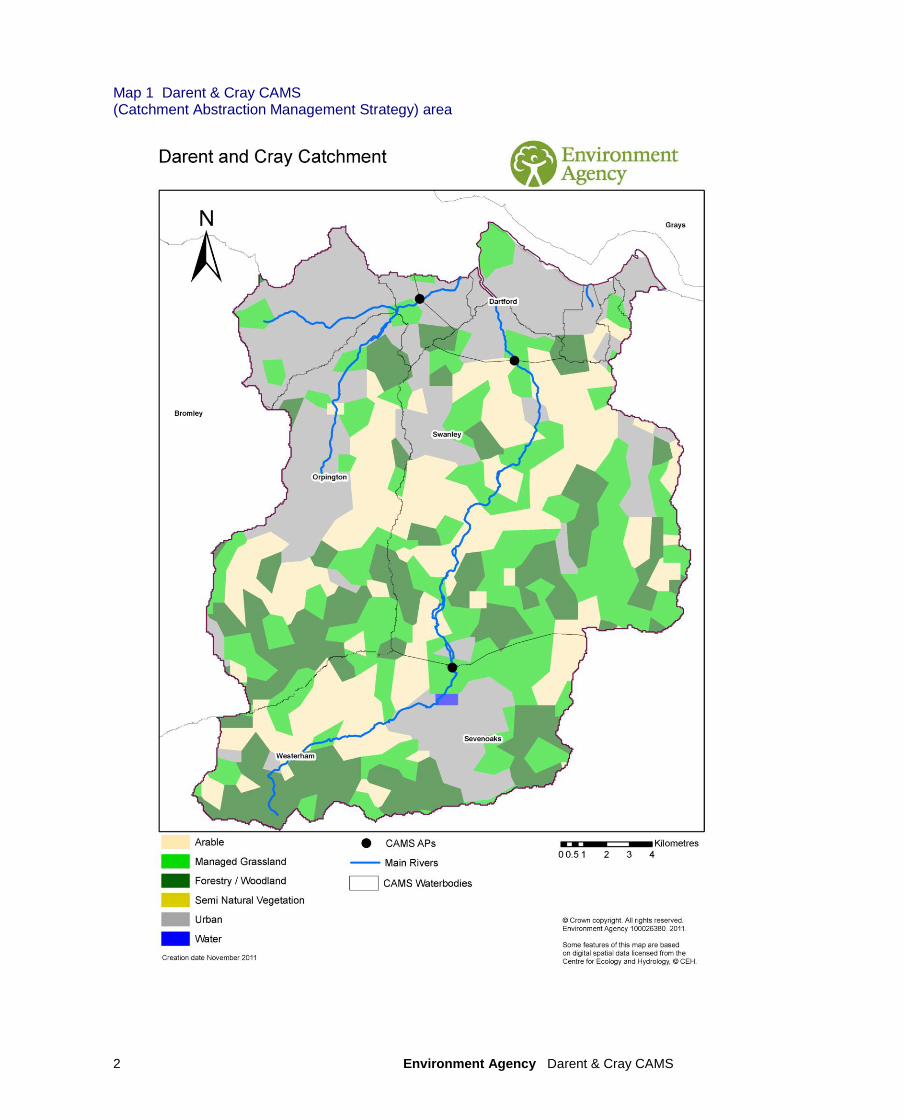
Map 1 Darent & Cray CAMS (Catchment Abstraction Management Strategy) area
Environment Agency Darent & Cray CAMS 3
Foreword
Kent and South London (KSL) is home to six million people and covers an area of 6,000km² with a diverse range of environments and related pressures. Proposed growth will continue to stretch the resources available to support this increasing population. Water is our most essential natural resource, and it is our job to ensure that we manage and use it effectively and sustainably. KSL is one of the driest parts of England and Wales and there are many catchments where there is little or no water available for abstraction during dry periods. Demand from agriculture and industry, and above average household consumption all add to this pressure and affect both the water environment and fresh supplies. The latest population growth and climate change predictions show that pressure on water resources will continue to increase in the future. We have to act now to make sure that we continue to maintain and improve sustainable abstraction and balance the needs of people and the environment. This licensing strategy sets out how we will manage water resources in the catchment, existing abstraction licences and water availability for further abstraction.
Andrew Pearce Kent & South London Area Manager

Environment Agency Darent & Cray CAMS 4
Contents
Map 1 Darent & Cray CAMS area...............................................................2
1. About the licensing Strategy.................................................................5 2. Darent & Cray CAMS area......................................................................7
3. Water resource availability of the Darent & Cray area........................9 4. How we manage abstractions in the Darent & Cray area..................15 Glossary of terms.......................................................................................24 List of abbreviations...................................................................................25
Environment Agency Darent & Cray CAMS 5
1. About the Licensing Strategy This Licensing Strategy sets out how water resources are managed in the Darent & Cray area. It provides information about where water is available for further abstraction and an indication of how reliable a new abstraction licence may be. This strategy was produced in December 2012 and it supersedes the strategy issued in April 2007. How CAMS contributes to achieving environmental objectives under the (WFD) Water Framework Directive The Water Framework Directive‟s main objectives are to protect and enhance the water environment and ensure the sustainable use of water resources for economic and social development. Catchment Abstraction Management Strategies (CAMS) set out how we will manage the water resources of a catchment and contribute to implementing the WFD. CAMS contribute to the WFD by:
providing a water resource assessment of rivers, lakes, reservoirs, estuaries and groundwater referred to as water bodies under the WFD;
identifying water bodies that fail flow conditions expected to support good ecological status;
preventing deterioration of water body status due to new abstractions;
providing results which inform River Basin Management Plans (RBMPs). When is an abstraction licence required? You need a licence from us if you want to abstract more than 20m
3/day (4 400 gallons) of water per
day from a:
river or stream
reservoir, lake or pond
canal
spring or
an underground source Whether or not a licence is granted depends on the amount of water available after the needs of the environment and existing abstractors are met and whether the justification for the abstraction is reasonable. If you want to apply for an abstraction licence or make changes to a licence that you already have then, please contact us:
by telephone on 03708 506 506
by email at [email protected]
or visit our website at www.environment-agency.gov.uk or our Abstraction Licensing web page
Environment Agency Darent & Cray CAMS 6
Sustainable abstraction This licensing strategy has been produced using evidence and information gathered during the Catchment Abstraction Management Strategy (CAMS) process. Through this process we consider the impact of abstraction at all flows. This helps to manage future abstraction more sustainably. We now assess water resources at a sub-catchment level called water bodies. This means that we can provide more detailed information on the availability of water resources in the Darent & Cray CAMS area compared to the scale used in the previous strategy. Within this strategy we also outline where we may need to reduce current rates of abstraction and our approach on time limiting licences. The background, aims and principles of CAMS, the over arching principles we use when managing abstraction licences and links with other initiatives are detailed in our document: Managing Water Abstraction. You should read Managing Water Abstraction when reading this catchment specific licensing strategy.
Environment Agency Darent & Cray CAMS 7
2. Darent & Cray CAMS area
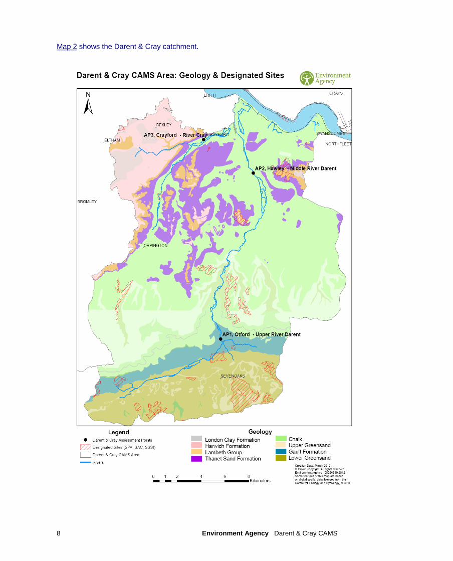
This CAMS covers the river Darent and river Cray catchments, with the Darent catchment covering an area of 423 km
2, the Cray catchment, the Darent‟s largest tributary, accounts for
123 km2 of this.
The upper catchment is an attractive valley between the dramatic North Downs scarp slope and the gentler lee slope of the Lower Greensand where the river is fed by a multitude of springs flowing to Sevenoaks. Near Otford, the Darent meets the Honeypot Stream before heading north through a narrow valley carved through the North Downs.
Downstream of South Darenth, the character of the valley changes dramatically, as land becomes flatter and more urbanised. After meeting the Cray, the Darent winds through the Dartford and Crayford Marshes before entering the Thames Estuary.
The River Cray, and its tributary the River Shuttle, are predominately urban rivers, flowing through the London Boroughs of Bromley and Bexley. Close proximity to London means that a large population is dependent on the Darent and Cray, as it provides important access to water based recreation and creates an environmental education resource. The Darent can be divided into two distinct geological units that heavily influence the nature of the catchment these are the; Upper Darent, which is underlain by Lower Greensand, and Middle Darent, which is underlain by Chalk.
The Cray catchment has two very different flow regimes due to differences in the underlying geology. The Chalk, from which the River Cray rises, gives a baseflow-dominated stream with a moderate gradient. The main source of the River Cray is Priory Ponds, Orpington. The River Shuttle rises from many springs originating in the Tertiary sediments and has a far more flashy nature due to the predominantly urban nature of the catchment.
Therefore, both the Cray and Darent river systems and their ecology are heavily reliant on groundwater from the Chalk and Lower Greensand. This makes them vulnerable to over-abstraction and drought. In the early 1990s, this combination led to some stretches of the Darent drying up completely. To address this problem the Darent Action Plan was set up by the predecessor to the Environment Agency and the local water companies. This involved installing an augmentation programme to support the river's flow.Since installation in 1996 the pumps have had to be used in 10 out of those 17 years, enabling the river to continue flowing. Many investigations of the River Darent and Cray have been carried out in order to understand more about the impact of public water supply abstraction which has been the dominant abstraction pressure on the river for the last 200 years.
Environment Agency Darent & Cray CAMS 8
Map 2 shows the Darent & Cray catchment.
Environment Agency Darent & Cray CAMS 9
3. Water resource availability of the Darent & Cray area 3.1 Resource assessment Resource assessment is at the heart of abstraction management. To manage water effectively we need to understand how much is available and where it is available, after considering the needs of the environment. We have a monitoring network to measure river flows and groundwater levels. We use this data along with our knowledge of human influences and environmental needs to establish a baseline of water availability for each water body that builds into a picture for the catchment. The main components of this assessment that help us to understand the availability of water resources are:
a resource allocation for the environment defined as a proportion of natural flow, known as the Environmental Flow Indicator (EFI);
the Fully Licensed (FL) scenario - the situation if all abstraction licences were being used to full capacity;
the Recent Actual (RA) scenario – the amount of water which has actually been abstracted on average over the previous six years.
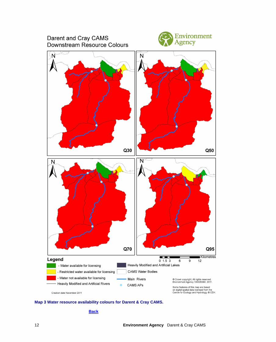
River flows change naturally throughout the year, so we want to protect flow variability in our rivers from low to high flow conditions. We use flow statistics to help to do this. Flow statistics are expressed as the percentage of time that flow is exceeded. Resource availability is calculated at four different flows, Q95 (lowest), Q70, Q50 and Q30 (highest). This information gives a realistic picture of what the current resource availability is within a given water body. Water bodies are sub-catchment surface water units or groundwater units on which we carry out assessments and map results. NB: Natural flows for CAMS AP water bodies have been taken from information provided in the CAMS ledgers. Natural flows for other water bodies have been derived based on simple interpolation between, or downstream of, CAMS APs, based on catchment area. Map 3 Water resource availability colours for Darent & Cray CAMS Provides an opportunity to reflect different CAMS colours for smaller coastal water bodies should this be required.
3.2 Resource availability 3.2.1 Surface water If you want to abstract water, you need to know what water resources are available within a catchment and where abstraction for consumptive purposes is allowed. To show this we have developed a classification system which indicates:
the relative balance between the environmental requirements for water and how much is licensed for abstraction;
whether water is available for further abstraction;
areas where abstraction may need to be reduced. The availability of water for abstraction is determined by the relationship between the fully licensed and recent actual flows in relation to the EFI. The results mapped onto these water bodies are represented by different water resource availability colours showing the availability of water resource for further abstraction. The water resource availability colours are explained in Table 1. In addition to these water resource availability colours we‟ve classified some surface water bodies as „high hydrological status‟ which are coloured blue on the maps. In these water bodies very little actual abstraction occurs and they show virtually undisturbed, or close to natural, flow conditions. Another category of water body are Heavily Modified Water Bodies (HMWB). These can be classified for many reasons but for water resources they are classified if they contain a lake and/or
Environment Agency Darent & Cray CAMS 10
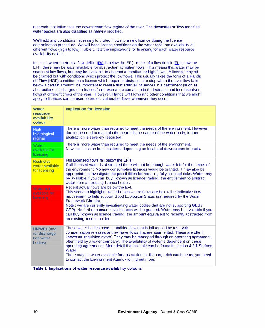
reservoir that influences the downstream flow regime of the river. The downstream „flow modified‟ water bodies are also classified as heavily modified. We‟ll add any conditions necessary to protect flows to a new licence during the licence determination procedure. We will base licence conditions on the water resource availability at different flows (high to low). Table 1 lists the implications for licensing for each water resource availability colour. In cases where there is a flow deficit (RA is below the EFI) or risk of a flow deficit (FL below the EFI), there may be water available for abstraction at higher flows. This means that water may be scarce at low flows, but may be available to abstract at medium or high flows. A licence may still be granted but with conditions which protect the low flows. This usually takes the form of a Hands off Flow (HOF) condition on a licence which requires abstraction to stop when the river flow falls below a certain amount. It‟s important to realise that artificial influences in a catchment (such as abstractions, discharges or releases from reservoirs) can act to both decrease and increase river flows at different times of the year. However, Hands Off Flows and other conditions that we might apply to licences can be used to protect vulnerable flows whenever they occur
Water resource availability colour
Implication for licensing
High hydrological regime
There is more water than required to meet the needs of the environment. However, due to the need to maintain the near pristine nature of the water body, further abstraction is severely restricted.
Water available for licensing
There is more water than required to meet the needs of the environment. New licences can be considered depending on local and downstream impacts.
Restricted water available for licensing
Full Licensed flows fall below the EFIs. If all licensed water is abstracted there will not be enough water left for the needs of the environment. No new consumptive licences would be granted. It may also be appropriate to investigate the possibilities for reducing fully licensed risks. Water may be available if you can „buy‟ (known as licence trading) the entitlement to abstract water from an existing licence holder.
Water not available for licensing
Recent actual flows are below the EFI. This scenario highlights water bodies where flows are below the indicative flow requirement to help support Good Ecological Status (as required by the Water Framework Directive Note : we are currently investigating water bodies that are not supporting GES / GEP). No further consumptive licences will be granted. Water may be available if you can buy (known as licence trading) the amount equivalent to recently abstracted from an existing licence holder.
HMWBs (and /or discharge rich water bodies)
These water bodies have a modified flow that is influenced by reservoir compensation releases or they have flows that are augmented. These are often known as „regulated rivers‟. They may be managed through an operating agreement, often held by a water company. The availability of water is dependent on these operating agreements. More detail if applicable can be found in section 4.2.1 Surface Water There may be water available for abstraction in discharge rich catchments, you need to contact the Environment Agency to find out more.
Table 1 Implications of water resource availability colours.
Environment Agency Darent & Cray CAMS 11
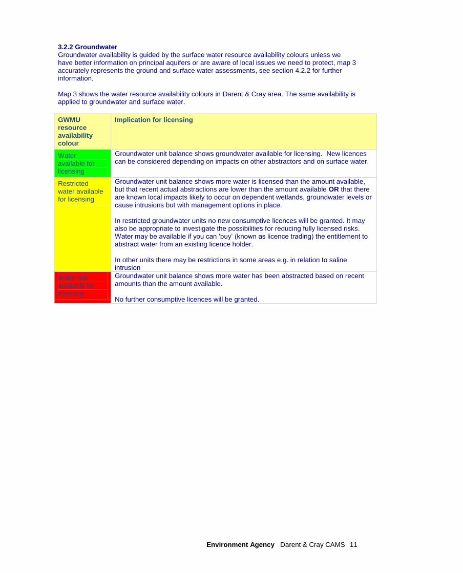
3.2.2 Groundwater Groundwater availability is guided by the surface water resource availability colours unless we have better information on principal aquifers or are aware of local issues we need to protect, map 3 accurately represents the ground and surface water assessments, see section 4.2.2 for further information. Map 3 shows the water resource availability colours in Darent & Cray area. The same availability is applied to groundwater and surface water.
GWMU resource availability colour
Implication for licensing
Water available for licensing
Groundwater unit balance shows groundwater available for licensing. New licences can be considered depending on impacts on other abstractors and on surface water.
Restricted water available for licensing
Groundwater unit balance shows more water is licensed than the amount available, but that recent actual abstractions are lower than the amount available OR that there are known local impacts likely to occur on dependent wetlands, groundwater levels or cause intrusions but with management options in place. In restricted groundwater units no new consumptive licences will be granted. It may also be appropriate to investigate the possibilities for reducing fully licensed risks. Water may be available if you can „buy‟ (known as licence trading) the entitlement to abstract water from an existing licence holder. In other units there may be restrictions in some areas e.g. in relation to saline intrusion
Water not available for licensing
Groundwater unit balance shows more water has been abstracted based on recent amounts than the amount available. No further consumptive licences will be granted.
Environment Agency Darent & Cray CAMS 12
Map 3 Water resource availability colours for Darent & Cray CAMS. Back
Environment Agency Darent & Cray CAMS 13
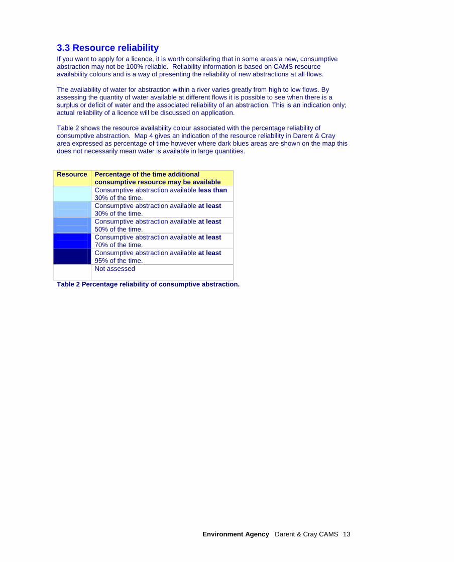
3.3 Resource reliability If you want to apply for a licence, it is worth considering that in some areas a new, consumptive abstraction may not be 100% reliable. Reliability information is based on CAMS resource availability colours and is a way of presenting the reliability of new abstractions at all flows. The availability of water for abstraction within a river varies greatly from high to low flows. By assessing the quantity of water available at different flows it is possible to see when there is a surplus or deficit of water and the associated reliability of an abstraction. This is an indication only; actual reliability of a licence will be discussed on application. Table 2 shows the resource availability colour associated with the percentage reliability of consumptive abstraction. Map 4 gives an indication of the resource reliability in Darent & Cray area expressed as percentage of time however where dark blues areas are shown on the map this does not necessarily mean water is available in large quantities.
Resource Percentage of the time additional consumptive resource may be available
Consumptive abstraction available less than 30% of the time.
Consumptive abstraction available at least 30% of the time.
Consumptive abstraction available at least 50% of the time.
Consumptive abstraction available at least 70% of the time.
Consumptive abstraction available at least 95% of the time.
Not assessed
Table 2 Percentage reliability of consumptive abstraction.

Environment Agency Darent & Cray CAMS 14
Map 4 Water resource reliability expressed as percentage of time available. Back
Environment Agency Darent & Cray CAMS 15
4. How we manage abstractions in the Darent & Cray area
4.1 Principles The document Managing Water Abstraction outlines the over-arching principles that we follow in managing our water resources. How we apply these principles in the Darent and Cray area is outlined in this section. If you want to abstract water it outlines where water is available for further abstraction and the principles we follow in assessing your application for a licence.
Abstraction licence application process Anyone wanting to take more than 20m
3/day (4 400 gallons) from a „source of supply‟ (river,
stream, lake, well, groundwater, etc) must have an abstraction licence. The application process for abstraction is similar to the planning process in that we may require the application to be advertised and may require supporting environmental information. When considering the application we check that the quantities applied for and the purpose of the abstraction are reasonable, that there is sufficient water available to support it and that the potential impacts on the environment and other water users are acceptable. Depending on the outcome of our investigations we will issue a licence either as applied for, or with conditions that restrict the abstraction to protect the environment or other users. In certain cases we may have to refuse the application. Any applicant who is not happy with our determination (decision) has the right to appeal against it. Each application is determined on its own merits Whilst this document may say that water is available for further abstraction, this does not guarantee that all applications will be successful. We‟ll determine each application upon its own merits and any local impacts. A licence does not guarantee that water is available It‟s important to understand that when we issue a licence we do not guarantee the supply of water. We have to protect the environment and rights of other abstractors. To do this we may add constraints to licences. Licence holders need to understand the implications of this as it affects the reliability of supply. For example, in drier years it‟s more likely that conditions will come into effect and abstraction is more likely to be stopped. Abstractions are managed to protect the environment. No ecological deterioration We assess the impact of new applications for water to make sure that the resultant river flows:
will maintain a good ecology or if the ecology is not good, will not deteriorate the ecology of our rivers further;
will maintain the near pristine condition of high hydrological regime water bodies. We‟ll also take action if necessary to limit the increase in current abstraction, if we think this will lead to deterioration of the ecology or the near pristine condition of our high hydrological regime water bodies. These principles apply to the water body in which the abstraction is located and also to all downstream water bodies that may be affected by any reduction in abstraction related flow. Doing this means that we will maintain the water body status as reported in the River Basin Management Plans (2009) and ensure compliance with the European Union Water Framework Directive.
Water efficiency and demand management: We need to make the best use of our existing water resources. Adopting water efficiency and demand management measures can help us achieve this goal. Water efficiency is one of the tests that will need to be satisfied before we grant a new licence or renew a time limited licence. We will promote the wise and efficient use of water and actions to limit demand (and reduce leakage) to curb the growth in abstraction and limit the impact on flows and any consequent impact on the ecology. For further details on our general approach to licensing please see the document Managing Water Abstraction.

Environment Agency Darent & Cray CAMS 16
- Building Design The South East is densely populated with household water use being the highest in the country at 164 litres per capita consumption (PCC) against a national average of 148 PCC. Throughout the area we are working closely with local authorities to ensure water conservation and efficient water use is embedded within their strategic spatial planning policies. One way this can be achieved is by designing all new homes and business unitsto achieve a minimum water efficiency level. Water efficiency and the reduction in household water demand are crucial elements of good water resource management planning especially as the South East is under increased pressure from climate change and population growth. Local Authorities in Kent are signing the Climate Local commitment to share knowledge and work towards agreed targets that will support the quality of life for those living and working in Kent. Climate Local Kent includes targets to reduce water consumption and support retrofitting schemes www.kent.gov.uk/climatelocalkent
- Sustainable drainage systems (or SuDS) are a positive way of controlling surface water
runoff as close to its origin as possible, before it is discharged to a watercourse or the ground. They involve moving away from traditional drainage systems to softer engineering solutions such as permeable paving. The benefits are reduced flood risk, improved water quality and increased groundwater recharge. This water can also be collected and reused for non-potable purposes.
- Water audits All businesses can use their water wisely. By investing a little time and money in implementing a simple water management plan, an organisation could reduce its water consumption by up to 80%, releasing money to be invested in other parts of the business and establishing „green‟ credentials. Water audits allow the volume of water used during an average year to be calculated and suggest ways to reduce water use and therefore costs.
- Environment Agency The Environment Agency provides a range of free guidance on water efficiency, including best practice case studies for agriculture, business, industry, public sector and the domestic consumer. Consult www.environment-agency.gov.uk/savewater.
- Water companies For local water efficiency advice, contact your water company along side leakage rates and water metering targets. Southern Water www.southernwater.co.uk South East Water www.southeastwater.co.uk Thames Water Utilities www.thameswater.co.uk/ Affinity Water www.affinitywater.co.uk Sutton & East Surrey Water www.waterplc.com
- Water Regulations Advisor Service WRAS provides advice on the Water Supply (Water Fittings) Regulations which prevents waste, misuse, undue consumption or contamination of wholesome water. Consult www.wras.co.uk or telephone 01495 248454.
- Business/Commercial Waterwise Waterwise is a UK Non-governmental Organisation (NGO) focused on decreasing water consumption in the UK and building the evidence base for large scale water efficiency. www.waterwise.org.uk/pages/save-water.html
- Public sector Water Summit - Water Resilience Framework Kent County Council and the Environment Agency are working in partnership to develop a Water Resilience Framework for Kent. In part this included a „Water Summit‟ held in 2012 with water companies, public sector organisations, NGOs, businesses, community and local interest groups across Kent. The aim to highlight local water resource pressures, drought issues and long-term local water risks, and establish a consensus on what needs to be done to develop a

Environment Agency Darent & Cray CAMS 17
Water Resilience Framework for Kent which in turn would be of benefit to the local economy and jobs.
- Water in the School benchmarks Water in the School is a website supported by a number of water companies aimed at National Curriculum Key Stage 2 and 3 pupils and their teachers. It provides a wealth of information for pupils on how to make savings. Consult www.waterintheschool.co.uk
- Hospitals Water UK has collaborated with NHS Estates and Watermark to produce Water Efficient Hospitals, an information pack to help hospitals use water wisely and save money by cutting both water and energy bills. Consult www.water.org.uk/index.php?cat=3-4701
- Agriculture & Horticulture It is recognised there is a need to balance between people, business and the environment. We are working closely with Kent County Council and others on a programme to address the rapid growth of water demand within Kent‟s horticulture and agriculture sector which was an action from the Kent Environment Strategy.
- UK Irrigation Association (UKIA) The UKIA provides information on irrigation to its members and runs technical workshops. Consult www.ukia.org - DEFRA’s Rural Development Service (RDS) DEFRA‟s Rural Development Service provides grants for agricultural water resources management schemes under its Rural Enterprise Scheme. Consult www.defra.gov.uk/rural/rdpe/ or telephone 0845 9335577.
- Linking Environment & Farming (LEAF) LEAF promote and develop integrated farm management, this includes whole farm water savings. Consult www.leafuk.org or telephone the Kent LEAF office 01580 712488.
Impoundments Applications for impoundment licenses will be dealt with on a case-by-case basis but the Environment Agency is generally opposed to in-stream impoundments as they can have significant impact on the flow regime and the natural ecology. An impoundment is a dam, weir or other construction in an inland waterway that obstructs or impedes flow and/or raises water levels. Hydropower Water abstraction for hydropower schemes is non-consumptive, with all water used returned to the watercourse. Hands off Flows and maximum abstraction volumes are determined in line with the Environment Agency's Hydropower Good Practice Guidelines and based on the assessment of environmental risk for each scheme. For further information please refer to our website.
4.2 Abstraction restrictions When issuing a licence we have to protect the environment and rights of other abstractors. To do this we may add conditions to licences.
Time limited licences In recognition of changing pressures on water resources all new licences and variations (other than downward variations or minor variations having no environmental impact) will have a time limit imposed. This allows for the periodic review and changes to abstraction licences where circumstances have changed since the licence was granted. All new licences within a CAMS area have a common end date (CED) so they can be reviewed at the same time. When an application is made within six years of the CED, we will generally apply the subsequent CED to any licence granted. This is to avoid issuing shorter and shorter duration licences as the CED approaches. This means that the initial CED on a licence may be between six and 18 years duration. On replacement the normal duration will then usually be 12 years. However, where we are uncertain about the long term impacts of an abstraction we will grant a short term licence during which time potential impacts are monitored.
Environment Agency Darent & Cray CAMS 18
10% of the licences in Darent & Cray CAMS are time-limited. CEDs occur every twelve years. The next CED for Darent & Cray CAMS is 2020 and the subsequent one is 2026. Additional information about the replacement of time limited licences is available in Managing Water Abstraction. We will seek to secure downward variations and/or apply surface or groundwater level conditions to existing licenses by using the criteria for the renewal of time limited licenses.
Hands off flow conditions To protect the environment we may issue a licence with a condition referred to as a „Hands-Off Flow‟ (HOF). This specifies that if the flow in the river drops below that which is required to protect the environment abstraction must stop, hence „Hands-Off Flow‟.
4.2.1 Surface water
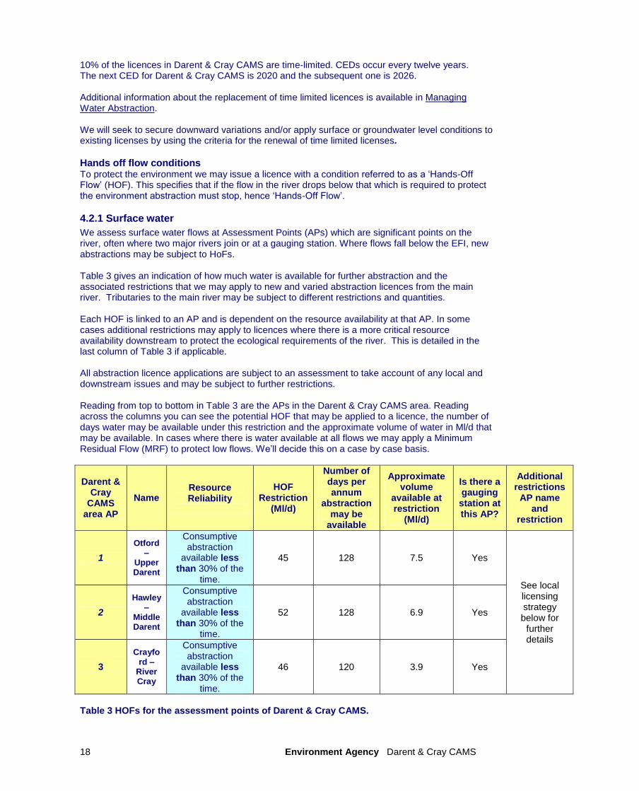
We assess surface water flows at Assessment Points (APs) which are significant points on the river, often where two major rivers join or at a gauging station. Where flows fall below the EFI, new abstractions may be subject to HoFs. Table 3 gives an indication of how much water is available for further abstraction and the associated restrictions that we may apply to new and varied abstraction licences from the main river. Tributaries to the main river may be subject to different restrictions and quantities. Each HOF is linked to an AP and is dependent on the resource availability at that AP. In some cases additional restrictions may apply to licences where there is a more critical resource availability downstream to protect the ecological requirements of the river. This is detailed in the last column of Table 3 if applicable. All abstraction licence applications are subject to an assessment to take account of any local and downstream issues and may be subject to further restrictions. Reading from top to bottom in Table 3 are the APs in the Darent & Cray CAMS area. Reading across the columns you can see the potential HOF that may be applied to a licence, the number of days water may be available under this restriction and the approximate volume of water in Ml/d that may be available. In cases where there is water available at all flows we may apply a Minimum Residual Flow (MRF) to protect low flows. We‟ll decide this on a case by case basis.
Darent & Cray
CAMS area AP
Name Resource Reliability
HOF Restriction
(Ml/d)
Number of days per annum
abstraction may be
available
Approximate volume
available at restriction
(Ml/d)
Is there a gauging station at this AP?
Additional restrictions
AP name and
restriction
1
Otford –
Upper Darent
Consumptive abstraction
available less than 30% of the
time.
45 128 7.5 Yes
See local licensing strategy below for
further details
2
Hawley –
Middle Darent
Consumptive abstraction
available less than 30% of the
time.
52 128 6.9 Yes
3
Crayford –
River Cray
Consumptive abstraction
available less than 30% of the
time.
46 120 3.9 Yes
Table 3 HOFs for the assessment points of Darent & Cray CAMS.

Environment Agency Darent & Cray CAMS 19
Assessment Point descriptive
AP1, Otford – Upper Darent The Otford Assessment Point (AP1) area includes the upper Darent and Honeypot Stream and underlying groundwater, the Lower Greensand. Both the River Darent and the Honeypot Stream are constrained by the geology of the Greensand ridge to the south and the North Downs to the north. For most of their length, the rivers flow over rocks of the Lower Greensand formation except for the section where it cuts through the Chalk of the North Downs at Otford. Both the Darent and the Honeypot Stream originate from a series of springs, either from the Greensand or from the Chalk of the North Downs. This water unit is assessed as: “Water not available for licensing”, and is heavily over abstracted with the aim to strive towards a more sustainable situation. Licence Strategy for new and varied licenses:
Any applications for „consumptive‟ abstractions from this unit, either from ground or surface waters are unlikely to be successful. All licence applications will be fully assessed and in some circumstances abstraction might be possible, but it is highly likely that there will be constraints imposed. The constraints or conditions attached to new or varied licences in this unit are given below.
Surface Water Abstraction: Within this unit even winter-only licences will be limited, despite the “HOF” restrictions detailed in table 3, because we will need to ensure there is enough river flow to provide a winter flush along the river to protect the wild brown trout spawning habitat. Any new or varied surface water licences that are granted, will have an appropriate Hands Off Flow condition tied to Otford Flow gauging station.
Groundwater Abstraction: There remains a “presumption against” further unconstrained consumptive abstraction from the Lower Greensand aquifers. Any new or varied licence will most likely have an „Antecedent Winter Rainfall Condition‟. This states that the total volume of abstraction authorised for any water year (12 months from October 1st) will be dependent on antecedent (or previous) winter rainfall. For clarification, this can be exemplified as follows:
• If 100% of the long term average rainfall (1961–1990) is recorded (during the previous winter) then 100% of the annual quantity may be abstracted • If 75% of the long term average rainfall is recorded then 75% of the annual quantity may be abstracted • If 50% of the long term average rainfall is recorded then 50% of the annual quantity may be abstracted • The maximum reduction will be 50% of the annual quantity
This condition allows the usage of any new or varied groundwater abstraction from this aquifer to be carefully managed in any one year. We will notify abstractors before 1 May of each year of the preceding total winter rainfall and the permitted abstraction volume. In some cases more sophisticated assessments of groundwater recovery may be used which represent actual groundwater storage rather than potential recharge based on actual rainfall. These will be represented by groundwater recovery levels.
• Existing licence holders that are causing environmental impact will only be changed through our Restoring Sustainable Abstraction programme. AP2, Hawley – Middle Darent Assessment Point 2 includes the River Darent from Otford Flow Gauging Station to Hawley Flow Gauging Station and the underlying groundwater (Chalk). The river from Hawley to the River Thames has not been assessed as the tidal gate at Dartford impounds the river and there is no appropriate Assessment Point for measuring river flow.
Environment Agency Darent & Cray CAMS 20
Within this unit, the river‟s course has been modified by the mills that used to operate along this stretch, with the river course having been diverted and enlarged upstream of the mills to provide larger heads of water. More recently, gravel extraction has further altered the hydraulics of the river flows and groundwater. Unlike the Upper Darent there are few distinctive springs contributing to river flow in this section. The river is known to suffer from low flow problems in summer due to its vulnerability to low rainfall, historical widening of the channel and water abstraction. This vulnerability to low flows has resulted in our river flow augmentation scheme, introduced as part of the Darent Action Plan. This involves pumping groundwater at depth from three Chalk boreholes to support the river in times of need. This augmentation improves river flow, although a proportion of water is lost through the riverbed and eventually goes back into the aquifer. We are nearing the end of a 20 year long Darent Action Plan project, to improve flows in the Darent. Over this time we have been working with Thames Water and the Darent River Preservation Society to reduce the water taken from the groundwater that feeds the river. This water unit is assessed as: “Water not available for licensing”, and is heavily over abstracted with the aim to strive towards a more sustainable situation. Licence Strategy for new and varied licenses:
Any applications for „consumptive‟ abstractions from this unit, either from ground or surface waters are unlikely to be successful. All licence applications will be fully assessed and in some circumstances abstraction might be possible, but it is highly likely that there will be constraints imposed. The constraints or conditions attached to new or varied licences in this unit are given below.
Surface Water Abstraction: Any new or varied surface water licences that are granted will have an appropriate Hands Off Flow condition tied to Hawley Flow gauging Station.
Groundwater Abstraction: There remains a “presumption against” further unconstrained consumptive abstraction from the Chalk aquifers. Any new or varied licence will most likely have an „Groundwater Level Condition‟ to ensure only sustainable abstractions can occur.
AP3, River Cray & Shuttle This section includes; the River Cray to Crayford Gauging Station (Assessment Point 3), River Shuttle and underlying groundwater. While the River Cray is base-flow dominated from the Upper Chalk and London Tertiaries springs, the flow in the Shuttle is far more erratic because of its urbanised catchment and impervious nature. One of the major sources of the River Cray is a series of spring fed ponds at Orpington that only dry up under severe drought conditions. The River Cray is a designated Biodiversity Action Plan (BAP) Chalk stream. The only Site of Special Scientific Interest (SSSI) in this unit is Ruxley Pits. This is notified for its aquatic and marginal vegetation, strong water beetle fauna and has a good water vole population. Much of the River Cray and the River Shuttle watercourses run through urbanised and industrialised areas. Such areas have inherent water quality issues due to the very nature of the concrete landscape with surface runoff finding its way into the watercourses with all the pollutants, contaminants and debris (such as oil and diesel) that accumulates in such environments. This water unit is assessed as: “Water not available for licensing”, and is heavily over abstracted with the aim to strive towards a more sustainable situation. Licence Strategy for new and varied licenses:
Any applications for consumptive abstraction from this unit either from ground or surface waters are unlikely to be successful due to the resource deficiencies in this unit.
Surface Water Abstraction: Any new or varied surface water licences granted from the River Cray catchment will be tied to an appropriate Hands Off Flow condition at our flow gauging station at Crayford. Any new or varied surface water abstractions granted from
Environment Agency Darent & Cray CAMS 21
the River Shuttle catchment will be tied to an appropriate Hands Off Flow condition at our proposed flow gauging station on the River Shuttle.
Groundwater Abstraction: There remains a “presumption against” further unconstrained consumptive abstraction from the Chalk aquifers. Any new or varied licence will most likely have an „Groundwater Level Condition‟ to ensure only sustainable abstractions can occur.
Important local features that may affect water availability
European law provides a very high level of protection to two types of designated sites due to their special environment. These are:
• Special Areas of Conservation (SAC), which contribute to biodiversity by maintaining and restoring habitats and species; • Special Protection Area (SPA), which provides protection to birds and their nests, eggs and habitats
Ramsar sites and Sites of Special Scientific Interest (SSSI) also carry a high level of environmental importance. Further information can be found in Section 4.5 – Restoring Sustainable Abstraction.
The four water-related SSSI in this CAMS area are:
• Ruxley Gravel Pits – Notified for its aquatic and marginal vegetation, water beetle fauna and over 500 species of vascular plants.
• Sevenoaks Gravel Pits – Notified for its post-industrial sand invertebrate communities and wetland birds.
• Westerham Wood – Notified for its ancient woodland including plants indicative of wet woodland. This wood is situated on Gault Clay, so its water-related needs are met by rainfall.
• Titsey Woods – These damp woods are notified for their important ground flora and invertebrate
4.2.2 Groundwater
Where groundwater (GW) abstractions directly impact on surface water flows, the impact is measured at the surface water AP. Restrictions will be applied to these licences. Where groundwater abstractions are likely to impact surface water features, or reduce baseflow to a river, a Hands off Level (HoL) condition may be applied to the abstraction. This is a groundwater level below which an abstractor is required to reduce or stop abstraction. These restrictions that might be applied to abstractions will be determined on an individual bases. Within the Darent & Cray CAMS the groundwater principal aquifer licensing strategy remains in place. Groundwater - Principal aquifer licensing strategy - There has been a “presumption against” further consumptive abstraction from the Chalk and Lower Greensand aquifers. The groundwater drought of the late 1980‟s and early 1990‟s highlighted the vulnerability of these very important water sources. In response a groundwater management policy was introduced by the Environment Agency‟s predecessor organisation, the National Rivers Authority (NRA), in 1993. This embodied the general principle of prohibiting further unconstrainted consumptive abstraction from the area‟s principal aquifers. In addition, the 1991–92 drought showed how the Lower Greensand aquifer and the Hastings Beds (particularly the Ashdown Sand layer within the Hastings Beds) were vulnerable to lack of winter rainfall and were taking longer to recover from drought. So in 1993, these aquifers were also included in this policy. Within the revised 1993 Groundwater Policy we introduced an „Antecedent Winter Rainfall Condition‟.
4.2.4 Estuaries/coast
The Darent river flows into the Thames tidal estuary, abstractions within the Thames Estuary are not included within the Darent CAMS, please see Thames Corridor CAMS.
Environment Agency Darent & Cray CAMS 22
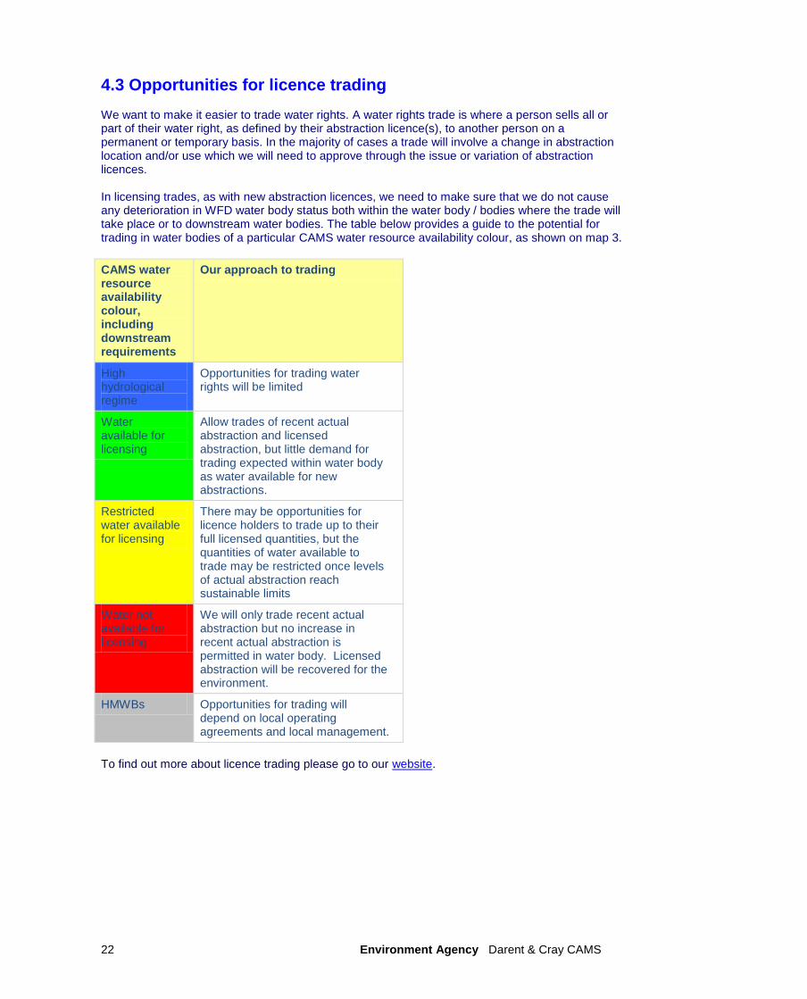
4.3 Opportunities for licence trading We want to make it easier to trade water rights. A water rights trade is where a person sells all or part of their water right, as defined by their abstraction licence(s), to another person on a permanent or temporary basis. In the majority of cases a trade will involve a change in abstraction location and/or use which we will need to approve through the issue or variation of abstraction licences. In licensing trades, as with new abstraction licences, we need to make sure that we do not cause any deterioration in WFD water body status both within the water body / bodies where the trade will take place or to downstream water bodies. The table below provides a guide to the potential for trading in water bodies of a particular CAMS water resource availability colour, as shown on map 3.
CAMS water resource availability colour, including downstream requirements
Our approach to trading
High hydrological regime
Opportunities for trading water rights will be limited
Water available for licensing
Allow trades of recent actual abstraction and licensed abstraction, but little demand for trading expected within water body as water available for new abstractions.
Restricted water available for licensing
There may be opportunities for licence holders to trade up to their full licensed quantities, but the quantities of water available to trade may be restricted once levels of actual abstraction reach sustainable limits
Water not available for licensing
We will only trade recent actual abstraction but no increase in recent actual abstraction is permitted in water body. Licensed abstraction will be recovered for the environment.
HMWBs Opportunities for trading will depend on local operating agreements and local management.
To find out more about licence trading please go to our website.
Environment Agency Darent & Cray CAMS 23
4.4 New Authorisations
The Water Act 2003 brought all significant water abstraction under licensing control. This will result in trickle irrigation, dewatering of mines, quarries, engineering works and construction sites, abstractions related to Internal Drainage Districts, navigation abstraction and abstraction for ports and harbour authorities and other local exemptions coming into the licensing regime.
As a result we‟ll be able to manage water resources more effectively by ensuring that all significant activities influencing the availability of water and its impact on the environment are undertaken in a sustainable manner.
Government are still developing their policies as to how to resolve some of the issues raised during the consultation process. Government will publish their proposals before new regulations are implemented and expect to do this at least 3 months before commencement so that we can issue guidance to those affected by the changes. Where we have details of these abstractions we have included them in our assessments to consider how they impact on the catchment. Within the Darent & Cray catchment it is estimated during the summer months a total of 0.67Ml/d is abstracted for trickle/drip irrigation from both ground and surface water sources.
4.5 Restoring Sustainable Abstraction
Where water abstractions cause or potentially cause actual flows to fall short of the EFIs and result in environmental damage, we may need to change or even revoke existing abstractions in order to achieve a sustainable abstraction regime. Within the Darent & Cray CAMS there is 1 water body in which recent actual flows are not sufficient to support their ecology. The abstraction licences within these water bodies that cause these issues are being investigated. Investigations into the impact caused by these licences, individually or cumulatively, may result in options being developed with licence holders on how to improve sustainability. Information on how licences in the RSA programme are dealt with can be found in our Step by Step guide on our website.
Investigation Water Framework Directive Water bodies. In addition to the RSA programme, we are investigating whether reduced water flow may be causing problems under the Water Framework Directive (WFD). About four per cent of rivers are failing to support WFD good ecological status due to pressures from over-abstraction. Habitats Directive Under the Habitats Regulations we have assessed the effects of existing abstraction licences and will assess new applications to make sure they are not impacting on internationally important nature conservation sites. These sites are known as Special Areas of Conservation (SAC‟s) and Special Protection Areas (SPA‟s). If your current licence has been reviewed under this legislation to assess its impact you will already know about the review. If we haven‟t contacted you yet then your licence is either not near a SAC/SPA or isn‟t having an impact on these sites. If our assessment shows that a new application could have an impact on a SAC/SPA we have to follow strict rules in setting a time limit for that licence. These are: • we may be able to grant the licence but only with a short time limit. This allows us to monitor the impact of the abstraction on a SAC/SPA and change the licence if necessary; • if we can‟t determine that your application will not affect the site we have to either put conditions on the licence so that it cannot affect the site or refuse the application. If we grant the licence we may ask you to monitor its impact; • if our assessment shows that there isn‟t an impact on the site we will manage the application according to the principles in this document.

Environment Agency Darent & Cray CAMS 24
Thank you for taking the time to read this Licensing Strategy. If you have any questions about it, or if you want to apply for an abstraction licence or make changes to a licence that you already have, then please contact us:
by telephone on 03708 506 506
by email at [email protected]
or visit our website at www.environment-agency.gov.uk or our Abstraction Licensing web page
Environment Agency Darent & Cray CAMS 25
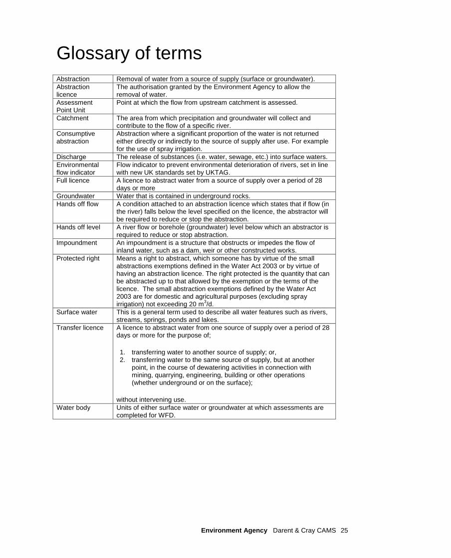
Glossary of terms Abstraction Removal of water from a source of supply (surface or groundwater).
Abstraction licence
The authorisation granted by the Environment Agency to allow the removal of water.
Assessment Point Unit
Point at which the flow from upstream catchment is assessed.
Catchment The area from which precipitation and groundwater will collect and contribute to the flow of a specific river.
Consumptive abstraction
Abstraction where a significant proportion of the water is not returned either directly or indirectly to the source of supply after use. For example for the use of spray irrigation.
Discharge The release of substances (i.e. water, sewage, etc.) into surface waters.
Environmental flow indicator
Flow indicator to prevent environmental deterioration of rivers, set in line with new UK standards set by UKTAG.
Full licence A licence to abstract water from a source of supply over a period of 28 days or more
Groundwater Water that is contained in underground rocks.
Hands off flow A condition attached to an abstraction licence which states that if flow (in the river) falls below the level specified on the licence, the abstractor will be required to reduce or stop the abstraction.
Hands off level A river flow or borehole (groundwater) level below which an abstractor is required to reduce or stop abstraction.
Impoundment An impoundment is a structure that obstructs or impedes the flow of inland water, such as a dam, weir or other constructed works.
Protected right Means a right to abstract, which someone has by virtue of the small abstractions exemptions defined in the Water Act 2003 or by virtue of having an abstraction licence. The right protected is the quantity that can be abstracted up to that allowed by the exemption or the terms of the licence. The small abstraction exemptions defined by the Water Act 2003 are for domestic and agricultural purposes (excluding spray irrigation) not exceeding 20 m
3/d.
Surface water This is a general term used to describe all water features such as rivers, streams, springs, ponds and lakes.
Transfer licence A licence to abstract water from one source of supply over a period of 28 days or more for the purpose of;
1. transferring water to another source of supply; or, 2. transferring water to the same source of supply, but at another
point, in the course of dewatering activities in connection with mining, quarrying, engineering, building or other operations (whether underground or on the surface);
without intervening use.
Water body Units of either surface water or groundwater at which assessments are completed for WFD.
Environment Agency Darent & Cray CAMS 26
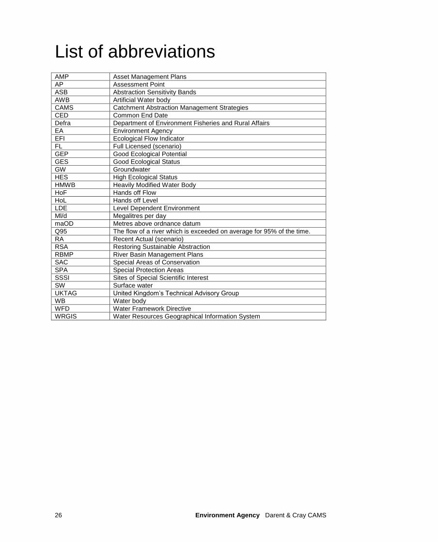
List of abbreviations AMP Asset Management Plans
AP Assessment Point
ASB Abstraction Sensitivity Bands
AWB Artificial Water body
CAMS Catchment Abstraction Management Strategies
CED Common End Date
Defra Department of Environment Fisheries and Rural Affairs
EA Environment Agency
EFI Ecological Flow Indicator
FL Full Licensed (scenario)
GEP Good Ecological Potential
GES Good Ecological Status
GW Groundwater
HES High Ecological Status
HMWB Heavily Modified Water Body
HoF Hands off Flow
HoL Hands off Level
LDE Level Dependent Environment
Ml/d Megalitres per day
maOD Metres above ordnance datum
Q95 The flow of a river which is exceeded on average for 95% of the time.
RA Recent Actual (scenario)
RSA Restoring Sustainable Abstraction
RBMP River Basin Management Plans
SAC Special Areas of Conservation
SPA Special Protection Areas
SSSI Sites of Special Scientific Interest
SW Surface water
UKTAG United Kingdom‟s Technical Advisory Group
WB Water body
WFD Water Framework Directive
WRGIS Water Resources Geographical Information System

Environment Agency Darent & Cray CAMS 27
Would you like to find out more about us,
or about your environment?
Call us on
08708 506 506* (Mon-Fri 8am-6pm)
or visit our website
www.environment-agency.gov.uk
incident hotline 0800 80 70 60 (24 hours)
floodline 0845 988 1188
* Approximate calls costs: 8p plus 6p per minute (standard landline). Please note charges will vary across telephone providers
Environment first: This publication is printed on paper made from 100 per cent previously used waste. By-products from making the pulp and paper are used for composting and fertiliser, for making cement and for generating energy.