dark clouds over clayton valley and green lights for...
TRANSCRIPT

May 30, 2016
Research #2Lithium in Nevada
Dark clouds over Clayton Valley and green lights for Belmont‘s
Kibby Basin ProjectToday, Belmont Resources Inc. announced to have received exchange approval for acquiring 100% of the Kibby Basin Property, located 65 km north of the Clayton Valley in Nevada, USA. According to the newly filed NI43-101 Technical Report, the property has potential to host lithium-bearing brines in a geological setting similar to the continental brine model ascribed to the Clayton Valley. As Albermarle Corp. has filed an official protest with the Nevada Division of Water Resources (NDWR) against any further granting of water rights in the “overapproriated” Clayton Valley, other basins in Nevada prospective for lithium brines – such as Kibby Basin – may experience an increased investor’s interest in the near future. Rockstone expects Belmont to start exploration at Kibby Basin shortly, potentially creating vast shareholder value in case commercial grades of lithium-bearing brines can be identified on its property.
Company Details
Belmont Resources Inc.Suite 600 - 625 Howe StreetVancouver, BC, V6C2T6 Canada Phone: +1 604 683 6648Email: [email protected] (Gary Musil)www.belmontresources.comShares Issued & Outstanding: 29,378,453
Canadian Symbol (TSX.V): BEACurrent Price: $0.07 CAD (May 27, 2016)Market Capitalization: $2 million CAD
German Symbol / WKN: L3L1 / A1JNZE Current Price: €0.045 EUR (May 27, 2016)Market Capitalization: €1 million EUR
Chart Canada (TSX.V)
Chart Germany (Frankfurt)
The Monte Cristo Valley and its Kibby Basin may host high-grade lithium brines similar to the grades when Clayton Valley started lithium production in the 1960s.

2
lbemarle Corp. (current market capitalization: $9 billion USD) acquired Rockwood Holdings,
amongst others operator of North Amer-ica’s only brine based lithium production facility, the Silver Peak Mine in the Clay-ton Valley, for $6 billion in early 2015. Considering Albemarle’s detailed argu-mentation in its protest letter, it appears that Albemarle does not want to allow any future competition for lithium brine production in the Clayton Valley. Silver Peak has been producing lithium from brines since the 1960s, during which per-iod the average lithium grades decreased from about 400 mg/L to an estimated 100 mg/L today.
According to Albemarle’s protest:
• Any further pumping in the Clayton Val-ley would decrease the levels of brine in both quality and quantity.
• Dilution would destroy the entire lith-ium ore deposit which would require Al-bemarle to cease operations as the lar-gest employer in Esmeralda County.
• Anyone speculating on the success of being granted water rights, or even on potentially operating a lithium mine in the Clayton Valley, is not proceeding in good faith, whereas Nevada’s State En-gineer has an obligation to protect exist-ing rights against such speculation.
Therefore, any company active in the Clayton Valley may have to cope with future protests from Albemarle. As such, Clayton Valley is believed to be a some-what riskier exploration area than other areas, such as Kibby Basin, in case lith-ium-bearing brines with commercial grades can be identified in closed aquifers below surface similar to Clayton Valley.
According to the NI43-101 Technical Re-port on Belmont’s Kibby Basin Property (May 26, 2016):
• The author, E.L. “Buster” Hunsaker (P.Geo), made an unaccompanied visit to the property on April 21, 2016 to review the access, property geology, and physio-graphic setting.
• The Kibby Basin Property is an early
stage exploration project that warrants further work. As is typical, the data avail-able are limited. However, due to the regional setting, extensive information is available from academic, government, and professional public domain sources. Using a continental-brine lithium model based on Clayton Valley, the available data is useful and sufficient to review and discuss the Property. Regional and prop-erty-wide geology reviewed for the Kibby Basin Property shows key features that are similar to the known lithium mine ar-ea at Silver Peak-Clayton Valley.
1. The setting of Kibby Flat within the Monte Cristo Valley indicates a basin large enough to develop layers that could act as aquifers.
2. Regional gravity data suggest a basin with sufficient depth to provide enough volume of Quaternary sediments to
host aquifers of sufficient extent.
3. Groundwater is present & widespread.
4. Geothermal indicators suggest an ar-ea with locally higher heat-flow.
• The data suggest two work phases will prudently and effectively test for the presence and quality of the four key fea-tures mentioned above. Phase one re-sults will determine how best to execute the drilling proposed in phase two. The phase one program consists of a regional geophysical review and a detailed gravity program. The regional geophysical review will give guidance to design the detailed gravity layout and orientation. Basin geometry indicates station spacing of 250 meters is sufficient. 395 stations will provide the coverage to determine basin depth and delineate the struc-tural setting.
Research #2 | Belmont Resources Inc.
A

3
The Kibby Basin Property
Size: 1,036 hectares (2,560 acres)
Location: The Kibby Property is located in Kibby Flat, which is the geographic name for the playa in the lowest portion, of the Monte Cristo Valley. The playa is a closed basin that is essentially flat, with an ele-vation of 5,268 feet (1,606 m). Access: Vehicle access is good to all por-tions of the Property.
Infrastructure: Surface rights are suffi-cient to support a mining operation, power is less than 8 miles distant. Tonop-ah and the surrounding region hosts sufficient experienced mining people, contractors, and equipment to carry out most mining and exploration activities. Reno and Las Vegas are less than 240 miles distant if additional supplies and experience are required. Tonopah is the likely source of water for drilling.
Geological Setting: Kibby Basin is located in the western portion of the Great Basin in Nevada. The regional tectonic and structural setting is complex (Figure 3). Lithology and physiography, in particular, reflect this complexity with a wide range of rock ages (Precambrian to recent) and a varied distribution of rock types (meta-morphic-volcanic-igneous-sediment-ary-surficial unconsolidated sediments). Of necessity, this complexity is simplified;
which still leaves a noticeably long list of specific rock units (Figure 3). However, the visible, surface of the property geol-ogy is simple. The surface rocks consist exclusively of Quaternary Alluvium and unconsolidated playa sand, gravel, and clay (Figure 3). No faults, folds, or addi-tional structural elements occur on the surface within the claim area.
Regional Geology: The Property is within the central Walker Lane. The Walker Lane is a distinct zone that is 50-100 miles wide and trends over 380 miles from north-west to southeast (Figure 1). The Walk-er Lane sub-parallels the southwestern
border of Nevada and is a continental scale transition zone between the Sierra Nevada massif and the north-trending regions of the Great Basin. Oldow et al (2016) describe how this portion of the Walker Lane is a structural stepover that links the Furnace Creek Fault System to the south with the central Walker Lane. The complex history of extensional and transcurrent faulting from 15 Ma to the present (Oldow, 2003) is reflected in the wide range of fault orientations; from northeast to west-northwest. Dur-ing this period, numerous half-grabens developed to accommodate the strain. Hardyman (1990) identified a series of
Research #2 | Belmont Resources Inc.
Figure 1: Kibby Basin Property Location Map
Figure 2: Location Map of Kibby Basin

4
half-grabens in and around Monte Cristo Valley. North-south trending basin and range faulting is the latest structural ac-tivity to overprint and offset the earlier faults and basins resulting in addition-al deepening or exhumation of these basins. Recent colluvial sediments have accumulated in these basins to depths which are variably well known.
Local & Property Geology: The Kibby Basin Property is located in topograph-ic lowlands. Thus, the surficial property geology consists of Quaternary colluv-ium - alluvium undifferentiated which includes recent desert wash, playa de-posits, and sand dunes (Figure 3). These units result from erosion of the sur-rounding ranges and basins. No distinctly observable structures occur.
Stratigraphy: Geologic units mapped in the ranges surrounding Kibby Flat are on Figure 4 (map labels in parentheses are same as noted on Figure 3). Tertiary units are the most ubiquitous. The same units also occur adjacent to basins Clay-ton Valley all around the town of Silver Peak (Figure 3) The Tertiary units are po-tential sources of lithium (Davis, 1979). Albers and Stewart (1972) restricted the nomenclature of the Tertiary Es-meralda Formation to the sedimentary units in the Weepah Hills area south of Kibby Basin. Other authors have either included volcanic units in the Esmeralda Formation or subdivided the Esmeralda Formation into even more distinct tec-tono-stratigraphic units (Jones, 2007, Burrus, 2013). Siltstone, shale, and lime-stone in the Esmeralda are fresh-water units and regionally extensive suggesting a lake (Esmeralda Lake - Turner, 1900, Reheis et al, 2009) or numerous wide-spread lakes throughout the region ex-panding and contracting through time. Variable wet and dry periods continued into the Quaternary and are apparent in the detailed stratigraphy of drill logs for Clayton Valley (Vine, 1979 and Pan-tea, 1981). Continued subsidence of the basins developed aquifers in the porous and permeable units in basin sediments. These general descriptions and more specific evaluations (Zampirro, 2003) de-fine distinct aquifers that host ground-water which are known to contain brines and lithium-bearing brines.
Research #2 | Belmont Resources Inc.
Figure 3: Kibby Basin Property Regional Geology Map including Legend

5
Structure: Distinct structural details are not mappable in the colluvial and alluvial filled basins. But, they do project into the playa from the faults in the surrounding ranges (Figure 4). Faults trend north-south, north-northeasterly and north-westerly. Within the broader Monte Cris-to Valley there are more easterly trending faults which bound half-grabens (Hardy-man 1990). Hardyman demonstrated thicker basin-fill close to the bounding faults. It is difficult to determine basin depths by observation of the playa sur-face exposures. However, regional grav-ity data provides relative caricatures of the depth, shape, and extent of covered basins. Kibby basin has a gravity signa-ture that suggests depths similar to Clay-ton Valley (Figure 5).
Deposit Types: Lithium-bearing contin-ental brines is the general description of the target deposit type and is the model-type used for this report. Various theories of formation suggest that con-tinental brines contain lithium due to:
• Lithium leaching from surrounding lith-ium-bearing rock units
and/or
• Lithium added to ground water from hot spring activity.
No definitive model exists that is univer-sally accepted. Historic and recent aca-demic and descriptive work defines the regional and local setting of the Clayton Valley brines (Albers and Stewart, 1972; Davis and Vine, 1979; Pantea et al, 1981; Zampirro, 2003). The Kibby Basin Prop-erty has potential to host lithium-bearing brines in a geologic setting similar to the continental brine model ascribed to Clay-ton Valley. Zampirro (2003) described Clayton Valley as a graben feature with accumulated pluvial and interpluvial sediments which contain lithium-bearing brines. Detailed structural interpretation at Clayton Valley from boreholes, seismic surveys, and gravity surveys has defined a hydrogeologic setting sufficient to host the lithium resource. A basin with similar regional features exists at Kibby Flat. The surrounding range contains the same and closely age-correlative lithologic units to those identified around Clayton
Valley. The faulting around Kibby Flat is also similar in orientation. The basin ap-pears to be large enough to allow for de-velopment of a favorable hydrogeologic setting to host lithium-bearing brines.
Interpretation & Conclusions: The Kibby Basin Property is an early stage explora-tion project that warrants further work.As is typical, the data available are lim-ited. However, due to the regional set-ting, extensive information is available from academic, government, and pro-fessional public domain sources. Using a continental-brine lithium model based on Clayton Valley, the available data is
useful and sufficient to review and dis-cuss the Property. Regional and prop-erty-wide geology reviewed for the Kibby Basin Property shows key features that are similar to the lithium mine area at Sil-ver Peak-Clayton Valley.
1. The setting of Kibby Flat within the Monte Cristo Valley indicates a basin large enough to develop layers that could act as aquifers.
2. Regional gravity data suggest a basin with sufficient depth to provide enough volume of sediments to host aquifers of sufficient extent.
Research #2 | Belmont Resources Inc.
Figure 4: Kibby Basin Property Geology Map (Legend: see Figure 3)

6
3. Groundwater is present and wide-spread.
4. Geothermal indicators suggest an area with locally higher heat-flow.
The surrounding Tertiary-age rocks con-tain lithologic units and formations which occur in the known lithium pro-ducing region of Clayton Valley and thus may also have acted as a source for lith-ium in the Kibby Flat region. The faults mapped in the surrounding basins trend north-south, east-northeast, and north-west. These intersecting trends are likely to occur within the basin and develop a plumbing system sufficient to circulate fluid. This faulting could be sufficient for fluid transport to allow lithium to ac-cumulate in economic concentration.
The continental-brine model for lithium, as exemplified in Clayton Valley, has po-tential at the Kibby Basin Property. A staged exploration program will prudent-ly test for each necessary element before proceeding to the next stage. Key ele-ments to determine at the project level are:
• Sufficient basin and aquifer size to host volumes with economic-size potential
• Presence of lithium in the groundwater
• Sufficient water volumes to provide economic-size potential
Research #2 | Belmont Resources Inc.
Figure 5: Kibby Basin Property Gravity Map (after Oppliger, 2003)
Staking of the Kibby Basin Property Road leading to Belmont‘s Kibby Basin Property

7
Water: Kibby Flat is a dry playa and no springs or water sources occur on the Property. Geothermal research by the Nevada Bureau of Mines and Geology (“NvBMG”) identified three wells and springs in the region (Figure 6). All three sources indicated near-surface water. Water from the Dunham Mill Well was geochemically analyzed however, the NvBMG discredited the results due to their observation of obvious contamin-ation. Nevada has abundant geother-mal resources and NvBMG compilation has outlined areas with potential heat flow, based on surface temperatures of springs, drill hole-water temperatures, geothermal-related geochemical signa-tures, and associated geologic settings. Figure 6 has areas highlighted with geo-thermal clusters. These areas suggest zones of potential elevated heat flow.
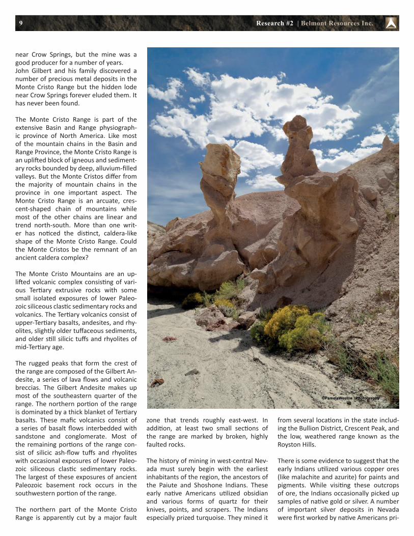
The Monte Cristo mountain range (see pictures below; source) was an active volcano millions of years ago. It is under-lain primarily by volcanic and sediment-ary rocks (between 24 and 11 million years old). The white and pink “tuff” is a rock composed of ash, crystals, rock fragments, and pumice violently erupted from a volcano. The grey green and brown andesite is from lava flows and the white bedded sandstone is volcan-ic debris. Erosion during the last several thousand years has sculpted the tuffs in-to unusual formations and shapes.
According to GeoZone:
The Monte Cristo Range is a cres-cent-shaped chain of highly eroded peaks located in the northernmost cor-ner of Esmeralda County, Nevada. This range of highly weathered and dissected peaks is bounded on the east and south by Big Smoky Valley and on the west by the Columbus Salt Marsh. To the north, the Monte Cristos gradually merge into a series of broken hills and peaks that rise up to form the Cedar Mountains. To the northwest, the Monte Cristos eventually give way to the loftier Pilot Mountains. The highest point in the Monte Cristo Range is Doyle Peak with an elevation of 7083 feet. In the heart of the range, the abandoned ruins of the mining camp of Gilbert still slumber. The boom town of Gilbert was appropriately placed and
Research #2 | Belmont Resources Inc.
Figure 6: Kibby Basin Property Well and Geothermal Map (after Oppliger, 2003)
The side of the “Amphitheater“ of the Monte Christo‘s Castle

8
aptly named for the Gilbert family. The Gilberts and the Monte Cristo Mountains will always be inextricably linked.
In 1896, John Gilbert and a fellow pros-pector discovered the rich Carrie lode on the rugged slopes of the Monte Cristo Range. (In some accounts of the story, Gilbert’s first name is listed as Herman.) A generation later, the Gilbert family dis-covered additional deposits of precious metals in the Monte Cristos. A small boom followed and the short-lived town of Gilbert sprang up near the mines. The Gilbert family certainly had mining in their blood. But the Gilberts were driv-en in their search for mineral wealth. They knew that somewhere in the rug-ged vastness of the Monte Cristo Range a fabulous lode of gold-bearing quartz was just lying at the surface.
In 1896, the mining industry of Nevada was in a virtual slump. Most of the early mining camps lay dormant and very few new discoveries had been made. Indeed, the single most important discovery of the 1890’s occurred 40 miles southwest of Pioche, in the Delamar Mountains. Pro-ducing over $15 million during its lifetime, the Delamar Mining District was the only bright spot in Nevada’s mining industry during the last 10 years of the century. Nevertheless, prospectors still combed the mountains and deserts of west-central Nevada in search of mineral wealth.
One of these prospectors was a man from Pahranagat Valley named Charles Lamp-son. While roaming the Monte Cristo Range near Crow Springs, Lampson stumbled up-on a chunk of extremely rich, gold-bear-ing float. The specimen consisted of clear quartz shot through with native gold. But try as he might, he just couldn’t find the source of the float. Eventually, he told his friend John Gilbert about the gold. Gilbert took one look at Lampson’s ore sample and spent the rest of his life searching for the lost vein. He eventually passed away in 1905. Charles Lampson returned to the Monte Cristos in the early 1920’s. In 1924, Lampson discovered an old marker that he had placed on a promising lead back in the 1890’s, nearly 30 years before! He chris-tened it the Last Hope Mine. The ore from the Last Hope was nowhere near as rich as the incredible specimen of float found
Research #2 | Belmont Resources Inc.
9
near Crow Springs, but the mine was a good producer for a number of years.John Gilbert and his family discovered a number of precious metal deposits in the Monte Cristo Range but the hidden lode near Crow Springs forever eluded them. It has never been found.
The Monte Cristo Range is part of the extensive Basin and Range physiograph-ic province of North America. Like most of the mountain chains in the Basin and Range Province, the Monte Cristo Range is an uplifted block of igneous and sediment-ary rocks bounded by deep, alluvium-filled valleys. But the Monte Cristos differ from the majority of mountain chains in the province in one important aspect. The Monte Cristo Range is an arcuate, cres-cent-shaped chain of mountains while most of the other chains are linear and trend north-south. More than one writ-er has noticed the distinct, caldera-like shape of the Monte Cristo Range. Could the Monte Cristos be the remnant of an ancient caldera complex?
The Monte Cristo Mountains are an up-lifted volcanic complex consisting of vari-ous Tertiary extrusive rocks with some small isolated exposures of lower Paleo-zoic siliceous clastic sedimentary rocks and volcanics. The Tertiary volcanics consist of upper-Tertiary basalts, andesites, and rhy-olites, slightly older tuffaceous sediments, and older still silicic tuffs and rhyolites of mid-Tertiary age.
The rugged peaks that form the crest of the range are composed of the Gilbert An-desite, a series of lava flows and volcanic breccias. The Gilbert Andesite makes up most of the southeastern quarter of the range. The northern portion of the range is dominated by a thick blanket of Tertiary basalts. These mafic volcanics consist of a series of basalt flows interbedded with sandstone and conglomerate. Most of the remaining portions of the range con-sist of silicic ash-flow tuffs and rhyolites with occasional exposures of lower Paleo-zoic siliceous clastic sedimentary rocks. The largest of these exposures of ancient Paleozoic basement rock occurs in the southwestern portion of the range.
The northern part of the Monte Cristo Range is apparently cut by a major fault
zone that trends roughly east-west. In addition, at least two small sections of the range are marked by broken, highly faulted rocks.
The history of mining in west-central Nev-ada must surely begin with the earliest inhabitants of the region, the ancestors of the Paiute and Shoshone Indians. These early native Americans utilized obsidian and various forms of quartz for their knives, points, and scrapers. The Indians especially prized turquoise. They mined it
from several locations in the state includ-ing the Bullion District, Crescent Peak, and the low, weathered range known as the Royston Hills.
There is some evidence to suggest that the early Indians utilized various copper ores (like malachite and azurite) for paints and pigments. While visiting these outcrops of ore, the Indians occasionally picked up samples of native gold or silver. A number of important silver deposits in Nevada were first worked by native Americans pri-
Research #2 | Belmont Resources Inc.

10
or to the arrival of the white man. These include Pioche, Pahranagat, White Pine, and Robinson.
Evidence for early Spanish mining activity in Nevada is less certain. Our best esti-mate places Spanish prospectors in south-ern Nevada by the late-1770’s. But they found very little gold or silver. Like all the other major precious metal deposits in the American Southwest, the Spaniards missed the big ones in Nevada too. The history of the West would have been quite different if the early Spaniards had stumbled onto the many great bonanzas lying north of the border. Incredible as it may seem, the Span-iards missed the vast goldfields of the Cal-ifornia Mother Lode, the Comstock silver lode, and the Cripple Creek gold deposits. They overlooked the massive ore bodies at Creede, Silverton, Rico, Elizabethtown, Superior, Globe, and Tombstone. The ear-ly Spaniards were the finest prospectors and miners of their day. It was quite un-characteristic of them to miss so many of the world’s great precious metal deposits.
It would be the intrepid American pros-pector who would eventually open up Nevada’s vast mineral deposits. Nevada is a haven for the prospector. The state has been blessed with three important mining booms during its history. Each has had a profound effect on the economy of the state and indeed of the whole world. The first mining boom began with the discov-ery of the fabulous Comstock Lode in 1859 and continued for more than 20 years. The second boom in Nevada mining hist-ory lasted from 1900 to about 1908 and included the Tonopah, Goldfield, Man-hattan, and Round Mountain strikes. The third mining boom began in 1987 and is continuing to this day. The incredible re-serves of the Carlin gold deposits have vaulted the state of Nevada to third place in world production.
The Monte Cristo Range is home to a very small mining district known variously as the Gilbert District and the Desert Dis-trict. Two types of precious metal deposits occur in the Monte Cristos, gold-bear-ing and silver-lead-bearing. The rich sil-ver-lead ores of the famous Carrie Mine were discovered by John Gilbert in 1896. Nearly 30 years later, the sons of John Gil-bert discovered additional precious metal
Above: Geothermal cluster centered on basin;Below: Gravity low (yellow) within the Kibby Basin Property (red) from Belmont
Research #2 | Belmont Resources Inc.
11
deposits in the heart of the range. A small gold rush ensued and the boom town of Gilbert sprang up near the mines. Unfortu-nately, the gold didn’t last. By 1932, the Gilbert District was dead.
Prospectors continued to roam the Monte Cristos throughout the 1930’s. Placer gold was recovered from the canyons and ar-royos that drain the northern slope of the range in 1935 and 1938. During the 1980’s, a small but rich pocket of ore yielded more than 10,000 ounces of gold! More recent-ly, turquoise has been mined in the area.
The Monte Cristo Range is literally sur-rounded by rich mining districts. From the crest of the range, near Doyle Peak, one can gaze southeastward across the Big Smoky Valley and see one of the greatest mining districts in North America. There, only 25 miles away, lies the famous silver and gold district, Tonopah. The Silver Peak District is located 35 miles straight south of the Monte Cristos, while the Candelaria silver lodes lie only 20 miles west of the range. Northwest of the Monte Cristos, the Pilot Mountains gradually rise up from the surrounding hills. Only 20 miles away, the Pilot Mountains are home to a num-ber of small gold mines and several rich turquoise deposits. Likewise, the Royston Hills District is also a source of excellent turquoise. Lying only 16 miles north of the Monte Cristo Range, the Royston Hills have been worked for centuries for their tur-quoise deposits. In 1921, a rich deposit of silver was discovered in the Royston Hills but the vein quickly petered out. Royston has slumbered since.
The Monte Cristo Range certainly has the potential for future strikes. Although the range has been heavily prospected, a small deposit of gold-bearing quartz could easi-ly have been overlooked by prospectors. Most accounts of Lampson’s lost gold vein places it somewhere in the vicinity of Crow Springs, on the northeastern edge of the range. Prospectors may want to concen-trate on this highly faulted area, particu-larly the fault zones separating the various rock types. Prospectors may also want to extend their search southwestward from Crow Springs, toward the Gilbert mining area. Once a source of rich gold-bearing deposits, the area may yet harbor addi-tional bodies of ore.
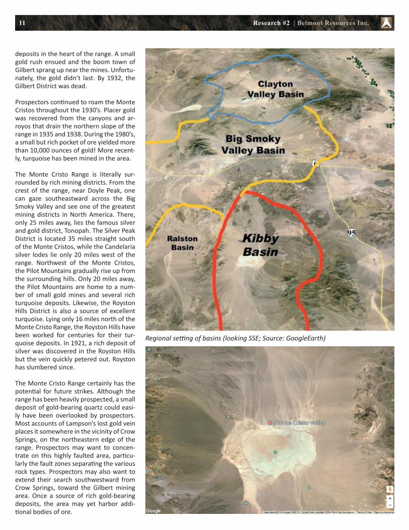
Regional setting of basins (looking SSE; Source: GoogleEarth)
Research #2 | Belmont Resources Inc.

12
Above left: Satellite image of the 3 lithium prospective basins Kibby Basin, Big Smoky Valley and Clayton Valley; Above right: Regional setting of the same area; Below: The Kibby Basin Property (red) from Belmont covers most of the Kibby Basin
Research #2 | Belmont Resources Inc.

13
MANAGEMENT
Vojtech Agyagos (President & Director)
Mr. Agyagos has more than 25 years of management and financial consulting experience and has served as an officer and director on numerous public companies since 1982. This experience has resulted in his managing of exploration projects in South America, Eastern Europe (Slovak Republic) in oil/gas and mineral exploration, and British Columbia, Quebec, Labrador and Ontario (Canada). Mr. Agyagos has served as President and Director of Belmont since December 1996.
Gary Musil(Secretary, CFO, Director)
Gary Musil has more than 30 years of management and financial consulting experience and has served as an officer and director on numerous public companies since 1988. This experience has resulted in his overseeing of financial aspects and expenditures on exploration projects in Peru, Chile, Eastern Europe (Slovak Republic), and British Columbia, Ontario, Quebec and New Brunswick (Canada). Prior to this, he was employed for 15 years with Dickenson Mines Ltd. and Kam-Kotia Mines Ltd. as a Controller for the producing silver/lead/zinc mine in the interior of British Columbia in Canada.
Jake Bottay(Director)
Jake Bottay is a graduate of Simon Fraser University, earning his Bachelor of Arts Degree in 1972. Since 1980, Mr. Bottay has been responsible for project co-ordination, financing, contract negotiations, audit committees and public relations with a number of junior exploration companies. While serving as a Director or Officer on numerous public companies, Mr. Bottay has gained valuable experience in doing business in South America, Europe and Canada.
Roger Agyagos(Director)
Mr. Agyagos has a Diploma in Management Systems from BCIT. Since 1995 he has been Vice President for a private BC company providing office
management and financial consulting services to various private and public companies. Mr. Agyagos assists with daily correspondence, office services, preparation of news releases and financial statements.
Dusan Berka(Director)
Mr. Berka (P.Eng.) has over 40 years of international business experience spanning Europe and the Americas with extensive experience in the finance, marketing and administration of public companies, having served as a Director and Officer of various public companies traded on the TSX, TSX Venture and NASDAQ exchanges. A graduate engineer with a M.Sc. (Dipl. Ing.) degree from Slovak Technical University, Bratislava, Slovakia (1968), Mr. Berka has been a member of the Association of Professional Engineers and Geoscientists of British Columbia since 1977.
ANALYST COVERAGE
Research #1: “Early Report on Belmont Resources” (April 13, 2016)
Belmont Resources Inc. (TSX.V: BEA; Frankfurt: L3L1) is an emerging resources company engaged in the acquisition, exploration and development of mineral properties; in Canada and USA. The company has recently entered into an property acquisition agreement to acquire 16 unpatented association placer mining claims, representing 1,036 hectares (the “Kibby Basin Project”) in the Monte Cristo Valley, Esmeralda County, Nevada, approximately 65 km north of Clayton Valley. Belmont has previously acquired 4 claim blocks comprising 2,252 hectares located within the Abitibi Harricana-Turgeon volcanic greenstone belt of Northwestern, Quebec. This belt hosts several world class deposits that have produced both gold and base metals. Belmont owns 12,841 hectares of uranium properties located in the Uranium City region of North Saskatchewan. Belmont is focused on the development of these projects through joint ventures, whereby Belmont recognizes exploration activity and minimizes cash commitments.
Research #2 | Belmont Resources Inc.

Vancouver Commodity ForumJune 14, 2016 at Hyatt Regency Hotel in Vancouver
Click Here to Register
Exhibitors:
92 Resources Corp. (TSX.V: NTY; Frankfurt: R9G2)ALX Uranium Corp. (TSX.V: AL; Frankfurt: 6LLN)Arctic Star Exploration Corp. (TSX.V: ADD; Frankfurt: 82A)Belmont Resources Inc. (TSX.V: BEA; Frankfurt: L3L1)Commerce Resources Corp. (TSX.V: CCE; Frankfurt: D7H)Canadian Zeolite Corp. (TSX.V: CNZ ; Frankfurt: ZEON)Copper North Mining Corp. (TSX.V: COL; Frankfurt: 79M)Dunnedin Ventures Inc. (TSX.V: DVI; Frankfurt: 5DD)Electra Stone Ltd. (TSX.V: ELT; Frankfurt: 44E1)Equitas Resources Corp. (TSX.V: EQT; Frankfurt: T6UN)MGX Minerals Inc. (CSE: XMG; Frankfurt: 1MG)Group Ten Metals Inc. (TSX.V: PGE; Frankfurt: 5D31)Nickel One Resources Inc. (TSX.V: NNN; Frankfurt: 7N1)Scandium Int. Mining Corp. (TSX.V: SCY; Frankfurt: 0E6)True Leaf Medicine Int. Ltd. (CSE: MJ; Frankfurt: TLA)Umbral Energy Corp. (CSE: UMB; Frankfurt: 2UE)Vatic Ventures Corp. (TSX.V: VCV.H)Voltaic Minerals Corp. (TSX.V: VLT; Frankfurt: 2P61)Zimtu Capital Corp. (TSX.V: ZC; Frankfurt: ZCT1)
Program:
12:00 pm: Exhibitor floor opens
1:00 pm: Welcome from Dave Hodge, President of Zimtu Capital Corp.
1:10 pm: Participant company introductions by Dave Hodge and Sven Olsson
1:30 pm: Joe Martin (Cambridge House International): The difference between exploration and mining, and the importance of Vancouver
1:40 pm: John Kaiser (Kaiser Researcb Online): “Criticality of Supply” and how it effects world prices, demand, and the ability to use that to your advantage in the market place
2:10 pm: BREAK - Networking with refreshments
3:00 pm: Stephan Bogner (Rockstone Research): How European markets impact Canadian markets
3:20 pm: John Hykawy (Stormcrow Capital): Demand & Pricing for lithium, cobalt and other battery materials
3:50 pm: Chris Berry (Disruptive Discoveries Journal): The future of lithium
4:30-6:00 pm: Networking Session with refreshments

15
Disclaimer and Information on Forward Looking Statements:All statements in this report, other than state-ments of historical fact should be considered forward-looking statements. Much of this re-port is comprised of statements of projection. Statements in this report that are forward looking include that Belmont Resources Inc. or any other company or market will perform as expected; that Belmont Resources Inc. will complete the recently announced Kibby Basin Property transaction; that Belmont Re-sources Inc. or its partner(s) can and will start producing and selling any kinds of products; that the company can raise sufficient funds for a transaction, exploration and corporate matters; that any of the mentioned plans, comparisons with other companies, regions or numbers are valid or economic. Such state-ments involve known and unknown risks, un-certainties and other factors that may cause actual results or events to differ materially from those anticipated in these forward-look-ing statements. Risks and uncertainties re-specting lithium and resource companies are generally disclosed in the annual financial or other filing documents of Belmont Resources Inc. and similar companies as filed with the relevant securities commissions, and should be reviewed by any reader of this report. In addition, with respect to Belmont Resources Inc., a number of risks relate to any statement of projection or forward statements, includ-ing among other risks: the receipt of all ne-cessary approvals and permits; the ability to conclude a transaction to start or continue exploration; uncertainty of future market regulations, capital expenditures and other costs; financings and additional capital re-quirements for exploration, development, construction, and operating of a facility; the receipt in a timely fashion of further per-mitting for its legislative, political, social or economic developments in the jurisdictions in which Belmont Resources Inc. carries on business; operating or technical difficulties in connection with production or development activities; the ability to keep key employees, joint-venture partner(s), and operations fi-nanced. There can be no assurance that such statements will prove to be accurate, as ac-tual results and future events could differ materially from those anticipated in such statements. Accordingly, readers should not place undue reliance on forward-looking in-formation. Rockstone and the author of this report do not undertake any obligation to update any statements made in this report.
Disclosure of Interest and Advisory Cautions: Nothing in this report should be construed as a solicitation to buy or sell any securities mentioned. Rockstone, its owners and the author of this report are not registered broker-dealers or financial advisors. Before investing in any securities, you should consult with your financial advisor and a registered broker-dealer. Never make an investment based solely on what you read in an online or printed report, including Rockstone’s report, especially if the investment involves a small, thinly-traded company that isn’t well known. The author of this report is paid by Zimtu Capital Corp., a TSX Venture Exchange listed investment company. Part of the author’s responsibilities at Zimtu is to research and report on companies in which Zimtu has an investment. So while the author of this report is not paid directly by Belmont Resources Inc., the author’s employer Zimtu will benefit from appreciation of Belmont Resources Inc.’s stock price. The author also owns shares of Belmont Resources Inc. and Zimtu Capital Corp. and thus would also benefit from volume and price appreciation of its stocks. Thus, multiple conflicts of interests exist. Therefore, the information provided herewithin should not be construed as a financial analysis or recommendation but as advertisement. The author’s views and opinions regarding the companies featured in reports are his own views and are based on information that he has researched independently and has received, which the author assumes to be reliable. Rockstone and the author of this report do not guarantee the accuracy, completeness, or usefulness of any content of this report, nor its fitness for any particular purpose. Belmont Resources Inc.has not reviewed the content of this report prior to publication. Lastly, the author does not guarantee that any of the companies mentioned in the reports will perform as expected, and any comparisons made to other companies may not be valid or come into effect.
Please read the entire Disclaimer carefully. If you do not agree to all of the Disclaimer, do not access this website or any of its pages including this report in form of a PDF. By using this website and/or report, and whether or not you actually read the Disclaimer, you are deemed to have accepted it. Information provided is educational and general in nature.
Analyst Profile and Contact
Stephan Bogner (Dipl. Kfm. FH)Mining Analyst Rockstone Research 8050 Zurich, [email protected]
Stephan Bogner studied at the International School of Management (Dortmund, Germany), the European Business School (London)
and the University of Queensland (Brisbane, Australia). Under supervision of Prof. Dr. Hans J. Bocker, Stephan completed his diploma thesis (“Gold In A Macroeconomic Context With Special Consideration Of The Price Formation Process”) in 2002. A year later, he marketed and translated into German Ferdinand Lips‘ bestseller („Gold Wars“). After working in Dubai for 5 years, he now lives in Switzerland and is the CEO of Elementum International AG specialized in duty-free storage of gold and silver bullion in a high-security vaulting facility within the St. Gotthard Mountain Massif in central Switzerland.
Rockstone is a research house specialized in the analysis and valuation of capital markets and publicly listed companies. The focus is set on exploration, development, and production of resource deposits. Through the publication of general geological basic knowledge, the individual research reports receive a background in order for the reader to be inspired to conduct further due diligence. All research from our house is being made accessible to private and institutional investors free of charge, whereas it is always to be construed as non-binding educational research and is addressed solely to a readership that is knowledgeable about the risks, experienced with stock markets, and acting on one’s own responsibility.
For more information and sign-up for free newsletter, please visit:
www.rockstone-research.com
Research #2 | Belmont Resources Inc.