data audit and gap analysis - nsw environment protection authority
TRANSCRIPT
WESTERN DATA AUDIT ANDGAP ANALYSIS
WESTERN REGION
NSW NATIONAL PARKS AND WILDLIFESERVICE
A project undertaken as part of theWestern Regional Assessment
project number WRA 02
For more information and for information on access to data contact the:
Resource and Conservation Division, Department of Urban Affairs and Planning
GPO Box 3927SYDNEY NSW 2001
Phone: (02) 9228 3166Fax: (02) 9228 4967
© Crown copyright October 1999New South Wales Government
Published by: Resource and Conservation Assessment Council
ISBN 1 74029 111 5
This project has been funded by the New South Wales Government and managed through the Resource andConservation Division, Department of Urban Affairs and Planning.
The project has been overseen and the methodology has been developed through the Western Data Audit and GapAnalysis Project Team which includes representatives from the Department of Urban Affairs and Planning, NationalParks and Wildlife Service, Department of Mineral Resources, Department of Land and Water Conservation and StateForests. The project and subsequent report were coordinated and managed by Ed Knowles with support from DavidCoote, Leonne Donnelly and Gary Saunders (NSW National Parks and Wildlife Service).
DisclaimerWhile every reasonable effort has been made to ensure that this document is correct at the time of printing, the State ofNew South Wales, its agents and employees do not assume any responsibility and shall have no liability, consequentialor otherwise, of any kind, arising from the use of or reliance on any of the information contained in this document.
CONTENTSEXECUTIVE SUMMARY v
1. INTRODUCTION........................................................................................................ 11.1 BACKGROUND....................................................................................................... 11.2 AIMS ........................................................................................................................ 21.3 STUDY AREA.......................................................................................................... 21.4 PROJECT MANAGEMENT...................................................................................... 2
2. METHODS.................................................................................................................. 42.1 BASE DATA LAYERS............................................................................................. 42.2 DATA AUDIT .......................................................................................................... 4
2.2.1 Key Contacts......................................................................................... 52.2.2 Universities............................................................................................ 52.2.3 Advertisement ....................................................................................... 52.2.4 Literature Search................................................................................... 52.2.5 NSW Natural Resources Data Directory................................................. 6
2.3 DATA CAPTURE..................................................................................................... 62.4 GAP ANALYSIS ...................................................................................................... 62.5 PROJECT WORKSHOP ........................................................................................... 7
3. RESULTS.................................................................................................................... 93.1 DATA AUDIT .......................................................................................................... 93.2 DATA CAPTURE................................................................................................... 10
3.2.1 Data Entry........................................................................................... 103.2.2 Digitising ............................................................................................. 103.2.3 Metadata ............................................................................................. 10
3.3 GAP ANALYSIS .................................................................................................... 103.3.1 Land ................................................................................................... 113.3.2 Heritage .............................................................................................. 113.3.3 Flora ................................................................................................... 113.3.4 Vegetation........................................................................................... 123.3.5 Fauna .................................................................................................. 133.3.6 Geoscience.......................................................................................... 143.3.7 Photography and Imagery..................................................................... 15
3.4 PROJECT WORKSHOP ......................................................................................... 15
4. DISCUSSION............................................................................................................ 164.1 DATA AUDIT ........................................................................................................ 164.2 DATA CAPTURE................................................................................................... 184.3 GAP ANALYSIS .................................................................................................... 184.4 PROJECT WORKSHOP ......................................................................................... 18
5. RECOMMENDATIONS............................................................................................ 195.1 DATA REQUIREMENTS ....................................................................................... 195.2 FUTURE SCOPING................................................................................................ 215.3 DATA MANAGEMENT ......................................................................................... 21
6. CONCLUSION ......................................................................................................... 25
APPENDICES.................................................................................................................. 26APPENDIX 1. METADATA....................................................................................... 26
Appendix 1a. Tenure. ............................................................................................... 26Appendix 1b. Murray Darling Basin Structural Vegetation........................................... 29Appendix 1c. SPOT Multispectral.............................................................................. 32Appendix 1d. Eastern Bushland Database .................................................................. 36Appendix 1e. Vegetation Mapping of the NSW Wheat-belt ......................................... 39Appendix 1f. Atlas of NSW Wildlife.......................................................................... 42
APPENDIX 2. ADVERTISEMENT ............................................................................ 44APPENDIX 3. SEARCHABLE LITERATURE DATABASES .................................... 45APPENDIX 4. ANZLIC METADATA STANDARD PROFORMA............................. 46APPENDIX 5. WORKSHOP HANDOUTS................................................................. 49APPENDIX 6. DATA LAYERS.................................................................................. 54APPENDIX 7. FAUNA SIGHTINGS BY CLASS........................................................ 57
Appendix 7a. Amphibians.......................................................................................... 57Appendix 7b. Birds ................................................................................................... 57Appendix 7c. Mammals ............................................................................................ 58Appendix 7d. Reptiles ............................................................................................... 58
APPENDIX 8. WORKSHOP SESSION RESULTS ..................................................... 59APPENDIX 9. ADDITIONAL MAJOR DATA SETS ................................................. 63APPENDIX 10. EXISTING DATA RELATED INITIATIVES ...................................... 64
Appendix 10a. National Land and Water Resources Audit ............................................ 64Appendix 10b. NSW Natural Resources Data Directory............................................... 64Appendix 10c. NSW Metadata Working Group ............................................................ 64Appendix 10d. NSW State Mapping Advisory Committee ............................................. 65Appendix 10e. Inter-governmental Committee on Surveying and Mapping...................... 65Appendix 10f. NSW Natural Resources Information Management Strategy................... 65Appendix 10g. Integrated Community Mapping and Information Support System............ 65Appendix 10h. Australian and New Zealand Land Information Council .......................... 65Appendix 10i. Community Access to Natural Resource Information ............................. 66Appendix 10j. NSW State Biodiversity Strategy........................................................... 66Appendix 10k. Architecture for Access to Government Information .............................. 66Appendix 10l. Discovery 2000.................................................................................... 66Appendix 10m. Western Lands Review ........................................................................ 66Appendix 10n. Protocol on the quality and usefulness of vegetation survey and mapping datasets 66Appendix 10o. Preparation of Guidelines for Vegetation Survey and Mapping ................ 67Appendix 10p. Classification of the plant communities of New South Wales and assessment of their
conservation and threat status. ............................................................. 67APPENDIX 11. EXPENDITURE AT APRIL 1999........................................................ 69
FIGURE 1. AREA COVERED BY THE WESTERN DATA AUDIT AND GAP ANALYSIS PROJECT ........................2FIGURE 2. FLORA RECORDS PER 1:100 000 MAP SHEET IN THE ATLAS OF NSW WILDLIFE........................12FIGURE 3. FAUNA RECORDS PER 1:100 000 MAP SHEET IN THE ATLAS OF NSW WILDLIFE. ......................14FIGURE 4. THE SIMPLE SEARCH PAGE FOR THE NSW NATURAL RESOURCES DATA DIRECTORY. ............18
PROJECT SUMMARY
The Western Data Audit and Gap Analysis Project was aimed initially at auditing existing data and determininggaps in the data required for an assessment to be made, leading to a Regional Forestry Agreement, in areas ofthe State not already covered by a Comprehensive Regional Assessment. During the early stages of the Projectit emerged that the Comprehensive Regional Assessment methods used in the eastern regions of New SouthWales would not be suited to western New South Wales due to significant differences in environmental andsocial conditions.
A number of major environmental planning processes requiring similar data are under way or have beencompleted in western New South Wales. The existence of these planning processes and the differences in datarequirements from an eastern Comprehensive Regional Assessment were realised early in the project and weretaken into consideration when fulfilling the Project aims and objectives. The original objectives were broadenedto encompass data required for regional planning in western New South Wales. The Resource andConservation Division, Department of Urban Affairs and Planning are currently developing a draft strategy forthe Western Regional Assessment.
The Project aimed to increase awareness of the nature and quality of existing information in western New SouthWales by undertaking a widespread search of and providing metadata on digital information. Metadatasummarises the properties of a data set, giving the user enough information to decide if the data is suitable fortheir needs or to provide an explanation of the content of the data received. All New South Wales metadata willbe located on the NSW Natural Resources Data Directory. This information can be accessed via the Internet atwww.nrims.nsw.gov.au. The NSW Natural Resources Data Directory will also enable information to be easilyupdated or added to by data custodians.
The project’s data audit and gap analysis revealed significant shortfalls in existing information. The projectfound that all existing base data layers possess at least one of the following:
n a lack of complete coverage across the region
n inconsistent methods used for the collection of similar data types
n variable or unknown reliability
n bias in collection locations
In fulfilling the project’s aim of capturing base data, all relevant flora and fauna information gathered wasentered into the Atlas of NSW Wildlife. This included information from published reports, environmental impactstatements, theses and personal collections.
Included in the project report are the following recommendations: DATA REQUIREMENTS That the following potential base data layers are developed for use in regional planning: n A current tenure and administrative layer
n A digital elevation model
n Aboriginal cultural information at the landscape level and cultural heritage sites
n A comprehensive and uniform vegetation layer derived from structural and floristic data
n Systematic and targeted survey of fauna and flora
n Autecological studies of targeted fauna and flora
n Up-to-date and uniform geology and soils layer
n Up-to-date and uniform metallic minerals, industrial minerals and occurrences
n Up-to-date and uniform construction materials occurrences
n Up-to-date and uniform wood resources information
n Current satellite imagery
n Current and historical land use
n Disturbance history
n Ground water and surface water quality and quantity
n Salinity and flood mapping
FUTURE SCOPING That scoping exercises be carried out, as part of the approved Western Regional Assessment Strategy, toidentify Stakeholders, relevant issues, standard methods and data layers required for regional planning. DATA MANAGEMENT That data be managed to maximise its availability to the community and agencies by ensuring that: n a Western Regional Assessment Data Management Working Group be established
n all current herbaria specimens are databased and investigate linking these
n all base data collected in the future be entered into the relevant database
n existing and proposed projects provide metadata to the NSW Natural Resources Data Directory
These recommendations could be used to guide the Western Regional Assessment Strategy. Somerecommendations could be implemented in the near future with minimal additional expenditure, whilst others willrequire a commitment of significant resources to provide the necessary base data layers.
1. INTRODUCTION
1.1 BACKGROUND
The Western Data Audit and Gap Analysis Project was aimed initially at auditing existing available data anddetermining data requirements for a Comprehensive Regional Assessment for forests in western New SouthWales. As time progressed, it became apparent that adopting Comprehensive Regional Assessment methodsused in the eastern regions of the State would not be suited to western New South Wales due to the: n differences in the threatening processes present
n differences in types of land ownership
n current low level of reservation
n need to address Aboriginal cultural heritage
n nature and variety of potential Stakeholder groups
n need to assist in addressing other resource allocation issues and
n lack of a requirement for a Regional Forest Agreement
A number of major environmental planning processes requiring similar resource data are underway or have beencompleted in western New South Wales. It was therefore considered that the Western Regional Assessmentwas more likely to provide information and assist these planning processes. Consequently the Project Teamopted to broaden the range of issues which would be encompassed by this project. When fulfilling the aims and objectives of the Project, the absence of an agreed framework for a WesternRegional Assessment, the presence of these planning processes and the different data requirements for westernNew South Wales were taken into consideration by the Project Team. The Resource and Conservation Divisionof the Department of Urban Affairs and Planning is currently developing a draft strategy for the WesternRegional Assessment. It is important to stress that the recommendations contained in this report focus on the base data layers. Whenthe Western Regional Assessment strategy is finalised, further workshops may be needed to determineadditional data required by end users of the Western Regional Assessment. Without suitable base data layers,additional information is difficult to generate or is of very little use in a regional planning context.
1.2 AIMS
The aim of the project was to:
Provide advice to government on information required for regional planning in western New South Wales.
The project consisted of the following objectives: n comprehensive data audit of existing information
n capture of base data layers by digitising and data entry of existing information
n analysis of the gaps in the existing information which needed to be filled prior to a comprehensive regionalassessment
The Project aimed to increase awareness of all forms of existing information by undertaking a widespreadsearch and providing relevant metadata statements. Metadata can simply be explained as data about data in astructured form. Accepted standards for storing metadata have been defined by the Australian and NewZealand Land Information Council. With centralised metadata, all information is accounted for in one database,without any of the issues associated with physically storing the actual data layers. Metadata from this projectwill enable users to find information on data and is easily accessed by all interested persons via the Internet andcan be easily added or updated to by data custodians.
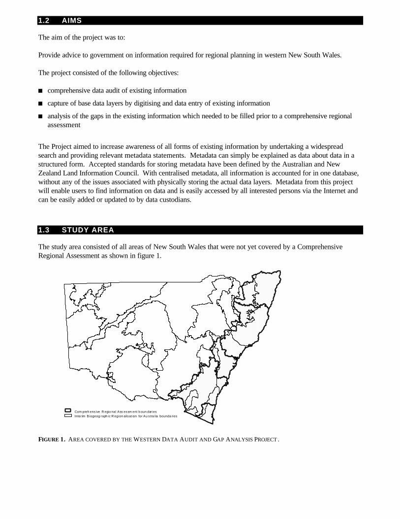
1.3 STUDY AREA
The study area consisted of all areas of New South Wales that were not yet covered by a ComprehensiveRegional Assessment as shown in figure 1.
FIGURE 1. AREA COVERED BY THE WESTERN DATA AUDIT AND GAP ANALYSIS PROJECT .
Com preh ensive R egio nal Ass essm ent b oun dar iesInter im Biogeog raph ic R egion alisat ion for Au stra lia bounda ries
1.4 PROJECT MANAGEMENT
A Project Team consisting of representatives from the Department of Urban Affairs and Planning, NSWNational Parks and Wildlife Service, State Forests of NSW, Department of Land and Water Conservation andthe Department of Mineral Resources oversaw the project. The Project proposal identified that the role of the Project Team was to: n set standards for data capture and storage
n ensure that end user needs be taken into consideration
n provide direction and guidance for prioritising the data audit
n ensure the collaboration of information custodians
n review the progress of the project
n ensure the completed project provides all Stakeholders with the collated information in a useable form
The Resource and Conservation Assessment Council provided funding for the Project. This funding wasallocated to the NSW National Parks and Wildlife Service who provided a Project Manager to assist the ProjectTeam.
2.METHODS
2.1 BASE DATA LAYERS
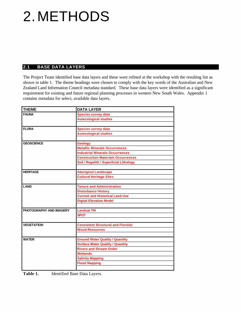
The Project Team identified base data layers and these were refined at the workshop with the resulting list asshown in table 1. The theme headings were chosen to comply with the key words of the Australian and NewZealand Land Information Council metadata standard. These base data layers were identified as a significantrequirement for existing and future regional planning processes in western New South Wales. Appendix 1contains metadata for select, available data layers. THEME DATA LAYERFAUNA Species survey data
Autecological studies
FLORA Species survey dataAutecological studies
GEOSCIENCE GeologyMetallic Minerals OccurrencesIndustrial Minerals OccurrencesConstruction Materials OccurrencesSoil / Regolith / Superficial Lithology
HERITAGE Aboriginal LandscapeCultural Heritage Sites
LAND Tenure and AdministrationDisturbance HistoryCurrent and Historical Land UseDigital Elevation Model
PHOTOGRAPHY AND IMAGERY Landsat TMSPOT
VEGETATION Consistent Structural and FloristicWood Resources
WATER Ground Water Quality / QuantitySurface Water Quality / QuantityRivers and Stream OrderWetlandsSalinity MappingFlood Mapping
Table 1. Identified Base Data Layers.
2.2 DATA AUDIT
The Western Data Audit and Gap Analysis Project used a range of methods to locate existing information fromnumerous data sources. This ensured that as many data sources as possible, from both government and thecommunity, could be contacted. The information that was most relevant to the project was data that would needto be converted into digital form to make it more accessible to end-users.
2.2.1 Key Contacts A contact spreadsheet was constructed in order to track potential data holders. The list included representativesfrom state government, local government, universities, conservation groups, environmental consultants andindividuals with specialist knowledge. This was compiled from various sources, including the: n NSW National Parks and Wildlife Service Community Relations Database
n NSW National Parks and Wildlife Service Wildlife Atlas Data Licence Database
n Threatened Species Conservation Flora and Fauna Consultants Register
n ‘Greenguide’
n Telstra Yellow Pages
2.2.2 Universities In order to gain access to data contained in Honours, Masters and Doctors of Philosophy theses held atuniversities, a project staff member visited the University of Sydney, Macquarie University and the University ofNew South Wales. University academics and other staff members in the departments of biology, zoology,botany and geography were interviewed about their own research and that of previous students. Potentiallyuseful theses were obtained from school libraries or restricted collections and where possible, any relevant datawere photocopied and the methods and author noted. Other universities within New South Wales werecontacted to obtain any information they possessed.
2.2.3 Advertisement An advertisement entitled ‘Call for public contributions to the Atlas of NSW Wildlife’ was placed in thefollowing regional newspapers: n Albury Border Mail n Broken Hill Truth n Condobolin Lachlander
n Country Leader n Dubbo Daily Liberal n Hay Riverina Grazier
n Hillston Ivanhoe Spectator n North West Magazine n Northern Daily Leader
n Rural News n Sunraysia Daily n The Land
n Wagga Daily Advertiser n Western Magazine
The advertisements contained a request for contributions of site specific flora or fauna species records, as wellas other wildlife related information in the form of notebooks, species lists or unpublished reports. A copy of theadvertisement is contained in appendix 2. As a consequence of the advertisements, interviews for the purpose of promoting the data audit process wererequested by ABC Regional Radio. A member of the NSW National Parks and Wildlife Service - Wildlife DataUnit gave the interview which explained the project, the use of the Atlas of NSW Wildlife and encouragedpeople with information to contact the data audit staff.
2.2.4 Literature Search Literature used to obtain records included Environmental Impact Statements, Review of Environmental Factors,academic theses and species lists from the Department of Land and Water Conservation clearing applicationassessments. Any flora and fauna data found in published literature from the literature search were entered intothe NSW Wildlife Atlas. Numerous databases exist that can be searched for topics related to the environment. The National Library ofAustralia carried out a search for articles relating to fauna and flora in Western NSW. This was unable to befinalised due to the very broad nature of the request. However, these databases may be very beneficial for aspecific search. A list of some of the relevant databases able to be searched is given in appendix 3.
2.2.5 NSW Natural Resources Data Directory The NSW Natural Resources Data Directory was searched using the following key words: n ecology n fauna
n flora n forests
n land n vegetation
The output was then crosschecked against known information. When potentially suitable data were identified,an attempt was made to obtain the information.
2.3 DATA CAPTURE
Data considered important to regional planning, where possible, were captured in digital form through data entry,digitising or the preparation of metadata. Hardcopy data such as photocopied species lists were entered into an Excel spreadsheet before being enteredinto the Atlas of NSW Wildlife. Spelling and naming checks were performed by checking each data set againsteither the Census of Australian Plants or the Census of Australian Vertebrates and then with expert NSWNational Parks and Wildlife Service staff. Data sets that had been provided digitally were formatted for ease ofentry into the Atlas of NSW Wildlife. Suitable data in map form were digitised into a Geographic Information System. Reference coordinates weremarked manually from map sheets, before being digitised. Digitised maps were checked for continuity withadjacent maps. Metadata statements were created to the Australian and New Zealand Land Information Council standards asper appendix 4. Local knowledge and information gained from examination of the data sets were used tocompile the metadata.
2.4 GAP ANALYSIS
When the framework of the Western Regional Assessment is finalised, more specific data layers andinformation may be required for certain projects. Themes about which further data may be required includesocio-economic, salinity, groundwater, artesian bore sites and the like. Existing data sets for each of the base data layers were assessed to determine their usefulness for regionalplanning purposes. Information outside the base data layers or of limited coverage was given a lower prioritythan information that contributed to a base data layer. For the existing regional data layers, all relevant data were identified by the project and reviewed for theirusefulness to regional planning by the Project Team and other relevant experts. Gaps in the base data layers for western New South Wales and within each bioregion were then identified.Recommendations were then made in order to fill these identified gaps. Should the Resource and Conservation Assessment Council accept these recommendations detailed projectproposals to fill these gaps would then need to be developed to determine the likely methodology and costs ofindividual projects.
2.5 PROJECT WORKSHOP
A workshop was held on Monday 3rd May 1999. The following organisations where invited to attend:
n Department of Land and Water Conservation n Department of Aboriginal Affairs*
n Department of State and Regional Development* n Department of Mineral Resources
n Environmental Protection Authority* n NSW Fisheries*
n Local Government and Shires Association n Macquarie University
n National Parks Association n National Parks and Wildlife Service
n Department of Urban Affairs and Planning n NSW Agriculture
n State Forests of New South Wales n Royal Botanic Gardens Sydney
n Forest Products Association n Australian Museum
(*) Absent.
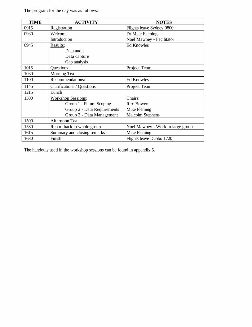
The program for the day was as follows:
TIME ACTIVITY NOTES0915 Registration Flights leave Sydney 08000930 Welcome
IntroductionDr Mike FlemingNoel Mawbey - Facilitator
0945 Results:Data auditData captureGap analysis
Ed Knowles
1015 Questions Project Team1030 Morning Tea1100 Recommendations: Ed Knowles1145 Clarifications / Questions Project Team1215 Lunch1300 Workshop Sessions:
Group 1 - Future ScopingGroup 2 - Data RequirementsGroup 3 - Data Management
Chairs:Rex BowenMike FlemingMalcolm Stephens
1500 Afternoon Tea1530 Report back to whole group Noel Mawbey - Work in large group1615 Summary and closing remarks Mike Fleming1630 Finish Flights leave Dubbo 1720
The handouts used in the workshop sessions can be found in appendix 5.
3.RESULTS
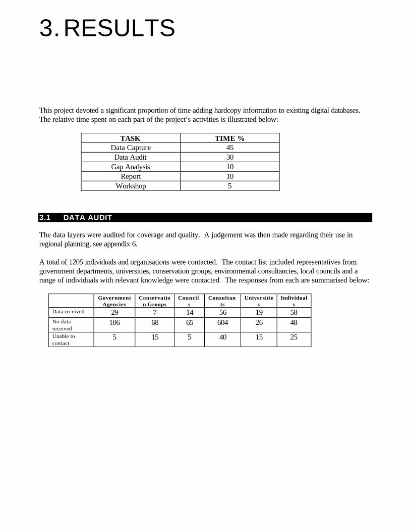
This project devoted a significant proportion of time adding hardcopy information to existing digital databases.The relative time spent on each part of the project’s activities is illustrated below:
TASK TIME % Data Capture 45 Data Audit 30
Gap Analysis 10 Report 10
Workshop 5
3.1 DATA AUDIT
The data layers were audited for coverage and quality. A judgement was then made regarding their use inregional planning, see appendix 6. A total of 1205 individuals and organisations were contacted. The contact list included representatives fromgovernment departments, universities, conservation groups, environmental consultancies, local councils and arange of individuals with relevant knowledge were contacted. The responses from each are summarised below:
GovernmentAgencies
Conservation Groups
Councils
Consultants
Universities
Individuals
Data received 29 7 14 56 19 58 No datareceived
106 68 65 604 26 48
Unable tocontact
5 15 5 40 15 25
3.2 DATA CAPTURE
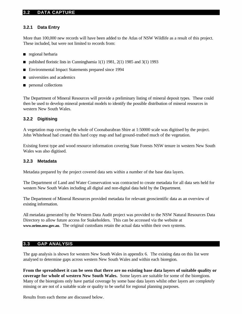
3.2.1 Data Entry More than 100,000 new records will have been added to the Atlas of NSW Wildlife as a result of this project.These included, but were not limited to records from: n regional herbaria
n published floristic lists in Cunninghamia 1(1) 1981, 2(1) 1985 and 3(1) 1993
n Environmental Impact Statements prepared since 1994
n universities and academics
n personal collections
The Department of Mineral Resources will provide a preliminary listing of mineral deposit types. These couldthen be used to develop mineral potential models to identify the possible distribution of mineral resources inwestern New South Wales.
3.2.2 Digitising A vegetation map covering the whole of Coonabarabran Shire at 1:50000 scale was digitised by the project.John Whitehead had created this hard copy map and had ground-truthed much of the vegetation. Existing forest type and wood resource information covering State Forests NSW tenure in western New SouthWales was also digitised.
3.2.3 Metadata
Metadata prepared by the project covered data sets within a number of the base data layers.
The Department of Land and Water Conservation was contracted to create metadata for all data sets held forwestern New South Wales including all digital and non-digital data held by the Department. The Department of Mineral Resources provided metadata for relevant geoscientific data as an overview ofexisting information. All metadata generated by the Western Data Audit project was provided to the NSW Natural Resources DataDirectory to allow future access for Stakeholders. This can be accessed via the website atwww.nrims.nsw.gov.au. The original custodians retain the actual data within their own systems.
3.3 GAP ANALYSIS
The gap analysis is shown for western New South Wales in appendix 6. The existing data on this list wereanalysed to determine gaps across western New South Wales and within each bioregion. From the spreadsheet it can be seen that there are no existing base data layers of suitable quality orcoverage for whole of western New South Wales. Some layers are suitable for some of the bioregions.Many of the bioregions only have partial coverage by some base data layers whilst other layers are completelymissing or are not of a suitable scale or quality to be useful for regional planning purposes. Results from each theme are discussed below.
3.3.1 Land The project identified shortfalls in the type and extent of information about land ownership. It is proposed thatfuture land tenure data layers include information about land ownership, mining tenure, current reserves,administrative boundaries, zoning status, property agreements and conservation agreements. All line-workshould be based upon the digital cadastre. The GEODATA 9-Second Digital Elevation Model gives the only consistent cover of western New SouthWales. With a cell size of approximately 250m, its use in regional planning is limited. For a Digital ElevationModel to be useful for use in regional planning it needs to have at least 100m resolution, although 50m or even25m would be ideal.
3.3.2 Heritage The Aboriginal Sites Register records known Aboriginal relics and Aboriginal places. Whilst the Register coversthe whole State, it contains only site specific records. The register lacks information about how its records fitinto a broader landscape context. The data contained in the Register is biased to some extent by factors such asaccessibility and areas subject to development assessment such as proposed mines, roads and pipelines. Someof the information held is confidential, and can not be used by the general public. No systematic collection ormodelling of information about Aboriginal Heritage across western New South Wales has occurred. The State Heritage Inventory lists identified non-indigenous and Aboriginal heritage items from various statutorysources. The State Heritage Register lists those items of state significance. There has been no systematicassessment of heritage items across western New South Wales. The National Estate Register also lists identified non-indigenous and Aboriginal heritage items although againthere has been no systematic assessment of heritage items across western New South Wales.
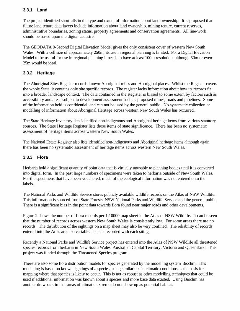
3.3.3 Flora Herbaria hold a significant quantity of point data that is virtually unusable to planning bodies until it is convertedinto digital form. In the past large numbers of specimens were taken to herbaria outside of New South Wales.For the specimens that have been vouchered, much of the ecological information was not entered onto thelabels. The National Parks and Wildlife Service stores publicly available wildlife records on the Atlas of NSW Wildlife.This information is sourced from State Forests, NSW National Parks and Wildlife Service and the general public.There is a significant bias in the point data towards flora found near major roads and other developments. Figure 2 shows the number of flora records per 1:10000 map sheet in the Atlas of NSW Wildlife. It can be seenthat the number of records across western New South Wales is consistently low. For some areas there are norecords. The distribution of the sightings on a map sheet may also be very confined. The reliability of recordsentered into the Atlas are also variable. This is recorded with each siting. Recently a National Parks and Wildlife Service project has entered into the Atlas of NSW Wildlife all threatenedspecies records from herbaria in New South Wales, Australian Capital Territory, Victoria and Queensland. Theproject was funded through the Threatened Species program. There are also some flora distribution models for species generated by the modelling system Bioclim. Thismodelling is based on known sightings of a species, using similarities in climatic conditions as the basis formapping where that species is likely to occur. This is not as robust as other modelling techniques that could beused if additional information was known about a species and more base data existed. Using Bioclim hasanother drawback in that areas of climatic extreme do not show up as potential habitat.
FIGURE 2. FLORA RECORDS PER 1:100 000 MAP SHEET IN THE ATLAS OF NSW WILDLIFE.
3.3.4 Vegetation Existing maps Differing standards may be necessary according to the scale and purpose of mapping. For example regionalplanning, property planning and fire management planning will all require different standards of mapping. TheNational Land and Water Resources Audit has provided funding for developing standards and protocols forupgrading and updating the M305 structural vegetation layer. Work is also underway to develop consistentmethods for vegetation mapping across New South Wales.
Western New South Wales is partially covered by a number of vegetation data sets.
The largest data set in spatial extent and data available is from the Murray Darling Basin Vegetation MappingProject, also known as M305. It consists of structural vegetation data and woody / non-woody data layers.With the structural vegetation data, the mapping units may represent attributes on the ground however somepreliminary investigations have revealed inconsistencies. The floristic information for the whole data set requiresfurther work to validate it. Work is being done to develop a methodology to reduce the numerous structural vegetation categories to auseable number for regional planning purposes. The data is currently being used inconsistently across westernNew South Wales for Regional Vegetation Management Plan vegetation maps, as it is the best available datawhere required, more detailed mapping has not occurred. The NSW National Parks and Wildlife Service has produced and is currently producing a series of vegetationmaps across the wheat belt of central New South Wales. This does not cover the whole of western New SouthWales and maps woody vegetation greater than 20% canopy cover of remnants greater 10 hectares. Withincreased resources this mapping could be improved and extended. Royal Botanic Gardens mapping covers the south west of New South Wales and is mapped at the same scale asthe wheat belt mapping. This mapping also needs its reliability checked.
0- 1011 - 100101- 10001001 - 1000010001- 100000
CRAboundariesIBRAbioregions
These data are only indicative and cannot be considered as a comprehensiveinventory and may contain errors andomissions
The Eastern Bushlands Database covers only the eastern edge of the Western Regional Assessment study area.It would not be suitable for regional planning work as it is not consistent with other mapping and the floristic dataare relatively poor. All above data sets only map greater than 20% canopy cover and therefore do not include grasslands andshrublands. The maps are based on limited sample sites. Due to the inconsistent mapping and data collectionmethods it is very difficult to mesh these data sets to generate one meaningful map set. Some areas such as theSouth West Slopes and Broken Hill may still not be covered adequately. Pickard’s 1:1000000 and Beadle’s vegetation maps are useful for broad state planning but are of limited use at aregional level because of their scale. These maps are not quadrat based. Some Local Councils, Rural Lands Protection Boards, State Forests and National Parks and Wildlife Servicehave some vegetation mapping that generally only covers some of their tenure and again is to varying standardsand for varying uses. Pre-clearing maps There is an understanding that for regional vegetation management plans to determine suitable conservationtargets for each plant community, there is a need for vegetation mapping to show the likely status of plantcommunities before clearing took place. With the exception of information relating to the Southern MalleeRegional Planning area such data sets do not exist across New South Wales. No standard methodology hasbeen agreed as to for developing a pre-clearing vegetation layer. CSIRO is currently undertaking a study toaddress this issue. The study aims to establish priorities for conservation and revegetation by predicting pre-clearing vegetation.
3.3.5 Fauna The Atlas of NSW Wildlife records are not based on systematic surveys across western New South Wales. Asfigure 3 shows, the number of records per 1:100 000 map sheet are variable. Even areas that have a relativelyhigh number of records are likely to be areas such as the Macquarie Marshes, that have been studied intensely,yet the rest of the map sheet has very few records. The quality of the records indicating possible bias towardsparticular species, reserves, main roads, pipe lines, development sites or where interest groups operate is notshown. A breakdown of the sightings by class can be found in appendix 7. CSIRO, Australian Museum, RAOU and NSW Bird Atlasers and State Forests of NSW manage otherdatabases. These databases face similar issues to those faced by the Atlas of NSW Wildlife. Some historicalrecords also exist in Museums outside of Australia, mainly in Europe. There are also some fauna distribution models for species generated by the modelling system Bioclim. Thismodelling is based on known sightings of a species, using similarities in climatic conditions as the basis formapping where that species is likely to occur. This is not as robust as other modelling techniques that could beused if additional information was known about a species and more base data existed. Using Bioclim hasanother drawback in that areas of climatic extreme do not show up as potential habitat.
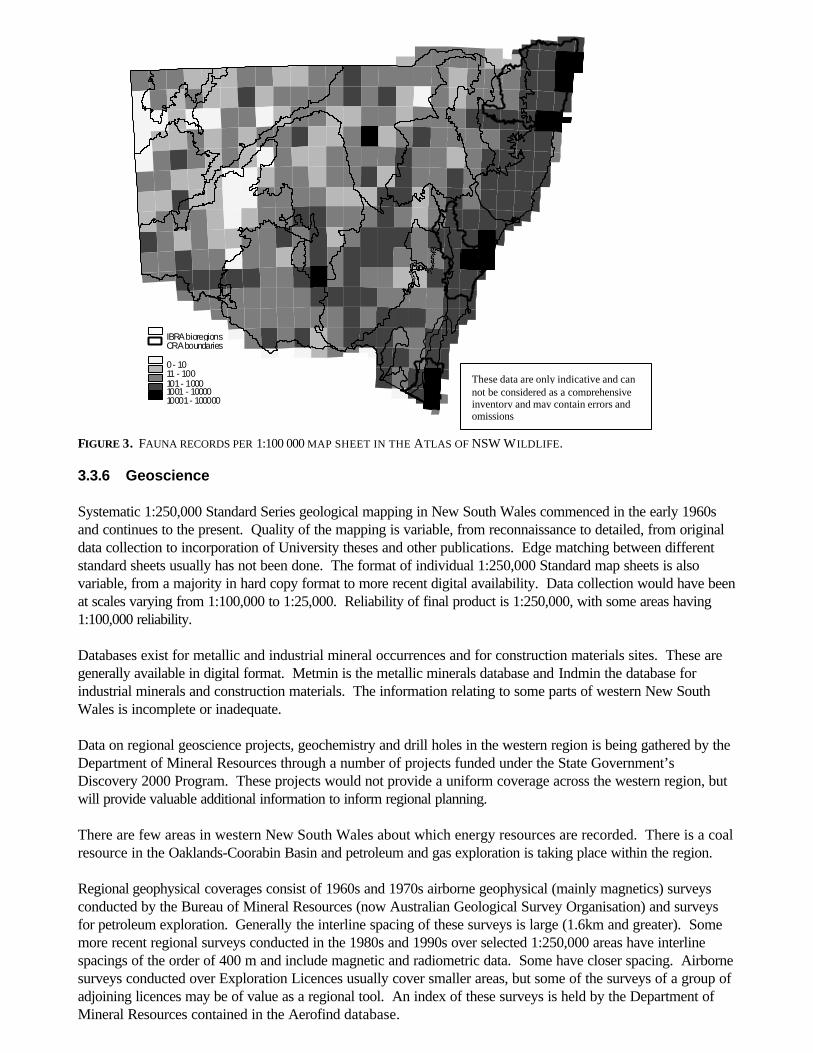
FIGURE 3. FAUNA RECORDS PER 1:100 000 MAP SHEET IN THE ATLAS OF NSW WILDLIFE.
3.3.6 Geoscience Systematic 1:250,000 Standard Series geological mapping in New South Wales commenced in the early 1960sand continues to the present. Quality of the mapping is variable, from reconnaissance to detailed, from originaldata collection to incorporation of University theses and other publications. Edge matching between differentstandard sheets usually has not been done. The format of individual 1:250,000 Standard map sheets is alsovariable, from a majority in hard copy format to more recent digital availability. Data collection would have beenat scales varying from 1:100,000 to 1:25,000. Reliability of final product is 1:250,000, with some areas having1:100,000 reliability. Databases exist for metallic and industrial mineral occurrences and for construction materials sites. These aregenerally available in digital format. Metmin is the metallic minerals database and Indmin the database forindustrial minerals and construction materials. The information relating to some parts of western New SouthWales is incomplete or inadequate. Data on regional geoscience projects, geochemistry and drill holes in the western region is being gathered by theDepartment of Mineral Resources through a number of projects funded under the State Government’sDiscovery 2000 Program. These projects would not provide a uniform coverage across the western region, butwill provide valuable additional information to inform regional planning. There are few areas in western New South Wales about which energy resources are recorded. There is a coalresource in the Oaklands-Coorabin Basin and petroleum and gas exploration is taking place within the region. Regional geophysical coverages consist of 1960s and 1970s airborne geophysical (mainly magnetics) surveysconducted by the Bureau of Mineral Resources (now Australian Geological Survey Organisation) and surveysfor petroleum exploration. Generally the interline spacing of these surveys is large (1.6km and greater). Somemore recent regional surveys conducted in the 1980s and 1990s over selected 1:250,000 areas have interlinespacings of the order of 400 m and include magnetic and radiometric data. Some have closer spacing. Airbornesurveys conducted over Exploration Licences usually cover smaller areas, but some of the surveys of a group ofadjoining licences may be of value as a regional tool. An index of these surveys is held by the Department ofMineral Resources contained in the Aerofind database.
0- 1011 - 100101- 10001001 - 1000010001- 100000
CRAboundariesIBRAbioregions
These data are only indicative and cannot be considered as a comprehensiveinventory and may contain errors andomissions
Systematic mineral potential assessment is essential in understanding the resource heritage of a region. This is aderived coverage, using all geoscience coverages and is discussed further below in Section 5.1.7. Mineralpotential analysis has not been undertaken in western New South Wales.
3.3.7 Photography and Imagery Due to the methods which satellites collect data, it is readily available to be purchased. However the regularcollection of the data does not mean that this information will of use to the task at hand; ie the image may becovered in cloud. The last whole-of-government, whole-of-New South Wales data set was purchased in 1994.For current planning purposes this could be considered to be out of date.
3.4 PROJECT WORKSHOP
The write up of the workshop sessions can be found in appendix 8.
4.DISCUSSION
In accordance with the project aims the Western Data Audit and Gap Analysis project was required to provide: n comprehensive data audit of existing information.
n capture of base data layers by digitising and data entry from existing information.
n analysis of the gaps in the existing information that need to be filled before a comprehensive regionalassessment.
The Western Data Audit and Gap Analysis project was able to meet these aims. Much of the project’s effortfocussed on ensuring that existing data sets within the base data layers were identified and if possible, the dataor at least the metadata were captured in digital form. This has been invaluable in providing more understandingof what data are available or unavailable for regional planning purposes in western New South Wales. The important conclusion from the gap analysis is that there are no regions of western New SouthWales that have all the required base data layers to consistent standards. Whilst some regional planning processes are using what they have available, a suite of consistent, current basedata layers need to be developed across western New South Wales. Recommendations are made regarding theneed to prepare these data layers. A number of issues relating to data management were identified during the course of the project. These issuesare relevant to most data collection and management projects, not just those related to the Western RegionalAssessment. Recommendations to address some of these issues are made in the next section.
4.1 DATA AUDIT
The results of the data audit demonstrate that a low proportion of contacts were able to provide relevant data.This may in part be explained by the shortage and poor quality of existent data, including flora and fauna data,from western New South Wales (see Section 5.3). It also emerged that many of the contacts were not relevantto the area targeted by the audit. A large number of contacts did not deal with flora or fauna records or did notpossess data originating from western New South Wales. The audit results for consultants provide an exampleof this. Of the relatively low proportion involved in environmental consultancy, the majority were concerned orfamiliar with data from eastern New South Wales. A similar pattern emerged in respondents from universitiesand conservation groups. In many cases where relevant records were identified it was not necessary for the contact to contribute therecords for the audit. This was because their information had been drawn initially from the Atlas of NSWWildlife. This was particularly true for many of the Councils that use Atlas records in State of EnvironmentReporting, Local Environment Plans and other similar documents. In addition to the contacts that were unable to provide data, a small fraction were unwilling to do so. Suchcontacts commonly cited their concerns regarding ownership or use of intellectual property or their unwillingnessto devote the necessary time to collating the information. Also included in this category are a number that didnot respond to repeated contact attempts.
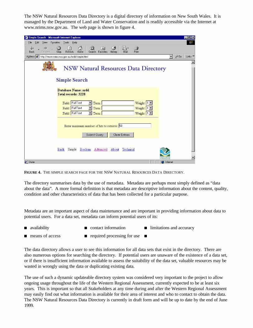
The NSW Natural Resources Data Directory is a digital directory of information on New South Wales. It ismanaged by the Department of Land and Water Conservation and is readily accessible via the Internet atwww.nrims.nsw.gov.au. The web page is shown in figure 4.
FIGURE 4. THE SIMPLE SEARCH PAGE FOR THE NSW NATURAL RESOURCES DATA DIRECTORY. The directory summarises data by the use of metadata. Metadata are perhaps most simply defined as “dataabout the data”. A more formal definition is that metadata are descriptive information about the content, quality,condition and other characteristics of data that has been collected for a particular purpose. Metadata are an important aspect of data maintenance and are important in providing information about data topotential users. For a data set, metadata can inform potential users of its: n availability n contact information n limitations and accuracy
n means of access n required processing for use n
The data directory allows a user to see this information for all data sets that exist in the directory. There arealso numerous options for searching the directory. If potential users are unaware of the existence of a data set,or if there is insufficient information available to assess the suitability of the data set, valuable resources may bewasted in wrongly using the data or duplicating existing data. The use of such a dynamic updateable directory system was considered very important to the project to allowongoing usage throughout the life of the Western Regional Assessment, currently expected to be at least sixyears. This is important so that all Stakeholders at any time during and after the Western Regional Assessmentmay easily find out what information is available for their area of interest and who to contact to obtain the data.The NSW Natural Resources Data Directory is currently in draft form and will be up to date by the end of June1999.
4.2 DATA CAPTURE
Data from relevant PhD’s and MSc’s post 1994 EIS’s, DLWC Far West Region Herbaria all published floristiclists from Cunninhamia, for western New South Wales, have now been captured in digital form. Theindividuals listed in appendix 9 have supplied additional major data sets. In future these data sources will notneed to be searched again, except for historic records.
4.3 GAP ANALYSIS
The results of the Western Data Audit and Gap Analysis project confirm much of what various professionals,organisations and individuals dealing with natural resource management in western New South Wales havepreviously identified. The project has found that: n Many base data layers suitable for regional planning do not exist across large parts of western New South
Wales.
n Uniform agreed standards for data collection for many base data layers do not exist.
n Data layers that do exist are often of variable quality. The may lack ground truthing, are missing vitalcomponents, are not to agreed standards, lack coverage across western New South Wales, or areinconsistent across the state. This inconsistency is commonly due to a lack of standards or coordination andan absence of integration into planning processes.
n Data are collected by numerous organisations or groups for varying reasons and to various standards. Anexample of this can be found in the number and variable quality of existing vegetation layers across NewSouth Wales, all of which use different vegetation units and methodologies.
n To provide consistent base data layers suitable for numerous planning processes it is necessary to havecommitment to a coordinated, integrated and suitably resourced data collection process.
4.4 PROJECT WORKSHOP
Holding the workshop enabled participants to be informed, in a semi informal setting, about what the project hadachieved and to refine the recommendations by drawing on participants’ experiences.
5.RECOMMENDATIONS
5.1 DATA REQUIREMENTS
This section identifies the proposed base data layers required to assist regional planning in western New SouthWales. Base data layers contain measurements of what can be physically recorded on the ground. Theselayers are then used to generate derived and modelled data layers. The quality and extent of existing information covering western New South Wales is inadequate. The followingproposals seek to improve the information for regional planning in western New South Wales. To provide appropriate base data layers different strategies will be required. Some data layers could be providedefficiently as a single consistent layer in one project whilst others could be developed on a region by region basis.Either method should use consistent standards. Some of the base data layer projects require extensive fieldwork. Economies of scale would be achieved if, forexample, flora and fauna surveys were carried out together. Satellite imagery could be used to stratify areasthat are to be sampled. Undertaking data collection at a regional level would allow these economies of scale tobe achieved. Once the base data layers have been completed, additional projects will be required to produce derived andmodelled data layers. Existing data related initiatives are described in appendix 10.
5.1.1 A CURRENT ADMINISTRATIVE AND TENURE LAYER A current administrative layer will be required. Knowledge of land ownership is important to planning processes,and may influence the choice of management options. The administrative layer should also include tenure information such as mining and exploration titles, VoluntaryConservation and Property Agreements, zoning information contained in statutory plans etc.
5.1.2 A DIGITAL ELEVATION MODEL A digital elevation model of appropriate resolution and accuracy (minimum – 100m western division and 25m incentral division) would enable useful terrain information to be generated such as slope, aspect and topographicposition. This information could then be used in modelling and to produce derived data layers.
5.1.3 ABORIGINAL CULTURAL INFORMATION AT A LANDSCAPE LEVEL AND CULTURALHERITAGE SITES
Information about the Aboriginal landscapes of western New South Wales is required urgently. Much focus hasbeen placed on archaeological relics and on site-specific importance, with relatively little analysis of the waysthese features fit into the overall landscape. Information could be captured through: n Recording of oral histories with Aboriginal Elders. Information gathered from oral histories could be
amalgamated with existing information to develop a data layer featuring areas of significance to Aboriginalpeople across western New South Wales. This information needs to be gathered as soon as possible.
n Landscape modelling of Aboriginal occupation, Aboriginal sites and Places of Significance.
n Targeted archaeological surveys and anthropological studies to validate the Aboriginal landscape modelling.
It will be necessary to consult with relevant Aboriginal communities to ensure a culturally appropriate process isundertaken.
5.1.4 A COMPREHENSIVE AND UNIFORM VEGETATION LAYER DERIVED FROMSTRUCTURAL AND FLORISTIC DATA
A consistent structural and floristic vegetation layer, both pre-clearing and existing need to be developed forwestern New South Wales. Existing data such as the M305 have variable reliability and includes only vegetation with greater than 20%canopy cover for remnants greater than ten hectares. This is inadequate for western New South Wales, as itdoes not provide mapping for grasslands, herblands and shrublands. An analysis of the reliability of the existing major vegetation maps, via quadrat based sampling, is also required.
5.1.5 SYSTEMATIC AND TARGETED SURVEYS OF FAUNA AND FLORA ANDAUTECOLOGICAL STUDIES TO PROVIDE ADEQUATE INFORMATION FORMODELLING THEIR DISTRIBUTION
Models of fauna and flora distribution, based upon extensive survey and autecological work are required.Recent biodiversity surveys undertaken by the NSW National Parks and Wildlife Service have shown the valueof systematic field surveys with a number of species being found for the first time or being rediscovered in NewSouth Wales. These include the Western Pygmy-possum and the Southern Hairy-nosed Wombat. Targetedsurveys for particular species may be required.
5.1.6 UP-TO-DATE AND UNIFORM GEOLOGY, SOIL, METALLIC MINERALSOCCURRENCES, INDUSTRIAL MINERALS OCCURRENCES AND CONSTRUCTIONMATERIALS OCCURRENCES
An overview of the western region is considered important to identify mineral potential and other issues ofgeoscientific significance. Up-to-date and uniform digital coverages of geology, soil, metallic mineralsoccurrences, industrial minerals occurrences and construction materials occurrences are strongly needed. To supplement these whole-of-region data sets, more detailed studies in selected areas are needed. Thesewould include information from projects undertaken by the Department of Mineral Resources on regionalgeoscience, geochemistry, drill holes, airborne geophysical coverages by both government and industry,information on energy resources in specific sedimentary basins, information gathered from exploration forminerals and energy resources. An important requirement in regional planning is systematic assessment of mineral potential. This assessment isbased on the geoscience data sets described above but also requires further analysis, particularly of mineraldeposit data. Mineral potential maps need to be supplemented by more specific studies in key areas, especiallythose of higher mineral potential, for any detailed land use assessments.
5.1.7 CURRENT SATELLITE IMAGERY Current remote sensing information would be needed to implement some of the above recommendations.
5.1.8 CURRENT AND HISTORICAL LAND USE, DISTURBANCE HISTORY, WOODRESOURCE INFORMATION, GROUND AND SURFACE WATER QUALITY ANDQUANTITY AND SALINITY AND FLOOD MAPPING.
The above data layers were identified as being necessary from the workshop.
5.2 FUTURE SCOPING
5.2.1 SCOPING EXERCISES, AS PART OF THE APPROVED WESTERN REGIONALASSESSMENT STRATEGY, SHOULD BE CARRIED OUT TO IDENTIFYSTAKEHOLDERS, ISSUES, STANDARD METHODS AND DATA LAYERS REQUIRED.
Once the Western Regional Assessment Strategy has been finalised, it is recommended that additionalconsultation be undertaken to define Stakeholders and their data requirements. The NSW Natural Resources Data Directory is well suited to obtaining the most up to date information onexisting data in an area and should be used as part of the scoping exercise. Any data collection should use standard methods. The Eastern Comprehensive Regional Assessments hadagreed standard methodologies for data collection in forests. These are not necessarily applicable to datarequirements in western New South Wales. There is a need for the development of agreed methods for thecollection of different types of data for the Western Regional Assessment. Any project to be funded by theResource and Conservation Assessment Council would then need to use these methods, so that the results canbe used as widely as possible.
Such development of standards would need to include a review of existing standards and guidelines, consultationwith various user groups to consider their requirements, peer review and then approval by the Resource andConservation Assessment Council. The agreed standards would need to be distributed as widely as possible toencourage adoption in future collection processes.
5.3 DATA MANAGEMENT
A number of data management issues became apparent during this project which will need to be addressedduring the Western Regional Assessment. To ensure data is managed appropriately and readily available tostakeholders, the community and agencies the following recommendations have been made:
5.3.1 THAT A WESTERN REGIONAL ASSESSMENT DATA MANAGEMENT WORKINGGROUP IS ESTABLISHED
This group would consider data management issues, develop a Western Regional Assessment DataManagement Manual and use as a reference the Natural Resources Information Management Strategy andComprehensive Regional Assessment Data Management Manual. The NSW Natural Resources Information Management Strategy is being developed by state government withrepresentatives of all land and resource management agencies. Agencies include: n Department of Land and Water Conservation n Department of Mineral Resources
n Department of Urban Affairs and Planning n Environmental Planning Authority
n Land Information Centre n NSW National Parks and Wildlife Service
n State Forests n
Many of the issues related to generic data management faced by government are being looked at by thisstrategy.
The Working Group will need to consider such issues as the:
a) Geocentric Datum of Australia, GDA94. Australia currently uses the AGD66 datum. As Australia is changing to GDA94 on 1 Jan 2000, any datagenerated by the Western Regional Assessment will need to be in this datum. The difference between datumcauses a displacement of locations by 200 metres in a NE direction. Existing data will also need to be convertedprior to use. Currently there is no conversion program available to undertake this work reliably. The likely timeand cost of this conversion could be significant. b) Scale. The scales that data are collected at and utilised are extremely important and vary according to the task at hand.For example the scale required for regional planning exercises will vary from that required for propertymanagement planning. c) Data Transfer.The way in which data is managed to maximise ease of access and consistency for users.
Other points generated from discussions at the Workshop include:
n data management principles / manual prepared
n data ownership, custodianship and transfer standards
n access to data not readily available
n value adding
n establish information needs of clients / users / Stakeholders
n ensure data is supplied in previously agreed format / standard
n communication of standards / access / new data available to other processes
n pricing policy
n metadata requirements
n many, many more
5.3.2 DATABASE ALL HERBARIA SPECIMENS AND INVESTIGATE LINKING THESE TO ASINGLE DATABASE
It is recommended that information about all specimens in existing herbaria be entered into a single database.There is also a need to improve and standardise the quantity and quality of ecological information recorded witha specimen when collected. All information present on the specimen label needs to be entered into the database. Investigation into linking all herbaria to a single database, possibly at the Royal Botanic Gardens is also required.
5.3.3 THAT FUTURE DATA COLLECTED BE ENTERED INTO THE RELEVANT DATABASE
To improve the use and availability of information collected in New South Wales, all relevant data generated inthe future should be entered into the appropriate digital database.
5.3.4 THAT EXISTING AND PROPOSED PROJECTS PROVIDE METADATA TO THE NSWNATURAL RESOURCES DATA DIRECTORY.
To identify existing and future planning projects all relevant projects should provide metadata to the NSWNatural Resources Data Directory. Metadata would explain the nature of the project and would includeinformation about any data produced by the project.
The keyword “PROJECT” will need to be added to the Australia and New Zealand Land Information Councilstandard for the NSW Natural Resources Data Directory.
The benefits of creating project metadata would include:
n alignment of projects with government strategies
n reduction in duplication
n efficiency in assessing the merit of proposed projects
n creation of a record of past projects, useable as a historic record
6.CONCLUSION
The recommendations of the Western Data Audit and Gap Analysis project, if implemented, could form thefoundation for a comprehensive and integrated planning and management system for western New South Wales. Some recommendations could be implemented in the near future with minimal expenditure, whilst others willrequire a commitment of significant resources. In conclusion, substantial benefits to regional planning and the community would be realised by implementing theabove recommendations. Such implementation will require thorough commitment from all relevantrepresentatives.
APPENDICES
APPENDIX 1. METADATA
Appendix 1a. Tenure. TITLE:Australia Land Tenure Data CUSTODIAN:Australian Surveying and Land Information Group (AUSLIG) JURISDICTION:Australia ABSTRACT:Contains boundary and attribute information for public and private land tenure, including Aboriginal & TorresStrait Islander land, for the whole of Australia. A nationally consistent, broadly based classification of landtenure has been used. Categories are Forestry Reserve; Aboriginal Freehold – national park; Marine Reserve;Nature Conservation Reserve; Water Reserve; Defence Land; Aboriginal Reserve; Other Crown Land; MiningReserve; Vacant Crown Land; Mainly Freehold; Crown Leasehold (mainly pastoral); and Aboriginal Freehold &Leasehold. SEARCH WORDS:BOUNDARIES MappingLAND Ownership MappingLAND Use Mapping GEOGRAPHIC EXTENT NAME(S):Australia BEGINNING DATE:Not Known ENDING DATE:30JUN1993 PROGRESS:Complete MAINTENANCE AND UPDATE FREQUENCY:Not Known STORED DATA FORMAT:DIGITAL, Vector DataNONDIGITAL, Maps
AVAILABLE FORMAT TYPE(S):DIGITAL – ARC/INFODIGITAL – AS2482DIGITAL – GINADIGITAL – MapInfoNONDIGITAL – Maps ACCESS CONSTRAINTS:The data are subject to Commonwealth of Australia Copyright. A licence agreement is required for digital dataand a licence fee is also applicable. LINEAGE:The data were captured from 1:1 million scale maps. POSITIONAL ACCURACY:Not Documented ATTRIBUTE ACCURACY:Not Documented LOGICAL CONSISTENCY:Not Documented COMPLETENESS:Not Documented CONTACT ORGANISATION:Australian Surveying and Land Information Group (AUSLIG) CONTACT POSITION:Enquiries, Data/Map Sales, National Data Centre CONTACT PERSON:Data/Map Sales Staff MAIL ADDRESS:PO Box 2 SUBURB OR PLACE OR LOCALITY:BELCONNEN STATE OR LOCALITY:ACT COUNTRY:Australia POSTCODE:2616 TELEPHONE:Australia Fixed Network number+61 2 6201 4340
Australia Freecall1800 800 173 FACSIMILE:Australia Fixed Network number+61 2 6201 4381 ELECTRONIC MAIL ADDRESS:[email protected]@auslig.gov.au METADATA DATE:25NOV1996
ADDITIONAL METADATA:
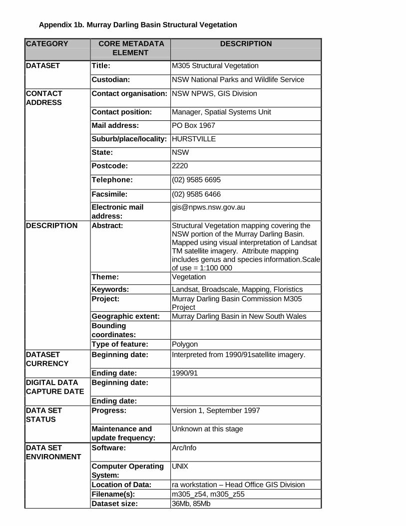
Appendix 1b. Murray Darling Basin Structural Vegetation
CATEGORY CORE METADATAELEMENT
DESCRIPTION
DATASET Title: M305 Structural Vegetation
Custodian: NSW National Parks and Wildlife Service
CONTACTADDRESS
Contact organisation: NSW NPWS, GIS Division
Contact position: Manager, Spatial Systems Unit
Mail address: PO Box 1967
Suburb/place/locality: HURSTVILLE
State: NSW
Postcode: 2220
Telephone: (02) 9585 6695
Facsimile: (02) 9585 6466
Electronic mailaddress:
DESCRIPTION Abstract: Structural Vegetation mapping covering theNSW portion of the Murray Darling Basin.Mapped using visual interpretation of LandsatTM satellite imagery. Attribute mappingincludes genus and species information.Scaleof use = 1:100 000
Theme: Vegetation
Keywords: Landsat, Broadscale, Mapping, FloristicsProject: Murray Darling Basin Commission M305
ProjectGeographic extent: Murray Darling Basin in New South WalesBoundingcoordinates:Type of feature: Polygon
DATASETCURRENCY
Beginning date: Interpreted from 1990/91satellite imagery.
Ending date: 1990/91DIGITAL DATACAPTURE DATE
Beginning date:
Ending date:DATA SETSTATUS
Progress: Version 1, September 1997
Maintenance andupdate frequency:
Unknown at this stage
DATA SETENVIRONMENT
Software: Arc/Info
Computer OperatingSystem:
UNIX
Location of Data: ra workstation – Head Office GIS DivisionFilename(s): m305_z54, m305_z55Dataset size: 36Mb, 85Mb
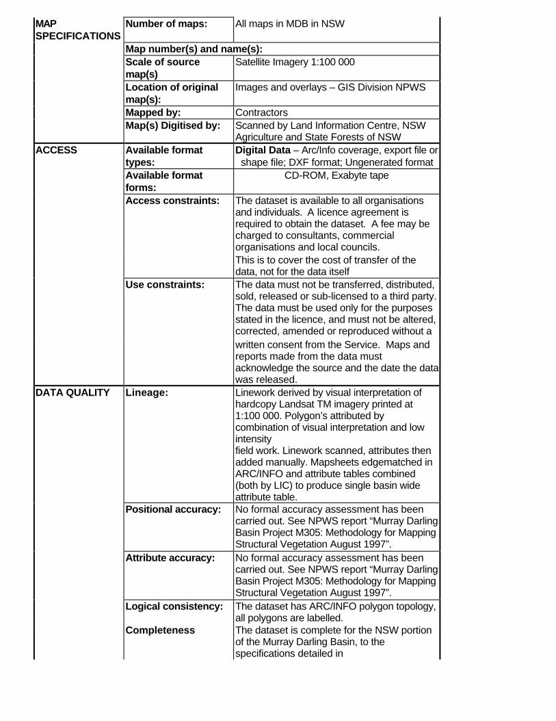
MAPSPECIFICATIONS
Number of maps: All maps in MDB in NSW
Map number(s) and name(s):Scale of sourcemap(s)
Satellite Imagery 1:100 000
Location of originalmap(s):
Images and overlays – GIS Division NPWS
Mapped by: ContractorsMap(s) Digitised by: Scanned by Land Information Centre, NSW
Agriculture and State Forests of NSWACCESS Available format
types:Digital Data – Arc/Info coverage, export file orshape file; DXF format; Ungenerated format
Available formatforms:
CD-ROM, Exabyte tape
Access constraints: The dataset is available to all organisationsand individuals. A licence agreement isrequired to obtain the dataset. A fee may becharged to consultants, commercialorganisations and local councils.This is to cover the cost of transfer of thedata, not for the data itself
Use constraints: The data must not be transferred, distributed,sold, released or sub-licensed to a third party.The data must be used only for the purposesstated in the licence, and must not be altered,corrected, amended or reproduced without awritten consent from the Service. Maps andreports made from the data mustacknowledge the source and the date the datawas released.
DATA QUALITY Lineage: Linework derived by visual interpretation ofhardcopy Landsat TM imagery printed at1:100 000. Polygon’s attributed bycombination of visual interpretation and lowintensityfield work. Linework scanned, attributes thenadded manually. Mapsheets edgematched inARC/INFO and attribute tables combined(both by LIC) to produce single basin wideattribute table.
Positional accuracy: No formal accuracy assessment has beencarried out. See NPWS report “Murray DarlingBasin Project M305: Methodology for MappingStructural Vegetation August 1997”.
Attribute accuracy: No formal accuracy assessment has beencarried out. See NPWS report “Murray DarlingBasin Project M305: Methodology for MappingStructural Vegetation August 1997”.
Logical consistency: The dataset has ARC/INFO polygon topology,all polygons are labelled.
Completeness The dataset is complete for the NSW portionof the Murray Darling Basin, to thespecifications detailed in
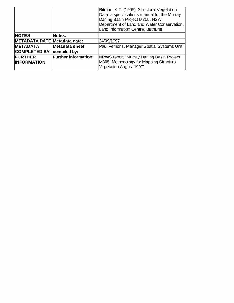
Ritman, K.T. (1995). Structural VegetationData: a specifications manual for the MurrayDarling Basin Project M305. NSWDepartment of Land and Water Conservation,Land Information Centre, Bathurst
NOTES Notes:METADATA DATE Metadata date: 24/09/1997METADATACOMPLETED BY
Metadata sheetcompiled by:
Paul Femons, Manager Spatial Systems Unit
FURTHERINFORMATION
Further information: NPWS report “Murray Darling Basin ProjectM305: Methodology for Mapping StructuralVegetation August 1997”.
Appendix 1c. SPOT Multispectral TITLE:SPOT Multispectral (XS) CUSTODIAN:Australian Surveying and Land Information Group (AUSLIG) JURISDICTION:Australia ABSTRACT:SPOT 1, launched in 1986 by the French Government agency, Centre National d’Etudes Spatiales, carries twoHigh Resolution Visible (HRV) sensors. Two SPOT satellites (SPOT 2 & 3) currently orbit the earth 180degrees apart with SPOT 2 being the nominally operational satellite but data from SPOT 3 can be acquired onrequest.Each HRV has a ground swath 60 kilometres wide, and can operate independently either in panchromatic (PA)or multispectral (XS) mode. SPOT 3 carries the only operational onboard tape recorders which store imagerywhen the sensors are operating outside the reception area of a ground station, allowing worldwide coverage bySPOT. Every 26 days, SPOT’s orbit can provide total coverage of the Earth’s surface, in a vertical viewingmode. Additionally, SPOT has the ability to image up to an angle of 27 degrees east or west of vertical. This canallow revisits of the same site in Australia in as little as three days, and also allows for stereo images to beacquired for use in determining the height of ground features. The archive of ACRES products includes SPOTdata from 1989 onwards.The HRV multispectral (XS) sensor operates in three bands in the visible and near infrared part of theelectromagnetic spectrum with a resolution of 20m.ACRES SPOT archive contains selected imagery from the following SPOT satellites:SPOT 1 commenced 1 January 1990, ceased January 91.SPOT 2 commenced 1 January 1991, continuing.SPOT 3 selected from 25 September 1993. SEARCH WORDS:PHOTOGRAPHY AND IMAGERYPHOTOGRAPHY AND IMAGERY Remote SensingPHOTOGRAPHY AND IMAGERY Satellite GEOGRAPHIC EXTENT NAME(S):Australia including external territoriesNew Zealand BEGINNING DATE:01JAN1990 ENDING DATE:Current PROGRESS:In Progress MAINTENANCE AND UPDATE FREQUENCY:As Required STORED DATA FORMAT:DIGITAL Archive Format
AVAILABLE FORMAT TYPE(S):DIGITAL Satellite Imagery ACCESS CONSTRAINTS:Payment and Licence Agreement LINEAGE:The SPOT XS data set is acquired by earth orbiting remote sensing satellites. These satellites carry two types ofsensor systems known as “active” and “passive”. A “passive” system generally consists of an array of smallsensors or detectors which record (as digital numbers) the amount of electro-magnetic radiation reflected and/oremitted from the Earth’s surface. The SPOT XS is a passive system. The digital data acquired by the satellitesare transmitted to ground stations and can be used to reconstitute an image of the Earth’s surface not toodissimilar to an aerial photograph.Data are received through the ACRES antenna at the Data Acquisition Facility at Alice Springs enablingcoverage of the Australian landmass. The recorded data are air-freighted daily to the Data Processing Facility inCanberra where it is catalogued and archived.Data are recorded and archived by path, or swath, allowing coverage of any region in the path to be extractedby its geographical coordinates. If the region of interest extends across two adjacent paths the appropriate dataset from each path will need to be extracted. Because of the orbital parameters of the satellite, adjacent pathsare not acquired sequentially and information from each path may differ according to the time delay between thetwo passes.To assist cataloguing and ordering, a path is segmented into individual scenes the length of each scene being thesame as the path width. Each scene can be related to geographical coordinates using the Path/Row referencesystem. The Path is the number of the satellite swath (east to west) across Australia and the Row is the numberof the scene south of the equator. Diagrams and formulae are available to assist in relating geographicalcoordinates to the satellite scene Path/Row coordinates.Each scene acquired by ACRES is sub-sampled and produced in its Digital Catalogue access to which isavailable through the WWW.Data are provided as hard copy photographic data products, or as digital data products which can be viewed andmanipulated on a variety of software systems. However, the data transmitted to Earth from an Earth observationsatellite are in a form unsuitable for use by customers so ACRES processes this raw data in varying degrees toproduce products suitable for use by clients. ACRES only processes the data after a client has placed an orderfor a specific product. This is due to the large quantities of data received from a satellite and the large range ofproduct options available. POSITIONAL ACCURACY:Within 3km to within 60m, or better, after specialised processing. ATTRIBUTE ACCURACY:Not Applicable LOGICAL CONSISTENCY:As the data is acquired in seamless north-south paths (swaths) each path is internally consistent. However, pathsare acquired on different dates and while paths can be joined to cover larger areas, changes in ground conditionsbetween acquisition dates may be apparent in the resulting mosaic. COMPLETENESS:Coverage is acquired on an “as required” basis and while national coverage may be extracted from the archivethe acquisition dates may range over a year or more. CONTACT ORGANISATION:Australian Surveying and Land Information Group (AUSLIG)Australian Centre for Remote Sensing (ACRES)
CONTACT POSITION:Direct Client Account Manager CONTACT PERSON:Mr John Lee MAIL ADDRESS:PO Box 2 SUBURB OR PLACE OR LOCALITY:BELCONNEN STATE OR LOCALITY:ACT COUNTRY:Australia POSTCODE:2616 TELEPHONE:Australia Fixed Network number61 2 6201 4131Australia Freecall1800 800 173 FACSIMILE:Australia Fixed Network number61 2 6201 4366 ELECTRONIC MAIL ADDRESS:ACRES METADATA DATE:04SEP1998 ADDITIONAL METADATA:Also, further information about Spatial Metadata is at ANZLIC LIST OF ATTRIBUTES:Nil SCALE/RESOLUTION:20 metre pixel resolution SCIENTIFIC AND TECHNICAL LIMITATIONS:The data may me limited by its pixel resolution and scene extents.
SIZE OF THE DATASET:A full scene is approximately 27Mb PRICE AND ASSOCIATED ACCESS CONSTRAINTS:Full Scene, Path Oriented, System Corrected is $1700Map Oriented, System Corrected, Variable Window Up to 13 000 sq km is $3000Map Oriented, Precision Corrected, Variable Window Up to 13 000 sq km is $3680Map Oriented, Ortho-Corrected, Variable Window Up to 13 000 sq km is $3790Scenes may also be purchased with differing band combinations and smaller variable windows.The lowest priced product is a 225 sqkm (15 x 15 km), Map Oriented, Precision Corrected, Variable Window for$495.Special copyright conditions apply to the sale of satellite data. To acknowledge these copyright conditions,customers are required to sign a Satellite Data Licence Conditions prior to the purchase of any data.
Appendix 1d. Eastern Bushland Database
CATEGORY CORE METADATAELEMENT
DESCRIPTION
DATASET Title: Eastern Bushlands Database
Custodian: NSW National Parks and Wildlife Service
CONTACTADDRESS
Contact organisation: NSW NPWS, GIS Division
Contact position: Manager, Spatial Systems Unit
Mail address: PO Box 1967
Suburb/place/locality: HURSTVILLE
State: NSW
Postcode: 2220
Telephone: (02) 9585 6695
Facsimile: (02) 9585 6466
Electronic mailaddress:
DESCRIPTION Abstract: Structural Vegetation mapping coveringthe eastern portion of NSW. Mappedusing visual interpretation of Landsat TMsatellite imagery. Attribute mappingincludes structural vegetationinformation.Data should not be used atscales finer than 1:250 000.
Theme: Vegetation
Keywords: Landsat, Broadscale, Structural
Project: Eastern Bushlands Database
Geographic extent: Eastern NSW Boundingcoordinates:
Type of feature: Polygon
DATASETCURRENCY
Beginning date: Interpreted from 1989/90/91 satelliteimagery.
Ending date: 1990/91 DIGITAL DATACAPTURE DATE
Beginning date:
Ending date:
DATASETSTATUS
Progress: Final Version, September 1997
Maintenance andupdate frequency:
None Planned
DATASETENVIRONMENT
Software: Arc/Info
Computer OperatingSystem:
UNIX
Location of Data: ra workstation – Head Office GIS Division
Filename(s): EBD_Cent, EBD_Sth, EBD_Nth
Dataset size: 62Mb ,18Mb, 36Mb
MAPSPECIFICATIONS
Number of maps:
Map number(s) andnames
Scale of source
map(s) Satellite Imagery 1:100 000
Location of originalmap(s):
Images and overlays – GIS DivisionNPWS
Mapped by: Contractors
Map(s) Digitised by: NPWS Regions and Districts ACCESS Available format
types: Digital Data – Arc/Info coverage, export
file or shape file; DXF format;Ungenerated format
Available formatforms:
CD-ROM, Exabyte tape
Access constraints: The dataset is available to allorganisations and individuals. A licenceagreement is required to obtain thedataset. A fee may be charged toconsultants, commercial organisationsand local councils.
This is to cover the cost of transfer of thedata, not for the data itself
Use constraints: The data must not be transferred,distributed, sold, released or sub-licensedto a third party. The data must be usedonly for the purposes stated in thelicence, and must not be altered,corrected, amended or reproducedwithout a
written consent from the Service. Mapsand reports made from the data mustacknowledge the source and the date thedata was released. Data should not beused at scales finer than 1:250 000.
DATA QUALITY Lineage: Data was captured as part of the Savethe Bush funded Eastern BushlandsDatabase project. Linework derived byvisual interpretation of hardcopy LandsatTM imagery printed at 1:100 000.Polygon’s attributed by combination ofvisual interpretation and low
intensity field work. Three separatedatasets are similar but not enough toenable combining of them. Digitised inERMS. Data then transferred intoARC/INFO. Three datasets stored andmanaged separately.
Positional accuracy: Data should not be used at scales finerthan 1:250 000. No formal accuracyassessment has been carried out. Seefollowing NPWS reports for details ofmethodology: “Holme, L. (1993). EasternBushlands Database Project (CentralRegion). NSW NPWS internal
unpublished document” and “Roberts, G.(1992). Vegetation systems of north eastNew South Wales: Mapped from LandsatTM imagery. NSW National Parks andWildlife Service NEP 91 298.”
Attribute accuracy: No formal accuracy assessment hasbeen carried out. See above NPWSreports.
Logical consistency: The dataset has ARC/INFO polygontopology, all polygons are labelled.
Completeness The dataset consists of three completeportions covering eastern NSW –Northern, Southern and Central.
NOTES Notes:
METADATA DATE Metadata date: 24/09/1997
METADATACOMPLETED BY
Metadata sheetcompiled by:
Paul Femons, Manager Spatial SystemsUnit
FURTHERINFORMATION
Further information: “Holme, L. (1993). Eastern BushlandsDatabase Project (Central Region).NSW NPWS unpublished”, “Roberts, G.(1992). Vegetation systems of north eastNew South Wales: Mapped from LandsatTM imagery. NSW National Parks andWildlife Service NEP 91 298.”
Appendix 1e. Vegetation Mapping of the NSW Wheat-belt
METADATACATEGORY
CORE METADATAELEMENT
DESCRIPTION
DATASET Title Native Remnant Vegetation Mapping of
the NSW Wheat-belt Custodian National Parks & Wildlife, NSW
CONTACTADDRESS
Contact organisation National Parks & Wildlife, NSW
Contact position Manager GIS Division Mail address P.O. Box 1967 Suburb/Place/Locality Hurstville
State NSW Postcode 2220 Telephone 02 585 6444 Facsimile 02 585 6555 Electronic mailaddress
DESCRIPTION Abstract Native woody remnant vegetationboundaries delineated from aerialphotographs of various ages transferredto 1:100 000 map sheets and digitised toproduce vegetation maps for the wheat-belt of NSW.
Theme Vegetation Keywords inventory mapping Project Wheat-belt vegetation mapping project. Geographic extent The wheat-belt of NSW is defined as the
plains west of the of southern andnorthern slopes of NSW and east of theWestern Division Boundary andextending from the Queensland border to33 degrees South. Primarily located in theCentral Division of NSW.
Bounding coordinates nw 146’ 30” 29’ 30” ne150’ 30” 29’ 30” se148’ 30” 33’ sw146’ 30” 33’
Type of feature polygon digitised data converted to gridcell data
DATASETCURRENCY
Beginning date 1978
Ending date 1994 DIGITAL DATACAPTURE DATE
Beginning date 20/04/91
Ending date current DATASET STATUS Progress In progress
Maintenance andupdate frequency
As required
DATASETENVIRONMENT
Software Digitised using Environmental ResourceMapping System (E-RMS) (Versionvarious), Arc/Info
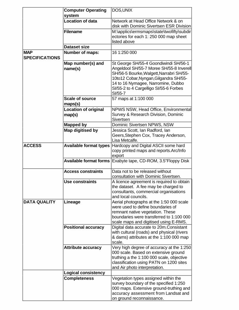
Computer Operatingsystem
DOS,UNIX
Location of data Network at Head Office Network & ondisk with Dominic Sivertsen ESR Division
Filename M:\applics\ermsmaps\state\twofifty\subdirectories for each 1: 250 000 map sheetlisted above
Dataset size MAPSPECIFICATIONS
Number of maps: 16 1:250 000
Map number(s) andname(s)
St George SH/55-4 Goondiwindi SH/56-1Angeldool SH/55-7 Moree SH/55-8 InverellSH/56-5 Bourke,Walgett,Narrabri SH/55-10to12 Cobar,Nyngan,Gilgandra SH/55-14 to 16 Nymagee, Narromine, DubboSI/55-2 to 4 Cargelligo SI/55-6 ForbesSI/55-7
Scale of sourcemaps(s)
57 maps at 1:100 000
Location of originalmap(s)
NPWS NSW, Head Office, EnvironmentalSurvey & Research Division, DominicSivertsen
Mapped by Dominic Sivertsen NPWS, NSW Map digitised by Jessica Scott, Ian Radford, Ian
Geers,Stephen Cox, Tracey Anderson,Lisa Metcalfe.
ACCESS Available format types Hardcopy and Digital ASCII some hardcopy printed maps and reports.Arc/Infoexport
Available format forms Exabyte tape, CD-ROM, 3.5”Floppy Disk
Access constraints Data not to be released withoutconsultation with Dominic Sivertsen.
Use constraints A licence agreement is required to obtainthe dataset. A fee may be charged toconsultants, commercial organisationsand local councils.
DATA QUALITY Lineage Aerial photographs at the 1:50 000 scalewere used to define boundaries ofremnant native vegetation. Theseboundaries were transferred to 1:100 000scale maps and digitised using E-RMS.
Positional accuracy Digital data accurate to 20m.Consistantwith cultural (roads) and physical (rivers& dams) attributes at the 1:100 000 mapscale.
Attribute accuracy Very high degree of accuracy at the 1:250000 scale. Based on extensive groundtruthing a the 1:100 000 scale, objectiveclassification using PATN on 1200 sitesand Air photo interpretation.
Logical consistency Completeness Vegetation types assigned within the
survey boundary of the specified 1:250000 maps. Extensive ground-truthing andaccuracy assessment from Landsat andon ground reconnaissance.

NOTES Notes METADATA DATE Metadata date Mar-96 METADATASHEETCOMPILED BY
Metadata sheetcompiled by
Lisa Metcalfe
FURTHERINFORMATION
Further information nil
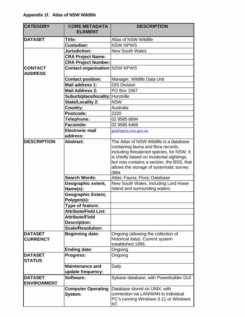
Appendix 1f. Atlas of NSW Wildlife
CATEGORY CORE METADATAELEMENT
DESCRIPTION
DATASET Title: Atlas of NSW Wildlife Custodian: NSW NPWS Jurisdiction: New South Wales CRA Project Name: CRA Project Number:
CONTACTADDRESS
Contact organisation: NSW NPWS
Contact position: Manager, Wildlife Data Unit Mail address 1: GIS Division Mail Address 2: PO Box 1967 Suburb/place/locality: Hurstville State/Locality 2: NSW Country: Australia Postcode: 2220 Telephone: 02 9585 6694 Facsimile: 02 9585 6466 Electronic mailaddress:
DESCRIPTION Abstract: The Atlas of NSW Wildlife is a databasecontaining fauna and flora records,including threatened species, for NSW. Itis chiefly based on incidental sightings,but now contains a section, the BSS, thatallows the storage of systematic surveydata.
Search Words: Atlas; Fauna; Flora; Database Geographic extent,Name(s):
New South Wales, including Lord HoweIsland and surrounding waters
Geographic Extent,Polygon(s):
Type of feature: Attribute/Field List: Attribute/FieldDescription:
Scale/Resolution: DATASETCURRENCY
Beginning date: Ongoing (allowing the collection ofhistorical data). Current systemestablished 1996.
Ending date: Ongoing DATASETSTATUS
Progress: Ongoing
Maintenance andupdate frequency:
Daily
DATASETENVIRONMENT
Software: Sybase database, with Powerbuilder GUI
Computer OperatingSystem:
Database stored on UNIX, withconnection via LAN/WAN to individualPC’s running Windows 3.11 or WindowsNT.
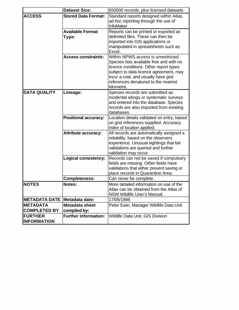
Dataset Size: 650000 records, plus licensed datasets ACCESS Stored Data Format: Standard reports designed within Atlas,
ad hoc reporting through the use ofInfoMaker.
Available FormatType:
Reports can be printed or exported asdelimited files. These can then beimported into GIS applications ormanipulated in spreadsheets such asExcel.
Access constraints: Within NPWS access is unrestricted.Species lists available free and with nolicence conditions. Other report typessubject to data licence agreement, mayincur a cost, and usually have gridreferences denatured to the nearestkilometre.
DATA QUALITY Lineage: Species records are submitted asincidental sitings or systematic surveysand entered into the database. Speciesrecords are also imported from existingdatabases.
Positional accuracy: Location details validated on entry, basedon grid references supplied. Accuracyindex of location applied.
Attribute accuracy: All records are automatically assigned areliability, based on the observersexperience. Unusual sightings that failvalidations are queried and furthervalidation may occur.
Logical consistency: Records can not be saved if compulsoryfields are missing. Other fields havevalidations that either prevent saving orplace records in Quarantine Area.
Completeness: Can never be complete. NOTES Notes: More detailed information on use of the
Atlas can be obtained from the Atlas ofNSW Wildlife User’s Manual.
METADATA DATE Metadata date: 17/05/1998 METADATACOMPLETED BY
Metadata sheetcompiled by:
Peter Ewin, Manager Wildlife Data Unit
FURTHERINFORMATION
Further information: Wildlife Data Unit, GIS Division
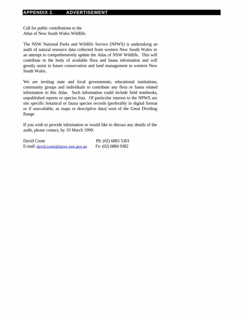
APPENDIX 2. ADVERTISEMENT
Call for public contributions to theAtlas of New South Wales Wildlife. The NSW National Parks and Wildlife Service (NPWS) is undertaking anaudit of natural resource data collected from western New South Wales inan attempt to comprehensively update the Atlas of NSW Wildlife. This willcontribute to the body of available flora and fauna information and willgreatly assist in future conservation and land management in western NewSouth Wales. We are inviting state and local governments, educational institutions,community groups and individuals to contribute any flora or fauna relatedinformation to this Atlas. Such information could include field notebooks,unpublished reports or species lists. Of particular interest to the NPWS aresite specific botanical or fauna species records (preferably in digital formator if unavailable, as maps or descriptive data) west of the Great DividingRange If you wish to provide information or would like to discuss any details of theaudit, please contact, by 19 March 1999: David Coote Ph: (02) 6883 5303 E-mail: [email protected] Fx: (02) 6884 9382
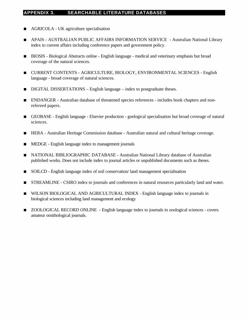
APPENDIX 3. SEARCHABLE LITERATURE DATABASES
n AGRICOLA - UK agriculture specialisation
n APAIS - AUSTRALIAN PUBLIC AFFAIRS INFORMATION SERVICE - Australian National Libraryindex to current affairs including conference papers and government policy.
n BIOSIS - Biological Abstracts online - English language - medical and veterinary emphasis but broadcoverage of the natural sciences.
n CURRENT CONTENTS - AGRICULTURE, BIOLOGY, ENVIRONMENTAL SCIENCES - Englishlanguage - broad coverage of natural sciences.
n DIGITAL DISSERTATIONS – English language – index to postgraduate theses.
n ENDANGER - Australian database of threatened species references - includes book chapters and non-refereed papers.
n GEOBASE - English language - Elsevier production - goelogical specialisation but broad coverage of naturalsciences.
n HERA - Australian Heritage Commission database - Australian natural and cultural heritage coverage.
n MEDGE - English language index to management journals
n NATIONAL BIBLIOGRAPHIC DATABASE - Australian National Library database of Australianpublished works. Does not include index to journal articles or unpublished documents such as theses.
n SOILCD - English language index of soil conservation/ land management specialisation
n STREAMLINE - CSIRO index to journals and conferences in natural resources particularly land and water.
n WILSON BIOLOGICAL AND AGRICULTURAL INDEX - English language index to journals inbiological sciences including land management and ecology
n ZOOLOGICAL RECORD ONLINE - English language index to journals in zoological sciences - coversamateur ornithological journals.
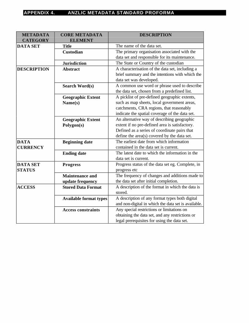
APPENDIX 4. ANZLIC METADATA STANDARD PROFORMA
METADATACATEGORY
CORE METADATAELEMENT
DESCRIPTION
DATA SET Title The name of the data set. Custodian The primary organisation associated with the
data set and responsible for its maintenance. Jurisdiction The State or Country of the custodian DESCRIPTION Abstract A characterisation of the data set, including a
brief summary and the intentions with which thedata set was developed.
Search Word(s) A common use word or phrase used to describethe data set, chosen from a predefined list.
Geographic Extent Name(s)
A picklist of pre-defined geographic extents,such as map sheets, local government areas,catchments, CRA regions, that reasonablyindicate the spatial coverage of the data set.
Geographic Extent Polygon(s)
An alternative way of describing geographicextent if no pre-defined area is satisfactory.Defined as a series of coordinate pairs thatdefine the area(s) covered by the data set.
DATACURRENCY
Beginning date The earliest date from which informationcontained in the data set is current.
Ending date The latest date to which the information in thedata set is current.
DATA SETSTATUS
Progress Progress status of the data set eg. Complete, inprogress etc
Maintenance andupdate frequency
The frequency of changes and additions made tothe data set after initial completion.
ACCESS Stored Data Format A description of the format in which the data isstored.
Available format types A description of any format types both digitaland non-digital in which the data set is available.
Access constraints Any special restrictions or limitations onobtaining the data set, and any restrictions orlegal prerequisites for using the data set.
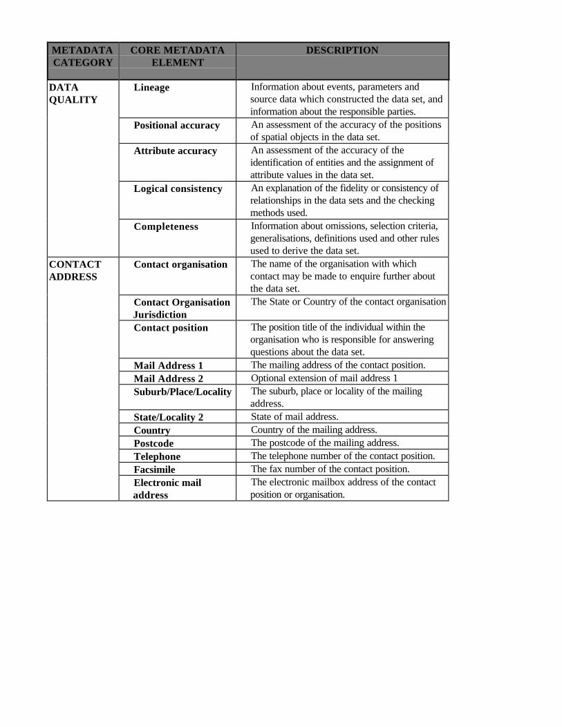
METADATACATEGORY
CORE METADATAELEMENT
DESCRIPTION
DATAQUALITY
Lineage Information about events, parameters andsource data which constructed the data set, andinformation about the responsible parties.
Positional accuracy An assessment of the accuracy of the positionsof spatial objects in the data set.
Attribute accuracy An assessment of the accuracy of theidentification of entities and the assignment ofattribute values in the data set.
Logical consistency An explanation of the fidelity or consistency ofrelationships in the data sets and the checkingmethods used.
Completeness Information about omissions, selection criteria,generalisations, definitions used and other rulesused to derive the data set.
CONTACTADDRESS
Contact organisation The name of the organisation with whichcontact may be made to enquire further aboutthe data set.
Contact OrganisationJurisdiction
The State or Country of the contact organisation
Contact position The position title of the individual within theorganisation who is responsible for answeringquestions about the data set.
Mail Address 1 The mailing address of the contact position. Mail Address 2 Optional extension of mail address 1 Suburb/Place/Locality The suburb, place or locality of the mailing
address. State/Locality 2 State of mail address. Country Country of the mailing address. Postcode The postcode of the mailing address. Telephone The telephone number of the contact position. Facsimile The fax number of the contact position. Electronic mail
address The electronic mailbox address of the contactposition or organisation.
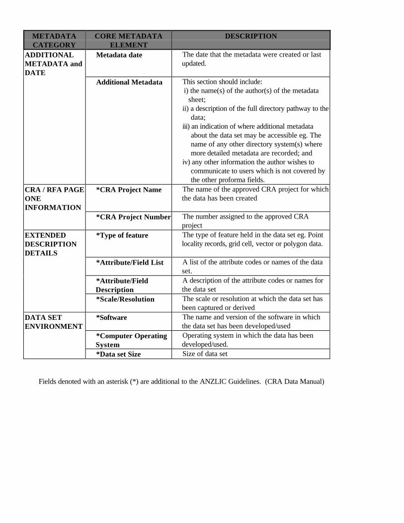
METADATACATEGORY
CORE METADATAELEMENT
DESCRIPTION
ADDITIONALMETADATA andDATE
Metadata date The date that the metadata were created or lastupdated.
Additional Metadata This section should include:i) the name(s) of the author(s) of the metadata
sheet; ii) a description of the full directory pathway to the
data; iii) an indication of where additional metadata
about the data set may be accessible eg. Thename of any other directory system(s) wheremore detailed metadata are recorded; and
iv) any other information the author wishes tocommunicate to users which is not covered bythe other proforma fields.
CRA / RFA PAGEONEINFORMATION
*CRA Project Name The name of the approved CRA project for whichthe data has been created
*CRA Project Number The number assigned to the approved CRAproject
EXTENDEDDESCRIPTIONDETAILS
*Type of feature The type of feature held in the data set eg. Pointlocality records, grid cell, vector or polygon data.
*Attribute/Field List A list of the attribute codes or names of the dataset.
*Attribute/FieldDescription
A description of the attribute codes or names forthe data set
*Scale/Resolution The scale or resolution at which the data set hasbeen captured or derived
DATA SETENVIRONMENT
*Software The name and version of the software in whichthe data set has been developed/used
*Computer OperatingSystem
Operating system in which the data has beendeveloped/used.
*Data set Size Size of data set Fields denoted with an asterisk (*) are additional to the ANZLIC Guidelines. (CRA Data Manual)
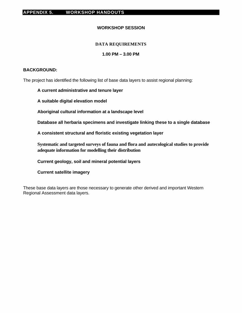
APPENDIX 5. WORKSHOP HANDOUTS
WORKSHOP SESSION
DATA REQUIREMENTS
1.00 PM – 3.00 PM
BACKGROUND:
The project has identified the following list of base data layers to assist regional planning:
A current administrative and tenure layer
A suitable digital elevation model
Aboriginal cultural information at a landscape level
Database all herbaria specimens and investigate linking these to a single database
A consistent structural and floristic existing vegetation layer
Systematic and targeted surveys of fauna and flora and autecological studies to provideadequate information for modelling their distribution
Current geology, soil and mineral potential layers
Current satellite imagery
These base data layers are those necessary to generate other derived and important WesternRegional Assessment data layers.
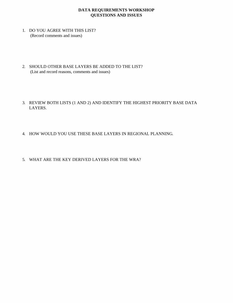
DATA REQUIREMENTS WORKSHOPQUESTIONS AND ISSUES
1. DO YOU AGREE WITH THIS LIST?(Record comments and issues)
2. SHOULD OTHER BASE LAYERS BE ADDED TO THE LIST?(List and record reasons, comments and issues)
3. REVIEW BOTH LISTS (1 AND 2) AND IDENTIFY THE HIGHEST PRIORITY BASE DATALAYERS.
4. HOW WOULD YOU USE THESE BASE LAYERS IN REGIONAL PLANNING.
5. WHAT ARE THE KEY DERIVED LAYERS FOR THE WRA?
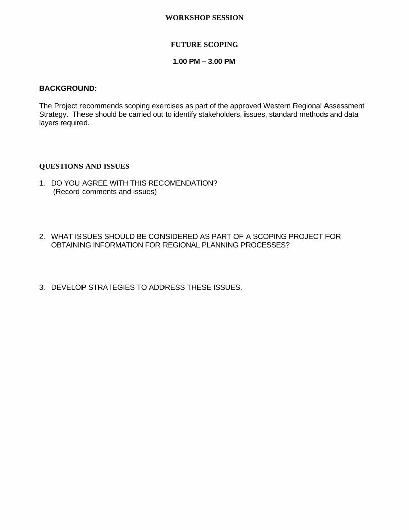
WORKSHOP SESSION
FUTURE SCOPING
1.00 PM – 3.00 PM
BACKGROUND:
The Project recommends scoping exercises as part of the approved Western Regional AssessmentStrategy. These should be carried out to identify stakeholders, issues, standard methods and datalayers required.
QUESTIONS AND ISSUES
1. DO YOU AGREE WITH THIS RECOMENDATION?(Record comments and issues)
2. WHAT ISSUES SHOULD BE CONSIDERED AS PART OF A SCOPING PROJECT FOROBTAINING INFORMATION FOR REGIONAL PLANNING PROCESSES?
3. DEVELOP STRATEGIES TO ADDRESS THESE ISSUES.
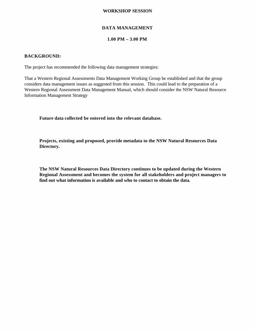
WORKSHOP SESSION
DATA MANAGEMENT
1.00 PM – 3.00 PM
BACKGROUND:
The project has recommended the following data management strategies:
That a Western Regional Assessments Data Management Working Group be established and that the groupconsiders data management issues as suggested from this session. This could lead to the preparation of aWestern Regional Assessment Data Management Manual, which should consider the NSW Natural ResourceInformation Management Strategy
Future data collected be entered into the relevant database.
Projects, existing and proposed, provide metadata to the NSW Natural Resources DataDirectory.
The NSW Natural Resources Data Directory continues to be updated during the WesternRegional Assessment and becomes the system for all stakeholders and project managers tofind out what information is available and who to contact to obtain the data.
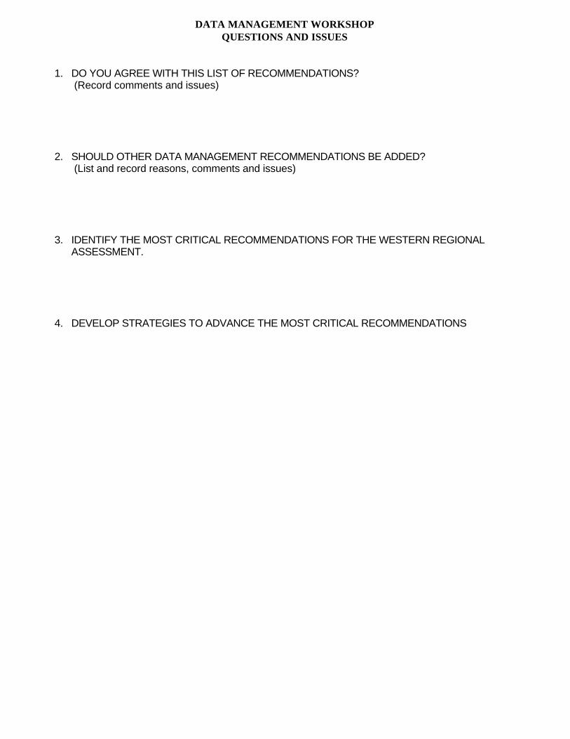
DATA MANAGEMENT WORKSHOPQUESTIONS AND ISSUES
1. DO YOU AGREE WITH THIS LIST OF RECOMMENDATIONS?(Record comments and issues)
2. SHOULD OTHER DATA MANAGEMENT RECOMMENDATIONS BE ADDED?(List and record reasons, comments and issues)
3. IDENTIFY THE MOST CRITICAL RECOMMENDATIONS FOR THE WESTERN REGIONALASSESSMENT.
4. DEVELOP STRATEGIES TO ADVANCE THE MOST CRITICAL RECOMMENDATIONS
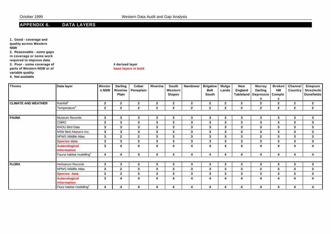
October 1999 Western Data Audit and Gap Analysis
APPENDIX 6. DATA LAYERS
1. Good - coverage andquality across WesternNSW2. Reasonable - some gapsin coverage or some workrequired to improve data3. Poor - some coverage ofparts of Western NSW or ofvariable quality
# derived layerbase layers in bold
4. Not available
Theme Data layer Western NSW
DarlingRiverine
Plain
CobarPeneplain
Riverina SouthWesternSlopes
Nandewar BrigalowBelt
South
MulgaLands
NewEngland
Tableland
MurrayDarling
Depression
BrokenHill
Complex
ChannelCountry
SimpsonStrezleckiDunefields
CLIMATE AND WEATHER Rainfall# 2 2 2 2 2 2 2 2 2 2 2 2 2Temperature# 2 2 2 2 2 2 2 2 2 2 2 2 2
FAUNA Museum Records 3 3 3 3 3 3 3 3 3 3 3 3 3CSIRO 3 3 3 3 3 3 3 3 3 3 3 3 3RAOU Bird Data 3 3 3 3 3 3 3 3 3 3 3 3 3NSW Bird Atlasers Inc. 3 3 3 3 3 3 3 3 3 3 3 3 3NPWS Wildlife Atlas 3 2 2 3 3 3 3 3 3 2 3 3 3Species data 3 3 3 3 3 3 3 3 3 3 3 3 3Autecologicalinformation
3 4 4 4 4 4 4 4 4 4 4 4 4
Fauna habitat modelling# 4 4 4 4 4 4 4 4 4 4 4 4 4
FLORA Herbarium Records 3 3 3 3 3 3 3 3 3 3 3 3 3NPWS Wildlife Atlas 3 2 3 3 3 3 3 3 3 2 3 3 3Species data 3 3 3 3 3 3 3 3 3 3 3 3 3Autecologicalinformation
3 4 4 4 4 4 4 4 4 4 4 4 4
Flora habitat modelling# 4 4 4 4 4 4 4 4 4 4 4 4 4
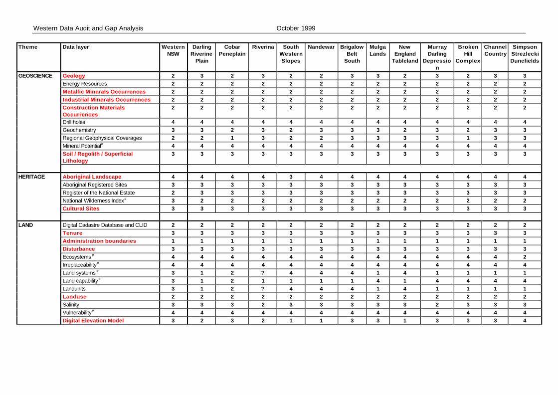
Western Data Audit and Gap Analysis October 1999
Theme Data layer WesternNSW
DarlingRiverine
Plain
CobarPeneplain
Riverina SouthWesternSlopes
Nandewar BrigalowBelt
South
MulgaLands
NewEngland
Tableland
MurrayDarling
Depression
BrokenHill
Complex
ChannelCountry
SimpsonStrezleckiDunefields
GEOSCIENCE Geology 2 3 2 3 2 2 3 3 2 3 2 3 3Energy Resources 2 2 2 2 2 2 2 2 2 2 2 2 2Metallic Minerals Occurrences 2 2 2 2 2 2 2 2 2 2 2 2 2Industrial Minerals Occurrences 2 2 2 2 2 2 2 2 2 2 2 2 2Construction MaterialsOccurrences
2 2 2 2 2 2 2 2 2 2 2 2 2
Drill holes 4 4 4 4 4 4 4 4 4 4 4 4 4Geochemistry 3 3 2 3 2 3 3 3 2 3 2 3 3Regional Geophysical Coverages 2 2 1 3 2 2 3 3 3 3 1 3 3Mineral Potential# 4 4 4 4 4 4 4 4 4 4 4 4 4Soil / Regolith / SuperficialLithology
3 3 3 3 3 3 3 3 3 3 3 3 3
HERITAGE Aboriginal Landscape 4 4 4 4 3 4 4 4 4 4 4 4 4Aboriginal Registered Sites 3 3 3 3 3 3 3 3 3 3 3 3 3Register of the National Estate 2 3 3 3 3 3 3 3 3 3 3 3 3National Wilderness Index# 3 2 2 2 2 2 2 2 2 2 2 2 2Cultural Sites 3 3 3 3 3 3 3 3 3 3 3 3 3
LAND Digital Cadastre Database and CLID 2 2 2 2 2 2 2 2 2 2 2 2 2Tenure 3 3 3 3 3 3 3 3 3 3 3 3 3Administration boundaries 1 1 1 1 1 1 1 1 1 1 1 1 1Disturbance 3 3 3 3 3 3 3 3 3 3 3 3 3Ecosystems # 4 4 4 4 4 4 4 4 4 4 4 4 2Irreplaceability# 4 4 4 4 4 4 4 4 4 4 4 4 4Land systems # 3 1 2 ? 4 4 4 1 4 1 1 1 1Land capability# 3 1 2 1 1 1 1 4 1 4 4 4 4Landunits 3 1 2 ? 4 4 4 1 4 1 1 1 1Landuse 2 2 2 2 2 2 2 2 2 2 2 2 2Salinity 3 3 3 2 3 3 3 3 3 2 3 3 3Vulnerability# 4 4 4 4 4 4 4 4 4 4 4 4 4Digital Elevation Model 3 2 3 2 1 1 3 3 1 3 3 3 4
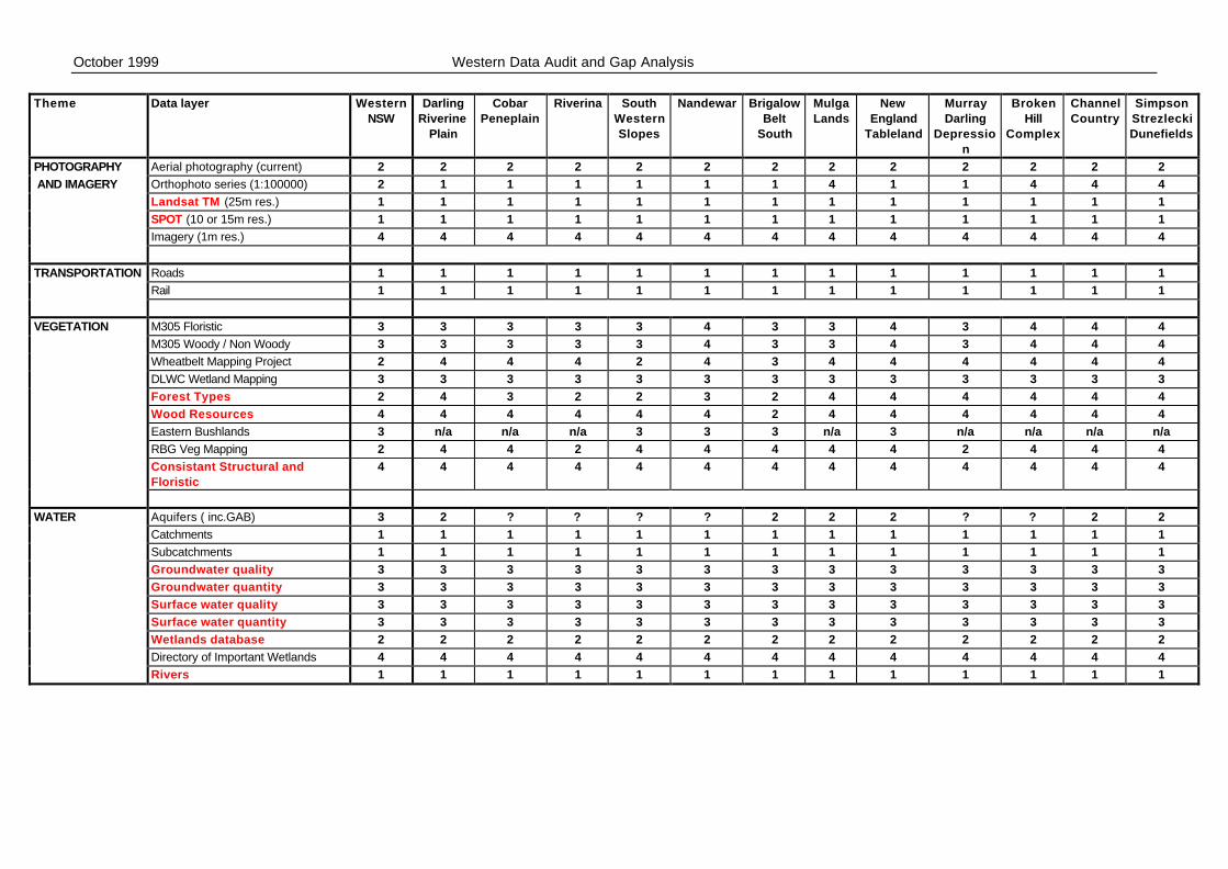
October 1999 Western Data Audit and Gap Analysis
Theme Data layer WesternNSW
DarlingRiverine
Plain
CobarPeneplain
Riverina SouthWesternSlopes
Nandewar BrigalowBelt
South
MulgaLands
NewEngland
Tableland
MurrayDarling
Depression
BrokenHill
Complex
ChannelCountry
SimpsonStrezleckiDunefields
PHOTOGRAPHY Aerial photography (current) 2 2 2 2 2 2 2 2 2 2 2 2 2 AND IMAGERY Orthophoto series (1:100000) 2 1 1 1 1 1 1 4 1 1 4 4 4
Landsat TM (25m res.) 1 1 1 1 1 1 1 1 1 1 1 1 1SPOT (10 or 15m res.) 1 1 1 1 1 1 1 1 1 1 1 1 1Imagery (1m res.) 4 4 4 4 4 4 4 4 4 4 4 4 4
TRANSPORTATION Roads 1 1 1 1 1 1 1 1 1 1 1 1 1Rail 1 1 1 1 1 1 1 1 1 1 1 1 1
VEGETATION M305 Floristic 3 3 3 3 3 4 3 3 4 3 4 4 4M305 Woody / Non Woody 3 3 3 3 3 4 3 3 4 3 4 4 4Wheatbelt Mapping Project 2 4 4 4 2 4 3 4 4 4 4 4 4DLWC Wetland Mapping 3 3 3 3 3 3 3 3 3 3 3 3 3Forest Types 2 4 3 2 2 3 2 4 4 4 4 4 4Wood Resources 4 4 4 4 4 4 2 4 4 4 4 4 4Eastern Bushlands 3 n/a n/a n/a 3 3 3 n/a 3 n/a n/a n/a n/aRBG Veg Mapping 2 4 4 2 4 4 4 4 4 2 4 4 4Consistant Structural andFloristic
4 4 4 4 4 4 4 4 4 4 4 4 4
WATER Aquifers ( inc.GAB) 3 2 ? ? ? ? 2 2 2 ? ? 2 2Catchments 1 1 1 1 1 1 1 1 1 1 1 1 1Subcatchments 1 1 1 1 1 1 1 1 1 1 1 1 1Groundwater quality 3 3 3 3 3 3 3 3 3 3 3 3 3Groundwater quantity 3 3 3 3 3 3 3 3 3 3 3 3 3Surface water quality 3 3 3 3 3 3 3 3 3 3 3 3 3Surface water quantity 3 3 3 3 3 3 3 3 3 3 3 3 3Wetlands database 2 2 2 2 2 2 2 2 2 2 2 2 2Directory of Important Wetlands 4 4 4 4 4 4 4 4 4 4 4 4 4Rivers 1 1 1 1 1 1 1 1 1 1 1 1 1
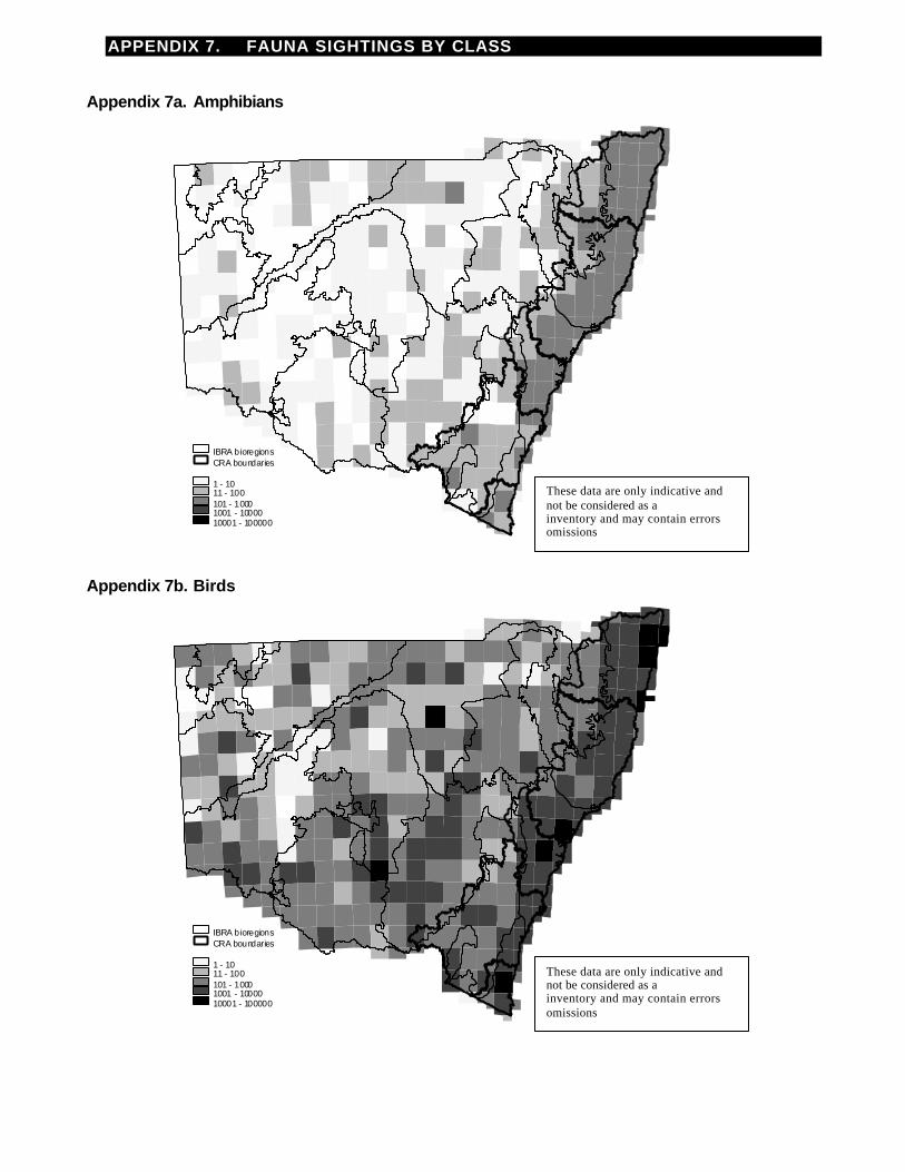
APPENDIX 7. FAUNA SIGHTINGS BY CLASS
Appendix 7a. Amphibians
Appendix 7b. Birds
1 - 1011 - 100101 - 10001001 - 1000010001 - 100000
CRA boundariesIBRA bioregions
1 - 1011 - 100101 - 10001001 - 1000010001 - 100000
CRA boundariesIBRA bioregions
These data are only indicative andcannot be considered as acomprehensiveinventory and may contain errorsandomissions
These data are only indicative andcannot be considered as acomprehensiveinventory and may contain errorsandomissions
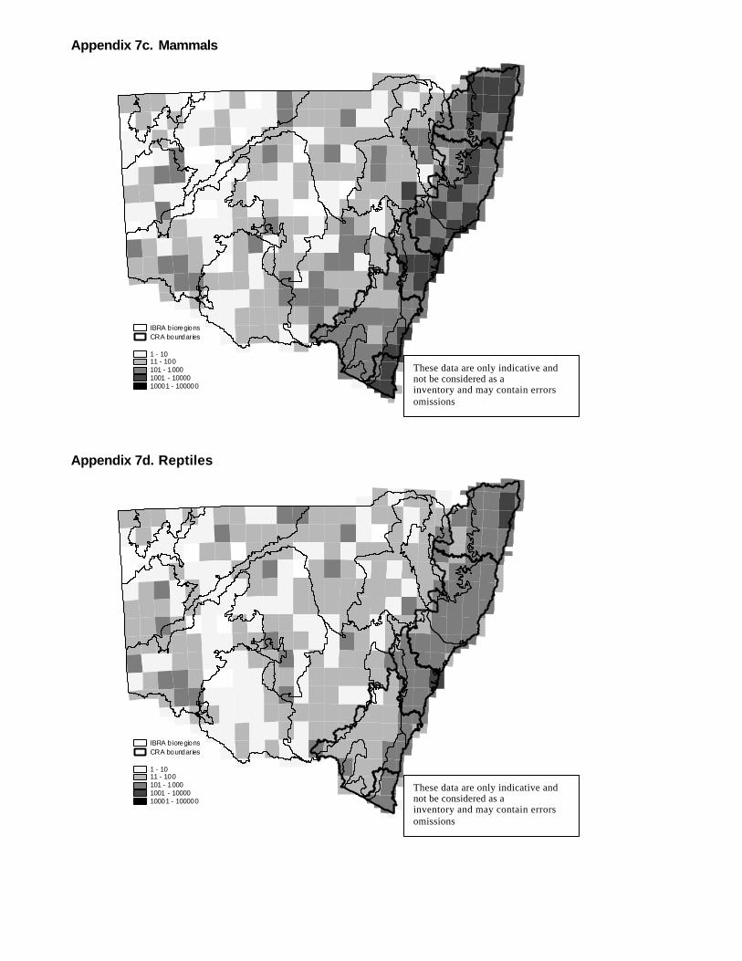
Appendix 7c. Mammals
Appendix 7d. Reptiles
1 - 1011 - 100101 - 10001001 - 1000010001 - 100000
CRA boundariesIBRA bioregions
1 - 1011 - 100101 - 10001001 - 1000010001 - 100000
CRA boundariesIBRA bioregions
These data are only indicative andcannot be considered as acomprehensiveinventory and may contain errorsandomissions
These data are only indicative andcannot be considered as acomprehensiveinventory and may contain errorsandomissions

APPENDIX 8. WORKSHOP SESSION RESULTS
DATA REQUIREMENTS WORKSHOP
1. DO YOU AGREE WITH THIS LIST?
n base data layers for derived information to feed into regional planning [qualification]
n digital elevation model; best available and according to need and may vary by region
n Aboriginal cultural information; subject to comprehensive consultation
1. SHOULD OTHER BASE LAYERS BE ADDED TO THE LIST?
n should add each individual data layer that falls under each theme and include a glossary of terms to clarifydefinitions
n add land use (historical and current)
n add disturbance history
n add cultural heritage sites (indigenous and non-indigenous) landscapes
n up to date and uniform geology, soil and mineral potential layers
n add water as a theme with rivers and streams, stream order, ground water, surface water, salinity mapping,flood mapping and wetlands as base layers
n add up to date and uniform wood resource information
2. REVIEW BOTH LISTS (1 AND 2) AND IDENTIFY THE HIGHEST PRIORITY BASE DATALAYERS.
n vegetation mapping
3. HOW WOULD YOU USE THESE BASE LAYERS IN REGIONAL PLANNING.
n base layers can be used directly to inform current initiatives and programs
n derived layers will be essential for strategic and sustainable planning
4. WHAT ARE THE KEY DERIVED LAYERS FOR THE WRA?
n salinity potential n land suitability / capability
n ecosystems n land systems
n modelled plant communities n terrain indices
n modelled species distribution n socio-economic
n threatening processes n vulnerability
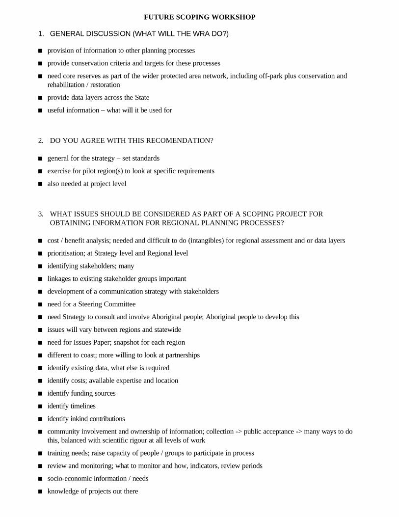
FUTURE SCOPING WORKSHOP
1. GENERAL DISCUSSION (WHAT WILL THE WRA DO?)
n provision of information to other planning processes
n provide conservation criteria and targets for these processes
n need core reserves as part of the wider protected area network, including off-park plus conservation andrehabilitation / restoration
n provide data layers across the State
n useful information – what will it be used for
2. DO YOU AGREE WITH THIS RECOMENDATION?
n general for the strategy – set standards
n exercise for pilot region(s) to look at specific requirements
n also needed at project level
3. WHAT ISSUES SHOULD BE CONSIDERED AS PART OF A SCOPING PROJECT FOROBTAINING INFORMATION FOR REGIONAL PLANNING PROCESSES?
n cost / benefit analysis; needed and difficult to do (intangibles) for regional assessment and or data layers
n prioritisation; at Strategy level and Regional level
n identifying stakeholders; many
n linkages to existing stakeholder groups important
n development of a communication strategy with stakeholders
n need for a Steering Committee
n need Strategy to consult and involve Aboriginal people; Aboriginal people to develop this
n issues will vary between regions and statewide
n need for Issues Paper; snapshot for each region
n different to coast; more willing to look at partnerships
n identify existing data, what else is required
n identify costs; available expertise and location
n identify funding sources
n identify timelines
n identify inkind contributions
n community involvement and ownership of information; collection -> public acceptance -> many ways to dothis, balanced with scientific rigour at all levels of work
n training needs; raise capacity of people / groups to participate in process
n review and monitoring; what to monitor and how, indicators, review periods
n socio-economic information / needs
n knowledge of projects out there
n need for technical support; socio / environmental economists
n need for indicators for socio-economic values; ie Treasury and WRA
n pressures and threats; economic and broader, need threat analysis
n regions; what will be used, bioregions, Aboriginal lands / nations, Local Government, Regional VegetationManagement Committee
n unit consistent with current planning; catchments, Local Government
n regions depend on data / uses -> don’t lose information
n pilot; needs information already / planning processes / scale
n trial of process -> adaptive learning for next region
4. DEVELOP STRATEGIES TO ADDRESS THESE ISSUES.
n need WRA Framework plus Regional Framework; plan of operation
n information must be useful; what will it be used for
n need to include experts and users
n “fuzzy” lines / boundaries on maps
n need to review conservation criteria for each region; eg CSIRO and Southern Mallee used thresholds,problems with targets too rigid, eg Central West thresholds exceeded
n thresholds vary between plant communities and temporally within communities
n guidelines of sensitivity
n monitoring / reporting approaches allows adaptive management, therefore Strategy would identify what ismonitored / who in community and why / when and must be repeatable
n innovative ways of providing access to information needed
n need for tools to assist decision making; wood resource assessments, requirement for timber for new industryand cultural heritage
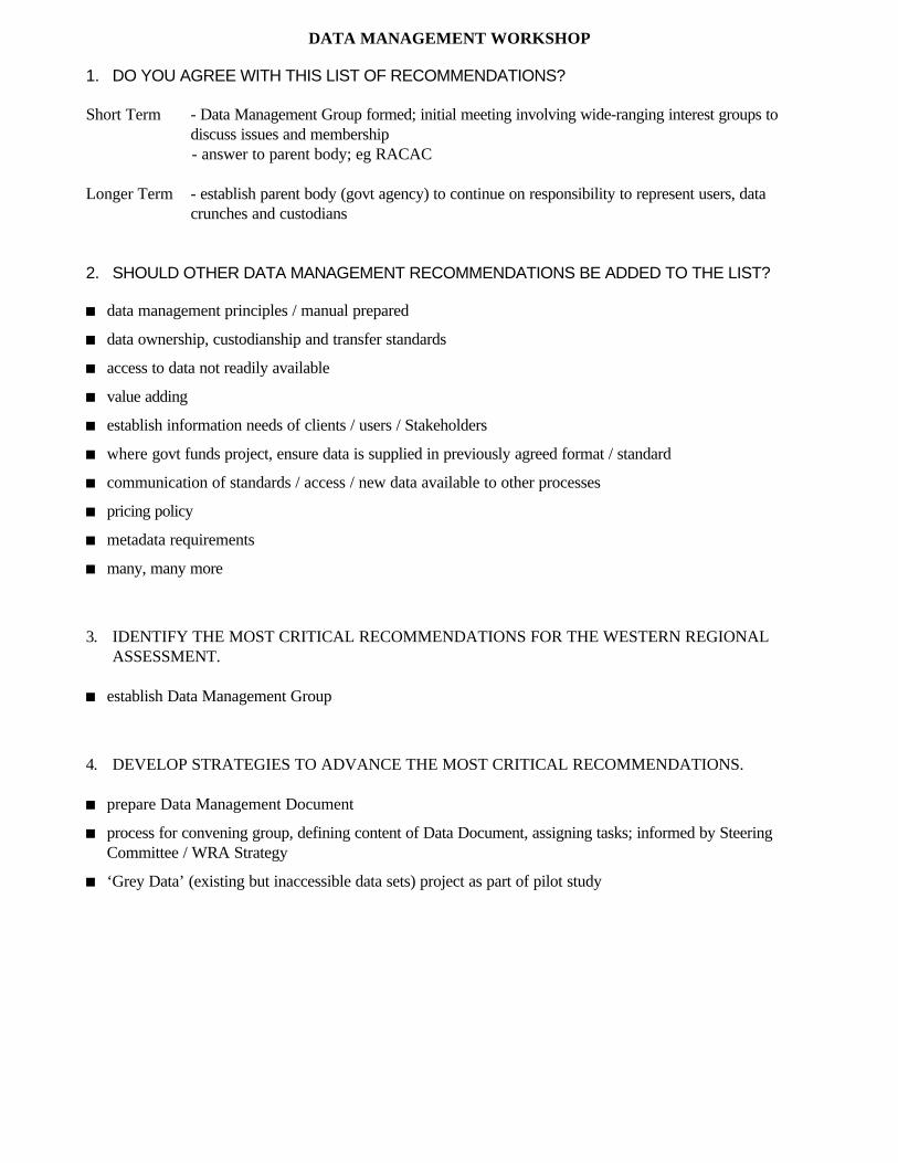
DATA MANAGEMENT WORKSHOP
1. DO YOU AGREE WITH THIS LIST OF RECOMMENDATIONS?
Short Term - Data Management Group formed; initial meeting involving wide-ranging interest groups todiscuss issues and membership- answer to parent body; eg RACAC
Longer Term - establish parent body (govt agency) to continue on responsibility to represent users, datacrunches and custodians
2. SHOULD OTHER DATA MANAGEMENT RECOMMENDATIONS BE ADDED TO THE LIST?
n data management principles / manual prepared
n data ownership, custodianship and transfer standards
n access to data not readily available
n value adding
n establish information needs of clients / users / Stakeholders
n where govt funds project, ensure data is supplied in previously agreed format / standard
n communication of standards / access / new data available to other processes
n pricing policy
n metadata requirements
n many, many more
3. IDENTIFY THE MOST CRITICAL RECOMMENDATIONS FOR THE WESTERN REGIONALASSESSMENT.
n establish Data Management Group
4. DEVELOP STRATEGIES TO ADVANCE THE MOST CRITICAL RECOMMENDATIONS.
n prepare Data Management Document
n process for convening group, defining content of Data Document, assigning tasks; informed by SteeringCommittee / WRA Strategy
n ‘Grey Data’ (existing but inaccessible data sets) project as part of pilot study
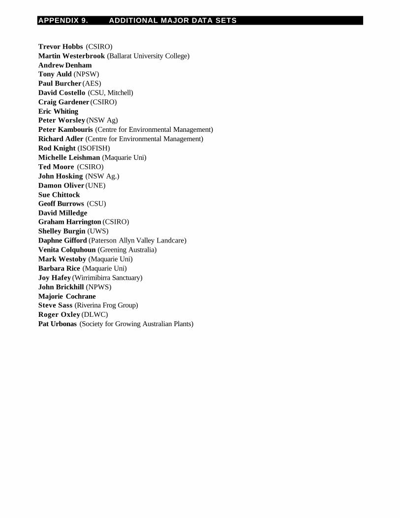
APPENDIX 9. ADDITIONAL MAJOR DATA SETS
Trevor Hobbs (CSIRO)Martin Westerbrook (Ballarat University College)Andrew DenhamTony Auld (NPSW)Paul Burcher (AES)David Costello (CSU, Mitchell)Craig Gardener (CSIRO)Eric WhitingPeter Worsley (NSW Ag)Peter Kambouris (Centre for Environmental Management)Richard Adler (Centre for Environmental Management)Rod Knight (ISOFISH)Michelle Leishman (Maquarie Uni)Ted Moore (CSIRO)John Hosking (NSW Ag.)Damon Oliver (UNE)Sue ChittockGeoff Burrows (CSU)David MilledgeGraham Harrington (CSIRO)Shelley Burgin (UWS)Daphne Gifford (Paterson Allyn Valley Landcare)Venita Colquhoun (Greening Australia)Mark Westoby (Maquarie Uni)Barbara Rice (Maquarie Uni)Joy Hafey (Wirrimibirra Sanctuary)John Brickhill (NPWS)Majorie CochraneSteve Sass (Riverina Frog Group)Roger Oxley (DLWC)Pat Urbonas (Society for Growing Australian Plants)
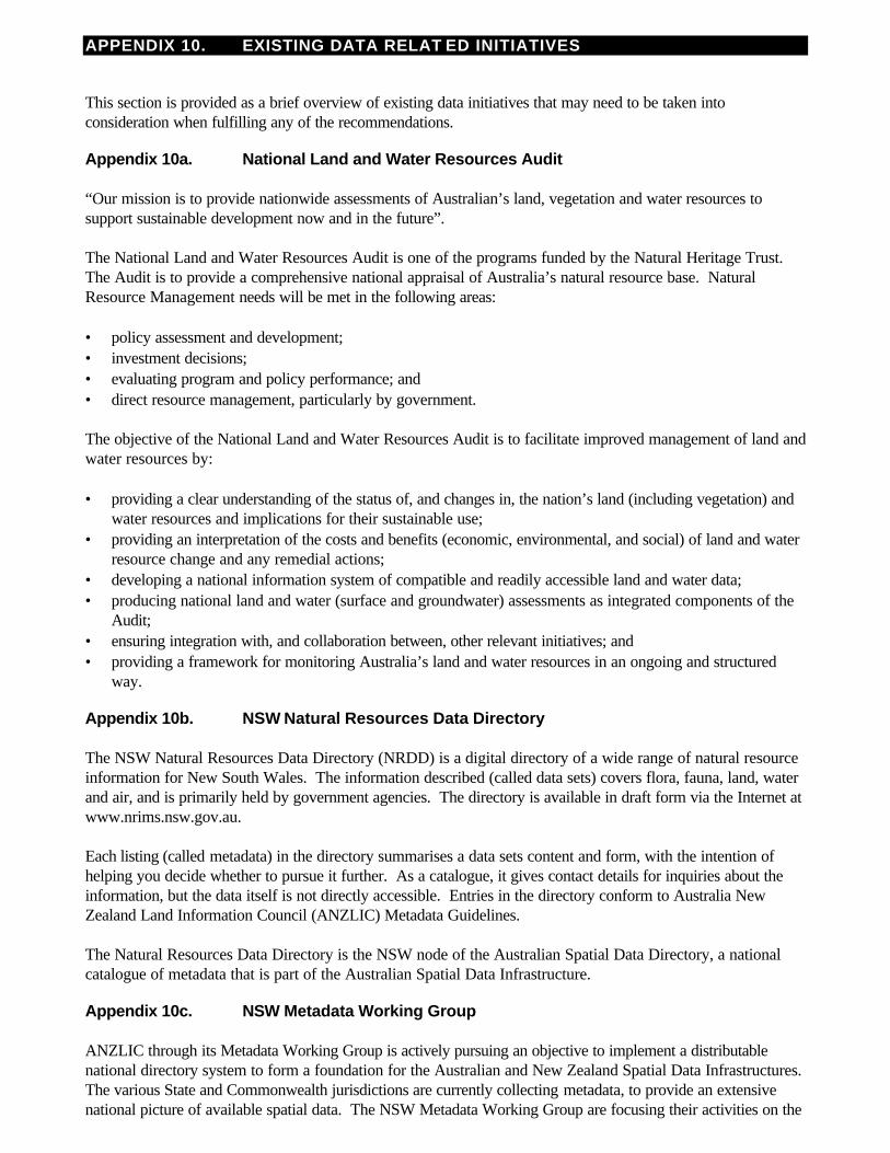
APPENDIX 10. EXISTING DATA RELAT ED INITIATIVES
This section is provided as a brief overview of existing data initiatives that may need to be taken intoconsideration when fulfilling any of the recommendations.
Appendix 10a. National Land and Water Resources Audit “Our mission is to provide nationwide assessments of Australian’s land, vegetation and water resources tosupport sustainable development now and in the future”. The National Land and Water Resources Audit is one of the programs funded by the Natural Heritage Trust.The Audit is to provide a comprehensive national appraisal of Australia’s natural resource base. NaturalResource Management needs will be met in the following areas: • policy assessment and development;• investment decisions;• evaluating program and policy performance; and• direct resource management, particularly by government. The objective of the National Land and Water Resources Audit is to facilitate improved management of land andwater resources by: • providing a clear understanding of the status of, and changes in, the nation’s land (including vegetation) and
water resources and implications for their sustainable use;• providing an interpretation of the costs and benefits (economic, environmental, and social) of land and water
resource change and any remedial actions;• developing a national information system of compatible and readily accessible land and water data;• producing national land and water (surface and groundwater) assessments as integrated components of the
Audit;• ensuring integration with, and collaboration between, other relevant initiatives; and• providing a framework for monitoring Australia’s land and water resources in an ongoing and structured
way.
Appendix 10b. NSW Natural Resources Data Directory The NSW Natural Resources Data Directory (NRDD) is a digital directory of a wide range of natural resourceinformation for New South Wales. The information described (called data sets) covers flora, fauna, land, waterand air, and is primarily held by government agencies. The directory is available in draft form via the Internet atwww.nrims.nsw.gov.au. Each listing (called metadata) in the directory summarises a data sets content and form, with the intention ofhelping you decide whether to pursue it further. As a catalogue, it gives contact details for inquiries about theinformation, but the data itself is not directly accessible. Entries in the directory conform to Australia NewZealand Land Information Council (ANZLIC) Metadata Guidelines. The Natural Resources Data Directory is the NSW node of the Australian Spatial Data Directory, a nationalcatalogue of metadata that is part of the Australian Spatial Data Infrastructure.
Appendix 10c. NSW Metadata Working Group ANZLIC through its Metadata Working Group is actively pursuing an objective to implement a distributablenational directory system to form a foundation for the Australian and New Zealand Spatial Data Infrastructures.The various State and Commonwealth jurisdictions are currently collecting metadata, to provide an extensivenational picture of available spatial data. The NSW Metadata Working Group are focusing their activities on the
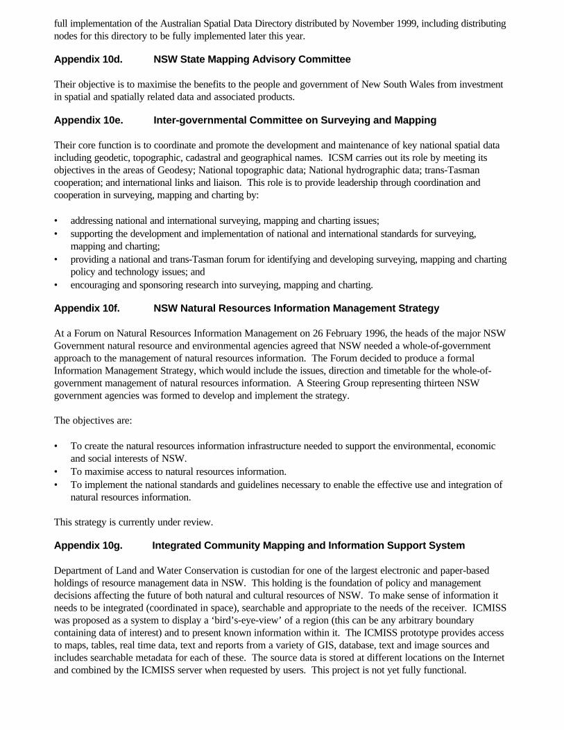
full implementation of the Australian Spatial Data Directory distributed by November 1999, including distributingnodes for this directory to be fully implemented later this year.
Appendix 10d. NSW State Mapping Advisory Committee Their objective is to maximise the benefits to the people and government of New South Wales from investmentin spatial and spatially related data and associated products.
Appendix 10e. Inter-governmental Committee on Surveying and Mapping Their core function is to coordinate and promote the development and maintenance of key national spatial dataincluding geodetic, topographic, cadastral and geographical names. ICSM carries out its role by meeting itsobjectives in the areas of Geodesy; National topographic data; National hydrographic data; trans-Tasmancooperation; and international links and liaison. This role is to provide leadership through coordination andcooperation in surveying, mapping and charting by: • addressing national and international surveying, mapping and charting issues;• supporting the development and implementation of national and international standards for surveying,
mapping and charting;• providing a national and trans-Tasman forum for identifying and developing surveying, mapping and charting
policy and technology issues; and• encouraging and sponsoring research into surveying, mapping and charting.
Appendix 10f. NSW Natural Resources Information Management Strategy At a Forum on Natural Resources Information Management on 26 February 1996, the heads of the major NSWGovernment natural resource and environmental agencies agreed that NSW needed a whole-of-governmentapproach to the management of natural resources information. The Forum decided to produce a formalInformation Management Strategy, which would include the issues, direction and timetable for the whole-of-government management of natural resources information. A Steering Group representing thirteen NSWgovernment agencies was formed to develop and implement the strategy. The objectives are: • To create the natural resources information infrastructure needed to support the environmental, economic
and social interests of NSW.• To maximise access to natural resources information.• To implement the national standards and guidelines necessary to enable the effective use and integration of
natural resources information. This strategy is currently under review.
Appendix 10g. Integrated Community Mapping and Information Support System Department of Land and Water Conservation is custodian for one of the largest electronic and paper-basedholdings of resource management data in NSW. This holding is the foundation of policy and managementdecisions affecting the future of both natural and cultural resources of NSW. To make sense of information itneeds to be integrated (coordinated in space), searchable and appropriate to the needs of the receiver. ICMISSwas proposed as a system to display a ‘bird’s-eye-view’ of a region (this can be any arbitrary boundarycontaining data of interest) and to present known information within it. The ICMISS prototype provides accessto maps, tables, real time data, text and reports from a variety of GIS, database, text and image sources andincludes searchable metadata for each of these. The source data is stored at different locations on the Internetand combined by the ICMISS server when requested by users. This project is not yet fully functional.
Appendix 10h. Australian and New Zealand Land Information Council ANZLIC’s mission is to provide leadership for effective management and use of land and geographicinformation to support economic growth, sustainable development and the social and environmental interests ofAustralia and New Zealand. By the year 2000, ANZLIC will deliver: • a national focus for strategic spatial information initiatives;• a strategic organisational framework;• spatial data infrastructures for Australia; and• the environment to support better decision-making.
Appendix 10i.Community Access to Natural Resource Information This is a program of funding to aid the community to access traditionally government based digital spatialinformation. The program covers issues such as Internet based data request and delivery, online data searchand development of comprehensive databases for natural resource data to serve the community in planning,assessment and information. This project is coordinated by DLWC.
Appendix 10j.NSW State Biodiversity Strategy The NSW Biodiversity Strategy emphasises that the conservation of biodiversity requires a collaborative effort,supported by the entire community. The NSW Government is committed to ensuring that the community has agreater role in decision-making on biodiversity issues. This will require a community that is both informed, willingto participate in and initiate conservation activities. Actions to achieve greater community involvement in biodiversity conservation through bioregional planning anda whole of government approach are central features of the Strategy. It outlines actions to improve thebiodiversity information base, provide educational opportunities and also provides support for communitypartnerships between the diverse range of individuals, organisations and agencies involved in biodiversityconservation. The Strategy has been ratified by government and $5.3m have been allocated over 3 years to begin the workidentified within the Strategy. The Western Regional Assessment and the various planning processes will needto take account of the Strategy and be consistent with the Strategy.
Appendix 10k. Architecture for Access to Government Information The IMSC-Technical Group as charged with producing a report for submission to the IMSC, investigatingaccess architectures to government information and recommending future actions.
Appendix 10l. Discovery 2000 The Discovery 2000 Exploration Initiative is an important New South Wales Government program to acceleratethe development of the mineral resources industry in the State. The Government is investing $35 million over thesix year period to the year 2000 to provide an enhanced geological, geophysical and information framework tocreate an environment for mineral exploration growth in the mining sector.
Appendix 10m. Western Lands Review The terms of reference are as follows: • review and report on the effectiveness of the operation of the Western Lands Act and associated Acts on
the management of western lands• identify issues which impact on the long term sustainable management of western lands addressing
economic, social and environmental outcomes
• recommend actions required to implement sustainable management and use of the western lands resourcesincluding appropriate legislation, institutions an tenure agreements
Appendix 10n. Protocol on the quality and usefulness of vegetation survey and mappingdatasets
Description: An interdepartmental committee on vegetation management coordinated by DLWC approachedthe RBG to prepare a protocol on data standards for vegetation mapping and survey. The protocol wouldinclude descriptions and provide examples of different qualities of data. It would also outline the usefulness ofdifferent types of data. Some data are misused in GIS either because it used at too fine a scale, or its quality isnot up to national or state standards. These standards relate to those being developed for Australia by theNational Land and Water Audit and those to be described in NSW Guidelines for Vegetation Survey andMapping (see below). The topics of mapping scale/quality and survey intensity/quality will be discussed in theProtocol. Existing vegetation data sets in the Natural Resources Data Directory could be assigned a code fromthis protocol. This would then be a guideline for the use of the data by regional vegetation committees and otherusers. A preliminary protocol is outlined on pages 25-26 in Benson, J.S. (1999) Setting the Scene: the nativeVegetation of NSW Background Paper No. 1 Native Vegetation Advisory Council: Sydney. This paper shouldbe published and widely distributed soon.
Status: This protocol is to be compiled by John Benson of the RBG under a steering committee. Funding fromDLWC was promised for March 1999 but it has not yet eventuated.
Appendix 10o. Preparation of Guidelines for Vegetation Survey and Mapping
Description: There is no statewide set of guidelines for vegetation survey and mapping in NSW. Given thatvegetation mapping may accelerate over the next decade to meet the demands of the native VegetationConservation Act and other laws, these are urgently required.
An interdepartmental committee on vegetation management coordinated by DLWC approached the RBG toprepare Guidelines on Vegetation Survey and Mapping. This would be similar to the South Australian guidelinesbut may develop into a field manual. The guidelines would describe how to sample the landscape for vegetationand how to map vegetation from aerial photographs or by other means. Specimen collection, recording,identification and herbarium procedures would be outlined. The aim of the guidelines would be to standardisehow floristic site data are collected and how mapping is done throughout NSW – not just by Governmentagencies but also consultants and local government. A site survey proforma would be attached to the guidelinesdeveloped from existing proformas used by agencies and for the CRA. This would contain mandatory and non-mandatory fields.
Status: This protocol is to be compiled by John Benson of the RBG under a steering committee. Funding fromDLWC was promised for March 1999 but it has not yet eventuated. It is anticipated this would take 6-12months to develop to a published state. The protocol outlined in 5n above would be referred to in the guidelines.
Appendix 10p. Classification of the plant communities of New South Wales andassessment of their conservation and threat status.
Description: This project would update the classification of NSW vegetation published in table 4 of Benson,J.S. (1989) Establishing priorities of the conservation of rare or threatened plants and plant associationsin NSW Occasional Paper 2 (Australian Committee of IUCN: Canberra). This paper listed 430 plantcommunities under major environmental domains in NSW. It has often been quoted in land assessments andEISs by a number of authorities and private individuals. Many reserves have been established, at least in part,due to the 1989 assessment ratings of certain plant communities. However, due to the dedication of manyreserves and a large number of vegetation surveys in the intervening period, Benson (1989) is out of date.
The project would reclassify the vegetation of NSW at a regional scale taking into account key vegetationmapping, surveys and expert advice. Data on each plant community would be placed onto an Access database.Fields would include existing extent, pre-European extent, area reserved, bioregional extent, mapping extent, keyreferences, conservation status code, threat status code and others. Many fields in the database would havereliability ratings assigned to data in them – ranging from measured to coarse estimate by an expert. Threatstatus codes would be similar to the IUCN codes for species and based on rules being developed in Australiaand overseas.
Over a longer time frame fine scale vegetation mapping may replace or lead to modifications of this database. Itis proposed that the classification be published in a refereed journal, but also be placed on the Internet. It couldbe regularly updated as more information comes to hand.
Status: Funds will be allocated to John Benson of the RBG under the Biodiversity Strategy Program. Theproject should commence in August 1999 and be completed 15 months later. Its success will largely rely on thecooperation of other agencies, particularly the NPWS concerning the classifications derived in theComprehensive Regional Assessments in eastern NSW.
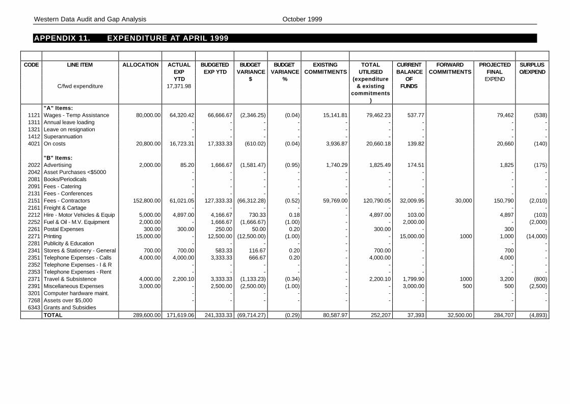
Western Data Audit and Gap Analysis October 1999
APPENDIX 11. EXPENDITURE AT APRIL 1999
CODE LINE ITEM ALLOCATION ACTUAL BUDGETED BUDGET BUDGET EXISTING TOTAL CURRENT FORWARD PROJECTED SURPLUSEXP EXP YTD VARIANCE VARIANCE COMMITMENTS UTILISED BALANCE COMMITMENTS FINAL O/EXPENDYTD $ % (expenditure OF EXPEND
C/fwd expenditure 17,371.98 & existing FUNDScommitments
)"A" Items:
1121 Wages - Temp Assistance 80,000.00 64,320.42 66,666.67 (2,346.25) (0.04) 15,141.81 79,462.23 537.77 79,462 (538)1311 Annual leave loading - - - - - - - - -1321 Leave on resignation - - - - - - - - -1412 Superannuation - - - - - - - - -4021 On costs 20,800.00 16,723.31 17,333.33 (610.02) (0.04) 3,936.87 20,660.18 139.82 20,660 (140)
"B" Items:2022 Advertising 2,000.00 85.20 1,666.67 (1,581.47) (0.95) 1,740.29 1,825.49 174.51 1,825 (175)2042 Asset Purchases <$5000 - - - - - - - - -2081 Books/Periodicals - - - - - - - - -2091 Fees - Catering - - - - - - - - -2131 Fees - Conferences - - - - - - - - -2151 Fees - Contractors 152,800.00 61,021.05 127,333.33 (66,312.28) (0.52) 59,769.00 120,790.05 32,009.95 30,000 150,790 (2,010)2161 Freight & Cartage - - - - - - - - -2212 Hire - Motor Vehicles & Equip 5,000.00 4,897.00 4,166.67 730.33 0.18 - 4,897.00 103.00 4,897 (103)2252 Fuel & Oil - M.V. Equipment 2,000.00 - 1,666.67 (1,666.67) (1.00) - - 2,000.00 - (2,000)2261 Postal Expenses 300.00 300.00 250.00 50.00 0.20 - 300.00 - 300 -2271 Printing 15,000.00 - 12,500.00 (12,500.00) (1.00) - - 15,000.00 1000 1,000 (14,000)2281 Publicity & Education - - - - - - - - -2341 Stores & Stationery - General 700.00 700.00 583.33 116.67 0.20 - 700.00 - 700 -2351 Telephone Expenses - Calls 4,000.00 4,000.00 3,333.33 666.67 0.20 - 4,000.00 - 4,000 -2352 Telephone Expenses - I & R - - - - - - - - -2353 Telephone Expenses - Rent - - - - - - - - -2371 Travel & Subsistence 4,000.00 2,200.10 3,333.33 (1,133.23) (0.34) - 2,200.10 1,799.90 1000 3,200 (800)2391 Miscellaneous Expenses 3,000.00 - 2,500.00 (2,500.00) (1.00) - - 3,000.00 500 500 (2,500)3201 Computer hardware maint. - - - - - - - - -7268 Assets over $5,000 - - - - - - - - -6343 Grants and Subsidies
TOTAL 289,600.00 171,619.06 241,333.33 (69,714.27) (0.29) 80,587.97 252,207 37,393 32,500.00 284,707 (4,893)