data quality evaluation & orbit identification from scatterometer
TRANSCRIPT

Data Quality Evaluation & Orbit Identification from SCATTEROMETER Data Products Using
Modern Computing Techniques
By:- Mudit J Dholakia (14MTPOS001)
Under the guidance of
Dr. C K Bhensdadia(Head, Department of Computer Engineering, DDU-Nadiad)
Mrs. Anuja Sharma (Scientist-’SF’, IAQD/SIPA/SPDCG/SAC/Ahmedabad)
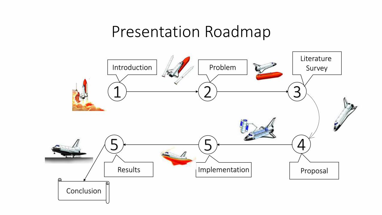
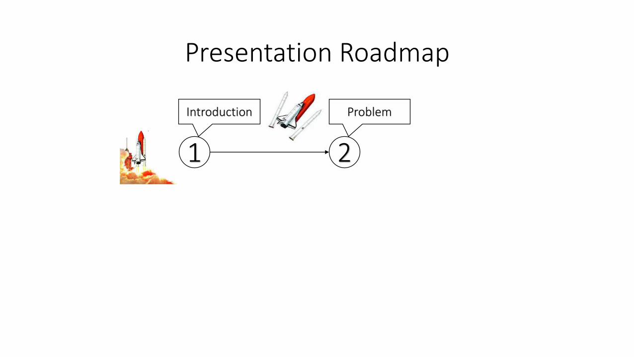
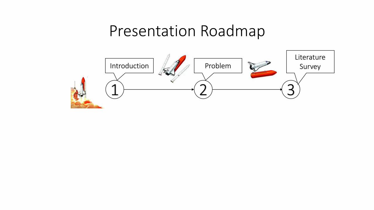
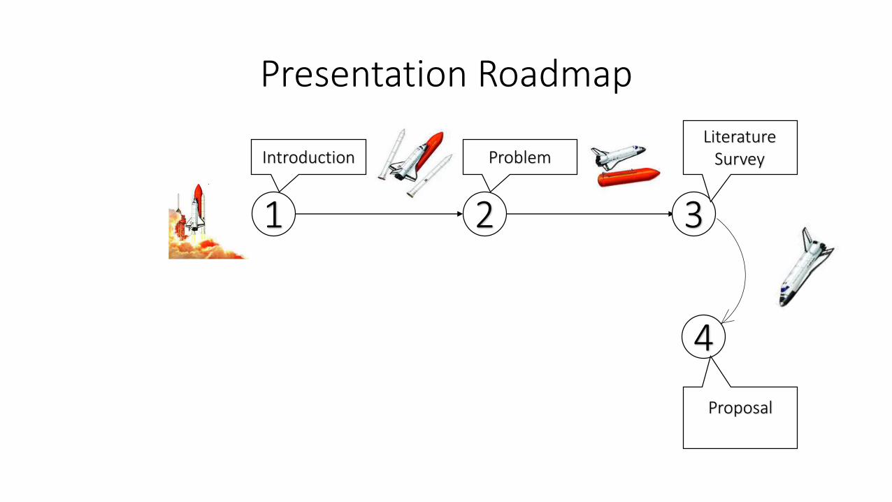
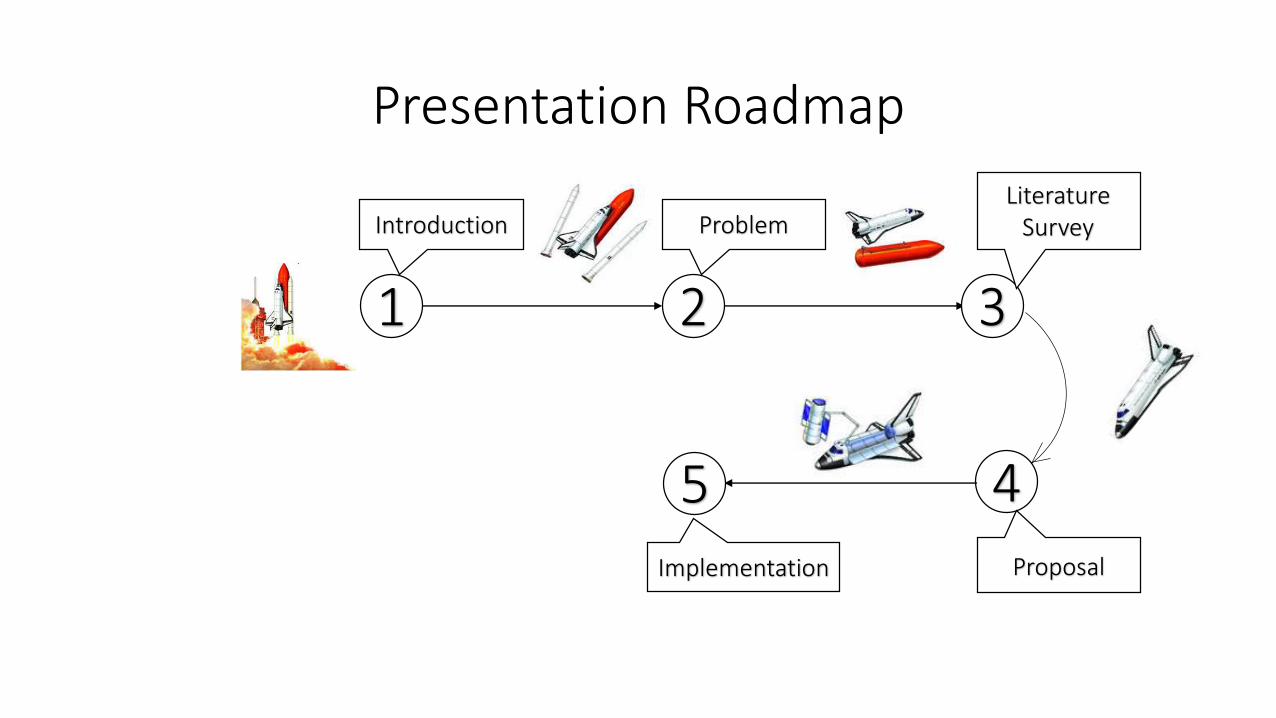
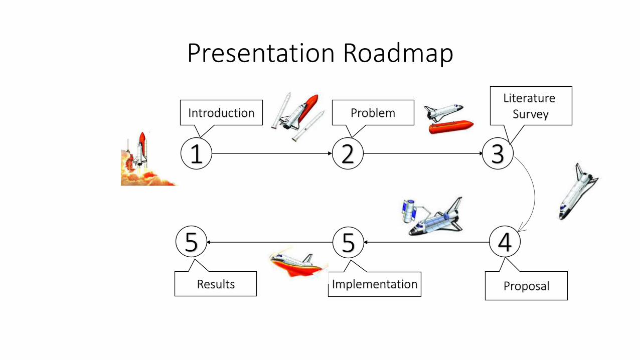
Presentation Roadmap
1
Introduction
2
Problem
3
Literature Survey
4
Proposal
5Implementation
5
Results
Conclusion

Presentation Roadmap
1
Introduction

Introduction
• SCATTEROMETER Overview
• Data Reception
• Data Products
• Data Quality Evaluation
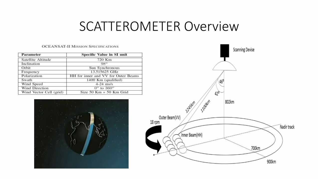
SCATTEROMETER Overview
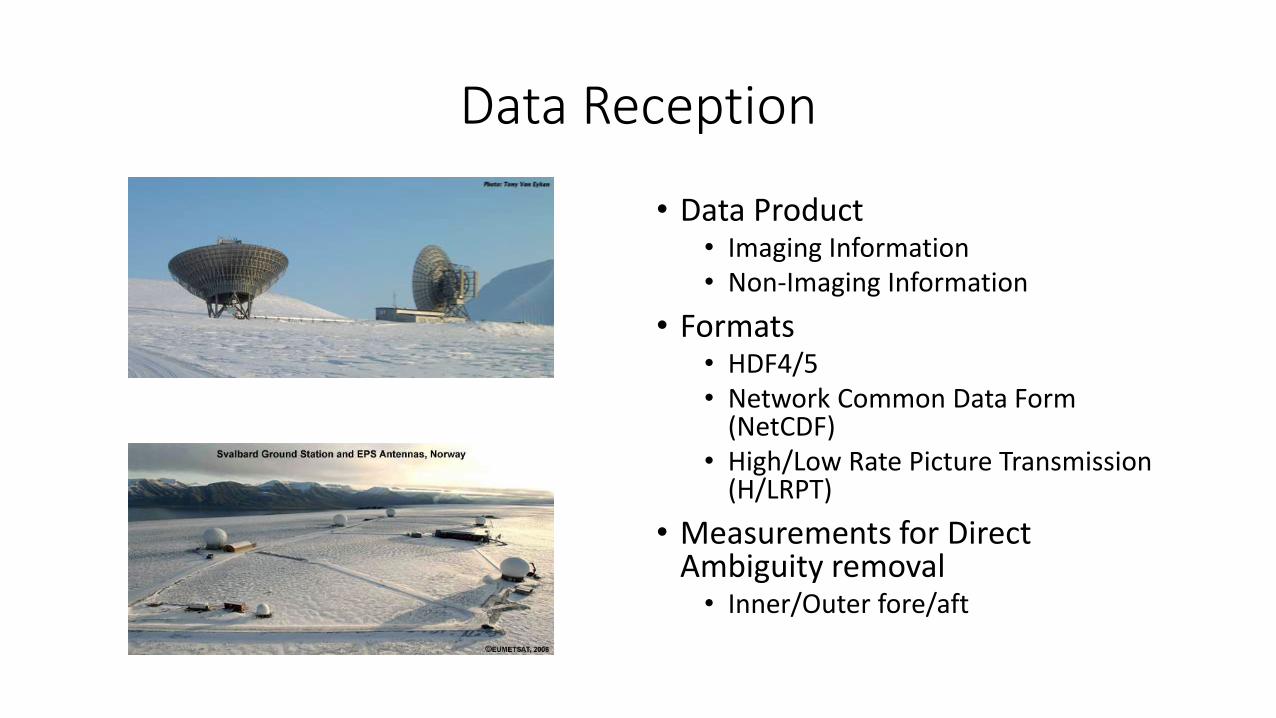
Data Reception
• Data Product• Imaging Information• Non-Imaging Information
• Formats• HDF4/5• Network Common Data Form
(NetCDF) • High/Low Rate Picture Transmission
(H/LRPT)
• Measurements for Direct Ambiguity removal• Inner/Outer fore/aft
Data Products
A systematic collection of near real-time data for the purpose of Retrospective analysis.[21]

Data Quality Evaluation
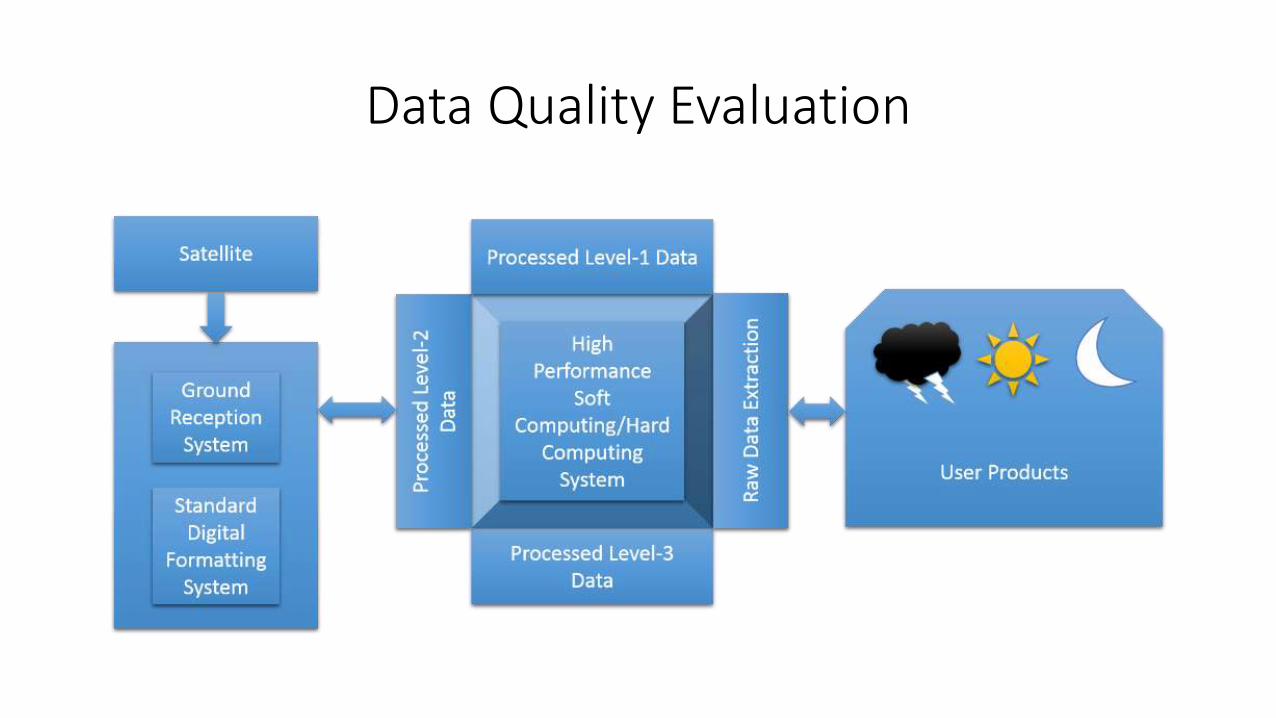
Data Quality Evaluation
Presentation Roadmap
1
Introduction
2
Problem

Problem
• Level wise difference
• Mathematical Model
• DQE
• Problem Statement &Objectives

Level wise difference
• Digital Geometry • Level-wise difference
281(HH)/282(VV)
61
03
32 samples
1 pixelDump wise
Level-0
Orbit-1
Orbit-2
Orbit-3
Orbit-4
Orbit wiseLevel-1
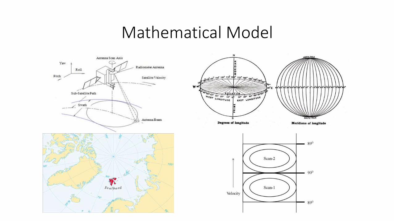
Mathematical Model

DQE
• Minimum
• Maximum
• Mean
• Histogram
• Pattern Identification
• Matching
• Digital Elevation Model
• Scattrometric Analysis
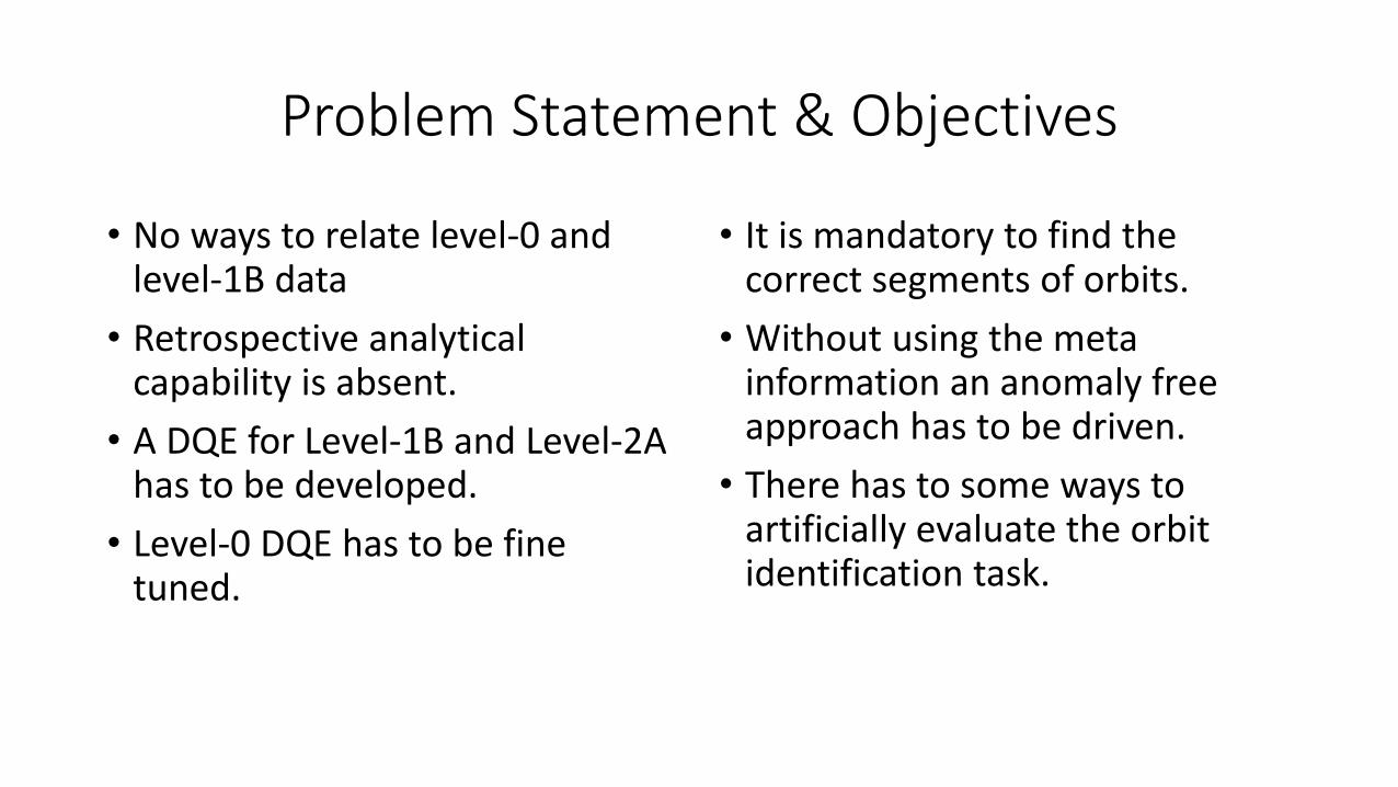
Problem Statement & Objectives
• No ways to relate level-0 and level-1B data
• Retrospective analytical capability is absent.
• A DQE for Level-1B and Level-2A has to be developed.
• Level-0 DQE has to be fine tuned.
• It is mandatory to find the correct segments of orbits.
• Without using the meta information an anomaly free approach has to be driven.
• There has to some ways to artificially evaluate the orbit identification task.
Presentation Roadmap
1
Introduction
2
Problem
3
LiteratureSurvey

Literature Survey
• QUICKSAT-DQE
• Voyager-DQE
• RAPIDSCAT-DQE
• RISAT-DQE
• RESOURSESAT-DQE
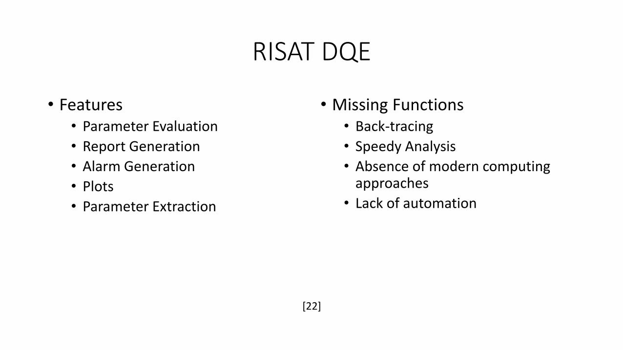
RISAT DQE
• Features• Parameter Evaluation
• Report Generation
• Alarm Generation
• Plots
• Parameter Extraction
• Missing Functions• Back-tracing
• Speedy Analysis
• Absence of modern computing approaches
• Lack of automation
[22]
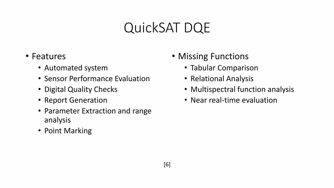
QuickSAT DQE
• Features• Automated system
• Sensor Performance Evaluation
• Digital Quality Checks
• Report Generation
• Parameter Extraction and range analysis
• Point Marking
• Missing Functions• Tabular Comparison
• Relational Analysis
• Multispectral function analysis
• Near real-time evaluation
[6]
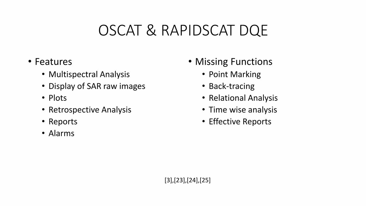
OSCAT & RAPIDSCAT DQE
• Features• Multispectral Analysis
• Display of SAR raw images
• Plots
• Retrospective Analysis
• Reports
• Alarms
• Missing Functions• Point Marking
• Back-tracing
• Relational Analysis
• Time wise analysis
• Effective Reports
[3],[23],[24],[25]
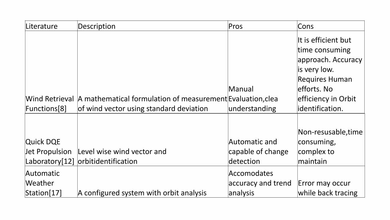
Literature Description Pros Cons
Wind Retrieval Functions[8]
A mathematical formulation of measurement of wind vector using standard deviation
Manual Evaluation,clea understanding
It is efficient but time consuming approach. Accuracy is very low. Requires Human efforts. No efficiency in Orbit identification.
Quick DQEJet Propulsion Laboratory[12]
Level wise wind vector and orbitidentification
Automatic and capable of change detection
Non-resusable,time consuming, complex to maintain
Automatic Weather Station[17] A configured system with orbit analysis
Accomodates accuracy and trend analysis
Error may occur while back tracing
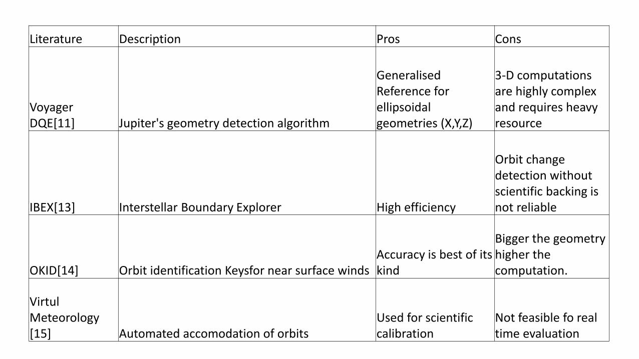
Literature Description Pros Cons
Voyager DQE[11] Jupiter's geometry detection algorithm
Generalised Reference for ellipsoidal geometries (X,Y,Z)
3-D computations are highly complex and requires heavy resource
IBEX[13] Interstellar Boundary Explorer High efficiency
Orbit change detection without scientific backing is not reliable
OKID[14] Orbit identification Keysfor near surface windsAccuracy is best of its kind
Bigger the geometry higher the computation.
VirtulMeteorology[15] Automated accomodation of orbits
Used for scientific calibration
Not feasible fo real time evaluation
Presentation Roadmap
1
Introduction
2
Problem
3
LiteratureSurvey
4
Proposal
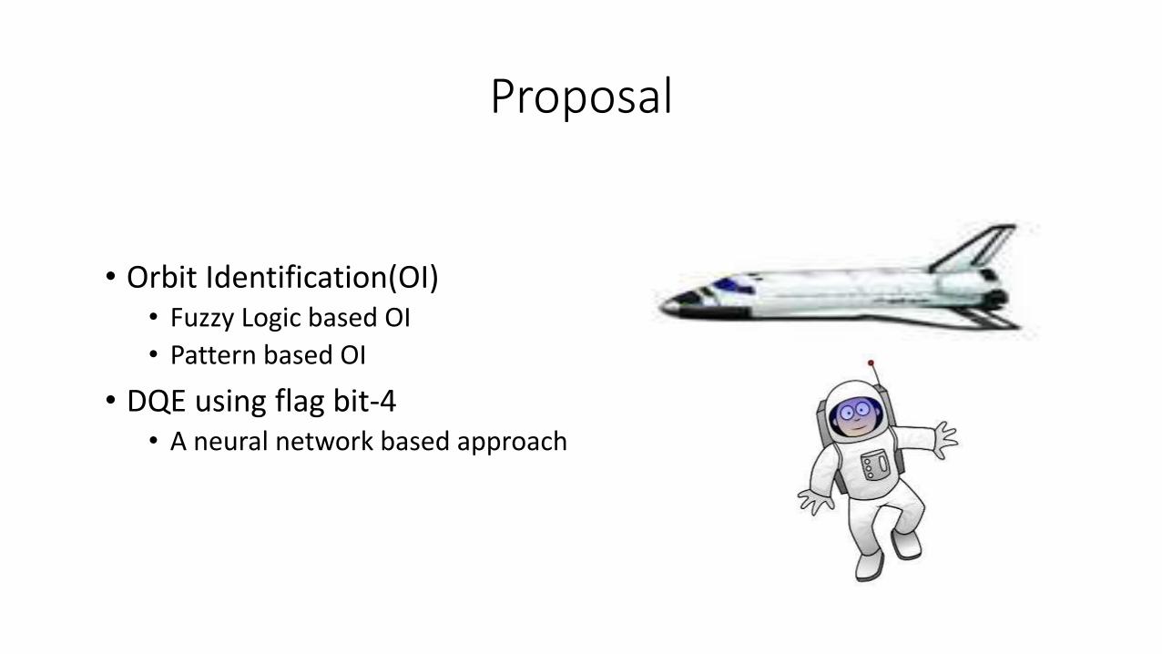
Proposal
• Orbit Identification(OI)• Fuzzy Logic based OI
• Pattern based OI
• DQE using flag bit-4• A neural network based approach

Fuzzy Logic based Orbit Identification

Motivation for approach 1: Fuzzy
• OAT Derived Match data• Time
• Latitude
• Longitude
• Attitude
• Roll
• Pich
• Yaw
• Position(x,y,z)
• Velocity(x,y,z)

Motivation for approach 1: Fuzzy
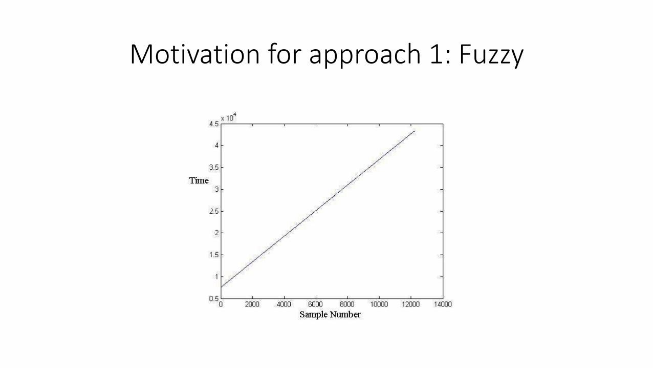
Motivation for approach 1: Fuzzy
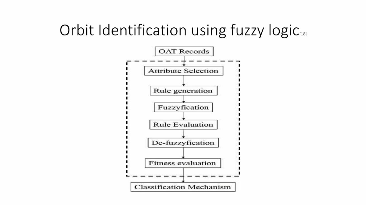
Orbit Identification using fuzzy logic[18]

Boon of the approach

Consideration of South pole crossing

Pattern based Orbit Identification

Overview
• Pattern Based Identification is used for automatic retrieval of orbits from SAR images depending upon contents of images known as features (i.e. a black chirp in the proposed case).
• Scanning consideration describes the process of accessing the interested patterns.
• Simplicity of Action is the outcome of the proposal.

Analysis of Signal Images
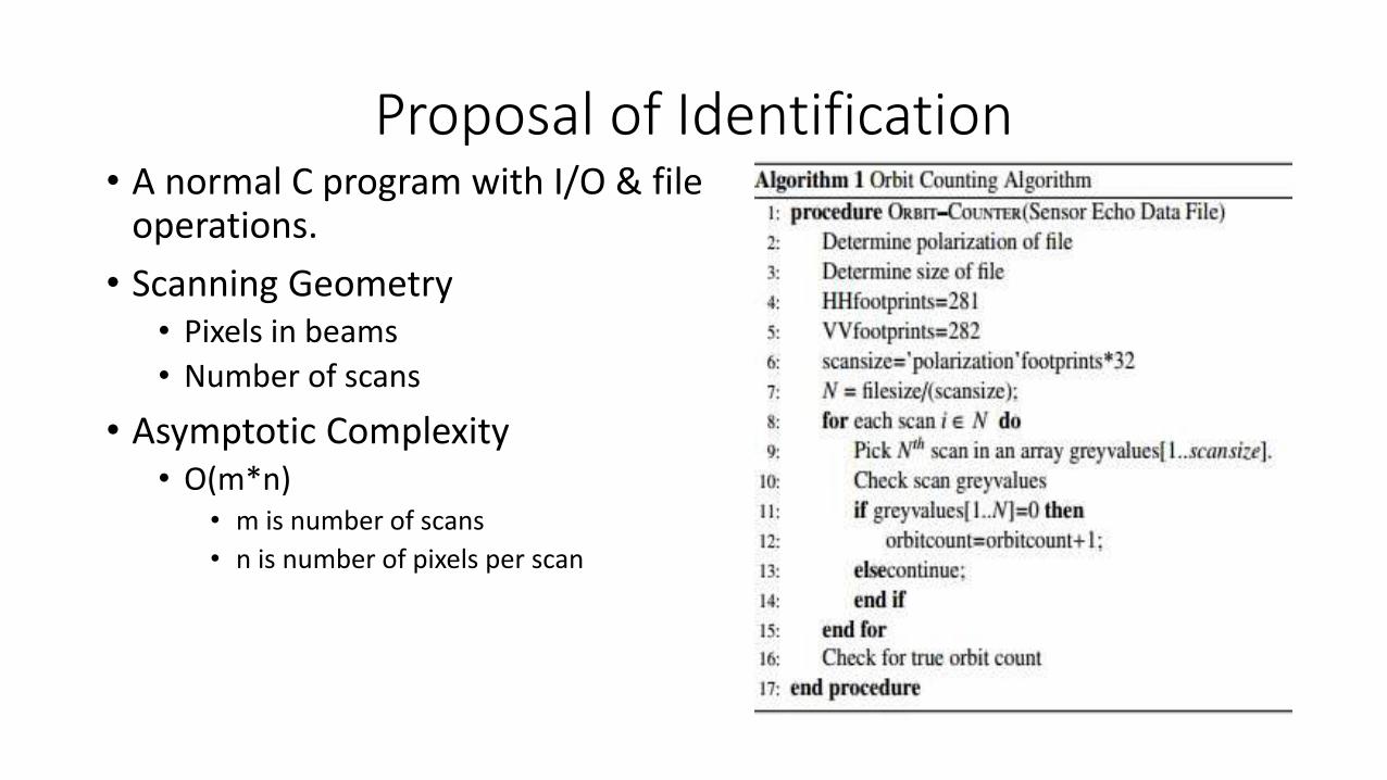
Proposal of Identification• A normal C program with I/O & file
operations.
• Scanning Geometry• Pixels in beams
• Number of scans
• Asymptotic Complexity• O(m*n)
• m is number of scans
• n is number of pixels per scan

Flag Based DQE(Neural Network Based DQE)

Globe according to flag bit-4
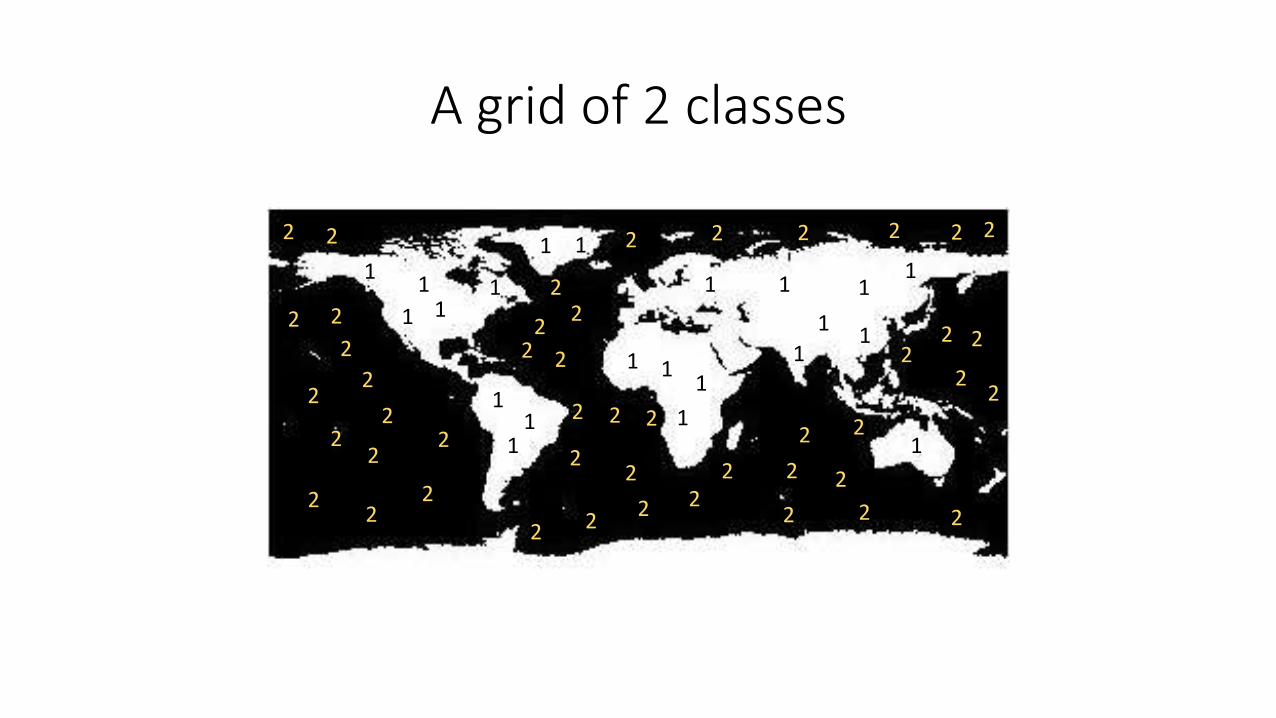
A grid of 2 classes
1
1 1
1
1
1
1
1
1
1
111
1
11
1
11
1
1
1
22
2
2
22
22
2 22
22
2 22 2
2
2
22 2
2
2
22
22
22 2
22
2
2 2 2 2222
22
2
2
2
2
Presentation Roadmap
1
Introduction
2
Problem
3
LiteratureSurvey
4
Proposal
5
Implementation
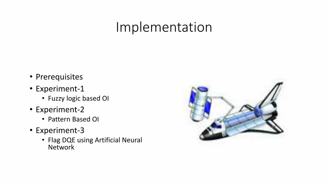
Implementation
• Prerequisites
• Experiment-1 • Fuzzy logic based OI
• Experiment-2• Pattern Based OI
• Experiment-3• Flag DQE using Artificial Neural
Network

Prerequisites
• Matlab R2013a
• JDK+Netbeans
• C editor & compiler
• Jasper Engine
• HDFView
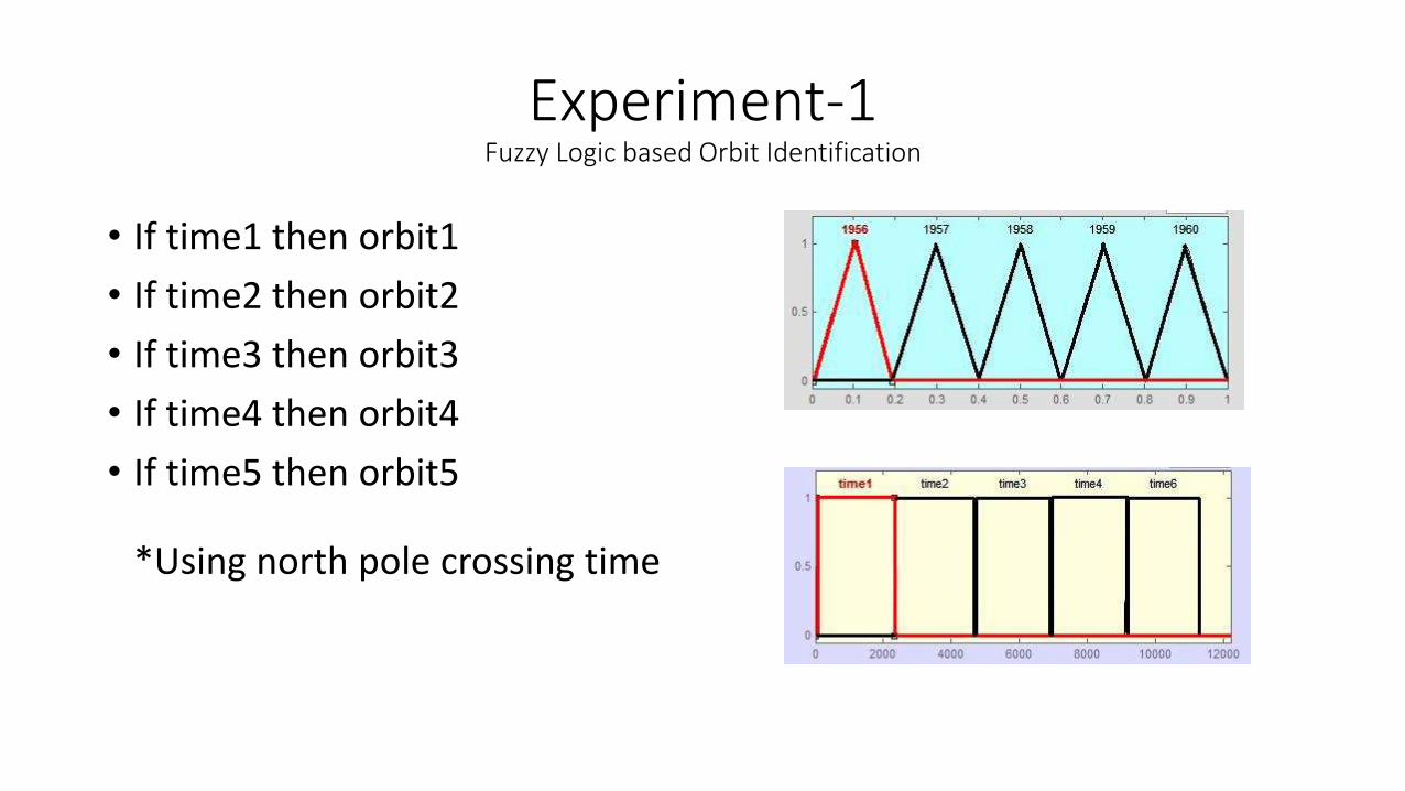
Experiment-1Fuzzy Logic based Orbit Identification
• If time1 then orbit1
• If time2 then orbit2
• If time3 then orbit3
• If time4 then orbit4
• If time5 then orbit5
*Using north pole crossing time
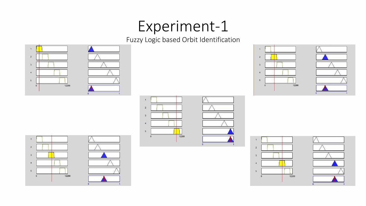
Experiment-1Fuzzy Logic based Orbit Identification
Experiment-1Fuzzy Logic based Orbit Identification
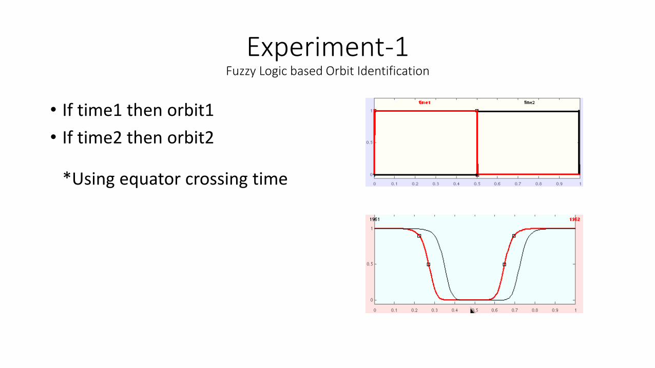
• If time1 then orbit1
• If time2 then orbit2
*Using equator crossing time
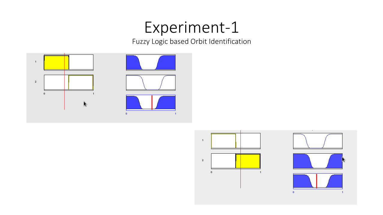
Experiment-1Fuzzy Logic based Orbit Identification
Experiment-1Fuzzy Logic based Orbit Identification
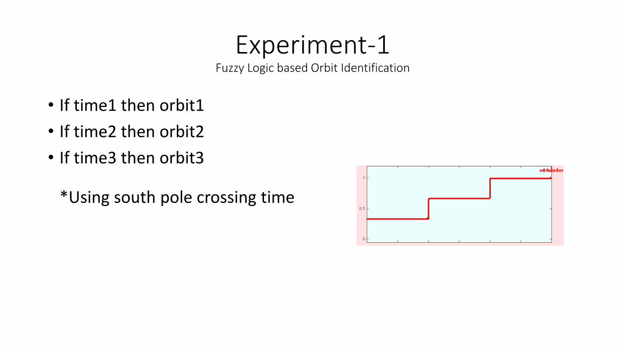
• If time1 then orbit1
• If time2 then orbit2
• If time3 then orbit3
*Using south pole crossing time
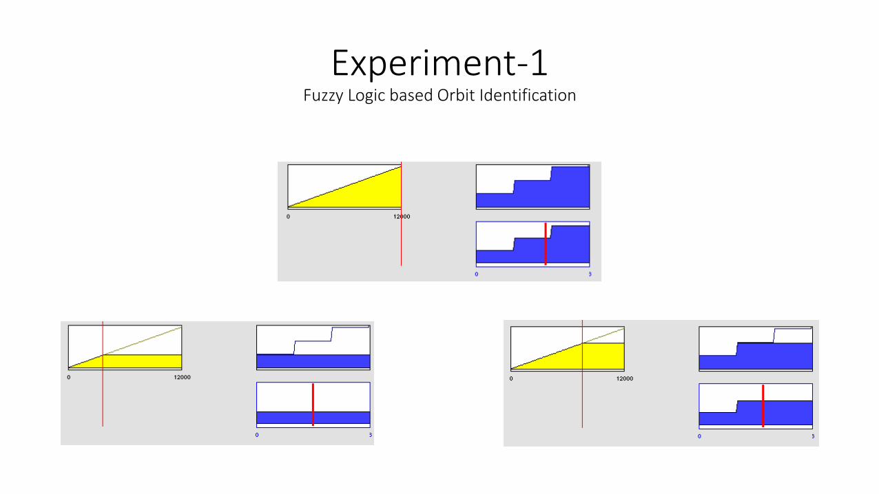
Experiment-1Fuzzy Logic based Orbit Identification
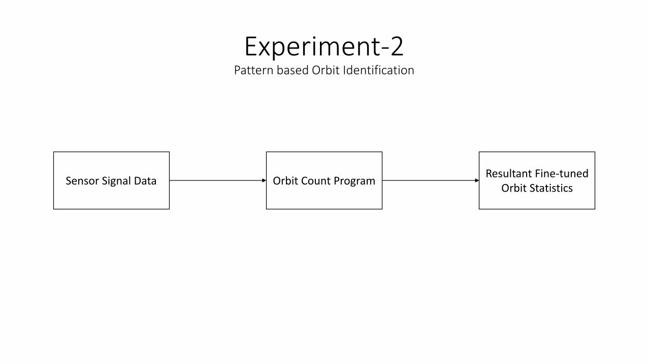
Experiment-2Pattern based Orbit Identification
Sensor Signal Data Orbit Count ProgramResultant Fine-tuned
Orbit Statistics
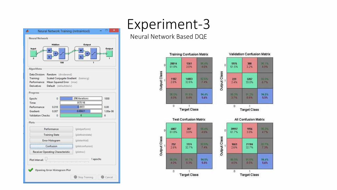
Experiment-3Neural Network Based DQE
Presentation Roadmap
1
Introduction
2
Problem
3
Literature Survey
4
Proposal
5Implementation
5
Results

Results
• Pattern based Orbit Identification
• Neural Network based DQE
• Retrospective GRID-GUI
• Added clarity to reports

Pattern Based Orbit Identification Results

Neural Network based DQEResults
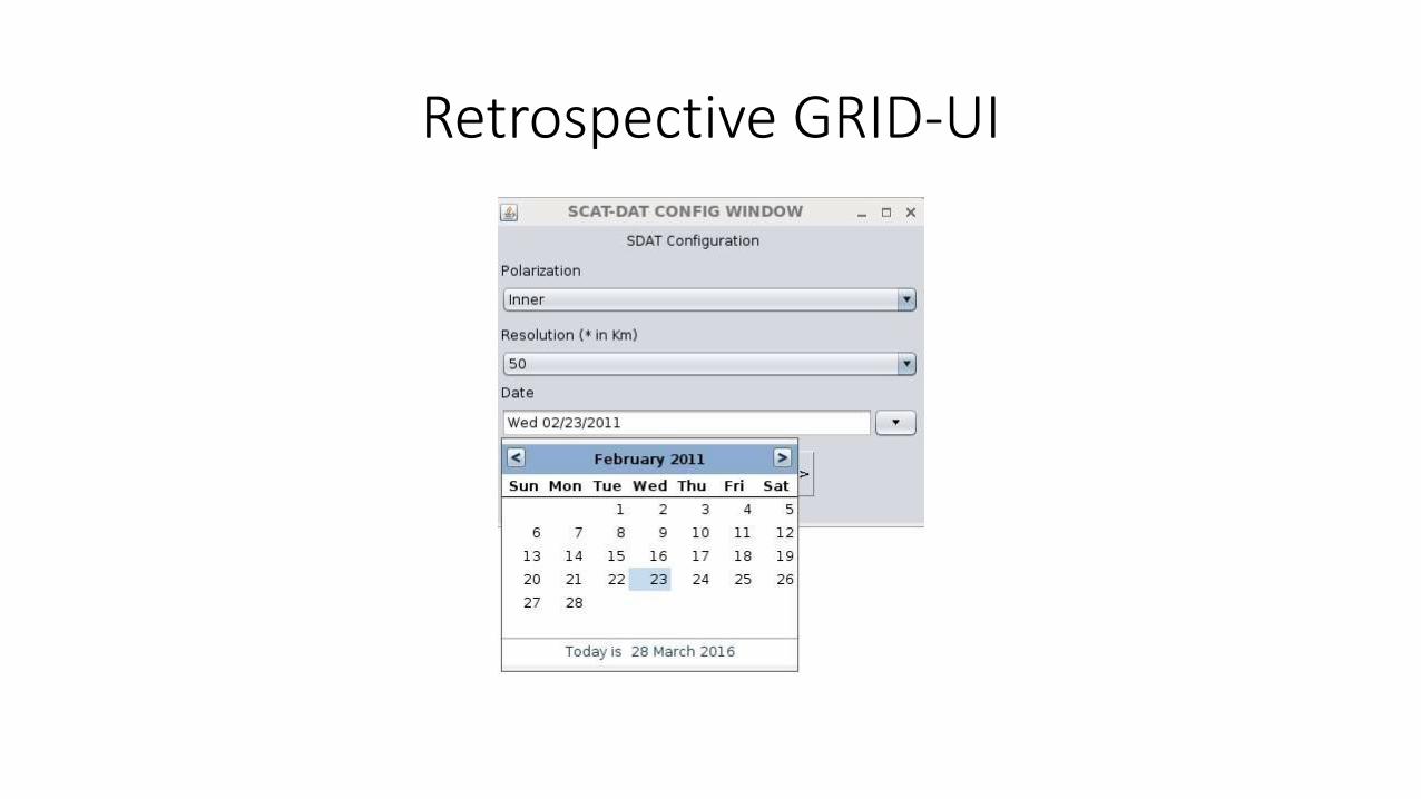
Retrospective GRID-UI

Retrospective GRID-UI

Clarity in Reports
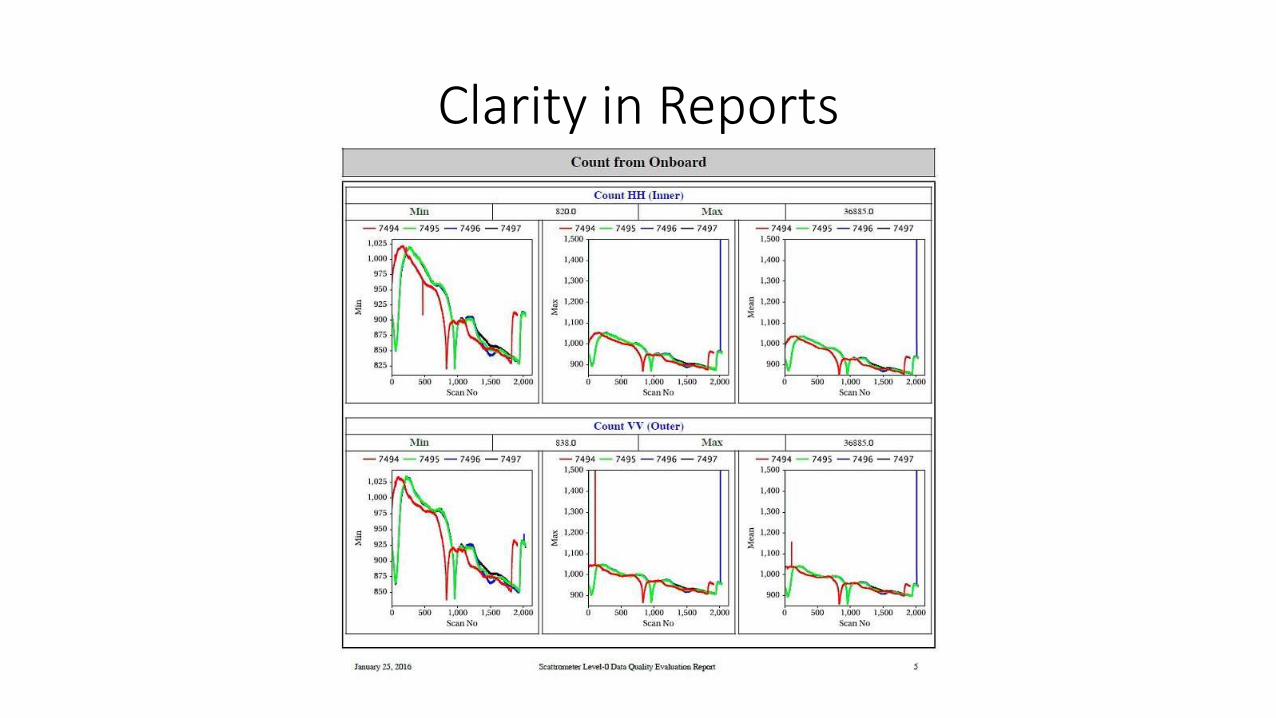
Clarity in Reports

Clarity in binning
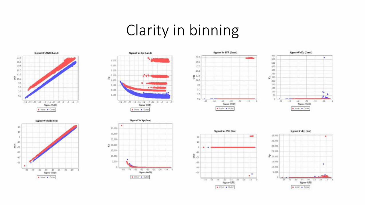
Clarity in binning

Overall System Overview
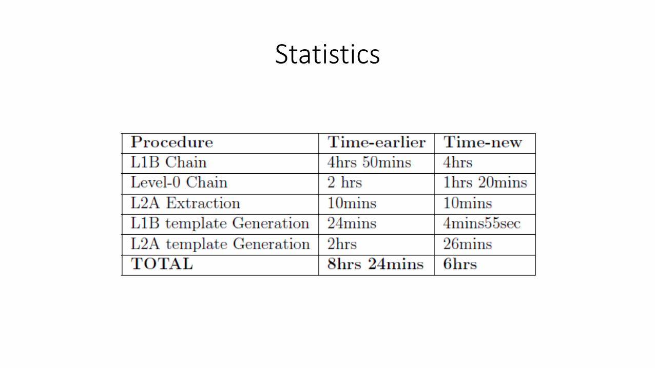
Statistics

Presentation Roadmap
1
Introduction
2
Problem
3
Literature Survey
4
Proposal
5Implementation
5
Results
Conclusion
Conclusion
• Conclusion
• Future work
• Bibliography
Conclusion
• A Fuzzy Logic(FL) based orbit identification(OI) has been proposed in this work. To select theattributes a preprocessed data set of Orbit Attitude Records are selected assuming extraction ofLevel-0 and some processing steps have already been performed. Selection of time and latitudehas been justified using Geo-mathematical criteria. Then a short introduction to fuzzy systems isgiven and using that approach the idea is implemented using matlab. This work has made a markin Data Quality Evaluation Modeling. This work is useful for the researchers to develop themodern terrain clustering systems.
• In traditional systems this redundancy leads to waste of computational efforts. Instead, thisapproach provides past knowledge, using which the new data can be segmented as well asanalyzed (using further integration) and improvements to the upcoming observation systems canbe carried-out. Moreover, it also reduces modeling complexity to compute the correlationbetween two images based on geometry, i.e. existing image of DQE and the image which iscurrently computed. It also improves the speed of a spatial data analysis system. Using secondapproach also orbit identification task has been implemented with modeling complexity of O(n).This makes a clear sense to computational geo-informatics about the patterns which areimportant aspect of consideration which was neglected earlier. Binning also improves theanalytical standard for the better understanding of anomalies in data , indirectly in sensors.
Conclusion
• At the end work has been concluded with the initial startup for futurework, i.e. Neural Network based DQE. The Neural Network basedapproach has been tested on randomly selected data products fromthe source NRSC even though surveying the current system with bestaccuracy. Making some more efforts towards the highest accuracythis approach also can show at least a technique other thanconventional technique of flag based DQE . Concluding with theretrospective DQE implementation to bridge the gap described inproblem definition this work encourages many researchers to workfor DQE and OI using modern computing techniques.

Future Work
• General Model Development
• Applicability to wider scope can be designed
• No parallel processes have been defined, thus work can be initiatedfor such faster models
• GRID_UI needs many improvements for the final application, i.e.deliverable
• More powerful soft computing with highest accuracy can be used forbetterment of DQE system.

Paper:1
A Novel Approach of Orbit Identification from Level-0 Data based on Level-1B convention for Scatterometer
using Fuzzy LogicMudit J Dholakia, Anuja Sharma, Dr. C. K. Bhensdadia
XPLORE COMPLIANT ISBN :- 978-1-4673-7807-9CD ISBN:- 978-1-4673-7805-5
PRINT ISBN :- 978-1-4673-7806-2
IEEE INTERNATIONAL CONFERENCE ON SYSTEMS AND CONTROL (ISCO)KARPAGAM COLLEGE OF ENGINEERING ,COIMBATORE,TAMIL NADU

Paper:2
Pattern Based Orbit Identification for SCATTEROMETER Level-0 Signal Images
Mudit J Dholakia, Anuja Sharma, Dr. C. K. Bhensdadia
Journal title: Procedia Computer Science
DOI information: 10.1016/j.procs.2016.03.049
INTERNATIONAL CONFERENCE ON CLOUD COMPUTING AND VIRTUALIZATION (ICCCV)
THAKUR COLLEGE OF ENGINEERING,KANDIVALI,MUMBAI,MAHARASHTRA
IN ASSOCIATION WITH ELSEVIER PROCEEDIA COMPUTER SCIENCE ,ELSEVIER B.V. AMSTERDAM, NETHERLANDS

Paper:3
Analytical Approach for identification of orbits from
SCATTEROMETER Level-0 Noise ImagesMudit J Dholakia, Anuja Sharma, Dr. C. K. Bhensdadia
International Journal of Applied Information Systems (IJAIS) – ISSN : 2249-086803.049
INTERNATIONAL CONFERENCE ON CLOUD COMPUTING AND VIRTUALIZATION (ICCCV)
THAKUR COLLEGE OF ENGINEERING,KANDIVALI,MUMBAI,MAHARASHTRA
IN ASSOCIATION WITH ELSEVIER PROCEEDIA COMPUTER SCIENCE ,ELSEVIER B.V. AMSTERDAM, NETHERLANDS

Paper:4
Pattern Based Orbit Identification for SCATTEROMETER Level-0 Signal Echo Window Images
Mudit J Dholakia, Anuja Sharma, Dr. C. K. Bhensdadia
Xplore ISBN:- 978-1-4673-8208-3DVD ISBN:- 978-1-4673-8207-6
IEEE INTERNATIONAL CONFERENCE ON INNOVATION IN INFORMATION AND COMMUNICATION SYSTEMS (ICIIECS)
KARPAGAM COLLEGE OF ENGINEERING, COIMBATORE ,TAMIL NADU

Paper:5
Land-Sea Classification using Machine Learning Technique for SCATTEROMETER L1B Globe
Mudit J Dholakia, Anuja Sharma, Dr. C. K. Bhensdadia
Number by ACM – ICPS for Proceeding Volume: 978-1-4503-4213-1049
INTERNATIONAL CONFERENCE ON CLOUD COMPUTING AND VIRTUALIZATION (ICCCV)
THAKUR COLLEGE OF ENGINEERING,KANDIVALI,MUMBAI,MAHARASHTRA
IN ASSOCIATION WITH ELSEVIER PROCEEDIA COMPUTER SCIENCE ,ELSEVIER B.V. AMSTERDAM, NETHERLANDS

BibliographyBOOKS:-
Joseph, George. Fundamentals of remote sensing. UniversitiesPress, 2005.
Calla, O. P. N. "Study of Ocean using Indian Space BorneMicrowave Sensors." IJCST 2.4 (2011).
Simpson, John E. Sea breeze and local winds. CambridgeUniversity Press, 1994.
Tobler, W. R. "Cellular geography." Philosophy in geography.Springer Netherlands, 1979. 379-386.
Toolbox, Fuzzy Logic. "User's Guide of Matlab. The Mathworks."Inc.(1995-2009) (1995).
Zadeh, Lofti A. "Fuzzy logic." Computer 4 (1988): 83-93.
Chapman, Stephen. MATLAB programming for engineers.Cengage Learning,2007.
Cormen, Thomas H. Introduction to algorithms. MIT press, 2009.
Brassard, Gilles, and Paul Bratley. Fundamentals of algorithmics.Prentice-Hall, Inc., 1996.
WEB:-
Dholakia, Mudit. "Muditdholakia/muditdholakia.github.io."GitHub. 1 Oct. 2015. Web. 30 Oct. 2015
ISRO, NRSC. "National Remote Sensing Centre." NationalRemote Sensing Centre. ISRO. Web. 25 Nov. 2015
Dutch, Steven. "Converting UTM to latitude and longitude (orvice versa)." Natural and Applied Sciences, University ofWisconsin-Green Bay, http://www .uwgb. edu/dutchs/Use-fulData/UTMFormulas. HTM (2007).
PAPERS & ARTICLES:-
Spencer, Michael W., Chialin Wu, and David G. Long. "Improvedresolution backscat- ter measurements with the SeaWindspencil-beam scatterometer." Geoscience and Remote Sensing,IEEE Transactions on 38.1 (2000): 89-104.
SCATTEROMETER Payload Design Team-ISRO. "OCEANSAT-IISCATTEROMETER PAYLOAD PRELIMINARY DESIGN REVIEWDOCUMENT." SAC-ISRO, 2005
Parmar, R. M., et al. "OCEANSAT 2: mission and its applications."Asia-Pacic Remote Sensing Symposium. International Society forOptics and Photonics, 2006.
Misra, Tapan, et al. "Oceansat-II Scatterometer: SensorPerformance Evaluation, Analyses, and Estimation of Biases."Geoscience and Remote Sensing, IEEE Transactions on 52.6(2014): 3310-3315.
Singh, Randhir, Prashant Kumar, and Pradip Kumar Pal."Assimilation of Oceansat-2-scatterometer-derived surfacewinds in the weather research and forecasting model." Geo-science and Remote Sensing, IEEE Transactions on 50.4 (2012):1015-1021.
Ebuchi, Naoto, Hans C. Graber, and Michael J. Caruso."Evaluation of wind vectors observed by QuikSCAT/SeaWindsusing ocean buoy data." Journal of Atmospheric and OceanicTechnology 19.12 (2002): 2049-2062.
Lindzen, Richard S., and Sumant Nigam. "On the role of seasurface temperature gradients in forcing low-level winds andconvergence in the tropics." Journal of the Atmospheric Sciences44.17 (1987): 2418-2436.
Folk, Mike, Robert E. McGrath, and Nancy Yeager. "HDF: anupdate and future directions." Geoscience and Remote SensingSymposium, 1999. IGARSS'99 Proceedings. IEEE 1999International. Vol. 1. IEEE, 1999.

BibliographyPAPERS & ARTICLES:-
Mujiasih, Subekti, and Eko Prasetyo. "Preliminary Study ofSpatial Verication for Wind Model Output Against Oceansat-2Satellite." IPTEK The Journal for Technology and Science 25.2(2015).
Stoelen, Ad, and Anton Verhoef. "Validation of Oceansat-2scatterometer data." the P. 59 EUMETSAT MeteorologicalSatellite Conference. 2011.
Narayanan, M. S., and Abhijit Sarkar. "Observations of MarineAtmosphere from Indian Oceansat-1." Proceedings from the.2001.
Bozoki, Eva, and Aharon Friedman. "Optimization method fororbit correction in accelerators." Particle AcceleratorConference, 1993., Proceedings of the 1993. IEEE, 1993.
Takahashi, Satoshi, and B. Ghosh. "Canonical forms and orbitidentication problems in machine vision." IEEE CONFERENCE ONDECISION AND CONTROL. Vol. 5. IEEE; 1998, 2000.
Campbell, James K., Stephen P. Synnott, and Gerald J. Bierman."Voyager orbit determination at Jupiter." Automatic Control,IEEE Transactions on 28.3 (1983): 256-268.
Miao-Fen, Huang, et al. "Study on data models of image qualityassessment for the Chinese-Brazil earth resources satellite."Geoscience and Remote Sensing Symposium, 2004. IGARSS'04.Proceedings. 2004 IEEE International. Vol. 6. IEEE, 2004.
Kukar, Matja. "Transduction and typicalness for qualityassessment of individual classications in machine learning anddata mining." Data Mining, 2004. ICDM'04. Fourth IEEEInternational Conference on. IEEE, 2004.
PAPERS & ARTICLES:-
Huddleston, James N., and Michael W. Spencer. "SeaWinds: theQuikSCAT wind scatterometer." Aerospace Conference, 2001,IEEE Proceedings.. Vol. 4. IEEE, 2001.
Huddleston, James N., et al. "SeaWinds on QuikSCAT: Postlaunchcalibration and validation." Geoscience and Remote SensingSymposium, 2000. Proceedings. IGARSS 2000. IEEE 2000International. Vol. 3. IEEE, 2000.
Long, David G., and Michael W. Spencer. "Performance analysisfor the SeaWinds scatterometer." Geoscience and RemoteSensing Symposium, 1996. IGARSS'96.'Remote Sensing for aSustainable Future.', International. Vol. 3. IEEE, 1996.
Wu, C., et al. "The SeaWinds scatterometer instrument."Geoscience and Remote Sensing Symposium, 1994. IGARSS'94.Surface and Atmospheric Remote Sensing: Technologies, DataAnalysis and Interpretation., International. Vol. 3. IEEE, 1994.
Kumar, Ravindra, et al. "Evaluation of Oceansat-2-derived oceansurface winds using observations from global buoys and otherscatterometers." Geoscience and Remote Sensing, IEEETransactions on 51.5 (2013): 2571-2576.
Fore, Alexander G., et al. "Point-wise wind retrieval andambiguity removal improvements for the QuikSCATclimatological data set." Geoscience and Remote Sensing, IEEETransactions on 52.1 (2014): 51-59.
Bhowmick, Suchandra Aich, and Ravindra Kumar. "Crosscalibration of the OceanSAT-2 scatterometer with QuikSCATscatterometer using natural terrestrial targets." Geoscience andRemote Sensing, IEEE Transactions on 52.6 (2014): 3393-3398.
PAPERS & ARTICLES:-
Richter, R. "On the in-ight absolute calibration of high spatialresolution spaceborne sensors using small ground targets."International Journal of Remote Sensing 18.13 (1997): 2827-2833.
Richter, Rudolf, et al. "Evaluation of the IRS-1B inight calibrationcampaign (1995).“ AeroSense'97. International Society forOptics and Photonics, 1997.
Atlas, Robert, et al. "A cross-calibrated, multiplatform oceansurface wind velocity product for meteorological andoceanographic applications." Bulletin of the AmericanMeteorological Society 92.2 (2011): 157-174.
Yang, Z., et al. "Association rule mining-based dissolved gasanalysis for fault diagnosis of power transformers." Systems,Man, and Cybernetics,Part C: Applications and Reviews, IEEETransactions on 39.6 (2009):597-610.
Mendel, Jerry M (1995). Fuzzy logic systems for engineering: atutorial. Proceedings of the IEEE, 83, 345-377.
Yu, Yiming, and Eddie R. Fowler. "Rule based fuzzy logicinferencing." Systems, Man, and Cybernetics, 1994. Humans,Information and Technology., 1994 IEEE InternationalConference on. Vol. 1. IEEE, 1994.
Guillemin, Pierre. "Fuzzy logic applied to motor control."Industry Applications, IEEE Transactions on 32.1 (1996): 51-56.
Chen, B., and L. L. Hoberock. "A fuzzy neural networkarchitecture for fuzzy control and classication." NeuralNetworks, 1996., IEEE International Conference on. Vol. 2. IEEE,1996.
Spencer, Michael W., James N. Huddleston, and Bryan W. Stiles."Advanced design concepts for a SeaWinds scatterometerfollow-on mission." Aerospace Conference, 2001, IEEEProceedings.. Vol. 4. IEEE, 2001.

BibliographyPAPERS & ARTICLES:-
Su, Te-Jen, et al. "Fuzzy theory application to the satellite antenna controller." Information Science, Electronics and Electrical Engineering (ISEEE), 2014 International Conference on. Vol. 2. IEEE, 2014.
Chapman, Stephen. MATLAB programming for engineers. Cengage Learning,2007.
PAPERS & ARTICLES:-
Horstmann, Jochen, Susanne Lehner, and Helmut Schiller."Global wind speed retrieval from complex SAR data usingscatterometer models and neural networks." Geoscience andRemote Sensing Symposium, 2001. IGARSS'01. IEEE 2001International. Vol. 3. IEEE, 2001.
Xu, Lingyu, and Jun Xu. "Satellite remote sensing SST qualityevaluation based on consensus measurement." WebInformation Systems and Mining, 2009. WISM 2009.International Conference on. IEEE, 2009.
Huang, Yi-Ting, and Fan-Tien Cheng. "Automatic data qualityevaluation for the AVM system." Semiconductor Manufacturing,IEEE Transactions on 24.3 (2011): 445-454.
Yang, Xiaofeng, et al. "Validation of sea surface wind vecterretrieval from China's HY- 2A Scatterometer." Geoscience andRemote Sensing Symposium (IGARSS), 2013 IEEE International.IEEE, 2013.
SCATSAT-1 SAC TEAM. "SCATSAT-1 SCATTEROMETER DATAPRODUCTS SYSTEM SAC ELEMENTS PRELIMINARY DESIGNREVIEW DOCUMENT." SAC-ISRO, 2014
Research Areas Of SAC. 1st ed. SAC, 2015. Web. 1 Nov. 2015.
ISRO, SAC. Remote Sensing Data Products & RetrievalAlgorithms. 4th ed. ISRO, 2013. Web. 1 Nov. 2015.
Klir, George, and Bo Yuan. Fuzzy sets and fuzzy logic. Vol. 4. NewJersey: Prentice Hall, 1995.
Giannini, Judith A., and Charles C. Kilgus. "A fuzzy logic techniquefor correcting climatological ionospheric models." Geoscienceand Remote Sensing, IEEE Transactions on 35.2 (1997): 470-474.
PAPERS & ARTICLES:-
Shekoofa, Omid, and Mohsen Taherbaneh. "Power sourcessizing in electrical power sub system design based on orbitparameters change in LEO satellites." Recent Advances in SpaceTechnologies, 2009. RAST'09. 4th International Conference on.IEEE, 2009.
Ivan, Cosmin. "Applications of nonlinear time-series analysis inunstable periodic orbits identication-Chaos control in buckconverter." Signals, Circuits and Systems, 2009. ISSCS 2009.International Symposium on. IEEE, 2009.
Almenar, C. Cuenca, et al. "ATLAS online data qualitymonitoring." Real Time Conference (RT), 2010 17th IEEE-NPSS.IEEE, 2010.
Peterson, Joseph G., et al. "Science operations support for theorbit change on the Interstellar Boundary Explorer (IBEX)mission." Aerospace Conference, 2012 IEEE. IEEE, 2012.
Hongjun, Wang, Wang Hongfeng, and Ji Yongjian. "Orbitidentication method based on ISOMAP for rotor system faultdiagnosis." Electronic Measurement & Instruments (ICEMI),2013 IEEE 11th International Conference on. Vol. 2. IEEE, 2013.
Peng, Ding, et al. "On-orbit identifcation and active vibrationsuppression for exible spacecraft." Mechatronic Sciences,Electric Engineering and Computer (MEC), Proceedings 2013International Conference on. IEEE, 2013.
Magnell, B. A., et al. "Current Measurements from a Deep Real-Time Metocean Mooring: Lessons Learned on Real-Time DataQA/QC.“
Palsule, S. S., et al. "Resourcesat-1 data quality evaluationsystem." International Journal of Applied Earth Observation andGeoinformation 10.2 (2008): 147-158.

Thank You!