date : december 2007 client : tulloch homes ltd project ... · pwyll ap stifin andrew bicket ross...
TRANSCRIPT

Date : December 2007
Client : Tulloch Homes Ltd
Project Code : CDF05
Culduthel Mains Farm, Inverness
Phase 5
Excavation of a Later Prehistoric Settlement: Assessment Report
Ross Murray
Planning Reference 00/00386/OUTIN

1
HEADLAND ARCHAEOLOGY LTD Culduthel Mains Farm, Inverness – Archaeological Excavation
ARCHAEOLOGICAL EXCAVATION CULDUTHEL MAINS FARM
PROJECT SUMMARY SHEET (CDF05)
Client Tulloch Homes Ltd
Planning Reference no. Planning Reference: 00/00386/OUTIN
National Grid Reference NH 6640 4140
Project Manager Mark Roberts
Text Ross Murray
Environmental Assessment Scott Timpany & David Masson
Artefact Assessment Fraser Hunter & Dawn McLaren
Survey & Illustrations Linn Breslin
Excavation & Post-excavation Team
Pwyll Ap Stifin Andrew Bicket
Ross Cameron Kelly Clapperton
Malcolm Corney Magnar Dalland
Kirsty Dingwall Mandy Duncan
Julie Franklin George Geddes
Roz Gillis Sarah-Jane Haston
Candy Hatherley Mhairi Hastie
Samantha Hatrick Andrew Jones
Stephen Lancaster James Lowe
Tom Lucas Fiona MacKenzie
Helen MacQuarrie Dave Marcus
Alison McCondichie James McMeekin
Ross Murray Sophie Nicol
Emma-Jane O’Riordan Malgorzata Puklicz
Alistair Robertson Daniel Sahlén
Ben Savine Katie Sludden
Jurgen van Wessel Katie Wardell
Craig Williams
Schedule
Fieldwork 20th June 2005 – 24th February 2006
Report December 2007

2
HEADLAND ARCHAEOLOGY LTD Culduthel Mains Farm, Inverness – Archaeological Excavation
Contents
1. INTRODUCTION
1.1 Project Background
1.2 Site Use and Location
2. ARCHAEOLOGICAL BACKGROUND
3. AIMS AND METHODOLOGY
3.1 Research Aims
3.2 Recording
3.2 Artefacts and Sampling
4.DESCRIPTION OF RESULTS
4.1 Prehistoric Activity
4.2 Pre-Iron Age Activity
4.3 Iron Age Activity
5. ASSESSMENT OF THE ARTEFACT ASSEMBLAGE
5.1 Overview
5.4 Glass
5.2 Iron
5.3 Non-Ferrous Metals
5.5 Non-Ferrous Metalworking
5.6 Ferrous Metalworking
5.7 Metallurgy of Slags and Iron Objects
5.8 Pottery
5.9 Daub
5.10 Petrology
5.11 Stone
5.12 Geology
5.13 Lithics
5.14 References
6. ASSESSMENT OF THE ENVIRONMENTAL EVIDENCE
6.1 Introduction
6.2 Method
6.3 Results
6.4 Discussion
6.5 Recommendations
6.6 References
7. THIN SECTION ANALYSIS
8. STATEMENT OF POTENTIAL
9. PUBLICATION PROPOSAL AND TASK LIST

3
HEADLAND ARCHAEOLOGY LTD Culduthel Mains Farm, Inverness – Archaeological Excavation
ACKNOWLEDGEMENTS
The project is funded by Tulloch Homes Ltd who also supplied the plant. The project was
monitored by Kirsty Cameron of Highland Council Archaeology Service. Thanks go to Bill
Hepburn, Alan MacDonald and the site staff of Tulloch Homes Ltd for their patience and
support during the excavation.
The author is extremely grateful for the hard work of the survey and excavation team. Thanks
also to Len Pentecost-Ingram and Eric Soane of the Highland Historical Search Society who
conducted the metal-detecting; Fraser Hunter of the National Museum of Scotland for his
advice during site visits and for taking aerial photographs of the site under excavation; Andy
Heald of the National Museum of Scotland for his advice during a site visit; Robert Preece
(Archivist, Inverness Royal Academy) for a copy of his research into the archaeological finds
at Culduthel;

4
HEADLAND ARCHAEOLOGY LTD Culduthel Mains Farm, Inverness – Archaeological Excavation
Summary
This report presents the findings of an archaeological excavation on the site of a housing
development at Culduthel Mains Farm, Inverness. The site is on the southern outskirts of
Inverness in the Inverness and Bona parish, on the south side of the recently constructed
Southern Distributor Road. Tulloch Homes Ltd commissioned Headland Archaeology Ltd to
undertake the work, which took place between June 2005 and February 2006, as part of the
planning consent for the construction of Phase 5 of a housing development.
The site covers an area of approximately 4.84 ha, is centred on NGR NH 66404140 and
occupies undulating ground on the 65 m contour. It commands clear views over present-day
Inverness to the north and the head of the Great Glen to the south-west.
The excavation was commissioned following an evaluation in May 2005 that had located an
enclosure, visible as a cropmark on aerial photographs, and identified two other areas of
archaeological potential. During the excavation it was apparent the archaeological remains
continued outside these areas. A watching brief undertaken by Alba Archaeology Ltd
uncovered the remaining archaeology, which was subsequently excavated by Headland.
The slightly oval enclosure located first in the evaluation measured 52 by 41m with a south-
west-facing entrance. The enclosure had one phase, and while the interior contained a
number of truncated pits and postholes no obvious buildings, other than a four-post
structure, could be identified. The main settlement activity was to the north-west and north-
east of the enclosure. The area to the north-east contained a large cobbled work area from
which abundant metalworking debris was recovered. The north-west area contained a total of
19 buildings, 16 of which were roundhouses. Six were situated on flat ground at the top of a
small rise; one contained an iron-smelting furnace and was clearly a workshop, another was a
substantial roundhouse, some 18m in diameter. At the base of the small rise were a further 11
roundhouses, a stone-built workshop and what has been tentatively interpreted as a Bronze
Age ring-ditch house. One roundhouse was extremely large, 19.5 m in diameter, and was
situated in an area of deep hillwash. This had been exceptionally well preserved along with
an area of industrial deposits with a deep stratigraphic sequence relating to the production of
iron, copper alloys, glass and enamel. A total of 9 iron-smelting furnaces were found in this
area, with the last firing in situ. All but one were in a roundhouse.

5
HEADLAND ARCHAEOLOGY LTD Culduthel Mains Farm, Inverness – Archaeological Excavation
1. INTRODUCTION
1.1 Project background
Tulloch Homes Ltd commissioned Headland Archaeology Ltd to undertake a series of
archaeological investigations at Culduthel Mains Farm, Inverness in advance of development
for housing. Two evaluations in April and May 2004 established that no archaeological
remains were present in Phases 1-4 other than a few undated charcoal rich pits.
The evaluation of Phase 5 took place in May 2005. The main objective was to locate a
palisaded enclosure, visible as a cropmark on aerial photographs, and determine the extent of
any archaeology associated with this as well as assessing the archaeological potential across
the whole development area. Three areas containing archaeology were identified and these
were the focus of an excavation that began in June 2005. This uncovered significant
archaeological remains in the excavation areas and beyond. Tulloch Homes Ltd
commissioned a watching brief, undertaken by Alba Archaeology Ltd, to uncover the full
extent of the archaeology on site. Headland subsequently excavated the site.
During the Phase 5 excavation a number of smaller areas in adjacent fields were stripped
under archaeological supervision to accommodate compounds and borrow pits. This led to
two further small area excavations. An evaluation of Phases 7 and 8 at this time (Jones 2005),
and a small excavation in September 2006 (Murray forthcoming), uncovered numerous
prehistoric features.
1.2 Site use and location
Phase 5 is on the southern outskirts of Inverness, in the Inverness and Bona parish on the
south side of the recently constructed Southern Distributor Road. It covers an area of 4.84 ha
centred on NGR NH 6640 4140. Up until the time of excavation the land had been under
pasture for approximately three years, and before this it had been under crop. The
development at Culduthel is part of a larger scheme of housing development on the south
side of the distributor road. This extends from the A9 in the east to Culduthel in the west.
The site is situated on a north-east to south-west oriented terrace along the 65m contour and
commands clear views westward to the head of the Great Glen, over Inverness to Craig
Phadrig and across the Kessock Narrows to the Black Isle and Ord Hill in the north. The
terrace is formed from sand and gravel moraine. The topography of the site is undulating,
with two areas of higher ground separated by a depression. The north-west part of site
initially sloped downwards from east to west. Once the topsoil had been removed it was clear
that in antiquity this area was an area of flat ground at the foot of a small slope. The western
fringe sloped sharply down to a small stream that wound its way along the perimeter of the
site.
2. ARCHAEOLOGICAL BACKGROUND
The NMRS holds the following records of archaeological sites or investigated areas
(excluding listed or standing buildings) in the immediate area (Fig 1).

6
HEADLAND ARCHAEOLOGY LTD Culduthel Mains Farm, Inverness – Archaeological Excavation
NMRS ref
number
Site type Description
NH64SE 25 Knocknageal Boar Stone Pitish Symbol Stone
NH64SE 26 Culduthel Cairn: ring-cairn Clava-type
NH64SE 29 Holm House Motte
NH63SE 30 Culduthel Cist; jet necklace; bronze awl; stone
flake; charcoal
NH64SE 33 Culduthel Mains,
Knocknagael
Cist
NH64SE 36 Culduthel Cist; Beaker; flint arrowheads;
NH64SE 37 Lower Slackbuie Pit circle; ring ditch
NH64SE 48 Inverness, Royal
Academy
Flints; bronze
NH64SE 49 Culduthel Flints; glass; bead
NH64SE 57 Fort William – Fort
Augustus
Military road
NH64SE 70 Knocknagael Ring ditch; barrows and pits
NH64SE 71 Culduthel Barrow (possible)
NH64SE 72 Castle Heather Postholes, Charcoal
NH64SE 241 Old Town of Leys Enclosure; palisaded
NH64SE 247 Drumdevan Geophysics and excavation
NH64SE 255 Culduthel Trial excavations
NH64SE 257 Drumdevan Watching brief
NH64SE 261 Culduthel Mains Cists; Beaker; flint arrowheads; amber
bead; stone bracer; bone toggle
NH64SE 329 Torbeck Watching brief; cremation, pits
Table 1. Gazetteer of Cultural Heritage Sites near the proposed development area
As the gazetteer shows, Phase 5 lies in a rich archaeological landscape, and substantial
numbers of prehistoric features have been uncovered in the vicinity. Limited excavation of a
palisaded enclosure at Balloan Park c 1.8 km north-east of Culduthel, also visible as a
cropmark, identified not only the location of the enclosure but also revealed an extensive
settlement to the north (Wordsworth 1999). This settlement probably dated from the Late
Bronze Age to the mid Iron Age. This layout, with a simple palisaded enclosure associated
with an external settlement, is similar to that at Culduthel.
The ring-cairn NH64SE 26, assumed to be of the Clava type, lies immediately north of the site.
It is situated on a natural rise and is now incomplete and ruinous. Much of the damage is
thought to be of relatively recent date as evidence from the OS 6" map of 1874 shows the cairn
to be largely complete.
Five short cists have been found in the surrounding area. NH63SE 30 was discovered in 1928
to the north of the site and contained a crouched female inhumation with accompanying jet
necklace and copper alloy artefacts. NH64SE 33 was found to the west of the site in 1970
containing a crouched inhumation but had no associated artefacts. NH64SE 48 was
discovered in 1975 during the construction of the new Inverness Royal Academy and
contained a male inhumation. Among the grave goods were a complete Beaker, eight barbed-

7
HEADLAND ARCHAEOLOGY LTD Culduthel Mains Farm, Inverness – Archaeological Excavation
and-tanged arrowheads and a stone wristguard on which the four copper alloy rivets had
been gilded.
Two cists were uncovered at Culduthel Mains in 2003 (Brown 2003). Both contained Beaker
pots, the best preserved of the cists containing an individual male placed in a crouched
position accompanied by two barbed-and-tanged arrowheads and ten other lithic artefacts.
Other archaeological features at Holm Mains Farm included a number of linear ditches
uncovered during an evaluation (Haliday 2000).
Archaeological work along the route of the Southern Distributor Road, to the north of the site,
recorded 128 pits, mostly thought to be Neolithic.
The archaeological evaluation of Phase 4 contained five small pits and one hearth pit, but no
datable artefacts were recovered (Dutton 2004).
Phases 7 and 8 were found to contain a significant amount of early and later prehistoric
features including a small roundhouse and an enclosure (Murray forthcoming). Two areas
required for borrow pits in the field to the south of Phase 5 were stripped under
archaeological supervision uncovering several features of early prehistoric date (Murray
forthcoming).
An excavation by Headland Archaeology at Slackbuie, c 500m east of Phase 5, revealed a
variety of features presumed to date to the prehistoric period. The site probably contained a
burnt mound, although only the central trough had survived later agricultural activity. There
were also the truncated remains of numerous small pits or postholes that suggest some form
of contemporary associated structure (Dutton, 2006).
An evaluation 500m further east, at Lower Slackbuie, identified two distinct areas containing
evidence of significant archaeological remains, also probably prehistoric. An excavation
examined these areas in March 2006 (Atkinson, 2006).

8
HEADLAND ARCHAEOLOGY LTD Culduthel Mains Farm, Inverness – Archaeological Excavation
3. AIMS AND METHODOLOGY
Following the evaluation, a Written Scheme of Investigation was submitted for approval to
Highland Council Archaeology Service.
3.1 Research aims
The objectives of the excavation were:
• To obtain a plan of the enclosures and settlement in all its phases.
• To attempt to identify structures and activity areas.
• To establish the date and duration of this settlement
• To obtain evidence for its economic basis so that its social and economic position in
the later prehistoric settlement pattern can be ascertained.
• To obtain environmental (both charred plant remains and animal bone, if present) as
well as artefactual evidence for the settlement's environment and economic
orientation.
With these objectives it was decided to strip three areas of archaeological potential in Phase 5:
1. Area A in the south-west corner measured 72 by 30m
2. Area B, focusing on the palisaded enclosure, measured 117 x 106m
3. Area C in the north-east corner measured 56 by 48m
These were topsoil stripped with a tracked excavator under archaeological supervision. All
features were planned with a robotic Leica TCRA 1105 total station controlled by a field
computer running Penmap software to created a geo-referenced digital pre-excavation plan
of the site.
The remainder of the site outside these areas was stripped by Alba Archaeology (Fig 2). Areas
which contained complex deposits were excavated by Headland Archaeology, with Alba
dealing with simple structures or remains.
All structures were fully excavated. Discrete features were half-sectioned or fully excavated
for retrieval of environmental evidence or artefacts. A minimum of 10% of all linear features
was excavated.
3.2 Recording
The recording was by Headland Archaeology Ltd standard method. All contexts, small finds
and environmental samples were given unique numbers. Bulk finds were collected by
context. Colour print and slide photographs were taken. An overall site plan was recorded
and related to the National Grid. All negative features, deposits and ground surfaces were
surveyed in plan, using a mini-prism for increased accuracy. The survey was complemented

9
HEADLAND ARCHAEOLOGY LTD Culduthel Mains Farm, Inverness – Archaeological Excavation
by hand-drawn plans at a scale of 1:20 when required. Sections were recorded by survey and
hand-drawn at a scale of 1:10. All recording was undertaken on pro forma record cards.
3.3 Artefacts and samples
Any artefacts retrieved during the excavation were bagged, labelled, catalogued on site and
their location surveyed when necessary. Archaeological deposits were sampled
systematically in accordance with Headland Archaeology Ltd standard environmental
sampling practice. Bulk samples were taken for wet sieving and flotation. Kubiena samples
were taken from important deposit boundaries.
4. DESCRIPTION OF RESULTS
The prehistoric settlement activity excavated at Culduthel (Fig 2) falls into three broad
periods, Iron Age, pre-Iron Age and general prehistoric activity. In the absence of absolute
dating evidence at the assessment stage (i.e. radiocarbon dates) archaeological features have
been dated by initial artefact evidence, architectural comparisons and where they sit in the
stratigraphic sequence.
All features are shown on the accompanying illustrations but not all deposits are labelled to
avoid confusion.
4.1 Prehistoric activity
The features described below could not be dated with certainty at this stage. It is assumed
that they are prehistoric but it is not clear if they belong to the Iron Age settlement or pre-date
this. This especially applies to the palisaded enclosure (Structure 30 – Fig 3), as this type of
structure is present in the archaeological record from the Bronze Age to the medieval period.
Structure 30 - Palisaded enclosure (Fig 3)
A large, single-phase enclosure was located on an area of flat ground on top of a rise in the
centre of the field. The enclosure consisted of an oval palisade ditch, which would have held
upright wooden posts, and measured 52 by 41 m. The narrow entrance was situated on the
south-west side and measured 1.75 m.
Three 5m long slots and both entrance terminals were fully excavated, amounting to just over
10% of the palisade ditch. These revealed the palisade ditch (469) to be up to 0.8 m wide and
0.7 m deep, with near-vertical sides breaking sharply to a broad flat base. Along the edges of
the cut large stones (467) had been used as packing for the posts. The posts were visible in
section, but it was not possible to detect individual post-settings in plan. The fill of the ditch
contained frequent large stones, which are presumed to be disturbed packing material.
Where the palisade ditch was situated on a slight down slope it had been more affected by
plough truncation. The ditch (457) was 0.3 m wide and survived to a depth of 0.3 m. Its sides
were less sheer and the base was narrow and concave. Packing stones (473) were present at
the base of the cut. One possible post-setting was visible.

10
HEADLAND ARCHAEOLOGY LTD Culduthel Mains Farm, Inverness – Archaeological Excavation
The two terminals (539 and 480), which formed the entrance to the enclosure, were very
similar. The palisade ditch widened to 1.15 m where circular cuts were made to accommodate
two larger entrance posts. The terminal cuts were lined with two tiers of flat, edge-set packing
stones; the south terminal (480) had one stone placed across the ditch to form a distinct
footing for the main entrance post.
Structure 30 - Internal Features
There was a total of 30 features in the interior of the enclosure, mostly clustered in the
western half, of which 23 were interpreted as postholes. The topsoil covering this area was
very shallow and as a result the features were more plough-truncated than in other areas of
the site.
A ‘four-post’ structure, 29, was the only clear structure identified among this cluster of
features. The four postholes were arranged in a square, with sides measuring c. 2.8 m, and all
were c. 0.4 m in diameter and 0.2 m deep. The other postholes in this area are evidence of
settlement activity, though no other clear structures were present, and many features have
probably been lost through plough truncation.
The remaining seven features were pits of unknown function. No artefacts were recovered
from these features. Two pits, 586 and 540, contained higher concentrations of charcoal and
may have been simple hearths or cooking pits.
It is not clear whether the internal features are contemporary with the enclosure, and while
their location may imply this it could also be an accident of preservation.
Group 1 (Fig 3)
To the east of the enclosure lay a group of 12 pits and a three-post structure that had been
sealed beneath a layer of hillwash. Five of these pits contained evidence of in situ burning in
the form of charcoal. One pit (531) had been re-cut twice for later burning events and was
filled by large quantities of charcoal and grey ash. Two pits (520 and 526) contained
prehistoric pottery (SF 96) and lacked evidence of burning.
The three postholes formed an isosceles triangle with sides measuring 1.7 x1.7 x 0.9 m. All
were c. 0.5m in diameter but the post at the head of the triangle was twice the depth. These
postholes appear to be the remains of a small structure, probably an A-frame supporting a
larger post, which related to ash-filled pit 552.
Structures 24 and 25 (Fig 3)
These structures were formed of four small postholes, in pairs of two, set in a slightly
trapezoidal arrangement.
Structure 24 (338, 340, 342 and 352) was situated 28 m west of the enclosure, was oriented
north to south and measured 2 m across. One post (340) contained disturbed packing stones,
another (342) heat-fractured stone.

11
HEADLAND ARCHAEOLOGY LTD Culduthel Mains Farm, Inverness – Archaeological Excavation
Structure 25 was 43 m north-west of the enclosure, oriented north-east to south-west, and
measured 2.5 m across. The pairs of posts were spaced further apart than those in Structure
24.
The function of these structures is unclear; it is possible they are the remnants of larger
structures or enclosures. Similar posthole arrangements, forming the entrances of
roundhouses, were present on site.
Group 2 (Fig 34)
A group of 11 features, consisting of ten pits of varying size and the remnants of a small cairn,
were situated to the south and west of the enclosure.
Cairn 295 (Fig 3)
The remains of a thin ground surface (447) survived beneath stone spread 295. This deposit
was mottled with dark patches containing small charcoal flecks and unidentified burnt bone.
The old ground surface was sealed by a layer of substantial deliberately placed stones (295)
which was sealed in turn by an amorphous spread (c. 7 x 5 m) of small sub-angular stone in a
loose sandy-silt matrix (297). Deposit 297 was almost non-existent on the north side of 295.
This feature is thought to be the remnants of a small cairn that had been robbed rather than
plough-truncated. The presence of burnt bone in the preserved ground surface, either from
cooking or cremation, suggests the cairn was not modern clearance.
Stone lined pits 354 and 401 (Fig 3)
Pit 354, situated 8 m south-west of Cairn 295, was the largest in Group 2 and measured 1.87 x
1.39 x 0.25 m. The upper fill contained heat-fractured stone, frequent charcoal as well as burnt
bone fragments. The northern half of pit 354 was lined with stones of varying size.
Pit 401, approximately 8 m from the enclosure entrance, measured 0.9 x 0.88 x 0.4 m and had
stones lining the edge of the cut. Prehistoric pottery was recovered from the fill (SF 87). It is
possible this feature was a large isolated posthole.
Other features
Four other features in Group 2 (426, 440, 454 and 465) were similar in size to 401, though
depth varied from 0.13 to 0.55 m, but were lacking stone lining or pottery. The remaining
features (391, 393, 424 and 438) were also pits but smaller (c. 0.5 x 0.4 m). Pit 393 contained
one piece of slag.
Area C (Fig 4)
This area, 70 m east of the palisaded enclosure, contained a total of seven features. Two, 419
and 451, were sub-oval shallow pits measuring 0.9 x 0.6 x 0.13 m and 1.21 x 1.07 x 0.12 m. The
presence of heat affected natural and concentrations of charcoal in these pits suggest they
were the remains of hearths. A small quantity of iron slag was recovered from the fill of pit
451.

12
HEADLAND ARCHAEOLOGY LTD Culduthel Mains Farm, Inverness – Archaeological Excavation
Pit 431 was oval and measured 0.75 x 0.68 x 0.28 m. The fill of this pit contained 6 body sherds
of prehistoric pottery, and a further 13 fragments were recovered from environmental
sampling of this feature.
The other feature of note was a pit, 434, which had a diameter of 0.72 m and a depth of 0.52
m. This had multiple fills and had been re-cut once; a small flint flake was recovered from the
basal fill.
Hearths 275 and 673 (Fig 3)
Two features in the north-west corner of Area B were identified as possible hearths. Both
were unrelated to any structure but were close to a number of large roundhouses.
Pit 275 was circular, 1.2 x 1.1 x 0.15 m, and lined with large sub-angular stones (281) that had
been used as a setting for a fire. Charcoal was abundant in the two fills of the hearth (276 and
277), with a higher concentration on the southern side.
Pit 673 was oval, 1.4 x 0.65 x 0.2 m, and contained an abundance of heat-fractured stone and
charcoal; stone lining was absent from this feature.
4.2 Pre-Iron Age activity
Several features were identified as being earlier than the Iron Age settlement and industrial
activity. In the case of the platform and cairns, their date has been determined from their
place in the stratigraphic sequence. The date of Structure 14 is suggested by comparison with
a similar structure found on a Bronze Age site excavated by Headland Archaeology in 2002
(Connolly, forthcoming).
Structure 14 (Fig 5)
Structure 14 was approximately 12 m south of the large roundhouse, Structure 10. It consisted
of a group of features interpreted as the truncated remains of a ring-ditch house formed by an
arc of five postholes, 4m in length and spaced at intervals ranging from 0.7m to 1.4m. It was
partially bounded to the north by a small hollow that may have been the remnants of a ring-
ditch. The postholes were sub-circular and measured between 0.31 x 0.26 and 0.46 x 0.41 m,
and depth varied from 0.1 m to 0.19 m. The irregular crescent-shaped hollow measured 4.22 x
1.56 m and survived to a depth of 0.16 m. There were two postholes at either end, on the
inside edge, though their relationship with the hollow was not clear. Small quantities of iron
slag were recovered from the fill of the hollow, 3444, and from one of the postholes though
these are likely to have been intrusive.
An arc of nine postholes measuring 7 m and a shallow amorphous pit 3.5 m south-west of
Structure 14 may have been the remains of another ring-ditch house.
Platform/Surface 3651 (Fig 5)
This was an amorphous area of rough cobbling at the base of a slope east of Structure 14,
between this building and Structure 11. It measured 9.5 x 8.4 m and was oriented north to

13
HEADLAND ARCHAEOLOGY LTD Culduthel Mains Farm, Inverness – Archaeological Excavation
south. The small rounded and sub-angular cobbles were supported by loosely compacted
dark brown silty sand matrix. This contained some flecks of charcoal and burnt bone as well
as 72 sherds of prehistoric coarseware pottery, much of it from one vessel. One possible flint
tool (SF 840) was also recovered. Slightly larger stones had been placed around the periphery
to form a possible revetment; this was most evident on the north side.
Originally, this was thought to be a truncated cairn similar to 4234 and 2671 (see below).
However, 3651 was different, as it was a matrix-supported structure in places. While the
cairns were constructed in one event and were surrounded by a matrix that had infiltrated
after deposition, these stones seem to have deliberately been set into an existing soil/ground-
surface to form a platform or cobbled surface.
Beneath the cobbles was a thin layer of hillwash that sealed a very pale grey palaeosoil. To the
east of the surface, at the base of the slope, a deeper band of hillwash had accumulated along
with material containing large angular stones that appears to have been transported more
rapidly. This may have built up against a raised platform formed by 3651. Stratigraphically,
3651 is earlier than the industrial buildings to the north-east and south and may have been
contemporary with two cairns that lie to the north.
Cairns 2671 and 4234 (Fig 5)
There were two small cairns to the east of Structure 10, one of which was sealed beneath a
band of hillwash that pre-dated the industrial activity in this area. Both had been disturbed in
antiquity, probably by the occupants of the later prehistoric settlement.
Cairn 2671 was less well preserved and was c. 5m east of Structure 10, where its remnants had
been incorporated into the cobbled yard (1945) associated with this roundhouse. The east side
had been truncated by modern disturbance. Despite this it was clear that it had an ovoid
ground plan measuring 7.5 x 7 m and was constructed of a mixture of sub-rounded and sub-
angular stones that were larger towards the core of the feature. A pit had been cut through
the core of the cairn, just off centre to the north-east. This was sub-circular in plan, measured
1.45 x 1.33 m and was up to 0.26 m deep with a black, charcoal-rich fill that contained
frequent stones from the surrounding cairn. It transpired that this was a re-cut of a slightly
larger pit that was originally sealed by the cairn.
Two small pits 1 m to the north were stratigraphically contemporary with the cairn. Pit 3023
was circular in plan, had a diameter of 0.8m and was up to 0.1m deep. The compact fill
contained a piece of worked flint. The pit had been sealed with a capstone measuring 0.68 x
0.63 x 0.09 m. The second pit (3025) truncated this on the northern side, and was oval in plan
and up to 0.1m deep. The charcoal-rich fill contained 30 small pieces of flint debitage.
The other cairn (4234) was c. 13 m south-east of 2671. It had been sealed by a layer of hillwash
(3720), resulting in a higher level of preservation. A roughly circular arrangement of non-
uniform sub-angular stones that measured 3.7 m in diameter formed the core of the cairn.
This survived to a height of 0.35 m. Light brown silty sand had infiltrated to form a sparse
matrix. Around this, and abutting the core, was an amorphous spread of sub-angular stones
in a matrix of yellowish-brown silty sand. This measured 7.2 x 5.1 m and differed from the
core structure in that the stones were smaller and less frequent within the matrix; this
frequency decreased further still towards the edges.
14
HEADLAND ARCHAEOLOGY LTD Culduthel Mains Farm, Inverness – Archaeological Excavation
There was a circular pit measuring 1.45 m in diameter in the centre of the cairn. This is
thought to have formed when the cairn was robbed out, presumably in antiquity and possibly
at the same time as the disturbance of cairn 2671 disturbed. The 0.4 m deep pit contained
three fills. The basal fill was a thin pale yellow band of silty sand, and the secondary fill was
loose pale grey silty sand with occasional sub- angular stones derived from the cairn. A small
piece of red flint and a fragment of iron slag were recovered from the bulk sample. The upper
fill consisted of frequent large sub-angular stones, again derived from the cairn structure, in a
loose light brown sandy silt matrix.
Cairn 4234 sealed the remains of a thin soil that had developed from the underlying glacial
till. Within this, sealed by the cairn, were two possible archaeological features. An
amorphous spread of small stones in a firm silty matrix (4381) measuring 3.3 x 2 m was
identified as the remnants of a possible surface. This was 1.5m north-east of the cairn core.
Adjacent to this was a small charcoal spread (4382) that measured 0.82 x 0.3 m. No artefacts
were recovered from these features.
15
HEADLAND ARCHAEOLOGY LTD Culduthel Mains Farm, Inverness – Archaeological Excavation
4.3 Iron Age activity
Structure 10 (Fig 5)
In the western half of the preserved ground surface on a flat terrace at the base of a small
slope were the remains of a massive and elaborate roundhouse. Like the industrial structures
to the east, after having been destroyed and abandoned it had been mostly sealed by
hillwash. This resulted in exceptional preservation over most of the building apart from the
area to the north, where modern disturbance had resulted in the partial truncation of some
internal elements and the complete destruction of some external structural elements.
Although initially thought to be one building, excavation proved that Structure 10 contained
the remains of three phases of roundhouses. Though no reliable stratigraphic relationships
were established between Phases 1 and 2 it was evident that they pre-dated Phase 3.
Structure 10-Phase 1 (Fig 6)
This building was represented by a ring of 20 postholes with a diameter of 13.3 m and was
similar to Structure 9, c. 5 m to the west, in scale and construction technique. The postholes
were placed at intervals ranging from 1 m to 2.6 m, the majority being c. 2 m apart. A 4 m
wide entrance faced north-east.
The postholes were circular or slightly sub-circular in plan with diameters varying between
0.3 m and 0.9 m; the larger diameter postholes were located in the south and west areas of the
building. Depth also varied, ranging from 0.08 m to 0.6 m, with the deeper postholes again in
the south and west areas. This was unexpected, because this area had been truncated by the
Phase 3 ring-ditch. Six postholes in the south-west half had been recut, indicating post-
replacement. Post-pipes were visible in seven postholes and displayed a degree of uniformity;
three were between 0.17m and 0.19m in diameter and four were between 0.3m and 0.34 m.
Artefactual evidence recovered from the posthole fills consisted of small quantities of iron
slag, present in eight postholes, and burnt clay. Two flint flakes, one burnt, were present in
two other postholes.
Structure 10-Phase 2 (Fig 9)
A partial post-ring of 14 postholes with a diameter of 11 m formed the second phase of
Structure 10. This was located within and was concentric with the Phase 1 post-ring.
The postholes were sub-circular in plan with diameters ranging from 0.35 m to 1.2 m and
depth between 0.2 and 0.5 m. These had been placed at intervals between 1.9 and 2 m. The
diameter of posts varied between c. 0.2 to 0.4 m. Unlike the postholes of Phase 1, no clear
post-pipes were visible in section, so post diameters were determined from the four postholes
containing undisturbed post-packing. The eastern side of the post-ring had been all but
destroyed by the construction of Phase 3 and as a result no entrance was observed. However,
like Phases 1 and 3, it probably faced north-east.
Artefactual evidence from the postholes was, as in Phase 1, almost exclusively confined to
small pieces of iron slag and daub, as well as small quantities of magnetic residue. However,

16
HEADLAND ARCHAEOLOGY LTD Culduthel Mains Farm, Inverness – Archaeological Excavation
in one a piece of rotary quern (SF 685) had been incorporated into the packing material close
to the base of posthole 3549.
Structure 10 - Phase 3 (Fig 9)
The final phase of Structure 10 saw a shift in the scale and grandeur of the roundhouse as it
evolved into a building similar to, but larger than, Structure 4, with a narrow ring-groove
enclosing a broad, penannular ring-ditch and internal post-ring. Several stone structures were
present both internally and externally. Given the similarities in architectural style it is
possible that Structures 4 and 10.3 are contemporary.
The internal post-ring was 9 m in diameter and contained 14 postholes. These were placed at
intervals between 1.5 and 2.1 m, with the majority being 1.9 m apart. The entrance into the
interior of the post-ring faced north-east; here the postholes were 3.5 m apart. The postholes
in the western half were mostly sub-circular in plan with diameters ranging between 0.95 and
1.6 m; the others had an amorphous shape in plan as several had been re-cut. These were
larger with lengths of 1.15 to 2.3 m and widths of 1.15 to 2 m. Depths varied from 0.23 to 1.2
m with the majority being between 0.7 and 1 m.
It was apparent from their size and depth that the postholes were designed to accommodate
massive upright timbers. The diameter of these was discernible in 10 of the 14 postholes by
the layout of packing stones (where present) and/or from observing the dimensions of post-
pipes. These, like those in Phase 1, were charcoal rich and remarkably consistent in their size;
seven were 0.5-0.55m wide and three were 0.4 m. Three of the wider posts tapered to 0.35-
0.4m at the base. The posts had been set at fairly consistent depths, with the wider posts
having depths of between 0.7 and 0.8m below the level of the natural geology. The three
narrower posts had been set 0.55 m, 0.65 m and 0.8 m deep.
The method used to hold the posts in place varied. Most of the postholes contained large
packing stones between 0.3 and 0.6 m in length, with the voids between them filled with
smaller stones. Redeposited natural had then been used to seal those in the eastern half of the
building. Those to the west had been packed with redeposited natural. In one case (2209) this
was c. 1m thick and 0.72 m deep. This posthole was elongated, measuring 2.55 x 0.88 m and
had truncated a posthole belonging to Phase 2. Though no post-pipe was visible the remains
of a partially carbonised/preserved post (SF 451) was recovered from the post-setting.
The elongation of posthole 2209 could be attributed to the replacement of this post once the
roundhouse was in use. More substantial evidence for post replacement was present in a
number of the postholes, especially those in the south-west and the north, including one of
the entrance posts, where excavation showed multiple post settings. It is these recutting
events that accounted for the size in plan of the larger postholes.
Several significant artefacts were recovered from the posthole fills, including some that
appear to have been deliberately deposited, specifically quernstones and the hilt of an iron
sword. The upper part of a rotary quern (SF 324) had been placed grinding face down on the
boundary between postholes 1881 and 1882. The adjacent posthole (2209) had three pieces of
an upper rotary quern (SF 654) incorporated into the packing material; these joined to form
half a complete quern. The other half was recovered in two pieces (SF 328 and 365) from the
ring-ditch fill next to the posthole. The iron sword hilt (SF 683) was recovered from the post-

17
HEADLAND ARCHAEOLOGY LTD Culduthel Mains Farm, Inverness – Archaeological Excavation
pipe of posthole 3632, suggesting parallels with the sword in posthole 2416 (SF 476) and
continuing the trend of deliberately placed iron weapons in post-settings.
The other artefacts present within the postholes were mostly residual. Iron slag was present
in varying quantities in almost all, both in post-pipes and packing material; some contained
small quantities of burnt clay. Several pieces of flint including two scrapers (SF 655 and 662),
a fragment of stone disc (SF 747) and an unfinished stone spindle whorl were the other finds
of note.
The penannular ring-ditch (2719) enclosed the post-ring and had an external diameter of 17.6
m; internally it measured 9.8 m. The entrance was in the south of the building and curved
round for half the circumference of roundhouse, terminating with a low drystone wall 1.3 m
in from the main north-east facing entrance. It was relatively shallow, with a maximum depth
of 0.4 m, and was between 3.6 and 4.2 m wide. The sides sloped at an angle of between 10°
and 20° before gently breaking to a broad, flat base. It is assumed that the ring-ditch was a cut
feature rather than an eroded one due to the nature of the glacial sub-soil, which was well
consolidated by numerous rounded stones. This cut truncated the postholes belonging to
Phases 1 and 2 as well the edges of the internal post-ring. Modern disturbance had
unfortunately removed a 4 by 4 m area in the north-west part of the ring-ditch.
The stratigraphic sequence in the ring- ditch was relatively simple. At the base was softly
compacted black silty sand (2179, 2553, 2686 and 2687), up to 0.1 m deep, within which was
numerous patches yellow/orange ash that contained abundant fragments of charcoal and
burnt bone. This deposit was not present across the whole area of the ring-ditch. Small
patches were found at the entrance while a larger spread, 4.8 by 2.8 m in size, was present in
association with the remains of a possible collapsed wall structure (2850). This was located in
the eastern area and was reminiscent of the collapsed wall in Structure 4. In this instance the
wall appears to be located along the inside edge of the ring-ditch, the ash-rich spread could
be the remains of turf used in the construction of the wall.
These deposits were sealed by dark grey silty sand (2155) up to 0.4 m deep that was present
across the whole ring-ditch. This too had an abundance of charcoal and pockets of burnt bone
throughout, as well as occasional patches of yellow/orange ash. Stone tumble was present
where this deposit overlay wall 2850.
The artefacts recovered from this deposit were unusual as very little domestic debris was
present. The most notable finds were an iron sickle (SF 510), which was missing its tip, a
copper alloy Roman coin (SF 503) minted during the reign of the emperor Trajan (AD98-117)
and an almost blank sub-circular disc (SF401) that could be a reworked coin (Nick Holmes
pers comm). The sickle and the coin were found in the ring-ditch entrance, 1.7m apart, and
may have been deliberately deposited prior to the building’s destruction. The other metal
finds were a probable shank of a copper alloy ring-headed pin (SF 368), a possible iron nail
(SF 497), an iron blade tip (SF367) and three iron objects (SF 366), two of which may be pin
shanks, the other a small iron bar. Stone objects were limited to the two quern fragments
mentioned above (SF 328 and 365) and a rubbing/hammer stone (SF 477). Iron slag was also
recovered (approx 0.3kg) as well as very small quantities of magnetic residue, burnt clay and
prill.
The uppermost deposit within the ring-ditch (1671) was 0.05 m deep and consisted of almost
black sandy silt with frequent burnt clay, iron slag and burnt bone. It is interpreted as the

18
HEADLAND ARCHAEOLOGY LTD Culduthel Mains Farm, Inverness – Archaeological Excavation
interface between the final abandonment deposit and the overlying hillwash. Heat fractured
stone was also present but was more concentrated around the entrance.
The northern terminal of the ring-ditch consisted of a low drystone wall (2204), that was
probably a continuation of wall 2850. Wall 2204 was U-shaped in plan and was constructed
with of a mixture of large (0.4 x 0.4 x 0.2 m) and medium (0.2 x 0.2 x 0.1 m) sub-rounded
stone, this was mostly one course high, though in some places two were identified. The wall
was up to 0.6 m wide and 0.25 m high, the total structure measured 2.7 by 2.5 m. This wall
had been placed on a rough cobbled surface (3569) of small, sub-angular stones that were laid
onto the natural sub-soil. This was one of three surfaces identified inside the ring-ditch,
which had become shallower at the terminal to the point that it was no longer a ‘ditch’,
though its full extent was unknown due to the modern disturbance in this part of the
building.
Another surface was represented by six pieces of burnt timber (3568) found lying on top of
the cobbled surface; these are thought to be the remains of a wooden floor. They were aligned
north north-west to south south-east and appear to be small planks. They were consistently
0.07m wide and 0.03 m thick with lengths varying between 0.13 and 0.3 m. A patchy ash-rich
deposit (3566), which is likely to be same as contexts 2179, 2553, 2686 and 2687, covered the
timbers and is interpreted as turf ash. The preservation of structural timbers in this way is
similar to those in Structure 4 (see below).
The ring-groove enclosing the post-ring and ring-ditch was circular and had a diameter of
19.5 m. The width was fairly consistent, varying between 0.55 and 0.65m, while the depth
ranged from 0.2m on the west side to 0.6m in the east, close to the entrance porch. The cut
had near vertical sides that broke sharply to a slightly concave base. In the eastern half of the
building a dark band on the inside edge indicated that the posts had been set here with
redeposited natural and stones used to hold them in place. These posts were mostly 0.23 m
wide and had been set up to 0.6 m below the level of the subsoil. It terminated at a sequence
of postholes that formed the north-east facing porch
The porch had been placed 4.5 m from the internal post-ring and formed a 3.2 m wide
entrance into the roundhouse. Four pairs of postholes were present demonstrating that the
porch had been altered; this was similar to Structures 13, 15, 16 and 17. The outermost pair
formed the earliest phase with each subsequent replacement being placed closer to the
roundhouse. All the postholes were c. 1 m in diameter with depths varying between 0.23 and
0.97 m. The penultimate phase had been joined by a 0.9 m wide gully. This had a broad U-
shape profile and was 0.3 m deep. The gully appears to have been out of use by the final
phase and a 3.8 m long, 0.6 m wide stone threshold had been partially inserted into the upper
fill. Also present in the gully was a small posthole (3935). It was identified by an arrangement
of packing stones and the presence of several pieces of carbonised timber. One of the timbers
was the in-situ remains of a post (3953), which had been braced with a small wooden wedge.
The post measured 0.2 x 0.2 x 0.13 m and was not completely preserved though what
remained indicated that it was roughly circular. The wedge (3952) was triangular in section
and measured 0.1 x 0.1 x 0.07 m. The other timbers were the fragmented remains of planking
(3849), roughly 0.5 x 0.1 x 0.05 m in size, similar to those present in the ring-ditch terminal.
The majority of these were aligned north to south.
The space between the porch and the internal ring-groove had been paved with large stone
slabs up to 0.9 x 0.65 x 0.07 m in size with the gaps between these filled with smaller angular

19
HEADLAND ARCHAEOLOGY LTD Culduthel Mains Farm, Inverness – Archaeological Excavation
stones. This paved entrance measured 5.4 x 4.7 m and was roughly rectangular in plan. An
unfinished rotary quern (Sf725) had been incorporated into this surface; a sharpening stone
(SF 329) was found lying on it.
The paving sealed a line of small postholes that would have blocked access to the right-hand
side of the roundhouse and formed a small rectangular cell between the ring ditch terminal
and the entrance porch. This cell had been formalised by a linear extension (4082) of the
curvilinear wall (2204), partitioning the space between the paving and ring-ditch.
The paved area was sealed by deposit 1671, described above in association with the ring
ditch, which contained a number of high status and unusual artefacts. A copper alloy
Romano-British brooch decorated with inlaid rings of blue, red and yellow enamel (SF 278)
was recovered just outside the roundhouse, adjacent to the entrance. This is a well-known
type dating to the late 1st/early 2nd century AD (Fraser Hunter pers. comm.). A copper alloy
cross with relief decoration (SF 318) was recovered 3 m south-west of the brooch. This has
been identified as a horse strap mount, also dated to the 1st/2nd century AD, and is likely to
be exotic to the area (Fraser Hunter pers. comm.). Among the other artefacts were eight lead
objects; seven of which were tightly coiled strips (SF 280, 281, 354 386, 403 and 511), the other
object was a folded and hammered bar (SF 1000). The coiled strips were found in close
proximity to each other just south of the paved entrance and they are provisionally
interpreted as weights, possibly attached to a hide or cloth curtain that was used to partition
off the area containing the ring-ditch.
As well as the artefacts described above a large number of other finds were recovered from
the entrance area of Structure 10.3 including several iron objects, c. 3.5kg of iron slag, burnt
clay/daub fragments, hammer/rubbing stones and a rotary quern fragment. Several flint
flakes and two possible flint tools were also present around the entrance that is likely to have
derived from earlier prehistoric activity.
Along the east side of Structure 10 were two stone structures (1853 and 1854) that are
interpreted as wall bases for a stone and turf façade. Between them they formed a small
annex that had a 2 m wide east facing entrance, the northernmost structure had a small cell
within it near the main entrance. Both structures had been placed directly on the cobbled
surface (1945) associated with Structure 10.
They were constructed with sub-angular stones up to 0.5 x 0.4 m in size. The southern wall
base (1854) was curvilinear in plan, was 9.5 m long, 0.7 m wide and 0.4 m high. No distinct
courses were identified. It respected the line of the ring-groove, which it is adjacent to at the
southern end. The northern end was 1.4 m away from the ring-groove and this formed the
southern part of the annex. A fragment of rotary quern (SF 653) had been incorporated into
this structure.
The northern wall base (1853) formed part of the entrance to the roundhouse and the
northern half of the annex. It was located 2 m from the ring-groove. It was triangular in plan,
5 m long and 4.2 m wide. A semi-circular cell was present in the north end; this recess was 2.2
m wide and 2 m deep. A flat stone with sharpening grooves (SF519) was present within this
structure.
These walls are likely to have been mirrored on Structure 10’s northern side.

20
HEADLAND ARCHAEOLOGY LTD Culduthel Mains Farm, Inverness – Archaeological Excavation
Structure 10-Phase 3- other features (Fig 9)
Within Structure 10 were several features that can be associated with the roundhouse. Three
lines of postholes were present within the interior. Each line was 2 to 3 m long and contained
four postholes c. 0.4m in diameter and between 0.1 and 0.35 m deep. These were too small to
hold load-bearing posts and could be the remains of small partitions used to divide up the
internal space. Several larger postholes/pits of unknown function were also present.
A small four-post structure was present in the south between the internal post-ring and the
ring-groove next to the start of the ring ditch. The sides were irregular, measuring from 1.3m
to 1.9 m, giving it a skewed rectangular shape in plan. It was not clear which phase, if any, of
Structure 10 this belonged to.
To the east were three pits all measuring c. 1 m in diameter. Two contained c. 0.3 kg of iron
slag. The other (2539) also contained small quantities of iron slag as well as two small sherds
of clear glass (SF 533), both slightly curving and beginning to crystallise. A further 19
fragments were recovered from the bulk sample. The glass is provisionally interpreted as the
remains of a Roman vessel. Additional glass fragments (approximately 50) were found in the
deposit sealing these pits (2198).
Cobbled yard 1945 (Fig 8)
A large cobbled surface (1945 and 2130) had been laid to the east of Structure 10. This was
contemporary with the final phase of this roundhouse. It was amorphous in plan and
measured 28 m north to south and up to 17.5 m east to west. The original north to south
extent would have been greater but, like parts of Structure 10, it had been removed by
modern disturbance. The cobbles were fairly small, sub-angular and tightly packed within a
black, charcoal rich matrix; this formed a fairly uniform, even surface. Two layers were
identified in places, with the lower one suspended in a lighter grey matrix. The cobbled yard
respects not only Structure 10 but also the industrial features to the east suggesting they are
broadly contemporaneous. A likely scenario for the construction of 1945 is that the heavy use
of this area, due to the industrial activity, churned up the ground necessitating consolidation
through the spreading of cobbles. The fact that there appears to be two layers suggests that
this process was ongoing.
The artefactual evidence confirmed the association of 1945 with industrial activity. A total of
8kg of iron slag was recovered from on or within the cobbles as well as large fragments of
burnt clay with slag adhered. The iron artefacts recovered included a possible offcut (SF 562),
a lozenge shaped rove (SF 454) and a nail (SF 719). The most unusual artefact was a copper
alloy Campanulate sword hilt guard (SF 483). This would have been part of a larger, organic
hilt guard and is dated to the 2nd/1st century BC (Fraser Hunter pers comm). It was found on
the north-east fringe of 1945.
The cobbled yard had been laid onto a large area of hillwash (3720). Once it had been
removed, several clusters of stakeholes were found. These were concentrated around the
eastern fringe of Structure 10 and were present internally and externally. Two groups of
stakeholes formed structures. One was present near the entrance of Structure 10, which it also
appears to respect. The other arc was located internally in the south-east part of Structure 10.

21
HEADLAND ARCHAEOLOGY LTD Culduthel Mains Farm, Inverness – Archaeological Excavation
Also beneath the cobbled yard were a group of thin ephemeral linear features thought to be
ardmarks. These were located just outside Structure 10 to the south-east. Some were oriented
southwest to northeast and measured 2.7-2.9 m in length. Several other shorter ardmarks
crossed these at right angles.
Structure 15 (Fig 8)
Structure 15 was a substantial roundhouse situated at, and cut into, the southern tip of a large
spread of hillwash (3720). This structure consisted of an internal post-ring with an entrance
porch facing, unusually, north-west.
The internal post-ring consisted of 13 postholes placed at 1.8 to 2 m intervals and had a
diameter of 9 m. The entrance to the internal post-ring was 3.5m wide. The postholes were
mostly sub-circular in plan with a two on the north side being more ovoid. The diameter of
the sub-circular postholes ranged from 0.7 to 1 m and depth between 0.25 and 0.65 m. The
ovoid postholes, 3558 and 4270, measured 1.49 x 0.91 m and 1.35 x 1.16 m; these were also
deeper at 1.24 and 0.85 m. Of the thirteen postholes, four on the east side had clear post-pipes,
three of which were 0.4 m wide with one measuring 0.37 m. One posthole, 3945, contained the
carbonised remains of the post within the post-pipe. Metalworking debris was present in the
majority of the postholes while a small, yellow glass bead was recovered from the sample of
the upper fill of posthole 3492.
The porch was placed 4.4 m to the north-west of the internal post-ring and was formed by
two large postholes, 4306 and 4341. The southern posthole, 4341, was oval in plan and
measured 1.3 x 1.2 m and had a depth of 0.68 m. A copper alloy pin shaft (SF 844) and a large
quantity of dense iron slag (SF 845) were recovered from the single fill. The other porch
posthole also measured 1.3 x 1.2 m and had a similar shape in plan. However, a more
substantial post-setting was present in the form of a single course of large packing stones into
which two rotary quern fragments (SF 835 and 836) and two joining pieces of a rubbing stone
(SF 837) had been incorporated. The packing stones indicate the post would have been c. 0.4
m in diameter. A narrow gully protruded 1.2 m from posthole 4306 across the entrance to
Structure 15. This was 0.6m wide and 0.12 m deep.
Both of these postholes had been slightly truncated by shallower negative features that may
have been small pits or postholes.
Structure 15- internal features
A number of small pits or postholes were present within the interior. Three features located
just inside the entrance were identified as the well-preserved bases of iron-smelting furnaces,
of a similar order of size to the furnace present in Structure 2. The close proximity of the
furnaces to each other made it unlikely they were contemporary and excavation identified
one as stratigraphically earlier than the other two.
Three large sub-rounded edge-set stones arranged in horseshoe shape (4175), placed in a
circular cut measuring 0.9 m in diameter and 0.2 m deep, formed the earliest furnace.
Externally, this measured 0.83 x 0.64 x 0.26 m; internal dimensions were 0.64 x 0.5 m. These
stones were fused together by a ring of iron slag. Two stones had been placed at the open end
to form a blockage. The stones on the south and east side were very fragile due to heat
exposure and had been damaged by the construction of the two adjacent, later furnaces. A

22
HEADLAND ARCHAEOLOGY LTD Culduthel Mains Farm, Inverness – Archaeological Excavation
thin deposit of pinkish brown sandy clay, 4217, lined the interior of the stones. The basal fill,
4218, was 0.04 m thick and rich in charcoal and pieces of ‘dripped’ slag. Over this was a 0.26
m thick deposit, 4148, containing burnt clay and iron slag as well as large quantities of
charcoal; this was found in higher concentrations towards the open end of the furnace. The
uppermost fill, 4121, appears to a deliberate backfill containing abundant burnt clay and iron
slag.
The furnace to the east, 4145, was larger and better preserved. It too measured 0.8 x 0.6 m
externally but had a depth of 0.47 m. It was horseshoe-shaped and formed by three large
stones set on edge in a pit at an angle of approximately 60 °. A 0.12 m thick and 0.24 m high
crust of iron slag had fused the stones together. Loose stones, set upright and lower down
than the side stones, had blocked the open end and lay over the construction cut of furnace
4175. The remains of the furnace superstructure were present as a ring of burnt clay, 4144, on
the top of the stones and in some places this was spread over the external face. The clay on
the top had been grogged with small angular stones and fragments of quartz. On the outside
face, the clay had fewer inclusions and in several places wattle/finger impressions were
noted.
The lowest fill was a 0.04 m thick layer of charcoal and ‘dripped’ slag. A 0.27 m deep layer
containing abundant iron slag, burnt clay and charcoal sealed the lowest deposit. As in
furnace 4175 the charcoal was more concentrated towards the open end. The upper fill, 4121,
of this furnace spread across to furnace 4175 and is described above. The deposit between the
outer face of the furnace and the edge of the construction cut, 4146, contained a large amount
of burnt clay and small pieces of quartz from the superstructure.
The third furnace was closest to the entrance and also post-dated 4175. This was formed by
four large sub-rounded stones set on edge in a pit at an angle of approximately 60°. These
were also arranged in a horseshoe shape and were fused together by two tiers of iron slag.
The remains of the furnace superstructure were found on the stones upper surface as patches
of burnt clay and small, decayed stones. The deposits in this furnace were the same as the two
others in most respects, however the basal deposit of charcoal and slag was 0.26m deep. The
upper fill contained many pieces of burnt clay with finger/hand impressions.
A circular pit, 4369, was immediately to the east of the three furnaces and appears to be
related to the metalworking process. It measured 1 m in diameter and was 0.16 m deep. The
top edge was lined by well-fired clay that varied in colour from light grey to bright
pink/orange. The single fill contained large quantities of burnt clay, clay fused to slag and
iron slag.
The remaining features were small postholes that may form a rectilinear structural
component of Structure 15, though this is a tentative interpretation. One posthole outwith the
central area, between two postholes in the post-ring, contained a small toggle, made from two
conjoined spheres, in very dark blue glass, with yellow stripes and patches (SF 938).
A large number of stakeholes, approximately 160, were located in the eastern half though
they formed no coherent structures and it is not clear if they were contemporary with
Structure 15.
23
HEADLAND ARCHAEOLOGY LTD Culduthel Mains Farm, Inverness – Archaeological Excavation
Contexts 798 and 1681- Industrial waste (Fig 5)
The uppermost deposit in the industrial area between Structure 10 and 13 was a vast spread
of black, humic silty loam with very abundant fire-cracked cobbles. This measured 27.4 by 24
m and was up to 0.4 m deep. The scale of this deposit meant that a series of test pits were
excavated in order to determine its nature and depth. Metal detectors were used to retrieve
metal finds. Following this a mechanical mini-digger was used to remove the bulk of the
deposit. A 0.7 m wide north-west to south-east aligned baulk was left at the centre of the
deposit. Two context numbers were assigned, one (798) was given during the test pitting and
the second (1681) was given to the remnants left by the mini-digger; this was removed by
hand.
As well as the abundant fire-cracked cobbles, 798 and 1681 contain large quantities of iron
slag and other metalworking debris. A significant amount, over 40kg, of iron slag was
recovered by hand from test pits and cleaning, though this was only a sample of the total iron
slag contained within these deposits, as well as many fragments of burnt clay tentatively
identified as waste from furnace structures. Non-ferrous metalworking debris was less
common. Two sherds of crucible (SF 351), a flawed casting of a ring-shaped copper alloy
object (SF 333), an unidentified cast object (SF180) and a lump of casting waste (SF288) were
recovered.
This spread of industrial waste also contained a total of 29 iron objects including an iron bar
(SF 1017), decorative objects such as a projecting ring-headed pin (SF 181), several tools
including a punch (SF 289) and tracer or awl (SF 326), possible iron offcuts (SF 177, 203 and
291), strap fittings (SF285 and 185), nails and a complete clench bolt (SF 183). A small grey
metal bar with three transverse grooves at one end (SF 309) has been provisionally identified
as silver.
Structure 13 (Fig 5)
This building was 1 m south of Structure 26 on ground that sloped gently down from east to
west. Two phases were identified each with an associated iron-smelting furnace.
Structure 13- Phase 1
Phase 1 was a small building consisting of a 4.1 m diameter post-ring of 11 postholes placed
at 1.1 m intervals, a 1.85 m wide entrance faced north-east. The postholes were mostly sub-
circular with diameters ranging between 0.4 and 0.6 m. The depths varied between 0.35 and
0.41 m on the building’s west side. Those on the east were deeper with depth varying
between 0.57 and 0.7 m. Packing stones had been used in four postholes; one had an ovoid
rubbing stone (SF 598) incorporated into the post-packing and another contained a pivot
stone (SF 599). The posthole fills all contained varying amounts of iron slag, up to 1kg in one
case; small quantities of burnt clay were also present.
Two postholes on the eastern side had been truncated by pit 3217. This was sub-oval,
measured 1.7 x 1.3 m and was 0.7 m deep. Unusually, this feature had been under-cut on the
west side x 0.15 m and on the east x 0.3 m. A large quantity on iron slag (2kg) was recovered

24
HEADLAND ARCHAEOLOGY LTD Culduthel Mains Farm, Inverness – Archaeological Excavation
from the fill, including a possible furnace/hearth base, as well as fragments of burnt clay. A
small opaque, amber-yellow glass bead was recovered from the sample.
Structure 13- Phase 1 internal features
The interior of Structure 13 contained a number of features; the most prominent was an iron-
smelting furnace found in the centre of the post-ring.
The furnace was set into a sub-oval pit (3050) measuring 1.2 x 0.97m and 0.25m deep, which
had steep sides breaking to a broad undulating base. The stone setting that formed the
furnace structure (3458) had been placed into this to form a box. Externally this measured 1.1
x 0.76 m, internally 0.64 x 0.54 m and rose to a height of 0.3 m. Two slabs of sandstone, set on
edge, formed the northwest and southeast sides. These had a thickness of between 0.11 m and
0.08 m and were angled inwards at 70° on the SE side and 60° on the north-west. Both had
been heavily heat-affected and had fractured into several pieces. The rear was formed by a
sub-angular piece of granite and two smaller sandstone blocks. The front was similarly
constructed with a sub-rounded piece of granite and three pieces of sandstone forming a
removable blockage.
The furnace interior contained three fills relating to the final use. The basal fill (3204) was fine
black silt that was very rich in charcoal and iron slag (approximately 2.7kg). Small pieces of
burnt clay and flecks of burnt bone were also present. A clear interface existed with the
middle deposit (3147). This 0.08 m deep, mottled brown sandy silt had large concentrations of
charcoal and iron slag (approximately 5kg) throughout. However, a greater concentration of
iron slag was noted in the northern half of the furnace and up against the side slabs. The
upper fill (3064) was softly compacted, dark grey sandy silt. This 0.13 m thick deposit
contained occasional fire cracked stones, whereas the lower fills were largely stone free, and
‘ashy’ patches that suggest a mixed deposit of furnace debris and backfill. A large quantity of
iron slag (approximately 9kg) was recovered as well as greater amounts of burnt clay, most
likely from the furnace superstructure. The space between the outer face of the furnace stones
and the edge of the cut was also filled with dark grey sandy silt (3458) that contained, in
relation to the interior fills, small quantities of iron slag and charcoal. Prill and a small yellow
glass bead were recovered from the sample.
The other internal features were small postholes that could not be directly related to Structure
13 or furnace 3050.
Structure 13-Phase 2
The second phase saw major alterations to Structure 13 with the addition of a south-west
facing entrance porch, the construction of another iron-smelting furnace and a possible anvil
setting both of which truncated the earlier post-ring.
The porch was placed 3.4 m south-west of the post-ring and was formed by two roughly
parallel lines of re-cut postholes joined by a narrow gully. The entrance was 1.2 m wide. The
postholes on the northern side were more substantial than those to the south with the largest,
and latest, measuring 0.6 x 0.46 m and being 0.42 m deep. This posthole (3807) was the only
one that contained a recognisable post-pipe; this was surrounded with packing stones and
redeposited natural. The gully (3866) formed a threshold to the building and was 0.3 m wide,

25
HEADLAND ARCHAEOLOGY LTD Culduthel Mains Farm, Inverness – Archaeological Excavation
0.1 m deep with shallow sides and a concave base. A small amount of iron slag and nine
fragments of coarseware pottery were recovered from the bulk sample.
Structure 13-phase 2-internal features
Furnace 3790
Located 3 m south-west of furnace 3050, truncating the post-ring of Structure 13, was a solidly
constructed iron-smelting furnace similar to those found in Structures 2 and 15. This was
located slightly outside the internal post-ring in what was the new entrance to the building.
Furnace 3790 supersedes a possible earlier phase of furnace formed by an oval pit (4179) that
measured 1.0 x 0.8m and had a depth of 0.18 m. An arrangement of sub-angular stones and
burnt clay towards the north-east end, similar to the blocked end of the later furnace, and a
very high concentration of iron slag and burnt clay suggest an earlier stone-built structure
was dismantled to accommodate the later furnace. It is possible the stones were re-used to
construct the later phase, though this is conjectural.
The next phase saw the construction of another stone-built furnace to the south-west of the
first. The cut (3790) was oval in plan, measured 0.96 x 0.94m and had a depth of 0.5 m. The
sides had a slight revetment into which seven stones of varying size, between 0.36 x 0.3m and
0.17 x 0.17m, had been set to form U-shape in plan. This overlapped the cut of the previous
furnace. The open end faced north-east and had been blocked by a line of removable stones
and lumps of burnt clay. This stone setting (3401) measured 0.86 x 0.98 m externally, 0.6 x 0.44
m internally and rose to a height of 0.32 m. As with previously described furnaces, the stones
were massively heat-affected and had been set tilting inward at an angle of approximately
60°. They had been fused together by a crust of iron slag; this was thicker (up to 0.18m) on the
north-west side.
The slightly concave base of the furnace had been lined with a thin layer of clay over which a
deposit of unspent fuel (charcoal) and iron slag (6.46kg) had formed (4182). The interface
between this and the deposit above (3467) was not clear due to the density of large pieces of
iron slag, which made excavation difficult. However, the upper deposit differed as it
contained larger pieces of iron slag and abundant lumps of burnt clay. The density of slag
made it difficult to determine where this deposit ended and the one outwith the furnace,
filling the old furnace cut, began. It is possible the whole deposit represents a spread of
material from the final use of the furnace. Towards the north-west limit of 3476, within cut
4179, small angular stones were concentrated suggesting a crude surface or deliberate
levelling of the area adjacent to, and possibly contemporary with, the final phase of the
furnace.
A total of 25.7 kg of iron slag, 1.2 kg magnetic residue, 0.031 kg of prill, 6 kg of burnt clay and
a large lump of iron (SF 728) was recovered by hand and from the bulk sample of 3467.
However, the artefacts recovered from this context were not confined to metalworking debris.
A small piece of copper alloy (SF696), three small custard yellow glass beads, a black (or very
dark blue) opaque glass or fine stone bead and a small ball of clear glass (possibly waste from
bead manufacture) was also recovered.
Anvil setting 3792

26
HEADLAND ARCHAEOLOGY LTD Culduthel Mains Farm, Inverness – Archaeological Excavation
Adjacent to the furnace 3790 was a small pit (3792) that also truncated the post-ring of
Structure 13. This oval pit measured 0.8 x 0.6m and was 0.25m deep. The top edge of the cut
had been lined on the north side by five angular stones. These formed a setting for a larger
stone that was discovered after the topsoil strip. After a visual inspection revealed no obvious
markings the large stone was removed and interpreted as natural. Further excavation
revealed the deliberate setting of this stone next to an iron-smelting furnace and suggests that
it may have been an anvil.
Pits 3756 and 3835
Clustered around the phase 2 entrance of Structure 13 were a number of pits and postholes.
Two pits in particular were of note as they contained an abundance of metalworking debris
that may be from furnaces within Structure 13.
Pit 3756 was sub-oval in plan, measured 2 x 1.4 m and had a depth of 0.2 m. The single fill
contained abundant heat-fractured cobbles and charcoal as well as iron slag (0.7 kg), burnt
clay and magnetic residue. This had cut an earlier, smaller pit that also contained burnt clay
and iron slag as well as small amounts of hammerscale.
Pit 3835 was also sub-oval in plan, measured 0.8 x 0.52 m and had a depth of 0.2 m. This too
had heat-fractured stone, charcoal and iron slag in the fill. A flat iron object (SF 717) was also
recovered.
Structure 13- Associated features
The area to the east and north-east of Structure 13 contained several small clusters of pits and
postholes that despite forming no discernable structures are associated with the adjacent
metalworking activity due to the artefactual evidence. Most contained metalworking debris
in varying quantities.
Of note was a pit (3744) situated 4 m north-east from the post-ring of Structure 13 that
contained abundant iron slag (1.9 kg) and magnetic residue as well as a small quantity of
prill. A posthole (2835) contained both ferrous and non-ferrous metalworking debris in the
form of iron slag, prill and a small piece of copper alloy slag.
Pit/Furnace 3811 (Fig 5)
This pit was 1 m north-east of the post-ring of Structure 13 and may be contemporary. It was
sub-oval in plan, measured 0.9 x 0.8 m and was 0.35 m deep. Sub-angular stones had been
placed around the base of the cut, presumably as post-packing. The deposit above these
stones was rich in industrial debris. An abundance of heat-fractured cobbles, burnt clay and
iron slag as well as small quantities of burnt bone, magnetic residue and prill indicate the re-
use of a post-setting as a waste pit.
Two flat stones had been placed at the top, sealing the back-filled posthole. These stones
appeared heat-affected and what remained of the deposit over them contained numerous
pieces of burnt clay and light bubbly slag. It is possible this represents the remains of a
collapsed furnace constructed over the waste-pit or that a nearby furnace had been
dismantled and placed in the pit with other metalworking debris. A posthole/small pit on the

27
HEADLAND ARCHAEOLOGY LTD Culduthel Mains Farm, Inverness – Archaeological Excavation
southwest side contained similar artefacts, iron slag, burnt clay, prill and magnetic residue, as
well as two possible tuyere fragments.
Structure 26 (Fig 5)
This structure was situated in an area of industrial activity near the eastern fringe of the
hillwash deposit 3720 and consisted of ten closely spaced postholes forming a U-shape in
plan 2 m wide and 1.15 m deep. The eight postholes that formed the two arms of the structure
were typically ovoid and measured c. 0.4 x 0.3 m with a depth between 0.05 and 0.17 m.
These were placed either side of two more substantial postholes measuring 0.52 x 0.41 x 0.44
m and 0.6 x 0.53 x 0.1 m. The former contained packing stones. Most of the fills contained
metalworking debris in the form of iron slag and burnt clay. One posthole contained two
crucible sherds (SF 629) and an iron nail; another contained a small piece of copper alloy slag.
It is possible the postholes did not contain wooden uprights but were settings for edge-set
stones. Two structures similar to this (2166 and 2434) were found c. 12m to the south-west.
A circular pit/posthole placed 1.5 m north-west of the open end, and equidistant between the
two arms, is thought to relate to Structure 26. This had a diameter of 0.68 m, vertical sides and
a depth of 0.57 m. Both the upper and lower fills of this feature contained approximately 1 kg
of iron slag, with the lower fill accounting for the majority. A small strip of iron was also
found in the lower fill.
Furnace 4273 (Fig 5)
Situated c. 7.5 m south-west of Structure 10 was the base of a collapsed clay-built iron
smelting/smithing furnace. This structure had been placed in a shallow sub-oval cut
measuring 0.82 x 0.76 m. The western half had been lined with a clay structure, measuring 0.6
x 0.4 and 0.15 m deep, that had a thickness of 0.14 m to the rear and 0.08 m on the north and
south sides. This left a cavity measuring 0.25 x 0.25 m in the interior of the furnace. The clay
around these three sides (4309) was a pale grey-green colour with a 0.01 m thick dark grey
horseshoe-shaped band on the inside face suggesting that it was relatively undisturbed at this
level. A 0.2 m thick mixture of pinkish-orange clay, light pink clay and charcoal flecked dark
brown silty sand (4251) formed the east side, it is likely that this was derived from the
destruction of this part of the furnace during the removal of the contents of last firing. This
deposit also filled the cavity in the centre of the furnace and sealed a deposit (4317) that
contained small fragments of unspent fuel.
The deposits present in the furnace interior contained just over 1 kg of iron slag as well as 0.2
kg of magnetic residue and 1.1 kg of burnt clay.
Structure 11 (Fig 5)
Situated c. 3m west of Structure 13 was the remains of a building c. 4.5 m across. Though
fragmented, it appears it was constructed with flat stones that may have been the lower
course of a stone wall or the base for a turf-built structure. No entrance could be identified.
The stones remained in two locations. A 2 m long curvilinear section to the north (1949)
indicated the building might have been circular. This single course was 0.56 m wide and had
three large pieces (up to 4 kg) of iron slag/furnace base incorporated into the structure. The
other surviving area of wall base (2456) would have formed the southern and western part of
the building. This had a length of c. 4.5m and was up to 1.48 m wide, though some stone is

28
HEADLAND ARCHAEOLOGY LTD Culduthel Mains Farm, Inverness – Archaeological Excavation
likely to be collapse. Two joining pieces of a trough quern (SF 505 and 506) and two
fragments of rotary querns (SF 507 and 508) had been incorporated into this part of the
building.
Several deposits that respected the wall bases were identified as possible compacted earth
floors relating to Structure 11’s function. A 3 by 2.5 m spread of compacted black silt (1952)
was present in the southern half. This was up to 0.2 m deep and contained large quantities of
burnt clay and iron slag (over 10 kg). A crucible rim sherd and a rotary quern that had been
re-used as an ingot mould (SF 339) provided evidence for non-ferrous metalworking. The re-
used quern had a dish and bar mould on one side and on the grinding face a ‘fish’-shaped
mould had been carved around the central feeder pipe. In the northern half a similar deposit
(2191) was present though this contained more frequent fire-cracked stones and less iron slag.
A possible iron pinhead (SF 451) was recovered.
Another deposit rich in charcoal and industrial debris (2100) sealed these possible surfaces
and partially covered Structure 11’s wall bases. This amorphous spread measured 6.2 by 2.3
m and varied in depth from 0.1 to 0.2 m. The remains of three industrial processes were
present. A total of 18 crucible fragments were indicative of non-ferrous metalworking/glass
working; the presence of a small piece of red glassy material (SF 355) is interpreted as either
enamelling or glass making waste and large lumps of iron slag, totalling 6.5 kg, and burnt
clay represent ferrous metalworking. In addition to the industrial waste, eight iron objects
were recovered including two possible punches/tracers (SF 372 and 407), a tooth-ended tool
(SF 371) and two fragments of finger rings (SF 379 and 409).
The uppermost, and latest, deposit within Structure 11 (1978) yielded six more fragments of
crucible as well as a very corroded piece of iron plate (SF 361).
Industrial features 2166 and 2434 (Fig 5)
West of, and adjacent to, Structure 11 were two industrial features of, as yet, unknown
function. Both were of similar construction.
The closest to Structure 11 was 2434; this was formed by a roughly oval arrangement of small
flagstones, covering an area of 0.8 x 0.75 m, bounded on the north-west side by five closely
spaced edge-set stones laid out in a C-shape spanning 1.1 m. These protruded between 0.1
and 0.15 m from the ground, a gap was present on the south-west edge where a stone
appeared to have been removed.
An arc of four small postholes on the south side curved round the flagstones and slightly
overlapped the edge-set stone structure on the west side. These were sub-circular, between
0.25 m and 0.45 m in diameter and 0.1 to 0.2 m deep. It is thought they were a component of
the structure formed by the flagstones and edge-set stones.
These postholes were remarkably rich in artefactual evidence relative to their size. In total
they contained 13 crucible sherds, fragments of a ceramic mould, 26 fragments of
glass/enamel working debris (red, blue/yellow, blue and clear), a lump of copper alloy casting
waste (SF 535), a possible iron file (SF 534) found at the base of a posthole as well as small
pieces of iron slag and magnetic residue. Based on this, it is evident this feature was related to
the smelting/working of copper alloy and/or glass and enamel.
29
HEADLAND ARCHAEOLOGY LTD Culduthel Mains Farm, Inverness – Archaeological Excavation
Contained within the edge-set stones and spreading eastwards over the flagstones was a
charcoal rich spread of black sandy silt measuring 2.5 by 2 m (2677). Industrial waste, similar
to that present in the postholes, was recovered from this deposit including nine crucible rim,
body and base sherds, two fragments of a ring mould, three red and one pale green/blue
fragments of glass working waste. In addition to these were small quantities of iron slag and
prill and a large amount of hammerscale. Burnt clay was abundant and included one finger-
impressed piece (SF 558).
Situated c. 2 m to the west was feature 2166. This also had a sub-oval arrangement of flat
flagstones, the largest measured 1 x 0.4 x 0.08 m and was heat-fractured into many pieces,
surrounded by the remains of cobbling. Placed 0.6 m to the south-west was eight closely
spaced edge-set stones, again C-shaped in plan measuring 1.6 m across. The second stone in
from the north was c. 45% of bun-shaped upper rotary quern stone with a decorated collar (SF
631); this may have been re-used in this instance as a tuyere. Curiously this quern fragment
fits neatly into the gap in the edge-set stones in 2434, though this may be coincidence. Other
finds recovered in association with this feature were a strip of iron (SF 414), a crucible rim
and body sherd (SF 415) and another fragment of a rotary quern (SF 630).
An oval pit was present next to the flagstones of 2434 and is assumed to be associated. This
measured 1.35 x 0.7 m and was 0.25 m deep. The black charcoal rich sandy fill contained
frequent fire-cracked stones as well as larger sub-angular stones measuring c0.25 x 0.2 x 0.2
m. Again, artefacts indicative of non-ferrous metalworking/glass working were present in the
form of four crucible sherds and a piece of melted blue-green glass. Small quantities of iron
slag and magnetic residue were also present.
A spread of silty material (2187) was present between feature 2166 and Structure 11, sealing
2434. This measured 9.5 by 4.3 m and contained abundant industrial debris including 1.6 kg
of iron slag, two small pieces of copper alloy casting waste (SF 433 and 445), two crucible rim
sherds (SF 447 and 481, the latter had an adhering copper alloy fragment). Nine iron objects
were also recovered. These were; a small V-shaped object and a possible punch (SF 434); a U-
shaped shaft, possibly part of a chain link, staple or bent nail (SF 435); a small round ball (SF
438); a probable nail (SF 487); a tool blade with toothed tip-blunt teeth (SF 1002); a strip of
iron, possibly an offcut (SF 1018); and part of a blade (SF 1019).
Structure 7 (Fig 7)
Structure 7, situated on the north-west edge of excavation, was half a roundhouse. The other
half was outwith the limit of excavation. The visible part of Structure 7 consisted of a ring of
postholes measuring 10.5 m across. The nine postholes excavated were positioned at intervals
varying between 1.7-2.3 m and were between 0.3 to 1.1 m in diameter and 0.25 to 0.62 m in
depth. The postholes alternated in size, every second posthole was larger and around 1 m in
diameter. The majority of the postholes contained small quantities of iron slag. Posthole 1834
contained a small iron plate (SF 330) and a small, translucent, blue glass bead was found in
posthole 1778.
A number of postholes were present in the interior of but formed no clear structure and is not
clear if they are contemporary with the roundhouse. An iron dagger or spearhead (SF 363)
was recovered from posthole 1898.

30
HEADLAND ARCHAEOLOGY LTD Culduthel Mains Farm, Inverness – Archaeological Excavation
Structure 8 (Fig 7)
Situated 2.5 m north-east of Structure 7 was a small post-built roundhouse with an internal
ring of 11 posts; a further two post formed a porch. The internal post-ring measured 5.8 m in
diameter with the posts placed at 1.4 m intervals; the two posts forming the entrance (1748
and 1774) were 1.8 m apart. The postholes were mostly oval in plan between 1.33 to 0.43 m
long, 0.9 to 0.6 m wide and up to 0.43 m deep. Three postholes in the southern half of
Structure 8 had been re-cut once. One posthole, 1991, truncated another belonging to
Structure 9.
The porch, which formed the entrance to the roundhouse, was positioned facing north-east
and formed by two large postholes (1736 and 2345) measuring 1 x 0.85 x 0.3 m and 1 x 0.95 x
0.42 m respectively. The porch was 3 m distant from the internal post-ring.
No evidence for an outer wall was found, though it is assumed it did exist and using the
porch as a guide Structure 8 would have been c. 13-14m in diameter.
Small quantities of iron slag were recovered from two postholes, 1774 and 2345.
Structure 9 (Fig 7)
Structure 9 was a ring of postholes adjacent to Structure 10 that partially overlapped the
eastern side of Structure 8. Fifteen postholes, placed at 2.5 m intervals, were arranged in a
circle measuring 12.7 m in diameter. The postholes varied in size from 0.92 x 0.86 m to 0.4 x
0.4 m, depth varied from 0.19 to 0.52 m. A possible entrance, formed by postholes 2113 and
2127, was present on the south side; however, there was no change in the spacing of these
posts. Structure 9 is earlier than Structure 8 and pit 1893 based on their stratigraphic
relationships though it is not obvious if it was a roofed structure or a simpler timber circle.
The majority of the postholes in Structure 9 contained small amounts of iron slag and several
contained other artefacts. A small square sectioned iron rod (SF 425) was recovered from
posthole 2151; a small flat iron object with two bulbous ends (SF343), two very small iron
nails or pins (SF342) and a possible crucible sherd (SF 344) were recovered from posthole
1860; a small yellow glass bead was recovered from a sample of posthole 1887.
[mark is here]
Pit 1863 (Fig 7)
A large oval pit measuring 2.8 by 2.4 x 0.65 m was situated between Structures 7 and 9. This
had fairly steep sloping sides, a broad flat base and contained 4 clearly stratified fills. The
basal fill (1884) was compact orange/grey clay, with moderate charcoal inclusions, up to 0.05
m deep. This had been spread over the base of the pit and burnt in situ. Over this was a black
silty deposit (1865) 0.15m deep containing a large amount of charcoal, lumps of burnt clay
and a lesser amount of burnt bone. Above this was a 0.35m deep, mottled yellow/brown,
compact silty clay (1864) with frequent inclusions of burnt clay and charcoal. The upper fill
(1862) was a brown topsoil derived deposit 0.2 m deep with charcoal flecks and small pieces
of burnt clay. A hammer/rubbing stone (SF323) was recovered from this fill.
Two shallow pits had been cut at both ends of pit 1863 and measured 1.8 x 1.5 x 0.1 m. Pit
1932 contained small amounts of burnt clay. The relationship between the three pits could not
31
HEADLAND ARCHAEOLOGY LTD Culduthel Mains Farm, Inverness – Archaeological Excavation
be seen in section. However two pits, 1863 and 1934, truncated a posthole, 1860, belonging to
Structure 9.
Structure 16 (Fig 7)
Situated immediately north-east of Structure 8 was post-built roundhouse with an internal
ring of ten posts; a further two post formed a porch. The internal post-ring measured 7.25 m
in diameter with the posts placed at 1.7 m intervals; the two posts forming the entrance (2303
and 2306) were 3.4 m apart. The majority of the postholes were between 0.7 to 1 m in
diameter and 0.3 and 0.7 m deep. The postholes on the south side were smaller and less deep
with a diameter of c. 0.4m and a maximum depth of 0.15 m. One posthole was outwith the
limit of excavation. Packing stones were present in two postholes. Posthole 2253 had a quarter
of a rotary quern (SF 471) re-used as a packing stone. This had been placed with the central
hole to the top and the worn side up against the cut. A pivot stone (SF464) was found in the
base of posthole 2306 with the worn surface face up. A small yellow glass bead was recovered
from a sample taken the upper fill (2285) of posthole 2284. Iron slag and prill were recovered
from the sample of the lower fill (2286). Small quantities of iron slag were present in a total of
six postholes.
The porch, which formed the entrance to the roundhouse, was positioned facing north-east
and formed by two large postholes joined by a shallow gully. The porch was 4.2 m distant
from the internal post-ring. Posthole 2236 was a ‘figure 8’ shape in plan, measured 2.06 x 1.15
x 0.73 m and had near vertical sides. The north-east and south-west sides were stepped to
accommodate two tiers of large packing stones; these surrounded a clear post-pipe with a
width of 0.7 m. A possible sharpening stone (SF 456) was present among the packing stones.
It is possible the step on the north-east side was an earlier posthole that had been re-cut.
The southern part of the porch comprised three postholes in a line, the earliest of which was
2234. This measured 0.65 x 0.9 x 0.58 m and was clearly truncated by 2392. This posthole was
larger, measuring 1.4 x 1.3 x 0.75 m, and was contemporary with 2236. No obvious stone
packing was present. The relationship with posthole 2394 was not clear. A shallow gully
(2240) measuring 1.8 x 0.4 x 0.1 m between posthole 2236 and 2392 formed a threshold to the
building. This gully was a later addition and truncated the packing material in posthole 2236
but not the post-pipe.
Structure 16- internal features
A furnace (2246) was present in the interior of Structure 16, just inside the internal post-ring.
It was similar to the furnace present in Structure 2 but not as large or well preserved. Sub-
rounded stones were placed in a rectangular cut measuring 1.3 x 1.08 x 0.23 m. Two stones,
one on the west edge (SF457) and the other on the south (SF458), were both halves of a broken
rotary quern set on edge with the central hole at the top; the worn side was facing inwards.
Both were heat affected and extremely fragile. It is possible they were used as bellow holes
for the furnace.
The basal fill (2288) of furnace 2246 was the in-situ remains of the last firing and was a black,
compact amalgam of gravel, burnt clay, iron slag and charcoal 0.15 m deep. The upper fill
was lighter in colour with small fragments of burnt clay, iron slag and charcoal and probably
derived from topsoil post-abandonment.
32
HEADLAND ARCHAEOLOGY LTD Culduthel Mains Farm, Inverness – Archaeological Excavation
A shallow circular pit was located 1m to the southwest and measured 1.2 m in diameter and
was 0.15 m deep. Half a rotary quern (SF 465) had been placed, with the central hole
upwards, up against the cut. The worn side faced outwards.
The remaining internal features were small shallow postholes. Three were in the vicinity of
furnace 2246 but are not clearly related. The remaining three were in the southern half, a pair
of two may be structural.
Structure 17 (Fig 7)
Situated 2 m north-east of Structure 16 was half of a post-built roundhouse; the other half was
outwith the limit of excavation. Structure 17 consisted of concentric inner and outer post-
rings, a sunken floor, and a porch. The outer post-ring was 10.4 m in diameter and contained
seven sub-circular postholes measuring between 1.7 x 1 x 0.7 m and 0.75 x 0.6 x 0.4 m placed
at 2.1 m intervals. Three postholes, 2263, 2377 and 2440, contained sub-rounded packing
stones. One posthole, 2440, contained a 0.35 m wide post-pipe.
The inner post-ring was 7.6 m in diameter and contained seven circular postholes measuring
between 0.77 to 0.46 m in diameter and 0.59 to 0.23 m deep. These were placed at 1.6 m
intervals. Three postholes, 2385, 2349 and 2420, contained sub-rounded packing stones. Two
postholes had been re-cut once.
The porch was placed 3.8 m to the north-east of the two post-rings, one half was outside the
limit of excavation. The exposed half was formed by a series of three inter-cutting postholes,
similar to a number of roundhouses on site. An adjacent posthole may have also belonged to
the porch. The porch truncated a narrow curvilinear feature, 2468, which appears to be an
earlier enclosure.
The sunken floor (2403) was sub-oval, 7.2 m long, had an exposed width of 2.5 m and was up
to 0.2 m deep. Approximately half of this feature was present in the excavation area, mostly
within the confines of the inner post-ring. However, the sunken floor truncated the two
southernmost postholes of the inner post-ring suggesting they may not be contemporary. A
spread of stones (up to 0.3 x 0.3 x 0.15 m in size) was present across the base of 2403. Though
they formed no obvious structure there was a concentration in the southern half. A broken
rotary quern (SF 476) had been placed at the base of the cut, worn side down.
Two pits, 2411 and 2409, were present within sunken floor 2403. Pit 2411 was partially outside
the limit of excavation; the visible part measured 1.02 x 0.5 x 0.35m and contained small
fragments of burnt clay and iron slag. This was truncated by pit 2409 that was also partially
exposed. This shallow, sub-circular pit measured 1.75 by 2.2 x 0.25 m.
A small rectangular structure measuring 3.2 x 1.2 m and formed by postholes 2266, 2271, 2317
and 2328 straddled the outer post-ring. It is not clear if this is a structural component of
Structure 17 or belongs to another phase.
Structure 12 (Fig 7)
Situated 6 m north-east of Structure 10 was the remains of a large post-built roundhouse
containing an internal post-ring of 13 posts and a northeast facing porch. This structure was
cut into a thin band of pale grey hillwash that had accumulated at the base of the terrace.

33
HEADLAND ARCHAEOLOGY LTD Culduthel Mains Farm, Inverness – Archaeological Excavation
Headland Archaeology excavated 5 postholes belonging to the internal post-ring as well as
the two postholes that formed the porch; Alba Archaeology excavated the remaining part of
this building during their watching brief.
The internal post-ring measured 8.7 m in diameter with the posts placed at 2 m intervals; the
two posts forming the entrance were 3.5 m apart. The sub-circular postholes measured 0.9 to
1.25 m in diameter and were 0.5 to 0.73 m deep. All had very steep sides and broad flat bases.
Re-deposited natural had been used a packing material for the posts, the width of which
could be seen in section as a post-pipe, which were c. 0.4 m in diameter. The upper fills
contained many heat-fractured stones, lumps of iron slag and burnt clay. Metalworking
debris was also present in a number of basal fills and packing material.
The porch was placed 4.6 m away from the internal post-ring and was formed by two large
postholes 3.2 m apart. These were circular, measured 1.4 and 1.2 m in diameter, were 0.6 m
deep and also had vertical sides and broad flat bases. The northernmost posthole had been
packed with large sub-rounded stones and re-deposited natural.
The remains of a ground surface or occupation deposit (2225) lay within the entrance and
eastern part of the internal post-ring of Structure 12. Approximately half of this surface was
truncated by machine during the watching brief. The surviving half was sub-oval spread of
compact brown silt that measured 4.9 x 1.8 m and was up to 0.1 m deep, most likely formed
by erosion (i.e. trampling) during the buildings use. A small, shallow pit (2226) truncated this
deposit. This contained frequent pieces of charcoal and heat-fractured stone and was
identified as a potential domestic hearth. Though no artefacts were retrieved by hand from
this pit the bulk soil sample contained small quantities of iron slag and magnetic residue. This
may be indicative of the function of the pit or could be intrusive from the metalworking areas
to the west and north. A fragment of green glass and two small flint flakes were also
recovered from the sample.
A total of 48 stakeholes were present around the porch and to the west of surface 2225. A
sample number of the stakeholes were excavated to test their authenticity and were typically
0.05 to 0.1 m in diameter and up to 0.1 m deep. Three larger stakeholes/postholes between the
internal post-ring and the porch formed a triangle and may be structural. It is possible that
the stakeholes are not contemporary with Structure 12, as they were common in this area of
site.
A large oval pit (3595) was present within the interior of Structure 12 and was truncated by
posthole 2444. The sub-oval pit, not visible in plan, was discovered during the excavation of
posthole 2444 and measured 3 x 1.6 x 0.4 m. This was filled with a light grey/brown sandy silt
similar to the hillwash but with a greater frequency of sub-angular stones. Occasional flecks
of charcoal and flint debitage were present; as well as small quantities of iron slag, though the
slag is likely to be intrusive. It is thought this feature pre-dated the deposition of the hillwash
and is therefore much earlier in date than Structure 12.
Structure 18 (Fig 7)
Structure 18 was a small roundhouse located 6 m north-east of Structure 12 constructed with
an internal post-ring containing nine postholes; a further four postholes formed a northeast
facing porch.

34
HEADLAND ARCHAEOLOGY LTD Culduthel Mains Farm, Inverness – Archaeological Excavation
The internal post-ring measured 4.3 m in diameter with posts placed at 1.1 m intervals, the
entrance to the post-ring measured 2.1 m. The postholes were circular and measured 0.2 to
0.35 m in diameter, depth varied from 0.09 to 0.28 m. One posthole appears to be missing on
the south side.
The porch was 2.3 m distant from the internal post ring and formed by four postholes, in
pairs of two. These postholes were more substantial than those belonging to the internal post-
ring with the two innermost measuring 0.7 x 0.57 x 0.33 and 0.57 x 0.55 x 0.3 m and containing
packing stones. The majority of the postholes contained small quantities of iron slag.
An oval pit (3599) measuring 1 x 0.7 x 0.4 m was present inside the porch area. This contained
large pieces of charcoal, some possibly structural timbers, as well as small fragments of burnt
bone (SF 689), iron slag (SF687) and a hammer/rubbing stone (SF 658).
Four small postholes within the internal post-ring may be structural, though this is not
certain.
Structure 19, 20 and 21 (Fig 7)
To the north of Structure 12, along the northern limit of excavation, were the partially
exposed remains of at least three structures. The density and level of preservation of these
structures led to a slight alteration of the development plan allowing them to preserved in-
situ. However, limited excavation was undertaken to determine their nature.
Structure 20 was the remnants of a narrow curvilinear ditch that formed, approximately, the
southern third of a small enclosure. The ditch was up to 0.4 m wide and 0.2 m deep with an
exposed length of c. 20 m. A 0.4 m wide gap in the ditch is thought to be due to variable
preservation rather than an entrance.
Structure 21 was a small circular post-built building that spatially overlies Structure 20 and
was, tentatively, later. This structure was formed by a roughly circular arrangement of
postholes with non-uniform spacing measuring 6.5 m in diameter. No features belonging to
this structure were investigated.
Structure 19 was a large roundhouse with an internal post-ring measuring 10 m in diameter.
A total of 9 postholes were visible in the area of excavation placed at 2.5 m intervals. The
postholes were an amorphous shape in plan, suggesting several recuts, and measured up to
2.5 x 1.5 m. A possible cobbled area on the eastern side obscured one or two postholes. This
area also contained a line of flat paving stones along its southern edge. Though unexcavated,
this area may form the entrance to Structure 19.
Two postholes from the internal post-ring were excavated. Posthole 2713 was sub-oval and
measured 1.2 x 1.1 m and was 0.94 m deep. The section revealed a 0.7 m wide deposit of
redeposited natural packing material abutting a clear 0.4 m post-pipe that tapered slightly
towards the base. This posthole truncated the ring groove of Structure 20. The other
excavated posthole was in fact six inter-cutting features. The largest posthole, 2535, measured
1.04 x 1 m and was 0.72 m deep. Packing stones had been placed along its southern edge;
these and the post-pipe suggested a post width of c. 0.4 m. A small pit, 2457, truncated this
posthole. An iron object (SF504), possibly a strap fitting, and small quantities of iron slag and
35
HEADLAND ARCHAEOLOGY LTD Culduthel Mains Farm, Inverness – Archaeological Excavation
prill were recovered from the fill. Adjacent to 2535 was another posthole of a similar size that
may represent replacement of a structural timber.
An iron-smelting furnace was located in the north-east quadrant of Structure 19. Though
unexcavated, it was similar to the furnace found in Structure 16 and may account for the
presence of metalworking debris in most of the excavated features in this area.
Posthole 2416 (Fig 7)
This circular posthole was situated immediately to the west of Structure 19’s internal post-
ring, up against the edge of excavation. It had a diameter of 0.65 m and a depth of 0.35 m.
Packing stones, some of which were heat-fractured, surrounded a 0.35 m post-pipe.
Incorporated into the packing material, up against the post-pipe, was an iron sword blade (SF
479) that had been placed vertically, point down with the post when it had been originally
set. The sword was 0.28 m in length and had a maximum width of 0.037 m. The lentoid-
sectioned blade had a stump of a tang measuring 0.02 m and, while it had been deposited
whole, had fractured into three fragments during antiquity. A small opaque green glass bead
(SF 486), found when cleaning the section around the posthole, is also thought to have come
from this feature.
Structure 2 (Fig 8)
In the north-west fringe of Area B was a large post-built roundhouse with an internal ring of
13 posts; a further four post formed a porch. An iron-smelting furnace was present just inside
the entrance of the internal post-ring.
The internal post-ring measured 8.5 m in diameter with the posts placed at 2 m intervals; the
two posts forming the entrance (605 and 704) were 2.8 m apart. The majority of the postholes
had a small shelf on one side that gave them an oval shape in plan. Length varied from 1.5 m
to 1.06m, width from 0.64 m to 1.23 m and depth from 0.35 m to 0.74 m. All postholes
contained packing material in the form of large sub-angular stones; the gaps had been filled
with smaller, more fractured stone. In almost all cases the packing had been positioned on the
outside edge of the posthole.
The porch, which formed the entrance to the roundhouse, was positioned facing north-east
and was formed by two large postholes (143 and 400) measuring 1.3 x 1.1 x 0.4 m and 1.27 x
1.23 x 0.4 m respectively. The porch was 3.5 m distant from the internal post-ring. Two posts
(145 and 398), measuring c. 0.3 x 0.3 x 0.15 m, were positioned just inside the larger postholes
and may be the footings for a door. Posthole 145 had neatly arranged packing stones around
the lip of the cut.
Several artefacts were recovered from the posthole fills. A pink glass bead (SF 156) was
recovered from the upper fill (595) of posthole 596; this was found along the northeast edge
where this fill abutted the packing stones and may have been deliberately deposited when the
post was placed. An iron object (SF 1006) was recovered from the basal fill (633) of posthole
637.
The remaining finds all related to metalworking activity and included charcoal, heat-
fractured stones, burnt clay and slag. These were mostly found in the upper fills of the

36
HEADLAND ARCHAEOLOGY LTD Culduthel Mains Farm, Inverness – Archaeological Excavation
postholes. In two postholes (613 and 634) the basal fills contained burnt clay and slag, the
replacement of a post may account for this.
Structure 2 – Furnace 681
The remains of a well-preserved iron-smelting furnace were situated just inside the post-ring
of Structure 2. It was constructed of four large edge-set stones in a ‘horseshoe’ shaped
arrangement (681) placed in a sub-rounded cut (686) measuring 1.12 x 1.1 x 0.15 m. Two
stones were used to form the back of the structure with two more forming the other sides.
The thickness of the stones varied between 0.14 and 0.17 m, all were angled inwards at
approximately 40 ° and rose to a height of 0.4 m from the base of cut 686. These heat-fractured
stones were fused together at the top internal edge by a crust of slag up to 0.1 m thick.
Smaller angular stones had temporarily blocked the open fourth side.
The furnace contained three fills that related to the last firing. The basal fill (677) was
moderately compact black silty sand that covered the base to a depth of 0.12 m. Small pieces
of dripped slag and lumps of charcoal were abundant; the charcoal increased in size towards
the base. Above this, sandy clay (675) had been placed up against the inside of the stone
structure as lining, this did not cover the whole internal area and was present up to 0.07 m
from the stones and had a maximum depth of 0.26 m. This deposit contained few stone
inclusions and had very fine flecks of charcoal and charcoal dust. A fragment of burnt clay
and slag formed round a cylindrical object, thought to be a tuyere (SF 166), was recovered.
The remaining internal space was taken up by two large pieces of slag (SF 131 and 132) that
were slightly pressed into the clay lining and sat directly on the basal deposit (677) towards
the back of the furnace. This slag was an amalgam of smaller droplets and had a large amount
of mineralised charcoal attached to it. Sealing this was another black deposit (676) that
contained less charcoal and more slag than the basal deposit. Frequent fragments of burnt
clay were recovered and are likely to have originated from the superstructure of the furnace.
The external space between the stone structure 681 and the edge of cut 686, which was up to
0.14 m wide and 0.1 m deep, was filled with a moderately compact dark brown sandy silt
containing charcoal, slag and burnt clay. Another fragment of tuyere (SF 133) was recovered;
it is possible this relates to the one found in the interior of the furnace.
A sub oval, shallow cut (679) was present at the open end of the furnace and measured 0.7 x
0.5 x 0.18 m. The fill (678) was relatively stony and contained frequent charcoal flecks and
pieces of slag. Its position in relation to the furnace would suggest this feature had something
to do with the removal of waste or control of air.
Surrounding the furnace was an amorphous spread (674) that was thought to be the remains
of a ground surface. This was a light brownish-grey sandy silty measuring 2.7 x 1.84 x 0.06 m
that contained frequent small stones and occasional lumps of charcoal. Three small postholes
(690 and 692 to the north and 688 to the west) were situated close to the furnace and may
have related to the superstructure.
Structure 4 (Fig8)
Situated 8 m north of Structure 2 was a large roundhouse measuring 18 m in diameter. It was
constructed of a narrow ring-groove surrounding a broad, penanular ring ditch and internal

37
HEADLAND ARCHAEOLOGY LTD Culduthel Mains Farm, Inverness – Archaeological Excavation
post-ring. The ground sloped slightly downwards from south to north resulting in better
preservation in the southern half. Provisionally, two phases of construction were identified.
The final phase had been destroyed by fire.
Structure 4- Phase 1 (Fig 9)
The first phase of Structure 4 consisted of an internal post-ring and a ring groove that
terminated with two posts forming a porch. The internal post-ring of 13 postholes measured
8.8 m in diameter with the posts placed at 2 m intervals; the two posts forming the entrance
(1709 and 1814) were 3.6 m apart. Length varied from 1.4 m to 0.9 m, width from 0.56 m to 1.2
m and depth from 0.36 m to 0.75 m. Two postholes (765 and 2244) contained packing material
in the form of large sub-angular stones; the gaps had been filled with smaller, more fractured
stone.
The porch, which formed the entrance to the roundhouse, was positioned facing north east
and was formed by two large postholes (1635 and 1661) measuring 1.25 x 1.25 x 0.42 m and
1.7 x 1.45 x 0.7 m respectively. An iron object, SF 245 (possibly the tip of a blade), was
recovered from the packing material (1636) of posthole 1635. The porch was 4.7 m distant
from the internal post-ring. These postholes formed the terminals of a circular ring-groove
that measured 17.9 m in diameter, was up to 0.9 m wide and 0.4 m deep. The ring-groove had
been recut, in most areas, on the inside edge. Near the southern terminal the recut was
present on the outside edge. This suggests the outer wall had been repaired or replaced in
stages rather than in a single event.
Structure 4- Phase 2 (Fig 9)
The later, second phase of Structure 4 retained most of the structural elements of the first
phase, including the internal post-ring, the porch and part of the ring-groove, with the
addition of a penanular ring-ditch that enclosed the internal post-ring and truncated the ring-
groove on the western side. The remains of several stone structures were present within the
ring-ditch.
The ring-ditch of Structure 4 was curvilinear in plan with rounded terminals, 6.4 m apart, on
the northeast side. The sides sloped at angle of up to 30 ° breaking to a broad, slightly
concave base. It had an external diameter of 16.5m, an internal diameter of 9.8 m and varied
in width between 2.25 m at the southern terminal to 5.3 m on the western side. A greater
degree of truncation had occurred in the northern half of the ring-ditch where depth was
between 0.3-0.25 m. The ring ditch had a shallow depth, 0.26m, at the southern terminal that
increased gradually to a maximum depth of 0.65 m; this occurred in the southwest area. A
narrow curvilinear gully was present along the inside edge of the ring-ditch beginning 3.4 m
from the northern terminal. This ran for c. 8.6m, had a width of 0.5 m and a depth of 0.1 m.
Three small postholes were present near the gully. A shallow oval pit (993) measuring 1.26 x
0.84 x 0.11 m was present inside the ring-ditch near the southern terminal. The basal fill (1825)
was predominately small charcoal pieces that may be the remains of a burnt wicker vessel.
Three stone-built structures were present within the ring-ditch. A slightly curved
arrangement of sub-angular stone (1703) measuring 1.62 x 1.58 x 0.35 m had been placed on
natural subsoil c. 9.7 m from the southern terminal forming a step or threshold into the
deepest part of the ring-ditch. Adjacent to this a small foundation trench contained a short
length of wall measuring 0.9 x 0.25 m. A large amount of tumbled stone (1677) was present

38
HEADLAND ARCHAEOLOGY LTD Culduthel Mains Farm, Inverness – Archaeological Excavation
lying on the outside edge and base of the ring-ditch just beyond the step and small wall. This
stone curved round the western half of the ring-ditch and was placed roughly equidistant
from both terminals. The stone on the outside edge was a more coherent structure and was
set into a slight revetment, only present in the southwest part, in the slope of the ring-ditch. It
is thought this was an external stone and turf wall that partially or completely replaced the
ring-groove of the first phase of Structure 4.
A large amount of sizeable charcoal fragments were present in the basal fills of the ring-ditch.
The majority of the carbonised timbers were found in the deepest part where conditions for
their preservation were most favourable. In most cases these timbers lay over a thin layer of
soft sandy silt that had a slightly pink hue (767), most likely caused by ash deposition. This
deposit could also have related to the occupation of Structure 4. A few of the timbers lay over
or within the stone tumble (1677) and it is probable these were part of the wooden
superstructure that collapsed into the ditch during destruction. Two groups of timbers were
identified as possible in situ structures. One timber, 977, was a large fragment (0.37 x 0.13 x
0.03 m) with a roughly circular cross-section oriented perpendicular to the ring-ditch. This
timber had two fragmented planks protruding at right angles from either side. One lay on
top, the other under the larger timber. Another long timber, 985, lay on the same orientation
as 977 and had a similar width. It was broken into four pieces measuring 0.66 m in total.
These could be the remains of joists for a decked area within the ring ditch.
A patchy ash-rich layer of bright orange sandy silt (1624) up to 0.18 m thick sealed the
carbonised timbers and is thought to be the burnt remains of a collapsed turf wall. This was
visible, to a lesser degree, in shallower areas of the ring-ditch where contemporary deposits
(1715) were very dark and charcoal rich with lighter brown and orange patches and are also
thought to represent a collapsed turf wall. A long iron tool, with a rectangular section that
curved up at one end to a possible straight tang (SF 512), was recovered at the base of 1715. It
is due to the presence of this deposit the carbonised timbers remain; a collapsing turf
structure would have smothered the burning wood preventing the charcoal turning to ash.
Above this ash-rich deposit was a thick layer (up to 0.33 m) of dark brown slightly sandy silt
(766) with frequent large pieces of charcoal. The uppermost fill of the ring-ditch was a deposit
with abundant heat-fractured stone and charcoal. This layer (775) was confined to an area
starting at the southern ring-ditch terminal and had a length of c9 m. Several artefacts were
recovered from this deposit; burnt animal bone and teeth (SF 186 and 187), iron slag (SF 172
and 240), four copper alloy objects (SF 173, 231, 232, and 241) that were mainly plate or sheet.
SF 173 was a thin folded copper alloy sheet; two fragments of this had rivets in place. A small
lump of unworked coal (SF 227), possibly cannel coal, and burnt clay fragments (SF 242) were
the remaining hand retrieved finds.
Structure 4- Internal features (Fig 9)
A number of postholes were present within the internal post-ring and the porch area of
Structure 4, most of which form small structures. It is not clear to which phase these
belonged.
A rectangular structure consisting of six postholes, located slightly off-centre to the south,
was present in the interior of Structure 4. This measured 2.4 by 4.1 m and was oriented
northeast to southwest. Within this was a smaller rectangular structure built with four
postholes in pairs of two, this measured 1.9 x 0.6 m and was oriented north to south. This was
similar in form to Structures 24 and 25.

39
HEADLAND ARCHAEOLOGY LTD Culduthel Mains Farm, Inverness – Archaeological Excavation
Two pairs of small postholes, one located inside the porch and the other just inside the
internal post-ring, with the post were identified as possible footings for a ladder. Five other
postholes were located in the porch area. One (1816) was placed centrally in the entrance to
the internal post-ring.
A pit (2172) was present in the northern half of Structure 4’s interior next to the internal post-
ring. This was oval in plan, measured 0.98 x 0.66 x 0.09 m and had stone lining (2171) placed
around the lip of the pit. This lining abutted an erratic (SF 420) measuring 0.66 x 0.66 x 0.34 m
with incised markings, especially on one side and corner. Most appear to be plough
markings but an by and some dashes seem to be deliberate. Eight sherds of prehistoric
pottery (SF 191 and 421) were found in the upper fill of pit 2172 near to the incised boulder.
The pottery was joining rim and body sherds forming the upper profile of a vessel with a
broad everted rim and suspension holes.
Pit 1615 (Fig 8)
A large oval pit measuring 3.45 x 1.95 x 0.5 m and oriented north to south was situated 3 m
west of Structure 4. The upper fill (1616) was up to 0.3 m deep and contained small amounts
of iron slag, a small, rectangular sectioned whetstone with a pendant hole drilled at one end
(SF 247), and an iron nail (SF 262). The fill below (1617) was 0.07 m thick and rich in charcoal.
The basal deposit fills a small hollow at the base of the pit, was 0.12 m thick and contained
small fragments of iron slag. The function of this pit is not known.
Structure 5 (Fig 8)
Immediately south of Structure 4, the remnants of a circular fence enclosed a centrally placed
post-built building. The enclosure fence was formed of a series of small postholes, each on
average 0.3 m in diameter and 0.1 m deep, and spaced 0.15 m apart. There was a 1.7 m wide
entrance on the northeast side formed by two larger postholes. Another possible entrance was
present 3.3 m NW and measured 1.7 m wide. The northernmost posthole, 1698, was truncated
by the outer ring-groove of Structure 4. The northeast quarter of the enclosure fence was all
that survived.
The post-built building had a diameter of 5.3 m and contained 11 postholes, between 0.3 to 0.6
m in diameter and up to 0.43 m deep, spaced 1.6 m apart. Three postholes had been re-cut
once and two contained packing stones. No entrance was visible.
Structure 3 (Fig 8)
Structure 3 was situated within the confines of Structure 5 and was composed of a partial
ring-groove and a series of internal postholes. The ring-groove was semi-circular measured
12.68 in length and was up to 1 m wide and 0.25 m deep. It was oriented northeast to
southwest. The ring-groove narrowed towards the northeast end before widening 4.6 m from
the northeast terminal. A slightly curvilinear extension, measuring 1.4 x 0.6 m, protruded
perpendicular to the ring-groove at what is assumed to be the entrance to Structure 3 forming
a small porch. A post-setting was present at the end of this extension.
Packing stones were placed along the outside of the ring-groove cut and would have held
upright timbers. The stones were sub-rounded, up to 0.15 m long and common throughout

40
HEADLAND ARCHAEOLOGY LTD Culduthel Mains Farm, Inverness – Archaeological Excavation
the fills of the ring-groove. More substantial stones were present at the entrance. This part
was more shallow and wider than the rest of the ring-groove and may be a foundation cut for
a low wall. It is not clear if the ring-groove would have been a more complete circle. The
ground slopes downward slightly after the terminals and the ‘missing’ half may not have
been cut through natural subsoil. Structure 3 was slightly revetted into this slope.
The internal features of Structure 3 consisted of postholes and two pits. The postholes were
not in a post-ring and formed no obvious coherent structure. Several postholes were arranged
in linear groups of three. Stone packing was used in some postholes. Three internal postholes
(962, 950 and 1646) had rubbing stones (SF 235, 234 and 428) incorporated in the packing
material. One posthole situated just outside the ring-groove entrance also contained a rubbing
stone (SF233). In all cases the rubbing stones had been placed with their worn side facing into
the posthole.
The pits, 918 and 1654, were sub-oval and located in the central area of Structure 3. They
measured 1.25 x 1 x 0.25 m and 1.3 x 1.35 x 0.3 m respectively. Both contained small quantities
of charcoal and burnt bone. A chert flake (SF 243) and a whetstone (SF 244) were recovered
from the fill of pit 918.
Overlying the upper fill of the ring-grove was a stony spread (793) and the remains of what is
either a rough cobbled surface or collapsed wall (796). The stony spread consisted of
abundant small sub-rounded stone in a sandy silt matrix and had a similar shape in plan to
the ring-groove beneath. It was confined to the narrower part of the ring-groove and was
absent from the entrance area and is thought to represent the remains of a collapsed bank.
Two fragments of a large rubbing stone (SF 204 and 205) and one complete one (SF206) were
recovered.
The stones over the entrance formed an uneven surface made up of large sub-angular stones
and measured 3 x 1.6 m. Two circular arrangements of stones may be settings for posts. A
well-worn trough quern (SF147) had been placed worn side up and oriented N-S over the
stones. A hammerstone (SF207), a fragment of a saddle quern (SF 222) and part of a possible
stone vessel (SF 209) were also recovered. A deposit of small angular stones in a dark brown
silty sand matrix (695), similar to 793, abutted 796. Two postholes (639 and 637) belonging to
Structure 2 truncated deposit 695.
Structure 6 (Fig 8)
To the west of Structure 4 was a group of postholes that contained the southern half of a
circular post-built roundhouse, Structure 6, and a small rectangular structure. The
roundhouse was 8.4 m in diameter and contained 8 postholes between 0.8 to 0.44 m in
diameter and 0.16 to 0.61 m deep with postholes were placed at 1.8 m intervals. The northern
half of the roundhouse was beyond the limit of excavation. Artefacts were recovered from
two postholes. A large piece of burnt clay adhered to slag (SF 208) was found in the upper fill
of posthole 889 and a small, lozenge-shaped iron spearhead (SF1026) was found in the upper
fill of posthole 1607. A deposit rich in metalworking debris (1632) was present just off centre
to the west and was truncated by another posthole
Structure 31 (Fig 3)

41
HEADLAND ARCHAEOLOGY LTD Culduthel Mains Farm, Inverness – Archaeological Excavation
Structure 31 was in a long hollow along the edge of Area B, approximately 35 m northeast of
the enclosure. The ground was much wetter here and a number of field drains were present.
Structure 31 was a large, roughly cobbled surface (227) measuring c. 50 m by c. 12 m with a
spread of pale grey ash (226) along its western edge; very dark (almost black) sandy silt (225)
sealed both these contexts.
Two slots were excavated across this surface to determine its nature and function. The first
slot was 7 m across and positioned where Structure 31 was best preserved. The cobbles were
up to two layers of sub-angular stones, with smaller stones and fragments packed into gaps
to create a more even surface. Towards the western limit of excavation, large flat stones (c. 0.7
x 0.4 x 0.2 m) were laid in two roughly linear, parallel arrangements, possibly the remains of
drystone walls. A large number of finds were recovered from context 225, many lying directly
on the cobbles. Iron slag was abundant, some appeared to have been dropped then
incorporated into the cobbled surface, as was burnt clay. A few iron objects and furnace bases
were also recovered along with several flint flakes. A section excavated through the surface
showed it to be up to 0.25 m deep and that it was lying directly over the natural subsoil.
The second slot was 16 m south of the first and measured 2 m. The overlying deposit (225)
was less deep and almost devoid of any metalworking debris. However, small quantities of
charcoal were spread over the cobbles.
Structure 31- Associated features
A number of pits present immediately to the west of Structure 31 appeared to be associated
with the industrial activity in this area. A total of eight pits, between 0.6 and 1.5 m across and
up to 0.2 m deep, contained large quantities of heat-shattered stone and charcoal. A further
six, up to 2 m across, had an abundance of large charcoal pieces and ash; some had a spread
of ash surrounding them similar to deposit 226. Small quantities of iron slag were recovered
from several of these pits.
Furnace/pits 185 and 200 (Fig 3)
Two features 27 m north of the enclosure contained an abundance of metalworking debris.
Both were rough ‘keyhole’ shaped, shallow pits of similar dimensions on the same north to
south alignment. It is thought they are contemporary and possibly relate to the cobbled work
area (ST 27), which lay 40 m east.
Pit 185 was 2 x 1.3 x 0.15 m and had been truncated by ploughing. It contained large
quantities of iron slag and burnt clay. A large, dense piece of slag (SF 15) situated at the base
of 185 suggests it could have been the remains of an iron-smelting furnace.
Situated 4 m south of 185 and measuring 2.7 x 0.9 x 0.15 m pit 200 also contained an
abundance of iron slag and burnt clay.
Structure 1 (Fig 4)
Structure 1 was a rectangular four-post structure towards the southern fringe of Area A. It
measured 1.4 x 1.7 m and was oriented northeast to southwest. The two postholes on the
southwest side were slightly larger measuring 0.8 and 0.98 m in diameter; the others were
0.64 and 0.57 m in diameter. All contained sub-rounded packing stones with smaller stone

42
HEADLAND ARCHAEOLOGY LTD Culduthel Mains Farm, Inverness – Archaeological Excavation
fragments filling the gaps. A hammerstone (SF 9) was incorporated into the packing stone of
posthole 85. Two fragments of prehistoric pottery, from different vessels, were recovered
from the fill.
In addition, Area A contained a total of 24 features the majority of which were isolated
shallow pits. Two pits, 97 and 140, contained fragments of prehistoric pottery.
Structure 23 (Fig 3)
Structure 23 was on the western edge of Area B and 3 m south of a large post-built
roundhouse (Structure 2). It was formed of four postholes arranged in a square (similar to
Structures 1 and 23) with sides measuring 2.7 m. Each posthole had been re-cut once
indicating post-replacement or a second phase.
Structure 28 (Fig 7)
This was situated 3 m north of Structure 12 and was formed by four postholes arranged in a
rectangle measuring 2.6 x 1.5 m. These were circular in plan and measured between 0.2 and
0.3 m in diameter, depth varied from 0.04 to 0.13 m.
Structure 27 (Fig 7)
This was situated 7 m north of Structure 13 and was formed by four postholes arranged in a
square with sides measuring 2.45 m. The postholes were sub-circular in plan and measured
between 0.3 and 0.4 m in diameter, depth varied from 0.15 to 0.26 m. One had a post-pipe
visible as a dark, charcoal rich patch. Iron slag was present in all the posthole fills.
Pit 153 (Fig 3)
Pit 153 differed from the majority of isolated pits in area B in that it had multiple fills, rich in
charcoal, and a number of small finds. The upper fill (156) contained frequent charcoal and
ten prehistoric pottery sherds (SF 2 and 8). The middle fill (155) contained four pottery sherds
(SF 4, 5 and 7) and one iron object (SF 6). The lower fill (154) was artefact free but contained a
number of heat-fractured stones.

43
HEADLAND ARCHAEOLOGY LTD Culduthel Mains Farm, Inverness – Archaeological Excavation
5. ASSESSMENT OF THE ARTEFACT ASSEMBLAGE
Fraser Hunter & Dawn McLaren (National Museum of Scotland)- with contributions from various
specialists
5.1 Overview
The Culduthel excavations have produced an assemblage of primary significance for the
study of the Scottish Iron Age. It is rare to find such a productive site in the cropmark zone of
Scotland; the range of material has the potential both to paint a detailed picture of activities at
the site and to impact on much wider research topics. We have drawn together a team of
specialists who will maximise the considerable potential of this assemblage.
Area Material Specialist
Metal Iron Dr Fraser Hunter (NMS)
Iron metallography Dr David Dungworth (English Heritage)
Non-ferrous metals Dr Fraser Hunter (NMS)
Coins Nick Holmes (NMS)
Copper alloy analysis Dr Jim Tate (NMS)
Lead isotope analysis Dr Rob Ellam (SUERC)
Ceramics Domestic pottery Dr Ann McSween (independent)
Crucibles & moulds Dr Andrew Heald (NMS)
XRF analysis of crucibles Dr Jim Tate (NMS)
Petrology of ceramics Daniel Sahlén (Univ Glasgow)
Daub & other fired clay Dawn McLaren (NMS)
Glass Glass artefacts & waste Dr Fraser Hunter (NMS)
Glass analysis Prof Ian Freestone (Univ Cardiff)
& Mary Davis (National Museum Wales)
Vessel glass Dr Dominic Ingemark (Univ Lund)
Stone Coarse stone Dawn McLaren (NMS)
Geological identifications Fiona McGibbon (Univ Edinburgh)
Struck lithics Dr Torben Bjarke Ballin (independent)
Slag Macroscopic identification Dr Andrew Heald & Dawn McLaren (NMS)
Scientific analysis Dr David Dungworth (English Heritage)
Table 1: specialists involved in work on the Culduthel assemblage

44
HEADLAND ARCHAEOLOGY LTD Culduthel Mains Farm, Inverness – Archaeological Excavation
5.2 Iron
Fraser Hunter
The iron is a substantial and important assemblage, totalling 171 objects. This makes it one of
the three largest assemblages from Iron Age Scotland, second only to Traprain Law and Fairy
Knowe. As such, given the rarity of Iron Age iron, it is of prime importance. An initial
functional assessment of the assemblage is given in table 2 below.
Category Number Notes
Weapons 4 Short sword, sword hilt, dagger, spearhead
Tools 19 + 9?
Includes two sickles; one or two files; a knife; a wedge or
blacksmith’s set; several fine tools, either punches, tracers
or awls; and an unusual toothed tool, perhaps for
decorating leather
Fixings & fastenings 27
Nails, bolts & tacks 17
Offcuts & part-
worked items 11
Ornaments 3 +5? Projecting ring-headed pin & other possible fragments;
strap fittings
More work required 56
Unidentifiable
fragments 18
Modern 2
TOTAL 171
Table 2: composition of the Culduthel iron assemblage from the initial assessment. Two
objects were listed but not found: c.2759 / sf 1451 and c.2435 / sf 491.
Before commenting on individual categories, a number of general points merit attention. The
high percentage of unidentified fragments is typical at this stage of analysis; further
conservation is required to allow this more fragmentary material to be identified.
Conservation is also required to clarify details of many of the items. This will undoubtedly
have sizeable resource implications but is imperative both to allow full study of this
important assemblage and to ensure its long-term survival.

45
HEADLAND ARCHAEOLOGY LTD Culduthel Mains Farm, Inverness – Archaeological Excavation
The small percentage of nails is increasingly recognised as typical for the Iron Age; the nail
was not a major element in woodworking technologies. Of prime importance is the wide
range of tools. Initial inspection reveals types otherwise unknown in Scotland, such as files
and an unusual tanged toothed implement, perhaps for decorating leather. Crafts represented
by the tools are woodworking, metalworking, agriculture and probably leather-working.
Once conserved, the tools should reveal considerable information on the craft processes at the
site. The evidence for iron-smelting and smithing is confirmed by a number of offcuts and
part-worked objects. Metallographic study of these will be of considerable importance in
enhancing our understanding of iron technology in the Iron Age; a programme of analysis of
the offcuts and other material is detailed below.
Another area of note is the presence of four weapons – two swords, a dagger and a spearhead
(there is also a copper alloy sword hilt guard, discussed below). Weapons are very rare on
Iron Age sites, particularly in northern Scotland, and the variety of forms represented here
will markedly advance our understanding of weaponry at this period.
The fixings and fastenings are a diverse category covering everything from mounts to clamps;
detailed study should clarify the functions and range of uses represented.
There is a small but significant range of ornaments, complementing the ornaments of copper
alloy, glass and shale. Most notable is a projecting ring-headed pin, of which a copper alloy
example was also found.
Conclusions
The Culduthel assemblage is sizeable and highly significant. On the one hand it will provide
a nationally important ironwork assemblage to enhance our understanding of this key
material in the Iron Age. On the other, the objects stand at the end of a production sequence
that is represented at Culduthel in every stage. Scientific analysis of the material has the
potential to provide an unmatched insight into the technology of iron procurement and
production.
Method statement
• A substantial programme of conservation to reveal details and stabilise the material
• Production of a full catalogue of the material with parallels where appropriate
• Metallographic study of selected items

46
HEADLAND ARCHAEOLOGY LTD Culduthel Mains Farm, Inverness – Archaeological Excavation
5.3 Non-Ferrous Metals
Fraser Hunter
The bulk of the non-ferrous assemblage is copper alloy; there is a small but significant lead
assemblage and a single fragment provisionally identified as silver. Initial assessment shows
that the assemblage contains a number of items of considerable individual significance, and
detailed analysis and scientific study may be expected to expand greatly the information
available. Table 3 summarises the assemblage.
Material Category Numbe
r
Notes
Copper
alloy (35)
Ornaments 5 Romano-British brooch; harness mount; dumb-
bell toggle; projecting ring-headed pin; pin
shank
Weapon 1 Campanulate sword hilt guard
Roman coins 2 Both late first-early second century AD bronzes
Fittings 7
Casting waste 9
Flawed casting 1
Ingots & raw
materials
2 Fine bar ingot & folded strip
More work required 3
Unidentifiable 2
Modern 3
Silver (1) Bar 1
Lead (9) Coiled strip 6
Bar ingot 1
Unidentified 2
TOTAL 45
Table 3: assessment of the assemblage of non-ferrous metals from Culduthel
A number of points mark this out as an important assemblage. There are individual items of
note, especially the ornaments and the sword hilt. The hilt is the first of its type from northern
Scotland, and is a valuable indicator that the area was drawing on wider styles of Iron Age
equipment. This is true also of many of the ornaments: while the pin types are common
across Scotland, the harness mount is of a type generally attributed to central Britain. Does its
presence here indicate exchange, or is there evidence of the production of such items locally?

47
HEADLAND ARCHAEOLOGY LTD Culduthel Mains Farm, Inverness – Archaeological Excavation
A full study will scrutinise the item to ascertain whether it has been finished – the absence of
any surviving enamel is surprising.
The evidence of Roman contact finds local parallels, with several recent excavations along the
Moray littoral producing Roman items, notably Seafield West (Inverness) and Birnie (Moray).
Brooches are one of the typical Roman imports, especially more ornate varieties as with this
one. More unusual are Roman bronze coins: coins are generally rare on Iron Age sites, and
when present tend to be silver. Full study will compare this to other site finds from Scotland.
The other striking feature is the evidence for on-site production: to the evidence of the
moulds and crucibles (discussed below) can be added the lumps of casting waste and, most
importantly, a failed casting of a ring-shaped object. This conjunction of moulds and debris is
a rare one, and scientific analysis of the alloys will greatly improve our understanding of the
range of alloys in use at the time. Qualititative (non-destructive) characterisation of all the
copper alloys is recommended, along with fully quantitative analysis of a selection of the
casting waste and selected other items. This area of Scotland has never seen a detailed study
of alloying traditions, and the results will be a valuable first step to defining patterns of alloy
use in comparison to southern Scotland, where the reuse of Roman alloys played a major role
(Dungworth 1996).
Of the other items, the probable silver fragment is extremely rare on an Iron Age site; the
integrity of its context needs examination, but if secure it is of considerable interest. Lead is
also unusual, coming to prominence only in the Roman Iron Age, probably due to contacts
with the Roman world, and the Culduthel material appears to support this: most comes from
the same context as the Roman brooch. The bulk of the assemblage is pieces of raw material
prepared for use, either as coiled strips or as a bar ingot; their actual use is opaque, and the
two possible artefacts from the site require conservation before any full identification is
possible. The geological source of the lead is of importance, in defining whether it is indeed
imported Roman material, and a programme of lead isotope analysis is suggested to define
this.
Method statement
• Full catalogue and discussion, with wider parallels where appropriate
• Qualitative XRF analysis of all copper alloys to allow assessment of the range of
alloys used and how they changed through time
• Quantitative XRF analysis of casting debris to supplement the information from
analysis of moulds
• Lead isotope analysis of the lead to clarify its likely source

48
HEADLAND ARCHAEOLOGY LTD Culduthel Mains Farm, Inverness – Archaeological Excavation
5.4 Glass
Fraser Hunter
Three categories of material are represented in the Culduthel glass assemblage: vessel glass,
artefacts and glass-working debris (table 4). Of these, the last is of prime importance as this is
the first secure evidence of Iron Age glass-working from any Scottish site. The evidence
comprises offcuts from glass rods and a range of molten waste. The colours represented are
opaque red and yellow, opaque sky blue, clear and translucent blue-green, the latter two
perhaps stemming from remelting glass. The products are not certain; red is rarely used in
Iron Age beads but is more common in enamels, and it may be the latter process that is
represented here. Detailed visual and scientific analysis is required to clarify the nature of the
materials, their technical properties (and thus likely uses) and their composition compared to
other Iron Age glass. This represents an assemblage of key importance to the study of Iron
Age glass. Within this material is a fragment that appears to be a mineral pigment, perhaps a
colorant, and characterisation of this too (by XRF, XRD and SEM) is key.
The artefact assemblage is less remarkable, but contains its own surprises. There is a single
dumb-bell toggle, a well-known type (represented in the assemblage also by a copper alloy
example), and a selection of beads. Most are the typical Iron Age ones for the region: 14
yellow annular ones and three Guido type 13 with spiral decoration, all probably made
locally (one of the Guido 13s is notably ornate, with a cable trail round the faces); two
translucent blue and two small ‘black’ ones (the latter probably very deep blue, as black glass
was not available in the Iron Age). More unusual are a two-tone green annular bead and a
bright pink globular one. Parallels can be found for the former but not easily for the latter,
and it is noticeably fresh; despite its apparently secure context, it may be intrusive and a key
task is to establish its antiquity through detailed study and analytical work. A number of the
yellow beads were made by coating a different-coloured core with yellow glass; this has not
received any detailed study in the literature, and this assemblage provides an ideal
opportunity for it. A likely interpretation is that yellow glass was more technically complex
and thus used more sparingly.
The bulk of the vessel glass is clearly or most probably modern, with only two possible
exceptions which are the typical blue-green of Roman glass. However this colour is not
uniquely Roman, and with such small fragments it will be near impossible to confirm a
Roman origin. Specialist advice on these fragments is recommended.
Category Object Number Notes
Glass-
working Rods & canes 5 Red; red with yellow trail
Molten waste 15
Red; pink-red; opaque yellow; clear;
translucent blue-green with yellow trail;
opaque bright blue
Artefacts:
beads Yellow annular 14
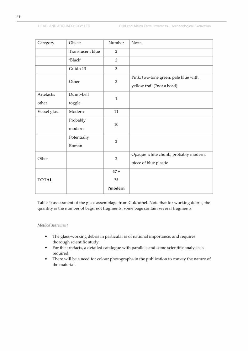
49
HEADLAND ARCHAEOLOGY LTD Culduthel Mains Farm, Inverness – Archaeological Excavation
Category Object Number Notes
Translucent blue 2
‘Black’ 2
Guido 13 3
Other 3 Pink; two-tone green; pale blue with
yellow trail (?not a bead)
Artefacts:
other
Dumb-bell
toggle 1
Vessel glass Modern 11
Probably
modern 10
Potentially
Roman 2
Other 2 Opaque white chunk, probably modern;
piece of blue plastic
TOTAL
47 +
23
?modern
Table 4: assessment of the glass assemblage from Culduthel. Note that for working debris, the
quantity is the number of bags, not fragments; some bags contain several fragments.
Method statement
• The glass-working debris in particular is of national importance, and requires
thorough scientific study.
• For the artefacts, a detailed catalogue with parallels and some scientific analysis is
required.
• There will be a need for colour photographs in the publication to convey the nature of
the material.

50
HEADLAND ARCHAEOLOGY LTD Culduthel Mains Farm, Inverness – Archaeological Excavation
5.5 Non-Ferrous Metalworking
Andrew Heald
The non-ferrous metalworking assemblage comprises 77 crucible fragments, 27 mould
fragments (almost all undiagnostic) and 15 objects that appear to be related to non-ferrous
metalworking activity (droplets, slag etc). In the absence of radiocarbon dates the material is
assumed to date to the later / Roman Iron Age. It would be one of the largest non-ferrous
metalworking assemblages in northern Britain of this date.
Initial assessment suggests that all of the crucibles were of the open variety (i.e. not lidded),
which fits with the suggested date. As the majority are fragmentary, reconstructing shape and
size is difficult. That said, where discernible, most appear to be of the triangular variety – the
most common type used throughout the Scottish Iron Age. In broad terms, two types can be
characterised by thickness, which are likely to relate either to size and/or function (the types
co-occur in the same context, suggesting the differences are not chronological). A few vessels
appear to be of a shallow triangular type. This type, although common in England, is
uncommon on Scottish sites, but there are parallels from sites in and around the Inverness
and Moray area; this may suggest a regional type.
The moulds are largely undiagnostic. Even when the casting surface survives, this is usually
too fragmentary to ascertain the product. Only one mould is clearly recognisable – a ring,
probably a finger ring. One reused rotary quern stone has a disc and a bar ingot mould
carved into one face and a ‘fish’-shaped mould around the central feeder pipe on the grinding
face. Parallels for this have not yet been found.
To extract the maximum information from the assemblage, a programme of scientific analysis
is strongly recommended. Given that crucibles were used for melting metals, it is common for
residues to survive either on or in the fabric. XRF analysis will provide gain insights into the
different alloys used. Key questions include: was the smith using copper alloy or precious
metals; where did they get the metal from; was some of it derived from Roman metal pools;
and what does this tell us about the standing of the smith and the Culduthel inhabitants?
Certain alloy types can also be used as a proxy dating tool. XRF will also help to highlight any
crucibles used for glass or enamel production.
Previous analyses of crucibles using non-destructive XRF suggests that to get a rounded view
of the alloys used on the site every crucible fragment should be analysed. It is generally
necessary to undertake multiple analyses on each fragment. The work has been costed on the
basis of 120 analyses.
Unlike crucibles, moulds very rarely have any metal traces. XRF analyses of moulds is,
therefore, extremely variable. Even when readings are forthcoming, interpretation is fraught
with difficulties. That said, the diagnostic moulds should be subjected to XRF analysis.
Recommendation: six diagnostic ceramic moulds, and one stone example; two analyses per
mould.
There are 15 objects that may relate non-ferrous metalworking activity; XRF analysis is
required to confirm this.
A programme of petrological analysis is also recommended (see below) to cast further light
on the technology of the moulds and crucibles. This would also be vital to confirm the

51
HEADLAND ARCHAEOLOGY LTD Culduthel Mains Farm, Inverness – Archaeological Excavation
identification of any suggested glass-working residues by thin-section analysis and SEM
inspection.
Method statement
• Full cataloguing of all material and discussion with wider parallels
• XRF analysis as discussed above
• Petrological study of crucible and mould fabrics (see below)
• All fragments should be marked with finds numbers prior to specialist examination.
5.6 Ferrous Metalworking
Dawn McLaren & Andrew Heald
The ironworking debris is a substantial and important assemblage, comprising over 250kg of
material. This is the largest Iron Age slag assemblage from mainland Scotland. In addition to
this are 16 stones associated with furnace structures, one bag of possible iron ore and
approximately 7kg of daub with adhering vitrified material. This assemblage is significant
due to the stratified nature of the majority of the material, particularly as quantities were
recovered in association with recognisable hearths or furnaces. In the absence of radiocarbon
dating it is assumed that the majority of these features are Iron Age in date. Given the rarity
of stratified ironworking deposits from later prehistoric Scottish sites, this assemblage has
great potential.
PROCESS
Smelting Large, charcoal rich, plano-convex slag
cakes
Runned or 'tapped' slag
Smithing Small, dense, plano-convex slag cakes
Slag spheres
Hammerscale
Non-
diagnostic
Unclassified slag
Vitrified ceramics (e.g. hearth lining)
Fuel ash slag
Magnetic residues
Non-magnetic residues

52
HEADLAND ARCHAEOLOGY LTD Culduthel Mains Farm, Inverness – Archaeological Excavation
Table 5: range of slag types present.
A 10% sample of the assemblage was visually examined to provide a basic guide to the range
of material recovered. As with most slag assemblages, a significant amount of material is
unclassifiable, making the allocation of individual pieces – particularly small samples – to
specific types and processes difficult (Crew & Rehren 2002, 84). However, large amounts of
diagnostic material have been identified; each diagnostic slag type that can be expected in
association with ironworking processes appears to be present within the assemblage. Plano-
convex slag cakes of varying sizes were identified. These hearth bottoms include large,
vesicular, charcoal-rich smelting cakes and small dense cakes likely to be the result of
smithing activities. Large quantities of runned slag are present, some preserving large
charcoal impressions, also indicating smelting activities. It is hoped that metallurgical
analysis of a sample of this material will reveal any difference in composition between these
two processes.
Just as significant are the large amounts of diagnostic micro-debris present. This is
particularly relevant due to their association in some cases with hearth features, suggesting in
situ ironworking activities. Slag spheres (formed as spherical globules of molten slag ejected
during smithing) and hammerscale (small flakes of iron produced by the impact of hammers
on hot iron during either the refining of iron blooms or the working of wrought iron) are
present in large quantities, as are large quantities of magnetic residue and metallic flakes.
There is also a suite of non-diagnostic material, comprising vitrified ceramics, hearth lining,
fuel ash slag and non-magnetic vitrified residues. These materials form when material such as
earth, clay, stones or ceramics is subjected to high temperatures, as in a hearth. During
heating these materials react, melt or fuse with alkali in ash, producing glassy (vitreous) and
porous materials. These can be formed during any high temperature pyrotechnic process and
are not necessarily indicative of deliberate industrial activity. Study of their contexts and
relationship to other debris should clarify their origin.
During the examination of the sample several fragments of iron were recovered. It is expected
that further iron will be recovered from the assemblage and will require X-raying to facilitate
identification. Some fragments may also require conservation.
Contextual analysis is essential to understanding the processes involved in ironworking at
Culduthel and the relationship of these activities to the settlement itself. Concentrations of
ironworking debris have been noted, and although further analysis is required, there appears
to be an association of debris from both smelting and smithing activities. It is unclear at this
stage whether or not this mixture of material originated from a secondary context such as a
dump of waste material, but it holds the possibility of allowing a greater understanding of
how the two processes may relate. Were the hearths/furnaces used for only one process, or is
there evidence of reuse? Is there evidence that both smelting and smithing activities took
place in the same area or is there a spatial difference?
Discussions with the excavator have suggested that three different furnace types may be
present at Culduthel: simple bowl, simple stone-built and more substantial stone-built
furnaces. It is recommended that scientific analysis should target samples from each furnace
type to try to determine whether any difference in processes can be detected between the
different structures.

53
HEADLAND ARCHAEOLOGY LTD Culduthel Mains Farm, Inverness – Archaeological Excavation
One of the questions posed by the presence of ironworking debris on any later prehistoric site
is the scale of production. In most cases it is difficult to determine whether or not the
activities can be attributed to occasional manufacture, repair of everyday objects or the large-
scale production of iron and/or iron objects. The scale and range of material from Culduthel is
important in this light, as the presence of several furnaces associated with ironworking debris
within a settlement context suggests a considerable scale of production. The large scale of the
slag assemblage suggests that Culduthel was a significant centre for ironworking, and it will
be important to examine the role of this site within its wider regional setting.
Conclusions
The quantity of the material, the stratified recovery and potential evidence of in situ
metalworking in association with a later prehistoric settlement complex makes this the largest
and potentially most significant assemblage of ironworking debris yet known from Iron Age
Scotland. This suite of material, with evidence of both smelting and smithing activities, has
the potential to provide answers to many of the questions in our understanding of
ironworking processes in later prehistoric Scotland.
Method statement
• Production of a full archive catalogue of material, and a condensed publication
synthesis with parallels where appropriate.
• All bulk slag samples will require washing prior to visual analysis. All loose residues
within each bulk sample should be retained for further analysis prior to washing as
these may contain micro-debris. Once washed, the slag will be divided up by
classification type, rebagged and given a new catalogue number or sub-number.
• Metallurgical analysis of a sample of diagnostic materials (plano-convex slag cakes &
runned slag) and unclassified slag is recommended to determine whether any
differences in composition can be detected between the two processes. Although
differences in the amount of manganese between smelting and smithing slags has
been noted previously (McDonnell 1994, 233), the significance of this and its
implications for the ironworking process itself are not clearly understood. This
assemblage may allow us to rectify this problem.
• Comparison of the metallurgical analysis of the iron objects and ironworking debris
is recommended to understand whether the iron being produced at Culduthel was
for local use.
• Large wood impressions have been noted on many of the slag samples, and species
identification may be possible; this is not costed for in the attached quote, and is best
performed by specialists at Headland.
• It is expected that during sorting of the slag, further fragments of iron objects will be
recovered. It will be necessary for these to be x-rayed and provision should be made
for this and any conservation that may be required.
54
HEADLAND ARCHAEOLOGY LTD Culduthel Mains Farm, Inverness – Archaeological Excavation
5.7 Metallurgy of Slags and Iron Objects
David Dungworth
This proposal sets out the aims and methods for the scientific examination of a range of
ironworking materials recovered during the archaeological recording of the late prehistoric
settlement at Culduthel. The manufacture and use of iron objects was an important activity in
late prehistory but stratified evidence for iron manufacture is rare in Scotland. The
assemblage of material recovered from Culduthel is of national significance and deserves to
be examined in considerable detail.
A range of scientific techniques will be used to pursue the following aims:
• Confirm the range of processes that took place on site
• Determine the source(s) of the raw material(s) used.
• Investigate the iron smelting technology (iron, phosphoric iron and/or steel).
• Estimate the output of the iron smelting (weight of iron produced).
• Examine the relationship(s) between smelting and smithing slags
• Examine the similarities and differences between the iron produced and the iron
worked (was all the iron recovered from Culduthel made there).
• Investigate the technological skills involved in the iron tools and other objects.
Samples of material from each category (and separate archaeological phases) identified from
macroscopic inspection will be selected for scientific examination. Samples will be examined
and photographed using optical and scanning electron microscopes. The chemical
composition of the samples (and in some cases individual crystals or phases within samples)
will be determined using an X-ray spectrometer attached to the scanning electron microscope.
Metallic samples will be subjected to micro-hardness testing. Ore samples will be analysed
using X-ray diffraction to confirm mineral species present. The scientific equipment used
would be that of the English Heritage Archaeological Science team. Permission to use the
facilities for this purpose has been granted.
The results of the chemical analysis and metallographic examination will be related to local
geological maps, relevant phase diagrams and comparative published material from
throughout the United Kingdom (and mainland Europe if necessary). Mass balance
calculations (using the chemical compositions of the ore, furnace lining and slag) will be
undertaken to estimate the amount of iron produced.
It is important that the scientific examination of the ironworking materials is closely linked to
the examination of the stratigraphic record and the visual examination of the excavated
artefacts. The scientific examination will require information on the extent of the site
excavated (and an estimate of the area unexcavated) and phasing information for each of the
contexts that have yielded metallic iron and iron working slags. The report on the visual
examination will form an essential starting point for the scientific examination of a selection
of samples. The interpretation of the results of the scientific examination will be greatly
facilitated by continuing dialogue between the various parties.
Method statement
Analysis of 70 samples of ore, various slags and artefacts (table 6). The slag samples will be
chosen to reflect different phasing or locations of iron-working on the site.

55
HEADLAND ARCHAEOLOGY LTD Culduthel Mains Farm, Inverness – Archaeological Excavation
Material Samples Methods
Ore 7 XRD/SEM/EDS
Furnace bottom 8 SEM/EDS
Run slag 8 SEM/EDS
Non-diagnostic slag 7 SEM/EDS
Smithing hearth bottom 6 SEM/EDS
Vitrified furnace/hearth lining 6 SEM/EDS
Slag spheres 7 SEM/EDS
Hammerscale 7 SEM/EDS
Iron off-cuts 7 OM/hard
Iron artefacts 7 OM/hard
Total 70
Table 6: metallurgical samples proposed for the Culduthel assemblage. XRD, X-ray
diffraction; SEM, scanning electron microscopy; EDS, energy-dispersive spectrometer; OM,
optical microscopy; hard, hardness testing
5.8 Pottery
Ann MacSween
Approximately 200 sherds of pottery were recovered from the excavations at Culduthel. Most
of these are small sherds or fragments. They were recovered from contexts across the site.
The material comprises mainly rim and body sherds, with one basal sherd. The lack of basal
sherds is due in part to some of the sherds deriving from carinated round-based vessels
dating to the Neolithic. Some thicker, more straight-sided vessels are probably Bronze Age or
Iron Age in date. An initial scan gave the impression that there are groups of sherds from the
same vessel. Many of the sherds are small and/or abraded but in some instances it may be
possible to suggest vessel forms.
The current packing is sufficient and any repacking can be carried out after the pottery has
been recorded.
Method statement
Visual examination and analysis will seek:
• to determine the date of the pottery (from comparison with other assemblages)
• to provide an analysis of the fabrics for spatial analysis
• to determine the means of deposition of the pottery
• to place the pottery within a broader context
• The production of a catalogue describing the sherds along with a discussion of the
material within the site and in its wider context is recommended. Given the number
of small sherds, it is recommended that the catalogue takes the form of full written
entries detailing form, fabric, surface finish, decoration, abrasion, etc for illustrated
material (c. 10 rim sherds) and a spreadsheet catalogue for the full assemblage. The
pottery typology may be of use in indicating broad dates, and analysis of the fabrics
and their spatial distribution may provide indications of chronological and/or
functional variation across the site.
• Marking of the pottery sherds is required prior to further analysis.

56
HEADLAND ARCHAEOLOGY LTD Culduthel Mains Farm, Inverness – Archaeological Excavation
• A number of fabrics were identified by eye, and thin section analysis would be useful
in looking at variations across the site and also in trying to identify the source of the
clays and tempers. The main fabrics identified were – untempered sandy clay; coarse
sandy clay; fine sandy clay with c.20% crushed white/gold rock fragments; sandy clay
with 40-50% of mixed rock temper.
5.9 Daub
Dawn McLaren
Approximately 17kg of burnt clay was recovered from the site. All bags were visually
examined, allowing some crucible/mould fragments to be extracted. The burnt clay appears
to be linked with three processes:
• furnace lining associated with metalworking debris
• hearth lining associated with high temperature pyrotechnic processes, but not
necessarily related to metalworking activities
• daub associated with wattle fences
The material comes in a range of conditions. The majority are small abraded fragments from
which little further information can be determined, whilst many larger fragments (48 bags)
preserve finger and/or wattle impressions which are worthy of further examination. It may
not be possible in all cases to assign the burnt clay to specific processes; however, contextual
analysis may prove fruitful. Despite the small and abraded condition of much of the
assemblage, investigation of fragmentation patterns should provide useful information
regarding site formation processes and depositional conditions.
Method statement
• Production of a full archive catalogue of the material, and a synthesis for publication
• Analysis of possible wattle/finger impressions
• Contextual analysis and investigation of fragmentation patterns
• Illustration of a small selection of diagnostic fragments (c.5)

57
HEADLAND ARCHAEOLOGY LTD Culduthel Mains Farm, Inverness – Archaeological Excavation
5.10 Petrology
Daniel Sahlén
The discovery of a wide range of domestic pottery wares and ceramic metalworking debris at
Culduthel provides a tremendous opportunity to study variation in ceramic production over
time and for different functions. The pottery spans the Neolithic to the Iron Age, with four
main fabrics identified; the metalworking debris (crucibles and moulds) shows a broad
variety in shapes and fabrics. It is anticipated that a thorough investigation focused on
ceramic technology and the use of raw materials would provide important evidence of
production and industrial activities at Culduthel and in the broader area in the prehistoric
period. This would be vital for our understanding of the socio-economic background of the
site and the region.
Method statement
• A combination of thin section analysis and scanning electron microscopy would be
used to inform on methods of ceramic manufacture and the diversity and sources of
clay material used at the site. The examination of different types of ceramic materials
would provide the chance to consider choices and tradition in relation to different
types of production systems.
• It is suggested that 16 samples in total, taken from the main ceramic groups (pottery,
crucibles, moulds, daub and furnace lining) should be investigated through thin
section and scanning electron microscopy (SEM); eight samples from the main
pottery fabrics wares and eight samples of metalworking/industrial ceramics.
• Thin section analysis will allow the identification of shaping/forming techniques and
the nature of inclusion/temper materials, as well as clarifying the mineral background
of the material.
• SEM analysis would investigate the microstructure of the fired clay, supplying crucial
information regarding firing and vitrification processes. The use of SEM would also
provide analytical data (through SEM-EDAX analysis) of the chemical properties of
the ceramic material.
• In addition, fieldwork to identify and sample local clay sources is recommended. This
would be vital for the identification of local and imported ceramics, and would give
us the opportunity to reconstruct prehistoric production patterns.
5.11 Stone
Dawn McLaren & Fraser Hunter
Of the 109 coarse stone items initially submitted, 59 fragments were worked (representing 53
objects), 14 may be worked, and 36 are natural. Also submitted were three boxes of fire-
cracked stones and one bag of possible iron ore. During this assessment, each fragment was
visually examined for evidence of use. This large assemblage contains a wide range of tools.
Most are quern stone fragments with a range of types represented; saddle querns (with
rubbers), trough querns, and both bun and disc rotary querns (table 7).

58
HEADLAND ARCHAEOLOGY LTD Culduthel Mains Farm, Inverness – Archaeological Excavation
Category Object Quantity
Personal & Leisure bead 1
disc (palette) 1
Tools grinders 2
pounders 2
hammerstones 1
smoothers (from textile/leather production) 4
Whetstones 2
Multi-function tools 2
Sharpening stone 1
Spindle whorl 1
Food processing Saddle querns 2
Rubbing stones 7 (6)
Trough querns 3 (2)
Rotary querns 24 (19)*
Miscellaneous Hollowed stones 2
Perforated stones (?weights) 4 (2)
Working surface 1
Total no of fragments 59
(Total no of objects) (53)
Table 7: assessment of the worked stone from Culduthel. The numbers in brackets denotes the
number of objects (as some are fragmented). Note: *one quern reused as ingot mould; one
?unfinished; two fragments reused as tuyères.
Four further aspects of the quern assemblage stand out for comment at this stage. One is the
mixture of different quern types. Although saddle and disc querns are not unexpected on an
Iron Age site, the presence of several bun querns, a type more common in southern Scotland
(MacKie 1971, 52-55, fig 5), and possible bun/disc-hybrids alongside the disc querns is worthy
of further investigation. Secondly, although it is not uncommon for querns to be recovered in
a fragmentary state, the consistent fragmentation of the rotary querns in particular will
benefit from further analysis. It is not possible at this stage to show that this was a deliberate,
votive process. However only three rotary querns were recovered intact; one of these had
been reused and no longer functioned as a quern stone. During the initial visual examination,
several fragments of the same querns were identified; therefore the total number of quern
fragments is an overestimate of the number of querns represented in the assemblage. Some of
these fragments had been recovered from different contexts and further contextual analysis is
required to determine the cause of this deposition pattern; this will be of importance in

59
HEADLAND ARCHAEOLOGY LTD Culduthel Mains Farm, Inverness – Archaeological Excavation
assessing whether there is evidence of structured deposition, with the burial of querns or
quern fragments for votive rather than practical purposes. Thirdly, three querns are
decorated with simple collars around the feeder pipe. A recent study of Scottish querns
(McLaren & Hunter forthcoming) has identified several other querns decorated in this
manner and it will be of value to see how these examples fit within the wider picture. Finally,
one stone from Culduthel has been tentatively identified as an unfinished rotary quern stone.
Although the local manufacture of quern stones on Iron Age sites would be expected,
evidence of on-site manufacture is surprisingly limited. In addition, several quern stones
appear to have been reused as a structural component within furnaces/hearths, with the
tentative suggestion of some feeder pipes being used as make-shift tuyères. Investigation of
the relationship between the broken up quernstones and the furnaces/hearths associated with
metalworking would be beneficial.
The coarse stone assemblage also includes a small group of cobble tools, including grinders,
pounders, hammerstones, smoothers and whetstones. The small size of this assemblage (only
thirteen cobble tools and six possible further examples) is surprising in comparison to the
large quantity of quern stone fragments recovered from the site. Some of the cobble tools
appear to be multi-functional, often with signs of significant use; unfortunately, in the
absence of experimental studies, the detailed function of such tools is uncertain. The
prominence of smoothers amongst the cobble tool assemblage is noteworthy. These objects,
characterised by areas of polish often associated with dark red-brown staining, are thought to
have functioned as tools used in the processing and preparation of hides.
There were also four personal or decorative items, including a small oval shale bead, a
fragment of a well-shaped stone disc, and a perforated whetstone fragment. Although not
primarily decorative, a spindle whorl rough-out has a series of incised scratch marks
(possible graffiti) on both faces. Although most of the stone objects from Culduthel appear to
have originated from local sources (see below), the shale bead hints at wider contacts,
perhaps across the Moray Firth to Golspie. Further analysis is required to confirm the likely
source of this material.
Amongst the common types of stone tools are a few more unusual objects. Three stand out in
particular. The reuse of a rotary quern stone as an ingot mould is noteworthy. In this instance,
both sides have been reused to carve moulds. One face has a shallow disc and an elongated
bar ingot mould carved into it, both well-paralleled forms. The other face has a large ‘fish’
shaped mould carved around the central perforation of the quern stone, which would have
been masked by the other half of the mould. This object is unparalleled, and further work is
required to understand it. XRF analysis of the interior surfaces of the moulds is
recommended.
Also submitted for analysis was a bag of possible iron ore fragments. These show no obvious
signs of working, but it is recommended that these samples be examined by a geologist to
confirm their identification. It would also be beneficial to submit these samples for
metallurgical analysis to determine if this material is the source of iron used by the Culduthel
metalworkers.
Three boxes of fire-cracked stones from context 3467 were submitted in an unwashed,
unsorted condition. Each fragment was visually examined in its present condition to
determine whether any fragmentary worked stone was amongst the assemblage. Two
possible cobble tool fragments were extracted for further analysis.

60
HEADLAND ARCHAEOLOGY LTD Culduthel Mains Farm, Inverness – Archaeological Excavation
Conclusions
Although not a large assemblage for the size of site excavated, the large number of rotary
quern stone fragments is of interest. Many aspects of the deposition of the quern stones may
be significant, as many of them are in a fragmentary condition and some have been reused as
structural components of furnaces. The presence of both bun- and disc-shaped quern stones,
two with decoration, is of particular interest.
Method statement
• Production of a full catalogue of the material with parallels where appropriate.
• Many of the stone tools require cleaning prior to further analysis.
• Marking of all worked and possibly worked stones is recommended.
• Geological identification of the worked stone assemblage is recommended; a wide
range of stone types has been utilised, and specialist study will allow a better
understanding of sources and motives behind their selection.
• Mineralogical study of the ore samples would be of considerable value.
• XRF analysis of the interior surfaces of the stone moulds is required.
5.12 Geology
Fiona McGibbon
75 stone artefacts were examined briefly in order to assess rock type and any trends in usage
of particular rock types for particular purposes. Rock types seen include a range of biotite and
muscovite schists, psammitic (more quartz rich) schist, granite, diorite, siltstone and
quartzite. The schists are texturally and mineralogically very variable. Artefacts of schist are
usually slab-like whereas those of quartzite or psammitic schist are more cobble-shaped.
Inspection of the 1:625,000 geological map shows the Culduthel site to be in an area of
outcropping Devonian sedimentary rocks (Middle Old Red Sandstone) with outcrops of
Moinian metamorphic rocks (schists etc.) with associated granite and diorite intrusives in the
vicinity. Inspection of the 1:63,360 series solid and drift maps show the area to be covered in
boulder clay and undifferentiated drift, and to be near the present course of the River Ness. It
is likely that the raw materials used to manufacture most artefacts were sourced from these
drift and alluvial deposits very near the site, although the quern stones are very large for such
deposits.
Most querns were made of various schists, sometimes of surprisingly coarse grain size. These
require large slabs of rock and these might have been sourced from drift deposits. All the
suggested whetstones were made of Devonian siltstone. The hand tools such as rubbing
stones, pounders, smoothers and grinders were usually of natural water-worn cobbles
predominantly comprised of quartzite with subordinate granite, diorite and psammitic schist.
The quartzite pebbles were probably ultimately derived from Devonian conglomerates, but
all the cobbles could have come from the local glacial drift deposits most likely reworked by
postglacial river processes. As with other sites the assemblage shows an astute use of
different lithologies and shapes for different purposes, making best use of locally sourced
materials. The schists used for quernstones are likely to have shed great quantities of mica
into foodstuffs though, and this is certainly not the preferred rock type at other sites.

61
HEADLAND ARCHAEOLOGY LTD Culduthel Mains Farm, Inverness – Archaeological Excavation
Method statement
• The artefacts require more detailed inspection to give more specific lithological
descriptions. This will produce a detailed archive catalogue and a synthesis for
publication.
• These identifications will then be more thoroughly considered in the context of local
geology, and analysed more rigorously in terms of choices of materials for specific
purposes.
• The quernstones need to be looked at further in order to assess whether they show
any signs of having been quarried from rock outcrops rather than found as blocks in
the local landscape.
• It would be valuable and useful to investigate the environs of the actual site to
examine the boulder clay and alluvial deposits; a short field trip is proposed.
5.13 Lithics
Torben Bjarke Ballin
As part of the assessment, the assemblage was divided into two sub-assemblages, namely
larger finds recovered in the field (c. 150 pieces), and mostly diminutive finds recovered in
the laboratory in connection with the sieving of samples (c. 350 pieces). The former were
examined individually with the consistent use of a magnifying glass (x8 and x15), whereas
the latter were examined in a more cursory fashion. The purpose of this report is to briefly
assess the lithic finds, and give a summary of the character and date range of the material. On
the basis of this assessment, a statement is produced on the potential for further analysis and
reporting.
From the archaeological investigations at Culduthel, 493 lithic artefacts were recovered. The
field-collected finds are listed in Table 8. In addition to these finds, the collection also includes
a small bag with possibly burnt quartz chips (93g). Apart from small chips, the sieved
material also embraces two regular thumbnail scrapers, bringing the number of thumbnail
scrapers to six.
The definitions of the main lithic categories are as follows:
Chips: All flakes and indeterminate pieces the greatest dimension (GD) of which is £ 10 mm.
Flakes: All lithic artefacts with one identifiable ventral (positive or convex) surface, GD > 10
mm and L < 2W (L = length; W = width).
Indeterminate pieces: Lithic artefacts that cannot be unequivocally identified as either flakes
or cores. Generally the problem of identification is due to irregular breaks, frost-shattering or
fire-crazing. Chunks are larger indeterminate pieces, and in, for example, the case of quartz,
the problem of identification usually originates from a piece flaking along natural planes of
weakness rather than flaking in the usual conchoidal way.
Blades and microblades: Flakes where L ³ 2W. In the case of blades W > 8 mm, in the case of
microblades W £ 8 mm.
Cores: Artefacts with only dorsal (negative or concave) surfaces – if three or more flakes have
been detached, the piece is a core, if fewer than three flakes have been detached, the piece is a
split or flaked pebble.
Tools: Artefacts with secondary retouch (modification).

62
HEADLAND ARCHAEOLOGY LTD Culduthel Mains Farm, Inverness – Archaeological Excavation
Debitage Flint Quartz /
quartzite Other Total
Chips 9 2 11
Flakes 79 7 6 92
Blades 5 5
Indeterminate pieces 5 7 12
Total debitage 98 14 8 120
Cores
Possible frags of bipolar cores 5 5
Other cores 2 2
Total cores 7 7
Tools
Thumbnail scrapers 4 4
Other scrapers (mostly end-scrapers) 13 1 14
Backed blades 1 1
Pieces w edge-retouch 9 9
Pieces w invasive retouch 1 1
Total tools 28 28
TOTAL 135 15 8 156
Table 8: field-collected struck lithics from Culduthel
Raw materials
As shown in Table 7, the assemblage consists mainly of flint (86%), supplemented by some
quartz and quartzite (9%), and eight pieces in other raw materials (5%). It is possible to sub-
divide the flint into three categories, namely 1) traditional East of Scotland brown flint, 2) flint
resembling Aberdeenshire Buchan Ridge flint, and 3) exotic dark flint. The Category 1 flints
are generally relatively small, whereas the Category 2 flints are somewhat larger. These
pieces were not quantified. Thirteen (from both sub-assemblages) grey to black pieces were
classified as probably having been imported from Yorkshire. The category ‘other raw
materials’ includes, inter alia, fine sandstone and chalcedony. A total of 31 pieces of flint and
quartz (almost 20% of the field collection) have been characterised as burnt and, amongst the
flint, several pieces are clearly patinated.

63
HEADLAND ARCHAEOLOGY LTD Culduthel Mains Farm, Inverness – Archaeological Excavation
If the Category 2 flints are truly of Buchan Ridge type, then a substantial proportion of the
total assemblage is based on imported (exotic) material. The definition of the dark grey to
black flint as exotic is based on the frequently soft, powdery cortex of this material, and the
assumption of this resource as deriving from NE England (Saville 2003) is, admittedly,
somewhat conjectural. The darkest of this form of chalk flint is of superb quality, resembling
the material used in the SE English gunflint industry.
Nine small chips listed as possible pitchstone (the sieved material) are most likely glassy slag.
The sieved sub-assemblage includes two bags with numerous small chips, possibly relating to
separate knapping floors. The fact that the two scatters seem to consist of two different forms
of flint suggests different knappers/?dates.
Typo-technological characterisation
Debitage: The field assemblage includes 120 pieces of debitage (87%), 11 of which are chips,
supplemented by 92 flakes, five blades, and 12 indeterminate pieces. Approximately one-
tenth is in quartz or quartzite, and one-twentieth in ‘other’ raw materials, with the vast
majority being in flint. The blades are relatively robust specimens, and practically all blades
and flakes appear to have been produced by the application of hard percussion.
Cores: Only seven cores were identified (12%), all of which are in flint. Five mostly burnt
pieces were defined as the likely fragments of bipolar cores, and two were classified as an
irregular flat core and a small Levallois-like core.
Tools: Twenty-eight tools were recovered and, apart from one, all are in flint. They include
four thumbnail-scrapers (six, with the two specimens from the sieved material), 14 other
scrapers, one backed blade, nine pieces with edge-retouch, and one piece with invasive
retouch. The ‘other’ scrapers are mainly larger end-scrapers, but side-scrapers are also
present; one of the end-scrapers is a particularly large elongated implement with full double-
sided lateral blunting. The thumbnail-scrapers are small almost circular specimens, modified
by the application of neat pressure-flaking. The backed blade is probably a small knife.
Technology: As the assemblage is clearly dominated by the application of platform technique,
the composition of the core group is somewhat surprising – five fragments of bipolar cores
against two platform cores. This suggests that either the site was not fully excavated, or parts
of the assemblage was manufactured outside the site. One core is an obvious Levallois-like
core, and the other (flat) platform core may be the totally exhausted remnant of a similar core.
These cores are waste products of Late Neolithic blank production, where flakes and blades
were produced from the same specialised cores (see Ballin forthcoming a).
The finds include very few diagnostic elements, but a small Levallois-like core and a series of
diminutive thumbnail scrapers indicate that the assemblage may include Late Neolithic and
Early Bronze Age components. A small number of hard-hammer blades are likely to form
part of the former sub-assemblage, as is an impressively large and neat end-scraper. In
Scotland, Yorkshire flint has been found throughout eastern Scotland, with Urquhart Castle
being one of the northernmost find-spots (Ballin 2005). This flint type is mostly associated
with Late Neolithic activity, as for example at East Lochside in Angus (Ballin forthcoming b).
If the site’s Category 2 flint is actually from Buchan in Aberdeenshire, this also supports the
Late Neolithic date, as the only diagnostic type found at the flint mines of that area is a chisel-
shaped arrowhead (albeit from surface contexts; Saville 1995).

64
HEADLAND ARCHAEOLOGY LTD Culduthel Mains Farm, Inverness – Archaeological Excavation
Method statement
• Classification and cataloguing will be carried as one coherent process. The first part
of the specialist analysis is the classification of all lithic material directly into a
computer database (Access 2000). The database includes standardised schemas for
debitage, cores and tools. An archive database (‘hard copy’) is also produced,
containing all the information from the database; the catalogue will be printed out
directly from Access. The next step is the actual analysis, which to a large extent
makes the information in the database visual, partly in text, but also in tables,
diagrams, and distribution maps (where relevant). The final stage is the production of
the actual report.
• It has not been possible to assess the artefacts’ contextual situation. This means that it
is uncertain whether the two main elements of the collection, the Late Neolithic finds
and the Early Bronze Age finds, can be separated spatially. However, it is the
analyst’s impression, that the different chronological elements may be associated
with different flint categories (the Early Bronze Age finds possibly relating to the
local brown flint, and the Late Neolithic finds mainly with the possible Buchan Ridge
flint and the Yorkshire flint), and an attempt at ‘dissecting’ the assemblage into its
chronological constituents should be made. If successful, this may provide two
separate sub-assemblages, each with considerable research potential. The excavating
unit’s database (finds, contexts, and features) suggests that the site includes a large
number of contexts and features, and it may be possible to link the Late Neolithic and
Bronze Age lithics to different contexts/features via vertical and/or horizontal
stratigraphy.
• The two potential sub-assemblages may provide information on matters such as
technology and settlement organisation / on-site activities during the two periods.
The Late Neolithic sub-assemblage may be particularly interesting and topical, as this
industry is presently being discussed in relation to its specialised Levallois-like
reduction technique (Ballin forthcoming a; forthcoming c), and this technique’s
presence at East of Scotland settlement sites (eg, East Lochside; Ballin forthcoming b)
and flint mines (the Buchan Ridge prehistoric mining complex; Saville 2005). Subjects
such as prehistoric territorial structures and exchange (particularly relating to the so-
called Yorkshire flint) are also highly relevant. It may also be possible to link the
burnt lithics, and the two bags of flint chips with specific contexts/features and
thereby provide information pertinent to the understanding of site activities.

65
HEADLAND ARCHAEOLOGY LTD Culduthel Mains Farm, Inverness – Archaeological Excavation
6. ASSESSMENT OF ENVIRONMENTAL SAMPLES
Dr S. Timpany
6.1 Introduction
A total of 1719 samples were collected from a series of features during the excavation,
including the interiors of roundhouses and the fills of pits and postholes associated with a
large Iron Age settlement. Samples ranged in size from 0.25 to 135 litres.
6.2 Method
Samples were processed in laboratory conditions using a standard floatation method (cf.
Kenward et al, 1980). All plant macrofossil samples were analysed using a stereomicroscope
at magnifications of x10 and up to x100 where necessary to aid identification. Identifications
were confirmed using modern reference material and seed atlases including Cappers et al
(2006).
Faunal remains were identified from hand recovered material and from processed samples.
6.3 Results
The results are presented in Tables 1 (retent samples) and 2 (floatation samples) below.
Charred cereal grain
A suite of charred cereal grain is present within the samples. Grains present within the
assemblage include, primarily, barley (Hordeum vulgare), club/bread wheat (Triticum
aestivo-compactum) and oats (Avena sp.) with lesser amounts of emmer wheat (Triticum
dicoccum), rye (Secale cereale) and spelt wheat (Triticum spelta) (see Table 2).
Other charred plant remains
Wood charcoal fragments were present in the majority of both floatation and retent samples
often of a size suitable for identification and radiocarbon dating (see Tables 1 and 2). There
are also a number of agricultural weed species present, including: pale persicaria (Persicaria
lapithifolia), knotgrass (Polygonum aviculare), sun spurge (Euphorbia helioscopia) and
hemp-nettles (Galeopsis sp.). Other charred plant remains found of interest include: crab
apple pips (Malus sylvestris), blackthorn (Prunus spinosa) fruit stones and hazel (Corylus
avellana) nutshell fragments.
Other finds
There is evidence for metalworking taking place at Culduthel with the finding of metal waste
within retent samples (see Table 1), such as slag, hammerscale and prill adding to the bulk
samples recovered from observable deposits during excavation. Finds such as glass beads,
glass shards, pottery fragments and metal objects were recovered within the retent samples.
For more information on these, please refer to the finds report. Many samples contained
burnt bone, while unburnt bone appeared more sporadically. Daub was recovered frequently
from samples, lithics were also recovered and are discussed elsewhere, while occasional
marine shell fragments were also found (see Table 1).

66
HEADLAND ARCHAEOLOGY LTD Culduthel Mains Farm, Inverness – Archaeological Excavation
Faunal remains
Faunal remains at Culduthel came from 1,143 samples in 1,013 contexts (one sample of less
than 5g calcined material was unstratified). Some were collected on site and the remainder
process as above. Over 98% of the remains were fully calcined; thus they were in poor
condition for examination, and the minority which were not calcined were often far too
fragmented for identification. Futhermore 1,033 of the samples (90.4%) were less than 5g in
weight.
Identification was also hindered by the burning of the material which caused shrinkage and
twisting of the bone. These distortions made smaller fragments from animals of similar size
and proportion (e.g. pig and sheep) difficult to distinguish from each other, and fragments of
larger animals (e.g. bovids) more easily distinguished from the rest of the assemblage. Thus
cattle may appear overrepresented in the sample from other relatively smaller animals, but it
is not advisable to accept this at face value.
Dentition was also easily spotted, though in every case only molars or molar fragments were
found. The conspicuous absence of canines or incisors in the assemblage suggests that the
anterior portion of the mandible was removed or separated from the rest of the remains prior
to deposition (Rideout et al 1992: 50).
Taxa identified included sheep, cattle, pig and notably one amphibian tibia and fibula
(Context 380, Sample 144). Given the poor taphonomy of the remains these identified pieces
are not exclusive of the possibility that other species were also present, such as red deer.
Consumption of meat and animal by-products is the most common use for domesticated
animals (Raish 1992: 45) and all of the faunal remains are typical of domestic waste.
6.4 Discussion
The charred cereal grain assemblage, dominated by barley, club/bread wheat and oats is
similar to other Iron Age assemblages across Scotland (e.g. Pollock et al, 1992; Banks et al,
2001). The presence of a number of arable weed species within samples containing charred
grain suggests that these taxa were being accidentally collected with the cereals during
harvesting and have then been discarded when the grain is being used for domestic activities,
such as baking. No evidence was found for any processing of the cereals (e.g. threshing and
winnowing) within the samples suggesting either this material hasn’t survived or that only
small-scale (domestic) processing was taking place.
Charred hazel nutshell is also present in samples from this assemblage and is an almost
ubiquitous find across prehistoric sites in the British Isles. A more rare find in Iron Age sites
is the presence of charred crab apple pips and these together with blackthorn and hazel show
that a mixture of cultivated and wild food resources were being utilised at Culduthel. The
occasional finding of marine shell fragments within the samples also indicates some (limited)
exploitation of coastal resources.
Wood charcoal fragments are present of sizes suggestive of in-situ or deliberately dumped
deposits. The smaller sized fragments (e.g. less than 1.0cm) may have been transported
across the site by mechanisms such as windblow and surface run-off and may originally have
been part of the deposits containing the larger fragments. Some charcoal fragments have

67
HEADLAND ARCHAEOLOGY LTD Culduthel Mains Farm, Inverness – Archaeological Excavation
been tentatively identified as roundwood and may represent structural material. Further
work on the distribution and spread of the fragments is needed to elucidate the potential
sources of the charcoal.
Faunal remains
Some of the identifiable remains showed epiphyseal lines, indicating that the animals were
juveniles as their bones had not completed fusion. Again, the profile of this assemblage
relative to age-at-death may be misleading as burned bones from older individuals tend to
survive compressive forces better than those of younger individuals (Lyman 1994: 390). This
would be expected of faunal waste from domestic consumption, although no butchering
marks were detectable (Lyman 1994: 389).
Even if identifiable, caution is taken that burnt animal remains correspond to such a small
proportion of the bone assemblage that information quantified from this data may be
misleading (Rideout et al 1992: 50). Without other faunal remains, this prevents any
conclusions to be drawn on wider uses of domesticated animals at this site.
Method statement
• All of the charred plant remains information (including charcoal) within Tables 1 and
2 should be plotted on to distribution maps for the site. This will then give precise
distribution of charred cereals and charcoal across the site, which will aid in
determining samples that are representative of in-situ material from those that are
more likely to represent scattered material (e.g. as a result of wind blow). These
maps will also help in illustrating the relationship between the charred plant remains
and the different areas of activity at the site (e.g. metalworking).
• A selection of charcoal fragments from any features of interest (to be determined)
should be identified to investigate the types of arboreal taxa being utilised for fuel
etc. This information will also provide data on the woodland types around the site
during the period of occupation.
• Samples containing abundant amounts of charred cereals, together with any samples,
which are of interest from distribution maps, should be further examined. This will
then give actual counts of the numbers of charred cereal grains and other plant
remains (e.g. seeds). This will provide information on the agrarian economy of the
site together with potential fluctuations in dominant cereal types.
• A review of prehistoric grain found at other Iron Age sites in the UK sites is needed
to place the Culduthel site into the known chronometry of agriculture within
Scotland and the British Isles. This will also require the radiocarbon dating of a suite
of grain, primarily from features of interest (to be identified from distribution maps),
from across the site.
• All the environmental data should be integrated with the artefactual material and
archaeological features (e.g. prehistoric roundhouses) in any finalised reports for the
Culduthel site.
Faunal remains
Although the straightforward conclusion is that the faunal remains are burned post-
consumption waste matter, comparison with material from other sites would clarify the
context of this data. The presence of other material in domestic context such as pottery would
again clarify the nature of the assemblage as domestic or other. Plotting these contexts onto

68
HEADLAND ARCHAEOLOGY LTD Culduthel Mains Farm, Inverness – Archaeological Excavation
distribution maps will allow spatial visualisation concerning where waste disposal is taking
place (e.g. inside the home or at designated sites elsewhere). Further study may also reveal
the reason for the absence of the anterior mandible of animals within this assemblage and
other similar assemblages (e.g. Rideout et al 1992: 50). The presence of the amphibian tibia
and fibula should be investigated as it serves as an environmental indicator.
7. THIN SECTION ANALYSIS
Archaeological Background
As a result of specialist advisory site visits to the site at Culduthel Mains Farm, nineteen
Kubiena tin sediments samples were taken. The samples were taken from a variety of
profiles in order to address specific questions concerning the formation of the sampled
deposits, both in terms of depositional and post-depositional processes. Specific issues are
addressed below in the brief description of the sampled deposit profiles.
The site lies on glacial drifts largely derived from Old Red Sandstone. Across the site
processes of hill wash movement have played a key role in the accumulation of deposits. The
depth of such deposits varied rapidly over the site, largely being controlled by local
topographic variation. The relative depth of the hill wash accumulations played a significant
role in determining the survival of the archaeological deposits: thicker deposits of hill wash
tended to reduce the impact of ploughing.
The site offers unique opportunities for thin-section analysis, given below. The opportunity
for comparison with thin-section work from another Iron Age roundhouse site in the north of
Scotland, Birnie, Morayshire, also exists, which would further enhance the value of studying
the samples listed below.
Sample Selection
Although nineteen samples were originally taken from the site, this initial group has been
examined and the samples for further work have been selected on the basis of a number of
criteria. These criteria are the avoidance of unnecessary duplication, the apparent state of
preservation of the samples and the probability of recovering evidence that will materially
aid understanding of the site. While preservation state of the samples did not affect the final
selection, the other application of the other criteria lead to the selection of the twelve samples
tabulated below.
Sample Contexts
4.1 2730
4.2 2370, 1655
4.3 2370, 1655, 776
4.4 776
4.5 776
4.6 776
4.7 776
4.8 776
1139 2878, 2725
1572 1671, 2429
1605 2179
1758 4365
Table Table 1: Contexts sampled at Culduthel Mains Farm.

69
HEADLAND ARCHAEOLOGY LTD Culduthel Mains Farm, Inverness – Archaeological Excavation
Context and Purpose of Selected Samples
Samples 4.1-4.8
These samples were taken through the fills of the ring ditch of Structure 4. These fills have
been interpreted as relating to the occupation, destruction and post-abandonment phases of
Structure 4
Sample 1139
This sample was taken through contexts that may be the remains of turf post pads and
overlying turf ash. The purpose of the sample is to check the composition of this material to
see if the basic interpretation is correct and to seek further evidence for the function of the turf
deposits.
Sample 1572
This sample was taken through the remains of a possible turf wall (Context 2429) and a
deposit thought to relate to the abandonment of the site during the 1st century AD (Context
1671). The interpretation of Context 1671 as an abandonment deposit is critical to
understanding the archaeological sequence in Structure 10. These interpretations will be
checked and enhanced using evidence from the thin-sections of formation processes and
composition
Sample 1605
This sample was taken through a possible floor layer (Context 2179) in Structure 10. Such an
interpretation is critical to understanding the sequence and use of the structure. Thin-section
analysis will check the interpretation and possibly provide evidence for activity on the floor.
Sample 1758
This sample was taken from Context 4365 and the underlying sub-soil. Context 4365 is
interpreted as a hill wash. This sample has been taken in order to check that interpretation
and to examine the nature of the contact between Context 4365 and the sub-soil. The degree
of weathering/ soil formation in the sub-soil will indicate the nature of the surface on which
Context 4365 accumulated, which in term will have implications for the formation
processes/chronology of hill wash accumulation.

70
HEADLAND ARCHAEOLOGY LTD Culduthel Mains Farm, Inverness – Archaeological Excavation
8. STATEMENT OF POTENTIAL
The excavation has revealed multi-period use of the site from the prehistoric through to the
?2nd century AD. The more important element of the site is the Iron Age occupation. There is
good evidence for 17 roundhouses, craft and industrial production, and perhaps trade links
with parts of Scotland further afield. The range of buildings and their good preservation is
unusual.
Many of the research issues will be addressed in conjunction with the artefact analysis as
outlined below. However, the structures have the potential to address questions about
construction:
• There is evidence for floors - is there any for roof timbers?
• Does the similar size of many of the posts suggest woodland management?
• The construction of some of the walls survives, are they head height or
foundation/stub walls?
• Is there evidence for turf construction?
• Are hearths present in all domestic structures?
• Are domestic buildings reused for craft activity or are craft structures purpose-built?
• Are differing construction techniques a chronological indicator?
The use of the site also raises questions:
• Are craft activities carried out in identifiable zones?
• Are there separate zones for occupation, craft/industry and animal husbandry?
• Can food (cereal) processing areas be identified by, for example, plotting charred
cereal grains or faunal remains?
• Is there evidence for social hierarchy in the structures?
• What deposition processes are at work on the site, and how does material find its
way into negative features?
Artefacts
The Culduthel excavations have produced an assemblage of primary importance for the
study of the Scottish Iron Age. It is rare to find such a productive site in the cropmark zone of
Scotland; the range of material has the potential both to paint a detailed picture of activities at
the site and to impact on much wider research topics. We have drawn together a team of
specialists who will maximise the considerable potential of this assemblage.
Among the rich range of material, the following areas are of particular importance:
• The evidence of glass- or enamel-working is unique in Iron Age Scotland, and very
rare in Britain as a whole
• The evidence for iron processing offers the chance to follow the material from ore to
artefact. This is exceptionally rare, especially in the Iron Age context to which this
material appears to date.
• The assemblage of iron objects is one of the largest and most important from Iron Age
Scotland, with unusual items such as swords, a dagger and a file.
• The non-ferrous metalworking debris is one of the largest and most important from
Iron Age Scotland.

71
HEADLAND ARCHAEOLOGY LTD Culduthel Mains Farm, Inverness – Archaeological Excavation
The finds will be studied by different specialists according to material; a number of categories
will undergo scientific analysis to extract further information (table 1). The results will then
be analysed in tandem with the structural evidence in a synthetic discussion that will address
a number of key themes identified in a recent research agenda for the Iron Age (Haselgrove et
al 2001, 14-22).
9. PUBLICATION PROPOSAL AND TASK LIST
Dissemination strategy
The excavations have revealed an enormous amount of information about Iron Age culture
both locally and nationally. The potential outlined above merits further study and
dissemination to a wider audience.
Academic publication
It is proposed that the results of the excavation should be published but whether as a
monograph, online or in a number of different places e.g. note in Britannia, a monograph in
the PSAS series and/or a popular booklet has yet to be determined.
A task list and proposed contents list for a monograph type report is included in this report.
The main element is the work on the artefacts recovered and this may take, overall, between
two-and-a-half and three-and-a-half years to complete since many of the staff are engaged in
research in museums, universities and other institutions. This element is being co-ordinated
by the National Museum of Scotland.
Discussions with Highland Council are to be held to determine the best approach.

Appendix 1. Assessment proposal and tasklistAppendix 1. Assessment proposal and tasklistAppendix 1. Assessment proposal and tasklistAppendix 1. Assessment proposal and tasklist
Section HeadingSection HeadingSection HeadingSection Heading PagesPagesPagesPages FiguresFiguresFiguresFigures PlatesPlatesPlatesPlates TablesTablesTablesTablesSummarySummarySummarySummary 1IntroductionIntroductionIntroductionIntroduction 3 7 2 1BackgroundLand use, geology and locationPrevious work in the areaAims and methodology Research aims Recording techniques Artefacts and Sampling Location of archive and findsSite DescriptionsSite DescriptionsSite DescriptionsSite DescriptionsIntroductionIntroductionIntroductionIntroduction 0.5 4Pre-Iron Age 0.5Cairns 1 3 2Enclosure 1 2Pits 1 1Iron AgeIntroduction 0.5 1Sequence of deposits 2.5 1 1Structure 10 and yard 5 6 3 1Industrial spread 798 0.5 1 1Structures with furnaces 2, 13, 15, 16 5 5 3Furnaces 3811 and 4273 1 1Structure 11 and 2166, 2434 2 1Structure 4 1.5 2 3Roundhouses ST3, 5, 6, 7, 8, 9, 12, 17, 18 and Alba house. 4 4Preserved Houses 1 1 2Other features 1 1Structure 31-cobbled surface 1 1 1Finds ReportsFinds ReportsFinds ReportsFinds ReportsIntroduction Iron 5 ? ? 1 Non-ferrous objects 3 ? ? 1 Glass 2 ? ? 11 Non-ferrous metal working 1 Ferrous metalworking 3 1 Metallurgy Iron & slag 4 ? Pottery 4 1 Daub 2 1 Petrology ? Lithics 3 2 Stone 2 1 Lead Isotope analysis 2 XRF analysis 3 3Discussion 3 ?Environmental ReportsEnvironmental ReportsEnvironmental ReportsEnvironmental ReportsCharred plant remains 2Animal bonethin section 1DiscussionDiscussionDiscussionDiscussion 6 6 2Deposition and taphonomy
o Evidence for structured deposits and their interpretation – considering especially querns and metal objects
o Patterns of deposition and survival – how typical or atypical is Culduthel? There are important methodological points arising from the excavation strategies at the site, which maximised artefact recovery, and with the preservation of the site under hillwash.
Life at the site; differences between buildings; changes through timeo Craft processeso Technology of iron, from ore to artefacto Technology of copper alloyo Technology of glass and enamelo Location of activities – embedded in the settlement or separate?
Contacts and networkso Sources of raw materials (copper alloy, lead, glass, stone)o Sources of exotic artefacts (especially contacts with the Roman world)
Culduthel in contexto Comparison with other sites on the Moray Firth littoral; can we define status hierarchies?o Patterns of resource procurement and artefact exchange in north-east Scotlando Contacts with Rome and with other areas of Iron Age Scotland
BibliographyBibliographyBibliographyBibliographyTotalsTotalsTotalsTotals 75 47 ? 31

Culduthel Phase 5, Post-excvation Task List
Task Staff Days
Pre-analysis tasks
Artefact analysis
Finds and pottery (National Museum) various
Bones & shells Finds specialist
Editing finds text Finds specialist
management (finds) Finds specialist
management Project manager
Environmental analysis
AMS dates 30
Charred plants Environmental specialist 40
Thin section analysis Environmental specialist 1
Management, monitoring editing Project manager 1
Report Preparation
Background research Project officer 6
introduction Project officer 2
Stratigraphic consideration Project officer 5
site descriptions Project officer 25
discussion and synthesis Project manager 12
Site Illustrations Illustrator 47
internal editing, final revisions, proof reading Project manager 15
Management Project manager 5
Costs exclusive of VAT 117
Headland Archaeology December 2007

72
HEADLAND ARCHAEOLOGY LTD Culduthel Mains Farm, Inverness – Archaeological Excavation
REFERENCES
Atkinson D. 2006 Lower Slackbuie, Inverness: Data Structure Report for an Archaeological
Evaluation, Headland Archaeology Ltd: Client Report
Ballin, T.B. 2005: The lithic assemblage from Urquhart Castle Visitor Centre. Unpublished
report.
Ballin, T.B. forthcoming a: The British Late Neolithic ‘Levalloisian’, and other operational
schemas from the later prehistoric period. A discussion based on finds from the Stoneyhill
Project, Aberdeenshire. In A. Saville (ed.): Proceedings of Conference held by the British Neolithic
Studies Group, at the British Museum 2005.
Ballin, T.B. forthcoming b: The Lithic assemblage. In M. Johnson: East Lochside, Kirriemuir,
Angus. Proceedings of the Society of Antiquaries of Scotland.
Ballin, T.B. forthcoming c: The Lithic Assemblage. In I. Suddaby: Stoneyhill Landfill Site,
Peterhead, Aberdeenshire. Proceedings of the Society of Antiquaries of Scotland.
Banks I., Alldritt D., Duncan J.S., Photos-Jones E., Simpson I.A., Taylor K. and Simpson B.
(2001) Excavation of an Iron Age and Romano-British enclosure at Woodend Farm, Johnstone
Bridge, Annandale, 1994 & 1997. Proceedings of the Society of Antiquities of Scotland 130 223-281.
Brown G 2003 Two Bronze Age Cists at Holm Mains Farm, Inverness Headland Archaeology Ltd
unpublished evaluation report.
Cappers R.T.J., Bekker R.M. and Jans J.E.A. 2006 Digital seed atlas of the Netherlands Barkhuis
Publishing and Groningen University Library, Groningen.
Crew, P & Rehren, T 2002 ‘High temperature workshop residues from Tara: iron, bronze and
glass’, in Roche, H (ed), ‘Excavations at Ráith na Ríg, Tara, Co. Meath, 1997’, Discovery
Programme Reports 6. Royal Irish Academy.
Dungworth, D B 1996 ‘The production of copper alloys in Iron Age Britain’, Proc Prehist Soc
62, 399-421
Dutton A. 2004 Culduthel Mains Farm, Inverness- Archaeological Evaluation, Headland
Archaeology Ltd: Client Report
Dutton A. 2006 Results of an Archaeological Evaluation at Slackbuie, Inverness (Phases L, J, K, P and
N), Headland Archaeology Ltd: Client Report
Haistie M. 2004 Report of an Archaeological Evaluation at Culduthel Mains Farm Phase 1 & 4,
Headland Archaeology Ltd: Client Report
Haliday S 2000 Holm Mains Farm, Inverness: Results of an Archaeological Evaluation Headland
Archaeology Ltd: Client Report

73
HEADLAND ARCHAEOLOGY LTD Culduthel Mains Farm, Inverness – Archaeological Excavation
Haselgrove, C, Armit, I, Champion, T, Creighton, J, Gwilt, A, Hill, J D, Hunter, F & A
Woodward, 2001 Understanding the British Iron Age: An Agenda for Action. Salisbury: Iron
Age Research Seminar / Prehistoric Society
Lyman, RL 1994. Vertebrate Taphonomy. Cambridge Manuals in Archaeology, Cambridge
University
Kenward, H. K., Hall, A. R. and Jones, A. K. G. (1980). A tested set of techniques for the
extraction of plant and animal macrofossils from waterlogged archaeological deposits. Science
and Archaeology 22, 3-15.
McDonnell, G 1994 ‘Slag report’, in Ballin Smith, B (ed), Howe: Four Millennia of Orkney
Prehistory. Excavations 1978-82, 228-34. Edinburgh (Soc Antiq Scot Monogr Ser, 9).
MacKie, E 1971 English migrants and Scottish brochs, Glasgow Archaeol J 2, 39-71
Preece R 2005 Some Pages from the History of an Inverness School: The Archaeological Finds at
Culduthel A Series of Occasional Papers No3
Pollock R.W., Boardman S., Smith C., Crone A. and Moffat B. (1992) The excavation of a
souterrain and roundhouse at Cyderhall, Sutherland. Proceedings of the Society of Antiquities of
Scotland 122 149-160.
Raish, C 1992. Domestic Animals and Stability in Pre-State Farming Societies. BAR
International Series 579, Oxford: Tempus Reparatum.
Rideout, JS, Owen, OA, and Halpin, E. Hillforts of Southern Scotland. Edinburgh: AOC
(Scotland) Ltd.
Saville, A. 1995: GB 20 Den of Boddam near Peterhead, Grampian Region, Scotland. GB 21
Saville, A. 2005: Prehistoric Quarrying of a Secondary Flint Source: Evidence from North-East
Scotland. In P. Topping, & M. Lynott (Eds.): The Cultural Landscape of Prehistoric Mines, 1-13.
Oxford: Oxbow Books.
Skelmuir Hill, Grampian Region, Scotland. Prehistoric exploitation of flint from the Buchan
Ridge Gravels, Grampian region, north-east Scotland. Archaeologia Polona 33, 353-368.
Saville, A. 2003: Lithic Resource Exploitation for Artefacts in Prehistoric and Early Historic
Scotland. In T. Stöllner, G. Körlin, G. Steffens, & J. Cierny (Eds.): Man and Mining - Mensch
und Bergbau. Studies in honour of Gerd Weisgerber on occasion of his 65th birthday, 405-413.
Bochum.
Stace C. 1997 New flora of the British Isles (2nd Edition) (Cambridge University Press,
Cambridge).
Wordsworth J. 1999 A later prehistoric settlement at Balloan Park, Inverness PSAS 129, p239-
249

74
HEADLAND ARCHAEOLOGY LTD Culduthel Mains Farm, Inverness – Archaeological Excavation
Cartographic sources
Ordnance Survey 1874 Inverness-shire 1:10560 sheet XII (Surveyed 1868-70)
Ordnance Survey 1906 Inverness-shire 1:10560 sheet XII (Revised 1902-3)
Ordnance Survey 1921 Popular Series 1 inch map
Ordnance Survey 1959 NH64SE Scale 1:10560
Ordnance Survey 1968 NH64SE Scale 1:10560
Ordnance Survey 1978 NH64SE Scale 1:10000
Ordnance Survey 1984 NH64SE Scale 1:10000

site boundary
0 200m
N
Key
Figure 1: CDF05, Culduthel Farm - site location.
distributor road
Reproduced from Ordnance Survey dated 25/05/05, 1:10,000 Landplan plot centre coordinates 267500, 842500 Reproduced from Ordnance Survey dated 25/05/05, 1:10,000 Landplan plot centre coordinates 267500, 842500 with the permission of the Controller of HMSO. © Crown copyright. Headland Archaeology Ltd, licence no AL 100013329 with the permission of the Controller of HMSO. © Crown copyright. Headland Archaeology Ltd, licence no AL 100013329 Reproduced from Ordnance Survey dated 25/05/05, 1:10,000 Landplan plot centre coordinates 267500, 842500 with the permission of the Controller of HMSO. © Crown copyright. Headland Archaeology Ltd, licence no AL 100013329
26767000 000
267000
26666000 000
266000
84242000 000 842000
84141000 000 841000
Inverness Inverness Inverness
Site Site Site
Reproduced from 2000 Ordnance Survey [1:50,000 Landranger Series 26 with the permission Reproduced from 2000 Ordnance Survey [1:50,000 Landranger Series 26 with the permission of the Controller of HMSO. © Crown copyright. Headland Archaeology Ltd, licence no AL 100013329 of the Controller of HMSO. © Crown copyright. Headland Archaeology Ltd, licence no AL 100013329 Reproduced from 2000 Ordnance Survey [1:50,000 Landranger Series 26 with the permission of the Controller of HMSO. © Crown copyright. Headland Archaeology Ltd, licence no AL 100013329
Inverness
trial trial excavation excavation
flints and flints and bronze (find) bronze (find)
enclosure enclosure (palisaded) (palisaded)
flints (find) flints (find)
chambered chambered cairn cairn
?barrow ?barrow
flints and flints and bronze (find) bronze (find)
cist cist
ring ditch ring ditch
cist cist
cist cist
trial excavation
flints and bronze (find)
enclosure (palisaded)
flints (find)
chambered cairn
?barrow
flints and bronze (find)
cist
ring ditch
cist
cist

841500
841400
841300
266300
266400
266500
N
0 50m
Area A
Area B
Area C
Limit of excavation
Figure 2: CDF05, Culduthel Farm - Plan of archaeological features within development area

266400
266300
841450
266450
841400
266350
Palisade terminals
0 2m
480
pit 673
Structure 25
pit 200Structure 23
pit 275
Structure 31
Structure 24
Structure 2
cairn 295
pit 354
pit 401
pit 185
See Fig 8 forgreyed out features
Limit of excavation
Area of hillwash
Structure 30
Structure 29
Figure 3: CDF05, Culduthel Farm - Plan of area B
Group 2
520520
526526
520
526
531531
552552
531
552
393
Group 1Group 1Group 1
539
Palisade
Structure 31
Four post structures
Key
Furnaces
Structure 2
Area of hillwash
0 20m
N
Area B
A
B
C
Areas

266320 841300
266320 841280
266530 841450
266530 841480
266460 841450
0 20m
N
Area A
Area C
0 1m Structure 1
Figure 4: CDF05, Culduthel Farm - Plan of areas A and C
431
451
419
534
A
B
C
Areas

266300
841460
266280
266260
841440
266240
841420
42624262
41474147
st10 st10
21662166
24342434
cairn cairn 42344234
cobble yard cobble yard 1945 1945
surface surface 3561 3561
37903790
pit pit 3835 3835
pit pit 3756 3756
anvil settinganvil setting37923792
3811 3811
30503050
See Fig? for See Fig? for Greyed out features Greyed out features
4262
435543554355 4147
Structure 10
2166
2434
cairn 4234
cairn cairn 26712671cairn 2671
cobble yard1945
surface 3561
3790
pit3835
pit3756
anvil setting3792
3811
798/1681
3050
See Fig 7 for greyed out features
4273
Figure 5: CDF05, Culduthel Farm - Plan of main industrial complex
Structure 15
Structure 11Structure 11Structure 11
Structure 26Structure 26Structure 26
Structure 13
Structure 27Structure 27Structure 27
Structure 14Structure 15
Structure 13
Structure 26
Structure 27
Structure 14
Structure 11
Cobbled yard
Key
0 5m
N
Furnaces
Earlier prehistoric features
Ard marks
Stakeholes
Area of fire cracked stones
Hillwash
Earlier prehistoric features
Ard marks
Stakeholes
Area of fire cracked stones

266280 841445
266265 841445
266280 841465
0 5m
N
All phases Phase 10.1
Phase 10.2 Phase 10.3
Figure 6: CDF05, Culduthel Farm: Plan of structure 10
3549
3850
2719
2209
1882
1881
2204
1853
18543632
2539

266300
841460
266280
266260
841480
Structure 20
Structure 21
Structure 28
2416
pit1863
1932
2306
2225
2246
floor2403
Structure 7
Structure 9
Structure 8
Structure 16
Structure 17
Structure 12
Structure 18
Structure 19
Figure 7: CDF05, plan of area north & west of structure 10.
Limit of excavation
Structure 7
Structure 8
Structure 9
Structure 12
Structure 16
Structure 17
Structure 19
Structure 21
Key
0 5m
N
Structure 28
Structure 18
Furnaces
Stakeholes
Structure 20
See Fig 5 forSee Fig 5 forgreyed out featuresgreyed out features
See Fig 5 forgreyed out features

266340
841480
266320
266360
266380
841480
841480
pit 1615
681
Structure 23
0 5m
N
Structure 2
Structure 3
Structure 4
Furnaces
Key
Four post structures
Structure 5
Structure 6
Structure 25
Excavated by Alba Archaeology
Figure 8: CDF05, Culduthel Farm - Plan of structures 2 - 6
Structure 4
Structure 6
Structure 2Structure 5
Structure 3
Limit of Area B

0 5m
N
Figure 9: CDF05, Culduthel Farm - Phase plan of structure 4
Phase 1 Phase 2
Phase 2
Unknown phase
burnt timbers
showing burnt timbers
266330841480
266345841465
266330841465