date revised: may 15, 2002 county: suffolk town(s): east ... · the beach area consists of sparsely...
TRANSCRIPT
Page 1 of 7
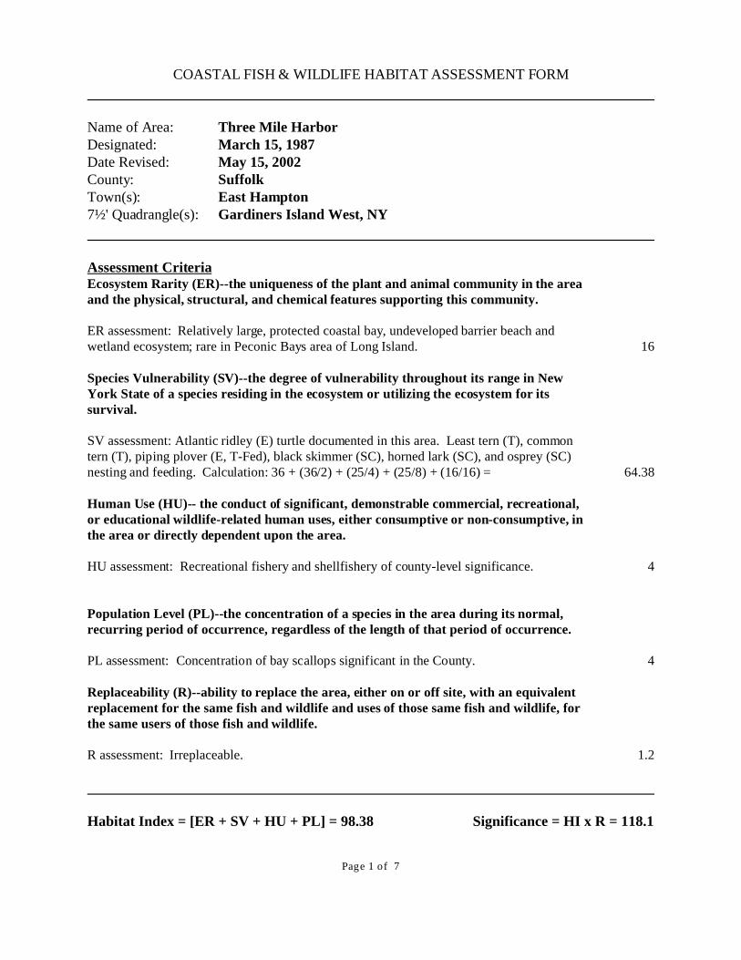
COASTAL FISH & WILDLIFE HABITAT ASSESSMENT FORM
Name of Area: Three Mile Harbor Designated: March 15, 1987Date Revised: May 15, 2002County: Suffolk Town(s): East Hampton 7½' Quadrangle(s): Gardiners Island West, NY
Assessment CriteriaEcosystem Rarity (ER)--the uniqueness of the plant and animal community in the areaand the physical, structural, and chemical features supporting this community.
ER assessment: Relatively large, protected coastal bay, undeveloped barrier beach andwetland ecosystem; rare in Peconic Bays area of Long Island.
Species Vulnerability (SV)--the degree of vulnerability throughout its range in NewYork State of a species residing in the ecosystem or utilizing the ecosystem for itssurvival.
SV assessment: Atlantic ridley (E) turtle documented in this area. Least tern (T), commontern (T), piping plover (E, T-Fed), black skimmer (SC), horned lark (SC), and osprey (SC)nesting and feeding. Calculation: 36 + (36/2) + (25/4) + (25/8) + (16/16) =
Human Use (HU)-- the conduct of significant, demonstrable commercial, recreational,or educational wildlife-related human uses, either consumptive or non-consumptive, inthe area or directly dependent upon the area.
HU assessment: Recreational fishery and shellfishery of county-level significance.
Population Level (PL)--the concentration of a species in the area during its normal,recurring period of occurrence, regardless of the length of that period of occurrence.
PL assessment: Concentration of bay scallops significant in the County.
Replaceability (R)--ability to replace the area, either on or off site, with an equivalentreplacement for the same fish and wildlife and uses of those same fish and wildlife, forthe same users of those fish and wildlife.
R assessment: Irreplaceable.
16
64.38
4
4
1.2
Habitat Index = [ER + SV + HU + PL] = 98.38 Significance = HI x R = 118.1

Page 2 of 7
NEW YORK STATESIGNIFICANT COASTAL FISH AND WILDLIFE HABITAT
NARRATIVE
THREE MILE HARBOR
LOCATION AND DESCRIPTION OF HABITAT: Three Mile Harbor is located two miles north of the Village of East Hampton on Gardiners Bayin the Town of East Hampton, Suffolk County (7.5' Quadrangle: Gardiners Island West, NY)The fish and wildlife habitat is approximately 1270 acres in size consisting of 1070 acres of openwater and fringing wetlands and a barrier beach/wetland area of 200 acres (Sammy’s Beach). The open water of Three Mile Harbor has an average depth of five to six feet during mean lowwater with a tidal range of 2.5 feet. The harbor's waters are stressed by increasing shorelinedevelopment, boat and watersports use, and runoff from roads, drainage and septic systems in theimmediate Three Mile Harbor area. The beach area consists of sparsely vegetated dunes, dredgedmaterial areas, sand beach, salt marshes, mudflats and a tidal inlet. The mouth of Hand’s Creekis a high quality example of brackish intertidal shore. Most of Sammy's Beach is owned by theTown of East Hampton and the NYSDEC, and receives moderate recreational use by pedestriansand off-road vehicles during the summer. Portions of the area have been posted historically asbird nesting areas. FISH AND WILDLIFE VALUES: The bay/beach/wetland ecosystem found at Three Mile Harbor is rare in the Peconic Bays areaand provides an important habitat for a large variety of fish and wildlife. Sammy's Beach hasbeen designated as part of the national Coastal Barrier Resources System, one of 67 such areason Long Island. Uncontrolled recreational use of the area has resulted in some degradation of thehabitat.
The mainland peninsula at Sammy's Beach is an important nesting site for least tern (T) andpiping plover (E, T-Fed). While piping plover were absent from this site during the late 1980'sand early 1990's, there was an annual average of one nesting pair at this site between 1992 and1996. A peak value of three pairs was documented in 1994. Town of East Hampton plovermonitoring documented an average of one pair nesting at Sammy’s Beach during the 1995-1999period, producing an average of 2 fledglings.
The 1987-1996 annual average number of pairs of least tern was five, with a peak value of 18pairs occurring in 1987. Sammy's Beach was one of the largest least tern nesting colonies onLong Island in the early 1980's; the number of breeding pairs at this location since then has beensteadily declining, possibly due to plant succession. Since 1989, least tern have nestedinconsistently at Sammy’s Beach: nine pairs were documented in 1992, ten pairs in 1999. However, no eggs or young were produced at the Sammy’s Beach site in the 1990s.
Page 3 of 7
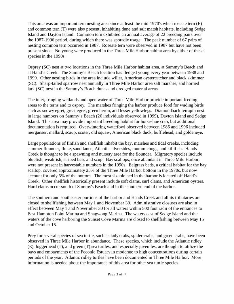
This area was an important tern nesting area since at least the mid-1970's when roseate tern (E)and common tern (T) were also present, inhabiting dune and salt marsh habitats, including SedgeIsland and Dayton Island. Common tern exhibited an annual average of 22 breeding pairs overthe 1987-1996 period, during which there was sporadic usage. The peak number of 67 pairs ofnesting common tern occurred in 1987. Roseate tern were observed in 1987 but have not beenpresent since. No young were produced in the Three Mile Harbor habitat area by either of thesespecies in the 1990s. Osprey (SC) nest at two locations in the Three Mile Harbor habitat area, at Sammy’s Beach andat Hand’s Creek. The Sammy’s Beach location has fledged young every year between 1988 and1999. Other nesting birds in the area include willet, American oystercatcher and black skimmer(SC). Sharp-tailed sparrow nest annually in Three Mile Harbor area salt marshes, and hornedlark (SC) nest in the Sammy’s Beach dunes and dredged material areas.
The inlet, fringing wetlands and open water of Three Mile Harbor provide important feedingareas to the terns and to osprey. The marshes fringing the harbor produce food for wading birdssuch as snowy egret, great egret, green heron, and lesser yellowlegs. Diamondback terrapin nestin large numbers on Sammy’s Beach (20 individuals observed in 1999), Dayton Island and SedgeIsland. This area may provide important breeding habitat for horseshoe crab, but additionaldocumentation is required. Overwintering waterfowl observed between 1986 and 1996 includedmerganser, mallard, scaup, scoter, old squaw, American black duck, bufflehead, and goldeneye. Large populations of finfish and shellfish inhabit the bay, marshes and tidal creeks, includingsummer flounder, fluke, sand lance, Atlantic silversides, mummichogs, and killifish. HandsCreek is thought to be a spawning and nursery area for the flounder. Migratory species includebluefish, weakfish, striped bass and scup. Bay scallops, once abundant in Three Mile Harbor,were not present in harvestable numbers in the 1990s. Eelgrass beds, a critical habitat for the bayscallop, covered approximately 25% of the Three Mile Harbor bottom in the 1970s, but nowaccount for only 5% of the bottom. The most sizable bed in the harbor is located off Hand’sCreek. Other shellfish historically present include soft clams, surf clams, and American oysters. Hard clams occur south of Sammy's Beach and in the southern end of the harbor.
The southern and southeaster portions of the harbor and Hands Creek and all its tributaries areclosed to shellfishing between May 1 and November 30. Administrative closures are also ineffect between May 1 and Novermber 30 for all waters within 500 foot radii of the entrances toEast Hampton Point Marina and Shagwong Marina. The waters east of Sedge Island and thewaters of the cove harboring the Sunset Cove Marina are closed to shellfishing between May 15and October 15.
Prey for several species of sea turtle, such as lady crabs, spider crabs, and green crabs, have beenobserved in Three Mile Harbor in abundance. These species, which include the Atlantic ridley(E), loggerhead (T), and green (T) sea turtles, and especially juveniles, are thought to utilize thebays and embayments of the Peconic Estuary in moderate to high concentrations during certainperiods of the year. Atlantic ridley turtles have been documented in Three Mile Harbor. Moreinformation is needed about the importance of this area for other sea turtle species.

Page 4 of 7
An annual Three Mile Harbor event brings approximately 1,000 boats into the harbor over a two-day period; between 200 and 300 vessels moor overnight. Three Mile Harbor has supported anactive fishery providing varied opportunities for commercial and recreational fishermen. ThreeMile Harbor remains an important nursery area for the commercial species of fin and shellfish, aswell as forage species, and contributes to the overall productivity of Gardiner's Bay, where fishtraps have been traditionally used. Shellfish closures have had a major impact on the valuableshellfisheries. IMPACT ASSESSMENT: Any activity that would further degrade the water quality in Three Mile Harbor would adverselyaffect the biological productivity of this area. All species of fish and wildlife may be affected bywater pollution, such as chemical contamination (including food chain effects resulting frombioaccumulation), oil spills, excessive turbidity, waste disposal (including boat wastes), andstormwater runoff. Installation of runoff catchment structures on roads adjacent to the Harborhave likely contributed to a decrease of shellfish closures due to coliform contamination,however continued shellfish closures emphasize the need to identify and minimize all point andnon-point sources of pollution in the Harbor. Pollution in upwelling groundwater, includingseptic system leachates, may be a significant source of contamination in the Harbor. Recent lossof important vegetated buffer areas from new development may also contribute to existing waterquality problems.
Unrestricted use of motorized vessels including personal watercraft in the protected, shallowwaters of bays, harbors, and tidal creeks can have adverse effects on aquatic vegetation and fishand wildlife populations. Use of motorized vessels should be controlled (e.g., no wake zones,speed zones, zones of exclusion) in and adjacent to shallow waters and vegetated wetlands.
Elimination of salt marsh and intertidal areas, through loss of tidal connection, excavation orfilling, would result in a direct loss of valuable habitat area. Construction of shoreline structures,such as docks, piers, bulkheads, or revetments, in areas not previously disturbed by development,may result in the loss of productive areas which support the fish and wildlife resources of ThreeMile Harbor. Alternative strategies for the protection of shoreline property should be examined,including innovative, vegetation-based approaches. Control of invasive nuisance plant species,through a variety of means, may improve fish and wildlife species use of the area and enhanceoverall wetland values.
Alteration of tidal patterns in Three Mile Harbor (including changes to inlet configuration) couldhave major adverse effects on the fish and wildlife communities present. However, restoration ofwater circulation patterns may benefit the fish and wildlife species of the area. Dredging tomaintain boat channels in the harbor should be scheduled between September 15 and December15 to minimize potential impacts on aquatic organisms and to allow for dredged materialdisposal when wildlife populations are least sensitive to disturbance. Dredged material disposalin this area would be detrimental, but such activities may be designed to maintain or improve thehabitat for certain species of fish and wildlife, especially nesting shorebirds.

Page 5 of 7
Nesting shorebirds inhabiting Three Mile Harbor are highly vulnerable to disturbance by humans,especially during the nesting and fledgling period (March 15 through August 15). Significantpedestrian traffic or recreational vehicle use of the beach could easily eliminate the use of thissite as a breeding area and should be minimized during this period. Recreational activities (e.g.,boat and personal watercraft landing, off-road vehicle use, picnicking) in the vicinity of birdnesting areas should be minimized during this period. Predation of chicks and destruction ofeggs or nests by unleashed pets (e.g., dogs, cats) and natural predators may also occur, andpredator control should be implemented where feasible. Fencing and/or continued annualposting of shorebird nesting areas should be provided to help protect these species. Control ofvegetative succession, through beneficial use of dredged material or other means may improvethe availability of nesting habitat in this area.

Page 6 of 7
KNOWLEDGEABLE CONTACTS:
Habitat UnitNYS Department of State Division of Coastal Resources 41 State StreetAlbany, NY 12231 Phone: (518) 474-6000
NYSDEC—Region 1 State University of New York, Building 40 Stony Brook, NY 11790-2356Phone: (631) 444-0354
Bureau of Marine ResourcesNYSDEC205 N. Belle Meade Road, Suite 1East Setauket, NY 11733 Phone: (631) 444-0430
Finfish and CrustaceansNYSDEC205 N. Belle Meade Road, Suite 1East Setauket, New York 11733 Phone: (631) 444-0436
New York Natural Heritage ProgramWildlife Resources Center700 Troy-Schenectady RoadLatham, NY 12110Phone: (518) 783-3932
East Hampton Dept. of Natural Resources Town of East Hampton 300 Pantigo Place, Suite 105East Hampton, NY 11937-2684Phone: (631) 324-0496
East Hampton Baymen’s AssociationP.O. Box 498Amagansett, NY 11930Phone: not available
Seatuck Research Program Cornell University Laboratory ofOrnithology P.O. Box 31 Islip, NY 11751 Phone: (631) 581-6908
Office of EcologySuffolk County Dept. of Health Services Bureau of Environmental Management County Center Riverhead, NY 11901 Phone: (631) 852-2077

Page 7 of 7
To print on 8.5 x 11 set printer to Fit to Print or reduce to 64%