daventry town transport strategy (pdf 2.13mb)
TRANSCRIPT

Daventry Town Transport Strategy
1
Northamptonshire Transportation Plan
Fit for Purpose Northamptonshire Transportation Plan Fit for Purpose
Daventry Town Transport Strategy Fit for Purpose
January 2013

Daventry Town Transport Strategy
2
(Blank Page)
Daventry Town Transport Strategy
2
Daventry Town Transport Strategy
Contacts and Further Information This is Northamptonshire County Council’s Daventry Town Transport Strategy. It sets out the overarching vision for transport in Daventry and sets out our strategy to achieve it. This strategy is one of a series of thematic daughter documents to the Northamptonshire Transportation Plan that was adopted in April 2012. Consultation on the first batch of the town transport strategies, including this Daventry Town Transport Strategy, took place between 24th September and 2nd November 2012. A summary of the consultation responses can be found on our website at: http://www.northamptonshire.gov.uk/en/councilservices/Transport/TP/Pages/NTP-Town-Transport-Strategies.aspx If you have any problems accessing Northamptonshire County Council’s website or do not have access to the internet, please contact us using the details below. This strategy was approved and adopted by Northamptonshire County Council’s Cabinet in December 2012. This strategy together with the other Batch 1 daughter documents and the Northamptonshire Transportation Plan itself can be viewed on the County Council’s website at: http://www.northamptonshire.gov.uk/en/councilservices/Transport/TP/pages/northamptonshire-transportation-plan.aspx
Should you have any queries regarding this strategy, please contact the Transport Planning Team. Transport Planning Northamptonshire County Council County Hall Northampton NN1 1ED Email: [email protected]

Daventry Town Transport Strategy
3
(Blank Page)

Daventry Town Transport Strategy
4
Contents
Chapter Theme & Content Page No.
1 Northamptonshire Transportation Plan 7 2 Existing Transport Situation 11
3 Future Pressures 29
4 The Strategy 35 5 Implementation Plan 53
Appendix A Future Cycling Schemes 57
Appendix B Location of Car Parking in Town Centre 59 Appendix C Location of Cycle Parking in Tow Centre 61
Appendix D Proposed Town Centre Car Parks 63

Daventry Town Transport Strategy
5
(Blank Page)
Daventry Town Transport Strategy
6
Chapter 1: Northamptonshire Transportation Plan: Fit for Purpose Transportation is not an end in itself. The movement of people and goods takes place not for its own sake, but to fulfil the diverse needs and desires of the public. Therefore the County Council’s transport policies are similarly promoted for their effect on other specific goals, priorities and objectives, rather than as an end in themselves.
Northamptonshire Transportation Plan Vision: For Transport and Travel to contribute towards making Northamptonshire a great place to live and work, through creating tangible transport options to satisfy individual needs and to encourage more sustainable travel. The transport system will provide fast and efficient movement of people and goods, and will be accessible for all. Expanding networks and capacity of networks in Northamptonshire will be fully integrated into new developments and regeneration areas to support more sustainable communities. Economic growth and prosperity is a top priority for Northamptonshire and connectivity has a vital role to play in encouraging businesses to locate to the area, and getting people to work and services such as education and health, as well as to leisure activities and for shopping. Improved technology and local accessibility will reduce the need to travel, whilst supporting economic growth, within a low carbon environment and Northamptonshire will become an exemplar for the latest developments in information technology, fuel technology, and new forms of transport. The county council will work in partnership with all stakeholders and the wider community to deliver this transport vision and strategy.
This transportation plan needs to be both aspirational and realistic at the same time. Current economic climates mean that transport is certainly in a more austere time than in the last 15 to 20 years and this plan needs to reflect that but at the same time still plan for future growth.
The overall aim for this Transportation Plan is:
‘Northamptonshire Transportation - Fit for..... Purpose’
The aim ‘fit for purpose’ means creating a network that delivers exactly what Northamptonshire needs to be able to function plus what it needs to be able to grow.
Dave
ntry To
wn

Daventry Town Transport Strategy
7
This overarching aim can then be broken down into six objectives that have been chosen to guide this Transportation Plan. These objectives have been drawn up to reflect the issues which have been identified as locally important through consultation, while at the same time reflecting wider national and local policy context. These objectives have been deliberately chosen to reflect the main impacts that transport can have on the wider community, rather than being linked to particular schemes or measures. They form the basis upon which the policies and programmes contained in this Plan have been developed.
1. Fit for.......the Future – creating a transport system that supports and encourages growth and plans for the future impacts of growth, whilst successfully providing benefits for the County.
2. Fit for.......the Community – through the transport system help to maintain and create safe, successful, strong, cohesive and sustainable communities where people are actively involved in shaping the places where they live.
3. Fit to.......Choose – ensuring that the people of Northamptonshire have the information and the options available to them to be able to choose the best form of transport for each journey that they make.
4. Fit for........Economic Growth – creating a transport system that supports economic growth, regeneration and a thriving local economy and successfully provides for population and business growth.
5. Fit for........the Environment – to deliver a transport system that minimises and wherever possible reduces the effect of travel on the built, natural and historic environment.
6. Fit for........Best Value - being clear about our priorities for investment and focusing on value for money by prioritising what we spend money on and how it can be beneficial for the county as a whole and search for alternative sources of funding.
The Northamptonshire Transportation Plan fits in with the Northamptonshire Arc, helps to deliver the Core Spatial Strategies in West and North Northamptonshire and supports the work of the Local Enterprise Partnerships.

Daventry Town Transport Strategy
8
Daughter Documents
This Strategy is the part of a series of documents which will eventually form the Northamptonshire Transportation Plan ‘suite of documents’. This suite of documents will include strategies or plans covering a range of transport themes and also detailed geographic strategies or plans for Northamptonshire’s main towns.
Thematic strategies or plans will be developed as daughter documents to the Northamptonshire Transportation Plan, of which this Daventry town Strategy is one.
Figure 1: Proposed Northamptonshire Transportation Plan suite of strategies
Town Transport Strategies
Daventry Town Transport Strategy Aim: Support the delivery of transport services and highways infrastructure necessary to
accommodate growth in Daventry and allow the town to thrive.
Northamptonshire Arc
Northamptonshire Transportation Plan (2012)
Thematic Strategies
Freight Parking Bus Rail Walking Cycling Air Quality Road Safety Smart Travel Choices Transport Management Highways Improvement Development Management
Town Strategies
Brackley Corby Daventry East Northamptonshire Kettering Northampton Towcester Wellingborough
Daughter Documents
Dave
ntry To
wn

Daventry Town Transport Strategy
9
The Town Transport Strategy has been developed to meet the needs of Daventry; to coordinate the approach and shared commitment of all parties involved in both delivering the improvements to and the provision of the transport and highways provision and infrastructure within Daventry as it grows. The following table shows how the Town Transport documents tie in with the six over-arching Northamptonshire Transportation Plan objectives:
Proposals contained within this document have been developed with due regard to national and local policy. The National Planning Policy Framework (NPPF), adopted in 2012, replaced the previous suite of national Planning Policy Statements, Planning Policy Guidance notes and some circulars with a single, streamlined document. It marks a shift towards promoting sustainable development and prioritising economic growth and, through the Localism Bill, a return to local and neighbourhood plans to empower local people to shape their surroundings.
This strategy reflects the plans for Daventry as set out in the emerging West Northamptonshire Joint Core Strategy and seeks to reflect the aspirations of the Daventry 2040 Masterplan.
Northamptonshire Transportation Plan Overarching Objectives
Fit for..... the
Future
Fit for..... the
Community
Fit to.....
Choose
Fit for.....
Economic
Growth
Fit for..... the
Environment
Fit for.....
Best
Value
Tow
n T
ran
spo
rt S
trat
egi
es
The town transport strategies set out the transport improvements that are required to support growth as set out in the Local Development Documents with the Local Development Frameworks for the area that they cover.
We have worked with district and borough councils to develop strategies that allow towns to grow into strong, cohesive communities.
The strategies consider the improvements that are necessary to increase the attractiveness of sustainable transport modes and increase accessibility of services.
Ways of tackling the congestion that would potentially be harmful to economic growth is considered in the plans, which also set out the transport improvements needed to increase access to employment.
The local environment in each town covered by a strategy will be improved if the impacts of traffic are reduced.
All transport improvements necessary in the towns need to be implemented with our budget or be funded from other sources.

Daventry Town Transport Strategy
1 1
Chapter 2: Existing Transport Situation
Study Area Daventry is situated close to the M1 motorway with access to two junctions, one to the northeast (junction 18) and a second to the southeast (junction 16) of the town. The town is also served by the A45 and the A361. The closest railway station is Long Buckby on the Northampton Loop of the West Coast Mainline. The town has at least hourly buses to Northampton, Rugby and Banbury and is on National Cycle Network Route 50. The District of Daventry, situated in the west of Northamptonshire, is predominantly rural in character. Despite being the largest district within the County it has the second smallest population. Approximately one third of the population of the district, some 25,000 people (2008 estimated by URS, Daventry Infrastructure Study) out of a total of 78,000, live within the town of Daventry.
Figure 2: Location of Daventry in Northamptonshire
Dave
ntry To
wn
Daventry Town Transport Strategy
1 2
Key Movement Attractors Daventry is a growing market town comprising an historic core surrounded by more modern housing and light industry. The key movement attractors in the town are detailed below: Leisure – There are a number of parks, playgrounds and recreation grounds situated throughout Daventry. Daventry has a leisure centre, including a swimming pool, on Lodge Road and a Sports Park off Browns Road. The town centre area has other leisure facilities, including a library and a number of public houses. There are two Country Parks; Daventry Country Park situated to the North East of the town centre and Borough Hill Country Park to the East. Education – There are a number of schools and colleges located across Daventry. Daventry has a campus of Northampton and Moulton Colleges located on Badby Road West and two secondary schools (William Parker located on Ashby Road to the north and Danetre located within the Southbrook housing estate to the east) as well as a number of primary schools. A University Technical College specialising in sustainable construction and related new technologies is scheduled to open in Daventry in September 2013, catering for up to 600 pupils. Employment – Daventry has four major employment sites:- the town centre; and the Marches, Royal Oak and Drayton Fields industrial and commercial estates. Commercial centre – The town centre area comprises the main retail area in Daventry. This includes a new edge-of-centre bulky goods retail area, Abbey Retail Park which is located off South Way. There are also a number of supermarkets situated within the town centre area. Healthcare – Danetre Hospital is situated to the south of the town centre. There are also a number of doctors and dental surgeries situated throughout the town.
Journey to Work The mode share for journey to work for Daventry District residents, based on 2001 Census figures, is shown in Table 1 overleaf.

Daventry Town Transport Strategy
1 3
Mode
Daventry District
East Midlands England
Total % Total % Total %
Underground, Light Rail, Metro, Tram
20 0.1 1,287 0.1 709,386 3.5
Train 435 1.3 18,849 1.1 950,023 4.7
Bus, Coach, Minibus 650 2.0 133,858 7.7 1,685,361 8.3
Taxi, Minicab 97 0.3 7,926 0.5 116,503 0.6
Driving a car or van 24,642 76.2 1,157,931 66.7 12,324,166 60.8
Passenger in a car or van 2,307 7.1 133,260 7.7 1,370,685 6.8
Motorcycle, Scooter, Moped 32 1.0 20,018 1.2 249,456 1.2
Bicycle 559 1.7 62,644 3.6 634,588 3.1
On Foot 3,323 10.3 201,247 11.6 2,241,901 11.1
Table 1: Journey to Work Trips by Mode (Census 2001)
The relatively high numbers of journeys to work by car or van are reflected in the above average car ownership per household in Daventry District. Table 2 shows car ownership levels, both in terms of the percentage of households without access to a car, and the average number of cars per household.
Table 2: Car Ownership
Car ownership in Daventry district as a whole is very high, with approximately half the national average percentage of households without access to a car, and almost 1.5 cars per household. However, car ownership in the town of Daventry itself is significantly lower than in the district and county as a whole, though still higher than the national average. Car ownership of residents of Daventry town centre is much lower. 33.7% of households in the town centre do not have access to a car – a significantly higher percentage than the national average but this involves only a small number of people.
Area Cars per household
% households without
access to a car
England & Wales 1.11 26.8%
East Midlands 1.15 24.3%
Northamptonshire 1.26 20.8%
Daventry District 1.49 13.6%
Daventry town 1.18 21.2%
Daventry town centre 0.87 33.7%
Dave
ntry To
wn

Daventry Town Transport Strategy
1 4
The origin and destination of trips to and from Daventry town, shown in Figure 3, indicates that the main destinations for trips from Daventry are to Northampton and that the main origin for trips into Daventry is from the West Midlands.
Figure 3: Trip Origins and Destinations

Daventry Town Transport Strategy
1 5
The Highway Network AM Peak In general, traffic speeds in Daventry town centre are good for a town centre, with minor delays occurring on both the inbound and outbound routes around Abbey Street and at the South Way/Eastern Way junction. These locations are shown on Figure 4. Local concerns have been expressed about queuing on New Street due to parking manoeuvres. London Road also shows lower speeds, between 21-30 mph, however, these speeds are appropriate for a largely residential urban location.
Figure 4: Outbound Traffic Average Speeds with areas of minor delays highlighted PM Peak Minor delays are experienced at the same points identified in the AM period; however these do not appear significant.
Dave
ntry To
wn

Daventry Town Transport Strategy
1 6
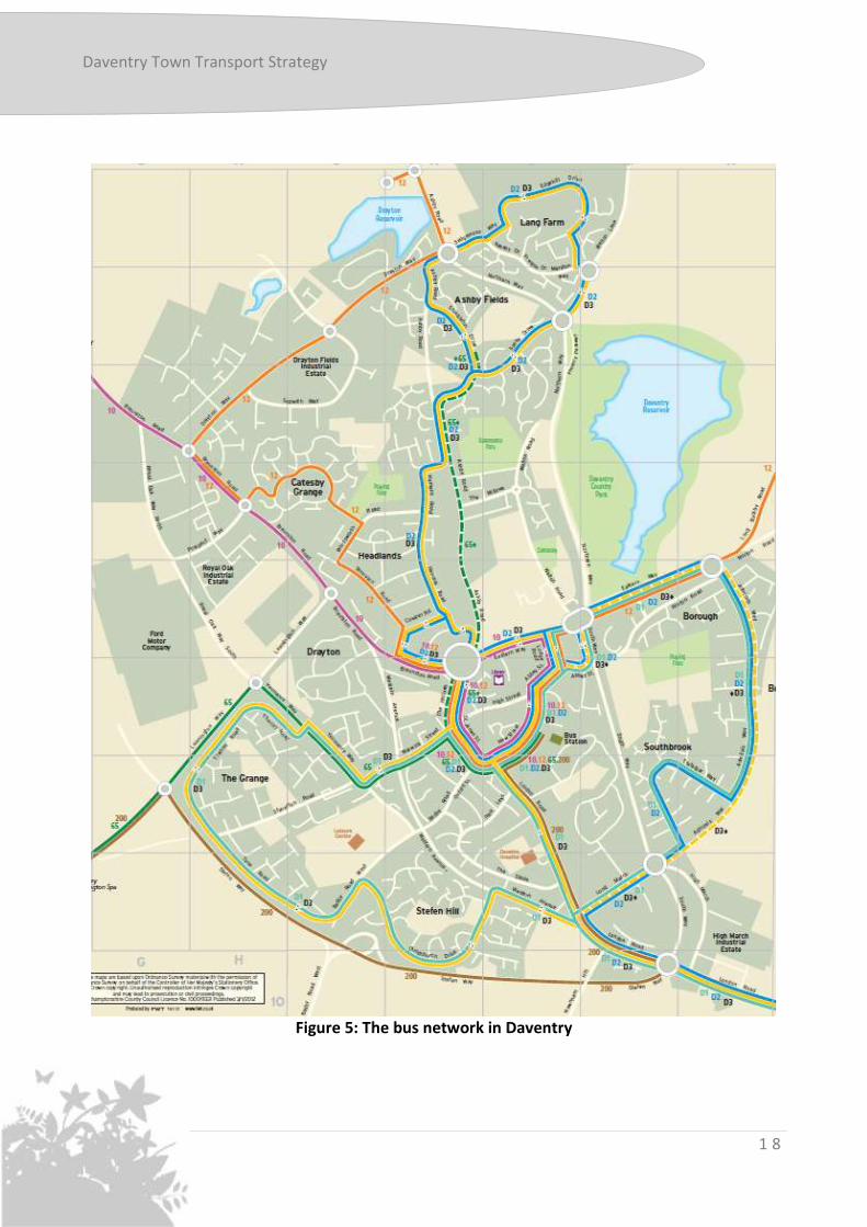
Public Transport – Bus Daventry is one of the largest towns in England with no rail station, and with no realistic prospect of providing one. Bus services represent the means by which public transport demands are met at this time. The bus services that operate within Daventry, and on the main inter-urban corridor to Northampton, were improved in January 2007 when the Daventry Dart services were introduced. The services underwent further review in 2011 as part of a county-wide review of bus services in Northamptonshire as a result of budget restrictions. However this review, combined with the failure of a competing operator, has led to a rather higher level of service, particularly towards Rugby, and to Long Buckby, than has historically been the case. However the commercial sustainability of this network is relatively fragile. There are currently three commercially operated services linking Daventry estates, via the town centre, to Northampton. D1 and D2 offer a combined trunk 30-minute frequency to Northampton, supplemented by D3 every hour, which serves intermediate off-line villages, and also provides a limited evening and Sunday service. Daventry is linked to Long Buckby and the railway station by the hourly number 12 service which was introduced on a commercial basis by Stagecoach in September 2011. The town is linked to Rugby by services 10 and 12 and to Banbury and Leamington Spa by services 200 and 65 respectively. The current fixed route bus network is shown in Figure 5. A new demand responsive County Connect service was introduced in the Daventry area in September 2011. This service, subsidised by the County Council, links the villages in the rural areas surrounding Daventry to the facilities in the town, the railway station at Long Buckby and the large employment site at Daventry International Rail Freight Terminal. Details of all of the bus services in Daventry are shown in Table 3. Service Number
Operator Route Frequency Approximate hours of operation
D1 Stagecoach Midlands
Northampton-Flore-Weedon-Dodford-High March Industrial Estate-Southbrook-Daventry Bus Station-Grange Estate-Stefen Hill-Danetre Hospital-Daventry Bus Station
Mon-Sat hourly until 1830. No evening service No Sunday service
0700-1900 Mon-Sat
D2 Stagecoach Midlands
Northampton-Flore-Weedon-Dodford-High March Industrial Estate-Southbrook-Daventry Bus Station-Ashby Fields-Lang Farm
Mon-Sat hourly until 1830. No evening service No Sunday service
0700-1900 Mon-Sat

Daventry Town Transport Strategy
1 7
Service Number
Operator Route Frequency Approximate hours of operation
D3 Stagecoach Midlands
Northampton-Kislingbury-Bugbrooke-Nether Heyford-Flore-Weedon-Dodford-Danetre Hospital-Daventry Bus Station-Grange Estate-Stefen Hill-Ashby Fields-Lang Farm
Mon-Sat daytime: hourly Evening services approx every 2 hours Sundays: every 2 hours
0800-midnight Mon-Sat 0900-1900 Sunday
10 Stagecoach Midlands
Rugby – Kilsby – Barby – Braunston – Royal Oak Industrial Estate – Daventry Bus Station
Mon-Sat daytime hourly. No Sunday or evening service
0700-1800 Mon-Sat
12 Stagecoach Midlands
Rugby – Dunchurch – Onley Park – Willoughby – Braunston – Middlemore – Catesby Grange – Daventry Bus Station – Long Buckby Station – Long Buckby
Mon – Sat daytime hourly. No Sunday or evening service
0600 – 1900 Mon – Sat
65 Stagecoach Midlands
Leamington Spa – Radford Semele – Ufton – Harbury – Bishops Itchington – Southam – Napton – Lower Shuckburgh – Staverton Park – Daventry Bus Station
Mon – Sat every 2 hours. No Sunday or evening service
0700 – 1900 Mon – Sat
200 Stagecoach in Oxfordshire
Banbury –Wardington – Chipping Warden – Byfield – Woodford Halse – Badby – Daventry
Mon – Sat hourly. No Sunday or evening service
0700 – 1800 Mon - Sat
Daventry South County Connect
Centrebus Serves: Adstone, Aston-le-Walls, Brockhall, Badby, Byfield, Canons Ashby, Charwelton, Chipping Camden, Church Stowe, Cold Higham, Dodford, Everdon, Eydon, Fawsley, Farthinghoe, Foxley, Grimscote, Hellidon, Litchborough, Little Everdon, Little Preston, Lower Boddington, Lower Catesby, Maidford, Muscott, Newnham, Norton, Preston Capes, Preston Deanery, Staverton, Towcester, Upper Boddington, Upper Catesby, Upper Stowe, Weedon, Westhorpe, Woodford Halse
Mon-Sat daytime: demand responsive. No Sunday or evening service
0700-1900 Mon-Fri, 0800-1800 Sat
Daventry North, DIRFT and Long Buckby County Connect
Centrebus Serves: Ashby St Ledgers, Braunston, Brockhall, Coton, Crick, DIRFT, Dodford, East Haddon, Elkington, Flecknoe, Grandborough, Great Brington, Guilsborough, Holdenby, Hollowell, Little Brington, Long Buckby, long Buckby Wharf, Murcott, Norton, Onley, Ravensthorpe, Sawbridge, Staverton, Teeton, Watford, Watford Gap, Weedon, Welton, West Haddon, Whilton, Willoughby, Winwick, Yelvertoft
Mon-Sat daytime: demand responsive. No Sunday or evening service
0700-1900 Mon-Fri, 0800-1800 Sat
Table 3: Bus services in Daventry
Dave
ntry To
wn
Daventry Town Transport Strategy
1 8
Figure 5: The bus network in Daventry

Daventry Town Transport Strategy
1 9
The current infrastructure for buses in the town is relatively poor. There is a central bus station, located on New Street. The passenger infrastructure within the bus station is not of a high standard, with no provision of real-time information. Elsewhere within the town, bus stop infrastructure is generally of a poor standard. The vehicles used on the Daventry bus network do not represent the cutting edge of vehicle specification, but are generally of a good quality. Accessibility modelling shows that all major services (major employment sites; primary, secondary and further education; and GP surgeries), with the exception of a general hospital, are within a 30 minute journey time by bus for all Daventry residents. However, in many cases, walking time for the same journey would be shorter, and would be considerably shorter by car in almost all circumstances.
Recent development, especially Catesby Grange (Timken) and Middlemore, are particularly poorly served by bus. Hourly frequencies are being sustained commercially, aided by the routes concerned offering inter-urban options. However, this frequency is not sufficiently attractive to achieve meaningful mode shift. There are few bus stops, and no shelters, with minimal timetable information. There are no scheduled services throughout the day directly serving very extensive employment areas on the northern and western sides of the Town at Royal Oak and Drayton Fields. CountyConnect is bookable, subject to the bus being available. Daventry International Rail Freight Terminal also draws very significant labour from the town, but there are no bus links, apart from the CountyConnect service, and this does not address key shift changes at 0600 and 2200h, nor could it sustainably offer sufficient capacity to meet potential suppressed demands, given its focus on meeting rural needs. Issues BI1: Journey time when compared to car, walking or cycling BI2: Road humps, particularly near New Street bus station BI3: Poor public image of the bus service BI4: Waiting facilities at bus stops and the bus station BI5: Availability of bus information, e.g. Traveline is not currently promoted significantly BI6: Difficulty accessing some bus stops due to gaps in pedestrian provision BI7: Minimal service to major peripheral employment areas, and no links to Daventry
International Rail Freight Terminal. BI8: No bus services to address key shift change times at 0600h, and 2100/2200h. Opportunities BO1: Proposed residential expansion in Daventry BO2: Proposed town centre development BO3: Quality of the existing ring road
Dave
ntry To
wn

Daventry Town Transport Strategy
2 0
BO4: Links to workplaces – reduction in need for parking provision is likely to be attractive to some employers BO5: Improving the links to rail services at Long Buckby BO6: Investment in bus stop infrastructure and new technologies for passenger information
Public Transport – Rail Daventry does not have an operational railway station; regular train services are available from the station at Long Buckby, approximately 7 kilometres to the north east of the town centre. There are three trains per hour in the morning peak (07:00 – 10:00) to Northampton and three to Birmingham New Street. In the evening peak (16:00 - 19:00), the frequency is three trains per hour to Birmingham New Street and four trains to Northampton. There is also an hourly service to the same destinations throughout the rest of the day. The proportion of Daventry residents’ work trips using the train is less than 1%. In September 2011 a new commercially operated bus service, the number 12, was introduced to connect Daventry to Long Buckby railway station. Twelve services per day (Monday – Saturday) operate between the Middlemore estate, Daventry bus station and Long Buckby station. Rail stations at Rugby and Northampton are accessible by bus from Daventry, with the number 12 bus service stopping at Rugby station and the D1/D2/D3 stopping at Northampton station. Issues RI1: Connectivity to Long Buckby station RI2: Pressure on station parking facilities, especially if demand is to increase RI3: Facilities at Long Buckby station Opportunities RO1: Proposed residential expansion of Daventry RO2: Integration of bus services with the rail services.
Daventry Town Transport Strategy
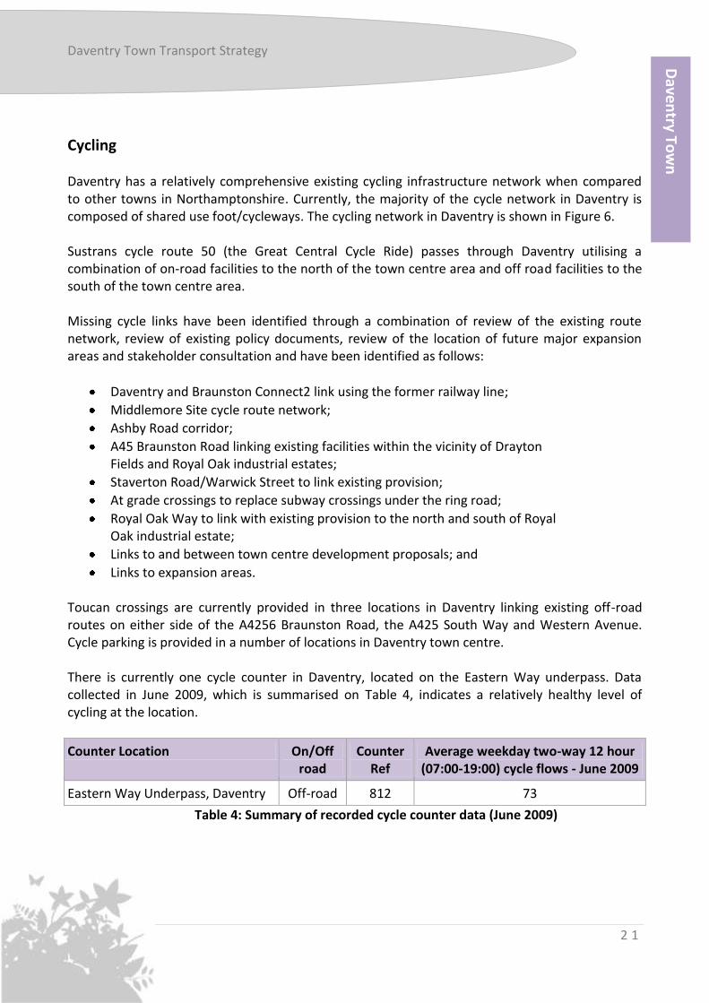
2 1
Cycling Daventry has a relatively comprehensive existing cycling infrastructure network when compared to other towns in Northamptonshire. Currently, the majority of the cycle network in Daventry is composed of shared use foot/cycleways. The cycling network in Daventry is shown in Figure 6. Sustrans cycle route 50 (the Great Central Cycle Ride) passes through Daventry utilising a combination of on-road facilities to the north of the town centre area and off road facilities to the south of the town centre area. Missing cycle links have been identified through a combination of review of the existing route network, review of existing policy documents, review of the location of future major expansion areas and stakeholder consultation and have been identified as follows:
Daventry and Braunston Connect2 link using the former railway line;
Middlemore Site cycle route network;
Ashby Road corridor;
A45 Braunston Road linking existing facilities within the vicinity of Drayton Fields and Royal Oak industrial estates;
Staverton Road/Warwick Street to link existing provision;
At grade crossings to replace subway crossings under the ring road;
Royal Oak Way to link with existing provision to the north and south of Royal Oak industrial estate;
Links to and between town centre development proposals; and
Links to expansion areas. Toucan crossings are currently provided in three locations in Daventry linking existing off-road routes on either side of the A4256 Braunston Road, the A425 South Way and Western Avenue. Cycle parking is provided in a number of locations in Daventry town centre. There is currently one cycle counter in Daventry, located on the Eastern Way underpass. Data collected in June 2009, which is summarised on Table 4, indicates a relatively healthy level of cycling at the location.
Counter Location On/Off road
Counter Ref
Average weekday two-way 12 hour (07:00-19:00) cycle flows - June 2009
Eastern Way Underpass, Daventry Off-road 812 73
Table 4: Summary of recorded cycle counter data (June 2009)
Dave
ntry To
wn

Daventry Town Transport Strategy
2 2
Figure 6: Existing Cycle Routes in Daventry

Daventry Town Transport Strategy
2 3
Secure cycle parking for a total of 169 cycles is currently provided within Daventry town centre. The majority of these (approximately 140) are provided as ‘Sheffield’ style stands, which are the recognised industry standard in accessible, secure cycle parking. Each stand consists of a steel hoop, set into the ground, which enables a bike to be secured to either side. Thus, a single stand provides secure parking for two bikes. The remainder are provided as individual spaces in a number of styles, some of which do not provide the level of security associated with the Sheffield stands. In general terms, the eastern part of the town centre is well stocked with cycle parking, particularly with the facilities provided in or close to new car parks at Abbey Retail Park and Welton Road. Together, these facilities provide space for 80 cycles. Cycle parking is generally less well provided for in the western part of the town centre. Notably, there are no cycle parking facilities provided on High Street. The Daventry Local Strategic Partnership is pursuing cycling as one of its ‘cross-cutting’ projects to improve health, sustainability, and the attractiveness of the local area. Issues CI1: Lack of cycle counters in Daventry CI2: Cycle parking provision at employment sites and on High Street CI3: Identified missing links in the cycling network Opportunities CO1: Proposed travel centres at large new development sites provide opportunity for personalised travel planning CO2: Marketing of cycling routes and benefits of cycling in conjunction with the health authority CO3: Presence of Cycle Route 70 and an history of close walking with Sustrans CO4: Proposed residential expansion
Dave
ntry To
wn

Daventry Town Transport Strategy
2 4
Walking It is widely recognised that walking is an extremely important mode of travel, and encouraging walking has many benefits. It improves health, and replaces the reliance on car use for shorter journeys so can potentially significantly reduce congestion and carbon emissions. Walking has not traditionally attracted significant levels of funding, however this balance is shifting with the Localism agenda and hence, more locally derived transport schemes. Any investment has historically been as a result of cycling and public realm improvements, but tackling deficiencies in the existing infrastructure such as missing dropped kerbs, signage and footways is where significant improvements can be made to the quality of the walking environment. Work undertaken as part of the Walking Development Plan has indicated that there is a strong correlation between different land uses (i.e. the age of residential development and industrial areas) and the type of barriers to walking within them. These are summarised in Table 5.
Due to Daventry’s relatively small physical size, a large proportion of the town is within walking distance of key services, particularly the town centre. There is significant infrastructure in place to facilitate journeys on foot. Figure 7 shows a five and ten minute walking catchment from the town centre, highlighting the significant proportion of Daventry from which it is easy to walk into the town centre. The town centre retail area of Daventry will be extended as part of the Town Centre Vision, altering these walking times. Issues WI1: Proposed new developments, further from the town centre, will need connecting to the existing network WI2: Missing walking links to some bus stops Opportunities WO1: Potential funding from new developments to improve walking links WO2: Pedestrian access to facilities. WO3: Permeability of modern housing estates for people travelling on foot. WO4: Ability of well designed new developments to make neighbourhoods walkable.

Daventry Town Transport Strategy
2 5
Land Use Positive Negative
Residential – Victorian Terraced
Access to local amenities Sense of pride Footways meet Manual for Streets principles Dropped kerbs/footways
Accident rate On-street parking
Residential – Post-war 1950s
Access to local amenities Pedestrian permeability
Houses inward looking Lack of dropped kerbs/missing footway Sub-standard lighting High vehicle speeds
Residential – 1990s
Pedestrian permeability Dropped kerbs Signage Traffic speeds Missing footways High vehicle speeds Distance between housing and destination
Residential – Modern
Access to local amenities Pedestrian permeability Low accident rates Wide shared use footways
Narrow footways/ missing dropped kerbs Distance between housing and destination Parking
Residential – Village
Access to local amenities Pedestrian permeability
Dropped kerbs Missing footways Lighting sub-standard Parking High vehicle speeds Distance between housing and destination
Industrial Estate
Bus stops Access to local amenities Wide footways
Limited crossing points On-street parking High vehicle speeds Parking, including large vehicles Damage by large vehicles
Table 5: Land Use Type and Their Effect on Walking
Dave
ntry To
wn

Daventry Town Transport Strategy
2 6
Figure 7: Daventry Town Centre Five and Ten Minute Walking Catchment

Daventry Town Transport Strategy
2 7
Car Parking Car parking in Daventry centre is characterised by a large number of generally small car parks which provide good access to the town centre through a mixture of long and short stay parking. There are also over 200 on-street spaces in Daventry centre. The location of the car parks is shown in Appendix B and the number of spaces is shown in Table 6. The busiest car parks are those that serve the main supermarkets and are closest to High Street. The more peripheral car parks are less well used. Evidence indicates that while some 41% of parking trips are made by people from within the town’s contiguous urban area, a majority of the users of the town’s car parks come from outside the town, thus emphasising the role Daventry plays as the service centre for a significant rural population. Key strengths of the current car parking arrangements that were identified in a Parking Strategy Report produced for Daventry District Council included:
The car parks were considered to be secure with little car crime;
Free parking was believed to be a “Unique Selling Point” for Daventry and the town’s economy was believed to benefit as a result;
Car parks were seen as being well located, close to the heart of the shopping area;
There was a good choice of car parks that could be used depending on where you were visiting;
Car parking arrangements are in overall terms convenient for residents. Weaknesses of the current arrangements that were highlighted by report included:
Congestion in the Bowen Square and New Street car park areas;
Some car parks reaching capacity regularly at certain times of day;
A concern that current arrangements are not well suited to accommodating growth;
Parking to serve the Leisure Centre was seen by some as currently inadequate;
Some car parks were felt to be not very well maintained;
The subway access to the centre from some of the long stay car parks was felt to be unattractive;
A belief that the “no return within 4 hours” rule was a difficulty for some people;
Concern expressed by some that there were insufficient disabled spaces;
Enforcement of on and off street parking was considered to be poor; and
Loading facilities in some places were felt to be inadequate, resulting in delivery vehicles blocking streets.
Dave
ntry To
wn

Daventry Town Transport Strategy
2 8
Table 6: Car parking spaces in Daventry centre.
Issues PI1: Town centre improvements required before car parking charging can be considered PI2: Congestion in some car parks whilst others remain underused PI3: Majority of parking used by people travelling from outside urban area where public transport links are less satisfactory Opportunities PO1: Secure parking available close to shopping area PO2: Proposed town centre improvements and residential development
Car Park Name Time Limit
Long Stay Spaces
Short Stay Spaces
Disabled General
Off Street Parking
P1 Welton Road Undercroft Long 179 0 179
P2 Lodge Road Lower Long 84 0 84
P2 Lodge Road Upper Short 27 4 23
P3 Golding Close Long 17 0 17
P4 St John's Square Short 63 8 55
P5 Chapel Lane Long 80 0 80
P6 Primrose Hill Short 129 0 129
P7 High Street Short 22 9 13
P8 Brook Street Short 10 0 10
P9 Bowen Square Short 67 7 74
P10 Newlands Short 77 5 72
P11 St James Short 30 0 30
P12 Chaucer Way Long 160 0 160
P13 Old Gas Works Long 145 0 145
P14 New Street (Tesco) Short 373 17 356
P15 Abbey Retail Park Short 195 9 186
Total 665 993 59 1599
Other Parking
P16 Market Square (On-street) Short 23 0 23
P17 Foundry Court (Mixed) Long 27 2 25
P18 Foundry Place (Mixed) Long 51 0 51
P19 Waterloo (On-street) Long 19 0 19
P20 New St (Waitrose) Long 34 2 32
OSP1 On-street Golding Close Long 12 0 12
OSP2 On-street St James Street Long 13 0 13
OSP3 On-street Oxford Street Long 22 0 22
OSP4 High Street Short 22 6 16
Total 178 45 10 213
Town Centre Total 1881 69 1812

Daventry Town Transport Strategy
2 9
Chapter 3: Future Pressures
Town Centre Aspirations Daventry District Council has proposals to redevelop Daventry town centre, with a resultant increase in the quantum of retail floorspace and number of dwellings in the town. It is therefore necessary that the transport strategy for the town takes into account an increasing number of people accessing the town centre by all transport modes including motor vehicles, cycling, walking and public transport.
Figure 8: Town Centre Opportunities Overview, taken from the Daventry Town Centre Vision
Dave
ntry To
wn

Daventry Town Transport Strategy
3 0
The Daventry Town Centre Vision (TCV) was finalised by Daventry District Council in 2004 and proposed developments at a number of sites which were designated as follows:
Site 1 – North of High Street. This is a predominantly retail area situated to the north of High Street, and will provide a range of fashion-led retail units and a new and enhanced library to replace the one that will be displaced by the new development. The scheme will include strong pedestrian links to High Street and vehicle access to a new shoppers’ car park from Millennium Way.
Site 2- Bowen Square and the Police Station. This is the least advanced of all of the town centre development sites, but is likely to include some retail use and some office and/or residential accommodation.
Sites 3 and 6 – WaterSpace and Learning Quarter. There will be residential and café/restaurant uses situated around a water space linked, in time, by the proposed canal arm to the Grand Union Canal. The proposed layout could offer 2,000sqm of new restaurant and bar space, a hotel, health club and 7,000sqm of offices, potentially creating 550 new jobs and 350 new homes. The site includes the University Technical College that is scheduled to open in September 2013.
Site 4A – Retail Site for Bulky Goods. This development has been completed and includes a retail led extension to the town centre including DIY uses and a replacement Working Men’s Club building.
Site 4G – iCon Development. This development has also been completed and is the location of an Innovation Centre for Sustainable Construction. The iCon’s uses include a high quality conference facility and 60 small business incubator units for those specialising in innovation and technology in construction. In time this should have strong links through to Site 6.
Site 5 – Mixed Uses, predominantly Retail and Leisure. Proposals for this site include a supermarket, petrol station and bulky goods retail units.

Daventry Town Transport Strategy
3 1
Residential Growth As part of the Pre-Submission Joint Core Strategy for West Northamptonshire provision will be made for 50,150 net additional dwellings in the plan area (Daventry District, Northampton and South Northamptonshire) by 2026 The Pre-Submission Joint Core Strategy supports Daventry District Council’s vision of Daventry town growing into a sustainable community with a population of 40,000 people. To deliver this, 5,400 new dwellings are proposed for the town before 2026. The majority of the new housing will be built on three locations across Daventry.
Middlemore – Existing housing commitments in Daventry include the remaining development of the Middlemore site to the north of Drayton Reservoir, accounting for about 350 further dwellings.
Monksmoor – Outline planning permission was granted in 2010 for 1,000 dwellings on the Monksmoor site to the north of Daventry Reservoir. The site will include a community hall, sports and play facilities and a primary school. The site is now in the hands of a housebuilder and is likely to be brought forward in the reasonably foreseeable future.
Daventry North East Sustainable Urban Expansion (SUE), also known as Churchfields – This mixed use development will include 4,000 dwellings (of which 2,000 will be built by 2026), three primary schools, local centres, one district centre, play and sport facilities, and some employment. The extent of the SUE is shown in Figure 9. The development will have good connections with the existing highway network and through new walking, cycling and public transport connections to the town centre. Walking, cycling and public transport connections can be established with the Southbrook area across the B4036 which will support the regeneration of Southbrook.
Dave
ntry To
wn

Daventry Town Transport Strategy
3 2
Figure 9: Extent of Daventry North East SUE
Daventry Town Transport Strategy
3 3
Employment Sites
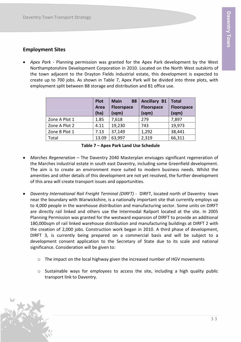
Apex Park - Planning permission was granted for the Apex Park development by the West Northamptonshire Development Corporation in 2010. Located on the North West outskirts of the town adjacent to the Drayton Fields industrial estate, this development is expected to create up to 700 jobs. As shown in Table 7, Apex Park will be divided into three plots, with employment split between B8 storage and distribution and B1 office use.
Table 7 – Apex Park Land Use Schedule
Marches Regeneration – The Daventry 2040 Masterplan envisages significant regeneration of the Marches industrial estate in south east Daventry, including some Greenfield development. The aim is to create an environment more suited to modern business needs. Whilst the amenities and other details of this development are not yet resolved, the further development of this area will create transport issues and opportunities.
Daventry International Rail Freight Terminal (DIRFT) - DIRFT, located north of Daventry town near the boundary with Warwickshire, is a nationally important site that currently employs up to 4,000 people in the warehouse distribution and manufacturing sector. Some units on DIRFT are directly rail linked and others use the Intermodal Railport located at the site. In 2005 Planning Permission was granted for the westward expansion of DIRFT to provide an additional 180,000sqm of rail linked warehouse distribution and manufacturing buildings at DIRFT 2 with the creation of 2,000 jobs. Construction work began in 2010. A third phase of development, DIRFT 3, is currently being prepared on a commercial basis and will be subject to a development consent application to the Secretary of State due to its scale and national significance. Consideration will be given to:
o The impact on the local highway given the increased number of HGV movements
o Sustainable ways for employees to access the site, including a high quality public
transport link to Daventry.
Plot Area (ha)
Main B8 Floorspace (sqm)
Ancillary B1 Floorspace (sqm)
Total Floorspace (sqm)
Zone A Plot 1 1.85 7,618 279 7,897
Zone A Plot 2 4.11 19,230 743 19,973
Zone B Plot 1 7.13 37,149 1,292 38,441
Total 13.09 63,997 2,319 66,311
Dave
ntry To
wn

Daventry Town Transport Strategy
3 4
(Blank Page)
Daventry Town Transport Strategy
3 5
Chapter 4: The Strategy
The aspirational vision for Daventry’s transport network is set out in the key diagram in Figure 10, which shows the improvements that could be implemented to make sustainable transport a more attractive choice for Daventry residents if funding becomes available. The starting point for the Daventry Town Strategy is to improve the attractiveness of sustainable transport modes for travelling within and from Daventry as an alternative to using the private car. A package of measures should be used to encourage this modal shift and this strategy considers the ways that those measures can be improved to make them more attractive choices for the current residents of Daventry and to accommodate the proposed growth. Encouraging modal shift is more successful in new developments so we have set two targets for the amount of modal shift that we would like to achieve in Northamptonshire:
A reduction of 20% in single occupancy car journeys to work from new developments
A reduction of 5%in single occupancy car journeys to work from the existing town Table 1 in Chapter 3 of this document showed the journey to work figures for each transport mode for Daventry District residents at the 2001 Census. Based on those figures, achieving a 5% modal shift will require 1,232 journey to work trips transferring away from private car use to more sustainable modes. Fulfilling the 20% modal shift target for new developments will be more challenging but will be achieved through a combination of travel plan measures, particularly travel centres in the larger developments. This chapter sets out our strategy for achieving those modal shift targets and delivering a transport network that will support growth in Daventry.
Figure 10 (overleaf): Daventry Town Transport Strategy
Dave
ntry To
wn

Daventry Town Transport Strategy
3 6
Symbol Description
Development
Town Centre Vision Site
Approximate location of Sustainable Urban Extension (Churchfields)
Approximate location of Monksmoor development
Approximate location of further Middlemore development
Bus Services
New Street Bus Station
Proposed bus gate
Possible alteration to D2/D3 route
Bus links to new developments required. Indicative only, routes to be decided
Potential route of ‘circular’ service linking housing to development
Proposed new bus interchange facilities on Eastern Way
Walking and Cycling
Proposed new cycling/walking facilities
Improvements to walking and cycling route to Long Buckby. Route to be decided
Walking and cycling links to new developments required

Daventry Town Transport Strategy
3 7
Public Transport The Bus and Rail strategies that form part of the Northamptonshire Transportation Plan set out in detail how we will aim to improve and promote the use of public transport across Northamptonshire. The proposals set out below would be aimed at increasing bus patronage for journeys within, to, and from Daventry. Our proposals to increase the use of public transport services in Daventry are based on:
providing a faster, more attractive journey time,
improving passenger infrastructure,
increasing patronage to improve the sustainability of commercial services,
improving pedestrian links to services,
improving public transport links to employment opportunities,
improving connectivity of the town with the Long Buckby station and other public transport services.
Improving the Bus Service to Middlemore and Catesby Grange (Timken) The subsidised D5 that previously operated at an hourly frequency between Daventry bus station and Middlemore was replaced in September 2011 with the commercially operated number 12 service. The 12 is an hourly service during the day. The journey from Middlemore to New Street Bus Station is timetabled at 15 minutes, which compares unfavourably with the approximate 5 minute driving time between the two locations. Short-term improvements to improve the service could include:
A series of bus gates have been identified, which would allow a significantly shortened route to be operated and increased population density along the route. A bus gate between Royal Star Drive and Faraday Close would allow buses a direct route from Catesby Grange to Drayton Fields; and another gate between Farnborough Drive and Newnham Drive would allow buses to directly access the western end of Middlemore.
Service could route via Hemans Road and Queens Road in preference to Cowper Road, Tennyson Road and Wordsworth Road. This slight amendment would save a small amount from the journey time and would also allow the service to directly serve the local shops at Edinburgh Square.
An increase in frequency to 30-minutes.
Examination of the potential to offer cross-town peak journeys connecting to Long Buckby Station. This may be best achieved in tandem with measures provided for development at Monksmoor.
Dave
ntry To
wn
Daventry Town Transport Strategy
3 8
Route D2 and D3 Alterations The commercially operated D2 and D3 each run at an hourly frequency between Northampton and Daventry. The current route does not operate, for the majority of its length, on either of the principal radial routes out of the town centre serving the North East part of the town – Ashby Road and Northern Way. Routing the service along Ashby Road, which has single depth residential frontage for much of its length, rather than Hemans Way would offer significant time savings for the journey to Lang Farm, but would reduce access to the service from the Headlands Estate. Routing the service along Northern Way would offer a limited stop service to Lang Farm, but offers no residential frontage. If re-routing the service, a balance should be struck between journey time and patronage base to make journey time more competitive with the private car without reducing their level of accessibility. A way of increasing access to the service would be to provide a bus gate on Hemans Road, most likely to be positioned to the north of the Wordsworth Road junction. ‘Circular’ Bus Service Linking Housing to Employment Sites Currently there is no direct bus service linking any of the residential areas of Daventry with the employment sites at Long March, Royal Oak and Drayton Fields Industrial Estates. To address this, a ‘circular’ service should be introduced to provide bus access for employees accessing these sites. Initially, a peak hour service could be provided using a Daventry-based Call Connect vehicle that has capacity during these times. Developer funding from Monksmoor and Churchfields could then be used to develop the route into and all-day service with dedicated vehicles, with the intention that the service would become commercially viable as patronage grows. Catering for Shift Working Patterns A significant issue with the current bus network is the lack of services to cater for the large proportion of the Daventry employment market which is focussed on shift working patterns. The manufacturing market, warehousing and distribution land uses -focussed in the three main industrial estates (Drayton Fields, Royal Oak and High March), employs high proportions of shift workers and these currently have no public transport option other than taxis. Public transport access to employment at DIRFT is a concern that has been raised through consultation on this strategy. DIRFT is served by the County Connect Demand Responsive service, but not at shift change times. We should seek to work with employers, bus operators and the

Daventry Town Transport Strategy
3 9
developers of DIRFT 3 to provide a service that will increase the accessibility of employment opportunities at the site. Improving Bus Stop Infrastructure The current stop infrastructure in Daventry is, in the main, of very poor quality and does not present potential passengers with an attractive gateway to the public transport network. A major opportunity exists to improve the image of bus services in Daventry by investing in high quality stop infrastructure. A common standard for bus stops in Daventry should be adopted that includes, as a minimum, a shelter, seating, footway access, timetable information and facilities to aid level boarding. Improving New Street Bus Station Low cost improvements to the existing bus station would make it a more attractive facility for bus passengers. Waiting facilities should be refreshed and improved information provided. This will create a more attractive passenger environment and improve passenger experience, creating a focal point for public transport in the town. In order to support an integrated transport network within Daventry, cycle parking facilities should be provided at the bus station, to facilitate multimodal trips. In the long term more significant changes may be required to improve access to the bus station, which is currently relatively poor. Currently, access to the station is shared with a busy 370 space supermarket car park, leading to significant interaction between buses and cars in the station area. Replacing the current layout with good quality on-street facilities would simplify bus movements in New Street and reduce journey time into and out of the town centre. Additional Bus Interchange Facilities on Eastern Way Many of the current bus services in Daventry currently use the Eastern Way/South Way junction, which is located close to Daventry Town Centre Vision Sites 3 and 6 and the iCon building. Providing high quality bus interchange facilities on Eastern Way would allow bus passengers to easily access these sites or change buses without travelling into the bus station. Marketing, Publicity and Information Significant efforts have been made in recent years to market the bus services in Daventry. Much of the material available at bus stops is now of a good quality. However, there is potential to generate more patronage through further improvements to marketing and information in parallel with service improvements.
Dave
ntry To
wn
Daventry Town Transport Strategy
4 0
High quality marketing and publicity activities should be introduced to raise the profile of Daventry’s existing public transport network. In marketing public transport services, it is important to align the marketing effort appropriately to the service being marketed. Inappropriate marketing of a poor service offer can have a negative effect on passenger perceptions. Conversely, a lack of marketing for a high quality service can lead to under-use and missed opportunities for increased mode share and commercialisation of the service. It is important to improve the quality of information that is provided to bus passengers in Daventry. Up to date maps and timetables should be available at the bus station on New Street. This could also include details of train services for passengers travelling to the Railway Station at Long Buckby. The information that passengers receive could be further improved with the introduction of Real Time Passenger Information at transport interchanges and bus stops. Bus Services to New Housing Developments New housing developments in Daventry, including Monksmoor and the Sustainable Urban Extension, should all have strong public transport links to the town centre and employment sites, including DIRFT. This would encourage new residents moving in to Daventry to consider using public transport for commuting and other trips. Developer funding should be sought in the first instance to provide a bus service that can then be developed into a commercial route. Rail Long Buckby station is the closest railway station to Daventry. Public transport access to the station was improved in September 2011 when the commercially operated number 12 bus service replaced the D5 service to the station. However further improvements to the bus service, along with improvements to the waiting facilities at the station will be necessary to increase the attractiveness of travelling by rail for Daventry residents and to relieve pressure on the car parking facilities at the station. Providing stronger public transport links between the town centre and Long Buckby Railway Station will have the added benefit of attracting inward investment into a town does that does not appear on railway timetables. The cycling network should also be expanded to provide a link between Long Buckby station and the residential and employment areas of Daventry. Improvements to the ticketing and waiting facilities at the station will improve the experience for people who choose to travel by train. The Rail Strategy gives detail on consideration to the improvements that we would welcome at Long Buckby station, including a permanent building

Daventry Town Transport Strategy
4 1
and better access to the platforms. The County Council would consider co-funding such an improvement alongside any funding from the rail industry such as the Department for Transport’s Access for All programme. An extension of the car park and cycle parking facilities may also be necessary to accommodate further patronage of the station, although this would require the acquisition or lease of further land. There may be potential to use developer funding from sites near to the station to improve these facilities. The consultation for this strategy generated proposals for reopening a railway to Daventry (either by re-opening the old line from Weedon or a new link directly to the Northampton Loop). While there are obstructions which would prevent the reconstruction of any of such a line on its original alignment, reopening would be possible, at a cost, possibly by using light rail technologies. Re-opening would bring benefits in terms of potential passengers, but there is no evidence that this would come anywhere near generating a positive business case. Concern has been raised during consultation about the road between the A5 and Long Buckby Station. Although it is unlikely that funding will be available to improve the road, any opportunities to make improvements should be exploited. Northamptonshire Arc Transit System (NAT) We are committed to investigating a rapid transit network for the Northamptonshire Arc (NAT). This will provide next-generation services on the core urban and inter-urban routes, link the main towns, and provide access to town centres and major trip generators such as hospitals, universities and colleges and business parks. Any improvements to public transport services in Daventry should prepare the foundations for the Northamptonshire Arc Transit System. The anticipated features of the NAT are:
Rapid links between existing urban and planned growth areas
Modern high capacity, low emission vehicles coupled with latest technology guidance, command and control systems
High levels of journey time reliability, approaching metro standards
High quality real-time information when and where passengers need it
Smart, multi-modal integrated ticketing
Walking and Cycling It is widely recognised that encouraging walking and cycling has many benefits. It improves health, and replaces the reliance on car use for shorter journeys so can potentially significantly reduce congestion and carbon emissions.
Dave
ntry To
wn

Daventry Town Transport Strategy
4 2
The proposed growth of Daventry provides the opportunity to develop a network of high quality walking and cycling corridors that should link housing areas to employment, key facilities and green spaces. The topography of Daventry is relatively flat, making it a town that lends itself to cycling. The data recorded in June 2009, shown in Table 5, for cycle counts indicates a relatively healthy level of cycling. Current cycling networks within the town are of good quality, however, further improvements are possible to encourage increased cycle usage; and existing networks will require extension to serve new development areas, including within the new developments. Our proposals are to improve safety and consider making the existing network more accessible through providing more cycle links, increased cycling parking provision, marketing incentives, and increased cycle access. Cycling schemes provide an alternative to the private car and are important in encouraging smarter choices. The cycling links should be integrated with public transport services such as buses by providing the cycle parking at key interchanges. An attractive cycle network for cyclists, experienced and inexperienced alike, is one based on providing infrastructure that links up the key education, retail, leisure, healthcare and employment sites in a town with the residential areas. Walking provides an alternative to travelling by private car for short journeys if an attractive environment for pedestrians is provided. To encourage walking in Daventry safe, attractive and direct pedestrian links to local services, facilities and workplaces should be available. The Walking and Cycling strategies that form part of the Northamptonshire Transportation Plan set out in detail our approach to increasing the number of trips made by cycling and walking in the county. The proposals below would increase the number of cyclists and pedestrians in Daventry. Cycle Infrastructure Links Assessment of the existing cycling network in Daventry was done as part of the Cycling Development Plan for the town. The plan identified a number of schemes and corridors that should be improved to encourage more cycling should funding be available. These are shown in Table 8. A plan of the schemes and the existing network can be seen in Appendix A.

Daventry Town Transport Strategy
4 3
Scheme Title Description
Daventry and Braunston link
Off-carriageway cycling and walking link utilising the disused railway line
Middlemore Site On-site network of cycle routes linking into the surrounding area
Ashby Road Shared route providing an additional north to south route , linking with existing provision
A45 Braunston Road Shared route linking with existing infrastructure
Staverton Road/Warwick Street
Combination of on and off-carriageway route linking with existing infrastructure
At Grade Crossings Replacement of subway crossings under the ring road with at grade crossings where cycle routes use them, except on the existing disused railway line route
Links to new developments (the North East SUE and Monksmoor)
High quality cycle links between existing infrastructure and new developments, with particular focus on routes between local trip attractors and new settlement areas.
Town Centre Development Proposals
Provision of links, cycle parking and welfare facilities for cyclists as part of town centre development proposals
Royal Oak Way Route linking with existing provision at the northern and southern extents of Royal Oak Way
Link to Long Buckby To provide a link between Long Buckby station and the residential and employment areas of Daventry.
Link to Weedon Alongside the A45 to provide a link between residential and employment areas in both settlements
Table 8: Proposed Cycle Infrastructure Improvements in Daventry Daventry to Braunston Connect2 Reserve Scheme Connect2 is a scheme pioneered by Sustrans, partly funded by the National Lottery to improve accessibility and walking/cycling facilities for 79 corridors across the United Kingdom, with overall completion anticipated by 2013. There are also 20 reserve schemes which can be called forward should any of the 79 schemes comprising the final Connect2 project find they are unable to complete their programme. The Daventry and Braunston scheme is a reserve scheme. It is a proposed off-road cycling and walking route between Daventry and Braunston using a disused railway line. It is anticipated that this route will provide a useful link between Braunston and Daventry as currently non-motorised users also have to use the busy A45 which links the two settlements. The scheme is also intended to act as a local park and route to the countryside for residents of the area.
Dave
ntry To
wn

Daventry Town Transport Strategy
4 4
This link has been discussed for a number of years without funding ever having been successfully allocated. If this continues to be the case then the corridor should be protected from development so that the route can be brought forward if funding becomes available in the future. If funding for the entire route is not available we should seek, as an interim measure, to extend the current walking/cycling facilities on the disused railway line as far as the Middlemore development. This would significantly improve the walking and cycling access to Middlemore. Marketing and Information Making the public aware of new cycling facilities and the quality of the existing network is an important part of increasing the number of people who choose to cycle. The development and implementation of a promotional strategy would highlight the facilities that are available to would-be cyclists. Engagement with employers and community groups is a useful method of raising awareness of cycling facilities. Both current cyclists and would-be cyclists will be encouraged to cycle more frequently if they have an understanding of the cycling facilities that are available to them and the routes that they need to take when cycling. For this reason the development of a high quality cycling map and implementation of a coherent signage strategy for both existing and proposed routes are important tools for encouraging a shift to cycling. Cycle Parking Facilities at Trip Attractors and Key Interchanges Cycle parking provision should be improved in the town centre, at large employment sites and at educational centres to encourage people to cycle to these locations. This should be accompanied by strong improvements to the infrastructure and publicity in order to make cycling easier. The Travel Planning process can be used to encourage employers to improve cycle parking facilities at their sites. Providing high quality cycle parking facilities is an important way of making public transport more accessible. High quality cycle parking should be considered at transport interchanges such as Long Buckby station, New Street bus station and popular bus stops. More commuters are likely to choose to cycle for at least part of their journey to work if there are secure facilities in which to leave their bicycle during the day. If Park and Ride sites are to be considered in the future they should also seek to encourage access to Daventry town centre by bike. The Park and Ride facility should include the option for commuters to drive to the site, where they can leave their car and cycle the rest of the way into town.

Daventry Town Transport Strategy
4 5
Going Forward A monitoring strategy should be developed that aims to identify the key corridors for cycling in Daventry and highlights which schemes and initiatives have been successful in encouraging take up of cycling. This will help to gain an understanding of which methods have been successful and allow development of best practice in the future. Once cycling facilities start to fall into disrepair there will be a decline in the number of cyclists. For this reason a maintenance and improvement strategy should be introduced that will ensure that cycling facilities in Daventry remain at a high standard. New Housing Developments New housing developments in Daventry, including Monksmoor, the Churchfields Sustainable Urban Extension and the Middlemore development should include attractive walking and cycling links to the town centre, employment areas and local services. These transport links should be included as part of the planning agreement for the developments. For Churchfields this could include a foot/cycle way running alongside the Daventry Canal Arm that is proposed by Daventry District Council.
Travel Planning The Smarter Travel Choices Policy that forms part of the Northamptonshire Transportation Plan outlines how soft measures can be used to encourage people choose more sustainable transport modes. Wherever possible we will encourage the use of smarter choices through travel planning. To do this we will work with the District Council to encourage employers in Daventry to prepare travel plans for their sites that promote the use of sustainable modes for employees’ journeys to work. We also suggest that any planning application with a significant traffic impact should provide a full Travel Plan in support of the application demonstrating how modal shift targets will be met. Travel Centres Northamptonshire County Council has been working on a travel centres project which will see either an on-site or virtual Travel Centre developed for all new large housing developments in the county. These will provide a range of personalised travel planning and information to new residents about their travel choices and the alternatives to private car use that are available. These are targeted at new developments as residents moving to these are more likely to consider changes to the way that they travel as part of the lifestyle change associated with moving house. Travel centres will be included as part of the new housing development proposed in Daventry.
Dave
ntry To
wn
Daventry Town Transport Strategy
4 6
Car Parking The Parking Strategy that forms part of the Northamptonshire Transportation Plan outlines in full our strategy for managing demand for car parking across the county. The proposals below consider the role that car parking can play in supporting growth in Daventry. Civil Parking Enforcement It was agreed by Northamptonshire County Council Cabinet in September 2011 that Daventry would be included in our Civil Parking Enforcement regime. This followed a similar decision by Daventry District Council’s Strategy Group in September 2010 and means that when the scheme is implemented in 2013, subject to the Department for Transports approval, we will:
Carry out enforcement of parking contraventions by the issuing of Penalty Charge Notices both on-street and in Daventry District Council’s offstreet car parks;
obtain the income from the Penalty Charge Notices from both on-street and off-street enforcement;
process the Penalty Charge Notices in accordance with legislation; and
administer the processing and issuing of any future parking permits / vouchers. Supporting Future Vision and Growth The parking strategy for Daventry should support the future vision and growth proposed for the town. Demand Modelling undertaken by WSP as part of the Daventry District Council Parking Definition Study forecasts a significant increase in the overall number of person trips to the town centre at the same time that a number of car parks are subject to redevelopment proposals. For the modelling the report separated the town into different zones, as shown in Figure 11.

Daventry Town Transport Strategy
4 7
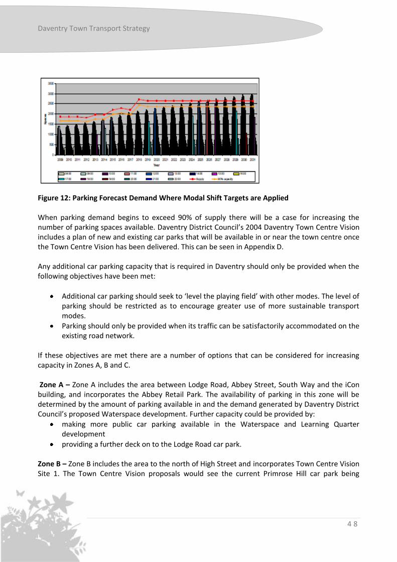
Figure 11: Parking Zones used in Parking Study The preferred scenario assumes the population of the town grows to the target level by 2026, retail growth factors are applied to account for suppressed retail demand and all the town centre development proposals are built out and also that measures are put in place to achieve the modal shift targets. This scenario would allow growth to be delivered in the most environmentally sustainable way, reducing the pressure on Greenfield and Brownfield sites for car park development. The results of the modelling for this scenario are shown in Figure 12 overleaf. From Figure 12 it can be seen that there would be sufficient car park spaces, allowing car parks proposed to be built as part of developments, to meet demand until 2021, when demand would exceed 90% of supply. Demand will not exceed capacity until 2026, however it is forecast to exceed 90% of supply in Zones A, B and C by 2021.
Dave
ntry To
wn
Daventry Town Transport Strategy
4 8
Figure 12: Parking Forecast Demand Where Modal Shift Targets are Applied When parking demand begins to exceed 90% of supply there will be a case for increasing the number of parking spaces available. Daventry District Council’s 2004 Daventry Town Centre Vision includes a plan of new and existing car parks that will be available in or near the town centre once the Town Centre Vision has been delivered. This can be seen in Appendix D. Any additional car parking capacity that is required in Daventry should only be provided when the following objectives have been met:
Additional car parking should seek to ‘level the playing field’ with other modes. The level of parking should be restricted as to encourage greater use of more sustainable transport modes.
Parking should only be provided when its traffic can be satisfactorily accommodated on the existing road network.
If these objectives are met there are a number of options that can be considered for increasing capacity in Zones A, B and C. Zone A – Zone A includes the area between Lodge Road, Abbey Street, South Way and the iCon building, and incorporates the Abbey Retail Park. The availability of parking in this zone will be determined by the amount of parking available in and the demand generated by Daventry District Council’s proposed Waterspace development. Further capacity could be provided by:
making more public car parking available in the Waterspace and Learning Quarter development
providing a further deck on to the Lodge Road car park. Zone B – Zone B includes the area to the north of High Street and incorporates Town Centre Vision Site 1. The Town Centre Vision proposals would see the current Primrose Hill car park being

Daventry Town Transport Strategy
4 9
developed on, but a new shoppers’ car park is included as part of proposals. Additional demand could be accommodated by encouraging parking demand to be met to the west of High Street, requiring shoppers to walk further. Zone C – Zone C is located to the south of High Street and incorporates Town Centre Vision Site 2, Bowen Square and the Police Station. Demand for off-street parking in this zone is already close to 90% of supply but retail developments to the north of the town centre could reduce the demand for parking within the zone. Additional provision could be provided by an additional deck on the Tesco car park but this would increase traffic on New Street and impact on access to the bus station. Any improvements to car parks should consider access to the site, to avoid congestion on the surrounding roads such as that currently seen on New Street as cars access the Bowen Square car park. Zone D is part of Town Centre Vision Site 5, where proposals currently include a new supermarket and bulky goods retail units. Car Parking Charges Once the retail offer has been improved in Daventry town centre charging for parking should be considered as a tool for managing parking demand. This would ensure more efficient use is made of the existing parking stock. Any income generated should be re-invested in transport improvements in the town, including parking facilities. Charges should be set at a level that does not act as a deterrent to people visiting or doing business in Daventry. Consultation undertaken as part of the Parking Study for Daventry District Council indicated that a charge of 20p per hour or £1 for all day would not act as a disincentive for visitors. Charges should be reviewed and varied as alternative transport modes are developed. Park and Ride Studies have shown that a stand alone Park and Ride scheme with a dedicated bus fleet would not be commercially viable in Daventry. However, in the long term a modest sized facility, located on the A45 corridor to the east of Daventry could be served by the existing bus services that operate between the town and Northampton, if the quality of on-board environment, journey time and service frequency were to be improved. This could potentially also be used by residents of the rural areas surrounding Daventry who commute to Northampton, and also act as a connecting point for CountyConnect services. A site in Weedon, or Flore could also represent an effective location.
Dave
ntry To
wn

Daventry Town Transport Strategy
5 0
Any park and ride site should also include high quality cycle facilities for commuters who choose to park and cycle into the town centre.
Road Infrastructure in Daventry The road infrastructure within Daventry town was constructed to accommodate a much larger population as part of its status as an “overspill” town in the 1960 and 1970s. This means that, for the growth proposed in Daventry, no junctions have been highlighted that would need capacity improvements to cope with the levels of development proposed. Some localised improvements to the road network will be necessary to accommodate the Sustainable Urban Extension. These include:
Issues identified through transport assessments for the development, including improvements to pedestrian and cycling routes
Improvements to the A5/B5385 junction near Watford
Improvements to the B4036
Traffic calming in Norton.
The redevelopment of the town centre associated with the Town Centre Vision and the Daventry 2040 Masterplan will put more traffic on the roads into Daventry, such as Braunston Road and Eastern Way. It is important that we work closely with the developers and Daventry District Council to ensure adequate access to developments and minimise the impact that this will have on local residents. Transport Assessments should be carried out as appropriate.
The A45 Daventry to Northampton Corridor The capacity issues of the A45 between Daventry and M1 Junction 16 is a major constraint on development in Daventry, particularly at the A5/A45 Weedon crossroads. Weedon A5/A45 Junction Improvements Improvements to the A5/A45 junction in Weedon are required to deliver the growth that is proposed as part of the Monksmoor development in Daventry. In June 2012 a project to improve this junction was announced as the first project to be forward funded by Northamptonshire Enterprise Partnership under the Government’s Growing Places Fund. £950,000 has been allocated for the improvements that will include extending the carriageway, creating additional lanes and installing ‘smart’ traffic signals that will re-prioritise traffic flow.

Daventry Town Transport Strategy
5 1
A45 Daventry to M1 Junction 16 Improvements The A45 between Daventry and Junction 16 of the M1 motorway is a significant constraint on the development of Daventry. The A45/A5 junction in Weedon is already operating at capacity and traffic in Weedon, Flore and Upper Heyford has a detrimental impact on the environment and quality of life in these villages. The junction improvements outlined in the section above would provide an interim solution that would allow some development of the Monksmoor site, but not the total number of new dwellings proposed for Daventry. The only practicable and accessible means of providing the necessary increase in road capacity to support the proposed housing developments is a new road bypassing Weedon, Flore, and possibly Upper Heyford. Consultation was carried out in 2012 seeking the views of local residents on the route of a new road. The route that was most favoured was one passing to the north of Weedon, Flore and Upper Heyford, as shown in Figure 13. Once the preferred route has been agreed and adopted it should be protected from future development.
Figure 13: Possible Route of a Weedon, Flore, Upper Heyford Bypass
Dave
ntry To
wn

Daventry Town Transport Strategy
5 2
The total cost of a single carriageway is expected to be between £40 – 45million. The developers of Churchfields and Monksmoor would be expected to contribute to the cost in proportion to the likely impact of their developments, but a significant amount of public funding will be required to deliver the scheme. More details and further consultation regarding the design and delivery of the new road will be available as and when the scheme progresses.
Innovation in Transport In the long term there is scope for an Advanced Public Transport System to be introduced in Daventry. Of the options that have been considered for this to date the most viable appears to be Group Rapid Transit. This consists of a fleet of automated driverless minibuses that serve key locations in the town. However, the cost of introducing such an innovative transport system means that this is a long term aspiration for Daventry, but it is important that further opportunities for funding research are exploited and that the key corridors that an advanced public transport system would operate on are identified and protected.
NTP Daughter Documents
The Town Transport Strategy for Daventry is supported by the 12 Thematic Strategies that make up the Northamptonshire Transportation Plan Suite of Documents. The Thematic Strategies cover;
Freight
Bus
Rail
Walking
Cycling
Air quality
Smart Travel Choices
Transport Management
Highway Improvements
Development Management
Parking
Road Safety These strategies set out the County Council’s vision for each transport related topic area, and as appropriate need to be in read in conjunction with this document, e.g. the Walking Thematic Strategy will give boarder information on the Council’s policies with regards to walking, and therein support the local nature of the walking section contained within this strategy.

Daventry Town Transport Strategy
5 3
Chapter 5: Implementation Plan The table below lists the schemes that could be implemented in Daventry, should funding be available, in order to provide the transport network to support the town’s growth into a sustainable community of 40,000 people by 2026:
Proposed Improvement Estimated Cost Possible Funding Source
Connect2 Daventry to Braunston cycle link £363,790 Connect2 reserve scheme.
Possible Sustrans/Big Lottery Fund
Middlemore on-site cycling network £65,160
(for disused railway path only)
Middlemore developer funding
Ashby Road cycle link £331,560 No funding source identified.
Potential for Sustrans
A45 Braunston Road off-carriageway cycle link
£109,560 No funding source identified
Staverton Road/Warwick Street cycle link £122,160 No funding source identified
At-grade cycle crossings £511,680 No funding source identified.
Potential Sustrans
Royal Oak Way off-carriageway cycle link £241,560 No funding source identified
Common standard for bus stop infrastructure
£15,000 per stop
Bus station improvements £250,000 Possible Developer funding
Hemans Road diversion for Middlemore service
n/a n/a
Bus gates for Middlemore service, and service diversion through whole development
£15,000 per gate
Middlemore developer
Re-routing of D2/D3 bus services Dependant on option chosen
‘Circular’ bus service to link housing with employment
Unknown Developer funding once service
operates in Monksmoor/Churchfields
Walking/cycling links to Monksmoor development
Unknown Monksmoor Developer funding
Walking/cycling provision on SUE development
£500,000 SUE Developer funding
Development of cycle network £8,000 No funding source identified
Dave
ntry To
wn
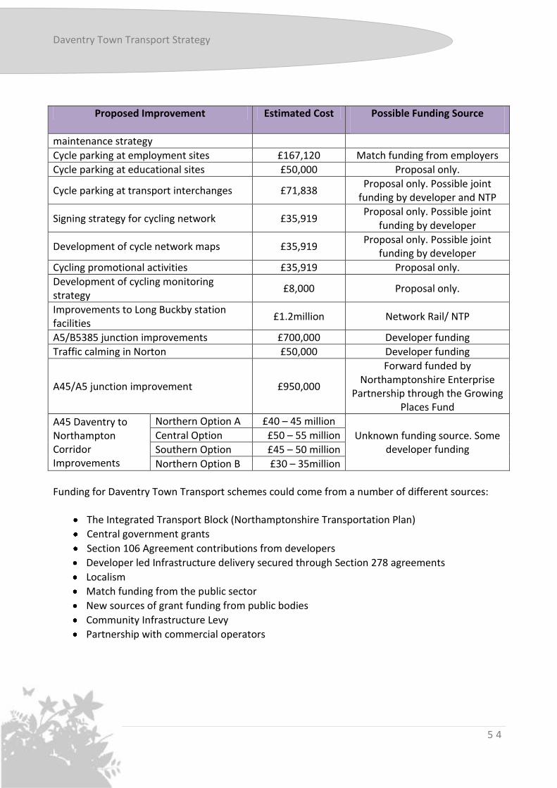
Daventry Town Transport Strategy
5 4
Proposed Improvement Estimated Cost Possible Funding Source
maintenance strategy
Cycle parking at employment sites £167,120 Match funding from employers
Cycle parking at educational sites £50,000 Proposal only.
Cycle parking at transport interchanges £71,838 Proposal only. Possible joint
funding by developer and NTP
Signing strategy for cycling network £35,919 Proposal only. Possible joint
funding by developer
Development of cycle network maps £35,919 Proposal only. Possible joint
funding by developer
Cycling promotional activities £35,919 Proposal only.
Development of cycling monitoring strategy
£8,000 Proposal only.
Improvements to Long Buckby station facilities
£1.2million Network Rail/ NTP
A5/B5385 junction improvements £700,000 Developer funding
Traffic calming in Norton £50,000 Developer funding
A45/A5 junction improvement £950,000
Forward funded by Northamptonshire Enterprise
Partnership through the Growing Places Fund
A45 Daventry to Northampton Corridor Improvements
Northern Option A £40 – 45 million
Unknown funding source. Some developer funding
Central Option £50 – 55 million
Southern Option £45 – 50 million
Northern Option B £30 – 35million
Funding for Daventry Town Transport schemes could come from a number of different sources:
The Integrated Transport Block (Northamptonshire Transportation Plan)
Central government grants
Section 106 Agreement contributions from developers
Developer led Infrastructure delivery secured through Section 278 agreements
Localism
Match funding from the public sector
New sources of grant funding from public bodies
Community Infrastructure Levy
Partnership with commercial operators

Daventry Town Transport Strategy
5 5
Devolution of Major Scheme Funding For many years, local authorities have obtained funding for major highway and public transport schemes (currently those costing over £5 million) through a process of bidding to central government. As part of the Localism Agenda, the government is devolving that funding and the associated decision-making to a more local level through the introduction of Local Transport Bodies. The new Local Transport Bodies will consist of a partnership between Northamptonshire County Council and Northamptonshire Enterprise Partnership and will be responsible for receiving delegated Local Transport Major Scheme funding from the Department for Transport. At the time of publication the levels of funding available for major schemes from April 2015 had not been set by the Department for Transport.
Dave
ntry To
wn

Daventry Town Transport Strategy
5 6
(Blank Page)

Daventry Town Transport Strategy
5 7
Appendix A: Future Cycling Schemes
Dave
ntry To
wn

Daventry Town Transport Strategy
5 8
(Blank Page)

Daventry Town Transport Strategy
5 9
Appendix B: Location of Car Parking in Daventry Town Centre From the Daventry District Council Parking Definition Study
Dave
ntry To
wn

Daventry Town Transport Strategy
6 0
(Blank Page)

Daventry Town Transport Strategy
6 1
Appendix C: Location of Cycle Parking in Daventry Town Centre From the Daventry District Council Parking Definition Study
Dave
ntry To
wn

Daventry Town Transport Strategy
6 2
(Blank Page)

Daventry Town Transport Strategy
6 3
Appendix D: Town Centre Parking Locations Proposed in Daventry District Council’s Daventry Masterplan 2004
Dave
ntry To
wn

Daventry Town Transport Strategy
6 4
Daventry Town Transport Strategy Fit for Purpose
For more information please contact [email protected]