davis pond freshwater diversion advisory...
TRANSCRIPT

Davis Pond Freshwater Diversion Advisory Committee
2014 Meeting Tuesday, November 18, 2014
David Pond Freshwater Diversion Advisory Committee2014

•Flood Control Act 1965 and WRDA 1974
•Constructed by USACE, operated by CPRA
* Four 14 ft2 gated culverts * Discharge = 10,650 cfs • Operational oversight by TWG/DPAC • Online in 2002 (sort of)
Davis Pond Facts
David Pond Freshwater Diversion Advisory Committee2014
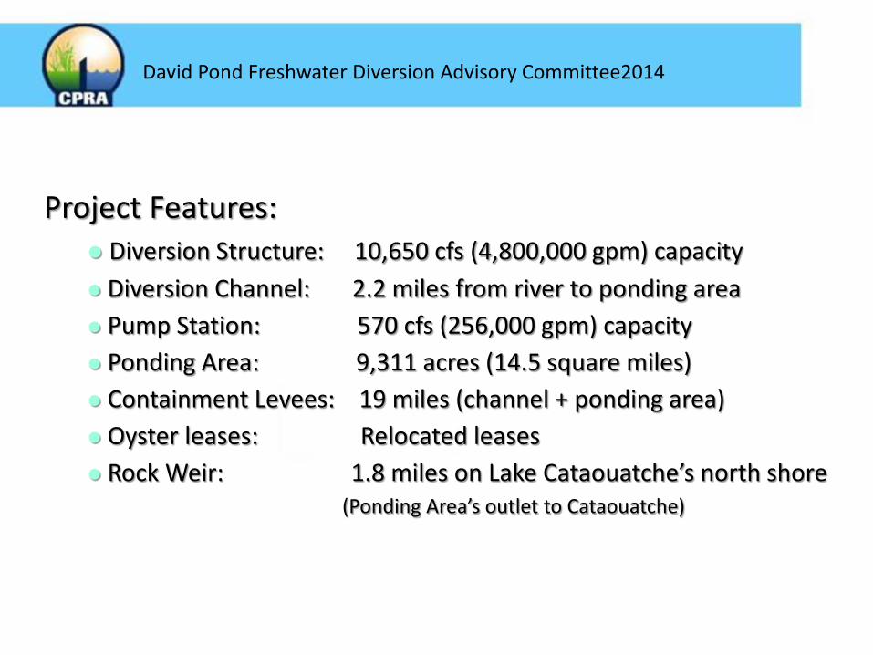
Project Features: Diversion Structure: 10,650 cfs (4,800,000 gpm) capacity Diversion Channel: 2.2 miles from river to ponding area Pump Station: 570 cfs (256,000 gpm) capacity Ponding Area: 9,311 acres (14.5 square miles) Containment Levees: 19 miles (channel + ponding area) Oyster leases: Relocated leases Rock Weir: 1.8 miles on Lake Cataouatche’s north shore (Ponding Area’s outlet to Cataouatche)
David Pond Freshwater Diversion Advisory Committee2014


Davis Pond Pump Station and Guide Levee
Completed January 1999

Rock Weir at Lake Cataouatche (completed 1998; part of East Guide Levee Contract)


• Three iterations of adding and enlarging
dips/cuts to weir and channels into the marsh to improve draining
• Cuts in Cypress Lumber Canal levee to improve
drainage – allowed flow into Tank Ponds
• Subsidence of west guide levee -sheet pile was added
Additional Construction / Modifications to Ponding Area 2003 - 2009
David Pond Freshwater Diversion Advisory Committee2014

2010 – 2013 Modifications complete and efficient delivery of water and suspended sediments to Lake Cataouatche

Crevasse Splay forming at top of ponding area and more efficient delivery pattern of water

Davis Pond Goals • Enhancement of emergent marsh vegetation
growth • Reduction of marsh loss • Increase significant commercial and
recreational fisheries productivity • Increase significant commercial and
recreational wildlife productivity
David Pond Freshwater Diversion Advisory Committee2014

• 2013 Data Results • 2014 Operations and Maintenance • 2015 Proposed Operation Plan
David Pond Freshwater Diversion Advisory Committee2014


Figure 2. Long term average (+/- 1 standard deviation) salinities from the Barataria Bay N of Grand Terre Gauge (USGS site 291929089562600). From December through May the Davis Pond Freshwater Diversion structure may be operated when the 30-day moving average salinity is within or above the data range. Operations will be reduced to the 1000cfs minimum if the 30-day moving average drops below the lower limit of the range.

Figure 3. Long term average (+/- 1 standard deviation) salinities from the Bay Dos Gris (USGS site 292800090060000) and Barataria Waterway (USGS site 292859090004000). From June through November the Davis Pond Freshwater Diversion structure may be operated when the 30-day moving average salinity is within or above the data range. Operations will be reduced to the 1000 cfs minimum if the 30-day moving average drops below the lower limit of the range.


Data Results 2013
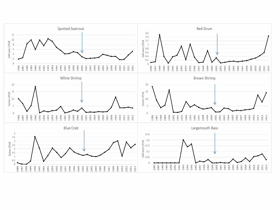
• Oysters continue to be of concern, but consistent with statewide trends
• All other fisheries/wildlife within range and consistent with historical variations
David Pond Freshwater Diversion Advisory Committee2014

• Fish/wildlife


2010 2013
Davis Pond Freshwater Diversion Ponding Area
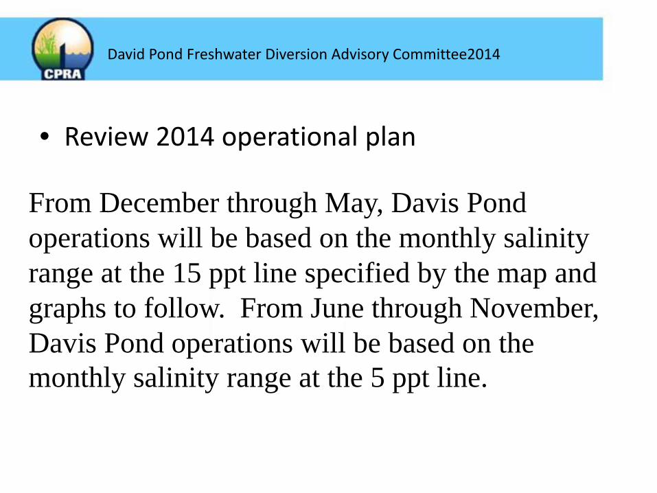
• Review 2014 operational plan
From December through May, Davis Pond operations will be based on the monthly salinity range at the 15 ppt line specified by the map and graphs to follow. From June through November, Davis Pond operations will be based on the monthly salinity range at the 5 ppt line.
David Pond Freshwater Diversion Advisory Committee2014

David Pond Freshwater Diversion Advisory Committee2014

Figure 2. Long term average (+/- 1 standard deviation) salinities from the Barataria Bay N of Grand Terre Gauge (USGS site 291929089562600). From December through May the Davis Pond Freshwater Diversion structure will be operated when the 30-day moving average salinity is within or above the data range. Operations will cease if the 30-day moving average drops below the lower limit of the range.

Figure 3. Long term average (+/- 1 standard deviation) salinities from the Bay Dos Gris (USGS site 292800090060000) and Barataria Waterway (USGS site 292859090004000). From June through November the Davis Pond Freshwater Diversion structure will be operated when the 30-day moving average salinity is within or above the data range. Operations will cease if the 30-day moving average drops below the lower limit of the range.


2014 Issues Affecting Operations • Gates 1 and 4 under repair • Estimated completion Early 2015 • Operational impacts
– <1000cfs minimum until October 2014 – Modified Operations (current)
• Gate differential allowance adjustment- gates 2 and 3 may be operated to full potential
• May affect salinity targets
David Pond Freshwater Diversion Advisory Committee2014


Proposed 2015 Operation Plan • TWG met 9/16/14 • “Low-trigger” added
• 14-day moving average, 30-day and running annual
monitored
• Barataria Grand Terre(15ppt) and Barataria Waterway S of Lafitte (5ppt) Long-Term Averages utilized
• Operations not to exceed 10,000 cfs
David Pond Freshwater Diversion Advisory Committee2014

December-May: 15ppt line • Barataria Grand Terre Gauge(USGS #
291929089562600) • Hackberry Bay (public oyster grounds)
utilized for supporting information and guidance
David Pond Freshwater Diversion Advisory Committee2014


June-November: 5ppt line • Barataria Waterway S Lafitte Gauge (USGS #
292859090004000)- operational range tailored to this gauge (previously combined)
• Bay Dos Gris and Hackberry Bay (public oyster grounds) utilized for
supporting information and guidance
David Pond Freshwater Diversion Advisory Committee2014


Proposed Alternative Operations • Education and PR visits (outside normal
ops) – NTE 5,000 cfs, return to appropriate output
within 2 hours
• Maintenance, Repair and Local issues – Evaluated on case-by-case basis – Notification to TWG members
David Pond Freshwater Diversion Advisory Committee2014

2014-2015
• More transparency in operations • More conservative in light of oyster concerns • Greater focus on salinity ranges • Monitoring adjustments
– Nestier trays – More robust oyster monitoring program (research) – Coastwide monitoring program (SWAMP)
David Pond Freshwater Diversion Advisory Committee2014


Drainage concerns • Some issues with drainage to the NW of
project area • Likely due to high precipitation, subsidence,
etc. • No evidence of Davis Pond influencing
drainage or water levels in the region
David Pond Freshwater Diversion Advisory Committee2014

Flow History

