dawson forest resources management plan - yukon · dawson forest resources management plan ... 4...
TRANSCRIPT
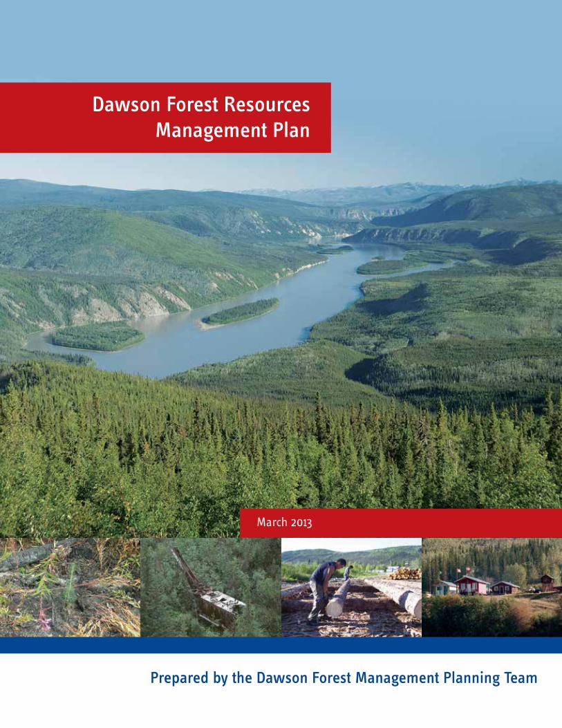
Dawson Forest Resources Management Plan
March 2013
Prepared by the Dawson Forest Management Planning Team

Tatonduk RiverOgilvie River
BlackstoneRiver
HartRiver
SouthKlondike
River
Chandindu
KlondikeRiver
FortyMile
River
YukonRiver
Central
YukonRiverNorth
White River
FlatCreek
SixtyMile
RiverGold
Fields
StewartRiver
YukonRiverSouth
NorthKlondike
River
Stewart Crossing
Mayo
Ddhaw GhroHPA
Dawson City
LhutsawWetland
Pelly Crossing
TombstoneTerritorial
Park
FortSelkirk
Stewart
Forty Mile
Sixtymile
McQuesten
Devil's ElbowHPA
RockCk.Bear
Ck.
105L 12
115K 07
105L 13
115P 08
105M 04
106D 04
105M 05
106D 05
105M 12
106D 12
106E 04
105M 13
106D 13
Dawson ForestResourcesManagement Plan
YUKONWhitehorse
Dawson City
DAWSONFOREST RESOURCESMANAGEMENT PLAN
0 20 4010
KmNorth American Datum 1983
UTM Zone 8N
AL
AS
KA
U.
S.
A.
Dawson Forest Resources Management PlanLandscape UnitsTr'ondëk Hwëch'in Settlement LandParks and Protected AreasLandscape Units
October 2012
MaP 1 LanDscaPe UniTs

iDawson Forest Resources Management Plan | March 2013
The plan was prepared by the Dawson Forest Management Planning Team, a joint planning committee with representation from Tr’ondëk Hwëch’in and the Yukon government. The plan covers both settlement and non-settlement land. The planning team consisted of:
Tr’ondëk Hwëch’in representatives: Bill Kendrick, Brian Willdey, Micah Olesh (2008-2010), and Renee Mayes (2005-2008), Trondëk Hwëch’in Land and Resources Branch, and Tobias Graf, local woodcutter.
Yukon government representatives: Lyle Dinn, Forest Management Branch; Bill Bowie, local mill operator.
Dawson District Renewable Resources Council representatives: Dan Reynolds and alternates.
If you would like more information regarding the Dawson Forest Resources Management Plan, please contact:
Dawson District Renewable Resources Council Box 1380 Dawson City, YT Y0B 1G0 Phone: 867-993-6976 Fax: 867-993-6093 Email: [email protected]
Tr’ondëk Hwëch’in - Main Administrative Building Natural Resources Department Land and Resources Branch 1242 Front Street PO Box 599 Dawson City, YT Y0B 1G0 Phone: 867-993-7100 Toll Free: 1-877-993-3400
Government of Yukon Department of Energy, Mines and Resources Forest Management Branch Mile 918 Alaska Highway Box 2703, (K-918) Whitehorse, YT Y1A 2C6 Phone: 867-456-3999 Toll Free: 1-800-661-0408 ext. 3999 Fax: 867-667-3138 Email: [email protected] Web: www.forestry.gov.yk.ca

ii Dawson Forest Resources Management Plan | March 2013
iiiDawson Forest Resources Management Plan | March 2013
Table of ConTenTs
1. InTRoDUCTIon . . . . . . . . . . . . . . . . . . . . . . . . . . . . . . . . . . . . . . . . . . . . . . . . . . . . . . . . . . . . . . . . . . . . . . . . . . . 11.1 Purpose . . . . . . . . . . . . . . . . . . . . . . . . . . . . . . . . . . . . . . . . . . . . . . . . . . . . . . . . . . . . . . . . . . . . . . . . . . . . 11.2 The Need and the Challenge. . . . . . . . . . . . . . . . . . . . . . . . . . . . . . . . . . . . . . . . . . . . . . . . . . . . . . . . . . . 11.3 Planning Region and Time Frame . . . . . . . . . . . . . . . . . . . . . . . . . . . . . . . . . . . . . . . . . . . . . . . . . . . . . . 21.4 Planning Region Description . . . . . . . . . . . . . . . . . . . . . . . . . . . . . . . . . . . . . . . . . . . . . . . . . . . . . . . . . . 2
1.4.1 Land . . . . . . . . . . . . . . . . . . . . . . . . . . . . . . . . . . . . . . . . . . . . . . . . . . . . . . . . . . . . . . . . . . . . . . . 21.4.2 Hydrology . . . . . . . . . . . . . . . . . . . . . . . . . . . . . . . . . . . . . . . . . . . . . . . . . . . . . . . . . . . . . . . . . . 31.4.3 Topography . . . . . . . . . . . . . . . . . . . . . . . . . . . . . . . . . . . . . . . . . . . . . . . . . . . . . . . . . . . . . . . . . 41.4.4 Climate and Soils . . . . . . . . . . . . . . . . . . . . . . . . . . . . . . . . . . . . . . . . . . . . . . . . . . . . . . . . . . . . 41.4.5 Forests . . . . . . . . . . . . . . . . . . . . . . . . . . . . . . . . . . . . . . . . . . . . . . . . . . . . . . . . . . . . . . . . . . . . . 41.4.6 Forest Disturbances . . . . . . . . . . . . . . . . . . . . . . . . . . . . . . . . . . . . . . . . . . . . . . . . . . . . . . . . . . 51.4.7 Fish and Wildlife . . . . . . . . . . . . . . . . . . . . . . . . . . . . . . . . . . . . . . . . . . . . . . . . . . . . . . . . . . . . 71.4.8 The People . . . . . . . . . . . . . . . . . . . . . . . . . . . . . . . . . . . . . . . . . . . . . . . . . . . . . . . . . . . . . . . . . . 91.4.9 The Economy . . . . . . . . . . . . . . . . . . . . . . . . . . . . . . . . . . . . . . . . . . . . . . . . . . . . . . . . . . . . . . 101.4.10 Special Places . . . . . . . . . . . . . . . . . . . . . . . . . . . . . . . . . . . . . . . . . . . . . . . . . . . . . . . . . . . . . . . 13
2. VIsIon foR foResT ManaGeMenT . . . . . . . . . . . . . . . . . . . . . . . . . . . . . . . . . . . . . . . . . . . . . . . . . . . . . . . . . . 152.1 Vision . . . . . . . . . . . . . . . . . . . . . . . . . . . . . . . . . . . . . . . . . . . . . . . . . . . . . . . . . . . . . . . . . . . . . . . . . . . . 152.2 Principle Statements . . . . . . . . . . . . . . . . . . . . . . . . . . . . . . . . . . . . . . . . . . . . . . . . . . . . . . . . . . . . . . . . 15
3. foResT PlannInG PRoCess . . . . . . . . . . . . . . . . . . . . . . . . . . . . . . . . . . . . . . . . . . . . . . . . . . . . . . . . . . . . . . . . 163.1 Legislative Context . . . . . . . . . . . . . . . . . . . . . . . . . . . . . . . . . . . . . . . . . . . . . . . . . . . . . . . . . . . . . . . . . 163.2 Existing Plans . . . . . . . . . . . . . . . . . . . . . . . . . . . . . . . . . . . . . . . . . . . . . . . . . . . . . . . . . . . . . . . . . . . . . . 17
3.2.1 Official Community Plans . . . . . . . . . . . . . . . . . . . . . . . . . . . . . . . . . . . . . . . . . . . . . . . . . . . . 173.2.2 Timber Harvest Plans . . . . . . . . . . . . . . . . . . . . . . . . . . . . . . . . . . . . . . . . . . . . . . . . . . . . . . . . 173.2.3 Other Plans . . . . . . . . . . . . . . . . . . . . . . . . . . . . . . . . . . . . . . . . . . . . . . . . . . . . . . . . . . . . . . . . 17
3.3 Planning Framework . . . . . . . . . . . . . . . . . . . . . . . . . . . . . . . . . . . . . . . . . . . . . . . . . . . . . . . . . . . . . . . . 173.4 Planning Process . . . . . . . . . . . . . . . . . . . . . . . . . . . . . . . . . . . . . . . . . . . . . . . . . . . . . . . . . . . . . . . . . . . 18
3.4.1 Chronology of Key Steps . . . . . . . . . . . . . . . . . . . . . . . . . . . . . . . . . . . . . . . . . . . . . . . . . . . . . 183.4.2 Participation in Forest Resources Management Planning. . . . . . . . . . . . . . . . . . . . . . . . . . . 18
4. sTRaTeGIC DIReCTIons fRoM PlannInG anD leGIslaTIVe InITIaTIVes . . . . . . . . . . . . . . . . . . . . . . . . . . . . 194.1 Tr’ondëk Hwëch’in Final Agreement . . . . . . . . . . . . . . . . . . . . . . . . . . . . . . . . . . . . . . . . . . . . . . . . . . . 194.2 Tr’ondëk Hwëch’in Land and Resources Act . . . . . . . . . . . . . . . . . . . . . . . . . . . . . . . . . . . . . . . . . . . . . . 204.3 Heritage and Archaeological Resources . . . . . . . . . . . . . . . . . . . . . . . . . . . . . . . . . . . . . . . . . . . . . . . . . 204.4 Land Use Planning . . . . . . . . . . . . . . . . . . . . . . . . . . . . . . . . . . . . . . . . . . . . . . . . . . . . . . . . . . . . . . . . . 20
4.4.1 Dawson Region . . . . . . . . . . . . . . . . . . . . . . . . . . . . . . . . . . . . . . . . . . . . . . . . . . . . . . . . . . . . . 204.4.2 Peel Watershed Land Use Plan . . . . . . . . . . . . . . . . . . . . . . . . . . . . . . . . . . . . . . . . . . . . . . . . . 21
4.5 Tombstone Territorial Park . . . . . . . . . . . . . . . . . . . . . . . . . . . . . . . . . . . . . . . . . . . . . . . . . . . . . . . . . . . 214.6 Priorities of the Yukon Government in Regards to Forest Management . . . . . . . . . . . . . . . . . . . . . . 224.7 Yukon Salmon Sub-Committee . . . . . . . . . . . . . . . . . . . . . . . . . . . . . . . . . . . . . . . . . . . . . . . . . . . . . . . 224.8 Species at Risk, of Special Concern and Listed Under the Yukon Wildlife Act . . . . . . . . . . . . . . . . . . 22
iv Dawson Forest Resources Management Plan | March 2013
5. sTRaTeGIC DIReCTIons fRoM KeY IssUes . . . . . . . . . . . . . . . . . . . . . . . . . . . . . . . . . . . . . . . . . . . . . . . . . . . . 245.1 Diversify Local Economy . . . . . . . . . . . . . . . . . . . . . . . . . . . . . . . . . . . . . . . . . . . . . . . . . . . . . . . . . . . . 24
5.1.1 Forest Sector Development . . . . . . . . . . . . . . . . . . . . . . . . . . . . . . . . . . . . . . . . . . . . . . . . . . . 245.1.2 Education and Training . . . . . . . . . . . . . . . . . . . . . . . . . . . . . . . . . . . . . . . . . . . . . . . . . . . . . . 25
5.2 Biodiversity . . . . . . . . . . . . . . . . . . . . . . . . . . . . . . . . . . . . . . . . . . . . . . . . . . . . . . . . . . . . . . . . . . . . . . . 255.2.1 Natural Disturbance Pattern . . . . . . . . . . . . . . . . . . . . . . . . . . . . . . . . . . . . . . . . . . . . . . . . . . 265.2.2 Seral Stage Distribution . . . . . . . . . . . . . . . . . . . . . . . . . . . . . . . . . . . . . . . . . . . . . . . . . . . . . . 265.2.3 Timing and Distribution of Harvesting . . . . . . . . . . . . . . . . . . . . . . . . . . . . . . . . . . . . . . . . . 275.2.4 Landscape Connectivity . . . . . . . . . . . . . . . . . . . . . . . . . . . . . . . . . . . . . . . . . . . . . . . . . . . . . . 275.2.5 Climate Change . . . . . . . . . . . . . . . . . . . . . . . . . . . . . . . . . . . . . . . . . . . . . . . . . . . . . . . . . . . . . 275.2.6 Forest Management and Carbon Sequestration . . . . . . . . . . . . . . . . . . . . . . . . . . . . . . . . . . . 285.2.7 Soil and Permafrost Conditions . . . . . . . . . . . . . . . . . . . . . . . . . . . . . . . . . . . . . . . . . . . . . . . 295.2.8 Fire Management . . . . . . . . . . . . . . . . . . . . . . . . . . . . . . . . . . . . . . . . . . . . . . . . . . . . . . . . . . . 29
5.3 Focal Species . . . . . . . . . . . . . . . . . . . . . . . . . . . . . . . . . . . . . . . . . . . . . . . . . . . . . . . . . . . . . . . . . . . . . . 295.3.1 Woodland Caribou . . . . . . . . . . . . . . . . . . . . . . . . . . . . . . . . . . . . . . . . . . . . . . . . . . . . . . . . . . 295.3.2 Barren-ground Caribou . . . . . . . . . . . . . . . . . . . . . . . . . . . . . . . . . . . . . . . . . . . . . . . . . . . . . . 305.3.3 Moose . . . . . . . . . . . . . . . . . . . . . . . . . . . . . . . . . . . . . . . . . . . . . . . . . . . . . . . . . . . . . . . . . . . . . 305.3.4 Grizzly Bear . . . . . . . . . . . . . . . . . . . . . . . . . . . . . . . . . . . . . . . . . . . . . . . . . . . . . . . . . . . . . . . . 305.3.5 Lynx . . . . . . . . . . . . . . . . . . . . . . . . . . . . . . . . . . . . . . . . . . . . . . . . . . . . . . . . . . . . . . . . . . . . . . 315.3.6 Salmon and Other Freshwater Species . . . . . . . . . . . . . . . . . . . . . . . . . . . . . . . . . . . . . . . . . . 315.3.7 Forest Birds . . . . . . . . . . . . . . . . . . . . . . . . . . . . . . . . . . . . . . . . . . . . . . . . . . . . . . . . . . . . . . . . 31
5.4 Placer Mining and Forestry . . . . . . . . . . . . . . . . . . . . . . . . . . . . . . . . . . . . . . . . . . . . . . . . . . . . . . . . . . 325.5 Salvaging of Timber Resources . . . . . . . . . . . . . . . . . . . . . . . . . . . . . . . . . . . . . . . . . . . . . . . . . . . . . . . 325.6 Tourism and Visual Quality Management . . . . . . . . . . . . . . . . . . . . . . . . . . . . . . . . . . . . . . . . . . . . . . 325.7 Access and Access Management . . . . . . . . . . . . . . . . . . . . . . . . . . . . . . . . . . . . . . . . . . . . . . . . . . . . . . . 375.8 Traditional and Non-timber Uses of Forest Resources . . . . . . . . . . . . . . . . . . . . . . . . . . . . . . . . . . . . 37
6. foResT PlannInG aReas . . . . . . . . . . . . . . . . . . . . . . . . . . . . . . . . . . . . . . . . . . . . . . . . . . . . . . . . . . . . . . . . . 386.1 Landscape Units . . . . . . . . . . . . . . . . . . . . . . . . . . . . . . . . . . . . . . . . . . . . . . . . . . . . . . . . . . . . . . . . . . . . 38
7. foResT ManaGeMenT Goals, obJeCTIVes anD InDICaToRs . . . . . . . . . . . . . . . . . . . . . . . . . . . . . . . . . . . . . 477.1 Goal A: Conserve Biological Diversity . . . . . . . . . . . . . . . . . . . . . . . . . . . . . . . . . . . . . . . . . . . . . . . . . . 48
7.1.1 Objective A.1 – Conserve Ecosystem Diversity . . . . . . . . . . . . . . . . . . . . . . . . . . . . . . . . . . . 497.1.2 Objective A.2 – Conserve Species Diversity . . . . . . . . . . . . . . . . . . . . . . . . . . . . . . . . . . . . . . 497.1.3 Objective A.3 – Conserve Genetic Diversity of Forest Resources . . . . . . . . . . . . . . . . . . . . . 50
7.2 Goal B: Maintain Forest Ecosystem Health and Productivity . . . . . . . . . . . . . . . . . . . . . . . . . . . . . . . 507.2.1 Objective B.1 – Maintain and Enhance Ecosystem Condition and Productivity . . . . . . . . 507.2.2 Objective B.2 – Support the Ecosystem’s Ability to Maintain Natural Processes . . . . . . . . 517.2.3 Objective B.3 – Maintain and Enhance Ecosystem Resilience . . . . . . . . . . . . . . . . . . . . . . . 51
7.3 Goal C: Conserve and Maintain Soil and Water Resources . . . . . . . . . . . . . . . . . . . . . . . . . . . . . . . . . 517.3.1 Objective C.1 – Conserve and Maintain Soil Resources . . . . . . . . . . . . . . . . . . . . . . . . . . . . 527.3.2 Objective C.2 – Conserve and Maintain Water Resources . . . . . . . . . . . . . . . . . . . . . . . . . . 52
7.4 Goal D: Maintain and Enhance Multiple Socio-economic Benefits . . . . . . . . . . . . . . . . . . . . . . . . . . 537.4.1 Objective D.1 – Maintain and Enhance Sustainable Social, Cultural and Economic Benefits from Timber Resources . . . . . . . . . . . . . . . . . . . . . . . . . . . . . . . . . . . . . . . . . . . . . . . 537.4.2 Objective D.2 – Maintain and Enhance Social, Cultural and Economic Benefits from Non-timber Resources . . . . . . . . . . . . . . . . . . . . . . . . . . . . . . . . . . . . . . . . . . . . . . . . . . 53
vDawson Forest Resources Management Plan | March 2013
7.5 Goal E: Maintain and Enhance Community Sustainability . . . . . . . . . . . . . . . . . . . . . . . . . . . . . . . . . 557.5.1 Objective E.1 – Respect the Rights and Strengthen the Traditional Use of Forest Resources by Tr’ondëk Hwëch’in Citizens . . . . . . . . . . . . . . . . . . . . . . . . . . . . . . . . . . . . . . . 557.5.2 Objective E.2 – Respect Rights of Forest Resource Users in General . . . . . . . . . . . . . . . . . 55
8. Plan IMPleMenTaTIon, MonIToRInG anD ReVIeW . . . . . . . . . . . . . . . . . . . . . . . . . . . . . . . . . . . . . . . . . . . . 568.1 Roles and Responsibilities . . . . . . . . . . . . . . . . . . . . . . . . . . . . . . . . . . . . . . . . . . . . . . . . . . . . . . . . . . . . 56
8.1.1 Planning Team. . . . . . . . . . . . . . . . . . . . . . . . . . . . . . . . . . . . . . . . . . . . . . . . . . . . . . . . . . . . . . 568.1.2 Yukon Government Forest Management Branch and Tr’ondëk Hwëch’in . . . . . . . . . . . . . 568.1.3 Dawson District Renewable Resources Council . . . . . . . . . . . . . . . . . . . . . . . . . . . . . . . . . . . 57
8.2 Direction for Planning Area Development . . . . . . . . . . . . . . . . . . . . . . . . . . . . . . . . . . . . . . . . . . . . . . 578.3 Adaptive Management Strategy . . . . . . . . . . . . . . . . . . . . . . . . . . . . . . . . . . . . . . . . . . . . . . . . . . . . . . . 57
8.3.1 Large Land Base Changes . . . . . . . . . . . . . . . . . . . . . . . . . . . . . . . . . . . . . . . . . . . . . . . . . . . . . 588.4 Integration with Regional Land Use Planning . . . . . . . . . . . . . . . . . . . . . . . . . . . . . . . . . . . . . . . . . . . 588.5 Priorities for Plan Implementation . . . . . . . . . . . . . . . . . . . . . . . . . . . . . . . . . . . . . . . . . . . . . . . . . . . . 59
9. RefeRenCes . . . . . . . . . . . . . . . . . . . . . . . . . . . . . . . . . . . . . . . . . . . . . . . . . . . . . . . . . . . . . . . . . . . . . . . . . . . . 6010. lIsT of aCRonYMs . . . . . . . . . . . . . . . . . . . . . . . . . . . . . . . . . . . . . . . . . . . . . . . . . . . . . . . . . . . . . . . . . . . . . . . 6211. GlossaRY of foResT TeRMs . . . . . . . . . . . . . . . . . . . . . . . . . . . . . . . . . . . . . . . . . . . . . . . . . . . . . . . . . . . . . . . 6312. appendix a . . . . . . . . . . . . . . . . . . . . . . . . . . . . . . . . . . . . . . . . . . . . . . . . . . . . . . . . . . . . . . . . . . . . . . . . . . . . . 69
lIsT of fIGUResFigure 1. Land Classification, Dawson FRMP Area . . . . . . . . . . . . . . . . . . . . . . . . . . . . . . . . . . . . . . . . . . . . . . . . . . 3Figure 2. Forest Tree Species, Dawson FRMP Area . . . . . . . . . . . . . . . . . . . . . . . . . . . . . . . . . . . . . . . . . . . . . . . . . . 5Figure 3. Forest Age Class Distribution, Dawson FRMP Area . . . . . . . . . . . . . . . . . . . . . . . . . . . . . . . . . . . . . . . . . 5Figure 4. Forest Productivity, Dawson FRMP Area . . . . . . . . . . . . . . . . . . . . . . . . . . . . . . . . . . . . . . . . . . . . . . . . . . 5Figure 5. Historical Fire Occurrence by Elevation Class (1952-2010). . . . . . . . . . . . . . . . . . . . . . . . . . . . . . . . . . . . 7
lIsT of TablesTable 1. Summary of Forest Fire History (1952-2010). . . . . . . . . . . . . . . . . . . . . . . . . . . . . . . . . . . . . . . . . . . . . . . 6Table 2. Wildlife in the Dawson Forest Management Planning Area identified by COSEWIC,
the Species at Risk Act (SARA), and/or the Yukon Wildlife Act as of December 2012. . . . . . . . . . . . . . . 23Table 3. Description of Strategic Forest Land Use Zones. . . . . . . . . . . . . . . . . . . . . . . . . . . . . . . . . . . . . . . . . . . . 39Table 4. Summary of Landscape Units. . . . . . . . . . . . . . . . . . . . . . . . . . . . . . . . . . . . . . . . . . . . . . . . . . . . . . . . . . . 41
lIsT of MaPsMap 1. Landscape Units . . . . . . . . . . . . . . . . . . . . . . . . . . . . . . . . . . . . . . . . . . . . . . . . . . . . . . . . inside front coverMap 2. Dawson Area Fire History . . . . . . . . . . . . . . . . . . . . . . . . . . . . . . . . . . . . . . . . . . . . . . . . . . . . . . . . . . . . . 33Map 3. Dawson Area Forest Cover by Leading Species . . . . . . . . . . . . . . . . . . . . . . . . . . . . . . . . . . . . . . . . .34–35Map 4. Dawson Area Forest Cover by Seral Stage Distribution . . . . . . . . . . . . . . . . . . . . . . . . . . . . . . . . . . . . . . 36Map 5. Forest Resources Management Zoning . . . . . . . . . . . . . . . . . . . . . . . . . . . . . . . . . . . . . . inside back cover
vi Dawson Forest Resources Management Plan | March 2013
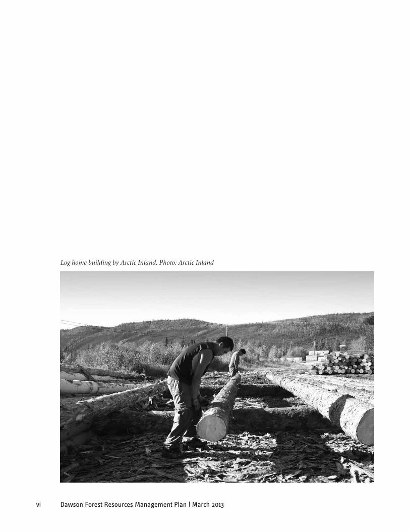
Log home building by Arctic Inland. Photo: Arctic Inland

1Dawson Forest Resources Management Plan | March 2013
DaWson foResT ResoURCes ManaGeMenT Plan
1. InTRoDUCTIon
1.1 PurPose
The purpose of the Dawson Forest Resources Management Plan (FRMP) is to provide a framework for the sustainable management of a forest-based economy in the Dawson forest planning area. This plan is intended to provide a clear framework and practical guidance for forest managers and planners to protect and integrate ecological, traditional, resource, heritage and other community values. The FRMP is intended to meet the criteria established for a Forest Resources Management Plan as established in Chapter 17 of the Tr’ondëk Hwëch’in Final Agreement and the Yukon government’s new Forest Resources Act. The FRMP identifies and provides recommendations to address the issues, concerns, values, and interests as forest resource development progresses in the area.
The intended purpose of the Dawson FRMP is to:
• identify the key forest resource-related issues in the area;
• identify the potential land base for forest development;
• identify strategic directions for forest management; and,
• produce a framework of goals, objectives and indicators to guide forest resource development in the area and monitor the results.
In developing this plan, the Dawson Forest Management Planning Team has considered the values and views of the area’s residents, the Tr’ondëk Hwëch’in, the Dawson District Renewable Resources Council (DDRRC) and the Yukon government (YG), as well as Yukon non-governmental organizations and other stakeholders. Views and values regarding forest management, including forest harvesting, have been solicited through consultation and public meetings.
1.2 The Need aNd The ChalleNge
Traditional economic activities have been and remain an important use of forest resources. Fishing, hunting, berry gathering, and small game trapping are important activities that require consideration in forest resources planning. In addition to resource value, forests in the Dawson area provide significant ecological and aesthetic value, cultural and heritage value, recreational value and other non-timber value.
The 1898 Gold Rush brought an increase in timber harvesting and milling, with cabin logs being cut and sold to the wave of prospectors arriving in Dawson City. Timber was also harvested for steamer fuelwood, mining and construction of houses and boats, and home heating. With a current, annual harvest of approximately 3,000 to 4,000 cubic metres (m3), small-scale forestry continues to contribute to the local Dawson economy.
Forestry is necessarily a small scale industry in the Dawson area as forest productivity is limited by the cold climate and short growing season. With careful management however, Dawson’s forests can sustain a vibrant, small scale forest industry that provides timber for local markets, energy, economic opportunity and employment for the area’s residents over the long-term.
Forest resources planning brings with it the opportunity to support local economic development and to encourage investment in the Dawson area. Forest resources planning also responds to local interests in securing access to the forested land base and facilitates longer term forest tenure.
2 Dawson Forest Resources Management Plan | March 2013
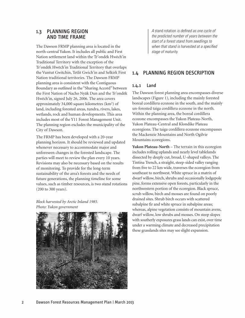
Block harvested by Arctic Inland 1985. Photo: Yukon government
A stand rotation is defined as one cycle of the predicted number of years between the start of a forest stand from seedlings to when that stand is harvested at a specified stage of maturity.
1.3 PlaNNiNg regioN aNd Time Frame
The Dawson FRMP planning area is located in the north-central Yukon. It includes all public and First Nation settlement land within the Tr’ondëk Hwëch’in Traditional Territory with the exception of the Tr’ondëk Hwëch’in Traditional Territory that overlaps the Vuntut Gwitchin, Tetlit Gwich’in and Selkirk First Nation traditional territories. The Dawson FRMP planning area is consistent with the Contiguous Boundary as outlined in the “Sharing Accord” between the First Nation of Nacho Nyäk Dun and the Tr’ondëk Hwëch’in, signed July 26, 2006. The area covers approximately 34,000 square kilometres (km2) of land, including forested areas, tundra, rivers, lakes, wetlands, rock and human developments. This area includes most of the Y11 Forest Management Unit. The planning region excludes the municipality of the City of Dawson.
The FRMP has been developed with a 20-year planning horizon. It should be reviewed and updated whenever necessary to accommodate major and unforeseen changes in the forested landscape. The parties will meet to review the plan every 10 years. Revisions may also be necessary based on the results of monitoring. To provide for the long-term sustainability of the area’s forests and the needs of future generations, the planning timeline for some values, such as timber resources, is two stand rotations (200 to 300 years).
1.4 PlaNNiNg regioN desCriPTioN
1.4.1 land
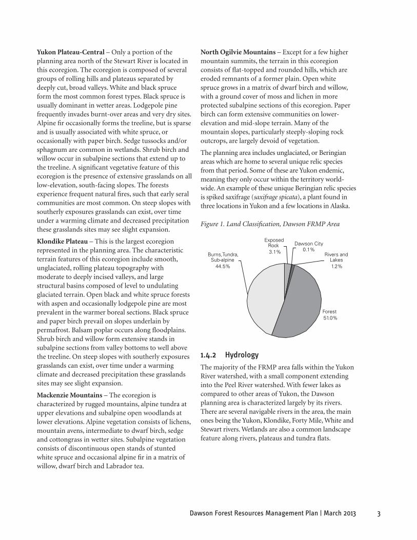
The Dawson forest planning area encompasses diverse landscapes (Figure 1), including the mainly forested boreal cordillera ecozone in the south, and the mainly un-forested taiga cordillera ecozone in the north. Within the planning area, the boreal cordillera ecozone encompasses the Yukon Plateau-North, Yukon Plateau-Central and Klondike Plateau ecoregions. The taiga cordillera ecozone encompasses the Mackenzie Mountains and North Ogilvie Mountains ecoregions.
Yukon Plateau-North – The terrain in this ecoregion includes rolling uplands and nearly level tablelands dissected by deeply cut, broad, U-shaped valleys. The Tintina Trench, a straight, steep-sided valley ranging from five to 22 km wide, traverses the ecoregion from southeast to northwest. White spruce in a matrix of dwarf willow, birch, shrubs and occasionally lodgepole pine, forms extensive open forests, particularly in the northwestern portion of the ecoregion. Black spruce, scrub willow, birch and mosses are found on poorly drained sites. Shrub birch occurs with scattered subalpine fir and white spruce in subalpine areas; whereas, alpine vegetation consists of mountain avens, dwarf willow, low shrubs and mosses. On steep slopes with southerly exposures grass lands can exist, over time under a warming climate and decreased precipitation these grasslands sites may see slight expansion.
3Dawson Forest Resources Management Plan | March 2013
Forest51.0%
Burns,Tundra,Sub-alpine
44.5%
Dawson City0.1%
ExposedRock3.1% Rivers and
Lakes1.2%
Figure 1. Land Classification, Dawson FRMP Area
Yukon Plateau-Central – Only a portion of the planning area north of the Stewart River is located in this ecoregion. The ecoregion is composed of several groups of rolling hills and plateaus separated by deeply cut, broad valleys. White and black spruce form the most common forest types. Black spruce is usually dominant in wetter areas. Lodgepole pine frequently invades burnt-over areas and very dry sites. Alpine fir occasionally forms the treeline, but is sparse and is usually associated with white spruce, or occasionally with paper birch. Sedge tussocks and/or sphagnum are common in wetlands. Shrub birch and willow occur in subalpine sections that extend up to the treeline. A significant vegetative feature of this ecoregion is the presence of extensive grasslands on all low-elevation, south-facing slopes. The forests experience frequent natural fires, such that early seral communities are most common. On steep slopes with southerly exposures grasslands can exist, over time under a warming climate and decreased precipitation these grasslands sites may see slight expansion.
Klondike Plateau – This is the largest ecoregion represented in the planning area. The characteristic terrain features of this ecoregion include smooth, unglaciated, rolling plateau topography with moderate to deeply incised valleys, and large structural basins composed of level to undulating glaciated terrain. Open black and white spruce forests with aspen and occasionally lodgepole pine are most prevalent in the warmer boreal sections. Black spruce and paper birch prevail on slopes underlain by permafrost. Balsam poplar occurs along floodplains. Shrub birch and willow form extensive stands in subalpine sections from valley bottoms to well above the treeline. On steep slopes with southerly exposures grasslands can exist, over time under a warming climate and decreased precipitation these grasslands sites may see slight expansion.
Mackenzie Mountains – The ecoregion is characterized by rugged mountains, alpine tundra at upper elevations and subalpine open woodlands at lower elevations. Alpine vegetation consists of lichens, mountain avens, intermediate to dwarf birch, sedge and cottongrass in wetter sites. Subalpine vegetation consists of discontinuous open stands of stunted white spruce and occasional alpine fir in a matrix of willow, dwarf birch and Labrador tea.
North Ogilvie Mountains – Except for a few higher mountain summits, the terrain in this ecoregion consists of flat-topped and rounded hills, which are eroded remnants of a former plain. Open white spruce grows in a matrix of dwarf birch and willow, with a ground cover of moss and lichen in more protected subalpine sections of this ecoregion. Paper birch can form extensive communities on lower-elevation and mid-slope terrain. Many of the mountain slopes, particularly steeply-sloping rock outcrops, are largely devoid of vegetation.
The planning area includes unglaciated, or Beringian areas which are home to several unique relic species from that period. Some of these are Yukon endemic, meaning they only occur within the territory world-wide. An example of these unique Beringian relic species is spiked saxifrage (saxifrage spicata), a plant found in three locations in Yukon and a few locations in Alaska.
1.4.2 hydrology
The majority of the FRMP area falls within the Yukon River watershed, with a small component extending into the Peel River watershed. With fewer lakes as compared to other areas of Yukon, the Dawson planning area is characterized largely by its rivers. There are several navigable rivers in the area, the main ones being the Yukon, Klondike, Forty Mile, White and Stewart rivers. Wetlands are also a common landscape feature along rivers, plateaus and tundra flats.

4 Dawson Forest Resources Management Plan | March 2013
1.4.3 Topography
Deep, narrow river valleys, plateaus and higher mountain ranges characterize the topography of the area. As the easternmost portion of Beringia, much of the area escaped the last period of glaciation. This unglaciated terrain has experienced long periods of soil weathering, creating smooth ridge tops, deep, narrow valleys, and vast upland boulder fields. Outside of Beringia, the Cordilleran glaciation shaped the landforms, surficial geology and soils of the area over 10,000 years ago. The major valleys and low uplands were significantly eroded by this ice sheet.
The lowest elevations in the area are found in the V-shaped valleys of the Yukon, Klondike, Forty Mile, and Stewart rivers. Higher elevations are found in the Mackenzie and South Ogilvie mountains. The elevation ranges from 290 to 2,000 m above sea level in the Klondike and Yukon Plateau-North ecoregions, with local relief between 300 and 900 m. In the Mackenzie and South Ogilvie mountains, the elevation ranges from 400 to 2,750 m and relief is typically 750 to 1,500 m above sea level (Yukon Ecoregions Working Group, 2004).
1.4.4 Climate and soils
The climate in the planning area is complex and varies depending on elevation, latitude and the weather patterns created by the area’s mountain ranges. For example, precipitation varies from 300 to 450 mm yearly around Dawson City, and reaches up to 750 mm per year in high elevation areas. In winter, temperature inversions can occur, with temperatures of -50 ºC common in the major river valleys. The seasonal variation is extreme, with a short, hot summer season and long, cold winters.
Dawson City, located on the Yukon River at an elevation of 317 m above sea level, has an average of 120 days of precipitation per year, consisting of an average of 164.5 cm of snowfall and 232.8 mm of rainfall. The annual average temperature in Dawson is -5 ºC, with a mean high of 15 ºC and a mean low of -32 ºC. The July mean high is 22 ºC and the January mean low is -32 ºC. The highest temperature ever recorded in Dawson was 35 ºC (1950), and the lowest recorded temperature was -58 ºC (1979). Dawson City is frost free for approximately 91 days per year. Prevailing winds are from the north, with an average speed of 7 km/hour.
Permafrost is discontinuous but widespread in the area. Permafrost-free areas are found on well-drained upland slopes; discontinuous permafrost occurs on lower slopes and valleys. Soils on upper slopes are rocky, while soils on lower slopes are silty, rich in organic matter, and often capped with peat. In the river valleys, soils are gravelly or composed of silt and loam, with the latter supporting productive boreal forest stands (Yukon Ecoregions Working Group, 2004).
At the moment, it is unclear how climate change will affect forests in the Dawson planning area or the Yukon over the long-term. Across Canada it is thought that boreal forest species may shift northward 300 to 500 km. Melting permafrost, glacial melting, increased forest fire frequency and increased spread of insect pests are several effects of warmer temperatures that are already evident. Extreme weather events and overall increased precipitation, with wetter winters and drier summers, are expected. With a shift in climate and corresponding shift in vegetation, increased spread of non-native and invasive species is also anticipated (Government of Yukon, Department of Environment, 2006).
1.4.5 Forests
The dominant tree species in the area are black spruce, white spruce and birch (Figure 2 and Map 3, centre spread). Black spruce dominates on wetter, poorly-drained sites. Mixed forests of white spruce, birch, trembling aspen and balsam poplar are found on warmer sites and south-facing slopes. Black spruce stands are mixed with aspen and birch on sites where disturbance, such as fire, has occurred within about 100 years. Lodgepole pine is also occasionally found with black spruce, although this species is at the northernmost extent of its range in this area. Birch communities can be found on lower and mid-elevation slopes. Birch and trembling aspen are found with black spruce where disturbance, such as fire, has occurred within about 100 years. Balsam poplar stands grow along floodplains, and alpine fir is found occasionally at higher elevations.

5Dawson Forest Resources Management Plan | March 2013
Forest Age Class Distribution
0
50000
100000
150000
200000
250000
300000
20 30 40 50 60 70 80 90 100
110
120
130
140
150
160+
Age(years)
Are
a (h
a)
Figure 3. Forest Age Class Distribution, Dawson FRMP Area
Area by Forest Tree Species
210,459
16,416 17,879 311
570,844
590,328
340,976
0
100,000
200,000
300,000
400,000
500,000
600,000
700,000
Are
a(h
a)
Aspen
Balsam
Popla
r
Alpine
Fir
Lodg
epole
Pine
Black S
pruc
e
Whit
e Spr
uce
Birch
Figure 2. Forest Tree Species, Dawson FRMP Area
Forest Productivity (site class)
Good (108,000ha)6%
Low (370,000ha)
20%
Medium (505,000ha)28%
Poor (850,000ha)46%
Figure 4. Forest Productivity, Dawson FRMP Area
Forest fires are the most significant natural disturbance impacting forest composition in the area. The relatively limited area of older forest (over 130 years) results from frequent stand replacing wildfires that occur in the area, particularly in mature coniferous forest.
The fire history of the area is reflected in the mosaic of forests of different age classes across the landscape (Figure 3). The age class distribution shows the predominant age range between 30 and 120 years. The age classes covering the largest areas of the forested land base are between 30 and 50 years, with older age classes of forest covering successively smaller land areas.
The forest productivity of the area is for the most part classified as poor (46%) or low (20%) (Figure 4). A small portion of the area (6%) is classified as having good productivity, and almost a third of the area (28%) is classified as having medium productivity. Trees on good sites are expected to reach heights of 20 to 25 m at maturity. Good sites are found mostly in riparian areas and south-facing upland slopes. Sites classed as having low productivity have limited capability for forest growth, either due to poor drainage, reduced nutrient availability or elevation.
1.4.6 Forest disturbances
1.4.6.1 Wildfire
Wildfires are integral to the ecology of boreal forests. Fire influences forest species composition, vegetation structure, stand productivity and mosaic of forest types. Fire is also responsible for nutrient cycling and replenishment of nutrients at cold sites, with ash returning significant nutrients to the forest floor. Additionally, the warming of soil and deepening of the permafrost active layer following fire contributes to regeneration (McCoy and Burn, 2005).
6 Dawson Forest Resources Management Plan | March 2013
Time Period
Total burned area (ha)
average number of fires Per Year
average area burned Per Year (ha)
average fire size (ha)
Maximum fire size (ha)
1952-2010 1,319,055 17 22,742 1,356 128,637
1982-2010 924,973 25 33,035 1,333 43,793
Table 1. Summary of Forest Fire History (1952–2010)
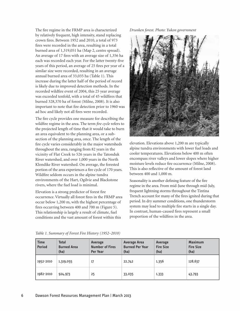
Drunken forest. Photo: Yukon government The fire regime in the FRMP area is characterized by relatively frequent, high intensity, stand replacing crown fires. Between 1952 and 2010, a total of 973 fires were recorded in the area, resulting in a total burned area of 1,319,051 ha (Map 2, centre spread). An average of 17 fires with an average size of 1,356 ha each was recorded each year. For the latter twenty-five years of this period, an average of 25 fires per year of a similar size were recorded, resulting in an average annual burned area of 33,035 ha (Table 1). This increase during the latter half of the period of record is likely due to improved detection methods. In the recorded wildfire event of 2004, this 25 year average was exceeded tenfold, with a total of 45 wildfires that burned 328,370 ha of forest (Milne, 2008). It is also important to note that fire detection prior to 1960 was ad hoc and likely not all fires were recorded.
The fire cycle provides one measure for describing the wildfire regime in the area. The term fire cycle refers to the projected length of time that it would take to burn an area equivalent to the planning area, or a sub-section of the planning area, once. The length of the fire cycle varies considerably in the major watersheds throughout the area, ranging from 82 years in the vicinity of Flat Creek to 526 years in the Tatonduk River watershed, and over 1,000 years in the North Klondike River watershed. On average, the forested portion of the area experiences a fire cycle of 170 years. Wildfire seldom occurs in the alpine tundra environments of the Hart, Ogilvie and Blackstone rivers, where the fuel load is minimal.
Elevation is a strong predictor of forest fire occurrence. Virtually all forest fires in the FRMP area occur below 1,200 m, with the highest percentage of fires occurring between 400 and 700 m (Figure 5). This relationship is largely a result of climate, fuel conditions and the vast amount of forest within this
elevation. Elevations above 1,200 m are typically alpine tundra environments with lower fuel loads and cooler temperatures. Elevations below 400 m often encompass river valleys and lower slopes where higher moisture levels reduce fire occurrence (Milne, 2008). This is also reflective of the amount of forest land between 400 and 1,000 m.
Seasonality is another defining feature of the fire regime in the area. From mid-June through mid-July, frequent lightning storms throughout the Tintina Trench account for many of the fires ignited during that period. In dry summer conditions, one thunderstorm system may lead to multiple fire starts in a single day. In contrast, human-caused fires represent a small proportion of the wildfires in the area.

7Dawson Forest Resources Management Plan | March 2013
Figure 5. Historical Fire Occurrence by Elevation Class (1952–2010)Historical Fire Occurence by Elevation Class 1952 to 2007
0
100,000
200,000
300,000
400,000
500,000
600,000
Class 1: 225 to 400m
Class 2: 401 to 700m
Class 4: 701 to 1000m
Class 3: 1001 to 1200m
Class 4: 1201 to 2288m
Elevation
Are
a (h
a)
1.4.6.2 other disturbance agents
In addition to large wildfires, small-scale disturbances such as forest insects, disease, flooding, drought and windthrow occur throughout the area.
Some forest pests have been active in the planning area. By now familiar to all residents of the Yukon, particularly to those between Carmacks and Dawson City, is the silvering of aspen leaves from the serpentine aspen leafminer (Phyllocnistis populiella). Larvae of this insect feed on the epidermal layer on the upper and lower surface of the leaves, leaving only the silver leaf cuticle behind. In the area between Stewart Crossing and Mayo, where severe mining has occurred every year for 15 or more years, the trees have become stunted and lacking in vigour; however, little or no mortality attributed to the leafminer has been observed or reported.
There have been reports of spruce mortality occurring in patches along the Yukon, Stewart and Indian rivers. Some trees at the mouth of the Indian River appeared at the time to be infested by spruce beetle (Dendroctonus rufi pennis) and the spruce engraver beetle (Ips pertabatus). Upon further examination the cause of the mortality was more complex than simple small bark beetle infestation. It appears now that drought was the single cause of death for most of the trees. (Government of Yukon, Energy Mines and Resources, 2008). Ongoing work was completed in summer of 2009.
1.4.6.3 human disturbances
Linear disturbances include major highways, secondary roads, mining roads, and trails. The Yukon
Ditch, a 44 km wooden flume, ditch and pipe that at one time carried water to dredge operations in the Klondike drainage, is also a persistent linear feature. The industrial mining history of the area has left a significant mark on the landscape in the form of a vast expanse of tailings covering the South Klondike River valley. Portions of the Forty Mile and Sixty Mile rivers have also been dredged for gold. For the past 25 years considerable mining activity and disturbance has occurred in the Indian River drainage.
The first significant period of timber harvesting began during the Klondike Gold Rush of 1898. Timber was harvested and milled for cabins, fuelwood, mining and boat construction. Additional information on the history of the Dawson forest industry can be found in A History of Logging in the Yukon: 1896 – 1970, by Northern Design Consultants (1993). Urban and agricultural development in Dawson City and the surrounding subdivisions is another human disturbance in the area.
1.4.7 Fish and Wildlife
1.4.7.1 mammals
There are at least 29 species of small mammals and 19 species of large mammals in the area (Yukon Ecoregions Working Group, 2004). Small mammals include such species as lynx, beaver, marten, otter, wolverine, mink, ermine, fox, muskrat, coyote, snowshoe hare and porcupine. The Ogilvie Mountain collared lemming is known only in Yukon worldwide, and lies in the northern part of the planning area. Large mammals include moose, caribou, sheep, grizzly bear, black bear, wolves and mule deer.
The winter ranges of two barren-ground caribou herds, the Porcupine herd and Forty Mile herd, extend within the planning area. The last census (2010) of the Porcupine caribou estimated the herd at 169,000 animals. The herd has increased since the 2001 census.
A 2010 census of the Forty Mile caribou herd estimated a population of 51,675 caribou. This represents an increase from a population of 38,364 in 2007, 40,000 in 2005 and 43,375 in 2003. At one time abundant throughout central and southern Yukon, the Forty Mile herd has been absent from its Yukon range for an extended period. Identified range areas in the Yukon include portions of the Forty Mile and Sixty Mile River watersheds, with the remainder of the herd’s range extending into Alaska (Kienzler, 2007).

8 Dawson Forest Resources Management Plan | March 2013
Yukon River salmon. Photo: Yukon government There are two woodland caribou herds in the area, the Hart River herd and the Clear Creek herd. A census of the Hart River caribou was carried out for the first time in 2006. The population was estimated at 2,200 individuals (plus or minus 25%) (Kienzler, 2007).
Moose density in the Dawson area varies greatly by habitat type, from an estimated low of 50 moose per 1,000 km2, to as high as 330 moose per 1,000 km2, with an average density estimated at 150 to 160 moose per 1,000 km2. Moose population counts are carried out approximately every five years.
Species of conservation concern, that occur in the Dawson planning area, identified by the Committee on the Status of Endangered Wildlife in Canada (COSEWIC), Species at Risk Act (SARA) and/or the Yukon Wildlife Act include five mammals. Mammals listed as Special Concern include: grizzly bear (NW population), collared pika, wolverine (western) and woodland caribou. The Yukon Wildlife Act lists cougar as a protected species. Other species of conservation concern that have not yet been assessed include the Ogilvie Mountain collared lemming (Yukon endemic and very rare).
1.4.7.2 Birds
There are 165 bird species that occur regularly in the Dawson planning area (Canadian Wildlife Service, 2003). Of these, 131 are federally protected under the Migratory Birds Convention Act. Only 27 of the 165 are year-round residents.
Among the year-round inhabitants are ptarmigan, owls, grouse, woodpeckers, gray jays and common ravens, as well as northern goshawk, gyrfalcon, black-capped chickadee, American dipper, bohemian waxwing, pine grosbeak and white winged crossbill (Canadian Wildlife Service, 2003). Raptor nesting surveys have shown key habitat areas along the Yukon, Stewart, White and Chandindu rivers, as well as the Dempster Highway corridor (Kienzler, 2007).
Several of the bird species present in the area are assessed by COSEWIC and listed by Government of Canada under the Federal Species at Risk Act (See Section 4.8).
Species of conservation concern, that occur in the Dawson planning area, identified by COSEWIC, Species at Risk Act (SARA) and/or the Yukon Wildlife Act include nine birds. Birds listed as Threatened include: the barn swallow, common nighthawk and
the olive-sided flycatcher. Birds listed as Special Concern include: the horned grebe, peregrine falcon, rusty blackbird and short-eared owl. The Yukon Wildlife Act lists the gyrfalcon and trumpeter swan as protected species.
1.4.7.3 Fish
The majority of the FRMP area falls within the Yukon River watershed. However, the north-eastern portion of the area falls within the upper Peel River drainage basin, specifically the upper watershed areas of three major tributaries to the Peel, Hart, Blackstone, and Ogilvie rivers.
Freshwater fish species found in the area include Arctic grayling, burbot, lake whitefish, broad whitefish, round whitefish, pygmy whitefish, least cisco, Arctic cisco, inconnu, northern pike, longnose sucker, lake chub, slimy sculpin, Arctic lamprey and dolly varden (Peel drainage only).
In the portions of the Hart, Blackstone and Ogilivie rivers within the area, the fish species diversity is lower. Species found in these watersheds may include Arctic grayling, Dolly Varden, burbot, round whitefish, pygmy whitefish, longnose sucker, lake chub and slimy sculpin. Information regarding patterns of habitat use for all species is generally very limited in these watersheds.
Chinook, chum and coho salmon species are present in the Yukon River watershed. In addition to the
9Dawson Forest Resources Management Plan | March 2013
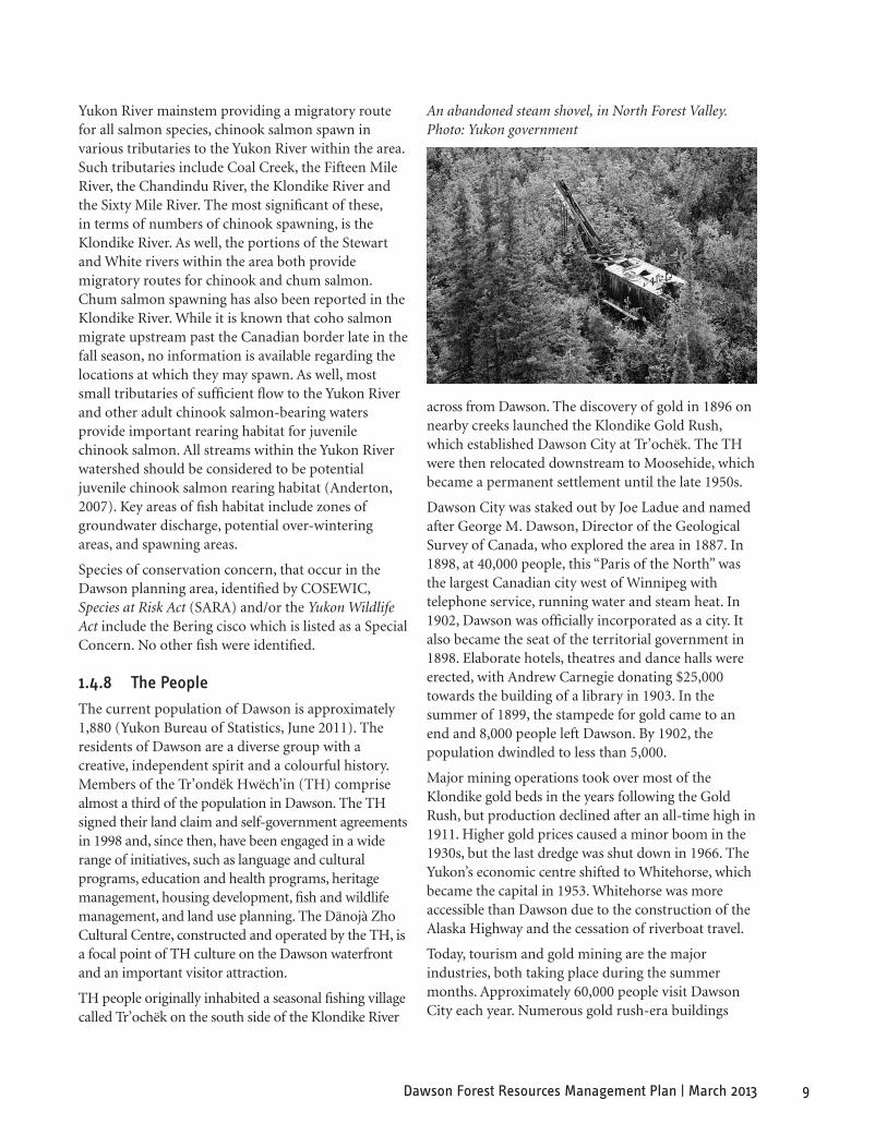
An abandoned steam shovel, in North Forest Valley.Photo: Yukon government
Yukon River mainstem providing a migratory route for all salmon species, chinook salmon spawn in various tributaries to the Yukon River within the area. Such tributaries include Coal Creek, the Fifteen Mile River, the Chandindu River, the Klondike River and the Sixty Mile River. The most significant of these, in terms of numbers of chinook spawning, is the Klondike River. As well, the portions of the Stewart and White rivers within the area both provide migratory routes for chinook and chum salmon. Chum salmon spawning has also been reported in the Klondike River. While it is known that coho salmon migrate upstream past the Canadian border late in the fall season, no information is available regarding the locations at which they may spawn. As well, most small tributaries of sufficient flow to the Yukon River and other adult chinook salmon-bearing waters provide important rearing habitat for juvenile chinook salmon. All streams within the Yukon River watershed should be considered to be potential juvenile chinook salmon rearing habitat (Anderton, 2007). Key areas of fish habitat include zones of groundwater discharge, potential over-wintering areas, and spawning areas.
Species of conservation concern, that occur in the Dawson planning area, identified by COSEWIC, Species at Risk Act (SARA) and/or the Yukon Wildlife Act include the Bering cisco which is listed as a Special Concern. No other fish were identified.
1.4.8 The People
The current population of Dawson is approximately 1,880 (Yukon Bureau of Statistics, June 2011). The residents of Dawson are a diverse group with a creative, independent spirit and a colourful history. Members of the Tr’ondëk Hwëch’in (TH) comprise almost a third of the population in Dawson. The TH signed their land claim and self-government agreements in 1998 and, since then, have been engaged in a wide range of initiatives, such as language and cultural programs, education and health programs, heritage management, housing development, fish and wildlife management, and land use planning. The Dänojà Zho Cultural Centre, constructed and operated by the TH, is a focal point of TH culture on the Dawson waterfront and an important visitor attraction.
TH people originally inhabited a seasonal fishing village called Tr’ochëk on the south side of the Klondike River
across from Dawson. The discovery of gold in 1896 on nearby creeks launched the Klondike Gold Rush, which established Dawson City at Tr’ochëk. The TH were then relocated downstream to Moosehide, which became a permanent settlement until the late 1950s.
Dawson City was staked out by Joe Ladue and named after George M. Dawson, Director of the Geological Survey of Canada, who explored the area in 1887. In 1898, at 40,000 people, this “Paris of the North” was the largest Canadian city west of Winnipeg with telephone service, running water and steam heat. In 1902, Dawson was officially incorporated as a city. It also became the seat of the territorial government in 1898. Elaborate hotels, theatres and dance halls were erected, with Andrew Carnegie donating $25,000 towards the building of a library in 1903. In the summer of 1899, the stampede for gold came to an end and 8,000 people left Dawson. By 1902, the population dwindled to less than 5,000.
Major mining operations took over most of the Klondike gold beds in the years following the Gold Rush, but production declined after an all-time high in 1911. Higher gold prices caused a minor boom in the 1930s, but the last dredge was shut down in 1966. The Yukon’s economic centre shifted to Whitehorse, which became the capital in 1953. Whitehorse was more accessible than Dawson due to the construction of the Alaska Highway and the cessation of riverboat travel.
Today, tourism and gold mining are the major industries, both taking place during the summer months. Approximately 60,000 people visit Dawson City each year. Numerous gold rush-era buildings
10 Dawson Forest Resources Management Plan | March 2013
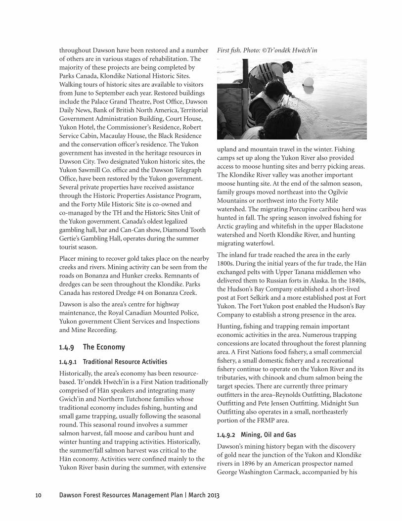
First fish. Photo: ©Tr’ondëk Hwëch’inthroughout Dawson have been restored and a number of others are in various stages of rehabilitation. The majority of these projects are being completed by Parks Canada, Klondike National Historic Sites. Walking tours of historic sites are available to visitors from June to September each year. Restored buildings include the Palace Grand Theatre, Post Office, Dawson Daily News, Bank of British North America, Territorial Government Administration Building, Court House, Yukon Hotel, the Commissioner’s Residence, Robert Service Cabin, Macaulay House, the Black Residence and the conservation officer’s residence. The Yukon government has invested in the heritage resources in Dawson City. Two designated Yukon historic sites, the Yukon Sawmill Co. office and the Dawson Telegraph Office, have been restored by the Yukon government. Several private properties have received assistance through the Historic Properties Assistance Program, and the Forty Mile Historic Site is co-owned and co-managed by the TH and the Historic Sites Unit of the Yukon government. Canada’s oldest legalized gambling hall, bar and Can-Can show, Diamond Tooth Gertie’s Gambling Hall, operates during the summer tourist season.
Placer mining to recover gold takes place on the nearby creeks and rivers. Mining activity can be seen from the roads on Bonanza and Hunker creeks. Remnants of dredges can be seen throughout the Klondike. Parks Canada has restored Dredge #4 on Bonanza Creek.
Dawson is also the area’s centre for highway maintenance, the Royal Canadian Mounted Police, Yukon government Client Services and Inspections and Mine Recording.
1.4.9 The economy
1.4.9.1 Traditional resource activities
Historically, the area’s economy has been resource-based. Tr’ondëk Hwëch’in is a First Nation traditionally comprised of Hän speakers and integrating many Gwich’in and Northern Tutchone families whose traditional economy includes fishing, hunting and small game trapping, usually following the seasonal round. This seasonal round involves a summer salmon harvest, fall moose and caribou hunt and winter hunting and trapping activities. Historically, the summer/fall salmon harvest was critical to the Hän economy. Activities were confined mainly to the Yukon River basin during the summer, with extensive
upland and mountain travel in the winter. Fishing camps set up along the Yukon River also provided access to moose hunting sites and berry picking areas. The Klondike River valley was another important moose hunting site. At the end of the salmon season, family groups moved northeast into the Ogilvie Mountains or northwest into the Forty Mile watershed. The migrating Porcupine caribou herd was hunted in fall. The spring season involved fishing for Arctic grayling and whitefish in the upper Blackstone watershed and North Klondike River, and hunting migrating waterfowl.
The inland fur trade reached the area in the early 1800s. During the initial years of the fur trade, the Hän exchanged pelts with Upper Tanana middlemen who delivered them to Russian forts in Alaska. In the 1840s, the Hudson’s Bay Company established a short-lived post at Fort Selkirk and a more established post at Fort Yukon. The Fort Yukon post enabled the Hudson’s Bay Company to establish a strong presence in the area.
Hunting, fishing and trapping remain important economic activities in the area. Numerous trapping concessions are located throughout the forest planning area. A First Nations food fishery, a small commercial fishery, a small domestic fishery and a recreational fishery continue to operate on the Yukon River and its tributaries, with chinook and chum salmon being the target species. There are currently three primary outfitters in the area–Reynolds Outfitting, Blackstone Outfitting and Pete Jensen Outfitting. Midnight Sun Outfitting also operates in a small, northeasterly portion of the FRMP area.
1.4.9.2 mining, oil and gas
Dawson’s mining history began with the discovery of gold near the junction of the Yukon and Klondike rivers in 1896 by an American prospector named George Washington Carmack, accompanied by his
11Dawson Forest Resources Management Plan | March 2013
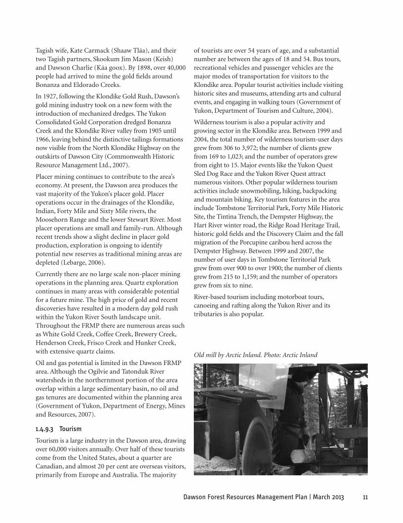
Old mill by Arctic Inland. Photo: Arctic Inland
Tagish wife, Kate Carmack (Shaaw Tláa), and their two Tagish partners, Skookum Jim Mason (Keish) and Dawson Charlie (Káa goox). By 1898, over 40,000 people had arrived to mine the gold fields around Bonanza and Eldorado Creeks.
In 1927, following the Klondike Gold Rush, Dawson’s gold mining industry took on a new form with the introduction of mechanized dredges. The Yukon Consolidated Gold Corporation dredged Bonanza Creek and the Klondike River valley from 1905 until 1966, leaving behind the distinctive tailings formations now visible from the North Klondike Highway on the outskirts of Dawson City (Commonwealth Historic Resource Management Ltd., 2007).
Placer mining continues to contribute to the area’s economy. At present, the Dawson area produces the vast majority of the Yukon’s placer gold. Placer operations occur in the drainages of the Klondike, Indian, Forty Mile and Sixty Mile rivers, the Moosehorn Range and the lower Stewart River. Most placer operations are small and family-run. Although recent trends show a slight decline in placer gold production, exploration is ongoing to identify potential new reserves as traditional mining areas are depleted (Lebarge, 2006).
Currently there are no large scale non-placer mining operations in the planning area. Quartz exploration continues in many areas with considerable potential for a future mine. The high price of gold and recent discoveries have resulted in a modern day gold rush within the Yukon River South landscape unit. Throughout the FRMP there are numerous areas such as White Gold Creek, Coffee Creek, Brewery Creek, Henderson Creek, Frisco Creek and Hunker Creek, with extensive quartz claims.
Oil and gas potential is limited in the Dawson FRMP area. Although the Ogilvie and Tatonduk River watersheds in the northernmost portion of the area overlap within a large sedimentary basin, no oil and gas tenures are documented within the planning area (Government of Yukon, Department of Energy, Mines and Resources, 2007).
1.4.9.3 Tourism
Tourism is a large industry in the Dawson area, drawing over 60,000 visitors annually. Over half of these tourists come from the United States, about a quarter are Canadian, and almost 20 per cent are overseas visitors, primarily from Europe and Australia. The majority
of tourists are over 54 years of age, and a substantial number are between the ages of 18 and 54. Bus tours, recreational vehicles and passenger vehicles are the major modes of transportation for visitors to the Klondike area. Popular tourist activities include visiting historic sites and museums, attending arts and cultural events, and engaging in walking tours (Government of Yukon, Department of Tourism and Culture, 2004).
Wilderness tourism is also a popular activity and growing sector in the Klondike area. Between 1999 and 2004, the total number of wilderness tourism-user days grew from 306 to 3,972; the number of clients grew from 169 to 1,023; and the number of operators grew from eight to 15. Major events like the Yukon Quest Sled Dog Race and the Yukon River Quest attract numerous visitors. Other popular wilderness tourism activities include snowmobiling, hiking, backpacking and mountain biking. Key tourism features in the area include Tombstone Territorial Park, Forty Mile Historic Site, the Tintina Trench, the Dempster Highway, the Hart River winter road, the Ridge Road Heritage Trail, historic gold fields and the Discovery Claim and the fall migration of the Porcupine caribou herd across the Dempster Highway. Between 1999 and 2007, the number of user days in Tombstone Territorial Park grew from over 900 to over 1900; the number of clients grew from 215 to 1,159; and the number of operators grew from six to nine.
River-based tourism including motorboat tours, canoeing and rafting along the Yukon River and its tributaries is also popular.
12 Dawson Forest Resources Management Plan | March 2013
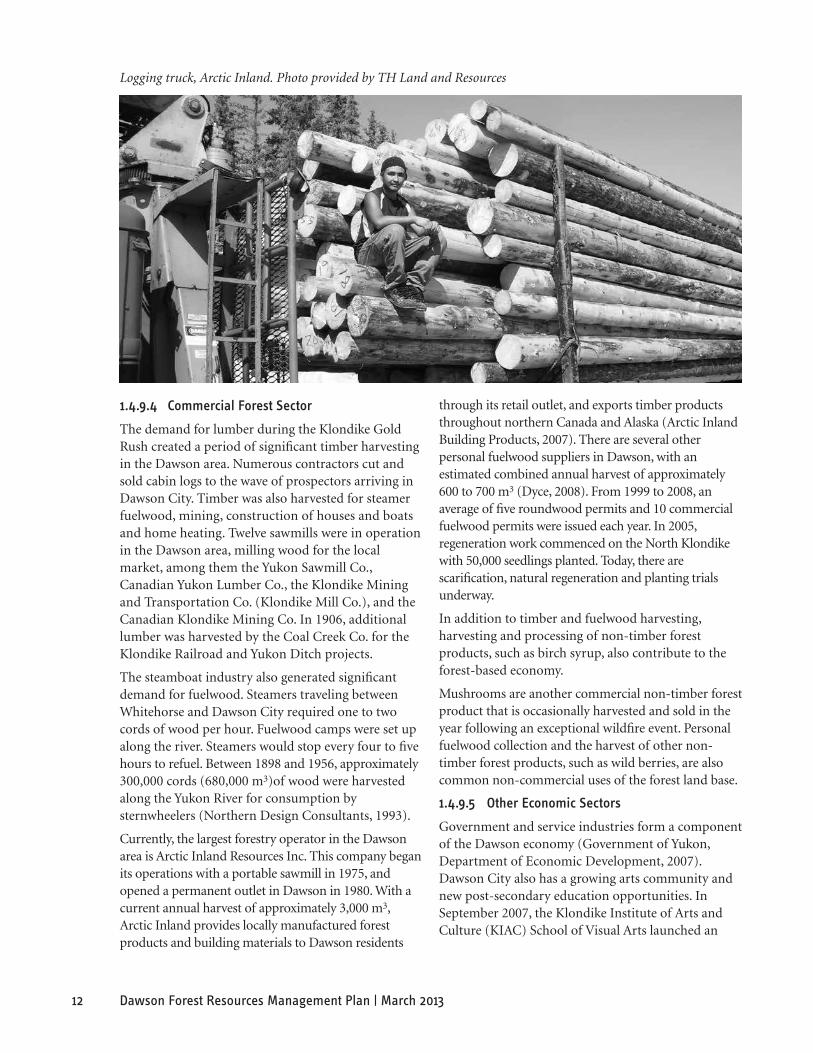
Logging truck, Arctic Inland. Photo provided by TH Land and Resources
1.4.9.4 Commercial Forest sector
The demand for lumber during the Klondike Gold Rush created a period of significant timber harvesting in the Dawson area. Numerous contractors cut and sold cabin logs to the wave of prospectors arriving in Dawson City. Timber was also harvested for steamer fuelwood, mining, construction of houses and boats and home heating. Twelve sawmills were in operation in the Dawson area, milling wood for the local market, among them the Yukon Sawmill Co., Canadian Yukon Lumber Co., the Klondike Mining and Transportation Co. (Klondike Mill Co.), and the Canadian Klondike Mining Co. In 1906, additional lumber was harvested by the Coal Creek Co. for the Klondike Railroad and Yukon Ditch projects.
The steamboat industry also generated significant demand for fuelwood. Steamers traveling between Whitehorse and Dawson City required one to two cords of wood per hour. Fuelwood camps were set up along the river. Steamers would stop every four to five hours to refuel. Between 1898 and 1956, approximately 300,000 cords (680,000 m3)of wood were harvested along the Yukon River for consumption by sternwheelers (Northern Design Consultants, 1993).
Currently, the largest forestry operator in the Dawson area is Arctic Inland Resources Inc. This company began its operations with a portable sawmill in 1975, and opened a permanent outlet in Dawson in 1980. With a current annual harvest of approximately 3,000 m3, Arctic Inland provides locally manufactured forest products and building materials to Dawson residents
through its retail outlet, and exports timber products throughout northern Canada and Alaska (Arctic Inland Building Products, 2007). There are several other personal fuelwood suppliers in Dawson, with an estimated combined annual harvest of approximately 600 to 700 m3 (Dyce, 2008). From 1999 to 2008, an average of five roundwood permits and 10 commercial fuelwood permits were issued each year. In 2005, regeneration work commenced on the North Klondike with 50,000 seedlings planted. Today, there are scarification, natural regeneration and planting trials underway.
In addition to timber and fuelwood harvesting, harvesting and processing of non-timber forest products, such as birch syrup, also contribute to the forest-based economy.
Mushrooms are another commercial non-timber forest product that is occasionally harvested and sold in the year following an exceptional wildfire event. Personal fuelwood collection and the harvest of other non-timber forest products, such as wild berries, are also common non-commercial uses of the forest land base.
1.4.9.5 other economic sectors
Government and service industries form a component of the Dawson economy (Government of Yukon, Department of Economic Development, 2007). Dawson City also has a growing arts community and new post-secondary education opportunities. In September 2007, the Klondike Institute of Arts and Culture (KIAC) School of Visual Arts launched an
13Dawson Forest Resources Management Plan | March 2013
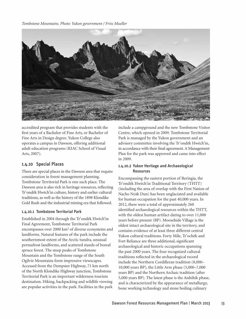
Tombstone Mountains. Photo: Yukon government / Fritz Mueller
accredited program that provides students with the first years of a Bachelor of Fine Arts, or Bachelor of Fine Arts in Design degree. Yukon College also operates a campus in Dawson, offering additional adult education programs (KIAC School of Visual Arts, 2007).
1.4.10 special Places
There are special places in the Dawson area that require consideration in forest management planning. Tombstone Territorial Park is one such place. The Dawson area is also rich in heritage resources, reflecting Tr’ondëk Hwëch’in culture, history and earlier cultural traditions, as well as the history of the 1898 Klondike Gold Rush and the industrial mining era that followed.
1.4.10.1 Tombstone Territorial Park
Established in 2004 through the Tr’ondëk Hwëch’in Final Agreement, Tombstone Territorial Park encompasses over 2000 km2 of diverse ecosystems and landforms. Natural features of the park include the southernmost extent of the Arctic tundra, unusual permafrost landforms, and scattered stands of boreal spruce forest. The steep peaks of Tombstone Mountain and the Tombstone range of the South Ogilvie Mountains form impressive viewscapes. Accessed from the Dempster Highway, 71 km north of the North Klondike Highway junction, Tombstone Territorial Park is an important wilderness tourism destination. Hiking, backpacking and wildlife viewing are popular activities in the park. Facilities in the park
include a campground and the new Tombstone Visitor Centre, which opened in 2009. Tombstone Territorial Park is managed by the Yukon government and an advisory committee involving the Tr’ondëk Hwëch’in, in accordance with their final agreement. A Management Plan for the park was approved and came into effect in 2009.
1.4.10.2 Yukon heritage and archaeological resources
Encompassing the eastern portion of Beringia, the Tr’ondëk Hwëch’in Traditional Territory (THTT) (including the area of overlap with the First Nation of Nacho Nyäk Dun) has been unglaciated and available for human occupation for the past 40,000 years. In 2012, there were a total of approximately 260 identified archaeological resources within the THTT, with the oldest human artifact dating to over 11,000 years before present (BP). Moosehide Village is the oldest intact archaeological site in the territory, and contains evidence of at least three different central Yukon cultural traditions. Forty Mile, Tr’ochëk and Fort Reliance are three additional, significant archaeological and historic occupations spanning the past 2000 years. The four recognized cultural traditions reflected in the archaeological record include the Northern Cordilleran tradition (8,000–10,000 years BP), the Little Arm phase (5,000–7,000 years BP) and the Northern Archaic tradition (after 5,000 years BP). The latest phase is the Aishihik phase, and is characterized by the appearance of metallurgy, bone working technology and stone boiling culinary
14 Dawson Forest Resources Management Plan | March 2013
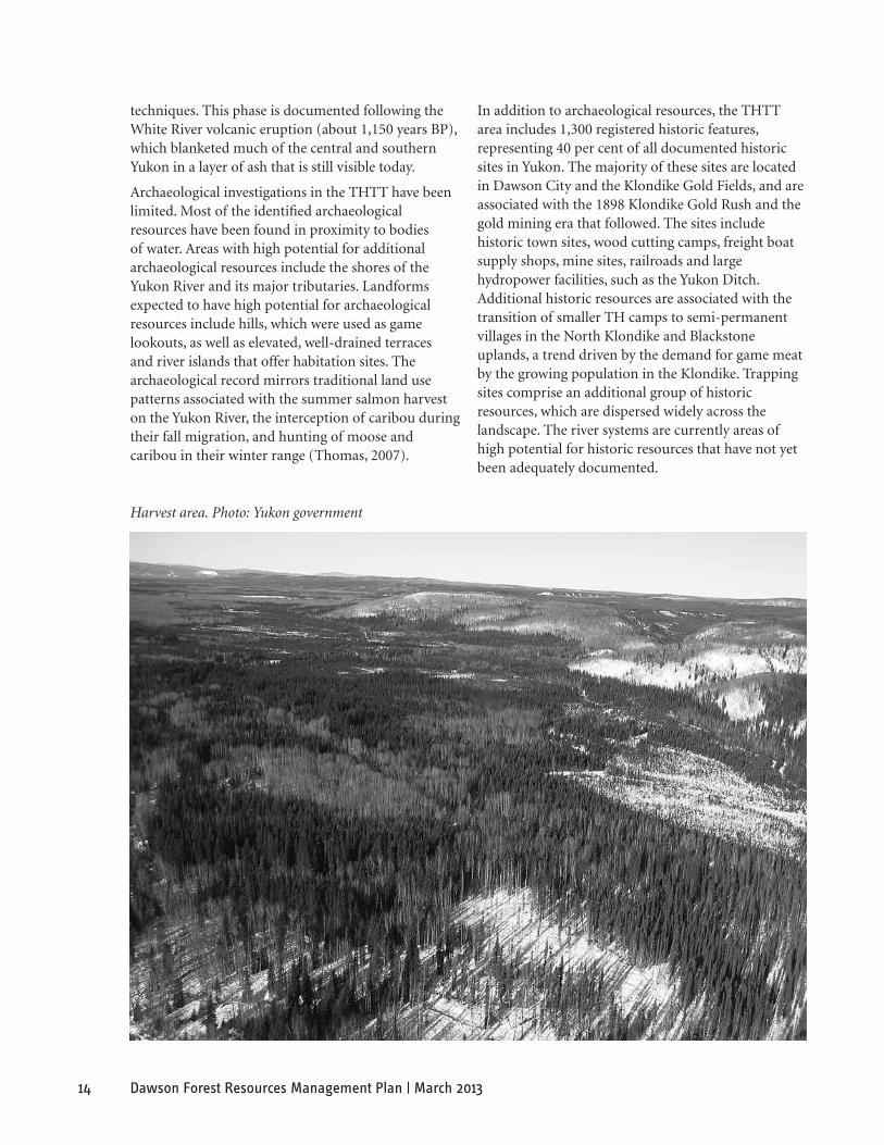
Harvest area. Photo: Yukon government
techniques. This phase is documented following the White River volcanic eruption (about 1,150 years BP), which blanketed much of the central and southern Yukon in a layer of ash that is still visible today.
Archaeological investigations in the THTT have been limited. Most of the identified archaeological resources have been found in proximity to bodies of water. Areas with high potential for additional archaeological resources include the shores of the Yukon River and its major tributaries. Landforms expected to have high potential for archaeological resources include hills, which were used as game lookouts, as well as elevated, well-drained terraces and river islands that offer habitation sites. The archaeological record mirrors traditional land use patterns associated with the summer salmon harvest on the Yukon River, the interception of caribou during their fall migration, and hunting of moose and caribou in their winter range (Thomas, 2007).
In addition to archaeological resources, the THTT area includes 1,300 registered historic features, representing 40 per cent of all documented historic sites in Yukon. The majority of these sites are located in Dawson City and the Klondike Gold Fields, and are associated with the 1898 Klondike Gold Rush and the gold mining era that followed. The sites include historic town sites, wood cutting camps, freight boat supply shops, mine sites, railroads and large hydropower facilities, such as the Yukon Ditch. Additional historic resources are associated with the transition of smaller TH camps to semi-permanent villages in the North Klondike and Blackstone uplands, a trend driven by the demand for game meat by the growing population in the Klondike. Trapping sites comprise an additional group of historic resources, which are dispersed widely across the landscape. The river systems are currently areas of high potential for historic resources that have not yet been adequately documented.

15Dawson Forest Resources Management Plan | March 2013
Harvest area, Dempster Highway. Photo: Yukon government
There are three basic questions to test the potential success of a forest management plan. The questions use the example of a three-legged stool: if one leg is missing, the stool falls over. The three questions are:
• Is the forest use ecologically sustainable?
• Are the range of forest uses and actions socially acceptable?
• Are the forest uses economically viable?
If the answer to all three questions is “yes”, the forest management plan meets the test of ecological, social and economic sustainability.
2. VIsIon foR foResT ManaGeMenT
2.1 VisioN
This plan recognizes and supports the following vision as a guide to forest management in the planning area.
Our vision is for a healthy forest that provides environmental, economic, social, and cultural benefits for present and future generations.
2.2 PriNCiPle sTaTemeNTs
The Dawson Forest Management Planning Team developed the following principles for the Dawson FRMP to encompass the dominant values and goals of the people of the area. These principles and Section 17.5.5 of the Tr’ondëk Hwëch’in Final Agreement are the foundation of the strategic directions of the plan.
Principles:
1. The FRMP will be developed based on principles of sustainable forest management.
2. The FRMP will contribute to the security, reliability and certainty needed to foster forest-based investment and development.
3. The FRMP will recognize and incorporate First Nation traditional knowledge and values with other baseline data sets in the planning process.
4. The FRMP will recognize, respect and incorporate the rights of all forest users.
5. The FRMP will be developed with the best available scientific, local and traditional knowledge, and lessons from past practices, both in the planning area and elsewhere.

16 Dawson Forest Resources Management Plan | March 2013
In the spring of 2003, the Yukon government began the preparation of a forest policy framework to guide the development of the Yukon’s first comprehensive forest legislation. In the fall of 2008, the Yukon government passed the Forest Resources Act. The Forest Resources Regulation was approved by the Yukon government September 2010 and the Forest Resources Act came into force January 31, 2011.
3. foResT PlannInG PRoCess
3.1 legislaTiVe CoNTexT
The Tr’ondëk Hwëch’in Final Agreement, in addition to establishing the basis for forest management planning in the area, establishes the rights and lands retained by TH citizens throughout the traditional territory. Signed July 16th, 1998, the authority and responsibility for forest planning and management on settlement lands, including the approval of forest management plans, rests with the First Nation (pursuant to Section 17.5.2 of the Tr’ondëk Hwëch’in Final Agreement). The Tr’ondëk Hwëch’in and Nacho Nyäk Dun (NND) Final Agreements establish the basis for consultation regarding forest management planning in traditional territory overlap areas. The authority and responsibility for forest planning and management on public lands rests with the Forest Management Branch of the Yukon government (pursuant to Section 17.5.1 of the Tr’ondëk Hwëch’in Final Agreement, the Devolution Transfer Agreement and the Territorial [Yukon] Lands Act). Under the Tr’ondëk Hwëch’in Final Agreement (Section 17.4.0), the Dawson District Renewable Resources Council (DDRRC) is also assigned responsibilities for forest resources management in the traditional territory.
Key legislation, regulations and policies affecting forest management and planning in the Dawson forest planning area include:
• Territorial Lands (Yukon) Act
• Yukon Area Development Act and Dempster Highway Development Area Regulation and the Klondike Valley Area Development Regulation
• Yukon Forest Resources Act
• Yukon Wildlife Act and Regulations
• Federal Fisheries Act
• Yukon Environment Act
• Yukon Historic Resources Act
• Yukon Highways Act
• Yukon Salmon Sub-Committee recommendations, guidelines and regulations
• Federal Yukon Environmental and Socio-economic Assessment Act (YESAA)
• Species at Risk Act (Federal)
• Yukon Forest Protection Act
• Tr’ondëk Hwëch’in Land and Resources Act
• Tr’ondëk Hwëch’in Fish and Wildlife Act
• Other Tr’ondëk Hwëch’in, Yukon or federal legislation as appropriate
• Migratory Birds Convention Act (MBCA)

17Dawson Forest Resources Management Plan | March 2013
Harvesting locations, South Klondike. Photo: Yukon government
3.2 exisTiNg PlaNs
3.2.1 official Community Plans
There are two community plans which provide guidance to forest resource management within the TH Traditional Territory:
• West Dawson and Sunnydale Local Area Plan (in progress)
• Dawson City Official Community Plan
3.2.2 Timber harvest Plans
Historic forest harvesting areas which have been planned are covered under:
• South Klondike Resources Report
• 10 Mile Timber Harvest Plan
• North Fork Timber Harvest Plan
• Flat Creek Timber Harvest Plan
• Dome Road Timber Harvest Plan
• Dempster Highway Timber Harvest Plan
• Five Mile Dempster Highway Timber Harvest Plan
• Bruin Creek Timber Harvest Plan
• Clear Creek Timber Harvest Plan
To view current list of approved THPs visit: www.emr.gov.yk.ca/forestry/204.html
3.2.3 other Plans
• Klondike Valley District Land Use Plan
• Recommendations regarding habitat protection measures for the Forty Mile caribou herd
• Planning and Regional Tourism Plan for Dawson
• Dawson Regional Economic Development Plan (in progress)
3.3 PlaNNiNg FrameWork
The recently developed Forest Resources Act identifies a hierarchy of forest management planning for Yukon public lands. This hierarchy consists of three main levels:
1. Forest Resources Management Plan (FRMP): A FRMP is a strategic, overarching, landscape level plan intended to provide broad direction on where and why forest resource management activities should be undertaken. The purpose of an FRMP is to identify forest resource values and sensitive areas, to identify management of forest resource zones, and to establish management intent. FRMP extend over large land bases, often greater than 1,000,000 ha in size.
2. Timber Harvest Plan (THP): A timber harvest plan is a development plan that identifies areas proposed for harvesting of forest resources. It also identifies strategies for reducing or eliminating environmental consequences and impacts on other resources identified in the FRMP. Timber harvest plans can extend over landscape units, or watersheds, ranging from 5000 ha to 300,000 ha in size.
3. Site Plan: A site plan is a site specific management plan. It identifies the specific area and attributes of the area proposed for harvesting, as well as the stand level management activities, methods and standards for harvesting to ensure the protection of the forest resource values on that harvest area. A site plan can also include a reforestation plan with proposed silviculture activities. A site plan extends over one to 500 ha in size.
A woodlot plan is similar to a THP; however, it is designed for a woodlot license area and may have an annual allowable cut specific to the woodlot license.

18 Dawson Forest Resources Management Plan | March 2013
January 2004 In the absence of any regional forestry planning, a wood supply planning team was assembled to identify wood supply areas for the vicinity of Dawson.
June to october 2005
Wood supply planning team identified the need for regional Forest Resources Management Plan.
January 2006 Tr’ondëk Hwëch’in and Yukon government started discussions on a MOU to establish a regional forestry planning team.
May 2006 MOU signed and planning team established. Planning team began work on the plan.
May 2006 to present
Planning team meetings held in Dawson, hosted by DDRRC.
March 2009 Public open house held in Dawson.
May to september 2010
Draft Plan presented to public for review.
september 2010 to fall 2012
Plan revised based on feedback from public.
fall 2012 2012 Plan recommended to the governments for approval.
fall 2012 Public review of recommended Plan.
Winter 2012 Yukon government and Tr’ondëk Hwëch’in approval process.
2013 Start of implementation.
3.4 PlaNNiNg ProCess
3.4.1 Chronology of key steps
3.4.2 Participation in Forest resources management Planning
3.4.2.1 Planning Team
The Dawson Forest Management Planning Team took the lead coordinating role in the development of the FRMP (MOU Respecting the Development of a Community-Based Strategic Forest Management Plan, May 1, 2006). The planning team was made up of representatives of the Dawson District Renewable Resources Council, the Yukon government Department of Energy, Mines and Resources, the Tr’ondëk Hwëch’in, and the local forest industry. These representatives coordinated the participation of their respective agencies in the development of the plan.
3.4.2.2 Community Participation
The planning team facilitated public participation in the planning process by hosting an open house, developing information materials, and providing formal opportunities for public consultation on the draft forest management plan.
3.4.2.3 approval Bodies
The approval bodies for the FRMP are the Yukon and TH governments. The Yukon government is responsible for approval and implementation of the FRMP on public lands, while the TH is responsible for approval and implementation of the plan on settlement lands (Chapter 17.5 of the Tr’ondëk Hwëch’in Final Agreement).
3.4.2.4 overlapping Traditional Territories
A portion of the Dawson forest planning area overlaps with the First Nation of Nacho Nyäk Dun Traditional Territory (NNDTT). NND participation in the development of the FRMP was completed in accordance with the “Sharing Accord” signed July 26, 2006 between NND and TH First Nations. The Accord sets management responsibilities and identifies a contiguous boundary between the First Nations.
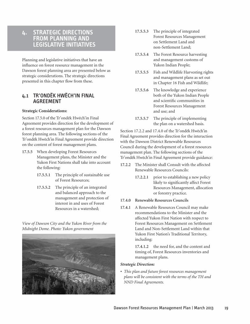
19Dawson Forest Resources Management Plan | March 2013
View of Dawson City and the Yukon River from the Midnight Dome. Photo: Yukon government
4. sTRaTeGIC DIReCTIons fRoM PlannInG anD leGIslaTIVe InITIaTIVes
Planning and legislative initiatives that have an influence on forest resource management in the Dawson forest planning area are presented below as strategic considerations. The strategic directions presented in this chapter flow from these.
4.1 Tr’oNdëk hWëCh’iN FiNal agreemeNT
Strategic Considerations:
Section 17.5.0 of the Tr’ondëk Hwëch’in Final Agreement provides direction for the development of a forest resources management plan for the Dawson forest planning area. The following sections of the Tr’ondëk Hwëch’in Final Agreement provide direction on the content of forest management plans.
17.5.5 When developing Forest Resources Management plans, the Minister and the Yukon First Nations shall take into account the following:
17.5.5.1 The principle of sustainable use of Forest Resources;
17.5.5.2 The principle of an integrated and balanced approach to the management and protection of interest in and uses of Forest Resources in a watershed;
17.5.5.3 The principle of integrated Forest Resources Management on Settlement Land and non-Settlement Land;
17.5.5.4 The Forest Resource harvesting and management customs of Yukon Indian People;
17.5.5.5 Fish and Wildlife Harvesting rights and management plans as set out in Chapter 16 Fish and Wildlife;
17.5.5.6 The knowledge and experience both of the Yukon Indian People and scientific communities in Forest Resources Management and use; and
17.5.5.7 The principle of implementing the plan on a watershed basis.
Section 17.2.2 and 17.4.0 of the Tr’ondëk Hwëch’in Final Agreement provides direction for the interaction with the Dawson District Renewable Resources Council during the development of a forest resources management plan. The following sections of the Tr’ondëk Hwëch’in Final Agreement provide guidance:
17.2.2 The Minister shall Consult with the affected Renewable Resources Councils:
17.2.2.1 prior to establishing a new policy likely to significantly affect Forest Resources Management, allocation or forestry practice.
17.4.0 Renewable Resources Councils
17.4.1 A Renewable Resources Council may make recommendations to the Minister and the affected Yukon First Nation with respect to Forest Resources Management on Settlement Land and Non-Settlement Land within that Yukon First Nation’s Traditional Territory, including:
17.4.1.2 the need for, and the content and timing of, Forest Resources inventories and management plans.
Strategic Direction:
• This plan and future forest resources management plans will be consistent with the terms of the TH and NND Final Agreements.

20 Dawson Forest Resources Management Plan | March 2013
4.2 Tr’oNdëk hWëCh’iN laNd aNd resourCes aCT
Strategic Considerations:
The Tr’ondëk Hwëch’in Land and Resources Act governs land and resource use on TH settlement lands. The intent of the Act is to provide for the sustainable use of the land, to promote a healthy lifestyle for citizens, and to preserve the peaceful enjoyment of the land for citizens. The Act enables the Tr’ondëk Hwëch’in Council to designate land and resource management areas, and requires a land or resource management plan to be developed to direct use of such areas. The Act also permits TH members to continue traditional uses of the land, including personal fuelwood harvesting, gathering flora and fungi for food or medicine, and spiritual or ceremonial activities. Harmful alteration of the land, such as disturbance of burial sites and release of damaging chemicals, is also prohibited. Finally, the Act establishes a process by which Council can receive, and approve or deny, applications for land use and resource development.
Strategic Directions:
• Forest management on settlement lands will be carried out in a manner that is consistent with the Tr’ondëk Hwëch’in Land and Resources Act.
• Forest management shall respect the provisions of the Tr’ondëk Hwëch’in Land and Resources Act for traditional use of settlement lands.
• Forest management planning shall aim to enhance the objectives of the Tr’ondëk Hwëch’in Land and Resources Act on settlement lands.
4.3 heriTage aNd arChaeologiCal resourCes
Strategic Considerations:
The Dawson forest planning area contains many of the Yukon’s heritage sites and resources. There are numerous historic features and values associated with the Klondike Gold Rush and industrial mining activity in the Klondike and Yukon River valleys. The Dawson area is also rich in historic and archaeological resources reflecting Tr’ondëk Hwëch’in culture and older archaeological cultures. There are numerous
traditional use sites in the Dawson forest planning area that must also be managed and protected. The Tr’ondëk Hwëch’in Final Agreement provides for Tr’ondëk Hwëch’in ownership and management of moveable heritage resources directly related to TH culture within the TH Traditional Territory, and outlines joint management planning for specific historic sites and routes. Management of all other historic resources is the responsibility of the Yukon government under the Yukon Historic Resources Act.
Strategic Direction:
• Adhere to the provisions of the Tr’ondëk Hwëch’in Final Agreement and the Yukon Historic Resources Act in this plan and future forest resources management plans with respect to management of heritage resources including archaeological and historic sites.
4.4 laNd use PlaNNiNg
4.4.1 dawson region
Strategic Considerations:
Under Chapter 11 of the Tr’ondëk Hwëch’in Final Agreement, the First Nation, federal and Yukon governments agreed to creating a Regional Land Use Plan for the Dawson Planning Region. Chapter 11 of the Tr’ondëk Hwëch’in Final Agreement speaks to the development of a regional land use plan:
Any regional land use planning process in Yukon shall be linked to all other land and water planning and management process established by Governments minimizing where practical any overlap or redundancy between the land use planning process and those other planning processes (Tr’ondëk Hwëch’in Final Agreement, Section 11.2.1.2).
Strategic Direction:
• The principles, goals, objectives and directions of the FRMP shall provide the basic guidance for forest management and forest resources development in the region. The FRMP, as per 17.6.1 of the Tr’ondëk Hwëch’in Final Agreement, may require amendment in order to be consistent with the approved Dawson Region Land Use Plan.

21Dawson Forest Resources Management Plan | March 2013
Log heating by Arctic Inland. Photo: Arctic Inland
4.4.2 Peel Watershed land use Plan
Strategic Considerations:
Under the mandate of Chapter 11 of the FNNND Final Agreement the Peel Watershed Planning Commission (PWPC) is responsible for developing and recommending a regional land use plan for the Peel Watershed Planning Region. The Ogilvie, Blackstone and Hart River portions of the FRMP overlap with the Peel Watershed Planning Region. Once the Peel Watershed Regional Land Use Plan is approved, the forest resources management plan may need to be amended to minimize overlap or redundancy, and ensure compatibility.
Strategic Direction:
• The principles, goals, objectives and directions of the FRMP shall provide the basic guidance for forest management and forest resources development within areas of compatible use consistent with the approved Peel Watershed Regional Land Use Plan. The FRMP, as per 17.6.1 of the FNNND Final Agreement, may require amendment in order to be consistent with the approved Peel Watershed Land Use Plan.
4.5 TomBsToNe TerriTorial Park
Strategic Considerations:
Clause 10.3.2.1 of the Tr’ondëk Hwëch’in Final Agreement establishes Tombstone Territorial Park as a Special Management Area. Schedule A of Chapter 10 of the Tr’ondëk Hwëch’in Final Agreement provides in Section 9.0, Forest Resources, that the right of the Tr’ondëk Hwëch’in and Tr’ondëk Huch’in to harvest forest resources in the Park pursuant to Chapter 17 – Forest Resources shall be subject to the provisions of the Management Plan.
Strategic Directions:
• Forest resource harvesting in the Tombstone Territorial Park will be consistent with the Tombstone Management Plan.
22 Dawson Forest Resources Management Plan | March 2013
4.6 PrioriTies oF The YukoN goVerNmeNT iN regards To ForesT maNagemeNT
Strategic Considerations:
Responsibility for management of natural resources was devolved to the Yukon government, Department of Energy, Mines and Resources (EMR) on April 1, 2003. A number of the department’s initiatives provide guidance to forest management and are designed to contribute to a better quality of life for Yukon residents through:
• responsible management of Yukon’s natural resources;
• promoting investment in, and responsible development of, natural resources; and
• providing strategic leadership on natural resource policy and planning to benefit Yukoners.
The Forest Management Branch of EMR is the regulatory agency responsible for management of forest resources on public land.
Strategic Direction:
• Secure a forest land base, to be managed in a responsible manner, from which the Yukon public can expect a sustainable supply of wood, in order to foster development of a local forest-based economy that will return positive benefits to the people of Dawson and Yukon.
4.7 YukoN salmoN suB-CommiTTee
Strategic Considerations:
The Yukon Salmon Sub-Committee (YSSC) is a public advisory body that is established under Chapter 16 of the Umbrella Final Agreement. The YSSC works towards the preservation and enhancement of the Yukon’s salmon stocks. The YSSC is responsible for making recommendations to the Minister of Fisheries and Oceans and to Yukon First Nations on all matters that are related to salmon in Yukon.
The main goal of the YSSC is to preserve salmon stocks in Yukon and; therefore, maintain the role of salmon within the Yukon’s ecosystems, economies and lifestyles. Specific principles and regulations have been identified to help ensure the conservation of salmon stocks in Yukon.
Strategic Direction:
• The regulations established to ensure the conservation of salmon stocks will be respected.
4.8 sPeCies aT risk, oF sPeCial CoNCerN aNd lisTed uNder The YukoN WildliFe aCT
Strategic Considerations:
A number of species found in the Dawson area are either listed under the federal Species at Risk Act (SARA), designated by the Committee on the Status of Endangered Wildlife in Canada (COSEWIC) as a species at risk of extinction or extirpation, or are protected by the Yukon Wildlife Act (Table 2.). Little is known about the interaction of these species and forest management activities in the Dawson area. In southern jurisdictions direct and indirect impacts of forest harvesting have been shown to include disturbance, habitat loss, and increased access for predators and hunters.
• Peregrine falcon and trumpeter swans have shown sensitivity to human disturbance during breeding that may result in abandonment of nesting areas. Trumpter swans breed in the Dawson area and throughout Yukon.
• The olive-sided flycatcher requires uneven canopy or forest openings for foraging and singing, and nests within the mid-story woodland canopy.
• The rusty blackbird is a riparian species, nesting in boreal forests dominated by conifer forest edges adjacent to lakes and bogs. It rarely enters the forest interior. This species is of significant conservation concern because 70 per cent of the world-wide breeding population exists within Canada.
• Wolverine and grizzly bear populations are healthy in the planning area. However they are sensitive to roads associated with forest harvesting that increase hunting, trapping and vehicular collisions.
• Woodland caribou within the Dawson forest planning area inhabit boreal forest and open mountain habitats. Although these populations are falling globally, locally these herds are characterized as healthy and their range is quite remote. There is little likelihood of significant forest harvesting occurring within their key habitats.

23Dawson Forest Resources Management Plan | March 2013
species CoseWIC status saRa status saRaschedule Yukon Wildlife act status
Barn Swallow Threatened No status n/a No status
Bering Cisco Special Concern No status n/a No status
Collared Pika Special Concern No status n/a No status
Common Nighthawk Threatened Threatened Schedule 1 No status
Grizzly Bear, NW population
Special Concern No status n/a No status
Horned Grebe Special Concern No status n/a No status
Olive-sided Flycatcher Threatened Threatened Schedule 1 No status
Peregrine Falcon anatum/tundrius
Special Concern Special Concern Schedule 1 No status
Gyrfalcon Not at Risk No Status n/a Specially protected
Rusty Blackbird Special Concern Special Concern Schedule 1 No status
Short-eared Owl Special Concern Special Concern Schedule 1 No status
Wolverine, western population
Special Concern No status n/a No status
Woodland Caribou, Northern Mountain population
Special Concern Special Concern Schedule 1 No status
Trumpeter Swan Not at Risk Not at Risk n/a Specially protected
Cougar Not at Risk Not at Risk n/a Specially protected
Note: For up-to-date listing of COSEWIC and SARA status please visit the Species at Risk Public Registry at www.sararegistry.gc.ca
Table 2. Wildlife in the Dawson Forest Management Planning Area identified by COSEWIC, the Species at Risk Act (SARA), and/or the Yukon Wildlife Act as of December 2012
• The common nighthawk and short-eared owl are not directly impacted by forestry activities. The short-eared owl requires broad expanses of open land with low vegetation for nesting and avoids closed canopy forests. The common nighthawk breeds in open habitats with little vegetation.
• Several unique Beringian relic species occur in the planning area, many of these are not found in forested habitats; including Ogilvie Mountain collared lemming and Yukon podistera (Podistera yukonensis). Spiked saxifrage (saxifrage spicata) occurs along, small sheltered creeks.
Strategic Directions:
• Forest management planning shall review recovery and action plans for SARA listed species and COSEWIC status reports for guidance on forest management in the Dawson forest planning area.
• Forest Management planning shall review the Yukon Wildlife Act for guidance and management of species with Specially Protected Status in the Dawson forest planning area.
• Forest Management planning shall review the latest information available from the Yukon conservation Data Center for guidance and management of relic species in the Dawson forest planning area.
24 Dawson Forest Resources Management Plan | March 2013
5. sTRaTeGIC DIReCTIons fRoM KeY IssUes
The planning team members identified the following as key issues that have an influence on forest resource management in the Dawson forest planning area. These issues are presented below as Strategic Considerations. The Strategic Directions presented in this chapter flow from these.
5.1 diVersiFY loCal eCoNomY
Forestry can continue to provide additional diversity to the economy of Dawson. A more diverse economy helps provide a wider safety net if downturns occur in the mining and tourism sectors. The forest management plan helps establish an investment climate through sustainable development of forest resources.
5.1.1 Forest sector development
Strategic Considerations:
Establishing a sustainable forest-based economy is a strategic component of regional economic stability. Investment in the forest sector is likely to occur if several factors are considered, including the identification of a forest land base, community support and long-term access to forest resources.
Strategic Directions:
• Establish a forest land base which will contribute certainty for investment in the forest sector.
• Support stable and secure access to forest resources as a foundation to a healthy forest industry.
• Support diversity as a community economic development strategy.
• Support tenure allocation procedures that provide opportunity for a variety of industry applications.
5.1.1.1 salvage of Burns, insect infestation or disease
Strategic Considerations:
Wildfire, insect infestation and disease occur relatively often within the planning area. After a disturbance, timber begins to dry out rapidly which causes checking and reduces the value for sawlogs. After a short period of time the timber primarily becomes a fuelwood resource.
Of greater concern for operators is worker safety. When forest stands burn, tree and snags can become very unstable causing blow down. The blow down and unstable trees can make salvaging stands dangerous for loggers to work. This process is very unpredictable and usually occurs within two years following the burn. Therefore, it is important that saw timber is salvaged immediately following disturbance before the stand deteriorates and safety issues arise.
A FireSmart Five-Year Plan for the Dawson Area was developed in 2004, for the period 2005–2010, there are remaining projects under this plan. Activities undertaken within these remaining projects areas should be consistent with the mitigative measures set out in the plan.
Strategic Directions:
• When interest exists, give planning priority to the salvage of saw timber within the remaining projects under the FireSmart Five-Year Plan and after burns, insect infestation and disease. Assessment and planning for the areas, if determined to be salvageable, should occur within 30 days of the assessment, followed by expression of interest for operators.
• Give planning priority and action to the sanitation harvesting of insect infestations or diseased areas to prevent detrimental impacts to forests resources.
5.1.1.2 harvest and management of riparian areas
Strategic Considerations:
The planning area has a number of major rivers with many tributaries and associated wetlands that provide habitat for fish and wildlife. These waterways, wet-lands and adjacent riparian areas are important in cycling nutrients, providing habitat for a diversity of plant and animal species, and acting as movement corridors for wildlife.
Additionally, considerable forest resources exist within and adjacent to riparian areas. Harvest management of these areas is necessary so they remain productive. Riparian areas are very productive and contain some of the best soils and forest growth in the area. When forest harvesting is done correctly these sites can be resilient to environmental damage. Riparian manage-ment zones require management so that the economic benefits of the riparian forest can be utilized and impact to other riparian resources minimized.
25Dawson Forest Resources Management Plan | March 2013
Strategic Directions:
• Utilize stream, lake and wetland riparian buffers guidelines and manage buffer harvesting adaptively.
• Further investigate riparian harvesting buffers and practices so that knowledge and forest practices can be developed that utilize the riparian resource without compromising other riparian area functions.
5.1.1.3 local Fuelwood market
Strategic Considerations:
Long winters in Dawson make heating homes expensive. Using fuelwood offsets this cost and offers attractive radiant heat. Each winter, around 3500 m3 or 1600 cords of fuelwood are used locally. Fuelwood is harvested by several commercial operators as well as residents for personal use. The major sources of fuelwood are dry wood from recent forest fires or from white birch stands surrounding Dawson. Harvesting of fuelwood by residents occurs during fall and winter and requires a permit. In addition, the Yukon Forest Resources Act requires commercial fuelwood operators to harvest under approved Timber Harvest Plans. It is important that opportunities to harvest fuelwood are maintained surrounding Dawson to meet local markets.
Strategic Directions:
• Develop plans for accessible burns for fuelwood opportunities for both commercial and personal use fuelwood harvesters. Over time, develop fuelwood harvesting opportunities within Flat Creek, Dempster Highway and North Fork Road burns.
• Develop and maintain white birch harvesting areas surrounding Dawson. Key areas for potential white birch harvesting are Hunker Creek, Bonanza Creek and the Top of the World Highway.
• Manage the volume of birch harvested so that over harvesting does not occur and opportunities remain for traditional uses of birch stands.
5.1.1.4 green energy
Strategic Considerations:
Energy from forest-based wood fibre can reduce the costs and impacts associated with burning of fossil fuels in northern communities. There is a wood supply that can be sustainably harvested and there are existing commercial applications to support a local green energy market in Dawson. For example, solid
wood boilers offset heating costs for some businesses in Dawson. The use of chips, sawdust and shavings as feed stock for central heating could be another application. This will help create a more diversified forest sector.
Strategic Directions:
• Support the development of a green energy industry and tenure opportunities for the local forest industry that utilize wood fibre and reduces community dependence on burning fossil fuels where economically viable.
5.1.2 education and Training
Strategic Considerations:
Local employment, education and training opportunities are important to support the ability of Dawson area residents, including Tr’ondëk Hwëch’in citizens, to exercise their rights to use the forest land base. There is an opportunity for the TH to participate in the First Nations Forestry Program (FNFP) coordinated through Natural Resources Canada. The FNFP offers funding for projects that build the capacity of First Nations to sustainably manage forest resources and benefit from forest-based development opportunities. Developing educational and training opportunities, through the FNFP and other programs, can build capacity for all Dawson area residents to participate in the forest sector.
Strategic Directions:
• Support the development of local training and education opportunities for Dawson area residents, including the Tr’ondëk Hwëch’in, through programs such as the First Nations Forestry Program.
5.2 BiodiVersiTY
Strategic Considerations:
Coarse filter management of biodiversity assumes that management of many forest species can be addressed through landscape level biodiversity strategies. Such strategies include managing forest harvesting activity to reflect the natural disturbance pattern and seral stage distribution in which indigenous species have persisted. This approach requires attention to the timing and distribution of harvest, landscape connectivity and riparian management. The following sections draw on the Dease-Liard Sustainable Resource Management Plan (Government of British
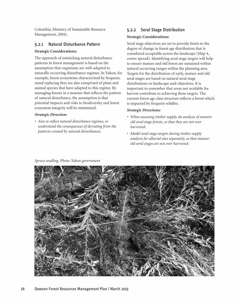
26 Dawson Forest Resources Management Plan | March 2013
Spruce seedling. Photo: Yukon government
Columbia, Ministry of Sustainable Resource Management, 2004).
5.2.1 Natural disturbance Pattern
Strategic Considerations:
The approach of mimicking natural disturbance patterns in forest management is based on the assumption that organisms are well-adapted to naturally occurring disturbance regimes. In Yukon, for example, forest ecosystems characterized by frequent, stand replacing fires are also comprised of plant and animal species that have adapted to this regime. By managing forests in a manner that reflects the pattern of natural disturbance, the assumption is that potential impacts and risks to biodiversity and forest ecosystem integrity will be minimized.
Strategic Direction:
• Aim to reflect natural disturbance regimes, or understand the consequences of deviating from the patterns created by natural disturbances.
5.2.2 seral stage distribution
Strategic Considerations:
Seral stage objectives are set to provide limits to the degree of change in forest age distribution that is considered acceptable across the landscape (Map 4, centre spread). Identifying seral stage targets will help to ensure mature and old forest are sustained within natural occurring ranges within the planning area. Targets for the distribution of early, mature and old seral stages are based on natural seral stage distributions or landscape unit objectives. It is important to remember that areas not available for harvest contribute to achieving these targets. The current forest age class structure reflects a forest which is impacted by frequent wildfire.
Strategic Directions:
• When assessing timber supply, do analysis of mature-old seral stage forests, so that they are not over harvested.
• Model seral stage targets during timber supply analysis for alluvial sites separately, so that mature-old seral stages are not over harvested.
27Dawson Forest Resources Management Plan | March 2013
5.2.3 Timing and distribution of harvesting
Strategic Considerations:
The forested landscape in the planning area is characterized by relatively frequent, high intensity stand replacing fires. This type of disturbance creates large contiguous stands where interior forest conditions occur. Other disturbance agents, such as windthrow, flooding, insect outbreaks, disease and lower intensity fires, can also create forest openings of varied sizes. Replicating large disturbances may reduce fragmentation, land use conflict, access issues, and minimize the need to enter other landscape units. Utilizing a variety of harvest patch sizes reflects the varied scale of natural disturbances in the boreal forest.
Strategic Directions:
• Utilize a variety of opening sizes consistent with the disturbance history.
• Consider concentrating logging in some areas, and leaving other areas undeveloped, as well as utilize existing access in order to reduce land use conflict caused by road access and human caused disturbance.
5.2.4 landscape Connectivity
Strategic Considerations:
Landscape connectivity refers to the ability of a landscape to facilitate or impede the movement of species. Landscape connectivity has been defined as
“ the degree to which the structure of a landscape helps or hinders the movement of wildlife species. A landscape is well connected when an organism (or natural process) can readily move among habitat patches” (Connectivity Planning Sub-Group, 2007).
Forest species have varied habitat requirements across the landscape and differing abilities to adapt to human and natural disturbances. Some species require continuous forest for movement, while others travel through large openings created by disturbance more easily. Natural landscapes are comprised of a mosaic of features, such as burned areas, mountains and lowlands, waterways, and riparian features. Seasonally, riparian areas often provide valuable landscape and site level corridors for wildlife movement for certain times of the year.
Strategic Direction:
• Utilize riparian areas, landscape features and natural disturbance patterns to manage connectivity across the landscape.
5.2.5 Climate Change
Strategic Considerations:
Climate change impacts on Yukon forests are expected to be complex and may have substantial impacts on forests across Yukon, including forests in the Dawson planning area. These anticipated changes include a shift in forest types northward 300 to 500 km and potentially increased spread of non-native and invasive species. Melting permafrost, glacial melting, increased forest fire frequency and increased spread of insect pests and diseases will also likely affect the natural disturbance regime and forest regeneration. Climate change will also affect how trees grow, which in turn will affect forest productivity, health and resilience to pests and disease.
Responding to climate change will require an adaptive management approach whereby forest management practices are modified to reflect geographic shifts in forest types and species. The way forests respond to climate change will depend on many things like tree species, changing temperature and precipitation, natural disturbance occurrences and the availability of nutrients. Monitoring and research will increase our understanding of forest response to climate change.
Forestry related climate change research is being conducted in Yukon, including in the Dawson planning area. An example of climate change research includes a study that was conducted by University of Northern British Columbia studying the nutrient profiles of trees and sites in various locations in Yukon which gives insight to the current health conditions of the trees. The results of this showed that many nutrients like calcium and nitrogen, commonly found in trees, were deficient and that nutrient levels could possibly dominate the growth constraints if other conditions such as temperature and precipitation were optimal. Continued studies will help increase our understanding of tree species vulnerabilities to climate change and continued research and monitoring will give forest managers a better understanding of the impacts of climate change and how forests are adapting.
Strategic Direction:
• Implement an adaptive management approach, whereby forest management and regeneration practices are modified in response to new information.

28 Dawson Forest Resources Management Plan | March 2013
Silviculture mounding project. Photo: Yukon government
5.2.6 Forest management and Carbon sequestration
Strategic Considerations:
The global boreal forest is one of the world’s largest terrestrial storehouses of carbon, storing hundreds of billions of tons of carbon in its forest, wetlands, and peat lands. The boreal continues to sequester carbon dioxide and mitigate against climate change, as well as sustain viable economies through sustainable harvesting of timber and non-timber forest resources. Most of the forest within the Dawson planning area will remain untouched by human impacts and be inaccessible. Of the mapped forest within the area over 800,000 ha (or 8,000 km2) is located within the hinterland zones. This forest will continue to provide mitigation against climate change, but also help achieve other FRMP goals such as conservation of biological diversity and maintenance of forest ecosystem health and productivity.
Further, the market for carbon trading and its relationship with forest management activities is in its infancy. However, it is commonly acknowledged that incremental forest management practice can play an important role in mitigating the impacts of climate change and that carbon management is moving rapidly from concept to practice in virtually all industrial sectors. New opportunities are emerging
where managed forests can participate in a carbon market. The current federal government’s plan proposes to create a national offset system that would allow large emitters to meet their emission targets by purchasing carbon offsets. Managed forests would be able to participate in the carbon market by either 1) reducing greenhouse gas emissions by offsetting the use of fossil fuels with biofuels; or 2) by increasing carbon sequestration through afforestation/ reforestation activities (which are now applicable under the Alberta GHG system and the California Climate Action Registry).
The Canadian Council of Forest Ministers is also working to develop a national forest management carbon framework. Through this framework, other forest management activities (in addition to those mentioned above) that create an incremental increase in carbon sequestration above a set baseline would be eligible as offset projects. This may include 1) activities that increase removals (fertilization, brush and weed control, site rehabilitation or conversion faster growing species, etc.); 2) activities that reduce emissions (reducing site degradation, thinning, etc.); and 3) activities that reduce the risk of emissions (increased pest infestation and fire control, etc.). At this time, it is difficult to determine what opportunities forests within the Dawson FRMP present for participating in the carbon market.
Strategic Directions:
• Assess carbon market risks and opportunities for forest management activities, fuelwood and biomass heating production in Dawson.
• Assess the feasibility of carrying out an operational scale forest carbon budget pilot project using the Canadian Forest Service’s carbon budget model and the national forest carbon management offset quantification protocol.
• Obtain a forest carbon budget for the Dawson Forest Planning area.
• Assess the feasibility of carrying out a project according to the proposed national forest management carbon quantification framework.
• Assess the feasibility and desirability of setting and maintaining a base carbon sequestration level for the entire Dawson forest planning area as a whole.
29Dawson Forest Resources Management Plan | March 2013
5.2.7 soil and Permafrost Conditions
Strategic Considerations:
Soil and permafrost conditions in the Dawson forest planning area pose unique challenges with respect to forest regeneration. In areas of continuous and discontinuous permafrost, soil conditions are generally cold and wet. Natural regeneration of harvested areas is challenging in these conditions, particularly on sites where seedling germination is impeded by thick moss and organic layers.
Strategic Directions:
• Implement regeneration strategies unique to the Dawson forest planning area when conditions of cold soil, thick moss and organic layers are found. In some situations, scarification of the deep moss layers may be necessary to facilitate natural regeneration.
• Locate access away from permafrost areas.
5.2.8 Fire management
Strategic Considerations:
The frequent, stand replacing fires in the Dawson forest planning area form a dominant component of the natural disturbance regime and play an essential role in forest regeneration and forest ecosystem processes.
Strategic Directions:
• Recognize that wildfire is an integral component of the natural disturbance regime and should, where possible, be left to occur naturally.
• Recognize that areas surrounding communities are valuable resources that need to be protected from fire. Within these areas forest management activities should integrate wildland fire protection.
5.3 FoCal sPeCies
Management of wildlife and wildlife habitats is an important issue in the area. The following list, of wildlife of concern, is not comprehensive but is intended to provide strategic directions for focal or priority species. Combined with landscape level biodiversity strategies, this coarse filter approach is intended to manage habitat for these and other species. Future planning at more detailed scales will identify more specific habitat and management considerations for other forest species whose habitat needs are not addressed at this broad scale.
Natural Disturbance Emulation and Habitat Management
“ Habitats created through forest harvesting instead of natural processes such as wildfire can never completely duplicate those that occur naturally, and we have no assurances that they are optimal for any species. Nevertheless, we know that natural habitats prevailing until the modern era were at least adequate for all the species left for us to manage today, so maintaining the closest possible similarity between wild and managed landscapes is an inherently conservative approach.”
Philip J. Burton, Sustainable Forest Management Network, 2003
5.3.1 Woodland Caribou
Strategic Considerations:
Two woodland caribou herds winter within the FRMP area – the Clear Creek and Hart River. The identification and protection of core winter ranges of the Clear Creek and Hart River caribou herds are the primary concerns of wildlife managers. In the planning area these ranges are largely without roads and experience limited human activity. The current population estimates for the Clear Creek and Hart River woodland caribou herds are 900 and 2200 respectively. The northern mountain population of woodland caribou are listed as a species of special concern under the Species at Risk Act. The emerging forest management challenge is to maintain the integrity of the key winter habitat and thus ensure the long-term survival of these herds. Core winter range is the area of highest density use by caribou during the late winter period. Core areas in combination with other variables are most critical to winter survival and long-term population persistence. There is little known forestry resource in the core winter range of these herds.
Strategic Directions:
• Maintain the quality of core caribou winter range habitats by deferring commercial harvesting of timber within the critical core caribou winter range for the period of the plan. Harvesting may be necessary for access or essential control of insect infestations, wildfire or diseases or in association with other land uses.
• Consult applicable caribou management plans as they are created and amended.

30 Dawson Forest Resources Management Plan | March 2013
5.3.2 Barren-ground Caribou
Two barren-ground caribou herds winter within the FRMP area – the Porcupine and the Forty Mile. The 2010 population estimate for the Forty Mile herd was 51,675 caribou. According to the Porcupine Caribou Management Board, the current population estimate (2010) is 169,000 caribou.
The winter range for the Porcupine herd does not contain large areas of economically viable forest resources. In Yukon, the winter range is situated in the snow shadow area of the Ogilvie and Hart River basins. Historic use of forest resources within this area has been negligible. Identification of specific management recommendation is currently not needed.
As an outcome of the Tr’ondëk Hwëch’in Final Agreement, a working group comprised of YG and TH representatives, the Forty Mile Caribou Working Group is preparing a management plan entitled “Recommendations regarding habitat protection measures for the Forty Mile Caribou Herd.” There are small sections of the winter range which contain viable forest resources; however, the extent and scale of forestry harvesting has and likely will remain quite small. Currently the herd’s use of areas which contain forest resources is limited.
Strategic Directions:
• Consider the availability, quality, and connectivity of lichen habitats within the core winter range of the Forty Mile herd when forest management activities and related guidelines are developed.
• Timber harvest planning should be consistent with forestry recommendation(s) contained within the “Recommendations regarding habitat protection measures for the Forty Mile Caribou Herd” document.
5.3.3 moose
Moose are associated with riparian habitats, especially floodplains and large wetlands. Generally, areas with a mosaic of habitat types are best for moose, including openings for browsing and forested cover that provide security and snow interception in winter. Critical habitats are late winter and calving ranges. Moose generally benefit when there is an abundance of early succession forests.
For moose, the most significant risks are increased access within moose ranges that may either change the natural balance between local populations and predators or increase the rate of adult mortality through hunting pressure. Moose density estimates range from 50-330 moose per 1000 km2. Key winter ranges for moose are largely without roads and have only few human created linear corridors. Winter range and calving areas are a matrix of:
• open canopied, mixed coniferous/deciduous, pine or spruce leading stands;
• a mixture of early and mature seral forest classes;
• lakes, wetlands and riparian features;
• burns and young seral forest; and
• primarily lower elevations.
Strategic Directions:
• Manage timber harvesting and access in critical moose winter and calving areas to maintain important attributes of moose key winter and calving habitat (forage, snow interception, visual screening).
• Aggregate timber harvesting in time and space in order to maintain diverse habitat types and minimize disturbance to moose.
• Avoid harvest of critical key winter habitat of cover and forage in winter. Timber harvest planning should identify these important areas.
5.3.4 grizzly Bear
Habitat fragmentation by human activity is perhaps the greatest threat to grizzly bear populations. The density of roads has been demonstrated to be one of the key factors that reduces habitat suitability for grizzly bears. Access can influence bear populations by either increasing bear mortality (hunting, collisions, etc.) or displacing bears from important habitats into lower quality, but safer, habitats. This can, in turn, influence the productivity and recruitment of bears.
Strategic Direction:
• Manage access in the development of planning areas. Harvest blocks should be aggregated and widely distributed forest activities should be discouraged. The maintenance of habitat and landscape connectivity will help maintain grizzly bear movement. Areas without roads should be preserved in critical key grizzly bear habitat.
31Dawson Forest Resources Management Plan | March 2013
5.3.5 lynx
Trapping of lynx has a long history in the FRMP area. Often high lynx populations are associated with landscapes with short fire cycles. Lynx are usually associated with habitats providing dense understory cover where snowshoe hares are abundant. Mature forest is used for travel, denning and resting. Lynx primarily use early seral habitats and to a lesser extent open areas. The effects of logging appear to be generally beneficial to the quality of habitat for lynx. There usually is; however, a delay of 10 to15 years after cutting before good populations of hares colonize these areas. Before this, lynx avoid open areas created by cutting. During the low population portion of the cycle, lynx may survive in areas of hare refugia that are characterized by dense cover of brushy forest understory.
Strategic Directions:
• Maintain areas of snowshoe hare habitat.
• When developing harvest plans try to retain good habitat for hares that in turn should benefit lynx.
5.3.6 salmon and other Freshwater species
The Yukon River and its tributaries provide important fish habitat for a range of freshwater fish and salmon species. Chinook, chum and coho salmon species are all present in the Yukon River watershed. Coal Creek and the Fifteen Mile, Chandindu, Klondike and Sixty Mile rivers provide spawning habitats for chinook salmon. The Stewart, White and Klondike rivers provide migratory routes and spawning habitat for chinook and chum salmon. Salmon are also present in the Miner and Whitestone River watersheds which drain into the Porcupine River. Less is known about coho distribution in the area. Salmon species in the area represent an important traditional food source for First Nations people.
Strategic Directions:
• Maintain salmon and fresh water fish habitat through management of riparian forests.
• Ensure road construction and harvesting activities do not impact water quality.
5.3.7 Forest Birds
Forest birds can be divided into four broad categories – those that prefer interior forest; those that prefer early seral forest; those that are edge specialists; and riparian/wetland birds. Forest management and natural disturbances often increase the amount of edge and early seral forest habitat. Therefore, bird species that prefer edge and early seral forest within managed forests often do well. Alternatively, interior forest species require more detailed management. Biodiversity objectives will provide coarse filter management of interior forest species. However, nesting and home range use require site level planning.
The Yukon River valley has one of the largest breeding peregrine falcon nesting populations in Yukon. The northern portion of the planning area is key to gyrfalcons, and there are raptor nesting key areas included in the Nahanni Range.
It should be noted that there is currently legal uncertainty surrounding incidental loss of migratory birds and their nests under the Migratory Birds Convention Act (MBCA). Although the development and implementation of a Forest Resources Management Plan is an important step in conserving populations of migratory birds, operators and proponents should practice due diligence in order to protect themselves from enforcement under the MBCA and Migratory Birds Regulations (MBR).
Strategic Directions:
• Use a variety of cut block sizes and retention in timber harvest planning to provide habitat for interior forest, early seral and edge specialists.
• Manage seral stage, forest connectivity and timing of harvest to minimize conflict with breeding and nesting times (e.g. operating windows, seasonal shut-downs).

32 Dawson Forest Resources Management Plan | March 2013
5.4 PlaCer miNiNg aNd ForesTrY
Placer mining in riparian forests often overlaps with areas of higher timber value. Often the timber is not merchantable to salvage. However, in some circumstances, it is desirable and economical for the forest industry to access the timber prior to being denuded by placer activity or where placer claims overlap viable forest resource. Misunderstandings can arise between placer miners and forest industry concerning rights to timber resources on placer claims. A placer claim holder has the right to harvest timber for purposes incidental and necessary to the operation of the claim. Placer claim holders do not have rights to sell a claim’s forest resources. The Crown retains all rights to manage public forests on placer claims including administering forest licences and issuing permits for harvesting timber which overlap placer claims.
Strategic Directions:
• Ensure that the higher value timber in riparian areas where placer mining activity is occurring is accessible and is being utilized by the forest industry or by other users.
• If possible, reduce or remove forest management guidelines and standards for riparian management, if placer activity is planned or is occurring in the riparian management area so that forest industry operators can salvage the forest resource before it is impacted by placer activity.
• Ensure that clarity and proper approvals are sought from regulatory authorities pertaining to rights to harvest timber on mining claims.
5.5 salVagiNg oF TimBer resourCes
Burning of forest resources often occurs during land use activities such as the installation of power lines, right of way clearing and any large-scale land clearing. Often the resource is of marginal value or inaccessible to salvage. However, when economical to do so, an opportunity should be provided for salvaging the resource.
Strategic Direction:
• Recommend all salvageable timber be utilized where demand exists and economical to do so.
5.6 Tourism aNd Visual QualiTY maNagemeNT
The Dawson area has numerous viewscapes, waterways and wilderness areas that contribute to tourism and recreational values. The visual and aesthetic quality along popular highways and river corridors provides economic and social benefits. The Dempster Highway and North Klondike Highway corridors are high visitor use areas, with scenic views and wildlife viewing. Management of visual and aesthetic qualities along waterways and in wilderness areas is another consideration. There are a number of trails and routes in the Dawson forest planning area, including the Yukon Quest Trail, the Whitehorse Dawson Overland Trail, the Ridge Road Heritage Trail, the Hart River Winter Road from North Fork Pass, the Yukon River, as well as canoe access routes to the Peel area from the Dempster Highway. There are also a number of outfitting concessions.
There are opportunities to manage viewscapes and aesthetic values in high visitor use areas and wilderness routes by harvesting timber in a manner that utilizes natural breaks in the forest canopy and follows natural contours. Cooperation and constructive dialogue with tourism operators and outfitters will also help to identify and manage valued viewscapes and wilderness areas.
Strategic Directions:
• Integrate management of valued viewscapes into planning along the Dempster and North Klondike highway corridors and major recreational and historic trails and routes, including waterways.
• Design harvest blocks that simulate natural forest openings and blend into the landscape to reduce the visual impacts.
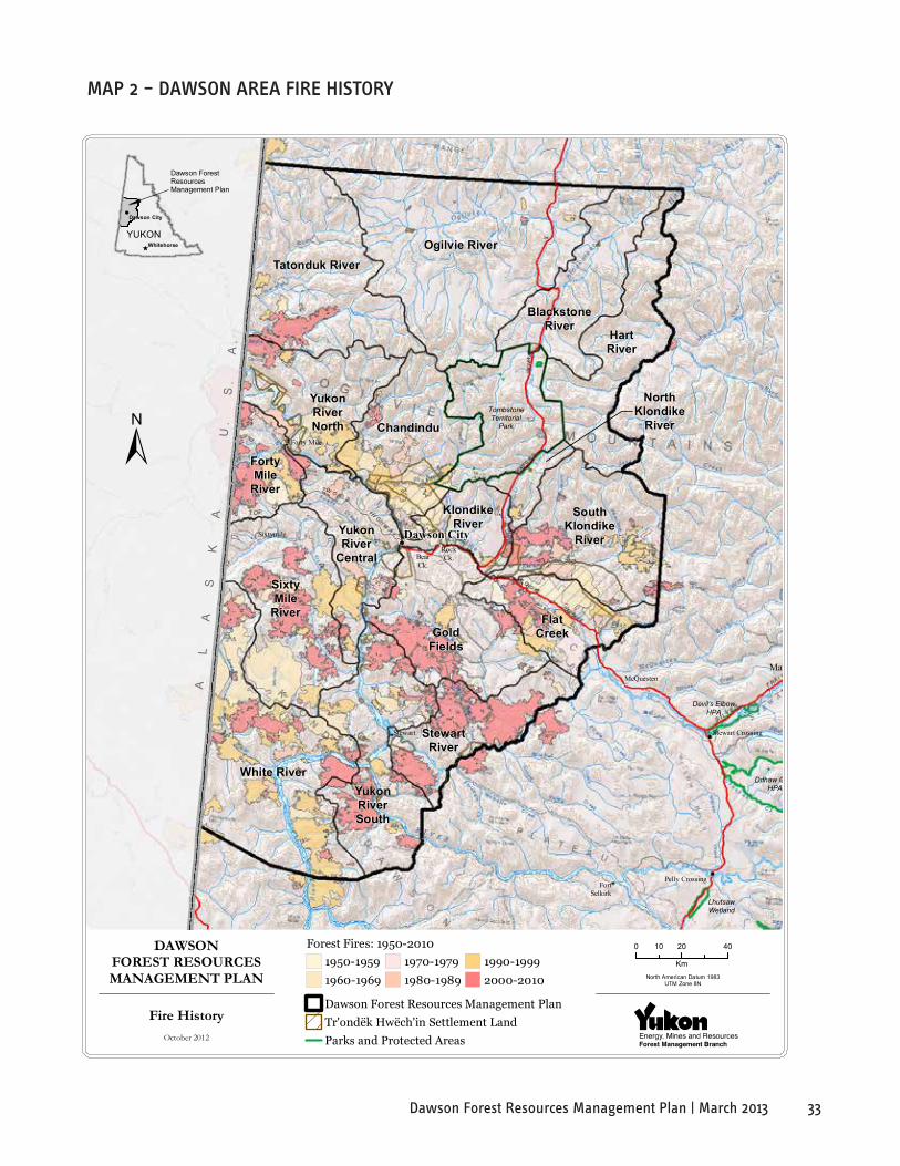
33Dawson Forest Resources Management Plan | March 2013
Tatonduk RiverOgilvie River
BlackstoneRiver
HartRiver
SouthKlondike
River
Chandindu
KlondikeRiver
FortyMile
River
YukonRiver
Central
YukonRiverNorth
White River
FlatCreek
SixtyMile
RiverGold
Fields
StewartRiver
YukonRiverSouth
NorthKlondike
River
Stewart Crossing
Mayo
Ddhaw GhroHPA
Dawson City
LhutsawWetland
Pelly Crossing
TombstoneTerritorial
Park
FortSelkirk
Stewart
Forty Mile
Sixtymile
McQuesten
Devil's ElbowHPA
RockCk.Bear
Ck.
105L 12
115K 07
105L 13
115P 08
105M 04
106D 04
105M 05
106D 05
105M 12
106D 12
105M 13
106D 13
Dawson ForestResourcesManagement Plan
YUKONWhitehorse
Dawson City
DAWSONFOREST RESOURCESMANAGEMENT PLAN
0 20 4010
KmNorth American Datum 1983
UTM Zone 8N
AL
AS
KA
U.
S.
A.
Fire HistoryOctober 2012
Dawson Forest Resources Management PlanTr'ondëk Hwëch'in Settlement LandParks and Protected Areas
1950-19591960-1969
1970-19791980-1989
1990-19992000-2010
Forest Fires: 1950-2010
maP 2 – daWsoN area Fire hisTorY

34 Dawson Forest Resources Management Plan | March 2013
Tato
nduk
Riv
erO
gilv
ie R
iver
Bla
ckst
one
Riv
erH
art
Riv
er
Sout
hK
lond
ike
Riv
er
Cha
ndin
du
Klo
ndik
eR
iver
Fort
yM
ileR
iver
Yuko
nR
iver
Cen
tral
Yuko
nR
iver
Nor
th
Whi
te R
iver
Flat
Cre
ek
Sixt
yM
ileR
iver
Gol
dFi
elds
Stew
art
Riv
er
Yuko
nR
iver
Sout
h
Nor
thK
lond
ike
Riv
er
Stew
art C
ross
ing
Daw
son
City
Lhut
saw
Wet
land
Pelly
Cro
ssin
g
Tom
bsto
neTe
rrito
rial
Park
Fort
Selk
irk
Stew
art
Forty
Mile
Sixt
ymile
McQ
uest
en
Dev
il's E
lbow
HPA
Rock
Ck.
Bear
Ck.
115J0
6
115J0
5
115K0
8
115K0
7
115P0
8
116H1
5
Daw
son
Fore
stR
esou
rces
Man
agem
ent P
lan
YU
KO
NW
hite
hors
e
Daw
son
City
DAW
SON
FOR
EST
RE
SOU
RC
ES
MAN
AGE
ME
NT
PLA
N
020
4010
Km
Nor
th A
mer
ican
Dat
um 1
983
UTM
Zon
e 8N
ALASKAU.S.A.
Fore
st C
over
by
Lead
ing
Spec
ies
Oct
ober
201
2
Sub-
Alp
ine
Fir
Bal
sam
Pop
lar
Bla
ck S
pruc
e
Larc
hLo
dgep
ole
Pine
Trem
blin
g A
spen
Whi
te B
irch
Whi
te S
pruc
e
Daw
son
Fore
st R
esou
rces
Man
agem
ent P
lan
Tr'o
ndëk
Hw
ëch'
in S
ettl
emen
t Lan
dPa
rks
and
Prot
ecte
d A
reas
Lead
ing
Spec
ies
ma
P 3
– da
Wso
N a
rea
Fo
resT
Co
Ver
BY l
eadi
Ng
sPe
Cies
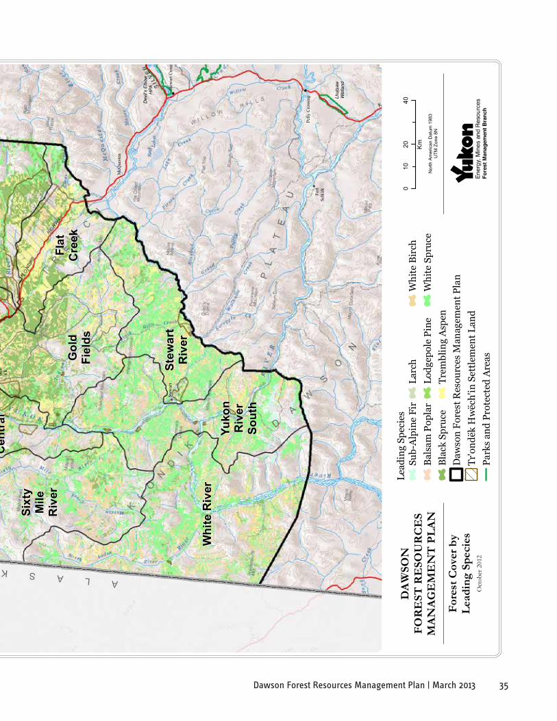
35Dawson Forest Resources Management Plan | March 2013
Tato
nduk
Riv
erO
gilv
ie R
iver
Bla
ckst
one
Riv
erH
art
Riv
er
Sout
hK
lond
ike
Riv
er
Cha
ndin
du
Klo
ndik
eR
iver
Fort
yM
ileR
iver
Yuko
nR
iver
Cen
tral
Yuko
nR
iver
Nor
th
Whi
te R
iver
Flat
Cre
ek
Sixt
yM
ileR
iver
Gol
dFi
elds
Stew
art
Riv
er
Yuko
nR
iver
Sout
h
Nor
thK
lond
ike
Riv
er
Stew
art C
ross
ing
Daw
son
City
Lhut
saw
Wet
land
Pelly
Cro
ssin
g
Tom
bsto
neTe
rrito
rial
Park
Fort
Selk
irk
Stew
art
Forty
Mile
Sixt
ymile
McQ
uest
en
Dev
il's E
lbow
HPA
Rock
Ck.
Bear
Ck.
115J0
6
115J0
5
115K0
8
115K0
7
115P0
8
116H1
5
Daw
son
Fore
stR
esou
rces
Man
agem
ent P
lan
YU
KO
NW
hite
hors
e
Daw
son
City
DAW
SON
FOR
EST
RE
SOU
RC
ES
MAN
AGE
ME
NT
PLA
N
020
4010
Km
Nor
th A
mer
ican
Dat
um 1
983
UTM
Zon
e 8N
ALASKAU.S.A.
Fore
st C
over
by
Lead
ing
Spec
ies
Oct
ober
201
2
Sub-
Alp
ine
Fir
Bal
sam
Pop
lar
Bla
ck S
pruc
e
Larc
hLo
dgep
ole
Pine
Trem
blin
g A
spen
Whi
te B
irch
Whi
te S
pruc
e
Daw
son
Fore
st R
esou
rces
Man
agem
ent P
lan
Tr'o
ndëk
Hw
ëch'
in S
ettl
emen
t Lan
dPa
rks
and
Prot
ecte
d A
reas
Lead
ing
Spec
ies
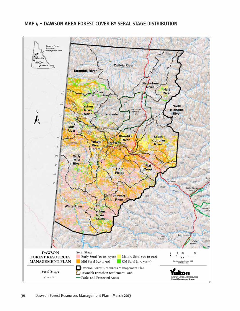
36 Dawson Forest Resources Management Plan | March 2013
Tatonduk RiverOgilvie River
BlackstoneRiver
HartRiver
SouthKlondike
River
Chandindu
KlondikeRiver
FortyMile
River
YukonRiver
Central
YukonRiverNorth
White River
FlatCreek
SixtyMile
RiverGold
Fields
StewartRiver
YukonRiverSouth
NorthKlondike
River
Stewart Crossing
Mayo
Ddhaw GhroHPA
Dawson City
LhutsawWetland
Pelly Crossing
TombstoneTerritorial
Park
FortSelkirk
Stewart
Forty Mile
Sixtymile
McQuesten
Devil's ElbowHPA
RockCk.Bear
Ck.
105L 12
115K 07
105L 13
115P 08
105M 04
106D 04
105M 05
106D 05
105M 12
106D 12
105M 13
106D 13
Dawson ForestResourcesManagement Plan
YUKONWhitehorse
Dawson City
DAWSONFOREST RESOURCESMANAGEMENT PLAN
0 20 4010
KmNorth American Datum 1983
UTM Zone 8N
AL
AS
KA
U.
S.
A.
Seral StageOctober 2012
Early Seral (10 to 50yrs)Mid Seral (50 to 90)
Mature Seral (90 to 130)Old Seral (130 yrs +)
Dawson Forest Resources Management PlanTr'ondëk Hwëch'in Settlement LandParks and Protected Areas
Seral Stage
maP 4 – daWsoN area ForesT CoVer BY seral sTage disTriBuTioN
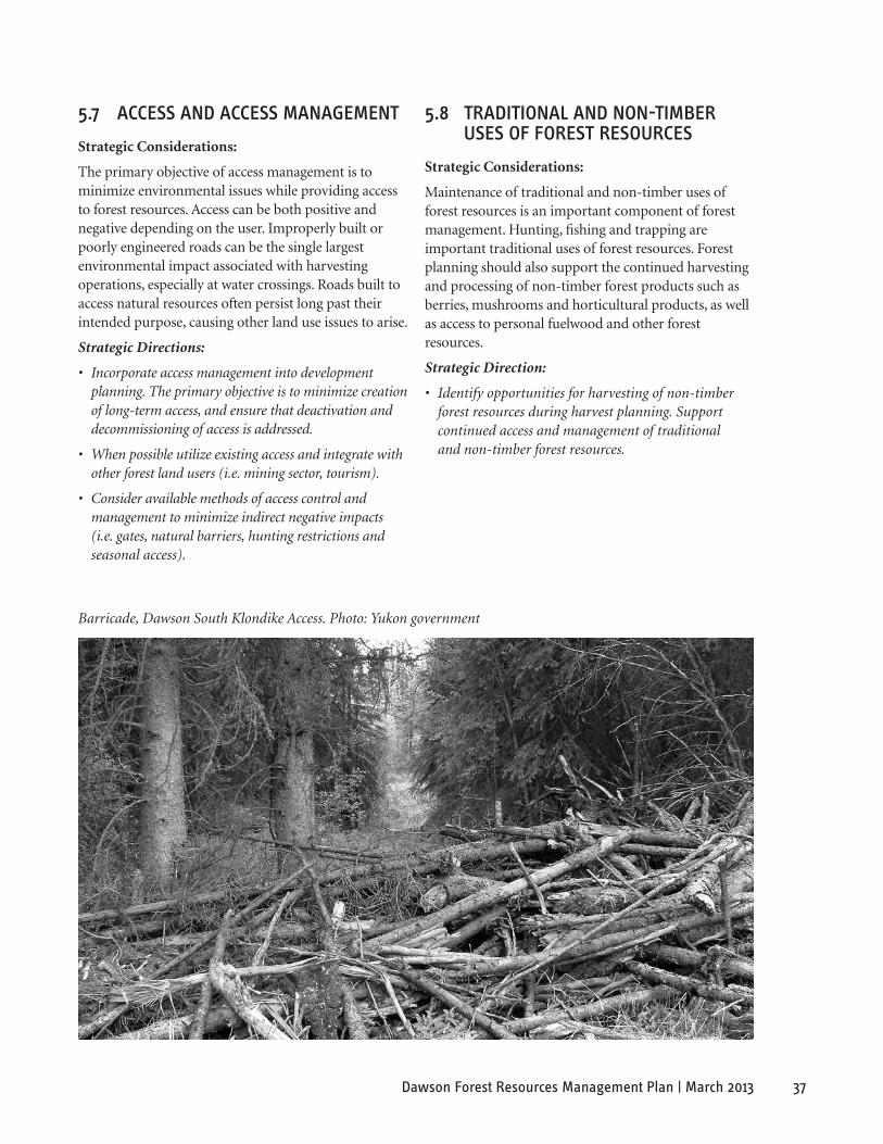
37Dawson Forest Resources Management Plan | March 2013
Barricade, Dawson South Klondike Access. Photo: Yukon government
5.7 aCCess aNd aCCess maNagemeNT
Strategic Considerations:
The primary objective of access management is to minimize environmental issues while providing access to forest resources. Access can be both positive and negative depending on the user. Improperly built or poorly engineered roads can be the single largest environmental impact associated with harvesting operations, especially at water crossings. Roads built to access natural resources often persist long past their intended purpose, causing other land use issues to arise.
Strategic Directions:
• Incorporate access management into development planning. The primary objective is to minimize creation of long-term access, and ensure that deactivation and decommissioning of access is addressed.
• When possible utilize existing access and integrate with other forest land users (i.e. mining sector, tourism).
• Consider available methods of access control and management to minimize indirect negative impacts (i.e. gates, natural barriers, hunting restrictions and seasonal access).
5.8 TradiTioNal aNd NoN-TimBer uses oF ForesT resourCes
Strategic Considerations:
Maintenance of traditional and non-timber uses of forest resources is an important component of forest management. Hunting, fishing and trapping are important traditional uses of forest resources. Forest planning should also support the continued harvesting and processing of non-timber forest products such as berries, mushrooms and horticultural products, as well as access to personal fuelwood and other forest resources.
Strategic Direction:
• Identify opportunities for harvesting of non-timber forest resources during harvest planning. Support continued access and management of traditional and non-timber forest resources.

38 Dawson Forest Resources Management Plan | March 2013
South Klondike. Photo: Yukon government
6. foResT PlannInG aReas
The FRMP area is sub-divided into smaller forest planning areas based on landscape features, forest cover type and general forest-related values. The smaller areas facilitate area-specific management planning. For the purposes of this FRMP, the term Landscape Unit (LU) is used to define these forest planning areas.
Landscape Units are based on watershed boundaries and modified by local access and development patterns. They usually contain similar management concerns and forest types. These units form the boundaries for detailed information gathering, monitoring and planning.
6.1 laNdsCaPe uNiTs
The area was divided into 17 different LUs using physiographic boundaries, such as watershed sub-basin boundaries and forest productivity conditions. (see Map 1, inside front cover). These units are fundamental to more detailed planning and analysis as development and operational plans are prepared. Land Cover Type (Table 1), Tree Species (Table 2) and Forest Productivity (Table 3) information for each Landscape Unit is provided in Appendix A (p. 65).
A strategic designation system is a fundamental component of sustainable regional economic development or conservation strategy, and is a key component of an integrated forest resource management framework (see Table 3).
Strategic forest land use zones that can be applied to the LUs include:
1) Hinterland Forest Zone (HFZ) – not included in timber supply analysis (TSA). In this zone, small-scale harvesting for non-commercial purposes may be permitted. Commercial forest operations would be limited to associated resource developments. The zone may contribute to biodiversity conservation for the entire planning area, subject to further monitoring and evaluation.
2) Forest Resource Management Zone (FRMZ) – the location where most forest management activities will occur.
3) Community Forest Development Zone (CFDZ) – includes municipal and other developed areas.
A draft Forest Resource Use Designation (FRUD) zoning system has been applied to the LUs in the Dawson FRMP area. Draft zoning is provided in Table 4. Once landscape zones are chosen for development, more detailed zoning will occur to identify the specific areas or drainages where additional planning will occur. For example, the Forest Resource Management Zone may be further divided into General, Conservation and Forest Resource Management Areas. Forest Resource Management Areas would be used to identify locations within the FRMZ that have forest resource potential and forest development interests.
The Regional Forest Use Designations are based partly on key concerns identified for each landscape unit. Thus, it is important to identify issues and attributes of key concern to the planning team and broader community in this FRMP.
A preliminary list of key values in each landscape unit is also presented in Table 4. These features were identified through a review of existing information on the following subjects:
• Wildlife key areas and critical habitat for species at risk;
• Parks and protected areas;
• Ungulate winter ranges;
• Heritage resources including archaeological sites and traditional use areas (general and publicly available information);
• Historic trails and routes;
• TH Settlement Lands;
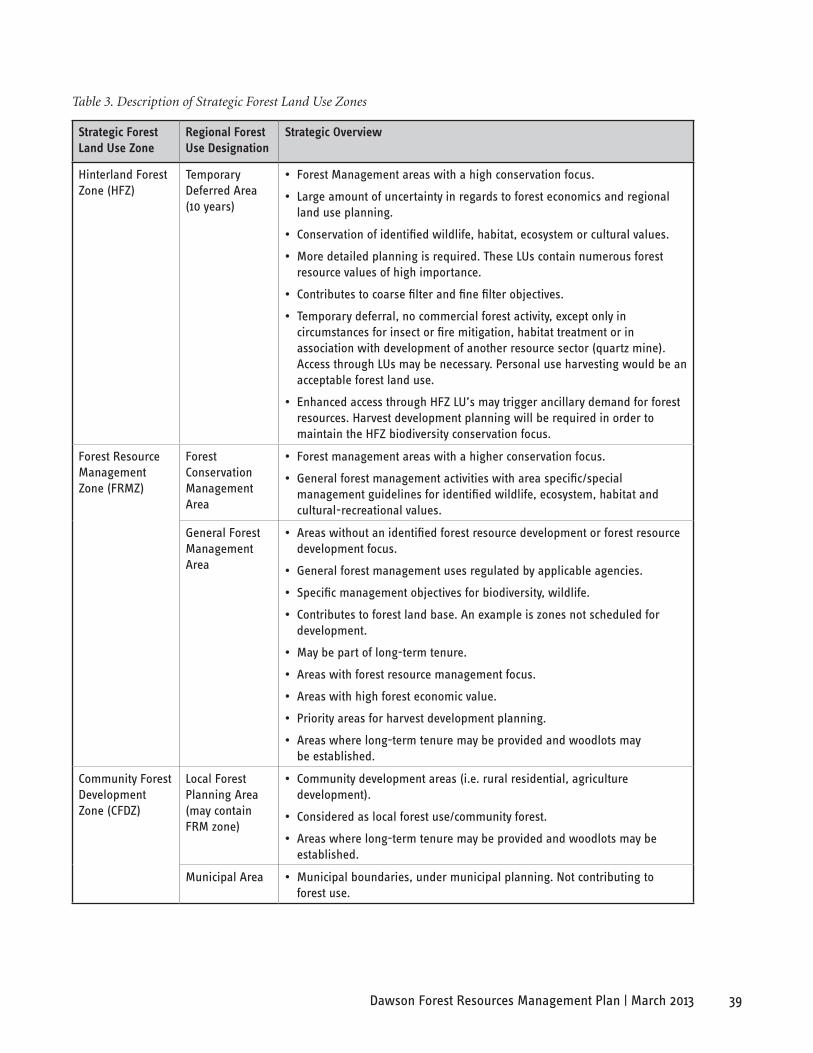
39Dawson Forest Resources Management Plan | March 2013
Table 3. Description of Strategic Forest Land Use Zones
strategic forest land Use Zone
Regional forest Use Designation
strategic overview
Hinterland Forest Zone (HFZ)
Temporary Deferred Area (10 years)
• Forest Management areas with a high conservation focus.
• Large amount of uncertainty in regards to forest economics and regional land use planning.
• Conservation of identified wildlife, habitat, ecosystem or cultural values.
• More detailed planning is required. These LUs contain numerous forest resource values of high importance.
• Contributes to coarse filter and fine filter objectives.
• Temporary deferral, no commercial forest activity, except only in circumstances for insect or fire mitigation, habitat treatment or in association with development of another resource sector (quartz mine). Access through LUs may be necessary. Personal use harvesting would be an acceptable forest land use.
• Enhanced access through HFZ LU’s may trigger ancillary demand for forest resources. Harvest development planning will be required in order to maintain the HFZ biodiversity conservation focus.
Forest Resource Management Zone (FRMZ)
Forest Conservation Management Area
• Forest management areas with a higher conservation focus.
• General forest management activities with area specific/special management guidelines for identified wildlife, ecosystem, habitat and cultural-recreational values.
General Forest Management Area
• Areas without an identified forest resource development or forest resource development focus.
• General forest management uses regulated by applicable agencies.
• Specific management objectives for biodiversity, wildlife.
• Contributes to forest land base. An example is zones not scheduled for development.
• May be part of long-term tenure.
• Areas with forest resource management focus.
• Areas with high forest economic value.
• Priority areas for harvest development planning.
• Areas where long-term tenure may be provided and woodlots may be established.
Community Forest Development Zone (CFDZ)
Local Forest Planning Area (may contain FRM zone)
• Community development areas (i.e. rural residential, agriculture development).
• Considered as local forest use/community forest.
• Areas where long-term tenure may be provided and woodlots may be established.
Municipal Area • Municipal boundaries, under municipal planning. Not contributing to forest use.

40 Dawson Forest Resources Management Plan | March 2013
South Klondike Access – debris used to limit access to harvest areas. Photo: Yukon government
• Wildfire history (1946-2005);
• Placer and quartz mining claims and operations;
• Outfitter concessions;
• Forest cover data (and analysis of timber values);
• Locations of highway and river corridors, communities and associated scenic values;
• Wilderness tourism key areas.
This preliminary list of key values in each landscape unit was presented to the planning team for review, revision, and discussion to determine which of these features present key forest planning concerns. These draft rankings were derived from community-identified resource values for each LU and the corresponding potential for resource conflict within the unit. From this assessment a priority for planning
was determined and a time frame for development. The areas identified as a low priority for planning are areas where low levels of forestry activities would occur because of cultural or other social values or access constraints.
For example, LUs with sensitive landscapes may be considered to have a high potential to be adversely affected by timber harvesting and; therefore, may be assigned a low priority for planning. LUs ranked low for development priority require a higher level of mitigation to protect resource values than LUs with higher activity rankings. It should be noted that all the mitigation measures required to protect these values will not be identified through the FRMP. When more in-depth planning occurs such as development of timber harvest and site plans, additional mitigations could occur.
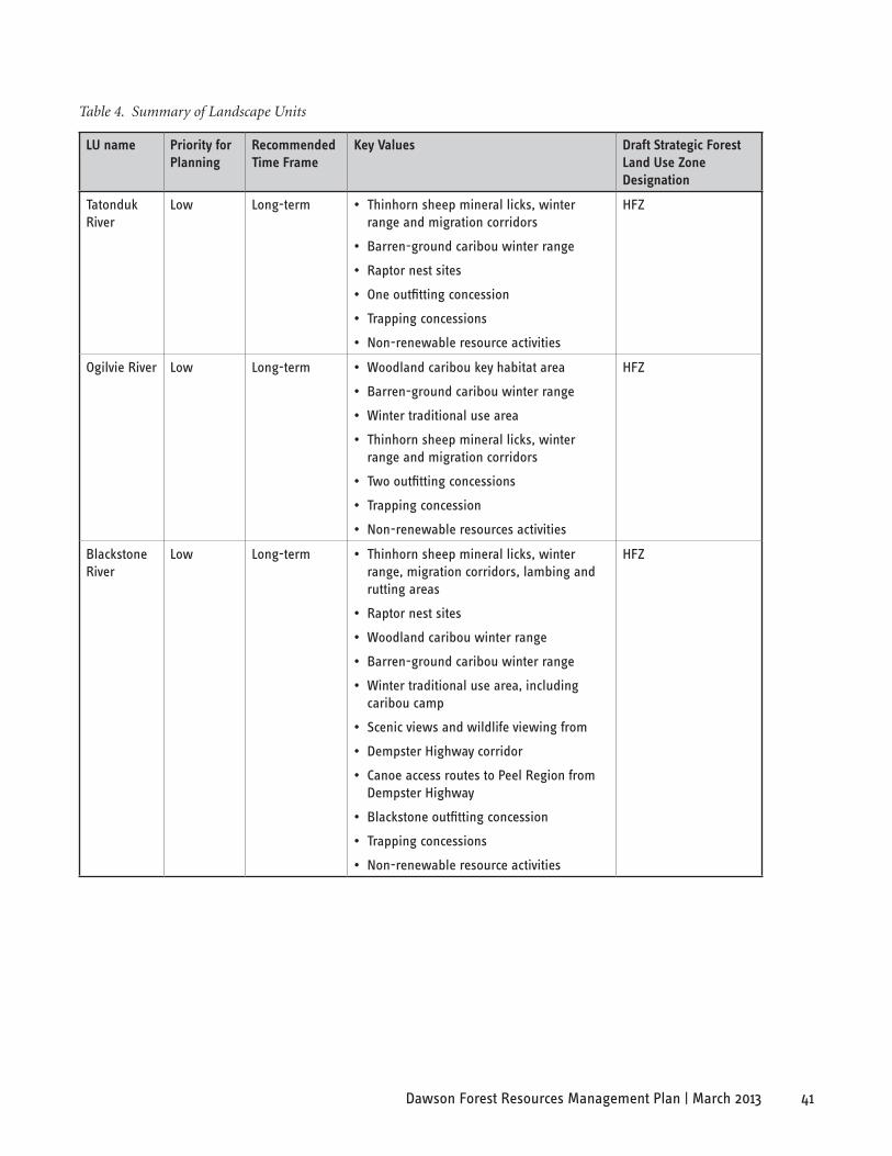
41Dawson Forest Resources Management Plan | March 2013
Table 4. Summary of Landscape Units
lU name Priority for Planning
Recommended Time frame
Key Values Draft strategic forest land Use Zone Designation
Tatonduk River
Low Long-term • Thinhorn sheep mineral licks, winter range and migration corridors
• Barren-ground caribou winter range
• Raptor nest sites
• One outfitting concession
• Trapping concessions
• Non-renewable resource activities
HFZ
Ogilvie River Low Long-term • Woodland caribou key habitat area
• Barren-ground caribou winter range
• Winter traditional use area
• Thinhorn sheep mineral licks, winter range and migration corridors
• Two outfitting concessions
• Trapping concession
• Non-renewable resources activities
HFZ
Blackstone River
Low Long-term • Thinhorn sheep mineral licks, winter range, migration corridors, lambing and rutting areas
• Raptor nest sites
• Woodland caribou winter range
• Barren-ground caribou winter range
• Winter traditional use area, including caribou camp
• Scenic views and wildlife viewing from
• Dempster Highway corridor
• Canoe access routes to Peel Region from Dempster Highway
• Blackstone outfitting concession
• Trapping concessions
• Non-renewable resource activities
HFZ

42 Dawson Forest Resources Management Plan | March 2013
Table 4. Summary of Landscape Units (cont’d)
lU name Priority for Planning
Recommended Time frame
Key Values Draft strategic forest land Use Zone Designation
Hart River Low Long-term • Thinhorn sheep mineral licks, winter range, lambing and rutting areas
• Raptor nest sites
• Woodland caribou winter range
• Barren-ground caribou winter range
• Hart River winter road from North Fork Pass is used by backpackers, mountain bikes, ATV and snowmobile users
• Two outfitting concessions
• Trapping concessions
• Non-renewable resource activities
HFZ
Chandindu Medium Long-term • Woodland caribou winter range
• Thinhorn sheep mineral licks, winter range, lambing and rutting areas
• Raptor nest sites
• Fall and winter traditional use areas
• Large TH settlement land parcels bordering the Yukon River
• One outfitting concession
• Trapping concessions
• Non-renewable resource activities
FRMZ
Forty Mile River
Medium Short-term • Barren-ground caribou winter range
• Raptor nest sites
• Historic resources along the Fortymile River
• Pre-gold rush and industrial mining sites
• Trapping concessions
• Non-renewable resource activities
FRMZ
Sixty Mile River
Medium Short-term • Significant wildfire disturbance in 2004
• Numerous placer and quartz mining claims
• Barren-ground caribou winter range
• Historic resources associated with Klondike Gold Rush and industrial mining activity
• Potentially high timber values
• Trapping concessions
• Non-renewable resource activities
FRMZ

43Dawson Forest Resources Management Plan | March 2013
Table 4. Summary of Landscape Units (cont’d)
lU name Priority for Planning
Recommended Time frame
Key Values Draft strategic forest land Use Zone Designation
Yukon River North
Low Long-term • Quartz mining claims
• Visual quality
• Peregrine falcon and golden eagle key habitat on Yukon River
• Thinhorn sheep mineral licks and winter range
• Raptor nest sites
• Barren-ground caribou winter range
• Yukon River corridor is a high-value heritage resource area
• TH settlement lands bordering the Yukon River
• Yukon Quest trail
• One outfitting concession
• Trapping concessions
• Non-renewable resource activities
HFZ
Yukon River Central
High Short-term • Peregrine falcon and golden eagle nest sites on Yukon River
• Barren-ground caribou winter range
• Yukon River corridor is a high-value heritage resource area
• Visual quality
• Slopes of West Dawson and the Top of the World Highway are highly visible from Dawson City and have scenic values
• Several TH settlement land parcels bordering Yukon River
• Potentially high timber values in this area
• Yukon Quest Trail
• High value visitor use area
• Trapping concessions
• Non-renewable resource activities
FRMZ

44 Dawson Forest Resources Management Plan | March 2013
Table 4. Summary of Landscape Units (cont’d)
lU name Priority for Planning
Recommended Time frame
Key Values Draft strategic forest land Use Zone Designation
Yukon River South
Medium Long-term • Yukon River corridor is a high-value heritage resource area
• Visual quality
• Significant wildfire disturbance in 2004
• Considerable placer claims and operations
• Peregrine falcon and golden eagle key habitat on Yukon River
• Barren-ground caribou winter range
• Raptor nest sites
• High moose density
• Trapping concessions
• Non-renewable resource activities
HFZ
White River
Low Long-term • Quartz mining claims
• Peregrine falcon and golden eagle key habitat on White River
• Barren-ground caribou winter range
• Moderate moose populations
• Trapping concessions
• Non-renewable resource activities
• Historic resources along the White River relating to Chisana Gold Rush
HFZ
Stewart River
Low Long-term • Significant wildfire disturbance in 2004
• Placer claims and operations, and considerable quartz claims
• High moose density
• Whitehorse Dawson Overland Trail passes through the LU
• Historic resources related to early mining and the Overland Trail.
• TH settlement land parcels
• Trapping concessions
• Non-renewable resource activities
HFZ
Flat Creek Medium Short-term • TH settlement lands comprise a significant portion of the LU
• Beaver key habitat (year-round)
• Waterfowl staging and breeding areas
• Moderate moose populations
• One outfitting concession
• Trapping concessions
• Non-renewable resource activities
FRMZ

45Dawson Forest Resources Management Plan | March 2013
Table 4. Summary of Landscape Units (cont’d)
lU name Priority for Planning
Recommended Time frame
Key Values Draft strategic forest land Use Zone Designation
Gold Fields High Short-term • Numerous historic resources
• Whitehorse Dawson Overland Trail passes through the LU
• Significant wildfire disturbance in 2004
• Numerous placer claims and operations; landscape has been significantly altered through industrial mining activity
• Extensive quartz mining claims
• Ridge Road Heritage Trail
• Potentially high timber values in this area
• Barren-ground caribou winter range
• Raptor nest sites
• Beaver key habitat (year-round)
• Sharptail grouse key habitat (year-round)
• Ungulate mineral licks
• High moose density
• High visitor use area
• Trapping concessions
• Non-renewable resource activities
FRMZ
North Klondike River
Medium Short-term • Thinhorn sheep key habitat area
• Woodland caribou (Hart River herd) and thinhorn sheep winter range
• Scenic views and wildlife viewing from Dempster Highway
• Raptor nest sites
• Winter traditional use sites
• TH settlement lands bordering North Klondike River
• One outfitting concession
• Trapping concessions
• Non-renewable resource activities
HFZ
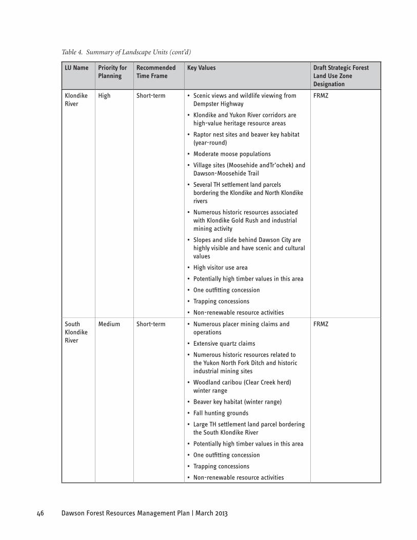
46 Dawson Forest Resources Management Plan | March 2013
Table 4. Summary of Landscape Units (cont’d)
lU name Priority for Planning
Recommended Time frame
Key Values Draft strategic forest land Use Zone Designation
Klondike River
High Short-term • Scenic views and wildlife viewing from Dempster Highway
• Klondike and Yukon River corridors are high-value heritage resource areas
• Raptor nest sites and beaver key habitat (year-round)
• Moderate moose populations
• Village sites (Moosehide andTr’ochek) and Dawson-Moosehide Trail
• Several TH settlement land parcels bordering the Klondike and North Klondike rivers
• Numerous historic resources associated with Klondike Gold Rush and industrial mining activity
• Slopes and slide behind Dawson City are highly visible and have scenic and cultural values
• High visitor use area
• Potentially high timber values in this area
• One outfitting concession
• Trapping concessions
• Non-renewable resource activities
FRMZ
South Klondike River
Medium Short-term • Numerous placer mining claims and operations
• Extensive quartz claims
• Numerous historic resources related to the Yukon North Fork Ditch and historic industrial mining sites
• Woodland caribou (Clear Creek herd) winter range
• Beaver key habitat (winter range)
• Fall hunting grounds
• Large TH settlement land parcel bordering the South Klondike River
• Potentially high timber values in this area
• One outfitting concession
• Trapping concessions
• Non-renewable resource activities
FRMZ

47Dawson Forest Resources Management Plan | March 2013
7. foResT ManaGeMenT Goals, obJeCTIVes anD InDICaToRs
The Canadian Council of Forest Ministers (CCFM) (2003) describes sustainable forest management criteria (expressed as goals and objectives in this FRMP) and indicators as follows:
“ [they] provide a science-based framework to define and measure Canada’s [or a region’s] progress in the sustainable management of its forests. The criteria [goals and objectives] represent forest values that Canadians [Dawson region residents, in this case] want to enhance or sustain, while the indicators identify scientific factors to assess the state of the forests and measure progress over time.”
goals of Forest management in the Planning area
There are five goals for forest management in the Planning Area:
• Conserve biological diversity;
• Maintain forest ecosystem health and productivity;
• Conserve and maintain soil and water resources;
• Maintain and enhance multiple socio-economic benefits;
• Maintain and enhance community sustainability.
These goals are consistent with the criteria of sustainable forest management defined nationally by the Canadian Council of Forest Ministers (2003), and internationally through the Montréal Process. The goals serve as a broad framework for forest management in the area.
The Montréal Process is the Working Group on Criteria and Indicators for the Conservation and Sustainable Management of Temperate and Boreal Forests. It was formed in Geneva, Switzerland in June 1994 to develop and implement internationally agreed criteria and indicators for the conservation and sustainable management of temperate and boreal forests. The member countries are Argentina, Australia, Canada, Chile, China, Japan, Republic of Korea, Mexico, New Zealand, Russian Federation, United States of America and Uruguay.
objectives and indicators of Forest management in the Planning area
For each of these five goals, there are a number of more specific objectives. These objectives further define the forest values that the community wishes to sustain and enhance in the area. Objectives set the future direction for forest management decisions and actions, and provide a basis for evaluating the outcomes of forest management.
For each objective presented in this plan there is a corresponding set of indicators. Indicators are used to monitor how well the outcomes of forest management fulfill the objectives stated in the FRMP. Indicators are used to answer the question, “Are we achieving the goals and objectives of our plan?” Indicators also allow forest managers and the community to identify aspects of forest management that need improvement. More importantly, they tell managers how the outcomes of forestry and forest-based activities will be evaluated by the community.
Indicators are a critical component of monitoring programs and a key tool in adaptive forest management. They are not meant to be used for enforcement purposes. If they are monitored regularly and supported by good information (including scientific, traditional and local knowledge), indicators can serve as early warning signs of forest management issues that require attention. Indicators requiring attention should help inform the adaptive management process and lead to new and improved management. The aim is to move indicators measured as “unacceptable” towards “acceptable.”

48 Dawson Forest Resources Management Plan | March 2013
Moosehide. Photo: Yukon government
The indicators developed for this FRMP are to be applied at the landscape level, across the entire Dawson forest planning area. Some indicators are also focused on monitoring activities in timber harvest areas that have the potential to impact the landscape. To be effective, these indicators should be:
• Meaningful – They should relate clearly to a particular objective and provide significant information about the values embodied by an objective.
• Measurable – They should be based on available or easily obtainable data that can be repeatedly measured over time to observe trends.
• Cost effective – It should be financially and practically feasible to collect data to report on the indicator.
• Understandable – They should be readily understood by forest managers and the public.
• Connected to forestry – They should respond to forest management actions and practices.
• Attributable – It should be possible to attribute (show cause and effect) trends observed over time to forest management actions and explain why these trends are being observed.
The first step in reporting on the indicators will be to compile an Initial Status Report. The purpose of this document will serve as the baseline against which future conditions will be compared. The Initial Status Report on indicators must be completed within five years from the approval date of the FRMP.
The list of indicators is not a comprehensive list, some maybe dropped and others added as new information and implementation occurs.
The indicators marked with an asterisk (*) may be easier to monitor in the near-term because they have established methodologies and/or monitoring data are readily available.
7.1 goal a: CoNserVe BiologiCal diVersiTY
The Canadian Council of Forest Ministers (2003) defines biological diversity as the “variability among living organisms and the ecological complexes of which they are a part.” Conservation of biological diversity involves management and preservation of ecosystems to ensure their viability, resiliency and sustainability. Biological diversity exists at multiple scales, from the level of the landscape or ecosystem, to individual species, to the genetic diversity within and between species. This FRMP identifies three objectives for biodiversity conservation: 1) conserve ecosystem diversity; 2) conserve species diversity; and 3) conserve genetic diversity.
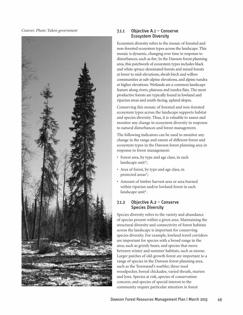
49Dawson Forest Resources Management Plan | March 2013
Cutover. Photo: Yukon government 7.1.1 objective a.1 – Conserve ecosystem diversity
Ecosystem diversity refers to the mosaic of forested and non-forested ecosystem types across the landscape. This mosaic is dynamic, changing over time in response to disturbances, such as fire. In the Dawson forest planning area, this patchwork of ecosystem types includes black and white spruce-dominated forests and mixed forests at lower to mid-elevations, shrub birch and willow communities at sub-alpine elevations, and alpine tundra at higher elevations. Wetlands are a common landscape feature along rivers, plateaus and tundra flats. The most productive forests are typically found in lowland and riparian areas and south-facing, upland slopes.
Conserving this mosaic of forested and non-forested ecosystem types across the landscape supports habitat and species diversity. Thus, it is valuable to assess and monitor any change in ecosystem diversity in response to natural disturbances and forest management.
The following indicators can be used to monitor any change in the range and extent of different forest and ecosystem types in the Dawson forest planning area in response to forest management:
• Forest area, by type and age class, in each landscape unit*;
• Area of forest, by type and age class, in protected areas*;
• Amount of timber harvest area or area burned within riparian and/or lowland forest in each landscape unit*.
7.1.2 objective a.2 – Conserve species diversity
Species diversity refers to the variety and abundance of species present within a given area. Maintaining the structural diversity and connectivity of forest habitats across the landscape is important for conserving species diversity. For example, lowland travel corridors are important for species with a broad range in the area, such as grizzly bears, and species that move between winter and summer habitats, such as moose. Larger patches of old-growth forest are important to a range of species in the Dawson forest planning area, such as the Townsend’s warbler, three-toed woodpecker, boreal chickadee, varied thrush, marten and lynx. Species at risk, species of conservation concern, and species of special interest to the community require particular attention in forest
50 Dawson Forest Resources Management Plan | March 2013
management planning at the landscape and operational level.
The following indicators can be used to monitor management practices aimed at conserving species diversity:
• Area and patch size of old forest in each landscape unit*;
• Conservation status and availability of suitable habitats for forest-associated species at risk, species of conservation concern, and species of special interest to the community;
• Retention of travel corridors for selected focal species within the forest development area.
7.1.3 objective a.3 – Conserve genetic diversity of Forest resources
Genetic diversity is the variation in genetic makeup within individual species and among different species. Conserving genetic diversity is critical to maintaining the ability of species to adapt to environmental change. In the forest management context, a reservoir of genetic diversity within and among tree species should be maintained to help ensure that the productivity and resilience of the forest is sustained over the long-term.
Applying natural regeneration methods using seed stock from the surrounding forest is one way to conserve genetic diversity. If replanting is applied as a regeneration method, the genetic diversity and origin of the seed stock used are also important considerations.
In light of the anticipated effects of climate change on forests in the Dawson forest planning area and throughout Yukon, an adaptive management approach to conserving genetic diversity will be needed. It is thought that boreal forest types may shift 300 to 500 km north in response to climate warming. Regeneration strategies will need to be monitored and adapted continuously to respond to the changes ahead.
The following indicators can be used to monitor the conservation of genetic diversity in the productive forest land base:
• Regeneration method applied in harvested areas*;
• Genetic origin and diversity of seed used in reforestation;
• Incidence of invasive species.
7.2 goal B: maiNTaiN ForesT eCosYsTem healTh aNd ProduCTiViTY
Maintaining forest ecosystem health and productivity is the second goal of this FRMP. The sustainable development of forest resources depends on the health and productivity of the ecosystem over the long-term (Canadian Council of Forest Ministers, 2003). Healthy forests are more resilient to change and disturbance, and are more likely to provide continuous new growth. This FRMP identifies three objectives related to the goal of maintaining forest health and productivity: 1) maintain and enhance ecosystem condition and productivity; 2) support the ecosystem’s ability to maintain natural processes; and 3) maintain and enhance ecosystem resilience.
7.2.1 objective B.1 – maintain and enhance ecosystem Condition and Productivity
Ecosystem condition and productivity refers to the health, vitality and rates of biological production in forest ecosystems. In the Dawson forest planning area, growing conditions are challenging and the area of forest land base with timber values is limited. To maintain long-term productivity, it is important to monitor the total growing stock of merchantable timber in the area and the rate of forest regeneration in response to forest management. To assess potential threats to the health, productivity and vitality of forest ecosystems, it is also important to keep track of insect and disease outbreaks, and other signs of stress.
The Forest Management Branch implemented a risk-based approach to forest health monitoring in 2009. Prior to 2009, FMB relied on the Canadian Forest Service, Pacific Region, to carry out its forest health program.
Yukon is divided into five forest health zones based on high-level strategic planning areas. Monitoring focuses on forest stands that are the most susceptible to the 10 forest health agents of greatest concern in Yukon (spruce bark beetle, northern spruce engraver, western balsam bark beetle, budworms, larch sawfly, large aspen tortrix, aspen serpentine leafminer, pine needle cast, mountain pine beetle and tree dieback due to drought stress). Each year at least one forest health zone is flown on a five year rotational basis and all communities and highway corridors within these areas are monitored. During the monitoring of the
51Dawson Forest Resources Management Plan | March 2013
forest zones, extra monitoring may be conducted on specific zones based on ongoing disturbances discovered by previous years forest health surveys. These ongoing monitoring areas will assist the forest health program in prioritizing enhanced monitoring and further response initiatives.
In 2009, the Dawson area was surveyed and based on the results, surveys were conducted in 2010.
The following indicators can be used to monitor forest ecosystem condition and productivity:
• Total growing stock of merchantable and non-merchantable tree species and common vegetation types*;
• Carbon storage in the Dawson Forest Planning area*;
• Amount of harvested areas successfully regenerated within the predetermined regeneration delay time*;
• Incidence of forest health concerns, including biotic (e.g. insect and disease outbreaks) and abiotic (e.g. windthrow, drought stress) disturbances.
7.2.2 objective B.2 – support the ecosystem’s ability to maintain Natural Processes
Natural ecosystem processes include the cycles of death and renewal, disturbance, regeneration and natural succession. Forest fires are the dominant disturbance type in the Dawson forest planning area and essential to natural succession in the area’s boreal forest ecosystems. Forest harvesting that emulates the range of variation in natural disturbance levels can help to support the ecosystem’s ability to maintain natural processes. To facilitate this, the following indicators can be used to monitor levels of natural and human disturbance in the timber harvest area and across the landscape:
• Area of each landscape unit affected by forest harvesting relative to area affected by natural disturbance, such as fire*;
• Number, patch size and cause of forest fires in each landscape unit*.
7.2.3 objective B.3 – maintain and enhance ecosystem resilience
Ecosystem resilience refers to the ability of an ecosystem to maintain its ecological integrity and productivity in the face of disturbance. Resilience is defined as the magnitude of disturbance that an ecosystem can withstand while still retaining essentially the same structure, function and feedbacks (Brand and Jax, 2007).
Maintaining the connectivity and integrity of forest habitats is important to supporting ecosystem resilience. Monitoring the density of forest roads and the sizes of cut blocks can serve as indicators of habitat connectivity and integrity. Monitoring trends in the area of productive forest can also help to assess the resilience of managed forest ecosystems.
The following indicators can be used to monitor the maintenance and enhancement of ecosystem resilience:
• Density of permanent, all-season forestry roads in each landscape unit*;
• Size and distribution of cut patches*;
• Area of productive land base in each landscape unit*;
• Density of temporary, winter and seasonal roads; and,
• Conservation status and availability of suitable habitats for forest-associated species at risk, species of conservation concern, and species of special interest to the community.
7.3 goal C: CoNserVe aNd maiNTaiN soil aNd WaTer resourCes
Conserving and maintaining soil and water resources is the third goal of this FRMP. Soil and water resources are the foundation of ecological functioning and productivity in forest ecosystems. Road construction and other forestry practices have the potential to impact soil and water resources in a number of ways, such as through soil erosion and compaction, siltation of aquatic habitats, flooding and increased water temperatures. Successful regeneration of harvested areas is important for maintaining soil moisture and nutrient levels, and in minimizing soil erosion, stream siltation and disruption of stream flow rates. This FRMP identifies two objectives related to this goal: 1) conserve and maintain soil resources; and 2) conserve and maintain water resources.

52 Dawson Forest Resources Management Plan | March 2013
7.3.1 objective C.1 – Conserve and maintain soil resources
Soils are the living substrate that supports forest growth and the foundation of a healthy, productive and resilient ecosystem. Conserving soil resources is critical to long-term forest ecosystem productivity. In the Dawson forest planning area, there is considerable variability in soil moisture and temperature conditions, resulting in part from the discontinuous but widespread permafrost found throughout the area. Potential disturbance to permafrost is an additional consideration in forestry activities because such disturbance may lead to slumping and erosion or to ponding of water, which may impact forest regeneration. Soil and permafrost disturbance can be minimized by harvesting during the winter over frozen ground.
Changes in soil conditions resulting from logging in the Dawson forest planning area can lead to the formation of duff layers and organic material at depths exceeding 30 cm. Under such deep duff and organic layers, decomposition rates are slow. As regeneration and succession occur in these conditions, the soil will cool and, over time, growth rates will decline. To facilitate forest regeneration, it may be necessary to break up or reduce duff layers in some sites.
In addition to minimizing disturbance, maintaining soil nutrients is another consideration for forest management. Post-harvest retention of woody debris is also important, serving an important role in sustaining long-term soil productivity and providing wildlife habitat.
The following indicators can be used to monitor the conservation and maintenance of soil resources in timber harvest areas:
• Amount of timber harvest area with significant soil and/or permafrost disturbance (resulting in compaction, displacement, erosion, slumping, loss of organic matter, ponding, etc.);
• Ratio of winter to summer harvesting operations;
• Volume of coarse woody debris in timber harvest area relative to natural forest.
7.3.2 objective C.2 – Conserve and maintain Water resources
Water conservation is important for sustaining potable water supplies for humans and wildlife, providing suitable aquatic habitats for many plant and animal species, and maintaining wetland ecosystems. By storing and filtering water, wetlands and riparian habitats in turn serve an important water conservation function, buffering terrestrial ecosystems from floods and preventing sediment from entering aquatic systems.
Maintaining the integrity of wetlands and riparian habitats is; therefore, an important forest management consideration. Forest development activities, such as construction of permanent stream crossings, and major stand replacing disturbances, also have the potential to impact water resources through introduction of sediment into watercourses.
The following indicators can be used to monitor the conservation and maintenance of water resources in the Dawson forest planning area:
• Proportion of riparian areas included within timber harvest areas in each landscape unit*;
• Number of permanent stream crossings on forest roads on major and minor watercourses in each landscape unit;
• Proportion of watersheds with stand replacing disturbance in the last 20 years*;
• Water quality measures;
• Area reported to have stream bank erosion as a result of forest resources harvesting.

53Dawson Forest Resources Management Plan | March 2013
First Nations traditional berry picking. Photo: Doreen Olsen by TH Heritage Department
7.4 goal d: maiNTaiN aNd eNhaNCe mulTiPle soCio-eCoNomiC BeNeFiTs
The fourth goal of this FRMP is to maintain and enhance the multiple economic and social benefits that the forest provides. Forest ecosystems provide both commercial and non-commercial socio-economic benefits. Direct commercial benefits include timber and non-timber forest products. Non-commercial benefits include wildlife habitat, recreational opportunities, scenic values, wilderness experiences, ecological services, and spiritual benefits. The goal of maintaining socio-economic forest benefits encompasses the wide range of goods and services provided by forest ecosystems. This FRMP identifies two objectives related to this goal: 1) maintain and enhance sustainable social and economic benefits from timber resources; and 2) maintain and enhance social and economic benefits from non-timber resources.
7.4.1 objective d.1 – maintain and enhance sustainable social, Cultural and economic Benefits from Timber resources
This FRMP aims to enhance the contribution of the area’s forest resources to a sustainable, local economy.
Opportunities to gain economic benefits from forest
resources include timber harvesting and other commercial forestry ventures. Local employment, the provision of timber products to local markets, and personal fuelwood collection are important social and economic benefits derived from the utilization of timber resources in the Dawson area.
The following indicators can be used to monitor the social, cultural and economic benefits derived from timber resources in the Dawson Forest Management Planning area:
• Proportion of local population employed in forestry-based activities*;
• Number of locally-owned operations relative to total area of productive forest land base*;
• Forest area by timber tenure*;
• Percentage of harvested timber and fuelwood sold to local markets;
• Product profile of harvested timber;
• Volume of wood salvaged from forest harvesting for non-timber purposes, such as clearing for placer mining operations;
• Annual harvest of timber products relative to the level of harvest deemed to be sustainable*.
7.4.2 objective d.2 – maintain and enhance social, Cultural and economic Benefits from Non-timber resources
This FRMP aims to enhance the social, cultural and economic benefits derived from the diversity of non-timber forest resources in the Dawson forest planning area. Examples of non-timber forest products and resources include meat, fish, fur, berries, medicinal products, tourism opportunities, scenic and recreational values, hunting and fishing resources and historic and archaeological resources.
Many of these non-timber forest products (NTFPs) are harvested for personal use and subsistence purposes by Dawson area residents. However, the harvesting, processing and sale of some of these NTFPs also provides small business opportunities. To ensure that harvest and use of NTFPs is sustainable over the long-term, it is important to monitor harvest volumes and trends in availability over time. The revenue generated from NTFPs and the percentage of these goods sold to local markets can also provide an indication of the locally-derived benefits of these resources.
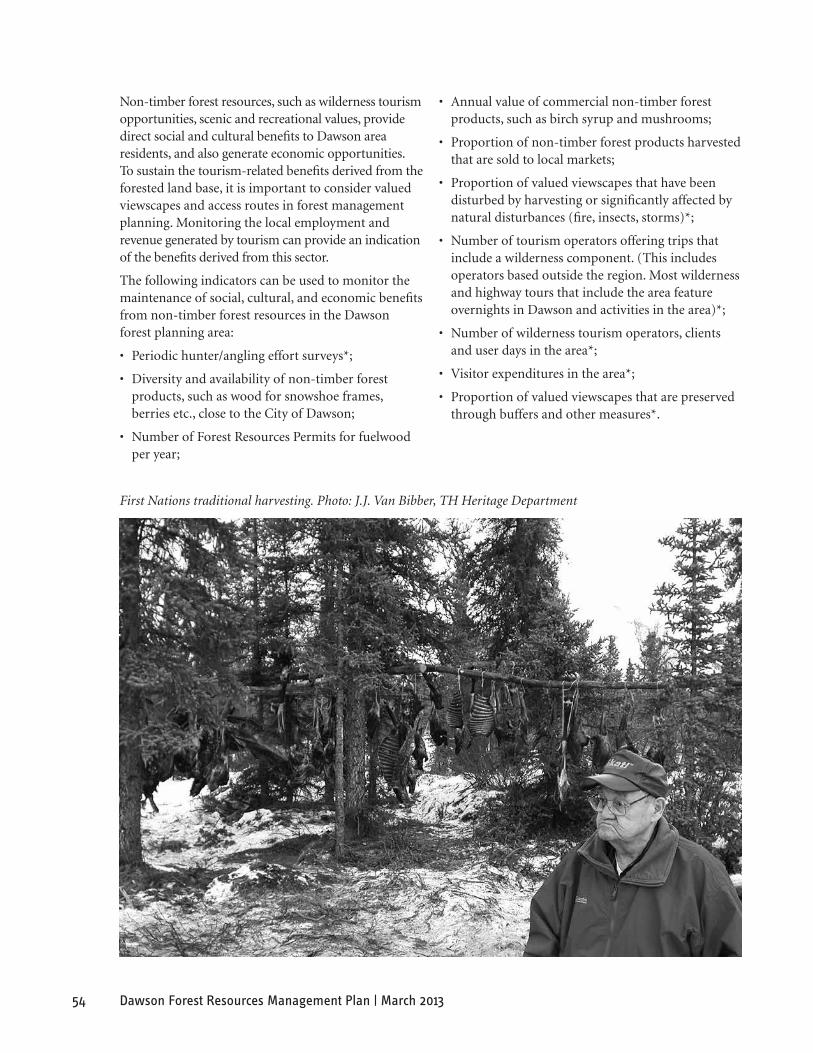
54 Dawson Forest Resources Management Plan | March 2013
First Nations traditional harvesting. Photo: J.J. Van Bibber, TH Heritage Department
Non-timber forest resources, such as wilderness tourism opportunities, scenic and recreational values, provide direct social and cultural benefits to Dawson area residents, and also generate economic opportunities. To sustain the tourism-related benefits derived from the forested land base, it is important to consider valued viewscapes and access routes in forest management planning. Monitoring the local employment and revenue generated by tourism can provide an indication of the benefits derived from this sector.
The following indicators can be used to monitor the maintenance of social, cultural, and economic benefits from non-timber forest resources in the Dawson forest planning area:
• Periodic hunter/angling effort surveys*;
• Diversity and availability of non-timber forest products, such as wood for snowshoe frames, berries etc., close to the City of Dawson;
• Number of Forest Resources Permits for fuelwood per year;
• Annual value of commercial non-timber forest products, such as birch syrup and mushrooms;
• Proportion of non-timber forest products harvested that are sold to local markets;
• Proportion of valued viewscapes that have been disturbed by harvesting or significantly affected by natural disturbances (fire, insects, storms)*;
• Number of tourism operators offering trips that include a wilderness component. (This includes operators based outside the region. Most wilderness and highway tours that include the area feature overnights in Dawson and activities in the area)*;
• Number of wilderness tourism operators, clients and user days in the area*;
• Visitor expenditures in the area*;
• Proportion of valued viewscapes that are preserved through buffers and other measures*.

55Dawson Forest Resources Management Plan | March 2013
7.5 goal e: maiNTaiN aNd eNhaNCe CommuNiTY susTaiNaBiliTY
The goal of developing forest resources to meet social needs was deemed fundamental to the development of the FRMP since the best interests of the present and future society need to be accounted for in the development of a FRMP. This FRMP identifies two objectives related to this goal: 1) respect the rights and strengthen the traditional use of forest resources by Tr’ondëk Hwëch’in citizens; and 2) respect the rights of forest resource users in general.
7.5.1 objective e.1 – respect the rights and strengthen the Traditional use of Forest resources by Tr’ondëk hwëch’in Citizens
The FRMP aims to respect the rights of the Tr’ondëk Hwëch’in relation to forest resources, as provided for in the Tr’ondëk Hwëch’in Final Agreement. In addition, it encourages and protects the cultural distinctiveness and social well-being of the Tr’ondëk Hwëch’in, including heritage resources and traditional economic resource use areas.
Economic development and capacity building is a key area of concern for present and future generations of Tr’ondëk Hwëch’in. The FRMP aims to enhance the participation of Tr’ondëk Hwëch’in members in forest resource development and provide a framework for forest management on settlement lands.
The following indicators can be used to monitor the degree to which forest management respects TH cultural, heritage, and traditional economic resource values, and involves TH citizens:
• Status of known heritage resources, such as archaeological sites and heritage sites including traditional use areas within forest development areas*;
• Level of participation in the First Nations Forestry Program;
• Financial resources available annually for training and capacity building in the forestry sector;
• Number of TH members employed in the forestry sector;
• Area of timber tenure on TH settlement land;
• Status of traditional economic activity opportunities including fishing, hunting, and gathering.
7.5.2 objective e.2 – respect rights of Forest resource users in general
Forest resource users include First Nation and non-First Nation populations who live within the Dawson community, throughout the area and Yukon, and visitors to the area. The key component of this objective is to respect community values, which contributes to both social and economic sustainability. This FRMP aims to support forest resource users to engage in commercial forestry activities and non-commercial forest uses. Providing community members with opportunities to participate in the forest management planning process is key to understanding and respecting community values in forest management.
Local employment, education and training opportunities also support the ability of community members to exercise their rights to use the forest land base. As well, the area and extent of the forest land base that is accessible to the community for various uses and activities demonstrates the degree of access that forest users have to this land base.
The following indicators can be used to monitor the degree to which forest management respects the rights of forest resource users in general:
• Number and variety of opportunities for community participation in forest management planning;
• Number of forestry-related education and training programs available and number of participants in these programs;
• Area and extent of the forested land base that is accessible to the community for forestry-based and non-forestry-based uses and activities*.

56 Dawson Forest Resources Management Plan | March 2013
8. Plan IMPleMenTaTIon, MonIToRInG anD ReVIeW
The FRMP is a government approved plan – approved by both the governments of the Tr’ondëk Hwëch’in and Yukon.
The plan is a working document that will be implemented by all relevant government departments and agencies through their management and regulatory activities. In the case of the Yukon government’s Forest Management Branch and the TH, it will also be implemented through the guidance of the FRMP, Forest Resources Act and its regulations. Timber harvest plans and permits will take guidance from the forest management principles, goals, objectives and strategic directions described in this plan. The priorities identified for LUs in the FRMP will also guide future forest resource development.
The plan recognizes the important contributions to be made to the effective implementation and monitoring of the plan, by the public, local residents and TH citizens, in partnership with DDRRC, Tr’ondëk Hwëch’in and Yukon government’s Department of Energy, Mines and Resources.
The plan is a dynamic document that must be responsive to a changing environment and changing needs and values. It will require monitoring, and periodic review and revisions. The Forest Resources Act provides the authority to amend a Forest Resources Management Plan, as well as, sets out the process for notification of First Nations and the public on the proposed action.
8.1 roles aNd resPoNsiBiliTies
8.1.1 Planning Team
The responsibility for the development of this plan lay with a planning team that consisted of the representatives of the plan’s approval bodies –Yukon government (as represented by the Forest Management Branch) and the TH. The role of the planning team ends with the approval of the plan. However, the planning team may be reconvened to consider periodic amendments to the plan. These amendments will be based on changing circumstances, conditions and feedback.
8.1.2 Yukon government Forest management Branch and Tr’ondëk hwëch’in
The FMB and the Tr’ondëk Hwëch’in Land and Resources Branch are responsible for the following activities:
a) Plan Implementation
• Review existing or new plans to ensure consistency with this plan.
• Coordinate implementation on their respective land base.
• Distribute copies of the plan to licenced resource users, lands and resource management staff, stakeholders and the public.
• Manage resource use within existing or future legislation, regulations, and standards.
• Develop supporting policy for implementation of FRMP.
• Continue to work together on forest management and forest management planning on a government-to-government basis.
b) Plan Monitoring, Amendment and Review
• Facilitate the development of an effective and practical monitoring program within 2-3 years of the approval date of the plan.
• Collect and compile indicator information, revise the indicators as necessary, and raise issues that need to be addressed. Initial status report of indicators to be completed within five years from the approval date of the DFRMP.
• Prepare a monitoring report within five years of approval of the plan that reviews and compiles indicator information and assesses how well the plan is meeting its objectives. (The monitoring report shall indicate how the objectives and strategies in the FRMP are being met through specific forest management activities, subsequent planning processes and timber harvest plans and permits).
• Determine timing of review of the plan. Will review the plan upon approval of Dawson Regional Land Use Plan, to ensure consistency with this plan and amend if required. The parties will meet to review the plan every 10 years. Revisions may also be necessary based on the results of monitoring.

57Dawson Forest Resources Management Plan | March 2013
8.1.3 dawson district renewable resources Council
The DDRRC has responsibilities for activities identified in Chapter 17 of the Tr’ondëk Hwëch’in Final Agreement for example the following:
a) Plan Implementation
Facilitate effective communication of forest management plans and information sharing throughout the planning area.
b) Plan Monitoring, Amendment and Review
Recommend revisions to the plan to the FMB and Tr’ondëk Hwëch’in Land and Resources Branch.
8.2 direCTioN For PlaNNiNg area deVeloPmeNT
The FRMP establishes what issues and concerns, values and interests must be addressed, as forest resource development moves forward in the area. The next two planning stages narrow the decisions and direction from the general goals and objectives of this plan to focus on priority planning areas and ultimately to candidate Timber Harvest Planning areas.
Plans are to be developed by the appropriate agencies consistent with legislation and regulations.
8.3 adaPTiVe maNagemeNT sTraTegY
Forest ecosystems are complex and dynamic and our ability to predict how they will respond to management actions is limited. Therefore, this plan prescribes an adaptive management framework. Adaptive management is a formal approach to learn from the responses of existing forest management actions, determine how to best improve current approaches and; therefore, improve overall management practices (Government of British Columbia, 1999).
The ability to predict how forest ecosystems respond to management actions is especially limited in Yukon where forest harvesting activities and ecosystem response research has been fairly limited compared to other jurisdictions in Canada. Formal and informal research has been undertaken by the Forest
Management Branch to determine ecosystem responses to specific management. The research results have led to the development of forest harvesting guidelines and standards for Yukon. These provide a framework for best managing the Yukon forested environment based on the knowledge gained so far. However, there are knowledge gaps and; therefore, uncertainties on how to best manage forests in Yukon.
Rather than produce a FRMP with concrete directions for management actions, which have been derived based on ecosystem response information gained so far, it is far more useful to implement a plan that incorporates an adaptive management strategy. Therefore, management actions will be modified and revised in response to new information as it is received.
A detailed description and framework for adaptive forest management is provided in the document titled An Introductory Guide to Adaptive Management prepared by the Forest Practices Branch, BC Ministry of Forests (Government of British Columbia, 1999). The guide provides an overview on adaptive management and describes the following six-step framework recommended for applying adaptive forest management.
Step 1: Assessing the Problem – includes defining the management concern, identifying measurable objectives (indicators), forecasting responses to management actions.
Step 2: Designing the Management Plan – includes both the management plan and a monitoring program to address gaps identified in Step 1.
Step 3: Implement the Management Plan – implementing the plan.
Step 4: Monitor – using indicators identified in Step 1 to test forecasts.
Step 5: Evaluate – comparing responses measured in Step 4 with forecasts identified in Step 1.
Step 6: Adjust – adjusting management actions, ecosystem objects, etc. to accommodate results evaluated in Step 5.
Repeat Process – as new understandings, problems or forest management questions arise.

58 Dawson Forest Resources Management Plan | March 2013
Ground view of 2000 harvest block. Photo: Yukon government
8.3.1 large land Base Changes
Strategic Considerations:
Wildfire is the agent primarily responsible for unpredictable large land base changes in Yukon. Depending on the extent and location, a fire can impact timber supply and non-timber values. Most often after a fire, there is a reduction in green wood harvest. The fire also creates opportunities by increasing the amount of fuelwood and providing the conditions for mushroom harvesting.
Changes in land use can impact the forest land base as well. For instance, access to forest resources may be gained if a new road is constructed or access may be limited or will be to forest resources when a large wilderness park is identified. When timber supply analysis occurs, changes in forest land use and wildland fire impacts on timber supply should be addressed to assist the decisions on the annual allowable cut (AAC).
Other land uses and land use decisions, such as extensive construction activity or changes in government policy, could impact supply of forest resources.
Strategic Direction:
• Forest managers should monitor other projects and government policy that will impact the demand for forest products.
8.4 iNTegraTioN WiTh regioNal laNd use PlaNNiNg
Strategic Considerations:
Regional land use plans make recommendations for the use of land, water and other renewable and non-renewable resources. This planning is necessary to resolve land use and resource conflicts within the region. The plans ensure that use of lands and resources is consistent with social, cultural, economic and environmental values. The plans build upon the traditional knowledge and experience of the residents of each region. There is currently no land use plan for the Dawson region.
A land use plan may evaluate and develop guidelines for integrating land uses. This will include understanding the land and its uses and making land management decisions. Uses may include mining, tourism, recreation, hunting, trapping, fishing, agriculture, energy production, communication, protected areas and parks.
Such a plan will address environmental, social and economic issues and will examine resource values and uses other than forestry. A land use plan may affect the available land base and access for development.
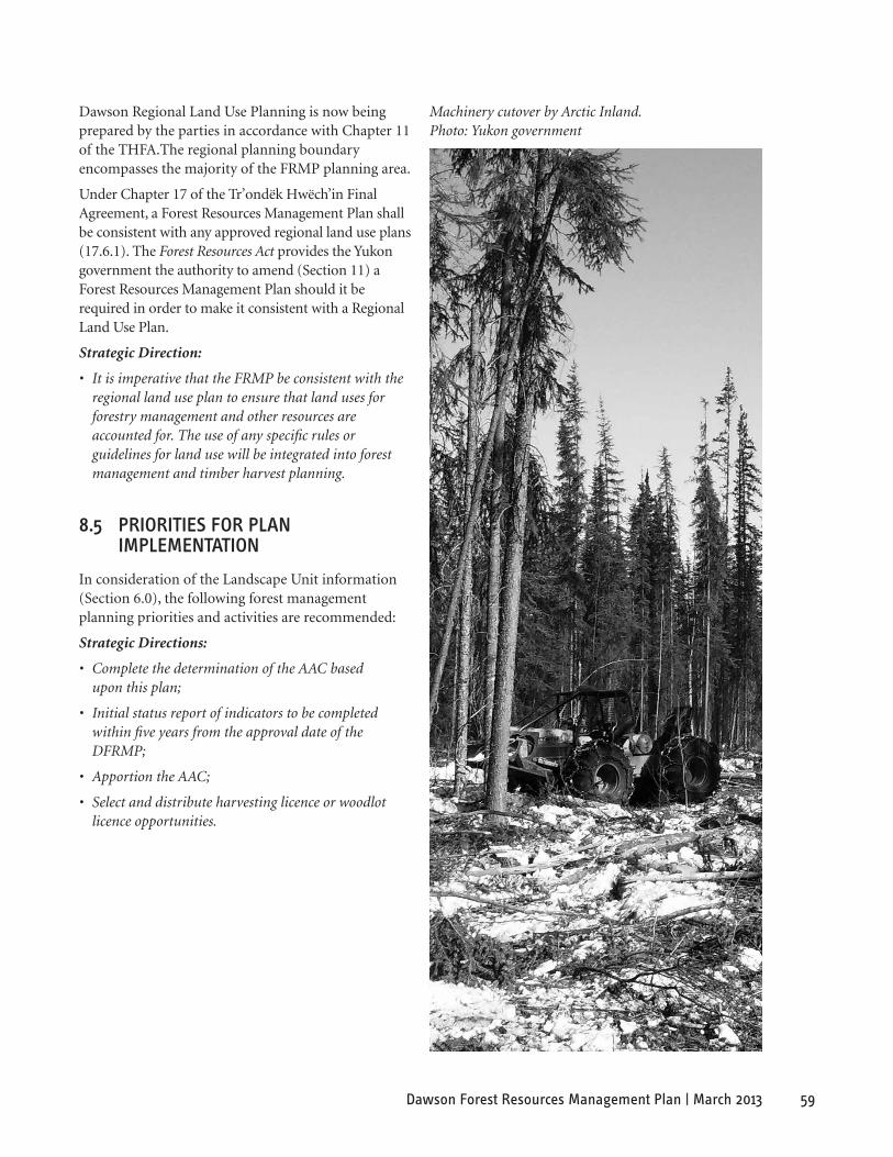
59Dawson Forest Resources Management Plan | March 2013
Machinery cutover by Arctic Inland. Photo: Yukon government
Dawson Regional Land Use Planning is now being prepared by the parties in accordance with Chapter 11 of the THFA.The regional planning boundary encompasses the majority of the FRMP planning area.
Under Chapter 17 of the Tr’ondëk Hwëch’in Final Agreement, a Forest Resources Management Plan shall be consistent with any approved regional land use plans (17.6.1). The Forest Resources Act provides the Yukon government the authority to amend (Section 11) a Forest Resources Management Plan should it be required in order to make it consistent with a Regional Land Use Plan.
Strategic Direction:
• It is imperative that the FRMP be consistent with the regional land use plan to ensure that land uses for forestry management and other resources are accounted for. The use of any specific rules or guidelines for land use will be integrated into forest management and timber harvest planning.
8.5 PrioriTies For PlaN imPlemeNTaTioN
In consideration of the Landscape Unit information (Section 6.0), the following forest management planning priorities and activities are recommended:
Strategic Directions:
• Complete the determination of the AAC based upon this plan;
• Initial status report of indicators to be completed within five years from the approval date of the DFRMP;
• Apportion the AAC;
• Select and distribute harvesting licence or woodlot licence opportunities.
60 Dawson Forest Resources Management Plan | March 2013
9. RefeRenCes
Anonymous. 2007 (draft). Wilderness Tourism Status Report, Chapter 4 Regional Summaries. Yukon Department of Tourism and Culture.
Anonymous. No date. Wilderness Tourism Best Management Practices [online]. Government of Yukon, Department of Energy Mines and Resources. Available at http://www.emr.gov.yk.ca/pdf/bmp_ brochure_wilderness.pdf
Anderton, 2007. Personal communication. Issac Anderton, Fisheries Biologist, Environmental Dynamics, Whitehorse, Yukon. Fall 2007.
Arctic Inland Building Products. 2007. Web Site. Available at http://www.arcticinland.ca
Brand, F. S., and K. Jax. 2007. Focusing the meaning(s) of resilience: resilience as a descriptive concept and a boundary object. Ecology and Society 12(1): 23. Available at http://www.ecologyandsociety.org/vol12/ iss1/art23
Burton, P.J., Messier. C., Smith, D.W., Adamowicz, W. L.(editor). 2003. Towards Sustainable Management of Boreal Forest. NRC Research Press, Ottawa, Ontario, Canada. 1039p.
Canadian Council of Forest Ministers. 2003. Defining Sustainable Forest Management in Canada: Criteria and Indicators [online]. Canadian Forest Service, Natural Resources Canada. Available at http:// www.ccmf.org/ci/CI_Booklet_e.pdf
Canadian Endangered Species Conservation Council (CESCC). 2006. Wild Species 2005: The General Status of Species in Canada [online]. Available at http://www.wildspecies.ca/wildspecies2005/GS2005_ site_e.pdf
Canadian Wildlife Service, 2003. Birds of the Yukon Database. Canadian Wildlife Service, Whitehorse.
Commonwealth Historic Resources Management Ltd. 2007. Dawson Heritage Management Plan. Prepared for the City of Dawson, Yukon.
Connectivity Planning Sub-Group. 2007. Habitat Connectivity Planning Recommendations for Forest Harvest Planning in the Champagne And Aishihik Traditional Territory. Prepared for the Forestry Working Group, with technical assistance from EDI Environmental Dynamics Inc., Whitehorse, Yukon.
Dyce, C. 2008. Personal communication. Chad Dyce, Senior Natural Resources Officer, Government of Yukon, Department of Energy, Mines and Resources, Dawson Region.
Government of British Columbia, Ministry of Sustainable Resource Management. 2004. Dease-Liard Sustainable Resource Management Plan [online]. Available at http://ilmbwww.gov.bc.ca/lup/srmp/ northern/dease-liard/index.html
Government of British Columbia. 1999. An Introductory Guide to Adaptive Management Forest Practices Branch, BC Ministry of Forests.
Government of Yukon, Department of Economic Development. 2007. Yukon Economic Overview and Outlook 2007 [online]. Available at http://economics.gov.yk.ca/Files/Economic%20Outlook/Outlook2007.pdf
Government of Yukon, Department of Energy, Mines and Resources. 2007. Oil and Gas Land Status Map [online]. Available at http://maps.gov.yk.ca/imf. jsp?site=OilandGas
Government of Yukon, Department of Energy, Mines and Resources. 2008 Yukon Forest Health Report. R. Garbutt, CFS.
Government of Yukon, Department of Environment, 2002. Draft Tombstone Territorial Park Management Plan.
Government of Yukon, Department of Environment. 2006. Government of Yukon Climate Change Strategy [online]. Available at http://www.yukonpremier.ca/ premier/pdf/ygclimatechangestrategy.pdf
Government of Yukon, Department of Tourism and Culture. 2004. 2004 Yukon Visitor Exit Survey: Klondike Region [online]. Available at http://www.tirc.gov.yk.ca/pdf/Klondike_VES2004_ Apr14.pdf
Government of Yukon, Department of Tourism and Culture. In progress. Draft Wilderness Tourism Study, Chapter 4, Regional Summaries. KIAC School of Visual Arts. 2007. Web Site. Available at http://kiacsova.ca/index2.html
KIAC School of Visual Arts, 2007. http://kiacsova.ca/index2.html
Kienzler, M. 2007. Personal communication. Martin Kienzler, Fish and Wildlife Technician, Northern Region, Government of Yukon, Department of Environment.

61Dawson Forest Resources Management Plan | March 2013
Bill Bowie and spruce sapling. Photo: Yukon government
LeBarge, W., 2006. Yukon Placer Mining Overview 2005. In Yukon Exploration and Geology, 2005.
D.S. Emond, G.D. Bradshaw, L.L. Lewis and L.H. Weston (eds.), Yukon Geological Survey, p. 41-45. Available at http://www.emr.gov.yk.ca/mining/ placeroverview2005.html
Milne, D. 2008. Personal communication. David Milne, Prevention Coordinator, Planning Section, Government of Yukon, Community Services Branch, January 18, 2008.
McCoy, V.M., and C.R. Burn. 2005. Potential Alteration by Climate Change of the Forest-Fire Regime in the Boreal Forest of Central Yukon Territory. Arctic 58: 276-285.
Northern Design Consultants. 1993. A History of Logging in the Yukon: 1896-1970. Volume 1. Canada/Yukon Economic Development Agreement.
Ogden, A. 2007. Personal communication. Aynslie Ogden, Forest Science Officer, Forest Management Branch, Yukon Energy, Mines and Resources.
Statistics Canada. 2007. 2006 Community Profiles: Dawson [Online]. Available at http://www12.statcan. ca/english/census06/data/profi les/community/Index. cfm?Lang=E
Thomas, C. 2007. Historic Resource Potential Overview Study: Tr’ondëk Hwëch’in Traditional Territory Forest Management Planning Area. Heritage Resource Unit, Cultural Service Branch, Yukon Department of Tourism and Culture.
Yukon Ecoregions Working Group, 2004. Part 2: Ecozone and Ecoregion Descriptions. In: Ecoregions of the Yukon Territory: Biophysical properties of Yukon landscapes, C.A.S. Smith, J.C. Meikle and
C.F. Roots (eds.), Agriculture and Agri-Food Canada, PARC Technical Bulletin No. 04-01, Summerland, British Columbia, p. 63-72.
Digital Data Sources and Print Maps
Fire History 1845-2005. Government of Yukon, Department of Energy, Mines and Resources.
Forest Cover. 1999. Government of Yukon, Department of Energy, Mines and Resources.
Placer and quartz claims. Government of Yukon, Department of Energy Mines and Resources.
Tombstone Territorial Park boundary. Government of Yukon, Department of Environment.
Tr’ondëk Hwëch’in Settlement Lands. Government of Yukon, Department of Environment.
Yukon Wildlife Key Areas. 2007. Habitat and Regional Management, Government of Yukon, Department of Environment.
Wilderness Tourism Key Areas. 2007 (draft). Government of Yukon, Department of Tourism and Culture.
62 Dawson Forest Resources Management Plan | March 2013
Arctic Inland new mill. Photo: Arctic Inland
10. lIsT of aCRonYMs
AAC Annual Allowable Cut
CCFM Canadian Council of Forest Ministers
CFDZ Community Forest Development Zone
COSEWIC Committee on the Status of Endangered Wildlife in Canada
CPAWS Canadian Parks and Wilderness Society
DDRRC Dawson District Renewable Resource Council
FMB Forest Management Branch
FNFP First Nations Forestry Program
FNNND First Nation of Nacho Nyäk Dun
FRMP Forest Resources Management Plan
FRUD Forest Use Designation System
HFZ Hinterland Forest Zone
LU Landscape Unit
MBCA Migratory Birds Convention Act
MBR Migratory Birds Regulations
MOU Memorandum of Understanding
NND Nacho Nyäk Dun
NNDTT Nacho Nyäk Dun Traditional Territory
NTFP Non-timber forest products
PWPC Peel Watershed Planning Commission
SARA Species at Risk Act
TH Tr’ondëk Hwëch’in
THTT Tr’ondëk Hwëch’in Traditional Territory
TSA Timber Supply Analysis
UFA Umbrella Final Agreement
YESAA Yukon Environmental and Socio-economic Assessment Act
YG Yukon government
YSSC Yukon Salmon Sub-Committee
63Dawson Forest Resources Management Plan | March 2013
11. GlossaRY of foResT TeRMs
Access management planning: Specific to the roading required to access the harvest planning area, and between harvest blocks within the area, and includes maintenance and deactivation.
Adaptive management: A dynamic approach to forest management in which the effects of treatments and decisions are continually monitored and used, along with research results, to modify management practices on a continuing basis to ensure that management objectives are being met.
Annual allowable cut (AAC): The amount of timber that is permitted to be cut annually from a particular area. AAC is used as the basis for regulating harvest levels to ensure a sustainable supply of timber.
Area regenerating: Includes areas that have been harvested recently (less than 10 years ago), and areas depleted by such natural disturbances as fire, insects and disease, where the stand does not meet stocking standards.
Available timber: Timber which is available for harvest after due recognition of constraints to protect the environment and other forest uses. (See operable timber)
Basic silviculture: Harvesting methods and silviculture operations including seed collecting, site preparation, artificial and natural regeneration, brushing, spacing and stand tending, and other operations that are for the purpose of establishing a free-growing crop of trees of a commercially valuable species.
Biodiversity (biological diversity): The variety, distribution and abundance of different plants, animals and micro-organisms, the ecological functions and processes they perform and the genetic diversity they contain at a local, landscape or regional level of analysis.
Boreal forest: The most extensive of the three main forest zones in the world. (Others are tropical and temperate forest zones). The boreal forest is the northern circumpolar forest zone and characterized by winters that always have snow and where summers are short. This coniferous, tundra forest type consists primarily of black and white spruce, balsam fir and larch interspersed with broadleaf trees, usually birch and aspen.
Clearcutting (clearcut): An even-aged forest management silviculture method that involves the complete felling and removal of a stand of trees producing a fully exposed micro-climate for the development of a new even-aged stand.
Climate change: An alteration in measured quantities (e.g., precipitation, temperature, radiation, wind and cloudiness) within the climate system that departs significantly from previous average conditions and is seen to endure, bringing about corresponding changes in ecosystems and socio-economic activity.
Coarse filter approach: A broad approach to maintaining biodiversity through the conservation of land areas and representative habitats with the assumption that the needs of most of the associated species, communities and ecological processes will be met at the large-scale. (See fine filter approach.)
Coarse woody debris (CWD): Sound and rotting logs, branches and stumps that provide habitat for plants, animals and insects and a source of nutrients for soil development. The type and size of material designated as CWD varies among classification systems.
Composition: The proportion of each tree species in a stand expressed as a percentage of either the total number, crown closure, basal area or volume of all tree species in the stand.
Commercial forest: Forest land that is able to grow commercial timber within an acceptable time frame and is designated for such a purpose.
Critical habitat (from the federal Species at Risk Act): Specific areas within the geographic area occupied by a federally listed species on which physical and biological features are found that are essential to the conservation of the species. In conservation biology – part or all of an ecosystem occupied by wildlife species that is recognized as essential for the maintenance and long-term survival of the population.
Development plan: A specific plan outlining harvesting, road construction, protection, and silviculture activities over the short-term (often five years) in accordance with the approved forest management plan.
Ecodistrict: A part of an ecoregion characterized by distinctive geologic, soil, water, fauna and land use.
64 Dawson Forest Resources Management Plan | March 2013
Ecological land classification: A process of delineating and classifying ecologically distinctive areas based on geologic, landform, soil, vegetative, climatic, wildlife, water and human factors. This holistic approach to land classification can be applied incrementally, from site-specific ecosystems to very broad ecosystems. This system provides for seven levels of generalization: ecozones, ecoprovinces, ecoregions, ecodistricts, ecosections, ecosites and ecoelements.
Ecoregion: A part of an ecozone characterized by distinctive regional ecological factors, including climate, physical geography, vegetation, soil, water, fauna and land use.
Ecosystem: A dynamic system of plants, animals and other organisms, together with the non-living components of the environment, functioning as an interdependent unit.
Ecosystem integrity: The quality of a natural unmanaged or managed ecosystem in which the natural ecological processes sustain the function, composition and structure of the system.
Ecosystem management: The use of an ecological approach to achieve productive resource management by blending social, physical, economic and biological needs and values to provide healthy ecosystems.
Ecotourism: A type of tourism that focuses on nature-related experiences (e.g., backcountry travel).
Ecozone: An area of the Earth’s surface that is representative of a broad-scale ecological unit characterized by particular abiotic (non-living) and biotic (living) factors.
Edge habitat: A loosely defined type of habitat that occurs at the boundary between two different habitat types. Typically, edge habitats share characteristics with both adjacent habitat types and have particular transitional characteristics that are important to wildlife.
Endangered species: Any species of plant or animal defined through the Species at Risk Act as being in danger of extinction throughout all or a significant portion of its range in the federal registry.
Fine filter approach: An approach to maintaining biodiversity that is directed toward particular habitats or individual species that might fall through the coarse filter. These habitats may be critical in some way, and the species threatened or endangered.
Fire cycle: The projected length of time that it would take to burn an area equivalent to the planning area, or a sub-section of the planning area once.
Forest: An ecosystem characterized by a more or less dense and continuous tree cover, often consisting of stands varying in composition, structure, age class and associated processes, and commonly including meadows, streams, fish and wildlife.
Forest cover: Forest stands or cover types consisting of a plant community made up of trees and other woody vegetation, growing more or less closely together.
Forest cover map: A map showing relatively homogeneous forest stands or cover types, produced from the interpretation of aerial photos and information collected in field surveys. Commonly includes information on species, age class, height class, site and stocking level.
Forest ecology: The relationships between forest organisms and their environment.
Forest Ecosystem Network (FEN): A planned landscape zone that serves to maintain or restore the natural connectivity within a landscape unit.
Forest land: Land primarily intended for growing, or currently supporting, forest. It includes land not now forested (e.g. clear-cut lands and northern lands that are forested but not intended for any commercial forestry use) and plantations.
Forest management: The practical application of scientific, economic and social principles to the administration and working of a forest for specified objectives. Particularly, that branch of forestry concerned with the overall administrative, economic, legal and social aspects and with the essentially scientific and technical aspects, especially silviculture, protection and forest regulation.
Forestry practices: Any activity that is carried out on forest land to facilitate the use of forest resources, including, but not limited to, timber harvesting, road construction, silviculture, grazing, recreation, pest control and wildfire suppression.
Forest areas classification: A process of delineating large geographic areas according to landform and climate, associated with broad variations in overall forest composition.

65Dawson Forest Resources Management Plan | March 2013
Forest Resources Management Plan (FRMP): a plan prepared as set out in Part 2 of the Forest Resources Act and in accordance with Chapter 17 of the Tr’ondëk Hwëch’in Final Agreement.
Forest type: A group of forest areas or stands whose similar composition (species, age, height and density) differentiates it from other such groups.
Fuelwood: Trees used for the production of firewood logs or other wood fuel.
Fragmentation: The process of transforming large continuous forest patches into one or more smaller patches surrounded by disturbed areas. This occurs naturally through such agents as fire, landslides, windthrow and insect attack. In managed forest, timber harvesting and related activities have been the dominant disturbance agents.
Geographic Information System (GIS): An organized collection of computer hardware, software and geographic data designed for capturing, storing, updating, manipulating, analyzing and displaying all forms of geographically referenced information.
Global warming: The rise in temperature of the Earth’s atmosphere due to the greenhouse effect (the retention of the sun’s energy by the atmosphere due to the build-up of CO2 and other gases that are the bi-product of industrial activities).
Green tree retention: Harvesting that retains live trees of a specific species and size on the area to be cut to achieve a site-specific objective.
Habitat: The environment in which a population or individual lives; includes not only the place where a species is found, but also the particular characteristics of the place (e.g., climate or the availability of suitable food and shelter) that make it especially well suited to meet the life-cycle needs of that species.
Habitat management: Management of the forest to create environments that provide habitats (food, shelter) to meet the needs of particular organisms.
Harvesting: The practice of felling and removing trees or the removal of dead or damaged trees from an area.
Harvesting method: The mix of felling, bucking and yarding systems used in logging a stand of timber.
Harvest mitigation: In areas where logging can occur, the harvest mitigation provides direction on where and how the logging should be carried out, based on the identified values. Values can range from landscape to site-specific interests, such as private lands.
Harvest pattern: The spatial distribution of cut blocks and reserve areas across the forested landscape.
Harvesting or site prescription: Detailed plan on how, when and where timber will be harvested from an area.
Harvest schedule: A document listing the stands to be harvested by year or period, usually showing types and intensities of harvests for each stand, as well as a timetable for regenerating currently non-productive areas.
Harvesting system: See Harvesting method.
Healthy ecosystem: An ecosystem in which structure and functions allow the maintenance of biodiversity, biotic integrity and ecological processes over time.
Integrated resource management: A holistic approach to resource management that entails the management of two or more resources (e.g. water, soil, timber, pasture, wildlife and recreation) and that integrates the values of the community into the design of policies or projects to use and sustain these resources in perpetuity.
Inventory (forest): A survey of a forest area to determine such data as area, condition, timber, volume and species for a specific purpose, such as planning, purchasing, evaluating, managing or harvesting.
Keystone species: A species that plays an important ecological role in determining the overall structure and dynamic relationships within a biotic community. A keystone species presence is essential to the integrity and stability of a particular ecosystem.
Landscape: Areas of land that are distinguished by differences in landforms, vegetation, land use and aesthetic characteristics.
Landscape units (LU): Landscape units are based on watershed boundaries and modified by local access and development patterns. They usually contain similar management concerns and forest types. These units form the boundaries for detailed information gathering, monitoring and planning.
Management ignited prescribed fire: A means of controlling forest diseases, insects and excessive buildup of trees, and managing vegetation and habitat through the scheduling of burns around weather, fuel loads, season and ability to control fire. This type of management has currently not been used in Yukon.

66 Dawson Forest Resources Management Plan | March 2013
Management plan: A detailed plan for a forested area. It contains inventory and other resource data. (See forest management.)
Merchantable timber: A tree or stand that has attained sufficient size, quality and/or volume to make it suitable for harvesting.
Multiple forest use: A system of resource use where the forest resources in a given land unit serves more than one user.
Natural disturbance: Natural events that cause tree or forest renewal, i.e. due to fire, flooding, insect or disease attack. Natural disturbance regimes are a description of the dominant natural disturbance agents occurring in a large area such as a watershed or ecoregion.
Natural disturbance regimes: The historic patterns (frequency and extent) of fire, insects, wind, landslides and other natural processes in an area.
Natural regeneration: The renewal of a forest stand by natural seeding, sprouting, suckering or layering seeds may be deposited by wind, birds or mammals.
Net down: A zoning of the harvest planning area that helps to describe where logging can and cannot occur.
Non-commercial tree species: A tree species for which there is currently no market.
Non-forest land: Land not primarily intended for growing or supporting a forest.
Non-timber resource value: A value within the forest other than timber that includes, but is not limited to, biological diversity, fisheries, wildlife, minerals, water quality and quantity, recreation and tourism, cultural and heritage values and wilderness and aesthetic values.
Old-growth forest: Old-growth is a forest that contains live and dead trees of various sizes, species, composition, and age class structure. Old-growth forests, as part of a slowly changing but dynamic ecosystem, include climax forests but not sub-climax or mid-seral forests. The age and structure of old growth varies significantly by forest type and from one biogeoclimatic zone to another.
Operability: The ease of operations determined by the complexity and sensitivity of the site conditions (slope, soil, timber, volumes, harvesting equipment, etc.) and the degree of disturbance expected.
Operable forest: That portion of the production forest that, under current market conditions, can be harvested at a profit.
Operable land: All lands that are not considered inoperable lands.
Operable timber: Available timber that can be economically logged with present harvesting methods after consideration of access, timber quality and market price.
Patch cutting: The removal of all of the trees in a stand. The same as clearcutting, except that the area involved is smaller.
Partial cutting: Tree removal other than in a clearcut silviculture system; includes seed tree, variable retention, shelterwood and selection systems.
Pest: An organism capable of causing material damage. Forest pests include insects, tree diseases and noxious fungi.
Protected area: An area protected by legislation, regulation or land use policy to control the level of human occupancy or activities. Categories of protected areas include protected landscapes, national parks, multiple use management areas and nature (wildlife) reserves.
Public land: Public land that is managed by the territorial government.
Reforestation: The re-establishment of trees on denuded forest land by natural or artificial means, such as planting and seeding.
Regeneration: The continuous renewal of a forest stand. Natural regeneration occurs gradually with seeds from adjacent stands or with seeds brought in by wind, birds or animals. Artificial regeneration involves direct seeding or planting.
Retention harvesting: A silvicultural system designed to retain individual trees or groups of trees to maintain structural diversity over the area of the cutblock.
Riparian forest: At a large-scale, it is the band of forest that has a significant influence on a stream ecosystem or is significantly affected by the stream. At a smaller scale, it is the forest at the immediate water’s edge, where some specialized plants and animals form a distinct community.
67Dawson Forest Resources Management Plan | March 2013
Riparian zone / Buffer zone / Buffer strip: A strip of land maintained along a stream, lake, road, recreation site or different vegetative zone to mitigate the impacts of actions on adjacent lands, to enhance aesthetic values or as a best management practice.
Rotation: The planned number of years between the formation or regeneration of a crop or stand and its final cutting at a specified stage or maturity.
Seral community: Often referred to as seral stage, a seral community is an identifiable stage in the succession of plant species compositions, different ages of the dominant vegetation and by different micro-climate, soil and forest conditions. It is described from the time of disturbance until reaching relatively stable or climax community. The common seral communities are from pioneer stage, through various early and mid-seral stages, to late seral, subclimax and climax states.
Selection cutting: Annual or periodic cutting of trees in a stand in which the trees vary markedly in age. The objective is to recover the yield and maintain an uneven-aged stand structure, while creating the conditions necessary for tree growth and seedling establishment. Differs from selective cutting, in which the most valuable trees are harvested without regard for the condition of the residual stand.
Silviculture: The theory and practice of controlling the establishment, composition, growth and quality of forest stands.
Single tree selection: The selection of individual trees for harvesting.
Silvicultural prescription: Provides direction on block size and harvesting methods within the planning area. The prescription also identifies site limitations and reforestation planning.
Site plan: A site plan is a site specific management plan. It identifies the specific area and attributes of the area proposed for harvesting, as well as the stand level management activities, methods and standards for harvesting to ensure the protection of the forest resource values on that harvest area. A site plan can also include a reforestation plan with proposed silviculture activities. A site plan extends over one to 500 ha in size
Stand: A community of trees possessing sufficient uniformity in composition, age, arrangement or condition to be distinguishable from the forest or other growth on adjoining areas, thus forming a silvicultural or management entity.
Even-aged stand: A stand in which the ages of most trees are within 20 years of each other or is comprised of no more than two age classes.
Mixed-wood stand: A stand containing both deciduous and coniferous species.
Uneven-aged stand: A stand in which the most of the trees differ by more than 20 years or is comprised of more than two age classes.
Stand age: Stand age is the average age of the dominant and co-dominant trees for the leading species.
Stand height: Tree height is estimated for the leading tree species in the canopy based upon an average of dominant and co-dominant tree heights.
Stand rotation: One cycle of the predicted number of years between the start of a forest stand from seedlings to when that stand is harvested at a specified stage of maturity.
Stand structure: Stand structure is the physical arrangement or pattern of organization within the forest stand.
Single-storied: An even-aged stand that exhibits a more or less uniform canopy height.
Two-storied: A stand with two distinct, homogeneous layers, each with at least 10 per cent crown closure, between which there is a height difference of at least 10 metres.
Complex: A stand characterized by trees of many ages or sizes occurring singly or in groups. Tree species are usually shade tolerant.
Sustainable forest management: Management that maintains or enhances the long-term health of forest ecosystems for the benefit of all living things while providing environmental, economic, social and cultural opportunities for present and future generations.

68 Dawson Forest Resources Management Plan | March 2013
Arctic Inland Skidder. Photo: Arctic Inland
Thinning: A treatment that reduces tree density and competition between trees in a stand. Thinning concentrates growth on fewer, high-quality trees, provides periodic income and generally enhances stand productivity.
Timber Harvest Plan (THP): A timber harvest plan is a development plan that identifies areas proposed for harvesting of forest resources. It also identifies strategies for reducing or eliminating environmental consequences and impacts on other resources identified in the FRMP. Timber harvest plans can extend over landscape units, or watersheds, ranging from 5000 ha to 100,000 ha in size.
Timber Supply Analysis (TSA): The process of assessing and predicting the current and future timber supply for a management unit (a geographic area). The results of a TSA are one of the factors used to determine the AAC.
Understory: Trees growing under the main forest canopy.
Value-added product / Value-added production: Adding value to a product by further processing it. Examples of value-added wood products include joinery stock, windows, doors, kitchen cabinets, flooring and mouldings. Value-added pulp and paper
products include such items as packaging, diapers, coated papers, tissue, business papers and stationery and other consumer paper products.
Vulnerable species: A species that is considered at risk because it exists in low numbers or in restricted ranges, due to loss of habitat or other factors.
Watershed: An area of land that collects and discharges water into a single main stream through a series of smaller tributaries.
Wetland: An area where the soils are water-saturated for a sufficient length of time that excess water and resulting low oxygen levels are principle determinants of vegetation and soil development. A wetland is a swamp, marsh, bog or similar area that supports natural vegetation that is distinct for adjacent areas. Wetlands may or may not be treed. Shrub scars are included as wetlands. Shrub scars occur primarily in broad depressions and low-lying areas where forest development is limited by cold, periodically saturated soils.
Wildlife key habit: Locations used by wildlife for critical, seasonal life functions. These are areas where animals aggregate, such as breeding areas, or are restricted in availability, such as winter range. They might also be places where animals are particularly sensitive to disturbance, such as birthing areas.

69Dawson Forest Resources Management Plan | March 2013
12. aPPenDIX a
Cover Type
landscape Units exposed Ground
sand Urban Water forest non-forest no Information**
Totals (ha.)
Blackstone River* 1,539 0 0 243 2,172 74,292 158,720 236,966
Chandindu* 1,337 0 0 1,648 38,603 124,928 98,654 265,170
Flat Creek 16,022 0 79 261 108,705 48,696 0 173,763
Forty Mile River 4,259 0 0 533 57,429 56,217 0 118,438
Gold Fields 6,984 0 2,676 1,410 196,927 88,470 0 296,467
Hart River* 2,413 0 0 80 11,096 36,291 221,744 271,624
Klondike River 2,716 0 0 518 90,247 20,763 0 114,244
North Klondike River* 2,715 0 0 22 6,926 37,798 1,436 48,897
Ogilvie River* 4,107 151 0 0 470 92,570 514,764 612,061
Sixty Mile River 1,066 0 803 1,052 165,734 177,898 0 346,553
South Klondike River* 32,024 0 0 712 151,768 71,059 66,524 322,087
Stewart River 58 0 346 4,982 149,639 52,264 0 207,289
Tatonduk River* 37 0 0 258 90,776 71,508 255,420 417,999
White River 4,002 0 91 6,749 221,270 253,768 0 485,880
Yukon River Central 26,010 0 0 6,304 131,255 34,553 0 198,122
Yukon River North* 99 0 0 5,935 124,436 77,108 34,543 242,121
Yukon River South 1,522 0 258 10,438 195,618 116,899 0 324,735
Totals 106,911 151 4,253 41,144 1,743,071 1,435,082 1,351,805 4,682,416
Table 1. Summary by Land Cover Type from Yukon Vegetation Inventory, 2006.
* Landscape unit does not have complete coverage of Yukon Vegetation Inventory.** No information means there is incomplete Yukon Vegetation Inventory within those landscape units.

70 Dawson Forest Resources Management Plan | March 2013
leading Tree species
landscape Units Trembling aspen
balsam Poplar
subalpine fir
lodgepole Pine
black spruce
White spruce
birch Totals (ha.)
Blackstone River* 0 469 0 0 0 1,703 0 2,172
Chandindu* 8,063 41 2,988 0 10,465 11,524 5,521 38,602
Flat Creek 41,522 411 695 0 45,545 12,455 8,077 108,706
Forty Mile River 3,485 0 122 0 39,294 9,000 5,528 57,429
Gold Fields 39,926 1,196 299 182 75,131 38,979 41,213 196,926
Hart River* 0 0 0 0 0 11,096 0 11,096
Klondike River 12,735 1,594 66 0 43,312 15,671 16,868 90,246
North Klondike River* 39 114 128 0 1,603 4,543 499 6,925
Ogilvie River* 0 0 0 0 0 470 0 470
Sixty Mile River 7,978 116 1,273 0 54,488 66,305 35,575 165,735
South Klondike River* 10,652 4,398 0 129 74,135 50,456 11,998 151,768
Stewart River 27,086 1,620 501 0 9,053 86,310 25,068 149,638
Tatonduk River* 0 1,001 0 0 65,380 16,906 7,489 90,776
White River 20,871 2,263 1,923 0 14,944 103,726 77,543 221,270
Yukon River Central 7,761 716 44 0 57,209 35,179 30,347 131,256
Yukon River North* 12,083 633 71 0 68,562 20,620 22,468 124,437
Yukon River South 19,692 1,985 8,360 0 7,885 104,808 52,887 195,617
Totals 211,893 16,556 16,469 311 567,006 589,751 341,081 1,743,066
Table 2. Area Summary for Leading Tree Species by Landscape Unit based on the Yukon Vegetation Inventory, 2006.
* Landscape unit does not have complete coverage of Yukon Vegetation Inventory.
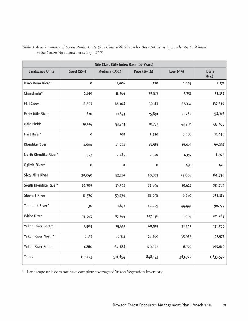
71Dawson Forest Resources Management Plan | March 2013
site Class (site Index base 100 Years)
landscape Units Good (20+) Medium (15-19) Poor (10-14) low (< 9) Totals (ha.)
Blackstone River* 0 1,006 120 1,045 2,171
Chandindu* 2,019 11,569 35,813 5,751 55,152
Flat Creek 16,597 43,308 39,167 33,314 132,386
Forty Mile River 670 10,873 25,891 21,282 58,716
Gold Fields 19,614 93,763 76,772 43,706 233,855
Hart River* 0 708 3,920 6,468 11,096
Klondike River 2,604 19,043 43,581 25,019 90,247
North Klondike River* 323 2,285 2,920 1,397 6,925
Ogilvie River* 0 0 0 470 470
Sixty Mile River 20,040 52,267 60,823 32,604 165,734
South Klondike River* 10,305 19,543 62,494 59,427 151,769
Stewart River 11,570 59,230 81,098 6,280 158,178
Tatonduk River* 30 1,877 44,429 44,441 90,777
White River 19,345 85,744 107,696 8,484 221,269
Yukon River Central 1,909 29,437 68,567 31,342 131,255
Yukon River North* 1,137 16,313 74,560 35,963 127,973
Yukon River South 3,860 64,688 120,342 6,729 195,619
Totals 110,023 511,654 848,193 363,722 1,833,592
Table 3. Area Summary of Forest Productivity (Site Class with Site Index Base 100 Years by Landscape Unit based on the Yukon Vegetation Inventory), 2006.
* Landscape unit does not have complete coverage of Yukon Vegetation Inventory.
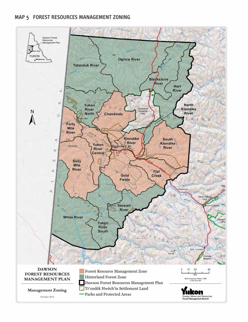
Tatonduk RiverOgilvie River
BlackstoneRiver
HartRiver
SouthKlondike
River
Chandindu
KlondikeRiver
FortyMile
River
YukonRiver
Central
YukonRiverNorth
White River
FlatCreek
SixtyMile
RiverGold
Fields
StewartRiver
YukonRiverSouth
NorthKlondike
River
Stewart Crossing
Mayo
Ddhaw GhroHPA
Dawson City
LhutsawWetland
Pelly Crossing
TombstoneTerritorial
Park
FortSelkirk
Stewart
Forty Mile
Sixtymile
McQuesten
Devil's ElbowHPA
RockCk.Bear
Ck.
105L 12
115K 07
105L 13
115P 08
105M 04
106D 04
105M 05
106D 05
105M 12
106D 12
106E 04
105M 13
106D 13
Dawson ForestResourcesManagement Plan
YUKONWhitehorse
Dawson City
DAWSONFOREST RESOURCESMANAGEMENT PLAN
0 20 4010
KmNorth American Datum 1983
UTM Zone 8N
AL
AS
KA
U.
S.
A.
Forest Resource Management ZoneHinterland Forest ZoneDawson Forest Resources Management PlanTr'ondëk Hwëch'in Settlement LandParks and Protected Areas
Management ZoningOctober 2012
MaP 5 FoResT ResoURces ManageMenT zoning

CONTACT INFORMATIONIf you would like more information regarding the Dawson Forest Resources Management Plan, please contact:
Dawson District Renewable Resources Council Box 1380 Dawson City, YT Y0B 1G0 Phone: 867-993-6976 Fax: 867-993-6093 Email: [email protected]
Tr’ondëk Hwëch’in - Main Administrative Building Natural Resources Department Land and Resources Branch 1242 Front Street PO Box 599 Dawson City, YT Y0B 1G0 Phone: 867-993-7100 Toll Free: 1-877-993-3400
Government of Yukon Department of Energy, Mines and Resources Forest Management Branch Mile 918 Alaska Highway Box 2703, (K-918) Whitehorse, YT Y1A 2C6 Phone: 867-456-3999 Toll Free: 1-800-661-0408 ext. 3999 Fax: 867-667-3138 Email: [email protected] Web: www.forestry.gov.yk.ca