decay processes and three-dimensional digital modelling ... · pdf fileneolithic “domus...
TRANSCRIPT
Decay processes and three-dimensional digital model ling for geometric-
spatial reconstruction of the volcanic stone called “the elephant” of
Neolithic “domus de janas” (Sardinia, Italy):
Investigation and preliminary data
Stefano COLUMBU1 | Giovanni GUCCINI2
1Dept. of Chemical and Geological Sciences, University of Cagliari, Italy | 2Dept. of Architettura Disegno
Storia Progetto, University of Florence, Italy
Abstract: This research is based on the preliminary physical and petrographic characterization applied with
the support of advanced 3D modelling developed from laser scanner survey data. The subject of the
investigation is a volcanic rock engraved with a group of ancient tombs carved within a great zoomorphic
stone which shape recall the one of an elephant. The research about this "domus de janas" (the named used
to indicate certain ancient sepulchral monuments quite common in the Anglona area, North-west of Sardinia)
started gathering the 3D digital models with a high level of details and developing this virtual model with its
great accuracy within its geographical -virtual- environment. The further steps were aimed at providing a first
set of information about its petrophysical characteristics, decay state (from petrographic composition to their
alteration processes and their causes), and the evidences of the missing parts fallen during the ancient
collapse which gave the stone its special shape. All the information was composed according to a detailed
3D representation, based on the original laser scanner survey. The main task is to show how to put together
the 3D survey of this monument with all the data about its degradation. The further development of the
gathered data will be aimed to the definition of a searchable model with all these information linked in it. At
the same time a set of specific digital models will be developed, to cover different tasks, from the virtual
exploration to the 3D printing (from the scaled representation to the creation of "spare parts"). This research
will be aimed to produce two main benefits: a complete reconstruction of the original structure of the
Neolithic tombs, including the collapsed parts; a correct definition of the decay state and of the potential
threats on the future of this natural/human monument conservation.
Keywords: Stones, Decay, Laser scanner, 3D modelling, Physical features, Geology, Survey, Landscape
Introduction and aims of work
The “domus de janas” are sepulchral structures made of rock-cut tombs during the prehistoric age with very
various shapes and are typical of the Mediterranean area, in particular they are a common feature in the
Sardinia Island. The term means houses of the fairies (or witches) and the common name used to indicate
them on the island is "forrus" or "forreddus". Often they are linked together to form real underground
necropolis with a common access corridor and an anteroom, often very spacious and high-ceilinged.
Archaeologists claim to have been built between the fourth and third millennia BC and were attributed to the
Ozieri Culture at that time completely up set the way of living of the Sardinian people. At the center of Sedini

International Conference on Cultural Heritage and New Technologies | Vienna | 2012
2
village (in the North-west of Sardinia) is the domus de janas largest in Sardinia from which it was converted
into areal house, now an ethnography museum. While the “elephant domus de janas” are placed in the field
of Anglona area between the villages of Sedini and Castelsardo.
The ancient tombs of "elephant domus de janas" were quarried inside a big block stone (Fig.1) of volcanic
rock (probably rolled down the slope of the near volcanic structures of the Casteddazzu Mountain) that
belongs to the sardinian Oligo-Miocenic volcanic cycle. The volcanic rocks of Sardinia (including also those
of Plio-Quaternary cycle) have had a wide use throughout the historical period. The ignimbritic facies (as that
of elephant stone), due to their petro-physical characteristics optimal in regard to workability, are used for
example as millstones, ashlars and decorative elements on the historical architecture, from to the Roman
period (COLUMBU et al. 2006; MELIS & COLUMBU 1997) to the medieval period of the "Giudicati"
(COLUMBU et al. 2011; CORONEO & COLUMBU 2010; COLUMBU et al. 2009; COLUMBU et al. 2008;
MACCIOTTA et al. 2001). Other volcanic lithotypes (e.g. obsidian, phonolite) are used for other aims, as
ancient war and work tools (e.g. arrow tips, Aeneolhitic chipped- or Neolithic polished-stone axes;
BERTORINO et al. 2002; MACCIOTTA et al. 2002; MACCIOTTA et al. 2003; MARCHI, BERTORINO et al.
2004; MARCHI, COLUMBU et al. 2004; MARCHI, GARAU et al. 2004).
The elephant stone boulder is significantly altered by weathering (VERDIANI & COLUMBU 2012), which
owes its odd shape. The main objects of the research at first are to analyse the decay processes on the
monument and take actual geometric data of stone structure by original laser scanner survey for made a
detailed 3D representation. A secondary task is to put together the 3D survey and all the data about its
decay.
The developments of this research will be aimed at:
- definition of a set of specific digital models, which will make available all data obtained, allowing the virtual
exploration in 3D through the scaling of the structure;
- complete reconstruction of the original structure of the Neolithic tombs, including the shares collapsed and
missing useful for any restoration and replacement of the lost parts.
Fig.1a,b – Photos of the “elephant” volcanic stone with views from north (on the left, a) and from south (on the right, b). On this latter
photo it’s possible to see the access/window to the “domus de janas”.
Columbu | Guccini – The Elephant Stone
3
Historical and archaeological data
The Neolithic domus de janas of the elephant however, was already known in the twelfth century, when it
appears in two medieval documents relating to donations of lands made in 1147 AC, the church of St. Maria
of Bonarcado, and in 1153 AC the monastery of Nostra Signora of Tergu.
The hypogeum complex was indicated from the past century using the dialect words "Sa pedra pertunta" (or
"pedra pertusa"): the perforated stone (LOVISATO 1887), whose name was later taken by TARAMELLI
(1926). The first official mention of it came by ANGIUS (1837) but he didn’t indicate a specific name. The
Anglona area, where the stone is located, was the place of important prehistoric settlements, both Neolithic
(domus de janas of the elephant, of Scala Coperta and of Rocca Bianca) and Chalcolithic (ancient fortress
and village of Monti Ossoni) and the Bronze age (Nuragic period). The Neolithic hypogean tombs of this area
are probably the more isolated, and are often characterized by being dug in erratic boulders, clearly visible
from a distance, sometimes placed in a dominant position or halfway up a slope (like it is for the elephant
domus de janas), or on the edge of a deep valley (as it can be seen for the domus de janas of Via Nazionale
in Sedini village).
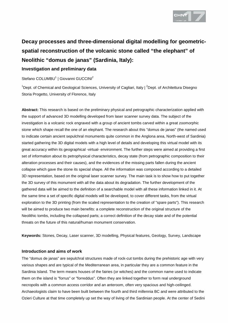
The complex of the “elephant domus de janas” consists of two subterranean tombs (commonly named I and
II). The tomb I is opened a little under the tomb II (Fig.2); it's composed by four cells: three along a single
pseudo axis disposed according to a N-S orientation, and one in a lateral position, in this way the whole plan
can recall a sort of “L” shape. In origin it was preceded by a short corridor realized to open sky (dromos) of
which only little traces remain today, and probably would only be covered in the last section, where there
was also a step now very worn (MELIS 1991). Inside the main room (Fig.2) there are two representations of
bovine heads (protomi), there is a certain discussion about the proper reading of these symbol, but their
most immediate interpretation recall directly a taurine shape with a small head and large horns. They show a
curvilinear style, recalling the TANDA A, III, 2 type (TANDA 1977), and testify an evolved artistic phase, in
which it turns out already started a geometrizing and simplifying process.
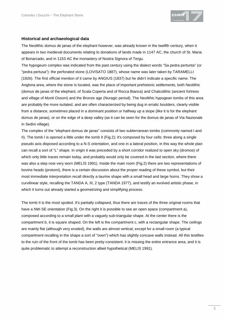
The tomb II is the most spoiled. It's partially collapsed, thus there are traces of the three original rooms that
have a NW-SE orientation (Fig.3). On the right it is possible to see an open space (compartment a),
composed according to a small plant with a vaguely sub-triangular shape. At the center there is the
compartment b, it is square shaped. On the left is the compartment c, with a rectangular shape. The ceilings
are mainly flat (although very eroded), the walls are almost vertical, except for a small room (a typical
compartment recalling in the shape a sort of "oven") which has slightly concave walls instead. All this testifies
to the ruin of the front of the tomb has been pretty consistent: it is missing the entire entrance area, and it is
quite problematic to attempt a reconstruction albeit hypothetical (MELIS 1991).
International Conference on Cultural Heritage and New Technologies | Vienna | 2012
4
Fig.2 – Plant of tomb I of “domus de janas” within the “elephant volcanic stone” (from MELIS 1991).
Methods
Petro-physical characterization
In order to study the petrophysical characteristics of the elephant volcanic stone, according to the
"Raccomandazioni Nor.Ma.L. 3/80" (1980/1988) some fragments, yet partially detached from the substrate,
were sampled out of the main rock.
The description of the samples was done prior through a microscope with magnification from12x to 56x and
then on thin sections with a polarizing microscope (in transmitted light) for petrographic determinations of
minerals and textural features of rocks.
The physical properties were determined according to the following methods: the samples were dried at
105±5°C and the dry weight (md) was determined. By an automatic helium pycnometer (Ultrapycnometer
Columbu | Guccini – The Elephant Stone
5
Fig.3 – Plant (down) and section (up) of tomb II of “domus de janas” within the “elephant volcanic stone” (from MELIS 1991).
1000, Quantachrome Instruments) the real volumes (Vr) of samples were determined, where Vr = VS+VCP, Vs
= solid volume, Vcp = closed porosity to helium.
Through the use of hydrostatic balance the bulk volumes (Vb) of specimens were measured, where Vb =
Vr+Vp, where Vp is the total volume of open pores. Open porosity to water (poH2O), open porosity to helium
(poHe), bulk density (ρb), real density (ρr) were computed as: poH2O = {[(mw-md)/ρwTX]/Vb}•100; poHe = [(Vb-
Vr)/Vb]•100; ρb = md/Vb; ρr = md/Vr, where: mw = wet weight; ρwTX = water density at the temperature TX
considered. The weight absorption coefficient (Ab) was computed as: Ab = [(mw-md)/md]•100.
International Conference on Cultural Heritage and New Technologies | Vienna | 2012
6
Laser scanner technologies
Survey
In 2006 the Survey Laboratory of the “Dipartimento di Progettazione dell’Architettura” from the Architectural
Faculty of Florence University decides to start a self-supported research project on the ancient elephant’s
stone (VERDIANI et al. 2007; VERDIANI et al. 2009).
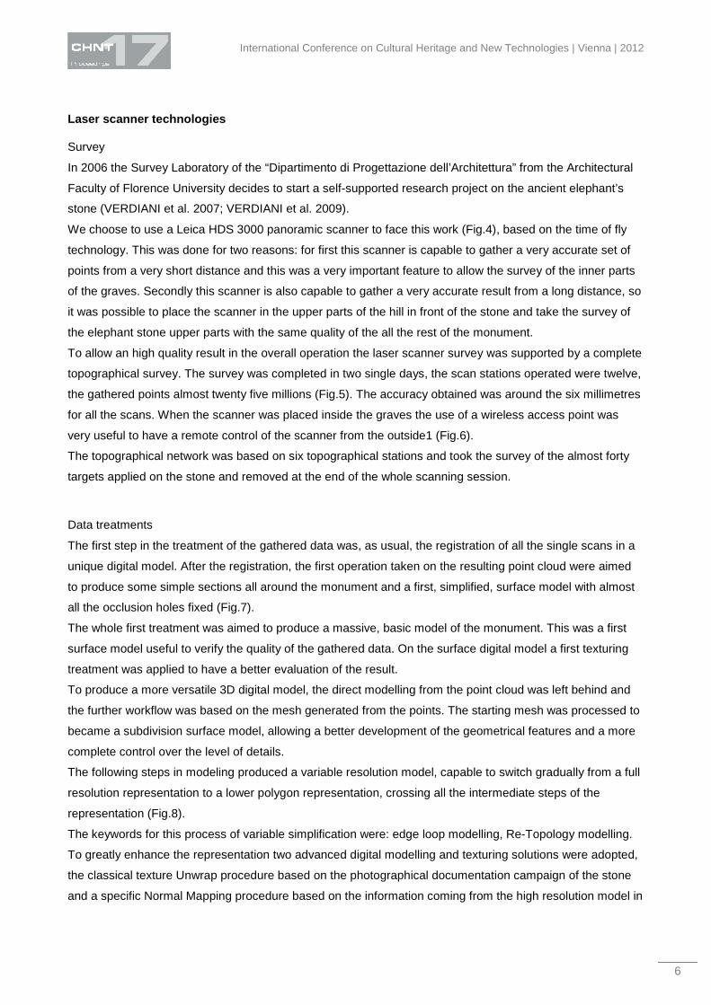
We choose to use a Leica HDS 3000 panoramic scanner to face this work (Fig.4), based on the time of fly
technology. This was done for two reasons: for first this scanner is capable to gather a very accurate set of
points from a very short distance and this was a very important feature to allow the survey of the inner parts
of the graves. Secondly this scanner is also capable to gather a very accurate result from a long distance, so
it was possible to place the scanner in the upper parts of the hill in front of the stone and take the survey of
the elephant stone upper parts with the same quality of the all the rest of the monument.
To allow an high quality result in the overall operation the laser scanner survey was supported by a complete
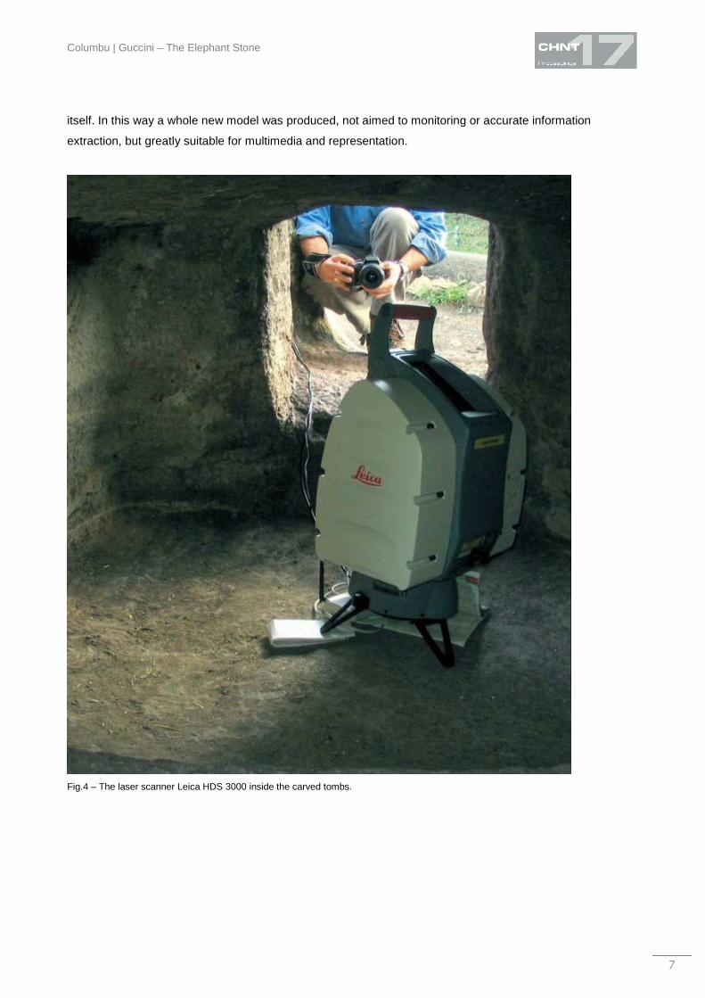
topographical survey. The survey was completed in two single days, the scan stations operated were twelve,
the gathered points almost twenty five millions (Fig.5). The accuracy obtained was around the six millimetres
for all the scans. When the scanner was placed inside the graves the use of a wireless access point was
very useful to have a remote control of the scanner from the outside1 (Fig.6).
The topographical network was based on six topographical stations and took the survey of the almost forty
targets applied on the stone and removed at the end of the whole scanning session.
Data treatments
The first step in the treatment of the gathered data was, as usual, the registration of all the single scans in a
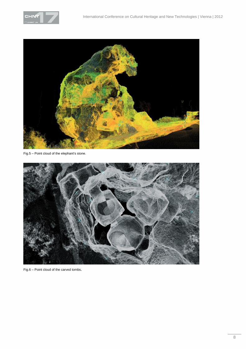
unique digital model. After the registration, the first operation taken on the resulting point cloud were aimed
to produce some simple sections all around the monument and a first, simplified, surface model with almost
all the occlusion holes fixed (Fig.7).
The whole first treatment was aimed to produce a massive, basic model of the monument. This was a first
surface model useful to verify the quality of the gathered data. On the surface digital model a first texturing
treatment was applied to have a better evaluation of the result.
To produce a more versatile 3D digital model, the direct modelling from the point cloud was left behind and
the further workflow was based on the mesh generated from the points. The starting mesh was processed to
became a subdivision surface model, allowing a better development of the geometrical features and a more
complete control over the level of details.
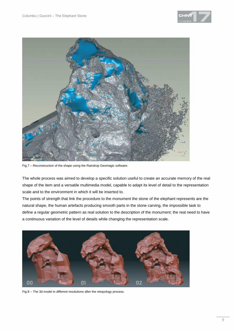
The following steps in modeling produced a variable resolution model, capable to switch gradually from a full
resolution representation to a lower polygon representation, crossing all the intermediate steps of the
representation (Fig.8).
The keywords for this process of variable simplification were: edge loop modelling, Re-Topology modelling.
To greatly enhance the representation two advanced digital modelling and texturing solutions were adopted,
the classical texture Unwrap procedure based on the photographical documentation campaign of the stone
and a specific Normal Mapping procedure based on the information coming from the high resolution model in
Columbu | Guccini – The Elephant Stone
7
itself. In this way a whole new model was produced, not aimed to monitoring or accurate information
extraction, but greatly suitable for multimedia and representation.
Fig.4 – The laser scanner Leica HDS 3000 inside the carved tombs.
International Conference on Cultural Heritage and New Technologies | Vienna | 2012
8
Fig.5 – Point cloud of the elephant’s stone.
Fig.6 – Point cloud of the carved tombs.
Columbu | Guccini – The Elephant Stone
9
Fig.7 – Reconstruction of the shape using the Raindrop Geomagic software.
The whole process was aimed to develop a specific solution useful to create an accurate memory of the real
shape of the item and a versatile multimedia model, capable to adapt its level of detail to the representation
scale and to the environment in which it will be inserted to.
The points of strength that link the procedure to the monument the stone of the elephant represents are the
natural shape, the human artefacts producing smooth parts in the stone carving, the impossible task to
define a regular geometric pattern as real solution to the description of the monument; the real need to have
a continuous variation of the level of details while changing the representation scale.
Fig.8 – The 3d model in different resolutions after the retopology process.
International Conference on Cultural Heritage and New Technologies | Vienna | 2012
10
The volcanic rock and its geology settings
The rock of the “elephant domus de janas” belong to the Oligo-Miocenic volcanism that forms a magmatic
arc running along the western margin of Sardinia and southern Corse microplates (LECCA et al. 1997 and
references therein). Three extensional phases can be recognized in Anglona area, where the “elephant
domus de janas” is located, during a 15 My period which spanned Corsica–Sardinia continental microplate
separation and western Mediterranean back-arc basin opening (SOWERBUTTS, 2000).
- On the first phase, initial late Oligocene extension has created a half-graben geometry with syn-rift clastic
deposits shed locally from fault-bounded highs, passing laterally to lacustrine marlstones. Subsequently, the
volcanic activity has predominated with volcanic centres developed along one half-graben bounding fault;
The Oligo-Miocene volcanic cycle has calcalkaline affinity l.s. and began around 32.4 My ago (BECCALUVA
et al. 1985; SAVELLI 2002 and references therein), producing on Sardinia basaltic and andesitic lavas, and
ended about 13-11 My ago, showing a climax between 23 and 17 My. This activity products crop out in vast
areas of Sardinia (COLUMBU et al. 2011) and is generally related with a subduction of oceanic lithosphere in
a N-NW direction along the European continental paleomargin (along the Apennines-Maghrebides
subduction zone) that produced the Oligocene rift between Sardinia and Provence (CHERCHI &
MONTADERT 1982).
- On second phase, mid-Aquitanian–early Burdigalian extensional faulting, recognized from localized clastic
syn-rift stratal wedges, truncated and subdivided the half-graben. The syn-rift sediments were sealed by a
regionally correlated ignimbrite that in turn was offset by late second-phase faulting.
- On third phase, an extensional fault movement has reactivated the original fault trend then occurred.
Results and discussion
Petrographic features
Microscopic analysis on thin sections of the samples examined from the domus de janas indicates that the
ignimbrite has a porphiric structure (with porphiritic index from 10 to 15%) for phenocrysts of opaque
minerals, plagioclase and rare clinopyroxene and quartz immersed in a ipocrystalline groundmass consisting
of plagioclase microliths and glass. The texture is fluidal, weakly oriented. The plagioclases (on average
about 95% of total phenocrysts present) are mainly elongated, from euhedral to subhedral, and are
distributed uniformly in all the examined sections. With crossed Nicol, we see the characteristic twins
according to the law of albite and albite-Carlsbad. By examining several individuals (according to Michel-
Lévy statistic method), the maximum symmetrical extinction angle measured in sections orthogonal to the
plane (010) was 35°, which corresponds to the 61% of anorthite content (labradorite composition).
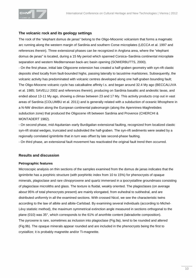
The pyroxene is rare, sometimes as inclusion into plagioclase (Fig.9a), tend to be rounded and altered
(Fig.9b). The opaque minerals appear rounded and are included in the phenocrysts being the first to
crystallize; it is probably magnetite and/or Ti-magnetite.
Columbu | Guccini – The Elephant Stone
11
Fig.9a,b. (crossed Nicol). Pyroxene enclosed within a crystal of plagioclase (on the left, a). Altered pyroxene (on the right, b).
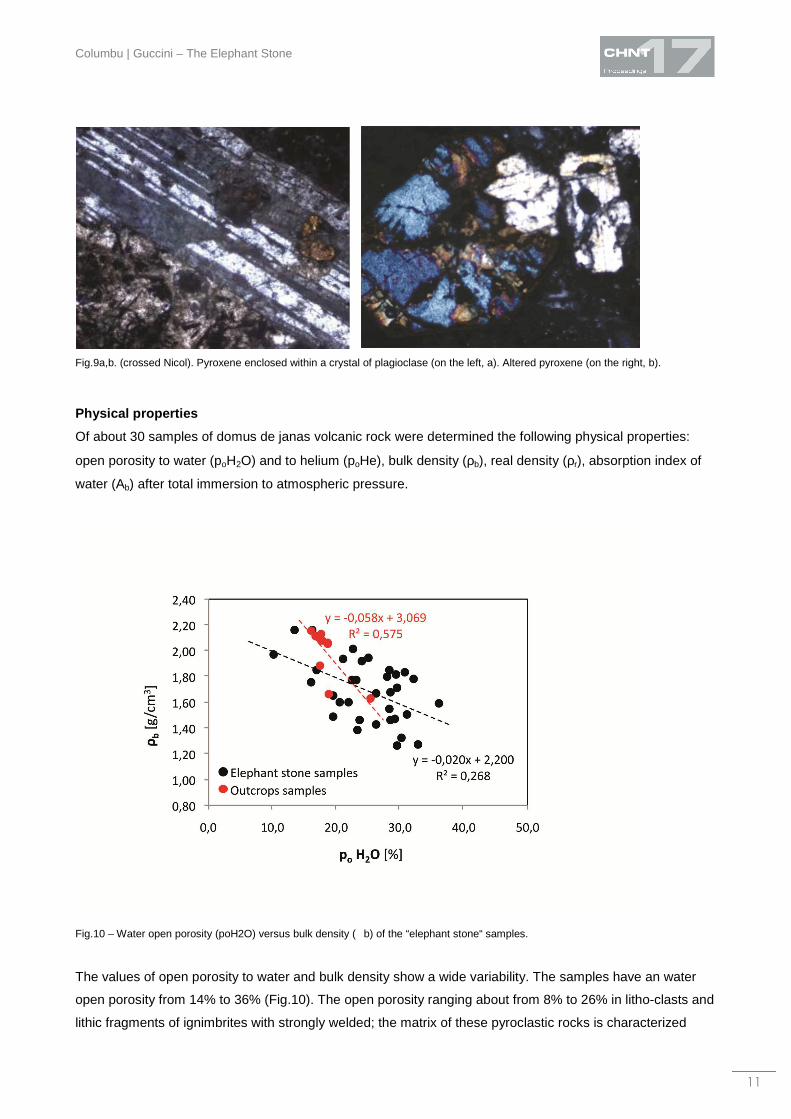
Physical properties
Of about 30 samples of domus de janas volcanic rock were determined the following physical properties:
open porosity to water (poH2O) and to helium (poHe), bulk density (ρb), real density (ρr), absorption index of
water (Ab) after total immersion to atmospheric pressure.
Fig.10 – Water open porosity (poH2O) versus bulk density (�b) of the “elephant stone“ samples.
The values of open porosity to water and bulk density show a wide variability. The samples have an water
open porosity from 14% to 36% (Fig.10). The open porosity ranging about from 8% to 26% in litho-clasts and
lithic fragments of ignimbrites with strongly welded; the matrix of these pyroclastic rocks is characterized
International Conference on Cultural Heritage and New Technologies | Vienna | 2012
12
from low- to medium-welded grade: the open porosity varies about from 15% (into unaltered matrix) to 42%
(in altered matrix). In some sample strongly altered, the porosity comes to 48%. This happens inside the
glassy matrix when this latter is already characterized by original poor welding. The average value of open
porosity, considering the whole set of samples, is 25% with a standard deviation of 6%.
The bulk density is ranging between a minimum of 1.27 and a maximum of 2.16 g/cm3 (Fig.10) with a mean
value of 1.69±0.24 g/cm3.
The variability of these two parameters (with low correlation coefficient: R2 = 0.268; Fig.10) is due to the high
compositional heterogeneity consequently to variable incidence of pumice, cognate fragments, litho-clasts,
crystal-clasts respect to matrix. The samples of near volcanic outcrops are less altered, show a more low
variability and consequently a more high correlation coefficient (R2 = 0.575; Fig.10).
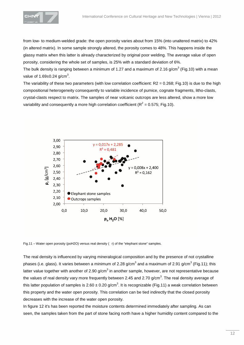
Fig.11 – Water open porosity (poH2O) versus real density (�r) of the “elephant stone“ samples.
The real density is influenced by varying mineralogical composition and by the presence of not crystalline
phases (i.e. glass). It varies between a minimum of 2.28 g/cm3 and a maximum of 2.91 g/cm3 (Fig.11); this
latter value together with another of 2.90 g/cm3 in another sample, however, are not representative because
the values of real density vary more frequently between 2.45 and 2.70 g/cm3. The real density average of
this latter population of samples is 2.60 ± 0.20 g/cm3. It is recognizable (Fig.11) a weak correlation between
this property and the water open porosity. This correlation can be tied indirectly that the closed porosity
decreases with the increase of the water open porosity.
In figure 12 it's has been reported the moisture contents determined immediately after sampling. As can
seen, the samples taken from the part of stone facing north have a higher humidity content compared to the
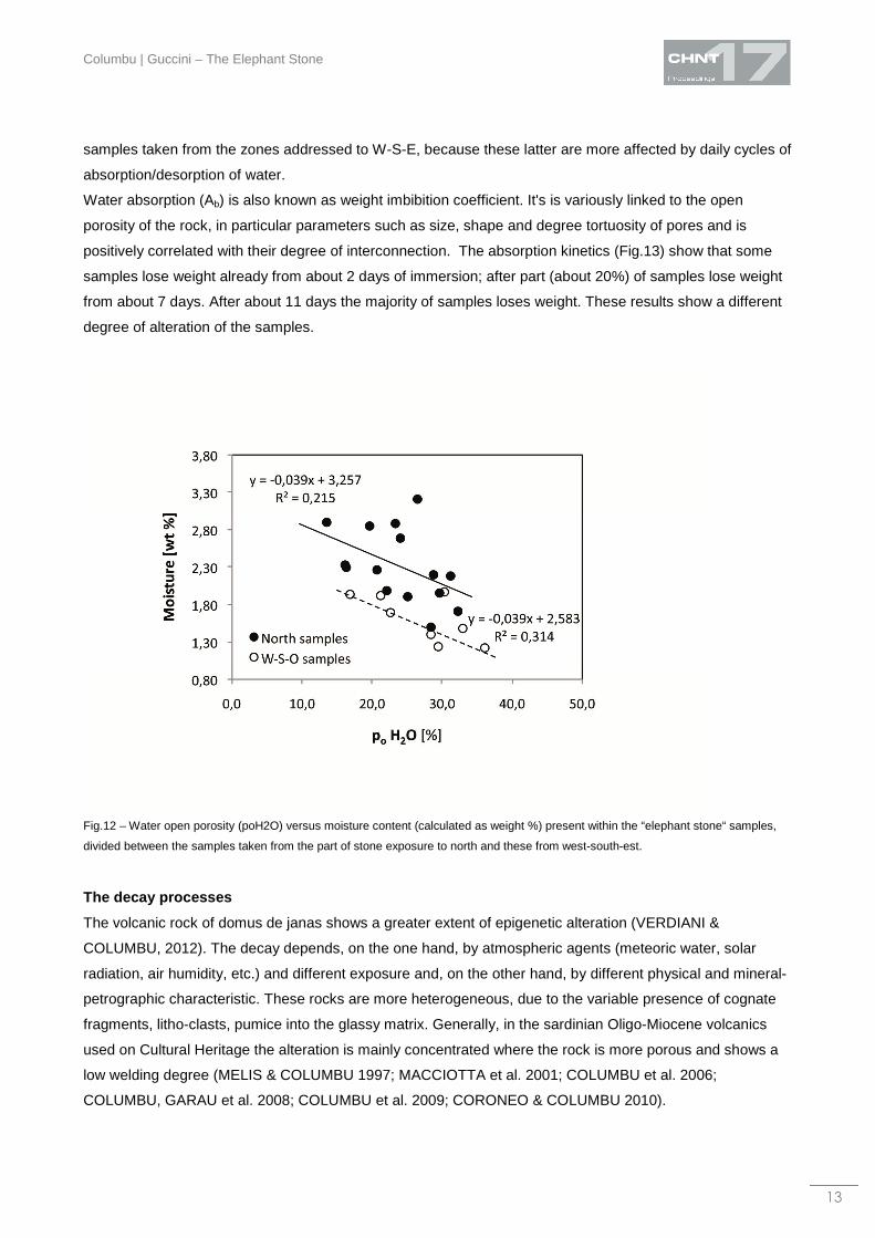
Columbu | Guccini – The Elephant Stone
13
samples taken from the zones addressed to W-S-E, because these latter are more affected by daily cycles of
absorption/desorption of water.
Water absorption (Ab) is also known as weight imbibition coefficient. It's is variously linked to the open
porosity of the rock, in particular parameters such as size, shape and degree tortuosity of pores and is
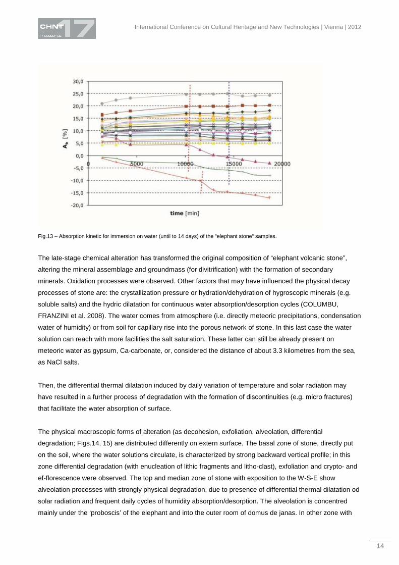
positively correlated with their degree of interconnection. The absorption kinetics (Fig.13) show that some
samples lose weight already from about 2 days of immersion; after part (about 20%) of samples lose weight
from about 7 days. After about 11 days the majority of samples loses weight. These results show a different
degree of alteration of the samples.
Fig.12 – Water open porosity (poH2O) versus moisture content (calculated as weight %) present within the “elephant stone“ samples,
divided between the samples taken from the part of stone exposure to north and these from west-south-est.
The decay processes
The volcanic rock of domus de janas shows a greater extent of epigenetic alteration (VERDIANI &
COLUMBU, 2012). The decay depends, on the one hand, by atmospheric agents (meteoric water, solar
radiation, air humidity, etc.) and different exposure and, on the other hand, by different physical and mineral-
petrographic characteristic. These rocks are more heterogeneous, due to the variable presence of cognate
fragments, litho-clasts, pumice into the glassy matrix. Generally, in the sardinian Oligo-Miocene volcanics
used on Cultural Heritage the alteration is mainly concentrated where the rock is more porous and shows a
low welding degree (MELIS & COLUMBU 1997; MACCIOTTA et al. 2001; COLUMBU et al. 2006;
COLUMBU, GARAU et al. 2008; COLUMBU et al. 2009; CORONEO & COLUMBU 2010).
International Conference on Cultural Heritage and New Technologies | Vienna | 2012
14
Fig.13 – Absorption kinetic for immersion on water (until to 14 days) of the “elephant stone“ samples.
The late-stage chemical alteration has transformed the original composition of “elephant volcanic stone”,
altering the mineral assemblage and groundmass (for divitrification) with the formation of secondary
minerals. Oxidation processes were observed. Other factors that may have influenced the physical decay
processes of stone are: the crystallization pressure or hydration/dehydration of hygroscopic minerals (e.g.
soluble salts) and the hydric dilatation for continuous water absorption/desorption cycles (COLUMBU,
FRANZINI et al. 2008). The water comes from atmosphere (i.e. directly meteoric precipitations, condensation
water of humidity) or from soil for capillary rise into the porous network of stone. In this last case the water
solution can reach with more facilities the salt saturation. These latter can still be already present on
meteoric water as gypsum, Ca-carbonate, or, considered the distance of about 3.3 kilometres from the sea,
as NaCl salts.
Then, the differential thermal dilatation induced by daily variation of temperature and solar radiation may
have resulted in a further process of degradation with the formation of discontinuities (e.g. micro fractures)
that facilitate the water absorption of surface.
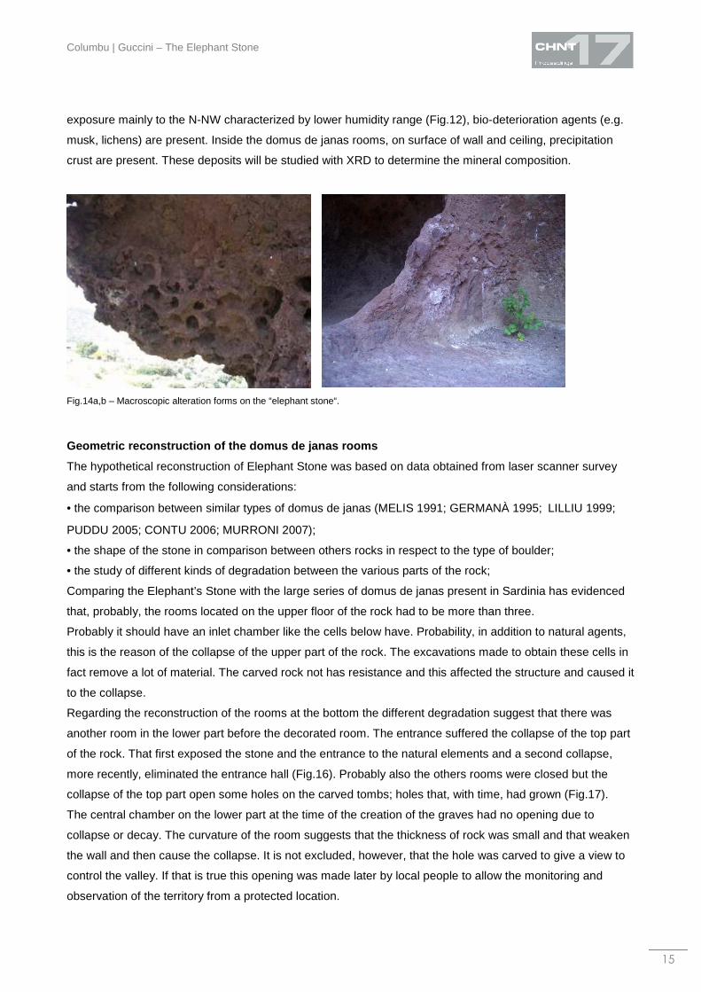
The physical macroscopic forms of alteration (as decohesion, exfoliation, alveolation, differential
degradation; Figs.14, 15) are distributed differently on extern surface. The basal zone of stone, directly put
on the soil, where the water solutions circulate, is characterized by strong backward vertical profile; in this
zone differential degradation (with enucleation of lithic fragments and litho-clast), exfoliation and crypto- and
ef-florescence were observed. The top and median zone of stone with exposition to the W-S-E show
alveolation processes with strongly physical degradation, due to presence of differential thermal dilatation od
solar radiation and frequent daily cycles of humidity absorption/desorption. The alveolation is concentred
mainly under the ‘proboscis’ of the elephant and into the outer room of domus de janas. In other zone with
Columbu | Guccini – The Elephant Stone
15
exposure mainly to the N-NW characterized by lower humidity range (Fig.12), bio-deterioration agents (e.g.
musk, lichens) are present. Inside the domus de janas rooms, on surface of wall and ceiling, precipitation
crust are present. These deposits will be studied with XRD to determine the mineral composition.
Fig.14a,b – Macroscopic alteration forms on the “elephant stone“.
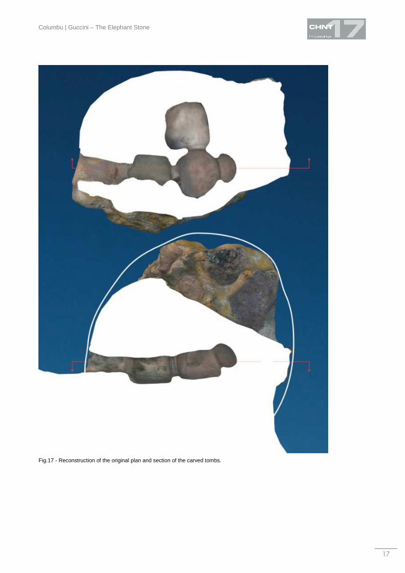
Geometric reconstruction of the domus de janas room s
The hypothetical reconstruction of Elephant Stone was based on data obtained from laser scanner survey
and starts from the following considerations:
• the comparison between similar types of domus de janas (MELIS 1991; GERMANÀ 1995;LILLIU 1999;
PUDDU 2005; CONTU 2006; MURRONI 2007);
• the shape of the stone in comparison between others rocks in respect to the type of boulder;
• the study of different kinds of degradation between the various parts of the rock;
Comparing the Elephant’s Stone with the large series of domus de janas present in Sardinia has evidenced
that, probably, the rooms located on the upper floor of the rock had to be more than three.
Probably it should have an inlet chamber like the cells below have. Probability, in addition to natural agents,
this is the reason of the collapse of the upper part of the rock. The excavations made to obtain these cells in
fact remove a lot of material. The carved rock not has resistance and this affected the structure and caused it
to the collapse.
Regarding the reconstruction of the rooms at the bottom the different degradation suggest that there was
another room in the lower part before the decorated room. The entrance suffered the collapse of the top part
of the rock. That first exposed the stone and the entrance to the natural elements and a second collapse,
more recently, eliminated the entrance hall (Fig.16). Probably also the others rooms were closed but the
collapse of the top part open some holes on the carved tombs; holes that, with time, had grown (Fig.17).
The central chamber on the lower part at the time of the creation of the graves had no opening due to
collapse or decay. The curvature of the room suggests that the thickness of rock was small and that weaken
the wall and then cause the collapse. It is not excluded, however, that the hole was carved to give a view to
control the valley. If that is true this opening was made later by local people to allow the monitoring and
observation of the territory from a protected location.
International Conference on Cultural Heritage and New Technologies | Vienna | 2012
16
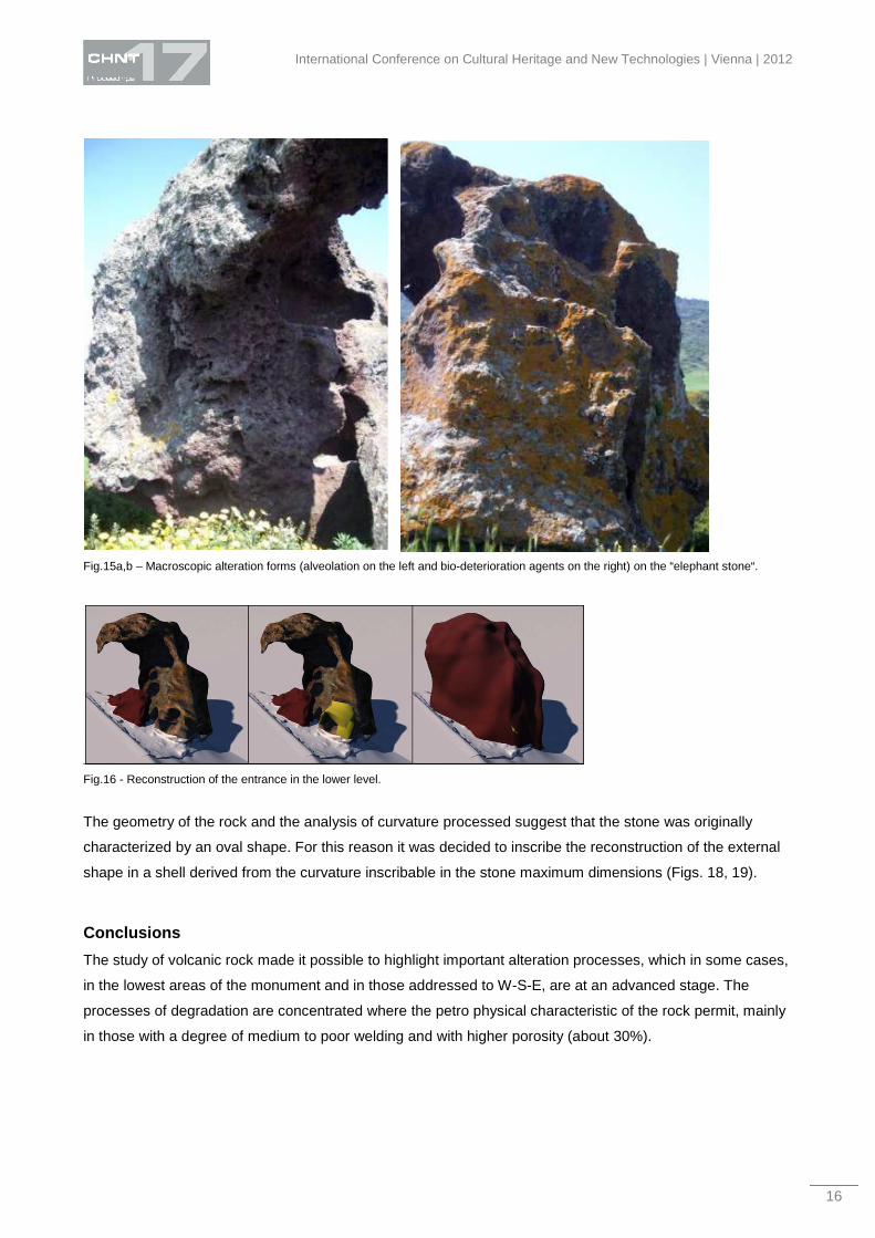
Fig.15a,b – Macroscopic alteration forms (alveolation on the left and bio-deterioration agents on the right) on the “elephant stone“.
Fig.16 - Reconstruction of the entrance in the lower level.
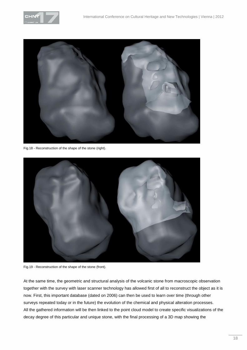
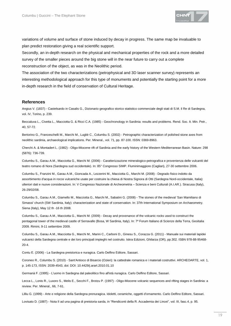
The geometry of the rock and the analysis of curvature processed suggest that the stone was originally
characterized by an oval shape. For this reason it was decided to inscribe the reconstruction of the external
shape in a shell derived from the curvature inscribable in the stone maximum dimensions (Figs. 18, 19).
Conclusions
The study of volcanic rock made it possible to highlight important alteration processes, which in some cases,
in the lowest areas of the monument and in those addressed to W-S-E, are at an advanced stage. The
processes of degradation are concentrated where the petro physical characteristic of the rock permit, mainly
in those with a degree of medium to poor welding and with higher porosity (about 30%).
Columbu | Guccini – The Elephant Stone
17
Fig.17 - Reconstruction of the original plan and section of the carved tombs.
International Conference on Cultural Heritage and New Technologies | Vienna | 2012
18
Fig.18 - Reconstruction of the shape of the stone (right).
Fig.19 - Reconstruction of the shape of the stone (front).
At the same time, the geometric and structural analysis of the volcanic stone from macroscopic observation
together with the survey with laser scanner technology has allowed first of all to reconstruct the object as it is
now. First, this important database (dated on 2006) can then be used to learn over time (through other
surveys repeated today or in the future) the evolution of the chemical and physical alteration processes.
All the gathered information will be then linked to the point cloud model to create specific visualizations of the
decay degree of this particular and unique stone, with the final processing of a 3D map showing the
Columbu | Guccini – The Elephant Stone
19
variations of volume and surface of stone induced by decay in progress. The same map be invaluable to
plan predict restoration giving a real scientific support.
Secondly, an in-depth research on the physical and mechanical properties of the rock and a more detailed
survey of the smaller pieces around the big stone will in the near future to carry out a complete
reconstruction of the object, as was in the Neolithic period.
The association of the two characterizations (petrophysical and 3D laser scanner survey) represents an
interesting methodological approach for this type of monuments and potentially the starting point for a more
in-depth research in the field of conservation of Cultural Heritage.
References Angius V. (1837) - Castelsardo in Casalis G., Dizionario geografico storico statistico commerciale degli stati di S.M. il Re di Sardegna,
vol. IV, Torino, p. 239.
Beccaluva L., Civetta L., Macciotta G. & Ricci C.A. (1985) - Geochronology in Sardinia: results and problems. Rend. Soc. It. Min. Petr.,
40, 57-72.
Bertorino G., Franceschelli M., Marchi M., Lugliè C., Columbu S. (2002) - Petrographic characterization of polished stone axes from
neolithic sardinia, archaeological implications. Per. Mineral., vol. 71, pp. 87-100. ISSN: 0369-8963.
Cherchi A. & Montadert L. (1982) - Oligo-Miocene rift of Sardinia and the early history of the Western Mediterranean Basin. Nature: 298
(5876): 736-739.
Columbu S., Garau A.M., Macciotta G., Marchi M. (2006) - Caratterizzazione mineralogico-petrografica e provenienza delle vulcaniti del
teatro romano di Nora (Sardegna sud occidentale). In: 85° Congresso SIMP. Fluminimaggiore (Cagliari), 27-30 settembre 2006.
Columbu S., Franzini M., Garau A.M., Gioncada A., Lezzerini M., Macciotta G., Marchi M. (2008) - Degrado fisico indotto da
assorbimento d'acqua in rocce vulcaniche usate per costruire la chiesa di Nostra Signora di Otti (Sardegna Nord-occidentale, Italia):
ulteriori dati e nuove considerazioni. In: V Congresso Nazionale di Archeometria – Scienza e beni Culturali (A.I.AR.). Siracusa (Italy),
26-29/02/08.
Columbu S., Garau A.M., Giamello M., Macciotta G., Marchi M., Sabatini G. (2008) - The stones of the medieval ‘San Mamiliano di
Simassi’ church (SW Sardinia, Italy): characterization and state of conservation. In: 37th International Symposium on Archaeometry.
Siena (Italy), May 12 th -16 th 2008.
Columbu S., Garau A.M., Macciotta G., Marchi M. (2009) - Decay and provenance of the volcanic rocks used to construct the
pentagonal tower of the medieval castle of Serravalle (Bosa, W Sardinia, Italy). In: 7º Forum Italiano di Scienze della Terra, Geoitalia
2009. Rimini, 9-11 settembre 2009.
Columbu S., Garau A.M., Macciotta G., Marchi M., Marini C., Carboni D., Ginesu S., Corazza G. (2011) - Manuale sui materiali lapidei
vulcanici della Sardegna centrale e dei loro principali impieghi nel costruito. Iskra Edizioni, Ghilarza (OR), pp.302. ISBN 978-88-95468-
20-4.
Contu E. (2006) - La Sardegna preistorica e nuragica. Carlo Delfino Editore, Sassari.
Coroneo R., Columbu S. (2010) - Sant’Antioco di Bisarcio (Ozieri): la cattedrale romanica e i materiali costruttivi. ARCHEOARTE, vol. 1,
p. 145-173, ISSN: 2039-4543, doi: DOI: 10.4429/j.arart.2010.01.10
Germanà F. (1995) - L’uomo in Sardegna dal paleolitico fino all’età nuragica. Carlo Delfino Editore, Sassari.
Lecca L., Lonis R., Luxoro S., Melis E., Secchi F., Brotzu P. (1997) - Oligo-Miocene volcanic sequences and rifting stages in Sardinia: a
review. Per. Mineral., 66, 7-61.
Lilliu G. (1999) - Arte e religione della Sardegna prenuragica. Idoletti, ceramiche, oggetti d’ornamento. Carlo Delfino Editore, Sassari.
Lovisato D. (1887) - Nota II ad una pagina di preistoria sarda, in “Rendiconti della R. Accademia dei Lincei”, vol. III, fasc.4, p. 95.
International Conference on Cultural Heritage and New Technologies | Vienna | 2012
20
Macciotta G., Bertorino G., Caredda A., Columbu S., Coroneo R., Franceschelli M., Marchi M., Rescic S. (2001) - The S.Antioco of
Bisarcio Basilica (NE Sardinia, Italy): water-rock interaction in ignimbrite monument decay. In: Water-Rock Interaction (WRI-10). 2001,
Cidu Ed., Swets & Zeitlinger, Lisse, vol.1, p. 415-418, ISBN 90 2651824 2.
Macciotta G., Columbu S., Garau A.M., Marchi M. (2002) - Aeneolhitic chipped-stone axes from mid-western Sardinia (preliminary
petrographic and geochemical data and archeological implications). 2° Congresso Nazionale AIAr, Bologna (Italy), 29 gennaio - 1
febbraio 2002.
Macciotta G., Columbu S., Garau A.M., Marchi M. (2003) - Obsidian in the geochemical-petrographical evolution of Plio-Quaternary
volcanics from Monte Arci. In: Atti del Convegno Internazionale: «L'ossidiana del Monte Arci nel Mediterraneo: recupero dei valori di un
territorio». Oristano-Pau, 29 novembre - 1 dicembre 2002. Tipografia Ghilarzese, Ghilarza, Italy, pp. 35-46.
Marchi M., Bertorino G., Columbu S., Garau A.M., Luglie' C., Macciotta G. (2004) - Asce in pietra di insediamenti eneolitici dell'alto
campidano, Sardegna centro-occidentale - Italia. (Caratterizzazione petrochimica e implicazioni archeologiche). In: Atti del 3th
Congresso Nazionale AIAr. L’archeometria In Italia: La Scienza per I Beni Culturali. Bressanone (Italy), 11-12 febbraio 2004, pp.117-
118.
Marchi M., Columbu S., Garau A., Luglie' C., Macciotta G., Doneddu A.A. (2004) - Asce eneolitiche in pietra scheggiata della Sardegna
centro occidentale. Dati preliminari petrografici e geochimici e implicazioni archeometriche. In: Atti del Convegno Internazionale:
«L'ossidiana del monte arci nel mediterraneo: recupero dei valori di un territorio», Oristano-Pau (Italy), 29 novembre - 1 dicembre 2002.
Tipografia Ghilarzese, Ghilarza, Italy, pp. 406-414.
Marchi M., Garau A.M., Columbu S., Macciotta G. (2004) - Definizione, nel Monte Arci, di possibili siti di provenienza di manufatti
ossidianacei, mediterranei, per mezzo della loro caratterizzazione petrografica e geochimica. 3° Convegno Internazionale: «L'ossidiana
del Monte Arci nel Mediterraneo: le vie dell’ossidiana nel Mediterraneo ed in Europa». Oristano-Pau (Italy). 25-26 settembre 2004.
Melis P. (1991) - La Domus dell’Elefante, Sardegna Archeologica n°15 , Carlo Delfino Editore, Sassari.
Melis S., Columbu S. (1999) - Materiaux de construction en epoque romaine et aves les ancuennes carrieres: l’exemple du theatre de
Nora (Sardaigne SO, Italie). In: La pierre dans la ville antique et mèdièval-Analyse mèthodologie et apports, Argentoun sur Creuse
(France). 29-31 Marzo 1998, p. 103-117.
Murroni F. (2007) - La Sardegna preistorica e Mediterraneo Antico. Storia e movimento di popoli. Grafica del Parteolla.
Puddu M. (2005) - La Sardegna dei megaliti. Megalitismo, miti e simboli nell’area del Mediterraneo. Iris editore.
Raccomandazioni Nor.Ma.L. 3/80 (1980) - Materiali Lapidei: Campionamento (Ristampa 1988)
Raccomandazioni Nor.Ma.L. 1/88 (1988) - Alterazioni macroscopiche dei materiali lapidei.
Savelli C. (2002) - Time-space distribution of magmatic activity in the western Mediterranean and peripheral orogens during the past 30
Ma (a stimulus to geodynamic considerations). J Geodyn 34,99-126.
Sowerbutts A. (2000) - Sedimentation and volcanism linked to multiphase rifting in an Oligo-Miocene intra-arc basin, Anglona, Sardinia.
Geological Magazine; July 2000; v. 137; no. 4; pp. 395-418. Cambridge University Press (CUP).
Tanda G. (1977) - Arte preistorica in Sardegna. Le figurazioni taurine scolpite dell’Algherese nel quadro delle rappresentazioni figurate
degli ipogei sardi a “domus de janas”, Sassari, p. 43, fig. 12.
Taramelli A. (1926) - La ricerca archeologica in Sardegna, in “Il Convegno archeologico in Sardegna”, Reggio Emilia, p. 35.
Taramelli A. (1927) - Convegno archeologico sardo, giugno 1926. Reggio nell'Emilia: Officine grafiche reggiane, 28 pp.
Verdiani G., Guccini G., Piras F. (2007) - The Stone of the Elephant, the survey of what was not surveyable. In: Workshop Archaologie
und Computer, Kulturelles Erbe und neue technologien. Wien. Austria. 18-20 Ottobre 2007. (pp. 1-10). Vienna: Stadt Archaologie Wien,
ISBN 978-3-85161-002-4.
Verdiani G., Piras F., Guccini G. (2009) - The Elephant Stone, tracing a new path for the digital approach to unsurveylable monuments,
in VSMM 2009 Proceedings of the 15th International Conference on Virtual Systems and Multimedia, Vienna 9-12 September 2009, pp.
47-51, IEEE Computer Society, CPS online, ISBN 978-0-7695-3790-0.
Columbu | Guccini – The Elephant Stone
21
Verdiani G., Columbu S., 2012, E. Stone, An Archive for the Sardinia Monumental Witnesses. International Journal of Heritage in the
Digital Era, vol. 1, p. 75-102, ISSN: 2047-4970, DOI: 10.1260/2047-4970.1.1.75
Acknowledgements
The survey of the elephant stone was made in 2006 in collaboration with Area3D s.r.l., Livorno, the survey
team was coordinated by Giorgio Verdiani and composed by Giovanni Guccini, Sergio Di Tondo, Federico
Piras, and Francesco Tioli. The further data treatment of the digital survey and digital modelling was
developed by Giovanni Guccini, Federico Piras, Filippo Susca.
The geological survey of the elephant stone was made in 2010 and coordinated by Stefano Columbu.
Imprint:
Proceedings of the 17th International Conference on Cultural Heritage and New Technologies 2012 (CHNT 17, 2012)
Vienna 2013
http://www.chnt.at/proceedings-chnt-17/
ISBN 978-3-200-03281-1
Editor/Publisher: Museen der Stadt Wien – Stadtarchäologie
Editorial Team: Wolfgang Börner, Susanne Uhlirz
The editor’s office is not responsible for the linguistic correctness of the manuscripts.
Authors are responsible for the contents and copyrights of the illustrations/photographs.