december 7, 2005 - deq.state.wy.usdeq.state.wy.us/wqd/wypdes_permitting/wypdes_pns... · 3601...
TRANSCRIPT
3601 Southern Drive • Gillette, WY 82718 • Telephone 307/685-5100 • Fax 307/682-7621
December 7, 2005 Becky Peters, Environmental Analyst Wyoming Department of Environmental Quality Water Quality Division 122 W. 25th St., Herschler Bldg. 4-W Cheyenne, WY 82002 RE: WY0045926: McKenzie - Stonepile WYPDES Permit Renewal Application
Pennaco Energy, Inc. Ms. Peters: Please consider and approve the enclosed WYPDES permit renewal. Enclosed for your use are the following:
• WYPDES Permit Application; • Permit Application Tables; • Water Balance Tables; • Flow Data Table; • Water Quality Data; and • Permit Application Map.
Pennaco respectfully requests the following:
• Remove outfalls 002 through 004, 006 and the Point of Compliance (POC1) from the permit.
• Retain the permitted flow rate of 1.23 MGD. • Update dissolved iron effluent limit from 234.2 ug/l to 1000 ug/l based on
current WDEQ regulatory standards. • Update dissolved manganese effluent limit from 841.5 ug/l to 850 ug/l based
on current WDEQ regulatory standards. • Update pH from 6.5-8.5 to 6.5-9.0 based on current WDEQ regulatory
standards. • Remove radium 226 from annual sampling and retain effluent limit of 60
pCi/l for initial samples. • Remove total recoverable aluminum per proposed WDEQ Chapter 1
changes. • Remove total petroleum hydrocarbons, and dissolved fluoride from initial
monitoring and annual sampling requirements based on current WDEQ regulatory standards.
WYPDES Permit RenewalPennaco Energy, Inc.
McKenzie-Stonepile WY0045926HUC 10-1009020802
December 7, 20053 of 24
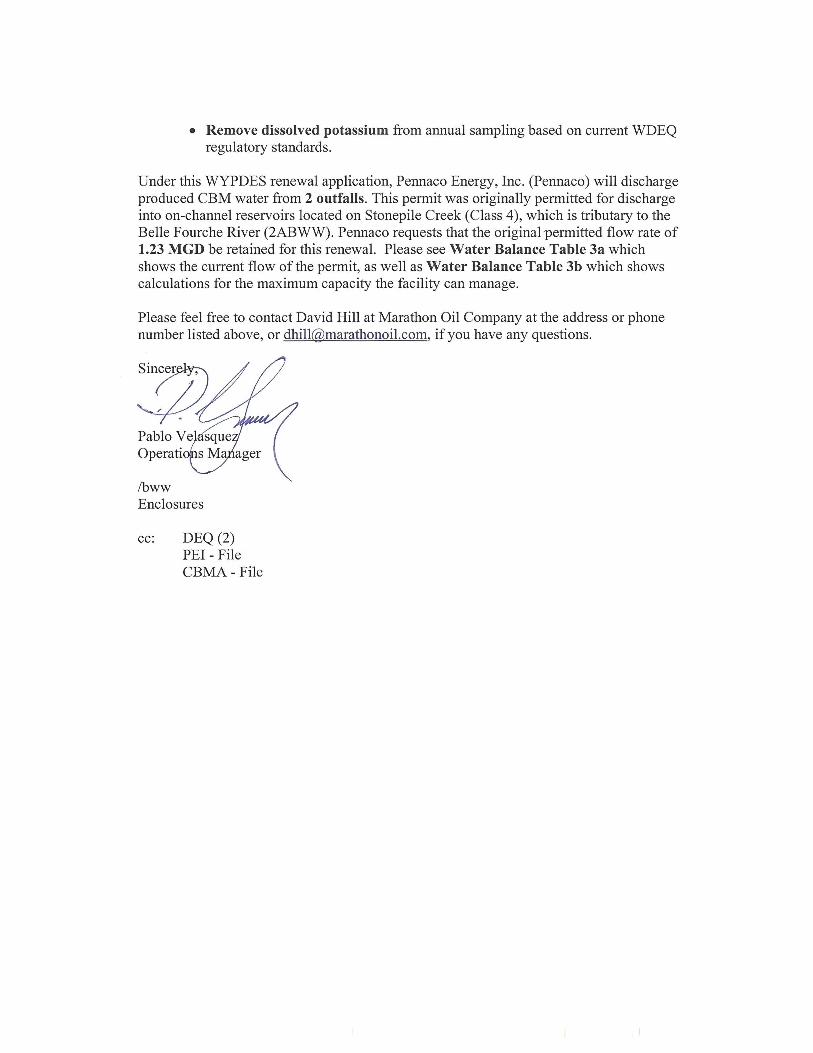
Remove dissolved potassium from annual sampling based on current WDEQ regulatory standards.
Under this WYPDES renewal application, Pennaco Energy, Inc. (Pennaco) will discharge produced CBM water from 2 outfalls. This pennit was originally permitted for discharge into on-channel reservoirs located on Stonepile Creek (Class 4), which is tributary to the Belle Fourche River (2ABWW). Pennaco requests that the original permitted flow rate of 1.23 MGD be retained for this renewal. Please see Water Balance Table 3a which shows the current flow of the permit, as well as Water Balance Table 3b which shows calculations for the maximum capacity the facility can manage.
Please feel free to contact David Hill at Marathon Oil Company at the address or phone number listed above, or dhill@,marathonoil.com, if you have any questions.
Ibww Enclosures
cc: DEQ (2) PEI - File CBMA - File
FOR AGENCY USE ONLY
Application Number
WY00 __ __ __ __ __
Date Received ___________________
(mo/day/yr)
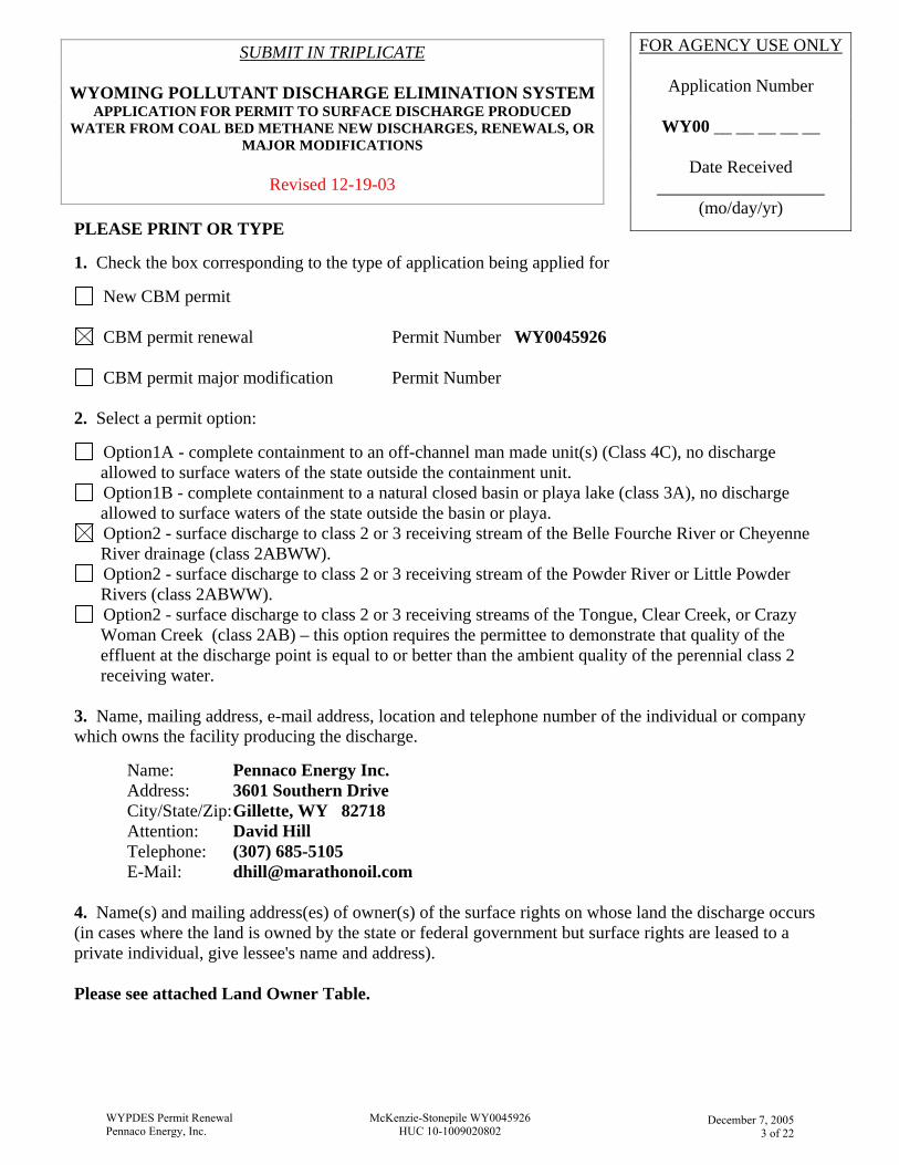
SUBMIT IN TRIPLICATE
WYOMING POLLUTANT DISCHARGE ELIMINATION SYSTEM APPLICATION FOR PERMIT TO SURFACE DISCHARGE PRODUCED
WATER FROM COAL BED METHANE NEW DISCHARGES, RENEWALS, OR MAJOR MODIFICATIONS
Revised 12-19-03
PLEASE PRINT OR TYPE 1. Check the box corresponding to the type of application being applied for
New CBM permit
CBM permit renewal Permit Number WY0045926
CBM permit major modification Permit Number 2. Select a permit option:
Option1A - complete containment to an off-channel man made unit(s) (Class 4C), no discharge allowed to surface waters of the state outside the containment unit.
Option1B - complete containment to a natural closed basin or playa lake (class 3A), no discharge allowed to surface waters of the state outside the basin or playa.
Option2 - surface discharge to class 2 or 3 receiving stream of the Belle Fourche River or Cheyenne River drainage (class 2ABWW).
Option2 - surface discharge to class 2 or 3 receiving stream of the Powder River or Little Powder Rivers (class 2ABWW).
Option2 - surface discharge to class 2 or 3 receiving streams of the Tongue, Clear Creek, or Crazy Woman Creek (class 2AB) – this option requires the permittee to demonstrate that quality of the effluent at the discharge point is equal to or better than the ambient quality of the perennial class 2 receiving water.
3. Name, mailing address, e-mail address, location and telephone number of the individual or company which owns the facility producing the discharge.
Name: Pennaco Energy Inc. Address: 3601 Southern Drive City/State/Zip: Gillette, WY 82718
Attention: David Hill Telephone: (307) 685-5105 E-Mail: [email protected]
4. Name(s) and mailing address(es) of owner(s) of the surface rights on whose land the discharge occurs (in cases where the land is owned by the state or federal government but surface rights are leased to a private individual, give lessee's name and address). Please see attached Land Owner Table.
WYPDES Permit RenewalPennaco Energy, Inc.
McKenzie-Stonepile WY0045926HUC 10-1009020802
December 7, 2005
3 of 22
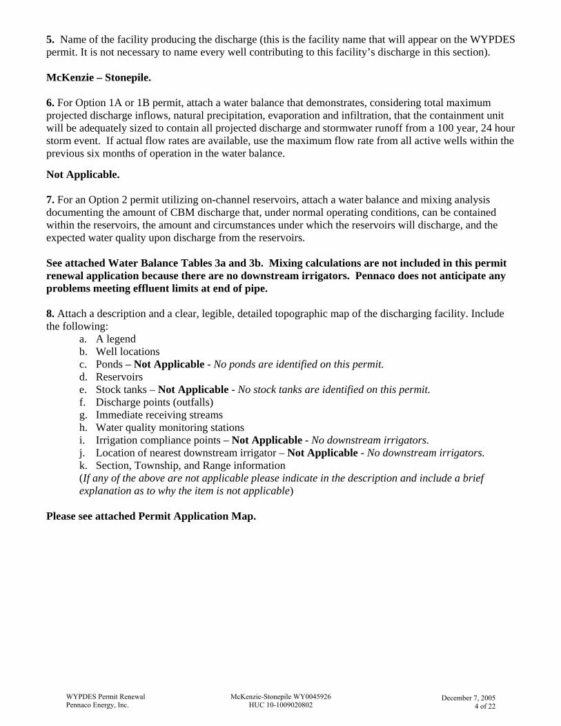
5. Name of the facility producing the discharge (this is the facility name that will appear on the WYPDES permit. It is not necessary to name every well contributing to this facility’s discharge in this section). McKenzie – Stonepile. 6. For Option 1A or 1B permit, attach a water balance that demonstrates, considering total maximum projected discharge inflows, natural precipitation, evaporation and infiltration, that the containment unit will be adequately sized to contain all projected discharge and stormwater runoff from a 100 year, 24 hour storm event. If actual flow rates are available, use the maximum flow rate from all active wells within the previous six months of operation in the water balance. Not Applicable. 7. For an Option 2 permit utilizing on-channel reservoirs, attach a water balance and mixing analysis documenting the amount of CBM discharge that, under normal operating conditions, can be contained within the reservoirs, the amount and circumstances under which the reservoirs will discharge, and the expected water quality upon discharge from the reservoirs. See attached Water Balance Tables 3a and 3b. Mixing calculations are not included in this permit renewal application because there are no downstream irrigators. Pennaco does not anticipate any problems meeting effluent limits at end of pipe. 8. Attach a description and a clear, legible, detailed topographic map of the discharging facility. Include the following:
a. A legend b. Well locations c. Ponds – Not Applicable - No ponds are identified on this permit. d. Reservoirs e. Stock tanks – Not Applicable - No stock tanks are identified on this permit. f. Discharge points (outfalls) g. Immediate receiving streams h. Water quality monitoring stations i. Irrigation compliance points – Not Applicable - No downstream irrigators. j. Location of nearest downstream irrigator – Not Applicable - No downstream irrigators. k. Section, Township, and Range information (If any of the above are not applicable please indicate in the description and include a brief explanation as to why the item is not applicable)
Please see attached Permit Application Map.
WYPDES Permit RenewalPennaco Energy, Inc.
McKenzie-Stonepile WY0045926HUC 10-1009020802
December 7, 2005
4 of 22
9. Describe the control measures that will be implemented to prevent significant damage to or erosion of the receiving water channel at the point of discharge. Pennaco Energy, Inc. has constructed erosion control structures at the outfall, such as rip-rap and/or geotextile membrane. Aeration facilities to reduce dissolved iron in the produced water are installed at the discharge point prior to the receiving waters of the state. 10. Describe the control measures that will be implemented to achieve water quality standards and effluent limits. If proposing to utilize a treatment process, provide a detailed description of the treatment process, including, but not limited to: Water quality analyses demonstrating the effluent quality before and after treatment; waste stream volumes and planned method of disposal; aquatic life toxicity data for any chemicals being used in the treatment process; description of how the chemicals will be handled at the facility and the potential for any impacts to waters of the state in the event of a spill; and diagrams of the facility indicating the water treatment path. Additional sheets and diagrams may be attached. No active water treatment planned. However, the outfalls will discharge in a manner that aerates the water to help induce the precipitation of dissolved metals. 11. Outfall locations must be established as part of a preliminary field reconnaissance survey using GPS or conventional survey equipment and documented in Table 1. Please document the type of equipment used, the expected accuracy of your measurements, and a brief rationale for locating the outfalls at the requested sites below. All outfalls associated with this application are constructed in sites designated by the landowner. Coordinates were obtained by the field personnel using handheld GPS units with accuracies ranging from 15 to 60 feet. 12. Complete the attached Table 1. Provide all the information in the table for each proposed discharge point or monitoring point. If proposing changes (a major modification) to an existing facility, clearly indicate the desired changes on the table. Additional tables may be attached. Use the format provided. Please see attached Table 1a and 1b. 13. Complete the attached Table 2. Provide all the information in the table for each well associated with this proposed discharge authorization. If proposing changes (a major modification) to an existing facility, clearly indicate the desired changes on the table. Additional tables may be attached. Use the format provided. Please see attached Table 2. 14. Provide the results of water analyses for a sample collected from a location representative of the quality of the water being proposed for discharge for the 25 chemical parameters listed below. The sample must be collected from a well or wells within at least a twenty mile radius of the proposed facility’s location, and from the same coal formation(s) and same approximate depth(s) as proposed in this application. If filing an application for a permit renewal or modification, the representative sample must be collected from the facility being proposed for renewal or modification. Explain why this sample is representative of the produced water to be discharged. Samples from co-mingled coal seams are acceptable as long as the sample(s) meet the following criteria:
A. all of the coal seams being proposed for development are represented in the co-mingled sample, B. the ratio of each coal seam’s contribution is approximately the same in the sample and the
proposed development, C. documentation is provided to verify the criteria listed in A. and B.
WYPDES Permit RenewalPennaco Energy, Inc.
McKenzie-Stonepile WY0045926HUC 10-1009020802
December 7, 2005
5 of 22
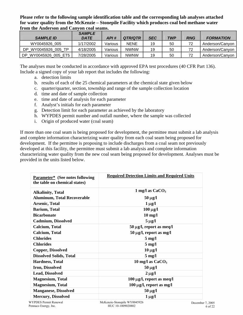
Please refer to the following sample identification table and the corresponding lab analyses attached for water quality from the McKenzie – Stonepile Facility which produces coal bed methane water from the Anderson and Canyon coal seams.
SAMPLE ID SAMPLE
DATE API # QTR/QTR SEC TWP RNG FORMATION WY0045926_005 1/17/2002 Various NENE 19 50 72 Anderson/Canyon
DP_WY0045926_005_TP 4/18/2005 Various NWNW 19 50 72 Anderson/CanyonDP_WY0045926_005_ET5 7/28/2005 Various NWNW 19 50 72 Anderson/Canyon
The analyses must be conducted in accordance with approved EPA test procedures (40 CFR Part 136). Include a signed copy of your lab report that includes the following:
a. detection limits b. results of each of the 25 chemical parameters at the chemical state given below c. quarter/quarter, section, township and range of the sample collection location d. time and date of sample collection e. time and date of analysis for each parameter f. Analyst’s initials for each parameter g. Detection limit for each parameter as achieved by the laboratory h. WYPDES permit number and outfall number, where the sample was collected i. Origin of produced water (coal seam)
If more than one coal seam is being proposed for development, the permittee must submit a lab analysis and complete information characterizing water quality from each coal seam being proposed for development. If the permittee is proposing to include discharges from a coal seam not previously developed at this facility, the permittee must submit a lab analysis and complete information characterizing water quality from the new coal seam being proposed for development. Analyses must be provided in the units listed below.
Parameter* (See notes following the table on chemical states)
Required Detection Limits and Required Units
Alkalinity, Total 1 mg/l as CaCO3
Aluminum, Total Recoverable 50 µg/l Arsenic, Total 1 µg/l Barium, Total 100 µg/l Bicarbonate 10 mg/l Cadmium, Dissolved 5 µg/l Calcium, Total 50 µg/l, report as meq/l Calcium, Total 50 µg/l, report as mg/l Chlorides 5 mg/l Chlorides 5 mg/l Copper, Dissolved 10 µg/l Dissolved Solids, Total 5 mg/l Hardness, Total 10 mg/l as CaCO3
Iron, Dissolved 50 µg/l Lead, Dissolved 2 µg/l Magnesium, Total 100 µg/l, report as meq/l Magnesium, Total 100 µg/l, report as mg/l Manganese, Dissolved 50 µg/l Mercury, Dissolved 1 µg/l
WYPDES Permit RenewalPennaco Energy, Inc.
McKenzie-Stonepile WY0045926HUC 10-1009020802
December 7, 2005
6 of 22
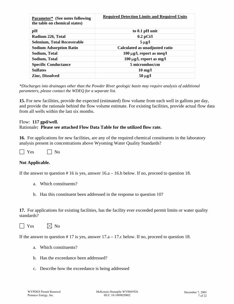
Parameter* (See notes following the table on chemical states)
Required Detection Limits and Required Units
pH to 0.1 pH unit Radium 226, Total 0.2 pCi/l Selenium, Total Recoverable 5 µg/l Sodium Adsorption Ratio Calculated as unadjusted ratio Sodium, Total 100 µg/l, report as meq/l Sodium, Total 100 µg/l, report as mg/l Specific Conductance 5 micromhos/cm Sulfates 10 mg/l Zinc, Dissolved 50 µg/l
*Discharges into drainages other than the Powder River geologic basin may require analysis of additional parameters, please contact the WDEQ for a separate list. 15. For new facilities, provide the expected (estimated) flow volume from each well in gallons per day, and provide the rationale behind the flow volume estimate. For existing facilities, provide actual flow data from all wells within the last six months. Flow: 117 gpd/well. Rationale: Please see attached Flow Data Table for the utilized flow rate. 16. For applications for new facilities, are any of the required chemical constituents in the laboratory analysis present in concentrations above Wyoming Water Quality Standards?
Yes No Not Applicable. If the answer to question # 16 is yes, answer 16.a – 16.b below. If no, proceed to question 18.
a. Which constituents?
b. Has this constituent been addressed in the response to question 10?
17. For applications for existing facilities, has the facility ever exceeded permit limits or water quality standards?
Yes No If the answer to question # 17 is yes, answer 17.a – 17.c below. If no, proceed to question 18.
a. Which constituents?
b. Has the exceedance been addressed?
c. Describe how the exceedance is being addressed
WYPDES Permit RenewalPennaco Energy, Inc.
McKenzie-Stonepile WY0045926HUC 10-1009020802
December 7, 2005
7 of 22
18. Is there active irrigation, (including but not limited to irrigation of cultivars or flood irrigation) in the drainage of the discharge?
Yes No If the answer to question #18 is yes, then documentation demonstrating one of the following must be provided:
A. Effluent will meet SAR and specific conductance (EC) values that are equal or of better quality to ambient values in the mainstem or highest quality receiving stream; or
B. Demonstrate that a higher level of EC and SAR at the point of irrigation diversion can be tolerated by irrigated soils and crops without a significant reduction in crop yield and soil quality permeability.
This information should include, but is not limited to the following:
a. Location and description of irrigated crop land between the discharge points and mainstem, including maximum local tolerance thresholds to SAR, EC, and sodium of each crop.
b. Description of irrigation practices including when and how frequent irrigation occurs. c. Soil characteristics for each area where irrigation occurs which includes: Classification of soils
and soil type (i.e. sandy loam, clay, etc.), Composition of soils (% clay, silt, sand), Type of soils, texture and permeability.
d. Baseline soil parameters in all actively irrigated areas which includes soil SAR, EC, Na, Mg, Ca, permeability, and exchangeable sodium percentage (ESP).
e. Determine the maximum SAR and EC of water that can be applied to the least tolerant and most sensitive identified irrigated soil type and crop, which would not result in a short and/or long-term reduction in soil infiltration/permeability or yield.
f. Provide the location (township, range, section, quarter/quarter and lat/long coordinates) of point(s) upstream from the first downstream point of irrigation diversion/use between the outfalls and mainstem and/or provide the location(s) of the irrigation diversion/use that requires the least flow to operate.
g. An evaluation that demonstrates the proposed discharge will be in compliance with Section 20, Chapter 1 of the Wyoming Water Quality Rules and Regulations.
h. If necessary to protect irrigated crops and/or soils, describe changes that must be made in traditional irrigation practices to protect downstream irrigation activities.
i. A monitoring plan, if necessary to gauge changes in water/soil quality and make adjustments before substantial reduction in crop production and soil permeability would occur.
j. Citations of reference for all the above information must be provided.
Not Applicable – No downstream irrigators. 19. Name(s) and address(es) of all downstream irrigators between the outfalls and mainstem must be provided. Not Applicable – No downstream irrigators.
WYPDES Permit RenewalPennaco Energy, Inc.
McKenzie-Stonepile WY0045926HUC 10-1009020802
December 7, 2005
8 of 22
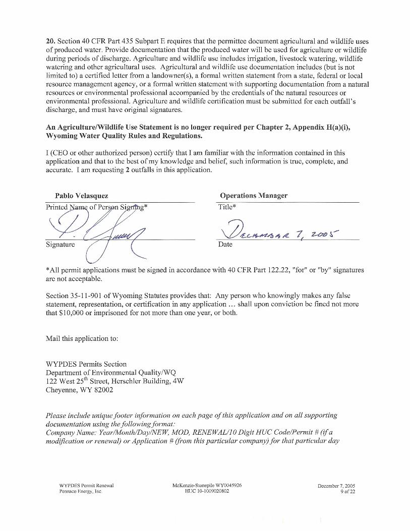
20. Section 40 CFR Part 435 Subpart E requires that the permittee document agricultural and wildlife uses of produced water. Provide documentation that the produced water will be used for agriculture or wildlife during periods of discharge. Agriculture and wildlife use includes irrigation, livestock watering, wildlife watering and other agricultural uses. Agricultural and wildlife use documentation includes (but is not limited to) a certified letter from a landowner(s), a formal written statement fi-om a state, federal or local resource management agency, or a formal written statement with supporting documentation from a natural resources or environmental professional accompanied by the credentials of the natural resources or environmental professional. Agriculture and wildlife certification must be submitted for each outfall's discharge, and must have original signatures.
An Agriculture/Wildlife Use Statement is no longer required per Chapter 2, Appendix H(a)(i), Wyoming Water Quality Rules and Regulations.
I (CEO or other authorized person) certify that I am familiar with the information contained in this application and that to the best of my knowledge and belief, such information is true, complete, and accurate. I am requesting 2 outfalls in this application.
Pablo Velasquez Operations Manager
Title*
3 w a 4 , e 3 -&- Date
*All permit applications must be signed in accordance with 40 CFR Part 122.22, "for" or "by" signatures are not acceptable.
Section 35-1 1-901 of Wyoming Statutes provides that: Any person who knowingly makes any false statement, representation, or certification in any application . . . shall upon conviction be fined not more that $10,000 or imprisoned for not more than one year, or both.
Mail this application to:
WYPDES Permits Section Department of Environmental QualityNQ 122 West 25th Street, Herschler Building, 4W Cheyenne, WY 82002
Please include unique footer information on each page of this application and on all supporting documentation using the following format: Company Name: Year/Month/DayRVEW, MOD, RENEWAL/lO Digit HUC Code/Permit # ($a modfication or renewal) or Application # from this particular company) for that particular day
WYPDES Permit Renewal Pennaco Energy, Inc.
December 7,2005 9 of 22
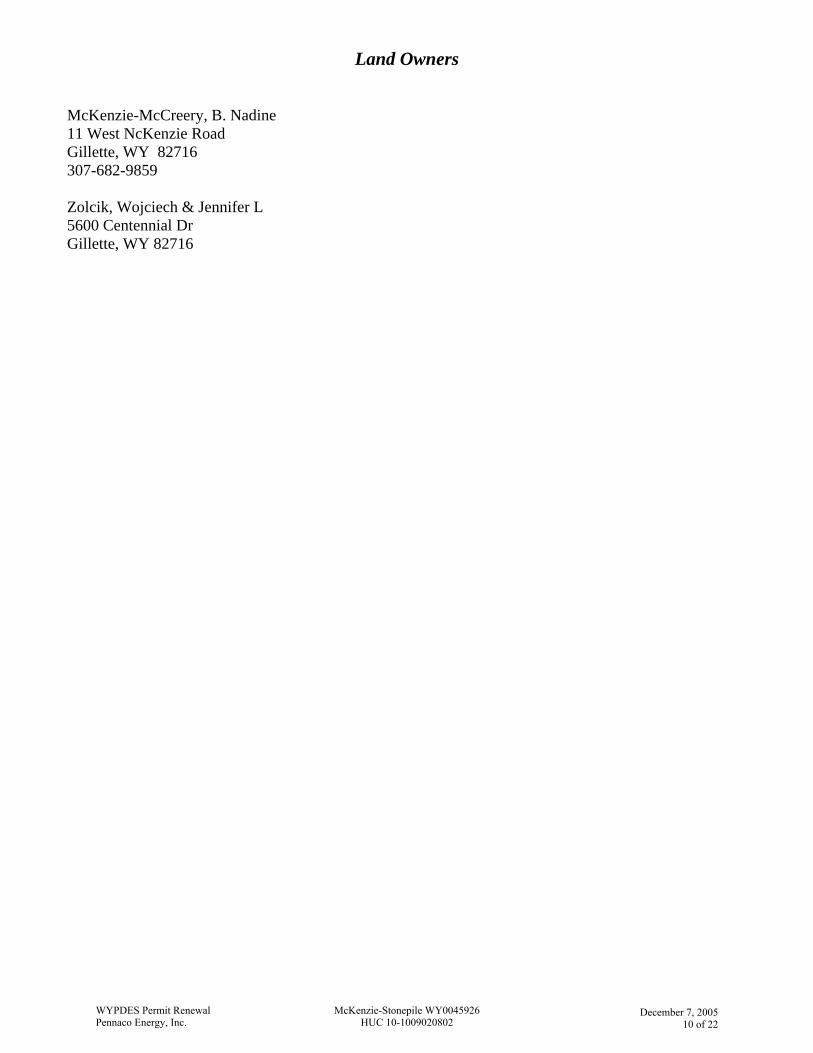
Land Owners McKenzie-McCreery, B. Nadine 11 West NcKenzie Road Gillette, WY 82716 307-682-9859 Zolcik, Wojciech & Jennifer L 5600 Centennial Dr Gillette, WY 82716
WYPDES Permit RenewalPennaco Energy, Inc.
McKenzie-Stonepile WY0045926HUC 10-1009020802
December 7, 2005
10 of 22
TABLE 1a: OUTFALL INFORMATION - McKenzie - Stonepile Permit Renewal WY0045926
Change
DischargePoint # (Outfall)
ImmediateReceiving
Stream Mainstem
Distancefrom outfall
tomainstem(streammiles)
Quarter/
Quarter Section Township Range Latitude Longitude County
ReservoirPermit
ApplicationSubmittedto SEO?
SEOReservoir
Permit # or Date Submitted
ReservoirName
SEO ReservoirRequirements
Existing 001 UET to Stonepile Creek Belle Fourche River 51.1 NENW 24 50 73 44.302500 -105.583889 Campbell 8/28/2001 P15012S Barbara McKenzie (On-Channel) N/A
Remove 002 UET to Stonepile Creek Belle Fourche River N/A SWNE 24 50 73 44.300528 -105.579154 Campbell N/A N/A N/A N/A
Remove 003 UET to Stonepile Creek Belle Fourche River N/A SWNW 24 50 73 44.298335 -105.588387 Campbell N/A N/A Horse Pasture #1 N/A
Remove 004 UET to Stonepile Creek Belle Fourche River N/A SWNW 19 50 72 44.298611 -105.570000 Campbell N/A N/A Liz Cramer N/A
Existing 005 UET to Stonepile Creek Belle Fourche River 50.7 NWNW 19 50 72 44.304056 -105.568967 Campbell 7/5/1994 P12104S Gaspers 1 (On-Channel) N/A
Remove 006 UET to Stonepile Creek Belle Fourche River N/A NENE 24 50 73 44.304167 -105.569167 Campbell N/A N/A N/A N/A
Remove POC1 N/A N/A N/A NWSW 31 50 71 44.268953 -105.43667 Campbell N/A N/A N/A N/A
ICP- Irrigation Compliance Point, TRIB- Tributary water quality monitoring station, WQMS-Up - upstream water quality monitoring station, WQMS- Down - downstream water quality monitoring station
WYPDES Permit RenewalPennaco Energy, Inc.
McKenzie-Stonepile WY0045926HUC 10-1009020802
December 7, 200511 of 22
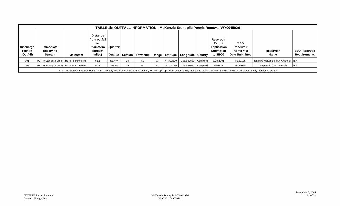
TABLE 1b: OUTFALL INFORMATION - McKenzie-Stonepile Permit Renewal WY0045926
DischargePoint # (Outfall)
ImmediateReceiving
Stream Mainstem
Distancefrom outfall
tomainstem(streammiles)
Quarter/
Quarter Section Township Range Latitude Longitude County
ReservoirPermit
ApplicationSubmittedto SEO?
SEOReservoir
Permit # or Date Submitted
ReservoirName
SEO ReservoirRequirements
001 UET to Stonepile Creek Belle Fourche River 51.1 NENW 24 50 73 44.302500 -105.583889 Campbell 8/28/2001 P15012S Barbara McKenzie (On-Channel) N/A
005 UET to Stonepile Creek Belle Fourche River 50.7 NWNW 19 50 72 44.304056 -105.568967 Campbell 7/5/1994 P12104S Gaspers 1 (On-Channel) N/A
ICP- Irrigation Compliance Point, TRIB- Tributary water quality monitoring station, WQMS-Up - upstream water quality monitoring station, WQMS- Down - downstream water quality monitoring station
WYPDES Permit RenewalPennaco Energy, Inc.
McKenzie-Stonepile WY0045926HUC 10-1009020802
December 7, 200512 of 22
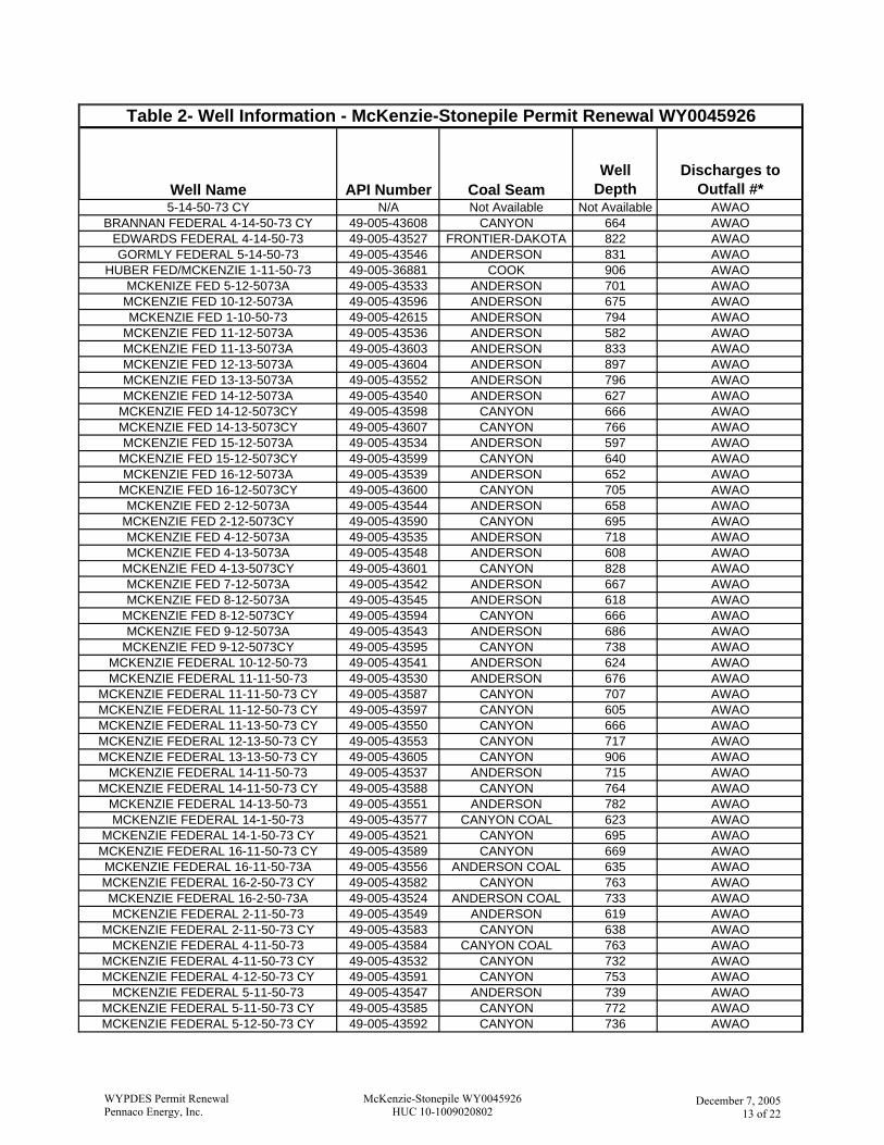
Well Name API Number Coal SeamWell
DepthDischarges to
Outfall #*5-14-50-73 CY N/A Not Available Not Available AWAO
BRANNAN FEDERAL 4-14-50-73 CY 49-005-43608 CANYON 664 AWAOEDWARDS FEDERAL 4-14-50-73 49-005-43527 FRONTIER-DAKOTA 822 AWAOGORMLY FEDERAL 5-14-50-73 49-005-43546 ANDERSON 831 AWAO
HUBER FED/MCKENZIE 1-11-50-73 49-005-36881 COOK 906 AWAOMCKENIZE FED 5-12-5073A 49-005-43533 ANDERSON 701 AWAO
MCKENZIE FED 10-12-5073A 49-005-43596 ANDERSON 675 AWAOMCKENZIE FED 1-10-50-73 49-005-42615 ANDERSON 794 AWAO
MCKENZIE FED 11-12-5073A 49-005-43536 ANDERSON 582 AWAOMCKENZIE FED 11-13-5073A 49-005-43603 ANDERSON 833 AWAOMCKENZIE FED 12-13-5073A 49-005-43604 ANDERSON 897 AWAOMCKENZIE FED 13-13-5073A 49-005-43552 ANDERSON 796 AWAOMCKENZIE FED 14-12-5073A 49-005-43540 ANDERSON 627 AWAO
MCKENZIE FED 14-12-5073CY 49-005-43598 CANYON 666 AWAOMCKENZIE FED 14-13-5073CY 49-005-43607 CANYON 766 AWAOMCKENZIE FED 15-12-5073A 49-005-43534 ANDERSON 597 AWAO
MCKENZIE FED 15-12-5073CY 49-005-43599 CANYON 640 AWAOMCKENZIE FED 16-12-5073A 49-005-43539 ANDERSON 652 AWAO
MCKENZIE FED 16-12-5073CY 49-005-43600 CANYON 705 AWAOMCKENZIE FED 2-12-5073A 49-005-43544 ANDERSON 658 AWAO
MCKENZIE FED 2-12-5073CY 49-005-43590 CANYON 695 AWAOMCKENZIE FED 4-12-5073A 49-005-43535 ANDERSON 718 AWAOMCKENZIE FED 4-13-5073A 49-005-43548 ANDERSON 608 AWAO
MCKENZIE FED 4-13-5073CY 49-005-43601 CANYON 828 AWAOMCKENZIE FED 7-12-5073A 49-005-43542 ANDERSON 667 AWAOMCKENZIE FED 8-12-5073A 49-005-43545 ANDERSON 618 AWAO
MCKENZIE FED 8-12-5073CY 49-005-43594 CANYON 666 AWAOMCKENZIE FED 9-12-5073A 49-005-43543 ANDERSON 686 AWAO
MCKENZIE FED 9-12-5073CY 49-005-43595 CANYON 738 AWAOMCKENZIE FEDERAL 10-12-50-73 49-005-43541 ANDERSON 624 AWAOMCKENZIE FEDERAL 11-11-50-73 49-005-43530 ANDERSON 676 AWAO
MCKENZIE FEDERAL 11-11-50-73 CY 49-005-43587 CANYON 707 AWAOMCKENZIE FEDERAL 11-12-50-73 CY 49-005-43597 CANYON 605 AWAOMCKENZIE FEDERAL 11-13-50-73 CY 49-005-43550 CANYON 666 AWAOMCKENZIE FEDERAL 12-13-50-73 CY 49-005-43553 CANYON 717 AWAOMCKENZIE FEDERAL 13-13-50-73 CY 49-005-43605 CANYON 906 AWAO
MCKENZIE FEDERAL 14-11-50-73 49-005-43537 ANDERSON 715 AWAOMCKENZIE FEDERAL 14-11-50-73 CY 49-005-43588 CANYON 764 AWAO
MCKENZIE FEDERAL 14-13-50-73 49-005-43551 ANDERSON 782 AWAOMCKENZIE FEDERAL 14-1-50-73 49-005-43577 CANYON COAL 623 AWAO
MCKENZIE FEDERAL 14-1-50-73 CY 49-005-43521 CANYON 695 AWAOMCKENZIE FEDERAL 16-11-50-73 CY 49-005-43589 CANYON 669 AWAOMCKENZIE FEDERAL 16-11-50-73A 49-005-43556 ANDERSON COAL 635 AWAOMCKENZIE FEDERAL 16-2-50-73 CY 49-005-43582 CANYON 763 AWAOMCKENZIE FEDERAL 16-2-50-73A 49-005-43524 ANDERSON COAL 733 AWAOMCKENZIE FEDERAL 2-11-50-73 49-005-43549 ANDERSON 619 AWAO
MCKENZIE FEDERAL 2-11-50-73 CY 49-005-43583 CANYON 638 AWAOMCKENZIE FEDERAL 4-11-50-73 49-005-43584 CANYON COAL 763 AWAO
MCKENZIE FEDERAL 4-11-50-73 CY 49-005-43532 CANYON 732 AWAOMCKENZIE FEDERAL 4-12-50-73 CY 49-005-43591 CANYON 753 AWAO
MCKENZIE FEDERAL 5-11-50-73 49-005-43547 ANDERSON 739 AWAOMCKENZIE FEDERAL 5-11-50-73 CY 49-005-43585 CANYON 772 AWAOMCKENZIE FEDERAL 5-12-50-73 CY 49-005-43592 CANYON 736 AWAO
Table 2- Well Information - McKenzie-Stonepile Permit Renewal WY0045926
WYPDES Permit RenewalPennaco Energy, Inc.
McKenzie-Stonepile WY0045926HUC 10-1009020802
December 7, 2005
13 of 22
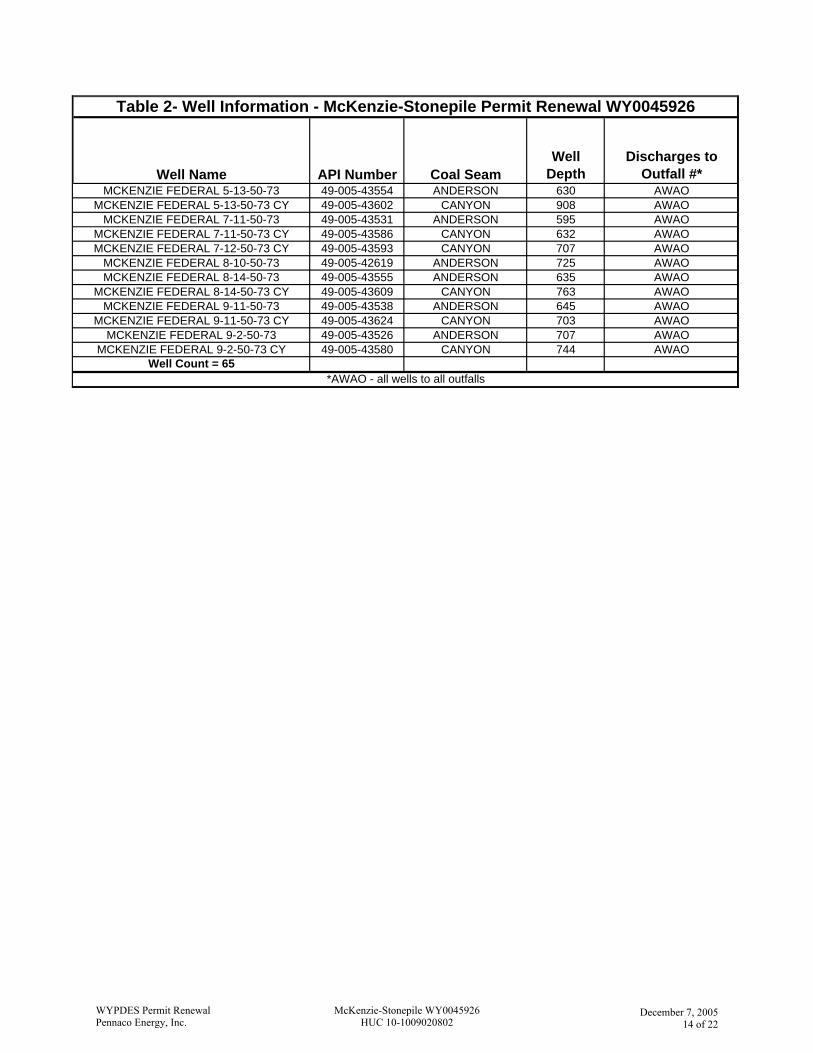
Well Name API Number Coal SeamWell
DepthDischarges to
Outfall #*
Table 2- Well Information - McKenzie-Stonepile Permit Renewal WY0045926
MCKENZIE FEDERAL 5-13-50-73 49-005-43554 ANDERSON 630 AWAOMCKENZIE FEDERAL 5-13-50-73 CY 49-005-43602 CANYON 908 AWAO
MCKENZIE FEDERAL 7-11-50-73 49-005-43531 ANDERSON 595 AWAOMCKENZIE FEDERAL 7-11-50-73 CY 49-005-43586 CANYON 632 AWAOMCKENZIE FEDERAL 7-12-50-73 CY 49-005-43593 CANYON 707 AWAO
MCKENZIE FEDERAL 8-10-50-73 49-005-42619 ANDERSON 725 AWAOMCKENZIE FEDERAL 8-14-50-73 49-005-43555 ANDERSON 635 AWAO
MCKENZIE FEDERAL 8-14-50-73 CY 49-005-43609 CANYON 763 AWAOMCKENZIE FEDERAL 9-11-50-73 49-005-43538 ANDERSON 645 AWAO
MCKENZIE FEDERAL 9-11-50-73 CY 49-005-43624 CANYON 703 AWAOMCKENZIE FEDERAL 9-2-50-73 49-005-43526 ANDERSON 707 AWAO
MCKENZIE FEDERAL 9-2-50-73 CY 49-005-43580 CANYON 744 AWAOWell Count = 65
*AWAO - all wells to all outfalls
WYPDES Permit RenewalPennaco Energy, Inc.
McKenzie-Stonepile WY0045926HUC 10-1009020802
December 7, 2005
14 of 22
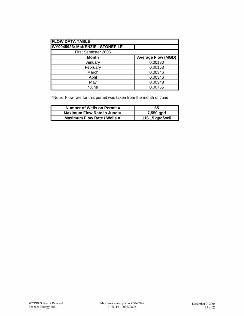
FLOW DATA TABLEWY0045926: McKENZIE - STONEPILE
First Semester 2005Month Average Flow (MGD)
January 0.00130February 0.00153
March 0.00346April 0.00346May 0.00348
*June 0.00755
*Note: Flow rate for this permit was taken from the month of June
Number of Wells on Permit = 65Maximum Flow Rate in June = 7,550 gpdMaximum Flow Rate / Wells = 116.15 gpd/well
WYPDES Permit RenewalPennaco Energy, Inc.
McKenzie-Stonepile WY0045926HUC 10-1009020802
December 7, 2005
15 of 22
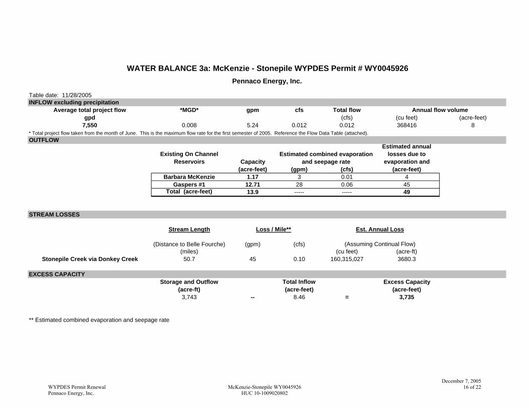
WATER BALANCE 3a: McKenzie - Stonepile WYPDES Permit # WY0045926Pennaco Energy, Inc.
Table date: 11/28/2005INFLOW excluding precipitation
Average total project flow *MGD* gpm cfs Total flow Annual flow volumegpd (cfs) (cu feet) (acre-feet)
7,550 0.008 5.24 0.012 0.012 368416 8* Total project flow taken from the month of June. This is the maximum flow rate for the first semester of 2005. Reference the Flow Data Table (attached).OUTFLOW
Existing On Channel Reservoirs Capacity
Estimated combined evaporation and seepage rate
Estimated annual losses due to
evaporation and (acre-feet) (gpm) (cfs) (acre-feet)
Barbara McKenzie 1.17 3 0.01 4Gaspers #1 12.71 28 0.06 45
Total (acre-feet) 13.9 ----- ----- 49
STREAM LOSSES
Stream Length Loss / Mile** Est. Annual Loss
(Distance to Belle Fourche) (gpm) (cfs) (Assuming Continual Flow)(miles) (cu feet) (acre-ft)
Stonepile Creek via Donkey Creek 50.7 45 0.10 160,315,027 3680.3
EXCESS CAPACITYStorage and Outflow Total Inflow Excess Capacity
(acre-ft) (acre-feet) (acre-feet)3,743 -- 8.46 = 3,735
** Estimated combined evaporation and seepage rate
WYPDES Permit RenewalPennaco Energy, Inc.
McKenzie-Stonepile WY0045926HUC 10-1009020802
December 7, 200516 of 22
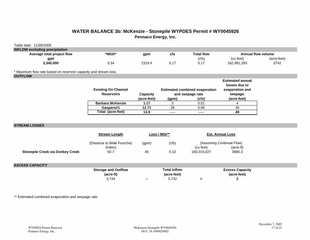
WATER BALANCE 3b: McKenzie - Stonepile WYPDES Permit # WY0045926Pennaco Energy, Inc.
Table date: 11/28/2005INFLOW excluding precipitation
Average total project flow *MGD* gpm cfs Total flow Annual flow volumegpd (cfs) (cu feet) (acre-feet)
3,340,000 3.34 2319.4 5.17 5.17 162,981,283 3742
* Maximum flow rate based on reservoir capacity and stream loss.OUTFLOW
Existing On Channel Reservoirs Capacity
Estimated combined evaporation and seepage rate
Estimated annual losses due to
evaporation and seepage.
(acre-feet) (gpm) (cfs) (acre-feet)Barbara McKenzie 1.17 3 0.01 4
Gaspers#1 12.71 28 0.06 45Total (acre-feet) 13.9 ----- ----- 49
STREAM LOSSES
Stream Length Loss / Mile** Est. Annual Loss
(Distance to Belle Fourche) (gpm) (cfs) (Assuming Continual Flow)(miles) (cu feet) (acre-ft)
Stonepile Creek via Donkey Creek 50.7 45 0.10 160,315,027 3680.3
EXCESS CAPACITYStorage and Outflow Total Inflow Excess Capacity
(acre-ft) (acre-feet) (acre-feet)3,743 -- 3,742 = 2
** Estimated combined evaporation and seepage rate
WYPDES Permit RenewalPennaco Energy, Inc.
McKenzie-Stonepile WY0045926HUC 10-1009020802
December 7, 200517 of 22
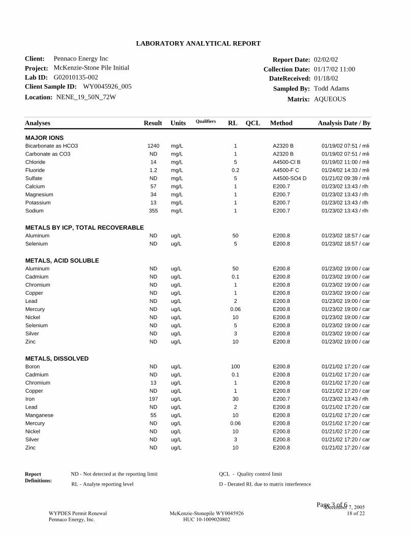
Analyses Result Units Analysis Date / ByRL MethodQCL
LABORATORY ANALYTICAL REPORT
Project: McKenzie-Stone Pile Initial
Client Sample ID: WY0045926_005
Collection Date: 01/17/02 11:00
Matrix: AQUEOUS
Client: Pennaco Energy Inc
Lab ID: G02010135-002
Report Date: 02/02/02
DateReceived: 01/18/02
Location: NENE_19_50N_72WSampled By: Todd Adams
Qualifiers
MAJOR IONS01/19/02 07:51 / mli1mg/L1240Bicarbonate as HCO3 A2320 B01/19/02 07:51 / mli1mg/LNDCarbonate as CO3 A2320 B01/19/02 11:00 / mli5mg/L14Chloride A4500-Cl B01/24/02 14:33 / mli0.2mg/L1.2Fluoride A4500-F C01/21/02 09:39 / mli5mg/LNDSulfate A4500-SO4 D01/23/02 13:43 / rlh1mg/L57Calcium E200.701/23/02 13:43 / rlh1mg/L34Magnesium E200.701/23/02 13:43 / rlh1mg/L13Potassium E200.701/23/02 13:43 / rlh1mg/L355Sodium E200.7
METALS BY ICP, TOTAL RECOVERABLE01/23/02 18:57 / car50ug/LNDAluminum E200.801/23/02 18:57 / car5ug/LNDSelenium E200.8
METALS, ACID SOLUBLE01/23/02 19:00 / car50ug/LNDAluminum E200.801/23/02 19:00 / car0.1ug/LNDCadmium E200.801/23/02 19:00 / car1ug/LNDChromium E200.801/23/02 19:00 / car1ug/LNDCopper E200.801/23/02 19:00 / car2ug/LNDLead E200.801/23/02 19:00 / car0.06ug/LNDMercury E200.801/23/02 19:00 / car10ug/LNDNickel E200.801/23/02 19:00 / car5ug/LNDSelenium E200.801/23/02 19:00 / car3ug/LNDSilver E200.801/23/02 19:00 / car10ug/LNDZinc E200.8
METALS, DISSOLVED01/21/02 17:20 / car100ug/LNDBoron E200.801/21/02 17:20 / car0.1ug/LNDCadmium E200.801/21/02 17:20 / car1ug/L13Chromium E200.801/21/02 17:20 / car1ug/LNDCopper E200.801/23/02 13:43 / rlh30ug/L197Iron E200.701/21/02 17:20 / car2ug/LNDLead E200.801/21/02 17:20 / car10ug/L55Manganese E200.801/21/02 17:20 / car0.06ug/LNDMercury E200.801/21/02 17:20 / car10ug/LNDNickel E200.801/21/02 17:20 / car3ug/LNDSilver E200.801/21/02 17:20 / car10ug/LNDZinc E200.8
ReportDefinitions:
ND - Not detected at the reporting limit
RL - Analyte reporting level
QCL - Quality control limit
Page 3 of 6
D - Derated RL due to matrix interference
WYPDES Permit RenewalPennaco Energy, Inc.
McKenzie-Stonepile WY0045926HUC 10-1009020802
December 7, 200518 of 22
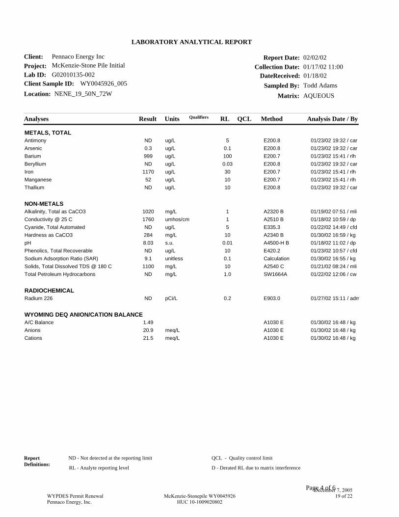
Analyses Result Units Analysis Date / ByRL MethodQCL
LABORATORY ANALYTICAL REPORT
Project: McKenzie-Stone Pile Initial
Client Sample ID: WY0045926_005
Collection Date: 01/17/02 11:00
Matrix: AQUEOUS
Client: Pennaco Energy Inc
Lab ID: G02010135-002
Report Date: 02/02/02
DateReceived: 01/18/02
Location: NENE_19_50N_72WSampled By: Todd Adams
Qualifiers
METALS, TOTAL01/23/02 19:32 / car5ug/LNDAntimony E200.801/23/02 19:32 / car0.1ug/L0.3Arsenic E200.801/23/02 15:41 / rlh100ug/L999Barium E200.701/23/02 19:32 / car0.03ug/LNDBeryllium E200.801/23/02 15:41 / rlh30ug/L1170Iron E200.701/23/02 15:41 / rlh10ug/L52Manganese E200.701/23/02 19:32 / car10ug/LNDThallium E200.8
NON-METALS01/19/02 07:51 / mli1mg/L1020Alkalinity, Total as CaCO3 A2320 B01/18/02 10:59 / dp1umhos/cm1760Conductivity @ 25 C A2510 B01/22/02 14:49 / cfd5ug/LNDCyanide, Total Automated E335.301/30/02 16:59 / kg10mg/L284Hardness as CaCO3 A2340 B01/18/02 11:02 / dp0.01s.u.8.03pH A4500-H B01/23/02 10:57 / cfd10ug/LNDPhenolics, Total Recoverable E420.201/30/02 16:55 / kg0.1unitless9.1Sodium Adsorption Ratio (SAR) Calculation01/21/02 08:24 / mli10mg/L1100Solids, Total Dissolved TDS @ 180 C A2540 C01/22/02 12:06 / cw1.0mg/LNDTotal Petroleum Hydrocarbons SW1664A
RADIOCHEMICAL01/27/02 15:11 / adm0.2pCi/LNDRadium 226 E903.0
WYOMING DEQ ANION/CATION BALANCE01/30/02 16:48 / kg1.49A/C Balance A1030 E01/30/02 16:48 / kgmeq/L20.9Anions A1030 E01/30/02 16:48 / kgmeq/L21.5Cations A1030 E
ReportDefinitions:
ND - Not detected at the reporting limit
RL - Analyte reporting level
QCL - Quality control limit
Page 4 of 6
D - Derated RL due to matrix interference
WYPDES Permit RenewalPennaco Energy, Inc.
McKenzie-Stonepile WY0045926HUC 10-1009020802
December 7, 200519 of 22
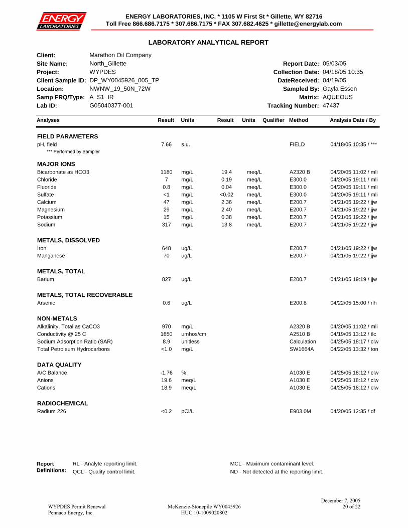
Analyses Result Units Analysis Date / ByMethod
LABORATORY ANALYTICAL REPORT
Site Name: North_Gillette
Client Sample ID: DP_WY0045926_005_TPCollection Date: 04/18/05 10:35
Matrix: AQUEOUS
Client: Marathon Oil Company
Lab ID: G05040377-001
Report Date: 05/03/05
DateReceived: 04/19/05Location: NWNW_19_50N_72W Sampled By: Gayla Essen
Qualifier
Samp FRQ/Type: A_S1_IR
Project: WYPDES
Tracking Number: 47437
Result Units
ENERGY LABORATORIES, INC. * 1105 W First St * Gillette, WY 82716Toll Free 866.686.7175 * 307.686.7175 * FAX 307.682.4625 * [email protected]
FIELD PARAMETERS04/18/05 10:35 / ***s.u.7.66pH, field FIELD
*** Performed by Sampler
MAJOR IONS04/20/05 11:02 / mlimg/L1180Bicarbonate as HCO3 A2320 B19.4 meq/L04/20/05 19:11 / mlimg/L7Chloride E300.00.19 meq/L04/20/05 19:11 / mlimg/L0.8Fluoride E300.00.04 meq/L04/20/05 19:11 / mlimg/L<1Sulfate E300.0<0.02 meq/L04/21/05 19:22 / jjwmg/L47Calcium E200.72.36 meq/L04/21/05 19:22 / jjwmg/L29Magnesium E200.72.40 meq/L04/21/05 19:22 / jjwmg/L15Potassium E200.70.38 meq/L04/21/05 19:22 / jjwmg/L317Sodium E200.713.8 meq/L
METALS, DISSOLVED04/21/05 19:22 / jjwug/L648Iron E200.704/21/05 19:22 / jjwug/L70Manganese E200.7
METALS, TOTAL04/21/05 19:19 / jjwug/L827Barium E200.7
METALS, TOTAL RECOVERABLE04/22/05 15:00 / rlhug/L0.6Arsenic E200.8
NON-METALS04/20/05 11:02 / mlimg/L970Alkalinity, Total as CaCO3 A2320 B04/19/05 13:12 / tlcumhos/cm1650Conductivity @ 25 C A2510 B04/25/05 18:17 / clwunitless8.9Sodium Adsorption Ratio (SAR) Calculation04/22/05 13:32 / tonmg/L<1.0Total Petroleum Hydrocarbons SW1664A
DATA QUALITY04/25/05 18:12 / clw%-1.76A/C Balance A1030 E04/25/05 18:12 / clwmeq/L19.6Anions A1030 E04/25/05 18:12 / clwmeq/L18.9Cations A1030 E
RADIOCHEMICAL04/20/05 12:35 / dfpCi/L<0.2Radium 226 E903.0M
ReportDefinitions:
RL - Analyte reporting limit. MCL - Maximum contaminant level.QCL - Quality control limit. ND - Not detected at the reporting limit.
WYPDES Permit RenewalPennaco Energy, Inc.
McKenzie-Stonepile WY0045926HUC 10-1009020802
December 7, 200520 of 22
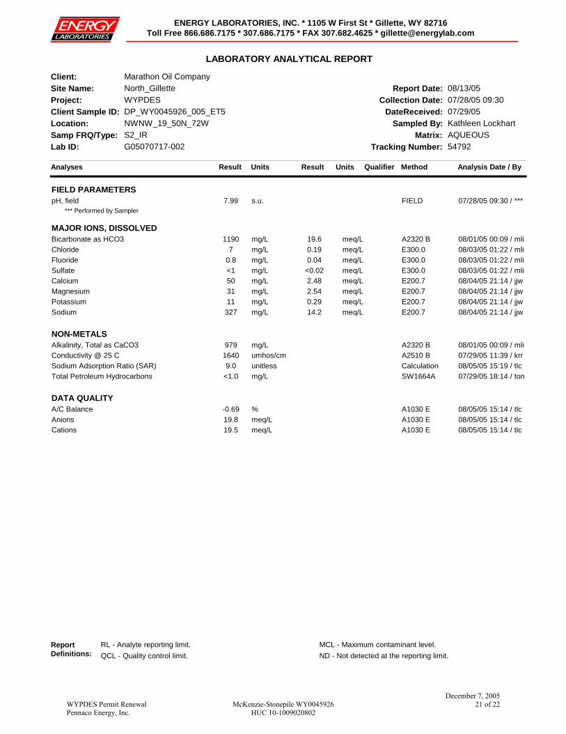
Analyses Result Units Analysis Date / ByMethod
LABORATORY ANALYTICAL REPORT
Site Name: North_Gillette
Client Sample ID: DP_WY0045926_005_ET5Collection Date: 07/28/05 09:30
Matrix: AQUEOUS
Client: Marathon Oil Company
Lab ID: G05070717-002
Report Date: 08/13/05
DateReceived: 07/29/05Location: NWNW_19_50N_72W Sampled By: Kathleen Lockhart
Qualifier
Samp FRQ/Type: S2_IR
Project: WYPDES
Tracking Number: 54792
Result Units
ENERGY LABORATORIES, INC. * 1105 W First St * Gillette, WY 82716Toll Free 866.686.7175 * 307.686.7175 * FAX 307.682.4625 * [email protected]
FIELD PARAMETERS07/28/05 09:30 / ***s.u.7.99pH, field FIELD
*** Performed by Sampler
MAJOR IONS, DISSOLVED08/01/05 00:09 / mlimg/L1190Bicarbonate as HCO3 A2320 B19.6 meq/L08/03/05 01:22 / mlimg/L7Chloride E300.00.19 meq/L08/03/05 01:22 / mlimg/L0.8Fluoride E300.00.04 meq/L08/03/05 01:22 / mlimg/L<1Sulfate E300.0<0.02 meq/L08/04/05 21:14 / jjwmg/L50Calcium E200.72.48 meq/L08/04/05 21:14 / jjwmg/L31Magnesium E200.72.54 meq/L08/04/05 21:14 / jjwmg/L11Potassium E200.70.29 meq/L08/04/05 21:14 / jjwmg/L327Sodium E200.714.2 meq/L
NON-METALS08/01/05 00:09 / mlimg/L979Alkalinity, Total as CaCO3 A2320 B07/29/05 11:39 / krrumhos/cm1640Conductivity @ 25 C A2510 B08/05/05 15:19 / tlcunitless9.0Sodium Adsorption Ratio (SAR) Calculation07/29/05 18:14 / tonmg/L<1.0Total Petroleum Hydrocarbons SW1664A
DATA QUALITY08/05/05 15:14 / tlc%-0.69A/C Balance A1030 E08/05/05 15:14 / tlcmeq/L19.8Anions A1030 E08/05/05 15:14 / tlcmeq/L19.5Cations A1030 E
ReportDefinitions:
RL - Analyte reporting limit. MCL - Maximum contaminant level.QCL - Quality control limit. ND - Not detected at the reporting limit.
WYPDES Permit RenewalPennaco Energy, Inc.
McKenzie-Stonepile WY0045926HUC 10-1009020802
December 7, 200521 of 22
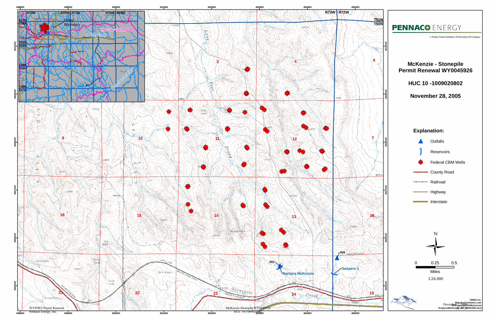
1
7
2
9
634
11
23
18
1924
1314
12
21 22
10
1516
Gaspers 1Barbara McKenzie
005
001
448000
448000
449000
449000
450000
450000
451000
451000
452000
452000
453000
453000
454000
454000
455000
455000
4905
000
4905
000
4906
000
4906
000
4907
000
4907
000
4908
000
4908
000
4909
000
4909
000
4910
000
4910
000
CBMA [email protected]
M:\Projects\PEI\McKenzie\Projects\McKenzie_PR_20051006.mxd
0 0.50.25
Miles1:24,000
McKenzie - StonepilePermit Renewal WY0045926
HUC 10 -1009020802
November 28, 2005
DetailBoundary
Explanation:
Outfalls
Reservoirs
Federal CBM Wells
County Road
Railroad
Highway
Interstate
HUC 10 - 1012020106
R70W | R69W
T50NT49N
R73W | R72W
T51NT50N
Donkey Creek
Belle F
ourche R
iver
T49NT48N
T48NT47N
R72W | R71W R73W
T51NT50N
WYPDES Permit RenewalPennaco Energy, Inc.
McKenzie-Stonepile WY0045926HUC 10-1009020802
December 7, 200522 of 22