decoupling of small-volume pyroclastic flows and related ... · decoupling of small-volume...
TRANSCRIPT

HAL Id: hal-00089708https://hal-insu.archives-ouvertes.fr/hal-00089708
Submitted on 13 Nov 2006
HAL is a multi-disciplinary open accessarchive for the deposit and dissemination of sci-entific research documents, whether they are pub-lished or not. The documents may come fromteaching and research institutions in France orabroad, or from public or private research centers.
L’archive ouverte pluridisciplinaire HAL, estdestinée au dépôt et à la diffusion de documentsscientifiques de niveau recherche, publiés ou non,émanant des établissements d’enseignement et derecherche français ou étrangers, des laboratoirespublics ou privés.
Decoupling of small-volume pyroclastic flows and relatedhazards at Merapi volcano, Indonesia
Jean-Louis Bourdier, E.K. Abdurachman
To cite this version:Jean-Louis Bourdier, E.K. Abdurachman. Decoupling of small-volume pyroclastic flows and relatedhazards at Merapi volcano, Indonesia. Bulletin of Volcanology, Springer Verlag, 2001, 63, pp.309-325.�10.1007/s004450100133�. �hal-00089708�
Decoupling of small-volume pyroclastic flows and related hazards at Merapi volcano, Indonesia J.-L. Bourdier1, and E. K. Abdurachman1, 2
(1) Institut des Sciences de la Terre d'Orléans, UMR6113 Université d'Orléans, BP 6759, 45067 Orléans, France (2) Volcanological Survey of Indonesia, Jl. Diponegoro 57, Bandung 40122, Indonesia
Abstract
The November 1994 eruption at Merapi volcano provided good evidence of decoupling of dome-collapse pyroclastic flows and of large-scale detachment of an ash-cloud surge (ACS) component from the basal block-and-ash flow (BAF). Timing and stratigraphic relationships of the largest 1994 ACS indicate that this escaped from the valleys, travelled well ahead of the BAF, arrived at the termination tens of seconds before it and deposited a discrete ACS deposit beneath the BAF unit. This suggests that the ACS detachment mostly occurred relatively high on the volcano slope, likely at the foot of the proximal cone. Later pyroclastic flow eruptions in January 1997 and July 1998 also showed evidence of ACS detachment, although to a lesser extent, suggesting that ACSs could be a frequent hazard at Merapi volcano. Based on an extensive review of the available literature and on field investigations of historical deposits, we show here that flow decoupling and ACS detachment in the way inferred from the 1994 eruption is a common process at Merapi. The ACS-related destructions outside valleys were frequently reported in the recent past activity of the volcano, i.e. in at least 16 pyroclastic flow eruptions since 1927. Destruction occurred systematically in eruptions where maximum runout of the BAFs was 6.5 km or more, and occurred rarely for BAF runouts of 4.5 km or less. The ACS deposits have been recognized beneath some valley-filling BAF units we attribute to some recent destructive eruptions, i.e. the 1930, 1954, 1961 and 1969 eruptions. Topographic conditions at Merapi volcano favouring ACS detachment include: (a) the high slope (30°) of the proximal cone, leading to high proximal velocities of the pyroclastic flows and thus to the transfer of large amounts of particles into the ash cloud; (b) the strong break in slope at the foot of the proximal cone, where the velocity of the basal BAF is strongly reduced and a major ACS component is thought to form and detach by shearing over the BAF; and (c) the small depth of most valleys in the first kilometres beyond the foot of the cone, which allows minor ACS components to escape from the valleys during travel of the BAF; however, flow decoupling and ACS detachment occur for only some of the numerous pyroclastic flows that follow the same path in a given eruption. This indicates that topography alone cannot lead to flow decoupling. We suggest two factors that control flow decoupling and its extent. The main one is flow volume (and thus flux, as both are correlated in almost instantaneous, dome-collapse events), as suggested by the observed relationship between flow decoupling and the travel distance of the pyroclastic flows. The second factor is the amount of available ash in the flow at its early stage, which influences the mass and thus momentum of the ash cloud. The amount of ash in the pyroclastic flows of Merapi may depend on several factors, among which are (a) the physical and thermal state of the part of the active dome that collapses, and (b) the proportion of older, cold rocks incorporated in the flow, either by undermining of

surrounding summit rocks by the current pyroclastic flow activity or by erosion on the upper slopes.
Keywords : Pyroclastic flow - Pyroclastic surge - Flow decoupling - Volcanic hazards - Lava dome - Merapi volcano - Indonesia
Introduction
The general view since Lacroix (1904) has been that small-volume pyroclastic flows consist of two distinct parts, a high-concentration basal avalanche and an overriding expanded ash cloud. These have quite different flow properties. Textural characteristics of the deposits support interpretation of the basal avalanche as a highly energetic inertial and density-modified grain flow (e.g. Nairn and Self 1978; Boudon et al. 1993), whereas the dilute ash cloud is essentially a turbulent suspension. Turbulence in the ash cloud is likely generated mainly from saltating particles at the upper surface and front of the basal avalanche (Denlinger 1987). It has further been proposed that the two flow components may, under some circumstances, separate from each other and then move independently (e.g. Crandell and Mullineaux 1973; Sheridan 1979; Fisher 1979, 1995). Theoretical modelling of the turbulent ash cloud also predicts that this can decouple from the basal flow and surge ahead of it, given some threshold conditions of slope or cloud density (Denlinger 1987). Evidence of detachment of an "ash-cloud surge" component from a pyroclastic flow has been provided by direct observations of active flows at Mount St. Helens (Hoblitt 1986), or has been inferred from the distributions of surge facies and surge-related destructions from well-identified pyroclastic flow events, e.g. at Santiaguito (Rose et al. 1977), Ngauruhoe (Nairn and Self 1978), Mount St. Helens (Mellors et al. 1988) and Unzen (Nakada and Fujii 1993; Yamamoto et al. 1993). In this paper we use the term "nuée ardente" (after Lacroix 1904) as a general, descriptive term encompassing both pyroclastic surge and pyroclastic flow of current terminology.
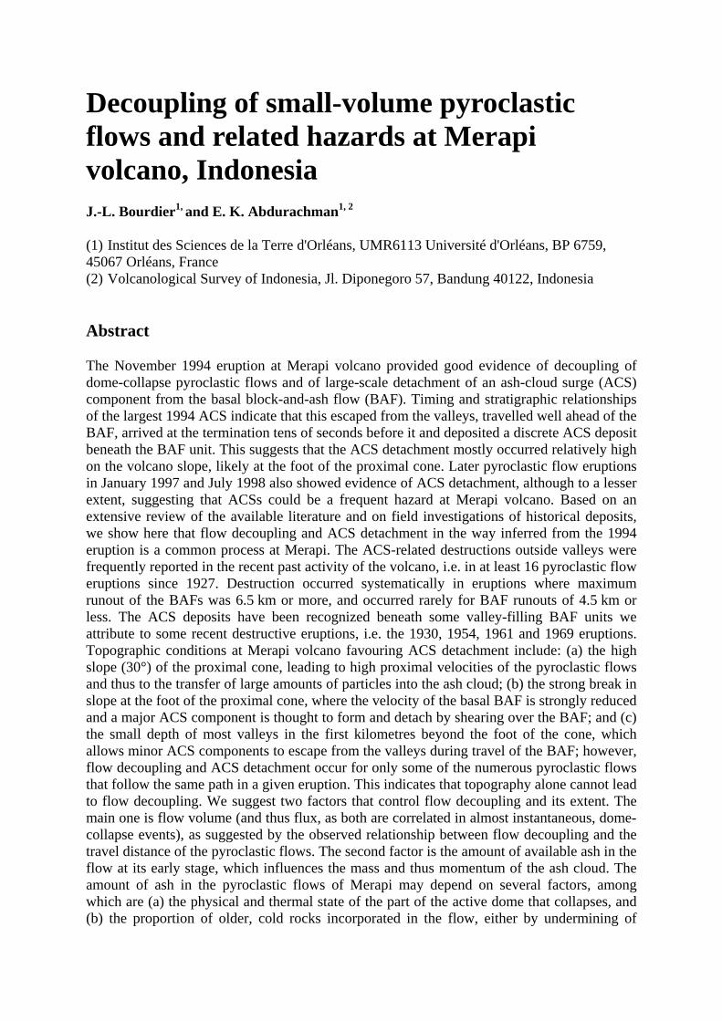
Given its implications for hazards assessment, we address herein flow decoupling and detachment of ash-cloud surges in the case of Merapi volcano (central Java, Indonesia). Merapi (Fig. 1) has had almost continuous dome-forming activity for the last centuries and is known to be very hazardous because of frequent dome-generated pyroclastic flow eruptions. Evidence for surge detachment has been recently demonstrated in the November 1994 nuée ardente eruption, based on associated block-and-ash flow (BAF herein) and ash-cloud surge (ACS) deposits and on extensive surge-related destructions (Bourdier et al. 1997; Abdurachman et al. 2000; Kelfoun et al. 2000). More recent field investigations by the authors after the January 1997 and July 1998 nuée ardente eruptions also indicated the occurrence of surge deposits and surge-related destructions outside the BAF-filled valleys. There is thus evidence from the most recent activity of Merapi that flow decoupling and detachment of ash-cloud surges may be a common hazard at Merapi. This is somewhat in contrast to the generally held view of Merapi as a reference volcano for mild, low-energy and valley-confined pyroclastic flows formed by poorly explosive dome-collapse activity.
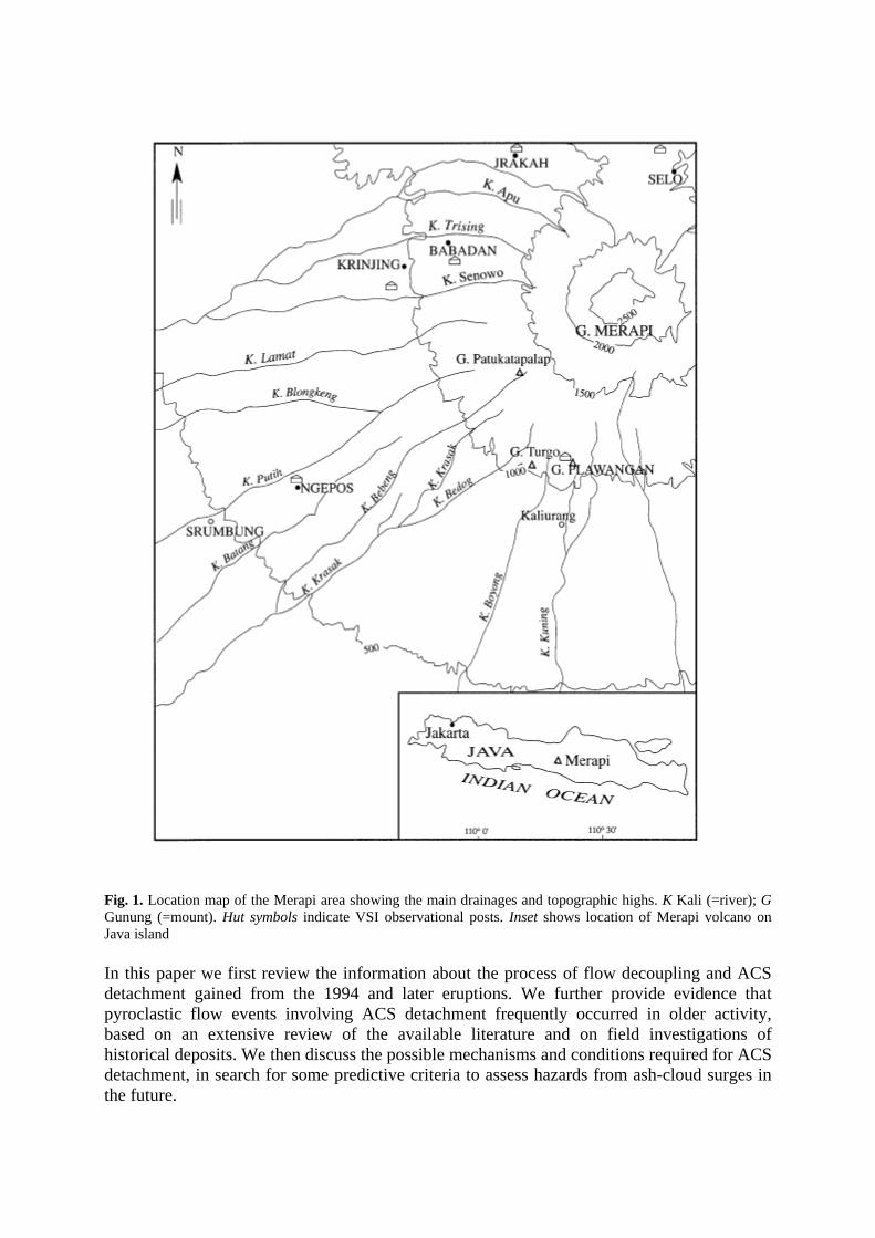
Fig. 1. Location map of the Merapi area showing the main drainages and topographic highs. K Kali (=river); G Gunung (=mount). Hut symbols indicate VSI observational posts. Inset shows location of Merapi volcano on Java island
In this paper we first review the information about the process of flow decoupling and ACS detachment gained from the 1994 and later eruptions. We further provide evidence that pyroclastic flow events involving ACS detachment frequently occurred in older activity, based on an extensive review of the available literature and on field investigations of historical deposits. We then discuss the possible mechanisms and conditions required for ACS detachment, in search for some predictive criteria to assess hazards from ash-cloud surges in the future.

Evidence for flow decoupling in the November 1994 eruption
A condition for assessing precisely the detachment process of ash-cloud surges is that a specific pyroclastic flow event can be isolated, so that the ACS component can be unambiguously related to its cogenetic BAF. Such an unequivocal relationship may be difficult to establish in pyroclastic flow eruptions where tens of pyroclastic flows may occur within a few hours, as is commonly the case at Merapi. The resulting stratigraphic sequence commonly consists of the vertical aggradation of numerous emplacement units of comparable lithological composition, so that any ACS unit, if present, cannot be easily correlated with a cogenetic BAF unit. Also, the destruction area may be the compound effect of several surges, the individual distribution of each being difficult to decipher. Such difficulties could be overcome in the case of the 22 November 1994 eruption, since all of the more than 60 pyroclastic flows travelled less than 4.5 km down the south-southwest flank, except one at 10:54 local time that bypassed the twinned hills of Plawangan and Turgo and reached a distance of 6.5 km in the Boyong valley. The destruction and deposits beyond 4.5 km in the Boyong valley and adjacent areas can therefore be wholly attributed to this largest pyroclastic flow. This allowed the relationships between the ACS and BAF components of a single pyroclastic flow to be evaluated in this area (Abdurachman et al. 2000).
The impact of this pyroclastic flow was severe, parts of the villages of Turgo and Kaliurang, located outside the Boyong valley at ca. 40 m above the valley bottom, being destroyed (Fig. 2). In the bottom of the valley, the basal avalanche deposit was 3-4 m thick, contained numerous metre-sized boulders, and had a planar surface and massive internal texture typical of valley-filling "Merapi-type" block-and-ash-flow deposits. By contrast, only approximately 5 cm of ash-sized material, containing scattered lapilli up to 2 cm, were reported in the destroyed parts of Turgo and Kaliurang villages just after eruption. Non-reworked remnants of this deposit observed months after the eruption were poorly sorted, medium-sized ash a few centimetres in thickness. They contained clots of soil and outsized, weathered accidental clasts picked up from the ground. Survivors inside the destroyed parts of Turgo and Kaliurang were mostly injured by surficial skin burns. They reported having been suddenly enclosed within a dark cloud that was flowing from the summit direction and contained numerous particles, some of them giving burning impacts on exposed parts of the body, whereas the air of the cloud was much less hot. They described particles as being like "bees flying from all around". There was major, although irregular, mechanical damage in the destroyed parts of Turgo and Kaliurang, including toppled masonry walls, demolished bamboo huts and uprooted trees. The overall evidence indicates that the area was caught in a violent pyroclastic surge. This must have developed as part of the pyroclastic flow that deposited the block-and-ash flow facies in the valley bottom, and in this respect it can be termed an ash-cloud surge.
The stratigraphic relationships between the ACS and BAF facies further indicate that the ACS travelled and deposited ahead of the valley-confined BAF (Bourdier et al. 1997; Abdurachman et al. 2000). Beyond the Plawangan and Turgo hills, the BAF facies in the Boyong channel is underlain by a discrete thin ash layer, which is only 1 cm thick near the front of the BAF facies. This ash layer directly overlies the palaeosol and is present only locally, suggesting that it has been eroded in many places by the BAF. It necessarily correlates with the surge unit at Turgo village. Above the Plawangan-Turgo pass in the Boyong valley, lateral equivalents of this ash layer are found locally beneath the block-and-ash flow facies in the form of a 5- to 10-cm-thick horizon of poorly graded and poorly sorted, openwork medium-to-coarse ash with scattered lapilli as large as 5 cm. This well-defined horizon contains soil clots, abundant uncharred to charred wood, and larger, variously charred

broken branches that pierce into the overlying BAF facies. Lateral equivalents of this horizon occur in the devastated area outside the valley margins as a surge layer with similar texture, lithological composition and grain size. The only difference is that the surge facies outside the valley is slightly thicker (typically ca. 20 cm) and has an upper laminated part that is lacking in the valley channel. The stratigraphic evidence thus indicates that the surge was sufficiently ahead of the BAF in the Boyong channel to deposit 5-10 cm of surge material. The upper part of the surge deposit outside the valley is apparently lacking in the channel, either because there was not enough time for deposition before the BAF overran the deposit, or because of erosion of the upper parts of the surge deposit by the BAF, or for both reasons.
Fig. 2. Map of the destruction area by the November 1994 nuées ardentes, with generalized orientations of the blow-down trees (adapted from Kelfoun et al. 2000, their Figs. 3, 7). Long lines refer to destruction by the main, "cone-derived" ash cloud surge (ACS), whereas the shorter lines on the sides of the Boyong valley relate to minor and later "valley-derived" ACS components (see text for discussion). Locations of grain-size samples of Fig. 5
The stratigraphic observations suggest that the surge cloud was already well ahead of the channelled block-and-ash flow at 3.5-4 km horizontal distance from the summit. Further evidence suggesting that decoupling of the flow occurred high on the volcano flank is given by the pattern of tree orientations in the extensive tree-blow-down zone. Statistical data on tree orientations (Kelfoun et al. 2000) show that at 1500 m a.s.l., i.e. the pre-eruption vegetation boundary, the direction of the blow-down trees already diverged from the local
direction of the Boyong valley. This suggests that decoupling of the pyroclastic surge occurred, or at least began, above 1500 m a.s.l., i.e. within 3 km horizontal distance from the summit.
The time delay between the arrival of the ACS and BAF at a given point must have increased with distance from the summit for two reasons, firstly because of the higher velocity of the surge over most of the travel distance, and secondly because the BAF had to follow the tortuous path of the Boyong channel, whereas the surge travelled along a more direct, shorter path. To give a rough figure, assuming 40 MS-1 (Kelfoun et al. 2000) and 15 MS-1 average velocities for the ACS and BAF, respectively, between 3 and 6.5 km horizontal distance from the vent, the ACS would have arrived in the Turgo-Kaliurang area more than 2 min before the BAF. Eyewitnesses located in Kaliurang and vicinity reported two successive clouds, one that overtopped Turgo hill and went into Turgo village, and the second one which was focused in and above the Boyong valley and descended further along the valley, consistent with the aforementioned scenario (Abdurachman et al. 2000). There is much discrepancy in the delay between the two clouds reported by eyewitnesses, as estimates vary from tens of seconds to several minutes.
In the January 1997 and July 1998 eruptions, the thermal effects and mechanical destructions observed outside the valleys were comparable in nature with those of 1994, although of different extents and magnitude. Poorly sorted, mostly ash-sized deposits comparable with the 1994 ACS deposits were also found in both eruptions, their extent coinciding within the destruction area in each case. Correlative ACS-type layers also occurred interstratified with the BAF units in the valleys. There is thus good evidence in both the 1997 and 1998 eruptions that destructions were due to pyroclastic surges like in 1994; however, we found no factual evidence allowing us to relate with certainty any ACS deposit/event to its BAF counterpart.
Evidence for flow decoupling in older eruptions
Evidence from eruption reports: assessment of destructive impact by ash-cloud surges since 1927
Despite the fact that nuées ardentes at Merapi are commonly valley-confined flows, destruction outside valleys have been sometimes reported in the volcano's recent history, with human losses in some cases. In the 18-19 December 1930 eruption 1369 people were killed by the nuées ardentes, most of them in villages outside the valleys; however, the significance and origin of destruction by nuées ardentes at Merapi have been poorly addressed in the literature. Moreover, no major destruction had occurred for more than 20 years prior to 1994, so that the destructive surge event of 22 November 1994 could be viewed at the time by some as a most unusual and unexpected phenomenon. In order to better assess the frequency of destructive nuées ardentes in the past, and their possible links with eruption parameters such as the explosivity and travel distance of the nuées, we made an extensive review of the available literature on the recent activity of Merapi (Table 1). This compilation goes back not earlier than the 1930 eruption, because Merapi's activity has only been continuously reported since 1927, when regular publication of the Bulletin of the Netherlands East Indian Volcanological Survey was established.
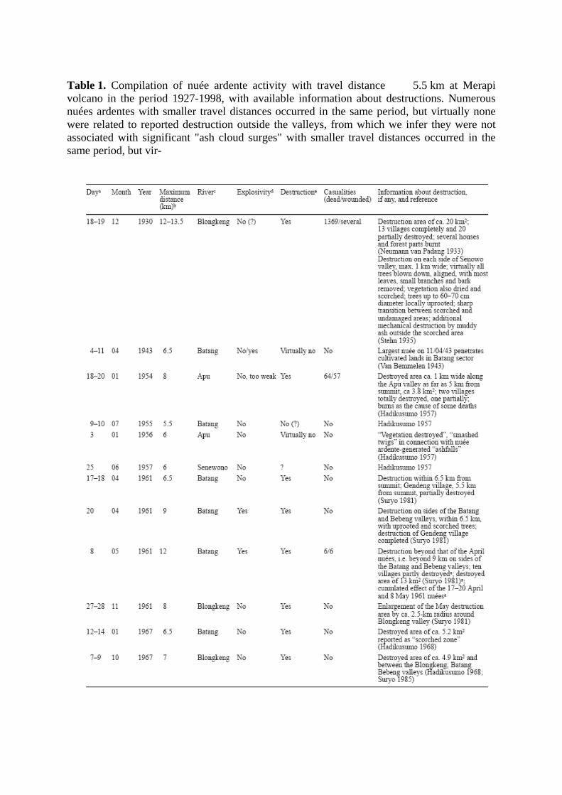
Table 1. Compilation of nuée ardente activity with travel distance 5.5 km at Merapi volcano in the period 1927-1998, with available information about destructions. Numerous nuées ardentes with smaller travel distances occurred in the same period, but virtually none were related to reported destruction outside the valleys, from which we infer they were not associated with significant "ash cloud surges" with smaller travel distances occurred in the same period, but vir-

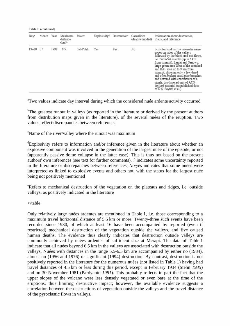
aTwo values indicate day interval during which the considered nuée ardente activity occurred
bThe greatest runout in valleys (as reported in the literature or derived by the present authors from distribution maps given in the literature), of the several nuées of the eruption. Two values reflect discrepancies between references
cName of the river/valley where the runout was maximum
dExplosivity refers to information and/or inference given in the literature about whether an explosive component was involved in the generation of the largest nuée of the episode, or not (apparently passive dome collapse in the latter case). This is thus not based on the present authors' own inferences (see text for further comments). ? indicates some uncertainty reported in the literature or discrepancies between references. No/yes indicates that some nuées were interpreted as linked to explosive events and others not, with the status for the largest nuée being not positively mentioned
eRefers to mechanical destruction of the vegetation on the plateaus and ridges, i.e. outside valleys, as positively indicated in the literature
</table
Only relatively large nuées ardentes are mentioned in Table 1, i.e. those corresponding to a maximum travel horizontal distance of 5.5 km or more. Twenty-three such events have been recorded since 1930, of which at least 16 have been accompanied by reported (even if restricted) mechanical destruction of the vegetation outside the valleys, and five caused human deaths. The evidence thus clearly indicates that destruction outside valleys are commonly achieved by nuées ardentes of sufficient size at Merapi. The data of Table 1 indicate that all nuées beyond 6.5 km in the valleys are associated with destruction outside the valleys. Nuées with distances in the range 5.5-6.5 km are accompanied by either no (1984), almost no (1956 and 1976) or significant (1994) destruction. By contrast, destruction is not positively reported in the literature for the numerous nuées (not listed in Table 1) having had travel distances of 4.5 km or less during this period, except in February 1934 (Stehn 1935) and on 30 November 1981 (Pardyanto 1981). This probably reflects in part the fact that the upper slopes of the volcano were less densely vegetated or even bare at the time of the eruptions, thus limiting destructive impact; however, the available evidence suggests a correlation between the destructions of vegetation outside the valleys and the travel distance of the pyroclastic flows in valleys.
The available information on destructive effects and areas of destruction in the past eruptions since 1930 is summarized in Table 1. The comparative extents of the destruction areas for some of those eruptions are shown in Fig. 3. Descriptions of destruction effects systematically involve scorched and dried vegetation, and in some cases broken, blown-down or uprooted trees. Destruction mostly develops along valley(s) followed by the pyroclastic flows; only in the areas of greatest destruction does it extend far from the valleys (1930, 1961, 1969). The evidence thus suggests that destruction is due to some hot, dilute currents, i.e. pyroclastic surges. It also suggests, in most cases at least, that these surges are not vent-generated currents expanding radially from the summit area, but are in close connection with pyroclastic flows following the valleys.
The destruction effects were not reported in the literature in much greater detail than what is given in Fig. 3 and Table 1. A notable exception, however, is the largest eruption of the list, that of 18-19 December 1930, whose destructive effects were documented in detail by Neumann van Padang (1931a, 1931b, 1933). His main observations and inferences are as follows:
1. The destruction area (more than 20 km2; Fig. 4) included tree blow-down, scorched and singe zones, and extensive, but irregular, damage to bamboo constructions. Transition between completely destroyed and unaffected areas was locally narrow. Only a few human bodies in the destruction area showed scorching and burns; most were only dessicated. Fallen trees were often aligned, indicating local flow directions, and tree trunks were mostly charred on the eastern side facing the summit.
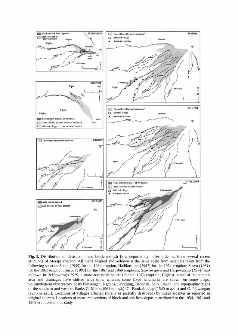
Fig. 3. Distribution of destruction and block-and-ash flow deposits by nuées ardentes from several recent eruptions of Merapi volcano. All maps adapted and redrawn at the same scale from originals taken from the following sources: Stehn (1935) for the 1934 eruption, Hadikusumo (1957) for the 1954 eruption; Suryo (1981) for the 1961 eruption; Suryo (1985) for the 1967 and 1969 eruptions; Siswowijoyo and Harjowarsito (1974; also redrawn in Reksowirogo 1979, a more accessible source) for the 1973 eruption. Highest points of the summit area and drainages have shifted with time, whereas some fixed landmarks are shown on some maps: volcanological observatory posts Plawangan, Ngepos, Krindjing, Babadan, Selo, Jrakah, and topographic highs of the southern and western flanks G. Maron (961 m a.s.l.), G. Patukalapalap (1540 m a.s.l.) and G. Plawangan (1275 m a.s.l.). Locations of villages affected (totally or partially destroyed) by nuées ardentes as reported in original sources. Locations of measured sections of block-and-ash flow deposits attributed to the 1954, 1961 and 1969 eruptions in this study
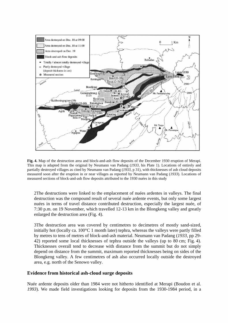
Fig. 4. Map of the destruction area and block-and-ash flow deposits of the December 1930 eruption of Merapi. This map is adapted from the original by Neumann van Padang (1933, his Plate 1). Locations of entirely and partially destroyed villages as cited by Neumann van Padang (1933, p 31), with thicknesses of ash cloud deposits measured soon after the eruption in or near villages as reported by Neumann van Padang (1933). Locations of measured sections of block-and-ash flow deposits attributed to the 1930 nuées in this study
2The destructions were linked to the emplacement of nuées ardentes in valleys. The final destruction was the compound result of several nuée ardente events, but only some largest nuées in terms of travel distance contributed destruction, especially the largest nuée, of 7:30 p.m. on 19 November, which travelled 12-13 km in the Blongkeng valley and greatly enlarged the destruction area (Fig. 4).
3The destruction area was covered by centimetres to decimetres of mostly sand-sized, initially hot (locally ca. 100°C 1 month later) tephra, whereas the valleys were partly filled by metres to tens of metres of block-and-ash material. Neumann van Padang (1933, pp 29-42) reported some local thicknesses of tephra outside the valleys (up to 80 cm; Fig. 4). Thicknesses overall tend to decrease with distance from the summit but do not simply depend on distance from the summit, maximum reported thicknesses being on sides of the Blongkeng valley. A few centimetres of ash also occurred locally outside the destroyed area, e.g. north of the Senowo valley.
Evidence from historical ash-cloud surge deposits
Nuée ardente deposits older than 1984 were not hitherto identified at Merapi (Boudon et al. 1993). We made field investigations looking for deposits from the 1930-1984 period, in a
search for possible stratigraphic relationships between BAF and ACS facies that would support a flow-decoupling process similar to that of 1994. We locally identified channel-fill deposits we can reliably attribute to several of the recent eruptions, namely 1930, 1954, 1961 and 1969 (Figs. 2, 3; Abdurachman et al. 1998). Our attribution of the deposits to specific eruptions is based on the deposit distributions reported in the literature (Figs. 2, 3), lithological and petrological similarities of products in different valleys affected by the same eruption, inter-eruption lithological differences and stratigraphic correlations.
We recognized valley-confined deposits from the 1930 eruption in the Senowo, Lamat, Blongkeng-Putih and Batang valleys (Fig. 4). Only one BAF unit is exposed in each section, the basis of which is not exposed except at one section in the Blongkeng valley, 8 km from the summit (M35 in Fig. 4). Only two nuées ardentes, at ca. 11:00 a.m. on 18 December and ca. 7:30 p.m. on 19 December are likely to have reached the distance of 8 km in this valley (Neumann van Padang 1933). The single BAF unit of section M35 most likely relates to the largest one, of 7:30 p.m. on 19 December, which is known to have reached 12-13 km in the Blongkeng valley. A lenticular, poorly sorted and fine-grained layer a few millimetres in thickness occurs between the BAF unit and the underlying palaeosol at section M35. In the context of the eruption, this layer is most likely an ACS deposit. Given the section location, which is far beyond the area destroyed on 18 December (Fig. 4), this ACS deposit likely relates to the 7:30 p.m. pyroclastic flow of 19 December, i.e. to the same pyroclastic event as the overlying BAF unit.
Nuée-ardente deposits from the 1954 eruption have been identified at one section in the Apu valley, 4 km from the summit (Fig. 3). Five superposed BAF units are exposed there. An ACS-type unit is interstratified between the lowermost BAF unit and the underlying palaeosol. Its lower part consists of 0-4 cm of coarse, poorly sorted sand and scattered lapilli up to 5 cm in diameter, containing unscorched twigs, and having an erosive lower contact with the palaeosol. This layer is overlain in transitional contact by 2 cm of fine, apparently unstratified ash without accretionary lapilli. In the 1994 ACS units, such a two-layer stratigraphy, was found on the interfluves and beyond the BAF deposits in the channels, whereas beneath the BAF facies in the Boyong channel, only the coarser lower layer occurred. Abdurachman et al. (2000) suggested that the presence of a finer-grained ACS top outside the valley and its absence beneath the BAF deposit in the valley may reflect the fact that the emplacement of the block-and-ash flow occurred before the fines had time to settle out from the surge, giving in this case an indirect argument for the ACS and BAF facies belonging to the same flow. By contrast with the 1994 example, the presence of a fine-grained ACS top beneath the BAF facies in the 1954 section may suggest that the basal ACS unit of this section was not related to the flow that emplaced the overlying BAF unit. Alternative possibilities are that the ACS unit was emplaced either by a discrete, vent-generated pyroclastic surge, or by an ash-cloud surge developed from a block-and-ash flow that stopped at higher elevation (the latter hypothesis contradicts the suggestion from Table 1 that BAFs smaller than 4.5 km lack any associated ACS); thus, no conclusive evidence is provided for the decoupling process in this case. Nevertheless, the presence of surge facies at ca. 4 km from the summit in the Apu valley is indirect evidence that the reported 1954 destruction outside the Apu valley was due to surge emplacement. This is consistent with reports of a few centimetres of a mixture of coarse and fine ash in the destroyed villages after the eruption (Djaetikoesoemo 1955).
Deposits from the 1961 eruption have been identified in the Batang, Bebeng and Lamat valleys (Fig. 3). They are best exposed in the Batang valley, where a single 1961 BAF unit

can be more or less continuously traced between 8 and 10 km from the summit. In most sections the BAF unit is separated from the pre-eruptive basement by 1-2 cm of poorly sorted, crudely stratified, fine- to medium-sized ash, having locally an erosive lower contact with a palaeosol. Nuées ardentes occurred many times in 1961, especially in April to May and in November; however, only one on 8 May reportedly travelled farther than 9 km, reaching 12 km in the Batang (Suryo 1981). Thus, the BAF unit and underlying ash layer are likely to have been both deposited by the same 8 May nuée. The destructions due to this largest 8 May nuée were not specifically described in early reports (Suryo 1981). However, destruction in 1961 beyond 9 km (Fig. 3) should logically be due at least in part to this nuée. We infer that a surge component of the largest 8 May nuée contributed to destruction beyond 9 km and is recorded in the deposits as the discrete, surge-like ash layer. The stratigraphic evidence further suggests that this surge component was emplaced and deposited ahead of the block-and-ash flow, in the same way as in 1994.
Nuée ardente deposits from 1969 have been identified in the Sat and mainly Bebeng valleys. The 1969 BAF deposits are lithologically distinctive from the 1961 deposits, and at one section in the Bebeng valley they have been observed overlying the 1961 deposits, separated from them by a thin palaeosol. Along the Bebeng 1969 deposits are discontinuously exposed between 5.5 and 9 km from the summit, and comprise either one or two BAF units, depending on the location. A discrete, poorly sorted, normally graded ash layer, 1-3 cm thick, occurs at four sections, directly above the pre-eruption basement and beneath the BAF deposits. It consists of mostly silt-sized ash with scattered lapilli up to 5 mm in diameter. The travel distances achieved imply that the 1969 deposits under consideration here could have been emplaced only by the 7-8 January activity, and likely include the largest nuée, that of 04:15 on 8 January (Suryo 1985; Hadikusumo 1971; Smithsonian 1970). The basal ash layer likely represents the deposit of surge material responsible for the destructions reported aside the Bebeng valley as far as 11.5 km from the summit (Fig. 3; Suryo 1985); however, the uncertainties about the number of nuées that travelled more than 6 km in the Bebeng valley on 7-8 January prevent us from relating the surge layer to any specific BAF.
In summary, discrete ash layers having sedimentological characteristics comparable with the 1994 surge facies were recognized in the 1930, 1954, 1961 and 1969 deposits. Such layers have been found within the areas of destruction reported for each eruption. We infer that the deposits and destruction resulted from ash-cloud surges. Because the destruction was mostly restricted to the vicinity of valleys followed by the block-and-ash flows during those eruptions, the surges were very likely derived from block-and-ash flows (i.e. were ash-cloud surges) rather than being independent, vent-generated events. Each observed ACS-type layer has a sharp, erosive lower contact (not readily shown in the 1930 case at section M35), whereas the upper contact with the overlying BAF unit is transitional, consistent with the foregoing inference. The ACS-type facies was found only in valleys, beneath the BAF valley-confined facies. This is likely because this is the best location for such thin deposits to be preserved. By reference to the 1994 eruption, we presume that the ACS facies once covered the whole destroyed area in each eruption, but was largely washed away by erosion soon after the eruptions, except where it was preserved beneath BAF deposits.
The stratigraphic position of the 1930, 1954, 1961 and 1969 ACS layers is similar to that of the 1994 ACS layers, i.e. beneath and in transitional contact with an overlying BAF unit. This makes it possible to infer that a similar process of flow decoupling and detachment of the ACS ahead of the block-and-ash flow operated in all eruptions, which would allow us to generalize the model described above for the 1994 eruption. However, a direct proof of this
would require timing constraints indicating that the ACS and overlying BAF deposits were emplaced within seconds to minutes, i.e. were generated from the same flow event. Such timing constraints are lacking for the 1954 and 1969 cases, whereas in the 1930 and 1961 cases, the ACS and BAF units described above are likely to represent subfacies of the same pyroclastic flow.
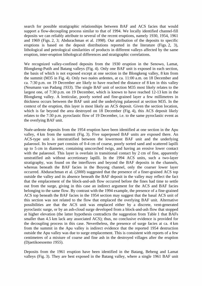
A detailed description of the sedimentological and lithological characters of Merapi's ACS deposits and comparison with their associated BAF deposits, are beyond the scope of this study. We have systematically sampled only the 1994 deposits. Virtually all material is fresh, poorly vesicular lava consistent with an origin by dome collapse. Some measured sections and lithological data about the 1994 deposits are given in Abdurachman et al. (2000). We additionally provide here grain-size histograms of representative 1994 ACS samples (Fig. 5).
Fig. 5. Grain-size histograms of representative samples of 1994 block-and-ash flow (BAF; M10) and ash cloud surge (ACS; all others) deposits. The 1994 ACS deposits within 4.5 km from the summit consist of two stratigraphic units (upper and lower, UACS and LACS), each of which consisted of a lower bed LB (massive) and an upper bed UB (laminated; Abdurachman et al. 2000). The samples herein refer to those layers as follows: LACS-LB (M25.1; M52.1); LACS-UB (M25.2; M18.1; M52.2); UACS-LB (M6.1; M7.1; M18.2); and UACS-UB (M18.3). Lower right: sorting vs mean grain-size calculated by the moment method for the 1994 ACS samples (white dots) and the M10 BAF sample (black dot). The two finest grained samples are affected by large uncertainties in the calculations due to large amounts of fines (below 32 μm) in the sieve pan

Discussion
Geological constraints on the process of flow decoupling at Merapi
The origin of the reported destructions in pre-1994 eruptions of Merapi had hitherto been poorly discussed, except by Neumann van Padang (1933) regarding the 1930 eruption. Neuman van Padang (1933) concluded that the 1930 destructions were due to ash clouds, and that these were linked to the valley-filling block-and-ash flows instead of being independent pyroclastic events, based on several lines of evidence: (a) the correspondence in time between the emplacement of the block-and-ash flows and the destruction; (b) the shape of the destruction area showing this was partly controlled by the valleys; and (c) the grade of destruction not varying consistently with distance from the summit area, but with distance away from the valleys. All reports on later Merapi eruptions until 1994 apparently relied on Neumann van Padang's interpretations and similarly attributed the observed destruction to ash clouds associated with valley-channelled pyroclastic flows. Our analysis of the available literature is consistent with this conclusion.
Neumann van Padang further suggested (1933, pp 80-81) that the ACS component of the 1930 nuées ardentes did not precede the BAF but developed in its trail, at variance with the model of ACS detachment ahead of the BAF that we have inferred from the 1994 example. The evidence given by Neumann van Padang is as follows:
1. Observations by Volcanological Survey personnel at Maron observation post (near the Blongkeng valley) on 18 December between 8 and 9 a.m., indicating that no pyroclastic cloud arrived, nor any pyroclastic material fell, before the flow passed in the valley, whereas on the contrary an ash cloud was still visible after the flow had passed in the valley, i.e. behind it (Neumann van Padang state elsewhere that the nuée of that time hardly bypassed Maron and travelled ca. 6 km).
2. Reported fallout of fine ash in areas as remote as Yogyakarta, 30 km from the volcano, well after the large pyroclastic flow events.
3. Repeated observations that the BAFs travelled in valleys beyond the radius of the co-eruptive destruction area.
We consider that points (2) and (3) are irrelevant to the issue of whether the ACSs preceded their BAF counterpart or not, and have been incorrectly interpreted by Neumann van Padang. His point (1) is partly relevant but only applies to BAFs with moderate travel distances (6 km at most) such that, keeping in mind the data of Table 1, those BAFs might well have not been associated with destructive ACSs such as we are dealing with herein; thus, point (1) gives no evidence that larger 1930 nuées did not decouple in the way we suggest in the 1994 case.
The stratigraphic evidence provided by historical pyroclastic sequences, on the other hand, is consistent with the process of flow decoupling exemplified by the 1994 eruption. We suggest that destructive surges in the recent past formed by a flow decoupling process similar to that of 1994, i.e. involving detachment of the ACS at close range from the summit, then its travel over the landscape along relatively straight paths, sufficiently ahead of the BAF to deposit a discrete surge-type layer beneath the BAF unit in valleys.
Decoupling process and influence of topography on the detachment of ash-cloud surges at Merapi
We follow here the analysis by Denlinger (1987) that the ash-cloud component of a pyroclastic flow is generated primarily as a turbulent boundary layer by air drag at the front and upper surface of the basal avalanche. This assumption implies that other proposed processes for development of the ash cloud, such as fluidization by gas emitted by the pyroclasts and thermal convection, are of second order. In this respect, pyroclastic flows are comparable to other natural gravity flows on a slope for which the development of a turbulent upper particle suspension has also been explained by drag of the ambient medium, such as powder snow avalanches (e.g. Beghin 1979; Mellors 1979) and subaqueous debris flows (e.g. Hampton 1972). At Merapi volcano, the proximal cone has a slope of ca. 30° within 1.5-km horizontal distance. This steep slope favours high-flow velocities, which in turn favour the transfer of particles into the ash clouds (Denlinger 1987), contributing their mass and momentum. There is no available data on the velocities of the Merapi flows on the steep proximal cone. A plausible figure may be taken from Stith et al. (1977) who derived velocities of the order of 50 MS-1 from timed photographs of a dome-collapse flow at Augustine volcano, on a similar 30° slope.
For large-scale detachment of the upper cloud from the dense basal part to occur, a significant velocity differential, allowing the cloud to accelerate ahead of the underflow, is required. At Merapi there is a major break in slope at the base of the proximal cone, as the slope decreases to 14° between 1.5- and 2-km horizontal distance. A bit above the break in slope, there is 100-m-high cliff along the Boyong channel. Kelfoun et al. (2000) emphasized the potential role of this cliff in the decoupling of the 1994 ash-cloud surges, suggesting that, as the flow went over the cliff, large amounts of ash were transferred to the cloud, which then accelerated ahead of the flow. We agree that the Boyong cliff is a favouring topographic feature for flow decoupling in the way proposed by Kelfoun et al. (2000); however, flow decoupling occurred at Merapi along other channels where no similar cliff is present (e.g. the Krasak valley in 1994). We suggest that more generalized topographic conditions favouring flow decoupling and detachment of ash-cloud surges could be the pronounced break in slope at the base of the proximal cone. There, the basal avalanche is expected to strongly, and continuously, reduce its velocity, eventually through a hydraulic jump that would lead to the transfer of an additional amount of particles into suspension. Conditions may be met there for significant volumes of the upper cloud to outrun the denser basal part of the flow. The assumption in this view is that the velocity of the basal grain flow is more reduced by the slope decrease than is that of the turbulent cloud. Nairn and Self (1978) similarly inferred that detachment of ash clouds from basal avalanches in the 1975 nuées ardentes of Ngauruhoe volcano, New Zealand, occurred at the base of the cone in response to slope decrease. In the case of the Merapi 1994 nuées, the pattern of tree orientations (Kelfoun et al. 2000) indicates that surge detachment occurred mainly at the base of the cone, but as this coincides approximately with the location of the cliff above the Boyong, the tree orientations are consistent by both the interpretation of Kelfoun et al. (2000) and ours.
Beyond the foot of the cone, on the south and west flanks that have been the most affected by nuées ardentes in the recent past, the valleys are poorly incised. The heights of the valley walls slightly increase with distance, from typically a few metres at the foot of the cone to less than 20 m at 4 km horizontal distance. The small section of the valleys makes it difficult for them to accommodate the influx of the block-and-ash flows as they reach the foot of the cone, which likely favours blocking of the BAFs, slows them down and eventually leads them to
spill out of the valleys, as indicated for instance by the occurrence of 1994 BAF facies on the plateau between the Krasak and Boyong valleys (Fig. 2). The small section and depth of the valleys appear also favourable for ash-cloud surge components to escape from the valleys. Support for this was suggested in 1994 by a later population of fallen trees found on both sides of the Boyong valley. Those trees had directions pointing to the valley and covered already fallen trees whose directions were essentially radial to the foot of the cone (Kelfoun et al. 2000).
The 1994 tree orientations thus suggest two sites for the detachment of ash-cloud surge components, i.e. (a) the foot of the cone, where the main ACS component originated ("cone-derived" ACS component), and (b) the valley, from which minor "valley-derived" ACS components continued to feed the ash-cloud surge. More speculatively, the 1994 tree patterns might allow constraints to be placed on the duration of the main surge detachment at the base of the cone in 1994. An interesting feature of the data reported by Kelfoun et al. (2000) is that fallen trees related to the valley-derived surge components are found only between ca. 1350 and 1100 m a.s.l., and are absent between 1650 and 1350 m a.s.l. The tree pattern observed between 1650 and 1350 m apparently relates entirely to the cone-derived surge component. The fact that the effects of the valley-derived surges are not visible above 1350 m might signify that, as the BAF front was travelling between 1650 and 1350 m, the more energetic cone-derived surge was still passing above it and was incorporating the valley-derived clouds. As the BAF front was at 1350 m and below, the whole of the energetic cone-derived surge had already outrun it. The distance from 1650 to 1350 m a.s.l. being ca. 1.5 km, taking realistic velocities of 20 and 50 MS-1 for the BAF and cone-derived surge, respectively, in this portion of their travel, the maximum duration for generation of the cone-derived surge would be 45 s, a plausible figure.
In summary, flow decoupling and detachment of ash-cloud surge are to be considered a more or less continuous process over a certain distance and a certain duration. We suggest that a most favourable site for this process to occur on a large scale is the foot of the proximal cone; however, this much likely continues beyond the foot of the proximal cone, from above the valleys. The general scenario we envision for the detachment of ACS components at Merapi is summarized in Fig. 6, based on the 1994 example.

Fig. 6A-E. Sketch of our model of flow decoupling and ash cloud surge detachment at Merapi, based on the November 1994 example. True topographical profile (no vertical exaggeration) in the azimuth of the Boyong valley, with vertical elevations and horizontal distances in kilometres. A The nuée ardente is initiated by non-explosive, gravitational collapse of part of the dome. Internal pore pressure and brittle behaviour of the dome
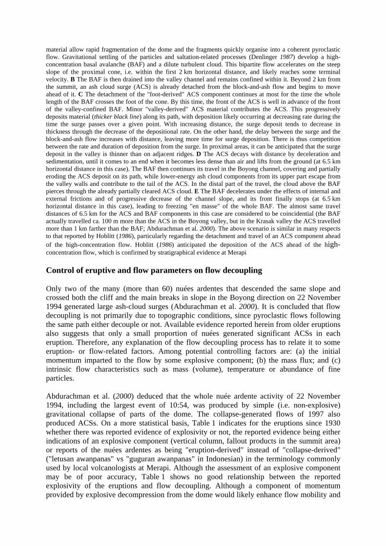
material allow rapid fragmentation of the dome and the fragments quickly organise into a coherent pyroclastic flow. Gravitational settling of the particles and saltation-related processes (Denlinger 1987) develop a high-concentration basal avalanche (BAF) and a dilute turbulent cloud. This bipartite flow accelerates on the steep slope of the proximal cone, i.e. within the first 2 km horizontal distance, and likely reaches some terminal velocity. B The BAF is then drained into the valley channel and remains confined within it. Beyond 2 km from the summit, an ash cloud surge (ACS) is already detached from the block-and-ash flow and begins to move ahead of it. C The detachment of the "foot-derived" ACS component continues at most for the time the whole length of the BAF crosses the foot of the cone. By this time, the front of the ACS is well in advance of the front of the valley-confined BAF. Minor "valley-derived" ACS material contributes the ACS. This progressively deposits material (thicker black line) along its path, with deposition likely occurring at decreasing rate during the time the surge passes over a given point. With increasing distance, the surge deposit tends to decrease in thickness through the decrease of the depositional rate. On the other hand, the delay between the surge and the block-and-ash flow increases with distance, leaving more time for surge deposition. There is thus competition between the rate and duration of deposition from the surge. In proximal areas, it can be anticipated that the surge deposit in the valley is thinner than on adjacent ridges. D The ACS decays with distance by deceleration and sedimentation, until it comes to an end when it becomes less dense than air and lifts from the ground (at 6.5 km horizontal distance in this case). The BAF then continues its travel in the Boyong channel, covering and partially eroding the ACS deposit on its path, while lower-energy ash cloud components from its upper part escape from the valley walls and contribute to the tail of the ACS. In the distal part of the travel, the cloud above the BAF pierces through the already partially cleared ACS cloud. E The BAF decelerates under the effects of internal and external frictions and of progressive decrease of the channel slope, and its front finally stops (at 6.5 km horizontal distance in this case), leading to freezing "en masse" of the whole BAF. The almost same travel distances of 6.5 km for the ACS and BAF components in this case are considered to be coincidential (the BAF actually travelled ca. 100 m more than the ACS in the Boyong valley, but in the Krasak valley the ACS travelled more than 1 km farther than the BAF; Abdurachman et al. 2000). The above scenario is similar in many respects to that reported by Hoblitt (1986), particularly regarding the detachment and travel of an ACS component ahead of the high-concentration flow. Hoblitt (1986) anticipated the deposition of the ACS ahead of the high-concentration flow, which is confirmed by stratigraphical evidence at Merapi
Control of eruptive and flow parameters on flow decoupling
Only two of the many (more than 60) nuées ardentes that descended the same slope and crossed both the cliff and the main breaks in slope in the Boyong direction on 22 November 1994 generated large ash-cloud surges (Abdurachman et al. 2000). It is concluded that flow decoupling is not primarily due to topographic conditions, since pyroclastic flows following the same path either decouple or not. Available evidence reported herein from older eruptions also suggests that only a small proportion of nuées generated significant ACSs in each eruption. Therefore, any explanation of the flow decoupling process has to relate it to some eruption- or flow-related factors. Among potential controlling factors are: (a) the initial momentum imparted to the flow by some explosive component; (b) the mass flux; and (c) intrinsic flow characteristics such as mass (volume), temperature or abundance of fine particles.
Abdurachman et al. (2000) deduced that the whole nuée ardente activity of 22 November 1994, including the largest event of 10:54, was produced by simple (i.e. non-explosive) gravitational collapse of parts of the dome. The collapse-generated flows of 1997 also produced ACSs. On a more statistical basis, Table 1 indicates for the eruptions since 1930 whether there was reported evidence of explosivity or not, the reported evidence being either indications of an explosive component (vertical column, fallout products in the summit area) or reports of the nuées ardentes as being "eruption-derived" instead of "collapse-derived" ("letusan awanpanas" vs "guguran awanpanas" in Indonesian) in the terminology commonly used by local volcanologists at Merapi. Although the assessment of an explosive component may be of poor accuracy, Table 1 shows no good relationship between the reported explosivity of the eruptions and flow decoupling. Although a component of momentum provided by explosive decompression from the dome would likely enhance flow mobility and

favour decoupling, the available evidence suggests that this is not a necessary factor. This implies that ACS detachment has to be basically explained within a fully gravity-driven framework.
Stratigraphic and seismic evidence from the 1994 eruption at Merapi strongly suggested that the 1994 large ACSs were generated by the largest flows in volume (Abdurachman et al. 2000). Independent empirical evidence also suggests that flow volume is influential. There is a consistent relationship between flow decoupling and the travel distance of the BAFs at Merapi (Table 1). The travel distance of mass flows has been shown to increase with flow volume (mass) and with slope (e.g. Campbell et al. 1995). Given such relationships, we suggest that flow volume may be a primary factor controlling the extent of flow decoupling and ACS development. In the case of dome-collapse events, the volume of the flow primarily reflects the volume of the lava portion that detaches from the dome to feed the flow, but additional processes may also contribute to the flow volume, e.g. undermining of rocks from beside the active dome in the summit area, and incorporation of loose surficial material lower on the slope, both being due to erosion by the active flow. Undermining of summit formations by nuées ardentes is common at Merapi, and typically forms breach-shaped depressions through which the flows are focused.
In dome-generated pyroclastic flows, it is likely that a strong positive correlation does exist between the flow volume and the flow eruptive rate (flux). This especially applies to flows that form from pure dome collapse, for which the event of flow feeding is negligibly small compared with the duration of the flow event. The control of the flow behaviour may thus be an interplay between two independent, but here linked, parameters, i.e. flow volume and flux.
The amount of particles that can be transferred into the ash cloud, thus contributing its mass, momentum and ability to detach, depends, for a given flow velocity, on the availability of particles of size small enough to be transferred (Denlinger 1987). For velocities of the order of 50 MS-1 inferred previously for flows on the Merapi cone, the analysis of Denlinger (1987)
suggests that more than 80% of ash of size 3 (0.125 mm) and finer would be transferred into the ash cloud. The more ash that is transferred into the ash cloud, the more the BAF should be depleted in ash. We have tried to check whether differences exist in ash content among the BAF deposits of Merapi, especially between those from ACS-forming eruptions such as that of 1994 and those lacking ACS such as those of 1984 and 1992 (Fig. 6). Figure 7 shows that the BAF samples from the 1994 eruption are neither poorer in coarse to medium ash nor in fine ash than the 1984 and 1992 samples. On the other hand, samples from the 1994 ACS deposits are richer in coarse to medium ash or in fine ash or both, compared with the 1994 BAF samples. The whole material of the 1994 flows being some addition of the BAF and ACS samples, the data thus indicate that the ACS-generating 1994 flows were richer in ash - both coarse to medium ash and fine ash - than the ACS-lacking 1984 and 1992 flows. Our grain-size data therefore suggest that the pyroclastic flows of Merapi have varying ash contents, and that the amount of ash in the flow may be one factor influential on the degree of ash cloud development and detachment.
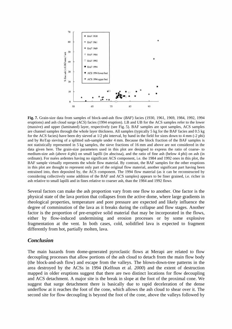
Fig. 7. Grain-size data from samples of block-and-ash flow (BAF) facies (1930, 1961, 1969, 1984, 1992, 1994 eruptions) and ash cloud surge (ACS) facies (1994 eruption). LB and UB for the ACS samples refer to the lower (massive) and upper (laminated) layer, respectively (see Fig. 5). BAF samples are spot samples, ACS samples are channel samples through the whole layer thickness. All samples (typically 5 kg for the BAF facies and 0.5 kg for the ACS facies) have been dry sieved at 1/2 phi interval, by hand in the field for sizes down to 4 mm (-2 phi) and by RoTap sieving of a splitted sub-sample under 4 mm. Because the block fraction of the BAF samples is not statistically represented in 5 kg samples, the sieve fractions of 16 mm and above are not considered in the data given here. The grain-size parameters used in this plot are designed to express the ratio of coarse- to medium-size ash (above 4 phi) on small lapilli (in abscissa), and the ratio of fine ash (below 4 phi) on ash (in ordinate). For nuées ardentes having no significant ACS component, i.e. the 1984 and 1992 ones in this plot, the BAF sample virtually represents the whole flow material. By contrast, the BAF samples for the other eruptions in this plot are thought to represent only part of the original flow material, another significant part having been entrained into, then deposited by, the ACS component. The 1994 flow material (as it can be reconstructed by considering collectively some addition of the BAF and ACS samples) appears to be finer grained, i.e. richer in ash relative to small lapilli and in fines relative to coarser ash, than the 1984 and 1992 flows
Several factors can make the ash proportion vary from one flow to another. One factor is the physical state of the lava portion that collapses from the active dome, where large gradients in rheological properties, temperature and pore pressure are expected and likely influence the degree of comminution of the lava as it breaks during the collapse and flow stages. Another factor is the proportion of pre-eruptive solid material that may be incorporated in the flows, either by flow-induced undermining and erosion processes or by some explosive fragmentation at the vent. In both cases, cold, solidified lava is expected to fragment differently from hot, partially molten, lava.
Conclusion
The main hazards from dome-generated pyroclastic flows at Merapi are related to flow decoupling processes that allow portions of the ash cloud to detach from the main flow body (the block-and-ash flow) and escape from the valleys. The blown-down-tree patterns in the area destroyed by the ACSs in 1994 (Kelfoun et al. 2000) and the extent of destruction mapped in older eruptions suggest that there are two distinct locations for flow decoupling and ACS detachment. A major site is the break in slope at the foot of the proximal cone. We suggest that surge detachment there is basically due to rapid deceleration of the dense underflow at it reaches the foot of the cone, which allows the ash cloud to shear over it. The second site for flow decoupling is beyond the foot of the cone, above the valleys followed by

the block-and-ash flow. Flow decoupling there gives ACS components that are apparently minor in volume and lateral extent compared with those that can form at the foot of the cone; however, they seem to be more common, judging from the distribution of the destruction areas. Ash-cloud surge detachment above the valleys is favoured by the small cross sections of the valleys and the low height of the valley walls at Merapi for several kilometres from the foot of the cone. Ash-cloud surge detachments at the foot of the cone may generate large ACSs that travel a direct path from there and whose extent is not controlled by the valleys, in contrast with valley-derived ACSs. Detached ACSs may travel well ahead of the BAF front and leave surge deposits beneath the BAF facies in valleys, correlating with ACS facies outside the valleys, as exemplified by the 1994 eruption (Abdurachman et al. 1994). However, in interpreting surge-like discrete layers in ancient block-and-ash flow sequences, it may be difficult to decipher whether the surge was derived from a co-genetic block-and-ash flow in the way described herein.
The likelihood and extent of ACS detachment, and the travel distance, velocity and destructive power of the ACS once detached, basically depend on the mass and momentum acquired by the ash cloud along the steep cone. We suggest at least two factors favouring ACS development, then detachment. One is the amount of ash (typically <0.1 mm) supplied and produced during flow along the steep slope. This may depend on the rheological state and pore pressure of the lava portion that collapses from the active dome, and also on the ratio of hot lava to older cold material that is incorporated into the flow. The second factor is flow volume, which is controlled primarily by the volume of the portion of active dome that collapses, but also by the volume of pre-eruptive material eventually incorporated by erosion and undermining. Volume is likely to vary more from flow to flow than the amount of ash, and best explains the observed relationship between the occurrence of ash-cloud surges and the travel distance of the block-and-ash flows.
Acknowledgements. Field work was funded by the French Ministry of Foreign Affairs and the Centre de Recherches Volcanologiques. Access to the field and to VSI internal reports was made possible through the permission and great support from the Volcanological Survey of Indonesia, especially from W. Tjetjep, R. Sukhyar and M.A. Purbawinata, which we warmly acknowledge. Merapi Volcano Observatory colleagues D. Sri Sayudi, A. Ratdomopurbo and J. Sulistiyo freely shared ideas and information about the current activity of Merapi. We thank A. Gourgaud, K. Kelfoun, F. Lavigne and J.-L. Le Pennec for assistance with field work, K. Kelfoun and B. Voight for thorough discussions about flow decoupling at Merapi, and G. Boudon for sharing unpublished grain-size data. We thank journal referees R. Fisher, D. Palladino and T.H. Druitt for detailed reviews. This paper is dedicated to our colleague and friend G. Camus, who used to share with friendly warmth his deep knowledge of Merapi volcano.
References
Abdurachman EK, Bourdier J-L, Camus G, Gourgaud A, Kelfoun K, Le Pennec J-L, Sukhyar R (1998) Identification de dépôts historiques du Mérapi (Java): vers une meilleure caractérisation des produits des nuées ardentes "de type Mérapi" (abstr). 17° RST Soc Geol Fr (abstr vol):61
Abdurachman EK, Bourdier J-L, Voight B (2000) Nuées ardentes of 22 November 1994 at Merapi volcano, Indonesia. J Volcanol Geotherm Res 100:345-361

Beghin P (1979) Etude des bouffées bidimensionnelles de densité en écoulement sur pente avec application aux avalanches de neige poudreuse. Thèse Univ INP Grenoble, pp 1-120
Boudon G, Camus G, Gourgaud A, Lajoie J (1993) The 1984 nuée-ardente deposits of Merapi volcano, Central Java, Indonesia: stratigraphy, textural characteristics, and transport mechanisms. Bull Volcanol 55:327-342
Bourdier J-L, Abdurachman EK, Voight B (1997) Flow-surge facies relationships and nuée ardente emplacement at Merapi volcano. IAVCEI General Assembly, Puerto Vallarta (abstr vol):82
Bronto S, Purbawinata MA, Suswati, Nurnusanto I, Sinulingga IK, Sayudi DS (1997) Guide book for field excursion on the southern flank of Merapi volcano. Second Merapi Decade Volcano International Workshop:17
Campbell CS, Cleary PW, Hopkins M (1995) Large-scale landslide simulation: global deformation, velocities and basal friction. J Geophys Res 100-B5:8267-8283
Crandell DR, Mullineaux DR (1973) Pine Creek volcanic assemblage at Mount St. Helens, Washington. US Geol Surv Bull 1383-A:1-23
Denlinger RP (1987) A model for generation of ash clouds by pyroclastic flows, with application to the 1980 eruptions at Mount St. Helens, Washington. J Geophys Res 92:10284-10298
Djatikoesoemo (1955) G. Merapi. Peristiwa korban awanpanas pada tg. 18 Djanuari 1954 (Mount Merapi. Casualties from the nuées ardentes of January 18 1954). VSI internal report (in Indonesian), pp 1-5
Fisher RV (1979) Models for pyroclastic surges and pyroclastic flows. J Volcanol Geotherm Res 6:305-318
Fisher RV (1995) Decoupling of pyroclastic currents: hazards assessments. J Volcanol Geotherm Res 66:257-263
Hadikusumo D (1957) Report on the volcanological research and volcanic activity in Indonesia for the period 1950-1957. Bull Volc Surv Indon 100:1-122
Hadikusumo D (1968) Description of volcanic eruptions. Indonesia. Bull Volc Erupt, VSJ-IAVCEI-IUGG, 8:3-7
Hadikusumo D (1971) Data kegiatan G. Merapi. Sesudah letusan Djanuari 1969 hingga achir tahun 1970 (Data on Merapi activity. After the January 1969 eruption until the end of the year 1970). VSI internal report (in Indonesian), pp 1-10
Hadikusumo D (1976) The eruptive activities and associated phenomena of Mt. Merapi (C- Java) during 1975. VSI internal report, pp 1-9
Hampton MA (1972) The role of subaqueous debris flows in generating turbidity currents. J Sediment Petrol 42:775-793

Harto (1979) Peningkatan kegiatan G. Merapi bulan Januari 1979 (Comments on the activity of Mt. Merapi in January 1979). VSI internal report (in Indonesian), pp 1-3
Hoblitt RP (1986) Observations of the eruptions of July 22 and August 7, 1980, at Mount St. Helens, Washington. US Geol Surv Prof Pap 1335:1-44
Kelfoun K, Legros F, Gourgaud A (2000) A statistical study of trees damaged by the November 22, 1994 eruption of Merapi volcano (Java, Indonesia): relationships between "ash-cloud surges" and block-and-ash flows. J Volcanol Geotherm Res 100:379-393
Lacroix A (1904) La Montagne Pelée et ses éruptions. Masson, Paris, pp 1-662
Mellors RA, Waitt RB, Swanson DA (1988) Generation of pyroclastic flows and surges by hot-rock avalanches from the dome of Mount St. Helens volcano, USA. Bull Volcanol 50:14-25
Nairn IA, Self S (1978) Explosive eruptions and pyroclastic avalanches from Ngauruhoe in February 1975. J Volcanol Geotherm Res 3:39-60
Nakada S, Fujii T (1993) Preliminary report on the activity at Unzen Volcano (Japan) November 1990 to November 1991: dacite lava domes and pyroclastic flows. J Volcanol Geotherm Res 54:319-333
Neumann van Padang M (1931a) Der Ausbruch des Merapi (Mittel Java) im Jahre 1930. Z Vulkanol 14:135-148
Neumann van Padang M (1931b) Volcanic phenomena during the months of November and December 1930. Bull Netherl Ind Volc Surv 39-40:39-44
Neumann van Padang M (1933) De Uitbarsting van den Merapi (Midden Java) in de jaren 1930-1931. Vulkanol Seismol Meded 12:1-116
Pardyanto L (1981) Status G. Merapi November to December 1981. VSI internal report (in Indonesian), pp 1-6
Reksowirogo LD (1979) Merapi. In: Kusumadinata K (ed) Data Dasar Gunungapi Indonesia. Catalogue of references on Indonesian volcanoes with eruptions in historical time. VSI, internal report (in Indonesian) pp 250-280
Reksowirogo D, Hamidi S (1976) Pemeriskaan G. Merapi, Jawah Tengah (bulan Maret 1976). VSI internal report (in Indonesian), pp 1-9
Rose WI, Pearson T, Bonis S (1977) Nuée ardente eruption from the foot of a dacitic lava flow, Santiaguito volcano, Guatemala. Bull Volcanol 40:1-16
Sheridan MF (1979) Emplacement of pyroclastic flows: a review. Geol Soc Am Spec Pap 180:125-136
Siswowijoyo S, Harjowarsito SH (1974) Laporan penyebaran bahan2 longsoran kubah lava G. Merapi bulan september dan desember 1973 (Report on the products of sliding of the Mt.
Merapi lava dome from September to December 1973). VSI internal report (in Indonesian), pp 1-7
Smithsonian (1970) Merapi. In: "Annual report 1969", Smithsonian Inst, pp 15-17
Stehn CE (1935) Volcanic phenomena during the months of January, February and March 1934. Bull Netherl Ind Volc Surv 67:73-86
Stith J, Hobbs PV, Radke LF (1977) Observations of a nuée ardente from the St. Augustine volcano. Geophys Res Lett 4:259-262
Sudradjat A, Siswowijoyo S (1987) Report on the Merapi 1984 eruption. Bull Volcanol 84:23
Suryo I (1981) Report on the volcanic activity in Indonesia during the period 1961-1963. Bull Volc Surv Ind 104:1-108
Suryo I (1985) Report on the volcanic activity in Indonesia during the period 1964-1970. Bull Volc Surv Ind 106:1-150
Tulus, Harto S, Panut, Sugiyono H, Supartono H (1984) Laporan pengamatan dan penelitian seismik G. Merapi June to September 1984 (Report on the visual observations and seismic record on Mt. Merapi in June-September 1984). VSI internal report (in Indonesian), pp 1-28
Van Bemmelen RW (1943) X. Report on the Merapi eruption cycle 2602-2603 period 20/III-28/VI. Volc Surv internal report, pp 1-18
VSI (1984) Merapi monthly report of June 1984. VSI internal report, pp 1-24
Yamamoto T, Takarada S, Suto S (1993) Pyroclastic flows from the 1991 eruption of Unzen volcano, Japan. Bull Volcanol 55:166-175