deep crustal reflection studies, amadeus and ngalia bains ... · cr spd: pr nd rd lnth: 0 nd rnttn:...
TRANSCRIPT

BMR Record 1970/94
c.4
•
•
053G Gl Record No. 1970/94
Deep Crustal Reflection Studies, Amadeus and Ngalia Basins, N.T. 1969
by
A.R. Brown
ER/1cc
LiffliaYCoPy3
1970/94
DEEP CRUSTAL REFLECTION STUDIES,
AMADEUS AND NGALIA BASINS, N.T. 1969
by
A.R. Brown

CONTENTS
pap
SUMMARY
1. INTRODUCTION^ 1
2. ANOMALOUS GRAVITY PATTERN\^ 1
3. PREVIOUS DEEP CRUSTAL REFLECTION STUDIES^2
4. OBJECTIVES AND PROGRAMME^ 4
5. TECHNIQUES AND RESULTS^ 5
6. CONCLUSIONS^ 9
7.^REFERENCES^ 10
Plate 1
Plate 2
Plate 3
Plate 4
ILLUSTRATIONS
Gravity features associated with Amadeusand Ngalia Basins.
Shooting diagram, Amadeus Basin.
Record section, traverses GB/L and GB/LA,Amadeus Basin.
Record section, traverse 0, Ngalia Basin.

SUMMARY
The opportunity was taken to conduct deep crustal reflection studiesin the Amadeus and Ngalia Basins during the course of a reflection seismicstudy of Gosses Bluff and a reconnaissance reflection survey of the NgaliaBasin respectively.
Seismic reflections were recorded at times greater than would beexpected of reflections from within the sedimentary section. Fair qualityevents at about 8 and 12 seconds are considered to be primary reflectionsfrom deep within the crust.
It may thus be hoped that a larger-scale seismic survey will shednew light on the deep structure and tectonic history of the Central Australianbasins and decide between conflicting theories put forward to explain theanomalous gravity features associated with them.
1. INTRODUCTION
The Amadeus and Yuendumu regional gravity depressions apparentlyassociated with the Amadeus and Ngalia Basins respectively are bothconsiderably displaced to the north of their geologically known basins.Known near-surface structure within and around the basins is not sufficientto explain these gravity anomalies. An explanation may be found in deepstmcture within the crust and possibly the upper mantle.
The present deep crustal reflection work was carried out by BMRSeismic Party No. 1 during the Gosses Bluff Seismic Survey, 1969, in theAmadeus Basin and the Ngalia Basin Seismic Survey, 1969. The seismicprogramme was planned to determine if crustal reflections could be recordedin these two areas.
2. Anomalous gravity pattern
The geology of the Amadeus and Ngalia Basins has been described byWells, Hanford, Cook, & Forman (1967) and Wells et al. (1968). Gravitysurveys using helicopters have been conducted over the two basins (Flavelle,1965; Whitworth, 1970).
Plate 1 indicates the results of these surveys and shows the gravityprovinces which have been postulated as well as the Outlines of the correspondingsedimentary basins as mapped by surface geology. It can be seen that in

-2-
both the Amadeus and Ngalia Basins there is a gravity depression whichdoes not lie symmetrically over the basin but is displaced considerably tothe north.
Both basins are known to have overthrust faulting along their northernmargins and the resultant extension of the sediments under basement rockswould contribute to a northern extension of the basin gravity depressions.However, it is considered that the overthrusting is insufficient to explain themagnitude of the northern extension of the gravity depressions and also thesteep Bouguer anomaly gradient north of the MacDonnell Ranges. Thus amore deepseated cause is "sought for these features.
Whitworth (1970) and Forman (Wells et al, 1967) discuss the possiblestructural configurations of the crust which would produce the negative gravityanomaly strip and intense ridge which exist between the two basins. Whitworthfavours a fundamental horizontal density change within the crust, as originallysuggested by Flavelle (1965), coupled with either southward overfolding ofArchaean and Proterozoic rocks on the northern edge of the Amadeus Basinor major faulting bringing ultrabasic rocks close to the surface along thesouthern flank of the ridge, as originally suggested by Langron (1962).
Forman proposes a major crustal warp as the most probable causeand draws a north-south section through the crust across the northernmargin of the Amadeus Basin which fits the gravity profile reasonably well.The depths under the northern part of the basin to the intermediate and Mohodiscontinuities are given as 24 and 40 kilometres. On the basis of recentgeological work, however, Forman (pers. comm.) also has suggested majorcrustal overthrusting along the basin margin as a possible cause of thegravity pattern.
3. Previous deep crustal reflection studies
Until recently most seismic crustal investigations within Australiahave been made using the refraction method. Some were large-scalecooperative experiments, such as project BUMP (Underwood, 1970).However, the reflection method has the advantages of greater resolvingpower, precision, and the ability to detect discontinuous low velocity layers.Reflection data can yield average vertical velocity using normal moveoutformulae if the reflection is recorded over a spread of sufficient length.From knowledge of average velocity, the depth to the reflecting zone isdirectly deducible. Consideration of the wavelengths of reflections enablesconclusions to be drawn regarding the sharpness of discontinuitiesfrom which the reflections are obtained.

The Australian Upper Mantle Committee recommended in1965 that a national project be undertaken to study the earth's crust andupper mantle across the southwest Australian Precambrian shield. Thisproject was called the 'Geo-Traverse'. BMR undertook the seismicsurvey, which was to be principally a reflection survey, with the aim ofmapping the Mohorovicic discontinuity (Moho) and any other discontin-uities detected in the crust or upper mantle.
Prior to its work on the Geo-Traverse, BMR conducted severalexperimental surveys in southeastern Australia to develop techniquesfor recording deep crustal reflections (Branson & Taylor, 1970a, b).
Criteria for recognition of deep crustal reflections.
A late event recorded on a seismic record, for example betweentimes of 8 to 15 seconds, may or may not be a reflection from withinthe crust or mantle. Kanasewich & Cumming (1965) established thecriteria for recognizing primary reflected energy:
(1) The reflected energy arrives at near-vertical incidence.To prove this it is necessary to record the event at essentially the samerecord time with geophone spreads mutually at right-angles.
(2) Enough data should be available so that the average vertical,velocity can be calculated from the surface to the reflecting layer. Theevent must, therefore, be recorded over a continuously expandingspread of sufficient length. The average velocity calculated will becharacteristic of either the deep crust, the mantle, or the sedimentarysection, indicating that the event is a primary reflection from within thecrust or mantle or a multiple of a reflection from within the sedimentarysequence.
(3) Every reflected event should be suspected as being of multipleorigin unless the data are sufficiently unambiguous to exclude thispossibility.
(4) Relative amplitude is useful in identifying reflections. Aparticularly strong late event, which is not at a time close to a simplemultiple of another event, is likely to be a primary crustal reflection.However, the absolute amplitude of an event varies widely from locationto location because of near-surface irregularities of velocity, variationsin seismometer placement, and differences in shot environment.

-4-
Dohr & Fuchs (1967) state that the appearance of deep crustalreflections differs considerably from that of reflections from shallowsedimentary beds. They correlate only over short distances, seldommore than a few kilometres. The reflections are usually broad, that isof many phases or legs.
For these reasons it is normally concluded that deep crustalreflections do not have sufficient character to allow Correlation ofindividual phases across considerable gaps between records.
It has been possible by use of the criteria mentioned above toidentify primary deep crustal reflections in the BMR work in southeasternAustralia (Branson & Taylor, 1970a, b) and also in the current work onthe Geo-Traverse (Branson & Harrison, 1970). Good deep crustalreflections have recently been recorded in Canada (Clowes, Kanasewich,& Cumming, 1968).
4. Objectives and programme
Objectives
The overall objective of deep crustal reflection work in the regionof the Amadeus and Ngalia Basins of the Northern Territory will be toinvestigate the deep structure and tectonic history of the area and in sodoing to explain the anomalous gravity depressions and gradientsassociated with these two basins.
The detailed objective of the work in 1969 was to determine whetherdeep crustal reflections can be recorded in these areas.
Programme - Amadeus Basin
The deep crustal reflection work in the Amadeus Basin was plannedas part of Gasses Bluff Seismic Survey, 1969 (Brown, 1970a). Recordsobtained during Gosses Bluff Seismic Survey, 1962 (Moss, 1964)indicated that energy transmission through the crust would probably notbe a major problem in the region of SP 110 on traverse L. Thus it wasdecided to conduct the crustal reflection work in 1969 along that part ofTraverse L between Gosses Bluff and the MacDonnell Ranges (Pl. 1).This location was as close as convenient to the northern margin of thebasin and thus to the anomalous gravity gradient.

-5-
It was planned that a short traverse of about six shot-points wouldbe recorded. If late events were obtained, their identity as primarycrustal reflections would be checked by shooting a short cross-traverseand by shooting some form of expanded spread.
Information on the techniques likely to produce the best results wasto be supplied by BMR Seismic Party No. 2 working at the time on theGeo-Traverse in Western Australia.
It was also planned that, during the Gosses Bluff Survey, Eiomenormal reflection records would be allowed to run on to about 20seconds in order to determine if deep crustal reflections could be recordedin this vicinity without the use of specially designed shots and recordingconditions.
Programme - Ngalia Basin
The deep crustal reflection work in the Ngalia Basin was plannedas part of Ngalia Basin Seismic Survey, 1969 (Jones, 1970). The site wasto be on one of the surveyed traverses where conditions for drilling andenergy transmission were reasonable. Furthermore the site had to be asclose to the northern margin of the basin as possible.
One shot using a large charge would be recorded. If this revealedlate events, and if time and explosive permitted, another shot would berecorded into a geophone spread at right-angles. It was not expected tohave time or explosive for a suitably large scale expanded spread tomeasure crustal velocities in this area.
5. Techniques and results
Amadeus Basin
Continuous reflection coverage was recorded on traverse GB/Lbetween SPs 3110 and 3100 (Pl. 2). The shot at SP 3110 was recorded bya geophone spread laid out between SPs 3108 and 9112. SP 3110, traverseGB/L, coincided with SP 110, traverse L, of the Gosses Bluff Seismic Survey,1962. SP 3106, namely the intersection of traverses GB/L and OS/LA, is atlatitude 23 °42.5', longitude 132°18.0'.
-6-
The recommended techniques were modified to the following*:
Shot - hole pattern: 3 in line, spacing 23 metresHole depth: 30 metresCharge: 3 x 158 kg GeophexGeophones: HS - J, 14 HzGeophone spread; 805 - 0 - 805 metres splitGeophone station interval: 67 metresGeophone pattern: 32 per trace in 2 lines, spacing in
line 6.1 metresInstruments: AGC SS, Final gain FULL or 10dB, filter
L/16 - KK/60Camera Speed: 15 cm per secondRecord length: 30 secondsPresentation: variable area/wiggle trace
The number of holes was limited by difficult drilling conditions. Itwas impossible to record on magnetic tape energy arriving after 6 secondsfrom the shot instant as that is the length of the recording cycle of thePMR-20 tape recorder.
Many late events were recorded using these techniques (Pi. 3).In fact, on most records coherent energy was recorded to 30 seconds.Most of this is undoubtedly of multiple origin, but two events stand outwith large relative amplitudes at times of 8.5 and 12.0 seconds. Theseare not obviously multiples.
One shot was then recorded at SP 3106-50 on traverse GB/LA,which intersects traverse GB/L at SP 3106 at right-angles (Pl. 2).This record (Pl. 3) indicated a similar pattern of events to those fromthe main traverse. The events at 8.5 and 12.0 seconds occurred atessentially the same record time, proving that they resulted from energyarriving at the geophones at near-vertical incidence.
* During the survey measurements were made in feet and pounds.The specifications here are conversions which have been roundedto the number of digits shown.

-7-
In order to prove conclusively that these two events were primarydeep crustal reflections rather than multiples of reflections from withinthe sedimentary section, an attempt was made to record an expandedspread of suitable size. There was little time available, the drilling wasdifficult and the length of traverse between Gosses Bluff and the MacDonnellRanges, about 13 km, was considered too short a distance.
However, the two extreme shots of an expanded spread wererecorded in the space available. A shot was fired from SP 3110 into aspread laid between SPs 3088 and 3092 and also one from SP 3090 intoa spread between SPs 3108 and 3112 (Pl. 2). These both had common
subsurface coverage with the split spread recorded at SP 3100. Thesethree records displayed with appropriate sized gaps are on the left inPlate 3.
Correlation of the events at 8.5 and 12.0 seconds between the centreand outside records proved difficult. However, of the many correlationsof phases possible some do indicate vertical velocities which are closeto those expected for primary crustal reflections.
Thus the evidence, although incomplete, suggests that these twostrong events at 8.5 and 12.0 seconds are primary deep crustalreflections. The deeper event is seen to dip to the south, which canbe interpreted either as structure deep within the crust or as crustalthickening. We can be optimistic that extension of the line to the northmay reveal crustal structure in the critical zone between the two basins.
The average vertical velocities to reflections at similar timesto these were deduced by Branson et al. (1970a) at Mildura, Vic.,to be 5.7 and 6.0 km/s. Use of these velocities in the Amadeus Basinyields depths to the reflecting layers of 24 and 36 kilometres. These arein fair agreement with the depths used in Forman's model for the inter-mediate crustal and Moho discontinuities.
Attempts during the Gosses Bluff Survey to record crustal reflectionsby allowing normal reflection records to run on to about 20 seconds wereunsuccessful. No late events were recorded.
-8-
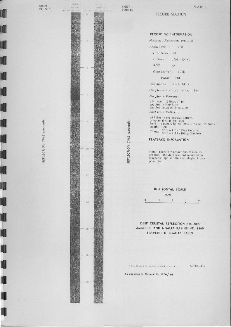
Ngalia Basin
Two shots were recorded from the same shotpoint (lat. 2024.0',long. 131 ° 14.2', see Plate 1) by geophone spreads mutually at right-angles.The shotpoint was SP 6016 on traverse 0 of the Ngalia Basin SeismicSurvey (Jones, 1970). One of the geophone spreads was laid along traverse0 which had a bearing of N. 15 ° W.
The techniques used were based on those found successful in theAmadeus Basin and were:
Shot-hole pattern: 30 holes were drilled in rectangular pattern,othogonal spacings 15 metres.Shot 1 (spread along traverse 0) used 6 holes.Shot 2 ( spread perp. to traverse 0) used 15 holes.
Hole depth: 37 metresCharge:^shot 1 - 6 x 129 kg (774 kg) Geophex
shot 2 - 15 x 109 kg (1630 kg) Geophex
Geophones: HS-J, 14 HzGeophone spread: 1100-0-1100 metres splitGeophone station interval: 91 metresGeophone pattern: 32 per trace in 2 lines, spacing in
line 6.1 metresInstruments: AGC SS, final gain FULL, filter L/16 - KK/60
Camera speed: 15 cm per secondRecord length: 30 secondsPresentation: variable area/wiggle trace
Many late events were recorded (Pl. 4), but not as many as wererecorded in the Amadeus Basin. One particularly strong, broad eventoccurs on both records at a time of 12.7 seconds. It is not obviouslya multiple. Assuming this is a primary deep crustal reflection andassuming an average velocity to the reflecting layer of 6.0 km/s, thedepth of the layer would be 38 kilometres, which is not an unreasonabledepth for the Moho discontinuity.
6. Conclusions
It has been demonstrated that fair quality reflections can beobtained from deep within the crust in particular areas of theAmadeus and Ngalia Basins, and it may be hoped that a larger-scaleseismic survey will shed new light on the deep structure and tectonichistory of these basins and decide between conflicting theories putforward to explain the anomalous gravity features associated with them.
- 10-
7. Referencek
BRANSON, J.C. and HARRISON, P.L., 1970 - Deep crustal reflection studies-on the Geo-Traverse, W.A., 1969 (in preparation).
BRANSON, J.C. and TAYLOR, F.J., 1970a - Deep crustal reflection test survey,Mildura, Vic., and Broken Hill, N.S.W., 1968 (in preparation)
BRANSON, J.C., and TAYLOR, F.J., 1970b - Deep crustal reflection testsurvey. Tidbinbilla, A.C.T., and Braidwood, N.S.W., 1 .969 (in preparation).
BROWN, A.R., 1971a - Gosses Bluff Seismic Survey, 1969, Bur. Miner.Resour. Aust. Rec. 1971/4.
BROWN, A.R., 1971b - Controlled Directional Reception - tests of the methodin the Amadeus Basin N.T. 1969 (in preparation)
CLOWES, R.M., KANASEWICH, E.R., and CUMMING, G.L., 1968 - Deepcrustal seismic reflections at near-vertical incidence. Geophysics, 33(3),441
DIX, C.H., 1965 - Reflection seismic crustal studies. Geophysics, 30(6), 1068
DOHR, G. and FUCHS, K., 1967 - Statistical evaluation of deep crustalreflections in Germany. Geophysics, 32(6), 951
FLAVELLE, A.J., 1965 - Helicopter gravity survey by contract, N.T. & Qld,1965, part 1. Bur. Miner. Resour. Aust. Rec. 1965/212 (unpubl.).
JONES, P., 1970 - Ngalia Basin Seismic Survey, 1969 (in preparation)
KANASEWICH, E.R., and CUMMING, G.L., 1965 - Near-vertical-incidenceseismic reflections from the "Conrad" discontinuity. J. geophys. Res., 70(4)3441
LANGRON, W.J., 1962- Amadeus Basin reconnaissance gravity survey usinghelicopters, N.T., 1961. Bur. Miner. Resour. Aust. Rec. 1962/24 (unpubl.).
MOSS, F.J., 1964 - Gosses Bluff Seismic Survey, Amadeus Basin, N.T.,1962 Bur. Miner. Resour. Aust. Rec. 1964/66 (unpubl.).
UNDERWOOD, R., 1970 - A large cooperative seismic experiment: projectBUMP. Aust. Phys. 7 (2) p.21.
WELLS, A.T., FORMAN, D.J., RANFORD, L.C., COOK, P.J., 1967 - Thegeology of the Amadeus Basin, Central Australia, Bur. Miner. Resour. Aust. Bull. 100.

WELLS, A.T., EVANS, T.G., and NICHOLAS, T., 1968 - Geology of thecentral part of the Ngalia Basin, N.T. (in preparation).
WHITWORTH, R., 1970 - 1967 Helicopter gravity survey, N.T. and W.A.(by contract) (in preparation).

11111 • I= I= MI• I=^•^• • • • MI • MI
150
Gravity province boundary
Sedimentary basin boundary
• Road
^
I^•^ I^Railway
• + SP6016^Crustal reflection probe
KILOME IC ES
^
80^0^50^100
PLATE I
LEGEND
Bouguer anomaly contours-rag t20 milligäl interval
DEEP CRUSTAL REFLECTION STUDIESAMADEUS AND NGALIA BASINS, N. T.,
1969
GRAVITY FEATURESASSOCIATED WITH AMADEUS
AND NGALIA BASINS
F53/83-147
T.::!!!11111111limagu„.... ^,, uldtzzat\
AAECit IMP^I
SP AUG^ • ALICE SPRING.GOES , F
) 20^•^ 1110111V^'Smock.^ IM7,77 7^ Rodingo
^-AMADEUS--v -1^VITY DETES ION144.L.N•ol•
frafF
-vo
\\\1■1111\011011111111111111111110lletafix //
• ATERS POCK
iTERRITORYaI^AUSTRALIA26

I= I= MIIN MI MN NM MI NM NM II= MN •110=1 =1^INN IMII M I= EMI
15
c'cs^A6^42 --^6'0<9
9a^6
^
n^nO^, 43
91^.096^9^ ni.^ t\\OtOeS^ '5°^
v.^5‘...^4,‘,..^,006 i^4,5e 4
I^
5 \
1., '^L^I^IP i^I^ i^ 1 ^TRAVERSE GB/L ---,- h. 10E1^ -
.^ .^ 1^il^I^1^„.... ....„ - 11^I
a
^
1^i.^.^ 4P.^ .^ ..-,..
..^.^I^I 1^I^1^ I.^.^ ■
09.^ 1 I^1 I^1 Ioexz
Configuration for --). .1!^ititi^
V^de •^_ , _ .V Continuous subsurface coverage obtained by4
ci^ expanded spread shots^ oe^t‘Ob •^sl shots at these shot-points
,..(1)^ tOne shot recordedinto spread 'at
• SP 3106 IS AT LAT. 23°42'30"^
right angles
LONG. 132° 00"
DEEP CRUSTAL REFLECTION STUDIESHORIZONTAL SCALE
3 4 KILOMETRES^AMADEUS AND NGALIA BASINS,N.T., 1969^-0
^.^.
^
.^.
^
..^..^1^I I^I^1^1 I^I
^
.^.
^
.^.o
^
--I^ ■■^ ■^1^I^1^I^ 1^1^i
^
■^■^■^■
^
0^ ■^■^1^1^1^1^ 1^1^I^IO ■^■^■^■
O ■^■^I^1^I^I^ I^I^1^1^I
^
0^ ■^■^3^ ..^ 1^1
^
o^ ..^.^1^1^I^I^I^I^1^I^I^i
^
la^ .
^
..c^ I^1^1^1 i^Ii^I^1^I^1^i=
^
0^ 11^i^I I^1 I
^
z^ I
o-.4
.1:.
SHOOTING DIAGRAM, AMADEUS BASIN 74

-SHOTPOINTS 3110
Trave rse GB/ l expanded spre ad
3100
GB / lA Trave rs e GB/ l
3090 3 106- 50====3100 3 10 2 310B 3 11 0
2 -
4 -
6
8 -
12
14
16 -
18
20 -
SHOTPOINTS
o
PLATE 3
RECORD SECTION
RECORDING INFORMATION
Magn e ti c R eco rde r." PMR-20
Ampl i!i e rs PT -700
Pre!i lI e rs." Ni I
Filte rs L/ 16 - KK/ 60
AGe 55
Gai n Initi a l ." -70 / -60dB
Final ." FULL (except 3108, 3110: - 10dB)
Geophones." Hs-J, 14H z
G eophon e Station Int erval 67m
Geoph on e Pal/ e rn ."
32 / trace in 2 lin es of 16 spaci ng in lin e 6.1m spa ci ng between lines 9. 1m
Sh o t H oi e. P a ll e r n ."
3 in l in e, spacin g 23m Depth: 30m Charge: 470kg Geoph ex per .shot
PLAYBACK INFORMATION
Note: Th ese are redu ction s of monitor record s. Th e data was not recorded on ma gne tic tape and thu s no pl ayback was pO SS I bl e.
~ORIZONTAL SCALE
IKm)
2 3 4
DEEP CRUSTAL REFLECTION STUDIES
AMADEUS AND NGALIA BASINS NT, 1969
TRAVERSE GB/ L AND GB/ LA, AMADEUS BASIN
RECORDED BY: SEI 5M l C PARTY NO. 1 FS2 / B3-39
To accompany Reco r d No 1970 / 94
SHOT -POIl'.TS
11\1 " L
.... , ,.'·ql
I, 11, 1
.1,1,1 I SHOTPO I NTS
o
PLATE 4
RECORD SECTION
RECORDING INFORMATION
Magn eti c R eco rder : PMR -20
Ampli fi er s PT -700
P r efi lt c rs Nil
F i ll e r s Ll 16 - KK / 60
A Ge ss
Gain Initi a l - 80 dB
Fin a l FULL
Geopfl on es: Hs-J, 14Hz
Geopfl o n e St a tion Int er va l : 91m
G eopflone P a l/ em:
321 lrace in 2 lines of 16, spaci ng in lin e 6. 1m spac in g hetween lin es 9. 1m
Sflot H o l e P atterll :
30 ho les In rec tangul ar pall ern , ortho gon al spaci ngs 15m 601 6 - 1 used 6 ho les, 601 6 - 2 used 15 hol es Depth : 37 m Charge' 6016- 1 6x 129kgGcophex
. 6016 -2 15 x 109kg Geoph ex
PLAYBACK I NFORMATION
Note: These are reductions of monitor r('co rels . Th e el ata was no t recorded on magnetic tape and thu s no playback was possi hi e.
HORIZONTAL SCALE
IKm )
2 3 4
DEEP CRUSTAL REFLECTION STUDIES
AMADEUS AND NGALIA BASINS NT, 1969
TRAVERSE 0 , NGALIA BASIN
RECORDED BY; SE I SM IC PARTY NO. 1 FS2 / B3-40A
To occo mpony Re cord No 1970/94