deep diving under the new britain trench
TRANSCRIPT

©Keren Francis, 2018. All rights reserved. Page 1 of 14
Deep Diving under the New Britain Trench
An examination of the junction between the Solomon Sea
Plate, the Bismarck Plates and the Pacific Plate
Keren Francis
April 2018

©Keren Francis, 2018. All rights reserved. Page 1 of 14
An examination of the junction between the Solomon Sea
Plate, the Bismarck Plates and the Pacific Plate
Using earthquake foci from January 1975 to March 2018
Keren Francis, 2018.
1. Abstract
A model for the current configuration of the subduction zones of the New Britain Trench on the northern boundaries of the Solomon Sea Plate is developed from earthquake foci plots as an example of the value of earthquake data to understanding geological structures.
The New Britain Trench is an interesting area to explore, being the site of intense earthquake and volcanic activity; for example, volcanoes have produced large Holocene eruptions, i.e. VEI-5 or more: Pago / Witori (VEI-6), Tavui (VEI-5), Dakataua (VEI-6) and Rabaul (VEI-6) on New Britain Island; and, Billy Mitchell (VEI-6) on Bougainville Island. Geochemical analysis of the lavas by other researchers has provided evidence of former subduction zones and earlier plate configurations. Both islands have had at least two episodes of subduction zone originated volcanic activity.
The earthquake foci plots for the western arm of the New Britain Trench are consistent with the volcanic activity observed on New Britain Island. There is a clearly delineated northwest trending subduction zone for the down-going slab of the Solomon Sea Plate under the South Bismarck Plate; the Wadati-Benioff zone reaches around 500km before it flexes to descend rapidly to 654km, with a suggested reversal of polarity. The change in direction of subduction may be a result of the influence of an earlier plate configuration, when the Pacific Plate subducted southward under the Indo-Australian Plate at the Manus-Kilinailau Trench. The northwest subduction zone also curves northwards under the Bismarck Sea Seismic Lineation and the North Bismarck Plate. To the east of this there are fewer earthquakes indicating a possible tear zone. The subducting slab of the Solomon Sea Plate passes under and may contribute to the lavas of the South East Ridge seamounts of the Manus Basin; tears in the down-going slab may provide a mechanism for Pacific-like MORBs to reach these seamounts.
The earthquake foci plots for the eastern arm of the New Britain Trench show a shallow zone to around 70km with a reversal of polarity at depths between circa 80km up to 300km between New Ireland and Bougainville. This indicates the possible slab fragment under the North Bismarck Plate, which, given its apparent polarity and thickness, the slab fragment originate from the Pacific Plate. The discontinuity in the subduction zone goes some way to explaining the lack of recorded volcanic activity between the northern tip of the Solomon Sea Plate and Bougainville Island. To the south east of the slab fragment, the Solomon Sea Plate has a shallow subduction zone which reaches a depth of around 200km; this feeds the volcanoes of Bougainville.
2. Introduction
The New Britain Trench is a pronounced feature between the Bismarck Sea and the Solomon Sea. It is seismically very active, with active volcanoes along its western arm and along the southern end of its eastern arm on the overriding plates. There is a gap in the volcanic activity at the northern end of the eastern arm of the trench near the plate junction, despite being seismically active.
I use 3D earthquake foci plots to examine the current configuration of the subduction zones of the New Britain Trench in order to further our understanding of evolution of the complex collision zone between the South Bismarck Plate, Solomon Sea Plate, North Bismarck Plate and Pacific Plate. Earthquake foci plots of the junction may go some way to explaining the gap in volcanic activity.

©Keren Francis, 2018. All rights reserved. Page 2 of 14
Fig 1: Solomon Sea Plate region from Google Earth, including active volcanoes. The New Britain Trench is the dark inverted “V” below New Britain and Bougainville Islands.
I downloaded publically available earthquake data (date, time, latitude, longitude, depth and magnitude) to MatLab from USGS’s
[15] website using the criteria: area 1.0°S 142.500°E to 12.0 °S 162.5°E; depth 0km to
1,000km; and, magnitude 0 to 10, from 1 January 1975 to 31 March 2018. The area selected was larger than that of the New Britain Trench to ensure that the deeper earthquake foci for the subduction zones were captured. The initial plots are data heavy above 100km so further analysis was done in three sections: the West New Britain Trench (WNBT); the East New Britain Trench; and the junction with the Bismarck Sea Seismic Lineation (BSSL).
The Solomon Sea Plate region earthquake foci plots show some activity on the Manus Trench, the Trobriand Trench and at the Woodlark Spreading Centre, although this is less intense than the activity on the New Britain Trench and BSSL. These are outside the scope of this paper.
Publically available data from U.S. Geological Survey [15]
for earthquake focal mechanisms is limited to earthquakes with a magnitude of 6.0 Mw or more, which, in turn, has limited our investigation into fault movement; most earthquakes in our data set have lower magnitude.
All plots and diagrams in this paper are by the author, except where stated otherwise.
3. Tectonic Setting
The current plate configuration has evolved over time from the collision of the Indian, Australain and Pacific Plates. Micro-plates evolved to accommodate the relative motions of the three plates. Here we focus on the Solomon Sea Plate, and the North and South Bismarck Plates, Pacific Plate, and the Australian Plate.
The earliest plate configuration in the region is believed to be the initial convergence of the Indian and Pacific Plate. The Indian and Australian Plates were originally part of Gondwana, until the Indian Plate started to separate from Gondwana, moving northwards 120mya; the Australian Plate separated from Gondwana in a process that took 10 my, completing around 45mya. India collided with Asia at about the same time the Indian and Australian Plates fused, also 45mya. By the Eocene, the Pacific Plate subducted under the Indo-Australian Plate at the Kilinailau Trench. The arrival of the Ontong-Java Plateau in the region caused subduction of the Pacific Plate to cease. The Ontong-Java Plateau is a large igneous province made up of oceanic crust overlain by flood basalt; the thickened oceanic lithosphere is more buoyant. There are differing opinions on the timing of when subduction ceased either at around 21mya to 23mya, (for example: Kroenke, (1984)
[8]; Musgrave,
(1990)[10]
; and, Petterson et al, (1999) [12]
), or, around 10mya, (for example: Hall (2002)[4]
, Mann & Taira (2004)
[9], and Schellart et al (2006)
[13]). It is not inconceivable that both opinions are “right” given the relative
speeds and directions of plate motions, and the size of the area looked at; or, perhaps, there was more than one collision event.
After the arrival of the Ontong-Java Plateau, the Indo-Australian Plate subducted under the Pacific Plate at the New Britain – Bougainville - Makira Trench. Around 3.0 mya to 3.7mya, at the time the Finisterre-Huron Range collided with northern New Guinea (Abbott et al (1994)
[1]), the Bismarck Plates were created. Lastly, the Indian
and Australian Plates separated at least 3mya, possibly in response to the earlier collision of the Indian Plate with the Eurasian Plate at the Himalayas. The Indian Plate now moves northwards at a rate of 3.7cm per year, whereas the Australian Plate moves northwards at a rate of 5.6 cm per year.

©Keren Francis, 2018. All rights reserved. Page 3 of 14
Fig 2: Image from Google Earth, including volcanoes. Names of some tectonic plates and trenches added by the author. White lines show approximate locations of trenches and current plate boundaries.
Solomon Sea Plate
The Solomon Sea Plate is a microplate located in the collision zone between the Australian and the Pacific Plates. The Plate, a slab of oceanic crust with an area of around 250,000km
2, may have formed between the
late Cretaceous and the Oligocene either as a back arc basin to an earlier subduction zone or as a fragment of the Pacific plate. Davis et al, (1987
)[3], found that the basalts of the Solomon Sea Plate are similar to those of
evolved mid ocean ridge basalts (MORBs) at the east Pacific Rise, indicating that the Solomon Sea Plate has a Pacific-like asthenosphere.
At the New Britain Trench, the Solomon Sea Plate is converging with the South Bismarck Plate a rate between 85 to 120mm per year, and with Pacific Plate at a rate of 145mm per year. The current northward subduction of the Solomon Sea plate originated around 10mya. The New Britain Trench marks the plate boundaries in the north. The Woodlark Spreading System is located on the south east boundary of the Solomon Sea Plate.
Bismarck Plates
The Bismarck Plates are slabs of oceanic lithosphere separated by a system of transform faults and spreading ridges, called the Bismarck Sea Seismic Lineation (BSSL). The South Bismarck Plate is located in the south of the Bismarck Sea and is home to the Bismarck Archipelago. The South Bismarck Plate is moving north eastwards at a rate of 26 mm per year, whereas the North Bismarck Plate is moving north westwards at rate of 96mm per year. The Kilinailau Trench marks the boundary of the North Bismarck Plate and the Pacific Ocean.
The Manus Basin[14]
is a backarc basin located on the Bismarck Plate between New Britain, New Ireland and Manus Island. The basin is crossed by extensional transform zones and the Manus Spreading Ridge, features of the BSSL.
4 Earthquake Data and Earthquake Foci Plots
4.1 Earthquakes of the Solomon Sea Plate Region
Earthquake data was downloaded from the U.S. Geological Survey[15]
website for the area 1.0°S 142.500°E to 12.0°S 162.500°E from 1 January 1975 to 31 March 2018. There were 27,582 reported, of which 184 earthquakes had a magnitude 6.5 or more. Most earthquakes occur at depths of between 0km and 150km, with larger earthquakes occurring in the lithosphere; however, some larger earthquakes were also noted at depths between 350 km and 550km.
Latitude v longitude plots of the earthquake foci (Fig 3) shows earthquakes occurring on the plate boundaries for the North Bismarck, the South Bismarck Plate and the Solomon Sea Plate.

©Keren Francis, 2018. All rights reserved. Page 4 of 14
Fig 3: Latitude v longitude plot of the earthquakes extracted for this study. Colours denote depth of earthquake foci: magenta, 0 to 33km; red, 33km to 70km; green, 70km to 150km; cyan, 150km to 300km; blue, 300km to 500km; and, black, 500 km to 655km. NBP = North Bismarck Plate; SBP = South Bismarck Plate; BSSL = Bismarck Seismic Sea Lineation; WNBT = West Bismarck Trench; and, ENBT = East New Britain Trench. Not to scale
Longitude v depth is examined. The longitude v depth plot below shows the subduction zones of the west and east New Britain Trench (Fig 4).
Fig 4: Longitude v depth plot of the Solomon Sea Plate Region. WNBT= the west New Britain Trench subduction zone. ENTB = the east New Britain subduction zone. Other structures in the image relate to other plate boundaries in the region. Colour denotes depth as above. Not to scale.
©Keren Francis, 2018. All rights reserved. Page 5 of 14
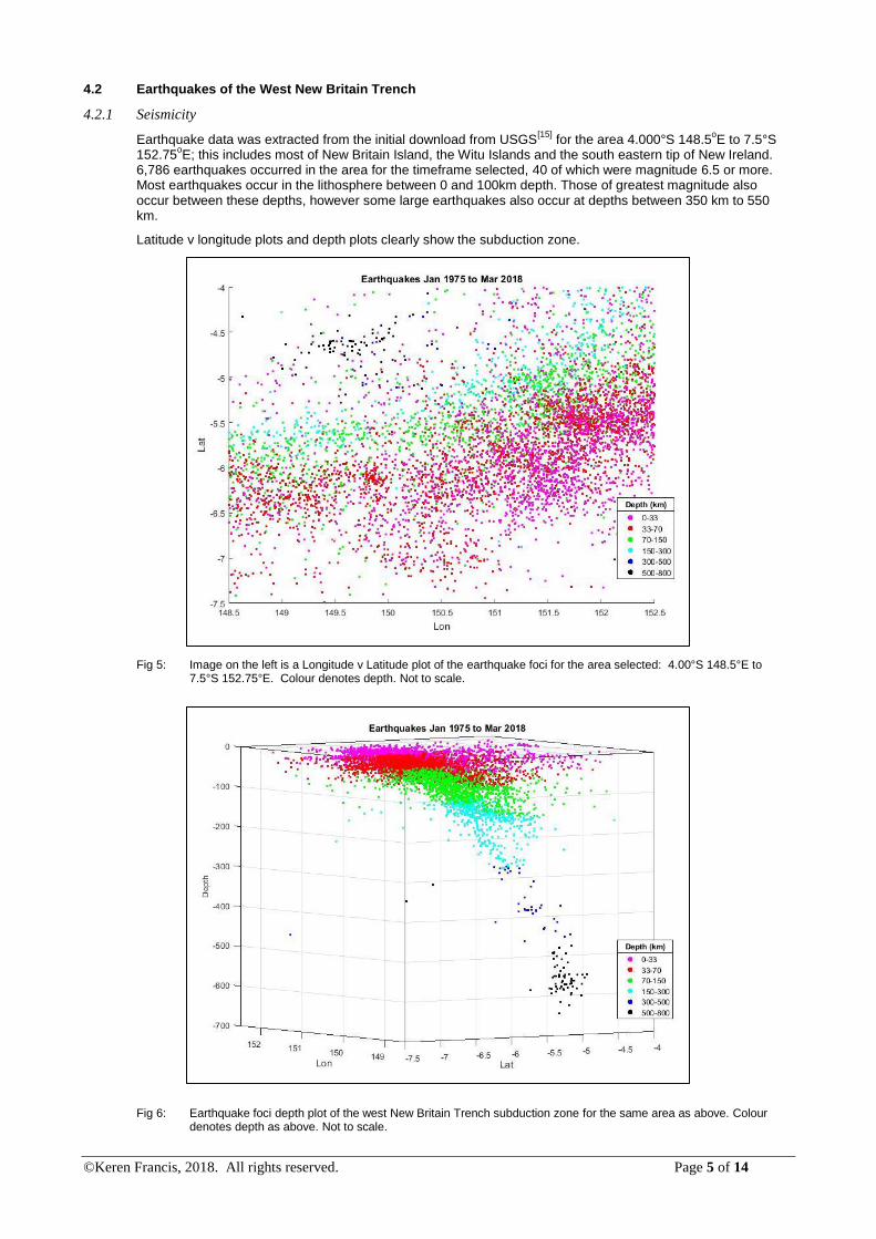
4.2 Earthquakes of the West New Britain Trench
4.2.1 Seismicity
Earthquake data was extracted from the initial download from USGS[15]
for the area 4.000°S 148.5oE to 7.5°S
152.75oE; this includes most of New Britain Island, the Witu Islands and the south eastern tip of New Ireland.
6,786 earthquakes occurred in the area for the timeframe selected, 40 of which were magnitude 6.5 or more. Most earthquakes occur in the lithosphere between 0 and 100km depth. Those of greatest magnitude also occur between these depths, however some large earthquakes also occur at depths between 350 km to 550 km.
Latitude v longitude plots and depth plots clearly show the subduction zone.
Fig 5: Image on the left is a Longitude v Latitude plot of the earthquake foci for the area selected: 4.00°S 148.5°E to 7.5°S 152.75°E. Colour denotes depth. Not to scale.
Fig 6: Earthquake foci depth plot of the west New Britain Trench subduction zone for the same area as above. Colour denotes depth as above. Not to scale.

©Keren Francis, 2018. All rights reserved. Page 6 of 14
The slab of the Solomon Sea Plate descends in a north westward direction under the Bismarck Plate, reaching a depth of 654km, and also curves northwards towards the BSSL. Below 500km the angle of subduction changes to being much steeper, with a possible reversal of direction.
4.2.2 Volcanoes of New Britain Island
Fig 7: Holocene volcanoes of New Britain. Image from Google Earth. Volcano names added by the author.
The Holocene volcanoes comprise a chain of volcanoes parallel to the New Britain Trench, and also a chain
volcanoes on an axis perpendicular to the trench. The Witu Islands are backarc to the New Britain Trench. According to GVP
[16], of these volcanoes, four have had eruptions with a magnitude of VEI 5 or more:
Pago/Witori (VEI 6), Tavui (VEI 5), Dakataua (VEI 6) and Rabaul (VEI 6).
New Britain Island is the largest island in the Bismarck Archipelago, with a population of 514,000 (2011) and an area of 36,520 km
2. The island was originally located to the west of the Indian Plate – Pacific Plate boundary
and is thought to have rotated round to its current position during the creation of the Bismarck Plates. The crust beneath New Britain is 20-40km thick. Rocks are characteristic of an island arc: tholeiitic, ranging from basalt to rhyolite (Jakes & Gill (1970
)[7]). Due to the changes in plate configurations, the direction (polarity) of the
subduction zone has changed from southward to northward over time; and, the island has undergone at least two episodes of volcanic activity.
Volcanic activity is known to have occurred: a) from the Eocene to the Oligocene; and, b) from the Pliocene to the present (Woodhead et al (1998
)[14], Holms et al (2013
)[5], and the references therein). The volcanic activity
of the Eocene and late Oligocene was mainly andesitic with dioritic plutons; in the upper Eocene strata, mafic and intermediate pillow lavas, breccias and volcanoclastics are found, followed in the upper Oligocene to lower Miocene, by volcanoclastic formations, plutonic and subvolcanic rocks of mafic to intermediate composition. The ratio of potassium (K) to silicon (Si) in the plutonic rocks increases towards the south, indicating a southward trending subduction zone. Volcanic activity ended in the lower Miocene at the same time the Ontong-Java Plateau is thought to have arrived at the Kilinailau Trench. Volcanic activity resumed in the Pliocene, with basalt, andesite and dacite lavas and volcanoclastics. In recent volcanics, the ratio of K to Si increases northward, consistent with the current northward trending subduction zone to where the zone is 200km deep; below 200km, the correlation between K and Si is either irregular or negative. Between the episodes of volcanic activity, there was a period of subsidence, extension and hydrothermal activity, during which copper and gold porphyry deposits occurred at Simuku-Kulu, Esis and Plesyumi.
Woodhead et al (1998) [14]
studied of the geochemical profiles of lavas across the volcanic arc from the volcanic front to the backarc. Their findings include evidence for a possible previous episode of subduction:
Unusually high depletion of the high field strength elements (HFSEs) niobium, zirconium and titanium, in the lavas of the volcanic front; the level of the depletion of HFSEs at the New Britain volcanic front is one of the highest in the world, consistent with a possible previous episode of subduction.

©Keren Francis, 2018. All rights reserved. Page 7 of 14
Paleo enrichment of Rabaul’s lavas is more than would be expected from the fluids from the descending slab from the Solomon Sea Plate, which have less sediment component than other island arcs. The enrichment may have come from the earlier subduction of the Pacific Plate at the Kilinailau Trench.
The mantle source for the backarc volcanoes shares more of the characteristics of Indian Ocean mid ocean ridge basalts (MORBs) than of Pacific MORBs. This is consistent with the earlier location of the Manus Basin and New Britain to the west of the Pacific Plate boundary with the Indian Ocean. The mantle source for the volcanoes of New Britain Island, itself, is not clear; i.e., there is no clear distinction between Indian Ocean MORB and Pacific Ocean MORB characteristics in the lavas.
Park et al (2010)[11]
found further evidence of an earlier subduction zone from the lavas of Tabar, Lihir, Tanga and Feni (TLTF) and the lavas of the active seamounts of the South East Rift (SER) in the Manus Basin; the amount of subduction elements in the SER lavas decreased with distance from New Ireland, but not the New Britain Arc. They concluded that the TLTF was the forearc and the SER a backarc for the earlier subduction zone at the Kilinailau Trench. Interestingly, they also found that the SER lavas were consistent with those of island arcs, including those of the New Britain Island (Woodhead et al’s
[14] zone E of the New Britain Arc), and
that the mantle source for the SER has more affinity with Pacific MORB than Indian Ocean MORB, which is discussed later in this paper.
In the light of both Woodhead et al’s[14]
and Park et al’s[11]
findings above, the earthquake foci for the New Britain Trench – BSSL junction were plotted.
4.3 Earthquakes of the East New Britain Trench
4.3.1 Seismicity
Earthquake data was extracted from the initial download from USGS[15]
for the area 3.0°S 152.75oE to 8.5°S
156.00oE; this includes the southern tip of New Ireland, and the islands of Ambitle, Pinipel, Sirot, Barahun,
Nissan, Buka and Bougainville. 7,721 earthquakes occurred in the area for the timeframe selected, 52 of which were magnitude 7 or greater. Most earthquakes occur in the lithosphere between 0 and 100km depth. Those of greatest magnitude also occur between these depths, however some large earthquakes also occur at depths between 350 km to 550 km.
Latitude v longitude plots appear to show a north eastward trending subduction zone.
Fig 9: The image shows Longitude v Latitude plot of the area selected: 3.0°S 152.750°E to 8.5°S 156.000°E. This includes the region from the southern tip of New Ireland to Buka and Bougainville. Colour denotes depth as above. Not to scale.
However, depth plots show that the Solomon Sea Plate descends to around 70km, after which there is a reversal of polarity from north east to south west after depths between 80km to around 300km.

©Keren Francis, 2018. All rights reserved. Page 8 of 14
Fig 10: The image shows the depth plot of the area selected: 3.0°S 152.750°E to 8.5°S 156.000°E. Colour denotes depth. Not to scale.
Zooming into the area, we can see that there is a discrete block of earthquakes at the point where the polarity of the subducting plate appears to change. This block of earthquake is also partially visible as the green block in Fig 9 between 4.25S 153.4E and 6.0S and 154.6E. The block is around 50km to 80km thick, thicker than expected for the oceanic crust of the Solomon Sea Plate.
Fig 11: The image shows the zoomed in depth plot for the Wadati Benioff zone in Fig 10. The descending slab of the Solomon Sea Plate is outlined in blue crayon. The discrete block of quakes lie between the two black lines. Colour denotes depth. Not to scale.
There is no recorded Holocene volcanic activity for the trench from the northern tip of the Solomon Sea Plate to north Bougainville Island, despite appearing to be an active section of a subduction zone. This “quiet zone” overlies the anomalous block of earthquakes noted above. Given the block’s proximity to the junction between
©Keren Francis, 2018. All rights reserved. Page 9 of 14
the Solomon Sea Plate, the Bismark Plate and the Pacific Plate, we will look further at the junction in section 4.4 below.
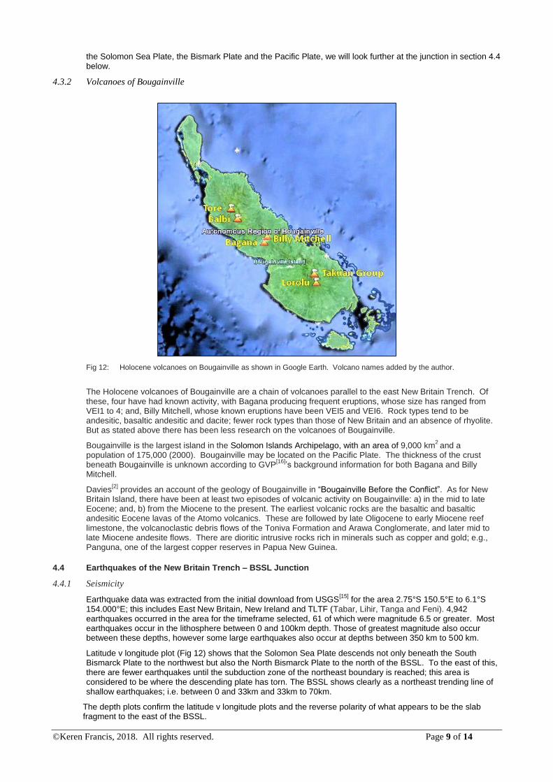
4.3.2 Volcanoes of Bougainville
Fig 12: Holocene volcanoes on Bougainville as shown in Google Earth. Volcano names added by the author.
The Holocene volcanoes of Bougainville are a chain of volcanoes parallel to the east New Britain Trench. Of these, four have had known activity, with Bagana producing frequent eruptions, whose size has ranged from VEI1 to 4; and, Billy Mitchell, whose known eruptions have been VEI5 and VEI6. Rock types tend to be andesitic, basaltic andesitic and dacite; fewer rock types than those of New Britain and an absence of rhyolite. But as stated above there has been less research on the volcanoes of Bougainville.
Bougainville is the largest island in the Solomon Islands Archipelago, with an area of 9,000 km2
and a population of 175,000 (2000). Bougainville may be located on the Pacific Plate. The thickness of the crust beneath Bougainville is unknown according to GVP
[16]’s background information for both Bagana and Billy
Mitchell.
Davies[2]
provides an account of the geology of Bougainville in “Bougainville Before the Conflict”. As for New Britain Island, there have been at least two episodes of volcanic activity on Bougainville: a) in the mid to late Eocene; and, b) from the Miocene to the present. The earliest volcanic rocks are the basaltic and basaltic andesitic Eocene lavas of the Atomo volcanics. These are followed by late Oligocene to early Miocene reef limestone, the volcanoclastic debris flows of the Toniva Formation and Arawa Conglomerate, and later mid to late Miocene andesite flows. There are dioritic intrusive rocks rich in minerals such as copper and gold; e.g., Panguna, one of the largest copper reserves in Papua New Guinea.
4.4 Earthquakes of the New Britain Trench – BSSL Junction
4.4.1 Seismicity
Earthquake data was extracted from the initial download from USGS[15]
for the area 2.75°S 150.5°E to 6.1°S 154.000°E; this includes East New Britain, New Ireland and TLTF (Tabar, Lihir, Tanga and Feni). 4,942 earthquakes occurred in the area for the timeframe selected, 61 of which were magnitude 6.5 or greater. Most earthquakes occur in the lithosphere between 0 and 100km depth. Those of greatest magnitude also occur between these depths, however some large earthquakes also occur at depths between 350 km to 500 km.
Latitude v longitude plot (Fig 12) shows that the Solomon Sea Plate descends not only beneath the South Bismarck Plate to the northwest but also the North Bismarck Plate to the north of the BSSL. To the east of this, there are fewer earthquakes until the subduction zone of the northeast boundary is reached; this area is considered to be where the descending plate has torn. The BSSL shows clearly as a northeast trending line of shallow earthquakes; i.e. between 0 and 33km and 33km to 70km.
The depth plots confirm the latitude v longitude plots and the reverse polarity of what appears to be the slab fragment to the east of the BSSL.

©Keren Francis, 2018. All rights reserved. Page 10 of 14
Holms et al (2013)[6]
, proposed a slab tear between New Ireland and TLTF from their 3D modelling of the subducting slab at depths below 100km, which is consistent with plots here.
Fig 13: The image shows Longitude v Latitude plot of the area selected: 2.750°S 150.5°E to 6.0°S 154.000°E. Colour denotes depth as above. Not to scale
Fig 14: The image shows a rotated depth plot of the New Britain Trench – BSSL junction. Colour denotes depth as above. Not to scale.
5 Discussion
Research by others on the volcanic activity and magma genesis for New Britain and Bougainville was used to interpret the earthquake foci plots, notably the work of Woodhead et al (1998)
[14], Park et al (2010)
[11], Holm et
al (2013, two papers) [5], [6]
, and Davies, H. (2005) [2]
, as noted above.

©Keren Francis, 2018. All rights reserved. Page 11 of 14
West New Britain Trench
The earthquake foci plots and the findings of researchers in respect of volcanic activity of the west New Britain trench are consistent. The plots show a clear Wadati-Benioff zone for the Solomon Sea Plate under the Bismarck Plates, reaching to a depth of 500km before descending more rapidly to a depth of 654km. Some depth rotations indicate that the deepest portion of the zone appears to have a different polarity, even a reverse one. This may be due to distortion of the subduction zone from the clockwise motion of New Britain Island or may reflect the influence of an earlier southward trending subduction zone. A reversal of polarity is consistent with the ratio of K to Si in the lavas from the first episode of subduction.
East New Britain Trench
The earthquake foci plots for the east New Britain Trench show a discontinuity in the subduction zone on the northeast boundary of the Solomon Sea Plate. As noted above, is a discrete block of earthquakes which do not appear to part of the descending slab of the Solomon Sea Plate; there appears to be a zone of reversed of polarity between 80k and up to 300km. The earthquake foci for this zone do not trend back to the surface, suggesting that this is a broken slab fragment or part of another subducted plate, possibly from the thickened Ontong Java Plateau of the Pacific Plate.
New Britain Trench – BSSL Junction
While Park et al (2010)[11]
thought that the SER was far enough away from the New Britain Trench not to be influenced by the subduction of the Solomon Sea Plate, this does not fit with the earthquake foci plots. The plots show that the subducting slab of the Solomon Sea Plate curves round to reach below the BSSL and the SER (Fig 15, deep blue earthquake foci). The Solomon Sea Plate would therefore have some influence on the SER lavas.
Fig 15: Longitude v Latitude plot of the area selected1.0°S 148.5°E to 8.5°S 157.000°E. The deepest earthquakes of the Solomon Sea Plate lie just within the blue line. The approximate location of the SER is shown in the dark oval. Not to scale.
Interestingly, Park et al (2010)[11]
, also found that the mantle source for the SER has more affinity with Pacific MORB than Indian Ocean MORB. If the Pacific Plate subducted under the Indian Plate or other precursor to the Bismarck Plates, Woodhead et al’s, 1998
[14], findings would indicate that a more Indian Ocean MORB might be
expected. A mechanism for Pacific-like MORB to reach the SER seamounts has to be found.
The earthquake foci plots of the New Britain Trench – BSSL junction show that there is a seismic gap at the northern tip of the Solomon Sea Plate to the east of the WNBT Wadati-Benioff zone, which may be indicative of

©Keren Francis, 2018. All rights reserved. Page 12 of 14
tears to accommodate the angle of the leading edge of the plate. These tears may provide a means for the Pacific-like MORB associated with the Solomon Sea Plate to reach the SER seamounts. This leads us to our model of the subduction zones of the northern boundaries of the Solomon Sea Plate (Fig 17). Furthermore, there is a discrete zone of earthquakes which appears to indicate a structure that hinders the descent of the slab on the north eastern boundary of the Solomon Sea Plate; that structure may be a slab fragment, e.g. from the Pacific Plate.
Fig 17: Model of the subduction zones of the New Britain Trench. The red line delinates the approximate descending slab of the SSP at the junction and for the WNBT.
6 Conclusion
A model for the subductions zones at the northern boundary of the Solomon Sea Plate has been developed from earthquake foci plots. The model shows:
1. A clearly delineated subduction of the Solomon Sea Plate under the South Bismarck Plate, the BSSL and the North Bismarck plate. A reversal of polarity in the deeper part of the subduction zone indicates the possible influence of an earlier subduction zone.
2. The seismic gap and an apparent reversal of polarity at a depth of between 80km and up to 300km in the East new Britain Trench indicates that there may be a slab fragment impeding subduction at the northern end of the East New Britain Trench. This is possibly a fragment of the Pacific Plate subducting under the North Bismarck Plate. Impaired subduction would account for the lack of observed volcanic activity between the northern tip of the plate and north Bougainville Island.
3. The Solomon Sea Plate subducts below the SER seamounts so would have an influence on their lavas. In the light of the curvature of the subduction zone, the SER may be a continuation of the Bismarck Archipelago. A possible slab tear at the leading edge of the Solomon Sea Plate may allow the Pacific-like MORBs of the Solomon Sea Plate mantle to reach the SER.
The model is consistent with observed volcanic activity in the vicinity of the New Britain Trench and illustrates a valuable role of earthquake foci data. Further research is required to confirm the presence of the slab tear and slab fragment.

©Keren Francis, 2018. All rights reserved. Page 13 of 14
7 References
Research Papers
1. Abbott, L. D., Silver, E.A., Thompson, P.R., Filewicz, M.V., Schneider, C., Abdoerrias, C., 1994, “Stratigraphic constraints on the development and timing of arc-continent collision in northern Papua New Guinea”. Journal of Sedimentary Research, 64B,169-183
2. Davies, H.L., “The Geology of Bougainville” in “Bougainville before the Conflict”. Anthony J. Regan, Helga-Maria Griffin, Stranger Journalism, 2005, ISBN 1740761383, 9781740761383
3. Davies, H. L., Honza, E., Tiffin, D. L., Lock, J., Okuda, Y., Keene, J. B., Murakami, F., Kisimoto, K.,1987, “Regional setting and structure of the Western Solomon Sea”. Geo-Marine Letters, 7, 153-160
4. Hall, R., 2002 “Cenozoic geological and plate tectonic evolution of SE Asia and the SW Pacific: computer based reconstructions, model and animations”. Journal of Asian Earth Sciences, 20, 353-431
5. Holm, R. J., Spandler, C., Richards, S. W., 2013, “Melanesian arc far-field response to collision of the Ontong Java Plateau: Geochronology and petrogensis of the Simuku Igneous Complex, New Britain, Papua New Guinea”. Tectonophysics, 603,189-212
6. Holm, R.J., Richards, S.W., 2013, “A re-evaluation of arc-continent collision and along-arc variation in the Bismarck Sea region, Papua New Guinea”. Australian Journal of Earth Sciences, 60, 605-619
7. Jakes, P., Gill, J., 1970, “Rare earth elements and island arc tholeiitic series”. Earth and Planetary Science Letters, 9, 17-28
8. Kroenke, L. W., 1984, “Cenozoic tectonic development of the southwest Pacific” U.N.ESCAP, CCOP/SOPAC. Technology Bulletin 6
9. Mann, P., Taira, A., 2004, “Global tectonic significance of the Solomon Islands and Ontong-Java Plateau convergent zone”. Tectonophysics, 389, 137-190
10. Musgrave, R., 1990, “Paleomagnetism and tectonics of Malaita, Solomon Islands”. Tectonics, 9, 735-759
11. Park, S-H., Lee, S-M., Kamenov, G. D., Kwon, S-T., Lee, K-Y., 2010, “Tracing the origin of subduction components beneath the South East rift in the Manus Basin, Papua New Guinea”. Chemical Geology, 269, 339-349
12. Petterson, M.G., Babbs, T., Neal, C. R., Mahoney, J.J., Saunders, A. D., Duncan, R. A., Tolia, D., Magu, R., Qopoto, C., Mahoa, H., and Natogga, D., 1999, “Geological-tectonic framework of the Solomon Islands, SW Pacific: crustal accretion and growth with an intra-oceanic setting”, Tectonophysics, 301, 35-60
13. Schellart , W. P., Lister, G.S., Toy, V. G., 2006, “A late Cretaceous and Cenozoic reconstruction of the Southwest Pacific region: tectonics controlled by subduction and slab roll back processes.” Earth-Science Reviews, 76, 191-233
14. Woodhead, J. D., Eggins, S. M., Johnson, R. W., 1998, “Magma genesis in the New Britain Island Arc: further insights into melting and mass transfer processes”. Journal of Petrology, 39, 1641 – 1668
Sources for raw data
15. U.S. Geological Survey: http://www.usgs.gov/
16. Global Volcanism Program, Department of Mineral Sciences, National Museum of Natural History, Smithsonian Institution (GVP): http://volcano.si.edu/