deforestation - ipam
TRANSCRIPT
DECEMBER | 2015
DEFORESTATION IN MATO GROSSO’S AMAZON FOREST
(PRODES/2015)CHARACTERISTICS, CURRENT POLICIES
AND WHAT NEEDS TO BE DONE
DEFORESTATION IN MATO GROSSO’S AMAZON FOREST
Mato Grosso is a key state within the Brazilian Amazon to reconcile an increase in agricultural production with reduced deforestation, a funda-mental equation to decrease the role of emis-sions from the agriculture and land-use change sectors in global climate change. Between 2005 and 2014, Mato Grosso reduced deforestation in its Amazon Biome by 87%, while more than doubling its GDP. In 2015, however, PRODES de-tected 1,508km² of deforestation in the state,
EXECUTIVE SUMMARY
the highest rate since 2008. In this document, we present the main characteristics of the de-forestation polygons detected by PRODES from August 2014 to July 2015, as well as the main measures taken so far to reduce this rate. We also propose recommendations for a long last-ing reduction in deforestation. The Mato Grosso strategy “Produce, Conserve and Include” pre-sented at COP21 covers part of these recom-mendations.
CHARACTERISTICS CURRENT POLICIES WHAT NEEDS TO BE DONE?
» Despite a great reduction in deforestation since 2005, illegal deforestation drivers remain active in Mato Grosso;
» 20 municipalities concentrate more than 70% of deforestation in Mato Grosso;
» Most of the identified deforestation occurs in private properties, with 60% of deforestation plots located inside large properties (> 15 MF);
» Large deforestation plots (>100ha) represent 41% of the deforested area;
» Transgressors are betting on illegal deforestation even after registering in the Rural Environmental Registry (CAR).
» State inspection has increased while federal inspection has remained at the same level;
» The Forest Code is being implemented at a slow pace;
» New actions are being implemented in the municipalities.
» Publish a list of illegal deforestations and embargoes;
» Implement the Forest Code by accelerating CAR validation, recovering and compensating environmental deficits;
» Engage municipalities in the fight against deforestation;
» Make data from CAR, licensing and environmental inspection publicly available;
» Establish new private incentives for deforestation-free agriculture.
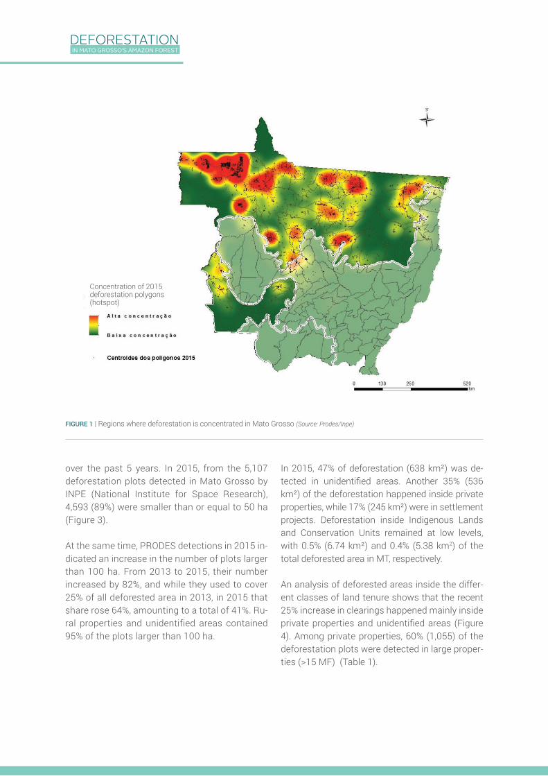
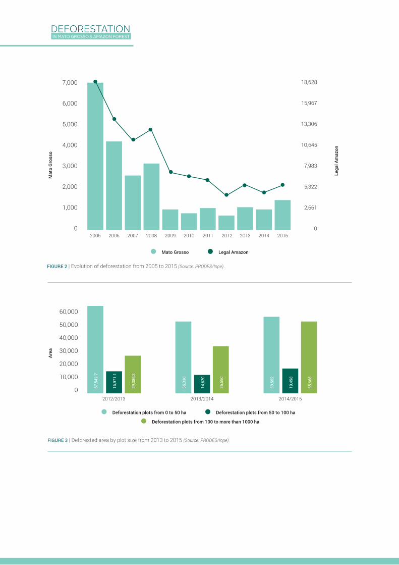
From 2009 to 2014, deforestation in Mato Gros-so’s Amazon Biome varied around an average of 1,000 km² a year. In 2013 and 2015, there was in increase (compared to the previous year) of 50% and 40%, respectively (Figure 1). Although these recent numbers are small when compared to the annual rates from 2005 to 2008, the maintenance of around 1,000 km² of annual deforestation and the increase detected in 2013 and 2015 show that deforestation is not yet under control in the state of Mato Grosso.
Year after year, the concentration of clearings detected by PRODES in 20 of the 141 municipal-
CHARACTERISTICS OF THE DEFORESTATION IN MATO GROSSO’S AMAZON FOREST IN 2015
ities of Mato Grosso portrays active deforesta-tion frontiers. In 2015, 72% of the deforestation plots were detected in 20 municipalities, from which only 10 were responsible for 52% of all de-forestation in the state (Figure 2). In this context, the case of the Colniza municipality is exempla-ry: in 2015, its clearings represented more than 17% of the state’s rates. Most clearings in Colni-za happened in unidentified areas, indicating that environmental registration (CAR) and land tenure regularization must become a priority.
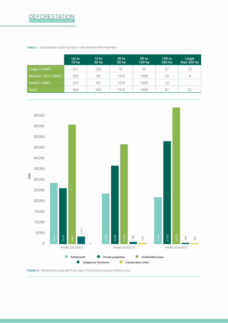
The size of deforestation plots in Mato Grosso and other Amazon states has been decreasing
DEFORESTATION IN MATO GROSSO’S AMAZON FOREST
over the past 5 years. In 2015, from the 5,107 deforestation plots detected in Mato Grosso by INPE (National Institute for Space Research), 4,593 (89%) were smaller than or equal to 50 ha (Figure 3).
At the same time, PRODES detections in 2015 in-dicated an increase in the number of plots larger than 100 ha. From 2013 to 2015, their number increased by 82%, and while they used to cover 25% of all deforested area in 2013, in 2015 that share rose 64%, amounting to a total of 41%. Ru-ral properties and unidentified areas contained 95% of the plots larger than 100 ha.
FIGURE 1 | Regions where deforestation is concentrated in Mato Grosso (Source: Prodes/Inpe)
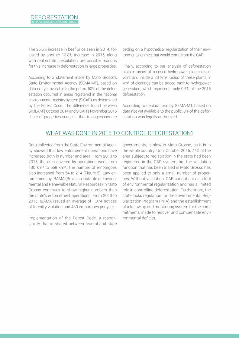
In 2015, 47% of deforestation (638 km²) was de-tected in unidentified areas. Another 35% (536 km²) of the deforestation happened inside private properties, while 17% (245 km²) were in settlement projects. Deforestation inside Indigenous Lands and Conservation Units remained at low levels, with 0.5% (6.74 km²) and 0.4% (5.38 km2) of the total deforested area in MT, respectively.
An analysis of deforested areas inside the differ-ent classes of land tenure shows that the recent 25% increase in clearings happened mainly inside private properties and unidentified areas (Figure 4). Among private properties, 60% (1,055) of the deforestation plots were detected in large proper-ties (>15 MF) (Table 1).
Concentration of 2015 deforestation polygons (hotspot)
DEFORESTATION IN MATO GROSSO’S AMAZON FOREST
FIGURE 2 | Evolution of deforestation from 2005 to 2015 (Source: PRODES/Inpe).
FIGURE 3 | Deforested area by plot size from 2013 to 2015 (Source: PRODES/Inpe).
18,628
15,967
13,306
10,645
7,983
5,322
2,661
0
Mat
o G
ross
o
2005 2006 2007 2008 2009 2010 2011 2012 2013 2014 2015
Mato Grosso Legal Amazon
Deforestation plots from 100 to more than 1000 ha
Deforestation plots from 0 to 50 ha Deforestation plots from 50 to 100 ha
Lega
l Am
azon
Area
2012/2013 2013/2014 2014/2015
67,5
42.7
16,9
71.1
29,3
86,3
56,3
30
14,6
20
36,5
50
59,5
52
19,4
98
55,6
66
7,000
6,000
5,000
4,000
3,000
2,000
1,000
0
60,000
50,000
40,000
30,000
20,000
10,000
0
DEFORESTATION IN MATO GROSSO’S AMAZON FOREST
FIGURE 4 | Deforested areas (km²) by class of land tenure (Source: PRODES/Inpe).
Area
Settlements Private properties Unidentified areas
Indigenous Territories Conservation Units
Up to 10 ha
10 to 30 ha
30 to 50 ha
50 to 100 ha
100 to 300 ha
Larger than 300 ha
Large (>15MF) 531 293 91 65 57 18
Medium (4 to 15MF) 229 82 1976 1958 20 4
Small (< 4MF) 225 60 1976 1958 10 -
Total 985 435 1976 1958 87 22
TABLE 1 | Deforestation plots by size in identified private properties.
Prodes 2012/2013 Prodes 2013/2014 Prodes 2014/2015
28,4
75
23,3
28
36,5
50
46,5
48
21,8
63
47,9
33
63,7
79
26,1
97
55,8
11
3,41
7
968
638
502
215
0
60,000
55,000
50,000
45,000
40,000
35,000
30,000
25,000
20,000
15,000
10,000
5,000
0
DEFORESTATION IN MATO GROSSO’S AMAZON FOREST
The 26.5% increase in beef price seen in 2014, fol-lowed by another 13.8% increase in 2015, along with real estate speculation, are possible reasons for this increase in deforestation in large properties.
According to a statement made by Mato Grosso’s State Environmental Agency (SEMA-MT), based on data not yet available to the public, 60% of the defor-estation occurred in areas registered in the national environmental registry system (SICAR), as determined by the Forest Code. The difference found between SIMLAM’s October 2014 and SICAR’s November 2015 share of properties suggests that transgressors are
betting on a hypothetical regularization of their envi-ronmental crimes that would come from the CAR.
Finally, according to our analysis of deforestation plots in areas of licensed hydropower plants reser-voirs and inside a 20 km² radius of these plants, 7 km² of clearings can be traced back to hydropower generation, which represents only 0.5% of the 2015 deforestation.
According to declarations by SEMA-MT, based on data not yet available to the public, 8% of the defor-estation was legally authorized.
WHAT WAS DONE IN 2015 TO CONTROL DEFORESTATION?
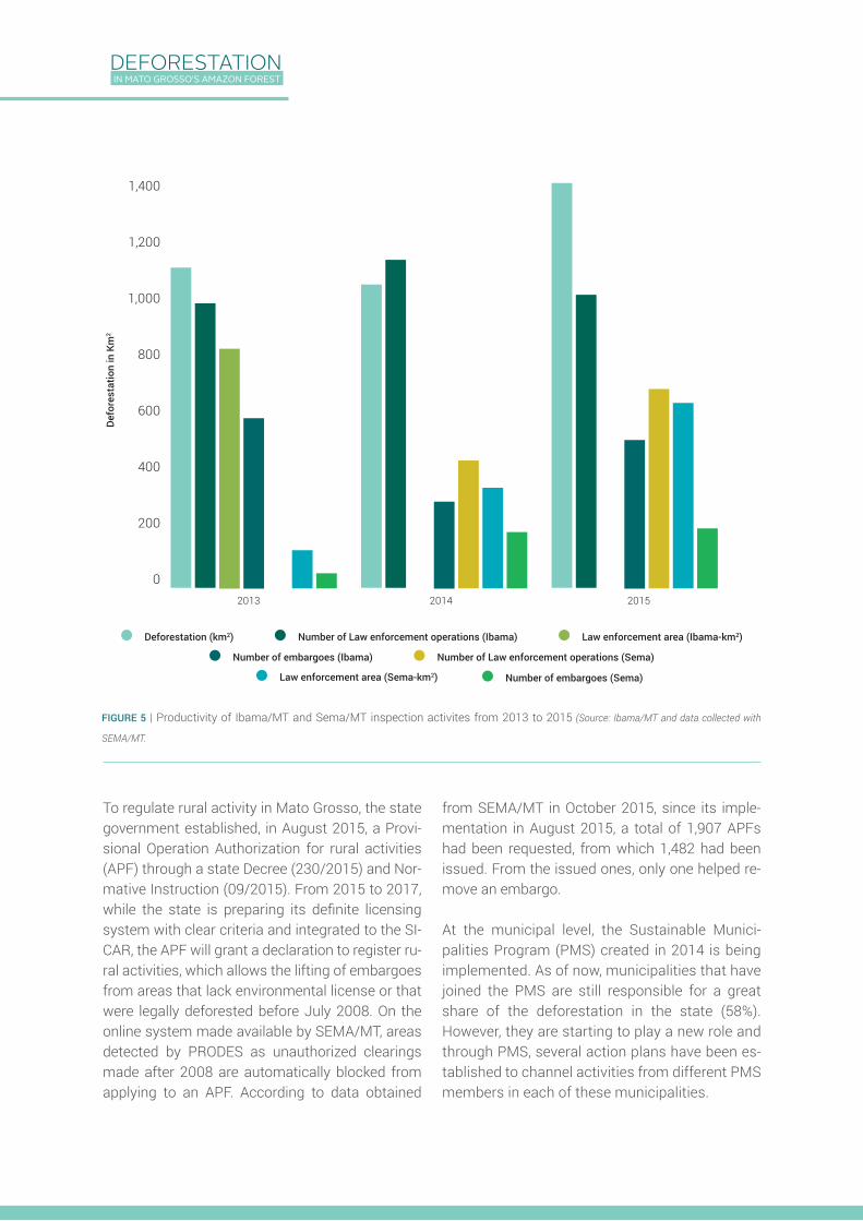
Data collected from the State Environmental Agen-cy showed that law enforcement operations have increased both in number and area. From 2013 to 2015, the area covered by operations went from 130 km² to 658 km². The number of embargoes also increased from 54 to 214 (Figure 5). Law en-forcement by IBAMA (Brazilian Institute of Environ-mental and Renewable Natural Resources) in Mato Grosso continues to show higher numbers than the state’s enforcement operations. From 2013 to 2015, IBAMA issued an average of 1,074 notices of forestry violation and 480 embargoes per year.
Implementation of the Forest Code, a respon-sibility that is shared between federal and state
governments, is slow in Mato Grosso, as it is in the whole country. Until October 2015, 77% of the area subject to registration in the state had been registered in the CAR system, but the validation function that has been trialed in Mato Grosso has been applied to only a small number of proper-ties. Without validation, CAR cannot act as a tool of environmental regularization and has a limited role in controlling deforestation. Furthermore, the state lacks regulation for the Environmental Reg-ularization Program (PRA) and the establishment of a follow up and monitoring system for the com-mitments made to recover and compensate envi-ronmental deficits.
DEFORESTATION IN MATO GROSSO’S AMAZON FOREST
Deforestation (km2) Number of Law enforcement operations (Ibama) Law enforcement area (Ibama-km2)
Number of embargoes (Ibama) Number of Law enforcement operations (Sema)
2013 2014 2015
Number of embargoes (Sema)Law enforcement area (Sema-km2)
FIGURE 5 | Productivity of Ibama/MT and Sema/MT inspection activites from 2013 to 2015 (Source: Ibama/MT and data collected with
SEMA/MT.
To regulate rural activity in Mato Grosso, the state government established, in August 2015, a Provi-sional Operation Authorization for rural activities (APF) through a state Decree (230/2015) and Nor-mative Instruction (09/2015). From 2015 to 2017, while the state is preparing its definite licensing system with clear criteria and integrated to the SI-CAR, the APF will grant a declaration to register ru-ral activities, which allows the lifting of embargoes from areas that lack environmental license or that were legally deforested before July 2008. On the online system made available by SEMA/MT, areas detected by PRODES as unauthorized clearings made after 2008 are automatically blocked from applying to an APF. According to data obtained
from SEMA/MT in October 2015, since its imple-mentation in August 2015, a total of 1,907 APFs had been requested, from which 1,482 had been issued. From the issued ones, only one helped re-move an embargo.
At the municipal level, the Sustainable Munici-palities Program (PMS) created in 2014 is being implemented. As of now, municipalities that have joined the PMS are still responsible for a great share of the deforestation in the state (58%). However, they are starting to play a new role and through PMS, several action plans have been es-tablished to channel activities from different PMS members in each of these municipalities.
1,400
1,200
1,000
800
600
400
200
0
Defo
rest
atio
n in
Km
2
DEFORESTATION IN MATO GROSSO’S AMAZON FOREST
WHAT ARE THE RECOMMENDATIONS TO CONTROL DEFORESTATION?
The deforestation detected in Mato Grosso shows that current tools applied to control and reduce de-forestation are not completely fulfilling their role. To correct that, our recommendations take 2 mu-tually dependent paths: 1) improve implementation of command and control policies, and 2) create a positive agenda that involves public policies and private initiatives. Part of these recommendations is covered by the “Produce, Conserve and Include” Strategy developed by the Mato Grosso govern-ment together with several institutions from the private sector and civil society.
1. Publishing a List of Illegal Deforestation that publicly exposes the identification and loca-tion of illegal deforesters, with the notices of violation and embargoes showing the names of transgressors. The high number of defor-estation plots happening inside properties registered in the CAR system shows that the state government needs to send clear signs that it is capable of identifying transgressors and punishing them accordingly. This list must also play a key role in excluding these properties from sustainable supply chains;
2. Implementing the Forest Code. This means going beyond registering properties in SICAR. It means verifying and validating the informa-
tion given by producers, publishing the rules for the Environmental Regularization Program (PRA), creating incentives for the recovery of deforested areas and notifying those who made illegal clearings in the CAR database. An implemented Forest Code is the starting point for controlling illegal deforestation and the ba-sis for ensuring legality;
3. Involving municipalities in the fight against deforestation, especially the most deforested ones, by establishing specific task forces for sensitive topics such as land and environmen-tal regularization;
4. Making data from CAR, licensing system and environmental inspection available to the public, so that everyone, including civil society and market actors, can follow up on transgres-sors’ actions, widening the government’s con-trol capacity;
5. Establishing new incentives for deforesta-tion-free agriculture. This includes a wide range of incentives that go from credit and fiscal tools, to support from the private sector, and market purchasing criteria. There is legal framework for those incentives in the Forest Code, but they have not yet been widely explored.
REFERENCES
1 Data used for this work: The analyses were done using PRODES deforestation polygons clipped to the boundaries of Mato Grosso state. PRODES only monitors the Amazon biome of Mato Grosso. Considering PRODES’ polygons for all of the Amazon biome, the deforestation added up to 5,273.46 km². The state of Mato Grosso was responsible for 1,346 km2 (26%), even though PRODES reports a rate of 1,508 km2. This difference occurs because INPE adds the defores-ted areas of the previous year which were covered by cloud in the previous reporting period.
2 The fiscal module (FM) in Mato Grosso’s Amazon biome varies from 60 ha to 100 ha. Therefore, properties larger than 15 FM are at least 900 ha in size.
3 The following hydropower plants were analyzed: Teles Pires (Paranaíta and Alta Floresta), São Manuel (Paranaíta), Complexo Apiacás (Alta Floresta and Nova Monte Verde), Colíder (Itauba, Nova Canaã, Colíder and Cláudia) and Sinop (Sinop, Itauba, Claudia, Ipiranga do Norte and Sorriso).
4 http://www.florestal.gov.br/cadastro-ambiental-rural/numeros-do-cadastro-ambiental-rural
Authors: Andrea Azevedo (IPAM), Alice Thuault (ICV), Cecilia Simões (IPAM), Isabel Castro (IPAM), Edilene Fernandes do Amaral (ICV) and Ana Paula Valdiones (ICV)Front cover image: Na LataGraphics: Alice ThuaultGraphic design & layout: Gueldon Brito
December/2015Non-commercial use authorized as long as the source is cited.