dekalb plan 2035 - home | dekalb county, ga · below is a table of criteria that has been set forth...
TRANSCRIPT

1
DeKalb Plan 2035

2
DeKalb Plan 2035
Table of Contents
I Land Use and Transportation Location Criteria 2
II Consistency Table - Comprehensive Plan and Economic Strategic
Plan Activity Centers
3
III DeKalb County 2016 Comprehensive Plan Update - Activity Cen-
ter Plan Amendments
5
IV Overlay Districts 8
V Land Use Parcel Maps 9
Districts 11 and 12
District 15
District 16
District 18
Land Use and Transportation Locational Criteria
In terms of addressing the most appropriate future land use for development, infrastructure should be adequate to ac-
commodate growing capacity. Road infrastructure should be adequate enough for activity centers that are proposed
nodes of development, throughout the county. Below is a table of criteria that has been set forth to show the relationship
between land use and transportation, in deciding the best locations for future growth.
Functional Class Land Use
Freeway Major Arterial Minor Arterial Collector Local
Regional Center x x
Town Center x x
Neighborhood Center x x
Major Corridor Develop-
ment x
Minor Corridor Develop-
ment x
Urban x x
Suburban x

3
DeKalb Plan 2035
EMPLOYMENT ACTIVITY CENTERS
Comprehensive Plan Activity Center
Comments
YES NO N/A
Southeast DeKalb
I-20/Lithonia Industrial Blvd X
Character Areas: Highway Corridor and Industrial The Economic Plan highlights the undeveloped land at the intersection of I-20/Lithonia Industrial Blvd. The Lithonia Industrial Park should also be noted for potential redevelopment and the existing business that is still thriving.
I-20/Panola Road X Character Areas: Town Center This area is consistent with the comp plan. Recommendation is this area should be a candidate for a market study to examine ways in how to maximize the economic potential.
I-285/Indian Creek MAR-TA Station X
Character Area: Town Center Includes the Indian Creek MARTA Station, which provides Transit Ori-ented Development potential. This is also a MALP Study area, which focuses on improving community health and wellness, through urban design.
I-285/Covington High-way X
Character Areas: Highway Corridor and Commercial Redevelopment Corridor A portion of this area is included within the MALP Study area.
Mall at Stonecrest X
Character Area: Regional Center Currently within the Stonecrest LCI Plan. Undeveloped land provides development opportunities. Transportation options will need to be expanded to support the growth potential of the area.
CONSISTENCY TABLE - COMPREHENSIVE PLAN & ECONOMIC STRATEGIC PLAN ACTIVITY CENTERS
Consistency Between Economic Employment Centers and Activ-ity Centers The purpose of the Consistency Table - Comprehensive Plan and Economic Strategic Plan Activity Centers, is to analyze the location of employment and activity centers. Employment Centers that were identified in the DeKalb County Economic Stra-tegic Plan by Planning Areas (North, West, East Central DeKalb, etc.), were compared to Activity Centers (Regional, Town, and Neighborhood) in the DeKalb County Comprehensive Plan. The reason for the comparison is to make sure that areas in the county that provided economic development opportunities were all in the same locations. It was determined that the ma-jority of employment centers were in the same locations as activity centers. Many of those that were not, were identified as Industrial Character Areas within the Comprehensive Plan.
EMPLOYMENT ACTIVITY CENTERS
Comprehensive Plan Activity Center Comments
YES NO N/A
Northern DeKalb
I-85/I-285 Interchange x Economic Plan mentions Mercer and the airport and key anchors, which are not in activity centers. However, there is a TC on the other side of I-285 (Henderson Mill & Chamblee Tucker Rds) in the vicinity. But the Economic Plan does not mention this. Recommendation is to include this area to make it compatible.
Downtown Tucker (now incorporated) x Incorporation of Tucker happened after the Economic Strategic Plan
was completed.
Northlake Mall X Character Area: Regional Center Threat of incorporation into Tucker is immanent. As long as this re-mains unincorporated, it is consistent with the comp plan activity cen-ter.
West Central DeKalb
Briarcliff Road and North Druid Hills Road X
Character Area: Neighborhood Center Currently located in the NDHLCI. Threat of incorporation into Brookhaven is possible. As long as this remains unincorporated, it is consistent with the comp plan activity center.
I-85 and Clairmont Road X Character Area: Neighborhood Center Executive Park (now in Brookhaven) mentioned as a draw for this ar-ea. Currently consistent with the comp plan activity center.
Druid Hills Road and Lavista Road X
Character Area: Town Center Currently in the NDHLCI. Key economic draw is Toco Hills shopping center, which houses the Dept. of Labor, restaurants, retail, and office. Infrastructure upgrades (if possible) are necessary for greater density. Currently consistent the comp plan activity center.
East Central DeKalb
Stone Mountain Indus-trial Park (now in Tucker) X Incorporation of Tucker happened after the Economic Strategic Plan
was completed.
Memorial Drive & I-285 X Character Area: Town Center Currently within the Kensington LCI, with the potential of Transit Ori-ented Development (includes Kensington MARTA Station).

4
DeKalb Plan 2035
EMPLOYMENT ACTIVITY CENTERS
Comments Comprehensive Plan
Activity Center
YES NO N/A
Southwest DeKalb
I-20/Candler Road X Character Area: Town Center South DeKalb Mall is named as the anchor business hub in the area. Plenty of available infrastructure for devel-opment. Currently part of the Candler Road/Flat Shoals LCI Area.
I-20/I-285 Inter-change X
Character Area: Highway Corridor The Economic Plan highlights the undeveloped land as a key component for development opportunity. However, this area is part of the Wesley Chapel LCI Plan, which explains future development differently. A flood plain exist on the undeveloped partial of land, which may /may not hinder development potential. However, the Wesley Chapel Plan has located more development op-portunity at Wesley Chapel Rd & I-20, which is con-sistent with the Comp Plan. Recommendation is to in-clude this area within the Economic Activity Center.
Memorial Drive (Atlanta to Avondale Estates)
X
Character Areas: Commercial Redevelopment Corridor and Town Center Technically, this area is from Candler Road to Columbia, which the Economic Plan does not detail. Consistency with the comp plan is vague. Two Comp Plan activity centers that were not highlighted in the Economic Plan were the Columbia/Memorial and Covington/Memorial Town Centers. More economic recommendations are needed for these areas. They are also Master Active Living Plan (MALP) Study areas.
Moreland Area (I-675/I-285) X
Character Area: Industrial Commercial logistics and manufacturing are key target areas. The Economic Plan states this area has room for additional growth. Even though this area is not within a comp plan activity center, industrial areas are still an economic draw. Recommendation is to include the SDAT Plan within the future land use, which incorpo-rates mixed-use opportunities with a logistics plan. The future plan of this area is to function as an "Industrial Activity Center". This change will add more consistency with the comp plan.
CONSISTENCY TABLE - COMPREHENSIVE PLAN & ECONOMIC STRATEGIC PLAN ACTIVITY CENTERS

5
DeKalb Plan 2035
DeKalb County 2016 Comprehensive Plan Update - Activity Center Land Use Amendments Analysis Table
REGIONAL ACTIVITY CENTERS CHANGE Comments
# Activity Center Name YES NO
1 Perimeter - LCI X No longer in DeKalb County (City of Dunwoody).
2 Stonecrest SAP Supported by the Stonecrest LCI Plan.
3 Northlake - LCI X Tucker has incorporated 3/4 of this RC. The remaining portion contains the Northlake Mall, and incorporation is likely.
NEW Kensington TOD Activity Center SAP New activity center with name change.
CONSERVATIVE OPEN SPACE CHANGES
Comments # Activity Center Name YES NO
1 Arabia Mountain Park X
2 Stone Mountain Park X
NEW None
DeKalb County Future Development
Concept Map
DeKalb County 2016 Comprehensive Plan Update - Activity Center Land Use Amendments Analysis
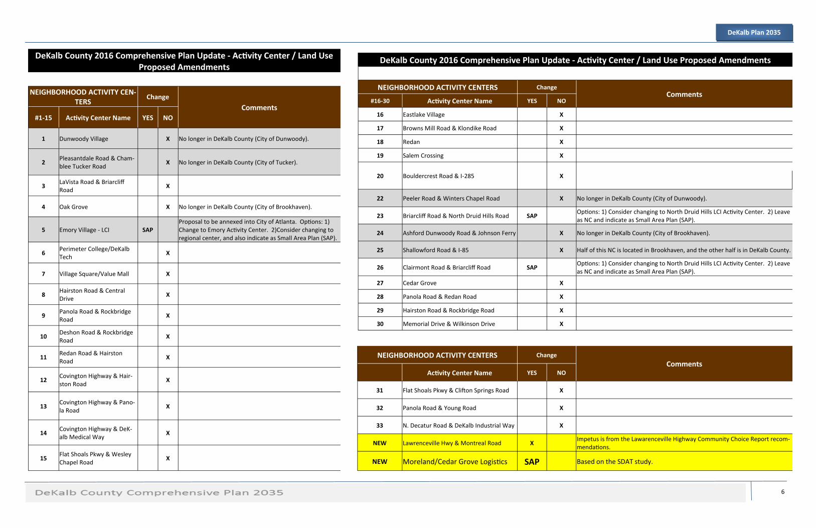
The purpose for creating the Proposed Land Use Amendment Table, is to show changes to any and all activity centers,
with an explanation describing the change. Activity Centers are divided among character areas, and changes are identi-
fied as either “Yes” or “No”. Explanations are recorded in the “Comments” section, help identify the reasoning for the
change. Small Area Plans (SAP) that are located within activity centers, have been identified as being the majority of
changes made.
The Development Plan Concept. The Future Land Use Map provides specific and detailed future development patterns
for the County. This Future Land Use Plan and Map consists primarily of the Activity Centers which emerged from the
concept map. There are three types of Activity Centers: Neighborhood Centers, Town Centers and Regional Centers,
which have emerged and included as a part of the Future Development Plan. There are a total of 45 Activity Centers
countywide. In addition, the Future Development Plan includes residential designations: Rural, Suburban, and Tradi-
tional.
6
DeKalb Plan 2035
DeKalb County 2016 Comprehensive Plan Update - Activity Center / Land Use Proposed Amendments
NEIGHBORHOOD ACTIVITY CEN-TERS
Change
Comments #1-15 Activity Center Name YES NO
1 Dunwoody Village X No longer in DeKalb County (City of Dunwoody).
2 Pleasantdale Road & Cham-blee Tucker Road
X No longer in DeKalb County (City of Tucker).
3 LaVista Road & Briarcliff Road
X
4 Oak Grove X No longer in DeKalb County (City of Brookhaven).
5 Emory Village - LCI SAP Proposal to be annexed into City of Atlanta. Options: 1) Change to Emory Activity Center. 2)Consider changing to regional center, and also indicate as Small Area Plan (SAP).
6 Perimeter College/DeKalb Tech
X
7 Village Square/Value Mall X
8 Hairston Road & Central Drive
X
9 Panola Road & Rockbridge Road
X
10 Deshon Road & Rockbridge Road
X
11 Redan Road & Hairston Road
X
12 Covington Highway & Hair-ston Road
X
13 Covington Highway & Pano-la Road
X
14 Covington Highway & DeK-alb Medical Way
X
15 Flat Shoals Pkwy & Wesley Chapel Road
X
DeKalb County 2016 Comprehensive Plan Update - Activity Center / Land Use Proposed Amendments
NEIGHBORHOOD ACTIVITY CENTERS Change Comments
#16-30 Activity Center Name YES NO
16 Eastlake Village X
17 Browns Mill Road & Klondike Road X
18 Redan X
19 Salem Crossing X
20 Bouldercrest Road & I-285 X
22 Peeler Road & Winters Chapel Road X No longer in DeKalb County (City of Dunwoody).
23 Briarcliff Road & North Druid Hills Road SAP Options: 1) Consider changing to North Druid Hills LCI Activity Center. 2) Leave as NC and indicate as Small Area Plan (SAP).
24 Ashford Dunwoody Road & Johnson Ferry X No longer in DeKalb County (City of Brookhaven).
25 Shallowford Road & I-85 X Half of this NC is located in Brookhaven, and the other half is in DeKalb County.
26 Clairmont Road & Briarcliff Road SAP Options: 1) Consider changing to North Druid Hills LCI Activity Center. 2) Leave as NC and indicate as Small Area Plan (SAP).
27 Cedar Grove X
28 Panola Road & Redan Road X
29 Hairston Road & Rockbridge Road X
30 Memorial Drive & Wilkinson Drive X
NEIGHBORHOOD ACTIVITY CENTERS Change
Comments Activity Center Name YES NO
31 Flat Shoals Pkwy & Clifton Springs Road X
32 Panola Road & Young Road X
33 N. Decatur Road & DeKalb Industrial Way X
NEW Lawrenceville Hwy & Montreal Road X Impetus is from the Lawarenceville Highway Community Choice Report recom-mendations.
NEW Moreland/Cedar Grove Logistics SAP Based on the SDAT study.

7
DeKalb Plan 2035
DeKalb County 2016 Comprehensive Plan Update - Activity Center / Land Use Proposed Amendments
TOWN CENTERS CHANGES Comments
#1-14 Activity Center Name YES NO
1 I-285 & Chamblee Dunwoody Road
X
2 Brookhaven X No longer in DeKalb County (Brookhaven).
3 I-285 & Chamblee Tucker Road X Extend TC character area to include Silverbacks (soccer team) practice and performance fields. It is currently Industrial.
4 Tucker X No longer in DeKalb County (City of Tucker).
5 Toco Hills SAP Small Area Plan for the NDHLCI. Come to a consensus with the community on the density within the activity center. This could also happen during LCI 5-year update.
6 Kensington MARTA Station - LCI
SAP
Options: 1) Consider RC. 2) Consider name change to Kensington Activity Center. 3) Consider merging with Indian Creek MARTA station, and creating a Regional Center.
7 Avondale Mall X
8 I-20 & Panola Road X
9 I-20 & Wesley Chapel Road X
10 I-20 & Candler Road - LCI SAP Name Change to Candler Road Activity Center, small area plan (SAP)
11 I-20 & Gresham Road X
12 Redan Road & Indian Creek Drive
SAP
Options: 1) Consider RC. 2) Consider name change to In-dian Creek Activity Center. 3) Consider merging with In-dian Kensington MARTA station, and creating a Regional Center.
13 North DeKalb Mall X
14 Lenox Park X No longer in DeKalb County (Brookhaven).
15 Clifton Community Town Cen-ter
X
16 Elijah Mountain X Options: 1) Consider amending down to NC. 2) Consider
17 Swift Creek/Tritium X Options: 1) Consider amending down to NC. 2) Consider removing.
18 Executive Park X No longer in DeKalb County (City of Brookhaven).
NEW Medline Activity Center SAP Based on Medline LCI. Include supplemental land use
DeKalb County 2016 Comprehensive Plan Update - Activity Center / Land Use Proposed Amend-ments
Corridors LU CHANGES
Comments YES NO
1 Memorial Drive - CRC X FC - Major Arterial
3 Buford Highway - CRC X Most of Buford Hwy is no longer in DeKalb County. Currently in the cities of Chamblee and Brookhaven.
4 Lawrenceville Highway - CRC X Most of Lawrenceville Hwy that is located outside of I-285, is now in the City of Tucker.
5 Covington Highway - CRC X FC - Major Arterial
Church Street - CRC X FC - Minor Arterial
Clairmont Road - CRC X FC - Major Arterial
Scott Boulevard - CRC X FC - Major Arterial
Cooledge Drive X Remove. Now in the City of Tucker.
Glenwood Road X FC - Minor Arterial
Candler Road X FC - Major Arterial
Interstate 20 X Consider removing HC designation, and simply labeling as Inster-state. There are no properties that have an interstate address, so
Interstate 85 X Consider removing HC designation, and simply labeling as Inster-state.
Interstate 285 X Consider removing HC designation, and simply labeling as Inster-state.
Interstate 675 X Consider removing HC designation, and simply labeling as Inster-state.
NEW No new CRCs
8
DeKalb Plan 2035
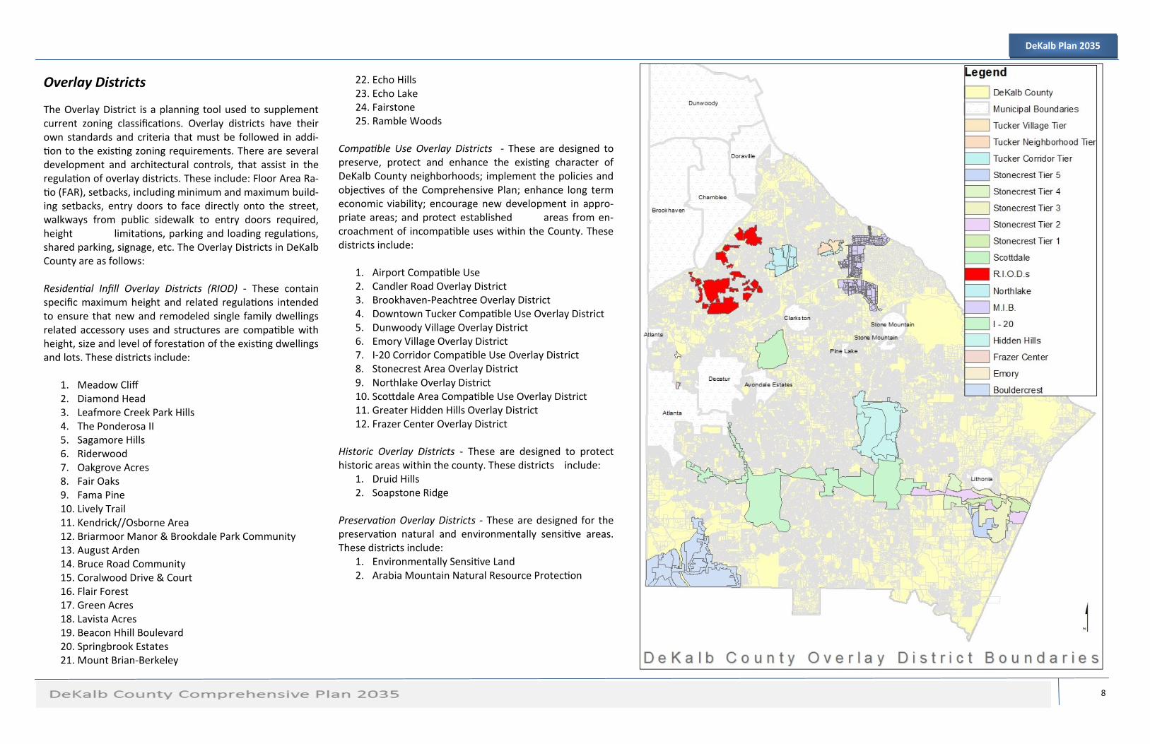
Overlay Districts
The Overlay District is a planning tool used to supplement current zoning classifications. Overlay districts have their own standards and criteria that must be followed in addi-tion to the existing zoning requirements. There are several development and architectural controls, that assist in the regulation of overlay districts. These include: Floor Area Ra-tio (FAR), setbacks, including minimum and maximum build-ing setbacks, entry doors to face directly onto the street, walkways from public sidewalk to entry doors required, height limitations, parking and loading regulations, shared parking, signage, etc. The Overlay Districts in DeKalb County are as follows: Residential Infill Overlay Districts (RIOD) - These contain specific maximum height and related regulations intended to ensure that new and remodeled single family dwellings related accessory uses and structures are compatible with height, size and level of forestation of the existing dwellings and lots. These districts include:
1. Meadow Cliff 2. Diamond Head 3. Leafmore Creek Park Hills 4. The Ponderosa II 5. Sagamore Hills 6. Riderwood 7. Oakgrove Acres 8. Fair Oaks 9. Fama Pine 10. Lively Trail 11. Kendrick//Osborne Area 12. Briarmoor Manor & Brookdale Park Community 13. August Arden 14. Bruce Road Community 15. Coralwood Drive & Court 16. Flair Forest 17. Green Acres 18. Lavista Acres 19. Beacon Hhill Boulevard 20. Springbrook Estates 21. Mount Brian-Berkeley
22. Echo Hills 23. Echo Lake 24. Fairstone 25. Ramble Woods
Compatible Use Overlay Districts - These are designed to preserve, protect and enhance the existing character of DeKalb County neighborhoods; implement the policies and objectives of the Comprehensive Plan; enhance long term economic viability; encourage new development in appro-priate areas; and protect established areas from en-croachment of incompatible uses within the County. These districts include:
1. Airport Compatible Use 2. Candler Road Overlay District 3. Brookhaven-Peachtree Overlay District 4. Downtown Tucker Compatible Use Overlay District 5. Dunwoody Village Overlay District 6. Emory Village Overlay District 7. I-20 Corridor Compatible Use Overlay District 8. Stonecrest Area Overlay District 9. Northlake Overlay District 10. Scottdale Area Compatible Use Overlay District 11. Greater Hidden Hills Overlay District 12. Frazer Center Overlay District
Historic Overlay Districts - These are designed to protect historic areas within the county. These districts include:
1. Druid Hills 2. Soapstone Ridge
Preservation Overlay Districts - These are designed for the preservation natural and environmentally sensitive areas. These districts include:
1. Environmentally Sensitive Land 2. Arabia Mountain Natural Resource Protection