delnor-wiggins pass state park - welcome … · delnor-wiggins pass state park unit management plan...
TRANSCRIPT
DELNOR-WIGGINS PASS STATE PARK
Unit Management Plan
APPROVED
STATE OF FLORIDA DEPARTMENT OF ENVIRONMENTAL PROTECTION
Division of Recreation and Parks
October 9, 2009

i
TABLE OF CONTENTS
INTRODUCTION.............................................................................................................1
PURPOSE AND SIGNIFICANCE OF THE PARK .......................................................1
PURPOSE AND SCOPE OF THE PLAN........................................................................1
MANAGEMENT PROGRAM OVERVIEW..................................................................5
Management Authority and Responsibility ..................................................................5
Park Management Goals .................................................................................................6
Management Coordination .............................................................................................6
Public Participation.......................................................................................................... 7
Other Designations ..........................................................................................................7
RESOURCE MANAGEMENT COMPONENT
INTRODUCTION.............................................................................................................9
RESOURCE DESCRIPTION AND ASSESSMENT .....................................................9
Natural Resources............................................................................................................9
Cultural Resources......................................................................................................... 24
RESOURCE MANAGEMENT PROGRAM ................................................................ 24
Management Needs and Problems .............................................................................. 24
Management Measures and Objectives ....................................................................... 25
Natural Resources.......................................................................................................... 25
Cultural Resources......................................................................................................... 30
Special Management Considerations........................................................................... 30
Research Needs .............................................................................................................. 32
Resource Management Schedule.................................................................................. 33
Land Management Review ........................................................................................... 33
ii
LAND USE COMPONENT
INTRODUCTION........................................................................................................... 35
EXTERNAL CONDITIONS........................................................................................... 35
Existing Use of Adjacent Lands.................................................................................... 36
Planned Use of Adjacent Lands.................................................................................... 37
PROPERTY ANALYSIS ................................................................................................. 37
Recreation Resource Elements...................................................................................... 37
Assessment of Use ......................................................................................................... 39
Existing Facilities ........................................................................................................... 41
CONCEPTUAL LAND USE PLAN............................................................................... 42
Potential Uses ................................................................................................................ 44
Proposed Facilities ......................................................................................................... 45
Facilities Development .................................................................................................. 48
Existing Use and Optimum Carrying Capacity .......................................................... 48
Optimum Boundary ...................................................................................................... 49
IMPLEMENTATION COMPONENT
MANAGEMENT PROGRESS....................................................................................... 51
Resource Management .................................................................................................. 51
Recreation and Visitor Services .................................................................................... 51
Park Facilities and Operations...................................................................................... 52
MANAGEMENT PLAN IMPLEMENTATION .......................................................... 52
iii
TABLES
TABLE 1 – Imperiled Species Inventory................................................................ 17—19
TABLE 2 – Exotic Plant Species Inventory ............................................................ 20—21
TABLE 3 - Existing Use and Optimum Carrying Capacity.......................................... 49
TABLE 4 – Implementation Schedule and Cost Estimates................................... 55—58
LIST OF ADDENDA
ADDENDUM 1
Acquisition History and Advisory Group Staff Report ...................................A 1 - 1
ADDENDUM 2
References Cited .................................................................................................A 2 - 1
ADDENDUM 3
Soil Descriptions .................................................................................................A 3 - 1
ADDENDUM 4
Plant and Animal List..........................................................................................A 4 - 1
ADDENDUM 5
Imperiled Species Ranking Definitions ............................................................A 5 - 1
ADDENDUM 6
October 17, 1997 Final Land Management Review Report ............................A 6 - 1
MAPS
Vicinity Map .......................................................................................................................2 Reference Map....................................................................................................................3 Soils Map........................................................................................................................... 11 Natural Communities Map ............................................................................................. 13 Management Zones Map................................................................................................. 22 Base Map........................................................................................................................... 40 Conceptual Land Use Plan .............................................................................................. 43 Optimum Boundary Map................................................................................................ 50
1
INTRODUCTION
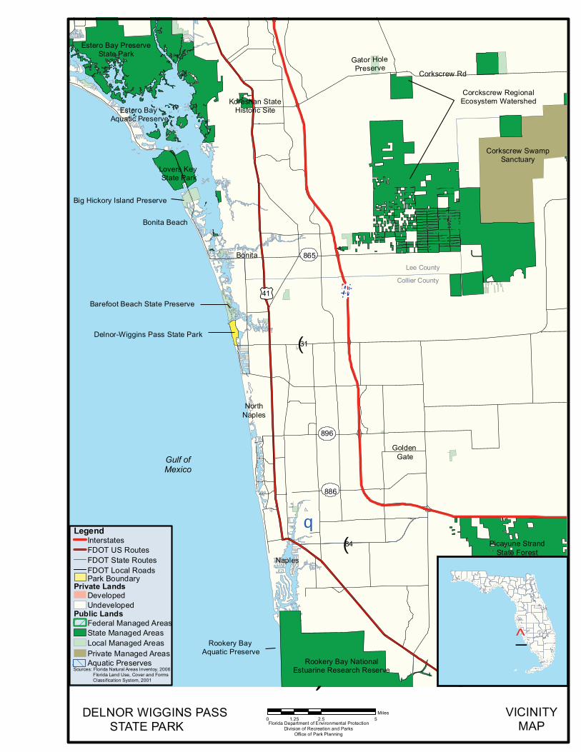
Delnor-Wiggins Pass State Park is located in Collier County (see Vicinity Map). Access to the park is from Interstate Highway 75 or U.S. Highway 41 via County Road 846 (Immokolee Road/Bluebill Avenue). The Vicinity and Reference Maps also reflect significant land and water resources existing near the park. At Delnor-Wiggins Pass State Park, public outdoor recreation and conservation is the designated single use of the property. There are no legislative or executive directives that constrain the use of this property (see Addendum 1). Currently, the park contains 166 acres.
PURPOSE AND SIGNIFICANCE OF THE PARK
The state park was acquired from Collier County to provide public beach access and outdoor recreation in a highly urbanized and populous region of Florida. Delnor-Wiggins Pass State Park is an important element of the supply for public beach access in southwest Florida. As a result, the park has experienced extremely high visitation for decades. The park’s beach dune, tropical hammock and mangrove swamp natural communities are important natural resources and, in conjunction with the Barefoot Beach Preserve, a County-managed area just north of the park, provide habitat for wide variety coastal plants and animals. Delnor-Wiggins Pass State Park is classified as a state recreation area in the Division’s unit classification system. In the management of a state recreation area, major emphasis is placed on maximizing the recreational potential of the park. However, preservation of the park’s natural and cultural resources remains important. Depletion of a resource by any recreational activity is not permitted. In order to realize the park’s recreational potential, the development of appropriate park facilities is undertaken with the goal to provide facilities that are accessible, convenient and safe, to support public recreational use or appreciation of the park’s natural, aesthetic and educational attributes. PURPOSE AND SCOPE OF THE PLAN
This plan serves as the basic statement of policy and direction for the management of Delnor-Wiggins Pass State Park as a unit of Florida's state park system. It identifies the goals, objectives, actions and criteria or standards that guide each aspect of park administration, and sets forth the specific measures that will be implemented to meet management objectives. The plan is intended to meet the requirements of Sections 253.034 and 259.032, Florida Statutes, Chapter 18-2, Florida Administrative Code, and is intended to be consistent with the State Lands Management Plan. Upon approval, this management plan will replace the 2000 approved plan. All development and resource alteration proposed in this plan is subject to the granting of appropriate permits, easements, licenses, and other required legal instruments. Approval of the management plan does not constitute an exemption from complying
Estero Bay PreserveState Park
Lovers KeyState Park
Rookery Bay NationalEstuarine Research Reserve
Delnor-Wiggins Pass State Park
Gulf ofMexico
Estero BayAquatic Preserve
Bonita Beach
NorthNaples
Bonita
Naples
Koreshan StateHistoric Site
Big Hickory Island Preserve
Barefoot Beach State Preserve
GoldenGate
Collier County
Lee County
Picayune StrandState Forest
Corkscrew Rd
Rookery BayAquatic Preserve
Corckscrew RegionalEcosystem Watershed
Corkscrew SwampSanctuary
Gator HolePreserve
®q!(84
886
896
!(31
(/41 !"#$75
865
Florida Department of Environmental ProtectionDivision of Recreation and Parks
Office of Park Planning
VICINITYMAP
´0 2.5 51.25
Miles
_̂Sources: Florida Natural Areas Inventoy, 2006
Florida Land Use, Cover and FormsClassification System, 2001
LegendInterstatesFDOT US RoutesFDOT State RoutesFDOT Local RoadsPark Boundary
Public Lands
Private Lands
Federal Managed AreasState Managed AreasLocal Managed Areas
DevelopedUndeveloped
Aquatic PreservesPrivate Managed Areas
DELNOR WIGGINS PASSSTATE PARK


4
with the appropriate local, state or federal agencies. This plan is also intended to meet the requirements for beach and shore preservation, as defined in Chapter 161, Florida Statutes and Chapter 62B-33 Florida Administrative Code. The plan consists of three interrelated components: the Resource Management Component, the Land Use Component and the Implementation Component. The Resource Management Component provides a detailed inventory and assessment of the natural and cultural resources of the park. Resource management problems and needs are identified, and measurable management objectives are established for each of the park’s management goals and resource types. This component provides guidance on the application of such measures as exotic species removal, imperiled species management, cultural resource management and restoration of natural conditions. The Land Use Component is the recreational resource allocation plan for the park. Based on considerations such as access, population, adjacent land uses, the natural and cultural resource base of the park, current public uses and existing development, measurable objectives are set to achieve the desired allocation of the physical space of the park. These objectives locate use areas and propose the types of facilities and programs and the volume of public use to be provided. The Implementation Component consolidates the measurable objectives and actions for each of the park’s management goals. An implementation schedule and cost estimates are included for each objective and action. Included in this table are (1) measures that will be used to evaluate the Division’s implementation progress, (2) timeframes for completing actions and objectives and (3) estimated costs to complete each action and objective. In the development of this plan, the potential of the park to accommodate secondary management purposes (“multiple uses”) was analyzed. These secondary purposes were considered within the context of the Division’s statutory responsibilities and an analysis of the resource needs and values of the park. This analysis considered the park natural and cultural resources, management needs, aesthetic values, visitation and visitor experiences. For this park, it was determined that no secondary purposes could be accommodated in a manner that would not interfere with the primary purpose of resource-based outdoor recreation and conservation. Uses such as water resource development projects, water supply projects, stormwater management projects, linear facilities and sustainable agriculture and forestry are not consistent with this plan or the management purposes of the park. The potential for generating revenue to enhance management was also analyzed. Visitor fees and charges are the principal source of revenue generated by the park. It was determined that multiple-use management activities would not be appropriate as a means of generating revenues for land management. Instead, techniques such as
5
entrance fees, concessions, facility rentals and similar measures will be employed on a case-by-case basis as a means of supplementing park management funding. The use of private land managers to facilitate restoration and management of this park was also analyzed. Decisions regarding this type of management (such as outsourcing, contracting with the private sector, use of volunteers, etc.) will be made on a case-by-case basis as necessity dictates. MANAGEMENT PROGRAM OVERVIEW
Management Authority and Responsibility
In accordance with Chapter 258, Florida Statutes and Chapter 62D-2, Florida Administrative Code, the Division of Recreation and Parks (Division) is charged with the responsibility of developing and operating Florida's recreation and parks system. These are administered in accordance with the following policy:
It shall be the policy of the Division of Recreation and Parks to promote the state park system for the use, enjoyment, and benefit of the people of Florida and visitors; to acquire typical portions of the original domain of the state which will be accessible to all of the people, and of such character as to emblemize the state's natural values; conserve these natural values for all time; administer the development, use and maintenance of these lands and render such public service in so doing, in such a manner as to enable the people of Florida and visitors to enjoy these values without depleting them; to contribute materially to the development of a strong mental, moral, and physical fiber in the people; to provide for perpetual preservation of historic sites and memorials of statewide significance and interpretation of their history to the people; to contribute to the tourist appeal of Florida.
The Trustees have granted management authority of certain sovereign submerged lands to the Division under Management Agreement MA 68-086 (as amended January 19, 1988). The management area includes a 400-foot zone from the edge of mean high water where a park boundary borders sovereign submerged lands fronting beaches, bays, estuarine areas, rivers or streams. Where emergent wetland vegetation exists, the zone extends waterward 400 feet beyond the vegetation. The agreement is intended to provide additional protection to resources of the park and nearshore areas and to provide authority to manage activities that could adversely impact public recreational uses. Many operating procedures are standard system-wide and are set by internal direction. These procedures are outlined in the Division’s Operations Manual (OM) that covers such areas as personnel management, uniforms and personal appearance, training, signs, communications, fiscal procedures, interpretation, concessions, public use

6
regulations, resource management, law enforcement, protection, safety and maintenance.
Park Management Goals
The following park goals express the Division’s long-term intent in managing the state park. 1. Provide administrative support for all park functions. 2. Protect water quality and quantity in the park, restore hydrology to the extent
feasible and maintain the restored condition. 3. Restore and maintain the natural communities/habitats of the park. 4. Maintain, improve or restore imperiled species populations and habitats in the
park. 5. Remove exotic and invasive plants and animals from the park and conduct needed
maintenance-control. 6. Protect, preserve and maintain the cultural resources of the park. 7. Provide public access and recreational opportunities in the park. 8. Develop and maintain the capital facilities and infrastructure necessary to meet
the goals and objectives of this management plan. Management Coordination
The park is managed in accordance with all applicable laws and administrative rules. Agencies having a major or direct role in the management of the park are discussed in this plan. The Department of Agriculture and Consumer Services, Division of Forestry (DOF), assists Division staff in the development of wildfire emergency plans and provides the authorization required for prescribed burning. The Florida Fish and Wildlife Conservation Commission (FFWCC), assists staff in the enforcement of state laws pertaining to wildlife, freshwater fish and other aquatic life existing within the park. Division staff maintains extensive coordination with FFWCC in relation to imperiled species management in the park, particularly the management of nesting sea turtles, and shorebirds. In addition, the FFWCC aids the Division with wildlife management programs, including the development and management of Watchable Wildlife programs. The Department of State, Division of Historical Resources (DHR) assists staff to assure protection of archaeological and historical sites. The Department of Environmental Protection (DEP), Office of Coastal and Aquatic Managed Areas (CAMA) aids staff in aquatic preserves management programs. Coastal resources management at the state park is coordinated by the Division with the DEP’s Bureau of Beaches and Coastal Systems and the Collier County Coastal Zone Management Department. The collaboration involves the management of Wiggins Pass, management of beach re-nourishment projects, navigational issues that impact the
7
park’s resources, and a variety of related issues. Division staff works closely with the Collier County Parks and Recreation Department, the County’s planning, zoning and development regulation agencies, and with the Collier County Sheriff’s Office to coordinate park operations and planning with the regulations, issues and actions of the surrounding community. On June 9, 2009, the Board of Trustees of the Internal Improvement Trust Fund approved a sovereignty submerged lands lease to Vanderbilt Partners II, Limited, for improvements to the Dunes Condominiums docking facilities adjacent to the state park. As part of the Board’s action, a 65.86-acre area of mangrove swamp contiguous to Water Turkey Bay (immediately east of the state park), along with other lands, will be deeded to the Board. The 65.86-acre mangrove area will be maintained by the Dunes Condominium Homeowners Association in compliance with the Southwest Florida Water Management District’s Environmental Resource Permit No. 11-01725-P. A maintenance and access easement over and across this parcel will be retained by the applicant to facilitate its maintenance activities. The Division of Recreation and Parks will monitor the easement holder to ensure management of the 65.86-acre mangrove area in accordance with the access and maintenance easement. This mangrove area is identified as the Management Monitoring Area on the Reference Map above.
Public Participation
The Division provided an opportunity for public input by conducting a public workshop and an advisory group meeting on February 18 and 19, 2009, respectively . The purpose of these meetings was to present this draft management plan to the public for comment and to provide the Advisory Group members an opportunity to discuss the draft management plan.
Other Designations
Delnor-Wiggins Pass State Park is not within an Area of Critical State Concern as defined in Section 380.05, Florida Statutes, and it is not presently under study for such designation. The park is a component of the Florida Greenways and Trails System, administered by DEP’s Office of Greenways and Trails. All waters within the unit have been designated as Outstanding Florida Waters, pursuant to Chapter 62-302, Florida Administrative Code. Surface waters in this unit are classified as Class II and Class III waters by DEP. This unit is not within or adjacent to an aquatic preserve as designated under the Florida Aquatic Preserve Act of 1975 (section 258.35, Florida Statutes).

8
9
RESOURCE MANAGEMENT COMPONENT
INTRODUCTION
In accord with Chapter 258, Florida Statute, the Division of Recreation and Parks has implemented resource management programs for preserving in perpetuity the representative examples of natural and cultural resources of statewide significance under its administration. This component of the unit plan describes the natural and cultural resources of the park and identifies the methods that will be used to manage them. The stated management measures in this plan are consistent with the Department’s overall mission in ecosystem management. Cited references are contained in Addendum 2. The Division’s philosophy of resource management is natural systems management. Primary emphasis is on restoring and maintaining, to the degree practicable, the natural processes that shaped the structure, function and species composition of Florida’s diverse natural communities as they occurred in the original domain. Single species management for imperiled species may be implemented when the recovery or persistence of a species is problematic if this approach is compatible with natural systems management. The management goal for cultural resources is to preserve sites and objects that represent Florida’s cultural periods as well as significant historic events or persons. This goal may entail active measures to stabilize, reconstruct or restore resources, or to rehabilitate them for appropriate public use. Because park units are often components of larger ecosystems, their proper management is often affected by conditions and occurrences beyond park boundaries. Ecosystem management is implemented through a resource management evaluation program (to assess resource conditions, evaluate management activities and refine management actions), and review of local comprehensive plans and development permit applications for park/ecosystem impacts.
RESOURCE DESCRIPTION AND ASSESSMENT
Natural Resources
Topography
The typical barrier island topography at this park consists of raised sand dunes on the Gulf side of the island, sloping eastward into the estuarine tidal swamp. The park is located in the coastal lowlands topographic division of Florida and on the western edge of the southwestern slope physiographic zone. Upland elevations are only slightly above mean sea level. Alterations in topography have been caused by dredging activity in the mangroves prior to becoming a state park. The spoil from the dredging was
10
deposited in the form of a berm along the eastern edge of the park. However, most of this spoil has been removed in the course of several mitigation projects. The park’s Gulf fronting beaches have remained relatively stable with some fluctuations in beach width and slope due to seasonal and storm induced erosion, inlet effects, and sand placement and erosion from dredging events. Geology
The park and surrounding region rest upon Pleistocene-aged limestone capped with a relatively shallow soil layer. The upper layer of limestone belongs to a series of sedimentary deposits called the Anastasia formation (coquinoid limestone, sand and clay).
Soils
There are three soil types identified in the park (see Soils Map). Porous soil formations consisting mainly of sand and shell characterize the Gulf side of the island while peat soils have formed on the east as a substrate for the mangrove swamp. The third type is associated with two developed sites in the park. Addendum 3 contains a complete soil description. Management measures will continue to follow generally accepted best management practices to prevent soil erosion and conserve soil and water resources on site. Minerals
No information is available on minerals in this park.
Hydrology
The park lies within the Big Cypress Swamp watershed basin. Wiggins Pass to the north of the park is the natural outlet for the Cocohatchee River. It has been dredged frequently to allow for improved boater access into the Gulf. Extensive channel dredging in the park’s adjacent mangroves in the 1950s and 1960s altered the surrounding estuary’s hydrology. The placement of the spoil berms along the channel disturbed natural hydrological circulation throughout portions of the mangrove forest community. Much of this damage has been repaired. Rainwater is quickly absorbed through the porous soils of the beach dunes and the maritime hammock. Standing brackish water levels within the estuarine tidal swamp fluctuate with tidal flooding. No data is available on the ground water at this time. Natural Communities
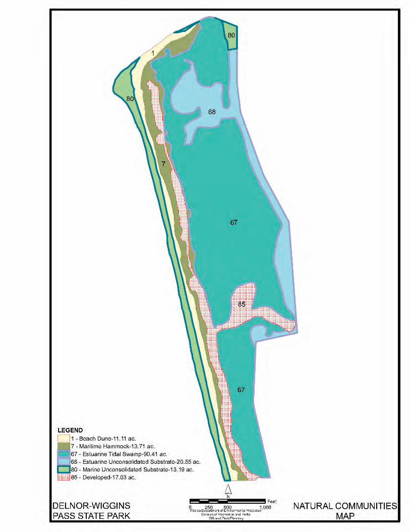
The system of classifying natural communities employed in this plan was developed by the Florida Natural Areas Inventory (FNAI). The premise of this system is that physical factors, such as climate, geology, soil, hydrology and fire frequency generally determine the species composition of an area, and that areas which are similar with respect to these factors will tend to have natural communities with similar species compositions.

40
42
35
DELNOR-WIGGINSPASS STATE PARK
SOILSMAPFlorida Department of Environmental Protection
Division of Recreation and ParksOffice of Park Planning
0 500 1,000250Feet
´
LEGEND35- Urban land-Aquents complex, organic substratum40- Durbin and Wulfert mucks, frequently flooded42- Canaveral-Beaches complexWater
12
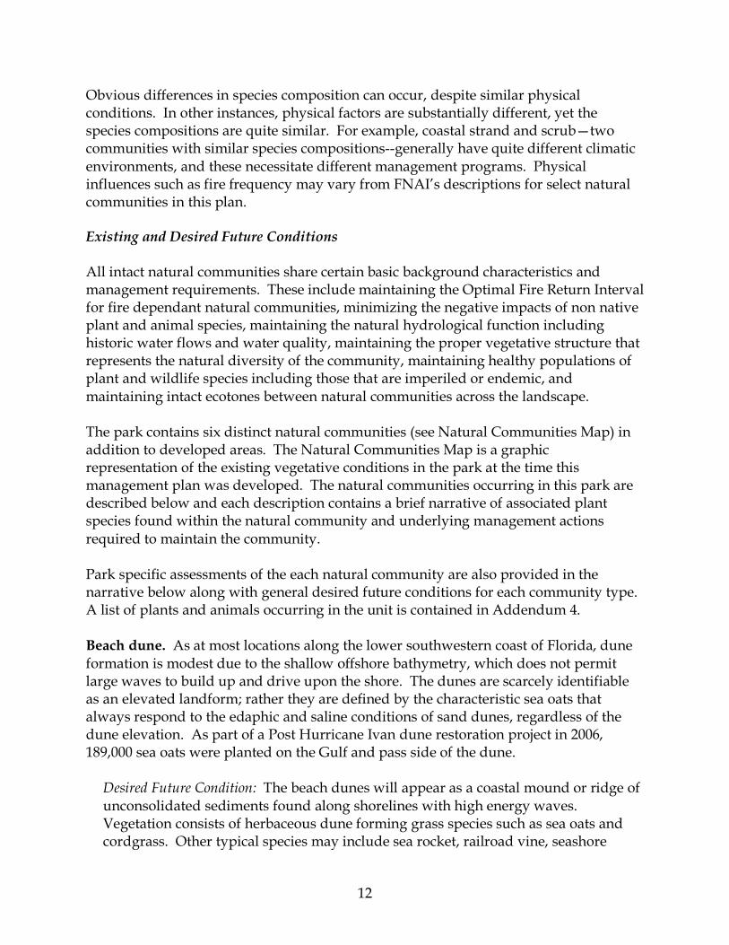
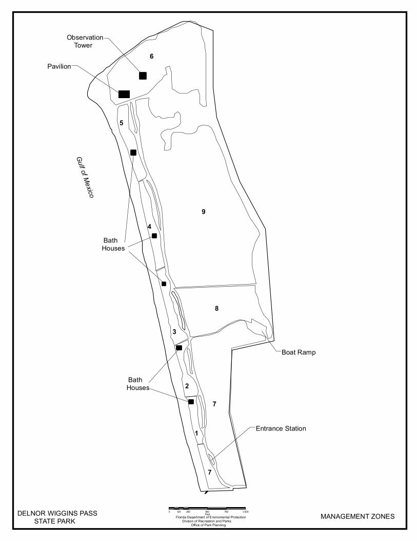
Obvious differences in species composition can occur, despite similar physical conditions. In other instances, physical factors are substantially different, yet the species compositions are quite similar. For example, coastal strand and scrub—two communities with similar species compositions--generally have quite different climatic environments, and these necessitate different management programs. Physical influences such as fire frequency may vary from FNAI’s descriptions for select natural communities in this plan. Existing and Desired Future Conditions All intact natural communities share certain basic background characteristics and management requirements. These include maintaining the Optimal Fire Return Interval for fire dependant natural communities, minimizing the negative impacts of non native plant and animal species, maintaining the natural hydrological function including historic water flows and water quality, maintaining the proper vegetative structure that represents the natural diversity of the community, maintaining healthy populations of plant and wildlife species including those that are imperiled or endemic, and maintaining intact ecotones between natural communities across the landscape. The park contains six distinct natural communities (see Natural Communities Map) in addition to developed areas. The Natural Communities Map is a graphic representation of the existing vegetative conditions in the park at the time this management plan was developed. The natural communities occurring in this park are described below and each description contains a brief narrative of associated plant species found within the natural community and underlying management actions required to maintain the community. Park specific assessments of the each natural community are also provided in the narrative below along with general desired future conditions for each community type. A list of plants and animals occurring in the unit is contained in Addendum 4. Beach dune. As at most locations along the lower southwestern coast of Florida, dune formation is modest due to the shallow offshore bathymetry, which does not permit large waves to build up and drive upon the shore. The dunes are scarcely identifiable as an elevated landform; rather they are defined by the characteristic sea oats that always respond to the edaphic and saline conditions of sand dunes, regardless of the dune elevation. As part of a Post Hurricane Ivan dune restoration project in 2006, 189,000 sea oats were planted on the Gulf and pass side of the dune.
Desired Future Condition: The beach dunes will appear as a coastal mound or ridge of unconsolidated sediments found along shorelines with high energy waves. Vegetation consists of herbaceous dune forming grass species such as sea oats and cordgrass. Other typical species may include sea rocket, railroad vine, seashore

14
paspalum, beach morning glory and beach sunflower. Occasionally shrubs such as seagrape may be scattered within the herbaceous vegetation.
Maritime hammock. Much of the park’s original hammock was displaced by Australian pines and Brazilian pepper. Most of the area occupied by non-native plants was in turn cleared during the construction of park facilities, which included entrance road and parking, bathhouses, boardwalks and picnic areas. Only a fragment of original maritime hammock remains and the best example can be seen between the park gate and the entrance station. Extensive restoration has taken place in park use areas. At the north end of the park, on the south bank of Wiggins Pass, a monoculture of Australian pines grew up in a place formerly occupied by mangrove trees. The trees took root on spoil that was deposited during a pass-dredging operation. This site is being rehabilitated and restored as maritime hammock. The Australian pines have been removed and native trees planted in their place. These native species flourished and a good representation of maritime hammock now exists north and west of Parking Lot #5. Brazilian pepper invaded the hammock just east of the mangrove swamp community. A small restoration project that began in October 2006 has eliminated most of these peppers. Wedelia, an exotic groundcover, has spread profusely, and other exotics, such as St. Augustine grass and sisal hemp, are regularly found at this site.
Desired Future Condition: A coastal evergreen hardwood forest will occur in narrow bands along stabilized coastal dunes. Canopy species typically consists of live oak, red bay and cabbage palm. The canopy is typically dense and often salt-spray pruned. Understory species may consist of yaupon holly, saw palmetto, and/or wax myrtle. Herbaceous groundcover is very sparse or absent. Variation in species composition exists along the coast as you head southward, tropical species become more prevalent.
Estuarine tidal swamp. The structure of the tidal swamp is relatively intact, though some ecological processes of this community such as detrital transport may have been impaired by berms that were raised by channel dredging activities to form a border along the navigation channel and along the edge of West Bay. It is on these berms that Australian pines and Brazilian pepper take root. As stated before, the berms have been largely eliminated with the aid of restoration projects, but those remaining should continue to be monitored and managed for the removal of invasive species. Occasionally, north of the park entrance road at the gate, exotic species such as St. Augustine grass, Brazilian pepper, carrotwood trees, and exotic palms are found; likely spreading from urban development. Park staff monitors this area and removes all encroaching invasive and exotic species.
Desired Future Condition: Coastal swamp consisting of a low, dense forest occurring

15
on low energy, flat shorelines. Dominant plants include mangrove species. Other species may be present including saltgrass, cordgrass, needlerush and sea oxeye.
Estuarine unconsolidated substrate. On the east side of the park, portions of the south channel leading from the Cocohatchee River and Little Turkey Bay are exposed at low tide. The community is commonly called a mudflat [an FNAI (1990) synonym]. Though the area may appear barren, large populations of infaunal organisms such as tube worms, clam, mollusks, and various species of crabs make this an important feeding ground for bottom fish such as redfish, flounder, and sheepshead. It is also significant as a foraging and resting site for many species of imperiled shorebirds.
Desired Future Condition: Consists of expansive unvegetated, open areas of mineral-based substrate composed of shell, coralgal, marl, mud and/or sand (sand beaches). Desired conditions include preventing soil compaction, dredging activities and disturbances such as the accumulation of pollutants.
Marine consolidated substrate. A subtidal, hard bottom reef occurs just offshore from the park. It is sparsely populated with soft corals, sponges and a few species of fish. This type of community is more widespread in Florida's offshore waters than coquina substrate. It has a patchy distribution from northern Florida to the Lower Keys. Portions of this community are found within the offshore boundaries of the park, which are between 50-200 feet from the shore, and most of it is within the 400-foot zone of jurisdiction granted to the Division of Recreation and Parks by the Board of Trustees. The shape of this community is irregular. Consideration shall be given in review of any dredge and renourishment projects.
Desired Future Condition: Consists of open, relatively unvegetated areas, with solidified rock or other substrate typically composed of coquina, limerock or relic reef materials. Some planktonic, pelagic or other plants may be sparsely present. Desired conditions include minimizing disturbance due to sedimentation from dredging activities, anchoring of vessels, vehicular traffic or the accumulation of pollutants.
Marine unconsolidated substrate. The western shore is a beach of white sand and granulated shell material. At the northern end of the park, the beach curves around to the east where the beach topography evolves due to the hydrodynamics of Wiggins Pass. Tidal and storm forces constantly reconfigure the shoreline in this vicinity, sometimes extending a spit to the north and west, and truncating the spit at other times. Beach and dunes are created in some years that favor the nesting of least terns at this location. The total length of the narrow beach is slightly more than a mile. The park has received material dredged from Wiggins Pass by Collier County. This material has been deposited on the north end of the beachfront.
16
Desired Future Condition: Consists of expansive unvegetated, open areas of mineral-based substrate composed of shell, coralgal, marl, mud and/or sand (sand beaches). Desired conditions include preventing soil compaction, dredging activities and disturbances such as the accumulation of pollutants.
Developed. Developed areas consist of recreation and support facilities. These areas include the paved roads, parking lots, picnic areas, boat ramp, entrance station, staff residences and maintenance shop area. Imperiled Species
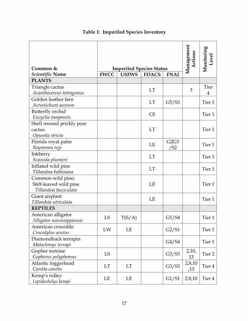
Imperiled species are those tracked by the Florida Natural Areas Inventory (FNAI) as critically imperiled, imperiled or rare; or listed by the U.S. Fish and Wildlife Service (USFWS), Florida Fish and Wildlife Conservation Commission (FFWCC), and the Florida Department of Agriculture and Consumer Services (FDA) as endangered, threatened, or of special concern. Addendum 5 contains definitions of the imperiled species status. Management measures will be addressed later in this plan. Several listed vertebrate species have been recorded in the park or in the waters offshore. Only two species so far have required direct management by the park staff: marine turtles and least terns. Marine turtle nesting is monitored under a permit from the FFWCC. The park is designated an Index Nesting Beach Survey (INBS) site, which is used by the FFWCC to track trends in the sea turtle nesting population in Florida. Strict monitoring guidelines are followed on INBS sites. Least tern nest sites were last documented in 1987. If nesting colonies are observed, they are marked with signs and string barriers to divert foot traffic. Additional concerns about least tern nesting arise from periodic proposals to dredge Wiggins Pass to improve navigation. The potential impact of channel dredging to least tern nest sites and to marine turtle nesting must always be evaluated. A population of gopher tortoises exists within the beach dune community. Listed plant species include triangle cactus (Acanthocereus tetragonus), golden leather fern (Acrostichum aureum), inkberry (Scaevola plumieri), and common wild pine, (Tillandsia fasciculata). Table 1 contains a list of all known imperiled species within the park and identifies their status as defined by various entities, the existing management actions taken by Division staff or others, and the current level of monitoring effort. Note that the Florida black bear, which is listed on an FNAI Managed Area Tracking Record for the park, is listed in Addendum 4 but not in Table 1 because neither existing management actions nor current level of monitoring are applicable. Addendum 4 is a record of historic, as well as current, occurrence.
17
Table 1: Imperiled Species Inventory
Imperiled Species Status Common & Scientific Name FWCC USFWS FDACS FNAI M
anag
emen
t A
ctio
ns
Mon
itor
ing
Lev
el
PLANTS Triangle cactus Acanthocereus tetragonus LT 3 Tier
4 Golden leather fern Acrostichum aureum LT G5/S3 Tier 1
Butterfly orchid Encyclia tampensis CE Tier 1
Shell mound prickly pear cactus Opuntia stricta
LT Tier 1
Florida royal palm Roystonea regi LE G2G3
/S2 Tier 1
Inkberry Scaveola plumieri LT Tier 1
Inflated wild pine Tillandsia balbisiana LT Tier 1
Common wild pine; Stiff-leaved wild pine Tillandsia fasciculata
LE Tier 1
Giant airplant Tillandsia utriculata LE Tier 1
REPTILES American alligator Alligator mississippiensis LS T(S/A) G5/S4 Tier 1
American crocodile Crocodylus acutus LW LE G2/S1 Tier 1
Diamondback terrapin Malaclemys terrapi G4/S4 Tier 1
Gopher tortoise Gopherus polyphemus LS G3/S3 2,10,
13 Tier 2
Atlantic loggerhead Caretta caretta LT LT G3/S3 2,8,10
,13 Tier 4
Kemp’s ridley Lepidochelys kempi LE LE G1/S1 2,8,10 Tier 4
18
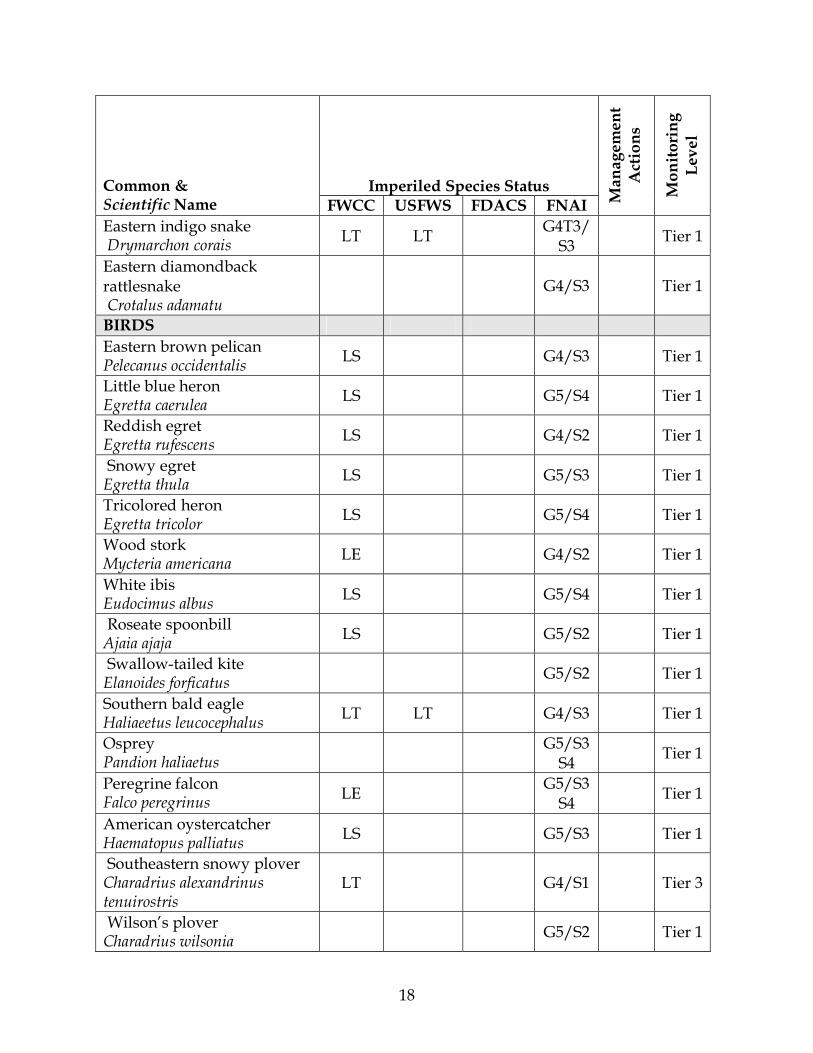
Imperiled Species Status Common & Scientific Name FWCC USFWS FDACS FNAI M
anag
emen
t A
ctio
ns
Mon
itor
ing
Lev
el
Eastern indigo snake Drymarchon corais LT LT G4T3/
S3 Tier 1
Eastern diamondback rattlesnake Crotalus adamatu
G4/S3 Tier 1
BIRDS Eastern brown pelican Pelecanus occidentalis LS G4/S3 Tier 1
Little blue heron Egretta caerulea LS G5/S4 Tier 1
Reddish egret Egretta rufescens LS G4/S2 Tier 1
Snowy egret Egretta thula LS G5/S3 Tier 1
Tricolored heron Egretta tricolor LS G5/S4 Tier 1
Wood stork Mycteria americana LE G4/S2 Tier 1
White ibis Eudocimus albus LS G5/S4 Tier 1
Roseate spoonbill Ajaia ajaja LS G5/S2 Tier 1
Swallow-tailed kite Elanoides forficatus G5/S2 Tier 1
Southern bald eagle Haliaeetus leucocephalus LT LT G4/S3 Tier 1
Osprey Pandion haliaetus G5/S3
S4 Tier 1
Peregrine falcon Falco peregrinus LE G5/S3
S4 Tier 1
American oystercatcher Haematopus palliatus LS G5/S3 Tier 1
Southeastern snowy plover Charadrius alexandrinus tenuirostris
LT G4/S1 Tier 3
Wilson’s plover Charadrius wilsonia G5/S2 Tier 1
19
Imperiled Species Status Common & Scientific Name FWCC USFWS FDACS FNAI M
anag
emen
t A
ctio
ns
Mon
itor
ing
Lev
el
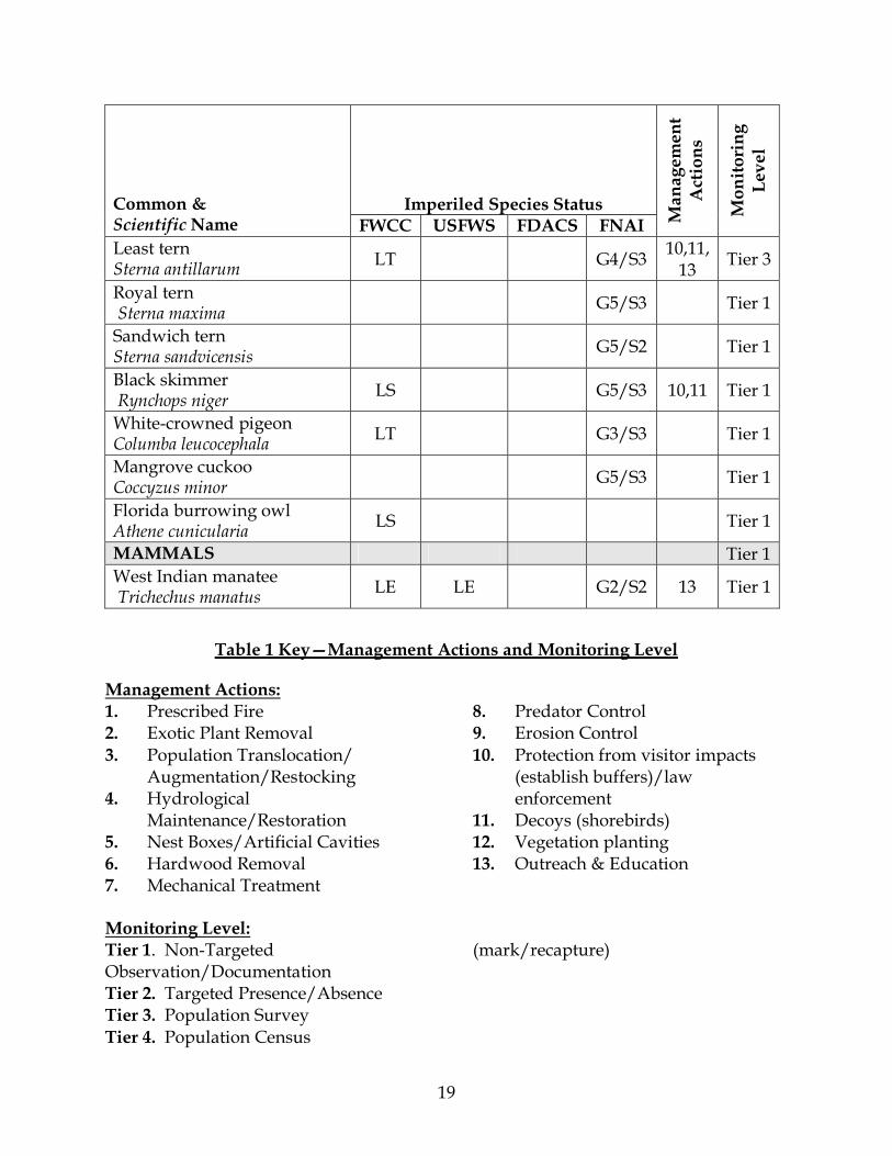
Least tern Sterna antillarum LT G4/S3 10,11,
13 Tier 3
Royal tern Sterna maxima G5/S3 Tier 1
Sandwich tern Sterna sandvicensis G5/S2 Tier 1
Black skimmer Rynchops niger LS G5/S3 10,11 Tier 1
White-crowned pigeon Columba leucocephala LT G3/S3 Tier 1
Mangrove cuckoo Coccyzus minor G5/S3 Tier 1
Florida burrowing owl Athene cunicularia LS Tier 1
MAMMALS Tier 1West Indian manatee Trichechus manatus LE LE G2/S2 13 Tier 1
Table 1 Key—Management Actions and Monitoring Level
Management Actions: 1. Prescribed Fire 2. Exotic Plant Removal 3. Population Translocation/
Augmentation/Restocking 4. Hydrological
Maintenance/Restoration 5. Nest Boxes/Artificial Cavities 6. Hardwood Removal 7. Mechanical Treatment
8. Predator Control 9. Erosion Control 10. Protection from visitor impacts
(establish buffers)/law enforcement
11. Decoys (shorebirds) 12. Vegetation planting 13. Outreach & Education
Monitoring Level: Tier 1. Non-Targeted Observation/Documentation Tier 2. Targeted Presence/Absence Tier 3. Population Survey Tier 4. Population Census
(mark/recapture)
20
Detailed management goals, objectives and actions for imperiled species in this park are discussed in the RESOURCE MANAGEMENT PROGRAM section of this component and the Implementation Component of this plan. Exotic Species
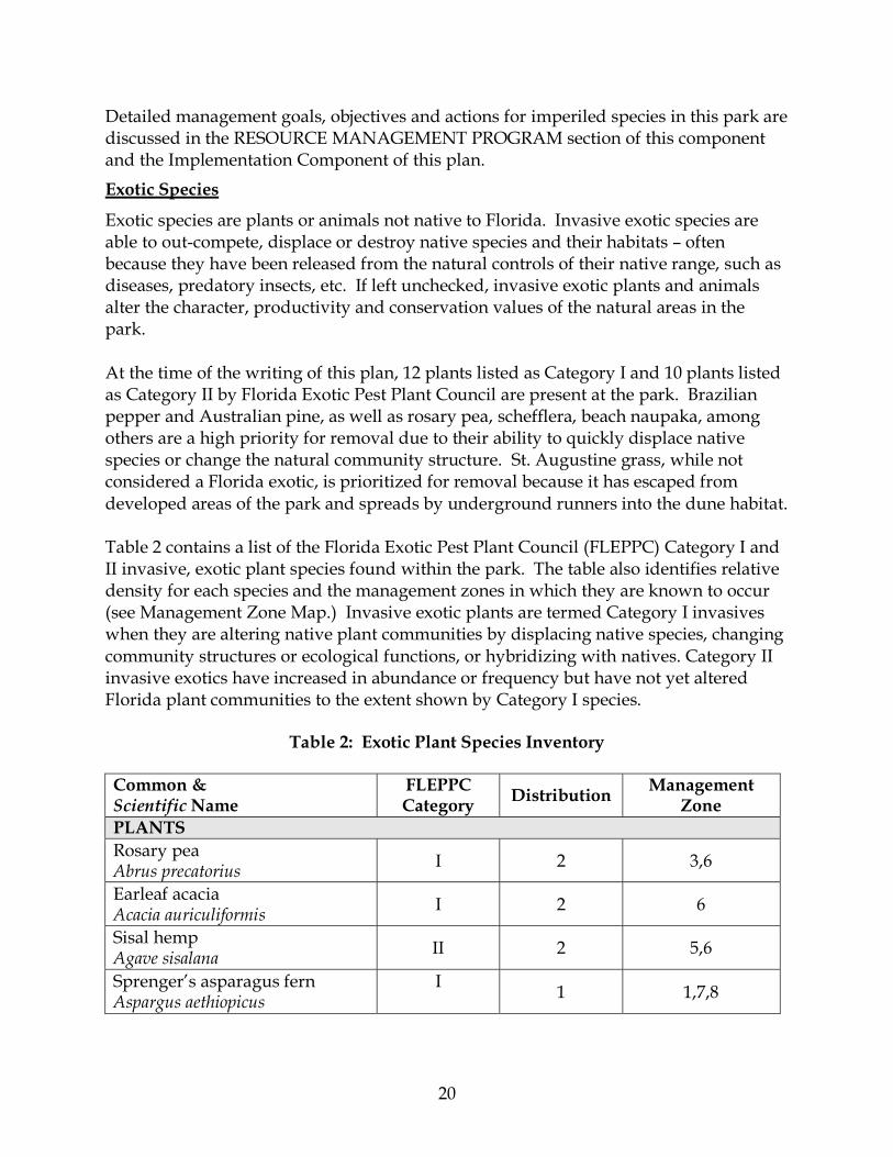
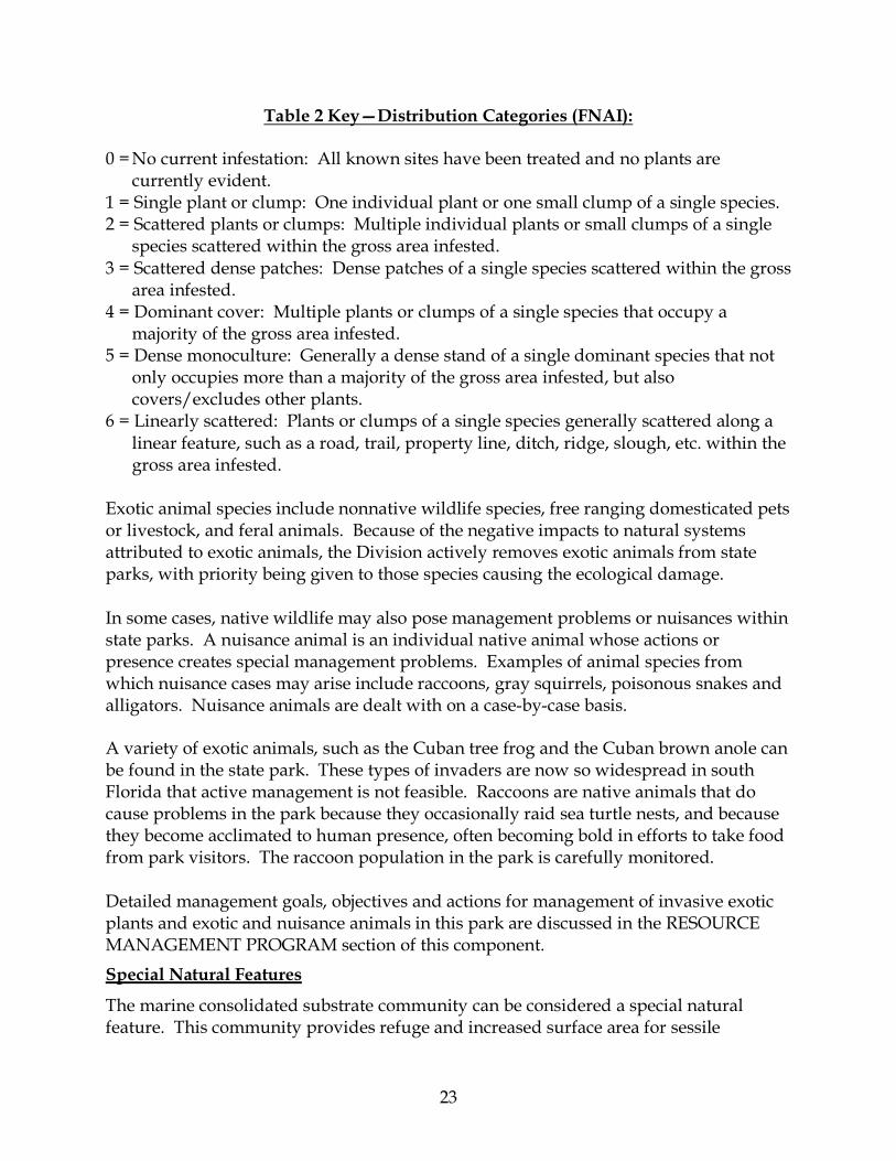
Exotic species are plants or animals not native to Florida. Invasive exotic species are able to out-compete, displace or destroy native species and their habitats – often because they have been released from the natural controls of their native range, such as diseases, predatory insects, etc. If left unchecked, invasive exotic plants and animals alter the character, productivity and conservation values of the natural areas in the park. At the time of the writing of this plan, 12 plants listed as Category I and 10 plants listed as Category II by Florida Exotic Pest Plant Council are present at the park. Brazilian pepper and Australian pine, as well as rosary pea, schefflera, beach naupaka, among others are a high priority for removal due to their ability to quickly displace native species or change the natural community structure. St. Augustine grass, while not considered a Florida exotic, is prioritized for removal because it has escaped from developed areas of the park and spreads by underground runners into the dune habitat. Table 2 contains a list of the Florida Exotic Pest Plant Council (FLEPPC) Category I and II invasive, exotic plant species found within the park. The table also identifies relative density for each species and the management zones in which they are known to occur (see Management Zone Map.) Invasive exotic plants are termed Category I invasives when they are altering native plant communities by displacing native species, changing community structures or ecological functions, or hybridizing with natives. Category II invasive exotics have increased in abundance or frequency but have not yet altered Florida plant communities to the extent shown by Category I species.
Table 2: Exotic Plant Species Inventory
Common & Scientific Name
FLEPPC Category Distribution Management
Zone PLANTS Rosary pea Abrus precatorius I 2 3,6
Earleaf acacia Acacia auriculiformis I 2 6
Sisal hemp Agave sisalana II 2 5,6
Sprenger’s asparagus fern Aspargus aethiopicus
I 1 1,7,8

21
Common & Scientific Name
FLEPPC Category Distribution Management
Zone Green shrimp plant Blechum pyramidatum
II 1 7
Australian pine Casurina equisetifolia I 3 1-9
Asiatic colubrine Colubrine asiatica I 2 6
Carrotwood Cupaniopsis anacardioides I 2 1-9
Air potato Dioscorea bulbifera I 2 1,5,7,8
Cuban laurel Ficus microcarpa I 2 1-9
Life plant Kalanchoe pinnata II 2 1-9
Shrub verbena Lantana camara II 2 1,8
Guinea grass Panicum maxicum II 2 4,7
Fountain grass Pennisetum setaceum II 0 4
Natal grass Rhynchelytrum repens I 2 2,3,4
Beach naupaka Scaevola taccada I 2 5,6
Schefflera Schefflera actinophylla I 2 7
Brazilian pepper Schinus terebinthifolius I 3 6,8
Nettleleaf velvetberry Stachytarpheta cayennensis
II 0 5
Seaside mahoe Talipariti tiliaceum II 1 9
Jamaican feverplant Tribulus cistoides
II 1 1
Caesarweed Urena lobata II 0 0
9
´0 250 500 750 1,000125
FeetFlorida Department of Enviromental Protection
Divison of Recreation and ParksOffice of Park Planning
DELNOR WIGGINS PASSSTATE PARK
MANAGEMENT ZONES
7
1
2
3
4
5
6
8
Entrance Station
BathHouses
ObservationTower
Pavilion
Boat Ramp
BathHouses
Gulf of M
exico
7
23
Table 2 Key—Distribution Categories (FNAI):
0 = No current infestation: All known sites have been treated and no plants are currently evident.
1 = Single plant or clump: One individual plant or one small clump of a single species. 2 = Scattered plants or clumps: Multiple individual plants or small clumps of a single
species scattered within the gross area infested. 3 = Scattered dense patches: Dense patches of a single species scattered within the gross
area infested. 4 = Dominant cover: Multiple plants or clumps of a single species that occupy a
majority of the gross area infested. 5 = Dense monoculture: Generally a dense stand of a single dominant species that not
only occupies more than a majority of the gross area infested, but also covers/excludes other plants.
6 = Linearly scattered: Plants or clumps of a single species generally scattered along a linear feature, such as a road, trail, property line, ditch, ridge, slough, etc. within the gross area infested.
Exotic animal species include nonnative wildlife species, free ranging domesticated pets or livestock, and feral animals. Because of the negative impacts to natural systems attributed to exotic animals, the Division actively removes exotic animals from state parks, with priority being given to those species causing the ecological damage. In some cases, native wildlife may also pose management problems or nuisances within state parks. A nuisance animal is an individual native animal whose actions or presence creates special management problems. Examples of animal species from which nuisance cases may arise include raccoons, gray squirrels, poisonous snakes and alligators. Nuisance animals are dealt with on a case-by-case basis. A variety of exotic animals, such as the Cuban tree frog and the Cuban brown anole can be found in the state park. These types of invaders are now so widespread in south Florida that active management is not feasible. Raccoons are native animals that do cause problems in the park because they occasionally raid sea turtle nests, and because they become acclimated to human presence, often becoming bold in efforts to take food from park visitors. The raccoon population in the park is carefully monitored. Detailed management goals, objectives and actions for management of invasive exotic plants and exotic and nuisance animals in this park are discussed in the RESOURCE MANAGEMENT PROGRAM section of this component. Special Natural Features
The marine consolidated substrate community can be considered a special natural feature. This community provides refuge and increased surface area for sessile

24
organisms. It is the foundation for the development of other marine communities. The FNAI ranking for this community indicates that it is limited in its distribution, very rare throughout its range, and vulnerable to extinction by actions causing siltation.
Cultural Resources
Evaluating the condition of cultural resources is accomplished using a three part evaluative scale, expressed as good, fair and poor. These terms describe the present condition, rather than comparing what exists against the ideal. “Good” describes a condition of structural stability and physical wholeness, where no obvious deterioration other than normal occurs. “Fair” describes a condition in which there is a discernible decline in condition between inspections, and the wholeness or physical integrity is and continues to be threatened by factors other than normal wear. A “fair” assessment is cause for concern. “Poor” describes an unstable condition where there is palpable, accelerating decline, and physical integrity is being compromised quickly. A resource in poor condition suffers obvious declines in physical integrity from year to year. A poor condition suggests immediate action to reestablish physical stability. A review of the Florida Master Site File revealed two artifact scatter sites. Artifact scatter site 8CR 970 is located on the very northern tip of the park adjacent to Wiggins Pass. Three stone tools, commonly called Florida Archaic stemmed points, were found at this location. Artifact scatter site 8CR 575, is located about half a mile east of Vanderbilt Channel but outside the park boundary. In 1981, Tropical Storm Dennis caused severe beach erosion, and the remains of a wooden sailing vessel were uncovered on the park beach. A cursory examination by the DHR found the remains of a nineteenth-century sailing vessel of the kind that once plied the coast. The beam was estimated at 17 feet. RESOURCE MANAGEMENT PROGRAM
Management Needs and Problems
Natural Resources
• Maintain exotic plant control in natural communities, which were heavily infested with exotic invasive plants in recent times, primarily Australian pines and Brazilian peppers.
• Restoration of native plant communities should continue, which will ensure the health of the native populations of flora and fauna and the park’s natural systems.
• As one of the few undeveloped barrier islands in the area, vigilant protection and management of imperiled plant and animal species must continue.
• The impacts of past and future dredging of Wiggins Pass and the river and channels that feed the pass and deposition of compatible material on the park are of great concern in the management of the park.
• Global climate change has potential to cause complex changes to the Gulf Coast
25
ecosystem. Management Measures and Objectives
The resources administered by the Division are divided into two principal categories: natural resources and cultural resources. The Division’s primary emphasis in natural resource management is to maintain and restore, to the extent possible, to the conditions that existed before the ecological disruptions caused by man. The philosophy for managing cultural resources is to protect these resources from human-related and natural threats. This will arrest deterioration and help preserve the cultural resources for future generations to enjoy. In the discussion below, measurable objectives have been identified for each of the Division’s management goals specific to Delnor-Wiggins Pass State Park. The Implementation Component of this plan consolidates these goals and objectives and documents the specific actions that have been identified to achieve the objectives and, ultimately, to achieve the broader management goals of the park. Please refer to the Implementation Component for the projected actions and measures for progress, the target year for completion and the estimated costs of each action and objective for the park.
Natural Resources
Hydrological Management
Goal: Protect water quality and quantity in the park, restore hydrology to the extent feasible and maintain the restored condition. To the extent possible, the Division actively restores the original hydrology in state parks. This is done primarily by filling or plugging ditches, removing obstructions to surface water “sheet flow,” installing culverts under roads, and installing water control structures to manage water levels. The Division is charged by statute to restore, maintain and protect the original character of representative portions of the state’s natural lands. However, it is now realized that the natural hydrology of many state parks is impaired to some degree. Most of Florida’s native habitats are precisely adapted to natural drainage patterns and seasonal water fluctuations. Depth to water table and the timing and length of flooding frequently determine what type of natural community occurs on a site. Even minor changes to natural hydrology can result in the loss of plant and animal species from a site.
Objective: Monitor and analyze water resources of the park. The Wiggins Pass Estuarine Area and the Cocohatchee River System were designated an Outstanding Florida Water (OFW) effective July 16, 1996. The intent of an OFW
26
designation is to prevent deterioration of existing water quality. The primary effect of an OFW designation is that new polluting activities requiring a Department permit must meet higher standards. Stormwater management facilities that require a Water Management District or Department permit can be similarly affected by an OFW designation. In addition, Temporary Operating Permits are not allowed for activities discharging directly into an OFW. New indirect pollutant discharges (i.e., discharges to tributaries of the OFW) also must not significantly degrade the OFW. Natural Community/Habitat Management
Goal: Restore and maintain the natural communities/habitats of the park. The Division is charged to protect, restore and maintain functioning representative examples of the full diversity of natural communities within the state, while providing appropriate recreational and educational benefits. This undertaking not only requires acquisition and protection of representative lands within the state park system, but also active restoration and maintenance of the natural processes that sustain complex and dynamic biological systems on those lands. To the extent possible, the Division practices natural systems management, whereby the processes that shaped (and continue to shape) the structure, function, species composition, and relative species abundances of Florida's natural communities are restored and maintained. In some cases, maintenance and reintroduction of natural processes is not enough to reach restoration objectives. Restoration of altered lands to a healthy, fully functioning natural community often requires substantial efforts that include mechanical treatment of vegetation or soils, and reintroduction or augmentation of native plants and animals.
Objective: Continue working to avoid impacts to park resources from dredging and erosion control projects in Wiggins Pass and Water Turkey Bay.
The human manipulation of the Pass and shoreline near Delnor-Wiggins Pass State Park is a concern in the management of the park. Impacts of future dredging projects at Wiggins Pass must be evaluated. As more pleasure boats of increasing size appear in the waters around the park, pressures mount to widen and deepen the channel. Any efforts to enlarge the Pass to accommodate boats of deeper draft could increase erosion in parts of the park and affect the ecological balance of the natural communities both in and surrounding the park. The Division will continue to participate in the planning and execution of dredge and spoil deposition activities to maintain a high quality beach system in and near the park. Periodic surveys to monitor the hard bottom reef, oyster beds and seagrass beds in the waters surrounding the park should be conducted. This will include mapping of these communities as needed.
Objective: Restore, enhance and maintain natural plant communities, plant and animal diversity and natural relative abundance.

27
Due to the erosional effects of storms and inlet forces, the park’s beaches may require nourishment and dune repairs to maintain storm protection for upland habitat and infrastructure, as well as adequate beach for shorebirds, marine turtles and recreation. Careful evaluation of dredged material is needed to ensure nourishment sands are compatible with the park’s beaches. Dune protection and restoration measures will be implemented as required. The restoration and maintenance of maritime hammock and beach dune communities should continue. The management approach is to propagate appropriate native species of plants in the nursery and use for restoration efforts. Also important is the removal of exotic, invasive species when found. The results of this management activity will be enhanced by using educational and interpretation opportunities to strengthen protection of imperiled plants and animals. A portion of the hard bottom community is outside the management area of the park but should be protected from harmful activities in cooperation with the Coast Guard and other managing authorities. Navigational buoys should be installed where practicable to protect the hard bottom community, which occurs within 50 feet of the shoreline. As noted previously, this community is considered a special natural feature for the park. Imperiled Species Management
Goal: Maintain, improve or restore imperiled species populations and habitats in the park. The Division primarily maintains healthy populations of imperiled plant and animal species by implementing effective management of natural systems. Single species management is appropriate on state parks when the maintenance, recovery or restoration of a species or population is complicated due to constraints associated with long-term restoration efforts, unnaturally high mortality or insufficient habitat. Single species management should be compatible with the maintenance and restoration of natural processes, and should not imperil other native species or seriously compromise park values. The Division has consulted with the FWC and will to continue coordination with that agency and with other appropriate federal, state and local agencies on management of imperiled animal species. Similarly, the Division has consulted with the FDACS on management of imperiled plant species. Data collected by the FWC, USFWS, FDACS and FNAI as part of their ongoing research and monitoring programs will be reviewed by park staff periodically to inform management of decisions that may have an impact on imperiled species at the park. The U.S. Fish and Wildlife Service (USFWS) will also be consulted for the following park species: American crocodile (Crocodylus acutus), eastern indigo snake (Drymarchon corais), Atlantic loggerhead (Caretta caretta), wood
28
stork, (Mycteria americana), Southern bald eagle (Haliaeetus leucocephalus), West Indian manatee (Trichechus manatus). The management recommendations in these species recovery plans will be followed as appropriate. Ongoing inventory and monitoring of imperiled species in the state park system is necessary to meet the Division’s mission. Long-term monitoring is also essential to ensure the effectiveness of resource management programs. Monitoring efforts must be prioritized so that the data collected provides information that can be used to improve or confirm the effectiveness of management actions on conservation priorities. Monitoring intensity must at least be at a level that provides the minimum data needed to make informed decisions to meet conservation goals. Not all imperiled species require intensive monitoring efforts on a regular interval. Priority must be given to those species that can provide valuable data to guide adaptive management practices. Those species selected for specific management action and those that will provide management guidance through regular monitoring are addressed in the objectives below.
Objective: Monitor sea turtles, gopher tortoises, least terns and four imperiled plant species.
Monitoring will continue for marine turtles. All nests found on the park are marked and protected according to the FFWCC permit requirements and INBS guidelines. During sea turtle nesting season, evening activities are limited and light sources on the beach are off to prevent disturbance to nesting sea turtles and their hatchlings. Monitoring for beach nesting birds will continue. Least tern nest sites were last documented in 1986 and 1987. Whenever suitable beach habitat is available for nesting birds, the area will be posted with twine and a sign before the nesting season begins. The twine will control foot traffic in accordance with the Division’s Operations Manual to ensure the species’ protection. Interpretive signs will be placed in appropriate areas for public education. Additional concerns for least tern nesting arise from periodic proposals to dredge Wiggins Pass. The potential impacts of channel dredging to least tern nest sites and to marine turtle nesting must always be evaluated. Gopher tortoises were present in the park until the early 1980s, but due to intensive land use activities, this population did not survive. A few individuals were reintroduced as replacements prior to the establishment of relocation protocols by the Florida Fish and Wildlife Conservation Commission. It was initially believed that this population might not fare well because of limited forage and heavy visitation. However, the tortoises were protected and now it is common for visitors to see a gopher tortoise foraging along the side of the road. Several large burrows are often visible within the beach dunes. A gopher tortoise burrow survey should be conducted periodically to monitor the population at the park and to evaluate if juveniles are

29
present. Depending on the results of the survey, and if carrying capacity and habitat requirements are met, the park could consider being placed on a list of approved recipient sites for permitted gopher tortoise relocations. Monitoring protocols will be developed and implemented for triangle cactus, golden leather fern, inkberry and common wild pine. Populations of these species will be documented through the monitoring process, and all necessary management actions will be taken to protect the sites from disturbance. Objective: Conduct species-specific management activities to protect targeted imperiled species in the park Sea turtle nests will continue to be located and protected as they occur, and park staff will continue to limit beach activity and lighting during the nesting season. Part of the Division’s review of potential impacts from dredging and beach nourishment activities in the park will continue to focus on potential impacts to nesting sea turtles and the potential for nesting activity by least terns. As discussed below, interpretive programs to inform and educate park visitors about these species, as well as gopher tortoises will be implemented to help minimize human-related disturbance to the imperiled species in the park.
Exotic Species Management
Goal: Remove exotic and invasive plants and animals from the park and conduct needed maintenance control. Exotic species are plants or animals not native to Florida. Invasive exotic species are able to out-compete, displace or destroy native species and their habitats – often because they have been released from the natural controls of their native range, such as diseases, predatory insects, etc. If left unchecked, invasive exotic plants and animals alter the character, productivity and conservation values of the natural areas in state parks. The Division actively removes invasive exotic species from state parks, with priority being given to those causing the ecological damage. Removal techniques may include mechanical treatment, herbicides or biocontrol agents.
Objective: Continue to remove exotic plants and animals from the park. The park will continue its vigorous follow-up surveillance and treatment of Australian pines and Brazilian peppers and all other exotic trees, shrubs, and herbaceous plants throughout the park. On average, approximately 1 non-contiguous acre of exotic plants within the park will be removed, annually. An exotic plant management work plan will be developed and updated annually to guide this effort. The large Australian pines within the picnic area will be removed as they die naturally or pose a safety hazard, unless otherwise required by local regulations. Appropriate native shade trees will be
30
planted in their place. Exotic and nuisance animals will be removed from the park as needed. Park staff is alert to the potential for new and potentially damaging exotic animal introductions, and to the occasional appearance of feral or abandoned domestic animals, and takes immediate action to remove them from the park. The park’s primary animal control effort will continue to be focused on raccoons, due to their tendency to raid sea turtle nests and to cause safety hazards for park visitors.
Cultural Resources
Cultural Resource Management
Goal: Protect, preserve and maintain the cultural resources of the park. The management of cultural resources is often complicated because these resources are irreplaceable and extremely vulnerable to disturbances. The advice of historical and archaeological experts is required in this effort. Managers of state lands must coordinate any land clearing or ground disturbing activities with DHR to allow for review and comment on the proposed project. Recommendations may include, but are not limited to approval of the project as submitted, pre-testing of the project site by a certified archaeological monitor, cultural resource assessment survey by a qualified professional archaeologist, modifications to the proposed project to avoid or mitigate potential adverse effects.
Objective: Assess and evaluate artifact scatter site 8CR 970.
An assessment and evaluation of the condition of the park’s single archaeological site will be completed. Division staff will design a regular monitoring program for the site, followed by the continuous implementation of that program.
Objective: Compile reliable documentation for all recorded historic and archaeological sites.
Short-term actions for cultural resource management will include developing a predictive model classifying the park land as having high, medium or low probability of hosting prehistoric or historic cultural resource sites. Park staff will insure that all newly identified cultural sites will be recorded in the Florida Master Site File and the file will be updated periodically, as needed. A Scope of Collections statement will also be developed and implemented for the park.
Special Management Considerations
Timber Management Analysis
Chapters 253 and 259, Florida Statutes, require an assessment of the feasibility of

31
managing timber in land management plans for parcels greater than 1,000 acres if the lead agency determines that timber management is not in conflict with the primary management objectives of the land. Since this park is less than 1,000 acres, this does not apply. It was determined that the primary management objectives of the unit could be met without conducting timber management activities for this management plan cycle. Coastal/Beach Management
Since the 1950s, there have been significant man-made alterations to the park’s surrounding waters. Collier County has dredged Wiggins Pass for navigation purposes, first in 1984, and then periodically through 2007. A Wiggins Pass Inlet Management Study in 1995 recommended widening and deepening the inlet and since 2000, the County has had to dredge the pass with increasing frequency, as often as every 18 months to two years. Additionally, in 2002 and in 2007 the park has been a disposal site for some of the beach-quality material dredged from the pass. The Park is working with the County and other stakeholders, including the County’s Coastal Advisory Committee, the Conservancy of Southwest Florida, Estuary Conservation Association (ECA), and the Friends of Barefoot Beach to evaluate alternatives that would alleviate the need for dredging the pass so frequently and stabilize movement of the pass. It is critical that the Park continues to work with these stakeholders to prevent negative impacts to the park’s shoreline and the surrounding natural habitats. Problem Species Management
Problem species are defined as native species whose habits create specific management problems or concerns. Occasionally, problem species are also an imperiled species, such as alligators. The Division will consult and coordinate with appropriate federal, state and local agencies for management of imperiled species that are considered a threat or problem. Swimming in the near shore waters is sometimes constrained by the presence of sharks, stinging jellyfish and stingrays. When sharks appear offshore, swimmers are directed to leave the water. Stinging jellyfish that wash up on shore are buried by the park staff. Victims of jellyfish stings are advised to seek medical treatment. Raccoons can also be a problem because they are attracted to food on the picnic tables and are often fed by visitors. In addition, there have been occasional complaints of raccoon bites. Another undesirable outcome of supplemental feeding of raccoons, particularly on a large scale, is that the population can expand and exert undue predatory pressure on other native wildlife. The predation of marine turtle nests is perhaps the best-known example. The management response has been to educate visitors, and to humanely trap and remove raccoons when necessary. Additional Considerations
In 1983, the Board of Trustees authorized the Division of Recreation and Parks to manage waters and state-owned water bottoms in the Gulf of Mexico within 400 feet of

32
the shore, for property protection and as a water recreation area. A native plant nursery has been in operation in this park since the late 1970s. Production levels have varied, but output has been steady. The principal purpose of the nursery is to produce plants to restore the maritime hammock. Areas that were most heavily impacted by invasive species have been successfully re-established to maritime hammock. As the need for nursery plants diminishes, the native plant nursery capacity can decrease but still provide a local seed source is available if needed. Plants may also be grown for landscaping purposes. The species needed most are strangler fig (Ficus aurea), buttonwood (Conocarpus erectus), Jamaica dogwood (Piscidia piscipula), catclaw (Pithecellobium unguis-cati), and seagrape (Coccoloba uvifera). These plants should constitute the majority of species in the nursery. It is important to note that the East coast variety of beach dune sunflower (Helianthus debilis subsp. debilis) occurs in the park in developed areas. It has come from landscape planting projects and adjacent properties. While this species is native to Florida, it can hybridize and outcompete the West coast variety (Helianthus debilis subsp. debilis vestitus). According to the 2004 report “Status Survey of West Coast Dune Sunflower” by The Institute for Regional Conservation, the West coast variety does not occur in the park. However, in the interest of protecting and promoting native species in our landscaping, all East coast subspecies should be removed from the park and replaced with another species native to the park.
Research Needs
Natural Resources
Any research or other activity that involves the collection of plant or animal species on park property requires a collecting permit from the Department of Environmental Protection. Additional permits from the Florida Fish and Wildlife Conservation Commission, the Department of Agriculture and Consumer Services, or the U.S. Fish and Wildlife Service may also be required. At Delnor-Wiggins Pass State Park, basic research is conducted and data are collected on the loggerhead turtles during the summer months by the park staff. Information such as the number and location of nests, number of nests hatched, and number of false crawls is recorded. Very occasionally, nests are relocated when deemed necessary and according to permit conditions to insure survival of hatchlings. Disturbances to the nests, such as predation, and inundation from high tides are also recorded. Alternatives for stabilizing Wiggins Pass with the least amount of negative impacts to the adjacent shorelines are currently evaluated by interested stakeholders, including representatives from the Division of Recreation and Parks. Monitoring and analysis of the inlet and storm effects to park beaches will continue in coordination with the
33
Department’s Strategic Beach Management Plan. Surveys for seagrasses and oyster reef beds should be conducted within the boundaries of the park. Surveys of the offshore hardbottom reef community are needed. A water quality monitoring program should be instituted in partnership with the conservation organizations associated with the park’s surrounding watershed.
Resource Management Schedule
A priority schedule for conducting all management activities that is based on the purposes for which these lands were acquired, and to enhance the resource values, is contained in the Implementation Component of this management plan.
Land Management Review
Delnor-Wiggins Pass State Park was subject to a land management review on October 17, 1997 (see Addendum 6). The review team made the following determinations: 1. The land is being managed for the purpose for which it was acquired. 2. The actual management practices, including public access, complied with the
management plan for this site.

34
35
LAND USE COMPONENT
INTRODUCTION
Land use planning and park development decisions for the state park system are based on the dual responsibilities of the Division of Recreation and Parks. These responsibilities are to preserve representative examples of original natural Florida and its cultural resources, and to provide outdoor recreation opportunities for Florida's citizens and visitors. The general planning and design process begins with an analysis of the natural and cultural resources of the unit, and then proceeds through the creation of a conceptual land use plan that culminates in the actual design and construction of park facilities. Input to the plan is provided by experts in environmental sciences, cultural resources, park operation and management, through public workshops, and environmental groups. With this approach, the Division objective is to provide quality development for resource-based recreation throughout the state with a high level of sensitivity to the natural and cultural resources at each park. This component of the unit plan includes a brief inventory of the external conditions and the recreational potential of the unit. Existing uses, facilities, special conditions on use, and specific areas within the park that will be given special protection, are identified. The land use component then summarizes the current conceptual land use plan for the park, identifying the existing or proposed activities suited to the resource base of the park. Any new facilities needed to support the proposed activities are described and located in general terms.
EXTERNAL CONDITIONS
An assessment of the conditions that exist beyond the boundaries of the park can identify any special development problems or opportunities that exist because of the park's unique setting or environment. This also provides an opportunity to deal systematically with various planning issues such as location, regional demographics, adjacent land uses and park interaction with other facilities. Delnor-Wiggins Pass State Park is located on the Gulf of Mexico in northwestern Collier County, about five miles north of the City of Naples and approximately two miles south of the Collier-Lee County line. Collier County’s Barefoot Beach Preserve is directly north of the state park, across Wiggins Pass. Access to the park from Interstate Highway 75 or U.S. Highway 41 is via County Road 846 (Immokolee Road) west, which becomes Bluebill Avenue. The park entrance lies west of the intersection of Bluebill Avenue and Gulfshore Drive.

36
This region of Florida experienced explosive growth in resident and seasonal population over the past 20 years. Collier County’s year-round resident population increased by 65 percent from 1990 to 2000 and reached an estimated 326,700 persons in 2006. Between 2006 and 2010, the County’s year-round resident population is expected to grow by an additional 16 percent to over 440,000 persons. In addition, the seasonal influx of winter residents has increased the County’s population by about 22 percent, on average, between the months of November and April during the years 2003 to 2007. During the same period, the County hosted an average of 1.4 million tourist visitors each year, primarily during the winter months. For the purpose of the current edition of Outdoor Recreation in Florida, Florida’s statewide comprehensive outdoor recreation plan, relative need is defined as the ranked, proportional relationship among all outdoor recreation needs for each basic type of activity. The relative need indices compare the needs from any one activity in a region, with the needs for all activities in all regions, and establish the priority ranking among them. Out of 252 ranked activities, saltwater beach activities in the Southwest Florida region are the 19th priority statewide. In addition, the relative need priority of picnicking and rv/trailer camping are ranked in the top ten in the region surrounding the state park. (Outdoor Recreation in Florida, 2009.)
Existing Use of Adjacent Lands
Most of the area surrounding the park is intensely urbanized. Residential, hotel, motel, resort, commercial and recreational land uses are all located in the immediate vicinity of the park. High-rise residential condominium developments along Vanderbilt Beach to the south and condominiums and single-family developments to the east and northeast create a very densely populated setting for the park. A shortage of publicly accessible recreational beaches in the southwest Florida region brings intense pressure for beach access to the park throughout the year, but particularly during the busy winter, spring and summer seasons. Alternatives to vehicular access to the park are provided by a paved on-road bike lane and a sidewalk along the north side of Bluebill Avenue and by facilities on Gulf Shore Boulevard. The Bluebill Avenue bike lane terminates at the east side of Gulf Shore Boulevard. West of Gulfshore Boulevard, the County-owned entrance drive and the sidewalk along its northern side provide access for bicyclists and pedestrians from Bluebill Avenue into the park. Bike lanes and sidewalks on both sides of Gulfshore Boulevard connect to the entrance road and sidewalk for entrance into the state park. In the past year, Collier County has acquired a ten-foot wide public beach access easement immediately beyond the southern state park boundary, with the intention of providing added public pedestrian access to the beach (see Reference Map).

37
Planned Use of Adjacent Lands
The Future Land Use Map for Collier County designates Delnor–Wiggins State Park and the adjacent Barefoot Beach Preserve as “Conservation.” The purpose of this district is to retain open space and conserve environmentally sensitive areas. The property immediately south, east and northeast of Delnor–Wiggins State Park is designated “Urban Residential.” The purpose of this subdistrict is to provide for higher densities in an area with fewer natural resource constraints and where existing and planned public facilities are concentrated. Ongoing development of residences and related land uses continues to increase the local population adjacent to Delnor-Wiggins State Park. Three new projects that will affect the park in the future are now under development. Moraya Bay Beach Tower is a 72- unit condominium tower and a proposed private beach club located directly south of the park boundary. The Aqua development is located east of the park across the Cocohatchee River. It will add 88 residential units and a private yacht club with more than 30 boat slips. The Dunes Condominiums expansion project immediately east of the park, across Vanderbilt Canal, will increase that development by 49 boat slips. New beach access improvements by Collier County include a stabilized path from Gulfshore Drive to the beach along the park’s southern boundary. The County is planning a boardwalk on that path, an automobile turn-about and pedestrian drop-off area, and a public restroom to be located just outside the park gate and connected to the boardwalk. In combination, these new developments have the potential to significantly alter beach recreation and park visitation patterns, and will encourage more visitors to enter the park along the beach from the south. Adjacent development of new boating facilities may intensify demand to maintain a deeper navigable outlet to the Gulf through Wiggins Pass, with potential impacts to park resources and recreational opportunities.
PROPERTY ANALYSIS
Effective planning requires a thorough understanding of the unit's natural and cultural resources. This section describes the resource characteristics and existing uses of the property. The unit's recreation resource elements are examined to identify the opportunities and constraints they present for recreational development. Past and present uses are assessed for their effects on the property, compatibility with the site, and relation to the unit's classification.
Recreation Resource Elements
This section assesses the unit’s recreation resource elements those physical qualities that, either singly or in certain combinations, support the various resource-based
38
recreation activities. Breaking down the property into such elements provides a means for measuring the property's capability to support individual recreation activities. This process also analyzes the existing spatial factors that either favor or limit the provision of each activity. Land Area
Delnor-Wiggins Pass State Park is comprised of 166 acres of beach, beach dune, maritime hammock, mangrove swamp and submerged land. The majority of the park is wetlands (over 124 acres). The park’s public facilities were developed within the narrow band of maritime hammock and along the edge of the beach dune community. The hammock community provides welcome shade for beachgoers, and an attractive natural setting for park activities. The beach dune community and the white sand beach along the western edge of the park are outstanding recreational resources, drawing the majority of public visitation that the park receives. The beach area comprises only about 24 acres, or 14 percent of the park land. Water Area and Shoreline
The Gulf of Mexico lies along the park’s approximately 6,000-foot western shoreline. The Gulf and the inlet are the primary recreational attractions of the park, providing opportunities for swimming, fishing, shelling, bird watching, sunbathing, picnicking and nature appreciation. From 2003 through 2007, an average of over 517,000 visitors enjoyed recreation on the park’s beach each year. Estuarine wetlands and a mature mangrove forest border the park on its eastern side, providing opportunities for fishing, wildlife viewing and interpretation. Wiggins Pass is a natural inlet and has been open since at least 1885. Before 1952, the inlet was subject to periodic, naturally occurring closures. In 1952, a south channel was dredged to connect Wiggins Pass through Water Turkey Bay to Vanderbilt Lagoon. From 1984 to 2000, Collier County maintained the pass entrance channel at a depth of -8 ft MLW in an area 1,050 ft. long and 200 ft. wide. The dredged sand was placed on the beaches north and south of the inlet. However, the channel fills rapidly, creating unreliable depths. Widening and deepening of Wiggins Pass was completed in July 2000. The improvements included deepening the channel through the ebb shoal to a depth of -12 ft MLW. The channel was dredged in 2002, 2005 and 2007 with some material placed on the beaches at Delnor-Wiggins Pass State Park and some material placed in the near shore at Barefoot Beach Preserve. For future maintenance events, dredging of the interior channel is proposed (FDEP, Bureau of Beaches and Coastal Systems, Strategic Beach Management Plan for the Southwest Coast Region, 2008). Recreational use of the inlet is high, including its use for landing of both private

39
watercraft and public shuttle boats bringing visitors to the park. Swimming is not allowed along the inlet shoreline to protect public safety. The management of the inlet is increasingly complex because of the volume and depth requirements of boat traffic, the natural coastal dynamics of the barrier island and the resource protection needs of adjacent state park and County preserve units. The beach at the park experiences very high public demand for recreational use, particularly during peak beach use seasons. Public beach access is limited in Collier County. The County’s Vanderbilt Beach Park, which includes a 340 - space parking garage, is located less than two miles from the state park, at the southern end of Gulfshore Drive. Collier County has maintained approximately 12-15 parking spaces on the County road right of way in front of the state park gate and has constructed an improved path to connect the County road directly to the beach; however, these parking spaces are slated to be removed as part of the County’s turnabout and pedestrian drop-off facility discussed above. The County also provides 79 parking spaces at Conner Park, about one-quarter mile east of the state park on Bluebill Avenue. Future plans include increasing parking capacity at Conner Park by 75 additional spaces. The availability of beach access and the dense local resident population generate extremely high traffic volumes on these roads when the weather is conducive for beach going. For many years, the Division and Collier County have sought solutions to the frequent traffic congestion problems outside the park gate and on Gulfshore Drive and Bluebill Avenue during peak attendance. Natural Scenery
Views of the Gulf of Mexico and the visual qualities of the beach dune and maritime hammock natural communities are the scenic attractions at the park. The large mangrove forest and adjacent wetland communities attract wildlife and also serve as visual resources in the park. These wetlands also provide opportunities for interpretation and environmental education. Significant Wildlife Habitat
The park provides habitat for nesting sea turtles and resting and loafing shorebirds. Manatees frequent the coastline and shallow interior waterways throughout this area of Florida. The mangrove swamp community also provides habitat for a variety of animals and plants. Natural Features
The park’s outstanding natural features include the wide white sand beach, the Gulf of Mexico, the natural inlet and the mature mangrove forest.
Assessment of Use
All legal boundaries, significant natural features, structures, facilities, roads and trails existing in the unit are delineated on the base map (see Base Map). Specific
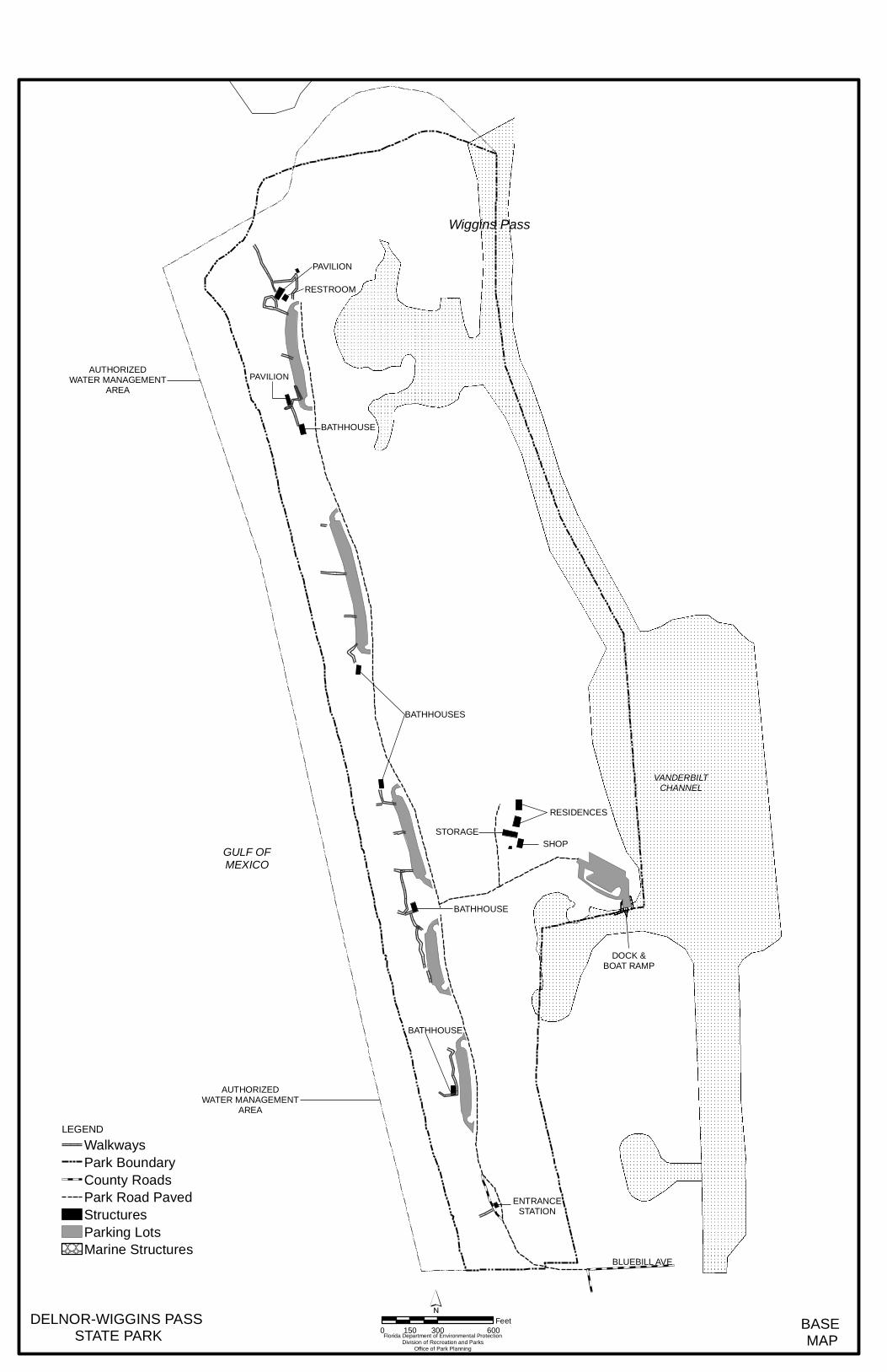
PAVILION
BLUEBILL AVE
RESIDENCES
GULF OFMEXICO
BATHHOUSE
STORAGE
PAVILION
VANDERBILTCHANNEL
BATHHOUSE
AUTHORIZEDWATER MANAGEMENT
AREA
SHOP
BATHHOUSE
ENTRANCESTATION
RESTROOM
BATHHOUSES
DOCK &BOAT RAMP
AUTHORIZEDWATER MANAGEMENT
AREA
DELNOR-WIGGINS PASS STATE PARK BASE
MAPFlorida Department of Environmental ProtectionDivision of Recreation and Parks
Office of Park Planning
0 300 600150Feet
LEGENDWalkwaysPark BoundaryCounty RoadsPark Road PavedStructuresParking LotsMarine Structures
Wiggins Pass

41
uses made of the unit are briefly described in the following sections. Delnor-Wiggins Pass State Park is located at the north end of a narrow barrier island. Although the uplands have been intensively developed to accommodate public recreation, the majority of the property supports a healthy mangrove forest that is set aside for protective management. Past Uses
The Caloosa Indians settled in this region at least 2,000 years ago and were present until the end of the eighteenth century. Their shell mounds are found in surrounding areas, though none is known to exist in the park. Recreational Uses
The focal point for the recreational activities in the park is the Gulf beach. There is a little over one mile of shoreline along the Gulf, and park facilities are located along the length of the property to take advantage of the recreational opportunities offered by this prime beach frontage. Approximately 0.9 mile of the shoreline is suitable for swimming. At the north end of the park, about 0.3 mile of shoreline fronting on Wiggins Pass is unsafe for swimming due to strong currents. Other Uses
A native plant nursery was established in the park to produce plants to revegetate the maritime hammock and for landscaping. Sand from maintenance dredging of Wiggins Pass is periodically placed on the beach. Protected Zones
A protected zone is an area of high sensitivity or outstanding character from which most types of development are excluded as a protective measure. Generally, facilities requiring extensive land alteration or resulting in intensive resource use, such as parking lots, camping areas, shops or maintenance areas, are not permitted in protected zones. Facilities with minimal resource impacts, such as trails, interpretive signs and boardwalks are generally allowed. All decisions involving the use of protected zones are made on a case-by-case basis after careful site planning and analysis. At Delnor-Wiggins Pass State Park, the beach dune natural community and estuarine/marine tidal swamp has been designated as protected zones as delineated on the Conceptual Land Use Plan. Existing Facilities
The existing public facilities were constructed in the mid-1980s and are in generally good condition. The Base Map shows the locations of the following recreation and support facilities within the park. Wastewater from the state park is disposed through the local municipal wastewater collection and treatment facilities.

42
Recreation Facilities
Picnic areas (5) Picnic pavilion Boardwalks (14) Observation tower Boat ramp (two-lane) Support Facilities
Parking – beach use (5 areas – 354 spaces) Parking – boat ramp (30 spaces) Bathhouses (5) Pavilion restroom Ranger station Ranger residences (2) Shop Equipment shelter. Flammable storage bldg. Native plant nursery
CONCEPTUAL LAND USE PLAN
The following narrative represents the proposed conceptual land use plan for this park. As new information is provided regarding the environment of the park, cultural resources, recreational use, and as new land is acquired, the conceptual land use plan may be amended to address the new conditions (see Conceptual Land Use Plan). Site plans for new facilities and infrastructure developed in the park will be based on this conceptual land use plan. During the development of the management plan, the Division assessed potential impacts of proposed uses or development on the park resources and applied that analysis to decisions on the future physical plan of the park as well as the scale and the character of proposed development. Potential impacts are more thoroughly identified and assessed as part of the site planning process once funding is available for facility development. At that stage, design elements (such as existing topography and vegetation, stormwater management, sewage disposal) and design constraints (such as designated species or cultural site locations) are more thoroughly investigated. Municipal sewer connections, or advanced wastewater treatment or best available technology systems are used for sewage disposal. Stormwater management systems are designed to minimize impervious surfaces to the greatest extent feasible, and all facilities are designed and constructed using best management practices to avoid impacts and to mitigate those that cannot be avoided. Federal, state and local permit and regulatory requirements are met by the final design of the projects. This includes

44
the design of all new park facilities consistent with the universal access requirements of the Americans with Disabilities Act (ADA). After new facilities are constructed, the park staff monitors conditions to ensure that impacts remain within acceptable levels.
Potential Uses
Goal: Provide public access and recreational opportunities in the park. The existing recreational activities and programs of this state park are appropriate to the natural and cultural resources contained in the park and should be continued. New interpretive programs are also recommended and discussed below.
Objective: Maintain the park’s current recreational carrying capacity of 3,414 users per day.
The existing recreational activities include swimming, sunning, walking, nature study, picnicking, fishing, snorkeling and scuba diving, boating, canoeing and kayaking. Power boating access to the Gulf of Mexico is available through the park’s two-lane boat ramp on Water Turkey Bay.
Objective: Expand the park’s recreational carrying capacity by 60 users per day.
An expansion of the park’s nature trail is recommended to provide visitors with a view of a cross section of the barrier island from the maritime hammock to the eastern shoreline. The interpretive trail will traverse hammock and mangrove swamp communities and provide an overlook on the shallow estuarine community. Interpretive graphics will support this self-guided program.
Objective: Continue to provide 10 interpretive/educational programs delivered throughout the year.
The topics of individual existing interpretive programs at Delnor-Wiggins Pass State Park include castnetting, beginning birding, saltwater fishing, sea turtles, a Mangrove Walk, a Native Plant Walk, beachcombing, gopher tortoises, manatees and small mammals.
Objective: Develop and implement 1 new interpretive/educational program.
New interpretive programs will be developed to inform and educate park visitors about the potential occurrence of nesting least terns on the beach of the state park. The programs will include ranger talks, interpretive graphics placed at several access points to the beach, and brochures. The necessity that visitors should avoid disturbing nesting
45
or resting shorebirds of any kind will be the focus of the program. The program will assist park staff in their efforts to protect habitat and encourage the use of the park’s resources by imperiled species.
Proposed Facilities
Goal: Develop and maintain the capital facilities and infrastructure necessary to implement the recommendations of the management plan. The addition of picnic shelters near the park’s beach access points, improvements to insure that the park is universally accessible, and the addition of a 0.5 mile nature trail and amenities at the boat ramp are proposed by this management plan. Delnor-Wiggins Pass State Park will continue to be a major provider of beach recreation in the Collier County area, and the improvement and maintenance of the existing park infrastructure along with the new facilities recommended should adequately support that role. The existing facilities of this state park are appropriate to the natural and cultural resources contained in the park and should be maintained. The new construction discussed below is recommended to improve the quality and safety of the recreational opportunities that visitors enjoy while in the park, to improve the protection of park resources, and to streamline the efficiency of park operations. The following is a summary of facility repairs and new facilities needed to implement the conceptual land use plan for Delnor-Wiggins Pass State Park:
Objective: Continue to maintain all public and support facilities in the park.
All capital facilities, trails and roads in the park will be kept in proper condition through the daily or regular work of park staff and/or contracted help.
Objective: Improve and repair 11 park buildings, 13 boardwalks, 1 mile of park road and 6 parking areas.
Major repair projects for park facilities may be accomplished within the 10-year term of this management plan, if funding is made available. These include the modification of 11 park structures and 13 boardwalks to bring them into compliance with the Americans with Disabilities Act (a top priority for all facilities maintained by the Division) and the resurfacing of the parks roads and parking areas.
Objective: Construct 7 new picnic shelters, a 0.5 mi. nature trail, a boat ramp area restroom and a park administrative facility. (Note: the administrative facility was previously approved and funded, and is awaiting the County’s building permit at this time.)
46
Beach Use Areas. Up to seven metal-roofed picnic shelters are proposed to be constructed in developed beach use areas of the park, as shown on the Conceptual Land Use Plan map. The development of picnic shelters will provide additional shade and picnicking amenities in the beach use area and will greatly improve the accessibility of the park for mobility-impaired visitors. Additional native landscaping will be installed with each shelter to provide more shade and enhance the maritime hammock and beach dune communities. Boat Ramp Area. The addition of a small restroom is recommended for the boat ramp area. The boat ramp hosts a large number of visitors, and the nearest restroom is approximately one-quarter mile away at Beach Area # 3. Trail. A short nature trail is recommended from the north parking lot (area #5), east through the mangroves. The nature trail will be elevated on boardwalks where it traverses wetlands, and will be located on grade where dredge spoil provides an elevated berm along the mangrove shoreline. An overlook deck at the end of the nature trail will provide views of the lagoon. Interpretive signage along the trail will provide information on the estuarine community, wildlife that may be viewed, and the impacts of managed waterways on wetlands. Administrative building. An administrative office building is recommended for construction in the existing traffic island of the park entrance road. The building will provide much-needed administrative and visitor service space, alleviating severely crowded conditions for park staff. As with the new design elements for the park entrance road, the expanded office space will speed the entry of visitors during peak visitation times to help alleviate traffic congestion. This facility was previously approved and has received construction funding, but construction has not started at this time.
Objective: Continue working with Collier County to upgrade the park entrance. Park Entrance Improvements. Delnor-Wiggins Pass State Park is one of the most heavily used urban beach parks in the state park system. Traffic congestion at the park entrance is a frequent problem during peak use days when the park is full and gridlock occurs as the result of automobiles attempting to enter, leave and avoid the park simultaneously. To help resolve the problem, the Division and Collier County have agreed to construct several improvements to the park entrance to facilitate the flow of people and automobiles into and out of the park. A second entrance lane on the park drive, a sidewalk from Gulfshore Drive to the ranger station, and a second traffic island (with a small ticket booth) are proposed to reduce congestion and move visitors through the park entrance more efficiently on peak use days. These improvements will be integrated with the County’s construction of a turnabout, drop-off area and restroom

47
connected with the existing pedestrian walkway at the park boundary. In addition, Division staff will include discussions on alternative access options with Collier County staff in the ongoing collaboration on beach access and local traffic congestion issues.
Objective: Conduct recreational use and carrying capacity survey/analysis during the park's peak visitation period.
Beach Use and Carrying Capacity Study. In 2000, the park’s carrying capacity for beach recreation was established at 1,657 at one time, or 3,114 persons on a daily basis. That figure was based on the physical dimensions of the beach, the estimated numbers of visitors walking into the park and was derived using the maximum density allowable under the Division’s state park carrying capacity guidelines (200 square feet of beach per person). It was noted then that, any decrease in the width of the beach or increase in the numbers of visitors who walk into the park from adjacent beachfront areas may necessitate reduction of the numbers of visitors allowed access to the park, in order to maintain state park-quality in the visitor’s recreational experiences in the park. The patterns of beach use at the park are complex. As in most state parks, the majority of beach users enter the park through the entrance by automobile, bicycle or on foot. On many days, however, it is common for hundreds of people to walk into the park through the southern boundary or arrive by boat at the northern tip of the park. Many of these visitors walk along the “wet beach” and have unrestricted access as long as they remain in that area. A significant number of walk-in or boat-in visitors, however, leave the “wet beach,” occupy the park’s sandy beach, and use the park facilities, as do the visitors who enter through the park entrance. It is anticipated that even more people will enter the park through the southern boundary after the County completes beach access improvements and Conner Park parking expansion and the Moraya Bay Beach Tower is completed and becomes fully occupied. To evaluate the park’s visitor use patterns, an assessment will be conducted to determine how the currently planned improvements affect visitation patterns in the park. The assessment will document the actual area of beach available for recreational use at the time of the study, although it should be understood that that area will change from season to season, as beach erosion, accretion, or re-nourishment projects occur. The study will count the number of visitors who arrive at the park by automobile, bicycle or on foot via the park road, walk in from the south boundary and land by boat. Visitors who walk in from the south boundary or land by boat and simply walk the “wet beach” but do not enter the park will be identified but not be counted toward determining capacity. The assessment will also determine what activities visitors participate in while at the park and what daily turnover rates occur. The assessment will be conducted over at least a six-month period and timed to

48
analyze visitation during the peak use season. Ideally, the assessment will be performed after the park entrance improvements and the County beach walkway, turn-around, restroom and Conner Park parking improvements, and the Moraya Bay Towers projects are completed. However, if these developments are not completed within a reasonable timeframe, the Division may proceed with the study. The park’s beach carrying capacity will be revised based on the measurements of the beach during this assessment. The beach carrying capacity will be revised annually, if necessary, based on measurements of the actual area of beach available for recreation, taken between January 1 and February 1 of each year. The carrying capacity guideline of 200 square feet per person will be used to calculate this number to maximize the provision of beach recreation allowed at the park.
Facilities Development
Preliminary cost estimates for the proposed facilities are provided in the Implementation Component. These cost estimates are based on the most cost-effective construction standards available at this time. The preliminary estimates are provided to assist the Division in budgeting future park improvements, and may be revised as more information is collected through the planning and design processes.
Existing Use and Optimum Carrying Capacity
Carrying capacity is an estimate of the number of users a recreation resource or facility can accommodate and still provide a high quality recreational experience and preserve the natural values of the site. The carrying capacity of a park is determined by identifying the land and water requirements for each recreation activity at the park, and then applying these requirements to the park's land and water base. Next, guidelines are applied which estimate the physical capacity of the park's natural communities to withstand recreational uses without significant degradation. This analysis identifies a range within which the carrying capacity most appropriate to the specific activity, the activity site and the park's classification is selected (see Table 3). The optimum carrying capacity for this park is the number of users the unit could accommodate after the current conceptual development program has been implemented. When developed, the proposed new facilities would approximately increase the unit's carrying capacity by 15 persons at one time or 16 persons daily. The park’s current carrying capacity for beach recreation (picnicking/swimming) of 1,657 persons at one time is considered to be the maximum allowable for the park. As noted above, variations in the width of the sand beach in the park may cause this number to be increased or decreased to maintain the allowable capacity within the Division’s carrying capacity guideline for beach recreation, which is 200 square feet of beach per person.
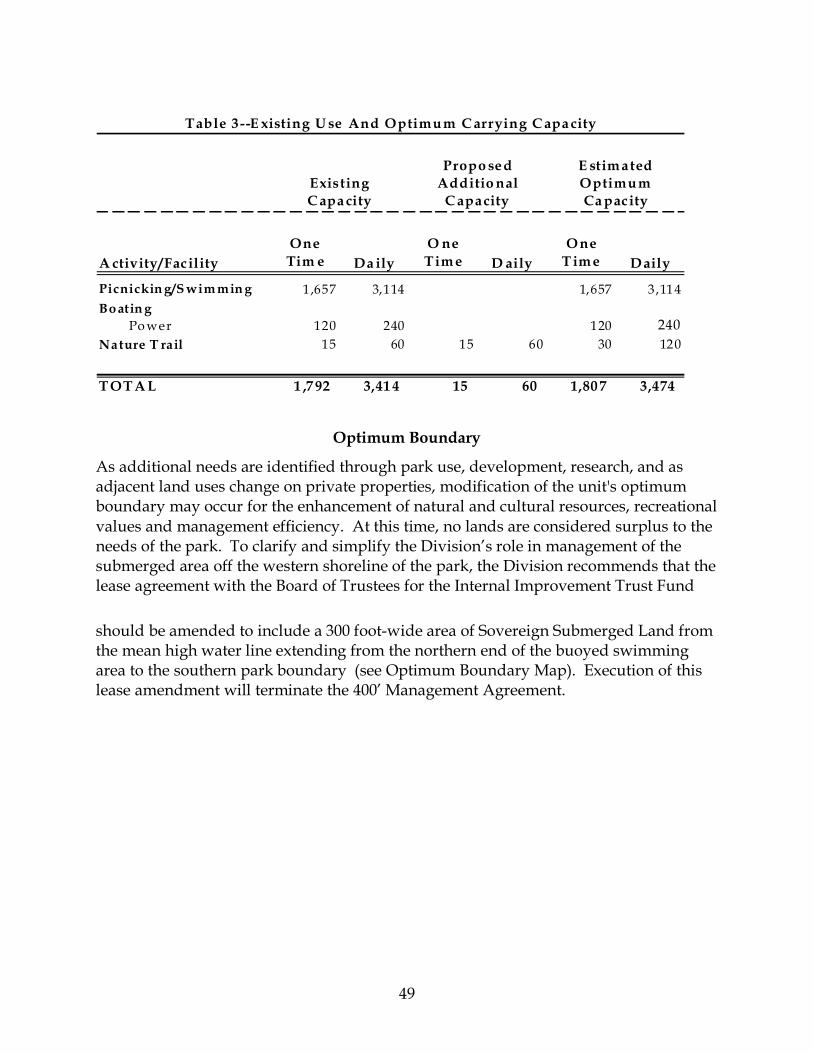
49
A ctivity/FacilityOne
Tim e Da ilyO ne Tim e D aily
O ne T im e D aily
Picnickin g/S wim min g 1,657 3,114 1,657 3,114Bo atin g Po wer 120 240 120 240Nature T rail 15 60 15 60 30 120
T OT A L 1 ,7 92 3,41 4 15 60 1,80 7 3,474
Propo sed Additio nal
C apacityExisting C apa city
E stim ated Optimum Ca pacity
Table 3 --E xisting U se And Optimum C arrying C apa city
Optimum Boundary
As additional needs are identified through park use, development, research, and as adjacent land uses change on private properties, modification of the unit's optimum boundary may occur for the enhancement of natural and cultural resources, recreational values and management efficiency. At this time, no lands are considered surplus to the needs of the park. To clarify and simplify the Division’s role in management of the submerged area off the western shoreline of the park, the Division recommends that the lease agreement with the Board of Trustees for the Internal Improvement Trust Fund should be amended to include a 300 foot-wide area of Sovereign Submerged Land from the mean high water line extending from the northern end of the buoyed swimming area to the southern park boundary (see Optimum Boundary Map). Execution of this lease amendment will terminate the 400’ Management Agreement.

WATER TURKEYBAY
DELNOR-WIGGINS PASSSTATE PARK
WIGGINS PASS
GULFOFMEXICO
Bluebill Ave
ParkDr
GulfshoreDr
BluebillAve
DELNOR-WIGGINS PASSSTATE PARK Florida Department of Environmental Protection
Division of Recreation and ParksOffice of Park Planning
0 510 1,020255Feet
OPTIMUM BOUNDARY MAP
LEGEND
Park BoundaryOptimum Boundary

51
IMPLEMENTATION COMPONENT
The resource management and land use components of this management plan provide a thorough inventory of the park’s natural, cultural and recreational resources. They outline the park’s management needs and problems, and recommend both short and long-term objectives and actions to meet those needs. The implementation component contains a report on the Division’s progress toward achieving resource management, operational and capital improvement goals and objectives since approval of the previous management plan for this park. This component also compiles the management goals, objectives and actions expressed in the separate parts of this management plan for easy review. Estimated costs for the 10-year period of this plan are provided for each action and objective, and the costs are summarized under standard categories of land management activities.
MANAGEMENT PROGRESS
Since the approval of the last management plan for Delnor-Wiggins Pass State Park in 2000, significant work has been accomplished and progress made towards meeting the Division’s management objectives for the park. These accomplishments fall within three of the five general categories that encompass the mission of the park and the Division.
Resource Management
• Successfully restored maritime hammock communities using native plantings such as sea grape, strangler fig, and gumbo limbo.
• Restored five acres of maritime hammock infested with invasive plant species by treating 1,160 Brazilian peppers and other exotic species.
• Successfully reduced invasive plant infestation to maintenance phase throughout the park.
• Treated 40 acres of Brazilian pepper and Australian pines on the barrier island parcel through a contract with Southwest Florida Water Management District.
• Planted 189,000 sea oats as part of a Post Hurricane Dune Recovery Project with funds from the Florida Legislature.
• Successfully partnered with the Estuary Conservation Association in 2006, which resulted in the survey of sea grass beds within the Park boundaries.
• Participated in the FWCC sea turtle nest index-monitoring program. • Collected 106 herbarium specimens for the District 4 Administration and
University of South Florida collections. • Expanded the wildlife inventory records for the park.
Recreation and Visitor Services
• Contracted out multiple concessions for visitor use with food service, merchandise and rentals.
• Instituted an annual Citizen Support Organization (CSO) sponsored Family

52
Discovery Day, an art show and other special events to increase awareness about the state park and natural areas.
• Increased interpretive programming from once a week to two programs a week during the summer season.
• Partnered with outside institutions in holding several children’s fishing contests.
Park Facilities and Operations
• Rebuilt many boardwalks, upgrading them to the ADA specifications at the time of completion.
• Rebuilt the louvers on the west side of all five bath houses with funding and help of the CSO.
• Rebuilt many of the handrails and supports with funding and labor from the CSO. • Rebuilt both docks at the boat ramp. • Rebuilt the top deck and other decking on the observation tower. • Installed waterless urinals in five bathhouses. • Installed new steel gate along with security light at entrance to park. • Worked with Collier County to install a lighted sign at the corner of Vanderbilt
Drive and Bluebill Avenue that notifies visitors when the park is full due to capacity.
• Upgraded all parking to ADA specifications in 2007 and 2008. • Developed one trail according to the Universal Trail Assessment Process with
ADA signage in 2008.
MANAGEMENT PLAN IMPLEMENTATION
This management plan is written for a timeframe of ten years, as required by Section 253.034 Florida Statutes. The Ten-Year Implementation Schedule and Cost Estimates (Table 4) summarize the management goals, objectives and actions that are recommended for implementation over this period. Measures are identified for assessing progress toward completing each objective and action. A time frame for completing each objective and action is provided. Preliminary cost estimates for each action are provided and the estimated total costs to complete each objective are computed. Finally, all costs are consolidated under the following five standard land management categories: Resource Management, Administration and Support, Capital Improvements, Recreation Visitor Services and Law Enforcement. Many of the actions identified in the plan can be implemented using existing staff and funding. However, a number of actions have been identified that are unlikely to be carried out during the life of this plan unless additional resources are provided. The 10-year Implementation Schedule and Cost Estimates table therefore includes both “funded” and “unfunded” needs. The administration of the state park is an ongoing cost that will increase in the future as additional staff, programs and responsibilities are assigned. These administrative costs
53
include a variety of activities, such as the administration of personnel, the management of vendors and contractors for all the park’s supply and service needs and the coordination of the park’s Citizen Support Organization, to name a few. The plan’s recommended actions, time frames and cost estimates will guide the Division’s planning and budgeting activities over the period of this plan. It must be noted that these recommendations are based on the information that exists at the time the plan was prepared. A high degree of adaptability and flexibility must be built into this process to ensure that the Division can adjust to changes in the availability of funds, improved understanding of the park’s natural and cultural resources, and changes in statewide land management issues, priorities and policies. Statewide priorities for all aspects of land management are evaluated each year as part of the process for developing the Division’s annual legislative budget requests. When preparing these annual requests, the Division considers the needs and priorities of the entire state park system and the projected availability of funding from all sources during the upcoming fiscal year. In addition to annual legislative appropriations, the Division pursues supplemental sources of funds and staff resources wherever possible, including grants, volunteers and partnerships with other entities. The Division’s ability to accomplish the specific actions identified in the plan will be determined largely by the availability of funds and staff for these purposes, which may vary from year to year. . Consequently, the target schedules and estimated costs identified in Table 4 may need to be adjusted during the 10-year management planning cycle.

54
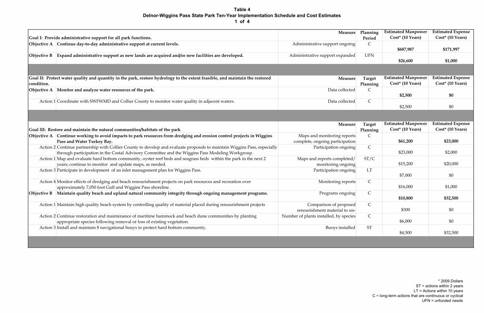
Table 4Delnor-Wiggins Pass State Park Ten-Year Implementation Schedule and Cost Estimates
1 of 4
Measure Planning Period
Estimated Manpower Cost* (10 Years)
Estimated Expense Cost* (10 Years)
Objective A Continue day-to-day administrative support at current levels. Administrative support ongoing C$687,987 $171,997
Objective B Expand administrative support as new lands are acquired and/or new facilities are developed. Administrative support expanded UFN$26,600 $1,000
Measure Target Planning
Estimated Manpower Cost* (10 Years)
Estimated Expense Cost* (10 Years)
Objective A Monitor and analyze water resources of the park. Data collected C$2,500 $0
Action 1 Coordinate with SWFWMD and Collier County to monitor water quality in adjacent waters. Data collected C$2,500 $0
Measure Target Planning
Estimated Manpower Cost* (10 Years)
Estimated Expense Cost* (10 Years)
Objective A Continue working to avoid impacts to park resources from dredging and erosion control projects in Wiggins Pass and Water Turkey Bay.
Maps and monitoring reports complete, ongoing participation
C$61,200 $23,000
Action 2 Continue partnership with Collier County to develop and evaluate proposals to maintain Wiggins Pass, especially through participation in the Costal Advisory Committee and the Wiggins Pass Modeling Workgroup.
Participation ongoing C$23,000 $2,000
Action 1 Map and evaluate hard bottom community, oyster reef beds and seagrass beds within the park in the next 2 years; continue to monitor and update maps, as needed.
Maps and reports completed/ monitoring ongoing
ST/C$15,200 $20,000
Action 3 Participate in development of an inlet management plan for Wiggins Pass. Participation ongoing LT$7,000 $0
Action 4 Monitor effects of dredging and beach renourishment projects on park resources and recreation over approximately 7,050 foot Gulf and Wiggins Pass shoreline .
Monitoring reports C$16,000 $1,000
Objective B Maintain quality beach and upland natural community integrity through ongoing management programs. Programs ongoing C$10,800 $32,500
Action 1 Maintain high quality beach system by controlling quality of material placed during renourishment projects Comparison of proposed renourishment material to un-
C$300 $0
Action 2 Continue restoration and maintenance of maritime hammock and beach dune communities by planting appropriate species following removal or loss of existing vegetation.
Number of plants installed, by species C$6,000 $0
Action 3 Install and maintain 8 navigational bouys to protect hard bottom community. Buoys installed ST$4,500 $32,500
Goal I: Provide administrative support for all park functions.
Goal II: Protect water quality and quantity in the park, restore hydrology to the extent feasible, and maintain the restored condition.
Goal lII: Restore and maintain the natural communities/habitats of the park
* 2009 DollarsST = actions within 2 years
LT = Actions within 10 yearsC = long-term actions that are continuous or cyclical
UFN = unfunded needs
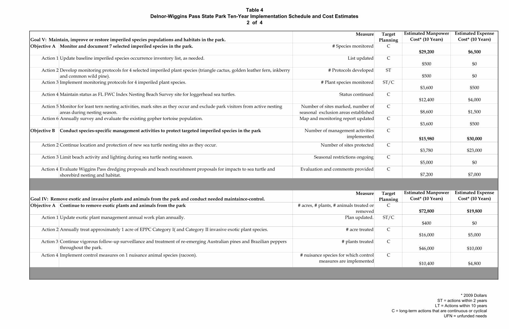
Table 4Delnor-Wiggins Pass State Park Ten-Year Implementation Schedule and Cost Estimates
2 of 4
Measure Target Planning
Estimated Manpower Cost* (10 Years)
Estimated Expense Cost* (10 Years)
Objective A Monitor and document 7 selected imperiled species in the park. # Species monitored C$29,200 $6,500
Action 1 Update baseline imperiled species occurrence inventory list, as needed. List updated C$500 $0
Action 2 Develop monitoring protocols for 4 selected imperiled plant species (triangle cactus, golden leather fern, inkberry and common wild pine).
# Protocols developed ST$500 $0
Action 3 Implement monitoring protocols for 4 imperiled plant species. # Plant species monitored ST/C$3,600 $500
Action 4 Maintain status as FL FWC Index Nesting Beach Survey site for loggerhead sea turtles. Status continued C$12,400 $4,000
Action 5 Monitor for least tern nesting activities, mark sites as they occur and exclude park visitors from active nesting areas during nesting season.
Number of sites marked, number of seasonal exclusion areas established
C$8,600 $1,500
Action 6 Annually survey and evaluate the existing gopher tortoise population. Map and monitoring report updated C$3,600 $500
Objective B Conduct species-specific management activities to protect targeted imperiled species in the park Number of management activities implemented
C
$15,980 $30,000Action 2 Continue location and protection of new sea turtle nesting sites as they occur. Number of sites protected C
$3,780 $23,000Action 3 Limit beach activity and lighting during sea turtle nesting season. Seasonal restrictions ongoing C
$5,000 $0Action 4 Evaluate Wiggins Pass dredging proposals and beach nourishment proposals for impacts to sea turtle and
shorebird nesting and habitat.Evaluation and comments provided C
$7,200 $7,000
Measure Target Planning
Estimated Manpower Cost* (10 Years)
Estimated Expense Cost* (10 Years)
Objective A Continue to remove exotic plants and animals from the park # acres, # plants, # animals treated or removed
C$72,800 $19,800
Action 1 Update exotic plant management annual work plan annually. Plan updated. ST/C$400 $0
Action 2 Annually treat approximately 1 acre of EPPC Category I( and Category II invasive exotic plant species. # acre treated C$16,000 $5,000
Action 3 Continue vigorous follow-up surveillance and treatment of re-emerging Australian pines and Brazilian peppers throughout the park.
# plants treated C$46,000 $10,000
Action 4 Implement control measures on 1 nuisance animal species (racoon). # nuisance species for which control measures are implemented
C
$10,400 $4,800
Goal V: Maintain, improve or restore imperiled species populations and habitats in the park.
Goal IV: Remove exotic and invasive plants and animals from the park and conduct needed maintaince-control.
* 2009 DollarsST = actions within 2 years
LT = Actions within 10 yearsC = long-term actions that are continuous or cyclical
UFN = unfunded needs
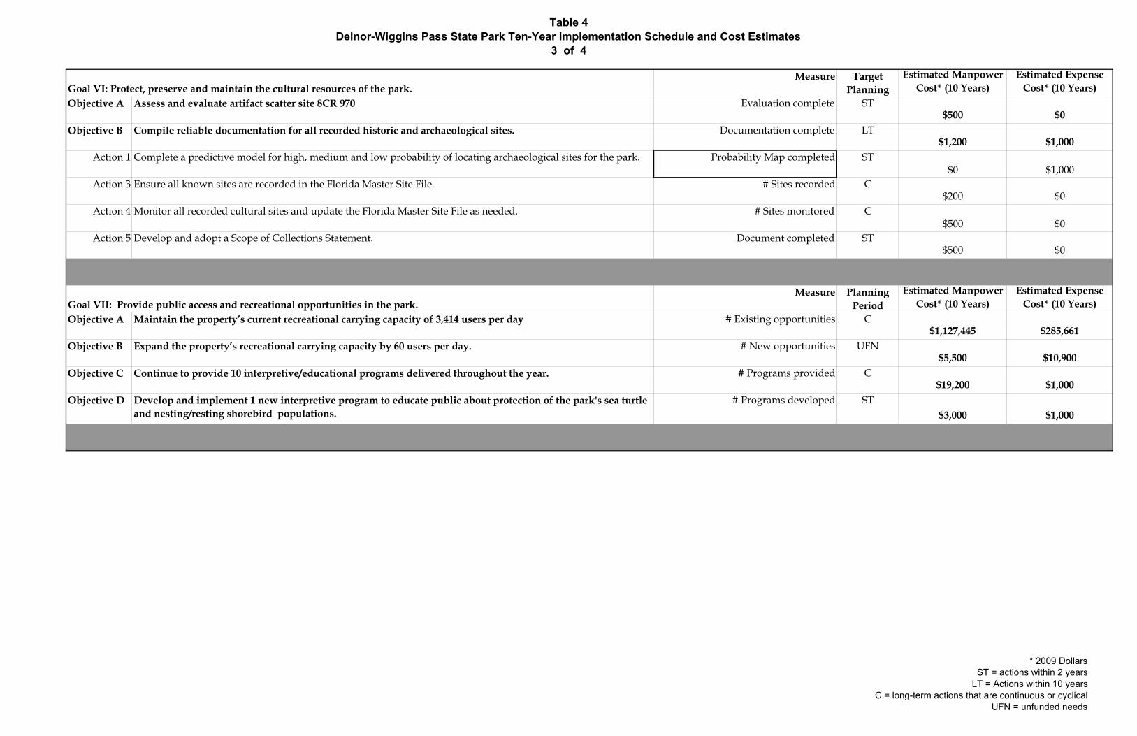
Table 4Delnor-Wiggins Pass State Park Ten-Year Implementation Schedule and Cost Estimates
3 of 4
Measure Target Planning
Estimated Manpower Cost* (10 Years)
Estimated Expense Cost* (10 Years)
Objective A Assess and evaluate artifact scatter site 8CR 970 Evaluation complete ST$500 $0
Objective B Compile reliable documentation for all recorded historic and archaeological sites. Documentation complete LT$1,200 $1,000
Action 1 Complete a predictive model for high, medium and low probability of locating archaeological sites for the park. Probability Map completed ST$0 $1,000
Action 3 Ensure all known sites are recorded in the Florida Master Site File. # Sites recorded C$200 $0
Action 4 Monitor all recorded cultural sites and update the Florida Master Site File as needed. # Sites monitored C$500 $0
Action 5 Develop and adopt a Scope of Collections Statement. Document completed ST$500 $0
Measure Planning Period
Estimated Manpower Cost* (10 Years)
Estimated Expense Cost* (10 Years)
Objective A Maintain the property’s current recreational carrying capacity of 3,414 users per day # Existing opportunities C$1,127,445 $285,661
Objective B Expand the property’s recreational carrying capacity by 60 users per day. # New opportunities UFN$5,500 $10,900
Objective C Continue to provide 10 interpretive/educational programs delivered throughout the year. # Programs provided C$19,200 $1,000
Objective D Develop and implement 1 new interpretive program to educate public about protection of the park's sea turtle and nesting/resting shorebird populations.
# Programs developed ST$3,000 $1,000
Goal VI: Protect, preserve and maintain the cultural resources of the park.
Goal VII: Provide public access and recreational opportunities in the park.
* 2009 DollarsST = actions within 2 years
LT = Actions within 10 yearsC = long-term actions that are continuous or cyclical
UFN = unfunded needs
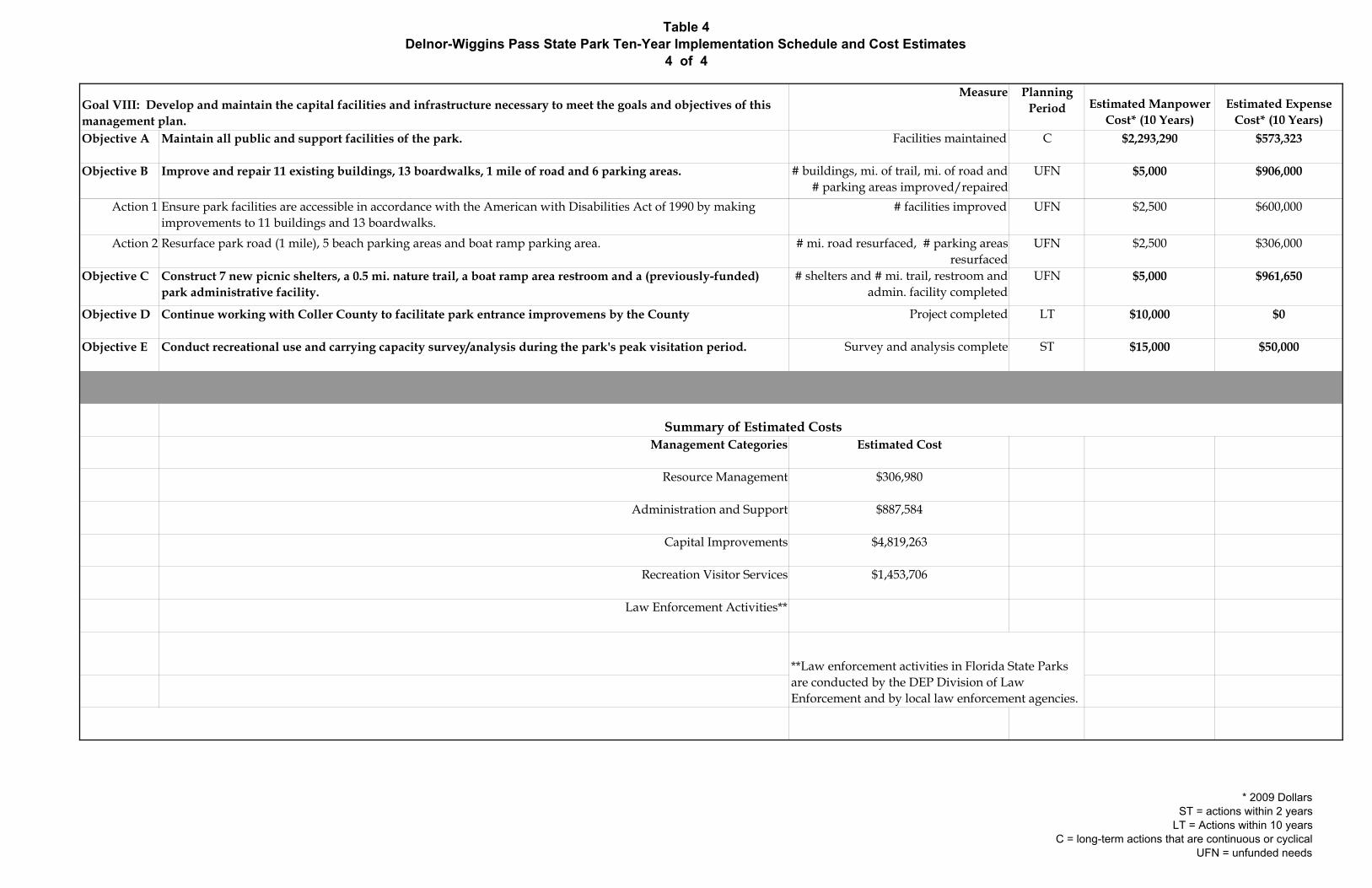
Table 4Delnor-Wiggins Pass State Park Ten-Year Implementation Schedule and Cost Estimates
4 of 4
Measure Planning Period Estimated Manpower
Cost* (10 Years)Estimated Expense
Cost* (10 Years)Objective A Maintain all public and support facilities of the park. Facilities maintained C $2,293,290 $573,323
Objective B Improve and repair 11 existing buildings, 13 boardwalks, 1 mile of road and 6 parking areas. # buildings, mi. of trail, mi. of road and # parking areas improved/repaired
UFN $5,000 $906,000
Action 1 Ensure park facilities are accessible in accordance with the American with Disabilities Act of 1990 by making improvements to 11 buildings and 13 boardwalks.
# facilities improved UFN $2,500 $600,000
Action 2 Resurface park road (1 mile), 5 beach parking areas and boat ramp parking area. # mi. road resurfaced, # parking areas resurfaced
UFN $2,500 $306,000
Objective C Construct 7 new picnic shelters, a 0.5 mi. nature trail, a boat ramp area restroom and a (previously-funded) park administrative facility.
# shelters and # mi. trail, restroom and admin. facility completed
UFN $5,000 $961,650
Objective D Continue working with Coller County to facilitate park entrance improvemens by the County Project completed LT $10,000 $0
Objective E Conduct recreational use and carrying capacity survey/analysis during the park's peak visitation period. Survey and analysis complete ST $15,000 $50,000
Management Categories Estimated Cost
Resource Management $306,980
Administration and Support $887,584
Capital Improvements $4,819,263
Recreation Visitor Services $1,453,706
Law Enforcement Activities**
**Law enforcement activities in Florida State Parks are conducted by the DEP Division of Law Enforcement and by local law enforcement agencies.
Summary of Estimated Costs
Goal VIII: Develop and maintain the capital facilities and infrastructure necessary to meet the goals and objectives of this management plan.
* 2009 DollarsST = actions within 2 years
LT = Actions within 10 yearsC = long-term actions that are continuous or cyclical
UFN = unfunded needs
Addendum 1—Acquisition History and Advisory Group Report

Delnor-Wiggins Pass State Park Acquisition History
A 1 - 1
Purpose of Acquisition The State of Florida Board of Trustees of the Internal Improvement Trust Fund (Trustees) acquired Delnor-Wiggins Pass State Park (Park) to retain the property for permanent open-space purposes to be used for park, recreation, conservation of natural and cultural resources, and scenic purposes. Sequence of Acquisition On April 13, 1965, Collier County (County), a political subdivision of the state of Florida, received a letter from the U.S. Department of Housing and Urban Development (HUD) authorizing the County to purchase open-space land with the understanding that HUD would refund the County for 50 percent of the purchase price. On April 29, 1965, the County purchased a 166-acre property located in Collier County, now known as Delnor-Wiggins Past State Park, from St. Charles Charities, an Illinois corporation not for profit, for $519,986.00. On June 1, 1966, HUD and the County executed a CONTRACT FOR GRANT TO ACQUIRE AND/OR DEVELOP LAND FOR OPEN-SPACE PURPOSES where HUD agreed to pay the County 50 percent of the purchase price of the 166-acre property. On June 16, 1970, the Trustees, HUD and the County signed a memorandum of agreement that allowed the County to transfer its title interest in the 166-acre property as well its obligation to develop and retain this property as open-space land to the Trustees. The Trustees agreed to acquire title interest in the property and develop and manage the property as open-space land. On September 8, 1970, the County transferred title interest to the Trustees. On the same day, the County also transferred its open-space land contract with HUD to the Trustees for a consideration of $271,949.66. The Trustees financed this transaction with funds from the Outdoor Recreation Development Council. Since this acquisition, the Trustees have not acquired any new lands to add to Delnor-Wiggins Pass State Park. The area of this park has not changed. Management Leases On January 27, 1971, the Trustees leased Delnor-Wiggins Pass State Park to what is now the State of Florida Department of Environmental Protection, for the use and benefit of the Division of Recreation and Parks (Division), under Lease No. 2514. Lease No. 2514, which is for a period of ninety-nine (99) years, will expire on January 26, 2070. According to Lease No. 2514, the Division manages Delnor-Wiggins Pass State Park for the purposes of preserving, developing, operating and maintaining the property for public outdoor recreational, park, conservation and related purposes.

Delnor-Wiggins Pass State Park Acquisition History
A 1 - 2
Title Interest The Trustees hold fee simple title to Delnor-Wiggins Pass State Park. Special Conditions on Use Delnor-Wiggins Pass State Park is designated single-use to provide public outdoor recreation and other park related uses. Uses such as water resource development projects, water supply projects, storm-water management projects, and linear facilities and sustainable agriculture and forestry (other than those forest management activities specifically identified in this plan) are not consistent with this plan. Outstanding Reservations Lease No. 2514 from the Trustees stipulates that the property will be used for public outdoor recreation and related purposes. Following is a listing of outstanding rights, reservations and encumbrances that apply to Delnor-Wiggins Pass State Park. Type of Instrument: ..................................Easement Instrument Holder: ...................................Florida Power and Light Company Beginning Date: ........................................ July 24, 1976 Ending Date:..............................................Coterminous with the term of Lease No. 2514. Outstanding Rights, Uses, Etc.: ...............The Trustees granted the easement to Florida Power and Light Company for the purposes of constructing, installing, operating and maintaining a single and/or three-phase distribution system for the transmission and distribution of electricity. The easement is subject to automatic termination when the subject property is not used for the purposes outlined in the instrument. Type of Instrument: ..................................Deed Instrument Holder: ...................................The Board of County Commissioners of Collier
County Beginning Date: ........................................September 8, 1970 Ending Date:..............................................Perpetual Outstanding Rights, Uses, Etc.: ...............This deed from the Board of County Commissioners of Collier County (Deed) is subject to the condition and restrictions that a strip of land 200 feet in width running across the entire width of the property conveyed by the Deed (Property) from the Gulf of Mexico Shore East to the side Westerly of the agreed boundary line lying immediately south of Wiggins Pass along the North side of the Property shall not be used in any way whatever which shall be a nuisance to the owners or interfere with the use and enjoyment by owners of the land lying North of Wiggins Pass.
Delnor-Wiggins Pass State Park 2009 Management Plan Advisory Group
A 1 - 3
The Honorable Frank Halas Collier County Board of County Commissioners 3301 East Tamiami Trail Administration Building, Building F Naples, Florida 34112 Stan Weiner, P.E., Chairman Collier Soil and Water Conservation District 9881 Clear Lake Circle Naples, Florida 34109-0787 Ricardo Zambrano, Regional Biologist South Region Fish and Wildlife Conservation Commission 8535 Northlake Boulevard West Palm Beach, Florida 33412 Mr. Kevin Podkowka Caloosahatchee District Office Florida Division of Forestry 10941 Palm Beach Boulevard Fort Myers, Florida 33905 Bill Eline, President Vanderbilt Beach Property Owners Association 2125 Aberdeen Lane, Unit 101 Naples, FL 34109 Doug Fee, President North Bay Civic Association Post Office Box 770273 Naples, Florida 34107 Mr. Joseph Carufe Recreational User 5920 Standing Oaks Lane Naples, Florida 34119
Mr. Kevin Dugan Recreational User 11611 Useppa Court Naples, Florida 34110 Mr. Fred Eckert Recreational Boater 14075 Tivoli Terrace Bonita Springs, Florida 34135 Mr. Brad Cornell Collier County Audubon Society 1020 8th Avenue South, Suite 2 Naples, Florida 34102 Mr. John Swingle Sierra Club, Calusa Chapter 2717 Royal Palm Avenue Fort Myers, Florida 33901
Ms. Nicole Ryan Governmental Relations Coordinator Conservancy of Southwest Florida 1450 Merrihue Drive Naples, Florida 34102 Dick Liden, President Supporters of Delnor-Wiggins Park, Inc. 1829 Pondside Lane Naples, Florida 34109 Robert Steiger, Park Manager Delnor-Wiggins Pass State Park 11135 Gulf Shore Drive North Naples, Florida 34108

Delnor-Wiggins Pass State Park 2009 Management Plan Advisory Group
A 1 - 4
Delnor-Wiggins Pass State Park 2009 Advisory Group Staff Report
A 1 - 5
The Advisory Group meeting to review the proposed land management plan for Delnor-Wiggins Pass State Park was held at St. John the Evangelist Catholic Church on Thursday, February 19 at 9:00 a.m. Ms. Peggy Dugan represented Mr. Kevin Dugan and Ms. Susan Snyder represented Mr. Bill Eline. Mr. Ricardo Zambrano did not attend due to travel restrictions. All other appointed members attended the meeting. Attending Division of Recreation and Parks staff were Valinda Subic, Albert Gregory, Sally Braem and Lew Scruggs. Attending Collier County staff were Marla Ramsey, Administrator, Collier County Department of Public Services and Gary McAlpin, Director, Collier County Coastal Zone Management Mr. Gregory began the meeting by explaining the purpose of the Advisory Group and reviewing the meeting agenda. He provided a brief overview of the Division's planning process and summarized public comments received during the previous evening’s public workshop. He clarified the Division’s position on Australian pine trees in the park, referring to language in the draft management plan that states that mature trees will not be removed from the park until they die or become unsafe, and reiterated that mature pines will not be removed to allow construction of new structures, such as the picnic shelters and concession chickees proposed by the plan, unless otherwise required by local regulations. Mr. Gregory read the attached letter regarding the County’s proposal to build a parking garage in the park to clarify the scope and intent of the process that has been agreed to by the two parties. He then asked each member of the advisory group to express his or her comments on the draft management plan. Summary of Advisory Group Comments Collier County – Commissioner Frank Halas noted that there seemed to be some confusion at the public workshop the previous evening on the number of times the park is typically closed each year when parking capacity is reached, and the duration of those closures. He stated that congestion problems are severe enough that Collier County has spent $170,000 during the past 5 years to post a Deputy Sheriff at the intersection of Bluebill Avenue and Gulfshore Drive during peak days to manage the traffic congestion. He pointed out that the Vanderbilt Inn operated on the property now being developed for the Moraya Bay Towers and was also a significant generator of traffic because public beach access was provided by that business. He explained that major population growth has occurred in the northern parts of Collier County and will continue. Therefore, the demand for public beach access will continue to increase. He noted that planning decisions that were made 30 to 40 years ago did not anticipate today’s demand for access. He explained that the Pelican Bay area (south of the park) has 3 miles of privately-owned beach the County has been faced with opposition of the landowners to the provision of public access, and that the County has tried to provide a shuttle system to bring the public to beach access walkways along Vanderbilt Beach in the past, but encountered strong opposition to that effort by the private landowners along the beach, as well.
Delnor-Wiggins Pass State Park 2009 Advisory Group Staff Report
A 1 - 6
Mr. Halas said that the County and the state need to find the best way to collaborate to provide citizens and tourist access to the beaches in Collier County. He noted that the County’s Tourism Development Commission collects some $14 million annually, some of which is available to develop the infrastructure needed to improve beach access. He expressed hope that all parties will be able come to a consensus and move forward to improve beach access, while protecting the environmental qualities of the state park. Mr. Halas also said that he is concerned about comments made in the draft management plan regarding impacts to park resources that may result from the County’s management activities in Wiggins Pass. He stated that the County is actively working with the Division and with other state agencies, local groups and concerned citizens to minimize those impacts, and to avoid management measures in the pass that would involve the use of permanent structures. Near the end of the meeting, Mr. Halas again explained that Collier County had tried to establish a shuttle system to move beachgoers to each of the public access points along Gulfshore Drive, and discontinued the effort after some local residents rose up in opposition. He said that it is a dilemma that the public seems to be opposed to every solution to the beach access problem. Yet, he noted, the University of Florida’s population estimates predict that Collier County may achieve a population of 1 million persons by the time it is built-out. Mr. Halas said that he understands that few people are in favor of the parking garage concept. He suggested that the County should revisit the shuttle option to see if the level of resident opposition to that option remains as high as it appeared to be in the past. Collier Soil and Water Conservation District – Mr. Stan Weiner asked if the park’s capacity problems are seasonal or year-round. Staff explained that the park closes mainly during the winter season from January to Easter, typically from 11:00 AM to 2:00 or 3:00 PM, and on major summer holidays, such as July 4th. When closures occur, cars are allowed in one at a time as cars depart from the park, as directed by Department policy. Mr. Weiner asked what amount of revenue is generated by the park, and staff replied that, on average, about $500,000 per year is collected. (From Division records, Delnor-Wiggins Pass State Park revenues for Fiscal Year (FY) 2006-07 were $562,988 with an attendance of 461,819 and for FY 2007-08 were $567,377 with an attendance of 480,514.) He asked if the numbers of visitors walking into the park and arriving by boat are included in annual attendance figures. Staff responded that these quantities are included. Staff explained that, on average, an estimated 36% of the number of visitors who arrive by vehicle have been counted walking into the park from the south, although this volume has decreased since the opening of the parking garage at Vanderbilt Beach. Staff also explained and that approximately 12,000 visitors arrive by boat, annually. Mr. Gregory pointed out that new patterns of visitor use will develop after improvements at the park entrance and other adjacent land use changes are
Delnor-Wiggins Pass State Park 2009 Advisory Group Staff Report
A 1 - 7
completed, and that this is the essence of the current issue. Ms. Ramsey, said that completion of the park’s entrance improvements will be approximately 12 months from now. Mr. Weiner noted that it may be 2 years in the future before the visitor use study recommended by the draft management plan could be completed. Mr. Weiner asked for information on the periodic dredging of Wiggins Pass. Mr. McAlpin explained that the Pass is on an approximately 2-year cycle for maintenance dredging (outside the pass, only). He said that a modeling study is being completed to address erosion and boater safety issues. Mr. Weiner asked if plans are to enlarge the pass in the future, and Mr. McAlpin responded that the controlling depth of the pass will remain at 3 feet, in accordance with the current inlet management plan. He said that the ongoing sand deposition in the pass is the major concern, and that the county has alternate deposit sites for non-beach quality sand that is not approved for deposition on the state park. Mr. Weiner concluded by stating that his agency is concerned with water quality and the imposition of roads and ditches that may divert natural hydrology in natural areas such as the state parks. Florida Fish and Wildlife Commission - Mr. Zambrano was not able to attend, but submitted comments in writing, which were read by Mr. Gregory and are attached to this report. He suggested that the Division should pre-post areas of the state park beach most suitable for least tern nesting to encourage birds to colonize the area. He suggested consideration for placing the park on the list of approved recipient sites for Gopher tortoises, depending on the outcome of the planned census in the park. Mr. Zambrano’s comments are attached. Florida Division of Forestry – Mr. Podkowka said that the draft management plan meets requirements and provides good general guidance in management of the park. He said that he is impressed that restoration of the majority of the park’s natural communities has progressed to maintenance phase. He suggested opening the park to native seed collection to benefit other land managers and to generate revenue, and said that nursery space for natural community restoration work is at a premium, suggesting that the park collaborate with other land managers to utilize the space available at the park. He suggested that fees at the park should be increased, since current fees are low in comparison to the value of the recreational opportunities provided at the park. He recommended that, where applicable, service roads should be lowered by installation of low water crossings to avoid impeding sheet flow drainage patterns in natural areas. Mr. Podkowka’s comments are attached. Vanderbilt Beach Property Owners Association – Ms. Snyder, representing Mr. Eline, noted that over 150 people attended the public workshop the previous evening, and that most attendees were against any actions that would add to the destruction of the natural environment of the park. She listed the reasons for opposition to the parking

Delnor-Wiggins Pass State Park 2009 Advisory Group Staff Report
A 1 - 8
garage, including security, litter, graffiti, unsightliness, increased traffic, fumes, noise, degradation of the quality of life for people and wildlife and noted that the density of recreational use on the beach is already high. She noted that opposition to the proposed chickees and shelters included issues with litter, attraction for raccoons, making the park like an amusement area, distraction from and destruction of the natural environment, interference with wildlife movement, impacts to stormwater runoff and hazards during thunderstorms and hurricanes. Ms. Snyder asked if the park’s carrying capacity was revised in 2000. Staff responded that the park’s original planning established the beach carrying capacity using the mid-range of the Division’s carrying capacity guidelines to set the capacity and design the parking areas. In the 2000 park management plan, the beach use carrying capacity was increased by applying the higher end of the carrying capacity guideline, based on the increased public demand for access to the park. She questioned the potential impact of the proposed service lane drop-off near Bathhouse #4, and staff explained that no vegetation or Gopher tortoises would be displaced by the proposed pavement, and that pervious pavement is recommended. Ms. Snyder pointed out that language in the draft plan regarding the recommended visitor use study was unclear. She questioned whether the intent is to build a parking garage to increase visitation to the maximum on a regular basis, or to facilitate the maximum number of visitors who can enter the park on the peak use days during the busy season. Staff responded that the intent was to address the capacity and traffic congestion problems that occur during the peak season. She asked for clarification of Commissioner Halas’s mention of revenue from the parking garage going to Collier County, and asked if a parking fee would be applied. Ms. Ramsey responded that the County was referring to Mr. Mudd’s proposal that the state pay to the County the amount of any increased gate receipts that would result from the addition of parking capacity in the park by construction of a parking garage. Mr. Gregory re-read a portion of the letter signed by Director Bullock and County Administrator Mudd, which refers to the discussion of increased park revenue going to the County to pay for construction costs of the proposed parking garage, but that states that no consensus on that question has been reached, and additional discussion on the issue will be needed. Ms. Snyder quoted statements from the management plan that she considers to be admirable regarding the prohibition of depletion of the park’s natural resources and preservation of resources. She noted that there seems to be two documents, one promoting preservation and the other promoting building facilities and increasing use. She suggested that only one concession chickee should be located centrally in the park, and that all other proposed development should be removed from the plan. She also recommended that the plan should address the need to update the park’s bathhouses to
Delnor-Wiggins Pass State Park 2009 Advisory Group Staff Report
A 1 - 9
keep pace with the increased use they are receiving. Mr. Gregory responded by describing the Division’s dual mission of protecting and managing natural and cultural resources, and providing high-quality recreation opportunities. Ms. Snyder provided corrections for a number of errors in the draft plan. Her notes area attached. Recreational User Representative – Mr. Carufe said that he is a 25-year patron of the park. He said that he has seen a decline in the presence of wildlife in the park as development has encroached around the property, and estimates that there are now about 50 percent of the populations of all species that could be observed here in the past. He noted the tremendous impact of litter in the park after busy weekends, and pointed out that an addition of 200 parking spaces could equate to over 500 additional visitors in the park. Mr. Carufe said that more structures are unnecessary at the state park. He suggested that the demand for public use should be diverted to Vanderbilt Beach, to City of Naples beaches and to the County’s Barefoot Beach Preserve. He stated that the state park is at its maximum now, and that this area should be left alone, because the proposed development will have an even larger negative effect on the natural resources of the park. North Bay Civic Association – Mr. Fee noted that the Collier County Commission has recently denied the development of a controversial local private beach club, and pointed out that an incremental encroachment of development on the barrier islands has led and will continue to lead to losses of irreplaceable resources. Mr. Fee agreed that the public has spoken against the idea of the parking garage, and urged the Division to look at alternatives. He noted that this would be the first parking garage in a state park, and asked, if approved here, will parking garages be constructed in other beach parks in the state park system. Mr. Fee provided Division staff with excerpts from Collier County’s comprehensive plan and zoning documents that apply to the state park, and suggested that the types of development proposed by the draft plan are not allowed within the Conservation land use and zoning classifications that apply to the park. Mr. Fee asked if the Division was eliminating its jurisdiction over the flood shoal in Wiggins Pass since the 400-foot management agreement boundary was not mapped on the park base map. He asked for explanation of the 400-foot management agreement mentioned in the Introduction of the draft plan. Mr. Gregory explained the purpose of the Division’s 400-foot management agreement with the Trustees (primarily, to provide limited authorization to manage recreation and protect public safety over state-owned submerged lands adjacent to state parks). Mr. Fee expressed concern that there is a move afoot to build permanent structures to manage Wiggins Pass. Mr. Gregory responded that the Division is not in favor of permanent structures on the inlet, and provided explanation that the 400-foot boundary does not apply to regulatory

Delnor-Wiggins Pass State Park 2009 Advisory Group Staff Report
A 1 - 10
issues related to the maintenance of navigation. He asked County staff if the parking garage and other structures recommended in the draft plan were allowable under the local development regulations. Mr. McAlpin said that he believed they were, and that the project will be taken through the County’s development review process at the appropriate time. Recreational User Representative - Ms. Dugan said that she is a 20-year resident of the area. She said that there is large public opposition to the idea of a parking garage, noting that it’s addition will not control the number of visitors in the park on peak days, and urged the Division to reconsider. She also expressed opposition to construction of chickees and shelters in the park. Recreational User Representative – Mr. Eckert said that he had talked to a number of boaters using the park in preparation for the advisory group meeting. He pointed out that the one quarter-mile distance from the boat ramp to the nearest restroom is inconvenient for users. He said the new ADA chair lift for boaters is a major improvement for the park. He observed that the canoe/kayak launch adjacent to the boat ramp is getting increasing use, which may lead to user conflicts. He suggested that the fish cleaning table should be either replaced or removed, since it is not functional in its current state. Mr. Eckert noted that the beach area designation as a no fishing zone is not often used by beachgoers during the off season and suggested that a portion of Area 1 could be opened to fishing during the off-season to allow use by both groups at appropriate times. He said that the area surrounding the park is an incredible fishery because of the configuration of the pass channel. He said that high boat speeds in the channel pose a hazard now, and will increase if the channel is made straighter in the future. Mr. Eckert deferred comment on the development proposals of the draft plan, since he was appointed to the group as a representative of the boating recreation group. Collier County Audubon Society – Mr. Cornell encouraged the park and the Division to stay involved in dredging projects in Wiggins Pass. He supported the FWC recommendation to pre-post beach areas to encourage Least tern nesting. He strongly recommended efforts in the park to educate park users about the effects of bird disturbance, and asked that monitoring of visitor interactions with birds be implemented. He said that he observes Gopher tortoises in the park regularly, and suggested that the dune areas could be managed better to provide forage for the animals. Mr. Cornell echoed concerns from the public and from other advisory group members regarding the parking garage. He recommended that parking capacity provided by Conner Park should be included in the visitor use study for the park. He stated that he is concerned that the park’s beach carrying capacity is now at its maximum, but recommended that, if additional parking is justified by the study, parking expansion should occur at Conner Park rather than in the state park.

Delnor-Wiggins Pass State Park Acquisition History
A 1 - 11
Sierra Club, Calusa Chapter – Mr. Swingle said that the Division does an exemplary job in managing the state park. He agreed that park fees should be raised to $6 or $7 per car, and would still be a bargain. He encouraged the Division to focus on maintaining existing facilities before starting new construction. He noted that the park could host outings programs, such as the Sierra Club’s program, which would provide a good source of volunteer labor for the resource management. He agreed on previous comments regarding Gopher tortoises, and recommended introduction of other species that have disappeared from the park, if possible. Conservancy of Southwest Florida – Ms. Ryan provided the attached written comments. She expressed appreciation for the opportunity to review the draft plan, and complemented the Division on the quality of work being done. She supported exploring the concept of chickee huts and/or shelters, but emphasized that the size, location and uses of proposed facilities need to be fully investigated, and urged the Division to avoid creating an amusement park character at the state park. She agreed with others that the Division needs to remain fully involved in decisions regarding management of Wiggins Pass. She provided detailed support for the following general comments:
• Additional data on current usage is needed. • Carrying capacity must be determined by counting all visitors (including visitors
who walk along the “wet’ beach). • Public access improvements underway or being planned should be completed
and their effects included in the needs assessment for additional parking. • The parking garage proposal should be removed from consideration at this time.
Supporters of Delnor-Wiggins Park, Inc – Mr. Liden presented a slideshow with aerial views of the state park beach and other beach areas south of the park, including the County’s Vanderbilt Beach access point, taken around noon on Sunday of the President’s Day holiday weekend (February 15). The presentation included an analysis of the current capacity of the state park beach calculated using widths measured at several points along its length. The calculation indicates that the beach size has decreased. Therefore, its actual carrying capacity now is approximately 1,030 persons at one time, rather than the 1,657 calculated in 2000. Mr. Liden noted that the beach size and configuration will change periodically, and that establishing the carrying capacity on a “locked-in” 10-year basis is unrealistic. Mr. Liden suggested that data on park closures is needed that includes the length of time the gate is closed and the number of people that are turned away. He agreed that maximizing public access to the beach is a priority, but that he is not sure that additional parking in the park is the answer. He said that we should demand creative solutions for all of the local beach access problems, not just the one at Delnor-Wiggins State Park. He pointed out that the state park offers a different experience, which

Delnor-Wiggins Pass State Park Acquisition History
A 1 - 12
includes shaded areas and restrooms, and that the beaches from the state park to the County’s access point at Vanderbilt Beach can and should offer a variety of experience opportunities to beachgoers. Mr. Liden provided the following recommendations:
• The Division should acknowledge that the park now exceeds its recreational carrying capacity guidelines during some peak use days.
• The Division should set an annual review date to re-evaluate the park’s beach carrying capacity based on the current conditions of the beach.
• The Division should accept that occasional crowding of visitors on the beach seems to be acceptable to the park’s patrons.
• The solution to these problems is to spread beach access and use out, not to concentrate it in one place by concentrating parking.
• That the Division should take consideration of the parking garage off the table. • That the Division should work with Collier County to find a way to disburse
beachgoers along the length of the park, as well as to beaches located to the south of the park.
Staff Recommendations A number of excellent suggestions for resource management and interpretation of natural resources in the park were provided by members of the advisory group, and will be incorporated into the next draft of the management plan. One example is the suggestion to implement a monitoring program for interactions between visitors and shorebirds and that interpretive panels be installed near potential bird resting and nesting areas that educate park visitors to the impact of human disturbance and ways to avoid that impact. Another is that a small restroom and a replacement for the fish cleaning table should be provided at the boat ramp. Typographic and factual corrections to the text of the plan provided by Ms. Snyder and Ms. Ramsey will also be made. Much concern was expressed by the advisory group and the citizens who spoke at the public workshop on the evening of February 18 regarding the plan’s proposals for new development at the park. The proposal to add seven picnic shelters and six small concession chickees along the length of the park’s main use area was described as being unnecessary, intrusive and detrimental to the park’s natural resources and to its aesthetic character. While Division staff feels that these facilities can be provided with minimal impact to the natural resources of the park, it can be agreed that concession chickees are not as important to the needs of park visitors as the proposed shelters. Shelters are recommended to provide important shade from the sun and refuge from sudden lightning storms and, more critically, to provide universally accessible recreational opportunities in the park, which is a priority for all parks in the state

Delnor-Wiggins Pass State Park Acquisition History
A 1 - 13
system. Therefore, staff recommends the elimination of the proposed chickees, but that the construction of up to seven shelters be included in the Acquisition and Restoration Council draft plan. The parking garage proposal by Collier County generated the greatest level of opposition at both the advisory group meeting and at the public workshop. Opposition to the proposal was virtually unanimous. A number of valid alternatives to construction of additional parking in the park were discussed. These included additional expansion of parking at the County’s Conner Park, establishment of a beach shuttle from Conner Park to the state park and other beach areas, and improvement of public access south of the park and at the County’s Barefoot Beach Preserve. There was general agreement that the visitor study recommended by the management plan is a critical element whether or not the parking garage concept is pursued. It was recommended by several advisory group members and workshop participants that the study must include all the parameters that will affect the park’s visitation patterns and carrying capacity, including seasonal variations in use and in the width of the beach, parking expansions at Conner Park, and others. It was also suggested that the visitor study should be done only after improvements of the park entrance and at the County’s beach access facilities on the park’s southern boundary, expansion of parking at Conner Park, and the Moraya Bay Tower condominium project have all been completed. After full consideration of all the input, Division staff recommends that the proposed parking garage should be removed from the next draft of the plan. Staff further recommends that the following text should replace discussion of the parking garage and the visitor use study in the draft plan:
The patterns of beach use at the park are complex. As in most state parks, the majority of beach users enter the park through the entrance by automobile, bicycle or on foot. On many days, however, it is common for hundreds of people to walk into the park through the southern boundary or arrive by boat at the northern tip of the park. Many of these visitors walk along the “wet beach” and have unrestricted access as long as they remain in that area. A significant number of walk-in or boat-in visitors, however, leave the “wet beach” and occupy the park’s sandy beach and use the park facilities, as do the visitors who enter through the park entrance. It is anticipated that even more people will enter the park through the southern boundary after the County completes beach access improvements and Conner Park parking expansion, and the Moraya Bay Beach Tower is completed and becomes fully occupied. To evaluate the park’s visitor use patterns, an assessment will be conducted to determine how the currently-planned improvements affect
Delnor-Wiggins Pass State Park Acquisition History
A 1 - 14
visitation patterns in the park. The assessment will document the actual area of beach available for recreational use at the time of the study, although it should be understood that that area will change from season to season, as beach erosion, accretion, or re-nourishment projects occur. The study will count the number of visitors who arrive at the park by automobile, bicycle or on foot via the park road, walk in from the south boundary and land by boat. Visitors who walk in from the south boundary or land by boat and simply walk the “wet beach” but do not enter the park will be identified but not be counted toward determining capacity. The assessment will also determine what activities visitors participate in while at the park and what daily turnover rates occur. The assessment will be conducted over at least a six-month period and timed to analyze visitation during the peak use season. The assessment will be performed after the park entrance improvements and the County beach walkway, turn-around, restroom and Conner Park parking improvements, and the Moraya Bay Towers projects are completed. The park’s beach carrying capacity will be revised based on the measurements of the beach during this assessment. The beach carrying capacity will be revised annually, if necessary, based on measurements of the actual area of beach available for recreation, taken between January 1 and February 1 of each year. The carrying capacity guideline of 200 square feet per person will be used to calculate this number to maximize the provision of beach recreation allowed at the park.
The complexity of management along dynamic shorelines such as the Gulf frontage of the state park was revealed by the discussion regarding the Division’s lease boundary along the shoreline, which is at the mean high water line, and the Division’s 400’ Management Agreement area. To clarify and simplify the Division’s role in management of the submerged area off the western shoreline of the park, staff recommends that the Division’s lease agreement with the Board of Trustees for the Internal Improvement Trust Fund should be amended to include a 300 foot-wide area of Sovereign Submerged Land from the mean high water line extending from the northern end of the buoyed swimming area to the southern park boundary (see Optimum Boundary Map). Execution of this lease amendment will terminate the 400’ Management Agreement. With these changes, Division staff recommends approval of the draft Delnor-Wiggins Pass State Park management plan, and submittal of the plan to the Acquisition and Restoration Council for further review.
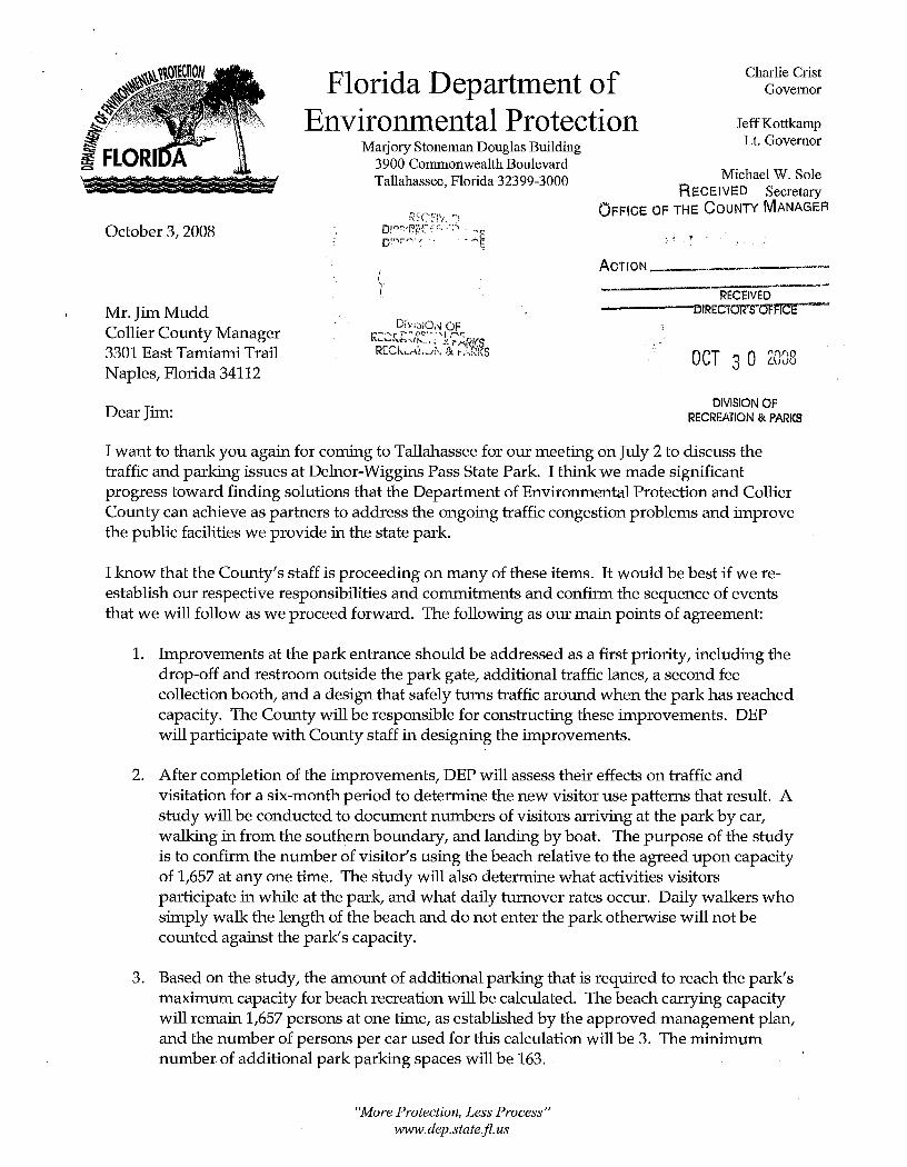

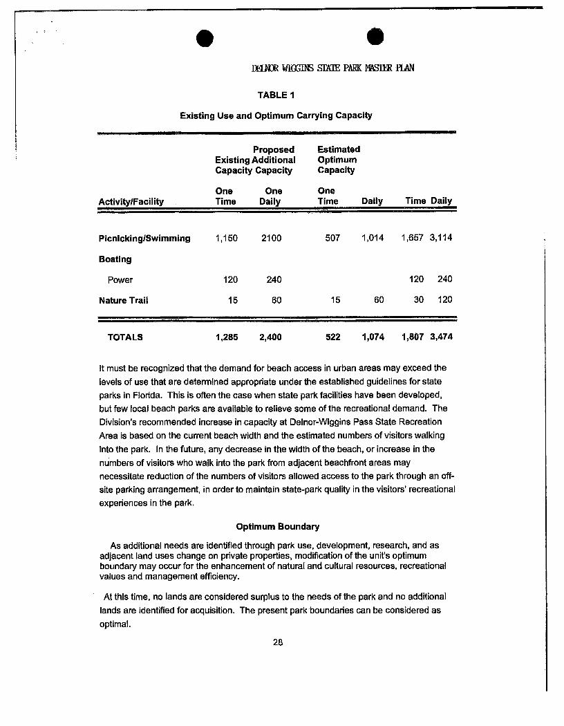


Addendum 2—References Cited

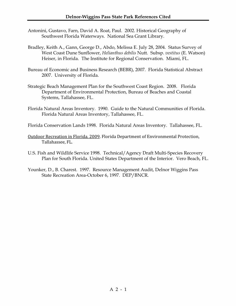
Delnor-Wiggins Pass State Park References Cited
A 2 - 1
Antonini, Gustavo, Farn, David A. Roat, Paul. 2002. Historical Geography of Southwest Florida Waterways. National Sea Grant Library.
Bradley, Keith A., Gann, George D., Abdo, Melissa E. July 28, 2004. Status Survey of
West Coast Dune Sunflower, Helianthus debilis Nutt. Subsp. vestitus (E. Watson) Heiser, in Florida. The Institute for Regional Conservation. Miami, FL.
Bureau of Economic and Business Research (BEBR), 2007. Florida Statistical Abstract
2007. University of Florida. Strategic Beach Management Plan for the Southwest Coast Region. 2008. Florida
Department of Environmental Protection, Bureau of Beaches and Coastal Systems, Tallahassee, FL.
Florida Natural Areas Inventory. 1990. Guide to the Natural Communities of Florida.
Florida Natural Areas Inventory, Tallahassee, FL. Florida Conservation Lands 1998. Florida Natural Areas Inventory. Tallahassee, FL. Outdoor Recreation in Florida. 2009. Florida Department of Environmental Protection, Tallahassee, FL. U.S. Fish and Wildlife Service 1998. Technical/Agency Draft Multi-Species Recovery
Plan for South Florida. United States Department of the Interior. Vero Beach, FL. Younker, D., B. Charest. 1997. Resource Management Audit, Delnor Wiggins Pass
State Recreation Area-October 6, 1997. DEP/BNCR.

Delnor-Wiggins Pass State Park References Cited
A 2 - 2
Addendum 3—Soil Description


Delnor-Wiggins Pass State Park Soil Description
A 3 - 1
Mangrove swamp (Mb.) - This land type occurs along the western and southwestern coast and on most of the Ten Thousand Islands. It occupies low-lying areas always covered by salt water during high tide and in some places covered even at low tide. The layers vary in color, texture, composition, and thickness. The surface layer is usually brown peat, composed of partly decayed leaves, limbs, and roots from dead mangrove trees and remains from a few other salt-tolerant plants. The peat is a few inches to several feet deep. It is underlain by light-gray or gray fine sands or marl. In places the very shallow peat layer is underlain by moderately hard limestone. The natural vegetation consists mainly of different varieties of mangrove, buttonwood, saltwort, glasswort, and a few grasses. The red mangroves occur on the outer zone of the mangrove swamps and are characterized by their many arching prop roots. These roots collect soil materials and aid materially in building the coasts farther into shallow waters, in forming islands, and in protecting the shores from storm. The soils in the red mangrove areas are nearly always flooded, even at low tides. The black and the white mangroves grow on the inshore mud flats that are usually exposed during low tide and covered by water at high tide. All of this land is covered with natural vegetation and serves as feeding and breeding ground for many birds and animals. The streams, bays, and lagoons within and adjacent to the mangrove swamps contain many fish, clams, crabs, and oysters.

Delnor-Wiggins Pass State Park Soil Description
A 3 - 2

Addendum 4—Plant and Animal List

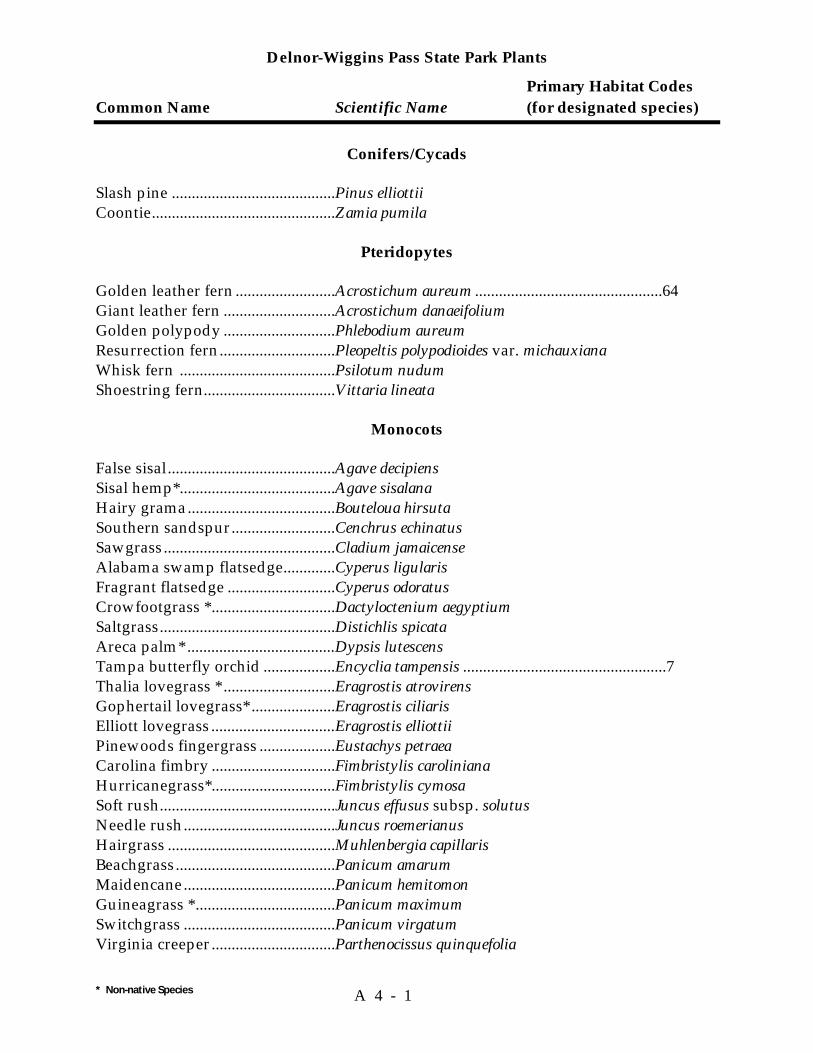
Delnor-Wiggins Pass State Park Plants
Primary Habitat Codes Common Name Scientific Name (for designated species)
* Non-native Species A 4 - 1
Conifers/Cycads
Slash pine .........................................Pinus elliottii Coontie..............................................Zamia pumila
Pteridopytes
Golden leather fern .........................Acrostichum aureum ...............................................64 Giant leather fern ............................Acrostichum danaeifolium Golden polypody ............................Phlebodium aureum Resurrection fern.............................Pleopeltis polypodioides var. michauxiana Whisk fern .......................................Psilotum nudum Shoestring fern.................................Vittaria lineata
Monocots
False sisal..........................................Agave decipiens Sisal hemp*.......................................Agave sisalana Hairy grama.....................................Bouteloua hirsuta Southern sandspur..........................Cenchrus echinatus Sawgrass...........................................Cladium jamaicense Alabama swamp flatsedge.............Cyperus ligularis Fragrant flatsedge ...........................Cyperus odoratus Crowfootgrass *...............................Dactyloctenium aegyptium Saltgrass............................................Distichlis spicata Areca palm* .....................................Dypsis lutescens Tampa butterfly orchid ..................Encyclia tampensis ...................................................7 Thalia lovegrass * ............................Eragrostis atrovirens Gophertail lovegrass* .....................Eragrostis ciliaris Elliott lovegrass ...............................Eragrostis elliottii Pinewoods fingergrass ...................Eustachys petraea Carolina fimbry ...............................Fimbristylis caroliniana Hurricanegrass*...............................Fimbristylis cymosa Soft rush............................................Juncus effusus subsp. solutus Needle rush......................................Juncus roemerianus Hairgrass ..........................................Muhlenbergia capillaris Beachgrass........................................Panicum amarum Maidencane......................................Panicum hemitomon Guineagrass *...................................Panicum maximum Switchgrass ......................................Panicum virgatum Virginia creeper...............................Parthenocissus quinquefolia
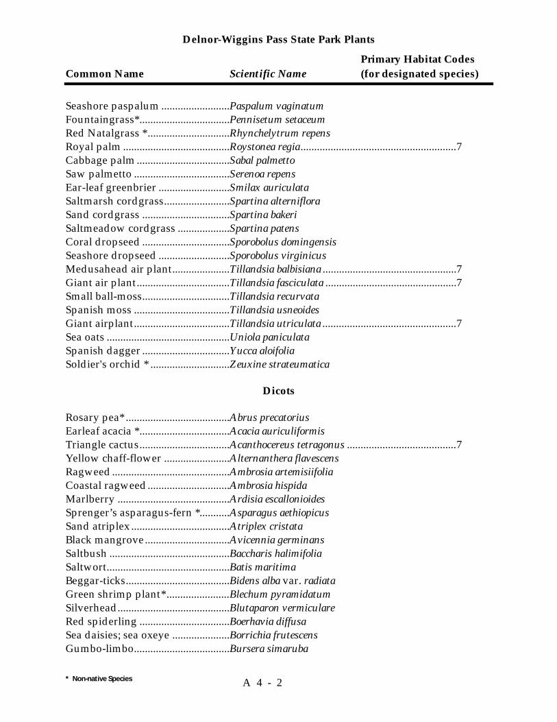
Delnor-Wiggins Pass State Park Plants
Primary Habitat Codes Common Name Scientific Name (for designated species)
* Non-native Species A 4 - 2
Seashore paspalum .........................Paspalum vaginatum Fountaingrass*.................................Pennisetum setaceum Red Natalgrass * ..............................Rhynchelytrum repens Royal palm .......................................Roystonea regia.........................................................7 Cabbage palm..................................Sabal palmetto Saw palmetto ...................................Serenoa repens Ear-leaf greenbrier ..........................Smilax auriculata Saltmarsh cordgrass........................Spartina alterniflora Sand cordgrass ................................Spartina bakeri Saltmeadow cordgrass ...................Spartina patens Coral dropseed ................................Sporobolus domingensis Seashore dropseed ..........................Sporobolus virginicus Medusahead air plant.....................Tillandsia balbisiana .................................................7 Giant air plant..................................Tillandsia fasciculata ................................................7 Small ball-moss................................Tillandsia recurvata Spanish moss ...................................Tillandsia usneoides Giant airplant...................................Tillandsia utriculata .................................................7 Sea oats .............................................Uniola paniculata Spanish dagger ................................Yucca aloifolia Soldier's orchid * .............................Zeuxine strateumatica
Dicots
Rosary pea* ......................................Abrus precatorius Earleaf acacia *.................................Acacia auriculiformis Triangle cactus.................................Acanthocereus tetragonus ........................................7 Yellow chaff-flower ........................Alternanthera flavescens Ragweed...........................................Ambrosia artemisiifolia Coastal ragweed..............................Ambrosia hispida Marlberry .........................................Ardisia escallonioides Sprenger’s asparagus-fern *...........Asparagus aethiopicus Sand atriplex ....................................Atriplex cristata Black mangrove...............................Avicennia germinans Saltbush ............................................Baccharis halimifolia Saltwort.............................................Batis maritima Beggar-ticks......................................Bidens alba var. radiata Green shrimp plant* .......................Blechum pyramidatum Silverhead.........................................Blutaparon vermiculare Red spiderling .................................Boerhavia diffusa Sea daisies; sea oxeye .....................Borrichia frutescens Gumbo-limbo...................................Bursera simaruba
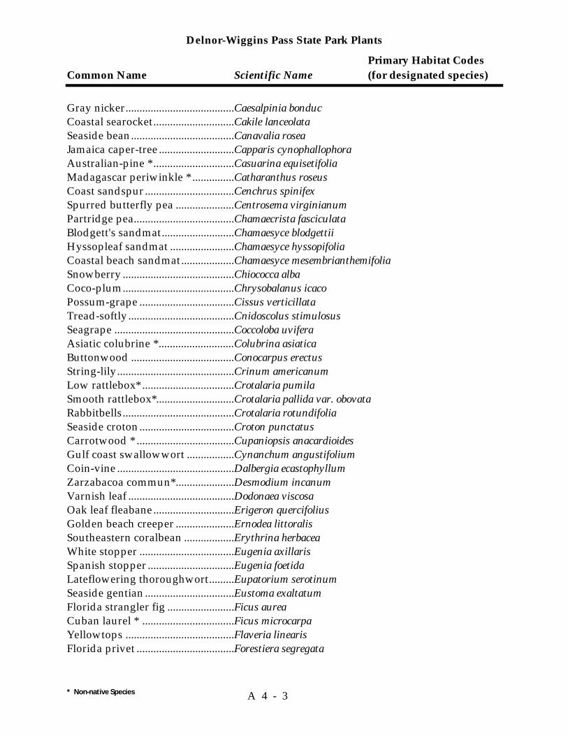
Delnor-Wiggins Pass State Park Plants
Primary Habitat Codes Common Name Scientific Name (for designated species)
* Non-native Species A 4 - 3
Gray nicker.......................................Caesalpinia bonduc Coastal searocket.............................Cakile lanceolata Seaside bean.....................................Canavalia rosea Jamaica caper-tree ...........................Capparis cynophallophora Australian-pine * .............................Casuarina equisetifolia Madagascar periwinkle * ...............Catharanthus roseus Coast sandspur................................Cenchrus spinifex Spurred butterfly pea .....................Centrosema virginianum Partridge pea....................................Chamaecrista fasciculata Blodgett's sandmat..........................Chamaesyce blodgettii Hyssopleaf sandmat .......................Chamaesyce hyssopifolia Coastal beach sandmat...................Chamaesyce mesembrianthemifolia Snowberry ........................................Chiococca alba Coco-plum........................................Chrysobalanus icaco Possum-grape ..................................Cissus verticillata Tread-softly......................................Cnidoscolus stimulosus Seagrape ...........................................Coccoloba uvifera Asiatic colubrine * ...........................Colubrina asiatica Buttonwood .....................................Conocarpus erectus String-lily..........................................Crinum americanum Low rattlebox* .................................Crotalaria pumila Smooth rattlebox*............................Crotalaria pallida var. obovata Rabbitbells........................................Crotalaria rotundifolia Seaside croton..................................Croton punctatus Carrotwood * ...................................Cupaniopsis anacardioides Gulf coast swallowwort .................Cynanchum angustifolium Coin-vine ..........................................Dalbergia ecastophyllum Zarzabacoa commun*.....................Desmodium incanum Varnish leaf ......................................Dodonaea viscosa Oak leaf fleabane.............................Erigeron quercifolius Golden beach creeper .....................Ernodea littoralis Southeastern coralbean ..................Erythrina herbacea White stopper ..................................Eugenia axillaris Spanish stopper ...............................Eugenia foetida Lateflowering thoroughwort.........Eupatorium serotinum Seaside gentian ................................Eustoma exaltatum Florida strangler fig ........................Ficus aurea Cuban laurel * .................................Ficus microcarpa Yellowtops .......................................Flaveria linearis Florida privet ...................................Forestiera segregata

Delnor-Wiggins Pass State Park Plants
Primary Habitat Codes Common Name Scientific Name (for designated species)
* Non-native Species A 4 - 4
Indian-blanket .................................Gaillardia pulchella Southern beeblossum .....................Gaura angustifolia Seven-year apple .............................Genipa clusiifolia East coast dune sunflower .............Helianthus debilis subsp. debilis .............................1 Scorpion-tail.....................................Heliotropium angiospermum Seaside heliotrope ...........................Heliotropium curassavicum Camphorweed .................................Heterotheca subaxillaris Moonflower......................................Ipomoea alba Beach morning-glory ......................Ipomoea imperati Oceanblue morning glory..............Ipomoea indica var. acuminata Railroad-vine ...................................Ipomoea pes-caprae subsp. brasiliensis Blue beach morning-glory .............Ipomoea violacea Juba’s bush .......................................Iresine diffusa Big-leaf marsh-elder .......................Iva frutescens Beach-elder.......................................Iva imbricata Life plant * ........................................Kalanchoe pinnata Chandelier plant* ............................Kalanchoe delagoensis White mangrove..............................Laguncularia racemosa Shrub verbena * ...............................Lantana camara Button-sage ......................................Lantana involucrata Gopher-apple...................................Licania michauxii Carolina sea-lavender.....................Limonium carolinianum Christmasberry................................Lycium carolinianum Snow squarestem ............................Melanthera nivea Poorman's patch..............................Mentzelia floridana Balsam pear * ...................................Momordica charantia Horsemint ........................................Monarda punctata Wax myrtle.......................................Myrica cerifera Madagascar olive*...........................Noronhia emarginata Seaside evening-primrose..............Oenothera humifusa Erect prickly-pear cactus................Opuntia stricta ......................................................1,81 Florida pellitory...............................Parietaria floridana Virgina creeper ................................Parthenocissus quinquefolia Corky-stemmed passionflower.....Passiflora suberosa Red bay .............................................Persea borbonia var. borbonia Carpetweed......................................Phyla nodiflora Drummond’s leafflower.................Phyllanthus abnormis Coastal ground-cherry ...................Physalis angustifolia Starry-hair ground-cherry .............Physalis walteri Jamaica dogwood............................Piscidia piscipula

Delnor-Wiggins Pass State Park Plants
Primary Habitat Codes Common Name Scientific Name (for designated species)
* Non-native Species A 4 - 5
Cat's-claw .........................................Pithecellobium unguis-cati Wild poinsettia ................................Poinsettia cyathophora Showy milkwort ..............................Polygala violoacea Hairy jointweed...............................Polygonella ciliata Purslane ............................................Portulaca oleracea Pink purslane...................................Portulaca pilosa Wild coffee .......................................Psychotria nervosa Live oak ............................................Quercus virginiana White indigo-berry .........................Randia aculeata Myrsine.............................................Rapanea punctata Mangrove rubber vine....................Rhabdadenia biflora Red mangrove .................................Rhizophora mangle Largeflower Mexican clover* ........Richardia grandiflora Rouge plant......................................Rivina humilis Rose-of-plymouth ...........................Sabatia stellaris Perennial glasswort.........................Salicornia bigelovii Tropical sage ....................................Salvia coccinea Southern soapberry.........................Sapindus saponaria White vine ........................................Sarcostemma clausum Inkberry ............................................Scaevola plumieri ......................................................1 Beach naupaka * ..............................Scaevola taccada var. sericea Queensland umbrella tree * ...........Schefflera actinophylla Brazilian pepper * ...........................Schinus terebinthifolius Shoreline sea-purslane ...................Sesuvium portulacastrum Saffron-plum....................................Sideroxylon celastrinum Antilles fanpetals.............................Sida antillensis Cuban jute ........................................Sida rhombifolia False mastic ......................................Sideroxylon foetidissimum Seaside goldenrod...........................Solidago sempervirens Wand goldenrod .............................Solidago stricta Yellow necklace pod.......................Sophora tomentosa var. truncata False buttonweed *..........................Spermacoce verticillata Creeping ox-eye * ............................Sphagneticola trilobata Nettleleaf velvetberry* ...................Stachytarpheta cayennensis Cheesytoes* ......................................Stylosanthes hamata Sea blite.............................................Suaeda linearis Bay-cedar..........................................Suriana maritima Sea side mahoe *..............................Talipariti tiliaceum Eastern poison ivy...........................Toxicodendron radicans Jamaican feverplant *......................Tribulus cistoides
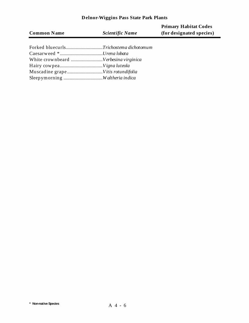
Delnor-Wiggins Pass State Park Plants
Primary Habitat Codes Common Name Scientific Name (for designated species)
* Non-native Species A 4 - 6
Forked bluecurls..............................Trichostema dichotomum Caesarweed * ...................................Urena lobata White crownbeard ..........................Verbesina virginica Hairy cowpea...................................Vigna luteola Muscadine grape.............................Vitis rotundifolia Sleepymorning ................................Waltheria indica

Delnor-Wiggins Pass State Park Animals
Primary Habitat Codes Common Name Scientific Name (for all species)
* Non-native Species A 4 - 7
FISH
Nurse shark......................................Ginglymostoma cirratum ........................................77 Bull shark .........................................Carcharhinus leucas.................................................77 Blacktip shark ..................................Carcharhinus limbatus ............................................77 Sandbar shark ..................................Carcharhinus plumbeus...........................................77 Scalloped hammerhead..................Sphyrna lewini.........................................................77 Spotted eagle ray.............................Aetobatis narinari ....................................................77 Cownose ray ....................................Rhinoptera bonasus..................................................77 Manta ................................................Manta birostris ........................................................77 Tarpon...............................................Megalops atlantica...................................................77 Atlantic herring ...............................Clupea harengus ......................................................77 Silverside shiner ..............................Notropis candidus....................................................77 Sea catfish.........................................Arius felis.................................................................77 Sailfin catfish....................................Pterygoplichthys multiradiatus...............................77 Sand diver ........................................Synodus intermedius ...............................................77 Leopard toadfish .............................Opsanus pardus .......................................................77 Atlantic batfish ................................Dibranchus atlanticus .............................................77 Atlantic needlefish ..........................Strongylura marina .................................................77 Common snook ...............................Centropomus undecimalis .......................................77 Goliath grouper ...............................Epinephelus itajara ..................................................77 Gag ....................................................Mycteroperca microlepis..........................................77 Crevalle jack.....................................Caranx hippos ..........................................................77 Dolphin.............................................Coryphaena hippurus...............................................77 Gray snapper ...................................Lutjanus griseus ......................................................77 Lane snapper ...................................Lutjanus synagris ....................................................77 Porkfish.............................................Anisotremus virginicus ...........................................77 Tomtate.............................................Haemulon aurolineatum..........................................77 White grunt ......................................Haemulon plumieri..................................................77 Bluestriped grunt ............................Haemulon sciurus....................................................77 Sheepshead ......................................Archosargus probatocephalus ..................................77 Atlantic spadefish ...........................Chaetopidterus faber ................................................77 Mullet................................................Mugil spp.................................................................77 Great barracuda...............................Sphyraena barracuda ...............................................77 Hogfish .............................................Lachnolaimus maximus ...........................................77 Seaweed blenny...............................Parablennius marmoreus.........................................77 Tiger goby ........................................Gobionellus macrodon .............................................77 Bridled burrfish ...............................Chilomycterus antennatus.......................................77 Porcupinefish...................................Diodon hystrix .........................................................77 Bandtail puffer.................................Sphoeroides spengleri...............................................77
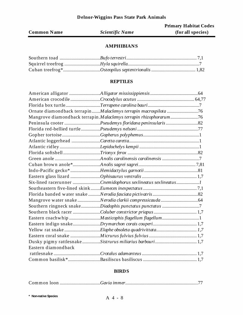
Delnor-Wiggins Pass State Park Animals
Primary Habitat Codes Common Name Scientific Name (for all species)
* Non-native Species A 4 - 8
AMPHIBIANS Southern toad ..................................Bufo terrestri........................................................... 7,1 Squirrel treefrog ..............................Hyla squirella............................................................7 Cuban treefrog* ...............................Osteopilus septentrionalis ..................................... 1,82
REPTILES American alligator ..........................Alligator mississippiensis ........................................64 American crocodile .........................Crocodylus acutus ................................................ 64,77 Florida box turtle.............................Terrapene carolina bauri...........................................7 Ornate diamondback terrapin.......Malaclemys terrapin macrospilota ..........................76 Mangrove diamondback terrapin.Malaclemys terrapin rhizophorarum.......................76 Peninsula cooter ..............................Pseudemys floridana peninsularis ...........................82 Florida red-bellied turtle................Pseudemys nelsoni ...................................................77 Gopher tortoise................................Gopherus polyphemus...............................................1 Atlantic loggerhead ........................Caretta caretta...........................................................1 Atlantic ridley..................................Lepidochelys kempii ..................................................1 Florida softshell ...............................Trionyx ferox ...........................................................82 Green anole ......................................Anolis carolinensis carolinensis ...............................7 Cuban brown anole* .......................Anolis sagrei sagrei................................................ 7,81 Indo-Pacific gecko* .........................Hemidactylus garnotii .............................................81 Eastern glass lizard .........................Ophisaurus ventralis .............................................. 1,7 Six-lined racerunner .......................Cnemidophorus sexlineatus sexlineatus ...................1 Southeastern five-lined skink........Eumeces inexpectatus ............................................. 7,1 Florida banded water snake ..........Nerodia fasciata pictivatris ......................................82 Mangrove water snake...................Nerodia clarkii compressicauda ...............................64 Southern ringneck snake................Diadophis punctatus punctatus ...............................7 Southern black racer .......................Coluber constrictor priapus .................................... 1,7 Eastern coachwhip..........................Masticophis flagellum flagellum...............................1 Eastern indigo snake.......................Drymarchon corais couperi..................................... 1,7 Yellow rat snake ..............................Elaphe obsoleta quadrivittata.................................. 1,7 Eastern coral snake .........................Micrurus fulvius fulvius ........................................ 1,7 Dusky pigmy rattlesnake...............Sistrurus miliarius barbouri................................... 1,7 Eastern diamondback rattlesnake .......................................Crotalus adamanteus .............................................. 1,7 Common basilisk* ...........................Basiliscus basiliscus ............................................. 1,7
BIRDS
Common loon ..................................Gavia immer.............................................................77

Delnor-Wiggins Pass State Park Animals
Primary Habitat Codes Common Name Scientific Name (for all species)
* Non-native Species A 4 - 9
Pied-billed grebe .............................Podilymbus podiceps................................................64 American white pelican .................Pelecanus erythrorhynchos ......................................77 Eastern brown pelican....................Pelecanus occidentalis carolinensis ...................... 77,64 Northern gannet..............................Sula bassanus...........................................................77 Double-crested cormorant .............Phalacrocorax auritus ..............................................64 Anhinga ............................................Anhinga anhinga .....................................................64 Magnificent frigatebird ..................Fregata magnificens................................................OF Great white heron ...........................Ardea herodias occidentalis.....................................OF Great blue heron..............................Ardea herodias .........................................................64 Green heron .....................................Butorides virescens ..................................................64 Cattle egret .......................................Bubulcus ibis......................................................... 64,77 Little blue heron ..............................Egretta caerulea ....................................................64,77 Reddish egret ...................................Egretta rufescens................................................... 64,77 Snowy egret .....................................Egretta thula ......................................................... 64,77 Tricolored heron..............................Egretta tricolor...................................................... 64,77 Yellow-crowned night heron ........Nycticorax violaceus ................................................64 Wood stork.......................................Mycteria americana .................................................64 White ibis..........................................Eudocimus albus ......................................................64 Roseate spoonbill ............................Ajaia ajaja ................................................................64 Canada goose...................................Branta canadensis ....................................................77 Cinnamon teal .................................Anas cyanoptera ......................................................77 Hooded merganser .........................Lophodytes cucullatus .............................................77 Red-breasted merganser ................Mergus serrator .......................................................77 Turkey vulture.................................Cathartes aura.........................................................OF Swallow-tailed kite .........................Elanoides forficatus.................................................OF Sharp-shinned hawk.......................Accipiter striatus ......................................................7 Red-tailed hawk ..............................Buteo jamaicensis....................................................OF Red-shouldered hawk ....................Buteo lineatus ......................................................... 1,7 Southern bald eagle ........................Haliaeetus leucocephalus ........................................OF Northern harrier..............................Circus cyaneus........................................................OF Osprey...............................................Pandion haliaetus....................................................OF Peregrine falcon...............................Falco peregrinus tundrius ......................................OF Merlin................................................Falco columbarius ...................................................OF American kestrel .............................Falco sparverius ......................................................OF Northern bobwhite .........................Colinus virginianus .................................................81 American oystercatcher..................Haematopus palliatus ..............................................77 Southeastern snowy plover ...........Charadrius alexandrinus tenuirostris .....................77 Wilson’s plover................................Charadrius wilsonia.................................................77 Black-bellied plover ........................Pluvialis squatarola .................................................77 Ruddy turnstone .............................Arenaria interpres....................................................77

Delnor-Wiggins Pass State Park Animals
Primary Habitat Codes Common Name Scientific Name (for all species)
* Non-native Species A 4 - 10
Whimbrel..........................................Numenius phaeopus ................................................77 Spotted sandpiper...........................Actitis macularia .....................................................77 Willet.................................................Catoptrophorus semipalmatus .................................77 Red knot ...........................................Calidris canutus.......................................................77 Sanderling ........................................Calidris alba .............................................................77 Short-billed dowitchers..................Limnodromus griseus ..............................................77 Black-necked stilt ............................Himantopus mexicanus ...........................................77 Great black-backed gull .................Larus marinus..........................................................77 Herring gull .....................................Larus argentatus ......................................................77 Ring-billed gull................................Larus delawarensis...................................................77 Laughing gull ..................................Larus atricilla...........................................................77 Lesser black-backed gull ................Larus fuscus.............................................................77 Gull-billed tern ................................Sterna nilotica.........................................................OF Forster's tern ....................................Sterna forsteri ..........................................................77 Common tern...................................Sterna hirundo .........................................................77 Least tern ..........................................Sterna antillarum.....................................................77 Royal tern .........................................Sterna maxima .........................................................77 Sandwich tern..................................Sterna sandvicensis..................................................77 Caspian tern.....................................Sterna caspia ............................................................77 Brown noddy ...................................Anous stolidus .........................................................77 Black skimmer .................................Rynchops niger ........................................................77 White-crowned pigeon...................Columba leucocephala..............................................82 Mourning dove................................Zenaida macroura .................................................. 1,81 Eurasian collared dove* .................Streptopelia decaocto................................................82 Ringed turtle-dove* ........................Streptopelia risoria................................................. 1,81 Common ground-dove...................Columbina passerina.............................................. 1,81 Mangrove cuckoo............................Coccyzus minor ..................................................... 7,64 Yellow-billed cuckoo ......................Coccyzus americanus............................................. 7,64 Smooth-billed ani ............................Crotophaga ani.........................................................81 Eastern screech-owl ........................Otus asio ................................................................ 7,81 Great horned owl ............................Bubo virginianus ......................................................7 Florida burrowing owl ...................Athene cunicularia floridana ....................................1 Barred owl........................................Strix varia .................................................................7 Chuck-will's-widow .......................Caprimulgus carolinensis .........................................7 Whip-poor-will................................Caprimulgus vociferus..............................................7 Common nighthawk.......................Chordeiles minor.....................................................OF Belted kingfisher .............................Ceryle alcyon......................................................... 7,OF Northern flicker...............................Colaptes auratus .......................................................7 Pileated woodpecker ......................Dryocopus pileatus ...................................................7 Red-bellied woodpecker ................Melanerpes carolinus ................................................7

Delnor-Wiggins Pass State Park Animals
Primary Habitat Codes Common Name Scientific Name (for all species)
* Non-native Species A 4 - 11
Yellow-bellied sapsucker ...............Sphyrapicus varius ...................................................7 Downy woodpecker .......................Picoides pubescens ....................................................7 Gray kingbird ..................................Tyrannus dominicensis.......................................... 1,81 American robin................................Turdus migratorius ............................................... 7,81 Great crested flycatcher..................Myiarchus crinitus ...................................................7 Eastern phoebe ................................Sayornis phoebe...................................................... 7,81 Tree swallow....................................Tachycineta bicolor .................................................OF Barn swallow ...................................Hirundo rustica ......................................................OF Purple martin...................................Progne subis.............................................................81 American crow ................................Corvus brachyrhynchos ........................................MTC Fish crow ..........................................Corvus ossifragus..................................................MTC House wren......................................Troglodytes aedon .....................................................7 Carolina wren ..................................Thryothorus ludovicianus.........................................7 Northern mockingbird ...................Mimus polyglottos ................................................. 1,81 Gray catbird .....................................Dumetella carolinensis .......................................... 7,81 Brown thrasher................................Toxostoma rufum................................................... 7,81 Blue-gray gnatcatcher.....................Polioptila caerulea.................................................. 7,81 Loggerhead shrike ..........................Lanius ludovicianus.................................................81 European starling* ..........................Sturnus vulgaris ......................................................81 White-eyed vireo.............................Vireo griseus .......................................................... 7,64 Yellow-throated vireo.....................Vireo flavifrons ...................................................... 7,64 Blue-headed vireo ...........................Vireo solitarius....................................................... 7,64 Black-whiskered vireo....................Vireo altiloquus........................................................64 Black and white warbler ................Mniotilta varia..........................................................7 Tennessee warbler...........................Vermivora peregrina .................................................7 Orange-crowned warbler...............Vermivora celata .................................................... 7,64 Yellow-rumped warbler.................Dendroica coronata ................................................ 7,64 Yellow-throated warbler................Dendroica dominica ..................................................7 Blackpoll warbler ............................Dendroica striata ................................................... 7,64 Pine warbler.....................................Dendroica pinus........................................................1 Florida prairie warbler ...................Dendroica discolor ................................................ 64,81 Palm warbler....................................Dendroica palmarum ............................................ 64,81 Ovenbird ..........................................Seiurus aurocapillus .................................................7 Common yellowthroat ...................Geothlypis trichas ................................................. 64,81 American redstart ...........................Setophaga ruticilla ruticilla ......................................7 Red-winged blackbird....................Agelaius phoeniceus.................................................64 Baltimore oriole ...............................Icterus galbula ..........................................................7 Boat-tailed grackle ..........................Quiscalus major .......................................................64 Common grackle .............................Quiscalus quiscula................................................ 64,81 Scarlet tanager .................................Piranga olivacea ........................................................7
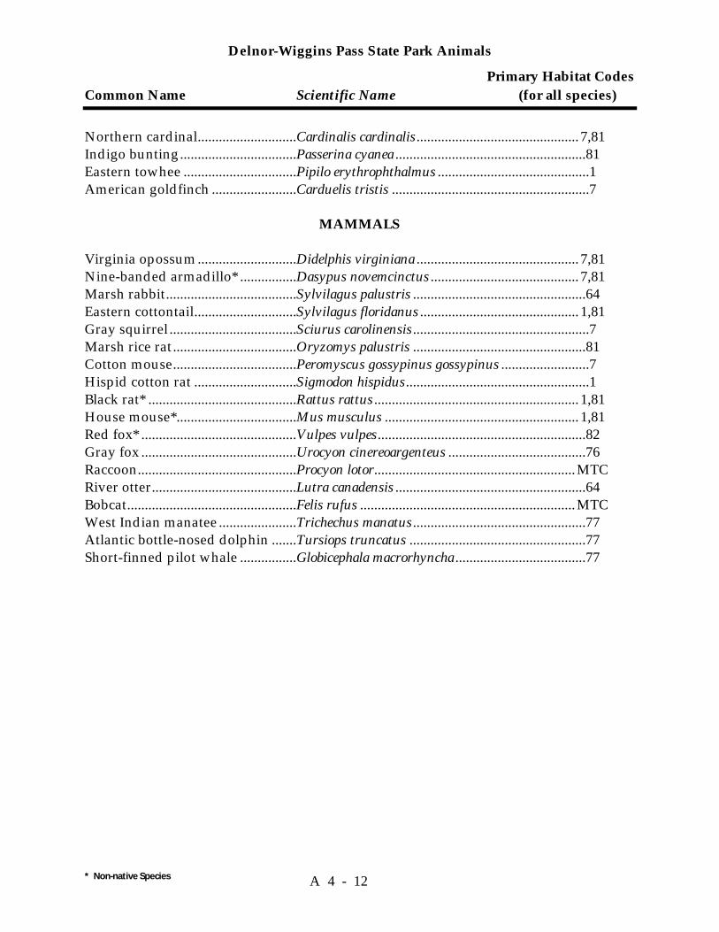
Delnor-Wiggins Pass State Park Animals
Primary Habitat Codes Common Name Scientific Name (for all species)
* Non-native Species A 4 - 12
Northern cardinal............................Cardinalis cardinalis.............................................. 7,81 Indigo bunting.................................Passerina cyanea ......................................................81 Eastern towhee ................................Pipilo erythrophthalmus ...........................................1 American goldfinch ........................Carduelis tristis ........................................................7
MAMMALS Virginia opossum............................Didelphis virginiana .............................................. 7,81 Nine-banded armadillo* ................Dasypus novemcinctus .......................................... 7,81 Marsh rabbit.....................................Sylvilagus palustris .................................................64 Eastern cottontail.............................Sylvilagus floridanus ............................................. 1,81 Gray squirrel ....................................Sciurus carolinensis..................................................7 Marsh rice rat...................................Oryzomys palustris .................................................81 Cotton mouse...................................Peromyscus gossypinus gossypinus .........................7 Hispid cotton rat .............................Sigmodon hispidus....................................................1 Black rat* ..........................................Rattus rattus .......................................................... 1,81 House mouse*..................................Mus musculus ....................................................... 1,81 Red fox* ............................................Vulpes vulpes...........................................................82 Gray fox ............................................Urocyon cinereoargenteus .......................................76 Raccoon.............................................Procyon lotor.........................................................MTC River otter.........................................Lutra canadensis ......................................................64 Bobcat................................................Felis rufus .............................................................MTC West Indian manatee ......................Trichechus manatus.................................................77 Atlantic bottle-nosed dolphin .......Tursiops truncatus ..................................................77 Short-finned pilot whale ................Globicephala macrorhyncha .....................................77

Habitat Codes
A 4 - 13
Terrestrial 1. Beach Dune 2. Bluff 3. Coastal Berm 4. Coastal Rock Barren 5. Coastal Strand 6. Dry Prairie 7. Maritime Hammock 8. Mesic Flatwoods 9. Mesic Hammock 10. Coastal Grasslands 11. Pine Rockland 12. Prairie Hammock 13. Rockland Hammock 14. Sandhill 15. Scrub 16. Scrubby Flatwoods 17. Shell Mound 18. Sinkhole 19. Slope Forest 20. Upland Glade 21. Upland Hardwood Forest 22. Upland Mixed Forest 23. Upland Pine Forest 24. Xeric Hammock Palustrine 25. Basin Marsh 26. Basin Swamp 27. Baygall 28. Bog 29. Bottomland Forest 30. Coastal Interdunal Swale 31. Depression Marsh 32. Dome 33. Floodplain Forest 34. Floodplain Marsh 35. Floodplain Swamp 36. Freshwater Tidal Swamp 37. Hydric Hammock 38. Marl Prairie 39. Seepage Slope 40. Slough 41. Strand Swamp 42. Swale 43. Wet Flatwoods 44. Wet Prairie Lacustrine 45. Clastic Upland Lake 46. Coastal Dune Lake
Lacustrine—Continued 47. Coastal Rockland Lake 48. Flatwood/Prairie Lake 49. Marsh Lake 50. River Floodplain Lake 51. Sandhill Upland Lake 52. Sinkhole Lake 53. Swamp Lake Riverine 54. Alluvial Stream 55. Blackwater Stream 56. Seepage Stream 57. Spring-Run Stream Estuarine 58. Estuarine Algal Bed 59. Estuarine Composite Substrate 60. Estuarine Consolidated Substrate 61. Estuarine Coral Reef 62. Estuarine Grass Bed 63. Estuarine Mollusk Reef 64. Estuarine Octocoral Bed 65. Estuarine Sponge Bed 66. Estuarine Tidal Marsh 67. Estuarine Tidal Swamp 68. Estuarine Unconsolidated Substrate 69. Estuarine Worm Reef Marine 70. Marine Algal Bed 71. Marine Composite Substrate 72. Marine Consolidated Substrate 73. Marine Coral Reef 74. Marine Grass Bed 75. Marine Mollusk Reef 76. Marine Octocoral Bed 77. Marine Sponge Bed 78. Marine Tidal Marsh 79. Marine Tidal Swamp 80. Marine Unconsolidated Substrate 81. Marine Worm Reef Subterranean 82. Aquatic Cave 83. Terrestral Cave Miscellaneous 84. Ruderal 85. Developed MTC Many Types of Communities OF Over Flying

Habitat Codes
A 4 - 14
Addendum 5—Imperiled Species Ranking Definitions


Imperiled Species Ranking Definitions
A 5 - 1
The Nature Conservancy and the Natural Heritage Program Network (of which FNAI is a part) define an element as any exemplary or rare component of the natural environment, such as a species, natural community, bird rookery, spring, sinkhole, cave or other ecological feature. An element occurrence (EO) is a single extant habitat that sustains or otherwise contributes to the survival of a population or a distinct, self-sustaining example of a particular element. Using a ranking system developed by The Nature Conservancy and the Natural Heritage Program Network, the Florida Natural Areas Inventory assigns two ranks to each element. The global rank is based on an element's worldwide status; the state rank is based on the status of the element in Florida. Element ranks are based on many factors, the most important ones being estimated number of Element occurrences, estimated abundance (number of individuals for species; area for natural communities), range, estimated adequately protected EOs, relative threat of destruction, and ecological fragility. Federal and State status information is from the U.S. Fish and Wildlife Service; and the Florida Game and Freshwater Fish Commission (animals), and the Florida Department of Agriculture and Consumer Services (plants), respectively.
FNAI GLOBAL RANK DEFINITIONS
G1 = Critically imperiled globally because of extreme rarity (5 or fewer occurrences or less than 1000 individuals) or because of extreme vulnerability to extinction due to some natural or man-made factor.
G2 = Imperiled globally because of rarity (6 to 20 occurrences or less than 3000 individuals) or because of vulnerability to extinction due to some natural or man-made factor.
G3 = Either very rare and local throughout its range (21-100 occurrences or less than 10,000 individuals) or found locally in a restricted range or vulnerable to extinction of other factors.
G4 = apparently secure globally (may be rare in parts of range)
G5 = demonstrably secure globally
GH = of historical occurrence throughout its range, may be rediscovered (e.g., ivory-billed woodpecker)
GX = believed to be extinct throughout range
GXC = extirpated from the wild but still known from captivity or cultivation
G#? = tentative rank (e.g.,G2?)
G#G# = range of rank; insufficient data to assign specific global rank (e.g.,
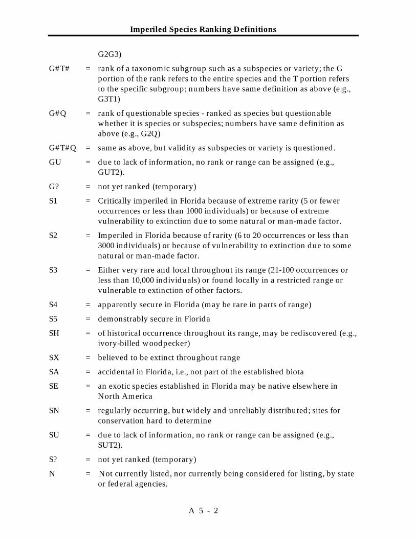
Imperiled Species Ranking Definitions
A 5 - 2
G2G3)
G#T# = rank of a taxonomic subgroup such as a subspecies or variety; the G portion of the rank refers to the entire species and the T portion refers to the specific subgroup; numbers have same definition as above (e.g., G3T1)
G#Q = rank of questionable species - ranked as species but questionable whether it is species or subspecies; numbers have same definition as above (e.g., G2Q)
G#T#Q = same as above, but validity as subspecies or variety is questioned.
GU = due to lack of information, no rank or range can be assigned (e.g., GUT2).
G? = not yet ranked (temporary)
S1 = Critically imperiled in Florida because of extreme rarity (5 or fewer occurrences or less than 1000 individuals) or because of extreme vulnerability to extinction due to some natural or man-made factor.
S2 = Imperiled in Florida because of rarity (6 to 20 occurrences or less than 3000 individuals) or because of vulnerability to extinction due to some natural or man-made factor.
S3 = Either very rare and local throughout its range (21-100 occurrences or less than 10,000 individuals) or found locally in a restricted range or vulnerable to extinction of other factors.
S4 = apparently secure in Florida (may be rare in parts of range)
S5 = demonstrably secure in Florida
SH = of historical occurrence throughout its range, may be rediscovered (e.g., ivory-billed woodpecker)
SX = believed to be extinct throughout range
SA = accidental in Florida, i.e., not part of the established biota
SE = an exotic species established in Florida may be native elsewhere in North America
SN = regularly occurring, but widely and unreliably distributed; sites for conservation hard to determine
SU = due to lack of information, no rank or range can be assigned (e.g., SUT2).
S? = not yet ranked (temporary)
N = Not currently listed, nor currently being considered for listing, by state or federal agencies.
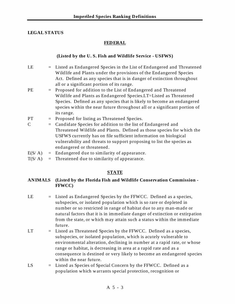
Imperiled Species Ranking Definitions
A 5 - 3
LEGAL STATUS
FEDERAL
(Listed by the U. S. Fish and Wildlife Service - USFWS)
LE = Listed as Endangered Species in the List of Endangered and Threatened Wildlife and Plants under the provisions of the Endangered Species Act. Defined as any species that is in danger of extinction throughout all or a significant portion of its range.
PE = Proposed for addition to the List of Endangered and Threatened Wildlife and Plants as Endangered Species.LT = Listed as Threatened Species. Defined as any species that is likely to become an endangered species within the near future throughout all or a significant portion of its range.
PT = Proposed for listing as Threatened Species. C = Candidate Species for addition to the list of Endangered and
Threatened Wildlife and Plants. Defined as those species for which the USFWS currently has on file sufficient information on biological vulnerability and threats to support proposing to list the species as endangered or threatened.
E(S/A) = Endangered due to similarity of appearance. T(S/A) = Threatened due to similarity of appearance.
STATE
ANIMALS (Listed by the Florida Fish and Wildlife Conservation Commission - FFWCC)
LE = Listed as Endangered Species by the FFWCC. Defined as a species,
subspecies, or isolated population which is so rare or depleted in number or so restricted in range of habitat due to any man-made or natural factors that it is in immediate danger of extinction or extirpation from the state, or which may attain such a status within the immediate future.
LT = Listed as Threatened Species by the FFWCC. Defined as a species, subspecies, or isolated population, which is acutely vulnerable to environmental alteration, declining in number at a rapid rate, or whose range or habitat, is decreasing in area at a rapid rate and as a consequence is destined or very likely to become an endangered species within the near future.
LS = Listed as Species of Special Concern by the FFWCC. Defined as a population which warrants special protection, recognition or

Imperiled Species Ranking Definitions
A 5 - 4
consideration because it has an inherent significant vulnerability to habitat modification, environmental alteration, human disturbance or substantial human exploitation that, in the near future, may result in its becoming a threatened species?
PLANTS (Listed by the Florida Department of Agriculture and Consumer
Services - FDACS) LE = Listed as Endangered Plants in the Preservation of Native Flora of
Florida Act. Defined as species of plants native to the state that are in imminent danger of extinction within the state, the survival of which is unlikely if the causes of a decline in the number of plants continue, and includes all species determined to be endangered or threatened pursuant to the Federal Endangered Species Act of 1973,as amended.
LT = Listed as Threatened Plants in the Preservation of Native Flora of Florida Act. Defined as species native to the state that are in rapid decline in the number of plants within the state, but which have not so decreased in such number as to cause them to be endangered.
Addendum 6—1997 Land Management Review Report
With Division of Recreation and Parks Response

Land Management Review of Delnor-Wiggins Pass State Recreation Area
Collier County (Lease No. 2514)
October 17, 1997
Prepared by Division of State Lands Staff Robert Clark, Environmental Administrator
William Howell, OMCM
Amy Knight, Planner
November 6, 1997

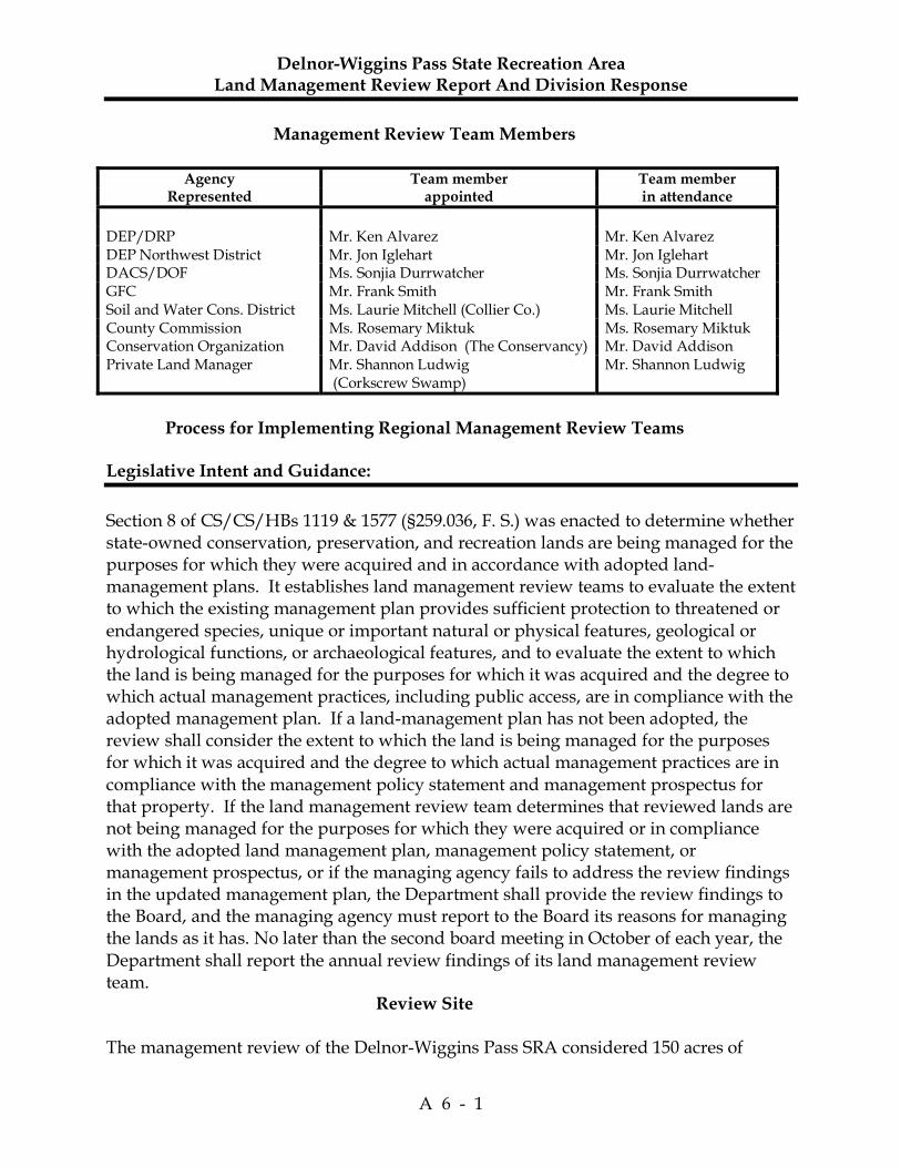
Delnor-Wiggins Pass State Recreation Area Land Management Review Report And Division Response
A 6 - 1
Management Review Team Members
Agency Team member Team member Represented appointed in attendance
DEP/DRP Mr. Ken Alvarez Mr. Ken Alvarez DEP Northwest District Mr. Jon Iglehart Mr. Jon Iglehart DACS/DOF Ms. Sonjia Durrwatcher Ms. Sonjia Durrwatcher GFC Mr. Frank Smith Mr. Frank Smith Soil and Water Cons. District Ms. Laurie Mitchell (Collier Co.) Ms. Laurie Mitchell County Commission Ms. Rosemary Miktuk Ms. Rosemary Miktuk Conservation Organization Mr. David Addison (The Conservancy) Mr. David Addison Private Land Manager Mr. Shannon Ludwig
(Corkscrew Swamp) Mr. Shannon Ludwig
Process for Implementing Regional Management Review Teams Legislative Intent and Guidance:
Section 8 of CS/CS/HBs 1119 & 1577 (§259.036, F. S.) was enacted to determine whether state-owned conservation, preservation, and recreation lands are being managed for the purposes for which they were acquired and in accordance with adopted land-management plans. It establishes land management review teams to evaluate the extent to which the existing management plan provides sufficient protection to threatened or endangered species, unique or important natural or physical features, geological or hydrological functions, or archaeological features, and to evaluate the extent to which the land is being managed for the purposes for which it was acquired and the degree to which actual management practices, including public access, are in compliance with the adopted management plan. If a land-management plan has not been adopted, the review shall consider the extent to which the land is being managed for the purposes for which it was acquired and the degree to which actual management practices are in compliance with the management policy statement and management prospectus for that property. If the land management review team determines that reviewed lands are not being managed for the purposes for which they were acquired or in compliance with the adopted land management plan, management policy statement, or management prospectus, or if the managing agency fails to address the review findings in the updated management plan, the Department shall provide the review findings to the Board, and the managing agency must report to the Board its reasons for managing the lands as it has. No later than the second board meeting in October of each year, the Department shall report the annual review findings of its land management review team. Review Site The management review of the Delnor-Wiggins Pass SRA considered 150 acres of
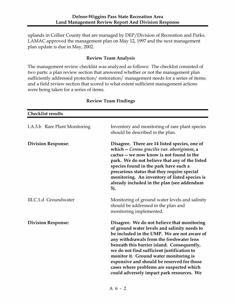
Delnor-Wiggins Pass State Recreation Area Land Management Review Report And Division Response
A 6 - 2
uplands in Collier County that are managed by DEP/Division of Recreation and Parks. LAMAC approved the management plan on May 12, 1997 and the next management plan update is due in May, 2002. Review Team Analysis
The management review checklist was analyzed as follows: The checklist consisted of two parts: a plan review section that answered whether or not the management plan sufficiently addressed protection/ restoration/ management needs for a series of items; and a field review section that scored to what extent sufficient management actions were being taken for a series of items. Review Team Findings
Checklist results
I.A.3.b Rare Plant Monitoring Inventory and monitoring of rare plant species
should be described in the plan. Division Response: Disagree. There are 14 listed species, one of
which -- Cereus gracilis var. aboriginum, a cactus -- we now know is not found in the park. We do not believe that any of the listed species found in the park have such a precarious status that they require special monitoring. An inventory of listed species is already included in the plan (see addendum 5).
III.C.1.d Groundwater Monitoring of ground water levels and salinity
should be addressed in the plan and monitoring implemented.
Division Response: Disagree. We do not believe that monitoring
of ground water levels and salinity needs to be included in the UMP. We are not aware of any withdrawals from the freshwater lens beneath this barrier island. Consequently, we do not find sufficient justification to monitor it. Ground water monitoring is expensive and should be reserved for those cases where problems are suspected which could adversely impact park resources. We

Delnor-Wiggins Pass State Recreation Area Land Management Review Report And Division Response
A 6 - 3
know salt water intrusion problems are occurring here and in many other locations along the coast of Florida. Except in cases where there are either known or suspected problems (such as the vicinity of hazardous, domestic, or industrial waste facilities or waste streams), ground water monitoring is not cost beneficial.
III.F.2 Inholdings/additions Effort should be made to assume management
over country-owned property to the east. Division Response: Disagree. We do not believe efforts should
be made to seek management control over county owned property to the East of the park. The land is located near the intersections of CR 901 and 846. Although it has certain scenic qualities and natural value, the property would not be integral to the park operation.
III.G.4. Staff Additional personnel are needed. Division Response: Disagree. At the time of the LMR, the park
was short one authorized position. That position has now been returned to the park. No additional staff are currently needed.
The review team found that the managing agency is doing an excellent job of protecting and restoring maritime hammock and beach dune communties, monitoring listed animal species, controlling and monitoring non-native invasive plants, delineating boundaries, providing waste disposal and sanitary facilities, and providing public access via roads, trails, and parking. Recommendations to the managing agency
1. The team recommended that the state have management control over the adjacent,
undeveloped, county-owned property south of the Cocohatchee River, west of Vanderbilt Drive, and east of SR 846.
Division Response: Disagree. See comments above under III.F.2.

Delnor-Wiggins Pass State Recreation Area Land Management Review Report And Division Response
A 6 - 4
1. Is the land being managed for the purpose for which it was acquired? All team members agreed that the land is being managed for the purpose for which it was acquired. 2. Are actual management practices, including public access, in compliance with the
management plan? All team members agreed that actual management practices, including public access, were in compliance with the management plan.