democratic drawing techniques for participatory...
TRANSCRIPT
176
Design Participation in the Face of Change(Re)constructing Communities
DEMOCRATIC DRAWINGTechniques for Participatory Design
Randolph Hester1
ABSTRACT
This is a reflective paper that examines techniques community designers use in creating places with people. One of the difficult tasks community designers perform is exchanging complex ideas, science, and technical information with diverse publics. Even more difficult is listening to and then drawing values and ideas of others. More difficult still is to synthesize and draw designs for imagined environments collaboratively. Although drawing is a key part of professional design education, these nonverbal communication problems challenge every community designer. Drawing with the public is immeasurably more complex than the communication techniques learned for traditional architectural or planning practices. So what techniques are used for creating collaboratively? A review of community design projects from the proceedings of the Democratic Design in the Pacific Rim conferences reveals numerous improvisations in shared drawing. These “representative representations” might be categorized as follows: 1) representing people, 2) exchanging professional knowledge and local wisdom spatially, 3) coauthoring design, 4) empowering people to “represent” themselves, and 5) visualizing deep values: community, stewardship, fairness and distinctive place. The intent here is not to compare techniques across cultures, although observations will be made about drawing skills that seem particular to certain social contexts. The goal, rather, is to uncover and highlight spatial representation techniques that seem to be particularly effective in overcoming the difficulties of transactive design especially of actual form making. The most used nonverbal techniques include recording social ecology patterns (11 out of 101) and building sense of community through workdays and walking tours (10 out of 101). Most used of all techniques is the workshop. Three fourths of all the articles (75 out of 101) mention workshops without describing non-verbal methods, content or design outcome. The workshop seems to be the participatory “black box” through which community designers are as inarticulate as traditional designers are about creative form making. Surprisingly few articles (5 out of 101) describe methods in which design is coauthored, passing representation of form and space back and forth between community and designer.
INTRODUCTION
Some years ago I was challenged by a colleague to describe precisely how participatory designers draw and otherwise communicate with communities differently than other designers do with their traditional clients. He implied that we are no different. We use presentation drawings and models like any other designer. Then he suggested that community designers talk more and aren’t as skilled at nonverbal communication.
My unprepared response went something like this. In a democracy, the design of the landscape depends on the representation of the public. This public representation, I called it “representative representation,” forces inventive drawing. Drawing against or for others is substantially different than drawing with or by others. We, as community designers, draw with the community and frequently they do the drawing. Then I cited drawing on your feet and designing upside down, two techniques I often employ, that suggest that participatory design requires special drawing skills.
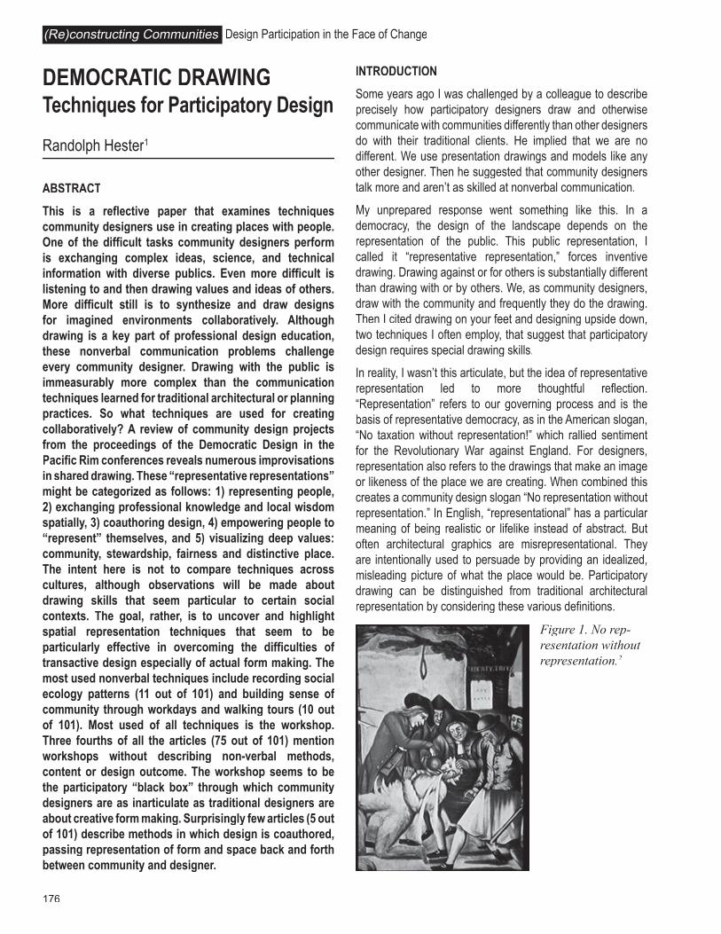
In reality, I wasn’t this articulate, but the idea of representative representation led to more thoughtful reflection. “Representation” refers to our governing process and is the basis of representative democracy, as in the American slogan, “No taxation without representation!” which rallied sentiment for the Revolutionary War against England. For designers, representation also refers to the drawings that make an image or likeness of the place we are creating. When combined this creates a community design slogan “No representation without representation.” In English, “representational” has a particular meaning of being realistic or lifelike instead of abstract. But often architectural graphics are misrepresentational. They are intentionally used to persuade by providing an idealized, misleading picture of what the place would be. Participatory drawing can be distinguished from traditional architectural representation by considering these various definitions.
Figure 1. No rep-resentation without representation.2

177
By “representative representation” I refer to the way drawing is used to communicate with communities as honestly and realistically as possible through grass roots democracy in direct “face-to-face” exchanges to design the landscape. The communication is about exchange of spatial information, not persuasion. This communication is often nonverbal because the picture is less ambiguous than the spoken word. Typically this is accomplished through graphic simulations of ideas, choices and plans for the landscapes we are designing with community members. In participatory work, drawing is used to collectively visualize, communicate and design.
“Drawing” is used here to include the representation of the landscape by designers and community members through a broad range of media from sketching, painting and collage to modeling by hand or machine. “Drawing” is also used as any way to visualize precisely and correctly places being designed. This would include stories turned into pictures, looking at photographs or visiting nearby precedents, all of which “draw” an image into the mind’s eye of the collective group. Drawing is used in community design for a great variety of purposes such as understanding a place, communicating the detailed dimensions or essence of a space, exchanging spatial, philosophical or programmatic ideas and imagining choices for changing a place. Drawing is used throughout the entire design process, from beginning steps like active listening, to final steps like post construction evaluation. Obviously only a few of these represent the landscape in a literal and figurative way, but all are essential to the participatory design process.
METHOD
I focused attention on the techniques participatory designers use that distinguish us from other architects, landscape architects and city designers. I did a content analysis of the proceedings from the conferences on Democratic Design in the Pacific Rim, a group who practices only participatory design. I read every article and studied all graphics for specific reference to nonverbal techniques used to honestly and precisely design collaboratively. I reviewed articles from each year the group has met. There are 87 papers in the proceedings. I also analyzed the handouts and notes from field study presentations, four in Japan, seven in Taiwan and three in Hong Kong. This gave a total of 101 papers that I analyzed.
I found five domains of skill especially critical to democratic landscape design. In this paper I will briefly describe each of the following:
• Representing People
• Exchanging Professional Knowledge and Local Wisdom Spatially
• Coauthoring Design
• Empowering People to Represent Themselves.
• Visualizing Deep Values: Community, Stewardship, Fairness and Distinctive Place
I kept a rough numerical tally of techniques as I analyzed the articles and graphics and I’ll report those. I’ll also draw case examples from the proceedings to illustrate the techniques. In a few cases I’ll rely on methods from my own work.
Some generalizations should be made at the outset. Descriptions of spatially explicit democratic design techniques were found in about a third of the articles. There were far more descriptions of verbal techniques such as listening, interviews, surveys and story telling than how that information informed design. In most articles workshops are referenced without description of the content or how that content is explicated in spatial or experiential terms. Similarly, goals like building social capital, networks and local identity describe intents with little explanation about methods for achieving them.
On the other hand, the articles and graphics that are explicit about techniques that communicate and lead to appropriate design offer informative examples of how representative representation is and can be distinguished in ways that truly matter. I highlight these in the following descriptions.
REPRESENTING PEOPLE
The lifting of martial law and increasing democratization in Taiwan, natural disasters, government secrecy in Japan and China and the civil rights movement and related urban renewal and freeway battles in the United States made designers aware that we did not have the skills to adequately represent people in the design process. In the worst cases many people were ignored altogether, represented as objects in Cartesian space, or depicted as standardized normative everyman. Most painfully, minorities, the poor, the elderly or the slightly deviant were not represented at all. The recognition of this problem led to a concerted research effort to understand and portray human perception, cognition and response to both the urban and wild landscape. Sociologists and environmental psychologists built a substantial body of research that could be applied to design. In retrospect, it seems that the research findings that are expressed in visual and spatial terms are most used by designers; less imageable research, no matter how important, remains unused. It is often left to the community designer to figure out how to transform nonspatial research on cultural rituals and economic variations into a form suitable for designing places. In other cases, designers must do project-specific investigations to record idiosyncratic desires and patterns of behavior. In some few cases designers try to picture the deeper substance of everyday life and the whole of dwelling as a means to represent and design appropriately for people. In representing people, four methods are most
Randy Hester Democratic Drawing
178
Design Participation in the Face of Change(Re)constructing Communities
described in the participatory literature. I expected these to be found in the content analysis of democratic designers in the Pacific Rim: Making Research Spatial, Environmental Justice Maps, Recording Social Ecology Patterns, and Picturing Everyday Life.
Making Research Spatial
Increasingly there is published research available on human environment interactions that can be applied to design. With People in Mind by Rachel and Stephen Kaplan and Robert Ryan comes immediately to mind because it provides social research findings and explains the design implications. But most social
research requires “translating” before it is useful for designers. It is not clear how much of this research is being used by the democratic designers in the Pacific Rim. Only five of the 101 articles reviewed mention using pre-existing research, typically site specific census data and historic information. As one exception, Mark Francis describes using his extensive review of recorded trends in park design as a foil for the design of Central Park in Davis, California. He expressly wanted the park to be more of a social center for diverse and divergent groups than most parks provide. The result is an unusual combination of settings from a farmers market and youth center to native gardens and a central valley beach.
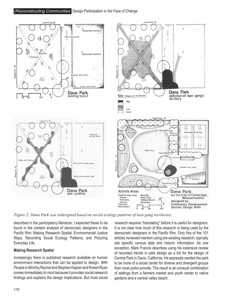
Figure 2. Dana Park was redesigned based on social ecology patterns of teen gang territories.
179
I was surprised at how few cases discussed the use of existing research to represent people. Do we really ignore already published research and rely almost exclusively on firsthand observation and narratives?
Environmental Justice Maps
Frequently powerless people have difficulty or lack the resources to represent themselves. In cases of extreme oppression, community designers may map relative deprivation that calls attention to injustices of distribution, access and exclusion. For example, park lands are frequently concentrated in affluent neighborhoods, a situation that is simply accepted until dramatically visualized with maps, graphs and diagrams, usually the work of community designers. Environmental justice maps focusing on availability of park lands, concentration of toxic sites, relative housing quality, access to natural open space or other environmental factors can often spur action among officials embarrassed by a previously invisible reality.
Although making invisible injustices visible is an important part of community design history, there were no explicit uses of environmental justice maps in the cases presented in the proceedings.
Recording Social Ecology Patterns
Behavior and social ecology mapping based on careful firsthand observation can create patterned visualizations of human activity not unlike soils maps or vegetative mosaics. These geometries suggest design solutions. In 1968 we discovered the utility of territorial mapping when we created maps of the turf that the Dana Park gang in Cambridge, Massachusetts defended. We did this by participant observation, hanging out with the gang for several months, mapping the territory they most often occupied and from which they excluded others. These maps explained, in spatial terms, conflicts with and crimes against other users, and ultimately was the primary piece of analysis that inspired a new park design that solved the turf wars.
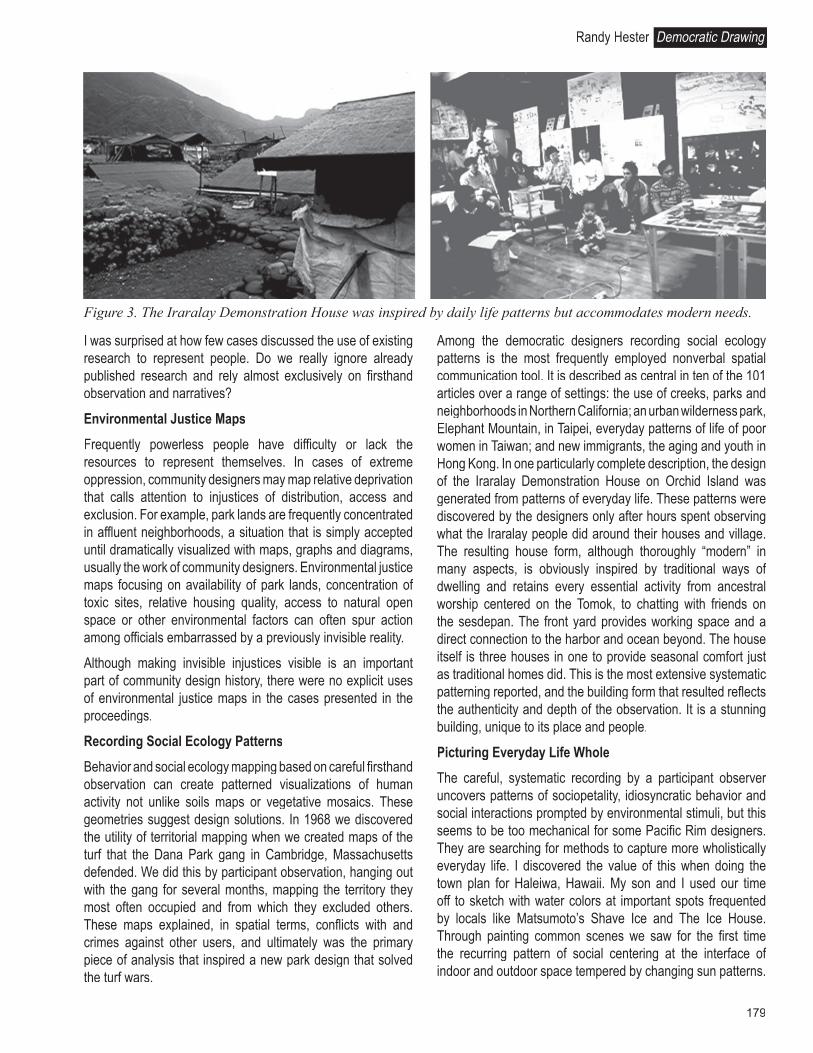
Among the democratic designers recording social ecology patterns is the most frequently employed nonverbal spatial communication tool. It is described as central in ten of the 101 articles over a range of settings: the use of creeks, parks and neighborhoods in Northern California; an urban wilderness park, Elephant Mountain, in Taipei, everyday patterns of life of poor women in Taiwan; and new immigrants, the aging and youth in Hong Kong. In one particularly complete description, the design of the Iraralay Demonstration House on Orchid Island was generated from patterns of everyday life. These patterns were discovered by the designers only after hours spent observing what the Iraralay people did around their houses and village. The resulting house form, although thoroughly “modern” in many aspects, is obviously inspired by traditional ways of dwelling and retains every essential activity from ancestral worship centered on the Tomok, to chatting with friends on the sesdepan. The front yard provides working space and a direct connection to the harbor and ocean beyond. The house itself is three houses in one to provide seasonal comfort just as traditional homes did. This is the most extensive systematic patterning reported, and the building form that resulted reflects the authenticity and depth of the observation. It is a stunning building, unique to its place and people.
Picturing Everyday Life Whole
The careful, systematic recording by a participant observer uncovers patterns of sociopetality, idiosyncratic behavior and social interactions prompted by environmental stimuli, but this seems to be too mechanical for some Pacific Rim designers. They are searching for methods to capture more wholistically everyday life. I discovered the value of this when doing the town plan for Haleiwa, Hawaii. My son and I used our time off to sketch with water colors at important spots frequented by locals like Matsumoto’s Shave Ice and The Ice House. Through painting common scenes we saw for the first time the recurring pattern of social centering at the interface of indoor and outdoor space tempered by changing sun patterns.
Figure 3. The Iraralay Demonstration House was inspired by daily life patterns but accommodates modern needs.
Randy Hester Democratic Drawing

180
Design Participation in the Face of Change(Re)constructing Communities
The habit of lingering in the cool of such places defined the essence of everyday life there. In all of our previous systematic behavior mapping we hadn’t noticed this sociopetal pattern that was unconsciously designed in the vernacular landscape. We employed the pattern to create more such successful places.
More experimental approaches are reported in the design of the spatial scenarios the National Taiwan University group used to design the shop house reconstruction in Kuo-hsin township after the earthquake. The design team tried to get the homeowners to tell them their own stories, to narrate their everyday lives in space. Eventually the designers were able to transform the stories into the language of space, providing residents pictures of how their lives might be in new houses.
The memory interviews used in the design of the Quaker Retirement Community in Sandy Springs, Maryland, may have likewise given a qualitative picture of everyday life. This method certainly enhanced empathy.
Jackie Kwok and Michael Siu describe another innovative way to picture everyday life. Immigrant women were given cameras and asked to take pictures and then discuss their everyday activities and settings. This allowed each woman to clearly express her evaluative comments about her living environment, her image of self and family and her everyday life rhythm.
I could identify only these few examples and I have read considerably between the lines, but I am interested to know if this desire to capture more wholistically everyday life is generating new approaches. Additional information about techniques that more qualitatively describe the gestalt of everyday life rather than separated patterns would be valuable. I would be particularly interested in knowing if these qualitative gestalts of everyday life are most useful when combined with quantitative pattern languages.
EXCHANGING PROFESSIONAL KNOWLEDGE AND LOCAL WISDOM SPATIALLY
For several years the Pacific Rim Conferences sponsored lively debate about the role of professional knowledge and
native wisdom. From this John Liu concluded that good results are usually attributable to a fully engaged interaction between the professional and the people. How does this interaction occur? What methods do community designers and community members use to exchange, accumulate and synthesize knowledge and wisdom?
Once the designer can comfortably work with community groups, he or she understandably wants more from them. Teaching lay people elementary professional spatial thinking can produce significant public design benefits. All people can map and draw, some quite well. But like beginning students, they need to be assisted in observing the landscape carefully, thinking complexly about a place of which they only know fragments, imagining nontraditional resources that are so familiar they don’t see or value them, using precise and sometimes faraway precedents, accounting for natural changes in the landscape, generating holistic spatial concepts and evaluating plans.
And in turn, lay people want more from us. They and we benefit from what they teach us. Community members know their own idiosyncratic needs better than we do, therefore, they need to inform any program. They often know details of the culture and ecology from years of dwelling in a place that professionals are likely to miss. In some cases there resides a deep and compelling local wisdom that provides time-honored precedents, gestalts, and ways to do things. Here I will highlight some of the techniques useful in the exchange of local and professional knowledge and wisdom. I will concentrate on techniques that explain how the exchange occurs.
Imagining Unseen Resources
In all poor communities, and most comfortable ones, successful development is dependent on discovering some previously unrecognized resource to capitalize the project. This process has been labeled finding fish heads, a waste product that can be turned into a benefit. Community designers often draw the fish heads diagram and have community members seek out local, undiscovered resources. They may photograph, sketch or simply list them. But often these resources are taken for
Figure 4. Painting uncovered the interface of the indoors and the outdoors, sun and shade, wind and calm essential to seeing everyday life in Haleiwa wholistically.

181
granted or viewed negatively; in those cases the designer must map and sketch the resources before they are acknowledged. In the design of San Vicente Mountain Park in the Santa Monica mountains in California, our design team recognized the remnants of an old Nike missile base as a resource that, if restored, would be useful and, if recycled, reduce cost. To local citizens the remaining tower was a safety hazard, the concertina wire fences inappropriate in a park and the concrete bunkers eyesores. They insisted the military remnants be removed. During a design workshop, quick sketches showed how the tower could be transformed into a wildlife observation deck, the concertina wire lined walkways into interpretive trails, and bunkers into benches. After additional research the military concept was deployed in full as the design gestalt with support of residents, most of whom had seen the hazards anew through the quick sketches. The recycled military artifacts provided a special place, capturing the past while reusing the missile relics to satisfy changed values for nature study, picnics and mountain biking.
In the proceedings are several cases where discovering unknown resources was essential to the successful design. In the case of the various Kyoto Hiroba, a city official with the design team inventoried used equipment and materials in the city storeyards. He then made these resources available to neighborhood groups. Recycled play equipment, granite curbs and other materials, which could not otherwise have been afforded, became available for use in the parks. The community groups often used these recycled materials in their local Hiroba. In another case in Matsu, Professors Liu and Hsia gave lectures about how the dilapidated buildings could be repaired, not just for historic preservation, but also as a local economic development strategy. This contributed to the recovery of many of the culturally significant stone and wood structures in which the third conference was held. This seems a particularly important role for the sensitive outside expert in community development.
Additional techniques to discover unseen resources include Lessons from Poverty, Small and Large, Rare and Commonplace, Conscious Nonconsumption and Dirty Enough to be Happy. These are all described in the Hong Kong proceedings.
Thinking Complexly
Community problems are embedded in complex systems that require systematic, cross-sectoral thinking. Drawing the relationships of all the components necessary to make a successful project can get designers and community to think holistically and sometimes outside the box of both narrow interests and narrow disciplines. A diagram stimulates the organized brain; a diagrammatic cartoon provokes thinking outside the normal. The synetics methods for making the familiar strange and the strange familiar can often help stimulate complex thinking.
In the case of a riverfront revitalization project in Mount Vernon, Washington, one middle-aged resident told us, “The river is not a part of me anymore.” Others told us not to worry because the service clubs would implement the plan. We made cartoons of a broken heart with his words and the river plan with “the Service clubs will do it” as a caption. These were shown as a slide in a community meeting. This was the most powerful drawing done during the whole design process. It called personal attention to the community’s disassociation from the river and the hopelessness of a river revitalization unless attitudes changed. The city intended to spend little money on improvements, and most people expected volunteers to do all the work. The river caused flood damage, was a dumping ground, and separated good and bad districts of the city. No one seemed to care about it. So why, we wondered, did people want to do anything to revitalize it? The cartoons prompted residents to begin thinking about the problem more holistically and realistically, and most concluded the river had such a bad reputation among adults that they didn’t really expect it to be
Figure 5. A quick sketch showing its reuse saved the Nike Missile Tower from demolition and turned it into a wildlife observation deck.
Randy Hester Democratic Drawing
182
Design Participation in the Face of Change(Re)constructing Communities
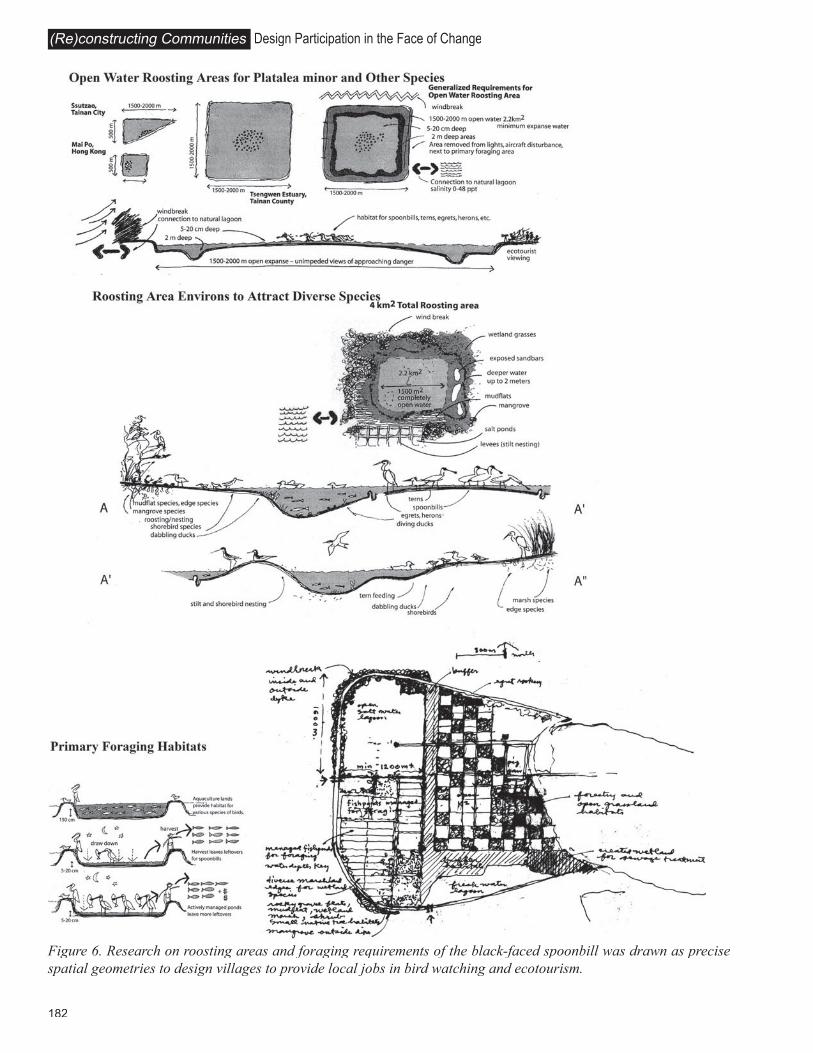
Figure 6. Research on roosting areas and foraging requirements of the black-faced spoonbill was drawn as precise spatial geometries to design villages to provide local jobs in bird watching and ecotourism.

183
revitalized. By thinking about the project more complexly and deeply, the community wisely abandoned the idea of doing a grand revitalization. They undertook small projects that service clubs and other volunteers could implement.
Two cases of such serious, interwoven thinking projects are described in the proceedings. One is the urban design work for Central Street of Ma-Kung City on the P’eng-hu Islands. Yu Chao-Ching describes a holistic approach that attempts to address community rehabilitation considering a complex web of legal and institutional problems, zoning contradictions, conflicting goals of land speculation and historic preservation, uncompetitive businesses and a degraded environment. For over ten years the designers learned and helped residents understand the complexity. By 1998 the group had developed a comprehensive plan to address the full range of entangled problems.
In a similarly multifaceted problem the Kyoto University team working on the Yoshino River attempted to help the community understand the intricate relationships between attachment to the river, flooding and single-species plantation forestry. Because these cases attempted to address extremely difficult problems by complex thinking, it would be especially informative to have updates on their progress. It would also be useful to see how other community designers come to understand and help communicate complexity through graphic means.
Making Science Spatial
One of the unique contributions that designers often make to community design is to translate conservation biology and wildlife habitat research into spatial patterns. At the simplest level this involves activity-mapping the territories of wild species, similar to recording human ecology patterns. We did this to determine the impact of habitat loss and the need for core areas and corridors in order to preserve the cougar population in the Santa Monica mountains. At a slightly more complex level, it involves understanding spatial relationships between multiple natural species like the cougar, coyote and quail. Human activities further complicate the relationships producing island and edge impacts, triggering rescue effects and changing species compositions. The fact that ecosystems are dynamic and evolving, as is the scientific knowledge, makes local wisdom especially important. Often local cultural patterns of resource use have been created over centuries to keep a balance with some essential species. Sometimes this wisdom is overrun or lost. Other times it is surpassed by science. As with social research on human behavior, urban ecological research almost always needs to be synthesized conceptually and spatially. In creating Big Wild in Los Angeles, we worked with citizens and scientists to draw research (much of which seems counter-intuitive due to the intricate food webs and habitat relationships) in forms useful to land use planning
and design. The drawing of the island effects on wildlife of the proposed Reseda to the Sea Highway was central to the creation of Big Wild in Los Angeles and the eventual abandonment of the freeway. Beyond these, visualizations of wildlife, natural processes like the relationship between coefficient of runoff and flooding, hungry water and erosion, or nutrient cycles remain mysteries until clearly diagrammed. By accurately portraying such complex science with citizens they develop the basis for ecologically sound stewardship activities like ecotourism, habitat restoration, species reintroduction, storm water management and urban vegetation enhancement.
In the proceedings there are numerous descriptions of community efforts to accurately draw natural science findings. Jeff Hou and Marcia McNally point out the joint work of local and international scientists, local fishermen and designers to create a picture of the spatial needs of the black-faced spoonbill. Each knew different parts of the habitat niche puzzle. Most scientists didn’t realize the spoonbills roosted during the day and foraged widely at night, but local fishermen did, and international spoonbill expert Malcolm Coulter knew how far, up to 30 kilometers. As more research was done, more precise spatial geometries were drawn for use in the design of villages to attract economic development based on bird watching.
Similar efforts are described by the Kyoto University team in their work with the Vision 21 Committee. They listened to the deliberations of the 12 experts who were trying to determine the best approach to preserve or recreate the ecological systems of the Yoshino River. The Kyoto Team then synthesized the complex and often contradictory science and drew this for the experts and residents to better understand. This work is particularly complex due to the dramatically dynamic nature of the river system, the scientific findings, politics and social values about the river. Scott McCreary describes similar complexity in the Ecuador ARCO oil exploration debate and the use of an independent scientific review process to reconcile industry claims and local knowledge.
One of the most difficult aspects of landscape to visualize is natural change over time, whether it is river dynamics, old-field succession or park vandalism. The exercise of drawing the expanding shadow from a maturing tree, or drawing what a place was like a century ago and will be like a century from now, can create the most essential visual dialogue. In Castle Rock, Washington, which was partly destroyed by the eruption of Mount Saint Helens, we worked with long-time residents to recreate large pastel drawings of what the Cowlitz River had been like in town before the eruption, immediately after, ten years after, and what it might look like in the future. At the time it was a dead wasteland of gray pumice and debris 50 feet high in places. Previously it had been a maturing riverine ecology teeming with wildlife. When the drawings were shown at a
Randy Hester Democratic Drawing

184
Design Participation in the Face of Change(Re)constructing Communities
community meeting, one woman looked at the lifeless present and said, “The birds don’t sing here anymore.” The audience hushed, many cried. It was no overstated metaphor. Songbirds disappeared when the habitat was washed away and buried by the debris flow. The future drawing gave hope but only after the catharsis from the set of evolutionary drawings spread throughout the city. Understanding the evolutionary, changing nature of the landscape via drawings is seldom so dramatic, but always useful.
Getting a Gestalt
Both citizens and designers are better partners in design when they are deeply rather than superficially engaged in the problem solving. One of the most critical aspects of deep involvement is getting a gestalt, the most essential image that cannot be derived simply from the sum of its complex parts. Ricardo Legoretta recently told me that for him getting the most essential idea is 95% of the design. It is not additive or even qualitative, and certainly not easy to draw, even for the most accomplished designers. To get a gestalt, community and designers have to move beyond polite superficial thinking, to probe and exchange core ideas and visualize the most profound synthesis of the situation. This is often done via a combination of sketching, collage, poetry, sense of the meeting, and free association following rigorous analysis. In Manteo, North Carolina, the mayor expressed the concept of, “Come sit on our front porch, let us tell you of the dreams we keep,” after he had analyzed a number of collages expressing what citizens considered the gestalt. The front porch gestalt was so to the point that it provided both metaphorical and literal inspiration for the community plan.
In the proceedings there is the report of a poem written by a resident of the Sandy Spring Friends House with the telling line, “...bring color to another’s life.” This gestalt reshaped the circle and inspired the design. In another case, Endoh Yasuhiro describes the shared balconies at M-Court as representing the spirit of the co-housing, the merging of space and living, an approach he uses to capture the essential life pattern in architectural form.
Generalizations Versus the Experience of Precise Place
Often in public landscape design there is a rush to judgment based on a generalization without careful consideration of the place itself. Community leaders sometimes make decisions without ever visiting a site, relying instead on stereotypical images of the place. John Liu notes that, “People often only voice wants not grounded in place.” Participatory exercises that require careful observation and discriminating looking can transform generalizations into space-specific problems that can be addressed by design. In the case of Runyon Canyon Park in Hollywood, most residents stated that they never went to the canyon because they feared for their safety. There was
building momentum to fence the whole park and remove the vegetation or sell parts of the park for private development. We made a map of Fearful Places in the park by asking residents to note exact spots where they were afraid and why. On walking tours they showed us precise locations. The resulting Fearful Places map showed only a few specific places of security concerns. Residents feared homeless people along narrow, enclosed walkways. In 99% of the canyon, residents felt completely safe. The map focused attention on the trouble spots, stopped the sale of public land and prevented wholesale and indiscriminate vegetation removal. The few trouble spots were designed to provide greater visibility. Homeless people agreed to locate to less traveled spots. The nagging fear was addressed with specificity.
Similar exchanges are noted in the proceedings. In the case of Densha Hiroba in Kyoto, a general fear that they would miss scheduled extracurricular activities prevented some school-aged children from using the local park. The designers addressed the vague but prevalent worry by locating a large clock readily visible to all park users. Similarly, the spatial scenarios led the designers of the shop houses in Kuo-hsin township to conclude that the most important part of a household design project lies in its specificity. Vague, nonspatial desires had to be concretized in real space and time for success.
Scored walking tours are the technique most often used to encourage the experience of precise locations and to dispel overblown generalizations. Several articles highlight the need for the designer and community members to experience the place together and to have spontaneous exchanges based on the sensual qualities in the real place. This is frequently accomplished by carefully scripted interpretation and dialogue about prearranged topics at particular sites. Such scored walks were used in the planning of Central Park in Davis. Others mention community exploring trips, walking and boat tours and watching tours. In most of these it is not clear exactly how the event influences the design per se.
COAUTHORING DESIGN
Through participatory design we learned that the built landscape could be enriched by transactive processes, but designers and involved citizens needed mutual empathy and a common language in order to design together. I am not discussing programming or analysis, but the actual event of making form as a group. To do this, designers had to learn to walk in the shoes of users and vice versa; we had to communicate clearly without jargon. Users and designers had to learn a shared language of everyday landscape in order to coauthor design. Representing people’s activity patterns and critical needs described above is essential for programs and in some cases inspires design, but here I am interested in the precise techniques we use to do form-making with people.

185
Yu Chao-Ching states the value of seeing reality instead of impression in designing collaboratively. He recalls that, “During the process of participation, we made every participant ‘see’ the objects that we were going to discuss.” He continues, “We used ‘seeing’ instead of ‘impression’ or ‘imagination.’” He concludes that, “The more participants visualized, the more impressions and exciting imaginations they could recall” and “the precise visualization gave continuity between the past, present and future” making “results clear and concrete.”
The language most useful to me is the drawing which, when thoughtfully done, is less ambiguous than spoken words, especially given culture, class and gender language differences. Equally useful for others are particular types of models, maps and texts. In the proceedings there are almost no descriptions of the particular methods we use to actually design with other people. I will describe techniques I know well in hopes of stimulating others to write explicitly about methods most useful to them in making form collaboratively.
Designing Upside Down
Once, sitting in a community meeting, I realized I was drawing upside down so that community members could more readily read the ideas we were generating. With practice, I got better at it. It is a useful skill and of symbolic import. I notice now that whenever I write upside down it changes the collaborative dynamic because the group is alerted to how serious we must be about communicating via a precise shared nonverbal language. We have to be sure we are understanding each other, even if it takes longer than normal.
And we have to be attentive to the various languages participants use. During the design of a new community center in Yountville, California several distinct languages were essential to the design. One mother always studied our drawings carefully but said little in the meetings; she would take the drawings home and write us letters describing how she would imagine using the spaces we proposed and suggesting detailed ways to improve the design. Her written language was spatial prose, insightful and precise. Her comments were narratives but always concluded with pointed design changes. She would describe how she imagined using the proposed library with her young children then admonish, “Move the computer area next to the little kid’s reading space so I can supervise and work at the same time.” The city manager’s language was the capital improvements budget spreadsheet, architecturally graphic, but hardly spatial. Our measured drawings evolved from sketches, usually in plan and section. This was the most expressly visual language. Each of us had to metaphorically and literally write upside down in order to communicate effectively in coauthoring the design. The design workshops took more time communicating in so many “languages,” but over time participants began to use each other’s means of
expression. Spreadsheet and story telling became integrated into upside down sections.
Sketching What Others Say
Related to this is the skill of sketching what another person says. This requires aggressive listening. The designer not only listens but also sketches while listening, trying to give form to the idea a community member is expressing verbally. The resulting sketch tests whether two or more people are visualizing the same thing and often becomes the medium of exchange, a way to elaborate or create new designs. In some cases the sketch completely replaces verbal communication. I noticed this for some years working with contractors before I understood its power as a means of designing what people say. In the construction of Marvin Braude Park in Los Angeles, we were rebuilding a part of the Santa Monica mountains scarred by a failed freeway with thousands of cubic yards of mud slide soil. Although our layout and grading plans provided general direction, most of the detailed design, including earth form and rock placement, was done in the field. The dirt contractor and I quickly learned that words and even flags did not produce the desired results. I resorted to sketching what he said, starting by directing the grading to landmarks via sketches oftentimes as the bulldozer followed. Sometimes he would take my sketchbook and redraw the most likely outcome of a slope stabilization or drainage way. He would point out that I drew beautifully but inaccurately. He, in contrast, drew crudely but in precise bulldozer language. We soon began sketching the next day’s, and even week’s, work in perspective triangulated to existing points of reference, in some cases miles away. Eventually we made almost all decisions about pathways and overlooks by perspective sketch, using the formal working drawings less and less.
In the proceedings John Liu describes a dramatic moment that changed the design for the Ilan Theatre. In one meeting with local performing artists, someone made the suggestion that the proposed theater would be much better if it weren’t separated from the vital street performances that occurred all over the surrounding downtown. Some felt that performances in the theater should begin as parades through the streets leading to an oversized front doorway and down a street-sized aisle directly to the stage. While performers talked about this, Liu sketched. He made a reasonably scaled drawing showing the shape and size of the entry sequence. The sketch became the focus of the conversation, allowing the group to elaborate and expand on the initial idea and discard unworkable aspects. The sketches provided a reality check for the much less precise verbiage. Often nonspatial narrative is so ambiguous that everyone is understanding a spoken word in completely different, often mutually exclusive, ways. Liu’s drawing turned the words into agreed upon form.
Randy Hester Democratic Drawing
186
Design Participation in the Face of Change(Re)constructing Communities
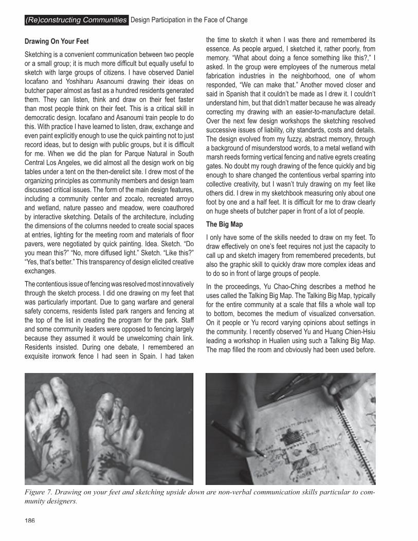
Drawing On Your Feet
Sketching is a convenient communication between two people or a small group; it is much more difficult but equally useful to sketch with large groups of citizens. I have observed Daniel Iocafano and Yoshiharu Asanoumi drawing their ideas on butcher paper almost as fast as a hundred residents generated them. They can listen, think and draw on their feet faster than most people think on their feet. This is a critical skill in democratic design. Iocafano and Asanoumi train people to do this. With practice I have learned to listen, draw, exchange and even paint explicitly enough to use the quick painting not to just record ideas, but to design with public groups, but it is difficult for me. When we did the plan for Parque Natural in South Central Los Angeles, we did almost all the design work on big tables under a tent on the then-derelict site. I drew most of the organizing principles as community members and design team discussed critical issues. The form of the main design features, including a community center and zocalo, recreated arroyo and wetland, nature passeo and meadow, were coauthored by interactive sketching. Details of the architecture, including the dimensions of the columns needed to create social spaces at entries, lighting for the meeting room and materials of floor pavers, were negotiated by quick painting. Idea. Sketch. “Do you mean this?” “No, more diffused light.” Sketch. “Like this?” “Yes, that’s better.” This transparency of design elicited creative exchanges.
The contentious issue of fencing was resolved most innovatively through the sketch process. I did one drawing on my feet that was particularly important. Due to gang warfare and general safety concerns, residents listed park rangers and fencing at the top of the list in creating the program for the park. Staff and some community leaders were opposed to fencing largely because they assumed it would be unwelcoming chain link. Residents insisted. During one debate, I remembered an exquisite ironwork fence I had seen in Spain. I had taken
the time to sketch it when I was there and remembered its essence. As people argued, I sketched it, rather poorly, from memory. “What about doing a fence something like this?,” I asked. In the group were employees of the numerous metal fabrication industries in the neighborhood, one of whom responded, “We can make that.” Another moved closer and said in Spanish that it couldn’t be made as I drew it. I couldn’t understand him, but that didn’t matter because he was already correcting my drawing with an easier-to-manufacture detail. Over the next few design workshops the sketching resolved successive issues of liability, city standards, costs and details. The design evolved from my fuzzy, abstract memory, through a background of misunderstood words, to a metal wetland with marsh reeds forming vertical fencing and native egrets creating gates. No doubt my rough drawing of the fence quickly and big enough to share changed the contentious verbal sparring into collective creativity, but I wasn’t truly drawing on my feet like others did. I drew in my sketchbook measuring only about one foot by one and a half feet. It is difficult for me to draw clearly on huge sheets of butcher paper in front of a lot of people.
The Big Map
I only have some of the skills needed to draw on my feet. To draw effectively on one’s feet requires not just the capacity to call up and sketch imagery from remembered precedents, but also the graphic skill to quickly draw more complex ideas and to do so in front of large groups of people.
In the proceedings, Yu Chao-Ching describes a method he uses called the Talking Big Map. The Talking Big Map, typically for the entire community at a scale that fills a whole wall top to bottom, becomes the medium of visualized conversation. On it people or Yu record varying opinions about settings in the community. I recently observed Yu and Huang Chien-Hsiu leading a workshop in Hualien using such a Talking Big Map. The map filled the room and obviously had been used before.
Figure 7. Drawing on your feet and sketching upside down are non-verbal communication skills particular to com-munity designers.

187
People knew where their homes were. The day I observed, it was the focus of discussion about improvements along the old rail line, district by district. As Huang elicited comments, Yu drew the ideas people had directly on an overlay. He drew quickly and clearly, pausing only for clarification. After several hours they had recorded dozens of proposals for each district. The Talking Big Map provided a collective memory of the ideas generated that day, but it also seemed that the Talking Big Map provided a focus and memory chamber for the entire planning process week after week.
The single text used by Scott McCreary provides a similar, although nonspatial collective memory and focus. Surprisingly for a group of designers, there are few spatially explicit collaborative design techniques precisely described in the proceedings. It would be particularly instructive for other participatory designers to describe in detail methods they use for coauthoring form making.
Figure 9. Yu Chao-Ching and Huang Chien Hsiu use the Talking Big Map and Model to assist the community in de-signing the abandoned railroad right of way in Hualien.
Figure 8. Most of the major design elements and details were drawn in community meetings, using precedents recalled by the landscape architect and often revised by a resident with construction expertise.
Randy Hester Democratic Drawing

188
Design Participation in the Face of Change(Re)constructing Communities
EMPOWERING PEOPLE TO REPRESENT THEMSELVES
If used collaboratively, or if transferred to the community, most of the previously discussed drawing techniques provide residents new skills and more control over community life and place. A few techniques particularly empower. Three of the following four are discussed in the proceedings: Envisioning Unity, Power Maps, Citizen Science and Making Choices.
Envisioning Unity
Participation shows people the power of working together, verifying the saying, “United we stand, divided we fall.” How is this unity and its authority made explicit? The cases indicate that community designers use particular methods to increase community unity. Numerous cases, including Menlo Park, SAVE, Hsiang-Ching Bao Village and Bao-Zan-Yan squatter settlement, employ newsletters to communicate, build a sense of community and encourage collective action. The Talking Big Map discussed previously creates a shared visual experience that serves as a collective unified memory, heightens a sense of community and helps even disjointed groups imagine that they could come together with the confidence to achieve a common goal. These are explicit graphic methods for building power through unity.
Other techniques are less explicit and direct. Every community workshop that concludes with a sense of shared purpose likely provides a subtle image of collective power. And certainly street protests and other collective actions that produce even small victories provide concrete evidence of the power of unity. The massive sleep-in in Taipei streets, Snails Without Shells, provides the most dramatic example of this in the proceedings. That image is so evocative of the power of unified action that it adorns many community design offices as a poster child of empowerment.
Power Maps
Although control of community events is sometimes readily apparent, there are almost always complex and unseen power relationships that determine the successful outcomes of community plans. Drawing a power map can make clear what is known and unknown about local control, and can spur
necessary action to determine key hidden authority, formal and informal. Power maps, when complete, look like food webs and, like food webs, they almost always lead incrementally to powerful forces. Discovering those powerful forces is essential to local empowerment in order to identify enemies of local control, parties who benefit directly and indirectly from local exploitation, and groups both inside and outside the community that manipulate local insecurities and factionalism for their gain. Mere knowledge of these alliances is empowering in order to expose and fight parties that would undermine any grass roots improvements and to strengthen and form alliances of mutual empowerment.
There were several cases where designers stated that they consciously sought an understanding of power relationships. The spatial scenarios after the Taiwan earthquake revealed that women who spent most of the time at home always deferred to older men to decide the arrangement of the house in spite of the men seldom being at home. Other cases note power plays determining design outcomes, but I could find no mention in the proceedings of power maps being made to explicitly visualize power relationships.
Citizen Science
Volunteers increasingly are involved in scientific monitoring of the environment and landscape change. The Nature Mapping Program in Washington State trains volunteers to identify wildlife species and to use maps to record locations of wildlife sightings. Fifty thousand volunteers participate to create a database of wildlife concentrations that supplements professional studies. These are used in land use planning decisions. Similarly, the Cornell Laboratory of Ornithology and the Audubon Society involve 42,000 participants in the Great Backyard Bird Count. The Keeping Track Program, which trains citizens to track and map wildlife, and revises local land use plans accordingly, recently intervened in a local planning decision to reverse a local general plan proposal to locate housing in wooded areas rather than in more visually sensitive open spaces. The Keeping Track data showed the import of the forest areas for wildlife, leading to a reprioritization of habitat ecology over scenic beauty. In none of these cases is a community designer an important participant, but many
Figure 10. Com-munity workshops in Setagaya en-gendered a sense of shared purpose that carried over to create locally con-trolled neighborhood places.

189
other professionals are. They train volunteers to do their own research using science and volunteer mapping to inform local decision-making.
There are a few cases in the proceedings of such citizen scientist activities. It appears that community people did some mapping in and around Nishinari Park to develop solutions acceptable to the residents and homeless. In another case, Berkeley residents sometimes do their own research about playground equipment, but these are seemingly coincidental to the process compared to citizen science activities reported elsewhere.
Making Choices: Maps and Models
Drawings and other concrete representations that give people realistic choices empower. Visual preference tests and simulations provide communities with clear alternatives. To be successful drawings must be easily read, compared and evaluated. Designer’s favorites must be drawn no more beautifully than other choices.
In the proceedings there are numerous examples of drawings and models being used to provide the basis for making choices. “Before” and “after” drawings are noted in the Hsin Kan case. Moveable model parts allowed youth to create their own plans for Union Point Park and then critically evaluate the best solutions. Two- and three-dimensional models were used in planning and evaluating Wanchai and Luen Fat Street Parks. In the most imaginative case, a full-scale model of the proposed creek plan allowed residents to design alternatives in precise detail for Kitazawagawa, a stream in Setagaya. The final plan, in which residents rejected a typical engineering solution for the creation of a complex stream with multiple, carefully orchestrated wildlife habitats, was built at real life size in a local school yard to make last minute adjustments in the plan before approval and construction.
This case points out an important aspect of making choices and evaluating plans for social suitability before they are built. Residents can readily do this using methods previously described in representing people—most notably drawing activity and social ecology patterns, and in the Setagaya case, by walking through the simulation. The difference is that the potential users have to imagine (rather than observe) how they
and others will use a space. The resulting evaluation can often correct design flaws before construction preventing costly mistakes, saving money and enhancing social suitability.
Designers and residents involved in participatory design learn the power of the drawing in many of its dimensions. We learn and relearn that you can draw almost anything—an idea, a place or an action—and that by drawing it you visualize it, grasp it, and can understand it better. Drawing an unseen thing—whether it is a map of environmental injustices or barriers to civicness, a diagram of the political power structure or concepts of naturalness, or perspective sketches of various preferred settings for a picnic or watching shooting stars—makes that unseen thing known, visible. That empowers people with the ability to grasp the thing and change it.
VISUALIZING DEEP VALUES: COMMUNITY,
STEWARDSHIP, FAIRNESS AND DISTINCTIVE PLACE
Participatory design is accurately viewed as a populist endeavor, advocating that local people, the users, know what is best for them. This user needs approach is a consumer, demand driven model that is producing many of the problems community designers seek to remedy. Meeting short-term needs and wants frequently results in exclusivity, injustice, and a material culture opposed to fundamental values held by community designers.
Community designers as a group are dissatisfied with and seek to change this status quo. For example, they are much more concerned about and work to overcome environmental
Figure 12. Workshops, workdays and walking tours are frequently used to provide shared imagery for design, shared community activity, and sensual experience of the place being considered.
Figure 11. Citizen Scientists in Korea monitor changes in wetland productivity, vegetation and bird habitat as a result of the 40,000 hectare Saemangeum dike project which many people fear will lead to multiple local extinc-tions and the loss of thousands of jobs in fi shing industries.
Randy Hester Democratic Drawing
190
Design Participation in the Face of Change(Re)constructing Communities
injustices than most other people in their society. Likewise, they worry more about the increase in privatization of community resources, diminishment of sense of community, destruction of ecosystems and biological diversity, and loss of distinctive cultures and places to homogenized, global styles. Most people, John Liu observes, tend too easily to adopt external images and values as their own.
To address these problems and nurture societies with deeply held values regarding community, ecological stewardship, environmental justice and distinctive places, community designers use methods to help people visualize this alternative and slightly idealistic world. In the proceedings three distinct techniques for this are offered—community building, mapping sacred landscapes and recalling through imagination and hypnosis values rooted in place.
Building Community Experientially
In order to overcome what seems to be a misplaced emphasis on individual freedom and an associated loss of community responsibility, participatory designers seek to build a sense of community while undertaking projects that build the physical community. Workshops, workdays and walking tours create both shared imagery for design and shared community activity. The simple act of walking around their community to look at paving materials provided a collective experience and the discovery of a precedent for the paving of Yachimun Street in Naha, Okinawa. This tour resulted in community agreement on a stone-paved path based on traditional coral stone pavers. Similarly, Endoh takes participants to co-housing projects to look at precedents and to build group solidarity. The joy of collective action guides the projects in Setagaya. Street parties and nature walks similarly build community and help residents rediscover the enchantment of nature, the unique sensual quality of their community and the pleasure of the company of others. These activities create the atmosphere for fireflies, funerals and old photographs to influence values and plans for the future of community.
These techniques typically utilize no graphic simulation; rather they depend upon the direct experience of the physicality of culture and landscape. Smells, sounds and touch replace drawings. They make sense of community truly sensual. The technique to build community experientially is the second most mentioned method among the cases from the Democratic Designers in the Pacific Rim.
Mapping Sacred Landscapes
In societies increasingly disassociated from natural phenomena and place, recording sacred places provides an antidote to environmental anomie. Sacred places represent deep values, often counter to superficial wants and needs. The sacred place exercise begins by asking people to individually list the places
they most value in their city, then in small groups visit, map and record those places with photographs or sketches. This typically heightens awareness of subconscious attachments to and dependence upon the landscape. The results can be used directly in the community design process as we did in Manteo, North Carolina. In another case recorded elsewhere, the United States Environmental Protection Agency realized that the sacred landscapes mapping could encourage better land management, and in 1997 undertook a demonstration project in Pennsylvania, Maryland and Virginia to assist communities in the identification and visualization of sacred places. The goal of the project is to reverse status quo land neglect and stimulate local stewardship in an effort to improve water quality miles away in the Chesapeake Bay.
In the proceedings are similar techniques like Yu’s Community Identity System, which concretized community values in Peng-hu and framing special places with red picture frames in Setagaya. These and other similar projects to identify sacred places typify efforts to make Machizukuri actualize values. All of these related techniques call up and make concrete profound values, many counter to prevalent consumer demands.
Recalling Values in Place Through Imagination and Hypnosis
Although most people don’t have precedents of great places from years of architectural history courses, most do have a storehouse of personal experiences that provide qualitative and quantitative measures of good environments. Many of these personally experienced places embody values contrary to the status quo and useful in public design for a more caring society. But people generally have a hard time recalling these precedents explicitly enough to use them in design. Self-hypnosis, or guided fantasy, can help people recall and draw their favorite street, square or landscape in such detail to inform design. Drawings done after a hypnotic visualization are amazingly clear in dimension and in more ephemeral aspects like light quality. These drawings help people to revisualize values embedded in place and create nurturing, supportive designs. These remembered places allow us to be much more critical and realistic about how big a site is, what fits, what doesn’t, when a site is too crowded and the impact of a low tree canopy versus a tall canopy. The informed design discussions that result could never happen without the detail of precedents visualized and drawn. This is particularly useful in determining what people mean by “natural,” a key concept for landscape design and one that has many abstract interpretations. Drawings make the abstract value concrete enough to guide design.
In the proceedings I describe our early experiment with hypnosis at the Harvard Law Child Care Center, which produced answers contradictory to those given in a previous

191
questionnaire. Endoh notes that talks about earliest childhood memories lead to materialization of value laden spaces like the mudroom (doma), veranda (engawa) and fireplace (irori). These spaces traditionally enhanced the most meaningful contacts between people and other people and between people and nature. In one case the description of a remembered irori led a young child to say, “Dad, I wish I could live in a house with a fireplace like this.” Endoh is able to incorporate these most profound settings into co-housing, creating places that become purveyors of humanizing values. Endoh is the most articulate of community designers in this regard. His designs speak of soft boundaries or ecotones rather than hard divisions or strict edges. These soft boundaries encourage exploration just as the “participation process cultivates in residents a sensitivity to what really matters” in life, rich human relationships and “wild nature, birds singing and the shadow of the moon up in the sky.” All of these are attempts to make places grounded in intense values to overcome mundane, profane and alienating places. There are also attempts to articulate dreams in the case of the Kyoto hiroba, and to encourage empathy in the case of the Emotional Landscape Models used in the design of the Sandy Spring, Maryland retirement community. In other cases, as Richard Meier stated, they also attempt to draw out of people their most heroic insights and find ways to implement them. All are counter to the prevailing dominant culture. It would be particularly useful to know exactly how Endoh and others
draw out these value laden memories and imaginations and transform them into nonverbal visualizations and design form. Are some approaches more effective at cultivating sensitivity to rich relationships, to wild nature, to heroic empathic acts, to stewardship of people and place?
CONCLUSIONS
For me this review rekindles the promise of the ongoing exchange of Democratic Designers in the Pacific Rim. On a personal level, it reminds me of how much I have learned from other’s participatory approaches and democratic design methods and how much insight I have gained into my own work by comparing it to and being challenged by others.
Normative and Experimental Techniques
On a more academic level, this review indicates that there are both normative techniques for drawing representationally as well as experimental techniques. The norm, expressed in the techniques most reported, indicates that this group of democratic designers relies on workshops and verbal exchanges. In about three quarters of the articles there is reference to a workshop without description of the content or how the content is explicated in spatial or experiential terms. There are almost as many references to workshop and/or community meeting as all spatially explicit techniques combined. This has been the norm in the United States for
Figure 13. The two most used nonverbal, spatial techniques are the recording of social ecology and building com-munity experientially.
Randy Hester Democratic Drawing
192
Design Participation in the Face of Change(Re)constructing Communities
Even in the use of traditional social ecology mapping there are innovations that suggest a shift in community design intent. Recording social ecology provided patterns of behavior, extremely useful but isolated from intention, attitudes and experience. Some of the cases combine behavior mapping with narrative to give a more holistic picture of everyday life. There seems to be a concerted effort to overcome modern abstraction and post-modern deconstruction of life space and to design it whole, to capture its sensual and experiential nuance. This represents an emphasis on social suitability based on imagination, meaning and values in addition to behavior, justice, and distribution of goods.
several decades where community decisions most depend on nominal group process as the technique of choice.
Among the most-used nonverbal, spatial techniques are the recording of social ecology patterns and building community experientially. Other methods mentioned frequently in the proceedings are techniques to envision the power of unity, to make science spatial and to capture the experience of precise places. Consider briefly what each of these indicates. Social ecology patterns is a traditional technique of social designers. It is easy, although time consuming to do, and it produces spatially explicit data about social nuance, the sum of which likely explains its extensive use among participatory designers.
The use of techniques that emphasize experiencing the place collectively seems to be increasing. Workdays and walking tours are fun, require physical exertion, provide hands-on learning, heighten sensual pleasure of places, build community, and stimulate imagination and creative problem solving based on the sense and reality of a place. All of these explain why participatory designers are using these phenomenological methods more.
The frequent use of techniques to emphasize the experience of a precise location corroborates this trend among participatory designers to turn abstract, often vague wants, needs and knowledge into place-specific design actions. These methods suggest an increased attention to design that not only meets programmatic needs but also is based on an intense experience of the life enriching qualities unique to each place and culture.
Community designers have long been committed to empowerment of people so it follows that many methods help people visualize the empowering aspects of unified action. The key here is the use of drawing in the broad sense to create an image of their collective power. Participatory designers work on increasingly difficult issues, technically and scientifically. Often these issues are so complex that no one understands them very well, not scientists themselves and certainly not designers and communities of lay people. It makes sense that drawing is being used to comprehend these complex problems and their spatial consequences.
Some of these most employed techniques are also among the more experimental. This may be explained in part because these techniques are most interesting to us right now. Among the experimental techniques are making science spatial and transforming generalizations into the experience of precise locations. There are conscious inventive efforts to ground design in the sensual experience of place and to tap into deeper values, not just superficial wants. Other experiments with map size (the Big Map), turning narrative into explicit space (spatial scenarios) and picturing everyday life whole (memory interviews) offer promising results.
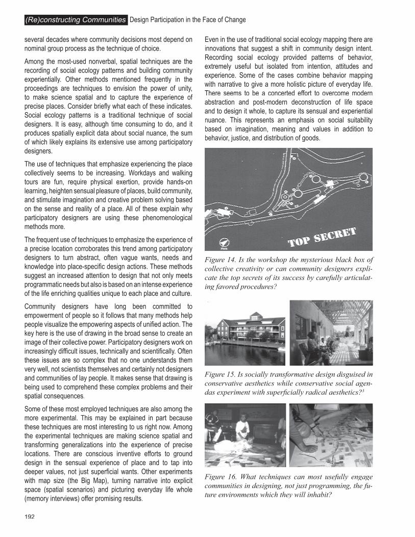
Figure 15. Is socially transformative design disguised in conservative aesthetics while conservative social agen-das experiment with superfi cially radical aesthetics?3
Figure 16. What techniques can most usefully engage communities in designing, not just programming, the fu-ture environments which they will inhabit?
Figure 14. Is the workshop the mysterious black box of collective creativity or can community designers expli-cate the top secrets of its success by carefully articulat-ing favored procedures?

193
Nonverbal Design and the Black Box
Return, for a moment, to the finding that community design relies most on verbal techniques like workshops rather than drawing and other nonverbal spatial representation. In all of the articles only one-third explicitly describe the use of spatial representation. Even fewer describe techniques leading directly to design, and almost none describe the built outcome.
I found only five out of 101 articles that describe techniques for coauthoring design in which spatial representation passed back and forth between community and designer. Many of the techniques mentioned create the program and lead up to design (recording social ecology patterns and making science spatial, for example) and some may even produce design decision-making (making choices with maps and models), but few describe collaborative form making.
This review might easily conclude that participatory design has a black box, the workshop, that is more democratic but equally elusive as the black box of traditional designers. To overcome this we need to be much more explicit in describing our methods and how they lead to or do not lead to action and outcomes, including designed and built landscapes. It would be especially informative to have in-depth descriptions of techniques that are spatially and experientially explicit and that capture and reshape place values.
The challenge of my colleague lingers. Do community designers shy from spatial explicitness? Are community designers more dependent on verbal communication and less skilled at spatially and experientially explicit communication? Or are our nonverbal techniques simply different and possibly superior when intensely and personally grounded in the place and culture?
Participatory Methods and Radical Design in Conventional Clothing
In a related topic of debate this review leaves little doubt that participatory design methods are more process oriented and less product oriented than other design approaches, products like building sense of community and empowerment
notwithstanding. But contrary to the often thought and sometimes spoken claim of elitist designers, there is scant evidence that the built design resulting from participatory processes is inferior. From this review the participatory design products seem unusually carefully crafted and reasonably low maintenance in addition to being well used and socially suitable. They are often figurative rather than abstract. There is loving attention to detail. There is no conceptual art nor is there deconstructed futurism. There does seem to be a comfortable, even conventional aesthetic in most participatory projects.
Randy Hester Democratic Drawing
Figure 17. Number of articles in which the technique is described.
Figure 18. Number of case studies employing techniques by category in proceedings of Democratic Designers in the Pacifi c Rim (1999-2002).

194
Design Participation in the Face of Change(Re)constructing Communities
DRAWING THE LINES IN THE WORLD AS COMMUNITY DESIGNERS
Masato Dohi
ABSTRACT
This article examines the issue of spatial form and social process. It puts forward ideas on the potential of ‘nature’ to show spatial borders and systems even in urban areas, and argues that we should read this potential to develop new city or urban form. To continue and deepen this argument, I will relate my thoughts on design process and try to connect with city or urban planning. Four cases of those I have experienced are chosen here to explore the design process: the case of King Estate Park, Oakland C.A., Suma-ward Kobe Japan, Narai Park Aichi Japan and Izumi settlement Tokyo, Japan. Each case will not be described as a whole. Instead, the focus will be on the most critical step of practice to consider what community design has created around space and society. Through this exploration, I hope to show that community design relies on and derives from some ‘natures of human character’ even when our project’s objective is not nature preservation or rehabilitation. After all, using this ‘nature of human character’, community design could realize a vital space in people’s relationship on site. However, how can we organize these sites on an urban scale? This question was a main theme of my presentation at the Hong Kong conference in 2002. I will trace briefly the idea that I have presented on natural systems and spatial-social form. At last, the connection between a well-managed design process and urban scale planning will be explored. The fractal concept will be introduced. With this concept, topics on form and process, design and planning or function and nature will be reconsidered.
WE DRAW LINES
We draw the lines. By drawing the lines, we imagine good space. We try to draw meaningful lines so that the space can be precious for people. This is why we need citizen participation. It is only through this process that lines have meaning and begin to live. If we do well, lines with rich meaning begin to create space, which gives meaning to people and to which people give meaning. At this moment lines we drew manifest themselves in space and society. Community designers draw the lines on paper, card, and wall or even on foot; all of these
Is socially transformative design disguised in conservative aesthetics while conservative social agendas experiment with superficially radical aesthetics? Does this directly result from the participatory process or certain participatory methods?
Skills Particular to Participatory Design
Participatory efforts share most drawing techniques with other designers. Careful observation, using research, developing concepts, and making choices are part of most design procedures.
Many representational techniques, like environmental justice maps, imagining unseen resources, envisioning unity, thinking complexly and building community experientially, may, on occasion, be shared with community organizing and development. There are also drawing methods that are likely the near exclusive domain of participatory design. Recording social ecology patterns, picturing everyday life whole, exchanging generalization for precise locations, designing upside down, mapping sacred landscapes and recalling values in place seem to be particular to participatory design.
Almost all of the drawing techniques discussed have special relevance to participatory design. What most distinguishes all these methods of drawing is the specific ways they are used in participatory contexts. They help designers express what other people think is important. They create a common language so complex publics can work together to make their own habitation. They nurture and inform civic debate. They include the excluded and they make democratic design from the bottom up. These differences in drawing are profound.
ENDNOTES1 Graphics provided by Randy Hester and Jeffrey Hou. 2 From The Bostonians Playing Excise-Man, 1774. print attributed to P. Dawe. 3 From Rural Studio: Samuel Mockbee and An Architecture of Decencyture of Decencyby Andrea Oppenheimer Dean and Timothy Hursley.