department of civil, environmental and geomatic engineeringposites, fire) and sarah springman...
TRANSCRIPT

Department of Civil,Environmental and
Geomatic Engineering
Annual Report 2003

Preface 3
Our Focus 4
Soil-Structure Interaction 6
Transport Infrastructures 8
High-Tech Geodetic Systems for Global Atmospheric and Space Geodetic Research 11
Highlights 14
Structures 14
Infrastructure Systems 16
Resources 18
Geo-, Structural and Environmental Data 20
High-Tech Measuring Systems 22
Studying at the Department of Civil, Environmental and Geomatic Engineering 24
Facts and Figures 25
Addresses 27
Table of Contents

3
The Department of Civil, Environmental and Geomatic Engineering of ETH Zurich is on its way to beco-ming a leading research and teaching institution in the field of man-made infrastructures and theirinterdependence on natural resources and spatial development. We are convinced, that these topics willbe the predominant challenge for civil, environmental and geomatic engineers in the future. Therefore itis evident, that our curricula and research focus on new technologies and processes contributing to asustainable development of society, economy and nature.
It is our prime goal to teach and train our undergraduate and graduate students on the basis of scienceand ethics, so that they will be able to identify future problems far in advance, to develop smart solutionsand to implement them successfully within the narrow constraints of an increasingly demanding andunstable social, economic and political environment. Despite the fact that the importance and the imageof the basic sciences is still growing, we are proud to educate engineers to be the future problem solversfor the benefit of mankind.
But also in research we strive towards implementing our long-term strategy. This has a direct impact onthe search for and appointment of new professors: Besides our traditional strengths in civil engineering,we are looking for a continual improvement of our competences in environmental and geomaticengineering in order to deal completely with the huge potential of our unique combination of disciplines.In addition, our department promotes interdisciplinary research projects launched by several professorswith the allocation of additional resources, such as PhD positions and seed money. All these efforts aimat leadership in engineering at an internationally acknowledged scientific level.
Hans-Rudolf SchalcherProf. Dr. sc. techn.Head of Department
Preface

Implementation of our strategyDuring the year 2003 we started to implementthe long-term strategy of our department, whichaims at focusing more precisely on man-made infra-structure and its interdependence with naturalresources. This strategy is fully in line with thestrategic plan of the Board of ETH (ETH-Rat) forthe period 2004 –2007 that designates infrastruc-ture, natural resources and sustainability as keyissues for the future.
Implementing an academic strategy correspondson the practical level to shaping the profiles ofnew professorships accordingly. Therefore our de-partment has decided during the last year to
search for two new full professors in the fields ofspatial development and of solid materials manage-ment and waste disposal technology.
A crucial problem for our department has emer-ged from the top down decision of the Board ofETH Zurich not to replace the faculty position incomputational science in civil engineering, tobecome vacant in 2004. The loss of such a basiccompetence will create serious threats to tea-ching and research in civil, environmental andgeomatics engineering. Thus we risk losing attrac-tiveness for Swiss and foreign students at thegraduate level, especially for PhD students.
The ongoing financial restrictions imposed by theSwiss Government are a further hindrance to thesuccessful implementation of our strategy for theyears 2004 – 2007. This situation doesn’t allow usa rapid adjustment of our scientific focus and ofthe corresponding organisational structure deman-ded by rapid global changes.
Strengthening the links with industryThe Holcim Foundation for Sustainable Cons-truction, established in 2003 and located in Zurich,has decided to sponsor an assistant professorshipfor sustainable construction to be based in ourdepartment. The search for the suitable person inaccordance with the general guidelines of ETHZurich will start in early 2004 and the position willbe financed from 2 005 until 2010. This generousendowment by one of the world’s largest cement,concrete and aggregate producers earns ourthanks and illustrates how the collaboration be-tween universities and industry could develop inthe future.
Our Focus

5
The new tenure track system worksTwo years ago ETH Zurich established a tenuretrack system for assistant professors. Our depart-ment took the chance immediately and appliedfor tenure of the professor for risk and safety. Aftera thorough evaluation by the tenure committee ofETH Zurich, our application was approved by endof 2003. We congratulate Prof. Dr. Michael Faberand welcome him as a full professor in our depart-ment.
Student intakeThe positive trend since 2000 regarding the num-ber of new students has turned out to be robust.In autumn 2003 168 students started their under-graduate studies in our department. Luckily, 25%of them are female. This proves that the variousattempts to attract more women to an enginee-ring education show the anticipated result. Whilethe number of beginners in civil engineering and
in geomatics engineering has remained more orless stable, environmental engineers have showna big increase to 60 new students.
The Bachelor program has startedOur department has started to implement thenew study model according to the BolognaDeclaration in autumn 2003. With the beginningof the winter semester 2003/04 we are offeringbachelor programs in civil engineering, environ-mental engineering as well as in geomatics andplanning. These programs last three years and arecompleted with a bachelor thesis. It is the ruling
policy of ETH Zurich, that the bachelor degreedoesn’t mean professional competence.The bache-lor degree is considered a prerequisite to enteringthe master programs and as a qualified platformfor student mobility.
The master programs of our department will startin autumn 2006. They are still at the stage of finetuning. It is planned to offer such programs in civiland environmental engineering as well as in geo-matics and planning. In addition there will bemaster programs in “spatial development andinfrastructure systems” and in “natural hazardsengineering”. Together with the Department ofArchitecture we plan to develop jointly twomaster's programs in the fields of “urban and land-scape design and planning” and of “technologyand management in construction”.
First Year Students 1982 – 2004160
140
120
100
80
60
40
20
0
1982 85 90 95 2004
Total Civil Engineering
Total Environmental and Geomatics
Total Geomatic Engineering and Planning
Total Environmental Engineering

6
Soil Structure Interaction (SSI) inevitably plays arôle for any structure that cannot be foundeddirectly on or in rock, and hence SSI must be consi-dered for a vast range of civil engineering structu-res. This subject remains one of fascination bothin industry and in research, largely because of thechallenges associated with working across thethematic divide and understanding the effect ofthe structure on the ground, and vice versa underincreasingly more demanding spatial and societalconditions.
Modern attempts to codify conceptual and actualdesign have been aided by the recent develop-ment of the thematic Swisscodes, under the lea-dership of Professor Peter Marti, with further con-tributions being made by Professors ThomasVogel (actions), Mario Fontana (steel, timber, com-posites, fire) and Sarah Springman (geotechnics).This has formalised the process across the Swisscivil engineering world, enabling a common philo-sophy and technical language to be adoptedacross all disciplines, aiding communication anddesign activity, with the intention of leading tooptimally safe and economic structures.The adop-tion of the potentially cost saving observationalmethod has also been introduced within the geo-technical design process, together with rules for
the acceptance of risk. In this respect, new designmethods related to Soil Structure Interaction mayalso be established based on results from physicalmodel testing.
Recent SSI research within IGT has focused prima-rily on either excavations in or embankments onhighly anisotropic soft lacustrine deposits (Diss.Trausch Giudici, Messerklinger, Weber) or founda-tions subjected to both static and dynamic loa-ding. Determination of both the serviceability andultimate limit states has become important as afunction of the respective deformation and failuremechanisms. The soil models are often inadequa-te for accurate prediction of structural deformati-ons related to excavations and the mechanicsbackground to the classical calculation methodsfor shallow foundations are questionable, where-by assumptions are made about homogeneityisotropy. These and other uncertainties werecovered by large global factors of safety in earlierdesign practise. Key issues in the research revolvearound the relative geometries and stiffnesses of
Soil Structure InteractionSarah Springman, Jan Laue
the structural and soil systems so that the effectof soil strata can be taken into account more reali-stically for future complex systems.
Investigations of the response of shallow founda-tions on layered soils to uniform vertical loadshave been carried out at diploma thesis (Ducksch,Herzog, Glanzmann, Tanner) and doctoral level(Diss. Nater) using combinations of analyticalmethods, as well as physical and numericalmodelling. Current design methods are inadequa-te because they do not allow for the extrusionmechanism in the clay layer, and may lead eitherto an under- or an over-estimation of bearingcapacity or settlements at working load. The Fi-gure below shows a comparison between resultsobtained from testing a 56 mm diameter rigidfooting in the IGT/ETHZ Geotechnical Centrifugeat 25 times earth’s gravity, simulating a 1.4 m dia-meter footing. This event has also been modellednumerically at full scale using a finite differenceapproach with a Mohr Coulomb yield criterion,including stress dependent increase of undrainedshear strength and strain dependent stiffnesswithin the yield locus.
Modern measurement techniques adapted frombiomedicine have aided the determination of theinteraction between the foundation and ground,showing the evolution of the bearing pressure as
Extrusion of soft material between two stifflayers (sand/clay/sand) due to the verticalloading of a 1.4 m diameter foundation:(left) failure mechanism, (center) resultfrom finite difference numerical modelling,(right) centrifuge physical modelling

7
the soil response evolves from small elastic strainsto increasingly plastic flow This will be used infuture for examining the different load-deforma-tion distribution across the footing when a moreflexible structural system is adopted.
A further dimension is added by the incorporationof cyclic or dynamic loads, either due to semi-repe-titive events based on known loads (e.g. tempera-ture induced changes in strut loads in excavations,infrastructure for high speed trains) as well as lesseasily predictable events, for example those due toearthquakes. IGT has recently been involved in amultidisciplinary project (with U. of Bogazici,Istanbul, D-ERDW, ENAC/EPFL) related to microzo-nation according to the risk of site amplification(of the signal at bedrock), slope instability andliquefaction. In the latter case, the rapid loss ofstiffness and strength occurring in certain poten-tially liquefiable soils (typically sands and silts) hascaused significant structural distress, whereby the
feedback between soil and structure becomesuniquely linked as liquefaction proceeds frompartial to full, where no effective stress can bemobilised between soil particles.
A new dynamic hollow cylinder device (R’EQUIP/ETH Fond) will enable soil response to be determi-ned from a typical soil element due to a combina-tion of dynamic and structural loading (Diss.Buchheister), depending not only on soil conditi-ons, but also on the initial stress conditions . Thesevary for a soil element located under the centre ofa structure and another element at the side of thefoundation before a seismic event, causing signi-ficantly different responses and effects on thestructure. Two dimensional effects related to theacceleration of the earthquake can also be con-sidered.This project will then provide soil conditionindicators to feed into a new generic risk analysistool, which will be developed in a D-BAUG researchgroup led by Prof. Michael Faber and includingProfessors Hans-Rudolf Schalcher, Armin Grün,Alessandro Dazio and Dr Jan Laue. Methods for
making deterministic assessments of actual riskwill be developed as well as generic proceduresfor taking uncertainties into account over a timeperiod including pre-, during and post-earth-quake.
These aspects, and important new develop-ments in Soil Structure Interaction, are incorpo-rated in teaching at all levels, from the basic andobligatory courses through to the selected topics,which may include Design and Construction inGeotechnical Engineering, Modelling in Geotech-nics (consisting of constitutive, physical andnumerical variants) or Soil Dynamics and link into advanced courses offered in Structural Engi-neering, including Structural Dynamics togetherwith many SSI-focused semester and diplomaprojects.
Load distribution under an axisysmmetric footing on sand under applied normal stress of c. 225 kPa (right) and at an earlier stage under 49 kPa (left).
Influence of location of soil elementon in-situ load distribution, withimplication for subsequent stresspaths due to earthquake loading
(Example from Microzonation Project in Turkey).
Collapse of a mosque during the Kocaeli-earthquake in Turkey (1999)

8
Transport InfrastructuresK. W. Axhausen, H. P. Lindenmann, J. Wichser
Understanding – measuring –forecasting – operatingThese four aspects of infrastructure engineeringwill be the focus of this contribution. They standpars-pro-toto for the life cycle of an infrastructurefrom the need identification, planning, design,construction, to operation, maintenance and eva-luation. Research focusing on infrastructures inthe Department is much broader than presentedhere this year, as active research is going in areassuch as water resources, hydraulic engineering,bridge design and monitoring, geotechnics, navi-gation, GIS or urban service provision. The exam-ples will be drawn from the Institute for TransportPlanning and Systems (IVT) and will sketch therange of the three groups making up the Institute:transport planning, transport systems (publictransport) and transport systems (road traffic).
Understanding: Human activity spacesand innovation in location choiceOne can understand transport demand models asmodels of daily life in as much as they predict thewhen and where of a population’s activities for anaverage day. Travel and traffic are only the resultsof these activities, excepting those where themovement is the purpose of the activity, e.g. wal-king the dog, jogging or a pleasure drive with thecar. Current state-of-the-art models approach dai-ly life as a set of decisions, which are dependent oneach other.The relevant statistical models accountfor the dependency of the choices, but also for thetaste differences of the different people in thesechoices. What they do not properly account for isthe dependency over time. How much structureand habit do the choices of a person exhibit overtime?
If, indeed, there are strong habits and visible struc-tures, then choice models will have to account forthem in the future. Recent work at the IVT hasaddressed both aspects, but only the question ofspatial structures will be discussed here. The IVThas currently the largest set of longitudinal traveldiary data sets available for its research, for mostof which it designed the survey itself. In each ofthese from 35 to 365 days long datasets the desti-nations of the travelers are geocoded allowing ananalysis of the spatial distribution of these desti-nations.
While biologists have worked with similar data foranimals for some time, these new datasets openup possibilities that transport researchers neverhad before. In the first instance, we developed aset of measures to characterize the size, structureand orientation of the activity space of an indivi-dual, i.e. the area which a person is actually using.The main driving force behind the size is the num-ber of activities a person performs, which in turncan only be very partially explained by the obvioussocio-demographic characteristics of the traveler.Beyond the size of the activity space we can iden-tify the number of distinct locations which a per-
son visited during the reporting period. The ratioof the number of activities to distinct locationsvaries around 4 per activity, but the distribution ofvisits per location is heavily skewed. Normally, the10 most heavily visited locations make up 80% ofthe activities. On the other hand, people conti-nuously add places to their repertoire of placesvisited. While it is possible in each survey to iden-tify the places (classified by both geocoded locati-on and purpose of visit), which had not been visi-ted before, we had included only in one survey thequestion, if this visit was the first ever visit to theplace. The ratio was about 1 to 10. Figure 1 summa-rizes the relevant results for three surveys. Giventhe way the new places are identified it is not sur-prising that the number goes down in the firstpart of the reporting period, but what is surprisingis the steady stream of new locations and placeseven after a number of weeks of observation.
Both results are a challenge to current choicemodeling approaches, as they indicate a strongserial dependency in the choices: both the prefe-rence for a small number of core locations, as wellas the wish for variety for its own sake demonstra-ted by the continuously added new locations.
Number of new places visited over thereporting periods of three surveys

9
Measuring: Current condition of thenational motorway networkThe IVT directed the work behind the first full-sca-le assessment of the condition and safety recordof the Swiss national highways (federally funded),by and large its motorways (Zustandserfassungund -bewertung Nationalstrassen Fahrbahnen(ZEB-NS)). This effort was motivated by the needfor the national and the regional governments toimprove their knowledge about the pavementperformance and safety levels, as well as themaintenance and long-term financial needs ofthe aging primary road infrastructure.This is espe-cially crucial as both levels need to plan for futureexpansion and extension of the network at thesame time.
In a series of major measurement campaigns sin-ce 1998 a range of variables were measured todescribe the conditions of the roads: grip, horizon-tal and vertical roughness, structural strength andfinally the accident record of each segment of thenetwork. The segment lengths varied between100 and 500 meters. To allow comparability theconditions were graded between 1 and 5 (verygood to not sufficient) following the Swiss code
SN 640 925. The generally good to very good con-ditions reflect the high level of investment andmaintenance afforded by the continuous fundingof the road system, as provided for in the Swissconstitution, which details a share of the fuel taxincome for this purpose.
For the analysis of the safety record all accidentsfor the last five years were geocoded to allow ananalysis of the accident black spots in the net-work. While the safety record of the motorways isimpressive in turns of accident rates per 106
vehicle-km, there are localized problems, whichneed further attention.
The ZEB-NS provides the owner of the nationalhighways with the information necessary for itsplanning and budgeting of the maintenance andrehabilitation of its network and for the invest-ment in an improved safety performance. Anupdate is planned for the period 2004/05.
Share of car driving license holders by age-cohort and sexamong Swiss residents
Pavement condition on the Swiss motorway network
Forecasting: Swiss travel demands in2030The Federal Office of Spatial Development(Bundesamt für Raumentwicklung; ARE) is regu-larly updating its long term perspectives of Swisstravel demand. As part of the current renewal theIVT was asked to provide a forecast of the numberof persons owning mobility tools in 2030 and ofthe average number of kilometers of travel theywill demand.
Mobility tools is a summary term for vehicles(cars, motorcycles, etc.), public transport seasonand discount tickets, which a person or householdacquires to enable its travel. These are longer termdecisions, with which the household determinesits short term marginal cost of travel. Daily modalchoices are then fairly obvious for the traveler. It istherefore crucial to understand how personschoose these tools, if one wishes to forecast thedemand for travel by mode, as the IVT had beenasked to do. A set of sequential choice models wasestimated to explain and predict the share ofowners of the different mobility tools as a func-tion of the usual socio-demographic variables, butalso a detailed description of the location of thehousehold and the speed on the regional trans-port system.
Current accident black spots on the Swiss motorway network.Source: NZZ am Sonntag, 7.12.2003

10
The driving license is the precondition for theaccess to cars. Inspection of the current share oflicense holders by age and sex shows what changecan be expected in the next thirty years. With thedeparture of the pre-war cohorts the number oflicense holders will substantially increase and thecurrent difference in ownership rates betweenmen and women will disappear.
The models for the travel demand were based onthe series of national travel surveys since 1984 andused the same person, location and network varia-bles as the ownership models. In addition, a timetrend was included to capture the unobservedstructural changes of the last twenty years.We areaware that such a simple approach has its dan-gers, but nothing more complex was possible inthe given timeframe.
A national average does not do justice to the varia-bility of conditions in the country or to the diffe-rences between the various groups of persons, inparticular the age cohorts. Therefore the IVT per-formed the forecasts separately for each munici-pality and each age group by sex within them. Aspecial software tool was developed to supportthe large computational effort involved in thisnumerical task. Additionally, for each forecast of abusiness-as-before scenario error bands were esti-mated to give the user an understanding of theuncertainty of forecasts over such a long period.
Operating: Horizontal transshipmentbetween rail and truckCombined freight traffic employing both rail andtruck stages is currently handicapped by the costsof the transfer of the container from rail wagon totruck. Regarding the labour costs, it is the invest-ment in the dedicated infrastructure of cranes,tracks and access which creates problems for thewidespread provision of terminals. Continuingprevious work, the IVT was involved in the 5th fra-mework-funded InHorTra consortium, which desi-gned, built, tested and evaluated three new hori-zontal transfer devices. These devices reduce thecost-base of a terminal considerably, which makessmaller scale terminals servicing smaller catch-ment areas feasible.
The IVT contribution was focused on the develop-ment of freight service concepts, which wouldmake full use of the possibilities of the new devi-ces. Drawing on much experience with railroadsimulation systems (see www.opentrack.ch) itdeveloped tools to simulate the new services andthe operation of the terminal to suggest furtherpossible improvements.
The new terminal concept can make a noticeablecontribution to the politically-desired shift to rail-based freight by lowering the costs of the operati-on and by reducing the access- and egress cost ofthe shipper to the terminal, while maintaining oreven improving service through shorter and morereliable terminal times.
Figure 3Share of car driving license holders by age-cohort and sex amongSwiss residents
Horizontal transfer deviceSource: Tuchschmid AG, Frauenfeld
OutlookThe provision of a welfare-enhancing traffic infra-structure is a central task for each industrializedcountry, especially for a densely populated one likeSwitzerland. The IVT contributes to the furtherdevelopment, operation and maintenance of thesenetworks by its research into all aspects of theinfrastructure lifecycle: need identification, plan-ning, design, construction, to operation, mainten-ance and evaluation.

11
Water Vapor, Atmosphere andGeodesyTropospheric water vapor plays an important rolein atmospheric and space geodetic sciences, espe-cially in the evolving field of space geodesy. It isthe most variable parameter of major constitu-ents in the atmosphere. Water vapor is one of theimportant greenhouse gases and involved in thedecomposition of the ozone layer. Atmospherichumidity has a strong impact on the refraction ofmicrowave signals emitted by GPS satellites. Thisresults in an overestimation of the distance bet-ween satellite and receiver. The so-called pathdelays enable the determination of the amount ofatmospheric water vapor, which is usually expres-sed in terms of the integrated precipitable watervapor (IPWV). The goal of the project describedhere is to develop methods to determine the con-tent of the atmospheric water vapor as well as itsspatial distribution on a continuous base and withhigh accuracy and reliability.
Methods of Measuring Water VaporTwo kinds of approaches exist to assess the watervapor content: either the IPWV along a signal pathor its distribution by measurement at specificlocations. The IPWV can be determined with GPS,radiometers, solar spectrometers and space-bornesystems (METEOSAT). Measurements at specificlocations are usually carried out with radiosondes,which provide vertical profiles and serve as a basisfor determining the 3 D distribution. The newapproach, which we have pursued, is using theIPWV to resolve the spatial structure with hightemporal and spatial resolution (GPS tomogra-phy).
Integrated Water Vapor ContentThe radiometric determination of IPWV is basedon intensity measurements of radiation, which isemitted by H2O-molecules due to thermal excita-tion. The technique utilizes the relation betweenwater vapor abundance and thermal radiationemitted at the 22.235 GHz spectral line. Severalprototypes of these instruments have been deve-loped at the Geodesy and Geodynamics Labora-
High-Tech Geodetic Systems for Global Atmospheric and Space Geodetic ResearchMarc Troller, Alexander Somieski, Beat Bürki, Alain Geiger and Hans-Gert Kahle
tory (GGL) of the Institute of Geodesy and Photo-grammetry (IGP). Figure 1 shows the new radiometerWVR2000.
Solar spectrometers utilize the absorption of thesolar radiation traversing the atmosphere due towater molecules. A portable field-capable typewas developed at GGL in cooperation with theInstitute of Spectrochemistry and Applied Spec-troscopy (ISAS, Berlin): the GEodetic MObile SolarSpectrometer (GEMOSS). It resolves single waterabsorption lines in the range between 730 nm and910 nm.Since GEMOSS acquires up to 4 solar spectraper minute containing numerous absorption lines,a high accuracy of IPWV can be achieved. A measu-red solar spectrum with hundreds of absorptionlines mainly from water and oxygen molecules isshown in figure 2. A total absorption of solar radia-tion due to oxygen molecules is visible near 760nm, whereas water molecules absorbe strongly ataround 820 nm and 900 nm.
Fig. 1: The new Water Vapor Radiometer WVR2000 installed
at ETH Hönggerberg.

12
A dedicated field campaign ESCOMPTE (expérien-ce sur site pour contraindre les modèles de polluti-on atmosphérique et de transport d'emissions)was performed to measure atmospheric gases inthe air-polluted region of Marseille. A network of16 GPS-receivers, the radiometer and solar spec-trometer as well as radiosondes were deployed.Figure 3 shows a time series of IPWV over a rangeof 5 days. A significant variation of the IPWV wasdetected by all techniques with good agreement.
GPS Tomography and 3D Water VaporInformationIn GPS tomography, the structure of the atmos-phere is elucidated. The signal emitted by the GPSsatellites propagates through the atmosphereand arrives at the GPS receiver after a time lagwhich corresponds to the distance satellite - recei-ver. The elapsed time depends also on the physicalparameters of the ionosphere and troposphere.The water vapor in the atmosphere causes syste-matic delays, the effects of which are exploited inGPS tomography. Since horizontal measurementsare not possible, and because the number of GPSsatellites and receivers are limited, boundary con-ditions have to be introduced in the adjustment
procedure to achieve the desired result. Promisingresults of profiles of water vapor were obtainedwith a high temporal resolution and at every loca-tion within the area of the GPS receivers.
A dedicated field experiment of GPS tomographywas conducted within Switzerland.The GPS nationalreference network AGNES of swisstopo was usedfor this study. It consists of 29 GPS stations, equallydistributed over Switzerland. A 3-dimensional boxmodel dividing the atmosphere into discretecuboids was introduced in the adjustment system(Figure 4). External data, such as radiosondes, have
Fig. 2: Solar absorption spectrum (730-910 nm) measured by theGeodetic Mobile Solar Spectrometer (GEMOSS). The inte-
grated water vapour content in direction to the sun is retrieved by quantifying the amount of absorption of sun radiation.
Fig. 4: 3D view of the tomographic box model above the Swiss territory.
The GPS stations of the AGNES network are shown in blue columns
according to their station heights.Radiosondes are launched from the
radiosonde station Payerne.

13
been used for the validation. They are usuallylaunched twice a day from the station at Payerne.Figure 5 shows a radiosonde profile and two profi-les obtained from GPS tomography for two nearbycolumns. The tomographic solutions fit the radio-sonde profile very well. The statistical evaluationshows, that, together with additional information,a sufficient accuracy of the water vapor determi-nation can be achieved. A cross section of thetomographic box model is depicted in figure 6.The rapid change of water vapor distribution inhorizontal direction is clearly seen.
Concluding Remarks and OutlookGeodetic systems are successfully applied for esti-mating the water vapor of the atmosphere. GPS,radiometers and mobile solar spectrometersachieve a high accuracy and reliability for thedetermination of integrated water vapor. Theyprovide long-term series of the total amount ofwater vapor for several applications, both in spacegeodesy and in the field of climate and atmosphe-
ric research. The spatial distribution of watervapor is successfully obtained by the method ofGPS tomography. An accuracy equivalent to radio-sondes can be reached. However, the spatial andtemporal resolution of the tomographic approachis much higher and provides nearly continuousinformation. With the development of GALILEOand improvement of GPS, a considerable increaseof accuracy can be expected. Geodetic measure-ment systems will, therefore, contribute substan-tially to recent issues of space geodesy, climatolo-gy and atmospheric science.
The ETH-funded project GEMOSS is conducted incooperation with Prof. Hans Richner of theIinstitute of Atmospheric and Climate Sciences.We are grateful for funds provided under the ETHresearch grant No. 00860/41-2647.5/AW/ML.
With this research topic, Marc Troller andAlexander Somieski participated at the Prix duJeune Entrepreneur de la Section Suisse desConseillers du Commerce Extérieur de la France.For further information refererence may be madeto ETH-Life (http://www.ethlife.ethz.ch/articles/KahleGPS.html).
Fig. 3: Time series of IPWV during 5 days. In addition to the GPS receiver
network, radiometer, solar spectro-meter and radiosondes were deployed.
Fig. 5: Comparison of a radiosonde profile vs. two tomographic determinations. The tomo-
graphic profiles are from the box column near the radiosonde station Payerne (indicated
in green and black color in figure 4).
Fig. 6: Cross section of the tomographic box model.

14
New Material Development:Hybrid Fibre ConcreteNew materials may open the road to new structu-ral applications in civil engineering. Over the lastfew decades not much improvement has beenmade in designing new types of concrete, but thelast decade has shown significant progress in thefield (IBWK, Group of Prof. van Mier). Recent deve-lopments have shown that, specifically, the tensilestrength of concrete can readily be improved byadding the right ‘fibre cocktail’ to the concrete. Afibre cocktail comprises of fibres of different size(and or shape), and/or of different types of fibre.Large amounts of short fibres tend to increase thestrength of the material, whereas a relativelysmall amount of long fibres is capable of impro-ving the ductility of the material. These are exact-ly the two material properties of concrete thathave given rise of substantial durability problemsin applications involving concrete. The flexuraltensile strength reaches values up to 80 MPa,which is 12 times higher than the bendingstrength of plain concrete. In addition, the defor-mations at the onset of global fracture exceed 0.3mm, with a rather interesting plastic response.The materials are designed to be self-compacting,
which implies that placement becomes relativelyeasy and straightforward, even without vibrating.The future might perhaps see concrete structureswithout conventional steel reinforcement.
Squeezing Rock in the Gotthard BaseTunnelIn some long stretches in the northern part of thenew Gotthard railway tunnel, rocks of lowstrength and high deformability such as kakiriticphyllite are expected. The critical zone is approxi-mately 1.1 km long, the depth of cover amounts to900 m. The existence of groundwater under highpressure favours the development of squeezing. Inthe critical zone, high initial pore water pressuresof up to 90 bar are expected.
In order to establish the mechanical characteri-stics of the kakiritic rocks, a comprehensive labora-tory testing programme on intact rock specimenswas carried out (IGT, Group of Prof. Anagnostou,Thesis of Martin Vogelhuber). A new apparatus
was developed in order to control and monitor thepore water pressure and the water content duringtesting. Despite the complex structure of thekakiritic phyllite, remarkably consistent resultswere obtained. Specimen pre-saturation and main-tenance of a sufficient back pressure proved to beessential for obtaining reliable and reproducibleparameters. In order to take into account the porewater pressure, the squeezing rock is modelled asa porous medium according to the principle ofeffective stress. This approach reduces the predic-tion uncertainties regarding the ground responseto the tunnelling operation.
Remaining structural capacity ofbroken laminated safety glassGlass constructions with structural functionrequire the verification of both the load carryingcapacity (LCC) and the remaining structural capa-city (RSC) of broken glass. The RSC is under theore-tically and experimentally investigation at theInstitute of Structural Engineering (IBK, group ofProf. Vogel,Thesis of Alexander Kott), as part of theEuropean COST action C13 ”Glass and InteractiveBuilding“. The load transfer mechanism in broken
Highlights
Structures
Tunnel cross section in squeezing rock
Example of the slump flow of self-compacting hybrid fibre concrete.

15
glass can be explained by applying yield linemechanisms and stress field theory. The PVB foilworks as tension reinforcement and the upperbroken glass layer carries the compression forces.The ultimate failure, which leads to the collapse ofthe structure, occurs when the compression zonein the yield line fails when the compressionstrength of glass is reached. Four point bendingtests combined with impact tests demonstratethat the different glass types, the type of initialfailure and the specimen dimensions determinethe post-breakage behaviour. The developedmechanical models can be considered in futurecodes, which will help the engineer to design glassstructures complying with the required safetystandards.
The EasyStatics E-Learning Project:A Virtual Structural Design Laboratory Architects and civil engineers need to understandhow the structures they design are going to carryloads. They have to know how design parametersinfluence deflections, section forces, stability,
dynamic behaviour, ultimate resistance, etc.Computers compute all this, but their users mustbe able to properly model real-life structures andto extract relevant information from computerresults. As easy to use as paper and pencil, as intui-tive as a hand calculator, the program EasyStaticsteaches these non-trivial but today essential skills(IBK, Group of Prof. Anderheggen,Thesis of ClaudiaPedron). Acting as a virtual structural laboratory,EasyStatics helps students in civil engineering andarchitecture to develop the feeling and intuitionneeded for structural design in a highly motiva-ting way. The aim of the accompanying e-learningproject is to build an environment in which tea-chers can freely produce their own lectures,demonstrations and student exercises utilisingEasyStatics’s power and flexibility. More informati-on is found on www.easystatics.ethz.ch.
Stabilizing water hardness in tunnel drainage systems lowers maintenance costsOperators of drained tunnels are faced with theproblem of cost-intensive maintenance measuresto counteract the phenomenon of scaling in tun-nel drainage systems. The enrichment of the des-cending seepage/ground water with carbon dioxi-de is a principal natural cause for the formation ofscale. The stabilization of water hardness byadding polyaspartic acid is investigated by IBB(Group of Prof. Girmscheid, Thesis of T. Gamisch,funded by the German Railways (Deutsche BahnAG). By adsorbing the hardness-forming ions inthe drainage system, polyaspartic acid prevents,disrupts or delays the formation of hard scale. Thisactive agent of hardness stabilization is a nature-related substance, which is fully decomposed bymicroorganisms and regarded as environmentallyunproblematic. As an overall result, the right useof hardness stabilization in connection with con-structional modifications can result in longermaintenance intervals and a substantial reduc-tion of cleaning work in pipes, which in turn leadsto considerable extension in the life cycle of thetunnel drainage system, to lower maintenancecosts, and to increased availability of the trafficroutes.
Broken pane of laminated safety glasswith PVB foil as tension reinforcementstill transferring load.
Scale deposits in tunnel drainage systems (left) and
effect of polyaspartic acid on the crystalisation of
calcium carbonate (right)
Graphic interface of EasyStatics
Crystal of calcium carbonate
Calciumcarbonate Crystal with polyaspar-tic-acid inclusion

Highlights
Infrastructure Systems
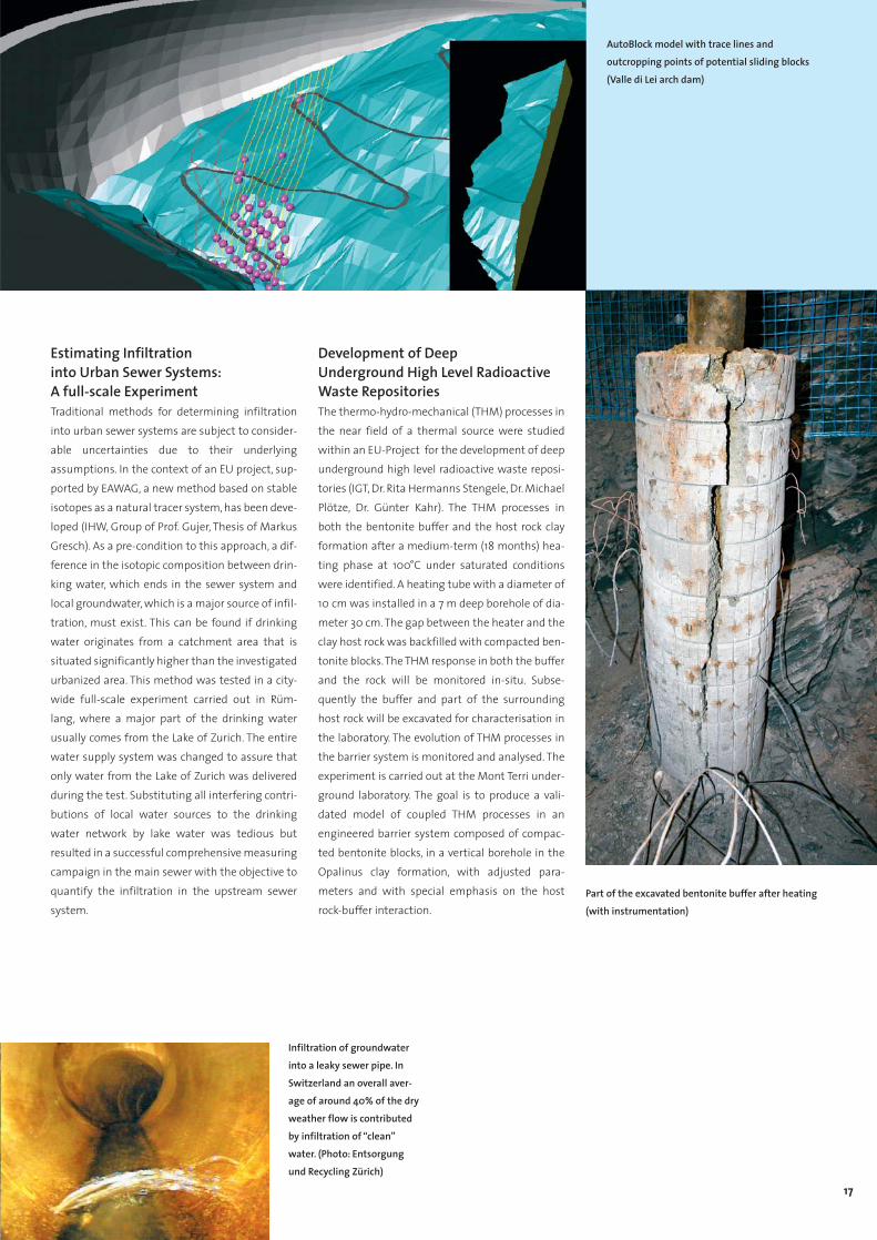
Stability of Foundations and Slopes inRock based on a Digital Terrain Model The CAD-based program AutoBlock enables one to analyze the stability of potential sliding blocks in a digital terrain model (IGT, Group of Prof.Anagnostou, Dr. Peter Fritz, Stefan Bergamin).These blocks are endangered by sliding along kno-wn planes of weakness or by separating fromthem. Additionally, foundations or parts of theground to be excavated may be superimposed. Foreach block, which, based on kinematic considerati-ons, may fail, the factor of safety against sliding iscomputed using the limit equilibrium method.AutoBlock is an add-on to the popular programAutoCAD and exploits its possibilities and itspower (e.g. for 3D-visualizations). It provides allthe tools required for representing and visualizingthe results and facilitates a stability analysis withany number of potential sliding blocks. Thanks tothese tools and by exploiting the services ofAutoCAD, AutoBlock enables engineers to over-view and handle the geometry of the discontinui-ties in the ground and to determine potential sli-ding blocks with a minimum of expense and amaximum of accuracy.
16
De-Aeration of a Diversion Tunnel of a Large Scale Hydroelectric SchemeOne of the intakes of the Jökulsà Diversion Tunnelof the Karahnjukar Hydroelectric Scheme is sub-jected to a transition from free-surface to pressu-rized tunnel flow due to the varying water level inthe main reservoir of up to 75m. In order to avoiddamage in the main conduit as well as in thehydraulic equipment, the air entrained into thepressurized flow has to be removed through verti-cal drill-holes of 0.5m diameter leading the air tothe ground surface. The air entrainment and thede-aeration system were studied in physicalmodels at the VAW (Group of Prof. Minor). Specialattention was paid to possible scale effects in thetwo-phase flow model, which includes a ratherslow concurrent horizontal two-phase flow with asmall void fraction in the diversion tunnel and ahighly turbulent and highly aerated vertical flowwith an almost stagnant liquid in the drill-holes.In a first phase, the capacity of the drill-holes, thecorresponding two-phase flow patterns and theadditional rise of the water level in the drill-holeshad to be assessed, as icing in the vicinity of theground surface would endanger the functionalityof the chosen system severely.
Additional rise of thewater level H. Arm of the test track showing the water tanks for loading the truck twin wheels
Hydraulic jump in the model tunnel, entraining air intothe pressurized part of the tunnel.
The IGT Circular Pavement Test Track The circular test track allows the simulation of theloading and the weather conditions that affectroads during their service life at full scale. Thetime scale of the loading conditions can be shor-tened, in comparison with experimental tracksconstructed within the existing road infrastructu-re, because the number of loading cycles can beincreased significantly within a given time period.The specifications of the test track include a circu-lar trapezoidal concrete pit (medium diameter: 32m) that allows the groundwater level to be adju-sted and controlled, a loading system consisting ofthree arms, each of them fitted with driven trucktwin wheels, a load adjustable from 50 kN to 80kN (corresponding to truck axle loads between100 kN and 160 kN), variable speed up to 80 Km/h(i.e. between 100,000 and 150,000 load cycles permonth). The test track is built for accelerated full-scale tests and comparisons of different pave-ment structures in order to find appropriate designmethods and construction procedures. Examplesof tested material include recycled road construc-tion materials, stone mastic asphalts, stress absor-bing membrane interlayer, thin overlays and naturalstone paving. Skid resistance can be measured,and weigh-in-motion (WIM) systems can be testedand calibrated (IGT, Dr. Markus Caprez).
17
Estimating Infiltration into Urban Sewer Systems:A full-scale ExperimentTraditional methods for determining infiltrationinto urban sewer systems are subject to consider-able uncertainties due to their underlyingassumptions. In the context of an EU project, sup-ported by EAWAG, a new method based on stableisotopes as a natural tracer system, has been deve-loped (IHW, Group of Prof. Gujer, Thesis of MarkusGresch). As a pre-condition to this approach, a dif-ference in the isotopic composition between drin-king water, which ends in the sewer system andlocal groundwater, which is a major source of infil-tration, must exist. This can be found if drinkingwater originates from a catchment area that issituated significantly higher than the investigatedurbanized area. This method was tested in a city-wide full-scale experiment carried out in Rüm-lang, where a major part of the drinking waterusually comes from the Lake of Zurich. The entirewater supply system was changed to assure thatonly water from the Lake of Zurich was deliveredduring the test. Substituting all interfering contri-butions of local water sources to the drinkingwater network by lake water was tedious butresulted in a successful comprehensive measuringcampaign in the main sewer with the objective toquantify the infiltration in the upstream sewersystem.
Development of Deep Underground High Level RadioactiveWaste RepositoriesThe thermo-hydro-mechanical (THM) processes inthe near field of a thermal source were studiedwithin an EU-Project for the development of deepunderground high level radioactive waste reposi-tories (IGT, Dr. Rita Hermanns Stengele, Dr. MichaelPlötze, Dr. Günter Kahr). The THM processes inboth the bentonite buffer and the host rock clayformation after a medium-term (18 months) hea-ting phase at 100°C under saturated conditionswere identified. A heating tube with a diameter of10 cm was installed in a 7 m deep borehole of dia-meter 30 cm. The gap between the heater and theclay host rock was backfilled with compacted ben-tonite blocks.The THM response in both the bufferand the rock will be monitored in-situ. Subse-quently the buffer and part of the surroundinghost rock will be excavated for characterisation inthe laboratory. The evolution of THM processes inthe barrier system is monitored and analysed. Theexperiment is carried out at the Mont Terri under-ground laboratory. The goal is to produce a vali-dated model of coupled THM processes in anengineered barrier system composed of compac-ted bentonite blocks, in a vertical borehole in theOpalinus clay formation, with adjusted para-meters and with special emphasis on the hostrock-buffer interaction.
AutoBlock model with trace lines and outcropping points of potential sliding blocks(Valle di Lei arch dam)
Part of the excavated bentonite buffer after heating(with instrumentation)
Infiltration of groundwaterinto a leaky sewer pipe. InSwitzerland an overall aver-age of around 40% of the dryweather flow is contributedby infiltration of “clean”water. (Photo: Entsorgungund Recycling Zürich)

Highlights
Resources
18
The VisuLands ProjectThe management of land is increasingly decidedat a local level, with trends across Europe of grea-ter public participation in landscape planning pro-cesses and empowerment of local administrati-ons to determine resource exploitation and deve-lopment. Yet, understanding of the consequencesof landscape planning decisions is generally pooramong the public and their elected representati-ves. The VisuLands Project analyses public prefe-rences and land manager aims for present lands-capes and scenarios of future land use to producea set of new visualization tools that enable publicparticipation in landscape management (IRL,Group of Prof. Schmid, Thesis of Olaf Schroth andUlrike Wissen). It uses relationships betweenvisual qualities and other landscape functionssuch as biodiversity, cultural heritage, amenityand sustainable production to support a soundstewardship of the rural and peri-urban landsca-pe, and an increased understanding of change.These tools should assist planners and the publicin assessing the outcome of landscape planningstrategies.This includes the development of quan-titative indicators of landscape change and theuse of landscape preference models. The tools aretested in co-operation with local stakeholders ofthe Entlebuch UNESCO Biosphere Reserve. TheEntlebuch‘s cultural landscape is of (inter-)natio-nal significance because of the natural sceneryand the habitat functions for plants and animals.In addition, it is a valuable resource for tourism aswell as for agriculture. In this context, the visua-lization tools are tested in public developmentforums as well as with local experts.
Upscaling and Effective Propertiesin Heterogeneous Aquifers Natural porous media such as aquifers and soilsare heterogeneous. As small scale heterogeneitycannot be considered explicitly in practical designand management, several strategies have beendevised to take into account the unresolved subs-cale. One of those is the introduction of effectiveparameters on the large scale. These are functionsof the stochastic properties on the small scale (e.g.mean, variance and correlation function). The pro-cedure has been quite successful in linear pro-blems. Successful upscaling implies that on thelarge scale the same transport equations apply ason the small scale with the coefficients replacedby their upscaled effective values. In nonlineartransport things change dramatically. We investi-gated nonlinear adsorptive transport according toa Freundlich isotherm as a prototype of nonlinearinteraction (IHW, Group of Prof. Kinzelbach, Thesisof Jiva Dimitrova Micha). If the exponent of theisotherm is assumed to be a spatially stochasticvariable, the large scale transport equation no lon-
ger has the same form as the small scale equation.The isotherm on the large scale has to be modi-fied. The new isotherm was derived using thetechnique of homogenization. While in the linearcase the dispersion coefficients are properties ofthe aquifers alone, they also depend on concentra-tion in the nonlinear case. If the Freundlich expo-nent can be assumed constant, upscaling is possi-ble to the extent that an equivalent adsorptioncapacity can be defined. However, the dispersioncoefficient cannot be localized and has the formof a spatial integral.
Water Management in an Arid Area(Xinjiang Project)The project, supported by D-BAUG funds, looksinto water management in an arid area of China.In the Yanqi plain of Xinjiang large scale irrigationwith river water has led to a groundwater tablerise and soil salination. It has also caused a salinityincrease in the downstream Lake Bostan. We areinvestigating several countermeasures (IHW,Group of Prof. Kinzelbach,Thesis of Philip Brunner)including irrigation from groundwater, which
VisuLands projectworkflow

19
should keep the water table down, water savingirrigation and direct diversion of water to thedownstream. To judge their effectiveness, thesemeasures will be simulated in a regional modelcombining surface water and groundwater. Themodel requires inputs which are not easily obtai-ned in an environment with a poor scientific infra-structure. We are exploiting therefore remote sen-sing data. As the salination depends on thedistance of groundwater tables from the surface,a digital terrain model is an important input. Itwas obtained from stereo radar satellite imagescombined with accurately measured fix points.Another input, which is required for calibratingthe final model, is a salinity map of the top soil.Here also remote sensing can be applied. Frommulti-spectral data a typical spectrum for comple-tely saline pixels was defined. The degree of clo-seness to this spectral fingerprint determines thedegree of salinity. Extensive field work on theground was performed to determine the actualsalinity of a number of training pixels. The satelli-
te signal correlates well to observed soil salinity inthe first 30 cm. The map was successfully calibra-ted with actual ground measurements and willplay an important role in future model calibration.
Experiments in Fractured Media Nuclear waste disposal has to address the pro-blem of gases produced by decay and corrosion. Ina fractured host rock the gases may migratetogether with the water, leading to a two-phaseflow. Up to now little is known about this type offlow, especially when the fractures are filled withfault gouge material. This was the motivation forcarrying out two-phase flow experiments insingle fractures in the Grimsel Rock Laboratory(IHW, Group of Prof. Kinzelbach, Thesis of IvanLunati). The research was done in cooperationwith NAGRA, ANDRA and UPC. To produce a two-
phase flow, a well-doublet was installed in thestudied fracture. Air was injected in one well and awater-air mixture was extracted from the otherone. After the air “bubble” stabilized, the systemwas ready for gas tracer tests to determine thevolume of air contained in the fracture. Numericalsimulations were conducted at IHW to interpretthe data obtained in the experiments. Three con-ceptual models of the fracture space were propo-sed in the simulations. While they did not differsignificantly in the breakthrough curves at theextraction well, the respective air distributions inthe fracture were extremely different. As thesecould not be observed in the field, a laboratoryexperiment was performed on a core from theGrimsel drift. The two-phase flow was visualizedby neutron-radiography at the Paul ScherrerInstitute. The first images obtained indicate thatthe air distribution has a structure consisting ofblobs connected by fine threads. This behavior fitsthe model of a fracture which is filled with faultgouge of spatially varying grain size distribution.
The heterogeneous structure of a gravelaquifer shows up in a gravel pit
Computed air distribution in a dipole flow field for two hypothetical models containing fault gouge material:– a Parallel-plate fracture containing heterogeneous fault gouge material (left) and – a Rough-walled fractured containing homogeneous fault gouge material (right)
Salinity distribution from remote sensing data

20
Conflict Management GISSpace is a limited resource and requires planningprocesses. Commercial Geo Information Systems(GIS) support these procedures by acquisition,maintenance, analysis and visualisation of spatialdata only. In order to achieve a common and wide-ly accepted solution, affected people have to beintegrated in a participatory process aiming atovercoming underlying conflicts. At IGP, Group ofProf. Giger, a Conflict Management GIS (COMAGIS)was developed, which is based on a commercialGIS, which was enhanced by additional functiona-lities:1. A usable interface according to the users’ men-
tal model, and a high-end visualisation systembased on Virtual Reality enables laymen to fullyparticipate equally to experts.
2. Executing all interactions based on this system,all interaction data are stored and can be usedas a protocol.
3. Interpreting these interaction data providesinformation if really all participants worked to-gether in a solution-oriented and constructiveway.
COMAGIS supports users’ perception and analysesthe interaction data in order to raise the probabili-ty to achieve a common solution to the givenplanning task.
Advanced User Interfaces for theHandling of Spatial DataThanks to the trend towards mobile applicationsand devices, new applications like mobile GIS, por-table tourist guides or supporting systems foremergency response are being developed. Thesesystems simplify the use of computing systemsand Geographic Information in highly mobile (e.g.field data collection) as well as in urgent situati-ons (e.g. disaster management). Research at IGP,Group of Prof. Ch. Giger, uses the latest advancesin spatial cognition sciences for developing newuser interfaces for handling spatial data in suchsystems. The interface is based on speech recogni-tion and enables the user to do without keyboardand mouse. Special functionalities like the selec-
tion of spatial objects or object spaces requiresophisticated algorithms and the consideration ofmany different influences. The results of suchresearch are user-centered, intuitive interfacesthat are tailored to spatial questions and easy touse. They also provide a framework for later userinterface design in totally new spatial environ-ments that use technologies like AugmentedReality and Wearable Computing.
EU-project GEOWARN The European Union-funded international GEO-WARN project provided an internet-based experttool to visualise and analyse research data in orderto aid the forecasting of natural disasters, as wellas scientific analysis. The volcanically activeEuropean regions of Nisyros (Greece) and CampiFlegrei (Italy) were chosen as pilot sites. Geo-physical, geochemical, geodetical, geological,
Highlights
Geo-, Structural and Environmental Data
Advanced user interfaces in use with wearable GISallow real-time access tocomplex spatial informationand analysis

21
demographic and geographic data of varioustypes, resolutions and formats (raster data, griddata, time series data, etc) from 8 teams in fourEuropean countries were unified in a single data-base. This database can be accessed by GIS soft-ware for expert visualisation, analyses, and hazardassessment, as well as by the internet-based AtlasInformation System (AIS) -type software, allowinginteractive multi-level access for user-friendlyvisualisation, crisis management, education andoutreach. The AIS software platform was custom-programmed at the IKA, Group of Prof. Hurni, andits user interface was designed as a component-based framework for interactive maps. GEOWARNwas invited to contribute to the World Orga-nisation of Volcano Observatories (WOVO) globaldata management effort (WOVOdat)."
Design Aspects for 3D-Maps Today, cartographic theory of 3D maps has someimportant deficits. Mainly, there are no designprinciples for the user-friendly symbolisation andexpressive visualisation of map objects. A PhD pro-ject at the IKA (Group of Prof. Hurni, Thesis ofChristian Häberling) aimed at deriving a prelimi-nary set of such design principles for 3D maps. Afirst inventory of design variables relevant for mapconcepts and production was assembled, and 3Dmap examples were created from sections of vec-torial landscape models and digital elevationmodels. The 3D map examples covered the fiveindependent design variables, i.e. observation angle,
observation distance, direction of illumination, skystructure, and fog effects. The quantitative ran-king and the comments of experts from differentfields within geomatics were interpreted for opti-mising the degrees of abstraction and dimension.As conclusions nineteen theses for design princi-ples were formulated. In particular, the familiarmap-like symbolisation of map content findsgreat acceptance. An almost natural representati-on of map objects should not be attempted. Infuture, 3D maps will find increasing application,especially in tourism, planning and education, par-ticularly when provided with extensive functiona-lity for interactive use. The proposed design princi-ples – in addition to the general availability of vec-tor-based geo-data sets and of powerful compu-tational resources – will facilitate the productionof this attractive type of map-related representati-ons.
Nisyros caldera, Greece: 3D-representation of IKONOS orthophoto overlaid with representation of CO2 flux (height) and surface temperature (colour).
Topographic 3D map of the region of Greifensee(Switzerland), seen from the east. The symbolised vec-
tor-based digital landscape model VECTOR200 wascombined with the digital elevation model DHM25
(Data: © Swisstopo, Wabern).
Geodetic strain field andseismicity in southern Italy
GPS Results and Seismo-TectonicProcesses in Southern ItalySouthern Italy is a key area for understanding thetectonic processes in the collision zone betweenthe African and Eurasian plates.With the results ofnew GPS measurements carried out between1994 and 2001, the GGL (Geodesy and Geody-namics Lab, IGP, Group of Prof. Kahle) presentedcompletely new findings for this area. CentralItaly, Corsica, Sardinia and the Tyrrhenian Seamove like the Eurasian plate.There is no indicationthat the opening of the Tyrrhenian Sea is stillactive. In contrast, the African plate motionextends across Maltese and southern Italianislands to southern and western Sicily. The com-pression between the African and Eurasian platesis concentrated along a 50 km narrow belt to thenorth of the Sicilian coast and reaches 60nstrain/yr (= 60 ppb per year). Location and direc-tion of this large compression is in general agree-ment with fault plane solutions of earthquakes.Due to the large velocities in northeastern Sicilyand the Eolian islands, the interior of Sicily isunder extension. Furthermore, we could confirmthe compression between Italy and Greece as wellas extension across the southern Apennines,which have been the site of numerous large-scaleearthquakes in the recent past.

Highlights
High-Tech Measuring Systems
22
3-D Terrestrial Laserscanning of theBenedictine Abbey of EinsiedelnIn collaboration with the Institute for History andTheory of Architecture (gta), Prof. Dr. W. Oechslin,the facade and the interior of the famous Abbey ofEinsiedeln have been scanned with the new tech-nology of 3-D Laserscanning (IGP, Group of Prof.Ingensand). The benefit of this new laser techno-logy is to capture 3-D coordinates of the construc-tion within a few minutes. In conjunction withintensity values of the reflected laser beam it ispossible to generate a full geometric model of thebuilding. As a result of this campaign the unkno-wn and complex geometry of the different con-struction stages of this building could be uncover-ed und documented.
3D Cloud Mapping and Tracking withSatellite and Terrestrial ImagesCloudmap2 is an EU project with 7 partners in 6European countries for the estimation and valida-tion of macroscopic (e.g. cloud-top height) andmicroscopic (e.g. cloud droplet radius) cloud para-meters and water vapor distributions forNumerical Weather Prediction Models. The role ofthe IGP (Group of Prof. Gruen, Thesis of GabrielaSeiz) is to estimate cloud-top and -bottom heightsand wind speeds from satellite and ground-basedsensors. The cloud-top heights are derived frommulti-view satellite scenes from AATSR, MISR andASTER, using Meteosat images for wind correc-tion. The cloud-bottom heights are estimatedfrom stereo images acquired by a self-establishedground-based sky imager system consisting of 3digital cameras with wide-angle lenses. In bothcases the photogrammetric processing includescamera calibration and orientation, image prepro-cessing, point measurements with our cloud-adapted multi-photo matching algorithm, qualitycontrol and further postprocessing. For validation,the derived cloud heights are compared to otherground-based (cloud radar, ceilometer, IR camera)and in-situ (radiosonde) measurements. Our self-developed terrestrial system is currently used inmeasurements campaigns in England and theUSA.
Development of a new Digital high-resolution Aerial CameraThe development of a new generation of high-resolution digital aerial cameras is currently amajor topic in photogrammetric system develop-ment worldwide. The STARIMAGER SI-200 is sucha new camera, based on the principle of CCD Three-Line Scanning, developed and manufactured bySTARLABO Corp., Tokyo. IGP (Group of Prof. Gruen)is currently doing extensive research work in coo-peration with STARLABO with the aim of develo-ping new methods for the automated and semi-automated processing of Three-Line Scanner data.Under a research and development contract weare also designing, developing and testing newsoftware for a variety of processing tasks, inclu-ding graphical user-interface for image handlingin mono, stereo and image triplet mode, modelorientation and image triangulation with fullyautomated tie point measurement, automatedDigital Surface Model generation, different modesfor image rectification, ortho-image generation,mono-plotting and feature and object extraction,with focus on 3D city and road network modeling(for more information see www.photogramme-try.ethz.ch). Originally designed for the modellingof line structures (roads, rivers, railways, etc.), thissystem can be used in many other applications aswell, as for instance in natural and man-madehazards damage monitoring, for 3D city modeling,car navigation, traffic control, and for general datacollection for GIS.
Cloud-top heights and motion resultsfrom satellite views, 03 Aug 2000
3-D Laserscanning data allow the survey ofhistorical buildings

23
First Airborne Absolute GravityMeasurements, WorldwideIn recent years global change has become of con-cern for mankind. In this context precise knowled-ge of the Earth's gravity field is of major impor-tance in order to establish the physical referencesurface needed for monitoring global sea levelchanges. There is a large uncovered wavelengthdomain, which can only be filled with airbornetechniques. Until now, airborne gravity surveyswere carried out with relative techniques usingspring-type gravimeters. These suffer, however,from correlated measurements, instrument drift
and frequency response of the spring. Our project,pursued at the IGP (Group of Prof. Kahle, Thesis ofHenri Baumann, supervised by Prof. Klingelé) isconcerned with the development of an absolutegravity measuring system which is based on theinterferometric principle. INS, GPS and mechanicalas well as mathematical filters are used to mitiga-te the disturbing accelerations significantly. Itallowed for the first time the retrieval of absolutegravity under flight conditions with a resolutionon the order of 6x10⁻⁶ g. The promising resultsachieved may open up a new era in airborne gravi-metry.
Grain Size Analysis for Coarse RiverBeds using Digital Image ProcessingQuantification of the grain size distribution ofriver beds remains an issue of large importancefor a wide range of river engineering problems. Anew procedure was empirically derived from flu-me experiments performed at the VAW (Group ofProf. Minor), using digital image analysis. The pro-posed method represents a fast, easy and inex-pensive alternative to determine the grain sizedistribution of the subsurface of coarse river beds.In a first step, a photograph is taken of a dry bedsection from an appropriate height. The followingstep converts the photograph into a quasi-binaryimage, which is suitable for an automated extrac-tion of grain size data. The programme scans theimage to identify and analyse objects. Besidesother information, the longest and shortest axesof the recognised objects are measured.The analy-sis with automated object recognition resemblesa point analysis of the surface layer. Thus, anappropriate conversion model was developed to determine the volumetric distribution of thesubsurface layer. The method was tested withindependent flume and field data, resulting in pro-mising approximations to the reference gradingcurves of the subsurface.
Grain size distribution of the subsurface of the Töss-river
Development of the airborneabsolute gravity meter system
3D hybrid city model of Yokohama,produced with CyberCity modeller in semi-automated mode from STARIMAGER SI-200 images
Image strips of STARIMAGER SI-200 over Yokohama (Insert: zoom-in)

The quality and the profit of the studies atD-BAUG only becomes obvious when one hascompleted one’s studies and the first projects inpractice. During the seemingly innumerable lectu-res, exercise courses, excursions and workshopsone easily forgets that these new importantinputs (from each meeting) develop the student’sknowledge and experience until he or she gainsthe engineering diploma. One first becomes reallyconscious of what has been achieved at the diplo-ma celebration, when the head of departmentcalls you “dear colleagues”.
But, no pains no gains! The studies are not a bed ofroses, particularly during the basic semesters andthe exams. Amazingly however one meets manyof the unloved propaedeutic subjects againduring the specialization studies, in the semesterprojects or the diploma thesis or in practical trai-ning.
Yes, practical training! For me it represents thehighlight of my years of study. My stays in Munichand Vienna allowed me to put to use the technicalknowledge and methods of problem solvingacquired and provided the chance for interculturalexchange. That will influence me for life. Unfor-
tunately, the mandatory practical training of 16weeks has been removed from the curriculumwith the conversion to the Bachelor/Master sys-tem; a terrible loss.
The transfer from the basic studies (1st– 4th semes-ters) to the specialized studies (5th–9th semesters)was in one way a continuous transition, formallyhowever it was radical, with the implementationof the new credit system. Being the first class toexperience this, it was sometimes quite difficultto obtain our credits. On the other hand, the opti-ons to attend elective courses were almost bound-less. In my branch of study “Geomatic enginee-ring” we were offered a pretty wide range: fromgeophysics to regional economics, from riverengineering to computer vision. Specialization inthe fields of study and the work as a student assi-stant in various institutes made personal contactto professors and assistants possible. This contactgave the studies a kind of humanity and quality oflife.
From the beginning of our studies the contact andsocial life among students was excellent. Thanksto the student associations and their financialsupport by the alumni great events like ski wee-kends, the annual ice hockey match, the famousJass competition or legendary parties can be fun-ded. All these happenings promote bonhommieamong the students. The student associationsalso place elected delegates in the different com-mittees of the department. Regrettably not every-where in these committees are the comments ofthe students taken seriously. On the whole, howe-ver the committees are a cooperative affair andare a useful preparation for later working life.
Before concluding I would like to mention one thing:Our studies are only as excellent as they are,because the state invests high sums of money inthis university and its teaching. We graduatesknow how to value this dedication and would liketo give sincere thanks to all the people who makesuch an education possible.
Hannes Schneebeli
Hannes Schneebeli got his diploma in Geomaticsengineering in autumn 2003
Studying at the Department of Civil, Environmentaland Geomatic Engineering (D-BAUG)

25
InstitutesInstitute for Construction Engineering and Management (IBB): Proff. G. Girmscheid, H.R. SchalcherInstitute of Structural Engineering (IBK): Proff. P. Marti, E. Anderheggen, M. Fontana, T. Vogel, M.H. Faber, A. DazioInstitute of Building Materials (IBWK): Prof. J.G.M. van MierInstitute of Geodesy and Photogrammetry (IGP): Proff. H. Ingensand, A. Carosio, A. Grün, H.G. Kahle, Ch. GigerInstitute of Geotechnical Engineering (IGT): Proff. S. Springman, G. AnagnostouInstitute of Cartography (IKA): Prof. L. HurniInstitute of Hydromechanics and Water Resources Management (IHW): Proff. W. Kinzelbach, P. Burlando, W. GujerLaboratory of Hydraulics, Hydrology and Glaciology (VAW): Prof. H.-E. MinorResource and Waste Management (S+E): Prof. P. BacciniNetwork City and Landscape (NSL)Institute for Territorial Development and Landscape (IRL): Proff. W.A. Schmid, S. Kytzia, A. ThiersteinInstitute of Tranport Planning and Systems (IVT): Prof. K.W. Axhausen
FacultyRetirements Prof. Dr. P. Amann Geotechnical Engineering June 30, 2003
Prof. Dr. H. Brändli Tranportation Engineering September 30, 2003Prof. Dr. R. Hermanns Stengele Geotechnical Engineering March 31, 2003
Appointments Prof. Dr. G. Anagnostou Geotechnical Engineering October 1, 2003Prof. Dr. A. Dazio Structural Engineering August 1, 2003
Facts and Figures
Students (Academic Year 2002/2003) Students1
st year 2nd year 3
rd year 4th year Total Diplomas
Civil Engineering 109 58 42 27 236 55Environmental Engineering 38 20 24 25 107 18Geomatic Engineering* 24 18 14 38 94 32
Total 171 96 80 90 437 105
(* Incl. Diplomas Rural Engineering)
Doctoral Students DiplomasStudents Students
in other from other D-BAUG Departments Departments Total
Civil Engineering 69 1 3 73 10
Environmental Engineering 26 1 3 30 6
Geomatic Engineering* 36 36 5
Total 131 2 6 139 21
(* Incl. Rural Engineering)
Department Conference
Head of Department LabsIT
SecretariatEducation
Planing/Controlling
Conference of Heads of InstituteConference of Faculty Members
Curriculum Committee
Examination Committee
CivilEngineering
EnvironmentalEngineering
GeomaticsEngineering
IBB
IBK
IBWK
IRL
IGP
IGT
IHW
IKA
IVT
S + E
VAW
Diploma Courses Institutes

26
Staff (including part-time employees)Assistents, Technical Administrative
Institute Professors Senior Staff PhD-Students Staff Staff TotalD-BAUG 5 5 4 14IBB 2 2 14 1 3 22IBK 5 4 39 5 5 58IBWK 1 1 9 4 2 17IGT 3 10 24 12 3 52IHW 3 5 27 3 3 41NSL 7 1 3 11IRL 3 7 24 0 2 36IVT 2 7 27 4 4 44VAW 1 12 29 15 3 60IGP 5 12 38 2 6 63IKA 1 4 21 2 2 30S+E 1 1 2 4Total 29 77 257 52 39 452
Postgraduate Studies (NDS), Postgraduate Courses (NDK), Short CoursesNDS/NDK IHW Hydrology and Hydrogeology (together with IATE/HYDRAM of EPFL)NDS/NDK NSL Spatial Planning NDS/NDK VAW Hydraulic Structures (together with LCH of EPFL)NDK D-MAVT, IBK Risk and SafetyNDK IGP, IKA Spatial Information SystemsNDK NSL Space as a Factor of Decision MakingShort Courses IBB Bauunternehmensmanagement
IBB BauinventarmanagementIBK/IGT/HBT/SIA Einführungskurse zu den neuen SIA-TragwerksnormenIHW Probabilistic and Stochastic Approaches for Characterizing Hydroclimatic Processes IHW Stochastic Tools for Groundwater ModellingIVT Einführung in die Abschätzung und Prognose der VerkehrsnachfrageIVT Forum Braunwald: Regionalverkehr zwischen Liberalisierung und FinanzproblemenIVT/SBB Integrierter öffentlicher VerkehrIVT/DVWG Liberalisierung und Privatisierung im Eisenbahnverkehr - aktueller Stand und zukünftiger HandlungsbedarfIVT/DVWG Güterverkehr im erweiterten Europa
Workshops, Symposia, CongressesEvent Institute DateInternational Workshop “Validation of Cloud and Water Vapour Satellite Products”, Zurich, Switzerland IGP January 27–28Milestones in Physical Glaciology from the Pioneers to a Modern Science VAW February 14ISPRS Workshop "Visualization and Animation of Reality-based 3D Models", Tarasp-Vulpera, Switzerland IGP February 24–28Turbulenzen in der Geomorphologie (Jahrestagung der Geomorphologischen Gesellschaft VAW March 27–293. RailML Tagung IVT April 3Plenary Meeting ISO-TC 211 Geographic information / Geomatics IGP May 19–238th International Conference on Permafrost IGT (Co-organiser) July 21–2510th International Conference on Travel Behaviour Research IVT August 10–14Hydrofractals’03 – International Conference on Fractals in Hydrosciences IHW August 25–29International Conference “Optical 3-D Measurement Techniques VI”, Zurich, Switzerland IGP September 22–252nd Int. Seminar on Environmental Engineering Education (Int. Water Association) IHW/EAWAG Sept. 24–26Workshop on Benchmarking of Groundwater Models IHW October 15–166th International Conference on Precipitation in Urban Areas IHW December 4–7Ingenieurbetonbau, Exhibition of the Society for the Art of Civil Engineering IBK December 8, 04 – Jan. 15, 04
HonoursProf. Dr. Peter Baccini S+E Honorary Doctor of the University of Neuchâtel.Prof. Dr. Lorenz Hurni IKA Mitglied der Deutschen Akademie der Naturforscher "Leopoldina", (Halle/Saale)Prof. Dr. Lorenz Hurni (Atlas der Schweiz) IKA Publikums- und Jurypreis für die beste Kartenpublikation in der Sparte
Multimedia, Int. Kartographie-Kongress, DurbanProf. Dr. Peter Marti IBK Honorary Member of the Swiss Society of Engineers and Architects (SIA)Prof. Dr. Martin Funk VAW Titularprofessor ETH ZürichProf. Dr. Willi H. Hager VAW elected as member of the Council of the International Association of Hydraulic Research (IAHR)Prof. Dr. Hansruedi Siegrist IHW/EAWAG Titularprofessor ETH ZürichDr. Lukas Arenson IGT T.L. Péwé Award for the Best Paper by a Young Author, 8th International Permafrost conference in ZürichHelen Freimark KTW-Software AwardDr. Kristian Kramer VAW Winner J.F. Kennedy Student Competition 2003, IAHR-congress ThessalonikiChristian Marti VAW Winner SANW competition for young researchersDr. Hubert Meusburger VAW Alpiner Wasserkraftpreis 2003 der Arbeitsgemeinschaft Alpine WasserkraftBarbara Schechinger IBK Best Poster Contribution Award, German Society for Non-Destructive TestingAndrea Thielen IGT F.C. Trapp-Prize, RWTH Aachen.Markus Gresch, Hans Seelhofer, Roland Zeller Medal for the best Students of ETHZ Markus Gresch, Roland Zeller Willi Studer PrizeSandro Bay, Raphael Marty Baubetriebs-FörderungspreisRuth Freiermuth, Romano Hofmann Geosuisse-PrizeBarbara Karin Ebert, Hans Seelhofer, Regula Wicki Culmann Fund PrizeYves Daniel Keller Maggia PreisSimon Denoth Otto Jaag - Prize

Department of Civil, Environmental and Geomatic EngineeringPostfach 193
ETH Hönggerberg
CH-8093 Zurich, Switzerland
www.baug.ethz.ch
Head of DepartmentProf. Dr. Hans Rudolf Schalcher
DeputyProf. Dr. Peter Marti
Diploma Course Civil Engineering Head Prof. Dr. Hans-Erwin Minor
Secretariate Enrico Manna
Diploma Course Environmental EngineeringHead Prof. Dr. Paolo Burlando
Secretariate Sigrid Schönherr
Diploma Course Geomatics EngineeringHead Prof. Dr. Lorenz Hurni
SecretariateSigrid Schönherr
StaffPlanning and ControllingDr. Andreas Müller
EducationMartin Hänger
IT-supportDr. Xaver Studerus
Addresses
Impressum
Published by Department of Civil, Environmental and
Geomatic Engineering
Editor Dr. Andreas Müller
Design inform-zh.ch
Photos Department of Civil, Environmental and
Geomatic Engineering
PrintBuchsMedien AG
1st Edition April 2004: 2000 copies
