department of environmental protection bedrock … · field studies of new jersey geology and guide...
TRANSCRIPT
Geology mapped 1987, 1998-99, 2008-09Some bedding data from Parker (1993) and Kummel (unpublished, on file at the New Jersey Geological Survey, Trenton, New Jersey)
Cartography by D. Monteverde, S. Stanford and M. Girard
7000 FEET1000 10000 2000 3000 4000 5000 6000
.5 1 KILOMETER1 0
SCALE 1:24 0001/ 21 0 1 MILE
MA
GN
ETIC
NO
RTH
APPROXIMATE MEANDECLINATION, 1998
TRU
E N
OR
TH
13.5
LOCATION INNEW JERSEY
5'
2'30"
41o00'74o07'30"
5' 2'30" 74o00'41o00'
RA
MSE
Y
BEDROCK GEOLOGY OF THE PARK RIDGE QUADRANGLE,BERGEN COUNTY, NEW JERSEY
byDonald H. Monteverde
2011
Base from U. S. Geological Survey, 1955
ss
ss
ssssss ss
ss
ss
ss
ssrr-ssss-rrss
ss
ss ssss
ssrr-ss
ss
ssss
ss
ssss
ssss
ssssss
ssss
ss
ss
ss ss
ss ssss
ss
ss ss
ss ss ssssss
ssssss-shss
ssss
ss
ss sh
ssss ss
ss
ss
ss
ss
ss
ss
ss
ss
ss
ss
ssss
ss
ss
rr-ssss ss
ss
ss
ssrr-ss
ss
ss
ss ss-shss
ss
ss
ss
ss
ss ss
ss
ss
ss
ss
shss
rr-ssss ss
ss
ss
ss
ssss
ssss
sh-ssss
ss
ssss
ss
ss
ss ss
ss
ss
ss ss ss
rr
ssss
ss
ss
ssss
ssss ss
ss
ssss
ss
ss
ss
ss
ssss
rr-ss
ssss
ss
ss-sh
ss ss
ss ssss
ss ss
ss
ss
ss
ss
ssss
ss ssss
ssss
ss
ssssssss
ss
rr-shss
ss
ssss
ssss
sh
ss
ss
sh-rr
ss
ss
ss
ssss
sh-ss
ss
ss
ss
ss
ss
sh
ss
ss
ss
ss
ssss
ssssss
ss
ss
shss sh-ss
ss ss
sh-ss
ss
ss-sh
sh-sssh-ss
ss
ssssss
ssss
sh
rr-ss
sh
sh-ss
shsh
sh-ss
ss
ss
ss
ss
DEPARTMENT OF ENVIRONMENTAL PROTECTIONWATER RESOURCES MANAGEMENTNEW JERSEY GEOLOGICAL SURVEY
BEDROCK GEOLOGY OF THE PARK RIDGE QUADRANGLE,BERGEN COUNTY, NEW JERSEY
OPEN-FILE MAP OFM 85
Prepared in cooperation with theU.S. GEOLOGICAL SURVEY
NATIONAL GEOLOGIC MAPPING PROGRAM
NYA
CK
HACKENSACK
3 6 9 12
36912
N
67 readings/66 stations
Bedding
3 6 9 12 15
3691215
N
34 readings/24 stations
Joints
NEWARK BASIN
Quaternary
Triassic
Jurassic
CORRELATION OF MAP UNITS
Qpg
Qg
Figure 3. Structural data on rocks in study area. Joints not present in all exposures.
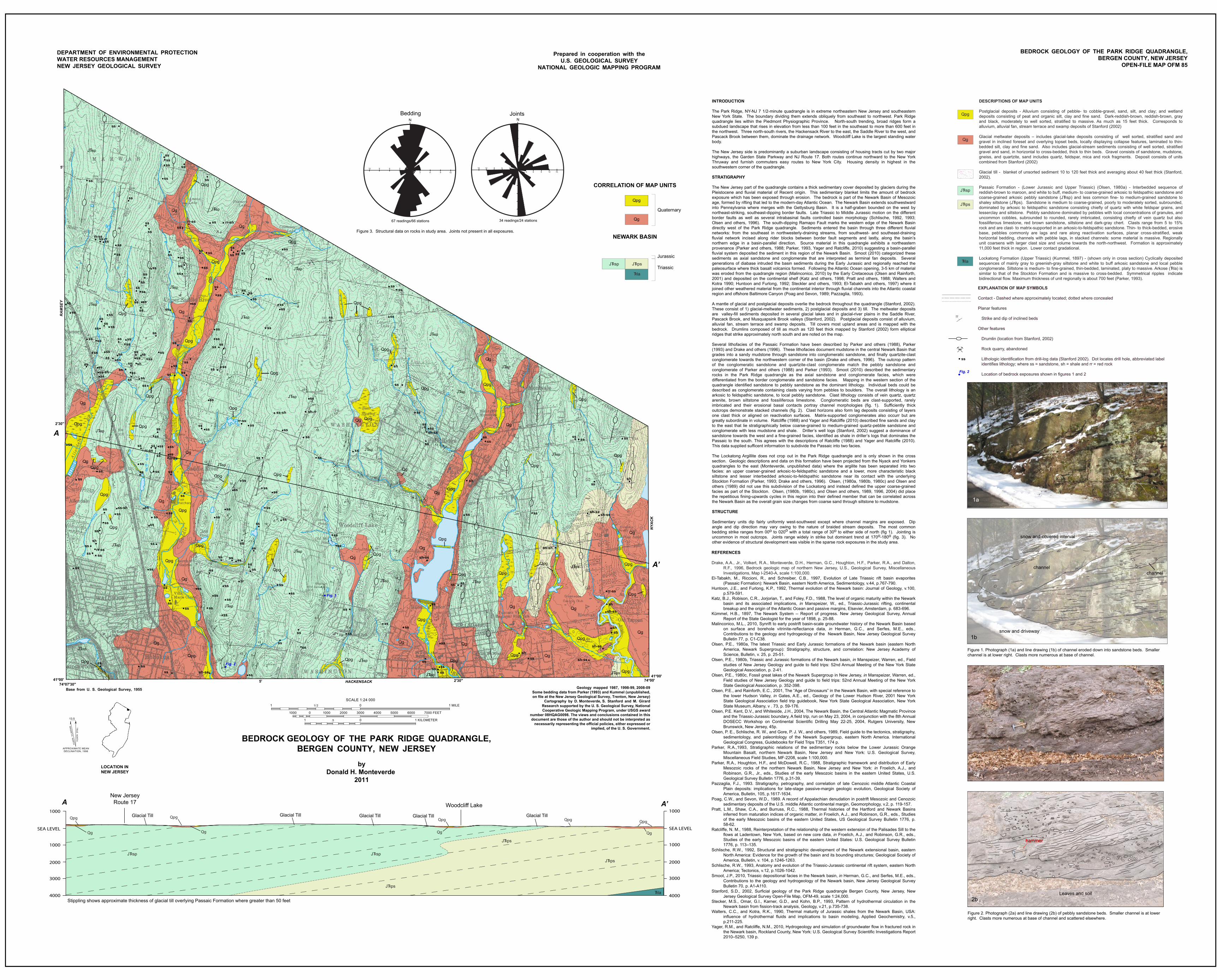
INTRODUCTION
The Park Ridge, NY-NJ 7 1/2-minute quadrangle is in extreme northeastern New Jersey and southeastern New York State. The boundary dividing them extends obliquely from southeast to northwest. Park Ridge quadrangle lies within the Piedmont Physiographic Province. North-south trending, broad ridges form a subdued landscape that rises in elevation from less than 100 feet in the southeast to more than 600 feet in the northwest. Three north-south rivers, the Hackensack River to the east, the Saddle River to the west, and Pascack Brook between them, dominate the drainage network. Woodcliff Lake is the largest standing water body.
The New Jersey side is predominantly a suburban landscape consisting of housing tracts cut by two major highways, the Garden State Parkway and NJ Route 17. Both routes continue northward to the New York Thruway and furnish commuters easy routes to New York City. Housing density in highest in the southwestern corner of the quadrangle. STRATIGRAPHY The New Jersey part of the quadrangle contains a thick sedimentary cover deposited by glaciers during the Pleistocene and fluvial material of Recent origin. This sedimentary blanket limits the amount of bedrock exposure which has been exposed through erosion. The bedrock is part of the Newark Basin of Mesozoic age, formed by rifting that led to the modern-day Atlantic Ocean. The Newark Basin extends southwestward into Pennsylvania where merges with the Gettysburg Basin. It is a half-graben bounded on the west by northeast-striking, southeast-dipping border faults. Late Triassic to Middle Jurassic motion on the different border faults as well as several intrabasinal faults controlled basin morphology (Schlische, 1992, 1993; Olsen and others, 1996). The south-dipping Ramapo Fault marks the western edge of the Newark Basin directly west of the Park Ridge quadrangle. Sediments entered the basin through three different fluvial networks: from the southeast in northwesterly-draining streams, from southwest- and southeast-draining fluvial network incised along rider blocks between border fault segments and lastly, along the basin’s northern edge in a basin-parallel direction. Source material in this quadrangle exhibits a northeastern provenance (Parker and others, 1988; Parker, 1993, Yager and Ratcliffe, 2010) suggesting a basin-parallel fluvial system deposited the sediment in this region of the Newark Basin. Smoot (2010) categorized these sediments as axial sandstone and conglomerate that are interpreted as terminal fan deposits. Several generations of diabase intruded the basin sediments during the Early Jurassic and regionally reached the paleosurface where thick basalt volcanics formed. Following the Atlantic Ocean opening, 3-5 km of material was eroded from the quadrangle region (Malinconico, 2010) by the Early Cretaceous (Olsen and Rainforth, 2001) and deposited on the continental shelf (Katz and others, 1998; Pratt and others, 1988; Walters and Kotra 1990; Huntoon and Furlong, 1992; Steckler and others, 1993; El-Tabakh and others, 1997) where it joined other weathered material from the continental interior through fluvial channels into the Atlantic coastal region and offshore Baltimore Canyon (Poag and Sevon, 1989; Pazzaglia, 1993). A mantle of glacial and postglacial deposits overlie the bedrock throughout the quadrangle (Stanford, 2002). These consist of 1) glacial-meltwater sediments, 2) postglacial deposits and 3) till. The meltwater deposits are valley-fill sediments deposited in several glacial lakes and in glacial-river plains in the Saddle River, Pascack Brook, and Musquapsink Brook valleys (Stanford, 2002). Postglacial deposits consist of alluvium, alluvial fan, stream terrace and swamp deposits. Till covers most upland areas and is mapped with the bedrock. Drumlins composed of till as much as 120 feet thick mapped by Stanford (2002) form elliptical ridges that strike approximately north south and are noted on the map.
Several lithofacies of the Passaic Formation have been described by Parker and others (1988), Parker (1993) and Drake and others (1996). These lithofacies document mudstone in the central Newark Basin that grades into a sandy mudstone through sandstone into conglomeratic sandstone, and finally quartzite-clast conglomerate towards the northwestern corner of the basin (Drake and others, 1996). The outcrop pattern of the conglomeratic sandstone and quartzite-clast conglomerate match the pebbly sandstone and conglomerate of Parker and others (1988) and Parker (1993). Smoot (2010) described the sedimentary rocks in the Park Ridge quadrangle as the axial sandstone and conglomerate facies, which were differentiated from the border conglomerate and sandstone facies. Mapping in the western section of the quadrangle identified sandstone to pebbly sandstone as the dominant lithology. Individual beds could be described as conglomerate containing clasts varying from pebbles to boulders. The overall lithology is an arkosic to feldspathic sandstone, to local pebbly sandstone. Clast lithology consists of vein quartz, quartz arenite, brown siltstone and fossiliferous limestone. Conglomeratic beds are clast-supported, rarely imbricated and their erosional basal contacts portray channel morphologies (fig. 1). Sufficiently thick outcrops demonstrate stacked channels (fig. 2). Clast horizons also form lag deposits consisting of layers one clast thick or aligned on reactivation surfaces. Matrix-supported conglomerates also occurr but are greatly subordinate in volume. Ratcliffe (1988) and Yager and Ratcliffe (2010) described fine sands and clay to the east that lie stratigraphically below coarse-grained to medium-grained quartz-pebble sandstone and conglomerate with less mudstone and shale. Driller’s well logs (Stanford, 2002) suggest a dominance of sandstone towards the west and a fine-grained facies, identified as shale in driller’s logs that dominates the Passaic to the south. This agrees with the descriptions of Ratcliffe (1988) and Yager and Ratcliffe (2010). This data supplied sufficent information to subdivide the Passaic into two facies.
The Lockatong Argillite does not crop out in the Park Ridge quadrangle and is only shown in the cross section. Geologic descriptions and data on this formation have been projected from the Nyack and Yonkers quadrangles to the east (Monteverde, unpublished data) where the argilite has been separated into two facies: an upper coarser-grained arkosic-to-feldspathic sandstone and a lower, more characteristic black siltstone and lesser interbedded arkosic-to-feldspathic sandstone near its contact with the underlying Stockton Formation (Parker, 1993; Drake and others, 1996). Olsen, (1980a, 1980b, 1980c) and Olsen and others (1989) did not use this subdivision of the Lockatong and instead defined the upper coarse-grained facies as part of the Stockton. Olsen, (1980b, 1980c), and Olsen and others, 1989, 1996, 2004) did place the repetitious fining-upwards cycles in this region into their defined member that can be correlated across the Newark Basin as the overall grain size changes from coarse sand through siltstone to mudstone.
STRUCTURE
Sedimentary units dip fairly uniformly west-southwest except where channel margins are exposed. Dip angle and dip direction may vary owing to the nature of braided stream deposits. The most common bedding strike ranges from 00o to 020o with a total range of 30o to either side of north (fig 1). Jointing is uncommon in most outcrops. Joints range widely in strike but dominant trend at 170o-180o (fig. 3). No other evidence of structural development was visible in the sparse rock exposures in the study area.
REFERENCES
Drake, A.A., Jr., Volkert, R.A., Monteverde, D.H., Herman, G.C., Houghton, H.F., Parker, R.A., and Dalton, R.F., 1996, Bedrock geologic map of northern New Jersey, U.S., Geological Survey, Miscellaneous Investigations, Map I-2540-A, scale 1:100,000.
El-Tabakh, M., Riccioni, R., and Schreiber, C.B., 1997, Evolution of Late Triassic rift basin evaporites (Passaic Formation): Newark Basin, eastern North America, Sedimentology, v.44, p.767-790.
Huntoon, J.E., and Furlong, K.P., 1992, Thermal evolution of the Newark basin: Journal of Geology, v.100, p.579-591.
Katz, B.J., Robison, C.R., Jorjorian, T., and Foley, F.D., 1988, The level of organic maturity within the Newark basin and its associated implications, in Manspeizer, W., ed., Triassic-Jurassic rifting, continental breakup and the origin of the Atlantic Ocean and passive margins, Elsevier, Amsterdam, p. 683-696.
Kümmel, H.B., 1897, The Newark System -- Report of progress. New Jersey Geological Survey, Annual Report of the State Geologist for the year of 1898, p. 25-88.
Malinconico, M.L., 2010, Synrift to early postrift basin-scale groundwater history of the Newark Basin based on surface and borehole vitrinite-reflectance data, in Herman, G.C., and Serfes, M.E., eds., Contributions to the geology and hydrogeology of the Newark Basin, New Jersey Geological Survey Bulletin 77, p. C1-C38.
Olsen, P.E., 1980a, The latest Triassic and Early Jurassic formations of the Newark basin (eastern North America, Newark Supergroup): Stratigraphy, structure, and correlation: New Jersey Academy of Science, Bulletin, v. 25, p. 25-51.
Olsen, P.E., 1980b, Triassic and Jurassic formations of the Newark basin, in Manspeizer, Warren, ed., Field studies of New Jersey Geology and guide to field trips: 52nd Annual Meeting of the New York State Geological Association, p. 2-41.
Olsen, P.E., 1980c, Fossil great lakes of the Newark Supergroup in New Jersey, in Manspeizer, Warren, ed., Field studies of New Jersey Geology and guide to field trips: 52nd Annual Meeting of the New York State Geological Association, p. 352-398.
Olsen, P.E., and Rainforth, E.C., 2001, The “Age of Dinosaurs” in the Newark Basin, with special reference to the lower Hudson Valley, in Gates, A.E., ed., Geology of the Lower Hudson River, 2001 New York State Geological Association field trip guidebook, New York State Geological Association, New York State Museum, Albany, v . 73, p. 59-176.
Olsen, P.E. Kent, D.V., and Whiteside, J.H., 2004, The Newark Basin, the Central Atlantic Magmatic Province and the Triassic-Jurassic boundary, A field trip, run on May 23, 2004, in conjunction with the 8th Annual DOSECC Workshop on Continental Scientific Drilling May 22-25, 2004, Rutgers University, New Brunswick, New Jersey, 45p.
Olsen, P. E., Schlische, R. W., and Gore, P. J. W., and others, 1989, Field guide to the tectonics, stratigraphy, sedimentology, and paleontology of the Newark Supergroup, eastern North America. International Geological Congress, Guidebooks for Field Trips T351, 174 p.
Parker, R.A.,1993, Stratigraphic relations of the sedimentary rocks below the Lower Jurassic Orange Mountain Basalt, northern Newark Basin, New Jersey and New York: U.S. Geological Survey, Miscellaneous Field Studies, MF-2208, scale 1:100,000.
Parker, R.A., Houghton, H.F., and McDowell, R.C., 1988, Stratigraphic framework and distribution of Early Mesozoic rocks of the northern Newark Basin, New Jersey and New York: in Froelich, A.J., and Robinson, G.R., Jr., eds., Studies of the early Mesozoic basins in the eastern United States, U.S. Geological Survey Bulletin 1776, p.31-39.
Pazzaglia, F.J., 1993. Stratigraphy, petrography, and correlation of late Cenozoic middle Atlantic Coastal Plain deposits: implications for late-stage passive-margin geologic evolution, Geological Society of America, Bulletin, 105, p.1617-1634.
Poag, C.W., and Sevon, W.D., 1989. A record of Appalachian denudation in postrift Mesozoic and Cenozoic sedimentary deposits of the U.S. middle Atlantic continental margin, Geomorphology, v.2, p. 119-157.
Pratt, L.M., Shaw, C.A., and Burruss, R.C., 1988, Thermal histories of the Hartford and Newark Basins inferred from maturation indices of organic matter, in Froelich, A.J., and Robinson, G.R., eds., Studies of the early Mesozoic basins of the eastern United States, US Geological Survey Bulletin 1776, p. 58-62.
Ratcliffe, N. M., 1988, Reinterpretation of the relationship of the western extension of the Palisades Sill to the flows at Ladentown, New York, based on new core data, in Froelich, A.J., and Robinson, G.R., eds., Studies of the early Mesozoic basins of the eastern United States: U.S. Geological Survey Bulletin 1776, p. 113–135.
Schlische, R.W., 1992, Structural and stratigraphic development of the Newark extensional basin, eastern North America: Evidence for the growth of the basin and its bounding structures; Geological Society of America, Bulletin, v. 104, p.1246-1263.
Schlische, R.W., 1993, Anatomy and evolution of the Triassic-Jurassic continental rift system, eastern North America; Tectonics, v.12, p.1026-1042.
Smoot, J.P., 2010, Triassic depositional facies in the Newark basin, in Herman, G.C., and Serfes, M.E., eds., Contributions to the geology and hydrogeology of the Newark basin, New Jersey Geological Survey Bulletin 70, p. A1-A110.
Stanford, S.D., 2002, Surficial geology of the Park Ridge quadrangle Bergen County, New Jersey, New Jersey Geological Survey Open-File Map, OFM-49, scale 1:24,000.
Stecker, M.S., Omar, G.I., Karner, G.D., and Kohn, B.P., 1993, Pattern of hydrothermal circulation in the Newark basin from fission-track analysis, Geology, v.21, p.735-738.
Walters, C.C., and Kotra, R.K., 1990, Thermal maturity of Jurassic shales from the Newark Basin, USA: influence of hydrothermal fluids and implications to basin modeling, Applied Geochemistry, v.5., p.211-225.
Yager, R.M., and Ratcliffe, N.M., 2010, Hydrogeology and simulation of groundwater flow in fractured rock in the Newark basin, Rockland County, New York: U.S. Geological Survey Scientific Investigations Report 2010–5250, 139 p.
Qg
Qg
Qg
QgQg
Qg
Qg
Qg
Qg
Qg
Qg
Qg
Qg
Qg
Qg
Qg
Qg
Qg
Qg
Qg
Qg
Qg
Qg
Qpg
Qpg
Qpg
Qpg
Qpg
Qpg
Qpg
Qpg
Qpg
Qpg
Qpg
Qpg
Qpg
QpgQpg
Qpg
Qpg
Qpg
Qpg
Qpg
Qpg
Qpg
Qpg
Qpg
Qpg
Qpg
Qpg
Qpg
Qpg Qpg
Qpg
Qpg
Qpg
Qpg
Qpg
Qpg
Qpg
Qpg
Qpg
Qpg
Qpg
QpgQpg
JTspR
JTspR
JTpsR
JTspR
JTpsRJTspR
JTspR
JTspR
JTspR
JTspR
JTspR
JTspR
JTspR
JTspR
JTspR
JTspR
JTspR
JTspR
JTspR
JTspR
JTspR
JTspR
JTspR
JTspR
Research supported by the U. S. Geological Survey, National Cooperative Geologic Mapping Program, under USGS award
number 08HQAG0098. The views and conclusions contained in this document are those of the author and should not be interpreted as
necessarily representing the official policies, either expressed or implied, of the U. S. Government.
DESCRIPTIONS OF MAP UNITS
Postglacial deposits - Alluvium consisting of pebble- to cobble-gravel, sand, silt, and clay; and wetland deposits consisting of peat and organic silt, clay and fine sand. Dark-reddish-brown, reddish-brown, gray and black, moderately to well sorted, stratified to massive. As much as 15 feet thick. Corresponds to alluvium, alluvial fan, stream terrace and swamp deposits of Stanford (2002)
Glacial meltwater deposits – includes glacial-lake deposits consisting of well sorted, stratified sand and gravel in inclined foreset and overlying topset beds, locally displaying collapse features, laminated to thin- bedded silt, clay and fine sand. Also includes glacial-stream sediments consisting of well sorted, stratified gravel and sand, in horizontal to cross-bedded, thick to thin beds. Gravel consists of sandstone, mudstone, gneiss, and quartzite, sand includes quartz, feldspar, mica and rock fragments. Deposit consists of units combined from Stanford (2002)
Glacial till - blanket of unsorted sediment 10 to 120 feet thick and averaging about 40 feet thick (Stanford, 2002).
Passaic Formation - (Lower Jurassic and Upper Triassic) (Olsen, 1980a) - Interbedded sequence of reddish-brown to maroon, and white to buff, medium- to coarse-grained arkosic to feldspathic sandstone and coarse-grained arkosic pebbly sandstone (JTRsp) and less common fine- to medium-grained sandstone to shaley siltstone (JTRps). Sandstone is medium to coarse-grained, poorly to moderately sorted, subrounded, dominated by arkosic to feldspathic sandstone consisting chiefly of quartz with white feldspar grains, and lesserclay and siltstone. Pebbly sandstone dominated by pebbles with local concentrations of granules, and uncommon cobbles, subrounded to rounded, rarely imbricated, consisting chiefly of vein quartz but also fossiliferous limestone, red brown sandstone, siltstone and dark-gray chert. Clasts range from 5 to 15% rock and are clast- to matrix-supported in an arkosic-to-feldspathic sandstone. Thin- to thick-bedded, erosive base, pebbles commonly are lags and rare along reactivation surfaces, planar cross-stratified, weak horizontal bedding, channels with pebble lags, in stacked channels: some material is massive. Regionally unit coarsens with larger clast size and volume towards the north-northwest. Formation is approximately 11,000 feet thick in region. Lower contact gradational.
Lockatong Formation (Upper Triassic) (Kummel, 1897) - (shown only in cross section) Cyclically deposited sequences of mainly gray to greenish-gray siltstone and white to buff arkosic sandstone and local pebble conglomerate. Siltstone is medium- to fine-grained, thin-bedded, laminated, platy to massive. Arkose (TRla) is similar to that of the Stockton Formation and is massive to cross-bedded. Symmetrical ripples indicate bidirectional flow. Maximum thickness of unit regionally is about 700 feet (Parker, 1993).
ss
JTRsp
JTRps
Qpg
Qg
11
TRla
EXPLANATION OF MAP SYMBOLS
Contact - Dashed where approximately located; dotted where concealed
Planar features
Strike and dip of inclined beds
Other features
Drumlin (location from Stanford, 2002)
Rock quarry, abandoned
Lithologic identification from drill-log data (Stanford 2002). Dot locates drill hole, abbreviated label identifies lithology; where ss = sandstone, sh = shale and rr = red rock
Location of bedrock exposures shown in figures 1 and 2
TRla
JTRpsJTRsp
Fig. 2
Fig. 1
Fig. 2
13
7
5
8
12
13
7
7
8
7
87
7
4
7
7
9
7
9
11
9
4
12
10
9
14
11
7
6
5
7
4
7
94
6
66
4
6
3813
6
7
1314
9
510
5
9
11
12
6
94
9
8
10
8
15
5
15
11
19
3
8
5
7
6
3
7
A
A’
SEA LEVEL
1000
2000
3000
4000
1000A’
SEA LEVEL
1000
2000
3000
4000
1000
A
Qpg
Qg Qg Qg Qg
QpgQpgQpg Qpg
Woodcliff Lake
New JerseyRoute 17
Stippling shows approximate thickness of glacial till overlying Passaic Formation where greater than 50 feet
Glacial TillGlacial Till Glacial Till Glacial Till Glacial Till
TRla
JTRpsJTRsp JTRsp
JTRps
JTRps
Figure 1. Photograph (1a) and line drawing (1b) of channel eroded down into sandstone beds. Smaller channel is at lower right. Clasts more numerous at base of channel.
snow and driveway
channel
snow and covered interval
1b
1a
Figure 2. Photograph (2a) and line drawing (2b) of pebbly sandstone beds. Smaller channel is at lower right. Clasts more numerous at base of channel and scattered elsewhere.
Leaves and soil
hammer
2b
2a
channel