department of marine science eckerd college
TRANSCRIPT
1
December 10, 2001A Summary of Findings of the West-Central Florida Coastal Studies Project
USGS Open File Report 01-303
Hine, A.C.1, Brooks, G.R. 2, Davis, R.A., Jr.3, Doyle, L.J.1, Gelfenbaum, G.4, Locker, S.D.1, Twichell, D. C.5, and Weisberg, R. H.1
1College of Marine ScienceUniversity of South FloridaSt. Petersburg, FL 33701
2Department of Marine ScienceEckerd College
St. Petersburg, FL 33711
3Department of GeologyUniversity of South Florida
Tampa, FL 33620
4U.S. Geological Survey345 Middlefield Rd.
Menlo Park, CA 94025
5U.S. Geological SurveyQuissett Campus
Woods Hole, MA 02543
Project Purpose, Scope, and Approach
This report summarizes the major findings of a United States Geological Survey (USGS)-funded project entitled the “West-Central Florida Coastal Studies Project” and managed by the USGS Center for Coastal Geology and Regional Marine Studies in St. Petersburg, FL. USGS scientists from Woods Hole and Menlo Park were involved as well. This project was a co-operative five-year venture with scientists from Eckerd College and the University of South Florida College of Marine Science (Center for Coastal Ocean Mapping) and the Department of Geology (Center for Coastal Geology) designed to conduct a geologic framework study of a barrier-island coastline and its adjacent inner continental shelf off west-central Florida (Figure 1). Early results are presented in Gelfenbaum (1995, 1997a,b), Siegel et al. (1996), Weisberg et al. (1996, 1997), Gelfenbaum et al. (1998), Hine et al. (1998), and Brooks et al. (1998, 1999).
This project is a regional study examining the geologic framework of a large sector of coastal zone and inner shelf. A regional study allows us to examine large coastal sectors as a single entity and as a sum of interacting parts, i.e., rather than study single elements such as one barrier island and one inlet. This approach allows us to examine a connected series of barrier islands and inlets and provides for a more synergistic understanding of coastal geology. It links the barrier islands to the adjacent inner shelf rather than viewing the two as separate, disparate components. It assists us to determine underlying causes of beach erosion, potential sources of sand, past effects of storms, and other factors significant to human needs. A geologic framework approach allows us to step back in time to see how this coastal system has evolved to its present configuration. Finally, these data might eventually provide a basis from which predictions on coastal behavior can be made.

2

3
Primary characteristics of the geologic framework include:
1. effectiveness of antecedent topographic control (karst features, shelf valleys), 2. identification of major sediment sources and sinks (sand bodies, headlands), 3. nature of the shallow, subsurface stratigraphy (lateral/vertical variations in lithology), 4. thickness and lithologic, textural character of the active sediment cover, 5. nature of biologic controls present or past (e.g., biologic sediment production from hardbottoms), and 6. identification of major geologic events of the past that explain present-day morphology and distribution of
geologic products (e.g., sea-level changes, climate changes).
These are primary themes derived from the data products presented in Appendix 1 and are presented collectively in the abstracts, theses, dissertations, and publications referenced in Appendices 2 and 3.
Overall, the primary goal of this regional study was to understand the natural variability of coastal morphology, seafloor bathymetry, surface sediment distribution, and subsurface stratigraphy of an extensive coastal system. An additional component was to understand shelf water circulation and how that interacts with this coastal/inner shelf system. This regional study was designed to view a naturally-bounded coastal sector as a field laboratory, which captures most of the spatial variability of a specific coastal type—in this case a low energy, sediment-starved, barrier-island system significantly influenced by underlying antecedent topography. Locally, coastal engineers, planners, government officials, and interested citizens can use these data products in managing coastal resources for the west-central Florida coast. More broadly, the national and international coastal geologic community can use the techniques presented, the database produced, and the conclusions drawn as a contrast to and comparison with other coastlines worldwide. Additionally, we offer this study as one example on how regional coastal studies should be done.
Field Strategy, Data Base, and Products
The 200 km length of the west-central Florida barrier-island coast presents an unusual degree of morphological complexity as compared to other barrier-island systems such as the famous North Carolina Outer Banks or the Texas coast, for example. As a result, our primary strategy was to concentrate our effort along the northern half of this barrier-island system from Anclote Key to the Venice headland, which are natural geologic boundaries and not arbitrary or political boundaries (Figure 2). This division was made for practical reasons such as limited logistics, time, and resources. Even within this 100 km natural subdivision, we further concentrated our efforts along nine onshore-to-offshore transects, each several kilometers wide for logistical reasons (Figure 3). Each transect represents a fundamentally different aspect of the coastline and inner shelf system with the sum of all nine transects representing nearly the full range of coastal morphologies, shelf provinces, sediment distributions, and stratigraphic variability. Therefore, the heart of our data products are nine USGS Open File Reports (Locker et al., 2001, b-j) each presenting a wide variety of geologic framework data along a single transect. They can be obtained at the following URL address: http://coastal.er.usgs.gov/wfla/.
Each of these reports represent a cross-shore transect extending from the mainland, across the lagoon, barrier island, and terminating out on the inner-shelf setting. Each reveals surficial and subsurface features using side-scan sonar imagery, high-resolution seismic reflection profiles, surface grab samples, vibracores, aerial photos, and bathymetry. In addition to these nine USGS Open File Reports are four side-scan sonar mosaics representing different shelf provinces (Donahue et al., 2000; Harrison et al., 2000; Locker et al., 2000; Twichell and Paskevich, 1999; and Twichell et al., 2000), a digitally generated bathymetric map (Gelfenbaum and Guy, 1999), a map illustrating the distribution of beach engineering structures (Gelfenbaum et al., 1999; Figure 1), and finally a map presenting the distribution of different geologic data types collected (Locker et al., 2001a; Figure 3). A full listing of these USGS Open File Reports appears in Appendix 1.

4

5

6
In addition, the West-Central Florida Coastal Studies Project funded two physical process-oriented stud-ies, the results of which are not shown in these USGS Open File Reports, but constitute significant contributions to our understanding of west-central Florida coastal and shelf system. An extensive, regional shelf circulation study has been published in Yang et al. (1999), Yang and Weisberg (1999) and other associated published works referenced and summarized below in the West-Central Florida Shelf Hydrography and Circulation section. Additionally, a site-specific study of transverse bar movement in the mouth of Tampa Bay is summarized in the Nearshore/Coastal Processes section below.
Graduate and undergraduate students were involved in this overall effort and a large data set is col-lectively presented in the theses completed by these students (see Appendix 2). Published abstracts representing papers or posters presented at meetings are also cited in Appendix 2.
Finally, as of this writing (December, 2001) the various investigators have submitted 20 manuscripts to be published in a special volume of Marine Geology. A list of titles is presented in Appendix 3. Please contact:
Dr. G.R. BrooksDepartment of Marine Science
Eckerd College4200 54th Ave South
St. Petersburg, FL [email protected]
for a status report on the progress of that volume. The USGS Open File Reports, the student theses, published abstracts, and the existing and planned publications represent the total work effort by our group on this project. It also collectively represents one of the most comprehensive regional, geologic framework studies on any coastal/inner shelf system.
The Study Area—Basic Characteristics
The west-central coast of Florida, extending from Anclote Key on the north to Cape Romano on the south (Figure 1) and facing the Gulf of Mexico, is an estuarine, barrier-island, inner-shelf system of marked contrasts, contradictions, and unique characteristics, yet it pro-vides broad applications to understanding other barrier-island systems. It lies between two plant-dominated, sediment-starved, low-wave energy coasts; (1) the open-marine, salt-marsh dominated (Juncus roemerianus) Big Bend coast to the north and (2) the open-marine, mangrove-dominated (Rhizophora mangle) Ten Thousand Island coast to the south (Hine et al., 1988; Parkinson, 1989, Davis et al., 1992; Davis, 1997). As mentioned above, we chose to examine the northern half of barrier chain from Anclote Key, the northernmost barrier island in the chain, to the mainland beach/headland at Venice, FL. In addition, we chose the 20 m isobath, occurring approximately 20 km offshore, as the seaward limit of the inner shelf. This isobath assured that that we would be examining at least the past 9,000 years of shelf and coastal evolution based upon most sea-level curves obtained from this part of the world (e.g., Neumann,

7
1971; Fairbanks, 1989; Wright, 1995).
This coastal/shelfal system offers contrasts and contradictions in that both wave-domi-nated and tide-dominated coastal features (Nummedal et al., 1977; Hayes, 1979), which are normally widely separated, herein lie closely juxtaposed (Davis and Hayes, 1984; Davis, 1989). The study area is sediment-starved, yet the ebb-tidal deltas associated with several inlets (e.g., mouth of Tampa Bay) are among the largest in the US and provide an enormous source of sand for beach nourishment (Hine et al., 1986). Areas of rapid erosion and rapid accretion may be found adjacent to one another. This coastal system is viewed as generally a low-wave energy system, yet overwash fans, new tidal-inlet cuts, areas of rapid coastal morphologic change, and offshore linear sand ridges with large-scale bedforms are found, all indicating high-energy activity. Additionally, the system is unique in that the sediment is rich in carbonate components (generally molluscan), may be pure carbonate in restricted areas, has Holocene limestone outcroppings, and is underlain in the shallow subsurface by Neogene limestone of a formerly active carbonate platform. This underlying limestone provides a strong, regional, antecedent topographic influence. However, this extreme range of morphologies, products, and processes makes this study area an ideal field laboratory to examine a wide spectrum of natural phenomena, which has broad application to most other barrier island/inner shelf systems.
Finally, this coastal system offers stark contrasts between highly developed, in human habitation terms, and relatively pristine areas and has one of the fastest increase in population anywhere in the US. The study area encompasses parts of five coastal counties whose combined year-round population is over 2,855,154 (www.census.gov) people. This number is increased consider-ably during the peak tourist season in the winter. The prime attraction to visitors providing an enormous contribution to the local economy are the barrier-island beaches, inlets, lagoons, and associated plant life (marshes, mangroves, seagrass) and animal life (fish, birds). Because of the development pressure placed upon this coastal system and the chronic beach erosion, the State of Florida considers most of the study area to be an area of great concern (Clarke, 1992).
It is our intent that the scientific data and interpretations produced by the West-Central Coastal Studies Project provide critical and important baseline information to all public and private sectors for the proper management of this enormous resource.
Early Geologic History
As is being more fully realized and appreciated by coastal scientists, most coastal systems have been influenced in varying degrees by their geologic inheritance, i.e., processes and products that have gone on in the past to bring the coastal system to its present-day appearance and behavior (e.g., Riggs et al., 1995). The following is a brief presentation that requires extending back to the Mesozoic Era to explain the first-order features seen today in our study area.
Carbonate Platform Development
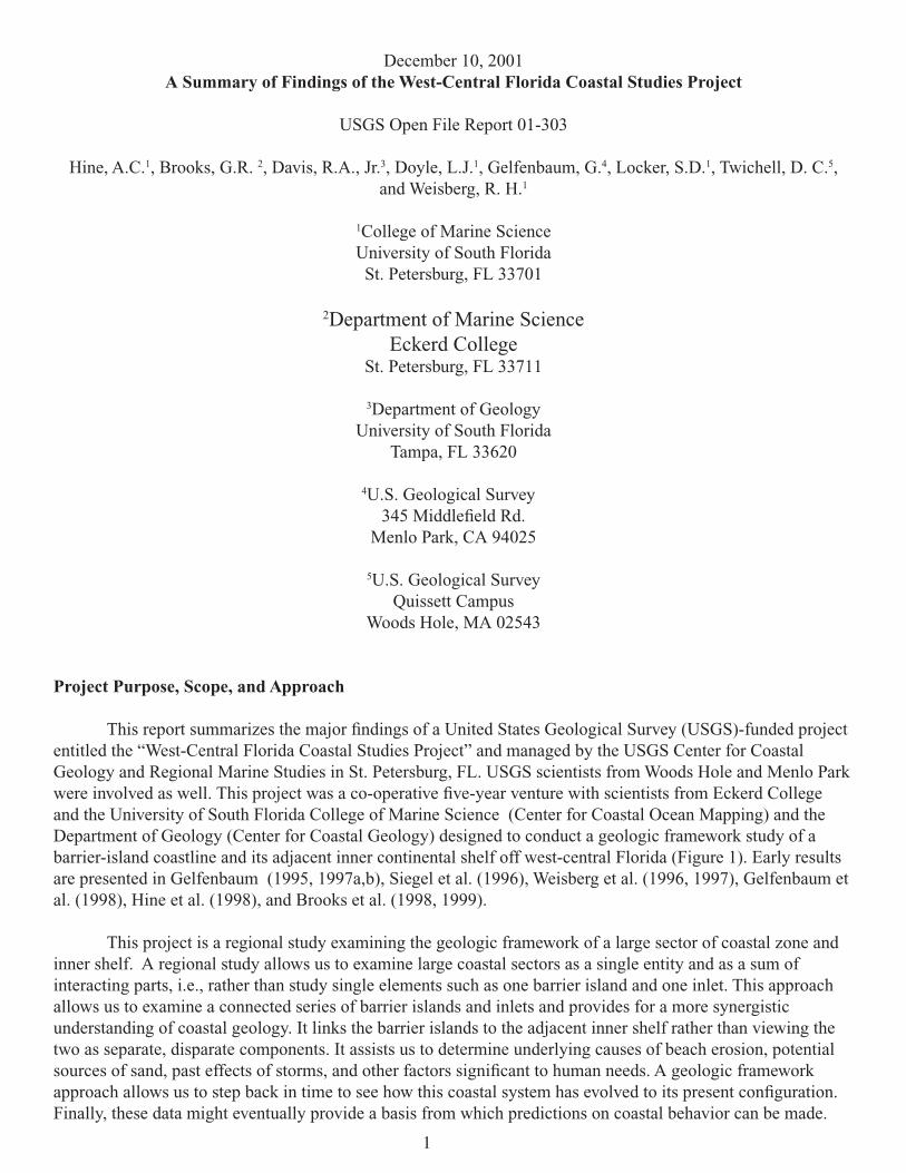
The siliciclastic-dominated, west-central barrier island coast of peninsular Florida and its adjacent inner continental shelf lie at the center of a huge, ancient carbonate platform and form the proximal portion of the west Florida shelf/slope system. This platform’s east-to-west lateral dimensions extend 500 km from the 200 m

8
water depth shelf break off the east coast of Florida to the 1,500 m top of the west Florida escarpment, which drops precipitously nearly another 1,800 m into the deep Gulf of Mexico (Figure 4). With the Florida/Bahamas platform being approximately 900 km long, 1,000 km wide, and over 12 km thick (Sheridan et al., 1988), this platform represented an enormous shallow-water accumulating, carbonate sedimentary province (Figure 5). The Florida/Bahamas platform was part of an even larger Jurassic carbonate “gigaplatform” that extended contiguously over 6,000 km from the Gulf of Mexico to the Grand Banks and probably was one of the largest carbonate platform systems in earth’s history (Poag, 1991).
By the mid Cretaceous, the western portion of the Florida Platform drowned possibly as a result of environmental stress and rising sea level (Corso et al., 1989; Vogt, 1989; Buffler, 1991; summarized in Hine, 1997). The environmental stress may have resulted from world-wide oceanic anoxic events, which could have been imported onto carbonate-producing, shallow shelves during periods of high sea level (Arthur and Schlanger, 1979; Vogt, 1989). Because this combination of environmental stress and rising sea level , sediment production and accumulation rates could not keep pace with tectonic subsidence associated with a relatively young passive margin. So, formerly shallow, neritic environments passed through the photic zone creating the pelagic environment seen today. By the early Cenozoic, the Florida Platform had been transformed into a topographically asymmetric feature with the eastern portion elevated and the western portion sloping into deeper
9

10
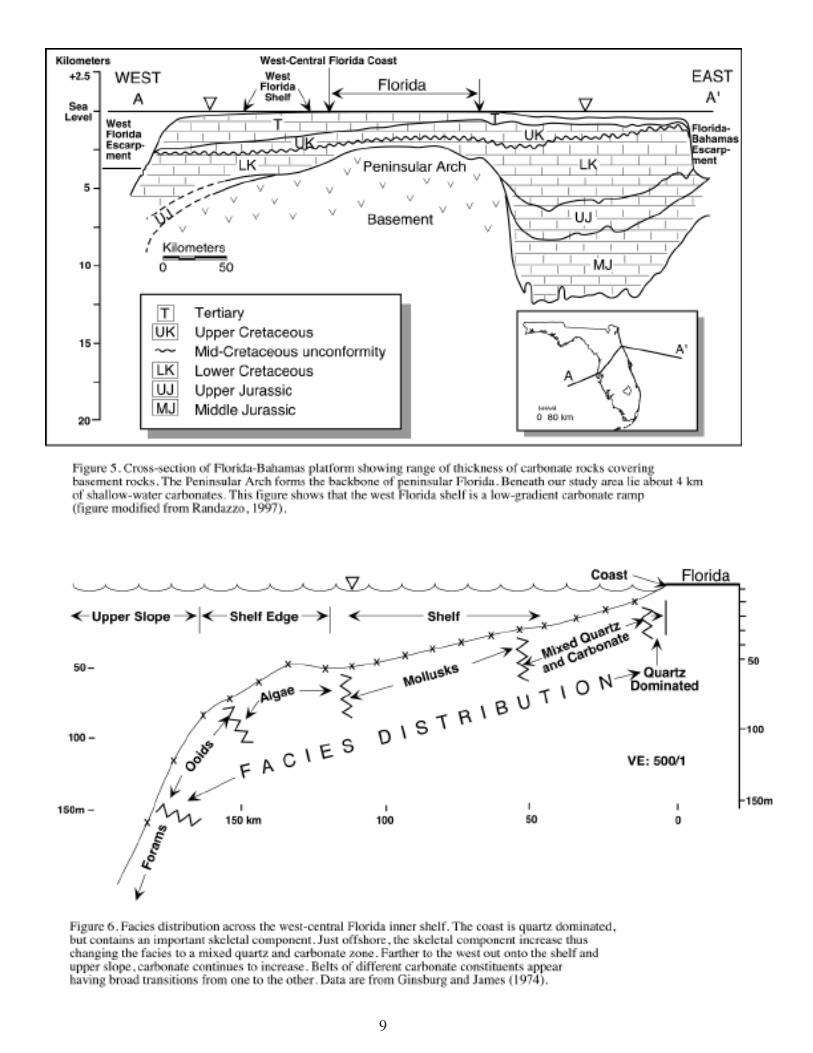
water. Here, the seafloor passed below the photic zone allowing carbonate accumulation rates to be greatly reduced compared to their shallow-water counterparts (Schlager, 1981; Mullins et al., 1987, 1988a,b). The western portion of the Florida Platform thus was transformed from a rim-type platform into a gently-sloping ramp, which terminated at the top of the eroding marginal escarpment. This 250 km wide ramp underlies the modern west Florida shelf-slope system and explains why the shelf system seaward of the entire west Florida coast has such a low gradient. There is a broad shelf-edge transition from approximately 100 to 200 m depth occurring over approximately 100 km between the shelf and the slope (Figure 6).
The west Florida shelf-slope system has been used extensively as a modern analog for non-rimmed, carbonate platforms, deep shelves, or ramps (Ahr, 1973; Ginsburg and James, 1974; Read, 1982; Hine and Mullins, 1983; Mullins et al., 1987; 1988a,b; Feary and James, 1998). Perhaps, Read’s (1982) distally inclined ramp model is the best overall descriptor of the west Florida shelf/slope system.
The Siliciclastic Invasion
By mid Cenozoic time (late Oligocene), the Suwannee Seaway and the Gulf Trough, two consecutive open seaways connecting the northern Gulf of Mexico to the Atlantic across northern Florida and Georgia, had been infilled (Chen, 1965; McKinney, 1984; Popenoe et al., 1987). This infilling probably occurred during sea-level lowstands when rivers draining off the southern Appalachian Mountains built deltas, which extended south and onlapped carbonates of the northern Florida Platform. This was the initial phase of Florida’s siliciclastic “invasion”, which continues today as quartz sand moves south along the beaches bordering peninsular Florida. The siliciclastic invasion is an important event in Florida’s geologic history, because this process provided the State with the materials to create the high-quality beaches people enjoy today.
Quartz sand transport onto the Florida platform was primarily via the dominant north-to-south longshore transport system. The surficial morphology of the peninsular Florida is domi-nated by these former siliciclastic shorelines (White, 1970). However, recent work ((Warzeski at al, 1996; Cunningham et al, 1998; Guertin et al, 2000, Cunningham et al., 2001a,b) have shown that a river delta up to 120 m thick filled accommodation space within the south central Florida Platform during the late Miocene. Nevertheless, rivers from the southern Appalachian Mountains and the southern coastal plain drained into the northern Gulf and the Atlantic rather than down peninsular Florida.
Because the eastern portion of the platform was relatively elevated and influenced by the frequent rise and fall of sea level, the quartz-rich sands were selectively sequestered to the east leaving the deeply submerged western portion of the platform to continue to accumulate carbonate sediments slowly.
By virtue of numerous sea-level fluctuations and the net southerly transport of silciciclas-tic sediments, quartz sand was transported all the way to the extreme southern margin of the platform by Pliocene time and reached the slope extending into the southern Straits of Florida. However, toward the western portion of the platform, there was no effective mechanism of transporting siliciclastic sediments across this ramp into deeper water. As a result, the quartz-rich sediment on the eastern portion of peninsular Florida transitions into carbonate-rich sedi-

11
ment toward the west. The inner shelf off the west-central barrier-island system forms part of that quartz to mixed quartz carbonate transition. Furthermore, the present west Florida shelf can be subdivided into distinct N-S trending, carbonate facies belts (Figure 6; Ginsburg and James 1974).
As previous investigators have pointed out, this east-to-west quartz-to-carbonate transition has been poorly defined (Ginsburg and James, 1974; Doyle and Sparks, 1980). As the results of several studies in this special issue show, the inner shelf is commonly dominated by NW-SE trending quartz-rich, sand ridges. These sand ridges extend beyond 20 km out onto the shelf, thus making it nearly impossible to precisely define a facies boundary or even a restricted transi-tion zone between the quartz-dominated, mixed quartz/carbonate, and carbonate- dominated surficial sediment facies.
The Coastal/Inner Shelf System—General Features
The west-central barrier-island coast includes two large estuarine systems (Tampa Bay and Charlotte Harbor) and two headlands (Indian Rocks and Venice; Figure 1). The Venice headland is a mainland beach with dark, phosphate-rich sediments of Neogene age directly cropping out along the inner shoreface. Additionally, Miocene limestone is exposed along the mainland shore at Indian Rocks. North of the barrier-island system is the Big Bend marsh-dominated coastline—a coastal system with such a low gradient (1:5,000) that it has been referred to as an incipient epicontinental sea (Hine et al., 1988). The inherited gradient from the underlying ramp off the west-central barrier-island system is slightly steeper having gradients of ~1:2,000. With the deeper water closer to the beach, the sandy coast has higher wave energy than the marsh-dominated coast that rests on the flatter gradient. Both coastal types are low-wave energy coastlines when compared to most parts of the US Gulf and east coasts. In addition, the relatively small fetch of the Gulf of Mexico and the prevailing easterly winds contribute to the overall low wave-energy character of the coastline. However, occasionally potent extratropical and tropical storms have made significant impact (Davis and Andronaco, 1987; Davis, 1994; Goodbred and Hine, 1995; Davis, 1994). The coast is also microtidal as defined by Davies (1964) and Hayes (1979), although as pointed out by Davis and Hayes (1984), it has many prominent mixed-energy features such as “drumstick” shaped barrier islands and two very large ebb-tidal deltas associated with the mouths of the two estuaries. Indeed, it is the great range in size of the back-barrier estuaries and lagoons that dictates the wide range of inlet types along this coast. Topographic variations of the pre-Holocene surface have played a strong role in the distribution of the estuaries, headlands, and controlling the size of back-barrier bodies of water (Evans et al., 1985).
Very little was known about the inner shelf prior to this study other than the fact that the sediment cover was spotty and that there were large expanses of limestone, which supported benthic communities (Riggs and O’Connor, 1974; Doyle and Sparks, 1980). Rock ledges and sinkholes were also known to exist, yet their control by the underlying stratigraphy was unknown. Additionally, sediment distribution on the inner shelf in any predictable pattern, the existence and nature of sand bodies, sediment types in these sand bodies, the degree, if any, of antecedent topographic control on sediment distribution, and the frequency of sediment transport activity all were essentially unknown.
Primary Objectives
The objectives listed below were defined based upon our present understanding of what is known about the geologic framework of the west-central Florida coast/inner shelf system. A summary of findings (see Primary Findings section) based on each objective follows this listing in the same numerical order. The primary

12
objectives are:
1. To understand overall shelf circulation and how that might affect nearshore and coastal processes (see Processes section below).
2. To determine the role of the underlying carbonate platform in controlling the overall geom-etry of the modern coastal system (see Underlying Geologic Template/Antecedent Topo-graphic Control section below).
3. To determine the significance of an infilled shelf/estuarine valley during the development of the coastal system (see Infilled Shelf Valleys and Their Significance section below).
4. To determine the thickness, overall geometry/bathymetry, and sedimentary character of the active, Holocene sand sheet , and to recognize and define contrasting shelf provinces. To understand the relative activity of the seabed, and the late Holocene evolution of the inner shelf (see Characteristics of the Shelf Sedimentary Cover section below).
5. To determine the lithology and origin of hardbottoms, particularly scarps, and the role that they play in sediment production and controlling benthic communities (see Hardbottom Development and Significance section below).
6. To understand the late Holocene evolution of the barrier islands and to develop stratigraphic models (see Barrier Island Studies section below).
Primary Findings
1. Processes
West-Central Florida Shelf Hydrography and Circulation Study
Introduction
Continental shelves may be discussed in terms of three regions, each controlled by different physical processes. The inner-shelf is where divergent surface and bottom frictional boundary layers play a major role; the middle-shelf is where these boundary layers are separated by a geostrophic interior; and the outer-shelf (shelf-break) is where strong interactions occur with the adjacent ocean. Of these regions, the inner-shelf is the least studied, either through in-situ observations, or through the application of analytical and numerical models. Yet, in many respects, depending upon the shelf width, this may be the scientifically most interesting region because of its physical, biological, chemical, and geological interactions in response to synoptic and seasonal forcing.
The west Florida shelf (WFS) is broad enough so that its inner, middle, and outer-shelf regions are relatively distinct, allowing the dominant processes within each region to be viewed somewhat independently from one another. Important inner-shelf scientific questions can therefore be addressed through the combination of in-situ measurements and models. These questions include the nature of: (1) the coastal jet’s three-dimensional structure, time dependence, and turbulence evolution; (2) its rectification by stratified boundary layer effects and how this impacts along and across-shelf transports; and (3) the seasonal modulation of these

13
processes by local and offshore forcing. Thus, the gently sloping WFS provides an excellent natural laboratory for studying the physical processes that set the stage for biological (blooms), chemical (nutrient concentrations), and geological (e.g., sediment resuspension) events.
This study was originally designed to include both in-situ measurements and numerical circulation modeling. It subsequently evolved with support from the MMS, the State of Florida, NOAA, and ONR. Presently ongoing is an Ecology of Harmful Algal Blooms (ECOHAB) regional field study to advance our understanding and forecasting ability for red-tides; a State of Florida supported Coastal Ocean Monitoring and Prediction System (COMPS) to provide real-time data for emergency management use; and ONR supported in-situ measurements and modeling. We adhere to the tenet that the in-situ measurements and modeling must be interac-tive. Measurements are sparse and require a multiple scale context. Models are critically dependent upon their parameterizations, initial state, and boundary conditions, so they must be pegged to measurements to be useful.
Accomplishments
Accomplishments may be organized in terms of in-situ measurements and models, both having a common theme: local forcing and its effects on the inner-shelf. We note that continental shelves respond to both local and offshore forcing. Local forcing is by the combined effects of momentum and buoyancy inputs at the sea surface and buoyancy inputs at the coast. Offshore forcing is by momentum and buoyancy inputs from the deep ocean at the shelf-break. By virtue of its width, the WFS is an end member in the spectrum of continental shelves for which local forcing should be important. Thus, our emphasis has been on local forcing and its effects on the inner-shelf. For completeness, we are making more limited measurements out to the shelf break, and our model domains [each employing the Princeton Ocean Model (POM)], while regional, extend out beyond the shelf break. Accomplishments are now listed and discussed in terms of: (1) in-situ data, (2) publications, and (3) dissertations/theses and other reports.
In Weisberg et al. (1996) we identify a seasonality to the circulation that previously had not been appreciated. We also discuss typical length scales for motions at semi-diurnal, diurnal, synoptic and monthly time scales and how these are modulated by season.
Li and Weisberg (1999a,b) describe the responses of the WFS to upwelling-favorable winds that are directed either along-shore or offshore. The model-related studies use a grid that extends from just west of the DeSoto Canyon region to the Florida Keys, and sufficiently far offshore so that the open boundary there does not interfere with the model responses over the continental shelf. Realistic coastline and isobath geometries are employed in fully three-dimensional model runs under a constant density setting. One of these describes the model response kinematics, and the other companion paper describes the model response dynamics. Relevant findings are as follows. The model spin-up follows an Ekman-geostrophic route resulting in a rapid adjustment over the course of a pendulum day. Surface Ekman layer

14
divergence effects a sea surface slope that causes a geostrophic coastal jet that, in turn, causes a bottom Ekman layer response. While the WFS is gently sloping, subtle variations in coastline geometry have major effects on the fully three-dimensional circulation fields. In particular, partial closure in the south by the Florida Keys and the coastline curvatures of the Florida Big Bend conspire to yield strong responses to uniform winds directed either along-shore or offshore with respect to the central west Florida coastline. This may seem surprising at first, based on two-dimensional arguments that offshore winds should not effect a coastal jet/upwelling response. Nevertheless, these findings are borne out by observations, and they are attributable to the coastline and isobath geometries. These geometry effects result in fully three-dimensional circulation patterns that are relevant to material property transports. The dynamics analyses help to define the inner-shelf as the region over which the sea-surface slope sets up. We describe, in a vertically integrated sense, the interactions that occur between the along-shelf and across-shelf momentum balances in establishing the flow fields. The offshore scale of the inner-shelf is a frictional one associated with the divergence of the surface and bottom Ekman layers. This varies with bottom slope as shown for different regions along the coast. Offshore of the central west Florida coastline, where we have corroborating data, the inner-shelf under a constant density setting extends out to about the 50-75m isobath. Fully three-dimensional momentum balance analyses provide further diagnoses of the model responses and where the Ekman and geostrophic regions are situated.
Yang and Weisberg (1999) ask the question of whether or not the seasonal variations in the circulation can be accounted for by seasonally varying winds alone. We used climatological monthly mean winds to drive monthly model simulations. While interesting patterns are found suggesting that the WFS has wind-driven seasons of predominantly upwelling and downwelling circulations, monthly mean winds alone can not account fully for the seasonal variations in the circulation. Baroclinic effects must also be important along with the surface heat fluxes that facilitate these.
Yang et al. (1999) compares observed Lagrangian surface drifter tracks with numerical model simulations. We demonstrate that model drifters can mimic in-situ drifters over time scales of the synoptic weather events, at least on the shelf where the model responses to these synoptic weather events exceed the effects of the Loop Current or eddies positioned on or offshore of the shelf-break. We also attempt to explain the curious finding that no drifters deployed to the north of the west central Florida shelf tracked toward the shoreline – hence the title of the paper.
Weisberg et al. (2000) is a specific case study of an upwelling event recorded both in satellite AVHRR imagery and in-situ data. While upwelling (and downwelling) occurs regularly on continental shelves with the passage of each weather front, rarely do all the necessary ingredients of nature coincide to make the upwelling response visible in satellite imagery. In this case, the winds were light for several days prior to a strong, upwelling favorable wind event, and we had in-situ velocity measurements for comparison. Through a combination of data and model analyses we demonstrate the Ekman-geostrophic spin-up route described earlier.

15
Using both constant density and stratified runs (stratification estimated from velocity shear by thermal wind) we describe the relative effects and explain the finding of maximum upwelling just offshore and to the south of Tampa Bay. We also explain other regions of local upwelling maxima south of Cape San Blas.
Spring and summer of 1998 exhibited large stratification over the inner-shelf, even right up to the shoreline. In-situ data shows that the circulation is very sensitive to stratification. By separating the surface and bottom Ekman layers, stratification in increases across-shelf transports. Weisberg et al. (2001) describes the in-situ data and the numerical model simulation for the month of April, 1998 and, buoyed by the fidelity between the two, uses the model to analyze the dynamics. A new result is found. The data show a rectification of the inner-shelf responses to synoptic wind forcing wherein upwelling favorable winds produce disproportionately larger responses in both sea level and currents than downwelling favorable winds. Stratification accounts for the rectification, and this is most readily understood in terms of the streamwise component of vorticity. For downwelling favorable winds, the buoyancy torque due to isopycnals bending into the sloping bottom opposes the tendency by planetary vorticity tilting due to the vertically sheared coastal jet. This thermal wind effect negates the need for large relative vorticity dissipation by the across-shelf flow in the bottom Ekman layer. The opposite occurs for upwelling favorable winds. Buoyancy torque adds constructively with planetary vorticity tilting requiring larger dissipation of relative vorticity by the bottom Ekman layer. By enhancing (upwelling) or suppressing (downwelling) the bottom Ekman layer the entire response is reduced or increased, respectively. Such rectification is evident on the WFS because the WFS is wide enough to distinguish the frictional inner-shelf (which this paper also helps to better define) from the shelf break.
Meyers et al. (2000) addresses the region of the shelf break based on the in-situ data collected between the 75 m and the 300 m isobaths over a one year time span. Large currents are found on occasion when the Loop Current or its eddies impinge on the shelf break. These effects are localized in the across-shelf direction due to the vorticity constraint of the shelf topography. Analysis of available satellite altimetry data also suggests local forcing. Loop Current impingement farther south did not force a large shelf-wide response.
Nearshore/Coastal Processes
A series of transverse bars has been observed off Anna Maria Island, on the west-central coast of Florida. These bars are unique in that they are oriented normal to shore, extend a long distance in the across shore direction, and they have amplitudes that become a significant fraction of the water depth. The bars come close to the beach but do not seem to effect the morphology of the beach.
Through the use of historical aerial photographs and repeated bathymetric surveys, these bars have been shown to migrate to the south. The long-term rate of migration averaged over 40 years is about 8 m/yr, whereas the short-term rate as determined by the bathymetric surveys

16
is substantially higher. Sand supplied to the bars comes from a shallow flank of the Tampa Bay ebb-tidal delta.
The migration of the transverse bars off Anna Maria Island seems to be associated with the passage of cold fronts as they move from north to south along the west Florida shelf and not related to tidal currents. The northerly directed winds ahead of the cold front drive a near-bed flow in a northerly direction normal to the transverse bar crests. This flow may or may not be strong enough to induce sediment transport. After the front passes, the wind reverses and drives a stronger flow to the south, again normal to the bar crests. This stronger flow, and the associated larger waves force sediment transport to the south and results in the net southerly migration of the transverse bars. The enhanced sediment transport due to the combined waves and currents, along with the reversing nature of the sediment transport associated with the passage of the cold front may explain how the bars attain the large bar height to water depth ratios that were observed.
2. Underlying Geologic Template/Antecedent Topographic Control
During the pre-Holocene geologic history, a broad, topographically uneven surface was generated, which provided a fundamental first-order control on the Holocene coastal morphol-ogy. Pre-existing basins became estuaries and pre-existing highs became headlands (Evans et al., 1985; Duncan, 1993; Hine, 1997). The fact that the study area is situated in the middle of an ancient carbonate platform, which features extensive internal karst features and an external very low gradient, is of primary importance in shaping the Holocene, pre-transgressive surface.
The age of the carbonate bedrock ontop of which the modern coastal lithosomes are emplaced ranges from the Oligocene (?) in the northern part of the study area to Quaternary in the south. Extensive paleo-sinkhole activity is revealed in the seismic profiles, but there seems to be little active sinkhole activity today occurring on the inner shelf. Instead, the carbonate surface has been “planed off” by physical/chemical/biological erosion during repeated glacioeustatic, sea-level driven transgressions and regressions. This erosion has removed topography created by extensive deformation caused by internal and external karst dissolution thus forming a relatively even sequence boundary surface. This surface has minor, local relief featuring scarps, pits, and depressions, the latter of which become infilled by Holocene marsh deposits as sea-level rose since the Last Glacial Maximum.
The Cenozoic deformation of the bedrock carbonates occurs at two scales: (1) warps and depression that are 100’s of meters to perhaps 1 km in width and up to 10 meters in relief, and (2) large areas of regional depression forming paleo-shelf valleys 10’s of kilometers in width and length and up to 30 m of subsurface relief. The latter controlled fluvial drainage pat-terns during sea-level lowstands and estuaries (Tampa Bay, Charlotte Harbor) during sea-level highstands (see Infilled Shelf Valleys and Their Significance section below). The headlands at

17
Indian Rocks and Venice are probably controlled by bedrock highs.
Barrier-island location, orientation, and to some extent morphology are controlled by underlying rock relief formed by multiple sea-level highstand events (Evans et al., 1985). The island orientation wrapping around the Indian Rocks headland is an obvious example. However, many of the inner-shelf/barrier island cross-sections reveal that the bedrock surface rises faster directly beneath the barrier islands or provides a terrace, which supports the modern coastal system. Changes in bedrock gradient control the width of the back-barrier lagoon, which in turn affects the size of the tidal prism and the behavior of the inlets. This bedrock gradient change was probably created by the reoccupation of multiple, glacioeustatic highstand events during the Quaternary.
3. Infilled Shelf Valleys and Their Significance
Tampa Bay marks the northern extent of the shelf-valley depressions. Infilled valleys are not found further north, although sinkholes and warped strata are common. From Tampa Bay south to the Venice headland numerous shelf-valley depressions are present, which contain progradational infilling sequences. These structures probably extend as far south as the Sanibel Island area. The extent and orientation of these systems is not well known, and many valley systems are limited to within 20 km of the present coastline with no particular orientation as yet determined. The majority of these features no longer have topographic expression. Tampa Bay, an exception, owes its origin to a large shore-normal valley system that has not been completely infilled and extends considerably further seaward beneath the inner continental shelf. Still, the Tampa Bay shelf-valley system appears to disappear between 20-30 m water depth west of the present bay mouth.
A dense grid of high-resolution, single-channel seismic data was collected at the mouth of Tampa Bay in an attempt to define the stratigraphy, determine the controls on deposition, and define the underlying structure of a shelf-valley system that underlies this area. The seismic data were tied into nearby wells and boreholes for lithologic and age control. Sequence stratigraphic methods were incorporated in order to develop an integrated chronostratigraphy for the depositional infilling of the shelf-valley system.
Five seismic sequences were identified infilling the Tampa Bay incised-valley system (Duncan, 1993). The lowest sequence (A) is characterized by gently prograding sigmoidal clinoforms and is interpreted as a product of highstand shedding from south of the study area. More carbonate-rich sediments are indicated based on well-log correlations. Sequences B and C indicate an east/northeast source of sediments and are characterized by steeply prograding reflectors in the north of the study area (possibly of deltaic origin) and flat-lying or chaotic units in the central and south, which are interpreted as a combination of reworked siliciclastic and nearshore marine deposits. These deposits may be the west Florida analog to the thick siliciclas-tic unit underlying southern Florida and the Florida Keys (Warzeski et al., 1996; Cunningham et al., 1998). Finally the upper sequences (D and E) are represented by predominately flat-lying

18
reflectors with common progradational character near Egmont Channel. These sequences have been interpreted as shallow marine deposits and reworked sediments (siliciclastic) controlled by nearshore wave and tidal processes similar to today.
Based on well-log correlations (Ferguson, 1997), seismic reflection characteristics, and comparisons to regional lithostratigraphic and biostratigraphic work, the chronostratigraphy of the infill of the Tampa Bay shelf-valley system is as follows:
The Arcadia Formation (underlying sequence boundary 1--SB1) within the Tampa Bay area was deposited during the early to middle Miocene highstand of sea level. SB1 and was formed during a sea-level lowstand during the middle Miocene, sometime after ~15 Ma. Sequence A was deposited during the middle Miocene infilling the shelf-valley system from the south. A major sea level lowstand occurred during the late Serravalian/early Tortonian (about 10 ma) forming SB2 and shifting the focus of deposition further northward in the shelf-valley system. Sequences B and C are deposited during the late Miocene/early Pliocene representing the transition from low-energy, more carbonate deposition (sequence A) to the higher energy, fluvial deltaic deposits interpreted as Upper Peace River (sequence C) within the shelf valley. SB4 caps these fluvial deltaic deposits sometime during the Pliocene and the onset of shallow-marine deposition of the Quaternary (sequences D and E) begins. SB5 marks the Pleistocene-Holocene boundary.
The modern mixed carbonate-siliciclastic shelf sediments are a product of continuing carbonate marine deposition interspersed with reworked siliciclastics, the majority of which have been sequestered in the coastal zone since the late Miocene/Pliocene. Climatic and oceanographic conditions responsible for this siliciclastic pulse are unique during the Neogene of Florida and provide a stark contrast to deposition before and after the late Miocene/Pliocene.
4. Characteristics of the Shelf Sedimentary Cover
Overview
The west Florida continental shelf consists of a thin veneer of unconsolidated sediments overlying a phosphatic, dolomitic limestone supporting a karstic surface. On the inner shelf off west-central Florida, these unconsolidated surface sediments are generally < 3 m thick, exhibit a patchy distribution, and consist of a mixture of siliciclastics and carbonates. The underlying limestone surface regularly crops out to form ledges and hard bottoms.
The inner continental shelf can be zoned into three main areas, or provinces: ( 1) a “shallow bedrock” sand-ridge system north of Tampa Bay, (2) a middle zone dominated by the Tampa Bay ebb-tidal delta , and (3) a southern “deep bedrock” sand-ridge system south of Tampa Bay.
The Tampa Bay ebb-tidal delta is the primary modern source of sediment to the inner continental shelf. Continuous sediment cover attributed to this supply extends approximately 10 km offshore and, combined with some smaller inlets linked to Tampa Bay, has resulted in late-Holocene sediment accumulation of 5 m or greater in a nearshore zone 20-25 km alongshore centered on the mouth of Tampa Bay. Other small ebb-tidal deltas

19
a few km’s in dimensions are maintained at the mouths of inlets throughout this coastal system, but are not significant modern contributors of sediment to the continental shelf. Should an inlet close, the ebb tidal-delta deposits are soon dispersed and accreted to the barrier island shoreface by waves and alongshore currents.
Sand-ridge morphologies predominate on the continental shelf north and south of the Tampa Bay ebb-tidal delta and beginning just seaward of the barrier islands shoreface. The northern and southern sand-ridge systems (provinces 1 and 3 mentioned above) display distinctive differences in orientations and sedimentary facies associations. These differences are also correlated with different bedrock elevation as well as a change in orientation of the coastline.
The northern sand ridge system (province 1) exhibits a consistent NW-SE ridge system trending at oblique angles to the shoreline that vary from 30-65 degrees. The ridge trends are most variable as they sweep around the Indian Rocks Beach headland. Seaward of 10 m water depth the ridge trends are more consistently oriented at approximately 50 degree from the shoreline, the oblique angle opening to the north. Sand ridge widths are on the order of 1 km, with a 2 to 2.5 km ridge spacing .
The southern sand ridge systems (province 3) are also orientated at oblique angles with the coastline but display mixed NW-SE and NE-SW trends. NE-SW trends at 45-55 degrees relative to the coastline are found south of Tampa Bay in the nearshore (out to ~10 m water depth). This switches to NW-SE trends at lower angles of 24 degrees south of the Venice headland. From 10 –15 m water depth NW-SE and NE-SW trends with 30-50 degrees are mixed. In greater than 15 m depth NE-SW trends of 50-60 degrees appear most common.
Two important contrasts between the northern and southern sand ridge systems are: (1) sediment textural trends in relation to ridge topography, and (2) smaller-scale sand wave morphologic variability. In the northern area, low side-scan backscatter associates with the full bathymetric expression of the sand ridges and sand waves, indicating more uniform textural patterns for these sand bodies at the level of 100 kHz acoustic imaging. The ridges in the north also are commonly mantled with smaller sand waves or form as a sand ridge through the coalescence of several large sand waves (Harrison et al., 2000). In contrast, the southern sand ridges may exhibit significant textural changes across a ridge (Twichell et al., 2000). Smaller scale sand waves are not a significant feature within these sand bodies.
The combination of approximately 300 vibracores, 500 surface sediment samples, and numerous hardbottom and ledge samples were used to define nine lithofacies. Lithofacies include Miocene carbonate platform, Pleistocene restricted marine, and Holocene back barrier/estuarine to shallow open-marine sediments deposited during the most recent sea-level rise. Facies associations and 14C dates indicate that in the northern portion of the study area, barrier islands may have developed at least 8 ka and up to 20 km from the present shoreline. In the southern portion of the study area, barrier island facies associations are not found offshore. This differential development was likely due to differences in the availability of sand, coupled with a slowing in the rate of sea-level rise overprinted on different shelf elevations from north to south. The southern shelf elevations are up to 5 m deeper at equivalent distances offshore and would have flooded earlier. The present coastal barrier-island system formed over a wide range of time scales from decades to millennia. The oldest of the barriers have been dated at 3,000 years (Stapor et al., 1988) and others have formed during the past two decades.
Surface sediments on the inner shelf consist of fine quartz sand, and coarse sand and gravel size marine biogenic carbonates. Black, phosphatic-rich sediments are locally abundant,

20
but are always subordinate to the quartz- and carbonate-rich sediment types. The distribution is patchy and the transition between sediment types is generally abrupt. Sediment is probably reworked by waves and tides, characteristic of siliciclastic shelf systems, but the patchy distribu-tion and generally abrupt transition between sediment types, indicates that these processes do not completely redistribute the sediment. Instead, the sediment distribution is more a reflection of the source of input, which is more characteristic of carbonate shelf systems.
There are multiple sources of sediment input, but all come from within, or immediately adjacent to, the basin. Quartz sand is most likely a product of reworking of coastal deposits from earlier sea-level highstands as previously mentioned. The carbonate component is pro-duced and deposited in situ by marine carbonate production. The black, phosphatic-rich sand is likely from the bioerosion and reworking of the numerous limestone outcrops as well as from non-lithified units of the Hawthorn Group.
The source for sand to initiate early Holocene barrier development in the north, may have been ancient coastal deposits that were stranded on the platform surface during a previous sea-level highstand. Quartz sand terraces, representing ancient coastlines, commonly veneer peninsular Florida. The intersection of one of these quartz sand deposits by the coastline approximately 8 ka, may have provided the sediment required for barrier-island development. The lack of evidence for early Holocene barrier-island development in the south may simply reflect the absence of available sand.
Based upon benthic foraminifera associations and test types, it is suggested that the climatic conditions during this early Holocene barrier island development were much more arid than they are today, similar to modern Laguna Madre of the Texas Gulf coast (Brooks et al., in review a,b). This coincides with a world-wide period of much drier and windier conditions. Evidence suggests that these climatic conditions may have been accompanied by a slowing in the rate of sea-level rise, which, coupled with the intersection of the coast at that time with the above mentioned sediment source, may have initiated barrier-island development.
Overall, the shelf off Tampa Bay (province 2) seems to have the thickest sediment cover associated with the enormous ebb-tidal delta. The shelf in the southern part (province 3) of the study area has the broadest areas of exposed bedrock. The inner shelf seaward of the Indian Rocks headland (province 1) seems to be the most active in terms of sediment transport.
Detailed Studies: Sand Ridges off Indian Rocks Beach Headland (Province 1)
Morphology and Processes
The west-central Florida sand ridges off the Indian Rocks Beach headland are far more complex morphologically than they appear on standard coastal bathymetric charts (Harrison, 1996). The mixed carbonate-siliciclastic sedimentary cover produces a high acoustic contrast such that the ridges, superimposed bedforms, and significant morphologic details are readily

21
visible in side-scan data, perhaps more so than in areas where such acoustic contrast does not exist (see Harrison et al., 2000). These ridges are covered with a bedform hierarchy consisting of large sand waves whose crests trend parallel to the sand ridges, small sand waves, sediment-starved sand waves, and small ripples all having multiple orientations. These large sand waves become aligned to form single sand ridges, which may extend for many km’s. The sand-ridge field extends from within 2 km of the beach to over 25 km offshore, where they become larger, more widely spaced. They seem to lack the bedform hierarchy and are not as complex morphologically. These smaller, complex sand ridges are laterally restricted to an area off a major coastal headland.
The west-central Florida ridges contrast with the US Atlantic margin ridges in that they:
1. have their large sand-wave crests oriented parallel to ridge-axis trend, 2. are smaller in all dimensions, 3. have a significantly higher carbonate content, 4. have limestone bedrock hardbottoms exposed in topographically low areas that support
mature benthic communities, 5. are not shoreface-connected, and 6. have the most proximal sand ridges at the headland apex, which are more shore-
parallel in orientation leaving a ~2 km gap between the ridges and the shoreface suggesting little sediment exchange between these two environments.
The smaller size of west-central Florida ridges is a function of the sediment-starved, low-energy nature of this inner shelf and controls sand-ridge and sand-wave morphology.
The seafloor is active and not relict as indicated by:1. relatively young AMS 14C dates (~1,200 to 1,600 yrs BP) at 1 to 1.6 m subsurface
depths, 2. possible shifts in sharp grayscale boundaries and patterns seen in time-series side-scan
mosaics, 3. maintenance of sharp textural and acoustic boundaries and small bedforms in area
where bioturbation is constantly active, 4. sediment textural asymmetry indicating selective transport across large sand waves
and sand-ridge crests, 5. morphological asymmetry of large sand waves and sand ridges with steeper, south-
west-facing flanks, and 6. current-meter data showing that the critical threshold velocity for sediment transport
is frequently exceeded.
Radiocarbon dating has indicated that these sand ridges can form relatively quickly (within past ~1,300 yrs) on relatively low-energy inner shelves once open marine conditions are avail-

22
able and that high energy, storm-dominated conditions are not necessarily required.
Two lines of evidence suggest that the offshore sand ridges and the shoreface do not exchange sediment to any significant degree. First, the ridge topography does not extend to the shoreface from the inner shelf leaving a 2-3 km gap of flat and relatively featureless topography between the two areas. Secondly, the carbonate content of the offshore sand ridges is higher than that found on the adjacent beaches indicating that two different facies (mixed siliciclastic/carbonate sand facies forming the ridges and the fine quartz sand facies forming the shoreface and beaches) are spatially partitioned and temporally sequestered.
Facies and Stratigraphy
The ridges are composed mostly of a mixed siliciclastic/carbonate sand facies with interlayered, coarser shelly sand facies suggesting migrating bedforms. The shelly sand facies also separates these higher energy facies from the stratigraphically lower, reduced-energy, muddy sand and organic-rich mud facies. Two models of shelf evolution are presented: model #1 indicates that the muddy sand facies is a low energy, open-shelf lagoon backed by open-marine marshes (organic-rich mud facies; Edwards, 1998). The shelly sand facies marks a period of water deepening with sea-level rise and concomitant sand-ridge formation as energy increased with greater water depth. The barrier-island chain formed landward during the deepening phase. Model #2 indicates that a landward transgressing barrier island passed through the area of the modern inner shelf leaving the base of the shelly sand facies as the ravinement surface cut into the muddy sand facies, which formed in the back-barrier lagoon. The organic-rich mud facies in this scenario were a fringing marsh formed along the mainland. Sedimentologic data within the cores do not allow a conclusive choice between these two models. However, it is most likely that both models are valid with the coastal system changing from one to another in time and space.
Detailed Studies: Late Holocene Estuarine-Inner Shelf Interactions; Evidence of Estuarine Retreat Path? Tampa Bay, Florida (Province 2)
An important component in the development of continental shelves during the sea-level rise since the last glacial maximum, particularly along passive margins, has been the landward retreat of fluvial-deltaic-estuarine systems. Although laterally restricted in places the surficial features generated by the landward tracking of such large paleo-drainage systems such as the Hudson, Delaware, Savannah, Altamaha, and Albemarle Rivers and the suite of rivers associated with the Chesapeake Bay estuary are impressive in bathymetric complexity and cross-shelf continuity. Indeed, features such as estuarine retreat shoals/blankets, shelf valleys and levees inherited from earlier estuary mouth environments then mantled by a hierarchy of sand ridges and bedforms may dominate certain shelf sectors such as the Georgia Embayment (South Atlantic Bight of Swift, 1976).
In the Tampa Bay area there was not a large paleo-fluvial system, nor a high-relief valley system that extended across the exposed west Florida shelf during that last sea-level lowstand (Donahue, 1999). Instead, a broad mid-platform depression existed in the proto Tampa Bay area with its western boundary located probably within 40 km west of the present day estuary.
As sea level started to rise since the Last Glacial Maximum the shoreline, starting at the –120 m isobath, transgressed rapidly across the shelf but did not track up a shelf-valley system until it reached the western, most-seaward limit of the mid-platform depression. Hence, there is no estuarine retreat path on the west Florida shelf well seaward of Tampa Bay similar to those described on the shelf off the US East Coast.

23
Instead, the inner shelf seaward of Tampa Bay is dominated by two sand bodies, the present-day modern ebb-tidal delta and a more distal and deeper sand plain, which we interpret to be an older, but a short-lived ebb-tidal delta (Donahue et al., 2000). This sand body may have formed during a sea-level stillstand or slowdown and then was abandoned during an ensuing accelerated sea-level rise. The modern ebb-tidal delta has prograded out onto the inner shelf during the past few thousand years as the rate of sea-level rise decelerated, the modern barrier-island system formed and narrowed the mouth of Tampa Bay. This, in turn, focussed the ebb-jet, which exported sands seaward to form the ebb-tidal delta. The most seaward part of the study area consists of sediment-starved sand waves surrounded by coarse, molluscan shelly material and/or exposed hardbottom. These sandwaves respond to modern shelf hydraulics and do not appear to be influenced by the modern estuarine system.
Detailed Studies: The Inner Shelf off Sarasota, Florida: A Complex Facies Boundary in a Low-Energy Environ-ment (Province 3)
The west-central Florida inner continental shelf is the transition between a beach system composed of nearly pure siliciclastic sand and a shelf of nearly pure carbonate sediment. The geometry of the transition between the beach and shelf facies on this low-energy, sediment- starved inner shelf was poorly understood, and for this reason the innermost shelf off Sarasota, Florida was mapped in detail using sidescan-sonar imagery, seismic-reflection profiles, surface sediment samples, and short cores (Twichell et al., 1999, 2000). Seaward of a smooth lower beach face that is covered with siliciclastic sand, the inner shelf is shaped by a series of low-relief, nearly shore-perpendicular ridges that are 3-11 km in length, 1-3 km in width, 1-4 m in height, and are asymmetrical with the steeper side facing northwest. These ridges rest on a flat erosional surface and contain the majority of the Holocene sediment in the area. The ridges are separated by flat-floored troughs where there are exposures of older strata and hardgrounds, which are partially covered by a veneer of shelly gravel. Despite the low relief of these Holocene deposits, the distribution of different surface sediment types is closely tied to this subtle morphology. The steeper northwestern sides of the ridges are covered with a coarse shell hash while the gentler southeastern sides are covered by fine siliciclastic sand. The transition between these facies is abrupt and occurs at the crest of the ridge. This facies distribution suggests that fine siliciclastic sediment is winnowed from the northwestern, updrift, sides of the ridges, presumably by south-flowing, storm-generated currents. A coarse shell lag is left armoring the updrift sides of the ridges. The fine sediment, in turn, is deposited on the gentler, downdrift, sides of the ridges. This pronounced partitioning of the surficial sediment has not been observed on other sand ridges. The difference in sediment distribution appears to be the result of the siliciclastic sand being easily transported by these currents while the carbonate shell hash falls below the threshold of sediment movement. The orientation of the ridges is nearly perpendicular rather than oblique to the strongest currents and may further enhance the sorting of these two facies. The resulting facies boundaries on this low-energy, sediment-starved inner continental shelf are complex and suggest that the remarkably subtle ridge morphology has had a strong control on sediment redistribution by modern processes.
5. Hardbottom Development and Significance
Hardbottoms are common in carbonate and siliciclastic shallow marine settings worldwide, but these features have been poorly documented. Along west-central Florida, at least 50% of the inner shelf sea floor seaward of 5 km consists of hardbottom and extensive systems of these features, locally termed ledges, constitute the only areas of natural relief (up to 4 m) providing important marine habitat. The lithology and stratigraphy of these ledges are all that remains of an incomplete geologic record of Tertiary continental shelf evolution. Extensive research of hardbottoms in Onslow Bay, North Carolina by Riggs et al. (1996; 1998) has pointed out the importance of hardbottoms as sequence boundaries and condensed sections commonly constituting the preserved sedimentary deposits of highstand and lowstand sea-level events. The hardbottoms of Onslow Bay occur on a high-energy continental shelf, and lithology plays a key role in controlling the morphology of these features (Riggs et al., 1998). In addition, these features have been shown to contribute

24
significant amounts of sediment to the inner shelf system (Riggs et al., 1998). West-central Florida represents a low-energy shelf, and the hardbottoms differ from those of Onslow Bay in lithology, stratigraphy, and relief. Initial studies have shown that these hardbottoms do contribute sediments to the shelf, but the total volume is unknown (Berman, 1998).
Two types of ledges (dolomitic and calcitic) trend roughly shore-parallel, exhibit varying relief (<1-4 m), and tend to be rich in siliciclastic and phosphatic sediments. Each ledge type provides a substrate for diverse floral and faunal assemblages that encrust and bore the outcrop, especially on the lee side (shoreward) of the ledge, producing a shoreward-facing scarp and overhang. Intense bioerosion causes the overhanging blocks to periodically fail, producing a rubble ramp/field and serves as a mechanism for releasing sediment grains onto the inner shelf, at a rate of 0.04 kg/m2/yr of siliciclastic sediment. High-relief (3-4 m), Quaternary calcitic ledges that can be underlain by a layer of blue-gray clay are located in the southeast portion of the study area and have not been correlated to any known formational unit. Low-relief (<2 m) dolomitic ledges, located in the northwest portion of the study area, are extensions of the underlying, Miocene Arcadia Formation, the known extent of which has been increased at least 40 km offshore.
Hardbottoms on the coast probably formed as non-deposition hardground surfaces during periods of sediment starvation and low-energy conditions. The difference in lithology is a function of time and diagenesis. The ledge orientation may be controlled by a pre-existing fracture pattern in the rocks, while the prevalence of undercutting may be a function of lithology, although this process is still uncertain.
6. Barrier Island Studies
The west-central Florida barrier/inlet system may be morphologically the most complicated in the world in an environment with tidal ranges of <1 m and a mean wave height of 30-40 cm. This coast contains all barrier island and inlet types in a range of sizes and ages. Barriers include both wave-dominated and mixed energy drumstick morphologies with lengths ranging from about 2 km to more than 30 km. Inlets range from tide-dominated through mixed energy to wave-dominated. Two of the latter variety closed in the 1980s.
The investigation of this barrier/inlet system was aimed at:
1. determining the detailed nature of barrier stratigraphy, 2. understanding our the geologic development of the system from this stratigraphic data base, and 3. determining the causes and effects of the modern morphodynamics of this system.
The stratigraphic portion of the study included detailed analysis of individual barrier/inlet elements as well as the stratigraphy of entire barrier islands and of pre-barrier depositional environments. Washover deposits are a major part of all barriers along this coastal reach. The detailed stratigraphy of these sequences shows that they do have a series of signature characteristics that permit recognition of supratidal, intertidal and subtidal portions of the sequences (Sedgwick, 1995). Preserved sequences of both flood and ebb tidal deltas as multiple inlets has enabled the development of stratigraphic models for microtidal tidal deltas (Kowalski, 1995).
The stratigraphy of Anna Maria Island showed that it originated as an elongate shoal adjacent to the sediment sink at the mouth of Tampa Bay. As the island continued to develop it prograded at the updrift or north end with extension to the south (Pekala, 1996). This study provided complementary data to previous similar investigations at Anclote Key and Caladesi Island. The capstone study of barrier island stratigraphy along this coastal reach was the construction and interpretation of nine barrier-island stratigraphic sections across nine different barrier islands from Anclote Key to Casey Key (Yale, 1997). This regional investigation showed that all of the barriers have the same basic stratigraphy, and all apparently originated at or near their present location as subtidal shoals evolving to supratidal barriers. Two themes develop from this common origin;

25
one is that of a wave-dominated barrier and the other is progradation of the barrier, typically at the updrift position of a tidal inlet.
Pre-barrier stratigraphic investigations included:
1. the origin of apparent beachrock at Siesta Key, 2. the stratigraphy of inlet channel -fill sequences and fluvial/estuarine channel sequences, and 3. the stratigraphy of the valley-fill sequences in the deeply incised mouth of the present Tampa Bay.
The beachrock has always been considered to be Pleistocene (Stage 5e) in age because of its similarity to the Anastasia Formation of the east coast of Florida. Radiometric dating has shown these rocks to be Holocene with a maximum age of 4 ka. Petrographic studies of numerous thin sections have revealed that the cement is meteoric in nature meaning that although the strata were deposited on a beach they were lithified by fresh groundwater percolation from overlying sediments. These sediments must have been part of a pre-existing barrier island.
The inlet sequences are characterized by shell gravel bases overlain by cross-bedded sand. The fluvial/ estuarine stratigraphy shows that late Pleistocene strata of about 32-34 ka age are unconformably overlain by Holocene strata of about 7 ka (FitzGerald, 1995).
Modern morphodynamics of the barrier/inlet system are strongly influenced by anthropogenic activities such as stabilization of inlets, construction of causeways, and dredge and fill construction in the backbarrier areas. Emphasis of this investigation was on the behavior of both natural and modified tidal inlets (Barnard, 1998). Careful analysis shows that all of the inlets have been influenced directly or indirectly by human activity, which led to a reduction in the size of the tidal prism and to the general instability of the inlets.
In summary, this barrier inlet system, although quite varied in all respects, actually displays many common attributes in the development of its individual barrier islands and tidal inlets. Their stratigraphy can be viewed in a fairly simple stratigraphic model characterized by initial upward shoaling, aggradation and then, in some cases, progradation. The pre-barrier history of this area is still not well known but we now have data to show that there have been multiple incursions and excursions of sea level preserved in a wide range of estuarine to open marine sequences. The modern system has been strongly influenced by human activities associated with the extensive development of this coast.
Ramifications for the Present and the Future
As primarily a geologic framework study the end result is to understand how this inner shelf and coastal system evolved over the middle to late Holocene and to identify the primary geologic forces active during that period of time. Revealing the distribution of sand bodies, their morphology, and sediment type was a primary goal and this information can be used to pick sites for sand renourishment of beaches. Also, the identification of hardbottom areas and extent of benthic communities is important information to choose areas for dumping dredge spoil as well as to identify habitat for fish and to locate recreational sites for fishing and diving. The distribution of sand and hardbottom areas can also be used by commercial fisherman to guide them in their activities. The seismic data allows groundwater geologists to better define the hydrostratigraphy that would lead to a better understanding of regional groundwater uses.
Since the behavior of the coastline is weather and climate dependent , it is impossible to predict where the coastline will be in the coming few years, decades, or longer. We cannot predict with any meaningful accuracy the weather , tropical storm activity , and climate changes in those time frames, so any specific predictions as to shoreline position, inlet behavior, barrier- island morphology, and resulting impact on human

26
activity and property is meaningless. However, based upon our understanding of the recent past and certain geologic facts such as the lack of any new inputs of sand into the system, we can conclude that areas of critical coastal erosion will continue to be areas of concern. The lack of a major tropical storm striking this area since the mid 1920’s coupled with the enormous growth in development since that time should remind all citizens of the potential for major destruction should the study area receive a direct hit.
References
Ahr, W. H., 1973, The carbonate ramp: an alternative to the shelf model: Gulf Coast Association of Geologic Societies, v. 23, p. 221-225.
Arthur, M.A., and Schlanger, S.O., 1979, Cretaceous “oceanic anoxic events” as causal factors in reef-reservoired oil fields: Geological Society of America Bulletin, v. 69, p. 870-885.
Barnard, P.L., 1998, Historical morphodynamics of inlet channels: west-central Florida. unpublished M.S. Thesis, University of South Florida, 179 p.
Berman, G. A., 1998, Origin and distribution of blackened grains across the inner west-central Florida continental shelf, unpublished B. S. thesis: Eckerd College, St. Petersburg, FL, 45 p.
Brooks, G.R., Doyle, L.J., DeWitt, N.T., and Suthard, B.C., 1998, Inner West-Central Florida continental shelf: surface sediment characteristics and distribution: U.S. Geological Survey Open File Report 98-37, 129 p.
Brooks, G.R., Doyle, L.J., Suthard, B.C., and DeWitt, N.T., 1999, Inner West-Central Florida continental shelf: sedimentary facies and facies associations: U.S. Geological Survey Open File Report 98-796, 124 p.
Brooks, G.R., Doyle, L.J., Suthard, B.C., and Obrochta, S.P., 1998, Sediment character and distribution on the inner west-central Florida shelf: is it right for our beaches: Rethinking the Role of Structures in Shore Protection; Proceedings of the 1998 National Conference on Beach Preservation and Technology, St. Petersburg, FL p. 2276-290.
Brooks, G. Doyle, L., Suthard, B. Locker, S.D., and Hine, A.C., in review (a). Facies architecture of a mixed carbonate/siliciclastic, sediment starved system: west-central Florida inner continental shelf: Marine Geology.
Brooks, G. R., Doyle, L.J., Davis, R.A., DeWitt, N.T. and Suthard, B.C., in review (b). Patterns and controls of surface sediment distribution on the west-central Florida inner shelf: Marine Geology.
Buffler, R.T., 1991, Seismic stratigraphy of the deep Gulf of Mexico and adjacent margins, in, Salvador, A., ed., The Gulf of Mexico Basin: The Geology of North America, vol. J., Geological Society of America, p. 353-387.
Chen, C.S., 1965, The regional lithostratigraphic analysis of Paleocene and Eocene rocks of Florida: Tallahas-see, Florida Geological Survey Bulletin No. 45.
Clarke, R.R., 1992, Beach conditions in Florida: a statewide inventory and identification of the beach erosion problem areas in Florida: Beaches and Shores Technical and Design Memorandum 89-1, 4th Edition, 208p.
Corso, W., Austin, J.A., and Buffler, R.T., 1989, The early Cretaceous platform off northwest Florida: controls

27
on morphologic development of carbonate margins: Marine Geology, v. 86, p. 1-14.
Cunningham, K.J., McNeill, D.F., Guertin, L.A., Scott, T.M., Ciesielski, P.F., and de Verteuil, L., 1998, A new Tertiary stratigraphy for the Florida Keys and southern peninsula of Florida: Geological Society of America Bulletin, v. 110, p. 231-258.
Cunningham, K.J. Locker, S.D., Hine, A.C., Bukry, D., Barron, J.A., and Guertin, L.A., 2001a, Surface geophysical characterization of ground-water systems of the Caloosahatchee River Basin, southern Florida: USGS Water Resources Investigations Report 01-4084, 76p.
Cunningham, K.J., Locker, S.D., Hine, A.C., Barron, J.A., Bukry, D., and Guertin, L.A., 2001b, Controls on the depositional balance between carboantes and silciclastics on the southeastern Florida platform: Annual GSA Meeting, Boston, MA., Abstract volume 33, no. 6, p. A-446
Davies, J.A., 1964, Geographical variation in coastal development: Edinburgh, Oliver and Boyd, 204p.
Davis, R.A., Jr., 1989, Morphodynamics of the west-central Florida barrier system: the delicate balance between wave- and tide-domination, in, Coastal Lowlands, Geology and Geotechnology, Dordrecht, Kluwer, p. 225-235.
Davis, R.A. Jr., and Hayes, M.O., 1984, What is a wave-dominated coast?: Marine Geology, v. 60., p. 313-329.
Davis R.A., Jr,., and Andronaco, M., 1987, Impact of hurricanes on Pinellas County Florida, 1985, Florida Sea Grant Publication, Tech Paper No. 51, 53p.
Davis, R.A., Jr., Hine, A.C., and Shinn, E.A., 1992, Holocene coastal development on the Florida peninsula, in, Fletcher, C. H., and Wehmiller, J.F., eds, Quaternary coasts of the United States: marine and lacustrine systems: SEPM Special Publication No. 48, p. 193-212.
Davis, R.A., Jr., 1994, West-central barrier system, in, Davis, R.A., Jr., ed., Geology of Holocene Barrier Island Systems: Springer-Verlag, p. 167-206.
Davis, R.A., Jr., 1997, Geology of the Florida coast, in Randazzo, A.F., and Jones, D.S., eds., The Geology of Florida: Gainesville, FL, University Press of Florida, p. 155-168.
Donahue, B.T., 1999, Modern morphodynamics and Holocene evolution of an inner shelf/estuarine transition zone on the west Florida shelf: unpublished MS thesis, Department of Marine Science, University of South Florida, 155p.
Donahue, B.T., Hine, A.C., Tebbens, S.F., Locker, S.D., Twichell, D.C. and Hafen, M., 2000, Side-Scan Sonar Mosaic, Mouth of Tampa Bay, Florida: U.S. Geological Survey Open File Report 99-445, St. Petersburg, Florida. CD-ROM.
Doyle, L.J., and Sparks, T. H., 1980, Sediments of the Mississippi, Alabama, and Florida (MAFLA) continental shelf: Journal of Sedimentary Petrology, v. 50, p. 905-916.
Duncan, D.S., 1993, Neogene to Recent seismic stratigraphy of the lower Tampa Bay estuary: West-Central Florida: unpublished MS thesis, Department of Marine Science, University of South Florida, St. Petersburg, FL, 100p.

28
Edwards, J.H., 1998, Stratigraphic framework of a mixed siliciclastic/carbonate inner-shelf sand-ridge system, west-central Florida: unpublished MS thesis, Department of Marine Science, University of South Florida, 133p.
Evans, M.W., Hine, A.C., Belknap, D.F., Davis, R.A., 1985, Bedrock controls on barrier island development: west-central Florida coast: Marine Geology, v. 63, p. 263-283.
Fairbanks, R.B., 1989, A 17,000-year glacio-eustatic sea level record: influence of glacial melting rates on the Younger Dryas event and deep-ocean circulation: Nature, v. 342, p. 637-642.
Feary, D. A., and James, N.P., 1998, Seismic stratigraphy and geological evolution of the Cenozoic, cool-water Eucla Platform, Great Australian Bight: American Association of Petroleum Geologists Bulletin, v. 82, p. 792-816.
Ferguson, T. W., IV, 1997, Post-Miocene stratigraphy and depositional environments of valley-fill sequences at the mouth of Tampa Bay, unpublished M.S. Thesis: University of South Florida, 118 p.
FitzGerald, M. V., 1995, Stratigraphy of tidal and fluvial paleochannel sequences beneath west-central Florida Gulf Coast barrier islands, unpublished M.S. Thesis: University South Florida, 134 p.
Gelfenbaum, G., Locker, S. D., and Brooks, G. R., 1995, Sand Resource Survey Offshore Sand Key Pinellas County, FL, U.S. Geological Survey Open File Report 95-547, 124 pp.
Gelfenbaum, G., 1995, West-Central Florida Coastal Studies Workshop Report, U.S. Geological Survey Open File Report 95-840, 125 p.
Gelfenbaum, G., 1997a, Second West-Central Florida Coastal Studies Workshop, U.S. Geological Survey Open File Report 97-51, 130 p.
Gelfenbaum, G., 1997b, West-Central Florida Coast - Limited sand resources for eroding beaches. U.S. Geological Survey Fact Sheet 069-97.
Gelfenbaum, G., Brooks, G.R., Davis, R.A., Jr., Doyle, L.J., Gibbs, A.E., Hine, A.C., Locker, S.D., Twichell, D.C., and Weisberg, R. H. 1998, Origins and development of the west-central Florida barrier island system: interpretations of the past and recommendations for the future: Rethinking the Role of Structures in Shore Protection: Proceedings of the 1998 National Conference on Beach Preservation and Technol-ogy, St. Petersburg, FL p. 248-259.
Gelfenbaum, G., Guy, K., and Geraghty, K., 1999, Beach structures map series of west-central Florida: U.S. Geological Survey Open File Report 99-416. CD-ROM.
Gelfenbaum, G., and Guy, K., 1999, Bathymetry of west-central Florida: U.S. Geological Survey Open File Report 99-417.
Ginsburg, R.N., and James, N.P., 1974, Holocene carbonate sediments of continental shelves, in Burk, C.A., and Drake, C.L., eds., Geology of Continental Margins: New York, Springer-Verlag, p. 137-155.
Goodbred, S.L., and Hine, A.C., 1995, Coastal storm deposition: salt-marsh response to a severe extratropical storm, March 1993, west-central Florida: Geology, v. 23, p. 679-682.

29
Guertin, L.A., McNeill, D.F., Lidz, B.H., and Cunningham, K.J., 2000, Chronologic model and transgressive-regressive signatures in the late Neogene siliciclastic foundation (Long Key Formation) of the Florida Keys: Journal of Sedimentary Research, v. 69, p. 653-666.
Harrison, S.E., 1996, Morphology and evolution of a Holocene carbonate/siliciclastic sand ridge field on the central-west Florida inner continental shelf: unpublished M.S. thesis, Department of Marine Science, University of South Florida, 211p.
Harrison, S.E., Locker, S.D., Hine, A.C., and Twichell, D.C., 2000, Side-Scan Sonar Mosaic, Indian Rocks Beach, Florida: U.S. Geological Survey Open File Report 99-444, St. Petersburg, Florida. CD-ROM.
Hayes, M.O., 1979, Barrier-island morphology as a function of tidal and wave regime, in, Leatherman, S. L., ed., Barrier islands from the Gulf of St. Lawrence to the Gulf of Mexico: New York, Academic Press, p. 1-27.
Hine, A.C., and Mullins, H.T., 1983, Modern carbonate shelf-slope breaks, in, Stanley, D.J., and Moore, G.T., eds, SEPM Special Publication No. 33, p. 169-188.
Hine, A.C., Mearns, D.L., Davis, R.A., Jr., and Bland, M., 1986, Impact of Florida’s Gulf coast inlets on the coastal sand budget: Tallahassee, FL, Final Report to The Division of Beaches and Shores, Florida Dept. of Natural Resources, 92p.
Hine, A.C., Belknap, D.F., Hutton, J.G., Osking, E.B., and Evans, M.W., 1988, Recent geological history and modern sedimentary processes along an incipient, low-energy, epicontinental-sea coastline: northwest Florida: Journal of Sedimentary Petrology, v. 58, p. 567-579.
Hine, A.C., 1997, Structural and paleoceanographic evolution of the margins of the Florida Platform, in, Randazzo, A.F., and Jones, D.S., eds, The Geology of Florida: Gainesville, University Press of Florida, p. 169-194.
Hine, A.C., Locker, S.D., Harrison, S.E., Edwards, J.H., Donahue, B., and Twichell, D.C., 1998, Regional geological characteristics and sediment cover of the inner shelf off the west-central Florida coastline: Rethinking the Role of Structures in Shore Protection; Proceedings of the 1998 National Conference on Beach Preservation and Technology, St. Petersburg, FL p. 260-275.
Kowalski, K. A., 1995, Morphodynamics and stratigraphy of Big Sarasota Pass and New Pass ebb-tidal deltas, Sarasota County, Florida, unpublished M.S.Thesis: University of South Florida, 144 p.
Li, Z., and Weisberg, R.H., 1999a, West Florida Shelf response to upwelling favorable wind forcing, Part 1: Kinematics. Journal of Geophysical Research, 104, 13,507-13,527.
Li, Z. and Weisberg, R.H., 1999b, West Florida Shelf response to upwelling favorable wind forcing, Part 2: Dynamics. Journal of Geophysical Research, 104, 23427-23442.
Locker, S.D., Hine, A.C., Brooks, G.R., Doyle, L.J., Blake, N.J., Guy, K.K.. and Suthard, B. 2000, Side-Scan Sonar Imagery, Anclote Keys Area, Florida: U.S. Geological Survey Open File Report 99-442, St. Petersburg, Florida. CD-ROM.
Locker, S.D., Brooks, G.R., Hine, A.C., Davis, R.A. Twichell, D.C., and Doyle, L.J., 2001(a), Compilation of geophysical and sedimentological data sets for the West-Central Florida Coastal Studies Project: U.S.

30
Geological Survey Open File Report 99-539, St. Petersburg, Florida. CD-ROM.
Locker, S.D., Hine, A.C., Davis, R.A., Brooks, G.R., and Guy, K.K., 2001(b), West-Central Florida Coastal Transect #1: Anclote Key: U.S. Geological Survey Open File Report 99-505, St. Petersburg, Florida. CD-ROM.
Locker, S.D., Davis, R.A., Brooks, G.R., Hine, A.C. and Gelfenbaum, G., 2001 (c), West-Central Florida Coastal Transect #2: Caladesi Island - Clearwater Beach: U.S. Geological Survey Open File Report 99-506, St. Petersburg, Florida. CD-ROM.
Locker, S.D., Brooks, G.R., Hine, A.C., Davis, R.A., Harrison, S.E., and Gelfenbaum, G., 2001 (d), West-Central Florida Coastal Transect #3: Sand Key: U.S. Geological Survey Open File Report 99-507, St. Petersburg, Florida. CD-ROM.
Locker, S.D., Hine, A.C., Brooks, G.R., Davis and Gelfenbaum, G., 2001 (e), West-Central Florida Coastal Transect #4: Indian Rocks Beach: U.S. Geological Survey Open File Report 99-508, St. Petersburg, Florida. CD-ROM.
Locker, S.D., Davis, R.A., Hine, A.C., Brooks and Gelfenbaum, G., 2001 (f), West-Central Florida Coastal Transect #5: Treasure Island – Long Key: U.S. Geological Survey Open File Report 99-509, St. Petersburg, Florida. CD-ROM.
Locker, S.D., Brooks, G.R., Davis, R.A., Hine, A.C. and Gelfenbaum, G., 2001 (g), West-Central Florida Coastal Transect #6: Anna Maria Island: U.S. Geological Survey Open File Report 99-510, St. Petersburg, Florida. CD-ROM.
Locker, S.D., Davis, R.A., Brooks, G.R., Hine, A.C. and Twichell, D.C., 2001 (h), West-Central Florida Coastal Transect #7: Longboat Key: U.S. Geological Survey Open File Report 99-511, St. Petersburg, Florida. CD-ROM.
Locker, S.D., Brooks, G.R., Davis,, Hine, A.C. and Twichell, D.C., 2001 (i), West-Central Florida Coastal Transect #8: Siesta Key: U.S. Geological Survey Open File Report 99-512, St. Petersburg, Florida. CD-ROM.
Locker, S.D., Hine, A.C., Davis, R.A., Brooks, G.R. and Gelfenbaum, G., 2001 (j), West-Central Florida Coastal Transect #9: Casey Key: U.S. Geological Survey Open File Report 99-513, St. Petersburg, Florida. CD-ROM.
McKinney, M.L., 1984, Suwannee channel of the Paleogene coastal plain: support for the “carbonate suppres-sion” model of basin formation: Geology, v. 12, p. 343-345.
Meyers, S.D., E.M. Siegel, and R.H. Weisberg (2001). Observations of currents on thewest Florida shelf break. Geophys. Res. Lett., 28, 2037-2040.
Mullins, H.T., Gardulski, A.F. Wise, S.W., and Applegate, J., 1987, Middle Miocene oceanographic event in eastern Gulf of Mexico: implications for seismic stratigraphic succession and loop current/Gulf Stream circulation: Geological Society of America Bulletin, v. 98, p. 702-713.
Mullins, H.T., Gardulski, A.F., Hinchey, E. J., and Hine, A.C., 1988a, The modern carbonate ramp slope of central west Florida: Journal of Sedimentary Petrology, v. 58, p. 273-290.

31
Mullins, H.T., Gardulski, A.F., Hine, A.C., Melillo, A. J., Wise, S.W., and Applegate, J., 1988b, Three-dimensional sedimentary framework of the carbonate ramp slope of central west Florida: a sequential stratigraphic perspective: Geological Society of America Bulletin, v. 100, p. 514-533.
Neumann, A.C., 1971, Quaternary sea-level data from Bermuda: Quaternaria XIV, Roma, p. 41-43.
Nummedal, D., Oertel, G.F., Hubbard, D.K., and Hine, A.C., 1977, Tidal inlet variability—Cape Hatteras to Cape Canaveral: Proceedings, Coastal Sediments ’77, ACSE, Charleston, SC, p. 543-562.
Parkinson, R., 1989, Decelerating Holocene sea-level rise and its influence on southwest Florida coastal evolu-tion: a transgressive/regressive stratigraphy: Journal of Sedimentary Petrology, v. 59, p. 960-972.
Pekala, J. M., 1996, Stratigraphy and geologic history of Anna Maria Island, Manatee County, Florida, unpublished M.S. Thesis: Department of Geology, University of South Florida, 144 p.
Poag, W., 1991, Rise and demise of the Bahama—Grand Banks gigaplatform, northern margin of the Jurassic proto-Atlantic seaway: Marine Geology, v. 102, p. 63-150.
Popenoe, P., Henry, V.J., and Idris, F.M., 1987, Gulf trough—the Atlantic connection: Geology, v. 15, p. 327-332.
Randazzo, A. F., 1997, The sedimentary platform of Florida: Mesozoic to Cenozoic, in, Randazzo, A.F., and Jones, D.S., eds., The Geology of Florida: Gainesville, University Press of Florida, p. 39-56.
Read, J.F., 1982, Carbonate platforms of passive (extensional) continental margins: types, characteristics, and evolution: Tectonophysics, v. 81, p. 195-212.
Riggs, S.R., and O’Connor, M.P., 1974. Relict sediment deposits in a major transgressive coastal system: University of North Carolina Sea Grant Program, UNC-SG-74-04, pp. 37.
Riggs, S.R., Cleary, W.J., and Snyder, S.W., 1995, Influence of inherited geologic framework on barrier shoreface morphology and dynamics: Marine Geology, v. 126, p. 213-234.
Riggs, S.R., Snyder, S.W., Hine, A.C., and Mearns, D.L, 1996. Hardbottom morphology and relationship to the geologic framework: mid-Atlantic continental shelf: Journal of Sedimentary Research, v. 66, p. 830-846.
Riggs, S.R., Ambrose, W. G., Cook, J. W., Snyder, S. W., and Snyder, S.W., 1998, Sediment production on sediment-starved continental margins: the interrelationship between hardbottoms, sedimentological and benthic community processes, and storm dynamics: Journal of Sedimentary Research, v. 68, p. 155-168.
Schlager, W., 1981, The paradox of drowned reefs and carbonate platforms: Geological Society of America Bulletin, v. 197, p. 197-211.
Sedgwick, P. E., 1995, Stratigraphy of washover deposits in Florida: implications for recognition in the stratigraphic record, unpublished M.S. Thesis: University of South Florida, 160 p.
Sheridan, R.E., Mullins, H.T., Austin, J.A., Jr., Ball, M.M., and Ladd, J.W., 1988. Geology and geophysics of the Bahamas; in Sheridan, R.E., and Grow, J.A. eds., The Geology of North America, Volume I-2, The

32
Atlantic Continental Margin, U.S., Geological Society of America. 329-364.
Siegel, E., Weisberg, R.H., Cole, R.D., and Donovan, J.C., 1996, Physical factors affecting salinity intrusion in wetlands: the Suwannee River, FL. estuary. Department of Marine Science, University of South Florida, Technical Report, October 1996.
Stapor, F.W., Matthews, T.D., and Lindfors-Kearns F.E., 1988, Episodic barrier island growth in southwest Florida: A response to fluctuating sea level?: Miami Geological Society Memoir, No. 3, p. 149-202.
Swift, D. J. P., 1976, Continental shelf sedimentation, in, Stanley, D. J., and Swift, D. J. P., eds., Marine sediment transport and environmental management: New York, John Wiley and Sons, p. 311-350.
Twichell, D.C. and Paskevich, V.F., 1999, Bathymetry, Sidescan Sonar Imagery, Surface Sediments, and Surficial Geologic Map of the Inner Shelf off Sarasota, Florida: U.S. Geological Survey Open File Report 99-396, St. Petersburg, Fl. CD-ROM.
Twichell, D.C., Cross, V.A., Paskevich, V.F., Parolski, K.F., Brooks, G.R., Gelfenbaum, G.R., Hine, A.C., and Locker, S.D., 2000, Side-scan sonar mosaic, Sarasota, FL, U.S. Geological Survey Open File Report 99-443, St. Petersburg, Fl. CD-ROM.
Vogt, P.R., 1989, Volcanogenic upwelling of anoxic, nutrient-rich water: a possible factor in carbonate-bank/reef demise and benthic faunal extinctions?: Geological Society of America Bulletin, v. 101, p. 1225-1245.
Warzeski, E.R., Cunningham, K.J., Ginsburg, R.N., Anderson, J.B., and Ding, Z-D, 1996, a Neogene mixed siliciclastic and carbonate foundation for the Quaternary carbonate shelf, Florida Keys: Journal of Sedimentary Research, v. 66, p. 788-800.
Weisberg, R.H., Black, B.D, Donovan, J.C., and Cole, R.,1996, The West-Central Florida shelf hydrography and circulation study: A report on data collected using a surface moored acoustic doppler current profiler. Oct. 1993 - Jan. 1995: Departmet of Marine Science, University of South Florida, Technical Report, January 1996.
Weisberg, R.H., Siegel, E.M., Black, B.D., Donovan, J.C., and Cole, R.D., 1997, The West-Central Florida Shelf Circulation Project: a report on data collected using a trans-shelf array of acoustic Doppler current profilers, January 1995 - February 1996: Department of Marine Science, University of South Florida Technical Report., April 1997.
Weisberg, R.H., Parrish, J., Siegel, E.M., Donovan, J.C., and Cole, R.D.,1998, Northeast Gulf of Mexico water velocity observations: a report on data collected from a surface moored acoustic Doppler current profiler, February 1996-April 1997. Department of Marine Science, University of South Florida Technical Report, July 1998.
Weisberg, R.H., Black, B.D., and Li, Z., 2000 , An upwelling case study on Florida’s west coast, Journal of Geophysical Research., v. 105, p. 11459-11469
Weisberg, R.H., Li, Z., and Muller-Karger, F.E., 2001, West Florida shelf response to local wind forcing: April 1998. Journal of Geophysical Research (in press)

33
White, W.A., 1970, The geomorphology of the Florida Peninsula: Florida Geological Survey Bulletin No. 41, 92p.
Wright, E.A., 1995, Sedimentation and stratigraphy of the Suwannee River marsh coastline, unpublished Ph.D. thesis: University of South Florida, St. Petersburg, FL.
Yale, K. E., 1997, Regional stratigraphy and geologic history of barrier islands, west-central coast of Florida, unpublished M.S. Thesis: University South Florida, 180 p.
Yang, H., and Weisberg, R. H., 1999, Response to the west Florida shelf circulation to climatological wind stress forcing: Journal of Geophysical Research, v. 104, p. 5301-5320.
Yang, H., Weisberg, R.H., Niiler, P.P. Sturges, W., and Johnson, W., 1999, Lagrangian circulation and forbidden zone on the west Florida shelf: Continental Shelf Research, v., 19, p. 1221-1245.
Yang, H. and Weisberg, R.H., 2000, A three-dimensional numerical study of storm surges along the west Florida coast, College of Marine Science, University of South Florida, COMPS Technical Report, December 2000.
Appendix 1. List of USGS Open File Reports as finished (or in press) data products of the West-Central Florida Coastal Studies Project.
Brooks, G.R., Doyle, L.J., DeWitt, N.T., and Suthard, B.C., 1998, Inner West-Central Florida Continental Shelf: Surface Sediment Characteristics and Distribution: U.S. Geological Survey Open File Report 98-37, 129 p.
Brooks, G.R., Doyle, L.J., Suthard, B.C., and DeWitt, N.T., 1999, Inner West-Central Florida Continental Shelf: Sedimentary Facies and Facies Associations: U.S. Geological Survey Open File Report 98-796, 124 p.
Donahue, B.T., Hine, A.C., Tebbens, S.F., Locker, S.D., Twichell, D.C. and Hafen, M., 2000, Side-Scan Sonar Mosaic, Mouth of Tampa Bay, Florida: U.S. Geological Survey Open File Report 99-445, St. Petersburg, Florida. CD-ROM.
Gelfenbaum, G., Locker, S. D., and Brooks, G. R., 1995, Sand Resource Survey Offshore Sand Key Pinellas County, FL, Open File Report 95-547, 124 pp.
Gelfenbaum, G., 1995, West-Central Florida Coastal Studies Workshop Report, U.S. Geological Survey Open File Report 95-840, 125 pp.
Gelfenbaum, G., 1997a, Second West-Central Florida Coastal Studies Workshop, U.S. Geological Survey Open File Report 97-51, 130 pp.
Gelfenbaum, G., 1997b, West-Central Florida Coast - Limited sand resources for eroding beaches. U.S. Geological Survey Fact Sheet 069-97.
Gelfenbaum, G., Guy, K., and Geraghty, K., 1999, Beach structures map series of west-central Florida: U.S. Geological Survey Open File Report 99-416.

34
Gelfenbaum, G., and Guy, K., 1999, Bathymetry of west-central Florida: U.S. Geological Survey Open File Report 99-417.
Harrison, S.E., Locker, S.D., Hine, A.C., and Twichell, D.C., 2000, Side-Scan Sonar Mosaic, Indian Rocks Beach, Florida: U.S. Geological Survey Open File Report 99-444, St. Petersburg, Florida. CD-ROM.
Locker, S.D., Hine, A.C., Brooks, G.R., Doyle, L.J., Blake, N.J., Guy, K.K., and Suthard, B. 2000, Side-Scan Sonar Imagery, Anclote Keys Area, Florida: U.S. Geological Survey Open File Report 99-442, St. Petersburg, Florida. CD-ROM.
Locker, S.D., Brooks, G.R., Hine, A.C., Davis, R.A. Twichell, D.C., and Doyle, L.J., 2001 (a), Compilation of geophysical and sedimentological data sets for the West-Central Florida Coastal Studies Project: U.S. Geological Survey Open File Report 99-539, St. Petersburg, Florida. CD-ROM.
Locker, S.D., Hine, A.C., Davis, R.A., Brooks, G.R., and Guy, K.K., 2001 (b), West-Central Florida Coastal Transect #1: Anclote Key: U.S. Geological Survey Open File Report 99-505, St. Petersburg, Florida. CD-ROM.
Locker, S.D., Davis, R.A., Brooks, G.R., Hine, A.C. and Gelfenbaum, G., 2001 (c), West-Central Florida Coastal Transect #2: Caladesi Island - Clearwater Beach: U.S. Geological Survey Open File Report 99-506, St. Petersburg, Florida. CD-ROM.
Locker, S.D., Brooks, G.R., Hine, A.C., Davis, R.A., Harrison, S.E., and Gelfenbaum, G., 2001 (d), West-Central Florida Coastal Transect #3: Sand Key: U.S. Geological Survey Open File Report 99-507, St. Petersburg, Florida. CD-ROM.
Locker, S.D., Hine, A.C., Brooks, G.R., Davis and Gelfenbaum, G., 2001 (e), West-Central Florida Coastal Transect #4: Indian Rocks Beach: U.S. Geological Survey Open File Report 99-508, St. Petersburg, Florida. CD-ROM.
Locker, S.D., Davis, R.A., Hine, A.C., , Brooks and Gelfenbaum, G., 2001 (f), West-Central Florida Coastal Transect #5: Treasure Island – Long Key: U.S. Geological Survey Open File Report 99-509, St. Petersburg, Florida. CD-ROM.
Locker, S.D., Brooks, G.R., Davis, R.A., Hine, A.C. and Gelfenbaum, G., 2001 (g), West-Central Florida Coastal Transect #6: Anna Maria Island: U.S. Geological Survey Open File Report 99-510, St. Petersburg, Florida. CD-ROM.
Locker, S.D., Davis, R.A., Brooks, G.R., Hine, A.C. and Twichell, D.C., 2001 (h), West-Central Florida Coastal Transect #7: Longboat Key: U.S. Geological Survey Open File Report 99-511, St. Petersburg, Florida. CD-ROM.
Locker, S.D., Brooks, G.R., Davis,, Hine, A.C. and Twichell, D.C., 2001 (I), West-Central Florida Coastal Transect #8: Siesta Key: U.S. Geological Survey Open File Report 99-512, St. Petersburg, Florida. CD-ROM.
Locker, S.D., Hine, A.C., Davis, R.A., Brooks, G.R. and Gelfenbaum, G., 2001 (j), West-Central Florida Coastal Transect #9: Casey Key: U.S. Geological Survey Open File Report 99-513, St. Petersburg, Florida. CD-ROM.

35
Twichell, D.C. and Paskevich, V.F., 1999, Bathymetry, Side scan Sonar Imagery, Surface Sediments, and Surficial Geologic Map of the Inner Shelf off Sarasota, Florida: U.S. Geological Survey Open File Report 99-396, CD-ROM.
Twichell, D.C., Cross, V.A., Paskevich, V.F., Parolski, K.F., Brooks, G.R., Gelfenbaum, G.R., Hine, A.C., and Locker, S.D., 2000, Side-scan sonar mosaic, Sarasota, FL, U.S. Geological Survey Open File Report 99-443., St. Petersburg, FL. CD-ROM.
University of South Florida Technical Reports
Siegel, E.M. , Weisberg, R.H., Cole, R.D., and Donovan, J.C., 1996, Physical factors affecting salinity intrusion in wetlands: the Suwannee River, FL. estuary. Department of Marine Science, University of South Florida, Technical Report, October 1996.
Weisberg, R.H., Black, B.D., Donovan, J.C., and Cole, R.D.,1996, The West-Central Florida shelf hydrography and circulation study: A report on data collected using a surface moored acoustic doppler current profiler. Oct. 1993 - Jan. 1995. Department of Marine Science, University of South Florida, Technical Report, January 1996.
Weisberg, R.H., Siegel, E.M., Black, B.D., Donovan, J.C., and Cole, R.D, 1997, The West-Central Florida Shelf Circulation Project: a report on data collected using a trans-shelf array of acoustic Doppler current profilers, January 1995 – February 1997; Department of Marine Science, University of South Florida Technical Report, April 1997.
Weisberg, R.H., Parrish, J., Siegel, E.M., Donovan, J.C., and Cole, R.D.,1998, Northeast Gulf of Mexico water velocity observations: a report on data collected from a surface moored acoustic Doppler current profiler, February 1996-April 1997. Department of Marine Science, University of South Florida Technical. Report, July 1998
Yang, H., and Weisberg, R.H., 2000, A three-dimensional numerical study of storm surges along the west Florida coast, College of Marine Science, University of South Florida, COMPS Technical Report, December 2000.
Appendix 2. List of theses, dissertations, published abstracts, and publications resulting from this work.
Theses and Dissertations
Barnard, P.L., 1998, Historical morphodynamics of inlet channels: west-central Florida, unpublished M.S. thesis: Department of Geology, University of South Florida, 179 p.
Berman, G. A., 1998, Origin and distribution of blackened grains across the inner west-central Florida continen-tal shelf, unpublished B. S. thesis: Eckerd College, Department of Marine Science, St. Petersburg, FL, 45 p.
Black, B.D. 1998, A description of the circulation on the west Florida continental shelf, unpublished M.S. thesis: Department of Marine Science, University of South Florida, St. Petersburg, FL., 33701.

36
Donahue, B.T., 1999, Modern morphodynamics and Holocene evolution of an inner shelf/estuarine transition zone on the west Florida shelf, unpublished MS thesis: Department of Marine Science, University of South Florida, 155p.
Duncan, D.S., 1993, Neogene to Recent seismic stratigraphy of the lower Tampa Bay estuary: West-Central Florida, unpublished MS thesis: Department of Marine Science, University of South Florida, St. Petersburg, FL, 100p.
Edwards, J.H., 1998, Stratigraphic framework of a mixed siliciclastic/carbonate inner-shelf sand-ridge system, west-central Florida, unpublished MS thesis: Department of Marine Science, University of South Florida, 133p.
Ferguson, T. W., IV, 1997, Post-Miocene stratigraphy and depositional environments of valley-fill sequences at the mouth of Tampa Bay, unpublished M.S. Thesis: University of South Florida, 118 p.
FitzGerald, M. V., 1995, Stratigraphy of tidal and fluvial paleochannel sequences beneath west-central Florida Gulf Coast barrier islands, unpublished M.S. Thesis: Department of Geology, University of South Florida, 134 p.
Harrison, S.E., 1996, Morphology and evolution of a Holocene carbonate/siliciclastic sand ridge field on the central-west Florida inner continental shelf, unpublished M.S. thesis: Department of Marine Science, University of South Florida, 211p.
Kling, J. A., 1997, Geologic history and morphodynamics of Egmont Key, Hillsborough County, Florida, unpublished M.S. Thesis: Department of Geology, University of South Florida, 145 p.
Kowalski, K. A., 1995, Morphodynamics and stratigraphy of Big Sarasota Pass and New Pass ebb-tidal deltas, Sarasota County, Florida, unpublished M.S.Thesis: Department of Geology, University of South Florida, 144 p.
Li, Z.,1998, Upwelling circulation on the west Florida continental shelf, unpublished Ph.D. Dissertation: Department of Marine Science, University of South Florida, St. Petersburg, FL., 33701.
Pekala, J. M., 1996, Stratigraphy and geologic history of Anna Maria Island, Manatee County, Florida, unpublished M.S. Thesis: Department of Geology, University of South Florida, 144 p.
Siegel, E.M., 1999, Currents observed across the west Florida continental shelf, unpublished M.S. thesis: Department of Marine Science, University of South Florida, St. Petersburg, FL., 33701.
Sedgwick, P. E., 1995, Stratigraphy of washover deposits in Florida: implications for recognition in the stratigraphic record, unpublished. M.S. Thesis: Department of Geology, University of South Florida, 160 p.
Spurgeon, D. L., 1997, Origin and distribution of “beachrock”, Point of Rocks, Siesta Key, Florida, unpublished M.S. Thesis: Department of Geology, University of South Florida, 93 p.
Yale, K. E., 1997, Regional stratigraphy and geologic history of barrier islands, west-central coast of Florida, unpublished M.S. Thesis: Department of Geology, University of South Florida, 180 p.

37
Publications and Published Abstracts
Berman, G. and Brooks, G.R., 1997, Origin and distribution of blackened grains: inner west-central Florida continental shelf: Geological Society of America, Abstracts with Programs, vol. 29, no. 3, p. A5.
Brooks, G. R., Leathem, S. P., and Gelfenbaum, G., 1994, Large-scale, shore-normal bars; coastal west-central Florida, Geological Society of America, Abstracts with Programs, v. 26, no. 7, p. 363.
Brooks, G. R., Locker, S. D., Gelfenbaum, G., and DeWitt, N. T., 1995, Nearshore sedimentary facies and distribution pattern off west-central Florida, 1st SEPM Congress on Sedimen-tary Geology, Congress Program and Abstracts, p. 33.
Brooks, G.R., Doyle, L.J., Suthard, B.C., and Obrochta, S.P., 1998, Sediment character and distribution on the inner west-central Florida shelf: is it right for our beaches: Rethinking the Role of Structures in Shore Protection; Proceedings of the 1998 National Conference on Beach Preservation and Technology, St. Petersburg, FL p. 2276-290.
Brooks, G.R., Doyle, L.J., and Suthard, B., 1998, Facies architecture of the west-central Florida inner continen-tal shelf: a mixed carbonate/siliciclastic system: AAPG Annual Convention Abstract Salt Lake City, Utah May 17–28, 1998.
Davis, R.A., Jr., 1998, Barrier/inlet system on the Florida Gulf coast: a Holocene mixture of carbonate and siliciclastic sediments: AAPG Annual Convention Abstract Salt Lake City, Utah May 17–28, 1998.
Donahue, B., Hine, A.C., Locker, S.D., and Tebbens, S., 1998, Estuarine/inner shelf seabed transition in a mixed carbonate/siliciclastic depositional regime: AAPG Annual Convention Abstract Salt Lake City, Utah May 17–28, 1998.
Doyle, L.J., and Brooks, G.R., 1998, Sediments on the inner central-west Florida continental shelf: AAPG Annual Convention Abstract Salt Lake City, Utah May 17–28, 1998.
Duncan, D.S., Locker, S.D., and Brooks, G.R., 1996, Mixed carbonate- siliciclastic infilling of a Neogene carbonate shelf valley system: Tampa Bay, West-Central Florida: Abstracts, GSA Annual Meeting 1995, p. A- 421.
Edwards, J.H., Hine, A.C., Locker, S.D., and Brooks, G.R., 1998, Stratigraphic framework of a mixed carbonate/siliciclastic inner shelf sand ridge system: AAPG Annual Convention Abstract Salt Lake City, Utah May 17–28, 1998.
Ferguson, T.W., and Davis, R.A., Jr., 1998, Post-Miocene stratigraphy and depositional environments of valley-fill sequences at the mouth of Tampa Bay, FL: AAPG Annual Convention Abstract Salt Lake City, Utah May 17–28, 1998.
Gelfenbaum, G., Brooks, G. R., Leathem, S. P., 1994, Submerged, shore-normal bars on the west-central Florida coast, EOS, Transactions of the American Geophysical Union, v. 75, no. 44, p. 340.
Gelfenbaum, G., Brooks, G. R., Leathem, S. P., 1995, Stratigraphy and migration of shore-normal bars on the west Florida inner shelf, 1st SEPM Congress on Sedimentary Geology, Congress Program and

38
Abstracts p. 58.
Gelfenbaum, G., and Brooks, G. R., 1997, Long-term observations of migrating shore-normal bars. Proceedings Coastal Dynamics 97, Plymouth, England, p. 654-663.
Gelfenbaum, G., Brooks, G.R., Davis, R.A., Jr., Doyle, L.J., Gibbs, A.E., Hine, A.C., Locker, S.D., Twichell, D.C., and Weisberg, R. H. 1998, Origins and development of the west-central Florida barrier island system: interpretations of the past and recommendations for the future: Rethinking the Role of Structures in Shore Protection; Proceedings of the 1998 National Conference on Beach Preservation and Technol-ogy, St. Petersburg, FL p. 248-259.
Harrison, S.E., Locker, S.D., Hine, A.C., Naar, D.F., and Twichell, D.C., 1996, Morphology and evolution of a Holocene carbonate/siliciclastic sand ridge field, Sand Key, west-central Florida: Geological Society of America Annual Meeting Abstracts with Programs, Denver, CO, p. A-43.
Harrison, S.E., Locker, S.D., and Hine, A.C., 1995, Morphology and evolution of a siliciclastic sand ridge field over a carbonate bedrock substrate, Indian Rocks Beach, Florida: The 1st SEPM Congress on Sedimentary Geology, St. Pete Beach, FL, Congress Program and Abstracts, v. 1, p. 66.
He, R and R.H. Weisberg (2001). West Florida shelf circulation and temperature budgetfor the 1999 spring transition. Cont. Shelf Res., in press.
He, R and R.H. Weisberg (2001). Tides on the west Florida shelf. J. Phys. Oceanogr.(submitted).
He, R and R.H. Weisberg (2001). A Loop Current intrusion case study on the westFlorida shelf. J. Phys. Oceanogr. (submitted).
Hine, A.C., Locker, S. D., Harrison, S.E., Brooks, G., Twichell, D.C., and Davis, R.A., Jr., 1996, West Florida inner-shelf provinces--links to present coastal system and to the geologic past: Geological Society of America Annual Meeting Abstracts with Programs, Denver, CO, p. A-43.
Hine, A. C., Locker, S.D., Brooks, G.R., and Davis, R.A., Jr.,1998, Cenozoic carbonate platform controls on a modern siliciclastic coastal system: AAPG Annual Convention Abstract Salt Lake City, Utah May 17–28, 1998.
Hine, A.C., Locker, S.D., Harrison, S.E., Edwards, J.H., Donahue, B., and Twichell, D.C., 1998, Regional geological characteristics and sediment cover of the inner shelf off the west-central Florida coastline: Rethinking the Role of Structures in Shore Protection; Proceedings of the 1998 National Conference on Beach Preservation and Technology, St. Petersburg, FL p. 260-275.
Li, Z., and Weisberg, R.H., 1999a, West Florida Shelf response to upwelling favorable wind forcing, Part 1: Kinematics. Journal of Geophysical Research 104, 13,507-13,527.
Li, Z. and Weisberg, R.H., 1999b, West Florida Shelf response to upwelling favorable wind forcing, Part 2: Dynamics. Journal of Geophysical. Research 104, 23,427-23,442.
Locker, S.D. and Hine, A.C., 1996, West-Central Florida Coastal Studies Project – Regional Geologic Frame-work. Tampa BASIS 3, Clearwater, FL.

39
Locker, S.D., and Hine, A.C., 1995, West-Central Florida Coastal Studies Project – initial results from geophysi-cal reconnaissance surveys. The 1st SEPM Congress on Sedimentary Geology, St. Pete Beach, FL, Congress Program and Abstracts, v. 1, p. 85
Locker, S.D., Hine, A.C., and Brooks, G.R., 1998, Inner Shelf sediment distribution and thickness patterns in a mixed carbonate/siliciclastic depositional setting: AAPG Annual Convention Abstract Salt Lake City, Utah May 17–28, 1998.
Meyers, S.D., E.M. Siegel, and R.H. Weisberg (2001). Observations of currents on thewest Florida shelf break. Geophys. Res. Lett., 28, 2037-2040.
Obrochta, S.P., Duncan, D.S., Berman, G., and Brooks, G.R., 1998, Offshore ledges as a possible source for siliciclastic sediments to the starved inner West-Central Florida carbonate shelf: AAPG Annual Convention Abstract Salt Lake City, Utah May 17–28, 1998.
Obrochta, S.P., Remick, B.T., Duncan, D.S., and Brooks, G.R., 1997, Ledges and hardbottoms on the inner west-central Florida continental shelf: implications for modern sedimentary development: Geological Society of America, Abstracts with Programs, vol. 29, no. 3, p. A61.
Obrochta, S.P., Duncan, D.S, and Brooks, G.R., 1998, Hardbottoms of the innerWest-Central Florida continental shelf: Trans. GCAGS., v. XLVIII, p. 312-319
Tihansky, A.B., Locker, S.D., and Hine, A.C., 1995, Possible origins and infilling history of the Tampa Bay basin from high-resolution seismic reflection records and core boring data: The 1st SEPM Congress on Sedimentary Geology, St. Pete Beach, FL, Congress Program and Abstracts, v. 1, p. 121-122.
Weisberg, R.H., Black, B.D., and Yang, H., 1996, Seasonal modulation of the west Florida continental shelf circulation. Geophys. Res. Lettrs., 23, 2247-2250.
Weisberg, R.H., Black, B.D., and Li , Z., 2000 , An upwelling case study on Florida’s west coast, Journal of Geophysical Research, v. 105, p. 11459-11469
Weisberg, R.H., Li, Z., and Muller-Karger, F.E., 2001, West Florida shelf response to local wind forcing: April 1998. Journal of Geophysical Research (in press)
Yang, H. and Weisberg, R.H., 1999, West Florida continental shelf circulation response to climatological wind forcing, Journal of Geophysical Research, v. 104, p. 5301-5320.
Yang, H., Weisberg, R.H., Niiler, P.P., Sturges, W., and Johnson, W., 1999, Forbidden zone over the West Florida Shelf, Cont. Shelf. Res., v. 19, p. 1221-1245.
Appendix 3. List of titles for Marine Geology Special volume.
Brooks, G. Doyle, L., Suthard, B. Locker, S.D., and Hine, A.C., in review (a). Facies architecture of a mixed carbonate/siliciclastic, sediment starved system: west-central Florida inner continental shelf: Marine Geology.

40
Brooks, G. R., Doyle, L.J., Davis, R.A., DeWitt, N.T. and Suthard, B.C., in review (b). Patterns and controls of surface sediment distribution on the west-central Florida inner shelf: Marine Geology.
Brooks, G., and Obrochta, S., in review. The role of hardbottoms in the recent geologic development of the west-central Florida inner continental shelf: Marine Geology.
Davis, R.A., and P. Barnard, in review. Morphodynamics of the barrier-inlet system, west-central Florida: Marine Geology.
Davis, R.A., C. K. Cuffe, K. A. Kowalski, and Shock,E.J., in review (a).Stratigraphic models for microtidal tidal deltas: examples from the Florida Gulf Coast. Marine Geology.
Davis, R.A., K. E. Yale, J. Pekala, and FitzGerald, M.V., in review (b). Stratigraphy of barrier islands, west-central Florida: Marine Geology.
Donahue, B.T., A.C. Hine, S. Tebbens, S.D. Locker, and D.C Twichell, in review. Late Holocene Estuarine-Inner Shelf Interactions; is there evidence of an estuarine retreat path for Tampa Bay, Florida?: Marine Geology.
Duncan, D., Locker, S.D., Brooks, G.R., Hine, A.C., and Doyle, L.J., in review. Mixed carbonate-siliciclastic infilling of a Neogene carbonate shelf valley system: Tampa Bay, west-central Florida, Marine Geology.
Edwards, J.H., Harrison, S.E., Locker, S.D., Hine, A.C., and Twichell, D.C., in review. Stratigraphic Framework of Sediment-Starved Sand Ridges on a Mixed Siliciclastic/Carbonate Inner Shelf off West-Central Florida, Marine Geology.
Ferguson, T.W., R. A. Davis, and S. Locker, in review. Stratigraphy of valley fill sequences at the mouth of Tampa, Marine Geology.
Gelfenbaum, G., and Brooks, G., in review. The morphology and migration of transverse bars, Marine Geology.
Harrison, S.E, Locker, S.D, Hine, A.C., Edwards, J. H., Naar, D.F., and D.F. Mallinson, in review. Seafloor char-acteristics and process-response relationships of sediment-starved sand ridges on a mixed carbonate/siliciclastic inner shelf off west-central Florida. Marine Geology.
Hill, T.M, Brooks, G.R. and Medioli, F., in review. Benthic foraminifera of west-central Florida inner shelf sediments: implications for Holocene climatic and coastal development, Marine Geology.
Hine, A.C., Brooks, G.R., Davis, R.A., Jr., Doyle, L.J., Edgar, N.T., Gelfenbaum, G., Locker, S.D., Twichell, D.C., and Weisberg, R. H., in review. The West-Central Florida inner shelf and coastal system: A geologic conceptual overview. Marine Geology.
Locker, S.D., Hine, A.C., and Brooks, G. R., this volume. Regional stratigraphic framework linking continental shelf and coastal sedimentary deposits of west-central Florida. Marine Geology.
Obrochta, S.P., Duncan, D.S. and Brooks, G.R., in review. Hardbottom development and significance to the sediment-starved, west-central Florida inner continental shelf, Marine Geology.

41
Sedgwick, P.E., and R. A. Davis, in review. Stratigraphy of washover deposits: implications for recognition in the stratigraphic record, Marine Geology.
Spurgeon, D., and R. A. Davis, in review. Formation of “beachrock” at Siesta Key and its influence on barrier island development, Marine Geology.
Stott, J.K., and R. A. Davis, in review. Geologic development and morphodynamics of Egmont Key, Florida, Marine Geology.
Twichell, D.C., Brooks, G. Gelfenbaum, G., and Paskevich, V., in review. Innershelf sand ridges off Sarasota FL: Modern deposits or reworking of a relict sand sheet?, Marine Geology.