department of parks and recreation state park …
TRANSCRIPT

Castle Rock State Park General Plan INTRODUCTION
June 2000 1
STATE OF CALIFORNIA - RESOURCES AGENCY GRAY DAVIS, Governor
DEPARTMENT OF PARKS AND RECREATION
STATE PARK AND RECREATION COMMISSIONP.O. BOX 942896, SACRAMENTO, CA 94296-0001
Resolution 5-00adopted by the
CALIFORNIA STATE PARK AND RECREATION COMMISSIONat its regular meeting in San Jose on
March 8, 2000
WHEREAS, the Director of the Department of Parks andRecreation has presented to this Commission for approval theproposed General Plan for Castle Rock State Park; and
WHEREAS, this document reflects long-range development plansto provide for optimum use and enjoyment of the unit as well as theprotection of its quality, resources and diversity; and
WHEREAS, it is the Commission’s view that added walk-incamping is desirable at Castle Rock State Park, therefore theCommission directs the staff to re-evaluate the issue of camping in thisPlan and, if appropriate, to prepare an amendment to the Planaddressing this subject at a Commission meeting no later than sixmonths from today;
NOW, THEREFORE, BE IT RESOLVED that the California StatePark and Recreation Commission hereby approves the Department ofParks and Recreation’s Castle Rock State Park Preliminary GeneralPlan, dated February 1999, subject to such environmental changes asthe Director of Parks and Recreation shall determine advisable andnecessary to implement the provisions of said plan.

INTRODUCTION Castle Rock State Park General Plan
June 20002
STATE OF CALIFORNIA - RESOURCES AGENCY GRAY DAVIS, Governor
DEPARTMENT OF PARKS AND RECREATION
STATE PARK AND RECREATION COMMISSIONP.O. BOX 942896, SACRAMENTO, CA 94296-0001
Resolution 6-00adopted by the
CALIFORNIA STATE PARK AND RECREATION COMMISSIONat its regular meeting in San Jose on
March 8, 2000
WHEREAS, the Director of the Department of Parks andRecreation has proposed an 1800-acre Natural Preserve beestablished in the core ecological area of Castle Rock State Park toprovide for the recognition and protection of significant naturalresources at the headwaters of the San Lorenzo River; and
WHEREAS, the proposed Natural Preserve contains highlysignificant natural, geologic and esthetic resources, including rare tafonisandstone formations and a diversity of plant communities and wildlifehabitats; and
WHEREAS, encompassed within the proposed boundaries of theNatural Preserve are plant communities of local or statewidesignificance, including the black oak woodland, redwood forest, whitealder forest and knobcone pine forest, which provides habitat for listedwildlife species, including potential marbled murrelet and peregrinefalcon nesting, and spawning steelhead trout; and
NOW, THEREFORE, BE IT RESOLVED pursuant to Section5019.50 of the Public Resources Code, and after proceedings inaccordance with the Administrative Procedures Act, that the CaliforniaState Park and Recreation Commission hereby classifies approximately1800 acres in Castle Rock State Park as a Natural Preserve and namesthe unit San Lorenzo Headwaters Natural Preserve.

Castle Rock State Park General Plan INTRODUCTION
June 2000 3
INTRODUCTION
PARK LOCATION AND SETTING
Castle Rock State Park occupies a part of the Santa Cruz Mountains and encompasses3,860 acres at the headwaters of the San Lorenzo River. The park is situated in SantaCruz, Santa Clara, and San Mateo Counties. It is within one hour's drive from San Joseand the Santa Clara Valley and only a slightly longer drive from San Francisco. Thus, itmakes an ideal spot for a getaway day or weekend for some of the millions of peopleliving in the Bay Area. Above the smog and fog, visitors can picnic in rolling meadows,hike or ride horses through chaparral and mixed evergreen forest, enjoy spectacularvistas, and see an array of wildflowers, wildlife, and unusual sandstone caves and rockformations. Limited day use and primitive camping facilities have been developed.Along the 33 miles of park trails are campsites for backpackers and access to large rockformations that are popular with rock climbers.
Castle Rock State Park is interconnected with a larger regional system of parks andopen space preserves. The park is adjacent to Santa Clara County’s Sanborn-SkylinePark and the Midpeninsula Regional Open Space District’s Preserve at Saratoga Gap.The closest State Park System units are Big Basin Redwoods State Park, 8 miles to thesouthwest, and Portola Redwoods State Park, 12 miles to the northwest. StateHighways 9 and 35 (Skyline Blvd.) are the principal transportation corridors serving thepark. These transportation routes connect the coastal Santa Cruz area with variouscommunities of the San Lorenzo Valley and the San Jose urban area. Two majorregional trail corridors, the Skyline-to-the-Sea and the Bay Area Ridge Trail (includingSkyline Trail), provide valuable recreational linkages between Castle Rock State Parkand the San Francisco Bay area and Santa Cruz coast.
THE PARK’S INCEPTION
The setting aside of land for the benefit of all requires people of vision with a sense ofvalues greater than their own personal needs. Judge Joseph Welch and Russell Varianwere such people. When Judge Welch of San Jose purchased a 60-acre parcel onCastle Rock Ridge in 1908, logging was still shattering the stillness downslope. Welch,however, established a precedent by making “Castle Rock” and a few acres around therock available for those people who wanted to enjoy the beauty of the area. RussellVarian had frequently hiked the rugged Castle Rock area as a boy and young man inthe earlier part of this century. Varian imagined the land around Castle Rock becominga public park, a place for people to enjoy as he had. He sought the help oforganizations with like-minded interests, and in 1959, with the help of the Sierra Club,obtained an option to buy 27 acres of the land around Castle Rock. When the park was

INTRODUCTION Castle Rock State Park General Plan
June 20004
officially opened as Castle Rock State Park on July 12, 1968, it had reached 513 acres.With the help of the Sempervirens Fund and other organizations, it has continued togrow to the present 3,860 acres.
Russell Varian’s Wilderness Legacy
“To enter the wilderness world, one must go unencumbered by the values of the world which he has fled, and find anew the values that are ages old”
Russell Varian
SPIRIT OF PLACE
Castle Rock State Park lands are a diverse mix of natural features that include most ofthe remnant ecosystem types of the Santa Cruz Mountains. Although substantiallyaltered since the arrival of Euro-Americans, the recovering park lands provide a glimpseof the original primeval character of the Santa Cruz Mountains. One can gaze from theridgetops along Highway 9 and Skyline Boulevard or hike over a landscape of steep,densely vegetated canyons, dense redwood and mixed evergreen forests, oakwoodlands, and open grasslands. Many of the ridges are embellished with sandstonerock outcrops that include very rare tafoni formations. On clear days the outstandingscenic views extend south to Monterey Bay and beyond. To the west nearly the entirelength of forested Ben Lomond Mountain is discernible. A portion of Big BasinRedwoods State Park is visible in the near distance. To the north grassland coveredridges and steep, forested canyons extend to the horizon. The ecological linkagebetween Castle Rock State Park and other natural areas of the Santa Cruz Mountains isapparent. Little evidence of human occupation is visible from the park.
Along park trails one can view cascading streams and luxuriant vegetation. In thespring wildflowers are abundant in the grasslands and oak savannahs of the park. NearPartridge Farm are numerous large, old live and black oak trees. A short distance awayare large rock outcrops where experienced climbers can enjoy a view of the SanLorenzo Valley and Monterey Bay. Not as readily seen, the fortunate visitor mayencounter some of the larger mammals of the park, such as deer and bobcat. On warmdays it is not uncommon to see turkey vultures cruising overhead on thermals in searchof food.
In a few locations are remnants of past occupation; Indian bedrock mortars, old cabinsites, a farm house, and orchards. The recovering vegetation has since altered thehistoric settings, and in many instances one must visualize how these historic culturalfeatures contribute to the sense of place.

Castle Rock State Park General Plan INTRODUCTION
June 2000 5
On clear, moonless nights at Castle Rock celestial bodies adorn the sky owing to thelack of light pollution sources so common in the metropolitan areas of the Santa ClaraValley to the east. For those who have the opportunity, the peacefulness of such anexperience contrasts sharply with the urban environment below. The overall impressionof the park for many visitors is a place of peace, tranquillity, beauty, and experience farremoved from the pressures of the modern world.
PURPOSE OF THIS GENERAL PLAN
The general plan is the primary management document for a unit of the State ParkSystem, establishing its purpose and a management direction for the future. Byproviding a defined purpose and vision with long-term goals and guidelines, it providesthe framework for a unit’s development, ongoing management, and public use.Thereafter, this framework assists in guiding daily decision-making and serves as thebasis for developing more detailed management and site-specific project plans.
This document was prepared by the California Department of Parks and Recreation tosatisfy the requirements of the California Public Resources Code (PRC) Section 5002.2.The PRC specifies that a general plan will be prepared prior to development of any newfacilities and shall consist of elements of discussion that will evaluate and define theproposed management of resources, land uses, facilities, concessions, operation of the
San Lorenzo River Watershed looking west toward the Pacific Ocean

INTRODUCTION Castle Rock State Park General Plan
June 20006
unit, and any environmental impacts. The Castle Rock State Park General Plan mustbe submitted to the State Park and Recreation Commission for approval.
This general plan identifies and analyzes the relative importance of the park’s variousresources, provides guidelines for their preservation and management, and makesproposals for their appreciation through interpretation. It proposes improvements toattain expected compatible land uses, and describes the nature and general location offuture developments. It outlines future operational needs and also provides anassessment of the potential cumulative environmental impacts as a result of the plan’simplementation.
In early 1994 the Department identified the need to prepare a general plan for CastleRock State Park. This state park has long been recognized as an integral part of theSanta Cruz Mountains ecological system and for its recreational value to a majorpopulation area. Several issues prevail at this time regarding watershed managementand resource impacts occurring from current and past activities. Cultural areas wereknown to exist in the unit, however, their significance was unknown in many cases.Some of the old roadways now serve as trails and are the primary facilities that exist forthe public’s use. Random off-trail use is causing soil erosion, with loss of vegetationand degradation of wildlife habitat. Therefore, existing activities and potential use areasneeded to be evaluated relative to resource significance, and guidelines developed forappropriate management and use.

Castle Rock State Park General Plan EXISTING CONDITIONS
June 2000 7
Divider Photo

EXISTING CONDITIONS Castle Rock State Park General Plan
June 20008
Blank side of divider page

Castle Rock State Park General Plan EXISTING CONDITIONS
June 2000 9
EXISTING CONDITIONS
EXISTING LAND USE
The nearly 4,000 acres of Castle Rock State Park is mostly steep terrain and forestedcanyons. The existing trail system provides access from multiple parking locations andtrailheads into this wildlands area. The most popular activities include hiking, rockclimbing, and nature walks; to a lesser degree, camping and horseback riding. Theunusual sandstone caves and large rock formations offer excellent opportunities for rockclimbing. Popular climbing areas include Goat Rock, Castle Rock, Castle Rock Falls,and the Underworld, to name a few. The locations of existing park facilities are at theCastle Rock Campground, Partridge Farm, Tin Can Ranch, Sempervirens Point, andWaterman Gap (See Existing Conditions Map No. 7).
Annual attendance at Castle Rock State Park is recorded above 70,000 visitors peryear. The monthly attendance ranges from 4,500 people in the winter to 7,000 peoplein the Spring and Fall. Review of the trail system during a peak month demonstrated atypical visitor attendance of 250 to 300 people on park trails at any one time, or peakattendance around 1,400 visitors per day.
Castle Rock State Park is also interconnected within a larger system of regional trailsand open space recreation areas. State park trails connect to regional trails in theSanborn-Skyline County Park, Saratoga Gap Open Space Preserve, San LorenzoValley Water District and Big Basin Redwoods State Park, where they extend to thePacific Ocean and to the San Francisco Bay. These parks offer a wide range ofrecreational opportunities and facilities, including playgrounds, campgrounds, picnicareas, and miles of trails designated for hiking, horseback riding, or multiple use whichincludes bicycles.
REGIONAL LAND USE
Consideration of regional context is important to any discussion of the land use andfacilities at Castle Rock State Park. The unit is located at the heart of the Santa CruzMountains surrounded by a network of state, county and regional parks, and openspace preserves. This region offers a wide range of recreational opportunities; it alsopreserves a significant amount of public open space and wildland habitat. Castle RockState Park must be viewed, not only for the features and values it possesses within itsboundaries, but in its relationship within this network of greenbelts and regionalrecreation corridors of the greater Santa Cruz Mountains.

EXISTING CONDITIONS Castle Rock State Park General Plan
June 200010
In this context, the park has become a destination for people that seek a more primitiverecreational experience and an opportunity to explore its diverse landscape. Itscharacter and land uses are generally compatible with its regional surroundings. A widerange of facilities and diverse recreational opportunities provided in other parkscomplements those presently available at Castle Rock. Planners must recognize theimportance of regional diversity, both in managing for natural processes and providingfor quality recreational opportunities.
The following describes the current public land management agencies and land usessurrounding Castle Rock State Park.
Midpeninsula Regional Open Space District
The Midpeninsula Regional Open Space District (MROSD) offers over 250 miles ofhiking trails, ranging from easy walks to challenging excursions in 23 open spacepreserves totaling over 43,000 acres. Bicycles and horses are permitted on manyDistrict trails. The open space preserves are developed with only the amenities neededto provide public access for low-intensity recreation. Improvements may include gravelparking areas, restrooms, signed trails, and occasional picnic tables.
The District’s mission and purpose is: “To acquire and permanently preserve a regionalopen space greenbelt, protecting and restoring the wilderness, wildlife habitat,watershed, viewshed, and fragile ecosystems. Linking District lands with other publicpark lands will eventually form a continuous greenbelt of permanently protected openspace that will be enjoyed by generations to come.”
The Saratoga Gap and Long Ridge Open Space Preserves managed by MROSD arelocated north of Castle Rock State Park along Skyline Boulevard. Combined, theyinclude over 2,200 acres and 16 miles of hiking, mountain bicycling, and equestriantrails. Hiking trails connect with Castle Rock State Park via the Skyline Trail (also partof the Bay Area Ridge Trail) and the Skyline-to-the-Sea Trail.
Santa Clara County Parks
Sanborn-Skyline County Park is contiguous to Castle Rock State Park along the statepark’s eastern boundary. Primarily redwood and mixed evergreen forest, Sanborn hasmany miles of hiking trails, group picnic sites, walk-in campsites, and a small RVcampground. Unique to this location are the Youth Science Institute and the AmericanYouth Hostel. Upper Stevens Creek County Park is located one mile north of SaratogaGap and offers a wilderness experience for visitors interested in the park’s maturestands of Douglas-fir and redwood. The park is also popular with hikers for its longtrails and valley vistas, and for bicyclists on mountain roads.

Castle Rock State Park General Plan EXISTING CONDITIONS
June 2000 11
Visitors make little distinction between the state and other parks along SkylineBoulevard. Hiking and equestrian trails cross the highway, providing access andconnecting the state, county, and regional parks together for a variety of recreationaluses. Visitors also share the roadside parking areas along Highway 35 for trail use andaccess to popular rock climbing areas at Castle Rock State Park and Sanborn-SkylineCounty Park.
State of California Department of Transportation - Saratoga Gap MaintenanceFacility
Located on the southwest corner at the intersection of Highway 35 and Highway 9 is a1.3 acre parcel owned by Caltrans. This location is the site of a former Caltransmaintenance yard that served for highway maintenance in the Saratoga Gap vicinityuntil 1997. The facility includes an old residence and a large vehicle storage andmaintenance shed. This site is accessed from Highway 35 and by an entrance roadshared with residents of the Indian Rock Ranch subdivision.
Caltrans has indicated their desire to surplus this property, which could make itavailable for consideration and potential use by State Parks.
San Lorenzo Valley Water District - Waterman Gap Unit
The San Lorenzo Valley Water District owns 1,370 acres (Waterman Gap Unit) abuttingthe southern boundary of Castle Rock State Park. The State Park and adjoiningWaterman Gap Unit are at the headwaters of the San Lorenzo River and, as such,share interests and watershed management responsibilities. The Water Districtproperty includes terrain and resource values similar to the state park.
Public access onto Water District property is limited to recreation easements granted toState Parks for use of the Toll Road across Water District property and the trail camp atWaterman Gap. The Kings Creek Truck Trail, an unpaved private road, goes fromHighway 35 at Mount Bielawski to the Saratoga Toll Road, and a short distance beyondto State Highway 9. This route travels through the state park, private lands, and waterdistrict properties, and provides access for water district management, emergencyvehicles, and park ranger patrols. This road is not open for public use.
Our Department shares an interest with the San Lorenzo Valley Water District inwatershed management policies and protection of significant natural and culturalresources. Land use agreements and easements for recreation or preservation areencouraged between these two agencies in order to provide for public access,recreation, and appropriate watershed management. Also, the Department hasexpressed an interest in water district property as a potential addition to the state park ifoffered for sale.

EXISTING CONDITIONS Castle Rock State Park General Plan
June 200012
Residential Developments
Overlooking Castle Rock State Park is the Indian Rock Ranch subdivision. This low-density residential community consists of approximately 535 acres and 32 single familyresidences situated on the hillside near Saratoga Gap, of which a few are visible fromthe park. The main access into this subdivision is from Indian Rock Ranch Road offHighway 35. The Department acquired a 60-foot wide recreation trail easement on thisroad from the Skyline-to-the-Sea Trail to the Saratoga Gap trail. This trail route isauthorized for hikers and equestrians.
Additional single-family residences are located near the park along both highways,including the Las Cumbres subdivision to the south off Highway 35. Concernsexpressed in the past by neighboring residents have been indiscriminate parking,highway traffic and pedestrian safety, public trespass onto private property, inadequateranger staffing, park land acquisition, and wildfire protection.
Commercial Developments
The Los Altos Gun Club is a privately owned and operated shooting facility locatedadjacent to the park along Highway 35, one mile north of the main parking lot. Thedriveway entrance into the gun club from Highway 35 is shared with the state parkservice road and trail. This facility existed before the establishment of the state park.Results of a visitor survey administered by the Department indicate that most visitorswould prefer that the gun club be reestablished elsewhere because of the noise impacton their recreational experience. However, the Department does not have jurisdiction orauthority over the gun club operations, and therefore, it does not propose specificactions in this general plan. As a close neighbor, the Department is concerned forvisitor safety and the impact the shooting range has on the visitor’s experience andsurrounding resource values. The Department’s cooperative relationship with the gunclub will aim to minimize potential impacts for as long as it operates next to the park.
Located on private property directly south of Partridge Farm and north of the CastleRock parking lot is a commercial Christmas tree farm and year around residence. Thistriangular piece of property is surrounded by park property on two sides and Highway35 on the east. Mutual concerns include maintaining boundary fencing and trespass. Ifthis property near the main park entrance is ever offered for sale by a willing seller, theDepartment should consider its benefits for possible future acquisition.

Castle Rock State Park General Plan EXISTING CONDITIONS
June 2000 13
SIGNIFICANT RESOURCE VALUES
The following resource information is a summary and evaluation of data contained in theResources Inventory for Castle Rock State Park. More detailed information containedin this inventory will be on file with the Department in the district headquarters. Thenatural resources information is presented by category of biotic and abiotic conditions,followed by cultural resource information.
NATURAL RESOURCES
PLANT LIFE
Castle Rock State Park lies within the Central Coast Region of the California FloristicProvince. This floristic province encompasses most of California and a small portion ofNevada, Baja California, and Oregon. The Central Coast Region has a rich endemicflora because of the great variety of habitats and relative stability of the climate.
Only common plant names are used in the Plant Life Section. The correspondingscientific names appear on the Plant Species List in Appendix A.
Special Plants
Special plants are listed annually on the California Department of Fish and Game’s(CDFG) Special Plant List. A subset of the Special Plant List includes those specieslisted by the U.S. Fish and Wildlife Service, the CDFG, and the California Native PlantSociety (CNPS) as rare, threatened, or endangered. The only special plant speciesidentified to date at Castle Rock State Park is Brewer’s calandrinia, which is a CNPSList 4 plant. It occurs in the Castle Rock Ridge portion of the park. Due to the diversityand size of the unit, it is possible that other special plant species could be discovered.Suitable habitat exists for 14 additional special plant species that are known to occur inthe vicinity of the park.
Plants of Special Interest
Plants of special interest are species of scientific, educational, or interpretive value.These include plants that are uncommon, at the limit of their native range, of unusualsize, form, color or beauty, or have important and unusual relationships with animal life.Several plant species in Castle Rock State Park fit one or more of these criteria. A very
EXISTING CONDITIONS Castle Rock State Park General Plan
June 200014
large, impressive specimen of the hybrid, oracle oak, is growing within a half mile of thePartridge Farm interpretive shelter. This tree is partly deciduous and partly evergreen.Park species that reach their southern limits of Coast Range distribution in the SantaCruz Mountains include Oregon ash, California hazelnut, and California nutmeg.Species occurring in the park that reach their northern limits of Coast Range distributionin the Santa Cruz Mountains include black sage, warty-leaved ceanothus, and stinginglupine.
Exotic Species
Exotic plant species are of concern at numerous locations in Castle Rock State Park.Infestations are usually not extensive at any one location, but tend to be widespread inthe park. Locations with the most serious problems are those that have experiencedthe greatest disturbance from past or current human activities. Exotic species of mostconcern are French broom, periwinkle, yellow star-thistle, Italian thistle, and non-indigenous ponderosa and Coulter pine.
Plant Communities
Plant community classifications and descriptions that follow are partly derived from a1986 publication by Bob Holland of the Department of Fish and Game. Nine plantcommunities are recognized at Castle Rock State Park (See Plant Communities MapNo. 1). The communities are:
Mixed Evergreen ForestBlack Oak WoodlandInterior Live Oak WoodlandKnobcone Pine ForestUpland Redwood ForestWhite Alder Riparian ForestNorthern Mixed ChaparralBald Hills PrairieNon-native Grassland
Knobcone Pine Forest and White Alder Riparian Forest are designated as Rare NaturalCommunities by the California Department of Fish and Game’s Natural Diversity DataBase. Black Oak Woodland stands in the park are considered locally significantbecause they are the best examples of a community that is rare in the Santa CruzMountains. Ancient redwood stands in the park are critical habitat for the federally listedthreatened (state-listed endangered) marbled murrelet.Knobcone Pine Forest

Castle Rock State Park General Plan EXISTING CONDITIONS
June 2000 15
This community is limited to four sites totaling about 30 acres in the vicinity of the CastleRock campground. It intergrades with and is surrounded by Northern Mixed Chaparral.A sparse understory of poison oak, manzanita, and chamise is overtopped by aknobcone pine dominated canopy. A substantial ground layer of leaf litter and woodydebris reflects an absence of recent fires. Stands of Knobcone Pine Forest are usuallylimited to poor soils and are typically even-aged, as a result of a previous fire event.Fire is usually necessary to open the cones of knobcone pine and to create pioneerconditions necessary for seedling establishment. Continued fire exclusion fromknobcone pine stands in Castle Rock State Park will eventually result in thedisappearance of this rare community.
White Alder Riparian Forest
This community is limited to a narrow strip along perennial streamcourses, primarilyKings Creek and the San Lorenzo River. It intergrades with Upland Redwood Forest inmoister locations and Mixed Evergreen Forest in drier situations. White alder and bigleaf maple dominate the canopy, with lesser numbers of willow forming a subcanopy. Insome locations willows are the dominant trees in the canopy. Common understoryspecies include five-finger fern, coastal wood fern, small-leaved montia, scarlet monkeyflower, and skunkweed.
Black Oak Woodland
Black Oak Woodland is restricted to the uppermost slopes and ridgetops of the park.The most extensive occurrence in the Santa Cruz Mountains is located in the GoatRock area. California black oak dominates this community; interior live oak and canyonlive oak are secondary dominants in the canopy. Understory species include poisonoak, non-native dogtail grass, blue wildrye, California buttercup, baby blue eyes, andwooly Indian paintbrush.
In general, stands of California black oak are even-aged, originating from some pastdisturbance such as fire or logging. In the absence of disturbance, black oaks can beovertopped by conifers and eventually replaced because of inherent shade intolerance.Much of the Black Oak Woodland in Castle Rock State Park is at risk of being replacedby Mixed Evergreen Forest because of fire exclusion. Restoration of fire as a naturalprocess in this community would reverse this trend and maintain a viable Black OakWoodland.
Upland Redwood Forest
The community classification system followed in this plan recognizes two types ofredwood communities in the state, an Upland Redwood Forest and an Alluvial Redwood

EXISTING CONDITIONS Castle Rock State Park General Plan
June 200016
Forest. Redwood stands in the park have attributes that closely correspond to thosedescribed for Upland Redwood Forest. This community is abundant in canyon bottomsand near streamcourses at low to middle elevations of the park. Most of the park’sredwood forests were harvested prior to acquisition, although a few stands of ancientredwoods in the Kings Creek drainage have escaped this fate. A high degree of soilmoisture is necessary for establishment and perpetuation of redwood forests. Thehumid microclimate of a redwood forest is maintained by runoff, perennial streams, andsummer fog. This community intergrades with Mixed Evergreen Forest and White AlderRiparian Forest in more moist areas and with Interior Live Oak Woodland and NorthernMixed Chaparral in drier locations.
Moist sites are dominated by redwood, with fewer numbers of Douglas-fir. Theselocations support an understory of giant chain fern, five-finger fern, western sword fern,and redwood sorrel. On drier sites, redwood, Douglas-fir, and madrone are co-dominants in the canopy, and tanoak is a common associate. Here the understoryincludes false Solomon’s seal, giant wake-robin, fairy bells, wild ginger, and redwoodviolet.
Plant Community Dynamics
Fire
Arguably, fire has the greatest potential of any natural process for altering the surfacelandscape of Castle Rock State Park. Fire has been, and will continue to be, a majorfactor in the ecology of the Santa Cruz Mountains. Documentation of fire history prior tothis century is based on sketchy historical accounts of the Euro-American settlementperiod and supposition of aboriginal burning practices. Vegetative fuel loads in thevarious plant communities of the park have been increasing for a considerable time. Nofires of any significance have occurred in the park during the past 20 years. A programof total fire exclusion is producing some significant and undesirable changes in thevegetation of the park. Also, both Northern Mixed Chaparral and Knobcone Pine Forestare dependent on fire for maintenance and renewal.
Floods
Floods are an important feature of riparian areas in Castle Rock State Park. Shortduration flood events are a relatively common occurrence in the Santa Cruz Mountainsbecause of intense, heavy precipitation during the winter. Constrained channels andsteep topography characteristic of most of the park’s streams increase flood severity.Loss of streamside vegetation is possible during intense and/or prolonged precipitation,although the White Alder Riparian Forest community is remarkably resilient to flooding.
Tree Harvesting

Castle Rock State Park General Plan EXISTING CONDITIONS
June 2000 17
The park and surrounding areas were heavily logged in the 1890s, and by the end ofthe century most of the large, valuable trees had been removed. Most areascommercially logged have undergone a series of successional changes resulting in welldeveloped, second growth Redwood and Mixed Evergreen Forests. Although not asbiologically unique as ancient forests, these second growth communities providevaluable wildlife habitat.
ANIMAL LIFE
Castle Rock State Park contains an assemblage of terrestrial vertebrates typical of theouter Coastal Range of central California. The large diversity of vegetation types andthe wildlife habitat that they provide within the park supports a wide variety of animalspecies. Some of the taxa that occur in the park are considered threatened,endangered, or species of special concern by the U.S. Fish and Wildlife Service and/orthe California Department of Fish and Game. However, most vertebrates occurringhere are common and equally important components of the ecosystem.
Only the common names of animals are used in the Animal Life Section; correspondingscientific names appear on the Animal Species List in Appendix B.
Wildlife Habitat
Castle Rock State Park contains nine natural wildlife habitat types as defined accordingto the California Wildlife Habitat Relationship System (WHR) (See Map No. 2). Thesehabitat types and the corresponding plant communities that occur within the unit appearin Appendix C, and are further described in the Castle Rock State Park ResourceInventory.
Special Habitat Features
Special habitat features occurring in many of the habitat types provide essentialmicrohabitats for several species. Caves, crevices, and ledges associated with rockoutcrops provide nesting and cover habitat for many wildlife species that are known tooccur in the Castle Rock State Park vicinity. Examples include peregrine falcon, turkeyvulture, golden eagle, American kestrel, ringtail, mountain lion, and others.Ecological Corridors
Habitat fragmentation and the resultant isolation of wildlife populations lead to the localextinction of those species that can only succeed in large, contiguous tracks of habitat.It may also result in the endangerment of low-density, wide-ranging species. Speciesthat are adapted to tolerate human-modified environments become dominant; thesespecies are frequently exotics and/or pests.

EXISTING CONDITIONS Castle Rock State Park General Plan
June 200018
The establishment and maintenance of habitat linkages that connect various wildlandscan partially alleviate wildlife habitat fragmentation. Corridors of natural habitat, free ofroads and other development disturbances, provide wildlife movement routes betweenlarger areas of habitat.
Castle Rock State Park lands, in conjunction with those of the San Lorenzo ValleyWater District at Waterman Gap, combine to form about 5,000 acres of nearlycontinuous habitat. However, old logging roads and other disturbances bisect theselands, making the quality of the open space variable. Other open space lands to thenorth (Midpeninsula Regional Open Space District Preserves) and to the east (Sanborn-Skyline County Park) are located in the near vicinity, but are separated from the parkunit by State Highways 9 and 35. Both highways may impact normal animalmovements.
Historical Influence
Historic land use in the state park has included the introduction of a variety ofdisturbance factors that affect native wildlife populations. These include logging, tan-bark and firewood cutting, poaching, hunting, trapping, highway and residentialconstruction, agricultural conversion, vegetation burning by Native Americans, wildfireprevention and suppression, and the introduction of exotic plants and animals.Volunteer habitat restoration projects have mitigated some of the past disturbances.The California grizzly bear, Mexican jaguar, California condor, and coho salmon nolonger exist in the vicinity of the park.
Exotic Animals
Of the several species introduced into Santa Cruz County, the European starling, feralpig, brown-headed cowbird, bullfrogs and wild turkey occur in Castle Rock State Park.Feral pigs are the most pestiferous. They damage native vegetation by their rootingactivities, are capable of eliminating populations of rare plants, cause erosion problems,and stimulate exotic plant proliferation. They compete with native animal species formast and predate upon herptofauna, bird eggs, and nestlings. They also may harbordiseases that pose a health threat to other mammals in their range, including humans. Brown-headed cowbirds have increased their numbers and range into Santa CruzCounty. This nest parasite has had a tremendous negative impact on the host species’populations in California. Horse-based recreation contributes to the spread of cowbirdsby providing a supplemental food source to cowbirds from undigested grain in horsemanure and the insects attracted to it.
Bullfrogs have been identified as a major contributor to the reduction of California red-legged frogs, a federal-listed threatened species. Bullfrogs predate upon red-leggedfrog lavae and juveniles, and compete with adult red-legged frog for food items.

Castle Rock State Park General Plan EXISTING CONDITIONS
June 2000 19
Sensitive Animals
A list of sensitive wildlife species documented as occurring at Castle Rock State Park isprovided in Appendix B. This list also includes species not documented to occur at thepark, but for which appropriate habitat is available in the park and is within the naturalrange of the species.
Mammals
Two California Fully Protected mammal species are known to occur within Castle RockState Park, including the ringtail and the mountain lion. A Species of Special Concern isknown to occur in the vicinity of the park (Townsend’s big-eared bat). Three otherspecial status bat species are suspected of occurring within Castle Rock State Parkbased upon the known range of the species and the presence of suitable habitat at thepark (See Appendix B).
Birds
Castle Rock State Park provides habitat for numerous bird species. Of the speciesdocumented using the park, 22 hold special status. Two are listed on FederalThreatened list, one is listed on the Federal Endangered list, one is listed on theCalifornia Endangered list, and 17 are California Species of Special Concern. Onespecies is listed as California Fully Protected. Several of these species occur on morethan one sensitivity list (See Appendix B).
Reptiles
Two sensitive reptiles have been documented to occur within the vicinity of Castle RockState Park: the western pond turtle and the California horned lizard. Both are Speciesof Special Concern.
Amphibians
There are 4 species of special status amphibians that have been documented in thepark or within the park’s vicinity. Of these, the California red-legged frog, a Federallisted Threatened species, is known from the vicinity and is most likely to occur inappropriate habitat types in the park. The leopard frog and the foothill yellow-leggedfrog, both Species of Special Concern, possibly occur in the park but their presencethere is unknown. The Federal listed Endangered tiger salamander may occur in thepark, but the paucity of suitable habitat in the park suggests that its presence is unlikely.

EXISTING CONDITIONS Castle Rock State Park General Plan
June 200020
AQUATIC LIFE
The aquatic resources of Castle Rock State Park are associated with the headwatersarea of the San Lorenzo River. The park unit contains a complex network of tributariesto the main stem of the San Lorenzo River. Within the park, Craig Springs Creek, TinCan Creek, and several small unnamed tributaries empty into the river. Theheadwaters of Kings Creek and its tributaries, and an intermittent tributary to DeerCreek, also originate in the unit, but join the main stem San Lorenzo River downstreamof park boundaries.
The San Lorenzo is a major river of the central California coast that supports a well-documented fishery. Only about 1 mile of the stream, mostly intermittent, is upstream ofthe park unit. Once inside the Castle Rock State Park boundary, the permanent riverflows approximately 1.5 miles before leaving the unit.
Within state park boundaries, the river provides habitat for native anadromous andresident rainbow trout, the Pacific giant salamander, Pacific tree frog, California newt,rough-skinned newt, and western toad. Other species that may occur in the vicinity ofCastle Rock State Park are the California red-legged frog and western pond turtle. Wildruns of coho salmon have been extirpated from the San Lorenzo River system.
Kings Creek provides permanent aquatic habitat for the same species composition thatoccurs in the San Lorenzo River, except fish. Downstream barriers prevent steelheadfrom entering the reach of Kings Creek within Castle Rock State Park.
The canyon slopes within the park have several widely scattered springs and seeps thatprovide important watering sites for wildlife. Many of these springs are the origins ofboth major and minor tributaries to the San Lorenzo River and Kings Creek.
The aquatic communities of Castle Rock State Park are generally less complex thanthose typical of the lower San Lorenzo River. At least 20 species of fish have beendocumented downstream of the park. However, there has been no meaningfulsampling of the reach of river within the park boundaries prior to the inventory for thisplan. Only one species, rainbow trout, was identified in the river during inventory effortsat the unit. Rainbow trout are separated into two forms: an anadromous form, calledsteelhead, which is sea-going, returning to freshwater streams to spawn; and a residentform, typically called rainbow trout, that resides in freshwater streams throughout its life.Both resident and anadromous forms of rainbow trout successfully spawn in the park.Steelhead are a Federal-listed Threatened species in the San Lorenzo River.
ECOLOGY
Castle Rock State Park encompasses seven different ecological units (EUs). TheseEUs constitute ecosystems whose boundaries were based primarily on the identification

Castle Rock State Park General Plan EXISTING CONDITIONS
June 2000 21
and analysis of watersheds and hydrological processes. They encompass bothdisturbed and undisturbed parts of the systems. The functioning of one ecological unitdepends to some degree on the functioning of the others, so definitive boundariesbetween ecosystems are somewhat artificial.
Ecological Units identified for Castle Rock State Park include: the Aquatic and RiparianComplex, Upper Kings Creek Watershed, Upper San Lorenzo River Watershed,Pescadero Creek Watershed, Deer Creek Watershed, Saratoga Creek Watershed, andUpper Stephen’s Creek Watershed. Refer to the Ecological Units Map No. 3 for anorientation to the locations and geographical extent of these Ecological Units.Descriptions of Ecological Units can be found in the unit Resource Inventory.
PHYSICAL RESOURCES
Topography
Castle Rock State Park encompasses a portion of the central Santa Cruz Mountains,primarily in the upper San Lorenzo River basin. Its varied topography includesmoderate to steep mountain slopes, relatively deep canyons, and level to gently rollingridgetops. Elevations range from about 880 feet above sea level along the San LorenzoRiver to the 3,214 foot summit of Castle Rock near Skyline Boulevard. Slopes varyfrom slight (0-8%) to greater than 50%, although most of the park has moderate tosteep slopes.
The moderately to steeply sloping upper San Lorenzo River basin dominates thetopography of the park. This southward-facing basin is dissected by several streams,including the two largest park streams, the upper San Lorenzo River and its tributary,Kings Creek. Higher elevation reaches of park streams are typically steep and confinedin narrow canyons. The noteworthy Castle Rock Falls is located on Kings Creek, at itsheadwaters.
Castle Rock Ridge circumscribes the heads of the San Lorenzo River and Kings Creekdrainages. This ridge is a major divide separating drainages of the San Francisco Bayarea and the Pacific Ocean. Most of Castle Rock Ridge exceeds 2,600 feet inelevation. A portion of this ridgecrest is situated within park boundaries. SkylineBoulevard generally runs parallel to or along the ridgecrest from Saratoga Gap to thepark’s southeastern boundary near Mt. Bielawski.
Castle Rock Ridge exhibits a rolling topography of mostly rounded summits interspersedwith a few more sharply defined peaks. One of the most prominent features is CastleRock, a large sandstone outcrop with a near vertical south face. Other notable rockoutcrops in the park, such as Goat Rock, are located on this ridge or subsidiary ridgesand canyon walls.

EXISTING CONDITIONS Castle Rock State Park General Plan
June 200022
The western and northwestern boundaries of the park are primarily delineated by aridge separating the Pescadero and Oil Creek drainages from the San Lorenzo River.This ridge ranges in elevation from about 2,600 feet at the northern tip of the park(Saratoga Gap) to about 1,300 feet at the southwestern corner of the park (WatermanGap).
Meteorology
The climate of the Santa Cruz Mountains varies over relatively short distances becauseof diverse topography, although the proximity of the Pacific Ocean moderates someextremes of climate. Generally, an increase in elevation and distance from the coastproduces a corresponding increase in precipitation and temperature maxima/minima.Winters are typically cool and wet, while summers are dry and warm to moderately hot.Summer fog is an important component of the park’s climate at lower elevations,especially in the valleys.
The average annual temperature in the area of the park is 56°F. The highest andlowest recorded temperatures are approximately 100°F and 20°F, respectively. TheJanuary mean maximum is 57°F, and the mean minimum is 37°F. In July the meanmaximum and minimum are 82°F and 54°F, respectively. Freezing temperatures canbe expected from late November to late March.
Average annual precipitation for the Castle Rock area ranges from 40 to 50 inches, withan average of 50 days per year having 0.1 inches or more. However, precipitation inthe Santa Cruz Mountains can vary greatly over short distances. For example, theaverage yearly precipitation ranges from 31.25 inches on the coast in Santa Cruz to54.50 inches nine miles inland at Ben Lomond (500 foot elevation). Orographicinfluences account for most of this increase. Most of the rain falls between Novemberand May.
Hydrology
Castle Rock State Park is primarily within the San Lorenzo Hydrologic Subarea (HSA) ofthe Santa Cruz Hydrologic Area (HA), as defined by the Department of WaterResources. The Santa Cruz Hydrologic Area lies within the Central Coast HydrologicBasin (HB). Relatively small portions of the park along the northwest and northeastridgetop areas occur within two distinct hydrologic areas of the San Francisco BayHydrologic Basin.
The greater San Lorenzo River watershed covers about 97,280 acres. About 3,670acres (3.8%) of this total are in Castle Rock State Park, draining nearly the entire unit.The upper San Lorenzo River and several of its tributaries provide drainage for thenorthwestern half of the park. Kings Creek and Deer Creek drain the southeastern half.

Castle Rock State Park General Plan EXISTING CONDITIONS
June 2000 23
Approximately 1.9 square miles of the Kings Creek drainage occurs on state parkproperty. Both creeks flow into the San Lorenzo River downstream of the park.
Castle Rock State Park contains many springs, which do not directly feed streamsduring most of the year. Many of these wet, seepy areas are associated with active aswell as ancient landslides. The abundance and persistence of springs within the unitindicates the presence of widespread water-bearing geologic strata with slow horizontalpermeability. However, it is also reasonable to assume that additional development ofgroundwater resources within the unit may reduce the production of any springs thatrely on common water-bearing formations. One small group of springs, knowncollectively as Travertine Springs, are a rare form in Santa Cruz County in that theyissue deposits of calcium carbonate where water surfaces.
The narrow floodplains along the San Lorenzo River in the southern part of Castle RockState Park are subject to seasonal flooding. The severity of habitat damage from somefloods can be intensified by unnaturally large quantities of sediment destabilized bydecades of human land uses in the watershed, as described in the Historic Resourcessection of this report.
Small earthen dams and associated reservoirs (<0.2 acres each) are located on 2tributaries to the San Lorenzo River. One dam occurs on Tin Can Creek; the other onan unnamed creek in the Partridge Farm area of the unit. While sediment volume in theponds is unknown, dregs have accumulated for decades. These sediment loads appearto be large enough to deliver significant damage to downstream aquatic resources,should the unmaintained dams fail. Geology
The rocks underlying Castle Rock State Park are a portion of a northwesterly trendingbelt of Cenozoic rocks that range in age from 25 to 60 million years. These rocks arepredominantly marine sediments, with minor inclusions of submarine and surfacevolcanics. They are bounded on the east by the San Andreas Fault and on the west bythe San Gregorio Fault.
The belt of Cenozoic rocks is comprised of 13 separate formations, with a compositethickness of about 30,000 feet. Six of these formations crop out in the park, the mostextensive being the Vaqueros Formation, which is a ridge-former that weathers intocavernous escarpments.
Castle Rock State Park is part of a structurally complex system of folds and faultsbounded by the San Andreas Fault on the northeast and Ben Lomond Mountain on thesouthwest. The major structures of the complex are roughly parallel and have anorthwest/southeast orientation. One of the most prominent folds is the Waterman Gapanticline, which passes through Fat Buck Peak and Waterman Gap. The otherprominent fold is the Castle Rock anticline in the vicinity of Castle Rock. Anticline is a

EXISTING CONDITIONS Castle Rock State Park General Plan
June 200024
term applied to rock strata which dip in opposite directions from a common ridge or axis,like the roof of a house.
The trace of the San Andreas Fault lies about 1.5 miles north of the park’s northeasternboundary. Twelve miles west is the San Gregorio Fault, which is the major offshorebranch of the San Andreas. On the south boundary of the park, the Butano Faultextends in a southeast direction from Waterman Gap to Kings Creek and beyond.Within the boundaries of the park and roughly paralleling the Butano Fault are the FatBuck, Sleeper Gulch, Oil Creek, and Deer Creek Faults.
The Castle Rock State Park area is in a region of high seismicity. Both the SanAndreas and San Gregorio Faults are considered active. Ground displacement hasoccurred on both these faults either in historic time or within the most recent period ofgeologic history (past 11,000 years). An earthquake up to a magnitude of 8.5 on theRichter scale can be expected to occur along the San Andreas Fault within the nextseveral decades. The San Gregorio Fault is capable of generating an earthquake ofmagnitude 7.2 to 7.9 with horizontal movement, and up to 8.5 if significant verticalmovement also occurs.
The risks of landslides in Castle Rock State Park are significant, especially for thosethat are earthquake-induced. Two slides in the park area were triggered by the 1906San Francisco earthquake. Major seismic events are chiefly responsible for this type oflandslide, known as a rock slide avalanche. Other factors contributing to landslidesinclude slope angle, high ground water, and human activity such as road constructionand maintenance. More than one factor acting together substantially increases the risk.Some 294 landslides of six different types have been mapped in the area of the park.These landslide types are slumps, debris slides, combination slides and slumps, rockslides, combination rock and debris slides, and rock slide avalanches.
Several geological features of special interest can be found in the park. The rarecavernous weathering of sandstone known as tafoni occurs in outcrops of the VaquerosFormation and to a lesser extent in the Butano Formation. Outcrops of these twoformations are popular with rock climbers. Castle Rock, for which the park is named, isone of the most recognized and visited rock outcrops. Differential weathering ofsandstone has also produced large spheroidal masses that resemble “cannonballs” andstone lattice or fretworks that are believed to be formed by the same process as fortafoni.
Soils
Castle Rock State Park is located in the Northwestern Coast Ranges Soil Region (SoilRegion I). Soil Region I encompasses steep mountain ranges and small valleys of theCoast Ranges from the Santa Cruz Mountains north to the Oregon border. This regionhas a temperate climate of cool, dry summers and wet winters with moderate

Castle Rock State Park General Plan EXISTING CONDITIONS
June 2000 25
temperatures. Soils in Region I are primarily derived from sedimentary rocks, alluvium,and granitic rocks.
Seventeen soil mapping units representing 10 soil series occur in the park. Soils in thepark are derived from sedimentary, metasedimentary, and metavolcanic rocks. Theyrange in depth from shallow to moderately deep or deep. Most soils are well drained,although soils of the Sur and Maymen series exhibit excessive drainage. Erosionhazards are primarily moderate to high because of the preponderance of steep slopesin the park. The most common soil mapping unit in the park is the moderately deepSur-Catelli complex, 50 to 75% slopes. It covers extensive areas in the uppermostwatershed of the San Lorenzo River drainage.
The U.S. Department of Agriculture Natural Resources Conservation Service hasdetermined the limitation or suitability of soils that occur in Santa Cruz and Santa ClaraCounties. Potential land uses that have applicability for DPR units are septic tankabsorption fields, roadfill, roads, shallow excavations, dwellings without basements,picnic areas, paths and trails, and camp areas. Soil limitation ratings are severe for allthese uses on every soil except for soils occurring on prairie-covered ridgetops, whichhave slight limitations for paths and trails and moderate limitations for other uses. Themost common limiting factor is slope.
Dark Skies
Although not often recognized, dark skies are a significant natural resource, especiallyfor the urban dweller of the Santa Clara Valley seeking a place absent of light pollutionsources so common in the metropolitan areas of the Santa Clara Valley to the east.Castle Rock State Park is a good location for viewing dark skies. The park’s distanceand orientation away from the city lights creates favorable conditions along SkylineBoulevard for this type of activity. Support facilities, such as parking and restrooms,and other developments can increase light pollution and require design considerationsto minimize impacts.
CULTURAL RESOURCES
PREHISTORIC RESOURCES
Prehistory
Prehistoric occupation of the region of which Castle Rock State Park is a part, can bedated to 3000-2000 BC and is known as the West Berkeley Culture. Evidence of theearliest inhabitants has been reconstructed from archaeological excavations conductedat several San Francisco Bay locations. The evidence shows that permanent villages

EXISTING CONDITIONS Castle Rock State Park General Plan
June 200026
were common along the coast and bay shores, and that inhabitants supportedthemselves by collecting shellfish, fishing, hunting, and gathering plants. Temporarycamps in the Santa Cruz Mountains, such as found at Castle Rock State Park, showthat acorn collecting and hunting were important seasonal activities away from the bayand coastal areas. Artifact assemblages for this period include milling stones, mortarsand pestles, chipped stone tools, bone implements, and shell ornaments.
Later archaeological evidence for the Middle and Late Horizons show that permanentvillages became more common along the coast and bay shores. Sea-mammal huntingbecame a more important aspect of the marine-adapted economy. Mortars andprojectile points are indications that plant food gathering and hunting continued to beimportant subsistence activities into the protohistoric period.
Previous Investigations
Prior to preparation of this general plan, only one previous cultural resource study hadbeen conducted at Castle Rock State Park. In 1982, the Sempervirens Fundcommissioned an archaeological and historic inventory of the Boisseranc Unit; a portionof which is referred to as the Partridge Farm area. A number of historic features wereidentified, as well as six prehistoric archaeological sites.
Previous studies in this region have concluded that there is a low potential forprehistoric archaeological sites in Castle Rock due to several factors. Most of the parkunit contains extremely steep terrain. Food resources would have been relativelyscarce and would have been confined to the relatively open oak woodlands along theridge, riparian zones near the San Lorenzo River, finger ridges, small terraces, andwithin meadows at higher elevations. Soil conditions are conducive to landslides.Archaeological sites, which may have been present, would be difficult to identify todaydue to unstable soils and the rapid formation of soil in highly-vegetated areas.
Inventory Procedures
A limited archaeological reconnaissance was conducted for this general plan effort. Theobject of this inventory was to survey those areas being affected by current use andareas likely to be affected by general plan proposals. These areas include existingroads and trails, the Waterman Gap trail camp, the main Castle Rock campground area,the Partridge Farm area, and the area surrounding the parking lot at Castle Rock. Withthe exception of the Partridge Farm and the main Castle Rock campground, most of thearea surveyed was in steep terrain and heavily vegetated with chaparral and mixedconifer forest. Leaves and duff covered most of the ground surface. No new prehistoricarchaeological sites were identified, however, a number of historic resources werediscovered in the unit.

Castle Rock State Park General Plan EXISTING CONDITIONS
June 2000 27
The large rock formations in the park were not included in this inventory. Futureresource management programs and climbing management plans will precipitate furtherinvestigations. These rocky areas may contain significant prehistoric rock art andshelters that may be affected by rock climbing activities.
Description of Prehistoric Resources
The six previously known sites (CA-Scr-255, -256, -257, -258, -259 and -260) in thePartridge Farm area could be considered as separate components of a single activityarea, being distributed along a single stream and in relatively close association. Thiscluster of sites can be interpreted as being a seasonal camp of undetermined age. Theprimary components of this cluster are: midden soil surrounding a large outcrop of rockwith mortar depression, mortar depressions in rocks scattered along a stream bed, ascatter of Monterey chert and quartzite flakes, and a quartzite core tool. Although theseresources have been adversely affected by “pre-park” building construction, roads,agricultural activities and land modification, they are collectively considered to besignificant and potentially eligible for the National Register of Historic Places. Thecluster of sites contains information important to the understanding of prehistory, andstudy of the data in the cultural deposit can advance our knowledge of events that havemade a significant contribution to the broad patterns of our history.
Overall, there is a low potential for the presence of other prehistoric archaeologicalresources within the project area.
NATIVE AMERICAN ETHNOGRAPHIC OVERVIEW
The Native Americans who inhabited the Castle Rock region are now known as eitherCostanoan or Ohlone. In prehistoric and protohistoric times, that is prior to 1770, theylived throughout the San Francisco and Monterey Bay Areas. The ancestors of theCostanoan, speakers of a Penutian Language, were probably the producers of theartifacts contained in the Late Horizon components of the archaeological sites of theSan Francisco Bay Area. They are thought to be later arrivals to these territories, some1,500 years ago, displacing an earlier Hokan-speaking group of Native Americans.
The terms Costanoan and Ohlone are modern terms. Costanoan was a term firstapplied by the Spanish, and is of Spanish derivation meaning “people of the coast.”Ohlone is recently derived from a village: Olxon. It is a term chosen by many of today’sdescendants of the Costanoan-speaking peoples to have a non-foreign term ofreference for themselves. Of the seven major Awaswas Ohlone tribes or villages, theAchistaca, who were located near present day Boulder Creek and Riverside Grove ofthe upper San Lorenzo River area (and may be the same as the Acsaggis nearSaratoga Gap) are of concern to Castle Rock State Park. Also of some concern are thePartacsi, Tamyen Ohlone speakers, who were located at Saratoga Gap.

EXISTING CONDITIONS Castle Rock State Park General Plan
June 200028
An Ohlone tribal village averaged about 200 people, with seasonal hamlets oftenscattered through the tribe’s territory. Hunting was usually a cooperative effort.Generally, fishing and gathering of fish and shellfish, like hunting, were the domains ofthe men. The women’s responsibilities, generally, were with plant harvesting and foodpreparation. Seed producing plants and leafy vegetable plants were encouragedthrough careful management of the land. Selective and controlled burning of extensiveareas of land was carried out each fall. Fresh re-growth from burned-overmeadowlands also attracted grazing deer, making hunting easier. This annual burningretarded the growth of chaparral species and prevented the accumulation of largequantities of dead plant material, which would have posed a serious fire threat. Now theridges and meadowlands of Castle Rock show slight remnants of the two NativeAmerican cultures and their activities.
Spanish incursions into Ohlone territory began in 1602 when an exploration party led bySebastián Vizcaíno encountered the Rumsen Ohlone in the Monterey area. VariousSpanish expeditions explored Costanoan territory between 1769 and 1776, andFranciscan priests founded seven missions in Costanoan territory. The plan of themission system was that after about ten years the missionaries would withdraw to bereplaced by parish priests in the mission churches. The land and the mission factorieswere to be turned over to the mission’s Native Californians who would then own them.This never happened.
Mission Santa Cruz was located in the midst of Awaswas Ohlone territory, but many ofthe Awaswas had previously been drawn into the spheres of San Carlos, SanFrancisco, and Santa Clara missions in earlier years. Any remaining disruption that hadnot occurred to their way of life was finalized with the founding of Mission Santa Cruz in1791. From that time on there was probably little or no association of the Awaswas orany Ohlone with the land we now call Castle Rock State Park.
HISTORIC RESOURCES
Euro-American History
The demand for firewood and building lumber by the citizens and towns of the SantaClara Valley produced a road over the summit from Saratoga to the San Lorenzo Valleyin 1870. Prior to this entry, the Castle Rock area had been visited by tanbark choppers,hunters, and an occasional settler in the lower or southern portion of what is now thepark. A brief, non-financially rewarding “gold rush” rocked the upper San Lorenzo in1855. Prospecting was soon over, but it did leave the earliest known place name, “TinCan Springs”. Potential mining claims were made over the next six decades, but noneproved valid. The area was opened for settlement with the opening of the Saratoga TollRoad (also known as the Saratoga-Pescadero Turnpike) over the summit and down theSan Lorenzo Valley.

Castle Rock State Park General Plan EXISTING CONDITIONS
June 2000 29
Summit Ridge and its slopes were remarkably bare of timber. Wood chopperssupplying the cooking fires and heating stoves of the valley to the east had worked upand over the ridge beginning in the late 1860s. A trail, or narrow road, snaked along thetop of Summit Ridge and today it is known as Skyline Boulevard or State Highway 35.
There were two earlier horse trails, apparently only occasionally used by horsebacktravelers. Along Damon Ridge, there was a trail noted in federal survey records (1868)as the “Santa Clara” or “Santa Cruz Trail”. A second trail was well known, as ittraversed the ridge from the gap at the summit to the “Waterman Gap” area. This trailwas known for James “Buckskin” Lawrence. It disappeared under the Carmichael andHubbard Logging Company logging road, which became John W. Chace’s road andlater part of Highway 9 in 1916.
The Saratoga Toll Road crossed the “Gap” at Summit Ridge in 1870. William S. Brewerbuilt a toll station and developed a tavern, with bar, restaurant, and “hotel” at thislocation. As work on the Saratoga Toll Road progressed down the north side of theupper San Lorenzo Valley, William H. Hall installed a roadside resort that served as arest stop for travelers just below the modern intersection of the Saratoga and “Beekhuis”Roads. The County bought the right-of-way, and opened the road to the public in 1891(See Cultural Resources Map No. 4).
Landowners came slowly. The first were speculators claiming the redwood forestbetween the San Lorenzo River and Pescadero Ridge (1870s). However, it was aquarter of a century before Boulder Creek loggers actually pushed into the area. Whenthe logging companies arrived in the mid-1890s, it took only five years to totally harvestthe redwood forest of “the San Lorenzo Gulch”. This left Douglas-fir for the fruit boxindustry in the Santa Clara Valley and oaks and madrones for tanbark and firewoodchoppers. The last commercial logging in the Castle Rock portion of this area tookplace in the early 1970s.
In the mid-1880s, speculators or farmers, unable to afford property in the Santa ClaraValley, began to claim land along the slopes of Summit Ridge. Taking Homestead Actof 1862 options or buying the land outright from the federal government, domesticsettlers carved 120-160 acre farmsteads out of the open, dry, rocky soil. Vineyards andorchards of apples and pears were planted. On the fringes of these farms in areas notsuitable for large scale orchards, a new type of owner joined the community, theweekend recreationist. Some of these urban types bought the land on the speculationthat lumber companies would buy the timber footage existing on their isolated pieces ofproperty, or that having a parcel near a proposed road, particularly a new road leadingto Big Basin Redwoods State Park, would bring the development of a community. Twocommunities were planned; both failed. Today’s “Indian Rock Ranch” community didnot appear until the late 1960s.

EXISTING CONDITIONS Castle Rock State Park General Plan
June 200030
The acquisition of the Redwoods State Park (Big Basin Redwoods State Park) in 1902led a sixteen year movement to create a highway, which connected Saratoga and theSaratoga Gap with Big Basin along the top of Pescadero Ridge. The SempervirensClub led the way, and finally in 1916, following old horse trails and lumber roads, whatbecame State Highways 9 and 9A (into Big Basin) were built. The highway alignmenthas been widened and improved a number of times since 1927.
The agriculturalists of the Castle Rock area fought a long battle of survival (1885-1960s). Lack of irrigation and weather conditions caused their produce to ripen late inthe year at the very end of canning season. Often the canneries were closed beforewagons of apples, pears, and grapes came down off Summit Road. The last of SantaClara Valley’s canneries had closed in 1955. The few farmers left in the Castle Rockarea turned to growing and selling Christmas trees. Today (1998) only one ChristmasTree farm is still in business.
The era of the “Cold War” between the U.S. and the Soviet Union initiated thedevelopment of a military facility at the Loghry residence area. The Navy leased nineacres at Loghry State Forest and established a radio relay station on the highest pointto conduct submarine patrols and relay to Moffett Field. With the development oforbiting satellites, the relay station passed into obsolescence and the site wasabandoned. The Department of Forestry then used several of the concrete buildings forfire suppression training. Although the facility is no longer used for fire training, the siteis still sealed off from the public by a chain link fence controlled by CDF&FP and thisportion of the site is currently not within the state park boundaries.
As far back as the late 1800s, visitors began arriving to experience the beauty of arejuvenating landscape. As well, visitors could enjoy camping on the summit via a oneor two day buggy ride along what was known as “Twenty-seven Mile Drive.” By the endof the century, hikers were coming up the Saratoga Road from Congress Hall Lodge tothe Summit. Seeing it at that time in its most open and heavily disturbed condition, theymust have been struck by the far reaching vistas of the rugged, if marred, landscape.
When Judge Joseph Welch of San Jose purchased a 60 acre parcel on Castle RockRidge in 1908, logging was still shattering the stillness downslope. Logging wouldcontinue in some parcels until the early 1970s. However, Welch established aprecedent by making “Castle Rock” and a few acres around the rock available for thosewho enjoyed the beauty of the world. Camping at the rock was also allowed by Welch.With the help from Russell Varian, the Varian Foundation, Sierra Club, and others,Castle Rock became a state park in 1968.
Historic Sites and Features
Gold mining, lumbering, agriculture, farming, and recreation brought people into thearea for over a hundred years before the initial park acquisition of the property in the

Castle Rock State Park General Plan EXISTING CONDITIONS
June 2000 31
late-1960s. Few obvious historic features remain of those many activities. Thefollowing represents a summary of these various historic features.
Partridge House: This house is typical of the farm bungalow-style of the 1900-1935 era.The house was built in 1924 and represents the living style of the farmers of SummitRidge and the Castle Rock area during the decades since 1900. A rear porch wasremoved after 1979, and a front porch was recently added. This structure is consideredhistorically significant because it is a good representation of the bungalow architecturalstyle and is associated with important local events of early agricultural activities in theSanta Cruz Mountains.
Historic Orchards: Remnants of historic orchards exist at two locations: the SmeadParcel just southeast of Mt. Bielawski summit and the Partridge Farm area. When theDepartment obtained the property at Partridge Farm, there were 10 acres of orchards.Currently, this area contains about 2 acres of old apple and pear trees, as well as newvarieties of English walnuts and apples. The existing 17 apple and 3 pear trees may beapproaching 100 years in age. They may represent the oldest remaining fruit trees onthe ridge and some of the oldest and last remaining trees in the general area thatinclude Santa Clara Valley. Little is known about the orchard on the former SmeadParcel. Trees is both orchards may be significant as representative of the early fruitindustry in the Santa Cruz Mountain region.
Hall’s Rest Stop Site: This site was originally a roadside rest stop or tavern on theSaratoga Toll Road and was used from 1872 to 1885. It is believed that this site liesnear the junction of the Toll Road and Beekhuis Road. Evidence of historic use here isapparent from the large patches of periwinkle, a non-native plant which is commonlyfound at historic sites in Northern California woods. No visible features or artifacts wereidentified here due to the heavy cover of vegetation and duff. The site is potentiallysignificant in that it may possess archeological information important to theunderstanding of the activities and structures that existed and the traffic on the roadduring the first decades of use.
Travertine Springs: Near the spring is recent refuse that has been determined to beassociated with a work camp, probably a PG&E construction crew for the nearbypowerlines. Although no significant cultural resources were identified here, thepresence of a perennial water supply indicates that evidence of older historic andprehistoric activities may exist under the heavy duff.
Tin Can Springs: The earliest historic site and place name in the unit, “Tin CanSprings”, reflects the earliest economic pursuit in the unit, the short-lived “gold rush” of1855. The site is located just uphill from the Saratoga Toll Road where it crosses TinCan Creek. The site has been heavily damaged by construction of a small reservoir.No significant artifacts or features were discovered.

EXISTING CONDITIONS Castle Rock State Park General Plan
June 200032
Louis Seek - A. F. Craig Cabin Site: This site lies adjacent to the Saratoga Gap Trailjust northwest of the main Castle Rock campground. Old fruit trees of an undeterminedvariety grow on a flat just northwest of the trail/road. It is suspected that archaeologicalevidence of structures, barns, and outbuildings lie in this area. This area was notinspected closely due to thick patches of poison oak and heavy duff cover.
Loghry Woods Demonstration Forest: The Woods are on both sides of State Highway35 in the northeast section of the park. The present focus of the Loghry Woods is onthe east side of the highway. These woods represent the kind of individual and groupefforts that are part of the history to save lands for various public uses. The Loghrysplanted a demonstration forest of non-native trees and then presented the forest to theDepartment of State Forestry (currently known as the California Department of Forestryand Fire Protection). This State Forest eventually became part of Castle Rock StatePark. Some trees are a genetic threat to plant species in the area or are invasive toareas outside the boundary of the woods. Also within the bounds of the forest, but stillowned by State Forestry, are buildings built by the US Navy for a radio transmissioncenter during the “cold war.” It was later used by the Forestry Department for firetraining. Both of these functions have interpretive value.
Historic Logging Features: Primary lumber products camps, noted by artificial flats,pads, skid trails, roads, and material cultural debris are scattered throughout the unit.One shingle camp located on a minor tributary to Kings Creek (previously known as“Deer Creek” where it passes through Hugh McDonald’s property) has potential historicsignificance as a preserved time capsule of April, 1906. Two brothers were killed, andthe camp buried, on the morning of the great “San Francisco earthquake.” A moredetailed inventory and inspection of these areas was considered to be outside thescope of this general plan.
Other Cabin Sites: Beginning in the early 1890s, parcels were purchased by individualsinterested in the recreational benefits of the area. While many owners leased timberrights of a given section of land, the real intent was to enjoy the peace and beauty of thearea. Most of them built cabins, often with horse barns and associated out-buildingsand corrals. Additional roads were constructed for access to these weekend or summerretreats. Several recreational cabin-cottage sites, plus cabin sites of former orchardistsor absentee owners, lie within the unit. All but one of the cabin sites have beenrecorded and determined not to be historically significant. The cabin site of an earlyhomesteader, Rosetta Damon, could yeld additional information to determine itshistorical significance, but it has yet to be found.
Other Potentially Significant Historic Sites: The location of the Saratoga Gap toll station(i.e. Brewer’s Station) and the last Castle Rock District school and precinct housecannot be positively located due to modern road and parking lot improvements.
Saratoga Toll Road: This historic wagon road served various economic activities alongthe flanks of the San Lorenzo River from 1871 until the construction of Highway 9 in

Castle Rock State Park General Plan EXISTING CONDITIONS
June 2000 33
1916. The Department of Parks and Recreation currently administers the use on theSaratoga Toll Road as an equestrian and hiking trail. The upper portion of the road isreduced to a narrow trail, affected by landslides and erosion. Other portions aremaintained for authorized vehicle access. Overall, the route remains intact and hasbeen modified very little since its use as the Toll Road. This old wagon road ishistorically significant due to its location in the northwestern portion of Santa CruzCounty and its role in opening portions of this area to the lumber business andencouraging various settlement patterns of Santa Clara County.
Other Historic Roads
Four historic routes should be considered historically significant because they openedthe interior of the unit primarily from Summit Ridge and Summit Road (now StateHighway 35) to farms, logging parcels, retreats, and summer residences. They areassociated with early settlers in the region. Their routes trace primary inhabitancypatterns in Castle Rock State Park.
Smead-Damond-McDonald Road (a.k.a. the Kings Creek Truck Trail): This road wasoriginally constructed in 1885 for access to orchards and recreational cabins. This
Bridge, Saratoga Toll Road

EXISTING CONDITIONS Castle Rock State Park General Plan
June 200034
private road is currently used as a service and fire road. Though the road has beengraded many times, it still maintains its original route. No significant artifacts norassociated features were identified during the inventory.
James Archibald McDuff Craig Road: This road was built by Craig in 1905-06 to gainaccess from Summit Road to the four room cottage he built on the site of Louis Seek’scabin. The road is regularly graded and used as a fire road and as a service road to thecampground. A small section is used for the Saratoga Gap trail. Fruit trees and thearchaeological remains of the Craig homesite may lie adjacent to this road justnorthwest of the campground.
Louis Seek Road: This road was originally constructed by Louis Seek to connect hisone room cabin to Saratoga Gap. The dirt road serves as a portion of the SaratogaGap trail and extends from just west of the Castle Rock campground to the property linewith the Indian Rock Ranch community. A portion of the original route is paved from thepark boundary to its junction with Highway 35 near Saratoga Gap. Archaeologicalremains of the Seek cabin may exist adjacent to the road just northwest of thecampground.
John W. Chace Road: Originally this route was a trail used by James “Buckskin”Lawrence in the 1860s. It was later improved by the Hubbard Logging Company toserve as a logging road. This route originally traversed the top of Pescadero Ridgefrom Saratoga Gap to Waterman Gap. When Highway 9 was constructed in 1916, itwas almost completely overlaid by new construction and is currently comprised of smallturnouts or former bends. Without further scientific study, these segments areindistinguishable from the early gradings of Highway 9. Significant artifacts or featuresmay be present in these small sections.

Castle Rock State Park General Plan EXISTING CONDITIONS
June 2000 35
EXISTING FACILITIES
The location of existing park facilities are shown on the Existing Conditions Map No. 7.
EXISTING TRAILS
The park offers over 34 miles of hiking trails, ranging from short walks, to longer trailsused by hikers, backpackers, and equestrians. Most use occurs on trails near the mainparking lot, including the Saratoga Gap Trail - Ridge Trail loop and the Skyline Trail.Lesser use is made of the trail system as it diverges from the main parking lot, with theSkyline-to-the-Sea Trail receiving moderate use and the Saratoga Toll Road having lightuse (See Table 2 in Appendix E for list of park trails).
The Saratoga Toll Road Trail provides a trail route for hikers and equestrians betweenSaratoga Gap and Waterman Gap in the redwood/Douglas-fir forest in the San LorenzoRiver watershed. In contrast, the Ridge and Saratoga Gap Trails provide ridge-topviews of the San Lorenzo River and Kings Creek canyons and traverse areas ofchaparral and mixed evergreen forest.
The Skyline-to-the-Sea Trail descends for approximately 30 miles from the SaratogaGap Junction at Highways 9 and 35, down through Big Basin Redwoods State Park toWaddell Beach on the Pacific Ocean. The trail offers many sweeping vistas, a widevariety of plant communities, and overnight trail camping (with 6 campsites in CastleRock State Park at Waterman Gap).
EXISTING PARKING FACILITIES
The primary entrance to Castle Rock State Park is at the main parking lot off StateHighway 35, 2.5 miles south of Saratoga Gap. State Highways 35 and 9 border thepark’s east and west boundaries for 9 miles, providing access to 35 roadside parkingareas, trailheads, and vista points. Besides automobiles, motorcycles, and recreationvehicles, the highway corridor is shared with hikers, equestrians, and bicyclists. Trailsparallel both highways and cross at a few different locations, connecting to a regionaland local trail system. The total capacity of roadside parking areas in the vicinity ofCastle Rock State Park, including the main Castle Rock parking lot, is 439 cars.Roadside parking is available to park visitors during daylight hours without charge. Alist of available roadside parking locations and their estimated parking capacities isshown on Table 3 in Appendix E.
The main Castle Rock parking lot will accommodate 55 cars including 2 parking spacesfor visitors with disabilities. Its location provides visitors with off-highway parking andeasy access to trails and scenic overlooks, as well as Castle Rock, Goat Rock, and

EXISTING CONDITIONS Castle Rock State Park General Plan
June 200036
other popular rock climbing areas. An entrance kiosk, single vault toilet, picnic site,telephone, and trailhead information panel are provided.
The parking lot is closed at sunset for day use, but provides overnight parking forbackpackers to the Castle Rock Trail Camp 3 miles away. It will fill to capacity duringholidays, busy weekends, and good weather days. During peak use periods, the visitordemand for parking often exceeds the current parking capacity of the main lot andnearby roadside parking along State Highway 35. This overflow can result in illegalparking along the highway and on nearby private properties.
Free daytime parking is currently allowed for 35 cars on the highway’s west shoulder,located immediately south of the parking lot entrance. A roadside parking area on theopposite side of the highway, approximately 500 feet south of the parking lot entrance,can accommodate 20 cars for access to Indian Rock and the Skyline Trail. Theroadside areas to the north and east of the parking lot are posted “no parking at anytime.” When parking is available along the highway, visitors will often park outside themain parking lot to avoid paying the day use fee. As well, some people choose to parkinside the lot and pay the fee because of the extra security provided by the presence ofpark staff and to support the park.
At Sempervirens Point, 2 miles west of Saratoga Gap, is a roadside parking area andvista point that accommodates approximately 30 cars. Parking improvements weredesigned and funded prior to the start of this general plan for implementation in 1998.These improvements will include paving, striping, walkway, interpretive panels, toilet,and parking for 21 cars and a bus. This parking provides the only vista parking locatedalong Highway 9, with southern views of Castle Rock State Park, the greater SanLorenzo River watershed, and distant Monterey Bay.
On the southeast corner of the intersection of Highways 9 and 35 at Saratoga Gap is a50 car parking lot owned and maintained by Caltrans. This vista point parking serves asa trailhead for users of the Skyline Trail and regional trails north and east of Castle RockState Park. Across State Highway 9 in the Saratoga Open Space Preserve, aninterpretive panel provides information and maps on the Bay Area Ridge Trail and openspace preserves to the north. These trails serve multiple uses, including horsebackriding, bicycling, backpacking, and hiking. During weekends and fair-weather days, thisparking lot becomes an active staging area for mountain biking in areas surrounding thepark.
EXISTING CAMPING FACILITIES
Castle Rock State Park has two backpack trail camps: the Castle Rock Trail Camp (23sites) and the Waterman Gap Trail Camp (6 sites). The Waterman Gap Trail Camp islocated approximately 6.3 miles from Saratoga Gap in a dense forest of redwood, oak,and madrone. The campground is partially located off state park property, by

Castle Rock State Park General Plan EXISTING CONDITIONS
June 2000 37
agreement with the San Lorenzo Valley Water District. The 6 campsites are accessiblefrom the Skyline-to-the-Sea Trail for backpackers, and a dirt road provides access forservice vehicles a short distance from State Highway 9. The campground has one vaulttoilet but no permanent supply of drinking water. Campsites are available byreservation and fires are not permitted.
The Castle Rock Trail Camp is located along the Saratoga Gap Trail in a knobcone pineforest approximately 2.6 miles northwest from the Castle Rock Parking Lot. There are23 hike-in campsites available; each has its own camp table and fire ring. Nearby is acampfire center (50 people), two vault toilets, and piped drinking water. A coveredshelter, constructed by the Boy Scouts of America with donated materials, is availablefor camper’s use during inclement weather; no reservations are required. Fires arepermitted only in designated fire pits during the off-fire season. Bicycles are permittedaccess to the trail camp on the Service Road Trail from State Highway 35.
EXISTING OPERATIONS & FACILITIES
Castle Rock State Park is part of the Mountains Sector of the Santa Cruz District, whichincludes Portola Redwoods and Big Basin Redwoods State Parks.
A Supervising Ranger is responsible for staff supervision at Portola Redwoods andCastle Rock State Parks. Two full time rangers report to Castle Rock and also providesome services to Portola and Big Basin Redwoods State Parks as needs arise.Maintenance and technical services (water needs) are provided by off-site personnelwithin the Mountains Sector. Collection of garbage from holding bins is done on an “oncall” basis. Equipment maintenance and repair are handled off site.
Castle Rock is primarily a hiking park with two hike-in campgrounds. Park staff reliesheavily on volunteers to maintain park trails. Two groups dedicated to trail maintenancehave worked monthly at Castle Rock for over 15 years repairing trails and putting in newtrails. In 1997, a group of volunteers was organized to assist with trail patrol and toidentify problems of human disturbance in the Lion Caves area. They also perform footpatrol in the more heavily used areas of the park.
Occasionally, Department volunteers under the administration of the Volunteers inParks Program will lead an interpretive program. In addition, there is a group of citizenswho have volunteered as an Advisory Committee since the inception of the park in1968; more recently to advise the District during the General Plan process. Acooperating association, operating under a contract with the Department, raises moneyfor interpretive programs and volunteer projects at Castle Rock and Portola RedwoodsState Parks.
Castle Rock State Park is open from 6 a.m. to sunset every day of the year. Thegreatest use of the park is on weekends in the spring and fall. The park office is located

EXISTING CONDITIONS Castle Rock State Park General Plan
June 200038
at the main campground, but because there is no power at the office site, equipment isstored and utilized near the residence at Partridge Farm. Day use and camping feesare generally collected at the Kiosk in the main parking lot, or deposited by visitors at an“iron ranger” located at the parking lot or at the Castle Rock Trail Camp.
Climbing is also a popular sport at Castle Rock State Park. To date, the Departmenthas opted not to regulate climbing; Special Use Permits are required for groupsengaged in climbing instruction. In 1996 the advisory committee distributed a guideentitled Castle Rock State Park Rock Climbers. This guide provides rules for voluntaryobservance by climbers to control resource impacts. The Lion Caves area was recentlyclosed, temporarily, due to damaging rock climbing activity.
Existing Concessions & Agency Agreements
There are no concessions at Castle Rock State Park. The Department has, however,entered into operating agreements with other agencies and districts for the purpose ofproviding access and recreational opportunities at this state park. The Department alsoissues special use permits to individuals or groups for a specified use, event, or activityin the park, but are not considered concession contracts.
The type of recreational experience and use of facilities at this state park are primitive innature. Most visitors bring food, water, and essential equipment used for their specificrecreational activity. The average length of stay for day use visitors is 2 to 5 hours.Mobile food units have provided service to park visitors on nearby properties locatedoutside Castle Rock State Park boundaries. These mobile units also serve trail users ofthe adjacent Sanborn County Park and Midpeninsula Regional Open Space Preserves.Commercial developments provide a multitude of services (such as food, recreationequipment, and information) in cities and communities located within a 10 mile distance(or 30 minutes) from the park.
Agency Coordination
Castle Rock State Park falls within three counties: Santa Cruz, Santa Clara, and SanMateo. Sheriff and California Highway Patrol personnel work with rangers in lawenforcement related activities.
The California Department of Forestry and Fire Protection (CDF&FP) is responsible forthe park’s primary fire protection. A State Parks Wildfire Plan for Castle Rock StatePark has been approved by CDF&FP and is on file at the District headquarters.CDF&FP personnel respond to medical emergencies in the park. Partridge Farm isutilized by CDF&FP personnel as a helicopter landing zone for medical evacuations.CDF&FP law enforcement personnel work with state park rangers on law enforcementincidents that deal with timber, such as wood poaching and burl cutting.

Castle Rock State Park General Plan EXISTING CONDITIONS
June 2000 39
The California Department of Fish and Game (CDFG) is concurrently responsible for allwildlife in Castle Rock State Park and works closely with state park personnel in habitatrestoration and fish and game law enforcement. CDFG reviews appropriate CEQAdocuments enforcing their natural resource requirements in state park projects.
The California Department of Transportation (Caltrans) is responsible for themaintenance of State Highway 9, which is partially owned by State Parks (postmile20.95 to 27.1). Caltrans owns and maintains State Highway 35 bordering Castle RockState Park. Signing along State Highway 9 is shared by both State Parks and Caltrans,and signing along State Highway 35 is the responsibility of Caltrans. State Parks hasan encroachment permit with Caltrans for use of the Caltrans right-of-way along StateHighway 35 for trail purposes.
Pacific Gas and Electric Company has a 60 KV power line that passes through the westside of Castle Rock State Park. The Company works with park staff, who monitor theiractivities, to maintain the right-of-way and repair power lines.
Castle Rock has two water systems that are available to the public and must meetDepartment of Public Health standards. Water testing is done in accordance with theirregulations.
The West Valley College Park Management Program has a long-standing relationshipwith Castle Rock State Park. Several classes utilize the park for practical training aswell as a location to place interns.
Both Santa Clara County Parks and the Midpeninsula Regional Open Space Districthave property that is adjacent to Castle Rock State Park. There are many issues thatour Department has in common with these other agencies, including multiple use oftrails and trail connections, fire suppression and management, law enforcement, wildlifemanagement, gun rangenoise pollution, and administrative concerns.
The San Lorenzo Valley Water District owns a 1,370 acre tract of land on the southernborder of the park. The Kings Creek Truck Trail, which is the main fire road thatencircles the park on the south and east side, passes through the Water Districtproperty ending at the Saratoga Toll Road. Park personnel utilize the truck trail forpatrol and administrative purposes. The Water District has an agreement with StateParks to allow use of their property for a portion of the Waterman Gap Trail Camp andthe Toll Road to the Skyline-to-the-Sea Interconnector Trail.
The South Skyline Association, Indian Rock Ranch Road Association, and the LasCumbres Conservation Association are all local landowner groups that affect CastleRock State Park. A state park trail easement exists through the Indian Rock Ranchsubdivision. There are two gun ranges in close proximity to the park: The Los AltosRod and Gun Club is surrounded by the park and State Highway 35, and the SantaClara County Peace Officer’s Association is located across State Highway 35.

EXISTING CONDITIONS Castle Rock State Park General Plan
June 200040
Park Headquarters
The park headquarters is currently situated in an office trailer, located at the CastleRock Trail Camp. A vacant house built prior to the State’s acquisition, and once usedas an employee residence, is also part of this early developed administrative area.Overnight use facilities were developed nearby. Potable water is provided from two20,000 gallon water tanks supplied by water diverted from Craig Springs Creek. Apublic telephone is available at this location and power has been provided by a portablegenerator. At the time of initial land acquisition, this area was a desirable location forthese facilities. However, in 1998 use of the office trailer is impractical, due to itsremote location and the lack of available electricity. As a result, most of the unitadministrative and maintenance work is done at Partridge Farm and Tin Can Ranch, orat Big Basin Redwoods and Portola Redwoods State Parks. The house is uninhabitableand is scheduled to be removed. The primary use of this area is now a trail camp forbackpackers and an occasional boy scout troop. The backpacker’s primitive campingexperience is sometimes disturbed by the presence of ranger vehicles and activity atthe park office or from the noise of the nearby gun club.
Employee Housing
Two employee residential sites are located in the park, consisting of a house at Tin CanRanch and two facilities at Partridge Farm (a residence in the historic Partridge houseand a concrete pad with hook-ups for an employee trailer a short distance away). ThePartridge house and the resident trailer are located on a pre-historic site, and both areserviced by a well and a 10,000 gallon water tank. Electricity is provided by overheadpower lines located along State Highway 35. The two houses at Partridge Farm and TinCan Ranch are located outside the public use areas and were built prior to theestablishment of the state park.
Along with the house at Tin Can Ranch, are two other partially completed unoccupiedhouses and a dormitory, which includes a garage with a second story room locatedabove. This unoccupied dormitory is used for material’s storage and serves as ameeting place for staff. The site surrounding the houses was graded and filled, withretaining walls constructed to support building foundations and protect existing trees.The residence is served by a water tank that also serves two private residences onadjacent property to the north. Vehicle access to this area is by a gated dirt road offState Highway 9, 3 miles south of Saratoga Gap.
PLANNING INFLUENCESSYSTEM-WIDE PLANNING

Castle Rock State Park General Plan EXISTING CONDITIONS
June 2000 41
The Department performs some planning that addresses issues that cross park andregional boundaries. The following are existing statewide or system-wide planninginfluences that may affect planning decisions at Castle Rock State Park:
• Public Resources Code (PRC)• California Code of Regulations• California Environmental Quality Act• Policies, Rules, Regulations, and Orders of the California State Park and
Recreation Commission and California Department of Parks and Recreation• California Department of Parks and Recreation Operation Manual (DOM)• California Department of Parks and Recreation Administration Manual (DAM)• California State Park System Plan• California State Park Mission Statement• California State Parks Access to Parks Guidelines• Resource Management Directives for the California Department of Parks and
Recreation. These directives amplify the legal codes contained in the PRC, theCalifornia Code of Regulations, and the California State Park and RecreationCommission’s Statements of Policy and Rules of Order. The text of the followingdirectives which are particularly pertinent to existing or potential issues at CastleRock State Park are included as Appendix D:
#5 State Park Development #9 Natural Preserve Integrity#26 Consideration of Ecological Factors#27 Natural Preserve Establishment#28 Visitor Use Impacts#29 Vegetation Management#34 Exotic Plant Elimination#35 Wildlife Habitat#36 Wildlife Population Balance#37 Erosion Control#38 Rock Protection#39 Rock Defacement#41 Paleontological Resources Protection#43 Water Quality Control#46 Environmental Quality#58 Archaeological Site Protection#60 Flow of Human History#63 Cultural Resource Management Plan#74 Recreation Development/Use
UNIT CLASSIFICATION

EXISTING CONDITIONS Castle Rock State Park General Plan
June 200042
Classification establishes broad management guidelines and direction for public use. Itprovides certain resource protections under the California Public Resources Code (PRC5019.50), California Parks and Recreation Commission policies, and resourcemanagement directives of the Department. An inventory of the unit’s scenic, natural,and cultural features was submitted by the Department to the State Parks andRecreation Commission for its consideration prior to classification action (PRC 5002.1).
Castle Rock State Park was classified and named by the State Park and RecreationCommission in 1968. The guidelines presented in this general plan are designed toassist the Department in achieving the goals outlined in the Public Resources Codedefinition of “state parks”.
Public Resource Code that defines “State Park” classification:
PRC 5019.53. State parks consist of relatively spacious areas of outstandingscenic or natural character, oftentimes also containing significant historical,archaeological, ecological, geological, or other such values. The purpose ofstate parks shall be to preserve outstanding natural, scenic, and cultural values,indigenous aquatic and terrestrial fauna and flora, and the most significantexamples of such ecological regions of California as the Sierra Nevada,northeast volcanic, great valley, coastal strip, Klamath-Siskiyou Mountains,southwest mountains and valley, redwoods, foothills and low coastal mountains,and desert and desert mountains.
Each state park shall be managed as a composite whole in order to restore,protect, and maintain its native environmental complexes to the extentcompatible with the primary purpose for which the park was established.
Improvements undertaken within state parks shall be for the purpose of makingthe areas available for public enjoyment and education in a manner consistentwith the preservation of natural, scenic, cultural, and ecological values forpresent and future generations. Improvements may be undertaken to provide forrecreational activities including, but not limited to, camping, picnicking,sightseeing, nature study, hiking, and horseback riding, so long as suchimprovements involve no major modification of lands, forests, or waters.Improvements which do not directly enhance the public’s enjoyment of thenatural, scenic, cultural, or ecological values of the resource, which areattractions in themselves, or which are otherwise available to the public within areasonable distance outside the park, shall not be undertaken within state parks.
State parks may be established in either the terrestrial or underwaterenvironments of the state.(Amended by Stats. 1981, Ch 714, Sec. 363.)

Castle Rock State Park General Plan EXISTING CONDITIONS
June 2000 43
SUBCLASSIFICATION
The Public Resources Code establishes several categories of units that may beincluded within the boundaries of another unit of the State Park System. Thesecategories include state wilderness, natural preserve, and cultural preserve. Thegeneral plan process establishes a mechanism for further determination of values thatmay warrant inclusion in one or more of these subclassifications. A suitable naturalpreserve area has been identified and is addressed in The Plan section of this GeneralPlan.
Public Resource Code that defines “Natural Preserve” classification:
5019.71. Natural preserves consist of distinct areas of outstanding natural or scientificsignificance established within the boundaries of other state park system units. Thepurpose of natural preserves shall be to preserve such features as rare or endangeredplant and animal species and their supporting ecosystems, representative examples ofplant or animal communities existing in California prior to the impact of civilization,geological features illustrative of geological processes, significant fossil occurrences orgeological features of cultural or economic interest, or topographic features illustrative ofrepresentative or unique biogeographical patterns. Areas set aside as naturalpreserves shall be of sufficient size to allow, where possible, the natural dynamics ofecological interaction to continue without interference, and to provide, in all cases, apracticable management unit. Habitat manipulations shall be permitted only in thoseareas found by scientific analysis to require manipulation to preserve the species orassociations, which constitute the basis for the establishment of the natural preserve.(Added by Stats. 1978, Ch. 615.)
ZONE OF PRIMARY INTEREST
The Department’s concern for any environmental changes or ongoing impacts outsidethe unit that could jeopardize or degrade State Park System values are thought of aszone(s) of primary interest.
At Castle Rock State Park, the Department is concerned about the following: forestmanagement, utility power lines, highway and residential developments that fragmentimportant biocorridors within the unit’s watersheds; the development of radio andtelephone antennas on Mt. Bielawski; alignment and width changes for State Highways9 and 35; water diversions on the San Lorenzo River, Kings Creek, and their tributaries;the potential for water contamination of these streams originating on lands outside ofpark boundaries; and, ongoing noise pollution from sources originating outside parkboundaries (i.e., adjacent gun club, air traffic, and vehicular traffic on State Highways 9and 35).

EXISTING CONDITIONS Castle Rock State Park General Plan
June 200044
This general plan may include discussion about non state-owned properties, theirresources values, and the possible effects that some privately managed lands within thesame watershed could potentially have upon resources at Castle Rock State Park.
Discussion and all other comments regarding land acquisition are intended for long-range planning purposes only, and do not represent any intent or commitment foracquisition. Acquisition of any land depends on many factors, including the availabilityof funds and the willingness of the owner to sell. In most areas, through properenforcement of existing county planning and zoning regulations, private lands can beprivately managed in harmony with the neighboring state park lands.
THE PLANNING PROCESS & PUBLIC PARTICIPATION
This general plan was prepared by a multi-disciplinary team of park professionals fromthe Department's Santa Cruz District, Santa Cruz Mountains Sector, and the NorthernService Center in Sacramento. Preliminary inventory and evaluation of existingresource conditions and park facilities began in October 1994. The team conductedfield reviews, research, interviews, and surveys to compile an information base duringthe next several months. This work included specific information relating to vegetation,wildlife, esthetics, the area's prehistory and history, surrounding land uses, and visitoruse patterns and desires.
A citizen’s advisory committee was formed in May 1995, formalizing a prior 1968 group,to advise the Santa Cruz District and assist in gathering and evaluating resourceinformation, and to help promote public participation and cooperation during the generalplan process. The Castle Rock Advisory Committee met almost monthly for three yearsto discuss park issues and make recommendations to the park management and the
Service Road Trail access and entrance to Gun Club

Castle Rock State Park General Plan EXISTING CONDITIONS
June 2000 45
planning team. This committee was instrumental in guiding the park’s purpose andvision and helping the planning team understand the public interests and concerns forpreserving resource values and providing opportunities for appropriate recreationalexperiences.
Contacts with a number of agencies and other parties outside the Department tookplace throughout the process, including the California Department of Fish and Game,California Department of Transportation, Pacific Gas & Electric, Midpeninsula RegionalOpen Space District, Santa Clara County Parks, the San Lorenzo Valley Water District,Sempervirens Fund, Sierra Club, and organized groups interested in rock climbing,mountain biking, horseback riding, astronomy, and representatives from the local NativeAmerican community. A visitor survey was conducted during 1996-97 to gatherinformation and help the planning team determine what services, facilities, andprograms are needed by and of interest to the visiting public.
Public meetings and planning workshops were held in Los Gatos, Saratoga, and SantaCruz during three stages in the planning process: (1) Understanding public concernsand planning issues; (2) Presentation and discussion of planning alternatives; and (3)Presentation of the preferred plan. A series of 4 newsletters were mailed to over 500people and organizations to inform them about the planning process and where toobtain information, provide notice of public meetings and summarize public comments,and explain or clarify the major issues and planning team proposals. Planninginformation was also made available on the State Park System website via the Internet.

EXISTING CONDITIONS Castle Rock State Park General Plan
June 200046
DISCUSSION OF LAND USE ISSUES
This section addresses issues related to potential land uses and the concomitant needfor protection of resource values in the park. These issues pertain to access and use ofPartridge Farm for public facilities, rock climbing, managing visitor impacts, andprovisions for overnight use. It does not, however, summarize or analyze all of theresource management issues that were addressed during this planning process. Theseissues are addressed by the goals and guidelines of The Plan section and discussion ofpotential impacts in the Environmental Analysis section of this document.
PUBLIC ACCESS, DEVELOPMENT, AND USE OF THE PARTRIDGE FARM AREA
The Partridge Farm area has the most potential of any area in the unit to provideorganized access for visitors with the awareness of a park management presence.However, concerns were generated for protecting resources in adjacent areas, andtherefore, this was the subject of extensive land use discussions.
In considering development at Partridge Farm, there are three primary goals: (1) toprovide and manage recreational use in such a way as to minimize resource impacts,(2) to establish a primary contact location to orient visitors to recreational opportunitiesand educate them about resource values, and (3) to improve manageability of visitorparking.
Partridge Farm has the potential to become a headquarters for visitor services,operations, and recreational support facilities. The site is accessible from StateHighway 35, and has available water and power and easy access to trails, scenicoverlooks, and popular climbing areas. The old farm house could serve for staffhousing, interpretive exhibits, or headquarters for park information and emergencyservices. Interpretive programs and special events could be enhanced with adequatesupport facilities, such as parking and restrooms. Staff presence on site would alsoallow consideration for overnight parking and camping.
The 70-acre Partridge Farm site is located off State Highway 35, two miles southeast ofSaratoga Gap and one-half mile north of the main Castle Rock parking lot. The site iscurrently used for staff housing, maintenance, and administrative functions. Facilitiesinclude an old farm house and trailer pad used for staff housing, a temporary officestructure, gas pump & shed, water storage tank, reservoir, and an open-air interpretiveshelter. Old paved roads and graveled parking remain from its prior use as a Christmastree farm and are used occasionally for short-term parking during special events. It isalso used as a temporary heliport for emergency airlift evacuations. This area alsoincludes evidence of an earlier Native American presence and remnants of historicorchards.
Castle Rock State Park General Plan EXISTING CONDITIONS
June 2000 47
Partridge Farm has had major disturbances since the late 1880’s. Forests were firstcleared for a fruit orchard before 1900 and then converted to a Christmas tree farm inthe 1960’s. All native vegetation was removed except for a few oak trees, and roadsand parking lots were constructed throughout the tree farm area. In 1984, following thestate acquisition of this land, restoration guidelines were developed for the PartridgeFarm site which was then referred to as the Boisseranc unit. Attempts to restore thisarea included removing non-native trees and planting additional oaks. Adjacent to thissite are special plants and plant communities, wildlife habitat, and unique geologicfeatures.
The interpretive shelter, constructed with private funds and donated to the park by theSempervirens Fund in 1985, is located at a trailhead on the southern edge of the farmsite. It was intended, originally, to become the primary interpretive center and trailheadfor the park. Day use parking was never developed, but the shelter providesinterpretive information and shade cover for hikers, and serves as a focal point foroccasional special events.
Partridge Farm, with its easy access and open space, currently provides opportunitiesfor occasional special uses, such as outdoor weddings or astronomy gatherings of smallgroups viewing the stars under the dark skies.
Castle Rock Falls and Goat Rock are among several popular climbing areas located ashort distance from Partridge Farm. Other nearby visitor attractions include the scenicoverlook and bird observation area. The Lion Caves, an area with moss-covered tafonisandstone formations, is located one-half mile to the west in the proposed naturalpreserve.
ROCK CLIMBING AND THE PROTECTION OF SIGNIFICANT RESOURCES
A goal of park management is to provide opportunities for the visiting public to enjoy thepark. Another goal is to maintain or restore the qualities of natural features andprocesses that visitors experience and enjoy. Because recreational pursuits impactthese qualities, the challenge becomes one of deciding how much change will beallowed to occur, where, and what actions are needed to manage or mitigate it.
This are designated for climbing encompasses rock features, scenic vistas, and easytrail access, which makes the Castle Rock Ridge one of the more popular destinationsfor visitors to Castle Rock State Park. The presence of appealing climbing routes, thegrowing interest in this sport, and the convenient location of this park to the Santa ClaraValley has made rock climbing an integral part of planning and focus for the CastleRock Ridge area of the park. Rock climbing is one of the traditional uses of the parkoccurring prior to the State’s acquisition, and several types and ability levels of climbingare practiced. The unit issues special event permits for climbing instruction, and noticeis given that rock climbing is a “hazardous recreational activity,” as defined in

EXISTING CONDITIONS Castle Rock State Park General Plan
June 200048
Government Code Section 831.7. Hikers, bird watchers, and others who are attractedhere by its natural beauty and opportunities for recreation are also frequent users of thisarea.
The Department acknowledges these forms of recreation in the park, while at the sametime recognizing that resource values must be protected and preserved for theenjoyment of present and future generations. However, impacts from climbing andother forms of recreation, including soil compaction and erosion, moss removal fromscraped rock faces, ground vegetation removal, rock face exfoliation, disturbance towildlife, and bolting of rocks have resulted in a general decline in resource values. Thisincrease in climbing activity in the park has resulted in congested activity areas and hascaused users to pursue new climbs deeper into the interior of the park. Unauthorizedtrails and rock bolting are appearing in areas previously undisturbed.
The Castle Rock Ridge area encompasses approximately 190 acres and is accessibledirectly from the current main parking lot, Partridge Farm, and Saratoga Gap via theSaratoga Gap and Ridge Trails. It is described as the Castle Rock Ridge ResourceManagement Zone in Table 4 on page 58, and shown on the Resource ManagementZones, Map No. 5.
Rock climber

Castle Rock State Park General Plan EXISTING CONDITIONS
June 2000 49
STATEWIDE CAMPING INTEREST
When planning a unit of the State Park System, opportunities to provide access forusers that may come from areas throughout the state are explored. To expand thatopportunity at Castle Rock State Park, the Department considered the inclusion oflimited overnight facilities for those who may travel a greater distance or want toexperience the park’s environment during the morning and evening hours. Currently,this opportunity exists only at other state park units, or in primitive backpacking trailcamps at two locations in the park.
Castle Rock State Park offers the opportunity to visit a ridge-top environment, which is aportion of the Foothills and Low Coastal Mountains Landscape Province. It providestrailhead opportunities for use of trails at Castle Rock and in the Midpeninsula RegionalOpen Space Preserves and Bay Area Ridge Trail, and hikes from the ridge to the oceanvia the Skyline-to-the-Sea Trail (approximately 30 mile/three day trail hike). Most of theSanta Cruz Mountain region is very accessible to the local communities of the lowerpeninsula for a bicycle day-trip or visit by automobile any time of the day. The regionaltrails system also provides primitive trail camps for backpackers. Consequently, it hasfocused this park unit primarily toward a regional use.
Camping opportunities in the Santa Cruz Mountains and vicinity of Castle Rock StatePark exist at Portola Redwoods State Park, 12 miles to the northwest, Big BasinRedwoods State Park, 15 miles to the southwest, and Sanborn-Skyline County Park, 6miles to the east. These state and county parks provide an overnight experience forconventional car campers in the redwood forest and canyons, and focus the users onrecreational activities within those park units. Camping facilities at these other parksinclude walk-in and family tent campsites, group facilities, and recreation vehicle hook-ups. Overnight visitors to state parks are primarily from major metropolitan areasoutside the Santa Cruz Mountains region, and must make reservations for campsitesdue to the popular demand for these facilities. Campsites in county parks are availableon a first-come, first-served basis.
The opportunity to provide for a camping experience within current state park ownershipis limited. At Partridge Farm, the physical site characteristics and developed access arefavorable for this type of facility. However, it is recognized that resource protection ofadjacent areas is a prominent consideration in the use of this property.

EXISTING CONDITIONS Castle Rock State Park General Plan
June 200050
. Divider photo

Castle Rock State Park General Plan THE PLAN
June 2000 51
blank back side of divider

THE PLAN Castle Rock State Park General Plan
June 200052
THE PLAN
The purpose of The Plan section is to portray the desired resource conditions of thepark and desired visitor experience, and to provide goals and guidelines that will directfuture management efforts toward achieving those desires. The Plan section, however,does not designate detailed facilities with specific size, design, and locations. Duringthe expected life of this general plan, we recognize that new technologies, differentrecreational needs, and new opportunities cannot be foreseen with the writing of thisdocument. Therefore, different methods can be used in the future to achieve thedesired conditions within the parameters provided by this general plan.
The Plan section includes the Declaration of Purpose and Unit Vision, which sets thepurpose for park management and the image(s) of what it could ultimately be like in thefuture. This section includes a discussion of carrying capacity and allowable useintensities designated for specific areas of the park. A further discussion of ResourceManagement Zones is also provided, including their significant values and constraints,management approaches, and management objectives. Unitwide and area goals andguidelines are prescribed, which state the management intentions and provides generalguidance supportive of the park’s natural, cultural, scenic, and recreational resources.Collectively, the contents of The Plan section will provide the direction for the futuremanagement, development, and use of Castle Rock State Park.
UNIT PURPOSE AND VISION
RESOURCE VALUES
Castle Rock State Park has been subjected to repeated logging, farming, road andbuilding construction, and powerline corridor development. The park is still recoveringfrom these past human-caused disturbances that continue to scar the landscape. Inaddition, it is currently in the flight paths of air traffic to two major metropolitan airportsand is affected by gun club noise. However, Castle Rock State Park exhibits “wild”characteristics, evident in its ruggedness and provision of natural habitat for nativeplants and animals. The protection and perpetuation of this “wild” character of the parkare important not only for continued recovery of natural processes, but for the health,inspiration, and enjoyment of visitors.
This Declaration of Purpose for Castle Rock State Park reaffirms the Department’scommitment for resource preservation and opportunities for compatible recreation. Thepotential increase in visitation and future recreation demands will be met withmanagement actions that minimize visitor impacts, with the intent to maintain wildland

Castle Rock State Park General Plan THE PLAN
June 2000 53
values and low-impact recreational use. Castle Rock State Park will remain a wildlandspark, providing opportunities for less intensive forms of recreation, solitude, andpersonal reflection.
Management and interpretation will aim to increase the visitor’s understanding andappreciation of resources within the park and surrounding region, and will strive tomotivate visitors to help protect and preserve these resources. Significant culturalfeatures will be interpreted and managed for their long-term preservation. Facilities,where necessary for public health, safety, enjoyment, and convenience, will beunobtrusive to minimize impact to the scenic beauty and resource values of the overallarea.
The Department will work with other agencies, groups, and private individuals whosupport these values to identify and protect habitat corridors connecting the park withadjacent “wildlands” * so the natural heritage will continue for generations. Providingaccess to the park for low-impact recreation is important for the health of the visitor. Itprovides an opportunity for the public to enjoy the park, experience its values, and gainan appreciation of its significance. This, in turn, will enhance public support for suchpark values.
* For the purpose of this general plan, “wildlands” is considered an appropriate term todefine its quality. Our definition follows:
Visitors enjoying park trails

THE PLAN Castle Rock State Park General Plan
June 200054
Wildlands - a large area of land that has functioning natural processesand is occupied by native plant and aquatic communities that supportnative fauna. It includes areas recovering from prior human-causeddisturbances and, therefore, are not necessarily pristine or unaltered.
DECLARATION OF PURPOSE
A declaration of purpose describes the purpose of the park and is the broadeststatement of management goals. A declaration of purpose is required by the PublicResources Code, Section 5002.2 (b), “setting forth specific long-range managementobjectives for the park consistent with the park’s classification...” The Declaration ofPurpose for Castle Rock State Park will be as follows:
The purpose of Castle Rock State Park is to preserve the outstandingnatural resources, wildland values, and supporting ecosystems of theupper watershed of the San Lorenzo River, while providing opportunitiesfor the visiting public to enjoy and be inspired by the unique and diversetopography, geology, biotic communities, and scenic views.
To accomplish this purpose, the California State Park System is tomanage the park resources for the continuing scenic, educational,scientific, and recreational benefits of present and future generations.Park management shall guide the recovery of natural processes andfeatures in the park towards the balances that existed prior to the arrival ofEuro-Americans. The Natural Preserve will be managed with the goal ofachieving wilderness protection. Restoration, preservation, and educationof wildland resources and ecological processes will be primaryconsiderations within the Natural Preserve.
UNIT VISION
This unit vision includes guiding images of what the park could ultimately be like in thefuture. The visionary images are built upon the Spirit of Place and fulfills theDeclaration of Purpose. Our vision for the future of Castle Rock State Park is asfollows:
Castle Rock State Park is a place of outstanding scenic beautypossessing the vestigial wilderness qualities of the Santa Cruz Mountains,linked through biocorridors with other remnant natural ecosystems of theregion. A management philosophy of protecting wildness guides visitorsthrough the scenic vistas, interesting vegetation, and unique landforms.

Castle Rock State Park General Plan THE PLAN
June 2000 55
The park lands and adjacent open space appear as interconnectedwildlands recovering from previous human use. The visitor’s quest foropen space and solitude are met through an integrated system of trailsand protected natural areas. Encounters with the most significant parkvalues intensify as visitors penetrate deeper into these forested canyons.An environmental ethic guides responsible behavior and minimizes visitorimpacts on the natural systems. There is a heightened awareness of thesignificance and sensitivity of park resources and the effect recreationmay have on the health of the ecosystem, with recognition to preserve thisarea for future generations.

THE PLAN Castle Rock State Park General Plan
June 200056
GENERAL UNIT MANAGEMENT GOALS AND GUIDELINES
This section presents the broad goals and guidelines that are developed for guidingunitwide management of resources, interpretation, visitor use, and development. Itaddresses all types of related planning issues that are not tied to a geographic area ofthe park, and specifically covers sub-unit classification.
RESOURCE MANAGEMENT ZONES
The evaluation of natural and cultural features helps decide the resource managementapproach most appropriate for a given area. In this general plan, these areas aredescribed as Resource Management Zones (RMZs).
Resource management approaches are not land-use designations. Rather, they arephilosophies or strategies that steer the development of resource managementobjectives and guidelines for the defined areas.
Resources in the State Park System are generally managed under one of fourapproaches briefly discussed below:
Natural Process Management: Nature is recognized as a dynamic system with acomplex set of processes and interactions. Under this approach, natural processesare allowed to occur without interference, and where they have been altered orinterrupted by human influence, attempts are made to restore processes to anatural condition. Restoration activities will be directed toward self-maintaininglevels, if possible.
Cultural Area Management: Preservation and interpretation of significant culturalfeatures are given the highest consideration. This type of management isappropriate in areas of prime historical or archeological significance. Historiczones and historic landscape scenes and settings are managed under thisapproach.
Recreation Enhancement: Management to enhance visitor appreciation ofnatural and cultural resources calls for creative resource management approaches.For instance, management of natural vegetation in campgrounds may be based onecological knowledge, but vegetation would be controlled to enhance visitor safetyand facility maintenance.Special Protection: Giving management priority to a specific element or conditionis sometimes required or suggested by legislation earmarking acquisition funding,

Castle Rock State Park General Plan THE PLAN
June 2000 57
by unit classification, by declaration of purpose, as well as by federal, state, andlocal laws. Archeological site protection, scenic viewshed protection, rare speciesor rare habitat management, and management for a specific successional stage(e.g., Kruse Rhododendron State Reserve) are all examples of special protection.
The RMZs mapped for Castle Rock State Park appear in Map No. 5. They weredelineated after an analysis of the natural conditions, cultural features, and currenthuman use patterns for each of the ecological units and cultural resource sensitivityareas (see resource maps, numbers 3 and 4). A brief description and outline of thefeatures and values leading to the appropriate resource management approach for eachRMZ is presented in Table 4. Resource management approaches are prioritized in thisTable.
The resource management objectives and the guidelines are intended to guide theDepartment in achieving the broader goals of the State Park System. Some resourcemanagement objectives have unitwide or regional significance, while others apply tomore specific areas. Objectives and guidelines that have broader application thansingle RMZs are presented separately under the heading “Unitwide Management Goalsand Guidelines.”
Geologic features where moss has been removed for climbing

THE PLAN Castle Rock State Park General Plan
June 200058
TABLE 411X17 TIP OUT side 1

Castle Rock State Park General Plan THE PLAN
June 2000 59
TABLE 4 11X17 TIP OUT
side 2

THE PLAN Castle Rock State Park General Plan
June 200060
UNITWIDE RESOURCE MANAGEMENTGOALS & GUIDELINES
Presented below are general goals and guidelines that are unitwide in their application:
Resource management program development and implementation is contingent uponthe availablity of funding. The Department should continue efforts to secure fundingnecessary for the success of this and other unitwide management programs.
NATURAL RESOURCES
A comprehensive resource management program should be established for themanagement of natural processes and elements at Castle Rock State Park. Thisprogram should address watershed, vegetation, and wildlife management issues,including subcategories such as soil erosion management, landform restoration,fisheries management, and prescribed fire management.
Watershed Management
Modern-day land uses such as logging, road building, rural residential development, andtrail construction have altered the natural processes of the San Lorenzo RiverWatershed within Castle Rock State Park. The greatest problem resulting from theseuses is stream sedimentation. Stream flows do not have the ability to carry unnaturallylarge sediment loads downstream. The channel becomes clogged, thereby raising thelevel of the stream bed and increasing the risk of flooding locally and downstream.Aquatic habitat is also altered, impacting the river’s biota.
Goal: Restore upper watershed function and remedy unnatural soil erosion andstream sedimentation problems within Castle Rock State Park.
Guidelines:
• The Department should cooperate with other landowners and regulatoryagencies to address watershed issues affecting Castle Rock State Park.
• The Department will develop a Watershed Management Program to remedyunnatural soil erosion and stream sedimentation problems within Castle RockState Park.

Castle Rock State Park General Plan THE PLAN
June 2000 61
Vegetation Management
Plant communities at Castle Rock State Park have been impacted since the mid-19thCentury by logging, residential and agricultural development, and alteration of the fireregime. These impacts have caused a shift in species composition, changes in thestructure of plant communities, and a change in the pattern of communities at alandscape level. In particular, fire suppression activities are contributing to the declineof many native plant communities and increasing the possibility of a wildfire due toexcessive fuel loads.
Goal: Preserve and perpetuate examples of natural plant communities, andrestore, protect, and maintain native ecosystems and indigenous flora andfauna.
Guidelines:
• The primary objective is to manage vegetation toward a natural condition with aminimum of disruption to natural processes. A secondary objective is toperpetuate and restore the composition and structure of native plant communitiesthat would prevail in the absence of human influences, including fire suppression.
Wetland and Meadow Soil Constraints
Human, animal, and wheel traffic damages wetland soils by destroying vegetation andcompacting it into a sodden mass that resists revegetation when dry. When wetlandsoils lose vegetative cover and dry, they are highly sensitive to wind erosion. Thesesoils occur at springs and seeps located throughout the park unit.
Goal: Prevent wetland soils compaction and destruction of associated vegetation.
Guidelines:
• Trails through areas with wetland soils should be designed and constructed toallow access over, but not on, fragile wetland soils. Where this is not feasible,trails should be rerouted to avoid such soils.
Special Plants and Communities
Special plants are listed annually on the California Department of Fish and Game’sSpecial Plant List. A subset of this list includes those species listed by the U.S. Fishand Wildlife Service, the California Department of Fish and Game, and the CaliforniaNative Plant Society (CNPS) as rare, threatened, or endangered. Species that areproposed for listing by the federal and state governments are legally protected as if theywere listed, and species listed by CNPS on their lists 1A and 1B meet the criteria for

THE PLAN Castle Rock State Park General Plan
June 200062
listing and are protected as such. Other species locally sensitive and important to themanagement of park units are also considered special by the Department. Specialplants can be inadvertently destroyed by facility development, maintenance programs,visitor use, or other activities, especially when the exact population locations, habitatrequirements, and tolerances are not known.
Special plant communities include those either determined to be rare by the CaliforniaDepartment of Fish and Game Natural Diversity Data Base (i.e., knobcone pine forestand white alder riparian forest), are of local significance (i.e., California black oakwoodland), or provides critical habitat for State and/or Federal listed wildlife species(ancient redwood forest).
Goal: Protect special plants and special plant communities within Castle RockState Park and manage for their perpetuation in accordance with state law(PRC, Division 2, Chapter 10, Section 1900).
Guidelines:
• Prior to any site-specific development, heavy use activities, or prescribed burns,additional surveys should be made, which contain quantitative baselineinformation for long term monitoring of special plants. These surveys should bedone during the appropriate flowering seasons in the areas that will be impacted.Populations of all special plant species found within the unit should be mapped.
• Because of their limited distribution in the Santa Cruz Mountains or on astatewide basis, ancient redwood forest, knobcone pine forest, white alderriparian forest and California black oak woodlands occurring at Castle Rock StatePark shall be considered as Special Plant Communities and their preservationshould be a high priority in vegetation management.
Exotic Plants & Landscaping Plant Materials
Exotic plant species are of concern in numerous locations at Castle Rock State Park.Exotic species detract from the natural appearance of the unit, can escape into the wild,and can displace native species.
Goal: Prevent the establishment and spreading of exotic plant species in thepark.
Guidelines:
• A long-term program of control and/or eradication measures is necessary toprevent the establishment and spread of non-native species that could displacenative species and disrupt natural communities. Priority for control efforts shouldbe given to those species most invasive and conspicuous in the park.

Castle Rock State Park General Plan THE PLAN
June 2000 63
• Landscaping in developed areas should consist of species indigenous to the areaand of local genetic stock. Exotic species used for interpretive reasons shall bespecies incapable of naturalizing and spreading into other areas of the unit andspecies not requiring a permanent irrigation system, with exception for areasadjacent to employee housing. Natural vegetation in campgrounds and otherhigh visitor use areas should be managed to mimic native vegetation patternsconsistent with safety and esthetic objectives, and State Park System values.
Prescribed Fire
Plant communities in the park and adjacent lands have evolved with fire, both naturaland human-caused. A policy of fire exclusion by state and federal agencies during thiscentury has altered the fire regime and created significant changes in the speciescomposition and stand structure of the native communities. This is especially true ofknobcone pine and oak woodland communities, which are fire-maintained vegetationtypes. Fire exclusion has favored more shade tolerant species and communities,decreasing the diversity of vegetation and wildlife habitat in the park and increasing fuelbuildup. These changes dramatically increase the possibility of wildfire on park lands.
Prescribed fire is a tool that allows land managers to mimic conditions that existed priorto Euro-American settlement. Fire has affected the evolution of individual species andthe pattern of vegetation across the landscape.
Goal: Reinstitute the benefits of fire to restore species composition and standstructure of native plant communities.
Guidelines:
• The use of prescribed fire shall be considered for ecosystem management in thepark. If prescribed fire is deemed necessary, a unitwide Prescribed FireManagement Program should be established.
Wildfire Suppression and Prevention
Wildfire can be a threat to human life and property and can also severely damage StatePark System resources. Because conventional fire control methods, equipment, andprocedures often cause longer lasting damage to resources than does fire itself, thedevelopment of standards and procedures applicable to this park is necessary.
Goal: Protect Castle Rock State Park resources from unnecessary damage fromwildfires and their suppression.

THE PLAN Castle Rock State Park General Plan
June 200064
Guidelines:
• The unit’s Wildfire Management Plan that addresses wildfire prevention,presuppression, and suppression should be periodically updated and reviewedby the Department in cooperation with the responsible fire control agencies. Thisplan should be consistent with the primary unit resource values and managementobjectives. Suppression methods shall cause the least resource damagecommensurate with effective control. Department standards require a minimumdisturbance of soil and primary emphasis on avoiding adverse aesthetic impactsin the location, construction, and maintenance of fire roads and fuelbreaks.
Wildlife Management
The protection and perpetuation of native wildlife populations will be accomplished, inpart, through the restoration and enhancement of native plant communities and theremoval of exotic plant taxa within the context of a Vegetation Management Plan. Thefollowing goal and guidelines further define the vision for wildlife management at CastleRock State Park.
Goal: Protect and perpetuate native wildlife populations at the park.
Guidelines:
• The Department will protect and preserve native wildlife populations and avoidecological imbalances that result from human-caused activities. Specificmanagement programs should be developed as necessary to protect and restoresensitive animal populations and their habitats using sound ecological principlesand professionally accepted methods. If it is necessary to regulate animalpopulations, the methods used will be based on sound principles of ecosystemmanagement, will be consistent with Department Resource ManagementDirectives, and will avoid disturbance to other natural values of the park.
• Park-wide surveys on sensitive species should be conducted to document andmap their presence within, movements through, and uses of the park. Studiesshould be conducted to determine the current presence or absence of amphibianspecies previously documented to occur in Castle Rock State Park in order toupdate the unit data file.
• Prior to any site development, heavy use activity, or prescribed burn, surveys forsensitive wildlife will be conducted during the appropriate season for detection inareas that will be affected. Programs or projects to be undertaken should bedesigned and scheduled so that sensitive wildlife and their requisite habitat willnot be adversely affected.

Castle Rock State Park General Plan THE PLAN
June 2000 65
• The Department will work with surrounding property owners and jurisdictions to
reduce the numbers of non-native animals such as feral pigs, feral cats,cowbirds, bullfrogs and starlings that enter the park.
Biocorridors
Protecting biocorridors and facilitating the continued movement of plants and animalswithin Castle Rock State Park, and between the park and other wildland areas, isimperative to maintaining the health of the ecosystem and regional conservation.
Goal: Maintain and enhance the movement of plants and animals within the park,and between the park and other wildland areas whenever possible.
Guidelines:
• Biocorridors should be designated when there is enough information to indicatethe importance of these connections to the exchange of plants and animalsbetween Castle Rock State Park and other wildland areas. The adequacy andeffectiveness of these corridors should be monitored by documentation of thepresence, distribution, movement, and habitat associations of the representativespecies using them.
• The collection of baseline information and the monitoring of the health and
function of core areas and biocorridors should be included in the park’s resourcemanagement program. The effects of human uses on the integrity of the systemshould be measured.
• The Department, along with federal, state and local jurisdictions and councils,transportation agencies, regulatory agencies, and private landowners, shouldwork together to insure that preserves and interconnecting biocorridors areeffectively managed at a regional level.
Zone of Primary Interest
Human-caused disturbances on properties adjacent to Castle Rock State Park can havedetrimental effects on park resources and disrupt natural ecosystem processes. Soils inthis area are erodible and often occur on moderate to steep slopes. Activities includinglogging, residential or commercial development, land clearing, and road building canresult in increased sedimentation of park streams. The areas of most concern are theIndian Rock Ranch Subdivision and the San Lorenzo Valley Water District property(Waterman Gap unit). Some of these lands are upslope of the park, and drain into theSan Lorenzo River and Kings Creek.
THE PLAN Castle Rock State Park General Plan
June 200066
Goal: Mitigate or prevent outside disturbances from having adverse impacts onpark resources and disruption of natural ecosystem processes.
Guidelines:
• The Department should continue to work with local jurisdictions and appropriateorganizations, and adjacent property owners to ensure long-term protection ofpark resources and the ecosystems of the Santa Cruz Mountains. TheDepartment should review and comment on all projects proposed on landsadjacent to the park to determine if they could have a detrimental effect on parklands.
Seismicity & Landslides
Castle Rock State Park lies within an area of high seismic activity. The park is locatedabout 1.5 miles west of the San Andreas fault and 12 miles east of the San Gregoriofault. Both of these faults are considered active. The San Andreas fault is capable ofgenerating an earthquake with a magnitude of 8.5 on the Richter scale. Continuedseismicity, ground rupture, and violent shaking are to be expected. The San GregorioFault is capable of generating an earthquake of magnitude 7.2 to 7.9 on the Richterscale (up to 8.5 on the Richter scale if significant vertical movement occurs).
Large, relatively old landslides and a number of localized active slope failures areevident throughout the upper and mid-slope areas of the unit and along various roadcuts. They indicate that the park has a high potential for landslides. Generally, newfacilities should not be constructed on, or in the path of landslides, or in areasrecognized as having a high potential for slope failure.Goal: Provide for public safety and prevent structural failures due to seismic
activity and landslides through proper siting and design of future parkfacilities.
Guidelines:
• The siting and design of permanent structures and major development projectsshould include professional geological evaluations, site investigations, and soiltesting. This should be prepared early in the project planning process in order toevaluate the geologic conditions and determine the appropriate facility design,including drainage control.
Geologic Features: Tafoni, Fossil Resources, and Associated Values

Castle Rock State Park General Plan THE PLAN
June 2000 67
Castle Rock State Park is a popular destination for visitors because of its uniquegeologic resources. Several sandstone outcrops of the Vaqueros and ButanoFormations in the park exhibit rare “tafoni” features. These differentially weatheredfeatures, including caves, spheroidal masses referred to as “cannonballs,” and lattice-like structures on rock faces and walls termed “fretworks,” are often very fragile and canbe easily damaged.
Rock climbing on sandstone outcrops and boulders has become a popular form ofrecreation in the park. However, impacts from this sport on rock features andassociated elements have resulted in a general decline in resource values. Impactsinclude rock face exfoliation and tafone disturbance, moss removal from scraped rockfaces, soil compaction and erosion, ground vegetation removal, and disturbance towildlife. The Department acknowledges low impact climbing as a valid form ofrecreation in the park, while at the same time recognizing that resource values must beprotected and preserved for the enjoyment of present and future generations.
Goal: Protect and preserve tafoni features, including caves, spheroid massescalled “cannonballs”, and lattice-work rock walls and faces. The fossil andmineral record and specimens of Castle Rock State Park will also bepreserved.
Guidelines:
• Geological investigations will be performed on sandstone outcrops wheresignificant tafoni features are present in order to recommend and implementappropriate measures for their preservation.
• Scientific investigation and analysis by various universities and museums shouldbe encouraged to broaden the knowledge of park resources. Private collectionand willful disturbance or dislodgment of the geological forms shall not beallowed.
• In order to protect natural resource values, only low-impact recreational climbing(defined below) will be allowed. A climbing management plan should bedeveloped that protects natural and cultural features, especially tafoni, andincludes mitigation for impacts resulting from climbing.
For purposes of this plan, low-impact rock climbing is defined as that form of rockclimbing that does not destroy or place into jeopardy of destruction the uniquetafoni features inherent in many rock outcrops. Low-impact climbing considersthe use of climbing equipment, including the appropriateness and possible use ofbolts, and prohibits the deliberate destruction of lichen, vegetation, soils, rocksurfaces, and/or rock art, including pictographs and petroglyphs, and prehistoricrock shelter sites.

THE PLAN Castle Rock State Park General Plan
June 200068
CULTURAL RESOURCES
Prehistoric Sites
There is a significant cluster of six prehistoric sites in the Partridge Farm area. Thesesites represent a seasonal camp of undetermined age. No other prehistoric sites haveyet been discovered within the boundaries of Castle Rock State Park. There is apossibility that significant rock art sites may exist in the large rock formations within thepark. In general, prehistoric resources are scarce in the park and therefore all arepotentially significant.
Goal: Identify and protect all significant prehistoric sites in Castle Rock StatePark.
Guidelines:
• Measures will be taken to identify and protect all significant prehistoric sites fromadverse effects resulting from park use, development, resource managementprograms or natural processes such as erosion. Future uses and activities willbe designed to avoid impacts to significant prehistoric resources to the maximumextent feasible.
Historic Resources
Few obvious historic features remain from activities prior to the park’s acquisition in the1960s. The Partridge house, built in 1924, old cabin sites, historic toll road, andremnants of historic orchards were located in the park and recorded. Guidelines forpreservation of the Partridge house and historic orchards are provided in the AreaGoals and Guidelines Section. In addition, old logging roads and skid trails riddle theCastle Rock area. Inventory and mapping of these roads could provide importantinformation about the locations of potentially significant logging sites.
Goal: Identify and protect all significant historic sites and features in Castle RockState Park.
Guidelines:
• Measures will be taken to identify and protect all significant historic sites andfeatures. Historic resources will be preserved and protected throughimplementation of Department and professional standards.

Castle Rock State Park General Plan THE PLAN
June 2000 69
• The alignment of old logging roads should be inventoried and mapped prior totheir removal or restoration to natural conditions.
ESTHETIC RESOURCES
Scenic Preservation
The diverse landscape of this region offers visitors a variety of scenic experiences, fromexpansive views of the Santa Cruz Mountains and Central California coastline tointimate views of wooded canyons and secluded grasslands with native wildflowers.The viewsheds from Skyline Boulevard and State Highway 9 are highly valued.Inappropriate facilities, utilities, and signage can significantly degrade these visualresources.
Goal: Protect the scenic resources inherent to the vicinity of Castle Rock StatePark from potentially degrading intrusions.
Guidelines:• Park facilities should visually integrate into the environment through the use of
appropriate siting techniques, scale, materials, and colors. The Departmentshould work with adjoining jurisdictions regarding land use and developmentwithin the viewshed of the unit that may affect the park and its scenic resources.
Abandoned and Unsightly Debris
Previous property owners of some land parcels now included in Castle Rock State Parkhave left behind debris that is unsightly and poses an environmental risk. This debrisincludes numerous tires in the Mt. Bielawski area, abandoned vehicles in theSempervirens Point area, and concrete culverts along the old Hansen Road leading toCraig Springs Creek. Abandoned tires provide breeding habitat for mosquitoes and area significant wildfire risk. While toxic fluids have been removed from abandonedvehicles, their presence in the park is unsightly and not in conformance with estheticvalues. Similarly, concrete culverts dumped along the Hansen road do not blend in withthe natural environment.
Goal: Eliminate unsightly debris and elements that pose an environmental risk topeople and resources at Castle Rock State Park.
Guidelines:
• The Department should remove abandoned tires, vehicles, and concrete culvertsfrom the park.

THE PLAN Castle Rock State Park General Plan
June 200070
Noise Reduction
Castle Rock State Park is adjacent to two State Highways and a gun club, and is withinthe flight path of San Francisco and San Jose International Airports. As such, the parkreceives intrusive noise pollution that serves as an annoyance to the visiting public.
Goal: Reduce the impact of noise pollution in the park.
Guidelines:
• The Department will work with the appropriate agencies and private propertyowners that regulate or generate noise pollution affecting Castle Rock State Parkin efforts to reduce this pollution to levels that are non-intrusive.
Utility Easements
Overhead utility lines and their easement corridors constitute visual intrusions that areincompatible with the otherwise natural appearance of the unit. Maintenance ofpowerline corridors impacts the species composition and vegetative structure of plantcommunities, indirectly affecting wildlife. Vehicles accessing these rights-of-way impactwet soils, vegetation, and other natural features. Goal: Work to bring about the elimination of the existing high power
transmission lines, along with associated rights-of-way through the unit,and to restore the area to natural conditions.
Guidelines:
• Where possible, power lines serving the park should be placed underground.The Department should work with utility companies to determine the mostappropriate access and methods of powerline maintenance that have the fewestimpacts to park resource elements and values. Ultimately, high powertransmission utilities and their associated rights-of-way should be removed andthe natural landform and vegetative cover restored.
UNITWIDE VISITOR USE & OPPORTUNITIES
CARRYING CAPACITY
Public Resources Code Sections 5001.96 and 5019.5 state that the land carryingcapacity shall be determined before any park development plan is made, and that

Castle Rock State Park General Plan THE PLAN
June 2000 71
attendance at State Park System units shall be held within the limits established by thiscapacity. A definition of carrying capacity by the code, however, is not provided.
The carrying capacity of land is understood here to mean a land’s inherent ability tosustain over time both the integrity of its natural systems and the land uses dependentupon them. It implies that there is a point in any system after which the ability toregenerate is exceeded by demands on the system, and a cumulative net loss results.In terms of park and recreation planning, carrying capacity may be extended in meaningto suggest that no cumulative net losses occur in any of the resource values of a unit(natural, cultural, aesthetic, or recreational) due to human use (activities or facilitydevelopment). Many seemingly insignificant effects tend to be permanent andcumulative, and the legislative intent (in the Public Resources Code) is to avoid long-term degradation of a resource-based park system. The difficulty arises in establishingsuch a capacity and quantifying it in terms of attendance limits. Significant resourcedamage can occur instantly by one individual or by many people over a long period oftime. Different types and patterns of recreational use may also contribute towardresource and social impacts. These impacts can be reduced or avoided by takingmanagement actions and initiating proper mitigation measures. Capacity limits, useregulations and enforcement, education and interpretation, site investigations andmonitoring, planning and proper design, and staff presence all contribute in minimizingthe impacts visitors have on park values. The first step of guiding future public accessor use of a park is to determine the location and significance of the unit’s resourcevalues.
The following presents an overview of the resource sensitivities, physical constraints,and intended park use, through descriptions of the park areas in three categories ofallowable use intensity.
ALLOWABLE USE INTENSITY
Allowable use intensity correlates the significance, sensitivities, and constraints of theunit’s resources with an allowable degree of disturbance due to human impacts. Theseuses may be defined by human activities and/or development of facilities. Allowable useintensity designations consider past, present, and future uses, and are used as planningtools in assessing the appropriateness of future proposals. The Allowable Use IntensityMap (Figure 2) illustrates which areas are included in each allowable use category.
Low Allowable Use Intensity - Category I
In Category I areas determined to have a low allowable use intensity, importantresource values are especially vulnerable to impacts from activities and development.This category encompasses significant geologic features in pristine and near-pristineconditions and areas with high ecological sensitivities such as rare and endangered

THE PLAN Castle Rock State Park General Plan
June 200072
flora, rare natural communities, threatened and endangered wildlife and aquatic life, andimportant habitats for these species. Category I includes those areas that are moderateto severely constrained by soil and hydric conditions, and/or geologic hazards. Anyallowable uses must be subordinate to the integrity of these resource values.Restoration or enhancement of resources shall be undertaken in situations where pastor current uses have undermined them. For the most part, no facility development shallbe allowed in these areas, with the exception of appropriate trail development. Well-designed trails serve an important role in ultimate protection and appreciation ofresource values. Sight-seeing, hiking, and nature study are representative ofappropriate activities for this category.
Moderate Allowable Use Intensity - Category II
Moderate allowable use intensity in category II areas include those moderate toseverely constrained by soil conditions such as slope and erosion conditions whenexposed; hydric conditions such as seasonal flooding, 100-year floods, and/or geologichazards such as fault zones. Ecologically sensitive areas in this category are those withnative plant communities that help define the character of the unit, and that providehabitat for native wildlife, and spot locations of sensitive flora and fauna. Moderatelysensitive cultural resources such as historic features of undetermined importance areincluded in this category also.
Appropriate facilities in the moderate use intensity category include such uses as trails,roads, primitive trail camps, small structures for interpretation and rest stops, and lowimpact rock climbing outside the natural preserve and where appropriate as determinedthrough a climbing management plan. Provision for such uses will be designed to avoidor minimize impacts on natural and cultural resources. All other uses and activitiescompatible with Category I areas are appropriate here.
High Allowable Use Intensity - Category III
Lands of higher allowable use intensity in Category III are not, or are only slightly,constrained by soil conditions, hydric conditions, or geologic hazards, although seismicactivity and severity are difficult to predict. In this category are areas with lessecological sensitivities but that still contribute to the general character and appeal of theunit, such that larger scale disturbance in these areas would appreciably diminish theattractiveness and ambiance of the unit as a whole. Cultural resource sites andfeatures with known slight sensitivities are included, as long as no major resourcemodifications are undertaken. Appropriate facilities in this high use intensity categoryare trails, roads, buildings and other facilities designed to blend esthetically with scenic,natural, and cultural features, and to avoid large-scale disturbance and minimizeimpacts. Parking availability, group activities, walk-in camping, administrative and

Castle Rock State Park General Plan THE PLAN
June 2000 73
maintenance functions, and all other compatible uses identified with Category I and IIareas are appropriate in Category III.
Allowable Use Intensity Map Application
Not all areas in a category share the same characteristics or are affected in the sameway by the conditions that may influence them. Therefore, the Allowable Use IntensityMap is useful only for general planning purposes. When site-specific proposals for landuses or facilities are to be prepared, the proposed location will be checked for resourceconstraints and sensitivities on various resource maps on file with the District, during thepreliminary planning phases of the project. Site-specific investigations may also benecessary.
MANAGING RESOURCES AND VISITOR IMPACTS
It is recognized that any recreational use produces at least some impact, and that theDepartment needs to manage visitor impacts. Also recognized is the importance ofproviding and maintaining diversity in resource features and conditions of the park.
Goal: Apply processes and methods of visitor impact analysis to minimizeresource impacts and maintain appropriate types and levels of visitor usewithin this unit.
Guidelines:
• In accordance with the California Environmental Quality Act (CEQA), prior tosite specific development or preparation of management plans, the area ofpotential impact will be surveyed and reviewed by appropriate personnel andresponsible agencies. Resource conditions will be periodically assessed andappropriate actions taken to maintain acceptable conditions and manage useaccordingly.

THE PLAN Castle Rock State Park General Plan
June 200074
Allowable Use Intensity MapFigure 2
Castle Rock State Park General Plan THE PLAN
June 2000 75
UNITWIDE ACCESS AND TRAILS
Castle Rock State Park has multiple access points located at the various roadsideparking areas, or trailheads designated at the park’s perimeter. The intensity of use ontrails varies with the destination of visitors and their purpose for long or shorter hikes, orfor access to park features and climbing areas. Trails and open space corridors providevital connections between public open space and recreation areas in the Santa CruzMountains.
The existing trail system is the primary recreation facility and means for visitors toexperience undeveloped areas of the park. Unless well planned and maintained, theyalso may constitute a significant environmental impact. Impacts resulting from existingtrail use at Castle Rock State Park include the propensity of numerous “social trails,”vegetation damage, and soil erosion that alters drainage patterns and increasessediments to streams. Increased sediments impact aquatic resources and contribute toflooding. In addition, trails may direct visitors to areas with sensitive cultural resources,or plant and/or wildlife populations that require special protection.
With one exception, trails at Castle Rock are currently closed to mountain bike use.The Castle Rock campground is accessible by bicycle via the Service Road Trail. TheDistrict Superintendent has the authority to open and close specific roads and trails tomountain bike use in the park based on Department policy and criteria established fordetermining environmental and social impacts (see Appendix F for the State Park andRecreation Commission Policy IV.2, Non-Motorized Bike Use).
Castle Rock State Park has opportunities to provide a trail experience where accessand low impact use remains a priority in future park management, and complements thepreservation of wildlands and diverse resource values.
Goal: Provide appropriate access and opportunities for the visiting public toenjoy the park, while not degrading the natural features and ecologicalprocesses.
Guidelines:
• A Unit Trails Plan should be prepared that strives to create opportunities forvisitors to enjoy the unique and diverse topography, geology, biotic communities,and scenic views at Castle Rock State Park. The actual location, distance, anduse of future trails should be governed by this plan.
• Trailhead connections and signing for interpretive information and visitor safety
should be improved throughout the park and at main points of entry along StateHighways 9 and 35. A primary visitor contact location, such as a multi-agencyvisitor center, should be considered for dissemination of regional trailsinformation.

THE PLAN Castle Rock State Park General Plan
June 200076
• A loop-trail system should be designated to distribute people throughout the park
and encourage use of perimeter parking locations, and to facilitate a balance oftrail use that is commensurate with resource values. First consideration shouldbe given to trail routes and connections outside the natural preserve boundaries,such as portions of the Kings Creek Truck Trail, through the use of recreationand/or conservation easements.
• Trails should provide for public access within the park and to adjacent regionaltrail systems, with priority for achieving unitwide resource management goals andobjectives. The Department should support regional trail objectives, coordinatewith other land management agencies in the Santa Cruz Mountains vicinity toevaluate and monitor resource conditions, and share information to develop openspace management programs and multiple use trail plans on a regional scale.
• Future trails planning and construction should include the Department’s
specifications and policies concerning trail construction and maintenance, and becoordinated with soil erosion and sediment policies prescribed in the “SanLorenzo River Watershed Management Plan” (Santa Cruz County PlanningDepartment and State of California Resources Agency 1979) or revisions thereof.
UNITWIDE INTERPRETATION
Interpretation is based on the premise that knowledge deepens the park experience andprovides lasting benefits not only to individuals but also to society in general. Thefollowing describes the interpretive goals for the park and its natural and culturalresources, establishes a period for interpreting the park’s cultural resources, andpresents the major interpretive themes created to help communicate resourceinformation to the public. If this approach is successful, individuals will have anenriched park experience and, at the same time, help preserve and protect the variedand sometimes fragile resources found here.
Goal: Provide the opportunities to increase the visitors’ knowledge andappreciation of the significant natural and cultural resources of the park; toincrease their understanding of ecological relationships; and to increasetheir awareness of, and sensitivity to, human impacts on these resources.
Interpretive Period
The Saratoga Toll Road, completed in 1871, opened the summit area and the park forintensive resource exploitation and settlement. Although most of the redwoods wereharvested by the turn of the century, logging continued in the area of the park until1970. This extensive span of years allows for the discussion of the ongoing and varied

Castle Rock State Park General Plan THE PLAN
June 2000 77
use of parkland resources over the years, and the impacts these varied uses had on thelandscape.
Some pre-historic resources exist from the Native Americans who inhabited the CastleRock area prior to 1770. This earlier period could also provide important and interestinginformation to park visitors.
Guidelines:
• The primary period for the interpretation of the park’s cultural history will be thehundred-year period from 1870 to 1970.
• A secondary interpretive period will include the prehistoric era when Native
Americans lived, hunted, and gathered in an area encompassing the present-daypark.
Interpretive Themes
Interpretation relies on themes to describe the significant natural and cultural resourcesof the park in personally meaningful ways. Themes help connect the various pieces ofthe park so that relationships between plants, animals, topography, climate, soil, andother parts and forces can be better understood. Most importantly, thematicinterpretation helps the park visitor understand the role humans have played, andcontinue to play, in impacting these resources. The unifying theme and the primarythemes are given below. Secondary themes that deal with specific natural and culturalfeatures of the park, as well as specific locations, will be presented in the InterpretiveProspectus.
Park Unifying Theme: Although substantially altered by a variety of humanimpacts, the recovering Castle Rock State Park provides a glimpse of the originalprimeval character of the Santa Cruz Mountains.
From pre-historic Native American burning to 1960s Christmas tree farming, CastleRock State Park, like much of the Santa Cruz Mountains, has experienced dramatichuman manipulation of the landscape. Gold miners and hunters, woodcutters andloggers, cabin and road builders, farmers and recreators have all made their mark. Yet,to the casual visitor, much of the park today has the feel of a rich natural area with awild character. The answers to the following questions provide the basis for the major interpretation ofthe park: What were some of the historic human impacts and what are the currentimpacts of recreational use? What are the natural forces involved in recoveringecosystems? What must we do to assist in this mostly natural recovery and to avoidfurther damage to resources? And what resource management measures must beadopted to insure continued recovery?
THE PLAN Castle Rock State Park General Plan
June 200078
Theme: Some of the Park’s most significant and sensitive geologic features, andimpressive examples of both untouched and recovering flora and faunaassemblages, are given special status in the park’s Natural Preserve.
The proposed 1,800-acre natural preserve recognizes both the significance and thefragility of this area and its resources. The preserve provides habitat for fourendangered animal species and several others considered threatened or of specialconcern to conservation agencies. Four special plant communities are included in thepreserve: an ancient redwood forest, a knobcone pine forest, a white alder riparianforest, and a black oak woodland. Relatively untouched and fragile tafoni rockformations and moss covered rock outcroppings are also found here. Interpretation willaim at educating visitors and motivating them to appreciate and cooperate in preservingthese resources.
Theme: Although most of the forested lands within the park were harvested bywoodcutters in the late 1800s, natural succession has created mature secondgrowth woodland habitat.
Beginning in the mid-1800s, tanoak, madrone, and oak were cut for use in the SantaClara and San Lorenzo Valleys, and most redwoods and Douglas-firs were clear cutlater in the century. Yet today, a visit to many of these same forests feels like a walkthrough untouched wildlands. What are the natural processes that result in regeneratedforest land, and how do we best manage these resources to allow these processes tocontinue?
Theme: The rugged and undeveloped terrain of the park has protected someanimal species, while others have not survived the destruction of their habitat.
Undeveloped parklands serve as survival islands for some animals, but the extensivehistoric destruction and disturbance of animal habitat throughout the Santa CruzMountains has resulted in the extirpation of several species. What habitat types doesthe park provide and what conditions are necessary within the park and adjoining landsto encourage the survival and ecological health of native animal species?
Theme: By becoming responsible stewards of the land, we can preserve thebeauty and majesty of this place for future park users.
In the late 1800s visitors recognized and appreciated the beauty and wildness of thesummit area, and one can imagine that earlier Native Americans had a similarexperience here. Today’s continually expanding population in the greater Bay Areaguarantees more intensive use of open space. We all have to be responsible parkusers to insure that areas like Castle Rock State Park are appreciated, understood,protected, and preserved.

Castle Rock State Park General Plan THE PLAN
June 2000 79
Interpretive Facilities, Programs, and Media
The interpretive facilities, programs, and media that will be the vehicles for conveyingthis information are described in the following guidelines. These guidelines arepresented for application of the unitwide goals and interpretive themes presented in theprevious section. More specific guidelines and descriptions of interpretive facilities andprograms will be included in the future Castle Rock State Park Interpretive Prospectus.
As the main entry and visitor contact area of the park, Partridge Farm is the one sitewhere limited development of new recreation and interpretive facilities will occur. It willalso be a central location for accessing other sections of the park. The existinginterpretive shelter is an excellent place where interpretive programs and tours canoriginate. The Partridge House, a historically significant structure, represents the livingstyle of the farmers of Summit Ridge and the present Castle Rock State Park area inthe decades since 1900. The house is currently serving as an employee residence, butalso has adaptive use potential and could be used as exhibit space.
Goal: Acquaint the public with the park’s resource values and the need forpreserving and protecting the significant resources. Update the existinginterpretation and provide a place to be used for traditional campfireprograms or outdoor classroom.
Guidelines for Partridge Farm:
• The interpretive shelter should serve as the primary interpretive facility in thepark with a strong emphasis on interpreting resources of the nearby NaturalPreserve. An important interpretive topic would be the people, Judge JosephWelch and Russell Varian, for example, whose foresight and concern led to theinception of the park.
• A campfire center or amphitheater/scenic viewing area should be developedwithin easy walking distance of the campsites.
• Guided and self-guided natural history walks should be provided for interpreting
significant resources.• The Partridge House may be considered for adaptive use as exhibit space to
interpret Castle Rock State Park, for example, historic agricultural uses.
• Historically significant pear and apple orchards should be maintained and used tohelp interpret historic agricultural practices in Castle Rock State Park. Thenearby historic orchard should also serve to interpret historic fruit growing.
Guidelines for Sempervirens Point:

THE PLAN Castle Rock State Park General Plan
June 200080
• Interpretive panels are currently being developed in conjunction with the parkinglot improvements at Sempervirens Point. The panels will interpret the panoramicview of the area, identifying mountain tops, the Monterey peninsula, and othersignificant geographical features. Additional information on park trails andgeneral park orientation should also be provided at this site.
Guidelines for Tin Can Ranch:
• An Environmental Living Program (ELP) where children get an intensive outdoorexperience and learn about the ecology of the Santa Cruz Mountains isrecommended for Tin Can Ranch. This area already has many of the facilitiesneeded for such a program. The intent is to make use of only those facilities ofTin Can Ranch that are appropriate for the proposed ELP program.
Guidelines for Loghry Woods:
• It is recommended that the Loghry Demonstration Forest and the cultural historyof this section of the park be interpreted. However, exotic species that constitutea genetic threat to local species should be eliminated. The abandoned andburned-out Naval Facility in Loghry Woods should also be interpreted.
Guidelines for Parking Lots and Other Entrances:
• The proliferation of directional signs, park regulation signs, information signs, andinterpretive signs should be reviewed, and, where possible, consolidated.
• Interpretive material that informs rock climbers of the area’s geologic resources,
and the care that must be taken to preserve these resources, should bedeveloped for appropriate entrances.
Guidelines for Magnetometer Site:
• It is recommended that the Magnetometer Site, near Castle Rock Trail Camp, beinterpreted for its own value as well as the role Russell Varian, early proponent ofthe park, played in developing it.
Interpretive Collections
The Department acquires and maintains collections for several reasons. First, topreserve elements of the natural and cultural environment original to the park; second,

Castle Rock State Park General Plan THE PLAN
June 2000 81
to document the people, events, and cultural or natural features that are central to thepark’s purpose; and third, to support the interpretation of themes that are important tothe park. The collection of both natural and cultural artifacts at Castle Rock State Parkwill be considered only as they fulfill these criteria. The Department has a legal andethical mandate to obtain only collections to which it can provide professional curatorialmanagement. Therefore, collections obtained or housed at Castle Rock State Park willbe obtained and maintained as directed by Departmental Collections ManagementStandards outlined in the Department Operations Manual (DOM).
The following is a general Scope of Collections Statement that provides the broadmanagement objectives and guidance for the type of park collections for Castle RockState Park.
Scope of Collections Statement
Museum collections will play a minor role at Castle Rock State Park. At present, thereare no formal museum collections in the park. Museum collections may be acquiredwhen necessary to:
1. Retain elements of the real property, such as archeological and paleontologicalmaterials removed from the site.
2. Retrieve objects that were used historically at the site, such as lumbering tools,
farming implements, tan bark processing tools, or household items used in thehistoric farmhouse.
3. Document the natural history of the park, such as herbaria specimens.
Guidelines:
• If museum collection needs are identified during future interpretive planning, theywill be incorporated into a revised, and approved, Scope of CollectionsStatement.
• Collections acquired for or maintained at the park will be managed in accordancewith the policies and procedures outlined in Chapter 20: Museum CollectionsManagement of the Department’s Operations Manual.
UNITWIDE CONCESSIONS
Concession operations in Castle Rock State Park are governed in part by PublicResources Code, Section 5080.02 - 5080.26 et seq. and by the policies of the CaliforniaState Park and Recreation Commission.

THE PLAN Castle Rock State Park General Plan
June 200082
The Department’s policy is to enter into contracts to provide services, products,facilities, and programs to enhance visitor use, enjoyment, safety, and convenience;ensure that concession developments, programs, or services are compatible with aunit’s classification and general plan provisions; promote concession opportunitiesinside or outside the unit where they are appropriate and either reduce costs and/orgenerate revenues to the State Park System; and encourage private-sector capitalinvestment for the development of needed facilities in State Park System units throughcontracts.
Goal: Provide opportunities to expand visitor services at Castle Rock State Park through contracts and special events.
Guidelines:
•
• Telescopes located at vista points, overlooks, and scenic stopping points alongthe highways may be considered a potential concession, which could enhancethe visitor’s experience.
• The sales of books, publications, and brochures related to the park’s natural andcultural history is the role of the cooperating association and should beconsidered for educational and interpretive value if a park headquarters and/ ormulti-agency visitor center is developed at Castle Rock State Park.
• Special events, activities, and uses, such as rock climbing instruction, weddings,and astronomical interpretive events may continue where they remain compatiblewith resource management objectives and low intensity recreational experiences.
• It is not possible to predict all potential and compatible activities for Castle RockState Park at this time, specific proposals to contract for services will beconsidered on a case-by-case basis. Each proposal will be weighed against thepurpose, vision, values, and spirit of the park as discussed in other sections ofthis plan.
Castle Rock State Park General Plan THE PLAN
June 2000 83
AREA GOALS & GUIDELINES
Presented below are guidelines developed for specific areas and/or resourcemanagement zones designated at Castle Rock State Park.
NATURAL PRESERVE AREA
Highly significant biotic and abiotic resources are found in the Kings Creek and upperSan Lorenzo River drainages. These include rare plant communities, habitat forsensitive animals and plants, spawning areas for sensitive fish, and prime examples ofdelicate, rare tafoni sandstone outcrops. Most of this area is characteristic of the SantaCruz Mountains when the first Euro-American settlers arrived, with normally functioningecosystems and continuous habitats relatively unfragmented by roads or trails.
Ridgetops and upper slopes are covered with mixed evergreen forest, chaparral, andoak woodlands, including a stand of the locally important California black oak. Raretafoni sandstone formations outcrop in the upper parts of the watersheds. Some tafoniformations are very fragile and easily disturbed by touch, and many are blanketed withmoss.
Redwood forests and riparian forests cover the lower slopes and stream bottoms,respectively. Most of the redwood forests exhibit second growth characteristics that areapproaching a mature forest stage, while a remnant ancient redwood forest remains inthe Kings Creek drainage. The riparian forests in the area are classified as White AlderRiparian Forest, a community recognized as rare by the California Department of Fishand Game.
These varied plant communities and tafoni rock outcrops furnish valuable wildlifehabitat. Ancient redwood forest in the Kings Creek drainage provides potential nestinghabitat for the endangered marbled murrelet and the sensitive Vaux’s swift. This ancientredwood forest has been included in marbled murrelet critical habitat designations bythe U.S. Fish and Wildlife Service. Riparian areas of the park support a great diversity ofanimal life, such as the endangered peregrine falcon, the threatened willow flycatcherand red-legged frog, western pond turtle, and sharp-shinned hawk. Within the park, theSan Lorenzo River provides spawning habitat for the threatened steelhead trout.

THE PLAN Castle Rock State Park General Plan
June 200084
Differential Weathering in Sandstone Formation
Kings Creek Aquatic and Riparian Complex
Black Oak Woodland

Castle Rock State Park General Plan THE PLAN
June 2000 85
Tafoni sandstone formations, with their crevices and small caves, provide potentialhabitat for several species of animals such as mountain lions, pallid bats, mastiff bats,bobcats, raptors, and small rodents. Areas in the upper Kings Creek area have tall cliffswith moss covered rock faces, potential nesting habitat for peregrine falcons or otherraptors.
Because of the diversity and sensitivity of plant communities and animal life, thepresence of pristine tafoni sandstone outcrops, and the relationship of these resourcesto steep slopes and unstable soils, portions of the Kings Creek and upper San LorenzoRiver drainages warrant special protection.
Natural Preserve Classification
Goal: Establish special protection and designation for sensitive plant and wildlifehabitats and geologic features in the upper San Lorenzo River and KingsCreek drainages, including the area known as Lion Caves.
The management intent is to establish approximately 1,800 acres in a Natural PreserveClassification, with a primary management philosophy to protect, preserve, and interpretsignificant resources, and promote natural processes. Sensitive plant communities,wildlife habitats, and geologic features will receive special protection. Visitor use will becarefully monitored and managed on a few trails through the natural preserve. Theseselective trails will be designed for access with the least impacts, allowing visitors anopportunity to experience the wildness and serenity of the park, without disturbingcritical habitats.
Guidelines:
• The primary purpose for management is the protection, preservation, andinterpretation of significant resources and management of natural processeswithout interference. Recreational activity and development within the preserveshould be limited to trails primarily for interpretive purposes. Active forms ofrecreation such as camping, rock climbing, and others that may occur off thetrails shall be prohibited in the proposed natural preserve.
• The natural preserve will be managed as a wildlands area where naturalprocesses can occur without interference and which provides opportunities forscientific study of interpretive and educational values, where appropriate.
• Existing and new trails may be considered in the natural preserve for guided andself-guided interpretive opportunities. These limited trails should be designed toprovide access in areas where they would have the least impact on wildlife

THE PLAN Castle Rock State Park General Plan
June 200086
habitat and ecological systems. Future trails development should be guided by aunitwide trails plan and directed by Departmental resource management andinterpretive policies, whereby preservation and resource protection areconsidered the primary management philosophy in this area.
• Evidence of old logging roads is found in the proposed natural preserve along theSan Lorenzo River off the Saratoga Toll Road. These roadways may remain butshould not be restored for purposes of preserving cultural features. The old roadalignments, where they present erosion and other problems will be surveyed andremoved, and appropriate actions will be taken to preserve significant culturalvalues, while controlling erosion.
• The proposed southern boundary of the 1,800-acre natural preserve is locatedon the state park boundary where it is contiguous with the San Lorenzo ValleyWater District property. Watershed management studies describe this adjacentland as having resource values of exceptionally high quality similar to theproposed natural preserve, including significant stands of late-phase secondgrowth redwoods, historic sites and features, and sensitive plant and wildlifehabitats. Our Department and the San Lorenzo Valley Water District shouldcontinue to coordinate their efforts for shared watershed management practicesand appropriate recreation trails planning.
TRAVERTINE SPRINGS AREA
Travertine Springs is a small, unique area of the park that exhibits travertine mineraldeposits issued from natural springs. The wetlands associated with the springs areequally fragile, supporting a tall grass meadow and stands of willow, bay, and hazelnut.This is the only place of occurrence of this rare and fragile feature in Santa CruzCounty.
Goal: Maintain, protect and perpetuate the Travertine Springs area of CastleRock State Park.
Guideline:
• The Department should develop and implement an area specific area plan thatprovides for the protection and preservation of the Travertine Springs featuresoccurring in the park.
PARTRIDGE FARM AREA

Castle Rock State Park General Plan THE PLAN
June 2000 87
To satisfy the unitwide goal for improved visitor contact, the Partridge Farm area wasselected because of its topography, characteristics, prior uses, easy access, openspace, and proximity to the primary visitor use areas with on-site ranger presence. Theresource sensitivities are considered slight on this site, although there are special plant,wildlife, and geologic features in adjacent areas. It has the most potential of any area inthe unit to provide visitors with the awareness of a park management presence, and toprovide organized access.
The site is accessible from State Highway 35, and has available water and power andeasy access to trails, scenic overlooks, trail camps, and popular climbing areas. Theinterpretive shelter, located at a trailhead on the southern edge of the farm site,provides interpretive information and shade cover for hikers, and serves as a focal pointfor occasional special events, such as outdoor weddings or group celebrations.Astronomers gather on a knoll nearby to view the stars under the dark skies. PartridgeFarm is currently used for short-term parking during these special events. Castle RockFalls and Goat Rock are among several popular climbing areas located a short distancefrom Partridge Farm. Another nearby visitor attraction includes the scenic overlook.
The primary concern in any future development and use of this area is the potentialimpact on the natural and cultural resources of this site and the adjacent areas. TheLion Caves, an area with moss-covered tafoni sandstone formations, is located one-halfmile to the west in the proposed natural preserve. Development of the Partridge Farmis expected to increase visitor use in the adjacent areas. Because of the differences inmanagement philosophy in the nearby Resource Management Zones (e.g., naturalresource management and recreation enhancement at Castle Rock Ridge RMZ; specialprotection at Lion Caves RMZ), different standards of acceptable change are likely.
Goal: Establish Partridge Farm as an entrance (or portal) into Castle Rock StatePark. As such, it will provide for improved vehicle access, visitor contacts,parking, orientation, and interpretive facilities at the park’s perimeter. Thelevel of recreational activity and use provided at Partridge Farm will beconsistent with and complement the resource management objectives ofadjacent RMZs.
Partridge Farm Area Land Use Management and Development
The management intent is that the Partridge Farm Area provide the primary access,contact, and orientation for visitors to Castle Rock State Park. For most visitors, thisentrance area will serve as the main trailhead parking and transitional zone between thepark’s wildland areas and the urbanized setting from which they come. Managementwill establish a new park headquarters area on this site that provides basic visitorservices and information, with programs stressing park values and recreationalopportunities. The open-air interpretive shelter will exhibit known natural and cultural

THE PLAN Castle Rock State Park General Plan
June 200088
features, and occasionally serve as an outdoor classroom. New facilities will beesthetically designed to blend with their surroundings and respect the environment andits preservation. The entry experience for visitors to Castle Rock State Park, throughPartridge Farm, will prepare visitors for a wildlands experience they will get whenentering the trail system beyond.
Future management and use of the Partridge Farm Area will be guided through propersite planning and on-going evaluation of resource conditions, as well as understandingvisitor and operational needs. The introduction of public access and use to this site willtransform some of the current open space to developed parking, buildings, and outdooruse areas. However, the predominance of open space will be preserved and nativevegetation reestablished to provide wildlife habitat and serve as a buffer betweenfacilities and surrounding natural areas. Visitors can be oriented to the appropriate useareas and informed about the resource values and park rules and regulations. TheDepartment will focus on mitigating visitor impacts in sensitive resource areas,establishing the initial public contact and operating functions, and improving access forpeople with disabilities.
An overall site plan will be prepared for the Partridge Farm Area, reflecting a phasedapproach to future development (see guidelines). This proposed change in land use willinvolve the design and construction of parking lots and entrance road in areaspreviously developed before the land became a state park. The design process willintegrate facilities and vehicle and pedestrian circulation into the site with the leastimpacts on resources and surrounding activities. This site transformation and changesin the patterns of use will occur incrementally. The first phase of new parking atPartridge Farm will be managed for the primary visitor access and use of the CastleRock Ridge area. Initially, any spaces retained in the existing Castle Rock main parkinglot could serve as a secondary access for trail use. Roadside parking will be removedalong the highway outside both of these parking areas. The Partridge area parking willserve first time visitors and others coming to the park headquarters office, as well as forspecial events. Visitors will be directed to trailheads and designated perimeter parkingareas, depending on their interests and need for visitor services. Ultimately, the goal isfor the Partridge Farm area to become the primary entrance and day use parking area,where visitor use can be effectively managed and resources protected.
Guidelines:
• Development will be guided by the intent to provide a sense of place, consistentwith the park’s wildland values. Such development will provide for the restorationand protection of natural and cultural resources and should include interpretationof such values. Development should focus on visitor contact, orientation, andprograms for resource education and awareness. Day use parking, including

Castle Rock State Park General Plan THE PLAN
June 2000 89
overnight parking for trail camps, and visitor facilities should be provided tosupport program needs. These facilities will be located away from sensitiveareas.
• Establishment of day use parking, and other facilities at Partridge Farm willinclude an assessment of the ecological and social conditions for the adjacentareas of the Black Oak Woodland, Lion Caves, and Castle Rock Ridge ResourceManagement Zones. It is the goal to apply processes and methods of visitormanagement to minimize resource impacts.
• With the guidance of resource inventories, studies, and review, an overall siteplan will be prepared for Partridge Farm. This site plan should includecomponents for vehicle access, visitor contact, park office, parking andcirculation, day use areas, interpretive and operations facilities, culturalprotection, buffer zones, and native plant restoration. Site planning shouldestablish a significant buffer between facilities and sensitive resources, andconsider the separation of day use, overnight use, and administrative areas, andinclude reforestation (with native species) of open space areas surroundingpublic use facilities.
• Existing structures and utilities may continue to serve for employee housing or
appropriate adaptive uses (e.g. park office, interpretive exhibit space), storage,maintenance, and visitor services, so long as they are needed and remaincompatible with resource management objectives. New park facilities shall notdegrade the site’s historic integrity.
• Day use parking should be provided, including support facilities, such as
restrooms, potable water, and appropriate trails (Refer to Parking and AccessGuidelines). An outdoor visitor program area and scenic overlook may beconsidered for development. Development projects shall include restoration andprotection of native vegetation and protection of cultural features.
• An entrance station or kiosk could be situated at the main entrance road toPartridge Farm and used for park orientation, visitor information, and feecollection. The Partridge house could also serve this function as a parkheadquarters office.
• Facilities planning and design should consider the potential of astronomy
activities and avoid impacts from surrounding area lighting. However, resourcemanagement practices shall not be changed to perpetuate sky viewing, such astree removal or other such measures.
• Volunteer patrols, docent guides, and interpretive planning and program activitiesshould be included in park operation functions. Office space and indoor-outdoorwork areas should be considered for program preparation. Facilities at Partridge
THE PLAN Castle Rock State Park General Plan
June 200090
Farm, Tin Can Ranch, and potentially at Saratoga Gap may provide for suchactivities. Other locations off-site may be considered as well.
• If additional lands suitable for development become available from willing sellers,
alternative design solutions could be explored for vehicle access, entrance road,and facility locations in the vicinity of Partridge Farm,
ACCESSIBILITY
Goal: Expand access opportunities for visitors, physical barriers, and provideequal accessibility to all programs and facilities.
Support facilities will be designed for accessibility in accordance with ADA guidelines,and sited with minimal impact on resource values. Prior to facility development, aresource assessment will be implemented in order to direct management ondevelopment, use limitations, and public access to the Partridge Farm Area and itssurroundings. The restoration and protection of the natural communities in the area willoffset unavoidable impacts associated with any development. As well, there is acommitment to provide quality interpretation of the natural and cultural values therein.Such interpretation is intended to stimulate an awareness and appreciation by all parkvisitors to share in the protection and preservation of these resource values.
Guidelines:
• Automobile parking should be screened with native plants.
• Restroom facilities should be small in scale and blended into the existing terrainand landscaped with native vegetation.
• Pathways connecting to park trails shall guide users through the least sensitiveresource areas.
• Provisions should be made for people with disabilities.
• Programs and development in the State Park System are currently guided by theACCESS TO PARKS GUIDELINES document, dated May 1999, on file in theHuman Rights Office of our Department. These guidelines are subject tocontinuous review and periodically updated as new information becomesavailable. Additional State and Federal guidelines may also apply.

Castle Rock State Park General Plan THE PLAN
June 2000 91
Partridge House
The house at the historic Partridge Farm, an agricultural area dating to about 1885,represents the farmstead of early domestic apple and pear production. The house,minus the porch added by the Department, dates to 1924. This bungalow-style farmhouse represents the middle era of fruit production in the Castle Rock area. In 1998,the house and immediate grounds are used as a residence for the on-site ranger.
Goal: Maintain the “Partridge House” as an example of agricultural residency inthe Castle Rock area, with consideration of appropriate adaptive uses.
Guidelines:
• The use and any alterations of the structure shall be guided by Departmentcodes for historic preservation, and general plan guidelines.
Historic Orchards
The existing apple and pear orchards on the parcels once owned by the Craig, Smead,and Partridge families represent, even in their ravaged conditions, the once-hardyagricultural endeavors of the people who struggled to survive economically in this areaof the Santa Cruz Mountains. It is not known if the existing pear and apple treesrepresent an historic mountain orchard, or pre-hybrid historic varieties. However,interpretation of these former orchards will play a major part of the history of the area.
Goal: Maintain, protect, and perpetuate, if determined historically significant, thehistoric orchard and any historic varieties.
Guidelines:
• The Department should determine the historic nature of surviving trees and takeappropriate measures.
Prehistoric sites
There is a significant cluster of six prehistoric sites in the Partridge Farm area. Thesesites represent a seasonal camp of undetermined age. Refer to the unitwide goal andguidelines for protection of prehistoric sites on page 67.

THE PLAN Castle Rock State Park General Plan
June 200092
GUIDELINES FOR MULTIPLE AREAS
The management intent for wildland areas surrounding the Partridge Farm andproposed natural preserve is to preserve natural resource values, protect cultural sitesand features and to provide access opportunities. Recreational activities will bemanaged and regulated to minimize visitor impacts on resources. Designatedtrailheads along State Highways 9 and 35 will be improved with upgrades in safety,services, and visitor orientation.
The following goals and guidelines pertain to the management and use of areas outsidethe natural preserve and the Partridge Farm Area; including rock climbing, parking andaccess, trail camps, and the protection of historic sites and features.
ROCK CLIMBING
The resource sensitivity and the wild character of the park indicate that only low-impactrecreation can be considered appropriate. The primary management concerns includevisitor safety, resource impacts, volunteer trail proliferation, and unauthorized climbingand access in the natural preserve and areas closed for rehabilitation.
Goal: Manage Castle Rock State Park for protection of significant resourcevalues and opportunities for low-impact recreation, including rockclimbing.
Guidelines:
• A Climbing Management Plan will be prepared in coordination with the climbingcommunity to establish appropriate guidelines for climbing that protect geologicfeatures and significant natural and cultural resources.
• The District should form a partnership with the climbing community to encourageparticipation from climbers, to help enforce climbing policy and rules, and toassist in the implementation of trail and rock restoration, and other mitigationprojects. This coordination with the climbing community should promote anenvironmental ethic and assist in the clarification and acceptance of the climbingrules for park visitors (see Appendix G for the Department’s climbing policy).

Castle Rock State Park General Plan THE PLAN
June 2000 93
• The portion of the black oak woodland (approximately 55%) lies within theproposed natural preserve, where restoration and preservation is paramount.The remaining portion of the black oak woodland is located in the Castle RockRidge Resource Management Zone (RMZ) where most climbing occurs. Whilethis RMZ allows for low-impact rock climbing, protection of the black oakwoodland and resource preservation will remain the primary managementphilosophy within this zone.
• The resources and recreational activities outside the natural preserve will bemanaged with methods that ensure protection of significant resource values andthat maintain compatibility with adjacent park land uses. This will includeconsultation with scientific and environmental specialists and other landmanagers and recreation providers to coordinate policy formation and systemsmanagement for long-term resource protection and public access.
• The Department should rehabilitate impacted areas with eroded soils and takeappropriate actions to minimize resource damage along trails and at climbinglocations.
• The Department should improve access trails and signing based on a unitwide
trails plan, including information on climbing and park rules, regulations, andresource sensitivities.
PARKING AND ACCESS
This plan includes parking recommendations to help satisfy operational needs andaddress resource management and visitor concerns. Current problems for parking andvisitor safety relate to the multiple access locations and the random parkingarrangement on the highways. Parking demand, during peak periods of use, exceedsthe current capacity at the main parking lot near Castle Rock. During this same period,free roadside parking is available in other areas. Parking is desirable at trailheads andprimary access locations. Visitor needs for parking will vary with the type and amount ofuse desired for a specific area. Provisions for day use and overnight visitor parking aredirected by the following goals and guidelines.
Goal: Satisfy operational needs for improving the management of access andparking for visitors.
Guidelines:
• Retain roadside parking areas where appropriate.• Provide trailhead parking facilities for access to regional trails.• Provide safe and secured day use and overnight parking areas.

THE PLAN Castle Rock State Park General Plan
June 200094
• Consolidate visitor parking areas to avoid multiple contact stations, if possible.• Provide short-term parking for dissemination of park/regional trails information.• Provide parking for people with disabilities.• Provide parking opportunities for groups by special use permit.• Provide drop-off location and bus parking where feasible.• Provide parking for horse trailers.
Phased Parking Development
During the preparation of this general plan, it was determined that a phased approach todevelopment at Partridge Farm would provide the best means to serve visitor needsand minimize resource impacts.
Highway pullouts are projected to continue to serve the same general distribution ofvisitors that presently exist, with potential for redistribution to improved parking areasalong State Highway 9 and some reduction in other locations. This general planproposes to relocate the existing main parking to the Partridge Farm area, in part or infull, but would not increase day-use parking capacity or overall visitor attendance due toparking.
Goal: Relocate the park entrance and main parking area to Partridge Farm.Phasing will allow for monitoring resource impacts and changes in visitoruse, and determining the appropriate management actions to minimizeresource impacts.
Guidelines:
• Subsequent changes in the patterns of use should occur incrementally, so thatvisitors can be oriented to the appropriate areas and informed about the resourcevalues and any new changes in park rules.
• The Department will perform site investigations and resource assessments to
determine appropriate management actions and recommended mitigation. • Actions should be initiated through Caltrans for highway parking restrictions and
access requirements in conjunction with plan development at Partridge Farm.
• Day use parking at Partridge Farm would consist of two phases:
Phase 1 - Manage day use parking at Partridge Farm in conjunction with theexisting Castle Rock parking lot for an overall capacity of approximately 100

Castle Rock State Park General Plan THE PLAN
June 2000 95
cars between the two parking areas. Request Caltrans to post “no parking”signs for approximately 2 miles along State Highway 35, south of SummitRock parking lot.
Phase 2 - If the results of visitor assessments and resource monitoringsupport the initial parking capacity in Phase 1, then additional parking couldbe developed at Partridge Farm. Parking would be removed from the existingmain parking lot, with no net increase in overall day use parking capacity forthis area. Alternatively, the parking arrangement could vary between the twoparking areas, based on the outcomes from resource monitoring andmanagement of visitor impacts. If a portion of the existing main parking lotremains, then problems with surface run-off should be mitigated; in addition,contact with park staff based at Partridge will need to be considered.
Overnight Parking
Existing trail camps require parking spaces for overnight use. Backpackers, or camperswho hike into the existing trail camps use the main parking lot. Currently, spaces in theexisting main parking lot are allocated at nighttime for this purpose. The general planguides the development and management of visitor parking and potential trail camplocations.
Goal: Provide parking for overnight use areas.
Guidelines:
• Day use parking spaces in the existing or proposed parking lots may be allocatedfor overnight use of existing trail camps. The needs of resource management,trail camp users, and day use visitors should be considered in determining futureparking lot capacities. The location and estimated number of parking spacesrequired by trail camp users depends on the total number of campsites and theuse they receive.
• Parking layout and lighting designs should also consider potential dark skyviewing by amateur astronomers.
Highway Roadside Parking
The multiple access locations and trailheads are served by roadside parking areasalong portions of State Highways 35 and 9. The following guidelines will help directfuture management of roadside parking and access in conjunction with developedparking lots.

THE PLAN Castle Rock State Park General Plan
June 200096
Goal: Consolidate parking for appropriate access and effectiveness
Guidelines:
• Parking lots near existing trailheads should be upgraded with interpretive andinformation panels and restrooms. The best possibilities include SempervirensPoint, Red Mountain, Oil Creek, and Waterman Gap. Tin Can Ranch may servealso for trailhead parking if compatible with other priority uses proposed there.Smaller roadside parking areas should be removed if determined necessarythrough further evaluation and coordination with Caltrans.
• The Department should coordinate with Caltrans to evaluate existing roadside
parking areas along State Highways 35 and 9 for possible closure or improvedparking use and trailhead access.
• Management of roadside parking along State Highway 9 should consideraccommodations for parking a horse trailer where there is sufficient size andeasy access to equestrian trails (for example, at Hoe Gate and Oil Creek parkinglot).
• The Department should coordinate with Santa Clara County, MidpeninsulaRegional Open Space and Caltrans for parking management and use at theSummit Rock and Vista Point parking lots. These parking lots are located onCaltrans property or highway right-of-way and provide visitor access to trails androck climbing sites in the state and county parks and regional open space.Uniform signing and regulations for appropriate parking and use are desirable atall designated parking potentially used by visitors to Castle Rock State Park.
• Considerations for the amount and disbursement of visitor parking madeavailable along both highways will be included in establishing a basis formanaging visitor use of the park.
Trail Camps
The primitive nature of the Castle Rock Trail Camp and overall visitor campingexperience is being impacted by the presence of park vehicles, old structures, andoperational facilities (See Existing Conditions on page 38). Trails and road corridorswere investigated to determine if other potential trail camp locations existed in the park.Due to the steep terrain and resource sensitivity, very few sites met the criteria forestablishing additional trail camps without causing further resource damage. The twoareas that were identified for possible campsite locations include: (1) Hall’s Rest Stopsite at the intersection of the Saratoga Toll Road and Beekhuis Road Trail, and (2) asite off the Travertine Springs Trail east of the San Lorenzo River and north of Craig

Castle Rock State Park General Plan THE PLAN
June 2000 97
Springs Creek. These potential campsite locations could accommodate approximately6 sites each.
Goal: Rehabilitate existing campsites and trails, and restore the primitivecamping experience.
Guidelines:
• Remove or relocate existing structures and restore plant and wildlife habitat atthe Castle Rock Trail Camp. The existing Boy Scout-constructed shelter couldremain and be considered as a possible site for interpretive panels.
• The design and location of existing campsites should be reevaluated to
determine impacts to plants and wildlife habitat. Campsites should be removed,where necessary, to minimize detrimental impacts to resource values. Theexisting campfire center at the trail camp could be removed if a new campfirecenter is developed at the Partridge Farm.
• The Department should continue to coordinate with the San Lorenzo ValleyWater District to maintain a trail camp at Waterman Gap. Trail access andcampground use should remain compatible with adjacent land uses and notdiminish natural or cultural resource values.
Existing campsite at Castle Rock Trail Camp

THE PLAN Castle Rock State Park General Plan
June 200098
• Alternative trail camp locations should be investigated (potential site at theintersection of the Saratoga Toll Road and Beekhuis Road Trail, and a site northof Craig Springs Creek off the Travertine Springs Trail) if future sites are neededdue to campsite removal, or if recreational needs are not being met at existingcampgrounds. Prior to establishing trail camp use in these areas, further culturalinvestigations and site studies are required. All trail camp amenities and useshall be governed by the elements of a unitwide Trails Plan.
HISTORIC FEATURES
The “Saratoga Toll Road,” originally known as the “San Lorenzo Valley River Road,” is ahistoric wagon road that served various economic activities along the flanks of the SanLorenzo River from 1871 until the creation of State Highway 9 in 1916. The road, whilenever a financial success as a toll road, was an early historic road that demonstratesthe local effort to connect Boulder Creek and Saratoga and the various settlers along itsroute. This road is presently used as a trail route that runs parallel to the San LorenzoRiver. Despite continual natural damage to the roadway alignment, the “Saratoga TollRoad” is a historical entity.
There are four historic roads, in addition to the Saratoga Toll Road, that should beconsidered historically significant:
A. The “Smead-Damond-McDonald Road”, a portion of which is known today asthe Kings Creek Truck Trail. It provides non-public access to park and privateproperties.
B. The “Craig Road” (after A. F. McDonald Craig) is now a service road and trailfrom Highway 35 to the campground.
C. The “Louis Seek Road” alignment. A portion of this road alignment lies underthe Indian Rock Ranch Road, and the remaining section is used as theSaratoga Gap trail from the main campground to its intersection with privateproperty to the north.
D. The John W. Chace Road, which has been almost completely overlaid by State
Highway 9 from Saratoga Gap to the Sempervirens Point Parking Lot. TheChace Road is comprised of small turnouts or former bends. These segmentsare indistinguishable from the early gradings of State Highway 9 without furtherscientific study.
Just west of the crossing of the Beekhuis Road and the Saratoga Toll Road is thearchaeological site of William H. Hall’s “rest stop or tavern” developed in 1872. Thetavern complex likely featured a two-story structure and a large flat area that could havecontained a barn, outbuildings, hay yard, and corrals. No description of these facilities

Castle Rock State Park General Plan THE PLAN
June 2000 99
has been found. The rest stop was closed and out of business by 1885. The site ofHall’s “rest stop” requires additional historical and archaeological research to evaluateits historic significance and to determine appropriate management actions.
Goal: Preserve the historic integrity of old roads and sites that are determinedsignificant to the history of Castle Rock State Park.
Guidelines:
• The use and maintenance of the Saratoga Toll Road alignment should respect itshistoric value.
• The historical alignments of the other significant historic roads should be retainedfor their interpretive value.
• No ground-disturbing activities shall take place in the vicinity of Hall’s Rest Stopuntil professional archaeological investigations can determine its significance andrequired protection.
• These historic sites (Hall’s Rest Stop, Louis Seek/A.F. Craig Cabin Site) shouldbe included in the interpretive program, if further research substantiates theirhistoric significance.
SARATOGA GAP
PARK ADMINISTRATION
Park administration functions presently occur at various locations, including: the SantaCruz District Office, Santa Cruz Mountain Sector Office at Big Basin Redwoods StatePark, Portola Redwoods State Park, and at the park office trailer and residences atCastle Rock State Park. If the Caltrans property at Saratoga Gap (former maintenancefacility) became available in the future, it could serve for State Park administrative andmaintenance functions. Vehicle access to this site is shared with private residences inthe Indian Rock Ranch Subdivision, therefore, this area would not work well for publicuse facilities.
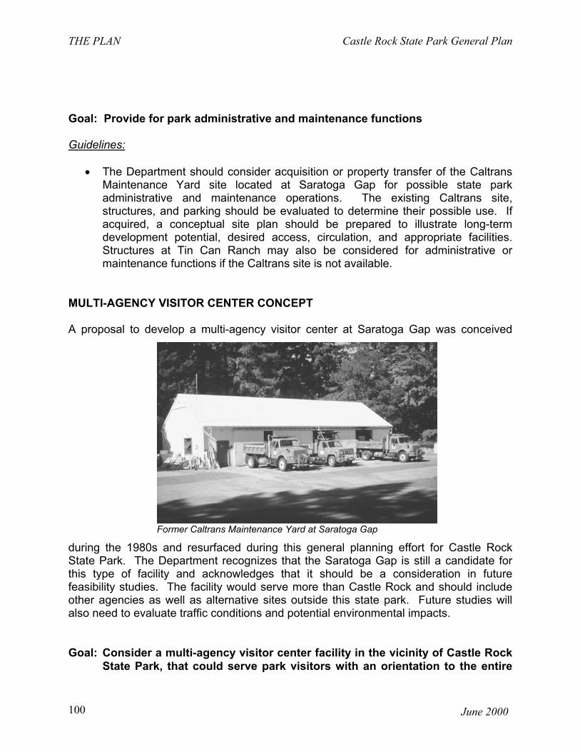
THE PLAN Castle Rock State Park General Plan
June 2000100
Goal: Provide for park administrative and maintenance functions
Guidelines:
• The Department should consider acquisition or property transfer of the CaltransMaintenance Yard site located at Saratoga Gap for possible state parkadministrative and maintenance operations. The existing Caltrans site,structures, and parking should be evaluated to determine their possible use. Ifacquired, a conceptual site plan should be prepared to illustrate long-termdevelopment potential, desired access, circulation, and appropriate facilities.Structures at Tin Can Ranch may also be considered for administrative ormaintenance functions if the Caltrans site is not available.
MULTI-AGENCY VISITOR CENTER CONCEPT
A proposal to develop a multi-agency visitor center at Saratoga Gap was conceived
during the 1980s and resurfaced during this general planning effort for Castle RockState Park. The Department recognizes that the Saratoga Gap is still a candidate forthis type of facility and acknowledges that it should be a consideration in futurefeasibility studies. The facility would serve more than Castle Rock and should includeother agencies as well as alternative sites outside this state park. Future studies willalso need to evaluate traffic conditions and potential environmental impacts.
Goal: Consider a multi-agency visitor center facility in the vicinity of Castle RockState Park, that could serve park visitors with an orientation to the entire
Former Caltrans Maintenance Yard at Saratoga Gap

Castle Rock State Park General Plan THE PLAN
June 2000 101
Santa Cruz Mountains, including state parks. It could supplement thepark’s interpretation through exhibits, brochures, and publications onrecreation opportunities and the natural and cultural history of this entireregion.
Guidelines:
• The multi-agency visitor center should not focus just on Castle Rock State Park.The visitor center could include office space for staff and/or volunteers, exhibitareas, and sales counters, as well as visitor parking, depending on agency needsand the location of the site and its physical constraints. If located at SaratogaGap, parking for a visitor center should be planned and managed to give priorityto short term visits and fewer parking spaces. Trailhead or long-term parking forother day use visitors should be planned at other locations.
• The Department should continue to coordinate with the Midpeninsula RegionalOpen Space District and the Santa Clara and Santa Cruz County Parks andRecreation Departments, to determine agency needs and the potential forserving the visiting public in the Santa Cruz Mountains Region.

ENVIRONMENTAL ANALYSIS Castle Rock State Park General Plan
June 2000102
divider photo

Castle Rock State Park General Plan ENVIRONMENTAL ANALYSIS
June 2000 103
blank side of divider

ENVIRONMENTAL ANALYSIS Castle Rock State Park General Plan
June 2000104
ENVIRONMENTAL ANALYSIS
SUMMARY
The general plan, with all its sections, constitutes an environmental impact report (EIR),as required by Public Resources Code Sections 5002.2 and 21000 et seq. It will besubmitted to the California Park and Recreation Commission for its approval. Thisgeneral plan and EIR is the first tier of environmental review. “Tiering” refers to usingthe analysis of general matters contained in a broader EIR (such as one prepared for ageneral plan or policy statement) with later EIRs and negative declarations on narrowerprojects; incorporating by reference the general discussions from the broader EIR; andconcentrating the later EIR or negative declaration solely on the issues specific to thelater project (State CEQA Guidelines, CCR Section 15152). The discussion of impactsis commensurate with the level of specificity of this plan. No other agencies havejurisdiction or permit approval over this general plan.
This general plan proposes facilities development and changes, operational changes,resource management proposals and classification recommendations. The initialimpetus for this general plan was the mitigation of impacts arising from existing activitiesand conditions. Nearly half of the park is proposed for a natural preserve classification.Prescribed burning is proposed to reintroduce fire into the ecosystems, which willmaintain and possibly expand native plant communities. The creation of a centralizedvisitor contact point at Partridge Farm will permit better visitor control and allow theprovision of better public sanitation facilities. Revegetation with native plant species ofthe undeveloped portion of Partridge Farm will expand native plant communities,improve esthetics, and provide additional wildlife habitat. These actions will alsoprovide mitigation for the impacts from the relocation of day use parking. The parkadministrative function will be relocated from the existing campground to one of threepossible locations - Partridge Farm, Tin Can Ranch, or the Caltrans maintenance yard.The park headquarters office will be relocated to Partridge Farm for primary visitorcontact. Vegetation management, trails, and climbing management plans areproposed. The development of a resource impact assessment and managementprogram to set limits on use and development is proposed. Significant environmentalimpacts are those commonly associated with visitor use and facility development -traffic, visual, and disturbance or loss of sensitive species and habitats. The mitigationgenerally requires resource specialists to review and select sites avoiding or reducingpotential impacts, and will be implemented as specific projects are proposed.
The Notice of Preparation was circulated to State agencies and local planning agencies.Public meetings have been held to solicit public input on the plan proposals and theissues. The issues raised in the process were: climbing impacts and management,protection of sensitive resources, traffic, need for public facilities (water, restrooms,parking, etc.), desire for recreational opportunities (particularly rock climbing andmountain biking), and conflict of uses (particularly with mountain biking). The General
Castle Rock State Park General Plan ENVIRONMENTAL ANALYSIS
June 2000 105
Plan cannot address all of these issues in detail, as it is the first level or tier of planningfor a park unit. This general plan sets the broader goals for the unit's management andprovisions for public use. It does not define the specific details of development or themethods that will be applied to goals for resource protection. Those details are part offuture planning steps that may include layout and design of facilities or specific resourcemanagement plans and process. Another level of environmental analysis is applied atthat time.
PROJECT DESCRIPTION
The Introduction and The Plan section of the general plan discuss developmentalproposals, appropriate land uses, operational and resource management issues, etc.These sections of the general plan constitute the project description.
The objectives of the Environmental Analysis section are to identify the significantimpacts of implementing the general plan, and provide general mitigation measures fora first tier of environmental review. Following the approval of the general plan by theCalifornia Park and Recreation Commission, the Department will prepare managementplans (i.e. climbing, vegetation, trails, etc.) and area development plans as staff andfunding become available. The area development plans will provide specific layout,capacity, facilities, configuration, etc. for a designated area such as Partridge Farm orTin Can Ranch. Implementation of the area development plans will generally be carriedout through major and minor capital outlay projects. At each planning level (whether itis a management or area development plan, major capital outlay or minor capital outlayproject), the plan or project will be subject to further detailed environmental review todetermine if the project is consistent with the general plan and identify any significantenvironmental impacts and mitigation that are specific to the project. More detailedenvironmental review will be possible at those levels of planning where facility size,location, and capacity will be more explicitly delineated than at the general plan level.
The proposed plan calls for the preparation of climbing and trails plans, and acomprehensive resource management program. Climbing will be prohibited within theproposed natural preserve. A climbing management plan is proposed for the areasoutside of the natural preserve. The park headquarters/visitor contact point will bemoved to the Partridge Farm from the existing campground. Partridge Farm will bedeveloped in phases to provide day use parking (estimated in the first phase to be 50spaces). A baseline resource study and visitor impact monitoring program to providelimits and directions for development and management is recommended.Approximately 1,800 acres of the unit is recommended for classification as a naturalpreserve.DESCRIPTION OF THE ENVIRONMENTAL SETTING

ENVIRONMENTAL ANALYSIS Castle Rock State Park General Plan
June 2000106
Refer to the Existing Conditions Section for a description of the existing environmentand significant resource values. Additional traffic, esthetics, and air quality informationis below.
Air Quality
Castle Rock State Park is in the North Central Coast Air Basin and Monterey BayUnified Air Pollution Control District (MBUAPCD). The North Central Coast Air Basin iscurrently in attainment for federal particulate (less than 10 microns) standards, andfederal and state standards for nitrogen dioxide, sulfur dioxide, and carbon monoxide.The Air Basin is not in attainment for federal and state standards for ozone and statestandards for particulate matter (less than 10 microns). Air quality is generally good dueto the inflow of clean air from the Pacific Ocean.
Esthetics
The two predominant esthetics factors at Castle Rock State Park are visual and audible.The determinations of quality and impact are subjective and are influenced byexpectations. Those visitors seeking a "wilderness experience" can have the quality oftheir visit significantly diminished by the presence of climbing bolts and chalk on therock faces, the background noise of the highway and aircraft, or the echo of gunshotsfrom the neighboring gun club. These are all existing conditions. Visitors, desiring anactive recreation experience, may be less affected by the same intrusions.
The three main existing noise generators in the Castle Rock area are automobiles,aircraft, and the gun club near Partridge Farm. Distance and terrain ameliorate most ofthe noise impacts from the highway and the gun club for much of the park. However,along Castle Rock Ridge, the noise level may be found excessive by some visitors. TheLos Altos Road and Gun Club, which predates the park establishment, is open to thepublic Thursday through Sunday.
Visual qualities of the Castle Rock State Park are generally rated high with only specificpoints having negative values (eroded areas, parking areas, trash or litter piles).Middle-ground and background views usually appear unimpacted by human beings.Most of CRSP slopes face the west and the viewshed is comprised of the relativelyundeveloped coastal range in Santa Cruz County. The high voltage powerlines cuttingthrough the San Lorenzo River valley are an intrusive visual element. Partridge Farmhas been recognized by amateur astronomers as having a valuable "dark sky" resource;there is a clear view of the horizon and low light pollution.
Traffic and Parking
Figure 3 shows the 1992 traffic levels on the three state routes (9, 35, and 236) aroundCastle Rock State Park. ADT is Average Daily Traffic, the total traffic of a time period

Castle Rock State Park General Plan ENVIRONMENTAL ANALYSIS
June 2000 107
divided by the number of days (year or month). It should be noted that the highest peakhour traffic volume on SR 9 was recorded in the winter during the morning commute.There are traffic delays at the 4-way stop intersection of SR 9 and 35. Figure 4 showsthe breakdown of traffic flow through the Saratoga Gap intersection from two differenthours of observation on one day. This diagram indicates the relative volumes of trafficthrough the intersection; it is not a complete study. For example, 225 vehicles (205eastbound and 20 westbound) entered or left the Saratoga Gap intersection on S.R. 9to Santa Cruz.
Caltrans rates level of service on roadways with a scale from A to F. The rating is notwholly dependent on the number of vehicles but also on the nature of the flow, speeds,and delays. Level of service A represents unrestricted operation; level F representsovercapacity flows with heavy congestion and considerable reductions in speed. LevelC is still stable flow; although it approaches the range where instability may occurbecause of small changes in flow. Caltrans design standard level of service forfreeways and highways is "C." Maximum volume (passenger cars per hour in onedirection) for rural two-lane highway for B level of service is 900 under ideal conditions(Fundamentals of Traffic Engineering, 8th Edition, Institute of Transportation and TrafficEngineering, University of California, Berkeley, 1973). The values for peak hourvolume, one way, on State Route 9 are well below this value. Levels of service for 9and 35 adjacent to the park are probably A and B most of the time.
The main Castle Rock State Park parking lot off State Highway 35 provides 55 parkingspaces. There is no left turn channelization at this entrance; at current traffic levels andsite distance, this has not been a problem. State Highway 35 from Saratoga Gap to amile past the main parking lot is either posted no parking or parking is limited to the dayuse. There are approximately 384 roadside parking sites available on the two highwaysbordering Castle Rock State Park (See Table 3 in Appendix E).
Intersection of State Highways 35 and 9 at Saratoga Gap
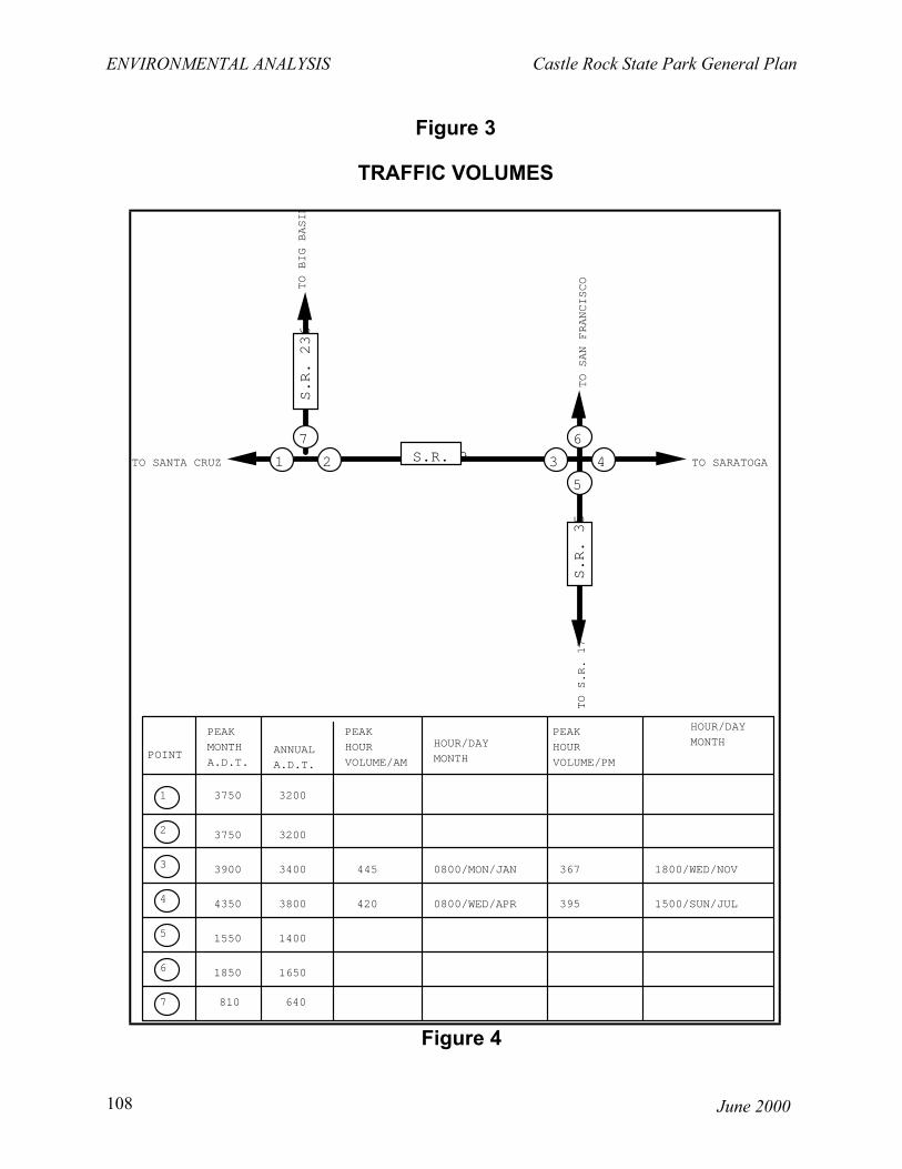
ENVIRONMENTAL ANALYSIS Castle Rock State Park General Plan
June 2000108
Figure 4
S.R. 9
S.R. 236
S.R. 35
������������������
1 2 3 4
5
67
TO SARATOGA
TO SAN FRANCISCOTO BIG BASIN
TO S.R. 17
TO SANTA CRUZ
POINT
PEAK
MONTH
A.D.T.ANNUAL
A.D.T.
PEAK
HOUR
VOLUME/AM
PEAK
HOUR
VOLUME/PM
HOUR/DAY
MONTH
HOUR/DAY
MONTH
1 3750 3200
2 3750 3200
3 3900 3400 445 0800/MON/JAN
4 4350 3800 420 0800/WED/APR
367 1800/WED/NOV
395 1500/SUN/JUL
5 1550 1400
6 1850 1650
7 810 640
Figure 3
TRAFFIC VOLUMES

Castle Rock State Park General Plan ENVIRONMENTAL ANALYSIS
June 2000 109
INTERSECTION FLOW
SIGNIFICANT ENVIRONMENTAL EFFECTS OF THE PROPOSED PROJECT
222
28
194
10
169
15
3
17
0
225
205
20
2 1 6
9 24
33
34 9 5
48
14
62 0815 - 0915
01/16/98
98
40
58
5
42
11
9
27
6
6 3 9
18 24
42
9 7 4
20
17
37 1210 - 1310
01/16/98
99
42
57
S.R. 9 TO SANTA CRUZ
S.R. 9 TO SANTA CRUZ
S.R. 35 TO S.R. 17
S.R. 35 TO S.R. 17

ENVIRONMENTAL ANALYSIS Castle Rock State Park General Plan
June 2000110
The purpose of this section is to identify impacts of the implementation of the generalplan as a whole, and to identify impacts that have the potential for significance and willrequire more specific analyses when area development and management plans areprepared.
The thresholds are standards that the EIE uses to determine if an activity or project willor potentially have a significant impact. If the project or activity could exceed athreshold, a significant impact is designated. If mitigation can reduce the impact belowthe threshold, the impact is considered avoidable.
1. There is a potential for significant traffic impacts. The entrance to Partridge Farmmay require a new alignment and channelization to provide safe access and egresswhen it is developed for public use. Assuming that each day use parking sitegenerates 4 trips per day, 160 trips per day total could be generated by PartridgeFarm development. Although the volume may not be excessive, sight limitationsand the lack of acceleration/deceleration and left turn channelization lanes at thehighway access may create problems. The current speed along State Highway 35in the vicinity of Partridge Farm is 55 MPH.
The multi-agency visitor center proposal is conceptual, neither the capacity nor itslocation has been selected. The indicated location shown in the general plan ispresented only as a possible alternative. The Department has included the multi-agency visitor center in the plan so that the California Park and RecreationCommission can approve the concept of this site as a possible candidate for futurestudies. The Department could at some future date jointly work with other agenciesto study the feasibility. The development of a multi-agency visitor center at thenorthwest corner of the intersection of SR 9 and 35 could create significant trafficproblems. Any objective determination of impact would be speculative.
THRESHOLD: Reduction in level of service below C or development of access with inadequate sight distance.
IMPACT: Potentially Significant.IMPACT UNAVOIDABLE: No
2. The potential for significant visual impacts from development at the Partridge Farmdoes exist. The landscape has been considerably altered over the years by farmoperations; however, a natural-appearing landscape is slowly reestablishing itself.The development of day-use parking could create an adverse visual impact to users.A parking area with reflective parked automobiles could be a very obvious humanimposed intrusion to the landscape. The activity and equipment associated with thehike-in campsites could also be an intrusion to the visual landscape for park users.The area is not readily visible from the highway or by neighboring land owners.

Castle Rock State Park General Plan ENVIRONMENTAL ANALYSIS
June 2000 111
THRESHOLD: New development in a natural-appearing landscape visible to users, neighbors, or adjacent traffic.
IMPACT: Potentially significant.IMPACT UNAVOIDABLE: No
3. Five state or federal listed animal species occur, have suitable habitat, or have beenobserved in transit through the park. Prescribed burning, disturbance of roostingsites by public use, etc. have the possibility of impacting these species. Release ofsediment from either of the two existing reservoirs catastrophically or as part of aresource management project could reduce steelhead trout spawning habitat in theSan Lorenzo River. Trail crossings of the river can further degrade riparian andaquatic habitat.
SPECIES LISTING COMMENTSsteelhead trout FT Spawns in the upper San Lorenzo
River within the parkCalifornia red-legged FT Potentially found in San Lorenzofrog RiverAmerican peregrine FE, SE Suitable nesting habitat, observed falcon flying over the parkmarbled murrelet FT, SE Suitable nesting habitat, observed
flying over the parkwillow flycatcher SE Migrant through park
(FE = Federally listed endangered; FT = Federally listed threatened; SE = State listed endangered)
Of the approximately 575 acres of redwood wildlife habitat, about 350 acres or 60%is within the proposed natural preserve. However, only the old growth redwood iscritical to the marbled murrelet. The only stand of ancient redwood is in the KingsCreek Canyon and entirely within the proposed natural preserve. No change in useis proposed for the remainder outside the proposed natural preserve. The naturalpreserve classification provides additional direction for resource management andrestriction on the type of use. The protection of listed sensitive species is the sameunder any of the classifications in the State Park System.
THRESHOLD: Direct take or removal of individuals of a sensitive species, reduction in area, or alteration or disturbance of critical habitat.
IMPACT: Potentially significant.IMPACT UNAVOIDABLE: No.
4. Brewer's calandrinia is found in the Castle Rock Ridge area of the park. Its habitat isgravelly slopes, disturbed or burnt areas, and chaparral. Castle Rock Ridge is themost popular visitor destination area; therefore, incidental destruction of individualsis possible. The possible introduction of prescribed burning to the area may createmore suitable habitat for the species while reduction of unauthorized trails and

ENVIRONMENTAL ANALYSIS Castle Rock State Park General Plan
June 2000112
revegetation of disturbed area may reduce habitat area. Because no specific areasare proposed for these activities, the real extent of impact cannot be projected.
THRESHOLD: Direct take or removal of individuals of a sensitive species, reduction in area, or alteration or disturbance of critical habitat.
IMPACT: Potentially significant.IMPACT UNAVOIDABLE: No.
5. Two rare natural plant communities (as defined by Department of Fish and Game,Natural Diversity Data Bank) occur within the park: knobcone pine forest and whitealder riparian forest.
The knobcone pine is dependent on fire for reproduction; fire prepares the seed bed,releases minerals to the soil, removes vegetative cover, and opens the conesreleasing the seeds. Approximately 40% of the existing knobcone forest would beoutside of the proposed natural preserve. However, no change in public use isproposed for this area outside of the proposed natural preserve although it mayreceive incidental use from the nearby campground. Fire suppression in the unit hasprobably reduced the acreage of this community and will continue to do so, unlessprescribed fire is introduced as a vegetative management activity. The white alderriparian forest along Kings Creek is entirely within the proposed natural preserve.
THRESHOLD: Reduction or loss of rare natural plant community.IMPACT: Potentially significant.IMPACT UNAVOIDABLE: No.
6. There is the potential for impacts to unknown cultural resources. The entire unit hasnot been surveyed for archeological or historical resources. Of particular concernare those areas currently receiving intensive use such as the Castle Rock Ridgearea and other climbing areas. There is a potential for prehistoric "rock art" and rockshelter sites to be found on the rock faces and caverns of the Vaqueros Formation.There is a potential for intentional or accidental destruction of the art by climbingactivities, vandalism, or foot traffic erosion.
THRESHOLD: Loss or destruction of resource IMPACT: Potentially significant.IMPACT UNAVOIDABLE: No.
MITIGATION MEASURES
The mitigation measures below reflect the specificity of a general plan and, therefore,are in the form of guidelines and directions. As management plans, area developmentplans, or other projects are proposed, they will be subject to further environmentalreview and project-specific mitigation measures will be developed and implemented.

Castle Rock State Park General Plan ENVIRONMENTAL ANALYSIS
June 2000 113
1. Prior to site specific development or preparation of management plans, areas ofpotential impact will be reviewed by Departmental historians and archeologists todetermine the presence and significance of cultural resources, the potential impact,and recommended mitigation, if appropriate. The alteration or removal of anyhistoric or archeological features will be subject to PRC 5024.5 review requirements.The evaluation is reviewed by the Departmental coordinator and also by the Office ofHistoric Preservation, if impact to a National Register-eligible site is possible.
Responsibility: Department Historian/Archeologist Monitoring/Reporting: An evaluation required under PRC 5024.5 is
submitted by Departmental historians or archeologist to the Office of Historic Preservation for
their concurrence.
2. Visual impacts can be mitigated by careful siting, design, and selection of materials.Landscaping with native plant species in the Partridge Farm area could screendeveloped parking areas and walk-in campsites.
Responsibility: Project manager, Department of Parks and Recreation
Monitoring/Reporting: Project review required as part of the second tier CEQA process.
3. Prior to construction of facilities and trails, areas of potential impact will be surveyedfor the presence of the endangered or threatened animal species. If there is apotential for impact, the California Department of Fish and Game and the U.S. Fishand Wildlife Service will be consulted. Facilities or trails will be relocated to avoidimpact. Nesting or spawning periods can be avoided with proper scheduling ofconstruction or resource management activities.
Responsibility: Department Staff/Resource EcologistMonitoring/Reporting: Project review required as part of the second tier
CEQA process.
4. Prior to any habitat restoration or construction, the areas will be surveyed for thepresence of listed plant species. If any are found in the proposed area ofconstruction or habitat restoration, the Department will consult with the U.S. Fish andWildlife Service and the California Department of Fish and Game to incorporateprotective measures or redesign the project to avoid impact.
Responsibility: Department Staff/Resource EcologistMonitoring/Reporting: Project review required as part of the second tier
CEQA process.

ENVIRONMENTAL ANALYSIS Castle Rock State Park General Plan
June 2000114
5. The Department will consult with the Caltrans for the design requirements forproviding safe access and egress at Partridge Farm. Left turn channelization andright turn acceleration and deceleration lanes may be necessary.
Responsibility: Project manager, Department of Parks and Recreation
Monitoring/reporting: Project review required as part of the second tier CEQA process. Conformance with Caltrans standards or recommendations will be considered meeting minimum requirements.
ENVIRONMENTAL EFFECTS THAT CANNOT BE AVOIDED IF THE PROJECT ISIMPLEMENTED
There is the potential for significant adverse environmental impacts resulting fromincreased public use and the development of facilities. These impacts, however, can bemitigated to a level of non-significance with proper design and siting of facilities,resource management programs, and specific mitigation measures.
The knobcone pine forest may continue to decline in acreage and vigor unlessprescribed burning is implemented to provide the conditions necessary for its survivaland expansion.
The impacts associated with climbing (i.e. soil erosion and compaction, vegetation lossaround climbing sites, removal of moss from rock surfaces, development of "volunteer"trails, rock face exfoliations, disturbance of wildlife) may continue in those areas outsideof the natural preserve (if classified).
ALTERNATIVES TO THE PROPOSED PROJECT
Four alternatives are proposed for comparison to the proposed project: (1) PreservationPriority, (2) Recreation Priority, (3) Wilderness Classification Alternative, and (4) NoProject (CEQA requires the consideration of a No Project alternative - no change inexisting development, operation, and management). It is possible to combine elementsfrom each of the alternatives to create additional alternatives. Suitable alternativelocations (acreage and slope restrictions) to public access development at PartridgeFarm were not found within the existing park boundaries. A visitor center alternativelocation was considered at the Caltrans maintenance yard, but was rejected for theexcessive traffic it would create at the entrance road to the Indian Rock subdivision.The multi-agency visitor center proposal is conceptual and will require additionalcoordination with the other land management agencies and a feasibility study todetermine the need, the size, and the best location.

Castle Rock State Park General Plan ENVIRONMENTAL ANALYSIS
June 2000 115
For comparison between the alternatives and the proposed plan, a theoretical maximumdaily use is estimated. The theoretical maximum daily use is calculated by multiplyingthree variables: (1) number of parking spaces, (2) number of people per vehicle, and(3) number of turnovers per parking space. The resulting number represents atheoretical or potential visitor use per day. The theoretical maximum daily use shouldbe used only as an index or an order of magnitude for comparison between alternatives,the proposed plan, and the existing condition.
The following evaluation has included a worst case scenario that anticipates all users ofall the parking bordering the highway will access Castle Rock State Park. In reality,many of the roadside parking spaces can be and are used for access to other areassuch as Sanborn-Skyline County Park or Saratoga Gap Open Space Preserve or maysimply be used as overlooks (such as Sempervirens Point). These calculations alsoassume that all the parking at the Castle Rock main parking lot is used only for day use,though some is used for the trail camp. Using these assumptions, the “no project”alternative (existing condition) has a theoretical maximum of 2018 visitors per day.However, actual visitor attendance records show an average of about 5300 visitors permonth (1983 - 1993).
Proposed Project:
Existing roadside parking (Semp. Pt. reduced by 9 cars): 375 carsReduce roadside parking along SR35: - 52 carsMaintain Castle Rock Main parking lot: + 55 carsDevelop day use parking at Partridge Farm: + 50 cars
Total Day Use Parking: 428 cars
Maximum daily use for the proposed project, assuming 428 day use parking sites, 2turnovers per parking site and 2.3 visitors per vehicle, 40 people per bus (1 site atSempervirens Point),
(428 x 2 x 2.3) + 40 = 2009 visitors/day The theoretical maximum daily use for the proposed project is 2009 visitors/day.(1) Preservation Priority Alternative
DESCRIPTION
The park administrative function would be relocated from the existing campground toPartridge Farm, Tin Can Ranch, or the Caltrans maintenance yard, if surplused. Nopublic use facilities would be constructed at Partridge Farm or the Caltrans site. Nonew trails would be constructed unless determined to be necessary. Volunteer trailswould be removed and either scarified and revegetated, or allowed to return to a naturalstate unassisted. The 1800 acres proposed for classification as a natural preservecould be expanded to the west to include an additional 400 acres bounded by theSaratoga Toll Road, the southern boundary of the Indian Rock subdivision, Saratoga

ENVIRONMENTAL ANALYSIS Castle Rock State Park General Plan
June 2000116
Gap Trail, and the San Lorenzo River. This would include all the redwood wildlife habitatwithin the proposed natural preserve as well as riverine and riparian habitat necessaryfor aquatic species such as steelhead trout and California red-legged frogs. Rockclimbing, horseback riding, and mountain biking would be prohibited. Following thepreparation of resource management plans, habitat restoration projects would becarried out to enhance the natural resource qualities. The Castle Rock campgroundcould be removed.
Parking could be reduced at the existing parking area to decrease public access anduse of the already heavily-used Castle Rock Ridge area. Roadside parking could beimproved, but not increased elsewhere, to encourage dispersed use of the park. Fiveareas along State Highway 9 have potential for parking improvements: Waterman Gap,Red Mountain, Oil Creek, Beekhuis Road, and Hoe Gate. All of these parking areas areexisting; while improvements could be achieved, it is not likely that any significantincrease in capacity can be made. Most of these parking areas are highway turnouts orpull-offs. Some roadside parking areas could be eliminated to reduce the number oftrail users and related impacts on adjacent resources. A parking survey was performedto determine the number of parking sites available for users of the state park. A total of288 parking spaces were found along State Highway 9 between Saratoga Gap andWaterman Gap. Improved public use facilities previously planned at SempervirensPoint will reduce parking capacity from 30 to 21 vehicles and one bus. A total of 96sites were found along Highway 35 between Saratoga Gap and Indian Rock. Theexisting Castle Rock parking area has 55 parking sites; it could be reduced to 35 sites.Reduction of the number of sites at the main Castle Rock parking lot cannot be replacedby expansion of these other parking areas around the perimeter of the park. Parkingoutside of the Castle Rock main lot plus parking at Indian Rock could be removed (52sites).
Preservation Priority:
Existing roadside parking (Semp. Pt. reduced by 9 cars): 375 carsReduce roadside parking along SR35: - 52 carsCastle Rock Main parking lot (Reduce by 20 cars): + 35 cars
Total Day Use Parking: 358 cars
Maximum daily use, assuming 358 day use parking sites, 2 turnovers per parking siteand 2.3 visitors per vehicle, 40 people per bus (1 site at Sempervirens Point):
(358 x 2 x 2.3) + 40 = 1687 visitors/day
The theoretical maximum daily use for the preservation priority alternative is 1687visitors/day.
EVALUATION

Castle Rock State Park General Plan ENVIRONMENTAL ANALYSIS
June 2000 117
Rock climbing and camping opportunities would be lost. Soil erosion and vegetationloss around high use climbing areas and from volunteer trails would be reduced.Maximum recreational use would be limited by parking. Recreational use patterns maychange; use may become more evenly distributed throughout the week and seasons,and dispersed around the park. Recreational demand will continue to increase with thepopulation growth in the nearby urban areas. Although it is not expected that the statepark must accommodate demand created by population growth, there will be increaseduse of the unit. Other open space areas in the region may need to allow for more publicaccess to meet the growth demand. The expansion of the proposed natural preservewould include the powerline running west of the San Lorenzo River. Maintenanceactivities for the powerline would be incompatible with the natural preserveclassification. Multiple entry points to the unit can create management and operationaldifficulties:
1. Visitor contact would be restricted thereby reducing the opportunity to educatethe visitor to the sensitive resources, the need for protection, and recognition ofentering a State Park.
2. Potential control of illegal activities would be reduced. 3. Emergency response time would be increased. 4. Maintenance costs would be increased.5. The demand for water and sanitation facilities at parking areas would be
unsatisfied.
Multiple entries may disperse users over a larger area but would substantially reducethe opportunity for park staff to contact and monitor use activities. Rotating closurescould allow areas to recuperate from intensive use, if necessary.
(2) Recreation Priority Alternative
DESCRIPTION
Partridge Farm would be developed to its potential. Allowing a 1000' buffer from thehighway, the remaining 36 acres could be developed to 150 standard campsites, and 50day use parking sites. The natural preserve would be limited to the Kings Creekwatershed, encompassing the ancient redwood stand, to allow the broadest range ofrecreation use. The Department would negotiate with Santa Cruz County and SanLorenzo Water District to amend the easement for the Saratoga Toll Road to permitmountain bike usage. Kings Creek Truck Trail could be opened to mountain bike usewith an agreement by the Water District and private property owners. Climbing wouldbe limited to low impact climbing but not limited to any area. Lions Cave Area would beopened to the public without a natural preserve classification. New trails and trailcamps would be developed to improve visitor access to all areas of the park.

ENVIRONMENTAL ANALYSIS Castle Rock State Park General Plan
June 2000118
Recreation Priority:
Existing roadside parking (Semp. Pt. reduced by 9 cars): 375 carsMaintain Castle Rock main parking lot: + 55 carsDevelop day use parking at Partridge Farm: + 50 cars
Total Day Use Parking: 480 cars
Maximum daily use, assuming 480 day use parking sites, 2 turnovers per day useparking site, 2.3 visitors per day use vehicle, 150 camp sites, 3.5 visitors per vehicle ata regular campsite, and 40 visitors per bus (1 site at Sempervirens Point):
(480 x 2 x 2.3) + (150 x 3.5) + 40 = 2773 visitors/day
The theoretical maximum daily use for the recreation priority alternative is 2773visitors/day.
EVALUATION
Generally, the impacts would be those resulting from increased public use. Soil erosionand vegetation loss would continue and increase around the highly popular Castle RockRidge area. The Lion Caves area would suffer the most visible impacts as it has beenrelatively unused by the visiting public. Unrestricted use of the Lion Caves area wouldeliminate its potential use as a baseline or control for future studies of user impacts, andits value as wildlife habitat.
Increasing the camping capacity at Partridge Farm from 20 to 150 campsites couldincrease the water supply requirement to nearly 12,000 gallons per day at maximumcapacity. Intensive camping development would likely render the site undesirable foramateur astronomical use.
Mountain bike usage would require trail planning and management that may designatesome trails as single use, one way use, or multiple use to reduce conflicts of oncomingtraffic and reduce confrontation with other trail users. Acquisition of rights-of-way oreasements on Kings Creek Truck Trail would be required as most of the road is not inState Park ownership. The concentration of use at Partridge Farm could alleviate someof the operation and management difficulties resulting from multiple entry points to theunit. An increase in use would create additional demands for maintenance andoperation service while the concentration of use could provide some economies.
(3) Wilderness Classification Alternative
DESCRIPTION
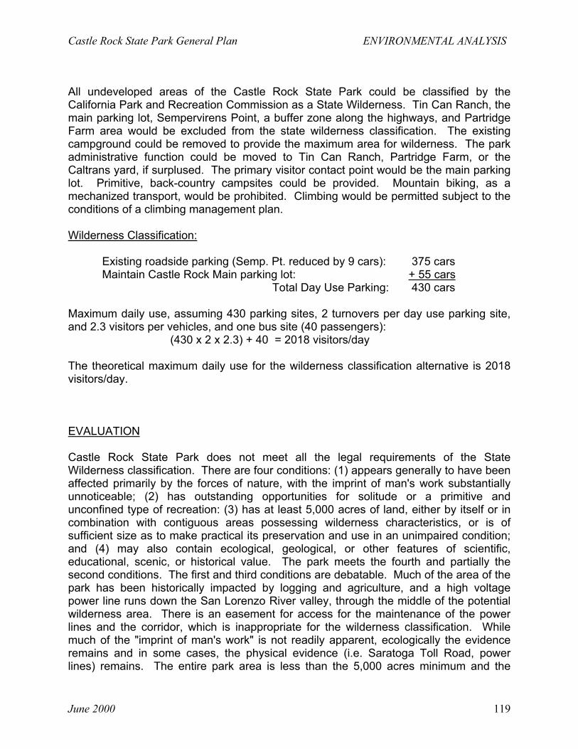
Castle Rock State Park General Plan ENVIRONMENTAL ANALYSIS
June 2000 119
All undeveloped areas of the Castle Rock State Park could be classified by theCalifornia Park and Recreation Commission as a State Wilderness. Tin Can Ranch, themain parking lot, Sempervirens Point, a buffer zone along the highways, and PartridgeFarm area would be excluded from the state wilderness classification. The existingcampground could be removed to provide the maximum area for wilderness. The parkadministrative function could be moved to Tin Can Ranch, Partridge Farm, or theCaltrans yard, if surplused. The primary visitor contact point would be the main parkinglot. Primitive, back-country campsites could be provided. Mountain biking, as amechanized transport, would be prohibited. Climbing would be permitted subject to theconditions of a climbing management plan.
Wilderness Classification:
Existing roadside parking (Semp. Pt. reduced by 9 cars): 375 carsMaintain Castle Rock Main parking lot: + 55 cars
Total Day Use Parking: 430 cars
Maximum daily use, assuming 430 parking sites, 2 turnovers per day use parking site,and 2.3 visitors per vehicles, and one bus site (40 passengers):
(430 x 2 x 2.3) + 40 = 2018 visitors/day
The theoretical maximum daily use for the wilderness classification alternative is 2018visitors/day.
EVALUATION
Castle Rock State Park does not meet all the legal requirements of the StateWilderness classification. There are four conditions: (1) appears generally to have beenaffected primarily by the forces of nature, with the imprint of man's work substantiallyunnoticeable; (2) has outstanding opportunities for solitude or a primitive andunconfined type of recreation: (3) has at least 5,000 acres of land, either by itself or incombination with contiguous areas possessing wilderness characteristics, or is ofsufficient size as to make practical its preservation and use in an unimpaired condition;and (4) may also contain ecological, geological, or other features of scientific,educational, scenic, or historical value. The park meets the fourth and partially thesecond conditions. The first and third conditions are debatable. Much of the area of thepark has been historically impacted by logging and agriculture, and a high voltagepower line runs down the San Lorenzo River valley, through the middle of the potentialwilderness area. There is an easement for access for the maintenance of the powerlines and the corridor, which is inappropriate for the wilderness classification. Whilemuch of the "imprint of man's work" is not readily apparent, ecologically the evidenceremains and in some cases, the physical evidence (i.e. Saratoga Toll Road, powerlines) remains. The entire park area is less than the 5,000 acres minimum and the
ENVIRONMENTAL ANALYSIS Castle Rock State Park General Plan
June 2000120
adjacent highways and private properties prevent the combination with contiguousproperties except for the San Lorenzo Valley Water District lands to the south.However, the eventual use of these District lands is unknown.
The existing camping opportunities would be lost; back-country camping opportunitiescould be increased. Camping in nonspecific sites could adversely impact special plantsand wildlife habitat. Restriction on the use of motorized vehicles in wilderness areaswould severely restrict the possibility of prescribed burning and, therefore, increase fuelload build-up and fire hazard. Further, restriction of motorized vehicles in thewilderness areas would allow deterioration of existing roads which would inhibitemergency (fire and rescue) vehicle use. Resource management activities would belimited; natural processes would generally be allowed to continue without humanintervention. Cultural features, such as historic cabin sites, old logging roads, historicorchards, and the Toll Road would be left to deteriorate by natural processes.Depending on the occurrence of wildfire, the lack of prescribed burning within the statewilderness could further inhibit the reproduction of the knobcone pine.
(4) No Project Alternative
DESCRIPTION
No new facilities would be constructed. The unit office could be moved to either TinCan Ranch, Partridge Farm, or the Caltrans maintenance yard, if surplused. A climbingplan would be developed in cooperation with the climbing community, which woulddetermine the appropriate climbing areas and restrictions. Partridge Farm would beallowed to recover naturally. No natural preserve classification would be proposed.
Maximum daily use, assuming 430 parking sites, 2 turnovers per day use parking site,and 2.3 visitors per vehicle, and one bus site (40 passengers):
(430 x 2 x 2.3) + 40 = 2018 visitors/day
The theoretical maximum daily use for the no project alternative is 2018 visitors/day.
EVALUATION
The eventual failure of the small reservoirs at Tin Can Ranch and Partridge Farm couldintroduce a significant short-term sediment load to the San Lorenzo River adverselyaffecting the fishery and aquatic habitat quality.
Public demand for access will increase with population growth. Without provision foruse areas appropriately designed and placed to provide the visitor with some sense oforganization or control and resource awareness, the significant park values will beirreparably degraded (i.e. “volunteer” trails, new climbing routes, etc. will accelerate soilerosion, vegetation loss, and disturbance of wildlife habitat).

Castle Rock State Park General Plan ENVIRONMENTAL ANALYSIS
June 2000 121
SIGNIFICANT IRREVERSIBLE ENVIRONMENTAL CHANGES IF THE PROJECT ISIMPLEMENTED
No significant irreversible environmental changes are projected. While any facilitydevelopment may be considered a long-term commitment of resources, the impacts canbe reversed through removal of the facilities and discontinued use. Much of the CastleRock area was logged and has recovered. The Department does remove or realigntrails, replace campsites, etc. where the impact has become unacceptable either fromexcessive use or from a change in environmental circumstances.
GROWTH INDUCING IMPACT OF THE PROPOSED PROJECT
The proposed project may have a minor cumulative impact on growth inducement in thearea. Any improvement or increase in capacity can encourage increased use whichtranslates into additional tourism and its attendant demand for services; however,population growth in the nearby urban area will create the demand for recreationalopportunities and increased use with or without facility development at Castle RockState Park. The proposed project would increase the theoretical maximum daily use byonly 2.5%. That 2.5% represents the increase from the camping at Partridge Farm.There is no proposed increase in day use parking capacity.
There are no known development projects proposed in the immediate vicinity of the unit.Caltrans has closed the maintenance station at Saratoga Gap and is consideringsurplusing the property. San Lorenzo Valley Water District, a major land owner to thesouth of the unit, is reviewing its options for management and use of those lands.Midpeninsula Regional Open Space District has recently started a planning effort fortheir lands in the vicinity of Castle Rock State Park, but at this time, we are unaware ofproject proposals that would change land use in the immediate proximity of the park.
EFFECTS FOUND NOT TO BE SIGNIFICANT
In this first tier of planning and environmental analysis, the following impacts were foundnot significant. In future planning and environmental analysis, they will be reconsidered.
1. No significant noise impacts by future development or management potentialallowed for in this general plan were projected. There will be temporary noiseincreases during future construction; however, there are no immediate sensitivereceptors. Construction normally would be limited to regular working hours.
2. No significant impact to archeological resources is projected. No sites are known to
be located within any area proposed for development. The only known archeological

ENVIRONMENTAL ANALYSIS Castle Rock State Park General Plan
June 2000122
site is in the Partridge Farm area, and no development is proposed that wouldimpact the site. There is a potential for “rock art” and rock shelter sites in theclimbing areas. These areas will be surveyed in preparation of the climbingmanagement plan. Known historic resource impacts are similarly limited. ThePartridge Farm house will be maintained in its current or adaptive use and condition.It could be converted to the unit administrative office with no impact to its historicintegrity. The Saratoga Toll Road will continue in its present use as a recreationaltrail. Other historic features may be provided with interpretive panels.
3. Assuming maximum buildout and full occupancy (worst case scenario) of theproposed project (every day use parking site used twice a day, each vehicle carries2.3 people and each person uses 5 gallons of water) the maximum total demand forPartridge Farm would be approximately 1150 gallons per day or a flow of .0016cubic feet per second. Low flush toilets, and low flow faucets can be installed tofurther reduce the water supply requirements. If water is supplied to the existingCastle Rock parking lot, an additional 1265 gallons could be required for a combinedtotal of 3450 gallons per day or 2.4 gallons per minute. The water system atPartridge Farm consists of a 10,000 gallon tank, well, and 20 GPM pump. The welland pump have been tested for several days with no significant draw down.Therefore, there is a more than adequate water supply for the proposeddevelopment.
4. Soil erosion is not expected to increase. The proposed development at PartridgeFarm is an area of lower erosion potential. The plan provides for consideration ofnew trails (projected at less than 10 miles). However, parking capacity will notsignificantly change; therefore, intensity of use may decline as the number of usersare spread over a longer distance of trails. A unitwide trails plan will be preparedwhich may call for the development of new trails and the removal of redundant trails.Trail construction and use will likely take place in areas of higher erosion hazard.Trails will be constructed to the standards of the Department’s Trails ConstructionManual, and trail conditions will be monitored by staff and volunteers. Resourcemanagement plans may call for the elimination or consolidation of “volunteer” trails,which could result in the reduction of soil erosion.
5. While the area of Castle Rock State Park is relatively geologically active (knownactive faults, known rock slide avalanches, high potential for mass movement byvirtue of the steep slopes and high water table), the General Plan does not call fordevelopment or substantial increase of public use in known risk areas. A landslidemap has been prepared and will be maintained as part of the Resource Inventory inthe Unit Data File. The entire unit is subject to significant seismic movements;however, the change in risk (increased or decreased) is dependent on where thevisitor might be if they were not at Castle Rock State Park. The impact is notconsidered significant.

Castle Rock State Park General Plan ENVIRONMENTAL ANALYSIS
June 2000 123
6. No change in public use, and, therefore, no change in fire risk is expected in thearea immediately downslope from the Indian Rock Ranch subdivision. Thereintroduction of fire by prescribed burning will reduce the fuel loading; it is unknownat this time whether the prescribed burning will take place in areas that will benefitthe subdivision. The fire risk will increase at Partridge Farm if it is opened to regularpublic use. The increased risk is partially mitigated by its close proximity to thehighway, employee residence and potential supervision, the top of the ridge locationwith low slope angles, and the preparation of a unit wildfire management plan.

ENVIRONMENTAL ANALYSIS Castle Rock State Park General Plan
June 2000124
REFERENCES
1992 Traffic Volumes on California State Highways, California Department ofTransportation.
Partridge Farm - Boisseranc Unit, Castle Rock State Park, Resources Description andGuidelines for Restoration, Harvey and Stanley Associates for Sempervirens Fund andthe Department of Parks and Recreation, 1984.
Natural Resources Inventory of Castle Rock State Park and the Upper San LorenzoRiver Basin, Harvey and Stanley Associates for Sempervirens Fund, 1979.

ENVIRONMENTAL ANALYSIS Castle Rock State Park General Plan
125 June 2000

APPENDICES Castle Rock State Park General Plan
June 2000126
divider photo

Castle Rock State Park General Plan APPENDICES
June 2000 127

APPENDICES Castle Rock State Park General Plan
June 2000128
Appendix A
Partial Plant Species List of Castle Rock State Park *
Family Species Common Name Origin
Blechnaceae Woodwardia fimbriata Giant chain fern NativeDryopteridaceae Dryopteris arguta Coastal wood fern NativeDryopteridaceae Polystichum munitum Western sword fern NativePteridaceae Adiantum aleuticum Five-finger fern NativePinaceae Pinus attenuata Knobcone pine NativePinaceae Pinus coulteri Coulter pine IntroducedPinaceae Pinus ponderosa Ponderosa pine IntroducedPinaceae Pseudotsuga menziesii var. menziesii Douglas-fir NativeTaxaceae Torreya californica California nutmeg NativeTaxodiaceae Sequoia sempervirens Redwood NativeAceraceae Acer macrophyllum Big-leaf maple NativeAnacardiaceae Toxicodendron diversilobum Poison oak NativeApocynaceae Vinca major Periwinkle IntroducedAristolochiaceae Asarum caudatum Wild ginger NativeAsteraceae Carduus pycnocephalus Italian thistle IntroducedAsteraceae Centaurea solstitialis Yellow star-thistle IntroducedAsteraceae Hypochaeris glabra Smooth cat’s ear IntroducedBetulaceae Alnus rhombifolia White alder NativeBetulaceae Corylus cornuta var. californica California hazelnut NativeCaprifoliaceae Lonicera hispidula var. vacillans Hairy honeysuckle NativeCaprifoliaceae Symphoricarpos albus var. laevigatus Snowberry NativeCaryophyllaceae Cerastium glomeratum Mouse-ear chickweed IntroducedEricaceae Arbutus menziesii Pacific madrone NativeEricaceae Arctostaphylos tomentosa ssp. crustacea Brittle-leaved manzanita NativeFabaceae Genista monspessulana French broom IntroducedFabaceae Lupinus hirsutissimus Stinging lupine NativeFabaceae Pickeringia montana var. montana Chaparral pea NativeFabaceae Vicia sativa Spring vetch IntroducedFagaceae Lithocarpus densiflorus Tanbark oak NativeFagaceae Quercus chrysolepis Canyon live oak NativeFagaceae Quercus kelloggii California black oak NativeFagaceae Quercus wislizenii Interior live oak NativeGarryaceae Garrya elliptica Coast silk tassel NativeGeraniaceae Erodium cicutarium Red-stemmed filaree IntroducedHydrophyllaceae Emmenanthe penduliflora Whispering bells NativeHydrophyllaceae Eriodictyon californicum Yerba santa NativeHydrophyllaceae Nemophila menziesii var. menziesii Baby blue-eyes Native

Castle Rock State Park General Plan APPENDICES
June 2000 129
Partial Plant Species List (continued)
Family Species Common Name Orgin
Lamiaceae Salvia mellifera Black sage NativeLauraceae Umbellularia californica California bay NativeOleaceae Fraxinus latifolia Oregon ash NativeOxalidaceae Oxalis oregana Redwood sorrel NativePapaveraceae Dendromecon rigida Bush poppy NativePolemoniaceae Navarretia squarrosa Skunkweed NativePortulacaceae Calandrinia breweri Brewer’s calandrinia Native **Portulacaceae Montia parvifolia Small-leaved montia NativeRanunculaceae Ranunculus californicus California buttercup NativeRhamnaceae Ceanothus cuneatus var. cuneatus Buck brush NativeRhamnaceae Ceanothus papillosus var. papillosus Warty-leaved ceanothus NativeRosaceae Adenostoma fasciculatum Chamise NativeRosaceae Heteromeles arbutifolia Toyon NativeScrophulariaceae Castilleja foliolosa Wooly Indian paintbrush NativeScrophulariaceae Mimulus aurantiacus Bush monkey flower NativeScrophulariaceae Mimulus cardinalis Scarlet monkey flower NativeViolaceae Viola sempervirens Redwood violet NativeLiliaceae Calochortus albus White globe lily, fairy lantern NativeLiliaceae Chlorogalum pomeridianum Soap plant NativeLiliaceae Dichelostemma capitatum ssp. capitatum Blue dicks NativeLiliaceae Disporum hookeri Fairy bells NativeLiliaceae Smilacina stellata False Solomon’s seal NativeLiliaceae Trillium chloropetalum Giant wake-robin NativeLiliaceae Triteleia laxa Ithuriel’s spear NativePoaceae Agrostis hallii Hall’s bentgrass NativePoaceae Aira caryophyllea Silver European hairgrass IntroducedPoaceae Bromus carinatus var. carinatus California brome NativePoaceae Bromus diandrus Ripgut grass IntroducedPoaceae Bromus hordaceus Soft chess IntroducedPoaceae Cynosurus echinatus Dogtail grass IntroducedPoaceae Elymus glaucus Blue wildrye Native
* Please note that a few species listed as introduced are native to California, but are not indigenous to CastleRock State Park. A prime example is ponderosa pine, which is naturally restricted in the Santa CruzMountains to a soil type and microenvironment type not found in the park. Ponderosa pines occurring in thepark were planted prior to state acquisition.
** Brewer's calandrinia (Calandrinia breweri) is a California Native Plant Society List 4 plant.

Castle Rock State Park General Plan APPENDICES
June 2000 130
Appendix B Animal Species List of Castle Rock State Park
Common Name Scientific Name Family NameTiger Salamander Ambystoma tigrinum AmbystomatidaePacific Giant Salamander Dicamptodon ensatus AmbystomatidaeRough Skinned Newt Taricha granulosa SalamandridaeCalifornia Newt Taricha torosa SalamandridaeEnsatina Enastina eschscholtzi PlethodontidaeCalifornia Slender Salamander Batrachoseps attenuatus PlethodontidaeBlack Salamander Aneides flavipunctatus PlethodontidaeArboreal Salamander Aneides lugubris PlethodontidaeWestern Spadefoot Scaphiopus hammondi PelobatidaeRed-legged Frog Rana aurora RanidaeFoothill Yellow-legged Frog Rana boylii RanidaeWestern toad Bufo boreas BufonidaePacific treefrog Hyla regilla HylidaeGreen heron Butorides virescens ArdeidaeWood duck Aix sponsa AnatidaeMallard Anas platyrhynchos AnatidaeCommon merganser Mergus merganser AnatidaeTurkey vulture Cathartes aura CathartidaeWhite-tailed kite Elanus caeruleus AccipitridaeSharp-shinned hawk Accipiter striatus AccipitridaeCooper’s hawk Accipiter cooperii AccipitridaeRed-shouldered hawk Buteo lineatus AccipitridaeRed-tailed hawk Buteo jamaicensis AccipitridaeRough-legged hawk Buteo lagopus AccipitridaeGolden eagle Aquila chrysaetos AccipitridaeAmerican kestrel Falco sparverius FalconidaeMerlin Falco columbarius FalconidaePeregrine falcon Falco pereginus FalconidaePrairie falcon Falco mexicanus FalconidaeRing-necked pheasant Phasianus colchicus PhasianidaeCalifornia quail Callipepla californicus PhasianidaeMountain quail Oreortyx pictus PhasianidaeKilldeer Charadrius vociferus CharadriidaeSpotted sandpiper Actitis macularia ScolopacidaeRing-billed gull Larus delawarensis LaridaeCalifornia gull Larus californicus LaridaeHerring gull Larus argentatus LaridaeMarbled murrelet Brachyramphus marmoratus AlcidaeRock dove Columba livia ColumbidaeBand-tailed pigeon Columba fasciata ColumbidaeMourning dove Zenaida macroura ColumbidaeGreater roadrunner Geococcyx californianus CuculidaeCommon barn owl Tyto alba TytonidaeWestern screech owl Otus kennicottii StrigidaeGreat horned owl Bubo virginianus StrigidaeNorthern pygmy owl Glaucidium gnoma StrigidaeBurrowning owl Athene cunicularia StrigidaeSpotted owl Strix occidentalis Stigidae

Castle Rock State Park General Plan APPENDICES
June 2000 131
Animal Species List (continued)Common Name Scientific Name Family Name
Long-eared owl Asio otus StigidaeNorthern saw-whet owl Aegolius acadicus StrigidaeCommon poorwill Phalaenoptilus nuttallii CaprmulgidaeBlack swift Cypseloides niger ApodidaeVaux’s swift Chaetura vauxi ApodidaeWhite-throated swift Aeronautes saxatalis ApodidaeAnna’s hummingbird Calypte anna TrochilidaeRufous hummingbird Selasphorus rufus TrochilidaeAllen’s hummingbird Selasphorus sasin TrochilidaeBelted kingfisher Ceryl alcyon AlcedinidaeLewis’ woodpecker Melanerpes lewis PicidaeAcorn woodpecker Melanerpes formicivorus PicidaeYellow-bellied sapsucker Sphyrapicus varius PicidaeNuttall’s woodpecker Picoides nuttallii PicidaeDowny woodpecker Picoides pubescens PicidaeHairy woodpecker Picoides villosus PicidaeCommon flicker Colaptes auratus PicidaePileated woodpecker Dryocopus pileatus PicidaeOlive-sided flycatcher Contopus borealis TyrannidaeWestern wood-peewee Contopus sordioulus TyrannidaeWillow flycatcher Empidonax traillii TyrannidaePacific-slope flycatcher Empidonax difficilis TyrannidaeBlack phoebe Sayornis nigricans TyrannidaeSay’s phoebe Sayornis saya TyrannidaeAsh-throated flycatcher Myiarchus cinerascens TyrannidaeWestern kingbird Tyrannus verticalis TyrannidaeHorned lark Eremophila alpestris AlaudidaePurple martin Progne subis HirundinidaeTree swallow Tachycineta bicolor HirundinidaeViolet-green swallow Tachycineta thalassina HirundinidaeNorthern rough-winged swallow Stelgidopterzx serripennis HirundinidaeBarn swallow Hirundo rustica HirundinidaeSteller’s jay Cyanocitta stelleri CorvidaeScrub jay Aphelocoma coerulescens CorvidaeClark’s nutcracker Nucifraga columbiana CorvidaeYellow-billed magpie Pica nuttallii CorvidaeAmerican crow Corvus brachyrhynchos CorvidaeCommon raven Corvus corax CorvidaeChestnut-backed chickadee Parus rufescens ParidaePlain titmouse Parus inoratus ParidaeBushtit Psaltriparus minimus AegithalidaeRed-breasted nuthatch Sitta canadensis SittidaeWhite-breasted nuthatch Sitta carolinensis SittidaePygmy nuthatch Sitta pygmaea SittidaeBrown creeper Certhia americana CerthidaeRock wren Salpinctes obsoletus TroglodytidaeCanyon wren Catherpes mexicanus TroglodytidaeBewick’s wren Thryomanes bewickii Troglodytidae
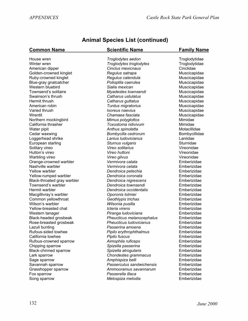
APPENDICES Castle Rock State Park General Plan
June 2000132
Animal Species List (continued)Common Name Scientific Name Family Name
House wren Troglodytes aedon TroglodytidaeWinter wren Troglodytes troglodytes TroglodytidaeAmerican dipper Cinclus mexicnaus CinclidaeGolden-crowned kinglet Regulus satrapa MuscicapidaeRuby-crowned kinglet Regulus calendula MuscicapidaeBlue-gray gnatcatcher Polioptila caerulea MuscicapidaeWestern bluebird Sialia mexican MuscicapidaeTownsend’s solitaire Myadestes townsendi MuscicapidaeSwainson’s thrush Catharus ustulatus MuscicapidaeHermit thrush Catharus guttatus MuscicapidaeAmerican robin Turdus migratorius MuscicapidaeVaried thrush Ixoreus naevius MuscicapidaeWrentit Chamaea fasciata MuscicapidaeNorthern mockingbird Mimus polyglottos MimidaeCalifornia thrasher Toxostoma ridivivum MimidaeWater pipit Anthus spinoletta MotacillidaeCedar waxwing Bombycilla cedrorum BombycillidaeLoggerhead shrike Lanius ludovicianus LaniidaeEuropean starling Sturnus vulgaris SturnidaeSolitary vireo Vireo solitarius VireonidaeHutton’s vireo Vireo huttoni VireonidaeWarbling vireo Vireo gilvus VireonidaeOrange-crowned warbler Vermivora calata EmberizidaeNashville warbler Vermivora celata EmberizidaeYellow warbler Dendroica petechia EmberizidaeYellow-rumped warbler Dendroica coronata EmberizidaeBlack-throated gray warbler Dendroica nigrescens EmberizidaeTownsend’s warbler Dendroica townsendi EmberizidaeHermit warbler Dendroica occidentalis EmberizidaeMacgillivray’s warbler Oporonis tolmiei EmberizidaeCommon yellowthroat Geothlypis trichas EmberizidaeWilson’s warbler Wilsonia pusilla EmberizidaeYellow-breasted chat Icteria virens EmberizidaeWestern tanager Piranga ludoviciana EmberizidaeBlack-headed grosbeak Pheucticus melanocephalus EmberizidaeRose-breasted grosbeak Pheucticus ludovicianus EmberizidaeLazuli bunting Passerina amoena EmberizidaeRufous-sided towhee Pipilo erythrophthalmus EmberizidaeCalifornia towhee Pipilo fuscus EmberizidaeRufous-crowned sparrow Aimophila ruficeps EmberizidaeChipping sparrow Spizella passerina EmberizidaeBlack-chinned sparrow Spizella atrogularis EmberizidaeLark sparrow Chondestes grammacus EmberizidaeSage sparrow Amphispiza belli EmberizidaeSavannah sparrow Passerculus sandwichensis EmberizidaeGrasshopper sparrow Ammooramus savannarum EmberizidaeFox sparrow Passerella illaca EmberizidaeSong sparrow Melospiza melodia Emberizidae

Castle Rock State Park General Plan APPENDICES
June 2000 133
Animal Species List (continued)Common Name Scientific Name Family Name
Lincoln’s sparrow Melospiza lincolnii EmberizidaeGolden-crowned sparrow Zonotrichia atricapilla EmberizidaeWhite-crowned sparrow Zonotrichia leucophrys EmberizidaeWhite-throated sparrow Zonotrichia albicollis EmberizidaeDark-eyed junco Juco hyemalis EmberizidaeRed-winged blackbird Agelaius phoeniceus EmberizidaeTri-colored blackbird Agelaius tricolor EmberizidaeWestern meadowlark Sturnella neglecta EmberizidaeBrewer’s blackbird Euphagus cyanocephalus EmberizidaeBrown-headed cowbird Molothrus ater EmberizidaeNorthern oriole Icterus galbula EmberizidaePurple finch Carpodacus mexicanus FringillidaeHouse finch Carpodacus mexicanus FringillidaeRed crossbill Loxia curvirostra FringillidaePine siskin Carduelis pinus FringillidaeLesser goldfinch Carduelis psaltria FringillidaeLawrence’s goldfinch Carduelis lawrencei FringillidaeAmerican goldfinch Carduelis tristis FringillidaeEvening grosbeak Coccothraustes vespertinus FringillidaeHouse sparrow Passer domesticus PasseridaeVirginia Opossum Didelphis marsupialis DidelphidaeVagrant Shrew Sorex vagrans SoricidaeOrnate Shrew Sorex ornatus SoridicaeTrowbridge’s Shrew Sorex trowbridgii SoricidaeShrew-mole Neurotrichus gibbsii TalpidaeBroad-footed Mole Scapanus latimanus TalpidaeLittle Brown Myotis Myotis lucifugus VespertilionidaeYuma Myotis Myotis yumanensis VespertilionidaeLong-eared Myotis Myotis evotis VespertilionidaeFringed Myotis Myotis thysanodes VespertilionidaeLong-legged Myotis Myotis volans VespertilionidaeCalifornia Myotis Myotis californicus VestpertilionidaeWestern Pipistrelle Pipistrellus hesperus VespertilionidaeBig Brown Bat Eptisicus fuscus VespertilionidaeRed Bat Lasiurus borealis VespertilionidaeHoray Bat Lasiurus cinereus VespertilionidaeTownsend’s Big-eared Bat Coryorhynus townsendii VespertilionidaePallid Bat Antrozous pallidus VespertiliionidaeBrazilian Free-tailed Bat Tadarida brasiliensis MolossidaeWestern Mastiff Bat Eumops perotis MolossidaeBrush Rabbit Sylviligus bachmani LeporidaeFeral Domestic Rabbit Oryctolagus cuniculus LeporidaeDesert Cottontail Sylvilagus audubonii LeporidaeBlack-tailed Hare Lepus californicus LeporidaeMerriam’s Chipmunk Tamias merriami SciuridaeCalifornia Ground Squirrel Spermophilus beecheyi SciuridaeEastern Gray Squirrel Sciurus carolinensis SciuridaeWestern Gray Squirrel Sciurus griseus Sciuridae

APPENDICES Castle Rock State Park General Plan
June 2000134
Animal Species List (continued)
Common Name Scientific Name Family Name
Fox Squirrel Sciurus niger SciuridaeBotta Pocket Gopher Thomomys bottae GeomyidaeCalifornia Pocket Mouse Chaetodipus californicus HeteromyidaeNarrow-faced Kangaroo Rat Dipodomys venustus HeteromyidaeWestern Harvest Mouse Reithrodontomys megalotis CricetidaeCalifornia Mouse Peromyscus californicus CricetidaeDeer Mouse Peromyscus maniculatus CricetidaePinyon Mouse Peromyscus truei CricetidaeDusky-footed Woodrat Neotoma fuscipes CricetidaeCalifornia Vole Microtus californicus CricetidaeBlack Rat Rattus rattus MuridaeNorway Rat Rattus norvegicus MuridaeHouse Mouse Mus musculus MuridaeCoyote Canis latrans CanidaeGray Fox Urocyon cinereoargenteus CanidaeRingtail Bassariscus astutus ProcyonidaeRacoon Procyon lotor ProcyonidaeLong-tailed weasel Mustela frenata MustelidaeAmerican Badger Taxidea taxus MustelidaeWestern Spotted Skunk Spilogale gracilis MustelidaeStriped Skunk Memphitis memphitis MustelidaeMountain Lion Felis concolor FelidaeBobcat Lynx rufus FelidaeFeral Pig Sus scrofa SuidaeBlack-tailed Deer Odocoileus hemionus CervidaeFeral Domestic Goat Capra hircus BovidaeWestern Pond Turtle Clemmys marmorata EmydidaeWestern Fence Lizard Sceloporus occidentalis IguanidaeCoast Horned Lizard Phrynosoma conronatum IguanidaeWestern Skink Eumeces skiltonianus ScinidaeSouthern Alligator Lizard Gerrhonotus multicarinatus AnguidaeNorthern Alligator Lizard Gerrhonotus coeruleus AnguidaeRubber Boa Charina bottae BoidaeRingneck Snake Diadophis punctatus ColubridaeSharp-tailed Snake Contia tenuis ColubridaeRacer Coluber constrictor ColubridaeCoachwhip Masticophis flagellum ColubridaeGopher Snake Pituophis melanoleucus ColubridaeCommon Kingsnake Lampropeltis getulus ColubridaeCalifornia Mountain Kingsnake Lampropeltis zonata CoubridaeCommon Garter Snake Thamnophis sirtalis ColubridaeWestern Terrestrial Garter Snake Thamnophis elegans ColubridaeWestern Aquatic Garter Snake Thamnophis couchi ColubridaeWestern Rattlesnake Crotalus viridis Viperidae

Castle Rock State Park General Plan APPENDICES
June 2000 135

Castle Rock State Park General Plan APPENDICES
June 2000 136
Special Animals of Castle Rock State Park LEGAL OCCURANCE AT UNIT 2
COMMON NAME SCIENTIFIC NAME STATUS 1 PRES PROB POSSCoho salmon Onhorhnchus kisutch FT 3Steelhead trout Oncorhynchus mykiss FT XCalifornia red-legged frog Rana aurora draytoni CSC, FT X(a) Foothill yellow-legged frog Rana boylii CSC X(a)California tiger salamander Ambystoma tigrinum californiense CSC, FC X(a)Leopard frog Rana peipens CSC X(a)Western pond turtle Clemmys marmorata CSC X(a)California horned lizard Phynostoma coronatum frontale CSC X(a)Townsend’s big-eared bat Corynorhinus townsendii CSC X(b)Pallid bat Antrozuous pallidus CSC X(b)Spotted bat Eumops perotis CSC X(b)Western mastiff bat Eumops perotis CSC X(b)Ringtail Bassariscus astutus CP X(a)Mountain lion Felis concolor CP XBlack-shouldered kite Elanus caeruleus CP X(a)Bald eagle Haliaeetus leucocephalus FT, CE X(a)Northern harrier Circus cyaneus CSC X(a)Sharp-shinned hawk Accipiter striatus CSC XCooper’s hawk Accipiter cooperi CSC X(a)Golden eagle Aquilla chrysaetos CSC, CP XMerlin Falco columbarius CSC X(a)American peregrine falcon Falco peregrinus anatum FE, CE, CP XPrairie falcon Falco mexicanus CSC X(a)Marbled murrelet Brachyramphus marmoratus FT, CE, CP X(a)Burrowing owl Athene cuncularia CSC X(a)California spotted owl Strix occidentalis occidentalis CSC X(a)Long-eared owl Asio otus CSC X(a)Black swift Cypseloides niger CSC X(a)Vaux’s swift Cypseloides vauxi CSC X(a)Willow flycatcher Empidonax traillii FSS, CE X(a)Purple martin Progne subis CSC X(a)Loggerhead shrike Lanius ludovicianus CSC X(a)Yellow warbler Dendroica petechia bewster CSC X(a)Horned lark Eremophila alpestris CSC X(a)Yellow-breasted chat Icteria virens CSC X(a)Tricolored blackbird Agelaius tricolor CSC X(a)
1 Legal status as of 12/92FE = Listed as endangered by the U.S. Fish and Wildlife Service.FT = Listed as threatened by the U.S. Fish and Wildlife Service.FSS = Federal (BLM and USFS) sensitive species.FC = Candidate species for federal listing (existing biological information is sufficient to support listing, but not yetproposed).CE = Listed as endangered by the State of California.CT = Listed as threatened by the State of California.CP = California Protected.CSC = State of California Species of Special Concern.
2 Occurrence at UnitPRES = Recently observed in the park.PROB = Likely to be found in the park if looked for; not documented since 1979.POSS = Range of species may include the park during at least part of the season (some species
documented in 1979 but the current presence in the park is questionable).(a) = Species documented to occur in the park in 1979.(b) = Species with no known documentation at the park.
3 Species extirpated from San Lorenzo River system.No attempt was made to determine the occurrence of the invertebrates in the park.

Castle Rock State Park General Plan APPENDICES
June 2000 137

APPENDICES Castle Rock State Park General Plan
June 2000138
Appendix C
Table 1
Crosswalk Between Wildlife Habitat Relationship System Habitat Types andTerrestrial Plant Communities (Holland 1986).
Wildlife Habitat Type Plant Community
Redwood. . . . . . . . . . . . . . . . . . . . . . . . . Upland RedwoodClosed-cone Pine-Cypress. . . . . . . . . Knobcone Pine ForestMontane Hardwood-Conifer. . . . . . . . . Mixed Evergreen ForestMontane Hardwood. . . . . . . . . . . . . . . . Mixed Evergreen Forest
Black Oak Woodland Interior Live Oak Woodland
Mixed Chaparral. . . . . . . . . . . . . . . . . . Northern Mixed ChaparralAnnual Grassland. . . . . . . . . . . . . . . . . Non-native Grassland
Bald Hills PrairieMontane Riparian. . . . . . . . . . . . . . . . . White Alder Riparian ForestRiverine. . . . . . . . . . . . . . . . . . . . . . . . . No analogueLacustrine (i.e., ponds and lakes) . . . No analogue

Castle Rock State Park General Plan APPENDICES
June 2000 139
blank side

APPENDICES Castle Rock State Park General Plan
June 2000140
Appendix D
Selected Systemwide Resource Management Directives
The following directives are taken from “Resource Management Directives for the California Departmentof Parks and Recreation”, May 1979, and Chapter 18 of the Department Operations Manual:
#5 Development in state parks is to be located and designed to protect and enhance enjoyment of theprimary resources. In state parks, the primary purpose for development is to place visitors in anoptimal relationship with the resources, for recreational enjoyment and understanding of thoseresources. In state parks, resources may not be managed or manipulated to enhance recreationalexperiences.
#9 Boundaries of wilderness and natural preserves will be established to give full protection toenvironmental and ecological integrity, from the standpoints of watershed influences, scenic andvisual unity, cultural values, and other appropriate environmental factors.
Developments in natural preserves are limited to trails and interpretive facilities required to makepossible the visual and sensory enjoyment of the resources by visitors. Vehicle access and parkingare not appropriate; visitor centers, restrooms, structures, and facilities other than signs shall beplaced outside natural preserves.
#26 It is an objective of the Department to identify the total framework of environmental andecological factors influencing the lands of the State Park System, including those arising fromhuman activities, and to promulgate and apply resource management techniques required to negatedeleterious human influences, and to achieve the environmental objectives established for thesystem.
#27 Wherever natural elements are recognized in the State Park System as being of special significancerequiring protection and preservation, and regardless of the classification of the units in which theyoccur, the Department shall recommend establishment of natural preserves (PRC Section No.5019.71), to embrace these elements, and to emphasize their recognition and protection.
#28 It is a primary responsibility of the Department to evaluate the ability of State Park Systemenvironments to withstand the impact of visitor use. Developments in any unit of the system shallnot be of such capacity, nor uses be of such intensity, that significant ecological damage ordeterioration of any environmental factor can reasonably be expected to occur. If deterioration iscaused by overuse, steps are to be taken to reduce the intensity of use, and to rehabilitate thedamaged resources.
#29 In the State Park System, perpetuation of values in today’s environment may require a purposefulguiding of dynamic ecological factors that are constantly undergoing a successional trend throughthe interaction of natural and extraneous forces. This guidance may not always involve simply thestatic protection of the features or elements that happen to be a part of the existing environment inany particular period of time.

Castle Rock State Park General Plan APPENDICES
June 2000 141
#34 Except in those areas where it is perpetuated for resource management of historical reasons,aggressively invading exotic vegetation will be systematically removed when it becomesestablished anywhere in the State Park System; first priority in the effort will be given to invasionsin state parks, state reserves, natural preserves, and wildernesses.
#35 It is an objective of the Department to maintain the natural faunal habitat, wherever possible. Thenatural wildlife habitat is defined as the nature of the wildlife resources and habitat of each areabefore Euro-American modification.
#36 Whether or not restoration of natural conditions is possible, it shall be an objective of theDepartment to avoid large imbalances in the wildlife population, using habitat managementwherever possible. If it is necessary to regulate the populations of native animals by other thannatural means, the methods used shall be efficient, humane, and as unobtrusive as possible.Restoration and maintenance of a natural faunal balance shall be the goal of the Department.
#37 The Department shall conserve the soils of the State Park System, and to that end, shall prevent, ifpossible, or control destructive or unnatural erosion by means that are in harmony with thepurposes of each unit. In state parks, reserves, natural preserves, and wildernesses, artificialcontrols shall be introduced only under the most extreme circumstances, and then only whenconversion to a natural condition in the future is the objective. Where corrective measures areneeded, all measures used shall be as unobtrusive as possible, fitting as naturally as possible intothe environment, with the objective of restoring the natural condition.
#38 It will be an objective of the Department to control and regulate the climbing of rocks, peaks,coastal bluffs, and other eminences, to prevent deterioration of such features. When it is necessaryto install visitor facilities such as trails, steps, railings, etc., the work will be done so the facilitiesharmonize with the geological features and their environments.
#39 It will be an objective of the Department to eliminate promptly any defacements of geologicfeatures, and to restore the damaged sites to as natural an appearance and condition as is possible.
#41 Paleontological resources in the State Park System shall be protected against damaging influences,including deterioration or adverse modification of their environment. Sites proposed fordevelopment will be evaluated for paleontological resources in the preliminary planning stage.Stabilization of paleontological resources may be required to prevent loss, but will be done inways that protect the integrity of the sites.
#43 The Department will continually strive to avoid degrading park system values by diversion ofwaters, by the alteration of stream regimens, or by allowing pollution to occur.
#46 In each park system unit, environmental quality shall be such that visitors are aware of being in aplace of special quality because of their surroundings. Man-made features and their maintenancewill have special qualities, which, in total, express a feeling of environmental quality that differsfrom areas where degrading and undesirable features and intrusions are commonplace.
#58 Cultural resources in the State Park System shall be protected against damaging or degradinginfluences, including deterioration or adverse modification of their environments. All evidence ofsuch resources shall be investigated by qualified personnel, as designated by the Director, beforeany restoration, reconstruction or development is begun. If stabilization of cultural remains is

APPENDICES Castle Rock State Park General Plan
June 2000142
required to prevent loss or deterioration, it shall be undertaken in ways that shall not threatenarchaeological, historical, or related environmental values.
#60 Management and interpretation of human history in the California State Park System shall be builtaround the continuous flow of human experience, with appropriate emphasis on key features andcircumstances, but always with full recognition of the need to show, and to achieve anunderstanding of, the interdependence between the past, the present, and the future.
#63 Realization of the objectives embodied in approved resource elements may require preparation ofcarefully designed cultural resource management programs. Such programs shall set forth detaileddescriptions of management procedures to be employed, including schedules and managementtechniques, and shall define the priorities and evaluations on which the program is based.
#74 In state parks and state reserves, recreational facilities may be operated to enable the public to see,use, enjoy, and understand the primary resource in accordance with the resource element for theunit. The primary resources may not be modified, manipulated, or impaired, to create or enhancerecreational opportunities.

Castle Rock State Park General Plan APPENDICES
June 2000 143
BACK SIDE BLANK

APPENDICES Castle Rock State Park General Plan
June 2000144
Appendix E
Table 2
CASTLE ROCK STATE PARK 1998 TRAILS INVENTORY
EXISTING TRAIL TYPE OF USE DISTANCE LOCATION (miles)
Castle Rock Trail pedestrian 0.59 Parking lot to Castle Rock to Saratoga Gap
Summit Meadows Trail pedestrian 1.06 Sempervirens Point to Red Mountain
Loghry Woods Trail pedestrian 1.76 Skyline Trail to Service Road Trail
Skyline-to-the-Sea Trail pedestrian 6.51 Saratoga Gap to Waterman Gap
Ridge Trail pedestrian 1.76 Saratoga Gap Trail (south) to Saratoga Gap Trail (north)
Saratoga Gap Trail (Sec. A) pedestrian 2.62 Parking lot to campground
Saratoga Gap Trail (Sec. B) pedestrian, equestrian, veh. 3.08 Saratoga gap to campground (dirt and paved road, fire road)
Service Road Trail pedestrian, equestrian, bicycle, veh. 1.00 State Highway 35 to campground
Frog Flat Fire Road Trail pedestrian 0.57 Headquarters bypass route north along Saratoga Gap
Trail
Saratoga Toll Road Trail pedestrian, equestrian 7.09 Saratoga Gap to Hwy. 9 intersection with San Lorenzo River *Sky-to-Sea Interconnector Trail to Toll Rd. pedestrian, equestrian 1.87 Southern end of toll road to Skyline-to-the-Sea Trail *Skyline Trail pedestrian 1.71 Saratoga Gap to approximately Postmile 12.6 on Hwy. 35 *Link Trail pedestrian 0.10 Parking lot to Skyline Trail *
Goat Rock Trail pedestrian 0.37 Ridge Trail to interpretive shelter to Goat Rock
Beekhuis Road Trail pedestrian, equestrian 1.50 Dirt road from Hwy. 9 to Saratoga Gap Toll Road Trail
Travertine Springs Trail pedestrian 2.09 Saratoga Gap Trail to Saratoga Toll Road Trail
Cut-off Trail pedestrian 0.20 Beekhuis Road Trail to Skyline-to-the-Sea Trail
Interconnector Trail pedestrian 0.20 Ridge Trail to Saratoga Gap Trail
* Portion of trail is located off state park property, but under agreement for DPR management and public use. The State portion of the Skyline Trail stops at Postmile 25.6 for a distance of 1.7 miles.
TRAILS SUMMARY
Hiking Only 19.54 miles Hiking trails opened for pedestrian use onlyHiking and Horseback Riding13.54 miles Trails opened for hiking and horseback riding only Hiking, Horseback Riding, Bicycles 1.00 miles Service Road Trail opened for multiple use
(provides bicycle access to trail camp)
Total Trails: 34.08 miles Miles of trail owned or managed by DPR

Castle Rock State Park General Plan APPENDICES
June 2000 145
Table 3EXISTING ROADSIDE PARKING
NAME LOCATION CAPACITY NOTESPostmile (side of hwy) estimated avg.
Highway 9 (Saratoga Gap to Waterman Gap)
Trailhead** 26.90 (east) 15 cars would accom. 4 horse trailers, call box 26.81 (west) 15 cars water wells exist in center26.78 (east) 10 cars26.71 (east) 3 cars
Oil Creek** 26.68 (west) 10 cars26.24 (west) 7 cars
Red Mtn.** 26.00 (west) 40 cars two separate areas, gate, call boxHoe Gate** 25.90 (east) 10 cars gated access to old horse camp
25.46 (west) 10 carsSemper. Pt.** 25.20 (east) 30 cars 1998 const. improvements (21 cars, bus)
25.10 (west) 7 cars24.68 (east) 7 cars24.50 (east) 7 cars near passing lane24.45 (west) 15 cars24.39 (west) 15 cars call box23.54 (east) 3 cars23.33 (east) 3 cars
Beekhuis** 23.31 (west) 3 cars23.02 (west) 5 cars22.97 (west) 2 cars22.80 (west) 7 cars22.61 (west) 3 cars22.48 (west) 2 cars22.38 (east) 5 cars22.12 (east) 7 cars call box22.03 (east) 10 cars21.95 (east) 5 cars21.57 (east) 5 cars
Trail camp** 21.43 (west) 7 cars turnoutWaterman** 21.00 (west) 20 cars call boxHwy. Roadside Parking: 288 cars
Highway 35 (Saratoga Gap to Indian Rock)
Vista 13.80 (west) 4 cars vista parking (views to the west)Loghry** 13.00 (east) 5 carsSummit Rock** (east) 35 cars trailhead to Summit Rock (Sanborn Co.)Castle Rock.** (west) 32 cars outside main parking lotIndian Rock.** (east) 20 cars trailhead to Indian Rock (Sanborn Co.)Hwy. Roadside Parking: 96 cars
TOTAL ROADSIDE PARKING 384 cars** These locations have developed trail access

APPENDICES Castle Rock State Park General Plan
June 2000146
Appendix F
CALIFORNIA STATE PARK AND RECREATION COMMISSION STATEMENTS OF POLICY
POLICY IV.2
NON-MOTORIZED BIKE USE(Amended 5-4-94)
Preface
This policy is based on the recognition: that bicycling on unpaved roads and trails (nonmotorizedbiking) has become a popular recreational activity; that providing areas for non-motorized bikingin the State Park System is consistent with our mission to provide recreation opportunities for thegeneral public; and, that the increasing use of mountain bikes has created a need to developmanagement policies to reduce the potential conflicts with other users and the impact on parkresources.
Policy
This policy is intended to provide for non-motorized bike use that is consistent with theDepartment’s responsibilities to all users and to the stewardship of park resources.
Generally, paved and unpaved* park roads are open and trails closed to bicycles. This policy willtake effect for trails after district management completes a use determination of major trails andthe signing of each. Unpaved roads may be closed and trails opened upon a written determinationby the district superintendent that specifically considers criteria as outlined in this policy. Trailscurrently approved for non-motorized bike use should be given special consideration forcontinued use, based on criteria below.
Special Restrictions
1. Bicycles will be operated, especially when passing users, at a safe speed and in a responsiblemanner as determined by Department staff.
2. Bicycles are prohibited in areas classified as wilderness.
3. Bicycles are allowed only on paved roads in State Reserves and in Cultural or NaturalPreserves.
4. As with other trail uses, off-trail or off-road (cross country) bicycle use is prohibited in allunits.
*Unpaved park roads are defined as fire roads, dirt roads, and service roads with a width of over 60 inches.

Castle Rock State Park General Plan APPENDICES
June 2000 147
DETERMINATION CRITERIA
1. Safety of bike user and other park users:- width, slope, visibility, grade, length, surface of road or trail
2. Impact of trail/road use on the unit’s environment:- wildlife, plants, cultural resources, soil condition, aquatics
3. User conflicts:- impact on recreation experience of other users
4. Volunteer participation by members of the mountain bike community in conjunction withefforts of other trail users:- volunteer patrols, trail/road building, and maintenance and user education
5. Purpose of the area within the unit:- zones (primary historic zone, open space, entrance, etc.), interpretive trails
6. Compatibility with adjoining land management of trail/road corridor.
7. Demonstrated demand for activity (public testimony as appropriate).
8. Ability to accommodate activity:- staffing, including volunteer patrols- carrying capacity
9. Seasonal conditions which might require periodic closure.
10. Type of trail/road:- point-to-point access- through travel- loop trails
APPENDICES Castle Rock State Park General Plan
June 2000148
Appendix G
ROCK CLIMBING POLICYDepartment Operations Manual, Chapter 1600, Natural and Cultural Resources
Policy No. 1622.11, September 9, 1993
Technical rock climbing is a form of recreation practiced in several park units. To protectresources and avoid conflicting uses, Superintendents may designate specific climbing areas,restrict the types of climbing, require mitigation, or close areas pursuant to a posted notice.When new climbing areas are proposed, a CEQA review should be initiated to determine ifimpacts from climbing are detrimental to scenic, natural, cultural and/or recreational resources.
Rock climbing activities should not be routinely restricted for reasons of liability. PerGovernment Code Section 831.7, the Department is immune from liability for visitors engagedin such inherently dangerous recreational activities. The Department may be liable, however,if it encourages the activity or involves itself with the equipment used; therefore, Districts willnot take part in rock climbing activities, or inspect, place or maintain climbing equipment.Climbers are responsible for maintaining their own equipment, and the Department isresponsible for insuring that resources are adequately protected.

Castle Rock State Park General Plan APPENDICES
June 2000 149
BACK SIDE