department of the air force - joint base...
TRANSCRIPT

Mr. Curtis A. Frye
DEPARTMENT OF THE AIR FORCE AIR FORCE CIVIL ENGINEER CENTER
INSTALLATION RESTORATION PROGRAM JOINT BASE MCGUIRE-DIX-LAKEHURST, NJ 08641
Remediation Program Manager (AFCEC/CZO) 787 CES/CEIE 2403 Vandenberg A venue Joint Base McGuire-Dix-Lakehurst, NJ 08641
Ms. Robyn Henderek USEP A, Region 2 290 Broadway - 18th Floor New York, NY 10007-1866
7 December 2017
Re: Revised Final Proposed Plan for McGuire Operable Unit (OU3), December 2017, for the Performance Based Remediation (PBR) Contract, Joint Base McGuire-Dix-Lakehurst (JB MDL), NJ
Dear Ms. Henderek:
Attached please find the Revised Final Proposed Plan for McGuire OU3, December 2017 (3 hard copies, 4 CDs) for the PBR contract at JB MDL. The Revised Proposed Plan updates the public comment period and public meeting information.
If you have any questions, please contact King Mak at (609) 754-3323.
Sincerely,
CURTIS A. FR
Attachment: 1. Revised Final Proposed Plan for McGuire OU3, December 2017 (3 hard copies, 4 CDs)
Cc: Carla Struble, US EPA Region 2 (2 hard copies, 2 CDs) Haiyesh Shah, NJDEP (1 CD) Michael Tamn, RAB Co-Chair (1 CD) Susan Trussell, USACE Tulsa (1 hard copy, 1 CD) Cynthia Khan, USACE Tulsa (1 CD) Cindy Hood, AFCEC CZR (1 CD) Mike Powers, TechLaw (1 CD) King Mak, JB MDL (2 hard copies, 3 CDs) Branwen Ellis, New Jersey Pinelands Commission (1 CD)

Revised
Final
Proposed
Plan for
McGuire-
Operable
Unit 3
Joint Base
McGuire-
Dix-
Lakehurst,
New Jersey
December
2017
1
Proposed Plan for
OPERABLE UNIT 3
JOINT BASE MCGUIRE-DIX-LAKEHURST,
NEW JERSEY
Department of the Air Force
Air Force Announces Proposed Plan
This Proposed Plan identifies the Preferred Alternative for environmental remediation at the Joint Base McGuire-Dix-Lakehurst (JB
MDL) – McGuire Operable Unit (OU) 3 and provides the rationale for this preference. In addition, this Proposed Plan includes summaries of other clean up alternatives evaluated for use at this site. This document is issued by the Department of the Air Force (USAF), the lead agency for site activities, and the United States Environmental Protection Agency (USEPA), the support agency. The USAF and the USEPA, will jointly select the final remedy for the site, after reviewing and considering all information submitted during the 45-day public comment period. At National
Priorities List (NPL) facilities, USEPA must co-select remedies, therefore, the USAF will consult with the state and obtain USEPA concurrence. The USAF, in conjunction with the USEPA, may modify the Preferred Alternative or select another response action presented in this Proposed Plan based on new information or public comments. Therefore, the public is encouraged to review and comment on all the alternatives in this Proposed Plan. [Note: words/acronyms
shown in bold lettering are defined in the
Glossary].
MARK YOUR CALENDARS
PUBLIC COMMENT PERIOD:
10 December 2017 – 23 January 2018 The USAF will accept written comments on the Proposed Plan during the public comment period. Comment letters must be postmarked by 23 January 2018 and should be submitted to:
Curtis A. Frye Chief, Environmental Restoration Program 787 CES/CEIE 2403 Vandenberg Avenue Joint Base McGuire-Dix-Lakehurst, NJ 08641 Email: [email protected] Fax: (609) 754-2096
To request an extension, send a request in writing to Curtis A. Frye by 5:00 p.m., on 23 January 2018.
PUBLIC MEETING: 13 December 2017 The USAF will provide the opportunity for, and if requested, a public meeting to explain the Proposed Plan and all of the alternatives presented in the Feasibility Study. Oral and written comments will also be accepted at the meeting. The meeting will be held at Edward Holloway Senior Citizen and Community Center, Cookstown, N.J, 13 December 2017, 6:30 p.m.
For more information, see the Administrative Record at the following locations:
Burlington County Library 5 Pioneer Boulevard Westampton, NJ 08060 (609) 267-9660 Hours: Sun, 1 p.m.–5 p.m. Mon, 9 a.m.–9 p.m. Tues–Fri, 10 a.m.–9 p.m. Sat, 9 a.m.–5 p.m.
For more information, see the Administrative Record
online at http://afcec.publicadmin-record.us.af.mil/:

2
The USAF is issuing this Proposed Plan as part of its public participation responsibilities under Section 117 (a) of the Comprehensive
Environmental Response, Compensation
and Liability Act (CERCLA, 42 United States Code § 9617(a) and Section 300.430 (f)(3) of the National Oil and Hazardous
Substances Pollution Contingency Plan (NCP). This Proposed Plan summarizes information that can be found in greater detail in the Remedial Investigation (RI) and Feasibility Study (FS) reports (Shaw, 2013, and FPM, 2017, respectively) and other documents contained in the Administrative
Record file for this site. The Administrative Record is available online at http://afcec.publicadmin-record.us.af.mil/. The USAF and the USEPA encourage the public to review these documents to gain a more comprehensive understanding of the site and remedial activities that have been conducted at the site.
Site History and Background
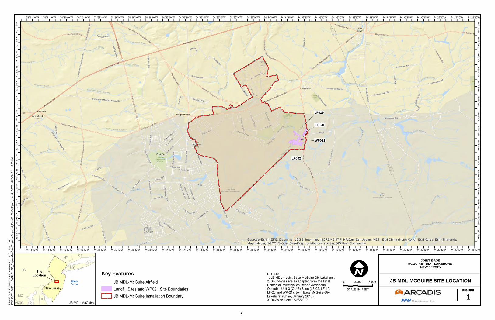
JB MDL is located in Burlington and Ocean counties, and is approximately 20 miles southeast of Trenton, New Jersey (Figure 1). OU3 is located in the northeastern portion of JB MDL-McGuire, to the north and east of the flight line. OU3 consists of three capped landfills (Sites LF002, LF019, and LF020) and the former wastewater treatment plant sludge stockpiling area (Site WP021) (Figure 1). These sites are discussed below. LF002 (Landfill No. 4): LF002 is a 25-acre landfill located in the eastern portion of JB MDL-McGuire, approximately 700 feet (ft) east of the main runway (Figure 2). The landfill operated as a mixed waste landfill for JB MDL-McGuire between 1958 and into the early 1970s.
Landfill operations were initiated in the southernmost section and expanded west in the direction of the main runway. By 1968, the section of LF002 located west of WP021 was actively used for landfilling. The landfill was primarily operated in a trench-and-fill manner. The trenches were often excavated to approximately 15 ft below ground surface (bgs), into the saturated zone below the water table. After disposal, the trenches were filled and covered with sandy soil of unknown origin. Based on the geologic cross sections presented in the FS, the thickness of waste in contact with groundwater (i.e., located beneath the water table) is between 9 and 16 feet thick, depending on the location. In some locations, the entire waste mass is submerged, while in other locations, where the waste appears to have been mounded above the original ground surface, there may be up to 5 feet of waste above the water table. Based on cross sections presented in the FS (The FS is located in the Administrative Record online at http://afcec.publicadmin-record.us.af.mil/), it appears that more than 90 percent of the landfill waste is in contact with the water table. Reportedly, no burning of waste occurred at this landfill. During its operation, a wide range of waste materials associated with JB MDL-McGuire operations were disposed in the landfill. These included general municipal/construction waste/debris, coal ash, and drums containing liquid waste (possibly oil, fuel, or solvents). There is no evidence of high-hazard military-specific waste (e.g., chemical warfare agents or munitions) disposal at LF002, which would preclude the use of the landfill presumptive
remedy (i.e., presumptive remedies are preferred technologies for common categories of sites. In the case of landfills, the presumptive remedy is containment using soil covers, impermeable covers, etc.).
LF002
LF020
LF019
WP021
Sources: Esri, HERE, DeLorme, USGS, Intermap, INCREMENT P, NRCan, Esri Japan, METI, Esri China (Hong Kong), Esri Korea, Esri (Thailand),MapmyIndia, NGCC, © OpenStreetMap contributors, and the GIS User Community
74°28'40"W
74°28'40"W
74°29'10"W
74°29'10"W
74°29'40"W
74°29'40"W
74°30'10"W
74°30'10"W
74°30'40"W
74°30'40"W
74°31'10"W
74°31'10"W
74°31'40"W
74°31'40"W
74°32'10"W
74°32'10"W
74°32'40"W
74°32'40"W
74°33'10"W
74°33'10"W
74°33'40"W
74°33'40"W
74°34'10"W
74°34'10"W
74°34'40"W
74°34'40"W
74°35'10"W
74°35'10"W
74°35'40"W
74°35'40"W
74°36'10"W
74°36'10"W
74°36'40"W
74°36'40"W
74°37'10"W
74°37'10"W
74°37'40"W
74°37'40"W
74°38'10"W
74°38'10"W
74°38'40"W
74°38'40"W
74°39'10"W
74°39'10"W
74°39'40"W
74°39'40"W
74°40'10"W
74°40'10"W
74°40'40"W
74°40'40"W
74°41'10"W
74°41'10"W
74°41'40"W
74°41'40"W40
°4'1
0"N
40°4
'10"
N
40°3
'50"
N
40°3
'50"
N
40°3
'30"
N
40°3
'30"
N
40°3
'10"
N
40°3
'10"
N
40°2
'50"
N
40°2
'50"
N
40°2
'30"
N
40°2
'30"
N
40°2
'10"
N
40°2
'10"
N
40°1
'50"
N
40°1
'50"
N
40°1
'30"
N
40°1
'30"
N
40°1
'10"
N
40°1
'10"
N
40°0
'50"
N
40°0
'50"
N
40°0
'30"
N
40°0
'30"
N
40°0
'10"
N
40°0
'10"
N
39°5
9'50
"N
39°5
9'50
"N
39°5
9'30
"N
39°5
9'30
"N
0 2,000 4,000
SCALE IN FEET
ISiteLocation
AtlanticOcean
New Jersey
PA
MD
NY CT
NY
DEVADC
Key FeaturesJB MDL-McGuire Airfield
Landfill Sites and WP021 Site Boundaries
JB MDL-McGuire Installation Boundary
DIV
/GR
OU
P: E
NV/
IMD
V D
B: A
delin
a L
D:
PIC
: P
M:
TM
:
PRO
JEC
T: J
BMD
L
PATH
: Y:\G
IS_P
roje
cts\
McG
uire
\Pro
ject
s\Pr
opos
ed_P
lan\
2017
0504
\Fig
ure_
1.m
xd
DAT
E: 5
/25/
2017
11:
15:5
8 AM
JB MDL-MCGUIRE SITE LOCATIONFIGURE
1
JOINT BASE MCGUIRE - DIX - LAKEHURST
NEW JERSEYNOTES:1. JB MDL = Joint Base McGuire Dix Lakehurst.2. Boundaries are as adapted from the FinalRemedial Investigation Report AddendumOperable Unit-3 (OU-3) Sites (LF-02, LF-19,LF-20 and WP-21), Joint Base McGuire-Dix-Lakehurst (Shaw, January 2013).3. Revision Date: 5/25/2017
JB MDL-McGuire
3

!(
!(
!(
!(
!(
!(
!(
!(
!(!(
!(!(
!(
!(
!(
!(!(
!(
!(!(!( !(!(
!(!(!(
!(!(!(
!(!(!(!(!(
!(!(!(
!(!(
!(!(
!(!(!(
!(!(
!(!(
!(!(!(
!(!(!(
!(!(
!(
!(
!(
!(!(
South Run
South Run
LF002
LF020
LF019
WP021
Imagery ©2017 , DigitalGlobe, U.S. Geological Survey, USDA Farm Service Agency
74°33'10"W
74°33'10"W
74°33'20"W
74°33'20"W
74°33'30"W
74°33'30"W
74°33'40"W
74°33'40"W
74°33'50"W
74°33'50"W
74°34'0"W
74°34'0"W
74°34'10"W
74°34'10"W
74°34'20"W
74°34'20"W
74°34'30"W
74°34'30"W40
°1'5
0"N
40°1
'50"
N
40°1
'40"
N
40°1
'40"
N
40°1
'30"
N
40°1
'30"
N
0 225 450
SCALE IN FEET
IKey Features
!( Monitoring WellGroundwater Flow DirectionSurface Water Flow DirectionWater Feature (Intermittent)Surface WaterPCB - Contaminated Soil Area
Former Waste Water Treatment PlantEOD Training AreaMcGuire Installation BoundaryOU3 BoundaryLandfills and WP021 Site BoundariesOverall Groundwater Contaminant Footprint
DIV
/GR
OU
P: E
NV/
IMD
V D
B: A
delin
a L
D:
PIC
: P
M:
TM
:
PRO
JEC
T: J
BMD
L
PATH
: Y:\G
IS_P
roje
cts\
McG
uire
\Pro
ject
s\Pr
opos
ed_P
lan\
2017
0504
\Fig
ure_
2.m
xd
DAT
E: 5
/25/
2017
12:
31:0
5 PM
OU3 STUDY AREAFIGURE
2
JOINT BASE MCGUIRE - DIX - LAKEHURST
NEW JERSEYNOTES:1. Landfills = Sites LF002, LF019, and LF020.2. Boundaries are as adapted from the FinalRemedial Investigation Report AddendumOperable Unit-3 (OU-3) Sites (LF-02, LF-19,LF-20 and WP-21), Joint Base McGuire-Dix-Lakehurst (Shaw, January 2013).3. PCB = Polychlorinated biphenyl.4. Revision Date: 5/25/2017
JB MDL-McGuire
SiteLocation
4

5
A portion of the area is used for explosive ordnance disposal (EOD) training. EOD training consists of detonating live munitions within a concrete-walled area. However, no live unexploded ordnance remains in place after training. Furthermore, munitions debris are periodically removed and disposed or recycled. Exploratory test pits during the previous RIs confirmed the presence of domestic waste, as well as automotive and construction debris. The amount of waste material disposed at landfill is estimated at 422,000 cubic yards. Analytical data from previous investigations indicate the presence of volatile organic
compounds (VOCs), pesticides, polycyclic
aromatic hydrocarbons (PAHs), and semi-
volatile organic compounds (SVOCs), polychlorinated biphenyls (PCBs), and inorganic contaminants (SAIC, 2008) in site media. Following closure, the site has since been covered with sandy soil, which support native grasses. In early 2012, due to clear zone requirements that dictate a height threshold for aboveground features and specific grades to land within 3,000 feet of a runway, most of the trees and shrubs were removed from LF002. Since 1980, approximately 6.5 acres of the site are used as an EOD training range (Figure 2). Types of ordnance include explosives, detonators, small caliber rounds, bulk high explosives, and pyrotechnics. JB MDL-McGuire EOD personnel certified that active (live) ordnance is not present on the site. LF019 (Landfill No. 5): LF019 is a narrow, 5.5-acre parcel of land between the WP021 Access Road and South Run (Figure 2). The site was operated as a landfill from approximately 1970 to 1973,
concurrent with the final phase of operation at LF002. The historical record reports that the landfill was primarily used for the disposal of coal ash, wood, and waste metal. Surface evidence suggests that the landfill was also used for the disposal of construction debris, domestic waste, and spent artillery casings. Chemical waste may have occasionally been disposed of at the landfill, as evidenced by a number of rusted drums and cans protruding through the surface. Analytical data from previous environmental assessments indicate the presence of VOCs, SVOCs, PCBs, and metals contamination. The depth of landfill material reportedly extends approximately 8 to 12 ft bgs. Based on the geologic cross sections presented in the RI, the thickness of waste in contact with groundwater (i.e., located beneath the water table) is between 4 and 6 feet on the northwestern portions of the landfill, and decreases towards the southeast portion of the landfill. The RI is located in the Administrative Record online at http://afcec.publicadmin-record.us.af.mil/. Unlike LF002, waste disposal at LF019 occurred primarily by burning bulk waste in-place, leveling the burned and unburned residue, and applying a clean soil cover. There is no historical evidence that trench-and-fill disposal techniques were utilized at this landfill. The amount of waste material disposed at the landfill is estimated at 82,000 cubic yards. There is no evidence of high-hazard military-specific waste (e.g., chemical warfare agents or munitions) disposal at LF019, which would preclude the use of the landfill presumptive remedy. Until recently, the original sandy soil cover supported abundant vegetation (grass, shrubs, and trees). In early 2012, due to clear zone requirements, most of the trees and
6
shrubs were removed from LF019. Further, as part of a Time-Critical Removal Action (TCRA) to remove fill material near South Run and to stabilize erosion at LF019, the eastern portion of LF019 was capped and seeded with native grasses. The TCRA was completed in mid-January 2013 and is discussed further in the Previous
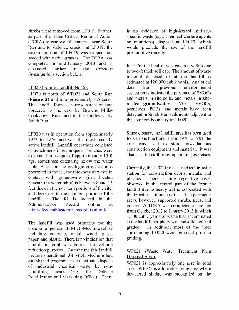
Investigations section below. LF020 (Former Landfill No. 6): LF020 is north of WP021 and South Run (Figure 2) and is approximately 6.5-acres. This landfill forms a narrow parcel of land bordered to the east by Browns Mills-Cookstown Road and to the southwest by South Run. LF020 was in operation from approximately 1973 to 1976, and was the most recently active landfill. Landfill operations consisted of trench-and-fill techniques. Trenches were excavated to a depth of approximately 15 ft bgs, sometimes extending below the water table. Based on the geologic cross sections presented in the RI, the thickness of waste in contact with groundwater (i.e., located beneath the water table) is between 8 and 13 feet thick in the northern portions of the site, and decreases to the southern portion of the landfill. The RI is located in the Administrative Record online at http://afcec.publicadmin-record.us.af.mil/. The landfill was used primarily for the disposal of general JB MDL-McGuire refuse including concrete, metal, wood, glass, paper, and plastic. There is no indication that landfill material was burned for volume reduction purposes. By the time this landfill became operational, JB MDL-McGuire had established programs to collect and dispose of industrial chemical waste by non-landfilling means (e.g., the Defense Reutilization and Marketing Office). There
is no evidence of high-hazard military-specific waste (e.g., chemical warfare agents or munitions) disposal at LF020, which would preclude the use of the landfill presumptive remedy. In 1976, the landfill was covered with a one to two-ft thick soil cap. The amount of waste material disposed of at the landfill is estimated at 120,000 cubic yards. Analytical data from previous environmental assessments indicate the presence of SVOCs and metals in site soils, and metals in site- related groundwater. VOCs, SVOCs, pesticides, PCBs, and metals have been detected in South Run sediments adjacent to the southern boundary of LF020. Since closure, the landfill area has been used for various functions. From 1976 to 1981, the area was used to store miscellaneous construction equipment and material. It was also used for earth-moving training exercises. Currently, the LF020 area is used as a transfer station for construction debris, metals, and plastics. There is little vegetative cover observed in the central part of the former landfill due to heavy traffic associated with the transfer station activities. The perimeter areas, however, supported shrubs, trees, and grasses. A TCRA was completed at the site from October 2012 to January 2013 in which 1,500 cubic yards of waste that accumulated at the landfill periphery was consolidated and graded. In addition, most of the trees surrounding LF020 were removed prior to grading. WP021 (Waste Water Treatment Plant Disposal Area): WP021 is approximately one acre in total area. WP021 is a former staging area where dewatered sludge was stockpiled on the

7
ground surface. The site is bordered on the west and south by LF002 (Figure 2). The site was used from 1970 to 1980 to stockpile dewatered sludge that was generated by the adjacent wastewater treatment plant (this facility was decommissioned in 1994 and is no longer present). In 1981, part of the stockpiling area was closed, and some sludge was removed and placed in the Fort Dix Landfill. By 1982, the remaining sludge pile supported dense vegetation. All of the sludge was removed from the site by November 1994 and presumably placed in the Fort Dix Landfill (AFCEE, 1998). Soil samples taken during the RI identified PCBs and PAHs above the RDCSRS. The HHRA concluded that no human health risks were identified for non-residential soil exposure pathways at WP021, however, the HHRA did not evaluate residential risks for soils. A follow-up health risk screening will be completed in a Feasibility Study
Addendum (FSA) for residential soil indicates a potential exposure risks exist due to PCBs in site soil. No other contaminant risks were identified, however, perfluorooctanoic acid (PFOA) and perfluorooctyl sulfonate (PFOS) are currently being investigated at WP021. Regulatory History
The site is participating in the Defense Environmental Restoration Program (DERP), a specially funded program established by the Department of Defense to identify, investigate, and clean up the hazardous contaminants at military and other Department of Defense facilities. Since JB MDL is an active Federal facility, environmental activities at the base conform to the requirements specific to projects performed under the CERCLA and the NCP.
The USEPA added JB MDL-McGuire to the NPL on October 22, 1999, due to the presence of several chemicals in soil, surface water and groundwater. On September 10, 2009, the USAF signed a Federal Facilities Agreement (FFA) with the USEPA Region 2 to ensure that the environmental impacts associated with past and present activities at JB MDL-McGuire, including OU3, are investigated and remediated, as necessary, to protect the public health, welfare, and the environment. In June 2015, a dispute resolution agreement (USEPA 2014a; USEPA 2014b) between the USEPA and the USAF required that the more stringent Class I Pineland Standards (Class I-PL; New Jersey Administrative Code [N.J.A.C.] 7:9C-1.5(d)2) be used as Applicable or Relevant and Appropriate
Requirements (ARARs) (USEPA, June 2015). ARARs are Federal or state environmental standards, requirements, criteria, or limitations that a remedial action must meet. Specifically, the following Pineland Standards are applicable to OU3: • N.J.A.C. 7:9C-1.5(d)2. Class I-PL
(Pinelands);
• N.J.A.C. 7:9C-1.7(b)2. Groundwater quality criteria for Class I-PL (Protection Area); and
• N.J.A.C. 7:26D-2.2(a)2. Minimum groundwater remediation standards for Class I-PL groundwater.
The dispute resolution agreement is located in the Administrative Record online at http://afcec.publicadmin-record.us.af.mil/. Recently, the USAF has conducted investigations to determine if PFOS and PFOA are present within soil and groundwater at OU3, and the investigation identified PFOA/PFOS at WP021. PFOS and
8
PFOA are an emerging contaminant and therefore have not been historically investigated during the previous investigations at OU3. Detailed assessment and remediation, if required, of PFOS and PFOA at the Sites will be evaluated at a future time and reported in a future separate action report later CERCLA documents. Should action be required for the PFOS/PFOA at OU3 then those actions will be proposed in a separate action report. Previous Investigations
The following section provides a brief overview of historical investigation and mitigation efforts implemented at the site. Additional information regarding the extent of contamination can be found in the Nature
and Extent section of this Proposed Plan. Pre-2006 Investigations: OU3 investigation activities began in 1981 with a Phase I preliminary assessment focused on LF002, LF019, and LF020. The assessment included establishing a groundwater monitoring network at LF002, establishing surface water sampling stations along the South Run to monitor potential impacts from LF019 and LF020, and characterizing sludge material staged at WP021. In 1983 and 1984, monitoring wells were installed and sampled downgradient of LF002, LF019, and LF020, and an Installation Restoration Program (IRP) Phase II assessment was completed. The IRP Phase II assessment included installing five additional wells. In 1991, field exploration was completed at LF002, LF019, and LF020 (ABB Environmental, 1991). The field exploration investigation included groundwater, surface
water, sediment, leachate, and soil sample collection for VOCs, SVOCs, pesticides, PCBs, and inorganics analysis. Remedial Investigation: Building on the findings of previous investigations, a Phase I RI was completed between April 2006 and March 2008 (Shaw, 2013). The field efforts included a geophysical survey (electromagnetic and magnetometer survey) to identify the landfill boundaries, and soil, surface water, sediment, and groundwater sampling. To supplement the Phase I RI, a Phase II RI was completed between August 2010 and March 2012. Phase II RI field efforts included installing groundwater monitoring wells, installing test pits/borings to further delineate the landfill boundaries, and collecting soil (surface and subsurface), surface water, sediment, and groundwater samples. Results from the RI geophysical survey and test pitting identified buried metallic objects at depths of less than 20 ft bgs at all three landfills, and determined that the southern boundary of LF002 and LF019 extended further than originally thought (Shaw, 2013). The landfill boundaries are shown in Figure 2. Groundwater Investigation 2012: To supplement the groundwater delineation information for the site, 11 additional monitoring wells (LF02-MW301 through LF02-MW311), referred to as the “300 Series” wells, were installed in March 2012 and sampled in April 2012. The 300 Series wells confirmed that groundwater flow direction in the shallow aquifer south of South Run was to the northeast, consistent with the conclusions of previous investigation efforts. The laboratory analytical results were reported in the FS, and incorporated into the nature and extent of
9
contamination discussion. The groundwater data from the 300 Series wells was used, along with the RI data, to complete delineation of the groundwater contaminant nature and extent, as presented in the FS. Time Critical Removal Action: A TCRA was performed at LF019 and LF020 from October 2012 to January 2013 (Shaw, 2012). At the eastern portion of LF019, the TCRA resulted in the removal of approximately 1,700 cubic yards of waste material from within 20 ft of the South Run. The removed material was placed on the eastern portion of LF019, graded and capped with 20-inches of certified clean fill and 4-inches of certified clean topsoil (Shaw, 2012). At LF020, the asphalt millings were recycled for reuse at an off-site facility. Approximately 1,500 cubic yards of peripheral waste material were consolidated onto LF020 and was graded, in preparation for the final remedy at LF020. The TCRA Report was approved by the USEPA and the USAF submitted the Final TCRA Report in March 2014. Feasibility Study: A FS was completed to identify and evaluate remedial solutions to the environmental issues identified at OU3. The remedial solutions evaluated in the FS for the landfill sites (LF002, LF019, and LF020) were limited to those remedies described in the USEPA Landfill Presumptive Remedy guidance, which establishes containment as the presumptive remedy under CERCLA for municipal landfills (USEPA, 1993) and for military landfills (USEPA, 1996). The Draft FS Report (Shaw, 2014) was submitted to the regulators in October 2013
and the Draft Final FS Report was submitted in June 2014. The Draft Final FS Report did not include certain components of the New Jersey groundwater quality standards (“Pineland Standards”) as ARARs. As per a June 2015 dispute resolution agreement between the USEPA and the USAF, the Draft Final FS Report was revised to incorporate the more stringent Class I-PL Standards as ARARs (USEPA, June 2015). The Revised Draft Final FS was submitted in October 2016 and the Final FS was finalized in October 2017. The FS is located in the Administrative Record online at http://afcec.publicadmin-record.us.af.mil/.
Site Characteristics
Geology
The geology at OU3, from the surface down, is comprised of the Kirkwood-Cohansey-Manasquan Formations, the Vincentown Formation, and the Hornerstown Formation. The Kirkwood Formation is generally characterized as silty sands and is approximately 40 ft in thickness across the OU3 sites, where portions have not been removed for landfilling. The Vincentown Formation is characterized by glauconitic clayey sands and is approximately 45 ft in thickness across the OU3 sites. The Hornerstown Formation is characterized by fossiliferous, cemented, fine silty sands. Hydrogeology
The majority of monitoring wells at OU3 terminate at 20 ft bgs, 30 ft bgs, or 40 ft bgs. The United States Geological Survey (USGS) 1996 report Hydrogeologic
Framework McGuire Air Force Base and
Vicinity, Burlington County, New Jersey
(McGuire Administrative Record 475) indicates the Cohansey Sand/upper

10
Kirkwood Formation, which is the upper hydrogeologic unit of the surficial aquifer system, is first encountered in the upper 16 ft bgs, overlying the lower Kirkwood and Manasquan Formation, and terminates at approximately 42 ft bgs. The Vincentown Formation extends from approximately 42 ft bgs to approximately 81 ft bgs. The Vincentown overlies the Hornerstown Sand/Navesink Formation (the interpreted confining unit), which begins at approximately 81 ft bgs. At JB MDL - McGuire, borehole geophysical logs indicate a very thin Kirkwood-Cohansey-Manasquan system and no major confining unit separating these sediments from the underlying Vincentown Formation; however, the lower Kirkwood and Manasquan Formations are comprised of poorly permeable sediments. Due to the hydraulic connection between the Kirkwood-Cohansey-Manasquan and Vincentown Formation in the McGuire area, the USGS concluded that the surficial or water-table aquifer should be considered to include the entire geologic section overlying the Hornerstown Sand (i.e., the Kirkwood-Cohansey-Manasquan and Vincentown) which generally ranges from 50 to 100 ft bgs across JB MDL. Most monitoring wells at OU3 terminate at 20 ft bgs, 30 ft bgs, and 40 ft bgs. Based on the USGS report, these wells would be screened within the Kirkwood and Manasquan Formation, which is hydraulically connected with the Kirkwood-Cohansey Formation and considered part of the surficial aquifer. Several wells at OU3 are screened within the Vincentown aquifer, particularly deep wells, at depths greater than approximately 40 ft bgs.
Based on information provided in the RI (Shaw, 2013), groundwater flow in shallow, intermediate, and deep zones is generally to the northeast towards South Run. Shallow and intermediate zones appear to converge on South Run, and slightly upward hydraulic gradients between zones suggest that groundwater discharges to South Run.
Regional Surface Water Hydrology
JB MDL-McGuire is drained primarily by overland flow to diversion structures and storm sewers, and then to surface streams. Many of the natural streams were diverted and channeled through underground storm drains as JB MDL-McGuire expanded. The northern part of JB MDL-McGuire generally drains to the North Run of Crosswicks Creek and the south part of JB MDL-McGuire drains to the South Run. Small areas in the southeast part of JB MDL-McGuire drain to Jack’s Run and Larkin’s Run, which are tributaries of Rancocas Creek. The surface waters ultimately drain westward into the Delaware River. Nature and Extent of Contamination
Site contamination is associated with buried waste material (consisting of material exhibiting assumed risks and hazards) at LF002, LF019, and LF020, as well as PCB soil contamination at WP021. The RI identified the nature and extent of the source materials of contamination present at OU3 as the impacted soils/buried wastes associated with LF002, LF019, and LF020, and impacted soil hot spots at WP021. Hot spots are areas with limited extent of PRG exceedances. These source materials have shown limited mobility and low-to-moderate toxicity. Therefore, they are considered to be only low-level threat wastes and do not constitute a principal threat wastes, which are those

11
source materials considered to be highly toxic or highly mobile that generally cannot be reliably contained, or would present a significant risk to human health or the environment should exposure occur. The contaminants of concern (COCs) associated with OU3 per media are discussed below. The COCs were established with help from the results of the human health risk
assessment (HHRA) completed during the RI (Shaw, 2013). The HHRA is further discussed under the Summary of Site Risks section below. In addition to the COCs identified by the HHRA, COCs are also identified based upon comparison against very specific Federal or state promulgated standards. Identification of these standards is discussed for the specific media to which they apply in the following discussion. Soil: In accordance with presumptive remedy guidance, action at the site was triggered by unacceptable risk in other media (groundwater), and risk assessment of the landfill wastes/footprint was not required as the presumptive remedy would address all migration pathways presented by the landfill source itself. The HHRA did not identify unacceptable exposure risks for likely site receptors, however, there are exceedances of chemical-specific ARARs for soils within the site but beyond the planned limits of the capping action and these pathways would therefore not be addressed by the presumptive remedy. A subsequent risk evaluation was completed, which will be included in the FSA for WP021 identified potential unacceptable risks with respect to PCBs associated with hypothetical future residential use of this area. Therefore, soil at WP021 are currently unsuitable for Unlimited Use/Unrestricted Exposure
CONTAMINANTS OF CONCERN AT OU3 The USEPA and USAF have identified seven contaminants in groundwater that present the greatest potential risk to human health, and therefore, trigger the need for remedial action at the site. These contaminants were identified by either (1) a formal risk assessment process or (2) by exceeding the more stringent of the state and Federal non-zero maximum contaminant goals or maximum contaminant levels. The health-based contaminants of concern (COCs) that were identified by the risk assessment include: benzene, vinyl chloride, arsenic, thallium, and iron. The health-based COCs that were identified based on their detection above the more stringent of the state or Federal standards listed above include 1,2-dichloroethane (1,2-DCA) and methylene chloride.
Due to the action triggered by the health-based COCs in groundwater, 35 contaminants in groundwater were identified at concentrations that exceed the New Jersey Class I-PL, a non-degradation standard for groundwater in the Pinelands National Reserve developed to preserve groundwater quality in its natural state. These contaminants are called non-degradation COCs. Because groundwater at OU3 discharges into the surface water of South Run, the health based and Class I-PLs non-degradation COCs identified for groundwater are also applicable to the portions of South Run and its tributaries within OU3.
GROUNDWATER & SURFACE WATER
VOC: 1,1-dichloroethane (1,1-DCA); acetone; bromodichloromethane; carbon disulfide; chlorobenzene; chloroethane; chloroform; cis-1,2-dichloroethylene (cis-1,2-DCE); dichlorodifluoromethane; ethylbenzene; 2-hexanone; methyl ethyl ketone; tert-butyl methyl ether; Tetrachloroethylene (PCE); trichloroethylene (TCE); and toluene;
SVOCs: diethyl phthalate; naphthalene; and pentachlorophenol;
Metals: aluminum; barium; beryllium; cadmium; chromium; copper; lead; manganese; mercury; molybdenum; nickel; potassium; selenium; silver; vanadium; and zinc.
SOIL
The USEPA and USAF have identified PCBs associated with OU3 Site WP021 as a contaminant in soil that poses unacceptable risk to human health, and therefore, triggers the need for remedial action for soil at the site. In addition, the following soil COCs at WP021 were identified as COCs since they exceed the New Jersey Residential Direct Contact Soil Remediation Standard:
SVOCs: benzo(a)pyrene and indeno(1,2,3-c,d)pyrene.
12
(UU/UE). The following chemicals exceed the Residential Direct Contact Soil
Remediation Standard (RDCSRS): PCBs, benzo(a)pyrene, and indeno(1,2,3-c,d)pyrene. Sediment: All human health risks and hazards are below or within the acceptable risk range for sediment. Results of the Screening Level
Ecological Risk Assessment (SLERA) from the RI report indicated no action is warranted with regard to sediment. However, monitoring of sediments, or pore water, may be required for groundwater COCs. Groundwater: The two categories of COCs identified for groundwater are: (1) health-based, which are based on exceedances of Federal or more stringent state maximum contaminant level goals or maximum contaminant levels and trigger the need for remedial action; and (2) non-degradation. Health-based COCs are based on either the calculated risk/hazards as determined in the HHRA or by exceedance of Federal or state health-based standards specified above. The HHRA determined risks and hazards to future (hypothetical) residents exist due to benzene, vinyl chloride, arsenic, thallium, and iron in groundwater. The FS (FPM, 2017) identified two additional COCs, 1,2-dichloroethane (1,2-DCA) and methylene chloride, based on their detection above the more stringent of State and Federal Maximum Contaminant Levels (MCLs) and non-zero Maximum Contaminant
Level Goals (MCLGs). Non-degradation COCs are chemicals included during the remedy selection process because they exceed New Jersey regulatory
non-degradation groundwater quality standards, which are CERCLA ARARs. In accordance with Section 121(d)(2) of CERCLA (42 United States Code section 9621(d)(2)), onsite remedial actions addressing CERCLA hazardous substances, pollutants and contaminants that will remain onsite must comply with federal and more stringent state standards, requirements, criteria and limitations that are applicable or relevant and appropriate to the release of such hazardous substance, pollutant and contaminant. JB MDL-McGuire is located within the Protection Area of the Pinelands National Preserve, for which the State of New Jersey has established more stringent (non-degradation) standards than apply for areas outside of the Pinelands National Preserve. Therefore, if the state non-degradation groundwater quality standard is exceeded in the Protection Area for a chemical, then such chemical is identified as a Pinelands non-degradation COC. Section 7:9C-1.7(b)2 of the New Jersey Administrative Code states that the ground water quality criteria for the Protection Area of the Pinelands National Reserve shall be the background water quality. Section 7:9C-1.4 of the New Jersey Administrative Code defines background water quality as the concentration of the constituent in the ground water that exists directly upgradient of the area in question, or the practical quantitation level (PQL), which means the lowest concentration of a constituent that can be reliably achieved among laboratories within specified limits of precision and accuracy during routine laboratory operating conditions. The non-degradation COCs for OU3, which were detected in shallow groundwater (10 to 30 ft bgs) and/or intermediate groundwater (30 to 40 ft bgs) at least once in exceedance of the ground water quality standards for the Protection Area, are listed below:

13
• VOCs: 1,1-dichloroethane (1,1-DCA); acetone; bromodichloromethane; carbon disulfide; chlorobenzene; chloroethane; chloroform; cis-1,2-dichloroethylene
(cis-1,2-DCE); dichlorodifluoromethane; ethylbenzene; 2-hexanone; methyl ethyl ketone (MEK); tert-butyl methyl ether (MTBE); tetrachloroethylene (PCE); trichloroethylene (TCE); and toluene;
• SVOCs: diethyl phthalate; naphthalene; and pentachlorophenol; and
• Metals: aluminum; barium; beryllium; cadmium; chromium; copper; lead; manganese; mercury; molybdenum; nickel; potassium; selenium; silver; vanadium; and zinc.
Surface Water: Similar to groundwater, health-based and non-degradation based COCs are also identified for surface water. Previous investigations’ results identified bis(2-ethylhexyl)phthalate, PCE, arsenic, lead, and thallium at concentrations above New Jersey Department of Environmental Protection (NJDEP) surface water quality criteria. Aluminum, beryllium, cadmium, copper, iron, manganese, mercury, sodium, thallium, and zinc concentrations were also reported above surface water quality standards for the Protection Area. The HHRA determined that human risks and hazards due to surface water exposure are within the risk range for current and future non-residents/workers and future (hypothetical) residents. The SLERA identified the potential for ecological risks. Because groundwater discharges into surface water at OU3, the health-based COCs that were identified for groundwater are then also retained for inclusion as a surface water COC. In addition, the non-degradation
COCs that were identified for groundwater are also retained as surface water COCs. The surface water at OU3 is classified as PL, and therefore the non-degradation standards apply to all surface waters within the Pinelands area. The non-degradation standards apply to the portions of South Run and its tributaries within OU3 because of OU3’s location within the Pinelands Area Boundary (New Jersey Pinelands Commission, 2016). Contaminant Fate and Transport
Fate and Transport in Soil: Contaminants in surface soil may be transported from their source area to other areas within OU3, and to off-site locations by a number of mechanisms including: volatilization; entrainment into the air column; surface runoff; and infiltration to subsurface soil/groundwater. The transport of contamination via these transport mechanisms was most significant during operation of the landfills and sludge stockpiling at WP021. Fate and Transport in Surface Water: South Run and its tributaries drain the OU3 area, and as such, they dominate the potential surface water fate and transport processes at OU3. Constituents present in the surface water at OU3 are the result of erosion and runoff from the surface soil, and infiltration of groundwater into the drainage channels. Contaminants in surface water at the site may be transported to other areas within OU3 or to off-site locations by the following mechanisms: 1) volatilization (i.e., transfer to air); 2) transfer to groundwater; 3) transfer to sediment; and 4) flow downstream.
14
Fate and Transport in Groundwater: Groundwater discharge to South Run and its tributaries in the vicinity of OU3 is a potentially viable transport mechanism for dissolved constituents in groundwater. As such, the major fate and transport mechanism for groundwater at OU3 is the discharge of groundwater to South Run and its tributaries and wetlands, with subsequent human exposure via the surface water exposure. Scope and Role of the Action
As with many Superfund sites, the contamination at the Site is complex. In order to manage the cleanup of the Site more effectively, JB MDL has organized the work into distinct phases of long-term cleanup called Operable Units, under the authority of CERCLA. This Proposed Plan addresses OU3. The response action for OU3 will protect human health and the environment by controlling potential exposure pathways; reducing receptor risk to acceptable levels; and reducing the mobility, toxicity, or volume of contaminants in media to the appropriate remediation goals (RGs) based on the most stringent federal and state ARAR values. The RAOs were developed to eliminate contact with landfill materials that remain, and manage the potential for exposure to contaminants at concentrations that could pose unacceptable risk to human health or the environment. The Final Feasibility Study Report (FPM, 2017) identified remedial alternatives and evaluated them independently against ARARs and RAOs to determine usability and then against one another. This evaluation was ultimately used to determine the preferred alternative presented in this Proposed Plan.
Summary of Site Risks
The majority of the JB MDL-McGuire land use is airfield, consisting of two active runways and support facilities. Other land uses on JB MDL-McGuire include administrative facilities, aircraft operation and maintenance facilities, community spaces, housing (including family housing), industrial facilities, medical facilities, open spaces, and outdoor recreation. Most of OU3 is adjacent to the active airfield and is designated as open space. Following implementation of the preferred alternative, OU3 would be designated to prohibit residential use, except where PCB soil removal meets residential standards at WP021. However, residential housing is highly unlikely because the location of WP021 is immediately adjacent to LF002 and is within the Air Force’s airfield “Clear Zone Restrictions,” which restricts the height of any aboveground feature (including development such as a house except for structures deemed mission critical) within 3,000 ft of the runway. Groundwater is not extracted from surficial aquifers at OU3 for human consumption or use. Human Health Risks
A HHRA, completed as part of the OU3 RI (Shaw, 2013), evaluated risks and hazards to the current/future base maintenance worker, the current/future golf maintenance worker, the future routine worker, the future construction worker, and the future (hypothetical) resident (adult and child). The receptors evaluated in the HHRA were originally presented in the OU3 Remedial Investigation Work Plan (Shaw, 2010) and agreed to by the USEPA. For known or suspected carcinogens, acceptable exposure levels are generally concentration levels that represent an excess upper bound lifetime cancer risk to an individual of between 10-4 and 10-6 (one-in-a-million to one-in-ten-

15
thousand) as established under the NCP , and a Hazard Index (HI) of less than or equal to 1.0. JB MDL has completed a base-wide Background Study for naturally occurring (i.e., metals) and anthropogenic (i.e., PAHs and pesticides) contaminants (BEM, 2013). Because the HHRA was completed prior to the availability of the Background Study, the results of the HHRA should be considered conservative. The summary of total cancer risks and non-cancer hazards are discussed below, and for further details the complete HHRA is provided in the OU3 RI Report (Shaw, 2013), which can be found in the Administrative Record. Current/Future Base Maintenance Worker: Results of the HHRA indicated that total risk across all media to this receptor is less than 8.2 x 10⁻⁷ and total hazard is less than 1, which indicates an acceptable level of risk and hazard. Therefore, no action is required for this receptor. Future Routine Worker: Results of the HHRA indicate that total risk across all media to this receptor is 2.6 x 10⁻⁶ and total hazard is less than 1, which indicates an acceptable level of risk. Therefore, no action is required. Current/Future Golf Course Maintenance Worker: Results of the HHRA indicate that total risk across all media to this receptor is 4.2 x 10⁻⁶ and total hazard is less than 1, which indicates an acceptable level of risk. Therefore, no action is required.
Future Construction Worker: Results of the HHRA indicate that total risk across all media to this receptor is 1 x 10⁻⁶ and total hazard is less than 1, which indicates an acceptable level of risk. Therefore, no action is required. Future Off-Site Adult/ Lifetime Resident: Groundwater exposures due to potable use were evaluated for this receptor. Total risk was 2.8 x 10⁻⁴, indicating unacceptable cancer risk due to the ingestion of groundwater contaminants vinyl chloride, benzene, and arsenic. Total hazards were 13.9, due to ingestion of thallium, which indicates an unacceptable hazard. Therefore, vinyl chloride, arsenic, and thallium in groundwater are retained as health-based COCs for this receptor. It should be noted that groundwater from surficial aquifers is not currently in use as a drinking water source at OU3, however, this still represents a potential future risk. Future Off-Site Child Resident: Groundwater exposures due to potable use were evaluated for this receptor. Total risk was 1.0 x 10⁻⁴, indicating acceptable cancer risk due to the ingestion of groundwater contaminants, vinyl chloride and arsenic, which together account for 96 percent of total risk. Total hazards were 34, due to ingestion of arsenic, iron, and thallium, which indicates an unacceptable hazard. Therefore, vinyl chloride, arsenic, iron, and thallium in groundwater are retained as health-based COCs for this receptor. It should be noted that groundwater from surficial aquifers is not currently in use as a drinking water source at OU3, however, this still represents a potential future risk.
16
Ecological Risks
A SLERA was conducted for OU3 as part of the RI (Shaw, 2013). The assessment consisted of a comparison of constituents detected in soil outside of the projected landfill presumptive remedy caps, surface water, and sediment to ecological benchmarks, as well as an evaluation of the potential risk to site indicator species through use of a food web model. Based on the results of the SLERA, no action is warranted for OU3 surface soil outside of the confines of the cap boundary for the protection of upper trophic level feeding guilds; the estimated risks resulting from potential exposures to surface water COCs can be successfully managed when the presumptive remedy for landfills is implemented, and no action is warranted for sediment COCs at OU3.
Remedial Action Objectives
Considering protection of human health and the environment, the future land use, and the results of the HHRA and SLERA, and the Pineland Standards, the following preliminary RAOs were developed: Landfills (LF002, LF019, and LF020)
• Landfill RAO No. 1 (Human Health) – Prevent human contact to all landfill waste, including direct contact with buried waste material.
• Landfill RAO No. 2 (Environmental) – Reduce the potential for ecological direct contact with buried and exposed waste material, prevent the environmental release of waste material due to surface erosional action, and reduce infiltration of precipitation.
Groundwater (All Sites)
• Groundwater RAO No. 1 (Human Health) – Prevent human exposure (due to ingestion) to COCs exceeding health-based standards.
• Groundwater RAO No. 2 (Environmental) – Achieve groundwater standards at the classification exception
area (CEA) boundary and prevent further degradation of groundwater quality for site-related constituents at the CEA boundary and beyond the limit of the CEA.
Soil (LF002 and LF019)
• Surface Soil RAO No. 1 (Human Health) – Prevent future non-residential exposure to contamination in soil exceeding the non-residential standard.
Soil (WP021)
• Surface Soil RAO No. 2 (Human Health) – Prevent future residential exposure to contamination in soil exceeding the UU/UE standard.
Surface Water (All Sites)
The HHRA identified that the cancer risk for exposure to surface water and sediment was 4.2 x 10⁻⁶, which is within the acceptable risk range of 1.0 x 10⁻⁶ to 1.0 x 10⁻⁴, and the non-cancer HI was less than 1. Based on this information, no remedial action objective is necessary for surface water and sediment. However, the OU3 point of compliance, the point beyond which OU3 related constituents will not exceed PRGs, is anticipated to be South Run; therefore, the following RAOs are proposed associated with surface water protection from OU3 contaminants. • Surface Water RAO No. 1 (Human
Health) – Prevent human exposure (recreational uses and ingestion) to

17
surface water that may be impacted by groundwater containing concentrations of site-related COCs exceeding health-based standards, and ensure that Pinelands standards are met at the point of compliance.
• Surface Water RAO No. 2 (Environmental) – Prevent further degradation of surface water quality for site-related COCs.
Preliminary Remediation Goals
PRGs are media specific cleanup goals for a selected remedial action. PRGs are established for each of the COCs identified by media. The COCs for OU3 consist of both (1) health-based and (2) non-degradation (i.e., Class I-PL) COCs. The following subsections discusses the identification and selection of PRGs for each media whereby COCs were identified (i.e., sediment did not have unacceptable risks/hazards, and therefore no COCs or PRGs were identified).
PRG For Landfill Waste
The landfill presumptive remedy will be employed to contain the landfill materials consistent with the USEPA’s presumptive remedy guidance (Office of Solid Waste and Emergency Response Directive No. 9355.0-49FS) and 40 Code of Federal Regulations 300.430(a)(iii)(B). As part of the landfill presumptive remedy, containment of the wastes and prevention of direct contact with waste and soils will be required by the remedy. PRGs For Groundwater and Surface Water
As previously mentioned, two types of COCs exist for groundwater and surface water, they are health-based and non-degradation based. Therefore, there are also corresponding
health-based and non-degradation PRGs. The health-based PRGs are based upon promulgated health-based standards. These promulgated state and Federal standards were compared, and the more stringent of the standards were selected as the health-based PRGs. The non-degradation PRGs are the Class I-PLs. Non-degradation standards are not based upon unacceptable risks or hazards, but rather returning the site to background conditions. Additional discussion in the identification and selection of PRGs is contained within the Final FS (FPM, 2017).
PRGs For Soils
PRGs for soil were based upon the New Jersey Non-Residential Direct Contact Soil
Remediation Standard (NRDCSRS) for LF002, LF019, and LF020 and the RDCSRS for WP021. The NRDCSRS would achieve the RAOs, but Sites LF002, LF019, and LF020 would require land use controls
(LUCs) to ensure the continued protection of human health. Whereas, attainment of the RDCSRS at WP021 would ensure attainment of UU/UE. It is the USAF’s current judgment that the preferred alternative identified in this Proposed Plan, or one of the other active measures considered in the Proposed Plan, is necessary to protect public health or welfare or the environment from actual or threatened releases of hazardous substances into the environment.
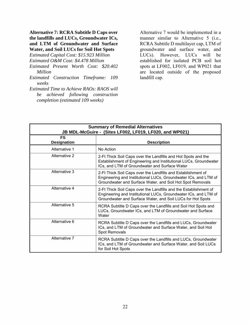
Summary of Remedial Alternatives
This section presents a summary of the remedial action alternatives developed for OU3 to meet the RAOs. A detailed analysis conducted in accordance with USEPA
Guidance for Conducting Remedial
Investigations and Feasibility Studies under

18
CERCLA (USEPA, 1988), and as presented in the FS (FPM, 2017), is summarized below. The seven remedial alternatives developed for OU3 are as follows: • Alternative 1: No Further Action
• Alternative 2: 2-Ft-Thick Soil Caps over the Landfills and Soil Hot Spots (“Soil Caps”) and the Establishment of Engineering and Institutional LUCs, Groundwater Institutional Controls
(ICs), and Long-Term Monitoring
(LTM) of Groundwater and Surface Water
• Alternative 3: 2-Ft-Thick Soil Caps over the Landfills and the Establishment of Engineering and Institutional LUCs, Groundwater ICs, and LTM of Groundwater and Surface Water, and Hot Spot Removals
• Alternative 4: 2-Ft-Thick Soil Caps over the Landfills and the Establishment of Engineering and Institutional LUCs, Groundwater ICs and LTM of Groundwater and Surface Water, and Soil LUCs
• Alternative 5: Resource Conservation
and Recovery Act (RCRA) Subtitle D Caps over the Landfills and Soil Hot Spots and LUCs, Groundwater ICs, and LTM of Groundwater and Surface Water
• Alternative 6: RCRA Subtitle D Caps over the Landfills and LUCs, Groundwater ICs, and LTM of Groundwater and Surface Water, and Hot Spot Removals
• Alternative 7: RCRA Subtitle D Caps over the Landfills and LUCs, Groundwater ICs, and LTM of Groundwater and Surface Water, and Soil LUCs
With the exception of Alternative 1, the alternatives use similar components to meet RAOs. Alternatives 2 through 7 all include a type of landfill cap, LUCs, and LTM of groundwater and surface water. The primary difference between the alternatives is the type of cap (i.e., soil cap or RCRA Subtitle D) and how PCB soil hot spots are addressed. Alternatives 2 through 4 include the installation of soil caps. Additionally, Alternative 2 covers the PCB soil hot spots with the soil cap; Alternative 3 removes the PCB soil hot spots; and Alternative 4 establishes LUCs for the PCB soil hot spots. Alternatives 5 through 7 are established similarly in their methods for addressing PCB soil hot spots; however, the alternatives utilize RCRA Subtitle D caps, rather than a soil cap. A summary discussion of each alternative is provided below. The types of costs assessed include the following: • Capital costs, including both direct and
indirect costs
• Annual operating and maintenance (O&M) costs
• Net present worth (PW) of capital and O&M costs
The strengths and weaknesses of each alternative is described further in the Evaluation of Alternatives section. Additional detail regarding the development and evaluation of alternatives can be found in the FS (FPM, 2017). Alternative 1: No Action
Estimated Capital Cost: $0
Estimated O&M Cost: $0
Estimated Present Worth Cost: $0
Estimated Construction Timeframe: Not
Applicable (N/A)
Estimated Time to Achieve RAOs: N/A
19
The NCP requires that the “No Action” alternative be developed and examined as a potential remedial action for all sites. The alternative provides for no remedial action for treatment, control, or monitoring of site groundwater. This alternative would be readily implementable. There are no costs associated with Alternative 1. Alternative 1, “the No Action Alternative,” is required by the NCP and USEPA guidance as a baseline with which to compare other remedial action alternatives. Under Alternative 1, no further action would be taken to control exposure to contaminated media at OU3. The landfill wastes and contaminated soil would remain in place without the implementation of any contaminant removal or treatment. Although the current landfill caps at OU3 would still exist as a containment measure, they would not be maintained, and LUCs to prevent access to them would not be implemented. Also, the JB MDL General Plan and LUCIP would not be amended and groundwater use controls would not be implemented. CERCLA five-year reviews would not be completed.
Alternative 2: 2-Ft-Thick Soil Caps over
the Landfills and Soil Hot Spots and the
Establishment of Engineering and LUCs,
Groundwater ICs, and LTM of
Groundwater and Surface Water
Estimated Capital Cost: $9.5 Million
Estimated O&M Cost: $4.536 Million
Estimated Present Worth Cost: $14.036
Million
Estimated Construction Timeframe: 122
weeks
Estimated Time to Achieve the RAOs: RAOs
will be achieved following construction
completion (estimated 122 weeks) and the
approval of the LTM and LUC Plan.
Under Alternative 2 the subgrade to the landfills would be regraded to promote positive drainage, and a 2-ft-thick soil cap (i.e., 20-inches of certified clean fill and 4-inches of certified clean topsoil) will be placed on the subgrade. The 20 inches of certified clean fill would meet certain specifications, and would be compacted to specific requirements prior to topsoil placement, to ensure that the cap would minimize the infiltration of precipitation, and the caps would be vegetated with native grasses to enhance evapotranspiration, and to prevent erosion. The specific cap design elements including final contours and clean fill types, volumes, and compaction requirements, will be determined during the Remedial Design (RD). The extent of PCB contamination at WP021 is delineated, however, a pre-design investigation will be implemented to complete delineation of PCB soil hot spots at LF002 and LF019. PCB soil hot spots at LF002, LF019, and WP021 will be capped concurrently with the construction of the landfill caps. Periodic maintenance including annual inspections, cap and vegetation maintenance, and CERCLA five-year reviews, will ensure the continued protectiveness of this alternative. Additionally, Alternative 2 would include an LTM sampling program of groundwater and surface water to (1) monitor impacts due to significant changes within the landfills; (2) ensure that the plume is stable and/or provide notification if the plume is migrating downgradient; and (3) determine whether a clear and meaningful trend of decreasing contaminant mass and/or concentration has occurred. The LTM program, including sample analysis and frequency, will be established as part of the RD.
20
Lastly, under Alternative 2, LUCs for landfills, groundwater, and surface water will be implemented to preclude residential development on the site and prohibit groundwater and surface water use. Because the PCB soil hot spots would be capped with the landfills, the LUCs would be addressed together. RAOs will be achieved following construction completion (estimated 122 weeks).
Alternative 3: 2-Ft Thick Soil Caps over
the Landfills and the Establishment of
Engineering and Institutional LUCs,
Groundwater ICs, and LTM of
Groundwater and Surface Water, and Soil
Hot Spot Removals
Estimated Capital Cost: $9.596 Million
Estimated O&M Cost: $4.304 Million
Estimated Present Worth Cost: $13.9 Million
Estimated Construction Timeframe:110
weeks
Estimated Time to Meet RAOs: RAOs will be
achieved following construction
completion (estimated 110 weeks)
Alternative 3 would be implemented in a manner similar to Alternative 2 (i.e., 2-ft-thick soil cap, LTM of groundwater and surface water, and LUCs). However, isolated PCB soil hot spots that are located outside of the proposed landfill cap (at WP021) will be spot excavated and disposed of off-site. A pre-design investigation will be implemented to complete delineation of PCB soil hot spots at LF002 and LF019. Since the proposed soil excavations are located adjacent to the landfills, the removals will occur prior to the construction of the landfill caps. The extent of PCB contamination is known at WP021. PCB contamination will be remediated to the respective PCB specific PRG near the landfill sites (i.e., NJ
NRDCSRS), and at WP021 (i.e., NJ RDCSRS) to achieve the RAO. Post-excavation confirmation samples would be collected and analyzed for PCBs to confirm the remaining soils are below the PRG. The excavation will be backfilled and restored with a native vegetative cover. Periodic maintenance, as described under Alternative 2, will be implemented at the landfill sites to ensure continued protectiveness. However, since WP021 would be remediated to below the NJ RDCSRS to achieve UU/UE conditions, no further action would be necessary at that site.
Alternative 4: 2-Ft Thick Soil Caps over
the Landfills and the Establishment of
Engineering and Institutional LUCs,
Groundwater ICs, and LTM of
Groundwater and Surface Water, and Soil
LUCs for Soil Hot Spots
Estimated Capital Cost: $9.186 Million
Estimated O&M Cost: $4.357 Million
Estimated Present Worth Cost: $13.544
Million
Estimated Construction Timeframe: 104
weeks
Estimated Time to Meet RAOs: RAOs will be
achieved following construction
completion (estimated 104 weeks).
Alternative 4 would be implemented in a manner similar to Alternative 2 (i.e., 2-ft-thick soil cap, LTM of groundwater and surface water, and LUCs). However, isolated PCB soil hot spots that are located outside of the proposed landfill cap will be addressed with soil-specific LUCs. A pre-design investigation will be implemented to complete delineation of PCB soil hot spots at LF002 and LF019. The extent of PCBs at WP021 is known. Periodic maintenance, as described under Alternative 2, will be implemented at the site
21
to ensure continued protectiveness. Alternative 4 utilizes LUCs to address soil hot-spots outside of the landfill presumptive rememdy area, which differs from the soil removal and soil capping alternatives. Alternative 5: RCRA Subtitle D Caps over
the Landfills and Soil Hot Spots and
LUCs, Groundwater ICs, and LTM of
Groundwater and Surface Water
Estimated Capital Cost: $16.215 Million
Estimated O&M Cost: $4.597 Million
Estimated Present Worth Cost: $20.812
Million
Estimated Construction Timeframe: 131
weeks
Estimated Time to Achieve RAOs: RAOs will
be achieved following construction
completion (estimated 131 weeks).
Under Alternative 5, subgrade to the landfills would be regraded. A RCRA Subtitle D multilayer cap that achieves a permeability no greater than 1x10⁻⁵ centimeters per second and consists of a geocomposite clay liner, a 20-mil geosynthetic membrane liner, an 18-inch cover soil drainage layer, and 6-inches of topsoil, will be placed. The surface of the cap will have an average slope of 3 to 5 percent and will be graded to promote positive drainage and vegetated with native grasses. A pre-design investigation will be implemented to complete delineation of PCB soil hot spots at LF002 and LF019. The extent of PCBs at WP021 is known. PCB soil hot spots at LF002, LF019, and WP021 will be capped concurrently with the construction of the landfill caps. Periodic maintenance, LTM of groundwater and surface water, and LUCs would be addressed in a manner similar to Alternative 2.
Alternative 6: RCRA Subtitle D Caps over
the Landfills and LUCs, Groundwater
ICs, and LTM of Groundwater and
Surface Water, and Soil Hot Spot
Removals
Estimated Capital Cost: $16.099 Million
Estimated O&M Cost: $4.262 Million
Estimated Present Worth Cost: $20.362
Million
Estimated Construction Timeframe: 113
weeks
Estimated Time to Achieve RAOs: RAOs will
be achieved following construction
completion (estimated 113 weeks).
Alternative 6 would be implemented in a manner similar to Alternative 5 (i.e., RCRA Subtitle D multilayer cap, LTM of groundwater and surface water, and LUCs). However, isolated PCB soil hot spots that are located outside of the proposed landfill cap and at WP021 will be spot excavated and disposed of off-site. Excavation of PCB soil hot spots would be implemented in a manner similar to Alternative 3 such that PCB hot-spots near the landfills are remediated to the NJ NRDCSRS, and the PCB hot-spot at WP021 would be remediated below the NJ RDCSRS.
Periodic maintenance, LTM of groundwater and surface water, and LUCs would be addressed in a manner similar to Alternative 2. However, since all PCBs outside the landfill cover would be excavated, LUCs for soil would not be necessary for WP021.
22
Alternative 7: RCRA Subtitle D Caps over
the landfills and LUCs, Groundwater ICs,
and LTM of Groundwater and Surface
Water, and Soil LUCs for Soil Hot Spots
Estimated Capital Cost: $15.923 Million
Estimated O&M Cost: $4.478 Million
Estimated Present Worth Cost: $20.402
Million
Estimated Construction Timeframe: 109
weeks
Estimated Time to Achieve RAOs: RAOS will
be achieved following construction
completion (estimated 109 weeks)
Alternative 7 would be implemented in a manner similar to Alternative 5 (i.e., RCRA Subtitle D multilayer cap, LTM of groundwater and surface water, and LUCs). However, LUCs will be established for isolated PCB soil hot spots at LF002, LF019, and WP021 that are located outside of the proposed landfill cap.
Summary of Remedial Alternatives JB MDL-McGuire - (Sites LF002, LF019, LF020, and WP021)
FS Designation Description
Alternative 1 No Action Alternative 2 2-Ft Thick Soil Caps over the Landfills and Hot Spots and the
Establishment of Engineering and Institutional LUCs, Groundwater ICs, and LTM of Groundwater and Surface Water
Alternative 3 2-Ft Thick Soil Caps over the Landfills and Establishment of Engineering and Institutional LUCs, Groundwater ICs, and LTM of Groundwater and Surface Water, and Soil Hot Spot Removals
Alternative 4 2-Ft Thick Soil Caps over the Landfills and the Establishment of Engineering and Institutional LUCs, Groundwater ICs, and LTM of Groundwater and Surface Water, and Soil LUCs for Hot Spots
Alternative 5 RCRA Subtitle D Caps over the Landfills and Soil Hot Spots and LUCs, Groundwater ICs, and LTM of Groundwater and Surface Water
Alternative 6 RCRA Subtitle D Caps over the Landfills and LUCs, Groundwater ICs, and LTM of Groundwater and Surface Water, and Soil Hot Spot Removals
Alternative 7 RCRA Subtitle D Caps over the Landfills and LUCs, Groundwater ICs, and LTM of Groundwater and Surface Water, and Soil LUCs for Soil Hot Spots

23
Evaluation Criteria for Superfund Remedial Alternatives
THRESHOLD CRITERIA Overall Protectiveness of Human Health and the Environment determines whether an alternative eliminates, reduces, or controls threats to public health and the environment through institutional controls, engineering controls, or treatment. Compliance with ARARs evaluates whether the alternative meets Federal and state environmental statutes, regulations, and other requirements that pertain to the site, or whether a waiver is justified.
PRIMARY BALANCING CRITERIA Long-Term Effectiveness and Permanence considers the ability of an alternative to maintain protection of human health and the environment over time. Reduction of Toxicity, Mobility, or Volume of Contaminants through Treatment evaluates an alternative's use of treatment to reduce the harmful effects of principal contaminants, their ability to move in the environment, and the amount of contamination present. Short-Term Effectiveness considers the length of time needed to implement an alternative and the risks the alternative poses to workers, residents, and the environment during implementation. Implementability considers the technical and administrative feasibility of implementing the alternative, including factors such as the relative availability of goods and services. Cost includes estimated capital and annual operations and maintenance costs, as well as present worth cost. Present worth cost is the total cost of an alternative over time in terms of today's dollar value. Cost estimates are expected to be accurate within a range of +50 to -30 percent.
MODIFYING CRITERIA State/Support Agency Acceptance considers whether the state agrees with the USAF's and USEPA’s analyses and recommendations, as described in the RI, FS, and Proposed Plan. Community Acceptance considers whether the local community agrees with USAF's analyses and preferred alternative. Comments received on the Proposed Plan are an important indicator of community acceptance.
Evaluation of Alternatives
Nine criteria were used to evaluate the different remediation alternatives individually and against each other in order to select a remedy. This section of the Proposed Plan profiles the relative performance of each alternative against the nine criteria, noting how it compares to the other options under consideration.
The nine criteria fall into three groups: threshold criteria, primary balancing criteria, and modifying criteria. The purposes of the three groups are as follows: • Threshold criteria: Requirements that
each alternative must meet in order to be eligible for selection.
• Primary balancing criteria: Used to weigh
major trade-offs among alternatives.
• Modifying criteria: May be considered to the extent that information is available during the FS, but can be fully considered only after public comment is received on the Proposed Plan.
The nine evaluation criteria are discussed below. The “Detailed Analysis of Alternatives” can be found in the FS. To compare alternatives qualitatively, general ratings of poor, adequate, good, and excellent were assigned to the alternatives for each of the evaluation criteria, based on a subjective appraisal of the degree to which the alternatives meet the criteria. In accordance with USEPA guidance (USEPA 1988), under each individual criterion the alternative(s) that performs the best overall in that category

24
is discussed first. Other alternatives are discussed in the relative order in which they are rated. 1. Overall Protection of Human Health
and the Environment
Alternatives 2 through 7 all “meet” this threshold criteria for the following reasons: • While residual risks will remain at the end
of the action for all alternatives, these are landfill sites that meet the criteria for selection of a presumptive remedy (capping and leaving waste-in-place). Adequate controls and protections will be in place under all alternatives to manage the residual risks which include the caps themselves, LUCs, and LTM. CERCLA five-year reviews will be required and will be used to ensure the remedies remain protective.
• All these alternatives will meet chemical specific ARARs at the points of compliance, and provide controls (monitoring) within the CEAs. These alternatives would comply with the substantive requirements of the action and location-specific ARARs through proper design and execution.
• All these alternatives are protective of the community, remedial workers, and the environment.
Each alternative relies on capping of wastes at the landfills, either through soil or RCRA caps, which have shown to be effective at similar sites. The alternatives also employ LUCs (i.e., CEA/Well Restriction Area
[WRA]) to prevent the use and consumption of groundwater within the boundary of the CEA/WRA (i.e., yet to be established), therefore eliminating the possible human exposure pathway. Long-term monitoring of groundwater and surface water would identify changing conditions within groundwater and surface water, provide advance notification of
increasing contaminant trends, and allow for an expansion of the LTM network and CEA/WRA boundary if need be (although this is not expected as the plume is stable and the capping will reduce infiltration through unsaturated wastes). Routine inspection and maintenance would ensure that caps and LUCs remain effective and protective of human health and the environment. Alternatives 3 and 6 add elements of removal of COCs at site WP021 thereby achieving UU/UE at that site.
Alternative 1 “does not meet” this threshold criterion as no actions are taken. 2. Compliance with ARARs
Rating under this threshold category is either “meets” or “does not meet” the criteria. Alternatives 2 through 7 all “meet” this threshold criteria. • Chemical-Specific ARARs: Alternatives
2 through 7 eliminate direct contact with landfill wastes. Alternatives 2, 3, and 4 utilize a soil cover while Alternatives 5, 6, and 7 utilize an impermeable cover. Each are equally effective at preventing direct contact and achieving ARAR compliance. As landfill wastes are in contact with groundwater, impact to groundwater criteria do not apply. Alternatives 2 through 7 all leave waste in-place, and groundwater standards (Class I-PL non-degradation) will be met at the point of compliance (the boundary of the CEA/WRA), which will be established at the time of the Record of Decision (ROD) approval, for the duration of the action. For surface water, the point of compliance will be established in the RD, and ARARs will be met at that location. The LTM component of the remedy will monitor groundwater and surface water quality to ensure COCs do not migrate beyond these

25
boundaries. The ARARs for soils (the Direct Contact Soil Remediation Standards) at WP021 are met under Alternatives 3 and 6 through removal; under Alternatives 2 and 5 through capping; and through LUCs under Alternatives 4 and 7.
• Location- and Action-Specific ARARs: Location-specific ARARs include requirements to minimize and control impacts to wetlands and floodplains, comply with the substantive requirements of the Pineland Comprehensive Management Plan (NJPC, 1980), and comply with USAF requirements for Air Force Installations. Action-specific ARARs include requirements for the management of hazardous wastes, soil erosion and sediment control, and air quality during construction activities. Alternatives 2 through 7 can all meet these requirements through adequate planning, mitigation, and controls. The ROD will identify ARARs specific to the selected alternative, and the RD will contain specifics as to how the selected remedy will comply with these location and action-specific ARARs.
Alternative 1 “does not meet” this threshold criteria, as no remedial actions are taken and no LTM program is implemented to monitor compliance with ARARs. 3. Long-Term Effectiveness and
Permanence
Alternatives 2 through 7 are rated as “good” under this balancing criterion. Under all alternatives, waste will remain in-place at the end of the action and achievement of the RAOs. As such, controls will be required to manage the remaining residual risks. Only Alternatives 3 and 6 remove soils from site WP021 and return it to UU/UE
conditions, which would not require controls to be established at the end of the action. It is estimated that 40 acres of waste will remain in-place at the OU3 landfills at the end of the action, regardless of the selected alternative. The residual risks would include exposure of waste material allowing direct contact and/or direct contact/ingestion of groundwater. The controls to be put in place under Alternatives 2 through 7 (soil or RCRA Subtitle D covers and LUCs for all media) would have to be maintained in perpetuity. Based on industry standards and experience at similar sites, these controls are expected to be adequate and reliable in the long term but will require long-term management, inspections, and repair. Five-year CERCLA reviews will be required. Alternative 1 is rated “poor” as no controls are implemented to monitor and control the residual risks at the end of the action. 4. Reduction of Toxicity, Mobility, or
Volume of Contaminants through
Treatment
Alternatives 2 through 7 are all rated as “adequate” under this balancing criterion. Because these landfill sites meet the criterion for the presumptive remedy (capping and leaving wastes-in-place), none of the alternatives incorporate active treatment as a component of the remedy. However, there are no principal threat wastes at this site. While no active treatment is proposed, the mobility of the wastes will be reduced through capping which may result in a reduction in the generation of leachate from above the water table. The RCRA cap (Alternatives 5, 6, and 7) may be more effective in reducing infiltration when compared with the soil cap (Alternatives 2, 3, and 4); however, as the majority of landfill wastes are in contact with the groundwater, the possible advantage of the

26
RCRA cap is diminished. Alternatives 3 and 6 remove contaminated soils at site WP021. However, the toxicity is merely transferred (not reduced) to the properly permitted off-site landfill accepting the disposed soils. Alternative 1 is rated as “poor” under this criterion as there are no actions taken to treat or reduce the mobility of wastes (the other alternatives provide reduced mobility through capping) and no actions to monitor the site. 5. Short-Term Effectiveness
Alternatives 2 through 7 are rated as “good” under this criterion for the following reasons: • These alternatives represent minimal
impacts to the surrounding communities, other than an increase in truck and equipment traffic during the 33 months (longest duration estimated) estimated to complete the work. OU3 is located in a remote portion of JB MDL and there are no nearby residents. Truck and equipment traffic will be controlled to ensure no impact to the mission at JB MDL as the work will be conducted, in part, in runway “clear zones” (as identified under the location specific ARAR discussion).
• Heavy equipment and 33 months of construction activities associated with the caps will require careful planning and focus on safety and health plans to ensure worker protection. However, there are no specialty activities, and industry standards are expected to provide adequate worker protection.
• Soil erosion and sediment controls will be required to ensure protection of the environment (wetland and surface water bodies). Wetland mitigation/riparian zone mitigation may be required to restore sensitive environments.
• Short-term benefits of the constructed landfill caps would include the reduction
of infiltration of precipitation into the buried landfill waste, and decreased contaminant migration into groundwater and surface water, as well as providing immediate protection from direct contact with exposed buried waste. Additionally, the mitigation of PCB soil hot spots through removal, capping, or LUCs provide immediate effectiveness once in-place. LUCs for landfill wastes, groundwater, surface water, and soils at WP021 (under Alternatives 4 and 7 only) would provide immediate protection from exposure to concentrations of COCs exceeding ARARs.
• The RAOs will be met at the end of the construction activities, which is expected to be 122 weeks for Alternative 2, 110 weeks for Alternative 3, 104 weeks for Alternative 4, 131 weeks for Alternative 5, 113 weeks for Alternative 6, and 109 weeks for Alternative 7.
Alternative 1 is rated as “poor” under this criterion. While Alternative 1 does not pose any short-term risks since there are no remedial activities associated with it, there are no actions taken to monitor and document any existing or potential future risks. 6. Implementability
Alternatives 2, 3, and 4 are rated as “excellent” under this criterion for the following reasons.
• Technical feasibility: There are no significant technical challenges associated with implementing the soil capping actions at the landfills, removal of the relatively small volume of soils at site WP021 (under Alternative 3), and implementation of LUCs and LTM activities.
• Administrative feasibility: Approval of the RD is expected, which will also address how the substantive requirements
27
of location and action-specific ARARs will be met.
• Availability of services: Placement, grading, and vegetation of the soil covers is conducted routinely at similar sites and at general construction sites. There are no expected issues with obtaining the equipment, labor, or materials.
Alternatives 5, 6, and 7 are rated as “good” under this criterion for the following reasons:
• Technical feasibility: While RCRA caps are constructed routinely, there are additional challenges because of the specialized equipment, materials, supplies, contractors, and quality control necessary to install the geocomposite clay layer and geomembrane. As with the previous Alternatives, there are no significant technical challenges associated with removal of the relatively small volume of soils at site WP021 (under Alternative 6), and implementation of LUCs and LTM activities.
• Administrative feasibility: Approval of the RD is expected, which will also address how the substantive requirements of location and action specific ARARs will be met.
• Availability of services: Placement, grading, and vegetation of the soil covers is conducted routinely at similar sites and at general construction sites. However, some specialized equipment and labor will be required to place the impermeable membranes, clay, and drainage layers associated with the RCRA caps. There are no other expected issues with obtaining the equipment. labor, or materials.
Alternative 1 is rated as “poor” under this criterion. While Alternative 1 does not pose any implementability issues, there are no remedial activities associated with it and there
are no actions taken to monitor and document any existing or potential future risks.
7. Cost
Cost estimates were evaluated to eliminate those remedial alternatives that are significantly more expensive than competing alternatives without offering commensurate increases in performance or overall protection of human health or the environment and risk reduction. Alternative 3, the preferred alternative, is rated as “excellent” under this criterion. Even though it is not the lowest cost alternative, it provides the most effective overall protection of human health and the environment, and scores well across the balancing criteria. The cost estimates for the soil cap alternatives (Alternative 2, 3, and 4) are significantly lower (approximately $7 million less) than the RCRA cap alternatives (Alternative 5, 6, and 7) which provide no significant advantages in terms of risk reduction and protection of human health and the environment for that additional cost. Alternatives 2 and 4 are rated as “good”. Alternatives 5, 6, and 7 are all rated as “adequate” under this criterion. 8. State/Support Agency Acceptance
Regulatory approval will be further evaluated in the ROD following the public comment period. 9. Community Acceptance
Community acceptance of the preferred alternative will be evaluated after the public comment period for this Proposed Plan. All community input will be incorporated into
28
the ROD, which formalizes the selection of the remedy for OU3.
Summary of Preferred Alternative
The preferred alternative for sites LF002, LF019, LF020, and WP021 is Alternative 3: 2-Ft-Thick Soil Caps over the Landfills and the Establishment of Engineering and Institutional LUCs, Groundwater ICs, and LTM of Groundwater and Surface Water, and PCB Soil Hot-Spot Removals. Alternative 3 will include the installation of a 2-ft-thick soil cap over the landfills (i.e., LF002, LF019, and LF020) that will be graded to promote positive drainage. The soil cap will consist of approximately 20-inches of certified clean fill would meet certain specifications, and would be compacted to specific requirements prior to topsoil placement, to ensure the cap would minimize the infiltration of precipitation. Four inches of topsoil would be placed, and vegetated with native grasses to enhance evapotranspiration and to prevent erosion. The combination of low permeability cap and vegetative layer will reduce infiltration of precipitation, and prevent exposure to waste materials. Any additional runoff created will have minimal impacts to COC concentrations in South Run and the surrounding wetlands. Alternative 3 also includes soil removal of PCB hot spots at locations outside of capped areas, and will achieve UU/UE at site WP021. Excavated soils will be disposed of off-site. Once the initial remedial components (i.e., soil cap and soil removal) are implemented, Alternative 3 will utilize LTM of groundwater and surface water, and LUCs to restrict land use and prevent the use of groundwater until health-based and
Pinelands non-degradation groundwater standards are achieved, to ensure that RAOs are achieved and that the remedy is protective. A Basewide CEA (using the Base boundary as horizontal limits) has been prepared by the USAF and is being reviewed by the NJDEP. Alternative 3 is more cost-effective than Alternative 6, which includes the installation of RCRA cap. However, the alternatives evaluation concluded that a properly designed soil cap will limit precipitation of infiltration, but not as effectively as the RCRA cap. In addition, under Alternative 3, PCB contamination will be removed to the NJ NRDCSRS of 1 milligrams per kilogram (mg/kg) at LF002 and LF019. It is anticipated that excavation at WP021 will be conducted to remove PCB contamination to the residential use NJ RDCSRS of 0.2 mg/kg eliminating the requirement for LUCs at the site. Therefore, the preferred alternative will maintain long-term effectiveness and overall protection of human health and the environment. Land Use Controls As indicated in the USAF’s Policy on Land Use Controls Associated with Environmental Restoration Activities (Department of Defense, 2001), LUCs are physical, legal, and/or administrative mechanisms that restrict the use of, or limit access to, real property implemented at a site to provide protection to humans from exposure to contaminants that remain on a site. To prevent exposure to contaminants that remain onsite either during or after remedial action and that present an unacceptable risk to human health or the environment. For the purposes of LUCs, LF002, LF019, and LF020, are addressed together and referred to as the “Site.” LUCs will be
29
implemented in perpetuity to mitigate exposure to buried waste, and impacted groundwater and surface water at the Site. Figure 3 identifies the area where LUCs will be enforced. The internal procedures that JB MDL will use to implement the LUCs include, but are not limited to, the JB MDL General Plan. The Base General Plan is a long-range planning tool that designates current and future land uses. It also provides a framework for selecting the locations of future facilities needed to carry out the Base mission. The Base General Plan describes the specific LUCs for each site, the reasons for controls, and the areas where the controls are applied. For a LUC to remain protective, base personnel must have access to information concerning its existence, purpose, and maintenance requirements. The Base General Plan provides the important information to ensure that LUC management takes place and that the LUCs presence is effectively communicated. The LUCs managed through the Base General Plan include dig permits restricting soil disturbance, construction reviews limiting the types of development, well permits to prevent the unauthorized use of groundwater, and the Environmental Impact Analysis
Process (EIAP) required by Title 32 Code of Federal Regulations (CFR) Part 989. LUCs are required at the Site because buried waste will remain indefinitely and elevated concentrations of COCs present a human health risk and exceed their respective groundwater standards. LUCs will be implemented to 1) maintain the integrity of the landfill cover in order to prevent direct exposure; 2) preclude change of use at the Site; and 3) prevent access to and use of the groundwater until health-based standards are met. Administrative controls will include establishing a CEA/WRA. The CEA is
administered and established by the State of New Jersey through the state permitting process and not JB MDL. Under the CEA, a well permit would not be approved if the location of the well is within the CEA boundary unless the well meets the well restriction requirements stipulated in the CEA. The CEA would remain in-place in perpetuity, as long as waste remains in the landfills, and as long as concentrations exceed non-degradation standards. The WRAs could be removed for areas outside of the landfills once health-based standards have been achieved. Signage will be placed at the Site regarding LUCs and will be implemented and maintained by JB MDL. In addition to LUCs for groundwater and surface water, LUCs will preclude development and/or digging at the site and prevent exposure of buried waste at the Site LUCs for buried waste and the overlying soil will consist of engineering controls (e.g., signage) describing restrictions to Site use and activities (e.g., no digging) to prevent exposure of buried waste at the Site. Additional LUCs will include restrictions preventing the construction of occupied buildings (e.g., residential properties or commercial/industrial) over portions of the Site with buried waste and the prohibition of uncontrolled excavation. In addition to LUCs, under CERCLA 121c, five-year reviews will be conducted at the Site following ROD signature and implementation of the remedial action. The USAF is responsible for implementing, maintaining, monitoring, reporting, and enforcing LUCs. Although the USAF may later transfer these procedural responsibilities to another party by contract, property transfer agreement, or through other means, the USAF shall retain ultimate responsibility for

!(
!(
!(
!(
!(
!(
!(
!( !(
!(!(!(
!(
!(!(
!(
!(
!(
!(
!(
!(
!(
!(
!( !(
!(
!(
!(
!(
!(
!(!(
!( !(
!(
!(
!(
!(
!(
!(!(
")
")
")
")
")
LF20-SS/GW04Coal Ash Pocket
LF002
LF020LF019
WP021
N: 435041.25E: 473634
N: 434507.19E: 472848.57
N: 435682.73E: 474006.6
N: 435431.63E: 474662.46
N: 435937.67E: 475455.71
N: 436413.78E: 475301.16
N: 436413.78E: 475195.79
N: 435878.85E: 473395.89
N: 435732.04E: 473541.24
N: 435415.43E: 473461.04
N: 435230.38E: 473678.76
N: 434307.44E: 473389.39
N: 433944.45E: 473934.82
N: 435352.68E: 474577.78
N: 436043.54E: 473745.94
N: 434116.78E: 473591.043N: 434031.66
E: 473451.06
N: 436038.81E: 473519.83
South Run
South Run
N: 434305.11E: 472944.4
N: 434206.66E: 473487.78
N: 434398.85E: 473338.83
N: 434696.08E: 473029.13
N: 434703.38E: 473337.25
N: 434291.22E: 473246.49
N: 434096.33E: 473379.44
N: 433942.97E: 474656
N: 434214.8E: 474695.82
N: 434214.80E: 474799.59
N: 434270.9E: 474799.59
N: 434270.9E: 474923.69
N: 434512.47E: 474663.24
N: 434496.2E: 474923.69
N: 434539.48E: 474662.88
N: 434574.63E: 474433.71
N: 434768.64E: 474388.14
N: 434651.46E: 474390.74
N: 435036.87E: 474610.79
N: 435206.26E: 474406.86
N: 435117.80E: 474635.90
N: 435289.30E: 474980.08
N: 434962.65E: 474566.52
74°33'10"W
74°33'10"W
74°33'20"W
74°33'20"W
74°33'30"W
74°33'30"W
74°33'40"W
74°33'40"W
74°33'50"W
74°33'50"W
74°34'0"W
74°34'0"W
74°34'10"W
74°34'10"W
74°34'20"W
74°34'20"W40
°1'5
0"N
40°1
'50"
N
40°1
'40"
N
40°1
'40"
N
40°1
'30"
N
40°1
'30"
N
0 200 400
SCALE IN FEET
ISite
Location Key Features") PCB Contaminated Sample Location!( Coordinate
Surface Water Flow DirectionConceptual Groundwater LUC BoundariesWater Feature (Intermittent)Surface Water
Surface Elevation ContourPCB - Contaminated Soil AreaOU3 BoundaryLandfills and WP021 Site BoundariesConceptual Soil LUC Boundaries
DIV
/GR
OU
P: E
NV/
IMD
V D
B: A
delin
a L
D:
PIC
: P
M:
TM
:
PRO
JEC
T: J
BMD
L
PATH
: Y:\G
IS_P
roje
cts\
McG
uire
\Pro
ject
s\Pr
opos
ed_P
lan\
2017
0504
\Fig
ure_
3.m
xd
DAT
E: 7
/6/2
017
9:56
:57
AM
CONCEPTUAL LUCS/IC BOUNDARIESUNDER THE SELECTED ALTERNATIVE
FIGURE
3
JOINT BASE MCGUIRE - DIX - LAKEHURST
NEW JERSEY
NOTES:1. Figure from the Draft Final Feasibility Study,prepared for the Air Force Civil Engineer Center byShaw Environmental, Inc., A CB&I Company, June2014.2. Boundaries are as adapted from the Final RemedialInvestigation Report Addendum Operable Unit-3 (OU-3) Sites (LF-02, LF-19, LF-20 and WP-21), Joint BaseMcGuire-Dix-Lakehurst (Shaw, January 2013).3. Landfills = Sites LF002, LF019, and LF020.4. LUC = Land use controlIC = Institutional controlPCB = Polychlorinated biphenyl5. Revision Date: 7/6/2017
JB MDL-McGuire
30

31
remedy integrity. The USAF must provide notice to USEPA and NJDEP at least six months prior to any transfer or sale of property containing land use controls so that USEPA and NJDEP can be involved in discussions to ensure that appropriate provisions are included in the transfer or conveyance documents to maintain effective LUCs. If it is not possible for the facility to notify USEPA and NJDEP at least six months prior to any transfer or sale, then the facility will notify USEPA and the state as soon as possible but no later than 60 days prior to the transfer or sale of any property subject to LUCs. The USAF agrees to provide USEPA and NJDEP with such notice, within the same time frames, for Federal-to-Federal transfer of property accountability. The USAF shall provide either access to or a copy of the executed deed or transfer assembly to the USEPA or NJDEP. The USAF shall notify USEPA and NJDEP 45 days in advance of any proposed land use changes that are inconsistent with LUC objectives or the selected remedy. Any activity that is inconsistent with the LUC objectives or use restrictions, or any other action that interferes with the effectiveness of the LUCs will be addressed by the USAF as soon as practicable, but in no case will the process be initiated later than 10 days after the USAF becomes aware of the breach. Additionally, the USAF will notify USEPA and NJDEP as soon as practicable, but no longer than 10 days after discovery of any activity that is inconsistent with the LUC objectives or use restrictions, or any other action that may interfere with the effectiveness of the LUCs. The USAF will notify USEPA and NJDEP regarding how the USAF has addressed or will address the breach within 10 days of sending USEPA and the NJDEP notification of the breach.
JB MDL shall not modify or terminate LUCs, implementation actions, or land use that are associated with the selected remedy without the approval of USEPA and the opportunity for concurrence by the State. JB MDL shall seek prior concurrence of USEPA and the State before any anticipated action that may disrupt the effectiveness of the LUCs or any action that may alter or negate the need for LUCs. Monitoring of the environmental use restrictions and controls will be conducted annually by the USAF. The monitoring results will be included in a separate report or as a section of another environmental report, if appropriate, and provided to the USEPA and NJDEP. The annual monitoring reports will be used in preparation of the five-year review to evaluate the effectiveness of the remedy. The annual monitoring report, submitted to the regulatory agencies by the USAF, will evaluate the status of the LUCs and how any LUC deficiencies or inconsistent uses have been addressed. The annual evaluation will address whether the use restrictions and controls referenced above were communicated in the deed(s), whether the owners and state and local agencies were notified of the use restrictions and controls affecting the property, and whether use of the property has conformed to such restrictions and controls. Based on information currently available, the USAF believes the preferred alternative meets the threshold criteria and provides the best balance of tradeoffs among the other alternatives with respect to the balancing and modifying criteria. The USAF expects the preferred alternative to satisfy the following statutory requirements of CERCLA §121(b): (1) be protective of human health and the environment; (2) comply with ARARs; and (3) be cost-effective. The presence of landfill material buried at OU3 will remain in
32
perpetuity. Therefore, this alternative does not utilize permanent solutions and alternative treatment technologies or resource recovery technologies to the maximum extent practicable. Rather, the preferred alternative relies upon the presumptive remedy for containment. The buried wastes and COCs at OU3 have shown limited mobility and low-to-moderate toxicity; therefore, the waste and impacted soils at OU3 do not constitute principal threat wastes and are considered to be only low-level threat wastes. The NCP establishes the expectation that treatment will be used to address the principal threats posed by a site whenever practicable (40 CFR 300.430[a] [1] [iii] [A]). However, the NCP identifies landfills as a type of site where waste treatment may be impracticable because of the large volumes and heterogeneous mixture of waste present. Because treatment is impracticable, containment is the appropriate response action, or the “presumptive remedy,” for the OU3 landfill sites.
Community Participation
The USAF and USEPA provide information regarding the cleanup of OU3 to the public through public meetings, the Administrative Record file for the site, and announcements published in the Burlington County Times and the Asbury Park Press. The USAF and the USEPA encourage the public to gain a more comprehensive understanding of the site and the remedial activities that have been conducted at the site. Written and oral comments on this Proposed Plan will be accepted throughout a public comment period between December 10, 2017 and January 23, 2018. A comment form titled “Use This Space To Write Your Comments” is provided on the last page of this Proposed Plan. Correspondence should be postmarked no later than January 23, 2018, and should be sent to the attention of Mr. Curtis A. Frye.
Contact information for Mr. Frye is provided on Page 1 of this Proposed Plan.
For further information on OU3, please contact: Curtis A. Frye, PE JB MDL Public Affairs Chief, Environmental (609) 754-2104 Restoration Program (609) 754-4952
US Air Force Civil Engineer Center
Building 171; 2261 Hughes Ave., Suite 155 Lackland AFB, TX 78236-9853

33
References
AFCEE, 1998. Remedial Investigation/Site Characterization Summary Report, McGuire Air Force Base, Wrightstown, New Jersey. January 1998.
BEM, 2013. Final Base Background Report. Engineering-Environmental Management, Inc. (e2M), 2007. Final Wetland Delineation Report For the Area South of Wrightstown-Cookstown Road McGuire Air Force Base, New Jersey. April 2007.
FPM Remediations, Inc. (FPM), 2017. Final Feasibility Study for McGuire Operable Unit 3
(OU3) Sites. October 2017. New Jersey Department of Environmental Protection (NJDEP), 2010. Technical Requirements
for Site Remediation. N.J.A.C. 7:26E. Amended May 7, 2012. New Jersey Pinelands Commission (NJPC), 2016. Map of the Permanently Protected Lands as of
June 2016. SAIC, 2008. Draft RI Report for the Landfill OU LF002/WP021 and LF019/LF020, McGuire
AFB, NJ. June 13, 2008. Shaw Environmental, Inc. (Shaw), 2010. Draft Final Remedial Investigation Addendum Work
Plan Operable Unit-3 (OU3) Sites (LF002, LF019, LF020, and WP021), Joint Base McGuire-Dix-Lakehurst (McGuire). November 2010.
Shaw, 2012. Final Time Critical Removal Action Memorandum for Operable Unit-3: LF019 and LF020; Joint Base McGuire-Dix-Lakehurst (JB MDL). October 2012.
Shaw, 2013. Final Remedial Investigation Report Addendum Operable Unit-3 (OU3) Sites (LF002, LF019, LF020 and WP021), Joint Base McGuire-Dix-Lakehurst. January 2013.
Shaw, 2014. Draft Final Feasibility Study Operable Unit OU3 Joint Base McGuire-Dix-Lakehurst
(McGuire), New Jersey, June 2014. USEPA, 1993. Office of Solid and Hazardous Waste Directive No. 9355.0-49FS EPA 540-F-93-
035, Presumptive Remedy For CERCLA Municipal Landfill Sites, September 1993. USEPA, 1996. Office of Solid and Hazardous Waste Directive No.9355.0-67FS EPAl5401F-
96/020 PB96-963314, Application of the CERCLA Municipal Landfill Presumptive
Remedy to Military Landfills, December 1996. USEPA, 2014a. June 2014 Letter from John S. Malleck, Chief Federal Facilities Section to Mr.
Curtis A. Frye, Chief, Environmental Restoration Program 871 CES/CEAN 2403 Vandenberg Avenue Joint Base: McGuire-Dix-Lakehurst, NJ 0864 1-5 104 Re: Operable Unit 3 - Draft-Final Feasibility Study Report, McGuire AFB, NJ.
USEPA, 2014b. December 2014 Letter from Judith A. Enck, Regional Administrator U.S. Environmental Protection Agency, Region 2 to Mr. Mark A. Correll, P.E. Deputy Assistant Secretary Environment, Safety, and Infrastructure SAF/IEE (Room 4B941) 1665 Air Force Pentagon Washington, D.C.

34
GLOSSARY Administrative Record: A collection of information- including reports, public comments, and correspondence- used by the USAF to select a cleanup action. The Administrative Record makes legally required information available to the public at the Information Repository and is an important part of the public involvement process.
Applicable or Relevant and Appropriate Requirements (ARAR): Applicable requirements are those cleanup standards, standards of control, and other substantive requirements, criteria, or limitations promulgated under Federal or state environmental or facility siting laws that specifically address a hazardous substance, pollutant, contaminant, remedial action, location, or other circumstance found at a CERCLA site. Only those state standards that are identified by a state in a timely manner and are more stringent than Federal requirements may be applicable. See also Relevant and Appropriate Requirements. BTEX: Volatile organic compounds (benzene, toluene, ethylbenzene, and xylene) typically associated with gasoline and other fuel product contamination.
Classification Exception Area (CEA): Serves as an institutional control by identifying that there is groundwater pollution in a localized area caused by a discharge at a contaminated site. CEAs are established when groundwater fails to meet the NJDEP groundwater quality standards.
Contaminant of Concern (COC): A subset of the COPCs that are an element or chemical detected in the environment with an exposure pathway to humans and/or the environment and whose concentration could pose an unacceptable risk to human health or the environment.
Comprehensive Environmental Response, Compensation, and Liability Act (CERCLA): A Federal law passed in 1980 also known as Superfund, establishes a program to identify, evaluate, and remediate sites where hazardous substances have been released to the environment and that present an unacceptable risk to human health or the environment. This legislation is also known as the Superfund Act. CERCLA Five-Year Review: Five-year reviews are required when hazardous substances remain on site above levels that permit unlimited use and unrestricted exposure. Five-year reviews provide an opportunity to evaluate the implementation and performance of a remedy to determine whether it remains protective of human health and the environment. Environmental Impact Analysis Process (EIAP): The Environmental Impact Analysis Process is outlined in Title 32 CFR Part 989, also published as Air Force Instruction (AFI) 32-7061, is the process for the analysis of environmental impacts on installations in the United States and abroad.
Feasibility Study (FS): An evaluation to identify and evaluate appropriate remedial goals and remedial alternatives for a site based upon United States Environmental Protection Agency criteria.
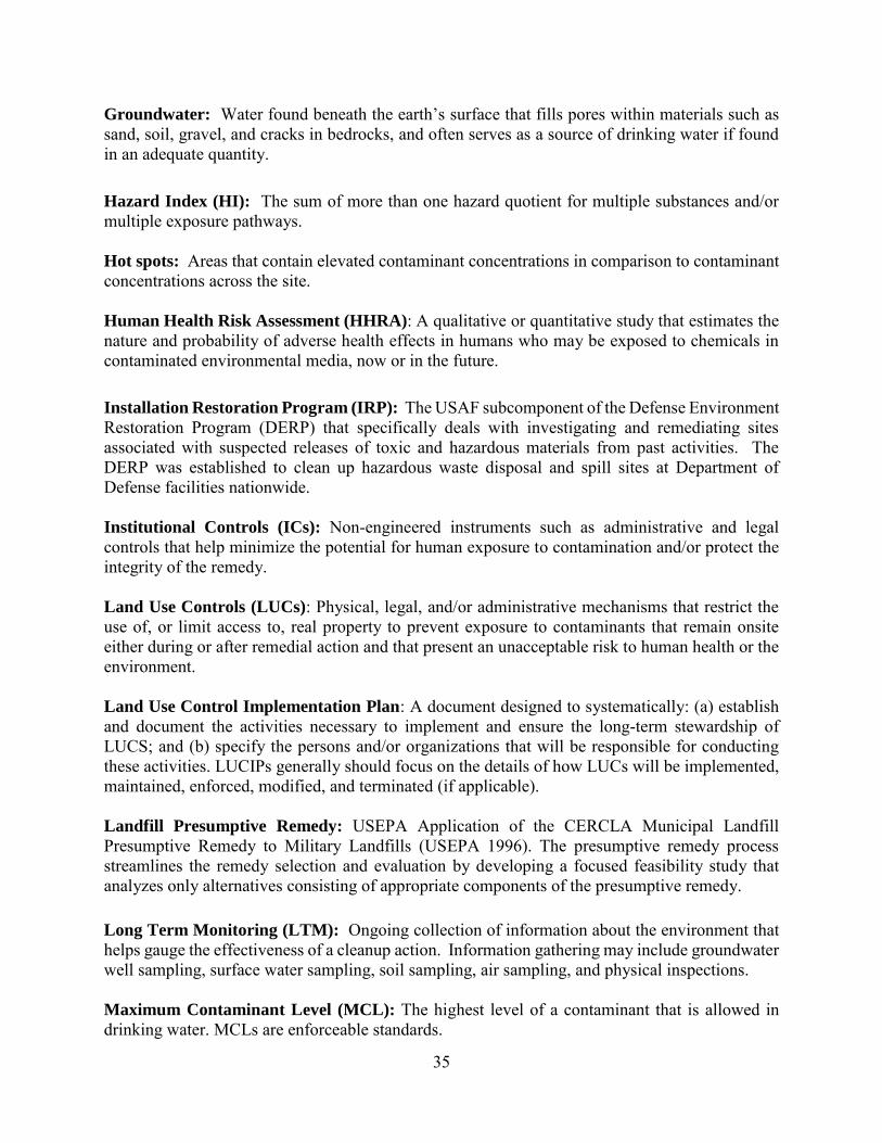
35
Groundwater: Water found beneath the earth’s surface that fills pores within materials such as sand, soil, gravel, and cracks in bedrocks, and often serves as a source of drinking water if found in an adequate quantity. Hazard Index (HI): The sum of more than one hazard quotient for multiple substances and/or multiple exposure pathways.
Hot spots: Areas that contain elevated contaminant concentrations in comparison to contaminant concentrations across the site. Human Health Risk Assessment (HHRA): A qualitative or quantitative study that estimates the nature and probability of adverse health effects in humans who may be exposed to chemicals in contaminated environmental media, now or in the future.
Installation Restoration Program (IRP): The USAF subcomponent of the Defense Environment Restoration Program (DERP) that specifically deals with investigating and remediating sites associated with suspected releases of toxic and hazardous materials from past activities. The DERP was established to clean up hazardous waste disposal and spill sites at Department of Defense facilities nationwide. Institutional Controls (ICs): Non-engineered instruments such as administrative and legal controls that help minimize the potential for human exposure to contamination and/or protect the integrity of the remedy.
Land Use Controls (LUCs): Physical, legal, and/or administrative mechanisms that restrict the use of, or limit access to, real property to prevent exposure to contaminants that remain onsite either during or after remedial action and that present an unacceptable risk to human health or the environment. Land Use Control Implementation Plan: A document designed to systematically: (a) establish and document the activities necessary to implement and ensure the long-term stewardship of LUCS; and (b) specify the persons and/or organizations that will be responsible for conducting these activities. LUCIPs generally should focus on the details of how LUCs will be implemented, maintained, enforced, modified, and terminated (if applicable).
Landfill Presumptive Remedy: USEPA Application of the CERCLA Municipal Landfill Presumptive Remedy to Military Landfills (USEPA 1996). The presumptive remedy process streamlines the remedy selection and evaluation by developing a focused feasibility study that analyzes only alternatives consisting of appropriate components of the presumptive remedy.
Long Term Monitoring (LTM): Ongoing collection of information about the environment that helps gauge the effectiveness of a cleanup action. Information gathering may include groundwater well sampling, surface water sampling, soil sampling, air sampling, and physical inspections. Maximum Contaminant Level (MCL): The highest level of a contaminant that is allowed in drinking water. MCLs are enforceable standards.

36
Maximum Contaminant Level Goals (MCLGs): The level of a contaminant in drinking water, below which, below which there is no known or expected risk to health. MCLGs allow for a margin of safety. MCLGs are non-enforceable standards.
National Oil and Hazardous Substances Pollution Contingency Plan (NCP): The NCP sets forth the procedures for implementing cleanup under CERCLA (commonly known as Superfund) National Priorities List (NPL): USEPA’s list of the most serious uncontrolled or abandoned hazardous waste sites identified for possible long-term remedial action under the Superfund program. New Jersey Administrative Code (N.J.A.C.): The collection of all rules and regulations made by the executive branch agencies of the State of New Jersey.
Non-Residential Direct Contact Soil Remediation Standard (NRDCSRS): Chemical-specific non-residential criteria (based on direct contact mode of exposure) per the NJDEP Soil Cleanup Criteria and Soil Remediation Standards included in N.J.A.C. 7:26D.
Operation and Maintance (O&M): after a remedial action is implemented, operation and maintenance are necessary to maintain the effectiveness of the remedial action.
Operable Unit (OU): A separate and distinct remedial project that is part of a large, complex hazardous waste site. Each OU has its own Record of Decision, remedial investigation, feasibility study, design, and construction. Polycyclic Aromatic Hydrocarbons (PAHs): Compounds often associated with combustion process and distillation tars. Polychlorinated Biphenyl (PCB): An organic pollutant that was formerly used in electrical transformers and capacitors, their manufacture was banned in 1979. There are 210 different PCB compounds that typically have 40 percent to 60 percent chlorine by weight. Practical Quantitation Level (PQL): means the lowest concentration of a constituent that can be reliably achieved among laboratories within specified limits of precision and accuracy during routine laboratory operating conditions. "Specified limits of precision and accuracy" are the criteria which have been included in applicable regulations including, but not limited to, those regulations listed at N.J.A.C. 7:9C-1.9 or are listed in the calibration specifications or quality control specifications of an analytical method.
Preliminary Remediation Goal (PRG): Proposed medium-specific cleanup goals for a selected remedial action. PRGs will be finalized to Remedial Goals (RGs) in the Record of Decision. Remediation efforts would be considered complete and no further action would be necessary upon attainment of the remedial goals.
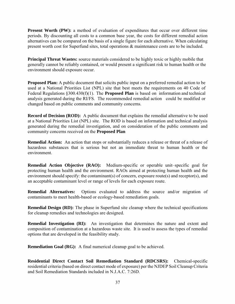
37
Present Worth (PW): a method of evaluation of expenditures that occur over different time periods. By discounting all costs to a common base year, the costs for different remedial action alternatives can be compared on the basis of a single figure for each alternative. When calculating present worth cost for Superfund sites, total operations & maintenance costs are to be included. Principal Threat Wastes: source materials considered to be highly toxic or highly mobile that generally cannot be reliably contained, or would present a significant risk to human health or the environment should exposure occur.
Proposed Plan: A public document that solicits public input on a preferred remedial action to be used at a National Priorities List (NPL) site that best meets the requirements on 40 Code of Federal Regulations §300.430(f)(1). The Proposed Plan is based on information and technical analysis generated during the RI/FS. The recommended remedial action could be modified or changed based on public comments and community concerns. Record of Decision (ROD): A public document that explains the remedial alternative to be used at a National Priorities List (NPL) site. The ROD is based on information and technical analysis generated during the remedial investigation, and on consideration of the public comments and community concerns received on the Proposed Plan Remedial Action: An action that stops or substantially reduces a release or threat of a release of hazardous substances that is serious but not an immediate threat to human health or the environment. Remedial Action Objective (RAO): Medium-specific or operable unit–specific goal for protecting human health and the environment. RAOs aimed at protecting human health and the environment should specify: the contaminant(s) of concern, exposure route(s) and receptor(s), and an acceptable contaminant level or range of levels for each exposure route. Remedial Alternatives: Options evaluated to address the source and/or migration of contaminants to meet health-based or ecology-based remediation goals. Remedial Design (RD): The phase in Superfund site cleanup where the technical specifications for cleanup remedies and technologies are designed. Remedial Investigation (RI): An investigation that determines the nature and extent and composition of contamination at a hazardous waste site. It is used to assess the types of remedial options that are developed in the feasibility study. Remediation Goal (RG): A final numerical cleanup goal to be achieved. Residential Direct Contact Soil Remediation Standard (RDCSRS): Chemical-specific residential criteria (based on direct contact mode of exposure) per the NJDEP Soil Cleanup Criteria and Soil Remediation Standards included in N.J.A.C. 7:26D.

38
Risk Assessment: A systematic scientific process of determining risk estimates based on the presence of contaminants in the environment and who might be exposed to the contaminants. Screening-Level Ecological Risk Assessment (SLERA): An initial screening process to evaluate risks to ecological receptors using conservative assumptions.
Semi-Volatile Organic Compounds (SVOCs): Organic constituents which are generally insoluble in water and are not readily transported in groundwater. Volatile Organic Compounds (VOCs): Organic constituents that tend to volatilize or to change from a liquid to a gas form when exposed to the atmosphere. Many VOCs are readily transported in groundwater. Unlimited Use/Unrestricted Exposure (UU/UE): Restrictions are no longer required at a Site because it meets the applicable health-based standards. Water Table: The level below ground surface, below which the ground is saturated. Well Restriction Area (WRA): A WRA is an institutional control that imposes a potable use restriction on a groundwater source when contaminant concentrations within a CEA exceed drinking water standards.

39
USE THIS SPACE TO WRITE YOUR COMMENTS
Your input on the Proposed Plan for OU3, JB MDL-McGuire is important to the USAF.
Comments provided by the public are valuable in helping the USAF select a final cleanup remedy for the site.
You may use the space below to write your comments, then fold and mail. Comments must be
postmarked by January 23, 2018. If you have questions about the comment period, please contact Curtis A. Frye at (609) 754-4952. Those with access to email may submit their comments to the USAF at the following address: [email protected]. ______________________________________________________________________________ ______________________________________________________________________________ ______________________________________________________________________________ ______________________________________________________________________________ ______________________________________________________________________________ ______________________________________________________________________________ ______________________________________________________________________________ ______________________________________________________________________________ ______________________________________________________________________________ ______________________________________________________________________________ ______________________________________________________________________________ ______________________________________________________________________________ ______________________________________________________________________________ ______________________________________________________________________________ ______________________________________________________________________________ ______________________________________________________________________________ ______________________________________________________________________________ ______________________________________________________________________________ ______________________________________________________________________________ ______________________________________________________________________________ ______________________________________________________________________________
Name:___________________________________________
Address:_________________________________________
City_____________________________________________
State________________________________Zip__________