department of the interior - blm
TRANSCRIPT
303 DM 7 Page 1 of 53
Department of the Interior Departmental Manual
Effective Date: 10/9/07 Series: Departmental Management Part 303: Indian Trust Responsibilities Chapter 7: Standards for Indian Trust Lands Boundary Evidence Originating Office: Bureau of Land Management 303 DM 7 7.1 Purpose. This chapter provides Department-wide guidance and instruction for the gathering and application of boundary evidence with respect to Indian trust assets, as defined herein. 7.2 Scope. The provisions of this chapter are to be observed and applied by all Department of the Interior bureaus and offices. A. Affected transactions include but are not limited to the following conveyances: fee to trust, government to trust, trust to fee, trust to trust, restricted to restricted, exchanges involving Indian trust assets, removal of restrictions, partition of trust or restricted lands, reservation proclamations, and other trust and restricted fee asset transactions made for the benefit of individual Indians and Indian tribes. B. Affected transactions may also include but are not limited to the following activities: timber sales, rights-of-way, and leases. 7.3 Authority. This chapter is issued under the authority of the American Indian Trust Fund Management Reform Act of 1994 (25 U.S.C. § 162a(d)(8) and 25 U.S.C. § 4001, et seq.) together with its implementing regulations, and 25 U.S.C. § 176, which states: “Whenever it becomes necessary to survey any Indian or other reservations, or any lands, the same shall be surveyed under the direction and control of the Bureau of Land Management (BLM) and in conformity to the rules and regulations under which other public lands are surveyed.” 7.4 General Provision. This chapter is intended to enhance the Department’s management of the Secretary’s trust responsibility as defined herein. It is not intended to, and does not, create any right to administrative or judicial review, or any legal right or benefit, substantive or procedural, enforceable against the United States, its agencies, or instrumentalities, its officers or employees, or any other person. 7.5 Definitions. For the purpose of this chapter, the following definitions apply: A. Trust Responsibility. As used in this chapter, only pertains to Indian trust assets.
10/9/07 #3770 New

303 DM 7 Page 2 of 53
B. Indian Trust Asset. Means land or a natural resource held by the Federal Government in trust, or that is restricted against alienation, for Indian tribes, individual Indians or individual Alaska Natives. C. Boundary. Every natural and/or artificial demarcation of the bounds or territorial extent of an Indian trust asset. D. Evidence. Any medium that furnishes or tends to furnish proof of a fact. The location of a land boundary in a court of law constitutes an issue of fact. E. BLM Cadastral Survey Program. The BLM program that is responsible for establishing, reestablishing, and describing the boundaries of Indian trust assets, among certain other lands of the United States. 7.6 Policy. The acquisition and use of boundary evidence as it pertains to the boundaries of Indian trust assets will follow the BLM Manual of Instructions for the Survey of the Public Lands of the United States (Survey Manual), its amendments and supplements, and the Department of the Interior Standards for Indian Trust Lands Boundary Evidence: A Cadastral Business Practice Standard (Standards), as amended and supplemented. 7.7 Objectives. The objectives of this policy are to: A. Provide a consistent, timely, efficient and economical assessment of the need for boundary evidence relative to Indian trust assets. B. Permit expeditious processing of Indian trust asset transactions. C. Provide managers with a cost and time saving tool that assists them in making appropriate determinations for solutions to Indian trust asset boundary issues. D. Protect and preserve Indian trust assets from boundary conflicts, trespass, unauthorized use and ambiguous land descriptions. E. Properly discharge the Secretary’s trust responsibilities as to Indian trust assets with a high degree of proficiency, integrity and care. 7.8 Responsibilities. A. Office of the Special Trustee for American Indians oversees all Indian trust reform efforts within the BIA, BLM, and MMS that are responsible for carrying out the Secretary’s trust responsibility. B. Assistant Secretaries ensure that bureaus and offices under their jurisdiction comply with this chapter.
10/9/07 #3770 New
303 DM 7 Page 3 of 53
C. Heads of bureaus and offices ensure the Standards are applied consistently between the BLM Cadastral Survey Program and the programs of other departmental bureaus and offices. D. Bureau and office program staff coordinate land boundary issues associated with Indian trust assets with the BLM Cadastral Survey Program. E. BLM Washington Office Chief Cadastral Surveyor provides direction and control, technical guidance and assistance to identify the appropriate action necessary for the timeliest most economical solution to Indian trust asset boundary issues. If an official survey is deemed the appropriate action to a land boundary issue, the BLM Cadastral Survey Program will provide survey administration, coordination, execution, approval, and filing. 7.9 Description of the Standards for Boundary Evidence. The Standards identify four sources of boundary evidence. The primary source is a land survey executed by skilled and trained professional surveyors. The execution of land surveys for purposes of the Standards is governed by the BLM Survey Manual, its amendments and supplements. The Standards recognize the paramount importance of a land survey but do not attempt to duplicate instructions found in the BLM Survey Manual. Instead, the Standards concentrate on the remaining three, practical secondary sources of boundary evidence. These three sources are: (1) a land description review; (2) a chain of surveys review; and (3) a physical inspection of the land, including inquiries as to possible unrecorded possessory and other off-record interests. 7.10 Need for the Standards for Boundary Evidence. Commercially available title insurance insures against many defects but not against boundary defects. The Standards provide allottees, tribes, holders of restricted land titles, and managers of Indian trust assets with the means to effectively apply boundary evidence to protect assets. Because these assets may have multiple owners and are often based on complicated and confusing land descriptions, their boundaries may not be accurately or adequately described, often are recognized only by approximate locations, or may contain latent defects. The discovery of erroneous or ambiguous boundary conflicts/descriptions after a transaction is completed can be very costly. When applied, the Standards reduce litigation and other costly conflicts over Indian trust assets and minimize unnecessary land surveys. The Standards give guidance to managers on when and how to involve qualified boundary description or boundary location subject matter experts at key stages of land and natural resource transactions. With standardized procedures, managers will be better able to manage risks and assure proper and efficient discharge of the Secretary’s responsibility to trust beneficiaries. Normally, the Standards are applied before a land acquisition or disposal, or natural resource transaction, but may be applied, in other situations as well. Application of the Standards reduces the potential for boundary defects, provides further assurances that acreage quantities are accurate and aids in permanently documenting boundary related decisions. A few examples of the kind of questions that the Standards address are provided below and a more detailed list of Frequently Asked Questions and Answers is contained in Appendix 1. A. When should a Bureau of Indian Affairs manager, tribal manager, and a Bureau of Land Management Cadastral Surveyor consult on land descriptions, uncertain boundary location, boundary evidence, and acreage?
10/9/07 #3770 New
303 DM 7 Page 4 of 53
B. When does a procedure result in good land descriptions, or provide conflict-free boundaries; when does it ignore existing problems or create new ones? C. How will timely consultations with boundary experts assure concise, accurate land descriptions with defendable boundaries, and provide a savings of time and cost? D. What worksheets and certificates are to be used when documenting essential boundary information? 7.11 Development of the Standards for Boundary Evidence. The Standards were developed jointly by the Bureau of Indian Affairs, Office of the Special Trustee for American Indians, Bureau of Land Management, and Tribal and Alaska Native Corporation Representatives for the guidance of Departmental employees, certified Federal surveyors, and pre-approved agency or tribal officials or agents when gathering boundary evidence. The Department of the Interior Standards are contained in Appendix 2 to this chapter.
10/9/07 #3770 New

303 DM 7 Page 5 of 53
Appendix 1
Frequently Asked Questions Concerning the Standards for Indian Trust Lands Boundary Evidence:
A Cadastral Business Practice Standard What are the Standards for Boundary Evidence (Standards)? The Standards provide a standardized system of identifying and documenting boundary evidence for trust and restricted lands. They are designed to assist the Bureau of Indian Affairs (BIA), Bureau of Land Management (BLM) and tribal managers in determining that activities, rights, and boundaries are located correctly on trust and restricted lands. How do they work? The Standards take the complex work of boundary management and break it down into the basic components. They require the involvement of managers, realty and resource specialists, and surveyors working in a collaborative manner. The trust obligation is reached by land tenure professionals working together and reporting their findings via uniform documentation. Who will benefit? Trust Beneficiaries. The Standards can reduce costly conflicts, reduce litigation, and reduce the number of land surveys. They will enable a more accurate accounting of trust funds by improved documentation of the location of activities and rights within appropriately located trust boundaries. Who else will benefit? Federal and tribal governments in cases where a boundary location is uncertain will benefit by obtaining an alternative to land surveys. The Boundary Assurance alternatives, in many cases but not in all cases, will cost less and can be completed quicker than a land survey. We have Department of Justice Title Standards now; why have Standards for Boundary Evidence too? Title Standards seek to identify and eliminate title defects. Surveys perform the same functions with respect to boundary defects. The Standards for Boundary Evidence help to identify boundary locations in those cases when a land survey is not necessary. Will every transaction and resource management activity have to go through the Standards process?
10/9/07 #3770 New

303 DM 7 Page 6 of 53
No. The Standards do not change existing BIA or tribal policy that govern when boundary assurance or an official survey for a past, current, future transaction, or Indian trust asset management activity are conducted. What is provided? The authorizing official is provided a written assurance (or non-assurance) certificate about the boundary location based upon an evidentiary investigation conducted by a cadastral surveyor or certified Federal surveyor. The certificate addresses the type of assurance authorized, excluding those matters which can only be determined by a land survey. What is new? The standardization of existing work processes and the uniform documentation of the work product will be established. The type of work is not new, but the systematization of the business processes is. The Standards are a compilation of best practices taken from BIA Regions and BLM State Offices. Will I have to consult with the BLM Cadastral Survey Program on every transaction or resource activity? No. The BIA or tribal manager is in charge and ultimately responsible for the outcome. The Standards provide, in some cases, more efficient and cost effective tools than a land survey to get the job done. With the Standards will I ever need a land survey? Yes. There will be cases where the Boundary Assurance report will contain caveats bearing higher risks than a prudent manager will want to assume. After consultation with your Cadastral Surveyor about what the caveats mean and your knowledge of the intended land use or purpose, you may decide you need to know the details which can only be revealed by an official survey. In some cases the need for survey monuments or new land descriptions simply requires an official survey. If I know I just want a Cadastral Survey will I have to go through the Standards process? No. The Standards are not mandatory. The authorized official can still request an official survey just as they could before the Standards. But BLM Cadastral Survey Program, based upon their preliminary research conducted for every survey, may come back and consult with you about a less expensive or timelier solution. But if I request an Administrative Survey, will the Standards benefit me? The Standards provide a tool for BLM to use to review administrative (unofficial) surveys. The report of the review can alert you to concerns about the surveys. In other words you can seek a second opinion in those cases when it is prudent.
10/9/07 #3770 New

303 DM 7 Page 7 of 53
How will the Standards benefit BIA and tribal title experts? The Standards provide a standardized process and documentation for the exchange of information between the title experts (those who deal with the “who” and the “what” about the land) and the boundary experts (those who deal with the “where” of the land). Surveyors are trained to identify latent ambiguities in legal descriptions and boundary encroachments. Surveyors interpret survey records and compare them with title records and the physical conditions on the ground to guard against potentially costly ambiguities and unauthorized use of lands. How will the Standards benefit BIA and Tribal resource and facilities managers? The Standards also provide a standardized process and documentation for the exchange of information between the resource and facilities managers (those who deal with the land resources and land uses) and the boundary experts (those who deal with the “where” of the land). Surveyors are trained to identify latent ambiguities in legal descriptions and boundary encroachments. Surveyors interpret survey records and compare them with title records and the physical conditions on the ground to guard against potentially costly ambiguities and unauthorized use of lands. Why should I have a surveyor conduct a Certification of Inspection and Possession (CIP)? A surveyor brings the unique knowledge combination of title records, survey records, and boundary location evidence. A surveyor is trained to distinguish between corner monuments and spurious corners. In many cases, but not in all cases, the surveyor can tell by inspection, after some preliminary research, whether a fence or other use is the true boundary line. What is Boundary Assurance? Boundary Assurance is a land boundary management tool for trust and restricted land transactions and resource activities. Boundary Assurance is not a land survey. Boundary Assurance is a non-survey alternative which can be used by BIA, tribes, individual Indians, individual Alaska Natives, and BLM for the purpose of assuring the boundary evidence either prior to or after a transaction and resource activity. How is a Boundary Assurance performed? The Boundary Assurance process is the result of the latest innovative and advanced boundary management techniques supported by automated survey and land records, photography, mapping, and computer software, which provides the BIA or tribe with sufficient detail to satisfy their boundary management requirements.
10/9/07 #3770 New

303 DM 7 Page 8 of 53
Is it a survey? No! While it is true that the Boundary Assurance process cannot furnish the kind of detail that would be available through an official survey, it is sufficiently specific and detailed to satisfy the BIA or tribe’s boundary management requirements in many cases. Will beneficiaries be misled? The BIA and BLM’s discussions with tribes and allottees emphasize that Boundary Assurance is not an official survey and does not satisfy the needs that can only be fulfilled by an official survey. Boundary Assurance can be sufficient to meet BIA or the tribe’s own internal transactions and resource activities related to boundary location. It is permanently filed by the BIA and BLM for future reference. Has a cost analysis been made? Yes. By better utilization of limited and specialized expertise the savings will be significant. It has been estimated that with implementation of the Standards, a savings of 8% in direct costs and 6% in surveyor work months per year can be achieved. This is equivalent to 8 additional survey projects a year being completed, based upon fiscal year 2004 appropriated dollars. The potential savings in litigation avoidance is difficult to estimate but could also be significant. What is a Certified Federal Surveyor (CFedS)? A CFedS is a state licensed land surveyor who has successfully completed the certification process established by the BLM Cadastral Survey Program. Tribal and agency surveyors will be encouraged to become state licensed land surveyors and federally certified. CFedS will perform a wide range of cadastral services within the state(s) in which he or she is licensed to practice land surveying. Certain services, however, will be under the direction and control of the appropriate Chief Cadastral Surveyor. What is a Pre-approved Agency or Tribal Official or Agent (PATOA)? A PATOA is an individual who has successfully completed the certification process established by the BLM Cadastral Survey Program. PATOA will perform land description reviews. They will provide more trained personnel for accomplishing land description reviews in order to streamline Indian trust asset transactions. Where is the increased capacity? The Standards allow the Department or BLM/BIA to increase its cadastral services capacity without sacrificing quality. The Certified Federal Surveyor Program uses highly trained personnel that are licensed land surveyors. Tribal members and BIA employees are encouraged to become licensed land surveyors that also are federally certified. The PATOA Program uses trained personnel. Tribal members and BIA employees will be encouraged to become proficient in legal description creation and review, and be federally pre-approved.
10/9/07 #3770 New

303 DM 7 Page 9 of 53
Can the Standards be changed? Yes. The Standards will be subject to amendment through due process when experience teaches us how to make them better. Who bears the cost for the Standards process? The department, agency, tribe, or land owner authorizing the work is responsible for the cost.
10/9/07 #3770 New

303 DM 7 Page 10 of 53
Appendix 2 Department of the Interior
Standards for Indian Trust Lands Boundary Evidence: A Cadastral Business Practice Standard
Chapters: Introduction 1. Boundary Evidence: A. Land Surveys – The Primary Mode of Boundary Evidence B. Secondary Modes of Boundary Evidence C. When to Obtain Boundary Evidence D. Responsibility for Obtaining Boundary Evidence E. Guidelines for Preparation of Boundary Evidence F. Boundary Evidence Search Time Frame G. Subsequent Boundary Evidence H. Boundary Assurance Certificates (BAC) I. Individuals Having the Authority and Responsibility for Obtaining Boundary Evidence J. Certified Federal Surveyors (CFedS) 2. Boundary Evidence – Special Situations: A. Records, Lost or Destroyed B. When a Trust Land Estate or Restricted Land Probate is Involved C. Foreclosure, Tax Sale, or a Judicial Proceeding D. Sale by a Trustee or Fiduciary E. Search of Federal and State Court Records F. Streets and Alleys G. Special Improvement Districts H. Executive Orders, Proclamations, Administrative Withdrawals, Reservations I. Adverse Possession J. Unrecorded Boundary Papers and/or Unrecorded Boundary Monuments 3. Reporting Boundary Evidence: A. In General B. Land Description Review (LDR) C. Chain of Surveys (COS) D. Certificate of Inspection and Possession (CIP) E. Boundary Assurance Certificate (BAC) 4. Worksheets and Certificates: A. Land Description Review (LDR) B. Chain of Surveys (COS) C. Certificate of Inspection and Possession (CIP) D. Boundary Assurance Certificate (BAC) 5. List of Definitions and Usage of Terms:
6. List of Acronyms:
10/9/07 #3770 New

303 DM 7 Page 11 of 53
Department of the Interior
Standards for Indian Trust Lands Boundary Evidence: A Cadastral Business Practice Standard
These Standards can be applied, as appropriate, to all Indian trust or restricted land or resource transactions. Following the Standards enables Federal agencies to help protect the interests of the Indian beneficiaries and the government. INTRODUCTION: The Department of the Interior Standards for Indian Trust Lands Boundary Evidence: A Cadastral Boundary Business Practice Standard (hereinafter referred to as the Standards) provide guidance and instruction for the gathering and application of several important types of boundary evidence applicable to Indian trust and restricted lands. THE MODES OF BOUNDARY EVIDENCE DISCUSSED IN THE STANDARDS INCLUDE FIRST AND FOREMOST LAND SURVEYS IN THE SPECIAL SENSE THAT WHEN PROPERLY EXECUTED SUCH SURVEYS ARE RECOGNIZED BY THE STANDARDS AS THE PRIMARY MODE OF BOUNDARY EVIDENCE. THE STANDARDS, HOWEVER, DO NOT PURPORT TO ESTABLISH ANY GUIDANCE OR INSTRUCTION APPLICABLE TO THE EXECUTION OF LAND SURVEYS. The Standards can be applied to acquisitions, conversions, transfers, partitions, asset management, donations, right-of-ways, easements, leases, and other land and resource transactions. The Standards interrelate with the Office of Management and Budget Circular No. A-16, Coordination of Geographic Information and Related Spatial Data Activities; the Departmental Manual, Department Management, Part 303: Indian Trust Responsibilities, Chapter 2: Principles for Managing Indian Trust Assets, and Special Programs, Part 757: Surveying and Mapping; the Code of Federal Regulations Title 25, Parts 150, 151 and 152, Indian Land Records and Title Documents, and Land Acquisitions and Title 43, Part 4, Probate; the Department’s Specifications for Descriptions of Tracts of Land for Use in Land Orders and Proclamations; and the Bureau of Land Management (BLM) Manual of Instructions for the Survey of the Public Lands of the United States (Survey Manual), as amended and supplemented. 1. BOUNDARY EVIDENCE
As used in these Standards, boundary evidence is authenticated documentation used to describe a natural or artificial/political separation that delineates and identifies a tract of land sufficient to ascertain the actual location of the land on the ground. Boundary evidence typically is in the form of a deed or other document describing the boundary to property, or a survey or other document locating the boundary to property, or an action or behavior upon the land determining the boundary to property. Boundary evidence will be presented through a Land Description Review (LDR), Chain of Surveys (COS), or Certificate of Inspection and Possession (CIP).
The Standards require both boundary and title evidence to be examined in totality for conflict free land boundaries. Boundary evidence is examined to identify insufficient land
10/9/07 #3770 New

303 DM 7 Page 12 of 53
descriptions, ambiguous boundary location, conflicts in use, unauthorized encroachments, boundary gaps or overlaps, and other conflicts along a boundary line. Relying solely on title evidence and title insurance creates the potential for overlooking boundary defects. Boundary evidence involves the compilation, examination and analysis of title documents and boundary documents combined with the physical inspection of the boundary. The focus of boundary evidence is on the on-the-ground location of boundaries. The Standards help to close the gap caused by the singular focus upon title evidence. Combining title evidence and boundary evidence creates stability for the benefit of the trust beneficiaries and the government.
Tribes and Interior bureaus and offices should consult with a BLM Cadastral Surveyor, a Certified Federal Surveyor (CFedS), or a Pre-approved Agency or Tribal Official or Agent (PATOA) to determine: a) if further boundary evidence is needed, and/or b) the type of boundary evidence to be obtained. Each case is different. The manager and boundary expert must keep in mind the differing and unique requirements of each transaction, planned activity, local practice, reliability, security, economy, efficiency and speed. In general, the character and scope of boundary evidence may: • consist of a diligent search of previous surveys or survey related records, and other
controlling evidence (such as identification of the best available evidence of the original survey; proper reference to interdependent corners, evidence of the acts and testimony of the interested landowners, witnesses, surveyors, or other authorities – e.g., local courts, state highway engineers or water masters) pertaining to boundary location for the interests to be conveyed or managed;
• consist of records and/or physical evidence that disclose the location of the surrounding
property boundaries to the proposed conveyance, or managed land interest; and • contain a sufficient summary of the material facts for the purpose of authenticating or not
authenticating various boundary locations, including exceptions, reservations, subject to, caveats, reversions, or objections to specific portions of the boundary location(s).
A. Land Surveys – The Primary Mode of Boundary Evidence
For many years, the Bureau of Indian Affairs (BIA), with its fiduciary responsibilities,
and BLM, with its land survey responsibilities, have worked together for conflict free land boundary transactions. Since 1832, the Commissioner of Indian Affairs, under the direction of the Secretary of the Interior, has been involved in the management of Indian affairs and matters arising out of Indian relations (25 U.S.C. § 2). By 1863 various systems of Indian boundary surveys were being used. Surveys were conducted under different acts of Congress, some under Indian Office supervision, some by order of the President, some by order of the Secretary, and others by the Commissioner of the General Land Office or a Surveyor General. There was no consistency in the methods of surveys or the field notes and plats, if any, prepared by survey. In 1864 Congress passed a single law placing all the Indian surveys under the direction and control of the Commissioner of the General Land Office (now the Director of the BLM). This statute, now codified at 25 U.S.C. § 176, places the survey of Indian lands under the authority of the BLM.
10/9/07 #3770 New

303 DM 7 Page 13 of 53
The following land surveys, prepared by a BLM surveyor under the direction and control
of a Chief Cadastral Surveyor, another Federal agency surveyor, a Certified Federal Surveyor, or a county or other local surveyor constitute the primary mode of boundary evidence.
1. Official surveys; surveys conducted under the authority of, and approved and officially filed by the BLM Cadastral Survey Program;
2. Local or administrative surveys conducted in conformance with, (a) the Minimum
Standard Detail Requirements for American Land Title Association/American Congress on Surveying and Mapping Land Title Surveys as adopted by American Land Title Association and National Society of Professional Surveyors (ALTA/ACSM land title survey), and (b) the applicable state law; or
3. Local or administrative surveys conducted in conformance with, (a) the Survey
Manual, and (b) the applicable state law. A local or administrative survey can come in many forms but the common element is that the survey results in an opinion as to a boundary location. This opinion may apply to the entire bundle of land rights or to any part thereof, such as an easement or other lesser interest. A local or administrative survey prepared by a registered land surveyor practicing in the state of the surveyor’s registration will be considered boundary evidence if the Chief Cadastral Surveyor finds that the survey was conducted in accordance with the Survey Manual, provides full disclosure of all matters which affected the surveyor’s opinion of the boundary location, and has the surveyor’s procedures, caveats, comments, recommendations, and certification relating thereto clearly written. If authorized to do so, the Chief Cadastral Surveyor may issue a boundary location opinion based on the information contained in such a survey. The Chief Cadastral Surveyor must be consulted prior to the execution of a local or administrative survey.
An ALTA/ACSM land title survey often comes the closest to meeting BLM Survey Manual standards. If a local survey is undertaken the use of an ALTA/ACSM survey is encouraged. CAUTION: A survey that meets the needs for title insurance purposes may not meet the needs of an individual Indian or tribe or the Federal Government, or of a surveyor conducting a survey at their request.
Local or administrative surveys conducted by non-licensed surveyors often are inadequate and result in disrupting legitimate Indian programs involving e.g., Indian housing projects, water lines or sanitation systems. One of the purposes of the Standards is to eliminate this practice or, at a minimum, encourage consultation with the Chief Cadastral Surveyor.
Agencies and/or tribes must have local surveys recorded in the county/borough/parish record system in the county/borough/parish or counties/boroughs/parishes in which the land is located. Even though the sovereign nature of Indian lands may exempt recording, as prescribed by state laws and regulations, it is important for the protection of Indian boundaries that these surveys be accessible through county/borough/parish record systems. These surveys must also be recorded in the respective BIA Land Title Record Office (LTRO) as part of the survey
10/9/07 #3770 New

303 DM 7 Page 14 of 53
process. This will ensure that these records will be public records and easier for interested parties to retrieve in the future.
Surveys should be prepared for all acquisitions, and for all conveyances, conversions, transfers, partitions, and management activities where:
• improvements to the land exist or are contemplated; • management activity involves part of a larger property; • new boundaries are being created (any boundary not shown on an official survey plat); • boundaries and titles are complex and confusing; • litigation is probable; or • the acquiring or managing agency or tribe requires a land survey.
Any encroachments or right-of-ways on or over the land should be shown or noted on the
survey plat.
If the land is described by metes and bounds, or by reference to lands of surrounding owners, abutting streets, ways, etc., its boundaries should be defined on the plat by courses, distances, and monuments, natural or otherwise. The plat also should identify the surrounding lands and other natural or man-made features that aid in locating the property.
When the land is part of a subdivision, a copy of the subdivision plat, or the section thereof in which the land is located, should be obtained.
If the land is described in a United States patent or a state grant that is the source of title, the boundary details (bearings and distances) from the survey plat of the land being acquired or managed should be superimposed on an image of the boundary details (bearings and distances) from the plat of the official survey relative to the patent or state grant and portrayed to a common scale on an orthophotograph. If necessary to convey land or an interest in land with a United States patent, the land must be returned upon (described by) an official survey plat. If the land being conveyed or managed is part of a larger tract, it should, when necessary for its identification, portray the boundary details (bearings and distances) to a common scale on an orthophotograph showing the larger tract and any successive diminishing tracts.
B. Secondary Modes of Boundary Evidence
The following, prepared in accordance with the requirements of these Standards by a Cadastral Surveyor, Certified Federal Surveyor, or Pre-approved Agency or Tribal Official or Agent, and approved by the Chief Cadastral Surveyor are acceptable modes of secondary boundary evidence:
1. Land Description Review (LDR) (see attached DOI worksheet and certificate); 2. Chain of Surveys (COS) (see attached DOI worksheet and certificate); 3. Certificates of Inspection and Possession (CIP) (see attached DOI worksheets and
DOJ forms);
10/9/07 #3770 New
303 DM 7 Page 15 of 53
4. Copies of relevant survey records duly authenticated by the custodian or land
surveyor; and 5. Any other boundary evidence which is acceptable to the Chief Cadastral
Surveyor. For example, boundary evidence pertaining to the location of boundaries, acceptable to prudent land surveyors in the locality in which the land is situated, will ordinarily be acceptable.
LDR, COS, and CIP, reported upon the attached certificates, are the modes of secondary
boundary evidence most used in Indian trust and restricted land acquisitions, conversions, transfers, partitions, and management activities. Secondary boundary evidence always applies to acquisitions, together with the primary evidence represented by a properly executed survey. There are all kinds of boundary defects such as latent boundary ambiguities, conflicting surveys, adverse claims, encroachments, unauthorized uses, etc.; such defects normally do not appear in the public records and typically are not insured against by a title insurance policy or disclosed in a Title Status Report. Secondary boundary evidence certificates provide an added degree of security that does not exist with less formal modes of boundary evidence. A Boundary Assurance Certificate (BAC), based on and in conformance with the three components of boundary evidence (LDR, COS, & CIP), gives added confidence that a boundary defect has not gone undetected. C. When to Obtain Boundary Evidence
Boundary evidence should be obtained for all interests in the land contiguous to the land or natural resource that is being acquired or used. If land is being assembled for a project, consideration should be given to obtaining boundary evidence that will initially cover each separate ownership or parcel, but which ultimately will be consolidated into a single product. Prior to gathering or contracting for boundary evidence, the Chief Cadastral Surveyor should always be consulted.
If the acquiring or managing agency or tribe has determined that oil, gas or other minerals do not need to be acquired, or can be subordinated to the surface interest to be acquired, or managed (because they are not needed and because the rights associated with such mineral interests, such as a right of surface access, will not interfere with the contemplated use of the surface of the land), then the boundary evidence need not include evidence of mineral interests or evidence of coincidental location of surface and subsurface rights, and other instruments relating to the descriptions and locations of such interests. If the acquiring or managing agency or tribe wishes to obtain relevant documents or location inspection reports of such severed or subordinated interests, it should so specify when it authorizes secondary boundary evidence. When boundary evidence of oil, gas and other mineral interests can be developed at a reasonable expense, it makes sense usually to do so. Such knowledge may serve a future purpose if the United States decides to conduct surface activities not originally contemplated. In addition, such subsurface boundary evidence can protect surface interests from interference due to incorrectly located surface access by the owner or operator of the subsurface mineral interests.
10/9/07 #3770 New

303 DM 7 Page 16 of 53
D. Responsibility for Obtaining Boundary Evidence
A tribe, bureau, or office should always obtain boundary evidence for any land or an interest in land that is being acquired. A BLM Cadastral Surveyor, a Certified Federal Surveyor, or a Pre-approved Agency or Tribal Official or Agent should be consulted in all circumstances in which boundary evidence is needed, as for example, road construction, capital investment projects, or timber sales. Always consult with legal counsel if in doubt as to whether or not a survey should be executed.
Boundary evidence must be obtained promptly to avoid delay in payment to landowners, lessees, tribes, or individual Indian beneficiaries, and to permit timely completion of a transaction.
There are a variety of boundary evidence modes. The suitability of a given mode will vary depending upon the situation. For example, an official survey may be more dependable in a conveyance or transaction involving new metes and bounds descriptions. However in other situations other modes of boundary evidence may be more appropriate and significantly less expensive. The sense of security engendered by an official survey or boundary assurance may not outweigh a strong economic incentive to use a more economical mode of boundary evidence where it would make sense to do so and be sufficient to meet the Secretary’s trust responsibilities.
E. Guidelines for Preparation of Boundary Evidence
Boundary evidence must be kept with the agency’s or tribe’s permanent files. Some guidelines for the preparation of boundary evidence follow:
1. The attached worksheets and certificates, LDR, COS, CIP, or BAC are required for each boundary evidence product requested. The worksheets and the certificates are part of the Standards and must be used to comply with the Standards.
2. The boundary evidence worksheet should disclose the name of each and
every person known to have any title to, or interest in, the land or natural resource, and every person known to have any title to, or any interest in the surrounding land or natural resource. A land status map provided by the relevant agency, and/or a title abstract, title certificate or other title report forms may disclose essential information, including the name(s) of the person or parties who hold interests of record. Addresses of parties having any interest in the subject land or natural resource, and in the surrounding land or natural resource, if disclosed by the public records or known to the tribe, bureau or office should be set out or provided via copies of the title reports. Title Status Reports provided by a LTRO may provide useful location, ownership, and encumbrance information. If available, a Land Title Mapper (LTM) tract map provides a spatial representation, a geographic information system (GIS) acreage
10/9/07 #3770 New

303 DM 7 Page 17 of 53
calculation, and shows adjacent landholdings. A LTM spatial analysis of automated land records (LRIS, TAAMS) can reveal conflicts involving the recorded descriptions of tracts, which may be an indication of potential boundary problems.
3. Complete, legible copies and images, or a sufficient abstract or digest, of
all instruments referenced in the boundary evidence must be obtained. Survey plats should be original size.
4. Where subsurface (mineral) interests in the property are to be conveyed, or
managed, the boundary evidence of each such outstanding interest and all data or exceptions, whether of record or not, relating thereto, must be developed.
F. Boundary Evidence Search Time Frame
The time frame for searching boundary evidence for the conveyance of a particular tract
of land should run from the inception of the search up until the recording of the deed. Title insurance companies continue searches of only the record title up until the recording of the deed. Boundary evidence, such as easements, on the other hand, typically is limited to the period of search prescribed by the policy coverage. Usually this coverage excludes the most common boundary evidence, namely, a survey plat updated before the deed is recorded. Sometimes this exclusion can be eliminated or modified by negotiation with the title insurance company.
G. Subsequent Boundary Evidence
Boundary evidence collected subsequent to the last physical inspection must indicate that the search or inspection has been continued from the date of that inspection. The subsequent boundary evidence should include the recordation or filing of the previous transaction, updated agency land status, survey, and Cadastral Geographic Information System (CGIS) records, when available and applicable.
H. Boundary Assurance Certificates (BAC)
The BAC enhances confidence that a boundary location is clear of conflicts and uncertainties, except as noted or as stated in caveats. When the need for a BAC is identified, the certificate should have an effective date as of or subsequent to the date of recording of the deed to the United States, updated agency land status, survey and CGIS records or completion of trust or restricted land asset activity.
I. Individuals Having the Authority and Responsibility for Obtaining Boundary Evidence
Boundary evidence will be gathered under the authority of the Chief Cadastral Surveyor.
Boundary evidence can be gathered and evaluated by BLM Cadastral Surveyors, Certified Federal Surveyors, or pre-approved agency or tribal officials or agents familiar with the
10/9/07 #3770 New

303 DM 7 Page 18 of 53
preparation of such evidence in the jurisdiction in which the lands are situated. Individuals certified or pre-approved to gather and/or evaluate boundary evidence must have no interest in the land or surrounding land. J. Certified Federal Surveyors
Certified Federal Surveyors must be licensed to practice land surveying in the state where the land lies. Agencies and tribes should seek to assure themselves that land surveyors selected for Certified Federal Surveyor training are experienced, financially responsible and of highly reputable character. 2. BOUNDARY EVIDENCE – SPECIAL SITUATIONS:
A. Records, Lost or Destroyed
When boundary location or description records such as patents, deeds, probates, and surveys, for any of the period of search required have been lost or destroyed, or are otherwise permanently unavailable, the boundary evidence worksheet should be supplemented by the following:
The boundary evidence certification will attest to the fact of (1) the loss or destruction of records, (2) property corner monuments or boundary markers exist on the ground of unknown origin, or (3) the unavailability of the record(s) is commonly acknowledged by landowners and land surveyors in the community. Such certification shall also provide (1) Proof of compliance with requirements of statutory proceedings, if any, to reestablish boundaries affected by the loss or destruction of the records; or (2) Secondary documentary evidence, such as an official survey, that complies with statutory requirements and which, if offered in an administrative or judicial proceeding, would be admissible as boundary evidence, or evidence of boundary by adverse possession, as provided in the instructions set out below in Section I.
B. When a Trust Land Estate or Restricted Land Probate is Involved
The acquiring or managing agency or tribe must satisfy itself that all required conditions and contingencies in the will relative to the boundary’s location have been met. The following may not apply in every jurisdiction, but it is offered as a general guideline.
To assure the privacy of individuals, only the boundary description of the land interest portion of the will should be reproduced. Essential portions of probate proceedings disclosing all material facts of record relating to the boundary location must be shown, including for example land partitions and land descriptions.
In every case before a new land description is created, a check of the official survey plats must be made. This verification is needed because before a patent can be issued or an allotment made, there must be an administrative determination that the land is suitable for this purpose. This decision is evidenced by, among other administrative determinations, the inclusion of the
10/9/07 #3770 New

303 DM 7 Page 19 of 53
land on the plat of an official survey. All land descriptions for patents or allotments are made with reference to the official survey plat. Sampson v. United States, 533 F.2d 499, 501 (9th Cir. 1976); Wise v. United States, 297 F.2d 822, 825 (10th Cir. 1961); Lemieux v. United States, 15 F.2d 518, 522 (8th Cir. 1926), cert. denied, 273 U.S. 749 (1927); Cragin v. Powell, 128 U.S. 691 (1888).
C. Foreclosure, Tax Sale, or a Judicial Proceeding
In cases involving foreclosure proceedings, the boundary evidence should disclose sufficient information regarding the description of the land or natural resource subject to the lien or encumbrance being foreclosed to determine the validity and effect of the foreclosure as to location, including descriptions of the land and surrounding premises, surveys, on-the-ground boundary conditions, sales, transfers, and other administrative or judicial proceedings affecting the boundary.
If the foreclosure is by judicial proceeding, the boundary evidence should show the
description of the relevant land, sufficient portions of the record to determine the jurisdiction of the court, and that all relevant boundary evidence has been considered.
Tax sales, foreclosures and some judicial proceedings result in changed land descriptions and/or can affect the statute of limitations for vesting unwritten rights. The boundary evidence should disclose sufficient information to determine the apparent changed land description and the correct land description, and to determine the on-the-ground limit of written and unwritten rights, title and interest.
D. Conveyance or Transfer by a Trustee or Fiduciary
The boundary evidence should contain the entire contents of each trust instrument, land description, survey plat, and conveyance in the chain of title made by fiduciaries or persons acting in a representative capacity, as well as a statement of the on-the-ground boundary conditions. Any conditions, limitations or changes to the land description, boundary location or use and occupancy reflected in such instruments or record of proceedings, or in any deed to the trustee, or to the beneficiary or principal for whom such trustee or representative is acting, should be fully set forth, and the boundary evidence should show whether such conditions, limitations, change or use will impact the boundary location.
E. Searches of Federal and State Court Records
In instances where court judgments and decrees are not recorded in title records and survey records it will be necessary to search for boundary evidence in Federal court records (in all divisions of the district where the land lies) and state court records, where the land lies.
10/9/07 #3770 New

303 DM 7 Page 20 of 53
F. Streets and Alleys
Where the land includes streets or alley areas, ingress and egress, easements dedicated or vacated, all matters of record affecting the boundary location of such areas should include the following:
1. The complete record of the proceeding for the dedication and, if vacated, the vacation proceedings, relevant to the boundary location of the area and to the location upon the dominant and servient estate.
2. All facts of record bearing on the location of existing prior rights,
prescriptive or otherwise, and location of public and private utilities, if any.
3. All instruments, surveys, and occupancy bearing on boundary locations or
conflicts of all relevant areas and estates.
G. Special Improvement Districts
Boundary evidence containing references to boundary locations of drainage, school, or other special improvement districts; or water, paving, sewer, should spell out all relevant land descriptions, land surveys, as-built plans, and post-construction locations.
H. Executive Orders, Proclamations, Administrative Withdrawals, Reservations Proposed descriptions of tracts of land shall conform, so far as practicable, to the Specifications for Descriptions of Tracts of Land for Use in Executive Orders and Proclamations, Executive Order No. 11030. LDR will determine conformance of the proposed order or proclamation. If land descriptions, surveys, and on-the-ground boundary conditions have not been previously reviewed, an LDR, COS, CIP and BAC should be considered, based on specific criteria set forth in agency manuals and handbooks. The boundary evidence should show all relevant affected and adjoining boundary land descriptions, surveys, and, if inspected, on-the-ground boundary conditions.
I. Adverse Possession When required, an adverse possession report, shall contain the following:
1. Evidence of the occupancy or use upon which the claim of adverse possession is based. This evidence may consist of undisputed, or disputed, testimony, taken under oath, and/or authenticated documents or photographs.
2. A statement of facts, relevant to the claim of adverse possession, as
determined by the surveyor or other specialist making the report.
10/9/07 #3770 New

303 DM 7 Page 21 of 53
In cases where large tracts of land are being conveyed, or actively managed, which encompass what formerly were smaller tracts, the report of adverse possession must relate specifically to the component parts of such tracts and contain sufficient facts to establish or reject adverse possession as to each part. Where two or more conflicting grants, patents, or transfers affect the same land, the exact location of the land over which the acts of possession are claimed or relied upon must be shown on an official survey plat or a state authority survey plat and by the adverse possession report. NOTE: Adverse possession, based on State law, does not apply to land owned by the United States, unless perfected before the period of Federal ownership.
J. Unrecorded Boundary Documents and/or Unrecorded Boundary Monuments
In all cases, any unrecorded boundary location documents, surveys, maps, plats, field notes, court decisions, copies of resolutions, ordinances, deeds, and boundary opinions containing references to the condition or location of a boundary or objections thereto with respect to such land, should accompany the boundary evidence. In cases of any monument or other possible boundary evidence, physical or otherwise, in the vicinity of a boundary corner or along or near a boundary line, not documented in the public record, such evidence must be incorporated into the official administrative record. The documentation shall be contained in a written report describing the extent and result of any investigation. Other sources of relevant information shall be included. 3. REPORTING BOUNDARY EVIDENCE:
A. In general
Title examination means an examination and evaluation by a qualified title examiner of the completeness and accuracy of title documents affecting a particular tract of Indian land with certification of the findings. Boundary examination means an examination and evaluation by a qualified surveyor or boundary location expert of the completeness and accuracy of boundary location documents affecting a particular tract of Indian land with certification of the findings. The closing of transactions or implementation of a management activity can be delayed due to the absence of vital supporting boundary data. Processes covering many of these items are indicated below. If boundary evidence is accumulated that results in a BAC, and does not contain any exceptions relating to the matters mentioned in sections B thru E below, and no supplemental evidence is required, then the transactions are adequately prepared for approval. All documentation must be maintained in the permanent files.
Caution: The BAC should not have exceptions to “parties in possession” or to “matters which would be revealed by a survey,” which are standard exceptions in most title insurance
10/9/07 #3770 New

303 DM 7 Page 22 of 53
policies. To do so would effectively exclude the value of the certificate as providing a sense of comfort concerning the presence or absence of, for example, unrecorded leases, right-of-ways, conflicting land surveys, and unauthorized use or occupancy. If the CIP reveals there may be third parties who have rights to use the land, or there may be potential boundary location conflict(s), copies of any available unrecorded documents, facts derived from the CIP and investigation, and a diagram showing their relative locations must be provided.
With respect to the boundary defects, conflicts, or ambiguities which cannot be eliminated administratively, the Chief Cadastral Surveyor must provide guidance to the acquiring or managing agency or tribe on how they can be cured, if necessary. Many defects, conflicts and ambiguities may be resolved by discussion with interested parties. Some situations may require the landowner or manager to undertake various curative steps to seek title or boundary remedies, such as quiet title actions, exchange of quit claim deeds, recordable disclaimer of interest documents, issuance of corrective conveyance documents, written boundary line agreements, additional records research, official surveys, or other administrative or judicial proceedings.
B. Land Description Review (LDR) An essential component of boundary evidence is a clear, unambiguous and conflict-free land description. There are three general types of land descriptions:
1. Lands described by legal subdivisions (aliquot part or government lot) based upon Official Surveys.
2. Lands described by lot and block (minor or major subdivision).
3. Lands described by distance and direction measurements or by naming
their boundaries or both (metes and bounds). Whenever possible a thorough review of the land description documents should be made early in the acquisition, conversion, transfer, partition, or management activity process by the acquiring or managing agency or tribe, and a LDR worksheet may be prepared and submitted to the Chief Cadastral Surveyor, Certified Federal Surveyor, or pre-approved agency or tribal official or agent, with copies of the agency’s or tribe’s boundary evidence. If a BIA Certified Title Status Report or other title evidence has been obtained, copies should be included with the LDR worksheet. If the documentation has not been obtained, the authorizing official should consult with the Chief Cadastral Surveyor and, if need be, legal counsel, to determine what documents are required.
C. Chain of Surveys (COS) A COS is a compendium of successive land surveys, or other forms of boundary and corner identification, location, or opinion, concerning the location of a particular parcel of land, arranged consecutively, from the government or original land survey down to the present. A COS enables the examining surveyor to often identify boundary conflicts and location
10/9/07 #3770 New

303 DM 7 Page 23 of 53
inconsistencies. The role of the Chief Cadastral Surveyor in conjunction with the acquiring or managing agency or tribe is to identify those defects, conflicts, and ambiguities to the boundary location, which may be administratively waived. A waiver will not be issued unless it is clear, beyond a reasonable doubt, that a defect to the boundary location will not preclude the agency or tribe from administering the property for the purposes for which it is conveyed or managed. Whenever possible the land surveys of the land and surrounding land should be obtained early in the acquisition conversion, transfer, partition, or management activity process by the Chief Cadastral Surveyor or Certified Federal Surveyor. The COS worksheet, which should include the agency or tribe’s boundary evidence, will be submitted to the Chief Cadastral Surveyor or a Certified Federal Surveyor. The COS should contain every known survey document, including documents claiming an opinion on the location of a corner or boundary line, affecting the boundary and corners of the land described. No attempt is made in this discussion to specify all items which must be shown in the COS, but the following must be shown as they appear in the records: The survey plat title block; the dates, certificates, and filing notations of public plats and field notes; and the dates, certificates if any, and location/repository of non-public plats and field notes. Where boundaries to separate parcels are derived from a common preceding COS, a master COS should be prepared and supplemented by individual COS. All copies of documents submitted should be of the same quality and size as the original. When after investigation survey records are believed to be lost, or destroyed or cannot be found, or are otherwise unavailable, the COS should be supplemented by the following: A statement of the particulars as to the foregoing and the fact of nonexistence or absence of the record(s) is commonly acknowledged by competent land surveyors and title examiners in the community. Where it is known that a significant number of survey monuments of record have been lost, obliterated or are in conflict, and that fact is not apparent on the face of the records obtained, the COS certificate should be supplemented by a statement of the fact that significant obliteration of original monuments or conflicts between survey monuments or boundary lines is known and that fact is commonly acknowledged by competent land surveyors and title examiners in the community.
D. Certificate of Inspection and Possession (CIP)
Potential encroachment, trespass, unauthorized use or occupancy is determined in relation to the true boundary line. The three most critical components of secondary boundary evidence are:
1) A search of the title (land) records.
2) A search of the survey records.
3) A physical inspection of the boundary.
10/9/07 #3770 New

303 DM 7 Page 24 of 53
Each can independently reveal evidence of possible defects, conflicts, ambiguities, and adverse claims of use or ownership and without linkage, may not reveal the same. Normally an investigation is made and a CIP issued immediately prior to the closing of a transaction. In some instances an early investigation and CIP is obtained to ascertain conditions on the land at that time. In condemnation actions an inspection and inquiry should be made immediately in advance of the date of taking if possible, or otherwise, as soon as the right of possession is granted by the court. The CIP must be documented using Department of Justice (DOJ) forms: Standards for the Preparation of Title Evidence in Land Acquisitions by the United States 2001. The DOJ forms are attached and are also available at http://www.usdoj.gov. Other forms of CIP are not acceptable. When needed, a field investigation required for a CIP should be ordered promptly and conducted under the direction and control of the Chief Cadastral Surveyor, who will also issue the CIP. The CIP does not take into account off-record facts, rights, claims not disclosed by the worksheet, survey work or by an inquiry and physical inspection of the land. Both DOJ forms anticipate that additional information can and often will be added or attached to the CIP, especially if the inspection or inquiry reveals possible possessory rights or claims of others in the property, or confused or ambiguous boundary location, such as those caused by conflicting land surveys or placement of improvements. Agencies and tribes may find it convenient and economical to have the persons who are to inspect the property for title, engineering, historical, hazardous, or environmental matters coordinate their inquiries and inspections with the boundary CIP. The interest or claim of any person(s) other than the record owner(s) occupying or using any part of the lands should be ascertained prior to closing or commencement of a transaction. The evidence of an overlap of boundaries or a gap between boundaries, or questionable or uncertain boundary locations should also be ascertained prior to the closing or commencement of a transaction. Consideration should be given as to whether, under the circumstances of the acquisition, conversion, transfer, partition, or management activity, the use, occupancy, interest, boundary overlap, gap, confused or uncertain location will interfere with the contemplated use of the land. Measures should be taken to eliminate claims, encroachments, questionable or conflicting boundaries which are not compatible, by obtaining disclaimers, agreements, quitclaim deeds, etc. Based upon the advice of the Chief Cadastral Surveyor, such devices may be used to deal with potential interests or conflicts which can be made compatible as they exist or if modified. For example: by obtaining boundary line clarification, or term agreements from tenants with unrecorded leases, or by agreeing to grant a private right-of-way pipeline easement with specific terms and an agreed to location and dimension, in return for the claimant’s agreement to quitclaim any poorly defined easement which may have been acquired by prescription.
10/9/07 #3770 New
303 DM 7 Page 25 of 53
E. Boundary Assurance Certificate (BAC)
A BAC is issued only after: a) it is sought by a Federal agency, tribal official, or an individual Indian; and b) satisfactory LDR, COS, and CIP certificates have been issued. Generally, certificates will be acceptable if in the form approved by the BLM Washington Office Chief Cadastral Surveyor. The State Office Chief Cadastral Surveyor is the responsible person who certifies the Boundary Assurance. BAC certification is based upon the findings of the three boundary evidence components (LDR, COS and CIP). It cannot take into account any other boundary evidence findings unless clearly noted. The Boundary Assurance should not be mistaken for an official survey, ALTA/ACSM Land Title Survey, or other types of local surveys. The assurance is only as good as the boundary evidence it is built upon. 4. WORKSHEETS AND CERTIFICATES:
The LDR, COS, and CIP address separate aspects of boundary evidence, each providing a portion of the total boundary assurance process. The Boundary Assurance is used in those cases where all three of the boundary evidence forms have been complied, and when an assurance on the boundary location is authorized. The following worksheets and certificates are included:
A. Land Description Review (LDR) The LDR consists of two parts: the Land Description Review Worksheet and the Land Description Review Certificate. The worksheet should contain all of the relevant information known to the submitting agency, tribe or individual Indian. Depending upon the needs of the tribe etc., the LDR can provide a number of informational services, including:
1. The review of boundary description(s) of land and/or interests in land, including surrounding interests when necessary;
2. The condition of the corner monuments, boundary line markings, and the practicability of the boundaries for the intended land use based upon:
a. minimal research to provide a general summary, b. a search of official records within the BLM Cadastral Survey Office,
or c. a search of official records, other Federal records, local public records,
private records, and a field inspection. 3. The condition of the Geographic Coordinate Data Base (GCDB) or the
Cadastral Geographic Information System (CGIS) on the tract corners and boundaries;
4. Reporting of the official area (area returned upon the official plat); 5. Reporting of area based upon other sources; and/or 6. Other related information (after a discussion between the authorizer and BLM
Cadastral Survey Office).
10/9/07 #3770 New
303 DM 7 Page 26 of 53
The LDR will require a search of all possible sources of title and related documents. A cadastral surveyor, a CFedS, or a PATOA conducts a LDR under the direction and control of the of the Chief Cadastral Surveyor.
B. Chain of Surveys (COS) The COS consists of two parts: the Chain of Survey Worksheet and the Chain of Survey Certificate. The worksheet should contain all of the relevant information known to the submitting agency, tribe, or individual Indian. Depending upon the needs of the tribe, etc., the COS can provide a number of informational services, including:
1. The review of land surveys and other boundary location information on the location of the corners and boundary lines of land and/or interest in land described, out to the controlling corners and lines, from the original survey to date;
2. A history of corner recovery, a description of every visit to a corner; a. without a field visit, or b. with a field visit;
3. A history of lines, a description of every record or computed measurement between corners;
4. The practicability of the corners and/or lines for the intended land use based upon the COS; and/or
5. Other related information (after a discussion between the authorizer and BLM Cadastral Survey Office).
The COS will require a search of all possible sources of surveys and related documents, including official and local, recorded and unrecorded, public and private records. A cadastral surveyor or a CFedS conducts a COS under the direction and control of the Chief Cadastral Surveyor.
C. Certificate of Inspection and Possession (CIP) A CIP consists of worksheets and the two forms of CIP from the Department of Justice. These forms are contained in the “Standards for the Preparation of Title Evidence in Land Acquisitions by the United States 2001.” The DOJ forms are attached and are also available at http://www.usdoj.gov. See the DOJ Title Standards for use of the forms for title evidence. The DOJ forms are the only acceptable forms.
Form #1 is designed to be completed by one individual. Form #2 is designed to be completed by two individuals. For boundary evidence purposes the forms are to be adopted to report on the ground inspection of the boundary and corners by a Cadastral Surveyor or Certified Federal Surveyor, under the direction and control of the Chief Cadastral Surveyor for acquisitions, conversions, transfers, partitions, and other activities.
Agencies, tribes, and individual Indians are encouraged to have the persons who are to inspect the property for among other things, title, engineering, historical, hazardous, or
10/9/07 #3770 New

303 DM 7 Page 27 of 53
environmental matters, coordinate their inquiries and inspections with the boundary evidence examination as required in the CIP.
D. Boundary Assurance Certificate (BAC) Subject to the limitations stated in section 3E, above, a BAC consists of a statement of all known boundary location defects, conflicts, ambiguities, gaps, overlaps, unwritten rights, and failure of legal descriptions, surveys, use and occupancy, and other boundary evidence for a tract of land, certified to by a BLM Cadastral Surveyor or Certified Federal Surveyor. The Chief Cadastral Surveyor approves and signs the BAC.
CAUTION: A BAC is not an official survey or a local survey, and should not be used in lieu thereof. An actual survey may reveal further evidence or clarify the proper use of existing evidence thereby resulting in a different corner or boundary location than certified to in the BAC.
10/9/07 #3770 New

303 DM 7 Page 28 of 53
Land Description Review Worksheet United States Department of the Interior
[Agency/Tribe] [Location]
To: BLM [State Office] Cadastral Survey Attention: [Chief Cadastral Surveyor] By: [Print - Cadastral Surveyor, Certified Federal Surveyor, or Pre-approved Agency or Tribal
Official or Agent] Subject: Land Description Review (LDR) Worksheet
BIA LAND AREA CODE: ALLOTMENT/TRACT NO.: PURPOSE:
Please review the land description(s) in the attached conveyance/activity document(s) for the case identified above, please complete the attached interoffice memo and return them to me for filing in the official case file [when applicable]. The purpose for the LDR is: In addition BLM is to report upon (check box(s), and within the brackets circle the service(s)): □ Condition of corner monuments based upon (existing knowledge or office investigation or
field investigation). □ Condition of boundary line marking based upon (existing knowledge or office investigation
or field investigation). □ Practicability of the boundaries for compliance with program purposes based upon (existing
knowledge or office investigation or field investigation). □ Condition of Geographic Coordinate Data Base (GCDB). □ Acres determined from GLO/BLM records. □ Acres determined by other means. □ Other - ____________________________________________________________________. The LDR is needed by: [Insert Date] Authorized by: Name: Title and Contact Information: Date:
[Signature] [Print Name]
[Include agency or tribal affiliation]
Date Received By Cadastral Survey: ______________ Received By: _____________________ Attachments: This worksheet is to be retained in the official case file
10/9/07 #3770 New

303 DM 7 Page 29 of 53
Land Description Review Certificate United States Department of the Interior
[Agency/Company] [Location/Address]
To: [Agency or Tribe and Office] Attention: From: [Chief Cadastral Surveyor] BLM [State Office] Subject: Land Description Review (LDR) Certificate
BIA LAND AREA CODE: ALLOTMENT/TRACT NO.: PURPOSE:
By LDR Worksheet received by this office on [Date from Worksheet], the land description(s) as stated in the attached conveyance document(s) for the above referenced realty/resource action has been reviewed. The following determination has been made: (Check one!) The land description is acceptable as written and presented, see comments below.
The land description has potential problems as noted below; however, the risk appears minor and the conveyance/activity should not be affected.
The land description has potential problems and should not be used as written in the subject conveyance/activity document. The following errors and/or concerns as noted below, need to be corrected/addressed before this description should be used.
Sufficiency of the land description to the land for the stated purpose: Comments/Concerns/Corrections: Condition of corner monuments: Condition of boundary line marking: Condition of Geographic Coordinate Data Base (GCDB): I certify that the parcel described on the attached conveyance document contains the following acreage(s): acres determined from GLO/BLM official records. acres determined by .
10/9/07 #3770 New

303 DM 7 Page 30 of 53
Certification: This Land Description Review correctly represents the records and documents compiled by me or under my direct supervision in conformance with the requirements of the Department of the Interior Standards for Indian Trust Lands Boundary Evidence, of the tract(s) or parcel(s) of land identified above. Name: Cadastral Surveyor, Certified Federal Surveyor, or Pre-approved Agency or Tribal Official or Agent
Title and Contact Information: Date:
[Signature] [Print Name]
Certification: This Land Description Review correctly represents the records and documents compiled under my direction and control and in conformance with the requirements of the Department of the Interior Standards for Indian Trust Lands Boundary Evidence, of the tract(s) or parcel(s) of land identified above. Name: Chief Cadastral Surveyor Contact Information: Date:
[Signature] [Print Name]
Attachments: This certificate is to be retained in the official case file
10/9/07 #3770 New

303 DM 7 Page 31 of 53
Chain of Surveys Worksheet United States Department of the Interior
[Agency/Tribe] [Location]
To: BLM [State Office] Cadastral Survey Attention: [Chief Cadastral Surveyor] By: [Print - Cadastral Surveyor or Certified Federal Surveyor] Subject: Chain of Surveys (COS) Worksheet
BIA LAND AREA CODE: ALLOTMENT/TRACT NO.: PURPOSE:
With reference to the land description(s) in the attached conveyance/activity document(s) for the case identified above, please complete the attached interoffice memo and return them to me for filing in the official case file [when applicable]. The purpose for the COS is: In addition BLM is to report upon (check box(s), and within the brackets circle the service(s)): □ A history of corners (without a field visit or with a field visit). □ A history of lines and measurements. □ Practicability of the corners (and/or) boundaries for compliance with program purposes based
upon the chain(s) of surveys certification. □ Other - ____________________________________________________________________. The Chain of Survey is needed by: [Insert Date] Authorized by: Name: Title and Contact Information: Date:
[Signature] [Print Name]
[Include agency or tribal affilation]
Date Received By Cadastral Survey: ______________ Received By: _______________________ Attachments: This worksheet is to be retained in the official case file
10/9/07 #3770 New

303 DM 7 Page 32 of 53
Chain of Surveys Certificate United States Department of the Interior
[Agency/Company] [Location/Address]
To: [Agency or Tribe and Office] Attention: From: [Chief Cadastral Surveyor] BLM [State Office] Subject: Chain of Surveys (COS) Certificate
BIA LAND AREA CODE: ALLOTMENT/TRACT NO.: PURPOSE:
By COS Worksheet received by this office on [Date from Worksheet] the chain of surveys for the attached land description(s) for the above referenced realty/resource action has been complied. The following determination has been made: (Check one!) The land surveys are acceptable, see comments below.
The land surveys have potential problems as noted below; however, the risk appears minor and the conveyance/activity should not be affected.
The land surveys have potential problems and should not be used for the subject conveyance/activity. The following errors and/or concerns as noted below, need to be corrected/addressed before the surveys should be used.
Sufficiency of the chain of survey of the land for the stated purpose: Comments/Concerns/Corrections: Corner History: Line and Measurement History:
10/9/07 #3770 New

303 DM 7 Page 33 of 53
Certification: This Chain of Surveys correctly represents the records and documents compiled by me or under my direct supervision in conformance with the requirements of the Department of the Interior Standards for Indian Trust Lands Boundary Evidence, of the tract(s) or parcel(s) of land identified above. Name: Cadastral Surveyor, or Certified Federal Surveyor
Title and Contact Information: Date:
[Signature] [Print Name]
Certification: This Chain of Surveys correctly represents the records and documents compiled under my direction and control and in conformance with the requirements of the Department of the Interior Standards for Indian Trust Lands Boundary Evidence, of the tract(s) or parcel(s) of land identified above. Name: Chief Cadastral Surveyor Contact Information: Date:
[Signature] [Print Name]
Attachments: This certificate is to be retained in the official case file
10/9/07 #3770 New

303 DM 7 Page 34 of 53
Certificate of Inspection and Possession Worksheet United States Department of the Interior
[Agency/Tribe] [Location]
To: BLM [State Office] Cadastral Survey Attention: [Chief Cadastral Surveyor] By: [Print - Cadastral Surveyor or Certified Federal Surveyor] Subject: Certificate of Inspection and Possession (CIP) Worksheet
BIA LAND AREA CODE: ALLOTMENT/TRACT NO: PURPOSE:
With reference to the land description(s) in the attached conveyance/activity document(s) for the case identified above, please complete the attached interoffice memo and return them to me for filing in the official case file [when applicable]. The purpose for the CIP is: In addition, BLM is to report upon what is known about (check box(s)): □ Condition of corner monuments. □ Condition of boundary line marking. □ Practicability of the boundaries for compliance with program purposes. □ Other - ____________________________________________________________________. The Certificate of Inspection and Possession is needed by: [Insert Date] Authorized by: Name: Title and Contact Information: Date:
[Signature] [Print Name]
[Include agency or tribal affilation]
Date Received By Cadastral Survey: ______________ Received By: _______________________ Attachments: This worksheet is to be retained in the official case file
10/9/07 #3770 New

303 DM 7 Page 35 of 53
CERTIFICATE OF INSPECTION AND POSSESSION (Form # 1)
This relates to an acquisition of the following described land, or an interest therein, by the United States of America. A. Property and project information: 1. The acquiring federal agency is: [name the agency] 2. The name and address of the owner(s) of the property is: [name and address of owner] 3. The property is identified and/or described as follows:
[insert some or all of the following: agency parcel number and project name, street address, acreage, common name of property or other reference sufficient to identify it; plus the name of the county and state where it is located; plus, if available, a legal description here or on an attached exhibit]
4. The estate(s) to be acquired is/are: [insert and identify estate (ex: fee simple, utility easement)] 5. The condemnation proceeding name and civil action number are: [if applicable, insert the condemnation proceeding name and civil action number] B. Certification: I hereby certify that on [date]________________________________, I made a personal examination and inspection of that certain tract or parcel of land identified above, and that I am fully informed as to the boundaries, lines and corners of said tract. I also spoke with the above-named owner(s) and with any other occupants (identified below) of said land. On the basis of my inspection and inquiry, I hereby certify that the following statements are accurate, or, if one or more statements is not accurate I have marked it/them and I have indicated on this sheet or on an attachment my findings which vary from the statement: __________________ _________________________________ (date) (signature) ______________________________________________________________ (print name, title, address and telephone number)
10/9/07 #3770 New

303 DM 7 Page 36 of 53
1. No work or labor has been performed or any materials furnished in connection with the making of any repairs or improvements on said land within the past ______ months that would entitle any person to a lien upon said premises for work or labor performed or materials furnished.
2. There are no persons or entities (corporations, partnerships, etc.) which
have, or which may have, any rights of possession or other interest in said premises adverse to the rights of the above-named owner(s) or the United States of America.
3. There is no outstanding unrecorded deed, mortgage, lease, contract, or
other instrument adversely affecting the title to said premises.
4. There are no vested or accrued water rights for mining, agricultural, manufacturing, or other purpose; nor any ditches or canals constructed by or being used thereon under authority of the United States, nor any exploration or operations whatever for the development of coal, oil, gas or other minerals on said lands; and there are no possessory rights now in existence owned or being actively exercised by any third party under any reservation contained in any patent or patents heretofore issued by the United States for said land.
5. There are no outstanding rights whatsoever in any person or entity
(corporation, partnership, etc.) to the possession of said premises, nor any outstanding right, title, interest, lien, or estate, existing or being asserted in or to said premises except such as are disclosed and evidenced by the public records, as revealed by the government's title evidence.
6. Said premises are now wholly unoccupied and vacant except for the
occupancy of the following, from whom disclaimer(s) of all right, title and interest in and to said premises, executed on [date] __________________________________ has (have) been obtained:
______________________________________________________________________________ ______________________________________________________________________________ ______________________________________________________________________________ This CIP form is taken from the Department of Justice Title Standards 2001.
10/9/07 #3770 New

303 DM 7 Page 37 of 53
CERTIFICATE OF INSPECTION AND POSSESSION (Form # 2)
This relates to an acquisition of the following described land, or an interest therein, by the United States of America. A. Property and project information: 1. The acquiring federal agency is: [name the agency] 2. The name and address of the owner(s) of the property is: [name and address of owner] 3. The property is identified and/or described as follows:
[insert some or all of the following: agency parcel number and project name, street address, acreage, common name of property or other reference sufficient to identify it; plus the name of the county and state where it is located; plus, if available, a legal description here or on an attached exhibit]
4. The estate(s) to be acquired is/are: [insert and identify estate (ex: fee simple, utility easement)] 5. The condemnation proceeding name and civil action number are: [if applicable, insert the condemnation proceeding name and civil action number] B. Certification (physical inspection): I hereby certify that on
[date]_________________________________________ I made a personal examination and inspection of that certain tract or parcel of land identified above, and that I am fully informed as to the boundaries, lines and corners of said tract. On the basis of my inspection, I hereby certify that the following statements are accurate, or, if one or more statements is not accurate I have marked it/them and I have indicated on this sheet or on an attachment my findings which vary from the statement:
____________________ __________________________________ (date) (signature) ____________________________________________________________________ (print name, title, address and telephone number)
10/9/07 #3770 New

303 DM 7 Page 38 of 53
1. No work or labor has been performed or any materials furnished in connection with the making of any repairs or improvements on said land within the past ______ months that would entitle any person to a lien upon said premises for work or labor performed or materials furnished.
2. There are no persons or entities (corporations, partnerships, etc.) which
have, or which may have, any rights of possession or other interest in said premises adverse to the rights of the above-named owner(s) or the United States of America.
3. There are no vested or accrued water rights for mining, agricultural,
manufacturing, or other purpose; nor any ditches or canals constructed by or being used thereon under authority of the United States, nor any exploration or operations whatever for the development of coal, oil, gas or other minerals on said lands; and there are no possessory rights now in existence owned or being actively exercised by any third party under any reservation contained in any patent or patents heretofore issued by the United States for said land.
4. There are no outstanding rights whatsoever in any person or entity
(corporation, partnership, etc.) to the possession of said premises, nor any outstanding right, title, interest, lien, or estate, existing or being asserted in or to said premises except such as are disclosed and evidenced by the public records, as revealed by the government's title evidence.
5. Said premises are now wholly unoccupied and vacant except for the
occupancy of the following, from whom disclaimer(s) of all right, title and interest in and to said premises, executed on [date] __________________________________ has (have) been obtained:
______________________________________________________________________________ ______________________________________________________________________________ C. Certification (owner inquiry): I hereby certify that on
[date]_______________________________________________ I spoke with the above-named owner(s) and with any other occupants (identified below) of said land. On the basis of my inquiry, I hereby certify that the following statements are accurate, or, if one or more statements is not accurate I have marked it/them and I have indicated on this sheet or on an attachment my findings which vary from the statement:
10/9/07 #3770 New
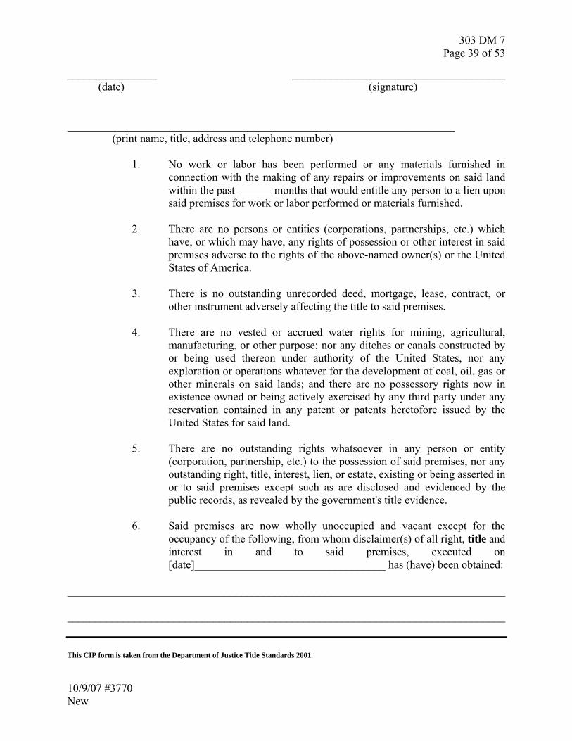
303 DM 7 Page 39 of 53
________________ ______________________________________ (date) (signature) _____________________________________________________________________ (print name, title, address and telephone number)
1. No work or labor has been performed or any materials furnished in connection with the making of any repairs or improvements on said land within the past ______ months that would entitle any person to a lien upon said premises for work or labor performed or materials furnished.
2. There are no persons or entities (corporations, partnerships, etc.) which
have, or which may have, any rights of possession or other interest in said premises adverse to the rights of the above-named owner(s) or the United States of America.
3. There is no outstanding unrecorded deed, mortgage, lease, contract, or
other instrument adversely affecting the title to said premises.
4. There are no vested or accrued water rights for mining, agricultural, manufacturing, or other purpose; nor any ditches or canals constructed by or being used thereon under authority of the United States, nor any exploration or operations whatever for the development of coal, oil, gas or other minerals on said lands; and there are no possessory rights now in existence owned or being actively exercised by any third party under any reservation contained in any patent or patents heretofore issued by the United States for said land.
5. There are no outstanding rights whatsoever in any person or entity
(corporation, partnership, etc.) to the possession of said premises, nor any outstanding right, title, interest, lien, or estate, existing or being asserted in or to said premises except such as are disclosed and evidenced by the public records, as revealed by the government's title evidence.
6. Said premises are now wholly unoccupied and vacant except for the
occupancy of the following, from whom disclaimer(s) of all right, title and interest in and to said premises, executed on [date]__________________________________ has (have) been obtained:
______________________________________________________________________________ ______________________________________________________________________________ This CIP form is taken from the Department of Justice Title Standards 2001.
10/9/07 #3770 New

303 DM 7 Page 40 of 53
DISCLAIMER
Reservation/Tribe(s) ______________________ County/Borough/Parish ____________________ ss: State of __________________________ We (I) ______________________________ being first duly sworn, depose and say (deposes and says) that we are (I am) occupying all (a part) of the land (proposed to be) (conveyed/managed] by the United States of America from __________________, described as ____________ acres, Tract No. _______________, lying in ____________________ County/Borough/Parish, State of __________________________; that we are (I am) occupying said land as the tenants (tenant) of _______________________; that we (I) claim no right, title, lien or interest in and to the above-described premises or any part thereof by reason of said tenancy or otherwise and that we (I) will vacate said premises upon demand for the possession of said lands by the United States of America. Dated this _______ day of ____________, ________.
(month) (Year) _________________________________
(Tenant) _________________________________
(Tenant) Witnesses: _________________________________ _________________________________
10/9/07 #3770 New
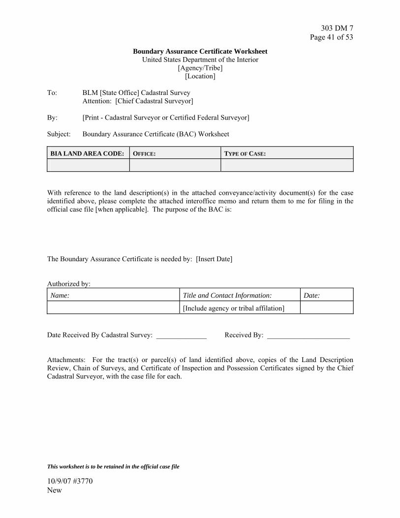
303 DM 7 Page 41 of 53
Boundary Assurance Certificate Worksheet United States Department of the Interior
[Agency/Tribe] [Location]
To: BLM [State Office] Cadastral Survey Attention: [Chief Cadastral Surveyor] By: [Print - Cadastral Surveyor or Certified Federal Surveyor] Subject: Boundary Assurance Certificate (BAC) Worksheet
BIA LAND AREA CODE: OFFICE: TYPE OF CASE:
With reference to the land description(s) in the attached conveyance/activity document(s) for the case identified above, please complete the attached interoffice memo and return them to me for filing in the official case file [when applicable]. The purpose of the BAC is: The Boundary Assurance Certificate is needed by: [Insert Date] Authorized by: Name: Title and Contact Information: Date:
[Include agency or tribal affilation] Date Received By Cadastral Survey: ______________ Received By: _______________________ Attachments: For the tract(s) or parcel(s) of land identified above, copies of the Land Description Review, Chain of Surveys, and Certificate of Inspection and Possession Certificates signed by the Chief Cadastral Surveyor, with the case file for each. This worksheet is to be retained in the official case file
10/9/07 #3770 New

303 DM 7 Page 42 of 53
UNITED STATES OF AMERICA BOUNDARY ASSURANCE CERTIFICATE
Boundary Assurance Certificate No. ______________________ To: From: Subject: Certification: Subject to the exceptions, conditions and stipulations, listed in Schedule B, I, ________________[Print Name]____________________, BLM Cadastral Surveyor/Certified Federal Surveyor, certify that critical records have been examined and boundaries have been inspected, and as of the Date of Boundary Assurance shown in Schedule A, assure that the United States of America will not sustain or incur a loss or damage, based upon the current/intended use of the land or interest in land shown in Schedule A, by reason of:
1. Land Description Review;
2. Chain of Surveys; and
3. Certification of Inspection and Possession. ___________________________________ __________________ Cadastral Surveyor or Certified Federal Surveyor Date Certification: This Boundary Assurance Certificate correctly represents the records and documents compiled under my direction and control and in conformance with the requirements of the Department of the Interior Standards for Indian Trust Lands Boundary Evidence, of the tract(s) or parcel(s) of land identified above. ___________________________________ __________________ Chief Cadastral Surveyor Date [ ] State Office
10/9/07 #3770 New
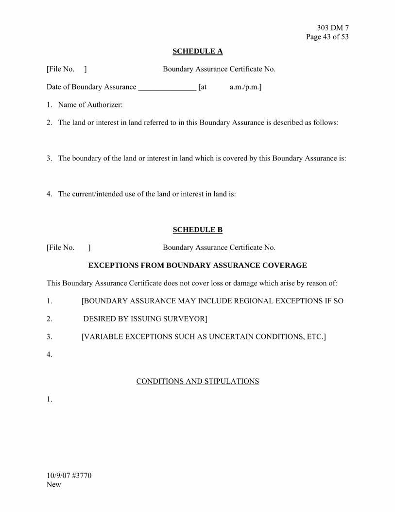
303 DM 7 Page 43 of 53
SCHEDULE A [File No. ] Boundary Assurance Certificate No. Date of Boundary Assurance _______________ [at a.m./p.m.] 1. Name of Authorizer:
2. The land or interest in land referred to in this Boundary Assurance is described as follows:
3. The boundary of the land or interest in land which is covered by this Boundary Assurance is:
4. The current/intended use of the land or interest in land is:
SCHEDULE B [File No. ] Boundary Assurance Certificate No. EXCEPTIONS FROM BOUNDARY ASSURANCE COVERAGE This Boundary Assurance Certificate does not cover loss or damage which arise by reason of: 1. [BOUNDARY ASSURANCE MAY INCLUDE REGIONAL EXCEPTIONS IF SO 2. DESIRED BY ISSUING SURVEYOR] 3. [VARIABLE EXCEPTIONS SUCH AS UNCERTAIN CONDITIONS, ETC.] 4. CONDITIONS AND STIPULATIONS 1.
10/9/07 #3770 New

303 DM 7 Page 44 of 53
5. LIST OF DEFINITIONS AND USAGE OF TERMS: The following definitions and terms are specific to the Department of the Interior Standards for Indian Trust Lands Boundary Evidence: A Cadastral Business Practice Standard. Administrative Survey A local survey executed by a Federal employee or an agent of a Federal agency. See Local Survey. Ambiguity Indistinct or uncertain meaning of information presented in a written instrument, including a survey plat, or extrinsic to a written instrument. See Latent Ambiguity and Patent Ambiguity. American Land Title Association/American Congress on Surveying and Mapping Land Title Survey (ALTA/ACSM Land Title Survey) A local survey usually a state authority survey. See Local Survey, Department of Justice Title Standards and State Authority Survey. Assurance A declaration tending to inspire added confidence; not a warranty. Boundary 1. Every natural and/or artificial demarcation of the bounds or territorial extent of an Indian trust asset. 2. Limits or marks of enclosures if possession is not based upon written title, or the boundaries or limits stated in title deed if possession is pursuant to a written title. Boundary Assurance 1. Identification of any defects, ambiguities, unwritten rights, conflicts, gaps, overlaps, possession, and failure of legal descriptions, surveys, and other boundary evidence for a tract of land, subject to stated exceptions and caveats. 2. An assurance on potential loss or damage resulting from heretofore unknown or hidden defects or failure of boundary or land description to a particular parcel of realty, or from the enforcement of unwritten rights existing against it. See Boundary Assurance Certificate. Boundary Assurance Certificate (BAC) 1. Official written representation by a BLM Cadastral Surveyor or a Certified Federal Surveyor of defects, ambiguities, unwritten rights, conflicts, gaps, overlaps, possessions, and failure of land descriptions and other boundary evidence for a tract of land at the time of the boundary assurance. 2. An assurance of the validity of the land description and boundary location, subject to stated exceptions and caveats. See Boundary Assurance. Boundary Description See Land Description. Boundary Evidence 1. Authenticated documentation (derived from congressional authorization, treaties, executive orders, etc.) used to describe a natural or artificial/political separation that delineates and
10/9/07 #3770 New

303 DM 7 Page 45 of 53
identifies a tract of land sufficient to ascertain the actual location of the land on the ground. 2. A deed or other document describing the boundary to property, or a survey or other document locating the boundary to property, or an action or behavior upon the land determining the boundary to property. 3. Boundary evidence is typically presented through a LDR, COS, or CIP. See Boundary and Evidence. Boundary Examination Examination and evaluation by a qualified surveyor or boundary location expert of the completeness and accuracy of boundary location documents affecting a particular tract of Indian land with certification of the findings. Boundary Location 1. The designation of the boundaries of a tract of land, either in documentation or on the land itself. 2. The finding and marking out the bounds of a particular tract of land, upon the land itself, in conformity to a certain description contained in an entry, grant, map, etc. See Boundary. Boundary Opinion A statement of the sufficiency of the boundary to land for the purposes for which the property is being conveyed or managed. See Boundary. Cadastral Survey See Official Survey. Cadastral Surveyor Unless qualified, means an OPM 1373 series land surveyor, employed by the BLM, with the authorization to perform surveys of boundaries of federal interest lands, nonfederal interest lands and Indian interest lands, under the direction and control of a State Office Chief Cadastral Surveyor. Certificate A written assurance or official representation that some act or event has or has not occurred, or of compliance with some legal formality. Certificate of Inspection and Possession (CIP) 1. A form of boundary evidence. 2. The official written opinion of a Cadastral Surveyor or a Certified Federal Surveyor that the boundary and corners are conflict free, in conformance with the land description, and complete and accurate (or otherwise, as stated). See Department of Justice Title Standards. Certified Federal Surveyor (CFedS) A state licensed land surveyor who has successfully completed the certification process established by the BLM Cadastral Survey Program and is in good standing. Tribal and agency surveyors will be encouraged to become state licensed land surveyors and federally certified. CFedS will perform a wide range of cadastral services within the state(s) he or she is licensed to practice land surveying. Certain services will be under the direction and control of the
10/9/07 #3770 New

303 DM 7 Page 46 of 53
appropriate Chief Cadastral Surveyor. They will provide more highly trained personnel for accomplishing cadastral services for Indian trust assets and restricted fee lands management and transactions. Certified Title Status Report A report, certified by a BIA Land Titles and Records Office, issued after a title examination which shows the proper legal description of a tract of Indian land; current ownership, including any applicable conditions, exceptions, restrictions or encumbrances on record; and whether the land is in unrestricted, restricted, trust, or other status. See Title Certificate, Title Insurance and Title Insurance Policy. Chain of Surveys (COS) 1. A form of boundary evidence. 2. Successive surveys, or other forms of boundary or corner information/opinion, affecting a particular parcel of land, arranged consecutively, from the government or original survey down to the latest survey or other record. See Chain of Surveys Certificate, Local Survey, Official Survey and Survey. Chain of Surveys Certificate 1. The official written opinion of a Cadastral Surveyor or a Certified Federal Surveyor that the COS is complete and accurate (or otherwise, as stated). 2. An assurance that the survey records for a particular boundary are consistent and free of error, subject to stated exceptions and caveats. See Chain of Surveys. Chain of Title Successive conveyances, or other forms of alienation, affecting a particular parcel of land, arranged consecutively, from the government or original source of title down to the present holder. See Department of Justice Title Standards. Chief Cadastral Surveyor, BLM State Office The BLM state office officials with the delegated authority to approve surveys, resurveys, and protraction diagrams of the lands within their administrative jurisdiction. As used in the Standards, Chief Cadastral Surveyor, unless qualified, means the appropriate BLM State Office Chief Cadastral Surveyor. Chief Cadastral Surveyor, BLM Washington Office The BLM Washington Office Cadastral Survey Program lead official, responsible for providing direction and control, technical guidance and assistance for Indian trust asset boundary issues. Clear Title Clear title, merchantable title and marketable title are synonymous, meaning that the land is free from title defects and encumbrances. See Department of Justice Title Standards. Convey To transfer a right or property; including, but not limited to, acquired, converted, divided, exchanged, partitioned, reconveyed, sold, or transferred.
10/9/07 #3770 New
303 DM 7 Page 47 of 53
Department of Justice Standards for the Preparation of Title Evidence in Land Acquisitions by the United States 2001 (DOJ Title Standards) The mandatory guide for the preparation of evidence of title, used in connection with all acquisitions of land or interests in land by the Federal Government, whether by purchase, donation, exchange, condemnation or in settlement of litigation. Note, these Title Standards also provide guidance for title disposal transactions. Evidence 1. Any medium of proof that furnishes or tends to furnish proof of a fact. In a court of law, the location of a land boundary constitutes an issue of fact. 2. Any type of proof, or probative matter, legally presented and admissible in a court of law through the medium of witnesses, documents, data or tangible things, for the purpose of inducing belief in the minds of the court or jury as to their contention. Evidence of Boundary See Boundary Evidence. Evidence of Title See Title Evidence. Exchange A land exchange is a real estate transaction where the disposal and acquisition of separate parcels of land are combined in the same transaction, some times referred to as a “trade.” Federal Authority Survey See Official Survey. Field Investigation (Boundary Inspection and Possession) 1. The physical examination, inspection and inquiry of the boundaries and corners, and of occupants of a tract of land by a BLM Cadastral Surveyor, or Certified Federal Surveyor. 2. An on the ground comparison of the land description of the boundaries and corners with the actual physical condition of the boundaries and corners, and occupation, of a tract of land. 3. A written report and opinion, typically expressed on the DOJ CIP form, if appropriate. See Certificate of Inspection and Possession. Good Title Title in land that is not subject to litigation and free from litigation, palpable defects, comprising both legal and equitable titles. See Department of Justice Title Standards. Indian Land Indian land means land in trust status or restricted status, or Federal Government owned land that is under the jurisdiction of the Bureau of Indian Affairs. 25 CFR 150.2(h). See Restricted Land and Trust Land.
10/9/07 #3770 New

303 DM 7 Page 48 of 53
Indian Trust Asset Means land or a natural resource held by the Federal Government in trust, or that is restricted against alienation, for Indian tribes, individual Indians, or individual Alaska Natives. Interest An interest in land is an estate, right, title, claim, or legal share that includes the advantages accruing from land ownership. Land Description That part of the conveyance document of land or interest in land, which identifies the land or interest to be affected. See Land Description Review. Land Description Review (LDR) 1. A form of boundary evidence. 2. To examine the land descriptions of a conveyance, acquisition, conversion, transfer, or partition of land or interest in land. 3. Examination of the land descriptions, including all exceptions, exclusions, reservations, subject to, and reversions, back to patent if necessary, of the subject tract and all surrounding tracts for the purpose of identifying patent ambiguities and actual or potential boundary conflicts. See Land Description and Land Description Review Certificate. Land Description Review Certificate 1. The official written opinion of a BLM Cadastral Surveyor, a Certified Federal Surveyor, or a Pre-approved Agency or Tribal Official or Agent that the land description is complete and accurate (or otherwise, as stated). 2. An assurance that the land description is free from patent ambiguities and other void or voidable conditions, subject to stated exceptions and caveats. See Land Description Review. Land Survey See Survey. Latent Ambiguity Hidden; concealed; dormant; that does not appear upon the face of a thing. In real property boundary law a latent ambiguity is where the legal description language employed is clear and intelligible and suggests but a single meaning, but some extrinsic fact or extraneous evidence creates a necessity for interpretation or a choice among two or more possible meanings, as where a description apparently plain and unambiguous is shown to fit different pieces of property, or fit the property in two or more locations or configurations. See Ambiguity and Patent Ambiguity. Legal Description See Land Description Local Survey An opinion on the location of a Federal, including trust, or restricted interest boundary, based on an executed land survey that does not contain every element of an official survey. Local surveys may include (not an exclusive list); Administrative Surveys, ALTA/ACSM land title surveys,
10/9/07 #3770 New

303 DM 7 Page 49 of 53
state authority surveys. See Administrative Survey, ALTA/ACSM Land Title Survey, Official Survey, State Authority Survey and Survey. Marketable Title See Clear Title. Merchantable Title See Clear Title. Non-registrant An individual who is practicing land surveying in a state without a survey license issued by that state. Office Investigation 1. The examination, inspection and inquiry of the documents describing the boundaries and corners of a tract of land by a Cadastral Surveyor, or Certified Federal Surveyor, without physically visiting the tract. 2. A written report and opinion, typically expressed on the LDR and/or COS certificate, if appropriate. See Chain of Surveys and Land Description Review. Official Survey 1. The highest form of boundary evidence available to the Federal Government and trust beneficiaries; proof of the geographic limits of the Federal interest. 2. A formal decision by the Federal Government, subject to administrative or judicial appeal, as to the physical limit of the Federal land or interest in land. 3. Creates, or reestablishes, marks, and defines boundaries of tracts of land. In the general plan, of disposing of the public domain and making all needful rules and regulations in respect thereto, this is a survey under the direction and control of the State Office Chief Cadastral Surveyor, and includes the elements of; a request for survey, special instructions, assignment instructions, field note record of the observations, measurements, monuments, and descriptive of the work performed, a plat that represents the official survey, all subject to review and approval of the Director, Bureau of Land Management, and officially filed in the official records of the United States. See 43 U.S.C. § 2 and 25 U.S.C. § 176. 4. The sole type of land survey to be used for the land description portion of a patent. See Local Survey. Opinion of Boundary See Boundary Opinion. Patent Ambiguity On the surface; that appears upon the face of a thing. In real property boundary law a patent ambiguity is where the legal description language employed is unclear and unintelligible and suggests more than a single meaning; creates a necessity for some extrinsic fact or extraneous evidence for an interpretation or a choice among two or more possible meanings; a description not plain and ambiguous so that it will fit different pieces of property, or fit the property in two or more locations or configurations. See Ambiguity and Latent Ambiguity.
10/9/07 #3770 New

303 DM 7 Page 50 of 53
Practice Repeated or customary action; habitual performance; a succession of acts of similar kind; habit; custom; usage; application of science to the wants of men; the exercise of any profession. Pre-approved Agency or Tribal Official or Agent (PATOA) An agency or tribal official or agent who has successfully completed the certification process established by the BLM Cadastral Survey Program. PATOA will perform land description reviews. They will provide more trained personnel for accomplishing land description reviews in order to streamline Indian trust asset management and transactions. Restricted Land Land held by an individual Indian, individual Alaska Native, tribe, or pueblo which can only be alienated or encumbered by the owner with the approval of the Secretary of the Interior because of limitations contained in the conveyance instrument pursuant to Federal law or because of a Federal law directly imposing such limitations, and is subject to tribal governance and managed by the United States pursuant to and in accordance with Federal statutes and legislation. See Indian Land and Trust Land. State Authority Survey A local survey executed within a state by a land surveyor registered to practice land surveying in that state that conforms to the laws and regulations, at the date of the survey, governing boundary surveys in that state. See Local Survey. State Office Chief Cadastral Surveyor See Chief Cadastral Surveyor, State Office. Standard A type, model, or combination of elements accepted as correct or perfect. Stability, general recognition, and conformity to established practice. Sufficient Title When the title to the land or interest in land to be purchased is sufficient for the purposes for which the Federal Government is acquiring the property. The statutory standard required before public money may be expended to purchase land or any interest in land, unless the Attorney General gives prior written approval. 40 U.S.C. § 3111(a). See Department of Justice Title Standards. Survey 1. The process by which a parcel of land (described by a land description) is measured, its location on the face of the earth determined, and its relationship to surrounding parcels of land (also described by land descriptions) ascertained; also a statement of the result of such survey, with a narrative of process and evaluation of the evidence, including descriptions of corners and monuments, use and occupancy, courses and distances, spatial conflicts, and the quantity of land. 2. The art of measuring and locating lines, angles, and elevations on the surface of the earth, within underground workings, and on the beds of bodies of water. 3. Of land, the procedure by
10/9/07 #3770 New
303 DM 7 Page 51 of 53
which to ascertain corners, boundaries, divisions, with distances and directions, and areas included within defined boundaries. See Chain of Surveys, Local Survey and Official Survey. Title In real property law it is the means whereby the owner of lands has the just possession of his/her property. The union of all the elements which constitute ownership. Title means the vested right or evidence of the vested right of ownership of property. 25 CFR 150.2(s) (Proposed reg.) See Department of Justice Title Standards. Title Abstract A condensed history of the title to land, consisting of a synopsis or summary of the material or operative portion of all the conveyances, of whatever kind or nature, which in any manner affect said land, or any estate or interest therein, together with a statement of all liens, charges, or liabilities to which the same may be subject, and of which it is in any way material for purchasers to be apprised. See Title. Title Certificate The formally expressed professional opinion of a title insurance company’s examiner that the title is complete and perfect (or otherwise, as stated), and the company is liable only for a want of care, skill, or diligence on the part of its examiner. See Certified Title Status Report and Title. Title Evidence A deed or other document establishing the title to property. See Department of Justice Title Standards, Evidence and Title. Title Examination An examination and evaluation by a qualified title examiner of the completeness and accuracy of title documents affecting a particular tract of Indian land with certification of the findings. See Certified Title Status Report. Title Insurance 1. Insurance against loss or damage resulting from defects or failure of title to a particular parcel of realty, or from the enforcement of liens existing against it at the time of the insurance. 2. This form of insurance is taken out by a purchaser of the property or one loaning money secured by a mortgage, and is furnished by companies specially organized for the purpose, and which keep complete sets of abstracts or duplicates or records, employ expert title-examiners, and prepare conveyances and transfers of all sorts. 3. Warrants the validity of the title in any and all events, subject to standard exceptions. See Certified Title Status Report, Title and Title Insurance Policy. Title Insurance Policy An insurance policy issued by a title insurance company against loss or damage resulting from defects or failure of title to a particular parcel of realty, or from the enforcement of liens existing against it at the time of the insurance. The maximum limit of liability is fixed by the policy. The liability does not extend to exclusions and exceptions from coverage. See Certified Title Status Report, Title and Title Insurance.
10/9/07 #3770 New

303 DM 7 Page 52 of 53
Title Insurance Policy Exceptions An exclusion of one or more risks; from the coverage of a title insurance policy. Two exceptions commonly included in title policies (but coverage can be purchased for both) are exceptions to “parties in possession” (no protection from unrecorded right-of-ways or vested unwritten (adverse possession) rights), and “matters which would be revealed by a survey” (typically a latent defect in a boundary location or an erroneous assumption of a boundary location). See Title Insurance Policy. Title Opinion A statement, customarily prepared by an attorney-at-law for a client, as to the sufficiency of the title to land for the purposes for which the property is being conveyed or managed. See Certified Title Status Report, Title, Title Certificate and Title Insurance Policy. Title Status Report See Certified Title Status Report. Trust Land Land to which the title is held in trust by the United States for an individual Indian, individual Alaska Native, tribe, or pueblo. See Indian Land and Restricted Land.
10/9/07 #3770 New

303 DM 7 Page 53 of 53
10/9/07 #3770 New
6. LIST OF ACRONYMS: List of Acronyms used in the Department of the Interior Standards for Indian Trust Lands Boundary Evidence: A Cadastral Business Practice Standard. ACSM – American Congress on Surveying and Mapping ALTA – American Land Title Association BAC – Boundary Assurance Certificate BIA – Bureau of Indian Affairs BLM – Bureau of Land Management CGIS ─ Cadastral Geographic Information System CFedS ─ Certified Federal Surveyor CFR – Code of Federal Regulations CIP – Certification of Inspection and Possession COS – Chain of Survey DOI – Department of the Interior DOJ – Department of Justice GCDB ─ Geographic Coordinate Data Base LRIS – Land Records and Information System LDR – Land Description Review LTM – Land Title Mapper LTRO – Land Title and Records Office OPM – Office of Personnel Management PATOA – Pre-approved Agency or Tribal Official or Agent TAAMS – Trust Asset and Accounting Management System U.S. – United States U.S.C. – United States Code