department of transportation - fmcsa.dot.gov · background and response to comments ... hazmat...
TRANSCRIPT

Vol. 80 Wednesday,
No. 82 April 29, 2015
Part II
Department of Transportation Federal Motor Carrier Safety Administration National Hazardous Materials Route Registry; Notice
VerDate Sep<11>2014 17:52 Apr 28, 2015 Jkt 235001 PO 00000 Frm 00001 Fmt 4717 Sfmt 4717 E:\FR\FM\29APN2.SGM 29APN2mst
ocks
till o
n D
SK
4VP
TV
N1P
RO
D w
ith N
OT
ICE
S2

23860 Federal Register / Vol. 80, No. 82 / Wednesday, April 29, 2015 / Notices
1 49 CFR 1.87(d)(2). 2 49 CFR 397.65 defines NRHM as, ‘‘A non-
radioactive hazardous material transported by motor vehicle in types and quantities which require placarding, pursuant to Table 1 or 2 of 49 CFR 172.504.’’
DEPARTMENT OF TRANSPORTATION
Federal Motor Carrier Safety Administration
[Docket No. FMCSA–2014–0022]
National Hazardous Materials Route Registry
AGENCY: Federal Motor Carrier Safety Administration (FMCSA), Department of Transportation (DOT). ACTION: Notice; current listing of designated and restricted routes for hazardous materials
SUMMARY: This notice provides the current National Hazardous Materials Route Registry (NHMRR), which is a listing, as reported by State and Tribal Government routing officials, of all designated and restricted road and highway routes for transportation of highway route controlled quantities (HRCQ) of Class 7 (radioactive) materials (RAM) (HRCQ/RAM) and non- radioactive hazardous materials (NRHMs) transportation. The listing in this notice supersedes the NHMRR published on July 14, 2014, and includes current route limitations and allowances, and information on State and Tribal Government routing agency contacts reported to FMCSA as of March 30, 2015. The notice also responds to comments received on the Agency’s Notice and request for comment on this subject published on July 14, 2014. DATES: Effective Date: April 29, 2015. FOR FURTHER INFORMATION CONTACT: Ms. Roxane Oliver, (202) 366–0735, or [email protected], Hazardous Materials Division, Office of Enforcement and Compliance, Federal Motor Carrier Safety Administration, 1200 New Jersey Ave. SE., Washington, DC 20590. Office hours are from 9 a.m. to 5 p.m., E.T., Monday through Friday, except for Federal holidays. SUPPLEMENTARY INFORMATION:
Table of Contents I. Electronic Access to the National
Hazardous Materials Route Registry II. Legal Basis for This Action III. Background and Response to Comments IV. About the Tables in the National
Hazardous Materials Route Registry V. Route Ordering Approach VI. National Hazardous Materials Route
Registry
I. Electronic Access to the National Hazardous Materials Route Registry
To find the most up-to-date listing of hazmat routes, you may access the NHMRR directly at: http://www.fmcsa.dot.gov/regulations/hazardous-materials/national- hazardous-materials-route-registry. This
site is the source of information in this notice and displays Hazardous Materials (HM) route listings that reflect any changes made after the publication date of this notice.
II. Legal Basis for This Action Section 5112 of 49 U.S.C. paragraphs
(a)(2) and (b) permit States and Tribal Governments to designate and limit highway routes over which HM may be transported provided the State or Tribal Government complies with standards prescribed by the Secretary of Transportation (the Secretary) and meets publication requirements in section 5112(c). To establish standards under paragraph (b), the Secretary must consult with the States, and, under section 5112(c), coordinate with the States to publish periodically a list of currently effective HM highway routing designations and restrictions. Subpart C of 49 CFR part 397 sets out the procedural requirements States and Tribal Governments must follow to establish, maintain, or enforce routing designations for the transport of placardable quantities of NRHM. In Subpart D, § 397.103 sets out the requirements for designating preferred routes for HRCQ/RAM shipments as an alternative to, or in addition to Interstate System highways. For HRCQ/RAM shipments, a preferred route is defined as an Interstate Highway for which no alternative route is designated by the State; a route specifically designated by the State; or both. See § 397.103(b). For the definition of NHRM routes, see § 397.65 ‘‘routing designations.’’
Under a delegation from the Secretary,1 FMCSA has authority to implement 49 U.S.C. 5112 and 5125(c). Currently, 49 CFR 397.73 establishes public information and reporting requirements for NRHM,2 by States or Tribal Governments who are required to furnish information regarding any new or changed routes to FMCSA within 60 days after establishment. Under 49 CFR 397.103, a State routing designation for HRCQ/RAM routes (preferred routes) as an alternative to, or in addition to an Interstate System highway is effective when the authorized routing agency provides FMCSA with written notification, FMCSA acknowledges receipt in writing, and the route is published in FMCSA’s National Hazardous Material Route Registry. FMCSA’s regulations in 49 CFR part 397 also include other standards and
procedures that States and Tribal Governments must follow to establish, maintain, and enforce designations specifying road and highway routes within their jurisdictions over which HRCQ/RAM and NRHM may or may not be transported, and to impose limitations or requirements for transporting these materials over applicable roads and highways. The Office of Management and Budget (OMB) has approved these collections of information under control number 2126–0014, Transportation of Hazardous Materials, Highway Routing.
III. Background and Response to Comments
In 49 CFR part 172, the Pipeline and Hazardous Materials Safety Administration (PHMSA) publishes a list of proper shipping names with corresponding identification numbers for HM that must be used when offering for transportation, or transporting any chemical or product that is a HM, hazardous substance or hazardous waste, as defined in 49 CFR 171.8. PHMSA lists HM in nine Classes, based on the type of substance and hazard, and determines the quantities that require a placard on the vehicle (e.g., truck, railroad car) transporting the substance so that emergency responders can identify the hazard at a distance.
State and Tribal Governments may designate routes for transporting these HM. The States and Tribal Governments may also establish limitations for the use of routes under section 5112 by using the required procedures specified in 49 CFR part 397. Carriers must develop written route plans for transporting HRCQ/RAM, and adhere to the written route plan [§§ 397.71 and 397.101(d)].
The NHMRR provides publicly accessible information concerning designated routes, which are mandatory assigned routes for transporting HM shipments and restricted routes over which such shipments may not be transported. FMCSA last published the NHMRR on July 14, 2014 (79 FR 40844). That listing reflected the Agency’s validation through publicly available information of route designations and limitations, using as the starting point a 2008 spreadsheet developed to address requirements of the Implementing Recommendations of the 9/11 Commission Act of 2007. While validating HM route entries, FMCSA identified other information that could either enhance the NHMRR or correct identified issues. (For detailed information, see the July 2014 Federal Register document.) The July 2014 notice also sought comment on a new
VerDate Sep<11>2014 17:52 Apr 28, 2015 Jkt 235001 PO 00000 Frm 00002 Fmt 4701 Sfmt 4703 E:\FR\FM\29APN2.SGM 29APN2mst
ocks
till o
n D
SK
4VP
TV
N1P
RO
D w
ith N
OT
ICE
S2

23861 Federal Register / Vol. 80, No. 82 / Wednesday, April 29, 2015 / Notices
approach to ordering the routes and presenting the listings table.
Response to Comments The Agency received five comments
on the notice. Two industry organizations the American Trucking Associations (ATA) and the Institute of Makers of Explosives (IME) endorsed the new route order approach and content listing. ATA commended FMCSA for updating the routes with a ‘‘user-friendly planning tool.’’ However, ATA encouraged FMCSA to update the NHMRR process to implement the requirements of section 33013 of the Moving Forward for Progress in the 21st Century Act of 2012 (MAP–21) concerning establishing the form, manner, and timetable for State and Tribal Governments to issue and update HM route information. ATA asserted that until FMCSA updates the route registry process, States could not change HM routes and carrier operations could be affected adversely by conflicts between State and Federal officials over which routes to enforce.
IME expressed support for FMCSA’s revised ‘‘streamlined approach,’’ stating that the new ordering approach was easy to understand and access. IME asserted, however, that the Agency either should use ‘‘preemptive authority’’ to compel State and Tribal Governments to update incorrect HM route information, or remove the designations from the NHMRR. Two State Government commenters (Texas and Commonwealth of Virginia Department of Transportation) and one individual citizen offered corrections to contact information, street names, or jurisdictional boundaries.
Regarding ATA’s comments on updating the NHMRR process to conform to MAP–21, FMCSA published a Technical Amendments Rule that included provisions to address section 33013 of the statute. [79 FR 59450; October 2, 2014]. Among the amendments was a State reporting requirement to include the name of the agency responsible for HM highway route designations, and another to clarify that any State or Tribal- government-designated route is effective only after publication in the NHMRR. The NHMRR process now conforms to MAP–21.
FMCSA notes that in response to IME’s comment on preemption, the Agency does not have preemptive authority to update State routing information. The Agency will continue notifying States concerning their obligations to submit correct and updated HM routing information. However, the applicable statute requires
the Agency to update HM route listings in coordination with the States’ submissions. A citizen who believes there are errors in these listings, such as the individual who commented on this notice, should contact the State entity responsible for designating and maintaining that State’s listings.
The Agency has corrected the listing based on comments received from the State agencies with responsibility for HM route designations. The technical amendments referenced above should result in the maintenance of a current list of State and Tribal agencies and contacts that can provide current information on HM routes. Going forward, these entities can promote carrier and driver compliance by using the new ordering approach to provide clear route descriptions for each HM route. Specifically, State and Tribal entities should consider clearly defining each route, including start and endpoints (e.g., road intersections, mile marker numbers, geographic features, and boundary delineations). An example of clear start and endpoints might be for this Delaware route, ‘‘Interstate 495 from Interstate 95 [southwest of Wilmington, Delaware] to Interstate 95 [northeast of Wilmington, Delaware].’’ Entities also should consider providing county and city information for each route, which information is especially important for HM routes that cross jurisdictional boundaries (e.g., ‘‘North Prince of Wales Rd. from Big Salt Lake Rd. [Thorne Bay] north to the Labouchere Bay [Prince of Wales]’’ [AK]). Finally, HM route descriptions should include commonly used names for each road to avoid including duplicate descriptions in the NHMRR of the same route (e.g., ‘‘Loop 375/Americas Ave [El Paso] from Border Highway/Loop 375 to Interstate 10’’ [TX]).
IV. About the Tables in the National Hazardous Materials Route Registry
As stated above, the only comments FMCSA received on the new route ordering approach and table expressed support for these changes, and the NHMRR published today reflects the same route ordering approach and content presentation as the listing published July 14, 2014. Today’s listing also includes additions, changes, and corrections received from four State authorities (Colorado, Ohio, Texas, and Virginia). Any remaining Quality Assurance (QA) issues are noted in the ‘‘FMCSA QA Comment’’ column in the NHMMR tables for the applicable jurisdictions.
Note that the following 14 States have no designated or restricted HM routes in
the NHMRR: Connecticut, Hawaii, Kansas, Maine, Mississippi, Missouri, Nevada, New Hampshire, New Jersey, North Carolina, North Dakota, South Carolina, Vermont, and Wisconsin. Note, too, that the NHMRR does not include HM route designations and restrictions applicable to lands under the jurisdiction of Federal entities except for National Park Service (NPS) lands in Montana and South Dakota. The listing of HM routes on NPS lands is based on information readily available to FMCSA at the time of publication of this notice and may not be complete.
NPS regulations generally prohibit commercial motor vehicles and traffic in National Parks, including commercial shipments of HM (36 CFR 5.6). However, a park Superintendent may allow commercial motor vehicles in a National Park subject to permits issued by the Superintendent, and according to terms and conditions set in those permits. In the case of an HM shipment, if the Superintendent designates a route for HM shipments, the operator of the motor vehicle must apply for the permit under 36 CFR 1.6. The Superintendent will apply criteria in that provision to make a determination whether such a shipment is permissible, identify routes, and set other terms and conditions. Subject to obtaining the proper permit, current NPS regulations provide conditions for HM shipments along specified routes in Yellowstone (36 CFR 7.13) and Badlands (36 CFR 7.23) National Parks. NPS regulations expressly state the operator’s obligation to comply with any State or Federal laws and regulations applicable to transportation of HM, including 49 CFR subtitle B (i.e., parts 100 to 1699). HM motor carriers and drivers should consult the Federal authorities with jurisdiction over Federal lands and activities on those lands for route information.
The NHMRR presents HM route information in up to three tables per State. The three table possibilities are: (1) ‘‘Restricted Routes’’ (prohibited routes for specified classes of HM shipments), (2) ‘‘Designated HRCQ/RAM Routes’’ (permissible routes tor transporting HRCQ quantities of Class 7 [radioactive] HM shipments), and (3) ‘‘Designated NRHM Routes’’ (permissible routes for transporting specified classes of non-radioactive HM shipments). To help users and stakeholders interested in HM transportation operations understand the route ordering approach and table presentation, FMCSA is repeating the description of the NHMRR elements in
VerDate Sep<11>2014 17:52 Apr 28, 2015 Jkt 235001 PO 00000 Frm 00003 Fmt 4701 Sfmt 4703 E:\FR\FM\29APN2.SGM 29APN2mst
ocks
till o
n D
SK
4VP
TV
N1P
RO
D w
ith N
OT
ICE
S2

23862 Federal Register / Vol. 80, No. 82 / Wednesday, April 29, 2015 / Notices
3 49 CFR 397.101(b)(1) defines ‘‘preferred route’’ as, ‘‘an Interstate System highway for which an
alternative route is not designated by a State routing agency; a State-designated route selected by a State routing agency pursuant to § 397.103; or both.’’
today’s notice that was provided in the July 14, 2014, notice.
V. Route Ordering Approach
Each listing in the NHMRR includes codes to identify each route designation and each route restriction reported by
the State. Designation codes identify the routes along which a driver can or must transport specified HM. Among the designation codes is one for ‘‘preferred routes,’’ which is defined in § 397.101(b)(1) 3 and applies to transporting ‘‘a highway route
controlled quantity of Class 7 (radioactive) materials.’’ Restriction codes identify the routes along which a driver cannot transport specified HM shipments. Table 1 presents information on each restriction and designation code.
TABLE 1—RESTRICTION/DESIGNATION KEY
Restrictions Designations
0—ALL Hazardous Materials ............................................................................................................... A—ALL NRHM Hazardous Materials. 1—Class 1—Explosives ...................................................................................................................... B—Class 1—Explosives. 2—Class 2—Gas ................................................................................................................................. I—Poisonous Inhalation Hazard (PIH). 3—Class 3—Flammable ...................................................................................................................... P—*Preferred Route* Class 7—Radioactive. 4—Class 4—Flammable Solid/Combustible.5—Class 5—Organic.6—Class 6—Poison.7—Class 7—Radioactive.8—Class 8—Corrosives.9—Class 9—Dangerous (Other).i—Poisonous Inhalation Hazard (PIH).
Each HM table is sorted by the ‘‘Route Order’’ column to help drivers navigate designated NRHM and HRCQ/RAM routes more easily and avoid restricted routes. At a minimum, each entry in the ‘‘Route Order’’ column, includes a capital letter and may contain a combination of capital letters, Arabic numbers, dashes, and decimals that present a ‘‘route order character’’ identifying the ordering relationship of each HM route in the table. The following table presents the alphanumeric key for understanding route order characters.
TABLE 2—ROUTE ORDER CHARACTER NAMING APPROACH
Order level
Alphanumeric identifier
Route order character example
1 ........ A, B, C . . . Z, AA, AB.
A
2 ........ 1, 2, 3 ................ A1 3 ........ A, B, C ............... A2A
TABLE 2—ROUTE ORDER CHARACTER NAMING APPROACH—Continued
Order level
Alphanumeric identifier
Route order character example
4 ........ 1.0, 2.0, 3.0 ....... A3A–1.0 5 ........ A, B, C ............... A4A–1.0–A 6 ........ 1, 2, 3 ................ A5A–1.0–A1 7 ........ A, B, C ............... A6A–1.0–A1A 8 ........ 1.0, 2.0, 3.0 ....... A7A–1.0–A1A–
1.0 9 ........ A, B, C ............... A8A–1.0–A1A–
1.0–A 10 ...... 1, 2, 3 ................ A9A–1.0–A1A–
1.0–A1
For the majority of states, the route order characters generally progress no further than the fourth order level. Alaska, California, Colorado, Illinois, Louisiana, Rhode Island, and Texas have route order characters beyond level four.
The route ordering approach is based on how distinct HM routes connect
(each HM route is a separate row in the HM table). An HM route is a single road segment that does not connect (i.e., does not share a terminus) with any other HM route. In this instance, the route order character will be a capital letter only. The route order character for HM routes begins at the first order level with a capital letter identifier (A, B, C, etc.) for each distinct HM route. If there are more than 26 distinct HM routes in a State (as with California and Texas), the first order level for the 27th HM route will begin with two capital letters and continue in alphabetical sequence for each new HM route (AA, AB, AC, etc.).
For each HM table for a State, the route order character lettering runs directionally from Southwest to Northeast. For example, if the first letter of a route order character is ‘‘A,’’ the route is the first HM route encountered beginning from the Southwest section and moving across the State. Figure 1 displays an example of this relationship.
VerDate Sep<11>2014 17:52 Apr 28, 2015 Jkt 235001 PO 00000 Frm 00004 Fmt 4701 Sfmt 4703 E:\FR\FM\29APN2.SGM 29APN2mst
ocks
till o
n D
SK
4VP
TV
N1P
RO
D w
ith N
OT
ICE
S2

23863 Federal Register / Vol. 80, No. 82 / Wednesday, April 29, 2015 / Notices
A ‘‘continuous route’’ is a sequence of distinct HM routes that connect at the termini. The individual HM routes will have the same first order level capital
letter, with a second order level number added for each new, connecting HM route. In a continuous route, the second order level number increases by one
from west to east for each connecting HM route (e.g., A1, A2, A3). Figure 2 displays an example of this relationship.
A ‘‘continuous route with junctions’’ is a sequence of distinct HM routes that connect and intersect or branch. A junction may either be an intersection where two HM routes cross; or a branch where a new HM route starts at the termini of the previous HM route or at a point along the HM route (see A2A or
A3A in Figure 3). For a continuous route with junctions, the route order character begins alphabetically with a first order level capital letter, a second order level number, and at each junction, a third order level alphabetical letter. When an HM route (e.g., A1, A2) junctions, each new HM route will have
a capital letter as the third element in the route order character and the second order level numeric character increases by one. In Figure 3, A1, A2, and A3 are continuous HM routes (i.e., connect at the termini) and A2A and A3A junction with HM routes A1 and A2 respectively.
If an HM route (e.g., A2A, A2B) junctions a second time, the sequence will include the fourth order level
which begins with a hyphen and number followed by a decimal point and a zero; the second order level
number increases by one. In Figure 4, the next junction from A2A is A3A–1.0.
VerDate Sep<11>2014 17:52 Apr 28, 2015 Jkt 235001 PO 00000 Frm 00005 Fmt 4701 Sfmt 4703 E:\FR\FM\29APN2.SGM 29APN2 EN
29A
P15
.001
</G
PH
>E
N29
AP
15.0
02<
/GP
H>
EN
29A
P15
.003
</G
PH
>
mst
ocks
till o
n D
SK
4VP
TV
N1P
RO
D w
ith N
OT
ICE
S2

23864 Federal Register / Vol. 80, No. 82 / Wednesday, April 29, 2015 / Notices
If a road segment (e.g., A3A–1.0) junctions a third time the fifth order level begins with a hyphen and an
alphabetical letter; the second order level number increases by one. In Figure
5, the next junction from HM route A3A–1.0 is A4A–1.0–A.
The pattern of increasing and alternating sequential numbers, letters, dashes, and decimals continues for each new junction from a road segment. For the three HM tables (Designated NRHM Routes, Designated HRCQ/RAM Routes, and Restricted HM Routes), the route ordering sequence begins anew, with the first HM route originating in the Southwest starting with the letter A.
Figures 6, 7 and 8 illustrate the ordering approach for a subset of Designated NRHM Routes in Lorain, Ohio, Columbus, Ohio, and Denver, Colorado. High-resolution images of Figures 6, 7, and 8 also will be available for review in the docket.
The regulatory process that States must follow for route designations and limitations is provided in 49 CFR part
397. FMCSA continues to seek comment from the States of Alaska and California, and the District of Columbia about the route quality assurance issues identified in the tables as ‘‘FMCSA QA Comment.’’
Issued on: April 21, 2015.
T.F. Scott Darling, III, Chief Counsel. BILLING CODE 4910–EX–P
VerDate Sep<11>2014 17:52 Apr 28, 2015 Jkt 235001 PO 00000 Frm 00006 Fmt 4701 Sfmt 4703 E:\FR\FM\29APN2.SGM 29APN2 EN
29A
P15
.004
</G
PH
>E
N29
AP
15.0
05<
/GP
H>
mst
ocks
till o
n D
SK
4VP
TV
N1P
RO
D w
ith N
OT
ICE
S2

23865 Federal Register / Vol. 80, No. 82 / Wednesday, April 29, 2015 / Notices
VerDate Sep<11>2014 17:52 Apr 28, 2015 Jkt 235001 PO 00000 Frm 00007 Fmt 4701 Sfmt 4725 E:\FR\FM\29APN2.SGM 29APN2 EN
29A
P15
.006
</G
PH
>
mst
ocks
till o
n D
SK
4VP
TV
N1P
RO
D w
ith N
OT
ICE
S2
Figure 6. - Select Designated NRHM Routes in Lorain, Ohio [See Table 85]
HM DESIGNATED ROUTE
UNOESIGNATED ROUTE

23866 Federal Register / Vol. 80, No. 82 / Wednesday, April 29, 2015 / Notices
VerDate Sep<11>2014 17:52 Apr 28, 2015 Jkt 235001 PO 00000 Frm 00008 Fmt 4701 Sfmt 4725 E:\FR\FM\29APN2.SGM 29APN2 EN
29A
P15
.007
</G
PH
>
mst
ocks
till o
n D
SK
4VP
TV
N1P
RO
D w
ith N
OT
ICE
S2
Figure 7.- Select Designated NRHM Routes in Columbus, Ohio [See Table 85]
HM DESIGNATED ROUTE
UNDESIGNATED ROUTE

23867 Federal Register / Vol. 80, No. 82 / Wednesday, April 29, 2015 / Notices
VerDate Sep<11>2014 17:52 Apr 28, 2015 Jkt 235001 PO 00000 Frm 00009 Fmt 4701 Sfmt 4725 E:\FR\FM\29APN2.SGM 29APN2 EN
29A
P15
.008
</G
PH
>
mst
ocks
till o
n D
SK
4VP
TV
N1P
RO
D w
ith N
OT
ICE
S2
Figure 8. - Select Designated NRHM Routes in Colorado [See Table 22]
Denver Area ..
HM DESIGNATED ROUTE
UN DESIGNATED ROUTE

23868 Federal Register / Vol. 80, No. 82 / Wednesday, April 29, 2015 / Notices
VI. National Hazardous Materials Route Registry
VerDate Sep<11>2014 17:52 Apr 28, 2015 Jkt 235001 PO 00000 Frm 00010 Fmt 4701 Sfmt 4725 E:\FR\FM\29APN2.SGM 29APN2 EN
29A
P15
.009
</G
PH
>
mst
ocks
till o
n D
SK
4VP
TV
N1P
RO
D w
ith N
OT
ICE
S2
State Agency: POC: Address:
Phone: Fax: Web Address:
Designation Date
Route Order
11/07/94 A
Desig-Route
nation Date
Order
08/26/96 A1
08/26/96 A2A
08/26/96 A2B
TABLE 3.- State: Alabama
ALDOT FMCSA: AL FMCSA Field Office Randy Braden FMCSAPOC: AL Motor Carrier Division Administrator 1409 Coliseum Blvd. 520 Cotton Gin Rd. Montgomery, AL 36130 Address: Montgomery, AL 36117
(334) 242-6474 Phone: (334) 209-4954 (334) 242-6378 Fax: (334) 290-4944 www.dot.state.al.us
TABLE 4.- ALABAMA- RESTRICTED HM ROUTES
Route Description City
Wallace Twin Tunnels [1-10 & US 90 in Mobile] Mobile [A signed detour is in place to direct traffic along Water St., US 43, and AltUS 90. Traffic will pass over the Mobile River using the Cochrane Bridge.]
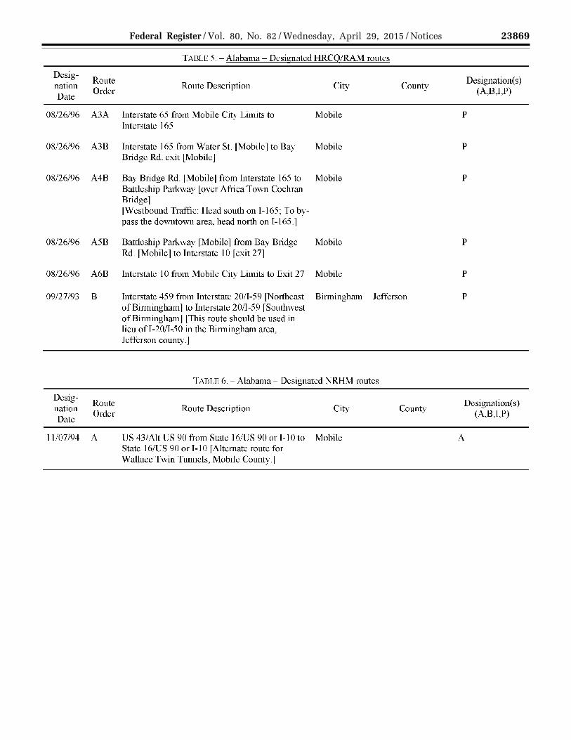
TABLE 5.- Alabama- Designated HRCQ/RAM routes
Route Description City
Interstate 10 from Mobile City Limits to Exit Mobile 26B [Water St] [Eastbound Traffic: To avoid the downtown area, exit on 1-65 North]
Interstate 65 from Interstate 10 to Interstate 165 Mobile [A route for trucks wishing to by-pass the downtown area.]
Water St. [Mobile] from Interstate lO [exit 26B] Mobile to Interstate 165
County
County
Restriction(s) (0,1,2,3,4,5,6,7,8,
9,i)
0
Designation(s) (A,B,I,P)
p
p
p
23869 Federal Register / Vol. 80, No. 82 / Wednesday, April 29, 2015 / Notices
VerDate Sep<11>2014 17:52 Apr 28, 2015 Jkt 235001 PO 00000 Frm 00011 Fmt 4701 Sfmt 4725 E:\FR\FM\29APN2.SGM 29APN2 EN
29A
P15
.010
</G
PH
>
mst
ocks
till o
n D
SK
4VP
TV
N1P
RO
D w
ith N
OT
ICE
S2
Desig-nation Date
08/26/96
OR/26/96
08/26/96
08/26/96
08/26/96
09/27/93
Designation Date
Route Order
A3A
A3B
A4B
A5B
A6B
B
Route Order
11107/94 A
TABLE 5.- Alabama- Designated HRCQ/RAM routes
Route Description City County
Interstate 65 from Mobile City Limits to Mobile Interstate 165
Interstate 165 from Water St. [Mobile] to Bay Mobile Bridge Rd. exit [Mobile]
Bay Bridge Rd. lMobilej from Interstate 165 to Mobile Battleship Parkway [over Africa Town Cochran Bridge] [Westbound Traffic: Head south on 1-165; To by-pass the downtown area, head north on 1-165.]
Battleship Parkway [Mobile] from Bay Bridge Mobile Rd. [Mobile] to Interstate I 0 [exit 27]
Interstate 10 from Mobile City Limits to Exit 27 Mobile
Interstate 459 from Interstate 20/1-59 [Northeast Birmingham Jefferson of Birmingham] to Interstate 20/1-59 [Southwest of Birmingham] [This route should be used in lieu ofl-20/1-50 in the Birmingham area, Jefferson county.]
TABLE 6.- Alabama- Designated NRHM routes
Route Description City
US 43/Alt US 90 from State 16/US 90 or 1-10 to Mobile State 16/US 90 or I -10 [Alternate route for Wallace Twin Tunnels, Mobile County.j
County
Designation(s) (A,B,I,P)
p
p
p
p
p
p
Designation(s) (A,B,I,P)
A

23870 Federal Register / Vol. 80, No. 82 / Wednesday, April 29, 2015 / Notices
VerDate Sep<11>2014 17:52 Apr 28, 2015 Jkt 235001 PO 00000 Frm 00012 Fmt 4701 Sfmt 4725 E:\FR\FM\29APN2.SGM 29APN2 EN
29A
P15
.011
</G
PH
>
mst
ocks
till o
n D
SK
4VP
TV
N1P
RO
D w
ith N
OT
ICE
S2
State Agency: POC: Address:
Phone: Fax: Web Address:
Desig-nation Date
11/0l/05 A1
11/0l/05 A2
11/0l/05 A3
11/01/05 A4
11/0 l/05 A4A
11/01/05 Bl
11/0l/05 B2
ll/0 l/05 B3A
11/0 l/05 B3 B
ll/0 l/05 B4A
TADLE 7.- State: Alaska
AKDOT FMC SA: AK FMCSA Field Office Sgt. Daniel Byrd Transportation & Public Facilities 12050 Industry Way
FMCSAPOC: Address:
AK Motor Carrier Division Administrator Frontier Building,
#0-6 MS-2540 Anchorage, AK 99515 (907) 365-1207 (907) 586- 8365 www.dot.state.ak.us
Phone: Fax:
Suite 260 3601 "C" Street Anchorage, AK 99503 (907) 271-4068 (907) 271-4069
TARLE 8.- Alaska- Designated NRHM routes
Route Designation(s) Order
Route Description City (A,B,I,P)
Pasagshak Rd. from Chiniak Kodiak A Highway south to end of road
Chiniak Highway from West Kodiak A RezanofDr. to Pasagshak Rd.
West Rezanof Dr. from Marine Kodiak A Way to Chiniak Highway
Marine Way from ocean to West Kodiak A RezanofDr.
Airport Terminal Rd. from Rezanof Kodiak A Dr. south to end of road
Kachcmak Bay Dr. from Sterling Homer A Highway/Homer Spit Rd. to East End Rd.
Sterling Highway from Seward Moose Pass and A Highway to Homer Spit Rd. Homer
K-Beach Rd. from Bridge Access Kenai A Rd. to Sterling Highway
Seward Highway from Anchorage and A Gambell/Ingra split to Railway Ave. Seward
Bridge Access Rd. from Kenai Spur Kenai A Highway to K-Beach Rd."
FMCSA QAComment

23871 Federal Register / Vol. 80, No. 82 / Wednesday, April 29, 2015 / Notices
VerDate Sep<11>2014 17:52 Apr 28, 2015 Jkt 235001 PO 00000 Frm 00013 Fmt 4701 Sfmt 4725 E:\FR\FM\29APN2.SGM 29APN2 EN
29A
P15
.012
</G
PH
>
mst
ocks
till o
n D
SK
4VP
TV
N1P
RO
D w
ith N
OT
ICE
S2
TAULU 8.- Alaska- Designated NRHM routes
Desig-Route Designation(s) FMCSA
nation Order
Route Description City (A,B,I,P) QAComment
Date
11/01/05 B4B Gambell St. from Third Ave. to Anchorage A Seward Highway
11/0 l/05 B4B Ingra St. from Third Ave. to Sevvard Anchorage A Highway
11/01/05 B4B-l.O Nash Rd. from Seward Highway to Seward A Morris Ave.
11/01/05 B4B-2.0 O'Malley Rd. from Minnesota Dr. Anchorage A to Seward Highway
11/0 l/05 BSA-1.0 Kenai Spur Highway from Beach Kenai A Bay Rd. along coast to Marathon Rd.
11/01/05 B5B-2.0 Minnesota Drive from Tudor Rd. to Anchorage A O'Malley Rd.
11/01/05 B5B-3.0 Third Ave. from the ocean to Reeve Anchorage A Blvd.
11/01/05 B6A-l.O-A Nikishka Beach Rd. from Dock Kenai A Gate Rd. to Kenai Spur Highway
11/01/05 B6B-2.0 Tudor Road from Muldoon Rd. to Anchorage A Minnesota Drive
ll/01/05 B6B-2.0-A Raspberry Road from the ocean to Anchorage A Minnesota Drive
11/01/05 B6B-3.0-A Reeve Blvd. from Post Rd. to 5th Anchorage A Ave.
11/01/05 B7B-2.0 Muldoon Road from Glenn Anchorage A Highway to Tudor Rd.
ll/01/05 B7B-3.0-A Post Rd. from \\lnitney Rd. to Anchorage A Reeve Blvd.
11/01/05 B8B-2.0-B Glenn Highway from 5th Ave. to Anchorage and A Richardson Highway Glenallen

23872 Federal Register / Vol. 80, No. 82 / Wednesday, April 29, 2015 / Notices
VerDate Sep<11>2014 17:52 Apr 28, 2015 Jkt 235001 PO 00000 Frm 00014 Fmt 4701 Sfmt 4725 E:\FR\FM\29APN2.SGM 29APN2 EN
29A
P15
.013
</G
PH
>
mst
ocks
till o
n D
SK
4VP
TV
N1P
RO
D w
ith N
OT
ICE
S2
TAULU 8.- Alaska- Designated NRHM routes
Desig-Route Designation(s) FMCSA
nation Order
Route Description City (A,B,I,P) QAComment
Date
11101105 B8B-3.0-A Whitney Rd. from Ocean Dock Rd. Anchorage A to Post Rd.
1110 l/05 B9B-2.0-B1 Artillery Rd. from Mausel St. to Eagle River A Artillery Rd./Glenn Highway overpass
11101105 B9B-2.0-B2 George Parks Highway from Glenn Fairbanks and A Highway northwest to Richardson Wasilla Highway
11101/05 B9B-2.0-B3 Palmer/Wasilla Highway from Palmer and A Glenn Highway to Knik Goose Bay Wasilla Rd.
11101/05 B9B-2.0-B4 Palmer-Fishhook Rd. from Glenn Palmer A Highway north to Willow Fishhook Rd.
11101/05 B9B-3.0-A Ocean Dock Road from the ocean Anchorage A to Whitney Rd.
11101/05 BlOB-2.0-B2 Richardson Highway from George Fairbanks and A Parks Highway (Fairbanks) Valdez southeast to Meals Ave. (Valdez)
11/0 l/05 BlOB-2.0-B2A Sheep Creek Rd. from George Fairbanks A Parks Highway to Murphy Dome Rd., continuing on Goldstream Rd. to Steese Highway
11101/05 B 10B-2.0-B2B Geist Rd. from George Parks Fairbanks A Highway to Peger Rd.
11/0 l/05 BlOB-2.0-B2C Airport Way from George Parks Fairbanks A Highway to Cushman St.
11101/05 BlOB-2.0-B3 Knik Goose Bay Rd. from Wasilla/ A Palmer/Wasilla Highway to Point Knik MacKenzie Rd.
11/0 l/05 B llB-2.0-B2B-l.O Johansen Expressway from Geist Fairbanks A Rd. to Steese Expressway/Elliot Highway

23873 Federal Register / Vol. 80, No. 82 / Wednesday, April 29, 2015 / Notices
VerDate Sep<11>2014 17:52 Apr 28, 2015 Jkt 235001 PO 00000 Frm 00015 Fmt 4701 Sfmt 4725 E:\FR\FM\29APN2.SGM 29APN2 EN
29A
P15
.014
</G
PH
>
mst
ocks
till o
n D
SK
4VP
TV
N1P
RO
D w
ith N
OT
ICE
S2
TAULU 8.- Alaska- Designated NRHM routes
Desig-Route Designation(s) FMCSA
nation Order
Route Description City (A,B,I,P) QAComment
Date
11/01/05 B II B-2.0-B2B-2.0 Pcgcr Rd. from Geist Rd. southward Fairbanks A until end of road
ll/0 l/05 B llB-2.0-B2D Steese Highway from Richardson Fairbanks and A Highway (Fairbanks) to end of road Circle (Circle)
11/01/05 B II B-2.0-B2E Badger Rd. from Richardson Fairbanks and A Highway to Richardson Highway the North Pole
ll/0 l/05 B llB-2.0-B2F Old Richardson Highway from North Pole A Richardson Highway to Laurance Rd.
ll/01/05 B llB-2.0-B3 Point McKenzie Rd. from Knik Port MacKenzie A Goose Bay Rd. south to end of road
ll/01/05 B l2B-2.0-B2B-2.0-A Van Hom Rd. from Cushman St Fairbanks A west to University Ave.
ll/0 1/05 B l2B-2.0-B2D-l.O Elliott Highway from Steese Fairbanks and A Highway (Fairbanks) to Airfield Manley Hot Access (Manley Hot Springs) Springs
ll/01/05 B l2B-2.0-B2F Laurance Rd. from Old Richardson North Pole A Highway east to end of road
ll/0 1105 Cl South Tongass Highway from Ketchikan A North Tongass Highway east to end of road
ll/01/05 C2 North Tongass Highway from Ketchikan A South Tongass Highway north to end of road
ll/0 1/05 Dl Hydaburg Highway from Hydaburg A Craig/Klawock/Hollis Highway south to ocean
ll/0 l/05 D2A Craig/Klawock/Hollis Highway Klawock and A from Big Salt Lake Rd. east to Hollis Hollis Ferry Terminal Rd.

23874 Federal Register / Vol. 80, No. 82 / Wednesday, April 29, 2015 / Notices
VerDate Sep<11>2014 17:52 Apr 28, 2015 Jkt 235001 PO 00000 Frm 00016 Fmt 4701 Sfmt 4725 E:\FR\FM\29APN2.SGM 29APN2 EN
29A
P15
.015
</G
PH
>
mst
ocks
till o
n D
SK
4VP
TV
N1P
RO
D w
ith N
OT
ICE
S2
TAI-li.E S -Alaska- Designated NRHM routes
Desig-Route Designation(s) FMCSA
nation Order
Route Description City (A,B,I,P) QA Comment
Date
ll/01/05 D3A-l.O Big Salt Lake Rd. from Thome Bay Klawock A Rd. south to Craig/Klawock/Hollis Highway
ll/0 l/05 D3A-2.0 Hollis Ferry Terminal Rd. from Hollis A Craig/Klawock/Hollis Highway to end of road
ll/01/05 D4A-l.O-A North Prince ofWales Rd. from Big Thome Bay and A Salt Lake Rd. (Thome Bay) north to Prince ofWales the Labouchere Bay (Prince of Wales)
ll/0 l/05 D4A-l.O-B Thome Bay Rd. from Big Salt Lake Thome Bay A Rd. east to Sandy Beach Rd.
ll/01/05 El Zimovia Highway from Bennett Wrangell A St./Wrangell Avenue south to McCormick Creek Rd
ll/01/05 E2 Bennett St. from Airport Rd. to Wrangell A Wrangell Ave.
ll/01/05 F 1 MitkofHighway from Nordic Dr. to Petersburg A end of road
11101105 F2 Nordic Dr. from ocean to Mitkof Petersburg A Highway
11101/05 F3A Haugen Dr. from Sandy Beach Rd. Petersburg A to Nordic Dr.
11101/05 Hl Halibut Point Rd. along coast to Sitka A Sawmill Creek Rd.
11101/05 H2 Sawmill Creek Rd. from end of Rd. Sitka A west to Halibut Point Rd.
11101/05 H3A Lake St. from Sawmill Creek Rd. to Sitka A Harbor Dr.
11101/05 H4A Harbor Drive from Lake St. to Sitka A Airport Rd.

23875 Federal Register / Vol. 80, No. 82 / Wednesday, April 29, 2015 / Notices
VerDate Sep<11>2014 17:52 Apr 28, 2015 Jkt 235001 PO 00000 Frm 00017 Fmt 4701 Sfmt 4725 E:\FR\FM\29APN2.SGM 29APN2 EN
29A
P15
.016
</G
PH
>
mst
ocks
till o
n D
SK
4VP
TV
N1P
RO
D w
ith N
OT
ICE
S2
TAULU 8.- Alaska- Designated NRHM routes
Desig-Route Designation(s) FMCSA
nation Order
Route Description City (A,B,I,P) QAComment
Date
11/01/05 H5A Airport Rd. from Harbor Dr. to Sitka A ocean
11/01/05 I Airport Way to and from Garteeni Hoonah A Highway
11/01/05 J Cannery Rd. from Hoonah Ferry Hoonah A Terminal Rd. to end of road
11/01/05 K North Douglas Highway along Juneau A coast to Douglas Highway
11101/05 Ll Thane Rd. from Franklin St. to end Juneau A of road
11/01/05 L2 Egan Dr. from Glacier Highway to Juneau A Franklin St to Thane Rd.
11/01/05 L3 Glacier Highway along coast to Juneau A Egan Dr.
11/01/05 L3A Channel Dr. from Egan Dr. to Egan Juneau A Dr.
11/01/05 L3B Y andukin Dr. from Egan Dr. west Juneau A to Shell Simmons Dr.
11/01/05 L4B Shell Simmons Dr. from Y andukin Juneau A Dr. toY andukin Dr.
11/01/05 Ml Old Haines Highway/Beach Rd. Haines A from Second Ave. east to end of road
11/01/05 M2A Haines Highway from the Haines A intersection of Main St. to Second Ave.
11/01/05 M2B Second Ave. from Union St. to Haines A Beach Rd.
11/01/05 M3A Haines Highway from Main St. Haines A west to US/Canada Border

23876 Federal Register / Vol. 80, No. 82 / Wednesday, April 29, 2015 / Notices
VerDate Sep<11>2014 17:52 Apr 28, 2015 Jkt 235001 PO 00000 Frm 00018 Fmt 4701 Sfmt 4725 E:\FR\FM\29APN2.SGM 29APN2 EN
29A
P15
.017
</G
PH
>
mst
ocks
till o
n D
SK
4VP
TV
N1P
RO
D w
ith N
OT
ICE
S2
TAULU 8.- Alaska- Designated NRHM routes
Desig-Route Designation(s) FMCSA
nation Order
Route Description City (A,B,I,P) QAComment
Date
11/01/05 M3A-l.O Union St. from Haines Haines A Highway/Lutak Rd./Second Ave to Haines Highway/Main St.
11/01/05 M4A-l.O-A Haines Highway/Lutak Rd. from Haines A Ferry Terminal Rd. to Haines Highway/Main St.
11/0l/05 M4A-2.0 Airport Rd. from Haines Highway Haines A west to Haines Airport
11/0 l/05 M5A-l.O-A Ferry Terminal Rd. from ocean to Haines A Haines Highway/Lutak Rd.
ll/Ol/05 N Klondike Highway from State St. to Skagway A US/Canada Border
ll/0 l/05 01 Dangerous River Rd. from ocean to Yakutat A ocean
11/0 l/05 02A Mall ott Ave. from Airport Rd. to Yakutat A ocean
ll/Ol/05 03A Airport Rd. from Mallott Ave. Yakutat A southeast to airport
ll/0 l/05 TBD Cushman St. from the Johansen Fairbanks A Unable to confinn Expressway to Peger Rd. route information
with state.
11/0l/05 TBD Illinois Street from the Johansen Fairbanks and A Unable to confirm Expressway to Phillips Field Rd. the North Pole route information
with state.
ll/0 l/05 TBD Phillips Field Rd. from Geist Rd. to Fairbanks and A Phillips Field Rd. Illinois St. the North Pole is not in the
Alaska GIS database of HM routes.
Unable to confirm route information with state.

23877 Federal Register / Vol. 80, No. 82 / Wednesday, April 29, 2015 / Notices
VerDate Sep<11>2014 17:52 Apr 28, 2015 Jkt 235001 PO 00000 Frm 00019 Fmt 4701 Sfmt 4725 E:\FR\FM\29APN2.SGM 29APN2 EN
29A
P15
.018
</G
PH
>
mst
ocks
till o
n D
SK
4VP
TV
N1P
RO
D w
ith N
OT
ICE
S2
TAULU 8.- Alaska- Designated NRHM routes
Desig-Route Designation(s) FMCSA
nation Order
Route Description City (A,B,I,P) QAComment
Date
11/01/05 TBD Airport Rd. from Keku Rd. north Kake A Unable to confirm route infonnation with state.
11/01/05 TBD Church Street Kake A Church St. is not in the Alaska GIS database of HM routes.
Unable to confirm route information with state.
11/0 l/05 TBD Fourth St. from Church St. to Kake Kake A Church St. and Rd. Fourth St. are not
in the Alaska GIS database of HM routes.
Unable to confirm route information with state.
11/0 l/05 TBD Kake Rd. from 4th St. to Keku Rd. Kake A Keku Rd. is the only road in the route description included in the Alaska GIS database of HM routes.
Unable to confirm route infonnation with state.
11/01/05 TBD Keku Rd. from Church St. to Kake A Church St. is not Airport Rd. in the Alaska GIS
database of HM routes.
Unable to confirm route information with state.

23878 Federal Register / Vol. 80, No. 82 / Wednesday, April 29, 2015 / Notices
VerDate Sep<11>2014 17:52 Apr 28, 2015 Jkt 235001 PO 00000 Frm 00020 Fmt 4701 Sfmt 4725 E:\FR\FM\29APN2.SGM 29APN2 EN
29A
P15
.019
</G
PH
>
mst
ocks
till o
n D
SK
4VP
TV
N1P
RO
D w
ith N
OT
ICE
S2
TAI3LE 8. -Alaska - Designated NRHM routes
Desig-Route Designation(s) FMCSA
nation Order
Route Description City (A,B,I,P) QAComment
Date
ll/0 l/05 TBD Silver Spike Rd. Kake A Silver Spike Rd. is not in the Alaska GIS database of HM routes.
Unable to confirm route information with state.
11/0 1/05 TBD Douglas Highway along coast Juneau A Two distinct route segments appear to comprise Douglas Highway:
(1) North Douglas Highway from Douglas Highway roundabout to end ofroad;and
(2) Douglas Highway from Egan/Glacier Highway to end of road
Unable to confirm route information with state.
ll/0 l/05 TBD Marathon Road from Kenai Spur Kenai A Marathon Rd. is Rd. north not in the Alaska
GIS database of HM routes.
Unable to confirm route information with state.

23879 Federal Register / Vol. 80, No. 82 / Wednesday, April 29, 2015 / Notices
VerDate Sep<11>2014 17:52 Apr 28, 2015 Jkt 235001 PO 00000 Frm 00021 Fmt 4701 Sfmt 4725 E:\FR\FM\29APN2.SGM 29APN2 EN
29A
P15
.020
</G
PH
>
mst
ocks
till o
n D
SK
4VP
TV
N1P
RO
D w
ith N
OT
ICE
S2
State Agency: POC: Address:
Phone: Fax: Web Address:
Designation Date
03/27/99
03/20/99
01/01/90
10/16/95
Designation Date
01/01/90
A
B
c
D
TAI3LE 9.- State: Arizona
FMC SA: AZ FMCSA Field Office AZDOT Mike Manthey 206 South 17th Ave. Phoenix, AZ 85007 ( 602) 712-8888 (602) 407-3243 www.azdot.gov
FMCSA POC: Address:
AZ Motor Carrier Division Administrator 400 East Van Buren St., Suite 401 Phoenix, AZ 85004
Route Order
Route Order
Phone: ( 602) 379-6851 Fax: (602) 379-3627
TABLE 10.- Arizona- Restricted HM routes
Route Description
Exit Ramp from US 60 [Eastbound] to State 101 [Southbound] 0
Exit Ramp from US 60 [Westbound] to State 101[Northbound] 0
Interstate 10 [Deck Tunnel - Phoenix] from 7th St. exit [Mile Post 144.3] to 0 7th Ave. exit [Mile Post 146.2] [Interstate 17 is the designated truck route which has been posted as the alternative route for hazmat traffic.]
State 202 from Mile Post 8.33 lMcClintock Exitj to Mile Post 11.07 0 [Dobson Exit] [Alternate Routes arc as follows: 1. McClintock to University to Dobson 2. McClintock to McKellips to SR-1 01 Note: Freeway ends at SR-1 01 with temporary lanes to Dobson. Alternative routing may vary with continuing constmction.l
TABLE 11.- Arizona- Designated NRHM routes
Route Description
Restriction( s) (0,1,2,3,4,5,6,
7,R,9,i)
Designation(s) (A,B,I,P)
A Interstate 17 from Interstate 10 [west of Deck Tunnel] to Interstate 10 [east A ofDeck Tunnell

23880 Federal Register / Vol. 80, No. 82 / Wednesday, April 29, 2015 / Notices
VerDate Sep<11>2014 17:52 Apr 28, 2015 Jkt 235001 PO 00000 Frm 00022 Fmt 4701 Sfmt 4725 E:\FR\FM\29APN2.SGM 29APN2 EN
29A
P15
.021
</G
PH
>
mst
ocks
till o
n D
SK
4VP
TV
N1P
RO
D w
ith N
OT
ICE
S2
State Agency: POC: Address:
Phone: Fax: Web Address:
Designation Date
Route Order
07/08/92 Al
07/08/92 A2A
Designation Date
Route Order
unknown A1
11/28/88 A2
11/28/88 A3A
TAI3LE 12.- State: Arkansas
AR Hwy & Transportation Dept. Yolanda Gomillion
FMC SA: AR FMC SA Field Office
Arkansas Highway Police Div. 10324 Interstate 30
FMC SA POC:
AR Motor Carrier Division Administrator Room 2427 Federal Building
Address: 700 W. Capitol Ave. Little Rock, AR 72209 Little Rock, AR 72201 (501) 569-2546 Phone: (501) 324-5050 (501) 569-4998 Fax: (501) 324-6562 www .arkansashighways.com
TABLE 13.- Arkansas - Restricted HM routes
Route Description
Interstate 630 [Entire Highway] [Downtown Little Rock. Exception for local delivery.]
City
Little Rock
Interstate 30 from Interstate 440 to Interstate 40 [in downtown Little Rock Little Rock] [Exception for local delivery.]
TABLE 14. -Arkansas - Designated HRCQ/RAM routes
Route Description
Interstate 30 from Interstate 440 to Texas [Memphis to Texarkana Route. Use this route in lieu ofl-430, 1-630 or that portion ofl-30 connecting T-40 and T-440]
Interstate 440 from Interstate 40 to Interstate 30 [Memphis to Texarkana route Use this route in lieu ofl-430, 1-630 or that portion ofl-30 connecting 1-40 and 1-440]
Interstate 40 from Tennessee to Oklahoma [Memphis to Fort Smith route 1
City
0
0
p
p
p
Restriction( s) (0,1,2,3,4,5,6,
7,8,9,i)
Designation(s) (A,B,I,P)

23881 Federal Register / Vol. 80, No. 82 / Wednesday, April 29, 2015 / Notices
VerDate Sep<11>2014 17:52 Apr 28, 2015 Jkt 235001 PO 00000 Frm 00023 Fmt 4701 Sfmt 4725 E:\FR\FM\29APN2.SGM 29APN2 EN
29A
P15
.022
</G
PH
>
mst
ocks
till o
n D
SK
4VP
TV
N1P
RO
D w
ith N
OT
ICE
S2
State Agency: POC: Address:
Phone: Fax: Web Address:
CA Highway Patrol Tian-Ting Shih Commercial Vehicle Section P.O. Box 942898 Sacramento, CA 94298-0001 (916) 843-3400 (916) 322-3154 www.chp.ca.gov
TADLE 15.- State: California
FMCSA: CA FMCSA Field Office FMCSA POC: CA Motor Carrier Division Administrator Address: 1325 J Street, Suite 1540
Sacramento, CA 95814
Phone: Fax:
(916) 930-2760 (916) 930-2778
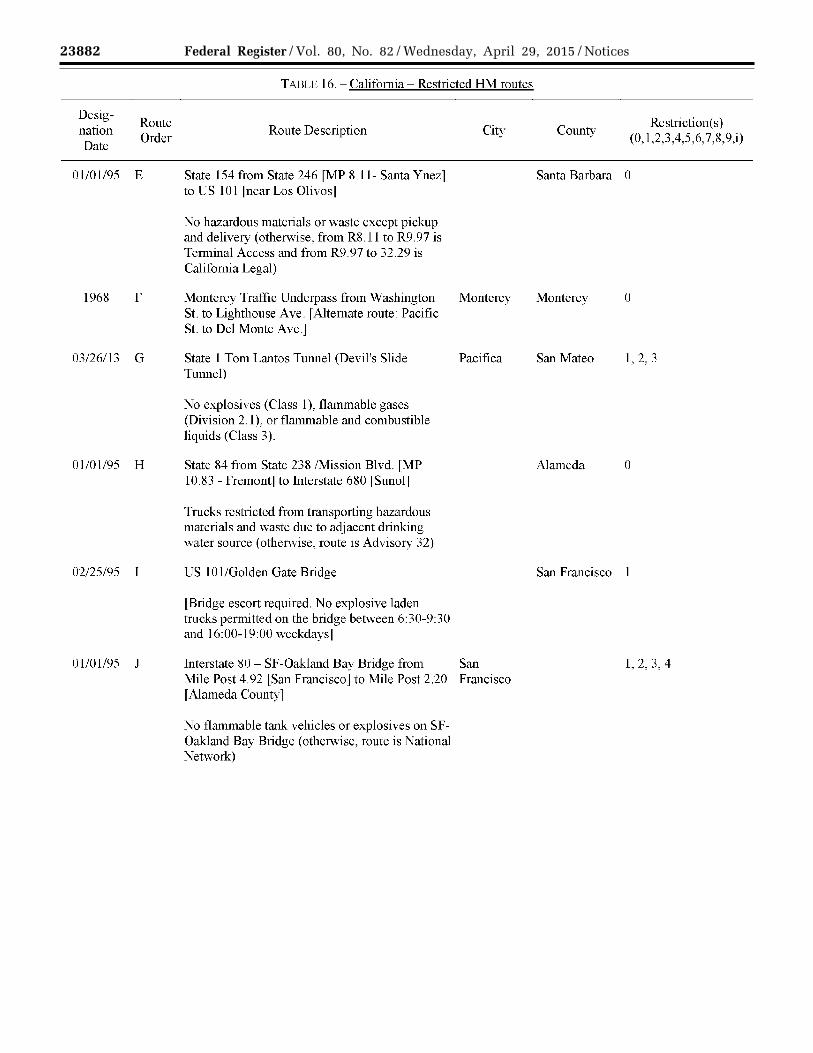
TABLE 16. - California - Restricted HM routes
Desig-Route Restriction(s)
nation Route Description City County Date
Order (0, 1,2,3,4,5,6, 7,8,9,i)
10/28/92 A No person shall drive or permit the driving of any vehicle transporting commodities listed in Section 13 CCR 1150 upon any highway not designated by this article. For pickup and delivery not over designated routes, the route selected must be the shortest-distance route from the pickup location to the nearest designated route entry location, and the shortest-distance route to the delivery location from the nearest designated route exit location.
01/01/95 B State 75 lCoronado Toll Bridgej from Mile Post San Diego San Diego 1,2,3,4 20.28 to Mile Post R22.26 Junction 5 [San Diego County]
No flammables/corrosives or explosives on Coronado Bay Bridge (otherwise route is tern1inal access)
06/29/00 c Sepulveda Blvd. [tunnel] from Interstate Los Angeles Los Angeles 1,2,3A,5,6,8 105/Imperial Highway toW. Century Blvd. [Restriction for Tank Vehicles]
10/28/92 D State 118 from State 232 [Oxnard] to Los Angeles [western county line]
23882 Federal Register / Vol. 80, No. 82 / Wednesday, April 29, 2015 / Notices
VerDate Sep<11>2014 17:52 Apr 28, 2015 Jkt 235001 PO 00000 Frm 00024 Fmt 4701 Sfmt 4725 E:\FR\FM\29APN2.SGM 29APN2 EN
29A
P15
.023
</G
PH
>
mst
ocks
till o
n D
SK
4VP
TV
N1P
RO
D w
ith N
OT
ICE
S2
Desig-Route
nation Order
Date
01/01/95 E
1968 F
03/26/13 G
01/01/95 H
02/25/95 I
01/0l/95 J
TAULE 16.- California- Restricted HM routes
Route Description
State 154 from State 246 [MP 8 .II- Santa Y nez] to US 101 fnearLos Olivosl
No hazardous materials or waste except pickup and delivery (otherwise, from R8.11 to R9.97 is Terminal Access and from R9.97 to 32.29 is California Legal)
Monterey Tratll.c Underpass from Washington St. to Lighthouse Ave. [Alternate route: Pacific St. to Del Monte Ave.]
State I Tom Lantos Tunnel (Devil's Slide Tunnel)
No explosives (Class 1), flammable gases (Division 2.1 ), or flammable and combustible liquids (Class 3).
State 84 from State 238 /Mission Blvd. [MP 10.83- Fremontj to interstate 680 LSunolj
Trucks restricted from transporting hazardous materials and waste due to adjacent drinking water source (otherwise, route is Advisory 32)
US 10 1/Golden Gate Bridge
[Bridge escort required. No explosive laden trucks permitted on the bridge between 6:30-9:30 and 16:00-19:00 weekdaysl
City
Monterey
Pacifica
interstate 80- SF-Oakland Bay Bridge from San Mile Post 4.92 [San Francisco] to Mile Post 2.20 Francisco [Alameda County]
No flammable tank vehicles or explosives on SFOakland Bay Bridge (otherw·ise, route is National Network)
Restriction(s) County
(0, 1,2,3,4,5,6, 7,8,9,i)
Santa Barbara 0
Monterey 0
San Mateo I, 2, 3
Alameda 0
San Francisco 1
1, 2, 3, 4
23883 Federal Register / Vol. 80, No. 82 / Wednesday, April 29, 2015 / Notices
VerDate Sep<11>2014 17:52 Apr 28, 2015 Jkt 235001 PO 00000 Frm 00025 Fmt 4701 Sfmt 4725 E:\FR\FM\29APN2.SGM 29APN2 EN
29A
P15
.024
</G
PH
>
mst
ocks
till o
n D
SK
4VP
TV
N1P
RO
D w
ith N
OT
ICE
S2
Desig-nation Date
01/01/95
Ol/Ol/95
10/28/92
Ol/Ol/95
Designation Date
Route Order
K
L
M
N
Route Order
10/19/94 A
TABLE 16.- California- Restricted HM routes
Route Description City County
State 260 from Atlantic Ave. [MP R0.62- Alameda Alameda] to Interstate 880 [MP Rl.92- Oakland] [Eastbound Webster St. Tube & Westbound Posey Tube]
Trucks restricted from transporting hazardous materials and waste through Webster and Posey Tubes (otherwise, route is Califomia Legal)
State 24 [Caldecott Tunnel] from Mile Post R5.89 [Alameda County] to Mile Post R0.35 [Contra Costa County]
[Transportation of an explosive substance, flammable liquid, liquefied petroleum gas, or poisonous gas in a tank truck, trailer, or semi-trailer is allowed through the tunnel only between the hours of3:00 AM and 5:00AM.] Otherwise route is National Network
Tennessee St. from Mare Island Way to Vallejo Solano Columbus Way.
State 20 from State 29 [MP 8.32- Upper Lake] Lake to State 53 [MP 31.62 - Clearlake Oaks]
[No vehicles transporting hazardous materials or waste due to adjacent waters (otherwise, route is tenninal access).]
TABLE 17.- Califomia- Designated HRCQ/RAM routes
Route Description
Interstate 5 from Mexican Border [MP 0] to Interstate 805 [MP l -San Ysidro]
City County Designation(s)
(A,B,I,P)
p
Restriction(s) (0, 1,2,3,4,5,6, 7,8,9,i)
0
l, 2, 3
0
FMC SA QA Comment
This route will be considered by the Califomia Highway Patrol tor updates in a future rulemaking.

23884 Federal Register / Vol. 80, No. 82 / Wednesday, April 29, 2015 / Notices
VerDate Sep<11>2014 17:52 Apr 28, 2015 Jkt 235001 PO 00000 Frm 00026 Fmt 4701 Sfmt 4725 E:\FR\FM\29APN2.SGM 29APN2 EN
29A
P15
.025
</G
PH
>
mst
ocks
till o
n D
SK
4VP
TV
N1P
RO
D w
ith N
OT
ICE
S2
TAULE 17. - California - Designated HRCQ/RAM routes
Desig-Route Designation( s) FMC SA
nation Order
Route Description City County (A,B,I,P) QAComment
Date
10/19/94 Bl Interstate 805 from Interstate 5 San Diego p This route will be [Torrey Pines] to Interstate 5 [San considered by the Ysidrol California Highway
Patrol for updates in a future rulemaking.
10/19/94 B2 Interstate 5 from State 78 [MP 51 p - Carlsbad] to Interstate 805 [MP 31- Torrey Pines]
10/19/94 B2A Interstate 15 from State 163 to San Diego San Diego p
Interstate 8
10/19/94 B2B Interstate 8 from Arizona to p Interstate 5 [San Diego]
10/19/94 B3 Interstate 5 from Interstate 405 p
fMP 93- Irvine 1 to State 78 fMP 7S - Carlsbadj
10/19/94 B3A Interstate 15 from State 60 [Mira p
Loma] to State 163 [San Diego]
10/19/94 B4 Interstate 5 from Interstate 605 p [MP 123 - Santa Fe Springs] to Interstate 405 [MP 93-Irvine]
10/19/94 B4A Interstate 15 from Nevada border p
to State 60 [Mira Lorna]
10/19/94 B5 Interstate 605 from Interstate 210 Los Angeles p [Duarte] to Interstate 5 [Santa Fe Springs]
10/19/94 B5A-l.O Interstate 40 from Arizona to p Interstate 15 [Barstow]
10/19/94 B6A-l.O Interstate 10 from Arizona to p
Interstate 605 fBaldwin Parkl
10/19/94 B6A-2.0 Interstate 210 from Interstate 5 Los Angeles p
[Sylmar] to State 57 [Glendora]

23885 Federal Register / Vol. 80, No. 82 / Wednesday, April 29, 2015 / Notices
VerDate Sep<11>2014 17:52 Apr 28, 2015 Jkt 235001 PO 00000 Frm 00027 Fmt 4701 Sfmt 4725 E:\FR\FM\29APN2.SGM 29APN2 EN
29A
P15
.026
</G
PH
>
mst
ocks
till o
n D
SK
4VP
TV
N1P
RO
D w
ith N
OT
ICE
S2
TADLE 17.- California- Designated HRCQ/RAM routes
Desig-Route Designation(s) FMC SA
nation Route Description City County Date
Order (A,B,I,P) QAComment
10/19/94 B7A-2.0 Interstate 5 from Oregon rMP p
796] to Interstate 210 [MP 160-Sylmar]
10/19/94 C1 Interstate 2RO from Interstate 6RO p
[in San Jose] to h1terstate 380 [in San Francisco]
10/19/94 C2 Interstate 680 from Interstate 80 p [Cordelia Junction, Fairfield] to Interstate 280 [San Jose]
10/19/94 Dl Interstate 880 from Interstate 980 Alameda p
[Oakland] to Interstate 238 [San Leandro]
10/19/94 D2A Interstate 980 from Interstate 580 Oakland Alameda p
to Interstate 880
10/19/94 E Interstate 238 from Interstate 580 Alameda p [Ashland] to Interstate 880 [San LeandroJ
10/19/94 Fl Interstate 580 from Interstate 5 p
[Southwest ofTracy] to Interstate 680 [in Dublin]
10/19/94 F2A Interstate 205 from Interstate 5 p
[Lanthrop] to Interstate 5 80 [Alameda County]"
10/19/94 G Interstate 80 from Nevada to p
interstate 580 lnorth ofOaklandJ

23886 Federal Register / Vol. 80, No. 82 / Wednesday, April 29, 2015 / Notices
VerDate Sep<11>2014 17:52 Apr 28, 2015 Jkt 235001 PO 00000 Frm 00028 Fmt 4701 Sfmt 4725 E:\FR\FM\29APN2.SGM 29APN2 EN
29A
P15
.027
</G
PH
>
mst
ocks
till o
n D
SK
4VP
TV
N1P
RO
D w
ith N
OT
ICE
S2
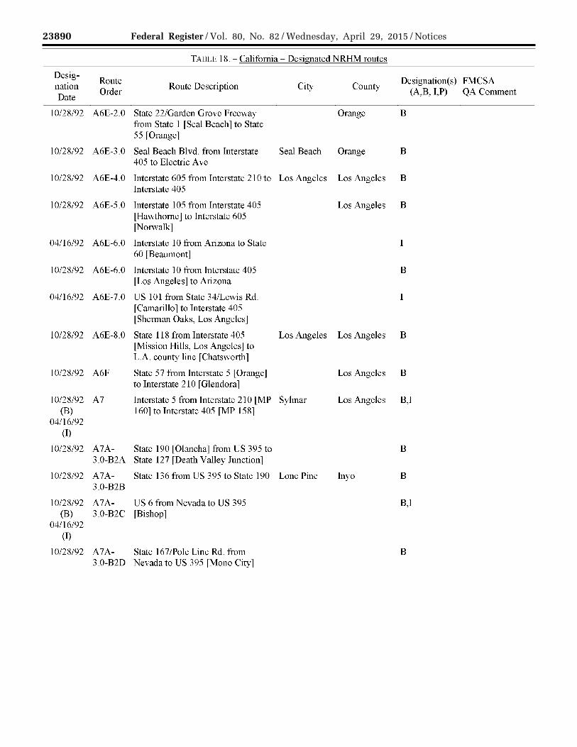
TADLE 18.- California- Designated NRHM routes
Desig-Route Designation(s) FMC SA
nation Order
Route Description City County (A,B, I,P) QA Comment
Date
10/28/92 AI Interstate 5 from Mexican Border San Diego San Diego B,I This route will be (B) lMP OJ to Interstate 805 lMP I- considered by the
04/16/92 San Ysidro] California (I) Highway Patrol
for updates in a future rule making.
10/28/92 A2 Interstate 805 from Interstate 5 San Diego B This route will be [Torrey Pines] to Interstate 5 [San considered by the Ysidro l California
Highway Patrol for updates in a future rule making.
04/16/92 A2 Interstate 805 lSan Diegoj from SR San Diego San Diego 1 163 [San Diego] to Interstate 8 [San Diego]
10/28/92 A2A Interstate 5 from Interstate 805 [MP San Diego San Diego B This route will be 3I- Torrey Pinesl to State 805 rsan considered by the Ysidro] California
Highway Patrol for updates in a future ruiemaking.
10/28/92 A3 Interstate 5 from State 78 [MP 51 - San Diego B Carlsbad] to Interstate 805 [MP 31-Torrey Pines]
10/28/92 A3A-l.O State 75 from Interstate 5 rsan San Diego B Diego] to R. H. Dana Place [Coronado]
10/28/92 A3A-2.0 State 15 from State 94 to Interstate 5 San Diego San Diego B
04/16/92 A3A-3.0 Interstate 8 from Arizona to I Interstate 805 [San Diego]
10/28/92 A3A-3.0 Interstate 8 from Arizona to end of B road [San Diego] at the intersection of Sunset Cliffs Blvd./Nimitz Blvd.
10/28/92 A3B State 94 from Interstate 5 to San Diego San Diego B Interstate 8

23887 Federal Register / Vol. 80, No. 82 / Wednesday, April 29, 2015 / Notices
VerDate Sep<11>2014 17:52 Apr 28, 2015 Jkt 235001 PO 00000 Frm 00029 Fmt 4701 Sfmt 4725 E:\FR\FM\29APN2.SGM 29APN2 EN
29A
P15
.028
</G
PH
>
mst
ocks
till o
n D
SK
4VP
TV
N1P
RO
D w
ith N
OT
ICE
S2
TAilLI' 18.- California- Designated NRHM routes
Desig-Route Designation(s) FMC SA
nation Order
Route Description City County (A,B, I,P) QA Comment
Date
10/28/92 A4 Interstate 5 from Interstate 405 [MP B,T (B) 93- Irvine] to State 78 [MP 78 -
04/16/92 Carlsbad] (I)
10/28/92 A4A-l.O RH. Dana Place from State 75 to San Diego San Diego B Ocean Blvd.
10/28/92 A4A- State 163 from Interstate 8 to San Diego San Diego B 3.0-A Interstate 15
04/16/92 A4A- State 163 from Interstate 15 to San Diego San Diego I 3.0-A Interstate 805
04/16/92 A4A- Interstate 15 from State 60 [Mira I This route will be 3.0-B Lorna] to State 163 [San Diego] considered by the
California Highway Patrol for updates in a future m1emaking.
10/28/92 A4A- Interstate 15 from State 91 [Corona] B 3.0-B and Interstate 8 [San Diego]
10/28/92 A4A- State 98 from Interstate 8 [MP 88- Imperial B This route will be 3.0-C Ocotillo] to Interstate 8 [MP 144 - considered by the
Warren H. Brock Reservoir] Califomia Highway Patrol for updates in a future rule making.
10/28/92 A4A- CR S30/ Forrester Rd. from State 86 Imperial B,l This route will be (B) 3.0-D [Westmorland] to Interstate 8 [El considered by the
04/16/92 Centro] Califomia (I) Highway Patrol
for updates in a future mlemaking.
10/28/92 A4B-l.O State 125 from State 94 to Interstate LaMesa San Diego B 8
04/16/92 A4C State 78 from Interstate 5 San Diego I [Oceanside] to Interstate 15 [Escondido]

23888 Federal Register / Vol. 80, No. 82 / Wednesday, April 29, 2015 / Notices
VerDate Sep<11>2014 17:52 Apr 28, 2015 Jkt 235001 PO 00000 Frm 00030 Fmt 4701 Sfmt 4725 E:\FR\FM\29APN2.SGM 29APN2 EN
29A
P15
.029
</G
PH
>
mst
ocks
till o
n D
SK
4VP
TV
N1P
RO
D w
ith N
OT
ICE
S2
TADLE 18.- California- Designated NRHM routes
Desig-Route Designation(s) FMC SA
nation Order
Route Description City County (A,B, I,P) QA Comment
Date
1 0/2R/92 A5 Interstate 5 from Interstate 605 [MP B 123- Santa Fe Springsl to Interstate 405 [MP 93-Irvine]
10/28/92 A5A-l.O Ocean Blvd. from R. H. Dana Place Coro-nado San Diego B to North Island Naval Air Station
10/28/92 A5A- Interstate 15 from Nevada border to B,I (B) 3.0-B State 60 [Mira Loma]
04/16/92 (I)
1 0/2R/92 A5A- Interstate 215 from Interstate 15 B 3.0-Bl [San Bernardino] to Interstate 15
[Murietta]
10/28/92 A5A- Railroad Blvd./ River Rd. from Cal-exico Imperial B This route will be 3.0-Cl State 98 to U.S. Customs considered by the
Compound [at Mexico] California Highway Patrol for removal in a future rule making.
10/28/92 A5A- State 111 from Interstate 8 rEI Imperial B This route will be 3.0-C2 Centro J to State 98 l Calexico J considered by the
California Highway Patrol for updates in a future rule making.
10/28/92 A5A- State 86 [Indio] to CR S30 I B,I This route will be (B) 3.0-D Forrester Rd. [Westmorland] considered by the
04/16/92 California (I) Highway Patrol
for updates in a future rule making.
10/28/92 A5D State 76 from Interstate 5 San Diego B [Oceanside] to Interstate 15 [Fallbrook]
10/28/92 A5E Interstate 405 from Interstate 5 B,I (B) fNorth Valley 1 to Interstate 5
04/16/92 [Irvine] (I)

23889 Federal Register / Vol. 80, No. 82 / Wednesday, April 29, 2015 / Notices
VerDate Sep<11>2014 17:52 Apr 28, 2015 Jkt 235001 PO 00000 Frm 00031 Fmt 4701 Sfmt 4725 E:\FR\FM\29APN2.SGM 29APN2 EN
29A
P15
.030
</G
PH
>
mst
ocks
till o
n D
SK
4VP
TV
N1P
RO
D w
ith N
OT
ICE
S2
TADLE 18.- California- Designated NRHM routes
Desig-Route Designation(s) FMC SA
nation Order
Route Description City County (A,B, I,P) QA Comment
Date
10/28/92 A6 Interstate 5 from Interstate 405 Los Angeles B fMP158- North Valleyl to Interstate 605 [MP 123- Santa Fe Springs]
10/28/92 A6A- US 395 from Oregon to US 6 B 3.0-B2 [Bishop]
[NOTE: US 395 enters Nevada and returns into California near Topaz]
10/28/92 A6A- US 395 from US 6 [Bishop] to B,I (B) 3.0-B2 Interstate 15 [Hesperia]
04/16/92 (I) [NOTE: US 395 enters Nevada and
returns into California in the mid-eastern section]
10/28/92 A6A- Lenwood Rd. from State 58 to San B,I This route will be (B) 3.0-B3 Interstate 15 Bernardino considered by the
04/16/92 California (I) Highway Patrol
for removal in a future rule making.
10/28/92 A6A- Interstate 40 from Arizona to B,I (B) 3.0-B4 Interstate 15 l Barstow J
04/16/92 (I)
I 0/2R/92 A6A- Fort Irwin Rd. from Interstate 15 to Barstow San B 3.0-B5 Fort Irwin Bernardino
10/28/92 A6A- State 127 from Nevada to Interstate B 3.0-B6 15 [Baker]
10/28/92 A6D-l.O CR- Sl3 from Interstate 15 to Fall-brook San Diego B This route will be State 76 considered by the
California Highway Patrol for updates in a future rulemaking.
10/28/92 A6E-l.O State 55 from Interstate 405 [Costa Orange B Mesa] to State 91 [Anaheim]
23890 Federal Register / Vol. 80, No. 82 / Wednesday, April 29, 2015 / Notices
VerDate Sep<11>2014 17:52 Apr 28, 2015 Jkt 235001 PO 00000 Frm 00032 Fmt 4701 Sfmt 4725 E:\FR\FM\29APN2.SGM 29APN2 EN
29A
P15
.031
</G
PH
>
mst
ocks
till o
n D
SK
4VP
TV
N1P
RO
D w
ith N
OT
ICE
S2
TADLE 18.- California- Designated NRHM routes
Desig-Route Designation(s) FMC SA
nation Order
Route Description City County (A,B, I,P) QA Comment
Date
1 0/2R/92 A6E-2.0 State 22/Gardcn Grove Freeway Orange B from State I fSeal Beach 1 to State 55 [Orange]
10/28/92 A6E-3.0 Seal Beach Blvd. from Interstate Seal Beach Orange B 405 to Electric Ave
10/28/92 A6E-4.0 Interstate 605 from Interstate 210 to Los Angeles Los Angeles B Interstate 405
10/28/92 A6E-5.0 Interstate 105 from Interstate 405 Los Angeles B [Hawthorne] to Interstate 605 [Norwalk]
04/I6/92 A6E-6.0 Interstate I 0 from Arizona to State I 60 [Beaumont]
10/28/92 A6E-6.0 Interstate 10 from Interstate 405 B [Los Angeles] to Arizona
04/16/92 A6E-7.0 US 101 from State 34/Lcwis Rd. I fCamarillo 1 to Interstate 405 [Sherman Oaks, Los Angeles]
10/28/92 A6E-8.0 State 118 from Interstate 405 Los Angeles Los Angeles B [Mission Hills, Los Angeles] to L.A. county line [Chatsworth]
10/28/92 A6F State 57 from Interstate 5 l Orange J Los Angeles B to Interstate 21 0 [Glendora]
10/28/92 A7 Interstate 5 from Interstate 210 [MP Sylmar Los Angeles B,I (B) 160] to Interstate 405 [MP 158]
04/I6/92 (I)
10/28/92 A7A- State 190 [Olancha] from US 395 to B 3.0-B2A State 127 [Death Valley Junction]
10/28/92 A7A- State 136 from US 395 to State 190 Lone Pine In yo B 3.0-B2B
10/28/92 A7A- US 6 from Nevada to US 395 B,I (B) 3.0-B2C [Bishop]
04/16/92 (I)
10/28/92 A7A- State 167/Pole Line Rd. from B 3.0-B2D Nevada to US 395 [Mono City]

23891 Federal Register / Vol. 80, No. 82 / Wednesday, April 29, 2015 / Notices
VerDate Sep<11>2014 17:52 Apr 28, 2015 Jkt 235001 PO 00000 Frm 00033 Fmt 4701 Sfmt 4725 E:\FR\FM\29APN2.SGM 29APN2 EN
29A
P15
.032
</G
PH
>
mst
ocks
till o
n D
SK
4VP
TV
N1P
RO
D w
ith N
OT
ICE
S2
TADLE 18.- California- Designated NRHM routes
Desig-Route Designation(s) FMC SA
nation Order
Route Description City County (A,B, I,P) QA Comment
Date
1 0/2R/92 A7A- A St. from National Trails San B 3.0-B4- Hwy/Historical US-66 to Interstate Bernardino A 40
10/28/92 A7E-6.0- Interstate 11 0 from Interstate 1 0 Los Angeles B A [Pico Union] to State 47 [San
Pedro]
10/28/92 A7E-6.0- Interstate 7 I 0 from Interstate I 0 to Los Angeles Los Angeles B B Interstate 405
10/28/92 A7E-6.0- Alabama St. from Interstate 10 San B c [Redlands] to San Bernardino Bernardino
International Airport rsan Bernardino]
10/28/92 A7E-6.0- State 62 [Desert Hot Springs] from B D Interstate 1 0 to Arizona
10/28/92 A7E-6.0- State 177 from State 62 to Interstate Desert Center Riverside B E 10
10/28/92 A7E-6.0- US 95 from Nevada to Interstate 10 B,I (B) F [Blythe]
04/16/92 (I)
04/16/92 A7E-8.0 State 27 /Topanga Canyon Blvd. Chats-worth Los Angeles I from State 118 to Chatsworth St.
10/28/92 A7G State 60 from Interstate 5 [Los B Angeles l to Interstate I 0 [Beaumont]
04/16/92 A7G State 60 from Interstate 605 [South I El Monte] to Interstate 10 [Beaumont]
10/28/92 A7H State 2 from Interstate 5 to Interstate Los Angeles Los Angeles B 210
10/28/92 A71 State 134 from Interstate 5 to Los Angeles Los Angeles B Interstate 210
10/28/92 A7J State 118 from Interstate 5 to Los Angeles Los Angeles B Interstate 21 0

23892 Federal Register / Vol. 80, No. 82 / Wednesday, April 29, 2015 / Notices
VerDate Sep<11>2014 17:52 Apr 28, 2015 Jkt 235001 PO 00000 Frm 00034 Fmt 4701 Sfmt 4725 E:\FR\FM\29APN2.SGM 29APN2 EN
29A
P15
.033
</G
PH
>
mst
ocks
till o
n D
SK
4VP
TV
N1P
RO
D w
ith N
OT
ICE
S2
TAilLI' 18.- California- Designated NRHM routes
Desig-Route Designation(s) FMC SA
nation Order
Route Description City County (AB, I,P) QA Comment
Date
10/28/92 A8 Interstate 5 from Oregon [MP 796] B,I (B) to Interstate 210 [MP 160- Sylmar]
04/16/92 (I)
10/28/92 A8A- State 89 from State 49 fSierraville l B 3.0-B2E to US 395 [Topaz]
10/28/92 A8A- CR A3/Standish-Buntingville Rd. Lassen B 3.0-B2F from US 395 [Standish] to US 395
[Buntingville]
10/28/92 ASA- Daggett-Yermo Rd. from Interstate San B 3.0-B4- 15 [Yermo] to National Trails Bernardino A Hwy./Historical US-66
10/28/92 A8E-6.0- State 47 from Interstate 110 to Navy San Pedro Los Angeles B A Way
04/16/92 A8E-6.0- State 91 from Interstate 605 to Los Angeles Los Angeles I B1 Interstate 71 0
04/16/92 A8E-6.0- Interstate 71 0 from Interstate 5 Los Angeles I B2 [Commerce] to Port of Long Beach
fLong Beach l 10/28/92 ASE-6.0- W. Lugonia Ave from Alabama St. Red-lands San B
C1 to Orange St. Bernardino
10/28/92 A8E-6.0- Adobe Rd. from Amboy Rd. to Twentynine San B D1 State 62 Palms Bernardino
04/16/92 A8J State 118 from Interstate 405 Los Angeles I [Mission Hills] to State 27 fChatsworth l
10/28/92 A8L Interstate 21 0 from Interstate 5 Los Angeles B [Sylmar] to State 57 [Glendora]
10/28/92 A9A- State 88 from State 89 [Woodfords] Alpine B 3.0-B2E- to Nevada 1.0
10/28/92 A9AA State 44 from Interstate 5 [Redding] Lassen B to State 3 6 [Susanville]
10/28/92 A9AB US 97 from Oregon to Interstate 5 Siskiyou B,I (B) [Weed}
04/16/92 (I)

23893 Federal Register / Vol. 80, No. 82 / Wednesday, April 29, 2015 / Notices
VerDate Sep<11>2014 17:52 Apr 28, 2015 Jkt 235001 PO 00000 Frm 00035 Fmt 4701 Sfmt 4725 E:\FR\FM\29APN2.SGM 29APN2 EN
29A
P15
.034
</G
PH
>
mst
ocks
till o
n D
SK
4VP
TV
N1P
RO
D w
ith N
OT
ICE
S2
TADLE 18.- California- Designated NRHM routes
Desig-Route Designation(s) FMC SA
nation Order
Route Description City County (A,B, I,P) QA Comment
Date
1 0/2R/92 A9E-6.0- State 91 from Interstate 605 B Bl fCerritos l to State 215 fRiverside l
04/16/92 A9E-6.0- Interstate 605 from State 60 [City of Los Angeles I BlA Industry] to State 91 [Cerritos]
10/28/92 A9E-6.0- E. Lugonia Ave./ State 38 from Red-lands San B Cl Orange St. toN. Wabash Ave. Bernardino
10/28/92 A9E-6.0- Amboy Rd. from National Trails San B Dl Highway [Amboy] to Adobe Rd. Bernardino
[Twentynine Palms]
04/16/92 A9M State 14 from US 395 [Indian I Wells] to State 138 [Lancaster]
10/28/92 A9M State 14 from US 395 l1ndian B Wells] to Interstate 5 [Santa Clarita]
04/16/92 A9N State 126 from Interstate 5 [Castaic I Junction] to Santa Paula [western boundaryl
10/28/92 A9N State 126 from Interstate 5 [Castaic B Junction] to State 118 [Saticoy]
04/16/92 A90 State 13 8 from Interstate 5 Los Angeles I [Gorman] to State 14 [Lancaster]
10/28/92 A90 State 13 8 from Interstate 5 B [Gorman] to Interstate 15 [Cajon Junction]
10/28/92 A9P State 166 from Interstate 5 [Mettler] B,I (B) to US 10 1/State 166 to E. Main St.
04/16/92 fSanta Marial (I)
10/28/92 A9Q State 99 from State 36 [Red Bluff] B to Interstate 5 [MP 217-Mettler]
04/16/92 A9Q State 99 from State 46 fFamoso l to I McFarland [northern city boundary]
10/28/92 A9R State 223 from Interstate 5 Kern B [Bakersfield] to State 58 [Caliente]
10/28/92 A9S State 119 from State 99 to Interstate Bakers-field Kern B 5
10/28/92 A9T State 140 from State 49 [Mariposa] B to Interstate 5 [Gustine]

23894 Federal Register / Vol. 80, No. 82 / Wednesday, April 29, 2015 / Notices
VerDate Sep<11>2014 17:52 Apr 28, 2015 Jkt 235001 PO 00000 Frm 00036 Fmt 4701 Sfmt 4725 E:\FR\FM\29APN2.SGM 29APN2 EN
29A
P15
.035
</G
PH
>
mst
ocks
till o
n D
SK
4VP
TV
N1P
RO
D w
ith N
OT
ICE
S2
TADLE 18.- California- Designated NRHM routes
Desig-Route Designation(s) FMC SA
nation Order
Route Description City County (A,B, I,P) QA Comment
Date
10/28/92 A9U Kasson Rd. from Interstate Tracy San Joaquin B 205B/ 11th St. to Interstate 5
10/28/92 A9V State 120 from Interstate 5 B [Lathrop] to Yosemite National Park
10/28/92 A9W Twin Cities Rd./ E13 from State 99 Sacramento B fGaltl To Interstate 5 fMP 497- Elk Grove]
10/28/92 A9X CR E8 [Road 102] from Interstate 5 Yolo B [Woodland] to State 113 [Knights Landing]
10/28/92 A9Y State 32 from State 36/89 [Mill B Creek] to Interstate 5 [Orland]
10/28/92 A9Z State 3 6 from Interstate 5 [Red B Bluff] to US 395 [Susanville]
10/28/92 AlOE- State 71 from Interstate 1 0 B 6.0-BlA [Pomona] to State 91 [Corona]
10/28/92 AlOE- Menton Blvd./State 38 from Crafton Men-tone San B 6.0-Cl Ave. toN. Wabash Ave. Bernardino
10/28/92 AlOE- National Trails Hwy./State 66 from San B 6.0-DlA Interstate 40 [Ludlow] to Interstate Bernardino
40 LFennerJ
10/28/92 AlON State 118 from State 126 to State Saticoy Ventura B 232
10/28/92 AlOO- State 18 from State 13 8 [Llano] to B 1.0 US 395 [Adelanto]
10/28/92 A lOP- State 33 from Interstate 5 [Tracy] to B 1.0 State 166 [Maricopa]
04/16/92 A lOP- US 101 from Healdsburg [northern Marin I 2.0 city boundary] to State 3 7 [Novato]
10/28/92 A lOP- US 101 from Oregon to State 246 Sonoma B 2.0 [Buellton]
04/16/92 A lOP- US 101 from State 166 [Nipomo] to I 2.0 State 246 [Buellton]

23895 Federal Register / Vol. 80, No. 82 / Wednesday, April 29, 2015 / Notices
VerDate Sep<11>2014 17:52 Apr 28, 2015 Jkt 235001 PO 00000 Frm 00037 Fmt 4701 Sfmt 4725 E:\FR\FM\29APN2.SGM 29APN2 EN
29A
P15
.036
</G
PH
>
mst
ocks
till o
n D
SK
4VP
TV
N1P
RO
D w
ith N
OT
ICE
S2
TADLE 18.- California- Designated NRHM routes
Desig-Route Designation(s) FMC SA
nation Order
Route Description City County (A,B, I,P) QA Comment
Date
02/25/95 A10P- US 101 [Golden Gate Bridge] from San Francisco B 2.0 Marin/San Francisco [County Line -
North End] to Toll Plaza [South End]
[Route is restricted from 6:30-9:30 and 16:00-19:00 weekdays. Separate entry is included in table for RESTRICTION.]
10/28/92 A10Q- State 65 from State 198 rExeterl to B 1.0 State 99 [Oil dale]
10/28/92 A10Q- State 43 from State 99 [Selma] to B 2.0 State 58 [Rosedale]
10/28/92 A10Q- W. Jensen Ave./ E. Jensen Ave. Fresno Fresno B 3.0 from S. Marks Ave. to State 99
10/28/92 A10Q- State 145 from State 99 to State 41 Madera Madera B 4.0
10/28/92 A10Q- State 26 from State 99 [Stockton] to B 5.0 State 49 rMoke1umne Hilll
10/28/92 A10Q- State 88 from State 99 lMP 269- B 6.0 Stockton] to State 49 [Martell]
10/28/92 A10Q- State 70 from State 99 [Pleasant B 7.0 Grove] to US 395 [Hallelujah
Junction, east of Chilcoot-Vinton]
10/28/92 A10Q- State 149 from State 99 to State 70 Oroville Butte B 8.0
10/28/92 A10T State 49 from State 70 [Vinton] to B State 140 [Mariposa]
10/28/92 A10U Grant Line Rd./CR-J4 from Byron Tracy San Joaquin B Rd./CR-J4 to Interstate 205Billth St.
10/28/92 A10X State 113 from State 99 [Woodland] B to CR E8 I Road 102 [Yuba City]
10/28/92 A10Z- State 139 from Oregon to State 36 B 1.0 [Susanville]

23896 Federal Register / Vol. 80, No. 82 / Wednesday, April 29, 2015 / Notices
VerDate Sep<11>2014 17:52 Apr 28, 2015 Jkt 235001 PO 00000 Frm 00038 Fmt 4701 Sfmt 4725 E:\FR\FM\29APN2.SGM 29APN2 EN
29A
P15
.037
</G
PH
>
mst
ocks
till o
n D
SK
4VP
TV
N1P
RO
D w
ith N
OT
ICE
S2
TADLE 18.- California- Designated NRHM routes
Desig-Route Designation(s) FMC SA
nation Order
Route Description City County (A,B, I,P) QA Comment
Date
10/28/92 A11E- Crafton Ave. from Sand Canyon Mentone San B This route will be 6.0-C1 Rd. to Lockheed Propulsion Bernardino considered by the
California Highway Patrol for removal in a future m1emaking.
10/28/92 A liN State 232 from State 118 [Saticoy] Ventura B to US 101 [Oxnard]
10/28/92 A110- Bear Valley Rd. from US 395 San B 1.0 fVictorville l to State 18 fApple Bernardino
Valley]
10/28/92 A liP- Ahem Rd. from S. Bird Rd. to Tracy San Joaquin B 1.0 Interstate 5
04/16/92 A liP- State 58 from State 14 [Mojave] to I 1.0-A Interstate 15 fBarstow l
10/28/92 A liP- State 58 from State 33 [McKittrick] B This route will be 1.0-A to Interstate 15 [Barstow] considered by the
California Highway Patrol for updates in a future mlemaking.
10/28/92 A11P- State 180 from State 33 [Mendota] Fresno B 1.0-B to Marks Ave. [Fresno]
10/28/92 A liP- State 132 from Interstate 580 B 1.0-C [Tracy] to State 49 [Coulterville]
10/28/92 A liP- State 246 from State 1 [Lompoc] to Santa Barbara B 2.0-A US 101 [Buellton]
04/16/92 A liP- State 246 from US 10 1 [Buellton] to Santa Barbara I 2.0-B Purisima Rd. l Lompoc J
04/16/92 A liP- State 46 from Interstate 5 [Lost Kern I 2.0-C Hills] to State 99 [McFarland]
10/28/92 A11P- State 46 from US 101 [Paso Robles] B 2.0-C to State 99 [McFarland]
10/28/92 A liP- CRG18 from CRG14lLockwoodj Monterey B 2.0-D to US 101 [Bradley]

23897 Federal Register / Vol. 80, No. 82 / Wednesday, April 29, 2015 / Notices
VerDate Sep<11>2014 17:52 Apr 28, 2015 Jkt 235001 PO 00000 Frm 00039 Fmt 4701 Sfmt 4725 E:\FR\FM\29APN2.SGM 29APN2 EN
29A
P15
.038
</G
PH
>
mst
ocks
till o
n D
SK
4VP
TV
N1P
RO
D w
ith N
OT
ICE
S2
TADLE 18.- California- Designated NRHM routes
Desig-Route Designation(s) FMC SA
nation Order
Route Description City County (A,B, I,P) QA Comment
Date
10/28/92 AllP- State 198 from US 1 01 [San Lucas] B 2.0-E to State 99 [Visalia]
10/28/92 AllP- State 25 from US 101 lGilroyj to B 2.0-F State 156 [Hollister]
04/16/92 AllP- State 152/Pacheco Pass Highway I 2.0-G from Interstate 5 [Los Banos] to
State 101 fGi1roy 1 10/28/92 AllP- State 152/Pacheco Pass Highway B
2.0-G from US 101 [Gilroy] to State 99 [Fairmead]
10/28/92 AllP- State 85 from Interstate 280 Santa Clara B 2.0-H fCupertino 1 to US 101 fMountain
View]
10/28/92 AllP- Interstate 280 from US 1010 [San B 2.0-I Francisco] to Interstate 680/US 101
[San Jose]
04/16/92 A11P- Interstate 680 from Interstate 80 I 2.0-J [Cordelia Junction, Fairfield] to
Interstate 580 [Dublin]
10/28/92 AllP- Interstate 680 [Cordelia Junction, B 2.0-J Fairfield] to US 101 [San Jose]
10/28/92 A11P- State 237 from Interstate 680 Santa Clara B 2.0-K [Milpitas] to US 101 [Sunnyvale]
10/28/92 AllP- State 92 from US I 0 1 to Interstate San Mateo San Mateo B 2.0-L 280
10/28/92 AllP- 3rd St. [San Francisco Bay] from San B This route will be 2.0-M US 101 to Cesar Chavez St. Francisco considered by the
California Highway Patrol for removal in a future mlemaking.
10/28/92 AllP- State 1 from US 101 [Presidio, San B 2.0-N Francisco] to the Tom Lantos
Tunnels [north entrance, Pacifica]
10/28/92 A11P- State 1 from US 101 fLeggett, B 2.0-0 Mendocino County] to US 101
[Manzanita, Marin County]

23898 Federal Register / Vol. 80, No. 82 / Wednesday, April 29, 2015 / Notices
VerDate Sep<11>2014 17:52 Apr 28, 2015 Jkt 235001 PO 00000 Frm 00040 Fmt 4701 Sfmt 4725 E:\FR\FM\29APN2.SGM 29APN2 EN
29A
P15
.039
</G
PH
>
mst
ocks
till o
n D
SK
4VP
TV
N1P
RO
D w
ith N
OT
ICE
S2
TADLE 18.- California- Designated NRHM routes
Desig-Route Designation(s) FMC SA
nation Order
Route Description City County (A,B, I,P) QA Comment
Date
1 0/2R/92 A11P- State 37 from US 101 [City of B,T (B) 2.0-P Novatol to Interstate 80 fMP 32
04/16/92 City ofVallejo] (I)
10/28/92 AllP- State 299 from US 101 [Arcata] to B 2.0-Q Nevada
10/28/92 AllP- US 199 from Oregon to US 10 l Del Norte B 2.0-R [Crescent City]
10/28/92 AllQ- State 245 from State 201 Tulare B 1.0 [Elderwood] to State 198 [Exeter]
10/28/92 AllQ- State 198 from State 65 [Visalia] to Tulare B 1.0-A the Sequoia National Park
10/28/92 AllQ- S. Marks Ave. from State 180 toW. Fresno Fresno B 3.0 Jensen Ave.
10/28/92 AllQ- State 41 from State 145 [Madera] to B 4.0 Yosemite National Park
10/28/92 AllQ- State 8 9 from Interstate 5 l Mount B 7.0-A Shasta] to State 80/State 70 to State
70 [Blairsden]
1 0/2R/92 A11U Byron Hwy./CR-J4 from Grant Line B Rd. fTracy 1 to Byron Hwy./Byron-Bethany Rd./CR-J4 to State 4 [Byron]
10/28/92 AllU- Interstate 205 from Interstate 5 B 1.0 [Lanthrop] to Interstate 5 80
lAlameda Countyj
10/28/92 AllZ- Termo-Grasshopper Rd. from State Termo Lassen B 1.0-A 139 to US 395
10/28/92 Al2E- Sand Canyon Rd. from Crafton Red-lands San B This route will be 6.0-ClA Ave. to Interstate 10 Bernardino considered by the
California Highway Patrol for updates in a future mlemaking.
10/28/92 Al2N US 101 from State 232 [Oxnard] to B Las Posas Rd [Camarillo]

23899 Federal Register / Vol. 80, No. 82 / Wednesday, April 29, 2015 / Notices
VerDate Sep<11>2014 17:52 Apr 28, 2015 Jkt 235001 PO 00000 Frm 00041 Fmt 4701 Sfmt 4725 E:\FR\FM\29APN2.SGM 29APN2 EN
29A
P15
.040
</G
PH
>
mst
ocks
till o
n D
SK
4VP
TV
N1P
RO
D w
ith N
OT
ICE
S2
TADLE 18.- California- Designated NRHM routes
Desig-Route Designation(s) FMC SA
nation Order
Route Description City County (A,B, I,P) QA Comment
Date
10/28/92 A120- State 18 from Bear Valley Rd. San B 1.0 fApple Valleyl to Old Woman Bernardino
Springs Rd. [Lucerne Valley]
10/28/92 Al2P- S. Bird Rd. from Interstate Tracy San Joaquin B 1.0 205B/llth St. to Ahem Rd.
10/28/92 Al2P- Old State 58 from State 58 San B This route will be 1.0-Al fHinkley l to Interstate 15 fBarstow l Bernardino considered by the
California Highway Patrol for removal in a future rule making.
10/28/92 Al2P- Chrisman Rd. from Interstate Tracy San Joaquin B 1.0-C 205B/llth St. to Interstate 580
10/28/92 A12P- State 108 from State 132 [Modesto] B 1.0-Cl to US 395 fSonora Junctionl
10/28/92 Al2P- State l from State 246 [Lompoc] to B 2.0-A US l 0 l [Las Cruces]
10/28/92 Al2P- Mission Gate Rd. from Purisima Lompoc Santa Barbara B 2.0-Al Rd. to State 246
10/28/92 Al2P- Purisima Rd. from State 246 to Lompoc Santa Barbara B,I (B) 2.0-B State l
04/16/92 (I)
10/28/92 Al2P- State 41 from State 46 [Cholame] to B 2.0-Cl E. Jensen Ave. fFresno l
10/28/92 Al2P- CRGl4/JolonRd. from US 101 Monterey B 2.0-D [King City] to CR G 18 [Lockwood]
10/28/92 Al2P- Interstate 580 from Interstate 236 B 2.0-Jl [Ashland] to Interstate 680 [Dublin]
10/28/92 Al2P- Interstate 580 from Interstate 5 B,I (B) 2.0-J2 [Southwest of Tracy] to Interstate
04/16/92 680 [in Dublin] (I)
04/16/92 Al2P- State 242 from Interstate 680 to Concord Contra Costa I 2.0-B State 4

23900 Federal Register / Vol. 80, No. 82 / Wednesday, April 29, 2015 / Notices
VerDate Sep<11>2014 17:52 Apr 28, 2015 Jkt 235001 PO 00000 Frm 00042 Fmt 4701 Sfmt 4725 E:\FR\FM\29APN2.SGM 29APN2 EN
29A
P15
.041
</G
PH
>
mst
ocks
till o
n D
SK
4VP
TV
N1P
RO
D w
ith N
OT
ICE
S2
TADLE 18.- California- Designated NRHM routes
Desig-Route Designation(s) FMC SA
nation Order
Route Description City County (A,B, I,P) QA Comment
Date
04/16/92 A12P- State 4 from Interstate 680 Contra Costa I 2.0-J4 fPacheco 1 to Loveridge Rd.
[Pittsburg]
10/28/92 Al2P- Evans Ave. [San Francisco Bay] San Fran- B This route will be 2.0-Ml from 3rd St. to Jennings St. CiSCO considered by the
California Highway Patrol for removal in a future rulcmaking.
10/28/92 Al2P- Cargo Way [San Francisco Bay] San Fran- B This route will be 2.0-M2 from 3rd St. to Jennings St. CiSCO considered by the
California Highway Patrol for removal in a future rule making.
10/28/92 Al2P- State 128 from State 1 [Near Albion B 2.0-01 Mendocino County] to US 101
[Cloverdale Sonoma County]
10/28/92 Al2P- State 20 from State 1 lFort Braggj Mendocino B 2.0-02 to State 29 [Upper Lake]
10/28/92 Al2P- State 96 from State 299 [Willow B 2.0-Q1 Creek] to Interstate 5 [Yreka]
10/28/92 Al2P- CR A2/Susanville Rd. from State Lassen B 2.0-Q2 299lBieberj to State 139 lAdinj
10/28/92 Al2Q- State 201 from State 99 [Kingsburg] B 1.0 to State 245 [Elderwood]
10/28/92 Al2Q- N. Marks Ave. from State 99 south Fresno Fresno B 3.0 to State 180
10/28/92 Al2Q- State 147 from State 36 lWestwoodj B 7.0-Al to State 89 [Canyondam]
10/28/92 Al2U- Mountain House Parkway from Tracy San Joaquin B 1.0-A Byron Rd. to Interstate 580
10/28/92 Al3N Las Posas Rd. from US 10 1 Ventura B lCamarilloj to Naval Base Ventura County [Oxnard]

23901 Federal Register / Vol. 80, No. 82 / Wednesday, April 29, 2015 / Notices
VerDate Sep<11>2014 17:52 Apr 28, 2015 Jkt 235001 PO 00000 Frm 00043 Fmt 4701 Sfmt 4725 E:\FR\FM\29APN2.SGM 29APN2 EN
29A
P15
.042
</G
PH
>
mst
ocks
till o
n D
SK
4VP
TV
N1P
RO
D w
ith N
OT
ICE
S2
TADLE 18.- California- Designated NRHM routes
Desig-Route Designation(s) FMC SA
nation Order
Route Description City County (A,B, I,P) QA Comment
Date
10/28/92 A130- Old Woman Springs Rd. from State Lucerne San B 1.0 18 to State 247 Valley Bernardino
10/17/94 Al3P- interstate 205B/llth St. from Tracy San Joaquin B 1.0-C Chrisman Rd. to Interstate 5
10/28/92 Al3P- State 1 from State 166 [Guadalupe] B 2.0-B to Purisima Rd. [Lompoc]
04/16/92 Al3P- State 1 from Purisima Rd. to Santa Lompoc Santa Barbara I This route will be 2.0-B2 Lucia Canyon Rd. considered by the
California Highway Patrol for updates in a future rule making.
10/28/92 Al3P- Grangeville Blvd. from State 41 to Le-moore Kings B 2.0-ClA Lemoore Naval Air Station
10/28/92 Al3P- Interstate 238 from Interstate 580 B 2.0-Jl [Ashland] to Interstate 880 [San
Leandro]
10/28/92 Al3P- Hunters Point Blvd. [San Francisco San Fran- B This route will be 2.0-Ml Bay] from Evans Ave. to Innes Ave. CiSCO considered by the
California Highway Patrol for removal in a future rule making.
10/28/92 Al3P- Jennings St. lSan Francisco Bayj San Fran- B This route will be 2.0-M2 from Evans Ave. to Cargo Way CiSCO considered by the
California Highway Patrol for removal in a future rule making.
10/28/92 A13P- State 29 from State 20 [Upper Lake] Lake B 2.0-02 to State 53 [Clear Lake]
10/28/92 Al3Q- State 63 from American Ave. Fresno B 1.0-A [Orange Cove] to State 201 [Cutler]
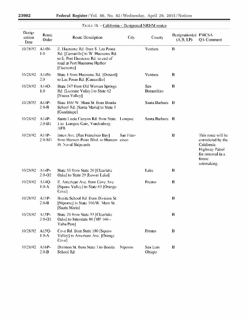
23902 Federal Register / Vol. 80, No. 82 / Wednesday, April 29, 2015 / Notices
VerDate Sep<11>2014 17:52 Apr 28, 2015 Jkt 235001 PO 00000 Frm 00044 Fmt 4701 Sfmt 4725 E:\FR\FM\29APN2.SGM 29APN2 EN
29A
P15
.043
</G
PH
>
mst
ocks
till o
n D
SK
4VP
TV
N1P
RO
D w
ith N
OT
ICE
S2
TADLE 18.- California- Designated NRHM routes
Desig-Route Designation(s) FMC SA
nation Order
Route Description City County (A,B, I,P) QA Comment
Date
10/28/92 Al4N- E. Hueneme Rd. from S Las Posas Ventura B 1.0 Rd. [Camarillo] to W. Hueneme Rd.
to E. Port Hueneme Rd. to end of road at Port Hueneme Harbor [Hueneme]
10/28/92 Al4N- State 1 from Hueneme Rd. [Oxnard] Ventura B 2.0 to Las Posas Rd. [Camarillo]
10/28/92 Al40- State 247 from Old Woman Springs San B 1.0 Rd. [Lucerne Valley] to State 6 2 Bernardino
[Yucca Valley]
10/28/92 Al4P- State 166/ W. Main St. from Bonita Santa Barbara B 2.0-B School Rd. [Santa Maria] to State 1
[Guadalupe]
10/28/92 A14P- Santa Lucia Canyon Rd. from State Lompoc Santa Barbara B 2.0-Bl 1 to Lompoc Gate, Vandenberg
AFB
10/28/92 Al4P- Innes Ave. [San Francisco Bay] San Fran- B This route will be 2.0-Ml from Hunters Point Blvd. to Hunters CiSCO considered by the
Pt. Naval Shipyards California Highway Patrol for removal in a future mlemaking.
10/28/92 Al4P- State 53 from State 20 [Clearlake Lake B 2.0-02 Oaks] to State 29 [Lower Lake]
10/28/92 Al4Q- E. American Ave. from Cove Ave. Fresno B 1.0-A [Squaw Valley] to State 63 [Orange
Covel
10/28/92 Al5P- Bonita School Rd. from Division St. B 2.0-B [Nipomo] to State 166/W. Main St.
[Santa Maria]
10/28/92 Al5P- State 20 from State 53 [Clearlake B 2.0-02 Oaks 1 to Interstate 80 fMP 166 -
Yuba Pass]
10/28/92 Al5Q- Cove Rd. from State 180 [Squaw Fresno B 1.0-A Valley] to American Ave. [Orange
Cove].
10/28/92 Al6P- Division St. from State 1 to Bonita Nipomo San Luis B 2.0-B School Rd. Obispo

23903 Federal Register / Vol. 80, No. 82 / Wednesday, April 29, 2015 / Notices
VerDate Sep<11>2014 17:52 Apr 28, 2015 Jkt 235001 PO 00000 Frm 00045 Fmt 4701 Sfmt 4725 E:\FR\FM\29APN2.SGM 29APN2 EN
29A
P15
.044
</G
PH
>
mst
ocks
till o
n D
SK
4VP
TV
N1P
RO
D w
ith N
OT
ICE
S2
TADLE 18.- California- Designated NRHM routes
Desig-Route Designation(s) FMC SA
nation Order
Route Description City County (A,B, I,P) QA Comment
Date
1 0/2R/92 A16Q- State 1 RO from McCall Ave Fresno B 1.0-A fSangerl to Cove Rd. fwest of
Squaw Valley]
10/28/92 Al7P- State 1 from Tom Lantos Tunnel B 2.0-B [south entrance, Pacifica] to
Division St. [Guadalupe]
10/28/92 Al7Q- S. McCall Ave. from E. Jensen Ave. Sanger Fresno B 1.0-A to State 180
10/28/92 Al7Q- N. Academy Ave. from State 180 Fresno B 1.0-Al [Sanger] to State 168 [Clovis]
10/28/92 Al8P- State 68 from State l [Monterey] to B 2.0-B3 US 101 lSalinasJ
10/28/92 Al8P- State 156 from State l [Castroville] B 2.0-B4 to State 152/Pacheco Pass Highway
[Hollister]
10/28/92 Al8P- State 183 from State l [Castroville] Monterey B 2.0-B5 toN. Main St. [Salinas]
10/28/92 Al8P- State l 7 from Interstate B 2.0-B6 880/Interstate 280 [San Jose] to
State 1 [Santa Cruz]
10/28/92 Al8Q- E. Jensen Ave. from S. Chestnut Fresno B 1.0-A Ave. [Fresno] to S. McCall Ave.
[Sanger]
10/28/92 Al8Q- State 168 from N. Academy Ave B 1.0-Al l Clovis J to Huntington Lake
Rd./Big Creek Rd. [Lakeshore]
10/28/92 Al9P- Interstate 880 from Interstate 280 B 2.0-B6 [San Jose] to Market St. [Oakland]
10/28/92 Al9Q- S. Chestnut Ave. from State 99 to E. Fresno Fresno B 1.0-A Jensen Ave.

23904 Federal Register / Vol. 80, No. 82 / Wednesday, April 29, 2015 / Notices
VerDate Sep<11>2014 17:52 Apr 28, 2015 Jkt 235001 PO 00000 Frm 00046 Fmt 4701 Sfmt 4725 E:\FR\FM\29APN2.SGM 29APN2 EN
29A
P15
.045
</G
PH
>
mst
ocks
till o
n D
SK
4VP
TV
N1P
RO
D w
ith N
OT
ICE
S2
TADLE 18.- California- Designated NRHM routes
Desig-Route Designation(s) FMC SA
nation Order
Route Description City County (A,B, I,P) QA Comment
Date
1 0/2R/92 A20P- Oakland Army Base [US Navy Oakland Alameda B 2.0-B6 Supply Centerl from W. Grand Ave.
[at Interstate 80] to Market St. [at Interstate 880] [From W. Grand Ave. via Interstate RO to Maritime St. to Middle Harbor Rd. to 3rd St. to Market St. which connects to Interstate 880]
10/28/92 A20P- Hegenberger Rd. from Interstate Oakland Alameda B 2.0-B6A 880 to Doolittle Dr./State 61
10/28/92 A20P- Dennison St. from Interstate 880 Alameda B 2.0-B6B [Oakland] to Coast Guard Island
[Alameda]
10/28/92 A20P- Interstate 980 from Interstate 580 to Oakland Alameda B 2.0-B6C Interstate 880
10/28/92 A21P- Interstate 80 from Interstate 580 and Oakland Alameda B 2.0-B6 W. Grand Ave
10/28/92 A21P- State 61 from Webster St. Alameda B 2.0-B6A [Alameda] to Hcgcnbcrgcr Rd.
fOaklandl
10/28/92 A21P- Interstate 580 from Interstate 80 to Oakland Alameda B This route will be 2.0-B6C Interstate 980 considered by the
California Highway Patrol for updates in a future rule making.
04/16/92 A22P- Interstate 80 from Interstate 5 [MP I 2.0-B6 92 - Sacramento l to State 37 fMP
32- Vallejo]
10/28/92 A22P- Interstate 80 from Nevada to B 2.0-B6 Interstate 580 [north of Oakland]
10/28/92 A22P- Central Ave. from State 61/Wcbstcr Alameda Alameda B 2.0-B6A St. to Main St.
10/28/92 A22P- Grand St. from Encinal Ave. to Alameda Alameda B 2.0- Buena Vista Ave. B6A-l.O
10/28/92 A23P- Main St. from Central Ave. to Alameda Alameda B 2.0-B6A Atlantic Ave.

23905 Federal Register / Vol. 80, No. 82 / Wednesday, April 29, 2015 / Notices
VerDate Sep<11>2014 17:52 Apr 28, 2015 Jkt 235001 PO 00000 Frm 00047 Fmt 4701 Sfmt 4725 E:\FR\FM\29APN2.SGM 29APN2 EN
29A
P15
.046
</G
PH
>
mst
ocks
till o
n D
SK
4VP
TV
N1P
RO
D w
ith N
OT
ICE
S2
TADLE 18.- California- Designated NRHM routes
Desig-Route Designation(s) FMC SA
nation Order
Route Description City County (A,B, I,P) QA Comment
Date
10/28/92 A23P- State 4 from 80 [Hercules] to State B 2.0-B6D 89 [Markleeville]
10/28/92 A23P- Interstate 780 from Interstate 80 Solano B 2.0-B6E [Vallejo] to Interstate 680 [Benicia]
10/28/92 A23P- State 12 from Interstate 80 [MP 49 - Solano B 2.0-B6F Fairfield] to State 49 [San Andreas]
10/28/92 A23P- Interstate 505 from Interstate 5 LMP B,I (B) 2.0-B6G 552- Zamora] to Interstate 80 [MP
04/16/92 61 - Vacaville] (I)
10/28/92 A23P- CR E7 /Pedrick Rd. from Interstate B 2.0-B6H 80 [Dixon] to Interstate 5
[Woodland]
10/28/92 A23P- Interstate Business 80 from Sacramento Sacramento B,I (B) 2.0-B61 Interstate 80 [west of Sacramento]
04/16/92 to US 50/State 99/Interstate (I) Business 80 [east of Sacramento]
10/28/92 A23P- State 65 from State 70 [Olivehurst] B 2.0-B6J to Interstate 80 [Roseville]
10/28/92 A24P- Atlantic Ave. from Main St. to Alameda Alameda B This route will be 2.0-B6A Webster St./State 61 considered by the
California Highway Patrol for updates in a future rule making.
10/28/92 A24P- State 113 from Interstate 80 [Dixon] Solano B 2.0-B6F- to State 12 fRio Vistal 1.0
10/28/92 A24P- State 16 from State 20 [Williams] to B 2.0- CR E7 /County Road 98/Pedrick Rd. B6H-l.O [Woodland]
10/28/92 A24P- US 50 from US 50/State Sacramento B,l (B) 2.0-B61- 99/Interstate Business 80 [east of
04/16/92 1.0 Sacramento] to Prairie City Rd (I) [Folsom]
10/28/92 A24P- Interstate Business 80 from US Sacramento Sacramento B 2.0-B61- 50/State 99 [east of Sacramento] to 2.0 Interstate 80 [north of Sacramento]

23906 Federal Register / Vol. 80, No. 82 / Wednesday, April 29, 2015 / Notices
VerDate Sep<11>2014 17:52 Apr 28, 2015 Jkt 235001 PO 00000 Frm 00048 Fmt 4701 Sfmt 4725 E:\FR\FM\29APN2.SGM 29APN2 EN
29A
P15
.047
</G
PH
>
mst
ocks
till o
n D
SK
4VP
TV
N1P
RO
D w
ith N
OT
ICE
S2
TADLE 18.- California- Designated NRHM routes
Desig-Route Designation(s) FMC SA
nation Order
Route Description City County (A,B, I,P) QA Comment
Date
11/16/94 A24P- Old Highway 65 I Lincoln Blvd Placer B 2.0-B6J- from State 65 [Lincoln] to Riosa 1.0 Rd. [Sheridan]
10/28/92 A25P- State 61 from Atlantic Ave. to Alameda Alameda B 2.0-B6A Buena Vista Ave.
10/28/92 A25P- US 50 from Prairie City Rd. B 2.0-B61- fFolsoml to Nevada 1.0
10/28/92 A25P- State 16 from US 50 [Sacramento] B 2.0-B61- to State 49 [Plymouth] 1.0-A
04/16/92 A25P- W. El Camino Ave. from Interstate Sacramento Sacramento I This route will be 2.0-B61- 80 to El Centro Rd. considered by the 2.0-A California
Highway Patrol for updates in a future rule making.
11/16/94 A25P- Riosa Rd. from State 65 to Old Sheridan Placer B 2.0-B6J- Highway 65/Lincoln Blvd. 1.0
10/28/92 A25P- State 193 from State 65 L Lincoln J to Placer B 2.0-B6J- Interstate 80 [Newcastle] 1.0-A
10/28/92 A26P- Buena Vista Ave. from Webster Alameda Alameda B This route will be 2.0-B6A St./State 61 to Park St. considered by the
California Highway Patrol for updates in a future rule making.
10/28/92 A27P- 23rd Ave. from Park St.[Alameda] Alameda B 2.0-B6A to Interstate 880 [Oakland]

23907 Federal Register / Vol. 80, No. 82 / Wednesday, April 29, 2015 / Notices
VerDate Sep<11>2014 17:52 Apr 28, 2015 Jkt 235001 PO 00000 Frm 00049 Fmt 4701 Sfmt 4725 E:\FR\FM\29APN2.SGM 29APN2 EN
29A
P15
.048
</G
PH
>
mst
ocks
till o
n D
SK
4VP
TV
N1P
RO
D w
ith N
OT
ICE
S2
TAilLI' 18.- California- Designated NRHM routes
Desig-Route Designation(s) FMC SA
nation Order
Route Description City County (A,B, I,P) QA Comment
Date
10/28/92 A27P- Sherman St. [San Francisco Bay] Alameda B This route will be 2.0- from Buena Vista Ave. to S.F. Bay considered by the B6A-l.O [Inner Harbor] California
Highway Patrol for update or removal in a future rule making.
10/28/92 A28P- Park St. from Buena Vista Alameda B This route will be 2.0-B6A Ave.[ Alameda] to 23rd considered by the
Ave.[Oakland] California Highway Patrol for updates in a future rnlcmaking.
10/28/92 B Army St. [San Francisco Bay] from San B This route will be 3rd St. to Pier 80 Francisco considered by the
California Highway Patrol for updates in a future rule making.
10/28/92 Cl 6th St. [San Francisco Bay] from San B This route will be Channel St to [southeast] Francisco considered by the
California Highway Patrol for removal in a future mlemaking.
10/28/92 C2 Challllel St from 4th St. to 6th St. San B This route will be Francisco considered by the
California Highway Patrol for removal in a future mlemaking.

23908 Federal Register / Vol. 80, No. 82 / Wednesday, April 29, 2015 / Notices
VerDate Sep<11>2014 17:52 Apr 28, 2015 Jkt 235001 PO 00000 Frm 00050 Fmt 4701 Sfmt 4725 E:\FR\FM\29APN2.SGM 29APN2 EN
29A
P15
.049
</G
PH
>
mst
ocks
till o
n D
SK
4VP
TV
N1P
RO
D w
ith N
OT
ICE
S2
TADLE 18.- California- Designated NRHM routes
Designation Date
Route Order
Route Description City Designation(s) FMCSA
(A,B, T,P) QA Comment County
10/28/92 C3
10/28/92 D
State Agency: POC: Address:
Phone: Fax: Web Address:
Designation Date
Route Order
12/30/86 A
12/30/86 B
4th St. [San Francisco Bay] from 3rd St. to Channel St.
San Francisco
Berry St. [San Francisco Bay] from San 3rd St. to pier Francisco
TARLE 19.- State: Colorado
CO State Patrol Capt. Josh Downing 15065 South Golden Rd. Golden, CO 80401 (303) 273-1900 (303) 273-1911 www .colorado .gov/cs/Satellite/StatePatrolMain/CBON/1251592908196
FMCSA: FMCSAPOC: Address:
Phone: Fax:
B
B
This route will be considered by the California Highway Patrol for removal in a future rnlemaking.
This route will be considered by the California Highway Patrol for removal in a future rnlemaking
CO FMCSA Field Office CO Motor Carrier Division Administrator 12300 West Dakota Ave, Suite 130 Lakewood, CO 80228 (720) 963-3130 (720) 963-3131
TABLE 20.- Colorado- Restricted HM routes
Route Description
Interstate 70 from Interstate 25 [at Mile Post 274.039] to State 2 [at Mile Post 276.572]
Interstate 70 from Utah to US 40 [at Mile Post 261.63]
City Restriction(s)
(0, 1,2,3,4,5,6, 7,8,9j)
7
7

23909 Federal Register / Vol. 80, No. 82 / Wednesday, April 29, 2015 / Notices
VerDate Sep<11>2014 17:52 Apr 28, 2015 Jkt 235001 PO 00000 Frm 00051 Fmt 4701 Sfmt 4725 E:\FR\FM\29APN2.SGM 29APN2 EN
29A
P15
.050
</G
PH
>
mst
ocks
till o
n D
SK
4VP
TV
N1P
RO
D w
ith N
OT
ICE
S2
Designation Date
Route Order
TAI3LE 21. - Colorado - Designated HRCQ/RAM routes
Route Description
04/30/89 Al Interstate 25 from Wyoming to New Mexico
04/30/89 A2A Interstate 225 from Interstate 70 to Interstate 25
04/30/89 A2B Interstate 76 from Interstate 25 to Nebraska
04/30/08 A3A Interstate 270 [Near Denver] from Interstate 25 to Interstate 70
4/30/89 A4A Interstate 70 from Interstate 270 to Kansas
TABLE 22.- Colorado- Designated NRHM routes
Desig-Route
nation Route Description Date
Order
04/30/89 AI Interstate 25 from Wyoming to New Mexico
04/30/89 A2A US 160 from New Mexico to Interstate 25 [Business Route in Walsenburg South to Exit 49 on 1-25]
04/30/89 A2B State 10 from Interstate 25 [in Walsenburg] to US 50 [in La Junta]
04/30/89 A2C State 47 from Interstate 25 to US 50 [State 96]
City
City
04/30/89 A2D US 24 from State 91 [at Leadville] to Interstate 25 [in Colorado Springs]
04/01/14 A2E State 4 70 from Interstate 70 to Interstate 25
04/30/89 A2F Interstate 225 from Interstate 70 to Interstate 25
04/30/89 A2G US 36 from Interstate 25 to State 157
04/30/89 A2H US 34 from Interstate 25 to Interstate 76
04/30/89 A21 State 14 from Interstate 25 to US 6 [in Sterling]
p
p
p
p
p
A
A
A
A
A
A
A
A
A
A
Desig-nation(s) (A,B,T,P)
Designation(s) (A,B,I,P)

23910 Federal Register / Vol. 80, No. 82 / Wednesday, April 29, 2015 / Notices
VerDate Sep<11>2014 17:52 Apr 28, 2015 Jkt 235001 PO 00000 Frm 00052 Fmt 4701 Sfmt 4725 E:\FR\FM\29APN2.SGM 29APN2 EN
29A
P15
.051
</G
PH
>
mst
ocks
till o
n D
SK
4VP
TV
N1P
RO
D w
ith N
OT
ICE
S2
TABLE 22.- Colorado- Designated NRHM routes
Desig-Route Designation(s)
nation Order
Route Description City (A,B,I,P)
Date
04/30/89 A3A-l.O State 17 from US 285 [near Mineral Hot Springs] to A US 160 [near Alamosa]
04/30/89 A3A-2.0 US 285 from US 160 [in Alamosa] to New Mexico A
04/30/89 A3A-3.0 US 285 from State 112 to US 160 A
04/30/89 A3A-4.0 State 112 from US 285 to US 160 A
04/30/89 A3A-5.0 US 550 from US 160 to New Mexico A
04/30/89 A3A-6.0 US 491 from Utah to New Mexico A
04/30/89 A3D State 91 from Interstate 70 to US 24 [near Leadville] A
04/01/14 A3E Interstate 76 from Interstate 70 to Nebraska A
04/30/89 A3G State i57 from US 36 to State ii9 A
04/30/89 A31 US 6 from State 14 [(Main St.) in Sterling] to A Nebraska
04/30/89 A31-l.O State 71 from Nebraska to State 14 A
04/30/89 A4A-3.0 US 285 from State 470 to State ii2 A
04/30/89 A4A-6.0-A State i4i from US 50 to US 49i A
04/30/89 A4E-l.O Interstate 270 [Near Denver] from Interstate 70 to A interstate 7 6
04/30/89 A4E-2.0 US 85 from Wyoming to interstate 76 A
04/30/89 A4G State ii9 from State i57 to State 52 A
04/30/89 A41-l.O US 138 from State 113 to US 6 [(Chestnut St.) in A Sterling]
04/30/89 A5A-6.0-A1 US 50 from State 141 [north junction near Grand A Junction] to Kansas

23911 Federal Register / Vol. 80, No. 82 / Wednesday, April 29, 2015 / Notices
VerDate Sep<11>2014 17:52 Apr 28, 2015 Jkt 235001 PO 00000 Frm 00053 Fmt 4701 Sfmt 4725 E:\FR\FM\29APN2.SGM 29APN2 EN
29A
P15
.052
</G
PH
>
mst
ocks
till o
n D
SK
4VP
TV
N1P
RO
D w
ith N
OT
ICE
S2
TABLE 22.- Colorado- Designated NRHM routes
Desig-Route Designation(s)
nation Order
Route Description City (A,B,I,P)
Date
04/30/89 A5E-l.O Interstate 70 from Interstate 270 to Kansas A
11/21/11 A5F-l.O-A US 36 from Interstate 70 [in Byers] to Kansas A
04/30/89 A5G State 52 from State 119 to State 79 A
04/30/89 A51-l.O State 113 from Nebraska to US 138 A
04/30/89 A6A-6.0-A1 State 141 from Interstate 70 [(Business Loop) near A Grand Junction] to US 50
04/30/89 A6A-6.0-A1A State 115 from State 83 (also called Academy Blvd.) A to US 50
04/30/89 A6A-6.0-A1B State 71 from US 24 [in Limon (west junction)] to A US 50 [near Rocky Ford]
04/30/89 A6A-6.0-A1C US 287 from US 40 [in Kit Carson] to Oklahoma A
04/30/89 A6G State 79 from State 52 to Interstate 70 [at Bennett] A
04/30/89 A7A-6.0-Al Interstate 70 [business loop] from Interstate 70 [east A of Grand Junctionl to State 141
04/30/89 A7A-6.0-A1A State 83 (also called Academy Blvd.) from US 24 to A State 115
04/30/89 A7A-6.0-A1B US 24 [Business Route] from US 24 [on the west A side of Limon] to State 71 [west junction]
04/30/89 A 7 A-6.0-A 1 D-1.0 Maple St [City of Lamar] from 2nd St. to US 50WI7 Lamar A
04/30/89 A 7 A-6.0-AlD-2.0 US 40 from Interstate 70 [(Exit 363) in Limon] to A Kansas
04/30/89 A8A-6.0-A1A Interstate 70 from Utah to US 6 [at Silverthorne A l Loveland Pass J
04/30/89 A8A-6.0-A1B US 24 from State 83 (also called Academy Blvd.) to A Interstate 70 [at West Limon (Exit 359)]

23912 Federal Register / Vol. 80, No. 82 / Wednesday, April 29, 2015 / Notices
VerDate Sep<11>2014 17:52 Apr 28, 2015 Jkt 235001 PO 00000 Frm 00054 Fmt 4701 Sfmt 4725 E:\FR\FM\29APN2.SGM 29APN2 EN
29A
P15
.053
</G
PH
>
mst
ocks
till o
n D
SK
4VP
TV
N1P
RO
D w
ith N
OT
ICE
S2
TABLE 22.- Colorado- Designated NRHM routes
Desig-Route Designation(s)
nation Order
Route Description City (A,B,I,P)
Date
04/30/89 A8A-6.0-AlD-l.O 2nd St. [City of Lamar] from US 50/385 to Maple St. Lamar A
04/30/89 A8A-6.0-AlD-2.0 US 24 [Business Route] from State 71 [east junction A in Limon] to Interstate 70 (Exit 363)
04/30/89 A8A-6.0-A 1 D-2.0-A US 385 from Interstate 76 [in Julesburg] to US 40 [in A Cheyenne Wells]
04/30/89 A9A-6.0-AlA US 6 rLoveland Passl from Interstate 70 rjust east of A the Eisenhower/Johnson Tunnels] to [just west of the Eisenhower/Johnson Tunnels at Silverthorne]
04/30/89 A9A-6.0-AlA-l.O State 139 from State 64 [in Rangely] to Interstate 70 A [ncar Lorna]
04/30/89 A9A-6.0-AlA-2.0 US 6 from State 13 [west of Rifle] to Interstate 70 A [Exit 87]
04/30/89 A9A-6.0-AlA-3 .0 State 9 from US 40 lin KremmlingJ to Interstate 70 A [in Silverthorne]
04/30/89 A9A-6.0-AlD-2.0 State 71 from State 14 to US 24 [in Limon (east A junction)]"
04/30/89 A 1 OA-6.0-A 1 A Interstate 70 from US 6 [east of Loveland Pass] to A Interstate 25
04/30/89 Al OA-6.0-AlA-1.0-A State 64 from US 40 [in Dinosaur] to State 13 A
04/30/89 Al OA-6.0-AlA-2.0 State 13 from US 40 [west of Craig] to US 6 [west of A RitleJ
04/30/89 Al OA-6.0-AlD-2.0-A US 34 from State 71 lwestjunctionJ to Nebraska A
04/30/89 AllA-6.0-AlA-1.0-Al US 40 from Utah to State 13 [west of Craig]
04/30/89 Al1A-6.0-AlA-2.0-A 1st St. [City of Craig] from State 13 [east] to State Craig A 394 lCraig City LimitJ
04/30/89 Al2A-6.0-AlA-l.O-Al County 7 lGreat Divide Rd.J from US 40 to City A Limit [City of Craig (north)]

23913 Federal Register / Vol. 80, No. 82 / Wednesday, April 29, 2015 / Notices
VerDate Sep<11>2014 17:52 Apr 28, 2015 Jkt 235001 PO 00000 Frm 00055 Fmt 4701 Sfmt 4725 E:\FR\FM\29APN2.SGM 29APN2 EN
29A
P15
.054
</G
PH
>
mst
ocks
till o
n D
SK
4VP
TV
N1P
RO
D w
ith N
OT
ICE
S2
TADLE 22.- Colorado- Designated NRHM routes
Desig-Route Designation(s)
nation Route Description City Date
Order (A,B,I,P)
04/30/89 Al2A-6.0-AlA-2.0-A 1st St. [Moffat County Rd. CG 2] from State 394 A [Craig City Limit] to US 40 [Runs East from Route 394 to US 40.]
04/30/89 Al3A-6.0-AlA-l.O-Al County 7 [(Great Divide Rd.)] from City Limit [City A of Craig (north)l to County 183 rin Moffat Countyl
04/30/89 A13A-6.0-A1A-2.0-A US 40 from First St. [Moffat County Road CG 2] to A Interstate 70 [east of Craig]
04/30/89 Al4A-6.0-A1A-l.O-Al County 183 [Moffat County] from County 7 (Great A Divide Rd.) [Moffat County] to State 13
04/30/89 Al4A-6.0-A1A-2.0-Al State 14 from US 40 to State 125 A
04/30/89 Al4A-6.0-A1A-2.0-A2 State 125 from Wyoming to US 40 [west of Granby] A
04/30/89 Al5A-6.0-A1A-l.O-Al State 13 from Wyoming to Moffat County 183 A [North of Craig]
04/30/89 Al5A-6.0-AlA-2.0-A2 State 127 from Wyoming to State 125 A
TABLE 23.- State: Connecticut
State Agency: CT Dept. ofEnv. Protection FMCSA: CT FMCSA Field Office POC: Dave Sattler FMCSAPOC: CT Motor Carrier Division Administrator Address: 79 Elm St. Address: 628-2 Hebron Ave.,
Hartford, CT 06106 Suite 302 Phone: (860) 424-3289 Glastonbury, CT 06033 Fax: (860) 424-4059 Phone: (860) 659-6700 Web Address: www.ct.gov/dcu/sitc/dcfaultasu Fax: (860) 659-6725
No designated or restricted routes as of 03/30/2015

23914 Federal Register / Vol. 80, No. 82 / Wednesday, April 29, 2015 / Notices
VerDate Sep<11>2014 17:52 Apr 28, 2015 Jkt 235001 PO 00000 Frm 00056 Fmt 4701 Sfmt 4725 E:\FR\FM\29APN2.SGM 29APN2 EN
29A
P15
.055
</G
PH
>
mst
ocks
till o
n D
SK
4VP
TV
N1P
RO
D w
ith N
OT
ICE
S2
State Agency: POC: Address:
Phone: Fax: Web Address:
TADLE 24.- State: Delaware
DE Emergency Mgmt. Agency Kevin Kille 165 Brick Stone Landing Rd. Smyrna, DE 19977 (302) 659-2237 (302) 659-6855 dema.delaware .gov/
FMCSA: FMCSA POC: Address:
Phone: Fax:
DE FMCSA Field Office DE Motor Carrier Division Administrator J. Allen Frear Federal Building 300 South New St., Suite 1105 Dover, DE 19904 (302) 734-8173 (302) 734-5380
TABLE 25.- Delaware - Designated HRCQ/RAM routes
Desig-Route
nation Route Description Designation( s)
(A,B,I,P) Date
Order
08/09/00 A1
08/09/00 A2
08/09/00 A2A
08/09/00 A3
State Agency: POC:
Address:
Phone: Fax: Web Address:
Designation Date
Route Order
03/08/95 A
03/08/95 B
Interstate 95 from Maryland to Interstate 495 [southwest ofWilmington] p
Interstate 495 from Interstate 95 [southwest of Wilmington] to Interstate 95 [northeast of P Wilmington]
Interstate 295 from Interstate 95 [Southwest of Wilmington] to New Jersey p
Interstate 95 from Interstate 495 [Northeast of Wilmington] to Pennsylvania p
TABLF 26.- State: District of Columbia
DC Dept. of the Environment Mary Begin
FMC SA: DC FMCSA Field Office
Toxic Substances Division 1200 First Street, NE Washington, DC 20002 (202) 481-3838 (202) 481-3770 green.dc.gov
FMCSAPOC: Address:
Phone: Fax:
DC Motor Carrier Division Administrator 1990 K Street, NW, Suite 510 Washington, DC 20006 (202) 219-3576 (202) 219-3546
TABLE 27. - District of Columbia - Restricted HM routes
Route Description Restriction(s)
(0,1,2,3,4,5,6,7,8,9, i)
9th St. Expressway Tunnel from North Portal [at Madison Dr.] to South Portal [south 0 oflndependence Ave.]
Interstate 395 Tunnel from South Portal [south oflndependence Ave.] to the most northerly portallat K St.j
0

23915 Federal Register / Vol. 80, No. 82 / Wednesday, April 29, 2015 / Notices
VerDate Sep<11>2014 17:52 Apr 28, 2015 Jkt 235001 PO 00000 Frm 00057 Fmt 4701 Sfmt 4725 E:\FR\FM\29APN2.SGM 29APN2 EN
29A
P15
.056
</G
PH
>
mst
ocks
till o
n D
SK
4VP
TV
N1P
RO
D w
ith N
OT
ICE
S2
Designation Date
Route Order
03/08/95 Al
03/08/95 A2
03/08/95 A3
03/08/95 A3
03/08/95 B
TAI3LE 28.- District of Columbia- Designated NRHM routes
Route Description Desig
nation(s) (A,B,I,P)
Interstate 395 from Virginia to Interstate 695 [vicinity of 2nd and E A St., S.W.]
Interstate 695 from Interstate 295 [vicinity of 11th and L St., S.E.] to A Interstate 395 [vicinity of 2nd and ESt., S.W.]
Interstate 295 from Maryland to Interstate 695 [vicinity of 11th and L A St., S.E.]
Anacostia Fwy from Interstate 295 f 11th St. Bridge 1 to E. Capitol St. A
Kenilworth Ave., N.E. from E. Capitol St. to Maryland A
FMC SA QA Comment
According to Google maps, "Anacostia Freeway" is another name for "Interstate 295."
Should both names be included in the route description?
According to Google maps, "Anacostia Freeway" is also called "Interstate 295." This route segment appears to be included in the larger route (see Route Order A3).
Should this duplicative route be removed?
According to Googlc maps, "DC 295" IS another name for "Kenilworth Ave., N.E."
Should both names be included in the route description?

23916 Federal Register / Vol. 80, No. 82 / Wednesday, April 29, 2015 / Notices
VerDate Sep<11>2014 17:52 Apr 28, 2015 Jkt 235001 PO 00000 Frm 00058 Fmt 4701 Sfmt 4725 E:\FR\FM\29APN2.SGM 29APN2 EN
29A
P15
.057
</G
PH
>
mst
ocks
till o
n D
SK
4VP
TV
N1P
RO
D w
ith N
OT
ICE
S2
State Agency: POC: Address:
Phone: Fax: Web Address:
Designation Date
Route Order
02/14/95 A
02/14/95 Bl
TADLE 29.- State: Florida
FL Dept. of Highway Safety & Motor Vehicles Artez Lester
FMCSA: FL FMCSA Field 0±1ice
2400 Apalachee Pkwy. Tallahassee, FL 32399 (850) 617-2287
FMCSAPOC: Address:
FL Motor Carrier Division Administrator 545 John Knox Rd , Room I 02 Tallal1assee, FL 32303
Phone: (850) 942-9338 Fax: (850) 942-9680
www.flhsmv.gov
TABLE 30.- Florida- Restricted HM routes
Route Description
Tampa central business area [Bounded on the east by Ybor Channel, on the west by the Hillsborough River, and on the north by a line running along Scott Street east to Orange Ave., south to Cass St., east to the Seaboard Cost Line Railroad, northeast to Adamo Drive, and on the south by Garrison Channel. * State-maintained highways other than Florida Ave. and Kennedy Blvd. are exceptions to this restriction *]
City
Kennedy Blvd. [Tampa] from Crosstown Expressway to Hillsborough Tampa River l Use Crosstown Expressway to Hyde Park Ave. and Davis Island Exit No. 5 to all points west.]
Restriction(s) ( i,2,3,4,5,6,7,8,9,i)
0
0
02/14/95 B2A Florida Ave. [Tampa] from Crosstown Expressway to Scott Street [Use Crosstown Expressway to 22nd St. North, thence north along 22nd Street to interstate 4 to either interstate 275 or points east.j
Tampa 0

23917 Federal Register / Vol. 80, No. 82 / Wednesday, April 29, 2015 / Notices
VerDate Sep<11>2014 17:52 Apr 28, 2015 Jkt 235001 PO 00000 Frm 00059 Fmt 4701 Sfmt 4725 E:\FR\FM\29APN2.SGM 29APN2 EN
29A
P15
.058
</G
PH
>
mst
ocks
till o
n D
SK
4VP
TV
N1P
RO
D w
ith N
OT
ICE
S2
State Agency: POC:
Address:
Phone: Fax: Web Address:
Designation Date
Route Order
03/14/95 A
State Agency: POC: Address: Phone: Fax:
TAI3LE 31.- State: Georgia
FMCSA: GA FMCSA Field Office GA Dept. of Public Safety Cpt. Bruce Bugg FMCSA POC: GA Motor Carrier Division Administrator
Address: Two Crown Center Motor Carrier Compliance Div. 320 Chester Ave., SE Atlanta, GA 30316
1745 Phoenix Blvd., Suite 380 Atlanta, GA 30349
(404) 463-3880 (770) 357-8867 dps.georgia.gov/
Phone: (678) 284-5130 Fax: (678) 284-5146
TABLE 32. -Georgia- Restricted HM routes
Route Description
Georgia Highway 400 between its origin at 1-85 and Exit 2 (Lenox Road I Buckhead Loop), due to a tunnel underneath an office building. The restriction applies to hazardous materials that require placarding.
TABLE 33.- State: Hawaii
No Agency Designated FMC SA: HI FMCSA Field Office
0
Restriction( s) (0,1,2,3,4,5,6,
7,8,9,i)
FMCSAPOC: Address:
HI Motor Carrier Division Administrator 300 Ala Moana Blvd. Room 3-239 Box 50226 Honolulu, HI 96850
Phone: (808) 541-2790 Fax: (808) 541-2702
No designated or restricted routes as of 03/30/2015

23918 Federal Register / Vol. 80, No. 82 / Wednesday, April 29, 2015 / Notices
VerDate Sep<11>2014 17:52 Apr 28, 2015 Jkt 235001 PO 00000 Frm 00060 Fmt 4701 Sfmt 4725 E:\FR\FM\29APN2.SGM 29APN2 EN
29A
P15
.059
</G
PH
>
mst
ocks
till o
n D
SK
4VP
TV
N1P
RO
D w
ith N
OT
ICE
S2
State Agency: POC: Address:
Phone: Fax: Web Address:
Designation Date
01/01/85
Ol/Ol/85
Route Order
A
B
TADLE 34.- State: Idaho
ID State Police FMC SA: ID FMCSA Field Office Cpt. Bill Reese FMCSAPOC: ID Motor Carrier Division Administrator P.O. Box 700 Address: 3200 N. Lakcharbor Lane 700 S. Stratford Dr. Suite 161 Meridian, ID 83680 Boise, ID 83703 (20R) RR4-7220 Phone: (20R) 334-1 R42 (208) 884-7192 Fax: (208) 334-1046 www.is12.idaho.gov/cvs/index.html
TABLE 35.- Idaho- Designated NRHM routes
Route Description City County
US 95 fnorthboundl from Oregon to Missile Base Mountain Home Elmore Road [US Ecology waste site] Northbound hazardous waste transporters are directed to tum right from US 95 onto Sommer Camp Rd. (STC-3710) to its junction with State 78. Tum right on SH78 to its junction with Missile Base Rd. and follow to the US Ecology waste site.
Interstate 84 from Exit 99 to Missile Base Rd. [US Mountain Home Ecology waste site]
Transporters arc to exit at Exit 99 onto 1-84 Business Loop (AKA Old Oregon Trail Road & Bennett Road) to its intersection with old US 30 (You will follow I-84B the entire time and go over an overpass. The road names will change). Tum Right and follow Old US 30 and go approximately 3/4 mile to Hamilton Rd. Tum right and follow Hamilton for 3 miles and tum south onto State 51 until its junction with State 78. Tum right on SH78 and continue to Grandview. The US Ecology Waste site is approximately 10.5 miles past Grandview. Exit State 78 onto Missile Base Rd. and follow to US Ecology waste site.
Elmore
Designation( s) (A,B,I,P)
A
A

23919 Federal Register / Vol. 80, No. 82 / Wednesday, April 29, 2015 / Notices
VerDate Sep<11>2014 17:52 Apr 28, 2015 Jkt 235001 PO 00000 Frm 00061 Fmt 4701 Sfmt 4725 E:\FR\FM\29APN2.SGM 29APN2 EN
29A
P15
.060
</G
PH
>
mst
ocks
till o
n D
SK
4VP
TV
N1P
RO
D w
ith N
OT
ICE
S2
State Agency: POC: Address:
Phone: Fax: Web Address:
Designation Date
Route Order
01/12/95 c
State Agency: POC:
Address:
Phone: Fax: Web Address:
Designation Date
02/10/86
Route Order
A1
TADLE 36.- State: Idaho
Fort Hall Reservation Dept. ofPublic Safety P.O. Box 306
FMCSA: ID FMCSA Field Office FMCSA POC: Address:
Fort Hall, ID 83203
ID Motor Carrier Division Administrator 3200 N. Lakeharbor Lane, Suite 161 Boise, ID 83703
(208) 237-0137 (208) 237-0049 www.shoshonebannocktribes.com
Phone: (208) 334-1842 Fax: (208) 334-1046
TABLE 37.- Idaho- Designated NRHM routes
Route Description
Interstate 15 l within the Fort Hall Reservation J l Designation by ShoshoneBannock Tribes. Only valid within Fort Hall Reservation.]
TABLE 38.- State: Illinois
A
FMCSA: IL FMCSA Field Oftl.ce
Designation(s) (A,B,I,P)
ILDOT Tom Wise FMCSA POC: IL Motor Carrier Division Administrator Division of Traffic Safety 1340 North 91
h St. Address: 3250 Executive Park Dr.
Springfield, IL 62703 P.O. Box 19212 Springfield, IL 62794-9212 (217) 785-1181
Phone: (217) 492-4608 Fax: (217) 492-4986
(217) 782-9159 www. dot. state .il. us
TAilLI': 39.- Illinois- Designated NRHM routes
Route Description City
W. State St. from Meridian Rd. to Kilburn Ave. [Primary Rockford Rockford Hazmat route as per City ordinance 1986-18-0 which amended Chapter 11 with Article Vll, Division 1, Hazardous Materials Routing.]
County
Winnebago
Designation(s) (A,B,I,P)
A
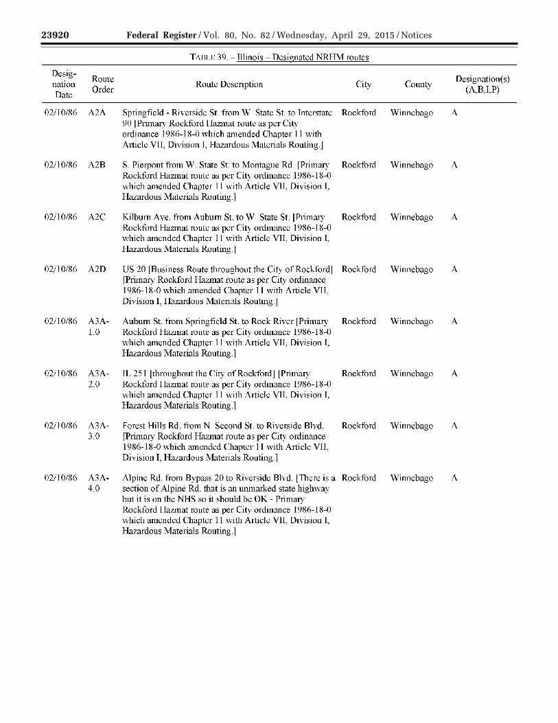
23920 Federal Register / Vol. 80, No. 82 / Wednesday, April 29, 2015 / Notices
VerDate Sep<11>2014 17:52 Apr 28, 2015 Jkt 235001 PO 00000 Frm 00062 Fmt 4701 Sfmt 4725 E:\FR\FM\29APN2.SGM 29APN2 EN
29A
P15
.061
</G
PH
>
mst
ocks
till o
n D
SK
4VP
TV
N1P
RO
D w
ith N
OT
ICE
S2
TAULl: 39.- Illinois- Designated NRHM routes
Desig-Route Designation(s)
nation Order
Route Description City County (A,B,I,P)
Date
02/10/86 A2A Springfield - Riverside St. from W. State St. to Interstate Rockford Winnebago A 90 l Primary Rockford Hazmat route as per City ordinauce 1986-18-0 which amended Chapter 11 with Article VII, Division I, Hazardous Materials Routing.]
02/10/86 A2B S Pierpont from W. State St. to Montague Rd. [Primary Rockford Winnebago A Rockford Hazmat route as per City ordinauce 1986-18-0 which amended Chapter 11 with Article V1L Division 1, Hazardous Materials Routing.]
02/10/86 A2C Kilburn Ave. from Auburn St. toW. State St. [Primary Rockford Winnebago A Rockford Hazmat route as per City ordinauce 1986-18-0 which amended Chapter 11 with Article VII, Division I, Hazardous Materials Routing.j
02/10/86 A2D US 20 [Business Route throughout the City of Rockford] Rockford Winnebago A [Primary Rockford Hazmat route as per City ordinauce 1986-18-0 which amended Chapter 11 with Article VII, Division I, Hazardous Materials Routing.]
02/10/86 A3A- Auburn St. from Springfield St. to Rock River [Primary Rockford Winnebago A 1.0 Rockford Hazmat route as per City ordinauce 1986-18-0
which amended Chapter 11 with Article VII, Division I, Hazardous Materials Routing.]
02/10/86 A3A- TL 251 [throughout the City of Rockford] [Primary Rockford Winnebago A 2.0 Rockford Hazmat route as per City ordinauce 1986-18-0
which amended Chapter 11 with Article VIL Division I, Hazardous Materials Routing.]
02/10/86 A3A- Forest Hills Rd. from N. Second St. to Riverside Blvd. Rockford Winnebago A 3.0 [Primary Rockford Hazmat route as per City ordinauce
1986-18-0 which amended Chapter 11 with Article VII, Division L Hazardous Materials Routing.]
02/10/86 A3A- Alpine Rd. from Bypass 20 to Riverside Blvd. [There is a Rockford Winnebago A 4.0 section of Alpine Rd. that is au unmarked state highway
but it is on the NHS so it should be OK - Primary Rockford Hazmat route as per City ordinauce 1986-18-0 which amended Chapter 11 with Article V1L Division 1, Hazardous Materials Routing.]

23921 Federal Register / Vol. 80, No. 82 / Wednesday, April 29, 2015 / Notices
VerDate Sep<11>2014 17:52 Apr 28, 2015 Jkt 235001 PO 00000 Frm 00063 Fmt 4701 Sfmt 4725 E:\FR\FM\29APN2.SGM 29APN2 EN
29A
P15
.062
</G
PH
>
mst
ocks
till o
n D
SK
4VP
TV
N1P
RO
D w
ith N
OT
ICE
S2
TAULl: 39.- Illinois- Designated NRHM routes
Desig-Route Designation(s)
nation Order
Route Description City County (A,B,I,P)
Date
02/10/86 A3A- Mulford Rd. from Sandy Hollow Rd. to Riverside Blvd. Rockford Winnebago A 5.0 [Primary Rockford Hazmat route as per City ordinance
1986-18-0 which amended Chapter 11 with Article VII, Division I, Hazardous Materials Routing.]
02/10/86 A3B Montague Rd. from S Pierpont to Bypass 20 [Primary Rockford Winnebago A Rockford Hazmat route as per City ordinance 1986-18-0 which amended Chapter 11 with Article VIL Division 1, Hazardous Materials Routing.]
02/10/86 A3B- Preston St. from Tay to S. Pierpont [Primary Rockford Rockford Winnebago A 1.0 Hazmat route as per City ordinance 1986-18-0 which
amended Chapter 11 with Article VII, Division I, Hazardous Materials Routing.]
02/10/86 A3C- Whitman St. from N. Second St. to Kilburn Ave. Rockford Winnebago A 1.0 [Primary Rockford Hazmat route as per City ordinance
1986-18-0 which amended Chapter 11 with Article VII, Division I, Hazardous Materials Routing.]
02/10/86 A3D First Ave. from Kishwaukee St. to Longwood [Primary Rockford Winnebago A Rockford Hazmat route as per City ordinance 1986- 18-0 which amended Chapter 11 with Routing.]
02/10/86 A4A- N. Main St. from Riverside Blvd. to Auburn St. [Primary Rockford Winnebago A 1.0-A Rockford Hazmat route as per City ordinance 1986-18-0
which amended Chapter 11 with Article VII, Division I, Hazardous Materials Routing.]
02/10/86 A4A- College Ave. from Rock River to Kishwaukee St. Rockford Winnebago A 2.0-A [Primary Rockford Hazmat route as per City ordinance
1986-18-0 which amended Chapter 11 with Article VII, Division I, Hazardous Materials Routing.]
02/10/86 A4A- Fifteenth Ave. from S. Main St. to Kishwaukee St. Rockford Winnebago A 2.0-B [Primary Rockford Hazmat route as per City ordinance
1986-18-0 which amended Chapter ll with Article VII, Division I, Hazardous Materials Routing.]
02/10/86 A4A- Blackhawk Park from Magnolia St. to Kishwaukee St. Rockford Winnebago A 2.0-C [Primary Rockford Hazmat route as per City ordinance
1986-18-0 which amended Chapter ll with Article Yll, Division I, Hazardous Materials Routing.]

23922 Federal Register / Vol. 80, No. 82 / Wednesday, April 29, 2015 / Notices
VerDate Sep<11>2014 17:52 Apr 28, 2015 Jkt 235001 PO 00000 Frm 00064 Fmt 4701 Sfmt 4725 E:\FR\FM\29APN2.SGM 29APN2 EN
29A
P15
.063
</G
PH
>
mst
ocks
till o
n D
SK
4VP
TV
N1P
RO
D w
ith N
OT
ICE
S2
TAULl: 39.- Illinois- Designated NRHM routes
Desig-Route Designation(s)
nation Order
Route Description City County (A,B,I,P)
Date
02/10/86 A4A- Kishwaukee St. from Harrison Ave. to Airport Drive Rockford Winnebago A 2.0-D including bypass 20 L Primary Rockford Hazmat route as
per City ordinance 1986-18-0 which amended Chapter 11 with Article VII, Division I, Hazardous Materials Routing.]
02/10/86 A4A- Sandy Hollow Rd. from Kishwaukee St. to Mulford Rd. Rockford Winnebago A 5.0 [Primary Rockford Hazmat route as per City ordinance
1986-18-0 which amended Chapter 11 with Article VII, Division I, Hazardous Materials Routing.]
02/10/86 A4B- Tay from Cedar St. to Preston St. [Primary Rockford Rockford Winnebago A 1.0 Hazmat route as per City ordinance 1986-18-0 which
amended Chapter 11 with Article VII, Division I, Hazardous Materials Routing.]
02/10/86 A4B- Central Ave. from Auburn Street to Riverside Blvd. Rockford Winnebago A 1.0-A [Primary Rockford Hazmat route as per City ordinance
1986-18-0 which amended Chapter 11 with Article VII, Division L Hazardous Materials Routing.]
02/10/86 A4D- Charles St. from East State Street to Alpine Rd. [Primary Rockford Winnebago A 1.0 Rockford Hazmat route as per City ordinance 1986-18-0
which amended Chapter 11 with Article VTT, Division I, Hazardous Materials Routing.l
02/10/86 A5A- Morgan St. from S. Main St. to Rock River LPrimary Rockford Winnebago A 2.0-A Rockford Hazmat route as per City ordinance 1986-18-0
which amended Chapter 11 with Article VII, Division I, Hazardous Materials Routing.]
02/10/86 A5A- Seminary St. from Harrison Ave. Fifteenth Ave. [Primary Rockford Winnebago A 2.0-B1 Rockford Hazmat route as per City ordinance 1986-18-0
which amended Chapter 11, with Article VII, Division 1, Hazardous Materials Routing."
02/10/86 A5A- 20th St. from Sandy Hollow Rd. to 23rd Ave. underpass Rockford Winnebago A 5.0-A [Primary Rockford Hazmat route as per City ordinance
1986-18-0 which amended Chapter 11 with Article VII, Division I, Hazardous Materials Routing.]

23923 Federal Register / Vol. 80, No. 82 / Wednesday, April 29, 2015 / Notices
VerDate Sep<11>2014 17:52 Apr 28, 2015 Jkt 235001 PO 00000 Frm 00065 Fmt 4701 Sfmt 4725 E:\FR\FM\29APN2.SGM 29APN2 EN
29A
P15
.064
</G
PH
>
mst
ocks
till o
n D
SK
4VP
TV
N1P
RO
D w
ith N
OT
ICE
S2
TAI3LE 39.- Illinois- Designated NRHM routes
Desig-Route Designation(s)
nation Order
Route Description City County (A,B,I,P)
Date
02/10/86 A5B- Cedar St. from S. Main St. to Tay [Primary Rockford Rockford Winnebago A 1.0 Hazmat route as per City ordinance 1986-18-0 which
amended Chapter 11 with Article VII, Division I, Hazardous Materials Routing.]
02/10/86 A5D- E. State St. from Second St. to Interstate 90 [Primary Rockford Winnebago A 1.0-A Rockford Hazmat route as per City ordinance 1986-18-0
which amended Chapter 11 with Article Vll, Division 1, Hazardous Materials Routing.]
02/10/86 A6A- S. Main St. from Morgan St. to Bypass 20 [Primary Rockford Winnebago A 2.0-A Rockford Hazmat route as per City ordinance 1986-18-0
which amended Chapter 11 with Article VII, Division I, Hazardous Materials Routing.]
02/10/86 A6A- 23rd Ave. from 11th St. to 20th St. [Primary Rockford Rockford Winnebago A 5.0-A Hazmat route as per City ordinance 1986-18-0 which
amended Chapter 11 with Article VII, Division I, Hazardous Materials Routing.]
02/10/86 A7A- Harrison Ave. from S. Main St. to Mulford Rd. fPrimary Rockford Winnebago A 2.0-Al Rockford Hazmat route as per City ordinance 1986-18-0
which amended Chapter 11 with Article VII, Division I, Hazardous Materials Routing.]
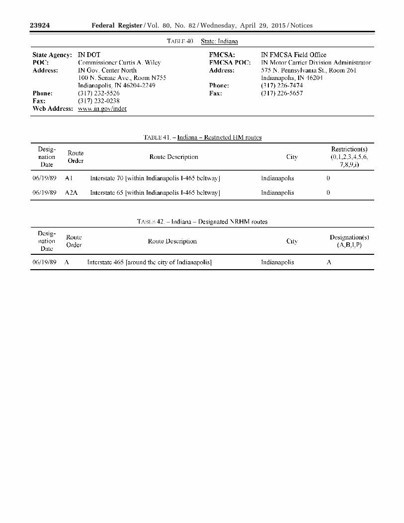
23924 Federal Register / Vol. 80, No. 82 / Wednesday, April 29, 2015 / Notices
VerDate Sep<11>2014 17:52 Apr 28, 2015 Jkt 235001 PO 00000 Frm 00066 Fmt 4701 Sfmt 4725 E:\FR\FM\29APN2.SGM 29APN2 EN
29A
P15
.065
</G
PH
>
mst
ocks
till o
n D
SK
4VP
TV
N1P
RO
D w
ith N
OT
ICE
S2
State Agency: IN DOT POC: Commissioner Curtis A. Wiley Address: IN Gov. Center North
100 N. Senate Ave., Room N755 Indianapolis, TN 46204-2249
Phone: (317) 232-5526 Fax: (317)232-0238 Web Address: www.in.gov/indot
TADLE 40.- State: Indiana
FMCSA: FMCSA POC: Address:
Phone: Fax:
IN FMCSA Field Office TN Motor Carrier Division Administrator 575 N. Pennsylvania St., Room 261 Indianapolis, IN 46204 (317) 226-7474 (317) 226-5657
T ADLE 41. - Indiana - Restricted HM routes
Desig-nation Date
06/19/89
06/19/89
Designation Date
06/19/89
Route Order
AI
A2A
Route Order
A
Route Description City
Interstate 70 [within Indianapolis I -465 beltway] Indianapolis
Interstate 65 [within Indianapolis I -465 beltway] Indianapolis
TABLE 42. -indiana- Designated NRHM routes
Route Description City
Interstate 465 r around the city of Indianapolis 1 Indianapolis
0
0
Restriction(s) (0,1,2,3,4,5,6,
7,8,9,i)
Designation(s) (A,B,LP)
A

23925 Federal Register / Vol. 80, No. 82 / Wednesday, April 29, 2015 / Notices
VerDate Sep<11>2014 17:52 Apr 28, 2015 Jkt 235001 PO 00000 Frm 00067 Fmt 4701 Sfmt 4725 E:\FR\FM\29APN2.SGM 29APN2 EN
29A
P15
.066
</G
PH
>
mst
ocks
till o
n D
SK
4VP
TV
N1P
RO
D w
ith N
OT
ICE
S2
State Agency: POC: Address:
Phone: Fax: Web Address:
TAI3LE 43.- State: Iowa
lA DOT, Motor Vehicle Enforcement Maj. Lance Evans 6310 SE Convenience Blvd. Ankeny, lA 50021 (515) 237-3214 (515) 237-3387 www .iowadot. gov
FMCSA: FMCSA POC: Address:
Phone: Fax:
lA FMCSA Field Office IA Motor Carrier Division Administrator 105 6th St. Ames, lA 50010 (515) 233-7400 (515) 233-7494
TABLE 44.- Iowa- Designated HRCO/RAM routes
Designation Date
Route Order
Route Description Dcsignation(s)
(A,B,LP)
07/18/88 A1
07/18/88 A2A
07/18/88 A2B
07/18/88 A3B-l.O
07/18/88 A3B-2.0
07/18/88 A3B-3.0
07/18/88 A4B-l.O
Interstate 680 from Nebraska to Interstate 80 [Usc 1-680 and 1-80 in lieu ofl-29 in P the Com1cil Bluffs area when heading north/south per 49 CFR 397.103(b). Use 1-680 in lieu ofl-80 in the Council Bluffs area when heading east/west per lA-NE coordination.]
Interstate 29 from Missouri to Interstate 80 [1-80 and 1-680 are used in lieu ofl-29 P in the Council Bluffs area when heading North/South per 49 CFR 397.103(b)]
Interstate 80 from Interstate 29 to Illinois [Use 1-280 or 1-80 in the Quad cities. Use P I-80 in lieu ofl-235 in the Des Moines area. Use I-680 in lieu ofl-80 in the Council Bluffs area per lA-NE coordination when heading east/west Use 1-80 and 1-680 in the Council Bluffs area in lieu ofl-29 when heading north/south]
Interstate 680 from Interstate 80 to Interstate 29 [Used in lieu ofl-29 in the P Council Bluffs area per 49 CFR 397.103(b)]
Interstate 35 from Minnesota to Missouri rstay on 1-35/1-80 in lieu ofl-235 in the P Des Moines area per 49 CFR 397.103(b)]
Interstate 280 from Interstate 80 to Illinois [Use 1-280 or 1-80 in Quad cities area.] P
Interstate 29 from Nebraska to Interstate 680 [I -80 and I-680 are used in lieu ofT- P 29 in the Council Bluffs area when heading North/South per 49 CFR 397.103(b)l

23926 Federal Register / Vol. 80, No. 82 / Wednesday, April 29, 2015 / Notices
VerDate Sep<11>2014 17:52 Apr 28, 2015 Jkt 235001 PO 00000 Frm 00068 Fmt 4701 Sfmt 4725 E:\FR\FM\29APN2.SGM 29APN2 EN
29A
P15
.067
</G
PH
>
mst
ocks
till o
n D
SK
4VP
TV
N1P
RO
D w
ith N
OT
ICE
S2
State Agency: POC:
Address:
Phone: Fax: Web Address:
KS Div. ofEmergency Mgmt. Harry Heintzelman Technological Hazards Section 2800 SW Topeka Blvd. Topeka, KS 66611 (785) 274-1408 (785) 274-1426 www.kansastag.gov/kdem
TADLE 45.- State: Kansas
FMCSA: FMCSA POC: Address:
Phone: Fax:
KS FMCSA Field Office KS Motor Carrier Division Administrator 1303 SW First American Place, Suite 200 Topeka, KS 66604 (785) 271-1260 (877) 54 7-03 78
No designated or restricted routes as of 03/30/2015
State Agency: POC: Address:
Phone: Fax: Web Address:
TABLE 46.- State: Kentucky
KY Transportation Cabinet Brian Bevin 200 Mero St. Frankfort, KY 40601 (502) 564-9900 X. 4136 (502) 564-4138 transportation.ky.gov/Pages/default.aspx
FMCSA: FMCSA POC: Address:
Phone: Fax:
KY FMCSA Field Office KY Motor Carrier Division Administrator 330 West Broadway, Room 124 Frankfort, KY 40601 (502) 223-6779 (502) 223-6767
TABLE 4 7. -Kentucky - Restricted HM routes
Designation Date
Route Order
07115/13 A
Designation Date
Route Order
07/15/13 A
Route Description
Interstate 75 from Interstate 275 to Ohio. 0
TARLE 48.- Kentucky- Designated NRHM routes
Route Description
Interstate 275 from Interstate 75 to Ohio. A
Restriction(s) (0, 1 ,2,3,4,5,6, 7 ,8,9,i)
Designation(s) (A,B,I,P)

23927 Federal Register / Vol. 80, No. 82 / Wednesday, April 29, 2015 / Notices
VerDate Sep<11>2014 17:52 Apr 28, 2015 Jkt 235001 PO 00000 Frm 00069 Fmt 4701 Sfmt 4725 E:\FR\FM\29APN2.SGM 29APN2 EN
29A
P15
.068
</G
PH
>
mst
ocks
till o
n D
SK
4VP
TV
N1P
RO
D w
ith N
OT
ICE
S2
State Agency: POC:
Address:
Phone: Fax: Web Address:
Desig-Route
nation Order
Date
03/0l/95 A
03/0l/95 B
03/0l/95 c
08/0l/99 D
08/0l/99 E
08/0l/99 F
08/0l/99 G
TADLE 49.- State: Louisiana
LA State Police FMCSA: LA FMCSA Field Office Sgt. Brad Yates Transportation and Environmental Safety Section
FMCSA POC: LA Motor Carrier Division Administrator 5304 Flanders Drive,
P.O. Box 66614 Baton Rouge, LA 70896 (225) 925-6113 (225) 925-4048 www .lsp .org/tess.html
Address: Suite A Baton Rouge, LA 70808 (225) 757-7640
Phone: (225) 757-7636 Fax:
TABLE 50.- Louisiana- Restricted HM routes
Route Description
Tunnel Boulevard Tunnel [in Terrebonne Parish (Houma)]
Harvey Tunnel [of Jefferson Parish on US90-B]
State 73 [In Ascension Parish] from Interstate 10 to State 74 and within 300 yards or less of any building used as a public or private elementary or secondary school except for carriers making local deliveries on this portion of State 73 [R.S. 32:1521 Motor Vehicles- Traffic Regulations]
Restriction(s) (0, 1,2,3,4,5,6, 7,8,9,i)
0
0
0
No carrier shall transport hazardous materials on any route in Caddo or Bossier 0 Parish within three hundred yards or less of any building used as a public or private elementary or secondary school, except for ( 1) carriers making local pickups or deliveries, (2) carriers using the route to reach a local pickup or delivery point, (3) carriers traveling to or from their terminal facilities, ( 4) carriers using the route to reach maintenance or service facilities within the boundaries of the parishes, or (5) on prescribed routes. [R.S. 32: 152l.E and F Motor Vehicles -Traffic Regulations]
See http://legis.la.gov/lss/lss.asp?doc=88111
US 171 from State 3132 to US 80 [R.S. 32:1521 Motor Vehicles- Traffic Regulations]
State 1 from State 526 to Interstate 220 [R.S. 32:1521 Motor Vehicles- Traffic Regulations]
US 71 from Interstate 220 to Interstate 20 lR.S. 32:1521 Motor Vehicles- Tratlic Regulationsj
0
0
0

23928 Federal Register / Vol. 80, No. 82 / Wednesday, April 29, 2015 / Notices
VerDate Sep<11>2014 17:52 Apr 28, 2015 Jkt 235001 PO 00000 Frm 00070 Fmt 4701 Sfmt 4725 E:\FR\FM\29APN2.SGM 29APN2 EN
29A
P15
.069
</G
PH
>
mst
ocks
till o
n D
SK
4VP
TV
N1P
RO
D w
ith N
OT
ICE
S2
Designation Date
08/01/99 Al
Route Order
08/01/99 A2A
08/01/99 A2B
08/01/99 A3B
08/01/99 A3B-l.O
08/01/99 A3B-2.0
08/01/99 A3B-3.0
TAULU 51. -Louisiana- Designated NRHM routes
Route Description
US 79 from Texas to Interstate 20 lR.S. 32:1521 Caddo-Bossier designated routej
US 80 from Texas to City of Greenwood [R.S. 32:1521 Caddo-Bossier designated route]
Interstate 20 from Texas to Caddo-Bossier [parish boundary] [R.S. 32:1521 Caddo-Bossier designated route]
Interstate 20 from Bossier-Caddo [parish boundary] to Bossier-Webster [parish boundary] [R.S. 32:1521 Caddo-Bossier designated route]
State 526 [R.S. 32:1521 Caddo-Bossier designated route]
Interstate 220 from Bossier-Caddo [parish boundary] to Interstate 20 [R.S. 32:1521 Caddo-Bossier designated route]
State 3132 lR.S. 32:1521 Caddo-Bossier designated routej
A
A
A
A
A
A
A
08/01/99 A3B-4.0 Interstate 49 from Caddo-DeSoto [parish boundary] to Interstate 20 A [R.S. 32:1521 Caddo-Bossier designated route]
08/01/99 A4B-l.O State 3 [Benton Road] from Arkansas to Interstate 20 A [R.S. 32:1521 Caddo-Bossier designated route]
08/01/99 A4B-l.O-A State 1 from Caddo-Red River [parish bmmdary] to State 526 to State 3132 A [R.S. 32:1521 Caddo-Bossier designated route]
08/01/99 A4B-2.0 US 71 from Bossier-Red River [parish boundary] to Interstate 20 A [R.S. 32:1521 Caddo-Bossier designated route]
08/01/99 A4B-2.0-A State 1 from Interstate 220 to Arkansas A [R.S. 32:1521 Caddo-Bossier designated route]
08/01/99 A4B-3 0-A State 511 [Jimmie Davis Highway] from US 71 to State 3132 rR.S. 32:1521 Caddo-Bossier designated routel
08/01/99 A4B-3.0-B US 171 from Caddo-DeSoto lparish boundaryj to State 3132 [R.S. 32:1521 Caddo-Bossier designated route]
A
A
Designation( s) (A,B,I,P)

23929 Federal Register / Vol. 80, No. 82 / Wednesday, April 29, 2015 / Notices
VerDate Sep<11>2014 17:52 Apr 28, 2015 Jkt 235001 PO 00000 Frm 00071 Fmt 4701 Sfmt 4725 E:\FR\FM\29APN2.SGM 29APN2 EN
29A
P15
.070
</G
PH
>
mst
ocks
till o
n D
SK
4VP
TV
N1P
RO
D w
ith N
OT
ICE
S2
Designation Date
Route Order
TAI3LE 51.- Louisiana- Designated NRHM routes
Route Description
08/01/99 ASB-2.0-A State 3 from Arkansas to State 3105 fAir line Drivel to US 71 [R.S. 32:1521 Caddo-Bossier designated route
A
08/01/99 A5B-2.0-Al US 71 from Interstate 220 to Arkansas A [R.S. 32:1521 Caddo-Bossier designated route]
08/01/99 A5B-2.0-A2 State 2 from State 1 to Caddo-Bossier fparish boundary l A [R.S. 32:1521 Caddo-Bossier designated route]
08/01/99 A6B-2.0-A2 State 2 from Caddo-Bossier [parish boundary] to Bossier-Webster [parish A boundary] [R.S. 32:1521 Caddo-Bossier designated route]
TABLE 52.- State: Maine
Designation( s) (A,B,I,P)
State Agency: ME State Police Shawn Currie
FMC SA: ME FMCSA Field Office POC: Address:
Phone: Fax: Web Address:
Department of Public Safety 20 State House Station Augusta, ME 04330 (207) 624-8938 (207) 287-5247 www .maine. gov I dps/msp/
FMCSAPOC: Address:
Phone: Fax:
ME Motor Carrier Division Administrator EdmundS. Muskie Federal Bldg. 40 Western Ave., Room 411 Augusta, ME 04330 (207) 622-8358 (207) 622-8477
No designated or restricted routes as of 03/30/2015

23930 Federal Register / Vol. 80, No. 82 / Wednesday, April 29, 2015 / Notices
VerDate Sep<11>2014 17:52 Apr 28, 2015 Jkt 235001 PO 00000 Frm 00072 Fmt 4701 Sfmt 4725 E:\FR\FM\29APN2.SGM 29APN2 EN
29A
P15
.071
</G
PH
>
mst
ocks
till o
n D
SK
4VP
TV
N1P
RO
D w
ith N
OT
ICE
S2
State Agency: POC: Address:
Phone: Fax: Web Address:
MD Trans. Authority Police 1st Sgt. Joel Layfield 2301 South Clinton Street Baltimore, MD 21224 (410) 575-6955 (410) 537-1376 \\IWw.mdta.maryland.gov/ Police/policeMain.html
TADLE 53.- State: Maryland
FMC SA: FMCSAPOC:
Address:
Phone: Fax:
MD FMCSA Field Office MD Motor Carrier Division Administrator City Crescent Building lOS. Howard Street, Suite 2710 Baltimore, MD 21201 (410) 962-2889 (410) 962-3916
State agency is responsible for all HM routes listed in Table 55 and Table 56, except for "lF.K. Memorial Highway [T-95]" and "Interstate 495".
State Agency: POC: Address:
Phone: Fax: Web Address:
MD State Highway Admin. David Czorapinski Motor Carrier Division 7491 Connelley Dr. Hanover, MD 21076 (410) 582-5734 (410) 787-2863 sha.md.gov!Home.aspx
TABLE 54.- State: Maryland
FMC SA: FMCSAPOC: Address:
Phone: Fax:
MD FMCSA Field Office MD Motor Carrier Division Administrator City Crescent Building lOS. Howard Street, Suite 2710 Baltimore, MD 21201 (410) 962-2889 (410) 962-3916
State agency is only responsible for the following HM routes listed in Table 55 and Table 56: "lFK Memorial Highway [1-95]" and "Interstate 495".
Designation Date
Route Order
01/25/80 A
01/25/80 B
01/25/80 c
TADU 55.- Maryland- Restricted HM routes
Route Description
Harry W. Nice Memorial Bridge lUS Route 301J [For specific exemptions to these restrictions, see Title 11 ofthe Code of MD Regulations, Transportation ofHazardous Materials (11.07.01.05)]
William Preston Lane, Jr. Memorial (Bay) Bridge rus 50/3011 rFor specific exemptions to these restrictions, see Title 11 of the Code of MD Regulations, Transportation of Hazardous Materials ( 11.07. 01. 05)]
Francis Scott Key Bridge [State 695] [For specific exemptions to these restrictions, see Title 11 ofthe Code of MD Regulations, Transportation ofHazardous Materials (11.07.01.05)]
Restriction(s) (0, 1,2,3,4,5,6, 7,8,9,i)
1,7
1,7
1,7

23931 Federal Register / Vol. 80, No. 82 / Wednesday, April 29, 2015 / Notices
VerDate Sep<11>2014 17:52 Apr 28, 2015 Jkt 235001 PO 00000 Frm 00073 Fmt 4701 Sfmt 4725 E:\FR\FM\29APN2.SGM 29APN2 EN
29A
P15
.072
</G
PH
>
mst
ocks
till o
n D
SK
4VP
TV
N1P
RO
D w
ith N
OT
ICE
S2
Designation Date
Route Order
01/25/80 D
01/25/80 E
01/25/80 F
01/25/80 G
Designation Date
Route Order
08/16/95 A
TADLE 55.- Maryland- Restricted HM routes
Route Description
Baltimore Harbor Tunnel [1-895] [For specific exemptions to this restriction, see Title 11 of the Code of MD Regulations, Transportation ofHazardous Materials (11.07.01.04)]
Fort McHenry Tunnel [1-95] l For specific exemptions to this restriction, see Title ll of the Code of MD Regulations, Transportation of Hazardous Materials (ll. 07.0 l. 04)]
J.F.K. Memorial Highway [1-95]
Thomas J. Hatem Memorial Bridge [US Route 40] lFor specific exemptions to these restrictions, see Title ll ofthe Code of MD Regulations, Transportation of Hazardous Materials (ll. 07.0 l. 05)]
TABLE 56.- Marvland- Designated NRHM routes
Route Description
Interstate 495 l NOTE: Restricts all vehicles carrying hazardous materials to right two lanes. J
Restriction(s) (0, 1,2,3,4,5,6, 7,8,9,i)
0
0
1,7
1,7
A
Designation( s) (A,B,I,P)

23932 Federal Register / Vol. 80, No. 82 / Wednesday, April 29, 2015 / Notices
VerDate Sep<11>2014 17:52 Apr 28, 2015 Jkt 235001 PO 00000 Frm 00074 Fmt 4701 Sfmt 4725 E:\FR\FM\29APN2.SGM 29APN2 EN
29A
P15
.073
</G
PH
>
mst
ocks
till o
n D
SK
4VP
TV
N1P
RO
D w
ith N
OT
ICE
S2
State Agency: POC: Address:
Phone: Fax: Web Address:
Designation Date
Route Order
06/13/12 A
12/01/95 B
11/13/94 c
11/13/94 D
11/13/94 E
TABLE 57.- State: Massachusetts
MADOT Eileen Fenton
FMCSA: MA FMCSA Field Office
3150 Ten Park Plaza Boston, MA 02116
FMCSAPOC: Address:
MA Motor Carrier Division Administrator 50 Mall Road, Suite 212 Burlington, MA 01803
(617) 973-7760 Phone: (781) 425-3210 (617) 973-8037 v.ww.massdot.state.ma.us/ highway/Main.aspx
Fax: (781) 425-3225
TABLE 58- Massachussets- Restricted HM routes
Route Description City Restriction( s)
(0,1,2,3,4,5,6,7,8,9,i)
City of Boston [City Streets in Downtown Area] Boston 0 [Use of City Streets in the Downtown Area for the through transportation of ALL NRHM in the City of Boston is prohibited between 6:00a.m. and 8:00p.m. where there is neither a point of origin nor destination (delivery point) within the City. For local deliveries within Boston, use of City Streets in the Downtown Area for the transportation ofNRHM is further STRICTLY PROHIBITED during the hours of7:00 a.m. to 9:00a.m. and 4:00p.m. to 6:00p.m. daily, except on Saturdays, Sundays, and legal holidays. When city streets are to be used for local deliveries, the transporter must use Major Thoroughfares to a point as close as possible to the destination and comply with 49 CFR 397.67.]
Downtown Area is defined as the area bounded by and including Massachusetts A venue at the Mass. Ave. Entrance Ramp to the Southeast Expressway, the Southeast Expressway to the Kneeland Street Ramp, along Kneeland Street to Atlantic A venue then along a line following the waterfront to the Charles River, along the Charles River to Massachusetts Avenue and along Massachusetts Avenue to the Mass. Ave Entrance Ramp to the Southeast Expressway all as shown on the map attached and incorporated as Exhibit A to the City of Boston's Regulations Controlling the Transportation ofHazardous Materials, issued December 15, 1980.
Interstate 90 from Logan Airport to Massachusetts A venue
Interstate 93 lThomas P. O'Neill Tmmelj from Exit 26 lLeverett Connector] to Kneeland Street
Callahan Tunnel rRoute 1A Northbound under Boston Inner Harborl
Sumner Tunnel [Route 1A Southbound under Boston Inner Harbor]
Boston 0
Boston 0
Boston 0
Boston 0

23933 Federal Register / Vol. 80, No. 82 / Wednesday, April 29, 2015 / Notices
VerDate Sep<11>2014 17:52 Apr 28, 2015 Jkt 235001 PO 00000 Frm 00075 Fmt 4701 Sfmt 4725 E:\FR\FM\29APN2.SGM 29APN2 EN
29A
P15
.074
</G
PH
>
mst
ocks
till o
n D
SK
4VP
TV
N1P
RO
D w
ith N
OT
ICE
S2
Designation Date
Route Order
Il/13/94 F
Designation Date
Route Order
06/13/12 A
TABLE 58- Massachusscts- Restricted HM routes
Route Description City Restriction( s)
(0,1,2,3,4,5,6,7,8,9,i)
Charlestown Tunnel/City Square Tunnel from Interstate 93 to Charlestown
Boston 0
TABLE 59.- Massachussetts - Designated NRHM routes
Route Description
[PREFERRED THROUGH ROUTE FOR ALL NRHM HAZMATS APPROACHING THE CITY OF BOSTON WITHOUT A POINT OF ORIGIN OR DESTINATION WITHIN THE CITY BETWEEN THE HOURS OF 6:00AM AND 8:00PM]
For vehicles approaching Boston from Quincy and points south, the northbound route starts at Exit 9 on T-93 and continues as follows: Start on T-93 at Exit 9, South on 1-93 to its termination at Exit 1 where the roadway continues as I-95N, North on 1-95 to Exit 37A to I-93S, South on 1-93 to the MA-38 ramp, South on MA-38, South on Maffa Way to Cambridge Street, East on Cambridge Street to Alford Street/MA-99, Northeast on Alford Street/MA-99, End on Alford St./MA-99 Bridge before Everett.
For vehicles approaching Boston from Everett and points north, the southbound route starts on MA-99 Bridge before Everett and continues as follows: Start on Alford Street/MA-99 Bridge just before Everett, Southwest on Alford Strcct/MA-99, Northwest onto Main Street to Mystic Avcnuc/MA-38, North on the Mystic Avenue to I-93N ramp, North on 1-93 to the I-95S ramp, South on 1-95 to Exit 12 where the roadway continues as I-93N, North on 1-93, End on 1-93 at Exit 9. Hazmat through cargoes approaching from other points west, north or south, may access and join the preferred hazmat route at the nearest logical access point outside of Downtown Boston along I-93N, I-93S orl-95.
City Designation(s)
(A,B,I,P)
Boston A
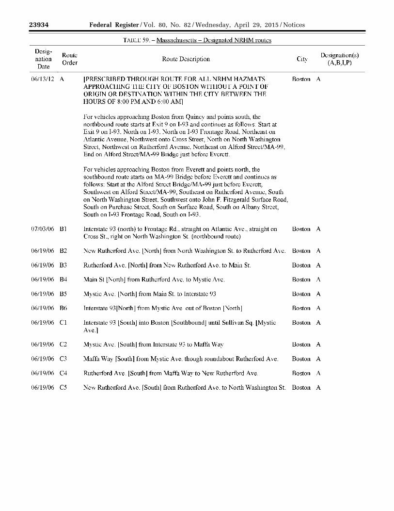
23934 Federal Register / Vol. 80, No. 82 / Wednesday, April 29, 2015 / Notices
VerDate Sep<11>2014 17:52 Apr 28, 2015 Jkt 235001 PO 00000 Frm 00076 Fmt 4701 Sfmt 4725 E:\FR\FM\29APN2.SGM 29APN2 EN
29A
P15
.075
</G
PH
>
mst
ocks
till o
n D
SK
4VP
TV
N1P
RO
D w
ith N
OT
ICE
S2
Designation Date
Route Order
06/13/12 A
07/03/06 Bl
06/19/06 B2
06/19/06 B3
06/19/06 B4
06/19/06 B5
06/19/06 B6
06/19/06 Cl
06/19/06 C2
06/19/06 C3
06/19/06 C4
06/19/06 C5
TADLU 59.- Massachussctts - Designated NRHM routes
Route Description
[PRESCRIBED THROUGH ROUTE FOR ALL NRHM HAZMA TS APPROACHING THE CITY OF BOSTON WITHOUT A POINT OF ORIGIN OR DESTINATION WITHIN THE CITY BETWEEN THE HOURS OF 8:00PM AND 6:00AM]
For vehicles approaching Boston from Quincy and points south, the northbound route starts at Exit 9 on I-93 and continues as follows: Start at Exit 9 on I-93, North on I-93, North on I-93 Frontage Road, Northeast on Atlantic Avenue, Northwest onto Cross Street, North on North Washington Street, Northwest on Rutherford Avenue, Northeast on Alford Street/MA-99, End on Alford Street/MA-99 Bridge just before Everett.
For vehicles approaching Boston from Everett and points north, the southbound route starts on MA-99 Bridge before Everett and continues as follows: Start at the Alford Street Bridge/MA-99 just before Everett, Southwest on Alford Street/MA-99, Southeast on Rutherford Avenue, South on North Washington Street, Southwest onto John F. Fitzgerald Surface Road, South on Purchase Street, South on Surface Road, South on Albany Street, South on I-93 Frontage Road, South on I-93.
Interstate 93 (north) to Frontage Rd., straight on Atlantic Ave., straight on Cross St., right on North Washington St. (northbound route)
New Rutherford Ave. [North] from North Washington St. to Rutherford Ave.
Rutherford Ave. [North] from New Rutherford Ave. to Main St.
Main St [North] from Rutherford Ave. to Mystic Ave.
Mystic Ave. [North] from Main St. to Interstate 93
Interstate 93[North] from Mystic Ave. out of Boston [North]
Interstate 93 [South] into Boston [Southbound] until Sullivan Sq. [Mystic Ave.]
Mystic Ave. lSouthj from Interstate 93 to Maf1a Way
Maffa Way [South] from Mystic Ave. though roundabout Rutherford Ave.
Rutherford Ave. [South] from Maffa Way to New Rutherford Ave.
New Rutherford Ave. [South] from Rutherford Ave. to North Washington St.
City Designation(s)
(A,B,I,P)
Boston A
Boston A
Boston A
Boston A
Boston A
Boston A
Boston A
Boston A
Boston A
Boston A
Boston A
Boston A
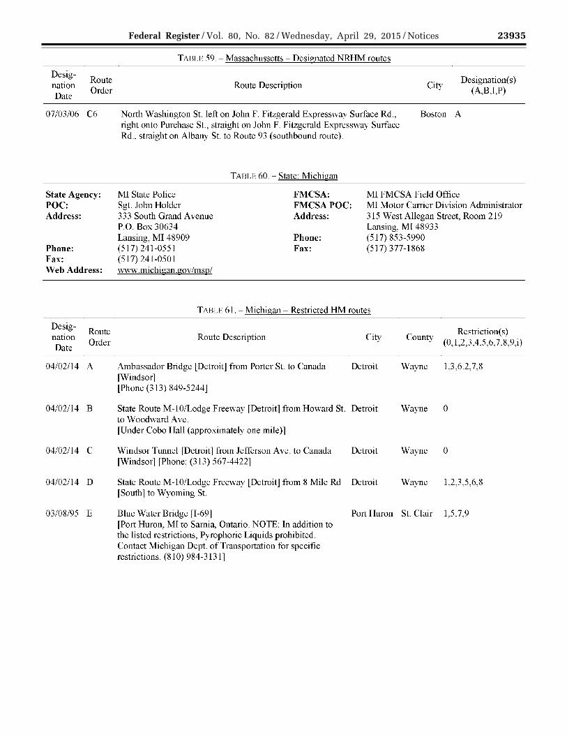
23935 Federal Register / Vol. 80, No. 82 / Wednesday, April 29, 2015 / Notices
VerDate Sep<11>2014 17:52 Apr 28, 2015 Jkt 235001 PO 00000 Frm 00077 Fmt 4701 Sfmt 4725 E:\FR\FM\29APN2.SGM 29APN2 EN
29A
P15
.076
</G
PH
>
mst
ocks
till o
n D
SK
4VP
TV
N1P
RO
D w
ith N
OT
ICE
S2
Designation Date
Route Order
07/03/06 C6
State Agency: POC: Address:
Phone: Fax: Web Address:
Designation Date
Route Order
04/02/14 A
04/02/14 B
04/02/14 c
04/02/14 D
03/08/95 E
TADLE 59.- Massachussctts - Designated NRHM routes
Route Description City Designation(s)
(A,B,T,P)
North Washington St. left on John F. Fitzgerald Expressway Surface Rd., right onto Purchase St., straight on John F. Fitzgerald Expressway Surface Rd., straight on Albany St. to Route 93 (southbound route).
Boston A
TARLE 60.- State: Michigan
MI State Police Sgt. John Holder
FMCSA: MI FMCSA Field Office
333 South Grand Avenue P.O. Box 30634
FMCSAPOC: Address:
MI Motor Carrier Division Administrator 315 West Allegan Street, Room 219 Lansing, MI 48933
Lansing, MI 48909 Phone: (517) 853-5990 (517) 241-0551 Fax: (517) 377-1868 (517) 241-0501 www.michigan.gov/msp/
TABLE 61. -Michigan- Restricted HM routes
Route Description
Ambassador Bridge [Detroit] from Porter St. to Canada [Windsor] [Phone (313) 849-5244]
City
Detroit
State Route M-10/Lodge Freeway [Detroit] from Howard St. Detroit to Woodward Ave. [Under Cobo Hall (approximately one mile)]
Windsor Tunnel [Detroit] from Jefferson Ave. to Canada Detroit [Windsor] [Phone: (313) 567-4422]
State Route M-10/Lodgc Freeway [Detroit] from 8 Mile Rd Detroit fSouth l to Wyoming St.
County
Wayne
Wayne
Wayne
Wayne
Rcstriction(s) (0, 1,2,3,4,5,6, 7,8,9,i)
1,3,6.2,7,8
0
0
1,2,3,5,6,8
Blue Water Bridge [1-69] Port Huron St. Clair 1,5,7,9 [Port Huron, MI to Samia, Ontario. NOTE: In addition to the listed restrictions, Pyrophoric Liquids prohibited. Contact Michigan Dept. of Transportation for specific restrictions. (81 0) 984-3131]

23936 Federal Register / Vol. 80, No. 82 / Wednesday, April 29, 2015 / Notices
VerDate Sep<11>2014 17:52 Apr 28, 2015 Jkt 235001 PO 00000 Frm 00078 Fmt 4701 Sfmt 4725 E:\FR\FM\29APN2.SGM 29APN2 EN
29A
P15
.077
</G
PH
>
mst
ocks
till o
n D
SK
4VP
TV
N1P
RO
D w
ith N
OT
ICE
S2
Designation Date
Route Order
01/01/90 F
10/03/98 G
03/08/95 H
03/08/95 I
State Agency: POC: Address:
Phone: Fax: Web Address:
Designation Date
Route Order
03/09/95 A
TADLE 61. -Michigan- Restricted HM routes
Route Description City County Restriction(s)
(0,1,2,3,4,5,6,7,8,9j)
Interstate 696 [Com1ty of Oakland] from State Route M-10 Royal Oak Oakland 1,3 to Interstate 75
State Route M-59 [Utica] [ 1.1 mile from either direction of the Mound Rd exit]
Mackinac Bridge ll-75J [Mackinac City to St. Ignace. All placarded loads require an escort by the Mackinac Bridge Authority. Phone (906) 643-7600.]
International Bridge [1-75] [All placarded vehicles require an escort. Contact Operations Supervisor at (906) 635-5255 before crossing. Sault Ste. Marie, Ml to Sault Ste. Marie, Ontario.J
MNDOT Jim Fox Oakdale Bridge Office 3485 Hadley Avenue North Oakdale, MN 55128 (651) 215-6330 (651) 366-4497 www.dot.state.mn.us
TABLE 62.- State: Minnesota
FMCSA: FMCSAPOC: Address:
Phone: Fax:
Utica Macomb 1,3
Mackinac - Emmet St. Ignace
0
Saulte St. Chippew 0 Marie a
MN FMCSA Field Office MN Motor Carrier Division Administrator 380 Jackson Street Galtier Plaza, Suite 500 St. Paul, MN 55101 (612) 291-6150 (651) 291-6001
TABLE 63.- Minnesota- Restricted HM routes
Route Description
Lowry Hill Tunnel [1-94] [Restricted from all hazardous material requiring the vehicle to be marked or placarded. Marked or Placarded tmcks should follow signed hazmat tmck routes around the tunnel.J
Restriction(s) (0,1,2,3,4,5,6,7,8,9j)
0

23937 Federal Register / Vol. 80, No. 82 / Wednesday, April 29, 2015 / Notices
VerDate Sep<11>2014 17:52 Apr 28, 2015 Jkt 235001 PO 00000 Frm 00079 Fmt 4701 Sfmt 4725 E:\FR\FM\29APN2.SGM 29APN2 EN
29A
P15
.078
</G
PH
>
mst
ocks
till o
n D
SK
4VP
TV
N1P
RO
D w
ith N
OT
ICE
S2
State Agency:
POC: Address:
Phone:
TADLE 64.- State: Mississippi
MS Emergency Mgmt. Agency Brian Maske 1 Mema Dr. Pearl, MS 39208 (601) 933-6369 (601) 933-6815
FMCSA: FMCSAPOC: Address:
Phone: Fax:
MS FMCSA Field Office MS Motor Carrier Division Administrator 100 West Capitol St., Suite 1049 Jackson, MS 39269 (601) 965-4219 (601) 965-4674
Fax: www.msema.org Web Address:
State Agency: POC: Address: Phone: Fax:
State Agency: POC: Address:
Phone: Fax: Web Address:
No designated or restricted routes as of 03/30/2015
TABLE 65.- State: Missouri
No Agency Designated FMCSA: FMCSAPOC: Address:
Phone: Fax:
MO FMCSA Field Office MO Motor Carrier Division Administrator 3219 Emerald Lane, Suite 500 Jefferson City, MO 65109 (573) 636-3246 (573) 636-8901
No designated or restricted routes as of 03/30/2015
MTDOT Dan Kiely 2701 Prospect Avenue Helena, MT 59604 ( 406) 444-7629 ( 406) 444-0800 wv1w.mdt.mtgov
TABLE 66. - State: Montana
FMCSA: FMCSAPOC: Address:
Phone: Fax:
MT FMC SA Field Office MT Motor Carrier Division Administrator 2880 Skyway Drive Helena, MT 59602 ( 406) 449-5304 (406) 449-5318
No designated or restricted routes as of 03/30/2015
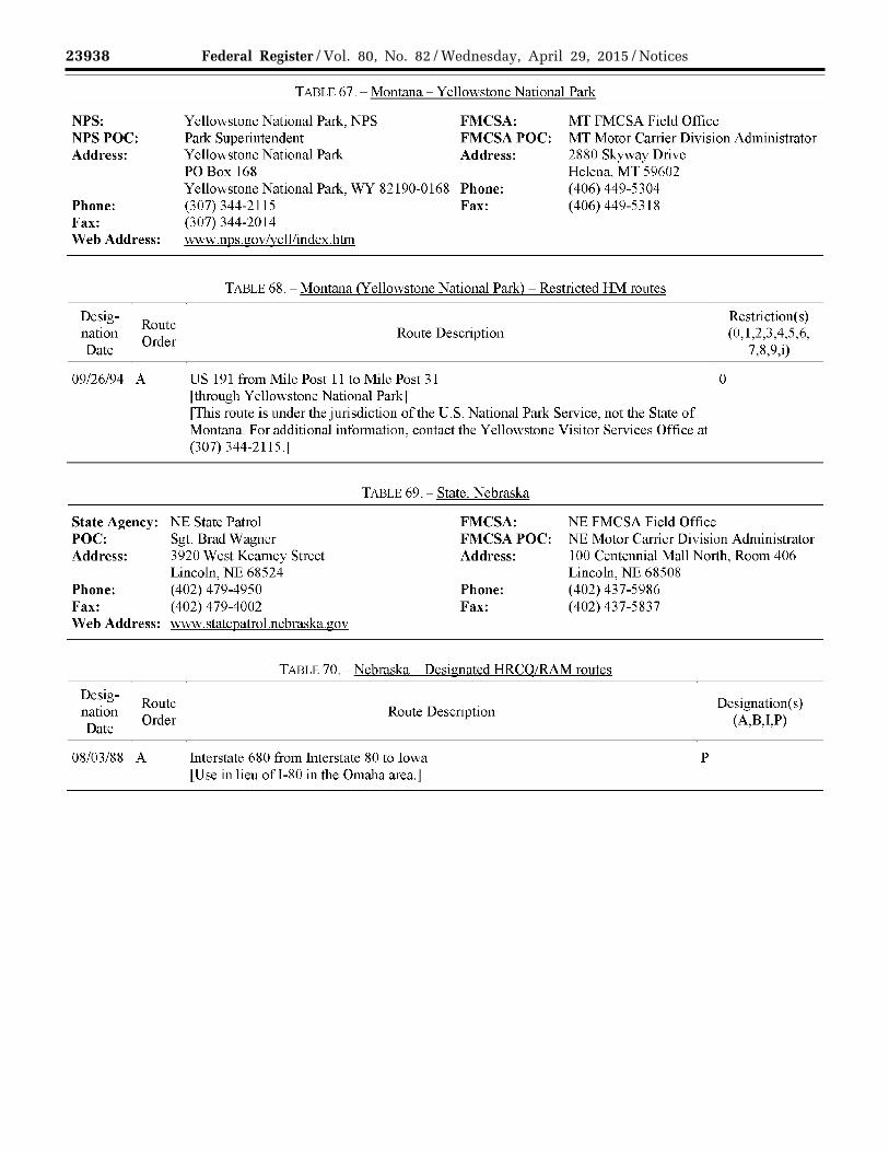
23938 Federal Register / Vol. 80, No. 82 / Wednesday, April 29, 2015 / Notices
VerDate Sep<11>2014 17:52 Apr 28, 2015 Jkt 235001 PO 00000 Frm 00080 Fmt 4701 Sfmt 4725 E:\FR\FM\29APN2.SGM 29APN2 EN
29A
P15
.079
</G
PH
>
mst
ocks
till o
n D
SK
4VP
TV
N1P
RO
D w
ith N
OT
ICE
S2
TAI3LE 67.- Montana- Y cllowstonc National Park
NPS: NPSPOC: Address:
Phone: Fax: Web Address:
Yellowstone National Park, NPS Park Superintendent Yellowstone National Park PO Box 168 Yellowstone National Park, WY 82190-0168 (307) 344-2115 (307) 344-2014 www .nps .gov /vell/index.htm
FMCSA: FMCSAPOC: Address:
Phone: Fax:
MT FMC SA Field Office MT Motor Carrier Division Administrator 2880 Skyway Drive Helena, MT 59602 ( 406) 449-5304 ( 406) 449-5318
TABLE 68.- Montana (Yellowstone National Park)- Restricted HM routes
Designation Date
Route Order
09/26/94 A
Route Description
US 191 from Mile Post 11 to Mile Post 31 rthrough Yellowstone National Parkl [This route is under the jurisdiction of the U.S. National Park Service, not the State of Montana. For additional information, contact the Yellowstone Visitor Services Office at (307) 344-2115.1
TABLE 69.- State: Nebraska
State Agency: NE State Patrol FMCSA: NE FMCSA Field Office
0
Rcstriction(s) (0, 1,2,3,4,5,6,
7,8,9,i)
POC: Sgt. Brad Wagner Address: 3920 West Kearney Street
Lincoln, NE 68524
FMCSAPOC: Address:
NE Motor Carrier Division Administrator 100 Centennial Mall North, Room 406 Lincoln, NE 68508
Phone: (402) 479-4950 Phone: (402) 437-5986 Fax: (402) 479-4002 Fax: (402) 437-5837 Web Address: www.statcpatrol.ncbraska.gov
TABLE 70.- Nebraska- Designated HRCO/RAM routes
Designation Date
Route Order
08/03/88 A
Route Description
Interstate 680 from Interstate 80 to Iowa LUse in lieu ofl-80 in the Omaha area.J
p
Designation( s) (A,B,I,P)

23939 Federal Register / Vol. 80, No. 82 / Wednesday, April 29, 2015 / Notices
VerDate Sep<11>2014 17:52 Apr 28, 2015 Jkt 235001 PO 00000 Frm 00081 Fmt 4701 Sfmt 4725 E:\FR\FM\29APN2.SGM 29APN2 EN
29A
P15
.080
</G
PH
>
mst
ocks
till o
n D
SK
4VP
TV
N1P
RO
D w
ith N
OT
ICE
S2
State Agency: POC: Address: Phone: Fax:
State Agency: POC:
Address:
Phone: Fax: Web Address:
State Agency: POC: Address:
Phone: Fax: Web Address:
State Agency:
POC: Address: Phone:
TADLE 71. - State: N cvada
No Agency Designated FMCSA: FMCSA POC: Address:
Phone: Fax:
NV FMCSA Field Office NV Motor Carrier Division Administrator 705 N. Plaza St., Suite 204 Carson City, NV 8970 l (775) 687-5335 (775) 687-8353
No designated or restricted routes as of 03/30/2015
NH Dept. of Safety Sgt. John P. Begin State Police - Troop G 33 Hazen Dr. Concord, NH 03305 (603) 223-8778 (603)271-1760 www.nh.gov/safcty/
TABLE 72.- State: New Hampshire
FMCSA: FMCSAPOC: Address:
Phone: Fax:
NH FMCSA Field Office NH Motor Carrier Division Administrator 70 Commercial St., Suite 102 Concord, NH 03301 (603) 228-3112 (603) 223-0390
No designated or restricted routes as of 03/30/2015
NJ State Police Lt. Lance Tokash 3925 US Route l Princeton, NJ 08540 (609) 452-2601 ext. 5913 (609) 452-8495 www.msp.org
TABLE 73.- State: New Jersey
FMCSA: FMCSAPOC: Address:
Phone: Fax:
NJ FMCSA Field Office NJ Motor Carrier Division Administrator One Independence Way, Suite 120 Princeton, NJ 08540 (609) 275-2604 (609) 275-5108
No designated or restricted routes as of 03/30/2015
TABLE 74.- State: New Mexico
NM Dept. ofHomeland Security & FMCSA: NM FMCSA Field Office Emergency Mgmt. FMCSAPOC: NM Motor Carrier Division Administrator Don Shainin Address: 2400 Louisiana Blvd., NE, Suite 520 P.O. Box 27111 Albuquerque, NM 87110 Santa Fe, NM 87502 Phone: (505) 346-7858 (505) 476-9628 Fax: (505) 346-7859

23940 Federal Register / Vol. 80, No. 82 / Wednesday, April 29, 2015 / Notices
VerDate Sep<11>2014 17:52 Apr 28, 2015 Jkt 235001 PO 00000 Frm 00082 Fmt 4701 Sfmt 4725 E:\FR\FM\29APN2.SGM 29APN2 EN
29A
P15
.081
</G
PH
>
mst
ocks
till o
n D
SK
4VP
TV
N1P
RO
D w
ith N
OT
ICE
S2
Fax: Web Address:
Designation Date
Route Order
04/30/99 A
01/01114 B
01/01/14 c
(505) 476-9695 www.nmdhsem.org
TADLE 7 4. - State: N cw Mexico
TABLE 75.- New Mexico- Designated HRCO/RAM routes
Route Description
Southern Route to WIPP facility: From the Texas- New Mexico border lMP O.OOOJ north on US 285 through Loving to the Junction on US 285 and US 62/180 [MP 3 1.180] in Carlsbad; east on US 62/1 SO to the WTPP north access road [MP 64.857].
If and when a south Carlsbad Relief Route is available, it shall be used instead of the route through the city. Currently posted "truck routes" shall not be used.
Note: This designation is based on 18 NMAC 20.9 (Designation of Highway Routes for the Transport of Radioactive Materials).
Negotiated Alternate Route A to WIPP facility: An alternate Southern Route departing US 285 at the inspection point west of Loving, traveling north on NM 31 to the junction with NM 128 (also known as the Jal Highway), proceeding east on NM 128 to the South Access Road, north on the South Access Road, terminating at the WTPP facility (reduces the designated route length by approximately 25 miles).
[Shall terminate on or before 12/31/2014, unless earlier terminated by 30-day written notice.l
Negotiated Alternate Route B to WIPP facility: An alternate Southern Route beginning at the TX/NM border on Interstate 20 at Big Spring, TX, proceeding west on TX/NM 176 to the junction with NM 18, continuing south on NM 18 to Jal, NM and turning west on NM 128 to the WIPP South Access Road, terminating at the WIPP facility (reduces the designated route length by approximately 93 miles).
l Shall terminate on or before 12/31/2014, unless earlier terminated by 30-day written notice.]
City
p
p
p
Designation(s) (A,B,I,P)

23941 Federal Register / Vol. 80, No. 82 / Wednesday, April 29, 2015 / Notices
VerDate Sep<11>2014 17:52 Apr 28, 2015 Jkt 235001 PO 00000 Frm 00083 Fmt 4701 Sfmt 4725 E:\FR\FM\29APN2.SGM 29APN2 EN
29A
P15
.082
</G
PH
>
mst
ocks
till o
n D
SK
4VP
TV
N1P
RO
D w
ith N
OT
ICE
S2
Designation Date
Route Order
04/30/99 D
04/30/99 E
TABLE 75.- New Mexico- Designated HRCQ/RAM routes
Route Description
Western Route to WIPP facility: From the Arizona- New Mexico border [MP 0.000] east on 1-40 through Gallup, Thoreau, Grants, Albuquerque and Moriarty to the junction ofl-40 and US 285 [MP 218 .128], Exit 218 at Clines Comers; south on US 285 through Encino, Vaughn, Roswell (along the Roswell Relief Route) [MP 119.930] and Artesia to the junction of US 285 and NM 200 North of Carlsbad [38.940] East on NM 200 (Carlsbad Relief Route) to the Junction of US 62/180 east of Carlsbad [38.789], east on US 62/180 to the WIPP north access road [MP 64.652].
Relief Routes are available; they shall be used instead of the route through each respective city. Currently posted ''truck routes" shall not be used.
Note: This designation is based on 18 NMAC 20.9 (Designation of Highway Routes for the Transport of Radioactive Materials).
Los Alamos National Laboratory to WIPP facility: From the Los Alamos National Laboratory in Los Alamos County Tech Area 54, [MP 0.000] east on the Los Alamos Truck Route to the junction of the Los Alamos Truck Route and NM 4; east on NM 4 to the junction ofNM 4 and NM 502; [MP 68.186] east on NM 502 to the junction ofNM 502 fl8.08ll and US 84/285 at Pojoaque; south on US 84/285 l MP 181.251 J to the junction of US 84/285 and NM 599; [MP 167.443] south on NM 599 to the junction ofNM 599 and 1-25; north on 1-25 to the junction ofl-25 and US 285 [MP 292.185], Exit 290]; south on US 285 through Clines Comers, Encino, Vaughn, Roswell (along the Roswell Relief Route) and Artesia to the junction of US 285 and NM 200 North of Carlsbad [38.940] East on (NM 200 Carlsbad Relief Route) to the Junction of US 62/180 east of Carlsbad [38.789], east on US 62/180 to the WIPP north access.
Relief Routes are available: they shall be used instead of the route through each respective city. Currently posted "truck routes" shall not be used, except for the Los Alamos Truck Route as stated above.
Note: This designation is based on 18 NMAC 20.9 (Designation of Highway Routes for the Transport of Radioactive Materials).
City
p
p
Designation(s) (A,B,I,P)

23942 Federal Register / Vol. 80, No. 82 / Wednesday, April 29, 2015 / Notices
VerDate Sep<11>2014 17:52 Apr 28, 2015 Jkt 235001 PO 00000 Frm 00084 Fmt 4701 Sfmt 4725 E:\FR\FM\29APN2.SGM 29APN2 EN
29A
P15
.083
</G
PH
>
mst
ocks
till o
n D
SK
4VP
TV
N1P
RO
D w
ith N
OT
ICE
S2
Designation Date
Route Order
04/30/99 F
Ol/01/14 G
04/30/99 H
TABLE 75.- New Mexico- Designated HRCQ/RAM routes
Route Description
Northern Route to WIPP facility: From the Colorado- New Mexico border [MP 462.124] south on 1-25 through Raton, Springer, and Las Vegas to the junction of I -25 and US 285 [MP292.185], Exit 290 near Santa Fe; south on US 285 through Clines Comers, Encino, Vaughn, Roswell (along the Roswell Relief Route) [MP 119.930] and Artesia to the junction of US 285 and NM 200 North of Carlsbad l38.940J East on NM 200 (Carlsbad Relief Route) to the Junction of US 62/180 east of Carlsbad [38.789], east on US 62/180 to the WIPP north access road [MP 64.652].
Relief Routes are available; they shall be used instead of the route through each respective city. Currently posted ''truck routes" shall not be used.
Note: This designation is based on 18 NMAC 20.9 (Designation of Highway Routes for the Transport of Radioactive Materials).
Negotiated Alternate Route C to WIPP Facility: An alternate Northern Route departing US 285 at the intersection of the WIPP Relief Route (also known as the Loop Road) north of Carlsbad traveling east to the junction of US 62/180, continuing east on US 62/180 to NM 31, which heads south to NM 128, and then proceeding east on NM 128 to the South Access Road, terminating at the WIPP site (increases the designated route length by approximately 10 miles).
[Shall terminate on or before 12/31/2014, unless earlier terminated by 30-day written notice.]
Eastern Route to WIPP facility: From the Texas- New Mexico border [MP 373.530] west on 1-40 through Tucumcari to the junction ofl -40 and US 54 [MP 276.836], Exit 275 at Santa Rosa; west on US 54 through Pastura to the junction of US 54 and US 285 at Vaughn; south on US 285 tl1rough Roswell (along the Roswell Relief Route) [MP 119. 930] and Artesia to the junction of US 285 and NM 200 North of Carlsbad [38.940] East on (NM 200 Carlsbad Relief
Route) to the Junction of US 62/180 east of Carlsbad [38.789], east on US 62/180 to the WIPP north access road [MP 64.857].
City
p
p
p
Designation(s) (A,B,I,P)

23943 Federal Register / Vol. 80, No. 82 / Wednesday, April 29, 2015 / Notices
VerDate Sep<11>2014 17:52 Apr 28, 2015 Jkt 235001 PO 00000 Frm 00085 Fmt 4701 Sfmt 4725 E:\FR\FM\29APN2.SGM 29APN2 EN
29A
P15
.084
</G
PH
>
mst
ocks
till o
n D
SK
4VP
TV
N1P
RO
D w
ith N
OT
ICE
S2
Designation Date
Designation Date
02/18/91
Route Order
Route Order
A1
TADLE 75.- New Mexico- Designated HRCQ/RAM routes
Route Description
Relief Routes are available; they shall be used instead of the route through each respective city. Currently posted "truck routes" shall not be used.
Note: This designation is based on 18 NMAC 20.9 (Designation ofHighway Routes for the Transport of Radioactive Materials)
TABLE 76.- New Mexico- Designated NRHM routes
Route Description
Interstate 10 [within Las Cruces city Limits]
City
City
Las Cruces
A
Designation(s) (A,B,T,P)
Designation(s) (A,B,l,P)
02/18/91 A2 Interstate 25 [within Las Cruces city Limits] Las Cruces
A
02/18/91 A3A US 70 from East City Limits [Las Cruces ncar Organ] to Interstate 25 Las Cruces
A
State Agency: POC:
Address:
Phone: Web Address:
New York City Fire Dept Sandy Camacho Bureau of Operations 9 Metro Tech Center Brooklyn, NY 11201 (718) 999-2464 www.nyc.gov/html/ fdny/html/home2.shtml
TABLE 77.- State: New York
FMC SA: FMCSAPOC: Address:
Phone: Fax:
NY FMCSA Field Office NY Motor Carrier Division Administrator Leo W. O'Brien Federal Bldg. Clinton Avenue & N. Pearl St. Albany, NY 12207 (518) 431-4145 (518) 431-4140
Note: New York City Fire Department already established a specific route ordering approach for designated NRHM routes (i.e., NYC Route 1, NYC Route 2, etc.). As a result, FMCSA chose not to include an FMCSA route order column in Table 79.

23944 Federal Register / Vol. 80, No. 82 / Wednesday, April 29, 2015 / Notices
VerDate Sep<11>2014 17:52 Apr 28, 2015 Jkt 235001 PO 00000 Frm 00086 Fmt 4701 Sfmt 4725 E:\FR\FM\29APN2.SGM 29APN2 EN
29A
P15
.085
</G
PH
>
mst
ocks
till o
n D
SK
4VP
TV
N1P
RO
D w
ith N
OT
ICE
S2
Designation Date
Route Order
01/06/95 A
01/06/95 B
TAI3LE 78.- New York- Restricted HM routes
Route Description City Restriction(s)
County (0,1,2,3,4,5,6, 7,8,9,i)
City of New York Hazmat Restrictions New York All 0 [For shipments of Hazardous Cargo through the City without pickup or delivery within the City, to piers, airports, and shipping terminals, hazardous cargo transportation prohibited by City, State, Federal law or regulation shall not be permitted to enter or pass through New York City, except where specifically authorized by authorized govemmental agencies and the Fire Commissioner. Such shipments shall conform to routes, times, and safety conditions specified by the Fire Commissioner. (Such designated routes are listed here in the FMCSA National Hazardous Material Route Registry.)
Motor Vehicles conforming to Fire Department specifications and tmder Fire Department permit may be used to transport allowable Hazardous Cargo in accordance with Chapter 4 of Title 27 Administrative Code and the rules and regulations of the Fire Commissioner without conformance to the routing, time, escorts, and other restrictions and such "permitted" vehicles must be used for deliveries for storage and/or use or for pickup in the City.
Hazardous cargo shipments shall transit the City only during non-rush hours. Shipments of explosives are permitted only during daylight hours, except that shipments at night may be allowed in individual cases for escorted shipments as pursuant to Administrative Code 27-4019(b). Times for shipments are as follows:
Monday through Friday: For explosives, and prohibited materials for which specific permission has been given by Fire Department: 10:00 A.M. to 3:00P.M. and 7:00P.M. to 6:00A.M. For all otherhazardous cargo: 9:00A.M. to 4:00PM and-6:00PM. to 7:00A.M. Saturday, Sm1day, and Holidays: As traffic conditions pennit, consistent with the rules and regulations of govemment agencies and/or authorities having jurisdiction.]
V errazano Bridge [Contact the FDNY (718) 403-1580 for more information.]
New York Rich-(Staten mond Island & & Brooklyn)
Kings

23945 F
ederal R
egister/V
ol. 80, No. 82
/Wed
nesd
ay, Ap
ril 29, 2015/N
otices
VerD
ate Sep<
11>2014
17:52 Apr 28, 2015
Jkt 235001P
O 00000
Frm
00087F
mt 4701
Sfm
t 4725E
:\FR
\FM
\29AP
N2.S
GM
29AP
N2
EN29AP15.086</GPH>
mstockstill on DSK4VPTVN1PROD with NOTICES2
TADLE 79.- New York -Designated NRHM routes
Desig-nation Route Description Date
01/06/95 City of New York Escort Rendezvous Points [Escorts by a fully manned fire department engine company shall be required for all permitted Class "A", Class "B", and Class "C" explosives (over 50 pounds in weight) from point of entry into the City until its exit from the City pursuant to 27-4034(j) Administrative Code of the City ofNew York. The fire commissioner reserves the right to require escorts for any hazardous cargo shipment when he deems necessary. Notification of arrival of explosives shipments shall be made 48 hours in advance by calling the notification desk in the chief of department's office (718) 403-1580.
Shipments from North Shore Long Island: Meet at safety area of Westbound Long Island Expressway (1-495) on the right side between Lakeville Road and Little Neck Parkway.
Shipments from South Shore Long Island: Meet at northwest corner of intersection of Sunrise Highway (State 27) bet\veen Hook Creek Blvd. and 246th Street.
From Upstate New York or New England via New England Thruway (I-95): exit at Connors Street exit, proceed on New England Thmway Service Road to Connors Street to meet Fire Department escort.
From Upstate New York and New England via New York Thruway (I -87): exit into Service Area of Major Deegan Expressway located between Westchester County line and the East 233rd street exit of the expressway, to meet Fire Department escort.
From NJ via Goethals, Bayonne, Outerbridge Crossing, and George Washington Bridges: Meet at Adm. Bldg - Toll Plaza.
From J.F.K. International Airport: Meet in front of the Major Robert Fitzgerald Building #111 on the inbound service road of the Federal Circle.
From LaGuardia Airport: Meet at Marine Air Terminal P.A.N.Y.NJ. Police Building, entering at 82nd Street entrance to LaGuardia Airport.]
City
New York All
County
B
Designation(s) (A,B,I,P)

23946 F
ederal R
egister/V
ol. 80, No. 82
/Wed
nesd
ay, Ap
ril 29, 2015/N
otices
VerD
ate Sep<
11>2014
17:52 Apr 28, 2015
Jkt 235001P
O 00000
Frm
00088F
mt 4701
Sfm
t 4725E
:\FR
\FM
\29AP
N2.S
GM
29AP
N2
EN29AP15.087</GPH>
mstockstill on DSK4VPTVN1PROD with NOTICES2
Designation Date
TADLE 79.- New York -Designated NRHM routes
Route Description
01/06/95 NYC Route 1: From NJ to western Westchester County and upstate New York lGeorge Washington Bridge (upper level) to Washington Expressway (without detour on City streets) via the Alexander Hamilton Bridge to the Major Deegan Expressway to New York Thruway (1-87).
Note: Reverse routing permitted. Rendezvous with escort if required.]
01/06/95 NYC Route 2: From NJ to eastern Westchester County, upstate New York, and New England [George Washington Bridge (upper level) to Washington Expressway (without detour on City streets) via the Alexander Hamilton Bridge directly to Cross Bronx Expressway (1-95) to Bruckner Interchange, continue on Bruckner Expressway to New England Thruway (1-95).
Note: Reverse routing permitted. Rendezvous with escort ifrequired.J
City
Washington Heights
County
New York & Westchester
A
New York & A Westchester
Designation(s) (A,B,I,P)

23947 F
ederal R
egister/V
ol. 80, No. 82
/Wed
nesd
ay, Ap
ril 29, 2015/N
otices
VerD
ate Sep<
11>2014
17:52 Apr 28, 2015
Jkt 235001P
O 00000
Frm
00089F
mt 4701
Sfm
t 4725E
:\FR
\FM
\29AP
N2.S
GM
29AP
N2
EN29AP15.088</GPH>
mstockstill on DSK4VPTVN1PROD with NOTICES2
Designation Date
TADLI 79.- New York- Designated NRHM routes
Route Description
01/06/95 NYC Route 3: From NJ to Nassau and Suffolk Counties [NYC Route 3(i): George Washington Bridge (upper level) via Washington Expressway (without detour on City streets) via the Alexander Han1ilton Bridge directly to Cross Bronx Expressway (I-95), east on Cross Bronx Expressway (I-95) to Throgs Neck Bridge, south across Throgs Neck Bridge to Clearview Expressway (T-295) to Long Island Expressway, east on Long Island Expressway (I-495) to Nassau and/or Suff-olk Counties.
NYC Route 3(ii): Usc either NYC Route 3(ii)A, 3(ii)B, or 3(ii)C THEN, East on Staten Island Expressway (I-278) to Verrazano Bridge, cross upperlevcl ofVerrazano Bridge to Brooklyn Queens Expressway (I-278), then east on Brooklyn Queens Expressway (I-278) to Long Island Expressway (I-495), then east on Long Island Expressway (I-495) to Nassau and/or Suffolk Counties.
NYC Route 3(ii)A: Outerbridge crossing to West Shore Expressway, North on West Shore Expressway (State 440) to Staten Island Expressway (I-278).
NYC Route 3(ii)B: Bayonne Bridge to Willowbrook Expressway (State 440) south to Staten Island Expressway (I-278).
NYC Route 3(ii)C: Goethals Bridge to Staten Island Expressway (1-278).
Note: Reverse routing permitted. Rendezvous witll escort if required. Hazardous cargo requiring escort (i.e. explosives) shall use route via George Washington Bridge only to minimize travel time within the city. Explosives are prohibited on Verrazano Bridge.]
City County
Nassau & Suffolk
A
Designation(s) (A,B,I,P)

23948 F
ederal R
egister/V
ol. 80, No. 82
/Wed
nesd
ay, Ap
ril 29, 2015/N
otices
VerD
ate Sep<
11>2014
17:52 Apr 28, 2015
Jkt 235001P
O 00000
Frm
00090F
mt 4701
Sfm
t 4725E
:\FR
\FM
\29AP
N2.S
GM
29AP
N2
EN29AP15.089</GPH>
mstockstill on DSK4VPTVN1PROD with NOTICES2
Designation Date
TADLE 79.- New York -Designated NRHM routes
Route Description
01/06/95 NYC Route 4: From Upstate NY or New England to Nassau and Suffolk Counties [NYC Route 4(i): New England Thmway (I-95) (to Connors Street exit to meet escort if required), to Bmckner Expressway (I-95) to Throgs Neck Expressway (1-295), to Throgs Neck Bridge, to Clearview Expressway (I-295), to Long Island Expressway (1-495), east on Long Island Expressway to City Line.
NYC Route 4(ii): New York State Thmway (1-87) south to Major Deegan Expressway (1-87), to Cross Bronx Expressway (I-95), east to Bmckner Expressway (I-278) to TI1rogs Neck Bridge, to Clearview Expressway (I-295), to Long Island Expressway (I-495), east on Long Island Expressway to City Line.
Note: See NYC Route 25 for alternate routes. Reverse routing permitted. Rendezvous with escort if required.j
01/06/95 NYC Route 5: From NJ to LaGuardia Airport via Goethals Bridge [Goethals Bridge to Staten Island Expressway (T-278) to Verrazano Narrows Bridge (upper level) to Brooklyn Queens Expressway (1-278) to Astoria Blvd. (exit 39), east to 82nd Street then north on 82nd Street to LaGuardia Airport.
Note: Reverse routing permitted. Rendezvous with escort if required. Explosives prohibited on Verrazano Bridge.j
01/06/95 NYC Route 6: From NJ to LaGuardia Airport via Outerbridge Crossing [Outerbridge Crossing to West Shore Expressway (State 440) to Staten Island Expressway (T-278) east to Verrazano Narrows Bridge (upper level) to Brooklyn Queens Expressway (I-278) to Astoria Blvd. (exit 39), east to 82nd Street then north on 82nd Street to LaGuardia Airport.
Note: Reverse routing permitted. Rendezvous with escort if required. Explosives prohibited on Verrazano Bridge.j
City County
Nassau & Suffolk
A
A
A
Designation(s) (A,B,I,P)

23949 F
ederal R
egister/V
ol. 80, No. 82
/Wed
nesd
ay, Ap
ril 29, 2015/N
otices
VerD
ate Sep<
11>2014
17:52 Apr 28, 2015
Jkt 235001P
O 00000
Frm
00091F
mt 4701
Sfm
t 4725E
:\FR
\FM
\29AP
N2.S
GM
29AP
N2
EN29AP15.090</GPH>
mstockstill on DSK4VPTVN1PROD with NOTICES2
Designation Date
TADLE 79.- New York -Designated NRHM routes
Route Description
01/06/95 NYC Route 7: From NJ to LaGuardia Airport via George Washington Bridge [George Washington Bridge (upper level) via Washington Expressway (without detour on City streets) via the Alexander Hamilton Bridge directly to Cross Bronx Expressway (I-95), east on Cross Bronx Expressway (I-95) to Throgs Neck Bridge, south across Throgs Neck Bridge to Clearview Expressway (T-295) to Long Island Ex1Jressway (T-495), west on L.T.E. (T-495) to VanWyck Expressway (T-67!1), north on VanWyck Expressway (I-678) to Northern Blvd. (25A), west on Northern Blvd. to Astoria Blvd. West on Astoria Blvd to 82nd Street, north on 82nd Street to LaGuardia Airport.
Note: Sec NYC Route 25 for alternate routes. Reverse routing permitted. Rendezvous with escort if required.]
01/06/95 NYC Route 8: From Long Island to LaGuardia Airport [NYC Route 8(i): Long Island Expressway (1-495) West to VanWyck Expressway (1-678), North to Northern Blvd. (25-A), West to Astoria Blvd .. Astoria Blvd. to !\2nd Street, North on !\2nd Street to LaGuardia Airport.
NYC Route 8(ii): Long Island Expressway (I-495) West to Brooklyn Queens Expressway (I-278) East to Astoria Blvd. (Exit 39) East to 82nd Street, North on 82nd to LaGuardia Airport.
NYC Route 8(iii): West on Sunrise Highway (State 27) to North Conduit Blvd. to VanWyck Expressway (1-678), North on VanWyck Expressway (I-678) to Northern Blvd. (25-A), West to Astoria Blvd., Astoria Blvd. to 82nd Street, North on 82nd Street to LaGuardia Airport.
NYC Route !l(iv): West on Sunrise Highway (State 27) to North Conduit Blvd. to VanWyck Expressway (I-678), North on VanWyck Expressway (I-678) to Long Island Expressway (I-495), West to Brooklyn Queens Expressway (1-278), East to Astoria Blvd. (Exit 39), East to 82nd Street, North on 82nd Street to LaGuardia Airport.
Note: Reverse routing permitted. Rendezvous tor escort if required.j
City County
A
A
Designation(s) (A,B,I,P)

23950 F
ederal R
egister/V
ol. 80, No. 82
/Wed
nesd
ay, Ap
ril 29, 2015/N
otices
VerD
ate Sep<
11>2014
17:52 Apr 28, 2015
Jkt 235001P
O 00000
Frm
00092F
mt 4701
Sfm
t 4725E
:\FR
\FM
\29AP
N2.S
GM
29AP
N2
EN29AP15.091</GPH>
mstockstill on DSK4VPTVN1PROD with NOTICES2
Designation Date
TADLE 79.- New York -Designated NRHM routes
Route Description
01/06/95 NYC Route 9: From New England or upper New York State to LaGaurdia Airport [NYC Route 9(i): New England Thmway (I-95) south take to LaGuardia Airport (to Connors Street exit to meet escort, if required), to Bmckner Expressway (I-95) to Throgs Neck Expressway (1-295), via Throgs Neck Bridge to Clcarvicw Expressway (1-295) to Long Island Expressway (1-495), west to Brooklyn Queens Expressway (T-278) east, to Astoria Blvd. (exit 39), east to 82nd Street, then north on 82nd Street to LaGuardia Airport.
NYC Route 9(ii): New York State Thruway (I-87) south to Major Deegan Expressway (I-87) to Cross Bronx Expressway (I-95) east to Bmckner Expressway (1-278) to Throgs Neck Bridge, to Clearview Expressway (I-295), to Long Island Expressway (I-495) west, to Brooklyn Queens Expressway (T-278) east, to Astoria Blvd. (Exit 39), east to 82nd Street, then north on 82nd Street to LaGuardia Airport.
Note: See NYC Route 25 for alternate routes. Reverse routing permitted. Rendezvous with escort if rcquircd.l
01/06/95 NYC Route 10: From New Jersey to J.F.K. International Airport via Goethals Bridge rFrom New Jersey via Goethals Bridge to Staten Island Expressway (1-278) to Verrazano-Narrows Bridge (upper level), Brooklyn Queens Expressway (I-278) east to Long Island Expressway (I-495). east to VanWyck Expressway (I-678), south on VanWyck Expressway (I-678) to J.F.K. International Airport.
Note: Reverse routing permitted. Rendezvous with escort if required. Explosives prohibited on Verrazano Bridge.j
City County
A
A
Designation(s) (A,B,I,P)

23951 F
ederal R
egister/V
ol. 80, No. 82
/Wed
nesd
ay, Ap
ril 29, 2015/N
otices
VerD
ate Sep<
11>2014
17:52 Apr 28, 2015
Jkt 235001P
O 00000
Frm
00093F
mt 4701
Sfm
t 4725E
:\FR
\FM
\29AP
N2.S
GM
29AP
N2
EN29AP15.092</GPH>
mstockstill on DSK4VPTVN1PROD with NOTICES2
Designation Date
TADLE 79.- New York -Designated NRHM routes
Route Description
01/06/95 NYC Route ll: From New Jersey to JF.K. international Airport via Outerbridge Crossing [From New Jersey via Outerbridge Crossing to West Shore Express\vay (State 440) to Staten Island Expressway (I-278) to Verrazano-Narrows Bridge (upper level), to Brooklyn Queens Expressway east (I-278) to Long Island EA-1Jressway (I-495), East on Long Island Expressway (I-495) to VanWyck Expressway (T-678), South on VanWyck Expressway (T-678) to J.F.K. International Airport.
Note: Reverse routing pennitted. Rendezvous with escort if required. Explosives prohibited on Verrazano Bridge.]
01/06/95 NYC Route 12: From Nevi Jersey to J.F.K. International Airport via George Washington Bridge (upper level) [From New Jersey via George Washington Bridge (upper level), via Washington Expressway (without detouring onto City streets) via the Alexander Hamilton Bridge directly to Cross Bronx Expressway (I-95), east on Cross Bronx Expressway (T-95), to Throgs Neck Bridge, south across Throgs Neck Bridge to Clearview Expressway (I-295) to Long Island Expressway (I-495), west to VanWyck Expressway (I-678), south on VanWyck Expressway (I-678) to J.F.K. International Airport.
Note: Sec NYC Route 25 for alternate routes. Reverse routing permitted. Rendezvous with escort if required.j
City County
A
A
Designation(s) (A,B,I,P)

23952 F
ederal R
egister/V
ol. 80, No. 82
/Wed
nesd
ay, Ap
ril 29, 2015/N
otices
VerD
ate Sep<
11>2014
17:52 Apr 28, 2015
Jkt 235001P
O 00000
Frm
00094F
mt 4701
Sfm
t 4725E
:\FR
\FM
\29AP
N2.S
GM
29AP
N2
EN29AP15.093</GPH>
mstockstill on DSK4VPTVN1PROD with NOTICES2
Designation Date
TADLE 79.- New York -Designated NRHM routes
Route Description
01/06/95 NYC Route 13: From New England and upper New York State to J.F.K. International Airport [NYC Route 13(i): Nevi England Thmway (I-95), south (to Connors Street exit to meet escort, if required) to Bmckner Expressway (I-95), to Throgs Neck Expressway (I-295), via Throgs Neck Bridge to Clearview Expressway (I-295), to Long Island Expressway (I-495) west on Long Island Expressway (I-495) to VanWyck Expressway (I-678), south on VanWyck Expressway (I-678), to J.F.K. International Airport.
NYC Route 13(ii): New York State Thmway (I-87) south to Major Deegan Express\vay (I-87) to Cross Bronx Expressway (I-95), east to Bruckner Expressway (I-278) to Throgs Neck Bridge, to Clearview Expressway (I-295) to L.I. Expressway (I-495) west to VanWyck Expressway (I-678), south on Van Wyck Expressway (I-678) to J.F.K. Airport.
Note: See NYC Route 25 for alternate routes. Reverse routing pem1itted. Rendezvous with escort if required.]
01/06/95 NYC Route 14: From Long Island to J.F.K. International Airport [NYC Route l4(i): West on Long Island Expressway (I-495) to VanWyck Express\vay (I-676), south on VanWyck Expressway (I-678) to J.F.K. International Airport.
NYC Route 14(ii): West on Sunrise Highway (State 27) to North Conduit Blvd. to VanWyck Expressway (1-678), south on VanWyck Expressway (1-678) to J.F.K.1nternational Airport.
NYC Route 14(iii): West on Sunrise Highway (State 27) to North Conduit Blvd. to Rockaway Blvd., or 150th Street, to J.F.K. International Airport.
Note: Reverse routing permitted. Rendezvous with escort if required.J
City County
A
A
Designation(s) (A,B,I,P)

23953 F
ederal R
egister/V
ol. 80, No. 82
/Wed
nesd
ay, Ap
ril 29, 2015/N
otices
VerD
ate Sep<
11>2014
17:52 Apr 28, 2015
Jkt 235001P
O 00000
Frm
00095F
mt 4701
Sfm
t 4725E
:\FR
\FM
\29AP
N2.S
GM
29AP
N2
EN29AP15.094</GPH>
mstockstill on DSK4VPTVN1PROD with NOTICES2
Designation Date
TADLE 79.- New York -Designated NRHM routes
Route Description
01/06/95 NYC Route 15: From New Jersey to Staten Island Piers [NYC Route 15(i): From Nevi Jersey via Bayonne Bridge Plaza via Willowbrook Expressway (State 440) to Staten Island Expressway (I-278), west on Staten Island Expressway to Westem Avenue, north on Western Avenue to Richmond Terrace, east on Richmond Terrace to Northside Piers, or Staten Island Expressway, east to Bay Street Exit then local streets to east side piers.
NYC Route 15(ii): From Goethals Bridge Plaza via Staten Island Expressway (I-278) to Forest Avenue, north on Forest Avenue to Goethals Road North, west on Goethals Road North to Western Avenue, north on Western Avenue to Northside Piers, or Staten Island Expressway east to Bay Street exit, then local streets to cast side piers.
NYC Route 15(iii): From Outerbridge Crossing via West Shore Expressway (State 440) and Staten Island Expressway (I-278), west on Staten Island Expressway to Western Avenue, north on Westem Avenue to Richmond Terrace, then local streets for Northside piers, or Staten Island Expressway east to Bay Street exit, then local streets to cast side piers.
Note: Reverse routing permitted. Rendezvous with escort ifrequired.J
City County
A
Designation(s) (A,B,I,P)

23954 F
ederal R
egister/V
ol. 80, No. 82
/Wed
nesd
ay, Ap
ril 29, 2015/N
otices
VerD
ate Sep<
11>2014
17:52 Apr 28, 2015
Jkt 235001P
O 00000
Frm
00096F
mt 4701
Sfm
t 4725E
:\FR
\FM
\29AP
N2.S
GM
29AP
N2
EN29AP15.095</GPH>
mstockstill on DSK4VPTVN1PROD with NOTICES2
Designation Date
TADLE 79.- New York -Designated NRHM routes
Route Description
01/06/95 NYC Route 16: From New Jersey to Brooklyn Piers [NYC Route l6(i): From Bayonne Bridge, south via Willowbrook Expressway (State 440) to Staten Island Expressway (I-278), eastto Verrazano-Narrows Bridge (upper level) to Brooklyn Queens Expressway (I-278), cast on Brooklyn Queens Expressway (I-278), cast on Brooklyn Queens Expressway (T-278) to nearest exit to location of pier then local streets to pier.
NYC Route l6(ii): From New Jersey via Goethals Bridge to Staten Island Expressway (1-278) to
Verrazano-Narrows Bridge (upper level), to Brooklyn Queens Expressway (I-278), east on Brooklyn Queens Expressway (I-278) to nearest exit to location of pier then local streets to pier.
NYC Route l6(iii): From New Jersey via Outerbridge Crossing to West Shore Expressway (State 440) to Staten Island Expressway (1-278) to Verrazano-Narrows Bridge (upper level) , to Brooklyn Queens Expressway (I-278), east on Brooklyn Queens Expressway (I-278) to nearest exit to location of pier, local streets to pier.
Note: Reverse routing pennitted. Rendezvous with escort if required. Explosives prohibited on Verrazano Bridge.]
01/06/95 NYC Route l7(i): From New Jersey to Manhattan Piers via George Washington Bridge [NYC Route l7(i): From New Jersey via George Washington Bridge (upper level), exit at 178th Street and Fort Washington Avenue, east on 178th Street to Amsterdam Avenue, south on Amsterdam Avenue to Cathedral Parkway ( llOth Street), cast on llOth Street to Columbus
Avenue, south on Columbus Avenue to west 57th Street, west on 57th Street to llth Avenue, south on 11th Avenue to 55th Street, west on 55th Street to 12th Avenue, 12th Avenue north or south to pier location.
Note: Reverse routing pennitted. Rendezvous with escort if required. Tn area of 12th Street, 12th Avenue becomes West Street.]
City County
A
A
De signatiml(s) (A,B,I,P)

23955 F
ederal R
egister/V
ol. 80, No. 82
/Wed
nesd
ay, Ap
ril 29, 2015/N
otices
VerD
ate Sep<
11>2014
17:52 Apr 28, 2015
Jkt 235001P
O 00000
Frm
00097F
mt 4701
Sfm
t 4725E
:\FR
\FM
\29AP
N2.S
GM
29AP
N2
EN29AP15.096</GPH>
mstockstill on DSK4VPTVN1PROD with NOTICES2
Designation Date
TADLE 79.- New York -Designated NRHM routes
Route Description
01/06/95 NYC Route l7(ii)A and l7(ii)B: From New Jersey to Manhattan Piers via Lincoln Tunnel [NYC Route l7(ii)A: Lincoln Tunnel to west side piers north of Lincoln Tunnel: From Lincoln Tunnel, exit at Dyer Avenue (40th Street) north on Dyer Avenue to 41st Street, west (left) on 41st Street, to 12th Avenue (right tum at 12th Avenue adjacent to elevated structure of West Side Highway, continue north on 12th Avenue to piers.
Return NYC Route 17(ii)A: Return route to Lincoln Tunnel: South on 12th Avenue (at 43rd Street, move to left traffic lane to exit at 42nd Street), east (left tum) at 42nd Street on block to 11th Avenue, tum south (right) at 11th Avenue, continue south on 11th Avenue for two blocks (follow signs to Lincoln Tunnel), east (left) on 40th Street to Lincoln Tunnel entrance at Galvin Avenue.
NYC Route l7(ii)B: Lincoln Tunnel to west side piers south of Lincoln Tunnel: From Lincoln Tunnel exit at Dyer Avenue (40th Street) north on Dyer Avenue to 41st Street, west (left) on 41st Street to 12th Avenue, south (left) on 12th Avenue (under elevated structure ofWcst Side Highway to southbound traffic lane of 12th Avenue) continue south on 12th Avenue and/or West Streetto piers.
Return NYC Route 17(ii)B: Return route to Lincoln Tunnel: North on West Street to 12th Avenue, north on 12th Avenue to 40th Street, east on 40th Street across 11th Avenue to Galvin Avenue entrance to Lincoln Tunnel.
Note: In area of 12th Street, 12th Avenue becomes West Street.]
City County
A
Designation(s) (A,B,I,P)

23956 F
ederal R
egister/V
ol. 80, No. 82
/Wed
nesd
ay, Ap
ril 29, 2015/N
otices
VerD
ate Sep<
11>2014
17:52 Apr 28, 2015
Jkt 235001P
O 00000
Frm
00098F
mt 4701
Sfm
t 4725E
:\FR
\FM
\29AP
N2.S
GM
29AP
N2
EN29AP15.097</GPH>
mstockstill on DSK4VPTVN1PROD with NOTICES2
TADLE 79.- New York -Designated NRHM routes
Desig-nation Route Description Date
01/06/95 NYC Route 17(ii)C and 17(ii)D: From New Jersey to Manhattan Piers via Holland Tunnel [NYC Route 17(ii)C: Holland Tunnel to west side piers north of Holland Tunnel: Exit from Holland Tunnel at Hudson Street, north (right tum) on Hudson Street to Canal Street, \vest (left tum) on Canal Street to West Street, north (right tum) on West Street, continue north on West Street and/or 12th Avenue, to piers.
Retum NYC Route 17(ii)C: Retum route to Holland Tunnel: South on 12th Avenue and continue south on West Street to Canal Street, east (left tum) on Canal Street to Hudson Street, then north (left tum) at Hudson Street to Holland Tunnel entrance.
NYC Route 17(ii)D: Holland Tunnel to west side piers south of Holland Tunnel: Exit from Holland Tunnel at Hudson Street, north (right tum) on Hudson Street to Canal Street, west (left tum) on Canal Street to West Street, north (right tum) on West Street to west Houston Street, make "U" tum from north bound traffic lane under elevated West Side Highway to south bound traffic lane of West Street, continue south on West Street to piers.
Rctum NYC Route 17(ii)D: North on West Street to Canal Street, cast (right tum) on Canal Street to Hudson Street, then north (left tum) on Hudson Street to Holland Tunnel entrance.
Note: In area of 12th Street, 12th Avenue becomes West Street.]
City County
Manhattan New York A
Designation(s) (A,B,I,P)

23957 F
ederal R
egister/V
ol. 80, No. 82
/Wed
nesd
ay, Ap
ril 29, 2015/N
otices
VerD
ate Sep<
11>2014
17:52 Apr 28, 2015
Jkt 235001P
O 00000
Frm
00099F
mt 4701
Sfm
t 4725E
:\FR
\FM
\29AP
N2.S
GM
29AP
N2
EN29AP15.098</GPH>
mstockstill on DSK4VPTVN1PROD with NOTICES2
Designation Date
TADLE 79.- New York -Designated NRHM routes
Route Description
01/06/95 NYC Route 17(ii)E: From New Jersey, via George Washington Bridge, Lincoln or Holland Tunnels to lower east side (East River) piers [Utilize routes l7(ii)A through l7(ii)D, continue south on 12th Avenue or West Street, south on West Street to Battery Park Underpass (head room 12' ll "),enter Battery Park Underpass and exit on South Street, continue north on South Street and/or marginal street under elevated F.D.R. Drive to location of pier Return route: Proceed south on marginal street under elevated F.D.R. Drive and/or South Street to Battery Park Underpass, enter Battery Park Underpass and exit on West Street, proceed north on West Street and/or 12th Avenue, continue as per routes l7(ii)A through l7(ii)D to Lincoln and Holland Tunnels respectively, and, for George Washington Bridge, proceed north on 12th Avenue to 57th Street, east on 57th Street to Amsterdam Avenue, north on Amsterdam Avenue to l79th Street, west on 179th Street to George Washington Bridge.
Note: Rendezvous with escort if required. In area of 12th Street, 12th Avenue becomes West Street.j
01/06/95 NYC Route 18(i): From New England to Manhattan piers [South on New England Thruway (T-95) (to Connors Street exit to meet escort if required), to Bruckner Expressway (I-278), to Willis Avenue and Third Avenue exit on l35th Street, west on l35th Street 1hird Avenue, south on Third Avenue across 3rd Avenue Bridge to 129th Street, east on l29th Street to Second Avenue, south on Second Avenue to East 125th Street. Return route: From Manhattan Piers to upstate New York, Westchester County, and New England.
Reverse NYC Route 18(i) to 12th Avenue, north to West 57th Street, then east on West 57th Street to Amsterdam Avenue, north on Amsterdam Avenue to l25th Street, east to lst Avenue, north on lst Avenue to Willis Avenue Bridge, across Willis Avenue Bridge to Bmckner Blvd., Bmckner Blvd. to l38th Street entrance to Bruckner Expressway (I-278), east and north on Bruckner Expressway (1-278) to New England Thruway (1-95), then New England Thruway (1-95) north to City line.
Note: Rendezvous with escort if required.]
City County
A
A
Designation(s) (A,B,I,P)

23958 F
ederal R
egister/V
ol. 80, No. 82
/Wed
nesd
ay, Ap
ril 29, 2015/N
otices
VerD
ate Sep<
11>2014
17:52 Apr 28, 2015
Jkt 235001P
O 00000
Frm
00100F
mt 4701
Sfm
t 4725E
:\FR
\FM
\29AP
N2.S
GM
29AP
N2
EN29AP15.099</GPH>
mstockstill on DSK4VPTVN1PROD with NOTICES2
Designation Date
TADLE 79.- New York -Designated NRHM routes
Route Description
01/06/95 NYC Route 18(ii): From Westchester County or upstate New York to Manhattan piers [New York Thruway (1-87), south to Major Deegan Expressway (1-87), Major Deegan Expressway, (1-87) south to 138th Street exit, service road to Third Avenue, south on 3rd Avenue, across 3rd Avenue Bridge to east 129th Street, east on 129th Street to Second Avenue, south on Second Avenue to east 125th Street. Then, west on 125th Street to Amsterdam Avenue, south on Amsterdam Avenue to Cathedral Parkway ( 11 Oth Street) east on 11 Oth Street to Columbus Avenue, south on Columbus Avenue to west 57th Street, west on 57th Street to lith Avenue, south on lith Avenue to west 55th Street, west on west 55th Street to 12th Avenue north or south to pier location. For lower East River piers, continue south on 12th Avenue to West Street, south on West Street around Battery Park (do not use Battery Under-Pass) to South Street, north on marginal streets under the elevated F.D.R. Drive to location of pier.
Return route: Reverse NYC Route 18(ii) to 12th Avenue, then north to West 57th Street, then east on west 57th Street to Amsterdam Avenue, north on Amsterdam Avenue to 125th Street, east on 125th Street to 1st Avenue, north on 1st Avenue to Willis Avenue Bridge, across Willis Avenue Bridge, Willis Avenue to Major Deegan Expressway (1-87), Major Deegan Expressway north to New York Thruway (1-87), then north to City line.
Note: Rendezvous with escort if required.j
City County
A
Designation(s) (A,B,I,P)

23959 F
ederal R
egister/V
ol. 80, No. 82
/Wed
nesd
ay, Ap
ril 29, 2015/N
otices
VerD
ate Sep<
11>2014
17:52 Apr 28, 2015
Jkt 235001P
O 00000
Frm
00101F
mt 4701
Sfm
t 4725E
:\FR
\FM
\29AP
N2.S
GM
29AP
N2
EN29AP15.100</GPH>
mstockstill on DSK4VPTVN1PROD with NOTICES2
Designation Date
TADLE 79.- New York -Designated NRHM routes
Route Description
01/06/95 NYC Route 19: From New England, upper New York State and Westchester County to Staten Island Piers [NYC Route l9(i): South on New England Thruway (I-95) (to Connors Street exit to meet escort if required) to Bruckner Expressway (1-95) to Throgs Neck Expressway (I-295) via Throgs Neck Bridge to Clearview Expressway (T-295) to Long Island Expressway (T-495), west on Long Island Expressway (I-495) to Brooklyn Queens Expressway (I-278), west to Verrazano-Narrows Bridge (upper level) to Staten Island Expressway (1-278) to Bay Street exit for eastside piers, or west to We stem Avenue, north to Richmond Terrace, then local streets to northside piers.
NYC Route 19(ii): New York State Thruway (I-87) south to Major Deegan Expressway (I-87) (exit into "service area" of Expressway, located between Westchester County line and east 233rd Street exit of the Expressway, to rendezvous with escort, if required) to Cross Bronx Expressway (I-95), east on Cross Bronx Expressway (I-95) to Throgs Neck Bridge, to Clearview Expressway (I-295) to Long Island Expressway (1-495), west to Brooklyn Queens Expressway (1-279), west to Verrazano-Narrows Bridge (upper level), to Staten Island Expressway (I-278) , exit at Bay Street for eastside piers, or continue on Staten Island Expressway (I-278) to Westem Avenue, north on westem Avenue to Richmond Terrace, then local streets to northside piers.
Note: Reverse routing permitted. Rendezvous with escort if required. Explosives prohibited on Verrazano Bridge.j
City County
A
Designation(s) (A,B,I,P)

23960 F
ederal R
egister/V
ol. 80, No. 82
/Wed
nesd
ay, Ap
ril 29, 2015/N
otices
VerD
ate Sep<
11>2014
17:52 Apr 28, 2015
Jkt 235001P
O 00000
Frm
00102F
mt 4701
Sfm
t 4725E
:\FR
\FM
\29AP
N2.S
GM
29AP
N2
EN29AP15.101</GPH>
mstockstill on DSK4VPTVN1PROD with NOTICES2
Designation Date
TADLE 79.- New York -Designated NRHM routes
Route Description
01/06/95 NYC Route 20: From New England, Westchester County and upstate New York to Brooklyn piers [NYC Route 20(i): South on New England Thmway (I-95) (to Connors Street exit to meet escort if required) to Bmckner Expressway (I-95) to Throgs Neck Expressway (1-295) via Throgs Neck Bridge to Expressway (1-495), west on Long Island Expressway (I-495) to Brooklyn Queens Expressway (I-278) west on Brooklyn Queens Expressway (T-278) to nearest exit to pier location. Route from nearest expressway exit to pier via local streets
NYC Route 20(ii): From New York State Thruway (I-87), south to Major Deegan Expressway (I-87), (exit into "service area" of expressway, located between \Vestchestcr County line and cast 233rd Street exit of the Expressway, to rendezvous with escort, if required) to Cross Bronx Expressway (1-95), east on Cross Bronx Expressway (1-95) to TI1rogs Neck Bridge, south to Clearview Expressway (1-295), to Long Island Expressway, west on Long Island Expressway (1-495) to Brooklyn Queens Expressway, west on Brooklyn Queens Expressway (1-278) to nearest exit to pier location, then via local streets to p1er.
Note: Reverse routing pem1itted. Rendezvous with escort if required.]
City County
A
Designation(s) (A,B,I,P)

23961 F
ederal R
egister/V
ol. 80, No. 82
/Wed
nesd
ay, Ap
ril 29, 2015/N
otices
VerD
ate Sep<
11>2014
17:52 Apr 28, 2015
Jkt 235001P
O 00000
Frm
00103F
mt 4701
Sfm
t 4725E
:\FR
\FM
\29AP
N2.S
GM
29AP
N2
EN29AP15.102</GPH>
mstockstill on DSK4VPTVN1PROD with NOTICES2
Designation Date
TADLE 79.- New York -Designated NRHM routes
Route Description
01/06/95 NYC Route 21: From Long Island (Nassau or Suffolk) to Brooklyn and Staten Island piers [Long Island Expressway (I-495) west to Brooklyn Queens Expressway (I-278), then west on Brooklyn Queens Expressway (I-278), then either:
NYC Route 2l(i)A: Continue to nearest exit for Brooklyn piers location
NYC Route 21 (i)B: Continue west on Brooklyn Queens Expressway (I-27!1) to Verrazano Bridge (upper level), cross bridge to Staten Island Expressway (I-278), exit at Bay Street for St.1.ten Island eastside piers (utilizing local streets), or continue west on Staten Island Expressway (I-278) to Western Avenue, north on Western Avenue to Riclunond Terrace, then local streets for northside Staten Island piers.
Note: Reverse routing pennitted. Rendezvous with escort if required. Explosives prohibited on Verrazano Bridge.]
01/06/95 NYC Route 22: From Long island (Nassau or Suffolk) to Manhattan piers [East on Long Island Expressway (I-495) to Clearview Express\vay (I-295), north on Clearview Expressway (I-295) across Throgs Neck Bridge to Bruckner Expressway (I-278), west on Bruckner Expressway (I-278) continuing as per NYC route l8(i) and l8(ii) to Manhattan piers.
Return routing: From Manhattan piers to Long Island. Use return route for 18(i) to Bruckner Expressway (I-278), east on Bmckner Expressway (I-278) to Throgs Neck Expressway (I-295) south on Throgs Neck Expressway (I-295), over Throgs Neck Bridge, south on Clearview Express\vay (I-295) to Long Island Expressway (I-495), then east on Long Island Expressway (I-495) to Nassau and Suffolk Counties.
Note: Rendezvous with escort if required.j
City County
A
A
Designation(s) (A,B,I,P)

23962 F
ederal R
egister/V
ol. 80, No. 82
/Wed
nesd
ay, Ap
ril 29, 2015/N
otices
VerD
ate Sep<
11>2014
17:52 Apr 28, 2015
Jkt 235001P
O 00000
Frm
00104F
mt 4701
Sfm
t 4725E
:\FR
\FM
\29AP
N2.S
GM
29AP
N2
EN29AP15.103</GPH>
mstockstill on DSK4VPTVN1PROD with NOTICES2
Designation Date
TADLE 79.- New York -Designated NRHM routes
Route Description
01/06/95 NYC Route 23(i): From New Jersey to Howland Hook Truck TerminaL Staten Island [NYC Route 23(i)A: From New Jersey via Bayonne Bridge Plaza via Willowbrook Expressway (State 440) south to Staten Island Expressway (I-278), north on Westem Avenue, east to Howland Hook Terminal.
NYC Route 23(i)B: From New Jersey via Outerbridge Crossing, north on West Shore Expressway (State 440) to Staten Island Expressway (1-27!1), west on Staten Island Expressway (1-27!1) to Westem Avenue, north on Westem Avenue, east to Howland Hook Tenninal.
NYC Route 23(i)C: From New Jersey via Goethals Bridge to Staten Island Expressway (I-278) to Forest Avenue, north on Forest Avenue to Goethals Road North, west on Goethals Road North to Westem Avenue, north on Westem Avenue, then east to Howland Hook Terminal
Note: Reverse routing pennitted. Rendezvous with escort if required.]
01/06/95 NYC Route 23(ii): From New England, upper New York State and Westchester County to Howland Hook Truck Tem1inal, Staten Island [Use NYC Routes 19(i) and l9(ii) except that entrance to Howland Hook Tenninal is east from Westem Avenue.
Note: Reverse routing permitted. Rendezvous with escort if required. Explosives prohibited on Verrazano Bridge.j
City County
A
A
Designation(s) (A,B,I,P)
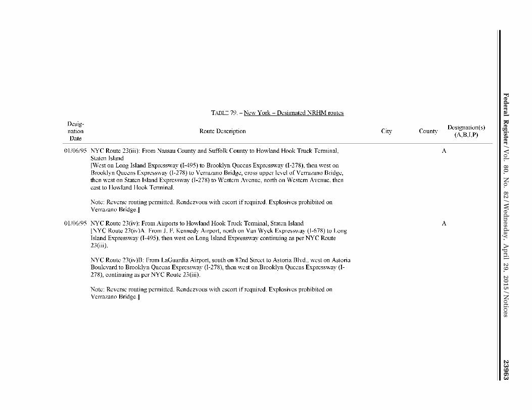
23963 F
ederal R
egister/V
ol. 80, No. 82
/Wed
nesd
ay, Ap
ril 29, 2015/N
otices
VerD
ate Sep<
11>2014
17:52 Apr 28, 2015
Jkt 235001P
O 00000
Frm
00105F
mt 4701
Sfm
t 4725E
:\FR
\FM
\29AP
N2.S
GM
29AP
N2
EN29AP15.104</GPH>
mstockstill on DSK4VPTVN1PROD with NOTICES2
Designation Date
TADLE 79.- New York -Designated NRHM routes
Route Description
01/06/95 NYC Route 23(iii): From Nassau County and Suffolk County to Howland Hook Truck Terminal, Staten Island [West on Long Island Expressway (I-495) to Brooklyn Queens Expressway (I-278), then west on Brooklyn Queens Expressway (I-278) to Verrazano Bridge, cross upper level ofVerrazano Bridge, then west on Staten Island Expressway (I-278) to Western Avenue, north on Western Avenue, then east to Howland Hook Terminal.
Note: Reverse routing pennitted. Rendezvous with escort if required. Explosives prohibited on Verrazano Bridge.]
01/06/95 NYC Route 23(iv): From Airports to Howland Hook Tmck Tern1inaL Staten Island [NYC Route 23(iv)A: From J. F. Kennedy Airport, north on VanWyck Expressway (I-678) to Long Island Expressway (I-495), then west on Long Island Expressway continuing as per NYC Route 23(iii).
NYC Route 23(iv)B: From LaGuardia Airport, south on 82nd Street to Astoria Blvd., west on Astoria Boulevard to Brooklyn Queens Expressway (I-278), then west on Brooklyn Queens Expressway (I-278), continuing as per NYC Route 23(iii).
Note: Reverse routing permitted. Rendezvous with escort if required. Explosives prohibited on Verrazano Bridge.j
City County
A
A
Designation(s) (A,B,I,P)

23964 F
ederal R
egister/V
ol. 80, No. 82
/Wed
nesd
ay, Ap
ril 29, 2015/N
otices
VerD
ate Sep<
11>2014
17:52 Apr 28, 2015
Jkt 235001P
O 00000
Frm
00106F
mt 4701
Sfm
t 4725E
:\FR
\FM
\29AP
N2.S
GM
29AP
N2
EN29AP15.105</GPH>
mstockstill on DSK4VPTVN1PROD with NOTICES2
Designation Date
TADLE 79.- New York -Designated NRHM routes
Route Description
01/06/95 NYC Route 24: Truck and Railroad Terminal in Bushwick area, Brooklyn and Maspeth area, Queens [Utilize NYC Routes 3(i) or 3(ii) from New Jersey, NYC Routes 4(i) or 4(ii) from upstate New York, New England or Westchester County, C-3 Island Expressway (I-495), then Long Island Express\vay (1-495) to Grand Avenue exit (westbound) or Maurice Ave. exit (eastbound), then to Grand Avenue (and Grand Street), cast or west as required.
Note: Reverse routing permitted. Rendezvous with escort if required.J
City County
A
Designation(s) (A,B,I,P)

23965 F
ederal R
egister/V
ol. 80, No. 82
/Wed
nesd
ay, Ap
ril 29, 2015/N
otices
VerD
ate Sep<
11>2014
17:52 Apr 28, 2015
Jkt 235001P
O 00000
Frm
00107F
mt 4701
Sfm
t 4725E
:\FR
\FM
\29AP
N2.S
GM
29AP
N2
EN29AP15.106</GPH>
mstockstill on DSK4VPTVN1PROD with NOTICES2
Designation Date
TAI3LE 79.- New York- Designated NRHM routes
Route Description
01/06/95 NYC Route 25: Altemate hazmat routes in lieu of the Throgs Neck Bridge [For vehicles not carrying explosives, altemate routes utilizing the Whitestone Bridge or the Triboro Bridge may be used in lieu of the Throgs Neck Bridge specified in NYC Routes 4(ii), 7(i), 9(ii), 12(i), 13(ii), 19(ii), and 20(ii), as follows:
NYC Route 25(i): Cross Bronx Expressway (I-95) to Hutchinson River Parkway, south on Hutchinson River Parkway over Whitestone Bridge, and continue south on Whitestone Expressway (I-678) -THEN either: NYC Route 25(i)A: to Astoria Blvd., west on Astoria Blvd. to 82nd Street, north on 82nd Street to LaGuardia Airport. NYC Route 25(i)B: to VanWyck Expressway (I-678), south on VanWyck Express way (I-676) to J.F. Kennedy Airport. NYC Route 25(i)C: to VanWyck Expressway (1-678), south to Long Island Expressway (1-495), west on Long Island Express\vay (1-495) to Brooklyn Queens Expressway (I-278), west on Brooklyn Queens Expressway (I-278) to Brooklyn or Staten Island piers as per NYC Routes (19) or (20).
NYC Route 25(ii): South on Major Deegan Expressway (T-87) from Cross Bronx Expressway or Upstate New York, to Triboro Bridge, across Triboro Bridge to Queens, exit and proceed east on Astoria Blvd. -THEN either: NYC Route 25(ii)A: to 82nd Street, north on 82nd Street to LaGuardia Airport. NYC Route 25(ii)B: to Brooklyn Queens Expressway (T-278), west on Brooklyn Queens Expressway (I-278) to Long Island Ex1Jressway (I-495), east on Long Island Expressway (I-495) to VanWyck Expressway (I-678), south on VanWyck Expressway (I-678) to J.F.K. Airport. NYC Route 25(ii)C: to Brooklyn Queens Expressway (I-278), west on Brooklyn Queens Expressway (I -278) to Brooklyn or Staten Island Piers as per NYC Routes ( 19) or (20).
Note: Reverse routing pennitted. Rendezvous with escort if required.]
City County
A
Designation(s) (A,B,I,P)

23966 Federal Register / Vol. 80, No. 82 / Wednesday, April 29, 2015 / Notices
VerDate Sep<11>2014 17:52 Apr 28, 2015 Jkt 235001 PO 00000 Frm 00108 Fmt 4701 Sfmt 4725 E:\FR\FM\29APN2.SGM 29APN2 EN
29A
P15
.107
</G
PH
>
mst
ocks
till o
n D
SK
4VP
TV
N1P
RO
D w
ith N
OT
ICE
S2
State Agency: POC: Address:
Phone: Fax: Web Address:
State Agency: POC: Address:
Phone: Fax: Web Address:
State Agency:
POC: Address:
Phone: Fax: Web Address:
Designation Date
Route Order
07/01/96 A
TABLE 80.- State: North Carolina
NC State Hwy. Patrol Herbert G. Tucker, Jr. 114 2 Southeast Maynard Rd. Cary, NC 27511 (919) 319-1523 (919) 319-1534 www.nccrimecontrol.org/SHP
FMC SA: FMCSAPOC: Address:
Phone: Fax:
NC FMCSA Field Office NC Motor Carrier Division Administrator 310 Bern Ave., Suite 468 Raleigh, NC 27601 (919) 856-4378 (919) 856-4369
No designated or restricted routes as of 03/30/2015
TABLE 81.- State: North Dakota
ND Highway Patrol Col. James Prochniak 600 East Blvd. Ave., Dept 504 Bismarck, ND 58505 (701) 328-2455 (701) 328-1717 www.nd.gov/ndhp/
FMC SA: FMCSAPOC: Address:
Phone: Fax:
ND FMCSA Field Office ND Motor Carrier Division Administrator 14 71 Interstate Loop Bismarck, ND 58503 (70 1) 250-4346 (70 1) 250-4389
No designated or restricted routes as of 03/30/2015
Public Utilities Comm. ofOH Dan Fisher 180 East Broad St. Columbus, OH 43215 (614) 752-7991 (614) 728-2133 www.puco.ohio.gov/puco/
TABLE 82.- State: Ohio
FMC SA: FMCSAPOC:
Address:
Phone: Fax:
OH FMC SA Field Office OH Motor Carrier Division Administrator 200 N. High St., Room 609 Columbus, OH 43215 (614) 280-5657 (614) 280-6875
TABLE 83.- Ohio - Restricted HM routes
Route Description
Any other highway or state or local road not otherwise designated for the transportation of hazardous materials by the routing designation [in Northeastern Ohio]
City Restriction(s)
(0, 1,2,3,4,5,6, 7,8,9,i)
0

23967 Federal Register / Vol. 80, No. 82 / Wednesday, April 29, 2015 / Notices
VerDate Sep<11>2014 17:52 Apr 28, 2015 Jkt 235001 PO 00000 Frm 00109 Fmt 4701 Sfmt 4725 E:\FR\FM\29APN2.SGM 29APN2 EN
29A
P15
.108
</G
PH
>
mst
ocks
till o
n D
SK
4VP
TV
N1P
RO
D w
ith N
OT
ICE
S2
TABLE 83.- Ohio - Restricted HM routes
Desig-Route Restriction(s)
nation Order
Route Description City (0, 1,2,3,4,5,6, 7,8,9,i)
Date
ll/03/86 B City ofLorain Lorain 0 fHazardous materials transportation in the City of Lorain is prohibited where there is neither a point of origin or destination within the City on the following routes: State Route 57, State Route 611, State Route 58, US Route 6, and any city streets.]
05/04/92 c City of Cleveland [City Streets] Cleveland 0 [Hazardous materials transportation in the City of Cleveland is prohibited where there is neither a point of origin nor delivery point with the City unless the point of origin or delivery is within one mile of the City limits and the use of the city streets is the safest and most direct route and the shortest distance of travel. Downtown streets are restricted from hazmat transportation between 7 AM and 6PM daily, except on the weekend. When city streets are to be used, the transporter must use interstate highways to a point as close as possible to the destination.]
10/14/93 D City of Cambridge Cambridge 0 [Hazardous materials transportation in the City of Cambridge is prohibited where there is neither a point of origin or destination within the City on the following routes: US Route 40, US Route 22, State Route 209, and any City streets.l
07/0l/96 El Interstate 90 from Interstate 2 71 [in Lake County] to Interstate Lorain 0 80/90 [in Lorain County]
07/0l/96 E2A Interstate 71 from Interstate 80 to Interstate 90 [in Cuyahoga 0 County]
07/0l/96 E2B Interstate 490 from Interstate 90 to Interstate 77 [in Cuyahoga 0 County]
07/0l/96 E2C Interstate 77 from Interstate 80 to Interstate 90 [in Cuyahoga 0 County]
07/0l/96 E2D State 2 from State 44 to Interstate 90 [in Lake County] 0
07/0l/96 E3D State 44 from State 2 to Interstate 90 [in Lake County] 0
07/0l/96 F Interstate 480 from Interstate 271 to Interstate 480N [in Cuyahoga Cleveland 0 County] - Cleveland

23968 Federal Register / Vol. 80, No. 82 / Wednesday, April 29, 2015 / Notices
VerDate Sep<11>2014 17:52 Apr 28, 2015 Jkt 235001 PO 00000 Frm 00110 Fmt 4701 Sfmt 4725 E:\FR\FM\29APN2.SGM 29APN2 EN
29A
P15
.109
</G
PH
>
mst
ocks
till o
n D
SK
4VP
TV
N1P
RO
D w
ith N
OT
ICE
S2
Designation Date
Route Order
09/09/88 A
Desig-Route
nation Order
Date
04/06/85 Al
04/06/85 A2A
04/06/85 A2B
04/06/85 A2C
04/06/85 A2D
04/06/85 A2E
04/06/85 A2F
04/06/85 A3B-l.O
04/06/85 A3B-2.0
10/14/93 B1
TABLE 84. Ohio- Designated HRCQ/RAM routes
Route Description
State-Wide [Preferred routes for high route controlled quantities of radioactive materials (HRCQ of RAM) are, "Interstate System highways, including interstate system bypasses or Interstate System beltways" as per 49 CFR Part 397]
TABLE 85. - Ohio - Designated NRHM routes
Route Description
Interstate 270 [Columbus Outerbelt] [Shipments which do not have the destination within the City of Columbus, but as a throughway.]
Broad St. [inside Interstate 270] [Only for the delivery ofNRHM within the City of Columbus]
Interstate 70 [inside Interstate 270] [Only for the delivery ofNRHM within the City of Columbus]
State 33 [inside Interstate 270] [Only for the delivery ofNRHM within the City of Columbus]
State 161 [inside Interstate 270] [Only for the delivery ofNRHM within the City of Columbus]
High St. [inside Interstate 270] [Only for the delivery ofNRHM within the City of Columbus]
Interstate 71 [inside Interstate 270] [Only for the delivery ofNRHM within the City of Columbus]
Interstate 670 from Interstate 70 to Interstate 270 [Only for the delivery ofNRHM within the City of Columbus]
State 315 [inside Interstate 270] [Only for the delivery of NRHM within the City of Columbus]
Interstate 70 [in the City of Cambridge] [For hazardous material shipments which have neither a point of origin or destination within the City of Cambridge.]
City
City
Columbus
Columbus
Columbus
Columbus
Columbus
Columbus
Columbus
Columbus
Columbus
Cambridge
Designation(s) (A,B,I,P)
p
Designation(s) (A,B,I,P)
A
A
A
A
A
A
A
A
A
A

23969 Federal Register / Vol. 80, No. 82 / Wednesday, April 29, 2015 / Notices
VerDate Sep<11>2014 17:52 Apr 28, 2015 Jkt 235001 PO 00000 Frm 00111 Fmt 4701 Sfmt 4725 E:\FR\FM\29APN2.SGM 29APN2 EN
29A
P15
.110
</G
PH
>
mst
ocks
till o
n D
SK
4VP
TV
N1P
RO
D w
ith N
OT
ICE
S2
TABLE 85. Ohio - Designated NRHM routes
Desig-Route Designation(s)
nation Order
Route Description City (A,B,I,P)
Date
10/14/93 B2 State 209 [Southgate Parkway in the City of Cambridge] [for Cambridge A destination within City only]
10/14/93 B3A US 40 [Wheeling Ave. in the City of Cambridge] [for Cambridge A destination within City only]
10/14/93 B3B US 22 [Wheeling Ave. in the City of Cambridge] [for Cambridge A destination within City only]
10/14/93 B4A-l.O County 35 [Old 21/Clark/Byesville Rd. in the City of Cambridge A Cambridge] [for destination within City only]
10/14/93 B4A-2.0 Interstate 77 [in the City of Cambridge] Cambridge A [For hazardous material shipments which have neither a point of origin or destination within the City of Cambridge.]
10114/93 B4B North Second St. [in the City of Cambridge] [for destination Cambridge A within City only]
10/14/93 B5B-l.O Steubenville Ave. [in the City of Cambridge] [for destination Cambridge A within City only]
11/03/86 C1 US 6 [in the city limits of Lorain] Lorain A [for destination within City only]
11/03/86 C2A State 611 [in the city limits of Lorain] Lorain A [for destination within City only]
11/03/86 C2B State 58 [in the city limits ofLorain] Lorain A [for destination within City only]
11/03/86 C2C State 57 [in the city limits ofLorain] Lorain A [for destination within City only]
11/03/86 C3B-l.O Cooper Foster Park Rd. [in the City of Lorain] [for destination Lorain A within City only]
11/03/86 C4B-l.O Middle Ridge Rd. [in the City of Lorain] Lorain A [for destination within City only]
ll/03/86 C5B-l.O State 2 [in the City of Lorain] Lorain A [For hazardous material shipments which have neither a point of origin nor destination within the City of Lorain.]

23970 Federal Register / Vol. 80, No. 82 / Wednesday, April 29, 2015 / Notices
VerDate Sep<11>2014 17:52 Apr 28, 2015 Jkt 235001 PO 00000 Frm 00112 Fmt 4701 Sfmt 4725 E:\FR\FM\29APN2.SGM 29APN2 EN
29A
P15
.111
</G
PH
>
mst
ocks
till o
n D
SK
4VP
TV
N1P
RO
D w
ith N
OT
ICE
S2
TABLE 85. Ohio - Designated NRHM routes
Desig-Route Designation(s)
nation Order
Route Description City (A,B,I,P)
Date
11/03/86 C5B-l.O Interstate 90/State Route 2 [around the City ofLorainJ Lorain A [For hazardous material shipments w·hich have neither a point of origin or destination within the City of Lorain.]
07/01/96 D1 Interstate 80 [and I80/I90 Ohio Turnpike] from Gate 13 [in A Portage County] to Lorain/Erie County Line
07/01/96 D2 Interstate 480 from Interstate 80 [Gate l3 in Portage County] to A Interstate 271 [in Summit County]
07/01/96 D2A Interstate 480N from Interstate 271 to Interstate 480 [in A Cuyahoga County]
07/01/96 D2B Interstate 71 from Interstate 80 [in Cuyahoga County] to A Interstate 271 [in Summit County]
07/01/96 D2C Interstate 77 from Interstate 80 fin Cuyahoga County] to A Interstate 271 [in Summit County]
07/01/96 D3A Interstate 480 from Interstate 480N [in Cuyahoga County] to Cleveland A Interstate 80 [in Lorain County] Cleveland
07/0l/96 D3B Interstate 271 from Interstate 90 [in Lake County] to Interstate A 71 [in Medina County] - Northeastern Ohio
07/01/96 D4B Interstate 90 from Lake/Ashtabula county line to Interstate 271 A [in Lake County]
Ol/29/90 D4B-l.O Bedford from Erieway Facility [at 33 Industry Drive] [Proceed Bedford A on Industry Dr, tum right on Northfield Rd, tum left on Alexander Rd., to I271 access road. Alternatively, from Northfield Rd, tum right on Forbes Rd, tum right on Broadway Rd. to I-271.]
11/01/94 E1 US 20 [Center Ridge Rd. in the City of Westlake] Westlake A,B
11/01/94 E2A State 252 [Columbia Rd. in the City ofWestlake] Westlake A,B
11/01/94 E3A-l.O State 254 [Detroit Rd. in the City ofWestlake] Westlake A,B
11/0l/94 E3A-2.0 Interstate 90 Westlake A [in the City ofWestlake]

23971 Federal Register / Vol. 80, No. 82 / Wednesday, April 29, 2015 / Notices
VerDate Sep<11>2014 17:52 Apr 28, 2015 Jkt 235001 PO 00000 Frm 00113 Fmt 4701 Sfmt 4725 E:\FR\FM\29APN2.SGM 29APN2 EN
29A
P15
.112
</G
PH
>
mst
ocks
till o
n D
SK
4VP
TV
N1P
RO
D w
ith N
OT
ICE
S2
State Agency: POC: Address:
Phone: Fax: Web Address:
Designation Date
07/29/97
07/29/97
Designation Date
07/29/97
Route Order
A
B
Route Order
A
07/29/97 Bl
07/29/97 B2
07/29/97 c
TABLE 86.- State: Oklahoma
OK DOT Harold Smart 200 NE 21st St
FMCSA: OK FMC SA Field Office FMCSAPOC: Address:
OK Motor Carrier Division Administrator 300 N. Meridian Suite 106 North Oklahoma City, OK 73105
(405) 521-2861 ( 405) 521-2865 www.okladot.state.ok.us/
Phone: Oklahoma City, OK 73107 (405) 605-6047
Fax: (405) 605-6176
Table 87.- Oklahoma- Restricted HM routes
Route Description Restriction(s)
(0,1,2,3,4,5,6,7,8,9,i)
Oklahoma City and Tulsa l Carriers transporting hazardous material cargo should avoid traveling through large metropolitan areas during times of the day when congestion is expected. These carriers should also avoid constmction zones when possible. Constmction information can be accessed by calling the OK Department of Transportation at (405) 521-2554.]
Interstate 40 [in Oklahoma City] from Interstate 44 to Interstate 35 is banned.
TABLE 88.- Oklahoma- Designated NRHM routes
Route Description
All Interstates [All hazardous material shipments moving through Oklahoma should remain on Interstate routes, when possible.]
0
0
A
Interstate 44 [Southwest of Oklahoma City] from Interstate 40 to Interstate 240 A [Use to bypass section of I -40 mnning through downtown Oklahoma City]
Interstate 240 [South of Oklahoma City] from Interstate 44 to Interstate 40 A fSoutheast of Oklahoma Cityl fUse to bypass section ofl-40 mnning through downtown Oklahoma City 1
Interstate 244 [Tulsa] from Interstate 44 [West of Tulsa] to Interstate 44 [East of A Tulsa] [Use to bypass downtown Tulsa]
Desig-nation(s) (A,B,I,P)

23972 Federal Register / Vol. 80, No. 82 / Wednesday, April 29, 2015 / Notices
VerDate Sep<11>2014 17:52 Apr 28, 2015 Jkt 235001 PO 00000 Frm 00114 Fmt 4701 Sfmt 4725 E:\FR\FM\29APN2.SGM 29APN2 EN
29A
P15
.113
</G
PH
>
mst
ocks
till o
n D
SK
4VP
TV
N1P
RO
D w
ith N
OT
ICE
S2
State Agency: POC: Address:
Phone: Fax: Web Address:
Designation Date
Route Order
11/01/94 A
11/01/94 B
ll/01194 c
Designation Date
Route Order
01/01/00 A
TABLE 89. State: Oregon
OR DOT FMCSA: OR FMCSA Field Office Jess Brown FMCSAPOC: OR Motor Carrier Division Administrator 550 Capitol Street NE Address: The Equitable Center Salem, OR 97301 530 Center Street NE, Suite 440 (503) 378-6336 Salem, OR 9730 l (503) 378-3567 Phone: (503) 399-5775 www. oregon. gov I odot/Pages/index. as:Qx Fax: (503) 316-2580
TABLE 90. Oregon- Restricted HM routes
Restriction( s) Route Description City County
(0, 1,2,3,4,5,6, 7,8,9,i)
US 26 from Interstate 405 to State 217 [includes Vista Portland Multnomah 0 Ridge Tunnel]
Restrictions apply to any quantity of hazardous material required to be marked or placarded in accordance with 49 CFR 177.823.
Arrowhead Truck Plaza on Route 331 [at the MP 216 Interstate 84 interchange 4 miles east of Pendleton (on tribal land)] overnight parking prohibited.
Wildhorse Casino parking lot on Route 331 [at the MP 216 Interstate 84 interchange 4 miles east of Pendleton adjacent to the Arrowhead Truck Plaza (on tribal land)] prohibits parking of all classes of hazardous material in the casino parking lot
TABLE 91. -Oregon - Designated NRHM routes
Route Description City
Umatilla 1,7
Umatilla 0
County
Kittridge Ave. Overpass [Portland] from US 30 [NW Portland Multnomah A St. Helens Ave.] to NW Front Ave. and the Northwest Portland Industrial Area
Designation( s) (A,B,I,P)

23973 Federal Register / Vol. 80, No. 82 / Wednesday, April 29, 2015 / Notices
VerDate Sep<11>2014 17:52 Apr 28, 2015 Jkt 235001 PO 00000 Frm 00115 Fmt 4701 Sfmt 4725 E:\FR\FM\29APN2.SGM 29APN2 EN
29A
P15
.114
</G
PH
>
mst
ocks
till o
n D
SK
4VP
TV
N1P
RO
D w
ith N
OT
ICE
S2
TABLE 92. State: Pennsvlvania
State Agency: PADOT FMC SA: PA FMCSA Field Office POC: Kenneth Thomton POC: PA Motor Carrier Division Administrator Address: Chief Motor Carrier Division Address: 215 Limekiln Road, Suite 200
P.O. Box 8210 New Cumberland, PA 17070 Harrisburg, P A 17105 Phone: (717) 614-4060
Phone: (717) 787-0459 Fax: (717) 614-4066 Fax: (717) 787-7839 Web Address: www .dot.state .ga. us/
State agency is responsible for all HM routes listed in Table 94, except for those routes on the Pennsylvania Tumpike.
State Agency: POC: Address:
Phone: Web Address:
PA Tumpike Commission Kenneth Slippey P.O. Box 67676 Harrisburg, P A 17106 (717) 939-9551 wwwpaturngike.com/
TABLE 93.- State: Pennsylvania
FMCSA: POC: Address:
Phone: Fax:
PA FMCSA Field Office PA Motor Carrier Division Administrator 215 Limekiln Road, Suite 200 New Cumberland, PA 17070 (717) 614-4060 (717) 614-4066
State agency is only responsible for HM routes listed in Table 94on the Pennsylvania Turnpike.
Designation Date
Route Order
01/01/50 A
01/01/58 B
TABLE 94.- Pennsylvania- Restricted HM routes
Route Description
Liberty Tunnel [in Allegheny County] from Carson St. to Saw Mill Run Blvd.
[(l) Explosives l.l to 1.6, (2) Blasting Agents, (3) Flammable Gas, (4) Flammable, (5) Flammable Solids, and (6) Flammable Solid W. prohibited.]
Interstate 376 [Fort Pitt Tunnels in Pittsburgh]
[(l) Explosives l.l to 1.6, (2) Blasting Agents, (3) Flammable Gas, (4) Flammable, (5) Flammable Solids, and ( 6) Flammable Solid W. prohibited.]
City
Pittsburgh
County
Allegheny
Restriction(s) (0,1,2,3,4, 5,6,7,8,9,i)
1,2,3,4,5,6
1,2,3,4,5,6

23974 Federal Register / Vol. 80, No. 82 / Wednesday, April 29, 2015 / Notices
VerDate Sep<11>2014 17:52 Apr 28, 2015 Jkt 235001 PO 00000 Frm 00116 Fmt 4701 Sfmt 4725 E:\FR\FM\29APN2.SGM 29APN2 EN
29A
P15
.115
</G
PH
>
mst
ocks
till o
n D
SK
4VP
TV
N1P
RO
D w
ith N
OT
ICE
S2
Designation Date
Route Order
01/01/52 c
07/22/89 D
01/01/40 E
01/01/40 F
TABLE 94. Pennsylvania Restricted HM routes
Route Description City
Interstate 376 [Squirrel Hill Tunnels in Pittsburgh] from Pittsburgh Exit 8 to Exit 9
[(1) Explosives 1.1 to 1.6, (2) Blasting Agents, (3) Flammable Gas, (4) Flammable, (5) Flammable Solids, and (6) Flammable Solid W. prohibited.]
US 30 [West- Descending Laurel Mountain in Somerset/ Westmoreland Counties] [Descending Laurel Mountain into the Village ofLaughlintmvn (to protect Ligonier Municipal Reservoir).
The "recommended" alternate route is south on US 219 to I-76 (PA Turnpike), west on I-76 to New Stanton.]
Interstate 70/76 [Allegheny Tunnel- Somerset County] from Exit 11 0 to Exit 146
[Effective July 16, 2000: All Table 1 materials and Explosives are still prohibited. Table 2 materials (except explosives) permitted for non-bulk packages (those placards that do not require four-digit codes)]
For additional information, visit the Pennsylvania Turnpike website: \VWW .paturnpike.com/trucking/placard.aspx#top
Interstate 76 [Tuscarora Tunnel- Franklin/ Huntingdon Counties] from Exit 180 to Exit 189
[Effective July 16, 2000: All Table 1 materials and Explosives are still prohibited. Table 2 materials (except explosives) permitted for non-bulk packages (those placards that do not require four-digit codes)]
For additional information, visit the Pennsylvania Turnpike website: www .paturnpike.com/trucking/placard.aspx#top
County Restriction(s)
(0, 1 ,2,3 ,4, 5,6, 7,8,9,i)
1,2,3,4,5,6
Somerset and 0 Westmoreland
Somerset
Franklin and Huntingdon
1,2,3,4,5,6, 7,8,i
1,2,3,4,5,6,7,8,i

23975 Federal Register / Vol. 80, No. 82 / Wednesday, April 29, 2015 / Notices
VerDate Sep<11>2014 17:52 Apr 28, 2015 Jkt 235001 PO 00000 Frm 00117 Fmt 4701 Sfmt 4725 E:\FR\FM\29APN2.SGM 29APN2 EN
29A
P15
.116
</G
PH
>
mst
ocks
till o
n D
SK
4VP
TV
N1P
RO
D w
ith N
OT
ICE
S2
TABLE 94. -Pennsylvania- Restricted HM routes
Desig-Route
Restriction(s) nation
Order Route Description City County (0, 1,23,4,
Date 5,6, 7,8,9,i)
01/01/40 G Interstate 76 [Blue Mountain Tunnel and Kittatinny Franklin 1,2,3,4,5,6,7,8,i Tunnel- Franklin County] from Exit 189 to Exit 201
[Effective July 16, 2000: All Table 1 materials and Explosives are still prohibited. Table 2 materials (except explosives) pennitted for non-bulk packages (those placards that do not require four-digit codes)]
For additional information, visit the Pennsylvania Turnpike website: www .paturnpike .com/trucking/placard.aspx#top
09/15/93 H US 11 [Cumberland County] from the intersection of Cumberland 0 Allen Rd. and SR 465 (at Segment 0360/0ffset 2119) to Interstate 76/P A Turnpike (at Segment 051 0/0ffset 0000)
09/15/93 I SR 74 [Cumberland County] from Fairfield St. (at Cumberland 0 Segment 0 170/0ffset 0000) toN. College St. (at Segment 0210/0ffset 0000)
09/15/93 J SR 641 [Cum berland County] from Interstate 81 (at Cumberland 0 Segment 0440/0ffset 3196) to N. College St. (at Segment 0470/0ffset 0000)
09/15/93 K SR 34 [Cumberland County] from Noble Cumberland 0 Blvd./Lamberton Middle School (at Segment 0270/0ffsct 0000) to Carlisle Springs Rd./ N. Hanover St. split (at Segment 0300/0ffset 0000)
11/03/94 L SR 3009/River Rd. [Dauphin County] (at Segment Dauphin 0 0210/0ffset 0720) to Country Club Rd. (at Segment 0221/0ffset 1382) just before SR 443
09/09/93 M SR 39 [Dauphin Com1ty] from Terrace Dr. (at Segment Dauphin 0 0030/0ffset 0000) to SR 81 (at Segment 0210/0ffset 0000) just past the Travel Center of America Truck Stops"
09/09/93 N US 22 [Dauphin County] from SR 39 (at Segment Dauphin 0 0420/0ffsct 0000) to Interstate 83 (at Segment 0571/0ffset 0000)

23976 Federal Register / Vol. 80, No. 82 / Wednesday, April 29, 2015 / Notices
VerDate Sep<11>2014 17:52 Apr 28, 2015 Jkt 235001 PO 00000 Frm 00118 Fmt 4701 Sfmt 4725 E:\FR\FM\29APN2.SGM 29APN2 EN
29A
P15
.117
</G
PH
>
mst
ocks
till o
n D
SK
4VP
TV
N1P
RO
D w
ith N
OT
ICE
S2
Designation Date
Route Order
03/21/94 0
01/01/65 p
State Agency: POC: Address:
Phone: Fax: Web Address:
TABLE 94.- Pennsylvania- Restricted HM routes
Route Description
SR 4020 lLancaster Countyj from Esbenshade Rd./ SR 230 (at Segment 00 10/0ffset 0000) to Mcgovemville Rd./Route 741 (at Segment 0130/0ffset 0000)
Interstate 4 7 6 [Northeast Extension of P A Tum pike at Lehigh Tunnel] from Exit 56 to Exit 74
[Effective July 16, 2000: All Table 1 materials and Explosives are still prohibited. Table 2 materials (except explosives) pennitted for non-bulk packages (those placards that do not require four-digit codes)J
For additional information, visit the Pennsylvania Tumpike website: W\VW .patumpike .com/tmcking/placard.aspx#top
TABLE 95.- State: Rhode Island
RI Dept. of Environmental Management Mark Dennen Oftice of Waste Mgt. 23 5 Promenade Street Providence, RI 02908 (401) 222-2797 ext. 7112 (401) 222-3812 www.dem.ri.gov/
FMCSA: FMCSAPOC: Address:
Phone: Fax:
City County
Lancaster
Carbon and Lehigh
0
Restriction(s) (0,1,2,3,4, 5,6,7,8,9,i)
1,2,3,4,5,6,7,8,i
RI FMCSA Field Office Rl Motor Carrier Division Administrator 20 Risho Avenue, Suite E East Providence, RI 02914 ( 40 1) 431-6010 (401) 431-6019
TABLE 96.- Rhode Island- Restricted HM routes
Desig-Route
nation Route Description Restriction(s)
Date Order
07/1 R/R4 AI
07/18/84 A2A
07/18/84 A3A
Old Plainfield Pike [in Foster & Scituate] from Route I 02 to Route 12 [Scituate]
Route 12 [in Scituate and Cranston] from Route 14 [Scituate] to Route 116 [Scituate]
Route 116 [in Scituate & Smithfield] from Scituate Ave. [Scituate] to Snake Hill Rd. [Smithfield]
(0, 1,2,3,4,5,6, 7,8,9,i)
0
0
0

23977 Federal Register / Vol. 80, No. 82 / Wednesday, April 29, 2015 / Notices
VerDate Sep<11>2014 17:52 Apr 28, 2015 Jkt 235001 PO 00000 Frm 00119 Fmt 4701 Sfmt 4725 E:\FR\FM\29APN2.SGM 29APN2 EN
29A
P15
.118
</G
PH
>
mst
ocks
till o
n D
SK
4VP
TV
N1P
RO
D w
ith N
OT
ICE
S2
TABLE 96.- Rhode Island- Restricted HM routes
Desig-Route Restriction(s)
nation Order
Route Description (0, 1 ,2,3,4,5,6, 7 ,8,9 ,i)
Date
07/18/84 A3A-l.O Route 102 [in Scituate and Foster] from Route 94 [Foster] to Snake Hill 0 Road [Glocester]
07/18/84 A4A-l.O Route 94 [in Foster] from Route 101 to Route 102 [Scituate] 0
07/18/84 A4A-l.O-A Route 14 rin Scituatel from Route 102 to Route 116 0
07/18/84 A5A-l.O Route 101 [in Foster, Glocester, and Scituate] from Route 94 [Foster] to 0 Route 6 [Scituate]
07/18/84 A5A-l.O-A Central Pike [in Scituate and Foster] from Route 94 [Foster] to Route 102 0 [Scituate]
07/18/84 A5A-l.O-B Route 6 Lin Scituate, Johnston, & FosterJ from Route 94 LFosterJ to Hopkins 0 Avenue [Johnson]
07/18/84 A6A-l.O-B1 Danielson Pike [in Scituate] from Route 6 to Route 6 0
07/18/84 A6A-l.O-C Rocky Hill Road & Peeptoad Road [in Scituate] from Route 10 1 to Route 0 116 [Sawmill Road]
07/18/84 B Route 295 [in Smithfield and Lincoln] from Exit 8 [Douglas Pike - 0 Smithfield] to Exit 9 [Route 146 - Lincoln]
07/18/84 c Reservoir Road Lin its entirety in Smithfield and North Smithtl.eldJ 0
07/18/84 D Route 120 [in Cumberland] from Mendon Road to Massachusetts 0
07/18/84 E Reservoir Road [in Cumberland] from Route 114 to Massachusetts 0
07/18/84 F North Main Road [in Jamestown] from Route 138 to East Shore Road 0
07/18/84 Gl Bliss Mine Road [in its entirety in Newport & Middletown] 0
07/18/84 G2 Miantonami Ave. [in Middletown] from Bliss Mine Road to Valley Road 0
07/18/84 G3A Valley Road rin Middletownl from Miantonami Avenue to Route 138 0
07/18/84 G4A Aquidneck Ave [in Middletown] from Wave Avenue to Valley Road 0
07/18/84 GSA Wave Avenue [in its entirety in Middletown] 0
07/18/84 Hl Serpentine Road [in its entirety in Warren] 0
07/18/84 H2A School House Road [in Warren] from Birch Swamp Road to Long Lane 0
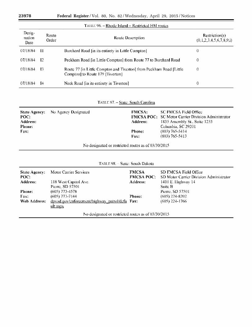
23978 Federal Register / Vol. 80, No. 82 / Wednesday, April 29, 2015 / Notices
VerDate Sep<11>2014 17:52 Apr 28, 2015 Jkt 235001 PO 00000 Frm 00120 Fmt 4701 Sfmt 4725 E:\FR\FM\29APN2.SGM 29APN2 EN
29A
P15
.119
</G
PH
>
mst
ocks
till o
n D
SK
4VP
TV
N1P
RO
D w
ith N
OT
ICE
S2
Desig-Route
nation Order
Date
07/18/84 11
07/18/84 12
07/18/84 13
07/18/84 14
TABLE 96.- Rhode Island- Restricted HM routes
Route Description
Burchard Road [in its entirety in Little Compton]
Peckham Road [in Little Compton] from Route 77 to Burchard Road
Route 77 [in Little Compton and Tiverton] from Peckham Road [Little Compton] to Route 179 [Tiverton]
Neck Road [in its entirety in Tiverton]
TADLE 97.- State: South Carolina
Restriction(s) (0, 1,2,3,4,5,6, 7,8,9,i)
0
0
0
0
State Agency: No Agency Designated POC:
FMCSA: SC FMCSA Field Office FMCSA POC: SC Motor Carrier Division Administrator
Address: Phone: Fax:
State Agency: POC: Address:
Phone: Fax: Web Address:
Address: 1835 Assembly St., Suite 1253 Columbia, SC 2920 l
Phone: (803) 765-5414 Fax: (803) 765-5413
No designated or restricted routes as of 03/30/2015
TABLE 98.- State: South Dakota
Motor Carrier Services FMCSA SD FMCSA Field Office FMCSAPOC:
118 West Capitol Ave. Address: Pierre, SD 57501 (605) 773-4578 (605) 773-7144 Phone: dps.sd.gov/enforcementlhighway patrol/defa Fax: ult.aspx
SD Motor Carrier Division Administrator 1410 E. Highway 14 Suite B Pierre, SD 57501 (605) 224-8202 (605) 224-1766
No designated or restricted routes as of 03/30/2015

23979 Federal Register / Vol. 80, No. 82 / Wednesday, April 29, 2015 / Notices
VerDate Sep<11>2014 17:52 Apr 28, 2015 Jkt 235001 PO 00000 Frm 00121 Fmt 4701 Sfmt 4725 E:\FR\FM\29APN2.SGM 29APN2 EN
29A
P15
.120
</G
PH
>
mst
ocks
till o
n D
SK
4VP
TV
N1P
RO
D w
ith N
OT
ICE
S2
NPS: NPSPOC:
Address:
Phone: Fax: Web Address:
Designation Date
Route Order
Ol/17/97 A
TABLE 99.- South Dakota- Badlands National Park
FMCSA: SD FMCSA Field Office Badlands National Park, NPS Park Superintendent 25216 Ben Reifel Road
FMCSAPOC: Address:
SD Motor Carrier Division Administrator 1410 E. Highway 14, Suite B
P.O. Box6 Pierre, SD 57501 Interior, SD 57750 Phone: (605) 224-8202 (605) 433-5361 Fax: ( 605) 224-1766 (605) 433-5404 www .nps.gov/badl/indcx.htm
TABLE 100.- South Dakota (Badlands National Park)- Restricted HM routes
Route Description
Badlands National Park -- Park road between the Northeast Entrance to the Interior 0 Entrance [Northeast Entrance/SD-240 to the intersection with SD-377 to SD-3 77 /Interior Entrance]
[This route is under the jurisdiction of the U.S. National Park Service, not the State of South Dakota. For additional information, contact the Badlands National Park at (605) 433-5361.]
Restriction(s) (0, 1,2,3,4,5,6,
7,8,9,i)

23980 Federal Register / Vol. 80, No. 82 / Wednesday, April 29, 2015 / Notices
VerDate Sep<11>2014 17:52 Apr 28, 2015 Jkt 235001 PO 00000 Frm 00122 Fmt 4701 Sfmt 4725 E:\FR\FM\29APN2.SGM 29APN2 EN
29A
P15
.121
</G
PH
>
mst
ocks
till o
n D
SK
4VP
TV
N1P
RO
D w
ith N
OT
ICE
S2
State Agency: POC: Address:
Phone: Fax: Web Address:
Designation Date
Route Order
05/15/87 A
10/18/96 B
Designation Date
Route Order
08/03/88 A
TABLE 101.- State: Tennessee
TN DOT Alan Durham
FMCSA: TN FMCSA Field Office FMCSAPOC:
James K. Polk Bldg. Address: TN Motor Carrier Division Administrator 640 Grassmere Park
505 Deaderick St., Suite 400 Nashville, TN 37243 (615) 741-2848/(615) 741-5616 (615) 741-2508 www. tdot.state. tn.us/
Phone: Fax:
Suite 111 Nashville, TN 37211 (615) 781-5781 (615) 781-5780
TABLE 102.- Tennessee- Restricted HM routes
Restriction(s) Route Description
(0, 1,2,3,4,5,6, 7,8,9,i)
Interstate 40 [Through City ofKnoxville] from Exit 385 [intersection with I-75/1- 0 640 west of Knoxville] to Exit 393 [intersection with I-640 east ofKnoxville]
[Prohibition does not apply to hazardous material shipments originating at or destined to the City of Knoxville and to service points of US 129 in Blount County as verified by appropriate shipping papers, or shipments to be interlined with other carriers or to be transferred to other vehicles of the same carrier at tacilities in these areas, or to vehicles which need emergency repair or warranty work performed at authorized dealers in these areas.]
Cumberland Gap Tunnel [US 25E I State Route 32] 1 [Trucks that display a hazardous material placard are required to stop at the Cumberland Gap Tunnel inspection lanes. After stopping in the lane, a CGTA operator requests infonnation from the driver such as Trucking Company name and address, DOT#, Tmck license#, Tmck Order# or bill of lading, origin and destination of goods, and driver's name and signature. The operator then performs a walk around inspection of the truck and looks for possible hazardous material leaks. Trucks transporting Class I Explosives arc prohibited and arc turned around at the tunnel. For further information, contact John R. Burke (cgta@}vaughnmelton.com) at 606-248-0996.]
TABLE 103.- Tennessee- Designated HRCQ/RAM routes
Route Description
Interstate 640/I -7 5 from Interstate 40 [exit 3 85 West of Knoxville] to Interstate 40 P [exit 393 East of Knoxville] [In lieu ofl-40 in the Knoxville area].
Designation( s) (A,B,I,P)

23981 Federal Register / Vol. 80, No. 82 / Wednesday, April 29, 2015 / Notices
VerDate Sep<11>2014 17:52 Apr 28, 2015 Jkt 235001 PO 00000 Frm 00123 Fmt 4701 Sfmt 4725 E:\FR\FM\29APN2.SGM 29APN2 EN
29A
P15
.122
</G
PH
>
mst
ocks
till o
n D
SK
4VP
TV
N1P
RO
D w
ith N
OT
ICE
S2
State Agency:
POC: Address: Phone: Web Address:
TX Dept. Public Safety Josh Verastique P 0 Box4087 Austin, Texas 78773-0001 (512) 416-3122 www.txdot.gov/
TABLE 104.- State: Texas
FMCSA: TX FMCSA Field Office FMCSA POC: TX Motor Carrier Division Administrator Address: 903 San Jacinto Blvd., Suite 101
Austin, TX 78701 Phone: (512) 916-5440 Fax: (512) 916-5482
TABLE 105.- Texas- Restricted HM routes
Desig-Route Restriction(s)
nation Route Description City County Date
Order (0, 1,2,3,4,5,6, 7,8,9,i)
12/12/97 A International Bridges I & II [Laredo] Laredo Webb 0
06/28/01 Bl Interstate 35 [Bexar County] from the IH 35/IH 10 San Bexar 0 interchange to the IH 10/IH 35/US 90 interchange Antonio
06/28/01 B2A Interstate l 0 [Bexar County] from the San Bexar 0 Fredericksburg/ Woodlawn interchange to the IH Antonio 10/IH 35 interchange
06/28/01 B2B Interstate 35 [Bexar County] from IH 35/IH 37/US San Bexar 0 281 interchange to IH 10/IH 35 interchange Antonio
06/28/01 B3B Interstate 3 7 [Bexar County] from the IH 35/IH San Bexar 0 37/US 281 interchange to the IH 37/Durango St. Antonio interchange
03/04/70 Cl Holcombe Boulevard [Houston] from Main St. to Houston Harris 0 South Braeswood Boulevard
03/04/70 C2 South Braeswood Boulevard rHouston l from Houston Harris 0 Holcombe Boulevard to Cambridge St.
03/04/70 C3 Cambridge St. [Houston] from South Braeswood Houston Harris 0 Boulevard to Main St.
03/04/70 C4 Main St. [Houston] from Cambridge St. to Houston Harris 0 Holcombe Boulevard
03/04/70 Dl Interstate 45 [Houston] from Franklin St. to US 59 Houston Harris 0
03/04/70 D2 US 59 [Houston] from Interstate 45 to Buffalo Houston Harris 0 Bayou

23982 Federal Register / Vol. 80, No. 82 / Wednesday, April 29, 2015 / Notices
VerDate Sep<11>2014 17:52 Apr 28, 2015 Jkt 235001 PO 00000 Frm 00124 Fmt 4701 Sfmt 4725 E:\FR\FM\29APN2.SGM 29APN2 EN
29A
P15
.123
</G
PH
>
mst
ocks
till o
n D
SK
4VP
TV
N1P
RO
D w
ith N
OT
ICE
S2
TABLE 105.- Texas- Restricted HM routes
Desig-Route Restriction(s)
nation Order
Route Description City County (0, 1,2,3,4,5,6, 7,8,9,i)
Date
10/13/83 E1 Interstate 45 [Galveston, Galveston County] from Galveston Galveston 0 State 342 to West City Limits
rDuring a 30-hour hurricane warning only. See City of Galveston code for more infonnation. J
10/13/83 E2 State 342 (61st. St.) [Galveston, Galveston County] Galveston Galveston 0 from Broadway Ave. to Seawall Blvd.
[During a 30-hour hurricane warning only. See City of Galveston code for more information.]
10/13/83 F North of Church St. rGalveston, Galveston County 1 Galveston Galveston 0 from 14th Street to 2nd Street
[See City of Galveston code for special restrictions/more information.]
Ol/25/84 G Transportation of hazardous materials in vehicles Dallas Dallas 0 bearing placards required by the U.S. Department of Transportation is prohibited for all tunnel delivery areas within the city of Dallas.
01/25/84 HI Interstate 30 (East RL Thornton Freeway) [Dallas] Dallas Dallas 0 from Interstate 35 E to Malcolm X Blvd. Overpass
Ol/25/84 H2A Interstate 45 Elevated (Julius Schepps Freeway) Dallas Dallas 0 [Dallas] from Lamar Underpass to Bryan St. Underpass [No operator of a motor vehicle transporting hazardous material scheduled for delivery to or from a Dallas Terminal shall transport those materials on any street or highway, or segment of a street or public highway designated as "Prohibited Hazardous Materials Area"]
Ol/25/84 H3A-l.O Interstate 345 (Central Expressway) [Dallas] from Dallas Dallas 0 Interstate 45 (Julius Schepps Freeway) to Bryan Street
Ol/25/84 I Spur 366 (Woodall Rodgers Freeway) [Dallas] Dallas Dallas 0 from US 75 to Interstate 35E

23983 Federal Register / Vol. 80, No. 82 / Wednesday, April 29, 2015 / Notices
VerDate Sep<11>2014 17:52 Apr 28, 2015 Jkt 235001 PO 00000 Frm 00125 Fmt 4701 Sfmt 4725 E:\FR\FM\29APN2.SGM 29APN2 EN
29A
P15
.124
</G
PH
>
mst
ocks
till o
n D
SK
4VP
TV
N1P
RO
D w
ith N
OT
ICE
S2
TABLE 105.- Texas- Restricted HM routes
Desig-Route
nation Route Description City Date
Order
10/10/95 J
10/10/95 K
Designation Date
Route Order
07/09/12 A
07/09/12 B
07/09/12 c
07/09/12 D
07/09/12 E
Loop 335 [Amarillo] from West Amarillo Blvd to Amarillo City Limits (7 pm to 7 am)
US 60/US 87/US 287 (Taylor and Filmore St. only) Amarillo [Amarillo] from Interstate 40 to Loop 335
TARLE 106.- Texas- Designated HRCQ/RAM routes
Route Description
Big Spring, TX to Pecos, TX to Carlsbad, NM to WlPP North Access Road (Current New Mexico designated route)
Big Spring, TX to Andrews, TX to FM 115 to intersection with FM 128 in Texas to SR 128 in New Mexico to WIPP South Access Road
Big Spring, TX to Monahans, TX to Kermit, TX to Jal, NM to WIPP South Access Road
Big Spring, TX to Andrews, TX to Eunice, NM to Hobbs, NM to WIPP North Access Road
Big Spring, TX to Andrews, TX to Eunice, NM to Jal, NM to WIPP South Access Road
City
County
Potter/ Randall
Potter/ Randall
County
Restriction(s) (0, 1,2,3,4,5,6, 7,8,9,i)
0
0
p
p
p
p
p
Designation( s) (A,B,I,P)

23984 Federal Register / Vol. 80, No. 82 / Wednesday, April 29, 2015 / Notices
VerDate Sep<11>2014 17:52 Apr 28, 2015 Jkt 235001 PO 00000 Frm 00126 Fmt 4701 Sfmt 4725 E:\FR\FM\29APN2.SGM 29APN2 EN
29A
P15
.125
</G
PH
>
mst
ocks
till o
n D
SK
4VP
TV
N1P
RO
D w
ith N
OT
ICE
S2
TABLE 107.- Texas- Designated NRHM routes
Desig-Route Designation(s)
nation Order
Route Description City County (A,B,I,P)
Date
10/16/90 Al Farm to Market 2061 [Edinburg] from Edinburg Hidalgo A Owassa Road to Farm to Market 1925 [Through only]
10/16/90 A2 Farm to Market 1925 [Edinburg] from Bus. Edinburg Hidalgo A US 281 to Farm to Market 2061 [Through only]
I 0/16/90 A2A State I 07 [Edinburg] from State 336 to Edinburg Hidalgo A Farm to Market 2061 [Through only]
10/16/90 A3 Bus. US 281 [Edinburg] from its North Edinburg Hidalgo A intersection with US 281 to Farm to Market 1925 [Through only]
10/16/90 A3A Bus. US 281 [Edinburg] from Farm to Edinburg Hidalgo A Market 1925 to its South intersection with US 281 [Local destination only]
10/16/90 A4 US 281 [Edinburg] from its North Edinburg Hidalgo A intersection with Bus. US 281 to Owassa Road [Through only]
10/16/90 A4A-l.O Chapin Street [Edinburg] from Bus. US 281 Edinburg Hidalgo A to US 281 fLocal destination only l
10/16/90 A4A-2.0 Farm to Market 2128 [Edinburg] from Bus. Edinburg Hidalgo A US 281 to US 281 [Local destination only]
I 0/16/90 A4A-3.0 Mcintyre St. [Edinburg] from 12th A vc. to Edinburg Hidalgo A lOth Ave. [Local destination only.]
10/16/90 A5A Fann to Market 2128 [Edinburg] from Edinburg Hidalgo A Tower Road to US 281 [Through only]
10/16/90 A5A-3.0 lOth Ave. [Edinburg] from Mcintyre to Edinburg Hidalgo A Cano Street fLocal destination only l
10/16/90 A5B State 107 [Edinburg] from Tower Road to Edinburg Hidalgo A US 281 [Through only]
10/16/90 A6A-3.0 Cano St. [Edinburg] from lOth Ave. to 12th Edinburg Hidalgo A Ave. [Local destination only.]

23985 Federal Register / Vol. 80, No. 82 / Wednesday, April 29, 2015 / Notices
VerDate Sep<11>2014 17:52 Apr 28, 2015 Jkt 235001 PO 00000 Frm 00127 Fmt 4701 Sfmt 4725 E:\FR\FM\29APN2.SGM 29APN2 EN
29A
P15
.126
</G
PH
>
mst
ocks
till o
n D
SK
4VP
TV
N1P
RO
D w
ith N
OT
ICE
S2
TABLE 107.- Texas- Designated NRHM routes
Desig-Route Designation(s)
nation Order
Route Description City County (A,B,I,P)
Date
10/16/90 A6A-3.0-A State 107 [Edinburg] from 12th Ave. to US Edinburg Hidalgo A 281 [Local destination only]
10/16/90 A7A-3.0 12th Ave. [Edinburg] from Mcintyre to Edinburg Hidalgo A Cano Street [Local destination only]
10/16/90 A8A-3.0-B State 107 lEdinburgj from Fam1 to Market Edinburg Hidalgo A 2061 to 10th Ave. [Local destination only]
04/15/81 Bl US 83 [Harlingen] from Southeast City Harlingen Cameron A Limits to West City Limits
04/15/81 B2A Spur 54 [Harlingen] from US 77 to US 83 Harlingen Cameron A
04/15/81 B3A-1.0 US 77 [Harlingen] from Northwest City Harlingen Cameron A Limits to Southeast City Limits
04/15/81 B4A-l.O-A Fann to Market 1479 (Rangerville Road) Harlingen Cameron A [Harlingen] from Southwest City Limits to us 77/83
04/15/81 B4A-l.O-B Loop 206 (Tyler St.) [Harlingen] from US Harlingen Cameron A 77 I US 83 to West City Limits
04/15/81 B4A-l.O-C Farm to Market 106 (Harrison St.) Harlingen Cameron A rHarlingenl from US 77 to West City Limits
04/15/81 B4A-l.O-D Bus. US 77 [Harlingen] from North City Harlingen Cameron A Limits to South City Limits
04/15/81 BSA-1.0-Dl Loop 499 (Ed Carey Dr.) [Harlingen] from Harlingen Cameron A Bus. US 77 N to US 77/83
04/15/81 B5A-l.O-D2 Commerce St. [Harlingen] from Bus. US 77 Harlingen Cameron A N to Bus. US 77 S
04/15/81 B5A-l.O-D3 Farm to Market 507 (Morgan Blvd.) Harlingen Cameron A rHarlingenl from Rio Hondo Rd. to Bus. US 77
04/15/81 B5A-l.O-D3A 25th St. [Harlingen] from Rio Hondo Rd. to Harlingen Cameron A North City Limits
04/15/81 B5A-l.O-D3B Rio Hondo Rd. [Harlingen] from 25th Street Harlingen Cameron A

23986 Federal Register / Vol. 80, No. 82 / Wednesday, April 29, 2015 / Notices
VerDate Sep<11>2014 17:52 Apr 28, 2015 Jkt 235001 PO 00000 Frm 00128 Fmt 4701 Sfmt 4725 E:\FR\FM\29APN2.SGM 29APN2 EN
29A
P15
.127
</G
PH
>
mst
ocks
till o
n D
SK
4VP
TV
N1P
RO
D w
ith N
OT
ICE
S2
TABLE 107.- Texas- Designated NRHM routes
Desig-Route Designation(s)
nation Order
Route Description City County (A,B,I,P)
Date
to East City Limits
04/15/81 B5A-10-D4 Farm to Market 106 (Harrison St.) Harlingen Cameron A [Harlingen] from East City Limits to Bus. us 77
12/12/97 c SH 255 (Camino Columbia Toll Road) Laredo Webb A [Laredo] from Interstate 35 to International Bridge III
12/28/93 D1 Interstate 10 l El Paso J from East City El Paso El Paso A Limits to North City Limits
12/28/93 D2A Trowbridge Dr. rEI Paso l from Interstate 10 El Paso El Paso A to Delta Dr.
12/28/93 D2B Airway Blvd [El Paso] from Interstate 10 to El Paso El Paso A us 62/180
12/28/93 D3A Delta Dr. [El Paso] from Trowbridge Dr. to El Paso El Paso A Fonseca Dr.
12/28/93 D3B US 62/180 (Montana Ave.) [E1 Paso] from E1 Paso E1 Paso A East City Limits to Airway Blvd.
12/28/93 D4A F onesca Dr. l El Paso J from Delta Dr. to El Paso El Paso A Loop 375
12/28/93 D4B Loop 375 (Joe Battle Blvd.) [El Paso] from El Paso El Paso A Interstate 10 to US 62/180
12/28/93 D5B Loop 375 (Americas Ave.) [El Paso] from El Paso El Paso A Border Highway (Loop 3 7 5) to Interstate 10
12/28/93 D5B-l.O Farm to Market 659 [El Paso] from East El Paso El Paso A City Limits to Loop 375 N (Americas Ave.) [Its North intersection with LP 375 (Americas Ave.)l
12/28/93 D6B Loop 375 (Border Highway) [El Paso] from El Paso El Paso A US 54 (Patriot Freeway) to Loop 375 (Americas Ave.)
12/28/93 D6B-2.0 Farm to Market 659 [El Paso] from LP 375 El Paso El Paso A

23987 Federal Register / Vol. 80, No. 82 / Wednesday, April 29, 2015 / Notices
VerDate Sep<11>2014 17:52 Apr 28, 2015 Jkt 235001 PO 00000 Frm 00129 Fmt 4701 Sfmt 4725 E:\FR\FM\29APN2.SGM 29APN2 EN
29A
P15
.128
</G
PH
>
mst
ocks
till o
n D
SK
4VP
TV
N1P
RO
D w
ith N
OT
ICE
S2
TABLE 107.- Texas- Designated NRHM routes
Desig-Route Designation(s)
nation Order
Route Description City County (A,B,I,P)
Date
(Border Highway) to South City Limits [International boundary at Y sleta Port of entry Zaragoza Bridge]
12/28/93 D7B US 54 [El Paso] from New Mexico to South El Paso El Paso A Loop 375
12/28/93 D7B-3.0 Interstate 110 [EI Paso] from Cordova Port- El Paso El Paso A of-Entry to Interstate 10
12/28/93 D8B-4.0 Fred Wilson Dr. [El Paso] from Airport Rd. El Paso El Paso A to US 54
12/28/93 D9B-4.0-A Railroad Dr. [El Paso] from Dyer St. (SP El Paso El Paso A 478) to Fred Wilson Dr.
12/28/93 D9B-4.0-B Marshall Rd. [El Paso] from Fred Wilson El Paso El Paso A Dr. to Railroad Dr.
12/28/93 DlOB-4.0-A Spur 478 (Dyer Rd.) [El Paso] from El Paso El Paso A Railroad Dr. to US 54 N
10/24/95 El Interstate 20 lOdessaj from Southwest City Odessa Ector A Limits to Southeast City Limits
10/24/95 E2A Loop 338 rodessal from South City Limits Odessa Ector A to North City Limits
06/14/83 Fl Interstate 20 [Midland] from East City Midland Midland A Limits to West City Limits
06/14/83 F2A Loop 250 [Midland] from Interstate 20 to Midland Midland A Fairgrounds Rd.
06/14/83 F2B Midkiff Rd. [Midland] from Interstate 20 to Midland Midland A Loop 250
06/14/83 F2C Cotton Flat Rd. rMidlandl from Interstate Midland Midland A 20 to Bus. I 20/ US 80
06/14/83 F2D State 349 [Midland] from Interstate 20 to Midland Midland/ A South City Limits Martin
06/14/83 F3A Fairgrounds Rd. [Midland] from South City Midland Midland A

23988 Federal Register / Vol. 80, No. 82 / Wednesday, April 29, 2015 / Notices
VerDate Sep<11>2014 17:52 Apr 28, 2015 Jkt 235001 PO 00000 Frm 00130 Fmt 4701 Sfmt 4725 E:\FR\FM\29APN2.SGM 29APN2 EN
29A
P15
.129
</G
PH
>
mst
ocks
till o
n D
SK
4VP
TV
N1P
RO
D w
ith N
OT
ICE
S2
TABLE 107.- Texas- Designated NRHM routes
Desig-Route Designation(s)
nation Order
Route Description City County (A,B,I,P)
Date
Limits to Loop 250
06/14/83 F3A-l.O Farm to Market 868 (Midland Dr.) Midland Midland A [Midland] from Bus. SR 158 to Loop 250
06/14/83 F3A-2.0 State 349 [Midland] from Loop 250 to Midland Midland/ A North City Limits Martin
06/14/83 F3C-l.O Garfield St. [Midland] from Bus. SH 158 to Midland Midland A Florida Ave.
06/14/83 F3E-l.O Scharbauer Rd. [Midland] from State 349 to Midland Midland A Golf Course Rd.
06/14/83 F4E-l.O Golf Course Rd. [Midland] from Scharbauer Midland Midland A Dr. to State 15 8
10/01/91 Gl US 67 [San Angelo] from Southwest City San Angelo Tom Green A Limits to Loop 306 W
10/01/91 G2 Loop 306 [San Angelo] from US 67 N to San Angelo Tom Green A US 87/US 277
10/01/91 G3 US 87 [San Angelo] from loop 306 to South San Angelo Tom Green A City Limits
06/28/01 Hl Interstate 35 [Bexar County] from South IH San Antonio Bexar A 410 to Atascosa/Bexar county line
06/28/01 H2A Interstate 41 0 [Bexar County] Entire San Antonio Bexar A Highway
06/28/01 H3A-l.O US 90 lBexar CountyJ from West IH 410 to San Antonio Bexar A the Medina/Bexar county line
06/28/01 H3A-2.0 Interstate 10 [Bexar County] from North IH San Antonio Bexar A 410 to the Kendall/Bexar county line
06/28/01 H3A-3.0 US 281 [Bexar County] from North IH 410 San Antonio Bexar A to the Comal/Bexar county line
06/28/01 H3A-4.0 Interstate 35 lBexar CountyJ from North IH San Antonio Bexar A 410 to the Guadalupe/Bexar county line
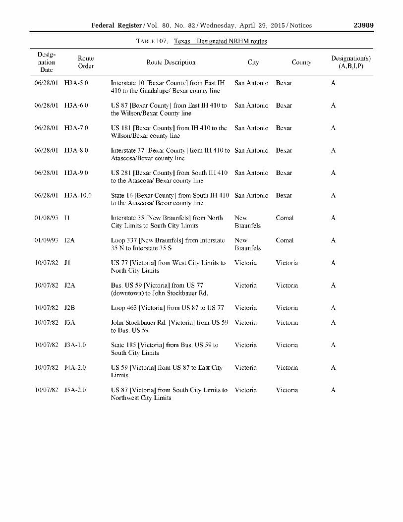
23989 Federal Register / Vol. 80, No. 82 / Wednesday, April 29, 2015 / Notices
VerDate Sep<11>2014 17:52 Apr 28, 2015 Jkt 235001 PO 00000 Frm 00131 Fmt 4701 Sfmt 4725 E:\FR\FM\29APN2.SGM 29APN2 EN
29A
P15
.130
</G
PH
>
mst
ocks
till o
n D
SK
4VP
TV
N1P
RO
D w
ith N
OT
ICE
S2
TABLE 107.- Texas- Designated NRHM routes
Desig-Route Designation(s)
nation Order
Route Description City County (A,B,I,P)
Date
06/28/01 H3A-5.0 Interstate 10 [Bexar County] from East IH San Antonio Bexar A 410 to the Guadalupe/ Bexar county line
06/28/01 H3A-6.0 US 87 [Bexar County] from East IH 410 to San Antonio Bexar A the Wilson/Bexar County line
06/28/01 H3A-7.0 US 181 [Bexar County] from IH 410 to the San Antonio Bexar A Wilson/Bexar county line
06/28/01 H3A-8.0 Interstate 3 7 fBexar County 1 from IH 410 to San Antonio Bexar A Atascosa/Bexar county line
06/28/01 H3A-9.0 US 281 [Bexar County] from South IH 410 San Antonio Bexar A to the Atascosa/ Bexar county line
06/28/01 H3A-10.0 State 16 [Bexar County] from South IH 410 San Antonio Bexar A to the Atascosa/ Bexar county line
01/08/93 T1 Interstate 35 [New Braunfels] from North New Co mal A City Limits to South City Limits Braunfels
Ol/09/93 12A Loop 337 lNew Braunfelsj from Interstate New Co mal A 35 N to Interstate 35 S Braunfels
10/07/82 Jl US 77 [Victoria] from West City Limits to Victoria Victoria A North City Limits
10/07/82 J2A Bus. US 59 [Victoria] from US 77 Victoria Victoria A (downtown) to John Stockbauer Rd.
10/07/82 J2B Loop 463 [Victoria] from US 87 to US 77 Victoria Victoria A
10/07/82 J3A John Stockbauer Rd. lVictoriaj from US 59 Victoria Victoria A to Bus. US 59
10/07/82 BA-1.0 State 185 [Victoria] from Bus. US 59 to Victoria Victoria A South City Limits
10/07/82 J4A-2.0 US 59 [Victoria] from US 87 to East City Victoria Victoria A Limits
10/07/82 JSA-2.0 US 87 [Victoria] from South City Limits to Victoria Victoria A Northwest City Limits

23990 Federal Register / Vol. 80, No. 82 / Wednesday, April 29, 2015 / Notices
VerDate Sep<11>2014 17:52 Apr 28, 2015 Jkt 235001 PO 00000 Frm 00132 Fmt 4701 Sfmt 4725 E:\FR\FM\29APN2.SGM 29APN2 EN
29A
P15
.131
</G
PH
>
mst
ocks
till o
n D
SK
4VP
TV
N1P
RO
D w
ith N
OT
ICE
S2
TABLE 107.- Texas- Designated NRHM routes
Desig-Route Designation(s)
nation Order
Route Description City County (A,B,I,P)
Date
06/28/93 K1 Farm to Market 609 [La Grange] from West LaGrange Fayette A City Limits to Bus. US 71
06/28/93 K2 Bus. US 71 [La Grange] from West City LaGrange Fayette A Limits to Farm to Market 609
06/28/93 Ll State 71 rLa Grange l from East City Limits LaGrange Fayette A to West City Limits
06/28/93 L2 US 77 [La Grange] from North City Limits LaGrange Fayette A to State 71
08/06/90 M US 59 [Rosenberg] from South City Limits Rosenberg Fort Bend A to North City Limits
08/06/90 N State 36 [Rosenberg] from 3400 Block to Rosenberg Fort Bend A 4300 Block [This segment of State 36 is on the South side oftown.]
08/06/90 0 State 36 lRosenbergj from 500 Block lto Rosenberg Fort Bend A US 90, 900 block only] to Farm to Market 529 [This segment of State 36 is to the Northwest side of town.]
Ol/21/87 p US 90A lStatiordj from West City Limits to Statiord Fort Bend A East City Limits
Ol/21/87 Q US 59 [Stafford] from West City Limits to Stafford Fort Bend/ A North City Limits Harris
03/25/91 R1 Farm to Market 518 [Pearland] from West Pearland Brazoria A City Limits to East City Limits
03/25/91 R2A State 35 [Pearland] from North City Limits Pearland Brazoria A to South City Limits
03/04/70 s Interstate 610 [Houston] Entire Highway Houston Harris A
02/22/72 T State 225 [Deer Park] from East City Limits Deer Park Harris A to West City Limits
05/25/82 U1 State 6 [Santa Fe] from West City Limits to Santa Fe Galveston A East City Limits

23991 Federal Register / Vol. 80, No. 82 / Wednesday, April 29, 2015 / Notices
VerDate Sep<11>2014 17:52 Apr 28, 2015 Jkt 235001 PO 00000 Frm 00133 Fmt 4701 Sfmt 4725 E:\FR\FM\29APN2.SGM 29APN2 EN
29A
P15
.132
</G
PH
>
mst
ocks
till o
n D
SK
4VP
TV
N1P
RO
D w
ith N
OT
ICE
S2
TABLE 107.- Texas- Designated NRHM routes
Desig-Route Designation(s)
nation Order
Route Description City County (A,B,I,P)
Date
05/25/82 U2A Farm to Market 1 7 64 [Santa Fe] Entire Santa Fe Galveston A highway within city limits
05/25/82 U2B Farm to Market 646 [Santa Fe] from North Santa Fe Galveston A City Limits to South City Limits
10/13/83 Vl Interstate 45 [Galveston, Galveston Cow1ty] Galveston Galveston A from West City Limits to Farm to Market 188 [Teichman Rd.]
[See City of Galveston code for special restrictions/more information.]
I 0/13/83 V2 State 275 (Port Industrial Blvd. and Galveston Galveston A Harborside Drive) [Galveston, Galveston County] from Interstate 45 to 9th St.
[See City of Galveston code for special restrictions/more information.]
10/13/83 V3A 51st St./SeawolfPkwy. [Galveston, Galveston Galveston A Galveston County] from State 275 (Harborside Drive) to 1/4 mile south of Sea wolf Park
[See City of Galveston code for special restrictions/more information.]
10/13/83 Wl State 342 (6lst St.) fGalveston, Galveston Galveston Galveston A Countyj from Broadway Ave. to Seawall Blvd.
[See City of Galveston code for special restrictions/more information.]
10/13/83 W2 Broadway Ave. [Galveston, Galveston Galveston Galveston A County (entire length)]
[See City of Galveston code for special restrictions/more information.]
03/01/72 Xl State 146 [Texas City, Galveston County] Texas City Galveston A from North City Limits to South City Limits

23992 Federal Register / Vol. 80, No. 82 / Wednesday, April 29, 2015 / Notices
VerDate Sep<11>2014 17:52 Apr 28, 2015 Jkt 235001 PO 00000 Frm 00134 Fmt 4701 Sfmt 4725 E:\FR\FM\29APN2.SGM 29APN2 EN
29A
P15
.133
</G
PH
>
mst
ocks
till o
n D
SK
4VP
TV
N1P
RO
D w
ith N
OT
ICE
S2
TABLE 107.- Texas- Designated NRHM routes
Desig-Route Designation(s)
nation Order
Route Description City County (A,B,I,P)
Date
03/01/72 X2A Loop 197 [Texas City, Galveston County] Texas City Galveston A from South City Limits to 2nd Ave. S.
03/01/72 X2B Farm to Market 519 [Texas City, Galveston Texas City Galveston A County] from State 146 to Loop 197
03/01/72 X2C 5th Ave. fTexas City, Galveston Countyl Texas City Galveston A from State 146 to 14th St
03/01/72 X2D Farm to Market 1764 [Texas City, Texas City Galveston A Galveston County] from Interstate 45 to State 146
03/01/72 X3A 2nd Ave. [Texas City, Galveston County] Texas City Galveston A from Loop 197 to Bay St.
03/01/72 X3A-l.O 4th Ave. [Texas City, Galveston County] Texas City Galveston A from Loop 197 to 1Oth St.
03/01/72 X3B-l.O Grant Ave. lTexas Cityj from 5th Ave. Texas City Galveston A South to FM 519/SH 341
03/01/72 X3C 14th St. [Texas City, Galveston County] Texas City Galveston A from Loop 197 to 5th Ave. S.
03/01/72 X4A-l.O lOth St. [Texas City, Galveston County] Texas City Galveston A from S. 4th Ave. to S. 6th Ave.
01/11/94 Yl Interstate 45 [Dickinson] from Northwest Dickinson Galveston A City Limits to Southeast City Limits
01/10/91 Y2 Interstate 45 [League City] from Northwest League City Galveston A City Limits to Southeast City Limits
01/11/94 Y3A Farm to Market 646 [Dickinson/League Dickinson/ Galveston A City] from Interstate 45 east to eastern City League City Limit [Dickinson].
01/11/94 Y4A-l.O Farm to Market 1266 [Dickinson] from Dickinson Galveston A Farm to Market 646 to Farm to Market 517
05/21/92 Zl Interstate 35 [Temple] from North City Temple Bell A Limits to Southwest City Limits
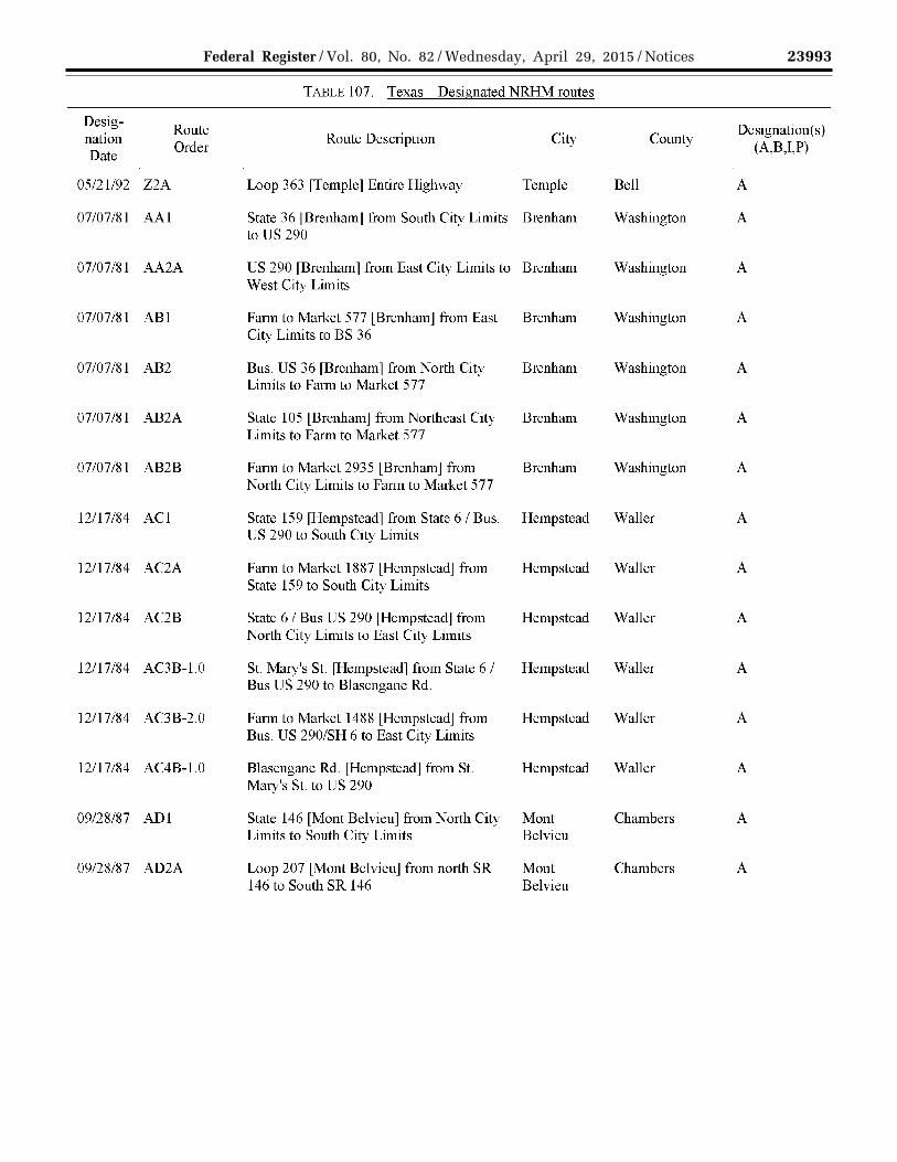
23993 Federal Register / Vol. 80, No. 82 / Wednesday, April 29, 2015 / Notices
VerDate Sep<11>2014 17:52 Apr 28, 2015 Jkt 235001 PO 00000 Frm 00135 Fmt 4701 Sfmt 4725 E:\FR\FM\29APN2.SGM 29APN2 EN
29A
P15
.134
</G
PH
>
mst
ocks
till o
n D
SK
4VP
TV
N1P
RO
D w
ith N
OT
ICE
S2
TABLE 107.- Texas- Designated NRHM routes
Desig-Route Designation(s)
nation Order
Route Description City County (A,B,I,P)
Date
05121192 Z2A Loop 363 [Temple] Entire Highway Temple Bell A
07/07181 AA1 State 36 lBrenhamj from South City Limits Brenham Washington A to US 290
07107181 AA2A US 290 [Brenham] from East City Limits to Brenham Washington A West City Limits
07107181 ABl Farm to Market 577 [Brenham] from East Brenham Washington A City Limits to BS 36
07107181 AB2 Bus. US 36 [Brenham] from North City Brenham Washington A Limits to Farm to Market 577
07/07181 AB2A State 105 lBrenhamj from Northeast City Brenham Washington A Limits to Farm to Market 577
07107181 AB2B Farm to Market 2935 [Brenham] from Brenham Washington A North City Limits to Farm to Market 577
12/17184 ACl State 159 [Hempstead] from State 6 I Bus. Hempstead Waller A US 290 to South City Limits
12117184 AC2A Farm to Market 1887 [Hempstead] from Hempstead Waller A State 159 to South City Limits
12/17184 AC2B State 6 I Bus US 290 lHempsteadj from Hempstead Waller A North City Limits to East City Limits
12/17184 AC3B-l.O St. Mary's St. [Hempstead] from State 6 I Hempstead Waller A Bus US 290 to Blasengane Rd.
12/17184 AC3B-2.0 Farm to Market 1488 [Hempstead] from Hempstead Waller A Bus. US 290ISH 6 to East City Limits
12117184 AC4B-1.0 Blasengane Rd. [Hempstead] from St. Hempstead Waller A Mary's St. to US 290
09128187 ADl State 146 [Mont Belvieu] from North City Mont Chambers A Limits to South City Limits Belvieu
09128187 AD2A Loop 207 [Mont Belvieu] from north SR Mont Chambers A 146 to South SR 146 Belvieu

23994 Federal Register / Vol. 80, No. 82 / Wednesday, April 29, 2015 / Notices
VerDate Sep<11>2014 17:52 Apr 28, 2015 Jkt 235001 PO 00000 Frm 00136 Fmt 4701 Sfmt 4725 E:\FR\FM\29APN2.SGM 29APN2 EN
29A
P15
.135
</G
PH
>
mst
ocks
till o
n D
SK
4VP
TV
N1P
RO
D w
ith N
OT
ICE
S2
TABLE 107.- Texas- Designated NRHM routes
Desig-Route Designation(s)
nation Order
Route Description City County (A,B,I,P)
Date
09/28/87 AD3A-l.O Farm to Market 565 [Mont Belvieu] from Mont Chambers A Loop 207 to East City Limits Belvieu
09/23/82 AE1 Interstate 45 [Conroe] from North City Conroe Montgomery A Limits to South City Limits
09/23/82 AE2A Loop 336lConroeJ Entire highway within Conroe Montgomery A city limits
08/01/91 AF1 Interstate 10 [Beaumont] from East City Beaumont Jefferson A Limits to West City Limits
08/01/91 AF2A US 69/96/287 [Beaumont] from North City Beaumont Jefferson A Limits to Southeast City Limits
08/01/91 AF2B US 90 [Beaumont] from West City Limits Beaumont Jefferson A to Interstate 1 0
08/01/91 AF3A-l.O Spur 380 (Railroad Ave.) [Beaumont] from Beaumont Jefferson A US 69/ US96/US287 (Cardinal Dr.) to Washington Blvd
08/01/91 AF3A-2.0 State 105 lBeaumontJ from West City Beaumont JeHerson A Limits to US 69/96/287
08/01/91 AF4A-l.O Washington Blvd. rBeaumontl from Spur Beaumont Jefferson A 3 80 to Irving St.
08/01/91 AF5A-l.O Irving St. [Beaumont] from Washington Beaumont Jefferson A Blvd. to Madison St.
08/01/91 AF6A-l.O Madison St. [Beaumont] from Irving St. to Beaumont Jefferson A Grove St.
01/16/78 AG1 Farm to Market 2110 [Crockett] from Crockett Houston A Southwest City Limits to Loop 304 SW
01/16/78 AG2 Loop 304 rcrockettl Entire highway Crockett Houston A
01/16/78 AG3A State 7/21 [Crockett] from West City Limits Crockett Houston A to Loop 304 W
01/16/78 AG3B Farm to Market 2076 [Crockett] from West Crockett Houston A City Limits to Loop 304 W

23995 Federal Register / Vol. 80, No. 82 / Wednesday, April 29, 2015 / Notices
VerDate Sep<11>2014 17:52 Apr 28, 2015 Jkt 235001 PO 00000 Frm 00137 Fmt 4701 Sfmt 4725 E:\FR\FM\29APN2.SGM 29APN2 EN
29A
P15
.136
</G
PH
>
mst
ocks
till o
n D
SK
4VP
TV
N1P
RO
D w
ith N
OT
ICE
S2
TABLE 107.- Texas- Designated NRHM routes
Desig-Route Designation(s)
nation Order
Route Description City County (A,B,I,P)
Date
01/16/78 AG3C Farm to Market 229 [Crockett] from Crockett Houston A Northwest City Limits to Loop 304 NW
01/16/78 AG3D US 287/State 19 [Crockett] from North City Crockett Houston A Limits to Loop 3 04 N
01/16/78 AG3E Farm to Market 2022 [Crockett] from Crockett Houston A Northeast City Limits to NE Loop 304
01/16/78 AG3F State 21 rcrockettl from Northeast City Crockett Houston A Limits to Loop 3 04 N E
01/16/78 AG3G State 7 [Crockett] from East City Limits to Crockett Houston A Loop 304 E
01/16/78 AG3H US 287 [Crockett] from Southeast City Crockett Houston A Limits to Loop 3 04 E
01/16/78 AG3T Farm to Market 2712 [Crockett] from South Crockett Houston A City Limits to Loop 304 S
01/16/78 AG3J State 19 l Crockett J from South City Limits Crockett Houston A to Loop 304 S
08/16/88 AH1 US 59 [Lufkin] from South City Limits to Lufkin Angelina A South Loop 287
09/23/88 AH2 Loop 287 [Lufkin] Entire highway Lufkin Angelina A
08/16/88 AH3A State 94 [Lufkin] from West City Limits to Lufkin Angelina A West Loop 287
08/16/88 AH3B State 103 lLufkinj from West City Limits to Lufkin Angelina A West Loop 287
08/16/88 AH3C US 69 [Lufkin] from Northwest City Limits Lufkin Angelina A to Northwest Loop 287
08/16/88 AH3D US 59 [Lufkin] from North City Limits to Lufkin Angelina A North Loop 287
09/23/88 AH3E State 103 [Lufkin] from East City Limits to Lufkin Angelina A East Loop 287 US 59/69

23996 Federal Register / Vol. 80, No. 82 / Wednesday, April 29, 2015 / Notices
VerDate Sep<11>2014 17:52 Apr 28, 2015 Jkt 235001 PO 00000 Frm 00138 Fmt 4701 Sfmt 4725 E:\FR\FM\29APN2.SGM 29APN2 EN
29A
P15
.137
</G
PH
>
mst
ocks
till o
n D
SK
4VP
TV
N1P
RO
D w
ith N
OT
ICE
S2
TABLE 107.- Texas- Designated NRHM routes
Desig-Route Designation(s)
nation Order
Route Description City County (A,B,I,P)
Date
09/23/88 AH3F US 69 [Lufkin] from Southeast City Limits Lufkin Angelina A to East Loop 287
09/20/77 All US 59 [Nacogdoches] from South City Nacogdoches Nacogdoches A Limits to Loop 224 S
09/20/77 AI2 Loop 224 [Nacogdoches] Entire Highway Nacogdoches Nacogdoches A
09/20/77 ABA State 7 [Nacogdoches] from West City Nacogdoches Nacogdoches A Limits to Loop 224 W
09/20/77 ABB State 21 [Nacogdoches] from West City Nacogdoches Nacogdoches A Limits to Loop 224 W
09/20/77 ABC US 59 lNacogdochesj from North City Nacogdoches Nacogdoches A Limits to Loop 224 N
09/20/77 ABD State 7 [Nacogdoches] from East City Nacogdoches Nacogdoches A Limits to Loop 224 E
09/20/77 ABE State 21 [Nacogdoches] from East City Nacogdoches Nacogdoches A Limits to Loop 224 E
08/22/88 AJl US 96 [Center] from North City Limits to Center Shelby A South City Limits
08/22/88 AJ2A State 7lCenterj from West City Limits to Center Shelby A us 96
08/22/88 AJ2B State 87 [Center] from West City Limits to Center Shelby A us 96
08/22/88 AKl Loop 500 [Center] from US 96 S to East Center Shelby A State 7
08/22/88 AK2A State 87 [Center] from East City Limits to Center Shelby A Loop 500
11/01/94 All US 377 [Benbrook] from North City Limits Benbrook Tarrant A to South City Limits
03/06/79 AL2 US 377 [Fort Worth] from Southwest City Fort Worth Tarrant A Limits to Interstate 20

23997 Federal Register / Vol. 80, No. 82 / Wednesday, April 29, 2015 / Notices
VerDate Sep<11>2014 17:52 Apr 28, 2015 Jkt 235001 PO 00000 Frm 00139 Fmt 4701 Sfmt 4725 E:\FR\FM\29APN2.SGM 29APN2 EN
29A
P15
.138
</G
PH
>
mst
ocks
till o
n D
SK
4VP
TV
N1P
RO
D w
ith N
OT
ICE
S2
TABLE 107.- Texas- Designated NRHM routes
Desig-Route Designation(s)
nation Order
Route Description City County (A,B,I,P)
Date
11/01/94 AL2A Farm to Market 2871 [Benbrook] from Benbrook Tarrant A West City Limits to US 377
09/06/84 AL3A-l.O Interstate 20/820 [Benbrook] from East City Benbrook Tarrant A Limits to West City Limits
03/06/79 AL4A-l.O Interstate 820 [Fort Worth] Entire highway Fort Worth Tarrant A [To include: Benbrook, Haltom, Hurst, Lake Worth, N. Richland Hills, Signaw]
07/0l/86 AL4A-l.O Interstate 820 LHaltomj from West City Haltom Tarrant A Limits to East City Limits
09/09/86 AL4A-l.O Interstate 820 [Hurstl from West City Hurst Tarrant A Limits to Southwest City Limits
10/14/86 AL4A-l.O Interstate 820 [Lake Worth] from South Lake Worth Tarrant A City Limits to East City Limits
08/25/86 AL4A-l.O Interstate 820 [North Richland Hills] from North Tarrant A West City Limits to East City Limits Richland
Hills
11/15/86 AL4A-l.O Interstate 820 [Saginaw] from West City Saginaw Tarrant A Limits to East City Limits
03/06/79 AL5A-l.O-A Interstate 30 [Fort Worth] from West City Fort Worth Tarrant A Limits to West Interstate 820
03/06/79 AL5A-1.0-B State 199 (Jacksboro H\-vy) [Fort Fort Worth/ Tarrant A Worth/Lake Worth] from Northwest City Lake Worth Limits of Fort Worth to Interstate 820 NW
03/06/79 AL5A-l.O-C Interstate 35 W fFort Worthl from North Fort Worth Tarrant A City Limits to North Interstate 820
08/25/86 AL5A-1.0-D State 26 [North Richland Hills (entire North Tarrant A highway within city limits)l Richland
Hills
03/06/79 AL5A-l.O-E Interstate 3 0 [Fort Worth] from East City Fort Worth Tarrant A Limits to East Interstate 820
03/06/79 AL5A-l.O-F State 180 [Fort Worth] from Interstate 820 Fort Worth Tarrant A

23998 Federal Register / Vol. 80, No. 82 / Wednesday, April 29, 2015 / Notices
VerDate Sep<11>2014 17:52 Apr 28, 2015 Jkt 235001 PO 00000 Frm 00140 Fmt 4701 Sfmt 4725 E:\FR\FM\29APN2.SGM 29APN2 EN
29A
P15
.139
</G
PH
>
mst
ocks
till o
n D
SK
4VP
TV
N1P
RO
D w
ith N
OT
ICE
S2
TABLE 107.- Texas- Designated NRHM routes
Desig-Route Designation(s)
nation Order
Route Description City County (A,B,I,P)
Date
to East City Limits
09/02/86 AL5A-l.O-G Interstate 20 [Forest Hill] from East City Forest Hill Tarrant A Limits to West City Limits
09/02/86 AL5A-l.O-H Interstate 20 [Arlington] from East City Arlington Tarrant A Limits to West City Limits
03/06/79 AL6A-l.O-H Interstate 20 [Fort Worth] from East City Fort Worth Tarrant A Limits to West City Limits
03/06/79 AL7A-l.O-Hl Interstate 35 W [Fort Worth] from South Fort Worth Tarrant A City Limits to Interstate 20
04/22/91 AM US 287 [Mansfield] Entire Highway Mansfield Tarrant/ A Johnson
01/0I/76 ANl Interstate 35E [Lancaster] from North City Lancaster Dallas A Limits to South City Limits
01/25/84 AN2 Interstate 35 E fDallasl from South City Dallas Dallas A Limits to Interstate 20
11/14/94 AN3A Interstate 20 [Balch Springs] from East City Balch Dallas A Limits to South City Limits Springs
01/25/84 AN3A Interstate 20 [Dallas] Entire Length within Dallas Dallas A City Limits
08/18/86 AN3A Interstate 20 [Duncanville] from East City Duncanville Dallas A Limits to West City Limits
02/09/87 AN3A Interstate 20 lHutchinsJ from West City Hutchins Dallas A Limits to East City Limits
01/01/76 AN3A Interstate 20 [Lancaster] from West City Lancaster Dallas A Limits to East City Limits
01/25/84 AN4A-l.O US 67 [Dallas] from Interstate 20 to South Dallas Dallas A City Limits
01/25/84 AN4A-2.0 Spur 408 [Dallas] from Interstate 20 to Dallas Dallas A Loop 12

23999 Federal Register / Vol. 80, No. 82 / Wednesday, April 29, 2015 / Notices
VerDate Sep<11>2014 17:52 Apr 28, 2015 Jkt 235001 PO 00000 Frm 00141 Fmt 4701 Sfmt 4725 E:\FR\FM\29APN2.SGM 29APN2 EN
29A
P15
.140
</G
PH
>
mst
ocks
till o
n D
SK
4VP
TV
N1P
RO
D w
ith N
OT
ICE
S2
TABLE 107.- Texas- Designated NRHM routes
Desig-Route Designation(s)
nation Order
Route Description City County (A,B,I,P)
Date
01/25/84 AN4A-3.0 State 342 [Dallas] from Interstate 20 to Dallas Dallas A South City Limits
01/25/84 AN4A-4.0 Interstate 45 [Dallas] from Southeast City Dallas Dallas A Limits to Interstate 20
01/25/84 AN4A-5.0 US 175 L Dallas J from South City Limits to Dallas Dallas A Interstate 20
08/18/86 AN5A-l.O US 67 [Duncanville] from East City Limits Duncanville Dallas A to South City Limits
01/25/84 AN5A-2.0 Loop 12 [Dallas] from Spur 408 to South Dallas Dallas A City Limits of Irving
01/25/84 AN5A-2.0-A Spur 303 [Dallas] from Spur 408 to West Dallas Dallas A City Limits
02/09/87 ANSA-4.0 Interstate 45 [Hutchins] from North City Hutchins Dallas A Limits to South City Limits
06/20/91 AN6A-2.0 Loop 12 [Irving] from North City Limits to Irving Dallas A South City Limits
01/25/84 AN6A-2.0-B State 180 [Dallas] from Loop 12 to West Dallas Dallas A City Limits
01/25/84 AN6A-2.0-C Interstate 30 [Dallas] from West City Limits Dallas Dallas A to Loop 12
01/25/84 AN7A-2.0 Loop 12 [Dallas] from North City Limits of Dallas Dallas A Irving to Interstate 35 E
01/25/84 AN8A-2.0 Interstate 35 E [Dallas] from North City Dallas Dallas A Limits to LP 12
01/25/84 AN8A-2.0-D Spur 348 (Northwest Highway) [Dallas] Dallas Dallas A from Loop 12 to West City Limits
01/25/84 AN9A-2.0-E Interstate 635 [Dallas] Entire highway Dallas Dallas A within Dallas City Limits
11/01/94 ANlOA-2.0-E Interstate 635 [Garland] from Southwest Garland Dallas A City Limits to South City Limits

24000 Federal Register / Vol. 80, No. 82 / Wednesday, April 29, 2015 / Notices
VerDate Sep<11>2014 17:52 Apr 28, 2015 Jkt 235001 PO 00000 Frm 00142 Fmt 4701 Sfmt 4725 E:\FR\FM\29APN2.SGM 29APN2 EN
29A
P15
.141
</G
PH
>
mst
ocks
till o
n D
SK
4VP
TV
N1P
RO
D w
ith N
OT
ICE
S2
TABLE 107.- Texas- Designated NRHM routes
Desig-Route Designation(s)
nation Order
Route Description City County (A,B,I,P)
Date
01/25/84 AN10A-2.0-E1 State 289 (Preston Rd.) [Dallas] from Dallas Dallas A Interstate 635 to North City Limits
01/25/84 AN10A-2.0-E2 US 75 [Dallas] from North City Limits to Dallas Dallas A Interstate 635 N
08/06/90 AN11A-2.0-E Interstate 635 rMesquite l from North City Mesquite Dallas A Limits to South City Limits
11/14/94 AN12A-2.0-E Interstate 635 [Balch Springs] from North Balch Dallas A City Limits to Interstate 20 Springs
03/28/96 A01 US 62/82 [Lubbock] from Southwest City Lubbock Lubbock A Limits to Loop 289 SW
03/28/96 A02 Loop 289 (Lubbock) from W. US 62/82, Lubbock Lubbock A North, East, South, & West to South Interstate 27/87
03/28/96 A03A State 114 l Lubbock J from West City Limits Lubbock Lubbock A to Loop 289W
03/28/96 A03B US 84 [Lubbock] from Northwest City Lubbock Lubbock A Limits to Loop 289 N
03/28/96 A03C US 62/82 /SH 114 [Lubbock] from Lubbock Lubbock A Northeast City Limits to Loop 289 NE
03/28/96 A03D US 84 [Lubbock] from Southeast City Lubbock Lubbock A Limits to Loop 289 S
03/28/96 A03E Interstate 27 [Lubbock] from North City Lubbock Lubbock A Limits to South City Limits
09/09/86 AP1 Interstate 27/ US 87/ US 60 [Amarillo] from Amarillo Potter/ A South City Limits to Interstate 40 Randall
10/10/95 AP2 US 60/US 87 /US 287 (Buchanan and Pierce Amarillo Potter/ A St. only) [Amarillo] from Loop 335 to Randall Interstate 40 [7 p.m. to 7 a.m.]
09/09/86 AP2A Interstate 40 [Amarillo] from East City Amarillo Potter/ A Limits to West City Limits Randall

24001 Federal Register / Vol. 80, No. 82 / Wednesday, April 29, 2015 / Notices
VerDate Sep<11>2014 17:52 Apr 28, 2015 Jkt 235001 PO 00000 Frm 00143 Fmt 4701 Sfmt 4725 E:\FR\FM\29APN2.SGM 29APN2 EN
29A
P15
.142
</G
PH
>
mst
ocks
till o
n D
SK
4VP
TV
N1P
RO
D w
ith N
OT
ICE
S2
TABLE 107.- Texas- Designated NRHM routes
Desig-Route Designation(s)
nation Order
Route Description City County (A,B,I,P)
Date
09/09/R6 AP3A Loop 335 [Amarillo] from Dumas Dr. [(US Amarillo Potter/ A 87/US 287)] to West City Limits Randall
09/09/86 AP3A-l.O Loop 335 rAmarillol from NE 24th Ave. to Amarillo Potter/ A Interstate 40 Randall
09/09/86 AP3B Loop 335 [Amarillo] from Dumas Dr. [US Amarillo Potter/ A 27/US 287] to East City Limits Randall
09/09/86 AP4A-l.O-A US 60 [Amarillo] from East City Limits to Amarillo Potter/ A Loop 335 E Randall
09/09/86 AQl BI 40 [Amarillo] from West City Limits to Amarillo Potter/ A Farm to Market 1719 Randall
09/09/86 AQ2 Farm to Market 1719 [Amarillo] from North Amarillo Potter/ A City Limits to BI 40 Randall

24002 Federal Register / Vol. 80, No. 82 / Wednesday, April 29, 2015 / Notices
VerDate Sep<11>2014 17:52 Apr 28, 2015 Jkt 235001 PO 00000 Frm 00144 Fmt 4701 Sfmt 4725 E:\FR\FM\29APN2.SGM 29APN2 EN
29A
P15
.143
</G
PH
>
mst
ocks
till o
n D
SK
4VP
TV
N1P
RO
D w
ith N
OT
ICE
S2
TABLE 108.- State: Utah
State Agency: FMCSA: UT FMCSA Field Office POC: Address:
UTDOT Lane Murphy Motor Carrier Division 4501
POC: Address:
UT Motor Carrier Division Administrator 310 East 4500 South, Suite l 02
Phone: Fax:
South 2700 West P.O. Box 148240 Salt Lake City, UT 84114-8240 (80 l) 965-4508 (801) 965-4211
Salt Lake City, UT 84107 Phone: (80 l) 288-0360 Fax: (801) 288-8867
Web Address: www.udot.utah .gov/
Desig-Route
nation Order
Date
07/0l/97 Al
07/0l/97 A2
07/0l/97 A3
Designation Date
07/0l/97
Route Order
A
TABLE 109.- Utah- Designated HRCQ/RAM routes
Route Description
Interstate 80 from Interstate 84 to Wyoming
Interstate 84 from Interstate 15 to Interstate 80 [Note: The Perry Port of Entry on I-15/I-84 is a designated safe haven for radioactive materials in transit. J
Interstate 15 from Idaho to Interstate 84
TABLE 110.- Utah- Designated NRHM routes
Route Description
All Interstates [The Utah Department of Transportation states that all Interstate routes in the State are designated NRHM routes.]
TABLE lll. - State: V emwnt
State Agency: VT Emergency Mgmt Division FMC SA: VT FMCSA Field Office
Designation(s) (A,B,I,P)
p
p
p
Designation(s) (A,B,I,P)
A
POC: William E. Irwin, Sc.D., CHP POC: VT Motor Carrier Division Administrator Address: l 08 Cherry St. Address: 87 State St., Room 305
Burlington, VT 05402 P.O. Box 338 Phone: (802) 863-7238 Montpelier, VT 0560 l Fax: (802) 865-7745 Phone: (802) 828-4480 Web Address: vem.vermont.gov/ Fax: (802) 828-4581

24003 Federal Register / Vol. 80, No. 82 / Wednesday, April 29, 2015 / Notices
VerDate Sep<11>2014 17:52 Apr 28, 2015 Jkt 235001 PO 00000 Frm 00145 Fmt 4701 Sfmt 4725 E:\FR\FM\29APN2.SGM 29APN2 EN
29A
P15
.144
</G
PH
>E
N29
AP
15.1
45<
/GP
H>
mst
ocks
till o
n D
SK
4VP
TV
N1P
RO
D w
ith N
OT
ICE
S2
State Agency: POC: Address:
Phone: Fax: Web Address:
TABLE 111. - State: Vermont
No designated or restricted routes as of 03/30/2015
VA DOT John Scrivani 1221 East Broad St. Richmond, VA 23219 (804) 786-2848 (804) 225-4979 virginiadot.org/
TABLE 112.- State: Virginia
FMC SA: POC: Address:
Phone: Fax:
VA FMC SA Field Office VA Motor Carrier Division Administrator 400 North 8th St., Suite 750 Richmond, VA 23219 (804) 771-8585 (804) 771-8670
TABLE 113.- Virginia- Restricted HM routes
Designation Date
Route Order
Route Description Restriction(s)
(0, 1,2,3,4,5,6, 7,8,9,i)
11/15/95 A
ll/15/95 B
05/25/85 c
Designation Date
11/15/95
Route Order
D
East River Mountain Tunnel - Interstate 77 [Phone: (276) 928-1994]
Highway Route Controlled Quantities (HRCQ) of high level radioactive material is not allowed
Big Walker Mountain Tunnel -Interstate 77 [Phone: (276) 228-5571]
Highway Route Controlled Quantities (HRCQ) of high level radioactive material is not allowed
7
7
Airport Tunnel (Airport Rd [State 118]) [City of Roanoke] from Trapper Cir NW 0 to DentRdNW
TABLE 113.- Virginia- Restricted HM routes
Route Description
Elizabeth River Tunnel [Downtown] -Interstate 264 [Phone: (757) 494-2424].
Materials in hazard classes 1.1, 1.2, 1.3, 2.3, 4.3, 6.1, 7 (i.e., Highway Route Controlled Quantities-HRCQ), and toxic inhalation hazard are not allowed passage through this tunnel.
Materials in hazard classes 2.1, 3, 5.1, 5.2, and 8, are allowed access to this tunnel only in "non-bulk".
Haztnat shipper MUST abide by mles and regulations outlined in VDOT's "Rules and Regulations Governing the Transportation of Hazardous Materials through Bridge-Tunnel Facilities". For additional information, sec www. virginiadot. org/info/re sources/vdothazmat.pdf
Restriction(s) (0, 1,2,3,4,5,6, 7,8,9,i)
1,2,3,4,5,6, 7,8,i

24004 Federal Register / Vol. 80, No. 82 / Wednesday, April 29, 2015 / Notices
VerDate Sep<11>2014 17:52 Apr 28, 2015 Jkt 235001 PO 00000 Frm 00146 Fmt 4701 Sfmt 4725 E:\FR\FM\29APN2.SGM 29APN2 EN
29A
P15
.146
</G
PH
>
mst
ocks
till o
n D
SK
4VP
TV
N1P
RO
D w
ith N
OT
ICE
S2
Designation Date
11/15/95
Route Order
E
11/15/95 F
TABLE 113.- Virginia- Restricted HM routes
Route Description
Elizabeth River Tunnel [Midtown] -US 58 [Phone: (757) 683-8123]
Materials in hazard classes 1.1, 1.2, 1.3, 2.3, 4.3, 6.1, 7 (Highway Route Controlled Quantities (HRCQ)), and toxic inhalation hazard are not allowed passage through this tunnel.
Materials in hazard classes 2.1, 3, 5.1, 5.2, and 8, are allowed access to this tunnel only in "non-bulk".
Hazmat shipper MUST abide by rules and regulations outlined in VA DOT's "Rules and Regulations Governing the Transportation of Hazardous Materials through Bridge-Tunnel Facilities". For additional infonnation, see www. virginiadot. org/info/re sources/vdothazmat. pdf
Restriction(s) (0, 1,2,3,4,5,6, 7,8,9,i)
1,2,3,4,5,6,7,8,i
Monitor-Merrimac Memorial [Bridge/Tunnel]- Interstate 664 [Phone: (757) 247- 1,2,3,4,5,6,7,8j 2123]
Materials in hazard classes 1.1, 1.2, 1.3, 2.3, 4.3, 6.1,7 (i.e, Highway Route Controlled Quantitics-HRCQ), and toxic inhalation hazard arc not allowed passage through this tunnel.
Materials in hazard classes 2. L 3, 5.1, 5.2, and 8, are allowed access to this tunnel only in non-bulk".
Hazmat shipper MUST abide by rules and regulations outlined in VDOT's "Rules and Regulations Governing the Transportation of Hazardous Materials through Bridge-Tunnel Facilities". For additional information, sec www. virginiadot. org/info/re sources/vdothazmat.pdf

24005 Federal Register / Vol. 80, No. 82 / Wednesday, April 29, 2015 / Notices
VerDate Sep<11>2014 17:52 Apr 28, 2015 Jkt 235001 PO 00000 Frm 00147 Fmt 4701 Sfmt 4725 E:\FR\FM\29APN2.SGM 29APN2 EN
29A
P15
.147
</G
PH
>
mst
ocks
till o
n D
SK
4VP
TV
N1P
RO
D w
ith N
OT
ICE
S2
Designation Date
11/15/95
Route Order
G
11/12/96 H
TABLE 113.- Virginia- Restricted HM routes
Route Description
Hampton Roads Bridge-Tmme1 [Interstate 64] [Phone: (757) 727-4832]
Materials in hazard classes 1.1, 1.2, 1.3, 2.3, 4.3, 6.1, 7 (i.e., Highway Route Controlled Quantities-HRCQ), and toxic inhalation hazard are not allowed passage through this tunnel.
Materials in hazard classes 2.1, 3, 5.1, 5.2, and 8, are allowed access to this tunnel only in "non-bulk".
Hazmat shipper MUST abide by rules and regulations outlined in VDOT's "Rules and Regulations Governing the Transportation of Hazardous Materials through Bridge-Tunnel Facilities". For additional infonnation, see www.virginiadot.org/info/resources/vdothazmat.pdf
Chesapeake Bay Bridge - Tunnel [Phone: (757) 331-2960]
The jurisdiction for this bridge and tunnel falls under the Chesapeake Bay Bridge and Tunnel District, which maintains its own regulations on hazardous materials.l
Classes 1.1, 1.2, 1.3, 2.3, 4.3, and 6.1 (Inhalation Hazard only) are not allowed passage in any quantity.
Classes 2.1., 2.2, 3, 4.1, 4.2, 5.1, 5.2, 6.1, 7, 8, and 9 are prohibited in limited circumstances.
For additional information on route restrictions, see www.cbbt.com/hazmat.html
Restriction(s) (0, 1,2,3,4,5,6, 7,8,9,i)
1,2,3,4,5,6, 7,8,i
1,2,3,4,5,6, 7,8,9,i

24006 Federal Register / Vol. 80, No. 82 / Wednesday, April 29, 2015 / Notices
VerDate Sep<11>2014 17:52 Apr 28, 2015 Jkt 235001 PO 00000 Frm 00148 Fmt 4701 Sfmt 4725 E:\FR\FM\29APN2.SGM 29APN2 EN
29A
P15
.148
</G
PH
>
mst
ocks
till o
n D
SK
4VP
TV
N1P
RO
D w
ith N
OT
ICE
S2
TABLE 114. - Virginia - Designated NRHM routes
Designation Date
Route Order
Route Description
07/31/95 A Interstate 495 [* * Restricted to right lanes only **]
State Agency: POC: Address:
Phone: Fax:
Dept. of Emergency Mgmt. Brian Iverson 10501 Trade Court Richmond, VA 23236 (804) 897-9953
TABLE 115.- State: Virginia
FMCSA: POC: Address:
Phone: Fax:
VA FMC SA Field Office
Designation(s) (A,B,I,P)
A
VA Motor Carrier Division Administrator 400 North 8th St., Suite 750 Richmond, VA 23 219 (804) 771-8585 (804) 771-8670
Web Address: (804) 897-6576 www.vaemergency.gov/
TABLE 116.- Virginia- HRCQ/RAM routes
Desig-Route Designation(s)
nation Route Description Date
Order (A,B,I,P)
03/11/94 A US 460 from West Virginia to State 100 fPearisburgl p
03/11/94 B1 US 220 Alt. from US 460 to Interstate 81 p
03/11/94 B2 US 460 from State 726 [Mt. Athos Rd. in Lynchburg] to US 220 Alt. p
03/11/94 B3 State 460 from Interstate 85 to State 726 [Mt. Athos Rd. in Lynchburg] p
03/11/94 B4 Interstate 85 from Interstate 95 to State 460 p
03/11/94 C1 US 58 from Portsmouth to Interstate 95 p
03/11/94 C2A US 460 from US 1 [in Petersburg] to US 58 [North of Suffolk] p
03/11/94 C2B State 1 0 from State 15 6 to State 58 p
03/11/94 C3B State 156 from State 5 to State 10 p
03/11/94 C3B-l.O US 17 /US 25 8 from Interstate 64 to State 10 p
03/11/94 C4B State 5 from State 155 [in Charles City] to State 156 p

24007 Federal Register / Vol. 80, No. 82 / Wednesday, April 29, 2015 / Notices
VerDate Sep<11>2014 17:52 Apr 28, 2015 Jkt 235001 PO 00000 Frm 00149 Fmt 4701 Sfmt 4725 E:\FR\FM\29APN2.SGM 29APN2 EN
29A
P15
.149
</G
PH
>
mst
ocks
till o
n D
SK
4VP
TV
N1P
RO
D w
ith N
OT
ICE
S2
TABLE 116.- Virginia- HRCQ/RAM routes
Desig-Route Designation(s)
nation Route Description Date
Order (A,B,I,P)
03/ll/94 C5B
03/11/94 D
03/11/94 E1
03/11/94 E2
03/11/94 E3
State Agency: POC:
Address:
Phone: Fax: Web Address:
Desig-Route
nation Order
Date
1990 A
1989 B
State 155 from Interstate 64 to State 5 [at Charles City]
US 29 from Interstate 66 to Interstate 64
US 522 from State 208 to Interstate 64
State 208 from US 522 to US 1
US 1 from State 208 to Interstate 95 [At Four Mile Fork]
TABLE 117.- State: Washington
W A DOT Commercial Vehicle Services Ann Ford, Commercial Vehicle Services Administrator PO Box47367 Olympia, WA 98504-7367 (360) 705-7341 (360) 704-6350 wsdot. wa.gov /CommercialV ehicle/
FMCSA: POC: Address:
Phone: Fax:
p
p
p
p
p
WA FMCSA Field Of±l.ce W A Motor Carrier Division Administrator 2424 Heritage Court, SW, Suite 302 Olympia, W A 98502 (360) 753-9875 (360) 753-9024
TABLE 118.- Washington- Restricted HM routes
Restriction(s) Route Description City County
(0, 1,2,3,4,5,6, 7,8,9,i)
I -90 [Seattle] Seattle King 3 MP 3 - 6 Flammable loads cannot be transported through the Mercer Island tunnel or the tunnel on the west side of Lake Washington when the sprinkler systems are not operational or being tested
T-5 [Seattle] Seattle King 3 MP 164 Flammable loads cannot be transported through the tunnel under convention center when the sprinkler systems are not operational or being tested"

24008 Federal Register / Vol. 80, No. 82 / Wednesday, April 29, 2015 / Notices
VerDate Sep<11>2014 17:52 Apr 28, 2015 Jkt 235001 PO 00000 Frm 00150 Fmt 4701 Sfmt 4725 E:\FR\FM\29APN2.SGM 29APN2 EN
29A
P15
.150
</G
PH
>
mst
ocks
till o
n D
SK
4VP
TV
N1P
RO
D w
ith N
OT
ICE
S2
State Agency: POC: Address:
Phone: Fax: Web Address:
TABLE 119.- State: West Virginia
WV DOT, District 6 David Sada 1 DOT Drive Moundsville,WV 26041-1605 (304) 843-4032 (304) 843-4059 www .transportation. wv. gov /Pages/ default. aspx
FMCSA: WV FMCSA Field Office POC: WV Motor Carrier Division Administrator Address: 700 Washington St. East
Geary Plaza, Suite 205 Charleston, WV 25301
Phone: (304) 347-5935 Fax: (304) 347-5617
TABLE 120.- West Virginia- Restricted HM routes
Designation Date
Route Order
Route Description Rcstriction(s)
(0, 1 ,2,3,4,5 ,6, 7 ,8,9 ,i)
12/06/66 A
State Agency: POC: Address:
Phone: Fax: Web Address:
State Agency: POC: Address:
Phone: Fax: Web Address:
Wheeling Tunnel (at I-70)
WI DOT Mark Gottlieb Office of the Secretary P.O. Box 7910 Madison, WI 53707 (608) 266-1114 (608) 266-9912 wwv;. dot. state. wi. us
TABLE 121.- State: Wisconsin
FMCSA: POC: Address:
Phone: Fax:
1,3,4
WI FMCSA Field Office WI Motor Carrier Division Administrator 1 Point Place, Suite 101 Madison, WI 53719 (608) 662-2010 (608) 829-7540
No designated or restricted routes as of 03/30/2015
WY Highway Patrol Capt. Scot Montgomery 5300 Bishop Blvd Cheyenne, WY 82009 (307) 777-4312 (307) 777-4282 www.whp.dot. state. wv. us/wvdot
TABLE 122.- State: Wyoming
FMCSA: POC: Address:
Phone: Fax:
WY FMCSA Field Office WY Motor Carrier Division Administrator 1637 Stillwater Avenue, Suite F Cheyenne, WY 82009 (307) 772-2305 (307) 772-2905

24009 Federal Register / Vol. 80, No. 82 / Wednesday, April 29, 2015 / Notices
[FR Doc. 2015–09701 Filed 4–28–15; 8:45 am]
BILLING CODE 4910–EX–C
VerDate Sep<11>2014 19:51 Apr 28, 2015 Jkt 235001 PO 00000 Frm 00151 Fmt 4701 Sfmt 9990 E:\FR\FM\29APN2.SGM 29APN2 EN
29A
P15
.151
</G
PH
>
mst
ocks
till o
n D
SK
4VP
TV
N1P
RO
D w
ith N
OT
ICE
S2