deploying dmc in today’s workflow - uni stuttgart · 2018-12-19 · deploying dmc in today’s...
TRANSCRIPT

Heier 35
Deploying DMC in today’s workflow
HELMUT HEIER, Oberkochen
ABSTRACT The mission of Z/I Imaging is to bring our customers best-in-class solutions for the entire photogrammetric production process; from acquisition via exploitation to digital distribution. With the availability of a digital camera, it will be possible to completely close this process-chain. As a consequence the management of this digital workflow becomes more considerable. Besides new digital image quality, benefits like cost and time saving will lead to higher productivity. The advantage of this flexible, fully digital workflow can just be empowered by introducing efficient data management tools. The state of the art hybrid workflow consists of several single independent steps. Today we can find mature powerful tools for each single production step. Developments during the last years where mainly focused to optimise the functionality of these digital photogrammetric exploitation tools. The lack of efficiency in current production environments is mainly based on missing of data management tools, interfacing problems and missing standardization of exchange formats. The success of digital imagery products from satellites has expanded the understanding of the workflow to start already from digital image acquisition. According to this understanding the following paper will describe the fully automated data post-processing steps for Z/I Imaging’s new Digital Modular Camera as an integrated part of a complete digital photogrammetric workflow. Finally it discusses the integration of DMC imagery into the new TerraShare data management environment.
1. INTRODUCTION
Aerial cameras manufactured by Carl Zeiss have been successfully used around the world for many decades. Z/I Imaging, an Intergraph - Carl Zeiss joint venture, continues this tradition with the development of the new Digital Modular Camera DMC; Figure 3. Products like the RMK-TOP, RMK and LMK have defined a standard for photogrammetric image acquisition. Figure 1 gives an
Figure 1 : Development history of aerial cameras; from a handheld camera to complex system solutions
2002 : DMC
'Photogrammetric Week 01' D. Fritsch & R. Spiller, Eds. Wichmann Verlag, Heidelberg 2001.
36 Heier
overview over this unique history in the development of photogrammetric cameras. In recent years this airborne cameras have evolved from handheld standalone cameras into complex systems. The total benefit of today's camera systems arises from system solutions based on features like motion compensation, photo-flight management, GPS-supported navigation, and the use of measurement methods for the precise determination position and orientation data during the photo-flight. The new digital modular camera DMC from ZI is the latest development step in this long history. The DMC will add digital capabilities to the existing image capturing technology. As today's airborne camera systems are complex system solutions the new digital camera is more than simply the exchange of film against silicon. Aspects like data transfer rates, image post-processing, colour fusion, calibration, image archiving and image data management have to be addressed.
2. Z/I-IMAGING'S DIGITAL MODULAR CAMERA DMC
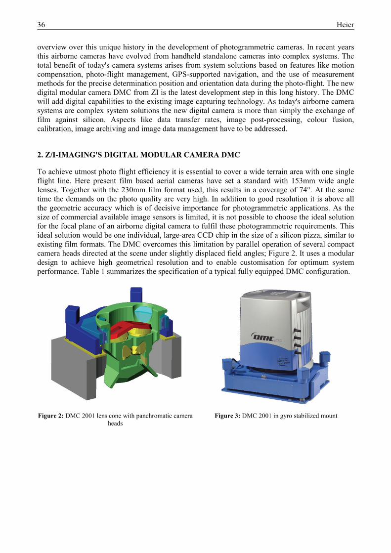
To achieve utmost photo flight efficiency it is essential to cover a wide terrain area with one single flight line. Here present film based aerial cameras have set a standard with 153mm wide angle lenses. Together with the 230mm film format used, this results in a coverage of 74°. At the same time the demands on the photo quality are very high. In addition to good resolution it is above all the geometric accuracy which is of decisive importance for photogrammetric applications. As the size of commercial available image sensors is limited, it is not possible to choose the ideal solution for the focal plane of an airborne digital camera to fulfil these photogrammetric requirements. This ideal solution would be one individual, large-area CCD chip in the size of a silicon pizza, similar to existing film formats. The DMC overcomes this limitation by parallel operation of several compact camera heads directed at the scene under slightly displaced field angles; Figure 2. It uses a modular design to achieve high geometrical resolution and to enable customisation for optimum system performance. Table 1 summarizes the specification of a typical fully equipped DMC configuration.
Figure 2: DMC 2001 lens cone with panchromatic camera heads
Figure 3: DMC 2001 in gyro stabilized mount
Heier 37
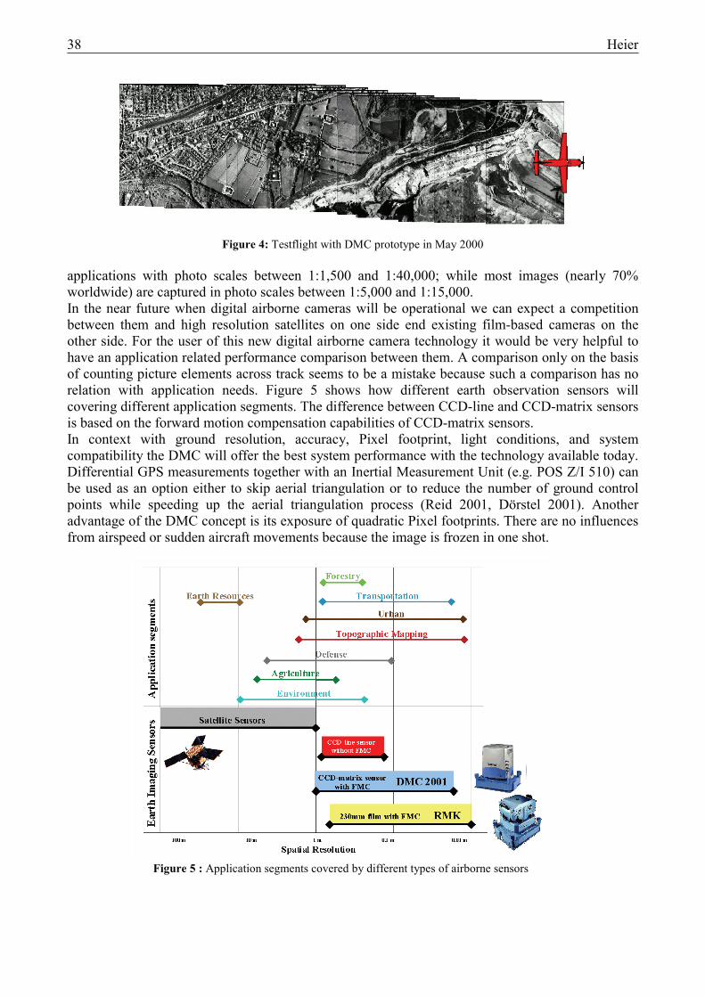
The CCD-matrix based camera heads can be mounted together in different configurations, depending on the application. This multi-camera approach allows the combination of high panchromatic resolution with multi-spectral capability. Up to four parallel cameras can generate multi-spectral 4-band imagery. Four panchromatic images from converging cameras, two at each side of the multi-spectral cameras, are mosaiced digitally to form a single high resolution image. The colour composite image and the composed panchromatic image have the same ground coverage. The cross track resolution for the mosaiced panchromatic image DMC is nearly twice as high as cross track resolution of a single camera head. The number of camera heads can be changed and their resolution can be upgraded in relation with the increasing performance of future sensor technology. A more detailed description of technical details can be found in [Hinz, 2001]. At this moment airborne digital cameras based either on CCD line sensors or CCD matrix sensors are under development. Z/I’s DMC is based on a CCD matrix sensor. This approach offers the best geometric accuracy for photogrammetric applications, without restrictions defined by the accuracy and reliability of orientation measurements by means of GPS and IMU. The high intrinsic accuracy is determined by the two dimensional matrix of CCD pixels structured on the silicon wafer. Besides this very stable image geometry the DMC offers an outstanding ground resolution even for large image scales due to the fact that FMC (forward motion compensation) was realized. The electronics of the CCD matrix sensors, which are used in the DMC camera heads can be operated in time delayed integration (TDI) mode. This allows fully electronic forward motion compensation of the digital image [Hinz 2001]. In this way compensation of image blur is assured as it is standard in film cameras since 1982. This concept was already proven during several testflights with a DMC prototype; Figure 4. A ground resolution of less then 2 inches could be expected. The introduction of FMC was one of the most important milestones in aerial photography of the last years [Voss 1983]. The importance of FMC depends on the application as the compensation effect is based on the relation between airspeed and flying height (v/h). As it is not possible to reduce the airspeed under a certain limits a camera system without FMC is limited to applications with medium to small photo-scale. FMC is a must to achieve high resolution images from low altitudes for medium to large scale applications. Today aerial camera systems are typically used for mapping
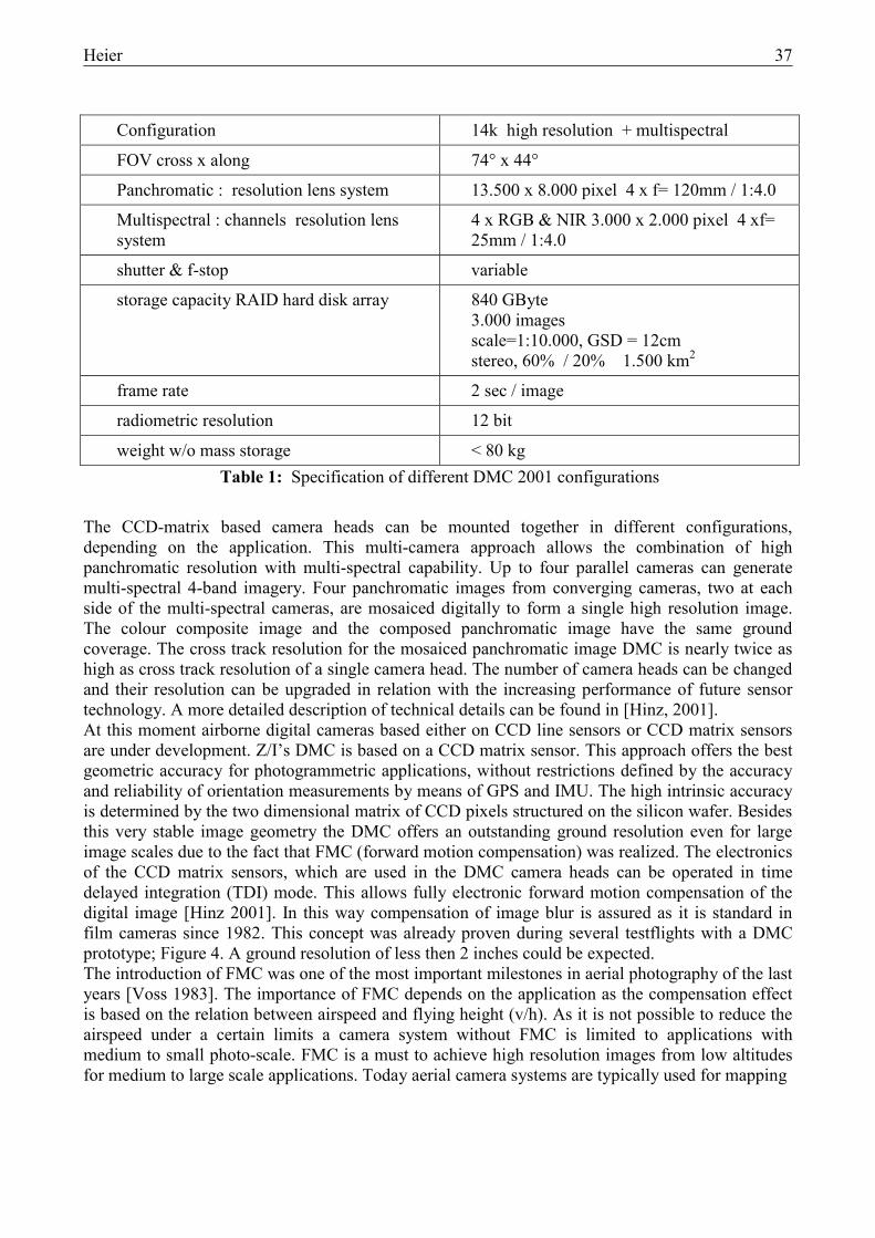
Configuration 14k high resolution + multispectral
FOV cross x along 74° x 44°
Panchromatic : resolution lens system 13.500 x 8.000 pixel 4 x f= 120mm / 1:4.0
Multispectral : channels resolution lens system
4 x RGB & NIR 3.000 x 2.000 pixel 4 xf= 25mm / 1:4.0
shutter & f-stop variable
storage capacity RAID hard disk array 840 GByte 3.000 images scale=1:10.000, GSD = 12cm stereo, 60% / 20% 1.500 km2
frame rate 2 sec / image
radiometric resolution 12 bit
weight w/o mass storage < 80 kg Table 1: Specification of different DMC 2001 configurations
38 Heier
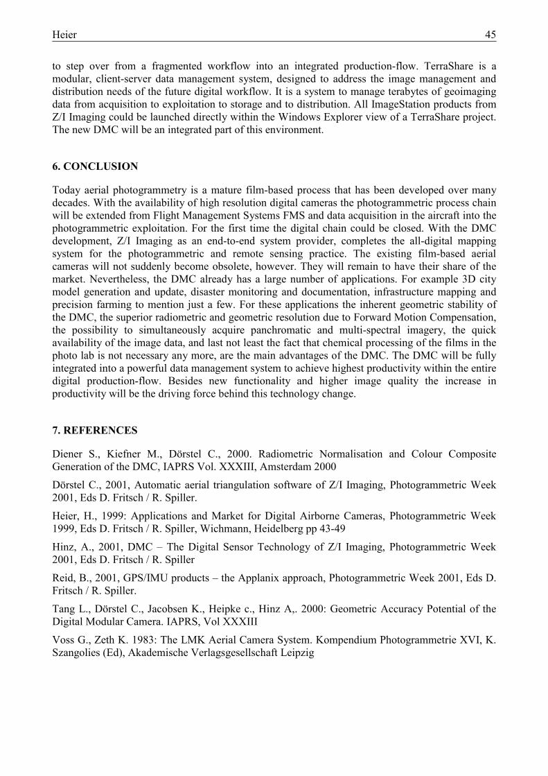
Figure 5 : Application segments covered by different types of airborne sensors
Figure 4: Testflight with DMC prototype in May 2000 applications with photo scales between 1:1,500 and 1:40,000; while most images (nearly 70% worldwide) are captured in photo scales between 1:5,000 and 1:15,000. In the near future when digital airborne cameras will be operational we can expect a competition between them and high resolution satellites on one side end existing film-based cameras on the other side. For the user of this new digital airborne camera technology it would be very helpful to have an application related performance comparison between them. A comparison only on the basis of counting picture elements across track seems to be a mistake because such a comparison has no relation with application needs. Figure 5 shows how different earth observation sensors will covering different application segments. The difference between CCD-line and CCD-matrix sensors is based on the forward motion compensation capabilities of CCD-matrix sensors. In context with ground resolution, accuracy, Pixel footprint, light conditions, and system compatibility the DMC will offer the best system performance with the technology available today. Differential GPS measurements together with an Inertial Measurement Unit (e.g. POS Z/I 510) can be used as an option either to skip aerial triangulation or to reduce the number of ground control points while speeding up the aerial triangulation process (Reid 2001, Dörstel 2001). Another advantage of the DMC concept is its exposure of quadratic Pixel footprints. There are no influences from airspeed or sudden aircraft movements because the image is frozen in one shot.

Heier 39
3. DMC IMAGE POST-PROCESSING
Z/I Imaging is a provider of complete end-to-end digital systems and therefore presents the DMC camera system as one component of an integrated workflow; from mission planning to the creation of deliverable products. The different steps of this workflow are shown in Table 2. A flight management systems is used for the preparation of the photo flight. During the photo flight, a GPS supported navigation system is interfacing with the camera control software. Additional sensors such as Differential-GPS, Inertial Measurement Units can be operated. A Quickview provides the navigator with an early quality control tool (In Flight Quality Check) and offers the necessary basic functions for visualization and assessment of the captured image data. After landing, the recorded data are supplied to the post-processing system. For this purpose, the RAID system which is used in the plane is transported to a post-processing workstation close to the aircraft; e.g. somewhere in the hangar or airport office. This eliminates lengthy data transfer times. The objective of post-processing is to prepare central perspective images for evaluation by any existing Digital Photogrammetric Work Station (DPWS). In this work process, the captured image data are normalized, verified, rectified, colour coded, formatted and made available for digital photogrammetric production. Additional information relating to the images and the photo flight are provided separately. The possible intermediate products are shown in Table 3. The first post-processing step – the generation of Level 1 images – is performed on the basis of camera calibration data. This includes the elimination of defect pixels and normalization. In the elimination of defect pixels, which could be individual pixels of poor electronic quality or, if applicable, missing individual pixels are corrected. In the radiometric correction, bright image and dark image corrections are applied to each pixel [Diener 2000]. Next, the image data are geometrically converted and combined by the mosaicing module. Before the virtual image is generated, the lens distortion is geometrically corrected based on the camera calibration. Here, the calibrated 3D location of each individual image level is taken into account and verified by cyclic control measurements. The image created in this way has a new, virtual camera constant and can be considered an ideal central perspective photogrammetric image.
Processing site Processing steps Detail Office Pre-Processing Mission planning Airplane Photo flight Navigation and flight management system
Camera control software Quickview (In Flight Quality Check) Data storage
Hangar / Office Post-Processing Exchange of data storage , RAID Checking option (Quickview / flight report) Post-processing • Radiometric correction • Geometric correction • Mosaicing (generate virtual images) • Color image • Color composite Data archiving and distribution, e.g. TerraShare /
E-Geo Office Data Acquisition Data evaluation, e.g. ImageStation
Table 2 : Workflow

40 Heier
1.1.1. Product level
Name Description
Level 1 Normalized original image Radiometrically (gain/offset) corrected image including elimination of defect pixels.
Level 1a Virtual image Individual images are converted distortion-free into a virtual image with central perspective (Mosaicing)
Level 1b Color composite or color image
Color image = R + G + B
Color composite = panchromatic image + color image
Level 2 Georeferenced image Data generated from level 1a or 1b by GPS/INS measurements
Table 3 : Product levels
Parallel to image conversion, the individual multispectral channels are now combined. For this purpose [Diener 2000], the RGB channels are first combined by means of colour matching. Also in this process an optimum result is obtained due to existing camera calibration and cyclic control measurements. The colour image thus produced is then, if necessary, combined together with the panchromatic image to the so-called colour composite. The image output format can be selected by the user. The standard format for image data to be transferred to other systems is TIFF – JPEG. As a result of these processing steps, the image data can be transferred to a data management system, e.g. TerraShare. Due to the presently long time required for post-processing of image data, the development of algorithms and work processes is focused strongly on parallel processing and automated batch processing. Here, the user can predefine the project/partial project to be processed, or make a specific selection of strips or images. In addition, the target parameters such as product level, data format, compression factor, image pyramids and auxiliary information are precisely defined. This project definition will be supported by a wizard This post-processing procedure serves to transform the four individual images into one virtual image which can be considered being of a normal central projection. The multi-spectral modules are arranged around the panchromatic modules acquiring nadir looking views. Their imagery has the same ground coverage as that of the virtual image but a reduced resolution. The geometric accuracy potential of this virtual DMC image is discussed from the photogrammetric point of view in [Tang 2000]. The integration of DMC sensor data into digital photogrammetric workstations like the Z/I-Imaging ImageStation can be based on the images of Level 1a, 1b or 2. In this case, the DPWS can be operated in the mode for aerial frame cameras. If the ImageStation is used as a DPW, it is possible to use both the colour image and the mosaic, if necessary. That means, both images can be stored in different files, without having the need to pre-compute the colour composite: The required disk storage capacity can therefore be reduced about 2.6 times; see Table 4. The storage capacity required for a single image with a radiometric resolution of 16 to 10 bit and 8 bit is calculated. In view of the current camera specification, the approach is based on a 7Kx4K chip for the 4 panchromatic channels and one 3Kx2K chip for each of the 3 multispectral channels. The color composite created online in the ImageStation can, if necessary, be generated on the basis of the ImagePipe™. The online generation of a colour composite is performed by more or less the same procedures as in stereoplotting or orthophoto generation.

Heier 41
10 - 16 bit image
8 bit image
Color image 36 MB 18 MB
Virtual image 224 MB 112 MB
Sum ( color image + virtual image ) 260 MB 130 MB Color composite
(virtual image with 3 color channel)
672 MB 336 MB
Table 4 : Disk storage capacity for uncompressed data stored as a color composite or stored in separate files for color and panchromatic information.
4. REPLACEMENT OF EXISTING FILM-BASED TECHNOLOGY
Now after this description of a new very interesting technology it is important to have a look how fast it will enter the market of airborne image acquisition systems. How soon will digital cameras replace the existing film-based solution ? As stated in the introduction the existing technology was developed over decades and is very mature. The existing film-based cameras are using long rolls of 230mm wide film with different specifications. They are used in a wide field of applications for image acquisition and image storage. The essential criterion in a performance comparison between photographic and digital airborne cameras is the geometric resolution and accuracy. A 230mm x 230mm film-based image can be digitised with the help of a state-of-the-art photogrammetric scanner with a pixel size of 7 µm. This resolution would correspond to a sensor resolution of 32,800 x 32,800 = 1.08x10⁹
pixels. An uncompressed colour image with 12bit information depth thus requires approx. 4.5 Gigabytes of memory and a complete roll of aerial film would need up to 2.7 Terabytes of storage capacity. The total annual capacity of images acquired by a modern aerial mapping camera such as the RMK-TOP is typically some 20,000 photos. This performance would result in approx. 90 Terabytes of image data at a resolution of 7 µm. These data will apply to the whole process chain. However, money can be made with a digital airborne camera only if the data volumes involved can be processed economically. Although there is a lot of progress in data processing technology, a yearly amount of 90 terabytes per camera will not be easy to process in the near future. Besides the data volume the data rates are a very important criterion. A modern film-based camera has an exposure cycle of less than 2 seconds. If we want to replace this capability 100% we will need a digital component onboard the aircraft which could handle 4-5 Gigabyte every 2 seconds. Today we can handle approximately 100 Megabyte per second every two seconds economically. These numbers imply that time isn't and technology haven't matured for a 100% replacement of film-based aerial mapping cameras by a digital solution. Thus it seems that we will use both technologies complementary side by side for the next 5 – 10 years. Recognizing that today's digital camera systems cannot replace existing film-based camera systems, the DMC was designed to fit easily into the current film based workflow to combine the best of both technologies in the most economical means. The DMC can be used complementary with RMK-TOP components and it will help to extent this investment into the digital future. Figure 6 shows how we can use both technologies within the same system environment.

42 Heier
Figure 6 : Complementary use of digital and film-based camera within the same installation
5. MARKET NEEDS FOR AIRBORNE DIGITAL CAMERAS
The change from existing analog film-based camera technology to digital cameras will always be connected with a considerable investment. Therefore it is very important to asses the practical use of this new technology. First the development of airborne digital cameras is driven by different factors : [Heier, 1999].
• replacement of existing film-based technology • advantages arising from cost saving • remote sensing applications arising from new multi spectral capabilities • opportunities resulting from the fast growing GIS market
At the same time the demand in classical aerial imaging applications such as cartography may stagnate and perhaps even shrink in the coming years, while a market segment for new commercial applications will develop; Table 5. Second, besides this new applications the change from analog to digital cameras will be driven by efficiency improvements for the entire photogrammetric process. As already discussed the change from film-based technology to a digital camera system is more than only the exchange of film against silicon. Table 6 gives a summary of the major advantages of a digital camera system in comparison with the existing film-based technology. But this advantages describe only the part of the economical assessment which is directly determined by the camera system.

Heier 43
cost saving • no film • no photolab • better automation • additional photoflight days
time saving • less interrupts
highly automatic workflow
• no photolab • no scanning
higher quality • radiometric resolution • radiometric accuracy • reproducible color • spatial accuracy • in-flight image control
new applications • new kind of information
multispectral • quick results within
a short time • multimedia
Table 6 : Advantages of digital camera systems
Application Description Mapping City and county governments, cartographic departments, remote
sensing comp anies; photo scale 1:5.000 - 1:50.000 Construction overground + underground building, facility management, supply
lines, small events; photo scale 1:3.000 - 1:7.000 Infrastructure route planning and monitoring of pipelines, railways, streets,
corridor applications; photo scale 1:3.000 - 1:7.000 Telecommunication 3D-models of the city buildings Agriculture monitor crop yield, soil, stress, and impacts of pests and disease Forestry monitor tree yield, tree trimming, fire Insurance high resolution data in a very short time e.g. height resolution 0,1 m
for flood monitoring Disaster Management quick reaction within hours
Table 5 : Future Applications of Airborne Imagery
In the modern photogrammetric processing chain the aerial film camera is the only remaining analogue component in an otherwise completely digital range of products. With the step of photogrammetric scanning it is already a digital workflow. With the introduction of the airborne digital cameras this gap will be closed for the first time. The entire photogrammetric workflow is a complex process-chain of several steps :
• flight planning • photoflight • flight reporting • Orientation + GPS post-processing • image post-processing • photogrammetric exploitation • production of deliverable products • distribution of digital products • digital image archive
And to use the comparison with a chain again, this process-chain is only as strong as its weakest link. Now if someone wants to find out how big is the real benefit of a change from a film-based workflow to a 100% digital workflow one has to assess the entire workflow with all its components. But how to find out where the most efficiency increase could be generated ? The state of the art

44 Heier
Figure 7 : Dataflow at the beginning of the digital process-chain
Figure 8 : TerraShare the photogrammetric Data Manager from Z/I-Imaging
workflow from today consists of several independent steps. Today we can find a lot of powerful tools for each production step. The performance increase during the last years were mainly focused on powerful tools and to optimise the digital photogrammetric production starting from digital imagery with existing orientation data. Figure 7 shows an example of the dataflow close to the camera. This is the beginning of the digital workflow which isn’t yet integrated into the digital process-chain.
The lack of efficiency in current production environments is mainly based on missing of powerful data management tools, interfacing problems with missing standardization of exchange formats. As a solution Z/I-Imaging has developed TerraShare (Figure 8) to overcome this lack in efficiency and
Heier 45
to step over from a fragmented workflow into an integrated production-flow. TerraShare is a modular, client-server data management system, designed to address the image management and distribution needs of the future digital workflow. It is a system to manage terabytes of geoimaging data from acquisition to exploitation to storage and to distribution. All ImageStation products from Z/I Imaging could be launched directly within the Windows Explorer view of a TerraShare project. The new DMC will be an integrated part of this environment.
6. CONCLUSION
Today aerial photogrammetry is a mature film-based process that has been developed over many decades. With the availability of high resolution digital cameras the photogrammetric process chain will be extended from Flight Management Systems FMS and data acquisition in the aircraft into the photogrammetric exploitation. For the first time the digital chain could be closed. With the DMC development, Z/I Imaging as an end-to-end system provider, completes the all-digital mapping system for the photogrammetric and remote sensing practice. The existing film-based aerial cameras will not suddenly become obsolete, however. They will remain to have their share of the market. Nevertheless, the DMC already has a large number of applications. For example 3D city model generation and update, disaster monitoring and documentation, infrastructure mapping and precision farming to mention just a few. For these applications the inherent geometric stability of the DMC, the superior radiometric and geometric resolution due to Forward Motion Compensation, the possibility to simultaneously acquire panchromatic and multi-spectral imagery, the quick availability of the image data, and last not least the fact that chemical processing of the films in the photo lab is not necessary any more, are the main advantages of the DMC. The DMC will be fully integrated into a powerful data management system to achieve highest productivity within the entire digital production-flow. Besides new functionality and higher image quality the increase in productivity will be the driving force behind this technology change.
7. REFERENCES
Diener S., Kiefner M., Dörstel C., 2000. Radiometric Normalisation and Colour Composite Generation of the DMC, IAPRS Vol. XXXIII, Amsterdam 2000
Dörstel C., 2001, Automatic aerial triangulation software of Z/I Imaging, Photogrammetric Week 2001, Eds D. Fritsch / R. Spiller.
Heier, H., 1999: Applications and Market for Digital Airborne Cameras, Photogrammetric Week 1999, Eds D. Fritsch / R. Spiller, Wichmann, Heidelberg pp 43-49
Hinz, A., 2001, DMC – The Digital Sensor Technology of Z/I Imaging, Photogrammetric Week 2001, Eds D. Fritsch / R. Spiller
Reid, B., 2001, GPS/IMU products – the Applanix approach, Photogrammetric Week 2001, Eds D. Fritsch / R. Spiller.
Tang L., Dörstel C., Jacobsen K., Heipke c., Hinz A,. 2000: Geometric Accuracy Potential of the Digital Modular Camera. IAPRS, Vol XXXIII
Voss G., Zeth K. 1983: The LMK Aerial Camera System. Kompendium Photogrammetrie XVI, K. Szangolies (Ed), Akademische Verlagsgesellschaft Leipzig