derby city local plan - part 1
TRANSCRIPT

Derby City Local Plan - Part 1: Draft Core StrategyOctober 2013
DRAFT

Derby City Local Plan, Part 1: Draft Core Strategy
Contents:
DRAFT

Derby City Local Plan, Part 1: Draft Core Strategy
This page is left intentionally blank
DRAFT

Derby City Local Plan, Part 1: Draft Core Strategy
Foreword: Derby is a special place; a historic and industrial city on the doorstep of one of the UK’s most visited and picturesque national parks, the Peak District. A city which is passionate about progress and continues to grow, punching above its weight in terms of its contribution to the UK economy. A city that is home to prestigious global brands such as Rolls‐Royce and Bombardier with a highly skilled workforce specialising in the manufacture of planes, trains and automobiles. A city with excellent road and rail links close to a rapidly expanding regional airport. An attractive city where people want to live and work and where people come to shop, to be entertained and to spend their leisure time. A city which despite its rapid growth retains its heritage and has valued areas of green space and high quality townscape. A city that has a World Heritage Site at its heart. The challenge for the future is to meet the demands for economic prosperity while retaining the qualities that make Derby such a special place. We need to solve existing and emerging problems and to establish Derby as a sustainable city fit for the 21st century. Our best chance to meet these existing and future challenges and keep Derby as a place we can all be proud of, is to plan for them. This draft version of the Core Strategy sets out how Derby City Council intends to meet these challenges up to 2028. It will not be easy, the future will demand that we make things happen in the right way and we may have to adjust our plans in response to changing times and world events. This version of the Core Strategy is the first full draft to be published. It provides an opportunity for people to comment on its content and make any suggestions about how it could be improved or amended.
All maps produced under OS License: © Crown copyright and database rights 2013. Ordnance Survey 100024913 All maps and diagrams in this document are indicative and have not been produced to a standard scale DRAFT

Derby City Local Plan, Part 1: Draft Core Strategy
About this Consultation: Derby City Council, Amber Valley Borough Council and South Derbyshire District Council make up the Derby Housing Market Area (HMA). These authorities have been preparing separate but aligned Core Strategies for a number of years, now referred to as Local Plans under the 2012 planning regulations. This consultation is taking place in accordance with Regulation 18 of the Town and Country Planning (Local Planning) (England) Regulations 2012. Under this Regulation, the local authority must: (a) notify specific consultation bodies or persons the local planning
authority consider may have an interest in the subject of the proposed plan, other general consultation bodies the local planning authority consider appropriate and such residents or other persons carrying on business in the Borough who the local planning authority consider it appropriate to invite representations, and;
(b) invite each of them to make representations to the local planning
authority about what the local plan ought to contain. In preparing the Local Plan, Regulation 18 also requires that the local planning authority must take into account any representation made to them in response to the invitations made. Information about how to respond to the consultation is provided overleaf. Under the previous regulations, local authorities were required to produce a Core Strategy which sets out a spatial strategy and key planning policies for development. As the Derby HMA authorities have been working on producing Core Strategies for some time, it is intended that the new Local Plan for Derby City will be produced in two parts. This document is the Core Strategy, which will comprise Part 1 of the new Local Plan for Derby City. It will be followed by a Site Allocations document, which will comprise Part 2 of the new Local Plan and will allocate non‐strategic development sites and include detailed policies on a range of issues. Together with the strategic growth sites allocated in the Core Strategy, the site allocations made in the Local Plan Part 2 will meet the full, objectively assessed needs for market and affordable housing and employment land
in the City, based on shared evidence produced for these requirements for the Derby Housing Market Area up to 2028. Once representations on this version of the Plan have been fully considered, the Plan will be published for the first stage of formal consultation in Spring 2014, before being formally submitted to the Secretary of State for Communities (SoS) and Local Government. This is likely to happen in Summer 2014. The SoS will arrange for the Plan to be formally examined by an independent planning Inspector who will check to see if the Plan has been formulated in a ‘sound’ manner. Once the Inspector has reported on the Plan it is hoped that the Core Strategy will be adopted by the City Council by the end of 2014. Further information on document production timescales will be set out in the Council’s Local Development Scheme (LDS) which will be revised in early 2014.
How to Comment: There are a number of ways in which you can comment on the draft Core Strategy. Our document and comments form are available at: The Council House, Corporation Street Our webpage, www.derby.gov.uk/environment‐and‐
planning/planning/local‐development‐framework Your local library Your Neighbourhood Board Member As part of our consultation we will be holding a number of drop‐in events at:
Our HMA partners in Amber Valley and South Derbyshire have produced their own draft Core Strategy documents which can be downloaded from: Amber Valley Borough Council: www.ambervalley.gov.uk South Derbyshire District Council: www.south‐derbys.gov.uk Derby City Council comment forms should be returned to: INSERT NEW ADDRESS Alternatively you can send comments to our email address,[email protected], or use the 'Your City Your Say' consultation webpage: www.derby.gov.uk/council‐and‐democracy/consultations/your‐city‐your‐say‐latestconsultations Any comments relating to sites in Amber Valley or South Derbyshire should be sent to the relevant authority, using their own comments form and clearly stating the paragraph and reference number. If you have any questions about the proposals or about the consultation you can email [email protected] or call 01332 642125
DRAFT

Derby City Local Plan, Part 1: Draft Core Strategy
Format of the Core Strategy: The Core Strategy is divided into nine chapters: ‐ Chapter 1 (ADD LINK) sets out the context underpinning the Core
Strategy. It provides information about how the document has been prepared and outlines what evidence has been used to inform the policies;
‐ Chapter 2 (ADD LINK) sets out a ‘Spatial Portrait’ which paints a
picture of what Derby is like today. It is a written account of the physical characteristics that make Derby unique. This is followed by the ‘Key Issues’ section which identifies the main challenges facing Derby now and those it may face in the future, bringing together information from the Spatial Portrait, evidence base and outcome of public consultation. These issues form the basis for the content of the Core Strategy.
‐ Chapter 3 (ADD LINK) includes the ‘Spatial Vision’ which outlines
the kind of place that we want Derby to be like by the end of the Plan period, taking account of the key issues identified in the previous chapter. Chapter 3 also identifies the ‘Spatial Objectives’ on which the policies in the Plan are based.
‐ Chapter 4 (ADD LINK) introduces the broad ‘Spatial Strategy’. It
identifies the main areas of change and sets out the broad levels of growth put forward in the Plan. It outlines the Council’s priorities and the timescales for delivering the proposed growth. The Spatial Strategy is summarised into diagrammatic form in the ‘Key Diagram’.
‐ Chapter 5 (ADD LINK) sets out the Council’s ‘Core Development
Principles’. These are the overarching policies that create the general thrust of the planning strategy. The Chapter is split into eight sections including: ‐ Responding to Climate Change ‐ Delivering High Quality Places ‐ Housing Delivery ‐ Delivering a Sustainable Economy
‐ Green Infrastructure ‐ Heritage ‐ Learning, Health and Community ‐ Delivering a Sustainable Transport Network
‐ Chapter 6 (ADD LINK) is entitled ‘Areas of Change’ and includes
policies that relate to specific areas of the city where regeneration and growth is being promoted. Areas include:
‐ The City Centre ‐ The River Derwent Corridor ‐ Osmaston and Sinfin ‐ Littleover, Mackworth and Mickleover ‐ Boulton and Chellaston ‐ Oakwood and Chaddesden
‐ Chapter 8 (ADD LINK) identifies how the growth will be delivered
over the Plan period. It includes policies relating to infrastructure delivery and developer contributions.
‐ Finally, Chapter 9 (ADD LINK) describes how policy outcomes will
be monitored in order to see how successful the Plan has been. INSET MAPS TO BE ADDED….
DRAFT

Derby City Local Plan, Part 1: Draft Core Strategy
It is essential that the Core Strategy is read as a whole, rather than a series of individual policies.
Development proposals that do not appropriately respond to the policies contained in this Plan will generally be resisted.
DRAFT
Derby City Local Plan, Part 1: Draft Core Strategy
1. Introduction:
What is the Core Strategy? 1.1 The Core Strategy is the first part of the new City of Derby Local
Plan. The new Local Plan will consist of two main documents:
‐ Part 1: Core Strategy Development Plan Document (DPD) ‐ Part 2: Site Allocations Development Plan Document
(DPD)
1.2 The Core Strategy is the most important document to be prepared as part of the new City of Derby Local Plan as it sets the overall strategic direction for planning the administrative area of Derby City over the period 2008 to 2028. It does this by setting out a series of planning policies and guidance which will help to shape the form, function and location of new development. All additional planning documents, including the Part 2, Site Allocations DPD and Neighbourhood Plans must be in conformity with the Core Strategy.
1.3 A key part of setting the strategic direction is establishing how
much major new development and other investment is needed to meet the needs of the City in the future and where it should be located in order to be sustainable. In particular, the Core Strategy specifies proposed levels of employment, housing and retail development and identifies broad locations for growth including strategic development allocations.
1.4 Part 2 of the new Local Plan, the Site Allocations DPD, will be
prepared once the Core Strategy has progressed further towards adoption. The Site Allocations DPD will allocate smaller sites and provide more detailed policies and guidance on key topic areas and locations. In some cases, the Part 2 document will provide additional detail to policies contained in this document. We have tried to make it clear where this is likely to be the case.
1.5 Although the new Local Plan will be the main planning document
for Derby, it will be complemented by a number of other documents that will also be important in planning decisions. These include the 'saved policies' from the City of Derby Local Plan Review (CDLPR), relevant Supplementary Planning Documents (SPDs) and the Waste and Minerals Development Plan Documents (DPDs). The policies contained in new Local Plan will also need to
be considered together with national policies, legislation and wider material considerations when determining planning applications.
1.6 Once adopted, this Local Plan will set the basis for deciding
individual planning applications and will provide some certainty to investors, residents and service providers as to how and where development is likely to take place over the next 15 years. It also shows what investment in infrastructure (such as schools and roads) will be needed and indicates its likely cost, who will provide it, where and when. It will also set the context for local neighbourhood planning groups in preparing Neighbourhood Development Plans.
1.7 In accordance with Government guidance and the Council’s
Statement of Community Involvement (SCI), the preparation of the Core Strategy has involved consultation with the public and stakeholders. The outcome of consultation has been considered alongside existing guidance and strategies and the results of various studies and research. All of this has helped to shape the overall strategy and has informed the assessment of options and preparation of policy guidance. An assessment of the sustainability of each of the options has been carried out on an iterative basis throughout the production of the Plan. Further information about the Sustainability Appraisal process is provided later in the document.
1.8 There may be circumstances under which it will be necessary to
revise the Core Strategy before 2028. In particular, the Core Strategy will be reviewed if future Strategic Housing Land Availability Assessments (SHLAAs) show that the Council cannot provide a 5 year housing supply, including any additional allowance to ensure choice and competition in the market for land, or if the context within this Plan has been prepared changes significantly.
1.9 Whilst flexibility has been built into the Strategy, to allow for
change, a significant alteration to national planning policy could result in the need to revise the strategic approach. The Council’s Annual Monitoring Report (AMR) will identify such circumstances.
Why are we preparing the Core Strategy? 1.10 The Government’s policies for the planning system are set out in
the National Planning Policy Framework (NPPF). The NPPF requires each local planning authority to produce a Local Plan for its area.
1.11 The NPPF sets out the Government’s planning policies for England
and how these are expected to be applied, providing a framework within which local people and planning authorities can produce their own distinctive local and neighbourhood plans, which reflect the needs and priorities of their communities. The overall purpose is to achieve ‘sustainable development’.
1.12 The planning system should help to make this happen and must be
creative in finding ways to enhance and improve the places in which we live our lives.
1.13 The NPPF states that Local Plans are the key to delivering
sustainable development that reflects the vision and aspirations of local communities, and must be prepared with the objective of contributing to the achievement of sustainable development. They should be consistent with the principles and policies set out in the NPPF, including the presumption in favour of sustainable development. Local Plans should be aspirational but realistic, addressing the spatial implications of economic, social and environmental change, setting out the opportunities for development and clear policies on what will or will not be permitted and where.
1.14 The Local Plan should be based on adequate, up‐to‐date and
relevant evidence about the economic, social and environmental characteristics and prospects of the area; should take full account of relevant market and economic signals; should set out the strategic priorities for the area; and where adverse impacts are unavoidable, should consider measures to mitigate or compensate for such impacts.
How we have prepared the Core Strategy: Relationship to Other Strategies: 1.15 Planning policies for Derby need to be prepared in the context of
national planning policy and guidance and have regard to other DRAFT

Derby City Local Plan, Part 1: Draft Core Strategy
strategies and plans produced by the Council and other organisations. The Core Strategy does not seek to duplicate these documents, but instead provide a coherent strategy for Derby that takes them into account.
1.16 National policies on planning matters are currently contained in
the National Planning Policy Framework (NPPF) that was published by the Government in March 2012. This single document replaces the majority of the individual Planning Policy Guidance documents (PPGs) that previously set out national planning policy.
1.17 The Regional Spatial Strategy for the East Midlands (RSS) was
officially revoked by the Government in April 2013 as part of a drive to devolve decision making to a local level. The RSS set out a coherent strategy for development in the East Midlands and identified specific housing targets for each local planning authority (LPA) area. The revocation of the RSS has placed the onus on individual LPAs to determine their own housing needs and to work closely with surrounding LPAs to ensure that needs are met across sub‐regions.
1.18 Whilst the RSS was still in place, it was a material consideration in
the preparation of new development plans such as the Core Strategy. Now that the Regional Plan has been officially revoked it is no longer a material consideration, although some of the evidence that underpinned it is still relevant.
1.19 ‘The Derby Plan’ is the Sustainable Community Strategy (SCS)
covering Derby. It covers the period 2011 to 2026 and sets out a vision for Derby’s future. The vision is:
‘Derby is a city that is passionate about progress. Home to world‐leading brands including Rolls‐Royce, Bombardier, Westfield and Citibank, Derby has a strong hi‐tech economy that is set to grow. Plans are in place to make the City Centre more attractive to residents, visitors and investors and with low levels of crime, friendly people, cultural events and festivals throughout the year, strong heritage and easy access to stunning national parks, Derby is well positioned for a strong and prosperous future. We want to ensure local people get the most out of what Derby offers, to be happy and satisfied with their quality of life.
We know that for people to be happy they need to have good health, financial security, good relationships with family and friends, opportunities to learn and have fun and to feel safe and secure. Our vision is for Derby to be passionate about progress and to be people’s first choice city in which to live and work’.
1.20 The SCS identifies several topic areas where additional work is needed in order to improve life in Derby by 2026 and to realise the vision. These work areas include ensuring that all people in Derby will enjoy:
‐ a thriving sustainable economy
‐ achieving their learning potential
‐ good health and well‐being
‐ being safe and feeling safe
‐ a strong community
‐ an active cultural life
1.21 The SCS goes on to identify various priorities that will need to be
met in order to contribute to meeting these aims. A list of the SCS priorities can be found in the appendix.
1.22 The policies and proposals within the Core Strategy will help to
deliver many of the SCS priorities. The priorities have also helped to guide the identification of the strategic objectives of the Core Strategy.
1.23 ‘The Council Plan’ is the Council’s corporate plan and covers the
period 2011‐2014. It takes forward the topic areas and priorities outlined in the SCS and sets out how they will be achieved. It acknowledges that one of the ways in which the aim of ‘creating a thriving sustainable economy’ will be achieved is through the adoption of the Core Strategy and Infrastructure Delivery Plan (IDP). There are a number of other actions outlined in the Plan that relate to outcomes facilitated by Core Strategy policies.
1.24 Minerals and Waste Plans are being jointly prepared by the Council and Derbyshire County Council. The Minerals Plan is unlikely to have a major impact upon Derby as there are limited mineral deposits within the city itself. The Waste Plan is more relevant and will give general guidance on suitable locations for waste treatment facilities. It will contain the policies which any applications for waste treatment facilities will be considered against.
1.25 There are a number of other strategies and plans that the Core
Strategy takes account of including a range of Council documents such as the Local Transport Plan, Leisure Strategy, Economic Strategy, City Centre Regeneration Framework, for example and
strategies prepared by other organisations such as the World Heritage Site Management Plan.
1.26 A comprehensive list of the plans, policies and strategies that are
relevant to the Core Strategy is set out in the Sustainability Appraisal Scoping Report (2008).
Cross Boundary Working: 1.27 Derby does not exist in isolation from its neighbours. The Core
Strategy needs to take account of the wider challenges, issues and opportunities affecting neighbouring areas as well as in the wider region.
1.28 It has been apparent from an early stage in the Plan making
process that Derby will not be able to accommodate all of its future growth needs within the administrative area of the City. This is because it is already tightly built up to its boundaries and spills out beyond them in places. This issue, coupled with the absence of a Regional Plan and the fact that Derby is an important employment location within the sub‐region, has meant that Derby's Core Strategy has been prepared in close partnership with Amber Valley Borough Council and South Derbyshire District Council. These neighbouring authorities with Derby City form the Derby Housing Market Area (HMA).
1.29 Each authority has produced their own Core Strategy. However,
production across the three authorities has been aligned to ensure that cross boundary issues are considered strategically and consistently. Joint working has been particularly important in considering land around the edge of the city that is within the administrative area of neighbouring local authorities but adjoins the built area of the city. The built extent of the city and the contiguous built development spilling over into adjoining authorities is known as the Derby Urban Area (DUA).
1.30 The Localism Act, section 110, and the NPPF, paragraphs 178 to
181, have created a duty on all local planning authorities and other bodies to cooperate with each other to address strategic planning issues. This is known as the ‘Duty to Cooperate’ (DtC).
DRAFT

Derby City Local Plan, Part 1: Draft Core Strategy
Diagram 1 – The Derby Housing Market Area 1.31 The DtC requires ongoing constructive and active engagement
throughout the plan preparation process and associated activities relating to sustainable development and the use of land, in particular in connection with strategic infrastructure.
1.32 The consideration of cross boundary relationships has been
fundamental to the preparation of this Plan. Whilst the DtC came into effect in November 2011, it is considered that the approach taken from the outset by the HMA authorities meets the DtC requirement. The close working relationship between the Derby HMA authorities has been identified by the Planning Advisory Service (PAS) as an example of best practice.
1.33 The joined up approach, overseen by a Derby HMA Co‐ordination
Group and Joint Advisory Board (JAB) has ensured that a shared evidence base was developed and a co‐ordinated approach to
engaging with neighbouring authorities, statutory bodies, businesses, and the wider community.
1.34 The administrative area of Erewash Borough Council also abuts the
City on its eastern edge. Erewash does not form part of the Derby HMA as large parts of the Borough have a closer relationship with Nottingham. Whilst not part of the Derby HMA, there has been coordination between Derby City and Erewash to ensure that any cross boundary issues are fully considered by both local planning authorities.
Evidence Base: 1.35 The Core Strategy has to be based on a robust and credible
evidence base. The Council has carried out or commissioned a range of technical background work to help inform the Plan making process. This includes the following studies and reports:
‐ Derby HMA Housing Requirements Study (HRS)
‐ Strategic Housing Land Availability Assessment (SHLAA)
‐ Strategic Housing Market Assessment (SHMA)
‐ Derby HMA Employment Land Review
‐ Derby HMA Employment Land Forecasting Report;
‐ Derby Retail and Leisure Study;
‐ Green Belt Study;
‐ Green Wedge Study;
‐ Water Cycle Study;
‐ Cleaner, Greener Energy Study;
‐ Derby Urban Area Transport Modelling; ‐ Neighbourhood Overviews;
1.36 This list is not exhaustive and does not cover every piece of work
that has been produced in support of the Core Strategy. The full range of supporting documentation is available on the Council’s webpage.
1.37 It is a legal requirement that the Core Strategy contributes to the
achievement of 'sustainable development'. The NPPF utilises the
United Nations General Assembly's Resolution 42/187 definition of 'sustainable development' which is development that, 'meets the needs of the present without compromising the ability of future generations to meet their own needs'.
1.38 The sustainability of the Core Strategy and its individual policies
have been appraised at each key stage of the Plan making process through the 'sustainability appraisal' (SA) process. The Plan and its policies have been appraised against a series of sustainability objectives which were developed following the assessment of Derby's performance against a range of indicators, as detailed in the SA Scoping Report.
Consultation: 1.39 The process for producing the Core Strategy has been largely set
by Government policy and legislation. At every stage in the Plan making process, there has been wide ranging public consultation, allowing stakeholders, the development industry and the public to comment on emerging proposals and shape the direction of the Plan. A large number of comments were received at the various consultation stages which were all fully considered and a number of changes were made as a result.
1.40 A breakdown of the different consultation stages that the
emerging Plan has been through to date is provided overleaf. Further information about consultation on the Plan can be found in the Statement of Consultation.
DRAFT
Derby City Local Plan, Part 1: Draft Core Strategy
Issues and Ideas: February 2009 This asked for people’s ideas about what issues the Core Strategy should cover and what its vision and priorities should be. It set out information on a range of policy areas and posed a number of questions for consultees to consider. It also set out a draft spatial portrait to give a clear picture of where the City is now and to help better understand the Vision of where we want it to be in 2028.
Core Strategy Options: January 2010 Comments received on Issues and Ideas helped us to draw up two alternative development options to underpin the Core Strategy. Option A concentrated development in the urban area and focussed new development on brownfield regeneration sites. Option B was for urban regeneration with greenfield development. The consultation document also set out a number of options for developing policies such as affordable housing, housing density and type, shopping policy and the role of town centres and employment land policy. At the same time, Amber Valley Borough and South Derbyshire District Councils consulted on options for development in their areas, including options for urban extensions to the City. In the summer of 2010, the new coalition Government announced its intention to revoke the Regional Plan on which the January Options consultation was based. The three Councils decided to take a step back from the Regional Plan and set their own housing targets and strategies for where houses would be located. These have to conform to the principles of sustainable development and be based on sound evidence.
Options for Housing Growth: July 2011 To help us develop local strategies, we consulted on a number of different options for the amount and location of new housing across the Derby Housing Market Area. This included a strategy of urban concentration around Derby, but also options to guide more development away from the City, including an option for new settlements.
Your Neighbourhood: January 2011 As part of the process of developing local strategies, and to help us understand local communities better, we began a programme of discussions with Derby’s neighbourhoods. To help these discussions, we produced a series of Neighbourhood Overviews and Townscape Character Assessments for each neighbourhood and asked people about the key issues affecting their area. This work will complement the Core Strategy design policies and help with the preparation of Neighbourhood Development Plans.
Consultation on shopping, parking standards and open space: February 2012 Previous consultations had been focussed on broad strategy, especially over how much housing we should be planning for and where this should be located. However, the final version of the Core Strategy will cover many more policies. As we have developed our evidence for these policies, a number of specific issues have arisen on some of the policy areas which we decided to consult on before proceeding further with them.
Preferred Growth Strategy (PGS): October 2012 The PGS set out how much new housing and employment growth there should be in Derby between 2008 and 2028. The document set out a range of strategic housing and employment sites that will contribute to meeting future needs. It also outlined how much new housing should be built around the edge of Derby and identified general locations for this growth.
Draft Plan – October 2013 DRAFT

Derby City Local Plan, Part 1: Draft Core Strategy
2. Derby in Context: 2.1 This section of the Core Strategy aims to paint a picture of what
Derby is like today. The Spatial Portrait is a written account of the physical characteristics that make Derby unique. It aims to explain Derby’s position within the landscape and explains how the city has grown and evolved over time.
2.2 The ‘Key Issues’ section brings together information from the
Spatial Portrait, the evidence base and from the outcome of public consultation. It includes headline information about the environmental, social and economic characteristics of the city and identifies the main challenges facing Derby now and in the future. These form the basis for the content of the Core Strategy.
Spatial Portrait: Geography and Population: ‐ Derby is a growing city of almost 250,000 people and around
105,000 homes. It has a retail catchment of over 800,000 people and 6 million people live within one hours travel time of the city.
Diagram 2 – Derby in Context
‐ Derby lies on the River Derwent to the north of the Trent Valley
and south of the Peak District. The area directly surrounding the city is generally rural and is characterised by settled and estate farmland to the west, lowland village farmland to the south and east and plateau estate farmland to the north‐east. The Derwent Valley area to the north of the city is characterised by riverside meadows and wooded slopes.
‐ Derby’s population has risen steadily since 2001. It is an
increasingly diverse city, with one in eight people belonging to a non‐white ethnic group. There has also been significant recent immigration from eastern European countries. Derby has a younger than average population with 48% of the population under 35. However, the number of older people in the city is expected to grow significantly over the next 20 years.
Regional / Sub‐Regional Role: ‐ Derby is strategically located in the centre of the country with
excellent road, rail and air connections. It is the third largest regional centre in the East Midlands, with links to nearby Nottingham and Leicester.
‐ Derby provides jobs and services for a wide area outside its
boundaries and has close connections with communities in the adjoining districts of South Derbyshire, Amber Valley and Erewash. East Midlands Airport lies some eight miles to the south east of Derby and is a major source of employment for the city as well as a principal freight hub for the UK.
History and Heritage: ‐ The City has Roman, Anglo Saxon and Viking origins. These include
the Roman settlement of Derventio, which was situated in the vicinity of today’s Chester Green and Racecourse Park, and Anglo Saxon and Viking settlements around the location of Iron Gate and St Werburgh’s.
‐ There are a number of important archaeological remains within
the City, including Scheduled Monuments, as well as a large number of statutory and locally listed buildings. There are also a number of large historic houses, set in important parks and gardens, including Kedleston Hall to the west of the City, Elvaston Castle Country Park to the south‐east and Locko Hall and Park to the north‐east.
‐ Derby is historically an important railway settlement. Derby’s railway legacy includes the former Friar Gate Goods Yard which was closed down in the 1960s and has remained vacant ever since. It also includes the former Chaddesden Sidings, much of which has been redeveloped, but which also includes a large area of vacant land to the south of the Wyvern Retail Park
‐ The River Derwent runs through the city from the north to the east
and skirts the north eastern side of the central area. The Derwent Valley was the birth place of the factory system and a large part of it is designated as a World Heritage Site. It was a centre for textiles and home to the country’s first powered factory on the site of the Silk Mill Museum in the World Heritage Site. The Darley Abbey Mills complex within this area is also protected as a Conservation Area and has many listed buildings.
Urban Form: ‐ Derby is a compact and concentric city of some 7,803 hectares that
has extended outwards from the City Centre for many centuries. Its urban area has grown up to the city’s boundaries in most places and extends beyond them in a few. There is a substantial Green Belt along the northern, eastern and south eastern fringes of the city, intended primarily to prevent coalescence with Nottingham and the towns and villages in the A52 corridor in between. The urban area of Derby itself is defined by Green Wedges which provide open breaks between different communities, helping to maintain local distinctiveness and access to open land and the countryside.
‐ Derby’s urban area has progressively absorbed several previously distinct outlying villages, such as Allestree, Mickleover, Littleover, Chellaston, Chaddesden, Spondon and Alvaston. Many of these communities retain a strong sense of their own identity, something which is aided by the maintenance of physical distinctiveness provided by Green Wedges. Some also contain distinctive local characteristics, such as mature townscape. These also help to foster a sense of local identity and distinctiveness and are much valued by residents. Some of these communities have historic village centres which are protected as Conservation Areas and also help to define local identity.
‐ The suburb of Oakwood was developed mainly in the 1980s and
1990s on Derby’s north eastern side to the north of Derwent and Chaddesden. Heatherton is a new community that has developed to the south west of Littleover. Three large housing estates at Mackworth, Sinfin and Derwent were built by the Council, partly to DRAFT

Derby City Local Plan, Part 1: Draft Core Strategy
replace older housing that was demolished in clearance programmes.
Diagram 3 – Urban Structure of Derby Employment, Commerce and Education: ‐ In the 19th Century, Derby’s growth was based on manufacturing
and this continues to be important to the local economy, with large firms such as Rolls‐Royce and Bombardier in Derby and Toyota just outside the city. The fastest recent growth has however, been in service industries, such as financial services, retailing and software development, supported by the development of The University of Derby. Despite high rates of job creation in recent years, unemployment is slightly above national average levels and is much higher than average in some areas. The city also performs poorly in terms of the numbers of new businesses that are created and is still relatively reliant on a small number of large firms.
‐ Pride Park is a modern business park of some 80 hectares created
over the last fifteen years or so out of former railway land, gas
works, gravel extraction works and landfill. It lies outside the City Centre to the east of the railway station and is home to the Derby County’s Pride Park Stadium, Derby College’s Roundhouse campus and a large call centre operated by Webhelp TSC.
‐ Derby is home to Rolls‐Royce and much of the Osmaston area was
built to house people who worked at their Nightingale Road plant. Rolls‐Royce have now vacated most of these works and relocated further south into the Sinfin area. This leaves a substantial area of vacant premises and land in an area that would benefit from regeneration. Working with Rolls‐Royce and other parties, the Council is drawing up proposals for the regeneration and renewal of this area.
‐ The University of Derby’s main campus is located in the north
western part of the city in southern Allestree. In the last decade or so, a University District of both residential and teaching properties, has grown up in the corridor between Ashbourne and Kedleston Roads.
The City Centre and Inner City: ‐ The City Centre is Derby’s main commercial, shopping, business
and cultural centre. Buildings are mostly low rise and the skyline is dominated by Derby Cathedral. Some higher rise buildings have been built recently though, including Jurys Inn to its north and Riverlights and the Westfield Centre to the south. The shopping heart of the City Centre has progressively moved south eastwards, most recently with the opening of the Westfield Shopping Centre.
‐ The City Centre’s historic northern side is located mainly within the
Cathedral Quarter, characterised by a network of medieval streets around Sadler Gate, Iron Gate and St Mary’s Gate. The Quarter is dominated architecturally by the Cathedral, but contains many fine Georgian, Victorian and a few timber framed buildings. A Business Improvement District (BID) has been established in this Quarter which aims to improve its business environment and make it a destination in its own right. A second BID has now been set up for the nearby St. Peter’s Quarter.
‐ To the east of the City Centre, between the Westfield Centre and
the Railway station, is an area known as Castleward. This is a mixed area of mainly low quality industrial units with some housing and community uses. The Council has been working to bring forward proposals for the redevelopment of this area as a new sustainable urban village.
‐ The 19th Century inner city areas of Rosehill and Peartree lie just to the south of the City Centre and are characterised by higher unemployment and other indicators of deprivation. This area has benefited from renewal actions and programmes over the last few decades, but still presents issues that need to be addressed.
Natural Environment: ‐ Derby has many good quality public parks, including the first public
park in the country at Arboretum, Chaddesden Park which has been awarded a green flag status and two large parks at Allestree and Markeaton. Much of the greenfield land within the city itself is currently protected as Green Belt, Green Wedge or public open space.
‐ Much of the Derwent Valley, the Markeaton Brook system to the
north‐west and parts of Sinfin Moor lie within Flood Zone 3, which is classed as being at high risk of flooding.
Transport: ‐ Derby’s road network includes a series of radial routes that extend
outwards from the centre, a recently completed inner ring road and a partial outer ring road beyond this. It has excellent links to the regional and national transport networks, is well served by rail connections and has a comprehensive local bus network. However, traffic congestion during peak traffic periods is a key issue causing delay for general traffic and buses as well as having other negative social and environmental impacts.
‐ The Midland Main Line runs through the city and, whilst the main
railway station is just outside the City Centre, this provides excellent services to London, Nottingham and Leicester to the south and to Sheffield and further north. The international rail station at St Pancras provides direct access to the European high speed rail network. There is also a direct rail link south westwards to Birmingham.
‐ Derby has an important network of cycle ways and footpaths that
provide on and off road routes for a range of different journeys. Some of these have been developed within existing green infrastructure corridors, including the Derwent Valley and the former Great Northern Railway. Parts of the former Derby and Sandiacre Canal have also become important green infrastructure corridors, in particular the route east to west from Spondon to Wilmorton and southwards to Chellaston. A local group is planning to restore the canal, a project which is supported by the Council.
DRAFT

Derby City Local Plan, Part 1: Draft Core Strategy
Key Issues: Population and Housing: ‐ Derby’s population is expected to increase significantly during the
Plan period. This will have an impact upon the number of new homes that will need to be built if we want to ensure that everyone who wants to live in and around Derby is able to. However, Derby is not able to meet all of its projected needs within its administrative area
‐ There are significant numbers of people from minority ethnic
groups, including recent arrivals from Eastern Europe. Minorities are focused in a few wards, mainly in the central and southern parts of the City. These groups have specific needs in terms of religion, education, social care, health, housing and community facilities
‐ The age profile of the City creates particular pressures on housing,
education, health and other services. The City is likely to continue to have an above average proportion of young people, while the proportion of people in the 60/65 plus age group is projected to increase
‐ Evidence suggests that there is a substantial need for affordable
housing within the city ‐ The existing housing stock shows relatively high levels of vacancy
and the proportion of existing homes not meeting the decency standard is also higher than regional or national averages
Climate Change: ‐ Climate change is a high priority local and national issue, although
the City’s per capita CO2 emissions are currently below the regional and national averages
‐ Significant parts of the City, including parts of the City Centre, are
at increased risk from flooding which is constraining the potential of the river corridor
‐ There is a pressing environmental need to minimise the
production of waste. There are challenging targets for recycling in order to support this
‐ Air quality is generally good but there are four AQMAs associated
with traffic congestion where quality needs to be improved
Economy: ‐ There is a discrepancy between the salaries of people who live in
the city and those that work here
‐ There is an over reliance on a small number of large employers which makes the city vulnerable to economic shocks
‐ Derby and the surrounding area has a history of engineering and
manufacturing, particularly in the planes, trains and automobile industries. The proportion of manufacturing jobs is notably higher than the national average, while the proportion in the financial sector is lower
‐ The City has seen sustained and rapid growth in new jobs, but long
term unemployment is still higher than regionally or nationally
‐ A substantial proportion of the workforce commutes some distance from outside of the City. Commuters earn more on average than people who live and work in Derby
‐ Derby is the UK’s leading hi‐tech city and number one in terms of
wealth creation (GVA)
‐ Derby has the highest workplace wage levels in any city outside London
‐ The rate of new business start ups is relatively low compared to
the regional average
‐ There are identified skills gaps in the local workforce
‐ The City is well placed to benefit from the electrification of the Midland Mainline and HS2
‐ A significant proportion of the available employment land supply is
constrained by flooding and infrastructure requirements Natural and Built Environment: ‐ The need for new housing will place additional pressures on
greenfield land in and around the edge of the city ‐ Derby has limited but significant areas of bio and geo‐diversity
which are under pressure from competing land uses
‐ Derby has an important built heritage, including the World Heritage Site and Buffer, which is under pressure from development
‐ The need for new housing may place additional pressure on
heritage assets and the ability to specifically protect them and their settings. However, the need for new housing also provides opportunities to bring heritage assets back into beneficial use
Health and Education: ‐ In the more deprived areas of Derby there are reduced
opportunities for sport and recreation, which is reflected in lower activity rates
‐ Life expectancy rates in Derby as a whole are slightly below
national averages, but are significantly lower in its deprived areas ‐ A number of Derby’s Primary and Secondary Schools are at
capacity with little scope for extension ‐ There is a high proportion of working age residents without any
qualifications Traffic and Accessibility: ‐ There is significant traffic congestion on major radial and cross city
routes at peak times. Traffic growth in Derby has recently exceeded that in Nottingham and Leicester
‐ Access to services and facilities is generally good. However, there
are some specific issues. Parts of the City are more than 30 minutes from a hospital by public transport
‐ Traffic across the City has lead to the identification of a number of Air Quality Management Areas
DRAFT
Derby City Local Plan, Part 1: Draft Core Strategy
3. What will Derby be like by 2028? 3.1 The Spatial Vision describes the kind of place that we want Derby
to be by the end of the Plan period. It picks up on the key issues and challenges that are set out in the previous sections.
Spatial Vision: 3.2 By 2028, Derby will be an attractive, thriving, healthy, lively city of
growth, opportunity and innovation for all. It will be recognised nationally and internationally as the UK’s number one high tech city underpinned by its portfolio of higher value, engineering and knowledge based employment. It will also be recognised as a regional centre for tourism led by an international reputation for creativity in technology and the arts.
3.3 It will continue to be home to world‐leading brands, including
Rolls‐Royce, Bombardier, Westfield, the University of Derby and, just outside the city itself, Toyota. It will have improved economic and transport links to East Midlands Airport and St Pancras International, facilitating stronger links with continental Europe.
3.4 12,500 new homes will have been built throughout the city,
including in and around the City Centre, the Osmaston Triangle, land on Boulton Moor at Alvaston and a number of smaller greenfield locations around the city.
3.5 A further 7,230 new homes will have been built as urban
extensions to the city beyond its boundaries. These will be built on land to the west of Mackworth Estate and to the south, west, south‐west and south east of the city.
3.6 Despite a growing population, Derby will remain compact and
‘liveable’. It will be focussed on a strong, accessible and vibrant City Centre of regional importance providing economic, civic and cultural activities, new residential areas, and a thriving daytime and evening economy. The Cathedral and St Peters Quarters will have developed distinctive roles and characters that will support the City Centre’s economy. This will be complemented by prosperous, cohesive and sustainable neighbourhoods with a strong sense of their own identity where everyone will have equal life opportunities no matter what their background.
3.7 Derby will be more resilient to the impacts of climate change and
new development will contribute to reducing carbon emissions and energy use.
3.8 The City Centre will remain predominantly within its existing
boundaries with the focus of development being on regeneration and consolidation to it rather than expansion. Its environment and public realm will have been enhanced, whilst linkages between the City Centre and Derby’s main railway station to its east will also be enhanced through the provision of a new boulevard. A new river corridor that offers leisure and regeneration opportunities with improved visibility and access to the river, combined with improved flood defences, will have been created along the Derwent as it flows to the north of the City Centre.
3.9 New investment will have taken place within the City Centre to
complement Westfield and Riverlights, including a major new leisure development adjacent to the bus station. This will have helped boost the centres vitality and viability through increased visitor numbers.
3.10 New office development will also have been bought forward
across the City Centre, partially facilitated by the Council’s Regeneration Fund, which will have provided a further boost to the City Centre’s economy. All new development will have respected and enhanced the quality of the City Centre’s built and natural environments, particularly in its historic heart.
3.11 Derby’s older areas will continue to play a vibrant part in the life of
the city. New development, renovation and regeneration of existing land and buildings and other new investment will be
directed into these areas, with a focus on the City Centre itself, including the River Derwent corridor, the Castleward area, Rosehill Peartree, the Osmaston Triangle and the former Derwent New Deal area. The number of long term empty properties will have been considerably reduced from the level at the beginning of the plan period.
3.12 Derby’s outer suburbs will be valued for their attractive living
environment. Their distinctive character will be recognised, protected and enhanced through appropriate scale and type of new development. The identity of many of these suburbs is defined in part by Green Wedges which prevent the coalescence of one community into another. The principle of these wedges will be maintained, although some of them will become narrower to accommodate new housing. Qualitative enhancements to wedges will have been delivered, particularly where wedges have been narrowed to accommodate new housing.
3.13 Derby is an ancient as well as a modern city with features dating
back to Roman times and beyond. This historic environment will be protected, enhanced and valued not just for its own sake but for its role in enhancing local distinctiveness and making Derby a more attractive place to live and visit. Historic and well‐designed shop fronts will have been reinstated across the City Centre.
3.14 The city has several conservation areas, including historic parts of
the City Centre and the historic core of several communities that have over time become part of the city. The Derwent Valley Mills World Heritage Site is a historic feature of international importance and contains the Darley Abbey Mills complex and the Silk Mill museum. These will be an important focus for ongoing conservation, tourism, leisure and cultural activities. It also DRAFT

Derby City Local Plan, Part 1: Draft Core Strategy
contains a great diversity of listed and locally listed buildings and a number of Scheduled Ancient Monuments. These will be protected both for their historic and conservation importance and for their importance in defining local identity.
3.15 Derby’s natural environment, biodiversity and open spaces will be
protected and improved, including the development of a network of green infrastructure based around the River Derwent, Derby and Sandiacre Canal, other watercourses, existing and new parks, Green Wedges and other green spaces. This network will have extended beyond the City’s boundaries to provide improved access to the countryside and important areas within it.
3.16 The Nottingham‐Derby Green Belt and the principle of Green
Wedges will be retained, with a presumption against inappropriate development.
3.17 Attractive landscapes and historic settings outside the city’s
boundaries, such as Kedleston Hall, Radbourne Hall, the Locko Estate and Elvaston Castle Country Park, will be recognised for their own sake and for their role in making Derby a more desirable place to live and invest. Access to these areas from all parts of the city, especially from older urban areas, will be improved.
3.18 Derby’s schools, colleges, the University and other services will
support children, young people, vulnerable adults and families with top quality services and buildings designed for the 21st century.
3.19 New schools will have been provided, or existing ones extended,
to serve major new housing development, including a new secondary school at … outside the city.
3.20 An innovation and technology park will have started to be developed to the south of the City. This will have become one of the city’s largest employment areas, accommodating an array of high‐tech businesses within the aerospace, rail, automotive and energy industries. This major development will have cemented Derby’s position as the country’s number one high‐tech city.
3.21 Derby Commercial Park will have become a major regional hub for
logistics and distribution development, providing an additional area of strength in the local economy. The Derwent Triangle will have been developed as an extension to Pride Park, providing a range of new employment uses.
3.22 Derby will have excellent communications, including high quality
broadband, and an effective and sustainable transportation system, especially to and from the City Centre, between the main residential, business and service areas and beyond the city to the East Midlands Airport, the M1, the A50 and by rail to London and the East Midlands cities. These will include excellent public transport, walking and cycle routes.
What do we need to do to deliver our Vision? 3.23 These objectives are about how we intend to achieve our vision for
Derby. They are specific to Derby City, but have been developed in conjunction with our HMA partners in Amber Valley and South Derbyshire. The first objective sets out our joint objective for the HMA as a whole and the role Derby plays within it.
Spatial Objectives: 3.24 Strategic HMA spatial objectives:
1. To enhance Derby as an attractive, vibrant and compact liveable City which has a strong City Centre of regional importance, regenerated older urban areas and locally distinct neighbourhoods.
2. To develop stronger, safer and more cohesive
communities through the provision of quality housing, employment opportunities, education, health care, sport, recreation, leisure and community facilities to help ensure that everyone has equal life opportunities, feel they belong to their communities and are less likely to take part in anti‐social behaviour or commit crime.
3. To reduce Derby’s impact on climate change by promoting
more sustainable forms of development, especially through the location and design of new development, the promotion of low carbon technologies, renewable forms of energy, recycling, the careful use of resources and minimising waste.
4. To strengthen Derby’s economy by making it an attractive
location for major employers and inward investment, especially high tech and creative industries, by supporting businesses to start up, survive and grow, delivering new communications infrastructure and retaining wealth by ensuring people have the opportunity to obtain the skills necessary to match jobs available.
5. To give priority to making the best use of previously
developed land and vacant or under used buildings in urban or other sustainable locations, including bring empty homes back into use.
6. To support the development of balanced communities by
ensuring that new, well designed, sustainable residential development helps to meet the city’s housing needs, providing at least 12,500 new homes with a mix of types, sizes and tenures, including:
‐ affordable and social housing; ‐ lifetime homes;
DRAFT

Derby City Local Plan, Part 1: Draft Core Strategy
‐ high quality homes that respect local distinctiveness and help make Derby a more attractive place to live and invest in;
‐ homes to meet the needs of our diverse
communities, including older people, and minority ethnic communities.
7. To protect and improve Derby’s natural environment by
developing a network of green infrastructure based around our parks and other green open spaces, wildlife sites and open corridors such as the River Derwent, the Derby and Sandiacre Canal, cycleways and walkways. These will improve biodiversity.
8. To enhance the role of Derby’s Green Wedges by
recognising and protecting them in terms of their contribution towards creating a network of Green Infrastructure that improves access to open spaces and the countryside, brings the countryside into the city, defines the character of our neighbourhoods and providing opportunities for supporting education, sport, recreation, healthy lifestyles, biodiversity and adapting to climate change.
9. Increase the opportunity for people to socialise, play, be
physically active and lead healthy lifestyles through a network of high quality, safe and accessible green infrastructure, sporting facilities, walking and cycling routes to help Derby become one of the most active cities in the country and tackle the incidence of premature deaths and childhood obesity.
10. To protect and enhance Derby’s character and built
heritage; its historic assets, public realm, older inner city neighbourhoods, established suburbs. All new development will be of the highest quality, accessible, have regard to local context and be appropriate in terms of scale, density and design.
11. To promote equality and community cohesion, healthy and
active lifestyles and support improvements in community safety, particularly for children and young people.
12. To make the best use of existing infrastructure and to fully
integrate and coordinate new development with investment in and provision of new infrastructure, taking
into account changes to our population including the needs of older people, children and young people.
13. To improve accessibility to and between jobs, homes and
services through sustainable transport links and public transport in order to reduce travel distances, especially commuting.
14. To enhance the River Derwent corridor as the city’s key
environmental, cultural and historic asset, creating a more attractive and welcoming riverside area for Derby residents and visitors and supporting the Environment Agency in providing a ‘Blue Corridor’ within it to improve overall flood protection to surrounding areas.
15. Ensuring a vibrant, accessible and attractive City Centre of
regional importance that has a thriving evening economy and Cathedral Quarter, improved links to the train station and new residential areas.
16. To strengthen the range and quality of Derby’s cultural and
learning opportunities and facilities by celebrating diversity, ensuring that the role of culture in the economy is better understood and that significant new developments always integrate public art.
17. To enhance transport links and accessibility to and
between different land uses such as housing, employment, shopping, education and leisure and to deliver an integrated transport system that improves travel choice and reduces car use, especially commuting.
DRAFT

Derby City Local Plan, Part 1: Draft Core Strategy
4. The Strategy for Derby:
Delivering Growth: 4.1 Derby City Council will promote sustainable growth to meet its
objectively assessed housing and commercial needs between 2008 and 2028. The Council will undertake this through the allocation of sites in this document and the Local Plan Part2.
4.2 Over the Plan period 2008‐2028 provision is made within the City
for:
‐ 12,500 new homes ‐ 199 hectares (gross) of new employment land
4.3 The spatial strategy identifies the opportunities for Derby to grow
within its environmental limits. Development will be guided to the most sustainable locations, recognising the contribution of brownfield opportunities within the existing urban area and ensuring that the necessary infrastructure is in place to allow for cross boundary, sustainable urban extensions.
4.4 Strategic locations for growth within Derby will include:
‐ The City Centre (1,700 homes, >100,000sqm office space) ‐ The River Derwent Corridor (92.7ha employment land) ‐ Osmaston and Sinfin (1,480 homes, 86.8ha employment
land) ‐ Littleover, Mackworth and Mickleover (2,385 homes) ‐ Boulton and Chellaston (1,125 homes) ‐ Chaddesden and Oakwood (475 homes)
4.5 Residential development will be delivered on a variety of sites
within these broad locations, including brownfield regeneration
sites and smaller Green Wedge release sites, ensuring that a deliverable supply of housing is maintained.
4.6 A minimum of a further 6,633 new homes will also be provided as
urban extensions to the city beyond its boundaries within South Derbyshire and Amber Valley. These homes will be delivered on sites to the west of Mackworth Estate and to the south, west, south‐west and south‐east of the city.
4.7 Spatial priorities for regeneration will be:
‐ The City Centre and its Eastern Fringes ‐ The Derwent Valley Corridor ‐ The Osmaston Regeneration Area ‐ The Former Celanese Acetate Works, Spondon ‐ The Rosehill and Peartree areas ‐ Derwent Estate ‐ Rolls‐Royce Campus, Sinfin
4.8 The Council is committed to delivering an economic renaissance for the City Centre and reinforcing its central economic, cultural and social role by supporting sustainable economic growth and regeneration, greatly improving the quality built environment, creating new residential neighbourhoods and enhancing its standing as a regionally important business, shopping, leisure, tourism and cultural destination.
4.9 The Core Strategy will support a thriving local economy that
delivers sustainable growth, prioritises regeneration and maintains local distinctiveness. New employment uses within the city will be located within:
‐ The Central Business District ‐ Land south of Wilmore Road, Sinfin ‐ The Derwent Triangle, Chaddesden ‐ Derby Commercial Park, Raynesway
4.10 Important areas of existing employment land will be protected,
recycled and intensified whilst additional employment land to the
south of Sinfin Moor Lane, within South Derbyshire, will also be safeguarded for future development. The Council will be generally supportive of further expansion of this employment area where appropriate.
4.11 All development will be expected to deliver high levels of
sustainability, adaption to the effects of a changing climate and to contribute to the strategic objectives of reducing carbon emissions and energy use. A major new flood risk alleviation scheme will be delivered within the Derwent Valley that will also help regenerate key riverside sites.
4.12 The natural and historic environments will continue to be
protected and maintained. New development will deliver high quality sustainable and inclusive design that contributes positively to an area’s character and local distinctiveness. Innovative design and use of new technologies will also be encouraged.
4.13 The existing Green Belt will be maintained. A strategic green
network of Green Wedges, public open spaces, wildlife corridors and recreational routes will be identified and maintained. Appropriate extensions or improvements to this will be sought as part of new development, including beyond the city boundary.
General Approach: 4.14 The Plan’s Strategy is about harnessing the opportunities of
sustainable growth to secure positive benefits for the City’s residents and employers. This means using development as a means of delivering not just much needed homes and business accommodation, but also other important community benefits where they are most needed such as developing brownfield land, DRAFT
Derby City Local Plan, Part 1: Draft Core Strategy
supporting local shops and services, improving the local environment, providing required infrastructure and addressing the causes and effects of climate change.
4.15 At the heart of the policies that make up the Strategy are decisions
over the amount and locations for accommodating future large‐scale development for both housing and employment. The decisions are based on careful consideration of wide ranging technical evidence and the views of local people, the development industry, employers, statutory consultees and service providers.
4.16 The overall Strategy is deliberately one of ambitious growth. In line
with the NPPF, the Plan reflects a general presumption in favour of sustainable development taking into account economic, social and environmental impacts the Plan will have.
4.17 The Government’s shift towards localism has meant we have been
able to consider afresh the benefits of where we locate our housing and employment sites. The three Local Authorities of the Derby Housing Market Area; Amber Valley District Council, Derby City Council and South Derbyshire District Council and in discussion with Derbyshire County Council have considered how the projected growth needs can most sustainably be distributed between the three Council areas.
4.18 Fundamental to the strategy is recognition that Derby is unable to
make provision for all its own housing needs within its own boundaries. This has meant a collective approach has been pursued to ensure development needs across the wider Derby area are properly met. As part of that approach, the authorities have worked together to ensure that optimum possible use is made of brownfield sites to ensure opportunities for urban regeneration are taken and the need for the loss of greenfield land is reduced.
Housing: 4.19 The City Council’s allocation of 12,500 homes reflects evidence of
a finite capacity for the City to meet its own needs within its administrative boundaries on brownfield and other sites.
4.20 The City’s additional housing needs are proposed to be met
through urban extensions across the boundary, mainly into South Derbyshire. Locations around Derby provide better opportunities for reducing reliance on the private car. This is particularly the case where new home owners retain strong connections to the city, for instance for work.
4.21 The proposed scale of these extensions is greater than that simply implied by the adjusted demographic projection for the City alone. This reflects the following considerations:
‐ Much of the projected in‐migration to South Derbyshire is
expected to relate to people wishing to be near to the City of Derby and/or employment opportunities in and around the City (including Toyota);
‐ Such urban extensions are likely to be in the most
sustainable locations in terms of proximity to higher order services and facilities and access to public transport;
‐ The overall amount of housing development proposed for the DUA implies a level of employment growth that is broadly consistent with the City of Derby’s aspirations;
4.22 This strategy does require the release of greenfield sites within the
City. Current market conditions no longer favour high density, apartment led schemes and alternative uses are now being put forward on some sites that once would have been identified for housing. Our proposed housing strategy continues to prioritise brownfield regeneration sites, but anticipated delivery within the urban area has been revised downwards.
4.23 Much of the north and the whole of the eastern side of Derby’s
urban area is bounded by the Nottingham Derby Green Belt. This extends eastwards into Erewash Borough and is mainly intended to separate Derby and Nottingham.
4.24 The Derby HMA Authorities have discussed the potential of
releasing land from the Green Belt for housing development with Erewash Borough Council. Together with Derbyshire County Council, this potential has been assessed in terms of the contribution of land to the Green Belt. This work has confirmed that all areas of the Green Belt on the edge of Derby continue to fulfil their purpose and should not be looked at for release, except as a very last resort
4.25 Significant urban extensions to the north west of Derby in Amber
Valley would detrimentally affect the setting of the Grade 1 listed Kedleston Hall Historic Park and Garden, as well as resulting in the loss of attractive countryside and potentially exacerbating flooding.
4.26 The HMA authorities have not identified further development
around Heatherton beyond that already allocated in the CDLP Review and with planning permission in South Derbyshire. This is
because we believe that sufficient land is already available for the Plan period and that it is unlikely that more would be built during this period even if we allocated it.
4.27 For these reasons, the HMA authorities have looked at major
urban extensions to the south east and south of the City. Land to the south‐east of Derby presents an opportunity to consolidate the existing planning permission and develop a more sustainable new community. It presents fewer transport challenges than other large scale locations and new development would benefit from the park and ride scheme proposed as part of the existing permission.
4.28 Land to the south of Sinfin and at Stenson Fields is well related to
schools, shops and services as well as to employment opportunities to the north in Derby. The HMA authorities acknowledge that strategic growth in this location presents challenges in terms of impact on the highway network, but we believe that these can be mitigated to a large extent through implementation of Phase 1 of the South Derby Integrated Transport Link.
Employment: 4.29 The City Council’s allocation of 199 hectares (gross) of new
employment land broadly reflects labour supply forecasts generated by the increase in population in the DUA during the Plan period. However, the relationship between population, jobs and land is very complex in a city such as Derby and therefore more qualitative issues have also been taken into consideration when allocating strategic employment sites.
4.30 The actual developable area of allocated sites is estimated to be in
the region of 127 hectares which is lower than the labour supply, DUA distribution forecast which is generally thought to be an optimistic forecast. Nonetheless, additional commercial need will be met through the recycling of existing employment sites and through the extension of the employment site to the south of Wilmore Road if necessary. South Derbyshire have safeguarded land to south of Sinfin Moor Lane to allow this to happen if the land is required during the Plan period.
4.31 The 199 hectares will be distributed across four strategic locations
including the Central Business District (CBD), land south of Wilmore Road (Sinfin), the Derwent Triangle (Chaddesden) and Derby Commercial Park (Raynesway) which will contribute 181.5 hectares of the gross area. The remaining land will be made up of smaller employment sites within mixed use allocations and saved employment allocations. DRAFT

Derby City Local Plan, Part 1: Draft Core Strategy
4.32 The employment strategy mirrors the housing strategy in that it
deliberately focuses on urban concentration, acknowledging Derby’s role as the main employment location in the sub‐region and its industrial strength. This approach will facilitate more sustainable commuting patterns and help to ensure that people living in the DUA have the opportunity to engage in the local labour market. It will also provide opportunities for existing employers in the DUA to expand, whilst attracting new supply chain businesses related to the planes, trains and automobile sectors.
Retail & Leisure: 4.33 New retail development will continue to be directed into the City
Centre to help bolster its vitality and viability. There are a number of extant planning permissions for out‐of‐centre retail and therefore the Plan does not make provision for any new major, additional, out‐of‐centre retail development. Provision is made for the expansion of the existing local centre at Heatherton, whilst new local centres are proposed at Hackwood Farm and Boulton Moor to enhance the sustainability of these development sites.
4.44 The Strategy will continue to facilitate and support improvements
to the City’s tourism, leisure and cultural offer. The implementation of the Multi‐Event Arena at Pride Park, and Aquatic Centre at Riverlights, will provide two excellent venues that will help to increase Derby’s attraction to visitors, boost the local economy and help to promote healthier lifestyles for Derby’s residents.
DRAFT

Derby City Local Plan, Part 1: Draft Core Strategy
Key Diagram:
DRAFT

Derby City Local Plan, Part 1: Draft Core Strategy
5. Core Principles:
Our Approach to Development:
CP1 ‐ Presumption in Favour of Sustainable Development and Cross Boundary Growth: When considering development proposals the Council will take a positive approach that reflects the presumption in favour of sustainable development contained in the National Planning Policy Framework (NPPF). The Council will: (a) always work proactively with applicants, adjoining authorities,
statutory partners and service providers to find solutions which mean that proposals can be approved wherever possible, and to secure development that improves the economic, social and environmental conditions in the area
(b) approve planning applications that accord with the policies in this
Local Plan (and, where relevant, with polices in neighbourhood plans without delay, unless material considerations indicate otherwise)
(c) Where there are no policies relevant to the application or relevant
policies are out of date at the time of making the decision then the Council will grant permission unless material considerations indicate otherwise – taking into account whether:
1. Any adverse impacts of granting permission would
significantly and demonstrably outweigh the benefits, when assessed against the policies in the National Planning Policy Framework taken as a whole or;
2. Specific policies in that Framework indicate that
development should be restricted
(d) expect proposals for development on the edge of the City, either
wholly or partly within the administrative boundary of a neighbouring authority to accord with the following principles:
1. Working jointly with neighbouring authorities, and with
partners, to achieve a coordinated and well designed development with appropriate infrastructure delivered in a timely manner
2. Creating sustainable, safe and high quality urban
extensions which are well integrated with and accessible from, the existing city. Its structure and layout should be based on the principles that have shaped the existing city, especially green wedges that define the City’s neighbourhoods and allow the countryside to penetrate the City
3. Taking a strategic, integrated and sustainable approach to
water resource management (including SUDS and flood risk mitigation)
4. Expecting the design of development to respect its context
as well as the character of the adjoining areas of the city 5. Thoroughly assess the traffic impacts of the development
on the City’s road network to mitigate adverse impacts and identify necessary improvements to public transport and the road network
6. Provide new and improved community and commercial
facilities and services to sustainably meet the day to day needs of new and existing residents
7. Work with neighbouring authorities and partner
organisations to produce an agreement on appropriate mechanisms to secure developer contributions towards improved and new infrastructure to support developments, including facilities in the city that will be used by residents of the new development
5.1.1 The presumption in favour of sustainable development is at the
heart of the NPPF and is a golden thread running through this Plan and the decisions that stem from it. The NPPF requires that Policies in Local Plans should follow the approach of the presumption in favour of sustainable development so that it is
clear that development which is deemed to be ‘sustainable’ will be approved without delay.
5.1.2 The Council is keen demonstrate that Derby is open for business
and will consider all proposals for new development in accordance with this Policy.
5.1.3 Whilst the Council is committed to the provisions of this Policy,
there is an expectation that the development industry will also help to facilitate sustainable development and prompt decision making. The Council expects developers to engage in pre‐application discussions at an early stage in the development process and to consult with communities who may be affected by proposals, in line with the Council’s adopted Statement of Community Involvement (SCI). Early engagement will enable issues to be resolved an early stage, leading to better forms of development and faster decision making.
DRAFT

Derby City Local Plan, Part 1: Draft Core Strategy
5.1.4 The Council is also committed to working with its Housing Market Area (HMA) partners and other adjoining authorities, including South Derbyshire District Council and Amber Valley Borough Council, Erewash Borough Council and Derbyshire County Council to ensure that sustainable development is delivered across administrative boundaries in a coherent and consistent manner.
5.1.5 It is critical to the delivery of our vision and of this strategy as a
whole that urban extensions are successful, high quality and offer sustainable on site facilities and infrastructure as well as easy access to jobs and services. This policy therefore seeks to achieve seamless cross boundary development that delivers growth alongside the appropriate infrastructure to create vibrant new and extended communities.
DRAFT

Derby City Local Plan, Part 1: Draft Core Strategy
Responding to Climate Change:
CP2 – Responding to Climate Change: The Council is committed to tackling the causes and effects of climate change, ensuring that all development takes account of opportunities to reduce greenhouse gas emissions and minimise the impacts caused as a result of a changing climate. The Council will:
(a) ensure that development is located in the most sustainable
locations where it is well related to complementary uses and has access to a range of travel choices including public transport;
(b) reduce reliance on travel by private car and encourage and enable
the use of forms of transport other than the private car. Where people choose to travel by car, encourage car sharing;
(c) seek to improve the resilience of the transport network to the
effects of climate change; (d) encourage an approach to the production and use of energy which
is consistent with the Energy Hierarchy and seeks to tackle fuel poverty;
Diagram 3 – The Energy Hierarchy
(e) encourage and where possible ensure the efficient management
and use of water and have regard to the water hierarchy; (f) have regard to the important role which green and blue
infrastructure plays in the mitigation of greenhouse gases and adapting to the effects of climate change including carbon sinks, air quality, cooling, biodiversity and flood prevention;
Sustainable Design and Construction: (g) ensure that the design and layout of new buildings and
developments take account of opportunities to mitigate greenhouse gas emissions and to adapt to the effects of a changing climate. The Council will have regard to emerging best practice and guidance in considering sustainable design and construction of development proposals. Further guidance on these matters will be set out in a design guidance document;
(h) require, subject to viability and technical feasibility, all new homes to be ‘zero carbon’ by 2016 and all new buildings by 2019. All new residential dwellings will be expected to meet as a minimum Code level 4 of the Code for Sustainable Homes by 2016 and all new commercial properties will be expected to meet as a minimum BREEAM Good Standard by 2016 and Very Good Standard by 2019;
(i) encourage the use of renewable forms of energy provided that the benefits of implementing the renewable energy outweigh any adverse impacts on the natural or built environment and do not inhibit the ability of other strategic objectives of the Plan from being realised. Micro‐generation and community led renewable energy and heat generation schemes will be welcomed;
(j) consider the emerging approach to the provision of ‘allowable
solutions’ to meet carbon reduction targets where they cannot be met on site. The Council will seek to identify appropriate schemes and projects which could secure carbon savings and be implemented through allowable solutions;
(k) require new developments to incorporate decentralised forms of energy generation where it is practical, feasible and viable to do so;
Flood Risk and Water Management: (l) ensure that development takes account of the need to provide
access to watercourses;
(m) apply the sequential test when considering proposals for
development in areas at risk of flooding. Where a development is proposed in an area at risk, it should be demonstrated why the use cannot be located in an area at a lower risk of flooding. When considering compliance with the sequential test, the Council will take account of the availability and suitability of alternative sites;
(n) ensure that development is flood resilient and resistant, that
unacceptable harm would not be caused to people or property through flooding and that development will not lead to an increased risk of flooding elsewhere;
(o) implement the ‘Our City Our River’ scheme to reduce flood risk
through the development of appropriate sites along the River Derwent corridor; and
(p) require developments to be designed and laid out to incorporate
sustainable drainage systems (SuDS) and to ensure that water run‐off is directed to areas where it does not cause harm to people or property.
Tackling Climate Change: 5.2.1 The need to address the changing climate is a national policy
priority and there has recently been a step change through the national mechanisms which have been put into place to seek to stabilise climate change and ensure that we can cope with the effects of more extreme weather conditions. The Climate Change Act has been supported by Government through policy and fiscal measures which are designed to reduce climate change impacts and better prepare the UK for its effects. Through changes to building regulations and through the use of new technologies for delivering cleaner, more efficient energy, the Government’s targets are that all new housing will be zero carbon by 2016 and all buildings will be zero carbon by 2019. Code 4 (B REEAM)
5.2.2 Although the world’s climate has always varied, in recent history
the rate and extent of the changes have been substantially attributed to human activity rather than to natural processes. The impacts of human activities on the climate, including more extreme weather conditions, are caused through the emission of greenhouse gases and particularly Carbon Dioxide (CO2). The effects of climate change are experienced through more extreme and unpredictable weather conditions which may include hotter summers and warmer but wetter winters. The impacts of these DRAFT
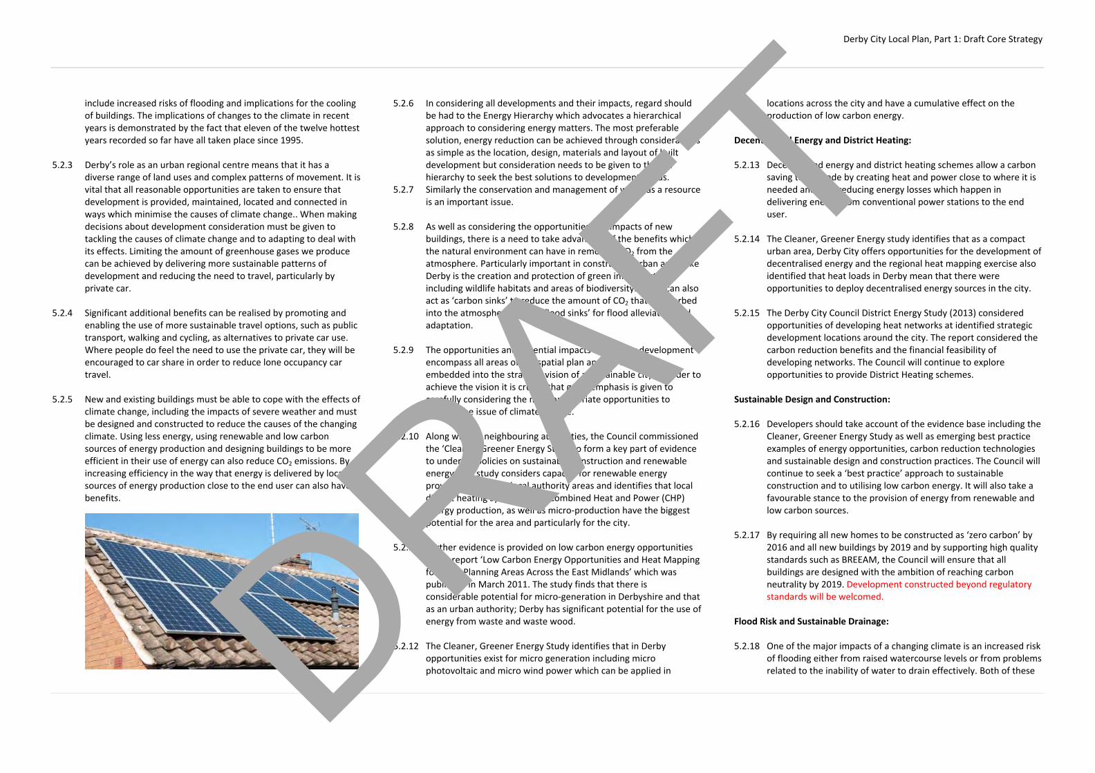
Derby City Local Plan, Part 1: Draft Core Strategy
include increased risks of flooding and implications for the cooling of buildings. The implications of changes to the climate in recent years is demonstrated by the fact that eleven of the twelve hottest years recorded so far have all taken place since 1995.
5.2.3 Derby’s role as an urban regional centre means that it has a
diverse range of land uses and complex patterns of movement. It is vital that all reasonable opportunities are taken to ensure that development is provided, maintained, located and connected in ways which minimise the causes of climate change.. When making decisions about development consideration must be given to tackling the causes of climate change and to adapting to deal with its effects. Limiting the amount of greenhouse gases we produce can be achieved by delivering more sustainable patterns of development and reducing the need to travel, particularly by private car.
5.2.4 Significant additional benefits can be realised by promoting and
enabling the use of more sustainable travel options, such as public transport, walking and cycling, as alternatives to private car use. Where people do feel the need to use the private car, they will be encouraged to car share in order to reduce lone occupancy car travel.
5.2.5 New and existing buildings must be able to cope with the effects of
climate change, including the impacts of severe weather and must be designed and constructed to reduce the causes of the changing climate. Using less energy, using renewable and low carbon sources of energy production and designing buildings to be more efficient in their use of energy can also reduce CO2 emissions. By increasing efficiency in the way that energy is delivered by locating sources of energy production close to the end user can also have benefits.
5.2.6 In considering all developments and their impacts, regard should be had to the Energy Hierarchy which advocates a hierarchical approach to considering energy matters. The most preferable solution, energy reduction can be achieved through considerations as simple as the location, design, materials and layout of built development but consideration needs to be given to the full hierarchy to seek the best solutions to development needs.
5.2.7 Similarly the conservation and management of water as a resource is an important issue.
5.2.8 As well as considering the opportunities and impacts of new
buildings, there is a need to take advantage of the benefits which the natural environment can have in removing CO2 from the atmosphere. Particularly important in constrained urban areas like Derby is the creation and protection of green infrastructure including wildlife habitats and areas of biodiversity. These can also act as ‘carbon sinks’ to reduce the amount of CO2 that is absorbed into the atmosphere and as ‘flood sinks’ for flood alleviation and adaptation.
5.2.9 The opportunities and potential impacts created by development
encompass all areas of the spatial plan and are inherently embedded into the strategic vision of a sustainable city. In order to achieve the vision it is crucial that great emphasis is given to carefully considering the most appropriate opportunities to address the issue of climate change.
5.2.10 Along with its neighbouring authorities, the Council commissioned
the ‘Cleaner, Greener Energy Study to form a key part of evidence to underpin policies on sustainable construction and renewable energy. The study considers capacity for renewable energy provision within the local authority areas and identifies that local district heating systems using Combined Heat and Power (CHP) energy production, as well as micro‐production have the biggest potential for the area and particularly for the city.
5.2.11 Further evidence is provided on low carbon energy opportunities
in the report ‘Low Carbon Energy Opportunities and Heat Mapping for Local Planning Areas Across the East Midlands’ which was published in March 2011. The study finds that there is considerable potential for micro‐generation in Derbyshire and that as an urban authority; Derby has significant potential for the use of energy from waste and waste wood.
5.2.12 The Cleaner, Greener Energy Study identifies that in Derby
opportunities exist for micro generation including micro photovoltaic and micro wind power which can be applied in
locations across the city and have a cumulative effect on the production of low carbon energy.
Decentralised Energy and District Heating: 5.2.13 Decentralised energy and district heating schemes allow a carbon
saving to be made by creating heat and power close to where it is needed and thus reducing energy losses which happen in delivering energy from conventional power stations to the end user.
5.2.14 The Cleaner, Greener Energy study identifies that as a compact
urban area, Derby City offers opportunities for the development of decentralised energy and the regional heat mapping exercise also identified that heat loads in Derby mean that there were opportunities to deploy decentralised energy sources in the city.
5.2.15 The Derby City Council District Energy Study (2013) considered
opportunities of developing heat networks at identified strategic development locations around the city. The report considered the carbon reduction benefits and the financial feasibility of developing networks. The Council will continue to explore opportunities to provide District Heating schemes.
Sustainable Design and Construction: 5.2.16 Developers should take account of the evidence base including the
Cleaner, Greener Energy Study as well as emerging best practice examples of energy opportunities, carbon reduction technologies and sustainable design and construction practices. The Council will continue to seek a ‘best practice’ approach to sustainable construction and to utilising low carbon energy. It will also take a favourable stance to the provision of energy from renewable and low carbon sources.
5.2.17 By requiring all new homes to be constructed as ‘zero carbon’ by
2016 and all new buildings by 2019 and by supporting high quality standards such as BREEAM, the Council will ensure that all buildings are designed with the ambition of reaching carbon neutrality by 2019. Development constructed beyond regulatory standards will be welcomed.
Flood Risk and Sustainable Drainage: 5.2.18 One of the major impacts of a changing climate is an increased risk
of flooding either from raised watercourse levels or from problems related to the inability of water to drain effectively. Both of these DRAFT

Derby City Local Plan, Part 1: Draft Core Strategy
issues are particularly relevant in Derby because of its urban nature.
5.2.19 The Council has prepared a Strategic Flood Risk Assessment (SFRA)
and a Preliminary Flood Risk Assessment which indicate areas that are at risk of flooding from the various watercourses in and around the city including the River Derwent. It is important that all efforts are taken to locate development, particularly that involving housing and habitable buildings in areas which are unlikely or less likely to flood.
5.2.20 There are varying levels of risk of flooding and the Council will try
to ensure that where possible, development is located in areas with the least risk. However, to achieve the Council’s strategic social, economic and environmental objectives, development will sometimes need to take place in areas which are at higher risks of flooding. In these cases, when development takes place, action must be taken to reduce the impacts and particularly to protect people and property from harm. The Council will apply the sequential test when considering developments in areas of flood risk.
5.2.21 Working with the Environment Agency, the Council has developed
the ‘Our City Our River’ (OCOR) masterplan. The plan seeks to reduce flood risk along the River Derwent while providing opportunities for the delivery of new homes, economic development and environmental enhancement. The Council will have regard to the OCOR masterplan in considering proposals for development.
5.2.22 Further risks of flooding arise from the inability of rainwater to
adequately drain through impermeable areas associated with development or because sewerage and drainage systems become over capacity and cannot cope. Permeable construction materials
and more sustainable forms of drainage can be used to adapt to this problem as well as utilising low lying green areas as flooding ‘sinks’ for water to drain to. Through laying out development appropriately and using sustainable drainage systems (SuDS) these risks can be minimised or removed.
5.2.23 Careful construction, design and layout before and during
development should be encouraged so that water can also be directed to areas where it will cause less harm. This may mean directing water to existing watercourses which have capacity to take it or by directing the water to greenfield locations to soak away. It is also important that in designing and laying out developments regard is had to the need to provide and retain access to watercourses, especially for maintenance purposes.
DRAFT

Derby City Local Plan, Part 1: Draft Core Strategy
Delivering High Quality Places:
CP3 – Placemaking Principles: High quality design should promote Derby as an evolving modern city and contribute to improving the life of the City's residents. It should enhance the experience of the place for visitors, workers and inward investors and help create a vibrant city that all residents are proud of. The Council will expect high quality, well designed developments that will help raise the overall design standard of the city, particularly in the City Centre and other areas of significant change. In order to achieve this aim, applicants should work collaboratively with the Council and should follow a logical design process. Proposals of all scales should embrace the principles of sustainable development and take account of current best practice guidance. More specifically proposals will be required to: (a) make efficient use of land by optimising development densities (b) incorporate high quality architecture which is well integrated into
its setting and exhibits locally inspired or distinctive character (c) provide good standards of privacy and security to create a
pleasant, safe and secure environment (d) maximise opportunities for low‐carbon, decentralised energy and
resource efficiency and incorporate flexibility and adaptability to provide resilience to environmental, economic and social change
(e) contribute to the creation of vibrant and mixed communities (f) exhibit a variety of well designed streets and spaces that are
shaped by buildings, are well connected, easy to navigate, encourage non‐vehicular activity and function as social spaces
(g) respond positively to existing topography, landscape features,
wildlife habitats, heritage assets, existing buildings, site orientation and contribute to the urban rural interface
(h) provide well‐integrated parking and adequate external storage
space that does not dominate the street scene (i) make provision for the appropriate maintenance and management
of infrastructure related to the development All proposals will be assessed in terms of their response to these placemaking principles, taking account of context and function. Proposals that do not appropriately respond will be resisted, unless acceptable reasons for them doing so are provided. The Council will:
(j) require all residential developments to also have regard to the
Building for Life 12 principles (or equivalent). Residential developments of 10 homes or more will be specifically required to demonstrate how the BfL12 principles have been satisfied and will be encouraged to work with the Council to achieve ‘Built for Life’ status. If principles cannot be satisfied, a full explanation of reasons will be expected
(k) expect developers to invest in the incorporation of public art into
proposals where it will contribute to the quality, appearance and local distinctiveness of new developments or to the general townscape. The Council will specifically require the provision of public art where proposals would create significant areas of public facing communal space
(l) encourage developers to refer major development proposals to an
independent panel such as the Architecture Centre in the East Midlands (or equivalent) for critical review, helping to further improve design quality in the city
Further guidance on urban design in Derby and the practical implementation of the Placemaking Principles will be set out in a design guidance document to be produced by the Council. 5.3.1 The Council attaches great importance to the design of the built
environment and recognises the multiple benefits that can be achieved through the delivery of well‐designed buildings and spaces. The Council is committed to ensuring that the principles of good urban design are embedded in all development proposals, ranging from domestic extensions to multi‐million pound developments.
5.3.2 Good urban design brings value, helps to support growth and is central to the delivery of sustainable development. The need to raise the overall design standard of the city is therefore a key theme that runs through the Core Strategy.
5.3.3 Through good design, practical and meaningful places can be
created and sustained. Good design in the built environment involves the creation of places that work well for occupants and all users and are built to last.
5.3.4 The starting point for raising the overall design standard of the city
if for developers to ensure that they have established a development team with adequate skills and the right mindset to deliver high quality design and placemaking. The creation of high quality places is no easy task and therefore the right people need to be involved from the outset.
5.3.5 Secondly, the Council will actively encourage developers to work
collaboratively by engaging in pre‐application discussions at an early stage in the design process. Developers are encouraged to follow a simple and logical design process. The key principle behind the design process is to ensure that development sites are fully assessed and understood before detailed design solutions are considered. Well‐designed proposals will be based on a robust context appraisal and understanding of opportunities and constraints. Applicants should demonstrate that a robust design process has been followed, including site and contextual analysis.
5.3.6 The delivery of high quality design is particularly important in
areas such as the City Centre. The City Centre helps to shape the image of Derby in the eyes of investors and visitors. The creation of a positive image is vital to securing sustainable economic growth and the delivery of high quality design and architecture are key to achieving this. More detailed design principles for the City Centre are set out in Policy AC5.
5.3.7 It is equally important that high quality design is delivered in areas
of significant change, such as areas of planned residential growth around the edge of Derby. It is vitally important that the design of cross boundary development sites is considered in a comprehensive and holistic manner, irrespective of administrative boundaries. Large scale new developments have the potential to have significant impacts upon existing residents. Visual impacts can at least be partially mitigated through the use of high quality design and architecture.
5.3.8 It is important that in future we create ‘places’ rather than
standalone ‘developments’. It is acknowledged that some housing DRAFT

Derby City Local Plan, Part 1: Draft Core Strategy
developments built in Derby in the past have failed to provide a sense of place and have subsequently failed to deliver some of the benefits that can be achieved through good design.
5.3.9 The Council is committed to ensuring that this does not happen in
future and has reviewed the qualities and deficiencies of both good and poor developments within the city in order to develop the ‘Placemaking Principles’ set out in the Policy.
5.3.10 The relevant principles will be used to assess the design quality of
all proposed developments within the city. Applicants will be encouraged to use these principles to guide the development of design solutions and will form the basis of pre‐application discussions. Well‐designed places should respond positively against the relevant principles.
5.3.11 The Council will produce a guidance document that will sit
alongside this policy. It will set out further guidance on the design process that developers are encouraged to follow and provide more detail on the practical application of the Placemaking Principles.
5.3.12 Many of the deficiencies in existing developments are related to
the use of standardised products that are inflexible and do not always respond to the local context. Ideally, all new developments should be bespoke to Derby; however it is recognised that this is not always possible due to viability. Developers are encouraged to only use standardised designs where appropriate.
5.3.13 One of the main obstacles to the delivery of good design is that it
is a difficult thing to measure in an objective way. Building for Life 12 (BfL12) provides a consistent approach to assessing design quality.
5.3.14 In addition to responding to the Placemaking Principles, all new
residential developments will be expected to also have regard to the BfL12 principles. More specifically, residential developments of ten homes or more will be required to demonstrate how they have responded to theBfL12 principles.
5.3.15 There is some overlap between the generic Placemaking Principles
outlined in this Plan and the BfL12 principles aimed at residential proposals. Therefore demonstration of compliance with a number of the Council’s Placemaking principles will contribute towards compliance with the BFL12 principles. Table 1 highlights the overlap between the Council’s Placemaking Principles and the BfL12 criteria.
Table 1 – Placemaking Principles vs. BfL12
Derby’s Placemaking Principles Building For Life 12 Principles
(a) Making efficient use of land by optimising development densities
(b) Incorporation of high quality architecture which is well integrated into its setting and exhibits locally inspired or distinctive character
5. Character
(c) Providing good standards of privacy and security to create a pleasant, safe and secure environment
(d) Maximising opportunities for low‐carbon, decentralised energy and resource efficiency and incorporate flexibility and adaptability to provide resilience to environmental, economic and social change
(e) Contributing to the creation of vibrant and mixed communities
2. Facilities and services
4. Meeting local housing requirements
(f) Exhibiting a variety of well designed streets and spaces that are shaped by buildings, are well connected, easy to navigate, encourage non‐vehicular activity and function as social spaces
1. Connections
3. Public transport
7. Creating well defined streets and spaces
8. Easy to find your way around
9. Streets for all
11. Public and private spaces
(g) Responding positively to existing topography, landscape features, wildlife habitats, heritage assets, existing buildings and site orientation
6. Working with the site and its context
(h) Providing well‐integrated parking and adequate external storage space that does not dominate the street scene
10. Car parking
12. External storage and amenity space
(i) Making provision for the appropriate maintenance and management of infrastructure related to the development
5.3.16 Residential developers are encouraged to work collaboratively with the Council to achieve ‘Built for Life’ standard. This means that all of the BfL12 principles have been fully met or that there are robust reasons to justify why a principle cannot be fully met. Where the Council and a developer cannot agree on the scoring of a scheme, an independent expert may be engaged to arbitrate. The achievement of ‘Built for Life’ status allows developers to market developments using the BfL12 brand and demonstrates a commitment to high quality urban design.
5.3.17 The Council will also encourage developers to use BfL12 as a
community engagement tool to ensure that those people that will be directly affected by proposals have an opportunity to input into the design process.
5.3.18 Public art is an important
cultural asset that can enhance and enliven the local environment whilst providing opportunities for social interaction. It includes any art, temporary or permanent, located or visible from a publicly accessible space, which has been created to promote and enhance a sense of identity and reference. It can be a stand‐alone feature on or off site or be an integral part of the fabric of the buildings within the development.
5.3.19 Developers are encouraged to incorporate public art within
proposals as part of the overall design, rather than as an additional extra. It should be an investment that will help to improve the overall quality of a development.
5.3.20 In some instances, public art can be utilised to help mitigate the
visual / aesthetic impact of a development. In such cases, the Council will seek to secure the provision of public art by legal agreement, in line with Policy MH1.
5.3.21 Further guidance on the Council’s approach to the delivery and
implementation of public art will be set out in a design guidance document to be produced by the Council.
DRAFT

Derby City Local Plan, Part 1: Draft Core Strategy
5.3.22 Design review is a method of reviewing the quality of
developments using an independent panel of professionals. Design review services in the East Midlands are currently provided by OPUN, the regional architecture centre. The Council will encourage developers of major proposals to refer them for design review, particularly where a development proposal is considered to be significant in terms of scale, location and strategic importance. Large developments on key sites in the City Centre will generally be regarded as significant. Applicants are encouraged to participate in design review at an early stage of the design process.
DRAFT

Derby City Local Plan, Part 1: Draft Core Strategy
CP4 ‐ Character and Context: All proposals for new development will be expected to make a positive contribution towards the character, distinctiveness and identity of our neighbourhoods. The Council will: (a) assess all proposals in terms of their suitability in relation to
neighbouring buildings and the local area. Assessment will focus on:
1. Development density and layout 2. Building form, scale, height and massing 3. Building siting and setting 4. Landscaping and boundary treatments 5. Parking 6. Architectural style, features and materials 7. Important views to and from the area and of landmark
buildings 8. Any other significant beneficial features of local character
or history
Proposals that do not appropriately respond to their context will be resisted.
(b) expect all proposals to be informed by a context appraisal,
commensurate with the significance of the proposal, to demonstrate how the design of the proposal responds to the context of the local area
(c) give particular scrutiny to proposals affecting areas of sensitive
local character and to proposals for ‘tandem’ and ‘backland’ developments
(d) continue to encourage innovative designs and architecture where
appropriate
5.4.1 Derby has diverse pockets of distinctive character, style and building materials. The compact city centre exhibits the tight streets of the medieval core. Derby’s suburbs have evolved as a mix of those which have naturally expanded from a historic village centre, those which exhibit a more linear nature, such as those along the arterial streets radiating from the city centre, or discreet large development areas of the 1980s/1990s.
5.4.2 The layout of housing areas within the suburbs show a patchwork
of Victorian terraces in grid patterns with smaller plots, in addition to later lower density, larger plots on a hierarchical road layout. This is interspersed with large industrial plots either linked to the railway and heavy industry or storage & distribution.
5.4.3 Local vernacular use of building materials is strongly focussed
upon the historic buildings and conservation areas, many of which relate to the small rural villages which became suburbs, or the railway architecture. This includes red bricks and Millstone Grit sandstones, with streets and spaces commonly exhibiting the pink Mountsorrel granite, or blue bricks within railway heritage areas.
5.4.4 Understanding local character and overall site context is
fundamental to designing successful places. All proposals for new development will be expected to make a positive contribution towards the distinctiveness and identity of our neighbourhoods.
5.4.5 All proposals will be thoroughly assessed by the Council to ensure
that new development s do not undermine local character and distinctiveness. Assessment will focus on the factors that are listed in the Policy as well as the Placemaking Principles set out in Policy CP3.
5.4.6 New development will be expected to relate positively to the context of the development site and the special characteristics of Derby and its neighbouring settlements.
5.4.3 Well‐designed proposals will be based on a robust context
appraisal and an understanding of the opportunities and constraints that an area provides. Context appraisal should be the starting point for the design of all proposals.
5.4.4 Particular care should be taken when designing ‘tandem’ and
‘backland’ developments. The nature of these type of developments generally have the potential to impact upon the amenity of nearby properties and the character of neighbourhoods.
5.4.5 Some areas of the city are more sensitive to changes in the built
environment than others. Areas of particular sensitivity include areas of heritage significance such as conservation areas and the World Heritage Site (WHS). The character of these areas is already specifically protected by relevant planning policies and legislation.
5.4.6 Other areas that are particularly sensitive to change are areas of
mature townscape character. These areas are generally located in and around the former villages and along some of the historic routes that link the former villages to the city centre and are generally characterised by:
‐ Residential properties that are over 50 years old ‐ Lower densities and large plots ‐ Large, mature trees and shrubs along streets and within
private front gardens creating privacy and landmark features
‐ Topography that provides views towards historic buildings
and countryside ‐ Prominent local design features such as chimneys, grey
slate, white and cream render, red brick, bay windows and gables creating a townscape rhythm and coherence
‐ Front gardens, including attractive boundary walls and hedges
‐ Local landmark buildings ‐ Stone and red brick boundary and retaining walls DRAFT

Derby City Local Plan, Part 1: Draft Core Strategy
‐ Pockets of historic dwellings fronting directly onto the street
5.4.7 The combination and delicate balance between these features and
characteristics make areas of mature townscape character more sensitive to changes in the surrounding environment. Whilst not specifically designated as heritage assets, it is particularly important that impacts upon the character of these areas are fully understood and considered to ensure that positive characteristics are not irrevocably undermined.
5.4.8 Further information about responding to character, design and the
historic environment and Derby’s mature townscape areas will be set out in a design guidance document to be produced by the Council.
DRAFT

Derby City Local Plan, Part 1: Draft Core Strategy
Regeneration:
CP5 – Regeneration Strategy: Sustainable regeneration of the City’s older urban areas and creating a renaissance in the City Centre are key priorities of the Core Strategy. The Council will give priority to the following locations: ‐ The City Centre and its Eastern Fringes ‐ Strategic Employment Locations ‐ The Osmaston regeneration Area ‐ Sinfin Lane ‐ Former Manor/Kingsway Hospitals ‐ The Derwent Valley, including the Darley Abbey Mills and the ‐ ‘Our City Our River’ area ‐ Celanese ‐ Derwent Estate ‐ Rosehill/Peartree 5.5.1 Whilst specific proposals for Rosehill/Peartree and Derwent are
not identified in the Core Strategy, they will be priorities for investment, renewal and environmental improvements. This will include addressing the issue of high densities in Rosehill/Peartree as opportunities arise, improving the living environment and opportunities for residents and integrating new communities settling predominantly in and around these areas.
5.5.2 A key part of the regeneration strategy is to encourage the re‐use
of vacant and underused brownfield land, especially for new housing, and to bring empty homes back into use.
DRAFT

Derby City Local Plan, Part 1: Draft Core Strategy
Housing:
CP6 – Housing Delivery: The Council will work collaboratively with its HMA partners, to ensure that the City’s full, objectively assessed needs for market and affordable housing are met. In order to meet these needs, land will be identified and allocated for residential development in the City and also as sustainable urban extensions to the City in the neighbouring HMA authorities. This will include cross boundary development and urban extensions wholly in the neighbouring districts which will contribute to meeting Derby’s housing needs. A closely co‐ordinated approach to infrastructure planning and delivery will be adopted between the authorities. The Council will: (a) enable the delivery of 12,500 new mixed tenure, high quality
homes in the City between 2008 and 2028 by allocating land in its Local Plan and by setting out a development framework which facilitates the delivery of housing on appropriate sites (See Diagram 4)
(b) identify specific thresholds and targets for the delivery of
affordable housing and other specialist housing to meet identified needs
(c) require proposals for residential development to have regard to
the Council’s most up‐to‐date Strategic Housing Market Assessment (SHMA) in delivering an appropriate mix of housing. Opportunities should be taken to rebalance the mix of housing tenures whilst having regard to local character
(d) periodically review, update and have regard to a Strategic Housing
Land Availability Assessment and Housing Trajectory for the City in order to identify new sites and maintain a supply of deliverable housing sites consistent with the requirements of national policy
(e) continue to encourage the re‐use of under utilised or vacant properties for residential uses, including empty homes and the upper floors of commercial properties within centres
(f) adopt a strategy which relies on a range of locations, site types
and sizes in order to deliver a wide choice of high quality homes. The Council will adopt a strategy for brownfield development and
regeneration, along with the release of appropriate strategic and non‐strategic greenfield sites to meet its housing needs. The Local Plan will identify sites for residential development which will form strategic urban extensions to the City and sustainable sites which have been identified in Green Wedges
Table 2 – Housing Supply Components 2008‐2028
Housing Supply Components Number of
Dwellings
Completions 2008‐2013 2396
Deliverable Planning Permissions 1344
Strategic Brownfield Allocations 3030
Strategic Greenfield/Mixed Allocations 4180
Windfall Sites 1000
Losses ‐460
Sites to be identified in the Part 2 Plan 1010
TOTAL SUPPLY 12500 5.6.1 The National Planning Policy Framework requires local authorities
to use their evidence base to ensure that their Local Plans meet the full objectively assessed needs for market and affordable housing in the housing market area.
5.6.2 The Derby HMA authorities’ shared evidence base includes the
Derby HMA Housing Requirements Study and the Strategic Housing Market Assessment Update. The evidence base considers
the key issues of migration and demographic change and sets out population projections which identify the objectively assessed housing requirements for the Housing Market Area. The evidence base further considers the housing needs of each of the component HMA local authorities.
5.6.3 The Derby HMA authorities have agreed to a housing
apportionment between the three districts to meet the needs of the HMA. The authorities’ respective Local Plans will include strategies and identify sites to deliver the targets as set out below:
Table 3 – HMA Apportionment
Authority Housing Target 2008‐
2028 Annual Housing Target
Amber Valley 9,400 470
Derby City 12,500 625
South Derbyshire 13,454 673
TOTALS 35,354 1,768
5.6.4 The strategic sites allocated in Derby City are identified in the
table below: DRAFT

Derby City Local Plan, Part 1: Draft Core Strategy
Table 4 – Strategic Housing Sites Identified in Derby
Site No. of Dwellings
Policy No. Map Ref.
City Centre 530 AC1 1
Castleward 800 AC6 2
Former Derbyshire Royal Infirmary 400
AC6 3
Osmaston Regeneration Area 600 AC14 4
Sinfin Lane/Goodsmoor Road 700 AC17 5
Wragley Way, Sinfin 180 AC18 6
Manor/Kingsway Hospitals 700 AC19 7
Rykneld Road, Littleover 900 AC20 8
Hackwood Farm, Mickleover 400 AC21 9
Onslow Road, Mickleover 200 AC22 10
Former Mackworth College 220 AC22 11
Boulton Moor East 800 AC23 12
Boulton Moor West (Fellow Lands Way) 200
AC23 13
South Chellaston Sites 105 AC24 14
Brook Farm, Chaddesden 275 AC25 15
South of Mansfield Road 200 AC26 16
TOTAL STRATEGIC SITE ALLOCATIONS 7210
5.6.4 More generally as a built‐up urban area, in Derby opportunities
exist to re‐use underutilised and unoccupied buildings. These may range from larger buildings to smaller infill sites, single buildings or perhaps the upper floors of commercial buildings which may have fallen into disrepair or become vacant or under used. The conversion and change of use of these buildings can contribute to the delivery of new homes and proposals to develop them for housing will generally be welcomed.
5.6.5 The Council has included a ‘windfall allowance’ in its supply of long
term housing. Historically the City has seen a range of buildings
Diagram 4 – Proposed Strategic Housing Sites
DRAFT

Derby City Local Plan, Part 1: Draft Core Strategy
and land become available for redevelopment to form new homes and this is expected to continue. Many of these types of sites are smaller and will become available in the course of time and are therefore very difficult to plan for and specifically identify in the long term.
5.6.6 Although not contributing directly to the supply of additional new
homes, the provision of new communal living accommodation such as student halls and residential care homes can free up spaces in other types of housing, particularly in the private rented market, and improve the availability of housing generally. Similarly, bringing empty homes back into use can help to meet housing needs and although not contributing to the additional new homes required will generally be welcomed and encouraged.
DRAFT
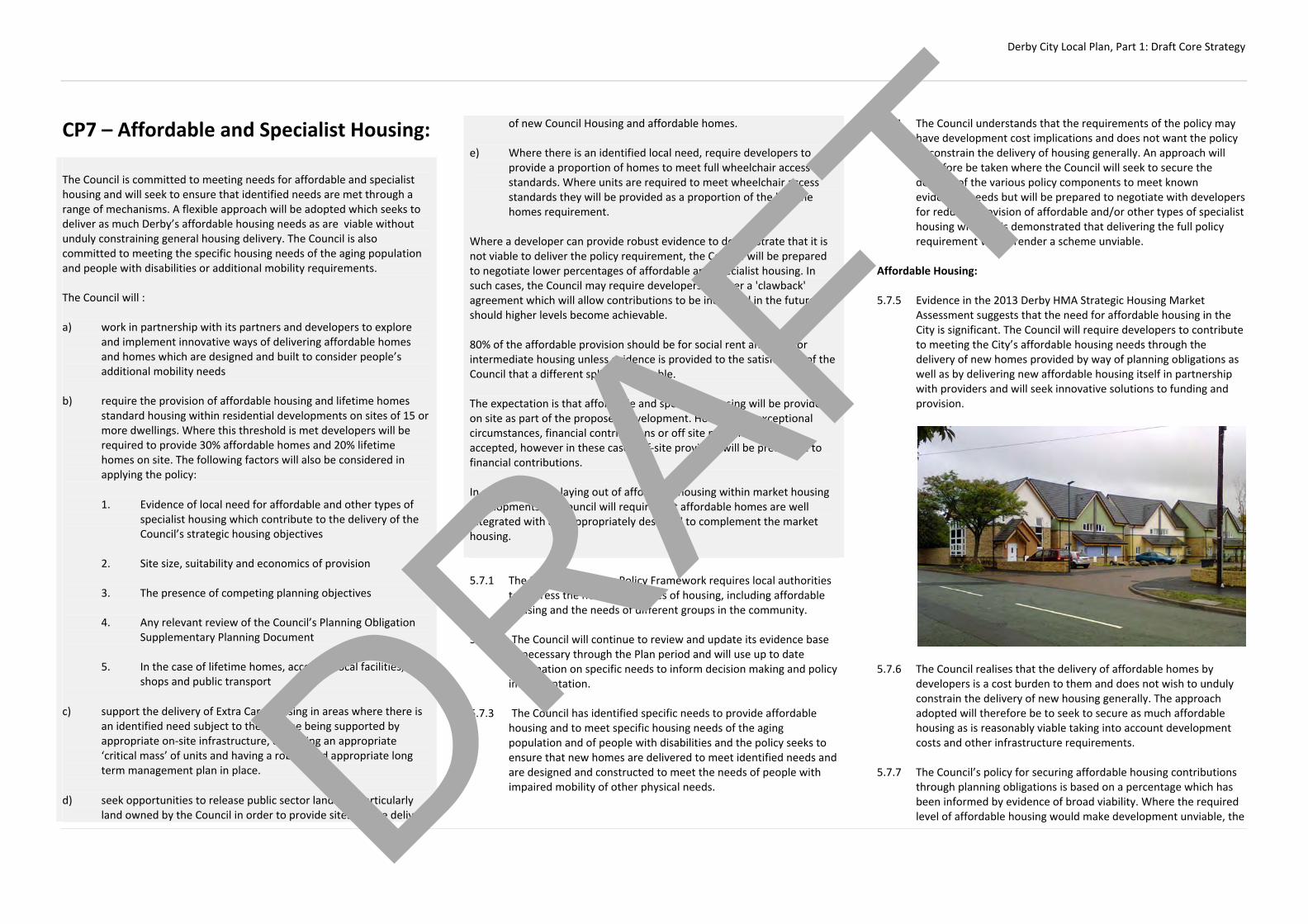
Derby City Local Plan, Part 1: Draft Core Strategy
CP7 – Affordable and Specialist Housing: The Council is committed to meeting needs for affordable and specialist housing and will seek to ensure that identified needs are met through a range of mechanisms. A flexible approach will be adopted which seeks to deliver as much Derby’s affordable housing needs as are viable without unduly constraining general housing delivery. The Council is also committed to meeting the specific housing needs of the aging population and people with disabilities or additional mobility requirements. The Council will : a) work in partnership with its partners and developers to explore
and implement innovative ways of delivering affordable homes and homes which are designed and built to consider people’s additional mobility needs
b) require the provision of affordable housing and lifetime homes
standard housing within residential developments on sites of 15 or more dwellings. Where this threshold is met developers will be required to provide 30% affordable homes and 20% lifetime homes on site. The following factors will also be considered in applying the policy: 1. Evidence of local need for affordable and other types of
specialist housing which contribute to the delivery of the Council’s strategic housing objectives
2. Site size, suitability and economics of provision 3. The presence of competing planning objectives 4. Any relevant review of the Council’s Planning Obligation
Supplementary Planning Document 5. In the case of lifetime homes, access to local facilities,
shops and public transport
c) support the delivery of Extra Care housing in areas where there is an identified need subject to the scheme being supported by appropriate on‐site infrastructure, delivering an appropriate ‘critical mass’ of units and having a robust and appropriate long term management plan in place.
d) seek opportunities to release public sector land and particularly
land owned by the Council in order to provide sites for the delivery
of new Council Housing and affordable homes. e) Where there is an identified local need, require developers to
provide a proportion of homes to meet full wheelchair access standards. Where units are required to meet wheelchair access standards they will be provided as a proportion of the lifetime homes requirement.
Where a developer can provide robust evidence to demonstrate that it is not viable to deliver the policy requirement, the Council will be prepared to negotiate lower percentages of affordable and specialist housing. In such cases, the Council may require developers to enter a 'clawback' agreement which will allow contributions to be increased in the future should higher levels become achievable. 80% of the affordable provision should be for social rent and 20% for intermediate housing unless evidence is provided to the satisfaction of the Council that a different split is acceptable. The expectation is that affordable and specialist housing will be provided on site as part of the proposed development. However, in exceptional circumstances, financial contributions or off site provision may be accepted, however in these cases off‐site provision will be preferable to financial contributions. In considering the laying out of affordable housing within market housing developments the council will require that affordable homes are well integrated with and appropriately designed to complement the market housing. 5.7.1 The National Planning Policy Framework requires local authorities
to address the need for all types of housing, including affordable housing and the needs of different groups in the community.
5.7.2 The Council will continue to review and update its evidence base
as necessary through the Plan period and will use up to date information on specific needs to inform decision making and policy implementation.
5.7.3 The Council has identified specific needs to provide affordable
housing and to meet specific housing needs of the aging population and of people with disabilities and the policy seeks to ensure that new homes are delivered to meet identified needs and are designed and constructed to meet the needs of people with impaired mobility of other physical needs.
5.7.4 The Council understands that the requirements of the policy may have development cost implications and does not want the policy to constrain the delivery of housing generally. An approach will therefore be taken where the Council will seek to secure the delivery of the various policy components to meet known evidenced needs but will be prepared to negotiate with developers for reduced provision of affordable and/or other types of specialist housing where it is demonstrated that delivering the full policy requirement would render a scheme unviable.
Affordable Housing: 5.7.5 Evidence in the 2013 Derby HMA Strategic Housing Market
Assessment suggests that the need for affordable housing in the City is significant. The Council will require developers to contribute to meeting the City’s affordable housing needs through the delivery of new homes provided by way of planning obligations as well as by delivering new affordable housing itself in partnership with providers and will seek innovative solutions to funding and provision.
5.7.6 The Council realises that the delivery of affordable homes by
developers is a cost burden to them and does not wish to unduly constrain the delivery of new housing generally. The approach adopted will therefore be to seek to secure as much affordable housing as is reasonably viable taking into account development costs and other infrastructure requirements.
5.7.7 The Council’s policy for securing affordable housing contributions
through planning obligations is based on a percentage which has been informed by evidence of broad viability. Where the required level of affordable housing would make development unviable, the DRAFT
Derby City Local Plan, Part 1: Draft Core Strategy
Council will be prepared to negotiate a lower affordable provision based on site level viability evidence provided by the developer. In cases where reduced amounts of affordable housing are required, the Council may require the developer to enter into a ‘clawback’ agreement so that should viability improve over time, the developer can provide the required contribution at a later date.
5.7.8 The Council will continue to update and review evidence on
affordable need and supply including periodically updating its Strategic Housing Market Assessment. It will work with partners in a co‐ordinated approach to meet identified needs. When necessary it will also review and update its Planning Obligations SPD to reflect emerging new evidence and to amend policy accordingly.
5.7.9 Evidence suggests that the Private Rented Sector has in the past
contributed to meeting affordable housing needs. Although meeting needs in the Private Rented Sector cannot constitute affordable housing, the sector can and will continue to meeting some of the current and future affordable need.
Lifetime Homes: 5.7.10 The Lifetime Homes standard seeks to ensure that design features
are included in new homes that add to the comfort and convenience of the home and support the changing needs of individuals and families at different stages of life.
5.7.11 Lifetime Homes are about flexibility and adaptability; they are not
‘special’, but are thoughtfully designed to create and encourage better living environments for everyone. From raising small children to coping with illness or dealing with reduced mobility in later life, Lifetime Homes make the ups and downs of daily living easier to manage.
5.7.12 Whilst the vast majority of the provisions set out in the Lifetime
Homes standard are supported by the Council, there a small number where it can be argued that the benefits achieved by the provision may be outweighed by the benefits achieved by not implementing the provision, mainly in terms of gains in living space and general utility to current occupiers. These provisions can also be prohibitive in terms of build costs and have a significant adverse impact upon the viability or projects.
5.7.13 The provisions not required by the Council include:
‐ The provision of space for a possible future through‐floor lift
‐ The provision of wheelchair access and circulation space
on balconies 5.7.14 The provision of space for a possible future through‐floor lift can
create largely redundant areas which can be more beneficially used as living space. The provision of wheelchair access and circulation space on balconies requires a high level of structural support, making provision generally cost prohibitive.
5.7.15 The requirement for a downstairs toilet with room for a shower
can also potentially result in a loss of usable living space. Therefore the Council requires that a wheelchair accessible, downstairs toilet is provided with an adjacent space (storage or utility area) of sufficient size and capacity to convert to a shower area containing a shower of 1mx1m.
5.7.16 Where there is an identified need for wheelchair accessible homes
to be provided the Council will seek their provision on larger development sites. The Council will require that developers provide dwellings to meet that need on developments of 100 or more homes. It would not be feasible to seek fully wheelchair accessible homes on all developments. The Council will use its up‐to‐date evidence on the need for wheelchair accessible housing and the locations where it is needed.
Housing Stock:
5.7.17 Derby’s housing stock of just over 100,000 homes is characterised by a mix of 80% private sector and 20% public sector housing. The City has a relatively high proportion of one bedroomed properties (11%), with 31% 2 bedroomed and 57% with three or more bedrooms.
5.7.18 The 2013 SHMA Refresh identifies a need to maintain and increase
the number of larger three or more bedroomed properties to meet projected market requirements.
5.7.19 There is also a need to provide smaller sized market dwellings
which are more suitable for older couples who wish to downsize or single people. The provision of these types of homes can help to rebalance the housing stock. This could include smaller homes grouped together for the ageing population.
Extra Care Housing:
5.7.20 The development of Extra Care housing is one of the ways in which the special housing needs of an aging population can be addressed.
5.7.21 The Council has a target of the development of 925 extra care
units by 2015, which is under the recommended target guidelines set by the department of health.
5.7.22 Extra Care schemes can provide accommodation which has
supporting facilities and management so that as and when people require more support and assistance it is available on site allowing them to stay in their home. Extra care accommodation can also help to free up larger under‐occupied houses.
5.7.23 The Council supports Extra Care provision generally and will
welcome schemes which are in an area of identified need, where they include the necessary communal spaces and supporting infrastructure on site. They should also have a robust long term management plan and be capable of delivering enough units to be feasible to serve their purpose.
DRAFT

Derby City Local Plan, Part 1: Draft Core Strategy
CP8 ‐ Gypsies and Travellers: The Council recognises the needs of gypsies, travellers and travelling showpeople within the City many of whom have established local connections and have developed links with local services. As part of providing for the housing needs of the City’s diverse communities, there is a need to provide additional sites to meet the needs of Gypsies, Travellers and Travelling Showpeople. The Council will: (a) protect existing lawful sites, plots and pitches for Gypsies,
Travellers and Travelling Showpeople. Proposals that would lead to the loss of an existing Gypsy, Traveller or Showpersons sites will only be permitted where it is demonstrated that there is no longer a need for the site or that replacement provision on a site that is of equal or better quality is provided.
(b) subject to evidence of need, provide site(s) to meet the future
accommodation needs of Gypsies, Travellers and Travelling Showpeople through an allocation or allocations in the Local Plan, Part 2 and/or through the grant of planning permission
In considering sites for allocation in Part 2 of the Local Plan or applications for planning permission the Council will require sites to be: 1. Well related to the existing built up area, have access to essential
services such as mains water, electricity supply, drainage and sanitation; and allow convenient access, preferably pedestrian, cycle or by public transport, to schools, shops, medical and other local facilities
2. Located away from areas at risk of flooding. Proposals for sites in locations other than Flood Zone 1 will be expected to demonstrate a sequential approach to site selection and be justified by a Flood Risk Assessment (FRA). Due to the highly vulnerable nature of caravans and mobile home sites in Flood Zone 3 will not be supported
3. Accessed safely by vehicles from the public highway
4. Located, designed and landscaped to provide a good level of residential amenity and quality of life for proposed occupiers whilst minimising the impact on the amenity of nearby residents and the character of the local area, particularly where mixed use sites are proposed
5. Of sufficient size to provide amenities and facilities for the planned
number of caravans; including parking spaces, areas for turning and servicing of vehicles, amenity blocks, play and residential amenity areas, access roads and temporary visitor areas; and
6. Large enough for the storage and maintenance of rides and equipment, in the case of Travelling Showpeople.
5.8.1 The Council has met the need identified in the Derby and
Derbyshire Gypsy and Traveller Accommodation Assessment (GTAA) 2008 for 16 additional permanent pitches within the City through the delivery of a new public site in Russell Street, Osmaston with 17 permanent pitches.
5.8.2 Since the 2008 GTAA, national planning policy for travellers sites
has been revised and is now set out in the NPPF and the stand alone policy “Planning policy for travellers sites”. The policy requires local planning authorities to work with the travelling community and their representatives to develop robust evidence to establish accommodation needs.
5.8.3 To reflect these requirements and ensure our policies remain up to
date, including understanding the need for additional permanent and transit pitches arising from growth in the existing population, the current Derby and Derbyshire Gypsy and Traveller Accommodation Assessment (GTAA), published in 2008, is being refreshed to provide an updated position on the number of new pitches required.
5.8.4 This evidence will inform the preparation of the Local Plan, Part 2
and/or development management decisions. This work is being jointly undertaken with other Derbyshire authorities and the Derbyshire Gypsy Liaison group which helps us plan effectively for the needs of Gypsies, Travellers and Travelling Showpeople across local authority boundaries.
5.8.4 Planning positively for Gypsies, Travellers and Travelling
Showpeople helps facilitate the traditional and nomadic way of life of travellers while respecting the interests of the settled community. More specifically, it can ensure that sufficient sites come forward to maintain an appropriate level of supply thus reducing the instances of unauthorised encampments and development. Providing appropriate sites can therefore reduce tensions between settled and traveller communities; ensure sites are located with easy access to education, health, welfare facilities
and employment opportunities and ensure sites are sensitive to their location in accordance with other policies in this plan.
5.8.5 Sites should be located outside the Green Belt unless very special
circumstances exist. Traveller sites represent inappropriate development, which by definition is harmful to the Green Belt see policy CP16.
DRAFT

Derby City Local Plan, Part 1: Draft Core Strategy
Delivering a Sustainable Economy:
CP9 – Delivering a Sustainable Economy: The Council is committed to realising the vision of a thriving, sustainable economy that contributes to making the D2N2 Local Enterprise Partnership area more prosperous, better connected and increasingly resilient and competitive. In order to help achieve this vision, the Council will: (a) encourage proposals that create new jobs and help to implement
the Council’s Economic Strategy, subject to the provisions of this Plan
(b) identify sufficient land, of an appropriate quality and in
appropriate locations to meet the needs of a thriving, sustainable economy
(c) focus on creating a culture where enterprise thrives, ensuring that
workforce skills match business needs and maximising quality of life for residents
(d) use public sector assets to help facilitate economic development More specifically, the Council will encourage proposals which: 1. contribute to an enterprise culture with innovation and creativity 2. support the growth and continued success of existing companies in
the D2N2 area, particularly companies related to transport equipment manufacturing
3. provide relocation opportunities, particularly where it would enable regeneration
4. improve Derby as an investment proposition
5. help to address barriers to employment
6. contribute to the alignment of the supply and demand of skills
7. positively influence young people’s career aspirations
8. reinforce cultural / leisure facilities and the city’s infrastructure
9. take advantage of opportunities in the low carbon economy sector
10. realise the potential of Derby’s heritage and tourism assets
11. contribute to the development of a vibrant City Centre
In addition to the aspirations of the Economic Strategy, the Council will also encourage proposals which: 12. help to make businesses more energy and resource efficient
13. provide a range of new business premises including affordable
workspace
14. enhance digital connectivity across the City
15. help to realise economic benefits of the expansion of the high speed rail network, electrification of the Midland Mainline and the ongoing success of East Midlands Airport
5.9.1 Derby is the focus for economic development and regeneration
within the sub‐region. Derby itself has a population of approximately 244,000 of which 77% of the working age population are economically active.
5.9.2 Employment in Derby is heavily weighted towards the public
sector with nearly a third of jobs being in public administration and education. At the same time, one in five jobs in the city is in manufacturing, almost double the national average. Derby is proud of being home to global companies such as Rolls‐Royce and Bombardier and will continue to support these firms as the cornerstone of the economy. However, in order to strengthen the private sector we also need to support the growth of new enterprises.
5.9.3 Derby’s exceptional industrial heritage, strengths in engineering
innovation and world‐class brands have helped to maintain a
vibrant local economy that has generally punched well above its weight on a whole range of economic indicators.
5.9.4 Derby is the UK leader in advanced manufacturing employment
and has the sixth highest value of goods and services produced per head (gross value added) in England, second highest of any local authority area outside the south‐east.
5.9.5 Our retail core has been transformed; we have a flourishing
commercial area at Pride Park and there is renewed interest in the city from inward investors. However, no city can afford to become complacent and stand still. Significant challenges lie ahead for Derby. This Policy sets out the Council’s broad strategy to delivering a sustainable economy during the Plan period.
5.9.6 The UK is still slowly emerging from the worst recession in a
generation and uncertainty prevails about the full impact of public spending cuts. Derby is competing in a global economy and our businesses face a fight to stay ahead of the game. Persistent low skill levels and high rates of worklessness continue to hold back some of our communities. The wealth that the city creates could be driving our progress even more effectively.
5.9.7 In light of the radical slimming down throughout the public sector
and the reduction in regeneration funding, Derby and Derbyshire, Nottingham and Nottinghamshire have formed a Local Enterprise Partnership (LEP). The geographic area covered by the LEP is known as the D2N2 area. The vision of the LEP is to make the D2N2 area more prosperous, better connected and increasingly competitive and resilient. In realising this vision, the LEP has set a goal of creating 55,000 new jobs by 2023.
5.9.8 The Council is keen to ensure that Derby continues to fully
contribute to the delivery of this vision and has identified the realisation of a thriving and sustainable economy as a key priority in the ‘Derby Plan’.
5.9.9 The Council’s Economic Strategy (2011‐2016) and associated
delivery plans set out how the Council will achieve the ‘Derby Plan’ vision. The Economic Strategy identifies three areas of focus including creating a culture where enterprise thrives, ensuring that workforce skills match business needs and maximising quality of life. This policy reflects these areas of focus.
5.9.10 To ensure Derby’s economy remains vibrant and competitive, the
Council is committed to facilitating the conditions that will encourage growth in private sector employment. This will involve measures to further diversify the local economy, to DRAFT
Derby City Local Plan, Part 1: Draft Core Strategy
comprehensively embed innovation and a culture of enterprise, to uplift skills, especially within our most deprived communities and to create a quality of life of which we are all proud of. The Council will identify opportunities to use public sector assets to help encourage economic development, including the use of the Derby Regeneration Fund.
5.9.11 The Council is also committed to ensuring that sufficient
employment land is identified in appropriate locations in order to enable the vision and aspirations of the LEP, Derby Plan and Economic Strategy to be realised. Policy CP10 identifies the key employment sites that will contribute to the supply during the Plan period.
5.9.12 Derby’s Economic Strategy identifies a number of issues and
interventions that are required to help achieve the Derby Plan vision. These are broadly reflected in this policy. Proposals that help to implement the aims and objectives of the Economic Strategy will be supported by the Council, subject to the provisions of other policies in this Plan. Further justification for each of the aims and objectives and detail of how each one will be achieved is set out in the Council’s Economic Strategy.
5.9.13 Ultimately, the aims of the LEP, Derby Plan, Economic Strategy and
the Core Strategy are underpinned by a single factor – the need to create and sustain net new private sector employment so that people living in and around Derby have the opportunity to engage in the local labour market.
5.9.14 To rebalance the economy of Derby in favour of a strengthened
private sector, a concerted effort is required in supporting enterprise to start, grow and thrive. In a changing environment of business support, Derby remains committed to achieving enterprise success. We will look to support the growth of all companies in the city and work with our partners to focus efforts on employment growth. The low carbon and renewable technologies sectors provide particular opportunities for future growth and diversification taking advantage of existing supply chains and skill sets already embedded in the city and surrounding area. Opportunities to expand employment in non‐B use sectors will also be pursued, such as leisure, tourism and culture.
5.9.15 Working with higher and further education providers will help to
improve educational achievement and tackle existing skills gaps within the workforce. Focus will be on the more deprived areas of the city where educational achievement and employment rates are generally lower. Working with these organisations will also help to stimulate innovation and the growth and nurture of small
and micro‐enterprises which are fundamental in helping to diversify the economy.
5.9.16 It is now widely considered that global oil production will ‘peak’
and go into sustained decline, with some commentators suggesting there is significant risk of this happening before 2020. What is certain is that fuel deficits and the end of cheap carbon will have extremely far‐reaching social and economic consequences. These inevitable increases in energy costs will impact on all of our businesses. We will contribute significantly to the strength of the future economy if we make Derby businesses more resilient to increases in energy costs by, for example, improving their resource efficiency.
5.9.17 Many firms in the city, such as Rolls‐Royce, are already world
leaders in the development of energy efficient technologies. There is great opportunity for the city to use the expertise it has within this field to embed new technology opportunities within other sectors and reduce energy use throughout the local economy. Our ambition is to pursue a low carbon economy in and realise the environmental and economic opportunities associated with reducing energy use.
5.9.18 It is important to provide a variety of types of accommodation to support a diverse economy. Small scale, affordable units are just as important to the local economy as landmark developments as they can provide start‐up / incubator space for new enterprises. The Council wishes to seek a balance in terms of the scale, location and tenure of commercial floorspace.
5.9.19 Enhancing digital connectivity is a key priority, helping to make
Derby’s economy more competitive, attracting a greater range of businesses, facilitating modern work practices and reducing the need to travel. The Council will continue to pursue opportunities to secure faster connection speeds for residents and businesses within the city.
5.9.20 Derby is at the heart of the UK railway system and is well
positioned to take advantage of the planned expansion of the high speed network, known as HS2. Plans for the new network currently identify a new HS2 station at Toton Sidings, serving both Derby and Nottingham. The proximity of this station is likely to generate related economic growth within the city due to significantly reduced travel times to London and to northern cities.
5.9.21 The city is also well placed to benefit from the electrification of the
Midland Mainline which will also reduce travel times to London and to mainland Europe. The Council will generally support
development proposals that help Derby to realise the economic benefits of these infrastructure projects.
5.9.22 East Midlands Airport (EMA) is located approximately 15 miles to
the east of the city. EMA and the city are connected by the A50 which provides an excellent link for freight and logistics. EMA was the second busiest freight hub in the UK in 2012 and carries in excess of 4 million passengers per year. The airport is currently undergoing a comprehensive £12 million improvement programme helping place it at the forefront of air travel and logistics. Derby is well placed to take advantage of the continuing success of EMA and the Council will generally support proposals that help the city to realise the economic benefits associated with proximity to EMA.
DRAFT

Derby City Local Plan, Part 1: Draft Core Strategy
CP10 ‐ Employment Locations: The Council will allocate 199 hectares (gross) of new employment land to be brought forward in a variety of accessible locations, accommodating a range of employment generating activities. In addition, key areas of existing employment development will be retained, intensified and recycled for employment uses. The majority of demand will be met at four strategic employment locations within Derby: ‐ The Central Business District (CBD) ‐ Land South of Wilmore Road, Sinfin ‐ Derby Commercial Park, Raynesway ‐ The Derwent Triangle, Chaddesden
The Council is committed to the delivery of new employment land in these strategic locations and will use CPO powers where necessary to ensure comprehensive development. Business and industrial development in other areas of the city will be permitted provided that: (a) it does not conflict with the objectives of this Plan (b) would not adversely impact upon the amenity of nearby residents (c) is well integrated into the urban area (d) would not lead to a significant oversupply of employment land (e) in the case of office development it would meet the requirements
of Policy CP11; and (f) it would contribute to the aims and objectives of Policy CP9 The delivery of new employment land as part of strategic housing developments will be encouraged where it would meet the criteria above, would not prejudice housing delivery and would create a more sustainable form of development.
The following existing employment areas will continue to be retained, intensified and recycled for the development of employment uses: ‐ The Rolls‐Royce Campus, Sinfin ‐ Pride Park and Wyvern Business Park ‐ The Railway Technology Centre and Bombardier ‐ Raynesway, including Rolls‐Royce Marine ‐ Ascot Drive ‐ Mansfield Road and Alfreton Road corridors
Proposals within these areas that would devalue the employment generating potential of the area or lead to the loss of important units or land will generally be resisted. Employment land or buildings in areas not identified in the above list may be appropriate for alternative uses. The Council will permit the release of such sites where: (g) the alternative use would benefit the economy of the city or other
strategic objectives of the Plan (h) evidence can be provided to demonstrate that the existing land or
buildings no longer meet modern requirements and that it has been adequately marketed for employment use for a reasonable period of time
(i) the employment land supply would not be unduly affected in
terms of quantity or quality (j) surrounding uses would not be adversely affected and in the case
of sites near to residential areas would lead to an improved environment for residents; and
(k) in the case of residential proposals a satisfactory living
environment can be created
5.10.1 It is crucial for the City’s economy to remain strong, particularly in
light of current economic circumstances. The Council is committed to doing everything within its power to secure sustainable economic growth. One of the key areas where the Council can directly influence economic growth is through ensuring that
sufficient employment land is allocated to meet needs during the Plan period.
5.10.2 The NPPF specifically requires Local Planning Authorities (LPAs) to
plan pro‐actively to meet the development needs of business and support an economy fit for the 21st Century. This Policy aims to identify sufficient land to meet the development needs of business during the Plan period.
5.10.3 The relationship between land and jobs is very complex and
control goes far beyond the remit of the planning system. In order to try and understand future business needs within Derby and the wider HMA it is necessary to look at a range of factors and indicators, both quantitative and qualitative. It is vital that sufficient new land is provided and existing land protected to enable the economy to be resilient to an ever changing economic climate and allow Derby to continue to be the focus for economic development in the HMA.
5.10.4 The Derby HMA Employment Land Review (2008) provided a
starting point for assessing future employment land needs. This study calculated land needs based on past take up rates.
5.10.5 The 2008 study concluded that need was in the region of 144
hectares up to 2026. Supply was calculated to be in the region of 227 hectares suggesting a significant oversupply of employment land within the city. However, the study also noted that Derby is the economic driver in the sub‐region and its employment land supply provides solutions for non‐B uses such as leisure, helping to justify the principle of an oversupply.
5.10.6 In order to reflect the Plan period and to take account of the
impact of the recession, new forecasts were commissioned in 2012. The revised forecasts utilised three different approaches to deriving land needs for the period 2008‐2028:
‐ Labour demand forecasts, based on Experian econometric
forecasts ‐ Labour supply, policy on forecasts, aligned to proposed
housing growth in the HMA and growth sectors ‐ Past take up rates, based on past completions
5.10.7 Forecast quantitative need ranged from 26.6 hectares in the labour demand scenario to 142.3 hectares using past take up over the last 20 years. DRAFT

Derby City Local Plan, Part 1: Draft Core Strategy
5.10.8 An even higher figure for Derby can be generated by distributing the labour supply HMA requirement proportionately across the HMA, in line with the distribution of proposed new housing. This approach generates a ‘DUA’ need in the region of 154 hectares. Approximately 4 hectares of new employment land have already been provided within the DUA since 2008, therefore the remaining requirement using this approach is approximately 150 hectares.
5.10.9 The three sets of forecasts highlight that the level of land which
could be developed for employment across the HMA up to 2028 is difficult to accurately predict and could vary wildly influenced by economic circumstances and performance as well as investment decisions by individual businesses.
5.10.10 The Council do not consider that any of the quantitative forecast
techniques, considered in isolation, provide a sufficiently robust basis from which to directly derive an employment land requirement. However, whilst the labour supply and DUA distribution approach has its drawbacks, it is considered to be the most appropriate and realistic way of informing the policy approach across the HMA, once more qualitative issues have been taken into account
5.10.11 In comparison to all of the most recent forecasts, Derby has a
significant oversupply of allocated employment land in terms of the gross allocated supply. Notwithstanding this, as successful employment sites such as Pride Park have gradually been developed out, there have been growing concerns about the amount of new, readily available employment land entering the supply. Much of the supply has been locked up in large, constrained, strategic sites.
5.10.12 In recent years, the Council has worked with development
industry to try and unlock the difficult sites. Attention has been focussed on the four locations identified in this Policy as they are the last remaining areas of the city that can appropriately accommodate new, large scale employment development and have the potential to provide for a range of business needs.
5.10.13 The Council consider that these sites have the potential to
support all of the predicted growth sectors whilst providing space for existing employers to expand. The portfolio of sites identified in the Policy has been supported by the development sector and no additional strategic sites have been promoted to the Council.
Diagram 5 – Employment Locations
DRAFT
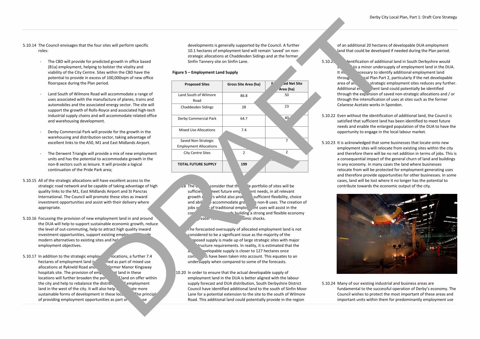
Derby City Local Plan, Part 1: Draft Core Strategy
5.10.14 The Council envisages that the four sites will perform specific roles:
‐ The CBD will provide for predicted growth in office based
(B1a) employment, helping to bolster the vitality and viability of the City Centre. Sites within the CBD have the potential to provide in excess of 100,000sqm of new office floorspace during the Plan period.
‐ Land South of Wilmore Road will accommodate a range of
uses associated with the manufacture of planes, trains and automobiles and the associated energy sector. The site will support the growth of Rolls‐Royce and associated high‐tech industrial supply chains and will accommodate related office and warehousing development.
‐ Derby Commercial Park will provide for the growth in the
warehousing and distribution sector, taking advantage of excellent links to the A50, M1 and East Midlands Airport.
‐ The Derwent Triangle will provide a mix of new employment
units and has the potential to accommodate growth in the non‐B sectors such as leisure. It will provide a logical continuation of the Pride Park area;
5.10.15 All of the strategic allocations will have excellent access to the
strategic road network and be capable of taking advantage of high quality links to the M1, East Midlands Airport and St Pancras International. The Council will promote these sites as inward investment opportunities and assist with their delivery where appropriate.
5.10.16 Focussing the provision of new employment land in and around
the DUA will help to support sustainable economic growth, reduce the level of out‐commuting, help to attract high quality inward investment opportunities, support existing employers, provide modern alternatives to existing sites and help to meet wider employment objectives.
5.10.17 In addition to the strategic employment locations, a further 7.4
hectares of employment land is identified as part of mixed use allocations at Rykneld Road and at the former Manor Kingsway hospitals site. The provision of employment land in these locations will further broaden the portfolio of land on offer within the city and help to rebalance the distribution of employment land in the west of the city. It will also help to facilitate more sustainable forms of development in these locations. The principle of providing employment opportunities as part of mixed use
developments is generally supported by the Council. A further 10.1 hectares of employment land will remain ‘saved’ on non‐strategic allocations at Chaddesden Sidings and at the former Sinfin Tannery site on Sinfin Lane.
Figure 5 – Employment Land Supply
5.10.18 The Council consider that this wide portfolio of sites will be
sufficient to meet future employment needs, in all relevant growth sectors whilst also providing sufficient flexibility, choice and ability to accommodate growth in non‐B uses. The creation of jobs outside of traditional employment uses will assist in the continuing move towards building a strong and flexible economy with greater resilience to economic shocks.
5.10.19 The forecasted oversupply of allocated employment land is not
considered to be a significant issue as the majority of the proposed supply is made up of large strategic sites with major infrastructure requirements. In reality, it is estimated that the actual developable supply is closer to 127 hectares once constraints have been taken into account. This equates to an undersupply when compared to some of the forecasts.
5.10.20 In order to ensure that the actual developable supply of
employment land in the DUA is better aligned with the labour supply forecast and DUA distribution, South Derbyshire District Council have identified additional land to the south of Sinfin Moor Lane for a potential extension to the site to the south of Wilmore Road. This additional land could potentially provide in the region
of an additional 20 hectares of developable DUA employment land that could be developed if needed during the Plan period.
5.10.21 The identification of additional land in South Derbyshire would
still lead to a minor undersupply of employment land in the DUA. It may be necessary to identify additional employment land through the Local Plan Part 2, particularly if the net developable area of any of the strategic employment sites reduces any further. Additional employment land could potentially be identified through the expansion of saved non‐strategic allocations and / or through the intensification of uses at sites such as the former Celanese Acetate works in Spondon.
5.10.22 Even without the identification of additional land, the Council is
satisfied that sufficient land has been identified to meet future needs and enable the enlarged population of the DUA to have the opportunity to engage in the local labour market.
5.10.23 It is acknowledged that some businesses that locate onto new
employment sites will relocate from existing sites within the city and therefore there will be no net addition in terms of jobs. This is a consequential impact of the general churn of land and buildings in any economy. In many cases the land where businesses relocate from will be protected for employment generating uses and therefore provide opportunities for other businesses. In some cases, land will be lost where it no longer has the potential to contribute towards the economic output of the city.
5.10.24 Many of our existing industrial and business areas are
fundamental to the successful operation of Derby’s economy. The Council wishes to protect the most important of these areas and important units within them for predominantly employment use
Proposed Sites Gross Site Area (ha) Estimated Net Site Area (ha)
Land South of Wilmore Road
86.8 50
Chaddesden Sidings 28 23
Derby Commercial Park 64.7 40
Mixed Use Allocations 7.4 5
Saved Non‐Strategic Employment Allocations
10.1 7
City Centre Sites 2 2
TOTAL FUTURE SUPPLY 199 127
DRAFT

Derby City Local Plan, Part 1: Draft Core Strategy
in order to avoid the potential prejudicial impact of alternative uses and to safeguard job opportunities. Some of these areas accommodate the city's biggest and most prestigious employers, such as Rolls‐Royce and Bombardier which are the cornerstones of the local economy.
5.10.25 Many of the existing employment areas are largely built up,
although there is significant scope for recycling and intensification of employment uses within these areas. In recent years, recycling of existing employment sites has made a significant contribution to meeting needs. This is expected to continue in the future as land accommodating older stock is recycled for the construction of new units, helping to meet modern needs.
5.10.26 The redevelopment of poorer quality existing employment land
for alternative uses can sometimes help to alleviate conflicts between industrial and surrounding uses. This can bring benefits for the area as a whole, particularly where there is conflict between residential properties and business use. Residential redevelopment and associated community uses may help to improve the local environment and provide the opportunity to create more open space in inner‐city areas.
5.10.27 Residential redevelopment in these areas may also improve the mix of brownfield housing sites available to the market. However, the Council will continue to ensure that an adequate employment land supply is maintained. Proposals for development of existing business and industrial land should not override the employment objectives of the Plan.
DRAFT

Derby City Local Plan, Part 1: Draft Core Strategy
CP11 – Office Development: The Central Business District (CBD) is the preferred location for the development of new offices (B1a) and vocational training establishments (D1). The Council will: (a) only permit the development of offices (B1a and D1) in other areas
of the city provided that proposals:
1. have demonstrated a sequential approach to site selection firstly giving preference to opportunities within the CBD and secondly to allocated employment or regeneration areas and defined Centres
2. would complement the CBD and would not prejudice
investment in it or other allocated sites 3. would facilitate inward investment 4. would contribute to the aims and objectives of Policy CP9
In considering compliance with the sequential test, the Council will have regard to the specific locational requirements of office occupants and their relationship with surrounding uses
(b) use the Derby Regeneration Fund to help deliver new office
accommodation within the CBD, helping to regenerate derelict and vacant sites
5.11.1 Focussing new office development within the City Centre,
specifically within the identified 'Central Business District' (CBD) will support regeneration initiatives and raise the profile of the area as a sustainable office location. It will create a critical mass of City Centre employees, putting 'suits on the streets' and boosting the overall vitality and viability of the City Centre.
5.11.2 In recent years, new office development has generally been
focussed within the Pride Park area. Whilst this has helped to successfully regenerate Pride Park, it has been to detriment of the City Centre, which has failed to offer viable alternatives to the new accommodation being provided on Pride Park.
5.11.3 The regeneration of Pride Park is now complete and it is time to shift office demand back towards the City Centre. In the last 20 years, new office space within the City Centre has predominantly been provided through the refurbishment of older stock. Refurbishment is becoming less desirable and financially viable as many of these buildings are now increasingly being used for alternative uses such as residential.
5.11.4 The ongoing drive for regeneration in the City Centre has opened
up new opportunities for new build office schemes. Several high quality office schemes have been permitted within the CBD area in recent years, totalling in excess of 100,000sqm (gross) of new floorspace.
5.11.5 Issues with developer, occupier and investor confidence and the
impacts of the global recession have acted as a barrier meaning that permitted schemes have not been built out. In order to fight back against these issues, the Council have been operating the Derby Regeneration Fund to support the delivery of new high quality commercial development in the City Centre. The initial phase of the first project to take advantage of the Regeneration Fund, ‘Friar Gate Square’ has been completed and is expected to be occupied in the near future.
5.11.6 The construction of the first new office space in the CBD in recent
times has provided the market with new confidence and it is hoped that more of the permitted schemes will take advantage of the funding opportunities available. Implementation of these schemes will also help to rebalance the spatial distribution of jobs within the city as a whole, where 75% of jobs are currently located outside of the City Centre. 5
Diagram 5 – Extent of the Central Business District
5.11.7 The benefits of working in the City Centre are clear.
Developments within the CBD are able to take advantage of the availability of public transport and the benefits associated with working in this location such as proximity to retail and leisure opportunities.
5.11.8 It estimated that the level of extant permissions within the CBD
area, combined with the potential for office development within allocated employment areas and regeneration priority areas should be more than capable of accommodating office needs up to 2028. Office opportunity sites in the CBD are identified in Policy AC2.
5.11.9 Whilst the CBD is the clear priority for new office development,
the Council recognises that not all forms of office development can be easily accommodated within a City Centre environment. The policy therefore provides flexibility to consider alternative options outside of the CBD.
5.11.10 The policy seeks to ensure that proposals for office development
outside of the CBD have considered sequentially preferable DRAFT

Derby City Local Plan, Part 1: Draft Core Strategy
locations and demonstrated why none of the more desirable locations are appropriate for the proposed use. First preference is given to locations within the CBD, whilst allocated employment and regeneration areas and identified local centres are second preference. The Council will only consider alternative locations once it has been demonstrated that opportunities within these areas are not suitable, available or viable.
5.11.11 When considering compliance with the sequential test, the
Council will have regard to specific locational requirements such as identified need and the relationship of the new development to surrounding uses. For example, it may be logical for some forms of office development associated with existing manufacturing businesses to be located close to existing operations rather than in the CBD.
5.11.12 The policy also seeks to ensure that new office development
outside of the CBD is complementary to it and would not undermine it as the primary location for office development within Derby, or prejudice potential investment within it.
5.11.13 The Council wishes to ensure that office development permitted
outside of preferred locations will facilitate inward investment and is not purely speculative. It will be important to ensure that such development is located within sustainable areas of the city that are well served by public transport and that development would contribute to the wider aims of the Economic Strategy and Policy CP9.
5.11.14 Commercial / vocational training (D1) has been a growth sector in
recent years and fundamentally operates in a very similar way to commercial offices (B1a) in terms of nature and function. These
kinds of operations have the potential to contribute to the vitality and viability of the City Centre and therefore will generally be assessed against this policy.
DRAFT

Derby City Local Plan, Part 1: Draft Core Strategy
CP12 – Centres: The Council will seek to sustain and enhance the vitality, viability and competitiveness of defined centres and prioritise them as the most accessible and sustainable way of meeting everyday shopping and service needs. The development of new shops, leisure and complementary main town uses will be prioritised in the following hierarchy of defined centres: The City Centre: The City Centre is the focus for comparison retail for the City but its catchment exceeds the City boundaries. The focus for new comparison retail is the Core Area. The City Centre is also the sub‐regional focus for commerce, culture, leisure and the visitor economy. Development within the City Centre should meet the specific requirements of the City Centre Strategy (Policy AC1)
District Centres: District centres have an essential role in providing key services to the City's neighbourhoods including shopping, commercial, leisure, public and community functions, ensuring that residents can access such services easily. They are also a focus for the City's residential neighbourhoods, providing an important opportunity to define local character. Development in these centres should primarily respond to the needs of the catchment and recognise the need to support, and not undermine, the vitality and viability of other centres in the hierarchy. Neighbourhood Centres: Neighbourhood Centres meet needs for small scale retail and services of small local catchments. Locations which are not identified on the Proposals Map but which may perform the same function in terms of scale and meeting local needs will also be considered to be Neighbourhood Centres. Development in these centres should be small scale and have regard to maintaining access to local shopping and other facilities that meet day‐to‐day needs. Within District and Neighbourhood Centres, the Council will support proposals that: 1. Meet local shopping and service needs while supporting the
vitality and viability of the centre. Uses which would undermine this objective, either as a result of loss of retail function or through
the impact on the character or environment of the centre, will be resisted
2. Help to combat long term and persistent vacancy. The Council may
require applicants to submit appropriate evidence which demonstrates that the unit has been marketed for retail uses for a reasonable period of time and/or is no longer suitable for shopping uses
3. Encourage competition and consumer choice 4. Help to maintain vibrant and coherent shop frontages 5. Respect, and are compatible with, the scale, role, character and
function of the centre and would not have an unacceptable impact on the vitality and viability of other centres in the hierarchy
6. Help secure physical improvements to the centre, particularly
where they serve to increase accessibility by all modes of transport and create high quality environments
New or extended Centres will be delivered at the following locations to support the creation of new or growing communities: ‐ Rykneld Road (Policy AC20)
‐ Hackwood Farm (Policy AC21)
‐ Boulton Moor (Policy AC23) In these locations, proposals should be of an appropriate scale for the level of growth proposed and should not have an unacceptable impact on the vitality and viability of existing centres in the shopping hierarchy. Where necessary, the Council will impose conditions on new centres to ensure they remain consistent with their expected role and function. 5.12.1 Reflecting National Planning Guidance, this policy establishes a
strategy of promoting the City Centre and other traditional centres as the best locations for a wide range of retail and other complementary services. The City Centre performs a sub‐regional role with a particular emphasis on ‘leisure shopping’ and, increasingly, a greater focus on leisure and cultural activities. Policies elsewhere in the document provide a detailed strategy for the City Centre and set a framework for considering development proposals. Under this policy, however, the City Centre will remain the ‘sequentially preferable’ location for large scale retail, leisure and other large ‘main town centre uses’, such as offices.
5.12.2 District Centres provide a different role. They are at the hearts of their local communities; serving relatively large residential areas and have good transport links. Usually they contain a range of local shopping facilities and other complementary non‐shopping uses which complement the main shopping function providing both for day‐to‐day needs. There are currently 13 District Centres in the City and the strategy will be to continue to try and protect, or enhance, their vitality and viability. This will be both through the careful management of the range of uses that exist in a centre and by trying to encourage or implement improvements to the environment.
5.12.3 Proposals for retail within defined centres will generally be
acceptable. However, all proposals should be consistent with the scale, nature and function of the centre they are in. This is to ensure that proposals in one centre do not undermine other centres. Applications for larger developments within defined centres may also be asked to provide evidence of their potential impact in order to ensure this objective can be acheived.
5.12.3 Neighbourhood Centres are smaller and concentrate on the
provision of basic essential goods. These usually have far tighter catchment areas and provide mainly ‘top‐up’ shopping facilities and other services important to local residents, such as post offices and pharmacies. There are many more defined Neighbourhood Centres across the City. However, there are also informal areas of shopping which can perform a similar role and function. Often these are informal rows of shops, or standalone facilities that provide a similar function. For the purposes of these policies, these informal areas will be subject to the same policies.
DRAFT

Derby City Local Plan, Part 1: Draft Core Strategy
5.12.4 In both District and Neighbourhood Centres, the strategy will be to maintain the local shopping function that each centre provides to nearby residents. The appropriateness of non‐shopping uses will be considered on their merits and care will be taken to ensure that changes from shopping to non‐shopping uses do not undermine the vitality of a centre as a whole or parts of larger centres (in particular defined ‘primary frontages’ within District Centres). In coming to decisions on whether non‐shopping uses will be acceptable, the Council will consider the proportion of shop uses within a centre, the nature of the shops in the centre or in a particular frontage, the quality of the unit in question, and whether it has market potential for continued use as a shop.
5.12.5 In terms of food and drink uses, regard will be had to Policy CP15.
There has been a significant increase in the proportion of food and drink uses within defined centres in recent years. While they can support the economy of a centre, too many in any one area can have a negative cumulative impact – particularly on the character of an area. This is to be avoided.
5.12.6 Residential or office conversions at first floor and above would be
considered beneficial to the potential vitality of a centre and so would be acceptable in principle. Conversion to residential at ground floor level has the potential to undermine the vitality of a centre and lead to areas of ‘dead frontage’. This is only likely to be considered acceptable on the periphery of centres where there is evidence of long‐term persistent vacancy.
5.12.7 Locating and protecting shopping, local services and community
facilities within defined centres helps to reduce the need to travel by car, reduce congestion and pollution and helps to facilitate travel choices. They are also of benefit to less mobile people and are important in addressing social exclusion since they are highly accessible to people who do not have access to a private car.
Diagram 6 – The Retail Hierarchy
DRAFT
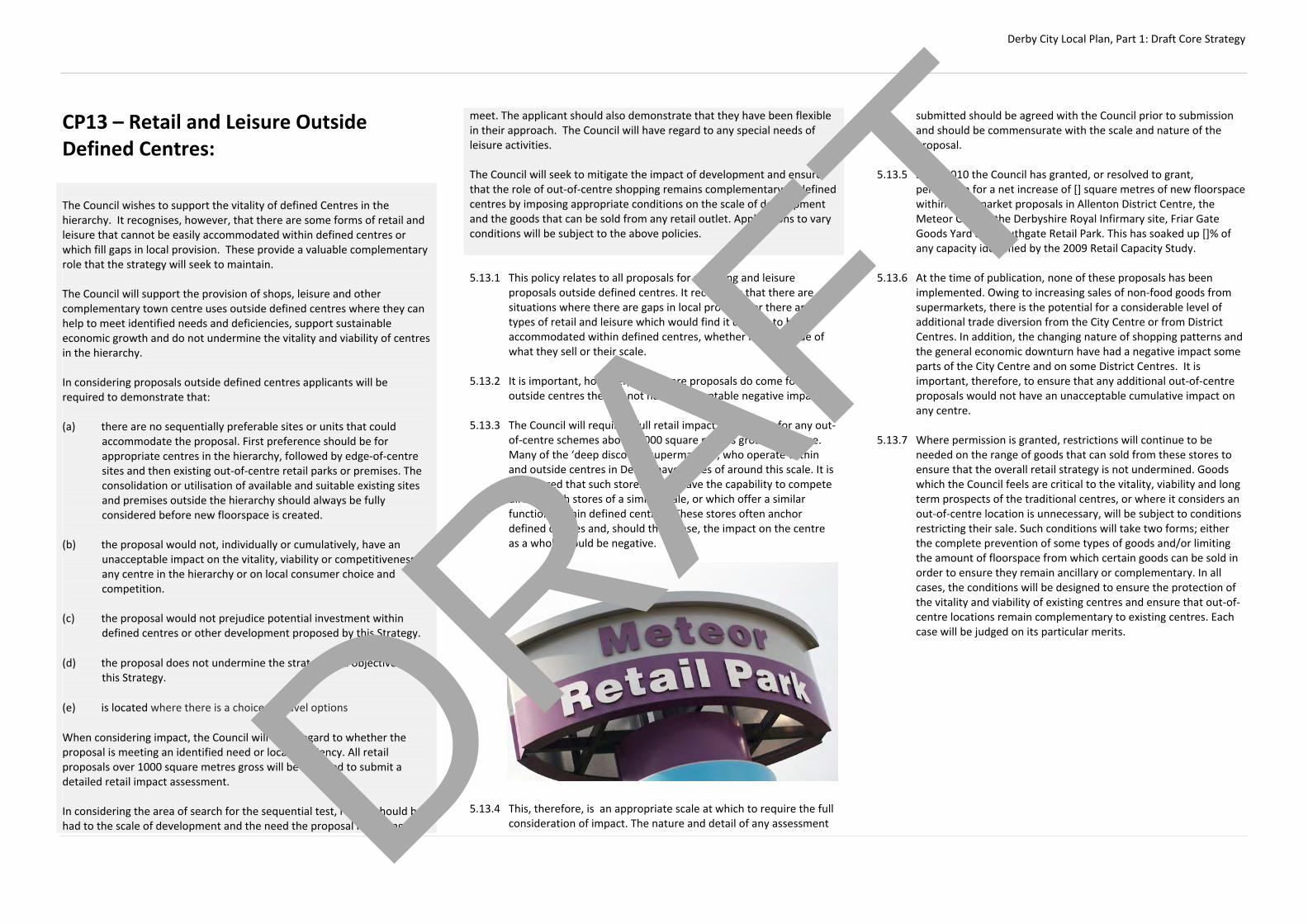
Derby City Local Plan, Part 1: Draft Core Strategy
CP13 – Retail and Leisure Outside Defined Centres: The Council wishes to support the vitality of defined Centres in the hierarchy. It recognises, however, that there are some forms of retail and leisure that cannot be easily accommodated within defined centres or which fill gaps in local provision. These provide a valuable complementary role that the strategy will seek to maintain. The Council will support the provision of shops, leisure and other complementary town centre uses outside defined centres where they can help to meet identified needs and deficiencies, support sustainable economic growth and do not undermine the vitality and viability of centres in the hierarchy. In considering proposals outside defined centres applicants will be required to demonstrate that:
(a) there are no sequentially preferable sites or units that could
accommodate the proposal. First preference should be for appropriate centres in the hierarchy, followed by edge‐of‐centre sites and then existing out‐of‐centre retail parks or premises. The consolidation or utilisation of available and suitable existing sites and premises outside the hierarchy should always be fully considered before new floorspace is created.
(b) the proposal would not, individually or cumulatively, have an
unacceptable impact on the vitality, viability or competitiveness of any centre in the hierarchy or on local consumer choice and competition.
(c) the proposal would not prejudice potential investment within
defined centres or other development proposed by this Strategy.
(d) the proposal does not undermine the strategy and objectives of this Strategy.
(e) is located where there is a choice of travel options
When considering impact, the Council will have regard to whether the proposal is meeting an identified need or local deficiency. All retail proposals over 1000 square metres gross will be required to submit a detailed retail impact assessment. In considering the area of search for the sequential test, regard should be had to the scale of development and the need the proposal is seeking to
meet. The applicant should also demonstrate that they have been flexible in their approach. The Council will have regard to any special needs of leisure activities. The Council will seek to mitigate the impact of development and ensure that the role of out‐of‐centre shopping remains complementary to defined centres by imposing appropriate conditions on the scale of development and the goods that can be sold from any retail outlet. Applications to vary conditions will be subject to the above policies. 5.13.1 This policy relates to all proposals for shopping and leisure
proposals outside defined centres. It recognises that there are situations where there are gaps in local provision or there are types of retail and leisure which would find it difficult to be accommodated within defined centres, whether it is by virtue of what they sell or their scale.
5.13.2 It is important, however, that where proposals do come forward
outside centres they do not have unacceptable negative impacts. 5.13.3 The Council will require a full retail impact assessment for any out‐
of‐centre schemes above 1,000 square metres gross floorspace. Many of the ‘deep discount’ supermarkets, who operate within and outside centres in Derby, have stores of around this scale. It is considered that such stores would have the capability to compete directly with stores of a similar scale, or which offer a similar function, within defined centres. These stores often anchor defined centres and, should they close, the impact on the centre as a whole would be negative.
5.13.4 This, therefore, is an appropriate scale at which to require the full
consideration of impact. The nature and detail of any assessment
submitted should be agreed with the Council prior to submission and should be commensurate with the scale and nature of the proposal.
5.13.5 Since 2010 the Council has granted, or resolved to grant,
permission for a net increase of [] square metres of new floorspace within supermarket proposals in Allenton District Centre, the Meteor Centre, the Derbyshire Royal Infirmary site, Friar Gate Goods Yard and Southgate Retail Park. This has soaked up []% of any capacity identified by the 2009 Retail Capacity Study.
5.13.6 At the time of publication, none of these proposals has been
implemented. Owing to increasing sales of non‐food goods from supermarkets, there is the potential for a considerable level of additional trade diversion from the City Centre or from District Centres. In addition, the changing nature of shopping patterns and the general economic downturn have had a negative impact some parts of the City Centre and on some District Centres. It is important, therefore, to ensure that any additional out‐of‐centre proposals would not have an unacceptable cumulative impact on any centre.
5.13.7 Where permission is granted, restrictions will continue to be
needed on the range of goods that can sold from these stores to ensure that the overall retail strategy is not undermined. Goods which the Council feels are critical to the vitality, viability and long term prospects of the traditional centres, or where it considers an out‐of‐centre location is unnecessary, will be subject to conditions restricting their sale. Such conditions will take two forms; either the complete prevention of some types of goods and/or limiting the amount of floorspace from which certain goods can be sold in order to ensure they remain ancillary or complementary. In all cases, the conditions will be designed to ensure the protection of the vitality and viability of existing centres and ensure that out‐of‐centre locations remain complementary to existing centres. Each case will be judged on its particular merits.
DRAFT

Derby City Local Plan, Part 1: Draft Core Strategy
CP14 – Tourism, Culture and Leisure: The Council is committed to elevating Derby’s identity and reputation as a cultural and leisure destination. The Council will encourage new development that will enhance the quality of the City’s offer and visitor experience, increase visitor numbers and increase participation in cultural and leisure activities by Derby’s residents. The Council will: (a) develop major new leisure venues, including the completion of the
new multi‐event arena on Pride Park and new Aquatic Centre at Riverlights
(b) support proposals that make a positive contribution to the City’s
tourism role and function, either through the development of new facilities or which improve the appearance, use and accessibility of existing attractions
(c) encourage investment to improve the quality of the infrastructure
and venues for the arts, sport and play, museums, libraries and other related leisure uses and activities. Facilities should be accessible, attracting participants from both within and outside the City and helping to build communities at the neighbourhood level
(d) improve the supporting infrastructure for visitors, including those
related to business tourism. New hotel development which contributes to the quality of the City Centre hotel offer will be supported. Proposals for new hotels outside of the City Centre will be supported where they support visitor‐oriented development, including business tourism
(e) Support and deliver proposals that help to maintain and develop
the City’s outdoor cultural offer, including providing spaces and locations for festivals, events and markets
5.14.1 Culture and tourism play an extremely important part in Derby’s
economy and in the day‐to‐day life of its residents. In order to promote further visitor growth in the City, it is important to try to encourage both new visitor attractions and to enhance the existing offer. Particular locations and sectors of importance are the City Centre and the range of visitor attractions and accommodation it already contains, the World Heritage Site and other important examples of Derby’s industrial heritage, including Royal Crown
Derby and Rolls Royce, and the increasingly important role of business tourism.
5.14.2 While new attractions themselves are important, it is also
important to ensure that the supporting infrastructure is of a high quality. This not only relates to the need for high quality visitor accommodation, but also high quality public spaces which can host events, festivals and concerts.
5.14.3 As well as providing for people visiting from outside the City, it is
also important to ensure Derby’s residents have good access to cultural and leisure facilities.
5.14.4 This covers an extremely broad area of activity and cross cuts with
a number of policies which consider specific uses. This policy should, therefore, be read in conjunction with policies for the City Centre, for Centres and for the Economy. The City Centre should be the focus for most new tourist, culture or major leisure relate development. It is the most accessible location in the City for major attractions and encouraging a critical mass of new leisure and tourism will help support its vitality and viability and support sustainable economic growth. However, there will be circumstances where the nature and scale of the proposed use will mean that appropriate City Centre sites may not be available. In such cases, the sequential approach outlined in Policy CPX should be adopted.
DRAFT

Derby City Local Plan, Part 1: Draft Core Strategy
CP15 ‐ Food, Drink and the Evening Economy: The Council will encourage food, drink and other evening and night‐time economy uses that contribute to the vitality of Derby’s centres and which support the creation of a safe, balanced and socially inclusive economy. The Council will support proposals which: (a) help to improve and diversify the City’s evening and night‐time
economy, helping to create a mix that meets the needs of all Derby residents and visitors
(b) have a positive impact on the vitality and viability of defined
centres. Concentrations of bars, hot food takeaways or other similar uses which could have a detrimental effect on community safety and/or on the character, role and function of a defined centre will be resisted
(c) support both the day‐time and evening/night‐time economies
whilst not undermining the role of primary shopping areas (d) do not unacceptably impact on neighbouring uses in terms of
noise, traffic and disturbance or prejudice the development of land identified for alternative uses
In considering applications for bars (A4), hot food takeaways (A5) and clubs, the Council will have regard to the following factors: 1. The characteristics of the area and its relationship to a defined
centre or other appropriate commercial activity 2. The existing number and impact of similar establishments in the
immediate area, their proximity to each other and whether there are existing issues with disturbance and/or anti‐social behaviour
3. The existence of vacant shop units, the condition of the unit and
its suitability for alternative uses 4. The importance of the location for local shopping, and the
number, function and location of shops that would remain to serve the local community
5. The character of the centre and its frontage, and the nature of the
use proposed
6. The potential impacts of the proposal on sites identified for alternative uses and/or on the wider community, and
7. Any known unresolved amenity, traffic or safety issues arising from
existing uses in the area
Planning conditions will be used where appropriate to mitigate the harmful effects of proposals, including the restriction of permitted development rights, installation of ventilation systems, the incorporation of sound insulation and the control of opening hours. 5.15.1 This policy is relevant to all uses that could be considered
important to the evening and night‐time economy, including restaurants (A3), pubs and bars (A4), hot food takeaways (A5) and clubs. In conjunction with Policies CPx, CPx, and CPx, it can also apply to other uses which could attract a large number of visitors into the city in the evening, such as theatres, cinemas, or other leisure uses. This forms part of a suite of policies designed to create and maintain vibrant city and district centres through both the day and night.
5.15.2 It is recognised that there is a need to improve the city’s evening
economy ‘offer’ so that it is more socially inclusive and caters for a wider range of residents and visitors. In particular, there is a need to encourage family‐friendly activities, rather than a further proliferation of bars and clubs. While this is particularly the case in the City Centre – as reflected in Policy CPx – there is no reason why District and Neighbourhood Centres should not be considered in the same way. Increasing the range of facilities on offer, or in some places resisting a concentration of similar uses may help to create places where all parts of the community feel safe and welcome throughout the day and night.
5.15.3 A vibrant evening economy is important source of economic
activity. However, this must be balanced against the other functions of centres, and in particular the need to support daytime activity. The Council will seek to prevent concentrations of uses that would harm a centre's attractiveness to visitors, either as a result of the loss of shopping function, by reducing or removing elements of ‘daytime activity’, or through the impact on the quality of the environment. This will include such problems as closed or shuttered units during the day, noise, smells, disturbance and, where appropriate, any concerns over community safety or anti‐social behaviour.
5.15.4 The Council will give some weight to proposals which seek to
combat long‐term or persistent vacancy or where it can be demonstrated that the unit in question is no longer suitable for
shopping use. In such circumstances, evidence will be required to demonstrate that the unit has been adequately marketed for a reasonable period of time and that it is not fit for purpose. However, even in such circumstances, if it is considered that the proposal will still have the negative effects described above in terms of impact on amenity or on the vitality and viability of the centre it will not be permitted.
5.15.5 In line with Policy CPX, bars and hot food takeaways are ‘town
centre’ type uses and so should be concentrated in defined centres where possible. In some circumstances, however, it is accepted that such uses can complement business or industrial areas by providing facilities for employees and reducing the need to travel. Equally, food and drink uses are not uncommon on retail parks or other areas with large numbers of visitors (for example, adjacent to Pride Park Stadium). Such locations will continue be acceptable subject to the provisions of the policy in terms of impact on amenity, accessibility, traffic and that they do not undermine the main commercial function of the area. In most cases, such uses will not be permitted in mainly residential areas.
5.15.6 The Council will seek to ensure that, where permission is granted,
any potential harm to the area from the proposal can be controlled, for example by limiting the hours of operation, requiring sound insulation, fume extraction and filtering equipment or ensuring that a shop front is maintained and that shutters are not left down during the day.
DRAFT

Derby City Local Plan, Part 1: Draft Core Strategy
Green Infrastructure:
CP16 – Green Infrastructure: The Council will seek to maintain, enhance and manage Derby’s Green Infrastructure (GI) to ensure that everyone has access to high quality natural and semi‐natural habitats, green space and sport and recreation facilities. The Council will ensure that land is available and managed to assist in, adapting to and mitigating against, climate change. The Council will: (a) minimise impacts and overall decline of biodiversity and, where
possible, provide net gains
(b) ensure that GI is an integral part of all development, contributing to the wider green infrastructure network, including the strategic network outside of the City;
(c) retain the principle of the Nottingham / Derby Green Belt and
resist harmful and inappropriate development as defined by national policy;
(d) identify Green Wedges as areas of land that define the City’s
neighbourhoods seek improvements to enhance the wider green infrastructure network;
(e) identify Derby’s public green space hierarchy and ensure that
everyone has access to a variety of public green spaces (f) seek to ensure that connections between biodiversity habitats are
resilient and appropriately protected. Where opportunities arise, new connections will be created.
(g) seek to avoid the fragmentation of habitats and, where
unavoidable, provide appropriate compensation on a like‐for‐like basis.
(h) seek to enhance linkages to the green infrastructure network to
improve access for residents, workers and visitors (i) prioritise investment in Green Infrastructure to:
1. Locations of major residential development and as part of
business and employment development
2. In areas of poor provision and in areas needed for
increasing functional connectivity; and 3. Areas needed for mitigating against and adapting to
climate change and flooding mitigation and adaption 4. Improve the role and function of the Green Wedges
(j) support improvements to the City’s green infrastructure through the implementation of the Our City Our River Masterplan and the restoration of the Derby and Sandiacre Canal. Improved links to Kedleston Hall, Elvaston Castle and the Trent and Mersey Canal will be supported
(k) ensure that new residential development provides improvements
to the public green space network either through new provision or improvements to existing spaces
(l) ensure that where new development has an adverse impact on a recognised important element of Green Infrastructure, that impact should be clearly understood, minimised and any residual adverse impacts mitigated for. As a last resort, the impact should be compensated for, either on‐site or off‐site. Any opportunities for enhancement and better management of the asset through development should be sought. In assessing the impact of the development, its need and benefit will be weighed against the harm caused to the green infrastructure
(m) identify a site for a new cemetery to meet Derby’s burial needs 5.16.1 Green Infrastructure (GI) is a network of high quality green and
blue spaces and other environmental features and is made up of the following elements:
‐ The local countryside ‐ Green Belt and Green Wedges ‐ Local Nature Reserves and wildlife sites ‐ Parks ‐ Allotments ‐ Outdoor sports facilities and playing fields ‐ Cemeteries and graveyards
‐ Amenity green space ‐ Green corridors such as rivers, canals, footpaths and multi‐
user routes ‐ Individual trees, woodland and hedgerows and other
landscape features
5.16.2 Derby has a unique network of multipurpose green infrastructure assets including Green Wedges, parks, local nature reserves, green spaces and green corridors which make a valuable contribution to the City.
5.16.3 Green infrastructure can provide a number of multiple benefits for
the City and the wider region. It helps to mitigate the effects of climate change by, for example, acting as ‘carbon sinks’ which help remove CO2 from the atmosphere, reducing the urban heat island effect and providing areas of natural drainage.
5.16.4 Green corridors provide connections between important wildlife
sites in, and beyond, the City. It provides opportunities for physical activities and areas for quiet contemplation thus improving the health and mental well‐being of the community. It can enrich an areas character and appearance and enhance the setting of our cultural assets. By making areas more attractive, Derby will encourage and maintain inward economic investment and assist in taking forward our regeneration priorities.
5.16.5 Derby’s green infrastructure is critical for continued, sustainable
economic prosperity by contributing to the conditions for growth and economic security. The attractiveness of the environment is in part what determines where employers choose to locate, and where the workforce chooses to live. Workers with access to green infrastructure also tend to be healthier and more productive. In DRAFT
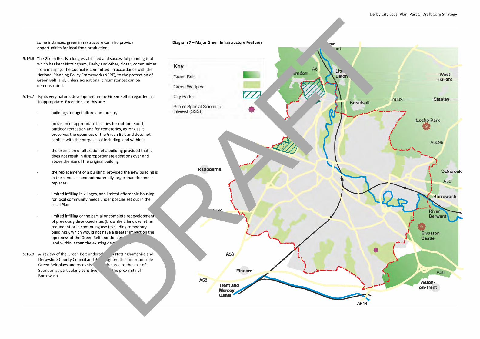
Derby City Local Plan, Part 1: Draft Core Strategy
some instances, green infrastructure can also provide opportunities for local food production.
5.16.6 The Green Belt is a long established and successful planning tool
which has kept Nottingham, Derby and other, closer, communities from merging. The Council is committed, in accordance with the National Planning Policy Framework (NPPF), to the protection of Green Belt land, unless exceptional circumstances can be demonstrated.
5.16.7 By its very nature, development in the Green Belt is regarded as
inappropriate. Exceptions to this are:
‐ buildings for agriculture and forestry ‐ provision of appropriate facilities for outdoor sport,
outdoor recreation and for cemeteries, as long as it preserves the openness of the Green Belt and does not conflict with the purposes of including land within it
‐ the extension or alteration of a building provided that it
does not result in disproportionate additions over and above the size of the original building
‐ the replacement of a building, provided the new building is
in the same use and not materially larger than the one it replaces
‐ limited infilling in villages, and limited affordable housing
for local community needs under policies set out in the Local Plan
‐ limited infilling or the partial or complete redevelopment
of previously developed sites (brownfield land), whether redundant or in continuing use (excluding temporary buildings), which would not have a greater impact on the openness of the Green Belt and the purpose of including land within it than the existing development.
5.16.8 A review of the Green Belt undertaken by Nottinghamshire and
Derbyshire County Council and it highlighted the important role Green Belt plays and recognised that the area to the east of Spondon as particularly sensitive, due to the proximity of Borrowash.
Diagram 7 – Major Green Infrastructure Features
DRAFT
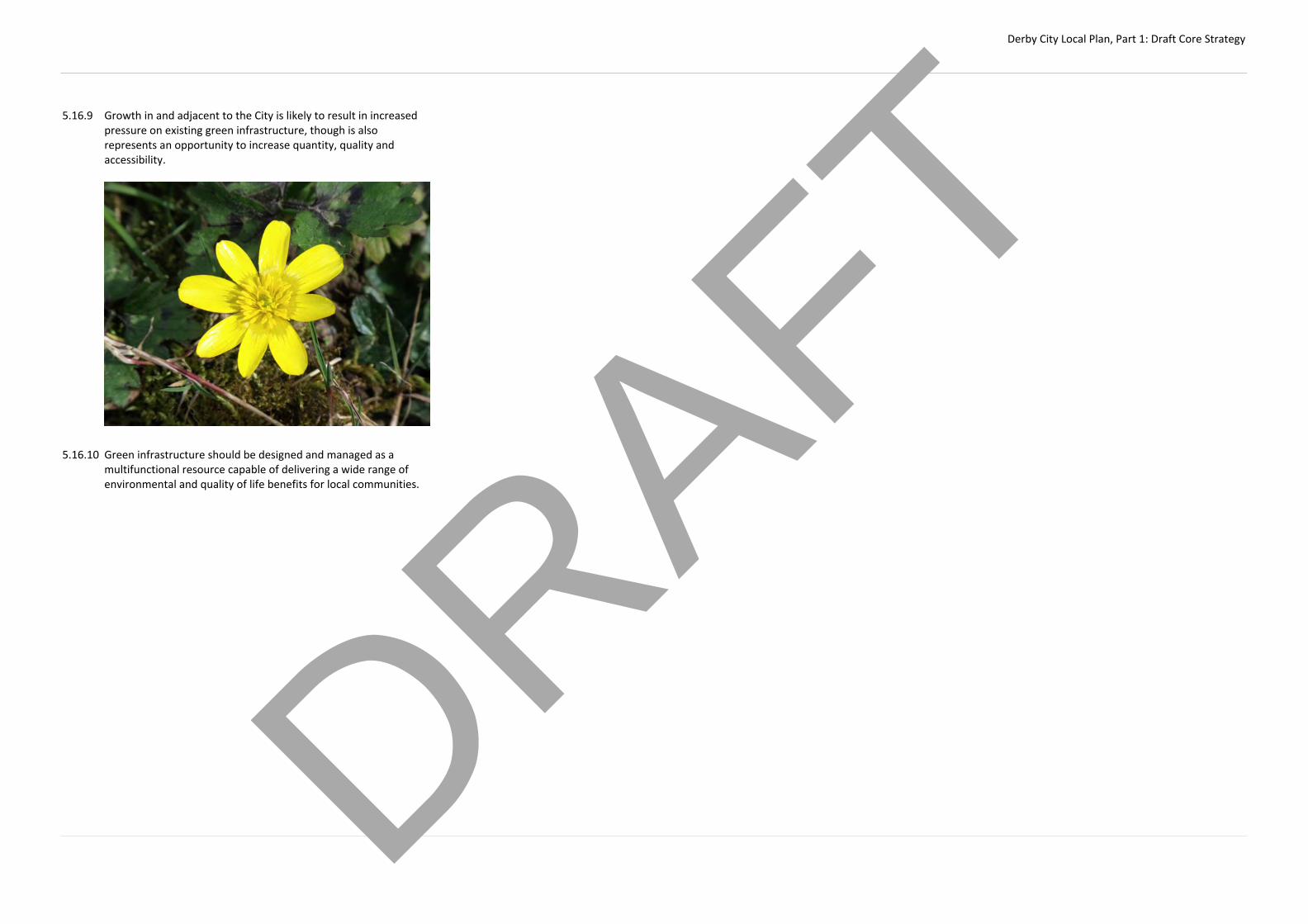
Derby City Local Plan, Part 1: Draft Core Strategy
5.16.9 Growth in and adjacent to the City is likely to result in increased pressure on existing green infrastructure, though is also represents an opportunity to increase quantity, quality and accessibility.
5.16.10 Green infrastructure should be designed and managed as a
multifunctional resource capable of delivering a wide range of environmental and quality of life benefits for local communities.
DRAFT

Derby City Local Plan, Part 1: Draft Core Strategy
CP17 – Public Green Space: The Council is committed to ensuring that everyone has access to a network of multi‐functional public green spaces. It will seek to ensure that this network provides a diverse range of spaces to meet city‐wide needs. Emphasis will be on reinforcing and improving this network to focus resources on improved quality and accessibility. This will be achieved by securing financial contributions from development to improve existing open spaces where these can meet the needs of that development or the provision of new public green spaces. Where new public green space is provided as part of development, the Council will expect developers to provide for its on‐going, long‐term maintenance to an agreed standard. The Council will: (a) consider the following factors in applying this policy:
1. a public green space standard of 3.8 hectares per 1000
people or equivalent financial contributions 2. accessibility standards set out in the Appendix 3. the nature of the development 4. the provision of existing public green space in the locality 5. the impact on the viability of the development 6. the need to ensure that it is a size, type and form that
meets local requirements and is located to maximise accessibility and security
(b) expect, where possible, new green spaces to connect to the wider
Green Infrastructure network in order to improve accessibility between sites and enhance biodiversity.
(c) work with neighbouring authorities to ensure a consistent and co‐
ordinated approach to the provision of public green space in cross‐boundary developments
(d) only permit the loss or change of use of green space or playing
pitches in circumstances where:
1. an assessment has been undertaken which has clearly
shown the public green space, buildings or land to be surplus to requirements; or
2. the loss resulting from the proposed development would
be replaced by equivalent or better provision in terms of quantity and quality in a suitable location; or
3. the development is for alternative sports and recreational
provision, the needs for which clearly outweigh the loss 4. the development will be ancillary and in scale to the public
green space, sport or recreation facility and compliment the use or character of the space
5.17.1 Derby’s public green space network is made up of the following
elements:
‐ Local Nature Reserves and wildlife sites ‐ Parks ‐ Allotments ‐ Outdoor sports facilities and playing fields such as playing
pitches, tennis courts and bowling greens ‐ Amenity green space
5.17.2 The provision of new, or improvements to existing, public green space will ensure that Derby remains an attractive City in which to live. This approach will bring multiple benefits to Derby by reinforcing the overall green infrastructure network, improving visual amenity and providing opportunities for sport and relaxation.
5.17.3 The Government recognizes that planning can play an important
role in promoting social interaction and creating healthy, inclusive communities through the provision of high quality, accessible open space and sport pitches.
5.17.4 In Derby, public green spaces provide multiple benefits and help
promote sustainable communities. In addition, public green spaces and playing pitches provide places for relaxation and contemplation and opportunities for sport and recreation.
5.17.5 Previous studies have highlighted a contrast in the provision of
public green spaces across the City with areas of the city, such as the wards of Normanton, Boulton and Derwent, which have a
deficiency in many types of green space while some of the suburbs have a surplus. It goes on to recognise that, in areas of deficit such as Derby’s historic core, it is often difficult to find available locations for new public green space and suggests alternative methods to green the city.
5.17.6 The Council may require the provision of different types of public
green space to meet a local shortfall. For example, the Council may require that allotments, natural and semi‐natural green space or woodland is provided rather than the more traditional parks and amenity green space.
5.17.7 In bringing forward new public green spaces, the Council will,
wherever possible, seek to ensure that new space links up with and enhances existing public green spaces, green corridors and the wider green infrastructure network.
5.17.8 In determining ‘surplus to requirement’ the Council will have
regard to provision in the surrounding area and consider the following:
‐ the public green space standard of 3.8 hectares per 1000
people ‐ the accessibility of public green space in the locality ‐ the function of the public green space ‐ opportunities for meeting localised deficiencies and
improving overall quality through rationalisation 5.17.9 The Council will undertake a strategic review of public green
space to assess the overall provision across the City and explore opportunities to rationalising this to create qualitative improvements that addresses existing deficiencies.
5.17.10 The City of Derby Local Plan Review, Adopted January 1996,
contains a number of saved policies. Policy L4 sets out allocations DRAFT
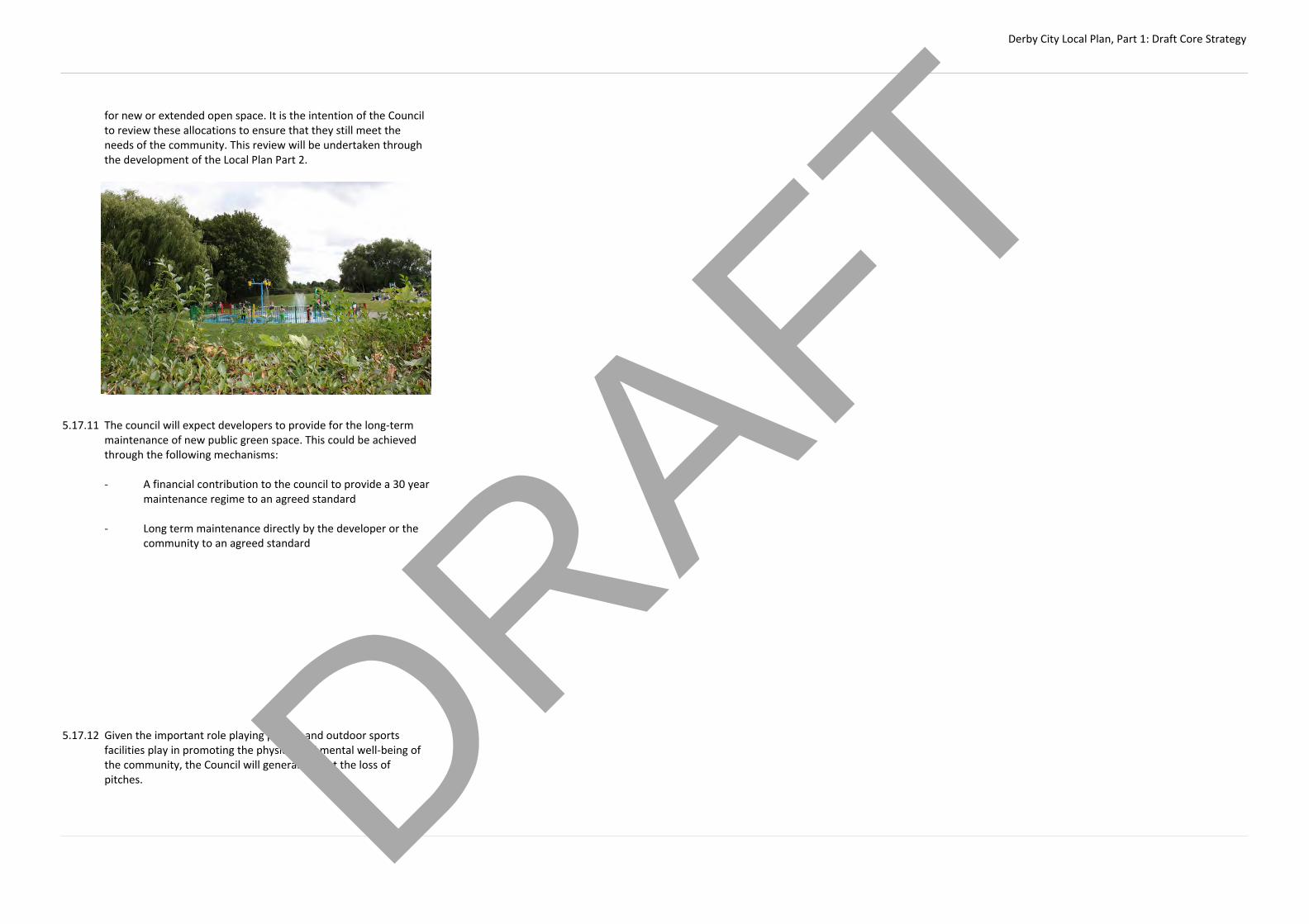
Derby City Local Plan, Part 1: Draft Core Strategy
for new or extended open space. It is the intention of the Council to review these allocations to ensure that they still meet the needs of the community. This review will be undertaken through the development of the Local Plan Part 2.
5.17.11 The council will expect developers to provide for the long‐term
maintenance of new public green space. This could be achieved through the following mechanisms:
‐ A financial contribution to the council to provide a 30 year
maintenance regime to an agreed standard
‐ Long term maintenance directly by the developer or the community to an agreed standard
5.17.12 Given the important role playing pitches and outdoor sports
facilities play in promoting the physical and mental well‐being of the community, the Council will generally resist the loss of pitches.
DRAFT

Derby City Local Plan, Part 1: Draft Core Strategy
CP18 – Green Wedges: The Council will continue to identify Green Wedges as areas of land that define and enhance the City’s urban structure, maintain the identity of the different residential neighbourhoods, provide an uninterrupted link to the countryside, form part of the wider Green Infrastructure network and play an important role in climate change adaptation. The Council will: (a) ensure that development in the Green Wedge is limited to the
following uses: 1. Agriculture and forestry; 2. Green space, outdoor sport, recreation and community
uses providing the character of the green wedge and it’s amenity is not adversely affected;
3. Nature conservation, including improvements to link the
Green Wedge to the wider GI network 4. Acceptable additions or enhancements which provide
multiple benefits to Derby’s green infrastructure; 5. Cemeteries; 6. Essential buildings and activities ancillary to existing
education establishments; 7. Public utilities where it can be shown that a suitable site
outside the green wedge is not available 8. The extension or alteration of existing dwellings and the
erection of ancillary buildings
(b) ensure that development does not endanger the open and undeveloped character of the Wedge, its links and green infrastructure value; taking into account scale, siting, design, materials and landscape treatment and would not lead to an excessive increase in numbers of people, traffic or noise
(c) ensure that development associated with categories 1 to 8 is
small‐scale and ancillary to the operation of the main use
(d) permit the conversion or change of use of existing buildings provided that building is suitable for its intended use without extensive alteration, rebuilding or extensions
(e) permit the redevelopment of existing buildings in the Green
Wedge for uses in categories 1 to 8 and the replacement of existing dwellings with new dwellings
(f) permit, in exceptional circumstances, redevelopment of buildings
other than dwellings for residential development, and supporting facilities. Permission will only be granted where the Council is satisfied that the original buildings are genuinely redundant and surplus to requirements, and that the site adjoins nearby residential areas
(g) ensure that planning permission for the conversion or change of
use of farm buildings is subject to conditions to prevent a proliferation of additional farm buildings under permitted development rights.
(h) ensure that development adjacent to a green wedge does not
endanger the character function of the wedge, taking into account scale, siting, design, materials and landscape treatment and would not lead to an excessive increase in numbers of people, traffic or noise
(i) seek opportunities to link green wedges to the wider green
infrastructure and ecological networks (j) ensure that development in or adjacent to a Green Wedge
provides opportunities to improve the remaining Green Wedge (k) seek to ensure that, where urban extensions occur, the principle of
the Green Wedge itself will be continued. For all development proposals, the proposed buildings: ‐ Should not have a greater impact on the openness of the Green
Wedge and the purpose of including land within it than the existing buildings
‐ Should not exceed the height of the existing buildings ‐ Should not occupy a materially larger area of the site than the
existing buildings, unless this would result in a reduction in height which would benefit visual amenity
5.18.1 Green Wedges are an important part of Derby’s character and are a long‐standing, and successful local planning policy. Their primary function is to define and enhance the urban structure of the city as a whole, in particular by reinforcing local identity by maintaining areas of open land between the City’s neighbourhoods. All have important existing or potential recreational and ecological value and play an important role in mitigating against climate change. In addition, farming remains an important economic activity and extensive user of land in some Green Wedges.
5.18.2 Green Wedges do not have the permanence of the Green Belt but
it is intended to retain the principle of Green Wedges, maintain their identity, reduce the impression of urban sprawl and resist harmful development.
5.18.3 The proximity of Green Wedges to the built‐up area and, in some
cases, their narrowness makes them particularly vulnerable to development pressure. Where development does occur the Council will ensure that the principle of the Green Wedge will not be adversely affected. In addition, the Council expects that development will provide improvements to part, or all, of the Green Wedge. Where urban extensions occur, outside of the city boundary, the Council will seek to ensure that wedge itself inside and outside the City will be continued.
5.18.4 The extension or alteration of existing homes and other buildings
may be permitted provided that they are in keeping with the size and character of the original building and do not adversely affect the overall character of the Green Wedge. The erection of ancillary domestic buildings may be approved as long as they do not adversely affect the openness of the Green Wedge. The replacement of existing homes may also be acceptable in the Green Wedge provided that the new home is not materially larger than the original dwelling.
5.18.5 From time to time, circumstances may arise where existing non‐
residential buildings in Green Wedges become redundant and pressure for redevelopment arises. Planning permission for residential development may exceptionally be granted on such 'previously developed' sites in Green Wedge locations, providing visual impact is minimised and the site is reasonably adjacent to existing housing areas.
DRAFT

Derby City Local Plan, Part 1: Draft Core Strategy
CP19 – Biodiversity: The biodiversity and geodiversity assets across the City will be protected, enhanced, managed, restored, strengthened and created in a manner appropriate to their significance. The Council will: (a) seek to mitigate the impacts on biodiversity and contribute to the
City’s ecological and geological resources resulting in a net gain in biodiversity over the plan period
(b) seek to reduce habitat and species fragmentation by developing a
functional ecological network and maximising opportunities for restoration, enhancement, better management and connectivity of natural habitats, including links beyond the City
(c) ensure that development will protect, enhance and restore the
biodiversity and geodiversity value of land and buildings (d) support species to adapt to the pressures of climate change (e) seek to ensure the creation, extension, protection and better
management of Biodiversity Action Plan priority habitats (f) work with partner organisations and neighbouring Local
Authorities to ensure that Derby positively contributes to the wider, regional biodiversity network
(g) work with relevant partners to help meet the requirements of the
Water Framework Directive to ensure that all surface water bodies reach at least 'good' ecological status or 'good' ecological potential.
Development proposals that would have a direct or indirect adverse effect on:
‐ Internationally important sites
‐ Nationally Important Sites (such as Sites of Special Scientific Interest)
‐ Regionally Important Sites (such as Local Geological Sites and Local Nature Reserves)
‐ Locally identified wildlife sites
‐ Ancient woodlands, veteran trees and hedgerows
‐ Priority habitats and species will only exceptionally be permitted if:
1. they cannot be located on alternative sites that would cause less or no harm;
2. the benefits of the development clearly outweigh the
impacts on the features of the site and the wider network of natural habitats; and
3. adequate mitigation or, as a last resort, compensation
measures are provided. Where development proposals have the potential to impact on a natural heritage asset, including where sites are derelict, vacant or previously developed, a supporting ecological site assessment is submitted in conjunction with the planning application identifying the nature and extent of any impact and mitigating measures that need to be taken. 5.19.1 Derby City contains a rich and diverse range of biodiversity and
geodiversity assets. It is intended to provide a framework for conserving and enhancing this diversity for both its own sake, and the positive contribution that it makes to the overall quality of life and sense of place for both Derby’s residents and visitors to the City.
5.19.2 There is one Site of Special Scientific Interest (SSSI) at Boulton
Moor, 10 Local Nature Reserves and over 50 other sites of wildlife interest in Derby.
5.19.3 It is important to protect the existing biodiversity of the City and
take opportunities to improve it to contribute to the Government’s commitment to halt the overall decline in biodiversity. In its core principles the National Planning Policy Framework (NPPF) states that planning should contribute to conserving and enhancing the natural environment and in pursuance of sustainable development should fully compensate for any loss of biodiversity value.
5.19.4 The Biodiversity Strategy for the East Midlands (East Midlands
Biodiversity Partnership, 2006) highlighted that the region’s biodiversity is a key resource but it recognised that it is under continued and sustained pressure to such an extent that the degradation of the biodiversity resource is greater than in any other region in England. Therefore, it is important to protect existing biodiversity and take opportunities to improve it to
contribute to the Government’s commitment to halt the overall decline in biodiversity. National planning policy states that planning should contribute to conserving and enhancing the natural environment and should fully compensate for any loss of biodiversity value.
5.19.5 Important sites for biodiversity, geodiversity and protected species
receive statutory protection under international and national legislation. It is the intention to promote the preservation and restoration of habitats, ecological networks and the protection and recovery of priority species populations and reflect local strategies such as the Biodiversity Strategy for the East Midlands and the Lowland Derbyshire Biodiversity Action Plan.
5.19.6 The Lowland Derbyshire Biodiversity Action Plan (LBAP) covers the
whole of Derbyshire which is outside the area covered by the Peak District LBAP. The plan is monitored by the LBAP Partnership and it has recently been reviewed. Its aim is to conserve and enhance existing wildlife and to redress past losses through habitat conservation, restoration, recreation and targeted action for priority species. The latest iteration of the document covers the period 2011 to 2020 recognises that the River Derwent is an important habitat corridor into the City Centre and forms the spine to the wider green network.
5.19.7 In other cases, the urban environment such as buildings and
structures, disused railway land and other land can make a positive contribution for wildlife and can be used as a stepping stone to the broader network of green spaces in Derby.
5.19.8 While such assets can also further wider social benefits of health
and wellbeing by increasing access of people to local semi‐natural green space, it is accepted that in some instances, such as sensitive biodiversity sites, it would not be appropriate to promote additional access as this could damage the resource.
5.19.9 There is a need to ensure that development proposals will have a
minimal impact on biodiversity. Where necessary, the Borough Council will require the submission of a supporting statement in conjunction with planning applications, identifying the nature and extent of any impact and mitigating measures that need to be taken. Surveys must be taken at appropriate times of year for the relevant habitats, species, flora and fauna. Where proposals could affect Sites of Special Scientific Interest (SSSI), these will be subject to special scrutiny including consultation with English Nature. DRAFT

Derby City Local Plan, Part 1: Draft Core Strategy
Heritage:
CP20 ‐ Historic Environment: The Council recognises the historic environment as one of Derby’s greatest resources and will protect it through the preservation, enhancement, restoration and repair of heritage assets. Designated and non‐designated heritage assets of importance within Derby include: ‐ The Derwent Valley Mills World Heritage Site ‐ Statutory and Locally Listed Buildings ‐ Conservation Areas ‐ Scheduled Monuments, Archaeological Alert Areas and Other
Archaeological Remains ‐ Historic Parks and Gardens Development proposals that would detrimentally impact upon the character, significance and / or setting of a heritage asset will be resisted. The Council will: (a) require that where proposals have the potential to impact upon
heritage assets, a statement of significance and an impact assessment are submitted to ensure that the importance of the asset and the extent of any impact are fully understood. Heritage assets will be conserved in a manner appropriate to their significance
(b) require proposals for new development, located within
Archaeological Alert Areas, or other areas of archaeological potential to be accompanied by an assessment of available evidence and where appropriate an archaeological evaluation. This should be submitted before the planning application is determined in order to enable an informed and reasonable planning decision
(c) require proposals for new development that have the potential to
impact upon heritage assets and / or their setting to be of the highest design quality to preserve and enhance their special character and significance through appropriate siting, alignment,
use of materials, mass and scale and take account of best practice guidance
(d) require that where a loss of significance to a heritage asset is justified by the benefits of a development proposal, appropriate recording is carried out
(e) support the sensitive re‐use of under‐ utilised assets consistent
with their conservation, whilst also recognising that managed change may sometimes be necessary if heritage assets are to be maintained in the long term
(f) ensure that development within the city does not adversely affect
the setting of heritage assets located outside of the city boundary, within adjoining local authority areas
(g) encourage opportunities to enhance the tourism potential of
heritage assets, particularly within the City Centre and the Derwent Valley Mills World Heritage Site (DVMWHS) as part of the Our City Our River project. Opportunities to adapt heritage assets to make them more resilient to climate change will also be supported in principle, provided they do not impact upon the significance of the asset
(h) support the reinstatement of historic and well‐designed new shop
fronts within the City Centre and Local Centres (i) continue to prepare, monitor and review conservation area
appraisals and management plans for existing and potential conservation areas
(j) continue to review, update and introduce Article 4 Directions,
where appropriate (k) continue to record and monitor heritage assets that are at risk and
take action where necessary. It will support re‐use and change where necessary to preserve the assets for the future
Within regeneration priority areas and areas of significant change, particular efforts will be made to ensure that heritage assets are positively integrated into regeneration proposals, through constructive conservation. Additional guidance relating to development and the historic environment will be set out in a design guidance document to be prepared by the Council.
5.20.1 Heritage assets are the valued components of the historic environment which have been identified as having a degree of ‘significance’ (i.e. archaeological, architectural, artistic or historic). They can include for example, buildings, monuments, sites, places, areas or landscapes. Conservation is the process of maintaining and managing change to a heritage asset in a way that sustains and, where appropriate, enhances its significance.
5.20.2 Derby is a city of considerable historic interest and architectural
merit with a range of streets and buildings spanning many centuries. The historic environment is a key element of the city's character and identity and contributes to our knowledge and understanding of the past. The Council is committed to ensuring that the city’s heritage is appropriately preserved and wherever possible enhanced. Proposals that would undermine this objective will not be permitted by the Council.
5.20.3 The long and varied history of Derby has left it with a rich legacy of
historic assets, ranging from the Roman remains at Little Chester to fine Georgian townhouses along Friar Gate and twentieth century industrial heritage in Osmaston The city also has a wealth of heritage assets from the Victorian era, particularly relating to the growth of railway engineering in the 19th Century.
5.20.4 There is a concentration of heritage assets within the City Centre
and along the river corridor, including the DVMWHS, which is currently the only World Heritage Site in the East Midlands. Policy AC9 provides further detail on the protection and enhancement of the DVMWHS.
5.20.5 There are 390 buildings in the City that are statutorily listed,
reflecting their special architectural or historic interest. 9 of these buildings are Grade I and 39 Grade II*. Listed building consent is needed for the demolition of listed buildings, or to carry out any internal and external alterations that affect the character of a listed building. Once historic features and other characteristics of listed buildings are lost, they cannot be replaced. The Council, therefore, has a duty to pay special regard to the preservation or enhancement of these buildings.
5.20.6 There are also many unlisted buildings and structures of
architectural or historic merit, which form an important part of Derby's heritage which also need to be protected from loss or harmful alterations. Many of these buildings have been identified on the Council's 'Local List'. As with all heritage assets, locally listed buildings will be conserved in a manner appropriate to their significance.
DRAFT
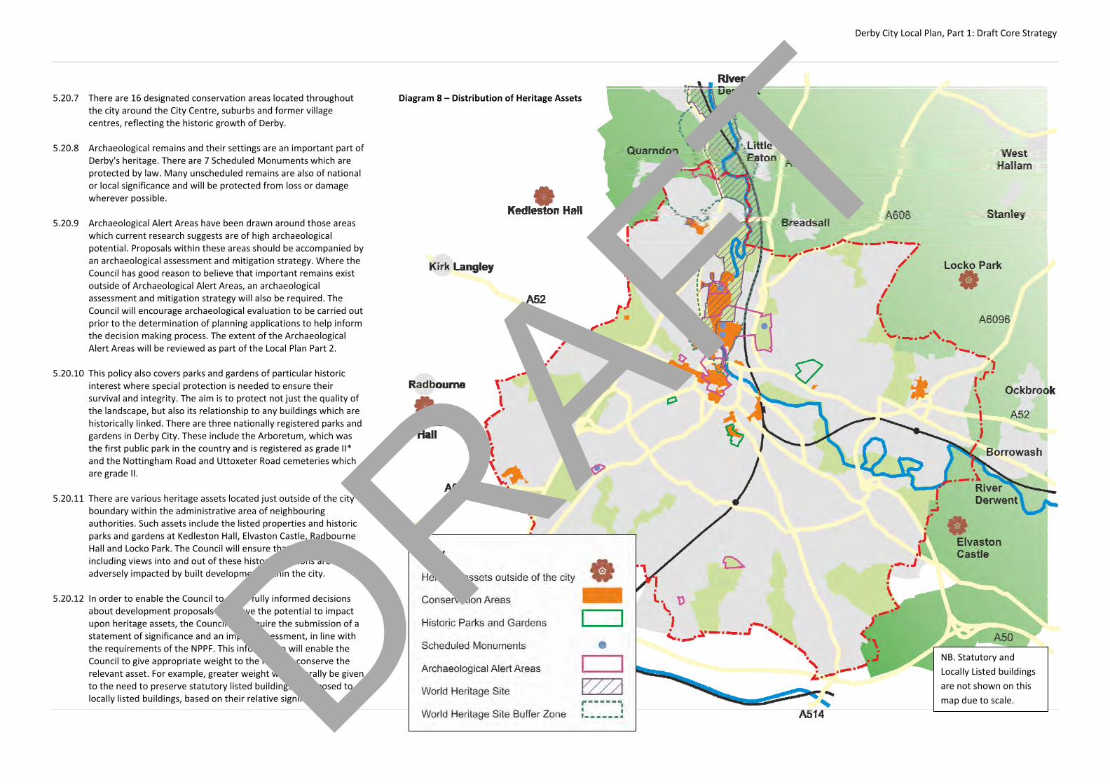
Derby City Local Plan, Part 1: Draft Core Strategy
5.20.7 There are 16 designated conservation areas located throughout the city around the City Centre, suburbs and former village centres, reflecting the historic growth of Derby.
5.20.8 Archaeological remains and their settings are an important part of
Derby's heritage. There are 7 Scheduled Monuments which are protected by law. Many unscheduled remains are also of national or local significance and will be protected from loss or damage wherever possible.
5.20.9 Archaeological Alert Areas have been drawn around those areas
which current research suggests are of high archaeological potential. Proposals within these areas should be accompanied by an archaeological assessment and mitigation strategy. Where the Council has good reason to believe that important remains exist outside of Archaeological Alert Areas, an archaeological assessment and mitigation strategy will also be required. The Council will encourage archaeological evaluation to be carried out prior to the determination of planning applications to help inform the decision making process. The extent of the Archaeological Alert Areas will be reviewed as part of the Local Plan Part 2.
5.20.10 This policy also covers parks and gardens of particular historic
interest where special protection is needed to ensure their survival and integrity. The aim is to protect not just the quality of the landscape, but also its relationship to any buildings which are historically linked. There are three nationally registered parks and gardens in Derby City. These include the Arboretum, which was the first public park in the country and is registered as grade II* and the Nottingham Road and Uttoxeter Road cemeteries which are grade II.
5.20.11 There are various heritage assets located just outside of the city
boundary within the administrative area of neighbouring authorities. Such assets include the listed properties and historic parks and gardens at Kedleston Hall, Elvaston Castle, Radbourne Hall and Locko Park. The Council will ensure that the setting, including views into and out of these historic locations are not adversely impacted by built development within the city.
5.20.12 In order to enable the Council to make fully informed decisions
about development proposals that have the potential to impact upon heritage assets, the Council will require the submission of a statement of significance and an impact assessment, in line with the requirements of the NPPF. This information will enable the Council to give appropriate weight to the need to conserve the relevant asset. For example, greater weight will generally be given to the need to preserve statutory listed buildings as opposed to locally listed buildings, based on their relative significance.
Diagram 8 – Distribution of Heritage Assets
NB. Statutory and Locally Listed buildings are not shown on this map due to scale. DRAFT

Derby City Local Plan, Part 1: Draft Core Strategy
5.20.13 The level of details to be submitted should be proportionate to the assets importance and sufficient to understand the potential impact of the proposals on that significance. This will normally include a justification statement and detailed drawings which have been prepared by a suitably qualified person or a relevant recognised body. The submitted details should address the likely impact upon the heritage asset and any mitigation measures necessary to protect and enhance its significance.
5.20.14 The Council will expect all proposals that have the potential to
impact upon heritage assets to be of the highest design quality to help preserve and enhance the special character and significance of assets. Detailed consideration will need to be given to the appropriate siting, alignment, use of materials, mass and scale in order to ensure that assets are protected and enhanced.
5.20.15 The historic environment is a key part of Derby's cultural heritage
and helps to create continuity, local distinctiveness and identity. Re‐use of historic buildings also contributes towards sustainability objectives as it lessens the need for new buildings and materials.
5.20.16 The concentration of heritage assets within the upper River
Derwent corridor provides opportunities to adapt and mitigate the risks associated with climate change. Projects involving preservation, enhancement and restoration of historic assets may also provide opportunities to implement new flood defences in line with the ‘OCOR’ Masterplan area.
5.20.23 Some assets need to be adapted to ensure their future long term
use. When this happens we will follow English Heritage Guidance to ensure an appropriate level of recording takes place to help future generations better understand their significance.
Conservation gain will be sought to ensure that a positive enhancement is made to the heritage assets of the city where mitigation is required.
5.20.17 Many of Derby’s historic assets are underutilised in terms of their
contribution to the city’s economy. The preservation, enhancement and restoration of the historic environment are particularly important in supporting the growth of tourism and leisure within the city and form an important part of the overall Economic Strategy for the city.
5.20.18 The Council has been successful in working with shop owners to
replace shop fronts in the City Centre, as part of the Partnership Schemes in Conservation Areas (PiSCA) promoted by English Heritage. The reinstatement of traditional shop fronts has made significant improvements to the environmental quality of many areas of the City Centre and the Council wishes to see this successful scheme continued and potentially expanded to also include local centres.
5.20.19 The historic environment of Derby extends beyond the sum total
of the designated heritage assets. To protect the distinctive character of Derby, the Council will continually review the extent of protection offered to the historic environment. This, for example, could include making recommendations to English Heritage that certain assets are given statutory protection by formal designation, that the number and extent of conservation areas are reviewed and that other means of identifying those assets that need protection on account of their local significance are positively identified through the compilation of lists of local buildings of special architectural or historic interest. The use of Article 4 directions will also continue to be reviewed.
5.20.20 The Council will continue to produce and review conservation area appraisals for all of the designated conservation areas within the city. These should be used by developers to help understand context and to develop appropriate design solutions.
5.20.21 The City Centre, Castleward, Osmaston and the River Derwent
corridor all provide opportunities to successfully integrate the conservation of heritage assets with physical and economic regeneration. Preservation and enhancement of heritage assets within these areas has the potential to add significant value to these projects whilst helping to maintain the character and identity of the city.
5.20.22 Derby’s built heritage is important and some buildings are
threatened by redundancy, dilapidation and general neglect. The Council will seek to identify these buildings and will encourage owners to find new beneficial uses to secure their long term future. If necessary, the Council will use legal powers to take action against owners of buildings at risk in order to secure the future of such buildings.
DRAFT

Derby City Local Plan, Part 1: Draft Core Strategy
Learning, Health and Community:
CP21 – Community Facilities: The Council recognises that facilities that meet Derby’s community, social, health, welfare, education, spiritual, cultural, leisure and physical activity needs and aspirations are key to how the City functions and our ability to create thriving communities. The Council will work with strategic partners and developers to provide City wide, high quality, accessible and inclusive facilities and services for the community by: a) supporting the retention of existing facilities unless it can be
demonstrated that there is no longer a need to retain the use, alternative provision is made or where we can assist strategic partners to renew or restructure their provision
b) providing new, or investing in improved, community facilities to
serve new development or meet an identified need. New community facilities will be provided as part of urban extensions to the city as detailed in individual site policies
c) seeking improvements in school provision, including:
‐ a new secondary school in the City or South Derbyshire to
serve housing growth in and on the edge of Derby. The need for the new school will be further refined through the Core Strategy process and a site allocated in the City Council’s or South Derbyshire’s Local Plan Part 2
‐ improvements/extension of existing secondary schools to
meet growing needs within the existing population and from new housing development
‐ new primary schools to serve larger development sites ‐ improvements/expansion of existing primary schools to
meet growing needs within the existing population and from new housing development
d) improving the range of leisure, recreation, sports, arts and cultural facilities by delivering the aspirations of the Councils Leisure Strategy, including: ‐ The Multi Use Sport Arena at Pride Park; ‐ New Aquatics Centre with 50m swimming pool at
Riverlights; ‐ Redevelopment of Moorways Sports Complex, Allenton;
and ‐ Provision of a new 25m swimming pool at Springwood
Leisure Centre, Oakwood; New and improved community facilities will: 1. Be located where there is a choice of travel options, ideally such
facilities should be located within existing centres and exploit opportunities for the co‐location of facilities where opportunities arise;
2. Be delivered in a timely manner to meet the needs of new
development, make a positive contribution towards safeguarding and creating sustainable communities, promote social inclusion and reduce deprivation;
Developments that increase the demand for community facilities and services will be required to make contributions towards, or provide for, new or improved facilities as set out in the Making it Happen chapter and the Planning Obligations SPD or any subsequent replacement. 5.21.1 Securing the right social, recreational and cultural facilities and
services the community needs is key to creating thriving, sustainable and successful communities. The NPPF required local authorities plan positively for the provision and use of shared space, community facilities and other local services to enhance the sustainability of communities and residential environments. In this context community facilities are considered to comprise local shops, meeting places, sports venues, libraries, health and emergency services facilities, cultural buildings, public houses, places of worship and educational/training facilities.
5.21.2 Community facilities and services need to be located so that they
are easily accessibility for their potential users, including co‐location of similar or complimentary uses. For those services and facilities that attract people from a large area it will be appropriate for them to be located in new or existing centres or, and this is
supported by the council’s policies on centres (CP12) and sustainable transport (CP23). However, other local facilities may be better located close to the communities they serve. New urban extensions to the City will offer the critical mass of new development to support new centres and community facilities. Securing new facilities on urban extensions to the City will help to make these sustainable additions to the City as well as helping to address deficiencies on existing facilities where appropriate.
5.21.3 The Council has a legal duty to ensure there a sufficient school places available.
increase of approximately 2,552 secondary aged pupils projected between September 2017 and September 2021, which would take the city wide total to approximately 17,936. This would leave only a 3% surplus in secondary school places; the ideal level is more like 8‐10%.
5.21.4 Whilst some existing secondary school may be capable of
expansion. Any additional capacity created is likely to be required to serve growth in the existing population. There will therefore be a shortfall in secondary school places to deal with the anticipated housing growth and a new seconhe level of growth 2008‐2028 in and around the City (particularly south and east) means that a number of new primary schools will also be required in the City and County on brownfield and large urban extension sites. The individual and collective impact of other sites coming forward will also necessitate extensions to existing primary schools. The impact of increasing pressure on primary school places is likely to be felt at least through the first few years of the plan (2014‐2018) but may continue further into the plan period. Details of those development necessitating new schools or extensions to existing schools are set out in individual sites polices and the IDP.
5.21.6 In April 2009 the Council commissioned a full and independent
feasibility study into the future provision of Council leisure facilities in Derby. The resulting Leisure Strategy found that many of the existing council facilities were ageing, in poor re DRAFT

Derby City Local Plan, Part 1: Draft Core Strategy
CP22 – Derby University and Further Education: The Council is committed to supporting the continued growth and development of Derby University, recognising its role in achieving economic and regeneration objectives, developing links between education and industry and in encouraging lifelong learning and achievement. The Council will: (a) support development associated with the University, particularly
within the identified Main Campus and University District and other sustainable locations. The Council will support measures which would promote the University District as a distinct and recognisable part of the City
(b) support the development and operation of the University
Technical College on Pride Park (c) resist development which may prejudice the ability of the
University to carry out its main functions, particularly in the identified Main Campus area
(d) support and encourage the development of new student
accommodation, particularly where this could lead to the release of existing accommodation for family / market housing
(e) encourage the improvement of transport links between the
University District, the Main Campus and the City Centre and measures to encourage students to use public transport, walking or cycling
All proposals related to the University will be expected to respect the character and amenity of the local area and be able to satisfactorily address any associated parking, traffic or access issues that may arise. 5.22.1 Derby University plays an extremely important role in the success
of the City. It not only provides lifelong learning and training opportunities to thousands of residents and visitors to the City, it also has a major positive and direct impact on its economy. This is both through the jobs it creates, the direct expenditure of students and also from the University’s support of local business through the establishment of business incubator units and through the sharing of knowledge and expertise. It also has a major role in the
cultural offer in the City, illustrated by the buying and running of the Derby Theatre.
5.22.2 The Council wish to continue to support the on‐going expansion
and growth of the University. The consolidation of University activity in both its Main Campus on Kedleston Road and in the ‘University District’ will be encouraged. The further development of these areas, subject to the important considerations of residential amenity, parking and accessibility, is a sustainable approach that should be capable of encouraging linked trips and alternatives to the car. In addition, it will help to create a distinct identify for the ‘University District’ that can both help the University attract students, and further cement the University’s role in the life of the City.
5.22.3 The recent expansion of the University has given rise to some
issues, particularly related to parking. The Council is keen to ensure that new development does not exacerbate current difficulties and will continue to encourage the University to develop measures to reduce these. [‐]
5.22.4 In supporting University activity, it will be equally important to
ensure new development, particularly in or adjacent to the Main Campus, or other educational activities in the University District are not unduly prejudiced by new developments. The Council will seek to ensure that all development can happily co‐exist and are designed and laid out in ways which encourage a
[Add text about the UTC and Derby College].
DRAFT
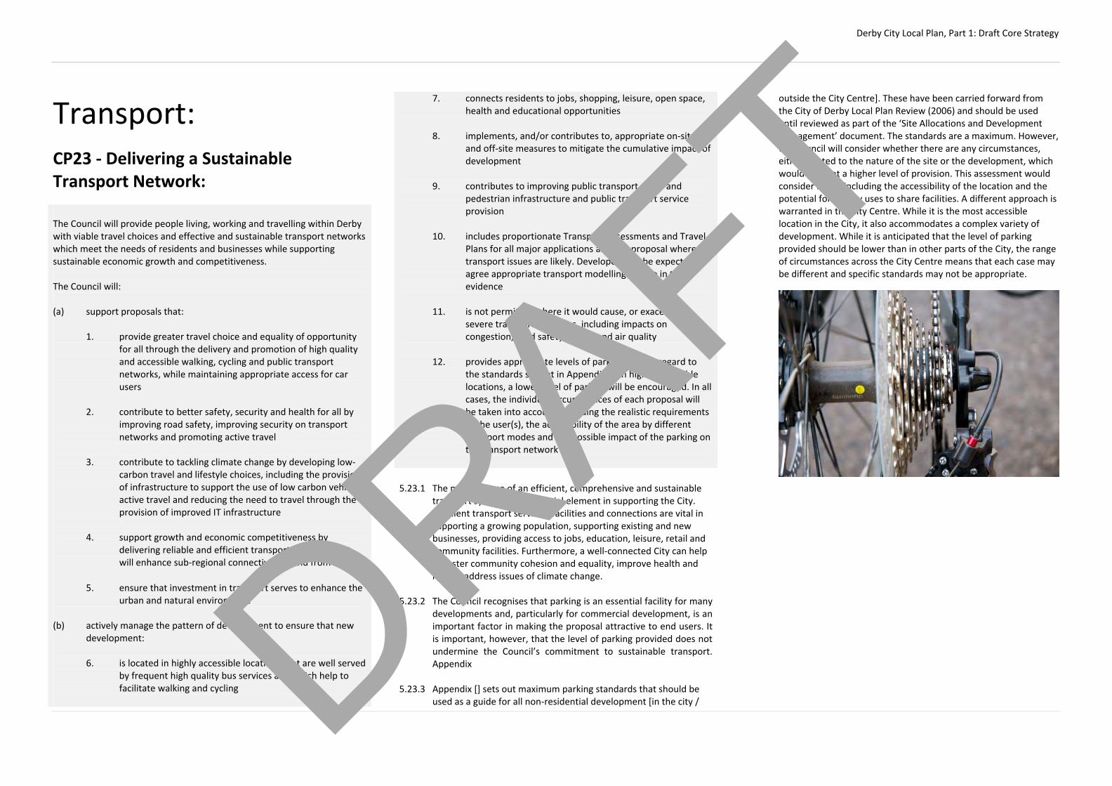
Derby City Local Plan, Part 1: Draft Core Strategy
Transport:
CP23 ‐ Delivering a Sustainable Transport Network: The Council will provide people living, working and travelling within Derby with viable travel choices and effective and sustainable transport networks which meet the needs of residents and businesses while supporting sustainable economic growth and competitiveness. The Council will:
(a) support proposals that:
1. provide greater travel choice and equality of opportunity
for all through the delivery and promotion of high quality and accessible walking, cycling and public transport networks, while maintaining appropriate access for car users
2. contribute to better safety, security and health for all by
improving road safety, improving security on transport networks and promoting active travel
3. contribute to tackling climate change by developing low‐
carbon travel and lifestyle choices, including the provision of infrastructure to support the use of low carbon vehicles, active travel and reducing the need to travel through the provision of improved IT infrastructure
4. support growth and economic competitiveness by
delivering reliable and efficient transport networks that will enhance sub‐regional connectivity to and from the City
5. ensure that investment in transport serves to enhance the
urban and natural environment
(b) actively manage the pattern of development to ensure that new development:
6. is located in highly accessible locations that are well served
by frequent high quality bus services and which help to facilitate walking and cycling
7. connects residents to jobs, shopping, leisure, open space, health and educational opportunities
8. implements, and/or contributes to, appropriate on‐site
and off‐site measures to mitigate the cumulative impact of development
9. contributes to improving public transport, cycle and
pedestrian infrastructure and public transport service provision
10. includes proportionate Transport Assessments and Travel
Plans for all major applications and any proposal where transport issues are likely. Developers will be expected to agree appropriate transport modelling for use in their evidence
11. is not permitted where it would cause, or exacerbate,
severe transport problems, including impacts on congestion, road safety, access and air quality
12. provides appropriate levels of parking, having regard to
the standards set out in Appendix X. In highly accessible locations, a lower level of parking will be encouraged. In all cases, the individual circumstances of each proposal will be taken into account, including the realistic requirements of the user(s), the accessibility of the area by different transport modes and the possible impact of the parking on the transport network
5.23.1 The maintenance of an efficient, comprehensive and sustainable
transport system is an essential element in supporting the City. Excellent transport services, facilities and connections are vital in supporting a growing population, supporting existing and new businesses, providing access to jobs, education, leisure, retail and community facilities. Furthermore, a well‐connected City can help to foster community cohesion and equality, improve health and help to address issues of climate change.
5.23.2 The Council recognises that parking is an essential facility for many
developments and, particularly for commercial development, is an important factor in making the proposal attractive to end users. It is important, however, that the level of parking provided does not undermine the Council’s commitment to sustainable transport. Appendix
5.23.3 Appendix [] sets out maximum parking standards that should be
used as a guide for all non‐residential development [in the city /
outside the City Centre]. These have been carried forward from the City of Derby Local Plan Review (2006) and should be used until reviewed as part of the ‘Site Allocations and Development Management’ document. The standards are a maximum. However, the Council will consider whether there are any circumstances, either related to the nature of the site or the development, which would warrant a higher level of provision. This assessment would consider issues including the accessibility of the location and the potential for nearby uses to share facilities. A different approach is warranted in the City Centre. While it is the most accessible location in the City, it also accommodates a complex variety of development. While it is anticipated that the level of parking provided should be lower than in other parts of the City, the range of circumstances across the City Centre means that each case may be different and specific standards may not be appropriate.
DRAFT
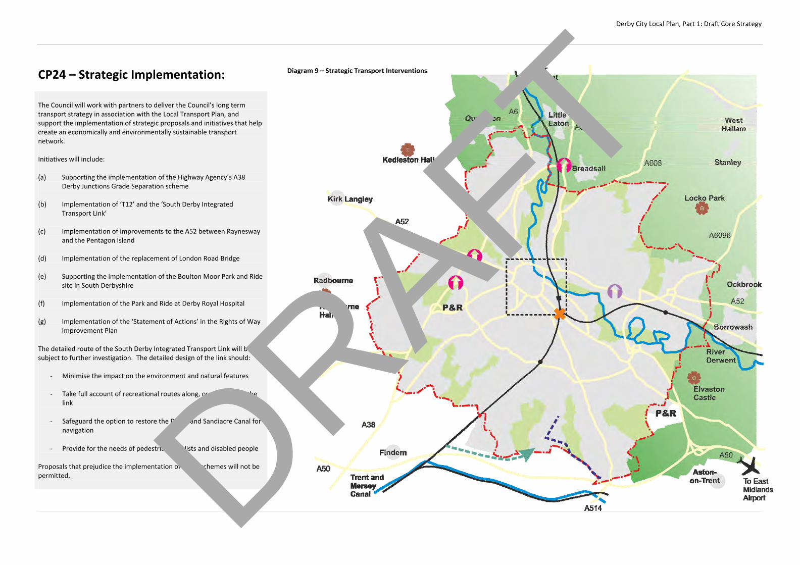
Derby City Local Plan, Part 1: Draft Core Strategy
CP24 – Strategic Implementation: The Council will work with partners to deliver the Council’s long term transport strategy in association with the Local Transport Plan, and support the implementation of strategic proposals and initiatives that help create an economically and environmentally sustainable transport network. Initiatives will include: (a) Supporting the implementation of the Highway Agency’s A38
Derby Junctions Grade Separation scheme (b) Implementation of ‘T12’ and the ‘South Derby Integrated
Transport Link’ (c) Implementation of improvements to the A52 between Raynesway
and the Pentagon Island (d) Implementation of the replacement of London Road Bridge (e) Supporting the implementation of the Boulton Moor Park and Ride
site in South Derbyshire (f) Implementation of the Park and Ride at Derby Royal Hospital (g) Implementation of the ‘Statement of Actions’ in the Rights of Way
Improvement Plan
The detailed route of the South Derby Integrated Transport Link will be subject to further investigation. The detailed design of the link should:
‐ Minimise the impact on the environment and natural features
‐ Take full account of recreational routes along, or affected by, the link
‐ Safeguard the option to restore the Derby and Sandiacre Canal for navigation
‐ Provide for the needs of pedestrians, cyclists and disabled people Proposals that prejudice the implementation of these schemes will not be permitted.
Diagram 9 – Strategic Transport Interventions
DRAFT
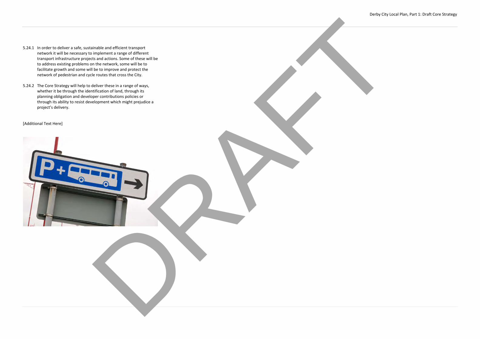
Derby City Local Plan, Part 1: Draft Core Strategy
5.24.1 In order to deliver a safe, sustainable and efficient transport
network it will be necessary to implement a range of different transport infrastructure projects and actions. Some of these will be to address existing problems on the network, some will be to facilitate growth and some will be to improve and protect the network of pedestrian and cycle routes that cross the City.
5.24.2 The Core Strategy will help to deliver these in a range of ways,
whether it be through the identification of land, through its planning obligation and developer contributions policies or through its ability to resist development which might prejudice a project’s delivery.
[Additional Text Here]
DRAFT

Derby City Local Plan, Part 1: Draft Core Strategy
6. Areas of Change
The City Centre:
AC1 - City Centre Strategy: The Council is committed to delivering a renaissance for the City Centre and reinforcing its central economic, cultural and social role by supporting sustainable economic growth and regeneration, improving the quality built environment, creating new residential neighbourhoods and enhancing its standing as a regionally important business, shopping, leisure, tourism and cultural destination. The Council will: (a) Encourage investment which strengthens and integrates the City
Centre’s retail, employment, leisure, cultural and residential functions and meets overall sustainability objectives
(b) Use its assets and seek all appropriate sources of Government and
EU funding to help create a thriving business environment and promote the Central Business District (CBD) as the preferred location for major new business, leisure, hotel or conferencing development
(c) Promote the ‘Core Area’(CA) as the preferred location for new
retail development and support proposals which serve to protect and enhance its overall vitality and viability. Regard will be given to the role, function and vision for different frontages within the CA
(d) Identify policies and priorities that will reinforce the specific character and roles for distinct City Centre character areas, including the Cathedral Quarter, St Peters Quarter, the Westfield Area, the Riverside and the Eastern Fringes,
(e) Support the delivery of a minimum of 1700 new homes across the City Centre through the delivery of key regeneration sites, realising the opportunities created by the ‘Our City, Our River’ Masterplan and by making better use of under used or vacant buildings and upper floors
(f) Establish the City Centre as a year round leisure, cultural and
festival destination through the diversification of the cultural, leisure and tourism offer by encouraging the development of new venues and visitor attractions. The Council will review Derby’s large scale performing arts infrastructure, currently delivered through the Assembly Rooms.
(g) Create a safe and inclusive City Centre by supporting the development of family orientated facilities that appeal to all residents and visitors, in particular uses that support the early evening economy and maintain the City’s ‘Purple Flag’ status. It will have regard to the character of the City Centre and crime and disorder by regulating the number and location of pubs, nightclubs and other licensed premises, hot food takeaways and taxi ranks
(h) Strengthen quality in every aspect of placemaking and reinforce distinctiveness through architecture, public realm and public art, while strengthening key routes between major spaces and nodes
(i) Enhance key heritage assets which have the greatest potential for
positive impact on the townscape character and vitality of the City Centre
(j) Maximise the potential of the riverside. The Council will promote
the use of the river and river corridor as part of the leisure infrastructure, improve safety and establish the river as a key connecting route within the city. The Council will work with the Environment Agency to deliver the Our City, Our River Masterplan.
(k) Make the City Centre the focus of sustainable transport nodes and
improve accessibility by all modes of transport
6.1.1 Derby City Centre is the main focus for commercial uses, business and shopping within the City and has an influence and attraction that stretches far beyond the City’s boundaries. Maintaining and enhancing its role as a sub-regional centre is a key policy of the Core Strategy.
6.1.2 To this end, the Council is seeking to encourage new investment
into the Centre and to improve the range and quality of services offered. This not only relates to improving the retail offer of the centre where possible, it also seeks to
6.1.3 Challenges resulting from the recession, the growth of alternative
forms of retailing and the re-organisation of the City Centre as a result of the development of the Westfield shopping centre will only increase the need to diversity and quality of the offer, for both existing residents and visitors to the City. These themes are addressed in more detail throughout the Strategy, though this policy establishes the strategic framework within which this will be delivered.
6.1.4 Policy AC2 sets out more detailed priorities for different parts of
the City Centre and identifies Regeneration Priority schemes that will help to deliver a ‘City Centre Renaissance’. The Council will take a positive stance toward development within the City Centre that can help deliver these schemes and enhance the economy of the centre or increase its attractiveness of a place to live and work. This will always, however, be subject to proposals respecting the heritage of the Centre, in particular the World Heritage Site, Conservation Area and Listed Buildings.
6.1.5 The City Council recognises the importance that Derby’s heritage
plays in making the experience within the City attractive and varied. From niche shopping in the Cathedral Quarter area, to the
DRAFT
Derby City Local Plan, Part 1: Draft Core Strategy
Silk Mill and World Heritage site, the City has used its heritage as a placemaking tool, capitalising on it in maintaining existing and encouraging new development. The City is committed to the continuation of this practice to use heritage to maintain and create a sustainable retail environment and economic vitality
DRAFT
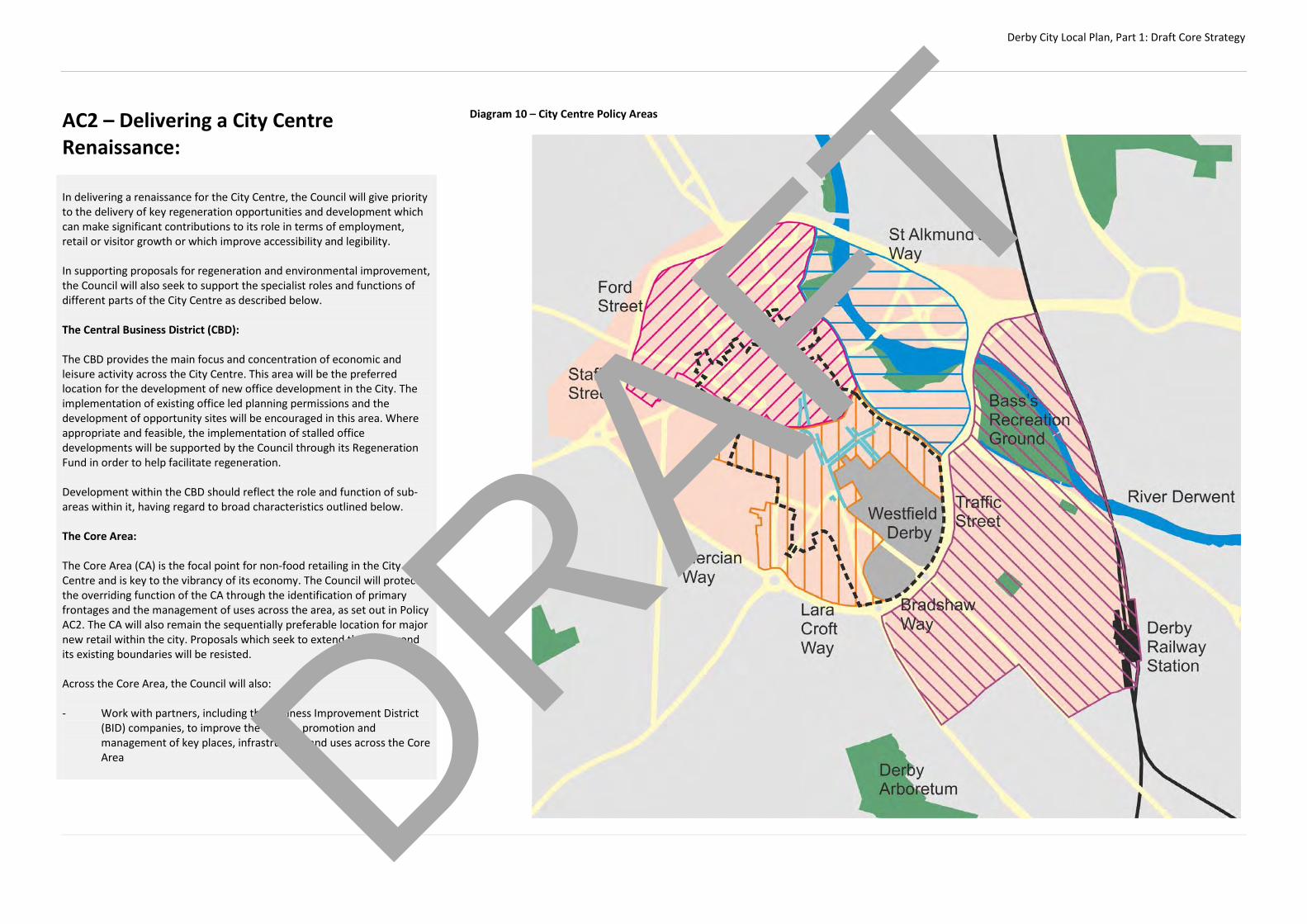
Derby City Local Plan, Part 1: Draft Core Strategy
AC2 – Delivering a City Centre Renaissance: In delivering a renaissance for the City Centre, the Council will give priority to the delivery of key regeneration opportunities and development which can make significant contributions to its role in terms of employment, retail or visitor growth or which improve accessibility and legibility. In supporting proposals for regeneration and environmental improvement, the Council will also seek to support the specialist roles and functions of different parts of the City Centre as described below. The Central Business District (CBD): The CBD provides the main focus and concentration of economic and leisure activity across the City Centre. This area will be the preferred location for the development of new office development in the City. The implementation of existing office led planning permissions and the development of opportunity sites will be encouraged in this area. Where appropriate and feasible, the implementation of stalled office developments will be supported by the Council through its Regeneration Fund in order to help facilitate regeneration. Development within the CBD should reflect the role and function of sub-areas within it, having regard to broad characteristics outlined below. The Core Area: The Core Area (CA) is the focal point for non-food retailing in the City Centre and is key to the vibrancy of its economy. The Council will protect the overriding function of the CA through the identification of primary frontages and the management of uses across the area, as set out in Policy AC2. The CA will also remain the sequentially preferable location for major new retail within the city. Proposals which seek to extend the CA beyond its existing boundaries will be resisted. Across the Core Area, the Council will also: - Work with partners, including the Business Improvement District
(BID) companies, to improve the quality, promotion and management of key places, infrastructure and uses across the Core Area
Diagram 10 – City Centre Policy Areas
DRAFT

Derby City Local Plan, Part 1: Draft Core Strategy
- Ensure new retail development is well integrated and closely
linked with the primary frontages in terms of proximity, continuity of function and ease of access
- Maintain an appropriate level of retail market provision having
regard to the Markets review currently being undertaken The Cathedral Quarter: The ‘Cathedral Quarter’ represents the historic core of the City Centre. Within the Core Area, the Council will encourage proposals which support its niche high quality shopping, leisure and evening economy role. Outside the Core Area, the strategy will also seek to strengthen the City Centre’s emerging office and commercial function. The Cathedral Quarter as a whole has an increasingly important role in supporting the evening economy of the City and this will be reflected in the nature of the uses permitted. Within the Cathedral Quarter, priority will be given to the following opportunities: - Implementation of the Sadler Square mixed-use regeneration
scheme
- Implementation of the St James’ Yard retail scheme
- Implementation of office schemes on Cathedral Road
St Peters Quarter: The ‘St Peters Quarter’ reflects the more modern shopping core and provides crucial pedestrian links between the historic core, the Westfield area and the Riverside. It almost entirely sits within the CA and contains a large number of primary and secondary frontages. There is a diverse range of shopping and complementary activities that will be managed to ensure they continue to contribute to the overall vitality and viability of the City Centre. Within the St Peter’s Quarter, priority will be given to the following opportunities: - Mixed-use regeneration of Becket Well and Duckworth Square
- East Street / Albion Street / Exchange Street
- Implementation of public realm improvements at The Spot and St Peter’s Cross
Westfield Shopping Area: The ‘Westfield Shopping Area’ contains the modern Westfield Shopping Centre and the Bradshaw Way Retail Park. This reflects the most recent retail and leisure development in the city. Westfield Shopping Centre has become the focus of shopping and leisure activity in recent years. The strategy will seek to enhance the integration between this area and the rest of the CA and support any further regeneration that can further enhance the retail and leisure offer. Proposals for the regeneration of the Bradshaw Way Retail Park will be supported, provided they include a significant retail element and would not exacerbate impacts on the Cathedral Quarter or St Peters Quarter. Riverside: The Riverside area consists of a diverse range of residential, commercial and civic uses. The Council will seek to emphasise this role by maximising the potential of the Riverside. The Council will promote the use of the river and river corridor as part of the leisure infrastructure, improve safety and establish the river as a key connecting route within the city. It will seek to incorporate the flood defences into appropriate regeneration projects including the green infrastructure, public realm design and buildings. Priority will be given to the following projects: - Implementation of the ‘Our City, Our River’ Masterplan in line with
Policy AC8 - Delivery of the Riverlights Aquatic Centre, including 50m
swimming pool - Regeneration of the former Magistrates Court and Police Station
regeneration scheme, including the provision of a new Local Studies library
The Eastern Fringes: The ‘Eastern Fringes’ will become a vibrant new residential neighbourhood that will complement the City Centre economy and breathe new life into an underutilised area. It will also contain significant commercial uses that can help support the overall City Centre economy. Improvements will be made to links to Bass’ Recreation Ground and hope to increase usage of the park to help support the new communities.
The Council will work with partners to deliver improvements to the railway station and links between the station and the City Centre. Priority will be given to the implementation of the major mixed use regeneration allocations at Castleward and former DRI sites, in line with requirements of Policy AC6. Implementation of the ‘Castleward Boulevard’ to improve links between the Railway Station and City Centre will be a key part of this scheme. The regeneration of the Trent Bus Depot and Derby Evening Telegraph sites to the north of Bass’ Recreation Ground will be supported, subject to the satisfactory relocation of existing businesses and the implementation of the ‘Our City, Our River’ Masterplan. [Justification to be added…]
DRAFT

Derby City Local Plan, Part 1: Draft Core Strategy
DRAFT
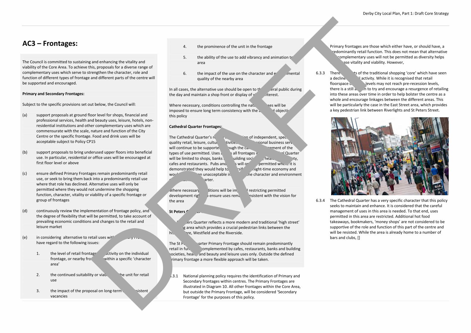
Derby City Local Plan, Part 1: Draft Core Strategy
AC3 – Frontages: The Council is committed to sustaining and enhancing the vitality and viability of the Core Area. To achieve this, proposals for a diverse range of complementary uses which serve to strengthen the character, role and function of different types of frontage and different parts of the centre will be supported and encouraged. Primary and Secondary Frontages: Subject to the specific provisions set out below, the Council will: (a) support proposals at ground floor level for shops, financial and
professional services, health and beauty uses, leisure, hotels, non-residential institutions and other complementary uses which are commensurate with the scale, nature and function of the City Centre or the specific frontage. Food and drink uses will be acceptable subject to Policy CP15
(b) support proposals to bring underused upper floors into beneficial
use. In particular, residential or office uses will be encouraged at first floor level or above
(c) ensure defined Primary Frontages remain predominantly retail
use, or seek to bring them back into a predominantly retail use where that role has declined. Alternative uses will only be permitted where they would not undermine the shopping function, character, vitality or viability of a specific frontage or group of frontages
(d) continuously review the implementation of frontage policy, and the degree of flexibility that will be permitted, to take account of prevailing economic conditions and changes to the retail and leisure market
(e) in considering alternative to retail uses within Primary Frontages,
have regard to the following issues: 1. the level of retail frontage and activity on the individual
frontage, or nearby frontages within a specific ‘character area’
2. the continued suitability or viability of the unit for retail
use 3. the impact of the proposal on long-term and persistent
vacancies
4. the prominence of the unit in the frontage 5. the ability of the use to add vibrancy and animation to the
area 6. the impact of the use on the character and environmental
quality of the nearby area
In all cases, the alternative use should be open to the general public during the day and maintain a shop front or display of visual interest. Where necessary, conditions controlling the nature of uses will be imposed to ensure long term consistency with the aims and objectives of this policy Cathedral Quarter Frontages:
The Cathedral Quarter’s role in the provision of independent, specialist quality retail, leisure, cultural activities and professional business services will continue to be supported through the careful management of the types of use permitted. Uses across all frontages in the Cathedral Quarter will be limited to shops, banks and building societies , health and beauty, cafes and restaurants. Pubs and clubs will only be permitted where it is demonstrated they would help to diversify the night-time economy and would not have an unacceptable impact on the character and environment of the Cathedral Quarter. Where necessary conditions will be imposed restricting permitted development rights to ensure uses remain consistent with the vision for the area
St Peters Quarter Frontages:
The St Peters Quarter reflects a more modern and traditional ‘high street’ shopping area which provides a crucial pedestrian links between the historic core, Westfield and the Riverside. The St Peters Quarter Primary Frontage should remain predominantly retail in function, complemented by cafes, restaurants, banks and building societies, health and beauty and leisure uses only. Outside the defined primary frontage a more flexible approach will be taken. 6.3.1 National planning policy requires the identification of Primary and
Secondary frontages within centres. The Primary Frontages are illustrated in Diagram 10. All other frontages within the Core Area, but outside the Primary Frontage, will be considered ‘Secondary Frontage’ for the purposes of this policy.
6.3.2 Primary frontages are those which either have, or should have, a
predominantly retail function. This does not mean that alternative and complementary uses will not be permitted as diversity helps to increase vitality and viability. However,
6.3.3 There are parts of the traditional shopping ‘core’ which have seen
a decline in retail activity. While it is recognised that retail floorspace or usage levels may not reach pre-recession levels, there is a still an aim to try and encourage a resurgence of retailing into these areas over time in order to help bolster the centre as a whole and encourage linkages between the different areas. This will be particularly the case in the East Street area, which provides a key pedestrian link between Riverlights and St Peters Street.
6.3.4 The Cathedral Quarter has a very specific character that this policy
seeks to maintain and enhance. It is considered that the careful management of uses in this area is needed. To that end, uses permitted in this area are restricted. Additional hot food takeaways, bookmakers, ‘money shops’ are not considered to be supportive of the role and function of this part of the centre and will be resisted. While the area is already home to a number of bars and clubs, []
DRAFT

Derby City Local Plan, Part 1: Draft Core Strategy
AC4 - City Centre Transport & Accessibility:
[Justification to be added…]
The Council will deliver a transport strategy for the City centre that supports its continued economic growth through the facilitation of movement of people, goods and services. In particular, it will seek to maximise the efficiency of the transport network and provide equality of opportunity through sustainable access choices, providing for and promoting the use of cycling, walking and public transport. The Council will: (a) encourage developers to make the most, and strengthen, the
opportunities provided by existing walking and cycling networks
(b) encourage developers to work with public transport providers to ensure that all users are able to access development by sustainable means, especially taking account of times when developments are likely to be busiest
(c) implement public realm improvements to improve access and
legibility across the city centre (d) support proposals that improve pedestrian safety, improve air
quality and increase the scope for accessible public realm improvements
(e) ensure development provides a level of car parking which reflects
the realistic requirements of the users and the highly accessible nature of the city centre. Parking should not take precedence over facilities provided for more sustainable modes of access. Regard will be given to the standards set out in the Appendix X.
Within the CBD, sites with awaiting redevelopment will only be allowed to be used for public parking, provided that the additional spaces; 1. would meet an identified deficiency or need, 2. would not undermine the objectives for promoting the use of
public transport, cycle or walking, particularly for commuting and long-stay visits
3. would not cause, or exacerbate, traffic problems – either locally or
across the city centre, and 4. would be used for a period of no more than two years
DRAFT
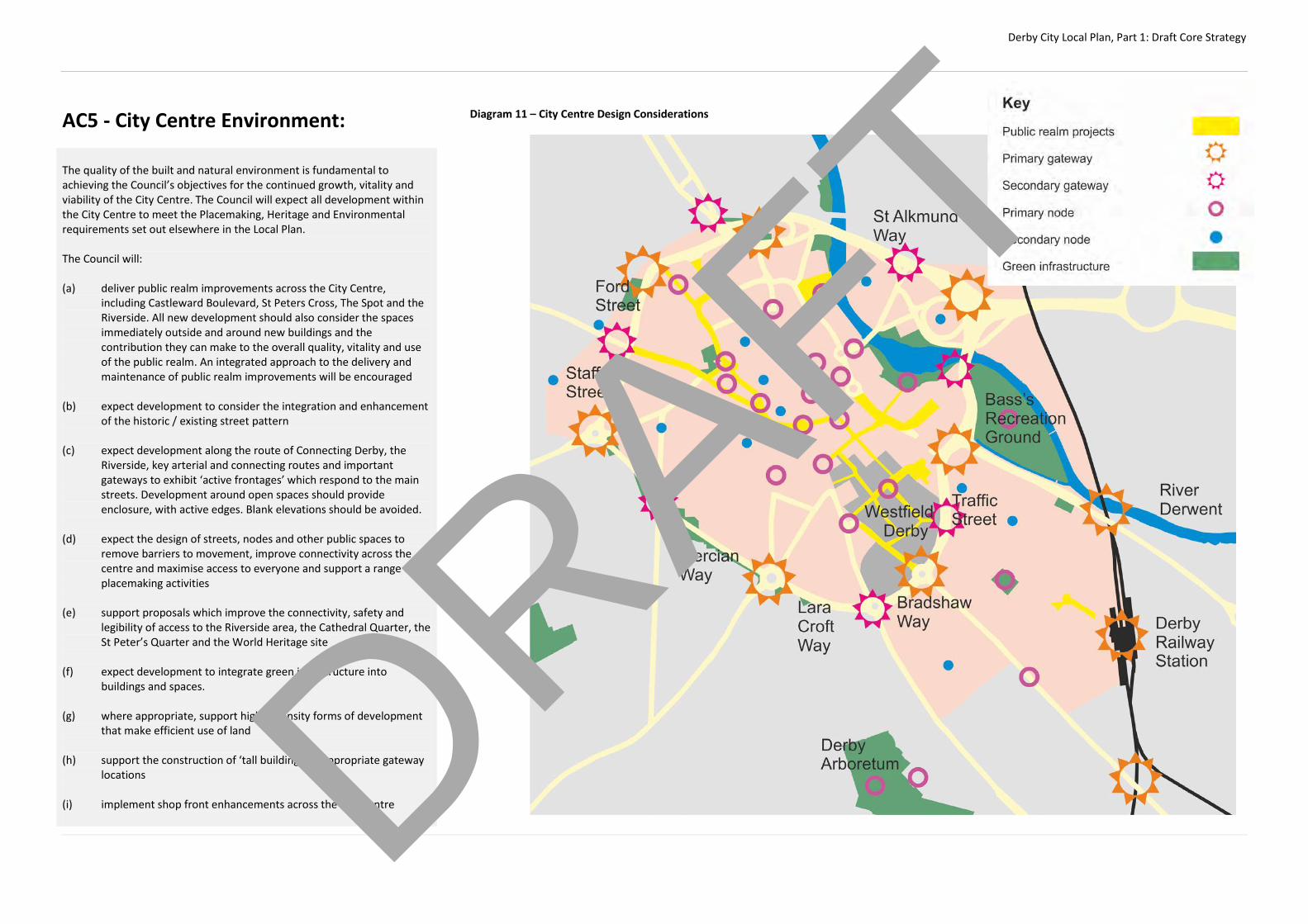
Derby City Local Plan, Part 1: Draft Core Strategy
AC5 - City Centre Environment: The quality of the built and natural environment is fundamental to achieving the Council’s objectives for the continued growth, vitality and viability of the City Centre. The Council will expect all development within the City Centre to meet the Placemaking, Heritage and Environmental requirements set out elsewhere in the Local Plan. The Council will:
(a) deliver public realm improvements across the City Centre,
including Castleward Boulevard, St Peters Cross, The Spot and the Riverside. All new development should also consider the spaces immediately outside and around new buildings and the contribution they can make to the overall quality, vitality and use of the public realm. An integrated approach to the delivery and maintenance of public realm improvements will be encouraged
(b) expect development to consider the integration and enhancement
of the historic / existing street pattern (c) expect development along the route of Connecting Derby, the
Riverside, key arterial and connecting routes and important gateways to exhibit ‘active frontages’ which respond to the main streets. Development around open spaces should provide enclosure, with active edges. Blank elevations should be avoided.
(d) expect the design of streets, nodes and other public spaces to
remove barriers to movement, improve connectivity across the centre and maximise access to everyone and support a range of placemaking activities
(e) support proposals which improve the connectivity, safety and
legibility of access to the Riverside area, the Cathedral Quarter, the St Peter’s Quarter and the World Heritage site
(f) expect development to integrate green infrastructure into
buildings and spaces. (g) where appropriate, support higher density forms of development
that make efficient use of land (h) support the construction of ‘tall buildings’ in appropriate gateway
locations (i) implement shop front enhancements across the City Centre
Diagram 11 – City Centre Design Considerations
DRAFT
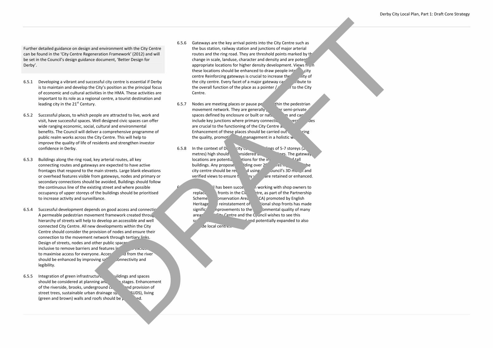
Derby City Local Plan, Part 1: Draft Core Strategy
Further detailed guidance on design and environment with the City Centre can be found in the ‘City Centre Regeneration Framework’ (2012) and will be set in the Council’s design guidance document, ‘Better Design for Derby’. 6.5.1 Developing a vibrant and successful city centre is essential if Derby
is to maintain and develop the City’s position as the principal focus of economic and cultural activities in the HMA. These activities are important to its role as a regional centre, a tourist destination and leading city in the 21st Century.
6.5.2 Successful places, to which people are attracted to live, work and
visit, have successful spaces. Well designed civic spaces can offer wide ranging economic, social, cultural and environmental benefits. The Council will deliver a comprehensive programme of public realm works across the City Centre. This will help to improve the quality of life of residents and strengthen investor confidence in Derby.
6.5.3 Buildings along the ring road, key arterial routes, all key
connecting routes and gateways are expected to have active frontages that respond to the main streets. Large blank elevations or overhead features visible from gateways, nodes and primary or secondary connections should be avoided, Buildings should follow the continuous line of the existing street and where possible occupancy of upper storeys of the buildings should be prioritised to increase activity and surveillance.
6.5.4 Successful development depends on good access and connections.
A permeable pedestrian movement framework created through a hierarchy of streets will help to develop an accessible and well connected City Centre. All new developments within the City Centre should consider the provision of nodes and ensure their connection to the movement network through tertiary links. Design of streets, nodes and other public spaces should be inclusive to remove barriers and features leading to exclusion and to maximise access for everyone. Access to and from the river should be enhanced by improving safety, connectivity and legibility.
6.5.5 Integration of green infrastructure into buildings and spaces
should be considered at planning and design stages. Enhancement of the riverside, brooks, underground culverts and provision of street trees, sustainable urban drainage systems (SUDS), living (green and brown) walls and roofs should be prioritised.
6.5.6 Gateways are the key arrival points into the City Centre such as the bus station, railway station and junctions of major arterial routes and the ring road. They are threshold points marked by the change in scale, landuse, character and density and are potentially appropriate locations for higher density development. Views from these locations should be enhanced to draw people into the city centre Reinforcing gateways is crucial to increase the legibility of the city centre. Every facet of a major gateway can contribute to the overall function of the place as a pointer / marker to the City Centre.
6.5.7 Nodes are meeting places or pause points within the pedestrian
movement network. They are generally public or semi-private spaces defined by enclosure or built or natural form and can include key junctions where primary connections converge. Nodes are crucial to the functioning of the City Centre as a place. Enhancement of these places should be carried out considering the quality, promotion and management in a holistic way.
6.5.8 In the context of Derby city centre, buildings of 5-7 storeys (20
metres) high should be considered as tall buildings. The gateway locations are potential locations for the introduction of tall buildings. Any proposed building over 20 metres high within the city centre should be reviewed using the Council’s 3D model and verified views to ensure that key views are retained or enhanced.
6.5.9 The Council has been successful in working with shop owners to
replace shop fronts in the City Centre, as part of the Partnership Schemes in Conservation Areas (PiSCA) promoted by English Heritage. The reinstatement of traditional shop fronts has made significant improvements to the environmental quality of many areas of the City Centre and the Council wishes to see this successful scheme continued and potentially expanded to also include local centres.
DRAFT

Derby City Local Plan, Part 1: Draft Core Strategy
AC6 – Castleward and the Former Derbyshire Royal Infirmary (DRI) The Eastern Fringes of the City Centre will be transformed into a vibrant residential and commercial neighbourhood where people will enjoy a high quality of life within a distinctive, accessible and sustainable urban environment. New residential neighbourhoods will be created in Castleward and the former DRI site, which will be complemented and supported by a mix of commercial, leisure and community uses that will also serve to support the wider economy of the City Centre. The regeneration of Castleward will deliver: - A minimum of 800 new high quality, mixed tenure homes; - New office and commercial uses, including major office
development adjacent to Traffic Street - A new primary and nursery school and other community facilities
to serve the new neighbourhood and/or replace existing facilities. The sharing of facilities and functions will be supported and encouraged where appropriate
- The ‘Castleward Boulevard’ pedestrian link between the railway
station and Core Area. Small scale convenience shopping and related commercial and community facilities will be permitted along the route of the ‘boulevard’ to support day-to-day needs and act as a focal point of the new neighbourhood
- Improved pedestrian and cycle access to Bass’ Recreation Ground
The regeneration of the former DRI site will deliver: - A minimum of 400 new high quality mixed tenure homes; - The effective protection and enhancement of heritage assets
within and adjacent to the site; - A positive contribution to the townscape of London Road; In all parts of the Eastern the Council will expect:
- A high standard of design which reflects the requirements of Policy
CPX and CPX - A mix of housing typologies and supporting facilities to ensure that
the new neighbourhood attracts a diverse population and caters for the changing needs of residents;
- A ‘green link’ through the area providing a pedestrian and cycle
link from Arboretum Park to Bass’ Recreation Ground; - Measures to improve accessibility to, and from, the City Centre,
bus station and railway station by walking and cycling
The Council will work with partners to ensure that regeneration of the Eastern Fringes is delivered in a comprehensive manner and will use compulsory purchase powers if necessary to ensure delivery.
Justification to be added…
DRAFT
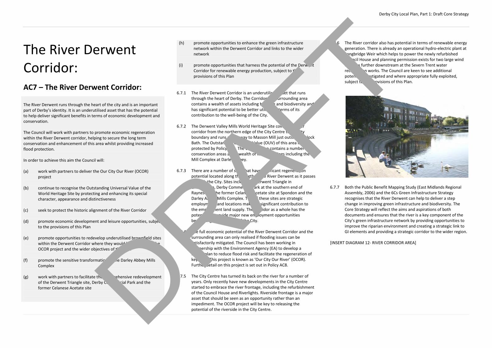
Derby City Local Plan, Part 1: Draft Core Strategy
The River Derwent Corridor:
AC7 – The River Derwent Corridor:
(h) promote opportunities to enhance the green infrastructure network within the Derwent Corridor and links to the wider network
(i) promote opportunities that harness the potential of the Derwent
Corridor for renewable energy production, subject to the provisions of this Plan
6.7.1 The River Derwent Corridor is an underutilised asset that runs
through the heart of Derby. The Corridor and surrounding area contains a wealth of assets including heritage and biodiversity and has significant potential to be better utilised in terms of its contribution to the well-being of the City.
6.7.2 The Derwent Valley Mills World Heritage Site covers the river
corridor from the northern edge of the City Centre to the city boundary and runs all the way to Masson Mill just outside Matlock Bath. The Outstanding Universal Value (OUV) of this area is protected by Policy AC9. The corridor also contains a number of conservation areas and a wealth of listed buildings including the Mill Complex at Darley Abbey.
6.7.3 There are a number of sites that have significant regeneration
potential located along the length of the River Derwent as it passes through the City. Sites include the Derwent Triangle in Chaddesden, Derby Commercial Park at the southern end of Raynesway, the former Celanese Acetate site at Spondon and the Darley Abbey Mills Complex. Two of these sites are strategic employment land locations making a significant contribution to the employment land supply. The Corridor as a whole has the potential to provide major new employment opportunities benefitting the economy of the City.
6.7.4 The full economic potential of the River Derwent Corridor and the
surrounding area can only realised if flooding issues can be satisfactorily mitigated. The Council has been working in partnership with the Environment Agency (EA) to develop a Masterplan to reduce flood risk and facilitate the regeneration of key sites. This project is known as ‘Our City Our River’ (OCOR). Further detail on this project is set out in Policy AC8.
6.7.5 The City Centre has turned its back on the river for a number of
years. Only recently have new developments in the City Centre started to embrace the river frontage, including the refurbishment of the Council House and Riverlights. Riverside frontage is a major asset that should be seen as an opportunity rather than an impediment. The OCOR project will be key to releasing the potential of the riverside in the City Centre.
6.7.6 The River corridor also has potential in terms of renewable energy generation. There is already an operational hydro-electric plant at Longbridge Weir which helps to power the newly refurbished Council House and planning permission exists for two large wind turbines further downstream at the Severn Trent water reclamation works. The Council are keen to see additional potential investigated and where appropriate fully exploited, subject to the provisions of this Plan.
6.7.7 Both the Public Benefit Mapping Study (East Midlands Regional
Assembly, 2006) and the 6Cs Green Infrastructure Strategy recognises that the River Derwent can help to deliver a step change in improving green infrastructure and biodiversity. The Core Strategy will reflect the aims and aspirations of both documents and ensures that the river is a key component of the City’s green infrastructure network by providing opportunities to improve the riparian environment and creating a strategic link to GI elements and providing a strategic corridor to the wider region.
[INSERT DIAGRAM 12- RIVER CORRIDOR AREA]
The River Derwent runs through the heart of the city and is an important part of Derby’s identity. It is an underutilised asset that has the potential to help deliver significant benefits in terms of economic development and conservation. The Council will work with partners to promote economic regeneration within the River Derwent corridor, helping to secure the long term conservation and enhancement of this area whilst providing increased flood protection. In order to achieve this aim the Council will: (a) work with partners to deliver the Our City Our River (OCOR)
project (b) continue to recognise the Outstanding Universal Value of the
World Heritage Site by protecting and enhancing its special character, appearance and distinctiveness
(c) seek to protect the historic alignment of the River Corridor (d) promote economic development and leisure opportunities, subject
to the provisions of this Plan (e) promote opportunities to redevelop underutilised brownfield sites
within the Derwent Corridor where they would help to deliver the OCOR project and the wider objectives of this Plan
(f) promote the sensitive transformation of the Darley Abbey Mills
Complex (g) work with partners to facilitate the comprehensive redevelopment
of the Derwent Triangle site, Derby Commercial Park and the former Celanese Acetate site
DRAFT
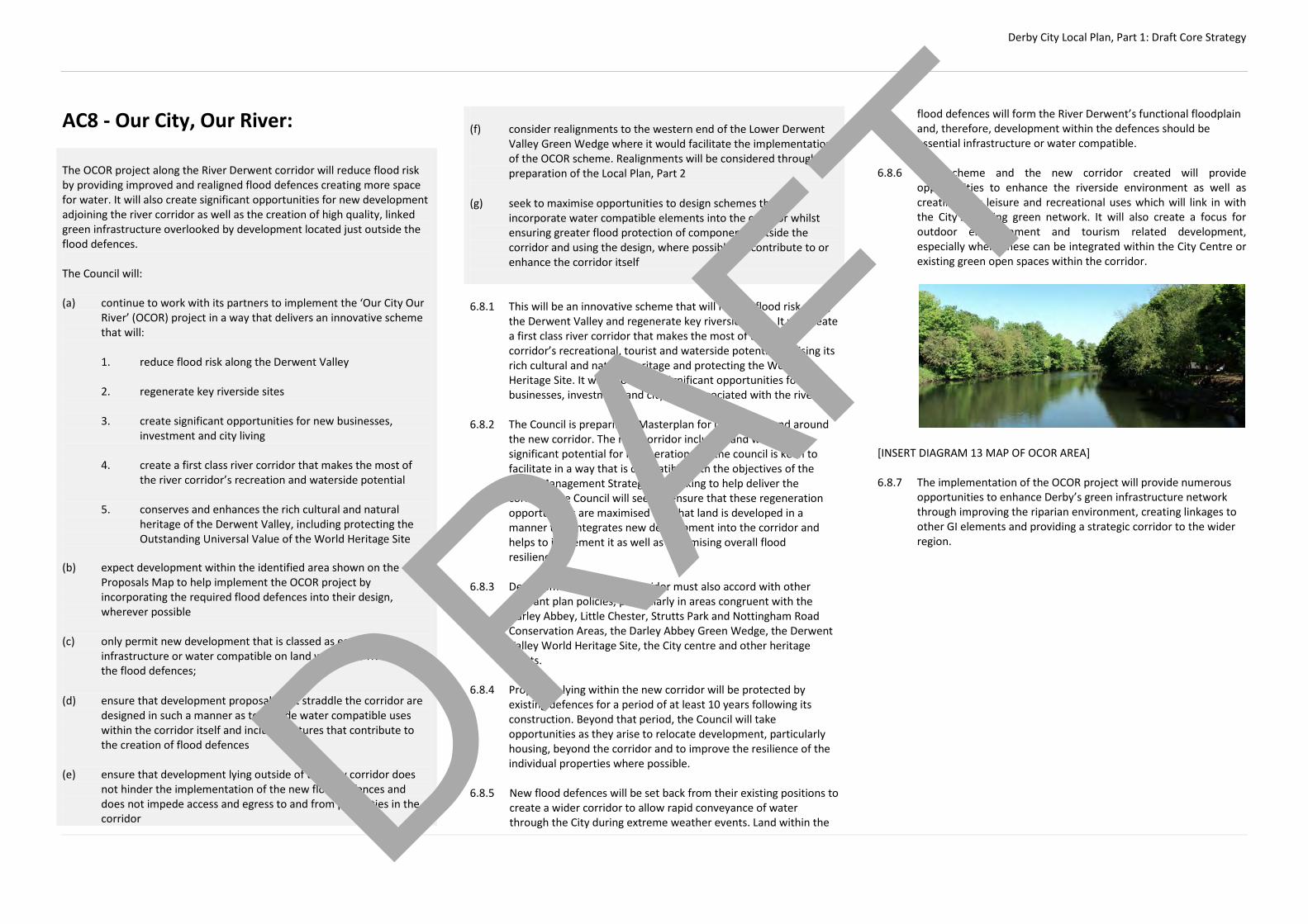
Derby City Local Plan, Part 1: Draft Core Strategy
AC8 - Our City, Our River: The OCOR project along the River Derwent corridor will reduce flood risk by providing improved and realigned flood defences creating more space for water. It will also create significant opportunities for new development adjoining the river corridor as well as the creation of high quality, linked green infrastructure overlooked by development located just outside the flood defences. The Council will: (a) continue to work with its partners to implement the ‘Our City Our
River’ (OCOR) project in a way that delivers an innovative scheme that will:
1. reduce flood risk along the Derwent Valley 2. regenerate key riverside sites 3. create significant opportunities for new businesses,
investment and city living 4. create a first class river corridor that makes the most of
the river corridor’s recreation and waterside potential 5. conserves and enhances the rich cultural and natural
heritage of the Derwent Valley, including protecting the Outstanding Universal Value of the World Heritage Site
(b) expect development within the identified area shown on the
Proposals Map to help implement the OCOR project by incorporating the required flood defences into their design, wherever possible
(c) only permit new development that is classed as essential
infrastructure or water compatible on land within the riverside of the flood defences;
(d) ensure that development proposals that straddle the corridor are
designed in such a manner as to include water compatible uses within the corridor itself and include features that contribute to the creation of flood defences
(e) ensure that development lying outside of the new corridor does
not hinder the implementation of the new flood defences and does not impede access and egress to and from properties in the corridor
(f) consider realignments to the western end of the Lower Derwent
Valley Green Wedge where it would facilitate the implementation of the OCOR scheme. Realignments will be considered through the preparation of the Local Plan, Part 2
(g) seek to maximise opportunities to design schemes that
incorporate water compatible elements into the corridor whilst ensuring greater flood protection of components outside the corridor and using the design, where possible, to contribute to or enhance the corridor itself
6.8.1 This will be an innovative scheme that will reduce flood risk along
the Derwent Valley and regenerate key riverside sites. It will create a first class river corridor that makes the most of the river corridor’s recreational, tourist and waterside potential, utilising its rich cultural and natural heritage and protecting the World Heritage Site. It will also create significant opportunities for new businesses, investment and city living associated with the river.
6.8.2 The Council is preparing a Masterplan for uses within and around
the new corridor. The new corridor includes land which offers significant potential for regeneration and the council is keen to facilitate in a way that is compatible with the objectives of the Flood Management Strategy. In working to help deliver the corridor, the Council will seek to ensure that these regeneration opportunities are maximised and that land is developed in a manner that integrates new development into the corridor and helps to implement it as well as maximising overall flood resilience.
6.8.3 Development within the corridor must also accord with other
relevant plan policies, particularly in areas congruent with the Darley Abbey, Little Chester, Strutts Park and Nottingham Road Conservation Areas, the Darley Abbey Green Wedge, the Derwent Valley World Heritage Site, the City centre and other heritage assets.
6.8.4 Properties lying within the new corridor will be protected by
existing defences for a period of at least 10 years following its construction. Beyond that period, the Council will take opportunities as they arise to relocate development, particularly housing, beyond the corridor and to improve the resilience of the individual properties where possible.
6.8.5 New flood defences will be set back from their existing positions to
create a wider corridor to allow rapid conveyance of water through the City during extreme weather events. Land within the
flood defences will form the River Derwent’s functional floodplain and, therefore, development within the defences should be essential infrastructure or water compatible.
6.8.6 This scheme and the new corridor created will provide
opportunities to enhance the riverside environment as well as creating new leisure and recreational uses which will link in with the City’s existing green network. It will also create a focus for outdoor entertainment and tourism related development, especially where these can be integrated within the City Centre or existing green open spaces within the corridor.
[INSERT DIAGRAM 13 MAP OF OCOR AREA] 6.8.7 The implementation of the OCOR project will provide numerous
opportunities to enhance Derby’s green infrastructure network through improving the riparian environment, creating linkages to other GI elements and providing a strategic corridor to the wider region.
DRAFT

Derby City Local Plan, Part 1: Draft Core Strategy
AC9 – Derwent Valley Mills World Heritage Site: The Council recognises the Outstanding Universal Value (OUV) of the Derwent Valley Mills World Heritage Site and will seek to preserve, protect and enhance the special character, appearance and distinctiveness of the area, in line with the Derwent Valley Mills World Heritage Site Management Plan. The Council will: (a) require proposals (including changes of use and conversions)
within the area designated as a World Heritage Site to:
1. preserve, protect and enhance the OUV of the area 2. encourage the physical and economic revitalisation of the
area 3. enhance the area in terms of the siting, alignment,
materials mass, scale and design of new buildings 4. not harm and where possible protect and enhance the
biodiversity of the area; and 5. demonstrate how the proposal will contribute towards the
achievement of the management objectives outlined in Derwent Valley Mills World Heritage Site Management Plan
Proposals that do not appropriately respond to these criteria will be resisted.
(b) encourage opportunities to interpret and promote the significance
of the World Heritage Site and its assets and sustainably enhance its economic well-being
(c) only approve proposals for development outside the World Heritage Site, but within the World Heritage Site buffer zone if they do not have an adverse effect upon the OUV of the World Heritage Site or its setting, including specific monitored views into and out of the site
(d) only approve proposals for contemporary buildings within the
World Heritage Site and associated buffer zone where they are complementary to the OUV
(e) give special scrutiny to proposals for significant development within the World Heritage Site itself or the buffer zone which have the potential to impact upon the OUV. Proposals for significant development may be referred to the World Heritage Site Partnership for detailed appraisal
6.9.1 The ensemble of industrial sites and settlements dating from the
eighteenth to the early twentieth centuries situated in the lower Derwent Valley in Derbyshire represents a unique surviving example of outstanding human endeavour in what the world has recognised as the ‘Industrial Revolution'.
6.9.2 The textile mills of Matlock Bath, Cromford, Lea, Belper, Milford,
Darley Abbey and Derby were the forerunners of industrialisation through the development of the textile factory system that has led to the area becoming known as ‘the cradle of the new factory system’.
6.9.3 Innovations in mill building with the use of cast iron, fireproofing
and warm air heating influenced the development of modern architecture across Europe and the world. The need to provide housing and other facilities for workers and managers resulted in the creation of the first modern industrial towns. This area represents a significant stage in human history and technological advancement leading to the inscription of the area by UNESCO in 2001. The delicate balance between the historic and natural environments combined with the cultural significance of the area contribute to the creation of the Outstanding Universal Value (OUV) that makes this area so important.
6.9.4 The World Heritage Site stretches from the Silk Mill within Derby in
the south to Masson Mill at Matlock Bath in the north . Within the City, the site also incorporates Darley Park and the Darley Abbey Conservation Area, which includes the mill complex and factory village. The section in Derby forms the gateway to the rest of the World Heritage Site to the north. Further guidance on the Darley Abbey Mills Complex is set out in Policy AC10.
Diagram 14 – Extent of WHS in Derby
DRAFT
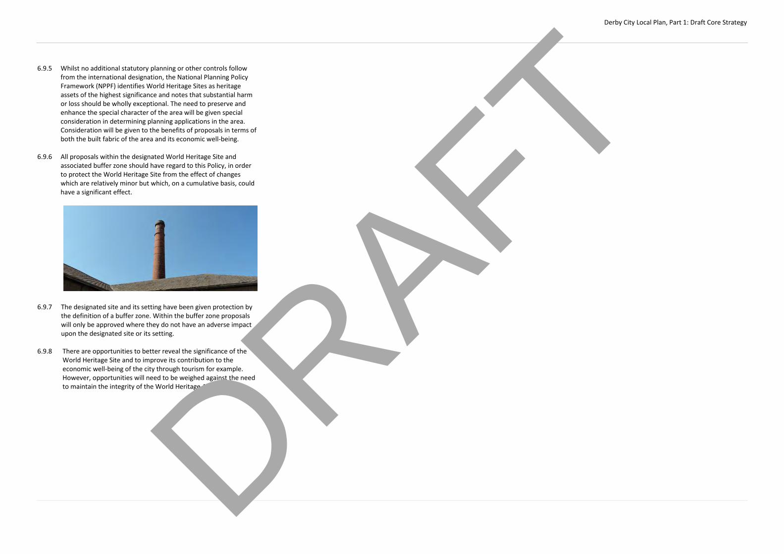
Derby City Local Plan, Part 1: Draft Core Strategy
6.9.5 Whilst no additional statutory planning or other controls follow from the international designation, the National Planning Policy Framework (NPPF) identifies World Heritage Sites as heritage assets of the highest significance and notes that substantial harm or loss should be wholly exceptional. The need to preserve and enhance the special character of the area will be given special consideration in determining planning applications in the area. Consideration will be given to the benefits of proposals in terms of both the built fabric of the area and its economic well-being.
6.9.6 All proposals within the designated World Heritage Site and
associated buffer zone should have regard to this Policy, in order to protect the World Heritage Site from the effect of changes which are relatively minor but which, on a cumulative basis, could have a significant effect.
6.9.7 The designated site and its setting have been given protection by
the definition of a buffer zone. Within the buffer zone proposals will only be approved where they do not have an adverse impact upon the designated site or its setting.
6.9.8 There are opportunities to better reveal the significance of the
World Heritage Site and to improve its contribution to the economic well-being of the city through tourism for example. However, opportunities will need to be weighed against the need to maintain the integrity of the World Heritage Asset.
DRAFT
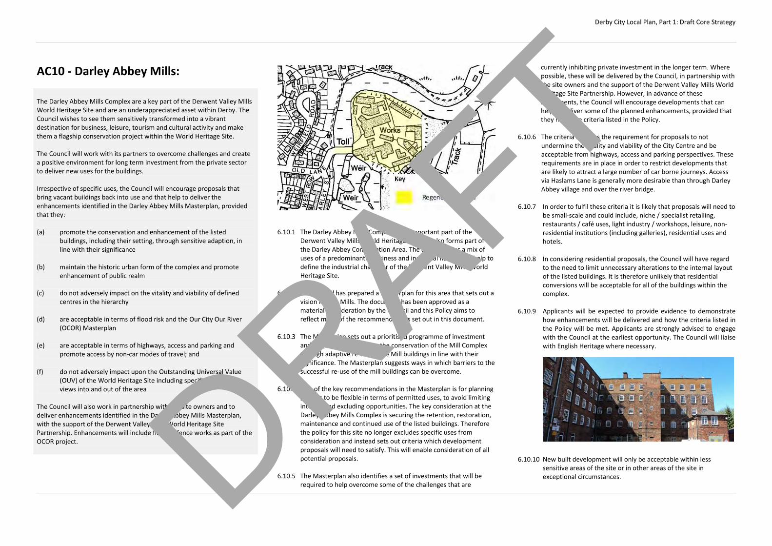
Derby City Local Plan, Part 1: Draft Core Strategy
AC10 - Darley Abbey Mills: The Darley Abbey Mills Complex are a key part of the Derwent Valley Mills World Heritage Site and are an underappreciated asset within Derby. The Council wishes to see them sensitively transformed into a vibrant destination for business, leisure, tourism and cultural activity and make them a flagship conservation project within the World Heritage Site. The Council will work with its partners to overcome challenges and create a positive environment for long term investment from the private sector to deliver new uses for the buildings. Irrespective of specific uses, the Council will encourage proposals that bring vacant buildings back into use and that help to deliver the enhancements identified in the Darley Abbey Mills Masterplan, provided that they: (a) promote the conservation and enhancement of the listed
buildings, including their setting, through sensitive adaption, in line with their significance
(b) maintain the historic urban form of the complex and promote
enhancement of public realm (c) do not adversely impact on the vitality and viability of defined
centres in the hierarchy (d) are acceptable in terms of flood risk and the Our City Our River
(OCOR) Masterplan (e) are acceptable in terms of highways, access and parking and
promote access by non-car modes of travel; and (f) do not adversely impact upon the Outstanding Universal Value
(OUV) of the World Heritage Site including specific monitored views into and out of the area
The Council will also work in partnership with the site owners and to deliver enhancements identified in the Darley Abbey Mills Masterplan, with the support of the Derwent Valley Mills World Heritage Site Partnership. Enhancements will include flood defence works as part of the OCOR project.
6.10.1 The Darley Abbey Mills Complex is an important part of the
Derwent Valley Mills World Heritage Site and also forms part of the Darley Abbey Conservation Area. The area contains a mix of uses of a predominantly business and industrial nature and help to define the industrial character of the Derwent Valley Mills World Heritage Site.
6.10.2 The Council has prepared a Masterplan for this area that sets out a
vision for the Mills. The document has been approved as a material consideration by the Council and this Policy aims to reflect many of the recommendations set out in this document.
6.10.3 The Masterplan sets out a prioritised programme of investment
and support to help secure the conservation of the Mill Complex through adaptive re-use of the Mill buildings in line with their significance. The Masterplan suggests ways in which barriers to the successful re-use of the mill buildings can be overcome.
6.10.4 One of the key recommendations in the Masterplan is for planning
policies to be flexible in terms of permitted uses, to avoid limiting interest and excluding opportunities. The key consideration at the Darley Abbey Mills Complex is securing the retention, restoration, maintenance and continued use of the listed buildings. Therefore the policy for this site no longer excludes specific uses from consideration and instead sets out criteria which development proposals will need to satisfy. This will enable consideration of all potential proposals.
6.10.5 The Masterplan also identifies a set of investments that will be
required to help overcome some of the challenges that are
currently inhibiting private investment in the longer term. Where possible, these will be delivered by the Council, in partnership with the site owners and the support of the Derwent Valley Mills World Heritage Site Partnership. However, in advance of these investments, the Council will encourage developments that can help to deliver some of the planned enhancements, provided that they meet the criteria listed in the Policy.
6.10.6 The criteria includes the requirement for proposals to not
undermine the vitality and viability of the City Centre and be acceptable from highways, access and parking perspectives. These requirements are in place in order to restrict developments that are likely to attract a large number of car borne journeys. Access via Haslams Lane is generally more desirable than through Darley Abbey village and over the river bridge.
6.10.7 In order to fulfil these criteria it is likely that proposals will need to
be small-scale and could include, niche / specialist retailing, restaurants / café uses, light industry / workshops, leisure, non-residential institutions (including galleries), residential uses and hotels.
6.10.8 In considering residential proposals, the Council will have regard
to the need to limit unnecessary alterations to the internal layout of the listed buildings. It is therefore unlikely that residential conversions will be acceptable for all of the buildings within the complex.
6.10.9 Applicants will be expected to provide evidence to demonstrate
how enhancements will be delivered and how the criteria listed in the Policy will be met. Applicants are strongly advised to engage with the Council at the earliest opportunity. The Council will liaise with English Heritage where necessary.
6.10.10 New built development will only be acceptable within less
sensitive areas of the site or in other areas of the site in exceptional circumstances.
DRAFT
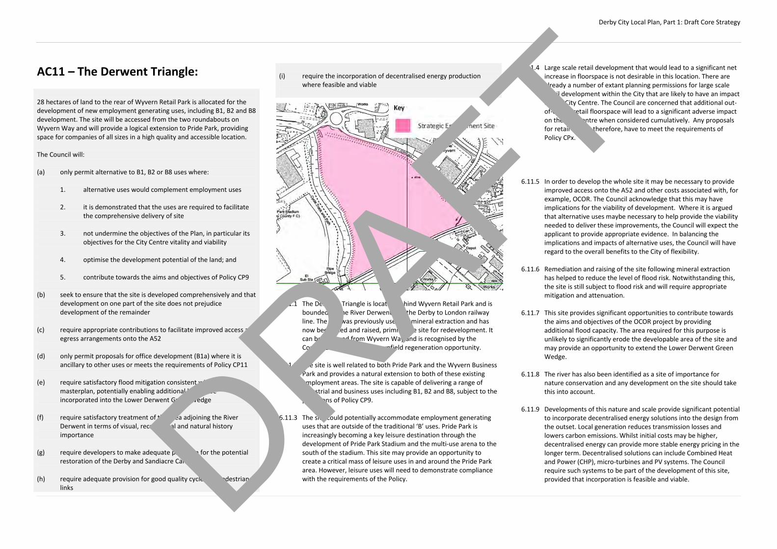
Derby City Local Plan, Part 1: Draft Core Strategy
AC11 – The Derwent Triangle: 28 hectares of land to the rear of Wyvern Retail Park is allocated for the development of new employment generating uses, including B1, B2 and B8 development. The site will be accessed from the two roundabouts on Wyvern Way and will provide a logical extension to Pride Park, providing space for companies of all sizes in a high quality and accessible location. The Council will: (a) only permit alternative to B1, B2 or B8 uses where:
1. alternative uses would complement employment uses 2. it is demonstrated that the uses are required to facilitate
the comprehensive delivery of site 3. not undermine the objectives of the Plan, in particular its
objectives for the City Centre vitality and viability 4. optimise the development potential of the land; and 5. contribute towards the aims and objectives of Policy CP9
(b) seek to ensure that the site is developed comprehensively and that
development on one part of the site does not prejudice development of the remainder
(c) require appropriate contributions to facilitate improved access and egress arrangements onto the A52
(d) only permit proposals for office development (B1a) where it is ancillary to other uses or meets the requirements of Policy CP11
(e) require satisfactory flood mitigation consistent with the OCOR
masterplan, potentially enabling additional land to be incorporated into the Lower Derwent Green Wedge
(f) require satisfactory treatment of the area adjoining the River
Derwent in terms of visual, recreational and natural history importance
(g) require developers to make adequate provision for the potential
restoration of the Derby and Sandiacre Canal
(h) require adequate provision for good quality cycle and pedestrian links
(i) require the incorporation of decentralised energy production
where feasible and viable 6.11.1 The Derwent Triangle is located behind Wyvern Retail Park and is
bounded by the River Derwent and the Derby to London railway line. The site was previously used for mineral extraction and has now been filled and raised, priming the site for redevelopment. It can be accessed from Wyvern Way and is recognised by the Council as a significant, brownfield regeneration opportunity.
6.11.2 The site is well related to both Pride Park and the Wyvern Business
Park and provides a natural extension to both of these existing employment areas. The site is capable of delivering a range of industrial and business uses including B1, B2 and B8, subject to the provisions of Policy CP9.
6.11.3 The site could potentially accommodate employment generating
uses that are outside of the traditional ‘B’ uses. Pride Park is increasingly becoming a key leisure destination through the development of Pride Park Stadium and the multi-use arena to the south of the stadium. This site may provide an opportunity to create a critical mass of leisure uses in and around the Pride Park area. However, leisure uses will need to demonstrate compliance with the requirements of the Policy.
6.11.4 Large scale retail development that would lead to a significant net increase in floorspace is not desirable in this location. There are already a number of extant planning permissions for large scale retail development within the City that are likely to have an impact on the City Centre. The Council are concerned that additional out-of-centre retail floorspace will lead to a significant adverse impact on the City Centre when considered cumulatively. Any proposals for retail would, therefore, have to meet the requirements of Policy CPx. Therefore, the Council will only consider large scale retail proposals where they would facilitate the comprehensive redevelopment of the nearby Wyvern Retail Park and lead to no, or at most marginal, net increase in out-of-centre floorspace.
6.11.5 In order to develop the whole site it may be necessary to provide
improved access onto the A52 and other costs associated with, for example, OCOR. The Council acknowledge that this may have implications for the viability of development. Where it is argued that alternative uses maybe necessary to help provide the viability needed to deliver these improvements, the Council will expect the applicant to provide appropriate evidence. In balancing the implications and impacts of alternative uses, the Council will have regard to the overall benefits to the City of flexibility.
6.11.6 Remediation and raising of the site following mineral extraction
has helped to reduce the level of flood risk. Notwithstanding this, the site is still subject to flood risk and will require appropriate mitigation and attenuation.
6.11.7 This site provides significant opportunities to contribute towards
the aims and objectives of the OCOR project by providing additional flood capacity. The area required for this purpose is unlikely to significantly erode the developable area of the site and may provide an opportunity to extend the Lower Derwent Green Wedge.
6.11.8 The river has also been identified as a site of importance for
nature conservation and any development on the site should take this into account.
6.11.9 Developments of this nature and scale provide significant potential
to incorporate decentralised energy solutions into the design from the outset. Local generation reduces transmission losses and lowers carbon emissions. Whilst initial costs may be higher, decentralised energy can provide more stable energy pricing in the longer term. Decentralised solutions can include Combined Heat and Power (CHP), micro-turbines and PV systems. The Council require such systems to be part of the development of this site, provided that incorporation is feasible and viable.
DRAFT
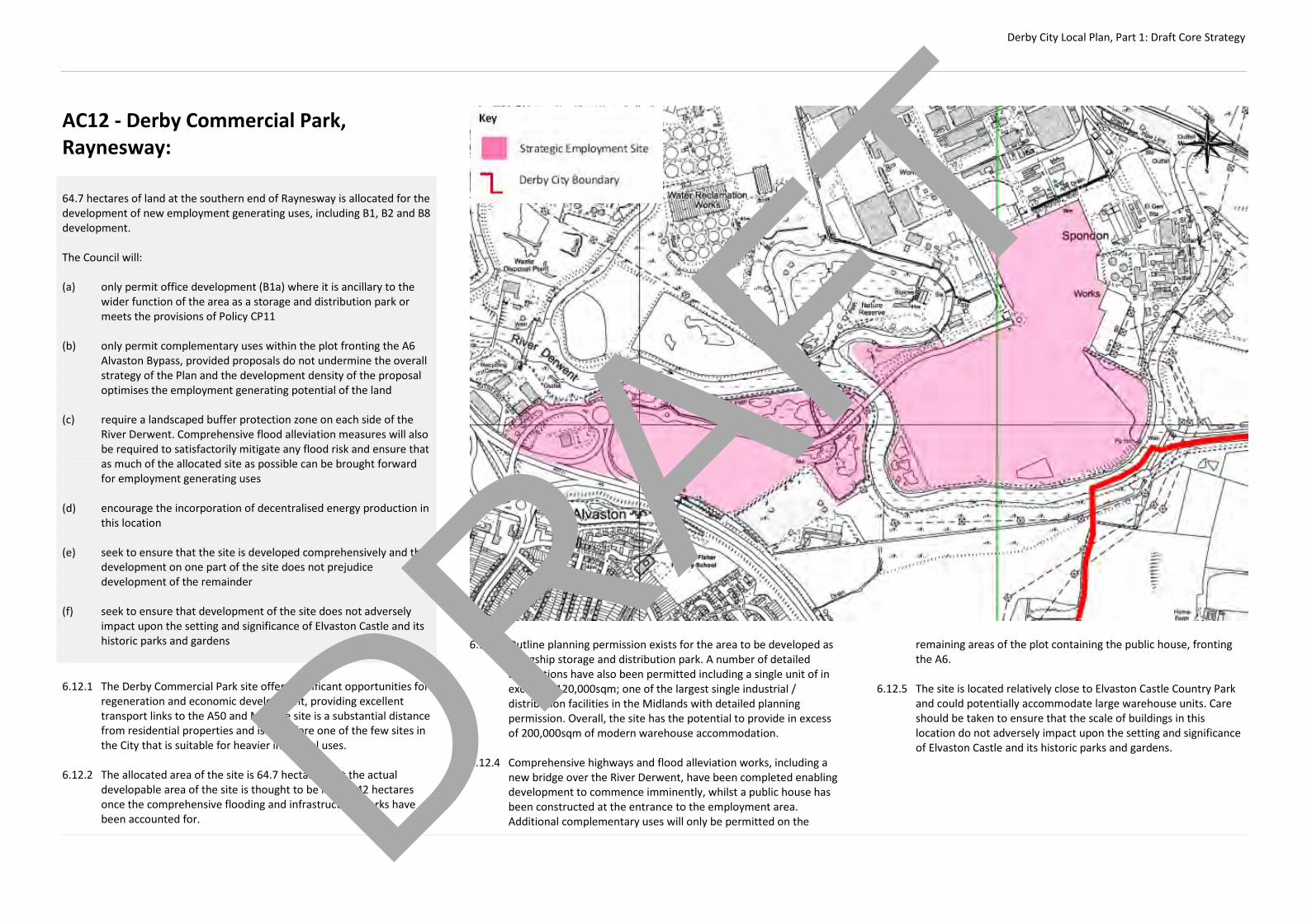
Derby City Local Plan, Part 1: Draft Core Strategy
AC12 - Derby Commercial Park, Raynesway: 64.7 hectares of land at the southern end of Raynesway is allocated for the development of new employment generating uses, including B1, B2 and B8 development. The Council will: (a) only permit office development (B1a) where it is ancillary to the
wider function of the area as a storage and distribution park or meets the provisions of Policy CP11
(b) only permit complementary uses within the plot fronting the A6
Alvaston Bypass, provided proposals do not undermine the overall strategy of the Plan and the development density of the proposal optimises the employment generating potential of the land
(c) require a landscaped buffer protection zone on each side of the
River Derwent. Comprehensive flood alleviation measures will also be required to satisfactorily mitigate any flood risk and ensure that as much of the allocated site as possible can be brought forward for employment generating uses
(d) encourage the incorporation of decentralised energy production in
this location (e) seek to ensure that the site is developed comprehensively and that
development on one part of the site does not prejudice development of the remainder
(f) seek to ensure that development of the site does not adversely
impact upon the setting and significance of Elvaston Castle and its historic parks and gardens
6.12.1 The Derby Commercial Park site offers significant opportunities for
regeneration and economic development, providing excellent transport links to the A50 and M1. The site is a substantial distance from residential properties and is therefore one of the few sites in the City that is suitable for heavier industrial uses.
6.12.2 The allocated area of the site is 64.7 hectares, but the actual
developable area of the site is thought to be nearer 42 hectares once the comprehensive flooding and infrastructure works have been accounted for.
6.12.3 Outline planning permission exists for the area to be developed as
a flagship storage and distribution park. A number of detailed applications have also been permitted including a single unit of in excess of 120,000sqm; one of the largest single industrial / distribution facilities in the Midlands with detailed planning permission. Overall, the site has the potential to provide in excess of 200,000sqm of modern warehouse accommodation.
6.12.4 Comprehensive highways and flood alleviation works, including a
new bridge over the River Derwent, have been completed enabling development to commence imminently, whilst a public house has been constructed at the entrance to the employment area. Additional complementary uses will only be permitted on the
remaining areas of the plot containing the public house, fronting the A6.
6.12.5 The site is located relatively close to Elvaston Castle Country Park
and could potentially accommodate large warehouse units. Care should be taken to ensure that the scale of buildings in this location do not adversely impact upon the setting and significance of Elvaston Castle and its historic parks and gardens.
DRAFT

Derby City Local Plan, Part 1: Draft Core Strategy
AC13 – Former Celanese Acetate Site, Spondon: The former Celanese Acetate site is a significant, brownfield regeneration opportunity with the potential to contribute towards the aims and objectives of this Plan. Continued use of the site for employment uses (B1, B2 and B8) would be acceptable in principle, however the Council will continue to work positively with the landowner to identify an appropriate comprehensive redevelopment scheme for the site that is sustainable and takes full account of the constraints including development viability. The Council will only permit the redevelopment of this site where it can be demonstrated that: (a) proposals are capable of creating a sustainable form of
development (b) proposals would contribute to the wider aims and objectives of
this Plan and would not undermine the Strategy (c) land contamination has been satisfactorily remediated to a
standard appropriate to the proposed use (d) appropriate access arrangements can be provided, taking account
of the level crossing on Station Road (e) flood risk and land drainage issues have been appropriately
addressed taking account of the impacts of the OCOR project (f) proposals would contribute to the extension and enhancement of
the green infrastructure network (g) proposals could be served by public transport (h) proposals for office development (B1a) meet the requirements of
Policy CP11
In the case of proposals for non-employment uses it must also be demonstrated that: (i) proposals will contribute to the wider aims and objectives of this
Plan; and
(j) alternative uses would not lead to a deficiency in terms of
quantitative or qualitative employment land supply; or (k) alternative uses are needed to make comprehensive regeneration
of the site deliverable In addition, in the case of proposals for residential development it must be demonstrated that: (l) proposals would create a critical mass of development to deliver a
high quality, new sustainable neighbourhood with on-site facilities. Further guidance on the regeneration of this site will be provided in the Local Plan Part 2.
6.13.1 The site lies immediately to the south of the Derby to Nottingham railway line and is served by Spondon railway station which is located just to the north of the site. The Severn Trent water reclamation works and Raynesway are located to the west of the site whilst the River Derwent borders the site to the south and east. Derby Commercial Park is located directly to the south of the site. Access is currently off Holme Lane at the north end of the site.
6.13.2 Celanese Acetate’s plant has been an active chemical factory
producing acetate materials, material used for cigarette filters and man-made fibres for nearly 100 years. The majority of the operations at the site ceased in November 2012 apart from acetate film production which continues to operate from approximately 3 hectares of the site.
DRAFT

Derby City Local Plan, Part 1: Draft Core Strategy
6.13.3 The vacant area of the site covers approximately 65 hectares and is a significant brownfield regeneration opportunity. The site is currently made up of a number of individual vacant / derelict buildings associated with the Celanese plant and areas of derelict / contaminated land.
6.13.4 The site is constrained by a number of factors such as
contamination, flood risk, access and its isolated location. However, it is recognised that the site has a number of benefits including the fact that it is previously developed and its proximity to Spondon railway station.
6.13.5 In light of these constraints and in the absence of an alternative
scheme, the most logical option is to re-use the site for industrial uses. The isolation of the site makes it one of the city’s best resources for heavier industrial uses, whilst the proximity of the railway line could provide opportunities for a railhead linking to Derby Commercial Park. However, proposals for intensified employment uses will be subject to criteria (a) - (h).
6.13.6 Whilst redevelopment for employment uses is the most logical
option, the Council acknowledge that this may not provide the viability needed to help deliver comprehensive regeneration. Therefore, it may be necessary to consider alternative uses of the site to help facilitate regeneration during the Plan period.
6.13.7 In addition to criteria (a) – (h), all potential alternative uses will be
required to demonstrate that release of the site would not lead to a deficiency in the employment land supply and that alternative uses are needed to make comprehensive redevelopment of the site viable.
6.13.8 The principle of residential development will only be acceptable
where a critical mass of development can be delivered to create a standalone neighbourhood. The site is physically isolated from existing facilities in the Spondon area and would need new facilities such as a primary school and local centre in order to be sustainable.
6.13.9 Further work is needed to understand the most appropriate mix of
uses, delivery timescales and potential implications of new development in this location. Work on understanding the constraints in more detail is ongoing and will inform the production of the Local Plan Part 2 which will provide further guidance on the future development of the site.
DRAFT
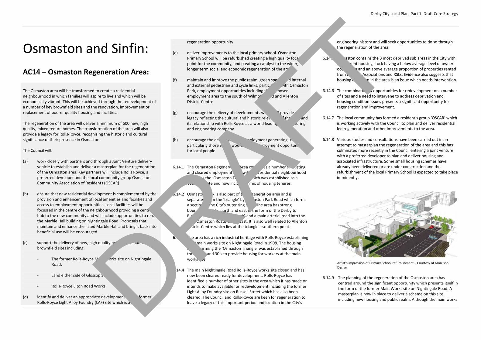
Derby City Local Plan, Part 1: Draft Core Strategy
Osmaston and Sinfin: AC14 – Osmaston Regeneration Area: The Osmaston area will be transformed to create a residential neighbourhood in which families will aspire to live and which will be economically vibrant. This will be achieved through the redevelopment of a number of key brownfield sites and the renovation, improvement or replacement of poorer quality housing and facilities. The regeneration of the area will deliver a minimum of 600 new, high quality, mixed tenure homes. The transformation of the area will also provide a legacy for Rolls-Royce, recognising the historic and cultural significance of their presence in Osmaston. The Council will: (a) work closely with partners and through a Joint Venture delivery
vehicle to establish and deliver a masterplan for the regeneration of the Osmaston area. Key partners will include Rolls Royce, a preferred developer and the local community group Osmaston Community Association of Residents (OSCAR)
(b) ensure that new residential development is complemented by the
provision and enhancement of local amenities and facilities and access to employment opportunities. Local facilities will be focussed in the centre of the neighbourhood providing a central hub to the new community and will include opportunities to re-use the Marble Hall building on Nightingale Road. Proposals that maintain and enhance the listed Marble Hall and bring it back into beneficial use will be encouraged
(c) support the delivery of new, high quality homes on a number of
brownfield sites including:
- The former Rolls-Royce Main Works site on Nightingale Road;
- Land either side of Glossop Street;
- Rolls-Royce Elton Road Works. (d) identify and deliver an appropriate development on the former
Rolls-Royce Light Alloy Foundry (LAF) site which is a key
regeneration opportunity (e) deliver improvements to the local primary school. Osmaston
Primary School will be refurbished creating a high quality focal point for the community, and creating a catalyst to the wider, longer term social and economic regeneration of the area
(f) maintain and improve the public realm, green spaces and internal
and external pedestrian and cycle links, particularly with Osmaston Park, employment opportunities including the proposed employment area to the south of Wilmore Road and Allenton District Centre
(g) encourage the delivery of developments which will provide a
legacy reflecting the cultural and historic relevance of the area and its relationship with Rolls Royce as a world leading manufacturing and engineering company
(h) encourage the development of employment generating uses and particularly those which would create employment opportunities for local people
6.14.1 The Osmaston Regeneration Area comprises a number of existing and cleared employment sites within a residential neighbourhood known as the ‘Osmaston Triangle’ which was established as a Council Estate and now includes a mix of housing tenures.
6.14.2 Osmaston Park is also part of the regeneration area and is
separated from the ‘triangle’ by Osmaston Park Road which forms a section of the City’s outer ring road. The area has strong boundaries to the north and east in the form of the Derby to Birmingham Railway line (north) and a main arterial road into the City (Osmaston Road) to the east. It is also well related to Allenton District Centre which lies at the triangle’s southern point.
6.14.3 The area has a rich industrial heritage with Rolls-Royce establishing
their main works site on Nightingale Road in 1908. The housing estate forming the ‘Osmaston Triangle’ was established through the 1920’s and 30’s to provide housing for workers at the main works site.
6.14.4 The main Nightingale Road Rolls-Royce works site closed and has
now been cleared ready for development. Rolls-Royce has identified a number of other sites in the area which it has made or intends to make available for redevelopment including the former Light Alloy Foundry site on Russell Street which has also been cleared. The Council and Rolls-Royce are keen for regeneration to leave a legacy of this important period and location in the City’s
engineering history and will seek opportunities to do so through the regeneration of the area.
6.14.5 Osmaston contains the 3 most deprived sub areas in the City with
the current housing stock having a below average level of owner occupation and an above average proportion of properties rented from Housing Associations and RSLs. Evidence also suggests that housing condition in the area is an issue which needs intervention.
6.14.6 The combination of opportunities for redevelopment on a number
of sites and a need to intervene to address deprivation and housing condition issues presents a significant opportunity for regeneration and improvement.
6.14.7 The local community has formed a resident’s group ‘OSCAR’ which
is working actively with the Council to plan and deliver residential led regeneration and other improvements to the area.
6.14.8 Various studies and consultations have been carried out in an
attempt to masterplan the regeneration of the area and this has culminated more recently in the Council entering a joint venture with a preferred developer to plan and deliver housing and associated infrastructure. Some small housing schemes have already been delivered or are under construction and the refurbishment of the local Primary School is expected to take place imminently.
Artist’s impression of Primary School refurbishment – Courtesy of Morrison Design
6.14.9 The planning of the regeneration of the Osmaston area has
centred around the significant opportunity which presents itself in the form of the former Main Works site on Nightingale Road. A masterplan is now in place to deliver a scheme on this site including new housing and public realm. Although the main works
DRAFT
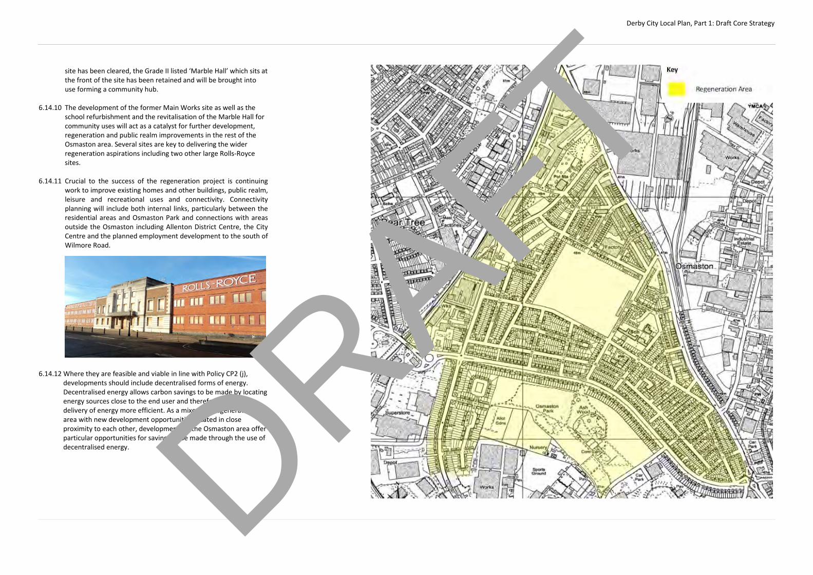
Derby City Local Plan, Part 1: Draft Core Strategy
site has been cleared, the Grade II listed ‘Marble Hall’ which sits at the front of the site has been retained and will be brought into use forming a community hub.
6.14.10 The development of the former Main Works site as well as the
school refurbishment and the revitalisation of the Marble Hall for community uses will act as a catalyst for further development, regeneration and public realm improvements in the rest of the Osmaston area. Several sites are key to delivering the wider regeneration aspirations including two other large Rolls-Royce sites.
6.14.11 Crucial to the success of the regeneration project is continuing
work to improve existing homes and other buildings, public realm, leisure and recreational uses and connectivity. Connectivity planning will include both internal links, particularly between the residential areas and Osmaston Park and connections with areas outside the Osmaston including Allenton District Centre, the City Centre and the planned employment development to the south of Wilmore Road.
6.14.12 Where they are feasible and viable in line with Policy CP2 (j),
developments should include decentralised forms of energy. Decentralised energy allows carbon savings to be made by locating energy sources close to the end user and therefore making the delivery of energy more efficient. As a mixed use regeneration area with new development opportunities located in close proximity to each other, developments in the Osmaston area offer particular opportunities for savings to be made through the use of decentralised energy.
DRAFT

Derby City Local Plan, Part 1: Draft Core Strategy
AC15 – Land South of Wilmore Road, Sinfin (Infinity Park Derby): 86.8 hectares of land is allocated to the south of Wilmore Road for the development of a new high quality business park accommodating B1, B2 and B8 uses. The site is identified for the development of a unique, innovation and technology park that will showcase and support innovation related to the automotive, rail, aerospace and energy sectors. It will provide high quality accommodation for companies in the manufacturing and manufacturing services sectors. The first development within the ‘Infinity Park Derby’ area of the site will be an ‘Innovation Hub’ including an ‘Innovation Centre’. The Innovation Centre will provide managed workspace and showcase R&D facilities, networks and support that will be offered to companies locating in this area of the City. The Council will: (a) support proposals which deliver a new link road between Wilmore
Road and Holmleigh Way, provided that they do not prejudice the future restoration of the Derby and Sandiacre Canal. The road link will provide direct access to the new employment area from the A50. Developers of plots accessing the new road will be required to contribute towards design and construction costs
(b) permit the development of offices (B1a) within all areas of the site,
subject to the provisions of Policy CP11. The Council will have regard to the complementarity of such proposals with the vision for the site and the relationship with surrounding uses
(c) limit the amount of B8 development across the whole site to 50%
of overall floorspace, excluding complementary uses, in order to ensure that development is in-keeping with the vision for the area and does not prejudice the development of other employment sites within the city
(d) encourage the development of on-site, small-scale,
complementary uses to serve the immediate employment area, where they would not undermine the overall strategy of the Plan and where proposals optimise the employment generating potential of the area. Complementary uses should be located centrally within the development to encourage walking and cycling
(e) require the layout and mix of development to respect the
proximity of residential properties to the east and west of the site and open countryside to the south of the site. The layout and mix of development should also be compatible with the reasonable operation of the Rolls-Royce test beds on Wilmore Road
(f) require proposals to maximise the development potential of the
allocated area and exhibit high standards of urban design and landscaping throughout the site
(g) ensure that access to the land to the south of Sinfin Moor Lane
does not undermine the recreational and biodiversity value of the route and surrounding hedgerows
(h) require comprehensive flood alleviation measures to satisfactorily
mitigate flood risk, whilst maximising the developable area of the site
(i) require the incorporation of decentralised energy production where feasible and viable
(j) require the provision of a network of green infrastructure
throughout the site, including the provision of structural planting and non motorised multi-user routes, including:
1. A landscaped buffer along both sides of Main Drain / Sinfin
Moor Lane 2. A landscaped buffer along both sides of Cuttle Brook 3. Structural planting on the eastern and western edges of
the site, incorporating the rights of way 4. A landscaped multi-user route incorporating the rights of
way from Sinfin Moor Lane to Wilmore Road 5. Measures to conserve and extend the woodland at Moor
Plantation; and 6. Measures to maximise the biodiversity value of the areas
of the site used for surface water discharge and flood risk mitigation
The Council will require appropriate alternative provision to be made to mitigate the loss or damage of environmental and recreational assets.
(k) seek to ensure that the site is developed comprehensively and that
development on one part of the site does not prejudice development of the remainder
6.15.1 86.8 hectares of land to the south of Wilmore Road is allocated for
the development of new employment uses, making a significant contribution towards meeting the need for new employment land during the Plan period.
6.15.2 The site will be developed as a high quality, innovation and
technology park set within landscaped surroundings. It will be a flagship development and provide accommodation to meet the needs of a range of occupiers, taking advantage of the proximity of existing employers and embedded skills sets within the local workforce.
6.15.3 The new employment area will be targeted at high-tech businesses
in the automotive, rail, aerospace and energy sectors and associated supply chain services. These sectors already underpin the local economy and the allocation of this land will provide opportunities for further growth in these industries.
6.15.4 There are clear synergies between these sectors and the
development of this site will provide opportunities for linked research and development, providing accommodation for new enterprises and space for existing employers already operating within these sectors space to expand operations.
6.15.5 The first development will be an 'Innovation Centre' as part of a
larger ‘Innovation Hub’ providing incubation and managed workspace in units of between 40sqm and 400sqm. The Innovation Centre will showcase R&D facilities, networks and support that will be offered to companies locating at the new innovation and technology park. R&D collaboration and commercialisation will be led by a consortium of Universities.
6.15.6 Businesses locating in this area will also be supported by a range of
complementary uses located centrally within the site to ensure that the development of this area is as sustainable as possible. Potential complementary uses could include small-scale retail, a hotel and food and drink type uses provided they maximise the development density of the land and do not undermine the City Centre strategy.
6.15.7 Development of the whole site will require the provision of new
link road between Wilmore Road and Holmleigh Way. The new road will help to avoid unacceptable congestion on existing routes and improve the attractiveness of the employment site due to direct links onto the A50, leading to East Midlands Airport and the M1.
DRAFT
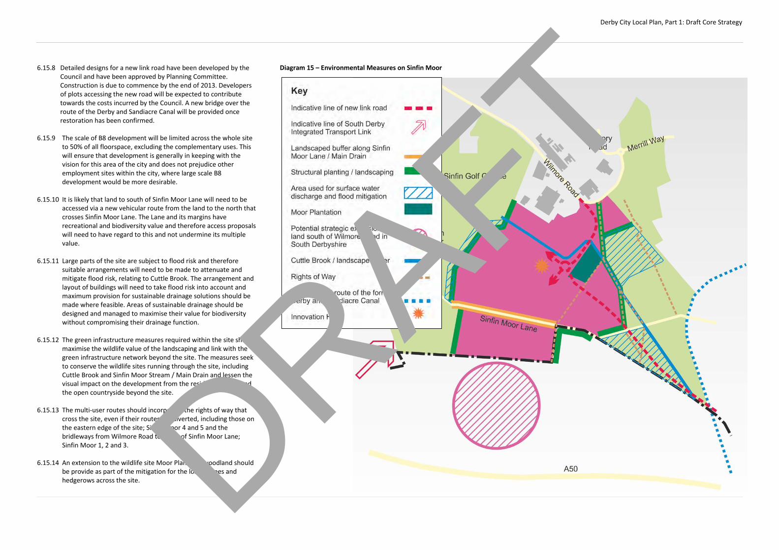
Derby City Local Plan, Part 1: Draft Core Strategy
6.15.8 Detailed designs for a new link road have been developed by the Council and have been approved by Planning Committee. Construction is due to commence by the end of 2013. Developers of plots accessing the new road will be expected to contribute towards the costs incurred by the Council. A new bridge over the route of the Derby and Sandiacre Canal will be provided once restoration has been confirmed.
6.15.9 The scale of B8 development will be limited across the whole site
to 50% of all floorspace, excluding the complementary uses. This will ensure that development is generally in keeping with the vision for this area of the city and does not prejudice other employment sites within the city, where large scale B8 development would be more desirable.
6.15.10 It is likely that land to south of Sinfin Moor Lane will need to be
accessed via a new vehicular route from the land to the north that crosses Sinfin Moor Lane. The Lane and its margins have recreational and biodiversity value and therefore access proposals will need to have regard to this and not undermine its multiple value.
6.15.11 Large parts of the site are subject to flood risk and therefore
suitable arrangements will need to be made to attenuate and mitigate flood risk, relating to Cuttle Brook. The arrangement and layout of buildings will need to take flood risk into account and maximum provision for sustainable drainage solutions should be made where feasible. Areas of sustainable drainage should be designed and managed to maximise their value for biodiversity without compromising their drainage function.
6.15.12 The green infrastructure measures required within the site should
maximise the wildlife value of the landscaping and link with the green infrastructure network beyond the site. The measures seek to conserve the wildlife sites running through the site, including Cuttle Brook and Sinfin Moor Stream / Main Drain and lessen the visual impact on the development from the residential areas and the open countryside beyond the site.
6.15.13 The multi-user routes should incorporate the rights of way that
cross the site, even if their routes are diverted, including those on the eastern edge of the site; Sinfin Moor 4 and 5 and the bridleways from Wilmore Road to south of Sinfin Moor Lane; Sinfin Moor 1, 2 and 3.
6.15.14 An extension to the wildlife site Moor Planation woodland should
be provide as part of the mitigation for the loss of trees and hedgerows across the site.
Diagram 15 – Environmental Measures on Sinfin Moor
DRAFT

Derby City Local Plan, Part 1: Draft Core Strategy
6.15.15 Part s of the site may be affected by noise from the Rolls-Royce test bed operations and therefore land uses may need to be restricted in these areas to allow for the continued operation of the test beds.
[INSERT PICTURE] 6.15.16 Developments of this nature and scale provide significant potential
to incorporate decentralised energy solutions into the design from the outset. Local generation reduces transmission losses and lowers carbon emissions. Whilst initial costs may be higher, decentralised energy can provide more stable energy pricing in the longer term. Decentralised solutions can include Combined Heat and Power (CHP), micro-turbines and PV systems. The Council require such systems to be part of the development of this site, provided that incorporation is feasible and viable.
DRAFT

Derby City Local Plan, Part 1: Draft Core Strategy
AC16 – Rolls-Royce Campus: Rolls-Royce’s existing facilities in the Victory Road, Wilmore Road and Moor Lane areas could be rationalised and enhanced in order to create a new revitalised and efficient campus at the heart of Rolls-Royce’s facilities in Sinfin. The new campus would significantly improve the working environment for employees and will create a quality environment in which to showcase Rolls Royce as a major global business. The Council will: (a) support proposals that help to deliver enhancements to existing
Rolls-Royce facilities
(b) support the rationalisation of existing buildings and the construction of new facilities within the defined Campus area. The potential realignment of the Allenton / Sinfin Industrial Area Green Wedge will be considered in the Local Plan Part 2 if necessary
(c) support comprehensive public realm works within the defined
Campus area
(d) support the provision of complementary uses within the defined Campus area, subject to them not undermining the overall Strategy
(e) consider the potential re-routing of Victory Road in the Local Plan
Part 2 if necessary
6.16.1 Rolls-Royce is currently in the process of evaluating their existing
estate. Some buildings in the Wilmore Road / Victory Road area are in excess of 50 years old and are no longer suitable to meet modern industrial needs in the 21st Century.
6.16.2 Work is being undertaken to look at how these buildings can be
replaced with new, fit for purpose accommodation that will meet the needs of Rolls-Royce in the future. Options are also being looked at that would create environmental improvements to the wider area through the creation of a true Rolls-Royce Campus. This could include enhanced public realm and new complementary uses such as small scale retail development within the new Campus.
6.16.3 Comprehensive enhancements and investment could potentially
be facilitated through more radical redevelopment options such as the realignment of Victory Road and / or the Allenton / Sinfin Industrial Area Green Wedge. Further work is needed to investigate the merits of these options. More detailed guidance on the redevelopment of this area will be provided in the Local Plan Part 2.
DRAFT

Derby City Local Plan, Part 1: Draft Core Strategy
AC17 - Sinfin Lane: The existing employment land between Sinfin Lane, Goodsmoor Road and the Derby to Birmingham railway line will be allocated for a minimum of 700 new high quality homes. It will provide a new sustainable extension to Sinfin and will be well integrated into the existing built area. The Council will: (a) require the provision of adequate access arrangements including a
new link road linking Goodsmoor Road and Sinfin Lane, providing for all forms of travel
(b) require the provision of on-site and off-site junction improvements (c) permit the development of a small local centre within the site of a
scale commensurate with the needs of the new enlarged community
(d) require appropriate sound attenuation measures to mitigate noise
from the railway line and industrial areas to the north of the site (e) require that provision is made for the long term management and
protection of the Great Crested Newt habitat The Council will work with partners to ensure that this scheme is delivered in a comprehensive manner and will use compulsory purchase powers to guarantee delivery. 6.17.1 This site is approximately 22 hectares and currently
accommodates a range of industrial units, predominantly storage and distribution and some derelict industrial land.
6.17.2 Many of the existing units are dated and are in poor physical
condition. They also suffer from low eaves heights, subdividing walls, lack of natural light and poor access onto the strategic road network which make them generally unsuitable for modern industrial needs. This has made letting them to industrial occupiers very difficult. Evidence suggests that the majority of units are vacant and have been vacant for some time, despite concerted efforts to let the units to industrial occupiers.
6.17.3 Refurbishment is not thought to be an economically viable option
and therefore the landowners have promoted the site for
residential development. A planning application for 106 homes in the southern part of the site was approved at appeal in 2011 whilst Planning Committee resolved to grant planning permission for 600 new homes on the remainder of the site in 2013.
6.17.4 The site is within a predominantly residential area and is
surrounded by residential properties on 2 / 3 sides. Redevelopment for residential use has the potential to remove the obsolete employment uses and help to improve the environment for existing residents in this area of the city.
6.17.5 From a pure quantitative perspective, loss of this employment land from the land supply will represent one of the largest single losses of existing employment land in recent years. However, Derby has traditionally had a projected oversupply of employment land, due to the history of engineering and manufacturing which has tended to have large land requirements. Economic restructuring in the national and local economy has meant that industrial land requirements have generally reduced with the advent of new technologies and moves towards more office based activities. This has left the city with significant areas of industrial land.
DRAFT

Derby City Local Plan, Part 1: Draft Core Strategy
6.17.6 Consolidation and intensification of existing sites has made a major contribution in soaking up industrial demand in recent years and this is expected to continue. The city also has a healthy supply of proposed employment sites that will be made available during the Plan period. This has reduced some of the pressure on the existing land supply in terms of meeting future needs and enabled the selective redevelopment of existing sites where they no longer meet modern industrial needs.
6.17.7 Vehicular access to the site will be provided from two points on
Sinfin Lane, one of which will link directly onto Goodsmoor Road via a new link road running through the site. An additional access to serve the southern part of the site could also be achieved from Goodsmoor Road.
6.17.8 Additional off-site highway improvements will also be required in
order to make schemes acceptable, including improvements to the Blagreaves Lane / Stenson Road junction.
6.17.9 The development of 700 new properties will generate a need for
community facilities that could be provided as part of the development within a new local centre. The centre could include new convenience shops and other facilities such as a doctor’s surgery and nursery. The new local centre should be of a scale that will only serve the needs of the enlarged community and should not impact upon the function of other local centres in the area.
6.17.10 The site is flanked by the Derby to Birmingham railway line and
industrial operations to the north. In order to create a satisfactory living environment it will be necessary for sound attenuation measures to be included as part of the redevelopment. This could include the use of buffers and / or specific acoustic measures within individual properties.
6.17.11 There is a record of a Great Crested Newt colony within and
around an emergency water tank at the southern end of the site. Great Crested Newts are a protected species and therefore appropriate measures will need to be taken to ensure the long term management and protection of the colony. This could be provided through the provision of alternative on-site habitats as part of sustainable urban drainage features.
6.17.12 Not all of the land needed in order to deliver the development in a comprehensive manner is owned by a single landowner. Additional land may be needed to secure the new link road between Sinfin Lane and Goodsmoor Road. The Council is committed to ensuring the delivery of brownfield housing in sustainable locations and will use compulsory purchase powers to ensure that this strategic site is delivered in the Plan period.
DRAFT

Derby City Local Plan, Part 1: Draft Core Strategy
AC18 - Wragley Way: Land between the southern edge of Wragley Way and the city boundary will form part of a new sustainable urban extension to Derby, the majority of the urban extension will be within South Derbyshire. Land within the city will deliver a minimum of 180 new, high quality, mixed tenure homes and form part of a larger cross-boundary sustainable development. The whole strategic location south of the urban extent of the City will provide over 2,000 new homes and supporting infrastructure when complete. The Council will work with South Derbyshire District Council to ensure that the new neighbourhood is comprehensively masterplanned, embraces high quality design standards and delivers a sustainable addition to the city. It will provide a range of new homes and will integrate with existing development along Wragley Way, helping to form a seamless extension to the built area of the City. Development within the City must be designed to integrate fully with the larger element in South Derbyshire, particularly in terms of scale, design and road, cycle and pedestrian links. Similarly, green infrastructure links and pedestrian and cycle routes should be established to allow people to walk and cycle through the site and provide access to the new local facilities. They should also provide access to the existing local facilities at Sinfin District Centre, employment opportunities and links to the open countryside in south Derbyshire and the recreational benefits which it provides. New development in Derby will need to contribute to the provision of supporting infrastructure which will be required as a result of the development. Supporting infrastructure will be carefully planned and coordinated between the two authorities and relevant developers and may be required within the City and /or in South Derbyshire. The Council will work with South Derbyshire District Council to ensure that : (a) new highway infrastructure is provided to help mitigate the impact
of the development on the local and strategic road networks. This will include the development of, or contributions towards, the construction of the South Derby Integrated Transport Link. The potential for a new junction onto the A50 to be delivered in the future should also not be prejudiced
(b) the appropriate primary school(s) are provided to serve the wider
development as a whole (c) Secondary school needs are met through the extension of existing
facilities and / or the provision of a new secondary school (d) new on-site local shopping and community facilities are provided
to meet the needs of the new development (e) appropriate flood mitigation and drainage measures are
implemented (f) appropriate landscaping / buffering in provided between new
homes and the proposed employment site south of Wilmore Road, the Derby to Birmingham railway line west of Stenson Road and between new homes and the A50 trunk road
(g) a mix of new green infrastructure is provided to meet the needs of
residents. Green infrastructure should be integrated to create a cross boundary network of green spaces
(h) improvements to the Green Wedge at Sinfin Moor. The boundaries
of the Green Wedge should also be strengthened
(i) cycleway and walkway links are provided to land south of Wilmore Road
6.18.1 Land south of Wragley Way has been identified to form a new
sustainable urban extension to the City. The whole site will deliver in excess of 2,000 new, high quality, mixed tenure homes and supporting facilities. The development of the cross-boundary site will take place over a time period beyond the lifespan of the Local Plans of each authority but within the Plan period a minimum of 180 dwellings will be provided in Derby City and 1,180 dwellings will be delivered in South Derbyshire.
6.18.2 It is crucial that a comprehensive approach is taken to delivering
the strategic extension as well as in delivering the appropriate supporting infrastructure at the right time.
6.18.3 The development should be designed to a high quality and should
integrate with the existing urban edge of the city. The wider strategic location will be masterplanned to ensure that all opportunities are taken to lay out sustainable patterns of development through the site and to have regard to the surrounding land uses, constraints and highway network.
DRAFT

Derby City Local Plan, Part 1: Draft Core Strategy
6.18.4 New strategic highway infrastructure will be required to support
the development. A new road (The South Derby Integrated Transport Link, Phase 1) will be constructed linking from Stenson Road across the site south of Wragley Way and across Sinfin Moor to the A50 junction at Chellaston. The detailed route and design of this link are to be determined.
6.18.5 In order to ensure that impacts of new traffic generated by the site
can be mitigated properly, the maximum of dwellings that can be built before the road link is completed between the site and the Bonnie Prince junction at Chellaston will be determined
6.18.6 Two new Primary schools will be provided on site to meet school
place needs arising from the development. Secondary school place requirements arising from the development will be met either through expansion of existing secondary school facilities or through the construction of a new secondary school to meet wider strategic growth needs or a combination of the two.
6.18.7 New areas of public open space should be provided across the site.
A range of types of open spaces should be provided which allow residents to engage in a variety of formal and informal recreational activities. Opportunities to establish green route ways forming part of a network of on-site public open space will be welcomed. Improvements to green infrastructure and open spaces should be established in the Green Wedge in Derby and will enhance the recreational facilities available to new residents.
6.18.8 Walking and cycling links through the site should facilitate
movement between key locations within the development including connecting local facilities, schools, public open space and other green infrastructure. Opportunities should be taken wherever possible to provide routes and links for walking and cycling for both recreational purposes and to provide non-car based travel to destinations which are well related to the site. In particular, links should be established between the site and the District Centre at Sinfin, the new employment area to the south of Wilmore Road and employment opportunities at Rolls Royce, recreational routes and paths across Sinfin Moor and beyond and with the open countryside in South Derbyshire. In considering establishing a network of walking and cycling routes regard should be had to the Council’s Rights of Way Improvement Plan.
6.18.9 The site should be well screened from the A50 road and
opportunities should be taken to use green infrastructure and planting to form a buffer between residential uses and the trunk road to protect the amenity of residents. Landscaping/buffering
should be provided between the site and the proposed employment land to the south of Wilmore Road.
DRAFT
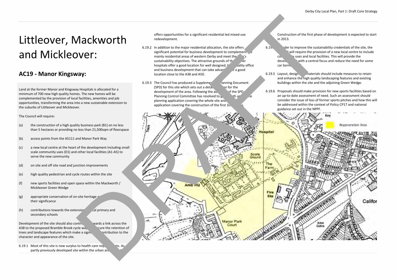
Derby City Local Plan, Part 1: Draft Core Strategy
Littleover, Mackworth and Mickleover: AC19 - Manor Kingsway: Land at the former Manor and Kingsway Hospitals is allocated for a minimum of 700 new high quality homes. The new homes will be complemented by the provision of local facilities, amenities and job opportunities, transforming the area into a new sustainable extension to the suburbs of Littleover and Mickleover. The Council will require: (a) the construction of a high quality business park (B1) on no less
than 5 hectares or providing no less than 21,500sqm of floorspace (b) access points from the A5111 and Manor Park Way (c) a new local centre at the heart of the development including small
scale community uses (D1) and other local facilities (A1-A5) to serve the new community
(d) on site and off site road and junction improvements (e) high quality pedestrian and cycle routes within the site (f) new sports facilities and open space within the Mackworth /
Mickleover Green Wedge (g) appropriate conservation of on-site heritage assets in line with
their significance
(h) contributions towards the extension of local primary and secondary schools
Development of the site should also contribute towards a link across the A38 to the proposed Bramble Brook cycle way and secure the retention of trees and landscape features which make a significant contribution to the character and appearance of the site. 6.19.1 Most of this site is now surplus to health care requirements. As a
partly previously developed site within the urban area, the site
offers opportunities for a significant residential led mixed-use redevelopment.
6.19.2 In addition to the major residential allocation, the site offers significant potential for business development to complement the mainly residential areas of western Derby and meet the Plan’s sustainability objectives. The attractive grounds of the former hospitals offer a good location for well designed, high quality office and business development that can take advantage of a good location close to the A38 and A50.
6.19.3 The Council has produced a Supplementary Planning Document (SPD) for this site which sets out a detailed vision for the development of the area. Following the adoption of the SPD, Planning Control Committee has resolved to grant both an outline planning application covering the whole site and a detailed application covering the construction of the first 100 homes.
Construction of the first phase of development is expected to start in 2013.
6.19.4 In order to improve the sustainability credentials of the site, the Council will require the provision of a new local centre to include community uses and local facilities. This will provide the development with a central focus and reduce the need for some car borne travel.
6.19.5 Layout, design and materials should include measures to retain and enhance the high quality landscaping features and existing buildings within the site and the adjoining Green Wedge.
6.19.6 Proposals should make provision for new sports facilities based on an up-to-date assessment of need. Such an assessment should consider the issue of loss of former sports pitches and how this will be addressed within the context of Policy CP17 and national guidance set out in the NPPF.
DRAFT

Derby City Local Plan, Part 1: Draft Core Strategy
AC20 - Rykneld Road: Land on both sides of Rykneld Road is allocated for a minimum of 900 high quality new homes. It will form part of a larger growth area that will also include the development of 970 new homes on land within South Derbyshire. Development will be built to a high design standard and will be a sustainable extension to the city. The Council will require:
(a) a coordinated approach to development, taking account of the
Highfields Farm allocation within South Derbyshire (b) a new primary school and contributions to the extension of local
Secondary Schools (c) the expansion of Heatherton Local Centre to provide extended
shopping facilities and community uses, including a small supermarket. Expansion should complement the provision of similar facilities within the South Derbyshire element of the development
(d) employment uses on land adjacent to the enlarged local centre,
providing at least 2.4 hectares or 15,000sqm of B1 floorspace (e) measures to encourage alternative forms of transport to the car (f) high quality pedestrian and cycle routes within the site and links
between these and existing or proposed routes beyond the site (g) the provision of two access points to each part of the site and on-
site and off-site road and junction improvements, including improvements to the A38 / A50 junction
(h) attenuation measures for noise generated by vehicles on the A38
(i) appropriate flood mitigation measures (j) land release to be managed to ensure a reasonably even pattern
and speed of development, to co-ordinate with infrastructure provision and to avoid undermining the delivery of housing on previously-developed sites elsewhere in the City
The Council will continue to work with South Derbyshire District Council and developers to ensure that development proposals offer a holistic vision for a new suburb that are delivered in a comprehensive manner across local authority boundaries.
6.20.1 This site provides the opportunity to consolidate the existing residential community at Heatherton with a view to enhancing the scale and nature of local facilities, improving the provision of bus services and creating local employment opportunities.
6.20.2 The eastern parcel of land is adjacent to the Highfields Farm site
which has been identified by South Derbyshire District Council for housing development, providing in the region of 970 new homes. It is important that the developers of the Highfields Farm site and this allocation adopt a coordinated approach, in order to create a sustainable form of development.
6.20.3 The Council has produced a Supplementary Planning Document
(SPD) for this site which sets out a detailed vision for the area. Following the adoption of the SPD, Planning Control Committee resolved to grant an outline planning application for this site in 2013. The application does not cover the entirety of the allocated
area and subsequently is only for 800 homes. A separate planning application is expected for the remainder of the site during the Plan period.
6.20.4 The Council will expect development proposals to include
provision for enhancing the existing Neighbourhood Centre in order to upgrade it to District Centre status. This could include the provision for approximately 1000 sqm (net) of additional convenience shopping floorspace. This should be well related to the existing Heatherton Neighbourhood Centre.
6.20.5 Highway improvements to the A38 / A50 will be needed to
facilitate the development of this area and should be implemented before the 500th house is occupied.
6.20.6 The 2 parcels of land which comprise the site can be developed
independently or in tandem in accordance with the SPD for the site.
DRAFT

Derby City Local Plan, Part 1: Draft Core Strategy
AC21 – Hackwood Farm: Land at Hackwood Farm, to the west of Station Road, Mickleover will provide a minimum of 400 new high quality homes in Derby, as part of a larger development of at least 690 homes, including land in South Derbyshire. The Council will work with South Derbyshire District Council to ensure that : (a) a comprehensive approach to cross boundary development and
the delivery of required infrastructure to support the site (b) new development embraces high quality design standards and
reflects the sensitivity of the location, particularly in terms of the rural landscape beyond the site. Landscaping and a green buffer will need to be provided on the periphery of the site in South Derbyshire where it meets the open countryside
(c) a new primary school is provided on site
(d) there are two points of highway access to the cross boundary site.
Any access from Radbourne Lane should be fully integrated with the whole site, should incorporate footways and should maintain as much of the hedgerow along Radbourne Lane as possible, particularly the most sensitive parts of the hedgerow in terms of biodiversity.
The Council will require : (e) a new local centre to be provided on site of a scale to meet the
needs of the new development and not impact on other centres in the hierarchy. The Council will welcome efforts to retain the existing farm buildings as part of the local centre;
(f) enhancements to remaining areas of the Green Wedge to the west
of Station Road, including the provision of new public open space; (g) improvements to the junction of Station Road and Radbourne
Lane; (h) as part of the green infrastructure network for site, retention of as
much as possible of the hedgerow along Radbourne Lane, subject to highway improvement and site access requirements, and provision of new hedgerows and tree planting to compensate for losses caused by the development
(i) a pedestrian / cycle bridge to be provided over the Mickleover to
Egginton Greenway, linking the site with existing residential areas of Mickleover;
(j) improved links across the site and between the site and the open
countryside including improvements to the walking, cycling and horse riding network in the area;
(k) comprehensive flood mitigation measures to address fluvial and surface water flood risk issues;
(l) contributions to the implementation of a bus service to access the
site and provide links with the wider area and particularly the City Centre.
6.21.1 Land at Hackwood Farm will form a sustainable urban extension to the suburb of Mickleover as a new cross-boundary housing development including land in Derby and in South Derbyshire.
6.21.2 The site will be developed sustainably by providing infrastructure
to meet the needs of new residents. Infrastructure requirements for the new extension to the City will include a new primary school and a new local centre which should contain facilities and services to meet local needs without attracting trips into the site from other areas.
6.21.3 Improved connectivity with the existing urban area of Mickleover
including improvements to the rights of way network, links to the Mickleover to Egginton Greenway and the open countryside will be provided. These improvements will include a pedestrian and cycle bridge across the Mickleover to Egginton Greenway which will allow the site to better integrate with the existing suburb of Mickleover.
6.21.4 Developers will be required to deliver a new development with
high design standards and to provide landscaping and screening where possible to reduce impact on the open countryside in South Derbyshire.
6.21.5 The cross boundary development will be comprehensively planned
and delivered to ensure that it integrates properly with the existing development in Derby and that it appears and functions as one site.
6.21.6 The development will require two points of highway access which
will also function as pedestrian and cycle links. Improvements to the local highway network will be provided at the junction of Station Road and Radbourne Lane. It is important that both accesses are fully integrated with the whole site. Improvements and upgrades including new footpaths and street lighting may be required on part of Radbourne Lane subject to access details.
6.21.7 Where access is taken from Radbourne Lane efforts will be made
to preserve the existing hedgerow and in particular to retain the most sensitive parts of the hedgerow in terms of biodiversity value.
6.21.8 The development of the site will take opportunities to protect and
enhance green infrastructure and biodiversity features where possible. Green infrastructure improvements will include the formation of a landscaping buffer which will provide a ‘soft edge’ to the development where it meets the rural open countryside in South Derbyshire.
DRAFT

Derby City Local Plan, Part 1: Draft Core Strategy
6.21.9 Developers will be required to demonstrate that a bus service to access the site and this may include the extension of an existing bus service which is already in operation.
6.21.10 The Government has recently announced their commitment to
support Highways Agency prioritised schemes, including improvements to the A38 Derby junctions. These improvements are anticipated to provide benefits to the strategic transport network and the local transport network.
DRAFT
Derby City Local Plan, Part 1: Draft Core Strategy
AC22 – Mickleover and Mackworth: Land between Mickleover and Mackworth will deliver high quality mixed tenure new homes in the form of two urban extensions made up of up to 200 homes as extension to Mickleover, to the north of Onslow Road and up to 221 new homes as an extension to Mackworth, on the site of the former Mackworth College. The Council will require:
(a) new development to embrace high design standards and reflect
the sensitivity of the greenfield location (b) new development in this broad location to maintain the principle
of the Mickleover / Mackworth Green Wedge allowing open countryside to penetrate into the City whilst reinforcing and defining the character and integrity of the two distinct suburbs of Mickleover and Mackworth
(c) new development to the north of Onslow Road will take vehicular
access from Station Road and will need to contribute towards the provision of improved junction arrangements at the northern extent of Station Road, at its junction with Radbourne Lane.
(d) contributions to extend primary and secondary school provision,
providing that any expansion of Murray Park has no adverse impact on the role and function of the Green Wedge, which this policy seeks to maintain
(e) new development to exploit opportunities to improve the existing
cycle network to link routes 54 and 68, along the route of the former railway line
(f) development in this broad location should minimise impact upon
the mouth of the green wedge and facilitate the delivery of qualitative improvements to the Green Wedge and to facilities within it. Improvements will include the creation of new areas of green space, improved connectivity, linkages and overall accessibility
(g) new development to the north of Onslow Road to fully take
account of and mitigate the potential impacts on the nearby local nature reserve and the designated nature conservation site within the site boundary
(h) new development on the former Mackworth College site to deliver improvements to existing recreational and community facilities on
site through the provision of a new health centre, additional changing facilities and improved play and other green space
(i) new development to exploit opportunities to enhance biodiversity
and provide sustainable flood alleviation measures. 6.22.1 These two sites offer the opportunities to discreetly roll back the
green wedge boundary still allowing the open countryside to penetrate into the City whilst reinforcing and defining the character of the two distinct suburbs of Mickleover and Mackworth. The Green Wedge study assessed the impacts of both these development sites and acknowledges the impact these sites
would have on narrowing the extent of the existing wedge and on visual amenity. The study concludes that should both these sites have their boundaries redrawn to “round-off” development that the impact on openness would be less and a functional and meaningful wedge could be retained. The site allocations reflect this “rounding-off”.
6.22.2 Development to the north of Green Wedge will form a component
part of a larger development on the site of the former Mackworth College, including the 216 new homes that are currently under construction on the footprint of the former college buildings. The redevelopment of the wider college site will help to secure improvements to existing recreational and community facilities
DRAFT

Derby City Local Plan, Part 1: Draft Core Strategy
including a new health centre, provide additional changing facilities, a new play area and associated green space. These improvements help to offset the loss of formal playing pitches that are no longer required by the College since their relocation to the Roundhouse campus.
6.22.3 Development on the southern side of the wedge should be
sensitively laid out to take into account the nature conservation interest both on and adjacent to the site at Mickleover Meadows Local Nature Reserve (LNR) and to exploit opportunities to create high quality pedestrian and cycle links between existing or proposed routes and green spaces beyond the site.
6.22.4 Additional pedestrian/cycle access points will be created on
Onslow Road, where existing field accesses exist. This will help the development integrate with the existing built up area allowing access to existing local facilities and public transport routes.
6.22.5 Opportunities should be taken to provide a more attractive cycle
link through the Onslow Road site, linking cycle route 54 from the former Etwall railway line on the west side of Station Road through to where it runs though Mickleover Meadows LNR.
6.22.6 Existing field margins on the Onslow Road site are of nature
consideration interest and existing hedgerows and ponds should be retained and sensitively integrated into the new development.
6.22.7 Development on both sides of the Green Wedge will require
comprehensive landscaping to mitigate the urbanising impact upon the Green Wedge and to create new defensible boundaries. The layout and design of development on both sides will need to integrate with the existing townscape, creating a seamless extension to the built development in this area.
6.22.8 Development in this location will be required to contribute
towards Primary School provision in the local area. New development to the north of Onslow Road may need to be appropriately phased to ensure that primary needs can be met by new schools developed as part of other new developments in the wider area. Contributions towards secondary provision will also be required from both sites.
6.22.9 Contributions towards new/extended secondary school provision
will also be required to ensure that sufficient school places exist to meet the needs of future residents. The local secondary school, Murray Park School, is located close to both these sites within the green wedge. The ability of this school to expand, both in terms of its physical structure and its resultant impact on the green wedge, is being assessed through a feasibility study. Should the school not
be capable of further expansion these sites would need to be part of the new secondary school(s) solution referred to in policy CP21.
DRAFT

Derby City Local Plan, Part 1: Draft Core Strategy
Boulton and Chellaston AC23 - Boulton Moor:
Land at Boulton Moor will provide a minimum of 1,000 high quality, mixed tenure new homes. New development will include 200 new homes as an extension to Chellaston, to the north of Fellow Lands Way and 800 new homes as an urban extension to the south of Field Lane, Alvaston. New development in this area will also deliver significant new green infrastructure within the retained area of Green Wedge between the two sites. The 800 new homes to the south of Field Lane will be a component part of a new strategic urban extension to Derby which will include the phased development of 2,750 homes, of which 1,950 will be built on land within South Derbyshire, creating a sustainable new suburb. The wider development will be comprehensively masterplanned to ensure that there is a clear and deliverable vision for the new community, with appropriate infrastructure delivered in a timely manner, making it a sustainable addition to the city. The Council will require: (a) New development to embrace high design standards, including a
jointly prepared development framework to ensure a holistic vision for the wider cross boundary site is developed and implemented, along with design code/concept statements for individual phases
(b) New development in this broad location to maintain the principle
of the Boulton Moor Green Wedge allowing open countryside to penetrate into the City whilst reinforcing and defining the character and integrity of the two distinct suburbs of Alvaston and Chellaston
(c) The delivery of significant qualitative improvements to the Green
Wedge and existing green spaces, including the creation of significant new green infrastructure to meet the existing unmet need for significant scale green space in the south of the City in line with the vision for green space uses set out in Policy CP16.
(d) Create strategic landscape boundaries to the outer edges of the
developments to mitigate the urbanising impact of new development upon the Green Wedge and surrounding open countryside and to create new defensible boundaries
(e) The layout and design of development on the Chellaston side of the Green Wedge to integrate with the existing townscape, creating a seamless extension to the built development in this area
(f) New shopping and community facilities provided as part of the 800
home development complementing the new district centre to be provided as part of the development in South Derbyshire
(g) A package of sustainable transport measures , including
contributions to the delivery of a new park and ride and associated bus service to serve this and wider urban extension site
(h) On-site and off site highways works, including improvements to
Snelsmoor Lane to ensure the impacts on its junctions with the A6 and High Street are satisfactorily mitigated
(i) New access points to be created a) to serve the 200 home
development off Fellowlands Way and b) to serve the 800 home development with main access off Snelsmoor Lane and secondary access off Field Lane
(j) High quality pedestrian and cycle routes within the site and links
between these and existing or proposed routes and green spaces beyond the site, including the green wedge, Elvaston Castle and new /extended schools
(k) The delivery of a new on-site Primary School as part of the 800
home development. Development on the Chellaston side will need to be appropriately phased to ensure that primary needs can be met by new schools developed as part of other new developments in the wider area (see Policy CP21)
(l) Contributions towards the extension of a local secondary school
and / or the delivery of a new secondary school (m) Provision of comprehensive flood mitigation measures; to address
fluvial and surface water issues relating to the Thulston Brook watercourse and ground water levels
(n) Both built development and the implementation of drainage, flood
mitigation, green infrastructure and landscape schemes to not adversely impact the archaeological and geomorphological interest of the area, relating to the nearby SSSI.
(o) That the urban extension as a whole has no adverse impact on the
setting of the nearby Elvaston Castle Historic Park and Garden (p) Consider the use of community energy networks in line with Policy
CP2 Climate Change (q) Provide residents and businesses with access to a high quality
telecommunications and ICT network.
Proposals that do not positively respond to these requirements will be resisted. The Council will continue to work with South Derbyshire District Council and developers to ensure that proposals offer a holistic vision for a new suburb that are delivered in a comprehensive manner across local authority boundaries. Delivery mechanisms will need to be established to provide the necessary level of coordination to effectively deliver the infrastructure and facilities to support the development. This could include developing SPDs, Masterplans, legal agreements or the use of compulsory purchase powers to guarantee delivery. 6.23.1 Land at Boulton Moor has been identified as forming a new
sustainable urban extension to the City. The whole site will deliver in excess of 2,700 new, high quality, mixed tenure homes and supporting facilities. The development of the cross boundary site will take place within the Plan period.
6.23.2 This area is one of the few areas of the city that is capable of
delivering strategic level growth due to its excellent links to the A6 and wider strategic road network, associated employment opportunities and the potential to provide new infrastructure and link with planned growth within South Derbyshire.
6.23.3 The overall width of the Green Wedge at Boulton Moor means
that there is some potential to release land within it to allow a significant amount of new development on the eastern edge, whilst retaining a meaningful and characteristic wedge of open land between Chellaston and Alvaston and retaining the penetration of the countryside into the City. Development on the eastern side would allow the principle of the wedge to be maintained, and possibly extended into South Derbyshire, but would still result in a narrowing of the wedge, particularly around the mouth, along the Snelsmoor Lane frontage.
6.23.4 The creation of significant green infrastructure within the retained
green wedge will make large areas of the wedge publically accessible, meeting a currently unmet need for significant scale green space in the south of the City and improving pedestrian connectivity across the wedge between Alvaston and Chellaston
DRAFT

Derby City Local Plan, Part 1: Draft Core Strategy
and between key sites, including Noel Baker School, Chellaston Park and Field Lane Recreation Ground and adjacent Community Centre and allotments. Developers will be expected to explore new and innovative ways of maintaining this new resource in the long term.
6.23.5 New green infrastructure will also enhance the recreational value
of the area, through the provision of new recreational facilities and opportunities to enhance biodiversity and provide sustainable flood alleviation measures.
6.23.6 The only SSSI within the City is located in the existing Green
Wedge. The value of the site is for its rare geological remains (underground) rather than for wildlife. As such the impact on this significant resource can managed by careful layout and design of built development and minimising disturbance caused by ground works or landscaping.
6.23.7 Development of 800 homes within Derby will form part of much
larger urban extension to the city that will include a further 1,950 homes just outside of the city in South Derbyshire, as detailed in the table (and map) below. 1,058 of the new homes planned in South Derbyshire already have planning permission after being approved by a Planning Inspector in 2009.
LPA Name Homes SDDC Boulton Moor Ph1 1,058* Boulton Moor Ph 2 700 Boulton Moor Ph 3 190 DCC Snelsmoor Grange (Boulton Moor East) 800 Land North of Fellowlands Way (Boulton
Moor West) 200
2,948 * With planning permission 6.23.8 Whilst the consented Boulton Moor phase 1 site considered the
infrastructure requirements of phases 1 and 2 (c1700 dwellings); the inclusion of the Snelsmoor Grange site within the City and the Boulton Moor Phase 3 site, within South Derbyshire adds an additional 990 dwellings to the infrastructure considerations that now need to be taken account of. It is therefore important that the infrastructure and mitigation packages, including transport mitigation options (especially Park & Ride) are reviewed and optimised as appropriate in light of the larger scale urban expansion now being proposed. Master planning and understanding delivery timescales will all be fundamental to this.
6.23.9 The quantum of development of the wider urban expansion
provides the critical mass to support both sustainable transport
solutions and new local facilities in the form of new local centre and new primary schools. The new local centre, located on the phase 1 sites in South Derbyshire will act as a focal point at the heart of the new community providing for the day-to-day needs of the wider neighbourhood, including both shopping and other service / community facilities. This should be complemented by small scale local facilities on the Snelsmoor Grange site to ensure facilities are within easy walking distance of all the new homes.
6.23.10 Development in this location is of sufficient scale to require the
provision of new on site primary schools. In addition development to the north of Fellowlands Way may need to be appropriately phased to ensure that primary needs can be met by new schools developed as part of other new developments in the wider area. Contributions towards secondary provision will also be required from both sites.
6.23.11 As set out in Policy CP21 the level of housing growth in and
around the edge of Derby when combined with lack of existing secondary school places and increasing pupil numbers at primary schools mean a new secondary school(s) will be required during the plan period. These sites will be required to contribute towards securing this new provision.
6.23.12 It is crucial that a comprehensive approach is taken to delivering
the strategic urban extension as well as in delivering the appropriate supporting infrastructure at the right time, to grasp the significant opportunity to create a distinct new suburb and reflect the sensitivity of the Green Wedge, edge of City location.
6.23.13 Walking and cycling links through the site should facilitate
movement between key locations within the development including connecting local facilities, schools, public open space and other green infrastructure. Opportunities should be taken wherever possible to provide routes and links for walking and cycling for both recreational purposes and to provide non-car based travel to destinations which are well related to the site.
6.23.14 Part of the north eastern corner of the Snelsmoor Grange site lies
within flood zone 2 and therefore, in terms of development potential, is less sequentially preferable than other areas of the city. However, comprehensive development in this location provides opportunities to mitigate flood risks, which are largely due to surface water run-off and management issues relating the Thulston Brook watercourse. The wider benefits of developing this site in terms of its potential to create a large scale sustainable urban extension, as opposed to other areas of the city, also help to outweigh the flooding sequential test issue.
DRAFT

Derby City Local Plan, Part 1: Draft Core Strategy
AC24 – South of Chellaston: Land to the south of Chellaston will be developed as a new urban extension to the City. Development will be spread across sites to the east and west of Swarkestone Road. Sites within the city will include land at Woodlands Farm and to the south of Holmleigh Way and will contribute a minimum of 110 new homes. These sites will form part of a larger development of around 750 new homes that will include land within South Derbyshire. Development in this area should exhibit high design standards and reflect the character of the Chellaston area. New homes should seamlessly integrate into the area across both sides of the City boundary, providing a high quality, mixed tenure and sustainable addition to the city. The Council will require new development in this area of the city to: (a) safeguard the line of the former Derby and Sandiacre canal route
to allow future restoration; (b) contribute to the provision of new primary and secondary school
places (c) provide a buffer between new development and the A50 to ensure
that a satisfactory living environment can be created; (d) not prejudice the development of the new link road or the Global
Technology Campus in Sinfin ; (e) provide a buffer between new development and the route of the
new link road to ensure that a satisfactory living environment can be created;
(f) provide comprehensive flood mitigation measures; (g) provide links to existing walking and cycling routes and access to
existing local facilities;
(h) provide on-site and off-site highways works. Development will be conditioned to ensure that highways works are completed before a proportion of homes are completed.
6.24.1 The Woodland Lane site will deliver a minimum of 56 new homes. Access will be from Woodlands Lane. Development will retain and integrate the wildlife features on the eastern side of the site, existing trees and hedges and the two footpaths which run within
and adjacent to it. Careful consideration will be given to land topography as the site slopes steeply up hill from north to south and consideration will be given to limiting the height of development on higher parts of the site due to their potential visual impact.
6.24.2 The site on the south side of Holmleigh Way straddles the
boundary between the City and South Derbyshire. The City element of the site will deliver approximately 50 homes with access off Holmleigh Way. Development will need to be appropriately laid out to ensure appropriate sound attenuation measures can be incorporated to protect future residents from noise impacts associated with the A50 and the new link road to the Global technology Campus alongside ensuring that the route of the former Derby and Sandiacre canal can be safeguarded to allow for its long term restoration.
6.24.3 A small part of the western corner of the Holmleigh Way site,
where it abuts the City boundary lies within flood zone 2 and therefore, in terms of development potential, is less sequentially
preferable than other areas of the city. However, comprehensive development in this location provides opportunities to mitigate flood risks associated with the Cuttle Brook. The benefits of developing this site in terms of its potential to create a cross boundary sustainable urban extension help to balance the flooding sequential test issue, providing appropriate flood mitigation measures can be secured.
6.24.4 There is pressure on school places at primary and secondary level
in and around Chellaston. These developments will be expected to contribute to the expansion of local primary school provision to ensure there are sufficient places available to meet the needs of residents.
6.24.5 As set out in Policy CP21 the level of housing growth in and around
the edge of Derby when combined with lack of existing secondary school places and increasing pupil numbers at primary schools mean a new secondary school(s) will be required during the plan period. These sites will be required to contribute towards securing this new provision.
DRAFT

Derby City Local Plan, Part 1: Draft Core Strategy
Chaddesden and Oakwood:
AC25 - Brook Farm: Land to the north of Oregon Way and Tennessee Road, will deliver up to 275 new high quality homes forming a sustainable urban extension to the north of Chaddesden. The Council will require:
(a) new development to embrace high design standards and reflect
the sensitivity of the location, in particular the topography of the site, its prominence and its relationship with the nearby Green Belt and open countryside
(b) the formation of improved pedestrian and cycle links into the
existing residential areas of Chaddesden via Tennessee Road and Oregon Way. Walking and cycling links will be provided across the site improving connectivity with the open countryside;
(c) the formation of a ‘green corridor / buffer’ along the southern
edge of Chaddesden / Lees Brook which will act as a buffer between new development and the brooks, forming a recreational route way. The buffer will act to protect and enhance the biodiversity value of the brook and form connections with areas of accessible public open space
(d) where possible, the retention of existing hedgerows within the
development; (e) contributions to primary and secondary school place provision (f) no vehicular access to the site to be taken from Acorn Way or
Tennessee Road; (g) the provision of publicly accessible recreational green space (h) a comprehensive surface water management scheme to be
implemented; and (i) a minimum of 60 units and supporting communal facilities to be
provided as part of any Extra Care scheme provided on site 6.25.1 The development of this site will require comprehensive
landscaping, particularly on the northern and eastern edges, to help mitigate its urbanising impact on the nearby open countryside and Green Belt in Erewash and to the east of Acorn Way. The height and massing of development on the site will also need to respect the visual prominence of the site and the topography of the land.
6.25.2 The development will integrate with the existing townscape,
creating a seamless extension to the existing community. Pedestrian and cycle routes will be established allowing integration with the existing residential area and local facilities and links to new open spaces and recreational routes.
6.25.3 The remaining Lees Brook Valley Green Wedge will not fulfil the
purposes of Green Wedges and will therefore be de-allocated in
the Local Plan Part 2. 6.25.4 The Chaddesden area has been identified by the Council as an
appropriate location for Extra Care development. The Council will welcome proposals which deliver Extra Care accommodation as a component of the development. In order to ensure an integrated and manageable development a minimum 60 of dwellings should be provided on any Extra Care proposal. Contributions towards the provision of affordable housing on the site will also be welcomed in the form of Extra Care provision.
6.25.5 A comprehensive surface water management scheme will be
required. 6.25.6 The pedestrian/cycle route way south of brooks should be
consistent with the Council’s Rights of Way Improvement Plan (ROWIP) and form connections to Tennessee Road.
DRAFT

Derby City Local Plan, Part 1: Draft Core Strategy
AC26 – Land south of Mansfield Road, Oakwood: Land to the north-west of Chaddesden Wood will deliver up to 200 new high quality homes forming a sustainable extension to Oakwood. The Council will require: (a) new development to embrace high design standards and reflect
the sensitivity of the location, in particular the topography of the site, its prominence and its relationship with the nearby Green Belt, Green Wedge and open countryside
(b) comprehensive landscaping throughout the scheme to help
mitigate the urbanising impact of the development on the remaining areas of Green Belt, Green Wedge and open countryside to the north. A green corridor along the western boundary of the site will be required to act as a buffer between the new development and the Green Wedge, providing a link between Chaddesden Wood and the open countryside
(c) that the site is accessed from the A608 and will be designed to
reflect the sensitivity of the greenfield location
(d) improved pedestrian and cycle links into the existing residential areas, the Green Wedge and Chaddesden Wood
(e) that the principle of the Oakwood Green Wedge is maintained,
allowing open countryside to penetrate into the built area.
(f) that development will contribute to the expansion, enhancement and on-going maintenance of Chaddesden Wood.
(g) the provision of publicly accessible recreational green space
(h) a comprehensive surface water management schemes to be
implemented.
(i) contributions towards both primary and secondary School provision in the local area.
6.26.1 The site covers an area of 19.28 hectares and is located on the
western side of the Green Wedge, providing a sustainable extension to Oakwood. The layout and design of the development
will need to integrate with the existing townscape and create a seamless extension to the current built development in this area.
6.26.2 Development along the eastern boundary should be sensitively
laid out to mitigate the visual impact of the development and take account of the nature conservation interest of the Green Wedge and Chaddesden Wood LNR. As part of the development, the Council will require comprehensive landscaping to mitigate the urbanising effect on the Green Wedge to create new defensible boundaries, especially along the eastern boundary of the site.
6.26.3 Development should minimise the impact on the mouth of the
Green Wedge and facilitate the delivery of qualitative
improvements to both the wedge and Chaddesden Wood. 6.26.4 Vehicular access will be from a ghost island on Mansfield Road.
Additional pedestrian & cycle access points will also be created to link the development with the surrounding residential area to the east and south, the Green Wedge and Chaddesden Wood.
6.26.5 Flooding has been experienced in Breadsall, located to the north,
and at the junction of Mansfield Road and Lime Lane. The Council therefore, will expect development to include measure to reduce and manage surface water run-off.
DRAFT

Derby City Local Plan, Part 1: Draft Core Strategy
7. Making it Happen
MH1 – Delivering Infrastructure: The Council is committed to ensure that the necessary and appropriate infrastructure, facilities, amenities and other planning benefits are provided to: - Meet the objectives of this plan and mitigate the impact of
development - Facilitate growth - Solve existing problems
The Council will only permit proposals for new development where a comprehensive and co-ordinated approach to both phasing and infrastructure can be demonstrated. In particular the City Council will seek to ensure that the density, layout and design of roads, buildings and green space is comprehensively phased and implemented within identified development sites. Through the use of planning obligations, the Council will ensure that new development will be supported by the necessary and appropriate infrastructure. The Council will ensure that new development is supported by the required infrastructure at the appropriate stage, such as: - Affordable housing and lifetime homes
- Education facilities
- Pedestrian, cycle and public transport facilities, disabled people’s
access and services
- Traffic management measures and road improvements
- Water, sewerage, surface water drainage and flood defences
- Primary and secondary schools
- Health and community facilities
- Provision of Green Infrastructure, including public green space,
sport and recreation facilities
- Public realm improvements and public art
- Protection or enhancement of the City’s cultural heritage
- Any other infrastructure deemed necessary to mitigate the impact of the development
Proposals that do not make adequate provision for necessary infrastructure will be resisted.
The Council will: (a) work in partnership with infrastructure providers, grant funders,
the development industry and other delivery agencies to seek the necessary infrastructure to support new development, mitigate its impact and improve the lives of people living in Derby
(b) take the necessary action to implement the policies and proposals of this plan, including:
1. Applying planning conditions
2. Securing developer contributions
3. Entering into joint development schemes
4. Assisting with site assembly
5. Using Compulsory Purchase powers
6. Seeking external funding
(c) use Section 106 obligations, the Community Infrastructure Levy
(CIL) or successor regulations/guidance to secure developer contributions. Where appropriate, these contributions will be pooled to allow the provision of strategic infrastructure that individual schemes cannot justify on their own
(d) set out strategic infrastructure priorities in its Infrastructure Delivery Plan.
(e) determine the nature and scale of any planning obligation sought
by taking into account specific site conditions and other material considerations including long-term viability, redevelopment of previously developed land or mitigation of contamination may be taken into account
(f) ensure that the necessary infrastructure is provided either on-site or off-site as part of the development or by making financial contributions towards its provision and/or maintenance
Where a developer can provide robust evidence to demonstrate that it is not viable to deliver the policy requirement, the Council may require developers to enter a 'clawback' agreement which will allow contributions to be increased in the future should higher levels of viability become achievable during the lifetime of a development. 7.1.1 Like many cities, Derby’s growth will happen on sites located near
to existing development, infrastructure facilities and networks. However, we recognise that the existing infrastructure is of varied age, quality and often under pressure from existing residents, businesses and visitors.
7.1.2 It is essential that the aims and objectives of the Core Strategy’s
spatial vision are met to ensure that Derby grows in a sustainable manner. This will need the necessary transport, physical, social and environmental infrastructure providing in a timely manner to support growth.
7.1.3 Cumulatively, almost all development puts additional pressure on
infrastructure and should contribute to addressing that impact. While some infrastructure can be directly provided by, and directly serve a specific development, in many cases it will be necessary to pool funding from several developments. The use of planning obligations and the Community Infrastructure Levy have an important role in contributing to the provision of supporting infrastructure.
7.1.4 The Council and its partners have an important role in ensuring the
City’s infrastructure is maintained, improved and where necessary, expanded. The Infrastructure Delivery Plan (IDP) contains the
DRAFT

Derby City Local Plan, Part 1: Draft Core Strategy
strategies and projects of both the Council and its partners necessary to support development. The IDP is a living document and will be updated at regular intervals throughout the plan period as the Council works closely with its partners, utility providers and the development industry to assess and meet future infrastructure needs.
7.1.5 The site specific policies outlined in this Plan specifically set out
the infrastructure requirements to support each individual development site.
7.1.6 The Council currently has an adopted Planning Obligations
Supplementary Planning Document which sets out the Council’s approach, policies and procedures in respect of Planning Obligations. Its aim is to indicate the requirements that are likely to be needed, providing formulae for calculating contributions and ensuring transparency, certainty and speed in the application process.
7.1.7 The Council’s Infrastructure Delivery Plan (IDP) sets out the
essential infrastructure required to deliver the Core Strategy. The schedule includes approximate costs, timescales, funding sources and, where known, likely delivery agents. The IDP is a ‘living’ document, and as such there will be on-going monitoring of infrastructure requirements and dialogue with infrastructure providers, through the Core Strategy plan period. Where necessary the IDP will be updated and new priority schemes included.
DRAFT

Derby City Local Plan, Part 1: Draft Core Strategy
8. Monitoring How we are Doing: 8.1 Monitoring is an essential component of effective spatial planning.
It helps determine whether policies are achieving their intentions and ultimately whether there is a need to review the policies. It is particularly important for some Core Strategy policies which rely upon monitoring outcomes as part of their implementation.
8.2 It is an expectation for development plan soundness that policies
have an agreed approach to monitoring. This section sets out a series of monitoring indicators that have been established in order to monitor the implementation of the Core Strategy, although the ability to maintain the extent of monitoring will always be dependent upon availability of resources.
8.3 The monitoring framework is subject to change and will be
reviewed throughout the lifetime of the Plan to ensure that monitoring remains effective.
Monitoring Indicators: (TBC)
Policy Reference Suggested Policy Performance Indicators CP1 - Presumption in Favour of Sustainable Development and Cross Boundary Growth CP2 - Climate Change CP3 – Placemaking Principles CP4 – Character and Context CP5 - Regeneration CP6 – Housing Delivery
DRAFT

Derby City Local Plan, Part 1: Draft Core Strategy
CP7 – Affordable and Specialist Housing CP8 – Gypsies and Travellers CP9 – Delivering a Sustainable Economy CP10 - Employment Locations CP11 – Office Development CP12 – Centres CP13 – Retail and Leisure Outside Defined Centres CP14 – Tourism, Culture and Leisure CP15 - Food, Drink and the Evening Economy CP16 – Green Infrastructure and Green Space: CP17 – Public Green Space and Playing Pitches CP18 – Green Wedges
DRAFT

Derby City Local Plan, Part 1: Draft Core Strategy
CP19 – Biodiversity CP20 - Historic Environment CP21 – Community Facilities: CP22 – Further Education CP23 - Delivering a Sustainable Transport Network: CP24 – Strategic Implementation AC1 - City Centre Strategy AC2 – Delivering a City Centre Renaissance AC3 – Frontages AC4 – City Centre Transport and Accessibility AC5 – City Centre Environment AC6 – Castleward and the Former DRI AC7 - The River Derwent Corridor AC8 - Our City, Our River AC9 - Derwent Valley Mills World Heritage Site:
DRAFT

Derby City Local Plan, Part 1: Draft Core Strategy
AC10 - Darley Abbey Mills: AC11 – The Derwent Triangle AC12 - Derby Commercial Park AC13 – Former Celanese Acetate Site AC14 – Osmaston Regeneration Area AC15 – Land South of Wilmore Road, Sinfin AC16 – Rolls-Royce Campus AC17 - Sinfin Lane AC18 – Wragley Way AC19 – Manor Kingsway AC20 – Rykneld Road AC21 – Hackwood Farm
DRAFT
Derby City Local Plan, Part 1: Draft Core Strategy
AC22 – Mickleover and Mackworth AC23 – Boulton Moor AC24 – South of Chellaston AC25 – Brook Farm AC26 - Land south of Mansfield Road, Oakwood MH1 – Delivering Infrastructure
DRAFT

Derby City Local Plan, Part 1: Draft Core Strategy
Glossary of Terms:
DRAFT

Derby City Local Plan, Part 1: Draft Core Strategy
Appendix:
DRAFT

Derby City Local Plan, Part 1: Draft Core Strategy
Status of City of Derby Local Plan Policies: [TBC]
Existing CDLPR Policy Status Replaced by Comments GD1 Social Inclusion REPLACED CP3
GD2 Protection of the Environment REPLACED CP3 and CP4
GD3 Flood Protection REPLACED CP2
GD4 Design and the Urban Environment REPLACED CP3
GD5 Amenity SAVED
GD6 Safeguarding Development Potential
GD7 Comprehensive Development
GD8 Infrastructure REPLACED MH1
GD9 Implementation REPLACED MH1
R1 Regeneration Priorities REPLACED CP5
R2 Friar Gate Station and Environs To be reviewed in Local Plan Part 2
R3 Land to the south of Slack Lane DELETED
R4 Land at the former Manor and Kingsway Hospitals REPLACED AC19
R5 Baseball Ground DELETED Site Completed
R6 Darley Abbey Mills REPLACED AC10
R7 Markeaton Brook Mixed Use Area DELETED
R8 Normanton Road / Peartree Road Linear Centre
CC1
City Centre Strategy REPLACED
CC2
City Centre Shopping Area REPLACED
CC3 Primary Frontages REPLACED
DRAFT
Derby City Local Plan, Part 1: Draft Core Strategy
CC4 Becketwell To be reviewed in Local Plan Part 2
CC6 Bus Station DELETED
CC7 Residential Uses within City Centre
CC8 Riverside – Derwent Street To be reviewed in Local Plan Part 2
CC9 Northern Quarter Policy Area DELETED
CC10 East Street / Morledge To be reviewed in Local Plan Part 2
CC11 Sadler Gate / Strand Arcade Special Shopping Area
CC12 Full Street Police Station To be reviewed in Local Plan Part 2
CC13 Castleward REPLACED
CC14 Wellington Street DELETED
CC15 Improvements in the Central Area
CC16 Transport
CC17 City Centre Servicing
CC18 Central Area Parking
CC19 Public Car Parking
H1 City Centre and Mixed Use Regeneration Sites
H2 Other Sites within the Urban Area
H3 Re-development Sites
H4 University Campus, Mickleover DELETED
H6 Highfield, Broadway DELETED
H8 Land to the west of the former Rolls Royce Training Centre, Station Road, Mickleover
DELETED
H9 Rykneld Road, Littleover REPLACED
H11 Affordable Housing REPLACED
DRAFT

Derby City Local Plan, Part 1: Draft Core Strategy
H12 Lifetime Homes REPLACED
H13 Residential Development -General Criteria
H14 Re-use of Underused Buildings
H15 Sites for Travellers REPLACED
H16 Housing Extensions
EP1 Land South of Wilmore Road REPLACED
EP2 Raynesway REPLACED
EP3 Pride Park DELETED
EP4 West Raynesway DELETED
EP5 Bombardier DELETED
EP6 Chaddesden Sidings, West SAVED
EP7 Chaddesden Sidings, South REPLACED
EP8 High Quality Business Park Sites DELETED
EP9 General Business and Industrial Opportunity Sites DELETED
EP10 Major Office Development REPLACED
EP11 Development in Existing Business and Industrial Areas REPLACED
EP12 Alternative Uses of Proposed Business and Industrial Areas REPLACED
EP13 Business and Industrial Development in Other Areas REPLACED
EP14 Employment with Potential Off-Site Effects DELETED
EP15 Visitor Attractions
EP16 Visitor Accommodation
S1 Shopping Hierarchy
S2 Retail Location Criteria
DRAFT

Derby City Local Plan, Part 1: Draft Core Strategy
S3 District and Neighbourhood Centres REPLACED CP12
S4 Proposed Neighbourhood Centres REPLACED CP12
S5 Small Shops
S6 Extensions to Small Shops
S7 Conservation of Shops
S8 Out-of-Centre Retail Parks and Other Locations
S9 Range of Goods and Alterations to Retail Units
S10 Trade and Showroom Type Sales
S11 Factory Shops
S12 Financial and Professional Services and Food and Drink Uses
E1 Green Belt REPLACED
E2 Green Wedges REPLACED
E4 Nature Conservation REPLACED
E5 Biodiversity REPLACED
E6 Wildlife Corridors REPLACED
E7 Protection of Habitats REPLACED
E8 Enhancing the Natural Environment REPLACED
E9 Trees REPLACED
E10 Renewable Energy REPLACED CP2
E11 Recycling Facilities
E12 Pollution SAVED
E13 Contaminated Land SAVED
E14 Development in Proximity to existing Operations
DRAFT

Derby City Local Plan, Part 1: Draft Core Strategy
E15 Protection of Mineral Resources SAVED
E16 Development close to important open land
E17 Landscaping Schemes
E18 Conservation Areas REPLACED CP20
E19 Listed Buildings and Buildings of Local Importance REPLACED CP20
E20 Uses within Buildings of Architectural or Historical Importance
REPLACED CP20
E21 Archaeology REPLACED CP20
E22 Historic Parks and Gardens REPLACED CP20
E23 Design REPLACED CP3
E24 Community Safety
E25 Building Security Measures
E26 Advertisements
E27 Environmental Art REPLACED
E29 World Heritage Site and its Surroundings REPLACED
E30 Safeguarded Areas Around Aerodromes SAVED
L1 Protection of Parks and Public Open Space
L2 Public Open Space Standards
L3 Public Open Space Requirements in New Development
L4 New or Extended Public Open Space
L5 Outdoor Recreation
L6 Sports Pitches and Playing Fields
L7 Derbyshire County Cricket Ground SAVED
L8 Leisure and Entertainment Facilities
DRAFT

Derby City Local Plan, Part 1: Draft Core Strategy
L9 Former Derby Canal SAVED
L10 Allotments
L11 New Community Facilities REPLACED
L12 Protection of Community Facilities
L13 Cemeteries
LE1 Education Uses
LE2 School Uses
LE3 University District
LE4 Derby University Main Campus
LE5 Derby College Campus, Wilmorton DELETED
LE6 Derbyshire Royal Infirmary REPLACED
T1 Transport Implications of New Development
T2 City Council Schemes
T3 Highways Agency Schemes
T4 Access, Parking and Servicing REPLACED
T5 Off-Street Parking
T6 Provision for Pedestrians
T7 Provision for Cyclists
T8 Provision for Public Transport
T9 Park and Ride
T10 Access for Disabled People
T11 New Bridge over the River Derwent DELETED
T12 New Road between Sinfin and Chellaston
DRAFT

Derby City Local Plan, Part 1: Draft Core Strategy
T13 Protection of Railway Lines and Canal Routes
T14 Public Rights of Way
T15 Protection of Footpath, Cycleways and Routes for Horseriders
DRAFT

Derby City Local Plan, Part 1: Draft Core Strategy
Parking Standards:
[TBC]
DRAFT

Derby City Local Plan, Part 1: Draft Core Strategy
Open Space Standards:
Open Space Type Accessibility
City Parks 10 minute drive time/public transport (circa 8000m)
District Parks 15 minute walk time (roughly 1200m)
Neighbourhood Parks 10 minute walk time (roughly 800m)
Natural and semi-natural green space
10 minute walk time (roughly 800m)
Children’s play areas* 10 minute walk time (roughly 800m)
Facilities for young people 15 minute walk time (roughly 1200m)
Allotments 15 minute walk time (roughly 1200m)
Outdoor sports facilities** Not applicable
DRAFT

Derby City Local Plan, Part 1: Draft Core Strategy
DRAFT
Derby City Local Plan, Part 1: Draft Core Strategy
01332 64 0807.
01332 64 0807.
01332 64 0807.
01332 64 0807
01332 64 0666.
01332 640666.
01332 640666
01332 640666
For more information please contact: Spatial Planning Team Derby City Council The Council House Corporation Street Derby DE1 2FS Phone: 01332 640807 Email: [email protected]
DRAFT