deschutes county planning commission agenda
TRANSCRIPT
DESCHUTES COUNTY PLANNING COMMISSION
5:30 PM, THURSDAY, NOVEMBER 18, 2021
Barnes Sawyer Rooms - Deschutes Services Bldg - 1300 NW Wall St – Bend
(541) 388-6575|www.deschutes.org
AGENDA
MEETING FORMAT
The Planning Commission will conduct this meeting in person, electronically, and by phone.
Members of the public may view the Planning Commission meeting in real time via the Public
Meeting Portal at www.deschutes.org/meetings.
Members of the public may listen, view, and/or participate in this meeting using Zoom. Using Zoom
is free of charge. To login to the electronic meeting online using your computer, copy this link:
https://us02web.zoom.us/j/84876668777?pwd=eXE4Y29uMVJjVzVYQzMxK1kwbEV3dz09
Passcode: 477711
Using this option may require you to download the Zoom app to your device.
Members of the public can access the meeting via telephone, dial: 1-312-626-6799. When prompted,
enter the following Webinar ID: 848 7666 8777 and Passcode: 477711. Written comments can also
be provided for the public comment section to [email protected] by 5:00 p.m. on November
18. They will be entered into the record.
I. CALL TO ORDER
II. APPROVAL OF MINUTES - October 28
III. PUBLIC COMMENT
IV. ACTION ITEMS
1. 2021 Housekeeping Amendments - Public Hearing (Kyle Collins, Associate Planner)
2. Wildlife Inventory Update - Status Report (Tanya Saltzman, Senior Planner)
3. SB 391 / Rural ADU Project Update (Tanya Saltzman, Senior Planner)
1
November 18, 2021 PLANNING COMMISSION Page 2 of 2
4. Review of Preliminary Work Plan - Deschutes County Dark Skies Ordinance Update (Tarik
Rawlings, Associate Planner)
V. PLANNING COMMISSION AND STAFF COMMENTS
VI. ADJOURN
Deschutes County encourages persons with disabilities to participate in all programs
and activities. This event/location is accessible to people with disabilities. If you need
accommodations to make participation possible, please call (541) 617-4747.
2
COMMUNITY DEVELOPMENT
MEMORANDUM
TO: Deschutes County Planning Commission
FROM: Kyle Collins, Associate Planner
DATE: November 12, 2021
SUBJECT: Housekeeping Amendments – Public Hearing
The Planning Commission will conduct a public hearing on November 18, 2021 at 5:30 p.m. at the
Deschutes Services Center, 1300 Wall Street, Barnes and Sawyer rooms to consider housekeeping
amendments (file no. 247-21-000862-TA). The public hearing will be conducted electronically, by
phone, and with optional in-person testimony.1
I. BACKGROUND
The Planning Division regularly amends Deschutes County Code (DCC) and the Comprehensive Plan
to correct minor errors identified by staff, other County departments, and the public. This process,
commonly referred to as housekeeping, also incorporates updates from rulemaking at the state
level through amendments to Oregon Revised Statutes (ORS) and Oregon Administrative Rules
(OAR), and allows for less substantive code changes to continue efficient County operations. The
last time Deschutes County adopted housekeeping amendments occurred in July 2020.2
II. OVERVIEW OF AMENDMENTS
The proposed amendments are described in Ordinance 2021-013 (Attachment 1). Added language
is underlined and deleted shown as strikethrough. Table 1 summarizes the amendments.
1 See Deschutes County Planning Commission November 18, 2021 Agenda for more information:
https://www.deschutes.org/bc-pc/page/planning-commission-6
2 Ordinance 2020-007.
3
Item #IV.1.

File No. 247-21-000862-TA Page 2 of 4
Table 1 - Summary of Amendments
Exhibit Amendment
A
Title 15 Buildings and Construction
Chapter 15.04 Building and Construction Codes and Regulations
DCC 15.04.080 Update edition of International Fire Code with current standards
B
Title 17 Subdivisions
Section 17.24 Final Plat
DCC 17.24.150 Update final plat recording requirements to reflect contemporary
standards
C
Title 18 County Zoning
Chapter 18.04 Title, Purpose and Definitions
DCC 18.04.030 Correct ORS reference error for “manufactured home” definition
DCC 18.04.030 Adds new definition for “Facility for the processing of farm products,” as
described in ORS 215.255
DCC 18.04.030 Amends two incorrect internal references in the definition for “Current
employment of land for farm use”
D
Title 18 County Zoning
Chapter 18.16 Exclusive Farm Use Zones
DCC 18.16.023 Update replacement dwelling standards in conformance with OAR 660-
033-0130
DCC 18.16.025 Update farm building/dog training standards in conformance with OAR
660-033-0130
DCC 18.16.025 Update farm crop processing standards in conformance with OAR 660-
033-0130
DCC 18.16.030 Update hardship dwelling standards in conformance with OAR 660-033-
0130
DCC 18.16.050 Correct internal reference error for “dwellings customarily provided in
conjunction with farm use”
DCC 18.16.050
Update dwelling standards in conformance with OAR 660-033-0135 to add
“Except for seasonal farmworker housing approved prior to 2001” to all
references of “no other dwelling on the subject tract”
E
Title 18 County Zoning
Chapter 18.32 Multiple Use Agricultural Zone
DCC 18.32.030 Correct OAR 660-004-0040 reference which outlines Goal 14 exceptions
for new manufactured home parks
F
Title 18 County Zoning
Chapter 18.36 Forest Use Zone; F-1
DCC 18.36.050 Update template dwelling standards in conformance with OAR 660-006-
0027
G
Title 18 County Zoning
Chapter 18.40 Forest Use Zone; F-2
DCC 18.40.050 Update template dwelling standards in conformance with OAR 660-006-
0027
4
Item #IV.1.

File No. 247-21-000862-TA Page 3 of 4
Exhibit Amendment
H
Title 18 County Zoning
Chapter 18.67 Tumalo Rural Community Zoning Districts
DCC 18.67.020 Correct a DCC 18.67.020(D)(2)(b) reference that was unintentionally
established by Ordinance 2020-010
DCC 18.67.040 Correct a DCC 18.67.040(D) reference that was unintentionally established
by Ordinance 2020-010
I
Title 18 County Zoning
Chapter 18.74 Rural Commercial Zone
DCC 18.74.020 Correct a DCC 18.74.020(B) reference to accurately address the Site Plan
chapter of County Code (DCC 18.124)
J
Title 18 County Zoning
Chapter 18.80 Airport Safety Combining Zone
DCC 18.80.044 Replaces a reference to FAA Order 5100.38A, which no longer exists, with
an updated FAA Order 5100.38 reference
K
Title 18 County Zoning
Chapter 18.84 Landscape Management Combining Zone
DCC 18.84.010 Correct scrivener's error to note the correct chapter title
L
Title 18 County Zoning
Chapter 18.108 Urban Unincorporated Community Zone; Sunriver
DCC 18.108.110 Correct a DCC 18.108.110(D) reference that was unintentionally
established by Ordinance 2012-002 and Ordinance 2019-008
M
Title 18 County Zoning
Chapter 18.116 Supplementary Provisions
DCC 18.116.330 Edits code language to clarify legislative intent for the relocation of
approved marijuana production or processing facilities
N
Title 18 County Zoning
Chapter 18.120 Exceptions
DCC 18.120.010 Correct a DCC 18.120.010(F)(3) reference to accurately address alterations
of a nonconforming use
O
Title 19 Bend Urban Growth Boundary Zoning Ordinance
Chapter 19.76 Site Plan Review
DCC 19.76.090
Replaces references of “Bend Urban Area Planning Commission” (a
defunct review body) with a reference to DCC 22.24.020 to determine an
appropriate review body for projects requiring site plan review in the
Deschutes River Corridor
P
Title 22 Deschutes County Development Procedures Ordinance
Chapter 22.04 Introduction and Definitions
DCC 22.04.020 Removes the unnecessary “A” reference in DCC 22.040.030(A), which was
repealed by previous Ordinances
5
Item #IV.1.

File No. 247-21-000862-TA Page 4 of 4
Exhibit Amendment
Q
Title 22 Deschutes County Development Procedures Ordinance
Chapter 22.24 Land Use Action Hearings
DCC 22.24.130 Alters DCC 22.24.030(D) to match the requirements of ORS 197.763(6)
regarding open record periods
R
Title 22 Deschutes County Development Procedures Ordinance
Chapter 22.32 Appeals
DCC 22.32.015
Alters DCC 22.32.015(B) to accommodate new visitor hours for the main
CDD office in regards to the appeals process and notify applicants of their
obligations when filing a formal appeal
III. NEXT STEPS
At the conclusion of the public hearing, the Planning Commission may:
Continue the hearing to a date certain;
Close the hearing and leave the written record open to a date certain; or
Close the hearing, and commence deliberations.
Ultimately, the Planning Commission will provide a recommendation to the Board of County
Commissioners. Options include:
Approve amendments as drafted;
Approve amendments with suggested edits;
Approve certain amendments / deny others;
Deny amendments altogether; or
Other
Attachments
1) Ordinance 2021-013 (Proposed Amendments and Draft Findings)
2) 247-21-000862-TA Notice of Public Hearing
6
Item #IV.1.
PAGE 1 OF 3 - ORDINANCE NO. 2021-013
For Recording Stamp Only
BEFORE THE BOARD OF COUNTY COMMISSIONERS OF DESCHUTES COUNTY, OREGON
“An Ordinance Amending Deschutes County Code
Title 15, Buildings and Construction, Title 17,
Subdivisions, Title 18, Zoning Ordinance, Title 19,
Bend Urban Area Zoning Ordinance, and Title 22,
Procedures Ordinance, to Incorporate Changes to
State and Federal Law, and Provide Clarification of
Existing Regulations, Procedures, and Policies.”
*
*
*
*
*
*
*
*
*
ORDINANCE NO. 2021-013
WHEREAS, the Deschutes County Community Development Department (CDD) initiated amendments
(Planning Division File Nos. 247-21-000862-TA) to the Deschutes County Code (“DCC”), Chapter 15.04 –
Building and Construction Codes and Regulations, Chapter 17.24 – Final Plat, Chapter 18.04 – Purpose and
Definitions, Chapter 18.16 – Exclusive Farm Use Zones, Chapter 18.32 – Multiple Use Agricultural Zone, Chapter
18.36 – Forest Use Zone F1, Chapter 18.40 – Forest Use Zone F2, Chapter 18.67 – Tumalo Rural Community
Zoning Districts, Chapter 18.74 – Rural Commercial Zone, Chapter 18.80 – Airport Safety Combining Zone,
Chapter 18.84 – Landscape Management Combining Zone, Chapter 18.108 – Urban Unincorporated Community
Zone-Sunriver, Chapter 18.116 – Supplementary Provisions, Chapter 18.120 – Exceptions, Chapter 19.76 – Site
Plan Review, Chapter 22.04 – Introductions and Definitions, Chapter 22.24 – Land Use Action Hearings, Chapter
22.32 – Appeals; and
WHEREAS, the Deschutes County Planning Commission reviewed the proposed amendments on
November 18, 2021, and subsequently forwarded a recommendation of Approval to the Deschutes County Board
of County Commissioners (“Board”); and
WHEREAS, the Board considered this matter after a duly noticed public hearing on _____, 2021, and
concluded that the public will benefit from the proposed changes to Deschutes County Code Chapter Titles 15,
17, 18, 19, and 22;
NOW, THEREFORE,
THE BOARD OF COUNTY COMMISSIONERS OF DESCHUTES COUNTY, OREGON, ORDAINS
as follows:
Section 1. AMENDMENT. Deschutes County Code Chapter 15.04, Building and Construction Codes
and Regulations, is amended to read as described in Exhibit “A”, attached hereto and by this reference
incorporated herein, with new language underlined and language to be deleted in strikethrough.
REVIEWED
______________
LEGAL COUNSEL
7
Item #IV.1.

PAGE 2 OF 3 - ORDINANCE NO. 2021-013
Section 2. AMENDMENT. Deschutes County Code Chapter 17.24, Final Plat, is amended to read as
described in Exhibit “B”, attached hereto and by this reference incorporated herein, with new language underlined
and language to be deleted in strikethrough.
Section 3. AMENDMENT. Deschutes County Code Chapter 18.04, Purpose and Definitions, is
amended to read as described in Exhibit “C”, attached hereto and by this reference incorporated herein, with new
language underlined and language to be deleted in strikethrough.
Section 4. AMENDMENT. Deschutes County Code Chapter 18.16, Exclusive Farm Use Zones, is
amended to read as described in Exhibit “D”, attached hereto and by this reference incorporated herein, with new
language underlined and language to be deleted in strikethrough.
Section 5. AMENDMENT. Deschutes County Code Chapter 18.32, Multiple Use Agricultural Zone, is
amended to read as described in Exhibit “E”, attached hereto and by this reference incorporated herein, with new
language underlined and language to be deleted in strikethrough.
Section 6. AMENDMENT. Deschutes County Code Chapter 18.36, Forest Use Zone – F1, is amended
to read as described in Exhibit “F”, attached hereto and by this reference incorporated herein, with new language
underlined and language to be deleted in strikethrough.
Section 7. AMENDMENT. Deschutes County Code Chapter 18.40, Forest Use Zone – F2, is amended
to read as described in Exhibit “G”, attached hereto and by this reference incorporated herein, with new language
underlined and language to be deleted in strikethrough.
Section 8. AMENDMENT. Deschutes County Code Chapter 18.67, Tumalo Rural Community Zoning
Districts, is amended to read as described in Exhibit “H”, attached hereto and by this reference incorporated herein,
with new language underlined and language to be deleted in strikethrough.
Section 9. AMENDMENT. Deschutes County Code Chapter 18.74, Rural Commercial Zone, is
amended to read as described in Exhibit “I”, attached hereto and by this reference incorporated herein, with new
language underlined and language to be deleted in strikethrough.
Section 10. AMENDMENT. Deschutes County Code Chapter 18.80, Airport Safety Combining Zone, is
amended to read as described in Exhibit “J”, attached hereto and by this reference incorporated herein, with new
language underlined and language to be deleted in strikethrough.
Section 11. AMENDMENT. Deschutes County Code Chapter 18.84, Landscape Management
Combining Zone, is amended to read as described in Exhibit “K”, attached hereto and by this reference
incorporated herein, with new language underlined and language to be deleted in strikethrough.
Section 12. AMENDMENT. Deschutes County Code Chapter 18.108 Urban Unincorporated
Community Zone – Sunriver, is amended to read as described in Exhibit “L”, attached hereto and by this reference
incorporated herein, with new language underlined and language to be deleted in strikethrough.
Section 13. AMENDMENT. Deschutes County Code Chapter 18.116, Supplementary Provisions, is
amended to read as described in Exhibit “M”, attached hereto and by this reference incorporated herein, with new
language underlined and language to be deleted in strikethrough.
Section 14. AMENDMENT. Deschutes County Code Chapter 18.120, Exceptions, is amended to read
as described in Exhibit “N”, attached hereto and by this reference incorporated herein, with new language
underlined and language to be deleted in strikethrough.
8
Item #IV.1.

PAGE 3 OF 3 - ORDINANCE NO. 2021-013
Section 15. AMENDMENT. Deschutes County Code Chapter 19.76, Site Plan Review, is amended to
read as described in Exhibit “O”, attached hereto and by this reference incorporated herein, with new language
underlined and language to be deleted in strikethrough.
Section 16. AMENDMENT. Deschutes County Code Chapter 22.04, Introductions and Definitions, is
amended to read as described in Exhibit “P”, attached hereto and by this reference incorporated herein, with new
language underlined and language to be deleted in strikethrough.
Section 17. AMENDMENT. Deschutes County Code Chapter 22.24, Land Use Action Hearings, is
amended to read as described in Exhibit “Q”, attached hereto and by this reference incorporated herein, with new
language underlined and language to be deleted in strikethrough.
Section 18. AMENDMENT. Deschutes County Code Chapter 22.32, Appeals, is amended to read as
described in Exhibit “R”, attached hereto and by this reference incorporated herein, with new language underlined
and language to be deleted in strikethrough.
Section 19. FINDINGS. The Board adopts as its findings Exhibit “S”, attached and incorporated by
reference herein.
Dated this _______ of ___________, 2021 BOARD OF COUNTY COMMISSIONERS
OF DESCHUTES COUNTY, OREGON
______________________________________
ANTHONY DEBONE, Chair
______________________________________
PHILIP CHANG, Vice Chair
ATTEST:
______________________________________
Recording Secretary
______________________________________
PATTI ADAIR
Date of 1st Reading: _____ day of ____________, 2021.
Date of 2nd Reading: _____ day of ____________, 2021.
Record of Adoption Vote:
Commissioner Yes No Abstained Excused
Anthony DeBone ___ ___ ___ ___
Philip Chang ___ ___ ___ ___
Patti Adair ___ ___ ___ ___
Effective date: _____ day of ____________, 2021.
9
Item #IV.1.

EXHIBIT A – Ordinance No. 2021-013 Page 1 of 1
CHAPTER 15.04 BUILDING AND CONSTRUCTION CODES AND REGULATIONS 15.04.080 Fire Code; Adopted 15.04.080 Fire Code; Adopted
In accordance with OAR 837-040-0010, tThe currently adopted 2019 edition of the International Fire Code, as published by the International Code Council and as amended by the Office of State Fire Marshal, hereinafter referred to as “fire code,” is adopted in its entirety as the fire code of the County and incorporated by reference herein.
HISTORY Adopted by Ord. 8 3-056 §6 on 8/3/1983 Amended by Ord. 8 6-068 §1 on 8/13/1986 Amended by Ord. 9 0-005 §4 on 1/10/1990 Amended by Ord. 9 3-006 §1 on 3/3/1993 Amended by Ord. 9 7-024 §1 on 3/12/1997
Amended by Ord. 2 011-022 §2 on 7/27/2011 Amended by Ord. 2 020-012 §3 on 9/22/2020 Amended by Ord. 2 020-007 §4 on 10/27/2020
10
Item #IV.1.
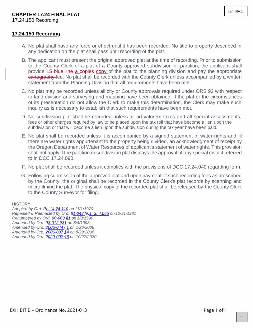
EXHIBIT B – Ordinance No. 2021-013 Page 1 of 1
CHAPTER 17.24 FINAL PLAT 1 7.24.150 Recording
117.24.150 Recording
A. No plat shall have any force or effect until it has been recorded. No title to property described in
any dedication on the plat shall pass until recording of the plat.
B. The applicant must present the original approved plat at the time of recording. Prior to submission to the County Clerk of a plat of a County-approved subdivision or partition, the applicant shall provide 15 blue line a copies copy of the plat to the planning division and pay the appropriate cartography fee. No plat shall be recorded with the County Clerk unless accompanied by a written statement from the Planning Division that all requirements have been met.
C. No plat may be recorded unless all city or County approvals required under ORS 92 with respect to land division and surveying and mapping have been obtained. If the plat or the circumstances of its presentation do not allow the Clerk to make this determination, the Clerk may make such inquiry as is necessary to establish that such requirements have been met.
D. No subdivision plat shall be recorded unless all ad valorem taxes and all special assessments, fees or other charges required by law to be placed upon the tax roll that have become a lien upon the subdivision or that will become a lien upon the subdivision during the tax year have been paid.
E. No plat shall be recorded unless it is accompanied by a signed statement of water rights and, if there are water rights appurtenant to the property being divided, an acknowledgment of receipt by the Oregon Department of Water Resources of applicant's statement of water rights. This provision shall not apply if the partition or subdivision plat displays the approval of any special district referred to in DCC 17.24.090.
F. No plat shall be recorded unless it complies with the provisions of DCC 17.24.040 regarding form.
G. Following submission of the approved plat and upon payment of such recording fees as prescribed by the County, the original shall be recorded in the County Clerk's plat records by scanning and microfilming the plat. The physical copy of the recorded plat shall be released by the County Clerk to the County Surveyor for filing.
HISTORY Adopted by Ord. P L-14 §4.110 on 11/1/1979 Repealed & Reenacted by Ord. 8 1-043 §§1, 3, 4.065 on 12/31/1981 Renumbered by Ord. 9 0-003 §1 on 1/8/1990 Amended by Ord. 9 3-012 §31 on 8/4/1993 Amended by Ord. 2 005-044 §1 on 1/26/2006 Amended by Ord. 2 006-007 §4 on 8/29/2006 Amended by Ord. 2 020-007 §6 on 10/27/2020
11
Item #IV.1.

EXHIBIT C – Ordinance No. 2021-013 Page 1 of 4
C HAPTER 18.04 TITLE, PURPOSE AND DEFINITIONS 18.04.030 Definitions
18.04.030 Definitions
“Current employment” of land for farm use includes:
A. Farmland, the operation or use of which is subject to any farm-related government program;
B. Land lying fallow for one year as a normal and regular requirement of good agricultural husbandry;
C. Land planted in orchards or other perennials, other than land specified in D below, prior to maturity;
D. Land not in an exclusive farm use zone which has not been eligible for assessment at special farm use value in the year prior to planting the current crop and has been planted in orchards, cultured Christmas trees or vineyards for at least three years;
E. Wasteland, in an exclusive farm use zone, dry or covered with water, neither economically tillable nor grazeable, lying in or adjacent to and in common ownership with a farm use land and which not currently being used for any economic farm use;
F. Except for land under a single family dwelling, land under buildings supporting accepted farm practices, including the processing facilities allowed DCC 18.16.025(JI) and the processing of farm crops into biofuel as commercial activities in conjunction with farm use under DCC 18.16.030(FE);
G. Water impoundments lying in or adjacent to and in common ownership with farm use land;
H. Any land constituting a woodlot, not to exceed 20 acres, contiguous to and owned by the owner of land specially valued for farm use even if the land constituting the woodlot is not utilized in conjunction with farm use;
I. Land lying idle for no more than one year where the absence of farming activity is due to the illness of the farmer or member of the farmer’s immediate family. For the purposes of this section, illness includes injury or infirmity whether or not such illness results in death;
J. Any land described under ORS 321.267(3) or 321.824(3);
K. Land use for the primary purpose of obtaining a profit in money by breeding, raising, kenneling or training of greyhounds for racing; and
L. Land used for the processing of farm crops into biofuel, as defined in ORS 315.141, if:
1. Only the crops of the landowner are being processed;
12
Item #IV.1.

EXHIBIT C – Ordinance No. 2021-013 Page 2 of 4
2. The biofuel from all of the crops purchased for processing into biofuel is used on the farm of the landowners; or
3. The landowner is custom processing crops into biofuel from other landowners in the area for their use or sale.
“Facility for the processing of farm products” means a facility for:
A. Processing farm crops, including the production of biofuel as defined in ORS 315.141, if at least one-quarter of the farm crops come from the farm operation containing the facility; or
A.B. Slaughtering, processing or selling poultry or poultry products from the farm operation containing the facility and consistent with the licensing exemption for a person under ORS 603.038(2)
"Manufactured home" shall have the meaning as set forth in ORS
446.003446.003(24)(a).
“Processing area” means the floor area of a building dedicated to farm product processing. “Processing area” does not include the floor area designated for preparation, storage or other farm use.
HISTORY Adopted by Ord. P L-15 on 11/1/1979 Amended by Ord. 8 2-013 §1 on 5/25/1982 Amended by Ord. 8 3-037 §2 on 6/1/1983 Amended by Ord. 8 3-033 §1 on 6/15/1983 Amended by Ord. 8 4-023 §1 on 8/1/1984 Amended by Ord. 8 5-002 §2 on 2/13/1985 Amended by Ord. 8 6-032 §1 on 4/2/1986 Amended by Ord. 8 6-018 §1 on 6/30/1986 Amended by Ord. 8 6-054 §1 on 6/30/1986 Amended by Ord. 8 6-056 §2 on 6/30/1986 Amended by Ord. 8 7-015 §1 on 6/10/1987 Amended by Ord. 8 8-009 §1 on 3/30/1988 Amended by Ord. 8 8-030 §3 on 8/17/1988 Amended by Ord. 8 8-030 §4 on 8/17/1988 Amended by Ord. 8 9-004 §1 on 3/24/1989 Amended by Ord. 8 9-009 §2 on 11/29/1989 Amended by Ord. 9 0-014 §2 on 7/12/1990 Amended by Ord. 9 1-002 §11 on 2/6/1991 Amended by Ord. 9 1-005 §1 on 3/4/1991 Amended by Ord. 9 2-025 §1 on 4/15/1991 Amended by Ord. 9 1-020 §1 on 5/29/1991 Amended by Ord. 9 1-038 §§3 and 4 on 9/30/1991 Amended by Ord. 9 2-004 §§1 and 2 on 2/7/1992 Amended by Ord. 9 2-034 §1 on 4/8/1992 Amended by Ord. 9 2-065 §§1 and 2 on 11/25/1992 Amended by Ord. 9 2-066 §1 on 11/25/1992 Amended by Ord. 9 3-002 §§1, 2 and 3 on 2/3/1993 Amended by Ord. 9 3-005 §§1 and 2 on 4/21/1993 Amended by Ord. 9 3-038 §1 on 7/28/1993 Amended by Ord. 9 3-043 §§1, 1A and 1B on 8/25/1993 Amended by Ord. 9 4-001 §§1, 2, and 3 on 3/16/1994 Amended by Ord. 9 4-008 §§1, 2, 3, 4, 5, 6, 7 and 8 on 6/8/1994
13
Item #IV.1.

EXHIBIT C – Ordinance No. 2021-013 Page 3 of 4
Amended by Ord. 9 4-041 §§2 and 3 on 9/14/1994 Amended by Ord. 9 4-038 §3 on 10/5/1994 Amended by Ord. 9 4-053 §1 on 12/7/1994 Amended by Ord. 9 5-007 §1 on 3/1/1995 Amended by Ord. 9 5-001 §1 on 3/29/1995 Amended by Ord. 9 5-075 §1 on 11/29/1995 Amended by Ord. 9 5-077 §2 on 12/20/1995 Amended by Ord. 9 6-003 §2 on 3/27/1996 Amended by Ord. 9 6-082 §1 on 11/13/1996 Amended by Ord. 9 7-017 §1 on 3/12/1997 Amended by Ord. 9 7-003 §1 on 6/4/1997 Amended by Ord. 9 7-078 §5 on 12/31/1997 Amended by Ord. 2 001-037 §1 on 9/26/2001 Amended by Ord. 2 001-044 §2 on 10/10/2001 Amended by Ord. 2 001-033 §2 on 10/10/2001 Amended by Ord. 2 001-048 §1 on 12/10/2001 Amended by Ord. 2 003-028 §1 on 9/24/2003 Amended by Ord. 2 004-001 §1 on 7/14/2004 Amended by Ord. 2 004-024 §1 on 12/20/2004
14
Item #IV.1.

EXHIBIT C – Ordinance No. 2021-013 Page 4 of 4
Amended by Ord. 2 005-041 §1 on 8/24/2005 Amended by Ord. 2 006-008 §1 on 8/29/2006 Amended by Ord. 2 007-019 §1 on 9/28/2007 Amended by Ord. 2 007-020 §1 on 2/6/2008 Amended by Ord. 2 007-005 §1 on 2/28/2008 Amended by Ord. 2 008-015 §1 on 6/30/2008 Amended by Ord. 2 008-007 §1 on 8/18/2008 Amended by Ord. 2 010-018 §3 on 6/28/2010 Amended by Ord. 2 010-022 §1 on 7/19/2010 Amended by Ord. 2 011-009 §1 on 10/17/2011 Amended by Ord. 2 012-004 §1 on 4/16/2012 Amended by Ord. 2 012-007 §1 on 5/2/2012 Amended by Ord. 2 013-008 §1 on 7/5/2013 Amended by Ord. 2 014-009 §1 on 8/6/2014 Amended by Ord. 2 015-004 §1 on 4/22/2015 Amended by Ord. 2 016-015 §1 on 7/1/2016 Amended by Ord. 2 016-026 §1 on 11/9/2016 Amended by Ord. 2 016-006 §1 on 2/27/2017 Amended by Ord. 2 017-015 §1 on 11/1/2017 Repealed by Ord. 2 018-005 §8 on 10/10/2018 Amended by Ord. 2 018-006 §4 on 11/20/2018 Amended by Ord. 2 019-010 §1 on 5/8/2019 Amended by Ord. 2 019-016 §1 on 2/24/2020 Amended by Ord. 2 020-001 §1 on 4/21/2020 Amended by Ord. 2 020-010 §1 on 7/3/2020 Amended by Ord. 2 020-007 §7 on 10/27/2020
15
Item #IV.1.

EXHIBIT D – Ordinance No. 2021-013 Page 1 of 16
CHAPTER 18.16 EXCLUSIVE FARM USE ZONES 1 8.16.023 Lawfully Established Dwelling Replacement 1 8.16.025 Uses Permitted Subject To The Special Provisions Under DCC Section 18.16.038 Or DCC S ection 18.16.042 And A Review Under DCC Chapter 18.124 Where Applicable 1 8.16.050 Standards For Dwellings In The EFU Zones
18.16.023 Lawfully Established Dwelling Replacement
A lawfully established dwelling may be altered, restored or replaced under DCC 18.16.020(J) above if, when an application for a permit is submitted, the County finds to its satisfaction, based on substantial evidence that:
A. The dwelling to be altered, restored or replaced met the following when an application for a permit
is submitted:
1. The dwelling has, or formerly had:
a. Intact exterior walls and roof structure;
b. Indoor plumbing consisting of a kitchen sink, toilet and bathing facilities connected to a sanitary waste disposal system;
c. Interior wiring for interior lights;
d. A heating system;
2. In addition to the provisions of subsection (A)(1), the dwelling to be replaced meets one of
the following conditions: The dwelling was assessed as a dwelling for purposes of ad valorem taxation for the previous five property tax years, or, if the dwelling has existed for less than five years, from that time; and
a. If the dwelling was removed, destroyed or demolished:
i. The dwelling’s tax lot does not have a lien for delinquent ad valorem taxes; and
ii. Any removal, destruction or demolition occurred on or after January 1, 1973;
b. If the dwelling is currently in such a state of disrepair that the dwelling is unsafe for occupancy or constitutes an attractive nuisance, the dwelling’s tax lot does not have a lien for delinquent ad valorem taxes; or
c. A dwelling not described in subparagraph (a) or (b) of this paragraph was assessed as a dwelling for purposes of ad valorem taxation:
i. For the previous five property tax years; or
ii. From the time when the dwelling was erected upon or affixed to the land and became subject to assessment as described in ORS 307.010 (Definitions of “land” and “real property” for state property tax laws).
3. Notwithstanding (2) above, if the value of the dwelling was eliminated as a result of either of the following circumstances, the dwelling was assessed as a dwelling unit until such time as the value of the dwelling was eliminated:
a. The destruction (i.e. by fire or natural hazard), or demolition in the case of restoration of the dwelling; or
b. The applicant establishes to the satisfaction of the County that the dwelling was
16
Item #IV.1.

EXHIBIT D – Ordinance No. 2021-013 Page 2 of 16
improperly removed from the tax roll by a person other than the current owner. “Improperly removed” means that the dwelling has taxable value in its present state, or had taxable value when the dwelling was first removed from the tax roll or was destroyed by fire or natural hazard, and the county stopped assessing the dwelling even though the current or former owner did not request removal of the dwelling from the tax roll.
B. For replacement of a lawfully established dwelling under DCC 18.16.020(J):
1. The dwelling to be replaced must be removed, demolished or converted to an allowable nonresidential use:
a. Within one year after the date the replacement dwelling is certified for occupancy pursuant to ORS 455.055 and DCC Chapter 15.04; or
b. If the dwelling to be replaced is, in the discretion of the County, in such a state of disrepair that the structure is unsafe for occupancy or constitutes an attractive nuisance, on or before a date set by the County that is not less than 90 days after the replacement permit is issued; and
c. If a dwelling is removed by moving it off the subject parcel to another location, the applicant must first obtain approval from the County for the new location.
2. The applicant must cause to be recorded in the deed records of the County a statement
that the dwelling to be replaced has been removed, demolished or converted.
3. Deed Restrictions.
a. As a condition of approval, if the dwelling to be replaced is located on a portion of the lot or parcel that is not zoned for exclusive farm use, the applicant shall execute and cause to be recorded in the deed records of the County a deed restriction prohibiting the siting of another dwelling on that portion of the lot or parcel.
b. The restriction imposed is irrevocable unless the County Planning Director, or the Director’s designee, places a statement of release in the deed records of the County to the effect that the provisions of 2013 2019 Oregon Laws, chapter 462440, section 2 1 and ORS 215.283 regarding replacement dwellings have changed to allow the lawful siting of another dwelling.
4. The replacement dwelling:
a. May be sited on any part of the same lot or parcel; and
b.a. Must comply with applicable siting standards such as minimum setbacks. However, the standards may not be applied in a manner that prohibits the siting of the replacement dwelling.
c.b. Must comply with applicable building codes, plumbing codes, sanitation codes and other requirements related to health and safety or to siting at the time of construction. However, the standards may not be applied in a manner that prohibits the siting of the replacement dwelling.
C. The siting standards of DCC 18.16.023(D) apply when a dwelling under DCC 18.16.020(J) qualifies
for replacement because the dwelling:
17
Item #IV.1.

EXHIBIT D – Ordinance No. 2021-013 Page 3 of 16
1. Formerly had the features described in DCC 18.16.023(A)(1)(a) through (d);
2. Was removed from the tax roll as described in DCC 18.16.023(A)(3); or
3. Had a permit that expired as described under DCC 18.16.023(E)(2)
D.C. The replacement dwelling per DCC 18.16.023(C) must be sited on the same lot or parcel:
1. Using all or part of the footprint of the replaced dwelling or near a road, ditch, river, property line, forest boundary or another natural boundary of the lot or parcel; and
2. If possible, for the purpose of minimizing the adverse impacts on resource use of land in the area, within a concentration or cluster of structures or within 500 yards of another structure.
3. Replacement dwellings that currently have the features described in DCC 18.16.023(A)(1) (a) through (d) and that have been on the tax roll as described in 18.16.023(A)(2) may be sited on any part of the same lot or parcel.
E.D. A replacement dwelling permit that is issued under DCC 18.16.020(J):
1. Is a land use decision as defined in ORS 197.015 where the dwelling to be replaced:
a. Formerly had the features described in DCC 18.16.023(A)(1)(a) through(d); or
b. Is eligible for replacement under DCC 18.16.023(A)(2)(b);Was removed from the tax roll as described in DCC 18.16.023(A)(3).
2. Is not subject to the time to act limits of ORS 215.417.; and
3. If expired before January 1, 2014, shall be deemed to be valid and effective, if, before January 1, 2015, the holder of the permit:
a. Removes, demolishes or converts to an allowable nonresidential use the dwelling to be replaced; and
b. Causes to be recorded in the deed records of the County a statement that the dwelling to be replaced has been removed, demolished or converted.
F.E. A temporary residence approved under DCC 18.116.080 or 18.116.090 is not eligible for replacement under this section.
HISTORY Adopted by Ord. 2 014-010 §1 on 4/28/2014
18.16.025 Uses Permitted Subject To The Special Provisions Under DCC Section 18.16.038 Or D CC Section 18.16.042 And A Review Under DCC Chapter 18.124 Where Applicable
A. Dwellings customarily provided in conjunction with farm use (farm-related dwellings), subject to
DCC 18.16.050.
B. A relative farm assistance dwelling, subject to DCC 18.16.050.
C. Religious institutions or assemblies and cemeteries in conjunction with religious institutions or assemblies consistent with ORS 215.441 and OAR 660-033-0130(2) on non-high value farmland.
D. Expansion of an existing church or cemetery in conjunction with a church on the same tract as the existing use, subject to Oregon Administrative Rules 660-033-0130.
18
Item #IV.1.

EXHIBIT D – Ordinance No. 2021-013 Page 4 of 16
E. Utility facilities necessary for public service, including wetland waste treatment systems, but not including commercial facilities for the purpose of generating electrical power for public use by sale and transmission towers over 200 feet in height. A utility facility necessary for public service may be established as provided in:
1. DCC 18.16.038(A); or
2. DCC 18.16.038(E) if the utility facility is an associated transmission line, as defined in ORS 469.300.
F. Winery, as described in ORS 215.452.
G. Farm stands, subject to DCC 18.16.038.
H. A site for the takeoff and landing of model aircraft, including such buildings or facilities as may be reasonably necessary.
I. A facility for the processing of farm crops, subject to the following standards:or for the production of biofuel as defined in ORS 315.141, if the facility is located on a farm operation that provides at
least one-quarter of the farm crops processed at the facility, or an establishment for the slaughter, processing or selling of poultry or poultry products pursuant to ORS 603.038.
1. The facility:
a. Uses less than 10,000 square feet for its processing area and complies with all applicable siting standards. Siting standards shall not be applied in a manner that prohibits the siting of a facility for the processing of farm products; or
b. Notwithstanding any applicable siting standard, uses less than 2,500 square feet for its processing area. However, applicable standards and criteria pertaining to floodplains, geologic hazards, beach and dune hazards, airport safety, tsunami hazards and fire siting standards shall apply
2. The County shall not approve any division of a lot or parcel that separates a facility for the processing of farm products from the farm operation on which it is located.
1. If a building is established or used for the processing facility or establishment, the farm operator may not devote more than 10,000 square feet of floor area to the processing facility or establishment, exclusive of the floor area designated for preparation, storage or other farm use .
2. A processing facility or establishment must comply with all applicable siting standards but the standards shall not be applied in a manner that prohibits the siting of the processing facility.
3. The County shall not approve any division of a lot or parcel that separates a processing facility or establishment from the farm operation on which it is located.
J. Agri-tourism and other commercial events and activities subject to DCC 18.16.042.
K. Dog training classes or testing trials conducted outdoors or in farm buildings that existed on January 1, 20132019, when:
1. The number of dogs participating in training does not exceed 10 per training class and the number of training classes to be held on-site does not exceed six per day; and
2. The number of dogs participating in a testing trial does not exceed 60 and the number of testing trials to be conducted on-site does not exceed four per calendar year.
19
Item #IV.1.

EXHIBIT D – Ordinance No. 2021-013 Page 5 of 16
HISTORY Adopted by Ord. 2 004-001 §2 on 7/14/2004 Amended by Ord. 2 008-001 §2 on 5/6/2008 Amended by Ord. 2 009-014 §1 on 6/22/2009 Amended by Ord. 2 010-022 §2 on 7/19/2010 Amended by Ord. 2 012-004 §2 on 4/16/2012 Amended by Ord. 2 012-007 §2 on 5/2/2012 Amended by Ord. 2 014-010 §1 on 4/28/2014 Amended by Ord. 2 016-015 §2 on 7/1/2016 Amended by Ord. 2 020-001 §3 on 4/21/2020 Amended by Ord. 2 021-004 §1 on 5/27/2021
18.16.030 Conditional Uses Permitted; High Value And Non-High Value Farmland
The following uses may be allowed in the Exclusive Farm Use zones on either high value farmland or non-high value farmland subject to applicable provisions of the Comprehensive Plan, DCC 18.16.040 and 18.16.050, and other applicable sections of DCC Title 18.
A. Nonfarm dwelling.
B. Lot of record dwelling.
C. Residential home or facility, as defined in DCC 18.04.030, in existing dwellings.
D. A hardship dwelling, which can include one manufactured dwelling or recreational vehicle, in conjunction with an existing dwelling as a temporary use for the term of a hardship suffered by the existing resident or a relative of the resident.as described in DCC 18.16.050(H).
E. Commercial activities that are in conjunction with farm use, but not including the processing of farm crops as described in DCC 18.16.025.
F. Operations conducted for: Mining and processing of geothermal resources as defined by ORS 522.005, and Mining and processing of natural gas or oil as defined by ORS 520.005, not otherwise permitted under DCC 18.16.020.
G. Expansion of an existing private park, playground, hunting and fishing preserve and campground on the same tract as the existing use.
H. Public park and playground consistent with the provisions of ORS 195.120, and including only the uses specified under OAR 660-034-0035 or 660-034-0040, whichever is applicable.
I. Community centers owned by a governmental agency or a nonprofit organization and operated primarily by and for residents of the local rural community.
1. A community center authorized under this section may provide services to veterans, including but not limited to emergency and transitional shelter, preparation and service of meals, vocational and educational counseling and referral to local, state or federal agencies providing medical, mental health, disability income replacement and substance abuse services, only in a facility that is in existence on January 1, 2006.
2. The services may not include direct delivery of medical, mental health, disability income replacement or substance abuse services.
J. Transmission towers over 200 feet in height.
K. Commercial utility facility, including a hydroelectric facility (in accordance with DCC 18.116.130 and 18.128.260, and OAR 660-033-0130), for the purpose of generating power for public use by sale, not including wind power generation facilities.
20
Item #IV.1.
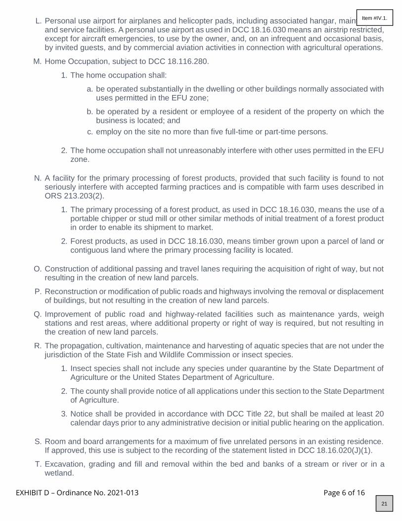
EXHIBIT D – Ordinance No. 2021-013 Page 6 of 16
L. Personal use airport for airplanes and helicopter pads, including associated hangar, maintenance and service facilities. A personal use airport as used in DCC 18.16.030 means an airstrip restricted, except for aircraft emergencies, to use by the owner, and, on an infrequent and occasional basis, by invited guests, and by commercial aviation activities in connection with agricultural operations.
M. Home Occupation, subject to DCC 18.116.280.
1. The home occupation shall:
a. be operated substantially in the dwelling or other buildings normally associated with uses permitted in the EFU zone;
b. be operated by a resident or employee of a resident of the property on which the business is located; and
c. employ on the site no more than five full-time or part-time persons.
2. The home occupation shall not unreasonably interfere with other uses permitted in the EFU
zone.
N. A facility for the primary processing of forest products, provided that such facility is found to not
seriously interfere with accepted farming practices and is compatible with farm uses described in ORS 213.203(2).
1. The primary processing of a forest product, as used in DCC 18.16.030, means the use of a portable chipper or stud mill or other similar methods of initial treatment of a forest product in order to enable its shipment to market.
2. Forest products, as used in DCC 18.16.030, means timber grown upon a parcel of land or contiguous land where the primary processing facility is located.
O. Construction of additional passing and travel lanes requiring the acquisition of right of way, but not
resulting in the creation of new land parcels.
P. Reconstruction or modification of public roads and highways involving the removal or displacement of buildings, but not resulting in the creation of new land parcels.
Q. Improvement of public road and highway-related facilities such as maintenance yards, weigh stations and rest areas, where additional property or right of way is required, but not resulting in the creation of new land parcels.
R. The propagation, cultivation, maintenance and harvesting of aquatic species that are not under the jurisdiction of the State Fish and Wildlife Commission or insect species.
1. Insect species shall not include any species under quarantine by the State Department of Agriculture or the United States Department of Agriculture.
2. The county shall provide notice of all applications under this section to the State Department of Agriculture.
3. Notice shall be provided in accordance with DCC Title 22, but shall be mailed at least 20 calendar days prior to any administrative decision or initial public hearing on the application.
S. Room and board arrangements for a maximum of five unrelated persons in an existing residence.
If approved, this use is subject to the recording of the statement listed in DCC 18.16.020(J)(1).
T. Excavation, grading and fill and removal within the bed and banks of a stream or river or in a wetland.
21
Item #IV.1.

EXHIBIT D – Ordinance No. 2021-013 Page 7 of 16
U. Roads, highways and other transportation facilities, and improvements not otherwise allowed under DCC 18.16, if an exception to Goal 3, Agricultural Lands, and to any other applicable goal is first granted under state law. Transportation uses and improvements may be authorized under conditions and standards as set forth in OAR 660-012-0035 and 660-012-0065.
V. Surface mining of mineral and aggregate resources in conjunction with the operation and maintenance of irrigation systems operated by an Irrigation District, including the excavation and mining for facilities, ponds, reservoirs, and the off-site use, storage, and sale of excavated material.
W. A living history museum.
X. Operations for the extraction and bottling of water.
Y. Transportation improvements on rural lands allowed by OAR 660-012-0065.
Z. Expansion of existing county fairgrounds and activities relating to county fairgrounds governed by county fair boards established pursuant to ORS 565.210.
AA. Extended outdoor mass gatherings, subject to DCC 8.16.
AB. A landscape contracting business, as defined in ORS 671.520, or a business providing landscape architecture services, as described in ORS 671.318, if the business is pursued in conjunction with the growing and marketing of nursery stock on the land that constitutes farm use.
AC. Wind power generation facilities as commercial utility facilities for the purpose of generating power for public use by sale, subject to OAR 660-033-0130.
AD. Photovoltaic solar power generation facilities as commercial utility facilities for the purpose of generating power for public use by sale, subject to OAR 660-033-0130. On high-value farmland only, photovoltaic solar power generation facilities are subject to the provisions in ORS 215.447.
AE. Commercial dog boarding kennel, or dog training classes or testing trials that exceed the standards under DCC 18.16.025(K), subject to DCC 18.16.040(A)(1 and 2).
AF. Equine and equine-affiliated therapeutic and counseling activities, provided:
1. The activities are conducted in existing buildings that were lawfully constructed on the property before the effective date of January 1, 2019 or in new buildings that are accessory, incidental and subordinate to the farm use on the tract; and
2. All individuals conducting therapeutic or counseling activities are acting within the proper scope of any licenses required by the state.
HISTORY Adopted by Ord. P L-15 on 11/1/1979 Amended by Ord. 8 3-028 §1 on 6/1/1983 Amended by Ord. 8 6-018 §3 on 6/30/1986 Amended by Ord. 8 7-013 §1 on 6/10/1987 Amended by Ord. 9 0-018 §1 on 5/16/1990 Amended by Ord. 9 0-014 §§23 and 31 on 7/12/1990 Amended by Ord. 9 1-005 §5 on 3/4/1991 Amended by Ord. 9 1-014 §1 on 3/13/1991 Amended by Ord. 9 1-020 §1 on 5/29/1991 Amended by Ord. 9 1-038 §2 on 9/30/1991 Amended by Ord. 9 2-065 §3 on 11/25/1992 Amended by Ord. 9 4-008 §9 on 6/8/1994 Amended by Ord. 9 5-007 §11 on 3/1/1995 Amended by Ord. 9 5-025 §1 on 3/3/1995 Amended by Ord. 98-030 §1 on 5/13/1998 Amended by Ord. 2 001-016 §2 on 3/28/2001 Amended by Ord. 2 001-039 §1 on 12/12/2001
22
Item #IV.1.
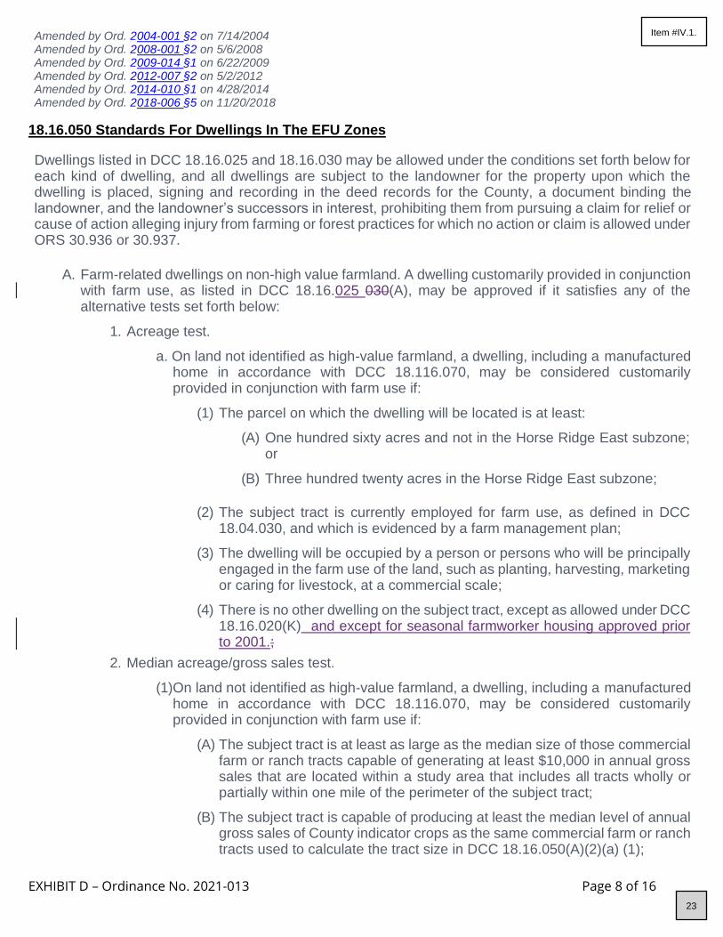
EXHIBIT D – Ordinance No. 2021-013 Page 8 of 16
Amended by Ord. 2 004-001 §2 on 7/14/2004 Amended by Ord. 2 008-001 §2 on 5/6/2008 Amended by Ord. 2 009-014 §1 on 6/22/2009 Amended by Ord. 2 012-007 §2 on 5/2/2012 Amended by Ord. 2 014-010 §1 on 4/28/2014 Amended by Ord. 2 018-006 §5 on 11/20/2018
18.16.050 Standards For Dwellings In The EFU Zones
Dwellings listed in DCC 18.16.025 and 18.16.030 may be allowed under the conditions set forth below for each kind of dwelling, and all dwellings are subject to the landowner for the property upon which the dwelling is placed, signing and recording in the deed records for the County, a document binding the landowner, and the landowner’s successors in interest, prohibiting them from pursuing a claim for relief or cause of action alleging injury from farming or forest practices for which no action or claim is allowed under ORS 30.936 or 30.937.
A. Farm-related dwellings on non-high value farmland. A dwelling customarily provided in conjunction
with farm use, as listed in DCC 18.16.025 030(A), may be approved if it satisfies any of the alternative tests set forth below:
1. Acreage test.
a. On land not identified as high-value farmland, a dwelling, including a manufactured home in accordance with DCC 18.116.070, may be considered customarily provided in conjunction with farm use if:
(1) The parcel on which the dwelling will be located is at least:
(A) One hundred sixty acres and not in the Horse Ridge East subzone; or
(B) Three hundred twenty acres in the Horse Ridge East subzone;
(2) The subject tract is currently employed for farm use, as defined in DCC
18.04.030, and which is evidenced by a farm management plan;
(3) The dwelling will be occupied by a person or persons who will be principally engaged in the farm use of the land, such as planting, harvesting, marketing or caring for livestock, at a commercial scale;
(4) There is no other dwelling on the subject tract, except as allowed under DCC 18.16.020(K) and except for seasonal farmworker housing approved prior to 2001.;
2. Median acreage/gross sales test.
(1) On land not identified as high-value farmland, a dwelling, including a manufactured home in accordance with DCC 18.116.070, may be considered customarily provided in conjunction with farm use if:
(A) The subject tract is at least as large as the median size of those commercial farm or ranch tracts capable of generating at least $10,000 in annual gross sales that are located within a study area that includes all tracts wholly or partially within one mile of the perimeter of the subject tract;
(B) The subject tract is capable of producing at least the median level of annual gross sales of County indicator crops as the same commercial farm or ranch tracts used to calculate the tract size in DCC 18.16.050(A)(2)(a) (1);
23
Item #IV.1.

EXHIBIT D – Ordinance No. 2021-013 Page 9 of 16
(C) The subject tract is currently employed for farm use, as defined in DCC 18.04.030, and which is evidenced by a farm management plan, at a level capable of producing the annual gross sales required in DCC 18.16.050(A) (2)(a)(2). If no farm use has been established at the time of application, land use approval shall be subject to a condition that no building permit may be issued prior to establishment of the farm use capable of meeting the median income test.
(D) The subject lot or parcel on which the dwelling is proposed is at least 20 acres in size;
(E) There is no other dwelling on the subject tract(1), except as allowed under DCC 18.16.020(K) and except for seasonal farmworker housing approved prior to 2001; and
(F) The dwelling will be occupied by a person or persons who will be principally engaged in the farm use of the land, such as planting, harvesting, marketing or caring for livestock, at a commercial scale.
(2) For the purpose of calculating appropriate tract sizes and gross incomes to satisfy
DCC 18.16.050(A)(2)(a)(1) and (2), the County will utilize the methodology contained in Oregon Administrative Rules 660 33 135(3) using data on gross sales per acre tabulated by LCDC pursuant to Oregon Administrative Rules 660 33 135(4).
3. Gross annual income test.
(1) On land not identified as high-value farmland, a dwelling, including a manufactured home in accordance with DCC 18.116.070, may be considered customarily provided in conjunction with farm use if:
(A) The subject tract is currently employed for a farm use, and that the farm operator earned $40,000 in gross annual revenue in the last two years, three of the last five years, or based on the average farm revenue earned on the tract in the highest three of the last five years.
(B) There is no other dwelling on the subject tract, except as allowed under 18.16.020(K) and except for seasonal farmworker housing approved prior to 2001;
(C) The dwelling will be occupied by a person or persons who produced the commodities which grossed the income in DCC 18.16.050(A)(3)(a)(1); and
(2) In determining gross revenue, the cost of purchased livestock shall be deducted from the total gross revenue attributed to the tract.
(3) Noncontiguous lots or parcels zoned for farm use in the same county or contiguous counties may be used to meet the gross revenue requirements.
(4) Only gross revenue from land owned, not leased or rented, shall be counted; and gross farm revenue earned from a lot or parcel which has been used previously to qualify another lot or parcel for the construction or siting of a primary farm dwelling may not be used.
(5) Prior to a dwelling being approved under this section that requires one or more contiguous or noncontiguous lots or parcels of a farm or ranch operation to comply with the gross farm revenue requirements, the applicant shall provide evidence that the covenants, conditions and restrictions form attached to Chapter 18.16, has been
24
Item #IV.1.

EXHIBIT D – Ordinance No. 2021-013 Page 10 of 16
recorded with the county clerk or counties where the property subject to the covenants, conditions and restrictions is located.
(A) The covenants, conditions and restrictions shall be recorded for each lot or parcel subject to the application for primary farm dwelling and shall preclude:
(A) All future rights to construct a dwelling except for accessory farm dwellings, relative farm assistance dwellings, temporary hardship dwellings or replacement dwellings allowed under ORS Chapter 215; and
(B) The use of any gross farm revenue earned on the lots or parcels to qualify another lot or parcel for a primary farm dwelling;
(C) The covenants, conditions and restrictions are irrevocable, unless a statement of release is signed by an authorized representative of the county or counties where the property subject to the covenants, conditions and restrictions is located;
(D) The failure to follow the requirements of this section shall not affect the validity of the transfer of property or the legal remedies available to the buyers of property which is subject to the covenants, conditions and restrictions required by this section.
B. Farm related dwellings on high value farmland. On land identified as high-value farmland, a dwelling, including a manufactured home in accordance with DCC 18.116.070, may be considered customarily provided in conjunction with farm use if:
1. The subject lot or parcel is currently employed for the farm use as defined in DCC 18.04.030, and that the farm operator earned at least $80,000 in gross annual revenue from the sale of farm products in the last two years, three of the last five years, or based on the average farm revenue earned by the farm operator in the best three of the last five years. In determining gross revenue, the cost of purchased livestock shall be deducted from the total gross revenue attributed to the tract;
2. There is no other dwelling on the subject tract, except as allowed under 18.16.020(K) and except for seasonal farmworker housing approved prior to 2001;
3. The dwelling will be occupied by a person or persons who produced the commodities which grossed the revenue under DCC 18.16.050(B)(1);
4. Noncontiguous lots or parcels zoned for farm use in the same county or contiguous counties may be used to meet the gross revenue requirements.
5. When a farm or ranch operation has lots or parcels in both “western” and “eastern” Oregon as defined in OAR 660-033-0020, lots or parcels in eastern or western Oregon may not be used to qualify a dwelling in the other part of the state.
6. Only gross revenue from land owned, not leased or rented, shall be counted; and gross farm revenue earned from a lot or parcel which has been used previously to qualify another lot or parcel for the construction or siting of a primary farm dwelling may not be used.
7. Prior to a dwelling being approved under this section that requires one or more contiguous or noncontiguous lots or parcels of a farm or ranch operation to comply with the gross farm revenue requirements, the applicant shall provide evidence that the covenants, conditions and restrictions form attached to Chapter 18.16 has been recorded with the county clerk.
25
Item #IV.1.

EXHIBIT D – Ordinance No. 2021-013 Page 11 of 16
The covenants, conditions and restrictions shall be recorded for each lot or parcel subject to the application for primary farm dwelling and shall preclude:
(1) All future rights to construct a dwelling except for accessory farm dwellings, relative farm assistance dwellings, temporary hardship dwellings or replacement dwellings allowed by ORS Chapter 215; and
(2) The use of any gross farm revenue earned on the lots or parcels to qualify another lot or parcel for a primary farm dwelling.
C. Accessory dwelling. A dwelling, including a manufactured home in accordance with DCC 18.116.070, is considered to be an accessory farm dwelling customarily provided in conjunction with farm use when:
1. The accessory dwelling meets the following criteria:
(1) The accessory farm dwelling will be occupied by a person or persons who will be principally engaged in the farm use of the land and whose seasonal or year-round assistance in the management of the farm use, such as planting, harvesting, marketing or caring for livestock, is or will be required by the farm operator; and
(2) The accessory farm dwelling will be located:
(A) On the same lot or parcel as the primary farm dwelling; or
(B) On the same tract as the primary farm dwelling when the lot or parcel on which the accessory farm dwelling will be sited is consolidated into a single parcel with all other contiguous lots and parcels in the tract; or
(C) On a lot or parcel on which the primary farm dwelling is not located, when the accessory farm dwelling is limited to only a manufactured home and a deed restriction substantially in compliance with the form set forth in E xhibit A to DCC 18.16 is filed with the County Clerk. The deed restriction shall require the manufactured dwelling to be removed when the lot or parcel is conveyed to another party. The manufactured home may remain if it is reapproved under DCC 18.16.050; or
(D) On a lot or parcel on which the primary farm dwelling is not located, when the accessory farm dwelling is located on a lot or parcel at least the size of the applicable minimum lot size under DCC 18.16.065 and the lot or parcel complies with the gross farm income requirements in DCC 18.16.050(A)(3) or (B)(1), whichever is applicable; and
(3) There is no other dwelling on land zoned EFU owned by the farm operator that
is vacant or currently occupied by persons not working on the subject farm or ranch and that could reasonably be used as an accessory farm dwelling; and
2. The primary farm dwelling to which the proposed dwelling would be accessory meets one
of the following:
(1) On land not identified as high-value farmland, the primary farm dwelling is located on a farm or ranch operation that is currently employed in farm use and produced $40,000 in gross annual sales in the last two years, three of the last five years, or based on the average farm revenue earned on the tract in the highest three of the last five years. In determining gross revenue, the cost of purchased livestock shall be deducted from the total gross revenue attributed to the tract; or
26
Item #IV.1.

EXHIBIT D – Ordinance No. 2021-013 Page 12 of 16
(2) On land identified as high-value farmland, the primary farm dwelling is located on a farm or ranch operation that is currently employed for farm use, and produced at least $80,000 in gross annual revenue from the sale of farm products in the last two years, three of the last five years, or based on the average farm revenue earned on the tract in the highest three of the last five years. Gross revenue shall be calculated by deducting the cost of purchased livestock from the total gross revenue attributed to the tract; and
3. A lot or parcel approved for an accessory farm dwelling under DCC 18.16.050 shall not be
approved for a division of land except as provided for in DCC 18.16.055(B).
4. An accessory farm dwelling approved pursuant to this section cannot later be used to satisfy the requirements for a nonfarm dwelling pursuant to DCC 18.16.050(G).
D. Relative farm help dwelling.
1. A dwelling listed in DCC 18.16.025(B) is allowed when:
(1) The subject tract is a commercial farming operation.
(2) The dwelling is a manufactured home and is sited in accordance with DCC 18.116.070, or is a site-built home;
(3) The dwelling is located on the same lot or parcel as the dwelling of the farm operator, and is occupied by a relative of the farm operator or farm operator’s spouse, including a grandparent, step-grandparent, grandchild, parent, step- parent, child, sibling, step-sibling, niece, nephew, or first cousin of either, if the farm operator does, or will, require the assistance of the relative in the management of the farm use.
(A) Notwithstanding ORS 92.010 to 92.190 or the minimum lot or parcel size requirements under ORS 215.780, if the owner of a dwelling described in this subsection obtains construction financing or other financing secured by the dwelling and the secured party forecloses on the dwelling, the secured party may also foreclose on the homesite, as defined in ORS 308A.250, and the foreclosure shall operate as a partition of the homesite to create a new parcel.
(B) Prior conditions of approval for the subject land and dwelling remain in effect.
(C) For purposes of this subsection, “Foreclosure” means only those foreclosures that are exempt from partition under ORS 92.010(9)(a).
(4) The farm operator plays the predominant role in the management and farm use of
the farm and will continue to do so after the relative farm help dwelling is approved.
(5) Any approval granted under DCC 18.16.050 shall be conditioned with a requirement that the farm operator annually submit a report to the Planning Division identifying the resident(s) of the dwelling, their relationship to the farm operator, the assistance the resident provides to the farm operator, and verifying the farm operator’s continued residence on the property and the predominant role the farm operator continues to play in the management and farm use of the farm.
2. A manufactured home permitted under DCC 18.16.050 shall be considered to be a
temporary installation, and permits for such home shall be renewable and renewed on an
27
Item #IV.1.

EXHIBIT D – Ordinance No. 2021-013 Page 13 of 16
annual basis. The manufactured home shall be removed from the property if it no longer meets the criteria of DCC 18.16.050 and the approval shall be so conditioned.
3. A dwelling approved under DCC 18.16.050 shall be removed or converted to an allowable use within one year of the date the relative farm help dwelling no longer meets the criteria of DCC 18.16.050 and the approval shall be so conditioned.
4. Upon approval of a dwelling under DCC 18.16.050, a Conditions of Approval Agreement shall be recorded with the Deschutes County Clerk prior to issuance of any building or placement permit for the new dwelling on the property.
5. For the purposes of DCC 18.16.050(D), a farm operator is a person who operates a farm, doing the work and making the day-to-day decisions about such things as planting, harvesting, feeding and marketing.
E. Lot of record dwelling on non-high value farmland.
1. A lot of record dwelling may be approved on a pre-existing lot or parcel on non-high value farmland when all of the following requirements are met:
(1) The lot or parcel on which the dwelling will be sited was lawfully created and was acquired and owned continuously by the present owner:
(A) Prior to January 1, 1985; or
(B) By devise or by intestate succession from a person who acquired and owned continuously the lot or parcel prior to January 1, 1985.
(2) The tract on which the dwelling will be sited does not include a dwelling.
(3) For lots or parcels located within a wildlife area (WA) combining zone, siting of the proposed dwelling would be consistent with the limitations on density as applied under the applicable density restrictions of DCC 18.88.
(4) If the lot or parcel on which the dwelling will be sited is part of a tract, the remaining portions of the tract shall be consolidated into a single lot or parcel when the dwelling is allowed.
(5) The County Assessor shall be notified of any approval of a dwelling under DCC 18.16.050.
(6) If the lot or parcel on which the dwelling will be sited was part of a tract on November 4, 1993, no dwelling exists on another lot or parcel that was part of the tract;
2. For purposes of DCC 18.16.050(E), "owner" includes the wife, husband, son, daughter,
mother, father, brother, brother-in-law, sister, sister-in-law, son-in-law, daughter-in-law, mother-in-law, father-in-law, aunt, uncle, niece, nephew, step-parent, step-child,
grandparent or grandchild of the owner or a business entity owned by any one or a combination of these family members.
3. For purposes of DCC 18.16.050(E), the date of creation and existence means that, when a lot, parcel or tract is reconfigured pursuant to applicable law after November 4, 1993, the effect of which is to qualify a lot, parcel or tract for the siting of a lot of record dwelling, the date of the reconfiguration is the date of creation and existence. Reconfigured means any change in the boundary of the lot, parcel or tract.
28
Item #IV.1.

EXHIBIT D – Ordinance No. 2021-013 Page 14 of 16
F. Lot of record dwelling on high-value farmland.
1. A lot of record dwelling on a pre-existing lot or parcel will be approved on high value farmland when all of the following requirements are met:
(1) The requirements set forth in DCC 18.16.050(E)(1)(a) through (f), as determined by the County; and
(2) The requirements of Oregon Administrative Rules 660-33-130(3)(c)(C), as determined by the County hearings officer.
2. Applicants under DCC 18.16.050(F) shall make their application to the County. The County
shall notify the State Department of Agriculture at least 20 calendar days prior to the public hearing under DCC 18.16.050(F)(1)(b).
3. Applicants under DCC 18.16.050(F) shall be subject to such other procedural requirements as are imposed by the Oregon Department of Agriculture.
4. For purposes of DCC 18.16.050(F), the date of creation and existence means that, when a lot, parcel or tract is reconfigured pursuant to applicable law after November 4, 1993, the effect of which is to qualify a lot, parcel or tract for the siting of a lot of record dwelling, the date of the reconfiguration is the date of creation and existence. Reconfigured means any change in the boundary of the lot, parcel or tract.
G. Nonfarm dwelling.
1. One single-family dwelling, including a manufactured home in accordance with DCC 18.116.070, not provided in conjunction with farm use, may be permitted on an existing lot or parcel subject to the following criteria:
a. The Planning Director or Hearings Body shall make findings that:
(1) The dwelling or activities associated with the dwelling will not force a significant change in or significantly increase the cost of accepted farming practices, as defined in ORS 215.203(2)(c), or accepted forest practices on nearby lands devoted to farm or forest use.
(2) The proposed nonfarm dwelling will not materially alter the stability of the overall land use pattern of the area. In determining whether a proposed nonfarm dwelling will alter the stability of the land use pattern in the area, the County shall consider the cumulative impact of nonfarm dwellings on other lots or parcels in the area similarly situated, by applying the standards under OAR 660-033-0130(4)(a)(D), and whether creation of the parcel will lead to creation of other nonfarm parcels, to the detriment of agriculture in the area.
(3) The proposed nonfarm dwelling is situated on an existing lot or parcel, or a portion of a lot or parcel that is generally unsuitable for the production of farm crops and livestock or merchantable tree species, considering the
terrain, adverse soil or land conditions, drainage and flooding, vegetation, location and size of the tract.
(4) The proposed nonfarm dwelling is not within one-quarter mile of a dairy farm, feed lot or sales yard, unless adequate provisions are made and approved by the Planning Director or Hearings Body for a buffer between such uses. The establishment of a buffer shall be designed based upon consideration of such factors as prevailing winds, drainage, expansion potential of
29
Item #IV.1.

EXHIBIT D – Ordinance No. 2021-013 Page 15 of 16
affected agricultural uses, open space and any other factor that may affect the livability of the nonfarm-dwelling or the agriculture of the area.
(5) Road access, fire and police services and utility systems (i.e., electrical and telephone) are adequate for the use.
(6) The nonfarm dwelling shall be located on a lot or parcel created prior to January 1, 1993, or was created or is being created as a nonfarm parcel under the land division standards in DCC 18.16.055(B) or (C).
2. For the purposes of DCC 18.16.050(G) only, "unsuitability" shall be determined with reference to the following:
(1) A lot or parcel or a portion of a lot or parcel shall not be considered unsuitable solely because of size or location if it can reasonably be put to farm or forest use in conjunction with other land. If the parcel is under forest assessment, the dwelling shall be situated upon generally unsuitable land for the production of merchantable tree species recognized by the Forest Practices Rules, considering the terrain, adverse soil or land conditions, drainage and flooding, vegetation, location and size of the parcel.
(2) A lot or parcel or portion of a lot or parcel is not "generally unsuitable" simply because it is too small to be farmed profitably by itself. If a lot or parcel or portion of a lot or parcel can be sold, leased, rented or otherwise managed as part of a commercial farm or ranch, it is not "generally unsuitable." A lot or parcel or portion of a lot or parcel is presumed to be suitable if it is composed predominantly of Class I-VI soils. Just because a lot or parcel or portion of a lot or parcel is unsuitable for one farm use does not mean it is not suitable for another farm use. If the parcel is under forest assessment, the area is not "generally unsuitable" simply because it is too small to be managed for forest production profitably by itself.
(3) If a lot or parcel under forest assessment can be sold, leased, rented or otherwise managed as a part of a forestry operation, it is not "generally unsuitable." If a lot or parcel is under forest assessment, it is presumed suitable if it is composed predominantly of soil capable of producing 20 cubic feet of wood fiber per acre per year. If a lot or parcel is under forest assessment, to be found compatible and not seriously interfere with forest uses on surrounding land it must not force a significant change in forest practices or significantly increase the cost of those practices on the surrounding land.
3. Loss of tax deferral. Pursuant to ORS 215.236, a nonfarm dwelling on a lot or parcel in an
Exclusive Farm Use zone that is or has been receiving special assessment may be approved only on the condition that before a building permit is issued the applicant must produce evidence from the County Assessor's office that the parcel upon which the dwelling is proposed has been disqualified under ORS 308A.050 to 308A.128 or other special assessment under ORS 308A.315, 321.257 to 321.390, 321.700 to 321.754 or
321.805 to 321.855 and that any additional tax or penalty imposed by the County Assessor as a result of disqualification has been paid.
H. Temporary hardship dwelling.
1. A temporary hardship dwelling listed in DCC 18.16.030 is allowed under the following conditions:
(1) The dwelling is an existing building, or is a manufactured home or recreational
30
Item #IV.1.

EXHIBIT D – Ordinance No. 2021-013 Page 16 of 16
vehicle that is used in conjunction with an existing dwelling on the lot or parcel. For the purposes of this section, “existing” means the building was in existence on or before March 29, 2017;
(2) The manufactured home or recreational vehicle would be temporarily sited on the lot or parcel only for the term of a hardship suffered by the existing resident or relative of the resident. The manufactured dwelling shall be removed or demolished within three months of the date the hardship no longer exists. The recreational vehicle shall not be occupied once the term of the medical hardship is completed, except as allowed under DCC 18.116.095. A temporary residence approved under this section is not eligible for replacement under DCC 18.16.020(J);
(3) The existence of a medical hardship is verified by a written doctor's statement, which shall accompany the permit application; and
(4) The temporary manufactured home uses the same subsurface sewage disposal system used by the existing dwelling, provided that the existing disposal system is adequate to accommodate the additional dwelling. If the manufactured home will use a public sanitary sewer system, such condition will not be required.
(5) If a recreational vehicle is used as a medical hardship dwelling, it shall be required to have a bathroom, and shall meet the minimum setbacks established under DCC 18.16.070.
2. Permits granted under DCC 18.16.050(H) shall be subject to the provisions of DCC
18.116.090 and shall be required to meet any applicable DEQ review and removal requirements as a condition of approval.
3. As used in DCC 18.16.050(H), the term "hardship" means a medical hardship or hardship for the care of an aged or infirm person or persons.
4. As used in DCC 18.16.050(H), the term "relative" means grandparent, step-grandparent, grandchild, parent, step-parent, child, step-child, brother, sister, sibling, step-sibling, niece, nephew, uncle, aunt, or first cousin of the existing resident.
5. The proposed hardship dwelling or recreational vehicle shall meet the criteria under DCC 18.16.040(A)(1-2) and DCC 18.16.020(J)(1).
HISTORY Adopted by Ord. P L-15 on 11/1/1979 Repealed & Reenacted by Ord. 9 1-020 §1 on 5/29/1991 Amended by Ord. 9 1-038 §§1 and 2 on 9/30/1991 Amended by Ord. 9 2-065 §3 on 11/25/1992 Amended by Ord. 9 4-026 §1 on 5/11/1994 Amended by Ord. 9 5-007 §15 on 3/1/1995 Amended by Ord. 98-030 §1 on 5/13/1998 Amended by Ord. 9 8-033 §1 on 12/2/1998 Amended by Ord. 2 004-001 §2 on 7/14/2004 Amended by Ord. 2 004-013 §2 on 9/21/2004
Amended by Ord. 2 004-020 §1 on 10/13/2004 Amended by Ord. 2 008-001 §2 on 5/6/2008 Amended by Ord. 2 009-014 §1 on 6/22/2009 Amended by Ord. 2 012-007 §2 on 5/2/2012 Amended by Ord. 2 014-010 §1 on 4/28/2014 Amended by Ord. 2 018-006 §5 on 11/20/2018
31
Item #IV.1.

EXHIBIT E – Ordinance No. 2021-013 Page 1 of 3
C HAPTER 18.32 MULTIPLE USE AGRICULTURAL ZONE; MUA 18.32.030 Conditional Uses Permitted
18.32.030 Conditional Uses Permitted
The following uses may be allowed subject to DCC 18.128:
A. Public use.
B. Semipublic use.
C. Commercial activities in conjunction with farm use. The commercial activity shall be associated with a farm use occurring on the parcel where the commercial use is proposed. The commercial activity may use, process, store or market farm products produced in Deschutes County or an adjoining County.
D. Dude ranch.
E. Kennel and/or veterinary clinic.
F. Guest house.
G. Manufactured home as a secondary accessory farm dwelling, subject to the requirements set forth in DCC 18.116.070.
H. Exploration for minerals.
I. Private parks, playgrounds, hunting and fishing preserves, campgrounds, motorcycle tracks and other recreational uses.
J. Personal use landing strip for airplanes and helicopter pads, including associated hangar, maintenance and service facilities. No aircraft may be based on a personal use landing strip other than those owned or controlled by the owner of the airstrip. Exceptions to the activities permitted under this definition may be granted through waiver action by the Aeronautics Division in specific instances. A personal use landing strip lawfully existing as of September 1, 1975, shall continue to be permitted subject to any applicable regulations of the Aeronautics Division.
K. Golf courses.
L. Type 2 or Type 3 Home Occupation, subject to DCC 18.116.280.
M. A facility for primary processing of forest products, provided that such facility is found to not seriously interfere with accepted farming practices and is compatible with farm uses described in ORS 215.203(2). Such a facility may be approved for a one year period which is renewable. These facilities are intended to be only portable or temporary in nature. The primary processing of a forest product, as used in DCC 18.32.030, means the use of a portable chipper or stud mill or other similar method of initial treatment of a forest product in order to enable its shipment to market. Forest products, as used in DCC 18.32.030, means timber grown upon a parcel of land or contiguous land where the primary processing facility is located.
N. Destination resorts.
O. Planned developments.
P. Cluster developments.
32
Item #IV.1.

EXHIBIT E – Ordinance No. 2021-013 Page 2 of 3
Q. Landfills when a written tentative approval by the Department of Environmental Quality (DEQ) of the site is submitted with the conditional use application.
R. Time share unit or the creation thereof.
S. Hydroelectric facility, subject to DCC 18.116.130 and 18.128.260.
T. Storage, crushing and processing of minerals, including the processing of aggregate into asphaltic concrete or Portland cement concrete, when such uses are in conjunction with the maintenance or construction of public roads or highways.
U. Bed and breakfast inn.
V. Excavation, grading and fill and removal within the bed and banks of a stream or river or in a wetland subject to DCC 18.120.050 and 18.128.270.
W. Religious institutions or assemblies, subject to DCC 18.124 and 18.128.080.
X. Private or public schools, including all buildings essential to the operation of such a school.
Y. Utility facility necessary to serve the area subject to the provisions of DCC 18.124.
Z. Cemetery, mausoleum or crematorium.
AA. Commercial horse stables.
AB. Horse events, including associated structures, not allowed as a permitted use in this zone.
AC. Manufactured home park or recreational vehicle park on a parcel in use as a manufactured home park or recreational vehicle park prior to the adoption of PL 15 in 1979 and being operated as of June 12, 1996, as a manufactured home park or recreational vehicle park, including any expansion of such uses on the same parcel, as configured on June 12, 1996.
AD. A new manufactured home/recreational vehicle park, subject to Oregon Administrative Rules 660-004-0040(8)(g)660-004-0040(7)(g) that:
1. Is on property adjacent to an existing manufactured home/recreational vehicle park;
2. Is adjacent to the City of Bend Urban Growth Boundary; and
3. Has no more than 10 dwelling units.
AE. The full or partial conversion from a manufactured home park or recreational vehicle park described
in DCC 18.32.030 (CC) to a manufactured home park or recreational vehicle park on the same parcel, as configured on June 12 1996.
AF. Wireless telecommunications facilities, except those facilities meeting the requirements of DCC 18.116.250(A) or (B).
AG. Guest lodge.
AH. Surface mining of mineral and aggregate resources in conjunction with the operation and maintenance of irrigation systems operated by an Irrigation District, including the excavation and mining for facilities, ponds, reservoirs, and the off-site use, storage, and sale of excavated material.
HISTORY Adopted by Ord. P L-15 on 11/1/1979 Amended by Ord. 8 0-206 §3 on 10/13/1980
33
Item #IV.1.

EXHIBIT E – Ordinance No. 2021-013 Page 3 of 3
Amended by Ord. 8 3-033 §2 on 6/15/1983 Amended by Ord. 8 6-018 §7 on 6/30/1986 Amended by Ord. 9 0-014 §§27 and 35 on 7/12/1990 Amended by Ord. 9 1-002 §7 on 2/6/1991 Amended by Ord. 9 1-005 §§19 and 20 on 3/4/1991 Amended by Ord. 9 1-020 §1 on 5/29/1991 Amended by Ord. 9 1-038 §1 on 9/30/1991 Amended by Ord. 9 2-055 §2 on 8/17/1992 Amended by Ord. 9 3-043 §§4A and B on 8/25/1993 Amended by Ord. 9 4-008 §11 on 6/8/1994 Amended by Ord. 9 4-053 §2 on 12/7/1994 Amended by Ord. 9 6-038 §1 on 6/12/1996 Amended by Ord. 9 7-017 §2 on 3/12/1997 Amended by Ord. 9 7-029 §2 on 5/14/1997 Amended by Ord. 9 7-063 §3 on 11/12/1997 Amended by Ord. 2 001-016 §2 on 3/28/2001 Amended by Ord. 2 001-039 §2 on 12/12/2001 Amended by Ord. 2 004-002 §4 on 4/28/2004 Amended by Ord. 2 009-018 §1 on 11/5/2009 Amended by Ord. 2 015-002 §1 on 7/8/2015 Amended by Ord. 2 015-002 §1 on 7/8/2015 Amended by Ord. 2 016-015 §3 on 7/1/2016 Amended by Ord. 2 020-001 §4 on 4/21/2020 Amended by Ord. 2 021-004 §2 on 5/27/2021
34
Item #IV.1.

EXHIBIT F – Ordinance No. 2021-013 Page 1 of 4
C HAPTER 18.36 FOREST USE ZONE; F-1 1 8.36.060 Siting Of Dwellings And Structures
18.36.050 Standards For Single-Family Dwellings
A. General provisions.
1. Dwellings listed as a conditional use under DCC 18.36.050 shall meet the following standards:
a. One of the alternative tests set out in DCC 18.36.050(B) (lot of record dwelling), (C) (large tract dwelling), or (D) (template dwelling);
b. If the lot or parcel is part of a "tract," the remaining undeveloped lots or parcels of the tract shall be consolidated into a single lot or parcel, or the applicant shall sign and record with the County Clerk covenants, conditions and restrictions (on a form substantially similar to that set forth in DCC 18.36.140) prohibiting the siting of a dwelling on the undeveloped portions of the tract. Such covenants, conditions and restrictions are irrevocable, unless a statement of release is signed by the County Planning Director, or his authorized representative.
c. No other dwellings shall be located on the tract.
d. The applicant shall provide evidence that any domestic water supply is from a source authorized in accordance with the Department of Water Resources Oregon Administrative Rules for the appropriation of ground water (Oregon Administrative Rules 690, Division 10) or surface water (Oregon Administrative Rules 690, Division 20) and not from a Class II stream as defined in the Forest Practices Rule (Oregon Administrative Rules chapter 629).
(1) For purposes of DCC 18.36.050, evidence of a domestic water supply means:
(A) Verification from a water purveyor that the use described in the application will be served by the purveyor under the purveyor's rights to appropriate water; or
(B) A water use permit issued by the Water Resources Department for the use described in the application; or
(C) Verification from the Water Resources Department that a water use permit is not required for the use described in the application. If the proposed water supply is from a well and is exempt from permitting requirements under ORS 537.545, the applicant shall submit the well construction report to the County upon completion of the well.
e. If road access to a dwelling is by a road owned and maintained by a private party or
by the Oregon Department of Forestry, the U.S. Bureau of Land Management or the U.S. Forest Service, then the applicant shall provide proof of a long-term road access use permit or agreement. The road use permit may require the applicant to agree to accept responsibility for road maintenance.
2. In addition, dwellings listed as a conditional use under DCC 18.36.030(Y) shall be subject
to the following standards or conditions:
a. The conditional use standards set forth in DCC 18.36.040;
35
Item #IV.1.

EXHIBIT F – Ordinance No. 2021-013 Page 2 of 4
b. The siting criteria set forth in DCC 18.36.060;
c. The fire siting standards set forth in DCC 18.36.070;
d. The fire safety design standards for roads set forth in DCC 18.36.080;
e. The stocking requirements set forth in DCC 18.36.085, if applicable; and
f. Any other provisions made applicable by DCC Title 18 or the comprehensive plan.
3. Dwellings in forest zones shall not be subject to conditional use standards.
4. Approval of a dwelling in the forest zone under DCC Chapter 18.36 shall include a condition of approval requiring that, prior to the issuance of a building permit, the landowner sign and record in the deed records for the County a document binding the landowner, and the landowner’s successors in interest, prohibiting them from pursuing a claim for relief or cause of action alleging injury from farming or forestry practices for which no action or claim is allowed under ORS 30.936 or 30.937.
B. Lot of Record Dwelling. For approval under DCC 18.36.050(B), a single family dwelling shall meet
the following requirements:
1. The lot or parcel on which the dwelling would be sited was lawfully created prior to January 1, 1985 and was acquired and owned continuously by the present owner either prior to January 1, 1985 or by devise or by intestate succession from a person who acquired the lot or parcel prior to January 1, 1985.
2. For the purposes of DCC 18.36.050(B), "owner" includes the wife, husband, son, daughter, mother, father, brother, brother-in-law, sister, sister-in-law, son-in-law, daughter-in-law, mother-in-law, father-in-law, aunt, uncle, niece, nephew, step-parent, step-child, grandparent or grandchild of the owner or a business entity owned by any one or combination of these family members.
3. The dwelling must be located on a tract that is composed of soils not capable of producing 4,000 cubic feet per year of commercial tree species and is located within 1,500 feet of a public road as defined under ORS 368.001 that provides or will provide access to the subject tract.
a. The road shall be maintained and either paved or surfaced with rock and shall not be a:
a. United States Bureau of Land Management (BLM) road, or
b. a United States Forest Service road unless the road is paved to a minimum width of 18 feet, there is at least one defined lane in each direction, and a maintenance agreement exists between the United States Forest Service and landowners adjacent to the road, a local government or a state agency.
4. For the purposes of DCC 18.36.050, "commercial tree species" means trees recognized
for commercial production under rules adopted by the Oregon Department of Forestry pursuant to ORS 527.715.
5. The lot or parcel on which the dwelling will be sited was part of a tract on November 4, 1993, no dwellings exists on another lot or parcel that was part of the tract.
6. When the lot or parcel on which the dwelling will be sited is part of a tract, the remaining portions of the tract shall be consolidated into a single lot or parcel when the dwelling is allowed.
36
Item #IV.1.

EXHIBIT F – Ordinance No. 2021-013 Page 3 of 4
7. For lots or parcels located within a Wildlife Area (WA) Combining Zone, siting of the proposed dwelling would be consistent with the limitations on density as applied under the applicable density restrictions of DCC 18.88.
C. Large Tract Dwelling. A dwelling not allowed pursuant to DCC 18.36.050(B) may be allowed if the subject property consists of at least 240 contiguous acres or 320 acres in one ownership that are not contiguous but are in the same county or adjacent counties and zoned for forest use and does not include an existing dwelling.
1. A deed restriction shall be filed pursuant to DCC 18.36.140 for all tracts that are used to meet the acreage requirements of this subsection.
2. A tract shall not be considered to consist of less than 240 acres because it is crossed by a public road or a waterway.
D. Template Dwelling. For approval under DCC 18.36.050(D), a single-family dwelling shall meet the
following requirements:
1. The lot or parcel on which the dwelling will be sited was lawfully established.
2. Any property line adjustment to the lot or parcel complied with the applicable property line adjustment provisions in ORS 92.192.
3. Any property line adjustment to the lot or parcel after January 1, 2019, did not have the effect of qualifying the lot or parcel for a dwelling under this section; and
4. If the lot or parcel on which the dwelling will be sited was part of a tract on January 1, 2019, no dwelling existed on the tract on that date, and no dwelling exists or has been approved on another lot or parcel that was part of the tract:
a. Notwithstanding (D)(4), prior to November 1, 2023, a single-family dwelling may be established on a lot or parcel that was part of a tract on January 1, 2021, if no more than one other dwelling exists or has been approved on another lot or parcel that was part of the tract.
4.5. The lot or parcel is predominantly composed of soils that are:
a. Capable of producing zero to 20 cubic feet per acre per year of wood fiber if:
(1) All or part of at least three other lots or parcels that existed on January 1, 1993, are within a 160 acre square centered on the center of the subject tract; and
(2) At least three dwellings existed on January 1, 1993, and continue to exist on the other lots or parcels.
b. Capable of producing 21 to 50 cubic feet per acre per year of wood fiber if:
(1) All or part of at least seven other lots or parcels that existed on January 1, 1993, are within a 160 acre square centered on the center of the subject tract; and
(2) At least three dwellings existed on January 1, 1993, and continue to exist on the other lots or parcels.
c. Capable of producing more than 50 cubic feet per acre per year of wood fiber if:
37
Item #IV.1.
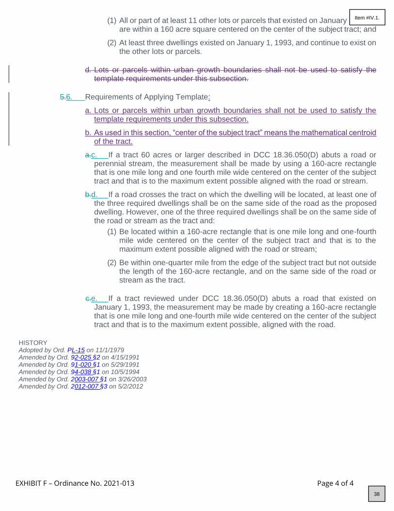
EXHIBIT F – Ordinance No. 2021-013 Page 4 of 4
(1) All or part of at least 11 other lots or parcels that existed on January 1, 1993, are within a 160 acre square centered on the center of the subject tract; and
(2) At least three dwellings existed on January 1, 1993, and continue to exist on the other lots or parcels.
d. Lots or parcels within urban growth boundaries shall not be used to satisfy the
template requirements under this subsection.
5.6. Requirements of Applying Template:
a. Lots or parcels within urban growth boundaries shall not be used to satisfy the template requirements under this subsection.
b. As used in this section, “center of the subject tract” means the mathematical centroid of the tract.
a.c. If a tract 60 acres or larger described in DCC 18.36.050(D) abuts a road or perennial stream, the measurement shall be made by using a 160-acre rectangle that is one mile long and one fourth mile wide centered on the center of the subject tract and that is to the maximum extent possible aligned with the road or stream.
b.d. If a road crosses the tract on which the dwelling will be located, at least one of the three required dwellings shall be on the same side of the road as the proposed dwelling. However, one of the three required dwellings shall be on the same side of the road or stream as the tract and:
(1) Be located within a 160-acre rectangle that is one mile long and one-fourth mile wide centered on the center of the subject tract and that is to the maximum extent possible aligned with the road or stream;
(2) Be within one-quarter mile from the edge of the subject tract but not outside the length of the 160-acre rectangle, and on the same side of the road or stream as the tract.
c.e. If a tract reviewed under DCC 18.36.050(D) abuts a road that existed on
January 1, 1993, the measurement may be made by creating a 160-acre rectangle that is one mile long and one-fourth mile wide centered on the center of the subject tract and that is to the maximum extent possible, aligned with the road.
HISTORY Adopted by Ord. P L-15 on 11/1/1979 Amended by Ord. 9 2-025 §2 on 4/15/1991 Amended by Ord. 9 1-020 §1 on 5/29/1991 Amended by Ord. 9 4-038 §1 on 10/5/1994 Amended by Ord. 2 003-007 §1 on 3/26/2003 Amended by Ord. 2 012-007 §3 on 5/2/2012
38
Item #IV.1.

EXHIBIT G – Ordinance No. 2021-013 Page 1 of 4
C HAPTER 18.40 FOREST USE ZONE; F-2 1 8.40.050 Standards For Single-Family Dwellings
18.40.050 Standards For Single-Family Dwellings
A. General Provisions.
1. Dwellings listed as a conditional use under DCC 18.40.030(X) shall meet the following standards:
a. One of the alternative tests set out in DCC 18.40.050(B) (lot of record dwelling), DCC 18.40.050(C) (large tract dwelling), or DCC 18.40.050(D) (template dwelling);
b. If the lot or parcel is part of a "tract," the remaining undeveloped lots or parcels of the tract shall be consolidated into a single lot or parcel, or the applicant shall sign and record with the County Clerk covenants, conditions and restrictions (on a form substantially similar to that set forth in DCC 18.36.140) prohibiting the siting of a dwelling on the undeveloped portions of the tract. Such covenants, conditions and restrictions are irrevocable, unless a statement of release is signed by the County Planning Director, or his authorized representative.
c. No other dwellings shall be located on the tract.
d. The applicant shall provide evidence that any domestic water supply is from a source authorized in accordance with the Department of Water Resources Oregon Administrative Rules for the appropriation of ground water (Oregon Administrative Rules 690, Division 10) or surface water (Oregon Administrative Rules 690, Division 20) and not from a Class II stream as defined in the Forest Practices Rule (Oregon Administrative Rules Chapter 629).
For purposes of DCC 18.40.050, evidence of a domestic water supply means:
(1) Verification from a water purveyor that the use described in the application will be served by the purveyor under the purveyor's rights to appropriate water; or
(2) A water use permit issued by the Water Resources Department for the use described in the application; or
(3) Verification from the Water Resources Department that a water use permit is not required for the use described in the application. If the proposed water supply is from a well and is exempt from permitting requirements under ORS 537.545, the applicant shall submit the well construction report to the County upon completion of the well.
e. If road access to a dwelling is by a road owned and maintained by a private party or
by the Oregon Department of Forestry, the U.S. Bureau of Land Management or the U.S. Forest Service, then the applicant shall provide proof of a long-term road access use permit or agreement. The road use permit may require the applicant to agree to accept responsibility for road maintenance.
2. In addition, dwellings listed as a conditional use under DCC 18.40.030(X) shall be subject
to the following standards or conditions:
a. The conditional use standards set forth in DCC 18.40.040;
b. The siting criteria set forth in DCC 18.40.060;
39
Item #IV.1.
EXHIBIT G – Ordinance No. 2021-013 Page 2 of 4
c. The fire siting standards set forth in DCC 18.40.070;
d. The fire safety design standards for roads set forth in DCC 18.40.080;
e. The stocking requirements set forth in DCC 18.40.085, if applicable; and
f. Any other provisions made applicable by DCC Title 18 or the comprehensive plan.
3. Dwellings in forest zones shall not be subject to conditional use standards.
4. Approval of a dwelling in the forest zone under DCC Chapter 18.40 shall include a condition of approval requiring that, prior to the issuance of a building permit, the landowner sign and record in the deed records for the County a document binding the landowner, and the landowner’s successors in interest, prohibiting them from pursuing a claim for relief or cause of action alleging injury from farming or forest practices for which no action or claim is allowed under ORS 30.936 or 30.937.
B. Lot of Record Dwelling. For approval under DCC 18.40.050, a single-family dwelling shall meet
the following requirements:
1. The lot or parcel on which the dwelling would be sited was lawfully created prior to January 1, 1985 and was acquired and owned continuously by the present owner either prior to January 1, 1985 or by devise or by intestate succession from a person who acquired the lot or parcel prior to January 1, 1985.
2. For the purposes of DCC 18.40.050, "owner" includes the wife, husband, son, daughter, mother, father, brother, brother-in-law, sister, sister-in-law, son-in-law, daughter-in-law, mother-in-law, father-in-law, aunt, uncle, niece, nephew, step-parent, step-child, grandparent or grandchild of the owner or a business entity owned by any one or combination of these family members.
3. The dwelling would be located on a tract that is composed of soils not capable of producing 4,000 cubic feet per year of commercial tree species and is located within 1,500 feet of a public road as defined under ORS 368.001 that provides or will provide access to the subject tract.
a. The road shall be maintained and either paved or surfaced with rock and shall not be:
a. a United States Bureau of Land Management (BLM) road; or
b. a United States Forest Service road unless the road is paved to a minimum width of 18 feet, there is at least one defined lane in each direction and a maintenance agreement exists between the United States Forest Service and landowners adjacent to the road, a local government or a state agency.
4. For the purposes of DCC 18.40.050, "commercial tree species" means trees recognized
for commercial production under rules adopted by the Oregon Department of Forestry pursuant to ORS 527.715.
5. The lot or parcel on which the dwelling will be sited was part of a tract on November 4, 1993, no dwellings exists on another lot or parcel that was part of the tract.
6. When the lot or parcel on which the dwelling will be sited is part of a tract, the remaining portions of the tract shall be consolidated into a single lot or parcel when the dwelling is allowed.
40
Item #IV.1.
EXHIBIT G – Ordinance No. 2021-013 Page 3 of 4
7. For lots or parcels located within a Wildlife Area (WA) Combining Zone, siting of the proposed dwelling would be consistent with the limitations on density as applied under the applicable density restrictions of DCC 18.88.
C. Large Tract Dwelling. A dwelling not allowed pursuant to DCC 18.40.050(B) may be allowed if the
subject property consists of at least 240 contiguous acres or 320 acres in one ownership that are not contiguous but are in the same county or adjacent counties and zoned for forest use and does not include an existing dwelling.
1. A deed restriction shall be filed pursuant to DCC 18.40.140 for all tracts that are used to meet the acreage requirements of this subsection.
2. A tract shall not be considered to consist of less than 240 acres because it is crossed by a public road or a waterway.
D. Template Dwelling. For approval under DCC 18.40.050(D), a single-family dwelling shall meet the
following requirements:
1. The lot or parcel on which the dwelling will be sited was lawfully established.
2. Any property line adjustment to the lot or parcel complied with the applicable property line adjustment provisions in ORS 92.192.
3. Any property line adjustment to the lot or parcel after January 1, 2019, did not have the effect of qualifying the lot or parcel for a dwelling under this section; and
4. If the lot or parcel on which the dwelling will be sited was part of a tract on January 1, 2019, no dwelling existed on the tract on that date, and no dwelling exists or has been approved on another lot or parcel that was part of the tract:
a. Notwithstanding (D)(4), prior to November 1, 2023, a single-family dwelling may be established on a lot or parcel that was part of a tract on January 1, 2021, if no more than one other dwelling exists or has been approved on another lot or parcel that was part of the tract.
1.5. The lot or parcel is predominantly composed of soils that are:
a. Capable of producing zero to 20 cubic feet per acre per year of wood fiber if:
(1) All or part of at least three other lots or parcels that existed on January 1, 1993, are within a 160 acre square centered on the center of the subject tract; and
(2) At least three dwellings existed on January 1, 1993, and continue to exist on the other lots or parcels.
b. Capable of producing 21 to 50 cubic feet per acre per year of wood fiber if:
(1) All or part of at least seven other lots or parcels that existed on January 1, 1993, are within a 160 acre square centered on the center of the subject tract; and
(2) At least three dwellings existed on January 1, 1993, and continue to exist on the other lots or parcels.
c. Capable of producing more than 50 cubic feet per acre per year of wood fiber if:
(1) All or part of at least 11 other lots or parcels that existed on January 1, 1993,
41
Item #IV.1.

EXHIBIT G – Ordinance No. 2021-013 Page 4 of 4
are within a 160 acre square centered on the center of the subject tract; and
(2) At least three dwellings existed on January 1, 1993, and continue to exist on the other lots or parcels.
2.6. Requirements of Applying Template:
a. Lots or parcels within urban growth boundaries shall not be used to satisfy the template requirements under this subsection.
a.b. As used in this section, “center of the subject tract” means the mathematical centroid of the tract.
b.c. Except as provided by subsection (c) of this section, if the tract described in DCC 18.40.050(D) abuts a road that existed on January 1, 1993, the measurement may be made by creating a 160-acre rectangle that is one mile long and 1/4 mile wide centered on the center of the subject tract and that is to the maximum extent possible, aligned with the road.
c.d. (1) If a tract 60 acres or larger described in DCC 18.40.050(D) abuts a road or perennial stream, the measurement shall be made in accordance with subsection (b) of this section. However, one of the three required dwellings shall be on the same side of the road or stream as the tract, and;
(A) Be located within a 160-acre rectangle that is one mile long and one-quarter mile wide centered on the center of the subject tract and that is, to the maximum extent possible aligned with the road or stream; or
(B) Be within one-quarter mile from the edge of the subject tract but not outside the length of the 160-acre rectangle, and on the same side of the road or stream as the tract.
(2) If a road crosses the tract on which the dwelling will be located, at least one
of the three required dwellings shall be on the same side of the road as the proposed dwelling.
HISTORY Adopted by Ord. P L-15 on 11/1/1979 Amended by Ord. 9 2-025 §3 on 4/15/1991 Amended by Ord. 9 1-020 §1 on 5/29/1991 Amended by Ord. 9 4-038 §2 on 10/5/1994 Amended by Ord. 2 003-007 §2 on 3/26/2003 Amended by Ord. 2 012-007 §4 on 5/2/2012 Amended by Ord. 2 018-006 §7 on 11/20/2018
42
Item #IV.1.

EXHIBIT H – Ordinance No. 2021-013 Page 1 of 6
CHAPTER 18.67 TUMALO RURAL COMMUNITY ZONING DISTRICTS 11 8.67.020 Residential (TuR) District 1 8.67.040 Commercial (TuC) District
18.67.020 Residential (TuR) District
The Tumalo Residential (TuR) District allows a mixture of housing types and densities suited to the level of available water and sewer facilities. The purpose of this district is to allow new residential development that is compatible with the rural character of the area.
A. Permitted Uses. The following uses and their accessory uses are permitted outright and do not
require site plan review.
1. Single-family dwelling, or a manufactured home subject to DCC 18.116.070.
2. Two-family dwelling.
3. Type 1 Home Occupation, subject to DCC 18.116.280.
4. Agricultural uses as defined in DCC Title 18, involving:
a. Keeping of cows, horses, goats, sheep or similar farm animals, provided that the total number of such animals over the age of six months is limited to one for each 20,000 square feet.
b. Keeping of chickens, fowl, rabbits or similar farm animals, provided that the total number of such animals over the age of six months does not exceed one for each 500 square feet of property.
5. Class I and II road or street project subject to approval as part of a land partition,
subdivision or subject to the standards of DCC 18.67.080 and 18.116.230.
6. Class III road or street project.
7. Operation, maintenance, and piping of existing irrigation systems operated by an Irrigation District except as provided in DCC 18.120.050.
B. Uses Permitted Subject to Site Plan Review. The following uses and their accessory uses are
permitted, subject to the applicable provisions of this chapter, DCC 18.116, Supplementary Provisions, and DCC 18.124 Site Plan Review, of this title:
1. Child care facility and/or preschool.
C. Conditional Uses. The following uses and their accessory uses are permitted subject to the
applicable provisions of DCC 18.67, 18.116, 18.124, and 18.128:
1. Multi-family dwelling complex.
2. Retirement center or nursing home.
3. Religious institutions or assemblies.
4. Cemetery.
5. Type 2 or Type 3 Home Occupation, subject to DCC 18.116.280.
6. Public or private school.
7. Park.
43
Item #IV.1.

EXHIBIT H – Ordinance No. 2021-013 Page 2 of 6
8. Public or semi-public building.
9. Utility facility.
10. Water supply or treatment facility.
11. Wireless telecommunications facilities, except those facilities meeting the requirements of DCC 18.116.250(A) or (B).
12. Surface mining of mineral and aggregate resources in conjunction with the operation and maintenance of irrigation systems operated by an Irrigation District, including the excavation and mining for facilities, ponds, reservoirs, and the off-site use, storage, and sale of excavated material.
D. Lot Requirements.
1. Partitions:
a. Subject to the provisions of DCC 17.36.170(A), parcels not served by an approved community, non-community or municipal water system shall have a minimum width of 150 feet with a minimum parcel size of one acre.
b. Subject to DCC 17.36.170(A), parcels served by an approved community, non- community, municipal or public water system, shall have a minimum parcel size as follows:
(1) For a single-family dwelling the parcel shall have a minimum width of 100 feet and a minimum parcel size of 22,000 square feet.
(2) For a two-family dwelling the parcel shall have a minimum width of 100 feet and a minimum parcel size of 33,000 square feet.
2. Subdivisions:
a. For subdivisions involving multi-family dwellings, a manufactured home park or a retirement home, all new lots shall be connected to a DEQ-permitted Wastewater Pollution Control Facility.
b. For subdivisions involving only single-family and two-family dwellings the standards set forth in DCC 18.67.020(CD)(1) shall apply.
E. Yard Standards.
1. Front Yard. The front yard shall be 20 feet for a property fronting on a local street right-of- way, 30 feet for a property fronting on a collector right-of-way and 80 feet for a property fronting on an arterial right-of-way.
2. Side Yard. A side yard shall be a minimum of five feet and the sum of the two side yards shall be a minimum of 15 feet, subject to DCC 18.67.020(E)(4).
3. Rear Yard. The minimum rear yard shall be 20 feet, subject to DCC 18.67.020(E)(4).
4. Exception to Yard Standards. Any new structure requiring a building permit on a lot or parcel contiguous to EFU-zoned land that is receiving special assessment for farm use shall be set back a minimum of 100 feet from the common property line.
HISTORY Adopted by Ord. 9 7-033 §2 on 6/25/1997
44
Item #IV.1.

EXHIBIT H – Ordinance No. 2021-013 Page 3 of 6
Amended by Ord. 9 7-063 §3 on 11/12/1997 Amended by Ord. 2 001-016 §2 on 3/28/2001 Amended by Ord. 2 001-039 §8 on 12/12/2001 Amended by Ord. 2 004-002 §17 on 4/28/2004 Amended by Ord. 2 020-001 §8 on 4/21/2020 Amended by Ord. 2 020-010 §4 on 7/3/2020
18.67.040 Commercial (TuC) District
The Tumalo Commercial District is intended to allow a range of limited commercial and industrial uses to serve the community and surrounding area.
A. Permitted Uses. The following uses and their accessory uses are permitted outright and do not
require site plan review.
1. Single-family dwelling or duplex.
2. Manufactured home subject to DCC 18.116.070.
3. Type 1 Home Occupation, subject to DCC 18.116.280.
4. Class I and II road or street project subject to approval as part of a land partition, subdivision or subject to the standards of DCC 18.67.060 and 18.116.230.
5. Class III road or street project.
6. Operation, maintenance, and piping of existing irrigation systems operated by an Irrigation District except as provided in DCC 18.120.050.
B. Uses Permitted, Subject to Site Plan Review. The following uses and their accessory uses are
permitted subject to the applicable provisions of DCC 18.67, 18.116 and 18.124:
1. A building or buildings, none of which exceeds 4,000 square feet of floor space to be used by any combination of the following uses:
a. Retail or service business.
b. Eating and/or drinking establishment.
c. Offices.
d. Residential use in the same building as a use permitted in DCC 18.67.040.
e. Marijuana wholesaling, office only. There shall be no storage of marijuana items or products at the same location.
2. Any of the uses listed under DCC 18.67.040 proposing to occupy more than 4,000 square
feet of floor area in a building subject to the provisions of DCC 18.67.040(E).
3. Child care facility and/or preschool.
C. Conditional Uses. The following uses and their accessory uses are permitted subject to the
applicable provisions of DCC 18.116, 18.124, and 18.128:
1. Religious institutions or assemblies.
2. Bed and breakfast inn.
3. Type 2 or Type 3 Home Occupation, subject to DCC 18.116.280.
4. Park.
45
Item #IV.1.

EXHIBIT H – Ordinance No. 2021-013 Page 4 of 6
5. Public or semi-public building.
6. Utility facility.
7. Water supply or treatment facility.
8. Manufactured home/RV park on a parcel in use as a manufactured home park or recreational vehicle park prior to the adoption of PL-15 in 1979 and being operated as of June 12, 1996 as a manufactured home park or recreational vehicle park, including any expansion of such uses on the same parcel as configured on June 12, 1996.
9. The following uses and their accessory uses may be conducted in a building or buildings not to exceed 4,000 square feet of floor space.
a. Farm equipment, sales, service or repair.
b. Trailer sales, service or repair.
c. Vehicle service or repair.
d. Veterinary clinic.
10. The following uses may be conducted in a building or buildings not to exceed 10,000 square feet of floor space:
a. Manufacturing or production.
b. Wholesale sales.
c. Marijuana retailing, subject to the provisions of DCC 18.116.330.
11. Wireless telecommunications facilities, except those facilities meeting the requirements of
DCC 18.116.250(A) or (B).
12. Surface mining of mineral and aggregate resources in conjunction with the operation and maintenance of irrigation systems operated by an Irrigation District, including the excavation and mining for facilities, ponds, reservoirs, and the off-site use, storage, and sale of excavated material.
D. Use Limitations. The following use limitations shall apply to the uses listed in DCC 18.67.040(C)
(1110).
1. Compatibility.
a. Any use expected to generate more than 50 truck-trailer and/or heavy equipment trips per day to and from the subject property shall not be permitted to locate on a lot or parcel adjacent to or across a local or collector street from a lot or parcel in a residential district.
2. Traffic and Parking.
a. A use that generates more than 20 auto or truck trips during the peak hour of the day to and from the premises shall document with facts that the affected transportation facilities are adequate to serve the proposed use, considering the functional classification, capacity and level of service of the affected transportation facility.
b. All parking demand generated by uses permitted by DCC 18.67 shall be accommodated entirely on the premises.
46
Item #IV.1.

EXHIBIT H – Ordinance No. 2021-013 Page 5 of 6
E. Requirements for Large Scale Uses.
1. All uses listed in DCC 18.67.040(B) may have a total floor area exceeding 4,000 square feet but not greater than 10,000 square feet if the Planning Director or Hearings Body finds:
a. The use is intended to serve the community and surrounding rural area or the traveling needs of people passing through the area;
b. The use will primarily employ a work force from the community and surrounding rural area; and
c. It is not practical to contain the proposed use within 4,000 square feet of the floor area.
2. This provision does not apply to uses listed in DCC 18.67.040(C)(10).
3. For the purposes of DCC 18.67.040, the surrounding rural area is described as the following: extending north to the Township boundary between Townships 15 and 16; extending west to the boundary of the public lands managed by the U.S. Forest Service in
T16S-R11E; extending south to the south section lines of T17S-R12E sections 4,5,6 and T17S-R11E sections 1,2,3; and extending east to Highway 97.
F. Design Standards. Ground Floor Windows. The following criteria for ground floor windows apply
to new buildings in the TuC district except those uses listed in DCC 18.67.040(C)(10) and any residential use. The provisions of DCC 18.124 also apply.
1. The windows must be at least 50 percent of the length of the ground level wall area and 25 percent of height of the ground level wall area. Ground level wall area includes all exterior wall area up to nine feet above the finished grade. The window requirement applies to the ground level of exterior building walls which abut sidewalks or streets.
2. Required window areas shall be either windows that allow views into working areas, lobbies, pedestrian entrances or display windows.
G. Lot Requirements. No lot shall be created having less than a minimum of 10,000 square feet. Lot
requirements for this district shall be determined by spatial requirements for sewage disposal, required landscaped areas and off-street parking.
H. Dimensional Standards.
1. Lot Coverage: No lot coverage requirements, provided spatial requirements for parking, sewage disposal and landscaping are satisfied.
2. No use listed in DCC 18.67.040(C)(10) that is located adjacent to or across a local or collector from a lot or parcel in a residential district shall exceed 70 percent lot coverage by all buildings, outside storage, or off-street parking and loading areas.
I. Yard Standards.
1. Front Yard. The front yard shall be a maximum of 15 feet, except as otherwise allowed by DCC 18.124.070 (D)(3).
The street setback for buildings may be reduced, but not increased, to the average building setback distance of existing buildings on adjoining lots.
2. Side Yard. No requirement, subject to DCC 18.67.040(I)(4).
47
Item #IV.1.

EXHIBIT H – Ordinance No. 2021-013 Page 6 of 6
3. Rear Yard. No specific requirement, subject to DCC 18.67.040 (I)(4).
4. Exceptions to Yard Standards.
a. Lot line adjacent to a residential zone.
For all new structures or substantial alteration of a structure requiring a building permit on a lot adjacent to a residential district, the setback shall be a minimum of 15 feet. The required yard will be increased by one foot for each foot by which the building height exceeds 20 feet.
b. Lot line adjacent to an EFU zone. Any structure requiring a building permit on a lot adjacent to EFU-zoned land that is receiving special assessment for farm use shall be set back a minimum of 100 feet from the common property line.
HISTORY Adopted by Ord. 9 7-033 §2 on 6/25/1997 Amended by Ord. 9 7-063 §3 on 11/12/1997 Amended by Ord. 2 000-033 §11 on 12/6/2000 Amended by Ord. 2 001-016 §2 on 3/28/2001
Amended by Ord. 2 001-039 §8 on 12/12/2001 Amended by Ord. 2 004-002 §19 on 4/28/2004 Amended by Ord. 2 004-013 §7 on 9/21/2004 Amended by Ord. 2 015-004 §5 on 4/22/2015 Amended by Ord. 2 016-015 §6 on 7/1/2016 Amended by Ord. 2 020-001 §8 on 4/21/2020 Amended by Ord. 2 020-010 §4 on 7/3/2020 Amended by Ord. 2 021-004 §4 on 5/27/2021
48
Item #IV.1.

EXHIBIT I – Ordinance No. 2021-013 Page 1 of 2
CHAPTER 18.74 RURAL COMMERCIAL ZONE 118.74.020 Uses Permitted; Deschutes Junction And Deschutes River Woods Store
18.74.020 Uses Permitted; Deschutes Junction And Deschutes River Woods Store
A. Uses Permitted Outright. The following uses and their accessory uses are permitted outright and
do not require site plan review:
1. Single-family dwelling.
2. Manufactured home subject to DCC 18. 1 16. 070.
3. Two-family dwelling.
4. Type 1 Home Occupation, subject to DCC 18. 1 16. 280.
5. Agricultural uses.
6. Class I and II road or street project subject to approval as part of a land partition or subdivision, or subject to the standards and criteria established in DCC 18. 116. 230.
7. Class III road or street project.
8. A lawfully established use existing as of 11/ 05/ 02, the date this chapter was adopted, not otherwise permitted by this chapter.
B. Uses Permitted Subject to Site Plan Review. The following uses and their accessory uses are
permitted subject to the applicable provisions of this chapter and DCC 18.116 and 18.128124:
1. A building or buildings not exceeding 2,500 square feet of floor space to be used by any combination of the following uses.
a. Restaurant, café or delicatessen.
b. Grocery store.
c. Tavern.
d. Retail sporting goods and guide services.
e. Barber and beauty shop.
f. General store.
g. Video store.
h. Antique, art, craft, novelty and second hand sales if conducted completely within an enclosed building.
2. Expansion of a nonconforming use listed under section B(1)(a-h), existing as of 11/05/2002,
the date this chapter was adopted, shall be limited to 2,500 square feet or 25 percent of the size of the building as of said date, whichever is greater.
3. A building or buildings not exceeding 3,500 square feet of floor space to be used by any combination of the following uses.
a. Retail sales of agricultural or farm products.
b. Farm machinery sales and repair.
c. Kennel.
49
Item #IV.1.

EXHIBIT I – Ordinance No. 2021-013 Page 2 of 2
d. Veterinary clinic.
e. Automobile service station and repair garage, towing service, fuel storage and sales.
f. Public or semi-public use.
g. Residential use in the same building as a use permitted by this chapter.
h. Park or playground.
4. Expansion of a nonconforming use listed under section B(3)(a-h), existing as of 11/05/2002,
the date this chapter was adopted, shall be limited to 3,500 square feet or 25 percent of the size of the building as of said date, whichever is greater.
C. Uses Permitted Subject to Site Plan Review. The following uses and their accessory uses are
permitted, subject to the applicable provisions of this chapter, DCC 18.116, Supplementary Provisions, and DCC 18.124, Site Plan Review, of this title:
1. Child care facility and/or preschool.
D. Conditional Uses. The following uses and their accessory uses are permitted subject to the
applicable provisions of this chapter and DCC 18.116, 18.124 and 18.128:
1. A building or buildings not exceeding 3,500 square feet of floor space to be used by any combination of the following uses.
a. Type 2 or Type 3 Home Occupation, subject to DCC 18.116.280.
b. Utility facility.
c. Wireless telecommunications facilities, except those facilities meeting the requirements of DCC 18.116.250(A) or (B).
d. Religious institutions or assemblies.
e. School.
2. Recreational vehicle park
3. Mini-storage facilities limited to 35,000 square feet in size.
4. Marijuana retailing, subject to the provisions of DCC 18.116.330.
HISTORY Adopted by Ord. 2 002-019 §2 on 8/7/2002 Amended by Ord. 2 004-002 §20 on 4/28/2004 Amended by Ord. 2 008-008 §1 on 3/18/2008 Amended by Ord. 2 015-004 §7 on 4/22/2015 Amended by Ord. 2 016-015 §7 on 7/1/2016 Amended by Ord. 2 020-001 §9 on 4/21/2020 Amended by Ord. 2 020-010 §5 on 7/3/2020
50
Item #IV.1.

EXHIBIT J – Ordinance No. 2021-013 Page 1 of 2
C HAPTER 18.80 AIRPORT SAFETY COMBINING ZONE; A-S 18.80.044 Land Use Compatibility
18.80.044 Land Use Compatibility
Applications for land use or building permits for properties within the boundaries of this overlay zone shall comply with the requirements of DCC 18.80 as provided herein. When compatibility issues arise, the Planning Director or Hearings Body is required to take actions that eliminate or minimize the incompatibility by choosing the most compatible location or design for the boundary or use. Where compatibility issues persist, despite actions or conditions intended to eliminate or minimize the incompatibility, the Planning Director or Hearings Body may disallow the use or expansion, except where the action results in loss of current operational levels and/or the ability of the airport to grow to meet future community needs. Reasonable conditions to protect the public safety may be imposed by the Planning Director or Hearings Body. [ORS 836.619; ORS 836.623(1); OAR 660-013-0080]
A. Noise. Within airport noise impact boundaries, land uses shall be established consistent with the
levels identified in OAR 660, Division 13, Exhibit 5 (Table 2 of DCC 18.80). Applicants for any subdivision or partition approval or other land use approval or building permit affecting land within airport noise impact boundaries, shall sign and record in the Deschutes County Book of Records, a Declaration of Anticipated Noise declaring that the applicant and his successors will not now, or in the future complain about the allowed airport activities at the adjacent airport. In areas where the noise level is anticipated to be at or above 55 DNL, prior to issuance of a building permit for construction of a noise sensitive land use (real property normally used for sleeping or as a school, religious institutions or assemblies, hospital, public library or similar use), the permit applicant shall be required to demonstrate that a noise abatement strategy will be incorporated into the building design that will achieve an indoor noise level equal to or less than 55 DNL. [NOTE: FAA Order 5100.38A, Chapter 7 D provides that interior noise levels should not exceed 45 decibels in all habitable zones.]
B. Outdoor lighting. No new or expanded industrial, commercial or recreational use shall project lighting directly onto an existing runway or taxiway or into existing airport approach surfaces except where necessary for safe and convenient air travel. Lighting for these uses shall incorporate shielding in their designs to reflect light away from airport approach surfaces. No use shall imitate airport lighting or impede the ability of pilots to distinguish between airport lighting and other lighting.
C. Glare. No glare producing material, including but not limited to unpainted metal or reflective glass, shall be used on the exterior of structures located within an approach surface or on nearby lands where glare could impede a pilot's vision.
D. Industrial emissions. No new industrial, mining or similar use, or expansion of an existing industrial, mining or similar use, shall, as part of its regular operations, cause emissions of smoke, dust or steam that could obscure visibility within airport approach surfaces, except upon demonstration, supported by substantial evidence, that mitigation measures imposed as approval conditions will reduce the potential for safety risk or incompatibility with airport operations to an insignificant level. The review authority shall impose such conditions as necessary to ensure that the use does not obscure visibility.
E. Communications Facilities and Electrical Interference. No use shall cause or create electrical interference with navigational signals or radio communications between an airport and aircraft. Proposals for the location of new or expanded radio, radiotelephone, and television transmission facilities and electrical transmission lines within this overlay zone shall be coordinated with the Department of Aviation and the FAA prior to approval. Approval of cellular and other telephone or radio communication towers on leased property located within airport imaginary surfaces shall be
51
Item #IV.1.

EXHIBIT J – Ordinance No. 2021-013 Page 2 of 2
conditioned to require their removal within 90 days following the expiration of the lease agreement. A bond or other security shall be required to ensure this result.
F. Limitations and Restrictions on Allowed Uses in the RPZ, Transitional Surface, Approach Surface, and Airport Direct and Secondary Impact Areas.
For the Redmond, Bend, Sunriver, and Sisters airports, the land uses identified in DCC 18.80 Table 1, and their accessory uses, are permitted, permitted under limited circumstances, or prohibited in the manner therein described. In the event of conflict with the underlying zone, the more restrictive provisions shall control. As used in DCC 18.80.044, a limited use means a use that is allowed subject to special standards specific to that use.
HISTORY Adopted by Ord. P L-15 on 11/1/1979 Repealed & Reenacted by Ord. 9 1-020 §1 on 5/29/1991 Amended by Ord. 2 001-001 §2 on 1/22/2001 Amended by Ord. 2 018-006 §10 on 11/20/2018 Amended by Ord. 2 020-001 §10 on 4/21/2020 Amended by Ord. 2 020-007 §12 on 10/27/2020
52
Item #IV.1.

EXHIBIT K – Ordinance No. 2021-013 Page 1 of 1
C HAPTER 18.84 LANDSCAPE MANAGEMENT COMBINING ZONE; LM 1 8.84.010 Purpose
Introductory Paragraph Eliminated Ord. 2001-016, §2, 2001
1 8.84.010 Purpose
The purposes of the Landscape Management Combining Zone are to maintain scenic and natural resources of the designated areas and to maintain and enhance scenic vistas and natural landscapes as seen from designated roads, rivers, or streams.
HISTORY Adopted by Ord. P L-15 on 11/1/1979 Amended by Ord. 9 0-020 §1 on 6/6/1990 Amended by Ord. 9 1-020 §1 on 5/29/1991 Amended by Ord. 9 2-034 §2 on 4/8/1992 Amended by Ord. 9 5-075 §3 on 11/29/1995 Amended by Ord. 2 001-016 §2 on 3/28/2001
53
Item #IV.1.

EXHIBIT L – Ordinance No. 2021-013 Page 1 of 4
C HAPTER 18.108 URBAN UNINCORPORATED COMMUNITY ZONE; SUNRIVER 1 8.108.110 Business Park; BP District
1 8.108.110 Business Park; BP District
A. Uses Permitted Outright. The following uses and their accessory uses are permitted outright:
1. Residential uses existing as of March 31, 1997.
2. Administrative, educational and other related facilities in conjunction with a use permitted outright.
3. Library.
4. Recreational path.
5. Post office.
6. Religious institutions or assemblies.
7. Child care facilities, nurseries, and/or preschools.
8. A building or buildings each not exceeding 8,000 square feet of floor space housing any combination of:
Retail/rental store, office and service establishment, including but not limited to the following:
a. Automobile, motorcycle, boat, recreational vehicle, trailer or truck sales, rental, repair or maintenance business, including tire stores and parts stores.
b. Agricultural equipment and supplies.
c. Car wash.
d. Contractor’s office, including but not limited to, building, electrical, plumbing, heating and air conditioning, painter, etc..
e. Construction equipment sales, rental and/or service.
f. Exterminator services.
g. Golf cart sales and service.
h. Lumber yard, home improvement or building materials store.
i. Housekeeping and janitorial service.
j. Dry cleaner and/or self-service laundry facility.
k. Marine/boat sales and service.
l. Restaurant, bar and cocktail lounge including entertainment.
m. Marijuana wholesaling, office only. There shall be no storage of marijuana items or products at the same location.
9. A building or buildings each not exceeding 20,000 square feet of floor space housing any
combination of:
a. Scientific research or experimental development of materials, methods or products, including engineering and laboratory research.
54
Item #IV.1.

EXHIBIT L – Ordinance No. 2021-013 Page 2 of 4
b. Light manufacturing, assembly, fabricating or packaging of products from previously prepared materials, including but not limited to cloth, paper, leather, precious or semi-precious metals or stones, etc.
c. Manufacture of food products, pharmaceuticals and the like, but not including the production of fish or meat products, or the rendering of fats and oils.
d. Warehouse and distribution uses in a building or buildings each less than 10,000 square feet of floor area.
10. Employee housing structures.
B. Conditional Uses Permitted. The following conditional uses may be permitted subject to DCC
18.128 and a conditional use permit:
1. Public buildings and public utility structures and yards, including railroad yards.
2. A dwelling unit for a caretaker or watchman working on a developed property.
3. Law enforcement detention facility.
4. Parking lot.
5. Radio and television broadcast facilities.
6. A building or buildings each not exceeding 8,000 square feet of floor space housing any combination of:
a. Bowling alley.
b. Theater.
c. Veterinary clinic and/or kennel.
d. Marijuana retailing, subject to the provisions of DCC 18.116.330.
7. A building or buildings each not exceeding 20,000 square feet of floor space housing any
combination of:
a. Warehouses and distribution uses in a building or buildings exceeding 10,000 square feet of floor area.
b. Distillery and beer/ale brewing facility, including wholesale sales thereof.
c. Self/mini storage.
d. Trucking company dispatch/terminal.
e. Solid waste/garbage operator, not including solid waste disposal or other forms of solid waste storage or transfer station.
C. Use Limits. The following limitations and standards shall apply to uses listed in DCC 18.108.110(A) or (B):
1. A use expected to generate more than 30 truck-trailer or other heavy equipment trips per day to and from the subject property shall not be permitted to locate on a lot adjacent to or across the street from a lot in a residential district.
2. Storage, loading and parking areas shall be screened from residential zones.
3. No use requiring air contaminant discharge permits shall be approved by the Planning
55
Item #IV.1.

EXHIBIT L – Ordinance No. 2021-013 Page 3 of 4
Director or Hearings Body prior to review by the applicable state or federal permit reviewing authority, nor shall such uses be permitted adjacent to or across the street from a residential lot.
D. Special Requirements for Large Scale Uses.
Any of the uses listed in DCC 18.108.110(A)(68) or (B)(6) may be allowed in a building or buildings each exceeding 8,000 square feet of floor space if the Planning Director or Hearings Body finds:
1. That the intended customers for the proposed use will come from the community and surrounding rural area, or the use will meet the needs of the people passing through the area. For the purposes of DCC 18.108.110, the surrounding rural area shall be that area identified as all property within five miles of the boundary of the Sunriver Urban Unincorporated Community;
2. The use will primarily employ a work force from the community and surrounding rural area; and
3. That it is not practical to locate the use in a building or buildings under 8,000 square feet of floor space.
E. Height Regulations. No building or structure shall be hereafter erected, enlarged or structurally
altered to exceed 45 feet in height.
F. Lot Requirements. The following lot requirements shall be observed:
1. Lot Area. No requirements.
2. Lot Width. No requirements.
3. Lot Depth. Each lot shall have a minimum depth of 100 feet.
4. Front Yard. The front yard shall be a minimum of 25 feet.
5. Side Yard. No side yard required, except when adjoining a lot in an RS or RM District and then the required side yard shall be 50 feet. No side yards are required on the side of a building adjoining a railroad right of way.
6. Rear Yard. No rear yard required, except when adjoining a lot in an RS or RM District and then the rear yard shall be 50 feet. No rear yard is required on the side of a building adjoining a railroad right of way.
7. Lot Coverage. The maximum lot coverage by buildings and structures shall be 50 percent of the total lot area.
G. Special Requirements for Employee Housing
1. The following definitions shall apply to DCC 18.108.110(A)(10):
“Employee” shall mean a person who earns a living by working in the hospitality, food and beverage, outdoor recreation or tourism industry (i) in or within two (2) miles of the Sunriver Urban Unincorporated Community Boundary, or (ii) at Mt. Bachelor Ski and Summer Resort.
“Employer” shall mean a person or entity who employs at least 50 full- or part-time Employees, as defined above, within the Sunriver Urban Unincorporated Community.
“Employee Housing Structure” shall mean a dormitory or similar dwelling structure whose
56
Item #IV.1.

EXHIBIT L – Ordinance No. 2021-013 Page 4 of 4
sole purpose is to serve the housing needs of Employees, and the occupancy of which is restricted to Employees. For the purposes of this section, “dormitory” is defined as a building primarily providing sleeping and residential quarters for large numbers of people, and may include common areas and kitchen facilities.
2. Employee’s spouse, partner and minor children shall only be allowed if compelled by either state or federal law.
3. Employee Housing Structures must be owned and operated by an Employer.
4. Employees, as defined above, who are not employed by an Employer, as defined above, shall only be permitted to reside in an Employee Housing Structure if the Employee’s employer has a signed housing agreement with the Employer operating the Structure.
5. Parking Requirements. Employee Housing Structures must provide as a minimum one vehicular parking space for every 3 beds provided, and bicycle parking for at least one space for every two beds provided.
a. For Employee Housing Structures constructed in one or more phases, the parking requirements may be reduced to no fewer than one space for every six beds if the applicant demonstrates at the time of site plan approval that a lesser parking ratio will continue to provide adequate parking as required by DCC 18.116.030(D)(9).
HISTORY Repealed & Reenacted by Ord. 9 7-078 §2 on 12/31/1997 Amended by Ord. 2 012-002 §1 on 2/27/2012 Amended by Ord. 2 015-004 §9 on 4/22/2015 Amended by Ord. 2 016-015 §9 on 7/1/2016 Amended by Ord. 2 019-008 §1 on 3/6/2019 Amended by Ord. 2 020-004 §1 on 2/19/2020 Amended by Ord. 2 020-001 §12 on 4/21/2020 Amended by Ord. 2 021-004 §6 on 5/27/2021
57
Item #IV.1.

EXHIBIT M – Ordinance No. 2021-013 Page 1 of 8
CHAPTER 18.116 SUPPLEMENTARY PROVISIONS 1 8.116.330 Marijuana Production, Processing, Retailing, And Wholesaling
1 8.116.330 Marijuana Production, Processing, Retailing, And Wholesaling
A. Applicability. Section 18.116.330 applies to:
1. Marijuana Production in the EFU, MUA-10, and RI zones, subject to a land use permit applied for from July 1, 2016 to April 21, 2021, so long as said permit was approved and the use was initiated pursuant to DCC 22.36. New land use permits for marijuana production in aforementioned zones are prohibited by Ordinance No. 2021-004.
2. Marijuana Processing in the EFU, MUA-10, TeC, TeCR, TuC, TuI, RI, and SUBP zones, subject to a land use permit applied for from July 1, 2016 to April 21, 2021, so long as
said permit was approved and the use was initiated pursuant to DCC 22.36. New land use permits for marijuana processing in aforementioned zones are prohibited by Ordinance No. 2021-004.
3. Marijuana Retailing in the RSC, TeC, TeCR, TuC, TuI, RC, RI, SUC, SUTC, and SUBP zones.
4. Marijuana Wholesaling in the RSC, TeC, TeCR, TuC, RC, SUC, and SUBP zones.
B. Continued marijuana production and marijuana processing. So long as the permit was approved
and the use was initiated pursuant to DCC 22.36, marijuana production and processing subject to land use permits applied for from July 1, 2016 to April 21, 2021 may continue as nonconforming uses pursuant to DCC 18.120.010. Prior to the initiation of the use, said land use permits may only be modified pursuant to the criteria established by DCC 22.36.040, Modification of Approval. A change in ownership of a property with a land use permit for marijuana production or processing, or a change in ownership of a business engaged in marijuana production or processing, shall not be deemed a change of circumstances requiring a modification of approval pursuant to DCC 22.36.040 or an alteration of a nonconforming use pursuant to DCC 18.120.010. Relocation of a marijuana production or processing use to a different lot or parcelA change in location for a marijuana production or processing use is prohibited by DCC 18.120.010 and DCC 22.36.040 as any location change will have a greater adverse impact on the neighborhood and/or significant additional impacts on surrounding properties. In addition to conditions of approval specified in each land use permit, the following standards shall govern continued marijuana production and processing:
1. Minimum Lot Area.
a. In the EFU and MUA-10 zones, the subject legal lot of record shall have a minimum lot area of five (5) acres.
2. Indoor Production and Processing.
a. In the MUA-10 zone, marijuana production and processing shall be located entirely within one or more fully enclosed buildings with conventional or post framed opaque, rigid walls and roof covering. Use of greenhouses, hoop houses, and similar non-rigid structures is prohibited.
b. In the EFU zone, marijuana production and processing shall only be located in buildings, including greenhouses, hoop houses, and similar structures.
58
Item #IV.1.

EXHIBIT M – Ordinance No. 2021-013 Page 2 of 8
c. In all zones, marijuana production and processing are prohibited in any outdoor area.
3. Maximum Mature Plant Canopy Size. In the EFU zone, the maximum canopy area for
mature marijuana plants shall apply as follows:
a. Parcels from 5 acres to less than 10 acres in lot area: 2,500 square feet.
b. Parcels equal to or greater than 10 acres to less than 20 acres in lot area: 5,000 square feet. The maximum canopy area for mature marijuana plants may be increased to 10,000 square feet upon demonstration by the applicant to the County that:
(1) The marijuana production operation was lawfully established prior to January 1, 2015; and
(2) The increased mature marijuana plant canopy area will not generate adverse impact of visual, odor, noise, lighting, privacy or access greater than the impacts associated with a 5,000 square foot canopy area operation.
c. Parcels equal to or greater than 20 acres to less than 40 acres in lot area: 10,000 square feet.
d. Parcels equal to or greater than 40 acres to less than 60 acres in lot area: 20,000 square feet.
e. Parcels equal to or greater than 60 acres in lot area: 40,000 square feet.
4. Maximum Building Floor Area. In the MUA-10 zone, the maximum building floor area used
for all activities associated with marijuana production and processing on the subject property shall be:
a. Parcels from 5 acres to less than 10 acres in lot area: 2,500 square feet.
b. Parcels equal to or greater than 10 acres: 5,000 square feet.
5. Limitation on License/Grow Site per Parcel. No more than one (1) Oregon Liquor Control
Commission (OLCC) licensed marijuana production or Oregon Health Authority (OHA) registered medical marijuana grow site shall be allowed per legal parcel or lot.
6. Setbacks. The following setbacks shall apply to all marijuana production and processing areas and buildings:
a. Minimum Yard Setback/Distance from Lot Lines: 100 feet.
b. Setback from an off-site dwelling: 300 feet. For the purposes of this criterion, an off-site dwelling includes those proposed off-site dwellings with a building permit application submitted to Deschutes County prior to submission of the marijuana production or processing application to Deschutes County.
c. Exception: Any reduction to these setback requirements may be granted by the Planning Director or Hearings Body provided the applicant demonstrates the reduced setbacks afford equal or greater mitigation of visual, odor, noise, lighting, privacy, and access impacts.
7. Separation Distances. Minimum separation distances shall apply as follows:
59
Item #IV.1.

EXHIBIT M – Ordinance No. 2021-013 Page 3 of 8
a. The use shall be located a minimum of 1,000 feet from:
(1) A public elementary or secondary school for which attendance is compulsory under Oregon Revised Statutes 339.010, et seq., including any parking lot appurtenant thereto and any property used by the school;
(2) A private or parochial elementary or secondary school, teaching children as described in ORS 339.030(1)(a), including any parking lot appurtenant thereto and any property used by the school;
(3) A licensed child care center or licensed preschool, including any parking lot appurtenant thereto and any property used by the child care center or preschool. This does not include licensed or unlicensed child care which occurs at or in residential structures; and
(4) National monuments and state parks.
b. For purposes of DCC 18.116.330(B)(7), all distances shall be measured from the
lot line of the affected properties listed in DCC 18.116.330(B)(7)(a) to the closest point of the buildings and land area occupied by the marijuana producer or marijuana processor.
c. A change in use of another property to those identified in DCC 18.116.330(B)(7) shall not result in the marijuana producer or marijuana processor being in violation of DCC 18.116.330(B)(7) if the use is:
(1) Pending a local land use decision;
(2) Licensed or registered by the State of Oregon; or
(3) Lawfully established.
8. Access. Marijuana production over 5,000 square feet of canopy area for mature marijuana plants shall comply with the following standards.
a. Have frontage on and legal direct access from a constructed public, county, or state road; or
b. Have access from a private road or easement serving only the subject property.
c. If the property takes access via a private road or easement which also serves other properties, the applicant shall obtain written consent to utilize the easement or private road for marijuana production access from all owners who have access rights to the private road or easement. The written consent shall:
(1) Be on a form provided by the County and shall contain the following information;
(2) Include notarized signatures of all owners, persons and properties holding a recorded interest in the private road or easement;
(3) Include a description of the proposed marijuana production or marijuana processing operation; and
(4) Include a legal description of the private road or easement.
60
Item #IV.1.

EXHIBIT M – Ordinance No. 2021-013 Page 4 of 8
9. Lighting. Lighting shall be regulated as follows:
a. Inside building lighting, including greenhouses, hoop houses, and similar structures, used for marijuana production shall not be visible outside the building from 7:00 p.m. to 7:00 a.m. on the following day.
b. Lighting fixtures shall be fully shielded in such a manner that all light emitted directly by the lamp or a diffusing element, or indirectly by reflection or refraction, is projected below the horizontal plane through the lowest light-emitting part.
c. Light cast by exterior light fixtures other than marijuana grow lights shall comply with DCC 15.10, Outdoor Lighting Control.
10. Odor. As used in DCC 18.116.330(B)(10), building means the building, including
greenhouses, hoop houses, and other similar structures, used for marijuana production or marijuana processing.
a. The building shall be equipped with an effective odor control system which must all times prevent unreasonable interference of neighbors’ use and enjoyment of their property.
b. An odor control system is deemed permitted only after the applicant submits a report by a mechanical engineer licensed in the State of Oregon demonstrating that the system will control odor so as not to unreasonably interfere with neighbors’ use and enjoyment of their property.
c. Private actions alleging nuisance or trespass associated with odor impacts are authorized, if at all, as provided in applicable state statute.
d. The odor control system shall:
(1) Consist of one or more fans. The fan(s) shall be sized for cubic feet per minute (CFM) equivalent to the volume of the building (length multiplied by width multiplied by height) divided by three. The filter(s) shall be rated for the required CFM; or
(2) Utilize an alternative method or technology to achieve equal to or greater odor mitigation than provided by (1) above.
e. The system shall be maintained in working order and shall be in use.
11. Noise. Noise produced by marijuana production and marijuana processing shall comply
with the following:
a. Sustained noise from mechanical equipment used for heating, ventilation, air condition, odor control, fans and similar functions shall not exceed 30dB(A) measured at any property line between 10:00 p.m. and 7:00 a.m. the following day.
b. Sustained noise from marijuana production is exempt from protections of DCC 9.12 and ORS 30.395, Right to Farm. Intermittent noise for accepted farming practices is permitted.
12. Screening and Fencing. The following screening standards shall apply to greenhouses,
hoop houses, and similar non-rigid structures and land areas used for marijuana production and processing:
a. Subject to 18.84, Landscape Management Combining Zone approval, if applicable.
61
Item #IV.1.
EXHIBIT M – Ordinance No. 2021-013 Page 5 of 8
b. Fencing shall be finished in a muted earth tone that blends with the surrounding natural landscape and shall not be constructed of temporary materials such as plastic sheeting, hay bales, tarps, etc., and shall be subject to DCC 18.88, Wildlife Area Combining Zone, if applicable.
c. Razor wire, or similar, shall be obscured from view or colored a muted earth tone that blends with the surrounding natural landscape.
d. The existing tree and shrub cover screening the development from the public right-of-way or adjacent properties shall be retained to the maximum extent possible. This provision does not prohibit maintenance of existing lawns, removal of dead, diseased or hazardous vegetation; the commercial harvest of forest products in accordance with the Oregon Forest Practices Act; or agricultural use of the land.
13. Water. The applicant shall provide:
a. A copy of a water right permit, certificate, or other water use authorization from the Oregon Water Resource Department; or
b. A statement that water is supplied from a public or private water provider, along with the name and contact information of the water provider; or
c. Proof from the Oregon Water Resources Department that the water to be used is from a source that does not require a water right.
14. Fire protection for processing of cannabinoid extracts. Processing of cannabinoid extracts shall only be permitted on properties located within the boundaries of or under contract with a fire protection district.
15. Utility Verification. A statement from each utility company proposed to serve the operation, stating that each such company is able and willing to serve the operation, shall be provided.
16. Security Cameras. If security cameras are used, they shall be directed to record only the subject property and public rights-of-way, except as required to comply with requirements of the OLCC or the OHA.
17. Secure Waste Disposal. Marijuana waste shall be stored in a secured waste receptacle in the possession of and under the control of the OLCC licensee or OHA Person Responsible for the Grow Site (PRMG).
18. Residency. In the MUA-10 zone, a minimum of one of the following shall reside in a dwelling unit on the subject property:
a. An owner of the subject property;
b. A holder of an OLCC license for marijuana production, provided that the license applies to the subject property; or
c. A person registered with the OHA as a person designated to produce marijuana by a registry identification cardholder, provided that the registration applies to the subject property.
19. Nonconformance. All medical marijuana grow sites lawfully established prior to June 8,
2016 by the Oregon Health Authority shall comply with the provisions of DCC 18.116.330(B)(9) by September 8, 2016 and with the provisions of DCC 18.116.330(B) (10-12, 16, 17) by December 8, 2016.
62
Item #IV.1.
EXHIBIT M – Ordinance No. 2021-013 Page 6 of 8
20. Prohibited Uses.
a. In the EFU zone, the following uses are prohibited:
(1) A new dwelling used in conjunction with a marijuana crop;
(2) A farm stand, as described in ORS 215.213(1)(r) or 215.283(1)(o), used in conjunction with a marijuana crop;
(3) A commercial activity, as described in ORS 215.213(2)(c) or 215.283(2)(a), carried on in conjunction with a marijuana crop; and Agri-tourism and other commercial events and activities in conjunction with a marijuana crop.
(4) Agri-tourism and other commercial events and activities in conjunction with a marijuana crop.
b. In the MUA-10 Zone, the following uses are prohibited:
(1) Commercial activities in conjunction with farm use when carried on in conjunction with a marijuana crop.
c. In the EFU, MUA-10, and Rural Industrial zones, the following uses are prohibited
on the same property as marijuana production:
(1) Guest Lodge.
(2) Guest Ranch.
(3) Dude Ranch.
(4) Destination Resort.
(5) Public Parks.
(6) Private Parks.
(7) Events, Mass Gatherings and Outdoor Mass Gatherings.
(8) Bed and Breakfast.
(9) Room and Board Arrangements.
C. Marijuana Retailing. Marijuana retailing, including recreational and medical marijuana sales, shall
be subject to the following standards and criteria:
1. Hours. Hours of operation shall be no earlier than 9:00 a.m. and no later than 7:00 p.m. on the same day.
2. Odor. The building, or portion thereof, used for marijuana retailing shall be designed or equipped to prevent detection of marijuana plant odor off premise by a person of normal sensitivity.
3. Window Service. The use shall not have a walk-up or drive-thru window service.
4. Secure Waste Disposal. Marijuana waste shall be stored in a secured waste receptacle in the possession of and under the control of the OLCC licensee or OHA registrant.
5. Minors. No person under the age of 21 shall be permitted to be present in the building, or portion thereof, occupied by the marijuana retailer, except as allowed by state law.
6. Co-Location of Related Activities and Uses. Marijuana and tobacco products shall not be
63
Item #IV.1.

EXHIBIT M – Ordinance No. 2021-013 Page 7 of 8
smoked, ingested, or otherwise consumed in the building space occupied by the marijuana retailer. In addition, marijuana retailing shall not be co-located on the same lot or parcel or within the same building with any marijuana social club or marijuana smoking club.
7. Separation Distances. Minimum separation distances shall apply as follows:
a. The use shall be located a minimum of 1,000 feet from:
(1) A public elementary or secondary school for which attendance is compulsory under Oregon Revised Statutes 339.010, et seq., including any parking lot appurtenant thereto and any property used by the school;
(2) A private or parochial elementary or secondary school, teaching children as described in ORS 339.030(1)(a), including any parking lot appurtenant thereto and any property used by the school;
(3) A licensed child care center or licensed preschool, including any parking lot appurtenant thereto and any property used by the child care center or preschool. This does not include licensed or unlicensed family child care which occurs at or in residential structures;
(4) National monuments and state parks; and
(5) Any other marijuana retail facility licensed by the OLCC or marijuana dispensary registered with the OHA.
b. For purposes of DCC 18.116.330(B)(7), distance shall be measured from the lot
line of the affected property to the closest point of the building space occupied by the marijuana retailer. For purposes of DCC 18.116.330(B)(7)(a)( vi), distance shall be measured from the closest point of the building space occupied by one marijuana retailer to the closest point of the building space occupied by the other marijuana retailer.
c. A change in use to another property to a use identified in DCC 18.116.330(B)(7), after a marijuana retailer has been licensed by or registered with the State of Oregon shall not result in the marijuana retailer being in violation of DCC 18.116.330(B)(7).
D. Annual Reporting
1. An annual report shall be submitted to the Community Development Department by the real property owner or licensee, if different, each February 1, documenting all of the following as of December 31 of the previous year, including the applicable fee as adopted in the current County Fee Schedule and a fully executed Consent to Inspect Premises form:
a. Documentation demonstrating compliance with the:
(1) Land use decision and permits.
(2) Fire, health, safety, waste water, and building codes and laws.
(3) State of Oregon licensing requirements.
b. Failure to timely submit the annual report, fee, and Consent to Inspect Premises
form or to demonstrate compliance with DCC 18.116. 330(C)(1)(a) shall serve as acknowledgement by the real property owner and licensee that the otherwise allowed use is not in compliance with Deschutes County Code; authorizes permit
64
Item #IV.1.

EXHIBIT M – Ordinance No. 2021-013 Page 8 of 8
revocation under DCC Title 22, and may be relied upon by the State of Oregon to deny new or license renewal(s) for the subject use.
c. Other information as may be reasonably required by the Planning Director to ensure compliance with Deschutes County Code, applicable State regulations, and to protect the public health, safety, and welfare.
d. Marijuana Control Plan to be established and maintained by the Community Development Department.
e. Conditions of Approval Agreement to be established and maintained by the Community Development Department.
f. This information shall be public record subject to ORS 192.502(17).
HISTORY Adopted by Ord. 2 016-015 §10 on 7/1/2016 Amended by Ord. 2 018-012 §3 on 11/23/2018 Repealed & Reenacted by Ord. 2 019-012 §1,2 on 12/2/2019 Amended by Ord. 2 020-007 §16 on 10/27/2020 Amended by Ord. 2 021-004 §7 on 5/27/2021
65
Item #IV.1.

EXHIBIT N – Ordinance No. 2021-013 Page 1 of 4
CHAPTER 18.120 EXCEPTIONS 1 8.120.010 Nonconforming Uses
18.120.010 Nonconforming Uses
Except as otherwise provided in DCC Title 18, the lawful use of a building, structure or land existing on the effective date of DCC Title 18, any amendment thereto or any ordinance codified therein may be continued although such use or structure does not conform with the standards for new development specified in DCC Title 18. A nonconforming use or structure may be altered, restored or replaced subject to DCC 18.120.010. No nonconforming use or structure may be resumed after a one-year period of interruption or abandonment unless the resumed use conforms with the provisions of DCC Title 18 in effect at the time of the proposed resumption.
A. Expansion or Replacement of a Nonconforming Structure.
1. Nonconforming Structure. For the purposes of DCC 18.120.010, a nonconforming structure is one that was lawfully established and violates current setbacks of DCC Title 18 but conforms with respect to use.
2. Replacement or Expansion without Additional Encroachment in Setback Area. A nonconforming structure may be replaced with a new structure of the same size on the same footprint as the preexisting nonconforming structure or may be expanded with an addition that does not project into the required setback area at any point, subject to all other applicable provisions of DCC Title 18.
3. Replacement or Expansion with Additional Encroachment in Setback Area. Replacement or expansion of a nonconforming structure that would involve an additional projection into the front, side or rear yard setback area at any point along the footprint of the existing or preexisting structure may be allowed provided such additional projection into the setback area (1) does not exceed 900 square feet; (2) does not exceed the floor space of the existing or preexisting structure; (3) does not cause the structure to project further toward the front, side or rear property lines than the closest point of the existing or preexisting structure; and (4) meets the variance approval standards set forth in DCC 18.132.025(A) (1) through (4).
Such replacements or expansions must conform with all other applicable provisions of DCC Title 18.
B. Expansion of a Nonconforming School in the Exclusive Farm Use Zone.
1. Notwithstanding ORS 215.130, 215.213, 215.283 or DCC 18.16, 18.116, 18.124, 18.128, a public or private school, including all buildings essential to the operation of the school, formerly allowed pursuant to ORS 215.213(1)(a) or 215.283(1)(a), as in effect before January 1, 2010, may be expanded provided:
a. The expansion complies with ORS 215.286;
b. The school was established on or before January 1, 2009;
c. The expansion occurs on a tax lot:
(1) On which the school was established; or
(2) Contiguous to and, on January 1, 2015, under the same ownership as the tax lot on which the school was established; and
66
Item #IV.1.

EXHIBIT N – Ordinance No. 2021-013 Page 2 of 4
d. The school is a public or private school for kindergarten through grade 12.
2. An expansion cannot be denied under DCC 18.120.010(B) upon any rule or condition
establishing:
a. A maximum capacity of people in the structure or group of structures;
b. A minimum distance between structures; or
c. A maximum density of structures per acre.
C. Verification of Nonconforming Use.
1. Subject to the procedures set forth in DCC 18.120.010 and in DCC Title 22 for processing declaratory rulings, the planning division will verify whether or not a use constitutes a valid nonconforming use in accordance with the provisions of DCC 18.120.010 and applicable state law. Verification of the existence of a nonconforming use is required prior to or concurrent with any application to alter or restore the use.
2. Subject to DCC 18.120.010(F)(2), the applicant shall demonstrate all of the following:
a. The nonconforming use was lawfully established on or before the effective date of the provisions of the zoning ordinance prohibiting the use or had proceeded so far toward lawful completion as of the date it became nonconforming that a right to complete and maintain the use would be vested;
b. The nonconforming use as it existed on the date it became nonconforming, considering the nature and the extent of the actual use of the property, has continued without abandonment or interruption; and
c. Any alteration in the nature and extent of the nonconforming use was done in compliance with applicable zoning ordinance standards governing alterations of non-conforming uses.
3. For purposes of determining whether an abandonment or interruption of use has occurred,
the following shall apply:
a. The reference period for determining whether an abandonment or interruption of a nonconforming use or an aspect thereof has occurred shall be one year.
b. An abandonment or interruption in a use or portion thereof may arise from the complete cessation of actual use of a property for a one-year period or may arise from a change in the nature or extent of the use made of the property for a one- year period or more.
c. An interruption or abandonment that constitutes less than full cessation of the use or a portion thereof may, in accordance with DCC 18.120.010(F)(4), result in a declaration of a continuing use, but of a lesser intensity or scope than what would have been allowable if the nature and extent of the use as of the date it became nonconforming had continued.
d. Absent an approved alteration, a change in the nature of the use may result in a determination that the use has been abandoned or has ceased if there are no common elements between the activities of the previous use and the current use.
e. Change of ownership or occupancy shall not constitute an interruption or abandonment, provided that, absent an approved alteration, the continuing use
67
Item #IV.1.

EXHIBIT N – Ordinance No. 2021-013 Page 3 of 4
made of the property falls within the allowed scope of use made of the property by previous owners or occupants.
f. Factors to be considered in determining whether there has been a change in the nature and/or extent of a use shall include, but are not limited to, consideration of the type of activities being conducted, the operating characteristics of the activities associated with the use (including off-site impacts of those activities), the frequency of use, the hours of operation, changes in structures associated with the use and changes in the degree to which the activities associated with the use occupy the site.
D. Maintenance of a nonconforming use. Normal maintenance of a verified nonconforming use or
structure shall be permitted. Maintenance does not include alterations which are subject to DCC 18.120.010(E).
E. Restoration or replacement of a nonconforming use. A verified nonconforming use may be restored or replaced if all of the following criteria are met:
1. Restoration is made necessary by fire, natural disaster or other casualty;
2. The nonconforming use is restored or replaced on the same location and is the same size or smaller than it was prior to the damage or destruction; and
3. The restoration or replacement of the nonconforming use is commenced within one year of the damage or destruction.
F. Alteration of a nonconforming use.
1. The alteration of a nonconforming use shall be permitted when necessary to comply with any lawful requirement.
2. Any other alteration to a nonconforming use may be permitted subject to all applicable provisions of DCC Title 18, including site plan review and upon a finding that the alteration will have no greater adverse impact on the neighborhood.
3. For the purposes of DCC 18.120.010(EF)(2), an “alteration of a nonconforming use” shall include any change in the use of the property that would constitute a change in the nature or extent of the use of the property.
G. Procedure.
1. Any application for verification of a nonconforming use or to expand, alter, restore or replace a nonconforming use shall be processed in conformance with the applicable procedures set forth in DC 18.120.010 and the applicable procedures of DCC Title 22, the Deschutes County Uniform Development Procedures Ordinance.
2. Notwithstanding DCC 22.20.010, the initial decision on an application for an alteration of a nonconforming use shall be made administratively, without a public hearing. The Planning Director may give prior notice of the pending application pursuant to DCC 22.20.020.
3. Except as allowed by DCC 18.120.010(F)(3)(a), the burden of proof shall be on a verification applicant to prove the existence, continuity, nature and extent of the use.
a. Notwithstanding DCC 22.24.050, if an applicant demonstrates by a preponderance of the evidence that the nature and extent of the use sought to be verified is of the same nature and extent as the use of the property for the ten-year
68
Item #IV.1.
EXHIBIT N – Ordinance No. 2021-013 Page 4 of 4
period immediately preceding the application, without interruption or abandonment, it shall be presumed that the nonconforming use, as proven, lawfully existed at the time the use became nonconforming and has continued without interruption or abandonment until the date of application.
b. The presumption may be rebutted by a preponderance of evidence showing that the use was unlawful prior to the time it became nonconforming, or that the use prior to the ten-year period was of a different nature or different in extent than the use, as proven, or that the use prior to the ten-year period was interrupted or abandoned. If the presumption is so rebutted, the presumption shall disappear and be of no further aid to the applicant.
4. If the proof demonstrates the continued existence of a valid non-conforming use, but of a
different nature or extent than that claimed by the applicant, the Hearings Body may declare there to be a valid nonconforming use to the extent proven.
5. An approval of a verification, replacement or restoration of a nonconforming use verification shall not be conditioned; an approval shall be sufficiently detailed to describe the allowed parameters of the verified use. However, an approval of an alteration of a nonconforming use may be conditioned in a manner calculated to ensure mitigation of adverse impacts so that the change has no greater adverse impact to the neighborhood.
6. After a decision has been rendered on an application for a verification of a nonconforming use (including any appeals provided for under DCC Title 22 and under state law), the applicant shall not be entitled to reapply under DCC 22.28.040 for another verification determination involving the same use of the property.
HISTORY Adopted by Ord. P L-15 §6.010 on 11/1/1979 Amended by Ord. 9 1-038 §1 on 9/30/1991 Amended by Ord. 9 3-043 §20 on 8/25/1993 Amended by Ord. 9 5-050 §1 on 6/28/1995 Amended by Ord. 9 8-037 §1 on 8/26/1998 Amended by Ord. 2 004-013 §13 on 9/21/2004 Amended by Ord. 2 020-022 §1 on 5/20/2020
69
Item #IV.1.

EXHIBIT O – Ordinance No. 2021-013 Page 1 of 3
CHAPTER 19.76 SITE PLAN REVIEW 1 9.76.090 Deschutes River Corridor Design Review
19.76.090 Deschutes River Corridor Design Review
A. Purpose. It is the purpose of the Deschutes River Corridor Design Review to ensure compliance
with the objectives of DCC Title 19 and the goals and policies relating to the Deschutes River in the Bend Area General Plan. The purpose shall also be to:
1. Recognize and respect the unusual natural beauty and character of the Deschutes River.
2. Conserve and enhance the existing riparian zone along the Deschutes River.
3. Allow the community flexibility in reviewing development proposals within the Areas of Special Interest that are designated on the Bend Area General Plan.
4. Maintain the scenic quality of the canyon and rimrock areas of the Deschutes River.
5. Conserve and enhance property values.
In considering a Design Plan the Deschutes CountyBend Urban Area Planning Commission shall utilize an appropriate review body as described in DCC 22.24.020 and take into account the impact of the proposed development on nearby properties, on the capacity of the street system, on land values and development potential of the area, and on the appearance of the street and community.
B. The following areas and uses are exempt from the Deschutes River Design Review process:
1. Public streets and utility facilities existing as of the date of adoption of DCC Title 19. Notwithstanding anything to the contrary in DCC Title 19, a variance may be granted to the mandatory 40 foot setback for future public streets and utility facilities.
2. Irrigation facilities, canals and flumes existing as of the date of adoption of DCC Title 19.
C. Design Review Procedure. All new development, structures, additions and exterior alterations to
structures, including outside storage and off-street parking lots within the Deschutes River Corridor, are subject to a Design Review process.
1. Prior to filing a design review application, the applicant shall confer with the Planning Director concerning the requirements of formal application.
2. The design review application shall be filed on a form provided by the Planning Division and shall be accompanied by drawings and information as specified by the Planning Division. Copies of the plan shall be submitted and such additional information as is deemed necessary for the Planning Director or the review bodyBend Urban Area Planning Commission to adequately review the application.
3. The review bodyBend Urban Area Planning Commission or Planning Director shall in accordance with DCC Title 19 and DCC Title 22 approve, approve with conditions, or disapprove the design plan. In approving the plan, the review body Bend Urban Area Planning Commission or Planning Director shall find that all provisions of DCC Title 19 are complied with and that all buildings and facilities, access points, parking loading facilities, lighting, and walls or fences are so arranged that traffic congestion is avoided and pedestrian and vehicular safety and welfare are protected, and there will be minimal adverse effect on surrounding property and the river corridor. The decision of the review bodyBend Urban Area Planning Commission or Planning Director shall be final unless appealed in accordance with applicable provisions of DCC Title 22.
D. Minimum Standards. All development within the Deschutes River Corridor shall meet the following
70
Item #IV.1.

EXHIBIT O – Ordinance No. 2021-013 Page 2 of 3
minimum standards for development:
1. Building Setbacks. For the areas described below, the setback for all new development shall be a minimum of 100 feet from the ordinary high water mark unless the applicant can demonstrate that a lesser setback is warranted, due to lot size and shape, topography, preservation of natural vegetation, view corridors, and subject to the criteria in DCC 19.76.090(E). In no case shall the setback be less than 40 feet from the ordinary high water mark of the Deschutes River. The term "new development" shall not include rebuilding an existing structure provided that the rebuilt structure is comparable in size, profile, use and location to the structure that previously existed.
a. The east and west banks from the southern boundary of the City of Bend to the southern boundary of the Bend Urban Area;
b. The east and west banks from the northern boundary of the City of Bend to the northern boundary of the Bend Urban Area.
2. Building Heights. Maximum structure height shall be limited to 30 feet at the minimum
setback line. The review body Bend Urban Area Planning Commission may allow increases in building heights up to the allowed height in the underlying zone the farther the building sets back from the river. The review bodyBend Urban Area Planning Commission may limit building height the closer to the river a building is allowed. The building height shall be measured from the lowest natural grade facing the river to the highest measurable point on or projecting from the roof of the structure.
E. Site and Design Review Criteria. In addition to the minimum standards above, the review body
Bend Urban Area Planning Commission shall review the development using the following design criteria:
1. Conservation of natural features. Major rock outcrops, stands of trees or other prominent natural features are an important part of the visual character and duality of the community. The review body Bend Urban Area Planning Commission shall review the applicant's proposal for impacts on these resources and may limit the amount of removal, require additional screening, or moving or reducing in size the development addition or structure in order to preserve to the greatest extent possible, existing natural features.
2. Compatibility with existing area. The review bodyBend Urban Area Planning Commission shall consider the relationship of the proposed development with the existing surroundings, in terms of building bulk, height, location, separation, shape, parking areas, lighting, fences, landscaping, open space, visual and physical corridors to the river and adjacent land use. The review bodyBend Urban Area Planning Commission may establish increased setbacks, limitations of building heights, and limitations on the bulk and length of buildings, limitations on lighting, landscaping, fences, size and shape of windows facing the river, size and location of parking, and outdoor storage areas in order to carry out the purpose of DCC Title 19.
3. Colors and Materials. The review bodyBend Urban Area Planning Commission shall consider colors and materials. The review bodyBend Urban Area Planning Commission may require new structures and additions to existing structures to be finished in muted earth tones that blend with and reduce contrast with the surrounding vegetation and landscape of the building site or colors that are compatible with adjacent buildings.
4. No large areas, including roofs, shall be finished with bright or reflective materials. Metal roofing material is permitted if it is nonreflective and of a color which blends with the surrounding vegetation and landscape.
71
Item #IV.1.

EXHIBIT O – Ordinance No. 2021-013 Page 3 of 3
HISTORY Adopted by Ord. P L-11 on 7/11/1979 Repealed & Reenacted by Ord. 9 0-038 §1 on 10/3/1990 Amended by Ord. 9 4-027 §3 on 6/15/1994
72
Item #IV.1.

EXHIBIT P – Ordinance No. 2021-013 Page 1 of 1
CHAPTER 22.04 INTRODUCTION AND DEFINITIONS 22.04.020 Definitions
22.04.020 Definitions
"Development action" means the review of any permit, authorization or determination that the Deschutes County Community Development Department is requested to issue, give or make that either:
A. Involves the application of a County zoning ordinance or the County subdivision and partition
ordinance and is not a land use action as defined below; or
B. Involves the application of standards other than those referred to in DCC 22.040.030subsection (A) above, such as the sign ordinance.
HISTORY Repealed & Reenacted by Ord. 8 2-011 on 8/9/1982 Repealed & Reenacted by Ord. 9 0-007 §1 on 12/7/1990 Amended by Ord. 9 5-045 §1 on 6/28/1995 Amended by Ord. 9 6-071 §1A on 12/30/1996 Amended by Ord. 2 017-015 §3 on 11/1/2017 Amended by Ord. 2 020-007 §19 on 10/27/2020
73
Item #IV.1.

EXHIBIT Q – Ordinance No. 2021-013 Page 1 of 1
CHAPTER 22.24 LAND USE ACTION HEARINGS 2 22.24.130 Close Of The Record
22.24.130 Close Of The Record
A. Except as set forth herein, the record shall be closed to further testimony or submission of further
argument or evidence at the end of the presentations before the Hearings Body.
B. If the hearing is continued or the record is held open under DCC 22.24.140, further evidence or testimony shall be taken only in accordance with the provisions of DCC 22.24.140.
C. Otherwise, further testimony or evidence will be allowed only if the record is reopened under DCC 22.24.160.
D. Unless waived by the applicant, the Hearings Body shall allow the applicant at least seven days after the record is closed to all other parties to submit final written arguments in support of the application. The applicant’s final submittal shall be considered part of the record, but shall not include any new evidence. This seven-day period shall not be subject to the limitations of ORS 215.427, ORS 215.429, or DCC 22.20.040An applicant shall be allowed, unless waived, to submit final written arguments in support of its application after the record in the initial hearing has closed within such time limits as the Hearings Body shall set. The Hearings Body shall allow applicant at least seven days to submit its argument, which time shall be counted against the 150-day clock.
HISTORY Repealed & Reenacted by Ord. 8 2-011 on 8/9/1982 Repealed & Reenacted by Ord. 9 0-007 §1 on 12/7/1990 Amended by Ord. 9 5-045 §19 on 6/28/1995 Amended by Ord. 9 6-071 §1D on 12/30/1996 Amended by Ord. 9 9-031 §8 on 10/27/1999 Amended by Ord. 2 006-010 §9 on 8/29/2006
74
Item #IV.1.

EXHIBIT R – Ordinance No. 2021-013 Page 1 of 1
CHAPTER 22.32 APPEALS
2 2.32.015 Filing Appeals
22.32.015 Filing Appeals
A. To file an appeal, an appellant must file a completed notice of appeal on a form prescribed by the
Planning Division and an appeal fee.
B. Unless a request for reconsideration has been filed, the notice of appeal and appeal fee must be received at the offices of the Deschutes County Community Development Department no later than 54:00 PM on the twelfth day following mailing of the decision. If a decision has been modified on reconsideration, an appeal must be filed no later than 54:00 PM on the twelfth day following mailing of the decision as modified. Notices of Appeals may not be received by facsimile machine.
C. If the Board of County Commissioners is the Hearings Body and the Board declines review, a portion of the appeal fee may be refunded. The amount of any refund will depend upon the actual costs incurred by the County in reviewing the appeal. When the Board declines review and the decision is subsequently appealed to LUBA, the appeal fee may be applied toward the cost of preparing a transcript of the lower Hearings Body’s decision.
D. The appeal fee shall be paid by method that is acceptable to Deschutes County.
HISTORY Repealed & Reenacted by Ord. 882-011 on 8/9/1982 Repealed & Reenacted by Ord. 990-007 §1 on 12/7/1990 Amended by Ord. 992-013 §11 on 2/27/1991 Amended by Ord. 994-042 §2 on 8/3/1994 Amended by Ord. 995-045 §32 on 6/28/1995 Amended by Ord. 996-071 §1G on 12/30/1996 Amended by Ord. 998-019 §2 on 3/11/1998 Amended by Ord. 999-031 §15 on 10/27/1999 Amended by Ord. 22015-017 §3 on 3/28/2016 Amended by Ord. 22018-012 §6 on 11/23/2018 Repealed & Reenacted by Ord. 22019-012 §1,2 on 12/2/2019
75
Item #IV.1.

117 NW Lafayette Avenue, Bend, Oregon 97703 | P.O. Box 6005, Bend, OR 97708-6005
(541) 388-6575 cdd@deschutes .org www.deschutes.org/cd
COMMUNITY DEVELOPMENT
FINDINGS
HOUSEKEEPING TEXT AMENDMENTS
I. APPLICABLE CRITERIA:
Title 22, Deschutes County Development Procedures Ordinance
II. BACKGROUND:
The Planning Division regularly amends Deschutes County Code (DCC) and the Comprehensive Plan
to correct minor errors identified by staff, other County departments, and the public. This process,
commonly referred to as housekeeping, also incorporates updates from rulemaking at the state
level through amendments to Oregon Revised Statutes (ORS) and Oregon Administrative Rules
(OAR), and allows for less substantive code changes to continue efficient County operations.
The last time Deschutes County adopted housekeeping amendments occurred in July 2020.1
III. BASIC FINDINGS:
The Planning Division determined minor changes were necessary to clarify existing standards and
procedural requirements, include less substantive code alterations, incorporate changes to state
and federal law, and correct errors found in various sections of the Deschutes County Code (DCC).
Staff initiated the proposed changes and notified the Oregon Department of Land Conservation and
Development on September 23, 2021 (File no. 247-21-000862-TA). As demonstrated in the findings
below, the amendments remain consistent with Deschutes County Code, the Deschutes County
Comprehensive Plan, and the Statewide Planning Goals.
IV. FINDINGS:
CHAPTER 22.12, LEGISLATIVE PROCEDURES
Section 22.12.010.
Hearing Required
No legislative change shall be adopted without review by the Planning Commission and a
public hearing before the Board of County Commissioners. Public hearings before the
1 Ordinance 2020-007.
76
Item #IV.1.
EXHIBIT S – Ordinance No. 2021-013 Page 2 of 9
Planning Commission shall be set at the discretion of the Planning Director, unless
otherwise required by state law.
FINDING: This criterion is met because a public hearing was held before the Deschutes County
Planning Commission on November 18, 2021 and before the Board of County Commissioners
(Board) on xx.
Section 22.12.020, Notice
Notice
A. Published Notice
1. Notice of a legislative change shall be published in a newspaper of general
circulation in the county at least 10 days prior to each public hearing.
2. The notice shall state the time and place of the hearing and contain a statement
describing the general subject matter of the ordinance under consideration.
FINDING: This criterion is met as notice was published in The Bulletin newspaper on September 29,
2021 for the Planning Commission public hearing and xx for the Board public hearing.
B. Posted Notice. Notice shall be posted at the discretion of the Planning Director and
where necessary to comply with ORS 203.045.
FINDING: This criterion is met as notice was posted on the bulletin board in the lobby of the
Deschutes County Community Development Department, 117 NW Lafayette, Bend, as well as on
the Planning Division website.
C. Individual notice. Individual notice to property owners, as defined in DCC 22.08.010(A),
shall be provided at the discretion of the Planning Director, except as required by ORS
215.503.
FINDING: The proposed amendments are legislative and do not apply to any specific property.
Therefore, individual notice is not required.
D. Media notice. Copies of the notice of hearing shall be transmitted to other newspapers
published in Deschutes County.
FINDING: Notice was provided to the County public information official for wider media
distribution. This criterion has been met.
Section 22.12.030 Initiation of Legislative Changes.
A legislative change may be initiated by application of individuals upon payment of
required fees as well as by the Board of County Commissioners.
77
Item #IV.1.
EXHIBIT S – Ordinance No. 2021-013 Page 3 of 9
FINDING: The application was initiated by the Deschutes County Planning Division at the direction
of the Board, and has received a fee waiver. This criterion has been met.
Section 22.12.040. Hearings Body
A. The following shall serve as hearings or review body for legislative changes in this order:
1. The Planning Commission.
2. The Board of County Commissioners.
B. Any legislative change initiated by the Board of County Commissioners shall be
reviewed by the Planning Commission prior to action being taken by the Board of
Commissioners.
FINDING: This criterion is met as the Planning Commission held a public hearing on November 18,
2021. The Planning Commission recommended approval of the proposed amendments
unanimously. The Board held their own public hearing on xx.
Section 22.12.050 Final Decision
All legislative changes shall be adopted by ordinance
FINDING: The proposed legislative changes included in file no. 247-21-000862-TA will be
implemented by ordinances upon approval and adoption by the Board.
V. PROPOSED TEXT AMENDMENTS:
The proposed text amendments are detailed in the referenced ordinance with additional text
identified by underline and deleted text by strikethrough. Below are summary explanations of the
proposed changes.
Title 15, Buildings and Construction:
Chapter 15.04. BUILDINGS AND CONSTRUCTION CODES AND REGULATIONS - (See Exhibit
A)
Section 15.04.080. Fire Code; Adopted
DCC 15.04.080 contains a reference to the “2019 edition of the International Fire Code” as the
locally adopted and applicable fire code for Deschutes County. The proposed amendment would
alter this language to reference the “currently adopted edition of the International Fire Code” as
well as OAR 837-040-0010 wherein the state of Oregon formally adopts the Fire Code, to prevent
the need for further code amendments when future iterations of the International Fire Code are
promulgated. Similar language was previously included in County Code, but was unintentionally
altered by Ordinance no. 2020-007.
78
Item #IV.1.

EXHIBIT S – Ordinance No. 2021-013 Page 4 of 9
Title 17, Subdivisions:
Chapter 17.24. FINAL PLAT
Section 17.24.150. Recording - (See Exhibit B)
DCC 17.24.150(B) contains a reference to “blue line” copies of final plats and “cartography” fees
when recording documents with the Planning Division. These specific standards are no longer
required during the final plat recording process, and the proposed changes reflect the
contemporary recording standards.
Title 18, County Zoning:
Chapter 18.04. TITLE, PURPOSE, AND DEFINITION - (See Exhibit C)
Section 18.04.030. Definitions
The current definition for Manufactured Home states: "Manufactured home shall have the
meaning as set forth in ORS 446.003(24)(a).” The amendment corrects the ORS Reference to
state: ORS 446.003.
Includes a new definition for “Facility for the processing of farm products,” as described in
ORS 215.255. This definition was previously established in DCC 18.16.025(I).
The definition for “Current employment of land for farm use” contains two incorrect references
for processing facilities allowed under DCC 18.16.025 and commercial activities in conjunction
with farm use under DCC 18.16.030. The proposed amendments alter these references to the
correct code sections describing processing facilities and commercial activities in conjunction
with farm use.
Chapter 18.16. EXCLUSIVE FARM USE ZONES - (See Exhibit D)
Section 18.16.023. Lawfully Established Dwelling Replacement
In conformance with House Bill 3024 and OAR 660-033-0130, the amendment prohibits the
County from considering property tax classification of dwellings deemed unsafe for occupancy
or constituting an attractive nuisance, or dwellings that were previously removed, destroyed,
demolished or converted to nonresidential uses when reviewing applications for replacement
dwellings on lands zoned for exclusive farm use. The amendments also more broadly align
County Code with the current replacement dwelling standards of OAR 660-033-0130. No
additional uses or restrictions are included within the general OAR alignment edits.
79
Item #IV.1.

EXHIBIT S – Ordinance No. 2021-013 Page 5 of 9
Section 18.16.025. Uses Permitted Subject To The Special Provisions Under DCC Section
18.16.038 Or DCC Section 18.16.042 And A Review Under DCC Chapter 18.124 Where
Applicable
In conformance with House Bill 2106 and OAR 660-033-0010, the amendment alters the
established date requirements for any farm building used for dog training classes or testing
trials.
In conformance with House Bill 2844 and ORS 215.255(2)(b), the amendment adds a new farm
crop processing use, provided that the operation uses less than 2,500 square feet for its
processing area. Pursuant to OAR 660-033-0130, the County may not impose any siting
requirements which would prohibit these uses from being established on a property.
Additionally, the proposed edits more generally align County Code with the OAR 660-033-0130
language describing facilities for processing of farm crops. No additional uses or restrictions are
included within the general OAR alignment edits.
Section 18.16.030. Conditional Uses Permitted – High-Value and Non-High Value Farmland
DCC 18.16.030(D) currently implies that a medical hardship dwelling in the EFU Zone can only
be a manufactured home or a recreation vehicle (RV). However, OAR 660‐033‐0130 also allows
existing buildings to be used for temporary hardship dwellings. This amendment will maintain
conformance with the existing hardship dwelling standards of DCC 18.16.050(H)(1)(a) and
OAR 660‐033‐0130.
Section 18.16.050. Standards for Dwellings in the EFU Zones
DCC 18.16.050(A) references 18.16.030(A). 18.16.050(A) should reference 18.16.025(A) to
address “dwellings customarily provided in conjunction with farm use.”
In conformance with OAR 660-033-0135, the amendment adds “Except for seasonal farmworker
housing approved prior to 2001” to all references of “no other dwelling on the subject tract”
and/or “land.”
Chapter 18.32. MULTIPLE USE AGRICULTURAL ZONE – MUA - (See Exhibit E)
Section 18.32.030. Conditional Uses Permitted
DCC 18.32.030(AD) contains a reference to OAR 660-004-0040(7)(g), which does not exist. The
amendment adds the correct reference which outlines Goal 14 exceptions for new
manufactured home parks which exceed the density allowed under OAR 660-004-0040.
Chapter 18.36. FOREST USE ZONE; F-1 - (See Exhibit F)
Section 18.36.050. Standards For Single-Family Dwellings
80
Item #IV.1.

EXHIBIT S – Ordinance No. 2021-013 Page 6 of 9
In conformance with House Bill 2225 and OAR 660-006-0027, the amendment adds additional
standards and clarifications for template dwellings approved in the Forest Zone, as well as
general conformance edits in line with the OAR language. The amendments associated with OAR
660-006-0027 do not become active across all jurisdictions until November 1, 2021.
Chapter 18.40. FOREST USE ZONE; F-2 - (See Exhibit G)
Section 18.40.050. Standards For Single-Family Dwellings
In conformance with House Bill 2225 and OAR 660-006-0027, the amendment adds additional
standards and clarifications for template dwellings approved in the Forest Zone, as well as
general conformance edits in line with the OAR language. The amendments associated with OAR
660-006-0027 do not become active across all jurisdictions until November 1, 2021.
Chapter 18.67. TUMALO RURAL COMMUNITY ZONING DISTRICTS - (See Exhibit H)
Section 18.67.020. Residential (TuR) District
DCC 18.67.020(D)(2)(b) currently reads “the standards set forth in DCC 18.67.020(C)(1) shall
apply.” This reference was unintentionally established by Ordinance 2020-010, as part of the
broader child care amendments. The amendment changes this reference back to its original
state, with the correct use listed as DCC 18.67.020(D)(1).
Section 18.67.040. Commercial (TuC) District
DCC 18.67.040(D) currently contains a reference to DCC 18.67.040(C)(11), which describes
wireless communication facilities. This reference was established by Ordinance 2020-010, as
part of the broader child care amendments. The previous reference listed under DCC
18.67.040(D) referred to “The following uses may be conducted in a building or buildings not to
exceed 10,000 square feet of floor space…” The amendment changes this reference back to its
original state, with the correct use listed as DCC 18.67.040(C)(10).
Chapter 18.74. RURAL COMMERCIAL ZONE - (See Exhibit I)
Section 18.74.020. Uses Permitted; Deschutes Junction And Deschutes River Woods Store
DCC 18.74.020(B) states “Uses Permitted Subject to Site Plan Review. The following uses and
their accessory uses are permitted subject to the applicable provisions of this chapter and DCC
18.116 and 18.128.” DCC 18.128 refers to the Conditional Use chapter rather than the Site Plan
chapter. The amendment alters DCC 18.74.020(B) to reflect the actual Site Plan chapter, DCC
18.124.
Chapter 18.80. AIRPORT SAFETY COMBINING ZONE; A-S - (See Exhibit J)
Section 18.80.044. Land Use Compatibility
81
Item #IV.1.

EXHIBIT S – Ordinance No. 2021-013 Page 7 of 9
DCC 18.80.044(A) refers to FAA Order 5100.38A. However, FAA Order 5100.38A has been
canceled and replaced with FAA Order 5100.38D. The amendment alters DCC 18.80.044(A) to
remove any specific FAA appendix references, but still maintain compliance with the FAA
guidance established in Order 5100.38(D).
Chapter 18.84. LANDSCAPE MANAGEMENT COMBINING ZONE; LM - (See Exhibit K)
Section 18.84.010. Purpose
DCC 18.84.010 currently states “The purposes of the Land Management Combining Zone…” The
amendment corrects the reference to the zoning chapter title as “Landscape Management
Combining Zone.”
Chapter 18.108. URBAN UNINCORPORATED COMMUNITY ZONE; SUNRIVER - (See Exhibit L)
Section 18.108.110. Business Park; BP District
DCC 18.108.110(D) states “Any of the uses listed in DCC 18.108.110(A)(6) or (B)(6) may be
allowed in a building or buildings each exceeding 8,000 square feet of floor space if the
Planning Director or Hearings Body finds…” Reference to 18.108.110(A)(6) is for “Religious
institutions or assemblies.” DCC 18.108.110(A)(6) originally referred to “A building or buildings
each not exceeding 8,000 square feet of floor space…” This reference was unintentionally
altered pursuant to Ordinance 2012-002 and Ordinance 2019-008. Given the unintentional
reference change, and the provisions of the Religious Land Use and Institutionalized Persons
Act (RLUIPA), the amendment changes this reference back to its original state, with the correct
use listed as DCC 18.108.110(A)(8).
Chapter 18.116. SUPPLEMENTARY PROVISIONS - (See Exhibit M)
Section 18.116.330. Marijuana Production, Processing, Retailing, And Wholesaling
DCC 18.116.330(B) needs clarification to align better with the legislative intent. Specifically, DCC
18.116.330(B) contains the language “A change in location for a marijuana production or
processing use is prohibited by DCC 18.120.010 and DCC 22.36.040 as any location change will
have a greater adverse impact on the neighborhood and/or significant additional impacts on
surrounding properties.” An argument could be made that the term a “location change” refers
to intra-property changes, inter-property changes, or both, thereby prohibiting both. Staff
understands the legislative intent to preclude only inter-property location changes (i.e. -
relocation of a marijuana production or processing use to another property/parcel). The
amendment clarifies the existing code language to ensure this legislative intent is more clearly
stated.
Chapter 18.120. EXCEPTIONS - (See Exhibit N)
Section 18.120.010. Nonconforming Uses
82
Item #IV.1.

EXHIBIT S – Ordinance No. 2021-013 Page 8 of 9
DCC 18.120.010(F)(3) states “For the purposes of DCC 18.120.010(E)(2), an “alteration of a
nonconforming use” shall include any change in the use of the property that would constitute a
change in the nature or extent of the use of the property.” The amendment changes the
reference to correctly identify the standards for “alteration of a nonconforming use.”
Title 19, Bend Urban Growth Boundary Zoning Ordinance:
Chapter 19.76. SITE PLAN REVIEW - (See Exhibit O)
Section 19.76.090. Deschutes River Corridor Design Review
DCC 19.76.090 contains references to the “Bend Urban Area Planning Commission” as the
appropriate review body for development which requires site plan and design review in the
Deschutes River Corridor for Title 19 properties. However, the Bend Urban Area Planning
Commission is no longer an active review body. The amendment replaces this language with a
reference to DCC 22.24.020 when determining an appropriate review body for all new site plan
development which occurs in Title 19 areas associated with the Deschutes River Corridor. DCC
22.24.020 describes the appropriate review body proceedings for all other County land use
action hearings.
Title 22, DESCHUTES COUNTY DEVELOPMENT PROCEDURES ORDINANCE:
Chapter 22.04. INTRODUCTION AND DEFINITIONS - (See Exhibit P)
Section 22.04.020. Definitions
“Development Actions” (B) states: “Involves the application of standards other than those
referred to in DCC 22.040.030(A), such as the sign ordinance.” DCC 22.04.030(A) has been
repealed. Ordinance 95-045 contains a reference to section (A) of the “Development Actions”
definition. Subsequent Ordinance 96-071 provided each definition in DCC 22.04 with a given a
section number, including section 22.04.030 for Development Actions. Subsequent ordinances
removed section numbers from definitions in Title 22 broadly. The amendment removes the
irrelevant section number from the “Development Actions” definition.
Chapter 22.24. LAND USE ACTION HEARINGS - (See Exhibit Q)
Section 22.24.130. Close Of The Record
The amendment alters DCC 22.24.030(D) to match the requirements of ORS 197.763(6).
Chapter 22.32. APPEALS - (See Exhibit R)
Section 22.32.015. Filing Appeals
83
Item #IV.1.

EXHIBIT S – Ordinance No. 2021-013 Page 9 of 9
To provide effective customer service, the Board of County Commissioners have augmented the
visitor hours for the main Community Development Department (CDD) office at 117 NW
Lafayette Ave, Bend. Beginning December 1st, 2021, the main CDD office will close to visitors
starting at 4:00 PM rather than 5:00 PM. The proposed amendment alters DCC 22.32.015(B) to
accommodate the appeals process and notify applicants of their obligations when filing a formal
appeal. After December 1st, 2021, applicants will be required to file any appeals by 4:00 PM on
the twelfth day following mailing of the decision or on the twelfth day following mailing of a
modified decision.
VI. CONCLUSION:
Based on the information provided herein, the staff recommends the Board of County
Commissioners approve the proposed text amendments that make minor changes necessary to
clarify existing standards and procedural requirements, incorporate changes to state and federal
law, and to correct errors in the Deschutes County Code.
84
Item #IV.1.

NOTICE OF PUBLIC HEARING
MEETING FORMAT
In response to the COVID-19 public health emergency, Oregon Governor Kate Brown issued
Executive Order 20-16 (later enacted as part of HB 4212) directing government entities to utilize
virtual meetings whenever possible and to take necessary measures to facilitate public participation
in these virtual meetings. Since May 4, 2020, Deschutes County public hearings have been
conducted primarily in a virtual format. Additionally, on August 13, 2021, the Public Health Division
of the Oregon Health Authority adopted into Administrative Rule requirements that all persons 5
years of age or older must wear face coverings and/or masks in indoor spaces (OAR 333-019-1025).
The Deschutes County Planning Commission will conduct the public hearing described below by
video and telephone. If participation by video and telephone is not possible, in-person testimony
is available. Options for participating in the public hearing are detailed in the Public Hearing
Participation section.
PROJECT DESCRIPTION
FILE NUMBER: 247-21-000862-TA
APPLICANT: Deschutes County Community Development Department
PROPOSAL: Text Amendments (“Housekeeping Amendments”) to clarify existing standards
and procedural requirements, incorporate changes to state and federal law,
and to correct errors found in various sections of the Deschutes County Code
HEARING DATE: Thursday, October 28, 2021
HEARING START: 5:30 pm
STAFF CONTACT: Kyle Collins, Associate Planner
[email protected], 541-383-4427
DOCUMENTS: Can be viewed and downloaded from:
www.buildingpermits.oregon.gov and http://dial.deschutes.org
PUBLIC HEARING PARTICIPATION
If you wish to provide testimony during the public hearing, please contact the staff planner
by 5 pm on October 27, 2021. Testimony can be provided as described below.
Members of the public may listen, view, and/or participate in this hearing using Zoom.
Using Zoom is free of charge. To login to the electronic meeting online using your
computer, copy this link:
https://us06web.zoom.us/j/84287305740?pwd=bUlwcEpvUkR4L3FGM0ExUXBaS093QT09
85
Item #IV.1.

Using this option may require you to download the Zoom app to your device.
Members of the public can access the meeting via telephone, dial 1-253-215-8782. When
prompted, enter the following: Webinar ID: 842-8730-5740 and Password: 697889.
If participation during the hearing by video and telephone is not possible, the public can
provide testimony in person at 5:30 pm in the Barnes and Sawyer Rooms of the Deschutes
Services Center, 1300 NW Wall Street, Bend. Please be aware County staff will enforce the 6-
foot social distancing standard in the hearing room. Additionally, all participants attending
in person must wear a face covering at all times.
Copies of the staff report, application, all documents and evidence submitted by or on behalf of the
applicant and applicable criteria are available for inspection at the Planning Division at no cost and
can be purchased for 25 cents a page. The staff report should be made available 7 days prior to the
date set for the hearing. Documents are also available online at www.deschutes.org.
Deschutes County encourages persons with disabilities to participate in all programs and activities.
This event/location is accessible to people with disabilities. If you need accommodations to make
participation possible, please contact the staff planner identified above.
86
Item #IV.1.

COMMUNITY DEVELOPMENT
MEMORANDUM
TO: Deschutes County Planning Commission
FROM: Tanya Saltzman, AICP, Senior Planner DATE: November 10, 2021
SUBJECT: Wildlife Inventory Update – Status Report
Staff is providing the Planning Commission with an update on the Wildlife Inventory Update project. On August 30, 2021, staff provided the Board of County Commissioners (Board) with a summary of the public outreach effort for the first phase of the wildlife inventory update project, which was funded by a Department of Land Conservation and Development (DLCD) Technical Assistance Grant;1 the summary report is attached here for reference. Last month, staff provided the Board with a “roadmap” of potential options pertaining to a wildlife inventory update,2 and followed up several weeks later.3 Ultimately, the Board directed staff to pursue an update of one inventory (mule deer winter range) as a pilot project, which is anticipated to take between 9 and 12 months. A summary of the background, decision points, Planning Commission involvement, and next steps is provided below. I. Wildlife Inventory Update – Overview The majority of the County’s Goal 5 wildlife inventories were last updated in the early 1990s and no longer reflect the best available data for wildlife habitat. As Deschutes County’s population grows and with it, development pressure increases, it is important for these inventories to be based on the best available data for avoidance and minimization to wildlife and their habitats, recognizing that wildlife protection and rural development expectations do not have to be mutually exclusive. For the initial phase of the project, the County engaged the public to present updated state and federal biological data and then gauge general interest in updating three inventories into the Comprehensive Plan that were selected by a team of wildlife biologists with experience in the County: mule deer winter range, elk winter range, and sensitive birds (golden and bald eagles). The process of updating wildlife inventories are governed by Oregon Administrative Rules (OARs)
1 https://www.deschutes.org/bcc/page/board‐county‐commissioners‐meeting‐12 2 https://www.deschutes.org/bcc/page/board‐county‐commissioners‐meeting‐16 3 https://www.deschutes.org/bcc/page/board‐county‐commissioners‐meeting‐25
87
Item #IV.2.

‐2‐
Chapter 660, Division 23. Overall, public input suggested a strong desire for the County to pursue updates of wildlife inventories based on the data presented. II. Wildlife Inventory Roadmap - Options
As stated above, the process for updating a Goal 5 wildlife inventory is prescribed by OARs. In addition, Oregon counties rarely, if ever, undergo the process to update existing wildlife inventories because, unlike cities, they are not required to comply with periodic review.4 By choosing to undertake a Goal 5 wildlife inventory update, Deschutes County will be moving forward with a rarely-utilized and admittedly complex process that, while a significant effort, can hopefully provide an example of best practices for other jurisdictions as well as the County for future efforts.
Given the newness of the process cited above as well as further details noted below, staff offered the Board three options to move forward:
Option 1 Select one of the three inventories to update the Comprehensive Plan and Zoning Code as a pilot project now, as a model for future inventory updates following the completion of the Comprehensive Plan Update. If this option is selected, staff suggests updating the mule deer inventory due to the species’ visibility in the county, the noted decline in population, and the most robust new data. This option will entail conducting 2-3 virtual open houses hosted by the Planning Commission. Option 2 Select two of the three inventories to update as a pilot project. If this option is selected, staff recommends updating the mule deer and elk winter range inventories owing to the similarity of the data types and therefore the methodology for the legal findings and justification. This option will entail conducting 4-6 virtual open houses hosted by the Planning Commission. Option 3 Initiate the wildlife inventory updates following the completion of the Comprehensive Plan Update, which is expected in FY 2023-2024.
As noted above, the Board chose to undertake Option 1. Due to the significant nature of the undertaking, updating each inventory will require extensive justification in robust, structured findings that will be resource- and time-intensive for both Planning and Legal staff. Therefore, staff anticipates that initiating a legislative amendment and updating one inventory (Option 1) would require conservatively, 9 to 12 months.
4 Periodic Review is a term used in Oregon law to describe the periodic evaluation and revision of a local comprehensive plan. Prior to 2003, state law (ORS 197.628 – 636) called for counties to review their comprehensive plans according to a periodic schedule established by the Land Conservation and Development Commission (LCDC). The Oregon Legislature eliminated periodic review requirements for counties in 2003 (SB 920).
88
Item #IV.2.

‐3‐
III. Considerations for all options – use restrictions
To provide more context for the steps that an inventory update would entail, staff presents this background information about conflicting uses. This will be revisited as the project progresses. One aspect of a wildlife inventory update of any scale would involve determining what uses, if any, might be conflicting and considered as a prohibited use in the proposed new areas. It is important to underscore that just because a use is “conflicting” does not require it to be prohibited in a wildlife inventory. Local governments get to choose, consistent with OAR Chapter 660 Division 23. The current Wildlife Area (WA) Combining Zone does not permit the following uses in those portions designated as deer winter ranges, significant elk habitat, and antelope range: 5 Existing Prohibited Land uses in Deer and Elk Winter Ranges
1. Golf course, not included in a destination resort; 2. Commercial dog kennel; 3. Public or private school; 4. Bed and breakfast inn; 5. Dude ranch; 6. Playground, recreation facility or community center owned and operated by a government
agency or a nonprofit community organization; 7. Timeshare unit; 8. Veterinary clinic; 9. Fishing lodge.
In 2009, the Oregon Department and Fish and Wildlife (ODFW), U.S. Fish and Wildlife Service, Bureau of Land Management, and the U.S. Forest Service, collaborated to provide a report on wildlife in Deschutes County titled, “Updated Wildlife Information and Recommendations for the Deschutes County Comprehensive Plan Update” (Interagency Report). It provided updated information to be used in revising County Goal 5 wildlife inventories. Staff coordinated with ODFW and they reconfirmed that those uses listed in the Interagency Report be prohibited in mule deer and elk winter ranges because of their high human use and disturbance levels: ODFW Proposed Land Uses to be Prohibited in Deer and Elk Winter Ranges
Guest ranch Outdoor commercial events (i.e. wedding venues) Off-Highway Motor Vehicle (OHV) course Paintball course Shooting range Model airplane park
5 https://deschutescounty.municipalcodeonline.com/book?type=ordinances#name=CHAPTER_18.88_WILDLIFE_AREA_COMBINING_ZONE;_WA
89
Item #IV.2.
‐4‐
BMX courses (ODFW notes that this category could potentially include other types of bikes, i.e. mountain bike courses)
The following additional uses, not cited in the Interagency Report, are subsequent recommendations from ODFW to preclude in deer and elk winter ranges:
Solar farms Commercial camping areas RV park areas Wind farm development
Consideration of Conflicting Uses For any chosen inventory update process, the Board will need to consider if it would like to:
1. Carry over existing WA Combining Zone prohibited uses to the new proposed mule deer winter ranges;
2. Prohibit any or all of ODFW’s recommended prohibited uses in the new proposed mule deer inventory area(s);
3. Add any or all of ODFW’s recommended prohibited uses to the existing WA Combining Zone related to mule deer winter ranges.
Board recommendations on the above items can serve as a starting point for legislative amendments and any use prohibitions can ultimately be revisited during the legislative public hearing process. Staff will prepare findings for the subsequent legislative amendments to support the Board’s chosen strategy. IV. Residential Uses Recognizing the Board’s commitment to housing needs in the unincorporated County, residential uses in rural Deschutes County would not change and continue to be permitted outright or conditionally, including:
Single family dwelling or manufactured home Medical hardship dwelling Guest house Land division (clustered / planned unit development) Rural accessory dwelling unit (ADUs) per SB 391 (in progress) Destination resort
If the Board wanted to limit residential uses, it is important to recognize Measure 49 (ORS 195.300-336), which states “If a public entity enacts one or more land use regulations that restrict the residential use of private real property…and that reduce the fair market value of the property, then
90
Item #IV.2.

‐5‐
the owner of the property shall be entitled to just compensation from the public entity that enacted the land use regulation.” V. Next Steps Staff will begin coordinating with ODFW (from which a letter of support is attached) and DLCD, drafting legislative amendments and associated findings for the proposed new mule deer inventory, and will coordinate with the Planning Commission to develop outreach and open house strategies later in the process.
Attachments:
1. Wildlife Inventory Update Public Outreach Report 2. ODFW letter of support to Board of County Commissioners
91
Item #IV.2.

Deschutes County Wildlife Inventory Update Public Outreach Report 1
Deschutes County
Wildlife Inventory Update Public Outreach Report
Photo: Andrew Walch, ODFW
Prepared by: Deschutes County Community Development Department www.deschutes.org/cd
May 21, 2021 92
Item #IV.2.

Deschutes County Wildlife Inventory Update Public Outreach Report 2
ACKNOWLEDGMENTS Deschutes County Board of Commissioners
Anthony DeBone, Chair Phil Chang, Vice Chair Patti Adair, Commissioner
Community Development Department
Nick Lelack, AICP, Community Development Director Peter Gutowsky, AICP, Planning Manager Tanya Saltzman, AICP, Senior Planner Kyle Collins, Associate Planner Brandon Herman, AICP, Associate Planner Tim Berg, Applications/Systems Analyst Ines Curland, Applications/Systems Analyst
Deschutes County Planning Commission Les Hudson, Chair Jessica Kieras, Vice Chair Susan Altman Dale Crawford Maggie Kirby Steve Swisher
This project is funded by Oregon general fund dollars through the Department of Land Conservation and Development (DLCD). The contents of this document do not necessarily
reflect the views or policies of the State of Oregon.
93
Item #IV.2.

Deschutes County Wildlife Inventory Update Public Outreach Report 3
Table of Contents PURPOSE ................................................................................................................... 4 EXECUTIVE SUMMARY .............................................................................................. 4
SECTION 1: BACKGROUND
PROJECT OVERVIEW ............................................................................................. 5 Wildlife Biologist Consultant .................................................................................. 6 Technical Advisory Committee (TAC) ..................................................................... 6 Interagency Working Group (IWG) ........................................................................ 7 IWG Report ................................................................................................................ 7
SECTION 2: PROPOSED NEW INVENTORY DATA
PUBLIC OUTREACH ............................................................................................... 8 Communications Plan and StoryMap .................................................................. 8 Online Survey ........................................................................................................ 12 Virtual Open Houses ............................................................................................ 16 General Public Comments .................................................................................... 16
SECTION 3: CONCLUSION
Appendices: IWG Report Online Survey Summary Virtual Open House Q&A Summaries General Public Comments
94
Item #IV.2.

Deschutes County Wildlife Inventory Update Public Outreach Report 4
PURPOSE
This report summarizes the public process for a Department of Land Conservation and Development (DLCD) Technical Assistance (TA) grant-funded initial phase of an update to three of the County’s wildlife inventories. This phase of the inventory update process encompasses the presentation and explanation of updated biological data concerning three of the County’s inventories: mule deer winter range, elk winter range, and sensitive birds (golden and bald eagles). It does not propose any new land use regulations or Comprehensive Plan amendments. This report provides an overview of the project, the consultant, and committee tasks, and a summary of the public input received concerning future potential actions on the topic. Supporting documents, such as the Interagency Working Group report summarizing proposed inventory updates, are included as appendices. Staff will engage the Planning Commission and/or Board to determine next steps in an inventory update.
EXECUTIVE SUMMARY
The majority of the County’s Goal 5 wildlife inventories, which are listed in the County Comprehensive Plan and form the basis for certain elements of the development code, were last updated in the early 1990s and no longer reflect the best available data for wildlife habitat. As the population grows and development pressure increases, it is becoming increasingly apparent that using outdated inventories can result in more conflicts between land use and wildlife protection. For this project, funded by a Technical Assistance Grant from DLCD, the County engaged the public to gauge general interest in pursuing an update of three inventories that were selected by a team of wildlife biologists with experience in the County: mule deer winter range, elk winter range, and sensitive birds (golden and bald eagles). Based on the outreach undertaken by the county, which is described later in this report, it appears that a significant majority of participants are supportive of utilizing the proposed inventories to begin the update process to the County Comprehensive Plan and development code.
It is important to note that this presentation of new biological data is only the very first step in what will be a thorough and complex undertaking to determine what an inventory update would look like. Nevertheless, the responses to the initial outreach reveal that the importance and protection of wildlife is a widely shared value in Deschutes County, and there is conceptual support for pursuing the next steps involved in an inventory update. This community conversation represents the culmination of the data collection stage for three
95
Item #IV.2.

Deschutes County Wildlife Inventory Update Public Outreach Report 5
proposed inventories. Further tasks beyond this grant will use input received from this public process to inform the Board of County Commissioners of potential next steps.
SECTION 1: BACKGROUND
Deschutes County’s Comprehensive Plan features extensive lists of “Goal 5 resources.” Statewide Planning Goal 5 aims to protect a variety of resources, from historic structures to surface mines. State administrative rules govern the implementation of Goal 5 (Oregon Administrative Rules Chapter 660, Division 23). In order to qualify for protection, a resource must first be inventoried. Wildlife inventories rely on federal or state inventories—that’s where this project comes in. The majority of the County’s Goal 5 wildlife inventories were last updated in the early 1990s and no longer reflect the best available data for wildlife habitat. According to Deschutes County’s Comprehensive Plan,
“It is important to note that OAR 660-016 provided direction when the County did an extensive review of Goal 5 resources primarily in the early 1990s. In 1996 OAR 660-023 replaced OAR 660-016 for all listed resources except cultural resources. The Goal and OAR require local governments to inventory various resources and determine which items on the inventory are significant…
Deschutes County completed Goal 5 inventories and the ESEE analysis during Periodic Review, a State process for updating comprehensive plans which lasted from 1988-2003. The County Goal 5 inventories and programs were acknowledged by the Department of Land Conservation and Development as being in compliance with Goal 5. Therefore, the acknowledged Goal 5 inventories, ESEEs and programs are retained in this Plan.”
As the human population grows and with it, development pressure increases, it is important for these inventories to be based on the best available data for avoidance and minimization to wildlife and their habitats. The efforts summarized in this document are intended to function as a pilot project to take the first steps towards updating three wildlife inventories, with a goal of serving as a model for future inventory updates.
PROJECT OVERVIEW
DLCD’s Technical Assistance (TA) grants are competitive awards to local communities that fund projects to update a comprehensive plan, update local land use ordinances, or other planning compliance projects.
96
Item #IV.2.
Deschutes County Wildlife Inventory Update Public Outreach Report 6
The goals of this grant project included:
Collection of updated data on three wildlife inventories using a wildlife biologist consultant and technical experts from relevant state and federal agencies;
Documentation and verification by technical experts of the methodology behind the data;
Presentation of these updated inventories to the public and the Planning
Commission, and later, the Board of County Commissioners for potential incorporation into a future Goal 5 wildlife inventory update.
The following subsections provide an overview of the project structure, organization, and process. Wildlife Biologist Consultant – Mason, Bruce & Girard In order to effectively compile new inventory data pursuant to state statute, the Community Development Department (CDD) hired a consultant with wildlife biology expertise to function as a liaison between CDD and relevant State and Federal agencies, such as Oregon Department of Fish and Wildlife (ODFW) and the U.S. Fish and Wildlife Service (USFWS), to understand the technical aspects and methodology of new inventories, and to participate in community outreach to convey to the public the significance of the new inventories. After a statewide open solicitation of qualified consultants, CDD hired Mason, Bruce & Girard, a Portland-based natural resource consulting firm, with Dr. Wendy Wente as project manager. Dr. Wente has worked as a wildlife biologist throughout Central and Eastern Oregon for over 20 years. Her field expertise includes wildlife surveys, habitat assessments and field research design. She has prepared numerous Wildlife Habitat Management Plans, Habitat Impact Assessments and Mitigation Plans, and other wildlife-related permitting and land use code compliance documents. Technical Advisory Committee (TAC) For this project, Dr. Wente guided the TAC, comprised of representatives from the County, DLCD, ODFW, and USFWS, through the inventory selection process, facilitated the Interagency Working Group (IWG) in its data collection and synthesis, and created a summary report. In turn, representatives from the County and DLCD framed the project through the state and local land use process.
97
Item #IV.2.

Deschutes County Wildlife Inventory Update Public Outreach Report 7
Interagency Working Group (IWG) Once the three inventories were identified by the TAC in the fall of 2020, MB&G convened an Interagency Working Group (IWG) consisting of agency species experts. This group was tasked with reviewing existing data and developing new inventories based on the best available science and professional opinion. The IWG members included agency representatives from ODFW and USFWS; discussions were facilitated by MB&G. The IWG representatives worked within their agencies and, where appropriate, consulted with other biologists to gather the most current data to inform the inventory updates. For example, the USFWS representative coordinated with biologists at the Bureau of Land Management (BLM) and U.S. Forest Service (USFS) to gather additional information on known bald and golden eagle nests within the County. IWG Report
The inventory process and data collected by the IWG was summarized in a report by the consultant, which is included as an appendix to this document. The report provides an overview of the inventory selection process and the methodology of the data collected and utilized by the IWG to form new recommended inventories for deer winter range, elk winter range, and sensitive birds. This report then formed the basis of the information presented during the public outreach process.
SECTION 2: PROPOSED NEW INVENTORY DATA
The County conducted a public outreach program to gauge support for pursuing Comprehensive Plan and development code updates of the three inventories addressed in this pilot project. The process for such an update is outlined in Oregon Administrative Rules Chapter 660, Division 23 and if undertaken, the County would initiate legislative amendment proceedings pursuant to those regulations, including a robust public process with the Deschutes County Planning Commission and Board of Commissioners. To that end, the County approached residents to:
1) Share the proposed new inventories based on the data collected by the IWG;
2) Provide opportunities to ask the IWG and County staff questions about the data, the proposed inventories, and the process for a formal update;
98
Item #IV.2.

Deschutes County Wildlife Inventory Update Public Outreach Report 8
3) Given the information presented, gauge general interest in the County pursuing an inventory update process.
Due to the COVID-19 pandemic in 2020 and 2021, public outreach opportunities were limited, and the County was unable to host any in-person meetings regarding wildlife inventory updates. However, given the success of the public outreach program for the other component of the TA Grant concerning wildfire mitigation several months earlier, the County utilized the following outreach methods:
1) Communications Plan. Press releases, social media, and the department’s electronic newsletter to announce a project website, ArcGIS StoryMap (interactive web-based maps with text, maps, and photos) and an online survey to understand the public’s support to pursue an inventory update.
2) Open Houses. Two virtual open houses with the Deschutes County Planning Commission on April 15 and April 29, 2021 to discuss the project purpose, proposed inventories, and options to move forward.
The following sections outline the results of those public outreach actions concerning wildlife inventory updates in Deschutes County.
PUBLIC OUTREACH
Communications Plan and StoryMap
As described previously, the County’s communication plan involved a number of online press releases, social media blasts prior to each virtual open house, a public-facing web page specific to the project (https://www.deschutes.org/cd/page/wildlife-inventory-update), and most significantly, an ArcGIS StoryMap containing an online survey.
The goal of the StoryMap was to communicate the information gathered and shared by the IWG in its report, as well as provide an overview of the project, thereby educating the reader in order to complete the survey. Screenshots of selected points in the StoryMap are provided below. The StoryMap in its entirety can be viewed via this link:
https://www.deschutes.org/WildlifeStorymap
99
Item #IV.2.

Deschutes County Wildlife Inventory Update Public Outreach Report 9
Besides providing general project information, the StoryMap features interactive maps that illustrate the County’s current wildlife inventory areas compared with proposed new inventory areas for each of the three inventories. The reader can pan or zoom in on the map and explore details of specific areas for each inventory.
100
Item #IV.2.

Deschutes County Wildlife Inventory Update Public Outreach Report 10
The StoryMap also provides snapshots of the raw data that the IWG used to develop these proposed inventories.
Maps of the proposed new inventory provide acreage summaries and other pertinent information.
101
Item #IV.2.

Deschutes County Wildlife Inventory Update Public Outreach Report 11
A sliding composite map allows the reader to toggle between current and proposed inventories for all three inventories at once.
102
Item #IV.2.

Deschutes County Wildlife Inventory Update Public Outreach Report 12
Online Survey
After proceeding through the StoryMap, the reader was led to a link to the online survey, which was available for approximately one month. The questions in the survey were intentionally broad—given that this is a relatively preliminary stage of the project rather than a specific proposal—with opportunities to provide written comments. The questions were as follows:
1. Do you live or own property in an area that falls within a wildlife inventory area, either current or proposed?
2. Do you support using these new wildlife inventories to inform the process of updating the County Comprehensive Plan and development code?
3. Please share any additional comments relating to this project in the space below. In total, the county received 456 individual responses to the online survey, with 153 of those responses coming from people living within a current or proposed wildlife inventory area. Of those 153 residents of current or proposed wildlife inventory areas, 142 of them supported using the data presented to inform the process of updating the County Comprehensive Plan and development code.
It is important to recognize the large number of people who answered “not sure” to the above question. Staff believes this might be due to a methodological shortfall. One of the primary purposes of the StoryMap was to illustrate the location of the current and proposed inventories, embedding the survey at the end so that the reader would first learn about the
103
Item #IV.2.
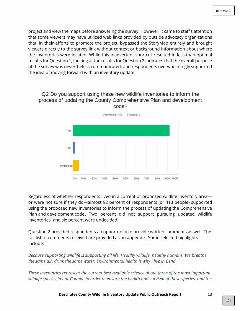
Deschutes County Wildlife Inventory Update Public Outreach Report 13
project and view the maps before answering the survey. However, it came to staff’s attention that some viewers may have utilized web links provided by outside advocacy organizations that, in their efforts to promote the project, bypassed the StoryMap entirely and brought viewers directly to the survey link without context or background information about where the inventories were located. While this inadvertent shortcut resulted in less-than-optimal results for Question 1, looking at the results for Question 2 indicates that the overall purpose of the survey was nevertheless communicated, and respondents overwhelmingly supported the idea of moving forward with an inventory update.
Regardless of whether respondents lived in a current or proposed wildlife inventory area—or were not sure if they do—almost 92 percent of respondents (or 413 people) supported using the proposed new inventories to inform the process of updating the Comprehensive Plan and development code . Two percent did not support pursuing updated wildlife inventories, and six percent were undecided. Question 2 provided respondents an opportunity to provide written comments as well. The full list of comments received are provided as an appendix. Some selected highlights include: Because supporting wildlife is supporting all life. Healthy wildlife, healthy humans. We breathe the same air, drink the same water. Environmental health is why I live in Bend. These inventories represent the current best available science about three of the most important wildlife species in our County. In order to ensure the health and survival of these species, and the
104
Item #IV.2.

Deschutes County Wildlife Inventory Update Public Outreach Report 14
rest of the ecosystems of which these species are a vital part, we need accurate information in order to plan for and regulate impactful human development. I don’t know enough about how the wildlife inventories would be used. If the data is thorough and actually used, then I am in favor. If the data is just gathered and not utilized, just to check a box, then I’m less excited about it. In general I believe wildlife inventories should be a guiding factor in comprehensive plans. The plan appears to take in all eagle nests, even if they are no longer active. The plan appears to protect elk ranges, where elk never have been. We have a huge housing shortage, prices are high, and are only higher because of how expensive it is to go through land use process. These wildlife inventories are overreaching protecting areas that do not need to be protected, and will further limit development only to the rich that can afford to fight the legal battles that this will inevitably enable. Good decisions depend upon having reliable and up-to-date information. Too expansive and limits options for land use The vast expansion of these areas will impose too great a cost on private property owners. The current rules seem to be working as the areas of habitat are vastly greater than inventoried in 1992 (even accounting for a less rigorous inventory process). The current WA zone rules key road requirements to 1992 -- fair for current zones but unfair for newly added properties. This will present nonproductive farm land from being used for nonfarm dwellings – sometimes the only way a farmer can qualify to live on his land (to be able to farm it to make farm income) without disqualifying the entire property from farm tax deferral. My home sits between Tumalo Reservoir Road and Pinehurst Road in Tumalo. We frequently see a herd of 70+ elk that use the area to rest and feed during the winter and even summer months. Under the proposed new expanded wildlife plan our area would be included. Given the deer, elk and other wildlife we see in our neighborhood, enlarging the current wildlife maps seems very appropriate. Question 3 was open-ended, and 146 people provided responses, some relating specifically to the inventory project, and others about wildlife in the County more generally. The comments appear to make it clear that Deschutes County residents care strongly about wildlife protection. All responses are provided in the appendix, but some are highlighted below. Protecting wildlife need not be difficult. Cooperation and information is essential. Every year I obtain a Deschutes Co. permit to place "give deer a brake" signs along Gosney and Rickard Rds. during spring and fall migration to/from winter range. Public feedback from these
105
Item #IV.2.

Deschutes County Wildlife Inventory Update Public Outreach Report 15
signs has been good to raise awareness that vehicle collisions are a major mortality factor, and speed a factor in collisions. I'd like to think this appears to have reduced deer deaths in these areas in the last 2 years. Why aren't there more public relations and efforts to reduce collisions? Interagency partnerships, with insurance companies, road depts, ODFW, conservation nonprofits and road frontage landowners could do more to do so, including clearing ROWs for sight distance, encouraging removal of unnecessary fences, motion sensor warning lights, etc. ODFW does very little stewardship to protect deer populations other than agreeing to undercrossings. Prohibiting feeding deer in neighborhoods would be a good first step to reduce deer vulnerability to vehicles. ODOT is the only agency being proactive in funding undercrossings and fencing. Perhaps with updated migration data, problem areas can be targeted for multi-pronged programs. Meanwhile deer numbers fall... Wildlife is the reason I live here. This is a crucial project in light of rapid population growth in the county which has led to loss of habitat for many native species. Adopting an updated inventory will be a great first step. Following that, giving the inventory meaningfulness by threading it through planning documents and processes will be critically important. Failure to have recent survey data ensures poor policy decisions. This change will devalue land. Property owners should be notified and, in all fairness, compensated for the loss of land value of land they purchased at prices based on current development expectations. Not only do the wildlife inventories need to be updated, but Deschutes County needs a plan for updating them on a regular bases. USFWS recommended 2 mile buffers for golden eagles should be adopted so development within that area can be reviewed. Additionally, the county needs a wildlife biologist on staff. The inventories are cursory in scope. The project aims to survey 'wildlife' but it only covers deer, elk, and eagles. If you are really concerned about conserving wildlife and habitats in the region, you need to do more comprehensive surveys. According to ODFW's own conservation strategy, Deschutes County comprises 4 different ecoregions, and these ecoregions support many species that are listed as sensitive by ODFW. And yet they only want to manage for deer, elk, and eagles. In the East Cascades ecoregion alone, there are at least 3 fish species, 4 amphibians, 3 reptiles, a dozen bird species, and 11 mammals listed as sensitive or critical (this list includes neither deer nor elk). I realize that not all of these species occur on lands managed by Deschutes County, but many do. And how will you know if you don't survey for them?
106
Item #IV.2.

Deschutes County Wildlife Inventory Update Public Outreach Report 16
Virtual Open Houses Due to the public gathering restrictions in place from the COVID-19 pandemic, the County was unable to host any in-person meetings regarding wildlife inventory updates. To account for these challenges, County planning staff facilitated two virtual open houses in conjunction with the Deschutes County Planning Commission, the project consultant, and representatives from the Interagency Working Group. The open house events were held on April 15, 20211 and April 29, 20212 and the videos—as well as Spanish translations of each open house—remain available on the project web page. The purpose of the open houses was to give the public and the Deschutes County Planning Commission an opportunity to ask County staff and wildlife biologist experts questions concerning the project process, data collection and methodology, and potential next steps. These sessions were intended to introduce community members to the StoryMap feature and associated survey, while also allowing for more clarification and inquiry into details which may not have been captured by the other outreach features. The open house sessions were conducted via Zoom, and each was simultaneously streamed and recorded via Facebook Live through the County’s social media account. Participants were encouraged to submit written questions through either of these channels, with corresponding answers provided in real time by facilitators and presenters. During the second open house, participants could also ask questions live via video. The open houses used the StoryMap as an outline, with staff and the wildlife biologist consultant taking the audience on a guided tour of the background and maps. The Planning Commission and the public asked questions throughout the presentation. The full list of questions and answers during the open house meetings has been included as an appendix to this report. In addition, these documents include several answers to questions that were not answered live due to time constraints.
General Public Comments In addition to the data gathered through survey outreach and both virtual open houses, the county received eight public comments from private citizens concerning the proposed wildlife inventory updates, not including clarifying or logistical inquiries. These comments unanimously supported the concept of proceeding with inventory updates. A full copy of the public comments has been included as an appendix to this report.
1 https://deschutescountyor.iqm2.com/Citizens/SplitView.aspx?Mode=Video&MeetingID=2749&Format=Agenda 2 https://deschutescountyor.iqm2.com/Citizens/SplitView.aspx?Mode=Video&MeetingID=2751&Format=Agenda
107
Item #IV.2.
Deschutes County Wildlife Inventory Update Public Outreach Report 17
SECTION 3: CONCLUSION
Based on the outreach undertaken by the County described above, it appears that a significant majority of participants are supportive of utilizing the proposed inventories to begin the update process to the County Comprehensive Plan and development code.
It is important to note that this presentation of new biological data is only the very first step in what will be a thorough and complex undertaking to determine what an inventory update would look like, both in terms of process—would it be a stand-alone amendment to the Comprehensive Plan, or incorporated into the larger, more holistic Comprehensive Plan update?—and in terms of specific regulations to be considered—such as the determination of conflicting uses as well as the recognition of development expectations and entitlements. Nevertheless, the responses to the initial outreach reveal that the importance and protection of wildlife is a widely shared value in Deschutes County, and there is conceptual support for pursuing the next steps involved in an inventory update. This community conversation represents the culmination of the data collection stage. Further tasks beyond this grant will use input received from this public process to inform the Board of County Commissioners of potential next steps.
108
Item #IV.2.

IWG Report
109
Item #IV.2.

Deschutes County Goal 5 Wildlife Inventory Update
Prepared for
Deschutes County Community Development Department
Prepared by Mason, Bruce & Girard, Inc.
707 SW Washington Street, Suite 1300 Portland, Oregon 97205
503-224-3445 www.masonbruce.com
February 26, 2021
This project is funded by Oregon general fund dollars through the Department of Land Conservation and Development. The contents of this document do not necessarily reflect the views or policies of the State of Oregon.
110
Item #IV.2.
i
Deschutes County Goal 5 Wildlife Inventory Update | February 26, 2021
Table of Contents Introduction ....................................................................................................................................................................... 1
Process for the Update ...................................................................................................................................................... 1
Results ................................................................................................................................................................................ 2
Mule Deer Winter Range Habitat ........................................................................................................................... 2
Sensitive Bird Habitat: Bald and Golden Eagle Nest Locations ............................................................................... 3
Elk Winter Range Habitat ........................................................................................................................................ 3
Recommendations from the IWG to the County ............................................................................................................... 4
Literature Cited .................................................................................................................................................................. 4
111
Item #IV.2.

1
Deschutes County Goal 5 Wildlife Inventory Update | February 26, 2021
Introduction The Deschutes County Community Development Department (County) is beginning the process of updating the County’s Comprehensive Plan, which formally records the community’s development aspirations and goals and provides guidelines for future growth. To complete one step of this multi-step process, the County applied for and received a Technical Assistance Grant from the Department of Land Conservation and Development. The grant provides funding to begin updating up to three of the County’s Statewide Planning Goal 5 (Goal 5) wildlife inventories because the existing Goal 5 wildlife inventories are dated and no longer represent the best available scientific data for the inventoried resources. The County engaged Mason, Bruce & Girard Inc. (MB&G) in 2020 to assist them with the implementation of the grant. This report presents the three updated Goal 5 wildlife inventories. Figures are presented in Appendix A. Raw data snapshots are presented in Appendix B. GIS data are delivered separately.
Process for the Update The decision-making group for the project is the Technical Advisory Committee (TAC). Initially the TAC included representatives from the Oregon Department of Fish and Wildlife (ODFW), the Land Conservation and Development Division (LCDC), the County, and MB&G. The County and MB&G kicked off the project in August of 2020 with the first meeting of the TAC. During this meeting, the group reviewed the existing Goal 5 inventories related to wildlife and selected three candidates for update. These included:
1) Mule Deer (Odocoileus hemionus) Winter Range Habitat 2) Sensitive Bird Habitat– specifically the bald eagle (Haliaeetus leucocephalus) and golden eagle (Aquila chrysaetos)
nest sites 3) Elk (Cervus canadensis) Winter Range Habitat
The TAC also identified additional inventories that would benefit from an update but did not rise to the same priority level as the three selected for this round. Those were:
1) Mule Deer Migration Corridors 2) Endangered Species Act Threatened & Endangered Species Habitat (e.g., Oregon spotted frog (Rana pretiosa))
Mule deer migration corridors were identified as important by the TAC because more recent data gathered over the past decade indicate the resource is likely significantly larger than the area that is currently protected. ODFW now also has a better understanding of how mule deer use corridors in the County. Although important, corridors were still seen by the TAC as a lower priority than updating the mule deer and elk winter ranges and the bald and golden eagle sensitive habitat areas. The TAC also decided that while Threatened & Endangered species habitats were important, species listed under the Endangered Species Act (ESA) and their habitats already receive federal protections and inventories are typically much more up-to-date than those selected for this project.
Once the three inventories were identified by the TAC, MB&G convened an Interagency Working Group (IWG) consisting of agency species experts. This group was tasked with reviewing existing data and developing new inventories based on the best available science and professional opinion. The IWG members included agency representatives from ODFW and U.S. Fish and Wildlife Service (USFWS); discussions were facilitated by MB&G. This report presents to the TAC the results of the IWG-led updates to the three selected inventories.
112
Item #IV.2.
2
Deschutes County Goal 5 Wildlife Inventory Update | February 26, 2021
Results Over the course of the project, the agency representatives developed updated versions of the three selected Goal 5 wildlife inventories. The three resulting updated datasets are described in this section, and GIS files and metadata are delivered separately. All area estimates reported herein were made using the Deschutes County-preferred coordinate system: Oregon State Plane South with Lambert Conformal Conic projection, North American Datum 1983 (international feet units).
Mule Deer Winter Range Habitat The mule deer winter range habitat inventory was selected by the TAC for update primarily because it no longer reflects usage patterns indicated by data collected by ODFW biologists, and this habitat commonly is a source of conflict with proposed developments in the County.
Research tools available to scientists have evolved since the original wildlife-related inventories were created back in the 1990s. For example, in the case of mule deer winter range habitat, since the last inventory was developed ODFW revised study designs to alter winter range sampling to more effectively measure changes in the deer population. ODFW and their research partners also completed studies that tracked deer use of the winter range habitat by collaring some individuals with GPS location transmitters, greatly enhancing ODFW’s understanding of how deer are using the winter range habitat. Finally, ODFW applied recently developed spatial modeling tools to better predict how mule deer utilize winter range habitat.
The revised mule deer winter range habitat was developed by ODFW based on the following data sources:
• The existing Deschutes County Wildlife Area Combining Zones (WA Zones) for mule deer winter range, including the Deer Winter Range, Tumalo Deer Winter Range, Metolius Deer Winter Range, Grizzly Deer Winter Range, and North Paulina Deer Winter Range
• The biological mule deer winter range (ODFW 2012) which provides a general outline of mule deer winter range east of the crest of the Cascades in Oregon. ODFW considers the winter range to be that area normally occupied by deer from December through April
• Aerial and ground survey observations of deer group sizes collected by ODFW biologists during each winter from 2015 through 2020 (unpublished)
• Mule deer resource selection function (RSF) model raster for probability of use in winter based on the “south central study” (Coe et al. 2018)
• Deer density polygons from two years of collar data for an area that was left out of the “south central study” (unpublished)
Figure 1 (Appendix A) depicts the updated inventory for mule deer winter range. Mule deer winter range areas currently protected by the County (the WA Zones for Mule Deer Winter Range) were included in the revision as they continue to represent key winter habitat areas for deer. The currently protected WA Zone for mule deer winter range in the County covers approximately 315,847 acres. The blue polygons indicate additional important mule deer winter range habitat areas covering approximately 188,132 acres. The revised mule deer winter range habitat as proposed would cover approximately 503,979 acres. Snapshots of the raw data informing the inventory update were provided by ODFW and are included in Appendix B. In the context of the greater mule deer winter range (ODFW 2012), these newly selected areas combined with the existing WA Zone winter range were thought to be particularly significant portions of the winter range
113
Item #IV.2.

3
Deschutes County Goal 5 Wildlife Inventory Update | February 26, 2021
habitat for mule deer based on the raw data inputs depicted in Appendix B, and therefore they were identified for protection by the members of the IWG representing ODFW.
Sensitive Bird Habitat: Bald and Golden Eagle Nest Locations Bald and golden eagle nest locations were selected by the TAC for update primarily because the datasets underlying the current sensitive bird habitat occurrences for these two species in Deschutes County are out of date, and development conflicts with known nests are increasing. USFWS participated in the IWG and provided the updated Goal 5 inventory for bald and golden eagles. The updated Goal 5 inventory dataset includes known golden and bald eagle nest sites, each buffered by a sensitive habitat area extending outward from the nest location. All known nest locations within Deschutes County as well as any buffers that extend into Deschutes County from nest locations in adjacent counties are included. Alternative nests with overlapping buffers are dissolved into single polygons to better capture potential use areas for active pairs. Golden eagle nest locations are buffered by a sensitive habitat area that extends out for a radius of 2 miles (Figure 2, Appendix A). USFWS buffered the golden eagle nest locations with the larger proposed sensitive area because this is the awareness distance used by the agency to trigger review of potential impacts of a proposed project or land use change on an active pair under the federal Bald and Golden Eagle Protection Act (BGEPA). Bald eagle nests are buffered by a ¼-mile -radius sensitive habitat area. The buffers applied to the updated golden eagle nest sites are larger than the ¼-mile sensitive habitat buffer currently applied by the County to golden eagle nest locations.
USFWS gathered the data informing the revised Goal 5 inventory from three sources:
• Oregon Eagle Foundation • United States Forest Service Natural Resource Information System (NRIS) for terrestrial wildlife data • Bureau of Land Management local records
The existing Deschutes County sensitive bird habitat inventory includes 5 bald eagle and 20 golden eagle nest locations. Each nest location is currently buffered by a ¼ mile radius sensitive habitat area. Altogether, the County currently protects 2,297 acres of sensitive bird habitat associated the 25 nest locations (603 acres for bald eagles and 1,694 acres for golden eagles).
In total, the proposed sensitive bird habitat associated with bald and golden eagles would cover approximately 344,778 acres in the County. The much larger acreage of sensitive habitat identified in the updated inventory stems from 1) an increase in the number of nests included in the updated inventory (116 bald eagle, and 103 golden eagle nests), and 2) the larger radius of sensitive habitat area identified for golden eagles. It is important to note that the larger number of nests included in the updated inventory does not correspond to increased eagle success or upward population trends, especially for golden eagles. Survey methods have improved and survey efforts have greatly increased over the past several decades resulting in the record of several alternative nest sites per territory (e.g. the 103 golden eagle nest sites represent 41 territories). The revised data also include nests on all land ownerships even were buffers are fully located on public lands.
Elk Winter Range Habitat Similar to the mule deer winter range inventory, the elk winter range habitat was selected by the TAC for update primarily because the existing WA Zone for Elk Range used by the County significantly differs from ODFW’s survey-based understanding of how elk currently use winter range habitat. The most heavily used winter range has expanded over time and often conflicts with development projects.
114
Item #IV.2.

4
Deschutes County Goal 5 Wildlife Inventory Update | February 26, 2021
The revised areas were identified by ODFW based on the following data sources:
• The existing Deschutes County WA Zone for elk habitat (which focuses on winter range)• The biological elk winter range (ODFW 2012) which provides a general outline of elk winter range east of the crest
of the Cascades in Oregon.• Winter observation data collected by ODFW biologists from 2015 through 2020 (unpublished)• ODFW biologists’ professional knowledge of winter range habitat use patterns by local elk herds
The revised elk winter range habitat is depicted in Figure 3 (Appendix A) and it extends the existing Wildlife Area Combining Zone, which covers approximately 51,717 acres, to include additional important portions of the biological winter range covering approximately 359,473 acres. The entire revised elk winter range would cover approximately 411,190 acres in the County. Snapshots of the raw data informing the inventory update were provided by ODFW and are included in Appendix B.
Recommendations from the IWG to the County While discussing the inventory revisions, the IWG also developed some recommendations for the County to consider during later phases of the Comprehensive Plan update. Recommendations included:
• Identify and utilize up-to-date databases to keep data layers current. For example, the Oregon BiodiversityInformation Center (ORBIC) which is part of the Institute for Natural Resources at Portland State University,manages a comprehensive database of rare, threatened, and endangered species in Oregon. The IWGrecommends the County regularly access this database to keep the bald and golden eagle inventory current. Itcould also be used as a resource for keeping other inventories associated with rare, threatened, or endangeredspecies in line with the best available science.
• Consider the consequences of disclosing sensitive information such as exact eagle nest locations to the public. Thesensitive habitat area buffers provide some protection, but the resource agencies urge the County to coordinatewith them prior to making the updated inventories accessible to the public to ensure proper precautions havebeen taken.
Literature Cited Coe, P. K., D. A. Clark, R. M. Nielson, S. C. Gregory, J. B. Cupples, M. J. Hendrick, B. K. Johnson, and D. H. Jackson. 2018. Multiscale models of habitat use by mule deer in winter. Journal of Wildlife Management, 82(6):1285-1299.
Oregon Department of Fish and Wildlife (ODFW). 2012. ODFW Deer and Elk Winter Range for Eastern Oregon. GIS Shapefile Published 01/09/2013. Online Link: https://nrimp.dfw.state.or.us/DataClearinghouse/default.aspx?p=202&XMLname=885.xml
115
Item #IV.2.

Deschutes County Goal 5 Wildlife Inventory Update | February 26, 2021
Appendix A Figures
116
Item #IV.2.

Figure1_Mule_Deer_Winter_Range Habitat, 2/3/2021
Figure 1. Mule Deer Winter Range Habitat
Deschutes County Goal 5 Wildlife InventoryDeschutes County, Oregon
Source: basemap from Microsoft Bing; proposedadditions to winter range from ODFW. Reproduced forinformational purposes and may not be suitable for legal,engineering, or surveying purposes. Conclusions drawnfrom such information are the responsibility of the user.
0 2 4 6 8 101Miles
Additional Mule Deer Winter Range Habitat
Deschutes County Mule Deer Winter Range WA Zones $117
Item #IV.2.

Figure2_Eagles_Sensitive_Habitat, 2/26/2021
Figure 2. Bald and Golden Eagle Sensitive Habitat Areas
Deschutes County Goal 5 Wildlife InventoryDeschutes County, Oregon
Source: basemap from Microsoft Bing; bald and goldeneagle sensitive habitat areas from USFWS. Reproducedfor informational purposes and may not be suitable forlegal, engineering, or surveying purposes. Conclusionsdrawn from such information are the responsibility of theuser.
0 2 4 6 8 101Miles
Additional Bald and Golden Eagle Sensitive Habitat Areas
Deschutes County Sensitive Bird Habitat for Bald and Golden Eagles $118
Item #IV.2.

Elk_Winter_Range Habitat, 2/3/2021
Figure 3. Elk Winter Range Habitat
Deschutes County Goal 5 Wildlife InventoryDeschutes County, Oregon
Source: basemap from Microsoft Bing; proposedadditions to winter range from ODFW. Reproduced forinformational purposes and may not be suitable for legal,engineering, or surveying purposes. Conclusions drawnfrom such information are the responsibility of the user.
0 2 4 6 8 101Miles
Additional Elk Winter Range Habitat
Deschutes County Elk Range WA Zones $119
Item #IV.2.

Deschutes County Goal 5 Wildlife Inventory Update | February 26, 2021
Appendix B Data Snapshots
120
Item #IV.2.

Deschutes County Goal 5 Wildlife Inventory Update | February 26, 2021
Snapshot provided by ODFW of raw data informing the mule deer winter range habitat inventory update.
121
Item #IV.2.

Deschutes County Goal 5 Wildlife Inventory Update | February 26, 2021
Snapshot provided by ODFW of raw data informing the mule deer winter range habitat inventory update.
122
Item #IV.2.

Deschutes County Goal 5 Wildlife Inventory Update | February 26, 2021
Snapshot provided by ODFW of raw data informing the elk winter range habitat inventory update.
123
Item #IV.2.

Online Survey Summary
124
Item #IV.2.

Wildlife Inventory Update
1 / 1
33.55% 153
19.52% 89
46.93% 214
Q1 Do you live or own property in an area that falls within a wildlifeinventory area, either current or proposed?
Answered: 456 Skipped: 0
TOTAL 456
Yes
No
Not sure
0% 10% 20% 30% 40% 50% 60% 70% 80% 90% 100%
ANSWER CHOICES RESPONSES
Yes
No
Not sure
125
Item #IV.2.

Wildlife Inventory Update
1 / 12
91.98% 413
2.00% 9
6.01% 27
Q2 Do you support using these new wildlife inventories to inform theprocess of updating the County Comprehensive Plan and development
code?Answered: 449 Skipped: 7
TOTAL 449
# COMMENTS? WHY OR WHY NOT? DATE
1 Our wildlife are extremely important!! 5/7/2021 8:59 AM
2 What inventories? Maybe an explanation of how and why would he helpful 5/7/2021 7:07 AM
3 Wildlife is important to our physical and emotional wellbeing in Central Oregon. 5/6/2021 3:58 PM
4 We have to manage the winter range better. We are killing too many ungulates with our cars,our development without some kind of mitigation...
5/6/2021 1:18 PM
5 With the rapid pace of growth, spread and construction, it is more important than ever that weare thoughtful, strategic, compassionate and smart in relationship to our urban wildlife.
5/6/2021 12:10 PM
6 The plan appears to take in all eagle nests, even if they are no longer active. The plan appearsto protect elk ranges, where elk never have been. We have a huge housing shortage, pricesare high, and are only higher because of how expensive it is to go through land use process.These wildlife inventories are overreaching protecting areas that do not need to be protected,and will further limit development only to the rich that can afford to fight the legal battles thatthis will inevitably enable.
5/5/2021 5:39 PM
7 When you have policies informed by science, outcomes will be relevant. 5/4/2021 3:12 PM
8 Because development frequently ignore existing ecosystems after their pursuit of greed whichcan never satisfy itself
5/4/2021 1:21 PM
9 I grew up here and know what Deschutes County looked like in 1981 and it is not evencomparable to what it looks like now. We need new inventories to go with the new
5/4/2021 12:02 PM
Yes
No
Undecided
0% 10% 20% 30% 40% 50% 60% 70% 80% 90% 100%
ANSWER CHOICES RESPONSES
Yes
No
Undecided
126
Item #IV.2.
Wildlife Inventory Update
2 / 12
Comprehensive plan. Otherwise we are planning without seeing the entire picture.
10 It's good to protect wintering areas so that we don't continue to build homes in these areas. Wemust keep habitat available for the species to survive.
5/4/2021 10:06 AM
11 Need to build wildlife overpasses on HWY 97, not undercrossings if herds are to survive. Allother western states have it figured out.
5/4/2021 9:46 AM
12 Because supporting wildlife is supporting all life. Healthy wildlife, healthy humans. We breathethe same air, drink the same water. Environmental health is why I live in Bend.
5/4/2021 8:20 AM
13 We need to protect our wildlife for future generations both for viewing and harvesting. It is timeto update the areas and data to reflect current actuals.
5/4/2021 8:12 AM
14 One thing to inventory them...another thing to not enforce speed limits resulting in huge deermortality!!!!
5/4/2021 8:05 AM
15 We need to protect important breeding areas and habitats that sustains wildlife, while at thesame time planning for safe housing that plans for the co-existence of human life and wildlife.
5/4/2021 7:29 AM
16 The current one is from 1981. Very outdated. I have lived in Bend since the 70's andeverything has changed here.
5/4/2021 7:22 AM
17 It’s important to include the most recent data when creating a new plan (or updating the currentone).
5/4/2021 7:08 AM
18 We need accurate numbers to make informed decisions. 5/3/2021 9:57 PM
19 Understanding where our wildlife live and the habitat they require is essential for management.Using 40-year-old data doesn't make sense.
5/3/2021 7:23 PM
20 Deschutes County is not just a place for humans. What makes it special for all of us whomove and live here is its rural wild area. This includes the precious wildlife who call this landhome. Their protection and conservation are essential!!
5/3/2021 6:27 PM
21 we have invaded wildlife's habitat and we should respect their needs. 5/3/2021 5:57 PM
22 We need to be making our decisions based on the best available scientific data. 5/3/2021 5:46 PM
23 taking care of our wildlife is very important, they need the space 5/3/2021 3:03 PM
24 Wildlife is the reason that many people were brought to enjoy the Central Oregon region. As wehave allowed growth to go unchecked with our population and building, wildlife has suffered.
5/3/2021 2:04 PM
25 We need to use the most up-to-date science when planning. I definitely want to preservewildlife habitat!
5/2/2021 8:07 PM
26 If there is no concern on protecting the migrating herds of deer and elk, we won't have ANY!County needs to watch wildlife corridor passages and protect them from differing developingtracts.
5/2/2021 6:34 AM
27 I feel wildlife in my area (Klippel acres) is getting 'squeezed' because of traffic/people/newhomes and lack of understanding of wildlife here by newcomers. I live about 400 feet from theTanager development where there are two lakes that are beside Tumalo Creek. The wildlifethrive this area.
5/1/2021 9:49 PM
28 It's important to know what's going on with wildlife and impacts that city growth has had. 4/30/2021 10:17 PM
29 Wildlife is important! As Deschutes County becomes ever more developed and populatedwildlife will lose out if there is not careful planning based on current science.
4/30/2021 5:04 PM
30 Would like to ensure that wildlife is protected 4/30/2021 4:43 PM
31 This shouldn't even be a question. We need to support our environment and this is one way todo so. We remove our ruin valuable habitat too easily.
4/30/2021 8:28 AM
32 We need to make informed decisions before we build to just build. The wildlife is precious anddon't have a voice or money to represent themselves.
4/30/2021 8:04 AM
33 Yes, our county is growing fast, we need to plan for conserving the wildlife and habitat thatcoexist with us.
4/30/2021 8:03 AM
127
Item #IV.2.

Wildlife Inventory Update
3 / 12
34 It's important we know what is happening and protect wildlife as our population expands 4/30/2021 7:53 AM
35 I believe the wildlife in the area will be significantly impacted by all the piping of the irrigationcanals. This reduction of surface water will cause them to search for it closer to people inmany instances.
4/30/2021 1:07 AM
36 I’ve not seen the wildlife surveys so unable to comment. How do I view them? 4/29/2021 10:00 PM
37 If we don't know what kind of wildlife is around us how can we help 4/29/2021 9:51 PM
38 Wildlife should be considered in coordination with city planning. This is their home too. 4/29/2021 9:25 PM
39 Our wildlife is in desperate need of inventory to best determine the best course of action topreserve our wildlife community.
4/29/2021 8:52 PM
40 Very important since bends growth has pushed deer eagles and owls into our neighborhood.We want to protect them.
4/29/2021 8:42 PM
41 It is critical to know where these areas are, so they can be preserved and these key speciescan be supported.
4/29/2021 8:19 PM
42 Yes because the wildlife corridors and environments are important for species health. 4/29/2021 7:21 PM
43 I don’t know anything about these. I need to be educated 4/29/2021 7:19 PM
44 These inventories represent the current best available science about three of the mostimportant wildlife species in our County. In order to ensure the health and survival of thesespecies, and the rest of the ecosystems of which these species are a vital part, we needaccurate information in order to plan for and regulate impactful human development.
4/29/2021 7:00 PM
45 Hoping to STOP ALL THE DEVELOPMENT :/ 4/29/2021 6:46 PM
46 Yes! The development in Bend does not seem to take wildlife communities into account -leveling ALL of the trees in a new development ruins micro-ecosystems. I live directly acrossCline Falls Rd from a 5 acre parcel that will be developed this summer, and I’m concerned forthe large herd of deer that use that open space for winter forage.
4/29/2021 6:23 PM
47 Very interested in the wildlife and helping out. 4/29/2021 6:10 PM
48 Current inventory is 30 years old and with the growth in humans over that time, it is essentialthat we have current data.
4/29/2021 5:13 PM
49 So much has changed in the county since the 1990's that it is imperative to understand whatthe current wildlife situation is now to use in our planning going forward. Many people live inDeschutes County because of the outdoor recreation, natural setting and wildlife. We shouldknow what we have in order to understand how to reduce or eliminate impact and protect theseresources.
4/29/2021 4:59 PM
50 It’s important to know wildlife volume and routes in order to plan out growth and prevent wildliferoutes being blocked
4/29/2021 4:28 PM
51 Wildlife is under increasing stress from increasing human populations, pollution, pesticide use,and poaching. It needs to be carefully monitored and protected to avoid extinction.
4/29/2021 4:07 PM
52 I don’t know enough about how the wildlife inventories would be used. If the data is thoroughand actually used, then I am in favor. If the data is just gathered and not utilized, just to checka box, then I’m less excited about it. In general I believe wildlife inventories should be aguiding factor in comprehensive plans.
4/29/2021 4:03 PM
53 As deschutes county grows we need to make sure it is sustainable with the wildlife that callthe area home too. This is only possible by using accurate and updated data.
4/29/2021 3:41 PM
54 Wildlife is a huge part of my quality of life and I believe that wildlife range and habitat shouldbe taken into consideration when proposing new county codes and changes to existing countycodes.
4/29/2021 3:40 PM
55 Overdevelopment of bike trails and recreation is seriously degrading wildlife habitat andthreatening animals. Great Gray Owls should be added to the inventory and protections astheir habitat is being seriously damaged by new trails and recreation.
4/29/2021 3:15 PM
56 The existing data is 30 years old. I think we need up to date information on our wildlife 4/29/2021 3:09 PM
128
Item #IV.2.

Wildlife Inventory Update
4 / 12
populations to be able to make good planning decisions.
57 I support the need for new data and updating wildlife inventories from 20 years ago. 4/29/2021 1:35 PM
58 Obviously the explosive population growth in this area has impacted the wildlife! 4/29/2021 1:35 PM
59 I have a lot of deer that visit my property daily, on average about 10 to 15 deer a day. I live onone acre of natural brush on the east side of Bend and I feel that all the new development ispushing them out and that is not good.
4/29/2021 1:33 PM
60 Deschutes County's wildlife areas are essential to our reputation and quality of life. 4/29/2021 1:29 PM
61 Deschutes county is rapidly growing; we need to have a clear idea of the wildlife beingdisplaced as we work to balance growth with wildlife protection and conservation. We cannotknow what we do not measure: a wildlife inventory is very important.
4/29/2021 1:14 PM
62 Do not have enough information 4/29/2021 1:13 PM
63 Up to date data will assist in making informed decisions when updating the ComprehensivePlan and development code. Worse is basing decisions on out of date information withpotential for creating conflict.
4/29/2021 1:10 PM
64 One of the reasons we love living here is because of the wildlife. Development should besensitive to these critical places our wildlife live.
4/29/2021 1:08 PM
65 I am concerned that encroaching development will compromise and/or destroy our amazingwildife habitats, both for today and for future generations.
4/29/2021 1:00 PM
66 Good decisions depend upon having reliable and up-to-date information. 4/29/2021 12:50 PM
67 We need to preserve as much wildlife as possible in these times of drought fire danger andincreased human usage of our forests.
4/29/2021 12:44 PM
68 Important to have data to measure how Deschutes County growth impacts wildlife, habitat, 4/29/2021 12:41 PM
69 It only makes sense as we develop more areas in Central Oregon which served as wildlifehabitat. Because of such rapid development, animals are getting killed by cars and familiarmigration routes now have obstacles that impede their movement and increase danger. It's justthe respectful "right" thing to do to consider impacts to wildlife that so many people agree isspecial to enjoying life here.
4/29/2021 12:39 PM
70 How can we know what to include in our plan if we don't know how many of different speciesoccupy our area? It seems ridiculous to use 30-year-old data to make decisions that will affectthe outcome of the future.
4/29/2021 12:29 PM
71 It's appalling that the last wildlife inventory update was in 1991. Bend's population hasexploded since then with home building on the west side especially, (Northwest Crossing,Tetherow and Tree Farm for example) devouring acreage that deer, quail, and small mammalsused to roam. And everywhere, off leash dogs are a menace. Ten years ago, in River West, Iwould see flocks of quail in my yard and large numbers of deer. Today, no quail sightings andfewer deer. We desperately need to update the wildlife inventory before its too late.
4/29/2021 12:25 PM
72 Only if the data supports protecting wildlife when needed. I would hate for County to see smallpopulations as justification for development when there can be multiple reasons as to why thisis. Now if sharing the wildlife inventories with the County are in the animals best interest Icompletely support it.
4/29/2021 12:19 PM
73 It is essential that we know our wildlife populations, where they are strong and where they areweak, so we can address any problems and promote the welfare of all wildlife.
4/29/2021 12:13 PM
74 We have chosen to live in this beautiful area, with wonderful wildlife. To ensure wildlifecontinues to survive and thrive it is imperative we update our habitat conservation plans toalign with the most current data available.
4/29/2021 12:12 PM
75 Protecting wildlife habitat makes for good habitat for all the county's human residents, as wellas the animals. Deschutes County without wildlife would just be yet another place that isdevoid of all that once made it special.
4/29/2021 12:05 PM
76 Important to know where the wildlife in the area lives to plan accordingly 4/29/2021 11:57 AM
77 It is my opinion that we encroach on wildlife areas and need to know where wildlife is, how 4/29/2021 11:57 AM
129
Item #IV.2.

Wildlife Inventory Update
5 / 12
many, and what we can do to protect this valuable resource.
78 It is important to keep track of human/wildlife interface especially because Deschutes Countyhuman population is growing so rapidly
4/29/2021 11:56 AM
79 I’d like to better understand human impact on my neighborhood wildlife. They are critical to ahealthy infrastructure, which we are responsible for maintaining.
4/29/2021 11:53 AM
80 I feel that we are encroaching on too much of the land that the wildlife needs to live andsurvive. I feel that there are way too many new houses going up everywhere and taking awayfrom the beauty that Bend, OR was.
4/29/2021 11:49 AM
81 Need to ensure we leave room for native life 4/29/2021 11:47 AM
82 I love critters! 4/29/2021 11:46 AM
83 Updated data will show how important habitat conservation is and how much we need toprotect it for our mule deer, elk, bald eagles, and golden eagles to thrive.
4/29/2021 11:44 AM
84 YES! We need to avoid big changes in sensitive areas. So what are the sensitive areas? 4/29/2021 11:26 AM
85 It’s irresponsible to claim ignorance and not update data regularly. Development will continueno matter what so it needs to be done in an informed and responsible way, which includesupdates to wildlife areas.
4/29/2021 10:08 AM
86 Wildlife are being marginalized with significant habitat loss. The inventory needs to be updatedto inform planning.
4/29/2021 9:45 AM
87 Absolutely support including wildlife inventories into future codes and plans. As thedevelopments and fences go in, migration for wildlife is drastically affected.
4/29/2021 9:22 AM
88 It is critically important especially at this stage of the condition of our wildlife and environment. 4/29/2021 9:09 AM
89 You cannot possibly update plans and development code without knowing how it affects localwildlife. You can't do that without knowing how our wildlife are doing. Ex: Declining populationsof Mule Deer
4/29/2021 9:08 AM
90 If the Deschutes County Comprehensive Plan does not take in account of wildlife needs of theanimals for development code, it would not really be Comprehensive - Would it?
4/28/2021 10:36 PM
91 It is important to protect our ecosystems 4/28/2021 8:20 PM
92 There doesn't seem to be any proposed conclusion to this proposed survey. What might be theresulting changes with the information gathered herein?
4/28/2021 2:14 PM
93 Using the best science available to make decisions can result in better outcomes for bothwildlife and people.
4/27/2021 9:21 AM
94 As our local population continues it's tremendous growth, we need to incorporate the mostrigorous and up-to-date scientific data for resources such as our native wildlife populations.Ultimately, if our growth is to be managed in a way that reduces negative impacts to wildlifepopulations, we will need accurate estimates for where and when animals utilize certain areasof our County. Without these estimates and associated development review actions, we arelikely to continue seeing decreases in wildlife populations such as mule deer, which willultimately compromise the very values which draw people to the region in the first place.Updates to our Comprehensive Plan which include this data represent the best chance wehave for the next 20+ years to recognize the challenges to wildlife that our region has producedthrough its growth, and develop strategies to mitigate those damages.
4/26/2021 3:50 PM
95 Too expansive and limits options for land use 4/26/2021 12:59 PM
96 we should be paying attention to options of roads etc. when we cut down and remove differentwildlife habitats. If there is a way to minimize this impact we should consider it.
4/26/2021 10:43 AM
97 The vast expansion of these areas will impose too great a cost on private property owners.The current rules seem to be working as the areas of habitat are vastly greater than inventoriedin 1992 (even accounting for a less rigorous inventory process). The current WA zone ruleskey road requirements to 1992 -- fair for current zones but unfair for newly added properties.This will present nonproductive farm land from being used for nonfarm dwellings - sometimesthe only way a farmer can qualify to live on his land (to be able to farm it to make farm income)without disqualifying the entire property from farm tax deferral.
4/26/2021 10:08 AM
130
Item #IV.2.
Wildlife Inventory Update
6 / 12
98 We need to do all we can to preserve wildlife habitat. 4/26/2021 9:32 AM
99 Where are the new inventories posted? 4/24/2021 3:58 PM
100 It is critical to use the best available science when assessing impacts to wildlife of current andfuture development and management.
4/24/2021 1:32 PM
101 We need to know what wildlife we may be impacting. People come here for the nature of Bend.Its up to us as a community to be mindful of that and protect our local wildlife.
4/24/2021 10:57 AM
102 I live off O.B. Riley and on the river and and I am increasingly fearful of the proposed housingdevelopments on Glen Vista and how they will impact the mule deer and other wildlife in thisarea. They are basically getting trapped and cannot access winter range land due todevelopments and highways. My deer are here all year and many are injured by barbed wirefences and other obstacles around the increasingly populated areas.
4/24/2021 10:51 AM
103 So many new housing developments are taking away wildlife areas. This needs to beconsidered and taken into account prior to taking over the wildlife areas before passing newdevelopments in UAR/UGB areas that animals are being displaced!
4/24/2021 9:20 AM
104 So there can be proper protection measures included in future planning 4/24/2021 7:36 AM
105 Yes data about impacts on wildlife from conversion of natural to developed landscapes iscritical.
4/24/2021 5:58 AM
106 I have never heard a word about "inventories". I can't support an unknown. This is a stupidquestion. Be clear, please.
4/23/2021 9:15 PM
107 I did not know about this 4/23/2021 8:57 PM
108 Our neighborhood in west Bend (just off Century Drive) has an abundance of deer, squirrels,birds etc. We have lived here 30 years and there has been no noticeable decrease in wildlifepopulation.
4/23/2021 6:55 PM
109 Need to try and strike a balance between development and wildlife needs to maintain quality oflife for all.
4/23/2021 2:04 PM
110 Don't know anything about this. 4/23/2021 1:45 PM
111 Our impact is accelerating and we need to make informed choices. 4/23/2021 12:53 PM
112 I do t understand what you mean by code or comprehensive plan. What is the purpose of theplan?
4/23/2021 12:30 PM
113 ...what are the plans and code? 4/23/2021 12:12 PM
114 Don't know what you are talking about 4/23/2021 12:00 PM
115 As the Bend population (of humans) expands we need to provide for the population of allcreatures that have come before us.
4/23/2021 11:35 AM
116 With the tremendous amount of development going on in our area in the past 15years, it is soimportant to use this information to get a fairly accurate idea on how this effects our wildlife.How else can you move forward with urban planning with the additional huge influx of peopleexpected!
4/23/2021 10:45 AM
117 I don’t know what the new wildlife inventories are. 4/23/2021 10:11 AM
118 So much growth...we need to be current with data for decisionmaking. 4/23/2021 9:41 AM
119 not informed as to what the plan and development code involves 4/23/2021 9:40 AM
120 I've not heard or read anything about it. 4/23/2021 9:04 AM
121 Yes, we should always be aware of the impact our ongoing county development and growth ishaving on the wildlife around us.
4/23/2021 9:03 AM
122 Development definitely impacts wild life populations with home or industry building moving intoformer wild life habitat.
4/23/2021 8:23 AM
123 There has been significant development since the last inventory was completed, and wildlifehas needed to adapt to it.
4/23/2021 8:18 AM
131
Item #IV.2.

Wildlife Inventory Update
7 / 12
124 30 years is a long time since the last one. 4/23/2021 7:05 AM
125 too much government ! 4/23/2021 6:59 AM
126 It’s vital that we understand and accommodate our wildlife as the county grows and changes. Ilive in Tumalo.
4/23/2021 6:54 AM
127 It's important for humans to acknowledge their negative impact on wildlife. 4/23/2021 6:03 AM
128 Don't know enough about it. 4/23/2021 3:57 AM
129 Because the Mule Deer need their habitat to thrive. Obviously if we've lost 40%, developmentis fringing on their survival.
4/23/2021 12:12 AM
130 It is about time that we start considering wildlife before making decision to spread out housingeven further.
4/22/2021 10:51 PM
131 Probably but I have no info on the new wildlife inventories. So, answering these 2 questions israther meaningless
4/22/2021 10:50 PM
132 Our wildlife is as much a part of Deschutes County as our natural rock outcroppings andjunipers. As such, we should appreciate, and protect the natural world.. Subdivisions, andinbuilding can destroy the very reason humans are here.
4/22/2021 10:48 PM
133 I think they need to find out what the cause of such a decrease in the Mule Deer population. Itwas once a major area to come to to exercise your hunting privileges in the state. I do notthink the decrease is due to the vast number of people moving to Bend. However, the deer killby traffic and poachers has increased and we need to address those problems.
4/22/2021 10:45 PM
134 More data is better than no data. 4/22/2021 10:40 PM
135 Haven’t heard about it 4/22/2021 10:40 PM
136 I believe we need to address sustainable growth that supports wildlife within our urbanboundaries, in order to support the livability of Bend.
4/22/2021 10:24 PM
137 I believe that this land is the wildlife's as well! 4/22/2021 10:18 PM
138 More than ever we need to preserve wild lands for the wildlife. I value wildlife and support usingthese new wildlife inventories.
4/22/2021 10:01 PM
139 I support any measure that protects wildlife and the environment. 4/22/2021 9:06 PM
140 It seems that it would be most useful to have this information included in the ComprehensivePlan, especially if actually used to guide and inform future development plans.
4/22/2021 7:11 PM
141 Wildlife habitats are destroyed regularly to build homes & infrastructure further disrupting thebalance nature provides to the ecosystem.
4/22/2021 1:07 PM
142 We need to be smart about managing the growth of Deschutes County. Wildlife is important toall of the citizens of Central Oregon. It's one of the core values of our community and hugeindicator of the quality of life we want to preserve in Deschutes County for future generations.We need to protect and conserve what we have and the only way to do that is to take stock ofwhat's out there so we can manage our growth responsibly.
4/22/2021 9:14 AM
143 This proposal is an important step towards far-reaching planning of our every expandingcommunity. The present overlay maps do not reflect the changes in wildlife habitat use or theincrease in scientific knowledge attained in the past 30 years. Central Oregon attracts peoplewho love nature and the outdoors, and wildlife is a big part of this appeal. Human development,climate change, and other factors will continue to shape the future of our region, and improvedoverlay maps will help in dealing with these challenges. Growth is inevitable. Planned growth isessential.
4/22/2021 8:40 AM
144 Pull your head out, we need to get rid of predator's such as wolfs and cougars, migrationpatterns need to be addressed and dip shits feeding deer need to be slapped.
4/22/2021 8:34 AM
145 We want to maintain the counts or restore declines of species. 4/22/2021 7:12 AM
146 Don't know about the inventories. 4/21/2021 8:50 PM
147 I am completely in favor of this proposal. As a biologiss by training and a wildlife lover as well, 4/21/2021 5:00 PM
132
Item #IV.2.

Wildlife Inventory Update
8 / 12
I think that revision of the overlay maps is quite overdue. Why wouldn’t the county want thebest available science to be included in any future planning? Having current information aboutthe ranges of elk, deer, and eagles is paramount to maintaining healthy populations that aresuch tremendous assets to Central Oregon.
148 My home sits between Tumalo Reservoir Road and Pinehurst Road in Tumalo. We frequentlysee a herd of 70+ elk that use the area to rest and feed during the winter and even summermonths. Under the proposed new expanded wildlife plan our area would be included. Given thedeer, elk and other wildlife we see in our neighborhood, enlarging the current wildlife mapsseems very appropriate.
4/21/2021 11:30 AM
149 The County needs to know the impact of loss of habitat is having on wildlife and also thetransition from open areas to deer resistant fencing and it's related impact.
4/20/2021 7:06 PM
150 So Sad that you have to ask....If we don't protect the animals we have we will all suffer. Ourgrowth affects all living things and we as humans need to live with in developed areas andallow animals to have healthy habitat.
4/19/2021 9:41 PM
151 Wildlife deserves our consideration and protection. Many species, including ungulates andbirds of prey, are facing serious threats, and we should minimize human impacts whereverpossible. To do so, we need a good understanding of current populations/ranges.
4/19/2021 3:19 PM
152 Yes. Wildlife are the primary indicators for the natural resources and values that make CentralOregon special, and which drive our tourism economy and the influx of people into the region.It's imperative that the county take measures to inventory and conserve what we have movingforward.
4/18/2021 3:16 PM
153 Because I have been involved with a mule deer advocacy group in Deschutes Co. , Iwholeheartedly support this wildlife inventory update for multiple reasons. With mule deerpopulations declining at 10% /yr., protected habitat increases will be one of the main tools inhelping their populations. These declines are not only due to habitat loss, but also due to the1000+ deer/vehicle collisions occurring each yr. in Deschutes Co. alone, plus declines due toresidents feeding deer which causes them to lose their migratory patterns, which causesincreased diseases and parasite loads due to crowding, and causes death due to toxins fromfeeding high energy feeds such as corn cobs, alfalfa, and grains, and draws in predators due tobunching of the deer around the feeding areas. Other reasons for declines are wildlifeunfriendly fencing and yard hazards causing injuries and deaths, and increased outdoorrecreation and off leash dogs which stress deer at a distance of 200 meters. Increased stresshormones cause adverse affects on reproduction. Poaching accounts for 22% mortality,whereas legal harvests cause 19% mortality. I also want to finally settle the myth perpetuatedin Oregon that mule deer declines are due to the "explosion" of cougar populations. Everyonebelieving this myth quotes that the Oregon cougar population in 6000+. Read carefully ODFWsCougar Management Plan which clearly states that there are about 3300 ADULT cougars inOregon. That 6000+ figure INCLUDES kittens and juveniles. High kitten mortality and juvenilereplacement of adults is why MOST state wildlife officials omit them in counts! Multiple wildlifebiologists with three decades of research show that Oregon's cougar densities are about 2.1-2.3/100km2 which closely matches that of WA, ID, and MT. In other words one cannot blamean ''explosion" of cougars as the cause of mule deer population decline! Considering the longlist of reasons for mule deer declines, is there any wonder why we are experiencing suchlosses? Habitat must be protected and increased. Deschutes Co. land decisions recently havebeen skirting the Goal 5 parameters by giving development that once was prohibited in winterdeer range the go-ahead for expansion of businesses in the Tumalo and Metolius critical winterranges. The law must be adhered to for protecting these vital habitats if we are to see anyimprovement in numbers.
4/17/2021 7:59 PM
154 Deschutes County does seem able to avoid unprecedented population and housing growth;evading any semblance of a sustainable ecological environment will have dire consequences.
4/16/2021 11:05 AM
155 With changing climates and increased development, it's important to incorporate this newverified information into the County's planning efforts to preserve and restore wildlife habitat.
4/16/2021 10:23 AM
156 If for no better reason than to know what we are about to lose. 4/16/2021 7:47 AM
157 Because ethical land management requires taking into consideration wildlife habitat needs. 4/16/2021 7:44 AM
158 Great presentation! I am very excited about this proactive approach towards integrating wildlifeand land use planning. It is so important to support all efforts to preserve our naturalenvironment, not only for our communities' quality of life but also for future generations.
4/15/2021 7:51 PM
133
Item #IV.2.

Wildlife Inventory Update
9 / 12
159 This hasn't been done in a long time and we need to know if and how the wildlife populationshave changed.
4/15/2021 7:45 PM
160 I was part of the survey team for the Oregon Eagle Foundation that located and conductedGolden Eagle Nest Surveys throughout Oregon for ten years ending in 2019.. The proposedexpanded area for sensitive bird habitat appears to accurately incorporate areas of knownGolden Eagle nesting and territorial activity. Allowing less territory than the proposed sensitivebird habitat would be disingenuous.
4/15/2021 4:18 PM
161 Deschutes county should be using the most comprehensive, up to date data to inform it'sdecisions.
4/15/2021 11:48 AM
162 I value wildlife and support using these new wildlife inventories. 4/15/2021 7:41 AM
163 Nature and Science. Nothing but truth. 4/14/2021 8:23 PM
164 This proposal needs to be adopted into the Comprehensive Plan to protect area wildlife for thenext seven generations. I've been a property owner in the proposed expanded areas since1994. I have seen a decline in the mule deer population, songbirds, and raptors over the theseyears.
4/14/2021 8:20 PM
165 Relevant data are the basis of all sound management decisions. Can't manage what is notknown. When we know and understand the resource, then an appreciation for what we haveand how to protect it can be developed.
4/14/2021 6:33 PM
166 Wildlife data tracking technologies has advanced so much in 30 years. Use the new stuff. 4/14/2021 4:06 PM
167 Wildlife should have rights and should have safe, appropriate, natural places to live. 4/14/2021 1:35 PM
168 Yes! With all of the new people moving in, wildlife should be a priority. 4/14/2021 12:19 PM
169 Humans are crowding out wildlife. We need to keep open lands for them! 4/14/2021 11:48 AM
170 It is crucial to keeping a balance of wildlife and human influences in this fast growing area ofdevelopment and population increases.
4/14/2021 10:29 AM
171 Mule deer population is in decline and there is a priority to save their species. Artificialwaterski lakes took away their habitat.
4/14/2021 9:33 AM
172 Should always be conducting research to best serve the needs of wildlife in the face ofcontinual growth and development.
4/14/2021 8:33 AM
173 Science should dictate areas needed for protecting wildlife. 4/13/2021 6:23 PM
174 Central Oregon is constructing new homes and infrastructure at an alarming rate. We need tohave a solid understanding of how our wildlife is coping with that growth.
4/13/2021 4:44 PM
175 Even though I hate it when the deer and ground squirrels eat my newly-planted native plants, Ido understand that it is THEIR habitat and we are interlopers.
4/13/2021 4:38 PM
176 The growth in Bend is so insane -- we are cutting out areas for wildlife so that, ironically, morepeople can live closer to wildlife! I think such an inventory would help guide growth thatpreserves what we love
4/13/2021 4:10 PM
177 It is extremely important to have actual date on wildlife populations and how they have beenand will be impacted/harmed by human developments when making the CountyComprehensive Plan.
4/13/2021 3:07 PM
178 Wildlife is worth protecting 4/13/2021 2:29 PM
179 Protecting wildlife habitat is also a protection for humans. 4/13/2021 12:32 PM
180 With Deschutes County's exploding population & subsequent building houses in wildlife zones,increasing awareness & tolerance for wildlife is in order. The reason people want to live inCentral OR is, in part, due to wildlife accessibility. This asset will not continue withoutplanning.
4/13/2021 12:13 PM
181 Would like building in wildlife areas curtailed and use best practices for decisions. Thank you. 4/13/2021 11:11 AM
182 Building is going on at a fast rate, affecting land, water, and air, and the wildlife doesn't get tofill out a survey.
4/13/2021 9:24 AM
134
Item #IV.2.

Wildlife Inventory Update
10 / 12
183 Development and population growth impacts need to be balanced by conservation efforts forwildlife survival.
4/13/2021 9:00 AM
184 There is a reason Oregon is a beautiful place, land use laws. Habitat for wildlife is critical in thequality of life we enjoy here. Our regional identity is connected to our wildlife. They are animportant part of what makes this place exceptional and distinct. Winter habitat is veryimportant so I hope you do seasonal studies to show migration and we learn to work within withmigration patterns.
4/13/2021 8:50 AM
185 I am an advocate for our wildlife and wilderness both, neither of whom has a voice of their ownwith which to speak for themselves. Central Oregon wildlife was here long before people were -let's protect them as they are part of what makes our region beautiful and helps to keep ourecosystem in balance.
4/13/2021 7:27 AM
186 Proximity to wildlife and nature is why people live here. If we keep paving over lands requiredby wildlife to flourish in the effort to provide "affordable" housing our own quality of life willdiminish in turn.
4/13/2021 7:02 AM
187 Wildlife has taken a backseat to development for decades. Winter ranges are critical for largeanimal migrations and current inventories can tell a factual story about the decline of manyspecies in the county at least in part to development.
4/12/2021 10:04 PM
188 So much change means wildlife have been impacted. 4/12/2021 9:27 PM
189 Because we share living space and natural resources with other wildlife species who were herelong before we moved into their home ranges.
4/12/2021 8:52 PM
190 We need to protect vital wildlife habitat as the area booms with development 4/12/2021 8:28 PM
191 Results of County planning decisions directly affect local wildlife populations and generalbiodiversity. In tern, biodiveristy can have a great impact on the aesthetics and overall healthof the County.
4/12/2021 8:14 PM
192 For most of the earth's existence, there have been no humans. But now, humanity threatens toexterminate vast numbers of species that "get in our way". If we cannot share our world withwildlife of all kinds, whether it's serves our interest or not, we will cease to have a planet thatsupports humanity as well. Knowing the status of wildlife populations is the first step in thatprocess.
4/12/2021 7:49 PM
193 It is very important to allow adequate and appropriate habitat for wildlife. 4/12/2021 5:55 PM
194 Our natural areas are obviously a necessary part of the health, welfare and beauty of our lives.And what goves us the right to exterminate everything in our path for the sake of money andselfish interests
4/12/2021 2:09 PM
195 We must know the data to know how better to co-exist with rich diversity of wildlife in thecounty.
4/12/2021 2:03 PM
196 Deschutes County is becoming way to overpopulated. Development is occurring everywhere.This has huge effects on wildlife habitat whether that be developing within city limits orexpanding the Urban Growth Boundary. With this new development and growth is putting wayto much pressure on our limited resources and wildlife habitat. More people living in DeschutesCounty means more people out in our forests and rural areas and having effects on wildlifehabitat. This will also lead to increase parking areas for trailhead and snowparks, etc. Newdevelopment means more people, less open space, less wildlife habitat, more stress onwildlife, and less available safe migration habitat.
4/12/2021 1:42 PM
197 We strongly support wildlife conservation and we need the best available information to beeffective in doing so.
4/12/2021 1:36 PM
198 It is essential that citizens and govt agencies protect native ecosystems and all species thatrely on the health and viability of these ecosystems. We must be caring and
4/12/2021 1:23 PM
199 This wildlife cannot necessarily recover from what we humans do to their environment, so weneed to understand where they are and what they need.
4/12/2021 1:20 PM
200 If we, Bend residents show that we are not that interested in updating the CountyComprehensive Plan and Development code, it sends a message that we are more interestedin development than in the wildlife who live here too.
4/12/2021 12:56 PM
135
Item #IV.2.

Wildlife Inventory Update
11 / 12
201 I am adamantly in favor of the inventories in order to support wildlife habitat, wild lands, andbiological diversity.
4/12/2021 12:56 PM
202 Of course wildlife should be considered before any new development. 4/12/2021 12:11 PM
203 It seems like it should be common sense that development code & planning needs to beupdated to accommodate the updated and more accurate wildlife inventories
4/12/2021 12:10 PM
204 Making decisions based outdated information is a waste of time and a misuse of resources. Ifthe county is going to adequately plan for development in a way that is complimentary towildlife use then up to date information is imperative.
4/12/2021 11:49 AM
205 Because wildlife habitat is declining and we need to protect the most important habitat that isleft
4/12/2021 11:46 AM
206 Critical habitat and corridors need to be protected 4/12/2021 10:59 AM
207 I feel inventories validate decisions with facts. 4/12/2021 10:50 AM
208 As stewards of this land and resources, we must know what those resources are in order to dothe job.
4/12/2021 10:41 AM
209 They appear to be well researched and needed. 4/12/2021 10:29 AM
210 We are guests in nature; not the other way around. We've been 'abusing' our 'rights' way toolong. Let's start respecting our surroundings & lessening our 'footprints'.
4/12/2021 10:17 AM
211 Part of the allure and character of Bend is it's proximity to and integration with nature. For somany reasons, it's worth maintaining the balance of wild and urban rather than becoming justanother city.
4/12/2021 10:13 AM
212 Wildlife is a central component of the natural environment that I enjoy. 4/12/2021 10:12 AM
213 With the loss of habitat there is a dramatic decrease in ungulate populations, especially ourdeer and elk. We must revise and expand current wildlife inventories in order to protect habitatwhich might disappear under proposed development. Not doing this will potentially exacerbateloss of populations such as bald and golden eagles, and deer and elk.
4/12/2021 9:56 AM
214 We are building at a rate that is going to impact not only human quality of life, but all thewildlife that also live here. We need to decide how enormous a city we want to become.
4/12/2021 9:45 AM
215 YES! Our natural wildlife and scenic beauty are defining characteristics of Bend which profitall, including our industries.
4/12/2021 9:29 AM
216 not sure of the inventory process 4/12/2021 9:25 AM
217 The densities in the 1991 report are woefully inadequate to gauge the impact of developmentand recreation on 2021 habitat. The declining populations of mule deer attest to the lack ofcounty planning to factor wildlife into conversations about land use.
4/12/2021 9:22 AM
218 Too little info provided to respond. I support not allowing VRBO, Airbnb, and Bed andBreakfasts on property zoned F2 with Wildlife overlay. County code allows the BnBs, as Iunderstand it, but was written prior to Airbnb, so there is no ordinance forbidding this businessfrom taking root.
4/12/2021 9:18 AM
219 Watching our wildlife is one of the joys of living in central Oregon. 4/12/2021 9:16 AM
220 I see so much development around the entire perimeter of Bend, and am especially worriedabout the west side that abuts NF lands. So much of the natural range of elk and deer is beingdeveloped.
4/12/2021 9:05 AM
221 Never heard of a wildlife inventory area... 4/12/2021 9:04 AM
222 Wildlife habitat protection is critical. 4/12/2021 8:55 AM
223 As a long time resident, wildlife is one of the reasons which Deschutes County separates itselffrom the endless sprawl happening in other urban areas.
4/12/2021 8:46 AM
224 We have an important opportunity to evaluate wildlife habitat and wildlife corridors and protectan important part of our natural heritage, part of what makes our region special.
4/12/2021 8:44 AM
225 So hard to watch their habitat disappearing over the last 35 years. It is a dramatic change. 4/12/2021 8:42 AM
136
Item #IV.2.

Wildlife Inventory Update
12 / 12
226 More care needs to be taken to protect these endangered species, 4/12/2021 8:33 AM
227 The wildlife was here first. We have a duty to restore as much of their habitat as we can. 4/12/2021 8:28 AM
228 We need to protect large blocks of un- fragmented habitat. With no mountain biking ormotorized recreation
4/12/2021 8:26 AM
229 Wildlife need protection from all the development. 4/12/2021 8:26 AM
230 Because habitat destruction/alteration is one of the biggest threats to biodiversity. It's hightime we develop responsibly.
4/12/2021 8:23 AM
231 Wildlife protections are so few, that any little bit will help. Central OR looks a lot different nowthan it did when the wildlife protections were initially written and adopted in the mid-90's.
4/12/2021 8:18 AM
232 Wildlife needs to be protected and we cannot do so if we don't update the inventories. Thecomprehensive plan will be the framework for protecting wildlife in the county as the countycontinues to grow, which I think most people would support. I certainly do!
4/10/2021 5:04 PM
233 We need accurate data to help make decisions as to how to best preserve our wildife 4/9/2021 1:08 PM
234 Absolutely. We need data that is more relevant than the previous 1991 information. 4/9/2021 10:56 AM
235 An up-to-date wildlife inventory is an important planning tool, a leading edge indicator for theheath of our environment and the right thing to do. If successful - to some extent - this projectwill rebalance the widespread belief that these wildlife spp. in particular always loose out todevelopment.
4/9/2021 10:54 AM
137
Item #IV.2.
Wildlife Inventory Update
1 / 8
Q3 Please share any additional comments relating to this project in thespace below.
Answered: 146 Skipped: 310
# RESPONSES DATE
1 Deer populations have declined because of mountain lion predation .... 5/7/2021 7:07 AM
2 We need better signage for wildlife migration corridors (E.G., Tumalo area crossings, such asthe few flagged Deer Crossing signs), and utilize seasonal reader boards!
5/6/2021 1:18 PM
3 This is very important and needs to happen. 5/5/2021 10:28 PM
4 Comments sent separately. 5/4/2021 7:50 PM
5 I'm more concerned with the declining numbers of mule deer as a result of predators andpoaching. We currently have a means of catching predators (law enforcement and citizens),but due to the laws on the books we can't keep predators under control. I'm specifically talkingabout cougars, and bears. Cougars are the greatest threat to our mule deer populations that weshould be able to control but we can't because of the laws on the books which do not allow theuse of hounds to hunt these animals. It is common sense that predators keep other predatorsin control. Unfortunately the only predator that cougars have is man, and man has effectivelybeen taken out of the equation by the banning of hounds in the hunting of these predators.Setting aside winter habitat is fine, but it doesn't solve the major problem of of an everexpanding cougar population which decimates the deer population. With 6,400 cougars in ourstate (ODFW), each killing one deer per week, the deer loss due to these cougars is 332,800deer per year! That is a major problem that no winter habitat can effect in a positive way.
5/4/2021 10:06 AM
6 Need to build wildlife overpasses on HWY 97, not undercrossings if herds are to survive. Allother western states have it figured out.
5/4/2021 9:46 AM
7 Thank you for this information. It is great to see these beautiful animals ranges have grown.Let's do what we can to keep them thriving.
5/4/2021 8:12 AM
8 If not based on current information, the project is useless. "garbage in, garbage out" 5/4/2021 7:22 AM
9 The county is not doing enough to protect our wildlife. If they have more accurate data andknowledge more can be done to maintain and restore habitat.
5/3/2021 9:47 PM
10 i have noticed over the last 10 years around our place much more Deer and Elk moving around, we are close to LaPine state park area. 2 years ago we had a doe have a pair of fawns in ourback area. they hung around about 3 weeks and then were gone.
5/3/2021 3:03 PM
11 We need to protect our wildlife all over the state, but especially here in Central Oregon as thisis one of the greatest areas for Mule Deer and Elk in the country.
5/3/2021 2:04 PM
12 Protecting wildlife need not be difficult. Cooperation and information is essential. 5/2/2021 6:34 AM
13 I was wondering when you update, if you could write how the inventory is done. I did not seethe zoom presentation.
5/1/2021 9:49 PM
14 I see eagles and know they are nesting in the area. We need to protect these nesting areasand make sure we are not taking the hunting areas away. We need to share this space weinhabit and not destroy that which makes it special.
4/30/2021 4:43 PM
15 Every year I obtain a Deschutes Co. permit to place "give deer a brake" signs along Gosneyand Rickard Rds. during spring and fall migration to/from winter range. Public feedback fromthese signs has been good to raise awareness that vehicle collisions are a major mortalityfactor, and speed a factor in collisions. I'd like to think this appears to have reduced deerdeaths in these areas in the last 2 years. Why aren't there more public relations and efforts toreduce collisions? Interagency partnerships, with insurance companies, road depts, ODFW,conservation nonprofits and road frontage landowners could do more to do so, includingclearing ROWs for sight distance, encouraging removal of unnecessary fences, motion sensor
4/30/2021 3:01 PM
138
Item #IV.2.

Wildlife Inventory Update
2 / 8
warning lights, etc. ODFW does very little stewardship to protect deer populations other thanagreeing to undercrossings. Prohibiting feeding deer in neighborhoods would be a good firststep to reduce deer vulnerability to vehicles. ODOT is the only agency being proactive infunding undercrossings and fencing. Perhaps with updated migration data, problem areas canbe targeted for multi-pronged programs. Meanwhile deer numbers fall...
16 Think Wild should be relied in to help represent the wildlife, they have the knowledge andforesight. Thank you for the opportunity to share our thoughts.
4/30/2021 8:04 AM
17 Wildlife is the reason I live here 4/29/2021 9:51 PM
18 I live next to a wildlife corridor east of pilot Butte and can help with counts. 4/29/2021 9:19 PM
19 While very limited in scope, it is more current and better than guessing. 4/29/2021 8:50 PM
20 Thank you for doing this. 4/29/2021 8:42 PM
21 Keep Deschutes wild. Please dont loose this natural resource to housing developments. 4/29/2021 7:21 PM
22 I support wildlife habitat preservation. What can we do to help? 4/29/2021 7:19 PM
23 The County should prioritize additional funding or resources to update habitat information formore species and habitat types, including T&E species, migration corridors, riparian species,other furbearers, reptiles and amphibians, other bird species, and sensitive plant species.
4/29/2021 7:00 PM
24 Deschutes County needs infrastructure update...increase in population is out of control. 4/29/2021 6:46 PM
25 Deschutes County as a whole should be WAY more conservative about development. Not onlyare we eliminating wildlife diversity, we’re also contributing to the warming local climate byeliminating trees.
4/29/2021 6:23 PM
26 Just do it! 4/29/2021 4:59 PM
27 We are not isolated from the stressors that affect other species. Their extinction will affect ourown lives. Fish, bird, deer and elk populations have been severely reduced because of ouractions. Imagine a world in which they no longer exist. It would have a severe impact on thebusinesses in this area.
4/29/2021 4:07 PM
28 How can we do effective wildlife management if the data isn't accurate? This is a necessity 4/29/2021 3:41 PM
29 The last inventory was taken in 1991; 30 years is a ridiculous amount of time to have passedwith no updated information on our important and revered wildlife populations.
4/29/2021 3:40 PM
30 This is a crucial project in light of rapid population growth in the county which has led to loss ofhabitat for many native species.
4/29/2021 1:55 PM
31 I think it’s very important to preserve our wildlife and wildlife areas 4/29/2021 1:44 PM
32 It is long past time to do an update! 4/29/2021 1:35 PM
33 I have a lot of deer that visit my property daily, on average about 10 to 15 deer a day. I live onone acre of natural brush on the east side of Bend and I feel that all the new development ispushing them out and that is not good.
4/29/2021 1:33 PM
34 Human population continues to stress wildlife habitat. We must have accurate information inorder to protect wildlife when making decisions for development.
4/29/2021 1:10 PM
35 We need to protect the ranges of these important species. Once they're gone, they're nevercoming back. Zone accordingly.
4/29/2021 1:08 PM
36 It seems as through rapid development of new homes and industry is occuring without anyconvcern for our linited water supply. Alos, I understand the benefits of convering the irrigationcanlas to pipe, but there seems to be little concern for the plants, trese, and animals thatdepend/depended on the canals for water.
4/29/2021 1:00 PM
37 Failure to have recent survey data ensures poor policy decisions. 4/29/2021 12:50 PM
38 As a 30 year resident of Deschutes County, I have seen both the positive and negative effectsof the growth we have experienced. I believe it is vital that we have updated and accurate datato factor in the impact our growth may be having on wildlife populations.
4/29/2021 12:16 PM
39 Please do everything you can to protect wildlife and it habitat. All over the country animals and 4/29/2021 12:13 PM
139
Item #IV.2.

Wildlife Inventory Update
3 / 8
birds are being driven out of their habitat--they have no place to live.
40 Wasn't the last update 30 years ago? It's critical to me and my family that we conduct aninventory update so we can wisely preserve remaining wildlife habitat. That's part of why I liveand spend money in Central Oregon!
4/29/2021 12:09 PM
41 As a Deschutes County resident, I implore you to inventory and then protect wildlife habitat. 4/29/2021 12:05 PM
42 It is important to consider wildlife as our human population continues to grow. 4/29/2021 12:04 PM
43 We own our house and property near the current UGB on the south east side of the city ofBend. We regularly see mule deer, bald and golden eagles in the area! It is crucial to maintaintrees (including mature pines and junipers) and to maintain intact habitat. All urban and ruralplanning should mai rain and even bolster usable corridors and islands of habitat as the city ofBend is planning new density housing. STOP allowing contractors to cut down every tree andbulldoze current corridors for deer and other wildlife movement and migration inside the city’sUGB.
4/29/2021 12:02 PM
44 Central Oregon is becoming more developed, and we need to protect the wildlife that exist andto help it populate as well. This project will keep the public informed.
4/29/2021 12:00 PM
45 We live in an agricultural area with a variety of wildlife. An inventory would help to inform howpeople and wildlife can share the space in a positive way.
4/29/2021 11:57 AM
46 Adopting an updated inventory will be a great first step. Following that, giving the inventorymeaningfulness by threading it through planning documents and processes will be criticallyimportant.
4/29/2021 11:42 AM
47 Can you just survey the public on what they see out their windows? In Tumalo I see deer noton the current range map, and Elk also. And Eagles hunt in my field each spring.
4/29/2021 11:26 AM
48 It is important to know what the population levels and habitat usage of specific species are sothat we can prevent destruction of habitat while still allowing expansion for our own growingpopulation.
4/29/2021 10:25 AM
49 Our wildlife is retreating & has been reduced in multiple areas in & around Bend & DeschutesCounty. New trails/new housing developments/increased traffic through & surrounding sensitiveelk, mule deer, songbird/migratory bird, birds of prey habitat is having a major negative impact.We must do better!!!
4/29/2021 10:04 AM
50 There has been so much growth in Deschutes county over the last 30 years. This is greatlyneeded for conservation purposes.
4/29/2021 9:33 AM
51 It’s important that we embrace and protect the natural and wild parts of this region. This iswhere the true beauty of central Oregon lies. The spaces ‘between’ aren’t enough.
4/29/2021 9:22 AM
52 It is imperative that we understand that the wellbeing of our wild neighbors is in our bestinterest.
4/29/2021 9:20 AM
53 I strongly support using wildlife inventories to update the comprehensive plan and developmentcode. We've lived in Bend since 1984 and have owned our house and property in DeschutesCounty (in deer winter range) since 1993. Living with wildlife enriches our lives daily. Using thebest available science to make planning decisions not only allows wildlife to continue to exist,but it improves the lives of the people who share this landscape.
4/27/2021 9:21 AM
54 This change will devalue land. Property owners should be notified and, in all fairness,compensated for the loss of land value of land they purchased at prices based on currentdevelopment expectations.
4/26/2021 10:08 AM
55 Please make the inventories available to the general public. 4/24/2021 3:58 PM
56 The story board was well done, although the final graphic with sliders did not render any mapson my browser while the others worked fine. Regarding the inventories, this effort essentiallyinventories habitat, which is of course extremely important. However, assessing the health,trends, and impacts to wildlife populations also requires estimating abundance or at aminimum, indices of abundance, for key species. Also, while the ungulates and raptors aremost iconic, I think that other species might provide better representation of different trends inthe County's ecosystems. These might include amphibians, small mammals, resident birds,etc.
4/24/2021 1:32 PM
140
Item #IV.2.

Wildlife Inventory Update
4 / 8
57 Although you don't address the water levels in the Deschutes, I watch my area of the riverfluctuate tremendously in spring, summer and fall. It is a disgrace and it happens in hours withno warnings or ability for wildlife to adapt to such drastic changes. It almost seems criminal.
4/24/2021 10:51 AM
58 Don't know anything about this and what it implies. 4/24/2021 9:56 AM
59 Stop the unbridled so called Smart code development that interfaces with designated areas.Use buffers of low density rural zoning . New housing developments are not needed for vrboand bankers.
4/24/2021 6:25 AM
60 I would rather develop density in the existing city, and near city limits buildable lands. Makefull use of all properties in and near the city boundary.
4/23/2021 6:55 PM
61 Let's keep our wildlife safe while we continue to expand as a city. The animals were here firstand deserve respect, and safety.
4/23/2021 12:59 PM
62 We have lived in the same house on the west side of Bend for 24 years, and would say thatthe deer population has never been healthier! There are herds of deer feeding on everythingand VERY healthy! We have recently experienced wild turkeys and bobcats. (This is new forus.) The wild life is VERY plentiful and very well fed on Awbrey Butte!
4/23/2021 12:55 PM
63 Wildlife is impacted in so many way, not the least of which is road kill. Great swaths ofwatering is lost to irrigation piping. The public needs specific information in order to haveinformed perspective.
4/23/2021 12:53 PM
64 Are you interested in protecting wildlife or do you have other reasons for this. Please clarify 4/23/2021 12:30 PM
65 I would like more information about this. 4/23/2021 9:20 AM
66 Don’t know anything about the project but have seen a great decline in deer the past 20 yearsespecially.
4/23/2021 9:13 AM
67 it will be interesting to see the results, I have MORE deer, rabbits and a lot less predators tokeep the populations down (coyotes, etc.)
4/23/2021 8:27 AM
68 I would hope that botanical surveys are also included so that rare plants are not wiped out fordevelopment
4/23/2021 8:23 AM
69 See above. 4/23/2021 8:18 AM
70 We have small herds of Deer out here year round. We enjoy seeing them and don't want tolose that enjoyment.
4/23/2021 12:12 AM
71 We have taken so much of wildlife's resources away, if we don't change our ways we won'thave any wildlife left.
4/22/2021 10:51 PM
72 Would appreciate info about this project. Send to [email protected] 4/22/2021 10:50 PM
73 We have to "connect the dots" so the natural wildlife - and its habitat should be taken intoconsideration, and have equality with the development of human habitat and the supportinginfrastructure. The habitat that's destroyed for man once belonged to wildlife. . .and it's oftenthe very reason man wants to share the unique country. We need to be more sensitive withlaws to protect it.
4/22/2021 10:48 PM
74 Don’t trust blue politics wildlife management practices 4/22/2021 10:40 PM
75 Please see above. I believe we need to have a better understanding and accurate picture ofwildlife populations in order to better support and enhance native wildlife habitat.
4/22/2021 10:24 PM
76 Human beings have been taking away land from wildlife. That isn't fair but it is happening. 4/22/2021 10:18 PM
77 I strongly support the proposed Wildlife Inventory Update. I support land use planning anddecision-making based on the best available science and most up-to-date research regardingour region’s wildlife populations.
4/22/2021 10:01 PM
78 When I hike, I often hear the sound of people shooting. Do the sounds of guns negativelyaffect wildlife, whether or not the shots are from poachers or people shooting at targets? Howcan I help make the shooter dissapear?
4/22/2021 9:06 PM
79 The health of our wildlife populations is a good indicator of the general health of the localecosystems that have a direct bearing on the health and well-being of the people who live here.
4/22/2021 7:11 PM
141
Item #IV.2.

Wildlife Inventory Update
5 / 8
Too much competition from burgeoning human populations usually is to the detriment of thelocal flora and fauna....something we should certainly keep in mind, as it is the health andbeauty of the natural environment which serves as a powerful magnet attracting those peoplehere. We live in a fragile high desert ecosytem, which is already suffering from the impacts ofclimate change and environmental degradation.... there are limits to growth!
80 It breaks my heart to see so many deer roaming the streets, and backyards in Bend. I wishsomething could be done to limit the number.
4/22/2021 1:51 PM
81 Understanding the wildlife populations and planning appropriately is imperative to undo damageand begin healing the Central Oregon ecosystem that so many people... and animals rely on.
4/22/2021 1:07 PM
82 We need greater protection against dogs within the WA overlay zones which disturb wildlifemigration. Evidence is clear that both the smell of dogs and the barking of dogs decrease thenumbers of all wildlife.
4/22/2021 9:11 AM
83 Consider migrating birds. 4/22/2021 7:12 AM
84 I believe this type of information should be updated more frequently in the rapidly changingenvironment.
4/20/2021 7:06 PM
85 The inventory update should include much more than elk and deer winter ranges and eaglenesting areas. The Greater Sage Grouse is nearing state and federal listing status. Leks bothpresent and historic should be mapped and protected. Inventories should include, birds,mammals, plants, reptiles and any rare insects.
4/20/2021 1:49 PM
86 These surveys need to be updated and given to the public for planning and advising aboutfuture growth in CO.
4/19/2021 9:41 PM
87 I have no idea what these inventories are 4/19/2021 1:53 PM
88 Not only do the wildlife inventories need to be updated, but Deschutes County needs a plan forupdating them on a regular bases. USFWS recommended 2 mile buffers for golden eaglesshould be adopted so development within that area can be reviewed. Additionally, the countyneeds a wildlife biologist on staff.
4/18/2021 3:16 PM
89 I am pleased to see such increases in acres protected for mule deer, elk, and our bald andgolden eagles. Now if only the county will allow for restraint on expansion of development in allthese critical areas, it will make a tremendous difference in the survivability of our wildlife thatwe all cherish.
4/17/2021 7:59 PM
90 We should update as the area has changed a lot over last 30 years. I care about wildlife 4/16/2021 9:09 PM
91 Deschutes County's current and future growth trends are the primary driver of ecologicalunraveling across micro- to regional scales. In the proverbial sense, the species we identifyremain "canaries of warning" but too often ignore other "keystone" species also requiresbroader understanding of the fundamental complexities removed by human activities.Moreover, the interactions of human activities are exponentially compounded by humanbehavior. This requires clear, dedicated, purposeful, and logical and seamless strategiesamong Federal, State, County and local agencies that is currently missing. An exampleinvolving our local situation is the unintelligent-able ability to provide species and safetydecisions. For example, how are the Deschutes important comprehensive plan for wildlifegoing to avoid the traps of USFS, ODFS, OSP, Sheriff Department constrained by CFRs,Dingell Act, State laws, county statute, not to mention the memorandums, agencies' lawenforcement handbooks, . . . when each of these have overlapping jurisdictions regarding thelocation of a bald eagle successfully reproducing nest. Which is within (less than 150-yds) aUSFS waterfowl hunting/shooting area and with the established Upper Deschutes River Wildand Scenic River? Not to mention hunting shot impacting and endangering campgrounds,resident homes, and a wide range of recreating land users? Yes, the plan is a good beginningbut will remain moot if population, human unsafe behavior, the complex "string ball" ofagencies are not unwound. Best of luck!!!
4/16/2021 11:05 AM
92 Outside the urban boundaries, we need wildlife corridors to give them some chance of survivalin an ever increasing populace.
4/16/2021 7:47 AM
93 This proposal fails to include other sensitive birds in this region. We need to includeendangered and sensitive birds and other animal species in our inventories and ourmanagement plans and zoning.
4/16/2021 7:44 AM
142
Item #IV.2.

Wildlife Inventory Update
6 / 8
94 I understand this is a pilot project and the reasons behind selecting the wildlife inventory thatyou did. That said, I would like to see other wildlife incorporated into this process. Perhapsthere are organizations that could help support this endeavor. It would be phenomenal ifDeschutes County could be an example of how this should be done. Great job and kudos toyour panel of experts.
4/15/2021 7:51 PM
95 I'm glad to see the county is attempting to update guidance (rules and regs) aboutdevelopment/zoning and building issues as part of the comprehensive plan.
4/15/2021 7:24 PM
96 I would like to see this project promoted more. I believe many Deschutes County residentswould be interested in supporting this update if they knew about it.
4/15/2021 11:48 AM
97 I am a 5th generation Oregonian and have lived in Bend for over 32 years. I have beendevastated to see the destruction of habitat for animals, insects, plants that have evolved heresince the beginning of time. Development for one species: Humans, is crime to this planet andall of her inhabitants. We need to think beyond ourselves or there will be nothing left to loveand enjoy. I remember when Elk Meadows was just that. Now it is that in name only. Even theslash burns that are done each year destroy hundreds of species: squirrels, rock chucks,badger, porcupines, spiders, ants, desert toads. The list goes on and on. Please, save thispart of earth for the animals, insects, plants. We are nothing without them....
4/14/2021 8:23 PM
98 Please keep me posted on these proceedings: Marguerite [email protected]
4/14/2021 8:20 PM
99 To get "buy-in" from people living in the urban wildland interface, the knowledge of what isthere is necessary. Only then can a program based on "watchable wildlife" be developed, andsuch a program is necessary to get taxpayer support.
4/14/2021 6:33 PM
100 How does someone help with this project? 4/14/2021 4:06 PM
101 Thanks for looking at this issue and asking for public input. Also, I moved away from Bend 6months ago because development is out of control there and it was horrifying to see deerfeeding habitats destroyed as well as seeing deer migrating in Spring and Winter and having tocross high speed roadways as well as city streets with moderate traffic.
4/14/2021 1:35 PM
102 Local wildlife populations should take precedence over tourists and transplants. Developmentcan be done intelligently, not just for the sake of growth and money.
4/14/2021 12:19 PM
103 There is a limit to human development in order to keep the wildlife. Deschutes County needs torecognize and act on this immediately.
4/14/2021 11:48 AM
104 It's also crucial to our future well being on the planet in general. The decrease in biodiversity ingeneral is already having a deleterious effect on the planet.
4/14/2021 10:29 AM
105 Why in the world are trails being widened & more bikes being encouraged to come through, inone of the few places on the Deschutes Wilderness River Trail, where the elk still exist? !? It'sonly a matter of short time, before they stop coming here as well. But hey more people & morebikes, screw the migratory birds & elk...
4/14/2021 10:08 AM
106 Loss of habit is irreversible. It would deny to future generations of humans and animals theright to a healthy, sustainable, natural ecology.
4/14/2021 9:33 AM
107 Need to close more areas to motorized vehicles west of the river off highway 126 and lowerspeed limits in rural neighborhood neighborhoods.
4/14/2021 9:17 AM
108 It would seem that past efforts to protect winter ranges from human encroachment has failed,and now the species have moved, no gained in population size as clearly stated in the report,so why should adding even more bureaucracy, more reports, more committees, more workinggroups achieve anything more than the previous failed system did. The only thing this willachieve is a good paying government jobs for a few people who like to push paper around anddo absolutely nothing to help the situation with diminishing winter ranges for these species.
4/13/2021 8:11 PM
109 Curious why you are not considering within a city UGb (ie Bend) along canyon and borderingNF
4/13/2021 4:57 PM
110 I was astounded (and thrilled) to have a bald eagle fly down the street right in front of me.Things like this make this place special.
4/13/2021 4:38 PM
111 Wildlife corridors, winter range, historical migration pathways need to be protected for one ofCentral OR/Deschutes County's desirable assets--wildlife & their specific required habitat.
4/13/2021 12:13 PM
143
Item #IV.2.

Wildlife Inventory Update
7 / 8
Wildlife without habitat will not be successful.
112 I’m glad this is being looked at snd hope that development planning looks at the big picture sowildlife and humans can live together. Nature and wild places are what make this area adestination. Smart development plans that include wildlife and their migration patterns are keyto our future.
4/13/2021 8:50 AM
113 The US Forest Service and Bureau of Land Management should be full partners in the processgiven the extent of Federal lands in the county and in the survey areas. Access of NRIS dataalone is insufficient as a tool. Federal biologists and land managers often have knowledge ofhabitat conditions and species occurrence not captured in NRIS. They also have importantmanagement responsibilities and abilities to direct management for the species of concern.Additionally, this survey should also consider other important and limited habitats such asriparian corridors and ephemeral wetlands.
4/13/2021 7:33 AM
114 I am concerned that mule deer elk and eagles are suffering from increased development inDeschutes County. Please update wildlife inventories as ranges have changed in the thirtyyears since the 1991 assessment.
4/13/2021 7:27 AM
115 We live out in McKenzie canyon which is already in a wildlife combining zone . This winter wehave seen far fewer deer than in past winters and the last time elk came through was inNovember. Apparently there are two confirmed Golden eagle nests up in the rim rock behindour farm. The county needs to rethink all the rampant development that is happening now .Loss of habitat is the greatest cause of wildlife decline. Thank you , Tim and Wendy DiPaolo
4/13/2021 7:26 AM
116 We have a home in Sunriver and delight every year in seeing the deer and elk move throughour area. It was worrisome to learn the deer are in decline.
4/13/2021 6:16 AM
117 Wildlife and climate change go hand in hand when considering new development codes.Particularly where water is concerned and how droughts have affected wildlife species. Codesshould consider impacts to wildlife habitats and populations as a very high priority. Incentivesor requirements for solar should be part of any new codes for large developments and or largehomes over an determined square footage. No more golf courses should be allowed until watersustainability is determined.
4/12/2021 10:04 PM
118 Thanks I support wildlife inventories 4/12/2021 8:28 PM
119 Hopefully the Biden administration will continue to take a forceful role in enforcing policies onBLM and Forest Service land that support wildlife, rather than people.
4/12/2021 7:49 PM
120 The inventories are cursory in scope. The project aims to survey 'wildlife' but it only coversdeer, elk, and eagles. If you are really concerned about conserving wildlife and habitats in theregion, you need to do more comprehensive surveys. According to ODFW's own conservationstrategy, Deschutes County comprises 4 different ecoregions, and these ecoregions supportmany species that are listed as senstive by ODFW. And yet they only want to manage fordeer, elk, and eagles. In the East Cascades ecoregion alone, there are at least 3 fish species,4 amphibians, 3 reptiles, a dozen bird species, and 11 mammals listed as sensitive or critical(this list includes neither deer nor elk). I realize that not all of these species occur on landsmanaged by Deschutes County, but many do. And how will you know if you don't survey forthem?
4/12/2021 7:42 PM
121 Wildfires will be even more inevitable because of the ever increasing population and growth inCentral Oregon.
4/12/2021 2:09 PM
122 We should commit resources for law enforcement to stop poaching and to create safe passageways to stop the killing of animals on roads.
4/12/2021 2:03 PM
123 To reiterate we strongly support adopting new wildlife inventories. 4/12/2021 1:36 PM
124 A Wildlife Inventory is long overdue in Deschutes County 4/12/2021 1:20 PM
125 Residents and visitors love wildlife, but more importantly, wildlife lives here and deserves thesupport and protection of Deschutes County.
4/12/2021 12:56 PM
126 This is important work. Thank you for the time you are putting into the process. 4/12/2021 11:49 AM
127 Wildlife is an important aspect of this ecosystem we call home. We enjoy sharing with ouranimal neighbors and should consider them in any plans.
4/12/2021 10:41 AM
128 Wildlife is extremely important and habitat and wildlife corridors should take precedence over 4/12/2021 10:26 AM
144
Item #IV.2.
Wildlife Inventory Update
8 / 8
expanded development and sprawl. As should farm land versus housing.
129 There is a lot of economic temptation and pressure to build and grow quickly, but there's valuein taking a moment to plan WITH nature, to get creative, and to consider the long termconsequences and benefits of development.
4/12/2021 10:13 AM
130 Within the 30 years since the last inventories of wildlife , there has been dramatic residentialdevelopment of habitat that once was used by wildlife . We must reassess habitat loss andproject forward more protections to avoid what already is happening, such as elk being forcedto use golf courses and neighborhoods for foraging and deer overwintering within Bend citylimits, which puts both species at great risk from crossing roads, gathering at neighborhoodfeeding spots which risks spread of disease and parasites, threats from dogs, overgrazingnative plant food sources, loss of migration incentives, and increased stress levels fromrecreationists.
4/12/2021 9:56 AM
131 Does anyone at the County Development Dept. actually care about the impact all this growth ishaving on our wildlife, or is it just MONEY MONEY MONEY?? I'd like a response. Tracy [email protected]
4/12/2021 9:45 AM
132 Thank You! 4/12/2021 9:29 AM
133 See above 4/12/2021 9:18 AM
134 The old maps are well out of date. We need updated information on our wildlife’s needs. 4/12/2021 9:16 AM
135 You should include a link to more info on wildlife inventory areas. Where are they? Whatrestrictions would they impose, etc?
4/12/2021 9:04 AM
136 We must protect both base habitat and migration corridors in Central Oregon! 4/12/2021 8:55 AM
137 Wildlife is disappearing. They need our help. 4/12/2021 8:47 AM
138 It is sad that deer have to move into urban areas to survive. 4/12/2021 8:46 AM
139 This information is important for making sound land use decisions that will stand the test oftime and allow us to grow economically and develop in an orderly, rather than a haphazard,fashion.
4/12/2021 8:44 AM
140 Thank you for protecting wildlife habitat through land use. 4/12/2021 8:28 AM
141 We need to designate large blocks of land that is not disturbed by human activity 4/12/2021 8:26 AM
142 Going forward, all biodiversity must be considered, not just the charismatic megafauna. 4/12/2021 8:23 AM
143 Fun and exciting! 4/10/2021 5:04 PM
144 Open spaces is important as well as stopping the use of things like wedding venues in wildlifeareas
4/9/2021 1:08 PM
145 These maps are awesome! They give us up to date information on our wildlife's behavior andpatterns so we can make smart and informed decisions for our future!
4/9/2021 10:56 AM
146 If this project were a genie, these open houses will start with the first toe out of the bottle. TheCounty should give equal regard to the opinions expressed on the limited data update, futureexpectations and what impact this might have on future building in wildlife areas. The Countyis to be congratulated for approaching this topic head on.
4/9/2021 10:54 AM
145
Item #IV.2.

Virtual Open House Q&A Summaries
146
Item #IV.2.

WILDLIFE OPEN HOUSE Q&A SUMMARY - APRIL 15, 2021
Questions answered during the open house event (please note that some questions were edited for clarity): 1. How did the TAC pick these three inventories?
With Dr. Wente facilitating, the TAC reviewed the 12 inventories that currently are associated with wildlife in Deschutes County; at the end of the meeting they ended up with a selection with the inventories that are in most need of being updated, that have changed the most, and that commonly come into conflict with land use/development. These are inventories where the best supporting data was available, since best science practices has changed significantly since they were originally set up. 2. The expanded deer winter range looks justified. The report should also note that urban
areas such as Bend and Redmond are also historic deer winter habitat and are presently used by deer as the observations show, and observed by many residents. This comes into play with analyses pertaining to urban growth expansion.
We do understand that mule deer have a very wide range, including the City of Bend. They use quite a range of habitat. The idea here, however, is to choose habitat areas that are particularly important to that species and to the long-term maintenance and management. Mule deer are a great example of this, because you have a lot of anecdotal evidence of mule deer sightings. But just because you see the animals there does not mean that it’s the key habitat. The idea is to protect and manage these areas that are important to the long-term maintenance of the mule deer population in the County.
ODFW is very concerned about mule deer; in Central OR the population is declining at a rate of about 10 percent a year. We are trying to look at the areas where we think we have a chance to improve the populations; for better or worse, our urban areas are not those areas. ODFW refers to those areas as “sinks,” where they’re not able to sustain themselves as they were evolved to do.
3. Would there be plans or a need to collar more mule deer to study their winter range more on the east side? I saw a lot more mapped on the west side. When expanding the mule deer range, such as in the southeast, how you determine the boundaries of where that area is? Is it individual deer, or the number who pass through, or some other metric?
Collar data: for the green polygons that are labeled “collared deer,” that is just a subset of the animals that were collared. It was meant to fill in a gap for animals that had been collared to cover other parts of the county within the context of the study Dr. Wente cited. So the collared animals have a much wider coverage than just the green shapes in the snapshot in the StoryMap. There
147
Item #IV.2.

are no plans for an additional collar study for some time; that was a huge undertaking, and collar studies are currently being conducted/planned in other areas throughout Eastern Oregon.
Defining the boundaries of the inventory: in some cases those boundaries follow the biological winter range, and also natural geographic breaks, such as the Deschutes River. This isn’t to say that deer don’t occur out of those areas, but these have been determined to be the most important.
4. Do you have any observations comparing natural resource management in Washington versus Oregon?
It’s difficult to compare the two states; land use law is quite different, as is population density. They have a different set of issues so it’s difficult to compare.
5. Regarding the proposed eagle inventory, there weren’t any nests identified south of the Bend urban area—why is that? Also, is the ¼ mile radius sufficient?
The reason we don’t see many golden eagle nests immediately south of Bend is because there 1) aren’t many nest/eyrie locations in that area and 2) finding eagle nests in trees is quite difficult so there may be nests in that area of which we are unaware. Golden eagles are usually seen more in open country and will nest on cliff faces and rocky outcroppings, but they can and do nest in trees.
With respect to buffers, bald eagles have a 660-foot nest buffer, which is based on the 2007 National Bald Eagle Management Guidelines. No such national guideline exists for golden eagles, but protection measures are much more conservative since their populations are generally declining. USFWS applies a 2-mile buffer to golden eagles which essentially serves as a screening distance, or an awareness distance. For these larger buffers, USFWS’s recommendations will be very project dependent, depending on what rises to the level of disturbance.
6. It is important to recognize migratory corridors, and that there are more species that need to be inventoried and evaluated. How is the County addressing other inventories beyond these three?
When the TAC originally met to discuss inventories, they also discussed selecting alternatives. The grant funding was awarded to select three inventories, so this project must work within those bounds—it is not that these others do not deserve to be addressed. The alternatives selected were the mule deer migration corridor, which has new data and a large change, and threatened and endangered (T&E) species, the Oregon spotted frog. In the latter case, it was determined that because it’s federally listed under the Endangered Species Act, it already benefits from a layer of protection; in addition, it is a smaller geographic portion of the County.
The Community Development Department is treating this as a pilot project; there isn’t normally a mechanism for counties to regularly update these inventories. This grant is allowing us to chip away at the start of this process. We hope to be able to address other species potentially in the future.
148
Item #IV.2.

7. Our community needs to think beyond just the species, but also recognize that demands
and challenges these species experience is ever-changing, and new species are traveling through the area. Monitoring is so important to ensure that these species remain viable and plentiful and productive. Any thoughts on monitoring?
Speaking for ODFW, the primary species of focus in this district currently is mule deer; monitoring is a priority for all wildlife management units in the area because of the population decline. For mule deer, ODFW conducts twice yearly surveys: December herd composition (does, bucks, fawns); and spring/late winter they fly the area to observe survival through winter and gather data for population estimates, and that’s how ODFW can determine the decline in population. Every three years, each part of the mule deer winter range in Central Oregon is getting flown intensively via helicopter surveys; wintering deer are counted and the numbers are run through a scientific model. Elk are the same: annual aerial monitoring of all known herds every February/March. It’s a core part of ODFW’s operations statewide. For eagles, federal partners and many nonprofits monitor populations regularly. Oregon has an excellent dataset for golden eagles, thanks in no small part to the Oregon Eagle Foundation. 8. As the use of drones increases by recreationists, are there any plans to protect eagles
and mule deer from the impacts of drones on these populations?
Drones, electric mountain bikes—there are lots of ‘new’ technologies that impact these species. ODFW has rules against using drones for hunting purposes, and there are also state laws (ORS 498.128) against the harassment of wildlife. ODFW tries to adapt regulations to new technology impacts, but it’s a constant issue. For bald and golden eagles, the Bald and Golden Eagle Protection Act, the Migratory Bird Treaty Act, and the Airborne Hunting Act outline what activities are prohibited and impose punishments for a person found in violation of those acts; USFWS has legal jurisdiction to address them. These penalties are not inconsequential and USFWS has educational materials discussing how to avoid disturbing eagles and nests, and what to do if you see someone in violation. In addition, the Airborne Hunting Act has a provision about disturbing or harassing wildlife with any airborne device. There are legal penalties for flying drones for flying around nests or following in-flight eagles. These are real issues beyond just drones—it’s recreation in general: biking, hiking, dogs, etc. 9. For elk and mule deer, what is the relationship between historic range and populations
to what is found today? Are elk expanding? If yes, is that desirable?
Elk populations in Central Oregon have grown slightly the last 10-20 years. Some people may be aware of the herd near Cloverdale, between Redmond and Sisters. That herd historically was south of Bend, but they were displaced by residential development and eventually landed where they are now. Desirability of elk, however, is in the eye of the beholder; they live in large groups,
149
Item #IV.2.

and can be destructive to crops, but also some people want to view them. This is part of the reason why ODFW is advocating for the expansion of the inventory into the historic biological winter range. The current inventory is still valuable elk habitat; most of this is in southern Deschutes County and it continues to be the area with the most density. New polygons represent where ODFW is seeing additional elk in the winter surveys, and clip them to the statewide ODFW elk winter range. Similarly, for mule deer, the existing inventory remains important.
10. Are these inventories final? If not, can people provide additional information or data to
inform the inventories?
There is a process prescribed by state law (https://secure.sos.state.or.us/oard/displayDivisionRules.action?selectedDivision=3073) on how an inventory update occurs, including how the inventories are determined and finalized. These largely come from ODFW and federal agencies but there are opportunities for the public to weigh in and those agencies can evaluate that information as they see fit. This information can be relayed to Tanya Saltzman ([email protected]), who will forward them to the relevant agency partner with the appropriate level of privacy. The County will look to the agencies to vet that information and provide appropriate recommendations.
11. Can you give some examples of changes to the Comprehensive Plan that could evolve
from the updated inventories?
The last time the county updated its inventories was 2014/2015, when sage grouse inventories produced by ODFW that affected Central and Eastern Oregon. These inventories were adopted into the Comprehensive Plan, as well as specific rules adopted by Oregon Land Conservation and Development Commission (LCDC) that were required to evaluate large-scale development in sage grouse habitat. This was a statewide effort to preempt a listing of sage grouse on the Federal Endangered Species Act.
12. What does this mean today if I am a landowner and I own property in one of these new
inventory areas? How will this affect the development code? How will this affect our Wildlife Area Combining Zone and Sensitive Bird and Mammal Combining Zones?
At this moment, nothing specific is being proposed. In the next phase of the process, there will be a robust public process to propose and evaluate potential actions to the development code, combining zones, and the Comprehensive Plan. Under the current phase of this project, County staff goals are to provide the education about the biological inventories, and obtain public—and Planning Commission—input to hear opinions and perspectives on a possible update, which will then be relayed to the Board of County Commissioners. Specific changes to the Comprehensive Plan or development code would come as part of the next part of the process, aiming to achieve a balance between conservation goals and development expectations.
150
Item #IV.2.

13. What are the deliverables of the grant? What are the expectations for the next phase?
In terms of the grant and its deliverables, we will have a second open house on April 29, gather all public input, compile that input into a report for the Board of County Commissioners, and present potential options to move forward (For instance, would an inventory update be a process of its own, or integrated into the larger Comprehensive Plan update?). We hope to have a direction later this summer. The grant itself ends on May 31 and the initial public engagement summary report will be complete by that date.
14. How much money was the grant? And are there any benchmarks for how much a complete inventory would cost?
The DLCD grant covered two different projects: this ($15,000), and another project concerning wildfire ($10,000), with a match from the County. The total for the two was $25,000, which was eventually reduced by $5,000 due to COVID-related state budget issues.
Regarding a larger inventory update undertaking, with this project, one of the reasons these species were selected was because the data were available. But what does that mean for us as a County, or for state agencies, or for the community, for other inventories to invest in collecting other data and evaluating them as well? This isn’t necessarily something we can address now but is extremely important to consider as we move forward, perhaps beyond the pilot project.
Additional questions submitted that were not addressed during the live event:
Why not call the bald and golden eagle inventories eagle inventory?
These two datasets are actually subsets of a larger inventory called Habitat Areas for Sensitive Birds. These areas are identified for several species in addition to bald and golden eagles, including osprey, prairie falcon, great grey owl, and great blue heron. I believe it is very important to incorporate these updated inventories. If we fail to
adequately protect wildlife and the natural environment Deschutes County’s appeal and quality of life will likely suffer. Are there any estimates of the costs of not using these updated inventories?
Currently there is not such an estimate, which would require an economic model that is beyond the scope of this project. However, part of the state requirements for adopting a new inventory will involve an ESEE (Economic, Social, Environmental, and Energy) analysis, which examines such consequences that could result from a decision to allow, limit, or prohibit a conflicting use.
151
Item #IV.2.

For more information about ESEE analyses, please see https://secure.sos.state.or.us/oard/viewSingleRule.action?ruleVrsnRsn=175713 Do any of your alternatives reflect climate change?
While there is little doubt that climate change affects wildlife habitat, this project is taking into account the current available data (rather than projections, which potentially could account for future variations attributable to climate change), based on observations, collaring, etc. Any updates to the development code or Comprehensive Plan would reflect that data. It is also important to note that the very act of updating and expanding habitat protections of existing wildlife habitat makes for a more resilient landscape in the face of many potential changes, including climate change, wildfires, continued increases in development and recreation.
How would the County propose to improve the actual protections for these wildlife
in the WA overlay zones? Recently, here on Sisemore Road in the middle of the Tumalo Winter Deer Range there were 50 elk within 3 miles of us, along with the daily migration of deer across my property. Yet, a neighbor, who has been in California for the past three months was allowing ‘guests’ come to his property who allowed their multiple dogs run loose on both BLM property and my property. While smiling as best as possible, I tried to talk with these dog owners about the dogs potentially interfering with the deer and elk. As a result of my efforts to protect the wildlife, the vacationing neighbor is now threatening me with a lawsuit.
The issues in question are already illegal under Oregon state statutes, (ORS 498.102, ORS 498.006, ORS 609.095), even without a change in the actual protections. The proper law enforcement should be contacted in these situations. Oregon State Police Fish & Wildlife Troopers handle fish & wildlife related violations, and have officers locally. Related comment: Since there are multiple agencies here tonight, I might mention the need for coordinated law enforcement for the protections for wildlife that have been discussed. Speaking for USFWS, we work hard to coordinate with as many agencies as possible; that includes BLM, USFS, and USFWS law enforcement as well as OSP. Most federal law enforcement agents operate with few individuals on a large scale, and I suspect OSP is in a similar boat. Additionally, I rely heavily on ODFW, Oregon State Parks, various federal agencies, and the public to keep me apprised of any situation that might warrant involving our law enforcement.
152
Item #IV.2.
WILDLIFE OPEN HOUSE Q&A SUMMARY - APRIL 29, 2021
Questions answered during the open house event (please note that some questions were edited for clarity):
In the Lower Bridge area, there are areas that are currently identified as part of wildlife inventories, but also some areas that are not included. There’s a recognition of the importance of population counts, in relationship to acreage, and how to reconcile the two of those. These observations are spot-on: the Lower Bridge area is crucial to wildlife, and particularly mule deer, which is why the ODFW team used different forms of data (helicopter surveys, habitat model, collar data) to inform that recommendation to increase those critical protection areas that aren’t currently protected. This was the task of the group to come with data to inform the County of these potential additional areas. What about the impacts that wildlife have on private property, such as commercial farmers? Is ODFW aware of programs that help offset those impacts? What type of resources are available? ODFW is mandated in statute to address wildlife damage and this is a large part of what they do. It’s also important to note that the majority of habitat is on private lands. ODFW has a budget to supply fencing and other protective measures, including damage tags and special hunting opportunities to keep the animals moving around a bit more. ODFW has a lot of tools to help private landowners manage that relationship between private landowners and wildlife. How did the TAC select these three inventories? The Technical Advisory Committee reviewed the existing significant Goal 5 inventories (approximately 12 of them) and considered things like how outdated the data are—for instance, are there more scientific resources available today?—which inventories are known to have lots of conflicts, and species that are known to be not doing so well, such as mule deer. The TAC also selected two alternates—the mule deer migration corridor, and threatened and endangered species, specifically the Oregon spotted frog. This pilot program ultimately chose the three top-tier inventories that would most benefit from an update. General comments from members of the IWG team: Sara Gregory: We all keep saying that these inventories are old but the landscape is ultimately the same. The technology to track movements and interact with the species has improved, which has given us fine-scale data sets. These animals need these landscapes to move around; there are so many obstacles to the migration and movement, particularly of mule deer; data show that those
153
Item #IV.2.

mule deer that can migrate have a higher survival rate. This is likely similar with elk, but we do not have that same fine-scale data. Andrew Walch: An additional note is the general state of the mule deer population in Central Oregon: In the last decade, mule deer across the West have been having a particularly difficult time; in Central Oregon we are averaging about a ten percent decline per year. The ODFW units in Central Oregon that make up portions of Deschutes County average from a quarter to half of what their population management objectives should be. We aren’t close to those targets anymore, and that gap is getting wider. This is due to a myriad of factors, and therefore this is a good conversation to have right now and to bring this data forward to the public and to the County. Wendy Wente: It’s very encouraging to see the County reconsidering these data sets, understanding that the data were old and that things are changing on the landscape. The County is responding to where they see areas of conflict. I was happy to be involved in a project that pays attention to the best available science for these inventories. Would Deschutes County be interested in applying to the Department of Land Conservation and Development for more grant money to expand the scope of the inventory updates for more species or habitats? While the prospect of additional funding is always appealing, in this case it may be better to see this pilot project through first to refine our processes and public input. Since this is a pilot project, this is new territory for the County, which is not technically required to update these inventories. Because of this, we are determining the ideal process as we go; as such, it might be a better use of resources to hone in on the best practices for performing this update and then consider additional species/inventories/habitats. Mule deer populations in the Metolius unit have been on the decline since 2016; in 2015 the populations were 129% of the management objective, and in 2016 it dropped to 93 percent. Is it true that the mule deer populations are now at 55 percent? What’s the basis for that decline, especially in a rural county with statewide planning objectives and rules pertaining to farm and forest lands? Those numbers are indeed correct and reflective of the rapid decline throughout Central Oregon. It’s not just land use that drives down mule deer population; it’s development dividing up habitats with fences and roads, it’s dogs, it’s the constant use of summer and winter range for recreation; it’s disease outbreaks; it’s bad winters (such as the late snow at the end of February a couple of years ago). There’s only so many things wildlife managers can do—fight for habitat, improve habitat, or create more hunting tags. Lastly, they continue to work with local partners—federal, local, and private landowners. Please discuss this project’s timeline with respect to the grant and afterwards.
154
Item #IV.2.

In terms of the grant and its deliverables, the goals of the current phase of this project are to provide the education about the biological inventories, and obtain public—and Planning Commission—input to hear opinions and perspectives on a possible update, which will then be relayed to the Board of County Commissioners. Once the survey closes on May 6, staff will gather all public input, compile that input into a report for the Board of County Commissioners, and present potential options to move forward (for instance, would an inventory update be a process of its own, or integrated into the larger Comprehensive Plan update?). We hope to have a direction later this summer. In the next phase of the process, if directed by the Board, there will be a robust public process to propose and evaluate potential actions to the development code, combining zones, and the Comprehensive Plan, aiming to achieve a balance between conservation goals and development expectations, and following a very detailed process prescribed by state statute for a potential inventory update.
That state process is outlined here: https://secure.sos.state.or.us/oard/displayDivisionRules.action?selectedDivision=3073
In Tumalo and throughout the less dense areas of the county, I see problematic fencing - nonporous to wildlife - being installed through large property areas confining wildlife (especially young elk and deer) often into roadways along long stretches of county roads. Are County planners able to address and perhaps impose limitations on the types of fencing homeowners can utilize?
We have numerous inventories that are identified in the County’s Wildlife Area Combining Zone. For any development that is proposed in those areas, there are siting standards that come into play for fencing. To the extent that someone is building a dwelling or accessory structure, fencing is required to accommodate wildlife passage.
These new inventories extend into areas where existing zones do not. As this update process matures, siting standards for fencing (among other elements) will likely be recommended to continue into those new areas, if we have public support, Planning Commission support, and Board support.
Wolves are now dispersing through Central Oregon - from the Blue Mountains, through the Ochocos, to the Cascades. In addition to direct population management asserted by federal and state wildlife management agencies, does the County [or State] have any plans for protective designations/overlays for broader corridors accommodating landscape-scale wildlife dispersal of this type?
This issue has not elevated in the county as have the three habitats this project addresses. Wolf populations are indeed increasing statewide and do disperse through Central Oregon. Currently there is no resident wolf pack that has been identified in Deschutes County, only those who migrate to the south. Wolves are protected by the Oregon Wolf Plan, which was updated a year ago and ratified by the ODFW Commission. As far as habitat protections, while this project might
155
Item #IV.2.

not be studying wolves specifically, it is important to note that updating protections and corridors for one species often helps those for other species as well.
Was the initial inventory compiled as part of the Comprehensive Plan?
Yes, and it becomes a part of the Goal 5 section of the Plan. An update could be a stand-alone amendment, or it could be rolled into the larger Comprehensive Plan update process.
156
Item #IV.2.

General Public Comments
157
Item #IV.2.
1
Tanya Saltzman
From: Cynthia SmidtSent: Thursday, March 25, 2021 4:38 PMTo: Nick Lelack; Peter GutowskyCc: Audrey Stuart; Tanya SaltzmanSubject: FW: DCPC Meeting 3/25 @ 5:30pm - re: Public CommentsAttachments: County Planning Commission.pdf; ATT00001.htm
Nick, I don’t know if Audrey sent this along yet but here’s something for tonight’s meeting. Cynthia Smidt | Associate Planner DESCHUTES COUNTY COMMUNITY DEVELOPMENT
Disclaimer: Please note that the information in this email is an informal statement made in accordance with DCC 22.20.005 and shall not be deemed to constitute final County action effecting a change in the status of a person's property or conferring any rights, including any reliance rights, on any person.
From: Greg & Joyce <[email protected]> Sent: Thursday, March 25, 2021 3:21 PM To: CDD Planning <[email protected]> Subject: DCPC Meeting 3/25 @ 5:30pm ‐ re: Public Comments
[EXTERNAL EMAIL]
[EXTERNAL EMAIL]
Hello, I’ve attached my comments here and attached as a pdf as well. Thanks for all your work! Greg Baker
Testimony to the Deschutes County Planning Commission
For Hearing on March 25, 2021 at 5:30 PM My name is Greg Baker, my wife and I live at 65580 Sisemore Road in Deschutes County. I may not able to attend your online hearing this evening but would like to thank the CDD for the (draft) FY 2021-22 Work Plan regarding future development in Deschutes County and provide a couple of comments for entry into the public record.
158
Item #IV.2.

2
The 2021-22 Work Plan includes a Mission Statement and Purpose. The mission statement speaks of orderly growth and development but doesn’t reflect what values might drive this growth and development. I would be interested in seeing what core values will drive future Deschutes County growth and development. I appreciate your Attachment 3 which includes goals and projects organized by Value, one of which is Land Stewardship & Thriving Ecosystem, with an explanation that “Many people have moved to or chosen to stay in Deschutes County because of a deep interest and respect for wildlife, the outdoors and the natural ecosystem.” To me, this is a foundational aspect of living, visiting and recreating in Bend, protection of which could and maybe should be stated as a core value, especially with current impacts of higher rates of population growth and development in the County. An explanation of core values to guide future development may help residents and visitors alike understand what the County is about as well as future direction and could help in mitigating some of the issues resulting from various types of recreation occurring in areas of multi-use recreation vs. more sensitive wildlife overlays. Protection of wildlife and ecosystem is core to sustainable development (mentioned as one of CDD’s Purposes), one cannot really happen without the other. To that end I’m happy to see the Deschutes County Goal 5 Wildlife Inventory Update, thank you for this activity. If I might add a couple of comments:
I would second IWG’s comment regarding the disclosure of eagle nesting locations to the public and for that matter, areas of mule deer and elk overwintering (poaching).
Has the County considered adding wildlife underpasses on highways north of town as has already been done on Hwy 97 south of Bend? There are too many dead deer on the side of the highways, and we don’t see the ones that are injured and wander away to die. I hope this is a future consideration.
I appreciate your time and work. With best regards, Greg Baker
159
Item #IV.2.

1
Tanya Saltzman
From: Peter Fullenwider <[email protected]>Sent: Friday, March 26, 2021 9:26 AMTo: [email protected]: Tanya Saltzman; Nick Lelack; Peter Gutowsky; jessica kierasSubject: Re: Deschutes County Goal 5 Wildlife Inventory Update
[EXTERNAL EMAIL]
Hi Tanya: Thanks Les for the introduction. I know Les through the Friends of the Tumalo Wildlife Corridor where I am the current Sec/Treasurer. I live on Snow Creek Road off of Sisemore Road within BLM's "Tumalo Natural Area". My wife and I have been at this location for around 15 years now. Of possible interest to you is our recent purchase and deployment of vehicle counters (https://www.trafx.net) along Bull Flat Road and Snow Creek Road to document objectively the vehicle violations of the Winter Deer Cooperative Closure. Although this effort is in support of identifying an anecdotally obvious fact (I watch folks bypass the ODFW signs all the time), it represents our effort to support/promote the long promised BLM "Travel Plan" to further implement the Upper Deschutes Resource Management Plan for the Tumalo Block. We will take our last reading for the WDCC timeframe on 3/31, verify and reify the data in preparation for further discussion with the BLM and if appropriate, brief input to one of your April meetings. The relevance to Deschutes County is indirect but I believe germane to your long term planning. Understanding travel dynamics to better post educational information (not just regulations), especially in regards to conservation (wildlife and habitat) seems to us to be an essential task. The primary motivation to the creation of fTWC was the chaos of use (automatic gunfire/shooting, hazardous material dumping, indiscriminate off-road vehicle use etc.) within the greater Bull Flat area. In the greater Bull Flat area, we have multiple public agencies (BLM, DSL, TID, Deschutes Nat'l Forest) with differing terms of use without (except for the three kiosks our organization put up) adequate educational information posted for the public.
ꞏ To the extent the TAC interacts with these agencies regarding wildlife management information, it would be an extraordinary benefit for postings of basic information to be consonant with each other. We are aware that each agency has their own formats and specifications. ꞏ To the extent that TAC needs to document vehicle, bicycle and pedestrian traffic, fTWC may be of value in deploying Trafx technology. ꞏ To the extent that your initiative interacts with the above agencies, we hope you will encourage them to move forward with travel management generally and educational postings regarding wildlife and use.
Thanks for your work, time and attention. Cheers: Peter On Thu, Mar 25, 2021 at 3:31 PM <[email protected]> wrote:
Hi Tanya,
160
Item #IV.2.

2
I think you and your Technical Advisory Committee will probably want to be aware of the work being done by Peter Fullenwider and his group on the quantitative assessment of human incursion into County Protected wild life zones. To date the TAC report has referenced housing development and these zones. Motorized vehicle incursion might have an equal impact and a greater footprint.
This mail is to introduce the two of you. I shall leave Peter reach out to you in due course and independently of me.
Regards,
Les.
Dr. Leslie Hudson
Mobile: 561 789 1620
Copyright protection is hereby asserted on this personal e-mail. Please do not copy or forward this copyrighted material without express permission of the copyright owner.
161
Item #IV.2.

1
Tanya Saltzman
From: Merry Ann Moore <[email protected]>Sent: Tuesday, April 13, 2021 8:51 PMTo: Tanya SaltzmanSubject: Updating maps of winter range for wildlife
[EXTERNAL EMAIL] ________________________________ Ms. Saltzman, your survey on the storymap is not working so I am writing you directly. I lived for close to 15 years in Sisters, Oregon and participated in many, many Deschutes County planning initiatives, more than a few related to wildlife. I also surveyed water temperatures on Whychus Creek as part of a salmon study. I have more than passing knowledge of how badly outdated the county’s wildlife maps are. I applaud the effort to have winter range maps actually reflect scientific reality. I note that the proposed new range would connect what is currently extremely fragmented habitat for deer and elk. This is essential for the long‐term health of these populations. Further, it is now finally possible, through the Oregon Eagle foundation’s groundbreaking ten‐year study, to see exactly where golden eagles are nesting. These magnificent apex predators must be protected adequately. Continuing to base development decisions on a wildlife inventory from 1981 will result in the collapse of these important natural resources sooner rather than later. The only winners will be those who seek to skirt scientific reality in the name of profit. While hunters, wildlife enthusiasts, ecosystems and the animals themselves lose. Please do the right thing and update the County comprehensive plan with accurate and current wildlife maps! Sincerely, Merry Ann Moore Portland, OR
162
Item #IV.2.

1
Tanya Saltzman
From: veronica newton hudson <[email protected]>Sent: Friday, April 16, 2021 2:19 PMTo: Tanya SaltzmanSubject: Meeting yesterday evening.
[EXTERNAL EMAIL]
Tanya, Thank you for laying out the proposed wildlife inventory updates succinctly and clearly ( not an easy subject!) at the meeting yesterday evening. Your IT lady whose name I didn’t catch fully did, as you mentioned, an excellent job with the mapping. Hopefully people are a bit clearer on at least some of the issues wildlife is facing. I hope this project can be brought to fruition with some better prospects for wildlife! Veronica Veronica Newton Hudson Cellphone: 215 275 0091
163
Item #IV.2.

1
Tanya Saltzman
Subject: RE: Form submission from: Contact Deschutes County
From: Deschutes County Oregon <[email protected]> Sent: Wednesday, April 21, 2021 11:23 AM To: cdd‐webmaster <cdd‐[email protected]> Subject: Form submission from: Contact Deschutes County
****AUTOMATED EMAIL - PLEASE DO NOT REPLY**** You have an incoming Comment or Question from the County's Website (Deschutes.org). Submitted
on: Wednesday, April 21, 2021 - 11:22am The following was submitted:
Department to Contact Community Development Subject Wildlife inventory project Your Message Hi i live in tumalo we infrequently have two heards of elk, one in our front pasture and one in our back pasture each heard 45 to 75 in number. They are coming almost weekly. They are wonderful and so majestic. I'm close to highway 20 and frequently have to call 911 when the elk get close to the highway. If there is any way I can be of assistance in this project I'm happy to help. Name Patricia devol nadon Email Address [email protected] Phone Number 2066787411 ****AUTOMATED EMAIL - PLEASE DO NOT REPLY****
164
Item #IV.2.

To the Board of County Commissioners, We have reviewed the Wildlife Inventory Update Storymap and Survey and would like to add a few comments. Aldo Leopold once said, “Conservation, viewed in its entirety, is the slow and laborious unfolding of a new relationship between people and land.” Indeed, the process of updating its wildlife inventory in which the county is currently engaged is “slow and laborious,” however, it is totally worthwhile in maintaining our respect for the beautiful place where we live. Other counties across the nation have not looked very far ahead in their planning and as a result have degenerated to a tax revenue mindset only, spawning growth that is devoid of beauty and wildlife, a cancer upon the landscape. Leopold also said, “We abuse land because we see it as a commodity belonging to us. When we see land as a community to which we belong, we may begin to use it with love and respect.” We applaud the current county effort to extend thoughtful courtesy to the values many of us hold dear, such as maintaining safe havens and corridors for wildlife, protecting plant species, and keeping our spectacular skyline free from visual impairments. Having studied Golden Eagles for more than 70 years in the Central Oregon area and beyond, as well as participating in the recently concluded 10 year survey of our local eagles, we were pleased to see that the findings of The Oregon Eagle Foundation were incorporated into the part of the Wlldlife Inventory Update that covered Bald and Golden Eagles. With increased recreational and developmental pressures mounting near these nesting territories, it is paramount that breeding areas be provided with strict regulatory protections to avoid further disturbance to their long established presence. The 2 mile buffer zone around the known nest areas for Golden Eagles look good to us. However, if the areas outside that zone are densely developed, the Goldens will have insufficient places to hunt their prey, which is mostly jackrabbits. Cooperative arrangements with BLM and USFS can help mitigate this issue. In addition, the buffer zones need to be free of recreationists or other activity during nesting season, whether the birds are using their nest or not. Goldens can, for a variety of reasons, not use their nest in a given year but will often return in subsequent years. Even if they don’t produce young in some years, they often remain in the territory to keep an eye on it. Regarding Bald Eagles, a 1/4 mi buffer around the nest is not sufficient. It should be at least 1/2 mile. Although there is documentation of Bald Eagles nesting close to human activity, with the growth that the county is experiencing, further development close to the
165
Item #IV.2.

1/4 mi border could easily be the tipping point to cause the eagles to abandon their nest. Bald Eagles are far more tolerant of human activity but rather than asking the eagles to be accepting of the 1/4 mile rule, it would be wise to allow them a decent space to nest to begin with. It is far better to err on the side of too much rather than too little. Both Bald and Golden Eagles are protected under a series of Federal Acts. The Acts are specific about molesting or disturbing any eagle and warn of stiff violation penalties. By not giving both Bald and Golden Eagles sufficient protection in the planning process, the county could become complicit in any activity proved to be disturbing. We are eager to see the county become heroes and examples of wildlife protection, not partners in crime trading values for dollars from pressuring developers. The number of Deschutes County citizens engaged in land ethics associated groups alone (Deschutes Land Trust, High Desert Museum, East Cascades Audubon Society, Central Oregon Landwatch, Central Oregon Flyfishers, Coalition for the Deschutes, Deschutes River Conservancy, Oregon Natural Desert Assoc., Oregon Wild, Juniper Group of the Sierra Club, Sunriver Nature Center, Upper Deschutes Watershed Council, Trout Unlimited, and many others), should express to the county the importance its residents place on the values the planners are reviewing. Our children and grandchildren will look back on these decisions as being either regretful or respectful. Let us choose the latter. Jim and Sue Anderson Naturalists
166
Item #IV.2.

1
Tanya Saltzman
From: Jim Henson <[email protected]>Sent: Tuesday, May 4, 2021 4:58 PMTo: Tanya SaltzmanSubject: County Wildlife Habitat Update
[EXTERNAL EMAIL]
Hi Tanya, I entered a survey, but I felt it was kind of short. I would argue in favor of accurate wildlife counts in the County. I would suggest that part of the survey could be public observations. I can look out my windows and count Deer, or Eagles. If there was a rigorous web entry method, you could enlist thousands of people in the project. Some other concerns‐‐ Eagle range: I am over a mile, maybe 2 miles from the known golden eagle nest, but I see golden eagles hunting sage rats on my property. Same for Bald eagles. So a nest needs a buffer, but maybe the hunting range needs some protections also. It would be nice to notify the public in a sensitive area what the dos and don’ts are. Coyote – are you counting predators also? A sudden change in population would be a concern. Owl – I think the Owls are being challenged and the public could be notified how to help out. Owls control the mice and too many mice damage the corps … So it would be good to count Owls. Thanks, Jim Henson 66255 White Rock Loop Bend, OR 97703
167
Item #IV.2.

1
Tanya Saltzman
From: Jon Nelson <[email protected]>Sent: Tuesday, May 4, 2021 9:35 PMTo: Tanya SaltzmanSubject: Wildlife Inventory Update
[EXTERNAL EMAIL]
Jon David Nelson
2312 NW 12th
Redmond, Oregon 97756
541‐233‐8405
May 4, 2021
Dear Deschutes County Planners, Planning Commission, and Board of Commissioners,
I was pleased to learn about the grant‐funded effort to gather data on habitat use by mule deer, elk, and eagles on
county lands. Thank you for your efforts to provide a transparent and accessible public process that offers citizens ample
opportunity for involvement. I am writing this letter to express my strong support and recommendation that the county
pursue a full update to the inventories based on this new data, and the input of our wildlife managers.
Although I am writing as a private citizen of Deschutes County, I would like to mention my professional background as a
matter of providing context to my comments. I work as the Curator of Wildlife at the High Desert Museum. For more
than a decade I have developed and delivered content and programming about wildlife that reaches more than 185,000
visitors a year. Those people can be divided into two groups, those who live and work in Deschutes County, and those
who are visiting, driving the tourism economy we all depend on for our prosperity.
Thanks to my work I have the pleasure of having conversations with many people every day about wildlife and how they
value wildlife populations on the landscape. The majority are largely unaware of the needs of wild animals, or the
myriad issues affecting the sustainability of those populations over time. However, not once have I spoken with
someone after a talk about mule deer, or with a golden eagle on my glove, and had them tell me they did not value
wildlife in highest possible terms. We are all aware, the forests, mountains, and wildlands surrounding Bend, Redmond,
and Sisters are largely what attract people to visit and move to Deschutes County to live. Wildlife is inextricably linked to
those places and to the high quality of life that drives the booming economy and unprecedented growth of our county.
However, wildlife require more than just the public lands adjacent to our growing cities. To persist they need functional,
well‐connected landscapes, with the ability to migrate, overwinter, and reproduce. We are privileged to live in a region
with so many nesting eagles, and where iconic species like elk and mule deer are part of our everyday lives. I believe not
only do we have an obligation to conserve these species and others, but that doing so protects the values of our people
and helps safeguard the current and future health and prosperity of our community.
I urge you to proceed with a full inventory update, and to carefully consider the needs of wildlife in planning decisions
moving forward. Furthermore, I recommend you explore the idea of creating a full‐time wildlife biologist position to
advise on these matters, liaison with wildlife management agencies, engage with the public, and to develop more
routine revision of these inventories through an adaptive management process. Please think about what we want our
part of Central Oregon to look like 50 years from now. I know the people of Deschutes County expect healthy and
sustainable wildlife populations to be part of that vision.
168
Item #IV.2.

2
Thank you again for your efforts on this matter, and for all that you do.
‐Jon Nelson
169
Item #IV.2.

Department of Fish and Wildlife East Region
61374 Parrell Road Bend, Oregon 97702
(541) 388-6363 FAX (541) 388-6281
Oregon Kate Brown, Governor
Deschutes County November 9, 2021
Board of County Commissioners
PO Box 6005
Bend, OR 97708-6005
Re: Deschutes County Wildlife Inventory Update
Dear Deschutes County Commissioners,
The Oregon Department of Fish & Wildlife (ODFW) would like to express support for the
Board’s recent decision to begin a pilot project updating the mule deer winter range inventory in
Deschutes County. In addition to the mule deer inventory, we also ask that the Board not delay,
but move forward with the elk and eagle inventory updates that were also developed and
presented.
As you know, ODFW has been working closely with the Community Development Department
over the last year on the potential wildlife inventory update process. We would be happy to
answer any questions the Board may have regarding any of the three inventories that were
proposed to be updated (mule deer winter range, elk winter range, and eagle nest locations), or
any other wildlife issues in Deschutes County.
The current County-adopted Goal 5 wildlife inventories were last updated in the early 1990s.
Since that time, in part due to the growth and development associated with the Central Oregon
human population, much has changed with wildlife and their habitats. Mule deer populations in
Central Oregon have declined drastically in that time frame and continue on a downward trend.
There are many factors that contribute to this decline, with one major factor being habitat loss,
fragmentation, and conversion. Land-use decisions play a major role in the preservation of open
space and wildlife habitat, and having up-to-date inventories and information is critical. Again,
ODFW would be available to provide more data and analysis to the Board or the County if
needed to support updating any of the three wildlife inventories.
Thank you for the consideration and coordination.
Andrew Walch
Wildlife Biologist
Deschutes Wildlife District
Oregon Dept. of Fish & Wildlife
cc: Corey Heath, Deschutes Watershed Manager
170
Item #IV.2.

COMMUNITY DEVELOPMENT
MEMORANDUM
TO: Deschutes County Planning Commission
FROM: Tanya Saltzman, AICP, Senior Planner Peter Gutowsky, AICP, Director
DATE: November 10, 2021
SUBJECT: Senate Bill 391 / Rural Accessory Dwelling Units
Staff is providing the Planning Commission with a status update for the SB 391/Rural Accessory Dwelling Unit project. Since staff’s last update to the Commission on September 9,1 Staff has been meeting with the Board of County Commissioners to discuss the various criteria of SB 391 that entails local decision-making or interpretations. This memorandum summarizes the process thus far, with the following components:
a) Present a preliminary draft of code language pertaining to SB 391, Rural Accessory Dwelling Units; b) Discuss the anticipated adoption timeline; c) Discuss the opportunities and challenges with respect to adopting state statute into local code,
including legal vulnerabilities; and d) Summarize staff’s suggested approach to a public process.
As noted in previous meetings, although implementation of rural ADU legislation ultimately cannot take place until after the adoption of statewide wildfire hazard maps in June 2022, there are numerous other provisions of the law that must be addressed at the County level, each with varying degrees of complexity. A. Draft Rural ADU Code Language On September 29, 2021, staff presented to the Board the first set of criteria from SB 391 to interpret locally.2 Now, staff has used that discussion to formulate a rough draft of Deschutes County Code (DCC) language, which is helpful in order to view the interrelated components of the various criteria.
1 https://www.deschutes.org/bc‐pc/page/planning‐commission‐1 2 https://meetings.municode.com/adaHtmlDocument/index?cc=DESCHUTES&me=393ad9ebb3bd4b34b349f968cf79bd49&ip=True
171
Item #IV.3.

‐2‐
Attachment A provides draft DCC based on the required provisions of SB 391 and direction received in previous meetings with the Board. In this draft, options for decisions or interpretations are highlighted. These include:
18.116.370(C)(5) Distance from existing dwelling 18.116.370(C)(6) Definition of useable floor area 18.116.370(C)(7) Minimum acreage 18.116.370(C)(8) Wildlife Area Combining Zone
The following subsections pertain to wildfire-related provisions that will be addressed at the state level. While some local decision-making may be necessary at a later date, the County must first wait for the state-level actions to be finalized.
18.116.370(C)(13) Statewide wildfire risk maps and Oregon residential specialty code 18.116.370(C)(14) State Board of Forestry standards for properties located in the wildland urban
interface 18.116.370(C)(15) Defensible space and fuel break standards for properties not located in the
wildland urban interface Lastly, one provision will require additional coordination between staff and rural fire protection districts, the County Forester, and potentially the Sheriff’s Office to determine what constitutes “adequate access for firefighting equipment, safe evacuation and staged evacuation areas.” Staff anticipates addressing these criteria may take several coordination meetings with relevant agencies and partners:
18.116.370(C)(12) Adequate access for firefighting equipment, safe evacuation and staged evacuation areas
B. Timeline
As noted previously, staff’s goal is to address the elements of the legislation that can be addressed locally, while the state is simultaneously addressing the wildfire-related provisions in SB 391—most significantly, the adoption of statewide wildfire risk maps, for which the deadline is June 30, 2022.3 Staff’s goal is to be able to formally initiate the legislative amendment process as soon after the completion of state-level tasks as possible, acknowledging that it is currently unclear exactly what the completion of those state-level tasks will look like—for instance, there may be further coordination required depending on the definition of the wildland urban interface (WUI), since SB 391 has separate criteria for those within and outside of the WUI.
The proposed timeline below seeks to maximize the available time between now and the adoption of the state wildfire maps, after which point the formal legislative process may be initiated. The timeline offers two options with respect to public hearings: the Board can choose to have the Planning Commission conduct the first evidentiary hearing and then proceed to a Board hearing, or the Board can conduct the first evidentiary hearing following a Planning Commission review of the amendments.
3 Senate Bill 762 is a comprehensive wildfire law that addresses the specific requirements of the wildfire hazard maps, as well as other wildfire‐related components that are intertwined with SB 391.
172
Item #IV.3.

‐3‐
Proposed Timeline November - December 2021
Staff coordination with rural fire protection districts, emergency services, County Forester
December - January 2021 Staff finalizes first draft of code, which includes options for certain provisions
Winter 2022 Public outreach: Planning Commission-facilitated outreach with public and stakeholders
Spring 2022 Staff coordination with Board following up on outreach, performing additional changes to code based on outreach, vetting code language with other CDD divisions
June 30, 2022 Wildfire Hazard Maps finalized by state
July 2022
Staff finalizes text amendments based on state wildfire maps and related criteria NOTE: The above estimate assumes that documents coming out of state wildfire processes will be relatively straightforward; it is possible staff may need more time to interpret/coordinate based on wildfire outcomes
July 2022 Staff initiates 35-day notice to DLCD of first evidentiary hearing Track 1 Track 2
Late July 2022 Work session with Planning Commission
Late July 2022 Review with Planning Commission
August 2022 First evidentiary hearing with Planning Commission
August 2022 Work session with BOCC
September 2022 Work session with BOCC August or September 2022
BOCC public hearing Late September 2022
BOCC public hearing
The Board will determine its preferred approach with regard to Track 1 or Track 2 at a later date.
C. Challenges of translating of state law into local code The process of turning state law into clear and objective code language can be difficult, depending on the level of clarity provided in the original law. In the case of SB 391, many components are undefined and ambiguous, which can make for a challenging “translation” process. Those imperfections in the law can result in a wide range of local interpretations, and because of this may have the potential for legal vulnerability. To minimize that risk, the Board may choose to consider adopting the most conservative interpretations of various criteria. For example, for the interpretation of the ADU being “no farther than 100 feet” from the primary dwelling, the least ambiguous interpretation would be to require the ADU to be completely within 100 feet.
173
Item #IV.3.

‐4‐
D. Public Process
Staff’s suggested approach moving forward recognizes that several of the outstanding interpretations or decisions in the law noted above may benefit from input from the Planning Commission, stakeholders, and the public. To that end, staff’s goal is to first complete the initial draft by conducting the necessary coordination to create draft language for 18.116.370(C)(12), Firefighting Access and Evacuation Areas. Staff would then take this draft—which includes the provisions with several options as listed above—through an initial public process to receive input on the draft language and options. This process would be facilitated by the Planning Commission, and the public and local stakeholders would be invited to participate. While ultimately there will still be a formal public hearing as part of the legislative amendment process in 2022, making the public aware of the criteria in the law and receiving input early on will help staff and the Board ensure a robust public process for what will ultimately be a significant land use change for the County. After the public outreach is complete, staff will reconvene with the Board to provide a summary of the input received, likely in spring 2022, and will work to refine the amendments based on that input and Board direction. This will allow for ample time to conduct further research and/or coordination as necessary prior to the state-level wildfire criteria being met. E. Next Steps The Board has directed staff to initiate coordination concerning the “adequate access” provisions of SB 391 and then craft associated code language, culminating in the first draft for release. Staff will then work with the Planning Commission to initiate public outreach. Attachments Draft DCC 18.116.370
174
Item #IV.3.

Bold type: options for BOCC consideration Yellow highlight: wildfire-related, to be addressed later, may also require subsequent Board direction
CHAPTER 18.116 SUPPLEMENTARY PROVISIONS 1 8.116.370 Rural Accessory Dwelling Units
* * *
18.116.370 Rural Accessory Dwelling Units
A. The purpose of DCC 18.116.070 is to, consistent with provisions of state law, provide for the allowance of accessory dwelling units in rural residential areas.
B. Definitions. As used in this section:
1. “Accessory dwelling unit” means a residential structure that is used in connection with or that is auxiliary to an existing single-family dwelling or manufactured home.
2. “Rural residential use” means a lot or parcel located in the RR-10, MUA-10, UAR-10, or SR 2 ½ zones, consistent with the definition in ORS 215.501.
3. “Single-family dwelling” or “manufactured home” means a residential structure designed as a residence for one family and sharing no common wall with another residence of any type.
4. “Vacation occupancy” means occupancy in a dwelling unit, not including transient occupancy in a hotel or motel, that has all of the following characteristics:
a. The occupant rents the unit for vacation purposes only, not as a principal residence; b. The occupant has a principal residence other than at the unit; and c. The period of authorized occupancy does not exceed 45 days.
C. One accessory dwelling unit is permitted outright on a lot or parcel zoned for rural residential use, provided:
1. One single-family dwelling is sited on the lot or parcel;
2. The lot or parcel is not located within the Redmond Urban Reserve Area, consistent with ORS 195.137;
3. No portion of the lot or parcel is within the Metolius Area of Critical State Concern, as defined in ORS 197.416;
4. The accessory dwelling unit will have a minimum setback of 100 feet between the accessory dwelling unit and adjacent land zoned F-1, F-2, or EFU and meet the other minimum setback requirements of the underlying zone and combining zones;
Distance from Existing Dwelling
5. The accessory dwelling unit will be located no farther than 100 feet from the existing single-family dwelling;
OPTION 1: The entirety of the useable floor area of the accessory dwelling unit will be located no farther than 100 feet from the existing single family dwelling;
OPTION 2: The accessory dwelling unit will be located no farther than 100 feet from the existing single family dwelling, measured by the nearest part of the useable square feet of the accessory dwelling unit;
175
Item #IV.3.

Useable Floor Area
6. The accessory dwelling unit will not include more than 900 square feet of useable floor area, where “useable floor area” means
OPTION 1: The area included within the surrounding insulated exterior walls;
OPTION 2: The area included within the surrounding insulated exterior walls, exclusive of garages, carports, decks and porch covers.
Minimum Acreage
7. The lot or parcel is at least two acres in size; with the exception of those unsewered areas between Sunriver and the Klamath County border; defined as those unincorporated portions of Deschutes County contained in Townships 19S, 20S, 21S, and 22S and Ranges 9E, 10E and 11E:
OPTION 1: the minimum lot or parcel size must be at least five acres in size
OPTION 2: the minimum lot or parcel size must be at least ten acres in size
Wildlife Areas
8. OPTION 1: The lot or parcel is not located within a Wildlife Area Combining Zone.
OPTION 2: A garage located in a Wildlife Area Combining Zone may be constructed to support the accessory dwelling unit, provided the garage is no larger than xxx square feet and complies with applicable siting standards in this section and the setbacks of the underlying zones and other combining zones. The garage may be either attached or detached to the accessory dwelling unit and does not count towards the useable square footage standards set forth in 18.116.370(C)(6).
9. The accessory dwelling unit receives approval from a sewer authority or Deschutes County Environmental Soils for onsite wastewater disposal and treatment;
10. The lot or parcel is served by one of the structural fire agencies serving Deschutes County: Alfalfa Rural Fire Protection District; Bend Fire and Rescue; Black Butte Ranch Rural Fire Protection District; Cloverdale Rural Fire Protection District; Crooked River Ranch Rural Fire Protection District; Deschutes Rural Fire Protection District #2; La Pine Rural Fire Protection District; Redmond Fire & Rescue; Sisters-Camp Sherman RFPD; Sunriver Fire and Rescue;
11. The existing single-family dwelling property on the lot or parcel is not subject to an order declaring it a nuisance or subject to any pending action under ORS 105.550 to 105.600;
12. The accessory dwelling unit has adequate access for firefighting equipment, safe evacuation and staged evacuation areas;
13. Statewide wildfire risk maps have been approved and the accessory dwelling unit complies with the Oregon residential specialty code relating to wildfire hazard mitigation for the mapped area;
14. The lot or parcel and accessory dwelling unit comply with rules of the State Board of Forestry under ORS 477.015 to 477.061; and
15. If the accessory dwelling unit is not subject to ORS 477.015 to 477.061, the accessory dwelling unit has defensible space and fuel break standards as developed in consultation with local fire protection service providers.
D. The applicant shall sign and record with the County Clerk a restrictive covenant stating an accessory dwelling unit allowed under this section to be used for vacation occupancy, as defined in DCC
176
Item #IV.3.

18.116.370(B) and consistent with ORS 90.100.
E. An accessory dwelling unit under this section is not authorized for :
1. A subdivision, partition, or other division of the lot or parcel so that the existing single-family dwelling is situated on a different lot or parcel than the accessory dwelling unit.
2. Construction of an additional accessory dwelling unit including a medical hardship dwelling on the same lot or parcel.
F. If the accessory dwelling unit is served by a well, the construction of the accessory dwelling unit shall maintain all setbacks from the well required by the Water Resources Commission or Water Resources Department.
G. An existing single-family dwelling and an accessory dwelling unit allowed under this section are considered a single unit for the purposes of calculating exemptions under ORS 537.545(1).
HISTORY Adopted by Ord. 2022-xxx §x on xx/xx/2022
177
Item #IV.3.

COMMUNITY DEVELOPMENT
MEMORANDUM
TO: Deschutes County Planning Commission
FROM: Tarik Rawlings, Associate Planner
Peter Gutowsky, AICP, CDD Director
DATE: November 3, 2021
SUBJECT: Preliminary Work Plan – Deschutes County Dark Skies Ordinance
The purpose of this memorandum is to provide an update to the Planning Commission regarding a
Preliminary Work Plan to update the County’s Dark Skies Ordinance. The Community Development
Department (CDD) FY 2020-2021 and 2021-2022 Work Plans identify updating the Deschutes County
Outdoor and Greenhouse Lighting Control Ordinance (aka Dark Skies Ordinance). The objective is to
ensure that the unincorporated areas of Deschutes County continue to mitigate the potential effects of
light pollution by exterior lighting standards with Dark Skies best practices and technologies. The benefits
and impacts of the proposed Dark Skies ordinance are outlined below.
On November 15, CDD will seek approval from the Board of County Commissioners (Board) to begin the
process of updating the County’s Dark Skies Ordinance, prior to initiation.
I. Background
Deschutes County’s Outdoor Lighting Ordinance was adopted in 1994.1 The ordinance received broad-
based support in testimony to the County Commissioners in 1994, and it continues to receive recognition
today.2 CDD produced a frequently asked questions factsheet, which is still distributed to customers.3
Ordinance 94-024 requires that:
All private and commercial outdoor lighting fixtures installed after August 10, 1994 or replacing a
fixture installed before that date 120 or brighter watt incandescent bulb (1,800 lumens) located in
the unincorporated areas must be shielded by design or modification that directs light downward,
and must limit direct line-of-sight of the fixture’s lamp to the property on which the fixture is
installed.
There are exceptions:
1 Ordinance 94-024. https://s3-us-west-2.amazonaws.com/municipalcodeonline.com-new/deschutescounty/ordinances/documents/1620317553_1994-34738-Ordinance%20No.%2094-024%20Recorded%209_1_1994.pdf 2 https://www.darkskydefenders.org/blog/sunriver-designated-first-international-dark-sky-place-in-oregon 3 https://www.deschutes.org/sites/default/files/fileattachments/community_development/page/781/outdoor_lighting_faq.pdf 178
Item #IV.4.

-2-
Motion-sensitive lights, which shine for not more than 20 minutes.
Decorative holiday lighting, which shines for not more than 45 days.
See the text of the ordinance for other exemptions, which apply in certain circumstances.
II. Dark Skies Purpose and Concept
The International Dark-Sky Association currently lists over 50 US jurisdictions that have been designated
as Dark Sky communities, parks, or reserves as of 2020.4 Support for the adoption of dark sky legislation
has been expressed by policymakers, designers, public safety professionals, wildlife biologists, and land
use planning entities across the country. A dark sky is one of many qualities that characterize rural areas
in Oregon and set them apart from the state’s urban and suburban areas.
DCC Chapter 15.10, Outdoor Lighting Control, includes outdoor lighting criteria.5 These standards are
subsequently incorporated by reference into eight (8) separate code sections within Title 18, County
Zoning. Aside from the lighting criteria included in DCC Chapter 15.10, DCC contains standalone exterior
lighting regulations within various zoning districts and combining zones (e.g. DCC Chapters 18.84,
Landscape Management Combining Zone and 18.116, Supplementary Provisions, for example).
III. Work Plan and Timeline
Below is a phased approach to updating Deschutes County’s Dark Skies Ordinance, including estimated
timelines.
Phase 1:
Preliminary Research
(Ongoing – January 2022)
o Explore causes of light pollution
o Assess the benefits and impacts of dark skies best practices
o Audit Deschutes County Development Code for existing exterior lighting standards
o Review other Oregon jurisdictions’ exterior lighting codes and dark skies ordinances in an
effort to gauge potential controversy or contentious elements that may arise in Deschutes
County’s process
o Review jurisdictional dark skies codes and policies outside of Oregon to further identify best
practices
Dark Skies Panel
(February 2022)
o Assemble Dark Skies Panel to gauge collective concerns, feedback, and recommendations for
revising Deschutes County’s Dark Skies Ordinance. Panelists could include representatives
from partner agencies, CDD divisions, as well as dark skies experts from nonprofit or similar
groups.
4 https://www.darksky.org/our-work/conservation/idsp/communities/ 5 https://deschutescounty.municipalcodeonline.com/book?type=ordinances#name=CHAPTER_15.10_OUTDOOR_LIGHTING_CONTROL
179
Item #IV.4.

-3-
o Hosted by the Planning Commission
Phase 2:
Dark Skies Report
(March 2022)
o Draft an initial Dark Skies Report incorporating preliminary research, current Deschutes
County exterior lighting standards, best practices from other jurisdictions, and
recommendations from the Dark Skies Panel.
o Present Dark Skies Report to the Planning Commission and Board
o Receive Planning Commission input and Board direction to initiate legislative amendments
Phase 3:
Legislative Amendments
(April – August 2022)
o Initiate Text Amendments to DCC.
o Planning Commission work session and public hearing
o Board work session and public hearing
o Consideration of an ordinance for adoption
IV. Next Steps
As noted above, staff will seek approval from the Board of County Commissioners (Board) on November
15, to begin the process of updating the County’s Dark Skies Ordinance, prior to initiation, including any
recommendations for panel representatives, timeline goals, or individual phases or steps within the
outlined process
180
Item #IV.4.