design parramatta
DESCRIPTION
New ideas to shape the cityTRANSCRIPT

Compiled and edited by
Kati Westlake and Callantha Brigham


Copyright ©2012 Parramatta City Council
This book in this form is copyright.
Permission is granted to reproduce part of this publication for non-commercial
purposes provided that the source is properly acknowledged.
Published by Parramatta City Council
30 Darcy Street Parramatta NSW 2150
PO Box 32 Parramatta NSW 2124
Compiled and edited by
Kati Westlake, Parramatta City Council
Callantha Brigham, Government Architect’s Office
Sub-editor
Barbara Cameron-Smith, Parramatta City Council
Graphic design - publication
Marietta Buikema, Government Architect’s Office
Graphic design - Design Parramatta branding and website
Doppio Design
NSW Dept of Finance and Services
Cataloguing-in-Publication data
Westlake, Kati
Design Parramatta : new ideas to shape the city / compiled and edited by Kati Westlake and Callantha Brigham.
ISBN: 978-0-7347-4463-0
1. Town planning - New South Wales - Parramatta.
I. Title. II. Westlake, Kati. III. Brigham, Callantha. IV. Parramatta City Council. V. Government Architects Office.
711.4099441
ISBN 978-0-7347-4463-0
Photograph on cover: Aerial view of Parramatta CBD (Image from Parramata City Council)
The publication of this book was made possible by support of the Lord Mayor of
Parramatta City Council, Councillor John Chedid and the Chief Executive Officer of
Parramatta City Council, Dr Robert Lang, as well as Parramatta City Council’s Councillors.

Compiled and edited by
Kati Westlake and Callantha Brigham

JANE IRWIN
“Design Parramatta is an exciting urban design project that harnessed the
‘complementarity’ of landscape architecture, architecture and art to shape
the future of Parramatta city centre. The project captures the City on the
brink of major change, and takes a whole of city, rather than project by
project approach, to urban design, to set up a coherent framework for urban
renewal.
Nineteen multi-disciplinary teams were engaged for 16 sites, with some
teams working together at the edges of their sites to coordinate outcomes.
It was a hothouse process of analysis and design, investigating place
physically and culturally as a basis for high level concepts. Teams shared
their exploratory work in a first workshop, and the ideas for sites in a second
workshop. All the projects were enriched by the workshops and design
panel feedback.
The Australian Institute of Landscape Architects congratulates Design
Parramatta for initiating such a brave project. It engaged so many landscape
practices in a collaborative, creative way; it generated energy and excitement
about urban design, and will help to highlight the role of landscape
architecture in the making of cities.”
President, The Australian Institute of Landscape Architects NSW
“The Creative City idea advocates the need for a culture of creativity to be embedded within how the urban
stakeholders operate. It implies reassessing the regulations and incentives regime and moving towards a
more ‘creative bureaucracy’. Good governance is itself an asset that can generate potential and wealth.
By encouraging creativity and legitimizing the use of imagination within the public, private and community
spheres, the ideas bank of possibilities and potential solutions to any urban problem or opportunity will
be broadened.”
Pg xxii - Charles Landry – The Creative City, London 2012
PETER POULET
“Parramatta is on the cusp of an exciting and reinvigorated future. The
City has bravely engaged with its community and many creative people to
speculate creatively about its future. This has taken leadership, innovative
thinking and trust in our architects, landscape architects, artists, poets and
dreamers.
The Design Parramatta initiative highlights the understanding by Parramatta
City Council that our built environment can enhance our quality of life
and generate economic prosperity. The Design Parramatta initiative has
harnessed the creativity and innovation of many talented people and
has highlighted the potential our urban environment has in building and
celebrating our communities.
With this critical understanding Parramatta City Council has played a pivotal
and inspirational role. I commend Parramatta City Council for embarking on
this initiative and in taking the first steps toward a renewed and revitalised
public realm.”

MATTHEW PULLINGER
“Our greatest cities are each very different, but have at least
two things in common — strong leadership with the vision to
imagine a better future, and a constituency that understands
what that vision means and why it’s important.
The rest of city making, although often complex and
protracted, cannot exist without these two preconditions.
But it is also the part of city making where design becomes
the dominant factor. Design determines the quality of a
place, its amenity, attractiveness, efficiency and cohesion.
And it’s where great design makes a critically important
difference.
Design Parramatta demonstrates a deep appreciation for
each of these elements — a strong, community-based
vision for the future, and a collaborative, team-based design
process to give physical expression to this vision.
Landscape architects, architects and urban designers all
possess different perspectives, but share a skill set and
training in design that is quite unique. Harnessing this ‘design
thinking’ is a powerful way to imagine and communicate an
alternative future for the places we know and love.
While change can be a confronting process, cities have an
almost limitless capacity for accommodating renewal and
reinvention. The important point is that change can be good
or bad, it can be embraced or resisted, and quality of design
is usually the difference between one and the other.
The Australian Institute of Architects is very proud to lend its
support to Design Parramatta. It has been a powerful model
demonstrating the value of good design. It is also a great way
to communicate with a passionate, engaged community.
In this context, it is clear that Parramatta has not only a rich
heritage but also a very bright future.”
President, The Australian Institute of Architects, NSW

Introduction by Chief Executive Officer Dr Robert Lang
A joint project between Parramatta City Council and the NSW Government
Architect’s Office, Design Parramatta represents a considerable step forward
in the future development of Parramatta — and with the concentration of
residents, businesses and workers set to increase markedly over the coming
years — this is a significant project that has the potential to deliver a number
of positive community outcomes.
Comprising different groups of multi-disciplined talent, including urban
designers, architects, landscapers and artists, the Design Parramatta
participants have collaborated impressively to bring to life their collective
vision for the City’s spaces.
The results of this intensive project speak for themselves, as you will see over
the coming pages.
From a local level — taking into account the diversity of our community —
to the bigger picture and how Parramatta is poised to drive Greater Sydney’s
growth, Design Parramatta will transform how the City is seen and experienced.
The next 12-18 months are going to be an exciting period, no doubt
galvanised by the recent launch of the new City Identity, Parramatta: Future
Generation which captures the energy and positivity for Parramatta’s future.
Design Parramatta builds on our new identity and reflects Council’s
commitment to the delivery of future urban spaces that connect and interact
with both people and place.
From Parramatta Square, to the river foreshore, streets or lanes, we aim to increase
engagement with young entrepreneurs and new business owners, inviting
them to explore the possibilities of the area — and simultaneously, to provide
opportunities to urban designers, architects and artists to activate and renew the
City’s spaces, drawing on the following concepts as inspiration and facilitation.
Through initiatives like Design Parramatta, the City will strengthen its
growing position as a vibrant and inspired place for businesses, visitors,
residents and workers.
I’d like to congratulate everyone involved with this exciting initiative and look
forward to seeing many of these concepts brought to life over the coming years.
“Design Parramatta builds on our new identity and
reflects Council’s commitment to the delivery of
future urban spaces that connect and interact with
both people and place.”

Introduction by Lord Mayor Councillor John Chedid
I am proud to present to you this inspiring collection of designs from the
Parramatta City Council Design Parramatta initiative.
The 19 concepts laid out inside these pages provide a visual blue print of
the future of our city centre.
I congratulate the 65 participants who gave their talents, expertise and
energy to creating these concepts for Design Parramatta.
This project was about re-imagining our City, especially spaces that are
run down, underused, neglected and need rejuvenation.
Some of the places identified include the Church Street Mall and the
River foreshore.
Revitalising these areas will provide our residents, workers and visitors with
a better experience of the City.
Design Parramatta will complement the city building projects that Council
already has underway, such as Parramatta Square. It will also be used as a
blue print for Council to prioritise works and lobby the State and Federal
Governments for funding.
This project comes at an exciting time in Parramatta’s development and I
am excited that some these big ideas may soon become a reality.
Again, I offer my congratulations to everyone who took part, including the
Council team that has driven this project, and the participants.
The final Design Parramatta concepts can be viewed online at
www.designparramatta.com.au as well as an exhibition in 2013.
“This project comes at an exciting time in
Parramatta’s development and I am excited that
some these big ideas may soon become a reality.”


ContentsPART 1
PART 2
PART 4
PART 3
Projects 28
Introduction to Projects 31
Main Streets 32
George Street 34
Macquarie Street 40
Phillip Street 46
Parramatta City Ring Road 50
Public Spaces and Parks 56 River Square 58
Charles Street Square 64
Horwood Avenue Civic Link 70
Church Street Mall 76
Clay Cliff Creek Parklands 84
Smith and Station Street 90
Lanes 96 Freemason’s Arms Lane 98
Barrack Lane 108
Erby Place and Lane 13 112
Wenworth Avenue Car Park and Lanes 118
Batman Walk 124
Art and Experimental 126 Lonely Laneways 128
A Space for Urban Follies 130
Parranet 132
A Place in the Sun 134
About 12
About Design Parramatta 15 The Public Domain 16
The Importance Of Design In The Public Domain 16
City Foundations 17
A Designed Process 17
Building From Precedents 20
An Iterative Approach 20
Multi-disciplinary Collaboration 21
What Happened When - A Timeline Of Events 24
The Parramatta City Centre Public Domain Framework Plan 2012 148
Student Projects 136
PART 5 Credit 156Teams 158
References 162

PART 1 /
ABOUT
12

PART 1 /
ABOUT
13

14
Design Parramatta is a collaborative project to revision
Parramatta City Centre’s public domain. Undertaken by
Parramatta City Council in collaboration with the NSW
Government Architect’s Office, the project invited multi-
disciplinary design teams to participate in a six week
intensive design event. A total of 19 concept designs
for public spaces were created to form a conceptual
masterplan and provide a catalyst for transformation of
Parramatta city centre’s public spaces.
The 16 project sites

15
About Design Parramatta
“The real voyage of discovery consists not in seeking new landscapes but in having new eyes”
Marcel Proust
Parramatta City Council has committed to a program of rapid
growth and change and recognises that an improved public domain
is vital to supporting the City Centre’s planned renewal and providing
the necessary amenity for attracting and retaining new residents and
employees who will drive the City Centre’s sustainable growth.
Design Parramatta captures a diverse ‘palette’ of creative input across
Parramatta City Centre’s public domain at a strategic moment in
time; creating a new vision for its streets, parks and public spaces. It
has increased design involvement in shaping and refining Parramatta
City Centre’s public spaces and introduces many architects,
landscape architects, artists and urban designers to Parramatta.
The Design Parramatta project provides the City Centre with;
• concept designs for 15 sites and four art projects
• an appreciation of the distinct identities that can be drawn from
the individual characteristics of each of the sites
• a rich palette of design approaches and elements
• a set of plans and images that describe each of the concepts and
can form the basis for community discussion and engagement
• a Public Domain Framework Plan to help shape the ongoing
development of Parramatta City Centre’s public domain.

16
THE PUBLIC DOMAIN
The public domain, comprising streets, parks and public spaces is the shared,
social, cultural and democratic heart of the city. It forms the common access
point and provides shared amenity for all the city buildings, utilities and
institutions. An expanded and improved public domain is pivotal to a vibrant
and successful city.
Design Parramatta focuses on the public domain because of its pivotal role in
shaping the way people experience Parramatta’s city centre. The absence of
differentiation and individual character in its streets and public spaces, create
an overall lack of memorable image for Parramatta’s city centre.
THE IMPORTANCE OF DESIGN IN THE PUBLIC DOMAIN
The many benefits of high quality design for cities have been recognised
internationally. As cities become denser and more complex, the adoption of
a design framework becomes increasingly important to resolve competing
demands and ensure high quality, well integrated buildings, streets and public
spaces. Additionally as most public domain elements are built over time and
as a series of discrete projects, a strong framework or masterplan ensures
that sequentially developed elements create coherent and attractive streets,
spaces and places.
“Well designed and maintained public spaces should be at the heart of any community. They are the foundation for public interaction and social integration, and provide the sense of place essential to engender civic pride.”
Lord Richard Rogers
Pritzker Architect and Chairman Urban Task Force,
London 19981927 - Parramatta survey of
the town in 1822, compiled
by J.F. Campbell
17
CITY FOUNDATIONS
Parramatta began life in 1788 as a planned settlement with a fine street
grid, excellent transport connections and many significant buildings and
institutions. The City of 2012 has a clear and legible street and block structure
due to its early Georgian street grid, riverside location and relatively flat terrain.
In recent times the Parramatta City Centre Local Environmental Plan 2007
and Development Control Plan 2007 have provided a solid framework for the
ongoing development of Parramatta’s buildings.
Design Parramatta builds upon a number of existing urban design resources
to generate a complementary framework for Parramatta’s public domain.
These include:
• the Parramatta Civic Improvement Plan 2007
• the Parramatta City Centre Lanes Strategy 2010
• the Parramatta Public Domain Guidelines
A DESIGNED PROCESS
Design methodology typically uses analysis, synthesis and an iterative process.
Recent research has highlighted the importance of creativity in creating new
approaches. This is particularly powerful when previously unrelated ways of
thinking or disciplines are brought together in new and novel relationships.
The iterative design process can be summarised as follows:
define > analysis > synthesis > review and feedback > concept

Two mapping series created
a shared foundation for the
Design Parramatta design
projects; the Urban Design
Analysis series and the City
Design Strategy Mapping
series. These seven images
are from the Analysis series.
18

19

20
BUILDING FROM PRECEDENTS
Design Parramatta builds upon the methodology of a City of Sydney project
entitled Sydney Spaces that was undertaken in 1995. The latter project
initiative generated public domain concept designs for a variety of city
streets and spaces. The designs were sought simultaneously from a range
of designers in order to create a collective blueprint for urban renewal. The
outcome of this initiative was a diverse palette of concepts which were
compiled into a publication, further developed over time, and the majority of
which were ultimately built.
Design Parramatta utilised a similar approach borrowing a number of the
most successful elements of this precedent project. These were:
• the undertaking of a suite of strategically selected public domain projects to
inform the overall development of a city
• the adoption of an intensive program format to ensure focus and
engagement by parties
• the selection of a diverse range of designers to ensure a variety of design
input and approach
• the deliberate matching of designers to projects based on individual project
characteristics and design team strengths.
Design Parramatta distinguishes itself from Sydney Spaces by utilising
an iterative approach and promoting discourse and collaboration by all
parties across all projects. This approach allowed the project to evolve in
a responsive manner and ensured that the resulting framework would be
developed as a series of interrelated projects.
AN ITERATIVE APPROACH
Design Parramatta was deliberately programed to incorporate an iterative
approach. Key components of this included:
•ongoing engagement by the project team with a range of Council
stakeholders throughout the project
•opportunities for direct interaction between designers and Council
stakeholders through the intensive workshop format. Design presentations
were hosted as group events where design teams could view other team’s
work and received feedback from Council and a design panel.

21
• a website set up to facilitate sharing of information and approaches served
as a tool for sharing public information about the project and provided a
design hub to generate discussion and professional collaboration between
the designers and project team.
•written feedback provided to design teams mid-way through the process
captured key points of overlap between projects and prompted specific
discussion between relevant teams.
MULTI-DISCIPLINARY COLLABORATION
Design Parramatta supported a multi-disciplinary collaborative approach by:
• embedding collaboration within the project team and combining the
technical expertise and local experience of a number of teams within
Parramatta City Council with strategic input from the NSW Government
Architect’s Office
• undertaking a range of design projects simultaneously to allow projects to
be developed cognisant of nearby design project developments
• selecting a range of scaled projects to suit a range of experiences and
teams
• encouraging design work to be undertaken by multi-disciplinary teams from
different backgrounds and disciplines
• encouraging student engagement with the project through the University of
Sydney urban design studio
• creating a website and a film to facilitate engagement and collaboration
with the community in the next steps of the design and construction
process.
Workshops were held at Information and
Cultural Exchange Studios Parramatta.

22
Workshop 33 September 2012

23
Teamwork and collaboration have been identified as shortcuts to
increasing creativity and new approaches in many areas of human
endeavour. Recent research has shown that major developments
are more likely to occur when a new point of view or skill is
merged with an existing discipline.

24
JUNE 2012
EXPRESSIONS OF INTEREST
Design Parramatta invited participants to become involved
in the project through an Expression of Interest process.
Key public and professional media were approached
and multi-disciplinary design teams were invited to form
specifically for the project and apply to participate.
Conceptual design and public domain experience were
listed as key criteria in the selection process. Teams were
selected for their demonstrated expertise in high quality
conceptual design and their ability and experience in public
domain projects.
What Happened When - A Timeline Of Events
MAY 2012
PROJECT ESTABLISHMENT
OVERALL PROJECT SCOPING
The Design Parramatta concept was defined and
scoped as a collaborative effort between Parramatta
City Council and the Government Architect’s Office. A
graphic design agency, Doppio, was also engaged to
assist in project communications.
The project scoping was limited to the concept design
stage only to ensure the first stage of the Design
Parramatta project would be delivered as a sketch plan.
The intention was to provide a wholistic outline for a
future city that would not be dominated by any single
style or project and could be used as the basis for
community consultation and the preparation of a whole
of city public domain framework plan.
INDIVIDUAL PROJECT SCOPING
Concise briefs were developed for each project
clarifying the project scope, program and key aspects
of the existing site and context. Each brief provided site
specific background information, a succinct project
objective, a listing of major constraints, directions to
key resources and a scaled plan. A collection of shared
resources were also collated and uploaded to the
project website.

25
3O JULY 2012
THE DESIGN EVENT -
THE FIRST WORKSHOP
The first workshop was a half-day
event and served as an introductory
session to introduce the selected
design teams to the Design
Parramatta initiative. The Lord
Mayor of Parramatta welcomed
participants and the designers were
able to meet with the project team,
key stakeholders from Council
and intermingle with one another.
A synopsis of each of the project
briefs was on display and the
forum provided an opportunity for
participants to ask questions and
begin conversations.
13 AUGUST 2012
THE DESIGN EVENT -
THE INTERIM WORKSHOP
The interim workshop was held two
weeks into the process and was an
opportunity for designers to present
their first ideas on each of the 19 city
centre projects. The full-day workshop
was attended by a design panel and
was structured to allow projects with
similar themes to be presented in the
context of one another. Each team
presented site analysis drawings as
well as preliminary concept designs.
It was a forum for hypothesising,
testing ideas and receiving critical
feedback. The event included
participants from each of the
design teams, a range of Council
representatives and a distinguished
design panel.
A film crew was in attendance to
record the event and each of the
design teams received written
feedback in the following week.
3 SEPTEMBER 2012
THE DESIGN EVENT -
THE FINAL WORKSHOP
The final workshop was held at
the end of the design event and
was the culmination of the Design
Parramatta initiative to date. Similar
in format to the interim workshop
it was held as a full-day event with
the design panel and design teams
in attendance throughout the day.
Each design team was required to
present analysis drawings, conceptual
design drawings and 3D images of
their projects to enable others to
understand the design thinking that
led to a particular solution and how
the scheme may eventually appear.
The images also demonstrated
how the proposal would change
the existing site and facilitate future
communications with the Parramatta
community regarding the proposals
in order for them to make comment
and provide feedback to guide the
next steps.

26
Exploration through scaled drawings, plans and models:
‘A picture tells a thousand words’

27
FEEDBACK ON THE PROCESS
The workshop and group presentations were
one of the most successful elements of Design
Parramatta to date. Many participants expressed
enthusiasm, appreciation and delight at the
opportunity to present, review the work of other
designers, and to receive similar feedback of
their own. Similarly, Council staff expressed
appreciation at being able to see projects unfold
as works in progress. For many it was surprising
to witness the design process, the many changes
and iterations that can occur, and the huge
range of factors that are brought to bear on any
single city centre design project.

PART 2 /
PROJECTS
28

PART 2 /
PROJECTS
29

30
Freemason’s Arms Lane
Barrack Lane
Erby Place and Lane 13
Wentworth Avenue Car Park & Lanes
Batman Walk
Blank Canvases
River Square
Charles Street Square
Horwood Avenue-Civic Link
Church Street Mall
Clay Cli Creek Parklands
Smith & Station Streets
George Street
Macquarie Street
Phillip Street
Parramatta City Ring Road: Victoria Road, O’Connell, Parkes and Harris Street
11
12
13
14
15
16
5
6
7
8
9
10
1
2
3
4
12
4
5
6
8
13
10
11
12
14
7
15
16
9
Plan of Design Parramatta Project sites

31
Introduction to Projects
“ ...the best way to predict the future is to design it”
Buckminster Fuller systems theorist, architect, engineer,
author, designer, inventor, and
futurist, 1895 – 1983
Design Parramatta incorporated 15 sites and 19 projects within the Parramatta
city centre. Each of the projects were either selected for their individual
importance or their ability to contribute in a temporary or permanent way
towards the City Centre’s program of urban renewal. As a group, the selected
sites reflect the complexity of the city centre and provided a canvas against
which teams of varying levels of experience could participate. This in turn
encouraged diverse designs reflecting the city’s scale and dynamism.
Based on type, scale and program, four main groups of projects developed.
•Main Streets
• Public Spaces and Parks
• Lanes
• Art and Experimental
During the design event, shared themes became apparent for the project
groupings;
• the Main Streets teams focused on augmenting the structure, access and
identity of the city centre
• the Public Spaces and Parks teams focused on public life in the city centre;
creating places for public events and celebrations; and improving its
amenity, especially through ‘mediating’ the environment and introducing
green elements
• the Lanes teams developed places suitable for local activation that could
provide individuation, vibrancy and dynamism in their immediate vicinity
and provide a more local counterpoint to the civic character created in the
larger projects
• the Art and Experimental teams were able to bring to light previously hidden
or less well-known sites in Parramatta’s city centre as well as creating
pockets of surprise and beauty. Freed from the constraint of creating an
enduring icon or place, these proposals could be current and immediate.

The Main Streets
32
Clay Cli� Creek Parklands
George St
Par
ram
atta
Cit
y R
ing
Rd
Phillip St
Macquarie St
1
2
4
5
6
7
8
10
11
12
13
14
15
16
9
The Main Streets Projects are:
1. George Street
2. Macquarie Street
3. Phillip Street
4. Parramatta City Ring Road
Diagram of Main Streets

George Street, Macquarie Street and Phillip Street
are Parramatta’s three main east-west streets running
parallel to the river, with continuous views through
the entire city centre. These flat long streets
traverse the city centre’s core and connect to key
institutions and the Parramatta City Ring Road, the
City’s orbital loop.
While their form, size, location and importance give
them the potential to become major avenues, they
currently lack this appearance. The ring road has
been developed from seven existing streets to reduce
traffic congestion and divert unnecessary traffic
from Parramatta’s central core. Although it exists as
a concept, because it is not widely recognised, the
ring road is not as well used as envisaged. A common
issue for each of these streets and routes is that none
have a recognisable identity that distinguishes their
role within the city centre or contributes civic quality,
despite their importance to both the city centre wide
access and Parramatta’s identity.
The project briefs framed this issue in differing ways
to reflect each street’s existing and potential future
function in the larger network. For George Street the
opportunity was about harnessing the heritage value
and affirming the street’s role as the city centre’s ‘civic
spine. For Macquarie Street the perceived opportunity
was about designing the street to become an
important transport corridor, potentially with light
rail, linking to Parramatta’s Transport Interchange.
For Phillip Street the opportunity was defined as
highlighting the street’s potential for night-time
activation and as a connector of many important
city centre thresholds.
For Parramatta City Ring Road the opportunity was
defined as creating a unique, compelling and cohesive
identity for the route.
The teams’ shared approach for each of these
proposals centred on developing a rich analysis
that unearthed the fundamental qualities of the site,
leading to the formation of design principles for
the streets’ ongoing character and future city centre
function. The analyses of all four projects combine
to form an interesting narrative about Parramatta’s
development. Four routes of similar character
have been redefined to become more distinct
and recognisable, with each providing a unique
contributing character to Parramatta’s city centre.
33

34
Parramatta 1793 - Fernando Brambila
George Street, Parramatta, is Australia’s first premeditated
street — its original grand and formal plan confidently
anticipating a vibrant future for Parramatta. Initially
planned and constructed to a width of 60m wide, George
Street was subsequently reduced to a more standard 25m
width. Today, the street contains many important civic,
government and heritage buildings.
George Street is located midway between the
Parramatta Transport Interchange and the
Parramatta River and Parramatta CBD’s principal east-
west spine. Commencing at the Tudor Gates entrance
to Parramatta Park, George Street crosses a range
of city centre areas including; the Justice Precinct;
Church Street retail and eateries; the future civic
link and the city centre office core, and terminates
at parklands at either end. Despite its historic
importance, in 2012 George Street’s significance is
not immediately recognisable and its character is
fragmented along its length.
George StreetHill Thalis Architecture + Urban Projects, Jane Irwin Landscape Architecture and Turpin + Crawford Studio
1792 1805 1813
Plan 1792 Plan 1805 Plan 1813
George Street – Historic Character Buildings
George Street – Historic Character Buildings
George Street – Historic Character Buildings
George Street – Historic Character Buildings
1841 - Perth House 1885 - Tudor Gates1820-21 -Brislington 1823-29 - Harris Ford

35
Parramatta 1793 - Fernando Brambila
Professor James Werrick
“Acknowledging the colonial mark is a generator of this project.”
The brief asked the team to revitalise George Street,
harness its heritage value and affirm its role as
Parramatta’s civic and commercial spine.
A major strength of the team’s approach was the
comprehensive and detailed analysis of the street’s
historic development. The analysis showed the
many important buildings along George Street that
have been setback to the original wider alignment
creating a series of small squares and forecourts.
The scheme suggests that all existing forecourts
and squares are retained and the built form between
them should be limited to four storey podiums,
with any new commercial towers set behind. The
street’s termination points would be reordered
commensurate with the street’s significance and
promote pedestrian priority at these parkland
connections. The new ‘double spatial order’ would
guide the built form, location of street trees,
landscape and art.
1813 1823
Plan 1823
George Street – Historic Character Buildings
George Street – Historic Character Buildings George Street – Historic Character Buildings
George Street – Historic Character Buildings
1924-38 - Civic Arcade 1938 - Bank of NSW1930 - Roxy Theatre 1938 - Courthouse
George Street – Historic Character Buildings
Plan 2012
Synthesis
1793, Fernando Brambila

36
Sheila hand drawn Plan
George Street will be reinstated as Parramatta’s pre-eminent street by emphasising its length, interpreting its original 60m width, celebrating its green ends and marking its symbolic cross axis.
George Street Proposal -
View East from Parramatta Park

37
Sheila hand drawn Plan
The long-term design proposal would reinstate
the street’s grandeur and create an immediately
recognisable identity for both the street and
Parramatta’s city centre.
The project would be realised through an Urban
Design Strategy and an Urban Art Strategy.
The proposed Urban Design Strategy involves:
• a double spatial order
• a series of small publicly accessible squares and
forecourts
• changed podium heights and setbacks in the City
Centre Develoment Control Plan to define the
existing squares and forecourts and emphasise the
double spatial reading
• the elimination of requirements for awnings unless
part of heritage architecture to highlight civic and
commercial building elevations
• revitalisation of the individual squares by reducing
walls and level changes, shifting stairs and ramps back
from the edge of the 20m street reserve, to enable
these spaces to reconnect with the life of the street
• reviewing street tree planting along George Street
to concentrate in the squares and spaces beyond
the 20m street reserve to preserve the vista down
George Street
• deciduous planting in squares along the southern
side to allow for good sun access during winter.
Philip Thalis
“The CBD needs to gain a new understanding with George Street at its centre.”

Projects Ð Parramatta Park Threshold
Projects Ð Justice Precinct
Projects Ð Perth House
George Street Public Domain
Perth House
Justice Precinct
Parramatta Park Threshold
Projects Ð Perth House 38

Projects – River Park
Ghost heritage Parramatta’s First Wharf
George Street Public Domain
River Park
Plan
The Urban Art Strategy proposes a suite of site
specific projects to highlight and reveal the underlying
character of Parramatta’s first planned street through a
‘ghost heritage’ that would interpret:
• the lost ‘ghost heritage’ in green anchor parklands
framing either end of George Street
• the lost convict buildings along the former
extension to George Street inside the gates of
Parramatta Park
• the street’s lost original length formerly extending
into Parramatta Park
• the lost former colonial wharf to be reinstated
as a waterside viewing tower, platform or design
element activated by tide and water wash.
Projects – Perth House 39

40
Macquarie Street - Existing View
Macquarie Street is the southernmost of Parramatta city
centre’s three main avenues and has been identified as
a possible route for the proposed new light rail east-
west route which would connect between Epping/
Strathfield and Liverpool, via Sydney Olympic Park,
the University of Western Sydney, Parramatta and the
Westmead Biomedical precinct. Macquarie Street will
connect to Parramatta’s Transport Interchange via the
proposed public domain of Parramatta Square.
The brief asked the team to redesign Macquarie
Street as a key component of Parramatta’s transport
interchange, with a two-way light rail system and
platforms at Parramatta Square and Civic Link in the
heart of the city centre.
The team presented a highly compelling narrative
of the symbiotic relationship between transport
and Parramatta’s historical development and then
described the best way that the light rail could help
renew Parramatta’s city centre.
Six key periods mark points of change in the history of
Parramatta’s city centre.
1792 – Ferry• town at western extent of navigable Parramatta
River
• town serviced by water
• ferry docked to east of township
• George Street as first planned street
from ferry to Government House
• river an extension of the axis
• extension of grid to south.
1883 – Steam Train• arrival of rail makes Church Street the major north-
south route
• larger ferries unable to reach original wharf
• steam tram on George Street to new wharf at Duck
River from 1883
Macquarie StreetCox Richardson Architects and Planners, Oculus and Parsons Brinkerhoff

41
Church Street c 1950
Church Street c 1950
• tram north to Baulkham Hills opened 1902 and
extended to Castle Hill in 1910
• major catchment to the north reinforces
importance of Church Street.
1920-50s – Car• private vehicles displace public transport
• trams removed by 1932 (Castle Hill) and George
Street (1943)
• Church Street as major north-south arterial
• congestion increases as Western Sydney grows
• main street retail on Church Street
• new vehicular river crossings.
1970s – Ring Road• function of streets and urban blocks altered to
accommodate cars
• traffic volumes on Church Street impact city
centre environment
• ring road formed to eliminate through traffic in
central Parramatta
• structured car parks built in the city centre
• pedestrianisation of Church Street at St. John’s
• one-way road system introduced.
2015 – Light Rail• light rail transport facilitates north-south
connectivity
• two-way light rail on Macquarie Street
• north-south light rail on Marsden Street
• relationship to transport interchange
• Pitt/Macquarie streets not part of ring road -
O’Connell Street two-way
• Church Street one-way south from George Street
• connect ‘park to park’ and break down block length
- new north-south links.

42
Option 2 Side Platform
View of Macquarie Street looking east

43
Option 2 Side Platform
Macquarie Street will drive the development of ‘large opportunity’ sites and become a tree-lined boulevard for light rail, cars and pedestrians with integrated platforms.

44
Illustrative Public Domain Plan Space Types
Public Domain Plan - Space Types
A Public Domain for a Nationally Important CBD
Public Domain for a nationally important CBD
45
A Public Domain for a Nationally Important CBD
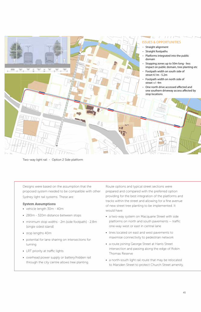
Two-way Light Rail Option 2 Side Platform
ISSUES & OPPORTUNITIES – Straight alignment – Straight footpaths – Platforms integrated into the public
domain – Stopping zones up to 50m long - less
impact on public domain, tree planting etc – Footpath width on south side of
street 4.1m - 5.2m – Footpath width on north side of
street +/- 4m – One north drive accessed a�ected and
one southern driveway access a�ected by stop locations
Two-way light rail - Option 2 Side platform
Designs were based on the assumption that the
proposed system needed to be compatible with other
Sydney light rail systems. These are:
System Assumptions
• vehicle length 30m - 40m
• 280m - 320m distance between stops
• minimum stop widths - 2m [side footpath] - 2.8m
[single sided island]
• stop lengths 40m
• potential for lane sharing on intersections for
turning
• LRT priority at traffic lights
• overhead power supply or battery/hidden rail
through the city centre allows tree planting.
Route options and typical street sections were
prepared and compared with the preferred option
providing for the best integration of the platforms and
tracks within the street and allowing for a fine avenue
of new street tree planting to be implemented. It
would have:
• a two-way system on Macquarie Street with side
platforms on north and south pavements — traffic
one-way west or east in central lane
• lines located on east and west pavements to
maximise connectivity to pedestrian network
• a route joining George Street at Harris Street
intersection and passing along the edge of Robin
Thomas Reserve
• a north-south light rail route that may be relocated
to Marsden Street to protect Church Street amenity.

46
Phillip StreetHASSELL
Phillip Street is the threshold between the grid of
Parramatta city centre and Parramatta River and links
many city centre destinations including the Justice
Precinct; the proposed new Riverbank Square, ‘eat
street’ north and nine connecting lanes. It is the
shortest and most northern of Parramatta’s three main
east-west avenues. It is uniquely positioned, with river
frontage at both ends of the street, and could form a
direct axis between Parramatta’s ferry wharf and the
southern end of (and potential entry to) Parramatta
Stadium. Currently Phillip Street has a scattered
pattern of functions and activity with many available
spaces for adaption and activation.
Phillip Street existing view

47
Phillip Street is close to the activity of the city
GEORGE ST= +70%
MACQUARIE ST= +130%
CHURCH ST= +500%
1. Phillip Street is close (but not connected) to the river Phillip Street is the dividing line between city and river
CITY CORE
RIVER CORRIDOR
2. Phillip Street is the dividing line between city and river
A STREET FLOODED WITH LANDSCAPE
A STREET FLOODED WITH LIGHT
Phillip Street can mediate the conditions of city and river3. Phillip Street can be visually extended to the water Phillip Street has a scattered pattern of functions and activity
Eating and drinking
Eating and drinking
Shopping
Shopping
Doing business
Doing business
4. Phillip Street can become an important social space
Phillip Street experiences: the big event
1_Arrive by ferry 2_Wait for buddies in Market Square 3_A couple of pre-match beers4_Parramatta Stadium (only a 5 minute walk!) 5_Celebratory drinks at the Streetside Bar6_Night market for kebabs7_Onward to Church Street...8_How did I get home again ...?
5. Phillip Street can amediate the conditions of city and river Phillip Street is close (but not connected) to the river
Parramatta Park/Stadium
Ferry Wharf
6. Two lines of subsurface infrastructure are introduced
Phillip Street can be visually extended to the water
Parramatta Park/Stadium
Ferry Wharf
7. End points are marked with larger elements Phillip Street can become an important social space
Culture Precinct
Justice Precinct
Chu
rch
Str
eet
Commercial Precinct
Riverside Precinct
Parramatta Park/Stadium
Ferry Wharf
8. Phillip Street has a scattered pattern of functions and activity
5. HTTP://FORECAST2.ID.COM.AU/DEFAULT.ASPX?ID=265&PG=5210
Parramatta is ...
84%SPEAK ENGLISH + ANOTHER LANGUAGE
OF PEOPLE (CBD) BORN OVERSEAS
50%OF PEOPLE (CBD) BORN
#2LGA IN SYDNEY (2010)
RAPIDLY EVOLVING 85.9%
OF BUSINESSES HAVE 1-4 EMPLOYEES) 5
ENTRE- PRENEURIAL
MULTI-CULTURAL
35.2% OF PEOPLE ARE AGED
25-34 YRS
YOUNG
GLOBALLY CONNECTED
9. Parramatta’s population today

48
Design tactics Street-side parking is inhabited for night and weekend uses
The brief asked the team to design a high quality
street environment to highlight the various city
thresholds and embrace the street’s potential as a
night-time destination.
Two major strengths of the team’s approach were the
recognition of Parramatta city centre’s existing and
future community and the identification of the street’s
potential to be extended along its axis to connect to
the southern tip of Parramatta Stadium. This would
bring this popular and symbolic destination into real
connection with the city centre, public transport
and other key night-time destinations. The concept
proposal identified a loose structure to create a
special character and highlight the many recreational
destinations that can be reached from Phillip Street.
They illustrated this by mapping a range of imaginary
routes that a visitor could experience.
“Parramatta is a young area that is highly multicultural
leading to a demand for new urban amenities
and services that meet the needs of the diverse
population. A large portion of the population speaks
a language other than English and the majority of
businesses in Parramatta are small. We recognise the
entrepreneurial spirit that exists in Parramatta and we
are looking to harness and promote this in our design.”
HASSELL.
Two lines of subsurface infrastructure are introduced Phillip Street experiences: the daily journey home
Two lines of subsurface infrastructure are introduced
WATER SYSTEM(subsurface water collection system)
CIVIC SYSTEM(water, energy, gas, fibre, etc)
Phillip Street experiences: the daily journey home
1_Arrive by train 2_Drop by the gym 3_Pick up take-away dinner 4_Home
Phillip Street will become a new event promenade linking adjoining night-time and recreational uses with Parramatta Stadium and Charles Street Wharf.
End points are marked with larger elements
LIGHT SCULPTURE/ INFORMATION POST
WATER TREATMENT PARK
End points are marked with
larger elements

49
Design tactics Street-side parking is inhabited for night and weekend uses
Design tactics
Streetside parking is inhabited for night and
weekend uses
The design detailing was conceived as an apparatus
for community activity. The proposal introduces
two lines of infrastructure. On the northern river
side, a subsurface water and drainage system would
support the landscape. On the southern city side
there would be a system of multifunction poles to
integrate energy, gas and most importantly light, and
become markers for different activities. The riverside
terminations would be marked by a larger sculptural
element and open space. The new infrastructure
would identify Phillip Street’s city/river threshold
character, with each side of the street reflecting their
adjacent and differing contexts. There would be mini
parks, reed beds and rain gardens. Green trellis would
be used to create shade, points of rest and to mitigate
flooding and heat island effects. Light poles could
support market structures for evening food stalls and
weekend markets, incorporating inbuilt projectors for
street cinemas and providing information screens,
community notice boards, phone charging points and
drinking fountains and other services.
HASSELL
“This design will establish Phillip Street as an event street. It will enable the community to actively shape the street and adapt it to their various requirements on a daily basis.”
Design tactics Setback zones become filled with landscape and sculpture
Setback zones become filled with
landscape and sculpture
Design tactics
End points are marked with larger elements
LIGHT SCULPTURE/ INFORMATION POST
WATER TREATMENT PARK
End points are marked with
larger elements

50
The Parramatta City Ring Road was planned to
reduce traffic congestion by diverting through
traffic away from the city centre. It comprises seven
existing streets; the Great Western Highway, Pitt
Street, O’Connell Street, Victoria Street, Macarthur
Street, Harris Street and Parkes Street. While the road
infrastructure exists, as do several planned design
changes to traffic lanes and signalling, to increase
capacity and efficiency, the ring road and its relation
to the city and surrounds has not been well articulated
to date.
The brief asked the team to create a unique, compelling
and cohesive identity for the Parramatta City Ring Road.
The team started from the assumption that the
road’s identity is interwoven with the city centre,
both spatially and from an image perspective.
They undertook extensive site analysis — including
mapping, photographs and documentation of
physical attributes — and asked community members
to describe Parramatta as a place, as well as to draw
its perimeter.
Parra Block is the name the team developed to
embrace all aspects of the project, including the
functional and physical and the changed perception
of the city centre.
Appropriately for a project with such a strong focus
on movement through space, sequence, image and
way finding, these analyses were edited together with
a drive around the road to create a film bringing the
whole experience together.
The analysis described several key elements:
• the ring road doesn’t correspond to the actual city
centre boundaries, either physically or perceptually
• the ring road, due to its width and heavy traffic
volumes could act as a barrier or could become
a gateway element into the city centre and a
connector between the city and surround rather
than a divider
• 28 streets and paths currently cross the ring road,
where people enter or leave the ‘block ‘
Parramatta City Ring RoadTERROIR, ASPECT Studio, u.lab University of Technology Sydney and Richard Goodwin Pty Ltd
“Boring, plain, frustrating, 1980s”

51
• a large low-density neighbourhood exists inside the
ring road but outside Parramatta’s city centre, and
could become a new high-density neighbourhood
to enrich Parramatta and help develop the city,
namely the north bank.
• new citizens will help to strengthen and subtly
refine the city centre’s identity as it grows and
cultural programs will help to attract these citizens
to Parramatta.
The team extrapolated that in 20 years time the
combination of the ring road and the city centre’s
40km pedestrian amenity zone could greatly
reduce the percentage of vehicles in the city centre
compared to people walking, using public transport
and cycling which would further enliven Parramatta’s
cultural and street life and the city centre’s resilience.
Parra Block would be developed via a 20-year plan to
become a distinct place to live, work and create.
Its four main components are:
1. The City Centre project
2. The North Bank project
3. Pressure Point projects. A series of pressure
point projects providing improved connectivity are
necessary to deliver the vision; including bridges, river
buildings, cycle paths and pedestrian networks; which
integrate the 14 other curated city centre projects.
4. Software projects. Culture will be developed in
parallel with the physical projects over a 20-year
timeframe with small initial projects gathering creative
citizens via social media and public engagement to
larger and longer-term ambitions to develop major
cultural institutions.
“I think of a place where there are people from all over the world.”
“Very busy place, pretty much got everything.”
“I think of traffic and congestion.”

52
123457 6
89
10
11
1213
14 1516
1718 19 20 21
2223
2425
ab
cdefgh
i
j
k
l mn
o pq r
s t u
v
w
x
y
26
27
28
1
2
7
8
n
q
ooooo
r
s
t
m
p
a
b
c
d
e
g
h
i
j
lf
k
Residents and workers were asked to
draw Parramatta City Centre
Parramatta City Ring Road - Existing Views

53
123457 6
89
10
11
1213
14 1516
1718 19 20 21
2223
2425
ab
cdefgh
i
j
k
l mn
o pq r
s t u
v
w
x
y
26
27
28
In addition to the analysis and film, the team prepared
concept designs for three defining parts of the
proposed ring road.
• a new pedestrian bridge across the river at
Gasworks Bridge
• improved intersection design for ring road users
as well as people crossing at the intersection of
Church Street and Great Western Highway
• a schematic approach to ‘fine grain densification’
of the proposed addition to the city centre in the
northeastern corner.
Parramatta City Ring Road - Existing Plan

54
Map with 4 strategies = Church Street
Church Street
CHURCH STREET
CHURCH STREET
GREAT WESTERN HWY PARKES STREETPARKES STREET
CHURCH STREET
GREAT WESTERN HWY
CHURCH STREET
1:1000
CCOONNDIITIOO : EXIISSTTCURRENT C ON : EXISTING TRAAFFIC FFLLOWWS TRAFFIC FL
BB I F : ADDITTIOONAAL RRI T HHAANNDD BRIEF : ADDIT RIGHT HANDTTURN NNORTTHH BOUUND TURN NORTH [[AAD ITIOONAL LANNEE][ADDITIONAL LANE]
WEST DIRECTION
EAST DIRECTION
SOUTH DIRECTION
NORTH DIRECTION
NEW RIGHT HAND TURN LANE WAY
EAST DIRECTION
SOUTH DIRECTION
NORTH DIRECTION
WEST DIRECTION
1:1000
Map with 4 strategies = Church Street
Gasworks Bridge
Map with 4 strategies = Church Street
North Bank
CHUR
CH ST
REET
MARS
DEN
STRE
ET
O`CO
NNEL
L STR
EET
SMITH
STRE
ET
HARR
IS S
TREE
T
PARRAMATTA RIVER
CHUR
CH S
TREE
T
SORR
ELL S
TREE
T
WILD
E AVE
VICTORIA ROAD
THOMAS STREET
MARS
DEN
STRE
ET
RETAIN PROMINENT URBAN FABRIC
ooooo
w
28
27
3 4
v
p

55
CHURCH STREET
CHURCH STREET
GREAT WESTERN HWY PARKES STREETPARKES STREET
CHURCH STREET
GREAT WESTERN HWY
CHURCH STREET
1:1000
CCOONNDIITIOO : EXIISSTTCURRENT C ON : EXISTING TRAAFFIC FFLLOWWS TRAFFIC FL
BB I F : ADDITTIOONAAL RRI T HHAANNDD BRIEF : ADDIT RIGHT HANDTTURN NNORTTHH BOUUND TURN NORTH [[AAD ITIOONAL LANNEE][ADDITIONAL LANE]
WEST DIRECTION
EAST DIRECTION
SOUTH DIRECTION
NORTH DIRECTION
NEW RIGHT HAND TURN LANE WAY
EAST DIRECTION
SOUTH DIRECTION
NORTH DIRECTION
WEST DIRECTION
1:1000
SECTION A 1:200
SECTION B 1:200
ELEVATION C 1:500
NEW GAS WORKS BRIDGE PROPOSAL
CHUR
CH ST
REETO`
CONN
ELL S
TREE
T
HARR
IS S
TREE
T
PARRAMATTA RIVER
CHUR
CH S
TREE
T
ELIZA
BETH
STR
EET
BULL
ER S
TREE
T
VICTORIA ROAD
THOMAS STREET
NORTH BANK AREA
FORESHORE ACTIVATION ZONE
NEW PEDESTRIAN LINKS
NEW CYCLE PATH
OPEN SPACE
NEW BUILDING DENSITY
RETAIN BUILT FABRIC
UPGRADE BRIDGE CONNECTION NEW & UPGRADED PEDESTRIAN BRIDGES
RING ROAD BOUNDARY
EXISTING BUILT CBD
RETAIN PROMINENT URBAN FABRIC
PHASE 2: NEW MIXED-USED URBAN DENSITY TO NORTH BANK
Parramatta Ring Road will become an identifiable threshold inviting movement between Parramatta’s city centre and surrounding neighbourhoods, and directing flows around the city centre.
Proposal 1 - Church Street
Proposal 2 -Gasworks Bridge
Proposal 3 -North bank

Public Spaces and Parks
Clay Cli� Creek Parklands
George St
Par
ram
atta
Cit
y R
ing
Rd
Phillip St
Macquarie St
1
2
4
5
6
7
8
10
11
12
13
14
15
16
9
The Public Space and Parks Projects are
5. River Square
6. Charles Street Square
7. Horwood Avenue-Civic Link
8. Church Street Mall
9. Clay Cliff Creek Parklands
10. Smith and Station Streets Greening
Diagram of Public Spaces and Parks Projects
56

Public Spaces and Parks
Like many Australian cities, Parramatta’s public life
has focused on its streets rather than its squares.
Recognising the need for larger spaces to house big
events and the importance of squares to foster the
planned and spontaneous social life and activities that
encourage people to gather, Parramatta is planning
for the creation of new public spaces as well as
substantially reworking and expanding existing spaces.
The sites are located in a north-south spine along the
centre of the city centre and several coincide with
one or more of the major streets projects.
The public space and parks projects share a theme
of change and represent most clearly Parramatta’s
aspirations for transformation. One of these sites,
River Square, does not currently exist as a public
space, and two sites, the Civic Link and Clay Cliff
Creek Parklands, involve considerable expansion
of the current space and complete renewal. While
the Church Street Mall, Charles Street Square and
Smith and Station Streets greening projects inhabit
existing spaces, major transformation of the space’s
appearance are proposed through transfiguring the
plan, decluttering the site and including elements
such as seating and stalls that will encourage people
to inhabit the space, rather than just passing through.
Three of the public space sites are streets with
reduced traffic roles to allow increased pedestrian
and social life. These are:
• Church Street Mall – which has been closed
(between Darcy and Macquarie streets) to traffic
since 1970
• Horwood Avenue – a partially existing street
that will be extended when a Council car park is
demolished to create a civic link extending from
Parramatta Transport Interchange through to the
river. Even though it will be as wide as a main street,
the avenue’s traffic role is limited to providing
access to buildings, affording spare capacity for a
series of small pedestrian pocket parks.
• Smith and Station Streets are currently major
traffic arteries with widened footpaths created by
generous building setbacks providing considerable
potential for a green overlay to enhance its current
function as a major bus route.
These three projects shared a common theme of
creating smaller spaces within a larger public area to
catalyse activation and create small havens of amenity
and comfort. The opportunity for Church Street Mall
was to propose options for an immediate short-term
makeover/clean up designed to improve the mall’s
appearance, and encourage events. The opportunity
for Horwood Avenue was to design a green spine
including water, landscape, and places to socialise
and relax. The opportunity for Smith and Station
Street Greening was to propose alternative green
solutions for footpath locations where street trees are
precluded due to services and other conditions.
Presented as a green ‘necklace’ of parks and places
along Clay Cliff Creek, this team’s proposal extended a
linear park model to link important parks surrounding
Parramatta’s city centre and form a four kilometre
continuous parkland walk with the potential to act
as a new ‘green lung’ for the city centre and foster
new recreational activities. This expanded green loop
would corresponded with the eastern section of the
ring road loop as well as the three main city streets
and also points to opportunities for a revitalised image
for Parramatta’s city centre.
57

58
a low still reflective canal.....a low still reflective canal.....
River Square, a new public space, is planned to
replace an existing Council car park.
The brief asked the team to design a concept for a
new riverfront square and terraced foreshore to the
river and parklands. The square, an urban character,
would have; capacity for everyday uses and well
as major events of up to 20,000 people, be able to
withstand flooding and designed on the assumption
that the ferry wharf remains at Charles Street.
The team noted that the river is presently barely
visible from adjoining streets due to the level
changes and width. They subtly expanded the brief
as about reconnecting with the river — physically
and symbolically — and transforming a vast space
at the edge into a meeting place at the heart,
allowing for gathering, meeting, quiet contemplation,
conversations and celebrations.
There were important functional requirements that
needed to be resolved:
• the six to eight metre change in levels between the
city centre and the water
• the requirement for a space that works well for
individuals, groups, and city centre and regional
events
• the creation of a thematic link to the Civic Link
• periodic flooding impacts.
The simple, pared back and restrained design
would provide an elegant and enduring space for
Parramatta’s city centre, that amplifies the river rather
Helen Lochhead
“... Parramatta needs to bring people back to the river ... This is a once in a lifetime opportunity to re-engage with the water in an evocative way….”
River SquareJAAA, Turf Design Studio, Roberts Day, Equatica and Electrolight
A low still reflective canal

59
a low still reflective canal.....
a place that offers respite - to simply sit & chat......
A place that offers respite - to simply sit & chat
or accommodates a celebrating community........
or accomodates a celebrating community
than dominating or competing with it. The square
has a unique character and its scale would augment
Paramatta’s existing suite of public spaces
Four main elements are proposed.
The River Steps
The river steps are the spine of the square, a
continuous unifying link running the 250m length of
the square, and allowing access to the river edge at
any point. The general step structure is a 1600mm
wide by 450mm high terrace step. Walkway and
ramp access would be embedded within the steps,
providing seamless at grade access to the river edge.
The river walk widens out to a promenade at the base
of the river steps. Further modulation of the steps
would allow for widened platforms of grass and gravel
in which you can ‘nestle’ and find quiet, and the tree
canopy is integrated.
Steps are also proposed on the northern bank,
cascading down and visually linking the square across
the river.
The Green
A generous open grass green space would be at the
heart of the square. The grassy lawn gently orients
towards the river, overlooking the steps and terraces
and facing the wooded northern foreshore and the
sun’s warmth. The lawn would accommodate many
modes of use from weekday lunchtimes to events and
gatherings.

60
thank you
Upper Plaza
The upper plaza flanked by cafes and bars would be
above the river flood level (at RL 6.4), and provide a
meandering progression through colonnades and
smaller spaces that open up at bends and junctions.
The Link
The river link would extend the Horwood Place axis
and draw you in. The Willow Grove heritage building
provides a fine anchor to this link and could be flanked
by still reflective water, echoing the river’s character.
Water would transition into ephemeral shallow
depressions in the main square overlooking the river
that would fill with rainfall and provide opportunities
River Square will be a grand square drawing people to the river, formed by elemental, grandly proportioned terraces, lawns and stairs.
River Square Proposal - View from the North Bank

61
thank you
for engaging with the water. The marshalling of the
waters in lineal formations echoes the strength of the
business district — while the capacity for overflow and
ripple reflects the ephemeral modes of the river at the
River Square — drawing the curious through to the plaza.
At the centre of the link, a new public building made
of glass and with public and cultural uses is proposed
to replace the existing rear extension to Willow Grove.
Public Domain Driven Development
A masterplan with some suggested refinements is also
proposed — identifying some modification of building
footprints potentially with concessions for height
to maintain gross floor area which would enable an
extended river plaza.
The potential to integrate nodal spaces within the lane
network may also be possible.
Floods and Levels
• 1:20 flood level = 5.5
• 1:100 flood level = 6.0
• Minimum habitable level = 6.4
• River level generally = 1.15
• Drop from adjoining streets to river level = 7-8 metres

62
Context Plan
River Square Proposal - View looking East
masterplanthe river linkthe river link
the river link

63
masterplanMasterplan

64
8 / 25
ch
arl
es
stre
et
squ
are
GREEN- Landscape Planes- Canopy- Green walls
PLACE- tidal salt water / river- fresh water weir- embankments- slopes- 1:100 storm flood line RL 6
AXES + VIEWS- Phillip Street axis- Charles Street axis- Water axis
MOVEMENT- Pedestrian- Ferry- Pier- Vehicles
ACTIVITIES- Ferry- Cafe- Amphitheatre- Water performance- Park Ribbon- Sound + Light
1
2
3
4
5
The Charles Street Square site is the closest access
point to the river and parklands from Parramatta’s
main city centre area and at its lowest point is the
ferry wharf. The current space is cluttered, municipal
in character and acts as a visual barrier to the river.
The brief asked the team to redesign the northern
terminus of Charles Street and create a lively urban
square and series of terraces adjoining the wharf and
river parklands.
The team’s approach was based on detailed historical
and physical analysis of the site’s development.
They noted:
“Here saltwater meets fresh, and inland waters first
reach those of the tidal harbour. ….
Prior to European settlement, this place was a
gathering place for traders from across Australia.
Middens and stones attest to the power of this place
as a place of coming together ...
Governor Phillip’s plan for this part of Parramatta
included a riverfront square, Queen Square, and
survives somewhat in the current name for this area,’
Charles Street Square.
Its current use an as a ferry landing point is, in some
ways, a continuation of this earlier pattern.” Charles
Street Square team
The analysis led to their description of the site as
being a place in motion and to a design approach
centred on drawing the broader city grid and natural
setting into place and stripping back the unnecessary
clutter to reveal the site’s inherent potential, and
improve its function.
8 / 25
ch
arl
es
stre
et
squ
are
GREEN- Landscape Planes- Canopy- Green walls
PLACE- tidal salt water / river- fresh water weir- embankments- slopes- 1:100 storm flood line RL 6
AXES + VIEWS- Phillip Street axis- Charles Street axis- Water axis
MOVEMENT- Pedestrian- Ferry- Pier- Vehicles
ACTIVITIES- Ferry- Cafe- Amphitheatre- Water performance- Park Ribbon- Sound + Light
1
2
3
4
5
Charles Street SquareContext Landscape Design, Zoe Spiegel, CM+ and Urban Art Projects

65
Charles Street Square team
“There is motion in the tides, … in ferry movements, in people arriving and departing, and in vehicles skirting the edge of the space ... These movements give this place an authentic life, but are not yet placed into a framework ...”
Charles Street Square - Existing

66
25 / 25
ch
arl
es
stre
et
squ
are
Charles Street Square will be pared back to its essential elements to connect to the river, frame the escarpment and create activated terraces.
Charles Street Square - Proposal View from the North

67
25 / 25
ch
arl
es
stre
et
squ
are
Charles Street Square team
“The development of the city centre, required a bold vision for projecting the city grid over the landscape to create a ‘clear urban framework’ …Our responsibility would be to respect the place’s past while giving its narrative meaning for the future. We envision a new name for this place that does not rely on a nearby street name, but supports its own complex identity ‘Water Square’. “

68
11 / 25
0 10 20 50m
ch
arl
es
stre
et
squ
are
concept plan
Charles StreetPhillip StreetPlazaCafe TerracePhillip St PierPier KioskRivercat dockRiver amphitheatreRiver walkWeirBasinArtwork to pierTidal artworkRiverside artworkOutlook/artworkTo River Sq.To Queen Sq.
0102030405060708091011121314151617
02
03
04
05
0607
08
10
09+4.0
+5.85
+7.5
+7.5
11
15
17
16
12
12
13
14
14
01
Concept Plan

69
11 / 25
0 10 20 50m
ch
arl
es
stre
et
squ
are
concept plan
Charles StreetPhillip StreetPlazaCafe TerracePhillip St PierPier KioskRivercat dockRiver amphitheatreRiver walkWeirBasinArtwork to pierTidal artworkRiverside artworkOutlook/artworkTo River Sq.To Queen Sq.
0102030405060708091011121314151617
02
03
04
05
0607
08
10
09+4.0
+5.85
+7.5
+7.5
11
15
17
16
12
12
13
14
14
01
Helen Lochhead
‘There is nothing static in the quality of the site. There is an opportunity to reinforce its dynamism and make the invisible visible …. But it doesn’t want to be overdesigned ... It wants to be the ‘prelude’ and part of a new language in how the city centre meets the river….”
10 / 25
ch
arl
es
stre
et
squ
are
folds
Detail
“The design builds upon the city centre grid by
projecting street corridors north and south of the
river to define a greater square that also embraces the
river. New elements were then positioned to reinforce
this ‘conceptual’ square and to make a place that is
conducive to movement and resting.
Phillip Street is unique in Parramatta as it essentially
begins and ends at the river. As such it provides an
opportunity for connecting the city centre, physically
and metaphorically, back to the river.” Charles Street
Square team
Philip Street would be extended as an art walk, and a
metaphorical ‘landing pier’ toward the east that would
act as a marker (when seen from the river), allow for
a café overlooking the river and provide shelter for
arriving and departing passengers beneath. Its eastern
end could house a signature piece of art visible along
Phillip Street.
The Charles Street axis would continue down to
the water, (as it once did for cattle crossing), and be
marked by a landscape gesture. The other sides of
the square would be implied within bush and riverside
parkland across the river and art pieces would be
installed to inviting the public to discover the square.
The slope down to the river would be configured as
a ‘folded’ welcome terrace providing access as well
as a place for gathering; lunch sunshine, evening
performances, and promenade.

70
The Horwood Avenue Civic link is a planned extension
of Horwood Place that would eventually connect
Parramatta’s two major public spaces, the River and
the transport interchange beyond.
The brief asked the team to design a green spine
including water, landscape, and places to socialise
and rest.
The team identified the site’s key elements as being;
passage and flow of people and cars; the existing
and evolving built form; and the creation of places
of collection and “pooling” of water, sunlight and
activity. They developed a narrative around three main
themes, flow, flux and collection, to integrate these
elements. The extensive site analysis also revealed
the importance of the section both longwise and
cross wise to understanding this site and revealing
and magnifying its unique characteristics. A long-term
vision as well as short-term interventions embracing
the reality of the ‘here and now’ have been proposed.
Horwood Avenue Civic LinkGallagher Ridenour, Redshift and Equatic

71
CIVICPLACE
RIVERSQUARE
Macquarie St.
George St.
Smith St.
Church
St.Phillip St.
SQUARESQUARE
CIVICPLACE
RIVERSQUARESQUARE
Macquarie St.
George St.
Smith St.
Church
St.Phillip St.
Brief - Civic to River
FLUXFLOWCOLLECT
Axis - Civic Place to River Square
+14
+12
+10
+10
+10
+8
+8
+10
Macquarie St.
George St.
Smith St.
Church
St.Phillip St.
+12
+10
+10
+10
+8
+8
+10
Macquarie St.
George St.
George St.
Smith St.
Church
St.Phillip St.
Flow - Civic to River
5.6 haCatchment
22.4 haCatchment
3600m2
3500m2
Macquarie St.
George St.
George St.
George St.
Smith St.
Church
St.Phillip St.
Localised storm water collection
Primary storm water flow
Localised storm water collection
Primary storm water flow
Greater than 1000 p/h
300 - 600 p/h
200- 299 p/h
Greater than 1000 p/h
300 - 600 p/h
200- 299 p/h
Macquarie St.
George St.
George St.
George St.
Smith St.
Church
St.Phillip St.
Phillip St.
Flow - Water
Flow - People
Flow - Civic Place to River Square
Flow - water
Flow - people
Analysis
Horwood Avenue - Existing View

72
Horwood Avenue Civic Link will become an activated green spine connecting Parramatta Square and River Square.

73
Pools
Water Trees Light People
s
s
Macquarie St.
George St.
Phillip St.
Phillip St.
Macquarie St.
George St.
Phillip St.
Pools
Water Trees Light People
Collect - Water treatment and planting
Mac
quar
ie S
tree
t
Geo
rge
Stre
et
Phill
ip S
tree
t
Collect - water treatment and planting
Conceptual plan
Flow Flux Collect - The Street
Mac
quar
ie S
tree
tCivic Square
RiverSquare
Geo
rge
Stre
et
Phill
ip S
tree
t
Flow Flux Collect - the street
Conceptual plan
Horwood Avenue Proposal - View of New Bar near Roxy

74
12pm - January 22 12pm - March 22 12pm - June 22 20st
24st
35st6st
Built Form and Solar Access Potential
Flow - Building interface and street activation
Mac
quar
ie S
tree
t
Geo
rge
Stre
et
Phill
ip S
tree
t
Fine Grain Commercial
Commercial Frontage Lobbies
Existing Cafe/Bar & Future Opportunities
Lane way Activation Opportunities
Flow - Parking
Option 1
Option 2
4m 6m 10m
Horwood Place
carriagewayfootpath linear walk
west east
4m 6m 10m
Horwood Place
carriagewayfootpath linear walk
west east
Mac
quar
ie S
tree
t
Geo
rge
Stre
et
Phill
ip S
tree
t
Mac
quar
ie S
tree
t
Geo
rge
Stre
et
Phill
ip S
tree
t
pkg
3mpkg
3msetback
Flow - building interface and street activation
built form and solar access potential
Roxy 01 - Plan
+0.45
+0.45
+0.45+0.45 +0.45+0.90+1.35
Roxy
Geo
rge
Stre
et
Futu
re L
ane
Exis
ting
Plan
t Roo
m
Existing Forecourt
Exis
ting
Acc
ess
Stai
r
Was
te S
tora
ge
Plan
Flow
“The design reveals the flow of water through the site.
Rain gardens are located at key areas of stormwater
collection and extend beyond the kerb edge and into
the public space, creating incidental garden ‘rooms’.”
Horwood Avenue team
The design is for a generous 10m wide linear
pedestrian footpath along the eastern side of the
street, providing ease of movement and social places.
At four locations, there would be groves of deciduous
trees extending the full width of the street, creating
pockets of sun and shade, protection and respite.
A rain garden ‘threshold’ would extend across the
avenue signalling the nearby river, where the street
slopes down to Phillip Street.
The rain gardens could be watered by stormwater
runoff from adjoining Council car park rooftops
collected through a tapestry of coloured pipes.
New lighting and paving would reinforce pedestrian
movement. The detailed design of materials and
elements such as inlet kerbs, facetted gutter
details and custom paving would make explicit the
concealed patterns of the stormwater flow and
collection.
Flux
Recognising that Horwood Avenue is a space in flux,
the design changes the proposed building envelopes
(to those currently proposed in the Development
Control Plan) to ensure maximise solar access can
reach the street during lunchtime hours.

75
Flow - Parking
Option 1
Option 2
4m 6m 10m
Horwood Place
carriagewayfootpath linear walk
west east
4m 6m 10m
Horwood Place
carriagewayfootpath linear walk
west east
Mac
quar
ie S
tree
t
Geo
rge
Stre
et
Phill
ip S
tree
t
Mac
quar
ie S
tree
t
Geo
rge
Stre
et
Phill
ip S
tree
t
pkg
3mpkg
3msetback
Flow - parkingRoxy 01 - Plan
+0.45
+0.45
+0.45+0.45 +0.45+0.90+1.35
Roxy
Geo
rge
Stre
et
Futu
re L
ane
Exis
ting
Plan
t Roo
m
Existing Forecourt
Exis
ting
Acc
ess
Stai
r
Was
te S
tora
ge
Temporary Installation - Carpark Water Treatment -1
Temporary installation - Carpark Water Treatment
Closure of the southern vehicular entry to Horwood
Place car park is suggested in the short-term to
improve the exisiting pedestrian link through the car
park. This can be achieved without undue impact on
car park function, and would be a first step to creating
the busy pedestrian area lined with retail tenancies
envisaged in the long-term.
Collection and Pooling
The design provides many opportunities for gathering
and meeting. There would be seating and small
squares at the cross-locations of lanes and the
avenue. Seating would also be located beneath
tree groves. Garden beds and seating have been
sited and scaled to encourage incidental gathering
and meeting.
Two options for seating were developed in more detail
next to the blank western façade (facing Horwood
Place) of the Roxy Theatre. One, a low-key approach,
involves alternating planting with terraces and seating
facing the street. The second more dramatic and
theatrical solution creates a four metre high stepped
‘bleacher’ terrace facing north.
The terrace would connect to a second higher terrace,
(providing for future connection into the Roxy) and
create a public ‘stage’. Beneath the terraces would be a
small café/or bar with colourful lighting, creating a new
destination under the red neon sign of the Roxy Theatre.

76
PARRAMAT TAChurch Street Mall
TEAMLacoste + StevensonToko. Concept. DesignDaryl Jackson Robin DykeJMD DesignPamela Mei-Leng See
Existing Photos
Church Street Mall is the city centre’s most enduring
public space but currently lacks identity, civic
character and is perceived by some to be unsafe at
certain times of day. The long-term plan is for the mall
to become the first in a series of interlocking public
spaces running across Parramatta Square.
The brief asked the team to propose two different
options for an immediate short-term makeover/clean
up to improve the mall’s appearance, encourage
visitation, and events while the construction of
Parramatta Square unfolds over the next 10-15 years.
Church Street Mall is a valuable public space that has
been incrementally added to without a vision for its
role in the city centre’s public life. The space contains
some of Parramatta’s oldest civic buildings and
monuments, but they are aligned along the previous
street’s geometry resulting in a space more suited
to walking and moving through than gathering and
socialising.
Church Street MallJMD Design, Lacoste + Stevenson Architects and Toko. Concept. Design.

77
PARRAMAT TAChurch Street Mall
TEAMLacoste + StevensonToko. Concept. DesignDaryl Jackson Robin DykeJMD DesignPamela Mei-Leng See
Existing Photos
PARRAMAT TAChurch Street Mall
TEAMLacoste + StevensonToko. Concept. DesignDaryl Jackson Robin DykeJMD DesignPamela Mei-Leng See
Historical elements and the site
1. St Johns Church
2. Town Hall
3. Centennial Clock
4. Royal Gates
5. Protected view to church fromChurch Street
1.
2.
3.
4.
5.
Consider reversing tra�c �ow in
Church St towards Church St Mall to raise its presence
Historical elements and the site
1. St Johns Church 2. Town Hall 3. Centennial Clock 4. Royal Gates 5.Protected view to church from Church Street
Church Street Mall team
“Church Street Mall suffers the same fate as many Australian city centres; we need a pedestrian area, let’s close a street! This has not achieved a great public space for pedestrians, market stall holders, entertainers, and public art or Council maintenance staff ...”
Church Street Mall - Existing

78
PARAMATTAChurch Street Mall
TEAMLacoste + StevensonToko. Concept. DesignDaryl Jackson Robin DykeJMD DesignPamela Mei-Leng See
Concept 01
Layout
Legend
1. Market lanterns.2. Pavement artwork activity zone.3. Ephemeral water feature.4. Upgraded playground.5. Church gate.6. Seating edge.7. Flower beds.8. Cinema screen.9. Lighting.10. Future light rail.
1.
2.
3.
4.
5.
6.
7.
8.
9.
10.
Macquarie Street
Proposal 1: The Public Room(s)
In this first option the dominance of the street
geometry is minimised and a new order that is more
like a public room is created from a series of smaller
spaces. The newly configured space integrates with
the St John’s Church garden and children’s playspace
area to create a legible whole that would be able to
accommodate a full range of current and future civic,
event and social functions.
Three different but related principal spaces
terminating the newly created Parramatta Square and
Church Street connection to Westfield are proposed.
• a paved market area runs north south
• an upgraded playground and water feature on axis
with the northern section of Church Street
• the gardens of St John’s and its forecourt.
The paved market area would reinforce the markets
as a major and recurrent event. It would be anchored
PARRAMAT TAChurch Street Mall
TEAMLacoste + StevensonToko. Concept. DesignDaryl Jackson Robin DykeJMD DesignPamela Mei-Leng See
Concept Diagrams
Concept 01 Concept 02
Concept 1

79
PARAMATTAChurch Street Mall
TEAMLacoste + StevensonToko. Concept. DesignDaryl Jackson Robin DykeJMD DesignPamela Mei-Leng See
Concept 01
PARAMATTAChurch Street Mall
TEAMLacoste + StevensonToko. Concept. DesignDaryl Jackson Robin DykeJMD DesignPamela Mei-Leng See
Concept 01
Layout
Legend
1. Market lanterns.2. Pavement artwork activity zone.3. Ephemeral water feature.4. Upgraded playground.5. Church gate.6. Seating edge.7. Flower beds.8. Cinema screen.9. Lighting.10. Future light rail.
1.
2.
3.
4.
5.
6.
7.
8.
9.
10.
Macquarie Street
Concept 1 - Plan Concept 1
at its northern end by permanent iconic stalls
providing colour and shade and serving as ‘lanterns’
at night. New paving would incorporate public art.
The permanent market would be augmented with
temporary stalls as demand dictates. Performance and
cinema would take place at the southern end of the
market area. There would be places to sit and watch
the world go by. It is a place of activity and vibrancy
as people traverse it towards the station and southern
retail precinct. Should the light rail eventuate it could
also run through this space.
In contrast, the gardens of St John’s, including lawns
and beds, would continue to be a place of calm and
repose for conversation, reading and exercise.
Construction hoardings along the southern end of
Church Street would be enlivened with public art
projections and crazy mirrors to invigorate the mall in
the short-term.
Church Street Mall will become a lively public square and garden area providing a setting for heritage buildings and events and a front door to Parramatta Square.

80
PARRAMAT TAChurch Street Mall
TEAMLacoste + StevensonToko. Concept. DesignDaryl Jackson Robin DykeJMD DesignPamela Mei-Leng See
Concept 02
Layout
Proposal 2: The River Of Activity
This second option accepts the strong diagonal
street geometry of the mall and utilises it as an
organisational device to unify the surrounding
areas that symbolically and physically reconcile the
opposing forces of history and development. The
concept builds upon the ideas of Parramatta Square
as a meeting place and Parramatta as the meeting
place of salt and fresh water. It sees the river as a
conceptual spine with the ability to reconcile the
site’s disparate and sometimes opposing elements.
Historical buildings meet new development, farming
meets the civic space.
A unifying space would be created that could provide
all of the necessary functions of a multicultural civic
space. Utilising many of the same features as the
first concept, this option also delivers flexibility to
the space, allowing it to be reinvented, night and day
through the use of multifunction street furniture and
innovative lighting to highlight elements.
PARRAMAT TAChurch Street Mall
TEAMLacoste + StevensonToko. Concept. DesignDaryl Jackson Robin DykeJMD DesignPamela Mei-Leng See
Concept Diagrams
Concept 01 Concept 02
Concept 2

81
PARRAMAT TAChurch Street Mall
TEAMLacoste + StevensonToko. Concept. DesignDaryl Jackson Robin DykeJMD DesignPamela Mei-Leng See
Concept 02
Layout
PARRAMAT TAChurch Street Mall
TEAMLacoste + StevensonToko. Concept. DesignDaryl Jackson Robin DykeJMD DesignPamela Mei-Leng See
Concept 02
Flexibility/ modes
Concept 2 - Plan
PARRAMAT TAChurch Street Mall
TEAMLacoste + StevensonToko. Concept. DesignDaryl Jackson Robin DykeJMD DesignPamela Mei-Leng See
Concept 02
The Story Civic Square = Meeting Place
Parramatta = Meeting place of salt and Fresh water
Agricultural History meets City
The Meeting point of Opposites
Historical Elements meet City Development
SALTCITYCONTROLORDERCORPORATEFIXEDFORMALORDER
FRESHAGRICULTURE
ORGANICADAPTABLELANDSCAPE
DISORDERSOFT
FLUID

82
PARRAMAT TAChurch Street Mall
TEAMLacoste + StevensonToko. Concept. DesignDaryl Jackson Robin DykeJMD DesignPamela Mei-Leng See
Concept 01
Night Cinema
View of proposed screen
PARAMATTAChurch Street Mall
TEAMLacoste + StevensonToko. Concept. DesignDaryl Jackson Robin DykeJMD DesignPamela Mei-Leng See
Concept 01

83
PARRAMAT TAChurch Street Mall
TEAMLacoste + StevensonToko. Concept. DesignDaryl Jackson Robin DykeJMD DesignPamela Mei-Leng See
Concept 01
Night Cinema
Market as flexible street furniture
Night time view
PARAMATTAChurch Street Mall
TEAMLacoste + StevensonToko. Concept. DesignDaryl Jackson Robin DykeJMD DesignPamela Mei-Leng See
Functional Brief - Concept Images
Market as flexible street furniture
PARRAMAT TAChurch Street Mall
TEAMLacoste + StevensonToko. Concept. DesignDaryl Jackson Robin DykeJMD DesignPamela Mei-Leng See
Concept 02
Smart Market
- Flexible- Seating- Power supply- Storage- Lighting
Both concept designs envisage a more cohesive,
distinct place with an altered geometry and an
improved public domain.
Adjacent areas — including the grass and gardens
surrounding St John’s and the future Parramatta
Square — are embraced in both proposals.
A suite of common elements has also been designed
to accompany both schemes. The range includes
purpose-built stalls and street furniture elements
which will help to animate the public realm.

84
HAWTHORNE CANALHAWTHORNE CANALHAWTHORNE CANALHAWTHORNE CANALHAWTHORNE CANALHAWTHORNE CANALHAWTHORNE CANALHAWTHORNE CANALHAWTHORNE CANAL
IRON COVE CREEKIRON COVE CREEKIRON COVE CREEKIRON COVE CREEKIRON COVE CREEKIRON COVE CREEKIRON COVE CREEKIRON COVE CREEKIRON COVE CREEK
TARBAN CKTARBAN CKTARBAN CKTARBAN CKTARBAN CKTARBAN CKTARBAN CKTARBAN CKTARBAN CK
SALTWATERSALTWATERSALTWATERSALTWATERSALTWATERSALTWATERSALTWATERSALTWATERSALTWATERCREEKCREEKCREEKCREEKCREEKCREEKCREEKCREEKCREEK
POWELLSPOWELLSPOWELLSPOWELLSPOWELLSPOWELLSPOWELLSPOWELLSPOWELLSCREEKCREEKCREEKCREEKCREEKCREEKCREEKCREEKCREEK
ARCHER CREEKARCHER CREEKARCHER CREEKARCHER CREEKARCHER CREEKARCHER CREEKARCHER CREEKARCHER CREEKARCHER CREEK
CHARITY CREEKCHARITY CREEKCHARITY CREEKCHARITY CREEKCHARITY CREEKCHARITY CREEKCHARITY CREEKCHARITY CREEKCHARITY CREEK
THE PONDS CREEKTHE PONDS CREEKTHE PONDS CREEKTHE PONDS CREEKTHE PONDS CREEKTHE PONDS CREEKTHE PONDS CREEKTHE PONDS CREEKTHE PONDS CREEK
HASLAMS CREEKHASLAMS CREEKHASLAMS CREEKHASLAMS CREEKHASLAMS CREEKHASLAMS CREEKHASLAMS CREEKHASLAMS CREEKHASLAMS CREEK
VINEYARD CREEKVINEYARD CREEKVINEYARD CREEKVINEYARD CREEKVINEYARD CREEKVINEYARD CREEKVINEYARD CREEKVINEYARD CREEKVINEYARD CREEK
SUBIACO CREEKSUBIACO CREEKSUBIACO CREEKSUBIACO CREEKSUBIACO CREEKSUBIACO CREEKSUBIACO CREEKSUBIACO CREEKSUBIACO CREEK
ABECKETTS CREEKABECKETTS CREEKABECKETTS CREEKABECKETTS CREEKABECKETTS CREEKABECKETTS CREEKABECKETTS CREEKABECKETTS CREEKABECKETTS CREEK
DUCK RIVERDUCK RIVERDUCK RIVERDUCK RIVERDUCK RIVERDUCK RIVERDUCK RIVERDUCK RIVERDUCK RIVER
DUCK CREEKDUCK CREEKDUCK CREEKDUCK CREEKDUCK CREEKDUCK CREEKDUCK CREEKDUCK CREEKDUCK CREEK
CLAY CLIFF CREEKCLAY CLIFF CREEKCLAY CLIFF CREEKCLAY CLIFF CREEKCLAY CLIFF CREEKCLAY CLIFF CREEKCLAY CLIFF CREEKCLAY CLIFF CREEKCLAY CLIFF CREEK
Parramatta River system
Parramatta CBD showing river and channel
High hydraulic hazard zone
Cycle network showing proposed link
Clay Cliff Creek Parklands is a proposal for several
new neighbourhood parks and the revitalisation of
Jubilee Park to form a much needed local recreational
focus in ‘Auto Alley’, along Church Street south of the
Transport Interchange.
The brief asked the team to develop a concept for
managing Clay Cliff Creek and designing adjoining
parks, both existing and proposed, to assist in
revitalising the Auto Alley area.
The team’s approach was complex and multi-layered.
The new parklands were designed to accommodate
intermittent flooding of Clay Cliff Creek, reduce the
‘heat island’ effect, create a recreational focus and
the potential for kitchen gardens while providing
urban habitat. They summarised their approach as
‘Urban by Nature,’ addressing the cross-dependencies
within the infrastructures of water management, food
production and heat islands.
Clay Cliff Creek ParklandsGovernment Architect’s Office, Parramatta City Council Landscape Architecture, Equatica and Lightwell

HAWTHORNE CANALHAWTHORNE CANALHAWTHORNE CANALHAWTHORNE CANALHAWTHORNE CANALHAWTHORNE CANALHAWTHORNE CANALHAWTHORNE CANALHAWTHORNE CANAL
IRON COVE CREEKIRON COVE CREEKIRON COVE CREEKIRON COVE CREEKIRON COVE CREEKIRON COVE CREEKIRON COVE CREEKIRON COVE CREEKIRON COVE CREEK
TARBAN CKTARBAN CKTARBAN CKTARBAN CKTARBAN CKTARBAN CKTARBAN CKTARBAN CKTARBAN CK
SALTWATERSALTWATERSALTWATERSALTWATERSALTWATERSALTWATERSALTWATERSALTWATERSALTWATERCREEKCREEKCREEKCREEKCREEKCREEKCREEKCREEKCREEK
POWELLSPOWELLSPOWELLSPOWELLSPOWELLSPOWELLSPOWELLSPOWELLSPOWELLSCREEKCREEKCREEKCREEKCREEKCREEKCREEKCREEKCREEK
ARCHER CREEKARCHER CREEKARCHER CREEKARCHER CREEKARCHER CREEKARCHER CREEKARCHER CREEKARCHER CREEKARCHER CREEK
CHARITY CREEKCHARITY CREEKCHARITY CREEKCHARITY CREEKCHARITY CREEKCHARITY CREEKCHARITY CREEKCHARITY CREEKCHARITY CREEK
THE PONDS CREEKTHE PONDS CREEKTHE PONDS CREEKTHE PONDS CREEKTHE PONDS CREEKTHE PONDS CREEKTHE PONDS CREEKTHE PONDS CREEKTHE PONDS CREEK
HASLAMS CREEKHASLAMS CREEKHASLAMS CREEKHASLAMS CREEKHASLAMS CREEKHASLAMS CREEKHASLAMS CREEKHASLAMS CREEKHASLAMS CREEK
VINEYARD CREEKVINEYARD CREEKVINEYARD CREEKVINEYARD CREEKVINEYARD CREEKVINEYARD CREEKVINEYARD CREEKVINEYARD CREEKVINEYARD CREEK
SUBIACO CREEKSUBIACO CREEKSUBIACO CREEKSUBIACO CREEKSUBIACO CREEKSUBIACO CREEKSUBIACO CREEKSUBIACO CREEKSUBIACO CREEK
ABECKETTS CREEKABECKETTS CREEKABECKETTS CREEKABECKETTS CREEKABECKETTS CREEKABECKETTS CREEKABECKETTS CREEKABECKETTS CREEKABECKETTS CREEK
DUCK RIVERDUCK RIVERDUCK RIVERDUCK RIVERDUCK RIVERDUCK RIVERDUCK RIVERDUCK RIVERDUCK RIVER
DUCK CREEKDUCK CREEKDUCK CREEKDUCK CREEKDUCK CREEKDUCK CREEKDUCK CREEKDUCK CREEKDUCK CREEK
CLAY CLIFF CREEKCLAY CLIFF CREEKCLAY CLIFF CREEKCLAY CLIFF CREEKCLAY CLIFF CREEKCLAY CLIFF CREEKCLAY CLIFF CREEKCLAY CLIFF CREEKCLAY CLIFF CREEK
Parramatta River system
Parramatta CBD showing river and channel
High hydraulic hazard zone
Cycle network showing proposed link
Parramatta River system
Parramatta city centre showing river
and channel
High hydraulic hazard zone
Cycle network showing proposed link
85
Context Plan

86
Clay Cliff Parklands team
“The park attempts to address three major global challenges: food production, water management and heat island effects while at the same time providing exciting new local experiences.”

Clay Cliff Creek Parklands is a proposal for expanding and revitalising Jubilee Park to form a much needed local recreational focus in Auto Alley.
87
Clay Cliff Parklands - Proposal at Jubilee Park

88
Cre
ek B
anks
& M
argi
ns
Sha
llow
Wat
er
Dee
p W
ater
Dam
p pl
aces
Triglochin procerumWater Ribbons
Schoenoplectus validusRiver Club Rush
Philydrum lanuginosumWoolly Waterlily
Persicaria decipiensSlender Knotweed
Juncus usitatusCommon Rush
Gahnia clarkeiTall Sawsedge
Eleocharis sphacelata Tall Spike Rush
Eleocharis acutaCommon Spike Rush
Cyperus exaltatusUmbrella Sedge
Carex fascicularisTassel Sedge
Carex appressaTussock Sedge
Bolboschoenus fl uviatilisStream club rush
Bolboschoenus caldwelliiMarsh club rush
Baumea articulataJointed Twig Rush
Alisma plantago aquaticaWater Plantain
Melaleuca decoraWhite Feather Honey Myrtle
Melaleuca styphelioidesPrickly Leafed Paperbark
Casuarina glaucaSwamp She-Oak
Eucalyptus tereticornisForest Red Gum
Eucalyptus moluccanaGrey Box
Angophora fl oribundaRough Barked Apple
Wetland design strategy
End
emic
Tre
e S
peci
es
Detail of proposal at
stormwater channel

89
The parks have been designed as a series of urban
wetlands, which are essentially green spaces, bound by
reeds reminiscent of a creek system. Tree-lined avenues
would define pedestrian and cycle access and create
a positive transition between the adjoining buildings
and parks. The existing stormwater channel must be
retained to accommodate flooding and a boardwalk
has been proposed to better integrate the channel with
the park. The boardwalk would include art and seating
and would float over the concrete channel and form a
main pedestrian spine through the parklands.
The revitalised parks would become part of a
sequence of existing parklands, including Parramatta
Park, Ollie Webb Reserve and the river banks, ringing
the city centre. These can be linked together to create
a four kilometre green ‘armature’ to assist with cooling
and civilising the city centre.
“The parkland loop would establish a new path for
pedestrians and cyclists and establish the city centre
of Parramatta as a greener, more habitable and better
… integrated with its natural surrounds.” Clay Cliff
Parklands team
This re-imagining of Clay Cliff Creek will contribute
to improving the quality of the the city centre’s
stormwater and the creek’s urban ecological role;
connect the inner city suburbs to the river; strengthen
the landscape experience for those approaching the
city centre; and offer the opportunity for a larger open
space network that would improve pedestrian and
cycle links through and around the city centre.
Clay Cliff Parklands - Plan

90
Smith and Station Streets are strongly affected by
public transport and paved surfaces and hard building
surfaces, resulting in localised heating during summer
and excessive run-off during rainstorms.
The brief asked the team to propose green solutions
for footpath locations where street trees are
precluded due to underground pipes, driveways,
street furniture and services.
A major strength of the team’s approach was
the comprehensive analysis of the site’s historic
development. The analysis showed how ongoing
interventions had worked to obscure the city centre’s
original terrain.
The design proposal is composed of several elements
that could be built independently and join together to
create a previously unrecognised ‘green thread’. Some
elements would require major transformation, others
are more immediately achievable.
The major transformation proposed was to relocate
the bus interchange and allow the site to be
Smith and Station StreetNobbs Radford Architects and Carmichael Studios
_ SITE 15_SMITH + STATION STREET
CARMICHAEL STUDIOS LANDSCAPE ARCHITECTS_NOBBS RADFORD ARCHITECTS_SUZIE IDIENS
_ SITE 15_SMITH + STATION STREET
CARMICHAEL STUDIOS LANDSCAPE ARCHITECTS_NOBBS RADFORD ARCHITECTS_SUZIE IDIENS
#06 INTERNAL VIEWS + CHARACTER
• VIEWS ARE TRUNCATED + BROKEN
• PHYSICAL CHARACTER IS VARIED + LACKS CONTINUITY
• SEGMENTED BY TWISTS AND TURNS, RISES AND FALLS
CONCLUSION:
• MISSING BINDING THREAD
SITE 15_SMITH + STATION STREET. THE GREEN THREAD
CARMICHAEL STUDIOS LANDSCAPE ARCHITECTS_NOBBS RADFORD ARCHITECTS_SUZIE IDIENS
#01 THE DISCONNECT
• THE GREAT DIVIDE
• VIEWS ARE TRUNCATED + BROKEN
• NO VIEW FROM THE HILL
• PHYSICAL CHARACTER IS VARIED
• LACKS CONTINUITY
• SEGMENTED BY TWIST + TURN, RISE + FALL
• LANDSCAPE CLUTTERED
_ SITE 15_SMITH + STATION STREET
CARMICHAEL STUDIOS LANDSCAPE ARCHITECTS_NOBBS RADFORD ARCHITECTS_SUZIE IDIENS
#02 THE THREAD
• LIKE THE CITY AND IT’S OCCUPANTS THE SITE IS DIVERSE AND MIXED. FULL OF POTENTIALS
• SMITH + STATION CAN FORM THE BINDING THREAD ALONG WHICH VARIED COMPONENTS CAN FLOURISH
• SMITH + STATION CAN ACT AS A CENTRAL MOTHERBOARD
• THE MOTHERBOARD FORMS THE HOST THAT ALL DIVERSE COMPONENTS CAN CONNECT THEMSELVES TO
_ SITE 15_SMITH + STATION STREET
CARMICHAEL STUDIOS LANDSCAPE ARCHITECTS_NOBBS RADFORD ARCHITECTS_SUZIE IDIENS
#05 GREEN ENVY
• 01_ LACK OF GREEN SPACE IN CBD
• 02_ SMITH + STATION SITS CENTRALLY WITHIN CBD
• 03_ SMITH + STATION INTER-FACES WITH LANCER BARRACKS
• 04_ SMITH + STATION CAN FORM GREEN THREAD IN CBD
PARRAMATTA PARK
RIVER FORESHORE
HERITAGE COURTYARDWILLOW GROVE
RIVER FORESHORE
ROBIN THOMAS RESERVE
LANCER BARRACKSSMITH + STATION
CHURCH STREET
ST JOHNS CHURCH
BICENTENNIAL SQUARE
PARRAMATTA PARK
ST JOHNS CEMETERY
#05 GREEN ENVY
• PARADISE LOST
• LACK OF GREEN SPACE IN CBD
• SMITH + STATION SITS CENTRALLY WITHIN CBD
• SMITH + STATION INTERFACES WITH LANCER BARRACKS
• SMITH + STATION CAN FORM GREEN THREAD IN CBD
• REMNANTS REMAIN
Smith and Station Streets team
“The site has become a disconnected, segmented, underutilised and cluttered environment lacking a commonly understood identity. It has untapped potential that needs to be recognised and revealed.”
Analysis - The DisconnectSite Context
Analysis - The ThreadAnalysis - Paradise found

transformed into a central new green park adjacent to
the station and opposite the Lancer Barracks — to be
known as the Hill. The proposal envisages the creation
of a stepped green wall and rain gardens along the
railway edge in Station Street — the Urban Wetland.
The small-scale interventions were for small pocket
arbours along Smith Street — described as the Hubbub.
transformed into a central new green park adjacent to
the station and opposite the Lancer Barracks — to be
known as the Hill. The proposal envisages the creation
arbours along Smith Street — described as the Hubbub.
smith & station street “greening “
noBBs raDForD arChiteCtsCarmiChaeL stUDios LanDsCaPesUZie iDiens artist
Smith and Station Street - Existing
91

92
_ SITE 15_SMITH + STATION STREET
CARMICHAEL STUDIOS LANDSCAPE ARCHITECTS_NOBBS RADFORD ARCHITECTS_SUZIE IDIENS
#10 THE HILL
• REPLACE THE BUS + CAR
• URBAN VERANDAH. THE VIEW ACROSS THE PADDOCK. SANCTUARY.
• PEDESTRIANISED ACTIVATED PROMENADE.
• TILTING PLANES. PROSPECT. EVENT SPACES. AMENITY. STAGE. MEADOW. ART INSTALLATIONS. GATHERINGS
• BRIDGES ACROSS THE CREEK.
• INDIGENOUS PLANTING FAUNA HABITATS FRAME AND DEFINE
• GREEN THREAD. BLUE THREAD
• WIND + SOLAR POWERED
• ORCHARD COURTYARD AND MARKETS REPLACE CAR PARK.
• EXISTING BUILT FORM RETROFITTED.
• ACTIVATION NODES ADDED
• BARRACKS CONNECTED. GREEN HUB FORMED
The Hill
Best described as a place to provide relief from the
hectic urban rush, The Hill would connect with the
Lancer Barracks across the road. Lining the western
edge would be a floating ‘urban veranda’ allowing
visitors and workers to gather and gaze across the
street, north towards the river. Within the barracks,
‘Smiths Orchard’ and a market place are proposed
to replace the car park and establish a productive
forecourt.
The Hill - Morphology
The Hill - Proposed
The Hill - View looking South
The Hill - Existing

93
_ SITE 15_SMITH + STATION STREET
CARMICHAEL STUDIOS LANDSCAPE ARCHITECTS_NOBBS RADFORD ARCHITECTS_SUZIE IDIENS
#10 THE HILL
• REPLACE THE BUS + CAR
• URBAN VERANDAH. THE VIEW ACROSS THE PADDOCK. SANCTUARY.
• PEDESTRIANISED ACTIVATED PROMENADE.
• TILTING PLANES. PROSPECT. EVENT SPACES. AMENITY. STAGE. MEADOW. ART INSTALLATIONS. GATHERINGS
• BRIDGES ACROSS THE CREEK.
• INDIGENOUS PLANTING FAUNA HABITATS FRAME AND DEFINE
• GREEN THREAD. BLUE THREAD
• WIND + SOLAR POWERED
• ORCHARD COURTYARD AND MARKETS REPLACE CAR PARK.
• EXISTING BUILT FORM RETROFITTED.
• ACTIVATION NODES ADDED
• BARRACKS CONNECTED. GREEN HUB FORMED
The Urban Wetland
The southern end of the site is the flood prone
section of Station Street bounded by the elevated rail
line. A new ‘folded’ wall is proposed to clad the rail
wall. The wall’s northern facets would transform in
response to changing light and climatic conditions.
The wall’s southern facets would be green walls that
could transform into an urban waterfall during rain
events. At the lowest point of the lowlands would be
an urban wetland incorporating rain gardens.
The Urban Wetland - Plan
The Urban Wetland -
View to Station Street Wall
_ SITE 15_SMITH + STATION STREET
CARMICHAEL STUDIOS LANDSCAPE ARCHITECTS_NOBBS RADFORD ARCHITECTS_SUZIE IDIENS
#12 WATER WATER
S
S
S
S
LAWN/MEADOW - PERMEABLE SURFACE
SOFTSCAPE PLANTING - PERMEABLE SURFACE
RAIN GARDEN/BIO SWALE - WATER POLISHING ZONES
FLOATING DECK/BRIDGE - PERMEABLE GRAVEL UNDER
STORM WATER/RAIN WATER MOVEMENT
EDGE STORMWATER PICK UP
IN GROUND STORM WATER COLLECTOR/TANK
NOTE: - TREAT STORMWATER- REDUCE RUN OFF- REDUCE DOWN STREAM POLLUTANT DISCHARGE- WATER TO PLANTING ZONES
S
S
S
S
LAWN/MEADOW - PERMEABLE SURFACE
SOFTSCAPE PLANTING - PERMEABLE SURFACE
RAIN GARDEN/BIO SWALE - WATER POLISHING ZONES
FLOATING DECK/BRIDGE - PERMEABLE GRAVEL UNDER
STORM WATER/RAIN WATER MOVEMENT
EDGE STORMWATER PICK UP
IN GROUND STORM WATER COLLECTOR/TANK
NOTE: - TREAT STORMWATER- REDUCE RUN OFF- REDUCE DOWN STREAM POLLUTANT DISCHARGE- WATER TO PLANTING ZONES
Smith and Station Streets
team
“ This natural hilltop, provides a natural vantage point that once offered prospect and sanctuary. Today it is divided, harsh and inaccessible.”
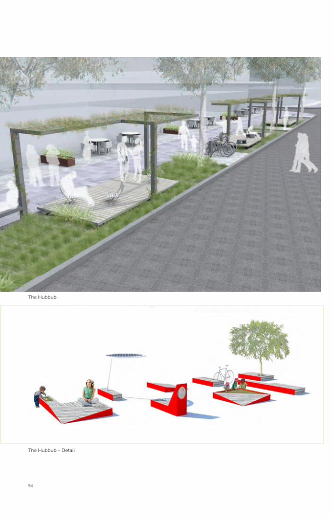
94
_ SITE 15_SMITH + STATION STREET
CARMICHAEL STUDIOS LANDSCAPE ARCHITECTS_NOBBS RADFORD ARCHITECTS_SUZIE IDIENS
#23 HUBBUB
• RETAIL THERAPY. THE URBAN DESERT BLOOMS
• PEDESTRIAN REALM NURTURED. PERMEABILITY PROMOTED
• WI FI CONNECTED. OUT OF OFFICE MEETINGS.
• CANOPY. SHELTER
• ACTIVITY PODS IN INDIGENOUS RAIN GARDENS
• CAFE SPILL OUT. VENDORS
• WEEKEND MARKETS. COMMUNITY UNIQUENESS OF PLACE ENCOURAGED
The Hubbub
The Hubbub - Detail

95
The Hubbub
The Hubbub proposed for Smith Street includes green
meeting places and wi-fi facilities under green shade
canopies within activity pods floating above roadside
rain gardens. By providing café spill out spaces,
vendor havens and market stalls and stages, a range of
spontaneous activation opportunities would become
available. Pedestrian and planting zones would be
separated to allow the urban desert to ‘bloom’.
The Green Thread
Pre-European plant communities that characterised
the Parramatta region including River-flat Forest,
Cumberland Plain Woodland, Shale/Sandstone
Transition Forest, Sydney Sandstone Ridge top
Woodland and Sydney Sandstone Gully Forest, would
be planted to create the green thread linking these
proposals. This would be complemented by the water
sensitive urban design ‘blue thread’.
“Our desire is to create a blue thread for Smith and
Station Streets by integrating a stormwater narrative
throughout the site. This is particularly poignant given
the sites’ geography and connection to Parramatta
River and its environs.” Smith and Station Streets team
The Hubbub 2
Smith and Station Streets will be civilised with seating, shade and rain gardens.

The Lanes
Clay Cli� Creek Parklands
George St
Par
ram
atta
Cit
y R
ing
Rd
Phillip St
Macquarie St
1
2
4
5
6
7
8
10
11
12
13
14
15
16
9
96
The Lanes Projects are;
11. Freemasons’ Arms Lane
12. Barrack Lane
13. Erby Park and Lane 13
14. Wentworth Car Park and Lanes
15. Batman Walk
Diagram of Lanes Projects

The Lanes
Parramatta’s extensive lanes network will be
improved to increase ‘fine grain’ access and street
level activation. The lanes sites have previously been
identified in the Parramatta City Lanes Strategy as
being suitable for renewal and activation. Two of
these lanes, Barrack and Freemason’s Arms, are
older service type lanes mostly addressed by back
entrances and providing shared pedestrian and
vehicular access along the carriageway.
Wentworth, Erby and Batman Lanes are part of networks
that were created in the 20th century to provide access
to the decked car parks built in the city centre. Batman
Lane will eventually be incorporated into the extended
Horwood Avenue Civic Link. This project was for an
installation that could exist and enliven the lane in the
intervening years.
The opportunity for Freemason’s Arms Lane was to
design a temporary installation or event to allow the
adjacent property owners and public to see the lane as
an interesting destination instead of a car park, and to
encourage adjacent properties to address the lane. The
opportunity for Barrack Lane was to make it a popular
city centre destination, not just a through route.
The project approach for both teams was to identify
new activities along the way that could lead to ongoing
transformation. The proposed new activation had a
strong relationship to existing nearby building uses.
The Barrack Lane team took a long-term and
interventionist approach suggesting changes to the
adjoining buildings that would be possible to deliver
as these sites slowly became renewed as part of the
developing city centre. They saw the school as an
important contributor to lane activation.
The Freemason’s Arm’s Lane team approach was
based upon a clear mapping and analysis of site
opportunities and constraints. The latter identified
highly imaginative and practical small-scale
interventions that could occur almost immediately
and would gradually transform how people perceived
the lane and its appearance and role in Parramatta.
The opportunity for Erby Park and Lane 13 was to
provide a concept design for the park and adjoining
lane that creates a well-used leafy green and activated
haven in the city centre.
The opportunity for Wentworth Car Park Lanes was to
develop a concept for the lanes network and the car
park elevations that activates and enhances this part
of the city centre.
The opportunity for Batman Lane was to propose
a short-term makeover incorporating the proposed
adjacent bakery to enliven this area and create a fine
grain pocket square in the city centre.
The Wentworth Car Park and Erby Park and Lanes
teams all analysed the relationship between
these ‘hidden’ parts of the lanes network and the
mainstream city grid and considered opportunities
of this ‘second’ city for enriching Parramatta’s city
centre. A shared theme of these car park lanes
projects was to replan and repave the ground plane
to reduce space designed for vehicles to a minimum
and increase the available area for pedestrians and
more social uses. These projects also shared similar
proposals to incorporate a mix of uses into the car
park to encourage activation, especially on the roof,
through the installation of public stairs.
Batman Lane, the smallest of the lanes projects, was
also posited as a short-term installation and the team
used this brief to develop a proposal for a new seat
and pavement with a strong artistic element.
The five lanes projects combine to form many
approaches for realising the vibrancy of the city
centre’s lanes network. Together they show that the
‘lanes’ palette can be more localised and diverse than
the more traditional streets and spaces of the ‘first
city’ and can introduce a range of elements including;
public stairs over several floors; relocatable and
foldaway kiosks; pop-up activities and timesharing
of spaces and buildings to increase usage and micro
businesses that bring life to the city centre 24/7.
97

98
Freemason’s Arms Lane is a service lane providing
back of house access to retail shops and restaurants
along Church Street. The back elevations of these
shopfronts provide a diminutive scale and fine grain
character to the lane. Despite its physical potential,
the lane is currently uninviting to pedestrians due
to a domination of parking, garbage collection and
servicing needs.
The brief asked the design team to create a
temporary installation or event which allowed
adjacent property owners and the general public
to see Freemason’s Arms Lane as an interesting
destination and address rather than a car park.
A major strength of the team’s approach was their
detailed study of the site, mappings and ‘bespoke’
response. The team mapped out the physical
Freemason’s Arms LaneHeide Axelsen, Hugo Moline, Adriano Pupilli
Freemason’s Arms Lane - Existing View

99
“they all know where to park so we can’t get them”Parking Enforcement Officer
“it’s just a back door to the restaurant, just a place to get deliveries, to park and to put out the rubbish”Indian restaurant manager
“I don’t think I would use it for anything else”Indian restaurant manager
properties of the site as well as interviewing locals
to identify a set of transformative, albeit small-scale,
opportunities. The lack of “inexpensive entertainment
for young people” was clearly iterated within
community responses and became a critical driver
of this project. Interviews were also undertaken with
adjacent building owners in order for the design team
to discern temporal opportunities within existing day-
night rhythms of use.
The proposal is to develop a staged reinterpretation
of the lane through a series of mini projects and
events. A staircase theatre, legal street hawking,
a pop-up bar in a nook, and collectivised rubbish
were key aspects, with each option presenting
different opportunities within the scheme. Pivotal to
activation of the space is a program of focused and
sensitive curation that builds off existing Parramatta
city centre cultural events.

100
CURRENT USES:ACCESS
CURRENT USES:ACCESS
CURRENT USES:TREES
CURRENT USES:VEGETATION
CURRENT USES:ALL CURRENT USES
CURRENT USES:ALL CURRENT USES
CURRENT USES:PARKING
CURRENT USES:PARKING
CURRENT USES:RUBBISH
CURRENT USES:RUBBISH
PROPOSED USES:TIDAL RYTHYMS
MON. TUE. WED. THU. FRI. SAT. SUN.
24.00 24.00 24.00 24.00 24.00 24.00 24.00 24.00
PROPOSED USES:VOIDS AS OPPORTUNITIESPROPOSED USES:OPPORTUNITIES EXPAND
PROPOSED USES:VOIDS AS OPPORTUNITIES
PROPOSED USES:VOIDS AS OPPORTUNITIES
PROPOSED USES:VOIDS AS OPPORTUNITIES
PROPOSED OCCUPATION:RUBBISH
GARBAGE COOPERATIVE RENTS ONE CAR SPACE FROM CROWN PROPERTY TO CREATE CENTRALISED, SECURE, WASTE DEPOT.
PROPOSED USES:LEGAL STREET HAWKING
Current Uses
Proposed Uses

101
PROPOSED USES:TIDAL RYTHYMS
MON. TUE. WED. THU. FRI. SAT. SUN.
24.00 24.00 24.00 24.00 24.00 24.00 24.00 24.00
PROPOSED USES:VOIDS AS OPPORTUNITIESPROPOSED USES:OPPORTUNITIES EXPAND
PROPOSED USES:VOIDS AS OPPORTUNITIES
Voids as Opportunities - 3
Voids as Opportunities - 1
Voids as Opportunities - 2
Freemason’s Arms Lane team
“We see the lane as an estuary – it’s a place for the ‘little shrimp’ to grow up before they become the ‘king shrimp’ of Church Street.”

102
FABRICATE & INSTALL STAIRCASE THEATRE, STABLES BAR, CARTS AND GATEWAYS
CALL FOR EXPRESSIONS OF INTEREST FOR RESIDENCIES TO ACTIVATE STAIRCASE THEATRE, STABLES BAR, ART WALL, CINEMA
LAUNCH OCTOBER 2013
LAUNCH GARBAGE COLLECTIVE
INTRODUCE LANE TO EXISTING FESTIVALS FOR PROGRAMMING
INTEREST FOR RESIDENCIES TO FESTIVALS FOR PROGRAMMING
STRATEGY
INTRODUCE ‘SIDESHOW’ PLAN LOCAL BUSINESSES
CONNECTING INFREEMASONS ARMS LANETO ONGOING CULTURAL PROGRAMS
SYDNEY SACRED MUSIC FESTIVAL
4 x 1100L
23 x 240L
INDIVIDUALISED RUBBISH(CURRENT APPROACH)
3 x 4500L
COLLECTIVISED RUBBISH(POTENTIAL APPROACH)
= 9920L of rubbish

103
OFF-SITECULTURAL ACTIVATORS
INFORMATION & CULTURAL EXCHANGE
RIVERSIDE THEATRE
MARS HILL CAFE
PARRAMATTA ARTIST STUDIO
POP UP PARRAMATTA
FORM DANCE
MILKCRATETHEATRE
OPERA AUSTRALIA(Western Sydney Community Choirs)
9 LIVES PARKOUR
POWERHOUSE YOUTH THEATRE
MISSION AUSTRALIA(soup kitchen/entertainment)
+LOY KRATONG FESTIVAL
+PARRAMASALA
+SYDNEY FESTIVAL PARRAMATTA
SYDNEY SACRED MUSIC FESTIVAL
+HERITAGE ROSE FESTIVAL
2100
1100
Proposal - Section detail Proposal - Section detail
View of Proposal for the Theatre

104
Freemason’s Arms Lane will undergo a staged reinterpretation to realise its unique potential as a fine grain public space through a series of micro projects and sensitively curated cultural events.
Freemason’s Arms Lane - Proposal

105
Helen Lochhead
“This scheme reminds me of the kitchen at parties, where all the excitement happens out the back.”

106
Barrack Lane is a busy pedestrian route located
between the Parramatta Transport Interchange and
George Street’s commercial zone. It is Parramatta’s
oldest existing lane and is a key route in the city
centre’s lanes network.
The brief asked designers to recognise Barrack
Lane’s historic significance and realise its potential
as a popular city centre destination, rather than a
pedestrian through route.
The team’s approach was to identify the opportunity
for a youth-focused public space offered by the
location of Arthur Phillip High School within the
lane. Introducing an element of fun into the laneway
— through the concept of urban play — builds off
this opportunity and is a key feature of the design.
Activation by the school is currently limited due to
their back-of-house utilisation of lane. The team
accordingly focused on a methodology for drawing
out this potential through a long-term plan for
engagement with the school. This relationship would
be the basis for the lane’s youth focus and would
assist in activating the lanes’ existing elements.
The project recognised the potential of Barrack
Lane to become more than just a lane and vehicular
servicing point, and developed strategies for the site
to transform into an interesting public space within
the city centre. The team presented a long-term
view of the lane’s development and included options
for five, 10 and 20 year scenarios. The long term
scenarios involved expensive land acquisition and
major redevelopment of nearby sites.
Barrack LaneGroup of Like-minded Designers (G.O.L.D.)

107
The three key themes of the project were:
• Destination: Create a destination rather than a
thoroughfare through strengthening of the northern
and southern end points of the laneway, providing
art installations and cafés to provide anchors of
activity.
• History: Acknowledge the lane’s rich history by
revealing existing heritage items — including the
underground convict drain, cottages and convict
barrack’s wall to new audiences.
• Education: Develop the potential of the site as a
place for children and teenagers within the city
centre through community engagement with
Arthur Philip High School. Consider blurring the
boundary between the school and the laneway to
encourage interaction between the two.
Framework Diagram
Barrack Lane - Existing
Barrack Lane -Analysis

108
GEORGE STREET
MACQUARIE STREET
GEORGE STREET
GEORGE STREET
MACQUARIE STREET
MACQUARIE STREET
Section
Plan
“As children and
young people explore the outside world... They develop detailed knowledge, often intertwining their
own identity with that of the places they spend time in. This...relationship...provides an important foundation for seeing children
not merely as objects of adults’ care and protection, but rather as citizens with a
feeling of ownership and belonging with an active stake in a
locality.”
E Adams and S Ingham, ChangingPlaces: Children’s participation in environmental planning (London:Children’s Society, 1998); M Jans,‘Children as citizens: towards a contemporary notion of child participation’, Childhood 11 (2004).
0-5 YEARS: UNVEILING HERITAGE
“Excitement for the future should be anchored in the security of the past”
- Remove a percentage of carparks and replace with bike store and end of trip facilities
- Clusters of school demountables- Commence new Green Lane connection
- Aquire and remove college building and open up forecourt to heritage cottages
Lynch (1960) in G. Ashworth & J. Tunbridge, The Tourist-Historic City: Retrospect and Prospect of Managing the Heritage City (Oxford: Elsevier Science Ltd, 2000)
5-10 YEARS: CREATING DESTINATION
“A continuously used public space with its many memories can help anchor one’s sense of
personal continuity in a rapidly changing world.”
- Demolish substation and activate gravel pit with urban playscape- Open first half of Green Lane
- Commence Community Garden
D.Francis & S.Hester, An Invitation to Ethnomethodology: Language, Society and Interaction (London: Sage Publications Ltd, 2004)
10 - 20 YEARS: COMMUNITY INTEGRATION
”By the building up of overlapping memories of individual and shared experience, a place
becomes sacred to a community.”
- Develop carpark site through PPP – lower level school and workshops with commercial above
- School consolidated along laneway edge- Redevelop sports grounds- Open up cross block links
D.Francis & S.Hester, An Invitation to Ethnomethodology: Language, Society and Interaction (London: Sage Publications Ltd, 2004)

109
D
H
D
D - Existing
H - Existing
Sub Station - Existing
D - Proposed
H - Proposed
Sub Station - Proposed
Barrack Lane will be enlivened by urban play elements and engaging with Arthur Phillip High School.

110
The Erby Place car park was built during the 1980s
with vehicular access from Horwood Avenue and a
set of narrow lanes running along its northern edge to
Phillip Street. The project site focused on an existing
pocket park fronting Phillip Street and Lane 13 which
wraps the west and southern edges of the car park.
Such pocket parks are rare in Parramatta’s city centre
and this one does not currently realise its potential
due to poor design and amenity and the absence of
activation.
The brief asked designers to provide a concept
design for Erby Place and Lane 13 which converted
the existing space into a well-utilised leafy green
activated haven within the city centre.
A major strength of the team’s approach was to
highlight the possibilities offered by an alternate
reading of the lanes network as a second-layer to the
city centre. This ‘second city’ could have a different
set of rules, ambitions and modes of activation to the
Erby Place and Lane 13DRAW, Tyrell Studio, Dr L.Stickells and Dr Z.Begg
Analysis - Plan

111
first city of main streets and major public spaces.
The proposal for the project site begins to explore the
potential for Parramatta’s service spaces to become
more than sites for storing cars and garbage. It builds
on the Parramatta Lanes Strategy, improves the
pedestrian network, increases city centre parkland,
and provides new areas for activation.
Erby Park - Existing View

112
The main elements of the proposal are: a reduction in
car dominance, improvements to the appearance of
the lane, car park and park; and increased opportunities
for activation. This will be achieved by:
• a unifying permeable treatment across the lane and
park that increases the pedestrian area and recognises
the historic significance of the site as the original
location of Wycombe House, owned by the lane’s
namesake, GT Erby, who was a draper in the 1890s.
Erby Place and Lane 13 will become an animated pocket park and community hub.
Erby Park Proposal - View South

113
Rod Simpson,
“This design presents one of the most compelling narratives of Parramatta’s second city.”
• a new planted public stair which leads from the
park to the roof of the car park, integrating the two
areas and providing access to a rooftop event space
for markets and other community events.
• the installation of a modular amenities block with
a generous roof on the top level of the car park to
support the new community event space.
• a community engagement strategy proposed to
invite different people to use the roof. Planned
gatherings such as a rooftop farmers markets,
basketball games or car boot sales are also
proposed to encourage community investment
in the park.
The Second City from Phillip Street

114
Erby Park Proposal - View East
Erby Park Proposal - Plan

115
Erby Place and Lane 13 Team,
“How can a ‘second city’ coexist? It has a second set of rules, a second set of spaces — provides hints and clues which intervene, interact and ‘infect’ the first city.”
Erby Park Proposal - Section

116
WalkRide
WalkRide
Ride
Wentworth car park is a 1,000 vehicle parking facility
located in the southern portion of Parramatta’s city
centre. It is a Council owned asset which provides a
key service to commuters. The existing lanes network
at its perimeter connects northbound to the transport
interchange, east to the southern commercial office hub
and west to the Church Street eateries. Despite daily
pedestrian use, the Wentworth car park lanes network
is dominated by vehicular use and does not currently
present a desirable image.
The brief asked the design team to propose
improvements to the lanes’ network and car park
elevations to encourage pedestrians use and
reinvigorate this part of the city centre.
The design approach was to challenge the ‘urban
sameness’ that characterises much of Parramatta’s
public spaces and streets by drawing out a compelling
narrative from the existing ‘mosaic of subcultures’
within Parramatta city centre.
Wentworth Avenue Car Park and LanesBKK Architects, Glas Urban Design and Landscape Architecture, Electrolight & Renew Australia
• Poor sightlines through site• Lack of permeability• Poor wayfinding
• Poorly defined pedestrian paths• Dominant car use
• Back-of-house, service zones address lanes• Mixed uses, lack of identity and urban clarity
Wentworth Car Park Team
“Parramatta has many enticing qualities — an historic urban grid, heritage parklands and river frontage, yet it suffers from a lack of distinctiveness. To escape the urban sameness, the city needs to cultivate distinctive neighbourhoods with special places, diverse facilities, and delightful happenings.”

117
ST. JOHNSPARK
BRISLINGTONHOUSE
JUSTICEPRECINCT
ERBYPLACE
PROPOSEDPUBLICSPACE
WESTERN RAIL LINE
PARRAMATTA RIVER
RD
STST
ELIZ
ABET
H
AVE
LN
THOMASTHOMAS
ST
ST
ST
SO
RR
ELL
WIL
DE
PDE
PDEEDGEWATER
LAMONTLAMONT
STST
STST
ALAS
KA
ROBERTSON
ELIZ
ABET
H
QU
EEN
SQ
UEE
NS
ST
ST
LN
STUNIONS
MITH
ARG
US
STLITTLE
ST
CH
AR
LES
STATION
PARKES
ST
ST
UNA
ST
HASSALL
AVE
KENDALL
ST
ADA
ST
CO
WP
ER
ST
ST
PL
VICTORIA
PALMER
STST
MAR
SDEN
MARKETMARKET
ST
PHILLIP
HO
RW
OO
D
CH
ARLE
S
SMIT
H
ST
PL
CH
UR
CH
ST
MAR
SDEN
GEORGE
OC
ON
NEL
L
ST
MACQUARIE
CH
UR
CH
ST
ST
DARCY
ST
FITZWILLIAMSTAIRD
ARGYLE
CA
GREAT
MPBELLVALENTINE
WE
NTW
OR
TH
ST
ST
PARKES
AN
DE
RS
ON
HWY
ST
STEARLY
WESTERN
ST
LN
BAR
RAC
KLN
HUNTER
AIRD ST
ST
ST
ST
DAVID FRATER RESERVE
RIVERSIDE WALK
PRINCEALFREDPARK
PARRAMATTA PARK
JUBILEEPARK
city public space
building footprintKey
on-grade carpark
ST. JOHNSPARK
BRISLINGTONHOUSE
JUSTICEPRECINCT
ERBY PLACE
Pedestrian networks make for a walkable city of human scale
Laneway network - A Second City
Wentworth Carpark - Close proximity to intermodal transport hub
Walk
Wentworth Car Park - Existing

118
Wentworth Car Park and Lanes will realise their potential as a ‘slow hub’ and multi-modal transport interchange lined with pedestrian activities and lively shopfronts.

119
Wentworth Car Park and Lanes Proposal - Aerial View

120
Layer 1: A shared ground plane
• Reconfigure traffic circulation for equity between cars, pedestrians and bikes. • Remove short term parking from car park periphery• Pedestrianise the East and part of the North lane• Provide dedicated cycle lanes with lane resurfacing to articulate ‘slow’ zones
Pedestrian/Car shared zone
N
Pedestrian zone
Layer 2: Activated ground level
• Provide incentives to encourage surrounding cafe & restaurant owners to spill into the lanes • Open up the ground & first levels of the North façade to provide additional programs - a Slow Hub theme• Provide more direct connections between the car park and the surrounding lanes
N“Slow Hub” programs within the car park
THE PROPOSITION
A layered approach
A blank canvas... Rooftop
Cinema?
The concept for the Wentworth Car Park and Lanes
Network is a strategy for a ‘slow hub’ — a multi-
modal transport interchange that provides an easy
transition from car, bus and train into the slower,
more experiential modes of walking and cycling. The
design limits the space required by vehicles in order
to free up parts of the lanes for pedestrian use and
improved activation. The north face of the car park and
the roof are identified as key locations for activation, to
draw people into and around the lanes network.
The design for Wentworth Car Park and Lane’s
Network is a strategy consisting of a several layers:
• Layer 1: A shared ground plane of consistent
surface which changes the priority of the site
away from cars towards ‘slow users’. This includes
reconfigured traffic circulation, prioritisation of
pedestrian movement and removal of short-term
parking within the lanes.
• Layer 2: An upgraded urban environment and
activated ground plane. This includes encouraging

121
Layer 2: Activated ground level
• Provide incentives to encourage surrounding cafe & restaurant owners to spill into the lanes • Open up the ground & first levels of the North façade to provide additional programs - a Slow Hub theme• Provide more direct connections between the car park and the surrounding lanes
N“Slow Hub” programs within the car park
Layer 3: The Roof & Car Park Facade
• A new, highly visible roof use - attract users from the city and the wider Sydney area for a specific activity• Animate the facade - provide a new address to broader urban context
N
Rooftop Cinema?
A Bar? An Urban Park?
Wentworth Car Park Team
“The ‘slow hub’ will make it easier and more enjoyable to move from the car into city life. It will welcome people into an unexpected and memorable urban experience.”
existing café and restaurant occupants to spill into
the laneways; sculptural intervention; and potential
vertical activation of parts of the northern facade, a
new external stair, and steps from the ground plane
into the basement of the car park connecting into a
multi-use facility for commuter cyclists.
• Layer 3: A highly visible, sculpturally iconic roof and
enticing roof activity. Strategies proposed include
a roof top bar, roof top cinema, pop up park, aerial
velodrome or play space.
• These three layers will be implemented over time
resulting in a gradual transformation of the area.
Gradually a strong identity will emerge assisting
to create a distinctive neighbourhood within the
city centre.

122
Batman Walk has a sunny north-south orientation
and central location, making it an ideal lunchtime
retreat. It will eventually be widened and redeveloped
to create the Horwood Avenue Civic Link, however in
the meantime the lane has the potential to function as
a much needed pocket square within the city centre.
Council have negotiated to lease the Council owned
building to the east of the lane to an artisan baker in
order to activate the laneway and attract passersby.
The brief asked the design team to propose a short-
term renovation for the lane which incorporates the
proposed bakery, enlivens the space, and creates a
fine grain pocket square in the city centre.
The strength of the design approach was to recognise
the potential of an everyday element, such as public
seating, to become a fun and iconic element. The
team’s design built on existing seating precedents
Batman WalkAndrew Burns and Brook Andrew
Batman Walk Team
“Batman Walk presents the challenge of an apparently ordinary lane. The task is to create a work that will extend the cultural aspirations of the city by way of impact, presence and quality.”
Batman Lane - Existing View
Batman Lane - Plan

123
from around the world, together with explorations of
geometry and pattern. The seat serves a functional
purpose, acts as a drawcard and is used to transform
the lane into a popular destination.
The artistic seat element envelopes the lane and
attracts passersby through the use of strong visual
imagery. Bold use of monochromatic colour,
geometry and pattern are applied to the ground plane
and ‘folded’ over the solid perimeter edge seating.
The geometry of the bench’s form creates a variety
of spaces and seating options for café visitors. The
uniform material finish uses optical devices to change
in response to pedestrian motion and perspective.
Batman Lane - Proposal Plan

124
The short-term proposal for Batman Walk will use a compelling artwork/seat to attract passersby and define a lively pocket square.
Batman Lane -
Existing View looking North

125
Batman Lane Proposed-
View North

The Art and Experimental
126
Clay Cli� Creek Parklands
George St
Par
ram
atta
Cit
y R
ing
Rd
Phillip St
Macquarie St
1
2
4
5
6
7
8
10
11
12
13
14
15
16
9
Diagram of Potential sites for Blank Canvas Projects
The Art and Experimental Projects are:
Lonely Laneways
A Place in the Sun
A Space for Urban Follies
Parra-Net

The Art and Experimental
These four projects invited design teams to identify
a previously unrecognised site for an appropriate
installation, known as the Blank Canvas projects. The
opportunity defined by the brief was for designers
and artists to identify and propose a site specific
improvement and/or artwork for a blank wall or
group of blank walls that currently make a negative
contribution to the city centre.
Artists’ played an intrinsic role in most of the Design
Parramatta teams. For these projects in particular, the
artist’s role was paramount. These projects share an
exploratory and experimental theme but are all very
different in realisation. Some used the artistic input
to encompass the entire space while other projects
proposed a more traditional approach of a free
standing object. For several, a strong component of
interactivity between the use of work and passerby.
operated. These projects work with the senses through
light and dark, sound, sitting in the sun and/or colour
and recognise the possibilities the city centre offers
beyond work and home.
127

The proposal is for a series of sculptural objects
placed within disused lanes that change in response
to human interaction.
The main design approach is to provide an artwork
which embodies and reflects the character and mood
of disused spaces within the city centre.
The design proposes a collection of sculptures to be
placed in lanes which share the same shape and form
but respond differently to each environment based
on how different objects are placed and interacted
with. Each sculpture is technologically hardwired and
consists of mirrored aluminium, light diffracting plastic
and LED lights. As people approach the sculpture –
either incidentally or deliberately – the object alters its
‘mood’, reflecting this with a combination of colour
and light.
Artworks for Lonely LanewaysStudio Damien Butler
ART WORKS LOCATIONS- Erby Place- Batman Lane- Wentworth Laneway- Wentworth Laneway- Batman Lane
ART WORKS LOCATIONSART WORKS LOCATIONS- Erby Place- Batman Lane- Batman Lane- Batman Lane- Batman Lane- Batman Lane- Wentworth Laneway- Wentworth Laneway
- Erby PlaceART WORKS LOCATIONSART WORKS LOCATIONSART WORKS LOCATIONS
- Batman Lane- Wentworth Laneway- Batman Lane- Erby Place- Erby Place- Erby Place- Batman Lane- Batman Lane- Erby Place- Batman Lane- Erby Place- Erby Place- Erby Place- Erby PlaceART WORKS LOCATIONSART WORKS LOCATIONSART WORKS LOCATIONS
- Wentworth Laneway- Wentworth Laneway
- Erby Place- Erby Place- Erby Place- Batman Lane- Batman Lane- Batman Lane- Wentworth Laneway- Wentworth Laneway- Wentworth Laneway- Wentworth Laneway- Wentworth Laneway- Wentworth Laneway- Wentworth Laneway- Wentworth Laneway
- Erby PlaceART WORKS LOCATIONSART WORKS LOCATIONS- Erby Place
LED LIGHTING
MIRROR ALUMINIUM
LIGHT DIFFRACTION PLASTIC
1800
mm
128

A proposal for a series of sculptures placed within quiet lanes that would respond to people passing by.
Studio Damien Butler
“Lonely spheres placed in laneways across Parramatta anxiously pulse their lights to express their loneliness ... not until people choose to enter the laneway and interact with the sphere do they change their state and respond to the attention given.”
129
Proposal - View

Meta Strategy - Old Eyes / New Eyes
AG
END
A /
PRIN
CIP
LES
Distil and intensify the experience of third layer spaces, and promote diversity in their use. 1. Enveloping, immersive, sensory and/or invites exploration, is dynamic, interactive or participatory
2. Infrastructure to facilitate activity, platform for exhibition, clever furniture
3. Opportunistic, contextual, ‘minimal‘ or sensitive, varied and free to grow
Service • Kitchen, toilet • Loading dock, bin enclosure • AC / plant
Collective – informal • Picnic • Event • Spontaneous dance
Collective – formal • Cinema • Bar, cafe • Group exercise
Individual • Meditation/contemplation • Study • Coffee • Exercise
AC
TIVI
TY /
FUN
CTI
ON
Landscape Furniture Sound Light ELEM
ENTS
Immersive Sculptural Pixel Surface Digital record
Kinetic Gallery Framed view
Green Object Folded / pop out
Temporary / mobile
Thresholds Secondary AN
ATO
MY
OF
SPA
CE
Primary
Exterior Entry / arrival space
Side space
Service space
Through space
Gates Level change
Corner Beacon / sign
Boundary / wall
Door / window
Site Two, Macquarie Lane - Old Eyes / New EyesSite Three, Railway Embankment and Art Studios - Old Eyes / New Eyes
The ‘meta-strategy’ provides a design framework
which enhances the sensory experience of leftover
spaces and creates opportunities for new types
of activity.
The design approach is to develop a whole of city
strategy for approaching and improving small-scale,
forgotten spaces. The strength of the scheme was
its principle-based approach to spatial improvement
unencumbered by property boundaries.
The team developed a series of design interventions
that could be applied to enhance the sensory
experience of different types of space and which
provided a variety of platforms for different types of
activation. The interventions focused on the addition
of light, sound, landscape and urban furniture. The
strategy was tested on a number of demonstration
sites which included an alley opposite Bicentennial
Square, Macquarie Link, and an art playground.
A Space for Urban FolliesOld Eyes New Eyes
130

131
WESTERN RAIL LINE
PARRAMATTA RIVER AVEEE
SSSTTT
SSSSSSTTTTTT
ALALALALALASASAS
KAKA
RROBERTSOONNNN
ELIZ
ABET
H
UEN
SQQQ
UUUUEEEEEEE
NNNNSSSS
SST
SST
STUNIONSS
MITH
ARG
US
ST
STLITTLE
ST
CH
AR
LES
STATIONNN
PARKES ST
ST
HASSALL
ST
ST
PHILLLIP
HO
RW
OO
DH
OR
WO
OD
CH
ARLE
SC
HAR
LES
SMIT
H
ST
PL
CH
UR
CH
ST
MAR
SDEN
GEORGE
OC
ON
NEL
L
ST
MMAACQUQUARIE
CH
UR
CH
ST
DARCY
ST
FITITZZWILLIAMSSTTAIAIRDD
ARGYLE
CAMPBELLLVALENTINE
WE
NNTTTW
ST
STT
LLLNNN
BAR
RAC
KLN
HUNTER
AIRD ST
ST
ST
SSST
DAVID FRATER RESERVE
DAVID FRATER RESERVE
DAVID FRATER RESERVE
DAVID FRATER RESERVE
DAVID FRATER RESERVE
DAVID FRATER RESERVE
DAVID FRATER RESERVE
DAVID FRATER RESERVE
DAVID FRATER RESERVE
DAVID FRATER RESERVE
DAVID FRATER RESERVE
DAVID FRATER RESERVE
DAVID FRATER RESERVE
DAVID FRATER RESERVE
DAVID FRATER RESERVE
DAVID FRATER RESERVE
RIVERSIDE WALK
RIVERSIDE WALK
RIVERSIDE WALK
RIVERSIDE WALK
RIVERSIDE WALK
RIVERSIDE WALK
RIVERSIDE WALK
RIVERSIDE WALK
RIVERSIDE WALK
RIVERSIDE WALK
RIVERSIDE WALK
RIVERSIDE WALK
RIVERSIDE WALK
RIVERSIDE WALK
RIVERSIDE WALK
Key
Existing lanes to be retained and enhanced
Desired new lanes
Existing pedestrian links to be retained
Desired newpedestrian links
Potential thirdlayer spaces
Third layer demonstrated sites
Map of Third Layer SpacesMap of Third Layer Spaces - Old Eyes / New Eyes
Site One, Unamed Alley, Opposite Bicentennial Square - Old Eyes / New Eyes
Site Three, Railway Embankment and Art Studios - Old Eyes / New Eyes
Old Eyes New Eyes
“We believe that Parramatta’s creative culture is underestimated and hidden.”
An art framework for enhancing the quiet out of the way spaces focusing on sensory experiences.

P o p U p s
design parramatta - mulloway studio + ernest edmonds - september 2012
D a r c y S t r e e t , r a i l w a y b r i d g e
design parramatta - mulloway studio + ernest edmonds - september 2012
i n p u t
o u t p u t i n t e r f a c esite specific inter face
LED screen / billboard and camera where
required
v i e w e rv i e w e r
c a m e r a / s e n s o r
detect movement / density of people in each location
‘ t h e n a n d n o w ’
photographs of the old and new of the City
p h o n e a p p s
programmed to influence colour output on display screen
transfer of data to localised driver at each site
c e n t r a l r e p o s i t o r y s y s t e m
council building / foyer / l ibrary / future civiv square
E l e m e n t 1
E l e m e n t 1
E l e m e n t 4
E l e m e n t 2
E l e m e n t 1
E l e m e n t 2
E l e m e n t 3
E l e m e n t 4
o u t p u t
design parramatta - mulloway studio + ernest edmonds - september 2012
132
The design proposal is for an interconnected urban
artwork which utilises a network of screens of varying
size and location, and an accompanying smart
phone ‘app’ to provoke thought and activate negative
facades and spaces within the city centre.
The design approach is to propose an artistic
framework which collects data on different parts
of Parramatta (past and present) and redistributes
it based on a pre-formulated algorithm onto
four proposed elements. Multiple levels of public
engagement are proposed within the artwork which
changes with respect to colour, image and speed and
can be interacted with by movement, viewing, and an
element of public curating.
The four display elements are:
1. three large-scale billboard and LED/LCD screen
elements installed in key locations between the
ParranetMulloway Studio and Ernest Edmonds

P o p U p s
design parramatta - mulloway studio + ernest edmonds - september 2012
f u t u r e r i v e r s q u a r e
f u t u r e c i v i c s q u a r e
f u t u r e c i v i c l i n k
r a i l w a y
r i v e r
p a r r a N E T 0 3
p a r r a N E T 0 1
p a r r a N E T 0 2
c e n t r a l n o d e
p o p u p ’ s
design parramatta - mulloway studio + ernest edmonds - september 2012
design parramatta - mulloway studio + ernest edmonds - september 2012
Mulloway Studio and
Ernest Edmonds
“Parranet is a project that explores how large scale, ‘flat’ artistic installations can activate the negative elevations of buildings in Parramatta’s city centre. Through the use of large colour surfaces coupled with historical and real time images activated by sensory technology, Parranet aims to transform parts of the city centre into an urban gallery by arousing cultural curiosity.”
133
railway and the river. Each installation is equipped with
individual cameras and sensors which are networked
to a central database.
2. a central display node which acts as the network
control point for all installations. The node is a
sculptural element located within a publicly-accessible
area and will display the ‘network’ of the artwork in
real-time on a LED/LCD screen.
3. a series of six ‘pop-up’ or temporary short-term
screens located within secure, weather protected
environments such as shop fronts and arcades.
The screens are temporary in nature, can be easily
relocated and placed to encourage curiosity and
activation.
4. an ‘app’ (for smart phones, tablets or similar
devices) that provides a guide to the work, as well as
collecting data and illustrating the output.
An artwork proposal made of mounted screens, and an accompanying smart phone ‘app’, using colour and community generated images to animate blank facades and spaces within the city centre.

The design proposal is for a small-scale intervention
which celebrates the simple pleasure of sitting in
the sun.
The approach adopted by the design team was to
analyse the common small-scale components which
frequently combine to create great public space. This
thinking was applied to Parramatta’s city centre and it
was concluded that what was missing was a humble
design intervention to better facilitate the simple act
of sitting in the sun.
The proposal is for a strategy which identifies
public space opportunities and provides small-scale
design interventions to improve public amenity. The
strategy is demonstrated through the creation of a
sun-drenched pocket park, located midway along
a pedestrian thoroughfare between the transport
interchange, a coffee shop and the existing library.
A Place in the SunPush Play
MACQUARIE STREET
CH
UR
CH
STREET
STREET
DARCY STREET
FITZWILLIAM STREETAIRD ST
VALENTINE
ARGYLE STREET
STREET
STREETSTREETSTREET
CH
UR
CH
CH
UR
CH
CIVIC PLACE
CH
UR
CH
STREET
LIBRARY
TOWN HALL
TRANSPORT HUB
SITUATION 1:1000
DESIGN PARRAMATTA SEPTEMBER 2012 PUSH PLAY PAUSE BLANK CANVAS A - COLLINS DOLEY KARLSSON WAGNER
134

Push Play
“We don’t want to be showy. We don’t want to make big promises for the future. We want to be kind, and speak how we like to be spoken to. We don’t want to be forced into participation. We don’t want to be forced to interact. We don’t want interaction to be novel or kitsch or overt, and we don’t want our interaction to blink or buzz. What we do want is interaction that is real and useful; dare we say functional.”
135
A proposal for a small-scale intervention which celebrates the simple pleasure of sitting in the sun.
Precedent photo

PART 3 /
STUDENT PROJECTS
136

PART 3 /
STUDENT PROJECTS
137

138
Perspective View - Joanne Munn
Perspective View -Krista McMaster
139
Finding the Future in the Exisiting Urban Fabric
Faculty of Architecture, Design and Planning University of Sydney
Rod Simpson
Associate Professor, Faculty of Architecture, Design and Planning
The University of Sydney
As part of the Design Parramatta process the urban design studio
at the University of Sydney has developed alternative designs for
Horwood Avenue; the civic link. This project was selected not only
because it may link the rail station to the river, but also because the
avenue is at the junction occupying a middle ground between the
concentration of large offices to the east and the highly modified
historic subdivision ‘grain’ around Church Street to the west.
With its ‘cranked’ alignment, modernist car parking structures, and
tendency to branch off to other smaller random spaces occupied
by small business ventures, it can also be seen as the location of
two distinct and misaligned urban processes; the planned and the
unplanned.
There is always a tension between top-down planning that
conceives of the city at a metropolitan scale and then attempts to
define a role, capacity and function for parts within it ‘Parramatta as
Sydney’s second CBD’, and the existing fabric of the place and the
patterns of activity that are constantly emerging from individuals’
actions, investments and entrepreneurship.
The Design Parramatta process, even at this early stage needs to
be recognised as a clear attempt to reconcile these tensions, and
to develop an approach and methodology that is able to mediate
between the macro and micro.
We are all too familiar with the excessive zeal of top-down planning
of the 1960’s that would have cut multi-lane motor-swathes through
the city and erased the Rocks, Woolloomooloo, Kings Cross and
much of North Sydney in the name of efficiency and renewal.
But although we have introduced and embedded heritage as a
consideration in response to these ravages, by identifying particular
items, curtilages or even physical patterns of urban form as being of
heritage significance, this is essentially a static, reactive, backward
looking approach based on an understandable sense of distrust.

140
There is no question that heritage should be recognised and
preserved, but that is not enough: culture and urbanity are
dynamic and occupy places that mostly do not have any particular
heritage, high cultural or aesthetic value, but that does not mean
they are worthless, or that their potential should not be a principal
focus of planning and design.
We also forget that the resistance to the top-down approach was
also socially motivated, with the ‘green bans’ in the Rocks being
as much concerned with the retention of affordable housing and
defence of tenants as with heritage preservation. Authenticity
comes from places having many authors, not just physical
preservation.
Heritage alone does not provide the basis for discussing how we
want places to be in the future. To do that we need to look at the
qualities of place and the activities and seek out the potential of
the places. In other words, Design Parramatta in order to Imagine
Parramatta!
DESIGN PARRAMATTA AS AN INTERMEDIARY PROCESS
Although Design Parramatta duly acknowledges the City of
Sydney ‘City Spaces’ project as a precedent, it differs in a number
of important respects:
Parramatta’s city centre is smaller. This means that rather than
a scattering of projects that could improve the City of Sydney,
the combined Design Parramatta projects have the potential to
provide a comprehensive framework that is linked up.
Parramatta’s city centre is ‘grittier’. Sydney was already in pretty
good shape and the ‘City Spaces’ project could be seen as further
embellishment. We forget that the Rocks and Woolloomooloo
were also ‘gritty’ in the early 70’s, and it took imagination to
see their potential and the value of what was already there, and
perhaps as importantly, manage to keep some of the authenticity,
which is still a ‘tension’ in the Rocks.
Parramatta’s city centre is more open to intervention. This because
it is not as capitalised or built-up as Sydney was in the 1990’s. This
should mean that new connections and re-configuration of the
city centre could be made more easily and at lower cost than
Sydney, facilitated by the extensive publicly owned land in the
centre: the car parks and lanes.

141
Parramatta’s city centre has lower density and more intimate scale
than Sydney and the potential for intriguing juxtapositions of scale,
age and building typologies should be recognised as a unique
potential, while not allowing any one type to dominate; there is
nothing inherently wrong with having two storeys next to 65 storeys.
Most importantly, the process suggests that it possible to use
urban design, the definition and formulation of ideas for the
public domain as a way of revealing, illuminating and articulating
the potential of what already exists in the city centre, (both fabric
and activities), in relation to major redevelopment proposals that
might be seen as ‘top-down’. Having articulated these values, the
challenges for designers then becomes how to reconcile these
different scales; how do large buildings come down to ground
and interact and mesh with surrounding activities?
FINAL COMMENT ON PROCESS
The innovation in the approach lies in the valuing of both what
exists and its potential using design as an exploratory, explanatory
and structuring process.
Major urban renewal projects often see existing fabric and
activities as a major impediments, both physical in terms of
development capacity, and in relation to ‘market perceptions’
that suggest places need to be ‘cleaned-up’ and re-branded. The
challenge and potential for Parramatta’s city centre may be to
question these assumptions, and develop new approaches that
are unique, specific and consequently; ‘world class’ urban design.
PROPOSITIONS
The idea that the ‘first city’ grid of rectilinear streets with consistent
street frontages, could be complemented and contrasted with a
‘second city’ of lanes and irregular diverse spaces that already exist
within the large street blocks emerged as a recurrent theme from
both the professional and student schemes.
The more detailed exploration of Horwood Avenue by the urban
design studio showed that this theme could be developed in a
number of ways.

142
Sharp proposes the modification and adaptation
of existing structures en route to the river where
the articulation of landform into promontory and
embayment provides both vistas and containment.
Horwood Place/Avenue is a minor street in the
grid geometry and, the diagram above shows it in
relation to the ‘second city’ that exists in the mid-
blocks of the main city grid.
Working with the existing structures: modification
and adaptation may be the way forward.
Four blocks
1. Parramatta Square block: Public buildings set
in a sequence of a generous link to station under
buildings, commercial buildings focused to the east.
2. Roxy block: Horwood Place as a central unifying
space with minor spaces pooling off the place, a
temporal shared way.
3. Erby block: Horwood Place as a minor street,
linear pedestrian link to courtyards, sets up clear view
towards river
4. River block: Willow House as upper promontory
park with a terraced link to the lower riverside park,
cut in to create large lower park.
Horwood Place/AvenueDaniel Sharp

143
Public domain as the venue for
individual and programed activity.
Mun takes advantage of the lack of preciousness about
what happens in the centre of the block to propose a
programed urban playground. Parramatta’s city centre
will be as busy on the weekends as midweek, while
office workers may also be drawn to the water park
midsummer.
Horwood Place/Urban PlaygroundJoanne Mun
Main Principles
1. Realign Horwood Link: a well-connected north-
south approach from transport interchange to the river
through pedestrian ways, shareways and service lanes.
2. Built forms to make way for Horwood Link:
subtracting/adding/multiplying/subdividing potential
new sites for future developments.
3. New spaces within each block: allocating new parks/
squares/urban spaces to encourage social activities.
4. Life on Street: creating opportunities to bring life
back onto the street with street furniture, intimate
parks, art installations, active retail frontages and
opportunity for events and fairs along Horwood Link.
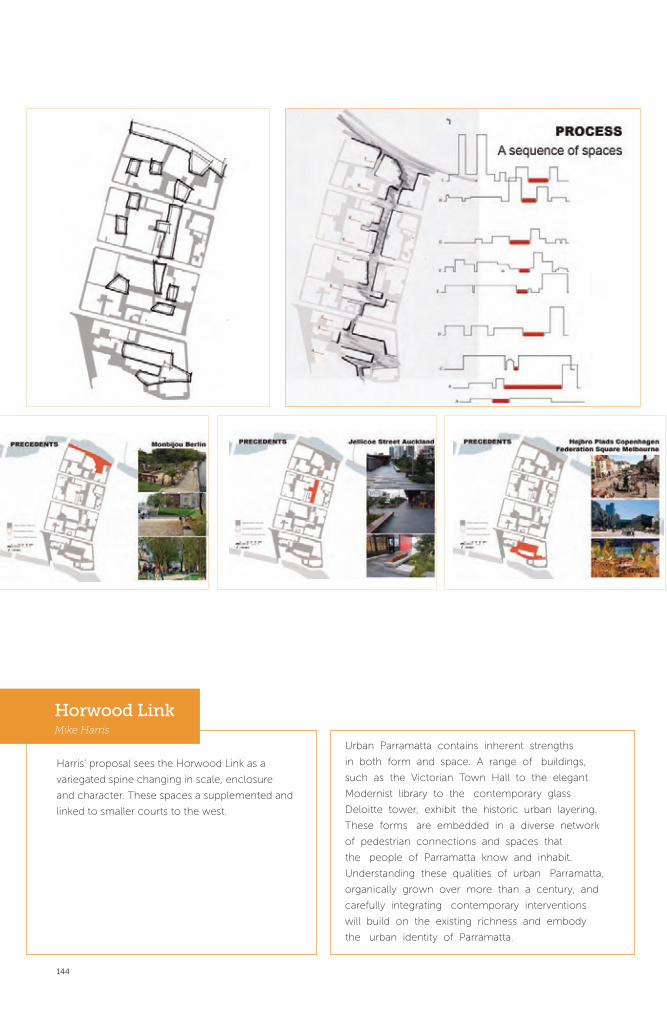
144
Harris’ proposal sees the Horwood Link as a
variegated spine changing in scale, enclosure
and character. These spaces a supplemented and
linked to smaller courts to the west.
Urban Parramatta contains inherent strengths
in both form and space. A range of buildings,
such as the Victorian Town Hall to the elegant
Modernist library to the contemporary glass
Deloitte tower, exhibit the historic urban layering.
These forms are embedded in a diverse network
of pedestrian connections and spaces that
the people of Parramatta know and inhabit.
Understanding these qualities of urban Parramatta,
organically grown over more than a century, and
carefully integrating contemporary interventions
will build on the existing richness and embody
the urban identity of Parramatta.
Horwood LinkMike Harris

145
Zolghadr envisages a series of green mid-block oases;
residential, education and civic, providing verdant
respite from the hard surfaces of the main streets and
leading to an extensive intense river park, active day
and night.
Horwood LinkGhazal Zolghadr
Proposal Description
Parramatta’s city centre vision: To no longer be just
a combination of oversize parking buildings, blank
facades and back lanes. It will be an integrated
network of open spaces connected by walking and
cycling through green and active footpaths. A place
for people, with buildings that open out to the streets
and engage people. There will be cafés, outdoor
dining, shopping, entertainment, places where people
can linger, sit, have a coffee and connect.
The public realm will culminate at the river, linked
to the water with a focus on activities, sports, cafés,
restaurants and green space.
Parramatta’s city centre will be a safe, vibrant place for
cultural activities, street theatre, fine views and interesting
facades. It will be a lively, diverse and safe place for people
to move around in and create beautiful memories.

146
McMaster sees the Horwood alignment as a high-
density pedestrian spine of commercial office
premises on both sides. Although there will be some
significant overshadowing of the spine itself, solar
access will be preserved in mid-block open spaces
by lower scale development to the west. In addition,
the shaded spine will be pleasant midsummer and
the idea is to have people moving through and using
the whole city centre; a realistic objective given the
relatively intimate scale.
Reinforce Church Street as the main pedestrian spine
• encourage movement between the civic core,
riverfront, theatre and station
• public domain is already of a high standard
• create a new civic core which interacts with the Church
Street spine and promote development of Horwood
Place as the commercial/mixed use city spine
• provision for high density
• create links with Church Street
• residential/mixed use function to waterfront
The common monotony of commercial office
precincts is avoided by the retention of heritage
buildings and the unexpected on the Horwood
alignment adjacent to other more intimate spaces as
well as the nearby active strip of Church Street.
Horwood AlignmentKrista McMaster

147
Additional fine grain mid-block subdivisions The growth in population of residential and
workers should make the smaller lanes viable (left)
and reduce the concentration on Church Street
Whiteley argues the need for a doubling of active
frontage by utilising the inside of blocks —‘the soft
centre’ — as well as the need for a significant increase
in ways to move through and around the city centre
with the possible tripling of the total number of people
living and working in the centre.
The Soft CentreChristiane Whiteley

PART 4 /
PARRAMATTA CITY CENTRE
PUBLIC DOMAIN FRAMEWORK
PLAN 2012148

PART 4 /
PARRAMATTA CITY CENTRE
PUBLIC DOMAIN FRAMEWORK
PLAN 2012149

150
“ ...we need to get the design right, we need to think carefully about the small scale, the human scale, the fine grain. This is as much about the big picture of what building and what architecture can bring to us.” Public Interview
Dr Robert LangChief Executive Officer
Parramatta City Council

151
Parramatta City Centre Public Domain Framework Plan 2012
The Parramatta City Centre Public Domain Framework Plan 2012 is a
new plan that has been generated as a result of the Design Parramatta
initiative. It combines the Design Parramatta projects, with ongoing
public domain projects to provide a unified framework to guide the
renewal of the Parramatta city centre public domain for the next
16 years. Key elements of the plan include:
• incorporation of the proposals and strategies identified for the each
of the streets, lanes, public spaces and parks included in the Design
Parramatta initiative;
• activation projects for short term improvements and seasonal events
including new kiosks and shelters;
• continued upgrade of city streets including new pavement, street
furniture and street trees in accordance with the Parramatta Public
Domain Guidelines and the Parramatta Street Tree Masterplan;
• continued upgrade of city lanes as described in the Parramatta City
Centre Lanes Strategy and the Parramatta Public Domain Guidelines;
• continued integration of public art into public domain upgrades either as
individual commissioned elements and/or through embedding of the
artistic approach into design responses and detailing; and
• additional strategic projects including Parramatta Square, a future
civic space for the city centre; the upgrade of Church Street in
addition to Project 8, Church Street Mall, and the upgrade of the
entire City Foreshore Area.
Design Parramatta has provided a new focus for
Parramatta City’s program of urban renewal. The concept
designs generated present the City with the opportunity
to embark on 15 strategic public domain projects and
combined with existing strategies, further contribute
to revitalising the city centre as a whole. Together, the
proposed interventions have the potential to improve
both the physical fabric of the city centre and the ways
in which it can be used by the community.

Ch
urc
h S
tree
t
Clay Cli� Creek Parklands
George St
Par
ram
atta
Cit
y R
ing
Rd
Phillip St
Macquarie St
1
2
4
5
6
7
8
10
11
12
13
14
15
9
Sheila hand drawn Plan
Option 2 Side Platform
George Street will be reinstated as Parramatta’s
pre-eminent civic street.
Macquarie Street will become a tree-lined transit
boulevard.
1
Erby Place and Lane 13 will become an animated
pocket park and community hub.
13
Wentworth Car Park and Lanes will become an
activated multi-modal transport interchange.
14
Batman Walk will become a lively pocket square
with artwork seat.
15
Artworks For Lonely Laneways A series of
sculptures objects which respond to people
A
Site Two, Macquarie Lane - Old Eyes / New EyesA Space For Urban Follies A framework for artistic
installations focusing on sensory experience.
BD a r c y S t r e e t , r a i l w a y b r i d g e
design parramatta - mulloway studio + ernest edmonds - september 2012
Parranet Artworks to activate blank walls with colour
and images.
C
A Place in the Sun An invitation to celebrate sitting
in the sun.
D
2PARRAMATTA CITY CENTRE PUBLIC DOMAIN FRAMEWORK PLAN 2012

PARRAMAT TAChurch Street Mall
TEAMLacoste + StevensonToko. Concept. DesignDaryl Jackson Robin DykeJMD DesignPamela Mei-Leng See
Concept 01
Night Cinema
Charles Street Square will activate Parramatta
wharf and the river’s edge.
thank you
River Square will become a grand event square
drawing people to the river.
25 / 25
ch
arl
es
stre
et
squ
are
Church Street Mall will be a lively public square
with gardens.
Horwood Avenue Civic Link will connect major
spaces and streets.
Clay Cliff Creek Parklands will expand Jubilee Park into
a natural green recreational haven.
Smith and Station streets will be civilised
with seating, shade and rain gardens.
5
6
7
8
9
10
Ch
urc
h S
tree
t
Clay Cli� Creek Parklands
George St
Par
ram
atta
Cit
y R
ing
Rd
Phillip St
Macquarie St
1
2
4
5
6
7
8
10
11
12
13
14
15
9
Design tactics Street-side parking is inhabited for night and weekend uses
Phillip Street will become an event promenade linking
River Square, Parramatta Stadium and the wharf.
Parramatta Ring Road will become a distinct city
entrance.
Barrack Lane will be enlivened by urban play elements
and engaging with Arthur Phillip High School.
12
Freemason Arm’s Lane will become a focus for local
culture.
11
3 4

154
COMMUNITY ENGAGEMENT AND ACTIVATION
Community use is central to improving Parramatta city centre’s public
domain. Activation can be encouraged in a variety of ways including both
short-term targeted events and longer term design improvements. While
a short-term event can be used either as a quick fix or to test different
approaches; design improvements generally focus on redressing the physical
barriers which inhibit activation. Often the two strategies are best used
together, with designers engaged to ameliorate spatial issues, which can then
be overlaid with targeted events.
Meaningful involvement and engagement of the local community is critical to
ensuring ongoing use of the city centre’s public domain. Many of the Design
Parramatta teams engaged with the local community and their findings
helped shape the designer’s response. The Parramatta Ring Road, Church
Street Mall, Clay Cliff Creek Parklands, Freemason’s Arms Lane, Wentworth
Carpark Lanes Network, Erby Park and Lane 13 and Phillip Street projects
each include proposals for further community engagement as part of design
development.
THE NEXT STEPS
Consultation
A rigorous consultation process would form the immediate next step for
further development of all the Design Parramatta projects. The concept
proposals for the individual sites have been well illustrated and modelled,
5. HTTP://FORECAST2.ID.COM.AU/DEFAULT.ASPX?ID=265&PG=5210
Parramatta is ...
84%SPEAK ENGLISH + ANOTHER LANGUAGE
OF PEOPLE (CBD) BORN OVERSEAS
50%OF PEOPLE (CBD) BORN
#2LGA IN SYDNEY (2010)
RAPIDLY EVOLVING 85.9%
OF BUSINESSES HAVE 1-4 EMPLOYEES) 5
ENTRE- PRENEURIAL
MULTI-CULTURAL
35.2% OF PEOPLE ARE AGED
25-34 YRS
YOUNG
GLOBALLY CONNECTED
Parramatta’s Population

155
providing an excellent platform for further engagement of Council
and the community. Additional mediums such as the Design
Parramatta website and the Design Parramatta film will also help
in broadcasting these ideas by increasing the ease with which
the community can engage with both project and the process of
revitalising the public spaces of their city centre.
Prioritisation Plan
Council will develop a 16 year plan to select and develop preferred
public domain projects from the Parramatta City Centre Public
Domain Framework Plan 2012 and apportion funding. The
prioritisation plan will run on four year cycles and be reviewed
every 4 years to align with Council’s Delivery Program.
Once a project has been scheduled for further work the following
steps are involved:
• consultation with the Community, Councillors and relevant
technical experts;
• design Development leading to an approved project plan;
• design Documentation resulting in detailed technical plans and
specifications;
• tendering of the works;
• construction; and
•ongoing management and maintenance of the places.
Consultation, design and technical expertise will be necessary
components of all these stages. The Parramatta Public Domain
Framework Plan 2012 will enable Council to undertake a
coordinated approach to the upgrade and revitalisation of the city
centre’s public domain in partnership with Government bodies,
the private sector and the community.

PART 5 /
CREDITS
156

PART 5 /
CREDITS
157

158
TeamsTEAMS FIRM / ORGANISATION INDIVIDUALS
Project Team Parramatta City Council – Urban Design Unit Kati Westlake
Parramatta City Council – Place Services Steve Ellis
Parramatta City Council – Urban Design Unit Andrew Tam
Government Architect’s Office Callantha Brigham
Government Architect’s Office Helen Lochhead
Government Architect’s Office Marietta Buikema
Workshop Team Parramatta City Council – Urban Design Unit Penny Bowen
Parramatta City Council – Place Services Robyn Hobbs
Parramatta City Council – Place Services Angie Paravalos
Parramatta City Council – Place Services Anthony Budini
Parramatta City Council – Place Services Anthony Milward
Parramatta City Council – Place Services Bruce Mills
Parramatta City Council – Place Services Eleni McRae
Parramatta City Council – Place Services Geoff Weston
Parramatta City Council – Place Services Sandra DaSilva
Parramatta City Council – Place Services Neile Robinson
Parramatta City Council – Place Services Wendy Read
Workshop Panelists Parramatta City Council Kati Westlake
Government Architect’s Office Helen Lochhead
Government Architect’s Office Peter Poulet
University of New South Wales James Weirick
University of Sydney Rod Simpson
Graphic Design - website Doppio Sinead McDevitt
Doppio Ali Ozden
Film Crew Director / Producer Carli Leimbach
Camera Operator / Editor Shaun Dougherty
Editor Cris Balmaceda Errazuriz
Sound Eren ‘Pinky’ Sener
Sound Sam Ada
Project Control Group Parramatta City Council Sue Weatherley
Parramatta City Council Scott Gregg
Parramatta City Council Geoff King
Parramatta City Council David Gray
Parramatta City Council Richard Searle
Parramatta City Council Amitabha Choudhury
Parramatta City Council Peter Lichaa
Parramatta City Council Jim Stefan
Parramatta City Council Andy Ling
Parramatta City Council Mark Leotta
Parramatta City Council James Smallhorn
Parramatta City Council Kim Foskett

159
TEAMS FIRM / ORGANISATION INDIVIDUALS
Parramatta City Council Adam Cook
Parramatta City Council Rebecca Grasso
Parramatta City Council Solaire Eggert
Parramatta City Council Vanessa Villa
Parramatta City Council Jennifer Concato
Parramatta City Council Helen Papathanasiou
Parramatta City Council Alison McDonagh
Parramatta City Council Michelle Desailly
Parramatta City Council Sophia Kouyoumdjian
Barrack Lane G.O.L.D. (Group of Like Minded Designers) Rebecca Caldwell
G.O.L.D. (Group of Like Minded Designers) Ash Every
G.O.L.D. (Group of Like Minded Designers) Regina Kaluzny
G.O.L.D. (Group of Like Minded Designers) Tersius Maass
G.O.L.D. (Group of Like Minded Designers) Phillip Nielsen
G.O.L.D. (Group of Like Minded Designers) Katie O’Brien
Batman Walk Andrew Burns Architect Andrew Burns
Artist Brook Andrew
Blank Canvas A Push Play Nuala Collins
Push Play Kelly Doley
Push Play Nadia Wagner
Push Play Charlotte Karlsson
Blank Canvas B Mulloway Studio Anthony Coupe
Mulloway Studio Esther Chew
Mulloway Studio James Baker
Artist Ernest Edmonds
Blank Canvas C Studio Damien Butler Damien Butler
Blank Canvas D Old Eyes / New Eyes Nikki Butlin
Old Eyes / New Eyes Asha Tsimeris
Old Eyes / New Eyes Patrick Stein
Old Eyes / New Eyes Louie Lester Yao
Old Eyes / New Eyes Janet Thomson
Old Eyes / New Eyes Ann Cleary
Old Eyes / New Eyes Robert Thorne
Charles Street Square Context Landscape Design Oi Choong
Zoe Spiegel Zoe Spiegel
CM+ Richard Nugent
Urban Art Projects Daniel Tobin
Heritage Advisor Craig Burton

160
TEAMS FIRM / ORGANISATION INDIVIDUALS
Church Street Mall -
Short Term Project
JMD Design Anton James
Lacoste + Stevenson Architects Thierry Lacoste
Lacoste + Stevenson Architects David Stevenson
Daryl Jackson Robin Dyke Emma Howarth
Toko. Concept. Design. Michael Lugmayr
Toko. Concept. Design. Eva Dijkstra
Artist Pamela See
Clay Cliff Creek Parklands GAO Landscape Architecture Barbara Schaffer
GAO Landscape Architecture Luke Wistencroft
Parramatta City Council Landscape Architecture Kim Foskett
Parramatta City Council Landscape Architecture Adam Cook
Parramatta City Council Landscape Architecture Alastair Hickey
Parramatta City Council Landscape Architecture John Graham
Equatica Alexa McAuley
Lightwell Michael Hill
Erby Park and Lane 13 DRAW Adam Russell
DRAW Imogene Tudor
DRAW Edward Rosier
Tyrrellstudio Mark Tyrrell
Tyrrellstudio Dan Sharp
Dr Lee Stickells
Dr Zanny Begg
Freemason’s Arms Lane The Lot Adriano Pupilli
The Lot Heidi Axelsen
The Lot Hugo Moline
George Street Hill Thalis Architecture + Urban Projects Philip Thalis
Hill Thalis Architecture + Urban Projects Sheila Tawalo
Hill Thalis Architecture + Urban Projects Alex Rink
Jane Irwin Landscape Architecture Jane Irwin
Jane Irwin Landscape Architecture Linden Crane
Jane Irwin Landscape Architecture Sam Westlake
Turpin + Crawford Studio Jennifer Turpin
Turpin + Crawford Studio Michaelie Crawford
Horwood Avenue
Civic Link
Gallagher Ridenour Urban & Landscape Projects Libby Gallagher
Gallagher Ridenour Urban & Landscape Projects Deena Ridenour
Gallagher Ridenour Urban & Landscape Projects Jane Nalder
Redshift Architecture & Art Angelo Konrsanos
Redshift Architecture & Art Michael Lewarne
Redshift Architecture & Art Wesley Grunsell
Equatica Richard McManus

161
TEAMS FIRM / ORGANISATION INDIVIDUALS
Macquarie Street Cox Richardson Architects and Planners John Richardson
Cox Richardson Architects and Planners Ian Connolly
Cox Richardson Architects and Planners Joe Rowling
Cox Richardson Architects and Planners Shirin Adorbehi
Oculus Roger Jasprizza
Oculus Simon Bond
Parsons Brinkerhoff Scott Ney
Parramatta City Ring Road TERROIR Gerard Reinmuth
TERROIR Scott Balmforth
TERROIR Teneil van Dyck
TERROIR Malina Brueckner
ASPECT Studios Sacha Coles
ASPECT Studios Orit Meylakh
u.lab, University of Technology Sydney Dr Joanne Jakovich
u.lab, University of Technology Sydney Dr Jochen Schweitzer
u.lab, University of Technology Sydney Vida Asrina
Richard Goodwin Pty Ltd Professor Richard Goodwin
Richard Goodwin Pty Ltd Samaneh Moafi
Phillip Street HASSELL Ken Maher
Matthew Pullinger
David Tickle
Sarah Meyer
Felicity Stewart
Anton Grimes
River Square Andersen Hunter Horne Jeppe Aagaard Andersen
Andersen Hunter Horne Mike Horne
Andersen Hunter Horne Adam Hunter
Roberts Day Stephen Moore
Equatica Alexa McAuley
Electrolight Don Salisbury
Smith and Station Streets
Greening
Nobbs Radford Architects Alison Nobbs
Nobbs Radford Architects Sean Radford
Nobbs Radford Architects Cecile Marguin
Carmichael Studios Rupert Carmichael
Artist Suzie Idiens
Wentworth Car Park BKK Architects Tim Black
BKK Architects George Huon
Glas Urban Design & Landscape Architecture Mark Gillingham
Renew Australia Marcus Westbury
Electrolight Paul Beale
Peter Emmett

162
References NAME PAGE ATTRIBUTE
Project sites p14 Parramatta City Council
Urban design analysis
Series 2012-10-21 Parramatta City Council
p18 Parramatta City Council
Photo from Design Parramatta Workshops p21-27 Parramatta City Council
Design Parramatta Plan p30 Parramatta City Council and Doppio Design
Main Streets Diagram p32 Parramatta City Council /Doppio Design/
Government Architetct’s Office
George Street Analysis and Proposal Images p33-39 George Street Project Team
Macquarie Street Analysis and Proposal Images p40-45 Macquarie Street Project Team
Phillip Street Analysis and Proposal Images p46-49 Phillip Street Project Team
Parramatta City Ring Road Analysis and Proposal Images p50-55 Parramatta City Ring Road Project Team
Public Space and Parks Projects Diagram p56 Parramatta City Council /Doppio Design/
Government Architect’s Office
River Square Analysis and Proposal Images p58-63 River Square Project Team
Charles Street Square Analysis and Proposal Images p64-69 Charles Street Project Team
Horwood Avenue Civic Link Analysis and Proposal Images p70-75 Horwood Avenue Civic Link Project Team
Church Street Mall
Analysis and Proposal Images
p76-83 Church Street Project Team
Clay Cliff Creek Parklands Analysis and Proposal Images p84-89 Clay Cliff Creek Parklands Project Team
Smith and Station Streets Analysis and Proposal Images p90-95 Smith and Station Streets Project Team
Lanes Projects Diagram p96 Parramatta City Council /Doppio Design/
Government Architect’s Office
Freemason’s Arms Lane p98-105 Freemason’s Arms Lane Project Team
Barrack Lane p106-109 Barrack Lane Project Team
Erby Place and Lane 13 p110-115 Erby Place and Lane 13 Project Team
Wentworth Car Park and Lanes p116-121 Wentworth Car Park and Lanes Project Team
Batman Walk p122-125 Batman Walk Project Team
Art and Experimental Projects Diagram p126 Parramatta City Council /Doppio Design/
Government Architect’s Office
Lonely Laneways p128 Lonely Laneways Project Team
A Space for Urban Follies p130 A Space for Urban Follies Project Team
Parra-net p132 Parra-net Project Team
A Place in the Sun p134 Push Play Project Team
Student Projects P138-147 University of Sydney Urban Design Studio
2012
Parramatta City Centre Public Domain Framework Plan 2012 p152-153 Parramatta City Council/Doppio Design/
Government Architect’s Office and all project
teams
Parramatt’s Population p154 HASSELL
Cover front and back Parramatta City Council

163


166