designing a geo-ecology and education nature trail by florian hopp (north america)
TRANSCRIPT

Research Report
Designing a Geo-Ecology and Education
Nature Trail
by Florian Hopp
September 25th
, 2014
Place: Sechelt Sand & Gravel Mine
Lehigh Material
5784 Sechelt Inlet Road
Sechelt, British Columbia, V0N 3A0
Canada
Company: Lehigh Hanson Materials Ltd.
Contact persons: Mr. Thomas Chizmadia, Ms. Sophie Mullen, Mr. Gabe Morrelli
Florian Hopp II
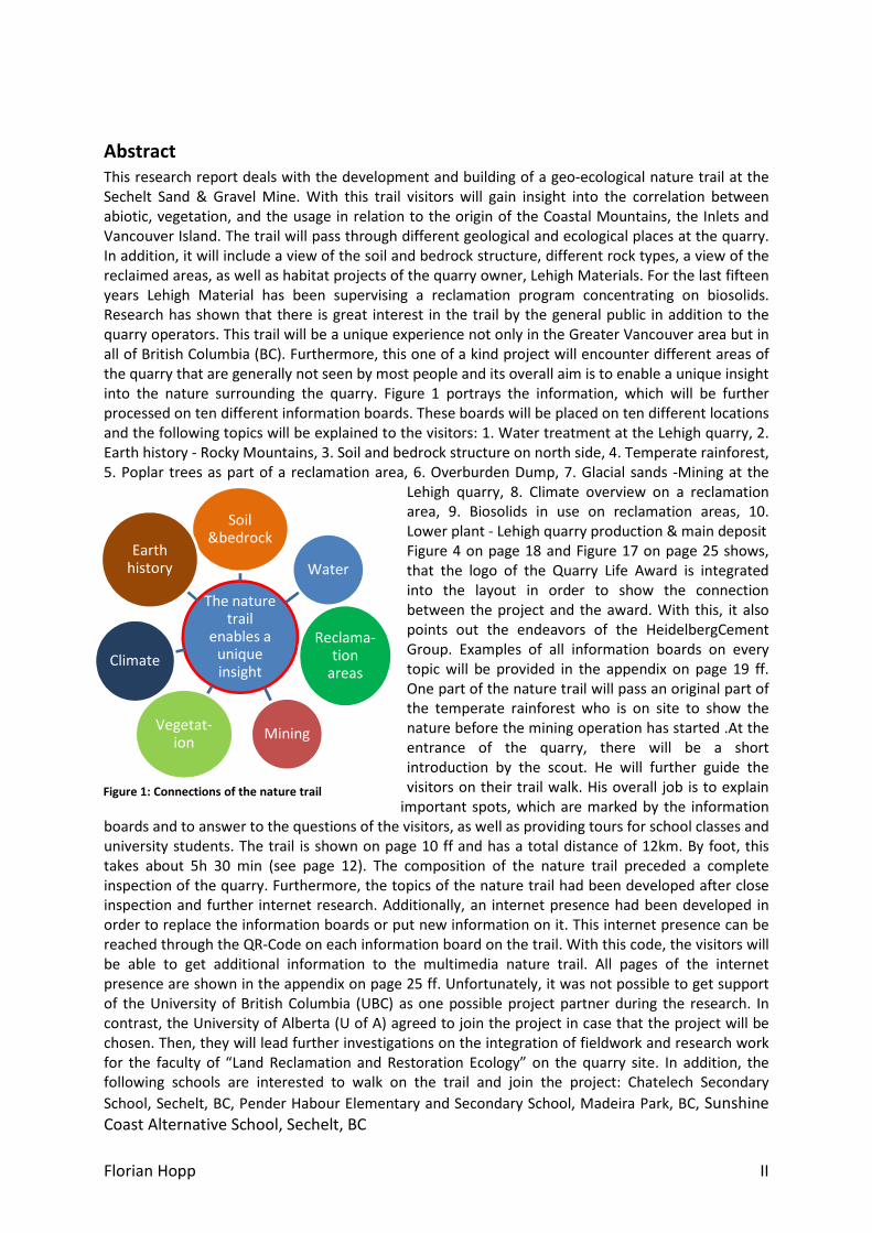
The nature trail
enables a unique insight
Soil &bedrock
Water
Reclama-tion
areas
MiningVegetat-
ion
Climate
Earth history
Abstract
This research report deals with the development and building of a geo-ecological nature trail at the
Sechelt Sand & Gravel Mine. With this trail visitors will gain insight into the correlation between
abiotic, vegetation, and the usage in relation to the origin of the Coastal Mountains, the Inlets and
Vancouver Island. The trail will pass through different geological and ecological places at the quarry.
In addition, it will include a view of the soil and bedrock structure, different rock types, a view of the
reclaimed areas, as well as habitat projects of the quarry owner, Lehigh Materials. For the last fifteen
years Lehigh Material has been supervising a reclamation program concentrating on biosolids.
Research has shown that there is great interest in the trail by the general public in addition to the
quarry operators. This trail will be a unique experience not only in the Greater Vancouver area but in
all of British Columbia (BC). Furthermore, this one of a kind project will encounter different areas of
the quarry that are generally not seen by most people and its overall aim is to enable a unique insight
into the nature surrounding the quarry. Figure 1 portrays the information, which will be further
processed on ten different information boards. These boards will be placed on ten different locations
and the following topics will be explained to the visitors: 1. Water treatment at the Lehigh quarry, 2.
Earth history - Rocky Mountains, 3. Soil and bedrock structure on north side, 4. Temperate rainforest,
5. Poplar trees as part of a reclamation area, 6. Overburden Dump, 7. Glacial sands -Mining at the
Lehigh quarry, 8. Climate overview on a reclamation
area, 9. Biosolids in use on reclamation areas, 10.
Lower plant - Lehigh quarry production & main deposit
Figure 4 on page 18 and Figure 17 on page 25 shows,
that the logo of the Quarry Life Award is integrated
into the layout in order to show the connection
between the project and the award. With this, it also
points out the endeavors of the HeidelbergCement
Group. Examples of all information boards on every
topic will be provided in the appendix on page 19 ff.
One part of the nature trail will pass an original part of
the temperate rainforest who is on site to show the
nature before the mining operation has started .At the
entrance of the quarry, there will be a short
introduction by the scout. He will further guide the
visitors on their trail walk. His overall job is to explain
important spots, which are marked by the information
boards and to answer to the questions of the visitors, as well as providing tours for school classes and
university students. The trail is shown on page 10 ff and has a total distance of 12km. By foot, this
takes about 5h 30 min (see page 12). The composition of the nature trail preceded a complete
inspection of the quarry. Furthermore, the topics of the nature trail had been developed after close
inspection and further internet research. Additionally, an internet presence had been developed in
order to replace the information boards or put new information on it. This internet presence can be
reached through the QR-Code on each information board on the trail. With this code, the visitors will
be able to get additional information to the multimedia nature trail. All pages of the internet
presence are shown in the appendix on page 25 ff. Unfortunately, it was not possible to get support
of the University of British Columbia (UBC) as one possible project partner during the research. In
contrast, the University of Alberta (U of A) agreed to join the project in case that the project will be
chosen. Then, they will lead further investigations on the integration of fieldwork and research work
for the faculty of “Land Reclamation and Restoration Ecology” on the quarry site. In addition, the
following schools are interested to walk on the trail and join the project: Chatelech Secondary
School, Sechelt, BC, Pender Habour Elementary and Secondary School, Madeira Park, BC, Sunshine
Coast Alternative School, Sechelt, BC
Figure 1: Connections of the nature trail

Florian Hopp III
Table of Contents
Abstract ...................................................................................................................................... II
List of abbreviations .................................................................................................................. IV
Table of illustrations ................................................................................................................... V
Introduction ................................................................................................................................ 1
Objectives ................................................................................................................................... 1
Background Information ............................................................................................................ 2
Methods ..................................................................................................................................... 3
Results ........................................................................................................................................ 5
Discussion ................................................................................................................................... 7
Conclusion .................................................................................................................................. 8
Appendix ..................................................................................................................................... 9
Index ......................................................................................................................................... 29

Florian Hopp IV
List of abbreviations
BC British Columbia
UBC University of British Columbia, Vancouver
U of A University of Alberta, Edmonton
SIB Sechelt Indian Band
dt dry tonne
ha hectares
km kilometer
h hours
min minutes

Florian Hopp V
Table of illustrations
Figure 1: Connections of the nature trail ................................................................................... II
Figure 2: Final nature trail with positions of the information boards ..................................... 10
Figure 3: Final trail with contour line ....................................................................................... 11
Figure 4: Start board at the nature trail entrance ................................................................... 18
Figure 5: Board with trail overview at the start position ......................................................... 18
Figure 6: Board 1 - Water Treatment at the Lehigh quarry ..................................................... 19
Figure 7: Board 2a - Earth History - Rocky Mountains ............................................................. 19
Figure 8: Board 2b - Earth History - Rocky Mountains ............................................................. 20
Figure 9: Board 3 - Soil and bedrock structure on north side .................................................. 20
Figure 10: Board 4 – Temperate Rainforest ............................................................................. 21
Figure 11: Board 5 - Poplar trees as part of a reclamation area .............................................. 21
Figure 12: Board 6 – Overburden Dump .................................................................................. 22
Figure 13: Board 7 - Glacial sands - Mining at the Lehigh quarry ............................................ 22
Figure 14: Board 8 - Climate overview on a reclamation area ................................................. 23
Figure 15: Board 9 - Biosolids in use for a reclamation area ................................................... 23
Figure 16: Board 10 - Lower plant - Lehigh quarry production & main deposit ...................... 24
Figure 17: Signpost of the trail ................................................................................................. 25
Figure 18: Front page of the internet presence ....................................................................... 25
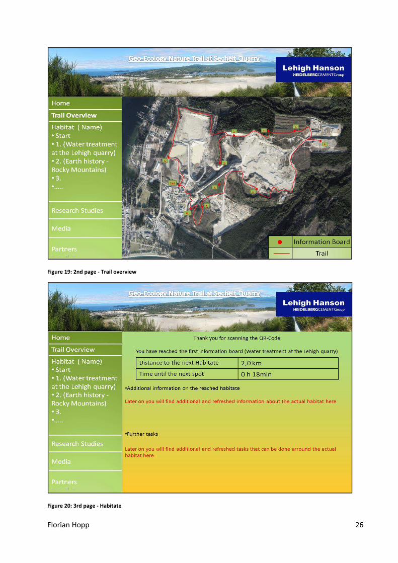
Figure 19: 2nd page - Trail overview ........................................................................................ 26
Figure 20: 3rd page - Habitate ................................................................................................. 26
Figure 21: 4th page - Research studies .................................................................................... 27
Figure 22: 5th page - Media ..................................................................................................... 27
Figure 23: 6th page – cooperating institutions ........................................................................ 28
Photograph 1: Start position of the trail .................................................................................. 13
Photograph 2: Position of the start board close to the main office ........................................ 13
Photograph 3: Trail between start board and 1st information board ..................................... 13
Photograph 4: Trail on the north side between information board one and two................... 13
Photograph 5: Trail between board 1 & 2 with view of the lower plateau ............................. 13
Photograph 6: Trail short before board 2 on the Northcope Upper Slope ............................. 14
Photograph 7: Trail between board 2 & 3 on the Northcote Upper Slope.............................. 14
Photograph 8: Position of board 3 below the North slope ...................................................... 14
Photograph 9: Position of board 4 at the temperate rainforest .............................................. 14
Photograph 10: Position of board 5 at the poplar reclamation area ....................................... 14
Photograph 11: Trail between the poplar rows ....................................................................... 14
Photograph 12: Planned trail breakthrough to reach board 6 at the end of the poplar row . 15
Photograph 13: Position of board 6 above the overburden dump ......................................... 15
Photograph 14: Trail to board 7 at the upper plateau ............................................................. 15
Photograph 15: Trail to board 8 at the upper plateau ............................................................. 15
Photograph 16: Trail to board 8 ............................................................................................... 15

Florian Hopp VI
Photograph 17: Position of board 8 at the Treangle reclamation area ................................... 15
Photograph 18: Position of board 9 at the south plateau reclamation area ........................... 16
Photograph 19: Biosolid cross-section close to board 9 .......................................................... 16
Photograph 20: South plateau reclamation area ..................................................................... 16
Photograph 21: Pond on south plateau reclamation area....................................................... 16
Photograph 22: Poplar trees at the south plateau reclamation area ...................................... 16
Photograph 23: South plateau reclamation area ..................................................................... 16
Photograph 24: Position of board 10 with view of the lower plant ........................................ 17
Photograph 25: Tree marking on the trail through the temperate rainforest ........................ 17
Photograph 26: Mr. Hopp while marking the trail ................................................................... 17
Photograph 27: Part of the marked trail at the temperate rainforest .................................... 17
Photograph 28: Part of the marked trail at the temperate rainforest .................................... 17
Photograph 29: End of the temperate rainforest trail ............................................................. 17
Photograph 30: Sample for a final information board ............................................................. 24
Table 1: Advantage and disadvantage of the geo-ecology and education nature trail ............. 7
Table 2: Time and distance for trail hike .................................................................................. 12

Florian Hopp 1
Introduction
A quarry is an intervention into the nature but it provides a unique view into the earth
history of British Columbia (B.C.).With the trail, this view will be accessible by public. The
insight into the formation history of the Rocky Mountains, as well as a history on climate,
flora and fauna will provide a better understanding of our environment. On the trail, there
are arrangements for reafforestation and installed habitants, which were created by Lehigh
Materials and demonstrate his environmental consciousness on the one hand and his own
efforts to reconstruct the unspoiled eco-system on the other hand. With the new
accessibility of the territory to school- and university students, it can be a great benefit for
school- and university programs. The mining company, named Lehigh Materials, is the main
operator of the mine in Sechelt, BC, Canada. While the research work was done from March
2014 to September 30th, 2014, the work on site was done from August 18th
, 2014 to August
22nd
, 2014. In the following research report “Designing a Geo-Ecology and Education nature
trail”, you will find a detailed description of all procedures and methods, which were
necessary within the construction of the Quarry Life Award on the topic of biodiversity and
education.
Objectives
The main purpose of this research project is to raise interest for the sector of biodiversity
and education and moreover to increase public relations. This nature trail will be the first
step to provide visitors with essential information on their environment and therefore help
to raise people’s awareness for environmental problems. For this reason, there are different
objectives chosen during the time of research. Undoubtedly, the most important subject will
be the trail route itself. For this, it is necessary to examine the total trail distance and the
estimated time to hike on it. On the route, the trail should pass all important locations and
also the reclamation areas on site. In addition, the information boards and the signposts
need intense preparation in advance. This includes a nice layout on the one hand, but
profound and comprehensive research information on the other hand. For this, a QR-Code
on each information board will connect the interactive boards with the further developed
web page. The establishment of the web page layout is another important objective within
the research project. In a last step, there must be a cooperation between the trail and the
surrounding universities and schools. Then, scouts will guide these groups of approximately
15 persons on this trail. One possibility to keep the information updated on the boards is to
incorporate schools and universities, which will provide further investigations throughout
the year. This will be done within course achievements and can be used to get more detailed
information on the nature trail in future.

Florian Hopp 2
Background Information
The Lehigh Sand & Gravel Mine is located in Sechelt, a small town at BC’s west coast. The
footprint of the quarry is over 250 hectares (ha) with over approximately 4 million tons of
products (sand and gravel) per year. A result, the Sechelt Mine is one of the largest
aggregate mines in Canada. With 57 employees, Lehigh’s Sechelt mine is not only one of the
largest employers on the Sunshine coast but also the largest employer of the local Sechelt
Indian Band (SIB).
By requesting terrain maps in advance, the operator Lehigh Material sent several maps
displaying contour lines, roads and soil structure to Germany. This made it possible to create
a first possible trail on a map as soon as the project has started in March. For a better
understanding of the local geology, the book Geology of British Columbia – A Journey
through Time – by Greystone Books was bought. In this book, the geology, as well as the
history change of the flora & fauna in BC over the past million years are described in detail.
After looking for more background information, the next task was to investigate the texts
that should be placed on the information boards. Until the actual visit in Sechelt, the topics
were still not definite. Especially the web page of the Environmental Government of BC was
very useful for creating the texts for the boards, because this web page described the
geological and the ecological structure of BC very well. With these information, it was easy
to investigate the bedrock of the whole area and on site. The bedrock was formed within the
period of the Mesozoic, which started 252,2 million years ago and ended 66 million years
ago. Being more specific, it is from the Jurassic period (201,3 - 145 million years ago) and the
Cretaceous period (145 - 66 million years ago). The mainly mined bedrock on site is granite.
The glacial sands on site are produced by glaciers that crushed the stones underneath when
the ice was moving forward. These glaciers were mainly in BC in the Late Wisconsinan
(25.000 - 10.000 years ago).
The texts for the water treatment, overburden dump and lower plant – Lehigh quarry are
prepared after a walk on site and further explanations by the main manager. In addition, the
internet was used to prepare the texts. To prepare the text for the information board with
the title „ Biosolids in use on reclamation areas“, the operation report from Lehigh Materials
with the title Lehigh Materials Sechelt Mine 2013 Operations Report and Cover Letter was an
important basis also in relation to get used to it and to become some background
information about the subject of matter before the actual visit on the quarry. The
preparation for the other five topics had been done by an independent internet enquiry. All
prepared information texts had then been placed on the layout of the educational nature
trail boards subsequent to the visit.
In addition to the layouts, final preparation was in March by contacting universities of this
area. The university should have the chance to do research as part of a course achievement
for their faculty on site. The UBC was the first choice because of their faculty “Earth, Ocean
and Atmospheric Sciences”. Moreover, this faculty was the most interesting, because of its
internal subjects, which would contribute to the research work of the project. After having e-
mail contact with the UBC, there was also to the aim to get in touch with other universities.
The next choice was to request the University of Alberta (U of A). Its faculty “Land
Reclamation and Restoration Ecology” also suits well to this project and possible research
work on site could be joined as part of a course achievement. This was also done because
Florian Hopp 3
the University of Applied Sciences in Bingen, Germany already had former cooperation with
the U of A.
Then, in August, the exploring expedition to Sechelt, BC in Canada has started. The first work
on site was the creation of a final trail with the prepared materials. This included the final
time for the hike, the final distance of the trail and the final positions and subjects for the
information boards.
Methods
After research, information boards will be placed on site. These boards provide information
on the different subjects concerning the Geo – Ecology and Education nature trail in Sechelt.
The layouts on every board are constructed in the same manner. On the very top, there is a
picture with the exact position of the single boards. The middle part provides information on
the different topics on this location. On the bottom, there is an indication to the Quarry Life
Award and the QR–Code. By scanning the QR–Code with a multimedia device (smartphone
or tablet), the visitor is able to connect with the nature trail website.
The board layouts including the texts, the missions, and the diagrams were developed by the
project team in the period from March to August and later being graphically converted by JD
Grafik Design. The final layouts of all information boards are shown in the appendix on page
18 ff. For a better understanding on how the final built board will look, there will be a
sample for a final information board out of aluminum on page 24. Aluminum boards were
chosen, because this material is stainless and easy to clean with water.
Besides the briefing by the scout at the beginning of every tour, the information boards at
the entrance also include additional information on safety- and behavior rules (See page 18).
The web page of the trail will include up–to-date and additional information and missions for
each location. At this moment, the web page is set up within six pages (see appendix page
25ff).
The participant will be forwarded to the front page of the website first. On this page, there is
an overview about all nature trail topics and a call number in order to book the tour. With
this procedure, it can be ensured and there will always be a guide on site in order to secure
the safety of all visitors.
The second page illustrates a map of the trail for providing a general overview and the exact
positions of the ten different information boards.
This is followed by the third page (see page 26). The visitor will be forwarded on this page by
scanning the QR-Code on each board. Here the visitor will get additional information and
missions, also as the distance and the approximate time to the next board. Page four is used
to report on further researches on the quarry. These are done by the operator Lehigh
Materials, as well as the partner schools and universities. The fifth page is titled media and
makes it possible to upload visitor pictures on site. In addition, events (for example open
days) can be published on this page.

Florian Hopp 4
The last page is used to show the cooperating institutions. Overall, on almost every page,
there is space for RSS – Feeds on the right hand side in order to publish up to date
information.
To ensure the security on site during the hike, there will be a special safety instruction
besides the general instruction about the topics on the nature trail. For example, this
includes the equipment (helmet and reflecting vests) that needs to be worn in order to
ensure the safety for each participant.
The visitors are also informed before their visit to wear hiking- or wellington boots.

Florian Hopp 5
Results
During research from March to September, the following results were achieved.
A layout for the webpage and the information boards were designed. The QR-Code can be
connected to the web page and the information boards. With the web page, the visitors are
able to get information before their actual visit. The complete web page layouts and their
functions are explained in the appendix page 25 ff.
According to the main layout, the information boards for the nature trail are designed by the
team. The layouts include a text with research information and missions for every topic and
location. On some locations, more information are needed so they won’t have missions for
the visitors on the board. These missions will be given in an oral explanation by the scout at
the end.
After research work on site in August, the trail includes the following ten topics.
1. Water treatment at the Lehigh quarry
2. Earth history - Rocky Mountains
3. Soil and bedrock structure on north side
4. Temperate rainforest
5. Poplar trees as part of a reclamation area
6. Overburden Dump
7. Glacial sands - Mining at the Lehigh quarry
8. Climate overview on a reclamation area
9. Biosolids in use on reclamation areas
10. Lower plant - Lehigh quarry production & main deposit
After the titles above were approved for the trail, the final layouts have been prepared
together with the final texts and missions. They are shown on page 18 ff.
To connect the topics with their positions on the trail, a detailed inspection of the trail was
obligatory. It was necessary to check whether all topics are connectable and integrable with
the operator and the main subject the “Geo - Ecology and Education nature trail“.
In addition, signposts for the trail were needed to mark it in order to find the information
boards. The signposts were created and can be seen in the appendix on page 25. The
signposts also have a connection to the Quarry Life Award as the dragonfly of their logo had
been used. It was essential to use bright and intense colors for the design in order to make it
apparent and eye-catching.
As the trail was planned by using maps before the actual visit, it was crucial to check and
correct the data for the trail in order to get the best route as possible with many interesting
positions about Geo – Ecology locations for the visitors. Also the positions of the information
boards were determined on this inspection.
The final trail is now displayed on page 10 ff in the appendix. On this map, the positions of
the information boards are marked with numbers. The numbers are corresponding with the
ten final topics.
A detailed overview on the route length and hiking time can further be seen at the table on
page 12. The final length of the trail is approx. 12,1km. The trail can be walked in 5h 30 min
including the period of time for explanations on every board, missions and breaks.

Florian Hopp 6
By expecting 3 to 4 bears on site at this time, it was not possible to walk the possible trail by
foot. Simply said, it was too dangerous for a European, who just knows bears from TV to
walk just with a Walki Talki. Therefore, a car was used to follow the trail and an estimated
time by foot was examined afterwards. Here an explanation of how it was done: The route
was followed by car with a speed of approx. 10km/h. Compared with the speed by food with
approx. 5km/h, the time had to be doubled as the doubled speed (comparison foot/car) was
driven. The kilometer counter in the car was used to get the distance between each
information board. Also the time was stopped on each information board position to know
the time compared to the distance. All this data was being converted in an excel sheet for
the final calculation.
The visit on site was also the chance to prepare the trail through the part of the temperate
rainforest as this will be part of the nature trail. As there had not been a trail before, the
trees of both sides of the future trail were marked by the participant Mr. Hopp and a worker
from the quarry. This can be seen on pictures in the appendix on page 17 ff.
As it was also part of the project to get a university within the area involved, the UBC in
Vancouver was contacted. Being more specific, the request was send to the faculty of “Earth,
Ocean and Atmospheric Sciences” asking for cooperation with the proposal of integrating
research works as part of their course achievements throughout the year.
Unfortunately, it was not possible to get the support of the UBC until the end of the research
study. In fact, this was the opportunity to contact the U of A in Edmonton, Alberta with the
same request at end of July. The U of A was chosen, because of a similar faculty, which also
goes well with the aim of this project. This is the faculty of “Land Reclamation and
Restoration Ecology“. The U of A was highly interested in the project but the period of time
was too short to integrate a possible course achievement or field research as part of their
faculty subjects.
In fact, this will be possible if the project will be chosen and this period of time can be
planned in advance. The faculty already ensured to the participant to help with content
questions concerning the information boards if it’s necessary.
Also, schools of the area of the quarry had been contacted. The moreover question was if
they would have interest on going to hike with their classes on such an education nature trail
and if they can integrate this as part of their school program. The e-mails were send directly
to the school principals. The contacted schools were:
• Langdale Elementary School, Gibsons, BC,
• Gibsons Elementary School, Gibsons, BC
• West Sechelt Elementary School, Sechelt, BC
• Madeira Park Elementary School, Madeira Park, BC
• Pender Habour Elementary and Secondary School, Madeira Park, BC
• Sunshine Coast Alternative School, Sechelt, BC
• Chatelech Secondary School, Sechelt, BC
Following schools expressed their interest in the trail:
• Chatelech Secondary School, Sechelt, BC
• Pender Habour Elementary and Secondary School, Madeira Park, BC
• Sunshine Coast Alternative School, Sechelt, BC

Florian Hopp 7
Discussion
The advantages and disadvantages of the nature trail are described in the following Table 1.
Table 1: Advantage and disadvantage of the geo-ecology and education nature trail
Advantages Disadvantages
Increase of the quarry acceptance in public The trail hike can only be done by a scout to
ensure the security on site
Increase of the public relations and public’s
awareness
Trail and information boards need to be
cleaned temporarily (because of vegetation
cover)
Educational support for school- and
university students
Explanation of the geology and ecology on
site
Low costs because most of the trail already
exists
The research period demonstrates that the operator of the quarry Lehigh Materials, as well
as public show great interest in such an educational nature trail. The trail is also a great
benefit, because of its uniqueness in the greater area of Vancouver and BC.
A quarry is an artificial intervention into the nature, but it allows a unique view into the
earth history of B.C. With this trail, this view can be accessed by public. It shows the primary
origin of the Rocky Mountains, the climate, the flora & fauna. What is even more important
during times of the environmental climate change is that visitors will have a better
understanding of their environment after coming to a visit at Sechelt quarry.
In sum, the trail will encounter the temperate rainforest, reclaimed area and habitats. In
particular, this project will depict on the ecological awareness and other reclamation
programs on site, for example the company Lehigh Material.
The accessibility for school- and university students as part of their school- and university
course achievements establishes the company as catalyst for more applied science research
in schools and public.

Florian Hopp 8
Conclusion
Despite the great distance, the realization of the research study was very successful. With
the developed measures during the research period, the operator has now all needed tasks
to move on and develop the educational nature trail. The layout of all information boards
and the webpage can be accessed in the final version. Not least, all routes for the nature trail
still exist because they follow existing roads. The trail only needs to be marked with the
developed signposts. The trail through the temperate rainforest is marked (see pictures on
page 17 ff) and also prepared with the help by members of the quarry. Only the trail at the
end of the poplar row reclamation area needs to be prepared with a breakthrough (see
picture on page 15). Otherwise, all structures for a successful realization are given by the
operator Lehigh Materials.
Seen in a larger context as well as within longer period of time, it is possible to gain
university support to join the project. A participation of the UBC is already planned as soon
as the trail is prepared and Lehigh Material or the HeidelbergCement Group will send an
official request to the university.
Until the end of this research study in September, the following schools expressed their
interest to hike on the nature trail:
• Chatelech Secondary School, Sechelt, BC
• Pender Habour Elementary and Secondary School, Madeira Park, BC
• Sunshine Coast Alternative School, Sechelt, BC
As there are summer vacations and a current teacher strike in BC until September 22nd
,
2014, the participant of the research is certain that more schools will join the next weeks.

Florian Hopp 9
Appendix
Final Trail .................................................................................................................................. 10
Final Trail (map with contour line) ........................................................................................... 11
Final timetable of the nature trail ............................................................................................ 12
Pictures of the trail route ......................................................................................................... 13
Nature Trail Information Boards .............................................................................................. 18
Signpost of the trail .................................................................................................................. 25
Internet presence of the nature trail ....................................................................................... 25

Florian Hopp 10
1.2.
3. 4.
5.
6.
7.
8.
9.
10.10.
Start
Final Trail
Information board
Trail
Figure 2: Final nature trail with positions of the information boards
N

Florian Hopp 11
Final Trail (map with contour line)
Information board
Trail
N
Figure 3: Final trail with contour line

Florian Hopp 12
Final timetable of the nature trail
Table 2: Time and distance for trail hike
Position Time Information board text Distance (km) Time to distance
Start 10:00:00 Introduction & safety advice 0,0 00:00:00
Welcome Hemet, reflecting vests, shoes 00:30:00
Walk 00:05:00
1 10:35:00 Water treatment at the Lehigh quarry 0,9
E,M 00:15:00
Walk 00:18:00
2 11:08:00 Earth history - Rocky Mountains 2,0
E,M 00:15:00
Walk 00:08:00
3 11:31:00 Soil and bedrock structure on north side 0,1
E,M 00:15:00
Walk 00:10:00
4 11:56:00 Temperated rainforest 1,4
E,M 00:15:00
Walk 00:16:00
5 12:27:00 Poplar trees as part of a reclamation 0,5
E,M 00:10:00
Walk 00:10:00
6 12:47:00 Overburden Dump 0,3
Lunch break 00:20:00
E,M 00:10:00
Walk 00:14:00
7 13:31:00 Glazial sands -Mining at the Lehigh quarry 1,6
E,M 00:15:00
Walk 00:20:00
8 14:06:00 Climate overview on a reclamation area 1,0
E,M 00:15:00
Walk 00:20:00
9 14:41:00 Biosolids in use for reclamtion 2,5
E,M 00:15:00
Walk 00:10:00
10 15:06:00 Lower plant - Lehigh quarry main deposit 0,7
E,M 00:10:00
Walk 00:10:00
End 15:26:00 Return to start point 1,1
Total 12,10 05:26:00
Legend: E,M Time for Explanation, Mission on each information board
Walk
Dated on 20.08.2014
Time for walk

Florian Hopp 13
Pictures of the trail route
Photograph 1: Start position of the trail
Photograph 2: Position of the start board close to the
main office
Photograph 3: Trail between start board and 1st
information board
Photograph 4: Trail on the north side between
information board one and two
Photograph 5: Trail between board 1 & 2 with view of
the lower plateau

Florian Hopp 14
Photograph 6: Trail short before board 2 on the
Northcope Upper Slope
Photograph 7: Trail between board 2 & 3 on the
Northcote Upper Slope
Photograph 8: Position of board 3 below the North
slope
Photograph 9: Position of board 4 at the temperate
rainforest
Photograph 10: Position of board 5 at the poplar
reclamation area
Photograph 11: Trail between the poplar rows

Florian Hopp 15
Photograph 12: Planned trail breakthrough to reach
board 6 at the end of the poplar row
Photograph 13: Position of board 6 above the
overburden dump
Photograph 14: Trail to board 7 at the upper plateau
Photograph 15: Trail to board 8 at the upper plateau
Photograph 16: Trail to board 8
Photograph 17: Position of board 8 at the Treangle
reclamation area

Florian Hopp 16
Photograph 18: Position of board 9 at the south plateau
reclamation area
Photograph 19: Biosolid cross-section close to board 9
Photograph 20: South plateau reclamation area
Photograph 21: Pond on south plateau reclamation
area
Photograph 22: Poplar trees at the south plateau
reclamation area
Photograph 23: South plateau reclamation area

Florian Hopp 17
Photograph 24: Position of board 10 with view of the
lower plant
Photograph 25: Tree marking on the trail through the
temperate rainforest
Photograph 26: Mr. Hopp while marking the trail
Photograph 27: Part of the marked trail at the
temperate rainforest
Photograph 28: Part of the marked trail at the
temperate rainforest
Photograph 29: End of the temperate rainforest trail

Florian Hopp 18
Nature Trail Information Boards
Figure 4: Start board at the nature trail entrance
Figure 5: Board with trail overview at the start position

Florian Hopp 19
Figure 6: Board 1 - Water Treatment at the Lehigh quarry
Figure 7: Board 2a - Earth History - Rocky Mountains

Florian Hopp 20
Figure 8: Board 2b - Earth History - Rocky Mountains
Figure 9: Board 3 - Soil and bedrock structure on north side

Florian Hopp 21
Figure 10: Board 4 – Temperate Rainforest
Figure 11: Board 5 - Poplar trees as part of a reclamation area

Florian Hopp 22
Figure 12: Board 6 – Overburden Dump
Figure 13: Board 7 - Glacial sands - Mining at the Lehigh quarry

Florian Hopp 23
Figure 14: Board 8 - Climate overview on a reclamation area
Figure 15: Board 9 - Biosolids in use for a reclamation area

Florian Hopp 24
Figure 16: Board 10 - Lower plant - Lehigh quarry production & main deposit
Photograph 30: Sample for a final information board

Florian Hopp 25
Signpost of the trail
Figure 17: Signpost of the trail
Internet presence of the nature trail
Figure 18: Front page of the internet presence
Florian Hopp 26
Figure 19: 2nd page - Trail overview
Figure 20: 3rd page - Habitate

Florian Hopp 27
Figure 21: 4th page - Research studies
Figure 22: 5th page - Media

Florian Hopp 28
Figure 23: 6th page – cooperating institutions
Florian Hopp 29
Index
Cannings, S., Nelson, J., & Cannings, R. (2011). Geology of British Columbia "A Journey
through Time". Greystone Books.
climatewna.com. (n.d.). Retrieved 08 27, 2014, from climatewna.com:
http://climatewna.com/climatewna_map/
empr.gov.bc. (n.d.). Retrieved 08 27, 2014, from empr.gov.bc:
http://www.empr.gov.bc.ca/Mining/Geoscience/SurficialGeologyandHazards/AggregateProj
ect/AggregateForum95/Pages/GeologyofSandGravelDeposits.aspx
empr.gov.bc.ca. (n.d.). Retrieved 08 27, 2014, from empr.gov.bc.ca:
http://www.empr.gov.bc.ca/Mining/Geoscience/SurficialGeologyandHazards/AggregateProj
ect/AggregateForum95/Pages/GeologyofSandGravelDeposits.aspx
extension.org. (n.d.). Retrieved 08 27, 2014, from extension.org:
https://www.extension.org/pages/70456/poplar-populus-spp-trees-for-biofuel-
production#.VAHc8qNHSIQ
geol.umd.edu. (n.d.). Retrieved 08 27, 2014, from geol.umd.edu:
http://www.geol.umd.edu/~piccoli/100/Image99.jpg
geology.com. (n.d.). Retrieved 08 27, 2014, from geology.com:
http://geology.com/rocks/granite.shtml
hellobc. (n.d.). Retrieved 08 27, 2014, from hellobc: http://www.hellobc.com/british-
columbia/about-bc/climate-weather.aspx
hww.ca. (n.d.). Retrieved 08 27, 2014, from hww.ca: http://www.hww.ca/en/where-they-
live/coastal-rainforest.html
iMapBC. (n.d.). Retrieved 08 27, 2014, from iMapBC:
http://webmaps.gov.bc.ca/imfx/imf.jsp?site=imapbc
Paleoportal. (n.d.). Retrieved 08 27, 2014, from Paleoportal: http://www.paleoportal.org/
School District 46 . (n.d.). Retrieved 09 08, 2014, from School District 46 :
http://www.sd46.bc.ca/index.php/schools
SYLVIS. (2013). Lehigh Materials Sechelt Mine 2013 Operations Report and Cover Letter.
Sechelt: SYLVIS.
ucmp.berkeley. (n.d.). Retrieved 08 27, 2014, from ucmp.berkeley:
http://www.ucmp.berkeley.edu/mesozoic/jurassic/jurassic.php