designing marine spatial planning legislation for
TRANSCRIPT
-1-
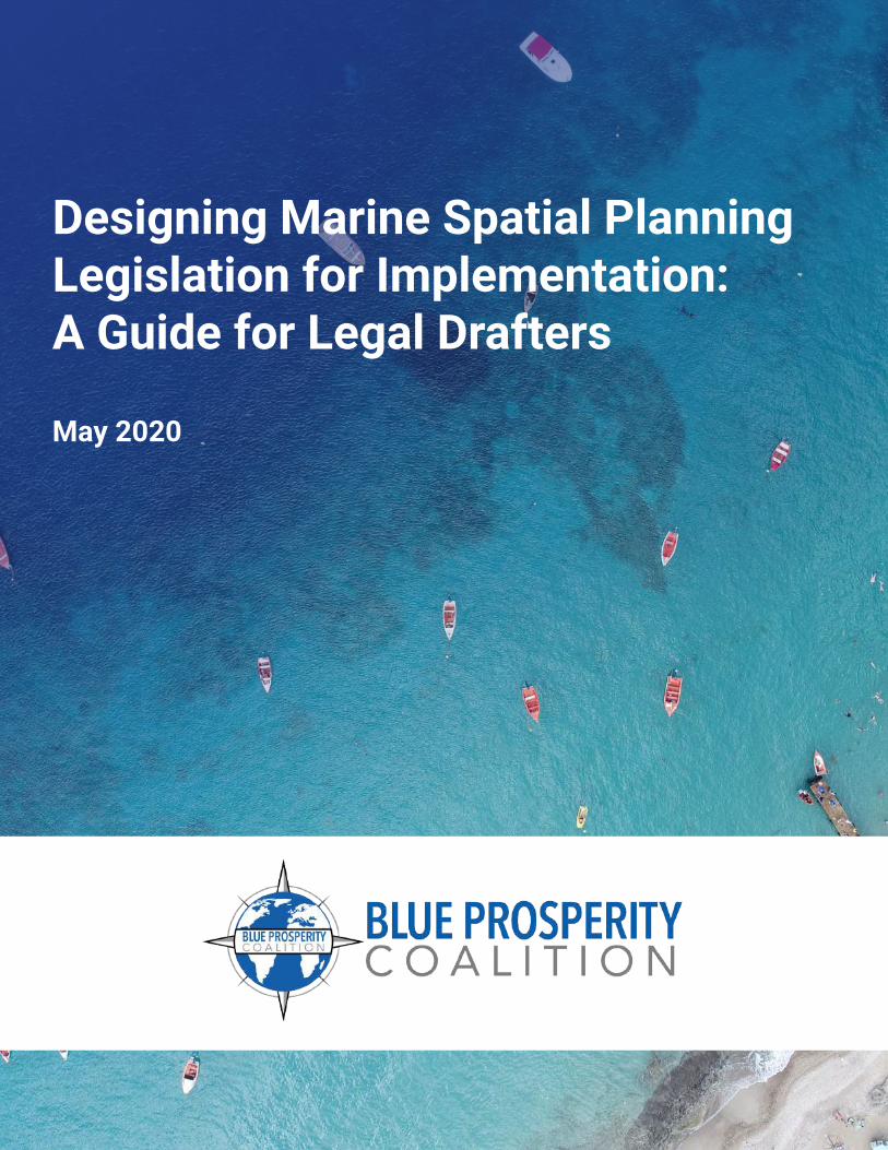
Designing Marine Spatial Planning Legislation for Implementation:A Guide for Legal Drafters
May 2020

-2-
Table of Contents
Acknowledgements 3Partners 4Introduction to this Guide 5Part I: Toward Marine Spatial Planning Legislative Frameworks 7Part II: Components of Marine Spatial Planning Legislation 11• Component 1: Preliminary 13• Component 2: Institutional & Administrative 21• Component 3: Marine Spatial Planning 26• Component 4: Public Participation & Access to Information 38• Component 5: Sustainable Funding 42• Component 6: Enforcement & Compliance 46• Component 7: Regulations & Miscellaneous 52• Component 8: Traditional Rights & Management 57Appendix A 59Appendix B 64

-3-
Acknowledgements
This document is a product of the Blue Prosperity Coalition. It was prepared by the Environ-mental Law Institute (ELI) and Animals | Environment PLLC (AELaw). The lead author was ELI’s Sofia O’Connor, with research assistance from Stephanie Oehler and drafting and editorial contributions by Bruce Myers from AELaw and Jay Austin from ELI.
The drafters wish to express their gratitude to the Waitt Institute, especially Kathryn Men-gerink and Vanessa Dick, for their ongoing input and support. A special thank you to all the presenters and other participants from the Blue Prosperity Workshop on Drafting Legislation to Support Marine Spatial Planning, conducted in Auckland, New Zealand in September 2019, for their invaluable feedback and insights. ELI is also grateful to IUCN Oceania, and Leanne Fernandes in particular, for help in organizing the workshop. Funding for this initiative was generously provided by the Waitt Foundation.
The contents of this report, including any errors or omissions, are solely the responsibility of ELI and AELaw. The authors invite corrections and additions. This document is an educational resource, and nothing contained herein is intended to serve as legal advice.
-4-
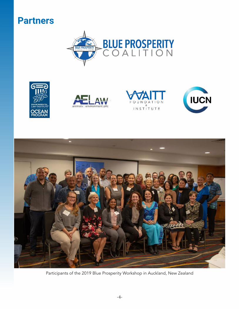
Partners
Participants of the 2019 Blue Prosperity Workshop in Auckland, New Zealand

-5-
Introduction to this GuideOcean and coastal states around the world are increasingly seeking to better utilize and benefit from their ocean environments, which can be vast in comparison to their land areas. Conflicting human uses, a changing climate, and a desire to ensure long-term sustainability compound the challenge to grow a robust “blue economy.” Consequently, countries are turning to marine spatial planning as a comprehensive management tool to assess and organize present uses of their ocean environments and map for future uses. A wealth of literature describes the importance of marine spatial planning and how it can be used to organize a country’s ocean activities. To date, little attention has been paid to how countries can give their marine spatial planning initiatives the force of law. Designing Marine Spatial Planning Legislation for Implementation: A Guide for Legal Drafters is intended to fill this gap, and to provide a starting point for the busy government lawyer who has been asked to “draft a marine spatial planning law.”
The Guide contains information about essential components and subcomponents of marine spatial planning legislation, describing each and highlighting its role and significance. The Guide also provides examples of textual provisions from existing marine spatial planning laws and regulations, along with sample provisions prepared by the authors, to illustrate how legislative or regulatory language can address each component. Appendix A contains a list of marine spatial planning laws to which the legal drafter can refer. Because this is a relatively new area of legal development, there is a correspondingly limited (and largely recent) set of laws. The drafter should draw from the available laws where useful, but realize that they are offered as examples—and not necessarily as models.
The primary audience for this Guide are legal drafters from ocean and coastal states where the development of marine spatial planning legislation is under consideration. These drafters will typically work in the Attorney General’s chambers or elsewhere within government, though the Guide may also assist legal consultants or NGO lawyers supporting a country’s marine spatial planning efforts.
Secondarily, policymakers and non-lawyer government officials from these states can benefit from gaining a better understanding of how marine spatial planning is incorporated into law. The Guide also serves as a reminder to government policymakers that involving legal counsel, including legal drafters, early in a country’s consideration of marine spatial planning is important, given the highly cross-cutting nature of the exercise. When counsel are brought in early, they can better identify potential problems—and potential opportunities.
It is also important to understand what this Guide is not.
First, the Guide is not intended to teach the concept of marine spatial planning, nor to explain how to design a marine spatial plan or run a marine spatial planning process. Ample resources, including toolkits and an ever-growing body of literature, exist to serve that purpose. The marine spatial planning process necessarily involves many scientific, public outreach, and political considerations that are beyond the scope of this Guide.
-6-
Appendix B provides some marine spatial planning resources to help orient the legal drafter who is new to this subject matter area, but the focus in this Guide remains on the law.
Second, the Guide is not intended to be a primer on legislative drafting in general. Many such guides already exist.1 Instead, it offers discussion, examples, and tips for legal drafting within the specific context of marine spatial planning. The Guide presumes that the typical reader is a lawyer or legal expert with drafting experience and familiarity with the drafting requirements and norms of his or her country.
Lastly, the Guide is not meant to be a source of “model legislation” that a country can simply adopt. Instead, it highlights the various legal components that the drafter should consider when drafting marine spatial planning legislation, and presents textual examples and tips. How a country chooses to frame its marine spatial planning law depends on the local context, needs, and existing legal framework. One size does not fit all.
1 See, e.g., KENNETH L. ROSENBAUM, LEGISLATIVE DRAFTING GUIDE: A PRACTITIONER’S VIEW (Food and Agriculture Organization of the United Nations 2007).
-7-
An ocean area with many activities and little planning can be a busy, at times even hazardous, place. Marine spatial planning is an internationally recognized planning tool that utilizes information about a particular ocean area, including its natural resources and human uses, to develop a comprehensive ocean management system. UNESCO defines marine spatial planning as a “public process of analyzing and allocating the spatial and temporal distribution of human activities in marine areas to achieve ecological, economic, and social objectives that are usually specified through a political process.”2 It usually divides a designated ocean space into defined zones that prescribe permitted uses and restrictions.3 More than sixty countries rely on some form of marine spatial planning to manage their ocean economies.
Key principles of marine spatial planning include reliance on the best available science, a participatory process, cross-sector planning, transparent decision-making, and consideration of economic and environmental objectives. Reliance on best available science allows a government to base planning decisions on actual data about the state of ocean resources, including fish populations and ecological conditions, as well as surrounding environmental and climate conditions. This helps dictate which human activities can be allowed in which zones and which restrictions must apply.
A participatory process encourages the inclusion of stakeholders in planning decisions, and transparent decision-making helps to ensure government accountability. Cross-sector planning is also necessary, as marine spatial planning involves a range of sectors with marine interests, such as fisheries, conservation, shipping, and tourism—and coordination of efforts is needed to achieve an appropriate balance of economic and environmental goals.
For marine spatial planning to be effective and enforceable, and thus able to achieve its defined objectives, it must be incorporated into a country’s legislative framework. This critical step institutionalizes the process, ensures that all parties are bound by a lawfully adopted plan (and subject to consequences for violations), provides for consistency of plan implementation and revisions, and places the approval of the national government on sensible, science-based ocean management.
2 C. Ehler et al., Marine Spatial Planning: A Step-by-Step Approach toward Ecosystem-Based Management, UNESCO IOC 2009.3 Ehler et al. note that zoning is often the principal management measure used to implement comprehensive marine spatial planning. More specifically, ocean zoning is defined as “an important regulatory measure to implement comprehensive marine spatial management plans usually through a zoning map or maps and regulations for some or all areas of a marine region. Ocean zoning is an effective tool of MSP.” Id. at 76, 24. Despite the central role played by ocean zoning in most marine spatial planning legislation, “marine spatial planning” and “ocean zoning” are not synonymous. Rather, the later is the main tool for implementing the former.
Toward Marine Spatial Planning Legislative Frameworks
PART I
-8-
National and subnational marine spatial planning legislation is becoming increasingly common, particularly in countries with large economies, including many European, North American, and Asian nations.4 While the laws of these jurisdictions contain provisions that can help ocean and coastal states draft their own marine spatial planning legislation, the vast differences in national scale, capacity, and financial resources mean that these laws are rarely a good fit. Another important distinction is that there is often a strong history of traditional rights and natural resource management in ocean states that is distinct from that in larger continental countries. This being said, there are highly relevant examples of marine spatial planning legislation among ocean and coastal states5 that would be useful to the legal drafter.
There is no model marine spatial planning act that will work for every country. Rather, a marine spatial planning act must be tailored to each country’s individual needs and circumstances, taking into account and complementing the country’s existing legal framework. For example, most countries already have at least some laws that contain definitions relevant to marine spatial planning, govern the use of certain ocean areas, and/or establish enforcement mechanisms for ocean-related offenses. The task of the legal drafter is to successfully incorporate marine spatial planning into current law rather than to rewrite that law.
Still, a few observations can be made. Marine spatial planning is generally best implemented through standalone legislation, administered by the government ministry and/or department responsible for environmental protection, fisheries and ocean governance, or, less commonly, planning. In some countries, the legal drafter could determine that mandatory marine spatial planning requirements are most easily implemented through amendment to an existing environmental framework law, fisheries management act, or planning law; or even by promulgating new regulations under one of these acts.
The determination of how and where to incorporate marine spatial planning provisions depends on many factors, including the reach of existing legislation. Since marine spatial planning is cross-cutting, multiple sectors will come within the legislation’s purview. Yet, marine spatial planning law is typically intended to complement and build on existing legislation, not displace it, so each ministry/department will retain its usual portfolio. The question is really which governmental office is best suited to lead or coordinate marine spatial planning efforts that will span ministries and departments.
In order to determine where marine spatial planning best “fits” into the existing legal and institutional framework, the legal drafter needs to understand the ocean management roles played by the country’s relevant laws and governmental institutions. This is ideally achieved by preparing a legal framework assessment report for marine spatial planning. This report would document the country’s laws governing the topics of fisheries management; protected areas; maritime & shipping; planning & land use; protected species; pollution, dumping, & accidents; forestry; and mining & offshore energy, and capture any constitutional or legislative requirements regarding ocean jurisdiction.
4 See e.g., Marine and Coastal Act 2018 (Australia); Marine Environment & Protection Law 2010 (Latvia); Act Concerning the Maritime Areas of the Republic of Poland and the Maritime Administration, 21 March 1991 (Poland); Marine and Coastal Access Act 2009 (United Kingdom); Ma-rine (Scotland) Act 2010 (asp 5) (United Kingdom); Massachusetts Ocean Act 2008 (United States). EU Directive 2014/89/EU requires member states to establish maritime spatial plans by 2021. Additional examples can be found in Appendix A.5 E.g., the Cook Islands’ Marae Moana Act 2017 and Antigua and Barbuda’s The Barbuda (Coastal Zoning and Management) Regulations, 2014, are recent examples of how marine spatial planning can be incorporated into law. And legal approaches to implement marine spatial planning are under consideration in countries such as, e.g., Fiji, Montserrat, Solomon Islands, Tonga, and Vanuatu. See also “World Applica-tions: MSP Around the Globe,” UNESCO IOC at http://msp.ioc-unesco.org/world-applications/.
-9-
A framework report would also identify the main institutional players, explore opportunities for creating a sustainable finance mechanism, and discuss legal gaps as well as opportunities for incorporating marine spatial planning.6 In countries where a comprehensive legal and institutional assessment is time- or cost-prohibitive, or otherwise infeasible, even a brief informal survey of relevant sectoral legislation will inform the legal drafter’s work.7
Drafting Tip: The legal drafter may find that his country’s legal framework contains fragmented, outdated, and sometimes conflicting legal authorities in the ocean arena. This is common in countries large and small, and across topics. Given the cross-cutting nature of marine spatial planning, the legal drafter can view this as an opportunity to resolve conflicts through targeted amendments to other laws.
In particular, the legal drafter must be aware of any existing sectoral zoning processes for the country’s ocean areas—these could arise from legislation on conservation, fisheries management, maritime activities, offshore industry, or other subjects. Similarly, the drafter will need to be aware of existing permitting and licensing processes that involve use of the ocean.
Conservation is a special consideration for marine spatial planning, and it drives the marine spatial planning process in many countries. And marine protected areas, or MPAs, are the most commonly used tool for protecting marine species and habitat.8 The legal drafter may find that his or her country already has legislation that provides for designating and managing protected areas—potentially including both terrestrial and marine protected areas. While marine spatial planning can and should incorporate the use of MPAs, a marine spatial plan and a marine protected area are not synonymous. Rather, a MPA can be thought of as one type of zone that is included in a marine spatial plan.
The legal drafter may also face a question of timing: does marine spatial planning legislation come first, or does the marine spatial plan come first? The intuitive response is “legislation first,” but the answer depends on the country’s needs and readiness to enact a new law. Beginning with the legislation ensures that any new plan will contain the necessary and desired legal elements and be developed through a participatory process with input from stakeholders.
6 For examples of comprehensive legal framework reports produced by the Environmental Law Institute with the support of the Waitt Institute for Waitt project sites, see https://www.waittinstitute.org/initiatives (linking to reports for Barbuda, Curaçao, & Montserrat).7 Where in-country legal capacity or resources are severely limited, outside legal expertise can be a valuable complement. The subject of marine spatial planning has increasingly gained the attention of legal experts, including those who work for NGOs and donor organizations.8 The IUCN definition of a protected area, also applicable to MPAs, is “a clearly defined geographical space, recognized, dedicated, and man-aged, through legal or other effective means, to achieve the long-term conservation of nature with associated ecosystem services and cultural values.” See J. Day et al., eds., Guidelines for applying the IUCN Protected Area Management Categories to Marine Protected Areas, 2d edition, IUCN 2019 at 14. MPAs fall along a continuum of protection, from fully protected with no take to multiple use. IUCN World Commission on Protected Areas, “Applying IUCN’s Global Conservation Standards to Marine Protected Areas (MPA)—Delivering effective conservation action through MPAs, to secure ocean health & sustainable development,” 2018. How MPAs are defined and designated under domestic law varies from one country to the next. For more on the status of MPAs around the world, see the Marine Conservation Institute’s online Atlas of Marine Protection at http://www.mpatlas.org. For more on designing MPAs to enhance enforcement and compliance, see Recio-Blanco, X., Myers, B., and Mengerink, K. Legal Tools for Strengthening Marine Protected Area Enforcement: A Handbook. Environmental Law Institute. Sept. 2016. Available at: https://www.eli.org/research-report/legal-tools-strengthening-marine-protected-area-enforcement-handbook.
-10-
But the reality is that many jurisdictions engage in some form of marine spatial planning process in the absence of legislation. This often results in a plan being devised in parallel with, or even prior to, the development and enactment of a new law.9
If that pre-legislation planning process has been participatory, science-based, and is acceptable to government and key stakeholders, the legal drafter may wish to attach it as a schedule to new legislation and bring it online with enactment. The pre-legislation plan could simply be deemed compliant with the new law. A country might also find it useful to draft a policy document setting forth its vision for the ocean state and guiding principles for marine spatial planning, including stakeholder engagement. Such policy similarly can be later integrated into the law.
Consider that it is often the planning process itself that generates interest in and excitement around marine spatial planning and thereby leads to legislation. And developing the initial plan in parallel with legislation can inform the legal drafting process with pertinent data about existing ocean uses. Finally, since marine spatial planning can take several years, beginning with legislative development means that the time from conceptualizing the law, to passage, to planning, to finalizing and adopting an initial plan, can be unduly lengthy.
Lastly, the legal drafter working in the marine spatial planning context should consider several general questions that, while pertinent to any legal drafting task, are especially relevant here:
• Am I taking into account applicable regional and international legal frameworks? These likely include, e.g., regional fisheries mechanisms, conservation, pollution, and maritime treaties, and the UN Convention on the Law of the Sea (UNCLOS). The country may be party to other regional bilateral or multilateral agreements that come into play.
• Am I drafting legislation that can be both successfully administered and enforced? The new law should mesh with existing legal authorities in the ocean arena and clearly communicate new obligations for all parties. The lead ministry or department should have the capacity to undertake what the law requires.
• Where applicable, have I accounted for traditional rights and management in the areas where planning is envisioned?
Ultimately, the legal drafter must determine which of the components in Part II are necessary. Whether a law includes some or all of these components depends heavily on local need, circumstances, and context. Perhaps the two greatest considerations are, first, the nature and extent of the marine spatial planning policy being implemented through law, and, second, the relationship of that policy to the content of existing law.
9 New Zealand has a marine spatial plan in the absence of legislation. Sea Change – Tai Timu Tai Pari. Hauraki Gulf Marine Spatial Plan. 2017. Available at: https://www.seachange.org.nz/read-the-plan/. However, this non-statutory plan is non-binding and has a number of issues with im-plementation, including that the plan does not consider existing statutory functions of relevant agencies. The Controller and Auditor-General New Zealand. Part 5: Implementing the marine spatial plan. Available at: https://oag.parliament.nz/2018/hauraki/part-5.
-11-
Comprehensive marine spatial planning legislation contains a number of identifiable components, some specific to marine spatial planning and some common to many types of legislation. This Guide uses the term “component” to refer to a subset of provisions that relate to a single aspect of the overall legislation.
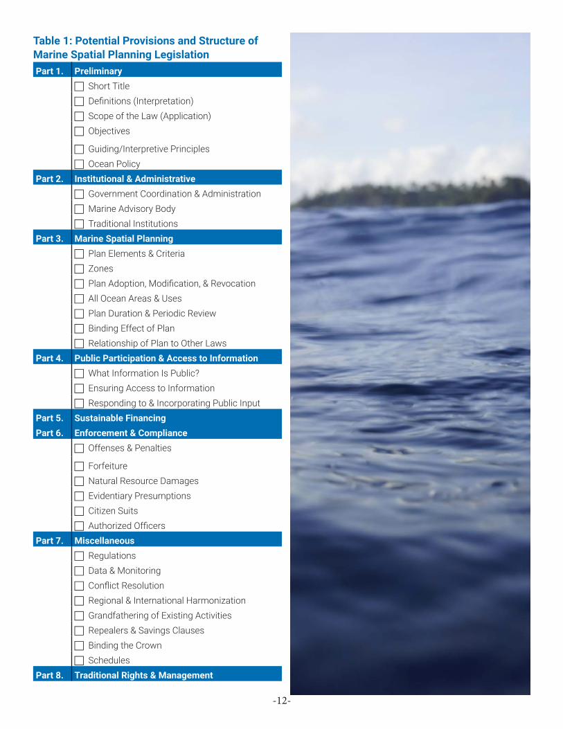
Table 1 identifies eight key potential provisions of marine spatial planning legislation, together with their common subcomponents. In practice, each component will typically correspond to one or more parts of the legislation, as drafted. The legal drafter may wish to use this analysis as a checklist for ensuring that their legislation contains all of the pieces necessary for the law to be complete and effective.
Some of the components listed here may not be necessary or even relevant in a specific jurisdiction, or they may already be addressed elsewhere in law. For example, the topic of traditional rights and management, which is of paramount importance in many Pacific island and coastal states, is not relevant in every country. The aim here is to present the legal drafter with a practical menu of the components and subcomponents that make up comprehensive marine spatial planning legislation.
The sections below provide a discussion of each component and subcomponent contained in Table 1. For each, there is a basic description, an explanation of its role and potential importance, and additional observations that may assist the drafter in assessing the need for the component. Where available, textual examples are provided. These examples are drawn from existing legislation or have been drafted by the authors as illustrations.
Components of Marine Spatial Planning Legislation
PART II
-12-
Table 1: Potential Provisions and Structure ofMarine Spatial Planning LegislationPart 1. Preliminary
Short Title Definitions (Interpretation) Scope of the Law (Application) Objectives
Guiding/Interpretive Principles Ocean Policy
Part 2. Institutional & Administrative Government Coordination & Administration Marine Advisory Body Traditional Institutions
Part 3. Marine Spatial Planning Plan Elements & Criteria Zones Plan Adoption, Modification, & Revocation All Ocean Areas & Uses Plan Duration & Periodic Review Binding Effect of Plan Relationship of Plan to Other Laws
Part 4. Public Participation & Access to Information What Information Is Public? Ensuring Access to Information Responding to & Incorporating Public Input
Part 5. Sustainable FinancingPart 6. Enforcement & Compliance
Offenses & Penalties
Forfeiture Natural Resource Damages Evidentiary Presumptions Citizen Suits Authorized Officers
Part 7. Miscellaneous Regulations Data & Monitoring Conflict Resolution Regional & International Harmonization Grandfathering of Existing Activities Repealers & Savings Clauses Binding the Crown Schedules
Part 8. Traditional Rights & Management
-13-
The “preliminary” component of marine spatial planning legislation covers a number of potential subcomponents. These include the short title, definitions (interpretation), scope of the law, objectives, guiding or interpretive principles, and ocean policy. Each of these subcomponents presents considerations specific to the ocean context.
Short Title
For jurisdictions where a legislative “short title” provision is used, this allows for a more compact way to refer to the legislation—as compared to the often unwieldy full title that appears at the head of the legislation. In the marine spatial planning context, the legal drafter should consider whether a simple but broad title is preferred over a more technical title, keeping in mind the need to differentiate the new legislation from existing fisheries, environmental, and maritime legislation.
COMPARE: Ocean Act of 2020 to Marine Spatial Planning Act, 2018
Additionally, the legal drafter (or policymakers in the relevant ministry or agency) may wish to consider a short title that is highly tailored to the local context. For example, the Cook Islands’ marine spatial planning legislation is titled “Marae Moana Act 2017,” with “marae moana” translated as “sacred ocean.”10
Definitions (Interpretation)
The legislative definitions section (or “interpretation” section, as it is called in many jurisdictions) presents several considerations for the legal drafter. First, the drafter may need to define certain legal and scientific terms related to ocean jurisdiction and the use of marine spaces, unless these terms have been defined elsewhere in the country’s law.11 Such terms, many of which are already defined by the United Nations Convention on the Law of the Sea (UNCLOS), may include:
territorial seacontiguous zoneexclusive economic zone (EEZ)continental shelfbaselineinternal watersarchipelagic waterswaters of [country name]
10 Marae Moana Act 2017, No. 10 of 2017 § 1 (Cook Islands).11 Some countries have legislation dedicated to asserting and characterizing their ocean jurisdiction. See e.g., Marine Spaces Act (Act. No. 18/1977 as amended by the Marine Spaces (Amendment) Act, Act No. 15/1978) (Fiji).
Component 1Preliminary

-14-
EXAMPLE:Exclusive Economic Zone(1) Subject to the following provisions of this section, the exclusive economic zone of Fiji comprises all areas of sea having, as their innermost limits the outermost limits of the territorial seas, and, as their outermost limits, a line drawn seaward from the baselines every point of which is at a distance of 200 miles from the nearest point of the appropriate baseline. (2) The Minister responsible for Foreign Affairs may by order, for the purpose of implementing any international agreement or the award of any international body, or otherwise, declare that the outer limits of the exclusive economic zone of Fiji extend to such line, any point of which may be at a distance of less than 200 miles from the nearest point of the appropriate baseline, as may be specified in such order. (3) Where the median line, as defined in subsection (4), is less than 200 miles from the nearest baseline, and no other line is for the time being specified under the provisions of subsection (2), the outer limits of the exclusive economic zone of Fiji extend to the median line. (4) The median line is a line every point of which is equidistant from the nearest points of the baselines from which the breadth of the territorial seas of Fiji and of any opposite or adjacent State or territory are measured.12
EXAMPLE:1. The territorial sea of the Republic of Poland consists of a marine area of 12 nautical miles (22 224 m) wide, measured from the baseline of the sea.2. The baseline of the territorial sea is constituted by the low-water line along the coat or the outer limit of the internal waters.3. The outer limit of the territorial sea is constituted by a line every point of which is at a distance of 12 nautical miles from the nearest point of the baselines, subject to paragraph 4.4. Roads, which are normally used for the loading, unloading and anchoring of ships and which are situated wholly or partly outside the outer limit of the areas defined in accordance with paragraph 1 and 3, are included in the territorial sea.5. The boundaries of the road referred to in paragraph 4 shall be determined by the Council of Ministers by means of an ordinance.13
Drafting Tips: 1. The importance of these terms extends beyond marine spatial
planning legislation. You may find that your country has or has not defined certain of these key terms, or that existing definitions are outdated. The drafting of marine spatial planning legislation presents an opportunity to update or correct these definitions across the law and to ensure consistent terminology.
2. It is good practice to adapt key ocean jurisdiction terms from the definitions contained in UNCLOS. For example, territorial sea, contiguous zone, exclusive economic zone, continental shelf, archipelagic baselines, and archipelagic waters are all defined in the UNCLOS.14
12 Marine Spaces Act (Act. No. 18/1977 as amended by the Marine Spaces (Amendment) Act, Act No. 15/1978) § 6 (Fiji).13 Act concerning the maritime areas of the Republic of Poland and the maritime administration, 21 March 1991 Article 5 (Poland).14 United Nations Convention on the Law of the Sea, Dec. 10, 1982, 1833 U.N.T.S. 397. Available at: https://www.un.org/depts/los/conven-tion_agreements/texts/unclos/unclos_e.pdf.

-15-
Second, key technical terms specific to marine spatial planning will require definition. These may include, for example, “marine spatial plan” and “zone,” as well as—depending on how the legislation is structured—definitions for specific types of zones (multi-use zone, shipping lane zone, recreational zone, etc.). These definitions also provide a means of describing the spatial dimensions in which marine spatial planning may occur under the law.
EXAMPLE:“marine spatial plan” means a plan for a specified marine area that includes a map of the marine area and that is produced as a result of a public process of analyzing and allocating the spatial and temporal distribution of human activities to achieve ecological, economic, and social objectives15
EXAMPLE:“marine waters” means all coastal and ocean water subject to the jurisdiction of [Country X];
“ocean area” means any geographically defined area of marine waters, and unless otherwise specified, includes: the surface and airspace above the water; the water column; the seabed, subsoil, and any minerals contained therein; the continental shelf; all flora, fauna, historical or cultural features, and anyone or anything else located in or on the water; and natural phenomena such as tidal, wind, and solar influences;
“marine spatial plan” or “plan” means a comprehensive plan to organize human activity in an ocean area so as to achieve the purposes of this Act;
“plan area” means the total ocean area covered by a marine spatial plan;16
15 Marae Moana Act 2017, No. 10 of 2017 § 4 (Cook Islands).16 Sample language provided by authors.

-16-
Scope of the Law (Application)
A section on the law’s scope, or application, characterizes its jurisdictional reach. The simplest approach is to extend jurisdiction to the whole of the country, including, geographically, to the limits of the country’s EEZ. The legal drafter may wish to structure the law broadly, then allow for planning under the law to take place within all—or only a portion—of the geographical area to which the law applies. This allows for the country to take an incremental approach to marine spatial planning, should it so choose.
EXAMPLE:Scope of the law:
Application of Act(1) This Act applies to activities referred to in this Act that are undertaken within the Cook Islands.. . .
Interpretation. . . Cook Islands includes the internal waters, territorial sea, exclusive economic zone, and continental shelf of the Cook Islands.17
VS
Planning under the law:
National marae moana spatial plan(1) The Technical Advisory Group must, as soon as practicable after this Act comes into force, begin preparing for approval by the Council the national marae moana spatial plan for the entire exclusive economic zone and continental shelf.(2) The national marae moana spatial plan must not include any area within the internal waters or the territorial sea, except where those internal waters or territorial sea fall outside the jurisdiction of any Island Government and are not internal waters or territorial sea of the island of Rarotonga. . . .18
Drafting Tips:1. The overall scope of the law presents a different issue from the
spatial and temporal coverage of any particular marine spatial plan. The spatial reach of a plan can be addressed through definitions, as noted above, and in provisions pertaining to the plan (see example above and discussion of All Ocean Areas & Uses in Part II.3).
2. Plan duration can similarly be addressed in provisions pertaining to the plan (see discussion of Plan Duration & Periodic Review in Part II.3).
3. For some countries, including certain Pacific island states, EEZ boundaries are in doubt or subject to dispute. Open questions about a country’s EEZ delineation are unlikely to significantly affect marine spatial planning legislation, even where planning may occur to the limits of the EEZ. This is because jurisdiction under the law may simply be asserted to the extent of the EEZ, whatever its lawful boundaries are determined to be.
17 Marae Moana Act 2017, No. 10 of 2017 §§ 4, 7 (Cook Islands).18 Marae Moana Act 2017, No. 10 of 2017 § 22 (Cook Islands).

-17-
Even where jurisdiction under the law is to be broadly asserted, the legal drafter should also consider whether planning may embrace dry land or the country’s internal waters. Maritime uses often have related land components, and human activities naturally cross the land-sea interface. For example, ships require access to ports, and the quality of fishing and recreational uses is affected by land-based discharges of waste and pollutants. And some protected areas span both land and sea areas.
However, land-based development is likely already subject to comprehensive planning legislation, and environmental legislation likely already addresses land-based sources of pollution. Too, political sensitivities tend to surround coastal and upland development. Despite the clear benefit of integrated planning, the legal drafter should proceed with caution before extending new marine spatial planning legislation onto land and into internal waters.
Another jurisdictional consideration is whether the country has by law or custom reserved certain spaces or activities for traditional purposes, and also whether new marine spatial planning legislation will affect such traditional rights or management. This is discussed further in Part II.8 of the Guide.
Objectives
The objectives section (sometimes called “objects” or “purpose”) expresses the legislature’s aims in enacting marine spatial planning legislation. This provides an opportunity to emphasize one or more beneficial aspects of planning and to provide a lens through which the legislation should be understood by the public, implemented by the government, and interpreted by courts. The usual approach is to call out numerous objectives, often including environmental protection and conservation, economic development, and resolution of conflicting ocean uses. In nations where traditional rights and management are part of the social and legal landscape, these considerations should also be reflected in the law’s objectives.
EXAMPLE:Objects of the ActThe objects of the Act are to—(a) develop and implement a shared marine spatial planning system to manage a changing environment that can be accessed by all sectors and users of the ocean;(b) promote sustainable economic opportunities which contribute to the development of the South African ocean economy through coordinated and integrated planning;(c) conserve the ocean for present and future generations;(d) facilitate responsible use of the ocean;(e) provide for the documentation, mapping and understanding of the physical, chemical and biological ocean processes and opportunities in, and threats to, the ocean; and(f) give effect to South Africa’s international obligations in South African waters.19
19 Marine Spatial Planning Act, 2018, Act No. 16 of 2018 § 2 (South Africa).

-18-
EXAMPLE:Objects of Act(1) The objects of this Act are:... (d) to promote a co operative approach to the protection and management of the environment involving governments, the community, land holders and indigenous peoples; and... (f) to recognise the role of indigenous people in the conservation and ecologically sustainable use of Australia’s biodiversity; and (g) to promote the use of indigenous peoples’ knowledge of biodiversity with the involvement of, and in co operation with, the owners of the knowledge.20
Guiding/Interpretive Principles
Marine spatial planning legislation may include a set of guiding or interpretive principles. Note that this is also a common feature of environmental framework legislation. Relevant principles may include, e.g., polluter pays, use of best available science, transparency, and the precautionary principle. These principles should guide the government during its development and implementation of a marine spatial plan, and, like legislative objectives, these principles provide guidance for courts called upon to interpret the law.
EXAMPLE:The Cook Islands marine spatial planning legislation frames these principles as principles of ecologically sustainable use and, in substantial detail, sets forth the following: principle of protection, conservation, and restoration; principle of sustainable use to maximize benefits; precautionary principle; principle of community participation; principle of transparency and accountability; principle of integrated management; principle of investigation and research; principle of ecosystem-based management; and principle of sustainable financing.21
20 Environment Protection and Biodiversity Conservation Act 1999 § 3(1) (Australia). Note that this is a framework environmental law.21 Marae Moana Act 2017, No. 10 of 2017 § 5 (Cook Islands).

-19-
EXAMPLE:Principles and criteria for marine spatial planning(1) The following principles apply to marine spatial planning and should be applied and considered having regard to the precautionary approach: (a) The sustainable use, growth and management of the ocean and its resources; (b) the identification of economic opportunities which contribute to the development of the ocean economy; (c) the promotion of collaboration and responsible use of the ocean through consultation and cooperation; (d). the advancement of an ecosystem and earth system approach to ocean management which focuses on maintaining ecosystem structure and functioning within a marine area; (e) adaptive management, which takes into account the dynamics of the ecosystems and the evolution of knowledge and of activities in South African waters; (f) the principle of spatial resilience and flexibility; (g) the promotion of equity between and transformation of sectors; (h) the reliance on the best available scientific information; (i) the equitable resolution of conflict scenarios including the implementation of trade-offs, relocations and other available resolutions; (j) the principle of efficiency, whereby decision-making procedures are designed to minimise negative financial, social, economic or environmental impacts; (k) the principle of good administration coherent and holistic planning and management; and (l) South Africa’s international obligations and cross-border cooperation.(2) Where there is a conflict between existing uses, developing uses or activities, maximum co-existence of uses or activities should be preferred wherever possible but where such co-existence is not possible, the principles in subsection (1) must be applied to resolve such conflict.22
This subcomponent is also a good place to provide definitions of the articulated principles.
EXAMPLE:Principle of sustainable use to maximize benefits(b) the principle of sustainable use to maximize benefits is that the marine resources should be used to maximize benefits, while meeting key environmental objectives to benefit current and future generations of Cook Islanders;
Precautionary principle(c) the precautionary principle is that the precautionary principle of the Rio Declaration should be applied where there are threats of serious or irreversible damage, and that a lack of full scientific certainty should not be used as a reason for postponing cost effective measures to prevent environmental degradation in accordance with the Cook Islands’ capabilities in the implementation of the marae moana;23
Drafting Tip: If relevant guiding principles are already contained in a country’s framework environmental legislation, or elsewhere, consider incorporating them by reference into new marine spatial planning legislation rather than restating them.
22 Marine Spatial Planning Act, 2018, Act No. 16 of 2018 § 5 (South Africa).23 Marae Moana Act 2017, No. 10 of 2017 § 5 (Cook Islands)

-20-
Ocean Policy
Some countries considering marine spatial planning either already have a written ocean policy or are considering to adopt one.24 Whether framed by the government as a comprehensive approach to ocean management or as a narrower statement of the government’s intent with respect to certain marine spaces or uses, an ocean policy can be an important complement to legislation. An ocean policy spells out the thinking of the government with respect to ocean management, often anticipating emerging and future uses. A policy is far easier to modify and update than legislation.
It can be useful to require a national ocean policy, and allow for its regular revision, through legislative text. Where new legislation will mandate such a policy, additional drafting options are to (1) require marine spatial planning activities under the law to conform to the policy (or not be inconsistent with the policy); and (2) state that one of the law’s objectives (see subsection on Objectives above) is to implement the policy.
EXAMPLE:Marae moana policy(1) The Marae Moana Policy approved by Cabinet and in existence immediately before the commencement of this Act has effect for the purposes of this Act.(2) Within 4 years after this Act comes into force, the Technical Advisory Group must evaluate, review, and update the Marae Moana Policy.(3) The Technical Advisory Group must continue to evaluate, review, and update the marae moana policy at 4-year intervals.25
EXAMPLE:Conformity of marine plans with other documents(1) A national marine plan and a regional marine plan must be in conformity with any marine policy statement currently in effect for the Scottish marine area, unless relevant considerations indicate otherwise.... 26
24 See generally the Intergovernmental Oceanographic Commission’s collected national ocean policies of select countries, at http://www.ioc-unesco.org/index.php?option=com_content&view=article&id=362&Itemid=100036. See also, e.g., Fiji Environmental Law Association and EDO NSW, “Towards an integrated oceans management policy for Fiji: Policy and Law Scoping Paper,” 2017, at https://d3n8a8pro7vhmx.cloudfront.net/edonsw/pages/5411/attachments/original/1511403416/171013_Integrated_Oceans_Management_Fiji.pdf?1511403416.25 Marae Moana Act 2017, No. 10 of 2017 § 19 (Cook Islands)26 Marine (Scotland) Act 2010 (asp 5) § 6(1).
-21-
This component of marine spatial planning legislation addresses the governmental institutions and other entities responsible for administering the law. Key subcomponents include: identifying the ministry, department, or other governmental entity responsible for coordinating planning activities under the law, and any new powers or responsibilities granted to the ministry; providing for a marine advisory body, if any; and, where appropriate, clarifying the role of traditional institutions in marine spatial planning.
Government Coordination & Administration
Marine spatial planning is rooted in ocean governance, so it implicates multiple government competencies and portfolios. And ocean uses such as conservation, fishing, shipping, tourism, recreation, and scientific research, among many others, span traditional sectors. While accounting for the cross-cutting nature of marine spatial planning, the law should assign the lead coordinating role to a single ministry or department.27 The most likely assignment is to the ministry with responsibility for one of the following portfolios: environment and natural resources; fisheries (which in some nations falls under agriculture); or planning.
The ministry or department in which marine spatial planning will be housed will often have been selected as a matter of policy (and politics) by the time the legal drafter becomes involved. Still, key considerations will include: the existing legal framework, existing competencies of the selected ministry/department and whether those should be expanded to encompass marine spatial planning duties, names of other ministries and stakeholders that should be involved in the marine spatial planning work due to its cross-cutting nature, capacity of the selected ministry/department to perform various duties, and whether some duties – including scientific expertise – should be assigned to an advisory body (one that already exists or one that should be formed). Sometimes, instead of selecting one ministry responsible for marine spatial planning, a state creates an intergovernmental council.
EXAMPLE:(a) The ocean waters and ocean-based development of the commonwealth, within the ocean management planning area described in this section, shall be under the oversight, coordination and planning authority of the secretary of energy and environmental affairs, hereinafter referred to as the secretary, in accordance with the public trust doctrine. . . . 28
27 Although the term “ministry” and “minister” will be used here for consistency, terminology for referring to arms of the executive branch varies by country (e.g., one could instead speak in terms of an “agency” and its “administrator.”) Additionally, countries vary in whether it is more appropriate to assign responsibility at the ministerial level, at a lower departmental level, or in some other manner. This Guide presumes that the legal drafter, and his or her governmental client, are best suited to make these determinations.28 Massachusetts Ocean Act, Mass. Gen. Laws ch. 21A § 4C(a) (United States).
Component 2Institutional & Administrative

-22-
EXAMPLE:The Minister for Business and Growth shall implement maritime spatial planning for Danish marine areas in accordance with this act and provisions laid down in pursuance of the act.29
EXAMPLE:Marae Moana Council (1) The Marae Moana Council is established. (2) The Council comprises the following members- (a) the Prime Minister: (b) the Leader of the Opposition: (c) the President of the House of Arikis: (d) the President of the Religious Advisory Council; (e) two representatives of the pa enua: one from the northern group and one from the southern group; (f) a representative of the private sector appointed by the members referred to in paragraphs (a) to (e): (g) a representative of the non-governmental sector (non-governmental organisations) appointed by the members referred to in paragraphs (a) to (e): (h) a representative of government and state-owned enterprises appointed by the members referred to in paragraphs (a) to (e). marine areas in accordance with this act and provisions laid down in pursuance of the act.30
Drafting Tip: Successful marine spatial planning is cross-cutting and depends for its success on stakeholder participation and intragovernmental coordination. The legal drafter should ensure that new legislation reflects these realities by not assigning responsibility for marine spatial planning to an office within government that lacks the authority, credibility, or staffing resources for implementation.
Marine spatial planning legislation should specify the powers and duties of the lead ministry or department. These might include overseeing the development of a marine spatial plan; ensuring consultations with appropriate stakeholders and timely adoption of the plan; periodic plan review; and amendment and revocation of the plan, as necessary.
EXAMPLE:Duties and functions of Council The duties and functions of the Council are to- (a) approve revised versions of the marae moana policy; and (b) approve the national marae moana spatial plan; and (c) approve a schedule of marine-based activities for which management measures are required and any revisions of the schedule; and (d) monitor the work of agencies under Part 5 in implementing the aspects of the national marae moana spatial plan and management measures for which those agencies are responsible; and (e) approve island spatial plans for Rarotonga and Suwarrow, and any revisions of the plans; and (f) approve the marae moana annual report for submission to Parliament; and (g) perform the other duties or functions imposed or conferred on it by this Act or any other Act.
29 Act on maritime spatial planning 2016 § 4 (Denmark).30 Marae Moana Act 2017, No. 10 of 2017 § 9 (Cook Islands)

-23-
Marae Moana Coordination Office and Coordinator (I) A Marae Moana Coordination Office is established as part of the Office of the Prime Minister. (2) The Marae Moana Coordination Office comprises- (a) an office coordinator, by whatever name called; and (b) any other staff that available resources allow and needs require. (3) The office coordinator and other staff of the Marae Moana Coordination Office are to be employed under the Public Service Act 2009. (4) The office coordinator is responsible to the chief of staff of the Office of the Prime Minister.(5) The purpose of the Marae Moana Coordination Office is to assist the Council and the Technical Advisory Group in fulfilling their administrative and consultative functions under this Act by acting as their secretariat.31
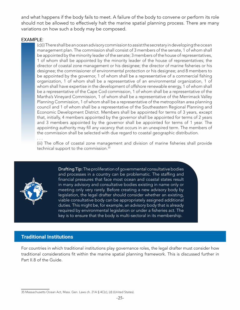
Marine Advisory Body
Marine spatial planning legislation can benefit significantly from an advisory body that provides guidance to government decision-makers throughout the planning process. This body, often a council or committee, makes non-binding recommendations related to all aspects of marine spatial planning. It typically contains members representative of government, industry, and conservation interests. It is also common to ensure that at least one member brings relevant scientific expertise. New legislation should describe the body’s role, membership, and operation.
The legal drafter should consider whom the body will advise and how often, as well as the weight of its advice. For example, can the ministry that the body advises ignore that advice? The language should explain the points in the process (such as at the conceptualization, development, and implementation phases of marine spatial planning) when the marine advisory body must be consulted.
EXAMPLE:(c)(i) There shall be an ocean advisory commission to assist the secretary in developing the ocean management plan. . . . (ii) The commission shall meet at least quarterly and at the discretion of the secretary. The commission shall hold public meetings relative to matters within the jurisdiction of the ocean management plan and shall make recommendations to the secretary for the proper management and development of the plan. The secretary shall consider the recommendations of the commission. . . . (d) There shall be an ocean science advisory council to assist the secretary in creating a baseline assessment and obtaining any other scientific information necessary for the development of an ocean management plan. . . . The secretary shall serve as coordinator of the council. The council shall meet at least quarterly and at any other time that the secretary shall deem necessary to assist him in compiling the scientific information necessary for the development of an ocean management plan.32
31 Marae Moana Act 2017, No. 10 of 2017 §§ 10, 18 (Cook Islands).32 Massachusetts Ocean Act, Mass. Gen. Laws ch. 21A § 4C(c), (d) (United States).

-24-
In addition to providing advice, an advisory body can be assigned other duties, including drafting the marine spatial plan and policy documents, monitoring implementation of the plan, and preparing reports.33
EXAMPLE:Duties and functions of Technical Advisory Group The Technical Advisory Group must- (a) prepare the marae moana policy for approval by the Council, and evaluate, review, and update the policy at 4-yearly intervals; and (b) prepare and review the national marae moana spatial plan; and (c) prepare and maintain a schedule of marine-based activities for which management measures should be implemented; and (d) monitor the work of agencies under Part 5 in implementing the aspects of the national marae moana spatial plan and management measures for which those agencies are responsible; and (e) comment on agency draft policies and instruments, including, but not limited to, strategic plans, protected area management plans, seabed mineral agreements, seabed environmental emergency contingency plans, fishery plans, access agreements, and licence and permit conditions; and (f) prepare an island marine spatial plan for Suwarrow, and evaluate, review, and update the plan periodically; and (g) assist in the preparation of island marine spatial plans for Rarotonga and Island Governments; and (h) undertake public education and promotional activities to raise awareness of the restrictions imposed by the national marae moana spatial plan and the management measures; and (i) prepare an annual report that records the activities and achievements of the Technical Advisory Group and related matters; and (j) take necessary measures to secure national and international sources of finance to support the purposes of this Act; and (k) perform other duties or functions imposed or conferred on it by regulations made under this Act.
Discretionary functions of Technical Advisory Group The Technical Advisory Group may perform all or any of the following functions as it thinks fit- (a) undertake public education and promotional activities within and beyond the Cook Islands to disseminate information on the values, purposes, strategies, and achievements of the marae moana: (b) invite to participate in Technical Advisory Group meetings, or other consultative or deliberative processes of the Technical Advisory Group, representatives of Cook Islands public organisations that are not otherwise represented on the Technical Advisory Group: (c) invite to participate in Technical Advisory Group meetings, or other consultative or deliberative processes of the Technical Advisory Group, persons who can productively contribute to those meetings or processes: . . . .34
Details about the advisory body can also include its size, the identity of its members (and any represented constituencies), membership term, compensation (if any), and appointment requirements. Legislation may also specify how often the body must convene, how its recommendations are made and reviewed, what information about its work is made public, 33 South Africa’s marine spatial planning legislation, for example, establishes a National Working Group on Marine Spatial Planning that, composed of officials from across government, is charged with drafting the marine spatial planning framework and marine area plans. The National Work Group is given other advisory duties, and it may, in turn, appoint a panel of experts to assist in its work. Marine Spatial Planning Act, 2018, Act No. 16 of 2018 § 9 (South Africa).34 Marae Moana Act 2017, No. 10 of 2017 §§ 15, 16 (Cook Islands).
-25-
and what happens if the body fails to meet. A failure of the body to convene or perform its role should not be allowed to effectively halt the marine spatial planning process. There are many variations on how such a body may be composed.
EXAMPLE:(c)(i) There shall be an ocean advisory commission to assist the secretary in developing the ocean management plan. The commission shall consist of 3 members of the senate, 1 of whom shall be appointed by the minority leader of the senate; 3 members of the house of representatives, 1 of whom shall be appointed by the minority leader of the house of representatives; the director of coastal zone management or his designee; the director of marine fisheries or his designee; the commissioner of environmental protection or his designee; and 8 members to be appointed by the governor, 1 of whom shall be a representative of a commercial fishing organization, 1 of whom shall be a representative of an environmental organization, 1 of whom shall have expertise in the development of offshore renewable energy, 1 of whom shall be a representative of the Cape Cod commission, 1 of whom shall be a representative of the Martha’s Vineyard Commission, 1 of whom shall be a representative of the Merrimack Valley Planning Commission, 1 of whom shall be a representative of the metropolitan area planning council and 1 of whom shall be a representative of the Southeastern Regional Planning and Economic Development District. Members shall be appointed for terms of 3 years, except that, initially, 4 members appointed by the governor shall be appointed for terms of 2 years and 3 members appointed by the governor shall be appointed for terms of 1 year. The appointing authority may fill any vacancy that occurs in an unexpired term. The members of the commission shall be selected with due regard to coastal geographic distribution.. . . (iii) The office of coastal zone management and division of marine fisheries shall provide technical support to the commission.35
Drafting Tip: The proliferation of governmental consultative bodies and processes in a country can be problematic. The staffing and financial pressures that face most ocean and coastal states result in many advisory and consultative bodies existing in name only or meeting only very rarely. Before creating a new advisory body by legislation, the legal drafter should consider whether an existing, viable consultative body can be appropriately assigned additional duties. This might be, for example, an advisory body that is already required by environmental legislation or under a fisheries act. The key is to ensure that the body is multi-sectoral in its membership.
Traditional Institutions
For countries in which traditional institutions play governance roles, the legal drafter must consider how traditional considerations fit within the marine spatial planning framework. This is discussed further in Part II.8 of the Guide.
35 Massachusetts Ocean Act, Mass. Gen. Laws ch. 21A § 4C(c), (d) (United States).

-26-
At the heart of marine spatial planning legislation is a suite of provisions governing the contents of a marine spatial plan and the process for adopting or changing a plan. These provisions establish the minimum required elements of a plan and the criteria for designing the plan; and for legislation that uses ocean zoning, these provisions also characterize the types of zones that may be used within the plan area. These provisions also govern the procedure for adopting, modifying, and revoking a plan. Finally, provisions may address certain other issues, such as whether a plan must cover all ocean areas and uses; plan duration and periodic review; the binding effect of the plan; and the plan’s relationship to other laws.
Plan Elements & Criteria
This subcomponent sets forth the required elements of a properly adopted marine spatial plan. At a minimum, a plan should include a demarcated plan area (defined by geographical coordinates and illustrated by a map) and identify any zones within the plan area, specifying the uses that are allowed or prohibited within each zone.
Drafting Tips: • Even where the term “marine spatial plan” is defined in the
legislation, there is value in expressly setting forth the required elements of a plan. Legal precision is important, given that a major aim of legislation is to make the plan legally binding.
• The legal drafter may wish to include optional plan elements that, while not binding, will aid the government and ocean users with respect to both plan implementation and compliance. A further possibility is to allow the government to make any such optional elements binding by way of subsequent regulation.
EXAMPLE (PLAN ELEMENTS):Preparation of marine spatial plan—elements(1) The Director, upon request of the Minister and in consultation with the Council, shall prepare a marine spatial plan to beneficially organise and regulate ocean activities in one or more ocean areas.(2) The Director shall include in the marine spatial plan such maps, narrative descriptions, and other elements as may be necessary to clearly describe the plan area, any zones within the plan area, and the ocean activities that are subject to the plan.(3) Without restricting the generality of subsection (2), the Director shall ensure that a marine
Component 3Marine Spatial Planning
-27-
spatial plan includes the following elements— (a) a map that delineates— (i) the boundaries of the plan area; and (ii) any zones within the plan area in which one or more specified ocean activities are allowed, prohibited, or otherwise regulated; (b) for each zone within the plan area, a written description indicating how the zone may be used, including— (i) identification of permissible ocean activities in the zone, including any licenses, permits, or other permissions that may be required to engage in such activities; (ii) a description of any prohibitions, limitations, or other requirements applicable to the zone, including as to the nature, timing, duration, or location of any ocean activity; and (iii) references to any Act, law, regulation, marine protected area designation, or policy of [Country X] that governs ocean activities within the zone.(4) The Director shall use best efforts to delineate the boundaries of the plan area, as well as any zones within the plan area, so as to allow for ease of administration and enforcement.36
EXAMPLE (OPTIONAL PLAN ELEMENTS):(5) Subject to subsection (6), the Director may include as part of a marine spatial plan additional elements to assist in the implementation, administration, and public understanding of the plan, such as— (a) narrative information (e.g., concerning the cultural, environmental, economic, or social context of the plan area; the plan’s procedural history and development; or relevant regional or international factors); (b) an implementation plan or similar tool to aid in the plan’s effectiveness; (c) references to scientific data and information, studies, and reports; and (d) supplemental maps, charts, graphs, tables, photographs, and other graphic materials or visual aids.(6) Any element included by the Director in a marine spatial plan pursuant to subsection (5) does not provide an independent basis for enforcement against any person, unless such element has been adopted through regulation, pursuant to section 42.37
This legislative subcomponent can also be used to set forth any criteria that the government must satisfy in developing a marine spatial plan. As a practical matter, these plan criteria often reinforce or build upon the stated legislative objectives and any guiding principles applicable to the law as a whole (see discussion of Objectives and Guiding/Interpretive Principles in Part II.1). As an example, while the guiding principles may have described the importance of conflict resolution in more general terms, the plan criteria can specify what types of uses, such as those promoting sustainability and synergy with other uses, should be prioritized in cases of conflict.
Certain activities that occur in the ocean space (such as, e.g., seabed mining and offshore energy development) can have a significant effect on ocean resources and ability to safely conduct other types of activities. It is thus useful for the plan’s criteria to include siting priorities and consideration of environmental impacts from potentially harmful projects, described in environmental impact assessments. Given the increasing effects of climate change on ocean resources, which might require adjusting uses or locations of the zones set forth in the marine spatial plan, it is also useful to mention climate change in the criteria.
36 Sample language provided by authors37 Sample language provided by authors.

-28-
Drafting Tip: Separate laws generally regulate seabed mining and other similarly disruptive activities, and would require preparation of environmental impact assessments. In addition to mentioning environmental impacts in the plan’s criteria, the legal drafter should also analyze how such existing laws would interact with the new law on marine spatial planning and describe points of interaction in a separate section (see discussion in Relationship to Other Laws below).
EXAMPLE (CRITERIA):... Notwithstanding any general or special law to the contrary, the secretary, in consultation with the ocean advisory commission established pursuant to subparagraph (c) and the ocean science advisory council established pursuant to subparagraph (d), shall develop an integrated ocean management plan, which may include maps, illustrations and other media. The plan shall: (i) set forth the commonwealth’s goals, siting priorities and standards for ensuring effective stewardship of its ocean waters held in trust for the benefit of the public; and (ii) adhere to sound management practices, taking into account the existing natural, social, cultural, historic and economic characteristics of the planning areas; (iii) preserve and protect the public trust; (iv) reflect the importance of the waters of the commonwealth to its citizens who derive livelihoods and recreational benefits from fishing; (v) value biodiversity and ecosystem health; (vi) identify and protect special, sensitive or unique estuarine and marine life and habitats; (vii) address climate change and sea-level rise; (viii) respect the interdependence of ecosystems; (ix) coordinate uses that include international, federal, state and local jurisdictions; (x) foster sustainable uses that capitalize on economic opportunity without significant detriment to the ecology or natural beauty of the ocean; (xi) preserve and enhance public access; (xii) support the infrastructure necessary to sustain the economy and quality of life for the citizens of the commonwealth; (xiii) encourage public participation in decision-making; (xiv) and adapt to evolving knowledge and understanding of the ocean environment; and (xv) shall identify appropriate locations and performance standards for activities, uses and facilities allowed under sections 15 and 16 of chapter 132A. ...38
Zones
Most marine spatial planning legislation relies on zoning to implement the marine spatial plan. Each zone included in the plan is intended to prioritize a particular ocean use or set of uses, often to the exclusion of other uses. While zone types must be tailored to a country’s needs and context, typical zones include: conservation, fisheries, shipping, recreational, tourism, and mixed use. To the extent that other existing sectoral legislation already governs the use of certain marine spaces—e.g., setting these areas aside as protected areas, fishing zones, shipping lanes, areas for mariculture, seabed mining areas, etc.—new marine spatial planning legislation should be designed to complement these laws and build on existing zone typology.39
38 Massachusetts Ocean Act, Mass. Gen. Laws ch. 21A § 4C(a) (United States).39 Even in the absence of marine spatial planning legislation as such, there is wide variation in the ways that countries regulate areas of their ocean space, depending on local circumstances. For example, Montserrat has established and designated as “maritime unsafe areas” certain volcanic exclusion zones. See, e.g., Emergency Powers (Maritime Unsafe Areas) Order 2014, S.R.O. 44 of 2014 (Montserrat).

-29-
Drafting Tip: All existing ocean controls and regulations should remain in place. Marine spatial planning legislation usually builds on the existing governance structure rather than replacing it.
Each zone type should have a name and objective, and it should be associated with appropriate uses or prohibitions. Zone types can be established through legislative definitions. It is also common to allow for the use of regulations to add additional zone types in the future, as needs may dictate. For example, existing human uses may shift—and new uses, such as offshore energy production or mariculture, may emerge.
EXAMPLE:Additional types of zones The Council may by notice in the Gazette amend the zones created in these Regulations or create additional types of zones and restrictions on activities in those zones to manage and accommodate other uses of Barbuda coastal waters. Such restrictions shall be fully enforceable pursuant to these Regulations.40
Also important are zone placement criteria (as distinguished from the definition of each zone type). How does the decision-maker determine where a particular zone should be situated and how various zones fit together? Activities conducted in one zone, including those involving pollution or impacts to the seabed, can have negative effects on the ocean resources in other zones. To be sure, the placement of the zones is heavily informed by the participatory planning process. Some key placement criteria could be established by the legislation or, in greater detail, by way of regulation. But a better approach may be to rely instead on a set of non-prescriptive guidelines for the placement of zones.41
EXAMPLE:Marine sanctuaries The areas of Barbuda specified in Part I of Schedule A and delineated on the maps set out in Part II thereof, are hereby declared to be marine sanctuaries.
No-net zones The areas of Barbuda specified in Part I of Schedule B and delineated on the maps set out in Part II thereof are hereby declared to be no-net zones.
Anchoring and mooring zones The areas of Barbuda specified in Part I of Schedule C and delineated on the maps set out in Part II thereof are hereby declared to be anchoring and mooring zones.
Shipping areas The areas of Barbuda specified in Part I of Schedule D and delineated on the maps set out in Part II thereof are hereby declared to be shipping areas.42
40 Barbuda (Coastal Zoning and Management) Regulations, 2014 § 7. Note that the cited language in Barbuda is contained in regulations rather than primary legislation.41 See, e.g., Solomon Islands Ocean Zone Placement Guidelines for Marine Spatial Planning 2017 (recommending that zone placement be guided by the use of biophysical design principles and socioeconomic, cultural, and management feasibility design principles).42 Barbuda (Coastal Zoning and Management) Regulations, 2014 §§ 3-7. Note that the cited language in Barbuda is contained in regulations rather than primary legislation.
-30-
EXAMPLE:National marae moana zones (1) The zones for the national marae moana spatial plan are— (a) a general use zone to provide for the protection of pelagic and benthic habitats of the marae moana, while allowing a range of ecologically sustainable uses: (b) a restricted commercial fishing zone to provide for the protection of pelagic and benthic habitats of the marae moana by restricting most large-scale commercial fishing activities, while allowing other ecologically sustainable uses: (c) a seabed minerals activity buffer zone to provide for the protection of pelagic, benthic, coral reef, coastal, and lagoon habitats of the marae moana by prohibiting all seabed minerals activities, while allowing other ecologically sustainable uses: (d) an island protection zone to provide for the protection of the pelagic, benthic, coral reef, coastal, and lagoon habitats of the marae moana by prohibiting all seabed minerals activities and large-scale commercial fishing, while allowing other ecologically sustainable uses: [sic] (e) an ocean habitat preservation zone to provide for the protection and management of sensitive and ecologically valuable pelagic and benthic habitats by prohibiting potentially damaging activities, while allowing other ecologically sustainable uses: (f) a national marine park zone to provide for the strict preservation of the natural integrity and ecological values of specific coral reef, coastal, and lagoon habitats of the marae moana that are remote from any permanent human settlement and are not within the jurisdiction of any Island Government. (2) Regulations made under section 35 may create additional national marae moana spatial plan zones....43
Drafting Tip: Violating the requirements of a zone used in a marine spatial plan can bring legal consequences for the violator. Therefore it is important that zone types be established by enforceable legislation or through regulation. A zone’s requirements should be reasonable and clear.
Plan Adoption, Modification, & Revocation
New marine spatial planning legislation should establish a clear procedure for plan adoption, as well as processes for modifying or revoking an existing plan. These are the procedural requirements that the lead ministry or other government entity must follow to ensure that a new plan, or changes to an existing plan, are lawful.
The development and adoption of a new marine spatial plan is a time-consuming process that requires, at a minimum, an understanding of the relevant ocean areas and extensive public engagement. The process followed is critical to the success and long-term viability of the plan. However, primary legislation, especially in island and coastal states whose governments face serious funding and staffing limitations, must avoid establishing overly cumbersome process requirements. New marine spatial planning legislation should simply fix the guideposts for ensuring a participatory, transparent, and science-informed planning process that takes into account current and reasonably anticipated uses of the ocean within the plan area. If greater detail is required as to aspects of the process, a country can follow up later with regulations.43 Marae Moana Act 2017, No. 10 of 2017 § 23 (Cook Islands).

-31-
EXAMPLE:Before the maritime spatial plan is promulgated, a proposal for a plan shall be published with a commenting period of at least six months. Subsection 2. The Minister for Business and Growth shall issue the maritime spatial plan no later than by 31 March 2021. The maritime spatial plan shall be revised and updated at least every tenth year. Subsection 3. The Minister for Business and Growth may decide that the commenting period stipulated in subsection 1 may be deviated from in special cases. Subsection 4. The proposal for a maritime spatial plan mentioned in subsection 1 shall be drawn up in consultation with the other ministries affected and with the involvement of coastal municipalities and coastal regions as well as any relevant business and interest organizations.44
EXAMPLE:Ministerial approval of coastal and marine management plans(1) After considering any submissions in relation to a draft coastal and marine management plan, the Crown land manager must submit the draft plan to the Minister for approval.(2) The Minister must-(a) approve the coastal and marine management plan with or without amendment; or(b) refuse to approve the coastal and marine management plan and direct the Crown land manager to amend the plan.(3) The Minister must publish notice of the approval of a coastal and marine management plan in the Government Gazette.(4) A coastal and marine management plan comes into operation – (a) on the date on which the notice under subsection (3) is published in the Government Gazette; or(b) on any later date specified in the notice.(5) The Minister must publish on the Internet site of the Department a copy of the coastal and marine management plan.45
Legislation must also allow for the modification of a marine spatial plan, but with certain safeguards to ensure that hasty alterations cannot easily be undertaken to weaken a plan or undermine its effectiveness. With changes in how the ocean is used, natural disasters, or advances in a country’s scientific understanding of its ocean areas, may come the need to change a marine spatial plan. The legal drafter should consider spelling out acceptable reasons for plan modification. The process for plan modification could track the process for adopting a plan initially, or the modification process could be slightly abbreviated. Ultimately, a plan should be changeable for good reason, but not too easily changeable.
44 Act on Maritime Spatial Planning (Act 615 of 8 June 2016) § 10 (Denmark).45 Marine and Coastal Act 2018, No. 26 of 2018 § 61 (Australia).

-32-
EXAMPLE:During the planning period, the Minister for Business and Growth may lay down regulations on amendments of the maritime spatial plan. Subsection 2. Before issuing an amendment to the maritime spatial plan, a proposal for an amended plan shall be published with a commenting period of at least eight weeks. Section 10(4) shall apply correspondingly. Subsection 3. If a proposal for an amendment of the maritime spatial plan involves amendments of the plan that are so comprehensive that it is in effect a new maritime spatial plan, the amendments shall be implemented only in accordance with the procedure stipulated in section 10. Subsection 4. The Minister for Business and Growth may decide that the commenting period stipulated in subsection 2 may be deviated from in special cases.
At the same time as the proposal for a maritime spatial plan pursuant to section 10(1) or a proposal for amendments of the maritime spatial plan pursuant to section 11(2), the first sentence, is being published, the Minister for Business and Growth shall inform the affected Government, regional and municipal authorities, the EU member States and third countries as well as any parties whose interests are affected about the draft maritime spatial plan or draft amendments hereof.46
EXAMPLE:Amendment of coastal and marine management plans(1) The Minister may approve the amendment of a coastal and marine management plan at any time.(2) Sections 57 to 62 apply to the amendment of a coastal and marine management plan as if the amendment were a draft plan.(3) Subsection (2) does not apply if the Minister considers the amendment to be fundamentally declaratory, machinery [sic] or administrative in nature.47
Lastly, new legislation should provide for revocation of a marine spatial plan. As with the provisions on plan modification, provisions governing plan revocation should both establish the grounds for revocation and describe what the procedure for revocation will be.
EXAMPLE:Withdrawal of marine plans(1) The Scottish Ministers may withdraw a national marine plan or (as the case may be) a regional marine plan where they consider it appropriate to do so.(2) If they do so, they must publish notice of withdrawal in the Edinburgh Gazette; and the marine plan concerned ceases to have effect on the date of such publication.(3) The Scottish Ministers must also take such further steps as they consider appropriate to secure that the withdrawal of the marine plan concerned is brought to the attention of interested persons.(4) In this section, “interested persons” means – (a) any persons appearing to the Scottish Ministers to be likely to be interested in, or affected by, the withdrawal of the marine plan concerned,(b) members of the general public.(5) Following withdrawal of a national marine plan, the Scottish Ministers must prepare and adopt in accordance with schedule 1 a new national marine plan for the Scottish marine area as soon as is reasonably practicable.48
46 Act on Maritime Spatial Planning (Act 615 of 8 June 2016) §§ 11, 12 (Denmark).47 Marine and Coastal Act 2018, No. 26 of 2018 § 63 (Australia).48 Marine (Scotland) Act 2010 (asp 5) § 9.

-33-
All Ocean Areas & Uses
The legal drafter should consider whether the legislation will require that a marine spatial plan cover the entire geographical ocean area subject to the law. A related consideration is whether a marine spatial plan must address all ocean uses within the plan area.
As to the first question, a simple approach is to have the legislation define the precise area for which a marine spatial plan is to be adopted.
EXAMPLE:National marae moana spatial plan (1) The Technical Advisory Group must, as soon as practicable after this Act comes into force, begin preparing for approval by the Council the national marae moana spatial plan for the entire exclusive economic zone and continental shelf. (2) The national marae moana spatial plan must not include any area within the internal waters or the territorial sea, except where those internal waters or territorial sea fall outside the jurisdiction of any Island Government and are not internal waters or territorial sea of the island of Rarotonga. ... 49
Another approach is to allow the government to develop and adopt one or more complementary marine spatial plans over time and for different ocean areas. This allows for an incremental approach to marine spatial planning. For example, the government may wish to plan first for the nearshore area or the territorial sea, and then, at a later date, plan out to the full extent of the EEZ. Or an archipelagic state may wish to plan around some of its islands before, or to the exclusion of, other islands.
EXAMPLE:The Technical Advisory Group must, as soon as practicable after this Act comes into force, begin preparing for approval by the Council a marine spatial plan for the territorial sea of [Country X]. If any plans are subsequently developed for other parts of the ocean waters of [Country X], those plans shall not diminish levels of protection afforded by the marine spatial plan for the territorial sea.50
If an incremental approach is allowed, then the legislation should clarify that subsequent plan additions cannot have the effect of diminishing levels of protection. Another approach, essentially a form of nesting, would be for the marine spatial plan to embrace a broader area than where ocean zoning actually occurs. In other words, less than the entire plan area is formally zoned. This can be a means of respecting traditional law and management systems applicable to certain areas.
Whether a marine spatial plan must embrace all existing and anticipated ocean uses within the plan area presents a more difficult question. By omitting from the plan any ocean uses that are occurring or likely to occur in the near future, the government loses one of the major benefits of marine spatial planning: identifying and resolving potential conflicts among uses. Worse, this could lead to confusion in plan implementation.
49 Marae Moana Act 2017, No. 10 of 2017 § 22 (Cook Islands).50 Sample language provided by authors.
-34-
However, there may be reason to exclude certain uses from a plan. Perhaps an existing use is so minor as to be de minimis. Or perhaps a country is exploring the possibility of allowing new uses—such as mariculture or offshore energy development—but is in the early stages of deciding how to regulate them. It may be preferable to omit such a use from the marine spatial plan and amend the plan later, as necessary. Still, the marine spatial planning legislation could require that any omitted uses, and the reason for the omission, be acknowledged in the plan.
Finally, there are uses that will occur but that are not necessarily subject to alteration under a marine spatial plan, such as the right of innocent passage of vessels through the territorial sea in compliance with UNCLOS. Such uses should nevertheless be acknowledged under a plan.
EXAMPLE:If a plan will address fewer than all present ocean activities or reasonably anticipated future ocean activities in the plan area, the Director shall include as part of the plan a brief statement indicating—
(a) which ocean activities are to be omitted from the plan;(b) why these ocean activities are to be omitted; and(c) how and when the omitted ocean activities are likely to be addressed.51
Plan Duration & Periodic Review
The legislation should provide that a properly adopted marine spatial plan remains in force until amended or revoked pursuant to law. A variation on this is to presume an indefinite duration except where the plan, on its face, fixes a term. Having the plan be of indefinite duration lends predictability for implementation, compliance, and enforcement and makes it less likely that a change in political leadership will sweep away an existing plan. Also, a plan that sunsets after a fixed number of years leaves open the undesirable possibility of having no plan in place. A requirement for periodic review of a marine spatial plan (five years being typical) can help ensure that a plan does not become stale.
EXAMPLE:Review of coastal and marine management plans (1) The Crown land manager must cause a review to be made of a coastal and marine management plan no later than 5 years after the commencement of the plan. (2) After the review of a coastal and marine management plan, the Minister may approve the amendment of the plan in accordance with this Division.52
EXAMPLE:The secretary shall promulgate regulations to implement, administer and enforce this section and shall interpret this section and any regulations adopted hereunder consistent with his power to enforce the laws. These regulations shall include provisions for the review of the ocean management plan, its baseline assessment and the enforceable provisions of relevant statutes and regulations at least once every 5 years.53
51 Sample language provided by authors.52 Marine and Coastal Act 2018, No. 26 of 2018 § 64 (Australia).53 Massachusetts Ocean Act, Mass. Gen. Laws ch. 21A § 4C(h) (United States).
-35-
EXAMPLE:Review of plans The marine area plans must be reviewed at least every five years and, if necessary, amended in terms of the iterative, phased process contemplated in section 6 and the process and procedure contemplated in sections 9 to 11.54
An additional option is to include objective criteria that, when satisfied, trigger a review requirements. This might include significant new human uses of the ocean or the availability of significant new scientific information, including information revealed through monitoring activities. Or, it could be a change in national legislation or policy that is material to marine spatial planning activities.
EXAMPLE: Monitoring and periodic review
(1) The Director shall monitor implementation of and public compliance with marine spatial plans.
(2) The Director shall periodically review all existing approved marine spatial plans and, as appropriate, propose that the Minister modify such plans. The Director shall review each plan at least once every five years.
(3) Notwithstanding subsection (2), the Minister may instruct the Director to conduct a review of a marine spatial plan at any time he sees fit, including upon the request of another Minister in the Cabinet, changes to national legislation or policy affecting the marine spatial planning activities, changes to uses of the ocean space, or new scientific information or data available through monitoring activities. 55
Binding Effect of Plan
To be most effective in organizing the marine space, a marine spatial plan must legally bind all persons. This is one of the principal reasons to use legislation or regulations, rather than a voluntary approach, to administer and implement marine spatial planning. This can be done with a simple provision.
EXAMPLE: Plan is bindingAll persons are bound by a lawfully adopted marine spatial plan, as that plan is expressed through the plan area boundaries, zone boundaries, and zone requirements established pursuant to [section of this legislation].56
Arguably, it would suffice to make clear that the law (through its general application) binds all persons and that, in appropriate jurisdictions, the law binds the sovereign. (See discussion of Binding the Crown in Part II.7). This may be the preferred approach in some countries.
54 Marine Spatial Planning Act, 2018, Act No. 16 of 2018 § 14 (South Africa).55 Sample language provided by authors.56 Sample language provided by authors.

-36-
EXAMPLE: Application of Act(1) This Act applies to marine spatial planning on or in South African waters and binds all organs of state.... 57
Relationship to Other Laws
Marine spatial planning legislation is cross-cutting by design, and it therefore touches on multiple sectors and their underlying sectoral legislation. Interactions can occur with laws governing fisheries, planning, shipping, maritime matters, marine protected areas, and environmental protection (e.g., pollution control and environmental impact assessment). There may be existing MPAs or zones for fishing, shipping, and other uses. Interactions may also arise with respect to the granting of permissions under those laws.
These interactions present at least two issues. First, does the marine spatial planning law “trump” other laws in the case of conflict? Second, how do zones established under other laws, or permissions issued under other laws, affect marine spatial planning?
The first question, regarding which law supersedes, is largely one of design: the legal drafter should be aware of the legal framework in which the new marine spatial planning legislation will operate and try to avoid conflicts with existing primary legislation and regulations. (See discussion in Part I of the importance of a legal assessment). Where necessary, the legal drafter can use targeted repealers or make narrow amendments to existing laws. Beyond this, the usual rule is that more recent legislation supersedes earlier legislation in the event of conflict.
Nevertheless, an express conflicts provision can be included, as in South Africa.
EXAMPLE:Conflicts with other legislationIn the event of any conflict between the provisions of this Act and other legislation specifically relating to marine spatial planning, the provisions of this Act prevail.58
But even the seemingly simple approach has an inherent limitation: the need to decide what other legislation “specifically relates” to marine spatial planning. A fisheries act? Protected areas legislation? A maritime act? The most prudent approach is to do the homework necessary to avoid conflicts, or to address them through targeted repealers and amendments. Yet another option is to include language providing that in case of a conflict between marine spatial planning legislation and another law, the law containing the more stringent (i.e., environmentally protective) requirement prevails.
The second question with respect to other laws is how best to integrate them with marine spatial planning legislation, especially when it comes to regulation under those laws and permissions issued pursuant to those laws. Good practice is to require conformity with a properly adopted marine spatial plan.
57 Marine Spatial Planning Act, 2018, Act No. 16 of 2018 § 3(1) (South Africa).58 Marine Spatial Planning Act, 2018, Act No. 16 of 2018 § 4 (South Africa).

-37-
EXAMPLE:Application of Act...(2) Any right, permit, permission, licence or any other authorisation issued in terms of any other law must be consistent with the approved marine area plans.59
EXAMPLE:Upon the secretary’s adoption of an ocean management plan, all certificates, licenses, permits and approvals for any proposed structures, uses or activities in areas subject to the ocean management plan shall be consistent, to the maximum extent practicable, with the plan.60
EXAMPLE:Relationship to other laws(1) Notwithstanding any other law, if all or part of an ocean area is subject to an existing approved marine spatial plan, no new regulatory requirements may be imposed in that ocean area except in conformance with the plan.(2) A government official deciding on the issuance of a certificate, license, permit, approval, or other permission under another law for any activity, use, development, or other action that will or is likely to occur within the plan area of a marine spatial plan shall ensure that his decision, and any resulting certificate, license, permit, approval, or other permission, conform to the plan’s requirements to the maximum extent practicable.61
59 Marine Spatial Planning Act, 2018, Act No. 16 of 2018 § 3(2) (South Africa).60 Massachusetts Ocean Act, Mass. Gen. Laws ch. 21A § 4C(e) (United States)61 Sample language provided by authors.
-38-
Effective marine spatial planning depends on successful public engagement. Those who depend on the ocean for their livelihood, for recreation, or for subsistence bring knowledge, experience, and quite often passion to discussions about how best to organize uses of a country’s marine waters. Ocean users will likely have a keen sense of what will work—and what will not. And as a matter of fairness, the people and organizations who use the ocean are the ones who will be most directly affected by governmental decision-making through the marine spatial planning process.
Public engagement is particularly important when there are conflicting uses in the same ocean area. Stakeholder consultations, though they can be expensive for government, are necessary to understand what uses and restrictions should exist in each zone and even how each zone should be delineated. Public participation is especially challenging for island and coastal states where many ocean-using communities are remotely located.
The drafter can think of this component as ensuring that three key procedural environmental rights are being addressed (whether or not they are formally considered “rights” in the drafter’s country): access to information, public participation in decision-making, and access to justice (i.e., to courts).62 Having these elements in place makes for better and more effective legislation, and it also reinforces the rule of law.
The remainder of this discussion focuses on access to information and public participation in decision-making. For the public to participate in a meaningful way, stakeholders must have access to relevant information. Access to justice is addressed further below, in Part II.6, on enforcement and compliance.
What Information is Public?
The starting point is that the marine spatial plan and all data, information, and other supporting materials are in the public domain. This includes maps, minutes of public meetings, public comments, and the like. Further, anything on which the coordinating ministry or department relies to make decisions in the marine spatial planning process should be accessible to the public.
There may be a very small subset of information generated through the planning process that the coordinating ministry or department reasonably wishes to keep confidential. This could
62 See Convention on Access to Information, Public Participation in Decision-Making and Access to Justice in Environmental Matters arts. I, IV-IX (Åarhus Convention).
Component 4Public Participation & Access to Information

-39-
include, for example, a specific description of or GPS coordinates for preferred fishing locations or for the habitat of a threatened or endangered species. These are likely to be rare instances, and the legal drafter could allow for the minister or department head to hold this information in confidence—while describing the general nature of the information and the reason for taking this action. Any exception to broad public access to information in the planning process should be narrowly crafted.
EXAMPLE:The Department shall not make public information generated during the planning process that will likely cause overfishing or harm threatened or endangered marine species, biodiversity, or fish habitat.63
Ensuring Access to Information
The public should have access to the proposed marine spatial plan and be able to discuss it and provide its input before the plan is adopted. This will help ensure that the process is transparent and allow those affected by the plan to voice their opinions. It is useful to specify in the law how and when the proposed plan will be published or otherwise made available for comments, and who will review public comments and incorporate feedback into the plan.
EXAMPLE:Before the maritime spatial plan is promulgated, a proposal for a plan shall be published with a commenting period of at least six months. . . . Subsection 3. The Minister for Business and Growth may decide that the commenting period stipulated in subsection 1 may be deviated from in special cases. Subsection 4. The proposal for a maritime spatial plan mentioned in subsection 1 shall be drawn up in consultation with the other ministries affected and with the involvement of coastal municipalities and coastal regions as well as any relevant business and interest organisations.64
Drafting tip: It is useful to provide a mechanism in the law to store and share marine spatial data, both publicly and for interagency operations. Marine spatial data can be defined in the law to include information beyond the plan, as well as the science and data considered as part of the marine spatial plan. Such a mechanism would help with plan revisions and implementation.
Following adoption of a marine spatial plan, the coordinating ministry or department should post the plan on its website and make hard copies of the plan and related materials available for inspection on request by any person. The legislation, while it need not be overly detailed, should make the government’s obligation clear.
63 Sample language provided by authors.64 Act on maritime spatial planning 2016 § 10 (Denmark).

-40-
EXAMPLE:Public access to information(1) The Department shall post and maintain online for public inspection an existing approved marine spatial plan and supporting materials.
(2) The Department shall maintain in its offices complete and accurate paper copies of an existing approved marine spatial plan and supporting materials and shall make such plan and materials available for inspection by any person during normal business hours, without prior request or fee.
(3) The Department shall, upon request, offer for sale paper copies of an existing approved marine spatial plan and supporting materials, at cost. 65
There is value in having the government actively disseminate information—rather than waiting passively for someone to ask for it. Although line ministry budgets are notoriously tight, even a modest social media campaign, coupled with some newspaper and radio outreach, public meetings, and notices, can help to spread the word in a small country.
EXAMPLE:The secretary shall develop and implement a public outreach and information program to provide information to the public regarding the ocean management planning process.66
A more targeted approach can be done with an ocean stakeholder list, in countries where this otherwise complies with privacy laws. This is a list of persons known to the government to have an interest in the use or management of the country’s marine waters. These can be associations of fishers, community leaders, civil society organizations, or any other person who has expressed interest to the government in the use of ocean resources.
EXAMPLE:Ocean Stakeholder List(1) The Director shall maintain a list of persons known to the Department to be interested in the use, conservation, or management of marine waters, including businesses, community leaders, government officials, civil society organisations, international donors, persons who have expressed interest to the Department in ocean policy, and other concerned individuals.(2) For each person on the list, the list must indicate a physical address, electronic address, or other reliable way to send written notice to the person. (3) The Department shall make reasonable efforts to keep names and addresses on the list current and shall promptly add or remove a person from the list at the person’s request. (4) The Director shall notify all persons on the Ocean Stakeholder List— a. in carrying out his responsibility to seek representations pursuant to this Act; and b. in providing public notice of any other significant decision made pursuant to this Act.67
Soliciting, Responding to, & Incorporating Public Input
Because meaningful public participation is fundamental, it must be incorporated into the processes for adopting, modifying, or revoking a marine spatial plan, as discussed above in Part
65 Sample language provided by authors.66 Massachusetts Ocean Act, Mass. Gen. Laws ch. 21A § 4C(f) (United States).67 Sample language provided by authors.

-41-
II.3. The basic legislative procedure should clarify the points at which the public is engaged and comment is solicited. Government at its best affirmatively seeks input, assesses and responds to that input, and incorporates it as appropriate. Where a country lacks a history of soliciting and responding to public comment, marine spatial planning can spell out these points.
Drafting Tips: • If people do not believe that they are being heard, they will not
participate. And absent broad and meaningful participation, it is difficult to ensure the success of marine spatial planning legislation. These are points that the legal drafter may wish to communicate to ministry and departmental clients who are dubious of public engagement or reluctant to invite the inevitable criticism that comes with public engagement.
• Use public participation provisions as an occasion to solicit input from key stakeholder demographics that are not traditionally heard, such as women and youth.
EXAMPLE:Stakeholder outreach
(1) In carrying out his responsibility to inform the public and seek representations pursuant to this Act, the Director shall— (a) use best efforts to communicate with the public, including women, youth, and other historically excluded groups, about marine spatial planning processes; and (b) notify all persons identified on the Ocean Stakeholder List maintained by the Department pursuant to section [xx].(2) In carrying out his responsibility to inform the public and seek representations pursuant to this Act, the Director may— (a) convene public meetings; (b) communicate marine spatial planning information by newspaper, radio, or social media; and (c) use any other method that the Department devises to ensure broad public participation.68
EXAMPLE:Costa Rica offers a novel and holistic approach to public participation that relies on a long-term mechanism of public engagement that is not project-specific. Costa Rica has divided its jurisdiction into marine governance units, each of which has a participatory local marine committee charged with various local management tasks—including with respect to marine spatial planning. An inter-ministerial marine governance committee develops policy, and there is a marine governance secretariat. This structural approach to public participation is intended to underpin sectoral and other legislation and ensure that their processes are inclusive.69
68 Sample language provided by authors.69 Decreto Ejecutivo No. 41775. Creación del mecanismo de gobernanza de los espacios marinos sometidos a la jurisdicción del Estado Co-starricense [Executive Decree No. 41775. Creation of the mechanism of governance of marine spaces subject to the jurisdiction of the Costa Rican State] (2019) (Costa Rica).

-42-
Most line ministries already struggle to secure steady funding for their portfolios. But effective management of zoned ocean areas—and especially conservation-related actions—requires a sustainable stream of funding. Stakeholder consultations, public outreach, data collection and monitoring, marking zones, and other kinds of plan administration come at an expense.
Locating this money presents challenges. Ocean and coastal states tend to generate only modest revenue from ocean-related permitting and licensing fees, fines, and forfeitures. And regardless, by the time a country enacts marine spatial planning legislation, any potential existing sources of governmental funds in this arena will long have been dedicated to other purposes.
Despite the practical and political realities of identifying and securing funding for marine management, the task of the legal drafter is to ensure the existence of a workable mechanism for receiving and directing funds that do become available—from the full range of potential sources. A common approach in sectoral legislation is to establish a government-controlled special fund (as distinct from the national consolidated fund) that the ministry can draw down for a defined category of projects or activities.
This approach, often expressly authorized by the constitution or by the national public finance law, has limitations. First, control and administration of monies in a special fund typically lie with the ministry, which faces competing priorities and staffing pressures, rather than with an independent or quasi-independent entity. Second, there is a political risk that a ministry’s annual appropriations will be adjusted downward by the legislature to account for monies received through a special fund, resulting in no net benefit for the ministry seeking to fund ocean management. Special funds in some countries are underutilized or go entirely unused, which could be for these reasons or simply due to a lack of staffing or revenue.
Another approach is to establish, legislatively, a new sustainable funding mechanism that exists partially or entirely outside of government—e.g., in the form of a conservation trust fund. Key considerations for such a mechanism include:
• the ability to accept funds from both within and outside of government, potentially including—• appropriations from the legislature;70
• monies derived from ocean-related fees—• including, e.g., fishing license fees, vessel registration fees, yachting fees, cruise
ship fees, diving fees, mooring fees, marine research permit fees, mining fees, & development application fees; and
70 Legislative authorization to spend government funds for ocean management, supported by annual appropriations providing such funds, is the most desirable option, to be sure, as it builds government ownership in marine spatial planning and affords a reliable funding stream allowing for consistency in implementation. This, however, presents more of a political issue than a drafting issue.
Component 5Sustainable Funding
-43-
• conservation-related fees, such as fees imposed on tourists and non-residents (sometime called “green fees”); and
• monies derived from ocean-related fines;• monies derived from ocean-related liability mechanisms—
• including, e.g., forfeitures of vessels, catch, and gear used in violations of the law; and
• payments for injury to natural resources; and• monies from intergovernmental donors, NGOs, philanthropic organizations, and
individual donors;71
• criteria governing the specific purposes for which funds can be dispersed;• provisions describing and governing the entity charged with administering the fund,
including, if the entity is new, on its membership and operations; and• recordkeeping, reporting, and auditing requirements, as well as any other financial
controls.
71 A country’s expatriates can be a good source of support for such mechanisms. Entities in some ocean and coastal states establish “friends of” funds in places like the United States so that these states’ expats can direct funds back home while also obtaining a charitable deduction in their country of residence.

-44-
EXAMPLE:A Designated Fund for the Management of Ocean Resources (a) A fund is hereby created for the management of ocean resources.(b) The fund is administered and managed by the Board of Directors, composed of 9 voting members, including the Minister of Finance and the Minister of Marine Resources. All members of the Board of Directors are selected in accordance with the special fund Regulations and serve three-year terms. (c) The fund is maintained on the basis of the funds received from: a. appropriations from the legislature; b. ocean-related fees, including fishing license fees, vessel registration fees, yachting fees, cruise ship fees, diving fees, mooring fees, marine research permit fees, mining fees, and development application fees; c. conservation-related fees, such as fees imposed on tourists and non-residents; d. ocean-related fines; e. ocean-related liability mechanisms, including forfeitures of vessels, catch, and gear used in violations of the law, and payments for injury to natural resources; f. donations, grants, and other aid obtained from intergovernmental organizations, NGOs, philanthropic organizations, and individual donors. (d) The Board of Directors manages all the funds received and disburses the funds for the following purposes: a. enforcement of laws, regulations, by-laws, and other legal restrictions related to coastal management, including creation, review, and modification of the marine spatial plan; b. informing the public of the contents of the laws, regulations, marine spatial plans, and sustainable management of the [country’s] coastal environment; c. consultations with stakeholders and the general public on the contents of and any modifications to the marine spatial plan; d. training and education of enforcement officers in enforcement of [the country’s] coastal management laws, regulations, by-laws, and other relevant legal restrictions; e. education and outreach activities and efforts related to the natural resources of [the country]; f. data collection, research monitoring and other endeavours to preserve, protect, and manage the natural, physical and ecological resources and the architectural, cultural and historical heritage of [the country]; g. the annual audit of the special fund’s operations, which shall comprise no more than 5% of the annual revenues of the fund.72
Palau provides a good, modern example of how a dedicated conservation funding entity, the Protected Areas Network Fund (PANF), can be supported through the imposition of a green fee paid by tourists and other non-residents. Palau’s Pristine Paradise Environmental Fee (PPEF) of US$100 is collected, at booking, from each airline passenger traveling to Palau. The fee is allocated across government, with the PANF and a national fisheries protection fund being among the recipients.73
72 Sample language provided by authors.73 See Conservation International, “Innovative Financing Solutions for Conservation in Hawai’i” Oct. 2019 at 6-8 (discussing Palau’s effective use of green fees for ocean protection activities); RPPL 10-02 (2017), RPPL 7-42 (2008), & RPPL 9-49 (2013) (amending provisions of Palau Na-tional Code re the PAN Fund and PPEF).

-45-
EXAMPLE:Protected Areas Network Fund (“PANF”): creation; relationship; and funds.
(a) Creation. The Minister of Finance and the Minister of Resources and Development shall identify one representative from the donor community and together, the three shall act as incorporators to establish a nonprofit corporation to be known as the “Protected Areas Network Fund” (“PANF”). The PANF shall be established under all applicable laws of the Republic of Palau and shall be a registered non-profit corporation under the Republic of Palau’s corporate registry, to the extent such laws do not conflict with this Act or in any manner distort the character of the PANF. The PANF shall not issue any stock or like instrument. The PANF, through a Board of Directors, shall administer and manage all funds received for the sustainable operation of the PAN and disburse these revenues to provide financial support for PAN sites and the PAN Office to implement the PAN system-wide and individual management and sustainable development plans. The Board shall receive, manage and disburse all funds generated through all sources according to the procedures set forth in this law and in the Corporation’s Articles of Incorporation and By-Laws.74
Drafting Tips: • The legal drafter should exercise caution to ensure that any new
funding mechanism under consideration conforms not only with the country’s constitution and public finance legislation, but also with any unwritten norms and expectations within government as to how public funds are to be collected, held, transferred, and disbursed. Consulting with the ministry of finance is essential.
• In countries with a national trust or similar institution, consider the feasibility of establishing an ocean trust fund within that institution—potentially reinforced with a reference in new marine spatial planning legislation.75 This can lend credibility and staying power to ocean management funding.
74 24 PNC § 3422(a) (as amended by RPPL 7-42 (2008)). The full subchapter governing Palau’s PAN Fund is too lengthy to reproduce here. Note that Palau’s PAN Fund is not contained in marine spatial planning legislation.75 An excellent regional example is provided by the Micronesia Conservation Trust (MCT), created in 2002, which supports biodiversity conser-vation and related sustainable development for the people of Micronesia. See http://www.ourmicronesia.org.
-46-
A principal aim of the drafter is to develop marine spatial planning legislation that establishes clear, understandable requirements and procedures. This improves the likelihood of broad compliance. Enforcement mechanisms also help to encourage compliance with the law, as well as provide the government with a means of responding when violations occur.
The legal drafter will inevitably find that his country’s legal framework already provides for a range of offenses and penalties, as well as related enforcement and evidentiary provisions, pertaining to use of the ocean. Such provisions are routinely contained in fisheries acts, environmental pollution and protected areas laws, maritime laws, and—more generally—in a country’s criminal code. To the extent that these existing provisions remain acceptable, they need not be repeated in marine spatial planning legislation.
Rather, the legal drafter should: (1) ensure that at least one set of offense provisions applies to violations of the new marine spatial planning law and its regulations; and (2) consider whether the country’s ocean-related enforcement provisions, and related evidentiary provisions, should be updated in light of the types of provisions discussed below.76 These updates could be made through marine spatial planning legislation or elsewhere.
Drafting Tip: The focus in this section of the Guide is on enforcement provisions related to the government bringing formal legal action against violators, typically through a criminal prosecution in court. If the legal drafter’s country already relies on less formal administrative processes or the use of, for example, notices of violation (NOVs), to address less serious violations of the law, the drafter may wish to make use of these procedures for minor violations of the marine spatial planning legislation.
Sometimes, citizens can participate in helping government authorities identify illegal activities and bring perpetrators to justice. For example, citizens can inform the proper authorities when they notice that certain activities are conducted in areas where they are not allowed (such as fishing in a no-fishing zone). To the extent such provisions do not already exist in the country’s fishing and criminal laws, it might be useful for the new legislation to specify what citizens are allowed to do, and what training and certificates they will need in order to help proper authorities with enforcement.
76 Portions of this discussion are adapted from Recio-Blanco, X., Myers, B., and Mengerink, K., Legal Tools for Strengthening Marine Protected Area Enforcement: A Handbook. Environmental Law Institute. Sept. 2016. Available at: https://www.eli.org/research-report/le-gal-tools-strengthening-marine-protected-area-enforcement-handbook.
Component 6Enforcement & Compliance

-47-
Offenses & Penalties
It is common for criminal monetary penalties to begin with a fine that increases with repeated offenses or with severity of harm caused by the violator. Imprisonment can also be added as an option. The court hearing a criminal prosecution will decide on the precise punishment, within the ranges established by the legislature. Regarding the amount of fines, every country is different, and penalties must be sufficient to punish and to deter, but also consistent with established local norms and traditions.
EXAMPLE:Offence for marine spatial planA person who engages in an ocean activity that contravenes any prohibition contained in section X or any enforceable requirement of an existing approved marine spatial plan made pursuant to section Y commits a summary offence and is liable to—
(1) a fine of $1,000;
(2) a fine of $3,000 for a second offence; or
(3) a fine of $5,000 for a third or further offence.
Penalty for breach of regulationsRegulations made under this Act may prescribe specific offences, and a person who commits a summary offence is liable to a fine of $1,000 and, if the offence is a continuing offence, to a further fine of $50 for each day during which the offence continues or three months’ imprisonment or to both.77
Forfeiture
In some jurisdictions, the government is authorized to seek forfeiture of and take title to seized property used in committing a violation of the law. This property can include vessels, fishing gear, and catch. Although forfeiture provisions can be a powerful tool, the reality in many countries is that seizing and storing until adjudication an IUU fishing vessel and gear can easily cost the government far more than the value of such vessels—which are often dilapidated and must be scrapped.
EXAMPLE:Forfeiture of Property(1) Where a person is convicted of an offence against this Act the court may, in addition to any other penalty it may impose, order that any vessel including its fishing gear, furniture, appurtenances, stores, equipment, cargo and aircraft, and all or part all or part of any fish, fish product, fishing gear, vehicle, aircraft or other item used in or connected with the commission of any act prohibited by this Act, and where any fish seized in connection with the offence have been sold in accordance with section X, the proceeds of the sale of the fish, may be forfeited to the Government, and if so forfeited such property shall be disposed of in such manner as the Minister may direct.78
77 Sample language provided by authors.78 Marine Resources Act 2006 (6 of 2006) § 81(1) (Tuvalu). Part X of this law, which is Tuvalu’s fisheries legislation (and not a marine spatial plan-ning law), contains detailed provisions on the forfeiture and disposition of seized and confiscated property. Forfeiture is handled differently in different jurisdictions, and in some countries (e.g., the United States) the government can pursue forfeiture either as part of a criminal action or by way of a new in rem civil action brought against the property itself.
-48-
Natural Resource Damages
Where a violation of the law results in an injury to or destruction of marine resources, the law can provide that the offender, upon conviction, must pay for the damage. In addition, any vessel used to destroy or injure any marine resource can be found liable in rem for the damage, constituting a maritime lien on the vessel.
EXAMPLE:Natural Resource Damages(1) Any person who destroys, causes the loss of, or injures any marine resource in Barbuda is liable upon conviction for an amount equal to the sum of-(a) the resulting response costs and damages; and(b) any interest on that amount as prescribed by the Court.(2) Any vessel used to destroy, cause the loss of, or injure any resource shall be liable in rem to the Council for response costs and damages resulting from such destruction, loss, or injury. The amount of that liability shall constitute a maritime lien on the vessel and may be recovered in an action in rem in any court of Antigua and Barbuda that has jurisdiction over the vessel. . . . (4) Damages recoverable under this section include all of the following- (a) compensation for- (i) the cost of replacing, restoring, or acquiring the equivalent of a resource; (ii) the value of the lost use of a resource pending its restoration or replacement or the acquisition of an equivalent resource; or(iii) the value of a resource if the resource cannot be restored or replaced or if the equivalent of such resource cannot be acquired; (b) the cost of damage assessments;(c) the cost of monitoring, curation, and/or conservation appropriate to an injured resource; and(d) the cost of enforcement actions undertaken by the Council and the Government in response to the destruction or loss of, or injury to, a resource.(5) Response costs and damages awarded to the Council under this section shall be retained by the Council, for use only as follows; (a) to reimburse the Council and/or any other government entity that conducted those activities; (b) after reimbursement of such costs, to restore, replace, or acquire the equivalent of any resource; (c) to restore, replace, or acquire the equivalent of the resources that were the subject of the action, including for monitoring, curation, and conservation of resources; and (d) to restore degraded resources of Barbuda, giving priority to resources and habitats that are comparable to the resources that were the subject of the action.79
Evidentiary Presumptions
Detecting and successfully prosecuting offenses that take place at sea is difficult for many reasons, not least of which are the challenges the government faces in obtaining, preserving, and presenting in court admissible evidence. It is a simple matter for violators to see the Coast Guard or other law enforcement vessels from afar and destroy evidence, stow offending gear, alter logs, or otherwise thwart law enforcement efforts prior to boarding. To help address this
79 Barbuda (Coastal Zoning and Management) Regulations, 2014 § 16.

-49-
problem, modern drafting practice is to include in legislation provisions that establish rebuttable presumptions that, unless the defendant presents evidence to refute them, allow a court to presume certain facts to be true.
EXAMPLE:General presumptions-(1) Any fish found on board of a fishing vessel which has been used in the commission of an offence under this Act is presumed to have been caught in thecommission of that offence, unless the contrary is proved.(2) If, in any legal proceedings under this Act, the place in which an event is alleged to have taken place is in issue, the place stated in the relevant entry in the logbook or other official record of an enforcement vessel or aircraft as being the place in which the event took place is presumed to be the place in which the event took place, unless the contrary is proved.(3) An entry in a logbook or other official record of an enforcement vessel or aircraft:(a) is prima facie evidence of the matters in the logbook or official record; and(b) may be given by the production of a written copy or extract of the entry certified by an authorised officer as a true copy of accurate extract.(4) For the purposes of any proceedings under this Act, the act of any member of the crew of a fishing vessel while aboard that vessel or engaged in fishing activity related to that vessel is taken to be also that of the operator and master of the vessel.(5) An entry in writing or other mark in or on a log, chart or other document required to be maintained under this Act or used to record the activities of a fishing vessel is to be taken to be that of the operator of the vessel.(6) If, in any legal proceedings for an offence under this Act:(a) an authorised officer gives evidence on reasonablegrounds to believe that any fish to which the offence relates were taken by -(i) the use of driftnets; or(ii) in a specified area of the fishery waters;and (b) the Court considers that, having regard to the evidence, the grounds are reasonable, the fish is presumed to have been so taken, unless the contrary is proved.(7) In any proceedings for an offence under this Act, anallegation made by the informant in any information or charge onwhether or not a person was the operator of a vessel is presumed to be true, unless the contrary is proved.80
Drafting Tip: Evidence relevant to violations at sea can come from a variety of sources, including: eyewitness testimony (from an enforcement officer, a citizen, or anyone else); photographs; video recordings; satellite data, vessel monitoring system (VMS) data, or other electronic information revealing a vessel’s location and course; a vessel’s logbook; catch and equipment found aboard a vessel; or a combination of sources. A country’s laws (or evidence code) should provide for the admissibility of any type of reliable information as evidence to prove these violations. At a minimum, the law should not inadvertently discriminate against technology, including modern forms of electronic evidence.
80 Fisheries Management Act 2016 (No. 8 of 2016) § 70 (Samoa). Samoa’s modern fisheries act contains other presumptions, including, for example, on the use of photographs (§ 71) and on data retrieved from mobile transceiver units (§ 49).
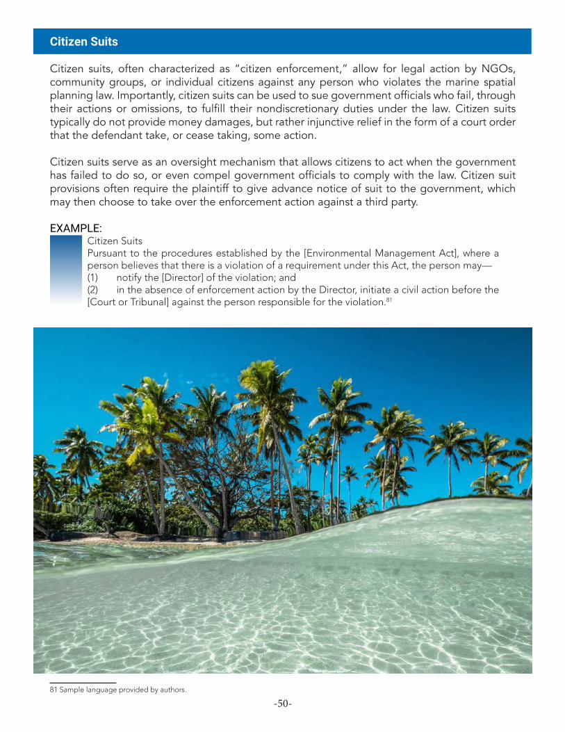
-50-
Citizen Suits
Citizen suits, often characterized as “citizen enforcement,” allow for legal action by NGOs, community groups, or individual citizens against any person who violates the marine spatial planning law. Importantly, citizen suits can be used to sue government officials who fail, through their actions or omissions, to fulfill their nondiscretionary duties under the law. Citizen suits typically do not provide money damages, but rather injunctive relief in the form of a court order that the defendant take, or cease taking, some action.
Citizen suits serve as an oversight mechanism that allows citizens to act when the government has failed to do so, or even compel government officials to comply with the law. Citizen suit provisions often require the plaintiff to give advance notice of suit to the government, which may then choose to take over the enforcement action against a third party.
EXAMPLE:Citizen Suits Pursuant to the procedures established by the [Environmental Management Act], where a person believes that there is a violation of a requirement under this Act, the person may—(1) notify the [Director] of the violation; and(2) in the absence of enforcement action by the Director, initiate a civil action before the [Court or Tribunal] against the person responsible for the violation.81
81 Sample language provided by authors.

-51-
Authorized Officers
It is the practice in many jurisdictions to designate who, pursuant to the legislation, has enforcement authority or may be granted such authority. Additional provisions may be used, where necessary, to describe the enforcement powers of authorized officers, including, for example, the powers to stop and detain vessels, board vessels, investigate, search, seize property, and arrest. Note that the pursuit of a foreign ship suspected of a legal violation may proceed beyond a coastal state’s territorial sea or contiguous zone only in compliance with the “hot pursuit” requirements of UNCLOS.82
EXAMPLE:Appointment of Authorised Officers.(1) The Minister may, after consultation with the Attorney General, appoint in writing any person or class of persons as authorised officer for the purposes of enforcing this Act and such persons shall exercise all powers and privileges accorded by this Act.(2) For all surveillance and enforcement duties and obligations provided under this Act and all other duties provided under this Act, except any duties arising from the licensing and reporting requirements of this Act, police officers of Tuvalu and the Masters of all Tuvalu flagged vessels ... are deemed to be authorised officers.(3) Any person or class of persons appointed as authorised officer in accordance with an access agreement, a fisheries management agreement or a similar cooperative arrangement to which Tuvalu is party, who is not a citizen or has not been appointed in accordance with subsection (1), shall have such rights and privileges of a citizen as may be necessary for the performance of his or her duties, and all provisions of this Act relating to authorised officers shall be applicable to such persons.(4) Any person or class of persons appointed as authorised officers pursuant to subsection (2) may perform duties which include:(a) for an authorised officer of Tuvalu, to perform fisheriessurveillance and law enforcement functions on behalf of Tuvalu while on board a vessel or aircraft of another party; and(b) for an authorised officer of another party to such agreement, to perform fisheries surveillance and law enforcement functions on behalf of Tuvalu while on board the vessel or aircraft of that other party, and all provisions of this Act relating to authorised officers shall be applicable to such persons carrying out duties in the areas of national jurisdiction of Tuvalu.(5) Any authorised officer is deemed to be an authorised inspector for purposes of a multilateral access agreement.83
82 UNCLOS art. 111 (right of hot pursuit).83 Marine Resources Act 2006 (6 of 2006) § 46 (Tuvalu). Enforcement powers for these officers are described in § 47.

-52-
The miscellaneous component of marine spatial planning legislation covers various subcomponents. Arguably the most important of these is the provision allowing for the promulgation of regulations.
Regulations
Marine spatial planning legislation law should contain a provision establishing the authority of the government to make regulations under the law, specifying which governmental body has such authority and with regard to which aspects of the law. It is good practice to reserve both a general regulatory authority as well as the authority to make regulations for specifically identified purposes.
EXAMPLE:RegulationsThe Queen’s Representative may, by Order in Executive Council, make regulations for all or any of the following purposes— (a) prescribing any other agency for the purposes of paragraph (e) of the definition of agency in section X, whether generally for the purposes of this Act or for any particular purposes specified in the regulations: (b) prescribing procedures to be followed by the Technical Advisory Group in developing plans: (c) defining additional zones for marae moana spatial plans for the purposes of section Y: (d) prescribing measures that are necessary or expedient to give full effect to the purpose of the marine protected area established by section Z: (e) providing for any other matters contemplated by this Act, necessary for its full administration, or necessary for giving it full effect.84
EXAMPLE:RegulationsThe Minister may, after consultation with the Ministerial Committee, make regulations on the following: (a) Submission of marine sector plans, including— (i) responsible organs of state that must submit marine sector plans; (ii) the frequency of submission of marine sector plans by responsible organs of state; and (iii) the content and format of marine sector plans;(b) the provision of data, statistics, documents and any other relevant information that may be necessary for the development of a marine area plan from organs of state or other relevant persons, bodies or institutions;(c) the manner and form of consultation as contemplated in section X;
84 Marae Moana Act 2017, No. 10 of 2017 § 35 (Cook Islands).
Component 7Regulations & Miscellaneous

-53-
(d) anything that may be prescribed under this Act; and(e) any other matter that is required for the effective implementation of marine spatial planning under this Act.85
EXAMPLE:Regulations(1) The Governor, acting on the advice of Cabinet, may make regulations for giving effect to this Act.(2) Without prejudice to the generality of subsection (1), the Governor, acting on the advice of Cabinet, may make regulations respecting— (a) the operations of the Marine Advisory Council; (b) the criteria, elements, or form of a marine spatial plan; (c) collecting and responding to public representations; (d) the process for preparing a marine spatial plan, or for modifying or revoking an existing approved plan; (e) categories of zones that may be used in a marine spatial plan; (f) monitoring and conducting reviews of an existing approved marine spatial plan; (g) the classification, demarcation, administration, management, use, and control of marine protected areas; (h) public participation and access to information with respect to ocean management; (i) the payment of fees and fines pursuant to this Act; (j) marine spatial plan administration, compliance, and enforcement; and (k) the provision of anything required to give effect to this Act.(3) In making regulations under this Act, the Governor may prescribe specific offences in accordance with section X.(4) In making regulations under this Act, the Governor shall take into account the purpose of the Act, the guiding principles articulated in Section Y, and the Ocean Policy.86
Legal provisions that depend on a ministry’s or department’s expertise, that address ministerial or departmental procedure, or that otherwise require a high level of detail are often left to regulations (and not included in primary legislation). Statutory language should be sufficiently detailed to ensure action by the government, with specifics left to regulation. In jurisdictions where legislative acts traditionally contain a significant amount of detail, however, it is still important to reserve the power to make regulations so as to allow flexibility to further develop aspects of the law’s implementation.
Drafting Tip: A common question is how much detail should be included in the primary marine spatial planning legislation, and how much can be left to secondary legislation/regulations without hindering implementation of the law. The answer depends on the country’s legal traditions and established norms. In any event, the legal drafter should exercise caution to ensure that a subsequent failure to promulgate regulations cannot be cited as a reason for not implementing or enforcing the marine spatial planning legislation.
85 Marine Spatial Planning Act, 2018, Act No. 16 of 2018 § 13 (South Africa).86 Sample language provided by authors.

-54-
Data & Monitoring
The data and monitoring provisions of marine spatial planning legislation can be used to specify how monitoring of the plan area is to be conducted and by whom, which types of information are collected and how often, which authority manages the data, where and how it is stored and analyzed, and how it is shared with others. Any such provisions should complement or build on existing monitoring provisions contained in a country’s fisheries act or environmental framework law. Note that monitoring can refer to monitoring of scientific indicators in the plan area, or it could refer to monitoring the implementation and effectiveness of the plan.
EXAMPLE:Monitoring of and periodical reporting on implementation of marine plans(1) For so long as a national marine plan or (as the case may be) a regional marine plan is in effect, the Scottish Ministers must keep under review in relation to each such plan the matters in subsection (2).(2) The matters are— (a) the effects of the policies in the plan, (b) the effectiveness of the policies in securing that the objectives for which the plan was prepared and adopted are met, (c) the progress being made towards securing the objectives, (d) the progress being made towards securing that the objectives in the regional marine plan secure the objectives in the national marine plan.(3) The Scottish Ministers must from time to time prepare and publish a report on the matters kept under review in pursuance of subsection (1).(4) After publishing a report under subsection (3), the Scottish Ministers must decide whether or not to amend or replace the national marine plan or (as the case may be) the regional marine plan.(5) The first report must be published before the expiry of 5 years beginning with the date on which the marine plan concerned was adopted.(6) After the publication of the first report, successive reports must be published at intervals of no more than 5 years following the date of publication of the previous report.(7) Any reference in this section to the replacement of a national marine plan or (as the case may be) a regional marine plan is a reference to— (a) preparing and adopting, in accordance with the provisions of this Part, a fresh national marine plan or (as the case may be) a regional marine plan (and as respects a regional marine plan whether or not it is for the identical Scottish marine region), (b) if the Scottish Ministers have not already done so, withdrawing the marine plan that is to be replaced.87
Drafting Tip: As the Scotland example makes clear, the issue of monitoring can be connected to the issue of periodic review of a plan, as discussed in Plan Duration & Periodic Review in Part II.3. These issues, in turn, can inform any reporting requirements that the legal drafter may include.
87 Marine (Scotland) Act 2010 (asp 5) § 16.

-55-
EXAMPLE:The Minister for Business and Growth shall ensure the organisation and use of the best available data and the sharing of information necessary for maritime spatial planning.88
Conflict Resolution
As previously mentioned, due to the variety of uses that can exist in the area covered by the marine spatial plan, conflicts can and do arise. Objectives of the law, guiding principles, and criteria for developing a marine spatial plan can all seek to prevent and resolve such conflicts. Some countries have also started creating additional mechanisms by, for example, designating a committee that considers conflicts between uses. This could be the same body that approves marine spatial plans.
EXAMPLE:(5) The Ministerial Committee may— (a) approve any marine area plans and accompanying reports referred to it by the Directors-General Committee; (b) approve any marine area plans and accompanying reports with amendments; or (c) refer any marine area plans and accompanying reports back to the Directors- General Committee for reconsideration with specific instructions.(6) The Ministerial Committee must— (a) ensure cooperation between sector departments; and (b) where necessary, resolve user conflicts, including relocations, and trade-offs or other resolutions between sectors as contemplated in section 5(2). (7) The Ministerial Committee must report to Cabinet on implementation of marine spatial planning at least every two years.89
Regional & International Harmonization
The geographically expansive and legally cross-cutting nature of marine spatial planning means that the legal drafter will need to ensure that the new legislation is consistent with the country’s regional and international commitments under treaties and other bilateral and multilateral arrangements that touch on use of the ocean, including fisheries mechanisms. This new legislation can also potentially be deployed as a means of domestic implementation of certain international obligations, as appropriate.
EXAMPLE:2. The provisions of the Act shall not be applicable if an international treaty to which the Republic of Poland is a party provides otherwise.90
EXAMPLE:(1) The following principles apply to marine spatial planning:. . . . (l) South Africa’s international obligations and cross-border cooperation.91
88 Act on Maritime Spatial Planning (Act 615 of 8 June 2016) § 17 (Denmark).89 Marine Spatial Planning Act, 2018, Act No. 16 of 2018 § 11 (South Africa).90 Act Concerning the maritime areas of the Republic of Poland and the maritime administration (21 March 1991) Article 1 (Poland).91 Marine Spatial Planning Act, 2018, Act No. 16 of 2018 § 5 (South Africa).
-56-
Grandfathering of Existing Activities
To address the fact that previously issued permits or other permissions may already be in effect, or pending approval, in the plan area prior to the commencement of a marine spatial plan, and that a new plan or planning process could alter them, it can be useful to include a grandfathering provision. This essentially allows for a grace period for certain lawful pre-existing activities to come into compliance.
EXAMPLE:Approved pre-existing ocean activitiesLicenses, permits, certificates, approvals, or other permissions that are lawfully issued prior to the effective date for a marine spatial plan and allow an activity, use, development, or other action to occur within the plan area are valid for the lesser of 1 year or the duration of the approval – after which time such approvals and activities must comply with the requirements of the marine spatial plan.92
Repealers & Savings Clauses
As is always the case with legal drafting, the key to using repealers and savings clauses in marine spatial planning legislation is to make sure that they are clear, and will alter the existing legal framework only insofar as is necessary and intended by the drafter. This consideration is especially important in the marine spatial planning context, as the new law will likely touch on sectoral laws governing subjects such as fisheries management, protected areas and environmental protection, maritime and shipping, and offshore industry. The legal drafter’s initial legal assessment should have identified potential areas of conflict and overlap, and care must be taken to resolve these.
Binding the Crown
In appropriate jurisdictions, marine spatial planning legislation should follow the convention of affirmatively expressing an intent to bind the Crown (or appropriate sovereign).
Schedules
Schedules form part of the legislation but are presented separately from the main body of the law. Routine uses for schedules include presenting standardized forms, identifying amendments that follow as a consequence of the act, and providing for current or future fine amounts. In the marine spatial planning context, the legal drafter should consider whether any other uses are necessary. For example, a map of the country’s maritime zones could prove helpful. Or, in a situation where a marine spatial planning process has taken place in parallel with development of legislation (see discussion in Part I) and the new legislation will bring that initial plan online at enactment, that plan could be appended as a schedule.
92 Sample language provided by authors.

-57-
In some countries, including many in the Pacific region, indigenous peoples enjoy rights over certain ocean resources by custom and tradition. Often, as in Vanuatu, customary law is enshrined in the constitution93—and the rules of custom form the basis of land use and ownership.94 Where traditional rights and management form part of the legal and policy framework, the legal drafter must take them into account in marine spatial planning legislation—just as the drafter would need to do in connection with any sectoral legislation touching on use of land and nearshore waters. The objectives section of legislation, as noted in Part II.1 of this Guide, is one important place to clarify legislative intent regarding traditional rights.
Precisely how tradition and custom should form part of marine spatial planning legislation—and the marine spatial planning process—remains an open question and highly dependent on a country’s particularized circumstances.95 But whatever the legislative design, marine spatial planning legislation should empower both the traditional and the modern systems of governance in a country. With respect to traditional communities, this means going far beyond “consulting” them as members of the public under public participation provisions and, instead, engaging these communities as owners and managers of their marine resources as recognized by law.
Traditional knowledge and management techniques often date back for many hundreds of years, or longer. There is much to learn from local traditional management of ocean resources, including practices that have and have not worked in the past, experience often gleaned from generations of local management. As a result, customary practices should inform not only ocean areas subject to customary rights but also the broader governance system for marine spatial planning. Conversely, marine spatial planning is a tool that can help to reinvigorate traditional management practices.
At a technical level, rights of traditional management could be an overlay for the entire marine spatial planning process, or these rights could be expressed through locally managed zones,96 or both. For example, a country could proceed with nearshore traditional management and offshore national management. Regardless, the legal drafter should ensure that customary considerations are integrated, as appropriate, into the specific components of marine spatial planning legislation discussed in this Guide.
93 See, e.g., Constitution of the Republic of Vanuatu art. 95.94 Constitution of the Republic of Vanuatu art. 74.95 These insights are adapted from plenary discussion on the subject at the workshop “Drafting Legislation to Support Marine Spatial Plan-ning,” convened in Auckland, NZ in September 2019.96 Generally speaking, ocean zones in a marine spatial plan are used for the ocean areas beyond the reef edge. But one could incorporate “cultural zones” or “locally managed zones,” unless this step in and of itself is viewed as undermining traditional rights. Again, practice and norms will vary by country and culture. Aspects of traditional management may lack written rules, so it is important to enable the exercise of traditional rights without forcing them into a national construct.
Component 8Traditional Rights & Management

-58-
This could mean, e.g., allocating competencies and management duties in view of existing rights and management practices. It could also mean designing special elements of public participation designed to reach, listen to, and learn from traditional communities. And it could mean relying on co-management mechanisms and traditional means of ensuring compliance by ocean users.Grandfathering of Existing ActivitiesEXAMPLE:
Arrangements with community groups that have special interests in areas of the Marine Park(1) The Authority may enter into an agreement or arrangement for the purposes of this Part with a group of people who are representative of a community group that has a special interest in an area of the Marine Park.(2) The agreement or arrangement may relate to the development and/or the implementation of a plan of management for, or for a species or ecological community within, the area concerned and may, if the Authority considers it appropriate, provide that, if such a plan of management is prepared, the community group is to manage the area, or the species or ecological community within the area, jointly with the Authority in accordance with the plan.97
Ultimately, this is a component of marine spatial planning legislation that, while critical, is not yet fully developed and will benefit from the design and implementation of innovative new approaches.
97 Great Barrier Reef Marine Park Act 1975, No. 85, 1975 §39ZA (Australia).

-59-
Appendix AIndex of Legislation and Regulations Related to Marine Spatial Planning
The following laws, regulations, and other legal instruments either implement marine spatial planning or contain provisions related to marine spatial planning.
Australia: • Marine and Coastal Act 2018 (VIC).• Environment Protection and Biodiversity Conservation Regulations 2000, Stat. Rules No. 181
(ACT).• Environment Protection and Biodiversity Conservation Act 1999 (ACT). • Great Barrier Reef Marine Park Act 1975 (ACT).
Barbuda: • The Barbuda (Coastal Zoning and Management) Regulations (No. 34/2014).
Belgium: • 22 mei 2019 Koninklijk besluit tot vaststelling van het marien ruimtelijk plan voor de periode van
2020 tot 2026 in de Belgische zeegebieden [Royal Decree on the establishment of the marine spatial planning plan for the period from 2020 to 2026 in Belgian marine areas], B.S. 2 juli 2019, p. 66980.
• 13 november 2012 Koninklijk besluit betreffende de instelling van een raadgevende commissie en de procedure tot aanneming van een marien ruimtelijk plan in de Belgische zeegebieden [Royal Decree on the establishment of an advisory commission and the procedure for the adoption of a plan for the management of marine areas in Belgian marine areas], B.S. 28 november 2012, p. 76072.
• 20 juli 2012 Wet tot wijziging van de wet van 20 januari 1999 ter bescherming van het mariene milieu in de zeegebieden onder de rechtsbevoegdheid van België, wat de organisatie van de marine ruimtelijke planning betreft [An Act to amend the Act of 20 January 1999 concerning the protection of the marine environment in marine areas under the jurisdiction of Belgium, with regard to the organization of marine spatial planning (Marine Environment Act)], B.S. 11 september 2012, p. 56962.
Belize: • Coastal Zone Management Act (2000, Ch. 329) (Belize).
Bulgaria: • Правилник за функциите, задачите и състава на Консултативния съвет по въпросите
на морското пространствено планиране към министъра на регионалното развитие и благоустройството [Regulation on the functions, tasks and composition of the Consultative Council for Marine Spatial Planning at the Minister of Regional Development and Public Works] (No. 79/2018) (Bulg.).
• Maritime Spaces, Inland Waterways and Ports of the Republic of Bulgaria Act (No. 28/2018).
Canada: • Oceans Act, S.C. 1996, c. 31 (Can.).
China: • Spatial Planning Act (2016) (China).• Coastal Zone Management Act (2015) (China). • Regulations of Zhejiang Province on the Administration of the Use of Sea Areas (2012) (China).• Measures of Hainan Province for implementing the Law of the People’s Republic China on the
Administration of the Use of Sea Areas (2008) (China).
-60-
• Provisions governing the disciplinary action against the violations of law and discipline on the use and management of the maritime zones (2008) (China).
• Regulations of Tianjin Municipality on the Administration of the Use of Sea Areas (2007) (China).• Regulations of Fujian Province on the Administration of the Use of Sea Areas (2006) (China).• Regulations of Jiangsu Province on the Administration of the Use of Sea Areas (2005) (China). • Law of the People’s Republic of China on the Administration of the Use of Sea Areas (2001)
(China).
Cook Islands: • Marae Moana Act (No. 10/2017) (Cook Islands).
Costa Rica: • Creación del mecanismo de gobernanza de los espacios marinos sometidos a la jurisdicción del
Estado Costarricense [Creation of the mechanism of governance of marine spaces subject to the jurisdiction of the Costa Rican State] (Executive Decree No. 41775/2019) (Costa Rica).
Croatia: • Strategija prostornog razvoja Republike Hrvatske [Strategy on the Spatial Development of the
Republic of Croatia] (No. 106/2017) (Croat.). • Zakon o izmjenama i dopunama Zakona o prostornom uređenju [Law on Amendments to the
Physical Planning Act] (No. 65/2017) (Croat.).• Zakon o prostornom uređenju [Law on Physical Planning] (No. 153/2013) (Croat.).
Cyprus: • Ο περί Θαλάσσιου Χωροταξικού Σχεδιασμού και άλλων Συναφών Θεμάτων Νόμος του
2017 [2017 Maritime Spatial Planning and Other Related Matters Act] (Law 114(I)/2017) (Cyprus).
Denmark: • Lov nr. 615 af 8 juni 2016 om maritime fysisk planlægning [Act on maritime spatial planning].
Ecuador: • Ley Orgánica de Régimen Especial de la Provincia de Galápagos (LOREG) [Organic Law of
Special Regime of the Province of Galapagos] (Registro Oficial Nº 520, Suplemento 2, 11 de junio de 2015) (Ecuador).
Estonia: • Planeerimisseadus [Planning Act] (2015) (Est.).
European Union: • Directive 2014/89, of the European Parliament and of the Council of 23 July 2014 Establishing a
Framework for Maritime Spatial Planning, OJ L 257, 28.8.2014.
Finland: • 482/2016 Lakimaankäyttö- ja rakennuslain muuttamisesta [Act amending the Land Use and
Building Act] (Fin.).
France:• Décret n° 2017-724 du 3 mai 2017 intégrant la planification maritime et le plan d’action pour
le milieu marin dans le document stratégique de façade [Decree no. 2017-724 of May 3, 2017 integrating the maritime planning and the action plan for the marine environment in the strategic document of facade] (Fr.).
• Loi n° 2016-1087 du 8 août 2016 pour la reconquête de la biodiversité, de la nature et des paysages (1) [Law No. 2016-1087 of August 8, 2016 for the reconquest of the biodiversity, the nature and the landscapes], J.O. du 4 août 2016 (Fr.).
Germany: • Gesetz zur Neufassung des Raumordnungsgesetzes und zur Änderung anderer Vorschriften
(Raumordnungsgesetz) [Spatial Planning Act] v. 22.12.2008, BGBI. I 2008, p. 2986, last amended 2017 (Ger.).
-61-
• Verordnung über die Raumordnung in der deutschen ausschließlichen Wirtschaftszone in der Nordsee (AWZ Nordsee-ROV) [Ordinance on Spatial Planning in the German Exclusive Economic Zone in the North Sea] v. 25.9.2009, BGBI. I 2009, p. 3107.
• Verordnung über die Raumordnung in der deutschen ausschließlichen Wirtschaftszone in der Ostsee (AWZ Ostsee-ROV) [Ordinance on Spatial Planning in the German Exclusive Economic Zone in the Baltic Sea] v. 10.12.2009, BGBI. I 2007, p. 3861.
Ghana: • Land Use and Spatial Planning Act (Act 925/2016) (Ghana).
Greece: • N. 4546/2018 [Incorporation to the Hellenic legislation of Directive 2014/89/EU “establishing a
framework for maritime spatial planning” and other provisions] (Greece).
Iceland: • Þingsályktun um landsskipulagsstefnu 2015–2026 [National Resolution on National Planning
Policy 2015-2026] (No. 19/145) (Ice.). • Landsskipulagsstefna 2015-2026 [National Planning Policy 2015-2026] (Ice.).
Indonesia: • Law on the Sea (No. 32/2014) (Indon.). • Guidance for Managing Resources in Maritime Territory (Reg. of the Minister of Home Affairs No.
30/2010) (Indon.). • Undang-Undang Republik Indonesia Tentang Penataan Ruang [Law of the Republic of Indonesia
concerning Spatial Planning] (No. 26/2007).
Ireland:• European Communities (Marine Strategy Framework) (Amendment) Regulations, 2018, S.I. 648
of 2018 (Ir.). • European Union (Framework for Maritime Spatial Planning) Regulations, 2016, S.I. 352 of 2016
(Ir.). • European Communities (Marine Strategy Framework) Regulations, 2011, S.I. 249 of 2011 (Ir.).
Italy: • Attuazione della direttiva 2014/89/UE che istituisce un quadro per la pianificazione dello spazio
marittimo [Implementation of Directive 2014/89/EU establishing a framework for maritime spatial planning], D.Lgs. 201/2016 (It.).
Latvia: • Teritorijas attīstības plānošanas likums [Spatial Development Planning Law] (Nr. 173/2011, last
amended 2014) (Lat.). • Jūras plānojuma izstrādes, ieviešanas un uzraudzības kārtība [Procedures for the development,
implementation and monitoring of the maritime spatial plan] (Ministru kabineta noteikumi Nr. 740/2012) (Lat.).
• Jūras vides aizsardzības un pārvaldības likums [Marine Environment Protection and Management Act] (2010) (Lat.).
Lithuania: • Teritorijų Planavimo Įstatymas [Law on Territorial Planning] (No. I-1120/1995, as amended by No.
XII-2643/2016) (Lith.).
Madagascar: • Décret portant réglementation de la gestion intégrée des zones côtières et marines de
Madagascar [Decree regulating the integrated management of coastal and marine areas of Madagascar] (Decree No. 137/2010).
Malta: • Maritime Spatial Planning Regulations (L.N. 341/2016, Cap. 552) (Malta).

-62-
• Development Planning Act Act VII/2016, Cap. 522) (Malta).• Environment and Development Planning Act (Act X/2010, Cap. 504) (Malta).
Netherlands: • Omgevingswet [Environment and Planning Act], Stb. 2016, 156 (Neth.). • Wet van 29 januari 2009, houdende regels met betrekking tot het beheer en gebruik van
watersystemen (Waterwet) [National Water Act], Stb. 2009, 107 (Neth.). • Wet van 20 oktober 2006, houdende nieuwe regels omtrent de ruimtelijke ordening (Wet
ruimtelijke ordening) [Spatial Planning Act], Stb. 2006, 566 (Neth.).
Norway: • Lov om forvaltning av naturens mangfold (naturmangfoldloven) [Nature Management Act] 19.
juni 2009 nr. 100 (Nor.).• Lov om forvaltning av viltlevande marine ressursar (havressurslova) [Marine Living Resources Act]
6. juni 2008 nr. 37 (Nor.).
Philippines: • Adopting Integrated Coastal Management as a National Strategy to Ensure the Sustainable
Development of the Country’s Coastal and Marine Environment and Resources and Establishing Supporting Mechanisms for its Implementation, Exec. Order No. 533 (2006) (Phil.).
• An Act Adopting the Strategic Environmental Plan for Palawan, Rep. Act No. 7611 (1992) (Phil.).
Poland: • Ustawa o obszarach morskich Rzeczypospolitej Polskiej i administracji morskiej [Act concerning
the Maritime Zones of the Polish Republic and the Marine Administration] (2018 r. DZ. U. poz. 2214) (Pol.).
• Rozporządzenie w sprawie wymaganego zakresu planów zagospodarowania przestrzennego morskich wód wewnętrznych, morza terytorialnego i wyłącznej strefy ekonomicznej [Regulation on the required scope of spatial development plans for internal maritime waters, the territorial sea and the exclusive economic zone] (2017 r. DZ. U. poz. 1025) (Pol.).
• Ustawa o obszarach morskich Rzeczypospolitej Polskiej i administracji morskiej [Act concerning the Maritime Zones of the Polish Republic and the Marine Administration] (1991) (Pol.).
Portugal:• Decreto-Lei n. 139/2015 de 30 de julho [Decree-Law No. 139/2015 amending Decree-Law No.
38/2015 implementing the Policy on the National Maritime Areas Planning and Management] (Port.).
• Decreto-Lei n. 38/2015 de 12 de março [Decree-Law No. 38/2015 implementing Law No. 17/2014 establishing the Policy on the National Maritime Areas Planning and Management] (Port.).
• Lei n. 17/2014 de 10 de abril [Law No. 17/2014 establishing the Policy on the National Maritime Areas Planning and Management] (Port.).
Romania: • Lege pentru aprobarea Ordonanţei Guvernului nr. 18/2016 privind amenajarea spaţiului maritim
[Law for the approval of the government Ordinance No. 18/2016 regarding the arrangement of the maritime space] (Law no. 88/2017) (Rom.).
• Ordonanţă privind amenajarea spaţiului maritim [Ordinance regarding the arrangement of the maritime space] (Ord. no. 18/2016) (Rom.).
Slovenia: • Zakona o urejanju prostora (ZUreP-2) [Spatial Planning Act] (No. 61/2017) (Slovn.).
South Africa: • Marine Spatial Planning Act, 16 of 2018 (S. Afr.).
-63-
Spain: • Real Decreto (R.D.) 363/2017, de 11 de abril, Marco para la ordenación del espacio marítimo
[Royal Decree 363/2017 of April 8 establishing a framework for Maritime space management], BOE 2017, 28802 (Spain).
Sweden: • Lag (2015:400) om Havsplaneringsförordning [The Marine Spatial Planning Ordinance] (Swed.).• Lag (2010:900) om Plan- och bygglag [The Planning and Building Act] (Swed.).• Lag (1998:808) om Miljöbalk [The Environmental Code] (Swed.).
Thailand: • Act on the Promotion of Marine and Coastal Resources Management, B.E. 2558 (2015) (Thai.).
United Kingdom: • Environment (Maritime Spatial Planning) Regulations 2016, SI 2016/179 (U.K.). • Marine and Coastal Access Act 2009, c. 23 (U.K.). • Marine (Scotland) Act 2010, (A.S.P. 5).
United States:• Florida:
• Florida Keys National Marine Sanctuary Regulations, 15 C.F.R. 922, subpart P (1997). • Florida Keys National Marine Sanctuary and Protection Act, 16 U.S.C. § 1433 (1990). • National Marine Sanctuaries Act, 16 U.S.C. § 1431 (1972).
• Massachusetts:• Ocean Management Plan Regulations, Mass. Regs. Code tit. 301, § 28 (2017).• An Act Relative to Oceans, S. Res. 2699, ch. 114 (2008).
• Oregon:• Oregon Ocean Resources Management Act, oR. Rev. stat. § 196.405-515 (1991).
• Rhode Island• Coastal Resources Management Council, Gen. L. 46-23 (R.I., 1971).
• Washington• Marine Waters Planning and Management Regulations, Wash. Rev. Code § 43.372 (2010).• Marine Waters Planning and Management Act, S. 6350, 61st. Legis. Sess. (Wash. 2010).
Vietnam: • Elaboration on the Law on Planning (No. 37/2019) (Viet.). • The Law on Marine and Island Resources and Environment (No. 10/2015) (Viet.).

-64-
Appendix BReference Materials Related to Marine Spatial PlanningThis appendix contains reports, academic articles, and other reference materials that discuss topics related to marine spatial planning and marine protected areas. These resources provide guidance on planning and drafting processes, explore different components of marine spatial planning, and highlight best practices and lessons learned from different jurisdictions.
• agaRdy, t., oCean Zoning: Making MaRine ManageMent MoRe effeCtive (Routledge Earthscan 2010).
• agaRdy, t., et al., United nations env’t PRogRaMMe, taking stePs toWaRd MaRine and Coastal eCosysteM-Based ManageMent—an intRodUCtoRy gUide (2011).
• agostini, v. n., et al., MaRine Zoning in saint kitts and nevis: a Path toWaRds sUstainaBle ManageMent of MaRine ResoURCes (The Nature Conservancy 2010).
• aUgé, a. a., s. atl. envtl. ReseaRCh inst., MaRine sPatial Planning foR the falkland islands: ‘fRaMing the PRoCess’ WoRkshoP RePoRt (2016).
• BaltiC sCoPe, CoheRent CRoss-BoRdeR MaRitiMe sPatial Planning foR the soUthWest BaltiC sea (Alberto Giacometti et al. eds., 2017).
• BaRRiteaU, M., et al., sUstainaBle gRenadines inC., develoPing a fRaMeWoRk foR a CoMPRehensive MaRine MUlti-Use Zoning Plan foR the gRenadine islands (National Oceanic and Atmospheric Administration 2012).
• BeCk, M.W., et al., Best PRaCtiCes foR MaRine sPatial Planning (The Nature Conservancy 2009).
• BlæsBjeRg, M., et al., MaRine sPatial Planning in the noRdiC Region: PRinCiPles, PeRsPeCtives and oPPoRtUnities (Nordic Council of Ministers 2009).
• CeCCaRelli, d. M., et al., MaRine and Coastal BiodiveRsity MgMt. in PaC. island CoUntRies, BioPhysiCal design PRinCiPles foR offshoRe netWoRks of no-take MaRine PRoteCted aReas (2018).
• CeCCaRelli, d. M., et al., MaRine and Coastal BiodiveRsity MgMt. in PaC. island CoUntRies, develoPing a MaRine sPatial Plan: a toolkit foR the PaCifiC (2018).
• Coastal Res. CtR. & R.i. sea gRant Coll. PRogRaM at the Univ. of R.i. gRadUate sCh. of oCeanogRaPhy, MaRine sPatial Planning: adviCe fRoM the field (2016).
• Collie, J. S., et al., Marine Spatial Planning in Practice, 117 estUaRine, Coastal & shelf sCienCe 1 (2013).
• day, j., et al., int’l Union foR ConseRvation of natURe, gUidelines foR aPPlying the iUCn PRoteCted aRea ManageMent CategoRies to MaRine PRoteCted aReas (2d ed. 2019).
• Day, J., The Need and Practice of Monitoring, Evaluating and Adapting Marine Planning and Management—Lessons from the Great Barrier Reef, 32 MaRine Pol’y 823 (2008).

-65-
• diaMond, j., et al., envtl. laW inst., MaRine sPatial Planning in Us WateRs: an assessMent and analysis of existing legal MeChanisMs, antiCiPated BaRRieRs, and fUtURe oPPoRtUnities (2009).
• Douvere, F. & Ehler, C. N., New Perspectives on Sea Use Management: Initial Findings from European Experience with Marine Spatial Planning, 90 j. envtl. MgMt. 77 (2008).
• Drankier, P., Embedding Maritime Spatial Planning in National Legal Frameworks, 14 j. envtl. Pol’y & Plan. 7 (2012).
• ehleR, C., inteRgoveRnMental oCeanogRaPhiC CoMM’n, a gUide to evalUating MaRine sPatial Plans (United Nations Educ., Scientific and Cultural Org. 2014).
• ehleR, C. & doUveRe, f., inteRgoveRnMental oCeanogRaPhiC CoMM’n & Man and the BiosPheRe PRogRaM, MaRine sPatial Planning: a steP-By-steP aPPRoaCh toWaRd eCosysteM-Based ManageMent (Rachel Dahl ed., United Nations Educ., Scientific and Cultural Org. 2009).
• Frazāo Santos, C., et al., Challenges in Implementing Sustainable Marine Spatial Planning: The New Portuguese Legal Framework Case, 61 MaRine Pol’y 196 (2015).
• Frazāo Santos, C., et al., Major Challenges in Developing Marine Spatial Planning, MaRine Pol’y, Sept. 13, 2018.
• int’l Union foR ConseRvation of natURe & WoRld CoMM’n on PRoteCted aReas, aPPlying iUCn’s gloBal ConseRvation standaRds to MaRine PRoteCted aReas (MPa): deliveRing effeCtive ConseRvation aCtion thRoUgh MPas, to seCURe oCean health and sUstainaBle develoPMent (2018).
• int’l Union foR ConseRvation of natURe, PRoteCted aRea goveRnanCe and ManageMent (Graeme L. Worboys et al. eds., ANU Press 2015).
• jay, s., oRg. foR eCon. Co-oPeRation and dev., MaRine sPatial Planning: assessing net Benefits and iMPRoving effeCtiveness (2017).
• Kenchington, R. A. & Day, J. C., Zoning, a Fundamental Cornerstone of Effective Marine Spatial Planning: Lessons Learnt from the Great Barrier Reef, Australia, 15 j. Costal ConseRvation 271 (2011).
• laUsChe, B., gUidelines foR PRoteCted aReas legislation (International Union for Conservation of Nature 2011).
• leWis, n., et al., Big oCean & int’l Union foR ConseRvation of natURe WoRld CoMM’n on PRoteCted aReas MPa task foRCe, laRge-sCale MaRine PRoteCted aReas: gUidelines foR design and ManageMent (Craig Groves ed., 2017).
• longley-Wood, k., seaPlan, CReating and Using data PoRtals to sUPPoRt oCean Planning: Challenges and Best PRaCtiCes fRoM the noRtheast United states and elseWheRe (2016).
• Maes, F., The International Legal Framework for Marine Spatial Planning, 32 MaRine Pol’y 797 (2008).
• MatCZak, M., et al., PaRtiseaPate, handBook on MUlti-level ConsUltations in MsP (2014).

-66-
• MCCann, j., et al., Coastal Res. CtR. & R.i. sea gRant Coll. PRogRaM at the Univ. of R.i. gRadUate sCh. of oCeanogRaPhy, identifying MaRine sPatial Planning gaPs, oPPoRtUnities, and PaRtneRs: an assessMent (2014).
t• MCCann, j. & sChUMann, s. With fUgate, gRoveR, kennedy, sUe & yoUng, ChiP, Univ. of R.i.
Coastal Res. CtR. & R.i. sea gRant Coll. PRogRaM, the Rhode island oCean sPeCial aRea ManageMent Plan: Managing oCean ResoURCes thRoUgh Coastal and MaRine sPatial Planning (Monica Allard-Cox ed., 2013).
• MengeRink, k., et al., envtl. laW inst. & the CtR. foR oCean solUtions, Coastal and MaRine sPatial Planning: legal ConsideRations (2010).
• MoURa, s. & Zaykoski, P., seaPlan, advanCing the PRaCtiCe of PeRfoRManCe MonitoRing and evalUation in oCean Planning (2016).
• MUldoon, j., et al., MaRine and Coastal BiodiveRsity MgMt. in PaC. island CoUntRies, RevieW of legislation, PoliCies, stRategies and Plans Relating to the develoPMent of MaRine PRoteCted aReas in fiji. RePoRt to the goveRnMent of fiji (2016).
• nat’l oCeaniC & atMosPheRiC adMin. sCi. advisoRy Bd., stRategiC adviCe on designing and iMPleMenting Coastal and MaRine sPatial Plans (2011).
• nat’l oCean CoUnCil, legal aUthoRities Relating to the iMPleMentation of Coastal and MaRine sPatial Planning (2011).
• nat’l oCean CoUnCil, MaRine Planning handBook (2013).
• Olsen, S. B., et al., The State of Rhode Island’s Pioneering Marine Spatial Plan, 45 MaRine Pol’y 26 (2013).
• PeaRt, R., envtl. def. soC’y, tURning the tide: integRated MaRine Planning in neW Zealand (2018).
• Pomeroy, R. S., et al., Marine Spatial Planning in Asia and the Caribbean: Application and Implications for Fisheries and Marine Resource Management, 32 desenvolviMento e Meio aMBiente 151 (2014).
• PoRteR, R. & asaRe, a., legal and liteRatURe RevieW of gloBal MaRine sPatial Planning legislation (Marine Affairs Institute at Roger Williams University School of Law & the Rhode Island Sea Grant Legal Program eds., 2019).
• Pyć, D., The Role of the Law of the Sea in Marine Spatial Planning, in MaRitiMe sPatial Planning: Past, PResent, fUtURe 375 (Jacek Zaucha & Kira Gee eds., 2019).
• RevieW of the gReat BaRRieR Reef MaRine PaRk aCt 1975 (Australian Government 2006).
• R.i. Coastal Res. MgMt. CoUnCil, Univ. of R.i. Coastal Res. CtR. & R.i. sea gRant, Rhode island oCean sPeCial aRea ManageMent Plan: advanCing MaRine sPatial Planning thRoUgh ReseaRCh and PUBliC inPUt (2010).

-67-
• seRjeant, k. & PeaRt, R., envtl. def. soC’y, healthy seas: iMPleMenting MaRine sPatial Planning in neW Zealand (2019).
• Solomon Islands Ocean Zone Placement Guidelines for Marine Spatial Planning 2017.
• United nations env’t PRogRaMMe – MediteRRanean aCtion Plan, ConCePtUal fRaMeWoRk foR MaRine sPatial Planning in the MediteRRanean (2018).
• Wendt, h., et al., MaRine and Coastal BiodiveRsity MgMt. in PaC. island CoUntRies, dRaft MaRine BioRegions of the soUthWest PaCifiC (2018).
• Zervaki, A., Introducing Maritime Spatial Planning Legislation in the EU: Fishing in Troubled Waters?, MaR. safety & seCURity l. j., 2015, at 95.