desinventarâtraining.desinventar.net/desinventar/desinventar-user… · web viewthe purpose of...
TRANSCRIPT

DesInventar Server 9
Disaster Inventory and Risk Management System
DesInventar Data Entry Module
USER MANUAL(Version 9.2.11)

DesInventar Server 9.5.12 User Manual February 2011.
CONTENTS
INTRODUCTION.....................................................................................4BASIC CONCEPTS................................................................................6
Events as defined by DesInventar........................................................................6Geography............................................................................................................6Definition of Disaster.............................................................................................7
PREDETERMINED EVENTS.................................................................8GETTING STARTED............................................................................15MAIN MENU.........................................................................................16SELECTING THE REGION OF STUDY...............................................17
Adding Events.....................................................................................................18Editing Events.....................................................................................................19Deleting Events...................................................................................................20Errors in manipulating events.............................................................................20
GEOGRAPHY MANAGEMENT...........................................................22Geographical Levels...........................................................................................22
Errors while entering Geography Data......................................................................26Management buttons in Geography tab.............................................................26
MANAGEMENT OF MAPS..................................................................27Overview of the process............................................................................................27Important considerations:..........................................................................................28Setting up a map for a level......................................................................................28
MANAGEMENT OF OTHER MAP LAYERS........................................29MANAGEMENT OF ATTRIBUTES......................................................31GOOGLE-GEOCODE...........................................................................32ADMINISTRATION OF CAUSES.........................................................33ENTERING AND MODIFYING DISASTER DATACARDS..................35
Data Entry Tab..........................................................................................................35The “New Datacard” Button......................................................................................35The “Edit Datacards” Button......................................................................................36The “Delete” Button...................................................................................................37The “Find Serial” Button............................................................................................37
THE DATACARD SECTIONS.............................................................................38Event selection and localization in space and time............................................38
Causes......................................................................................................................41Effects.................................................................................................................43
PERSONS.................................................................................................................43INFRASTRUCTURE..................................................................................................44Other Effects on infrastructure..................................................................................44Magnitude.................................................................................................................46
Page 2 © La Red 1993...2009with support from United Nations UNISDR and UNDP

DesInventar Server 9.5.12 User Manual February 2011.
The Field “Comments”...............................................................................................46The Extension section of the Datacard...............................................................46
THE EXTENSION TAB.........................................................................48The Extension Manager.....................................................................................49
Field Types................................................................................................................50Tab Manager.............................................................................................................51
TAB DATA SCREEN............................................................................52ASSIGN VARIABLES TO TAB SCREENTHE QUERY TAB..............52THE QUERY TAB.................................................................................53
Selecting Data Cards by “Event”...............................................................................54Selecting Data Cards by “Geography”......................................................................54Selecting Data Cards by “Date”.................................................................................54
ADMINISTRATION FUNCTIONS.........................................................57Region Administration.........................................................................................59
DESINVENTAR SYSTEM PARAMETERS..........................................63Importing DataCards from other DesInventar Sources......................................67
SECURITY............................................................................................68User management..............................................................................................68Security of the System........................................................................................70
Other security considerations:...................................................................................70
Page 3 © La Red 1993...2009with support from United Nations UNISDR and UNDP

DesInventar Server 9.5.12 User Manual February 2011.
Introduction
Introduction to DesInventar
The Network of Social Studies in Disaster Prevention in Latin America, LA RED, was incorporated in 1992 in San José, Costa Rica. A few months later, in January 1993, LA RED released its Research Agenda and Organic Constitution documents, stating that
Population growth and urbanization processes, trends in land use, increasing impoverishment of significant segments of the population, use of inappropriate technological systems in the construction of houses and basic infrastructure, and inappropriate organization systems, amongst others, are factors that have increased the vulnerability of the population vis-a-vis the wide diversity of physical and natural events.
However, lack of systematic, homogeneous, and compatible records of disaster typologies, understood as the effect of the occurrence of threatening events on the vulnerability of each region, country or city, on the one hand, and insistence on considering disasters only as effects of events of huge proportions and high impact, on the other, have hidden the thousands of small and medium scale disasters that occur every year in regions such as Latin America, the Caribbean, Asia and Africa.
Institutions and researchers of a number of countries are interested in this subject. But unfortunately, they use different tools to systematize the information on disasters -especially databases or physical files- designed on the basis of specific or sectorial criteria, and using different formats. Besides, there is a large volume of information pending compilation and systematization, specifically in graphic material.
This scattered information must be compiled, homogenized and analyzed. But it must also be geographically referenced, since disasters (affected communities and infrastructure) due to the effects of each type of event (threat) are regionalized variables.
ObjectivesA common objective in regions and countries of Latin America and the Caribbean, Asia and Africa is to build the capacity to analyze and represent hazards, vulnerabilities, and risks in terms of space and time, both retrospectively and prospectively. The purpose of this capacity is its application in risk management, whose activities go from mitigation to post-disaster attention and recovery.
Qualitative and quantitative evaluation of vulnerability and risk growth requires a sound base of documents and records including past and present disasters.
Page 4 © La Red 1993...2009with support from United Nations UNISDR and UNDP

DesInventar Server 9.5.12 User Manual February 2011.
As a contribution to this common objective, LA RED began its project “Inventory of Disasters in Latin America” in late 1993. Its pilot stage comprised the following activities: a) discussion and definition of conceptual and methodological criteria for the analytical treatment of small, medium and large scale disasters; b) compilation of the information for years 1990 through 1994 in available sources, obtained from a sample of Latin American countries (Mexico, Guatemala, El Salvador, Costa Rica, Colombia, Ecuador, Peru and Argentina); and c) development of the systems tool required for this purpose.
DesInventar is then the synthesis of a process through which the research teams committed to LA RED proposed a framework under which the concepts and methodologies related to disasters were unified, and is also an instrument for the development of the objectives determined. The basic criteria guiding DesInventar are:
- All inventories must have at least a common set of basic variables to measure the effects, and a homogeneous and basic classification of events;
- The information compiled and processed must be entered in a scale of time and at a geo-referenced spatial level;
- The inventories must be analyzed with system tools, which is a basic requirement in comparative research and to support decision-making processes related to mitigation actions and risk management as a whole.
DesInventar is also an instrument that allows to visualize, in space and time, the phenomena that have been registered, thanks to its additional instrument called Query Module or DesConsultar.
Page 5 © La Red 1993...2009with support from United Nations UNISDR and UNDP

DesInventar Server 9.5.12 User Manual February 2011.
Welcome to DesIventar!
BASIC CONCEPTS
Events as defined by DesInventar
EVENT is defined by DesInventar as a phenomenon, whether natural or not, which, once triggered, produces adverse effects on human lives, health and/or social and economic infrastructures.
The words selected by DesInventar to designate the types of events are not “orthodox” for disciplines such as geology, meteorology, etc.; the purpose is just to come closer to the most common designations used in each region for the phenomena. The selection was made based on several dictionaries and technical glossaries, although the search was not exhaustive. Neither do we intend to propose or impose a new glossary. The point is more to provide a set of terms with which each research team or user can enter, in a practical manner, the information on disasters that can be compiled from different sources: existing databases, graphic material, files, or from the search-and-rescue activities that entities and institutions carry out every day.
The description of the use of each term can be accessed in the Glossary, through the menu “Help”. It includes some alternative words or synonyms that may appear frequently, depending on the sources or on country or sub-region uses. If preferred, or for practical or uses reasons, the option “Create Type of Event” has been included. Thus, DesInventar can be applied even to follow up threatening phenomenologies in industrial sectors or in evaluations of environment degradation over time.
Geography
A good deal of the effort made by DesInventar has focussed on “geo-referencing” the information. This process assumes the existence of geographical units to which the information will be “anchored”.
The geographical units might be, for example, elements of a uniform grid. This could be very advantageous, but impracticable, because neither natural territorial units nor political-administrative divisions are square.
The alternative is then to use more “human” geographical units, which may be less homogeneous, but can be used in a practical way. These geographical units must be known zones, established to last over time.
Page 6 © La Red 1993...2009with support from United Nations UNISDR and UNDP

DesInventar Server 9.5.12 User Manual February 2011.
Theoretically, a researcher could establish HIS OWN geographical unit, and use it to geo-referencing the information. This is valid, but it might not allow cross-referencing information, such as the social-economic information, which could be absolutely relevant in a study from the social point of view of disasters.
The research team of DesInventar suggests using the political-administrative divisions of each country as the basis to geo-referencing the disaster information entry cards.
Definition of Disaster
Now that the concepts of geography and data resolution have been described, the cornerstone of the DesInventar methodology can be introduced: the definition of “Disaster”:
DISASTER IS DEFINED AS THE SET OF EFFECTS CAUSED BY AN EVENT (WHETHER NATURAL OR NOT) ON HUMAN LIVES AND ECONOMIC INFRASTRUCTURE ON A GEOGRAPHICAL UNIT OF MINIMUM RESOLUTION.
This definition contrasts openly with the traditional concepts of disaster, in which:- the total effects caused by an event are considered.- Conditions like “the ability of a community to cope with the effects” are
imposed in order to be considered a disaster- No thresholds on the amount of damages are imposed (for example “10 or
more people killed” or “more than 100 affected” or ‘a call for international help”)
This definition bears many advantages and a few minor disadvantages as well.
It should be noted, in the first place, that it is possible, for example, to reconstruct the total effects of an event by adding up its components, but it is not necessarily possible, or trivial, to divide the global effects of an event into components by geographical unit.
On the other hand, the only way to have a permanent record of the history of disasters at a certain level is by carrying the account of disaggregate at this level.
Both statements may seem “commonplace” and obvious, but practice has proved that disaggregate inventories of disasters are not made because, among other things, the creation of entities devoted to the attention of emergencies has prevailed over the creation of entities devoted to prevent emergencies. These agencies are usually interested in the global aggregate of the effects as an input to operational plans, budgeting, etc.
Page 7 © La Red 1993...2009with support from United Nations UNISDR and UNDP

DesInventar Server 9.5.12 User Manual February 2011.
The advantages of keeping disaggregated inventories are various and obvious, and we do not want to insist on the issue. However, it is important to clarify some points:
Talking about events in DesInventar is quite different from talking about disasters. An event can cause as many disasters as there are geographical units vulnerable to it.
This makes statistics kept by DesInventar look inflated with respect to statistics kept under the traditional notion of disaster, but only in terms of the number of “disasters”.
Making a discriminated, rather than a global inventory, indeed takes more time. It can even happen that the disaggregated data of a disaster turn out to be impossible to obtain accurately, often due to the nature or the intensity of the disaster.
Predetermined Events
Bellow you will find the types of events (threatening phenomena, or hazards, of natural, anthropic or technological origin) that DesInventar’s data entry card includes in alphabetical order. For analytical purposes, some of the events can be grouped based on their similarity or origin; for example: “flash-flood”, “flood”, and “avalanche” or “rain”, “gale” and “storm” can be considered under two categories. DesInventar allows making reports using this type of considerations.
We suggest that the events are not modified by independent users. New types of events may be entered, but we recommend users to inform the Coordination of DesInventar about the new type of event, and provide a description of the same.
The reason for this procedure is to guarantee homogeneity and comparability of disaster inventories in many regions of the world, including Latin America and the Caribbean, Africa and Asia by preferring unified criteria and languages over regionalisms.
The following is the list of events predetermined in the System:
AccidentAutomobile, rail, aircraft or navigation accidents. Limited to accidents induced by natural phenomena, such as landslides, earthquakes, hurricanes, rain, etc. Includes transportation accidents generating spills or leaks of harmful substances, regardless of the cause.
Avalanche
Page 8 © La Red 1993...2009with support from United Nations UNISDR and UNDP

DesInventar Server 9.5.12 User Manual February 2011.
Swift sliding of loosened ice and/or snow masses.
Alluvion Torrential water flows dragging large amounts of solid material (pebbles, stones, and rock blocks) common in dry regions or river beds produced by heavy rain. Equivalent to the term “huaico” used in Peru.
Flash-flood Torrential freshet. Violent water flow in a watershed, overflowing or as torrent. Flash-floods usually carry tree trunks and/or abundant fine to bulky sediment. They can be caused by rain, dam bursting or abundant landslides on a watershed or basin.
Biological EventDestruction of biological species for known or unknown reasons. In the end, these events may be associated to pollution or drastic changes in environmental parameters. An example could be the “red tide”.
PollutionConcentration of polluting substances in the air, water or soils, at levels harmful to human health, crops or animal species.
LandslideAll mass movements other than surface erosion of a hillside. This event includes terms such as precipitation of earth, settling, horizontal land thrust , mass movement, displacement, subsidence, collapse of caves or mines, rock falls, (slow or quick) detachment of soil masses or rocks on watersheds or hillsides.
EpidemicDisease attacking many individuals in a same community during short terms (days, weeks, months maximum), such as cholera, typhoid, bubonic plague, etc.
EruptionVolcanic eruption with disastrous effects: eruption and emission of gas and ashes, stone falls (pyroclast), flows of lava, etc. This event includes eruption of sludge volcanoes found in some Caribbean regions.
LeakLeak of harmful liquid, solid or gas substances, whether radioactive or not, generated by technological accidents, human fault or transportation accidents.
Structural CollapseDamages or collapse of any type of structure for reasons such as excess weight in public places, bridges, etc. This event includes damage that, although not taking the structures to the point of collapse, does make them unusable. Damages in
Page 9 © La Red 1993...2009with support from United Nations UNISDR and UNDP

DesInventar Server 9.5.12 User Manual February 2011.
structures caused by natural phenomena are reported as an effect of these phenomena.
ExplosionExplosions of any type, but limited to those induced or highly connected to natural phenomena, such as electrical storms, earthquakes, droughts, etc.
Forest fireForest fire. The event includes all open-air fires in rural areas, natural and artificial forests, plains, etc.
HailstormPrecipitation of hail. Frozen raindrops that fall violently in the form of hard pellets.
FrostTemperature low enough to cause freezing, with damaging effects on population, crops, properties and services.
Hurricanes/CyclonesViolent atmospheric anomaly characterized by strong whirling winds accompanied by rain. They are originated in the Caribbean Sea and tropical areas of the Pacific Ocean. They are equivalent to the cyclones in the Indian Ocean and to typhoons in the West Pacific Ocean.
FireUrban, industrial or rural fires, but not including forest fires. Limited to those induced or highly connected to natural phenomena, such as electrical storms, earthquakes, droughts, etc.
FloodWater that overflows river-bed levels and runs slowly or quickly on small areas or vast regions. Tidal flooding in coastal zones will be reported as “Tidal wave”.
Coastal erosionVariations of the coast line and/or maritime zones near the coast. Includes formation and destruction of islands, beaches and sand banks and erosion of cliffs affecting populations, navigation, etc.
RainPrecipitation. Includes punctual, persistent or torrential rain, or rain exceeding the rainfall averages of a specific region; also, unusual long rain periods. Rain includes terms such as downpour, cloudburst, heavy shower, deluge, persistent drizzle, squalls, etc.
Surge
Page 10 © La Red 1993...2009with support from United Nations UNISDR and UNDP
DesInventar Server 9.5.12 User Manual February 2011.
Great sea waves breaking on the littoral. Includes reports caused by Tidal waves, gales, storms -other than tsunami or seaquake, in the strict sense indicated under “tsunami”- by coincidence of wind directions and high tide periods, or by rise of average sea level during the phenomenon “El Niño”. In some places, tidal rises reaching maximum bimonthly levels or up to maximum annual levels are called "high tide".
SnowfallAnomalous fall and accumulation of snow, especially when it occurs in zones not subject to seasonal changes. This term refers to events where precipitation exceeds the average multi-annual values, causing especially serious effects.
Heat WaveRise of atmospheric average temperature well above the averages of a region, with effects on human populations, crops, properties and services.
Cold WaveDrop of atmospheric average temperature well above the averages of a region, with effects on human populations, crops, properties and services.
PanicPanic o mass hysteria among people concentrated in a certain place (stadiums, theaters, etc.) that can kill or injure them, and cause physical damage. Limited to those induced or highly connected to natural phenomena, such as electrical storms, earthquakes, etc., and early warnings about incoming events.
PlagueProliferation of insects or animal pests affecting communities, agriculture, cattle or stored perishable goods; for example, rats, locusts, African bees, etc.
EarthquakeAll movements in the earth’s crust causing any type of damage or negative effect on communities or properties. The event includes terms such as earth tremor, earthquake and vibration.
SedimentationDeposits of solid material on hillsides and river beds produced by mass movements or surface erosion with damages on crops, utilities or other infrastructure.
DroughtUnusually dry season, without rain or with rain deficit. As a whole, these are long periods (months, years, and even decades) typical in limited continental areas or on regional scales.
Page 11 © La Red 1993...2009with support from United Nations UNISDR and UNDP
DesInventar Server 9.5.12 User Manual February 2011.
StormRain accompanied by strong winds and/or electric discharges (lightning). Due to regional connotations, sometimes there is no difference between “storm” and “gale”.
ThunderstormElectrical Storm: concentration of atmospheric static discharges (lightning), with effects on people, cattle, domestic properties, infrastructure (mains, for example, causing blackouts), and industries. It is different from “storm” in that thunderstorms are not accompanied by rain and gusty winds.
TsunamiThe term is applied only to waves generated by undersea movements (caused by earthquakes, volcanic eruptions or landslides).
Gale/TornadoAll atmospheric disturbance generating strong and destructive winds, usually without rain or little rain. The term is synonym of hurricane-type winds, whirlwind, squall, cyclone, strong wind, blizzard, wind-blast, gust, and tornado.
Boat CapsizeOverturning of a boat due to hitting the water-bed or due to sea-disturbances.
Page 12 © La Red 1993...2009with support from United Nations UNISDR and UNDP

DesInventar Server 9.5.12 User Manual February 2011.
Causes
It is usually difficult to differentiate between the cause and the effect of a phenomenon in the generation and development process of an event that leads to disaster. Therefore, each research team may include observations on causality relationships under “Comments”. Below you will find the list of causes included in the data card and a description of use.
BehaviorIt usually refers to disasters or emergencies caused by panic, or resulting from cultural causes of floods or landslides.
LandslideAs a cause of road closures, accidents, isolation of people or property, sedimentation, flash floods, etc.
DesignDesign and/or construction errors or defects in civil work, industrial installations, infrastructure systems, etc., which lead to collapses, accidents, explosions, leaks, flash-floods or floods (for example, bursting of dams or dykes).
El NiñoAs a phenomenon that causes global or regional climatic anomalies, such as rain, drought, and derived types of event. Many newspaper reports attribute higher or lower precipitation to El Niño. Entry of El Niño events (or “ENSO” ) must include strictly those reported as such. For the last two decades, they are: 1982 to 1983 (very strong), 1987 (moderate) and 1991 to 1992 (moderate?).
FaultAs a cause of seismic activity, cracking of civil work or vital infrastructure networks, etc., in the strict sense of geological fault (see “Fault” in Type of Events).
FloodAs a cause of sedimentation, epidemic, etc.
RainAs primary or triggering cause of floods, flash floods, landslides, accidents, etc.
Seismic activityAs generator of tsunamis, landslides, liquefaction, flash floods, structural damage, fire, explosion, accidents, changes in coastlines, etc.
DeforestationAs a cause of floods, landslides, etc.
Page 13 © La Red 1993...2009with support from United Nations UNISDR and UNDP

DesInventar Server 9.5.12 User Manual February 2011.
Other CauseClassify under “other cause” causes that have not been classified.
Page 14 © La Red 1993...2009with support from United Nations UNISDR and UNDP

DesInventar Server 9.5.12 User Manual February 2011.
Getting started
Starting DesInventar is normally accomplished by starting a browser and typing the DesInventar system URL:
http://localhost:8081/DesInventar
The Welcome screen of the system will be shown:
To enter the DesInventar module just click on the corresponding link on the main menu bar. In some systems this module is password protected. Ask your administrator for your user name and password as you fill out the following screen:
Page 15 © La Red 1993...2009with support from United Nations UNISDR and UNDP
Click on “DesInventar” link
DesInventar Server 9.5.12 User Manual February 2011.
.
Main Menu
The main menu contains the functions implemented by DesInventar, and is always the first screen shown by the system:
This screen groups a set of administrative functions used for data entry and to manage the system; each mayor function is shown in a Tab. Click on the Tab title to see what can you do on each.
Page 16 © La Red 1993...2009with support from United Nations UNISDR and UNDP
System Tabs

DesInventar Server 9.5.12 User Manual February 2011.
Before clicking on any Tab remember to select a country in the Region tab. This first tab of the system allows the user to select a specific Region (country) to work with.
The next function tabs in this screen are used to create, edit or delete Events, Causes, and Geographic units.
The Extension tab allows to “extend” the set of data that will be kept for every disaster, in addition to the system pre-defined Disaster DataCard. The disaster DataCard is designed such that the information can be homologized in all inventories made with DesInventar. You may not change the card, but you may create extensions that will sufficiently meet the needs of other possible fields in the database.
Two tabs (Query and Edit Data) will let you quickly query the system and find the data you want to edit (or delete)
The methodology for entering data on the cards (and on events, causes and other objects) is consistent across the system. You can usually choose from the functions “Create”, “Update” and “Delete” functions.
Finally, the last two tabs of the system (Admin and Security) contain all the functions needed to administer it; it includes import/export functions, country creation and management, definition of the users that will be allowed to access the system, privileges and permissions.
Selecting the Region of Study
Once DesInventar has been installed, your first action is to choose the region you are going to study. You can do this on the following window, clicking on the Region tab:
Page 17 © La Red 1993...2009with support from United Nations UNISDR and UNDP

DesInventar Server 9.5.12 User Manual February 2011.
Choose the country/region from the list with a click; the country/region will be highlighted in black. Your choice will not be actually “chosen” until you click on another tab.
Page 18 © La Red 1993...2009with support from United Nations UNISDR and UNDP

DesInventar Server 9.5.12 User Manual February 2011.
Event Management
The functions available in this menu, “Add”, “Edit” and Delete”, use the same data window, although each of them uses it in a slightly different manner:
You may click on any other tab at any time once you’re done.
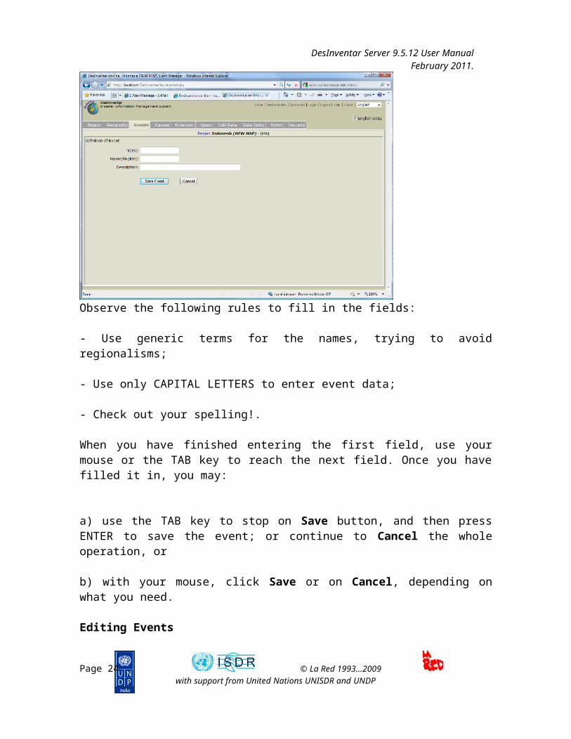
Adding Events.
When you are going to create an event, a data screen, similar to the one shown below, is displayed, but with blank fields for the name and description of the event.
Page 19 © La Red 1993...2009with support from United Nations UNISDR and UNDP

DesInventar Server 9.5.12 User Manual February 2011.
Observe the following rules to fill in the fields:
- Use generic terms for the names, trying to avoid regionalisms;
- Use only CAPITAL LETTERS to enter event data;
- Check out your spelling!.
When you have finished entering the first field, use your mouse or the TAB key to reach the next field. Once you have filled it in, you may:
a) use the TAB key to stop on Save button, and then press ENTER to save the event; or continue to Cancel the whole operation, or
b) with your mouse, click Save or on Cancel, depending on what you need.
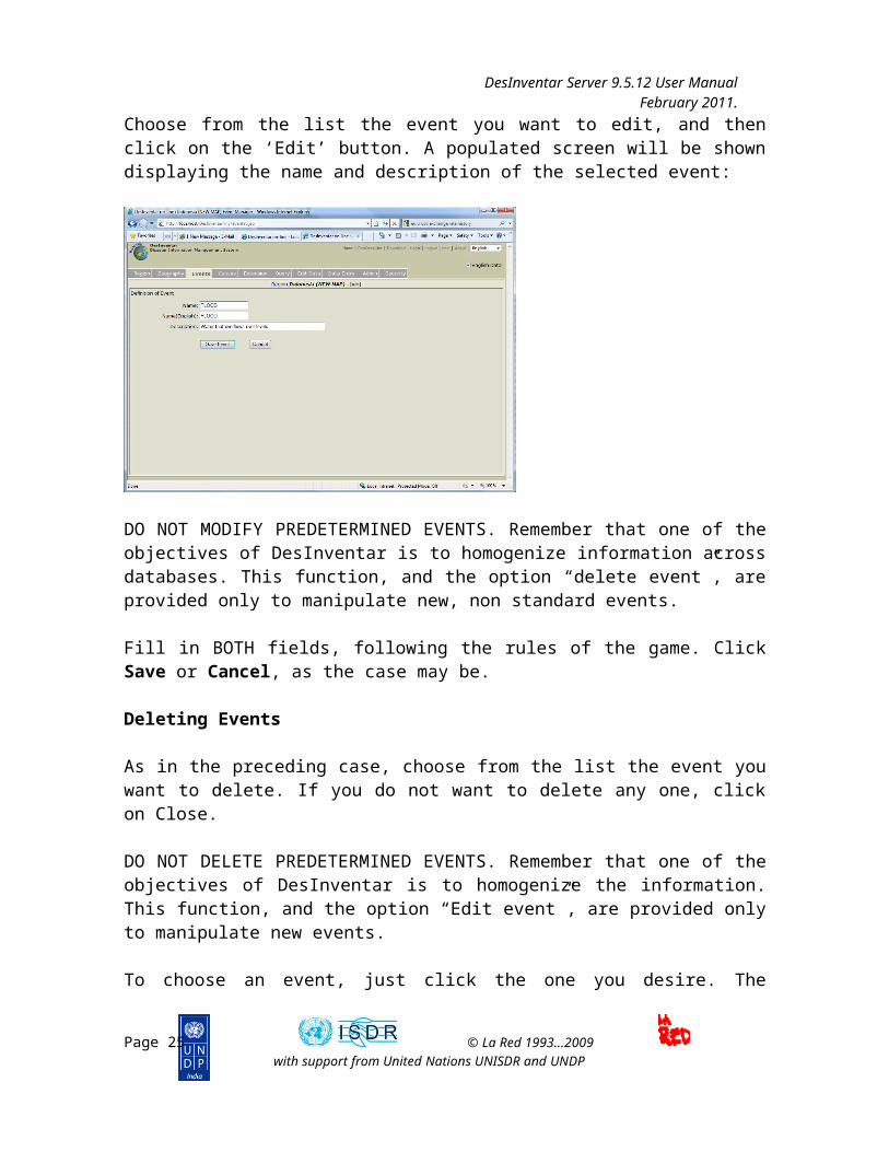
Editing Events
Choose from the list the event you want to edit, and then click on the ‘Edit’ button. A populated screen will be shown displaying the name and description of the selected event:
Page 20 © La Red 1993...2009with support from United Nations UNISDR and UNDP

DesInventar Server 9.5.12 User Manual February 2011.
DO NOT MODIFY PREDETERMINED EVENTS. Remember that one of the objectives of DesInventar is to homogenize information across databases. This function, and the option “delete event”, are provided only to manipulate new, non standard events.
Fill in BOTH fields, following the rules of the game. Click Save or Cancel, as the case may be.
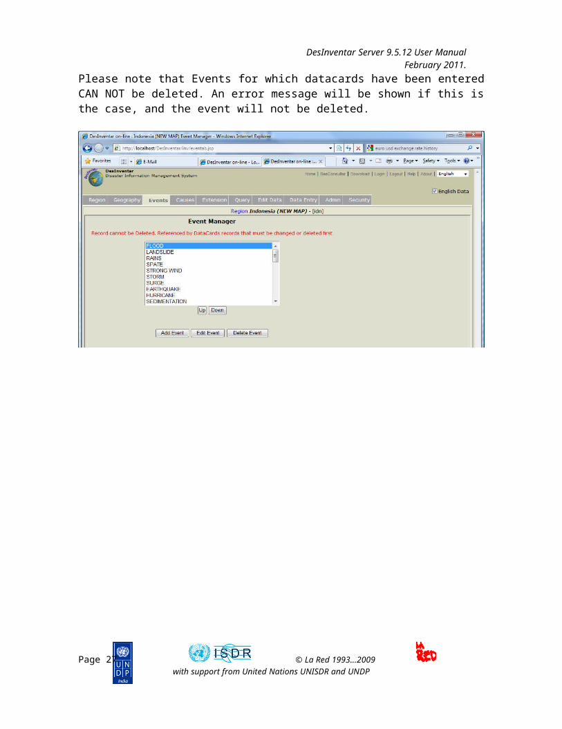
Deleting Events
As in the preceding case, choose from the list the event you want to delete. If you do not want to delete any one, click on Close.
DO NOT DELETE PREDETERMINED EVENTS. Remember that one of the objectives of DesInventar is to homogenize the information. This function, and the option “Edit event”, are provided only to manipulate new events.
To choose an event, just click the one you desire. The function buttons will be displayed as soon as you have chosen the event to be deleted.
Click OK to delete the event, or CANCEL if you are not going to make any changes.
Errors in manipulating events
When you use the above options, two types of error may appear. One, when you have failed to fill in one or both of the blank descriptions at the moment of creating or editing an event. In this case, an error warning (“Creation Error) is displayed. This means that the event was not created or modified, and you must fix the problem before the object can be created.
Page 21 © La Red 1993...2009with support from United Nations UNISDR and UNDP

DesInventar Server 9.5.12 User Manual February 2011.
The second possible error occurs when you type an existing Name of Event. In this case, the warning in red reads “ALREADY EXISTS”, and the operation is cancelled.
Please note that Events for which datacards have been entered CAN NOT be deleted. An error message will be shown if this is the case, and the event will not be deleted.
Page 22 © La Red 1993...2009with support from United Nations UNISDR and UNDP

DesInventar Server 9.5.12 User Manual February 2011.
Page 23 © La Red 1993...2009with support from United Nations UNISDR and UNDP
DesInventar Server 9.5.12 User Manual February 2011.
Geography Management
The Geography tab main screen.
Geographical Levels
Once the country has been chosen and installed, your first step is to determine the NAMES given to the geographical levels in the relevant country. Click on the button “Manage Levels” of the geography tab (see previous screen).
Page 24 © La Red 1993...2009with support from United Nations UNISDR and UNDP
DesInventar Server 9.5.12 User Manual February 2011.
Observe that the fields corresponding to code lengths may initially shows zeros. It is very important to specify the length of the codes for each level.
As in all the windows of DesInventar, you must click the Save button as you finish entering the names of the levels. If you don’t click OK, THE INFORMATION TYPED WILL BE LOST.
The Cancel button aborts the operation; that is, the window is closed without making any changes.
When you choose them from the menu, the processes to enter code and name data for each level will be initiated.
The following are examples of levels for some countries (those participating in the internal project of DesInventar in LA RED).
Mexico Level 0 = StateLevel 1 = MunicipalityLevel 2 = Colony
Guatemala Level 0 = DepartmentLevel 1 = MunicipalityLevel 2 = Neighborhoods (only for the 2 major cities)
India Level 0 = StateLevel 2 = DistrictLevel 3 = Block
Nepal Level 0 = RegionLevel 1 = DistrictLevel 2 = Village
Jamaica Level 0 = Parish
Creating Geographic Units
The visualization of levels shows the names and lengths given to level 1, 2 and 3. For example for the India region, level 0 takes the name STATE and the length of the code is 3. For level 1 the name is DISTRICT with a code length of 6 and level 2 is BLOCK with a code length equal to 9.
The length of the more internal codes contains that of the superior level.
For a possible region such as India:
Page 25 © La Red 1993...2009with support from United Nations UNISDR and UNDP

DesInventar Server 9.5.12 User Manual February 2011.
Level 0 (name: STATE length:3)
Level 0Code Name
002 Andhra Pradesh003 Arunachal Pradesh
004 Assam005 Bihar
006 Goa007 Gujarat
Level 1 (name: DISTRICT length:6).A few districts belonging to Andra Pradesh:
Code Name002001 Sambalpur
002002 Sundargarh002003 Keonjhar
002004 Mayurbhanj002005 Balasore
Level 2 (name: BLOCK length:9)A few districts belonging to Salbanpur,Andra Pradesh:
Code Name002001001 Dhankauda
002001002 Manesar002001003 Jujomura
002001004 Rengali002001022 Kuchinda
This configuration indicates that :
• The first level corresponds to States, and its length is 3, therefore only values between 001 and 999 should be used if possible. As a result, the maximum number of state to be contained in this region is 1000.
• The second level corresponds to Districts, the code length is 6, but 3 are reserved forthe first level, meaning that the posible values for district within a state range from 000 to 999. As a result, the maximum number of districts per states is again 1000.
Management of each Level
The provided operations allow adding, editing, and removing elements on each level.
Page 26 © La Red 1993...2009with support from United Nations UNISDR and UNDP
DesInventar Server 9.5.12 User Manual February 2011.
• Add: It allows to enter a new level record, indicating code and name. The code length shall not be greater than the assigned length for its level.
When you click this button, blank fields are displayed on the window for you to fill them in.
You may fill in the fields in order using the keyboard. Use the TAB key to move from one field to another.
Once you have finished filling in the fields, click SAVE, such that the information is registered in the database. IF YOU DO NOT USE THE SAVE BUTTON, THE INFORMATION WILL BE LOST.
• Delete: It eliminates the record from the database. This operation definitely erases the record from the system.
• Edit: An element from the list must be selected. You are allowed to change only the name of the selected record.
The edit screen (shown below) allows to change the basic data of a geographic unit.
Page 27 © La Red 1993...2009with support from United Nations UNISDR and UNDP

DesInventar Server 9.5.12 User Manual February 2011.
When editing elements in the lower geographical levels (Level 1 and 2) you must select an element from level 0 and click on the “Manage XXXX of YYYY” button on each level screen: the elements will be displayed only if this level has been defined in the database being used.
Note that the system suggests the new codes in levels 1 and 2 to start with the code of the selected element in the previous element. Note also that an element can be moved to another ‘parent’ element selecting the appropriate entry in the drop down list.
Errors while entering Geography Data
DesInventar detects several types of error while entering data. One of them occurs when you try to create or edit a region, but you have not entered the name or the code.
When this happens, an error warning sign is displayed and, as it announces, the region will not be created or modified, as the case may be. Enter the complete information (code and name).
Other error occurs when you try to create a region using a code already applied to other region. In this case, DesInventar displays the message “Duplicated Code”. Repeat the operation using a new code.
DesInventar will also issue an error message If a region for which DataCards have been created is attempted to be deleted.
Page 28 © La Red 1993...2009with support from United Nations UNISDR and UNDP

DesInventar Server 9.5.12 User Manual February 2011.
Management buttons in Geography tab
The Level 0 geography screen shows also several buttons that bring the user to screens in which other data related to Geography is managed. These are:
Management of Maps
Maps can be managed in DesInventar in two possible ways: as DesInventar 6.0 imported maps or as shapefile maps.
For information on how to build DesInventar 6.0 maps please refer to the document “Map Import Tool”. We recommend these maps be discontinued and only Shapefiles used from now on.
As the recommended method is to use the new approach, i.e. coordinate referenced shapefiles the following paragraphs will describe how to use these types of files as base for the Geography.
Overview of the process
Page 29 © La Red 1993...2009with support from United Nations UNISDR and UNDP

DesInventar Server 9.5.12 User Manual February 2011.
As a very brief summary the steps to import a map are the following:
a) Verify that you have POLYGON maps, and that each of the polygons is uniquely identified by a code.
b) Verify that each of the layers (shapefiles) to be used correspond to one of the Levels in DesInventar. Each shapefile must cover ALL of the country/region.
c) Verify coverage and correspondence of the map and the database. If there is already a geographical division in the database (for example from the Statistics Bureau of the country), this verification should include an assurance that the codes for each polygon are the same as those being used in DesInventar, that ALL codes in DesInventar have a corresponding polygon in the map and that every polygon in the map corresponds to a geographic unit, i.e. that there is a one-to-one correspondence between the map and the system of selected codes.
d) Verify that the coordinate system is based on Latitude and Longitude coordinates, preferably using the WSGS84 standard.
e) Use an external tool (such as Excel, Dbase or similar) to clearly identify the fields (column names) that contain the code and names of each geographic unit.
MAKE SURE YOU TAKE A BACKUP COPY OF THE DATABASE before attempting this process
Important considerations:
Please note the following:
- All codes and names of polygons found in the map which don’t exist in the DesInventar database will be imported to DesInventar as new areas (i.e the code will be created along with the name).
- No error or warning will be displayed if an Area in DesInventar doesn’t have a polygon in the map.
- This process assumes the LENGTH of codes are as per the definition on “Manage Levels” tab. You CANNOT use shapefile maps when codes are not hierarchical. This means the code of an area must be start with the code of its ‘parent’ area. For example all districts of a province with code 02 must start with 02, like 02125.
Page 30 © La Red 1993...2009with support from United Nations UNISDR and UNDP

DesInventar Server 9.5.12 User Manual February 2011.
Setting up a map for a level
The process is rather simple:
a) Select “Shapefile” as format type.b) Select a Line width. A line width of 100% is roughly a line 1 pixel wide. You
may have thicker lines for higher boundaries (for example 130%). You may specify less than 100% as width, which will be attempted to be rendered using a technique called anti-aliasing. However it will not be strictly a less-than-one pixel line.
c) Select a Colour for the limit. A palette will be shown; click on the desired color, either on the top palette or in the gradient bar.
d) Browse to the file that contains the map. Keep in mind this browses the server computer; if you are working on your local host you will see you own computer folders and files. However, if the DesInventar server is another computer you will see the server files and folders; in this case you must upload manually the map to the server. No provision is made for doing this in DesInventar as a security measure.
First, save the specification and then save it again with the option of Integrate the new map into the Server 7 format database.
Management of Other Map Layers
DesInventar can show, in addition to the Geography maps, other cartographical information that is considered to be relevant, such as rivers, roads, location of villages and other urban centers, topography, etc.
Each additional map will be treated as a “Layer”. Layers may be made visible or invisible during the process of producing Thematic Maps, giving the user high flexibility.
Map Layers MUST be stored in Shapefiles of the following supported types:
- Polygon- Polyline- Point
Support for other types of shapefiles will be added in the future.
Layer management is done with the following screen:
Page 31 © La Red 1993...2009with support from United Nations UNISDR and UNDP

DesInventar Server 9.5.12 User Manual February 2011.
The process of adding a map layer is simple:
- Select the shapefile using the button “Browse”. Same as in the Level Maps, this files must be in the server computer. If your DesInventar is working on your local PC you will see you own computer folders and files. However, if the DesInventar server is another computer you will see the remote server files and folders; in this case you must upload manually the map files to the server. No provision is made for doing this in DesInventar as a security measure.
- Provide a name for the Layer, in local language and in English; this name will be displayed in the Thematic Map windows to turn on an off layers.
- Decide if the layer will be visible or not by default.- Select a Line width. A line width of 100% is roughly a line 1 pixel wide. You
may have thicker lines (for example 150%). You may specify less than 100% as width, which will be attempted to be rendered using a technique called anti-aliasing. However it will not be strictly a less-than-one pixel line.
- Select a Colour for the layer. A palette will be shown; click on the desired color, either on the top palette or in the gradient bar.
Once you are done, click on the button Save at the bottom of the screen. If you want to remove a map layer, just erase the file name and the layer names.
Page 32 © La Red 1993...2009with support from United Nations UNISDR and UNDP

DesInventar Server 9.5.12 User Manual February 2011.
Management of Attributes
One of the mayor additions to this version of DesInventar is the ability to manage a large set of indicators (“Attributes”) associated to the geographic units on the system, such as population, demographics and many other economic and social numbers.
Each level of the Geography then may be associated to a database table containing these attributes. The creation of this tables is outside of the scope of this document, but briefly:
- Tables can be imported to a database usually through the DB System built-in functionality. For example to import a table to an Access database use the Tools->get External data -> Import menus in the system. Many databases can export tables using SQL scripts which can later be used to import data in another system or database. Others provide methods to import or export tables to intermediate formats; lastly tables can be created as external links in databases or built using INSERT sql statements. Refer to your specific database system for instructions and suggestions on how to accomplish this.
- Attribute tables must comply with one main requisite: each row must contain a column with the geographic code that will allow the system to ‘connect’ the attribute data with the geographic units and thus the disaster data. These must be the same codes used in the Geography.
Page 33 © La Red 1993...2009with support from United Nations UNISDR and UNDP

DesInventar Server 9.5.12 User Manual February 2011.
When the Option to Manage Attributes is selected a screen showing as many entries as levels in the system is shown. For each level (all are optional) a table may be selected from the dropdown list. Note the table must be already present in the database.
Once a table is selected a field or column must be selected for the Join (to ‘connect’) with the rest of the geography. The best way for doing this is to click on the button with the ellipsis (…) and select the field from the list. To make the process safer, the content of the first few records are shown. Once the column has been selected click on Save.
After attribute tables are selected they will start showing on the Variables boxes of the system (charts, maps, stats, etc). Please refer to the Query module manual (DesConsultar) for more information on how to use these attributes in queries, charts, maps, reports and statistics.
Google-Geocode
As experimental feature of the system, you may try to obtain an initial pair of coordinates for those records in the system that DON’T have a Lat-Lon pair defined.
This is done through the Geocode window; it uses the Google API to obtain coordinates. It is recommended that the batch size is kept low (Max points), otherwise the service can be denied after some intensive use.
Once the “Start geocode” link is clicked the system will communicate with Google, obtain the approximate coordinates of each event based on the Names of the geography and Place. A bubble will be put on the map for each location calculated.
Page 34 © La Red 1993...2009with support from United Nations UNISDR and UNDP
DesInventar Server 9.5.12 User Manual February 2011.
Page 35 © La Red 1993...2009with support from United Nations UNISDR and UNDP
DesInventar Server 9.5.12 User Manual February 2011.
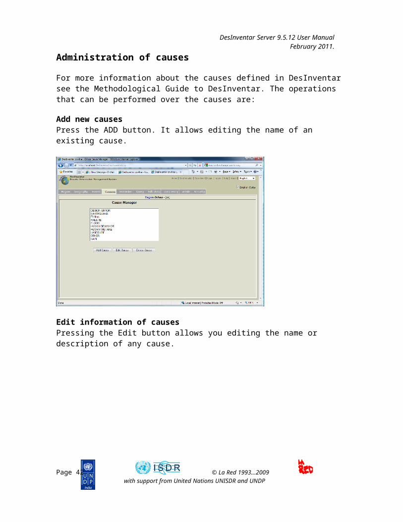
Administration of causes
For more information about the causes defined in DesInventar see the Methodological Guide to DesInventar. The operations that can be performed over the causes are:
Add new causesPress the ADD button. It allows editing the name of an existing cause.
Edit information of causesPressing the Edit button allows you editing the name or description of any cause.
Page 36 © La Red 1993...2009with support from United Nations UNISDR and UNDP

DesInventar Server 9.5.12 User Manual February 2011.
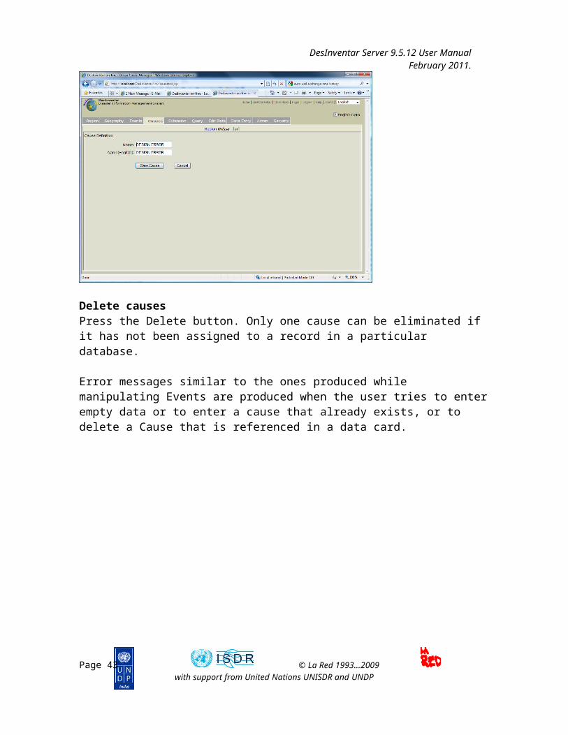
Delete causesPress the Delete button. Only one cause can be eliminated if it has not been assigned to a record in a particular database.
Error messages similar to the ones produced while manipulating Events are produced when the user tries to enter empty data or to enter a cause that already exists, or to delete a Cause that is referenced in a data card.
Page 37 © La Red 1993...2009with support from United Nations UNISDR and UNDP

DesInventar Server 9.5.12 User Manual February 2011.
ENTERING AND MODIFYING DISASTER DATACARDS
To initiate the Disater data entry process, you have to activate the option “Data Entry” in the main menu.
Data Entry Tab
These Function buttons are mutually exclusive, except for the “Print” function. When you activate one of them, the others are disabled.
The “New Datacard” Button
As suggested by its name, it is used to add new disaster cards to the inventory.The blank data card will be displayed in a few seconds. The content of the card is distributed in several sections:
Page 38 © La Red 1993...2009with support from United Nations UNISDR and UNDP

DesInventar Server 9.5.12 User Manual February 2011.
When you click this button, all the card fields are cleared and you can start entering the information on the new card. Only the fields corresponding to Level 0 and Event usually show the information of the card that was displayed before creating the new card. DesInventar suggests a Card Serial Number equivalent to the number of cards contained in the database plus one.
The fields can be filled in an orderly manner using the keyboard. To move from one field to another you can use the TAB key.
Page 39 © La Red 1993...2009with support from United Nations UNISDR and UNDP
IMPORTANT:As soon as the button Create is clicked on, a set of buttons will appear at the bottom of the Datacard screen.
Once you finish filling all the fields, click SAVE to store the information in the database, OR THE INFORMATION WILL BE LOST.
To store the record press SAVE, in the lower part of the record.

DesInventar Server 9.5.12 User Manual February 2011.
The “Edit Datacards” Button
Its function is to allow editing information in cards previously entered to the system. Click this button to activate the fields of the current card.
An extra set of buttons will be shown:
If you want to edit a card other than the one displayed on the screen, you have two options:
Moving through the set of cards using the scroll arrows found at the top of the page. The internal arrows (< and >) allow forward and backward movements, and the outer arrows (>> and <<) will take you to the first card (left arrow) or to the last card (right arrow) of the database;
Use the “SEARCH” button to find the card you want to update; thus, you have to know the Card No.
The updating process is repetitive; it allows to continue to update cards as described. Use the Done button (bottom of the screen to the right) to suspend.
The “Delete” Button
This button eliminates cards from the inventory, and the process is similar to that of the “Update” button:
Click DELETE to choose the card you wish to eliminate. Once it is displayed, the “Delete” button at the bottom of the screen changes to DELETE.
When you click DELETE, DesInventar displays a sign to confirm the elimination of the card activated, which corresponds to a record of the database. It will ask you: Are you sure you want to delete this record?
Click OK to approve elimination.
Page 40 © La Red 1993...2009with support from United Nations UNISDR and UNDP
IMPORTANT:
Once you have updated the data on the card, use the “save” button to store the information; otherwise, the corrections will be lost.

DesInventar Server 9.5.12 User Manual February 2011.
The “Find Serial” Button
Use this button to find a card when you know its serial number. When you activate it, a field is displayed to enter the card serial number.
More than one card may have the same serial number; serial numbers are NOT exclusive. For this reason, you may have to click in the search button more than once, one to find the first card identified with the serial number, and another to find the next:
If the card actually exists, it will be displayed. Then you can use the “Update” or “Delete” buttons.
.THE DATACARD SECTIONS
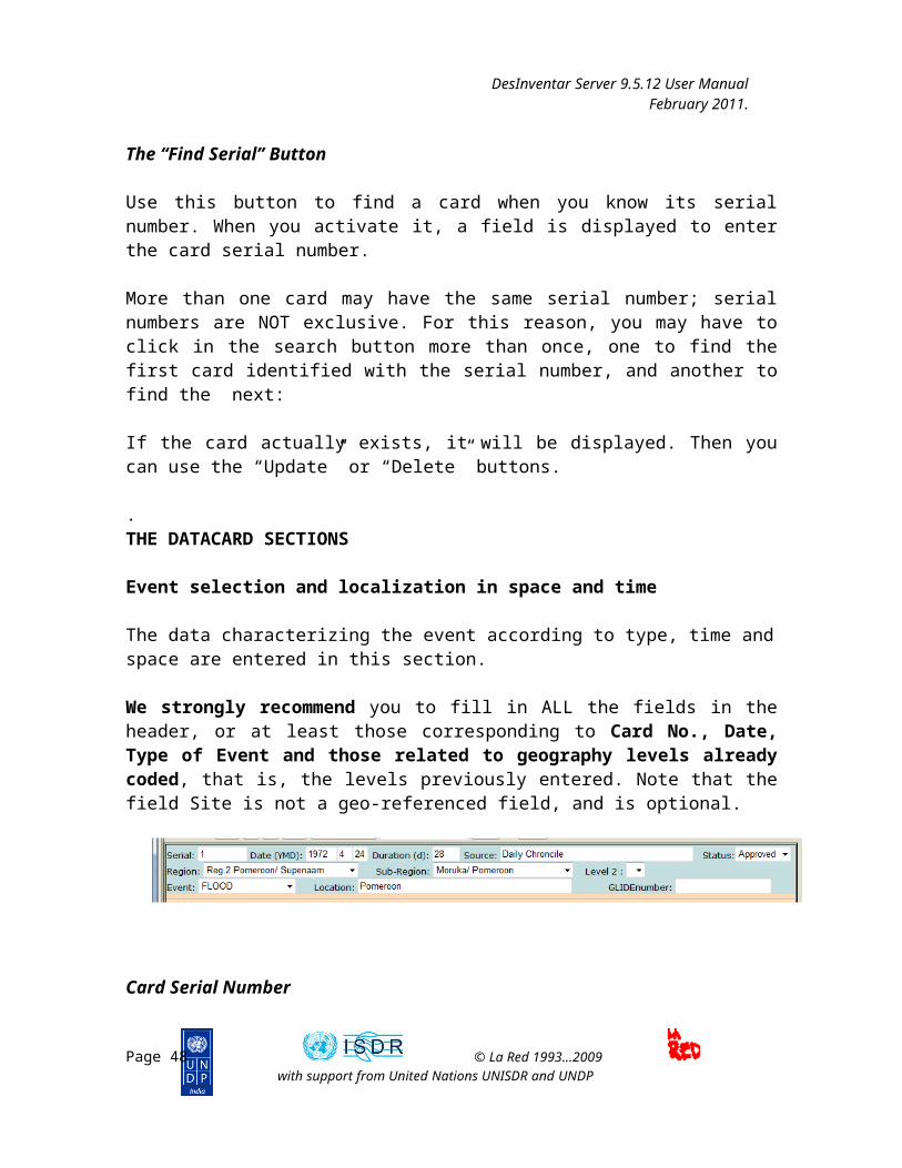
Event selection and localization in space and time
The data characterizing the event according to type, time and space are entered in this section.
We strongly recommend you to fill in ALL the fields in the header, or at least those corresponding to Card No., Date, Type of Event and those related to geography levels already coded, that is, the levels previously entered. Note that the field Site is not a geo-referenced field, and is optional.
Card Serial Number
Page 41 © La Red 1993...2009with support from United Nations UNISDR and UNDP
NOTE:
The DELETE operation can’t be undone. Once the card is erased, it will be impossible to recover it. It will be necessary to enter the data again.
DesInventar Server 9.5.12 User Manual February 2011.
It is recommended that the number you assign corresponds to a characteristic of the original record (for example, in paper) that you may transcribe on it, to facilitate future references or reviews.
Type in this field a number, an abbreviation or a code to identify the card. We recommend that you use numbers in sequential order, although this is not mandatory. You can also use letters, hyphens and other symbols.
We also recommend that the number given correspond to a characteristic of the original card (on paper, for example), or that it is transcribed onto the card to facilitate future references or revisions.
Remember that serial numbers are NOT exclusive; more than one card may have the same serial number.
Disaster date
Type the date of the disaster in the three fields available in numbers, in this order: year, month and day. Years must be written in full: 1995, 1845, etc.
The letters YMD remind you of the order in which you must type these data.
DesInventar does not require leading zeroes for one-digit months or days. If you type them, DesInventar will ignore them, without affecting the information in the database. For example: if you enter month 06, DesInventar will only register number 6.
Information Source
Enter the source(s) here: information mean(s), existing database(s), entity or entities from which you obtained the information.
TRY TO BE CONSISTENT: always use the same spelling, the same abbreviations and letter types (capital or small letters) in the same places.
The “Event” Field
Select, as described below, the type of event the disaster you are entering refers to. If it is not included among the events predetermined, POSTPONE the entry of the card, and create the event. Follow the rules established in the Menu of Events.
How to use it:
Page 42 © La Red 1993...2009with support from United Nations UNISDR and UNDP
DesInventar Server 9.5.12 User Manual February 2011.
This is a multiple-choice list that you can use in several manners:
-using the “arrow up” and “arrow down” keys, you can select the type of event; the events will be displayed in the same order as they were entered;
-using the first letter of each option; if more than one option begins with the same letter, press this letter several times, until the type of event that your are looking for appears;
-using the mouse: when you click the downwards-arrow that is found to the right of the list, the list is displayed. If the list includes more elements than those visible, a scroll bar will be displayed; use it to see all the options. Clicking an option will activate it, or disable it if it is already activated.
Geography Level 0
The title of this field changes according to the names of the levels. It may be State, Province, etc., depending on the nomenclature of each country.
This IS A MANDATORY FIELD of the data card, because it’s the minimum possible geo-referenced level.
How to use itThis is a multiple-choice list that you can use in several manners:
-using the “arrow up” and “arrow down” buttons to change the selection;
-using the first letter of each option. If more than one option begins with the same letter, press the letter several times until the option you are looking for appears;
-using the mouse: when you click the downwards-arrow that is found to the right of the list, the list is displayed. If the list includes more elements than those visible, a scroll bar will be displayed; use it to see all the options. Clicking an option will activate it, or disable it if it is already activated.
Geography Level 1
The title of this field changes according to the names of the levels in each country. It may be Municipality, district, etc., and corresponds to the second classification level or political-administrative subdivision.
This field is NOT mandatory, but it MUST be entered when a disaster affects only one municipality.
Page 43 © La Red 1993...2009with support from United Nations UNISDR and UNDP

DesInventar Server 9.5.12 User Manual February 2011.
IF YOU DO NOT ENTER THIS FIELD, DESINVENTAR WILL ASSUME THAT THE DISASTER AFFECTED ALL THE ELEMENTS OF THIS LEVEL.
How to use it:This is a multiple-choice list that you can use in several manners:
- using the “arrow up” and “arrow down” keys to change the selection;
- using the first letter of each option. If more than one option begins with the same letter, press the letter several times until the option you are looking for appears;
-using the cursor: when you click the downwards-arrow that is found to the right of the list, the list is displayed. If the list includes more elements than those visible, a scroll bar will be displayed; use it to see all the options. A click an option will activate it, or disable it if it is already activated.
Geography Level 2
The title of this field changes according to the names of the levels in each country. It may be District, Parish, etc., and corresponds to the third classification level or political-administrative division.
This field is NOT mandatory, but it MUST be entered when a disaster affects only one subdivision.
IF YOU DO NOT ENTER THIS FIELD, DESINVENTAR WILL ASSUME THAT THE DISASTER AFFECTED ALL THE ELEMENTS OF THIS LEVEL.
For example, if this level (district) is not entered for Costa Rica (where the levels are Province, Canton, District), the program will assume that all the districts of the canton were affected.
Use it in the same way as Level1 list. See above for detailed explanation.
Place
Enter in this field the site where the event occurred, if the information is available.
If the site corresponds exactly with the last geographical level reported, it is NOT necessary to type it again. This space is to specify the exact place in the municipality or geographical unit where the disaster occurred. It can be a rural settlement, a village or post, a farm, a city address, a geographical accident, a river, etc.
Page 44 © La Red 1993...2009with support from United Nations UNISDR and UNDP

DesInventar Server 9.5.12 User Manual February 2011.
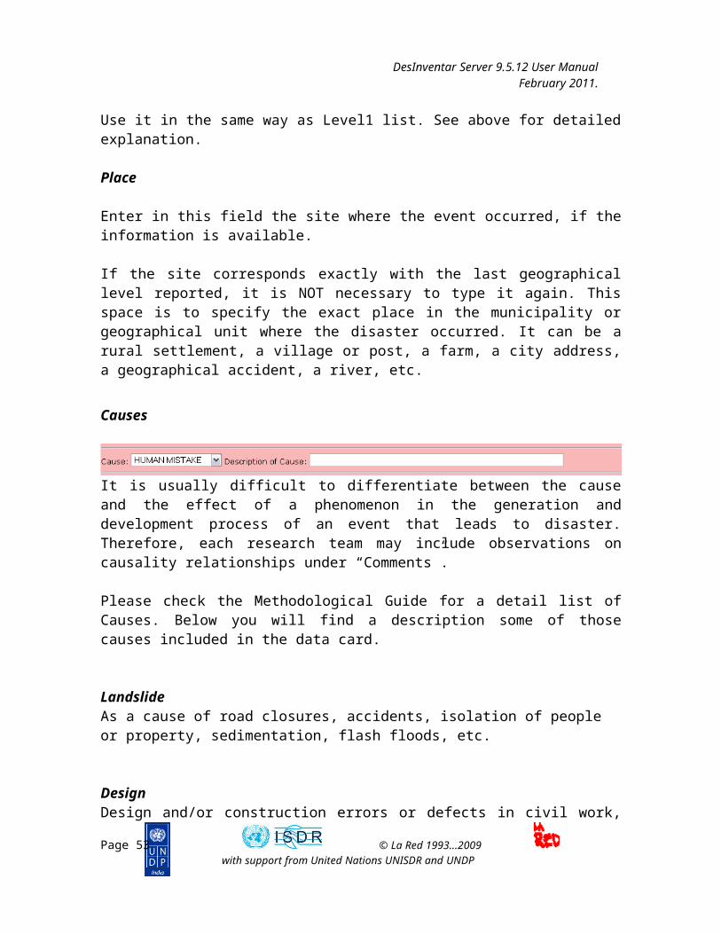
Causes
It is usually difficult to differentiate between the cause and the effect of a phenomenon in the generation and development process of an event that leads to disaster. Therefore, each research team may include observations on causality relationships under “Comments”.
Please check the Methodological Guide for a detail list of Causes. Below you will find a description some of those causes included in the data card.
LandslideAs a cause of road closures, accidents, isolation of people or property, sedimentation, flash floods, etc.
DesignDesign and/or construction errors or defects in civil work, industrial installations, infrastructure systems, etc., which lead to collapses, accidents, explosions, leaks, flash-floods or floods (for example, bursting of dams or dykes).
El NiñoAs a phenomenon that causes global or regional climatic anomalies, such as rain, drought, and derived types of event. Many newspaper reports attribute higher or lower precipitation to El Niño. Entry of El Niño events (or “ENSO” ) must include strictly those reported as such. For the last two decades, they are: 1982 to 1983 (very strong), 1987 (moderate) and 1991 to 1992 (moderate?).
FloodAs a cause of sedimentation, epidemic, etc.
RainAs primary or triggering cause of floods, flash floods, landslides, accidents, etc.
Seismic activityAs generator of tsunamis, landslides, liquefaction, flash floods, structural damage, fire, explosion, accidents, changes in coastlines, etc.
Page 45 © La Red 1993...2009with support from United Nations UNISDR and UNDP

DesInventar Server 9.5.12 User Manual February 2011.
BehaviorIt usually refers to disasters or emergencies caused by panic, or resulting from cultural causes of floods or landslides.
Other CauseClassify under “other cause” causes that have not been classified.
Page 46 © La Red 1993...2009with support from United Nations UNISDR and UNDP
DesInventar Server 9.5.12 User Manual February 2011.
Effects
PERSONS
DeadCorresponds to the number of people who died due to direct causes, whether immediately or time after the disaster.
If final official data are available, they must be included with the relevant comments. For example, when official figures differ from those of other sources.
Assumptions about deaths not officially verified must be registered under “Comments”, stating the information source.
InjuredCorresponds to the number of persons with bodily injuries. Bodily injuries, and, if the cause is plague or epidemic, the sick must be included.
Missing peopleNumber of persons whose whereabouts as from the effects of the disaster are unknown. It includes people presumed dead without physical evidence. Data on dead and missing persons are mutually exclusive; therefore, avoid grouping them.
VictimsNumber of persons whose individual or collective property and/or services have suffered serious damage directly associated to the event. For example, total or partial destruction of homes and property; loss of crops and/or
Page 47 © La Red 1993...2009with support from United Nations UNISDR and UNDP
DesInventar Server 9.5.12 User Manual February 2011.
warehouses, etc. This group also includes evacuees or resettled persons, whether temporarily or not. If the information is available by family, the number of persons must be estimated based on indicators available.
EvacueesNumber of persons temporarily evacuated from their homes. If the information is available by family, the number of persons must be estimated based on indicators available.
Re personsNumber of persons who have been moved from their homes to new permanent sites. If the information is available by family, the number of persons must be estimated based on indicators available.
Affected personsNumber of persons who suffer indirect or secondary effects associated to a disaster. These persons, different from “victims”, suffer the impact of secondary effects of disasters for reasons such as deficiencies in the provision of public services, the hampering of trade and work, isolation, or their mental health may be affected. If the information is available by family, the number of persons must be estimated based on indicators available.
INFRASTRUCTURE
Destroyed homesHouses that have collapsed, or have been swept, submerged or damaged in such a manner that they are not habitable.
Affected homesNumber of houses that suffered minor damage other then structural or architectural, and continue to be habitable, although requiring basic repairs and cleaning.
Other Effects on infrastructure
Quantitative
Roads - Mts.Extension in meters of road networks destroyed and/or unfit for use.
HectaresCrop, pasture or forest areas destroyed.
Livestock
Page 48 © La Red 1993...2009with support from United Nations UNISDR and UNDP

DesInventar Server 9.5.12 User Manual February 2011.
Number of animals lost.
Education CentersNumber of nurseries, schools, universities, training centers, etc that were destroyed and/or affected.
HospitalsNumber of local and regional health centers, clinics and hospitals.
IndicatorsVital lines, public and production infrastructure that suffered an effect:
TransportRoad networks, railways, transport terminals, airports, river and seaports.
AgriculturalCrops, farms, pasture zones.
CommunicationsTelephone plants and networks, radio and television stations, mail and public information offices.
PowerDams, substations, transmission lines, generation plants, processing plants, fuel deposits, oil and gas lines.
EducationAll related to this sector: nurseries, schools, universities, training centers, etc.
Rescue DepartmentsFire departments, Civil Defense, Red Cross and public order entities.
Water Supply SystemsIntakes, treatment plants, aqueducts and canals conducting drinking water.
SewerageNetworks for disposal of waste and/or rain water; treatment plants.
IndustryIndustries of all types and sizes, including agricultural and livestock
industries.
HealthLocal and regional health centers, clinics, hospitals.
Page 49 © La Red 1993...2009with support from United Nations UNISDR and UNDP

DesInventar Server 9.5.12 User Manual February 2011.
Losses
Loss ValueAmount of direct losses in present value (local currency).
Loss Value in US dollarsAmount in dollars equivalent to the losses entered in the previous field, based on the exchange rate in force the date of the disaster. This value is useful to make comparative evaluations.
Other lossesEstimated value of losses due to indirect or induced effects attributable to interruptions or deficiencies in the provision of public services, the hampering of trade and work, and geographical isolation.
MagnitudeThis alpha-numeric field is used to enter international magnitude values for seism, volcanic eruption, tsunami, hurricane – tropical storm.
For other cases, you may enter quantified variables such as wind speed; heights of flashfloods and floods in meters; 24-hour rainfall in specific places; area or volume of landslides or deposits. We recommend to use always the same units for each type of variable: km/hr, m, mm/day, m2, m3, km3.
This field allows short descriptions (up to 25 letters), such as “slight”, “medium”, “high”, “extreme”, etc.
The Field “Comments”
This is a text field with a 750 character-capacity, equivalent to almost 200 words.
IMPORTANT:Type your text without using the “ENTER” key to separate paragraphs. This allows use of maximum capacity and will be useful in future developments with routines that would allow automatic retrieval of comments of specific interest from the database.
The Extension section of the Datacard
It is quite usual that DesInventar users find it necessary to keep record of a series
Page 50 © La Red 1993...2009with support from United Nations UNISDR and UNDP

DesInventar Server 9.5.12 User Manual February 2011.
of additional variables in each disaster, variables that are not included in the basic record.
The administrator (the “owner”) of the database decides which additional variables will be included in the expanded card for each case. The Methodology Guide provides clear instructions regarding the process, limitations, methodology and philosophy to design the expanded card.
Extended variables can be organized further in Tabs. The figure below depicts an extended datacard organized in several sections (tabs): Info, Shelter, Nutrition, WASH, Health, etc..
The above illustration shows the expanded section of a card window: you can see the set of fields names to one side, and the boxes used to populate the values on the right side. During the data entry process, all these fields are fed following the normal procedure. Text fields, and others having length restrictions, are controlled, such that the maximum length is not exceeded.
Use the keys TAB to move through the fields, and SHIFT-TAB to move forwards and backwards on the set of fields.
Once you have typed the information, use button “SAVE” to register it in the database.
Page 51 © La Red 1993...2009with support from United Nations UNISDR and UNDP
IMPORTANT:IF YOU DO NOT USE THE BUTTON “SAVE”, THE DATA OR THE MODIFICATIONS WILL BE LOST.

DesInventar Server 9.5.12 User Manual February 2011.
The Extension Tab
This section provides indications about the process for defining the extended card. The process functionality is split it two: Tabs management and Extension variables Management. All these functions are accessible from the main Extension tab.
The Extension Tab
Once the Extension tab is selected a screen with two links is shown. The two links are “Extension Manager”, which contains the functions to define all the additional variables needed, and the “Tab manager”, where these groups are defined and managed.
The mechanism is very simple, but demands a good deal of attention and planning.
If you are familiar with the definition of databases, you will find this process very similar. The expanded card is basically a set of “Fields”, each with its corresponding type of data. You can define additional labels for interpretation by the operator, and comments for long term documentation.
The definition of both variables and tabs includes the three usual possibilities: creation of new fields or tabs, deletion of fields and modification of the attributes of the fields/tabs.
Page 52 © La Red 1993...2009with support from United Nations UNISDR and UNDP
DesInventar Server 9.5.12 User Manual February 2011.
The Extension Manager
Depending on the database platform YOU CAN CREATE AT LEAST 180 FIELDS IN AN EXTENDED CARD. 180 fields is the limit for MS ACCESS databases. In other database platforms (SQL Server, Oracle, etc) this limit goes to 1000 variables.
The field must be named following the convention of database names: the name must start with a letter, followed by any combination of letters and numbers, with no embedded spaces. Names must be of 32 character or less length.
Note that the length attribute is applied only to text-type fields. The maximum length is 255 letters. If you need longer texts, use a Memo field (without length limits).
Page 53 © La Red 1993...2009with support from United Nations UNISDR and UNDP

DesInventar Server 9.5.12 User Manual February 2011.
Field Types
There are 7 different data types available:
Text: Single line of text, up to 255 charsInteger Number with no decimals, up to 10 digitsFloating Point Any other numberCurrency Numbers with 2 decimalsDate DD/MM/YYYYMemo A chunk of text of unlimited lengthYes/No (Boolean) Yes or NoDropdown list A drop down list with a series of values. Use the Codes button to
populate the list.Multiple choice A radio button list with a series of values. Use the Codes button to
populate the list.
The Extension Manager contains the following functions, each one on a button:
- Add Field: A new field will be included at the end of the list. Please see below a Field Definition Screen
- Edit Field: if a field is selected, it will be possible to modify the labels (local language and English) as its description. Please note the field type cannot be changed (except in a few cases, for example it can be done from Dropdown list to Choice)
- Delete Field: It is possible to delete a field, but bear in mind that when you delete a field, you eliminate the information stored in this field in all the cards, and this is IRREVERSIBLE. The same applies to a change in the length: if you reduce the length of a field, you will cut the information, and this is irreversible too.
- Codes: For dropdown and choice fields, it allows to define the list of values that will appear on the list.
- Field UP/Down: These buttons help moving the place the fields appear up and down. Keep in mind the list in the Extension Manager contains all the fields of all the tabs.
Field definition Screen Code Definition Screen
Page 54 © La Red 1993...2009with support from United Nations UNISDR and UNDP

DesInventar Server 9.5.12 User Manual February 2011.
Page 55 © La Red 1993...2009with support from United Nations UNISDR and UNDP

DesInventar Server 9.5.12 User Manual February 2011.
Tab Manager
In order to organize the Extension variables in a way its easier to find them, to type and update them and to produce smaller data entry screens, extended variables can be grouped in tabs.
The functions required to manage tabs are present in the Tab Manager:
The Tab Manager contains the following functions, each one on a button:
- Add tab: A new tab will be included at the end of the list. Please see below a Tab Definition Screen
- Edit Tab: if a Tab is selected, it will be possible to modify the labels (local language and English).
- Delete Tab: It is possible to delete a tab, but bear in mind that when you delete a tab, all fields return to the default Extension group.
- Assign Variables: This function allows the user to define which variables are to be shown on each tab. User must select one tab from the list, and click in this button. All variables will be shown on the left hand list, and the list of variables that will appear on the tab in the right side list. Variables can be selected and moved to the right and left with the corresponding “Add to Tab” and “Remove from Tab” buttons
- Field UP/Down: These buttons help moving the place the tabs appear up and down (left and right on the datacard).
Page 56 © La Red 1993...2009with support from United Nations UNISDR and UNDP

DesInventar Server 9.5.12 User Manual February 2011.
Tab data screen
Assign variables to Tab screen
Page 57 © La Red 1993...2009with support from United Nations UNISDR and UNDP

DesInventar Server 9.5.12 User Manual February 2011.
The Query Tab
The ultimate rationale of an information system goes beyond the initial and basic objective of achieving a methodical, homogeneous and systematic storage of information.
Information is useless if there are no tools to retrieve, (consult) and analyze.
Information retrieval processes must be selective, specific to the characteristics of the information. In DesInventar, retrieval is made based on thematic (type of event and causes), spatial component (geography) and time (dates) criteria.
Data analysis is a too wide an issue to be approached in a generic manner. However, DesInventar provides tools to display and visualize the information, which will serve to initiate and support the analysis activity.
Mark the query options with which you restrict your search. Then press the CONTINUE button to visualize the results. The criteria for limiting the information output of the query are :
• One or several types of events.• One or several sub regions of level 0.• One or several sub regions of level 1, if level 0 has been selected.• One or several sub regions of level 2, only if level 1 has been selected.
Page 58 © La Red 1993...2009with support from United Nations UNISDR and UNDP
DesInventar Server 9.5.12 User Manual February 2011.
• Range of dates, that can be : only year, year-month or year- month- day.• Events with victims(dead), injured people, destroyed houses, affected houses, and other effects.• Type of selection: AND (Conjunctive - classifies strictly in all the selected/checked variables), OR ( Disjunctive - classifies if any of the selected variables is present).• Affected infrastructure.• Output sort order
Selecting Data Cards by “Event”
The first list displayed includes all the types of event that have been defined. If you need a consultation (or report) containing one or more events, select it from this list. If you do NOT select a type of event, the consultation (report) will display ALL the types of event.
Click the event you wish to select. To actually select it, click again.
Selecting Data Cards by “Geography”
The next two lists allow to select regions on which you need information.
As in the list of Events, if you do not select something, you are implying that you want to see all the regions at this level. If you do not select Regions at Level 0, DesInventar will retrieve the cards of all the regions.
If you have select regions at Level 0, but you fail to fill in the Level 1 list or to select something from it, all the cards for disasters occurred in the regions selected at Level 0 will be retrieved.
Note that Level 1 lists appear empty at the beginning. They contain information only if a selection has been made at the previous Level. When you click them, the regions of this level are displayed, and they correspond with the regions selected in the previous level.
In the example window, if you have selected the Departments Antioquia and Atlántico, and you have clicked the Level 1 list, the municipalities of these departments will be displayed. They you can select only some of these municipalities.
Selecting Data Cards by “Date”
At the bottom of the window you can see two dates: an initial date (SINCE) and a final one, “UNTIL”.
As with the lists, using them or not using them will determine or not the dates to be
Page 59 © La Red 1993...2009with support from United Nations UNISDR and UNDP

DesInventar Server 9.5.12 User Manual February 2011.
retrieved. If you do not use the date SINCE, the dates will be displayed without restrictions, except for those resulting from the date UNTIL. The same applies to “UNTIL” dates.
Thus, if you give the date “SINCE” only, all the cards with subsequent dates will be retrieved.
If you use the date “UNTIL” only, the cards with dates prior to the one indicated will be retrieved.
If you include both dates, DesInventar will retrieve the cards whose date is included in the period specified.
It is important to clarify that if you enter a year as a date, you must also enter the month and the day. Otherwise, DesInventar will take January 1st as the rest of the date. This is particularly important in the case of the “UNTIL” date. If you enter the year only, only the cards of PREVIOUS YEARS will be retrieved.
EXAMPLE: To retrieve cards corresponding to years 1993 and 1994, type as “SINCE” date year 1993. And as “UNTIL” date, 31-12-94, or year 1995 ONLY.
Page 60 © La Red 1993...2009with support from United Nations UNISDR and UNDP

DesInventar Server 9.5.12 User Manual February 2011.
The results of the selection show a spreadsheet-like matrix of data with the records that comply with the selection criteria.
Optionally, the user is able to edit the information in each cell, this information gets automatically stored replacing the last piece of information: BE CAREFUL IN ITS USE.
The colors indicated in the back of the fields of the basic record correspond to the groups of variables being refered to in the Section called Basic record.
Print: It prints out the records currently on screen in a record format.
Export: It allows to export information as a txt archive, separated by tabulators. This file can be read from the mayority of spreadsheets programs..
Page 61 © La Red 1993...2009with support from United Nations UNISDR and UNDP

DesInventar Server 9.5.12 User Manual February 2011.
Administration functions
Under this tab there are a series of important administrative tasks. You won’t be allowed access to this tab if you don’t have Administrator or SuperUser privileges.
If you have selected a region in the Region Tab you will get many more options than if you haven’t: the entire section “Data Administration Functions [region]” will or won’t be shown.
The Administrative tab looks like:
The following are the possible Administrative functions:
General Administrative Functions:
Region Administration: with this option Region specifications may be added, modified or deleted. See section ahead.
Parameter Administration: Maintenance of the main parameters of the system. See section ahead.
Page 62 © La Red 1993...2009with support from United Nations UNISDR and UNDP

DesInventar Server 9.5.12 User Manual February 2011.
Data Administration Functions [Region]These function apply to the currently selected region.
Full text re-index of this Region: Regenerates the full-text index, which is used for Keyword search. Useful when data has been added to the system via processes outside of DesInventar.
Import an MS ACCESS DesInventar 6.x Database: As the name suggests, databases produced with previous versions (5.x and 6.x) can be imported into the current DesInventar region. See section ahead.
Import from another DesInventar region: Similar to the previous one, but this options allows the entire content of another DesInventar database managed in the server to be imported into the current Region. Very useful to physically consolidate multiple databases into one.
Import database from MS EXCEL file: Similar to the previous ones, but this options allows the entire content of an Excel spreadsheet server to be imported into the current Region
Import from table: this options allows the entire content of an non-DesInventar table in the database to be imported into the current Region
Export Database in XML format: this options allows the export of the database to a platform neutral XML file. Files produced with this option can be imported with the next option. These files are useful when moving data from Windows based (Access) databases to Linux or Unix databases where these databases are not supported.
Import from DesInventar Standard XML: see previous option. Run SQL Script: This utility presents a text screen where the user can
enter an SQL query or DDL/DML statement for execution. Only experienced and expert users should attempt to execute DDL or DML statements here. Extreme caution should be exercised when using this option.
Useful Links:
Query this region with DesConsultar on-line: jump to the Query module with this Region selected.
Logout: disconnects the current user and jumps to the Login Screen. Reload Translations: Useful when working on new languages or when
changes to the translation files (located at <install dir>/DesInventar/WEB-INF/classes/org/lared/desinventar have been changed to, for example, correct a spelling mistake or localize a translated sentence or word.
Page 63 © La Red 1993...2009with support from United Nations UNISDR and UNDP
DesInventar Server 9.5.12 User Manual February 2011.
Region Administration
Administrator users can Add regions to the list, and Edit or Delete existing regions from the Region Administration screen.
CAUTION: These operations affect ALL users of the system. Use your administrator privileges with caution.
The button “Add Region” will display a new screen where the user will fill in the two-digit code that will identify the region and the name of the region. Then the record required to store the data on the new region is created.
DO NOT CREATE REGIONS IF IT IS NOT ABSOLUTELY NECESSARY. THIS OCCUPIES SPACE IN THE HARD DISK, IN YOUR DATABASE SERVER AND SLOWS DOWN OVERALL PROCESSING.
The “Delete Region” button, as its name indicates, deletes a region of study from the list of available regions: It doesn’t delete its database, the maps, etc. This DELETE FUNCTION IS IRREVERSIBLE.
Page 64 © La Red 1993...2009with support from United Nations UNISDR and UNDP

DesInventar Server 9.5.12 User Manual February 2011.
Note that it is NOT possible to Delete the active region of study.
The parameters for each region
An administrator of DesInventar may add new countries to the list of currently available by using the Region Administration function.
Each country needs a minimum set of parameters, as requested in the screen:
Region code: the two letter code used to create the files with the standalone version.
Available to public: if set to NO the database will NOT be shown in the list of countries
Region Name: name to be displayed in the country lists.
Page 65 © La Red 1993...2009with support from United Nations UNISDR and UNDP

DesInventar Server 9.5.12 User Manual February 2011.
Database Type: select here the type of database engine under wich DesInventar on line will maintain this country’s database.
JDBC DRIVERJDBC CONNECT STRING: these two parameters inform the system how to access the country’s data. The JDBC Driver is suggested by the system when a database type is selected. Don’t change this suggestion unless you are completely sure the driver class is available to the web server.
The JDBC Connect String depends on the type of database and JDBC driver selected. If using one of the suggested drivers, you will have to probably substitute the UPPERCASE parameters of the connect string with appropriate values:
For MS ACCESS:
jdbc:odbc:DATASOURCE Substitute DATASOURCE by the System DSN Name supplied in the ODBC Data Source Administrator.
See examples of data sources in the System tab of the ODBC administrator, where the Data sources may be created in advance, where DesInventar Server will expect to find it and where it will be created if necessary.
For Oracle:
jdbc:oracle:thin:@SERVER:PORT:DATABASE
Substitute:
Page 66 © La Red 1993...2009with support from United Nations UNISDR and UNDP

DesInventar Server 9.5.12 User Manual February 2011.
SERVER: IP address of fully qualified name of the database serverPORT: usually 1521DATABASE: this is the database System Identifier (SID) of the database. Consult with your database administrator.
For MS SQL Server:
jdbc:sqlserver://SERVER:PORT;DatabaseName=DATABASE;
SERVER: IP address of fully qualified name of the database serverPORT: usually 1433DATABASE: this is the database name of the database, as seen in the Enterprise Manager for MS SQL Server. Consult with your database administrator.
DB USER NAME: this is the signon for the database server. MS ACCESS does not require it. In Oracle, this will define the schema that the server will give access to. In MS SQL Server and PostgreSQL must be a login name with permissions to access the database.
DB USER PASSWORD: corresponding to the user name above.
DIRECTORY WITH MAP FILES: as it name suggests this directory will contain the map files (SAME AS IN THE STANDALONE VERSION).
Page 67 © La Red 1993...2009with support from United Nations UNISDR and UNDP

DesInventar Server 9.5.12 User Manual February 2011.
DesInventar System Parameters
The main task of DesInventar is to maintain Disaster inventories of multiple regions. DesInventar can manage this information in a set of Databases or a set of ‘database Schemas’, depending on the database product or products being used.
But, how does DesInventar knows what countries and databases must access in order to fulfill its mission?. The answer is through a very special database, called the ‘Default Database’ which in turn stores data about all possible databases DesInventar can access, users, authoring information, driver and connecting data and many other important information.
There is also the need to know the values of several parameters related to other areas of the operation of DesInventar, such as the mail server parameters, the location of critical folders and so on.
This Default database and those special parameters are described and defined using a small and simple file that must be always stored in a standard location, the DesInventar.properties file, in the /etc/DesInventar/ folder.
This file MUST be stored in the /etc/DesInventar folder and MUST exist.
An example of the content of the DesInventar.properties is:
#System Properties#Thu Feb 20 23:35:17 EST 2003default.directory=/tomcat/webapps/DesInventarplatform=Windowsdb.type=0db.password=db.username=db.name=jdbc:odbc:DesInventardb.driver=sun.jdbc.odbc.JdbcOdbcDriverdb.maxconnections=250template.prefix=/tomcat/webapps/DesInventarabsolute.prefix=mail.directory=/tomcat/webapps/DesInventarmail.out.protocol=SMTPmail.out.port=25mail.out.IP=localhost
Page 68 © La Red 1993...2009with support from United Nations UNISDR and UNDP

DesInventar Server 9.5.12 User Manual February 2011.
The following are the parameters that govern the behaviour of DesInventar:
PARAMETER DESCRIPTION
Database Type(db.type ) Must be one of the values in the dropdown list. This value refers to the
Database or indexing system that contains the table of URLs. The possible Values are: Access, Oracle, SQL Server or MySQL
Database JDBC Driver(db.driver)
Fully qualified name of the database JDBC driver class. This value refers to the Database or indexing system that contains the table of URLs. Is responsibility of the Administrator to supply an adequate value to the type of database.
Some of these names are:
Oracle: oracle.jdbc.driver.OracleDriver
ODBC/JDBC Bridge (Access): sun.jdbc.odbc.JdbcOdbcDriver
JDBC Drivers for MS SQL Server:com.microsoft.sqlserver.jdbc.SQLServerDriver
MySQL:com.mysql.jdbc.Driver
Database Connect String(db.name)
This is a string that tells the JDBC driver how to connect to the specific database, as the database server can run on a separate computer. This string contains information about the driver to use, the database server IP and port, and some other important information.
Some examples of connection strings are:
Oracle: jdbc:oracle:thin:@127.0.0.1:1521:ORCL
ODBC/JDBC Bridge (Access): jdbc:odbc:inventXX
Drivers for MS SQL Server:jdbc:microsoft:sqlserver://SERVER:1433;databasename=dbname
MySQL:jdbc:mysql://DataBase?autoReconnect=true&initialTimeout=1&relaxAutocommit=true"
Database Username(db.username)
The username of the owner of DesInventar tables in the database. Some databases as Access or SearchServer may not require this parameter. Leave it blank in those cases.
Database Password(db.password)
The password of the owner of DesInventar tables in the database. Some databases as Access or SearchServer may not require this parameter. Leave
Page 69 © La Red 1993...2009with support from United Nations UNISDR and UNDP

DesInventar Server 9.5.12 User Manual February 2011.
it blank in those cases.Default directorydefault.directory
Directory in which the System files reside, typically under the webapps directory of Tomcat (or the JSP/Servlet container).
HTML templates Directory(template.prefix)
Directory in which the System Template files reside, typically under the webapps directory of Tomcat (or the JSP/Servlet container).
System Platform(platform)
Operating system platforms against which this version of DesInventar has been tested.
Temporary Mail Directory(mail.directory) Temporary directory to be used for email operations. Empty by default.Mail Server Protocol(mail.out.protocol) Mail protocol of mail server. SMTP by default.Mail Server Port(mail.out.port) Port at which the mail server listens.Mail Server IP address(mail.out.IP)
IP address or fully qualified name of the mail server
The System Administrator who physically installs the system normally configures this file manually, based on an initial template that works usually in most systems without much changes.
In a Windows environment the initial default database is normally an MS ACCESS type database file named desinventar.mdb, which is accesed via ODBC. The system administrator MUST create an ODBC System DNS entry named “desinventar” pointing to this MS Access file, if this is the case.
If the System Administrator decides that the default database will run under another type of database, he or she has to manually create the default database (with possibly a username and password) and has to edit the /etc/desinventar/desinventar.properties file manually with appropriate settings (driver, connect string, type, username and password).
The tables required by DesInventar in the Default Database can be created using the scripts found in the /data folder of the distribution CD.
Scripts to create tables are provided for Oracle, MS SQL Server and PosgreSQL. An Access database is also found in that folder, that can be used as a template to create other MS ACCESS databases.
The only advantage of the MS Access version is that it doesn’t require any royalty. However, the MS Access libraries must be installed in the target computer. Those libraries are installed with DesInventar, Desconsultar or MS Office or Visual Basic, and constraints the System to run in a Windows environment. While MS Access is
Page 70 © La Red 1993...2009with support from United Nations UNISDR and UNDP
DesInventar Server 9.5.12 User Manual February 2011.
very good for personal installations, its use in multiuser environments is strongly discouraged.
Once the default database is created and configured, the system should work right immediately and the administrator should be able to login with no password (anonymous access) or the default power user:
Username: defaultPassword: password
Once DesInventar can access the Default database, further configuring of DesInventar is done using the Parameter Administration and Region Administrations pages of system. With this interface DesInventar can be configured to access multiple regions stored in different types of databases.
In order to configure the System you must click on the link “Parameter Administration” of the main screen of the DesInventar index page.
After logging to the system, the administrator will access the main Administration menu of the system, from where the parameters page will be accessed. The figure below shows a sample System Parameters page with typical values for an Access type default database.
WARNING: The Parameters page SHOWS and allows the USERNAME and PASSWORD of the default database to be modified by anyone with access to this page. Take all necessary precautions to restrict the access of unauthorized users to this page.
Page 71 © La Red 1993...2009with support from United Nations UNISDR and UNDP

DesInventar Server 9.5.12 User Manual February 2011.
Importing DataCards from other DesInventar Sources
This option allows the consolidation of multiple sources (including MS Access DesInventar databases version 6.0 or other DesInventar Server 7 databases) However, this process has been conceived more as a migration path from DesInventar 5. or 6 than a consolidation process.
The use is very simple: The MS Access database is selected by clicking on the button “Browse” and navigating by the Server computer hard disk structure to find it. Please note this functionality will NOT work if the target database is not stored in the server computer.
Page 72 © La Red 1993...2009with support from United Nations UNISDR and UNDP

DesInventar Server 9.5.12 User Manual February 2011.
SECURITY
User management
The security model in DesInventar Server considers two objects:
- Users that access the system- Regions (databases) which can potentially be modified by those users.
Users themselves are classified into several categories:
1. Guests: users that can only visit the public part of the system (i.e. DesConsultar) and have no permissions to modify the system in any way.
2. Operators: these users can be authorized to enter data in one or more Regions. Entering data means here the permission to add, remove or modify DataCards in those regions.
3. Administrators: A user of this type can modify all objects of the Regions he/she has been granted permission. All objects include Events, Causes, all levels of Geography, and also enter data (add, remove or modify DataCards)
4. Owner: an owner of the system has all the privileges of an Administrator but can also modify the Regions in the system: change the settings of a given region, add more regions, or remove a region from the system. (Note the system NEVER deletes a Region. It only removes it from the list of available ones).
The owner can also add, modify, deactivate and remove users and give them up to Owner category. It is the user in charge of the overall security of the system. It is recommended only one Owner per system.
5. SuperUser: this user has all the privileges of the system (all of the previous categories) and it can also create Owners, other SuperUser but basically his/her main privilege is to manage the global parameters of the system. It is recommended only one SuperUser per system
Users are managed using the Security tab of the DesInventar Module:
Page 73 © La Red 1993...2009with support from United Nations UNISDR and UNDP

DesInventar Server 9.5.12 User Manual February 2011.
With this screen new Users can be added to the system, existing user settings can be changed, unwanted users may be removed from the system and permissions can be granted to existing users.
The Add and Edit user buttons will bring up the User definition screen, in which the properties of the User are established:
Page 74 © La Red 1993...2009with support from United Nations UNISDR and UNDP

DesInventar Server 9.5.12 User Manual February 2011.
Important remarks:
- Password has to be typed twice in order to be validated as it is not displayed.
- User name, last name, first name and email are mandatory fields.- The default access type of a user is guest. Set it to the desired level.
In order to de-activate a user, just turn it into a guest.
Security of the System
The system is shipped without security enabled. Once the system is installed, the DesInventar module is enabled for Anonymous access. This means that ANY user may perform ANY activity in the system.
This is appropriate for personal systems or for systems where all users are highly trusted (such as systems running on IntraNets or private LAN’s – Local Area Networks)
However, this setting SHOULD be changed immediately for any other situation, especially, of course, systems that will be running over the Internet.
Before doing this please make sure you have created at least one user with SuperUser privileges and that you know and keep the password.
Security is turned on using the Admin tab of the system, in the System parameters section. Just enter this screen and change the setting “Access To DesInventar Module” to read “Authentication Required (Username & password).
Other security considerations:
a) Database passwords.
The main database of the system (as defined in the parameters section) contains the Database login (DB Username and Password) of each of the databases of the system.
Granting OWNER access will allow a user to see this usernames and passwords. Please take all possible precautions to maintain access to this pages restricted.
b) System parameters file
Page 75 © La Red 1993...2009with support from United Nations UNISDR and UNDP

DesInventar Server 9.5.12 User Manual February 2011.
All parameters of the system are stored in the file:
/etc/desinventar/DesInventar.properties. In windows system it will be located in the same Drive where the system (or the Java container –Tomcat, Websphere, etc- in Manual Installations) is located
TAKE ALL PRECAUTIONS TO RESTRICT ACCESS TO THIS FILE, AS IT CONTAINS DATA THAT CAN COMPROMISE THE SECURITY OF THE SYSTEM.
Depending on the operating system this can be implemented in different ways, but the main recommendation is to give Read and Write access to this file ONLY to the administrator of the system and the user that runs the Java Container.
In UNIX-LINUX users, use the chmod, chown and chgrp commands to achieve this. In Windows systems use the Permissions tab of the properties of this file to restrict access to this file as much as possible.
Page 76 © La Red 1993...2009with support from United Nations UNISDR and UNDP