desoto county, mississippi
TRANSCRIPT

Placetype Guidelines A D E V E L O P M E N T G U I D E
D E S O T O C O U N T Y , M I S S I S S I P P I
P L A C E T Y P E G U I D E L I N E S B Y
M A Y 2 0 1 3
Local Images: Courtesy of the DeSoto Camera Club.

| i
C o n t e n t s
ContentsO v e r v i e w 1
P l a c e t y p e s 3N A T U R A L L A N D S C A P E 5F A R M L A N D 6R U R A L R E S I D E N T I A L 7V I L L A G E 8C O N S E R V A T I O N S U B D I V I S I O N 9T R A D I T I O N A L N E I G H B O R H O O D 1 0S U B U R B A N N E I G H B O R H O O D 1 2M U L T I - F A M I L Y R E S I D E N T I A L 1 4N E I G H B O R H O O D C O M M E R C I A L 1 6H A M L E T 1 8M I X E D U S E B U S I N E S S / T O W N C E N T E R 1 9I N T E R S T A T E H I G H W A Y 2 1S P E C I A L D I S T R I C T S 2 3C O R R I D O R C O M M E R C I A L 2 4I N D U S T R I A L 2 5
O T H E R D O C U M E N T S I N T H E S T E W A R D S H I P P L A N I N C L U D E :
E x e c u t i v e S u m m a r yC o r r i d o r C o m p a s sS t r a t e g i c P l a nD e v e l o p m e n t F r a m e w o r kP u b l i c F a c i l i t i e s P l a n n i n g G u i d eI m p l e m e n t a t i o n G u i d e
BACKGROUND REPORTS:
P e o p l e a n d M a r k e tB u i l t a n d N a t u r a l E n v i r o n m e n tC a s e S t u d i e s a n d L e s s o n s L e a r n e d

PAGE INTENTIONALLY LEFT BLANK
ii |
DeSoto P L A C e t Y P e G U I D e L I n e sStewardship Plan Vision

Many places throughout the country are transitioning from conventional land use designations to placetypes when developing their growth strategies. This change is driven by a renewed interest in the interrela-tionship between land use and urban design for creating unique plac-
es. Generalized development characteristics used to describe different placetypes may include: primary and secondary land uses, residential density, non-residential intensity, prevailing building height, open space elements, street connectivity, and typical modes of transportation. The emphasis on land use and urban design in the placetype descriptions guides future decisions about growth and development, land preservation, resource protection, viable transportation service, and the provision of community facilities and services.
In the development of the growth scenario, a GIS based exercise conducted as part of this plan’s creation, placetypes were considered the “building blocks” of the future community. Since the objective of this chapter is not to map future land uses but rather to identify appropriate patterns and forms of development in the I-269 Corridor, each placetype represents a “snapshot” example of a typical pattern of de-velopment within sectors of the study area. Each placetype varies in mixture of land uses, development densities/intensities, building heights, open space allocation, and street connectivity levels.
The DeSoto County Planning Commission, DeSoto County Board of Supervi-sors, planning staff and other key agency stakeholders are encouraged to use the Placetype Guidelines when considering revisions to land use plans, policies or or-dinances, which could be used as tools to implement the preferred development patterns in the sector plans. The placetypes are not meant to be synonymous with zoning districts, nor should they be thought to completely replace rules or require-ments in locally-adopted comprehensive plans and zoning ordinances.
Overview
| 1
o v e r v I e w

Figure 1: Illustrations provided by McBride Dale Clarion. 2013.
NEIGHBORHOOD TO INDUSTRIAL
TRANSITIONS AND COMPATIBILITY GUIDE
The diagrams below illustrate four appropriate transitions from one placetype to another and between existing and future develop-ments. These transitions are hypothetical. Other options include transitions from existing development with a series of placetypes.
The placetypes proposed in this chapter are intended to guide the design and form of new development that oc-curs within the sectors of the study cor-ridor. However, the County recognizes that there is the potential for existing development that will be impacted by the growth. To address the transitions between existing and future develop-ment, the planning commission should
consider the sequence or adjacency of placetypes in the development review process to determine if appropriate tran-sitions from existing to new development are achieved. Particular attention should be paid to the design and use of the pe-rimeter lots and/or roads of new devel-opments. These areas should include a transition in scale, function, and use that lessens the impact of new develop-
ment and integrates the new forms into an environment that is compatible with the existing communities in the corridor while meeting the guiding principles of the Stewardship Plan. The transitions and compatibility guide on the following page illustrates the appropriate way to transition from one placetype (including the use and form of existing neighbor-hoods) to another.
2 |
DeSoto P L A C e t Y P e G U I D e L I n e sStewardship Plan Vision

PlacetypesA key element of the Growth Scenario developed in the “Vision” phase of
the study was the creation of the placetypes. The placetypes illustrate development patterns that will help the county to realize the vision em-bodied in the Guiding Principles of the Stewardship Plan.
The visioning process resulted in the creation of fifteen unique placetypes. De-sign considerations for each placetype can be divided into three major categories:
DISTRICT CHARACTERISTICS
A district is the broadest building block of each placetype. It primarily sets out how the building sites relate to one another and their relationship to the local street network. A district pattern sets guidance for the form of land subdivision and road networks. For example, a complete district includes a well-connected vehicular and pedestrian circulation system—a system of blocks that are walkable—with appro-priate facilities and amenities such as a mix of different housing styles, commercial and service buildings, parks and open spaces, and essential community facilities like schools, and fire stations. A diversity of uses creates neighborhoods and unique places that are economically vital with lasting value and character for the commu-nity.
The site recommendations in each placetype provide guidance for the preferred layout for individual building lots. These recommendations relate to setbacks and lot coverage requirements. The way in which buildings, circulation, parking and landscapes are arranged on a site can create a vehicle-dominated location or a pe-destrian-oriented one. For example, site design features that contribute to pedestri-an orientation include building orientation toward the street, relationship between public, semi-private, and private spaces (minimized setbacks), and arrangement of sidewalks and driveways.
SITE CHARACTERISTICS
The building recommendations refer to the common characteristics of buildings or architecture within an area or district. Building height, density and floor-area ratio, architectural elements, mass and scale, relationship to adjacent buildings and streets, orientation of the entry, and the design and type of ground floor land uses strongly influence the character of an area and its walkability. An important ele-ment of site and building design is designing to the scale of a human – a scale that is comfortable to a person walking adjacent to a site or building.
BUILDING CHARACTERISTICS
T H E P L A C E T Y P E SThe following placetypes were cre-ated for the Stewardship Plan, and their district, site and building charac-teristics are detailed and illustrated on the following pages:
• Natural Landscapes• Farmland• Rural Residential• Village• Conservation Subdivision• Traditional Neighborhood• Suburban Neighborhood• Multi-Family Residential • Neighborhood Commercial• Hamlet• Mixed Use Business/Town
Center• Interstate Highway• Special Districts/Campus • Corridor Commercial • Industrial
| 3
t h e P L A C e t Y P e s

PAGE INTENTIONALLY LEFT BLANK
4 |
DeSoto P L A C e t Y P e G U I D e L I n e sStewardship Plan Vision

DISTRICT CHARACTERISTICS BUILDING CHARACTERISTICS
SITE CHARACTERISTICS
MIX OF USES
AVERAGE SCALE
• Land in the Natural Landscape pla-cetype is retained or maintained in a natural forested or grassland state.
• Relatively minimal land subdivision and visible infrastructure.
The vast amount of open space is intend-ed to support passive recreation, as well as providing wildlife habitat and natural processes such as flood management, erosion control, or air quality.
Buildings are one to three stories high, but the land should be sparsely settled.
2% Single-family residential95% Parks / Open Space3% ROW / Infrastructure
100 acres
Figure 2: Aerial Image of Desoto County river corridor. Image Source: Google Maps. 2012
How big is an acre?
Red= One acre
Blue= Soccer FieldGreen= Football Field
NATURAL LANDSCAPE
NATURAL LANDSCAPE | 5
t h e P L A C e t Y P e s

FARMLAND
Figure 3: Aerial image of farmland in the Delta Sector. Image Source: Google Maps. 2012.
DISTRICT CHARACTERISTICS
BUILDING
SITE CHARACTERISTICS
MIX OF USES
AVERAGE SCALEThe Farmland placetype is defined by a pattern of large unsubdivided lots with widely spaced roads suited for agricul-tural and rural levels of traffic move-ment.
• The primary residence of the proper-ty owner and any processing or out-buildings associated with activities on the working farm are the only build-ings on the land.
• Buildings are one to three stories high and are traditional in style for homes, barns and processing facilities.
5% Single-family residential90% Parks / Open Space5% ROW / Infrastructure
50 acres
• Buildings are low in density and resi-dential development and processing facilities should be considered “acces-sory” to the use of the land itself.
6 | FARMLAND
DeSoto P L A C e t Y P e G U I D e L I n e sStewardship Plan Vision

RURAL RESIDENTIAL
DISTRICT CHARACTERISTICS BUILDING CHARACTERISTICSSITE CHARACTERISTICS • Rural Residential is characterized by large lot, single-family home sites within a rural setting of winding roads and natural landscape. Each lot typically has direct access to the main rural arterial or subdivision road.
• There is limited connectivity between lots, and no commercial or public ac-tivities within walking distance.
• Rural Residential areas are character-ized by single-family homes on large lots, abundant open space, pastoral views, and a high degree of separa-tion between buildings.
• Buildings at the edges of most rural areas are generally oriented toward highways and have direct access to the adjacent highway through a pri-vate driveway.
• Buildings are one to two stories high.
• Buildings range from historic farm houses and barns to new residential development.
MIX OF USES 75% Single-family residential 10% Parks / Open Space 15% ROW / Infrastructure
AVERAGE SCALE Over 10 Acres
Figure 4: Rural residential in the corridor. Image Source: Google Maps. 2013.
RURAL RESIDENTIAL | 7
t h e P L A C e t Y P e s

VILLAGE
DISTRICT CHARACTERISTICS
BUILDING CHARACTERISTICS
SITE CHARACTERISTICS
MIX OF USES
• Villages are characterized as small rural communities of pri-marily single-family homes in a walkable environment located within 1/4 mile radius of a mixed-use core.
• Often includes a park and some civic or religious uses, along with one or two businesses/industrial operations at the perim-eter of the village along a major roadway.
• Building setbacks are flexible to the range of uses and den-sities. The mixed-use core should have small block sizes to accommodate the denser mix of commercial, retail and office uses.
• On-street parking is suggested in the mixed-use core and high-er-density residential areas. Where garages are present, they should be set to the rear or side of a residence so that they do not dominate the residential frontage.
Buildings are one to three stories high and should strive to main-tain a reasonably high density, which in turn frees green space for public use or for use as a natural buffer.
65% Single-family residential3.5% Commercial1.5% Office2.5% Industrial
2.5% Civic / Institutional10% Parks / Open Space15% ROW / Infrastructure
AVERAGE SCALE
125 acres/.25 mile radius approximately
Figure 5: The village of Lewisburg, Eastern Sector.
8 | VILLAGE
DeSoto P L A C e t Y P e G U I D e L I n e sStewardship Plan Vision

CONSERVATION SUBDIVISION
Figure 6: Example conservation subdivision. Image Source: MDC 2005
• Conservation Subdivisions are semi-rural subdivisions com-posed of single-family and two-family homes. The cluster-ing of homes provides common open space, which is intend-ed to protect farmland and/or natural resources, or provide functional open spaces to the development.
• For both urban and rural situations, important land and natural resources can be protected by distributing density within an area to the sections of the area most suitable for development.
• Street pattern is curvilinear or irregular and street length and width is minimized.
DISTRICT CHARACTERISTICS
BUILDING CHARACTERISTICS
SITE CHARACTERISTICS
MIX OF USES
AVERAGE SCALE
Homes are clustered in the most accessible or buildable loca-tions of a larger parent plot, building lots may be regular or irregular in size and shape, homes may face a local street, and are surrounded by large amounts of common open space and uninterrupted view of the surrounding countryside.
Buildings are one to two stories high and are traditional style homes.
More than 10 Acres
25% Single-family residential 5% ROW / Infrastructure70% Parks / Open Space
CONSERVATION SUBDIVISION | 9
t h e P L A C e t Y P e s

TRADITIONAL NEIGHBORHOOD
Figure 7: Diagram of a typical traditional neighborhood composition. Image Source: McBride Dale Clarion 2010.
• Traditional Neighborhoods are characterized by a pattern of small, walkable blocks and an interconnected street grid with a high level of connectivity.
• Predominantly single-family neighborhoods, with mixed-lot sizes, are clustered around a town center and civic/institution-al uses.
• Allows for a mix of single-family detached, attached-single family and multi-family buildings.
• Streets often have narrower cross-sections and sidewalks creat-ing a more pedestrian friendly environment.
• In more intense traditional neighborhoods, mid-block alleys can be used to enhance access to individual properties.
• Setbacks and site configurations vary slightly depending on the building size and lot. Buildings are oriented toward the street.
• Buildings are oriented toward the street and garages, when present, are located behind the main façade and are often de-tached.
DISTRICT CHARACTERISTICS
SITE CHARACTERISTICS • Pocket and neighborhood parks may vary in scale but are intended to serve local residents as recreational and gathering space.
10 | TRADITIONAL NEIGHBORHOOD
DeSoto P L A C e t Y P e G U I D e L I n e sStewardship Plan Vision

BUILDING CHARACTERISTICS MIX OF USES
AVERAGE SCALE
60% Single-family residential (on various lot sizes)3% Multi-family residential (including town houses, 2 and 3-family houses, and 4-8 unit buildings)5% Commercial2% Civic / Institutional15% Parks / Open Space15% ROW / Infrastructure
40 or more acres (quarter-mile square)
A civic or small neighborhood commercial center will repeat about every quarter-mile within adjacent Traditional Neighbor-hoods.
• Buildings are one to two stories high and should strive to maintain a rea-sonably high density, which in turn frees green space for public use as an amenity. Three- to five-story build-ings may be appropriate in some lo-cations, particularly close to Town or Neighborhood Centers, as transition, and to accommodate smaller concen-trations of higher density develop-ment.
• Buildings in existing Traditional Neighborhoods typically are of a tra-ditional architectural style based on the era in which they were built. New and infill buildings should maintain traditional proportions and details common in the existing block.
• In new development, modern ar-chitectural styles are appropriate. Typically, buildings have a narrower façade facing the primary street of ad-dress, and gain area in depth, in pro-portion to the lot on which they are situated.
• Front porches are common.
TRADITIONAL NEIGHBORHOOD | 11
t h e P L A C e t Y P e s

SUBURBAN NEIGHBORHOOD
Figure 8: A suburban neighborhood displaying common elements of cul-de-sac, moderate front yards, and wide roads. Image Source: McBride Dale Clarion 2009.
Figure 9: A diagram showing common suburban development patterns or district charac-teristics and how new neighborhoods can be built near other developments. Image Source: MenalousTriantifillouforMDC2002.
12 | SUBURBAN NEIGHBORHOOD
DeSoto P L A C e t Y P e G U I D e L I n e sStewardship Plan Vision

• Suburban Neighborhoods are com-posed of a mix of housing types with low-to-high density residential home sites.
• A curvilinear street network with the use of culs-de-sac creates a semi-regular to irregular blocks or pods of home sites.
• Streets have a narrow to moderate cross section. Sidewalks and paths are provided on at least one side of the street and paths may be provided through common open spaces.
• Districts may include sub-districts of different housing types including single-family detached, townhouses, and multi-family structures.
DISTRICT CHARACTERISTICS SITE CHARACTERISTICS • Individual lots are uniform in size (either rectangular or irregular in shape).
• Buildings typically are located in the center of lots with regular front and side yard setbacks. Garages are typically attached and may be side or front loading.
• Open space is passive and sidewalks and paths should be built on at least one side of the street and through common open space.
BUILDING CHARACTERISTICS
MIX OF USES
AVERAGE SCALE
• Buildings are one to three stories high and should be similar in style and scale to surrounding neighborhoods.
• Wide lots allow for wider front fa-cades than in a traditional neighbor-hood development.
• Attached garages are typically front or side loading with substantial drive-ways occupying front and side yards.
65% Single-family Residential5% Multi-family Residential10% Parks / Open Space20% ROW / Infrastructure
60 or more acres
SUBURBAN NEIGHBORHOOD | 13
t h e P L A C e t Y P e s

MULTI-FAMILY RESIDENTIAL
Figure10:Aerialimageshowingapossibleconfigurationofamulti-family district.
Figure 11: Courtyard style multi-family. Image Source: Clarion As-sociates 2008.
N O T E
This placetype describes typical multi-family complexes. Multi-family buildings or uses may be appropriate in other placetypes as a secondary use.
14 | MULTI-FAMILY RESIDENTIAL
DeSoto P L A C e t Y P e G U I D e L I n e sStewardship Plan Vision

DISTRICT CHARACTERISTICS
• Multi-Family Residential is generally formed by complexes or communities that support high intensity residential building types, such as town homes, apartments, condominiums and se-nior housing.
• Large parking lots and low street con-nectivity are common in Multi-Family Residential areas.
• Open spaces and landscaping along the perimeter or edges of develop-ments act as a buffer from commer-cial or higher intensity development, and to screen the uses from adjacent single-family residential uses.
SITE CHARACTERISTICS BUILDING CHARACTERISTICS
MIX OF USES
AVERAGE SCALE
• Buildings are aligned along a corridor, and are typically configured around internal roads and open space.
• Buildings may be connected by com-mon spaces such as hallways, cause-ways, or covered walkways.
• Clusters of buildings typically sur-round shared yards, common fea-tures like club houses, pools, or water features.
• Subdivision patterns and individual lots are of little importance as owner-ship is consolidated or a condomini-um where no land is associated with the residential unit. Building spacing should be influenced by light and fire clearance requirements.
Buildings are one to four stories high and should have finished facades that face the public right-of-way.
70% Multi-family residential10% Parks / Open Space20% ROW / Infrastructure
10 or more acres
MULTI-FAMILY RESIDENTIAL | 15
t h e P L A C e t Y P e s

NEIGHBORHOOD COMMERCIAL
Figure 12: Illustration of a Mixed-use Neighborhood Commer-cial center within a traditional neighborhood.
Figure13:Three-quarteracreneighborhoodcommercialinfilldevelopment showing scale and site placement of buildings. Image Source: McBride Dale Clarion 2008.
• Neighborhood Commercial is char-acterized by a locally-oriented con-centration of retail, office and service uses that are typically located at busy arterial intersections within neigh-borhoods or at their perimeter.
• This subdistrict may occupy the four corners of an intersection, or only one lot within a neighborhood.
• Uses are intended to service the daily needs of the surrounding residential neighborhoods.
DISTRICT CHARACTERISTICS
• The district characteristics should be influenced by the larger parent district (Traditional Neighborhood, Town Center, Suburban Neighbor-hood, Village, etc. ).
• Neighborhood Commercial may be used as a transition between neigh-borhoods and more intense business districts.
16 | NEIGHBORHOOD COMMERCIAL
DeSoto P L A C e t Y P e G U I D e L I n e sStewardship Plan Vision

• The buildings should be concentrated at the main arterial intersection to provide a sense of spatial enclosure, and prominence within the neighbor-hood.
• Setbacks should be minimized or sim-ilar to the setbacks on adjacent lots in neighborhoods. Surface parking should be placed at the rear of build-ings, shielded from the sidewalk and arterial streets. Large surface parking lots should be placed within the inte-rior of blocks and arranged to maxi-mize sharing between multiple uses. On-street parking is encouraged.
• A public plaza or pocket park is the most appropriate type of open space and should be established as public civic space at the core of the district.
SITE CHARACTERISTICS BUILDING CHARACTERISTICS MIX OF USES
AVERAGE SCALE
• Buildings are one to two stories high and should integrate in scale and ar-chitectural style with the surrounding neighborhood.
• The scale of the buildings should be similar to that of adjacent homes.
• Mixed-use structures and the adap-tive re-use of an existing residential structure are encouraged.
50% Commercial10% Office5% Civic / Institutional15% Parks / Open Space20% ROW / Infrastructure
15 acres maximum
NEIGHBORHOOD COMMERCIAL | 17
t h e P L A C e t Y P e s

HAMLET
• A Hamlet is the rural equivalent of a Neighborhood Commer-cial placetype with a small amount of associated residential.
• Hamlets are typically focused around a crossroads or near a rail line.
• Hamlets are characterized by the development of the four quadrants of a rural street intersection, and are usually fo-cused around a rural business, a historic landmark, church, or civic use (i.e. schools, post office).
• Small-scale commercial businesses, such as gas stations, con-venience stores, or restaurants, serve some daily needs of the surrounding rural residents.
• A loose collection of homes along the major roadways is also common.
• Hamlets can serve as the central focus for commercial activity within a rural area. When the rural areas around a Hamlet de-velop they can transition to a Village Placetype.
• Minimal local road networks are present; lots have access di-rectly from major arterial roadways.
Figure 14: Nesbit displays common historical clustering of non-residen-tial uses and a few homes near rural crossroad. Settlement patterns like this are also referred to as hamlets. Image Source: Pictomertry Birds-eye, 2012.
• Uses are often clustered and no open space is reserved.
• Residential densities are relatively high for rural areas, and typically the homes are situated on frontage lots of various sizes with direct access to a major road.
• Buildings are one to three stories high.
45% Single-family residential 25% Commercial10% Civic / Institutional20% ROW / Infrastructure
15 acresSITE CHARACTERISTICS
BUILDING CHARACTERISTICS
MIX OF USES
AVERAGE SCALE
DISTRICT CHARACTERISTICS
18 | HAMLET
DeSoto P L A C e t Y P e G U I D e L I n e sStewardship Plan Vision

MIXED USE BUSINESS/TOWN CENTER
Figure 15: The Green in Beavercreek, Ohio is a mixed use town center thatcombinescommercial,office,residentialandpublicspacesintoaunique destination. Image Source: The Greene. 2012.
• A Mixed-Use Business / Town Center is an urban-style des-tination intended to serve as a center to live, shop, work and play in the community.
• The higher intensity multi-story apartments, condomini-ums, retail, entertainment and office uses are intended to cater to an ‘urban’ lifestyle, providing a comfortable pedes-trian environment of blocks based on a grid or intersecting perpendicular street pattern.
• The higher-intensity residential areas are encouraged within close walking distance to the main arterial.
• The district should include internal street networks with regular to semi-regular blocks.
• A Mixed-Use Business/Town Center should at a minimum include the following components:
° A central concentration of mixed use buildings including retail and service uses on the ground floor, office, servic-es, and residential units on upper stories.
° A common open space or plaza.
° Sidewalks and on-street parking.
° Shared parking structures and lots.
° Further from the core, single use commercial build-ings, and residential blocks of town houses or multi-family buildings.
° Traditional Neighborhoods may be built adjacent to a Mixed-Use Business/Town Center to expand the scale and accommodate additional residential growth.
DISTRICT CHARACTERISTICS
MIXED USE BUSINESS/TOWN CENTER | 19
t h e P L A C e t Y P e s
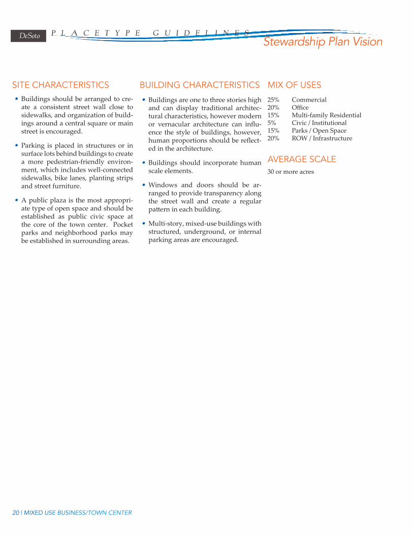
SITE CHARACTERISTICS BUILDING CHARACTERISTICS MIX OF USES
AVERAGE SCALE
• Buildings should be arranged to cre-ate a consistent street wall close to sidewalks, and organization of build-ings around a central square or main street is encouraged.
• Parking is placed in structures or in surface lots behind buildings to create a more pedestrian-friendly environ-ment, which includes well-connected sidewalks, bike lanes, planting strips and street furniture.
• A public plaza is the most appropri-ate type of open space and should be established as public civic space at the core of the town center. Pocket parks and neighborhood parks may be established in surrounding areas.
• Buildings are one to three stories high and can display traditional architec-tural characteristics, however modern or vernacular architecture can influ-ence the style of buildings, however, human proportions should be reflect-ed in the architecture.
• Buildings should incorporate human scale elements.
• Windows and doors should be ar-ranged to provide transparency along the street wall and create a regular pattern in each building.
• Multi-story, mixed-use buildings with structured, underground, or internal parking areas are encouraged.
30 or more acres
25% Commercial20% Office15% Multi-family Residential5% Civic / Institutional15% Parks / Open Space20% ROW / Infrastructure
20 | MIXED USE BUSINESS/TOWN CENTER
DeSoto P L A C e t Y P e G U I D e L I n e sStewardship Plan Vision

INTERSTATE HIGHWAYInterstate Highway placetypes describe the location of a place more than the
form of the place. Since the form of each interchange will vary based on the existing development pattern, the mix of proposed uses, and the availability of other utili-ties and services, these locations should be considered for more focus master plan-ning. It is recommended that the county undertake a study of the land within one quarter mile of each of the exits to prepare a coordinated transportation network, development pattern and access management plan.
Figure 16: Development at interchanges contains a variety of uses with a combina-tion of placetypes decreasing in intensity as they are farther from the most visible areas.ImageSource:MenelaosTriantifil-lou for MDC 2002.
INTERSTATE HIGHWAY | 21
t h e P L A C e t Y P e s

• The site should vary to accommodate the variety of development that oc-curs around the interchange.
• A one mile square master plan should be completed for each interchange/exit to coordinate access management with development forms appropri-ate to capitalize on the high visibility easy access locations.
• Surface parking is discouraged; struc-tured or deck parking is preferred to preserve open space.
• Buildings are one to three stories high and architectural themes should be developed for each interchange quad-rant area. Taller buildings may be appropriate to accommodate higher density office buildings.
The mix of use varies by location, but may include an array of other placetypes described in these Guidelines.
A minimum of one-quarter mile from highway rights-of-way.
SITE CHARACTERISTICS BUILDING CHARACTERISTICS
MIX OF USES
AVERAGE SCALE
• Interstate Highway Districts may share characteristics with Special Districts or Mixed-Use Town Centers.
• Interstate Highway is intended for the development of the four quadrants of an interchange, intended to serve as a first impression “gateway” into the community.
• The district serves as a regional economic engine with large employment populations, and a variety of uses, such as office complexes, commercial, research parks.
• With their location in close proximity to major vehicular transportation gateways, the Interstate Highway District should be designed to accommodate high volumes of ve-hicular traffic.
• Careful use of access management from the primary roadway or interchange is essential to maintain adequate traffic flow.
• As key hubs for travelers, interstate highway districts should incorporate multi-modal transportation options so travelers can switch travel modes easily within their boundaries.
• Frontage lots with direct access to the local road with ramp access are discouraged within 1/8th mile of the ramp intersections and interchange. Parallel access roads and master planned developments are the preferred ap-proach for developing land at the exits, to maintain safe traffic flow on the highway and local roads.
DISTRICT CHARACTERISTICS
22 | INTERSTATE HIGHWAY
DeSoto P L A C e t Y P e G U I D e L I n e sStewardship Plan Vision

SPECIAL DISTRICTSThe Special District Placetype applies to any development
form that has its own unique internal layout of streets, blocks, and buildings typically owned, maintained or designed by a single entity.
• Special Districts are intended to support large numbers of em-ployment uses, and will take different forms based upon the use and the intensity of the use.
• Most suitably located near but just off major roads and high-ways, Special Districts could include such uses as: educational campuses, industrial and business parks, office parks, or expo centers.
• A local road network will be required to accommodate heavy freight traffic where industrial uses are concentrated, and high levels of vehicular traffic during peak rush hours for office and educational districts.
• Multi-modal transportation options should also be integrat-ed in these districts to provide alternative travel to and from these destination districts.
• Buildings located internal to a Special District and situated in a “campus-like” arrangement should be drawn closer to the street for optimal pedestrian access between adjacent build-ings.
• Surface parking should be placed to the rear of buildings, shielded or screened from the sidewalk and the street.
• Access to the campus should be compatible with surrounding uses and development should include necessary buffering or transitions from adjacent uses.
• Buildings are one to four stories high and tend to have large footprints.
• Architecture will be the product of the district’s func-tion and will vary in each special district.
Varies by primary use and function.
20 acres or more
DISTRICT CHARACTERISTICS
SITE CHARACTERISTICS BUILDING CHARACTERISTICS
MIX OF USES
AVERAGE SCALE
Figure 17: Example of a university campus. Source: University of Mississippi. 2012
SPECIAL DISTRICTS | 23
t h e P L A C e t Y P e s

CORRIDOR COMMERCIAL
Figure 18: A mixed layout common in corridor commercial development. Image Source: McBride Dale Clarion. 2013.
This placetype should be used sparingly and is not encouraged as a prominent form for the corridor. It may be appropriate within suburban or traditional neigh-borhoods in limited amounts in context like a “Main Street” type district. Major corridors (arterials and collectors) should not be dominated by extensive corridor commercial development because of the access management issues associated with this type of development. See Goodman Road as an example of Corridor Commer-cial placetype development form.
• Corridor Commercial is highway and auto-oriented development com-posed of a mixture of commercial, re-tail and services that are adjacent to or near major arterials.
• Districts are linear and follow a major corridor.
• This placetype will draw customers from a more regional service area than the Neighborhood Commercial, and will not have as strong a relation-ship with nearby residential neigh-borhoods.
• Buildings generally have a single-lot depth and have large setbacks from the road to accommodate for surface parking lots. Surface parking is en-couraged to be located to the rear or side of the building.
• Densities are relatively low, may be increased by requiring smaller side setbacks and providing incentives to build taller buildings with smaller footprint sizes.
Buildings are generally one to three sto-ries. It is recommended that building facades follow a local vernacular-style of design and materials to create a look and feel unique to the area.
Primarily commercial, retail, services, hos-pitality with some civic and institutional uses, and parks.
20 acres
DISTRICT CHARACTERISTICS SITE CHARACTERISTICS
BUILDING CHARACTERISTICS
MIX OF USES
AVERAGE SCALE
24 | CORRIDOR COMMERCIAL
DeSoto P L A C e t Y P e G U I D e L I n e sStewardship Plan Vision

INDUSTRIALIndustrial parks would be developed under the
Special District Place type as a campus with internal circulation. Industrial placetypes address free- stand-ing single building industrial development with access from a major corridor.
• The Industrial placetype is typically located near major roads, highways, and railways. These sites may include manufacturing centers, warehouse and distribution centers and assembly operations.
• The Industrial areas are intended to provide op-portunities to concentrate employment and thus to help maintain and increase the amount of employ-ment in the region.
• The location of industrial districts is appropriate along rural corridors and should be designed to consider the surrounding uses and the potential impacts on residential and farming operations in terms of noise, odor, or transportation implications.
• They are often buffered from surrounding develop-ment by transitional uses or landscaped areas that shield the view of structures, loading docks, or out-door storage from nearby properties and roads.
• Buildings should be clustered so that uses that sup-port or serve one another are located in the same areas.
• Buildings are generally one to two stories and have large footprints.
Manufacturing and agricultural processing
20 acres
DISTRICT CHARACTERISTICS
SITE CHARACTERISTICS
BUILDING CHARACTERISTICS
MIX OF USES
AVERAGE SCALE
INDUSTRIAL | 25
t h e P L A C e t Y P e s
