detailed project report - gshp2.gov.in summary dm.pdf · 1.3 detailed project report 7. this...
TRANSCRIPT

ROADS AND BUILDINGS DEPARTMENT
GOVERNMENT OF GUJARAT
L E A A s s o c i a t e s S o u t h A s i a P v t . L t d . L E A d e r s h i p i n e n g i n e e r i n g & p l a n n i n g s o l u t i o n s
Detailed Project Report
January 2013
Executive Summary (DHANSURA - MEGHRAJ)

Project Preparatory Works Consultancy Services for
G u j a r a t S t a t e H i g h w a y P r o j e c t - I I Roads & Buildings Department, GoG
LASA-India DPR: Dhansura-Meghraj i
EXECUTIVE SUMMARY
CONTENTS
1 INTRODUCTION ................................................................................................................................. 1
1.1 PROJECT BACKGROUND ........................................................................................................ 1 1.2 BROAD OBJECTIVES AND SCOPE ......................................................................................... 2 1.3 DETAILED PROJECT REPORT ................................................................................................ 2
2 SOCIO-ECONOMIC PROFILE OF THE CORRIDOR .................................................................. 5
3 CORRIDOR CHARACTERISTICS ................................................................................................... 7
3.1 PROJECT CORRIDOR ............................................................................................................... 7
4 TRAFFIC ANALYSIS AND FORECAST ......................................................................................... 8
4.1 INTRODUTION .......................................................................................................................... 8 4.2 EXISTING TRAFFIC CHARACTERISTICS ............................................................................. 8 4.3 TRAFFIC FORECAST ................................................................................................................ 8 4.4 IMPROVEMENT OPTION ......................................................................................................... 9
5 ROAD SAFETY AUDIT .................................................................................................................... 10
5.1 PROJECT BRIEF ...................................................................................................................... 10 5.2 ACCIDENTS STATISTICS ...................................................................................................... 10 5.3 SAFETY ISSUES FOR PROJECT CORRIDOR ....................................................................... 10 5.4 IDENTIFIED ISSUES AND SUGGENTIONS ......................................................................... 11
6 DESIGN OF CORRIDOR .................................................................................................................. 12
6.1 INTRODUCTION ..................................................................................................................... 12 6.2 IMPROVEMENT OPTION ....................................................................................................... 12 6.3 GEOMETRIC DESIGN INTERVENTIOINS ........................................................................... 16 6.4 INTERSECTION/JUNCTION DESIGN ................................................................................... 18 6.5 WAYSIDE AMENITIES AND SAFETY ASPECTS ................................................................ 19 6.6 PAVEMENT DESIGN .............................................................................................................. 22 6.7 IMPROVEMENT PROPOSAL FOR STRUCTURES .............................................................. 26
7 ENVIRONMENTAL AND SOCIAL IMPACT ASSESSMENT .................................................... 28
7.1 ENVIRONMENTAL IMPACT ASSESSMENT ....................................................................... 28 7.2 LAND ACQUISITION AND RESETTLEMENT IMPACTS ................................................... 28
8 ACCESSIBILITY AND MOBILITY TO TRANSPORT FACILITIES IN VILLAGES:
SUMMARY .................................................................................................................................................. 30
8.1 INTRODUCTION ..................................................................................................................... 30 8.2 PROFILE OF SAMPLE POPULATION ................................................................................... 30 8.3 MAJOR FINDINGS .................................................................................................................. 30
9 PROJECT COSTING ......................................................................................................................... 31
10 ECONOMIC ANALYSIS ................................................................................................................... 32
10.1 RESULTS OF ECONOMIC ANALYSIS .................................................................................. 32 10.2 IMPACT OF PROJECT DELAY ON ECONOMY ................................................................... 33 10.3 CONCLUSION .......................................................................................................................... 33
Project Preparatory Works Consultancy Services for
G u j a r a t S t a t e H i g h w a y P r o j e c t - I I Roads & Buildings Department, GoG
LASA-India DPR: Dhansura-Meghraj ii
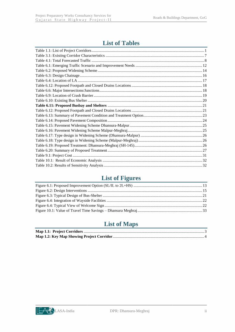
List of Tables Table 1.1: List of Project Corridors ................................................................................................................. 1 Table 3.1: Existing Corridor Characteristics ................................................................................................... 7 Table 4.1: Total Forecasted Traffic ................................................................................................................. 8 Table 6.1: Emerging Traffic Scenario and Improvement Needs ................................................................... 12 Table 6.2: Proposed Widening Scheme ......................................................................................................... 14 Table 6.3: Design Chainage ........................................................................................................................... 16 Table 6.4: Location of LA ............................................................................................................................. 17 Table 6.12: Proposed Footpath and Closed Drains Locations ....................................................................... 18 Table 6.6: Major Intersections/Junctions ....................................................................................................... 18 Table 6.9: Location of Crash Barrier ............................................................................................................. 19 Table 6.10: Existing Bus Shelter ................................................................................................................... 20 Table 6.11: Proposed Busbay and Shelters ............................................................................................... 21 Table 6.12: Proposed Footpath and Closed Drains Locations ....................................................................... 21 Table 6.13: Summary of Pavement Condition and Treatment Option........................................................... 23 Table 6.14: Proposed Pavement Composition ............................................................................................... 24 Table 6.15: Pavement Widening Scheme Dhansura-Malpur ......................................................................... 25 Table 6.16: Pavement Widening Scheme Malpur-Meghraj........................................................................... 25 Table 6.17: Type design in Widening Scheme (Dhansura-Malpur) .............................................................. 26 Table 6.18: Type design in Widening Scheme (Malpur-Meghraj) ................................................................ 26 Table 6.19: Proposed Treatment: Dhansura-Meghraj (SH-145) .................................................................... 26 Table 6.20: Summary of Proposed Treatment ............................................................................................... 27 Table 9.1: Project Cost .................................................................................................................................. 31 Table 10.1: Result of Economic Analysis .................................................................................................... 32 Table 10.2: Results of Sensitivity Analysis ................................................................................................... 32
List of Figures Figure 6.1: Proposed Improvement Option (SL/IL to 2L+HS) ..................................................................... 13 Figure 6.2: Design Interventions ................................................................................................................... 15 Figure 6.3: Typical Design of Bus-Shelter .................................................................................................... 21 Figure 6.4: Integration of Wayside Facilities ................................................................................................ 22 Figure 6.4: Typical View of Welcome Sign .................................................................................................. 22 Figure 10.1: Value of Travel Time Savings – Dhansura Meghraj ................................................................. 33
List of Maps Map 1.1: Project Corridors ......................................................................................................................... 3 Map 1.2: Key Map Showing Project Corridor ............................................................................................ 4

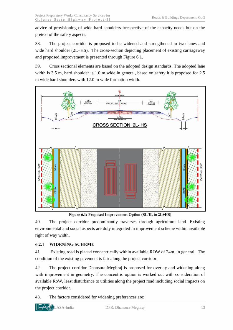
LASA-India DPR: Dhansura-Meghraj 1
1 INTRODUCTION
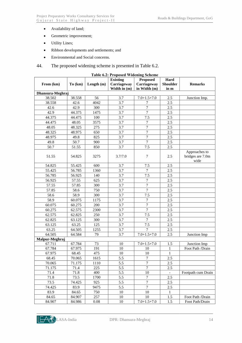
1.1 PROJECT BACKGROUND
1. Gujarat is one of the versatile and dynamic states in India. The state has established
itself on stronger economic foundation. Over the last decade the name of “Gujarat” has
emerged synonymous with progress and vibrancy. Government of Gujarat (GoG) through
Roads and Buildings Department (R&BD) is thriving to deliver better than the best road
infrastructure for the communities.
2. Gujarat roads, managed by R&BD, are known as one of the best in the country.
R&BD is successfully managing its road assets through various flagship programs of GoG,
besides multilateral funding and Public Private Participation. The Gujarat State Highway
Project – I (GSHP-I) successfully implemented by R&BD, GoG through 2001 to 2007 with
the World Bank assistance, has set many bench marks for other states to follow. The state
appreciating need of sustenance of its economic growth, endorses that the infrastructure is
one of the key and further its enhanced quality is a great value addition.
3. GSHP-I project umbrella before its closure itself rooted efforts towards second
highway project for the state. The Updated Strategic Options Study (USOS) for the Core
Road Network of the Gujarat State was carried out in 2005-06 to this respect and the same
was duly revalidated in 2010. This study has prioritised road sections on strategic parameters
to arrive at about 1,600 km road length. R&BD, GoG with in-principal agreement with the
World Bank (WB) has finalised project budget as Rs. 2,100 crore. As a pre-requisite for loan
appraisal process with the WB, R&BD, GoG selected about 397.9/460 km of road length for
project preparatory works.
4. R&BD, GOG has taken a step forward by selecting LEA Associates South Asia Pvt.
Ltd. (LASA) as Project Preparatory Works Consultant. Project Preparatory Works
Consultancy Services (PPWCS) mandates the consultant for detailed engineering project
report preparation along with procurement documents for selected 397.9 km road length.
1.1.1 Project Corridors
5. The corridors are selected by R&BD across the state to have representation of various
project interventions like four laning, wide two laning and maintenance. The list of project
corridors at a glance is furnished through Table 1.1. The map showing project corridor is
provided as Map 1.1.
Table 1.1: List of Project Corridors
Work Type Sr. No. Link Name SH No. Length (km)
Two Laning /
Wide Two
Laning
1 Lunawada – Khedapa (Border) SH-02, SH-152 56.70
2 Bayad – Lunawada SH-69,SH-63, VR/MDR 44.56
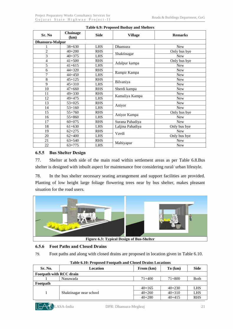
3 Dhansura – Meghraj SH-145 46.65
4 Gondal – Atkot SH-01 35.40
5 Dhandhuka – Dholera SH-20 27.00
6 Umreth- Vasad (including SH-83,SH-188, SH-151 35.45

Project Preparatory Works Consultancy Services
f o r G u j a r a t S t a t e H i g h w a y P r o j e c t - I I Roads & Buildings Department, GoG
LASA-India DPR: Dhansura-Meghraj 2
Work Type Sr. No. Link Name SH No. Length (km)
Kapadvanj-Ladvel)
7 Dabhoi – Bodeli SH-11 38.60
Four laning 8 Mehsana-Himmatnagar SH-55 66.15
Rehabilitation 9 Paliyad-Dhandhuka SH-001 46.00 Source: As provided in Terms of Reference (ToR)1
1.2 BROAD OBJECTIVES AND SCOPE
6. The broad objective of the assignment
is to have detailed engineering project ready for
bidding. It includes economic analysis for each
section, integration of road safety audit in final
design, implementation and O&M along with Environmental Impact Assessment,
Environmental Management Action Plan and Rehabilitation and Resettlement Studies as per
World Bank Guidelines.
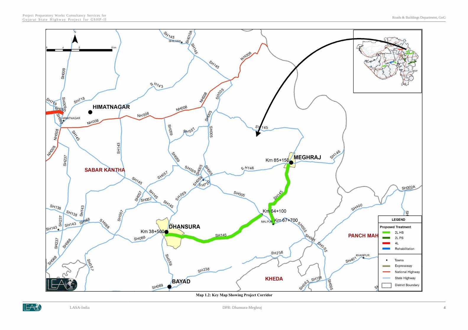
1.3 DETAILED PROJECT REPORT
7. This Executive Summary of DPR pertains to two laning with hard shoulder for the
project corridor Dhansura-Meghraj. The key map showing project corridor is presented in
Map 1.2.
1 Bodeli-Alirajpur Corridor left out as part of GSHP-II as it is being declared as National Highway
Project Intervention Total Length (Km)
Widening to tWide 2L 286.9 km
Widening to 4L 66 km
Maintenance/Rehabilitation 45 km
Total length 397.9 km

Project Preparatory Works Consultancy Services for
G u j a r a t S t a t e H i g h w a y P r o j e c t - I I Roads & Buildings Department, GoG
LASA-India DPR: Dhansura-Meghraj 3
Map 1.1: Project Corridors
Project Preparatory Works Consultancy Services for
Gu j a r a t S t a t e H i g h w a y P r o j e c t fo r GS H P - I I Roads & Buildings Department, GoG
LASA-India DPR: Dhansura-Meghraj 4
Map 1.2: Key Map Showing Project Corridor

LASA-India DPR: Dhansura-Meghraj 5
2 SOCIO-ECONOMIC PROFILE OF THE CORRIDOR
8. The corridor Dhansura-Meghraj is located in Dhansura, Meghraj and Malpur talukas
of Sabarkantha district covering a total length of nearly 43.5 km.
9. Population Distribution: The project corridor traverses through 3 talukas which
comprise a total population of 3.71 lakh in 2011 and 3.24 lakh during 2001. Population of
these talukas grew at an Average Annual Growth Rate (AAGR) of 1.4 percent during the year
2001 to 20112. There are total of 30 census villages and 2 towns (Meghraj and Malpur) which
abuts the project corridor. The total population of villages and towns adjoining corridor is
58,780; which is almost 18 percent to the project talukas population (Census 2001).
Settlements seen along the corridor are Dhansura, Wantada suka, Aniyor Kampa, Rasapur,
Malpur, Parsoda, Idalpura and Meghraj. The total number of households along project
corridor is 11,563. Average Household (HH) size along the project corridor is 5.1, which vary
from 4.6 in Juna Takhatpur to 6 in Rasapur village.
10. Age and Sex Ratio: The overall population below 6 years age in project corridor
talukas is 14 percent. The average sex ratio3 for project corridor talukas during 2001 was 941
which increased to 950 during 2011. Meghraj taluka has shown relatively higher sex ratio of
965 followed by Malpur taluka. For the project corridor villages, the analysis for sex ratio
reveals 923 females per thousand males. Bhempur village followed by Sonikpur village have
shown higher sex ratio of 1193 and 1116, which is higher when compared to the average of
state and talukas average. Maljina Pahadiya has shown relatively lower sex ratio of 825 than
other villages abutting corridor. Similarly, looking into the juvenile sex ratio4, it was analysed
that as against the juvenile sex ratio of 897 for project corridor talukas, the project corridor
villages had the lowest sex ratio of 848.
11. Literacy Rate: As per Provisional Census 2011, the project corridor talukas possess
literacy rate of 72 percent, as against 62 percent during 2001. Male literacy ratio in project
corridor taluka is 85 percent as against the female literacy rate of 59 percent in 2011. Average
literacy rate in project corridor villages is 72 percent, this constitutes 84 percent male literates
and 59 percent females. Amongst all the villages and settlements along corridor, urban
settlements of Malpur and Meghraj have shown higher literacy rates i.e. 81 and 83 percent.
12. Urban Rural Population: The project corridor abuts 2 urban settlements of Meghraj
and Malpur. Population of Meghraj and Malpur during the year 2001 was 9902 and 6512.
These 2 towns comprise nearly 28 percent of the total population residing along the corridor.
2 Village/ settlement wise analysis for the project corridor has been done based on 2001 Census
information. Taluka level analysis is based on 2001 census information and 2011 Provisional census data
base information. 3 Sex Ratio: Number of females per thousand males
4 Juvenile Sex Ratio is the sex ratio of population in age-group 0-6 years

Project Preparatory Works Consultancy Services for
G u j a r a t S t a t e H i g h w a y P r o j e c t - I I Roads & Buildings Department, GoG
LASA-India DPR: Dhansura-Meghraj 6
13. Occupational Structure: Total workers according to census 2001 in project corridor
taluka was 1.57 lakh, this comprised 70 percent workers classified as main workers5 and rest
30 percent as marginal workers6. Taking into account the composition of workers majority of
workers are cultivators (51 percent) and are working in other sectors7 (24 percent). The total
workers in project corridor settlements are 24,431. Of this, Dhansura village accounts for
majority of workers i.e. 18 percent to total project corridor settlement. Workers composition
along the corridor shows highest share of workers engaged in others sector (46 percent)
followed by agricultural sector (38 percent). The Workforce Participation Ratio (WPR) for
project corridor taluka in 2001 was 49 percent. While comparing and analysing the male
WPR and female WPR, it was recorded that the female WPR is merely 28 percent as against
male WPR of 54 percent. The average WPR for project corridor settlements is 42 percent
which is lower than the Talukas WPR. Male WPR in project corridor settlements is 53
percent as against 30 percent for female WPR.
14. Schedule Caste and Schedule Tribe Population: Analysis of social groups for the
project corridor has been done on the basis of concentration of Schedule Caste (SC) and
Schedule Tribe (ST) population in talukas and project corridor settlements. 22 percent
population in project corridor talukas comprises SC and ST community. The share of SC
community in talukas is 17 percent, whereas, the SC community have a share of 5 percent. As
mentioned above, Meghraj is a tribal taluka and is included as part of Fifth schedule area. The
schedule tribes identified in this taluka are predominantly Bhil and Nayak. As per Census
2001, total SC and ST population along the corridor accounts for the figure of 6,582 which is
nearly 11 percent of total population for settlements along the project corridor. Primarily, the
predominant group amongst the social groups is that of SC community i.e. 8 percent to the
entire SC and ST population of the corridor.
5 Main workers were those who had worked for the major part of the year preceding the date of enumeration
i.e., those who were engaged in any economically productive activity for 183 days (or six months) or more
during the year 6 Marginal workers were those who worked any time at all in the year preceding the enumeration but did
not work for a major part of the year, i.e., those who worked for less than 183 days (or six months). 7 Census Definition of Other Workers: All workers, i.e., those who have been engaged in some economic
activity during the last one year, but are not cultivators or agricultural labourers or in Household Industry,
are 'Other Workers (OW)'. The type of workers that come under this category of 'OW' include all
government servants, municipal employees, teachers, factory workers, plantation workers, those engaged in
trade, commerce, business, transport banking, mining, construction, political or social work, priests,
entertainment artists, etc. In effect, all those workers other than cultivators or agricultural labourers or
household industry workers, are 'Other Workers'
LASA-India DPR: Dhansura-Meghraj 7
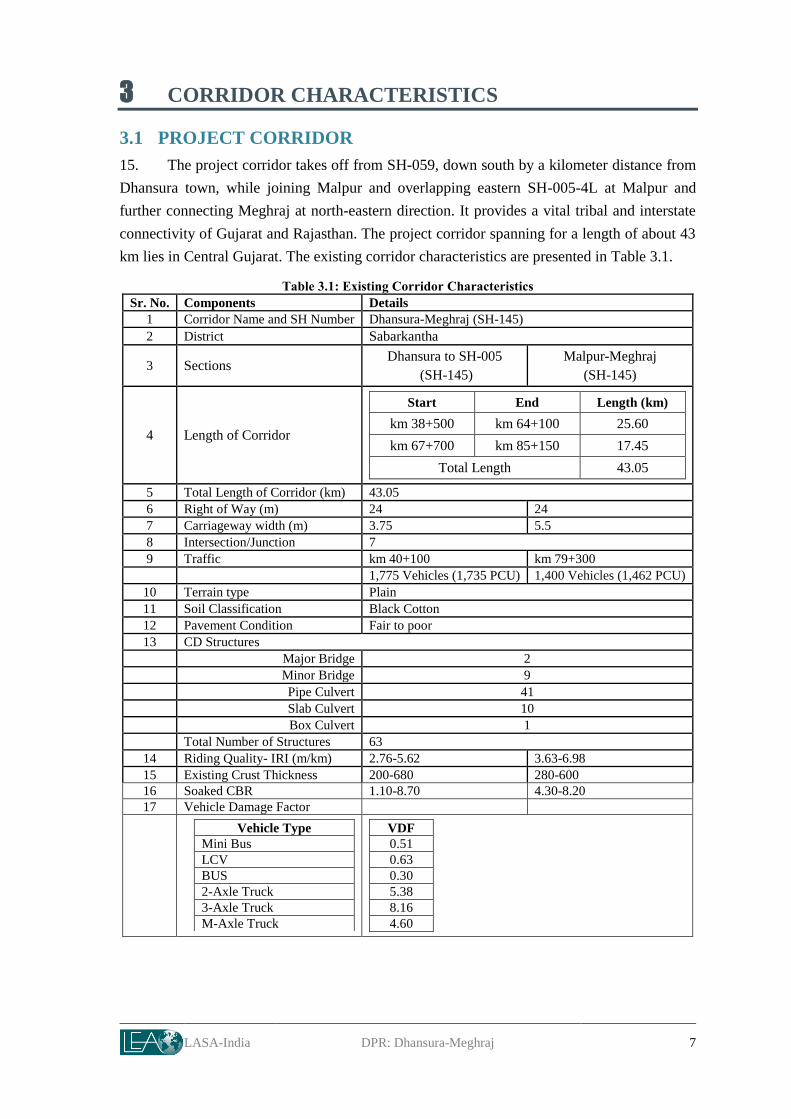
3 CORRIDOR CHARACTERISTICS
3.1 PROJECT CORRIDOR
15. The project corridor takes off from SH-059, down south by a kilometer distance from
Dhansura town, while joining Malpur and overlapping eastern SH-005-4L at Malpur and
further connecting Meghraj at north-eastern direction. It provides a vital tribal and interstate
connectivity of Gujarat and Rajasthan. The project corridor spanning for a length of about 43
km lies in Central Gujarat. The existing corridor characteristics are presented in Table 3.1.
Table 3.1: Existing Corridor Characteristics
Sr. No. Components Details
1 Corridor Name and SH Number Dhansura-Meghraj (SH-145)
2 District Sabarkantha
3 Sections Dhansura to SH-005
(SH-145)
Malpur-Meghraj
(SH-145)
4 Length of Corridor
Start End Length (km)
km 38+500 km 64+100 25.60
km 67+700 km 85+150 17.45
Total Length 43.05
5 Total Length of Corridor (km) 43.05
6 Right of Way (m) 24 24
7 Carriageway width (m) 3.75 5.5
8 Intersection/Junction 7
9 Traffic km 40+100 km 79+300
1,775 Vehicles (1,735 PCU) 1,400 Vehicles (1,462 PCU)
10 Terrain type Plain
11 Soil Classification Black Cotton
12 Pavement Condition Fair to poor
13 CD Structures
Major Bridge 2
Minor Bridge 9
Pipe Culvert 41
Slab Culvert 10
Box Culvert 1
Total Number of Structures 63
14 Riding Quality- IRI (m/km) 2.76-5.62 3.63-6.98
15 Existing Crust Thickness 200-680 280-600
16 Soaked CBR 1.10-8.70 4.30-8.20
17 Vehicle Damage Factor
Vehicle Type
Mini Bus
LCV
BUS
2-Axle Truck
3-Axle Truck
M-Axle Truck
VDF
0.51
0.63
0.30
5.38
8.16
4.60
LASA-India DPR: Dhansura-Meghraj 8
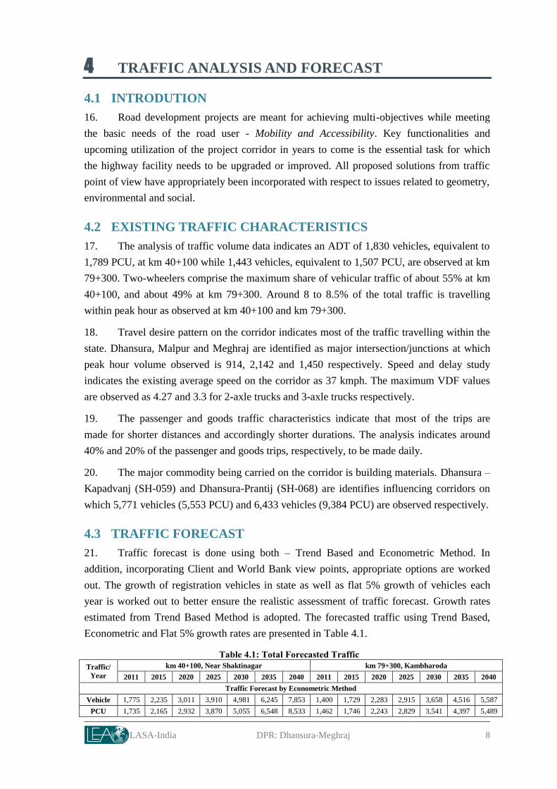
4 TRAFFIC ANALYSIS AND FORECAST
4.1 INTRODUTION
16. Road development projects are meant for achieving multi-objectives while meeting
the basic needs of the road user - Mobility and Accessibility. Key functionalities and
upcoming utilization of the project corridor in years to come is the essential task for which
the highway facility needs to be upgraded or improved. All proposed solutions from traffic
point of view have appropriately been incorporated with respect to issues related to geometry,
environmental and social.
4.2 EXISTING TRAFFIC CHARACTERISTICS
17. The analysis of traffic volume data indicates an ADT of 1,830 vehicles, equivalent to
1,789 PCU, at km 40+100 while 1,443 vehicles, equivalent to 1,507 PCU, are observed at km
79+300. Two-wheelers comprise the maximum share of vehicular traffic of about 55% at km
40+100, and about 49% at km 79+300. Around 8 to 8.5% of the total traffic is travelling
within peak hour as observed at km 40+100 and km 79+300.
18. Travel desire pattern on the corridor indicates most of the traffic travelling within the
state. Dhansura, Malpur and Meghraj are identified as major intersection/junctions at which
peak hour volume observed is 914, 2,142 and 1,450 respectively. Speed and delay study
indicates the existing average speed on the corridor as 37 kmph. The maximum VDF values
are observed as 4.27 and 3.3 for 2-axle trucks and 3-axle trucks respectively.
19. The passenger and goods traffic characteristics indicate that most of the trips are
made for shorter distances and accordingly shorter durations. The analysis indicates around
40% and 20% of the passenger and goods trips, respectively, to be made daily.
20. The major commodity being carried on the corridor is building materials. Dhansura –
Kapadvanj (SH-059) and Dhansura-Prantij (SH-068) are identifies influencing corridors on
which 5,771 vehicles (5,553 PCU) and 6,433 vehicles (9,384 PCU) are observed respectively.
4.3 TRAFFIC FORECAST
21. Traffic forecast is done using both – Trend Based and Econometric Method. In
addition, incorporating Client and World Bank view points, appropriate options are worked
out. The growth of registration vehicles in state as well as flat 5% growth of vehicles each
year is worked out to better ensure the realistic assessment of traffic forecast. Growth rates
estimated from Trend Based Method is adopted. The forecasted traffic using Trend Based,
Econometric and Flat 5% growth rates are presented in Table 4.1.
Table 4.1: Total Forecasted Traffic
Traffic/
Year
km 40+100, Near Shaktinagar km 79+300, Kambharoda
2011 2015 2020 2025 2030 2035 2040 2011 2015 2020 2025 2030 2035 2040
Traffic Forecast by Econometric Method
Vehicle 1,775 2,235 3,011 3,910 4,981 6,245 7,853 1,400 1,729 2,283 2,915 3,658 4,516 5,587
PCU 1,735 2,165 2,932 3,870 5,055 6,548 8,533 1,462 1,746 2,243 2,829 3,541 4,397 5,489
Project Preparatory Works Consultancy Services for
G u j a r a t S t a t e H i g h w a y P r o j e c t - I I Roads & Buildings Department, GoG
LASA-India DPR: Dhansura-Meghraj 9
Traffic Forecast by Trend Based Method
Vehicle 1,775 2,164 2,731 3,453 4,295 5,069 5,666 1,400 1,682 2,095 2,615 3,212 3,757 4,175
PCU 1,735 2,105 2,650 3,344 4,176 4,947 5,547 1,462 1,716 2,086 2,551 3,088 3,578 3,955
Traffic Forecast by Flat 5% Growth Rate
Vehicle 1,775 2,157 2,753 3,514 4,485 5,724 7,305 1,400 1,701 2,170 2,770 3,535 4,512 5,758
PCU 1,735 2,109 2,691 3,435 4,384 5,595 7,141 1,462 1,776 2,267 2,893 3,690 4,710 6,011
4.4 IMPROVEMENT OPTION
22. The improvement option proposed is SL/IL to 2LHS and is further reconfirmed with
concerns related to geometry, safety, land acquisition, environmental and social aspects,
before incorporation in the final design of the corridor.
LASA-India DPR: Dhansura-Meghraj 10
5 ROAD SAFETY AUDIT
5.1 PROJECT BRIEF
23. Dhansura-Meghraj is proposed to be improved with better riding quality and
enhanced safety. Road Safety Audit addresses identification of safety related deficiencies as
well as behavioral safety issues while subsequently recommending countermeasures in
approaching towards sustainable design solution. All sections of the project corridor are
visited and studied. Review and audit of safety measures of the corridor are followed with the
prevailing best practices. With proposed improvement option of two lane with granular
shoulders, the objective of the exercise focuses on abating road accidents and their severity
while improving riding quality.
5.2 ACCIDENTS STATISTICS
24. First Information Report (FIR) details relating to the accidents, fatalities and injuries
in the project corridor and its immediate influence area are collected and studied. Though
such information is recorded by police stations, there is a potential scope of other minor
injury and property damage accidents to not have reported. However, efforts are extended in
preparing safety improvement options beyond available accident data and the same is
incorporated in final improvement proposals. 17 fatalities and 34 injuries reported in a span of
6 years (2006 – 2011). The data indicates most accidents concentrated at Aniyor, Aniyor
kampa and Dhansura.
5.3 SAFETY ISSUES FOR PROJECT CORRIDOR
5.3.1 Carriageway
25. It is observed that carriageway and shoulders are inadequate in width. It is essential to
increase the carriageway width in this entire stretch at least up to 7.0 meters + edge strips 1.0
m on either side for improved safety.
5.3.2 Geometric design
26. During the audit, it is identified that sight distance at sharp curves lack in standards
and needs to be improved with geometric design. Curve passing through villages needs
proper signage. Appropriate control measures are essential.
5.3.3 Intersections/Junctions
27. There are seven major junctions/intersections observed on the project corridor. It is
observed that considerable habitants gather near these junctions; thereby generating local
trips. It is audited that the existing junction/intersection design lacks in incorporating local
travel behaviour and influence of habitations in proximity, which makes them potential
accident prone spots. It is identified that careful attention needs to be given in developing
appropriate designs for these junctions/intersections. In addition, provision of suitable
location of bus stops near junction/intersection needs to be considered.

Project Preparatory Works Consultancy Services for
G u j a r a t S t a t e H i g h w a y P r o j e c t - I I Roads & Buildings Department, GoG
LASA-India DPR: Dhansura-Meghraj 11
5.3.4 CD Structures
28. The cross drainage works, especially culverts/Canals, are narrow in width and the
parapets of the culverts are potential hazards.
5.3.5 Wayside amenities
29. It is observed that Intermediate Public Transport (IPT) modes operating on this
corridor are popular as well as in demand due to their services in providing local accessibility
and mobility at affordable price to the habitants. They usually travel with over occupancy and
their stoppages and parking are uncertain, creating chaotic and unsafe conditions to the other
traffic utilizing corridor.
5.3.6 Traffic Management and Control Issues
30. It is identified that traffic signs needs to be provided at many places. Existing
signages are in a poor condition. It is identified that provision of pavement markings lack at
many places on the project corridor.
5.4 IDENTIFIED ISSUES AND SUGGENTIONS
31. Suggestions, recommendation as well as issues identified from safety audit are
incorporated into final improvement options which include, but not limited to,
a. Deficient 36 horizontal curves;
b. Identified 115 major/minor intersections (including access roads);
c. Identified 12 highway sections near habitations and;
d. Identified deficient 63 structures.
32. The details of the recommended interventions are presented in Volume III Road
Safety Audit.

LASA-India DPR: Dhansura-Meghraj 12
6 DESIGN OF CORRIDOR
6.1 INTRODUCTION
33. This chapter deals with detailed analysis of road geometrics, development aspects,
safety and road furniture requirements, to provide pleasant and aesthetic highway for road
users. This chapter also discusses about pavement design, design and rehabilitation proposals
of CD structures and bridges.
6.2 IMPROVEMENT OPTION
34. The existing carriageway width of the project corridor is 3.5-3.75m, i.e. Single Lane
(SL) configuration for Dhansura-Malpur section, thereafter from Malpur-Meghraj project
section is having carriageway of 5.5m (intermediate lane) and with 10m wide carriageway at
Malpur and Meghraj. Project scope is for widening of existing road from SL/IL to 2L++HS
configuration.
35. The project corridor has right of way of 24 m. The improvement option for project
corridor is seen with respect to traffic, safety, speed and mobility. World Bank advises and
shared iRAP8 reports are also taken into consideration.
36. The project section, Dhansura-Malpur is carrying 1775 vehicles on the project road in
2011-2012 projecting to 3,344 PCUs in 2025 and 5,547 PCUs in 2040. Looking to traffic
figures project road calls for higher order up gradation from the year 2013-2014. The
emerging traffic scenario and feasibility of improvement option can be simulated through
Table 6.1.
Table 6.1: Emerging Traffic Scenario and Improvement Needs
Project
Section Traffic /Year 2011 2015 2020 2025 2030 2035 2040
Dhansura-
Malpur
Vehicle 1,775 2,164 2731 3,453 4295 5,069 5,666
PCU 1,735 2,105 2,650 3,344 4,176 4,947 5,547
Configuration SL 2LHS
Malpur-
Meghraj
Vehicle 1,400 1,682 2,095 2,615 3,212 3,757 4,175
PCU 1,462 1,716 2,086 2,551 3,088 3,578 3,955
Configuration IL 2LHS
37. The project section Malpur-Meghraj is carrying 1,400 vehicles on the project road, in
2011-2012 projecting to 2,551 PCUs in 2025 and 3955 PCUs in 2040. Not traffic numbers
but importantly bridging the tribal villages and talukas supports up gradation to standard two
lanes. The project section does not call for up gradation before 2040. Based on World Bank’s
8 iRAP: International Road Assessment Programme, Gujarat is also covered under the Programme with selected
corridors. Findings of IRAP and recommendations at particular stage are shared.
Project Preparatory Works Consultancy Services for
G u j a r a t S t a t e H i g h w a y P r o j e c t - I I Roads & Buildings Department, GoG
LASA-India DPR: Dhansura-Meghraj 13
advice of provisioning of wide hard shoulders irrespective of the capacity needs but on the
pretext of the safety aspects.
38. The project corridor is proposed to be widened and strengthened to two lanes and
wide hard shoulder (2L+HS). The cross-section depicting placement of existing carriageway
and proposed improvement is presented through Figure 6.1.
39. Cross sectional elements are based on the adopted design standards. The adopted lane
width is 3.5 m, hard shoulder is 1.0 m wide in general, based on safety it is proposed for 2.5
m wide hard shoulders with 12.0 m wide formation width.
Figure 6.1: Proposed Improvement Option (SL/IL to 2L+HS)
40. The project corridor predominantly traverses through agriculture land. Existing
environmental and social aspects are duly integrated in improvement scheme within available
right of way width.
6.2.1 WIDENING SCHEME
41. Existing road is placed concentrically within available ROW of 24m, in general. The
condition of the existing pavement is fair along the project corridor.
42. The project corridor Dhansura-Meghraj is proposed for overlay and widening along
with improvement in geometry. The concentric option is worked out with consideration of
available RoW, least disturbance to utilities along the project road including social impacts on
the project corridor.
43. The factors considered for widening preferences are:
Project Preparatory Works Consultancy Services for
G u j a r a t S t a t e H i g h w a y P r o j e c t - I I Roads & Buildings Department, GoG
LASA-India DPR: Dhansura-Meghraj 14
Availability of land;
Geometric improvement;
Utility Lines;
Ribbon developments and settlements; and
Environmental and Social concerns.
44. The proposed widening scheme is presented in Table 6.2.
Table 6.2: Proposed Widening Scheme
From (km) To (km) Length (m)
Existing
Carriageway
Width in (m)
Proposed
Carriageway
in Width (m)
Hard
Shoulder
in m
Remarks
Dhansura-Meghraj
38.502 38.558 56 3.7 7.0+1.5+7.0 2.5 Junction Imp.
38.558 42.6 4042 3.7 7 2.5
42.6 42.9 300 3.7 7 2.5
42.9 44.375 1475 3.7 7 2.5
44.375 44.475 100 3.7 7.5 2.5
44.475 48.05 3575 3.7 7 2.5
48.05 48.325 275 3.7 7 2.5
48.325 48.975 650 3.7 7 2.5
48.975 49.8 825 3.7 7 2.5
49.8 50.7 900 3.7 7 2.5
50.7 51.55 850 3.7 7.5 2.5
51.55 54.825 3275 3.7/7.0 7 2.5
Approaches to
bridges are 7.0m
wide
54.825 55.425 600 3.7 7.5 2.5
55.425 56.785 1360 3.7 7 2.5
56.785 56.925 140 3.7 7.5 2.5
56.925 57.55 625 3.7 7 2.5
57.55 57.85 300 3.7 7 2.5
57.85 58.6 750 3.7 7 2.5
58.6 58.9 300 3.7 7.5 2.5
58.9 60.075 1175 3.7 7 2.5
60.075 60.275 200 3.7 7 2.5
60.275 62.575 2300 3.7 7 2.5
62.575 62.825 250 3.7 7.5 2.5
62.825 63.125 300 3.7 7 2.5
63.125 63.25 125 3.7 7.5 2.5
63.25 64.505 1255 3.7 7 2.5 64.505 64.584 79 3.7 7.0+1.5+7.0 2.5 Junction Imp
Malpur-Meghraj
67.711 67.784 73 10 7.0+1.5+7.0 1.5 Junction Imp
67.784 67.975 191 10 10 1 Foot Path /Drain
67.975 68.45 475 10 10 1
68.45 70.065 1615 5.5 7 2.5
70.065 71.175 1110 5.5 7 2.5 71.175 71.4 225 5.5 7 2.5
71.4 71.8 400 5.5 10 - Footpath cum Drain
71.8 73.5 1700 5.5 7 2.5
73.5 74.425 925 5.5 7 2.5
74.425 83.9 9475 5.5 7 2.5
83.9 84.65 750 10 10 1 84.65 84.907 257 10 10 1.5 Foot Path /Drain
84.907 84.986 0.08 10 7.0+1.5+7.0 1.5 Foot Path/Drain

Project Preparatory Works Consultancy Services for
G u j a r a t S t a t e H i g h w a y P r o j e c t - I I Roads & Buildings Department, GoG
LASA-India DPR: Dhansura-Meghraj 15
6.2.2 DESIGN INTERVENTIONS
45. The process involved in design
intervention is depicted in Figure 6.2.
Speed
46. The horizontal geometry with
speeds less than 65 kmph in rural sections is
improved. Largely following the mandate
improvements are proposed within available
RoW. Efforts are also made to provide safe
designs in settlements considering speeds
40-65 kmph.
Intervention on Saving of Trees
47. No significant of impact on existing
plantation is observed along the project
corridor. Alignment
improvement/modifications evaluated lesser
impact on tree cutting.
Social Impact
48. Special efforts have been made to
minimize the social &environment impacts
by shifting the alignment along the project
corridor at sensitive receptors. Two wells
along project corridor within corridor of impact at km 53+760 and km 78+490 are saved by
adjusting the alignment. The land acquisition is avoided in tribal area of Meghraj taluka
which is part of Fifth Schedule Area. The alignment is adjusted to eliminate impacts on
temple at km 55+750 and km 78+495.
49. For the sections through settlements specific care has been taken to safe guard
cultural properties, existing permanent structures and kiosks towards reducing the social
impacts. In total 72 socially impacted structures are identified in the initial stages of design,
the same is reduced to 26 after design interventions coupled with road furniture and safety
measures along the project corridor.
Safety
50. The safety is very much incorporated in design process; interventions include
provision of speed humps at exit and entry of settlements, foot paths, improved junction
layouts, advanced warning signs, rumble strips, provision of guard rails etc. The detailed
interventions on safety are provided through Volume III of this DPR.
Figure 6.2: Design Interventions

Project Preparatory Works Consultancy Services for
G u j a r a t S t a t e H i g h w a y P r o j e c t - I I Roads & Buildings Department, GoG
LASA-India DPR: Dhansura-Meghraj 16
6.3 GEOMETRIC DESIGN INTERVENTIOINS
51. Base plan of the corridor showing all existing natural and manmade features has been
prepared using the topographical survey data. All the features within a band width of 60m
have been captured with an unique “description code” during the survey along with the
details of existing carriageway centreline, edge of pavement, edge of shoulder, toe line of the
embankment etc. Survey data is formatted to suit the requirements of Civil 3D environment.
The steps followed for preparation of base plan are:
Data is imported into software;
Main corridor features are defined by joining the points of centerline, edge of pavement, embankment
toe line;
The points with same description codes for all physical features like rivers, buildings, religious
structures, shops, telephone poles, electric poles, cross roads etc. within the above specified limits are
joined;
Break lines for features such as edge of the road, shoulder, nallahs, top and bottom of ditches, etc. are
established;
Details of existing cross drainage structures such as bridge number, span arrangement etc. are inserted;
Details of utility services collected are inserted;
The prepared base plans are verified and updated by “walkover” surveys and
Additional survey data where necessary is gathered and the base plans is finalized.
6.3.1 Horizontal Alignment Design
52. Design of the horizontal alignment has been carried out in CIVIL 3D environment as
per the finalised widening scheme. Extensive field checks to verify the feasibility of the
proposed alignment have been carried out and suitable modifications to the alignment have
been effected wherever considered essential to safeguard sensitive elements.
53. The design chainage is given Table 6.3.
Table 6.3: Design Chainage
Project Section Start Chainage (km) End Chainage (km) Length (km)
Dhansura-Malpur 38+501.28 64+583.61 26.082
Malpur-Meghraj 67+711.75 84+986.94 17.275
54. Geometric design of project corridor has been conceptualized for a design speed of
80/100kmph in rural sections and 40-60 kmph in village/urban sections as per the design
standards formulated for the project. The project corridor has fair horizontal geometrics but
several locations of horizontal curves (40 Curves), low degree of curvature are identified and
are improved.
55. Geometric improvement has been carried out, with due consideration of project
features, social impact assessment, along with interventions due to green tunnels. Crossroads
have been realigned at the junction with main carriageway to reduce the skew angle of the
crossing and to ensure safety. The list of access roads with realignment is provided Volume
VIII of this report. The process involved in design intervention is depicted in Figure 6.2. The

Project Preparatory Works Consultancy Services for
G u j a r a t S t a t e H i g h w a y P r o j e c t - I I Roads & Buildings Department, GoG
LASA-India DPR: Dhansura-Meghraj 17
geometry is improved within available RoW, except at following locations where Land
Acquisition (LA) is inevitable for improvement. The location of LA is given in Table 6.4.
Table 6.4: Location of LA
Chainage Side
Village
Total Area
(sq.m)
Total Area
(ha) From (km) To (km)
57+594 57+852 LHS Satarda 1592.873 0.1592873
70+672 70+896 RHS Medi timba 1040.018 0.1040018
70+999 71+085 RHS
Medi timba
426.643 0.0426643 71+085 71+110 River Portion
71+110 71+148 Nanavada
74+095 74+290 RHS Parsoda 2356.641 0.2356641
Total 5416.175 0.5416175
6.3.2 Vertical Alignment Design
56. The existing vertical geometry for majority of project road calls for attention. The
project road is in place since long, but the proper design of project corridor has not probably
taken place in recent times. The unevenness in profile calls for efforts for designing the
vertical profile. The existing pavement is under fair condition.
57. The design Finished Road Levels (FRL) at the centreline of the roadway is
determined from new pavement design for Dhansura-Malpur and Malpur-Meghraj. The
pavement design necessitates overlay in sections as discussed in subsequent chapters.
58. For fixing the design finished road level an overlay of 25 mm SDBC and 100mm9 of
BM is proposed. Out of the 100 mm BM, 75 mm is for overlay and 25 mm is profile
corrective course (PCC). During the design of vertical profile, due unevenness in existing
profile, it is observed that PCC is required to keep design profile within design standards set
out for project corridor.
59. Cutting of existing pavement to provide required finished road level is kept to a
minimum and adopted only when cost effective or most appropriate.
6.3.3 Side Slopes
60. The average embankment height of existing project road is about 0.5-1.0 m. The side
slopes of highway embankments shall be as flat as possible so that drivers accidentally
leaving the roadway have better chances of survival. This has been also recommended in
IRC-36, which provides a side slope of 1:4 for low embankment upto1.5m height, although
due to limited RoW and accommodating the longitudinal drains the slope is kept as 1:2.0.
Where required essential safe guards are proposed.
9 Includes 75mm overlay requirement in BM, rest 25 mm considered as PCC, but modelled to have 50 mm
layer first to have corrected good profile along with structural layer built-in, followed by uniform 50mm as
next layer. This optimises the PCC quantity.

Project Preparatory Works Consultancy Services for
G u j a r a t S t a t e H i g h w a y P r o j e c t - I I Roads & Buildings Department, GoG
LASA-India DPR: Dhansura-Meghraj 18
6.3.4 Road Side Drainage
61. Project corridor is passing through agricultural lands, call for attention on drainage.
The longitudinal drain is proposed all along the project corridor. The drain width is 0.6m at
bottom and 1.2:1 side slopes. The drainage analysis along the project road is provided in
Volume II of this report.
62. Closed drains are proposed in location given in Table 6.10.
Table 6.5: Proposed Footpath and Closed Drains Locations
Sr. No. Location From (km) To (km) Side
Footpath with RCC drain
1 Nanawada 71+400 71+800 Both
Footpath
1 Shaktinagar near school
40+165 40+230 LHS
40+260 40+310 LHS
40+280 40+415 RHS
2 Sherdi Kampa near school 47+625 47+760 LHS
47+710 47+760 RHS
3 Parsoda near school 74+300 74+400 Both
6.3.5 Utility Crossings
63. Utility crossings are proposed at 9 locations to avoid frequent digging of carriageway.
6.4 INTERSECTION/JUNCTION DESIGN
64. At-grade intersections/junctions, unless properly designed can be accident-prone and
can reduce the overall capacity of the road. The basic requirements for the design of
intersections are not only to cater safe movements of road users, but also to provide them full
traffic information by way of signs and pavement markings. Simplicity and uniformity is the
guiding principles for intersection design. Based upon these principles at-grade
intersections/junctions have been categorized as:
1. Major Intersections/Junctions
2. Minor Intersections/Junctions
3. Access roads and Cart Tracks
65. The project corridor is having six major junctions/intersections, 12 minor
junctions/intersections and 27 access roads and cart tracks. The location of intersections along
the project road with various categories of roads, improvements proposed is detailed in this
section.
6.4.1 Major Intersections/Junctions
66. Intersections/junctions with category of roads like NH/SH/MDR and having black top
surface are presented in Table 6.6.
Table 6.6: Major Intersections/Junctions
Sr.
No.
Intersection/
Junction Type Chainage (km)
Existing Width
(m) Improvement
1 Dhansura 3-Arm 38+501 3.75 As per MOST standards
2 Malpur 3-Arm 64+583.61 3.75 As per MOST standards
3 Malpur 4-Arm 67+711.75 10.00 As per MOST standards
Project Preparatory Works Consultancy Services for
G u j a r a t S t a t e H i g h w a y P r o j e c t - I I Roads & Buildings Department, GoG
LASA-India DPR: Dhansura-Meghraj 19
Sr.
No.
Intersection/
Junction Type Chainage (km)
Existing Width
(m) Improvement
4 Mewada 3-Arm 72+760 5.5 As per IRC
5 Meghraj 3-Arm 84+986.94 10.00 As per MOST standards
67. The start of the project corridor forms a junction with SH-59 near Dhansura,
providing connectivity to Kapadvanj and Modasa. The junction design is based on type
designs for T junction on NH/SH as per MOST specifications. Another two junctions is at
Malpur with SH-5 providing connectivity to Northern States to south Gujarat. The Meghraj
end forms T-junction for the town. The detailed junction/intersection design is provided
through Volume VIII.
6.4.2 Minor Junctions
68. The project road is having 47 junctions with category of roads like MDR ODR and
VR. Two typical designs (Type-I, Type-II) have been developed for these junctions types.
Type-1 is for approach road having carriageway width greater than 5.0 m. Type-2 is for
approach road having carriageway width less than 5m. One out of the 47 is Type-1. Design
details of these intersections are provided at Volume VIII- Drawings.
6.4.3 Access Road and Cart tracks
69. The access road leading to commercial establishments, public amenities and cart
tracks leading to agricultural fields are 102 in number along project road. For access road/cart
tracks two types of typical designs are developed i.e. Type-I and Type-II. Type-I is for access
road having carriageway width greater than 5 m. Type-2 is for access road having
carriageway width less than 5 m. Design details of these intersections are provided at Volume
VIII Drawings.
6.5 WAYSIDE AMENITIES AND SAFETY ASPECTS
6.5.1 Pedestrian Safety
70. Pedestrian crossing a across project road is normally major cause of concern for the
accidents. iRAP study findings for Gujarat have highlighted such and other issues. To reduce
the speed and subsequently to increase the pedestrian safety rumble strips are proposed at
major intersections/ junctions and at entry and exit of settlements.
71. Rumble strips are provided at 49 locations on project corridor
72. Pedestrian Crossings: Raised pedestrians crossings are provided at 18 locations on
project corridor
6.5.2 Crash Barrier
73. The guard rails are provided at sharp curves, approaches to canals along with
signage’s to provide safety for vehicles at such locations. The locations of guard rails are
given in Table 6.7. The guard rails are provided with W-metal beam type barrier, the details
of same are provided in design drawings.
Table 6.7: Location of Crash Barrier

Project Preparatory Works Consultancy Services for
G u j a r a t S t a t e H i g h w a y P r o j e c t - I I Roads & Buildings Department, GoG
LASA-India DPR: Dhansura-Meghraj 20
Sr. No. From (km) To (km) Side Location
1 39+950 40+425 RHS Trees
2 42+600 42+900 Both Curve
3 43+200 43+400 Both Curve
4 44+960 44+000 LHS Bridge
5 48+000 48+300 Both Curve
6 49+150 49+350 Both Curve
7 51+750 52+050 Both Bridge
8 52+700 52+950 Both Bridge
9 53+755 53+790 LHS Well
10 57+600 58+100 Both Curve
11 68+115 68+140 LHS Trees
12 69+790 69+900 LHS Trees
13 71+850 71+870 RHS Well
14 72+690 72+660 RHS Trees
15 72+900 73+200 Both Bridge
16 73+125 73+360 Both Bridge
17 77+750 77+415 RHS Trees
18 78+195 78+215 LHS Well
19 78+460 78+490 LHS Well
20 82+000 82+500 both Curve
21 82+700 82+900 RHS Bridge
22 83+150 83+250 Both Culvert
6.5.3 Signage
74. The detailed signage plan is provided in Volume VIII of this report. The same is
checked for compliance to the safety audit report.
6.5.4 Bus Shelter and Busy bays
75. There are existing bus stops along project road. Generally these stops are associated
with a settlement area or an intersection with a crossroad. It is proposed to provide bus stops
and bus bays in both directions at these locations. The details of bus shelter and bus bay
locations along the project corridor are given Table 6.8 and Table 6.9.
76. The typical design of bus shelter is provided in Figure 6.3.
Table 6.8: Existing Bus Shelter
Sr. No. Chainage (km) Side Village Remarks
Dhansura-Malpur
1 40+200 RHS Shaktinagar Use existing bus stop
2 41+450 RHS Adalpur Use existing bus stop
3 44+375 RHS Rampir kampa Existing demolished
4 45+225 RHS Bilvaniya Existing demolished
5 47+775 RHS Sherdi kampa Existing demolished
6 55+775 RHS Aniyor Kampa Use existing bus stop
7 60+190 RHS Surana pahadiya Existing demolished
8 61+630 LHS Laljina Pahadiya Use existing bus stop
9 62+400 LHS Vavdi Use existing bus stop
10 63+680 LHS Mahiyapur Existing demolished
Malpur-Meghraj
11 67+825 RHS Malpur Use existing bus stop
12 70+050 RHS Meditimba/Sonik pur Existing demolished
13 71+380 LHS Nanawada Use existing bus stop
14 77+650 RHS Eploda Existing demolished
15 79+335 RHS Kambhroda Use existing bus stop
16 83+390 RHS Vasna Existing demolished
Project Preparatory Works Consultancy Services for
G u j a r a t S t a t e H i g h w a y P r o j e c t - I I Roads & Buildings Department, GoG
LASA-India DPR: Dhansura-Meghraj 21
Table 6.9: Proposed Busbay and Shelters
Sr. No Chainage
(km) Side Village Remarks
Dhansura-Malpur
1 38+630 LHS Dhansura New
2 40+200 RHS Shaktinagar
Only bus bye
3 40+375 LHS New
4 41+500 RHS Adalpur kampa
Only bus bye
5 41+615 LHS New
6 44+320 RHS Rampir Kampa
New
7 44+450 LHS New
8 45+125 RHS Bilvaniya
New
9 45+310 LHS New
10 47+660 RHS Sherdi kampa New
11 49+330 RHS Kamaliya Kampa
New
12 49+475 LHS New
13 53+025 RHS Aniyor
New
14 53+160 LHS New
15 55+760 RHS Aniyor Kampa
Only bus bye
16 55+860 LHS New
17 60+075 RHS Surana Pahadiya New
18 61+630 LHS Laljina Pahadiya Only bus bye
19 62+275 RHS Vavdi
New
20 62+400 LHS Only bus bye
21 63+540 RHS Mahiyapur
New
22 63+775 LHS New
6.5.5 Bus Shelter Design
77. Shelter at both side of the main road within settlement areas as per Table 6.8.Bus
shelter is designed with inbuilt aspect for maintenance free considering rural/ urban lifestyle.
78. In the bus shelter necessary seating arrangement and support facilities are provided.
Planting of low height large foliage flowering trees near by bus shelter, makes pleasant
situation for the road users.
Figure 6.3: Typical Design of Bus-Shelter
6.5.6 Foot Paths and Closed Drains
79. Foot paths and along with closed drains are proposed in location given in Table 6.10.
Table 6.10: Proposed Footpath and Closed Drains Locations
Sr. No. Location From (km) To (km) Side
Footpath with RCC drain
1 Nanawada 71+400 71+800 Both
Footpath
1 Shaktinagar near school
40+165 40+230 LHS
40+260 40+310 LHS
40+280 40+415 RHS

Project Preparatory Works Consultancy Services for
G u j a r a t S t a t e H i g h w a y P r o j e c t - I I Roads & Buildings Department, GoG
LASA-India DPR: Dhansura-Meghraj 22
Sr. No. Location From (km) To (km) Side
2 Sherdi Kampa near school 47+625 47+760 LHS
47+710 47+760 RHS
3 Parsoda near school 74+300 74+400 Both
6.5.7 Integration of Way Side Facilities
80. The integration of bus shelter, foot path and pedestrian crossing is done and the
typical plan is depicted in Figure 6.4.
Figure 6.4: Integration of Wayside Facilities
6.5.8 Information on Infrastructure Development
81. The entry and exit point is
treated with welcome signage’s with
due information regarding the
project corridors. The same is shown
up in Figure 6.5. The detailing is
provided in Volume-VIII of this
report. The signs are provided at four
locations near exit and entry of project sections.
6.5.9 Truck laybys
82. The truck laybys are proposed one each at Dhansura-Malpur and Malpur-Meghraj
sections. The truck laybys are provided at locations where additional land acquisition is
proposed i.e. km 57+650 and km 70+700.
6.6 PAVEMENT DESIGN
6.6.1 General
83. Pavement design forms an integral part of highway design. Pavement performance
under prevailing and projected traffic and environmental conditions is considered to be
Figure 6.5: Typical View of Welcome Sign

Project Preparatory Works Consultancy Services for
G u j a r a t S t a t e H i g h w a y P r o j e c t - I I Roads & Buildings Department, GoG
LASA-India DPR: Dhansura-Meghraj 23
crucial as it has an implication on the economic returns from the project. Present section of
the report deals with pavement design and strengthening of the existing pavement crust.
Detailed description of pavement evaluation and pavement design has been included in
Volume-II under pavement design chapter.
6.6.2 PROPOSED ROAD STRENGTHENING AND RECONSTRUCTION NEEDS
6.6.2.1 General
84. Distresses other than ravelling on the pavement of the entire corridor covering 43.05
km of road are not severe, however the ride quality is not up to mark. The IRI in most of the
cases is more than 3. The characteristic deflection is high, the traffic loading is moderate.
However, in order to control further deterioration of pavement and improve the riding quality
strengthening of pavement is necessary. All 43.05 kilometres of road are considered most
suitable candidate for strengthening of pavement by providing bituminous overlays on the
existing pavement. The strengthening of pavement option envisages that the candidate
preventive treatments will focus primarily on medium thick overlay, shape correction,
pavement preparatory works, shoulder repairs and drainage.
85. The lane configuration of existing road is single lane and short intermediate lane. It is
proposed to widen the existing road pavement to standard two lane configuration along with
hard shoulders.
86. Pavement design for widening of carriageway to standard two-lane and paved
shoulder is carried out as new pavement design based on the concept of repetitions of million
standard axles during the design life and design CBR of subgrade and in accordance with IRC
Publication No.IRC;37-2001.
Table 6.11: Summary of Pavement Condition and Treatment Option
Section Length
(km)
Carriageway
Width (m)
Status of
pavement
condition
Proposed treatment
Dhansura-Malpur section
25.60 3.75 Fair with High
Ravelling, High
IRI
Strengthening the existing
pavement and widening to
standard two lane CW Malpur- Meghraj section 17.45 5.5 to 10
6.6.2.2 Design Life of Pavement
87. The design life of new pavement is considered 10 years for bituminous courses and
15 years for graular base and sub base courses. The overlays (strengthening course) have been
designed for 7 year design life from the year of completion of construction.
6.6.2.3 Pavement strengthening (overlay) strategy
88. Pavement strengthening strategy adopted in this project envisages that after attending
to the rectification of defects like cracking, potholes, deep depressions, and rutting etc. the
overlay will be laid over the existing bituminous surface.
89. The design of the overlay has been carried out to determine the strengthening
requirement for a forecast period of 7 year’s traffic demand.
90. The requirement of overlay have been deduced from the design curves relating
characteristic deflection to the cumulative number of standard axles to be carried over the

Project Preparatory Works Consultancy Services for
G u j a r a t S t a t e H i g h w a y P r o j e c t - I I Roads & Buildings Department, GoG
LASA-India DPR: Dhansura-Meghraj 24
design life given in IRC 81;1997. The thickness deduced from these is the overlay thickness
in terms of bituminous macadam construction. The equivalent overlay thickness in terms of
The equivalent overlay thickness in terms of BC/DBM to be provided shall be determined
using appropriate equivalency factor given in IRC:81-1997, which are reproduced below:
1 cm of Bituminous macadam = 1.5 cm of WBM/WMM/BUSG
1 cm of Bituminous macadam =0.7 cm of DBM/AC/SDC
91. The annual rainfall in project area is >2000 mm and the design traffic (msa) is less
than 10, the proposed wearing course shall be 30 mm SDBC and the binder course of BM of
required thickness.
92. The designed overlay thickness for section under strengthening is given in Table 6.12.
6.6.2.4 Pavement Composition
93. Pavement composition for strengthening and widening of pavement of various
sections is indicated in Table 6.12. Pavement design module is presented in Part I of Volume
II of this DPR.
Table 6.12: Proposed Pavement Composition
Section Overlay New construction for widening
Dhansura-Malpur section- length-26.082 Km
Section-1
Km 38.700 to 45.000
(Length- 6.3 Km)
SDBC- 25 mm
BM- 100 mm in two layers
(50+50)
SDBC-25 mm
BM – 50mm
WMM- 250mm
GSBC-150 mm
Subgrade 8 CBR-500mm
Section 2
Km 45.000 to57.000
(Length- 12 Km)
SDBC- 25 mm
BM- 100 mm in two layers
(50+50)
SDBC-25 mm
BM – 50mm
WMM- 250mm
GSBC-150 mm
Subgrade 8% CBR-500mm
Section 3
Km 57.000 to 64.100
(Length – 7.1 Km)
SDBC- 25 mm
BM- 100mm in two layers
(50+50)
SDBC-25 mm
BM – 50mm
WMM- 250mm
GSBC-150 mm
Subgrade 8% CBR-500mm
Malpur- Meghraj section- Length-17.275 Km
Km 67.700 to 85.000
(Length- 17.3 Km)
SDBC-25mm BM- 100 mm in
two layers
(50+50)
SDBC-25 mm
BM - 50mm
WMM- 250mm
GSBC-150 mm
Subgrade 8% CBR-500mm
94. Although variation BM overlay in different sections of Dhansura-Malpur, the uniform
BM thickness of 100 mm is considered, out of the same 50 mm is for Overlay and 50 mm is
profile corrective course (PCC). The profile corrective in some of the sections is more than
50mm requirement due unevenness in the existing surface. The addition quantity of BM is
worked out comparing the profiles.

Project Preparatory Works Consultancy Services for
G u j a r a t S t a t e H i g h w a y P r o j e c t - I I Roads & Buildings Department, GoG
LASA-India DPR: Dhansura-Meghraj 25
6.6.3 Widening Scheme
95. The pavement widening scheme is provided in Table 6.13 and Table 6.14. Pavement
sections are prepared with respect to type of treatment, varying widths, improvement options
and road furniture in line with existing site condition on situation to situation, the typical
cross-section are presented in Volume VIII of this DPR.
Dhansura-Malpur
Type A: Widening and Overlay, widening to 7.0 m carriageway 2.5 m wide shoulders.
Type B: Widening and Overlay, widening to 7.0 m carriageway 2.5 m wide shoulders.
Type C: Widening with extra width of 0.5 at locations of Geometric Improvement
Type D: Four Lane Reconstruction for Junction improvement with formation width of 20.5
Malpur-Meghraj
Type A1: Widening and Overlay, widening to 7.0 m carriageway 2.5 m wide shoulders.
Type B1: Widening and Overlay, widening to 7.0 m carriageway 2.5 m wide shoulders.
Type C1&C2: Overlay only over 10m wide carriageway
Type D1: Four Lane Reconstruction for Junction improvement with formation width of 20.5
Table 6.13: Pavement Widening Scheme Dhansura-Malpur
From
km
To
km
Length
km Type
Existing
Carriageway
(m)
Proposed
Carriageway
(m)
Hard
Shoulder
(m)
Formation
Width (m) Remarks
38.502 38.558 0.056 Type D 3.7 7.0+1.5+7.0 2.5 20.5 Junction
improvement
38.558 42.600 4.042 Type A 3.7 7 2.5 12
42.600 42.900 0.300 Type B 3.7 7 2.5 12
42.900 44.375 1.475 Type A 3.7 7 2.5 12
44.375 44.475 0.100 Type C 3.7 7.5 2.5 12.5
44.475 48.050 3.575 Type A 3.7 7 2.5 12
48.050 48.325 0.275 Type B 3.7 7 2.5 12
48.325 48.975 0.650 Type A 3.7 7 2.5 12
48.975 49.800 0.825 Type B 3.7 7 2.5 12
49.800 50.700 0.900 Type A 3.7 7 2.5 12
50.700 51.550 0.850 Type C 3.7 7.5 2.5 12.5
51.550 54.825 3.275 Type A 3.7/7.0 7 2.5 12
Approaches
to Bridges
are 7.0m
wide
54.825 55.425 0.600 Type C 3.7 7.5 2.5 12.5
55.425 56.785 1.360 Type A 3.7 7 2.5 12
56.785 56.925 0.140 Type C 3.7 7.5 2.5 12.5
56.925 57.550 0.625 Type A 3.7 7 2.5 12
57.550 57.850 0.300 Type B 3.7 7 2.5 12
57.850 58.600 0.750 Type A 3.7 7 2.5 12
58.600 58.900 0.300 Type C 3.7 7.5 2.5 12.5
58.900 60.075 1.175 Type A 3.7 7 2.5 12
60.075 60.275 0.200 Type B 3.7 7 2.5 12
60.275 62.575 2.300 Type A 3.7 7 2.5 12
62.575 62.825 0.250 Type C 3.7 7.5 2.5 12.5
62.825 63.125 0.300 Type A 3.7 7 2.5 12
63.125 63.250 0.125 Type C 3.7 7.5 2.5 12.5
63.250 64.505 1.255 Type A 3.7 7 2.5 12
64.505 64.584 0.079 Type D 3.7 7.0+1.5+7.0 2.5 20.5 Junction
improvement
Table 6.14: Pavement Widening Scheme Malpur-Meghraj
From
(km)
To
(km)
Length
(km) Type
Existing
Width
(m)
Propose
d CW
Width
(m)
Proposed
Hard
Shoulder
(m)
Proposed
Formation
Width (m)
Remarks
67.711 67.784 0.073 Type D1 10 7.0+1.5+ 1.5 18.5 Four Lane-Int

Project Preparatory Works Consultancy Services for
G u j a r a t S t a t e H i g h w a y P r o j e c t - I I Roads & Buildings Department, GoG
LASA-India DPR: Dhansura-Meghraj 26
From
(km)
To
(km)
Length
(km) Type
Existing
Width
(m)
Propose
d CW
Width
(m)
Proposed
Hard
Shoulder
(m)
Proposed
Formation
Width (m)
Remarks
7.0
67.784 67.975 0.191 Type C1 10 10 1 12 Foot
Path/Drain
67.975 68.450 0.475 Type C2 10 10 1 12
68.450 70.065 1.615 Type A1 5.5 7 2.5 12
70.065 71.175 1.110 Type B1 5.5 7 2.5 12
71.175 73.500 2.325 Type A1 5.5 7 2.5 12
73.500 74.425 0.925 Type B1 5.5 7 2.5 12
74.425 83.900 9.475 Type A1 5.5 7 2.5 12
83.900 84.650 0.750 Type C2 10 10 1 12
84.650 84.907 0.257 Type C1 10 10 1.5 13 Foot
Path/Drain
84.907 84.987 0.080 Type D1 10 7.0+1.5+
7.0 1.5 18.5
Four lane Foot
Path/Drain
Table 6.15: Type design in Widening Scheme (Dhansura-Malpur)
Type Overlay New Construction and Widening
SDBC BM SDBC BM WMM GSBC Subgrade 8 CBR
A,C 25 50+50 25 50 250 150 500
B,D 25 50 250 150 500
Table 6.16: Type design in Widening Scheme (Malpur-Meghraj)
Type Overlay Widening/Reconstruction
SDBC BM SDBC BM WMM GSBC Subgrade 8 CBR
A1 25 100 25 50 250 150 500
B1,D1
25 50 250 150 500
C1, C2 25 100
6.7 IMPROVEMENT PROPOSAL FOR STRUCTURES
6.7.1 Proposal
96. Major and Minor Bridges: The major bridges at SH-145, km 52+600 and km
73+050 are in good condition, hence this bridges are retained. Out of 9 minor bridges 8 needs
repair and only 1 needs widening and repair. The details of proposed treatments for bridges
are provided in Table 6.17.
Table 6.17: Proposed Treatment: Dhansura-Meghraj (SH-145)
Sr.
No.
Design
Chainage
(km)
Type of
Bridge
Nos.
of
Span
Span
length
(m).
Total
Length
of
Bridge
Total
Width
of
Bridge
Carriageway
Width (m)
Overall Structure
Condition Proposal
1 44+255 Minor 2 5.10 10.20 7.80 3.80
Condition: 3
1. Spall in slab 2. Loose Joints and
Vegetation
3. Parapet damaged
Repair
2 47+335 Minor 4 6.80 27.20 8.00 7.10
Condition: 3 1. Loose Joints and
Vegetation 2. Parapet damaged
3. Spall in slab
4. Scour
Repair
3 51+895 Minor 4 12.10 48.40 8.20 7.40 Condition: 4 1. Minor Spall
2. Vegetation
Repair
4 52+850 Major 5 12.20 61.00 8.30 7.50
Condition: 3
1. Minor Spall in
Girder
2. Vegetation 3. Possibility of
Repair
Project Preparatory Works Consultancy Services for
G u j a r a t S t a t e H i g h w a y P r o j e c t - I I Roads & Buildings Department, GoG
LASA-India DPR: Dhansura-Meghraj 27
Sr.
No.
Design
Chainage
(km)
Type of
Bridge
Nos.
of
Span
Span
length
(m).
Total
Length
of
Bridge
Total
Width
of
Bridge
Carriageway
Width (m)
Overall Structure
Condition Proposal
water pipe in LHS
which is causing
deterioration of pier 4. Scour
5 58+361 Minor 2 7.00 14.00 8.30 6.90
Condition: 5
1. Horizontal members of railing
missing
Repair
6 68+165 Minor 3 3.00 9.00 9.50 8.60
Condition: 3
1. Scour 2. Minor Spall
3. Poor quality of
Coarse aggregates (pebbles) are used
Repair
7 71+305 Minor 3 6.20 18.60 8.40 7.60 Condition: 5
1. Minor Scour Repair
8 72+500 Minor 1 7.60 7.60 7.60 5.00
Condition: 2 1. Heavy Scour
needs immediate attention
2. Loose joints in
railing, needs to be repaired
3. Loose joints in
substructure 4. Vegetation
Repair and
widening
9 73+080 Major 7 12.40 86.80 8.00 5.60
Condition: 3
1. Spall in slab
2. Vegetation 3. Requires
Hydraulic Analysis
Repair
10 81+820 Minor 3 6.00 18.00 8.40 5.00
Condition: 4 1. Poor quality
coarse aggregates
(Pebbles)
Repair
11 84+530 Minor 2 6.35 12.70 8.40 7.30 Condition: 4 Repair
97. Culverts: The condition of some culverts along this corridor are bad, more over these
are very old structures with loose joints, blockage of pipes, scour and growth of vegetation.
Head walls of some culverts are damaged. Hence reconstruction is suggested of such highly
damaged culverts.
98. The summary of proposed treatment for culverts is presented in Table 6.18.
Table 6.18: Summary of Proposed Treatment
Treatment Numbers
Repair 40
Replace with new 10
Head wall reconstruction 2
Total 52

LASA-India DPR: Dhansura-Meghraj 28
7 ENVIRONMENTAL AND SOCIAL IMPACT
ASSESSMENT
7.1 ENVIRONMENTAL IMPACT ASSESSMENT
99. The proposed upgradation (strengthening and widening) of Dhansura-Meghraj
Corridor is designed within the available RoW. The environmental and social screening and
the subsequent consultations with the stakeholders confirmed that there are no sensitive
environmental features that are present along the corridor. In addition to the construction
related impacts, the key issues of concern were (i) those arising from safety issues with
respect to geometric / curve improvement and provision of road safety furniture’s at
settlement / urban areas and temples, schools and cultural properties and (ii) provision for
sufficient drain facility including upgrading the bridges and culverts and provision of
additional culverts at water logging areas.
100. As per the Government of Gujarat Gazette dated 5th July, 1973, the project corridor
from Dhansura-Meghraj (SH-145) is notified as “Protected Forest” and warrants forest
clearance for diversion of 36.76ha of forest land for non-forest purpose. Proposals have been
submitted to the forest department for necessary action for the purpose of obtaining forest
clearance and for seeking permission for tree felling.
101. The environmental impacts associated with the proposed widening and upgradation
activities are construction related impacts pertaining to the road widening projects. These are
proposed to be addressed through good engineering practices and adoption of environmental
management measures proposed in the Environmental Management Plan (EMP) for the
corridor. The EMP budget of INR 2.39 million comprises of the funds necessary for the
implementation of management measures as well as includes the provision for environmental
monitoring, HIV/ AIDS prevention measures and for the cultural / community enhancements.
7.2 LAND ACQUISITION AND RESETTLEMENT IMPACTS
102. A total of 1.02 ha land will be acquired for the geometric improvements, of this 0.89
ha is private agricultural land and remaining 0.14 ha is government land. Geometric
improvements of curves trigger land acquisition at four locations (57+594 km to 57+852 km
on LHS at Satarda village, 70+672 km to 70+896 km on RHS and 70+999 km to 71+085 km
on RHS at Medi Timba, 71+110 km on RHS to 71+148 on RHS at Nanavada village, 74+095
km to 74+290 km on RHS at Parsoda village) in Malpur taluka of Sabarkantha district. Land
acquisition and resettlement of the affected persons shall be carried out in accordance with
the provisions of RPF of the project.
103. Apart from the impact on agricultural land of 10 households, 10 commercial
structures (kiosks) which are of non-titleholders and boundary wall of 4 residential structures
will be affected due to project intervention. No private structures and land are affected in
Project Preparatory Works Consultancy Services for
G u j a r a t S t a t e H i g h w a y P r o j e c t - I I Roads & Buildings Department, GoG
LASA-India DPR: Dhansura-Meghraj 29
tribal area along the corridor. The project will affect 2 community assets (1 hand pump and 1
seating area around tree). Cultural properties will not be affected due to the project.
104. Five public consultation meetings were held along the project corridor with road side
communities to obtain their views and suggestions regarding the proposed project
interventions. The consultations have provided inputs towards mitigation of impacts,
improvement in designs, and preparation of resettlement plan and its implementation. Based
on the suggestions design modifications including curve improvement, shifting of alignment
to protect mainly structures of religious importance, provision of road safety measures such
as pedestrian crossings, warning signs, markings, etc has been carried out.
105. A resettlement budget of INR 1.5 million including compensation for the affected
land and structures, assets within the affected properties and rehabilitation and resettlement
assistance has been estimated. Any unforeseen impacts on resettlement during
implementation will be taken up in accordance with the Resettlement Policy Framework
(RPF) of the project.

LASA-India DPR: Dhansura-Meghraj 30
8 ACCESSIBILITY AND MOBILITY TO TRANSPORT
FACILITIES IN VILLAGES: SUMMARY
8.1 INTRODUCTION
106. Baseline socio-economic information related to accessibility and mobility to transport
facilities in the villages along the proposed corridor has been collected and analyzed. The
study intended to assess the travel pattern of villagers, which includes, travel time to major
markets, educational and health institutions, frequency of trips to nearby places, perception of
villagers on travel situation, etc. The findings of the present study shall form basis for
measuring impacts after the proposed roads are improved. There are 82 villages located
within 2 km bandwidth of the proposed corridor, of which 41 villages are chosen for the
survey. Altogether 205 households are surveyed.
8.2 PROFILE OF SAMPLE POPULATION
107. Gender and Age Distribution: Age distribution shows that 52 percent of the
population belongs to the age group of 26-60 and 11 percent of the population is in the age
group of 6-14.
108. Education profile: Female population has a lower level of education compared to
male population. 35 percent of the population has secondary levels of education and 14
percent are having graduation or higher qualifications.
109. Income Profile and Dependency Ratio: 75 percent of the sample households have a
monthly income of less than Rs.3000; of which33 percent have a monthly income less than
Rs.2000. The dependency ratio is 2.4:1
110. Occupation Profile: major percentage of sample population is engaged in
agriculture.
8.3 MAJOR FINDINGS
111. Trip Information: Analysis of trip information of villagers is based on 549 cases of
usual trip information of 205 surveyed households. Analysis based on chi-square test shows
that trip information does not vary significantly between income-groups.
112. Mode of Travel: Amongst the 549 usual trip information, 185 (34 percent) travel on
foot and 364 trips (66 percent) are by bicycle, auto-rickshaw, bus or chakda.
113. Frequency of Travel: 10 percent of the 549 usual trips are on daily basis; 16 percent
of the trips are for 3-4 times in a week and 26 percent trips are on monthly basis. Among all
vehicles chakda and bus are the most used modes for usual trip. Bus is used for 51 percent of
usual trips. Of the total trips using vehicles, 10 percent trips are on daily basis.
114. Perception about Present Transport Situation: Villagers opined about the
requirement of good quality roads, more number of buses and requirement of road widening,
etc.

LASA-India DPR: Dhansura-Meghraj 31
9 PROJECT COSTING
115. The project corridor is divided in two sections as Dhansura-Malpur and Malpur-
Meghraj. The project corridor is designed involving widening, reconstruction and
maintenance of both pavement and cross-drainage structures. Based on the estimated
quantities and extensive rate analysis, combined project cost including environmental is Rs
62.55 crore. The total cost is presented in two subheads as Civil Construction Cost and Social
Cost. Environmental Management Plan (EMP) related cost is factored in construction cost
itself. The total cost under two sub heads is given in Table 9.1.
Table 9.1: Project Cost
Sr. No. Description Amount (INR)
1 Civil Construction Cost 62,39,03,465
2 Social Cost 15,70,127
Grand Total 62,54,73,592
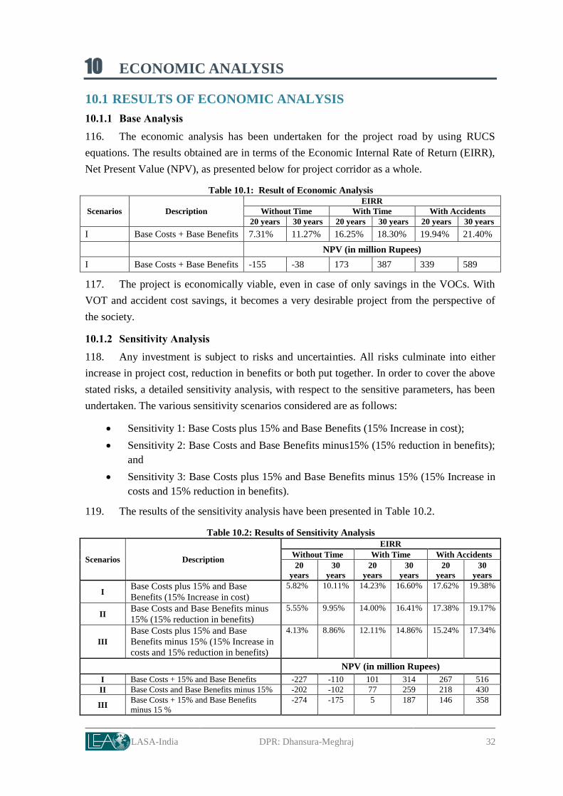
LASA-India DPR: Dhansura-Meghraj 32
10 ECONOMIC ANALYSIS
10.1 RESULTS OF ECONOMIC ANALYSIS
10.1.1 Base Analysis
116. The economic analysis has been undertaken for the project road by using RUCS
equations. The results obtained are in terms of the Economic Internal Rate of Return (EIRR),
Net Present Value (NPV), as presented below for project corridor as a whole.
Table 10.1: Result of Economic Analysis
Scenarios Description
EIRR
Without Time With Time With Accidents
20 years 30 years 20 years 30 years 20 years 30 years
I Base Costs + Base Benefits 7.31% 11.27% 16.25% 18.30% 19.94% 21.40%
NPV (in million Rupees)
I Base Costs + Base Benefits -155 -38 173 387 339 589
117. The project is economically viable, even in case of only savings in the VOCs. With
VOT and accident cost savings, it becomes a very desirable project from the perspective of
the society.
10.1.2 Sensitivity Analysis
118. Any investment is subject to risks and uncertainties. All risks culminate into either
increase in project cost, reduction in benefits or both put together. In order to cover the above
stated risks, a detailed sensitivity analysis, with respect to the sensitive parameters, has been
undertaken. The various sensitivity scenarios considered are as follows:
Sensitivity 1: Base Costs plus 15% and Base Benefits (15% Increase in cost);
Sensitivity 2: Base Costs and Base Benefits minus15% (15% reduction in benefits);
and
Sensitivity 3: Base Costs plus 15% and Base Benefits minus 15% (15% Increase in
costs and 15% reduction in benefits).
119. The results of the sensitivity analysis have been presented in Table 10.2.
Table 10.2: Results of Sensitivity Analysis
Scenarios Description
EIRR
Without Time With Time With Accidents
20
years
30
years
20
years
30
years
20
years
30
years
I Base Costs plus 15% and Base
Benefits (15% Increase in cost)
5.82% 10.11% 14.23% 16.60% 17.62% 19.38%
II Base Costs and Base Benefits minus
15% (15% reduction in benefits)
5.55% 9.95% 14.00% 16.41% 17.38% 19.17%
III
Base Costs plus 15% and Base
Benefits minus 15% (15% Increase in
costs and 15% reduction in benefits)
4.13% 8.86% 12.11% 14.86% 15.24% 17.34%
NPV (in million Rupees)
I Base Costs + 15% and Base Benefits -227 -110 101 314 267 516
II Base Costs and Base Benefits minus 15% -202 -102 77 259 218 430
III Base Costs + 15% and Base Benefits
minus 15 %
-274 -175 5 187 146 358

Project Preparatory Works Consultancy Services for
G u j a r a t S t a t e H i g h w a y P r o j e c t - I I Roads & Buildings Department, GoG
LASA-India DPR: Dhansura-Meghraj 33
120. The sensitivity analysis reflects project viability in the worst scenario also, in case the
VOT and/or accident cost savings are considered. If the analysis period is taken as 20 years,
the project is viable in case of VOC and VOT savings (EIRR>12%). With additional benefit
of accident cost savings, it tends to become more attractive.
10.2 IMPACT OF PROJECT DELAY ON ECONOMY
121. The project needs to be planned and implemented soon. The savings in travel time is
precious for the economy. In case, the project implementation is delayed, the cumulative loss
in value of travel time is likely to go up from Rs 34.6 million in 2015 to about Rs 2575.5
million in the year 2040. Therefore, the state should get the project initiated soon. (Refer
Figure 10.1).
Figure 10.1: Value of Travel Time Savings
10.3 CONCLUSION
122. The road project is desirable from the society’s point of view. The project corridor as
a whole is found to be economically viable with positive net present values and EIRR greater
than 12%, even in the worst scenario of drop in benefits coupled with increase in cost. Hence,
based on the above results, the project is recommended for implementation.
123. Since the accident benefits are high, it is further recommended that due consideration
should be given to the measures suggested from safety point of view. This would make
Dhansura-Meghraj corridor a safe highway.
0.0
500.0
1000.0
1500.0
2000.0
2500.0
3000.0
3500.0
4000.0
0.0
50.0
100.0
150.0
200.0
250.0
300.0
350.0
400.0
450.0
2015 2017 2019 2021 2023 2025 2027 2029 2031 2033 2035 2037 2039 2041 2043 2045
Cu
mu
lati
ve V
alu
e o
f Tr
ave
l Tim
e S
avin
gs
(Rs
mill
ion
)
Val
ue
of
Trav
el T
ime
(Rs
mill
ion
per
an
nu
m)
Year
Value of Travel Time Savings Dhansura Meghraj
Without project-value of travel time With project-value of travel time
Cumulative value of travel time savings