detailed site assessment - chorley councilchorley.gov.uk/documents/detailed site assessment.pdf ·...
TRANSCRIPT

Housing
Employment
Mixed Use
Retail
Commercial
Leisure
Recreation
Safeguarded Land
Preferred Options Decision
Allocate site Potential no. units: 18
Hectares of land: 0
Other
Site Reference: CH0036 Land at Babylon Lane
Adlington
The site is readily developable, within close proximity to local services and is highly accessible by public and private transport. Wish to see the site bought forward to the preferred options stage.
Objections to proposed housing development use and general agreement that the land should remain vacant and safeguarded. Concerns raised over potential flooding and traffic issues that could result from development of the site, as well as the increased height of the land in question.
Summary of Objections
Summary of Support
Alternative site suggestions: ---
DETAILED SITE ASSESSMENT
Location
Development Criteria
Infrastructure Infrastructure Delivery Schedule identifies: Improvements to Adlington Clinic (2016-2021); and provision of Adlington half form entry primary places (2016-2021).
Transport: All development proposals should achieve a high level of road safety, and will be assessed as such by the Council through the planning application process. For housing developments with between 50 and 80 units, the Council will require a Transport Statement. For developments of more than 80 units, the Council will require a Transport Assessment and Travel Plan as part of the application.
Additional Details:
---
Issues and Options Consultation Summary
Playspace
HS1.29
Page 1 of 471 Site Allocations and Development Management Policies DPD | Preferred Options

Sustainability Appraisal
Site Ref CH0036
Address Land at Babylon Lane, Adlington
SA Obj
Indicator Site Performance SA Comments
S1
Distance to railway station 0 .81 to 1 .6km Social This site has good access to public transport although rail services are not frequent. The site is over 3km from the main service centre of Chorley and the nearest supermarket. The site has good access to a local convenience store and there are employment opportunities within Adlington. Environmental The only identified negative environmental effects in developing this site is that the site is Greenfield with a currently designation of Safeguarded land. Economic There are no identified negative economic effects in developing the site.
Rail service freque ncy H ourly se rvice Distance to nearest bus stop Up to 0.4km Bus service frequency 6 or more/ hour/direction Distance to se rvice centre Over 3km Distance to A Road junction Up to 0.4km Distance to motorway junction Over 3km Distance to supermarket Over 3km Distance to conve nience s tore Up to 0.4km Distance to Post Office Up to 0.4km Distance to Primary School Up to 0.4km Distance to Secondary School 3 .21 to 5 km On a cycle route Yes Distance to cycle route Up to 0.4km
S2
Distance to GP surge ry Up to 0.4km Distance to NHS gene ra l hospital 5 .1 to 10 km Distance to public open space/park Up to 0.4km Distance to local centre Up to 0.4km
EN1
Designation of land Safeguarded Land Are a of Se paration Outs ide AONB Outs ide SSSI Outs ide Biological/ G eological H eritag e Site Outs ide Agricultural classifica tion 3
EN2
Conservation Area Outs ide Ancie nt Monument on site No Regis te re d Park or G arden Outs ide Listed Building on site No Locally Lis te d Building on s ite No
EN3 Curre nt/former land use Greenfie ld EN4 Flood Zone a re a All Zone 1
EN5 Contaminated land No risk Within 3km of a congestion spot No
EC1 Distance to employment site 1 .21 to 1 .6km Access to Broadband Yes
EC2 Distance to furthe r/higher education Over 5km
Del
iver
abili
ty
Indi
cato
rs
Access to sewer system
Yes
Is the site deliverable: Yes Access to wa te r
Access to ga s
Access to e lectricity
Exis ting road access
At risk from hazardous installations No
Overall Site Performance
Band Spe ctrum:
Overall Band:
C
Page 2 of 471 Site Allocations and Development Management Policies DPD | Preferred Options

Housing
Employment
Mixed Use
Retail
Commercial
Leisure
Recreation
Safeguarded Land
Preferred Options Decision
Allocate site Potential no. units: 37
Hectares of land: 0
Other
Site Reference: CH0064 Remainder of Fairview Farm
Adlington
Planning Permission 09/00714 FULMAJ was granted for 37 (affordable) houses in January 2010. Development commenced with completion estimated December 2011. As already allocated for housing (1.2h), no further action is required.
None received.Summary of Objections
Summary of Support
Alternative site suggestions: ---
DETAILED SITE ASSESSMENT
Location
Development Criteria
Infrastructure ---
Transport: All development proposals should achieve a high level of road safety, and will be assessed as such by the Council through the planning application process. As this site is already under construction, the relevant Transport Statement/Assessment has already been submitted to, and approved by the Council.
Additional Details:
---
Issues and Options Consultation Summary
Playspace
HS1.30
Page 3 of 471 Site Allocations and Development Management Policies DPD | Preferred Options

Sustainability Appraisal
Site Ref CH0064
Address Remainder of Fairview Farm, Adlington
SA Obj
Indicator Site Performance SA Comments
S1
Distance to railway station 0 .81 to 1 .6km This site has been granted planning permission for housing and is currently under construction.
Rail service freque ncy H ourly se rvice Distance to nearest bus stop Up to 0.4km Bus service frequency 6 or more/hour/direction Distance to se rvice centre Over 3km Distance to A Road junction Up to 0.4km Distance to motorway junction Over 3km Distance to supermarket Over 3km Distance to conve nience s tore Up to 0.4km Distance to Post Office 0 .41 to 0 .8km Distance to Primary School 0 .41 to 0 .8km Distance to Secondary School 1 .61 to 3 .2km On a cycle route No Distance to cycle route Up to 0.4km
S2
Distance to GP surge ry 0 .41 to 0 .8km Distance to NHS gene ra l hospital 5 .1 to 10 km Distance to public open space/park Up to 0.4km Distance to local centre 0 .41 to 0 .8km
EN1
Designation of land Urban Local Service Ce ntre Are a of Se paration Outs ide AONB Outs ide SSSI Outs ide Biological/ G eological H eritag e Site Outs ide Agricultural classifica tion 3
EN2
Conservation Area Outs ide Ancie nt Monument on site No Regis te re d Park or G arden Outs ide Listed Building on site No Locally Lis te d Building on s ite No
EN3 Curre nt/former land use Greenfie ld EN4 Flood Zone a re a All Zone 1
EN5 Contaminated land No risk Within 3km of a congestion spot No
EC1 Distance to employment site 0 .81 to 1 .2km Access to Broadband Yes
EC2 Distance to furthe r/higher education Over 5km
Del
iver
abili
ty
Indi
cato
rs
Access to sewer system
Yes
Access to wa te r
Access to ga s
Access to e lectricity
Exis ting road access
At risk from hazardous installations No
Overall Site Performance
Band Spe ctrum:
Overall Band:
B
Page 4 of 471 Site Allocations and Development Management Policies DPD | Preferred Options

Housing
Employment
Mixed Use
Retail
Commercial
Leisure
Recreation
Safeguarded Land
Preferred Options Decision
Do not allocate Potential no. units: 0
Hectares of land: 0
Other
Site Reference: CH0114 Red Rose Garage, Westhoughton Road
Adlington
Site is currently used for commercial purposes. Recommendation: Allocate for housing (0.5h).
None received.Summary of Objections
Summary of Support
Alternative site suggestions: ---
DETAILED SITE ASSESSMENT
Location
Development Criteria
Infrastructure N/A- proposed not to allocate this site
Transport: N/A- proposed not to allocate this site
Additional Details:
This site is currently in active employment use. The Employment use will be protected.
Issues and Options Consultation Summary
Playspace
Page 5 of 471 Site Allocations and Development Management Policies DPD | Preferred Options

Sustainability Appraisal
Site Ref CH0114
Address Red Rose Garage, Westhoughton Road, Adlington
SA Obj
Indicator Site Performance SA Comments
S1
Distance to railway station 0 .81 to 1 .6km Social This site has good access to public transport links although rail services are hourly and bus services are less than hourly. The site is over 3km away from the key services centre of Chorley Town Centre however there are many facilities, services and employment opportunities within Adlington. Environmental There are no identified negative effects in developing this site. Economic There are no identified negative economic effects in developing this site.
Rail service freque ncy H ourly se rvice Distance to nearest bus stop Up to 0.4km Bus service frequency Less than 1/hour/dire ction Distance to se rvice centre Over 3km Distance to A Road junction Up to 0.4km Distance to motorway junction Over 3km Distance to supermarket Over 3km Distance to conve nience s tore 0 .41 to 0 .8km Distance to Post Office 0 .41 to 0 .8km Distance to Primary School Up to 0.4km Distance to Secondary School 1 .61 to 3 .2km On a cycle route No Distance to cycle route Up to 0.4km
S2
Distance to GP surge ry 0 .41 to 0 .8km Distance to NHS gene ra l hospital 5 .1 to 10 km Distance to public open space/park 0 .41 to 0 .8km Distance to local centre 0 .41 to 0 .8km
EN1
Designation of land Urban Local Service Ce ntre Are a of Se paration Outs ide AONB Outs ide SSSI Outs ide Biological/ G eological H eritag e Site Outs ide Agricultural classifica tion 3
EN2
Conservation Area Outs ide Ancie nt Monument on site No Regis te re d Park or G arden Outs ide Listed Building on site No Locally Lis te d Building on s ite No
EN3 Curre nt/former land use Brownfield EN4 Flood Zone a re a All Zone 1
EN5 Contaminated land No risk Within 3km of a congestion spot No
EC1 Distance to employment site Up to 0.8km Access to Broadband Yes
EC2 Distance to furthe r/higher education Over 5km
Del
iver
abili
ty
Indi
cato
rs
Access to sewer system
Yes
Is the site deliverable: Yes Access to wa te r
Access to ga s
Access to e lectricity
Exis ting road access
At risk from hazardous installations No
Overall Site Performance
Band Spe ctrum:
Overall Band:
B
Page 6 of 471 Site Allocations and Development Management Policies DPD | Preferred Options
Housing
Employment
Mixed Use
Retail
Commercial
Leisure
Recreation
Safeguarded Land
Preferred Options Decision
Allocate site Potential no. units: 75
Hectares of land: 0
Other Park and Ride Facility
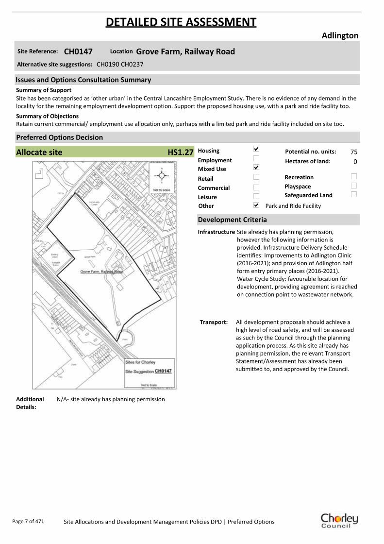
Site Reference: CH0147 Grove Farm, Railway Road
Adlington
Site has been categorised as ‘other urban’ in the Central Lancashire Employment Study. There is no evidence of any demand in the locality for the remaining employment development option. Support the proposed housing use, with a park and ride facility too.
Retain current commercial/ employment use allocation only, perhaps with a limited park and ride facility included on site too.Summary of Objections
Summary of Support
Alternative site suggestions: CH0190 CH0237
DETAILED SITE ASSESSMENT
Location
Development Criteria
Infrastructure Site already has planning permission, however the following information is provided. Infrastructure Delivery Schedule identifies: Improvements to Adlington Clinic (2016-2021); and provision of Adlington half form entry primary places (2016-2021).Water Cycle Study: favourable location for development, providing agreement is reached on connection point to wastewater network.
Transport: All development proposals should achieve a high level of road safety, and will be assessed as such by the Council through the planning application process. As this site already has planning permission, the relevant Transport Statement/Assessment has already been submitted to, and approved by the Council.
Additional Details:
N/A- site already has planning permission
Issues and Options Consultation Summary
Playspace
HS1.27
Page 7 of 471 Site Allocations and Development Management Policies DPD | Preferred Options

Sustainability Appraisal
Site Ref CH0147
Address Grove Farm, Railway Road, Adlington
SA Obj
Indicator Site Performance SA Comments
S1
Distance to railway station Up to 0.8km Social Site has good access to public transport although rail services are not very frequent. Access to services and facilities is also very good with the exception of distance to secondary schools as there are none in the settlement. The site is over 3km away from the key service centre of Chorley town centre however there are many facilities, services and employment opportunities within Adlington. Environmental There are no identified negative environmental effects in developing this site. Economic There are no identified negative economic effects in developing the site.
Rail service freque ncy H ourly se rvice Distance to nearest bus stop Up to 0.4km Bus service frequency 1/hour/direction Distance to key service centre Over 3km Distance to A Road junction Up to 0.4km Distance to motorway junction Over 3km Distance to supermarket Over 3km Distance to conve nience s tore Up to 0.4km Distance to Post Office Up to 0.4km Distance to Primary School Up to 0.4km Distance to Secondary School 3 .21 to 5 km On a cycle route No Distance to cycle route Up to 0.4km
S2
Distance to GP surge ry Up to 0.4km Distance to NHS gene ra l hospital 5 .1 to 10 km Distance to public open space/park Up to 0.4km Distance to local centre Up to 0.4km
EN1
Designation of land Urban Local Service Ce ntre Are a of Se paration Outs ide AONB Outs ide SSSI Outs ide Biological/ G eological H eritag e Site Outs ide Agricultural classifica tion 3
EN2
Conservation Area Outs ide Ancie nt Monument on site No Regis te re d Park or G arden Outs ide Listed Building on site No Locally Lis te d Building on s ite No
EN3 Curre nt/former land use Brownfield EN4 Flood Zone a re a All Zone 1
EN5 Contaminated land M edium risk Within 3km of a congestion spot No
EC1 Distance to employment site Up to 0.8km Access to Broadband Yes
EC2 Distance to furthe r/higher education Over 5km
Del
iver
abili
ty
Indi
cato
rs
Access to sewer system
Yes Is the site deliverable: Yes
Access to wa te r Access to ga s
Access to e lectricity
Exis ting road access
At risk from hazardous installations No
Overall Site Performance
Band Spe ctrum:
Overall Band:
B
Page 8 of 471 Site Allocations and Development Management Policies DPD | Preferred Options
Housing
Employment
Mixed Use
Retail
Commercial
Leisure
Recreation
Safeguarded Land
Preferred Options Decision
Allocate site Potential no. units: 179
Hectares of land: 3
Other
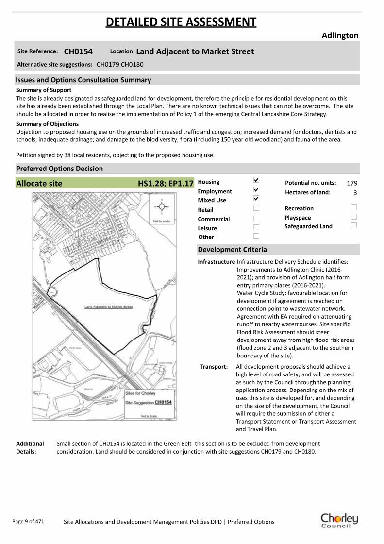
Site Reference: CH0154 Land Adjacent to Market Street
Adlington
The site is already designated as safeguarded land for development, therefore the principle for residential development on this site has already been established through the Local Plan. There are no known technical issues that can not be overcome. The site should be allocated in order to realise the implementation of Policy 1 of the emerging Central Lancashire Core Strategy.
Objection to proposed housing use on the grounds of increased traffic and congestion; increased demand for doctors, dentists and schools; inadequate drainage; and damage to the biodiversity, flora (including 150 year old woodland) and fauna of the area.
Petition signed by 38 local residents, objecting to the proposed housing use.
Summary of Objections
Summary of Support
Alternative site suggestions: CH0179 CH0180
DETAILED SITE ASSESSMENT
Location
Development Criteria
Infrastructure Infrastructure Delivery Schedule identifies: Improvements to Adlington Clinic (2016-2021); and provision of Adlington half form entry primary places (2016-2021).Water Cycle Study: favourable location for development if agreement is reached on connection point to wastewater network. Agreement with EA required on attenuating runoff to nearby watercourses. Site specific Flood Risk Assessment should steer development away from high flood risk areas (flood zone 2 and 3 adjacent to the southern boundary of the site).
Transport: All development proposals should achieve a high level of road safety, and will be assessed as such by the Council through the planning application process. Depending on the mix of uses this site is developed for, and depending on the size of the development, the Council will require the submission of either a Transport Statement or Transport Assessment and Travel Plan.
Additional Details:
Small section of CH0154 is located in the Green Belt- this section is to be excluded from development consideration. Land should be considered in conjunction with site suggestions CH0179 and CH0180.
Issues and Options Consultation Summary
Playspace
HS1.28; EP1.17
Page 9 of 471 Site Allocations and Development Management Policies DPD | Preferred Options

Sustainability Appraisal
Site Ref CH0154
Address Land Adjacent to Market Street, Adlington
SA Obj
Indicator Site Performance SA Comments
S1
Distance to railway station 0 .81 to 1 .6km Social This site has good access to public transport although rail services are not frequent. The site is over 3km from the main service centre of Chorley. The site has good access to a local convenience store and there are employment opportunities within Adlington. Adlington does not have a secondary its settlement. Environmental The only identified negative environmental effect in developing this site is that the site is Greenfield with a current designation of Safeguarded land. Economic There are no identified negative economic effects in developing the site.
Rail service freque ncy H ourly se rvice Distance to nearest bus stop Up to 0.4km Bus service frequency 6 or more/hour/direction Distance to se rvice centre Over 3km Distance to A Road junction Up to 0.4km Distance to motorway junction Over 3km Distance to supermarket Over 3km Distance to conve nience s tore Up to 0.4km Distance to Post Office Up to 0.4km Distance to Primary School 0 .41 to 0 .8km Distance to Secondary School 3 .21 to 5 km On a cycle route No Distance to cycle route Up to 0.4km
S2
Distance to GP surge ry Up to 0.4km Distance to NHS gene ra l hospital 5 .1 to 10 km Distance to public open space/park 0 .41 to 0 .8km Distance to local centre 0 .41 to 0 .8km
EN1
Designation of land Safeguarded Land Are a of Se paration Outs ide AONB Outs ide SSSI Outs ide Biological/ G eological H eritag e Site Outs ide Agricultural classifica tion 3
EN2
Conservation Area Outs ide Ancie nt Monument on site No Regis te re d Park or G arden Outs ide Listed Building on site No Locally Lis te d Building on s ite No
EN3 Curre nt/former land use Greenfie ld EN4 Flood Zone a re a All Zone 1
EN5 Contaminated land No risk Within 3km of a congestion spot No
EC1 Distance to employment site Up to 0.8km Access to Broadband Yes
EC2 Distance to furthe r/higher education Over 5km
Del
iver
abili
ty
Indi
cato
rs
Access to sewer system
Yes
Is the site deliverable: Yes Access to wa te r
Access to ga s
Access to e lectricity
Exis ting road access
At risk from hazardous installations No
Overall Site Performance
Band Spe ctrum:
Overall Band:
C
Page 10 of 471 Site Allocations and Development Management Policies DPD | Preferred Options
Housing
Employment
Mixed Use
Retail
Commercial
Leisure
Recreation
Safeguarded Land
Preferred Options Decision
Allocate site Potential no. units: 20
Hectares of land: 0
Other
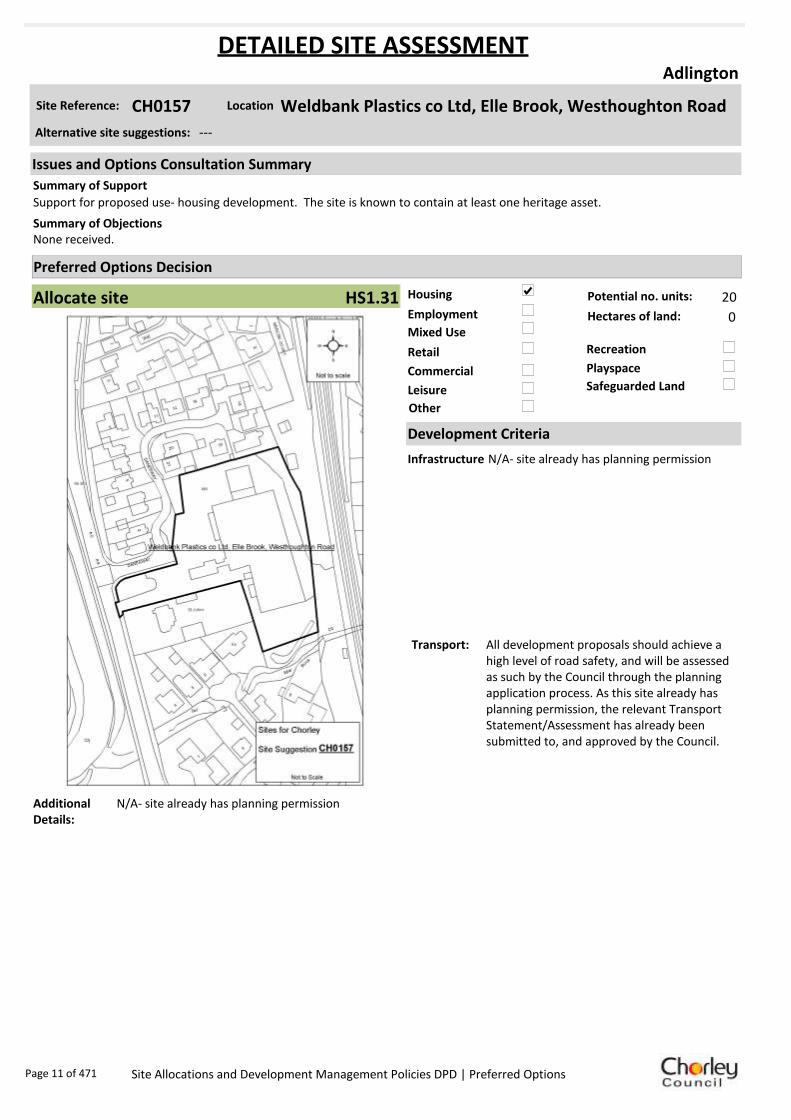
Site Reference: CH0157 Weldbank Plastics co Ltd, Elle Brook, Westhoughton Road
Adlington
Support for proposed use- housing development. The site is known to contain at least one heritage asset.
None received.Summary of Objections
Summary of Support
Alternative site suggestions: ---
DETAILED SITE ASSESSMENT
Location
Development Criteria
Infrastructure N/A- site already has planning permission
Transport: All development proposals should achieve a high level of road safety, and will be assessed as such by the Council through the planning application process. As this site already has planning permission, the relevant Transport Statement/Assessment has already been submitted to, and approved by the Council.
Additional Details:
N/A- site already has planning permission
Issues and Options Consultation Summary
Playspace
HS1.31
Page 11 of 471 Site Allocations and Development Management Policies DPD | Preferred Options

Sustainability Appraisal
Site Ref CH0157
Address Weldbank Plastics, Westhoughton Road, Adlington
SA Obj
Indicator Site Performance SA Comments
S1
Distance to railway station 0 .81 to 1 .6km Social The site has good access to public transport although rail services are not very frequent. Access to local services is good. The Key Service Centre is over 3km away in the centre of Chorley however there are many employment opportunities within Adlington. Environmental There are no identified negative environmental effects in developing this site. Economic There are no identified negative economic effects in developing this site.
Rail service freque ncy H ourly se rvice Distance to nearest bus stop Up to 0.4km Bus service frequency 1/hour/direction Distance to se rvice centre Over 3km Distance to A Road junction Up to 0.4km Distance to motorway junction Over 3km Distance to supermarket Over 3km Distance to conve nience s tore 0 .41 to 0 .8km Distance to Post Office 0 .41 to 0 .8km Distance to Primary School 0 .41 to 0 .8km Distance to Secondary School 1 .61 to 3 .2km On a cycle route No Distance to cycle route Up to 0.4km
S2
Distance to GP surge ry 0 .41 to 0 .8km Distance to NHS gene ra l hospital 5 .1 to 10 km Distance to public open space/park 0 .41 to 0 .8km Distance to local centre 0 .81 to 1 .2km
EN1
Designation of land Urban Local Service Ce ntre Are a of Se paration Outs ide AONB Outs ide SSSI Outs ide Biological/ G eological H eritag e Site Outs ide Agricultural classifica tion 3
EN2
Conservation Area Outs ide Ancie nt Monument on site No Regis te re d Park or G arden Outs ide Listed Building on site No Locally Lis te d Building on s ite No
EN3 Curre nt/former land use Brownfield EN4 Flood Zone a re a All Zone 1
EN5 Contaminated land M edium risk Within 3km of a congestion spot No
EC1 Distance to employment site 0 .81 to 1 .2km Access to Broadband Yes
EC2 Distance to furthe r/higher education Over 5km
Del
iver
abili
ty
Indi
cato
rs
Access to sewer system
Yes
Is the site deliverable: Yes Access to wa te r
Access to ga s
Access to e lectricity
Exis ting road access
At risk from hazardous installations No
Overall Site Performance
Band Spe ctrum:
Overall Band:
B
Page 12 of 471 Site Allocations and Development Management Policies DPD | Preferred Options

Housing
Employment
Mixed Use
Retail
Commercial
Leisure
Recreation
Safeguarded Land
Preferred Options Decision
Allocate site Potential no. units: 179
Hectares of land: 3
Other
Site Reference: CH0179 Land South East of Belmont Road and Abbey Grove
Adlington
The site is already designated as safeguarded land for development, therefore the principle for residential development on this site has already been established through the Local Plan. There are no known technical issues that can not be overcome. The site should be allocated in order to realise the implementation of Policy 1 of the emerging Central Lancashire Core Strategy.
Objection to proposed housing use on the grounds of increased traffic and congestion; increased demand for doctors, dentists and schools; inadequate drainage; noise and air pollution; and damage to the biodiversity, flora (including 150 year old woodland) and fauna of the area. Also a perceived lack of ‘need’ for new housing development.
Petition signed by 38 local residents, objecting to the proposed housing use.Suggestion that the site may be better used in the provision of allotments.
Summary of Objections
Summary of Support
Alternative site suggestions: CH0154 CH0180
DETAILED SITE ASSESSMENT
Location
Development Criteria
Infrastructure Infrastructure Delivery Schedule identifies: Improvements to Adlington Clinic (2016-2021); and provision of Adlington half form entry primary places (2016-2021).Water Cycle Study: favourable location for development if agreement is reached on connection point to wastewater network. Agreement with EA required on attenuating runoff to nearby watercourses. Site specific Flood Risk Assessment should steer development away from high flood risk areas (flood zone 2 and 3 adjacent to the southern boundary of the site).
Transport: All development proposals should achieve a high level of road safety, and will be assessed as such by the Council through the planning application process. Depending on the mix of uses this site is developed for, and depending on the size of the development, the Council will require the submission of either a Transport Statement or Transport Assessment and Travel Plan.
Additional Details:
Land should be considered for development in conjunction with site suggestions CH0154 and CH0180.
Issues and Options Consultation Summary
Playspace
HS1.28; EP1.17
Page 13 of 471 Site Allocations and Development Management Policies DPD | Preferred Options

Sustainability Appraisal
Site Ref CH0179
Address Land Adjacent to Market Street, Adlington
SA Obj
Indicator Site Performance SA Comments
S1
Distance to railway station 0 .81 to 1 .6km Social This site has good access to public transport although rail services are not frequent. The site is over 3km from the main Key service centre of Chorley. The site has good access to a local convenience store and there are employment opportunities within Adlington. Adlington does not have a secondary school within its settlement. Environmental The only identified negative environmental effects in developing this site is that the site is Greenfield with a currently designation of Safeguarded land. Economic There are no identified negative economic effects in developing the site.
Rail service freque ncy H ourly se rvice Distance to nearest bus stop Up to 0.4km Bus service frequency 6 or more/hour/direction Distance to se rvice centre Over 3km Distance to A Road junction Up to 0.4km Distance to motorway junction Over 3km Distance to supermarket Over 3km Distance to conve nience s tore Up to 0.4km Distance to Post Office Up to 0.4km Distance to Primary School 0 .41 to 0 .8km Distance to Secondary School 3 .21 to 5 km On a cycle route No Distance to cycle route Up to 0.4km
S2
Distance to GP surge ry Up to 0.4km Distance to NHS gene ra l hospital 5 .1 to 10 km Distance to public open space/park 0 .41 to 0 .8km Distance to local centre 0 .41 to 0 .8km
EN1
Designation of land Safeguarded Land Are a of Se paration Outs ide AONB Outs ide SSSI Outs ide Biological/ G eological H eritag e Site Outs ide Agricultural classifica tion 3
EN2
Conservation Area Outs ide Ancie nt Monument on site No Regis te re d Park or G arden Outs ide Listed Building on site No Locally Lis te d Building on s ite No
EN3 Curre nt/former land use Greenfie ld EN4 Flood Zone a re a All Zone 1
EN5 Contaminated land No risk Within 3km of a congestion spot No
EC1 Distance to employment site Up to 0.8km Access to Broadband Yes
EC2 Distance to furthe r/higher education Over 5km
Del
iver
abili
ty
Indi
cato
rs
Access to sewer system
Yes
Is the site deliverable: Yes Access to wa te r
Access to ga s
Access to e lectricity
Exis ting road access
At risk from hazardous installations No
Overall Site Performance
Band Spe ctrum:
Overall Band:
C
Page 14 of 471 Site Allocations and Development Management Policies DPD | Preferred Options
Housing
Employment
Mixed Use
Retail
Commercial
Leisure
Recreation
Safeguarded Land
Preferred Options Decision
Allocate site Potential no. units: 179
Hectares of land: 3
Other
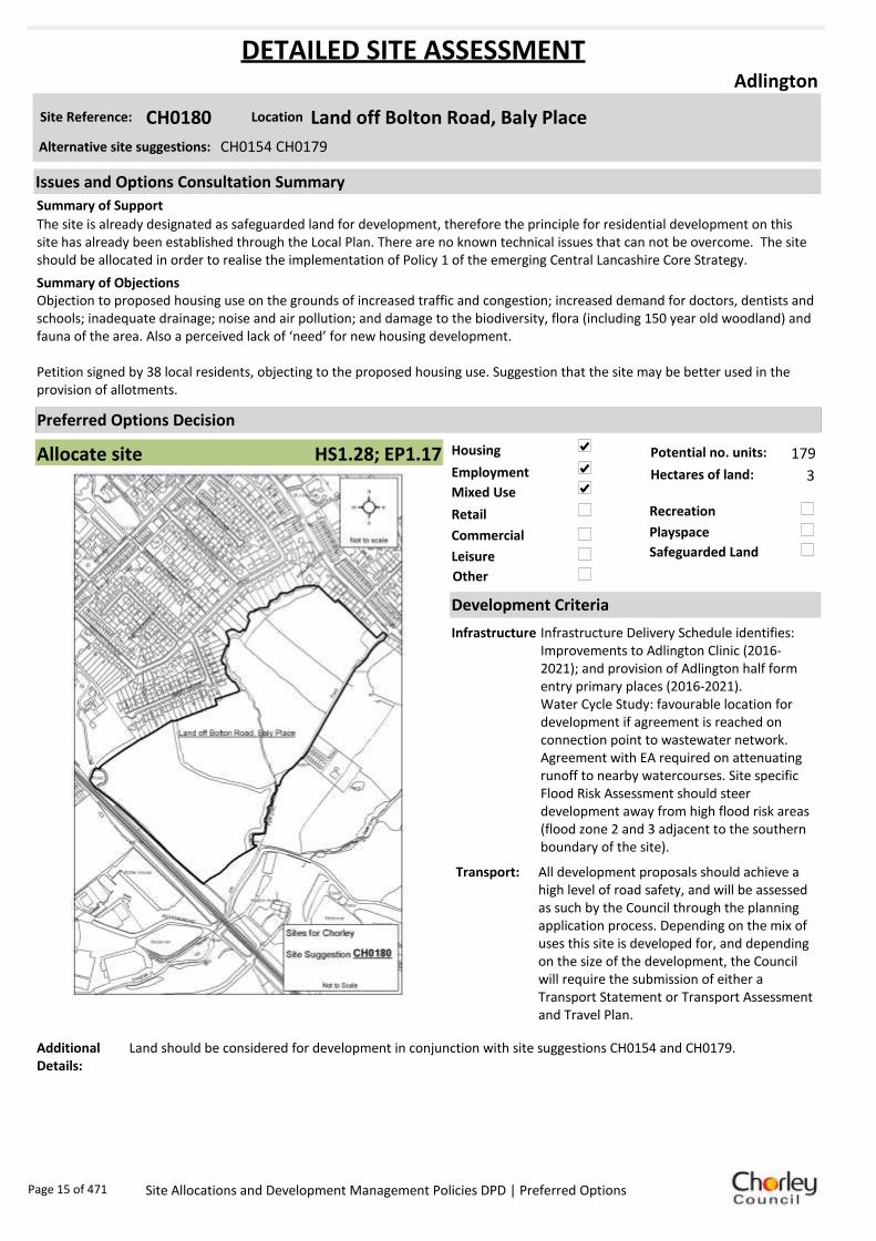
Site Reference: CH0180 Land off Bolton Road, Baly Place
Adlington
The site is already designated as safeguarded land for development, therefore the principle for residential development on this site has already been established through the Local Plan. There are no known technical issues that can not be overcome. The site should be allocated in order to realise the implementation of Policy 1 of the emerging Central Lancashire Core Strategy.
Objection to proposed housing use on the grounds of increased traffic and congestion; increased demand for doctors, dentists and schools; inadequate drainage; noise and air pollution; and damage to the biodiversity, flora (including 150 year old woodland) and fauna of the area. Also a perceived lack of ‘need’ for new housing development.
Petition signed by 38 local residents, objecting to the proposed housing use. Suggestion that the site may be better used in the provision of allotments.
Summary of Objections
Summary of Support
Alternative site suggestions: CH0154 CH0179
DETAILED SITE ASSESSMENT
Location
Development Criteria
Infrastructure Infrastructure Delivery Schedule identifies: Improvements to Adlington Clinic (2016-2021); and provision of Adlington half form entry primary places (2016-2021).Water Cycle Study: favourable location for development if agreement is reached on connection point to wastewater network. Agreement with EA required on attenuating runoff to nearby watercourses. Site specific Flood Risk Assessment should steer development away from high flood risk areas (flood zone 2 and 3 adjacent to the southern boundary of the site).
Transport: All development proposals should achieve a high level of road safety, and will be assessed as such by the Council through the planning application process. Depending on the mix of uses this site is developed for, and depending on the size of the development, the Council will require the submission of either a Transport Statement or Transport Assessment and Travel Plan.
Additional Details:
Land should be considered for development in conjunction with site suggestions CH0154 and CH0179.
Issues and Options Consultation Summary
Playspace
HS1.28; EP1.17
Page 15 of 471 Site Allocations and Development Management Policies DPD | Preferred Options

Sustainability Appraisal
Site Ref CH0180
Address Land Adjacent to Market Street, Adlington
SA Obj
Indicator Site Performance SA Comments
S1
Distance to railway station 0 .81 to 1 .6km Social This site has good access to public transport although rail services are not frequent. The site is over 3km from the main service centre of Chorley. The site has good access to a local convenience store and there are employment opportunities within Adlington. Adlington does not have a secondary school within its settlement. Environmental The only identified negative environmental effects in developing this site is that the site is Greenfield with a currently designation of Safeguarded land. Economic There are no identified negative economic effects in developing the site.
Rail service freque ncy H ourly se rvice Distance to nearest bus stop Up to 0.4km Bus service frequency 6 or more/hour/direction Distance to se rvice centre Over 3km Distance to A Road junction Up to 0.4km Distance to motorway junction Over 3km Distance to supermarket Over 3km Distance to conve nience s tore Up to 0.4km Distance to Post Office Up to 0.4km Distance to Primary School 0 .41 to 0 .8km Distance to Secondary School 3 .21 to 5 km On a cycle route No Distance to cycle route Up to 0.4km
S2
Distance to GP surge ry Up to 0.4km Distance to NHS gene ra l hospital 5 .1 to 10 km Distance to public open space/park 0 .41 to 0 .8km Distance to local centre 0 .41 to 0 .8km
EN1
Designation of land Safeguarded Land Are a of Se paration Outs ide AONB Outs ide SSSI Outs ide Biological/ G eological H eritag e Site Outs ide Agricultural classifica tion 3
EN2
Conservation Area Outs ide Ancie nt Monument on site No Regis te re d Park or G arden Outs ide Listed Building on site No Locally Lis te d Building on s ite No
EN3 Curre nt/former land use Greenfie ld EN4 Flood Zone a re a All Zone 1
EN5 Contaminated land No risk Within 3km of a congestion spot No
EC1 Distance to employment site Up to 0.8km Access to Broadband Yes
EC2 Distance to furthe r/higher education Over 5km
Del
iver
abili
ty
Indi
cato
rs
Access to sewer system
Yes
Is the site deliverable: Yes Access to wa te r
Access to ga s
Access to e lectricity
Exis ting road access
At risk from hazardous installations No
Overall Site Performance
Band Spe ctrum:
Overall Band:
C
Page 16 of 471 Site Allocations and Development Management Policies DPD | Preferred Options
Housing
Employment
Mixed Use
Retail
Commercial
Leisure
Recreation
Safeguarded Land
Preferred Options Decision
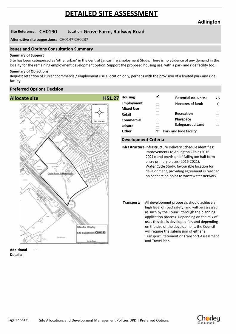
Allocate site Potential no. units: 75
Hectares of land: 0
Other Park and Ride facility
Site Reference: CH0190 Grove Farm, Railway Road
Adlington
Site has been categorised as ‘other urban’ in the Central Lancashire Employment Study. There is no evidence of any demand in the locality for the remaining employment development option. Support the proposed housing use, with a park and ride facility too.
Request retention of current commercial/ employment use allocation only, perhaps with the provision of a limited park and ride facility.
Summary of Objections
Summary of Support
Alternative site suggestions: CH0147 CH0237
DETAILED SITE ASSESSMENT
Location
Development Criteria
Infrastructure Infrastructure Delivery Schedule identifies: Improvements to Adlington Clinic (2016-2021); and provision of Adlington half form entry primary places (2016-2021).Water Cycle Study: favourable location for development, providing agreement is reached on connection point to wastewater network.
Transport: All development proposals should achieve a high level of road safety, and will be assessed as such by the Council through the planning application process. Depending on the mix of uses this site is developed for, and depending on the size of the development, the Council will require the submission of either a Transport Statement or Transport Assessment and Travel Plan.
Additional Details:
---
Issues and Options Consultation Summary
Playspace
HS1.27
Page 17 of 471 Site Allocations and Development Management Policies DPD | Preferred Options

Sustainability Appraisal
Site Ref CH0190
Address Grove Farm, Railway Road, Adlington
SA Obj
Indicator Site Performance SA Comments
S1
Distance to railway station Up to 0.8km Social Site has good access to public transport although rail services are not very frequent. Access to services and facilities is also very good with the exception of distance to secondary schools as there are none in the settlement. The site is over 3km away from the key service centre of Chorley town centre however there are many facilities, services and employment opportunities within Adlington. Environmental There are no identified negative environmental effects in developing this site. Economic There are no identified negative economic effects in developing the site.
Rail service freque ncy H ourly se rvice Distance to nearest bus stop Up to 0.4km Bus service frequency 1/hour/direction Distance to key service centre Over 3km Distance to A Road junction Up to 0.4km Distance to motorway junction Over 3km Distance to supermarket Over 3km Distance to conve nience s tore Up to 0.4km Distance to Post Office Up to 0.4km Distance to Primary School Up to 0.4km Distance to Secondary School 3 .21 to 5 km On a cycle route No Distance to cycle route Up to 0.4km
S2
Distance to GP surge ry Up to 0.4km Distance to NHS gene ra l hospital 5 .1 to 10 km Distance to public open space/park Up to 0.4km Distance to local centre Up to 0.4km
EN1
Designation of land Urban Local Service Ce ntre Are a of Se paration Outs ide AONB Outs ide SSSI Outs ide Biological/ G eological H eritag e Site Outs ide Agricultural classifica tion 3
EN2
Conservation Area Outs ide Ancie nt Monument on site No Regis te re d Park or G arden Outs ide Listed Building on site No Locally Lis te d Building on s ite No
EN3 Curre nt/former land use Brownfield EN4 Flood Zone a re a All Zone 1
EN5 Contaminated land M edium risk Within 3km of a congestion spot No
EC1 Distance to employment site Up to 0.8km Access to Broadband Yes
EC2 Distance to furthe r/higher education Over 5km
Del
iver
abili
ty
Indi
cato
rs
Access to sewer system
Yes Is the site deliverable: Yes
Access to wa te r Access to ga s
Access to e lectricity
Exis ting road access
At risk from hazardous installations No
Overall Site Performance
Band Spe ctrum:
Overall Band:
B
Page 18 of 471 Site Allocations and Development Management Policies DPD | Preferred Options

Housing
Employment
Mixed Use
Retail
Commercial
Leisure
Recreation
Safeguarded Land
Preferred Options Decision
Retain existing designation Potential no. units: 0
Hectares of land: 0
Other
Site Reference: CH0219 Land off 1 The Common
Adlington
None received.
Objection to the proposed site use. Request land to remain as safeguarded, it’s current use.Summary of Objections
Summary of Support
Alternative site suggestions: ---
DETAILED SITE ASSESSMENT
Location
Development Criteria
Infrastructure N/A- proposed to retain existing safeguarded land designation
Transport: N/A- proposed to retain existing safeguarded land designation
Additional Details:
This site has access issues along Park Road and is therefore unsustainable.
Issues and Options Consultation Summary
Playspace
BNE2.3
Page 19 of 471 Site Allocations and Development Management Policies DPD | Preferred Options

Sustainability Appraisal
Site Ref CH0219
Address Land off The Common, Adlington
SA Obj
Indicator Site Performance SA Comments
S1
D istance to railway station 0. 81 to 1. 6km Social This site has good access to public transport networks although the rail services and bus services are hourly. The site is over 3km from the main key service centre of Chorley. The site has good access to a local convenience store and there are employment opportunities within Adlington. Adlington does not have a secondary school within the settlement. Environmental The only identified negative environmental effects in developing this site is that the site is Greenfield with a currently designation of Safeguarded land. Economic There are no identified negative economic effects in developing the site.
Rail service frequency H ourly service D istance to ne arest bus stop Up to 0 .4km Bus service frequency 1/hour/direction D istance to service centre Ove r 3 km D istance to A Road junction 0. 41 to 0. 8km D istance to motorway junction Ove r 3 km D istance to supermarket Ove r 3 km D istance to convenience store Up to 0 .4km D istance to Post Office 0. 41 to 0. 8km D istance to Primary School 0. 41 to 0. 8km D istance to Secondary School 3 .21 to 5 km On a cycle route No D istance to cycle route Up to 0 .4km
S2
D istance to GP surgery 0. 81 to 1. 6km D istance to NH S general hospital 5 .1 to 10 km D istance to public ope n space /park Up to 0 .4km D istance to local ce ntre 0. 41 to 0. 8km
EN1
D esigna tion of land Safe guarded Land Area of Separation Outside AONB Outside SSSI Outside Biological/ G eological He ritage Site Outside Agricultural classification 3
EN2
Conservation Are a Outside Ancient Monument on site No Registered Park or G arden Outside Listed Build ing on site No Locally Listed Building on site No
EN3 Current/former land use Greenfield EN4 Flood Zone area All Zone 1
EN5 Contaminated land No risk Within 3 km of a conge stion spot No
E C1 D istance to employme nt site 0. 81 to 1. 2km Acce ss to Broadband Yes
E C2 D istance to further/highe r e ducation Ove r 5 km
Del
ive
rab
ility
Ind
icat
ors
Acce ss to sewer system
Yes
Is the site deliverable: Yes Acce ss to water
Acce ss to gas
Acce ss to ele ctricity
E xisting road acce ss
At risk from hazardous installations No
Overall Site Performance
Band Spe ctrum:
Overall Band:
C
Page 20 of 471 Site Allocations and Development Management Policies DPD | Preferred Options

Housing
Employment
Mixed Use
Retail
Commercial
Leisure
Recreation
Safeguarded Land
Preferred Options Decision
Allocate site Potential no. units: 75
Hectares of land: 0
Other Park and Ride facility
Site Reference: CH0237 Grove Farm, Railway Road
Adlington
The site can make affordable provision as part of a scheme that delivers market family housing as well as implementing the Park and Ride proposal of Publication Core Strategy Policy 3. No demand in the locality for development of the remaining land for employment use.
Objection to the proposed site suggestion use based on unsuitable access, proximity to Community Centre, and drainage issues. Would like to see the current employment allocation retained.
Summary of Objections
Summary of Support
Alternative site suggestions: CH0147 CH0190
DETAILED SITE ASSESSMENT
Location
Development Criteria
Infrastructure Site already has planning permission, however the following information is provided. Infrastructure Delivery Schedule identifies: Improvements to Adlington Clinic (2016-2021); and provision of Adlington half form entry primary places (2016-2021).Water Cycle Study: favourable location for development, providing agreement is reached on connection point to wastewater network.
Transport: All development proposals should achieve a high level of road safety, and will be assessed as such by the Council through the planning application process. As this site already has planning permission, the relevant Transport Statement/Assessment has already been submitted to, and approved by the Council.
Additional Details:
N/A- this site already has planning permission
Issues and Options Consultation Summary
Playspace
HS1.27
Page 21 of 471 Site Allocations and Development Management Policies DPD | Preferred Options

Sustainability Appraisal
Site Ref CH0237
Address Grove Farm, Railway Road, Adlington
SA Obj
Indicator Site Performance SA Comments
S1
Distance to railway station Up to 0.8km Social Site has good access to public transport although rail services are not very frequent. Access to services and facilities is also very good with the exception of distance to secondary schools as there are none in the settlement. The site is over 3km away from the key service centre of Chorley town centre however there are many facilities, services and employment opportunities within Adlington. Environmental There are no identified negative environmental effects in developing this site. Economic There are no identified negative economic effects in developing the site.
Rail service frequency Hourly servi ce Distance to ne arest bus stop Up to 0.4km Bus service frequency 1/hour/ direction Distance to key service centre Over 3km Distance to A Road junction Up to 0.4km Distance to motorwa y junction Over 3km Distance to supermarket Over 3km Distance to convenience store Up to 0.4km Distance to Post Office Up to 0.4km Distance to Primary School Up to 0.4km Distance to Secondary School 3.21 to 5km On a cycle route No Distance to cycle route Up to 0.4km
S2
Distance to GP surge ry Up to 0.4km Distance to NH S general hospital 5.1 to 1 0km Distance to public open space /park Up to 0.4km Distance to local ce ntre Up to 0.4km
EN1
Designation of land Urban Local Service Centre Are a of Separation Outs ide AONB Outs ide SSSI Outs ide Biological/ G eological He ri tage Site Outs ide Agricultural classification 3
EN2
Conservation Are a Outs ide Ancie nt Monument on site No Regis tere d Park or G arden Outs ide Listed Build ing on site No Locally Listed Building on s ite No
EN3 Curre nt/former land use Brownfie ld EN4 Flood Zone are a All Zone 1
EN5 Contaminated land Medium risk Within 3 km of a congestion spot No
EC1 Distance to employme nt site Up to 0.8km Access to Broadband Yes
EC2 Distance to further/ highe r e ducation Over 5km
De
live
rab
ility
In
dic
ato
rs
Access to sewer system
Yes Is the site deliverable: Yes
Access to water Access to gas
Access to e lectricity
Exis ting road acce ss
At risk from haza rdous ins tallations No
Overall Site Performance
Band Spe ctrum:
Overall Band:
B
Page 22 of 471 Site Allocations and Development Management Policies DPD | Preferred Options

Housing
Employment
Mixed Use
Retail
Commercial
Leisure
Recreation
Safeguarded Land
Preferred Options Decision
Allocate site Potential no. units: 18
Hectares of land: 0
Other
Site Reference: CH0283 Land off Babylon Lane
Adlington
None received.
Presently safeguarded land situated in a rural area and should remain so. The land has been artificially raised from its original height and as such any development would be unacceptably intrusive to neighbouring properties. It is vital that this space remains protected and not eradicated by new housing development.
No perceived need or market demand for redevelopment. Concerns over surface water run off and drainage. Also, the capacity of the adjacent highways is already at its maximum and further development could well compromise the safety of road users and pedestrians.
Summary of Objections
Summary of Support
Alternative site suggestions: ---
DETAILED SITE ASSESSMENT
Location
Development Criteria
Infrastructure Infrastructure Delivery Schedule identifies: Improvements to Adlington Clinic (2016-2021); and provision of Adlington half form entry primary places (2016-2021).
Transport: All development proposals should achieve a high level of road safety, and will be assessed as such by the Council through the planning application process. For housing developments with between 50 and 80 units, the Council will require a Transport Statement. For developments of more than 80 units, the Council will require a Transport Assessment and Travel Plan as part of the application.
Additional Details:
---
Issues and Options Consultation Summary
Playspace
HS1.29
Page 23 of 471 Site Allocations and Development Management Policies DPD | Preferred Options

Sustainability Appraisal
Site Ref CH0283
Address Land off Babylon Lane, Adlington
SA Obj
Indicator Site Performance SA Comments
S1
Distance to railway station 0 .81 to 1 .6km Social This site has good access to the public transport network although rail and bus services are hourly. The site is over 3km from the main key service centre of Chorley and the nearest supermarket. The site has good access to a local convenience store and there are employment opportunities within Adlington. Environmental The only identified negative environmental effects in developing this site is that the site is Greenfield with a currently designation of Safeguarded land. Economic There are no identified negative economic effects in developing the site.
Rail service freque ncy H ourly se rvice Distance to nearest bus stop Up to 0.4km Bus service frequency 1/hour/direction Distance to se rvice centre Over 3km Distance to A Road junction 0 .41 to 0 .8km Distance to motorway junction Over 3km Distance to supermarket Over 3km Distance to conve nience s tore Up to 0.4km Distance to Post Office 0 .41 to 0 .8km Distance to Primary School Up to 0.4km Distance to Secondary School 3 .21 to 5 km On a cycle route Yes Distance to cycle route Up to 0.4km
S2
Distance to GP surge ry Up to 0.4km Distance to NHS gene ra l hospital 5 .1 to 10 km Distance to public open space/park Up to 0.4km Distance to local centre 0 .41 to 0 .8km
EN1
Designation of land Safeguarded Land Are a of Se paration Outs ide AONB Outs ide SSSI Outs ide Biological/ G eological H eritag e Site Outs ide Agricultural classifica tion 3
EN2
Conservation Area Outs ide Ancie nt Monument on site No Regis te re d Park or G arden Outs ide Listed Building on site No Locally Lis te d Building on s ite No
EN3 Curre nt/former land use Greenfie ld EN4 Flood Zone a re a All Zone 1
EN5 Contaminated land No risk Within 3km of a congestion spot No
EC1 Distance to employment site 1 .21 to 1 .6km Access to Broadband Yes
EC2 Distance to furthe r/higher education Over 5km
Del
iver
abili
ty
Indi
cato
rs
Access to sewer system
Yes
Is the site deliverable: Yes Access to wa te r
Access to ga s
Access to e lectricity
Exis ting road access
At risk from hazardous installations No
Overall Site Performance
Band Spe ctrum:
Overall Band:
C
Page 24 of 471 Site Allocations and Development Management Policies DPD | Preferred Options
Housing
Employment
Mixed Use
Retail
Commercial
Leisure
Recreation
Safeguarded Land
Preferred Options Decision
Undecided Potential no. units: 0
Hectares of land: 0
Other Suggested recreation allocation. Await results of Open Space Study.
Site Reference: CH0305 Land between Bolton Road and Huyton Lodge
Adlington
Support for suggested recreation use. The site would be suitable for habitat creation, restoration and protection for potential use as a community facility or educational amenity.
None received.Summary of Objections
Summary of Support
Alternative site suggestions: ---
DETAILED SITE ASSESSMENT
Location
Development Criteria
Infrastructure ---
Transport: ---
Additional Details:
It has been suggested that this site be allocated for recreation use. Until the results of the Open Space Study are received, no decisions will be made as to the allocation or otherwise of this site.
Issues and Options Consultation Summary
Playspace
Page 25 of 471 Site Allocations and Development Management Policies DPD | Preferred Options

Sustainability Appraisal
No sustainability Appraisal has been undertaken of this site suggestion. Until the findings of the
Open Space Study are produced, the Council will not be allocating additional land for recreation
purposes. Once the Study is complete, a decision on the allocation of this site for recreational use
can be made.
Page 26 of 471 Site Allocations and Development Management Policies DPD | Preferred Options
Housing
Employment
Mixed Use
Retail
Commercial
Leisure
Recreation
Safeguarded Land
Preferred Options Decision
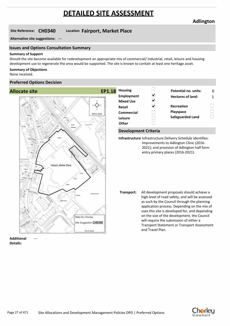
Allocate site Potential no. units: 0
Hectares of land: 1
Other
Site Reference: CH0340 Fairport, Market Place
Adlington
Should the site become available for redevelopment an appropriate mix of commercial/ industrial, retail, leisure and housing development use to regenerate the area would be supported. The site is known to contain at least one heritage asset.
None received.Summary of Objections
Summary of Support
Alternative site suggestions: ---
DETAILED SITE ASSESSMENT
Location
Development Criteria
Infrastructure Infrastructure Delivery Schedule identifies: Improvements to Adlington Clinic (2016-2021); and provision of Adlington half form entry primary places (2016-2021).
Transport: All development proposals should achieve a high level of road safety, and will be assessed as such by the Council through the planning application process. Depending on the mix of uses this site is developed for, and depending on the size of the development, the Council will require the submission of either a Transport Statement or Transport Assessment and Travel Plan.
Additional Details:
---
Issues and Options Consultation Summary
Playspace
EP1.18
Page 27 of 471 Site Allocations and Development Management Policies DPD | Preferred Options

Sustainability Appraisal
Site Ref CH0340
Address Fairport, Market Place, Adlington
SA Obj
Indicator Site Performance SA Comments
S1
Distance to railway station Up to 0.8km Social Site has good access to public transport although rail services are hourly. Access to services and facilities are good with the exception of distance to secondary schools as there are none in the settlement. The site is over 3km away from the key service centre of Chorley town centre however there are many facilities, services and employment opportunities within Adlington. Environmental There are no identified negative environmental effects in developing this site. Economic There are no identified negative economic effects in developing the site.
Rail service freque ncy H ourly se rvice Distance to nearest bus stop Up to 0.4km Bus service frequency 1/hour/direction Distance to se rvice centre Over 3km Distance to A Road junction Up to 0.4km Distance to motorway junction Over 3km Distance to supermarket Over 3km Distance to conve nience s tore Up to 0.4km Distance to Post Office Up to 0.4km Distance to Primary School Up to 0.4km Distance to Secondary School 3 .21 to 5 km On a cycle route No Distance to cycle route Up to 0.4km
S2
Distance to GP surge ry Up to 0.4km Distance to NHS gene ra l hospital 5 .1 to 10 km Distance to public open space/park Up to 0.4km Distance to local centre Up to 0.4km
EN1
Designation of land Urban Local Service Ce ntre Are a of Se paration Outs ide AONB Outs ide SSSI Outs ide Biological/ G eological H eritag e Site Outs ide Agricultural classifica tion 3
EN2
Conservation Area Outs ide Ancie nt Monument on site No Regis te re d Park or G arden Outs ide Listed Building on site No Locally Lis te d Building on s ite No
EN3 Curre nt/former land use Brownfield EN4 Flood Zone a re a All Zone 1
EN5 Contaminated land M edium risk Within 3km of a congestion spot No
EC1 Distance to employment site Up to 0.8km Access to Broadband Yes
EC2 Distance to furthe r/higher education Over 5km
Del
iver
abili
ty
Indi
cato
rs
Access to sewer system
Yes
Is the site deliverable: Yes Access to wa te r
Access to ga s
Access to e lectricity
Exis ting road access
At risk from hazardous installations No
Overall Site Performance
Band Spe ctrum:
Overall Band:
B
Page 28 of 471 Site Allocations and Development Management Policies DPD | Preferred Options

Housing
Employment
Mixed Use
Retail
Commercial
Leisure
Recreation
Safeguarded Land
Preferred Options Decision
Do not allocate Potential no. units: 0
Hectares of land: 0
Other
Site Reference: CH0349 Land at/adjacent to White Bear Marina, Park Road
Adlington
Support future possible commercial/industrial, retail and/or leisure development with resultant employment opportunities. Site is known to contain at least one heritage asset.
None received.Summary of Objections
Summary of Support
Alternative site suggestions: ---
DETAILED SITE ASSESSMENT
Location
Development Criteria
Infrastructure Proposed not to allocate this site, however the following information is provided. Infrastructure Delivery Schedule identifies: Improvements to Adlington Clinic (2016-2021); and provision of Adlington half form entry primary places (2016-2021).
Transport: N/A- proposed not to allocate this site.
Additional Details:
Rely on brownfield policy controls and policies for canalside, tourism, rural business. Possible negative impact on car parking arrangements for residential moorings recently approved.
Issues and Options Consultation Summary
Playspace
Page 29 of 471 Site Allocations and Development Management Policies DPD | Preferred Options

Sustainability Appraisal
Site Ref CH0349
Address Land at/adjacent to White Bear Marina, Park Road, Adlington
SA Obj
Indicator Site Performance SA Comments
S1
Distance to railway station Up to 0.8km Social Site has good access to public transport although rail services are hourly. Access to services and facilities are good with the exception of distance to secondary schools as there are none in the settlement. The site is over 3km away from the key service centre of Chorley town centre however there are many facilities, services and employment opportunities within Adlington. Environmental There are no identified negative environmental effects in developing this site. Economic There are no identified negative economic effects in developing the site.
Rail service freque ncy H ourly se rvice Distance to nearest bus stop Up to 0.4km Bus service frequency 1/hour/direction Distance to se rvice centre Over 3km Distance to A Road junction Up to 0.4km Distance to motorway junction Over 3km Distance to supermarket Over 3km Distance to conve nience s tore Up to 0.4km Distance to Post Office Up to 0.4km Distance to Primary School Up to 0.4km Distance to Secondary School 3 .21 to 5 km On a cycle route No Distance to cycle route Up to 0.4km
S2
Distance to GP surge ry Up to 0.4km Distance to NHS gene ra l hospital 5 .1 to 10 km Distance to public open space/park Up to 0.4km Distance to local centre Up to 0.4km
EN1
Designation of land Urban Local Service Ce ntre Are a of Se paration Outs ide AONB Outs ide SSSI Outs ide Biological/ G eological H eritag e Site Outs ide Agricultural classifica tion 3
EN2
Conservation Area Outs ide Ancie nt Monument on site No Regis te re d Park or G arden Outs ide Listed Building on site No Locally Lis te d Building on s ite No
EN3 Curre nt/former land use Brownfield EN4 Flood Zone a re a All Zone 1
EN5 Contaminated land M edium risk Within 3km of a congestion spot No
EC1 Distance to employment site Up to 0.8km Access to Broadband Yes
EC2 Distance to furthe r/higher education Over 5km
Del
iver
abili
ty
Indi
cato
rs
Access to sewer system
Yes
Is the site deliverable: Yes Access to wa te r
Access to ga s
Access to e lectricity
Exis ting road access
At risk from hazardous installations No
Overall Site Performance
Band Spe ctrum:
Overall Band:
B
Page 30 of 471 Site Allocations and Development Management Policies DPD | Preferred Options

Housing
Employment
Mixed Use
Retail
Commercial
Leisure
Recreation
Safeguarded Land
Preferred Options Decision
Do not allocate Potential no. units: 0
Hectares of land: 0
Other
Site Reference: CS0002 Land off Westhoughton Road
Adlington
Support allocation for housing development.
None received.Summary of Objections
Summary of Support
Alternative site suggestions: ---
DETAILED SITE ASSESSMENT
Location
Development Criteria
Infrastructure N/A- proposed not to allocate site
Transport: N/A- proposed not to allocate site
Additional Details:
Currently in use as private gardens/allotments. Await Open Space Study.
Issues and Options Consultation Summary
Playspace
Page 31 of 471 Site Allocations and Development Management Policies DPD | Preferred Options

Sustainability Appraisal
Site Ref CS0002
Address Land off Westhoughton Road, Adlington
SA Obj
Indicator Site Performance SA Comments
S1
Distance to railway station 0.81 to 1.6km Social This site has good access to public transport although the bus and rail services are not frequent. The site does have access to local facilities and employment opportunities within Adlington. Environmental There are no identified negative effects in developing this site. Economic There are no identified negative economic effects in developing this site.
Rail se rvice frequency Hourly service Distance to nearest bus s top Up to 0.4 km Bus service fre que ncy Less than 1 /hour/direction Distance to service centre Over 3km Distance to A Road junction Up to 0.4 km Distance to motorway junction Over 3km Distance to supermarke t Over 3km Distance to convenience s tore 0.41 to 0.8km Distance to Post Office 0.41 to 0.8km Distance to Primary School 0.41 to 0.8km Distance to Secondary School 1.61 to 3.2km On a cycle route No Distance to cycle route Up to 0.4 km
S2
Distance to G P surgery 0.41 to 0.8km Distance to NHS general hospital 5.1 to 10km Distance to public open space/park 0.41 to 0.8km Distance to local centre 0.41 to 0.8km
E N1
Designation of land Urban Local Service Centre Area of Separation Outside AONB Outside SSSI Outside Biological/ Geological H eritage Site Outside Agricultural class ification 3
E N2
Conservation Area Outside Ancient Monument on s ite No Re gistered Park or Garde n Outside Lis te d Building on s ite No Locally Lis ted Building on s ite No
E N3 Current/former land use Brownfield E N4 Flood Zone area All Zone 1
E N5 Contaminated land No risk Within 3km of a congestion spot No
EC1 Distance to e mployment site 0.81 to 1.2km Access to Broadband Y es
EC2 Distance to further/higher educa tion Over 5km
Del
iver
abili
ty
Indi
cato
rs
Access to sewer syste m
Y es
Is the site deliverable: Yes Access to water
Access to gas
Access to electricity
Existing road access
At risk from hazardous installations No
Overall Site Performance
Band Spe ctrum:
Overall Band:
B
Page 32 of 471 Site Allocations and Development Management Policies DPD | Preferred Options

Housing
Employment
Mixed Use
Retail
Commercial
Leisure
Recreation
Safeguarded Land
Preferred Options Decision
Retain existing designation Potential no. units: 0
Hectares of land: 0
Other
Site Reference: CS0014 Land off The Common
Adlington
None received.
Object to proposed use. Retain as protected land.Summary of Objections
Summary of Support
Alternative site suggestions: ---
DETAILED SITE ASSESSMENT
Location
Development Criteria
Infrastructure Proposed to retain existing safeguarded land designation, however the following information is provided. Infrastructure Delivery Schedule identifies: Improvements to Adlington Clinic (2016-2021); and provision of Adlington half form entry primary places (2016-2021).
Transport: N/A- proposed to retain existing safeguarded land designation
Additional Details:
Chorley Council is the landowner of this site. Land should be considered in conjunction with site suggestion CH0219. Not necessary to release all Safeguarded Land in Adlington - Access issues along Park Road.
Issues and Options Consultation Summary
Playspace
BNE2.3
Page 33 of 471 Site Allocations and Development Management Policies DPD | Preferred Options
Sustainability Appraisal
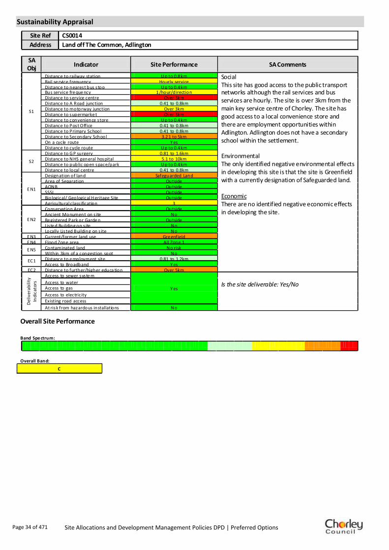
Site Ref CS0014
Address Land off The Common, Adlington
SA Obj
Indicator Site Performance SA Comments
S1
Distance to railway station Up to 0.8 km Social This site has good access to the public transport networks although the rail services and bus services are hourly. The site is over 3km from the main key service centre of Chorley. The site has good access to a local convenience store and there are employment opportunities within Adlington. Adlington does not have a secondary school within the settlement. Environmental The only identified negative environmental effects in developing this site is that the site is Greenfield with a currently designation of Safeguarded land. Economic There are no identified negative economic effects in developing the site.
Rail se rvice frequency Hourly service Distance to nearest bus s top Up to 0.4 km Bus service fre que ncy 1 /hour/direction Distance to service centre Over 3km Distance to A Road junction 0.41 to 0.8km Distance to motorway junction Over 3km Distance to supermarke t Over 3km Distance to convenience s tore Up to 0.4 km Distance to Post Office 0.41 to 0.8km Distance to Primary School 0.41 to 0.8km Distance to Secondary School 3.2 1 to 5km On a cycle route Y es Distance to cycle route Up to 0.4 km
S2
Distance to G P surgery 0.81 to 1.6km Distance to NHS general hospital 5.1 to 10km Distance to public open space/park Up to 0.4 km Distance to local centre 0.41 to 0.8km
E N1
Designation of land Safeguarded Land Area of Separation Outside AONB Outside SSSI Outside Biological/ Geological H eritage Site Outside Agricultural class ification 3
E N2
Conservation Area Outside Ancient Monument on s ite No Re gistered Park or Garde n Outside Lis te d Building on s ite No Locally Lis ted Building on s ite No
E N3 Current/former land use Gre enfield E N4 Flood Zone area All Zone 1
E N5 Contaminated land No risk Within 3km of a congestion spot No
EC1 Distance to e mployment site 0.81 to 1.2km Access to Broadband Y es
EC2 Distance to further/higher educa tion Over 5km
Del
iver
abili
ty
Indi
cato
rs
Access to sewer syste m
Y es
Is the site deliverable: Yes/No Access to water
Access to gas
Access to electricity
Existing road access
At risk from hazardous installations No
Overall Site Performance
Band Spe ctrum:
Overall Band:
C
Page 34 of 471 Site Allocations and Development Management Policies DPD | Preferred Options

Housing
Employment
Mixed Use
Retail
Commercial
Leisure
Recreation
Safeguarded Land
Preferred Options Decision
Retain existing designation Potential no. units: 0
Hectares of land: 0
Other
Site Reference: CS0015 Land off Park Road
Adlington
Support the proposed housing use.
None received.Summary of Objections
Summary of Support
Alternative site suggestions: ---
DETAILED SITE ASSESSMENT
Location
Development Criteria
Infrastructure Proposed to retain existing safeguarded land designation, however the following information is provided. Infrastructure Delivery Schedule identifies: Improvements to Adlington Clinic (2016-2021); and provision of Adlington half form entry primary places (2016-2021).
Transport: N/A- proposed to retain existing safeguarded land designation
Additional Details:
Not necessary to release all Safeguarded Land in Adlington. Site used for allotments and equestrian purposes. No land owner interest in development.
Issues and Options Consultation Summary
Playspace
BNE2.4
Page 35 of 471 Site Allocations and Development Management Policies DPD | Preferred Options

Sustainability Appraisal
Site Ref CS0015
Address Land off Park Road, Adlington
SA Obj
Indicator Site Performance SA Comments
S1
Distance to railway station Up to 0.8km Social This site has good access to public transport although rail services are not very frequent. Access to services and facilities is also very good with the exception of distance to secondary schools as there are none in the settlement. The site is over 3km away from the key service centre of Chorley town centre however there are many facilities, services and employment opportunities within Adlington. Environmental The only identified negative environmental effects in developing this site is that the site is Greenfield with a currently designation of Safeguarded land. Economic There are no identified negative economic effects in developing the site.
Rail service freque ncy H ourly se rvice Distance to nearest bus stop Up to 0.4km Bus service frequency 1/hour/direction Distance to se rvice centre Over 3km Distance to A Road junction Up to 0.4km Distance to motorway junction Over 3km Distance to supermarket Over 3km Distance to conve nience s tore Up to 0.4km Distance to Post Office Up to 0.4km Distance to Primary School Up to 0.4km Distance to Secondary School 3 .21 to 5 km On a cycle route Yes Distance to cycle route Up to 0.4km
S2
Distance to GP surge ry 0 .41 to 0 .8km Distance to NHS gene ra l hospital 5 .1 to 10 km Distance to public open space/park Up to 0.4km Distance to local centre Up to 0.4km
EN1
Designation of land Safeguarded Land Are a of Se paration Outs ide AONB Outs ide SSSI Outs ide Biological/ G eological H eritag e Site Outs ide Agricultural classifica tion 3
EN2
Conservation Area Outs ide Ancie nt Monument on site No Regis te re d Park or G arden Outs ide Listed Building on site No Locally Lis te d Building on s ite No
EN3 Curre nt/former land use Greenfie ld EN4 Flood Zone a re a All Zone 1
EN5 Contaminated land No risk Within 3km of a congestion spot No
EC1 Distance to employment site Up to 0.8km Access to Broadband Yes
EC2 Distance to furthe r/higher education Over 5km
Del
iver
abili
ty
Indi
cato
rs
Access to sewer system
Yes
Is the site deliverable: Yes Access to wa te r
Access to ga s
Access to e lectricity
Exis ting road access
At risk from hazardous installations No
Overall Site Performance
Band Spe ctrum:
Overall Band:
C
Page 36 of 471 Site Allocations and Development Management Policies DPD | Preferred Options

Housing
Employment
Mixed Use
Retail
Commercial
Leisure
Recreation
Safeguarded Land
Preferred Options Decision
Do not allocate Potential no. units: 0
Hectares of land: 0
Other
Site Reference: CS0049 Brook Mill, Brook Street
Adlington
The site appears to fall on an identified textile mill site and should be assessed before development occurs.
None received.Summary of Objections
Summary of Support
Alternative site suggestions: ---
DETAILED SITE ASSESSMENT
Location
Development Criteria
Infrastructure N/A- propose not to allocate site
Transport: N/A- propose not to allocate site
Additional Details:
Poor quality employment site, but in active use. Not suitable for housing.
Issues and Options Consultation Summary
Playspace
Page 37 of 471 Site Allocations and Development Management Policies DPD | Preferred Options

Sustainability Appraisal
Site Ref CS0049
Address Brook Mill, Brook Street, Adlington
SA Obj
Indicator Site Performance SA Comments
S1
Distance to railway station 1 .61 to 2 .4km Social The site has good access to public transport with an every ten minutes bus service running close to the site however rail services are less frequent. Access to services and facilities is also very good. The site is over 3km from the key service centre of Chorley however there are many facilities, services and employment opportunities within Adlington. Environmental There are no identified negative environmental effects in developing this site. Economic There are no identified negative economic effects in developing the site.
Rail service freque ncy H ourly se rvice Distance to nearest bus stop Up to 0.4km Bus service frequency 6 or more/hour/direction Distance to se rvice centre Over 3km Distance to A Road junction Up to 0.4km Distance to motorway junction Over 3km Distance to supermarket Over 3km Distance to conve nience s tore Up to 0.4km Distance to Post Office 0 .41 to 0 .8km Distance to Primary School 0 .41 to 0 .8km Distance to Secondary School 1 .61 to 3 .2km On a cycle route Yes Distance to cycle route Up to 0.4km
S2
Distance to GP surge ry 0 .41 to 0 .8km Distance to NHS gene ra l hospital 5 .1 to 10 km Distance to public open space/park Up to 0.4km Distance to local centre 0 .41 to 0 .8km
EN1
Designation of land Urban Local Service Ce ntre Are a of Se paration Outs ide AONB Outs ide SSSI Outs ide Biological/ G eological H eritag e Site Outs ide Agricultural classifica tion 3
EN2
Conservation Area Outs ide Ancie nt Monument on site No Regis te re d Park or G arden Outs ide Listed Building on site No Locally Lis te d Building on s ite No
EN3 Curre nt/former land use Brownfield EN4 Flood Zone a re a All Zone 1
EN5 Contaminated land No risk Within 3km of a congestion spot No
EC1 Distance to employment site 1 .21 to 1 .6km Access to Broadband Yes
EC2 Distance to furthe r/higher education Over 5km
Del
iver
abili
ty
Indi
cato
rs
Access to sewer system
Yes
Is the site deliverable: Yes Access to wa te r
Access to ga s
Access to e lectricity
Exis ting road access
At risk from hazardous installations No
Overall Site Performance
Band Spe ctrum:
Overall Band:
B
Page 38 of 471 Site Allocations and Development Management Policies DPD | Preferred Options

Housing
Employment
Mixed Use
Retail
Commercial
Leisure
Recreation
Safeguarded Land
Preferred Options Decision
Undecided Potential no. units: 0
Hectares of land: 0
Other Suggested recreation allocation. Await results of Open Space Study.
Site Reference: CH0293 Land Adjacent Buckshaw Primary School
Astley Village
Full support for the proposed recreation use.
None received.Summary of Objections
Summary of Support
Alternative site suggestions: ---
DETAILED SITE ASSESSMENT
Location
Development Criteria
Infrastructure ---
Transport: ---
Additional Details:
It has been suggested that this site be allocated for recreation use. Until the results of the Open Space Study are received, no decisions will be made as to the allocation or otherwise of this site.
Issues and Options Consultation Summary
Playspace
Page 39 of 471 Site Allocations and Development Management Policies DPD | Preferred Options

Sustainability Appraisal
No sustainability Appraisal has been undertaken of this site suggestion. Until the findings of the
Open Space Study are produced, the Council will not be allocating additional land for recreation
purposes. Once the Study is complete, a decision on the allocation of this site for recreational use
can be made.
Page 40 of 471 Site Allocations and Development Management Policies DPD | Preferred Options

Housing
Employment
Mixed Use
Retail
Commercial
Leisure
Recreation
Safeguarded Land
Preferred Options Decision
Undecided Potential no. units: 0
Hectares of land: 0
Other Suggested recreation allocation. Await results of Open Space Study.
Site Reference: CH0294 Chancery Road
Astley Village
Full support for the proposed recreation use.
None received.Summary of Objections
Summary of Support
Alternative site suggestions: ---
DETAILED SITE ASSESSMENT
Location
Development Criteria
Infrastructure ---
Transport: ---
Additional Details:
It has been suggested that this site be allocated for recreation use. Until the results of the Open Space Study are received, no decisions will be made as to the allocation or otherwise of this site.
Issues and Options Consultation Summary
Playspace
Page 41 of 471 Site Allocations and Development Management Policies DPD | Preferred Options

Sustainability Appraisal
No sustainability Appraisal has been undertaken of this site suggestion. Until the findings of the
Open Space Study are produced, the Council will not be allocating additional land for recreation
purposes. Once the Study is complete, a decision on the allocation of this site for recreational use
can be made.
Page 42 of 471 Site Allocations and Development Management Policies DPD | Preferred Options

Housing
Employment
Mixed Use
Retail
Commercial
Leisure
Recreation
Safeguarded Land
Preferred Options Decision
Undecided Potential no. units: 0
Hectares of land: 0
Other Suggested recreation allocation. Await results of Open Space Study.
Site Reference: CH0303 Astley Village Green, Chancery Road
Astley Village
Full support for the proposed recreation use.
None received.Summary of Objections
Summary of Support
Alternative site suggestions: ---
DETAILED SITE ASSESSMENT
Location
Development Criteria
Infrastructure ---
Transport: ---
Additional Details:
It has been suggested that this site be allocated for recreation use. Until the results of the Open Space Study are received, no decisions will be made as to the allocation or otherwise of this site.
Issues and Options Consultation Summary
Playspace
Page 43 of 471 Site Allocations and Development Management Policies DPD | Preferred Options

Sustainability Appraisal
No sustainability Appraisal has been undertaken of this site suggestion. Until the findings of the
Open Space Study are produced, the Council will not be allocating additional land for recreation
purposes. Once the Study is complete, a decision on the allocation of this site for recreational use
can be made.
Page 44 of 471 Site Allocations and Development Management Policies DPD | Preferred Options

Housing
Employment
Mixed Use
Retail
Commercial
Leisure
Recreation
Safeguarded Land
Preferred Options Decision
Do not allocate Potential no. units: 0
Hectares of land: 0
Other Suggested cycle route already overlaps exisiting LCC cycle route.
Site Reference: CH0024 Disused Railway Line from Brinscall to Abbey Village
Brinscall
None received.
None received.Summary of Objections
Summary of Support
Alternative site suggestions: ---
DETAILED SITE ASSESSMENT
Location
Development Criteria
Infrastructure N/A- proposed not to allocate site
Transport: N/A- proposed not to allocate site
Additional Details:
N/A- proposed not to allocate site
Issues and Options Consultation Summary
Playspace
Page 45 of 471 Site Allocations and Development Management Policies DPD | Preferred Options

Sustainability Appraisal
No sustainability Appraisal has been undertaken of this site suggestion as cycle routes are a matter
handled by Lancashire County Council (LCC). We are not proposing to allocate any further routes
unless advised to do so by LCC.
Page 46 of 471 Site Allocations and Development Management Policies DPD | Preferred Options

Housing
Employment
Mixed Use
Retail
Commercial
Leisure
Recreation
Safeguarded Land
Preferred Options Decision
Allocate site Potential no. units: 9
Hectares of land: 0
Other
Site Reference: CH0169 Land at Drinkwater Farm, Windsor Drive
Brinscall
None received.
None received.Summary of Objections
Summary of Support
Alternative site suggestions: ---
DETAILED SITE ASSESSMENT
Location
Development Criteria
Infrastructure ---
Transport: All development proposals should achieve a high level of road safety, and will be assessed as such by the Council through the planning application process. For housing developments with between 50 and 80 units, the Council will require a Transport Statement. For developments of more than 80 units, the Council will require a Transport Assessment and Travel Plan as part of the application.
Additional Details:
---
Issues and Options Consultation Summary
Playspace
HS1.48
Page 47 of 471 Site Allocations and Development Management Policies DPD | Preferred Options

Sustainability Appraisal
Site Ref CH0169
Address Land at Drinkwater Farm, Brinscall
SA Obj
Indicator Site Performance SA Comments
S1
Distance to railway station Over 3km Social This site has poor access to public transport with no rail services in the settlement. Although the site is in close proximity to a bus route the service is only once an hour. The site has poor access to an A road junction and is over 3km from a motorway junction. The site has poor access to local services and facilities with the exceptions of a convenience store and post office which are in close proximity to the site. Environmental The only identified negative environmental effect in developing this site is the site is a Greenfield site. Economic There are no identified negative economic effects in developing this site.
Rail service freque ncy No services in settlement Distance to nearest bus stop Up to 0.4km Bus service frequency 1/hour/direction Distance to se rvice centre Over 3km Distance to A Road junction 1 .61 to 3 km Distance to motorway junction Over 3km Distance to supermarket Over 3km Distance to conve nience s tore 0 .41 to 0 .8km Distance to Post Office 0 .41 to 0 .8km Distance to Primary School Up to 0.4km Distance to Secondary School Over 5km On a cycle route No Distance to cycle route 0 .41 to 0 .8km
S2
Distance to GP surge ry 0 .81 to 1 .6km Distance to NHS gene ra l hospital 5 .1 to 10 km Distance to public open space/park Up to 0.4km Distance to local centre 0 .41 to 0 .8km
EN1
Designation of land Rural Local Service Centre Are a of Se paration Outs ide AONB Outs ide SSSI Outs ide Biological/ G eological H eritag e Site Outs ide Agricultural classifica tion 4
EN2
Conservation Area Outs ide Ancie nt Monument on site No Regis te re d Park or G arden Outs ide Listed Building on site No Locally Lis te d Building on s ite No
EN3 Curre nt/former land use Greenfie ld EN4 Flood Zone a re a All Zone 1
EN5 Contaminated land No risk Within 3km of a congestion spot No
EC1 Distance to employment site 0 .81 to 1 .2km Access to Broadband Yes
EC2 Distance to furthe r/higher education Over 5km
Del
iver
abili
ty
Indi
cato
rs
Access to sewer system
Yes
Is the site deliverable: Yes Access to wa te r
Access to ga s
Access to e lectricity
Exis ting road access
At risk from hazardous installations No
Overall Site Performance
Band Spe ctrum:
Overall Band:
C
Page 48 of 471 Site Allocations and Development Management Policies DPD | Preferred Options

Housing
Employment
Mixed Use
Retail
Commercial
Leisure
Recreation
Safeguarded Land
Preferred Options Decision
Undecided Potential no. units: 0
Hectares of land: 0
Other Suggested recreation allocation. Await results of Open Space Study.
Site Reference: CH0344 Land at Lodge Bank
Brinscall
No objection is raised to the principle of the site being allocated for recreation provided it is recognised that such use will need to respect the nature conservation value of the site, requiring proper site supervision and management.
None received.Summary of Objections
Summary of Support
Alternative site suggestions: ---
DETAILED SITE ASSESSMENT
Location
Development Criteria
Infrastructure ---
Transport: ---
Additional Details:
It has been suggested that this site be allocated for recreation use. Until the results of the Open Space Study are received, no decisions will be made as to the allocation or otherwise of this site.
Issues and Options Consultation Summary
Playspace
Page 49 of 471 Site Allocations and Development Management Policies DPD | Preferred Options

Sustainability Appraisal
No sustainability Appraisal has been undertaken of this site suggestion. Until the findings of the
Open Space Study are produced, the Council will not be allocating additional land for recreation
purposes. Once the Study is complete, a decision on the allocation of this site for recreational use
can be made.
Page 50 of 471 Site Allocations and Development Management Policies DPD | Preferred Options

Housing
Employment
Mixed Use
Retail
Commercial
Leisure
Recreation
Safeguarded Land
Preferred Options Decision
Retain existing designation Potential no. units: 0
Hectares of land: 0
Other
Site Reference: CS0030 Land off Heather Lea Drive
Brinscall
None received.
This is part of Railway Road Park and should be retained for recreation and for separating Withnell from Brinscall.Summary of Objections
Summary of Support
Alternative site suggestions: ---
DETAILED SITE ASSESSMENT
Location
Development Criteria
Infrastructure N/A- proposed to designate site as open space to reflect existing use
Transport: N/A- proposed to designate site as open space to reflect existing use
Additional Details:
Final Detailed Open Space Study awaited. Existing Park - unlikely to be surplus to open space requirements.
Issues and Options Consultation Summary
Playspace
HW1.8
Page 51 of 471 Site Allocations and Development Management Policies DPD | Preferred Options
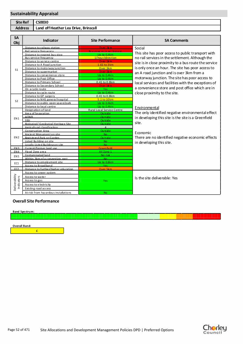
Sustainability Appraisal
Site Ref CS0030
Address Land off Heather Lea Drive, Brinscall
SA Obj
Indicator Site Performance SA Comments
S1
Distance to railway station Over 3km Social This site has poor access to public transport with no rail services in the settlement. Although the site is in close proximity to a bus route the service is only once an hour. The site has poor access to an A road junction and is over 3km from a motorway junction. The site has poor access to local services and facilities with the exceptions of a convenience store and post office which are in close proximity to the site. Environmental The only identified negative environmental effect in developing this site is the site is a Greenfield site. Economic There are no identified negative economic effects in developing this site.
Rail service freque ncy No services in settlement Distance to nearest bus stop Up to 0.4km Bus service frequency 1/hour/direction Distance to se rvice centre Over 3km Distance to A Road junction 1 .61 to 3 km Distance to motorway junction Over 3km Distance to supermarket Over 3km Distance to conve nience s tore Up to 0.4km Distance to Post Office Up to 0.4km Distance to Primary School 0 .41 to 0 .8km Distance to Secondary School Over 5km On a cycle route Yes Distance to cycle route Up to 0.4km
S2
Distance to GP surge ry 0 .41 to 0 .8km Distance to NHS gene ra l hospital 5 .1 to 10 km Distance to public open space/park Up to 0.4km Distance to local centre Up to 0.4km
EN1
Designation of land Rural Local Service Centre Are a of Se paration Outs ide AONB Outs ide SSSI Outs ide Biological/ G eological H eritag e Site Outs ide Agricultural classifica tion 4
EN2
Conservation Area Outs ide Ancie nt Monument on site No Regis te re d Park or G arden Outs ide Listed Building on site No Locally Lis te d Building on s ite No
EN3 Curre nt/former land use Greenfie ld EN4 Flood Zone a re a All Zone 1
EN5 Contaminated land No risk Within 3km of a congestion spot No
EC1 Distance to employment site Up to 0.8km Access to Broadband Yes
EC2 Distance to furthe r/higher education Over 5km
Del
iver
abili
ty
Indi
cato
rs
Access to sewer system
Yes
Is the site deliverable: Yes Access to wa te r
Access to ga s
Access to e lectricity
Exis ting road access
At risk from hazardous installations No
Overall Site Performance
Band Spe ctrum:
Overall Band:
C
Page 52 of 471 Site Allocations and Development Management Policies DPD | Preferred Options

Housing
Employment
Mixed Use
Retail
Commercial
Leisure
Recreation
Safeguarded Land
Preferred Options Decision
Do not allocate Potential no. units: 0
Hectares of land: 0
Other
Site Reference: CS0043 Commercial Premises, Hartington Road
Brinscall
There are 40ft wagons coming daily, problem with existing employment use. Would like to see the site allocated for affordable housing to meet local residents' needs.
None received.Summary of Objections
Summary of Support
Alternative site suggestions: ---
DETAILED SITE ASSESSMENT
Location
Development Criteria
Infrastructure N/A- propose not to allocate site
Transport: N/A- propose not to allocate site
Additional Details:
This site is currently in active employment use. Employment use will be protected.
Issues and Options Consultation Summary
Playspace
Page 53 of 471 Site Allocations and Development Management Policies DPD | Preferred Options

Sustainability Appraisal
Site Ref CS0043
Address Commercial Premises, Hartington Road, Brinscall
SA Obj
Indicator Site Performance SA Comments
S1
Distance to railway station Over 3km Social This site has poor access to public transport with no rail services in the settlement. Although the site is in close proximity to a bus route the service is only once an hour. The site has poor access to an A road junction and is over 3km from a motorway junction. The site has poor access to local services and facilities with the exceptions of a convenience store and post office which are in close proximity to the site. Environmental There are no identified negative environmental effects in developing this site. Economic There are no identified negative economic effects in developing this site.
Rail service freque ncy No services in settlement Distance to nearest bus stop Up to 0.4km Bus service frequency 1/hour/direction Distance to se rvice centre Over 3km Distance to A Road junction 0 .81 to 1 .6km Distance to motorway junction Over 3km Distance to supermarket Over 3km Distance to conve nience s tore 0 .41 to 0 .8km Distance to Post Office 0 .41 to 0 .8km Distance to Primary School 0 .81 to 1 .6km Distance to Secondary School Over 5km On a cycle route Yes Distance to cycle route Up to 0.4km
S2
Distance to GP surge ry Up to 0.4km Distance to NHS gene ra l hospital 5 .1 to 10 km Distance to public open space/park Up to 0.4km Distance to local centre 0 .41 to 0 .8km
EN1
Designation of land Rural Local Service Centre Are a of Se paration Outs ide AONB Outs ide SSSI Outs ide Biological/ G eological H eritag e Site Outs ide Agricultural classifica tion 4
EN2
Conservation Area Outs ide Ancie nt Monument on site No Regis te re d Park or G arden Outs ide Listed Building on site No Locally Lis te d Building on s ite No
EN3 Curre nt/former land use Brownfield EN4 Flood Zone a re a All Zone 1
EN5 Contaminated land No risk Within 3km of a congestion spot No
EC1 Distance to employment site Up to 0.8km Access to Broadband Yes
EC2 Distance to furthe r/higher education Over 5km
Del
iver
abili
ty
Indi
cato
rs
Access to sewer system
Yes
Is the site deliverable: Yes Access to wa te r
Access to ga s
Access to e lectricity
Exis ting road access
At risk from hazardous installations No
Overall Site Performance
Band Spe ctrum:
Overall Band:
C
Page 54 of 471 Site Allocations and Development Management Policies DPD | Preferred Options

Housing
Employment
Mixed Use
Retail
Commercial
Leisure
Recreation
Safeguarded Land
Preferred Options Decision
Do not allocate Potential no. units: 0
Hectares of land: 0
Other Suggested cycle route already overlaps exisiting LCC cycle route.
Site Reference: CH0021 Perimeter of Buckshaw Village
Buckshaw Village
Site known to contain at least one heritage asset. Whilst is probable that most could be successfully developed there could be considerable advantages in assessing the implications of development in advance of establishing any plans.
None received.Summary of Objections
Summary of Support
Alternative site suggestions: ---
DETAILED SITE ASSESSMENT
Location
Development Criteria
Infrastructure N/A- proposed not to allocate site
Transport: N/A- proposed not to allocate site
Additional Details:
N/A- proposed not to allocate site
Issues and Options Consultation Summary
Playspace
Page 55 of 471 Site Allocations and Development Management Policies DPD | Preferred Options

Sustainability Appraisal
No sustainability Appraisal has been undertaken of this site suggestion as cycle routes are a matter
handled by Lancashire County Council (LCC). We are not proposing to allocate any further routes
unless advised to do so by LCC.
Page 56 of 471 Site Allocations and Development Management Policies DPD | Preferred Options

Housing
Employment
Mixed Use
Retail
Commercial
Leisure
Recreation
Safeguarded Land
Preferred Options Decision
Allocate site Potential no. units: 761
Hectares of land: 5
Other
Site Reference: CH0038 Group 1, Former Royal Ordnance Site, Euxton Lane
Buckshaw Village
Site known to contain at least one heritage asset. Whilst is probable that most could be successfully developed there could be considerable advantages in assessing the implications of development in advance of establishing any plans.
None received.Summary of Objections
Summary of Support
Alternative site suggestions: ---
DETAILED SITE ASSESSMENT
Location
Development Criteria
Infrastructure Infrastructure Delivery Schedule identifies: Buckshaw Village 1 form extension to primary school (2011-2016; Additional primary school on Group 1 site (2016-2021); and a new Buckshaw Village surgery (2012).Water Cycle Study: Discussion and agreement with UU required on timing of development and network capacity and pumping station to network. UU is applying for funding to upsize the sewers in this area as part of their business plan, to be able to accept flows from the this development. Agreement with EA required on attenuating runoff to nearby watercourse. Otherwise favourable location for development.
Transport: All development proposals should achieve a high level of road safety, and will be assessed as such by the Council through the planning application process. As this site already has planning permission, the relevant Transport Statement/Assessment has already been submitted to, and approved by the Council.
Additional Details:
---
Issues and Options Consultation Summary
Playspace
HS1.25
Page 57 of 471 Site Allocations and Development Management Policies DPD | Preferred Options

Sustainability Appraisal
Site Ref CH0038
Address Group 1, Former Royal Ordnance Site, Euxton
SA Obj
Indicator Site Performance SA Comments
S1
Distance to railway station 2 .41 to 3 km
Rail service freque ncy 2-3 trains/hour per d ir ection Distance to nearest bus stop Up to 0.4km Bus service frequency 2-5 /hour/direction Distance to se rvice centre 2 .41 to 3 km Distance to A Road junction Up to 0.4km Distance to motorway junction 1 .61 to 3 km Distance to supermarket 1 .61 to 3 km Distance to conve nience s tore Up to 0.4km Distance to Post Office 0 .81 to 1 .2km Distance to Primary School 0 .81 to 1 .6km Distance to Secondary School 1 .61 to 3 .2km On a cycle route Yes Distance to cycle route Up to 0.4km
S2
Distance to GP surge ry Up to 0.4km Distance to NHS gene ra l hospital 2.1 to 5 km Distance to public open space/park Up to 0.4km Distance to local centre 0 .81 to 1 .2km
EN1
Designation of land Urban Local Service Ce ntre Are a of Se paration Outs ide AONB Outs ide SSSI Outs ide Biological/ G eological H eritag e Site Part outs ide/part w ithin Agricultural classifica tion 3
EN2
Conservation Area Outs ide Ancie nt Monument on site No Regis te re d Park or G arden Outs ide Listed Building on site No Locally Lis te d Building on s ite No
EN3 Curre nt/former land use Brownfield EN4 Flood Zone a re a All Zone 1
EN5 Contaminated land High risk Within 3km of a congestion spot Yes
EC1 Distance to employment site Up to 0.8km Access to Broadband Yes
EC2 Distance to furthe r/higher education Up to 1.6km
Del
iver
abili
ty
Indi
cato
rs
Access to sewer system
Yes
Is the site deliverable: Yes Access to wa te r
Access to ga s
Access to e lectricity
Exis ting road access
At risk from hazardous installations No
Overall Site Performance
Band Spe ctrum:
Overall Band:
B
Page 58 of 471 Site Allocations and Development Management Policies DPD | Preferred Options

Housing
Employment
Mixed Use
Retail
Commercial
Leisure
Recreation
Safeguarded Land
Preferred Options Decision
Allocate site Potential no. units: 93
Hectares of land: 0
Other
Site Reference: CH0039 Group 4N, Royal Ordnance Site, Euxton Lane
Buckshaw Village
None received.
None received.Summary of Objections
Summary of Support
Alternative site suggestions: ---
DETAILED SITE ASSESSMENT
Location
Development Criteria
Infrastructure Infrastructure Delivery Schedule identifies: Buckshaw Village 1 form extension to primary school (2011-2016; Additional primary school on Group 1 site (2016-2021); and a new Buckshaw Village surgery (2012).Water Cycle Study: Discussion and agreement with UU required on timing of development and network capacity and pumping station to network. UU is applying for funding to upsize the sewers in this area as part of their business plan, to be able to accept flows from the this development. Agreement with EA required on attenuating runoff to nearby watercourse. Otherwise favourable location for development. National Grid confirm that the nearest relevant main to this site is medium pressure instead of low pressure, however the site could still feasibly be provided with a gas connection.
Transport: All development proposals should achieve a high level of road safety, and will be assessed as such by the Council through the planning application process. As this site already has planning permission, the relevant Transport Statement/Assessment has already been submitted to, and approved by the Council.
Additional Details:
---
Issues and Options Consultation Summary
Playspace
HS1.24
Page 59 of 471 Site Allocations and Development Management Policies DPD | Preferred Options

Sustainability Appraisal
Site Ref CH0039
Address Group 4N, Former Royal Ordnance Site, Euxton
SA Obj
Indicator Site Performance SA Comments
S1
Distance to railway station 2 .41 to 3 km
Rail service freque ncy 2-3 trains/hour per d ir ection Distance to nearest bus stop Up to 0.4km Bus service frequency 2-5 /hour/direction Distance to se rvice centre 2 .41 to 3 km Distance to A Road junction 0 .81 to 1 .6km Distance to motorway junction 1 .61 to 3 km Distance to supermarket 1 .61 to 3 km Distance to conve nience s tore 0 .41 to 0 .8km Distance to Post Office 1 .21 to 1 .6km Distance to Primary School 0 .81 to 1 .6km Distance to Secondary School 1 .61 to 3 .2km On a cycle route Yes Distance to cycle route Up to 0.4km
S2
Distance to GP surge ry 0 .41 to 0 .8km Distance to NHS gene ra l hospital 2.1 to 5 km Distance to public open space/park Up to 0.4km Distance to local centre 1 .21 to 1 .6km
EN1
Designation of land Green Belt Are a of Se paration Outs ide AONB Outs ide SSSI Outs ide Biological/ G eological H eritag e Site Outs ide Agricultural classifica tion 3
EN2
Conservation Area Outs ide Ancie nt Monument on site No Regis te re d Park or G arden Outs ide Listed Building on site No Locally Lis te d Building on s ite No
EN3 Curre nt/former land use Greenfie ld EN4 Flood Zone a re a All Zone 1
EN5 Contaminated land High risk Within 3km of a congestion spot Yes
EC1 Distance to employment site Up to 0.8km Access to Broadband Yes
EC2 Distance to furthe r/higher education 1 .61 to 3 .2km
Del
iver
abili
ty
Indi
cato
rs
Access to sewer system
Yes
Is the site deliverable: Yes Access to wa te r
Access to ga s
Access to e lectricity
Exis ting road access
At risk from hazardous installations No
Overall Site Performance
Band Spe ctrum:
Overall Band:
C
Page 60 of 471 Site Allocations and Development Management Policies DPD | Preferred Options
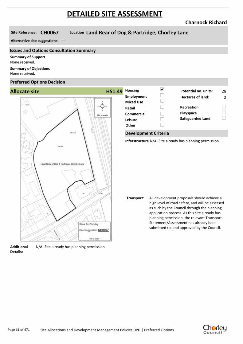
Housing
Employment
Mixed Use
Retail
Commercial
Leisure
Recreation
Safeguarded Land
Preferred Options Decision
Allocate site Potential no. units: 28
Hectares of land: 0
Other
Site Reference: CH0067 Land Rear of Dog & Partridge, Chorley Lane
Charnock Richard
None received.
None received.Summary of Objections
Summary of Support
Alternative site suggestions: ---
DETAILED SITE ASSESSMENT
Location
Development Criteria
Infrastructure N/A- Site already has planning permission
Transport: All development proposals should achieve a high level of road safety, and will be assessed as such by the Council through the planning application process. As this site already has planning permission, the relevant Transport Statement/Assessment has already been submitted to, and approved by the Council.
Additional Details:
N/A- Site already has planning permission
Issues and Options Consultation Summary
Playspace
HS1.49
Page 61 of 471 Site Allocations and Development Management Policies DPD | Preferred Options

Sustainability Appraisal
No sustainability Appraisal has been undertaken of this site suggestion as the site has already been
granted planning permission/ is under construction.
Page 62 of 471 Site Allocations and Development Management Policies DPD | Preferred Options

Housing
Employment
Mixed Use
Retail
Commercial
Leisure
Recreation
Safeguarded Land
Preferred Options Decision
Undecided Potential no. units: 0
Hectares of land: 0
Other Suggested recreation allocation. Await results of Open Space Study.
Site Reference: CH0124 Coppull New Road
Charnock Richard
None received.
Request a full description of what would constitute 'recreational use'. What would, and would not, be permissible on this suggested site?
Summary of Objections
Summary of Support
Alternative site suggestions: ---
DETAILED SITE ASSESSMENT
Location
Development Criteria
Infrastructure ---
Transport: ---
Additional Details:
It has been suggested that this site be allocated for recreation use. Until the results of the Open Space Study are received, no decisions will be made as to the allocation or otherwise of this site.
Issues and Options Consultation Summary
Playspace
Page 63 of 471 Site Allocations and Development Management Policies DPD | Preferred Options

Sustainability Appraisal
No sustainability Appraisal has been undertaken of this site suggestion. Until the findings of the
Open Space Study are produced, the Council will not be allocating additional land for recreation
purposes. Once the Study is complete, a decision on the allocation of this site for recreational use
can be made.
Page 64 of 471 Site Allocations and Development Management Policies DPD | Preferred Options

Housing
Employment
Mixed Use
Retail
Commercial
Leisure
Recreation
Safeguarded Land
Preferred Options Decision
Undecided Potential no. units: 0
Hectares of land: 0
Other Suggested recreation allocation. Await results of Open Space Study.
Site Reference: CH0125 Park Hall Hotel/Camelot Theme Park
Charnock Richard
Camelot Theme Park remains an appropriate location for residential development of 500 dwellings. This would make a significant contribution to meeting total housing requirements, reliably contributing to the provision of affordable housing in accordance with policy, viability considerations and agreement between the parties, and to meeting of the target of providing at least 70% of housing on previously developed land.
Objection to any residential development at the Park Hall/ Camelot Theme Park site as it would not be sustainable. This site is known to contain at least one heritage asset.
Summary of Objections
Summary of Support
Alternative site suggestions: ---
DETAILED SITE ASSESSMENT
Location
Development Criteria
Infrastructure ---
Transport: ---
Additional Details:
It has been suggested that this site be allocated for recreation use. Until the results of the Open Space Study are received, no decisions will be made as to the allocation or otherwise of this site.
Issues and Options Consultation Summary
Playspace
Page 65 of 471 Site Allocations and Development Management Policies DPD | Preferred Options

Sustainability Appraisal
No sustainability Appraisal has been undertaken of this site suggestion. Until the findings of the
Open Space Study are produced, the Council will not be allocating additional land for recreation
purposes. Once the Study is complete, a decision on the allocation of this site for recreational use
can be made.
Page 66 of 471 Site Allocations and Development Management Policies DPD | Preferred Options

Housing
Employment
Mixed Use
Retail
Commercial
Leisure
Recreation
Safeguarded Land
Preferred Options Decision
Allocate site Potential no. units: 50
Hectares of land: 0
Other
Site Reference: CH0001 Chancery Way/West Way
Chorley
Logical expansion to existing Astley Village residential area. Sustainable and appropriate location. Proposals involve retention and improvement of rugby facilities, with the provision of a new clubhouse and car park. Residential development would be at a scale which reflects the characteristics of surrounding area.
Promoting health and wellbeing states a key issue is to protect sport and recreation facilities. Retain as recreational space, as per DC3.6 of existing Local Plan. Housing would lead to overdevelopment in an area already close to Buckshaw Village. Negative impact on road traffic.
Summary of Objections
Summary of Support
Alternative site suggestions: CH0220
DETAILED SITE ASSESSMENT
Location
Development Criteria
Infrastructure ---
Transport: All development proposals should achieve a high level of road safety, and will be assessed as such by the Council through the planning application process. For housing developments with between 50 and 80 units, the Council will require a Transport Statement. For developments of more than 80 units, the Council will require a Transport Assessment and Travel Plan as part of the application.
Additional Details:
---
Issues and Options Consultation Summary
Playspace
HS1.12; BNE2.12
Page 67 of 471 Site Allocations and Development Management Policies DPD | Preferred Options

Sustainability Appraisal
Site Ref CH0001
Address Chancery Way/West Way, Chorley
SA Obj
Indicator Site Performance SA Comments
S1
Distance to railway station 2 .41 to 3 km Social The site has good access to public transport with bus and rail services very frequent although the rail station is 2.41 to 3km from the site. The site is not close to a convenience store although a large supermarket is within 1.6km of the site. The site has good road links to the M61 motorway junction. Environmental The only negative environmental effects in developing this site is that the site is a designated Urban Greenspace and within 3km of a congestion spot. Economic There are no identified economic effects in developing the site.
Rail service freque ncy 4 or more/hour/direction Distance to nearest bus stop Up to 0.4km Bus service frequency 2-5 /hour/direction Distance to se rvice centre 2 .41 to 3 km Distance to A Road junction 0 .81 to 1 .6km Distance to motorway junction 1 .61 to 3 km Distance to supermarket 0 .81 to 1 .6km Distance to conve nience s tore Ove r 1 .2km Distance to Post Office 0 .41 to 0 .8km Distance to Primary School 0 .41 to 0 .8km Distance to Secondary School 0 .81 to 1 .6km On a cycle route Yes Distance to cycle route Up to 0.4km
S2
Distance to GP surge ry 1 .61 to 3 km Distance to NHS gene ra l hospital Up to 2km Distance to public open space/park Up to 0.4km Distance to local centre 0 .41 to 0 .8km
EN1
Designation of land Safeguarded Land Are a of Se paration Outs ide AONB Outs ide SSSI Outs ide Biological/ G eological H eritag e Site Outs ide Agricultural classifica tion 3
EN2
Conservation Area Outs ide Ancie nt Monument on site No Regis te re d Park or G arden Outs ide Listed Building on site No Locally Lis te d Building on s ite No
EN3 Curre nt/former land use Urban G re enspace EN4 Flood Zone a re a All Zone 1
EN5 Contaminated land No risk Within 3km of a congestion spot Yes
EC1 Distance to employment site Up to 0.8km Access to Broadband Yes
EC2 Distance to furthe r/higher education Up to 1.6km
Del
iver
abili
ty
Indi
cato
rs
Access to sewer system
Yes
Is the site deliverable: Yes Access to wa te r
Access to ga s
Access to e lectricity
Exis ting road access
At risk from hazardous installations No
Overall Site Performance
Band Spe ctrum:
Overall Band:
C
Page 68 of 471 Site Allocations and Development Management Policies DPD | Preferred Options

Housing
Employment
Mixed Use
Retail
Commercial
Leisure
Recreation
Safeguarded Land
Preferred Options Decision
Allocate site Potential no. units: 68
Hectares of land: 0
Other
Site Reference: CH0006 Park Mills, Deighton Road
Chorley
None received.
Site falls on an identified textile site and is known to contain at least one heritage asset. This should be assessed before any development occurs.
Summary of Objections
Summary of Support
Alternative site suggestions: CH0113
DETAILED SITE ASSESSMENT
Location
Development Criteria
Infrastructure Water Cycle Study: Discussion and agreement with UU required on pumping station network. Agreement with EA require on attenuating runoff to nearby watercourses. Otherwise favourable location for development.
Transport: All development proposals should achieve a high level of road safety, and will be assessed as such by the Council through the planning application process. As this site already has planning permission, the relevant Transport Statement/Assessment has already been submitted to, and approved by the Council.
Additional Details:
Site proposals should be considered in conjunction with site suggestion CH0113.
Issues and Options Consultation Summary
Playspace
HS1.15
Page 69 of 471 Site Allocations and Development Management Policies DPD | Preferred Options

Sustainability Appraisal
Site Ref CH0006
Address Park Mills, Deighton Road, Chorley
SA Obj
Indicator Site Performance SA Comments
S1
Distance to railway station 0 .81 to 1 .6km Social The site has very good access to public transport with rail and bus services running very frequently. The site is also very close to the key service centre of Chorley with very good access to all local services and facilities. Environmental There are no identified negative environmental effects in developing this site. Economic There are no identified negative economic effects in developing this site.
Rail service freque ncy 4 or more/hour/direction Distance to nearest bus stop Up to 0.4km Bus service frequency 6 or more/hour/direction Distance to se rvice centre Up to 0.8km Distance to A Road junction 0 .81 to 1 .6km Distance to motorway junction Over 3km Distance to supermarket 0 .81 to 1 .6km Distance to conve nience s tore Up to 0.4km Distance to Post Office Up to 0.4km Distance to Primary School Up to 0.4km Distance to Secondary School 0 .81 to 1 .6km On a cycle route No Distance to cycle route Up to 0.4km
S2
Distance to GP surge ry 0 .41 to 0 .8km Distance to NHS gene ra l hospital 2.1 to 5 km Distance to public open space/park 0 .41 to 0 .8km Distance to local centre Up to 0.4km
EN1
Designation of land Ke y Service Centre Are a of Se paration Outs ide AONB Outs ide SSSI Outs ide Biological/ G eological H eritag e Site Outs ide Agricultural classifica tion None
EN2
Conservation Area Outs ide Ancie nt Monument on site No Regis te re d Park or G arden Outs ide Listed Building on site No Locally Lis te d Building on s ite No
EN3 Curre nt/former land use Brownfield EN4 Flood Zone a re a All Zone 1
EN5 Contaminated land M edium risk Within 3km of a congestion spot Yes
EC1 Distance to employment site Up to 0.8km Access to Broadband Yes
EC2 Distance to furthe r/higher education Up to 1.6km
Del
iver
abili
ty
Indi
cato
rs
Access to sewer system
Yes
Is the site deliverable: Yes Access to wa te r
Access to ga s
Access to e lectricity
Exis ting road access
At risk from hazardous installations No
Overall Site Performance
Band Spe ctrum:
Overall Band:
B
Page 70 of 471 Site Allocations and Development Management Policies DPD | Preferred Options

Housing
Employment
Mixed Use
Retail
Commercial
Leisure
Recreation
Safeguarded Land
Preferred Options Decision
Retain existing designation Potential no. units: 0
Hectares of land: 0
Other
Site Reference: CH0009 Bagganley Lane
Chorley
None received.
Oppose the proposed use and request the land is retained as safeguarded.Summary of Objections
Summary of Support
Alternative site suggestions: ---
DETAILED SITE ASSESSMENT
Location
Development Criteria
Infrastructure N/A- proposed not to allocate site
Transport: N/A- proposed not to allocate site
Additional Details:
Land is east of the M61 and would have significant impact on open countryside, and there is a significant access constraint.
Issues and Options Consultation Summary
Playspace
BNE2.1
Page 71 of 471 Site Allocations and Development Management Policies DPD | Preferred Options

Sustainability Appraisal
Site Ref CH0009
Address Bagganley Lane, Chorley
SA Obj
Indicator Site Performance SA Comments
S1
Distance to railway station 1 .61 to 2 .4km Social This site has good access to public transport and is in close proximity to a primary school and post office, however the site is 0.81 to 1.2km from the nearest convenience store and 1.61 to 3km from an A road junction. Road access to the site is poor. Environmental The site is located partly in flood zone 3 which is a high risk area. The site is also Greenfield and is currently designated safeguarded land. Economic There are no identified negative economic effects in developing this site.
Rail service freque ncy 4 or more/hour/direction Distance to nearest bus stop 0 .41 to 0 .8km Bus service frequency 2-5 /hour/direction Distance to se rvice centre 1 .61 to 2 .4km Distance to A Road junction 1 .61 to 3 km Distance to motorway junction Over 3km Distance to supermarket 1 .61 to 3 km Distance to conve nience s tore 0 .81 to 1 .2km Distance to Post Office Up to 0.4km Distance to Primary School Up to 0.4km Distance to Secondary School 1 .61 to 3 .2km On a cycle route No Distance to cycle route Up to 0.4km
S2
Distance to GP surge ry 0 .81 to 1 .6km Distance to NHS gene ra l hospital 2.1 to 5 km Distance to public open space/park Up to 0.4km Distance to local centre 0 .81 to 1 .2km
EN1
Designation of land Safeguarded Land Are a of Se paration Outs ide AONB Outs ide SSSI Outs ide Biological/ G eological H eritag e Site Outs ide Agricultural classifica tion None
EN2
Conservation Area Outs ide Ancie nt Monument on site No Regis te re d Park or G arden Outs ide Listed Building on site No Locally Lis te d Building on s ite No
EN3 Curre nt/former land use Greenfie ld EN4 Flood Zone a re a Part Zone 3
EN5 Contaminated land No risk Within 3km of a congestion spot Yes
EC1 Distance to employment site 1 .21 to 1 .6km Access to Broadband Yes
EC2 Distance to furthe r/higher education 3 .21 to 5 km
Del
iver
abili
ty
Indi
cato
rs
Access to sewer system
Yes
Is the site deliverable: No Access to wa te r
Access to ga s
Access to e lectricity
Exis ting road access
At risk from hazardous installations No
Overall Site Performance
Band Spe ctrum:
Overall Band:
B
Page 72 of 471 Site Allocations and Development Management Policies DPD | Preferred Options

Housing
Employment
Mixed Use
Retail
Commercial
Leisure
Recreation
Safeguarded Land
Preferred Options Decision
Do not allocate Potential no. units: 0
Hectares of land: 0
Other
Site Reference: CH0018 Former Phoenix MG Rover Dealership, Bengal Street
Chorley
None received.
Allocation appears to fall on an identified textile site. Any proposed schemes will need to assess the impact of development upon the site.
Summary of Objections
Summary of Support
Alternative site suggestions: ---
DETAILED SITE ASSESSMENT
Location
Development Criteria
Infrastructure N/A- proposed not to allocate site
Transport: N/A- proposed not to allocate site
Additional Details:
Site was sold after initial suggestion made and is still in active employment use as showroom. Will be protected for employment use as per the Core Strategy.
Issues and Options Consultation Summary
Playspace
Page 73 of 471 Site Allocations and Development Management Policies DPD | Preferred Options

Sustainability Appraisal
Site Ref CH0018
Address Former Phoenix MG Rover Dealership, Bengal Street, Chorley
SA Obj
Indicator Site Performance SA Comments
S1
Distance to railway station Up to 0.8km Social The site has very good access to public transport with both bus and rail services frequent. The site is within the key service centre of Chorley and has very good access to all services and facilities. Environmental The only negative environmental effect in developing this site is the site is a high risk for contaminated land. Economic There are no identified negative economic effects in developing the site.
Rail service frequency 4 or more/hour/direction Distance to nearest bus stop Up to 0.4km Bus service frequency 6 or more/hour/direction Distance to service centre Up to 0.8km Distance to A Road junction Up to 0.4km Distance to motorway junction 1.61 to 3km Distance to supermarket Up to 0.4km Distance to convenience store Up to 0.4km Distance to Post Office Up to 0.4km Distance to Primary School 0.41 to 0.8km Distance to Secondary School 0.81 to 1.6km On a cycle route No Distance to cycle route Up to 0.4km
S2
Distance to GP surgery 0.41 to 0.8km Distance to NHS general hospital Up to 2km Distance to public open space/park Up to 0.4km Distance to local centre Up to 0.4km
EN1
Designation of land Key Service Centre Area of Separation Outside AONB Outside SSSI Outside Biological/ Geological Heritage Site Outside Agricultural classification None
EN2
Conservation Area Outside Ancient Monument on site No Registered Park or Garden Outside Listed Building on site No Locally Listed Building on site No
EN3 Current/former land use Brownfield EN4 Flood Zone area All Zone 1
EN5 Contaminated land High risk Within 3km of a congestion spot Yes
EC1 Distance to employment site Up to 0.8km Access to Broadband Yes
EC2 Distance to further/higher education Up to 1.6km
Del
iver
abili
ty
Indi
cato
rs
Access to sewer system
Yes
Is the site deliverable: Yes Access to water
Access to gas Access to electricity Existing road access At risk from hazardous installations Yes
Overall Site Performance Band Spectrum:
Overall Band:
B
Page 74 of 471 Site Allocations and Development Management Policies DPD | Preferred Options

Housing
Employment
Mixed Use
Retail
Commercial
Leisure
Recreation
Safeguarded Land
Preferred Options Decision
Do not allocate Potential no. units: 0
Hectares of land: 0
Other
Site Reference: CH0022 Astley Park
Chorley
None received.
Suggestion concerns a registered park and the listed buildings within it. Any scheme would need to demonstrate that it does not adversely impact the designated assets.
Summary of Objections
Summary of Support
Alternative site suggestions: ---
DETAILED SITE ASSESSMENT
Location
Development Criteria
Infrastructure N/A- proposed not to allocate site
Transport: N/A- proposed not to allocate site
Additional Details:
N/A- proposed not to allocate site
Issues and Options Consultation Summary
Playspace
Page 75 of 471 Site Allocations and Development Management Policies DPD | Preferred Options

Sustainability Appraisal
No sustainability Appraisal has been undertaken of this site suggestion as cycle routes are a matter
handled by Lancashire County Council (LCC). We are not proposing to allocate any further routes
unless advised to do so by LCC.
Page 76 of 471 Site Allocations and Development Management Policies DPD | Preferred Options

Housing
Employment
Mixed Use
Retail
Commercial
Leisure
Recreation
Safeguarded Land
Preferred Options Decision
Do not allocate Potential no. units: 0
Hectares of land: 0
Other
Site Reference: CH0023 Footpath from Knowley Brow to Higher House Lane
Chorley
None received.
Cycleway would be better routed on the existing tarmac road, namely Crosse Hall Lane. Cyclists use this route as shortest/quickest path. Wouldn’t want to fund a folly that no one uses.
Summary of Objections
Summary of Support
Alternative site suggestions: ---
DETAILED SITE ASSESSMENT
Location
Development Criteria
Infrastructure N/A- proposed not to allocate site
Transport: N/A- proposed not to allocate site
Additional Details:
N/A- proposed not to allocate site
Issues and Options Consultation Summary
Playspace
Page 77 of 471 Site Allocations and Development Management Policies DPD | Preferred Options

Sustainability Appraisal
No sustainability Appraisal has been undertaken of this site suggestion as cycle routes are a matter
handled by Lancashire County Council (LCC). We are not proposing to allocate any further routes
unless advised to do so by LCC.
Page 78 of 471 Site Allocations and Development Management Policies DPD | Preferred Options

Housing
Employment
Mixed Use
Retail
Commercial
Leisure
Recreation
Safeguarded Land
Preferred Options Decision
Do not allocate Potential no. units: 0
Hectares of land: 0
Other
Site Reference: CH0028 Land at Botany Bay, Off Bagganley Lane
Chorley
None received.
Oppose the proposed use and request the land is retained as safeguarded.Summary of Objections
Summary of Support
Alternative site suggestions: ---
DETAILED SITE ASSESSMENT
Location
Development Criteria
Infrastructure N/A- proposed not to allocate site
Transport: N/A- proposed not to allocate site
Additional Details:
Land is east of the M61 and would have significant impact on open countryside, and there is a significant access constraint.
Issues and Options Consultation Summary
Playspace
Page 79 of 471 Site Allocations and Development Management Policies DPD | Preferred Options

Sustainability Appraisal
Site Ref CH0028
Address Land at Botany Bay, Off Bagganley Lane, Chorley
SA Obj
Indicator Site Performance SA Comments
S1
Distance to railway station 1 .61 to 2 .4km Social The site has good access to public transport with frequent bus and rail services. Access to services and facilities is also very good. There are no negative social effects in developing this site. Environmental The site is located partly within Flood zone 3 which is a high risk flood zone. The site is also a Greenfield site and is currently allocated safeguarded land. Economic There are no identified negative economic effects in developing this site.
Rail service freque ncy 4 or more/hour/direction Distance to nearest bus stop Up to 0.4 km Bus service frequency 2-5/hour/direction Distance to se rvice centre 0 .81 to 1 .6km Distance to A Road junction 0 .81 to 1 .6km Distance to motorway junction 1 .61 to 3km Distance to supermarket 0 .81 to 1 .6km Distance to conve nience s tore 0 .41 to 0 .8km Distance to Post Office 0 .41 to 0 .8km Distance to Primary School Up to 0.4 km Distance to Secondary School 0 .81 to 1 .6km On a cycle route Ye s Distance to cycle route Up to 0.4 km
S2
Distance to GP surge ry 0 .41 to 0 .8km Distance to NHS gene ra l hospital Up to 2km Distance to public open space/park Up to 0.4 km Distance to local centre 0 .41 to 0 .8km
EN1
Designation of land Safeguarded Land/Open Countrys ide Are a of Se paration Outs ide AONB Outs ide SSSI Outs ide Biological/ G eological H eritag e Site Outs ide Agricultural classifica tion None
EN2
Conservation Area Outs ide Ancie nt Monument on site No Regis te re d Park or G arden Outs ide Listed Building on site No Locally Lis te d Building on s ite No
EN3 Curre nt/former land use Greenfie ld EN4 Flood Zone a re a Part Zone 3
EN5 Contaminated land No risk Within 3km of a congestion spot Ye s
EC1 Distance to employment site 1 .21 to 1 .6km Access to Broadband Ye s
EC2 Distance to furthe r/higher education 1 .61 to 3 .2km
Del
iver
abili
ty
Indi
cato
rs
Access to sewer system
Ye s
Is the site deliverable: Yes Access to wa te r
Access to ga s
Access to e lectricity
Exis ting road access
At risk from hazardous installations No
Overall Site Performance
Band Spe ctrum:
Overall Band:
B
Page 80 of 471 Site Allocations and Development Management Policies DPD | Preferred Options

Housing
Employment
Mixed Use
Retail
Commercial
Leisure
Recreation
Safeguarded Land
Preferred Options Decision
Retain existing designation Potential no. units: 0
Hectares of land: 0
Other
Site Reference: CH0031 Lower Healey Works, Froom Street
Chorley
None received.
Land to remain as safeguarded as development would go against current planning policy. Site is known to contain at least one heritage asset and is identified as a textile mill site. Any scheme should be assessed against potential impact on assets.
Summary of Objections
Summary of Support
Alternative site suggestions: CH0365
DETAILED SITE ASSESSMENT
Location
Development Criteria
Infrastructure N/A- proposed not to allocate site
Transport: N/A- proposed not to allocate site
Additional Details:
Site proposals should be considered in conjunction with site suggestion CH0365. Land is east of the M61 and would have significant impact on open countryside, and there is a significant access constraint. A small part of the site is a small business park with low occupancy.
Issues and Options Consultation Summary
Playspace
BNE2.1
Page 81 of 471 Site Allocations and Development Management Policies DPD | Preferred Options

Sustainability Appraisal
Site Ref CH0031
Address Lower Healey Works, Froom Street, Chorley
SA Obj
Indicator Site Performance SA Comments
S1
Distance to railway station 1 .61 to 2 .4km Social This site has good access to public transport and services are frequent. The site is only 0.81 to 1.6km from the key service centre of Chorley Town centre. The site is 1.61 to 3km from the nearest supermarket although there are local convenience stores in the local area. The site is not close to an A road junction making access poor to the site. Environmental The only identified negative environmental effects in developing this site are its current safeguarded land designation and part of the site is within flood zone 2 and is intermediately at risk of flooding. Economic There are no identified negative economic effects in developing this site.
Rail service freque ncy 4 or more/hour/direction Distance to nearest bus stop 0 .41 to 0 .8km Bus service frequency 2-5 /hour/direction Distance to se rvice centre 0 .81 to 1 .6km Distance to A Road junction 0 .81 to 1 .6km Distance to motorway junction Over 3km Distance to supermarket 1 .61 to 3 km Distance to conve nience s tore 0 .41 to 0 .8km Distance to Post Office 0 .41 to 0 .8km Distance to Primary School 0 .41 to 0 .8km Distance to Secondary School 1 .61 to 3 .2km On a cycle route No Distance to cycle route Up to 0.4km
S2
Distance to GP surge ry 0 .81 to 1 .6km Distance to NHS gene ra l hospital 2.1 to 5 km Distance to public open space/park Up to 0.4km Distance to local centre 0 .41 to 0 .8km
EN1
Designation of land Safeguarded Land Are a of Se paration Outs ide AONB Outs ide SSSI Outs ide Biological/ G eological H eritag e Site Outs ide Agricultural classifica tion None
EN2
Conservation Area Outs ide Ancie nt Monument on site No Regis te re d Park or G arden Outs ide Listed Building on site No Locally Lis te d Building on s ite No
EN3 Curre nt/former land use Brownfield EN4 Flood Zone a re a Part Zone 2
EN5 Contaminated land M edium risk Within 3km of a congestion spot Yes
EC1 Distance to employment site 1 .21 to 1 .6km Access to Broadband Yes
EC2 Distance to furthe r/higher education 1 .61 to 3 .2km
Del
iver
abili
ty
Indi
cato
rs
Access to sewer system
Yes
Is the site deliverable: Yes Access to wa te r
Access to ga s
Access to e lectricity
Exis ting road access
At risk from hazardous installations No
Overall Site Performance
Band Spe ctrum:
Overall Band:
B
Page 82 of 471 Site Allocations and Development Management Policies DPD | Preferred Options

Housing
Employment
Mixed Use
Retail
Commercial
Leisure
Recreation
Safeguarded Land
Preferred Options Decision
Do not allocate Potential no. units: 0
Hectares of land: 0
Other
Site Reference: CH0042 Ellerbeck East and West
Chorley
None received.
Site known to contain at least one heritage asset. Any scheme should assess the implications on heritage assets.Summary of Objections
Summary of Support
Alternative site suggestions: ---
DETAILED SITE ASSESSMENT
Location
Development Criteria
Infrastructure N/A- proposed not to allocate site
Transport: N/A- proposed not to allocate site
Additional Details:
N/A- proposed not to allocate site
Issues and Options Consultation Summary
Playspace
Page 83 of 471 Site Allocations and Development Management Policies DPD | Preferred Options

Sustainability Appraisal
No sustainability Appraisal has been undertaken of this site suggestion. Until the findings of the
Open Space Study are produced, the Council will not be allocating additional land for recreation
purposes. Once the Study is complete, a decision on the allocation of this site for recreational use
can be made.
Page 84 of 471 Site Allocations and Development Management Policies DPD | Preferred Options

Housing
Employment
Mixed Use
Retail
Commercial
Leisure
Recreation
Safeguarded Land
Preferred Options Decision
Allocate site Potential no. units: 0
Hectares of land: 0
Other It is proposed to bring forward all existing play space allocations.
Site Reference: CH0048 Southport Road
Chorley
None recevied.
Site is adjacent to the Registered Astley Park, and has the potential to impact on the setting of the designated asset. An impact assessment should be produced at an early stage of the planning of any development scheme.
Summary of Objections
Summary of Support
Alternative site suggestions: ---
DETAILED SITE ASSESSMENT
Location
Development Criteria
Infrastructure ---
Transport: ---
Additional Details:
---
Issues and Options Consultation Summary
Playspace
HW1.10
Page 85 of 471 Site Allocations and Development Management Policies DPD | Preferred Options

Sustainability Appraisal
No sustainability Appraisal has been undertaken of this site suggestion. Until the findings of the
Open Space Study are produced, the Council will not be allocating additional land for recreation
purposes. Once the Study is complete, a decision on the allocation of this site for recreational use
can be made.
Page 86 of 471 Site Allocations and Development Management Policies DPD | Preferred Options

Housing
Employment
Mixed Use
Retail
Commercial
Leisure
Recreation
Safeguarded Land
Preferred Options Decision
Allocate site Potential no. units: 0
Hectares of land: 1
Other
Site Reference: CH0052 Bankside House and Weldbank Training Centre, Weldbank
Chorley
None received.
None received.Summary of Objections
Summary of Support
Alternative site suggestions: ---
DETAILED SITE ASSESSMENT
Location
Development Criteria
Infrastructure ---
Transport: All development proposals should achieve a high level of road safety, and will be assessed as such by the Council through the planning application process. Depending on what type of employment use or mix of uses this site is developed for, and depending on the size of the development, the Council will require the submission of either a Transport Statement or Transport Assessment and Travel Plan.
Additional Details:
---
Issues and Options Consultation Summary
Playspace
EP1.10
Page 87 of 471 Site Allocations and Development Management Policies DPD | Preferred Options

Sustainability Appraisal
Site Ref CH0052
Address Bankside House and Weldbank Training Centre, Weldbank Lane, Chorley
SA Obj
Indicator Site Performance SA Comments
S1
Distance to railway station 0 .81 to 1 .6km Social This site has good access to public transport with very regular bus and rail services. The site is close to all local services and facilities and there are no identified negative effects in developing this site. Environmental The only identified negative effect in developing this site is the medium risk of contaminated land. Economic There are no identified negative economic effects in developing this site.
Rail service freque ncy 4 or more/hour/direction Distance to nearest bus stop Up to 0.4km Bus service frequency 6 or more/hour/direction Distance to se rvice centre Up to 0.8km Distance to A Road junction 0 .81 to 1 .6km Distance to motorway junction Over 3km Distance to supermarket 0 .81 to 1 .6km Distance to conve nience s tore Up to 0.4km Distance to Post Office 0 .41 to 0 .8km Distance to Primary School Up to 0.4km Distance to Secondary School Up to 0.8km On a cycle route No Distance to cycle route Up to 0.4km
S2
Distance to GP surge ry 0 .81 to 1 .6km Distance to NHS gene ra l hospital 2.1 to 5 km Distance to public open space/park 0 .41 to 0 .8km Distance to local centre Up to 0.4km
EN1
Designation of land Ke y Service Centre Are a of Se paration Outs ide AONB Outs ide SSSI Outs ide Biological/ G eological H eritag e Site Outs ide Agricultural classifica tion None
EN2
Conservation Area Outs ide Ancie nt Monument on site No Regis te re d Park or G arden Outs ide Listed Building on site No Locally Lis te d Building on s ite No
EN3 Curre nt/former land use Brownfield EN4 Flood Zone a re a All Zone 1
EN5 Contaminated land M edium risk Within 3km of a congestion spot Yes
EC1 Distance to employment site Up to 0.8km Access to Broadband Yes
EC2 Distance to furthe r/higher education 1 .61 to 3 .2km
Del
iver
abili
ty
Indi
cato
rs
Access to sewer system
Yes
Is the site deliverable: Yes Access to wa te r
Access to ga s
Access to e lectricity
Exis ting road access
At risk from hazardous installations No
Overall Site Performance
Band Spe ctrum:
Overall Band:
B
Page 88 of 471 Site Allocations and Development Management Policies DPD | Preferred Options

Housing
Employment
Mixed Use
Retail
Commercial
Leisure
Recreation
Safeguarded Land
Preferred Options Decision
Do not allocate Potential no. units: 0
Hectares of land: 0
Other
Site Reference: CH0056 Chorley Social Club, Friday Street
Chorley
None received.
None received.Summary of Objections
Summary of Support
Alternative site suggestions: ---
DETAILED SITE ASSESSMENT
Location
Development Criteria
Infrastructure N/A- proposed not to allocate site
Transport: N/A- proposed not to allocate site
Additional Details:
Highly sustainable but site area amended. Now 0.12 ha. Too small to allocate.
Issues and Options Consultation Summary
Playspace
Page 89 of 471 Site Allocations and Development Management Policies DPD | Preferred Options

Sustainability Appraisal
Site Ref CH0056
Address Chorley Social Club, Friday Street, Chorley
SA Obj
Indicator Site Performance SA Comments
S1
Distance to railway station Up to 0.8km Social There are no identified negative social effects in developing this site. Environmental The only negative environmental effects in developing this site is the medium risk of contamination. Economic There are no identified negative effects in developing this site however the rear of the site area is currently in B1 employment use and allocating a residential use on this site will have a negative effect.
Rail service freque ncy 4 or more/hour/direction Distance to nearest bus stop Up to 0.4km Bus service frequency 6 or more/hour/direction Distance to se rvice centre Up to 0.8km Distance to A Road junction Up to 0.4km Distance to motorway junction 1 .61 to 3 km Distance to supermarket Up to 0.4km Distance to conve nience s tore Up to 0.4km Distance to Post Office Up to 0.4km Distance to Primary School Up to 0.4km Distance to Secondary School 0 .81 to 1 .6km On a cycle route Yes Distance to cycle route Up to 0.4km
S2
Distance to GP surge ry 0 .41 to 0 .8km Distance to NHS gene ra l hospital Up to 2km Distance to public open space/park Up to 0.4km Distance to local centre Up to 0.4km
EN1
Designation of land Ke y Service Centre Are a of Se paration Outs ide AONB Outs ide SSSI Outs ide Biological/ G eological H eritag e Site Outs ide Agricultural classifica tion None
EN2
Conservation Area Outs ide Ancie nt Monument on site No Regis te re d Park or G arden Outs ide Listed Building on site No Locally Lis te d Building on s ite No
EN3 Curre nt/former land use Brownfield EN4 Flood Zone a re a All Zone 1
EN5 Contaminated land M edium risk Within 3km of a congestion spot Yes
EC1 Distance to employment site Up to 0.8km Access to Broadband Yes
EC2 Distance to furthe r/higher education 1 .61 to 3 .2km
Del
iver
abili
ty
Indi
cato
rs
Access to sewer system
Yes
Is the site deliverable: Yes Access to wa te r
Access to ga s
Access to e lectricity
Exis ting road access
At risk from hazardous installations No
Overall Site Performance
Band Spe ctrum:
Overall Band:
A
Page 90 of 471 Site Allocations and Development Management Policies DPD | Preferred Options

Housing
Employment
Mixed Use
Retail
Commercial
Leisure
Recreation
Safeguarded Land
Preferred Options Decision
Undecided Potential no. units: 0
Hectares of land: 0
Other Suggested recreation allocation. Await results of Open Space Study.
Site Reference: CH0063 Ellerbeck, Off Wigan Lane
Chorley
None received.
Site known to contain at least one heritage asset. Any scheme should assess the implications on heritage assets.Summary of Objections
Summary of Support
Alternative site suggestions: ---
DETAILED SITE ASSESSMENT
Location
Development Criteria
Infrastructure ---
Transport: ---
Additional Details:
Await results of Open Space Study before allocating further sites for recreation.
Issues and Options Consultation Summary
Playspace
Page 91 of 471 Site Allocations and Development Management Policies DPD | Preferred Options

Sustainability Appraisal
No sustainability Appraisal has been undertaken of this site suggestion. Until the findings of the
Open Space Study are produced, the Council will not be allocating additional land for recreation
purposes. Once the Study is complete, a decision on the allocation of this site for recreational use
can be made.
Page 92 of 471 Site Allocations and Development Management Policies DPD | Preferred Options

Housing
Employment
Mixed Use
Retail
Commercial
Leisure
Recreation
Safeguarded Land
Preferred Options Decision
Allocate site Potential no. units: 0
Hectares of land: 0
Other
Site Reference: CH0065 Land at Union Street/New Market Street
Chorley
None received.
Site known to contain at least one heritage asset. Any scheme should assess the implications on heritage assets.Summary of Objections
Summary of Support
Alternative site suggestions: ---
DETAILED SITE ASSESSMENT
Location
Development Criteria
Infrastructure N/A- Site already has planning permission
Transport: All development proposals should achieve a high level of road safety, and will be assessed as such by the Council through the planning application process. As this site already has planning permission, the relevant Transport Statement/Assessment has already been submitted to, and approved by the Council.
Additional Details:
Part of site allocated for retail. Permission granted for extension to Market Walk Shopping Centre.
Issues and Options Consultation Summary
Playspace
EP4.1
Page 93 of 471 Site Allocations and Development Management Policies DPD | Preferred Options

Sustainability Appraisal
Key + Minor positive ++ Major positive - Minor negative -- Major negative 0 Neutral / No link
Site Ref CH0065
Address Land at Union Street/New Market Street, Chorley
SA Objective
SA Effects
Comments Short term
Medium term
Long term
S1 + ++ ++
This site is located within 50m of the bus station and within 150m of the railway station and therefore has excellent public transport links. Its size and proximity to Market Walk shopping centre provides the opportunity for the development of a significant retail scheme which would increase the retail offer of the town centre and may lead to more residents in the Borough shopping in the town centre rather than travelling to other centres outside of the Borough, which would lead to a reduction in car travel.
S2 0 0 0 Allocating this site for retail development would have little impact on improving health and wellbeing.
S3 0 0 0 Allocating this site for retail development would have little impact on crime. This would need to be taken into account in the design of any development on the site.
S4 / / / There is no link between allocating this site for retail development and improving access to housing.
EN1 / / / There is no link between allocating this site for retail development and managing biodiversity and landscape character.
EN2 / / / There is no link between allocating this site for retail development and protecting and enhancing heritage.
EN3 + ++ ++
Allocating this site for retail development would have a positive impact on tackling climate change due to its excellent public transport links and the potential to significantly increase the retail offer of the town centre which would encourage more local people to shop in Chorley rather than travel to other neighbouring towns/cities. The site is also previously developed so redevelopment of the site would enable the re-use of land and resources.
EN4 / / / There is no link between allocating this site for retail development and managing flood risk.
EN5 + ++ ++ Allocating this site for retail development would help minimise air pollution due to its excellent public transport links and the potential to encourage more local residents to shop in the town centre rather than travel to other centres.
EC1 ++ ++ ++
Retail development on the site would lead to the creation of jobs in a sustainable location. There is the potential for a large scale retail development on the site which would lead to the creation of a significant number of jobs. Improving the retail offer of the town centre may also encourage more retailers to locate in the town centre which would create further jobs.
EC2 / / / There is no link between allocating this site for retail development and improving skills.
EC3 / / / There is no link between allocating this site for retail development and the sustaining the rural economy.
EC4 ++ ++ ++ Allocating the site for retail development would enable the provision of large scale additional retail and related services in the town centre which may also encourage more retailers to locate in the town centre.
Comments The site has excellent access to public transport and provides the opportunity to extend Market Walk. This would increase the retail offer of the town centre significantly, especially if national chain stores locate in the new extension, and would encourage more residents to shop in the town centre rather than travel elsewhere. The development would also create a significant number of jobs.
Page 94 of 471 Site Allocations and Development Management Policies DPD | Preferred Options

Housing
Employment
Mixed Use
Retail
Commercial
Leisure
Recreation
Safeguarded Land
Preferred Options Decision
Allocate site Potential no. units: 71
Hectares of land: 0
Other
Site Reference: CH0080 Land off Duke Street
Chorley
Site is in a highly sustainable location close to the town centre and services/shops on Pall Mall. Development of this site will add local customers to an area suffering from lack of investment thereby sustaining those local shops and services. The site has the ability to meet the sustainable principles embodied in the Core Strategy.
None received.Summary of Objections
Summary of Support
Alternative site suggestions: ---
DETAILED SITE ASSESSMENT
Location
Development Criteria
Infrastructure N/A- site already has planning permission (subject to S.106 agreement)
Transport: All development proposals should achieve a high level of road safety, and will be assessed as such by the Council through the planning application process. As this site already has planning permission (subject to S.106 agreement), the relevant Transport Statement/Assessment has already been submitted to, and approved by the Council.
Additional Details:
N/A- site already has planning permission (subject to S.106 agreement)
Issues and Options Consultation Summary
Playspace
HS1.17
Page 95 of 471 Site Allocations and Development Management Policies DPD | Preferred Options

Sustainability Appraisal
Site Ref CH0080
Address Land off Duke Street, Chorley
SA Obj
Indicator Site Performance SA Comments
S1
Distance to railway station 0 .81 to 1 .6km Social The only identified negative social effect in developing this site is the distance to the motorway junction. The site is very close to all local services and facilities. Environmental The only identified negative environmental effect in developing this site is the current allocation as urban greenspace. Economic There are no identified negative economic effects in developing this site.
Rail service freque ncy 4 or more/hour/direction Distance to nearest bus stop Up to 0.4km Bus service frequency 6 or more/hour/direction Distance to se rvice centre Up to 0.8km Distance to A Road junction Up to 0.4km Distance to motorway junction Over 3km Distance to supermarket 0 .41 to 0 .8km Distance to conve nience s tore Up to 0.4km Distance to Post Office Up to 0.4km Distance to Primary School Up to 0.4km Distance to Secondary School 0 .81 to 1 .6km On a cycle route No Distance to cycle route Up to 0.4km
S2
Distance to GP surge ry 0 .41 to 0 .8km Distance to NHS gene ra l hospital 2.1 to 5 km Distance to public open space/park Up to 0.4km Distance to local centre Up to 0.4km
EN1
Designation of land Ke y Service Centre Are a of Se paration Outs ide AONB Outs ide SSSI Outs ide Biological/ G eological H eritag e Site Outs ide Agricultural classifica tion None
EN2
Conservation Area Outs ide Ancie nt Monument on site No Regis te re d Park or G arden Outs ide Listed Building on site No Locally Lis te d Building on s ite No
EN3 Curre nt/former land use Urban G re enspace EN4 Flood Zone a re a All Zone 1
EN5 Contaminated land No risk Within 3km of a congestion spot Yes
EC1 Distance to employment site Up to 0.8km Access to Broadband Yes
EC2 Distance to furthe r/higher education 1 .61 to 3 .2km
Del
iver
abili
ty
Indi
cato
rs
Access to sewer system
Yes
Is the site deliverable: Yes Access to wa te r
Access to ga s
Access to e lectricity
Exis ting road access
At risk from hazardous installations No
Overall Site Performance
Band Spe ctrum:
Overall Band:
B
Page 96 of 471 Site Allocations and Development Management Policies DPD | Preferred Options

Housing
Employment
Mixed Use
Retail
Commercial
Leisure
Recreation
Safeguarded Land
Preferred Options Decision
Allocate site Potential no. units: 0
Hectares of land: 14.1
Other
Site Reference: CH0083 Great Knowley/ Botany
Chorley
none received.
Suggested allocations on the interactive site suggestions web site potentially jeopardise achievement of the aims of Core Strategy Policy 9 by limiting the employment to the north of the A674 only. It is premature to designate separate boundaries and split uses within a site which, due to its size and Core Strategy designation, should be considered as a whole.
The Site Allocations DPD ought more properly to allocate the whole site in accordance wit the Core Strategy Policy 9. It should enable a wider mix of uses including residential and open space. In this way a more inclusive sustainable development would be possible with enabling funding from the residential to ensure with more certainty that the employment development will happen.
Summary of Objections
Summary of Support
Alternative site suggestions: CH0119 CH0159 CH0239 CH0240 CH0241 CH0242 CH0243 CH0312
DETAILED SITE ASSESSMENT
Location
Development Criteria
Infrastructure ---
Transport: All development proposals should achieve a high level of road safety, and will be assessed as such by the Council through the planning application process. Depending on what type of employment use or mix of uses this site is developed for, and depending on the size of the development, the Council will require the submission of either a Transport Statement or Transport Assessment and Travel Plan.
Additional Details:
Site proposals should be considered in conjunction with site suggestion CH0119.
Issues and Options Consultation Summary
Playspace
EP1.1
Page 97 of 471 Site Allocations and Development Management Policies DPD | Preferred Options

Sustainability Appraisal
Site Ref CH0083
Address Great Knowley, Botany, Chorley
SA Obj
Indicator Site Performance SA Comments
S1
Distance to railway station 2 .41 to 3 km Social This site has poor access to public transport. It is in close proximity to a bus stop although services are less than hourly. The nearest railway station is 2.41 to3km away. The site has good road access and is less than 0.4km from an A road junction and junction 8 of the M61. The site does not have good access to local services and facilities. Environmental The only identified negative effect of developing this site is that it is a Greenfield site. Economic There are no identified negative effects in developing this site.
Rail service freque ncy 4 or more/hour/direction Distance to nearest bus stop Up to 0.4km Bus service frequency Less than 1/hour/dire ction Distance to se rvice centre 1 .61 to 2 .4km Distance to A Road junction Up to 0.4km Distance to motorway junction Up to 1.6km Distance to supermarket 1 .61 to 3 km Distance to conve nience s tore 0 .81 to 1 .2km Distance to Post Office 1 .21 to 1 .6km Distance to Primary School 0 .41 to 0 .8km Distance to Secondary School 1 .61 to 3 .2km On a cycle route Yes Distance to cycle route Up to 0.4km
S2
Distance to GP surge ry 0 .81 to 1 .6km Distance to NHS gene ra l hospital Up to 2km Distance to public open space/park Up to 0.4km Distance to local centre 1 .21 to 1 .6km
EN1
Designation of land Ke y Service Centre Are a of Se paration Outs ide AONB Outs ide SSSI Outs ide Biological/ G eological H eritag e Site Outs ide Agricultural classifica tion 3
EN2
Conservation Area Outs ide Ancie nt Monument on site No Regis te re d Park or G arden Outs ide Listed Building on site No Locally Lis te d Building on s ite No
EN3 Curre nt/former land use Greenfie ld EN4 Flood Zone a re a All Zone 1
EN5 Contaminated land No risk Within 3km of a congestion spot Yes
EC1 Distance to employment site Up to 0.8km Access to Broadband Yes
EC2 Distance to furthe r/higher education 1 .61 to 3 .2km
Del
iver
abili
ty
Indi
cato
rs
Access to sewer system
Yes
Is the site deliverable: Yes Access to wa te r
Access to ga s
Access to e lectricity
Exis ting road access
At risk from hazardous installations No
Overall Site Performance
Band Spe ctrum:
Overall Band:
C
Page 98 of 471 Site Allocations and Development Management Policies DPD | Preferred Options

Housing
Employment
Mixed Use
Retail
Commercial
Leisure
Recreation
Safeguarded Land
Preferred Options Decision
Allocate site Potential no. units: 59
Hectares of land: 0
Other
Site Reference: CH0112 Land off Quarry Road
Chorley
None received.
None received.Summary of Objections
Summary of Support
Alternative site suggestions: CH0206
DETAILED SITE ASSESSMENT
Location
Development Criteria
Infrastructure N/A- site is already under construction
Transport: All development proposals should achieve a high level of road safety, and will be assessed as such by the Council through the planning application process. As this site is already under construction, the relevant Transport Statement/Assessment has already been submitted to, and approved by the Council.
Additional Details:
Site proposals should be considered in conjunction with site suggestion CH0206.
Issues and Options Consultation Summary
Playspace
HS1.4
Page 99 of 471 Site Allocations and Development Management Policies DPD | Preferred Options

Sustainability Appraisal
Site Ref CH0112
Address Land off Quarry Road, Chorley
SA Obj
Indicator Site Performance SA Comments
S1
Distance to railway station 0 .81 to 1 .6km This site has been given planning permission and is under construction.
Rail service freque ncy 4 or more/hour/direction Distance to nearest bus stop Up to 0.4km Bus service frequency 2-5 /hour/direction Distance to se rvice centre Up to 0.8km Distance to A Road junction 0 .81 to 1 .6km Distance to motorway junction Over 3km Distance to supermarket 0 .81 to 1 .6km Distance to conve nience s tore Up to 0.4km Distance to Post Office 0 .81 to 1 .2km Distance to Primary School Up to 0.4km Distance to Secondary School Up to 0.8km On a cycle route No Distance to cycle route Up to 0.4km
S2
Distance to GP surge ry 0 .81 to 1 .6km Distance to NHS gene ra l hospital 2.1 to 5 km Distance to public open space/park Up to 0.4km Distance to local centre 0 .81 to 1 .2km
EN1
Designation of land Ke y Service Centre Are a of Se paration Outs ide AONB Outs ide SSSI Outs ide Biological/ G eological H eritag e Site Outs ide Agricultural classifica tion None
EN2
Conservation Area Outs ide Ancie nt Monument on site No Regis te re d Park or G arden Outs ide Listed Building on site No Locally Lis te d Building on s ite No
EN3 Curre nt/former land use Brownfield EN4 Flood Zone a re a All Zone 1
EN5 Contaminated land M edium risk Within 3km of a congestion spot Yes
EC1 Distance to employment site Up to 0.8km Access to Broadband Yes
EC2 Distance to furthe r/higher education 1 .61 to 3 .2km
Del
iver
abili
ty
Indi
cato
rs
Access to sewer system
Yes
Is the site deliverable: Yes/No Access to wa te r
Access to ga s
Access to e lectricity
Exis ting road access
At risk from hazardous installations No
Overall Site Performance
Band Spe ctrum:
Overall Band:
B
Page 100 of 471 Site Allocations and Development Management Policies DPD | Preferred Options

Housing
Employment
Mixed Use
Retail
Commercial
Leisure
Recreation
Safeguarded Land
Preferred Options Decision
Allocate site Potential no. units: 68
Hectares of land: 0
Other
Site Reference: CH0113 Park Mills, Deighton Road
Chorley
None received.
Allocation is on an identified textile site and is known to contain at least one heritage asset. This should be fully assessed in light of any potential development schemes.
Summary of Objections
Summary of Support
Alternative site suggestions: CH0006
DETAILED SITE ASSESSMENT
Location
Development Criteria
Infrastructure Site already has planning permission, however the following information should be noted. Water Cycle Study: Discussion and agreement with UU required on pumping station network. Agreement with EA require on attenuating runoff to nearby watercourses. Otherwise favourable location for development.
Transport: All development proposals should achieve a high level of road safety, and will be assessed as such by the Council through the planning application process. As this site already has planning permission/ is already under construction, the relevant Transport Statement/Assessment has already been submitted to, and approved by the Council.
Additional Details:
---
Issues and Options Consultation Summary
Playspace
HS1.15
Page 101 of 471 Site Allocations and Development Management Policies DPD | Preferred Options

Sustainability Appraisal
Site Ref CH0113
Address Park Mills, Deighton Road, Chorley
SA Obj
Indicator Site Performance SA Comments
S1
Distance to railwa y s tation 0.8 1 to 1.6 km Social The site has very good access to public transport with rail and bus services running very frequently. The site is also very close to the key service centre of Chorley with very good access to all local services and facilities. Environmental There are no identified negative environmental effects in developing this site. Economic There are no identified negative economic effects in developing this site.
Rail service frequency 4 or more /hour/direction Distance to nearest bus stop Up to 0. 4km Bus servi ce frequency 6 or more /hour/direction Distance to service centre Up to 0. 8km Distance to A Roa d junction 0.8 1 to 1.6 km Distance to motorway junction Over 3km Distance to supermarke t 0.8 1 to 1.6 km Distance to convenie nce store Up to 0. 4km Distance to Post Office Up to 0. 4km Distance to Primary School Up to 0. 4km Distance to Secondary School 0.8 1 to 1.6 km On a cycle route No Distance to cycle route Up to 0. 4km
S2
Distance to GP surgery 0.4 1 to 0.8 km Distance to NHS general hospital 2. 1 to 5km Distance to public open space/park 0.4 1 to 0.8 km Distance to local centre Up to 0. 4km
EN1
Des ignation of land Key Service Centre Area of Sepa ra tion Outside AONB Outside SSSI Outside Biological/ Ge ological Heritage Site Outside Agricultural classification None
EN2
Conservation Area Outside Ancient Monument on site No Registered Park or Garden Outside Listed Building on site No Locally Listed Build ing on site No
EN3 Current/ forme r land use Brow nfie ld EN4 Flood Zone area All Zone 1
EN5 Contaminate d land Medium risk Within 3km of a congestion spot Yes
EC1 Distance to employment s ite Up to 0. 8km Access to Br oadband Yes
EC2 Distance to further/higher education Up to 1. 6km
Del
iver
abili
ty
Ind
icat
ors
Access to sewe r system
Yes
Is the site deliverable: Yes Access to water
Access to gas
Access to electricity
Existing road access
At risk from hazardous installations No
Overall Site Performance
Band Spectrum:
Ove rall Ba nd:
B
Page 102 of 471 Site Allocations and Development Management Policies DPD | Preferred Options

Housing
Employment
Mixed Use
Retail
Commercial
Leisure
Recreation
Safeguarded Land
Preferred Options Decision
Allocate site Potential no. units: 51
Hectares of land: 0
Other
Site Reference: CH0118 Land Adjacent to and Surrounding 135/139 Blackburn Road
Chorley
None received.
Site known to contain at least one heritage asset. The implications of development should be assessed in advance of establishing any plans. Request the site to remain as safeguarded.
Summary of Objections
Summary of Support
Alternative site suggestions: ---
DETAILED SITE ASSESSMENT
Location
Development Criteria
Infrastructure ---
Transport: All development proposals should achieve a high level of road safety, and will be assessed as such by the Council through the planning application process. For housing developments with between 50 and 80 units, the Council will require a Transport Statement. For developments of more than 80 units, the Council will require a Transport Assessment and Travel Plan as part of the application.
Additional Details:
---
Issues and Options Consultation Summary
Playspace
HS1.10
Page 103 of 471 Site Allocations and Development Management Policies DPD | Preferred Options

Sustainability Appraisal
Site Ref CH0118
Address Land adjacent to and surrounding 135-139 Blackburn Road, Chorley
SA Obj
Indicator Site Performance SA Comments
S1
Distance to railwa y s tation 2.41 to 3km Social This site has poor access to public transport. It is in close proximity to a bus stop although services are less than hourly. The nearest railway station is 2.41 to3km away. The site does not have good access to local services and facilities. Environmental The only identified negative effect of developing this site is that it is a Greenfield site currently designated as safeguarded land. Economic There are no identified negative effects in developing this site.
Rail service frequency 4 or more/hour/direction Distance to nearest bus stop Up to 0.4 km Bus servi ce frequency Less than 1/hour/dire ction Distance to service centre 1 .61 to 2 .4km Distance to A Roa d junction 0 .81 to 1 .6km Distance to motorway junction 1.61 to 3km Distance to supermarke t 0 .81 to 1 .6km Distance to convenie nce store 0 .81 to 1 .2km Distance to Post Office 0 .81 to 1 .2km Distance to Primary School 0 .41 to 0 .8km Distance to Secondary School 1 .61 to 3 .2km On a cycle route No Distance to cycle route Up to 0.4 km
S2
Distance to GP surgery 0 .81 to 1 .6km Distance to NHS general hospital Up to 2km Distance to public open space/park Up to 0.4 km Distance to local centre 0 .81 to 1 .2km
EN1
Des ignation of land Key Service Centre/Safeguarded Land Area of Sepa ra tion Outs ide AONB Outs ide SSSI Outs ide Biological/ Ge ological Heritage Site Outs ide Agricultural classification 3
EN2
Conservation Area Outs ide Ancient Monument on site No Registered Park or Garden Outs ide Listed Building on site No Locally Listed Build ing on site No
EN3 Current/ forme r land use Greenfie ld EN4 Flood Zone area All Zone 1
EN5 Contaminate d land No risk Within 3km of a congestion spot Yes
EC1 Distance to employment s ite 1 .21 to 1 .6km Access to Br oadband Yes
EC2 Distance to further/higher education 3.21 to 5km
Del
iver
abili
ty
Ind
icat
ors
Access to sewe r system
Yes
Is the site deliverable: Yes Access to water
Access to gas
Access to electricity
Existing road access
At risk from hazardous installations No
Overall Site Performance
Band Spectrum:
Ove rall Ba nd:
B
Page 104 of 471 Site Allocations and Development Management Policies DPD | Preferred Options

Housing
Employment
Mixed Use
Retail
Commercial
Leisure
Recreation
Safeguarded Land
Preferred Options Decision
Allocate site Potential no. units: 0
Hectares of land: 14.1
Other
Site Reference: CH0119 Great Knowley /Botany
Chorley
Due to the topography it is envisaged that this top section is only suitable for housing. The land enjoys a very attractive water frontage to the canal which to a certain extent would be a shame to lose to employment use. A ‘recreational corridor’ could be created along the water’s edge for amenity purposes and would benefit the community as a whole.
Request the retention of the land as open space/ grazing.
Suggested allocations on the interactive site suggestions web site potentially jeopardise achievement of the aims of Core Strategy Policy 9 by limiting the employment to the north of the A674 only. It is premature to designate separate boundaries and split uses within a site which, due to its size and Core Strategy designation, should be considered as a whole.
The Site Allocations DPD ought more properly to allocate the whole site in accordance wit the Core Strategy Policy 9. It should enable a wider mix of uses including residential and open space. In this way a more inclusive sustainable development would be possible with enabling funding from the residential to ensure with more certainty that the employment development will happen.
Summary of Objections
Summary of Support
Alternative site suggestions: CH0083 CH0159 CH0239 CH0240 CH0241 CH0242 CH0243 CH0312
DETAILED SITE ASSESSMENT
Location
Development Criteria
Infrastructure ---
Transport: All development proposals should achieve a high level of road safety, and will be assessed as such by the Council through the planning application process. Depending on what type of employment use or mix of uses this site is developed for, and depending on the size of the development, the Council will require the submission of either a Transport Statement or Transport Assessment and Travel Plan.
Additional Details:
Site proposals should be considered in conjunction with CH0083.
Issues and Options Consultation Summary
Playspace
EP1.1
Page 105 of 471 Site Allocations and Development Management Policies DPD | Preferred Options

Sustainability Appraisal
Site Ref CH0119
Address Great Knowley, Botany, Chorley
SA Obj
Indicator Site Performance SA Comments
S1
Distance to railwa y s tation 2.4 1 to 3km Social This site has poor access to public transport. It is in close proximity to a bus stop although services are less than hourly. The nearest railway station is 2.41 to3km away. The site has good road access and is less than 0.4km from an A road junction and junction 8 of the M61. The site does not have good access to local services and facilities. Environmental The only identified negative effect of developing this site is that it is a Greenfield site. Economic There are no identified negative effects in developing this site.
Rail service frequency 4 or more /hour/direction Distance to nearest bus stop Up to 0. 4km Bus servi ce frequency Less than 1 /hour/direction Distance to service centre 1.6 1 to 2.4 km Distance to A Roa d junction Up to 0. 4km Distance to motorway junction Up to 1. 6km Distance to supermarke t 1.6 1 to 3km Distance to convenie nce store 0.8 1 to 1.2 km Distance to Post Office 1.2 1 to 1.6 km Distance to Primary School 0.4 1 to 0.8 km Distance to Secondary School 1.6 1 to 3.2 km On a cycle route Yes Distance to cycle route Up to 0. 4km
S2
Distance to GP surgery 0.8 1 to 1.6 km Distance to NHS general hospital Up to 2 km Distance to public open space/park Up to 0. 4km Distance to local centre 1.2 1 to 1.6 km
EN1
Des ignation of land Key Service Centre Area of Sepa ra tion Outside AONB Outside SSSI Outside Biological/ Ge ological Heritage Site Outside Agricultural classification 3
EN2
Conservation Area Outside Ancient Monument on site No Registered Park or Garden Outside Listed Building on site No Locally Listed Build ing on site No
EN3 Current/ forme r land use G reenfield EN4 Flood Zone area All Zone 1
EN5 Contaminate d land No risk Within 3km of a congestion spot Yes
EC1 Distance to employment s ite Up to 0. 8km Access to Br oadband Yes
EC2 Distance to further/higher education 1.6 1 to 3.2 km
Del
iver
abili
ty
Ind
icat
ors
Access to sewe r system
Yes
Is the site deliverable: Yes Access to water
Access to gas
Access to electricity
Existing road access
At risk from hazardous installations No
Overall Site Performance
Band Spectrum:
Ove rall Ba nd:
C
Page 106 of 471 Site Allocations and Development Management Policies DPD | Preferred Options
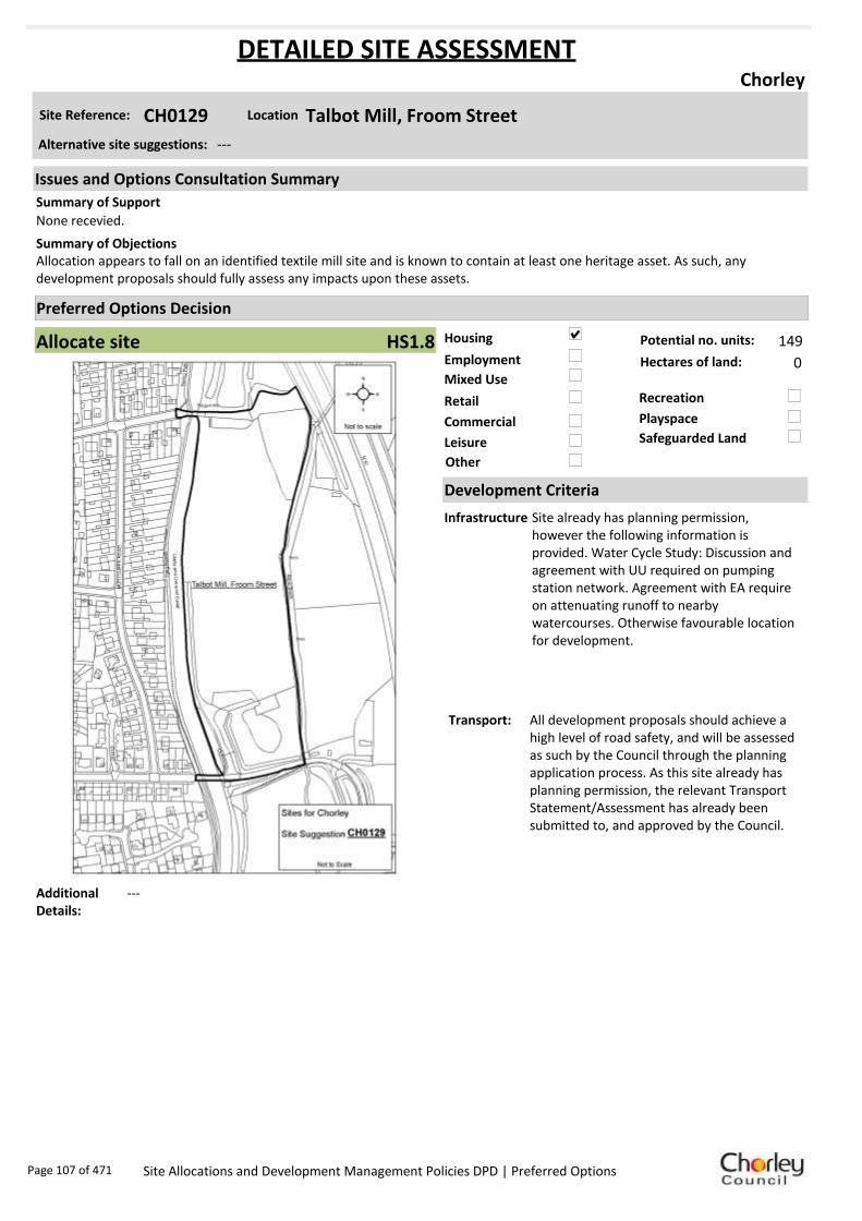
Housing
Employment
Mixed Use
Retail
Commercial
Leisure
Recreation
Safeguarded Land
Preferred Options Decision
Allocate site Potential no. units: 149
Hectares of land: 0
Other
Site Reference: CH0129 Talbot Mill, Froom Street
Chorley
None recevied.
Allocation appears to fall on an identified textile mill site and is known to contain at least one heritage asset. As such, any development proposals should fully assess any impacts upon these assets.
Summary of Objections
Summary of Support
Alternative site suggestions: ---
DETAILED SITE ASSESSMENT
Location
Development Criteria
Infrastructure Site already has planning permission, however the following information is provided. Water Cycle Study: Discussion and agreement with UU required on pumping station network. Agreement with EA require on attenuating runoff to nearby watercourses. Otherwise favourable location for development.
Transport: All development proposals should achieve a high level of road safety, and will be assessed as such by the Council through the planning application process. As this site already has planning permission, the relevant Transport Statement/Assessment has already been submitted to, and approved by the Council.
Additional Details:
---
Issues and Options Consultation Summary
Playspace
HS1.8
Page 107 of 471 Site Allocations and Development Management Policies DPD | Preferred Options

Sustainability Appraisal
Site Ref CH0129
Address Talbot Mill, Froom Street, Chorley
SA Obj
Indicator Site Performance SA Comments
S1
Distance to railway station 0 .81 to 1 .6km Social This site has good access to public transport and services are frequent. The site is only 0.81 to 1.6km from the key service centre of Chorley Town centre. The site is 1.61 to 3km from the nearest supermarket although there are local convenience stores in the local area. The site is not close to an A road junction making access to the site poor. Environmental The only identified negative environmental effects in developing this site are is the Grade II Listing within the site and the site is partly within Flood Zone 3 which is a high risk flood zone on the majority of the site. Economic There are no identified negative economic effects in developing this site.
Rail service freque ncy 4 or more/hour/direction Distance to nearest bus stop Up to 0.4km Bus service frequency 2-5 /hour/direction Distance to se rvice centre 0 .81 to 1 .6km Distance to A Road junction 0 .81 to 1 .6km Distance to motorway junction 1 .61 to 3 km Distance to supermarket 0 .81 to 1 .6km Distance to conve nience s tore Up to 0.4km Distance to Post Office Up to 0.4km Distance to Primary School Up to 0.4km Distance to Secondary School 1 .61 to 3 .2km On a cycle route Yes Distance to cycle route Up to 0.4km
S2
Distance to GP surge ry Up to 0.4km Distance to NHS gene ra l hospital Up to 2km Distance to public open space/park Up to 0.4km Distance to local centre Up to 0.4km
EN1
Designation of land Ke y Service Centre Are a of Se paration Outs ide AONB Outs ide SSSI Outs ide Biological/ G eological H eritag e Site Outs ide Agricultural classifica tion None
EN2
Conservation Area Outs ide Ancie nt Monument on site No Regis te re d Park or G arden Outs ide Listed Building on site G rade II Locally Lis te d Building on s ite No
EN3 Curre nt/former land use Brownfield EN4 Flood Zone a re a Part Zone 3
EN5 Contaminated land M edium risk Within 3km of a congestion spot Yes
EC1 Distance to employment site 0 .81 to 1 .2km Access to Broadband Yes
EC2 Distance to furthe r/higher education 1 .61 to 3 .2km
Del
iver
abili
ty
Indi
cato
rs
Access to sewer system
Yes
Is the site deliverable: Yes Access to wa te r
Access to ga s
Access to e lectricity
Exis ting road access
At risk from hazardous installations No
Overall Site Performance
Band Spe ctrum:
Overall Band:
B
Page 108 of 471 Site Allocations and Development Management Policies DPD | Preferred Options
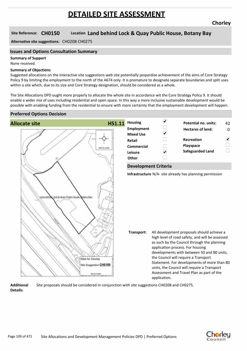
Housing
Employment
Mixed Use
Retail
Commercial
Leisure
Recreation
Safeguarded Land
Preferred Options Decision
Allocate site Potential no. units: 42
Hectares of land: 0
Other
Site Reference: CH0150 Land behind Lock & Quay Public House, Botany Bay
Chorley
None received.
Suggested allocations on the interactive site suggestions web site potentially jeopardise achievement of the aims of Core Strategy Policy 9 by limiting the employment to the north of the A674 only. It is premature to designate separate boundaries and split uses within a site which, due to its size and Core Strategy designation, should be considered as a whole.
The Site Allocations DPD ought more properly to allocate the whole site in accordance wit the Core Strategy Policy 9. It should enable a wider mix of uses including residential and open space. In this way a more inclusive sustainable development would be possible with enabling funding from the residential to ensure with more certainty that the employment development will happen.
Summary of Objections
Summary of Support
Alternative site suggestions: CH0208 CH0275
DETAILED SITE ASSESSMENT
Location
Development Criteria
Infrastructure N/A- site already has planning permission
Transport: All development proposals should achieve a high level of road safety, and will be assessed as such by the Council through the planning application process. For housing developments with between 50 and 80 units, the Council will require a Transport Statement. For developments of more than 80 units, the Council will require a Transport Assessment and Travel Plan as part of the application.
Additional Details:
Site proposals should be considered in conjunction with site suggestions CH0208 and CH0275.
Issues and Options Consultation Summary
Playspace
HS1.11
Page 109 of 471 Site Allocations and Development Management Policies DPD | Preferred Options

Sustainability Appraisal
Site Ref CH0150
Address Land behind Lock & Quay Public House, Botany Bay, Chorley
SA Obj
Indicator Site Performance SA Comments
S1
Distance to railway station 1 .61 to 2 .4km Social The site has very good access to public transport with frequent bus services. The site is close to all services and facilities and there are no identified negative social effects in developing this site. Environmental There are no identified negative environmental effects in developing this site. Economic There are no identified negative economic effects in developing this site.
Rail service freque ncy 4 or more/hour/direction Distance to nearest bus stop Up to 0.4km Bus service frequency 2-5 /hour/direction Distance to se rvice centre 0 .81 to 1 .6km Distance to A Road junction 0 .81 to 1 .6km Distance to motorway junction 1 .61 to 3 km Distance to supermarket 0 .81 to 1 .6km Distance to conve nience s tore 0 .41 to 0 .8km Distance to Post Office 0 .41 to 0 .8km Distance to Primary School Up to 0.4km Distance to Secondary School 0 .81 to 1 .6km On a cycle route Yes Distance to cycle route Up to 0.4km
S2
Distance to GP surge ry 0 .41 to 0 .8km Distance to NHS gene ra l hospital Up to 2km Distance to public open space/park Up to 0.4km Distance to local centre 0 .41 to 0 .8km
EN1
Designation of land Ke y Service Centre Are a of Se paration Outs ide AONB Outs ide SSSI Outs ide Biological/ G eological H eritag e Site Outs ide Agricultural classifica tion None
EN2
Conservation Area Outs ide Ancie nt Monument on site No Regis te re d Park or G arden Outs ide Listed Building on site No Locally Lis te d Building on s ite No
EN3 Curre nt/former land use Brownfield EN4 Flood Zone a re a All Zone 1
EN5 Contaminated land No risk Within 3km of a congestion spot Yes
EC1 Distance to employment site 0 .81 to 1 .2km Access to Broadband Yes
EC2 Distance to furthe r/higher education 1 .61 to 3 .2km
Del
iver
abili
ty
Indi
cato
rs
Access to sewer system
Yes
Is the site deliverable: Yes Access to wa te r
Access to ga s
Access to e lectricity
Exis ting road access
At risk from hazardous installations No
Overall Site Performance
Band Spe ctrum:
Overall Band:
A
Page 110 of 471 Site Allocations and Development Management Policies DPD | Preferred Options

Housing
Employment
Mixed Use
Retail
Commercial
Leisure
Recreation
Safeguarded Land
Preferred Options Decision
Allocate site Potential no. units: 14
Hectares of land: 0
Other
Site Reference: CH0156 Railway Road
Chorley
None received.
None received.Summary of Objections
Summary of Support
Alternative site suggestions: ---
DETAILED SITE ASSESSMENT
Location
Development Criteria
Infrastructure N/A- site already has planning permission
Transport: All development proposals should achieve a high level of road safety, and will be assessed as such by the Council through the planning application process. As this site already has planning permission, the relevant Transport Statement/Assessment has already been submitted to, and approved by the Council.
Additional Details:
N/A- site already has planning permission
Issues and Options Consultation Summary
Playspace
HS1.20
Page 111 of 471 Site Allocations and Development Management Policies DPD | Preferred Options

Sustainability Appraisal
Site Ref CH0156
Address Railway Road, Chorley
SA Obj
Indicator Site Performance SA Comments
S1
Distance to railway station 0 .81 to 1 .6km Social The only identified negative social effect in developing this site is the site is not on a cycle route, however the site is within 0.4km of a cycle route. The site has very good access to public transport links and all services and facilities. Environmental There are no identified negative environmental effects in developing this site. Economic There are no identified negative economic effects in developing this site.
Rail service freque ncy 4 or more/hour/direction Distance to nearest bus stop Up to 0.4km Bus service frequency 2-5 /hour/direction Distance to se rvice centre Up to 0.8km Distance to A Road junction Up to 0.4km Distance to motorway junction 1 .61 to 3 km Distance to supermarket Up to 0.4km Distance to conve nience s tore Up to 0.4km Distance to Post Office 0 .41 to 0 .8km Distance to Primary School Up to 0.4km Distance to Secondary School Up to 0.8km On a cycle route No Distance to cycle route Up to 0.4km
S2
Distance to GP surge ry 0 .41 to 0 .8km Distance to NHS gene ra l hospital Up to 2km Distance to public open space/park Up to 0.4km Distance to local centre 0 .41 to 0 .8km
EN1
Designation of land Ke y Service Centre Are a of Se paration Outs ide AONB Outs ide SSSI Outs ide Biological/ G eological H eritag e Site Outs ide Agricultural classifica tion None
EN2
Conservation Area Outs ide Ancie nt Monument on site No Regis te re d Park or G arden Outs ide Listed Building on site No Locally Lis te d Building on s ite No
EN3 Curre nt/former land use Brownfield EN4 Flood Zone a re a All Zone 1
EN5 Contaminated land No risk Within 3km of a congestion spot Yes
EC1 Distance to employment site Up to 0.8km Access to Broadband Yes
EC2 Distance to furthe r/higher education 1 .61 to 3 .2km
Del
iver
abili
ty
Indi
cato
rs
Access to sewer system
Yes
Is the site deliverable: Yes Access to wa te r
Access to ga s
Access to e lectricity
Exis ting road access
At risk from hazardous installations No
Overall Site Performance
Band Spe ctrum:
Overall Band:
A
Page 112 of 471 Site Allocations and Development Management Policies DPD | Preferred Options
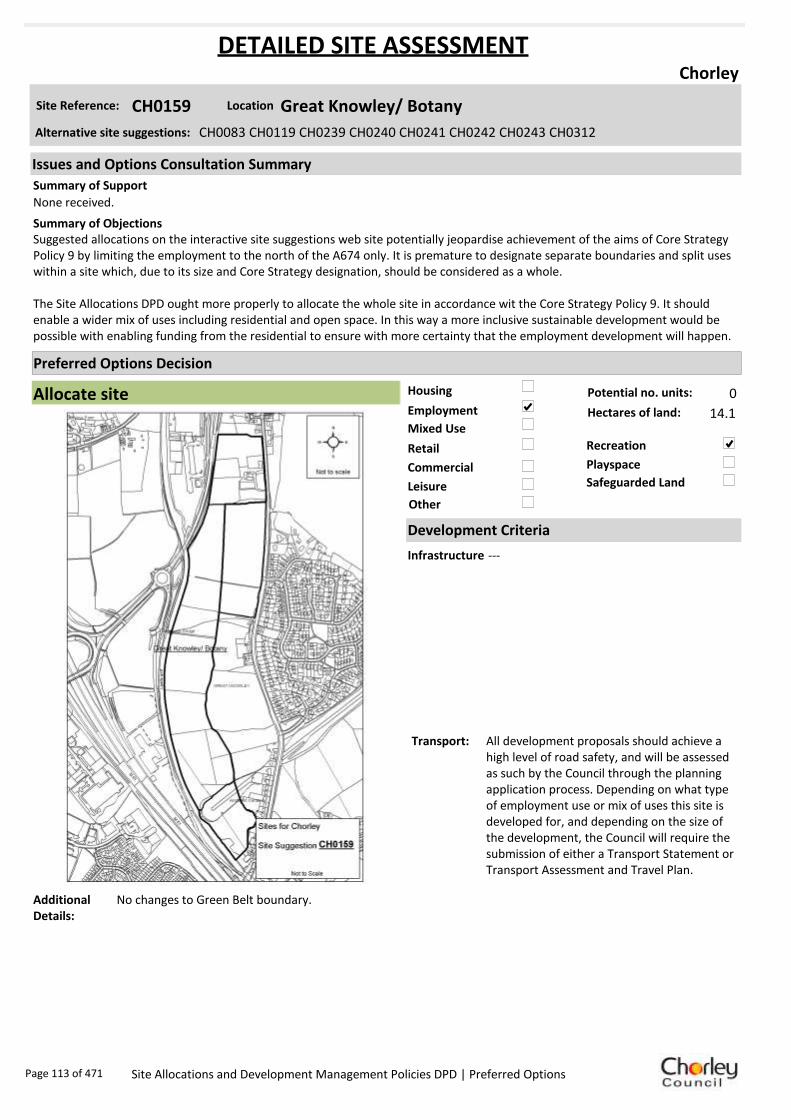
Housing
Employment
Mixed Use
Retail
Commercial
Leisure
Recreation
Safeguarded Land
Preferred Options Decision
Allocate site Potential no. units: 0
Hectares of land: 14.1
Other
Site Reference: CH0159 Great Knowley/ Botany
Chorley
None received.
Suggested allocations on the interactive site suggestions web site potentially jeopardise achievement of the aims of Core Strategy Policy 9 by limiting the employment to the north of the A674 only. It is premature to designate separate boundaries and split uses within a site which, due to its size and Core Strategy designation, should be considered as a whole.
The Site Allocations DPD ought more properly to allocate the whole site in accordance wit the Core Strategy Policy 9. It should enable a wider mix of uses including residential and open space. In this way a more inclusive sustainable development would be possible with enabling funding from the residential to ensure with more certainty that the employment development will happen.
Summary of Objections
Summary of Support
Alternative site suggestions: CH0083 CH0119 CH0239 CH0240 CH0241 CH0242 CH0243 CH0312
DETAILED SITE ASSESSMENT
Location
Development Criteria
Infrastructure ---
Transport: All development proposals should achieve a high level of road safety, and will be assessed as such by the Council through the planning application process. Depending on what type of employment use or mix of uses this site is developed for, and depending on the size of the development, the Council will require the submission of either a Transport Statement or Transport Assessment and Travel Plan.
Additional Details:
No changes to Green Belt boundary.
Issues and Options Consultation Summary
Playspace
Page 113 of 471 Site Allocations and Development Management Policies DPD | Preferred Options

Sustainability Appraisal
Site Ref CH0159
Address Great Knowley, Botany, Chorley
SA Obj
Indicator Site Performance SA Comments
S1
Distance to railway station 2.41 to 3km Social This site has poor access to public transport. It is in close proximity to a bus stop although services are less than hourly. The nearest railway station is 2.41 to3km away. The site has good road access and is less than 0.4km from an A road junction and junction 8 of the M61. The site does not have good access to local services and facilities. Environmental The only identified negative effect of developing this site is that it is a Greenfield site. Economic There are no identified negative effects in developing this site.
Rail service frequency 4 or more/hour/direction Distance to nearest bus stop Up to 0.4km Bus service frequency Less than 1/hour/direction Distance to service centre 1.61 to 2.4km Distance to A Road junction Up to 0.4km Distance to motorway junction Up to 1.6km Distance to supermarket 1.61 to 3km Distance to convenience store 0.81 to 1.2km Distance to Post Office 1.21 to 1.6km Distance to Primary School 0.41 to 0.8km Distance to Secondary School 1.61 to 3.2km On a cycle route Yes Distance to cycle route Up to 0.4km
S2
Distance to GP surgery 0.81 to 1.6km Distance to NHS general hospital Up to 2km Distance to public open space/park Up to 0.4km Distance to local centre 1.21 to 1.6km
EN1
Designation of land Key Service Centre Area of Separation Outside AONB Outside SSSI Outside Biological/ Geological Heritage Site Outside Agricultural classification 3
EN2
Conservation Area Outside Ancient Monument on site No Registered Park or Garden Outside Listed Building on site No Locally Listed Building on site No
EN3 Current/former land use Greenfield EN4 Flood Zone area All Zone 1
EN5 Contaminated land No risk Within 3km of a congestion spot Yes
EC1 Distance to employment site Up to 0.8km Access to Broadband Yes
EC2 Distance to further/higher education 1.61 to 3.2km
Del
iver
abili
ty
Indi
cato
rs
Access to sewer system
Yes
Is the site deliverable: Yes Access to water
Access to gas Access to electricity Existing road access At risk from hazardous installations No
Overall Site Performance Band Spectrum:
Overall Band:
C
Page 114 of 471 Site Allocations and Development Management Policies DPD | Preferred Options

Housing
Employment
Mixed Use
Retail
Commercial
Leisure
Recreation
Safeguarded Land
Preferred Options Decision
Allocate site Potential no. units: 63
Hectares of land: 0
Other
Site Reference: CH0162 Cowling Mill, Cowling Brow
Chorley
Housing development should be within existing mill to retain the character of the building.
Suggestion appears to fall on an identified textile mill site and is known to contain at least one heritage asset. As such, impact assessments should be undertaken before any development occurs.
Summary of Objections
Summary of Support
Alternative site suggestions: ---
DETAILED SITE ASSESSMENT
Location
Development Criteria
Infrastructure Water Cycle Study: Site specific Flood Risk Assessment required. Sequential approach to site design required. Discussion and agreement with UU required on pumping station to network. Agreement with EA require on attenuating runoff to nearby watercourses.
Transport: All development proposals should achieve a high level of road safety, and will be assessed as such by the Council through the planning application process. For housing developments with between 50 and 80 units, the Council will require a Transport Statement. For developments of more than 80 units, the Council will require a Transport Assessment and Travel Plan as part of the application.
Additional Details:
---
Issues and Options Consultation Summary
Playspace
HS1.5
Page 115 of 471 Site Allocations and Development Management Policies DPD | Preferred Options

Sustainability Appraisal
Site Ref CH0162
Address Cowling Mill, Cowling Brow, Chorley
SA Obj
Indicator Site Performance SA Comments
S1
Distance to railway station 0 .81 to 1 .6km Social This site has good access to public transport with frequent bus and rail services. Access to services and facilities is good although the site is over 3km from a motorway junction. The site is close to the key service centre of Chorley. Environmental The site is located partly within flood zone 3 which is a high risk flood zone. Mitigation measures would be required for any residential use on site. The site is also at medium risk of land contamination. Economic There are no identified negative economic effects in developing this site.
Rail service freque ncy 4 or more/hour/direction Distance to nearest bus stop Up to 0.4km Bus service frequency 2-5 /hour/direction Distance to se rvice centre 0 .81 to 1 .6km Distance to A Road junction 0 .81 to 1 .6km Distance to motorway junction Over 3km Distance to supermarket 0 .81 to 1 .6km Distance to conve nience s tore Up to 0.4km Distance to Post Office 0 .81 to 1 .2km Distance to Primary School 0 .41 to 0 .8km Distance to Secondary School 0 .81 to 1 .6km On a cycle route No Distance to cycle route Up to 0.4km
S2
Distance to GP surge ry 0 .81 to 1 .6km Distance to NHS gene ra l hospital 2.1 to 5 km Distance to public open space/park Up to 0.4km Distance to local centre 0 .81 to 1 .2km
EN1
Designation of land Ke y Service Centre Are a of Se paration Outs ide AONB Outs ide SSSI Outs ide Biological/ G eological H eritag e Site Outs ide Agricultural classifica tion None
EN2
Conservation Area Outs ide Ancie nt Monument on site No Regis te re d Park or G arden Outs ide Listed Building on site No Locally Lis te d Building on s ite No
EN3 Curre nt/former land use Brownfield EN4 Flood Zone a re a Part Zone 3
EN5 Contaminated land M edium risk Within 3km of a congestion spot Yes
EC1 Distance to employment site Up to 0.8km Access to Broadband Yes
EC2 Distance to furthe r/higher education 1 .61 to 3 .2km
Del
iver
abili
ty
Indi
cato
rs
Access to sewer system
Yes
Is the site deliverable: Yes Access to wa te r
Access to ga s
Access to e lectricity
Exis ting road access
At risk from hazardous installations No
Overall Site Performance
Band Spe ctrum:
Overall Band:
B
Page 116 of 471 Site Allocations and Development Management Policies DPD | Preferred Options

Housing
Employment
Mixed Use
Retail
Commercial
Leisure
Recreation
Safeguarded Land
Preferred Options Decision
Do not allocate Potential no. units: 0
Hectares of land: 0
Other
Site Reference: CH0164 FDC (Holdings) Ltd & Ferax Premises, Moorland Gate, Cowli
Chorley
None received.
Request the site to remain as open space/ grazing land.Summary of Objections
Summary of Support
Alternative site suggestions: ---
DETAILED SITE ASSESSMENT
Location
Development Criteria
Infrastructure N/A- proposed not to allocate this site
Transport: N/A- proposed not to allocate this site
Additional Details:
Other urban, in active employment use. Employment use will be protected as per Core Strategy.
Issues and Options Consultation Summary
Playspace
Page 117 of 471 Site Allocations and Development Management Policies DPD | Preferred Options

Sustainability Appraisal
Site Ref CH0164
Address FDC (Holdings) Ltd & Ferax Premises, Moorland Gate, Cowling Brow, Chorley
SA Obj
Indicator Site Performance SA Comments
S1
Distance to railway station 1 .61 to 2 .4km Social This site has good access to public transport although bus services are poor and the nearest railway station is 1.61 to 2.4km away. The site has poor access to the road network although there is good access to local services and facilities with the exception of a GP surgery which is 1.61 to 3km away. Environmental The only identified negative environmental effect in developing this site is the medium risk of land contamination which will need to be addressed through mitigation measures. Economic There are on identified negative economic effects in developing this site.
Rail service freque ncy 4 or more/hour/direction Distance to nearest bus stop Up to 0.4km Bus service frequency Less than 1/hour/dire ction Distance to se rvice centre 0 .81 to 1 .6km Distance to A Road junction 0 .81 to 1 .6km Distance to motorway junction Over 3km Distance to supermarket 0 .81 to 1 .6km Distance to conve nience s tore 0 .41 to 0 .8km Distance to Post Office 0 .81 to 1 .2km Distance to Primary School 0 .41 to 0 .8km Distance to Secondary School 0 .81 to 1 .6km On a cycle route Yes Distance to cycle route Up to 0.4km
S2
Distance to GP surge ry 1 .61 to 3 km Distance to NHS gene ra l hospital 2.1 to 5 km Distance to public open space/park Up to 0.4km Distance to local centre 0 .81 to 1 .2km
EN1
Designation of land Ke y Service Centre Are a of Se paration Outs ide AONB Outs ide SSSI Outs ide Biological/ G eological H eritag e Site Outs ide Agricultural classifica tion 3
EN2
Conservation Area Outs ide Ancie nt Monument on site No Regis te re d Park or G arden Outs ide Listed Building on site No Locally Lis te d Building on s ite No
EN3 Curre nt/former land use Brownfield EN4 Flood Zone a re a All Zone 1
EN5 Contaminated land M edium risk Within 3km of a congestion spot Yes
EC1 Distance to employment site Up to 0.8km Access to Broadband Yes
EC2 Distance to furthe r/higher education 3 .21 to 5 km
Del
iver
abili
ty
Indi
cato
rs
Access to sewer system
Yes
Is the site deliverable: Yes Access to wa te r
Access to ga s
Access to e lectricity Exis ting road access
At risk from hazardous installations No
Overall Site Performance
Band Spe ctrum:
Overall Band:
B
Page 118 of 471 Site Allocations and Development Management Policies DPD | Preferred Options

Housing
Employment
Mixed Use
Retail
Commercial
Leisure
Recreation
Safeguarded Land
Preferred Options Decision
Allocate site Potential no. units: 79
Hectares of land: 0
Other
Site Reference: CH0173 Eaves Green, off Lower Burgh Lane
Chorley
HCA supports Taylor Wimpey and promotes this site for residential development with small scale employment opportunities. The site is considered to be available, suitable and achievable and therefore deliverable for housing (approx 250 dwellings). Contribute 30% affordable either through on-site delivery or off-site contribution.
Development would significantly encroach into the Yarrow Valley Park area and reduce wildlife corridors. This area must retain an adequate ‘buffer zone’. Core Strategy objective is to protect, enhance and safeguard biological and environmental assets.
Summary of Objections
Summary of Support
Alternative site suggestions: ---
DETAILED SITE ASSESSMENT
Location
Development Criteria
Infrastructure Water Cycle Study: Discussion and agreement with UU required on pumping station network. Agreement with EA require on attenuating runoff to nearby watercourses. Otherwise favourable location for development.
Transport: All development proposals should achieve a high level of road safety, and will be assessed as such by the Council through the planning application process. For housing developments with between 50 and 80 units, the Council will require a Transport Statement. For developments of more than 80 units, the Council will require a Transport Assessment and Travel Plan as part of the application.
Additional Details:
---
Issues and Options Consultation Summary
Playspace
HS1.1
Page 119 of 471 Site Allocations and Development Management Policies DPD | Preferred Options
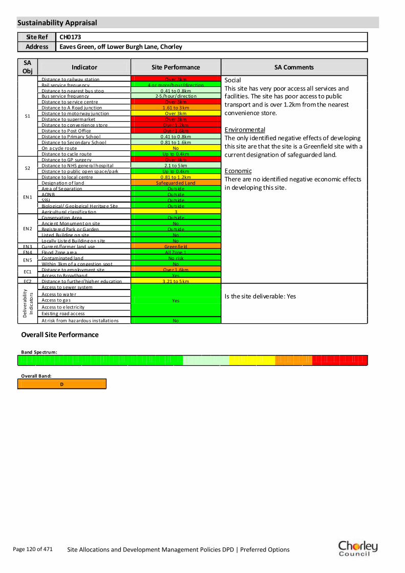
Sustainability Appraisal
Site Ref CH0173
Address Eaves Green, off Lower Burgh Lane, Chorley
SA Obj
Indicator Site Performance SA Comments
S1
Distance to railway station Over 3km Social This site has very poor access all services and facilities. The site has poor access to public transport and is over 1.2km from the nearest convenience store. Environmental The only identified negative effects of developing this site are that the site is a Greenfield site with a current designation of safeguarded land. Economic There are no identified negative economic effects in developing this site.
Rail service freque ncy 4 or more/hour/direction Distance to nearest bus stop 0 .41 to 0 .8km Bus service frequency 2-5 /hour/direction Distance to se rvice centre Over 3km Distance to A Road junction 1 .61 to 3 km Distance to motorway junction Over 3km Distance to supermarket Over 3km Distance to conve nience s tore Ove r 1 .2km Distance to Post Office Ove r 1 .6km Distance to Primary School 0 .41 to 0 .8km Distance to Secondary School 0 .81 to 1 .6km On a cycle route No Distance to cycle route Up to 0.4km
S2
Distance to GP surge ry Over 3km Distance to NHS gene ra l hospital 2.1 to 5 km Distance to public open space/park Up to 0.4km Distance to local centre 0 .81 to 1 .2km
EN1
Designation of land Safeguarded Land Are a of Se paration Outs ide AONB Outs ide SSSI Outs ide Biological/ G eological H eritag e Site Outs ide Agricultural classifica tion 3
EN2
Conservation Area Outs ide Ancie nt Monument on site No Regis te re d Park or G arden Outs ide Listed Building on site No Locally Lis te d Building on s ite No
EN3 Curre nt/former land use Greenfie ld EN4 Flood Zone a re a All Zone 1
EN5 Contaminated land No risk Within 3km of a congestion spot No
EC1 Distance to employment site Ove r 1 .6km Access to Broadband Yes
EC2 Distance to furthe r/higher education 3 .21 to 5 km
Del
iver
abili
ty
Indi
cato
rs
Access to sewer system
Yes
Is the site deliverable: Yes Access to wa te r
Access to ga s
Access to e lectricity
Exis ting road access
At risk from hazardous installations No
Overall Site Performance
Band Spe ctrum:
Overall Band:
D
Page 120 of 471 Site Allocations and Development Management Policies DPD | Preferred Options

Housing
Employment
Mixed Use
Retail
Commercial
Leisure
Recreation
Safeguarded Land
Preferred Options Decision
Allocate site Potential no. units: 135
Hectares of land: 3
Other
Site Reference: CH0174 Chorley Training and Conference Centre, Little Carr Lane
Chorley
None received.
Site known to contain at least one heritage asset. Any development scheme must assess its impact upon known heritage assets.Summary of Objections
Summary of Support
Alternative site suggestions: ---
DETAILED SITE ASSESSMENT
Location
Development Criteria
Infrastructure N/A- site already has planning permission
Transport: All development proposals should achieve a high level of road safety, and will be assessed as such by the Council through the planning application process. As this site already has planning permission, the relevant Transport Statement/Assessment has already been submitted to, and approved by the Council.
Additional Details:
N/A- site already has planning permission
Issues and Options Consultation Summary
Playspace
HS1.2; EP1.4
Page 121 of 471 Site Allocations and Development Management Policies DPD | Preferred Options

Sustainability Appraisal
Site Ref CH0174
Address Chorley Conference and Training Centre, Little Car Lane, Chorley
SA Obj
Indicator Site Performance SA Comments
S1
Distance to railway station 1 .61 to 2 .4km Social This site has good access to public transport with bus services 6 or more times per hour. The site is 0.81 to 1.6km from the key service centre of Chorley Town centre. The site has good access to services and facilities with the exception of a post office which is 1.21 to 1.6km away. Environmental The only identified negative effect in developing this site is the medium risk of contaminated land. The site is also partly within flood zone 3 but this is to the very south of the site just past the site boundary. Economic There are no identified negative economic effects in developing this site.
Rail service freque ncy 4 or more/hour/direction Distance to nearest bus stop Up to 0.4km Bus service frequency 6 or more/hour/direction Distance to se rvice centre 0 .81 to 1 .6km Distance to A Road junction 0 .41 to 0 .8km Distance to motorway junction Over 3km Distance to supermarket 0 .81 to 1 .6km Distance to conve nience s tore Up to 0.4km Distance to Post Office 1 .21 to 1 .6km Distance to Primary School 0 .41 to 0 .8km Distance to Secondary School Up to 0.8km On a cycle route No Distance to cycle route Up to 0.4km
S2
Distance to GP surge ry 1 .61 to 3 km Distance to NHS gene ra l hospital 2.1 to 5 km Distance to public open space/park Up to 0.4km Distance to local centre 0 .41 to 0 .8km
EN1
Designation of land Ke y Service Centre Are a of Se paration Outs ide AONB Outs ide SSSI Outs ide Biological/ G eological H eritag e Site Outs ide Agricultural classifica tion 3
EN2
Conservation Area Outs ide Ancie nt Monument on site No Regis te re d Park or G arden Outs ide Listed Building on site No Locally Lis te d Building on s ite No
EN3 Curre nt/former land use Brownfield EN4 Flood Zone a re a Part Zone 3
EN5 Contaminated land M edium risk Within 3km of a congestion spot No
EC1 Distance to employment site 1 .21 to 1 .6km Access to Broadband Yes
EC2 Distance to furthe r/higher education 3 .21 to 5 km
Del
iver
abili
ty
Indi
cato
rs
Access to sewer system
Yes
Is the site deliverable: Yes Access to wa te r
Access to ga s
Access to e lectricity
Exis ting road access
At risk from hazardous installations No
Overall Site Performance
Band Spe ctrum:
Overall Band:
B
Page 122 of 471 Site Allocations and Development Management Policies DPD | Preferred Options

Housing
Employment
Mixed Use
Retail
Commercial
Leisure
Recreation
Safeguarded Land
Preferred Options Decision
Do not allocate Potential no. units: 0
Hectares of land: 0
Other
Site Reference: CH0185 Yarrow Mill, Yarrow Road
Chorley
None received.
Suggestion appears to fall on an identified textile mill site and is known to contain at least one heritage asset. Any development proposals would need to fully assess potential impacts upon these assets.
Summary of Objections
Summary of Support
Alternative site suggestions: ---
DETAILED SITE ASSESSMENT
Location
Development Criteria
Infrastructure N/A- proposed not to allocate site
Transport: N/A- proposed not to allocate site
Additional Details:
'Other urban', in active use. Employment use will be protected as per the Core Strategy.
Issues and Options Consultation Summary
Playspace
Page 123 of 471 Site Allocations and Development Management Policies DPD | Preferred Options

Sustainability Appraisal
Site Ref CH0185
Address Yarrow Mill, Yarrow Road, Chorley
SA Obj
Indicator Site Performance SA Comments
S1
Distance to railway station 0 .81 to 1 .6km Social The site has good access to public transport with frequent bus and rail services close to the site. Access to services and facilities is also very good with the exception of the motorway junction over 3km away. Environmental The only identified negative environment effect in developing this site is the medium risk of contamination which will need to be addressed through appropriate mitigation measures. Economic There are no identified negative economic effects in developing this site.
Rail service freque ncy 4 or more/hour/direction Distance to nearest bus stop Up to 0.4km Bus service frequency 2-5 /hour/direction Distance to se rvice centre 0 .81 to 1 .6km Distance to A Road junction 0 .81 to 1 .6km Distance to motorway junction Over 3km Distance to supermarket 0 .81 to 1 .6km Distance to conve nience s tore Up to 0.4km Distance to Post Office 0 .81 to 1 .2km Distance to Primary School 0 .41 to 0 .8km Distance to Secondary School Up to 0.8km On a cycle route Yes Distance to cycle route Up to 0.4km
S2
Distance to GP surge ry 0 .81 to 1 .6km Distance to NHS gene ra l hospital 2.1 to 5 km Distance to public open space/park Up to 0.4km Distance to local centre 0 .81 to 1 .2km
EN1
Designation of land Ke y Service Centre Are a of Se paration Outs ide AONB Outs ide SSSI Outs ide Biological/ G eological H eritag e Site Outs ide Agricultural classifica tion None
EN2
Conservation Area Outs ide Ancie nt Monument on site No Regis te re d Park or G arden Outs ide Listed Building on site No Locally Lis te d Building on s ite No
EN3 Curre nt/former land use Brownfield EN4 Flood Zone a re a All Zone 1
EN5 Contaminated land M edium risk Within 3km of a congestion spot Yes
EC1 Distance to employment site Up to 0.8km Access to Broadband Yes
EC2 Distance to furthe r/higher education 1 .61 to 3 .2km
Del
iver
abili
ty
Indi
cato
rs
Access to sewer system
Yes
Is the site deliverable: Yes Access to wa te r
Access to ga s
Access to e lectricity
Exis ting road access
At risk from hazardous installations No
Overall Site Performance
Band Spe ctrum:
Overall Band:
B
Page 124 of 471 Site Allocations and Development Management Policies DPD | Preferred Options
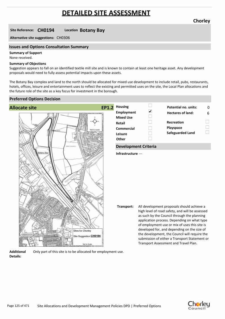
Housing
Employment
Mixed Use
Retail
Commercial
Leisure
Recreation
Safeguarded Land
Preferred Options Decision
Allocate site Potential no. units: 0
Hectares of land: 6
Other
Site Reference: CH0194 Botany Bay
Chorley
None received.
Suggestion appears to fall on an identified textile mill site and is known to contain at least one heritage asset. Any development proposals would need to fully assess potential impacts upon these assets.
The Botany Bay complex and land to the north should be allocated for mixed use development to include retail, pubs, restaurants, hotels, offices, leisure and entertainment uses to reflect the existing and permitted uses on the site, the Local Plan allocations and the future role of the site as a key focus for investment in the borough.
Summary of Objections
Summary of Support
Alternative site suggestions: CH0306
DETAILED SITE ASSESSMENT
Location
Development Criteria
Infrastructure ---
Transport: All development proposals should achieve a high level of road safety, and will be assessed as such by the Council through the planning application process. Depending on what type of employment use or mix of uses this site is developed for, and depending on the size of the development, the Council will require the submission of either a Transport Statement or Transport Assessment and Travel Plan.
Additional Details:
Only part of this site is to be allocated for employment use.
Issues and Options Consultation Summary
Playspace
EP1.2
Page 125 of 471 Site Allocations and Development Management Policies DPD | Preferred Options

Sustainability Appraisal
Site Ref CH0194
Address Botany Bay, Chorley
SA Obj
Indicator Site Performance SA Comments
S1
Distance to railway station 2 .41 to 3 km Social This site has good access to frequent bus services however the site is 2.41 to 3km away from the nearest railway station. The site has very good road access and is in close proximity to both an A road junction and junction 8 of the M61 motorway. The site has poor access to a supermarket however the key service centre of Chorley is 1.61 to 2.4km away. Environmental The only identified negative effect in developing this site is the medium risk of contamination within the site. Economic There are no identified negative effects in developing this site.
Rail service freque ncy 4 or more/hour/direction Distance to nearest bus stop 0 .41 to 0 .8km Bus service frequency 6 or more/hour/direction Distance to se rvice centre 1 .61 to 2 .4km Distance to A Road junction Up to 0.4km Distance to motorway junction Up to 1.6km Distance to supermarket 1 .61 to 3 km Distance to conve nience s tore 0 .41 to 0 .8km Distance to Post Office 0 .41 to 0 .8km Distance to Primary School 0 .41 to 0 .8km Distance to Secondary School 1 .61 to 3 .2km On a cycle route Yes Distance to cycle route Up to 0.4km
S2
Distance to GP surge ry 0 .41 to 0 .8km Distance to NHS gene ra l hospital Up to 2km Distance to public open space/park Up to 0.4km Distance to local centre 0 .41 to 0 .8km
EN1
Designation of land Ke y Service Centre Are a of Se paration Outs ide AONB Outs ide SSSI Outs ide Biological/ G eological H eritag e Site Outs ide Agricultural classifica tion 3
EN2
Conservation Area Outs ide Ancie nt Monument on site No Regis te re d Park or G arden Outs ide Listed Building on site No Locally Lis te d Building on s ite No
EN3 Curre nt/former land use Brownfield EN4 Flood Zone a re a All Zone 1
EN5 Contaminated land M edium risk Within 3km of a congestion spot Yes
EC1 Distance to employment site Up to 0.8km Access to Broadband Yes
EC2 Distance to furthe r/higher education 1 .61 to 3 .2km
Del
iver
abili
ty
Indi
cato
rs
Access to sewer system
Yes
Is the site deliverable: Yes Access to wa te r
Access to ga s
Access to e lectricity
Exis ting road access
At risk from hazardous installations No
Overall Site Performance
Band Spe ctrum:
Overall Band:
B
Page 126 of 471 Site Allocations and Development Management Policies DPD | Preferred Options
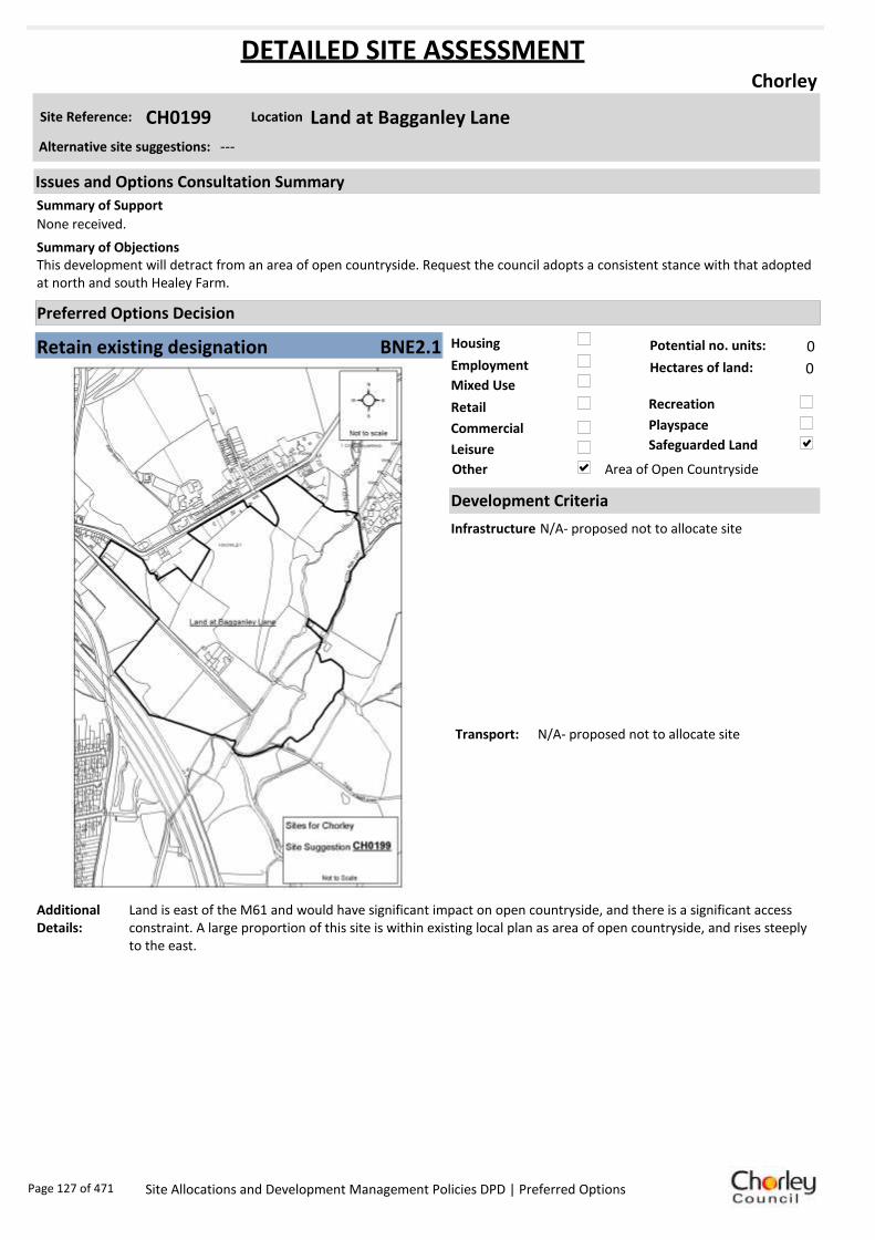
Housing
Employment
Mixed Use
Retail
Commercial
Leisure
Recreation
Safeguarded Land
Preferred Options Decision
Retain existing designation Potential no. units: 0
Hectares of land: 0
Other Area of Open Countryside
Site Reference: CH0199 Land at Bagganley Lane
Chorley
None received.
This development will detract from an area of open countryside. Request the council adopts a consistent stance with that adopted at north and south Healey Farm.
Summary of Objections
Summary of Support
Alternative site suggestions: ---
DETAILED SITE ASSESSMENT
Location
Development Criteria
Infrastructure N/A- proposed not to allocate site
Transport: N/A- proposed not to allocate site
Additional Details:
Land is east of the M61 and would have significant impact on open countryside, and there is a significant access constraint. A large proportion of this site is within existing local plan as area of open countryside, and rises steeply to the east.
Issues and Options Consultation Summary
Playspace
BNE2.1
Page 127 of 471 Site Allocations and Development Management Policies DPD | Preferred Options

Sustainability Appraisal
Site Ref CH0199
Address Land at Bagganley Lane, Chorley
SA Obj
Indicator Site Performance SA Comments
S1
Distance to railway station 1 .61 to 2.4km Social The site has good access to public transport although the railway station is 1.61 to 2.4km away. The site has good access to local services and facilities. Environmental The site is currently Greenfield open countryside partly within flood zone 3 with a medium risk of contamination. Major mitigation measure would be required in order for the site to be environmentally sustainable. Economic There are no identified negative economic effects in developing this site.
Rail service freque ncy 4 or more/hour/direction Distance to nearest bus stop Up to 0.4 km Bus service frequency 2-5/hour/direction Distance to se rvice centre 0 .81 to 1.6km Distance to A Road junction 0 .81 to 1.6km Distance to motorway junction 1.61 to 3km Distance to supermarket 0 .81 to 1.6km Distance to conve nience s tore 0 .41 to 0.8km Distance to Post Office 0 .41 to 0.8km Distance to Primary School 0 .41 to 0.8km Distance to Secondary School 1 .61 to 3.2km On a cycle route Ye s Distance to cycle route Up to 0.4 km
S2
Distance to GP surge ry 0 .41 to 0.8km Distance to NHS gene ra l hospital Up to 2km Distance to public open space/park Up to 0.4 km Distance to local centre 0 .41 to 0.8km
EN1
Designation of land Safe guarde d Land/Open Countryside Are a of Se paration Outs ide AONB Outs ide SSSI Outs ide Biological/ G eological H eritag e Site Outs ide Agricultural classifica tion None
EN2
Conservation Area Outs ide Ancie nt Monument on site No Regis te re d Park or G arden Outs ide Listed Building on site No Locally Lis te d Building on s ite No
EN3 Curre nt/former land use Gree nfield EN4 Flood Zone a re a Part Zone 3
EN5 Contaminated land Medium risk Within 3km of a congestion spot Ye s
EC1 Distance to employment site 1 .21 to 1.6km Access to Broadband Ye s
EC2 Distance to furthe r/higher education 1 .61 to 3.2km
Del
iver
abili
ty
Indi
cato
rs
Access to sewer system
Ye s
Is the site deliverable: Yes Access to wa te r
Access to ga s
Access to e lectricity
Exis ting road access
At risk from hazardous installations No
Overall Site Performance
Band Spe ctrum:
Overall Band:
B
Page 128 of 471 Site Allocations and Development Management Policies DPD | Preferred Options

Housing
Employment
Mixed Use
Retail
Commercial
Leisure
Recreation
Safeguarded Land
Preferred Options Decision
Allocate site Potential no. units: 0
Hectares of land: 7
Other
Site Reference: CH0202 Land to North East of M61 Junction
Chorley
The suggested employment use would enable the development of a most strategically located and currently safeguarded site at junction 8 of M61, for employment purposes to meet development needs to 2026.
Redesignate the site for public open space/ recreational use.Summary of Objections
Summary of Support
Alternative site suggestions: ---
DETAILED SITE ASSESSMENT
Location
Development Criteria
Infrastructure --
Transport: All development proposals should achieve a high level of road safety, and will be assessed as such by the Council through the planning application process. Depending on what type of employment use or mix of uses this site is developed for, and depending on the size of the development, the Council will require the submission of either a Transport Statement or Transport Assessment and Travel Plan.
Additional Details:
---
Issues and Options Consultation Summary
Playspace
EP1.3
Page 129 of 471 Site Allocations and Development Management Policies DPD | Preferred Options

Sustainability Appraisal
Site Ref CH0202
Address Land to North East of M61 Junction, Chorley
SA Obj
Indicator Site Performance SA Comments
S1
Distance to railway station 2 .41 to 3 km Social This site has very good access to the road network and is in close proximity to junction 8 of the M61. The site has good access to some services and facilities with the exception of a local convenience store which is over 1.2km away. The site also has good access to public transport. Environmental The only identified negative environmental effects in developing this site is the site is Greenfield with a current designation of safeguarded land. Economic There are no identified negative economic effects in developing this site.
Rail service freque ncy 4 or more/hour/direction Distance to nearest bus stop 0 .41 to 0 .8km Bus service frequency 6 or more/hour/direction Distance to se rvice centre 1 .61 to 2 .4km Distance to A Road junction Up to 0.4km Distance to motorway junction Up to 1.6km Distance to supermarket 1 .61 to 3 km Distance to conve nience s tore Ove r 1 .2km Distance to Post Office 0 .81 to 1 .2km Distance to Primary School 0 .81 to 1 .6km Distance to Secondary School 1 .61 to 3 .2km On a cycle route Yes Distance to cycle route Up to 0.4km
S2
Distance to GP surge ry 1 .61 to 3 km Distance to NHS gene ra l hospital Up to 2km Distance to public open space/park 0 .41 to 0 .8km Distance to local centre Ove r 1 .6km
EN1
Designation of land Safeguarded Land Are a of Se paration Outs ide AONB Outs ide SSSI Outs ide Biological/ G eological H eritag e Site Outs ide Agricultural classifica tion 3
EN2
Conservation Area Outs ide Ancie nt Monument on site No Regis te re d Park or G arden Outs ide Listed Building on site No Locally Lis te d Building on s ite No
EN3 Curre nt/former land use Greenfie ld EN4 Flood Zone a re a All Zone 1
EN5 Contaminated land No risk Within 3km of a congestion spot Yes
EC1 Distance to employment site Up to 0.8km Access to Broadband Yes
EC2 Distance to furthe r/higher education 1 .61 to 3 .2km
Del
iver
abili
ty
Indi
cato
rs
Access to sewer system
Yes
Is the site deliverable: Yes Access to wa te r
Access to ga s
Access to e lectricity
Exis ting road access
At risk from hazardous installations No
Overall Site Performance
Band Spe ctrum:
Overall Band:
C
Page 130 of 471 Site Allocations and Development Management Policies DPD | Preferred Options
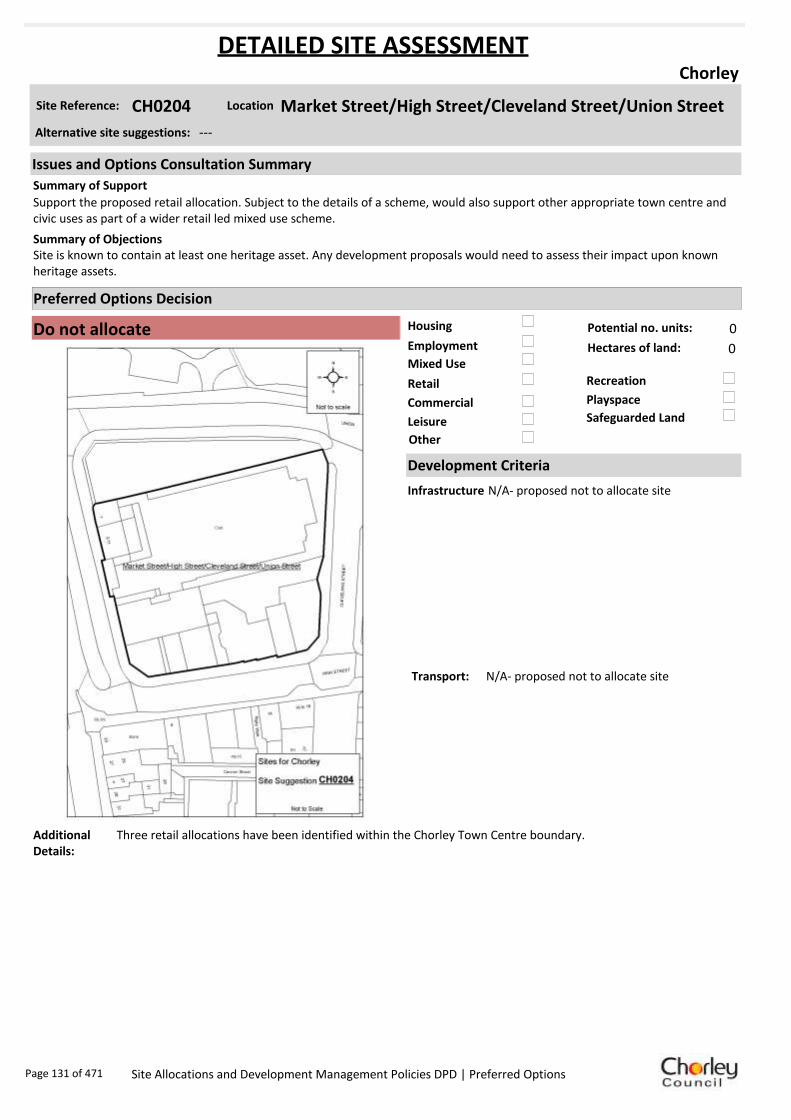
Housing
Employment
Mixed Use
Retail
Commercial
Leisure
Recreation
Safeguarded Land
Preferred Options Decision
Do not allocate Potential no. units: 0
Hectares of land: 0
Other
Site Reference: CH0204 Market Street/High Street/Cleveland Street/Union Street
Chorley
Support the proposed retail allocation. Subject to the details of a scheme, would also support other appropriate town centre and civic uses as part of a wider retail led mixed use scheme.
Site is known to contain at least one heritage asset. Any development proposals would need to assess their impact upon known heritage assets.
Summary of Objections
Summary of Support
Alternative site suggestions: ---
DETAILED SITE ASSESSMENT
Location
Development Criteria
Infrastructure N/A- proposed not to allocate site
Transport: N/A- proposed not to allocate site
Additional Details:
Three retail allocations have been identified within the Chorley Town Centre boundary.
Issues and Options Consultation Summary
Playspace
Page 131 of 471 Site Allocations and Development Management Policies DPD | Preferred Options

Sustainability Appraisal
Key + Minor positive ++ Major positive - Minor negative -- Major negative 0 Neutral / No link
Site Ref CH0204
Address Market Street/High Street/Cleveland Street/Union Street, Chorley
SA Objective
SA Effects
Comments Short term
Medium term
Long term
S1 + + +
The site is located within 300m of the bus station and within 450m of the train station therefore it has good public transport access. It is in close proximity to Market Walk therefore if developed for retail it is likely that people would walk between this site and Market Walk.
S2 0 0 0 Allocating this site for retail development would have little impact on improving health and wellbeing.
S3 0 0 0 Allocating this site for retail development would have little impact on crime. This would need to be taken into account in the design of any development on the site.
S4 / / / There is no link between allocating this site for retail development and improving access to housing.
EN1 / / / There is no link between allocating this site for retail development and managing biodiversity and landscape character.
EN2 / / / There is no link between allocating this site for retail development and protecting and enhancing heritage.
EN3 + + +
Allocating this site for retail development would have a positive impact on tackling climate change due to its good public transport access and proximity to Market Walk. The site is also previously developed so redevelopment of the site would enable the re-use of land and resources.
EN4 / / / There is no link between allocating this site for retail development and managing flood risk.
EN5 + + + Allocating this site for retail development would help minimise air pollution due to its good public transport access.
EC1 + + + Retail development on the site would lead to the creation of jobs in a sustainable location.
EC2 / / / There is no link between allocating this site for retail development and improving skills.
EC3 / / / There is no link between allocating this site for retail development and the rural economy.
EC4 + + + Allocating the site for retail development would enable the provision of additional retail and related services in the town centre.
Comments The site has good access to public transport and is in close proximity to Market Walk which would encourage people to walk to the site. The site could accommodate a reasonably sized retail development which would help increase the retail offer of the town centre and create a large number of jobs.
Page 132 of 471 Site Allocations and Development Management Policies DPD | Preferred Options

Housing
Employment
Mixed Use
Retail
Commercial
Leisure
Recreation
Safeguarded Land
Preferred Options Decision
Allocate site Potential no. units: 59
Hectares of land: 0
Other
Site Reference: CH0206 Land off Quarry Road
Chorley
None received.
None received.Summary of Objections
Summary of Support
Alternative site suggestions: CH0112
DETAILED SITE ASSESSMENT
Location
Development Criteria
Infrastructure N/A- site is already under construction
Transport: All development proposals should achieve a high level of road safety, and will be assessed as such by the Council through the planning application process. As this site is already under construction, the relevant Transport Statement/Assessment has already been submitted to, and approved by the Council.
Additional Details:
Site proposals should be considered in conjunction with site suggestion CH0112.
Issues and Options Consultation Summary
Playspace
HS1.4
Page 133 of 471 Site Allocations and Development Management Policies DPD | Preferred Options

Sustainability Appraisal
Site Ref CH0206
Address Land off Quarry Road, Chorley
SA Obj
Indicator Site Performance SA Comments
S1
Distance to railway station 0 .81 to 1 .6km This site has been given planning permission and is under construction.
Rail service freque ncy 4 or more/hour/direction Distance to nearest bus stop Up to 0.4km Bus service frequency 2-5 /hour/direction Distance to se rvice centre Up to 0.8km Distance to A Road junction 0 .81 to 1 .6km Distance to motorway junction Over 3km Distance to supermarket 0 .81 to 1 .6km Distance to conve nience s tore Up to 0.4km Distance to Post Office 0 .81 to 1 .2km Distance to Primary School Up to 0.4km Distance to Secondary School Up to 0.8km On a cycle route No Distance to cycle route Up to 0.4km
S2
Distance to GP surge ry 0 .81 to 1 .6km Distance to NHS gene ra l hospital 2.1 to 5 km Distance to public open space/park Up to 0.4km Distance to local centre 0 .81 to 1 .2km
EN1
Designation of land Ke y Service Centre Are a of Se paration Outs ide AONB Outs ide SSSI Outs ide Biological/ G eological H eritag e Site Outs ide Agricultural classifica tion None
EN2
Conservation Area Outs ide Ancie nt Monument on site No Regis te re d Park or G arden Outs ide Listed Building on site No Locally Lis te d Building on s ite No
EN3 Curre nt/former land use Brownfield EN4 Flood Zone a re a All Zone 1
EN5 Contaminated land M edium risk Within 3km of a congestion spot Yes
EC1 Distance to employment site Up to 0.8km Access to Broadband Yes
EC2 Distance to furthe r/higher education 1 .61 to 3 .2km
Del
iver
abili
ty
Indi
cato
rs
Access to sewer system
Yes
Is the site deliverable: Yes/No Access to wa te r
Access to ga s
Access to e lectricity
Exis ting road access
At risk from hazardous installations No
Overall Site Performance
Band Spe ctrum:
Overall Band:
B
Page 134 of 471 Site Allocations and Development Management Policies DPD | Preferred Options

Housing
Employment
Mixed Use
Retail
Commercial
Leisure
Recreation
Safeguarded Land
Preferred Options Decision
Allocate site Potential no. units: 42
Hectares of land: 0
Other
Site Reference: CH0208 Land behind and West of Blackburn Brow
Chorley
Site is only suitable for residential to include the scraping away of the former railway embankment. A narrow corridor could be created along the water’s edge.
Suggested allocations on the interactive site suggestions web site potentially jeopardise achievement of the aims of Core Strategy Policy 9 by limiting the employment to the north of the A674 only. It is premature to designate separate boundaries and split uses within a site which, due to its size and Core Strategy designation, should be considered as a whole.
The Site Allocations DPD ought more properly to allocate the whole site in accordance wit the Core Strategy Policy 9. It should enable a wider mix of uses including residential and open space. In this way a more inclusive sustainable development would be possible with enabling funding from the residential to ensure with more certainty that the employment development will happen.
Summary of Objections
Summary of Support
Alternative site suggestions: CH0150 CH0275
DETAILED SITE ASSESSMENT
Location
Development Criteria
Infrastructure ---
Transport: All development proposals should achieve a high level of road safety, and will be assessed as such by the Council through the planning application process. Depending on the mix of uses this site is developed for, and depending on the size of the development, the Council will require the submission of either a Transport Statement or Transport Assessment and Travel Plan.
Additional Details:
Site proposals should be considered in conjunction with site suggestions CH0150 and CH0275.
Issues and Options Consultation Summary
Playspace
HS1.11
Page 135 of 471 Site Allocations and Development Management Policies DPD | Preferred Options
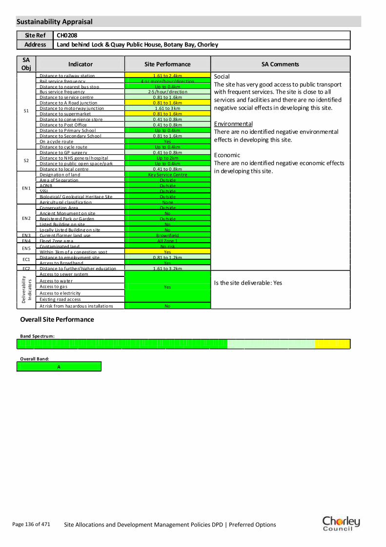
Sustainability Appraisal
Site Ref CH0208
Address Land behind Lock & Quay Public House, Botany Bay, Chorley
SA Obj
Indicator Site Performance SA Comments
S1
Distance to railway station 1 .61 to 2 .4km Social The site has very good access to public transport with frequent services. The site is close to all services and facilities and there are no identified negative social effects in developing this site. Environmental There are no identified negative environmental effects in developing this site. Economic There are no identified negative economic effects in developing this site.
Rail service freque ncy 4 or more/hour/direction Distance to nearest bus stop Up to 0.4km Bus service frequency 2-5 /hour/direction Distance to se rvice centre 0 .81 to 1 .6km Distance to A Road junction 0 .81 to 1 .6km Distance to motorway junction 1 .61 to 3 km Distance to supermarket 0 .81 to 1 .6km Distance to conve nience s tore 0 .41 to 0 .8km Distance to Post Office 0 .41 to 0 .8km Distance to Primary School Up to 0.4km Distance to Secondary School 0 .81 to 1 .6km On a cycle route Yes Distance to cycle route Up to 0.4km
S2
Distance to GP surge ry 0 .41 to 0 .8km Distance to NHS gene ra l hospital Up to 2km Distance to public open space/park Up to 0.4km Distance to local centre 0 .41 to 0 .8km
EN1
Designation of land Ke y Service Centre Are a of Se paration Outs ide AONB Outs ide SSSI Outs ide Biological/ G eological H eritag e Site Outs ide Agricultural classifica tion None
EN2
Conservation Area Outs ide Ancie nt Monument on site No Regis te re d Park or G arden Outs ide Listed Building on site No Locally Lis te d Building on s ite No
EN3 Curre nt/former land use Brownfield EN4 Flood Zone a re a All Zone 1
EN5 Contaminated land No risk Within 3km of a congestion spot Yes
EC1 Distance to employment site 0 .81 to 1 .2km Access to Broadband Yes
EC2 Distance to furthe r/higher education 1 .61 to 3 .2km
Del
iver
abili
ty
Indi
cato
rs
Access to sewer system
Yes
Is the site deliverable: Yes Access to wa te r
Access to ga s
Access to e lectricity
Exis ting road access
At risk from hazardous installations No
Overall Site Performance
Band Spe ctrum:
Overall Band:
A
Page 136 of 471 Site Allocations and Development Management Policies DPD | Preferred Options

Housing
Employment
Mixed Use
Retail
Commercial
Leisure
Recreation
Safeguarded Land
Preferred Options Decision
Allocate site Potential no. units: 50
Hectares of land: 0
Other
Site Reference: CH0220 Chorley RUFC Chancery Road
Chorley
Logical expansion to existing Astley Village residential area. Sustainable and appropriate location. Proposals involve retention and improvement of rugby facilities, with the provision of a new clubhouse and car park. Residential development would be at a scale which reflects the characteristics of surrounding area.
Promoting health and wellbeing states a key issue is to protect sport and recreation facilities. Retain as recreational space, as per DC3.6 of existing Local Plan. Housing would lead to overdevelopment in an area already close to Buckshaw Village. Negative impact on road traffic.
Summary of Objections
Summary of Support
Alternative site suggestions: CH0001
DETAILED SITE ASSESSMENT
Location
Development Criteria
Infrastructure ---
Transport: All development proposals should achieve a high level of road safety, and will be assessed as such by the Council through the planning application process. For housing developments with between 50 and 80 units, the Council will require a Transport Statement. For developments of more than 80 units, the Council will require a Transport Assessment and Travel Plan as part of the application.
Additional Details:
Proposals for this site should be considered in conjunction with site suggestion CH0001.
Issues and Options Consultation Summary
Playspace
HS1.12; BNE2.12
Page 137 of 471 Site Allocations and Development Management Policies DPD | Preferred Options

Sustainability Appraisal
Site Ref CH0220
Address Chancery Way/West Way, Chorley
SA Obj
Indicator Site Performance SA Comments
S1
Distance to railway station 2 .41 to 3 km Social The site has good access to public transport with bus and rail services very frequent although the rail station is 2.41 to 3km from the site. The site is not close to a convenience store although a large supermarket is within 1.6km of the site. The site has good road links to the M61 motorway junction. Environmental The only negative environmental effects in developing this site is that the site is a designated Urban Greenspace and within 3km of a congestion spot. Economic There are no identified economic effects in developing the site.
Rail service freque ncy 4 or more/hour/direction Distance to nearest bus stop Up to 0.4km Bus service frequency 2-5 /hour/direction Distance to se rvice centre 2 .41 to 3 km Distance to A Road junction 0 .81 to 1 .6km Distance to motorway junction 1 .61 to 3 km Distance to supermarket 0 .81 to 1 .6km Distance to conve nience s tore Ove r 1 .2km Distance to Post Office 0 .41 to 0 .8km Distance to Primary School 0 .41 to 0 .8km Distance to Secondary School 0 .81 to 1 .6km On a cycle route Yes Distance to cycle route Up to 0.4km
S2
Distance to GP surge ry 1 .61 to 3 km Distance to NHS gene ra l hospital Up to 2km Distance to public open space/park Up to 0.4km Distance to local centre 0 .41 to 0 .8km
EN1
Designation of land Safeguarded Land Are a of Se paration Outs ide AONB Outs ide SSSI Outs ide Biological/ G eological H eritag e Site Outs ide Agricultural classifica tion 3
EN2
Conservation Area Outs ide Ancie nt Monument on site No Regis te re d Park or G arden Outs ide Listed Building on site No Locally Lis te d Building on s ite No
EN3 Curre nt/former land use Urban G re enspace EN4 Flood Zone a re a All Zone 1
EN5 Contaminated land No risk Within 3km of a congestion spot Yes
EC1 Distance to employment site Up to 0.8km Access to Broadband Yes
EC2 Distance to furthe r/higher education Up to 1.6km
Del
iver
abili
ty
Indi
cato
rs
Access to sewer system
Yes
Is the site deliverable: Yes Access to wa te r
Access to ga s
Access to e lectricity
Exis ting road access
At risk from hazardous installations No
Overall Site Performance
Band Spe ctrum:
Overall Band:
C
Page 138 of 471 Site Allocations and Development Management Policies DPD | Preferred Options

Housing
Employment
Mixed Use
Retail
Commercial
Leisure
Recreation
Safeguarded Land
Preferred Options Decision
Allocate site Potential no. units: 0
Hectares of land: 2
Other Education
Site Reference: CH0221 Woodlands Centre, Southport Road
Chorley
None received.
None received.Summary of Objections
Summary of Support
Alternative site suggestions: ---
DETAILED SITE ASSESSMENT
Location
Development Criteria
Infrastructure ---
Transport: All development proposals should achieve a high level of road safety, and will be assessed as such by the Council through the planning application process. Depending on the mix of uses this site is developed for, and depending on the size of the development, the Council will require the submission of either a Transport Statement or Transport Assessment and Travel Plan.
Additional Details:
---
Issues and Options Consultation Summary
Playspace
EP1.11
Page 139 of 471 Site Allocations and Development Management Policies DPD | Preferred Options

Sustainability Appraisal
Site Ref CH0221
Address Woodlands Centre, Southport Road, Chorley
SA Obj
Indicator Site Performance SA Comments
S1
Distance to railway station 1 .61 to 2 .4km Social This site has very good access to public transport with frequent bus and rail services. The site has very good access to the road network and is within 0.4km of an A road and 0.8km from the key service centre of Chorley.. The site has good access to local facilities with the exception of a convenience store and post office which are 0.81 to 1.2km away. Environmental This site is within a biological and geological heritage site and is also Greenfield. These are negative environmental factors and will need to be addressed in order for the site to become sustainable. Economic There are no identified negative economic effects in developing this site.
Rail service freque ncy 4 or more/hour/direction Distance to nearest bus stop Up to 0.4km Bus service frequency 6 or more/hour/direction Distance to se rvice centre Up to 0.8km Distance to A Road junction Up to 0.4km Distance to motorway junction Over 3km Distance to supermarket 0 .41 to 0 .8km Distance to conve nience s tore 0 .81 to 1 .2km Distance to Post Office 0 .81 to 1 .2km Distance to Primary School Up to 0.4km Distance to Secondary School Up to 0.8km On a cycle route Yes Distance to cycle route Up to 0.4km
S2
Distance to GP surge ry 0 .41 to 0 .8km Distance to NHS gene ra l hospital 2.1 to 5 km Distance to public open space/park Up to 0.4km Distance to local centre 1 .21 to 1 .6km
EN1
Designation of land Ke y Service Centre Are a of Se paration Outs ide AONB Outs ide SSSI Outs ide Biological/ G eological H eritag e Site Within Agricultural classifica tion None
EN2
Conservation Area Outs ide Ancie nt Monument on site No Regis te re d Park or G arden Outs ide Listed Building on site No Locally Lis te d Building on s ite No
EN3 Curre nt/former land use Greenfie ld EN4 Flood Zone a re a All Zone 1
EN5 Contaminated land No risk Within 3km of a congestion spot Yes
EC1 Distance to employment site Up to 0.8km Access to Broadband Yes
EC2 Distance to furthe r/higher education Up to 1.6km
Del
iver
abili
ty
Indi
cato
rs
Access to sewer system
Yes
Is the site deliverable: Yes Access to wa te r
Access to ga s
Access to e lectricity
Exis ting road access
At risk from hazardous installations No
Overall Site Performance
Band Spe ctrum:
Overall Band:
B
Page 140 of 471 Site Allocations and Development Management Policies DPD | Preferred Options

Housing
Employment
Mixed Use
Retail
Commercial
Leisure
Recreation
Safeguarded Land
Preferred Options Decision
Allocate site Potential no. units: 19
Hectares of land: 0
Other
Site Reference: CH0222 Rydal House, Chorley Hall Road
Chorley
None received.
None received.Summary of Objections
Summary of Support
Alternative site suggestions: ---
DETAILED SITE ASSESSMENT
Location
Development Criteria
Infrastructure N/A- this site already has planning permission
Transport: All development proposals should achieve a high level of road safety, and will be assessed as such by the Council through the planning application process. As this site already has planning permission, the relevant Transport Statement/Assessment has already been submitted to, and approved by the Council.
Additional Details:
---
Issues and Options Consultation Summary
Playspace
HS1.23
Page 141 of 471 Site Allocations and Development Management Policies DPD | Preferred Options

Sustainability Appraisal
Site Ref CH0222
Address Rydal House, Chorley Hall Road, Chorley
SA Obj
Indicator Site Performance SA Comments
S1
Distance to railway station 0 .81 to 1 .6km Social This site has very good access to public transport with frequent bus and rail services. The site also has good road links and is in close proximity to and A road and motorway junction. The site has good access to local services with the exception of a post office and GP surgery which are 0.81 to 1.6km away. Environmental There are no identified negative environmental effects in developing this site. Economic There are no identified negative economic effects in developing this site.
Rail service freque ncy 4 or more/hour/direction Distance to nearest bus stop Up to 0.4km Bus service frequency 6 or more/hour/direction Distance to se rvice centre Up to 0.8km Distance to A Road junction Up to 0.4km Distance to motorway junction Up to 1.6km Distance to supermarket Up to 0.4km Distance to conve nience s tore Up to 0.4km Distance to Post Office 0 .81 to 1 .2km Distance to Primary School Up to 0.4km Distance to Secondary School Up to 0.8km On a cycle route No Distance to cycle route Up to 0.4km
S2
Distance to GP surge ry 0 .81 to 1 .6km Distance to NHS gene ra l hospital Up to 2km Distance to public open space/park Up to 0.4km Distance to local centre 0 .41 to 0 .8km
EN1
Designation of land Ke y Service Centre Are a of Se paration Outs ide AONB Outs ide SSSI Outs ide Biological/ G eological H eritag e Site Outs ide Agricultural classifica tion None
EN2
Conservation Area Outs ide Ancie nt Monument on site No Regis te re d Park or G arden Outs ide Listed Building on site No Locally Lis te d Building on s ite No
EN3 Curre nt/former land use Brownfield EN4 Flood Zone a re a All Zone 1
EN5 Contaminated land No risk Within 3km of a congestion spot Yes
EC1 Distance to employment site Up to 0.8km Access to Broadband Yes
EC2 Distance to furthe r/higher education 1 .61 to 3 .2km
Del
iver
abili
ty
Indi
cato
rs
Access to sewer system
Yes
Is the site deliverable: Yes Access to wa te r
Access to ga s
Access to e lectricity
Exis ting road access
At risk from hazardous installations No
Overall Site Performance
Band Spe ctrum:
Overall Band:
A
Page 142 of 471 Site Allocations and Development Management Policies DPD | Preferred Options
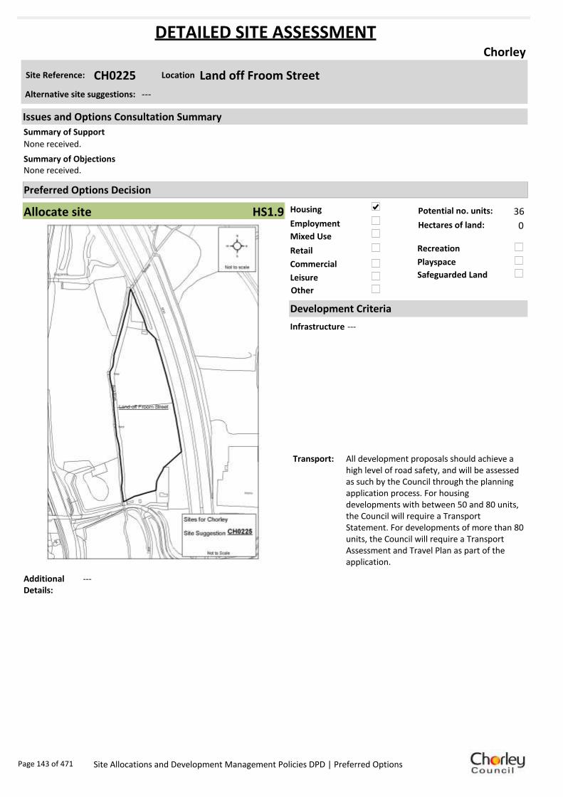
Housing
Employment
Mixed Use
Retail
Commercial
Leisure
Recreation
Safeguarded Land
Preferred Options Decision
Allocate site Potential no. units: 36
Hectares of land: 0
Other
Site Reference: CH0225 Land off Froom Street
Chorley
None received.
None received.Summary of Objections
Summary of Support
Alternative site suggestions: ---
DETAILED SITE ASSESSMENT
Location
Development Criteria
Infrastructure ---
Transport: All development proposals should achieve a high level of road safety, and will be assessed as such by the Council through the planning application process. For housing developments with between 50 and 80 units, the Council will require a Transport Statement. For developments of more than 80 units, the Council will require a Transport Assessment and Travel Plan as part of the application.
Additional Details:
---
Issues and Options Consultation Summary
Playspace
HS1.9
Page 143 of 471 Site Allocations and Development Management Policies DPD | Preferred Options

Sustainability Appraisal
Site Ref CH0225
Address Land off Froom Street, Chorley
SA Obj
Indicator Site Performance SA Comments
S1
Distance to railway station 0 .81 to 1 .6km Social This site has good access to public transport and services are frequent. The site is only 0.81 to 1.6km from the key service centre of Chorley Town centre and has good access to all services and facilities. Environmental The only identified negative environmental effects in developing this site is Greenfield and part of the west boundary of the site is located within flood zone 3 which is a high risk area. Economic There are no identified negative economic effects in developing this site.
Rail service freque ncy 4 or more/hour/direction Distance to nearest bus stop 0 .41 to 0 .8km Bus service frequency 2-5 /hour/direction Distance to se rvice centre 0 .81 to 1 .6km Distance to A Road junction 0 .81 to 1 .6km Distance to motorway junction 1 .61 to 3 km Distance to supermarket 0 .81 to 1 .6km Distance to conve nience s tore Up to 0.4km Distance to Post Office Up to 0.4km Distance to Primary School Up to 0.4km Distance to Secondary School 1 .61 to 3 .2km On a cycle route No Distance to cycle route Up to 0.4km
S2
Distance to GP surge ry Up to 0.4km Distance to NHS gene ra l hospital Up to 2km Distance to public open space/park Up to 0.4km Distance to local centre Up to 0.4km
EN1
Designation of land Ke y Service Centre Are a of Se paration Outs ide AONB Outs ide SSSI Outs ide Biological/ G eological H eritag e Site Outs ide Agricultural classifica tion None
EN2
Conservation Area Outs ide Ancie nt Monument on site No Regis te re d Park or G arden Outs ide Listed Building on site No Locally Lis te d Building on s ite No
EN3 Curre nt/former land use Greenfie ld EN4 Flood Zone a re a Part Zone 3
EN5 Contaminated land No risk Within 3km of a congestion spot Yes
EC1 Distance to employment site Up to 0.8km Access to Broadband Yes
EC2 Distance to furthe r/higher education 1 .61 to 3 .2km
Del
iver
abili
ty
Indi
cato
rs
Access to sewer system
Yes
Is the site deliverable: Yes Access to wa te r
Access to ga s
Access to e lectricity
Exis ting road access
At risk from hazardous installations No
Overall Site Performance
Band Spe ctrum:
Overall Band:
B
Page 144 of 471 Site Allocations and Development Management Policies DPD | Preferred Options

Housing
Employment
Mixed Use
Retail
Commercial
Leisure
Recreation
Safeguarded Land
Preferred Options Decision
Allocate site Potential no. units: 0
Hectares of land: 14.1
Other
Site Reference: CH0239 Great Knowley/ Botany
Chorley
None received.
Suggested allocations on the interactive site suggestions web site potentially jeopardise achievement of the aims of Core Strategy Policy 9 by limiting the employment to the north of the A674 only. It is premature to designate separate boundaries and split uses within a site which, due to its size and Core Strategy designation, should be considered as a whole.
The Site Allocations DPD ought more properly to allocate the whole site in accordance wit the Core Strategy Policy 9. It should enable a wider mix of uses including residential and open space. In this way a more inclusive sustainable development would be possible with enabling funding from the residential to ensure with more certainty that the employment development will happen.
Summary of Objections
Summary of Support
Alternative site suggestions: CH0083 CH0119 CH0159 CH0240 CH0241 CH0242 CH0243 CH0312
DETAILED SITE ASSESSMENT
Location
Development Criteria
Infrastructure ---
Transport: All development proposals should achieve a high level of road safety, and will be assessed as such by the Council through the planning application process. Depending on what type of employment use or mix of uses this site is developed for, and depending on the size of the development, the Council will require the submission of either a Transport Statement or Transport Assessment and Travel Plan.
Additional Details:
No changes to the Green Belt boundary.
Issues and Options Consultation Summary
Playspace
EP1.1
Page 145 of 471 Site Allocations and Development Management Policies DPD | Preferred Options
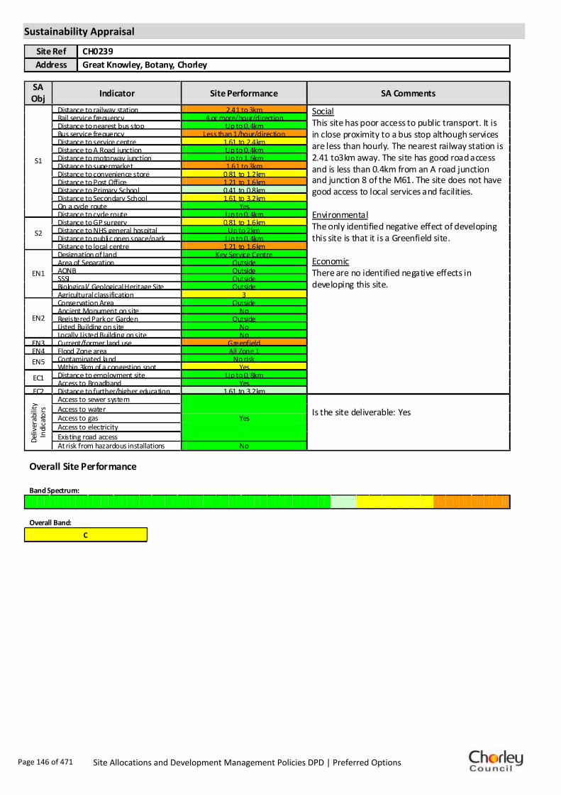
Sustainability Appraisal
Site Ref CH0239
Address Great Knowley, Botany, Chorley
SA Obj
Indicator Site Performance SA Comments
S1
Distance to railway station 2.41 to 3km Social This site has poor access to public transport. It is in close proximity to a bus stop although services are less than hourly. The nearest railway station is 2.41 to3km away. The site has good road access and is less than 0.4km from an A road junction and junction 8 of the M61. The site does not have good access to local services and facilities. Environmental The only identified negative effect of developing this site is that it is a Greenfield site. Economic There are no identified negative effects in developing this site.
Rail service frequency 4 or more/hour/direction Distance to nearest bus stop Up to 0.4km Bus service frequency Less than 1/hour/direction Distance to service centre 1.61 to 2.4km Distance to A Road junction Up to 0.4km Distance to motorway junction Up to 1.6km Distance to supermarket 1.61 to 3km Distance to convenience store 0.81 to 1.2km Distance to Post Office 1.21 to 1.6km Distance to Primary School 0.41 to 0.8km Distance to Secondary School 1.61 to 3.2km On a cycle route Yes Distance to cycle route Up to 0.4km
S2
Distance to GP surgery 0.81 to 1.6km Distance to NHS general hospital Up to 2km Distance to public open space/park Up to 0.4km Distance to local centre 1.21 to 1.6km
EN1
Designation of land Key Service Centre Area of Separation Outside AONB Outside SSSI Outside Biological/ Geological Heritage Site Outside Agricultural classification 3
EN2
Conservation Area Outside Ancient Monument on site No Registered Park or Garden Outside Listed Building on site No Locally Listed Building on site No
EN3 Current/former land use Greenfield EN4 Flood Zone area All Zone 1
EN5 Contaminated land No risk Within 3km of a congestion spot Yes
EC1 Distance to employment site Up to 0.8km Access to Broadband Yes
EC2 Distance to further/higher education 1.61 to 3.2km
Del
iver
abili
ty
Indi
cato
rs
Access to sewer system
Yes
Is the site deliverable: Yes Access to water
Access to gas Access to electricity Existing road access At risk from hazardous installations No
Overall Site Performance Band Spectrum:
Overall Band:
C
Page 146 of 471 Site Allocations and Development Management Policies DPD | Preferred Options

Housing
Employment
Mixed Use
Retail
Commercial
Leisure
Recreation
Safeguarded Land
Preferred Options Decision
Allocate site Potential no. units: 0
Hectares of land: 14.1
Other
Site Reference: CH0240 Great Knowley/ Botany
Chorley
None received.
Suggested allocations on the interactive site suggestions web site potentially jeopardise achievement of the aims of Core Strategy Policy 9 by limiting the employment to the north of the A674 only. It is premature to designate separate boundaries and split uses within a site which, due to its size and Core Strategy designation, should be considered as a whole.
The Site Allocations DPD ought more properly to allocate the whole site in accordance wit the Core Strategy Policy 9. It should enable a wider mix of uses including residential and open space. In this way a more inclusive sustainable development would be possible with enabling funding from the residential to ensure with more certainty that the employment development will happen.
Summary of Objections
Summary of Support
Alternative site suggestions: CH0083 CH0119 CH0159 CH0239 CH0241 CH0242 CH0243 CH0312
DETAILED SITE ASSESSMENT
Location
Development Criteria
Infrastructure ---
Transport: All development proposals should achieve a high level of road safety, and will be assessed as such by the Council through the planning application process. Depending on what type of employment use or mix of uses this site is developed for, and depending on the size of the development, the Council will require the submission of either a Transport Statement or Transport Assessment and Travel Plan.
Additional Details:
---
Issues and Options Consultation Summary
Playspace
EP1.1
Page 147 of 471 Site Allocations and Development Management Policies DPD | Preferred Options

Sustainability Appraisal
Site Ref CH0240
Address Great Knowley, Botany, Chorley
SA Obj
Indicator Site Performance SA Comments
S1
Distance to railway station 2.41 to 3km Social This site has poor access to public transport. It is in close proximity to a bus stop although services are less than hourly. The nearest railway station is 2.41 to3km away. The site has good road access and is less than 0.4km from an A road junction and junction 8 of the M61. The site does not have good access to local services and facilities. Environmental The only identified negative effect of developing this site is that it is a Greenfield site. Economic There are no identified negative effects in developing this site.
Rail service frequency 4 or more/hour/direction Distance to nearest bus stop Up to 0.4km Bus service frequency Less than 1/hour/direction Distance to service centre 1.61 to 2.4km Distance to A Road junction Up to 0.4km Distance to motorway junction Up to 1.6km Distance to supermarket 1.61 to 3km Distance to convenience store 0.81 to 1.2km Distance to Post Office 1.21 to 1.6km Distance to Primary School 0.41 to 0.8km Distance to Secondary School 1.61 to 3.2km On a cycle route Yes Distance to cycle route Up to 0.4km
S2
Distance to GP surgery 0.81 to 1.6km Distance to NHS general hospital Up to 2km Distance to public open space/park Up to 0.4km Distance to local centre 1.21 to 1.6km
EN1
Designation of land Key Service Centre Area of Separation Outside AONB Outside SSSI Outside Biological/ Geological Heritage Site Outside Agricultural classification 3
EN2
Conservation Area Outside Ancient Monument on site No Registered Park or Garden Outside Listed Building on site No Locally Listed Building on site No
EN3 Current/former land use Greenfield EN4 Flood Zone area All Zone 1
EN5 Contaminated land No risk Within 3km of a congestion spot Yes
EC1 Distance to employment site Up to 0.8km Access to Broadband Yes
EC2 Distance to further/higher education 1.61 to 3.2km
Del
iver
abili
ty
Indi
cato
rs
Access to sewer system
Yes
Is the site deliverable: Yes Access to water
Access to gas Access to electricity Existing road access At risk from hazardous installations No
Overall Site Performance Band Spectrum:
Overall Band:
C
Page 148 of 471 Site Allocations and Development Management Policies DPD | Preferred Options

Housing
Employment
Mixed Use
Retail
Commercial
Leisure
Recreation
Safeguarded Land
Preferred Options Decision
Allocate site Potential no. units: 0
Hectares of land: 14.1
Other
Site Reference: CH0241 Great Knowley/ Botany
Chorley
None received.
Suggested allocations on the interactive site suggestions web site potentially jeopardise achievement of the aims of Core Strategy Policy 9 by limiting the employment to the north of the A674 only. It is premature to designate separate boundaries and split uses within a site which, due to its size and Core Strategy designation, should be considered as a whole.
The Site Allocations DPD ought more properly to allocate the whole site in accordance wit the Core Strategy Policy 9. It should enable a wider mix of uses including residential and open space. In this way a more inclusive sustainable development would be possible with enabling funding from the residential to ensure with more certainty that the employment development will happen.
Summary of Objections
Summary of Support
Alternative site suggestions: CH0083 CH0119 CH0159 CH0239 CH0240 CH0242 CH0243 CH0312
DETAILED SITE ASSESSMENT
Location
Development Criteria
Infrastructure ---
Transport: All development proposals should achieve a high level of road safety, and will be assessed as such by the Council through the planning application process. Depending on what type of employment use or mix of uses this site is developed for, and depending on the size of the development, the Council will require the submission of either a Transport Statement or Transport Assessment and Travel Plan.
Additional Details:
---
Issues and Options Consultation Summary
Playspace
EP1.1
Page 149 of 471 Site Allocations and Development Management Policies DPD | Preferred Options

Sustainability Appraisal
Site Ref CH0241
Address Great Knowley, Botany, Chorley
SA Obj
Indicator Site Performance SA Comments
S1
Distance to railway station 2.41 to 3km Social This site has poor access to public transport. It is in close proximity to a bus stop although services are less than hourly. The nearest railway station is 2.41 to3km away. The site has good road access and is less than 0.4km from an A road junction and junction 8 of the M61. The site does not have good access to local services and facilities. Environmental The only identified negative effect of developing this site is that it is a Greenfield site. Economic There are no identified negative effects in developing this site.
Rail service frequency 4 or more/hour/direction Distance to nearest bus stop Up to 0.4km Bus service frequency Less than 1/hour/direction Distance to service centre 1.61 to 2.4km Distance to A Road junction Up to 0.4km Distance to motorway junction Up to 1.6km Distance to supermarket 1.61 to 3km Distance to convenience store 0.81 to 1.2km Distance to Post Office 1.21 to 1.6km Distance to Primary School 0.41 to 0.8km Distance to Secondary School 1.61 to 3.2km On a cycle route Yes Distance to cycle route Up to 0.4km
S2
Distance to GP surgery 0.81 to 1.6km Distance to NHS general hospital Up to 2km Distance to public open space/park Up to 0.4km Distance to local centre 1.21 to 1.6km
EN1
Designation of land Key Service Centre Area of Separation Outside AONB Outside SSSI Outside Biological/ Geological Heritage Site Outside Agricultural classification 3
EN2
Conservation Area Outside Ancient Monument on site No Registered Park or Garden Outside Listed Building on site No Locally Listed Building on site No
EN3 Current/former land use Greenfield EN4 Flood Zone area All Zone 1
EN5 Contaminated land No risk Within 3km of a congestion spot Yes
EC1 Distance to employment site Up to 0.8km Access to Broadband Yes
EC2 Distance to further/higher education 1.61 to 3.2km
Del
iver
abili
ty
Indi
cato
rs
Access to sewer system
Yes
Is the site deliverable: Yes Access to water
Access to gas Access to electricity Existing road access At risk from hazardous installations No
Overall Site Performance Band Spectrum:
Overall Band:
C
Page 150 of 471 Site Allocations and Development Management Policies DPD | Preferred Options

Housing
Employment
Mixed Use
Retail
Commercial
Leisure
Recreation
Safeguarded Land
Preferred Options Decision
Allocate site Potential no. units: 0
Hectares of land: 14.1
Other
Site Reference: CH0242 Great Knowley/ Botany
Chorley
None received.
Suggested allocations on the interactive site suggestions web site potentially jeopardise achievement of the aims of Core Strategy Policy 9 by limiting the employment to the north of the A674 only. It is premature to designate separate boundaries and split uses within a site which, due to its size and Core Strategy designation, should be considered as a whole.
The Site Allocations DPD ought more properly to allocate the whole site in accordance wit the Core Strategy Policy 9. It should enable a wider mix of uses including residential and open space. In this way a more inclusive sustainable development would be possible with enabling funding from the residential to ensure with more certainty that the employment development will happen.
Summary of Objections
Summary of Support
Alternative site suggestions: CH0083 CH0119 CH0159 CH0239 CH0240 CH0241 CH0243 CH0312
DETAILED SITE ASSESSMENT
Location
Development Criteria
Infrastructure ---
Transport: All development proposals should achieve a high level of road safety, and will be assessed as such by the Council through the planning application process. Depending on what type of employment use or mix of uses this site is developed for, and depending on the size of the development, the Council will require the submission of either a Transport Statement or Transport Assessment and Travel Plan.
Additional Details:
---
Issues and Options Consultation Summary
Playspace
EP1.1
Page 151 of 471 Site Allocations and Development Management Policies DPD | Preferred Options

Sustainability Appraisal
Site Ref CH0242
Address Great Knowley, Botany, Chorley
SA Obj
Indicator Site Performance SA Comments
S1
Distance to railway station 2.41 to 3km Social This site has poor access to public transport. It is in close proximity to a bus stop although services are less than hourly. The nearest railway station is 2.41 to3km away. The site has good road access and is less than 0.4km from an A road junction and junction 8 of the M61. The site does not have good access to local services and facilities. Environmental The only identified negative effect of developing this site is that it is a Greenfield site. Economic There are no identified negative effects in developing this site.
Rail service frequency 4 or more/hour/direction Distance to nearest bus stop Up to 0.4km Bus service frequency Less than 1/hour/direction Distance to service centre 1.61 to 2.4km Distance to A Road junction Up to 0.4km Distance to motorway junction Up to 1.6km Distance to supermarket 1.61 to 3km Distance to convenience store 0.81 to 1.2km Distance to Post Office 1.21 to 1.6km Distance to Primary School 0.41 to 0.8km Distance to Secondary School 1.61 to 3.2km On a cycle route Yes Distance to cycle route Up to 0.4km
S2
Distance to GP surgery 0.81 to 1.6km Distance to NHS general hospital Up to 2km Distance to public open space/park Up to 0.4km Distance to local centre 1.21 to 1.6km
EN1
Designation of land Key Service Centre Area of Separation Outside AONB Outside SSSI Outside Biological/ Geological Heritage Site Outside Agricultural classification 3
EN2
Conservation Area Outside Ancient Monument on site No Registered Park or Garden Outside Listed Building on site No Locally Listed Building on site No
EN3 Current/former land use Greenfield EN4 Flood Zone area All Zone 1
EN5 Contaminated land No risk Within 3km of a congestion spot Yes
EC1 Distance to employment site Up to 0.8km Access to Broadband Yes
EC2 Distance to further/higher education 1.61 to 3.2km
Del
iver
abili
ty
Indi
cato
rs
Access to sewer system
Yes
Is the site deliverable: Yes Access to water
Access to gas Access to electricity Existing road access At risk from hazardous installations No
Overall Site Performance Band Spectrum:
Overall Band:
C
Page 152 of 471 Site Allocations and Development Management Policies DPD | Preferred Options
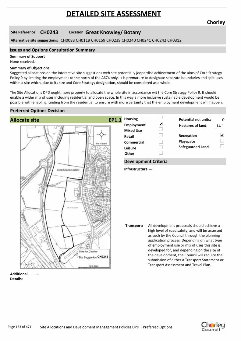
Housing
Employment
Mixed Use
Retail
Commercial
Leisure
Recreation
Safeguarded Land
Preferred Options Decision
Allocate site Potential no. units: 0
Hectares of land: 14.1
Other
Site Reference: CH0243 Great Knowley/ Botany
Chorley
None received.
Suggested allocations on the interactive site suggestions web site potentially jeopardise achievement of the aims of Core Strategy Policy 9 by limiting the employment to the north of the A674 only. It is premature to designate separate boundaries and split uses within a site which, due to its size and Core Strategy designation, should be considered as a whole.
The Site Allocations DPD ought more properly to allocate the whole site in accordance wit the Core Strategy Policy 9. It should enable a wider mix of uses including residential and open space. In this way a more inclusive sustainable development would be possible with enabling funding from the residential to ensure with more certainty that the employment development will happen.
Summary of Objections
Summary of Support
Alternative site suggestions: CH0083 CH0119 CH0159 CH0239 CH0240 CH0241 CH0242 CH0312
DETAILED SITE ASSESSMENT
Location
Development Criteria
Infrastructure ---
Transport: All development proposals should achieve a high level of road safety, and will be assessed as such by the Council through the planning application process. Depending on what type of employment use or mix of uses this site is developed for, and depending on the size of the development, the Council will require the submission of either a Transport Statement or Transport Assessment and Travel Plan.
Additional Details:
---
Issues and Options Consultation Summary
Playspace
EP1.1
Page 153 of 471 Site Allocations and Development Management Policies DPD | Preferred Options

Sustainability Appraisal
Site Ref CH0243
Address Great Knowley, Botany, Chorley
SA Obj
Indicator Site Performance SA Comments
S1
Distance to railway station 2.41 to 3km Social This site has poor access to public transport. It is in close proximity to a bus stop although services are less than hourly. The nearest railway station is 2.41 to3km away. The site has good road access and is less than 0.4km from an A road junction and junction 8 of the M61. The site does not have good access to local services and facilities. Environmental The only identified negative effect of developing this site is that it is a Greenfield site. Economic There are no identified negative effects in developing this site.
Rail service frequency 4 or more/hour/direction Distance to nearest bus stop Up to 0.4km Bus service frequency Less than 1/hour/direction Distance to service centre 1.61 to 2.4km Distance to A Road junction Up to 0.4km Distance to motorway junction Up to 1.6km Distance to supermarket 1.61 to 3km Distance to convenience store 0.81 to 1.2km Distance to Post Office 1.21 to 1.6km Distance to Primary School 0.41 to 0.8km Distance to Secondary School 1.61 to 3.2km On a cycle route Yes Distance to cycle route Up to 0.4km
S2
Distance to GP surgery 0.81 to 1.6km Distance to NHS general hospital Up to 2km Distance to public open space/park Up to 0.4km Distance to local centre 1.21 to 1.6km
EN1
Designation of land Key Service Centre Area of Separation Outside AONB Outside SSSI Outside Biological/ Geological Heritage Site Outside Agricultural classification 3
EN2
Conservation Area Outside Ancient Monument on site No Registered Park or Garden Outside Listed Building on site No Locally Listed Building on site No
EN3 Current/former land use Greenfield EN4 Flood Zone area All Zone 1
EN5 Contaminated land No risk Within 3km of a congestion spot Yes
EC1 Distance to employment site Up to 0.8km Access to Broadband Yes
EC2 Distance to further/higher education 1.61 to 3.2km
Del
iver
abili
ty
Indi
cato
rs
Access to sewer system
Yes
Is the site deliverable: Yes Access to water
Access to gas Access to electricity Existing road access At risk from hazardous installations No
Overall Site Performance Band Spectrum:
Overall Band:
C
Page 154 of 471 Site Allocations and Development Management Policies DPD | Preferred Options
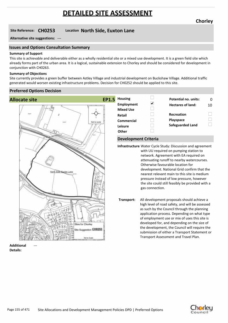
Housing
Employment
Mixed Use
Retail
Commercial
Leisure
Recreation
Safeguarded Land
Preferred Options Decision
Allocate site Potential no. units: 0
Hectares of land: 10
Other
Site Reference: CH0253 North Side, Euxton Lane
Chorley
This site is achievable and deliverable either as a wholly residential site or a mixed use development. It is a green field site which already forms part of the urban area. It is a logical, sustainable extension to Chorley and should be considered for development in conjunction with CH0263.
Site currently provides a green buffer between Astley Village and industrial development on Buckshaw Village. Additional traffic generated would worsen existing infrastructure problems. Decision for CH0252 should be applied to this site.
Summary of Objections
Summary of Support
Alternative site suggestions: ---
DETAILED SITE ASSESSMENT
Location
Development Criteria
Infrastructure Water Cycle Study: Discussion and agreement with UU required on pumping station to network. Agreement with EA required on attenuating runoff to nearby watercourses. Otherwise favourable location for development. National Grid confirm that the nearest relevant main to this site is medium pressure instead of low pressure, however the site could still feasibly be provided with a gas connection.
Transport: All development proposals should achieve a high level of road safety, and will be assessed as such by the Council through the planning application process. Depending on what type of employment use or mix of uses this site is developed for, and depending on the size of the development, the Council will require the submission of either a Transport Statement or Transport Assessment and Travel Plan.
Additional Details:
---
Issues and Options Consultation Summary
Playspace
EP1.5
Page 155 of 471 Site Allocations and Development Management Policies DPD | Preferred Options

Sustainability Appraisal
Site Ref CH0253
Address North Side, Euxton Lane, Chorley
SA Obj
Indicator Site Performance SA Comments
S1
Distance to railway station 1 .61 to 2 .4km Social The site has good access to public transport links and very good access to the road network. The site is located along an A road and is in close proximity to junction 8 of the M61. The site is 0.81 to 1.2km from the nearest convenience store and 1.2 to 1.6km from the nearest post office. Environmental The only identified negative effects in developing this site is the site is currently Greenfield with a current designation of safeguarded land. The site also has a medium risk of contamination. Economic There are no identified negative effects in developing this site.
Rail service freque ncy 4 or more/hour/direction Distance to nearest bus stop Up to 0.4km Bus service frequency 2-5 /hour/direction Distance to se rvice centre 0 .81 to 1 .6km Distance to A Road junction Up to 0.4km Distance to motorway junction Up to 1.6km Distance to supermarket 0 .81 to 1 .6km Distance to conve nience s tore 0 .81 to 1 .2km Distance to Post Office 1 .21 to 1 .6km Distance to Primary School 0 .41 to 0 .8km Distance to Secondary School Up to 0.8km On a cycle route Yes Distance to cycle route Up to 0.4km
S2
Distance to GP surge ry 1 .61 to 3 km Distance to NHS gene ra l hospital Up to 2km Distance to public open space/park Up to 0.4km Distance to local centre 1 .21 to 1 .6km
EN1
Designation of land Safeguarded Land Are a of Se paration Outs ide AONB Outs ide SSSI Outs ide Biological/ G eological H eritag e Site Outs ide Agricultural classifica tion 3
EN2
Conservation Area Outs ide Ancie nt Monument on site No Regis te re d Park or G arden Outs ide Listed Building on site No Locally Lis te d Building on s ite No
EN3 Curre nt/former land use Greenfie ld EN4 Flood Zone a re a All Zone 1
EN5 Contaminated land M edium risk Within 3km of a congestion spot Yes
EC1 Distance to employment site Up to 0.8km Access to Broadband Yes
EC2 Distance to furthe r/higher education Up to 1.6km
Del
iver
abili
ty
Indi
cato
rs
Access to sewer system
Yes
Is the site deliverable: Yes Access to wa te r
Access to ga s
Access to e lectricity
Exis ting road access
At risk from hazardous installations No
Overall Site Performance
Band Spe ctrum:
Overall Band:
B
Page 156 of 471 Site Allocations and Development Management Policies DPD | Preferred Options

Housing
Employment
Mixed Use
Retail
Commercial
Leisure
Recreation
Safeguarded Land
Preferred Options Decision
Allocate site Potential no. units: 0
Hectares of land: 3
Other
Site Reference: CH0263 Land North of Euxton Lane
Chorley
This site is achievable and deliverable either as a wholly residential site or a mixed use development. It is a green field site which already forms part of the urban area. It is a logical, sustainable extension to Chorley and should be considered for development in conjunction with CH0253.
Site currently provides a green buffer between Astley Village and industrial development on Buckshaw Village. Additional traffic generated would worsen existing infrastructure problems. Decision for CH0252 should be applied to this site.
Summary of Objections
Summary of Support
Alternative site suggestions: ---
DETAILED SITE ASSESSMENT
Location
Development Criteria
Infrastructure Water Cycle Study: Discussion and agreement with UU required on pumping station to network. Agreement with EA required on attenuating runoff to nearby watercourses. Otherwise favourable location for development. National Grid confirm that the nearest relevant main to this site is medium pressure instead of low pressure, however the site could still feasibly be provided with a gas connection.
Transport: All development proposals should achieve a high level of road safety, and will be assessed as such by the Council through the planning application process. Depending on what type of employment use or mix of uses this site is developed for, and depending on the size of the development, the Council will require the submission of either a Transport Statement or Transport Assessment and Travel Plan.
Additional Details:
---
Issues and Options Consultation Summary
Playspace
EP1.5
Page 157 of 471 Site Allocations and Development Management Policies DPD | Preferred Options

Sustainability Appraisal
Site Ref CH0263
Address Land North of Euxton Lane, Chorley
SA Obj
Indicator Site Performance SA Comments
S1
Distance to railway station 2 .41 to 3 km Social The site has good access to public transport links and very good access to the road network. The site is located along an A road and is in close proximity to junction 8 of the M61. The site is 0.81 to 1.2km from the nearest convenience store and 1.2 to 1.6km from the nearest post office. Environmental The only identified negative effects in developing this site is the site is currently Greenfield with a current designation of safeguarded land. The site also has a medium risk of contamination. Economic There are no identified negative effects in developing this site.
Rail service freque ncy 4 or more/hour/direction Distance to nearest bus stop Up to 0.4km Bus service frequency 2-5 /hour/direction Distance to se rvice centre 1 .61 to 2 .4km Distance to A Road junction 0 .81 to 1 .6km Distance to motorway junction Up to 1.6km Distance to supermarket 1 .61 to 3 km Distance to conve nience s tore Ove r 1 .2km Distance to Post Office 1 .21 to 1 .6km Distance to Primary School 0 .41 to 0 .8km Distance to Secondary School Up to 0.8km On a cycle route Yes Distance to cycle route Up to 0.4km
S2
Distance to GP surge ry 1 .61 to 3 km Distance to NHS gene ra l hospital Up to 2km Distance to public open space/park Up to 0.4km Distance to local centre 1 .21 to 1 .6km
EN1
Designation of land Safeguarded Land Are a of Se paration Outs ide AONB Outs ide SSSI Outs ide Biological/ G eological H eritag e Site Outs ide Agricultural classifica tion 3
EN2
Conservation Area Outs ide Ancie nt Monument on site No Regis te re d Park or G arden Outs ide Listed Building on site No Locally Lis te d Building on s ite No
EN3 Curre nt/former land use Greenfie ld EN4 Flood Zone a re a All Zone 1
EN5 Contaminated land M edium risk Within 3km of a congestion spot Yes
EC1 Distance to employment site Up to 0.8km Access to Broadband Yes
EC2 Distance to furthe r/higher education Up to 1.6km
Del
iver
abili
ty
Indi
cato
rs
Access to sewer system
Yes
Is the site deliverable: Yes Access to wa te r
Access to ga s
Access to e lectricity
Exis ting road access
At risk from hazardous installations No
Overall Site Performance
Band Spe ctrum:
Overall Band:
C
Page 158 of 471 Site Allocations and Development Management Policies DPD | Preferred Options

Housing
Employment
Mixed Use
Retail
Commercial
Leisure
Recreation
Safeguarded Land
Preferred Options Decision
Allocate site Potential no. units: 225
Hectares of land: 0
Other
Site Reference: CH0268 Land South of Housing site HS1.3, Lower Burgh Way
Chorley
Land at Eaves Green accords with the Core Strategy spatial strategy. Site is sustainably located, deliverable within the next 5 years and will provide approximately 10,000 sqft of rural workspaces. Site will contribute 30% affordable through either on-site delivery or off-site contribution.
Development would significantly encroach on the Yarrow Valley Park and reduce wildlife corridors. A significant ‘buffer zone’ should remain. The Core Strategy seeks to protect, enhance and safeguard environmental assets from inappropriate development. Site is known to contain at least one heritage asset. Any development schemes must assess the potential impacts upon heritage assets.
Summary of Objections
Summary of Support
Alternative site suggestions: CH0353
DETAILED SITE ASSESSMENT
Location
Development Criteria
Infrastructure Water Cycle Study: Discussion and agreement with UU required on pumping station network. Agreement with EA require on attenuating runoff to nearby watercourses. Otherwise favourable location for development.
Transport: All development proposals should achieve a high level of road safety, and will be assessed as such by the Council through the planning application process. For housing developments with between 50 and 80 units, the Council will require a Transport Statement. For developments of more than 80 units, the Council will require a Transport Assessment and Travel Plan as part of the application.
Additional Details:
Site proposals should be considered in conjunction with site suggestion CH0353.
Issues and Options Consultation Summary
Playspace
HS1.1
Page 159 of 471 Site Allocations and Development Management Policies DPD | Preferred Options

Sustainability Appraisal
Site Ref CH0268
Address Land South of Housing Site HS1.3, Lower Burgh Way, Chorley
SA Obj
Indicator Site Performance SA Comments
S1
Distance to railway station Over 3km Social This site has very poor access all services and facilities. The site has poor access to public transport and is over 1.2km from the nearest convenience store. Environmental The only identified negative effects of developing this site is the site is a Greenfield site with a current designation of safeguarded land. Economic There are no identified negative economic effects in developing this site.
Rail service freque ncy 4 or more/hour/direction Distance to nearest bus stop 0 .41 to 0 .8km Bus service frequency 2-5 /hour/direction Distance to se rvice centre Over 3km Distance to A Road junction 1 .61 to 3 km Distance to motorway junction Over 3km Distance to supermarket Over 3km Distance to conve nience s tore Ove r 1 .2km Distance to Post Office Ove r 1 .6km Distance to Primary School 0 .41 to 0 .8km Distance to Secondary School 0 .81 to 1 .6km On a cycle route No Distance to cycle route Up to 0.4km
S2
Distance to GP surge ry Over 3km Distance to NHS gene ra l hospital 2.1 to 5 km Distance to public open space/park Up to 0.4km Distance to local centre 0 .81 to 1 .2km
EN1
Designation of land Safeguarded Land Are a of Se paration Outs ide AONB Outs ide SSSI Outs ide Biological/ G eological H eritag e Site Outs ide Agricultural classifica tion 3
EN2
Conservation Area Outs ide Ancie nt Monument on site No Regis te re d Park or G arden Outs ide Listed Building on site No Locally Lis te d Building on s ite No
EN3 Curre nt/former land use Greenfie ld EN4 Flood Zone a re a All Zone 1
EN5 Contaminated land M edium risk Within 3km of a congestion spot No
EC1 Distance to employment site Ove r 1 .6km Access to Broadband Yes
EC2 Distance to furthe r/higher education 3 .21 to 5 km
Del
iver
abili
ty
Indi
cato
rs
Access to sewer system
Yes
Is the site deliverable: Yes Access to wa te r
Access to ga s
Access to e lectricity
Exis ting road access
At risk from hazardous installations No
Overall Site Performance
Band Spe ctrum:
Overall Band:
D
Page 160 of 471 Site Allocations and Development Management Policies DPD | Preferred Options
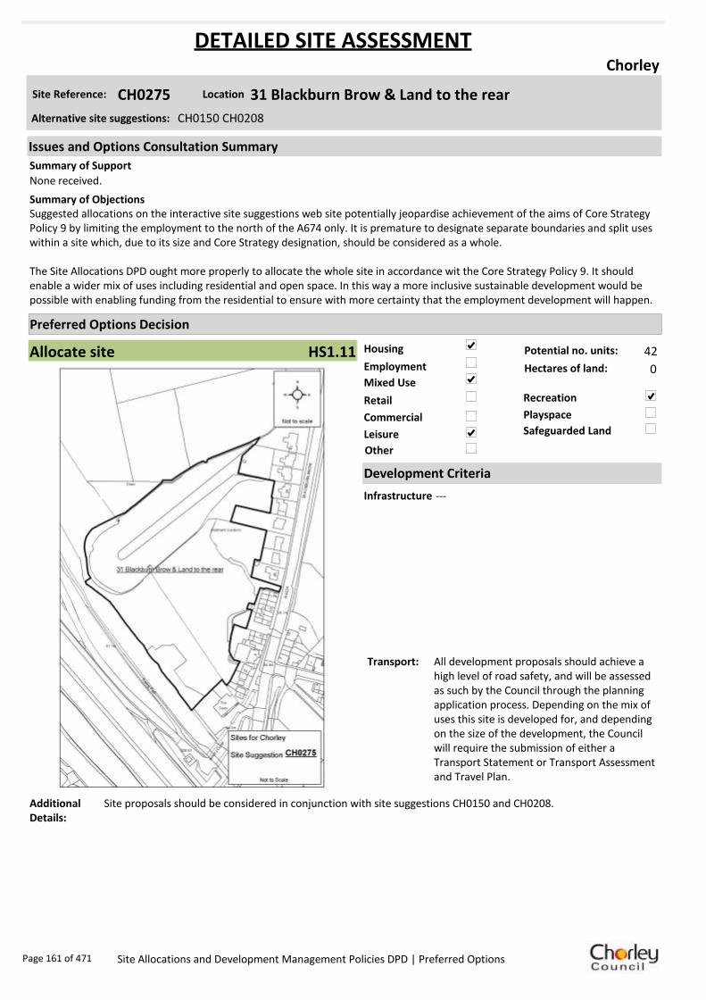
Housing
Employment
Mixed Use
Retail
Commercial
Leisure
Recreation
Safeguarded Land
Preferred Options Decision
Allocate site Potential no. units: 42
Hectares of land: 0
Other
Site Reference: CH0275 31 Blackburn Brow & Land to the rear
Chorley
None received.
Suggested allocations on the interactive site suggestions web site potentially jeopardise achievement of the aims of Core Strategy Policy 9 by limiting the employment to the north of the A674 only. It is premature to designate separate boundaries and split uses within a site which, due to its size and Core Strategy designation, should be considered as a whole.
The Site Allocations DPD ought more properly to allocate the whole site in accordance wit the Core Strategy Policy 9. It should enable a wider mix of uses including residential and open space. In this way a more inclusive sustainable development would be possible with enabling funding from the residential to ensure with more certainty that the employment development will happen.
Summary of Objections
Summary of Support
Alternative site suggestions: CH0150 CH0208
DETAILED SITE ASSESSMENT
Location
Development Criteria
Infrastructure ---
Transport: All development proposals should achieve a high level of road safety, and will be assessed as such by the Council through the planning application process. Depending on the mix of uses this site is developed for, and depending on the size of the development, the Council will require the submission of either a Transport Statement or Transport Assessment and Travel Plan.
Additional Details:
Site proposals should be considered in conjunction with site suggestions CH0150 and CH0208.
Issues and Options Consultation Summary
Playspace
HS1.11
Page 161 of 471 Site Allocations and Development Management Policies DPD | Preferred Options

Sustainability Appraisal
Site Ref CH0275
Address Land behind Lock & Quay Public House, Botany Bay, Chorley
SA Obj
Indicator Site Performance SA Comments
S1
Distance to railway station 1 .61 to 2 .4km Social The site has very good access to public transport with frequent services. The site is close to all services and facilities and there are no identified negative social effects in developing this site. Environmental There are no identified negative environmental effects in developing this site. Economic There are no identified negative economic effects in developing this site.
Rail service freque ncy 4 or more/hour/direction Distance to nearest bus stop Up to 0.4km Bus service frequency 2-5 /hour/direction Distance to se rvice centre 0 .81 to 1 .6km Distance to A Road junction 0 .81 to 1 .6km Distance to motorway junction 1 .61 to 3 km Distance to supermarket 0 .81 to 1 .6km Distance to conve nience s tore 0 .41 to 0 .8km Distance to Post Office 0 .41 to 0 .8km Distance to Primary School Up to 0.4km Distance to Secondary School 0 .81 to 1 .6km On a cycle route Yes Distance to cycle route Up to 0.4km
S2
Distance to GP surge ry 0 .41 to 0 .8km Distance to NHS gene ra l hospital Up to 2km Distance to public open space/park Up to 0.4km Distance to local centre 0 .41 to 0 .8km
EN1
Designation of land Ke y Service Centre Are a of Se paration Outs ide AONB Outs ide SSSI Outs ide Biological/ G eological H eritag e Site Outs ide Agricultural classifica tion None
EN2
Conservation Area Outs ide Ancie nt Monument on site No Regis te re d Park or G arden Outs ide Listed Building on site No Locally Lis te d Building on s ite No
EN3 Curre nt/former land use Brownfield EN4 Flood Zone a re a All Zone 1
EN5 Contaminated land No risk Within 3km of a congestion spot Yes
EC1 Distance to employment site 0 .81 to 1 .2km Access to Broadband Yes
EC2 Distance to furthe r/higher education 1 .61 to 3 .2km
Del
iver
abili
ty
Indi
cato
rs
Access to sewer system
Yes
Is the site deliverable: Yes Access to wa te r
Access to ga s
Access to e lectricity
Exis ting road access
At risk from hazardous installations No
Overall Site Performance
Band Spe ctrum:
Overall Band:
A
Page 162 of 471 Site Allocations and Development Management Policies DPD | Preferred Options

Housing
Employment
Mixed Use
Retail
Commercial
Leisure
Recreation
Safeguarded Land
Preferred Options Decision
Allocate site Potential no. units: 0
Hectares of land: 0
Other
Site Reference: CH0281 Land West of Bolton Road
Chorley
ASDA support the allocation for retail purposes. Any specific policies that are formulated for this site should reflect the outline approval that exists for a business/ non-residential institution unit, which is currently being proposed as a location to relocate the Probation Service.
Allocation appears to fall on an identified textile mill site and is known to contain at least one heritage asset. Appropriate impact assessments should be conducted before development occurs.
Summary of Objections
Summary of Support
Alternative site suggestions: ---
DETAILED SITE ASSESSMENT
Location
Development Criteria
Infrastructure N/A- this site already has planning permission
Transport: All development proposals should achieve a high level of road safety, and will be assessed as such by the Council through the planning application process. As this site already has planning permission, the relevant Transport Statement/Assessment has already been submitted to, and approved by the Council.
Additional Details:
Retail allocations have been identified within the Chorley Town Centre boundary. Permission has been granted for a food store on this site and the area has been allocated for retail.
Issues and Options Consultation Summary
Playspace
EP4.2
Page 163 of 471 Site Allocations and Development Management Policies DPD | Preferred Options
Sustainability Appraisal
+ Minor positive ++ Major positive - Minor negative -- Major negative 0 Neutral / No link
Site Ref CH0281
Address Land West of Bolton Road, Chorley
SA Objective
SA Effects Comments Short
term Medium
term Long term
S1 + + ++
The site is located within 600m of the bus and train stations therefore it has relatively good public transport access. The size of the site provides the opportunity for the development of a significant retail scheme which would increase the retail offer of the town centre. The site is located at the opposite end of the town centre from the main retail area at Market Walk. The southern end of Market Street has suffered a decline in recent years and there are many vacancies. Developing this site may result in people travelling by car between this site and Market Walk rather than walking. The development of this site however will benefit businesses located at this end of the town centre due to increased footfall and may lead a reduction in the number of vacancies. This would lead to more residents in the Borough shopping in the town centre rather than travelling to other centres outside of the Borough, which would lead to a reduction in car travel.
S2 0 0 0 Allocating this site for retail development would have little impact on improving health and wellbeing.
S3 0 0 0 Allocating this site for retail development would have little impact on crime. This would need to be taken into account in the design of any development on the site.
S4 / / / There is no link between allocating this site for retail development and improving access to housing.
EN1 / / / There is no link between allocating this site for retail development and managing biodiversity and landscape character.
EN2 / / / There is no link between allocating this site for retail development and protecting and enhancing heritage.
EN3 + + ++
Allocating this site for retail development would have a positive impact on tackling climate change due to its good public transport links and its potential to significantly increase the retail offer of the town centre which would encourage more local people to shop in Chorley rather than travel to other neighbouring towns/cities. The site is also previously developed so redevelopment of the site would enable the re-use of land and buildings.
EN4 / / / There is no link between allocating this site for retail development and managing flood risk.
EN5 + + ++ Allocating this site for retail development would help minimise air pollution due to its good public transport links and the potential to encourage more local residents to shop in the town centre rather than travel to other centres.
EC1 + ++ ++
Retail development on the site would lead to the creation of jobs in a sustainable location. There is the potential for a large scale retail development on the site which would lead to the creation of a significant number of jobs. Improving the retail offer of the town centre and may also encourage more retailers to locate in the town centre which would create further jobs.
EC2 / / / There is no link between allocating this site for retail development and improving skills.
EC3 / / / There is no link between allocating this site for retail development and the rural economy.
EC4 + ++ ++ Allocating the site for retail development would enable the provision of large scale additional retail and related services in the town centre which may also encourage more retailers to locate in the town centre.
Comments: The site has good access to public transport but is located at the opposite end of the town centre to Market Walk and is therefore detached from the main shopping area which may lead to people driving between the sites. The site is large and has the potential for a significant sized retail development. This would attract more people to this end of the town centre and may boost other businesses along Market Street. This would lead to an extension of the main shopping area and encourage people to walk from one end of the town centre to the other. Retail development on the site would also lead to a significant number of jobs.
Key
Page 164 of 471 Site Allocations and Development Management Policies DPD | Preferred Options

Housing
Employment
Mixed Use
Retail
Commercial
Leisure
Recreation
Safeguarded Land
Preferred Options Decision
Do not allocate Potential no. units: 0
Hectares of land: 0
Other
Site Reference: CH0282 St Georges Institute, Trinity Road
Chorley
None received.
None received.Summary of Objections
Summary of Support
Alternative site suggestions: ---
DETAILED SITE ASSESSMENT
Location
Development Criteria
Infrastructure N/A- proposed not to allocate site
Transport: N/A- proposed not to allocate site
Additional Details:
Existing Social Club in active use, with associated open space. Detailed Open Space Study results awaited.
Issues and Options Consultation Summary
Playspace
Page 165 of 471 Site Allocations and Development Management Policies DPD | Preferred Options

Sustainability Appraisal
Site Ref CH0282
Address St Georges Institute, Trinity Road, Chorley
SA Obj
Indicator Site Performance SA Comments
S1
Distance to railway station 0 .81 to 1 .6km Social This site has very good access to public transport with frequent services. The site has very good access to local services and facilities with the exception of a supermarket which is 0.81 to 1.6km. Environmental There are no identified negative environmental effects in developing this site. Economic There are no identified negative economic effects in developing this site.
Rail service freque ncy 4 or more/hour/direction Distance to nearest bus stop Up to 0.4km Bus service frequency 6 or more/hour/direction Distance to se rvice centre Up to 0.8km Distance to A Road junction 0 .41 to 0 .8km Distance to motorway junction Over 3km Distance to supermarket 0 .81 to 1 .6km Distance to conve nience s tore Up to 0.4km Distance to Post Office Up to 0.4km Distance to Primary School 0 .41 to 0 .8km Distance to Secondary School 0 .81 to 1 .6km On a cycle route No Distance to cycle route Up to 0.4km
S2
Distance to GP surge ry Up to 0.4km Distance to NHS gene ra l hospital 2.1 to 5 km Distance to public open space/park Up to 0.4km Distance to local centre Up to 0.4km
EN1
Designation of land Ke y Service Centre Are a of Se paration Outs ide AONB Outs ide SSSI Outs ide Biological/ G eological H eritag e Site Outs ide Agricultural classifica tion None
EN2
Conservation Area Outs ide Ancie nt Monument on site No Regis te re d Park or G arden Outs ide Listed Building on site No Locally Lis te d Building on s ite No
EN3 Curre nt/former land use Brownfield EN4 Flood Zone a re a All Zone 1
EN5 Contaminated land No risk Within 3km of a congestion spot Yes
EC1 Distance to employment site Up to 0.8km Access to Broadband Yes
EC2 Distance to furthe r/higher education Up to 1.6km
Del
iver
abili
ty
Indi
cato
rs
Access to sewer system
Yes
Is the site deliverable: Yes Access to wa te r
Access to ga s
Access to e lectricity
Exis ting road access
At risk from hazardous installations No
Overall Site Performance
Band Spe ctrum:
Overall Band:
A
Page 166 of 471 Site Allocations and Development Management Policies DPD | Preferred Options
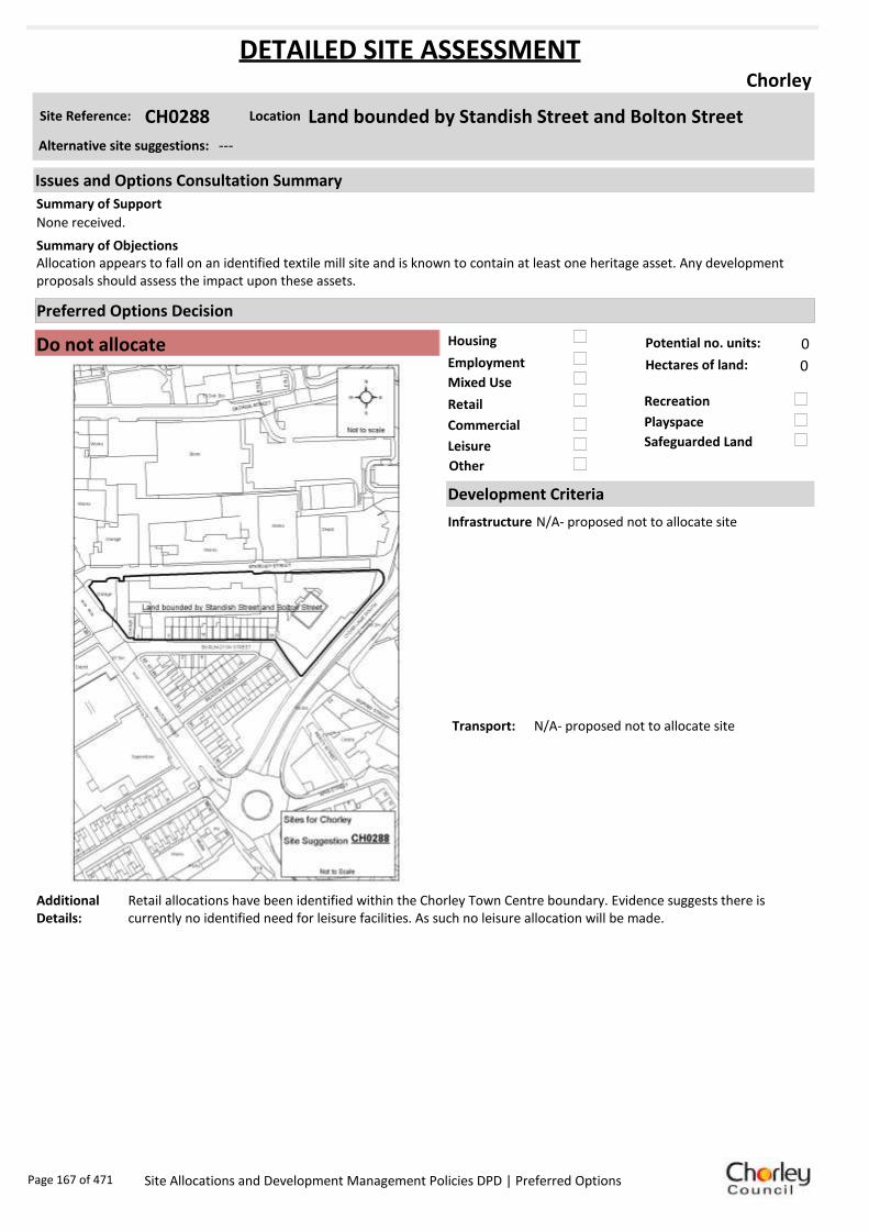
Housing
Employment
Mixed Use
Retail
Commercial
Leisure
Recreation
Safeguarded Land
Preferred Options Decision
Do not allocate Potential no. units: 0
Hectares of land: 0
Other
Site Reference: CH0288 Land bounded by Standish Street and Bolton Street
Chorley
None received.
Allocation appears to fall on an identified textile mill site and is known to contain at least one heritage asset. Any development proposals should assess the impact upon these assets.
Summary of Objections
Summary of Support
Alternative site suggestions: ---
DETAILED SITE ASSESSMENT
Location
Development Criteria
Infrastructure N/A- proposed not to allocate site
Transport: N/A- proposed not to allocate site
Additional Details:
Retail allocations have been identified within the Chorley Town Centre boundary. Evidence suggests there is currently no identified need for leisure facilities. As such no leisure allocation will be made.
Issues and Options Consultation Summary
Playspace
Page 167 of 471 Site Allocations and Development Management Policies DPD | Preferred Options

Sustainability Appraisal
Key + Minor positive ++ Major positive - Minor negative -- Major negative 0 Neutral / No link
Site Ref CH0288
Address Land bounded by Standish Street and Bolton Street, Chorley
SA Objective
SA Effects
Comments Short term
Medium term
Long term
S1 + + + The site is located within 400m of the bus and train stations therefore it has good public transport access. It is however located on the edge of the town centre and detached from the main shopping area of the town centre.
S2 0 0 0 Allocating this site for retail development would have little impact on improving health and wellbeing.
S3 0 0 0 Allocating this site for retail development would have little impact on crime. This would need to be taken into account in the design of any development on the site.
S4 / / / There is no link between allocating this site for retail development and improving access to housing.
EN1 / / / There is no link between allocating this site for retail development and managing biodiversity and landscape character.
EN2 / / / There is no link between allocating this site for retail development and protecting and enhancing heritage.
EN3 + + +
Allocating this site for retail development would have a positive impact on tackling climate change due to its good public transport access. The site is also previously developed so redevelopment of the site would enable the re-use of land and resources.
EN4 / / / There is no link between allocating this site for retail development and managing flood risk.
EN5 + + + Allocating this site for retail development would help minimise air pollution due to its good public transport access.
EC1 + + + Retail development on this site would lead to the creation of jobs on a sustainable location.
EC2 / / / There is no link between allocating this site for retail development and improving skills.
EC3 / / / There is no link between allocating this site for retail development and the rural economy.
EC4 + + + Allocating the site for retail development would enable the provision of additional retail and related services on the edge of the town centre.
Comments This site has good access to public transport but is located on the edge of the town centre and is detached from the main shopping area which may discourage people from walking to the site. Retail development of the site would lead to the creation of a reasonable number of jobs. Priority for retail allocations should be given to sites within the town centre boundary in accordance with PPS4.
Page 168 of 471 Site Allocations and Development Management Policies DPD | Preferred Options

Housing
Employment
Mixed Use
Retail
Commercial
Leisure
Recreation
Safeguarded Land
Preferred Options Decision
Undecided Potential no. units: 0
Hectares of land: 0
Other Suggested recreation allocation. Await results of Open Space Study.
Site Reference: CH0289 Southport Road
Chorley
None received.
None received.Summary of Objections
Summary of Support
Alternative site suggestions: ---
DETAILED SITE ASSESSMENT
Location
Development Criteria
Infrastructure ---
Transport: ---
Additional Details:
It has been suggested that this site be allocated for recreation use. Until the results of the Open Space Study are received, no decisions will be made as to the allocation or otherwise of this site.
Issues and Options Consultation Summary
Playspace
Page 169 of 471 Site Allocations and Development Management Policies DPD | Preferred Options

Sustainability Appraisal
No sustainability Appraisal has been undertaken of this site suggestion. Until the findings of the
Open Space Study are produced, the Council will not be allocating additional land for recreation
purposes. Once the Study is complete, a decision on the allocation of this site for recreational use
can be made.
Page 170 of 471 Site Allocations and Development Management Policies DPD | Preferred Options

Housing
Employment
Mixed Use
Retail
Commercial
Leisure
Recreation
Safeguarded Land
Preferred Options Decision
Undecided Potential no. units: 0
Hectares of land: 0
Other Suggested recreation allocation. Await results of Open Space Study.
Site Reference: CH0302 Buttermere Green
Chorley
None received.
Site known to contain at least one heritage asset. Any proposed schemes should assess the implications of development upon identified heritage assets.
Summary of Objections
Summary of Support
Alternative site suggestions: ---
DETAILED SITE ASSESSMENT
Location
Development Criteria
Infrastructure ---
Transport: ---
Additional Details:
It has been suggested that this site be allocated for recreation use. Until the results of the Open Space Study are received, no decisions will be made as to the allocation or otherwise of this site.
Issues and Options Consultation Summary
Playspace
Page 171 of 471 Site Allocations and Development Management Policies DPD | Preferred Options

Sustainability Appraisal
No sustainability Appraisal has been undertaken of this site suggestion. Until the findings of the
Open Space Study are produced, the Council will not be allocating additional land for recreation
purposes. Once the Study is complete, a decision on the allocation of this site for recreational use
can be made.
Page 172 of 471 Site Allocations and Development Management Policies DPD | Preferred Options

Housing
Employment
Mixed Use
Retail
Commercial
Leisure
Recreation
Safeguarded Land
Preferred Options Decision
Allocate site Potential no. units: 0
Hectares of land: 6
Other
Site Reference: CH0306 Botany Bay area
Chorley
None received.
The Botany Bay complex and land to the north should be allocated for mixed use development to include retail, pubs, restaurants, hotels, offices, leisure and entertainment sues to reflect the existing and permitted uses on the site, the Local Plan allocations and the future role of the site as a key focus for investment in the Borough. The allocation appears to fall on an identified textile mil site and is known to contain at least one heritage asset. Any proposed schemes should assess the implications of development on the heritage assets.
Summary of Objections
Summary of Support
Alternative site suggestions: CH0194
DETAILED SITE ASSESSMENT
Location
Development Criteria
Infrastructure ---
Transport: All development proposals should achieve a high level of road safety, and will be assessed as such by the Council through the planning application process. Depending on what type of employment use or mix of uses this site is developed for, and depending on the size of the development, the Council will require the submission of either a Transport Statement or Transport Assessment and Travel Plan.
Additional Details:
---
Issues and Options Consultation Summary
Playspace
EP1.2
Page 173 of 471 Site Allocations and Development Management Policies DPD | Preferred Options

Sustainability Appraisal
Site Ref CH0306
Address Botany Bay, Chorley
SA Obj
Indicator Site Performance SA Comments
S1
Distance to railway station 2.41 to 3km Social This site has good access to frequent bus services however the site is 2.41 to 3km away from the nearest railway station. The site has very good road access and is in close proximity to both an A road junction and junction 8 of the M61 motorway. The site has poor access to a supermarket however the key service centre of Chorley is 1.61 to 2.4km away. Environmental The only identified negative effect in developing this site is the medium risk of contamination within the site. Economic There are no identified negative effects in developing this site.
Rail service frequency 4 or more/hour/direction Distance to nearest bus stop 0.41 to 0.8km Bus service frequency 6 or more/hour/direction Distance to service centre 1.61 to 2.4km Distance to A Road junction Up to 0.4km Distance to motorway junction Up to 1.6km Distance to supermarket 1.61 to 3km Distance to convenience store 0.41 to 0.8km Distance to Post Office 0.41 to 0.8km Distance to Primary School 0.41 to 0.8km Distance to Secondary School 1.61 to 3.2km On a cycle route Yes Distance to cycle route Up to 0.4km
S2
Distance to GP surgery 0.41 to 0.8km Distance to NHS general hospital Up to 2km Distance to public open space/park Up to 0.4km Distance to local centre 0.41 to 0.8km
EN1
Designation of land Key Service Centre Area of Separation Outside AONB Outside SSSI Outside Biological/ Geological Heritage Site Outside Agricultural classification 3
EN2
Conservation Area Outside Ancient Monument on site No Registered Park or Garden Outside Listed Building on site No Locally Listed Building on site No
EN3 Current/former land use Brownfield EN4 Flood Zone area All Zone 1
EN5 Contaminated land Medium risk Within 3km of a congestion spot Yes
EC1 Distance to employment site Up to 0.8km Access to Broadband Yes
EC2 Distance to further/higher education 1.61 to 3.2km
Del
iver
abili
ty
Indi
cato
rs
Access to sewer system
Yes
Is the site deliverable: Yes Access to water
Access to gas Access to electricity Existing road access At risk from hazardous installations No
Overall Site Performance Band Spectrum:
Overall Band:
B
Page 174 of 471 Site Allocations and Development Management Policies DPD | Preferred Options
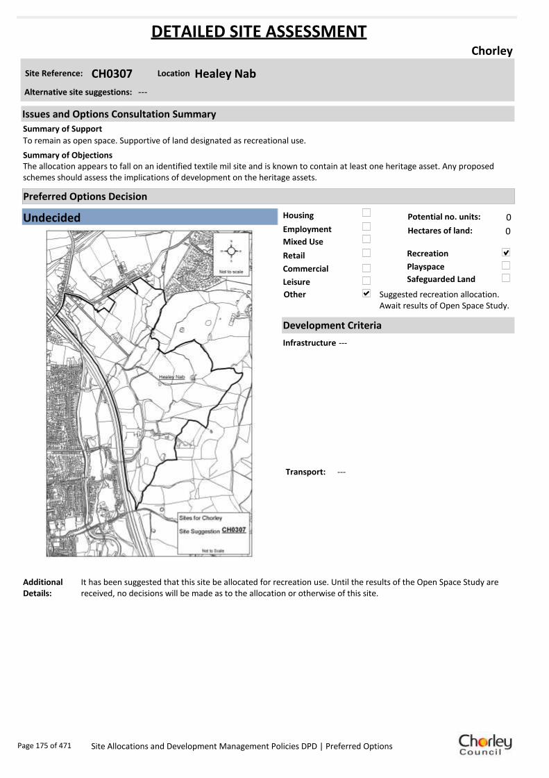
Housing
Employment
Mixed Use
Retail
Commercial
Leisure
Recreation
Safeguarded Land
Preferred Options Decision
Undecided Potential no. units: 0
Hectares of land: 0
Other Suggested recreation allocation. Await results of Open Space Study.
Site Reference: CH0307 Healey Nab
Chorley
To remain as open space. Supportive of land designated as recreational use.
The allocation appears to fall on an identified textile mil site and is known to contain at least one heritage asset. Any proposed schemes should assess the implications of development on the heritage assets.
Summary of Objections
Summary of Support
Alternative site suggestions: ---
DETAILED SITE ASSESSMENT
Location
Development Criteria
Infrastructure ---
Transport: ---
Additional Details:
It has been suggested that this site be allocated for recreation use. Until the results of the Open Space Study are received, no decisions will be made as to the allocation or otherwise of this site.
Issues and Options Consultation Summary
Playspace
Page 175 of 471 Site Allocations and Development Management Policies DPD | Preferred Options

Sustainability Appraisal
No sustainability Appraisal has been undertaken of this site suggestion. Until the findings of the
Open Space Study are produced, the Council will not be allocating additional land for recreation
purposes. Once the Study is complete, a decision on the allocation of this site for recreational use
can be made.
Page 176 of 471 Site Allocations and Development Management Policies DPD | Preferred Options

Housing
Employment
Mixed Use
Retail
Commercial
Leisure
Recreation
Safeguarded Land
Preferred Options Decision
Allocate site Potential no. units: 0
Hectares of land: 14.1
Other
Site Reference: CH0312 Great Knowley/ Botany
Chorley
None received.
Site is equally sustainable, accessible and deliverable as the neighbouring allocations. The Botany Bay complex and land to the north should be allocated for mixed use development to include retail, pubs, restaurants, hotels, offices, leisure and entertainment sues.
Summary of Objections
Summary of Support
Alternative site suggestions: CH0083 CH0119 CH0159 CH0239 CH0240 CH0241 CH0242
DETAILED SITE ASSESSMENT
Location
Development Criteria
Infrastructure ---
Transport: All development proposals should achieve a high level of road safety, and will be assessed as such by the Council through the planning application process. Depending on what type of employment use or mix of uses this site is developed for, and depending on the size of the development, the Council will require the submission of either a Transport Statement or Transport Assessment and Travel Plan.
Additional Details:
No changes to the Green Belt boundary are proposed.
Issues and Options Consultation Summary
Playspace
EP1.2
Page 177 of 471 Site Allocations and Development Management Policies DPD | Preferred Options

Sustainability Appraisal
Site Ref CH0312
Address Botany Bay, Chorley
SA Obj
Indicator Site Performance SA Comments
S1
Distance to railway station 2 .41 to 3 km Summarise the performance of the site against each SA objective. Split into social, environmental and economic.
Rail service freque ncy 4 or more/hour/direction Distance to nearest bus stop 0 .41 to 0 .8km Bus service frequency 6 or more/hour/direction Distance to se rvice centre 1 .61 to 2 .4km Distance to A Road junction Up to 0.4km Distance to motorway junction Up to 1.6km Distance to supermarket 1 .61 to 3 km Distance to conve nience s tore 0 .41 to 0 .8km Distance to Post Office 0 .41 to 0 .8km Distance to Primary School 0 .41 to 0 .8km Distance to Secondary School 1 .61 to 3 .2km On a cycle route Yes Distance to cycle route Up to 0.4km
S2
Distance to GP surge ry 0 .41 to 0 .8km Distance to NHS gene ra l hospital Up to 2km Distance to public open space/park Up to 0.4km Distance to local centre 0 .41 to 0 .8km
EN1
Designation of land Ke y Service Centre Are a of Se paration Outs ide AONB Outs ide SSSI Outs ide Biological/ G eological H eritag e Site Outs ide Agricultural classifica tion 3
EN2
Conservation Area Outs ide Ancie nt Monument on site No Regis te re d Park or G arden Outs ide Listed Building on site No Locally Lis te d Building on s ite No
EN3 Curre nt/former land use Brownfield EN4 Flood Zone a re a All Zone 1
EN5 Contaminated land M edium risk Within 3km of a congestion spot Yes
EC1 Distance to employment site Up to 0.8km Access to Broadband Yes
EC2 Distance to furthe r/higher education 1 .61 to 3 .2km
Del
iver
abili
ty
Indi
cato
rs
Access to sewer system
Yes
Is the site deliverable: Yes/No Access to wa te r
Access to ga s
Access to e lectricity
Exis ting road access
At risk from hazardous installations No
Overall Site Performance
Band Spe ctrum:
Overall Band:
B
Page 178 of 471 Site Allocations and Development Management Policies DPD | Preferred Options

Housing
Employment
Mixed Use
Retail
Commercial
Leisure
Recreation
Safeguarded Land
Preferred Options Decision
Allocate site Potential no. units: 10
Hectares of land: 0
Other
Site Reference: CH0352 Land at Worthy Street/Buchanan Street
Chorley
None received.
Site is known to contain at least one heritage asset. Any proposed schemes should assess the implications of development on the known assets.
Summary of Objections
Summary of Support
Alternative site suggestions: ---
DETAILED SITE ASSESSMENT
Location
Development Criteria
Infrastructure ---
Transport: All development proposals should achieve a high level of road safety, and will be assessed as such by the Council through the planning application process. For housing developments with between 50 and 80 units, the Council will require a Transport Statement. For developments of more than 80 units, the Council will require a Transport Assessment and Travel Plan as part of the application.
Additional Details:
---
Issues and Options Consultation Summary
Playspace
HS1.19
Page 179 of 471 Site Allocations and Development Management Policies DPD | Preferred Options

Sustainability Appraisal
Site Ref CH0352
Address Land at Worthy Street/Buchanan Street, Chorley
SA Obj
Indicator Site Performance SA Comments
S1
Distance to railway station Up to 0.8km Social The site has very good access to public transport with frequent bus and rail services. The site also has good road connections and access to all local services and facilities with the exception of distance to post office which is 0.81 to 1.2km away. Environmental There are no identified negative environmental effects in developing this site. Economic There are no identified negative economic effects in developing this site.
Rail service freque ncy 4 or more/hour/direction Distance to nearest bus stop Up to 0.4km Bus service frequency 2-5 /hour/direction Distance to se rvice centre Up to 0.8km Distance to A Road junction Up to 0.4km Distance to motorway junction 1 .61 to 3 km Distance to supermarket Up to 0.4km Distance to conve nience s tore Up to 0.4km Distance to Post Office 0 .81 to 1 .2km Distance to Primary School Up to 0.4km Distance to Secondary School 0 .81 to 1 .6km On a cycle route No Distance to cycle route Up to 0.4km
S2
Distance to GP surge ry 0 .41 to 0 .8km Distance to NHS gene ra l hospital 2.1 to 5 km Distance to public open space/park Up to 0.4km Distance to local centre Up to 0.4km
EN1
Designation of land Ke y Service Centre Are a of Se paration Outs ide AONB Outs ide SSSI Outs ide Biological/ G eological H eritag e Site Outs ide Agricultural classifica tion None
EN2
Conservation Area Outs ide Ancie nt Monument on site No Regis te re d Park or G arden Outs ide Listed Building on site No Locally Lis te d Building on s ite No
EN3 Curre nt/former land use Brownfield EN4 Flood Zone a re a All Zone 1
EN5 Contaminated land No risk Within 3km of a congestion spot Yes
EC1 Distance to employment site Up to 0.8km Access to Broadband Yes
EC2 Distance to furthe r/higher education 1 .61 to 3 .2km
Del
iver
abili
ty
Indi
cato
rs
Access to sewer system
Yes
Is the site deliverable: Yes Access to wa te r
Access to ga s
Access to e lectricity
Exis ting road access
At risk from hazardous installations No
Overall Site Performance
Band Spe ctrum:
Overall Band:
A
Page 180 of 471 Site Allocations and Development Management Policies DPD | Preferred Options

Housing
Employment
Mixed Use
Retail
Commercial
Leisure
Recreation
Safeguarded Land
Preferred Options Decision
Allocate site Potential no. units: 225
Hectares of land: 0
Other
Site Reference: CH0353 Land off Lower Burgh Way, Eaves Green
Chorley
Land at Eaves Green accords with the Core Strategy spatial strategy. Site is sustainably located and deliverable within the next 5 years, providing approximately 250 dwellings and 10,000 sqft of rural workspaces. Site will contribute 30% affordable through either on-site delivery or off-site contribution.
Development would significantly encroach on the Yarrow Valley Park and reduce wildlife corridors. A significant ‘buffer zone’ should remain. The Core Strategy seeks to protect, enhance and safeguard environmental assets from inappropriate development. Site is known to contain at least one heritage asset. Any development schemes must assess the potential impacts upon heritage assets.
Summary of Objections
Summary of Support
Alternative site suggestions: CH0268
DETAILED SITE ASSESSMENT
Location
Development Criteria
Infrastructure Water Cycle Study: Discussion and agreement with UU required on pumping station network. Agreement with EA require on attenuating runoff to nearby watercourses. Otherwise favourable location for development.
Transport: All development proposals should achieve a high level of road safety, and will be assessed as such by the Council through the planning application process. For housing developments with between 50 and 80 units, the Council will require a Transport Statement. For developments of more than 80 units, the Council will require a Transport Assessment and Travel Plan as part of the application.
Additional Details:
Site proposals should be considered in conjunction with site suggestion CH0268.
Issues and Options Consultation Summary
Playspace
HS1.1
Page 181 of 471 Site Allocations and Development Management Policies DPD | Preferred Options

Sustainability Appraisal
Site Ref CH0353
Address Land South of Housing Site HS1.3, Lower Burgh Way, Chorley
SA Obj
Indicator Site Performance SA Comments
S1
Distance to railway station Over 3km Social This site has very poor access all services and facilities. The site has poor access to public transport and is over 1.2km from the nearest convenience store. Environmental The only identified negative effects of developing this site is the site is a Greenfield site with a current designation of safeguarded land. Economic There are no identified negative economic effects in developing this site.
Rail service freque ncy 4 or more/hour/direction Distance to nearest bus stop 0 .41 to 0 .8km Bus service frequency 2-5 /hour/direction Distance to se rvice centre Over 3km Distance to A Road junction 1 .61 to 3 km Distance to motorway junction Over 3km Distance to supermarket Over 3km Distance to conve nience s tore Ove r 1 .2km Distance to Post Office Ove r 1 .6km Distance to Primary School 0 .41 to 0 .8km Distance to Secondary School 0 .81 to 1 .6km On a cycle route No Distance to cycle route Up to 0.4km
S2
Distance to GP surge ry Over 3km Distance to NHS gene ra l hospital 2.1 to 5 km Distance to public open space/park Up to 0.4km Distance to local centre 0 .81 to 1 .2km
EN1
Designation of land Safeguarded Land Are a of Se paration Outs ide AONB Outs ide SSSI Outs ide Biological/ G eological H eritag e Site Outs ide Agricultural classifica tion 3
EN2
Conservation Area Outs ide Ancie nt Monument on site No Regis te re d Park or G arden Outs ide Listed Building on site No Locally Lis te d Building on s ite No
EN3 Curre nt/former land use Greenfie ld EN4 Flood Zone a re a All Zone 1
EN5 Contaminated land M edium risk Within 3km of a congestion spot No
EC1 Distance to employment site Ove r 1 .6km Access to Broadband Yes
EC2 Distance to furthe r/higher education 3 .21 to 5 km
Del
iver
abili
ty
Indi
cato
rs
Access to sewer system
Yes
Is the site deliverable: Yes/No Access to wa te r
Access to ga s
Access to e lectricity
Exis ting road access
At risk from hazardous installations No
Overall Site Performance
Band Spe ctrum:
Overall Band:
D
Page 182 of 471 Site Allocations and Development Management Policies DPD | Preferred Options

Housing
Employment
Mixed Use
Retail
Commercial
Leisure
Recreation
Safeguarded Land
Preferred Options Decision
Do not allocate Potential no. units: 0
Hectares of land: 0
Other
Site Reference: CH0356 Yarrow Bridge Depot
Chorley
Support the site for use by the Gypsy and Roma Traveller communities. Site is ideally located for schools and health care. Allocating the site would fulfil a need in the area as there are no existing Traveller sites available.
Support for site as a Showman’s Quarters due to size and location of the site.
The Lancashire GTAA found no proven need for additional pitches in Central Lancashire. The suggested uses would have an un acceptable impact von the immediate area and wider landscape. The site is already needed for other uses e.g. salt storage and allotments.
Summary of Objections
Summary of Support
Alternative site suggestions: ---
DETAILED SITE ASSESSMENT
Location
Development Criteria
Infrastructure N/A- proposed not to allocate this site
Transport: N/A- proposed not to allocate this site
Additional Details:
N/A- proposed not to allocate this site
Issues and Options Consultation Summary
Playspace
Page 183 of 471 Site Allocations and Development Management Policies DPD | Preferred Options

Sustainability Appraisal
No sustainability Appraisal has been undertaken of this site suggestion. There is no demonstrable
need to allocate a site for Travelling Showpeople plots. This site is located in the Green Belt and does
not adjoin any designated settlements. Part of this site (including its entrance) is located in Flood
Zone 2 where there is a medium probability of flooding. PPS25 Development and Flood Risk aims to
steer new development to areas of the lowest probability of flooding (Zone 1). Therefore, this Zone
2 site is not favoured for development.
Page 184 of 471 Site Allocations and Development Management Policies DPD | Preferred Options
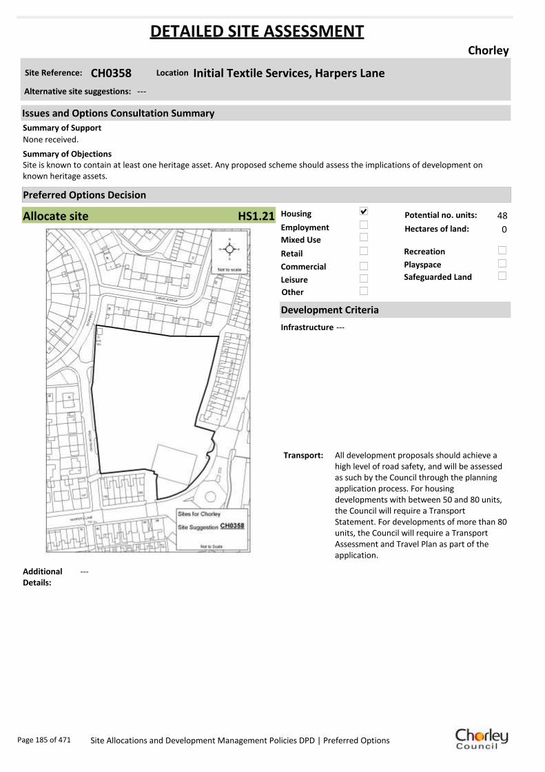
Housing
Employment
Mixed Use
Retail
Commercial
Leisure
Recreation
Safeguarded Land
Preferred Options Decision
Allocate site Potential no. units: 48
Hectares of land: 0
Other
Site Reference: CH0358 Initial Textile Services, Harpers Lane
Chorley
None received.
Site is known to contain at least one heritage asset. Any proposed scheme should assess the implications of development on known heritage assets.
Summary of Objections
Summary of Support
Alternative site suggestions: ---
DETAILED SITE ASSESSMENT
Location
Development Criteria
Infrastructure ---
Transport: All development proposals should achieve a high level of road safety, and will be assessed as such by the Council through the planning application process. For housing developments with between 50 and 80 units, the Council will require a Transport Statement. For developments of more than 80 units, the Council will require a Transport Assessment and Travel Plan as part of the application.
Additional Details:
---
Issues and Options Consultation Summary
Playspace
HS1.21
Page 185 of 471 Site Allocations and Development Management Policies DPD | Preferred Options

Sustainability Appraisal
Site Ref CH0358
Address Initial Textile Services, Harpers Lane, Chorley
SA Obj
Indicator Site Performance SA Comments
S1
Distance to railway station 0 .81 to 1 .6km Social This site has very good access to public transport with frequent bus and rail services. The site is in close proximity to the road and motorway networks and has good access to all local services and facilities. The site is not on a cycle route but is up to 0.4km away from a route. Environmental The only identified negative environmental factor effecting this site is the medium risk of contamination. Economic There are no identified negative economic effects in developing this site.
Rail service freque ncy 4 or more/hour/direction Distance to nearest bus stop Up to 0.4km Bus service frequency 2-5 /hour/direction Distance to se rvice centre 0 .81 to 1 .6km Distance to A Road junction 0 .41 to 0 .8km Distance to motorway junction 1 .61 to 3 km Distance to supermarket 0 .41 to 0 .8km Distance to conve nience s tore Up to 0.4km Distance to Post Office Up to 0.4km Distance to Primary School Up to 0.4km Distance to Secondary School 0 .81 to 1 .6km On a cycle route No Distance to cycle route Up to 0.4km
S2
Distance to GP surge ry Up to 0.4km Distance to NHS gene ra l hospital Up to 2km Distance to public open space/park Up to 0.4km Distance to local centre Up to 0.4km
EN1
Designation of land Ke y Service Centre Are a of Se paration Outs ide AONB Outs ide SSSI Outs ide Biological/ G eological H eritag e Site Outs ide Agricultural classifica tion None
EN2
Conservation Area Outs ide Ancie nt Monument on site No Regis te re d Park or G arden Outs ide Listed Building on site No Locally Lis te d Building on s ite No
EN3 Curre nt/former land use Brownfield EN4 Flood Zone a re a All Zone 1
EN5 Contaminated land M edium risk Within 3km of a congestion spot Yes
EC1 Distance to employment site Up to 0.8km Access to Broadband Yes
EC2 Distance to furthe r/higher education 1 .61 to 3 .2km
Del
iver
abili
ty
Indi
cato
rs
Access to sewer system
Yes
Is the site deliverable: Yes Access to wa te r
Access to ga s
Access to e lectricity
Exis ting road access
At risk from hazardous installations No
Overall Site Performance
Band Spe ctrum:
Overall Band:
A
Page 186 of 471 Site Allocations and Development Management Policies DPD | Preferred Options

Housing
Employment
Mixed Use
Retail
Commercial
Leisure
Recreation
Safeguarded Land
Preferred Options Decision
Allocate site Potential no. units: 14
Hectares of land: 1
Other
Site Reference: CH0359 Lyons Lane Mill, Townley Street
Chorley
None received.
Allocation appears to fall on an identified textile mill site and is known to contain at least one heritage asset. Any proposed scheme should assess the implications/impact of development upon the known heritage assets.
Summary of Objections
Summary of Support
Alternative site suggestions: ---
DETAILED SITE ASSESSMENT
Location
Development Criteria
Infrastructure ---
Transport: All development proposals should achieve a high level of road safety, and will be assessed as such by the Council through the planning application process. Depending on the mix of uses this site is developed for, and depending on the size of the development, the Council will require the submission of either a Transport Statement or Transport Assessment and Travel Plan.
Additional Details:
---
Issues and Options Consultation Summary
Playspace
HS1.18; EP1.9
Page 187 of 471 Site Allocations and Development Management Policies DPD | Preferred Options

Sustainability Appraisal
Site Ref CH0359
Address Lyons Lane Mill, Townley Street, Chorley
SA Obj
Indicator Site Performance SA Comments
S1
Distance to railway station Up to 0.8km Social This site has good access to public transport with frequent bus and rail services. The site also has good road connections and is close to a motorway junction. The site has full access to all local services and facilities. Environmental There are no identified negative environmental effects in developing this site. Economic There are no identified negative economic effects in developing this site.
Rail service freque ncy 4 or more/hour/direction Distance to nearest bus stop Up to 0.4km Bus service frequency 6 or more/hour/direction Distance to se rvice centre Up to 0.8km Distance to A Road junction Up to 0.4km Distance to motorway junction 1 .61 to 3 km Distance to supermarket Up to 0.4km Distance to conve nience s tore Up to 0.4km Distance to Post Office 0 .41 to 0 .8km Distance to Primary School Up to 0.4km Distance to Secondary School 0 .81 to 1 .6km On a cycle route No Distance to cycle route Up to 0.4km
S2
Distance to GP surge ry Up to 0.4km Distance to NHS gene ra l hospital Up to 2km Distance to public open space/park Up to 0.4km Distance to local centre Up to 0.4km
EN1
Designation of land Ke y Service Centre Are a of Se paration Outs ide AONB Outs ide SSSI Outs ide Biological/ G eological H eritag e Site Outs ide Agricultural classifica tion None
EN2
Conservation Area Outs ide Ancie nt Monument on site No Regis te re d Park or G arden Outs ide Listed Building on site No Locally Lis te d Building on s ite No
EN3 Curre nt/former land use Brownfield EN4 Flood Zone a re a All Zone 1
EN5 Contaminated land No risk Within 3km of a congestion spot Yes
EC1 Distance to employment site Up to 0.8km Access to Broadband Yes
EC2 Distance to furthe r/higher education 1 .61 to 3 .2km
Del
iver
abili
ty
Indi
cato
rs
Access to sewer system
Yes
Is the site deliverable: Yes Access to wa te r
Access to ga s
Access to e lectricity
Exis ting road access
At risk from hazardous installations No
Overall Site Performance
Band Spe ctrum:
Overall Band:
A
Page 188 of 471 Site Allocations and Development Management Policies DPD | Preferred Options

Housing
Employment
Mixed Use
Retail
Commercial
Leisure
Recreation
Safeguarded Land
Preferred Options Decision
Retain existing designation Potential no. units: 0
Hectares of land: 0
Other
Site Reference: CH0365 Lower Healey Business Park
Chorley
New site suggestion.
New site suggestion.Summary of Objections
Summary of Support
Alternative site suggestions: CH0031
DETAILED SITE ASSESSMENT
Location
Development Criteria
Infrastructure N/A- proposed not to allocate site
Transport: N/A- proposed not to allocate site
Additional Details:
Site proposals should be considered in conjunction with site suggestion CH0031. land is east of the M61 and would have significant impact on open countryside, and there is a significant access constraint. A small part of the site is a small business park with low occupancy.
Issues and Options Consultation Summary
Playspace
BNE2.1
Page 189 of 471 Site Allocations and Development Management Policies DPD | Preferred Options

Sustainability Appraisal
Site Ref CH0365
Address Lower Healey Works, Froom Street, Chorley
SA Obj
Indicator Site Performance SA Comments
S1
Distance to railway station 1 .61 to 2 .4km Social This site has good access to public transport and services are frequent. The site is only 0.81 to 1.6km from the key service centre of Chorley Town centre. The site is 1.61 to 3km from the nearest supermarket although there are local convenience stores in the local area. The site is not close to an A road junction making access poor to the site. Environmental The only identified negative environmental effects in developing this site are its current safeguarded land designation and part of the site is within flood zone 2 and is intermediately at risk of flooding. Economic There are no identified negative economic effects in developing this site.
Rail service freque ncy 4 or more/hour/direction Distance to nearest bus stop 0 .41 to 0 .8km Bus service frequency 2-5 /hour/direction Distance to se rvice centre 0 .81 to 1 .6km Distance to A Road junction 0 .81 to 1 .6km Distance to motorway junction Over 3km Distance to supermarket 1 .61 to 3 km Distance to conve nience s tore 0 .41 to 0 .8km Distance to Post Office 0 .41 to 0 .8km Distance to Primary School 0 .41 to 0 .8km Distance to Secondary School 1 .61 to 3 .2km On a cycle route No Distance to cycle route Up to 0.4km
S2
Distance to GP surge ry 0 .81 to 1 .6km Distance to NHS gene ra l hospital 2.1 to 5 km Distance to public open space/park Up to 0.4km Distance to local centre 0 .41 to 0 .8km
EN1
Designation of land Safeguarded Land Are a of Se paration Outs ide AONB Outs ide SSSI Outs ide Biological/ G eological H eritag e Site Outs ide Agricultural classifica tion None
EN2
Conservation Area Outs ide Ancie nt Monument on site No Regis te re d Park or G arden Outs ide Listed Building on site No Locally Lis te d Building on s ite No
EN3 Curre nt/former land use Brownfield EN4 Flood Zone a re a Part Zone 2
EN5 Contaminated land M edium risk Within 3km of a congestion spot Yes
EC1 Distance to employment site 1 .21 to 1 .6km Access to Broadband Yes
EC2 Distance to furthe r/higher education 1 .61 to 3 .2km
Del
iver
abili
ty
Indi
cato
rs
Access to sewer system
Yes
Is the site deliverable: Yes Access to wa te r
Access to ga s
Access to e lectricity
Exis ting road access
At risk from hazardous installations No
Overall Site Performance
Band Spe ctrum:
Overall Band:
B
Page 190 of 471 Site Allocations and Development Management Policies DPD | Preferred Options
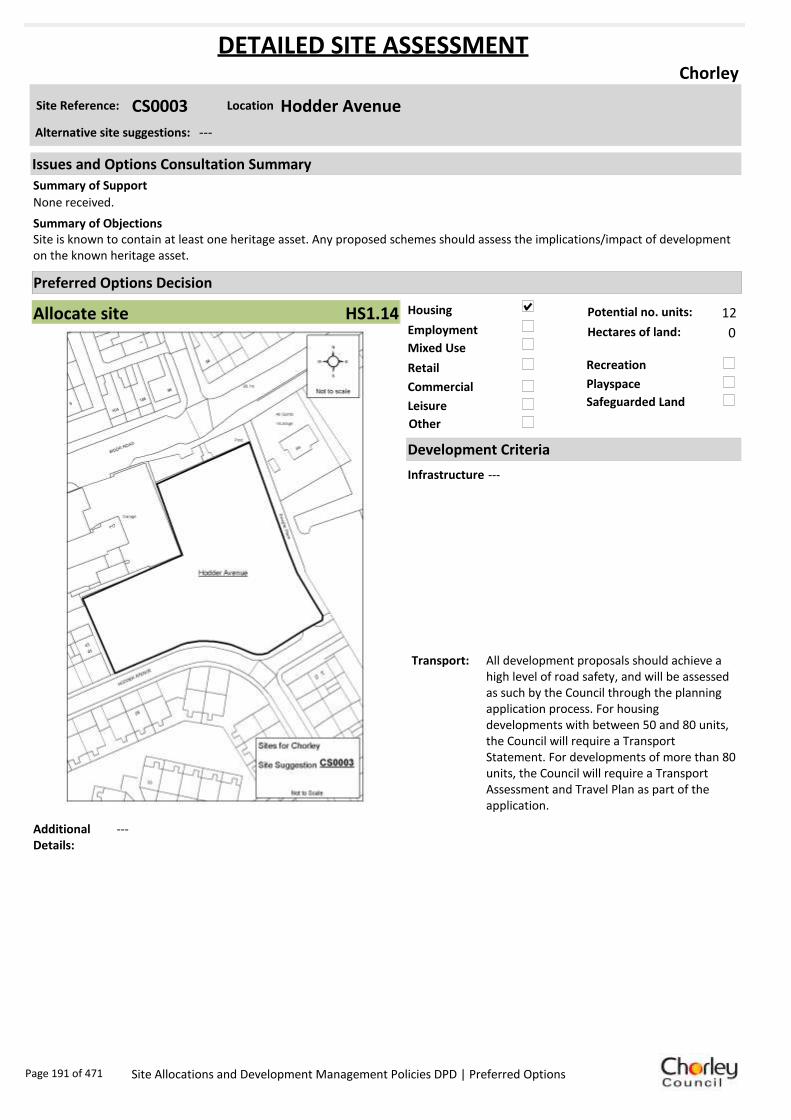
Housing
Employment
Mixed Use
Retail
Commercial
Leisure
Recreation
Safeguarded Land
Preferred Options Decision
Allocate site Potential no. units: 12
Hectares of land: 0
Other
Site Reference: CS0003 Hodder Avenue
Chorley
None received.
Site is known to contain at least one heritage asset. Any proposed schemes should assess the implications/impact of development on the known heritage asset.
Summary of Objections
Summary of Support
Alternative site suggestions: ---
DETAILED SITE ASSESSMENT
Location
Development Criteria
Infrastructure ---
Transport: All development proposals should achieve a high level of road safety, and will be assessed as such by the Council through the planning application process. For housing developments with between 50 and 80 units, the Council will require a Transport Statement. For developments of more than 80 units, the Council will require a Transport Assessment and Travel Plan as part of the application.
Additional Details:
---
Issues and Options Consultation Summary
Playspace
HS1.14
Page 191 of 471 Site Allocations and Development Management Policies DPD | Preferred Options

Sustainability Appraisal
Site Ref CS0003
Address Hodder Avenue, Chorley
SA Obj
Indicator Site Performance SA Comments
S1
Distance to railway station 1 .61 to 2 .4km Social This site has very good access to public transport with very frequent bus and rail services. The site has very good access to all services and facilities with the exception of a GP surgery which is 0.81 to 1.6km away. Environmental There are no identified negative environmental effects in developing this site. Economic There are no identified negative economic effects in developing this site.
Rail service freque ncy 4 or more/hour/direction Distance to nearest bus stop Up to 0.4km Bus service frequency 6 or more/hour/direction Distance to se rvice centre Up to 0.8km Distance to A Road junction 0 .81 to 1 .6km Distance to motorway junction Over 3km Distance to supermarket 0 .81 to 1 .6km Distance to conve nience s tore Up to 0.4km Distance to Post Office 0 .41 to 0 .8km Distance to Primary School Up to 0.4km Distance to Secondary School Up to 0.8km On a cycle route No Distance to cycle route Up to 0.4km
S2
Distance to GP surge ry 0 .81 to 1 .6km Distance to NHS gene ra l hospital 2.1 to 5 km Distance to public open space/park Up to 0.4km Distance to local centre Up to 0.4km
EN1
Designation of land Ke y Service Centre Are a of Se paration Outs ide AONB Outs ide SSSI Outs ide Biological/ G eological H eritag e Site Outs ide Agricultural classifica tion None
EN2
Conservation Area Outs ide Ancie nt Monument on site No Regis te re d Park or G arden Outs ide Listed Building on site No Locally Lis te d Building on s ite No
EN3 Curre nt/former land use Brownfield EN4 Flood Zone a re a All Zone 1
EN5 Contaminated land No risk Within 3km of a congestion spot Yes
EC1 Distance to employment site Up to 0.8km Access to Broadband Yes
EC2 Distance to furthe r/higher education 1 .61 to 3 .2km
Del
iver
abili
ty
Indi
cato
rs
Access to sewer system
Yes
Is the site deliverable: Yes Access to wa te r
Access to ga s
Access to e lectricity
Exis ting road access
At risk from hazardous installations No
Overall Site Performance
Band Spe ctrum:
Overall Band:
B
Page 192 of 471 Site Allocations and Development Management Policies DPD | Preferred Options

Housing
Employment
Mixed Use
Retail
Commercial
Leisure
Recreation
Safeguarded Land
Preferred Options Decision
Do not allocate Potential no. units: 0
Hectares of land: 0
Other
Site Reference: CS0004 Buckingham Street Yard
Chorley
None received.
None received.Summary of Objections
Summary of Support
Alternative site suggestions: ---
DETAILED SITE ASSESSMENT
Location
Development Criteria
Infrastructure N/A- proposed not to allocate site
Transport: N/A- proposed not to allocate site
Additional Details:
Employment use will be protected.
Issues and Options Consultation Summary
Playspace
Page 193 of 471 Site Allocations and Development Management Policies DPD | Preferred Options
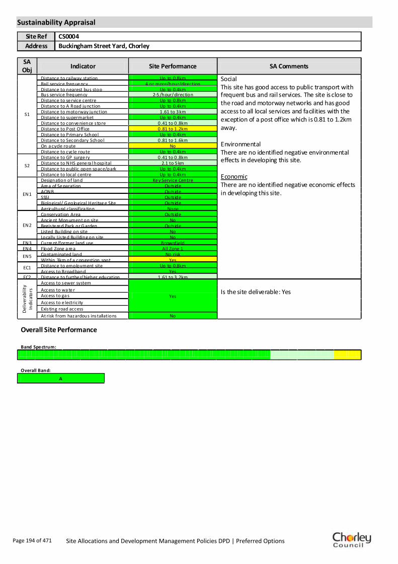
Sustainability Appraisal
Site Ref CS0004
Address Buckingham Street Yard, Chorley
SA Obj
Indicator Site Performance SA Comments
S1
Distance to railway station Up to 0.8km Social This site has good access to public transport with frequent bus and rail services. The site is close to the road and motorway networks and has good access to all local services and facilities with the exception of a post office which is 0.81 to 1.2km away. Environmental There are no identified negative environmental effects in developing this site. Economic There are no identified negative economic effects in developing this site.
Rail service freque ncy 4 or more/hour/direction Distance to nearest bus stop Up to 0.4km Bus service frequency 2-5 /hour/direction Distance to se rvice centre Up to 0.8km Distance to A Road junction Up to 0.4km Distance to motorway junction 1 .61 to 3 km Distance to supermarket Up to 0.4km Distance to conve nience s tore 0 .41 to 0 .8km Distance to Post Office 0 .81 to 1 .2km Distance to Primary School Up to 0.4km Distance to Secondary School 0 .81 to 1 .6km On a cycle route No Distance to cycle route Up to 0.4km
S2
Distance to GP surge ry 0 .41 to 0 .8km Distance to NHS gene ra l hospital 2.1 to 5 km Distance to public open space/park Up to 0.4km Distance to local centre Up to 0.4km
EN1
Designation of land Ke y Service Centre Are a of Se paration Outs ide AONB Outs ide SSSI Outs ide Biological/ G eological H eritag e Site Outs ide Agricultural classifica tion None
EN2
Conservation Area Outs ide Ancie nt Monument on site No Regis te re d Park or G arden Outs ide Listed Building on site No Locally Lis te d Building on s ite No
EN3 Curre nt/former land use Brownfield EN4 Flood Zone a re a All Zone 1
EN5 Contaminated land No risk Within 3km of a congestion spot Yes
EC1 Distance to employment site Up to 0.8km Access to Broadband Yes
EC2 Distance to furthe r/higher education 1 .61 to 3 .2km
Del
iver
abili
ty
Indi
cato
rs
Access to sewer system
Yes
Is the site deliverable: Yes Access to wa te r
Access to ga s
Access to e lectricity
Exis ting road access
At risk from hazardous installations No
Overall Site Performance
Band Spe ctrum:
Overall Band:
A
Page 194 of 471 Site Allocations and Development Management Policies DPD | Preferred Options

Housing
Employment
Mixed Use
Retail
Commercial
Leisure
Recreation
Safeguarded Land
Preferred Options Decision
Allocate site Potential no. units: 144
Hectares of land: 0
Other
Site Reference: CS0025 West Of Blackburn Road
Chorley
None received.
Request site to remain as safeguarded, grazing land.Summary of Objections
Summary of Support
Alternative site suggestions: ---
DETAILED SITE ASSESSMENT
Location
Development Criteria
Infrastructure ---
Transport: All development proposals should achieve a high level of road safety, and will be assessed as such by the Council through the planning application process. For housing developments with between 50 and 80 units, the Council will require a Transport Statement. For developments of more than 80 units, the Council will require a Transport Assessment and Travel Plan as part of the application.
Additional Details:
---
Issues and Options Consultation Summary
Playspace
HS1.10
Page 195 of 471 Site Allocations and Development Management Policies DPD | Preferred Options

Sustainability Appraisal
Site Ref CS0025
Address West Of Blackburn Road, Chorley
SA Obj
Indicator Site Performance SA Comments
S1
Distance to railway station 1 .61 to 2 .4km Social This site has good access to public transport although bus services are not very frequent. The site has access to local services and facilities and is close to the motorway junction. The site is 1.61 to 2.4km from the key service centre of Chorley. Environmental The only identified negative effect in developing this site is that the site is Greenfield within a current safeguarded land designation. Economic There are no identified negative economic effects in developing the site.
Rail service freque ncy 4 or more/hour/direction Distance to nearest bus stop Up to 0.4km Bus service frequency Less than 1/hour/dire ction Distance to se rvice centre 1 .61 to 2 .4km Distance to A Road junction 0 .81 to 1 .6km Distance to motorway junction 1 .61 to 3 km Distance to supermarket 0 .81 to 1 .6km Distance to conve nience s tore 0 .41 to 0 .8km Distance to Post Office 0 .81 to 1 .2km Distance to Primary School 0 .41 to 0 .8km Distance to Secondary School 1 .61 to 3 .2km On a cycle route Yes Distance to cycle route Up to 0.4km
S2
Distance to GP surge ry 0 .81 to 1 .6km Distance to NHS gene ra l hospital Up to 2km Distance to public open space/park Up to 0.4km Distance to local centre 0 .81 to 1 .2km
EN1
Designation of land Safeguarded Land Are a of Se paration Outs ide AONB Outs ide SSSI Outs ide Biological/ G eological H eritag e Site Outs ide Agricultural classifica tion None
EN2
Conservation Area Outs ide Ancie nt Monument on site No Regis te re d Park or G arden Outs ide Listed Building on site No Locally Lis te d Building on s ite No
EN3 Curre nt/former land use Greenfie ld EN4 Flood Zone a re a All Zone 1
EN5 Contaminated land No risk Within 3km of a congestion spot Yes
EC1 Distance to employment site 1 .21 to 1 .6km Access to Broadband Yes
EC2 Distance to furthe r/higher education 3 .21 to 5 km
Del
iver
abili
ty
Indi
cato
rs
Access to sewer system
Yes
Is the site deliverable: Yes Access to wa te r
Access to ga s
Access to e lectricity
Exis ting road access
At risk from hazardous installations No
Overall Site Performance
Band Spe ctrum:
Overall Band:
B
Page 196 of 471 Site Allocations and Development Management Policies DPD | Preferred Options
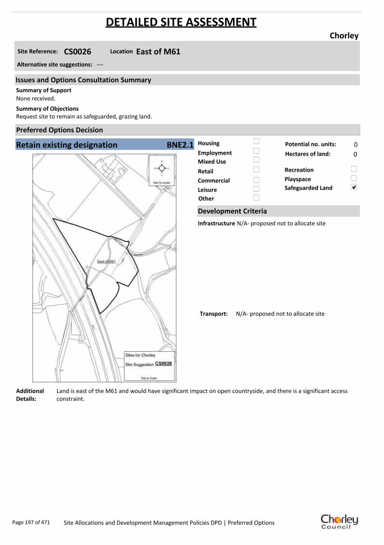
Housing
Employment
Mixed Use
Retail
Commercial
Leisure
Recreation
Safeguarded Land
Preferred Options Decision
Retain existing designation Potential no. units: 0
Hectares of land: 0
Other
Site Reference: CS0026 East of M61
Chorley
None received.
Request site to remain as safeguarded, grazing land.Summary of Objections
Summary of Support
Alternative site suggestions: ---
DETAILED SITE ASSESSMENT
Location
Development Criteria
Infrastructure N/A- proposed not to allocate site
Transport: N/A- proposed not to allocate site
Additional Details:
Land is east of the M61 and would have significant impact on open countryside, and there is a significant access constraint.
Issues and Options Consultation Summary
Playspace
BNE2.1
Page 197 of 471 Site Allocations and Development Management Policies DPD | Preferred Options

Sustainability Appraisal
Site Ref CS0026
Address East of M61, Chorley
SA Obj
Indicator Site Performance SA Comments
S1
Distance to railway station 2 .41 to 3 km Social This site has good access to public transport and is in close proximity to a primary school and post office, however the site is 0.81 to 1.2km from the nearest convenience store and 1.61 to 3km from an A road junction. Road access to the site is poor. Environmental The site is located within flood zone 3 which is a high risk area. The site is also Greenfield and is currently designated safeguarded land. Economic There are no identified negative economic effects in developing this site.
Rail service freque ncy 4 or more/hour/direction Distance to nearest bus stop 0 .41 to 0 .8km Bus service frequency Less than 1/hour/dire ction Distance to se rvice centre 1 .61 to 2 .4km Distance to A Road junction 1 .61 to 3 km Distance to motorway junction Over 3km Distance to supermarket 1 .61 to 3 km Distance to conve nience s tore 0 .81 to 1 .2km Distance to Post Office Up to 0.4km Distance to Primary School Up to 0.4km Distance to Secondary School 1 .61 to 3 .2km On a cycle route No Distance to cycle route Up to 0.4km
S2
Distance to GP surge ry 0 .81 to 1 .6km Distance to NHS gene ra l hospital 2.1 to 5 km Distance to public open space/park Up to 0.4km Distance to local centre 0 .81 to 1 .2km
EN1
Designation of land Safeguarded Land Are a of Se paration Outs ide AONB Outs ide SSSI Outs ide Biological/ G eological H eritag e Site Outs ide Agricultural classifica tion None
EN2
Conservation Area Outs ide Ancie nt Monument on site No Regis te re d Park or G arden Outs ide Listed Building on site No Locally Lis te d Building on s ite No
EN3 Curre nt/former land use Greenfie ld EN4 Flood Zone a re a All Zone 3
EN5 Contaminated land No risk Within 3km of a congestion spot Yes
EC1 Distance to employment site Ove r 1 .6km Access to Broadband Yes
EC2 Distance to furthe r/higher education 3 .21 to 5 km
Del
iver
abili
ty
Indi
cato
rs
Access to sewer system
Yes
Is the site deliverable: Yes Access to wa te r
Access to ga s
Access to e lectricity
Exis ting road access
At risk from hazardous installations No
Overall Site Performance
Band Spe ctrum:
Overall Band:
C
Page 198 of 471 Site Allocations and Development Management Policies DPD | Preferred Options
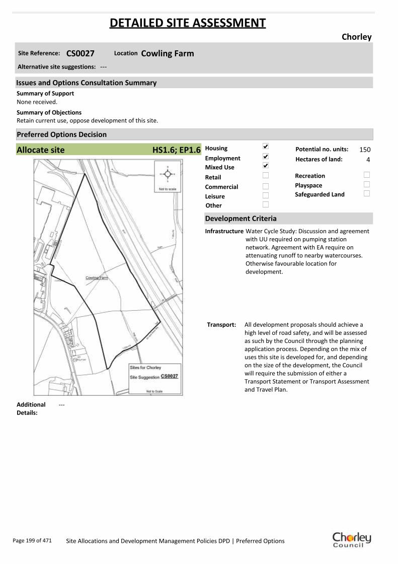
Housing
Employment
Mixed Use
Retail
Commercial
Leisure
Recreation
Safeguarded Land
Preferred Options Decision
Allocate site Potential no. units: 150
Hectares of land: 4
Other
Site Reference: CS0027 Cowling Farm
Chorley
None received.
Retain current use, oppose development of this site.Summary of Objections
Summary of Support
Alternative site suggestions: ---
DETAILED SITE ASSESSMENT
Location
Development Criteria
Infrastructure Water Cycle Study: Discussion and agreement with UU required on pumping station network. Agreement with EA require on attenuating runoff to nearby watercourses. Otherwise favourable location for development.
Transport: All development proposals should achieve a high level of road safety, and will be assessed as such by the Council through the planning application process. Depending on the mix of uses this site is developed for, and depending on the size of the development, the Council will require the submission of either a Transport Statement or Transport Assessment and Travel Plan.
Additional Details:
---
Issues and Options Consultation Summary
Playspace
HS1.6; EP1.6
Page 199 of 471 Site Allocations and Development Management Policies DPD | Preferred Options

Sustainability Appraisal
Site Ref CS0027
Address Cowling Farm, Chorley
SA Obj
Indicator Site Performance SA Comments
S1
Distance to railway station 1 .61 to 2 .4km Social This site has poor access to public transport with bus services less than hourly. The railway station is 1.61 to 2.4km away although there are frequent rail services. The site has poor access to local services and facilities with poor access to the road network. Environmental The only identified negative environmental effect in developing this site is the site is a Greenfield site. Economic There are no identified negative economic effects in developing this site.
Rail service freque ncy 4 or more/hour/direction Distance to nearest bus stop Up to 0.4km Bus service frequency Less than 1/hour/dire ction Distance to se rvice centre 0 .81 to 1 .6km Distance to A Road junction 0 .81 to 1 .6km Distance to motorway junction Over 3km Distance to supermarket 0 .81 to 1 .6km Distance to conve nience s tore 0 .41 to 0 .8km Distance to Post Office 1 .21 to 1 .6km Distance to Primary School 0 .41 to 0 .8km Distance to Secondary School 0 .81 to 1 .6km On a cycle route No Distance to cycle route Up to 0.4km
S2
Distance to GP surge ry 1 .61 to 3 km Distance to NHS gene ra l hospital 2.1 to 5 km Distance to public open space/park Up to 0.4km Distance to local centre 1 .21 to 1 .6km
EN1
Designation of land Ke y Service Centre Are a of Se paration Outs ide AONB Outs ide SSSI Outs ide Biological/ G eological H eritag e Site Outs ide Agricultural classifica tion 3
EN2
Conservation Area Outs ide Ancie nt Monument on site No Regis te re d Park or G arden Outs ide Listed Building on site No Locally Lis te d Building on s ite No
EN3 Curre nt/former land use Greenfie ld EN4 Flood Zone a re a All Zone 1
EN5 Contaminated land No risk Within 3km of a congestion spot Yes
EC1 Distance to employment site Up to 0.8km Access to Broadband Yes
EC2 Distance to furthe r/higher education 1 .61 to 3 .2km
Del
iver
abili
ty
Indi
cato
rs
Access to sewer system
Yes
Is the site deliverable: Yes Access to wa te r
Access to ga s
Access to e lectricity
Exis ting road access
At risk from hazardous installations No
Overall Site Performance
Band Spe ctrum:
Overall Band:
B
Page 200 of 471 Site Allocations and Development Management Policies DPD | Preferred Options
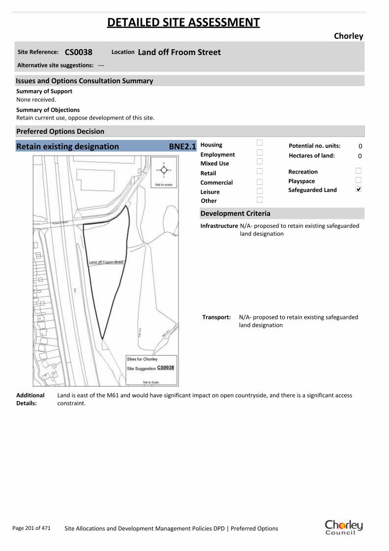
Housing
Employment
Mixed Use
Retail
Commercial
Leisure
Recreation
Safeguarded Land
Preferred Options Decision
Retain existing designation Potential no. units: 0
Hectares of land: 0
Other
Site Reference: CS0038 Land off Froom Street
Chorley
None received.
Retain current use, oppose development of this site.Summary of Objections
Summary of Support
Alternative site suggestions: ---
DETAILED SITE ASSESSMENT
Location
Development Criteria
Infrastructure N/A- proposed to retain existing safeguarded land designation
Transport: N/A- proposed to retain existing safeguarded land designation
Additional Details:
Land is east of the M61 and would have significant impact on open countryside, and there is a significant access constraint.
Issues and Options Consultation Summary
Playspace
BNE2.1
Page 201 of 471 Site Allocations and Development Management Policies DPD | Preferred Options

Sustainability Appraisal
Site Ref CS0038
Address Land off Froom Street, Chorley
SA Obj
Indicator Site Performance SA Comments
S1
Distance to railway station 1 .61 to 2 .4km Social This site has good access to public transport and services are frequent. The site is only 0.81 to 1.6km from the key service centre of Chorley Town centre. The site is 1.61 to 3km from the nearest supermarket although there are local convenience stores in the local area. The site is not close to an A road junction making access poor to the site. Environmental The only identified negative environmental effect in developing this site is its current designation of safeguarded land. Economic There are no identified negative economic effects in developing this site.
Rail service freque ncy 4 or more/hour/direction Distance to nearest bus stop 0 .41 to 0 .8km Bus service frequency 2-5 /hour/direction Distance to se rvice centre 0 .81 to 1 .6km Distance to A Road junction 0 .81 to 1 .6km Distance to motorway junction Over 3km Distance to supermarket 1 .61 to 3 km Distance to conve nience s tore 0 .41 to 0 .8km Distance to Post Office 0 .41 to 0 .8km Distance to Primary School 0 .41 to 0 .8km Distance to Secondary School 1 .61 to 3 .2km On a cycle route No Distance to cycle route Up to 0.4km
S2
Distance to GP surge ry 0 .81 to 1 .6km Distance to NHS gene ra l hospital 2.1 to 5 km Distance to public open space/park Up to 0.4km Distance to local centre 0 .41 to 0 .8km
EN1
Designation of land Safeguarded Land Are a of Se paration Outs ide AONB Outs ide SSSI Outs ide Biological/ G eological H eritag e Site Outs ide Agricultural classifica tion None
EN2
Conservation Area Outs ide Ancie nt Monument on site No Regis te re d Park or G arden Outs ide Listed Building on site No Locally Lis te d Building on s ite No
EN3 Curre nt/former land use Greenfie ld EN4 Flood Zone a re a All Zone 1
EN5 Contaminated land No risk Within 3km of a congestion spot Yes
EC1 Distance to employment site 1 .21 to 1 .6km Access to Broadband Yes
EC2 Distance to furthe r/higher education 1 .61 to 3 .2km
Del
iver
abili
ty
Indi
cato
rs
Access to sewer system
Yes
Is the site deliverable: Yes Access to wa te r
Access to ga s
Access to e lectricity
Exis ting road access
At risk from hazardous installations No
Overall Site Performance
Band Spe ctrum:
Overall Band:
B
Page 202 of 471 Site Allocations and Development Management Policies DPD | Preferred Options

Housing
Employment
Mixed Use
Retail
Commercial
Leisure
Recreation
Safeguarded Land
Preferred Options Decision
Do not allocate Potential no. units: 0
Hectares of land: 0
Other
Site Reference: CS0040 Land South of Crosse Hall Lane
Chorley
None received.
To remain as grazing land. This area being an historic area adjacent to the site of Crosse Hall and development will set a precedent for development towards Limbrick and South which is ancient countryside including Limbrick and Anglezarke.
Summary of Objections
Summary of Support
Alternative site suggestions: ---
DETAILED SITE ASSESSMENT
Location
Development Criteria
Infrastructure Proposed not to allocate site, however the following information is provided. Water Cycle Study: Significant flood risk. Only recommended land uses should be developed. Site specific Flood Risk Assessment required. Sequential approach to site design required. Discussion and agreement with UU required on pumping station network. Agreement with EA required on attenuating runoff to nearby watercourses.
Transport: N/A- proposed not to allocate site
Additional Details:
Unsuitable for development as too steep, and access is poor.
Issues and Options Consultation Summary
Playspace
Page 203 of 471 Site Allocations and Development Management Policies DPD | Preferred Options

Sustainability Appraisal
Site Ref CS0040
Address Land South of Crosse Hall Lane, Chorley
SA Obj
Indicator Site Performance SA Comments
S1
Distance to railway station 0 .81 to 1 .6km Social This site has good access to public transport with frequent bus and rail services. The site is in close proximity to all local services and facilities with the exception of a GP surgery which is 0.81 to 1.6km away. The site has poor access to a motorway junction which is over 3km away. Environmental The only identified negative environmental effect in developing this site is the site is Greenfield. Economic There are no identified negative economic effects in developing this site.
Rail service freque ncy 4 or more/hour/direction Distance to nearest bus stop Up to 0.4km Bus service frequency 2-5 /hour/direction Distance to se rvice centre 0 .81 to 1 .6km Distance to A Road junction 0 .81 to 1 .6km Distance to motorway junction Over 3km Distance to supermarket 0 .81 to 1 .6km Distance to conve nience s tore 0 .41 to 0 .8km Distance to Post Office 0 .41 to 0 .8km Distance to Primary School Up to 0.4km Distance to Secondary School 0 .81 to 1 .6km On a cycle route No Distance to cycle route Up to 0.4km
S2
Distance to GP surge ry 0 .81 to 1 .6km Distance to NHS gene ra l hospital 2.1 to 5 km Distance to public open space/park Up to 0.4km Distance to local centre 0 .81 to 1 .2km
EN1
Designation of land Ke y Service Centre Are a of Se paration Outs ide AONB Outs ide SSSI Outs ide Biological/ G eological H eritag e Site Outs ide Agricultural classifica tion 3
EN2
Conservation Area Outs ide Ancie nt Monument on site No Regis te re d Park or G arden Outs ide Listed Building on site No Locally Lis te d Building on s ite No
EN3 Curre nt/former land use Greenfie ld EN4 Flood Zone a re a All Zone 1
EN5 Contaminated land No risk Within 3km of a congestion spot Yes
EC1 Distance to employment site Up to 0.8km Access to Broadband Yes
EC2 Distance to furthe r/higher education 1 .61 to 3 .2km
Del
iver
abili
ty
Indi
cato
rs
Access to sewer system
Yes
Is the site deliverable: Yes Access to wa te r
Access to ga s
Access to e lectricity
Exis ting road access
At risk from hazardous installations No
Overall Site Performance
Band Spe ctrum:
Overall Band:
B
Page 204 of 471 Site Allocations and Development Management Policies DPD | Preferred Options
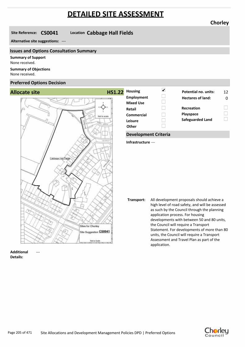
Housing
Employment
Mixed Use
Retail
Commercial
Leisure
Recreation
Safeguarded Land
Preferred Options Decision
Allocate site Potential no. units: 12
Hectares of land: 0
Other
Site Reference: CS0041 Cabbage Hall Fields
Chorley
None received.
None received.Summary of Objections
Summary of Support
Alternative site suggestions: ---
DETAILED SITE ASSESSMENT
Location
Development Criteria
Infrastructure ---
Transport: All development proposals should achieve a high level of road safety, and will be assessed as such by the Council through the planning application process. For housing developments with between 50 and 80 units, the Council will require a Transport Statement. For developments of more than 80 units, the Council will require a Transport Assessment and Travel Plan as part of the application.
Additional Details:
---
Issues and Options Consultation Summary
Playspace
HS1.22
Page 205 of 471 Site Allocations and Development Management Policies DPD | Preferred Options

Sustainability Appraisal
Site Ref CS0041
Address Cabbage Hall Fields, Chorley
SA Obj
Indicator Site Performance SA Comments
S1
Distance to railway station 0 .81 to 1 .6km Social This site has very good access to all local services and facilities, the site has very good access to public transport and road networks. There are no identified negative social effects in developing this site. Environmental The only identified negative environmental effect in developing this site is the site is Greenfield. The site is also at medium risk of contamination. Economic There are no identified negative economic effects in developing this site.
Rail service freque ncy 4 or more/hour/direction Distance to nearest bus stop Up to 0.4km Bus service frequency 2-5 /hour/direction Distance to se rvice centre 0 .81 to 1 .6km Distance to A Road junction 0 .41 to 0 .8km Distance to motorway junction Up to 1.6km Distance to supermarket 0 .41 to 0 .8km Distance to conve nience s tore 0 .41 to 0 .8km Distance to Post Office 0 .41 to 0 .8km Distance to Primary School Up to 0.4km Distance to Secondary School 0 .81 to 1 .6km On a cycle route Yes Distance to cycle route Up to 0.4km
S2
Distance to GP surge ry 0 .41 to 0 .8km Distance to NHS gene ra l hospital Up to 2km Distance to public open space/park Up to 0.4km Distance to local centre 0 .41 to 0 .8km
EN1
Designation of land Ke y Service Centre Are a of Se paration Outs ide AONB Outs ide SSSI Outs ide Biological/ G eological H eritag e Site Outs ide Agricultural classifica tion None
EN2
Conservation Area Outs ide Ancie nt Monument on site No Regis te re d Park or G arden Outs ide Listed Building on site No Locally Lis te d Building on s ite No
EN3 Curre nt/former land use Greenfie ld EN4 Flood Zone a re a All Zone 1
EN5 Contaminated land M edium risk Within 3km of a congestion spot Yes
EC1 Distance to employment site Up to 0.8km Access to Broadband Yes
EC2 Distance to furthe r/higher education 1 .61 to 3 .2km
Del
iver
abili
ty
Indi
cato
rs
Access to sewer system
Yes
Is the site deliverable: Yes Access to wa te r
Access to ga s
Access to e lectricity
Exis ting road access
At risk from hazardous installations No
Overall Site Performance
Band Spe ctrum:
Overall Band:
B
Page 206 of 471 Site Allocations and Development Management Policies DPD | Preferred Options

Housing
Employment
Mixed Use
Retail
Commercial
Leisure
Recreation
Safeguarded Land
Preferred Options Decision
Allocate site Potential no. units: 42
Hectares of land: 0
Other
Site Reference: CS0042 Gillibrand
Chorley
None received.
Site is known to contain at least one heritage asset. Any proposed schemes should assess the impact of development upon any known heritage assets.
Summary of Objections
Summary of Support
Alternative site suggestions: ---
DETAILED SITE ASSESSMENT
Location
Development Criteria
Infrastructure Water Cycle Study: Site Specific Flood Risk Assessment required. Sequential approach to development. Discussion and agreement with UU required on timing of development and network capacity and pumping station to network. Agreement with EA required on attenuating to nearby watercourses.
Transport: All development proposals should achieve a high level of road safety, and will be assessed as such by the Council through the planning application process. For housing developments with between 50 and 80 units, the Council will require a Transport Statement. For developments of more than 80 units, the Council will require a Transport Assessment and Travel Plan as part of the application.
Additional Details:
---
Issues and Options Consultation Summary
Playspace
HS1.13
Page 207 of 471 Site Allocations and Development Management Policies DPD | Preferred Options

Sustainability Appraisal
Site Ref CS0042
Address Gillibrand, Chorley
SA Obj
Indicator Site Performance SA Comments
S1
Distance to railway station 2 .41 to 3 km Social This site has good access to public transport with bus services 6 or more per hour and 4 or more trains per hour although the railway station is 2.41 to 3km from the site. The site has poor access to a motorway junction and an A road junction. The site has access to all local services with the exception of a post office which is over 1.6km from the site. Environmental The only identified negative environmental effect in developing this site is the site is currently Greenfield. Economic There are no identified negative economic effects in developing this site.
Rail service freque ncy 4 or more/hour/direction Distance to nearest bus stop Up to 0.4km Bus service frequency 6 or more/hour/direction Distance to se rvice centre 0 .81 to 1 .6km Distance to A Road junction 1 .61 to 3 km Distance to motorway junction Over 3km Distance to supermarket 1 .61 to 3 km Distance to conve nience s tore Up to 0.4km Distance to Post Office Ove r 1 .6km Distance to Primary School 0 .81 to 1 .6km Distance to Secondary School Up to 0.8km On a cycle route Yes Distance to cycle route Up to 0.4km
S2
Distance to GP surge ry 1 .61 to 3 km Distance to NHS gene ra l hospital 2.1 to 5 km Distance to public open space/park Up to 0.4km Distance to local centre 0 .81 to 1 .2km
EN1
Designation of land Ke y Service Centre Are a of Se paration Outs ide AONB Outs ide SSSI Outs ide Biological/ G eological H eritag e Site Outs ide Agricultural classifica tion None
EN2
Conservation Area Outs ide Ancie nt Monument on site No Regis te re d Park or G arden Outs ide Listed Building on site No Locally Lis te d Building on s ite No
EN3 Curre nt/former land use Greenfie ld EN4 Flood Zone a re a All Zone 1
EN5 Contaminated land No risk Within 3km of a congestion spot Yes
EC1 Distance to employment site 1 .21 to 1 .6km Access to Broadband Yes
EC2 Distance to furthe r/higher education 1 .61 to 3 .2km
Del
iver
abili
ty
Indi
cato
rs
Access to sewer system
Yes
Is the site deliverable: Yes Access to wa te r
Access to ga s
Access to e lectricity
Exis ting road access
At risk from hazardous installations No
Overall Site Performance
Band Spe ctrum:
Overall Band:
C
Page 208 of 471 Site Allocations and Development Management Policies DPD | Preferred Options

Housing
Employment
Mixed Use
Retail
Commercial
Leisure
Recreation
Safeguarded Land
Preferred Options Decision
Do not allocate Potential no. units: 0
Hectares of land: 0
Other
Site Reference: CS0044 Saville Street
Chorley
None received.
Site is known to contain at least one heritage asset. Any proposed schemes should assess the impact of development upon any known heritage assets.
Summary of Objections
Summary of Support
Alternative site suggestions: ---
DETAILED SITE ASSESSMENT
Location
Development Criteria
Infrastructure N/A- propose not to allocate site
Transport: N/A- propose not to allocate site
Additional Details:
Part of site has been developed, remaining part of site is in employment use and is too small to allocate.
Issues and Options Consultation Summary
Playspace
Page 209 of 471 Site Allocations and Development Management Policies DPD | Preferred Options

Sustainability Appraisal
Site Ref CS0044
Address Saville Street, Chorley
SA Obj
Indicator Site Performance SA Comments
S1
Distance to railway station 0 .81 to 1 .6km Social This site has very good access to public transport with frequent bus and rail services. The site has good access to all local services and facilities with the exception of a post office which is 0.81 to 1.6km away and GP surgery which is 0.81 to 1.6km away. Environmental The only identified negative environmental effect in developing this site is the medium risk of land contamination. Economic There are no identified negative economic effects in developing this site.
Rail service freque ncy 4 or more/hour/direction Distance to nearest bus stop Up to 0.4km Bus service frequency 6 or more/hour/direction Distance to se rvice centre Up to 0.8km Distance to A Road junction 0 .41 to 0 .8km Distance to motorway junction Over 3km Distance to supermarket 0 .81 to 1 .6km Distance to conve nience s tore Up to 0.4km Distance to Post Office 0 .81 to 1 .2km Distance to Primary School Up to 0.4km Distance to Secondary School 0 .81 to 1 .6km On a cycle route No Distance to cycle route Up to 0.4km
S2
Distance to GP surge ry 0 .81 to 1 .6km Distance to NHS gene ra l hospital 2.1 to 5 km Distance to public open space/park Up to 0.4km Distance to local centre Up to 0.4km
EN1
Designation of land Ke y Service Centre Are a of Se paration Outs ide AONB Outs ide SSSI Outs ide Biological/ G eological H eritag e Site Outs ide Agricultural classifica tion None
EN2
Conservation Area Outs ide Ancie nt Monument on site No Regis te re d Park or G arden Outs ide Listed Building on site No Locally Lis te d Building on s ite No
EN3 Curre nt/former land use Brownfield EN4 Flood Zone a re a All Zone 1
EN5 Contaminated land M edium risk Within 3km of a congestion spot Yes
EC1 Distance to employment site Up to 0.8km Access to Broadband Yes
EC2 Distance to furthe r/higher education 1 .61 to 3 .2km
Del
iver
abili
ty
Indi
cato
rs
Access to sewer system
Yes
Is the site deliverable: Yes Access to wa te r
Access to ga s
Access to e lectricity
Exis ting road access
At risk from hazardous installations No
Overall Site Performance
Band Spe ctrum:
Overall Band:
B
Page 210 of 471 Site Allocations and Development Management Policies DPD | Preferred Options

Housing
Employment
Mixed Use
Retail
Commercial
Leisure
Recreation
Safeguarded Land
Preferred Options Decision
Allocate site Potential no. units: 15
Hectares of land: 0
Other
Site Reference: CS0045 Commercial Premises, Cottam Street
Chorley
None received.
None received.Summary of Objections
Summary of Support
Alternative site suggestions: ---
DETAILED SITE ASSESSMENT
Location
Development Criteria
Infrastructure N/A- site already has planning permission
Transport: All development proposals should achieve a high level of road safety, and will be assessed as such by the Council through the planning application process. As this site already has planning permission, the relevant Transport Statement/Assessment has already been submitted to, and approved by the Council.
Additional Details:
N/A- site already has planning permission
Issues and Options Consultation Summary
Playspace
HS1.16
Page 211 of 471 Site Allocations and Development Management Policies DPD | Preferred Options

Sustainability Appraisal
Site Ref CS0045
Address Commercial Premises, Cottam Street, Chorley
SA Obj
Indicator Site Performance SA Comments
S1
Distance to railway station 0 .81 to 1 .6km This site has been granted planning permission and the remaining 0.3ha is too small to be considered as part of the site allocation process.
Rail service freque ncy 4 or more/hour/direction Distance to nearest bus stop Up to 0.4km Bus service frequency 6 or more/hour/direction Distance to se rvice centre Up to 0.8km Distance to A Road junction 0 .41 to 0 .8km Distance to motorway junction Over 3km Distance to supermarket 0 .41 to 0 .8km Distance to conve nience s tore Up to 0.4km Distance to Post Office Up to 0.4km Distance to Primary School Up to 0.4km Distance to Secondary School 0 .81 to 1 .6km On a cycle route No Distance to cycle route Up to 0.4km
S2
Distance to GP surge ry 0 .41 to 0 .8km Distance to NHS gene ra l hospital 2.1 to 5 km Distance to public open space/park Up to 0.4km Distance to local centre Up to 0.4km
EN1
Designation of land Ke y Service Centre Are a of Se paration Outs ide AONB Outs ide SSSI Outs ide Biological/ G eological H eritag e Site Outs ide Agricultural classifica tion None
EN2
Conservation Area Outs ide Ancie nt Monument on site No Regis te re d Park or G arden Outs ide Listed Building on site No Locally Lis te d Building on s ite No
EN3 Curre nt/former land use Brownfield EN4 Flood Zone a re a All Zone 1
EN5 Contaminated land No risk Within 3km of a congestion spot Yes
EC1 Distance to employment site Up to 0.8km Access to Broadband Yes
EC2 Distance to furthe r/higher education Up to 1.6km
Del
iver
abili
ty
Indi
cato
rs
Access to sewer system
Yes
Is the site deliverable: Yes/No Access to wa te r
Access to ga s
Access to e lectricity
Exis ting road access
At risk from hazardous installations No
Overall Site Performance
Band Spe ctrum:
Overall Band:
A
Page 212 of 471 Site Allocations and Development Management Policies DPD | Preferred Options

Housing
Employment
Mixed Use
Retail
Commercial
Leisure
Recreation
Safeguarded Land
Preferred Options Decision
Do not allocate Potential no. units: 0
Hectares of land: 0
Other
Site Reference: CS0046 Devonshire Road/Alker Street
Chorley
None received.
None received.Summary of Objections
Summary of Support
Alternative site suggestions: ---
DETAILED SITE ASSESSMENT
Location
Development Criteria
Infrastructure N/A- propose not to allocate site
Transport: N/A- propose not to allocate site
Additional Details:
Part of site has been developed, remaining part of site is in employment use and is too small to allocate.
Issues and Options Consultation Summary
Playspace
Page 213 of 471 Site Allocations and Development Management Policies DPD | Preferred Options

Sustainability Appraisal
Site Ref CS0046
Address Devonshire Road/Alker Street, Chorley
SA Obj
Indicator Site Performance SA Comments
S1
Distance to railway station Up to 0.8km This site has been given planning permission and is under construction. The remainder of the site is 0.2ha which is too small to consider as part of this site allocations process.
Rail service freque ncy 4 or more/hour/direction Distance to nearest bus stop Up to 0.4km Bus service frequency 6 or more/hour/direction Distance to se rvice centre Up to 0.8km Distance to A Road junction 0 .41 to 0 .8km Distance to motorway junction 1 .61 to 3 km Distance to supermarket 0 .41 to 0 .8km Distance to conve nience s tore Up to 0.4km Distance to Post Office Up to 0.4km Distance to Primary School 0 .41 to 0 .8km Distance to Secondary School 0 .81 to 1 .6km On a cycle route No Distance to cycle route Up to 0.4km
S2
Distance to GP surge ry Up to 0.4km Distance to NHS gene ra l hospital Up to 2km Distance to public open space/park Up to 0.4km Distance to local centre Up to 0.4km
EN1
Designation of land Ke y Service Centre Are a of Se paration Outs ide AONB Outs ide SSSI Outs ide Biological/ G eological H eritag e Site Outs ide Agricultural classifica tion None
EN2
Conservation Area Outs ide Ancie nt Monument on site No Regis te re d Park or G arden Outs ide Listed Building on site No Locally Lis te d Building on s ite No
EN3 Curre nt/former land use Brownfield EN4 Flood Zone a re a All Zone 1
EN5 Contaminated land M edium risk Within 3km of a congestion spot Yes
EC1 Distance to employment site Up to 0.8km Access to Broadband Yes
EC2 Distance to furthe r/higher education Up to 1.6km
Del
iver
abili
ty
Indi
cato
rs
Access to sewer system
Yes
Is the site deliverable: Yes/No Access to wa te r
Access to ga s
Access to e lectricity
Exis ting road access
At risk from hazardous installations No
Overall Site Performance
Band Spe ctrum:
Overall Band:
A
Page 214 of 471 Site Allocations and Development Management Policies DPD | Preferred Options

Housing
Employment
Mixed Use
Retail
Commercial
Leisure
Recreation
Safeguarded Land
Preferred Options Decision
Allocate site Potential no. units: 0
Hectares of land: 4
Other
Site Reference: CS0048 Martindales Depot, Cowling Brow
Chorley
None received.
Allocation appears to fall on identified textile mill site and is known to contain at least one heritage asset. Any proposed scheme should assess the impact of development upon known heritage assets.
Objection to expanding industry into and across the Black Brook and would like to ensure the Brook is safeguarded from pollution.
Summary of Objections
Summary of Support
Alternative site suggestions: ---
DETAILED SITE ASSESSMENT
Location
Development Criteria
Infrastructure ---
Transport: All development proposals should achieve a high level of road safety, and will be assessed as such by the Council through the planning application process. Depending on what type of employment use or mix of uses this site is developed for, and depending on the size of the development, the Council will require the submission of either a Transport Statement or Transport Assessment and Travel Plan.
Additional Details:
---
Issues and Options Consultation Summary
Playspace
EP1.7
Page 215 of 471 Site Allocations and Development Management Policies DPD | Preferred Options

Sustainability Appraisal
Site Ref CS0048
Address Martindales Depot, Cowling Brow, Chorley
SA Obj
Indicator Site Performance SA Comments
S1
Distance to railway station 0 .81 to 1 .6km Social This site has good access to public transport with frequent bus and rail services. The site has good access to local services and facilities with the exception of a post office which is 0.81 to 1.6km away. Environmental This site is located within flood zone 3 and is at high risk of flooding. There is also a medium risk of land contamination. Economic There are no identified negative economic effects in developing this site.
Rail service freque ncy 4 or more/hour/direction Distance to nearest bus stop Up to 0.4km Bus service frequency 2-5 /hour/direction Distance to se rvice centre 0 .81 to 1 .6km Distance to A Road junction 0 .81 to 1 .6km Distance to motorway junction Over 3km Distance to supermarket 0 .81 to 1 .6km Distance to conve nience s tore Up to 0.4km Distance to Post Office 0 .81 to 1 .2km Distance to Primary School 0 .41 to 0 .8km Distance to Secondary School 0 .81 to 1 .6km On a cycle route No Distance to cycle route Up to 0.4km
S2
Distance to GP surge ry 0 .81 to 1 .6km Distance to NHS gene ra l hospital 2.1 to 5 km Distance to public open space/park Up to 0.4km Distance to local centre 0 .81 to 1 .2km
EN1
Designation of land Ke y Service Centre Are a of Se paration Outs ide AONB Outs ide SSSI Outs ide Biological/ G eological H eritag e Site Outs ide Agricultural classifica tion None
EN2
Conservation Area Outs ide Ancie nt Monument on site No Regis te re d Park or G arden Outs ide Listed Building on site No Locally Lis te d Building on s ite No
EN3 Curre nt/former land use Brownfield EN4 Flood Zone a re a Part Zone 3
EN5 Contaminated land M edium risk Within 3km of a congestion spot Yes
EC1 Distance to employment site Up to 0.8km Access to Broadband Yes
EC2 Distance to furthe r/higher education 1 .61 to 3 .2km
Del
iver
abili
ty
Indi
cato
rs
Access to sewer system
Yes
Is the site deliverable: Yes Access to wa te r
Access to ga s
Access to e lectricity
Exis ting road access
At risk from hazardous installations No
Overall Site Performance
Band Spe ctrum:
Overall Band:
B
Page 216 of 471 Site Allocations and Development Management Policies DPD | Preferred Options

Housing
Employment
Mixed Use
Retail
Commercial
Leisure
Recreation
Safeguarded Land
Preferred Options Decision
Do not allocate Potential no. units: 0
Hectares of land: 0
Other
Site Reference: CH0019 Land to the Rear of Ley Inn, Back Lane
Clayton Brook/Green
None received.
None received.Summary of Objections
Summary of Support
Alternative site suggestions: ---
DETAILED SITE ASSESSMENT
Location
Development Criteria
Infrastructure N/A- proposed not to allocate site
Transport: N/A- proposed not to allocate site
Additional Details:
In active use as pub car park and bowling green. Await Open Space Study.
Issues and Options Consultation Summary
Playspace
Page 217 of 471 Site Allocations and Development Management Policies DPD | Preferred Options

Sustainability Appraisal
Site Ref CH0019
Address Land to the Rear of Ley Inn, Back Lane, Clayton Brook/Green
SA Obj
Indicator Site Performance SA Comments
S1
Distance to railway station 2 .41 to 3 km Social The site has good access to a bus route although there is only an hourly service. There are no rail services within the settlement. The site has good access to the road network with an A road and motorway junction nearby. Local Services are accessible however the nearest GP surgery is 1.61 to 3km away. Environmental There are no identified environmental effects in developing this site. Economic There are no identified economic effects in developing this site.
Rail service freque ncy No services in settlement Distance to nearest bus stop Up to 0.4km Bus service frequency 1/hour/direction Distance to se rvice centre 2 .41 to 3 km Distance to A Road junction 0 .41 to 0 .8km Distance to motorway junction 1 .61 to 3 km Distance to supermarket 0 .81 to 1 .6km Distance to conve nience s tore 0 .41 to 0 .8km Distance to Post Office 1 .21 to 1 .6km Distance to Primary School Up to 0.4km Distance to Secondary School 1 .61 to 3 .2km On a cycle route No Distance to cycle route Up to 0.4km
S2
Distance to GP surge ry 1 .61 to 3 km Distance to NHS gene ra l hospital 2.1 to 5 km Distance to public open space/park Up to 0.4km Distance to local centre 0 .81 to 1 .2km
EN1
Designation of land Urban Local Service Ce ntre Are a of Se paration Outs ide AONB Outs ide SSSI Outs ide Biological/ G eological H eritag e Site Outs ide Agricultural classifica tion 3
EN2
Conservation Area Outs ide Ancie nt Monument on site No Regis te re d Park or G arden Outs ide Listed Building on site No Locally Lis te d Building on s ite No
EN3 Curre nt/former land use Brownfield EN4 Flood Zone a re a All Zone 1
EN5 Contaminated land No risk Within 3km of a congestion spot Yes
EC1 Distance to employment site 0 .81 to 1 .2km Access to Broadband Yes
EC2 Distance to furthe r/higher education Over 5km
Del
iver
abili
ty
Indi
cato
rs
Access to sewer system
Yes
Is the site deliverable: Yes Access to wa te r
Access to ga s
Access to e lectricity
Exis ting road access
At risk from hazardous installations No
Overall Site Performance
Band Spe ctrum:
Overall Band:
C
Page 218 of 471 Site Allocations and Development Management Policies DPD | Preferred Options

Housing
Employment
Mixed Use
Retail
Commercial
Leisure
Recreation
Safeguarded Land
Preferred Options Decision
Allocate site Potential no. units: 62
Hectares of land: 0
Other
Site Reference: CH0130 Former Concrete Works, Radburn Brow
Clayton Brook/Green
None received.
None received.Summary of Objections
Summary of Support
Alternative site suggestions: CH0198
DETAILED SITE ASSESSMENT
Location
Development Criteria
Infrastructure N/A- site already has planning permission and is under construction
Transport: All development proposals should achieve a high level of road safety, and will be assessed as such by the Council through the planning application process. As this site is already under construction, the relevant Transport Statement/Assessment has already been submitted to, and approved by the Council.
Additional Details:
N/A- site already has planning permission and is under construction
Issues and Options Consultation Summary
Playspace
HS1.33
Page 219 of 471 Site Allocations and Development Management Policies DPD | Preferred Options

Sustainability Appraisal
No sustainability Appraisal has been undertaken of this site suggestion as the site has already been
granted planning permission/ is under construction.
Page 220 of 471 Site Allocations and Development Management Policies DPD | Preferred Options
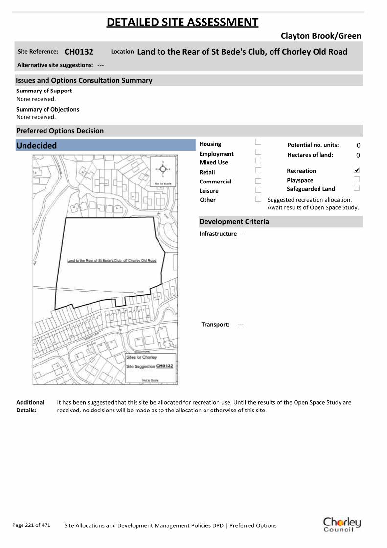
Housing
Employment
Mixed Use
Retail
Commercial
Leisure
Recreation
Safeguarded Land
Preferred Options Decision
Undecided Potential no. units: 0
Hectares of land: 0
Other Suggested recreation allocation. Await results of Open Space Study.
Site Reference: CH0132 Land to the Rear of St Bede's Club, off Chorley Old Road
Clayton Brook/Green
None received.
None received.Summary of Objections
Summary of Support
Alternative site suggestions: ---
DETAILED SITE ASSESSMENT
Location
Development Criteria
Infrastructure ---
Transport: ---
Additional Details:
It has been suggested that this site be allocated for recreation use. Until the results of the Open Space Study are received, no decisions will be made as to the allocation or otherwise of this site.
Issues and Options Consultation Summary
Playspace
Page 221 of 471 Site Allocations and Development Management Policies DPD | Preferred Options

Sustainability Appraisal
No sustainability Appraisal has been undertaken of this site suggestion. Until the findings of the
Open Space Study are produced, the Council will not be allocating additional land for recreation
purposes. Once the Study is complete, a decision on the allocation of this site for recreational use
can be made.
Page 222 of 471 Site Allocations and Development Management Policies DPD | Preferred Options

Housing
Employment
Mixed Use
Retail
Commercial
Leisure
Recreation
Safeguarded Land
Preferred Options Decision
Allocate site Potential no. units: 8
Hectares of land: 0
Other
Site Reference: CH0175 Land off Fiddlers Lane
Clayton Brook/Green
None received.
Site known to contain at least one heritage asset. Whilst it is probable that most could be successfully developed there could be considerable advantages, both for the heritage and in terms of time and costs, in assessing the implications of development in advance of establishing any plans.
Summary of Objections
Summary of Support
Alternative site suggestions: ---
DETAILED SITE ASSESSMENT
Location
Development Criteria
Infrastructure N/A- site already has planning permission
Transport: All development proposals should achieve a high level of road safety, and will be assessed as such by the Council through the planning application process. As this site already has planning permission, the relevant Transport Statement/Assessment has already been submitted to, and approved by the Council.
Additional Details:
N/A- site already has planning permission
Issues and Options Consultation Summary
Playspace
HS1.32
Page 223 of 471 Site Allocations and Development Management Policies DPD | Preferred Options

Sustainability Appraisal
Site Ref CH0175
Address Land off Fiddlers Lane, Clayton Brook/Green
SA Obj
Indicator Site Performance SA Comments
S1
Distance to railway station Over 3km Social This site has good access to a very frequent bus service in close proximity to the site and good access to local facilities and services with the exception of a railway station as there is no service in the area. The site is over 3km from the key service centre of Chorley but has good links to local conveniences. Environmental The only negative environmental effect in developing this site is the site is a Greenfield site. Economic There are no identified negative economic effects in developing this site.
Rail service freque ncy No services in settlement Distance to nearest bus stop Up to 0.4km Bus service frequency 6 or more/hour/direction Distance to se rvice centre Over 3km Distance to A Road junction Up to 0.4km Distance to motorway junction 1 .61 to 3 km Distance to supermarket 0 .81 to 1 .6km Distance to conve nience s tore Up to 0.4km Distance to Post Office 1 .21 to 1 .6km Distance to Primary School Up to 0.4km Distance to Secondary School 1 .61 to 3 .2km On a cycle route Yes Distance to cycle route Up to 0.4km
S2
Distance to GP surge ry 0 .81 to 1 .6km Distance to NHS gene ra l hospital 2.1 to 5 km Distance to public open space/park Up to 0.4km Distance to local centre 0 .81 to 1 .2km
EN1
Designation of land Urban Local Service Ce ntre Are a of Se paration Outs ide AONB Outs ide SSSI Outs ide Biological/ G eological H eritag e Site Outs ide Agricultural classifica tion 3
EN2
Conservation Area Outs ide Ancie nt Monument on site No Regis te re d Park or G arden Outs ide Listed Building on site No Locally Lis te d Building on s ite No
EN3 Curre nt/former land use Greenfie ld EN4 Flood Zone a re a All Zone 1
EN5 Contaminated land No risk Within 3km of a congestion spot No
EC1 Distance to employment site 0 .81 to 1 .2km Access to Broadband Yes
EC2 Distance to furthe r/higher education Over 5km
Del
iver
abili
ty
Indi
cato
rs
Access to sewer system
Yes
Is the site deliverable: Yes Access to wa te r
Access to ga s
Access to e lectricity
Exis ting road access
At risk from hazardous installations No
Overall Site Performance
Band Spe ctrum:
Overall Band:
C
Page 224 of 471 Site Allocations and Development Management Policies DPD | Preferred Options

Housing
Employment
Mixed Use
Retail
Commercial
Leisure
Recreation
Safeguarded Land
Preferred Options Decision
Allocate site Potential no. units: 62
Hectares of land: 0
Other
Site Reference: CH0198 Tarmac Ltd, Sandy Lane
Clayton Brook/Green
None received.
None received.Summary of Objections
Summary of Support
Alternative site suggestions: CH0130
DETAILED SITE ASSESSMENT
Location
Development Criteria
Infrastructure Site already has planning permission and is under construction, however the following information is provided. Water Cycle Study: Surface water should not be routed to wastewater network. All developments in the Walton-le-Dale Wastewater Treatment Works catchment need to be assessed by UU. Attenuation SUDS most likely to be viable. Site specific FRA advised to check flood zones.
Transport: All development proposals should achieve a high level of road safety, and will be assessed as such by the Council through the planning application process. As this site is already under construction, the relevant Transport Statement/Assessment has already been submitted to, and approved by the Council.
Additional Details:
N/A- site already has planning permission and is under construction
Issues and Options Consultation Summary
Playspace
HS1.33
Page 225 of 471 Site Allocations and Development Management Policies DPD | Preferred Options

Sustainability Appraisal
Site Ref CH0198
Address Former Concrete Works, Radburn Brow, Clayton Brook/Green
SA Obj
Indicator Site Performance SA Comments
S1
Distance to railway station Over 3km This site has been given planning permission for housing and is under construction.
Rail service freque ncy No services in settlement Distance to nearest bus stop Up to 0.4km Bus service frequency 6 or more/hour/direction Distance to se rvice centre Over 3km Distance to A Road junction Up to 0.4km Distance to motorway junction 1 .61 to 3 km Distance to supermarket 0 .41 to 0 .8km Distance to conve nience s tore 0 .41 to 0 .8km Distance to Post Office 0 .41 to 0 .8km Distance to Primary School Up to 0.4km Distance to Secondary School 1 .61 to 3 .2km On a cycle route Yes Distance to cycle route Up to 0.4km
S2
Distance to GP surge ry 0 .41 to 0 .8km Distance to NHS gene ra l hospital 2.1 to 5 km Distance to public open space/park Up to 0.4km Distance to local centre 0 .41 to 0 .8km
EN1
Designation of land Urban Local Service Ce ntre Are a of Se paration Outs ide AONB Outs ide SSSI Outs ide Biological/ G eological H eritag e Site Outs ide Agricultural classifica tion 3
EN2
Conservation Area Outs ide Ancie nt Monument on site No Regis te re d Park or G arden Outs ide Listed Building on site No Locally Lis te d Building on s ite No
EN3 Curre nt/former land use Brownfield EN4 Flood Zone a re a All Zone 1
EN5 Contaminated land M edium risk Within 3km of a congestion spot No
EC1 Distance to employment site Up to 0.8km Access to Broadband Yes
EC2 Distance to furthe r/higher education Over 5km
Del
iver
abili
ty
Indi
cato
rs
Access to sewer system
Yes
Is the site deliverable: Yes/No Access to wa te r
Access to ga s
Access to e lectricity
Exis ting road access
At risk from hazardous installations No
Overall Site Performance
Band Spe ctrum:
Overall Band:
B
Page 226 of 471 Site Allocations and Development Management Policies DPD | Preferred Options

Housing
Employment
Mixed Use
Retail
Commercial
Leisure
Recreation
Safeguarded Land
Preferred Options Decision
Allocate site Potential no. units: 29
Hectares of land: 0
Other
Site Reference: CH0259 Westwood Road
Clayton Brook/Green
None received.
None received.Summary of Objections
Summary of Support
Alternative site suggestions: ---
DETAILED SITE ASSESSMENT
Location
Development Criteria
Infrastructure ---
Transport: All development proposals should achieve a high level of road safety, and will be assessed as such by the Council through the planning application process. For housing developments with between 50 and 80 units, the Council will require a Transport Statement. For developments of more than 80 units, the Council will require a Transport Assessment and Travel Plan as part of the application.
Additional Details:
---
Issues and Options Consultation Summary
Playspace
HS1.34
Page 227 of 471 Site Allocations and Development Management Policies DPD | Preferred Options

Sustainability Appraisal
Site Ref CH0259
Address Westwood Road, Clayton Brook/Green
SA Obj
Indicator Site Performance SA Comments
S1
Distance to railway station Over 3km Social The site has good access to a bus route with services very regular however there is no access to a rail service in this area. Access to services and facilities are very good with the exception of the key service centre of Chorley. Environmental The site is within an urban local service centre and the only identified negative environmental effect in developing this site is its currently urban greenspace. Economic There are no identified negative economic effect in developing this site.
Rail service freque ncy No services in settlement Distance to nearest bus stop Up to 0.4km Bus service frequency 6 or more/hour/direction Distance to se rvice centre Over 3km Distance to A Road junction Up to 0.4km Distance to motorway junction 1 .61 to 3 km Distance to supermarket 0 .41 to 0 .8km Distance to conve nience s tore 0 .41 to 0 .8km Distance to Post Office 0 .41 to 0 .8km Distance to Primary School Up to 0.4km Distance to Secondary School 1 .61 to 3 .2km On a cycle route Yes Distance to cycle route Up to 0.4km
S2
Distance to GP surge ry Up to 0.4km Distance to NHS gene ra l hospital 2.1 to 5 km Distance to public open space/park Up to 0.4km Distance to local centre Up to 0.4km
EN1
Designation of land Urban Local Service Ce ntre Are a of Se paration Outs ide AONB Outs ide SSSI Outs ide Biological/ G eological H eritag e Site Outs ide Agricultural classifica tion 3
EN2
Conservation Area Outs ide Ancie nt Monument on site No Regis te re d Park or G arden Outs ide Listed Building on site No Locally Lis te d Building on s ite No
EN3 Curre nt/former land use Urban G re enspace EN4 Flood Zone a re a All Zone 1
EN5 Contaminated land No risk Within 3km of a congestion spot Yes
EC1 Distance to employment site Up to 0.8km Access to Broadband Yes
EC2 Distance to furthe r/higher education Over 5km
Del
iver
abili
ty
Indi
cato
rs
Access to sewer system
Yes
Is the site deliverable: Yes Access to wa te r
Access to ga s
Access to e lectricity
Exis ting road access
At risk from hazardous installations No
Overall Site Performance
Band Spe ctrum:
Overall Band:
B
Page 228 of 471 Site Allocations and Development Management Policies DPD | Preferred Options

Housing
Employment
Mixed Use
Retail
Commercial
Leisure
Recreation
Safeguarded Land
Preferred Options Decision
Do not allocate Potential no. units: 0
Hectares of land: 0
Other
Site Reference: CH0367 The Pines Hotel, 570 Preston Road
Clayton Brook/Green
New site suggestion.
New site suggestion.Summary of Objections
Summary of Support
Alternative site suggestions: ---
DETAILED SITE ASSESSMENT
Location
Development Criteria
Infrastructure N/A- proposed not to allocate site
Transport: N/A- proposed not to allocate site
Additional Details:
In active use. Employment and leisure use will be protected.
Issues and Options Consultation Summary
Playspace
Page 229 of 471 Site Allocations and Development Management Policies DPD | Preferred Options

Sustainability Appraisal
Site Ref CH0367
Address The Pines Hotel, 570 Preston Road, Clayton Brook/Green
SA Obj
Indicator Site Performance SA Comments
S1
Distance to railway station Over 3km Social The site has good access to a bus route with a service 6 or more times an hour. There is no rail service within the settlement. Access to services and facilities are very good. The site is over 3km away from the key service centre of Chorley. Environmental There are no identified negative environmental effects in developing this site. Economic There are no identified economic effects in developing this site.
Rail service freque ncy No services in settlement Distance to nearest bus stop Up to 0.4km Bus service frequency 6 or more/hour/direction Distance to se rvice centre Over 3km Distance to A Road junction Up to 0.4km Distance to motorway junction 1 .61 to 3 km Distance to supermarket 0 .41 to 0 .8km Distance to conve nience s tore 0 .41 to 0 .8km Distance to Post Office 0 .41 to 0 .8km Distance to Primary School Up to 0.4km Distance to Secondary School 1 .61 to 3 .2km On a cycle route Yes Distance to cycle route Up to 0.4km
S2
Distance to GP surge ry Up to 0.4km Distance to NHS gene ra l hospital 2.1 to 5 km Distance to public open space/park Up to 0.4km Distance to local centre Up to 0.4km
EN1
Designation of land Urban Local Service Ce ntre Are a of Se paration Outs ide AONB Outs ide SSSI Outs ide Biological/ G eological H eritag e Site Outs ide Agricultural classifica tion 3
EN2
Conservation Area Outs ide Ancie nt Monument on site No Regis te re d Park or G arden Outs ide Listed Building on site No Locally Lis te d Building on s ite No
EN3 Curre nt/former land use Brownfield EN4 Flood Zone a re a All Zone 1
EN5 Contaminated land No risk Within 3km of a congestion spot Yes
EC1 Distance to employment site Up to 0.8km Access to Broadband Yes
EC2 Distance to furthe r/higher education Over 5km
Del
iver
abili
ty
Indi
cato
rs
Access to sewer system
Yes
Is the site deliverable: Yes Access to wa te r
Access to ga s
Access to e lectricity
Exis ting road access
At risk from hazardous installations No
Overall Site Performance
Band Spe ctrum:
Overall Band:
B
Page 230 of 471 Site Allocations and Development Management Policies DPD | Preferred Options

Housing
Employment
Mixed Use
Retail
Commercial
Leisure
Recreation
Safeguarded Land
Preferred Options Decision
Do not allocate Potential no. units: 0
Hectares of land: 0
Other
Site Reference: CH0025 Cuerden Valley Park – Linear Path from A6 to B5256 and Ar
Clayton-le-Woods
None received.
Site is an identified textile mill site and is known to contain at least one heritage asset. Whilst it is probable that most could be developed, redeveloped or converted, the implications of development should be assessed in advance of establishing any plans.
Summary of Objections
Summary of Support
Alternative site suggestions: ---
DETAILED SITE ASSESSMENT
Location
Development Criteria
Infrastructure N/A- proposed not to allocate site
Transport: N/A- proposed not to allocate site
Additional Details:
N/A- proposed not to allocate site
Issues and Options Consultation Summary
Playspace
Page 231 of 471 Site Allocations and Development Management Policies DPD | Preferred Options

Sustainability Appraisal
No sustainability Appraisal has been undertaken of this site suggestion as cycle routes are a matter
handled by Lancashire County Council (LCC). We are not proposing to allocate any further routes
unless advised to do so by LCC.
Page 232 of 471 Site Allocations and Development Management Policies DPD | Preferred Options

Housing
Employment
Mixed Use
Retail
Commercial
Leisure
Recreation
Safeguarded Land
Preferred Options Decision
Allocate site Potential no. units: 600
Hectares of land: 20
Other
Site Reference: CH0109 Land East of Wigan Road
Clayton-le-Woods
The HCA has been actively collaborating with Fox Land and Property (FLP) and Redrow Homes to promote this project for residential development. Work has been undertaken to demonstrate that this site is achievable and deliverable. The HCA and Redrow do not support the early planning application for part of the site by FLP.
There is no technical matter that would prevent the successful and viable implementation of development on the site for approximately 300 dwellings. The site is deliverable and compliant with the key tests of PPS 3. The site should be allocated in order to achieve successful implementation of Policy 1 of the Central Lancashire Core Strategy.
The housing needs can largely be met through existing allocations and brownfield sites. Concerns over increased volume of traffic. The site provides a valuable amenity for local residents to enjoy the natural environment, wildlife and open space. There is also a Biological Heritage Site designation. Propose site is returned to green belt.
If this development site is allowed the ditch will be unable to cope with moderate rainfall, the run off from 300 houses and highway works.
Summary of Objections
Summary of Support
Alternative site suggestions: CH0131 CH0163 CH0167 CH0168 CH0172 CH0197 CH0267 CH0310 CH0
DETAILED SITE ASSESSMENT
Location
Development Criteria
Infrastructure N/A- site already has outline planning permission
Transport: All development proposals should achieve a high level of road safety, and will be assessed as such by the Council through the planning application process. As this site already has planning permission, the relevant Transport Statement/Assessment has already been submitted to, and approved by the Council.
Additional Details:
Site proposals should be considered in conjunction with site suggestions CH0111, CH0163, CH0167, CH0168, CH0172, CH0197, CH0267, CH0369.
Issues and Options Consultation Summary
Playspace
HS1.35; EP1.19
Page 233 of 471 Site Allocations and Development Management Policies DPD | Preferred Options

Sustainability Appraisal
Site Ref CH0109
Address Land East of Wigan Road, Clayton-le-Woods
SA Obj
Indicator Site Performance SA Comments
S1
Distance to railway station 0 .81 to 1 .6km Social This site has good access to a frequent bus service although there is no rail service within the settlement. The site is in close proximity to the road network and is upto 1.6km from a motorway junction. The site has good access to local services and facilities. Environmental The site is located partly within a biological/geological heritage site and is Greenfield with an existing safeguarded land designation. Economic There are no identified negative economic effects in developing this site.
Rail service freque ncy No services in settlement Distance to nearest bus stop Up to 0.4km Bus service frequency 2-5 /hour/direction Distance to se rvice centre 0 .81 to 1 .6km Distance to A Road junction Up to 0.4km Distance to motorway junction Up to 1.6km Distance to supermarket 0 .41 to 0 .8km Distance to conve nience s tore 0 .81 to 1 .2km Distance to Post Office Up to 0.4km Distance to Primary School 0 .41 to 0 .8km Distance to Secondary School 1 .61 to 3 .2km On a cycle route No Distance to cycle route Up to 0.4km
S2
Distance to GP surge ry 0 .81 to 1 .6km Distance to NHS gene ra l hospital 2.1 to 5 km Distance to public open space/park 0 .41 to 0 .8km Distance to local centre 0 .41 to 0 .8km
EN1
Designation of land Safeguarded Land Are a of Se paration Outs ide AONB Outs ide SSSI Outs ide Biological/ G eological H eritag e Site Part outs ide/part w ithin Agricultural classifica tion 3
EN2
Conservation Area Outs ide Ancie nt Monument on site No Regis te re d Park or G arden Outs ide Listed Building on site No Locally Lis te d Building on s ite No
EN3 Curre nt/former land use Greenfie ld EN4 Flood Zone a re a All Zone 1
EN5 Contaminated land No risk Within 3km of a congestion spot Yes
EC1 Distance to employment site 1 .21 to 1 .6km Access to Broadband Yes
EC2 Distance to furthe r/higher education 1 .61 to 3 .2km
Del
iver
abili
ty
Indi
cato
rs
Access to sewer system
Yes
Is the site deliverable: Yes Access to wa te r
Access to ga s
Access to e lectricity
Exis ting road access
At risk from hazardous installations No
Overall Site Performance Band Spe ctrum:
Overall Band:
B
Page 234 of 471 Site Allocations and Development Management Policies DPD | Preferred Options
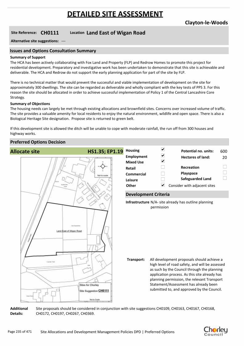
Housing
Employment
Mixed Use
Retail
Commercial
Leisure
Recreation
Safeguarded Land
Preferred Options Decision
Allocate site Potential no. units: 600
Hectares of land: 20
Other Consider with adjacent sites
Site Reference: CH0111 Land East of Wigan Road
Clayton-le-Woods
The HCA has been actively collaborating with Fox Land and Property (FLP) and Redrow Homes to promote this project for residential development. Preparatory and investigative work has been undertaken to demonstrate that this site is achievable and deliverable. The HCA and Redrow do not support the early planning application for part of the site by FLP.
There is no technical matter that would prevent the successful and viable implementation of development on the site for approximately 300 dwellings. The site can be regarded as deliverable and wholly compliant with the key tests of PPS 3. For this reason the site should be allocated in order to achieve successful implementation of Policy 1 of the Central Lancashire Core Strategy.
The housing needs can largely be met through existing allocations and brownfield sites. Concerns over increased volume of traffic. The site provides a valuable amenity for local residents to enjoy the natural environment, wildlife and open space. There is also a Biological Heritage Site designation. Propose site is returned to green belt.
If this development site is allowed the ditch will be unable to cope with moderate rainfall, the run off from 300 houses and highway works.
Summary of Objections
Summary of Support
Alternative site suggestions: ---
DETAILED SITE ASSESSMENT
Location
Development Criteria
Infrastructure N/A- site already has outline planning permission
Transport: All development proposals should achieve a high level of road safety, and will be assessed as such by the Council through the planning application process. As this site already has planning permission, the relevant Transport Statement/Assessment has already been submitted to, and approved by the Council.
Additional Details:
Site proposals should be considered in conjunction with site suggestions CH0109, CH0163, CH0167, CH0168, CH0172, CH0197, CH0267, CH0369.
Issues and Options Consultation Summary
Playspace
HS1.35; EP1.19
Page 235 of 471 Site Allocations and Development Management Policies DPD | Preferred Options

Sustainability Appraisal
Site Ref CH0111
Address Land East of Wigan Road, Clayton-le-Woods
SA Obj
Indicator Site Performance SA Comments
S1
Distance to railway station 0 .81 to 1 .6km Social This site has good access to a frequent local bus service however there is no rail service within the settlement. The site is in close proximity to a motorway junction and local services and facilities with the exception of a convenience store which is over 1.2km from the site. Environmental The site is Greenfield within a current safeguarded land designation. Economic There are no identified negative economic effects in developing this site.
Rail service freque ncy No services in settlement Distance to nearest bus stop Up to 0.4km Bus service frequency 2-5 /hour/direction Distance to se rvice centre 0 .81 to 1 .6km Distance to A Road junction Up to 0.4km Distance to motorway junction Up to 0.1.6 km Distance to supermarket 0 .81 to 1 .6km Distance to conve nience s tore Ove r 1 .2km Distance to Post Office Up to 0.4km Distance to Primary School 0 .41 to 0 .8km Distance to Secondary School 1 .61 to 3 .2km On a cycle route No Distance to cycle route Up to 0.4km
S2
Distance to GP surge ry 0 .81 to 1 .6km Distance to NHS gene ra l hospital 2.1 to 5 km Distance to public open space/park 0 .41 to 0 .8km Distance to local centre 0 .41 to 0 .8km
EN1
Designation of land Safeguarded Land Are a of Se paration Outs ide AONB Outs ide SSSI Outs ide Biological/ G eological H eritag e Site Outs ide Agricultural classifica tion 3
EN2
Conservation Area Outs ide Ancie nt Monument on site No Regis te re d Park or G arden Outs ide Listed Building on site No Locally Lis te d Building on s ite No
EN3 Curre nt/former land use Greenfie ld EN4 Flood Zone a re a All Zone 1
EN5 Contaminated land No risk Within 3km of a congestion spot Yes
EC1 Distance to employment site 1 .21 to 1 .6km Access to Broadband Yes
EC2 Distance to furthe r/higher education 1 .61 to 3 .2km
Del
iver
abili
ty
Indi
cato
rs
Access to sewer system No
Yes
Yes
Yes
Yes
Is the site deliverable: Yes Access to wa te r
Access to ga s
Access to e lectricity
Exis ting road access
At risk from hazardous installations No
Overall Site Performance Band Spe ctrum:
Overall Band:
B
Page 236 of 471 Site Allocations and Development Management Policies DPD | Preferred Options

Housing
Employment
Mixed Use
Retail
Commercial
Leisure
Recreation
Safeguarded Land
Preferred Options Decision
Do not allocate Potential no. units: 0
Hectares of land: 0
Other
Site Reference: CH0120 Burrows (GM) Premises, Wigan Road
Clayton-le-Woods
Site adjoins residential development and is brownfield land. The property itself does not properly meet present day economic operations in terms of its buildings and layout, therefore supportive of the allocation for residential development.
No proven housing need in the immediate area, with piecemeal housing development taking place all over Clayton and with developments at nearby Buckshaw still taking place. The proposed use will destroy (not protect) the character of the area and represents a threat to quality of life for both current and future residents. This site is known to contain at least one heritage asset.
Summary of Objections
Summary of Support
Alternative site suggestions: ---
DETAILED SITE ASSESSMENT
Location
Development Criteria
Infrastructure N/A- site already has planning permission
Transport: All development proposals should achieve a high level of road safety, and will be assessed as such by the Council through the planning application process. As this site already has planning permission, the relevant Transport Statement/Assessment has already been submitted to, and approved by the Council.
Additional Details:
Planning permission granted for 13 detached dwellings 11/00480/FULMAJ. Brownfield site.
Issues and Options Consultation Summary
Playspace
Page 237 of 471 Site Allocations and Development Management Policies DPD | Preferred Options

Sustainability Appraisal
Site Ref CH0120
Address Burrows (GM) Premises, Wigan Road, Clayton-le-Woods
SA Obj
Indicator Site Performance SA Comments
S1
Distance to railway station 0 .81 to 1 .6km Social This site has good access to a frequent bus service however there are no rail services within the settlement. The site has good access to all local services and facilities although the site is 0.81 to 1.2km from the local convenience store. Environmental There are no identified negative environment effects in developing this site. Economic There are no identified negative economic effects in developing this site.
Rail service freque ncy No services in settlement Distance to nearest bus stop Up to 0.4km Bus service frequency 2-5 /hour/direction Distance to se rvice centre 0 .81 to 1 .6km Distance to A Road junction Up to 0.4km Distance to motorway junction Up to 1.6km Distance to supermarket 0 .41 to 0 .8km Distance to conve nience s tore 0 .81 to 1 .2km Distance to Post Office Up to 0.4km Distance to Primary School Up to 0.4km Distance to Secondary School 1 .61 to 3 .2km On a cycle route No Distance to cycle route Up to 0.4km
S2
Distance to GP surge ry 0 .81 to 1 .6km Distance to NHS gene ra l hospital 2.1 to 5 km Distance to public open space/park 0 .41 to 0 .8km Distance to local centre Up to 0.4km
EN1
Designation of land Urban Local Service Ce ntre Are a of Se paration Outs ide AONB Outs ide SSSI Outs ide Biological/ G eological H eritag e Site Outs ide Agricultural classifica tion 3
EN2
Conservation Area Outs ide Ancie nt Monument on site No Regis te re d Park or G arden Outs ide Listed Building on site No Locally Lis te d Building on s ite No
EN3 Curre nt/former land use Brownfield EN4 Flood Zone a re a All Zone 1
EN5 Contaminated land No risk Within 3km of a congestion spot Yes
EC1 Distance to employment site 1 .21 to 1 .6km Access to Broadband Yes
EC2 Distance to furthe r/higher education 1 .61 to 3 .2km
Del
iver
abili
ty
Indi
cato
rs
Access to sewer system
Yes
Is the site deliverable: Yes Access to wa te r
Access to ga s
Access to e lectricity
Exis ting road access
At risk from hazardous installations No
Overall Site Performance Band Spe ctrum:
Overall Band:
B
Page 238 of 471 Site Allocations and Development Management Policies DPD | Preferred Options

Housing
Employment
Mixed Use
Retail
Commercial
Leisure
Recreation
Safeguarded Land
Preferred Options Decision
Allocate site Potential no. units: 600
Hectares of land: 20
Other
Site Reference: CH0131 Shady Lane, Off Sheephill Lane
Clayton-le-Woods
This is a greenfield site which should remain as such. This proposal will provide much needed facilities for locals, particularly young people.
The HCA remains supportive in principle of the modest partial recreation suggestion. It is difficult to see how a major recreation facility could be bought forward within the plan period without a wider view on viability and funding. Redrow and the HCA have been developing a more comprehensive and phased approach to masterplanning the full site area, including a range of facilities, which will balance development with appropriate areas of viable recreational use.
The fact that this building of up to 300 houses was refused by Chorley Council and has now gone to appeal is wrong and we are bitterly disappointed.
Summary of Objections
Summary of Support
Alternative site suggestions: CH0109 CH0163 CH0167 CH0168 CH0172 CH0197 CH0267 CH0310 CH0
DETAILED SITE ASSESSMENT
Location
Development Criteria
Infrastructure N/A- site already has outline planning permission
Transport: All development proposals should achieve a high level of road safety, and will be assessed as such by the Council through the planning application process. As this site already has planning permission, the relevant Transport Statement/Assessment has already been submitted to, and approved by the Council.
Additional Details:
Site proposals should be considered in conjunction with site suggestions CH0111, CH0163, CH0167, CH0168, CH0172, CH0197, CH0267, CH0369.
Issues and Options Consultation Summary
Playspace
HS1.35; EP1.19
Page 239 of 471 Site Allocations and Development Management Policies DPD | Preferred Options

Sustainability Appraisal
No sustainability Appraisal has been undertaken of this site suggestion as the site has already been
granted planning permission/ is under construction.
Page 240 of 471 Site Allocations and Development Management Policies DPD | Preferred Options

Housing
Employment
Mixed Use
Retail
Commercial
Leisure
Recreation
Safeguarded Land
Preferred Options Decision
Allocate site Potential no. units: 600
Hectares of land: 20
Other
Site Reference: CH0163 Land off Cypress Close, Lancaster Lane
Clayton-le-Woods
The HCA has been actively collaborating with Fox Land and Property (FLP) and Redrow Homes to promote this project for residential development. Work has been undertaken to demonstrate that this site is achievable and deliverable. The HCA and Redrow do not support the early planning application for part of the site by FLP.
There is no technical matter that would prevent the successful and viable implementation of development on the site for approximately 300 dwellings. The site is deliverable and compliant with the key tests of PPS 3. The site should be allocated in order to achieve successful implementation of Policy 1 of the Central Lancashire Core Strategy.
The housing needs can largely be met through existing allocations and brownfield sites. Concerns over increased volume of traffic. The site provides a valuable amenity for local residents to enjoy the natural environment, wildlife and open space. There is also a Biological Heritage Site designation. Propose site is returned to green belt.
If this development site is allowed the ditch will be unable to cope with moderate rainfall, the run off from 300 houses and highway works. There is no proven housing need in our immediate area, with piecemeal housing development taking place all over Clayton and with developments at nearby Buckshaw still taking place.
Summary of Objections
Summary of Support
Alternative site suggestions: CH0109 CH0131 CH0167 CH0168 CH0172 CH0197 CH0267 CH0310 CH0
DETAILED SITE ASSESSMENT
Location
Development Criteria
Infrastructure N/A- site already has outline planning permission
Transport: All development proposals should achieve a high level of road safety, and will be assessed as such by the Council through the planning application process. As this site already has planning permission, the relevant Transport Statement/Assessment has already been submitted to, and approved by the Council.
Additional Details:
Site proposals should be considered in conjunction with site suggestions CH0109, CH0167, CH0168, CH0172, CH0197, CH0267, CH0369.
Issues and Options Consultation Summary
Playspace
HS1.35; EP1.19
Page 241 of 471 Site Allocations and Development Management Policies DPD | Preferred Options

Sustainability Appraisal
Site Ref CH0163
Address Land off Cypress Close, Lancaster Lane, Clayton-le-Woods
SA Obj
Indicator Site Performance SA Comments
S1
Distance to railway station 0 .81 to 1 .6km Social This site has good access to a frequent local bus service however there is no rail service within the settlement. The site is in close proximity to a motorway junction and a supermarket. The site is not close to a convenience store with the nearest being over 1.2km from the site. Environmental The site is located partly within a biological and geological heritage site and is also Greenfield within a current safeguarded land designation. Economic There are no identified negative economic effects in developing this site.
Rail service freque ncy No services in settlement Distance to nearest bus stop Up to 0.4km Bus service frequency 2-5 /hour/direction Distance to se rvice centre 0 .81 to 1 .6km Distance to A Road junction 0 .41 to 0 .8km Distance to motorway junction Up to 1.6km Distance to supermarket 0 .41 to 0 .8km Distance to conve nience s tore Ove r 1 .2km Distance to Post Office Up to 0.4km Distance to Primary School 0 .81 to 1 .6km Distance to Secondary School 1 .61 to 3 .2km On a cycle route No Distance to cycle route Up to 0.4km
S2
Distance to GP surge ry 0 .81 to 1 .6km Distance to NHS gene ra l hospital 2.1 to 5 km Distance to public open space/park 0 .41 to 0 .8km Distance to local centre 0 .81 to 1 .2km
EN1
Designation of land Safeguarded Land Are a of Se paration Outs ide AONB Outs ide SSSI Outs ide Biological/ G eological H eritag e Site Part outs ide/part w ithin Agricultural classifica tion 3
EN2
Conservation Area Outs ide Ancie nt Monument on site No Regis te re d Park or G arden Outs ide Listed Building on site No Locally Lis te d Building on s ite No
EN3 Curre nt/former land use Greenfie ld EN4 Flood Zone a re a All Zone 1
EN5 Contaminated land No risk Within 3km of a congestion spot Yes
EC1 Distance to employment site Ove r 1 .6km Access to Broadband Yes
EC2 Distance to furthe r/higher education 1 .61 to 3 .2km
De
liver
abili
ty
Indi
cato
rs Access to sewer system
Yes
Is the site deliverable: Yes
Access to wa te r Access to ga s Access to e lectricity Exis ting road access At risk from hazardous installations No
Overall Site Performance Band Spe ctrum:
Overall Band:
B
Page 242 of 471 Site Allocations and Development Management Policies DPD | Preferred Options

Housing
Employment
Mixed Use
Retail
Commercial
Leisure
Recreation
Safeguarded Land
Preferred Options Decision
Allocate site Potential no. units: 600
Hectares of land: 20
Other
Site Reference: CH0167 Woodcocks Farm, Wigan Road
Clayton-le-Woods
None received.
The housing needs can largely be met through existing allocations and brownfield sites. Concerns over increased volume of traffic. The site provides a valuable amenity for local residents to enjoy the natural environment, wildlife and open space. There is also a Biological Heritage Site designation. Propose site is returned to green belt.
If this development site is allowed the ditch will be unable to cope with moderate rainfall, the run off from 300 houses and highway works. There is no proven housing need in the immediate area, with piecemeal housing development taking place all over Clayton and with developments at nearby Buckshaw still taking place.
This site is known to contain at least one heritage asset.
Summary of Objections
Summary of Support
Alternative site suggestions: CH0109 CH0131 CH0163 CH0168 CH0172 CH0197 CH0267 CH0310 CH0
DETAILED SITE ASSESSMENT
Location
Development Criteria
Infrastructure N/A- site already has outline planning permission
Transport: All development proposals should achieve a high level of road safety, and will be assessed as such by the Council through the planning application process. As this site already has planning permission, the relevant Transport Statement/Assessment has already been submitted to, and approved by the Council.
Additional Details:
Site proposals should be considered in conjunction with site suggestions CH0109, CH0163, CH0168, CH0172, CH0197, CH0267, CH0369.
Issues and Options Consultation Summary
Playspace
HS1.35; EP1.19
Page 243 of 471 Site Allocations and Development Management Policies DPD | Preferred Options

Sustainability Appraisal
Site Ref CH0167
Address Woodcocks Farm, Wigan Road, Clayton-le-Woods
SA Obj
Indicator Site Performance SA Comments
S1
Distance to railway station 0 .81 to 1 .6km Social This site has good access to a frequent local bus service however there is no rail service within the settlement. The site is in close proximity to a motorway junction and local services and facilities. Environmental The site is located partly within a biological and geological heritage site and is also Greenfield within a current safeguarded land designation. Economic There are no identified negative economic effects in developing this site.
Rail service freque ncy No services in settlement Distance to nearest bus stop Up to 0.4km Bus service frequency 2-5 /hour/direction Distance to se rvice centre 0 .81 to 1 .6km Distance to A Road junction Up to 0.4km Distance to motorway junction Up to 1.6km Distance to supermarket 0 .41 to 0 .8km Distance to conve nience s tore 0 .81 to 1 .2km Distance to Post Office Up to 0.4km Distance to Primary School 0 .41 to 0 .8km Distance to Secondary School 1 .61 to 3 .2km On a cycle route No Distance to cycle route Up to 0.4km
S2
Distance to GP surge ry 0 .81 to 1 .6km Distance to NHS gene ra l hospital 2.1 to 5 km Distance to public open space/park 0 .41 to 0 .8km Distance to local centre 0 .41 to 0 .8km
EN1
Designation of land Safeguarded Land Are a of Se paration Outs ide AONB Outs ide SSSI Outs ide Biological/ G eological H eritag e Site Part outs ide/part w ithin Agricultural classifica tion 3
EN2
Conservation Area Outs ide Ancie nt Monument on site No Regis te re d Park or G arden Outs ide Listed Building on site No Locally Lis te d Building on s ite No
EN3 Curre nt/former land use Greenfie ld EN4 Flood Zone a re a All Zone 1
EN5 Contaminated land No risk Within 3km of a congestion spot Yes
EC1 Distance to employment site Ove r 1 .6km Access to Broadband Yes
EC2 Distance to furthe r/higher education 1 .61 to 3 .2km
Del
iver
abili
ty
Indi
cato
rs
Access to sewer system No
Yes
Yes
Yes
Yes
Is the site deliverable: Yes Access to wa te r
Access to ga s
Access to e lectricity
Exis ting road access
At risk from hazardous installations No
Overall Site Performance Band Spe ctrum:
Overall Band:
B
Page 244 of 471 Site Allocations and Development Management Policies DPD | Preferred Options
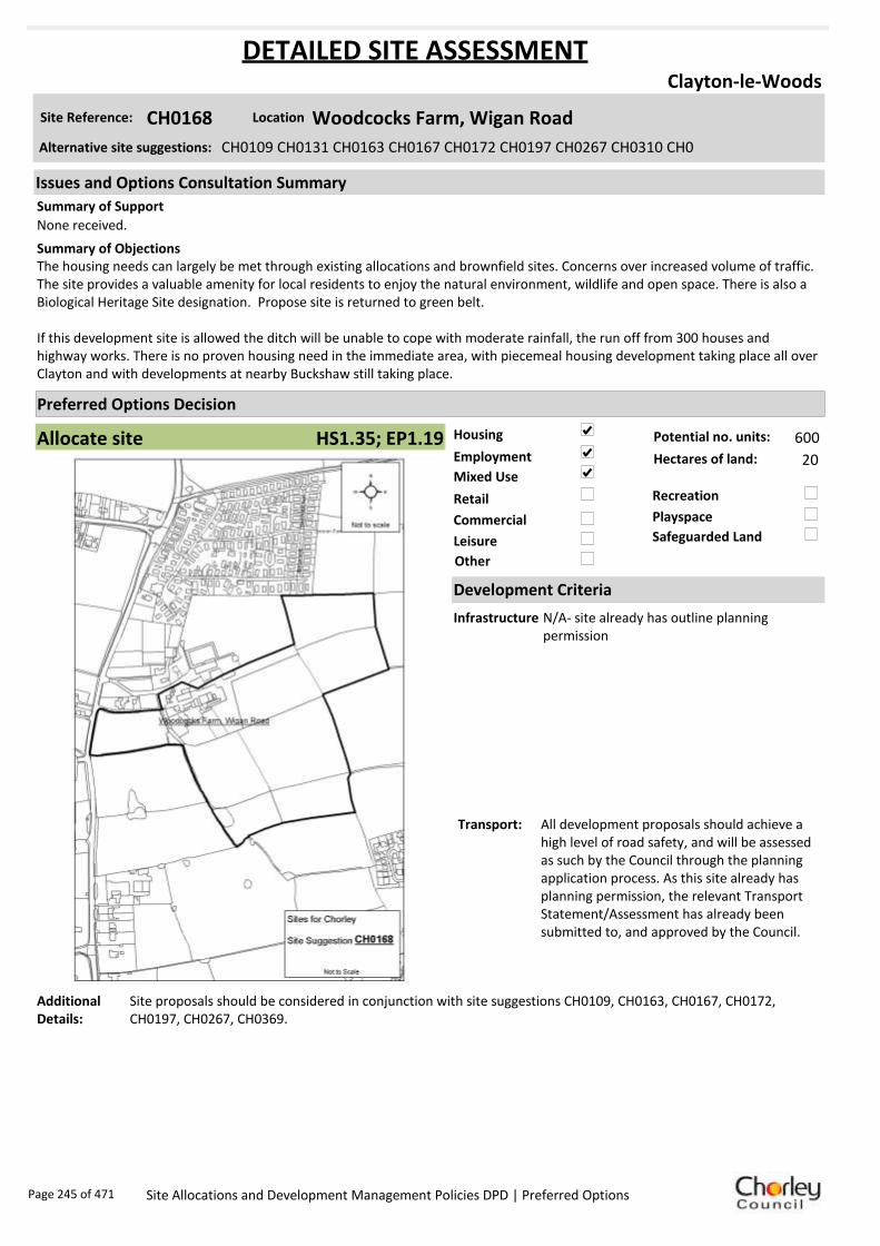
Housing
Employment
Mixed Use
Retail
Commercial
Leisure
Recreation
Safeguarded Land
Preferred Options Decision
Allocate site Potential no. units: 600
Hectares of land: 20
Other
Site Reference: CH0168 Woodcocks Farm, Wigan Road
Clayton-le-Woods
None received.
The housing needs can largely be met through existing allocations and brownfield sites. Concerns over increased volume of traffic. The site provides a valuable amenity for local residents to enjoy the natural environment, wildlife and open space. There is also a Biological Heritage Site designation. Propose site is returned to green belt.
If this development site is allowed the ditch will be unable to cope with moderate rainfall, the run off from 300 houses and highway works. There is no proven housing need in the immediate area, with piecemeal housing development taking place all over Clayton and with developments at nearby Buckshaw still taking place.
Summary of Objections
Summary of Support
Alternative site suggestions: CH0109 CH0131 CH0163 CH0167 CH0172 CH0197 CH0267 CH0310 CH0
DETAILED SITE ASSESSMENT
Location
Development Criteria
Infrastructure N/A- site already has outline planning permission
Transport: All development proposals should achieve a high level of road safety, and will be assessed as such by the Council through the planning application process. As this site already has planning permission, the relevant Transport Statement/Assessment has already been submitted to, and approved by the Council.
Additional Details:
Site proposals should be considered in conjunction with site suggestions CH0109, CH0163, CH0167, CH0172, CH0197, CH0267, CH0369.
Issues and Options Consultation Summary
Playspace
HS1.35; EP1.19
Page 245 of 471 Site Allocations and Development Management Policies DPD | Preferred Options
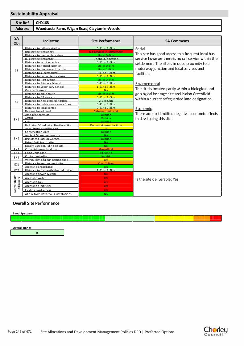
Sustainability Appraisal
Site Ref CH0168
Address Woodcocks Farm, Wigan Road, Clayton-le-Woods
SA Obj
Indicator Site Performance SA Comments
S1
Distance to railway station 0 .81 to 1 .6km Social This site has good access to a frequent local bus service however there is no rail service within the settlement. The site is in close proximity to a motorway junction and local services and facilities. Environmental The site is located partly within a biological and geological heritage site and is also Greenfield within a current safeguarded land designation. Economic There are no identified negative economic effects in developing this site.
Rail service freque ncy No services in settlement Distance to nearest bus stop Up to 0.4km Bus service frequency 2-5 /hour/direction Distance to se rvice centre 0 .81 to 1 .6km Distance to A Road junction Up to 0.4km Distance to motorway junction Up to 1.6km Distance to supermarket 0 .41 to 0 .8km Distance to conve nience s tore 0 .81 to 1 .2km Distance to Post Office Up to 0.4km Distance to Primary School 0 .41 to 0 .8km Distance to Secondary School 1 .61 to 3 .2km On a cycle route No Distance to cycle route Up to 0.4km
S2
Distance to GP surge ry 0 .81 to 1 .6km Distance to NHS gene ra l hospital 2.1 to 5 km Distance to public open space/park 0 .41 to 0 .8km Distance to local centre 0 .41 to 0 .8km
EN1
Designation of land Safeguarded Land Are a of Se paration Outs ide AONB Outs ide SSSI Outs ide Biological/ G eological H eritag e Site Part outs ide/part w ithin Agricultural classifica tion 3
EN2
Conservation Area Outs ide Ancie nt Monument on site No Regis te re d Park or G arden Outs ide Listed Building on site No Locally Lis te d Building on s ite No
EN3 Curre nt/former land use Greenfie ld EN4 Flood Zone a re a All Zone 1
EN5 Contaminated land No risk Within 3km of a congestion spot Yes
EC1 Distance to employment site Ove r 1 .6km Access to Broadband Yes
EC2 Distance to furthe r/higher education 1 .61 to 3 .2km
Del
iver
abili
ty
Indi
cato
rs
Access to sewer system No
Yes
Yes
Yes
Yes
Is the site deliverable: Yes Access to wa te r
Access to ga s
Access to e lectricity
Exis ting road access At risk from hazardous installations No
Overall Site Performance Band Spe ctrum:
Overall Band:
B
Page 246 of 471 Site Allocations and Development Management Policies DPD | Preferred Options

Housing
Employment
Mixed Use
Retail
Commercial
Leisure
Recreation
Safeguarded Land
Preferred Options Decision
Allocate site Potential no. units: 600
Hectares of land: 20
Other
Site Reference: CH0172 Shady Lane
Clayton-le-Woods
The HCA has been actively collaborating with Fox Land and Property (FLP) and Redrow Homes to promote this project for residential development. Work has been undertaken to demonstrate that this site is achievable and deliverable. The HCA and Redrow do not support the early planning application for part of the site by FLP.
There is no technical matter that would prevent the successful and viable implementation of development on the site for approximately 300 dwellings. The site is deliverable and compliant with the key tests of PPS 3. For this reason the site should be allocated in order to achieve successful implementation of Policy 1 of the Central Lancashire Core Strategy.
The housing needs can largely be met through existing allocations and brownfield sites. Concerns over increased volume of traffic. The site provides a valuable amenity for local residents to enjoy the natural environment, wildlife and open space. There is also a Biological Heritage Site designation. Propose site is returned to green belt.
If this development site is allowed the ditch will be unable to cope with moderate rainfall, the run off from 300 houses and highway works. There is no proven housing need in our immediate area, with piecemeal housing development taking place all over Clayton and with developments at nearby Buckshaw still taking place.
Summary of Objections
Summary of Support
Alternative site suggestions: CH0109 CH0131 CH0163 CH0167 CH0168 CH0197 CH0267 CH0310 CH0
DETAILED SITE ASSESSMENT
Location
Development Criteria
Infrastructure N/A- site already has outline planning permission
Transport: All development proposals should achieve a high level of road safety, and will be assessed as such by the Council through the planning application process. As this site already has planning permission, the relevant Transport Statement/Assessment has already been submitted to, and approved by the Council.
Additional Details:
Site proposals should be considered in conjunction with site suggestions CH0109, CH0163, CH0167, CH0168, CH0197, CH0267, CH0369.
Issues and Options Consultation Summary
Playspace
HS1.35; EP1.19
Page 247 of 471 Site Allocations and Development Management Policies DPD | Preferred Options

Sustainability Appraisal
Site Ref CH0172
Address Shady lane, Clayton-le-Woods
SA Obj
Indicator Site Performance SA Comments
S1
Distance to railway station 1 .61 to 2 .4km Social This site has good access to public transport with bus services 2-5 times per hour. The site does not have access to a rail service and the nearest convenience store is over 1.2km away. The site has good access to an a road junction and a motorway junction but has poor access to local services and facilities. Environmental This site is a Greenfield site with a current safeguarded land designation. The site is also partly within a biological and geological heritage site. Economic There are no identified negative economic effects in developing this site.
Rail service freque ncy No services in settlement Distance to nearest bus stop Up to 0.4km Bus service frequency 2-5 /hour/direction Distance to se rvice centre 1 .61 to 2 .4km Distance to A Road junction 0 .41 to 0 .8km Distance to motorway junction 1 .61 to 3 km Distance to supermarket 0 .81 to 1 .6km Distance to conve nience s tore Ove r 1 .2km Distance to Post Office Up to 0.4km Distance to Primary School 0 .81 to 1 .6km Distance to Secondary School 1 .61 to 3 .2km On a cycle route No Distance to cycle route Up to 0.4km
S2
Distance to GP surge ry 1 .61 to 3 km Distance to NHS gene ra l hospital 2.1 to 5 km Distance to public open space/park Up to 0.4km Distance to local centre 1 .21 to 1 .6km
EN1
Designation of land Safeguarded Land Are a of Se paration Outs ide AONB Outs ide SSSI Outs ide Biological/ G eological H eritag e Site Part outs ide/part w ithin Agricultural classifica tion 3
EN2
Conservation Area Outs ide Ancie nt Monument on site No Regis te re d Park or G arden Outs ide Listed Building on site No Locally Lis te d Building on s ite No
EN3 Curre nt/former land use Greenfie ld EN4 Flood Zone a re a All Zone 1
EN5 Contaminated land No risk Within 3km of a congestion spot Yes
EC1 Distance to employment site Ove r 1 .6km Access to Broadband Yes
EC2 Distance to furthe r/higher education 3 .21 to 5 km
De
liver
abili
ty
Indi
cato
rs Access to sewer system
Yes
Is the site deliverable: Yes
Access to wa te r Access to ga s Access to e lectricity Exis ting road access At risk from hazardous installations No
Overall Site Performance Band Spe ctrum:
Overall Band:
C
Page 248 of 471 Site Allocations and Development Management Policies DPD | Preferred Options

Housing
Employment
Mixed Use
Retail
Commercial
Leisure
Recreation
Safeguarded Land
Preferred Options Decision
Allocate site Potential no. units: 600
Hectares of land: 20
Other
Site Reference: CH0197 Land off A49 Wigan Road
Clayton-le-Woods
The HCA has been actively collaborating with Fox Land and Property (FLP) and Redrow Homes to promote this project for residential development. Work has been undertaken to demonstrate that this site is achievable and deliverable. The HCA and Redrow do not support the early planning application for part of the site by FLP.
There is no technical matter that would prevent the successful and viable implementation of development on the site for approximately 300 dwellings. The site is deliverable and compliant with the key tests of PPS 3. The site should be allocated in order to achieve successful implementation of Policy 1 of the Central Lancashire Core Strategy.
The housing needs can largely be met through existing allocations and brownfield sites. Concerns over increased volume of traffic. The site provides a valuable amenity for local residents to enjoy the natural environment, wildlife and open space. There is also a Biological Heritage Site designation. Propose site is returned to green belt.
If this development site is allowed the ditch will be unable to cope with moderate rainfall, the run off from 300 houses and highway works. There is no proven housing need in our immediate area, with piecemeal housing development taking place all over Clayton and with developments at nearby Buckshaw still taking place.
Summary of Objections
Summary of Support
Alternative site suggestions: CH0109 CH0131 CH0163 CH0167 CH0168 CH0172 CH0267 CH0310 CH0
DETAILED SITE ASSESSMENT
Location
Development Criteria
Infrastructure N/A- site already has outline planning permission
Transport: All development proposals should achieve a high level of road safety, and will be assessed as such by the Council through the planning application process. As this site already has planning permission, the relevant Transport Statement/Assessment has already been submitted to, and approved by the Council.
Additional Details:
Site proposals should be considered in conjunction with site suggestions CH0109, CH0163, CH0167, CH0168, CH0172, CH0267, CH0369.
Issues and Options Consultation Summary
Playspace
HS1.35; EP1.19
Page 249 of 471 Site Allocations and Development Management Policies DPD | Preferred Options

Sustainability Appraisal
Site Ref CH0197
Address Land East of Wigan Road, Clayton-le-Woods
SA Obj
Indicator Site Performance SA Comments
S1
Distance to railway station 0 .81 to 1 .6km Social This site has good access to a frequent bus service although there is no rail service within the settlement. The site is in close proximity to the road network and is upto 1.6km from a motorway junction. The site has good access to local services and facilities. Environmental The site is located partly within a biological/geological heritage site and is Greenfield with an existing safeguarded land designation. Economic There are no identified negative economic effects in developing this site.
Rail service freque ncy No services in settlement Distance to nearest bus stop Up to 0.4km Bus service frequency 2-5 /hour/direction Distance to se rvice centre 0 .81 to 1 .6km Distance to A Road junction Up to 0.4km Distance to motorway junction Up to 1.6km Distance to supermarket 0 .41 to 0 .8km Distance to conve nience s tore 0 .81 to 1 .2km Distance to Post Office Up to 0.4km Distance to Primary School 0 .41 to 0 .8km Distance to Secondary School 1 .61 to 3 .2km On a cycle route No Distance to cycle route Up to 0.4km
S2
Distance to GP surge ry 0 .81 to 1 .6km Distance to NHS gene ra l hospital 2.1 to 5 km Distance to public open space/park 0 .41 to 0 .8km Distance to local centre 0 .41 to 0 .8km
EN1
Designation of land Safeguarded Land Are a of Se paration Outs ide AONB Outs ide SSSI Outs ide Biological/ G eological H eritag e Site Part outs ide/part w ithin Agricultural classifica tion 3
EN2
Conservation Area Outs ide Ancie nt Monument on site No Regis te re d Park or G arden Outs ide Listed Building on site No Locally Lis te d Building on s ite No
EN3 Curre nt/former land use Greenfie ld EN4 Flood Zone a re a All Zone 1
EN5 Contaminated land No risk Within 3km of a congestion spot Yes
EC1 Distance to employment site 1 .21 to 1 .6km Access to Broadband Yes
EC2 Distance to furthe r/higher education 1 .61 to 3 .2km
Del
iver
abili
ty
Indi
cato
rs
Access to sewer system
Yes
Is the site deliverable: Yes Access to wa te r
Access to ga s
Access to e lectricity
Exis ting road access
At risk from hazardous installations No
Overall Site Performance Band Spe ctrum:
Overall Band:
B
Page 250 of 471 Site Allocations and Development Management Policies DPD | Preferred Options
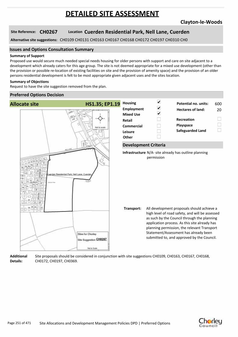
Housing
Employment
Mixed Use
Retail
Commercial
Leisure
Recreation
Safeguarded Land
Preferred Options Decision
Allocate site Potential no. units: 600
Hectares of land: 20
Other
Site Reference: CH0267 Cuerden Residential Park, Nell Lane, Cuerden
Clayton-le-Woods
Proposed use would secure much needed special needs housing for older persons with support and care on site adjacent to a development which already caters for this age group. The site is not deemed appropriate for a mixed use development (other than the provision or possible re-location of existing facilities on site and the provision of amenity space) and the provision of an older persons residential development is felt to be most appropriate given adjacent uses and the sites location.
Request to have the site suggestion removed from the plan.Summary of Objections
Summary of Support
Alternative site suggestions: CH0109 CH0131 CH0163 CH0167 CH0168 CH0172 CH0197 CH0310 CH0
DETAILED SITE ASSESSMENT
Location
Development Criteria
Infrastructure N/A- site already has outline planning permission
Transport: All development proposals should achieve a high level of road safety, and will be assessed as such by the Council through the planning application process. As this site already has planning permission, the relevant Transport Statement/Assessment has already been submitted to, and approved by the Council.
Additional Details:
Site proposals should be considered in conjunction with site suggestions CH0109, CH0163, CH0167, CH0168, CH0172, CH0197, CH0369.
Issues and Options Consultation Summary
Playspace
HS1.35; EP1.19
Page 251 of 471 Site Allocations and Development Management Policies DPD | Preferred Options

Sustainability Appraisal
Site Ref CH0267
Address Cuerden Residential Park, Nell Lane, Clayton-le-Woods
SA Obj
Indicator Site Performance SA Comments
S1
Distance to railway station 1 .61 to 2 .4km Social This site has good access to public transport with bus services 2-5 times per hour. The site does not have access to a rail service and the nearest convenience store is over 1.2km away. The site has good access to an A road junction and a motorway junction but has poor access to local services and facilities. Environmental This site is a Greenfield site with a current safeguarded land designation. The site also has a medium risk of land contamination. Economic There are no identified negative economic effects in developing this site.
Rail service freque ncy No services in settlement Distance to nearest bus stop Up to 0.4km Bus service frequency 2-5 /hour/direction Distance to se rvice centre 1 .61 to 2 .4km Distance to A Road junction Up to 0.4km Distance to motorway junction Up to 1.6km Distance to supermarket 0 .81 to 1 .6km Distance to conve nience s tore Ove r 1 .2km Distance to Post Office Up to 0.4km Distance to Primary School 0 .81 to 1 .6km Distance to Secondary School 1 .61 to 3 .2km On a cycle route No Distance to cycle route Up to 0.4km
S2
Distance to GP surge ry 1 .61 to 3 km Distance to NHS gene ra l hospital 2.1 to 5 km Distance to public open space/park Up to 0.4km Distance to local centre 1 .21 to 1 .6km
EN1
Designation of land Safeguarded Land Are a of Se paration Outs ide AONB Outs ide SSSI Outs ide Biological/ G eological H eritag e Site Outs ide Agricultural classifica tion 3
EN2
Conservation Area Outs ide Ancie nt Monument on site No Regis te re d Park or G arden Outs ide Listed Building on site No Locally Lis te d Building on s ite No
EN3 Curre nt/former land use Greenfie ld EN4 Flood Zone a re a All Zone 1
EN5 Contaminated land M edium risk Within 3km of a congestion spot Yes
EC1 Distance to employment site Ove r 1 .6km Access to Broadband Yes
EC2 Distance to furthe r/higher education 3 .21 to 5 km
Del
iver
abili
ty
Ind
icat
ors
Access to sewer system No
Yes
Yes
Yes
Yes
Is the site deliverable: Yes Access to wa te r
Access to ga s Access to e lectricity Exis ting road access At risk from hazardous installations No
Overall Site Performance Band Spe ctrum:
Overall Band:
C
Page 252 of 471 Site Allocations and Development Management Policies DPD | Preferred Options

Housing
Employment
Mixed Use
Retail
Commercial
Leisure
Recreation
Safeguarded Land
Preferred Options Decision
Allocate site Potential no. units: 600
Hectares of land: 20
Other
Site Reference: CH0310 Wigan Road/Lancaster Lane
Clayton-le-Woods
None received.
A 50 hectare recreational area for this site is likely to prove unviable without development of some sort to fund it. Objection is raised to site suggestion insofar as it relates to the whole of the site east of Wigan Road. There is an opportunity to deliver publicly useable recreation and open space on the site as part of a comprehensive residential and open space development of the land.
There is no technical matter that would prevent the successful and viable implementation of development on the site for approximately 300 dwellings. The site can be regarded as deliverable and wholly compliant with the key tests of PPS 3. The HCA and Redrow do not support the early planning application for part of the site by FLP.
We need prime agricultural land as we cannot produce enough food for the population. There are plenty of brownfield sites available without taking good land for building houses. This is a greenfield site which should remain as such. Propose that this site be re-classified as ‘Greenbelt’.
This site is known to contain at least one heritage asset.
Summary of Objections
Summary of Support
Alternative site suggestions: CH0109 CH0131 CH0163 CH0167 CH0168 CH0172 CH0197 CH0267 CH0
DETAILED SITE ASSESSMENT
Location
Development Criteria
Infrastructure N/A- site already has outline planning permission
Transport: All development proposals should achieve a high level of road safety, and will be assessed as such by the Council through the planning application process. As this site already has planning permission, the relevant Transport Statement/Assessment has already been submitted to, and approved by the Council.
Additional Details:
Site proposals should be considered in conjunction with site suggestions CH0109, CH0163, CH0167, CH0168, CH0172, CH0197, CH0369.
Issues and Options Consultation Summary
Playspace
HS1.35; EP1.19
Page 253 of 471 Site Allocations and Development Management Policies DPD | Preferred Options
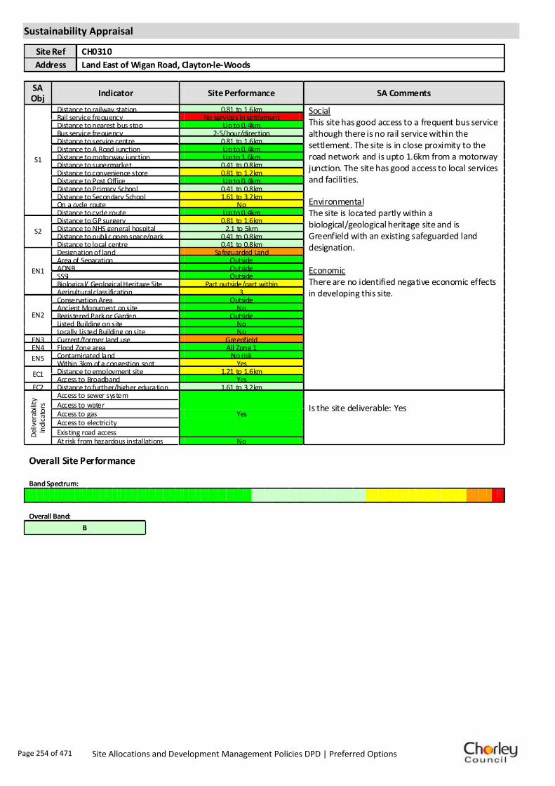
Sustainability Appraisal
Site Ref CH0310
Address Land East of Wigan Road, Clayton-le-Woods
SA Obj
Indicator Site Performance SA Comments
S1
Distance to railway station 0.81 to 1.6km Social This site has good access to a frequent bus service although there is no rail service within the settlement. The site is in close proximity to the road network and is upto 1.6km from a motorway junction. The site has good access to local services and facilities. Environmental The site is located partly within a biological/geological heritage site and is Greenfield with an existing safeguarded land designation. Economic There are no identified negative economic effects in developing this site.
Rail service frequency No services in settlement Distance to nearest bus stop Up to 0.4km Bus service frequency 2-5/hour/direction Distance to service centre 0.81 to 1.6km Distance to A Road junction Up to 0.4km Distance to motorway junction Up to 1.6km Distance to supermarket 0.41 to 0.8km Distance to convenience store 0.81 to 1.2km Distance to Post Office Up to 0.4km Distance to Primary School 0.41 to 0.8km Distance to Secondary School 1.61 to 3.2km On a cycle route No Distance to cycle route Up to 0.4km
S2
Distance to GP surgery 0.81 to 1.6km Distance to NHS general hospital 2.1 to 5km Distance to public open space/park 0.41 to 0.8km Distance to local centre 0.41 to 0.8km
EN1
Designation of land Safeguarded Land Area of Separation Outside AONB Outside SSSI Outside Biological/ Geological Heritage Site Part outside/part within Agricultural classification 3
EN2
Conservation Area Outside Ancient Monument on site No Registered Park or Garden Outside Listed Building on site No Locally Listed Building on site No
EN3 Current/former land use Greenfield EN4 Flood Zone area All Zone 1
EN5 Contaminated land No risk Within 3km of a congestion spot Yes
EC1 Distance to employment site 1.21 to 1.6km Access to Broadband Yes
EC2 Distance to further/higher education 1.61 to 3.2km
Del
iver
abili
ty
Indi
cato
rs
Access to sewer system
Yes
Is the site deliverable: Yes Access to water
Access to gas Access to electricity Existing road access At risk from hazardous installations No
Overall Site Performance Band Spectrum:
Overall Band:
B
Page 254 of 471 Site Allocations and Development Management Policies DPD | Preferred Options

Housing
Employment
Mixed Use
Retail
Commercial
Leisure
Recreation
Safeguarded Land
Preferred Options Decision
Allocate site Potential no. units: 600
Hectares of land: 20
Other
Site Reference: CH0311 Wigan Road/Lancaster Lane
Clayton-le-Woods
None received.
A 50 hectare recreational area for this site is likely to prove unviable without development of some sort to fund it. Objection is raised to site suggestion insofar as it relates to the whole of the site east of Wigan Road. There is an opportunity to deliver publicly useable recreation and open space on the site as part of a comprehensive residential and open space development of the land.
There is no technical matter that would prevent the successful and viable implementation of development on the site for approximately 300 dwellings. The site can be regarded as deliverable and wholly compliant with the key tests of PPS 3. The HCA and Redrow do not support the early planning application for part of the site by FLP.
We need prime agricultural land as we cannot produce enough food for the population. There are plenty of brownfield sites available without taking good land for building houses. This is a greenfield site which should remain as such. Propose that this site be re-classified as ‘Greenbelt’.
This site is known to contain at least one heritage asset.
Summary of Objections
Summary of Support
Alternative site suggestions: CH0109 CH0131 CH0163 CH0167 CH0168 CH0172 CH0197 CH0310 CH0
DETAILED SITE ASSESSMENT
Location
Development Criteria
Infrastructure N/A- site already has outline planning permission
Transport: All development proposals should achieve a high level of road safety, and will be assessed as such by the Council through the planning application process. As this site already has planning permission, the relevant Transport Statement/Assessment has already been submitted to, and approved by the Council.
Additional Details:
Site proposals should be considered in conjunction with site suggestions CH0109, CH0163, CH0167, CH0168, CH0172, CH0197, CH0369.
Issues and Options Consultation Summary
Playspace
HS1.35; EP1.19
Page 255 of 471 Site Allocations and Development Management Policies DPD | Preferred Options

Sustainability Appraisal
Site Ref CH0311
Address Land East of Wigan Road, Clayton-le-Woods
SA Obj
Indicator Site Performance SA Comments
S1
Distance to railway station 0.81 to 1.6km Social This site has good access to a frequent bus service although there is no rail service within the settlement. The site is in close proximity to the road network and is upto 1.6km from a motorway junction. The site has good access to local services and facilities. Environmental The site is located partly within a biological/geological heritage site and is Greenfield with an existing safeguarded land designation. Economic There are no identified negative economic effects in developing this site.
Rail service frequency No services in settlement Distance to nearest bus stop Up to 0.4km Bus service frequency 2-5/hour/direction Distance to service centre 0.81 to 1.6km Distance to A Road junction Up to 0.4km Distance to motorway junction Up to 1.6km Distance to supermarket 0.41 to 0.8km Distance to convenience store 0.81 to 1.2km Distance to Post Office Up to 0.4km Distance to Primary School 0.41 to 0.8km Distance to Secondary School 1.61 to 3.2km On a cycle route No Distance to cycle route Up to 0.4km
S2
Distance to GP surgery 0.81 to 1.6km Distance to NHS general hospital 2.1 to 5km Distance to public open space/park 0.41 to 0.8km Distance to local centre 0.41 to 0.8km
EN1
Designation of land Safeguarded Land Area of Separation Outside AONB Outside SSSI Outside Biological/ Geological Heritage Site Part outside/part within Agricultural classification 3
EN2
Conservation Area Outside Ancient Monument on site No Registered Park or Garden Outside Listed Building on site No Locally Listed Building on site No
EN3 Current/former land use Greenfield EN4 Flood Zone area All Zone 1
EN5 Contaminated land No risk Within 3km of a congestion spot Yes
EC1 Distance to employment site 1.21 to 1.6km Access to Broadband Yes
EC2 Distance to further/higher education 1.61 to 3.2km
Del
iver
abili
ty
Indi
cato
rs
Access to sewer system
Yes
Is the site deliverable: Yes Access to water
Access to gas Access to electricity Existing road access At risk from hazardous installations No
Overall Site Performance Band Spectrum:
Overall Band:
B
Page 256 of 471 Site Allocations and Development Management Policies DPD | Preferred Options
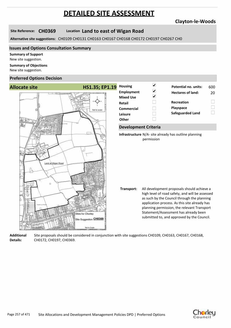
Housing
Employment
Mixed Use
Retail
Commercial
Leisure
Recreation
Safeguarded Land
Preferred Options Decision
Allocate site Potential no. units: 600
Hectares of land: 20
Other
Site Reference: CH0369 Land to east of Wigan Road
Clayton-le-Woods
New site suggestion.
New site suggestion.Summary of Objections
Summary of Support
Alternative site suggestions: CH0109 CH0131 CH0163 CH0167 CH0168 CH0172 CH0197 CH0267 CH0
DETAILED SITE ASSESSMENT
Location
Development Criteria
Infrastructure N/A- site already has outline planning permission
Transport: All development proposals should achieve a high level of road safety, and will be assessed as such by the Council through the planning application process. As this site already has planning permission, the relevant Transport Statement/Assessment has already been submitted to, and approved by the Council.
Additional Details:
Site proposals should be considered in conjunction with site suggestions CH0109, CH0163, CH0167, CH0168, CH0172, CH0197, CH0369.
Issues and Options Consultation Summary
Playspace
HS1.35; EP1.19
Page 257 of 471 Site Allocations and Development Management Policies DPD | Preferred Options

Sustainability Appraisal
Site Ref CH0369
Address Land East of Wigan Road, Clayton-le-Woods
SA Obj
Indicator Site Performance SA Comments
S1
Distance to railway station 0 .81 to 1 .6km Social This site has good access to a frequent bus service although there is no rail service within the settlement. The site is in close proximity to the road network and is upto 1.6km from a motorway junction. The site has good access to local services and facilities. Environmental The site is located partly within a biological/geological heritage site and is Greenfield with an existing safeguarded land designation. Economic There are no identified negative economic effects in developing this site.
Rail service freque ncy No services in settlement Distance to nearest bus stop Up to 0.4km Bus service frequency 2-5 /hour/direction Distance to se rvice centre 0 .81 to 1 .6km Distance to A Road junction Up to 0.4km Distance to motorway junction Up to 1.6km Distance to supermarket 0 .41 to 0 .8km Distance to conve nience s tore 0 .81 to 1 .2km Distance to Post Office Up to 0.4km Distance to Primary School 0 .41 to 0 .8km Distance to Secondary School 1 .61 to 3 .2km On a cycle route No Distance to cycle route Up to 0.4km
S2
Distance to GP surge ry 0 .81 to 1 .6km Distance to NHS gene ra l hospital 2.1 to 5 km Distance to public open space/park 0 .41 to 0 .8km Distance to local centre 0 .41 to 0 .8km
EN1
Designation of land Safeguarded Land Are a of Se paration Outs ide AONB Outs ide SSSI Outs ide Biological/ G eological H eritag e Site Part outs ide/part w ithin Agricultural classifica tion 3
EN2
Conservation Area Outs ide Ancie nt Monument on site No Regis te re d Park or G arden Outs ide Listed Building on site No Locally Lis te d Building on s ite No
EN3 Curre nt/former land use Greenfie ld EN4 Flood Zone a re a All Zone 1
EN5 Contaminated land No risk Within 3km of a congestion spot Yes
EC1 Distance to employment site 1 .21 to 1 .6km Access to Broadband Yes
EC2 Distance to furthe r/higher education 1 .61 to 3 .2km
Del
iver
abili
ty
Indi
cato
rs
Access to sewer system
Yes
Is the site deliverable: Yes Access to wa te r
Access to ga s
Access to e lectricity
Exis ting road access
At risk from hazardous installations No
Overall Site Performance Band Spe ctrum:
Overall Band:
B
Page 258 of 471 Site Allocations and Development Management Policies DPD | Preferred Options

Housing
Employment
Mixed Use
Retail
Commercial
Leisure
Recreation
Safeguarded Land
Preferred Options Decision
Allocate site Potential no. units: 600
Hectares of land: 20
Other Consider with adjacent sitess
Site Reference: CS0021 Land off Wigan Road
Clayton-le-Woods
None received.
At present there are 700 houses for sale in the area. Another 300 will probably remain unsold because they are not needed. On the other hand we need prime agricultural land as we cannot produce enough food for the population. There are plenty of brownfield sites available without taking good land for building houses
If this development site is allowed the ditch will be unable to cope with moderate rainfall, the run off from 300 houses and highway works.
Summary of Objections
Summary of Support
Alternative site suggestions:
DETAILED SITE ASSESSMENT
Location
Development Criteria
Infrastructure ---
Transport: All development proposals should achieve a high level of road safety, and will be assessed as such by the Council through the planning application process. Depending on the mix of uses this site is developed for, and depending on the size of the development, the Council will require the submission of either a Transport Statement or Transport Assessment and Travel Plan.
Additional Details:
---
Issues and Options Consultation Summary
Playspace
HS1.35; EP1.19
Page 259 of 471 Site Allocations and Development Management Policies DPD | Preferred Options

Sustainability Appraisal
Site Ref CS0021
Address Land off Wigan Road, Clayton-le-Woods
SA Obj
Indicator Site Performance SA Comments
S1
Distance to railway station 0 .81 to 1 .6km Social This site has good access to public transport with bus services 2-5 times per hour. The site does not have access to a rail service and the nearest convenience store is over 1.2km away. The site has good access to an A road junction and a motorway junction but has poor access to local services and facilities. Environmental This site is a Greenfield site with a current safeguarded land designation. The site also has a medium risk of land contamination. Economic There are no identified negative economic effects in developing this site.
Rail service freque ncy No services in settlement Distance to nearest bus stop Up to 0.4km Bus service frequency 2-5 /hour/direction Distance to se rvice centre 0 .81 to 1 .6km Distance to A Road junction Up to 0.4km Distance to motorway junction Up to 1.6km Distance to supermarket 0 .81 to 1 .6km Distance to conve nience s tore Ove r 1 .2km Distance to Post Office Up to 0.4km Distance to Primary School 0 .81 to 1 .6km Distance to Secondary School 1 .61 to 3 .2km On a cycle route No Distance to cycle route Up to 0.4km
S2
Distance to GP surge ry 0 .81 to 1 .6km Distance to NHS gene ra l hospital 2.1 to 5 km Distance to public open space/park 0 .41 to 0 .8km Distance to local centre 0 .81 to 1 .2km
EN1
Designation of land Safeguarded Land Are a of Se paration Outs ide AONB Outs ide SSSI Outs ide Biological/ G eological H eritag e Site Outs ide Agricultural classifica tion 3
EN2
Conservation Area Outs ide Ancie nt Monument on site No Regis te re d Park or G arden Outs ide Listed Building on site No Locally Lis te d Building on s ite No
EN3 Curre nt/former land use Greenfie ld EN4 Flood Zone a re a All Zone 1
EN5 Contaminated land No risk Within 3km of a congestion spot Yes
EC1 Distance to employment site Ove r 1 .6km Access to Broadband Yes
EC2 Distance to furthe r/higher education 1 .61 to 3 .2km
De
liver
abili
ty
Indi
cato
rs Access to sewer system No
Yes
Yes
Yes
Yes
Is the site deliverable: No
Access to wa te r Access to ga s Access to e lectricity Exis ting road access At risk from hazardous installations No
Overall Site Performance Band Spe ctrum:
Overall Band:
C
Page 260 of 471 Site Allocations and Development Management Policies DPD | Preferred Options

Housing
Employment
Mixed Use
Retail
Commercial
Leisure
Recreation
Safeguarded Land
Preferred Options Decision
Allocate site Potential no. units: 0
Hectares of land: 0
Other
Site Reference: CH0011 Coppull Enterprise Centre, Mill Lane
Coppull
The Core Strategy directs some growth to Coppull, reflecting its role as an Urban Local Service Centre. This is supported in principle. Request that this site is allocated for housing development.
There would only be a single access road into the development, which is already used by vehicles and HGVs. Residents complain about the existing traffic. It would also reduce the separation between Charnock Richard and Coppull.
Allocation appears to fall on identified textile mill site and is known to contain at least one heritage asset. Any proposed scheme should assess the impact of development upon known heritage assets.
Summary of Objections
Summary of Support
Alternative site suggestions: ---
DETAILED SITE ASSESSMENT
Location
Development Criteria
Infrastructure ---
Transport: All development proposals should achieve a high level of road safety, and will be assessed as such by the Council through the planning application process. As this site already has planning permission, the relevant Transport Statement/Assessment has already been submitted to, and approved by the Council.
Additional Details:
---
Issues and Options Consultation Summary
Playspace
HS1.39
Page 261 of 471 Site Allocations and Development Management Policies DPD | Preferred Options
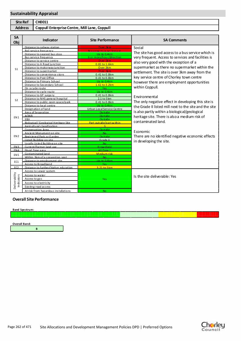
Sustainability Appraisal
Site Ref CH0011
Address Coppull Enterprise Centre, Mill Lane, Coppull
SA Obj
Indicator Site Performance SA Comments
S1
Distance to railway station Over 3km Social The site has good access to a bus service which is very frequent. Access to services and facilities is also very good with the exception of a supermarket as there no supermarket within the settlement. The site is over 3km away from the key service centre of Chorley town centre however there are employment opportunities within Coppull. Environmental The only negative effect in developing this site is the Grade II listed mill next to the site and the site is also partly within a biological/geological heritage site. There is also a medium risk of contaminated land. Economic There are no identified negative economic effects in developing the site.
Rail service freque ncy No services in settlement Distance to nearest bus stop Up to 0.4km Bus service frequency 6 or more/hour/direction Distance to se rvice centre Over 3km Distance to A Road junction 0 .81 to 1 .6km Distance to motorway junction Over 3km Distance to supermarket Over 3km Distance to conve nience s tore 0 .41 to 0 .8km Distance to Post Office 0 .41 to 0 .8km Distance to Primary School Up to 0.4km Distance to Secondary School 1 .61 to 3 .2km On a cycle route Yes Distance to cycle route Up to 0.4km
S2
Distance to GP surge ry 0 .41 to 0 .8km Distance to NHS gene ra l hospital 2.1 to 5 km Distance to public open space/park 0 .41 to 0 .8km Distance to local centre Up to 0.4km
EN1
Designation of land Urban Local Service Ce ntre Are a of Se paration Outs ide AONB Outs ide SSSI Outs ide Biological/ G eological H eritag e Site Part outs ide/part w ithin Agricultural classifica tion 3
EN2
Conservation Area Outs ide Ancie nt Monument on site No Regis te re d Park or G arden Outs ide Listed Building on site G rade II Locally Lis te d Building on s ite No
EN3 Curre nt/former land use Brownfield EN4 Flood Zone a re a All Zone 1
EN5 Contaminated land M edium risk Within 3km of a congestion spot No
EC1 Distance to employment site Up to 0.8km Access to Broadband Yes
EC2 Distance to furthe r/higher education 3 .21 to 5 km
Del
iver
abili
ty
Indi
cato
rs
Access to sewer system
Yes
Is the site deliverable: Yes Access to wa te r
Access to ga s
Access to e lectricity Exis ting road access
At risk from hazardous installations No
Overall Site Performance
Band Spe ctrum:
Overall Band:
B
Page 262 of 471 Site Allocations and Development Management Policies DPD | Preferred Options
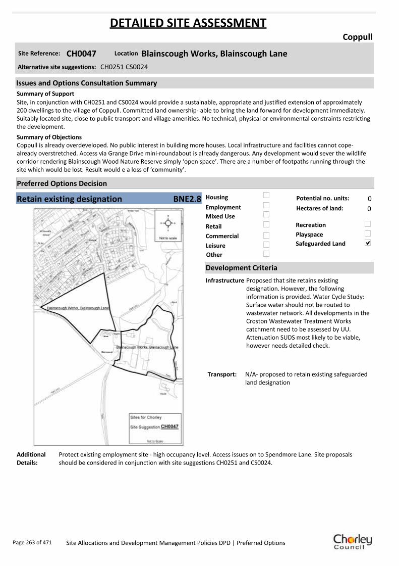
Housing
Employment
Mixed Use
Retail
Commercial
Leisure
Recreation
Safeguarded Land
Preferred Options Decision
Retain existing designation Potential no. units: 0
Hectares of land: 0
Other
Site Reference: CH0047 Blainscough Works, Blainscough Lane
Coppull
Site, in conjunction with CH0251 and CS0024 would provide a sustainable, appropriate and justified extension of approximately 200 dwellings to the village of Coppull. Committed land ownership- able to bring the land forward for development immediately. Suitably located site, close to public transport and village amenities. No technical, physical or environmental constraints restricting the development.
Coppull is already overdeveloped. No public interest in building more houses. Local infrastructure and facilities cannot cope- already overstretched. Access via Grange Drive mini-roundabout is already dangerous. Any development would sever the wildlife corridor rendering Blainscough Wood Nature Reserve simply ‘open space’. There are a number of footpaths running through the site which would be lost. Result would e a loss of ‘community’.
Summary of Objections
Summary of Support
Alternative site suggestions: CH0251 CS0024
DETAILED SITE ASSESSMENT
Location
Development Criteria
Infrastructure Proposed that site retains existing designation. However, the following information is provided. Water Cycle Study: Surface water should not be routed to wastewater network. All developments in the Croston Wastewater Treatment Works catchment need to be assessed by UU. Attenuation SUDS most likely to be viable, however needs detailed check.
Transport: N/A- proposed to retain existing safeguarded land designation
Additional Details:
Protect existing employment site - high occupancy level. Access issues on to Spendmore Lane. Site proposals should be considered in conjunction with site suggestions CH0251 and CS0024.
Issues and Options Consultation Summary
Playspace
BNE2.8
Page 263 of 471 Site Allocations and Development Management Policies DPD | Preferred Options

Sustainability Appraisal
Site Ref CH0047
Address Blainscough Works, Blainscough Lane, Coppull
SA Obj
Indicator Site Performance SA Comments
S1
Distance to railway station Over 3km Social The site has good access to a bus service which is very frequent. Access to services and facilities is also very good with the exception of a supermarket as there no supermarket within the settlement. The site is over 3km away from the key service centre of Chorley town centre however there are employment opportunities within Coppull. Environmental The only negative effect in developing this site is that the site is Greenfield with a current designation of safeguarded land. Economic There are no identified negative economic effects in developing the site.
Rail service freque ncy No services in settlement Distance to nearest bus stop Up to 0.4km Bus service frequency 6 or more/hour/direction Distance to se rvice centre Over 3km Distance to A Road junction Up to 0.4km Distance to motorway junction Over 3km Distance to supermarket Over 3km Distance to conve nience s tore Up to 0.4km Distance to Post Office 0 .81 to 1 .2km Distance to Primary School Up to 0.4km Distance to Secondary School 1 .61 to 3 .2km On a cycle route No Distance to cycle route Up to 0.4km
S2
Distance to GP surge ry 0 .41 to 0 .8km Distance to NHS gene ra l hospital 2.1 to 5 km Distance to public open space/park Up to 0.4km Distance to local centre 0 .41 to 0 .8km
EN1
Designation of land Safeguarded Land Are a of Se paration Outs ide AONB Outs ide SSSI Outs ide Biological/ G eological H eritag e Site Outs ide Agricultural classifica tion 3
EN2
Conservation Area Outs ide Ancie nt Monument on site No Regis te re d Park or G arden Outs ide Listed Building on site No Locally Lis te d Building on s ite No
EN3 Curre nt/former land use Brownfield EN4 Flood Zone a re a All Zone 1
EN5 Contaminated land No risk Within 3km of a congestion spot No
EC1 Distance to employment site 1 .21 to 1 .6km Access to Broadband Yes
EC2 Distance to furthe r/higher education Over 5km
Del
iver
abili
ty
Indi
cato
rs
Access to sewer system
Yes
Is the site deliverable: Yes Access to wa te r
Access to ga s
Access to e lectricity
Exis ting road access
At risk from hazardous installations No
Overall Site Performance
Band Spe ctrum:
Overall Band:
C
Page 264 of 471 Site Allocations and Development Management Policies DPD | Preferred Options

Housing
Employment
Mixed Use
Retail
Commercial
Leisure
Recreation
Safeguarded Land
Preferred Options Decision
Do not allocate Potential no. units: 0
Hectares of land: 0
Other
Site Reference: CH0054 Land at Mountain Road
Coppull
None received.
Coppull has a significant shortfall in open space, therefore object to the suggested housing use. It would be an ideal extension to Blainscough Wood Nature Reserve. If development occurs on all suggested sites, there would be no access to the nature reserve.
Summary of Objections
Summary of Support
Alternative site suggestions: ---
DETAILED SITE ASSESSMENT
Location
Development Criteria
Infrastructure ---
Transport: ---
Additional Details:
Await results of Open Space Study before allocating further recreation sites.
Issues and Options Consultation Summary
Playspace
Page 265 of 471 Site Allocations and Development Management Policies DPD | Preferred Options

Sustainability Appraisal
Site Ref CH0054
Address Land at Mountain Road, Coppull
SA Obj
Indicator Site Performance SA Comments
S1
Distance to railway station Over 3km Social The site has good access to a bus service which is very frequent. Access to services and facilities is also very good with the exception of a supermarket as there no supermarket within the settlement. The site is over 3km away from the key service centre of Chorley town centre however there are employment opportunities within Coppull. Environmental The only negative effect in developing this site is that the site is Urban Greenspace. Economic There are no identified negative economic effects in developing the site.
Rail service freque ncy No services in settlement Distance to nearest bus stop Up to 0.4km Bus service frequency 6 or more/hour/direction Distance to se rvice centre Over 3km Distance to A Road junction 0 .41 to 0 .8km Distance to motorway junction Over 3km Distance to supermarket Over 3km Distance to conve nience s tore Up to 0.4km Distance to Post Office Up to 0.4km Distance to Primary School Up to 0.4km Distance to Secondary School 1 .61 to 3 .2km On a cycle route No Distance to cycle route Up to 0.4km
S2
Distance to GP surge ry Up to 0.4km Distance to NHS gene ra l hospital 2.1 to 5 km Distance to public open space/park Up to 0.4km Distance to local centre Up to 0.4km
EN1
Designation of land Urban Local Service Ce ntre Are a of Se paration Outs ide AONB Outs ide SSSI Outs ide Biological/ G eological H eritag e Site Outs ide Agricultural classifica tion 3
EN2
Conservation Area Outs ide Ancie nt Monument on site No Regis te re d Park or G arden Outs ide Listed Building on site No Locally Lis te d Building on s ite No
EN3 Curre nt/former land use Urban G re enspace EN4 Flood Zone a re a All Zone 1
EN5 Contaminated land M edium risk Within 3km of a congestion spot No
EC1 Distance to employment site 0 .81 to 1 .2km Access to Broadband Yes
EC2 Distance to furthe r/higher education Over 5km
Del
iver
abili
ty
Indi
cato
rs
Access to sewer system
Yes
Is the site deliverable: Yes Access to wa te r
Access to ga s
Access to e lectricity
Exis ting road access
At risk from hazardous installations No
Overall Site Performance
Band Spe ctrum:
Overall Band:
C
Page 266 of 471 Site Allocations and Development Management Policies DPD | Preferred Options

Housing
Employment
Mixed Use
Retail
Commercial
Leisure
Recreation
Safeguarded Land
Preferred Options Decision
Allocate site Potential no. units: 25
Hectares of land: 0
Other
Site Reference: CH0128 Land at Northenden Road
Coppull
None received.
Objection to the proposed housing use of the site.Summary of Objections
Summary of Support
Alternative site suggestions: ---
DETAILED SITE ASSESSMENT
Location
Development Criteria
Infrastructure N/A- site already has planning permission
Transport: All development proposals should achieve a high level of road safety, and will be assessed as such by the Council through the planning application process. As this site already has planning permission, the relevant Transport Statement/Assessment has already been submitted to, and approved by the Council.
Additional Details:
---
Issues and Options Consultation Summary
Playspace
HS1.38
Page 267 of 471 Site Allocations and Development Management Policies DPD | Preferred Options

Sustainability Appraisal
Site Ref CH0128
Address Land at Northenden Road, Coppull
SA Obj
Indicator Site Performance SA Comments
S1
Distance to railway station Over 3km Social The site has good access to a bus service which is very frequent. Access to services and facilities is also very good with the exception of a supermarket as there no supermarket within the settlement. The site is over 3km away from the key service centre of Chorley town centre however there are employment opportunities within Coppull. Environmental The only negative effect in developing this site is that the site is Greenfield with a medium risk of contamination. Economic There are no identified negative economic effects in developing the site.
Rail service freque ncy No services in settlement Distance to nearest bus stop Up to 0.4km Bus service frequency 6 or more/hour/direction Distance to se rvice centre Over 3km Distance to A Road junction 0 .81 to 1 .6km Distance to motorway junction Over 3km Distance to supermarket Over 3km Distance to conve nience s tore 0 .41 to 0 .8km Distance to Post Office 0 .41 to 0 .8km Distance to Primary School Up to 0.4km Distance to Secondary School 1 .61 to 3 .2km On a cycle route No Distance to cycle route Up to 0.4km
S2
Distance to GP surge ry Up to 0.4km Distance to NHS gene ra l hospital 2.1 to 5 km Distance to public open space/park Up to 0.4km Distance to local centre 0 .41 to 0 .8km
EN1
Designation of land Urban Local Service Ce ntre Are a of Se paration Outs ide AONB Outs ide SSSI Outs ide Biological/ G eological H eritag e Site Part outs ide/part w ithin Agricultural classifica tion 3
EN2
Conservation Area Outs ide Ancie nt Monument on site No Regis te re d Park or G arden Outs ide Listed Building on site No Locally Lis te d Building on s ite No
EN3 Curre nt/former land use Greenfie ld EN4 Flood Zone a re a All Zone 1
EN5 Contaminated land M edium risk Within 3km of a congestion spot No
EC1 Distance to employment site Up to 0.8km Access to Broadband Yes
EC2 Distance to furthe r/higher education 3 .21 to 5 km
Del
iver
abili
ty
Indi
cato
rs
Access to sewer system
Yes
Is the site deliverable: Yes Access to wa te r
Access to ga s
Access to e lectricity Exis ting road access
At risk from hazardous installations No
Overall Site Performance
Band Spe ctrum:
Overall Band:
B
Page 268 of 471 Site Allocations and Development Management Policies DPD | Preferred Options
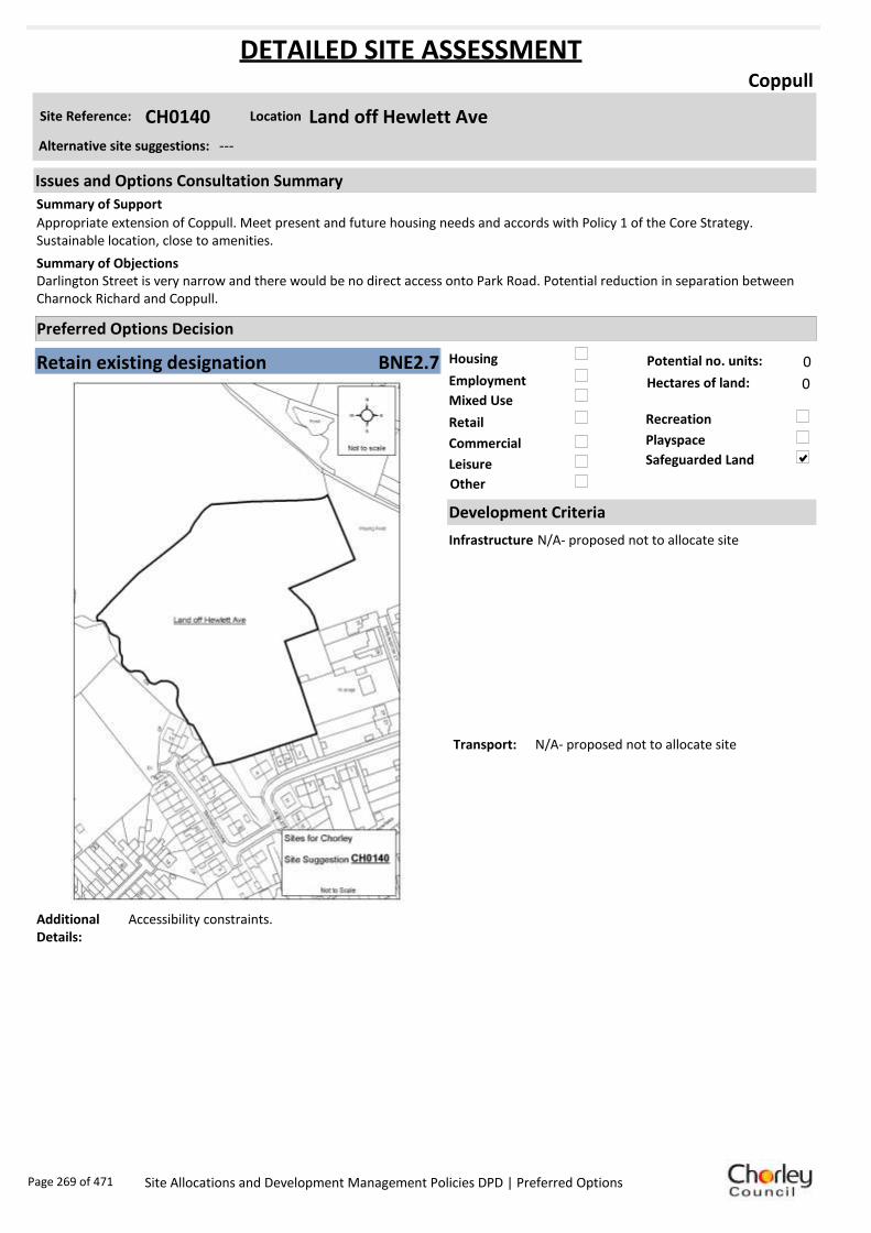
Housing
Employment
Mixed Use
Retail
Commercial
Leisure
Recreation
Safeguarded Land
Preferred Options Decision
Retain existing designation Potential no. units: 0
Hectares of land: 0
Other
Site Reference: CH0140 Land off Hewlett Ave
Coppull
Appropriate extension of Coppull. Meet present and future housing needs and accords with Policy 1 of the Core Strategy. Sustainable location, close to amenities.
Darlington Street is very narrow and there would be no direct access onto Park Road. Potential reduction in separation between Charnock Richard and Coppull.
Summary of Objections
Summary of Support
Alternative site suggestions: ---
DETAILED SITE ASSESSMENT
Location
Development Criteria
Infrastructure N/A- proposed not to allocate site
Transport: N/A- proposed not to allocate site
Additional Details:
Accessibility constraints.
Issues and Options Consultation Summary
Playspace
BNE2.7
Page 269 of 471 Site Allocations and Development Management Policies DPD | Preferred Options

Sustainability Appraisal
Site Ref CH0140
Address Land off Hewlett Avenue, Coppull
SA Obj
Indicator Site Performance SA Comments
S1
Distance to railway station Over 3km Social The site has good access to a bus service which is very frequent. Access to services and facilities is also very good with the exception of a supermarket as there no supermarket within the settlement. The site is over 3km away from the key service centre of Chorley town centre however there are employment opportunities within Coppull. Environmental The only negative effect in developing this site is that the site is Greenfield with a current designation of safeguarded land. Economic There are no identified negative economic effects in developing the site.
Rail service freque ncy No services in settlement Distance to nearest bus stop Up to 0.4km Bus service frequency 6 or more/hour/direction Distance to se rvice centre Over 3km Distance to A Road junction 0 .41 to 0 .8km Distance to motorway junction Over 3km Distance to supermarket Over 3km Distance to conve nience s tore Up to 0.4km Distance to Post Office 0 .41 to 0 .8km Distance to Primary School Up to 0.4km Distance to Secondary School 1 .61 to 3 .2km On a cycle route No Distance to cycle route 0 .41 to 0 .8km
S2
Distance to GP surge ry Up to 0.4km Distance to NHS gene ra l hospital 2.1 to 5 km Distance to public open space/park Up to 0.4km Distance to local centre Up to 0.4km
EN1
Designation of land Safeguarded Land Are a of Se paration Outs ide AONB Outs ide SSSI Outs ide Biological/ G eological H eritag e Site Outs ide Agricultural classifica tion 3
EN2
Conservation Area Outs ide Ancie nt Monument on site No Regis te re d Park or G arden Outs ide Listed Building on site No Locally Lis te d Building on s ite No
EN3 Curre nt/former land use Greenfie ld EN4 Flood Zone a re a All Zone 1
EN5 Contaminated land No risk Within 3km of a congestion spot No
EC1 Distance to employment site Up to 0.8km Access to Broadband Yes
EC2 Distance to furthe r/higher education Over 5km
Del
iver
abili
ty
Indi
cato
rs
Access to sewer system
Yes
Is the site deliverable: Yes Access to wa te r
Access to ga s
Access to e lectricity
Exis ting road access
At risk from hazardous installations No
Overall Site Performance
Band Spe ctrum:
Overall Band:
C
Page 270 of 471 Site Allocations and Development Management Policies DPD | Preferred Options
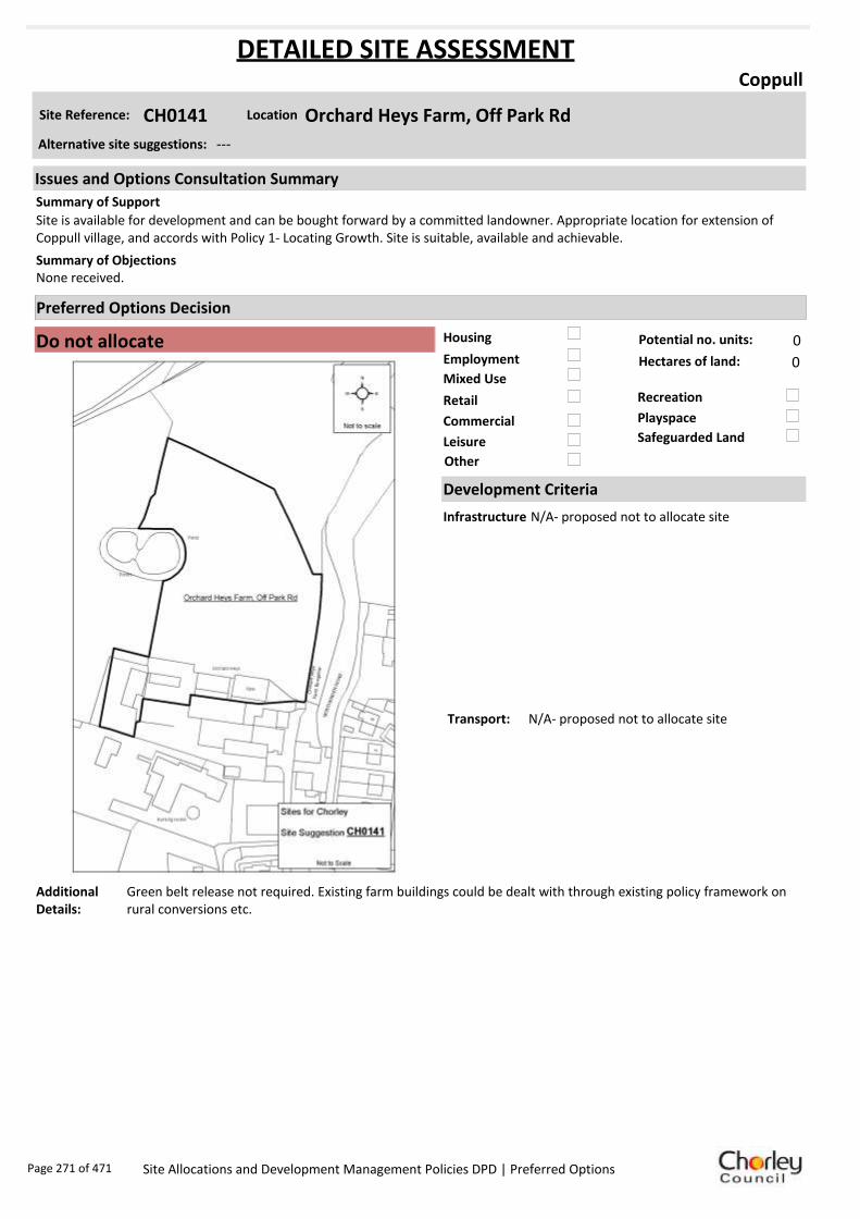
Housing
Employment
Mixed Use
Retail
Commercial
Leisure
Recreation
Safeguarded Land
Preferred Options Decision
Do not allocate Potential no. units: 0
Hectares of land: 0
Other
Site Reference: CH0141 Orchard Heys Farm, Off Park Rd
Coppull
Site is available for development and can be bought forward by a committed landowner. Appropriate location for extension of Coppull village, and accords with Policy 1- Locating Growth. Site is suitable, available and achievable.
None received.Summary of Objections
Summary of Support
Alternative site suggestions: ---
DETAILED SITE ASSESSMENT
Location
Development Criteria
Infrastructure N/A- proposed not to allocate site
Transport: N/A- proposed not to allocate site
Additional Details:
Green belt release not required. Existing farm buildings could be dealt with through existing policy framework on rural conversions etc.
Issues and Options Consultation Summary
Playspace
Page 271 of 471 Site Allocations and Development Management Policies DPD | Preferred Options

Sustainability Appraisal
Site Ref CH0141
Address Orchard Heys Farm, Park Road, Coppull
SA Obj
Indicator Site Performance SA Comments
S1
Distance to railway station Over 3km Social The site has good access to a bus service which is very frequent. Access to services and facilities is also very good with the exception of a supermarket as there no supermarket within the settlement. The site is over 3km away from the key service centre of Chorley town centre however there are employment opportunities within Coppull. Environmental The only negative effect in developing this site is that the site is Greenfield with a current designation of Green Belt on part of the site. Economic There are no identified negative economic effects in developing the site.
Rail service freque ncy No services in se ttlement Distance to nearest bus stop Up to 0. 4km Bus service frequency 6 or more/hour/dire ction Distance to se rvice centre Over 3km Distance to A Road junction 0.81 to 1.6km Distance to motorway junction Over 3km Distance to supermarket Over 3km Distance to conve nience s tore 0.41 to 0.8km Distance to Post Office 0.41 to 0.8km Distance to Primary School Up to 0. 4km Distance to Secondary School 1.61 to 3.2km On a cycle route No Distance to cycle route Up to 0. 4km
S2
Distance to GP surge ry Up to 0. 4km Distance to NHS gene ra l hospital 2. 1 to 5km Distance to public open space/park Up to 0. 4km Distance to local centre Up to 0. 4km
EN1
Designation of land Urban Local Service Centre/Green Belt Are a of Se paration Outside AONB Outside SSSI Outside Biological/ G eological H eritag e Site Outside Agricultural classifica tion 3
EN2
Conservation Area Outside Ancie nt Monument on site No Regis te re d Park or G arden Outside Listed Building on site No Locally Lis te d Building on s ite No
EN3 Curre nt/former land use G re enfield EN4 Flood Zone a re a All Zone 1
EN5 Contaminated land No risk Within 3km of a congestion spot No
EC1 Distance to employment site Up to 0. 8km Access to Broadband Y es
EC2 Distance to furthe r/higher education 3.2 1 to 5km
Del
iver
abili
ty
Indi
cato
rs
Access to sewer system
Y es
Is the site deliverable: Yes/No Access to wa te r
Access to ga s
Access to e lectricity
Exis ting road access
At risk from hazardous installations No
Overall Site Performance
Band Spe ctrum:
Overall Band:
C
Page 272 of 471 Site Allocations and Development Management Policies DPD | Preferred Options

Housing
Employment
Mixed Use
Retail
Commercial
Leisure
Recreation
Safeguarded Land
Preferred Options Decision
Do not allocate Potential no. units: 0
Hectares of land: 0
Other
Site Reference: CH0216 263 Spendmore Lane
Coppull
No objection to the proposed housing use, but should note the flood plain in the area.
If development occurs on this and all other sites, access would be cut off to Blainscough Nature Reserve. The ecology of Clancutt Brook must be considered if development should occur. Site by the brook is infested with Japanese Knottweed.
Summary of Objections
Summary of Support
Alternative site suggestions: ---
DETAILED SITE ASSESSMENT
Location
Development Criteria
Infrastructure N/A- proposed not to allocate site
Transport: N/A- proposed not to allocate site
Additional Details:
In active employment use. Employment use will be protected. Part of site is residual allocation for housing.
Issues and Options Consultation Summary
Playspace
Page 273 of 471 Site Allocations and Development Management Policies DPD | Preferred Options

Sustainability Appraisal
Site Ref CH0216
Address 263 Spendmore Lane, Coppull
SA Obj
Indicator Site Performance SA Comments
S1
Distance to railway station Over 3km Social The site has good access to a bus service which is very frequent. Access to services and facilities is also very good with the exception of a supermarket as there no supermarket within the settlement. The site is over 3km away from the key service centre of Chorley town centre however there are employment opportunities within Coppull. Environmental There are no identified negative environmental effects in developing the site. Economic There are no identified negative economic effects in developing the site.
Rail service freque ncy No services in settlement Distance to nearest bus stop Up to 0.4km Bus service frequency 6 or more/hour/direction Distance to se rvice centre Over 3km Distance to A Road junction Up to 0.4km Distance to motorway junction Over 3km Distance to supermarket Over 3km Distance to conve nience s tore Up to 0.4km Distance to Post Office Up to 0.4km Distance to Primary School Up to 0.4km Distance to Secondary School 1 .61 to 3 .2km On a cycle route No Distance to cycle route Up to 0.4km
S2
Distance to GP surge ry Up to 0.4km Distance to NHS gene ra l hospital 2.1 to 5 km Distance to public open space/park Up to 0.4km Distance to local centre Up to 0.4km
EN1
Designation of land Urban Local Service Ce ntre Are a of Se paration Outs ide AONB Outs ide SSSI Outs ide Biological/ G eological H eritag e Site Outs ide Agricultural classifica tion 3
EN2
Conservation Area Outs ide Ancie nt Monument on site No Regis te re d Park or G arden Outs ide Listed Building on site No Locally Lis te d Building on s ite No
EN3 Curre nt/former land use Brownfield EN4 Flood Zone a re a All Zone 1
EN5 Contaminated land No risk Within 3km of a congestion spot No
EC1 Distance to employment site 0 .81 to 1 .2km Access to Broadband Yes
EC2 Distance to furthe r/higher education Over 5km
Del
iver
abili
ty
Indi
cato
rs
Access to sewer system
Yes
Is the site deliverable: Yes Access to wa te r
Access to ga s
Access to e lectricity Exis ting road access
At risk from hazardous installations No
Overall Site Performance
Band Spe ctrum:
Overall Band:
B
Page 274 of 471 Site Allocations and Development Management Policies DPD | Preferred Options

Housing
Employment
Mixed Use
Retail
Commercial
Leisure
Recreation
Safeguarded Land
Preferred Options Decision
Retain existing designation Potential no. units: 0
Hectares of land: 0
Other
Site Reference: CH0251 Land off Blainscough Lane
Coppull
Site, in conjunction with CH0047 and CS0024 would provide a sustainable, appropriate and justified extension of approximately 200 dwellings to the village of Coppull. Committed land ownership- able to bring the land forward for development immediately. Suitably located site, close to public transport and village amenities. No technical, physical or environmental constraints restricting the development.
Coppull is already overdeveloped. No public interest in building more houses. Local infrastructure and facilities cannot cope- already overstretched. Access via Grange Drive mini-roundabout is already dangerous. Any development would sever the wildlife corridor rendering Blainscough Wood Nature Reserve simply ‘open space’. There are a number of footpaths running through the site which would be lost. Result would e a loss of ‘community’. Blainscough Estate is of significant historical interest.
Summary of Objections
Summary of Support
Alternative site suggestions: CH0047 CS0024
DETAILED SITE ASSESSMENT
Location
Development Criteria
Infrastructure N/A- proposed not to allocate site
Transport: N/A- proposed not to allocate site
Additional Details:
Protect existing employment site - high occupancy level. Access issues on to Spendmore Lane. Site proposals should be considered in conjunction with site suggestions CH0047 and CS0024.
Issues and Options Consultation Summary
Playspace
BNE2.8
Page 275 of 471 Site Allocations and Development Management Policies DPD | Preferred Options

Sustainability Appraisal
Site Ref CH0251
Address Blainscough Works, Blainscough Lane, Coppull
SA Obj
Indicator Site Performance SA Comments
S1
Distance to railwa y s tation Over 3km Social The site has good access to a bus service which is very frequent. Access to services and facilities is also very good with the exception of a supermarket as there no supermarket within the settlement. The site is over 3km away from the key service centre of Chorley town centre however there are employment opportunities within Coppull. Environmental The only negative effect in developing this site is that the site is designated of safeguarded land. Economic There are no identified negative economic effects in developing the site.
Rail service frequency No services in se ttlement Distance to nearest bus stop Up to 0. 4km Bus servi ce frequency 6 or more /hour/direction Distance to service centre Over 3km Distance to A Roa d junction Up to 0. 4km Distance to motorway junction Over 3km Distance to supermarke t Over 3km Distance to convenie nce store Up to 0. 4km Distance to Post Office 0.8 1 to 1.2 km Distance to Primary School Up to 0. 4km Distance to Secondary School 1.6 1 to 3.2 km On a cycle route No Distance to cycle route Up to 0. 4km
S2
Distance to GP surgery 0.4 1 to 0.8 km Distance to NHS general hospital 2. 1 to 5km Distance to public open space/park Up to 0. 4km Distance to local centre 0.4 1 to 0.8 km
EN1
Des ignation of land Safeguarded Land Area of Sepa ra tion Outside AONB Outside SSSI Outside Biological/ Ge ological Heritage Site Outside Agricultural classification 3
EN2
Conservation Area Outside Ancient Monument on site No Registered Park or Garden Outside Listed Building on site No Locally Listed Build ing on site No
EN3 Current/ forme r land use Brow nfie ld EN4 Flood Zone area All Zone 1
EN5 Contaminate d land No risk Within 3km of a congestion spot No
EC1 Distance to employment s ite 1.2 1 to 1.6 km Access to Br oadband Yes
EC2 Distance to further/higher education Over 5km
Del
iver
abili
ty
Ind
icat
ors
Access to sewe r system
Yes
Is the site deliverable: Yes Access to water
Access to gas
Access to electricity
Existing road access
At risk from hazardous installations No
Overall Site Performance
Band Spectrum:
Ove rall Ba nd:
C
Page 276 of 471 Site Allocations and Development Management Policies DPD | Preferred Options

Housing
Employment
Mixed Use
Retail
Commercial
Leisure
Recreation
Safeguarded Land
Preferred Options Decision
Allocate site Potential no. units: 30
Hectares of land: 0
Other
Site Reference: CH0274 Clancutt Lane
Coppull
None received.
Land borders the Green Belt and development would result in reduction in separation between Charnock Richard and Coppull. Poor access and over intensification of the area.
Summary of Objections
Summary of Support
Alternative site suggestions: CH0292
DETAILED SITE ASSESSMENT
Location
Development Criteria
Infrastructure ---
Transport: All development proposals should achieve a high level of road safety, and will be assessed as such by the Council through the planning application process. For housing developments with between 50 and 80 units, the Council will require a Transport Statement. For developments of more than 80 units, the Council will require a Transport Assessment and Travel Plan as part of the application.
Additional Details:
Site proposal should be considered in conjunction with site suggestion CH0292.
Issues and Options Consultation Summary
Playspace
HS1.40
Page 277 of 471 Site Allocations and Development Management Policies DPD | Preferred Options

Sustainability Appraisal
Site Ref CH0274
Address Land and Buildings at 47 Clancutt Lane, Coppull
SA Obj
Indicator Site Performance SA Comments
S1
Distance to railway station Over 3km Social The site has good access to a bus service which is very frequent. Access to services and facilities is also very good with the exception of a supermarket as there no supermarket within the settlement. The site is over 3km away from the key service centre of Chorley town centre however there are employment opportunities within Coppull. Environmental The only negative effect in developing this site is that the site is Greenfield with a current designation of safeguarded land. Economic There are no identified negative economic effects in developing the site.
Rail service freque ncy No services in settlement Distance to nearest bus stop Up to 0.4km Bus service frequency 6 or more/hour/direction Distance to se rvice centre Over 3km Distance to A Road junction 1 .61 to 3 km Distance to motorway junction Over 3km Distance to supermarket Over 3km Distance to conve nience s tore 0 .41 to 0 .8km Distance to Post Office 0 .81 to 1 .2km Distance to Primary School 0 .41 to 0 .8km Distance to Secondary School 1 .61 to 3 .2km On a cycle route No Distance to cycle route Up to 0.4km
S2
Distance to GP surge ry 0 .81 to 1 .6km Distance to NHS gene ra l hospital 2.1 to 5 km Distance to public open space/park 0 .41 to 0 .8km Distance to local centre 0 .81 to 1 .2km
EN1
Designation of land Safeguarded Land Are a of Se paration Outs ide AONB Outs ide SSSI Outs ide Biological/ G eological H eritag e Site Outs ide Agricultural classifica tion 3
EN2
Conservation Area Outs ide Ancie nt Monument on site No Regis te re d Park or G arden Outs ide Listed Building on site No Locally Lis te d Building on s ite No
EN3 Curre nt/former land use Greenfie ld EN4 Flood Zone a re a All Zone 1
EN5 Contaminated land No risk Within 3km of a congestion spot No
EC1 Distance to employment site Up to 0.8km Access to Broadband Yes
EC2 Distance to furthe r/higher education 3 .21 to 5 km
Del
iver
abili
ty
Indi
cato
rs
Access to sewer system
Yes
Is the site deliverable: Yes Access to wa te r
Access to ga s
Access to e lectricity
Exis ting road access
At risk from hazardous installations No
Overall Site Performance
Band Spe ctrum:
Overall Band:
C
Page 278 of 471 Site Allocations and Development Management Policies DPD | Preferred Options

Housing
Employment
Mixed Use
Retail
Commercial
Leisure
Recreation
Safeguarded Land
Preferred Options Decision
Allocate site Potential no. units: 59
Hectares of land: 2
Other
Site Reference: CH0280 Discover Leisure, Chapel Lane
Coppull
Scope for mixed use development depending on viability and demand. Previously developed land, connected to all services and can achieve good access to local services and public transport. Predominant surrounding use is residential. Redevelopment would result in visual improvement to the area.
None received.Summary of Objections
Summary of Support
Alternative site suggestions: ---
DETAILED SITE ASSESSMENT
Location
Development Criteria
Infrastructure ---
Transport: All development proposals should achieve a high level of road safety, and will be assessed as such by the Council through the planning application process. Depending on the mix of uses this site is developed for, and depending on the size of the development, the Council will require the submission of either a Transport Statement or Transport Assessment and Travel Plan.
Additional Details:
---
Issues and Options Consultation Summary
Playspace
HS1.36; EP1.20
Page 279 of 471 Site Allocations and Development Management Policies DPD | Preferred Options

Sustainability Appraisal
Site Ref CH0280
Address Discover Leisure, Chapel Lane, Coppull
SA Obj
Indicator Site Performance SA Comments
S1
Distance to railway station Over 3km Social The site has good access to a bus service which is very frequent. Access to services and facilities is also very good with the exception of a supermarket as there is no supermarket within the settlement. The site is over 3km away from the key service centre of Chorley town centre however there are employment opportunities within Coppull. Environmental There are no identified negative environmental effects in developing the site. Economic There are no identified negative economic effects in developing the site.
Rail service freque ncy No services in settlement Distance to nearest bus stop Up to 0.4km Bus service frequency 6 or more/hour/direction Distance to se rvice centre Over 3km Distance to A Road junction 1 .61 to 3 km Distance to motorway junction Over 3km Distance to supermarket Over 3km Distance to conve nience s tore Up to 0.4km Distance to Post Office 0 .81 to 1 .2km Distance to Primary School Up to 0.4km Distance to Secondary School 1 .61 to 3 .2km On a cycle route No Distance to cycle route 0 .41 to 0 .8km
S2
Distance to GP surge ry 0 .41 to 0 .8km Distance to NHS gene ra l hospital 2.1 to 5 km Distance to public open space/park Up to 0.4km Distance to local centre 0 .41 to 0 .8km
EN1
Designation of land Urban Local Service Ce ntre Are a of Se paration Outs ide AONB Outs ide SSSI Outs ide Biological/ G eological H eritag e Site Outs ide Agricultural classifica tion 3
EN2
Conservation Area Outs ide Ancie nt Monument on site No Regis te re d Park or G arden Outs ide Listed Building on site No Locally Lis te d Building on s ite No
EN3 Curre nt/former land use Brownfield EN4 Flood Zone a re a All Zone 1
EN5 Contaminated land No risk Within 3km of a congestion spot No
EC1 Distance to employment site Up to 0.8km Access to Broadband Yes
EC2 Distance to furthe r/higher education 3 .21 to 5 km
Del
iver
abili
ty
Indi
cato
rs
Access to sewer system
Yes
Is the site deliverable: Yes Access to wa te r
Access to ga s
Access to e lectricity
Exis ting road access
At risk from hazardous installations No
Overall Site Performance
Band Spe ctrum:
Overall Band:
B
Page 280 of 471 Site Allocations and Development Management Policies DPD | Preferred Options

Housing
Employment
Mixed Use
Retail
Commercial
Leisure
Recreation
Safeguarded Land
Preferred Options Decision
Allocate site Potential no. units: 30
Hectares of land: 0
Other
Site Reference: CH0292 Clancutt Lane
Coppull
None received.
The land borders onto the green belt and there would be a potential reduction in separation between Charnock Richard and Coppull. Objection to this proposal on the grounds of access and over-intensification of the area.
Summary of Objections
Summary of Support
Alternative site suggestions: CH0274
DETAILED SITE ASSESSMENT
Location
Development Criteria
Infrastructure ---
Transport: All development proposals should achieve a high level of road safety, and will be assessed as such by the Council through the planning application process. For housing developments with between 50 and 80 units, the Council will require a Transport Statement. For developments of more than 80 units, the Council will require a Transport Assessment and Travel Plan as part of the application.
Additional Details:
Site proposal should be considered in conjunction with site suggestion CH0274.
Issues and Options Consultation Summary
Playspace
HS1.40
Page 281 of 471 Site Allocations and Development Management Policies DPD | Preferred Options

Sustainability Appraisal
Site Ref CH0292
Address Land and Buildings at 47 Clancutt Lane, Coppull
SA Obj
Indicator Site Performance SA Comments
S1
Distance to railway station Over 3km Social The site has good access to a bus service which is very frequent. Access to services and facilities is also very good with the exception of a supermarket as there no supermarket within the settlement. The site is over 3km away from the key service centre of Chorley town centre however there are employment opportunities within Coppull. Environmental The only negative effect in developing this site is that the site is Greenfield with a current designation of safeguarded land. Economic There are no identified negative economic effects in developing the site..
Rail service freque ncy No services in settlement Distance to nearest bus stop Up to 0.4km Bus service frequency 6 or more/hour/direction Distance to se rvice centre Over 3km Distance to A Road junction 1 .61 to 3 km Distance to motorway junction Over 3km Distance to supermarket Over 3km Distance to conve nience s tore 0 .41 to 0 .8km Distance to Post Office 0 .81 to 1 .2km Distance to Primary School 0 .41 to 0 .8km Distance to Secondary School 1 .61 to 3 .2km On a cycle route No Distance to cycle route Up to 0.4km
S2
Distance to GP surge ry 0 .81 to 1 .6km Distance to NHS gene ra l hospital 2.1 to 5 km Distance to public open space/park 0 .41 to 0 .8km Distance to local centre 0 .81 to 1 .2km
EN1
Designation of land Safeguarded Land Are a of Se paration Outs ide AONB Outs ide SSSI Outs ide Biological/ G eological H eritag e Site Outs ide Agricultural classifica tion 3
EN2
Conservation Area Outs ide Ancie nt Monument on site No Regis te re d Park or G arden Outs ide Listed Building on site No Locally Lis te d Building on s ite No
EN3 Curre nt/former land use Greenfie ld EN4 Flood Zone a re a All Zone 1
EN5 Contaminated land No risk Within 3km of a congestion spot No
EC1 Distance to employment site Up to 0.8km Access to Broadband Yes
EC2 Distance to furthe r/higher education 3 .21 to 5 km
Del
iver
abili
ty
Indi
cato
rs
Access to sewer system
Yes
Is the site deliverable: Yes Access to wa te r
Access to ga s
Access to e lectricity
Exis ting road access
At risk from hazardous installations No
Overall Site Performance
Band Spe ctrum:
Overall Band:
C
Page 282 of 471 Site Allocations and Development Management Policies DPD | Preferred Options

Housing
Employment
Mixed Use
Retail
Commercial
Leisure
Recreation
Safeguarded Land
Preferred Options Decision
Allocate site Potential no. units: 15
Hectares of land: 0
Other
Site Reference: CH0301 Regent Street
Coppull
Support for proposed housing use.
None received.Summary of Objections
Summary of Support
Alternative site suggestions: ---
DETAILED SITE ASSESSMENT
Location
Development Criteria
Infrastructure ---
Transport: All development proposals should achieve a high level of road safety, and will be assessed as such by the Council through the planning application process. For housing developments with between 50 and 80 units, the Council will require a Transport Statement. For developments of more than 80 units, the Council will require a Transport Assessment and Travel Plan as part of the application.
Additional Details:
---
Issues and Options Consultation Summary
Playspace
HS1.37
Page 283 of 471 Site Allocations and Development Management Policies DPD | Preferred Options

Sustainability Appraisal
Site Ref CH0301
Address Regent Street, Coppull
SA Obj
Indicator Site Performance SA Comments
S1
Distance to railway station Over 3km Social The site has good access to a bus service which is very frequent. Access to services and facilities is also very good with the exception of a supermarket as there no supermarket within the settlement. The site is over 3km away from the key service centre of Chorley town centre however there are employment opportunities within Coppull. Environmental There are no identified negative environmental effects in developing this site. Economic There are no identified negative economic effects in developing the site.
Rail service freque ncy No services in settlement Distance to nearest bus stop Up to 0.4km Bus service frequency 6 or more/hour/direction Distance to se rvice centre Over 3km Distance to A Road junction 0 .81 to 1 .6km Distance to motorway junction Over 3km Distance to supermarket Over 3km Distance to conve nience s tore Up to 0.4km Distance to Post Office Up to 0.4km Distance to Primary School Up to 0.4km Distance to Secondary School 1 .61 to 3 .2km On a cycle route No Distance to cycle route Up to 0.4km
S2
Distance to GP surge ry Up to 0.4km Distance to NHS gene ra l hospital 2.1 to 5 km Distance to public open space/park Up to 0.4km Distance to local centre Up to 0.4km
EN1
Designation of land Urban Local Service Ce ntre Are a of Se paration Outs ide AONB Outs ide SSSI Outs ide Biological/ G eological H eritag e Site Outs ide Agricultural classifica tion 3
EN2
Conservation Area Outs ide Ancie nt Monument on site No Regis te re d Park or G arden Outs ide Listed Building on site No Locally Lis te d Building on s ite No
EN3 Curre nt/former land use Brownfield EN4 Flood Zone a re a All Zone 1
EN5 Contaminated land Low risk Within 3km of a congestion spot No
EC1 Distance to employment site Up to 0.8km Access to Broadband Yes
EC2 Distance to furthe r/higher education 3 .21 to 5 km
Del
iver
abili
ty
Indi
cato
rs
Access to sewer system
Yes
Is the site deliverable: Yes Access to wa te r
Access to ga s
Access to e lectricity
Exis ting road access
At risk from hazardous installations No
Overall Site Performance
Band Spe ctrum:
Overall Band:
B
Page 284 of 471 Site Allocations and Development Management Policies DPD | Preferred Options

Housing
Employment
Mixed Use
Retail
Commercial
Leisure
Recreation
Safeguarded Land
Preferred Options Decision
Retain existing designation Potential no. units: 0
Hectares of land: 0
Other
Site Reference: CS0024 Blainscough Works, Blainscough Lane
Coppull
Site, in conjunction with CH0047 and CH0251 would provide a sustainable, appropriate and justified extension of approximately 200 dwellings to the village of Coppull. Committed land ownership- able to bring the land forward for development immediately. Suitably located site, close to public transport and village amenities. No technical, physical or environmental constraints restricting the development.
Coppull is already overdeveloped. No public interest in building more houses. Local infrastructure and facilities cannot cope- already overstretched. Access via Grange Drive mini-roundabout is already dangerous. Any development would sever the wildlife corridor rendering Blainscough Wood Nature Reserve simply ‘open space’. There are a number of footpaths running through the site which would be lost. Result would e a loss of ‘community’. Blainscough Estate is of significant historical interest.
Summary of Objections
Summary of Support
Alternative site suggestions: CH0047 CH0251
DETAILED SITE ASSESSMENT
Location
Development Criteria
Infrastructure Proposed to retain existing safeguarded land designation, however the following information is provided. Water Cycle Study: Surface water should not be routed to wastewater network. All developments in the Croston Wastewater Treatment Works catchment need to be assessed by UU. Attenuation SUDS most likely to be viable, however needs detailed check.
Transport: N/A- proposed to retain existing safeguarded land designation.
Additional Details:
Protect existing employment site - high occupancy level. Access issues on to Spendmore Lane. Site proposals should be considered in conjunction with site suggestions CH0047 and CH0251.
Issues and Options Consultation Summary
Playspace
BNE2.8
Page 285 of 471 Site Allocations and Development Management Policies DPD | Preferred Options

Sustainability Appraisal
Site Ref CS0024
Address Blainscough Works, Blainscough Lane, Coppull
SA Obj
Indicator Site Performance SA Comments
S1
Distance to railway station Over 3km Social The site has good access to a bus service which is very frequent. Access to services and facilities is also very good with the exception of a supermarket as there no supermarket within the settlement. The site is over 3km away from the key service centre of Chorley town centre however there are employment opportunities within Coppull. Environmental The only negative effect in developing this site is that the site is designated safeguarded land. Economic There are no identified negative economic effects in developing the site.
Rail service freque ncy No services in settlement Distance to nearest bus stop Up to 0.4km Bus service frequency 6 or more/hour/direction Distance to se rvice centre Over 3km Distance to A Road junction Up to 0.4km Distance to motorway junction Over 3km Distance to supermarket Over 3km Distance to conve nience s tore Up to 0.4km Distance to Post Office 0 .81 to 1 .2km Distance to Primary School Up to 0.4km Distance to Secondary School 1 .61 to 3 .2km On a cycle route No Distance to cycle route Up to 0.4km
S2
Distance to GP surge ry 0 .41 to 0 .8km Distance to NHS gene ra l hospital 2.1 to 5 km Distance to public open space/park Up to 0.4km Distance to local centre 0 .41 to 0 .8km
EN1
Designation of land Safeguarded Land Are a of Se paration Outs ide AONB Outs ide SSSI Outs ide Biological/ G eological H eritag e Site Outs ide Agricultural classifica tion 3
EN2
Conservation Area Outs ide Ancie nt Monument on site No Regis te re d Park or G arden Outs ide Listed Building on site No Locally Lis te d Building on s ite No
EN3 Curre nt/former land use Brownfield EN4 Flood Zone a re a All Zone 1
EN5 Contaminated land No risk Within 3km of a congestion spot No
EC1 Distance to employment site 1 .21 to 1 .6km Access to Broadband Yes
EC2 Distance to furthe r/higher education Over 5km
Del
iver
abili
ty
Indi
cato
rs
Access to sewer system
Yes
Is the site deliverable: Yes Access to wa te r
Access to ga s
Access to e lectricity
Exis ting road access
At risk from hazardous installations No
Overall Site Performance
Band Spe ctrum:
Overall Band:
C
Page 286 of 471 Site Allocations and Development Management Policies DPD | Preferred Options

Housing
Employment
Mixed Use
Retail
Commercial
Leisure
Recreation
Safeguarded Land
Preferred Options Decision
Do not allocate Potential no. units: 0
Hectares of land: 0
Other No identified need for a community facility
Site Reference: CH0084 Land off Westhead Road
Croston
None received.
Object to the Council’s decision not to carry the suggestion forward. The site is deliverable, sustainable and achievable, with a committed owner to bring the land forward for development. Recreation/ community facilities are unlikely to be provided without other forms of development i.e. limited residential and retail.
Summary of Objections
Summary of Support
Alternative site suggestions: CH0096 CH0188 CH0189 CH0327
DETAILED SITE ASSESSMENT
Location
Development Criteria
Infrastructure N/A- proposed not to allocate site
Transport: N/A- proposed not to allocate site
Additional Details:
N/A- proposed not to allocate site
Issues and Options Consultation Summary
Playspace
Page 287 of 471 Site Allocations and Development Management Policies DPD | Preferred Options

Sustainability Appraisal
No sustainability Appraisal has been undertaken of this site suggestion as there is currently no
identified need for additional community facilities. If a need is demonstrated in the future, the
provision of community facilities will be reassessed at such a time.
Page 288 of 471 Site Allocations and Development Management Policies DPD | Preferred Options

Housing
Employment
Mixed Use
Retail
Commercial
Leisure
Recreation
Safeguarded Land
Preferred Options Decision
Allocate site Potential no. units: 45
Hectares of land: 0
Other No identified need for a community facility
Site Reference: CH0088 Site of Former Woodyard, Station Road
Croston
None received.
This former recreation land would make an ideal allotment site. There is currently a demand for allotments in Croston and no provision.
Summary of Objections
Summary of Support
Alternative site suggestions: CH0100 CH0191
DETAILED SITE ASSESSMENT
Location
Development Criteria
Infrastructure ---
Transport: All development proposals should achieve a high level of road safety, and will be assessed as such by the Council through the planning application process. As this site already has planning permission, the relevant Transport Statement/Assessment has already been submitted to, and approved by the Council.
Additional Details:
---
Issues and Options Consultation Summary
Playspace
HS1.51
Page 289 of 471 Site Allocations and Development Management Policies DPD | Preferred Options

Sustainability Appraisal
No sustainability Appraisal has been undertaken of this site suggestion as the site has already been
granted planning permission/ is under construction.
Page 290 of 471 Site Allocations and Development Management Policies DPD | Preferred Options
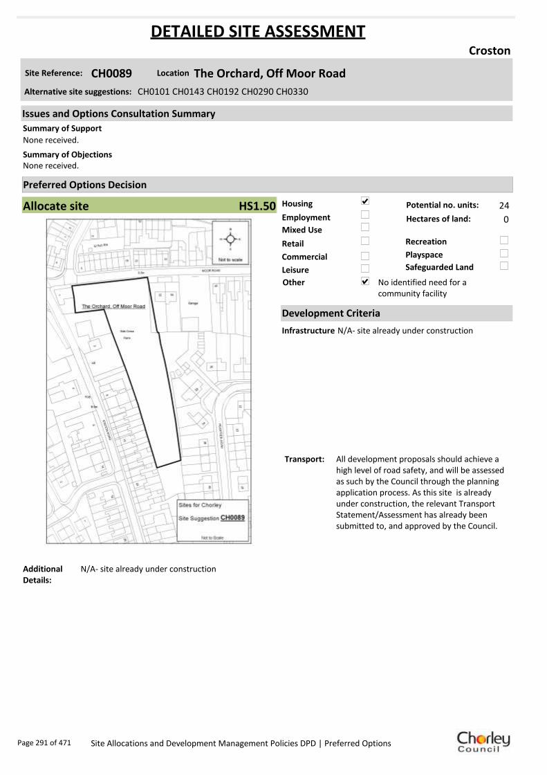
Housing
Employment
Mixed Use
Retail
Commercial
Leisure
Recreation
Safeguarded Land
Preferred Options Decision
Allocate site Potential no. units: 24
Hectares of land: 0
Other No identified need for a community facility
Site Reference: CH0089 The Orchard, Off Moor Road
Croston
None received.
None received.Summary of Objections
Summary of Support
Alternative site suggestions: CH0101 CH0143 CH0192 CH0290 CH0330
DETAILED SITE ASSESSMENT
Location
Development Criteria
Infrastructure N/A- site already under construction
Transport: All development proposals should achieve a high level of road safety, and will be assessed as such by the Council through the planning application process. As this site is already under construction, the relevant Transport Statement/Assessment has already been submitted to, and approved by the Council.
Additional Details:
N/A- site already under construction
Issues and Options Consultation Summary
Playspace
HS1.50
Page 291 of 471 Site Allocations and Development Management Policies DPD | Preferred Options

Sustainability Appraisal
No sustainability Appraisal has been undertaken of this site suggestion as the site has already been
granted planning permission/ is under construction.
Page 292 of 471 Site Allocations and Development Management Policies DPD | Preferred Options

Housing
Employment
Mixed Use
Retail
Commercial
Leisure
Recreation
Safeguarded Land
Preferred Options Decision
Do not allocate Potential no. units: 0
Hectares of land: 0
Other No identified need for a community facility
Site Reference: CH0096 Land off Westhead Road
Croston
None received.
None received.Summary of Objections
Summary of Support
Alternative site suggestions: CH0084 CH0188 CH0189 CH0327
DETAILED SITE ASSESSMENT
Location
Development Criteria
Infrastructure N/A- proposed not to allocate site
Transport: N/A- proposed not to allocate site
Additional Details:
N/A- proposed not to allocate site
Issues and Options Consultation Summary
Playspace
Page 293 of 471 Site Allocations and Development Management Policies DPD | Preferred Options

Sustainability Appraisal
No sustainability Appraisal has been undertaken of this site suggestion as there is currently no
identified need for additional community facilities. If a need is demonstrated in the future, the
provision of community facilities will be reassessed at such a time.
Page 294 of 471 Site Allocations and Development Management Policies DPD | Preferred Options
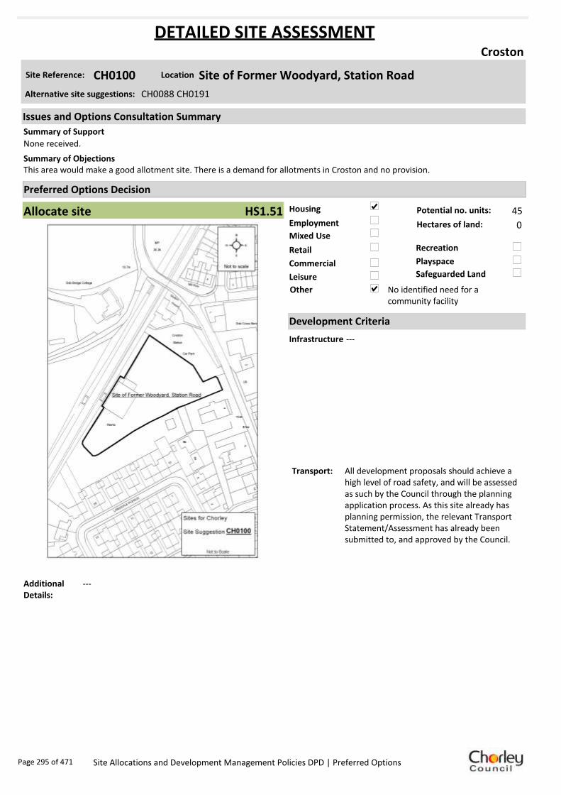
Housing
Employment
Mixed Use
Retail
Commercial
Leisure
Recreation
Safeguarded Land
Preferred Options Decision
Allocate site Potential no. units: 45
Hectares of land: 0
Other No identified need for a community facility
Site Reference: CH0100 Site of Former Woodyard, Station Road
Croston
None received.
This area would make a good allotment site. There is a demand for allotments in Croston and no provision.Summary of Objections
Summary of Support
Alternative site suggestions: CH0088 CH0191
DETAILED SITE ASSESSMENT
Location
Development Criteria
Infrastructure ---
Transport: All development proposals should achieve a high level of road safety, and will be assessed as such by the Council through the planning application process. As this site already has planning permission, the relevant Transport Statement/Assessment has already been submitted to, and approved by the Council.
Additional Details:
---
Issues and Options Consultation Summary
Playspace
HS1.51
Page 295 of 471 Site Allocations and Development Management Policies DPD | Preferred Options

Sustainability Appraisal
No sustainability Appraisal has been undertaken of this site suggestion as the site has already been
granted planning permission/ is under construction.
Page 296 of 471 Site Allocations and Development Management Policies DPD | Preferred Options
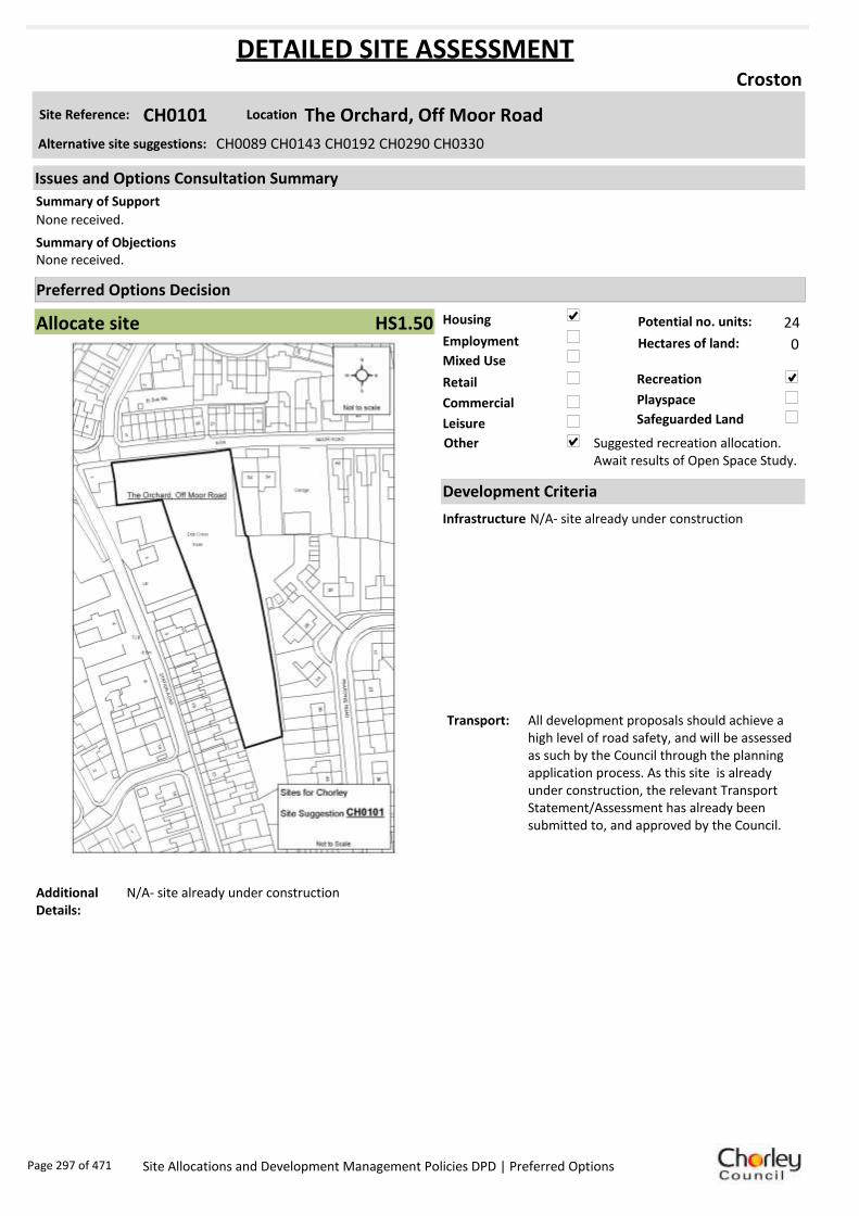
Housing
Employment
Mixed Use
Retail
Commercial
Leisure
Recreation
Safeguarded Land
Preferred Options Decision
Allocate site Potential no. units: 24
Hectares of land: 0
Other Suggested recreation allocation. Await results of Open Space Study.
Site Reference: CH0101 The Orchard, Off Moor Road
Croston
None received.
None received.Summary of Objections
Summary of Support
Alternative site suggestions: CH0089 CH0143 CH0192 CH0290 CH0330
DETAILED SITE ASSESSMENT
Location
Development Criteria
Infrastructure N/A- site already under construction
Transport: All development proposals should achieve a high level of road safety, and will be assessed as such by the Council through the planning application process. As this site is already under construction, the relevant Transport Statement/Assessment has already been submitted to, and approved by the Council.
Additional Details:
N/A- site already under construction
Issues and Options Consultation Summary
Playspace
HS1.50
Page 297 of 471 Site Allocations and Development Management Policies DPD | Preferred Options

Sustainability Appraisal
No sustainability Appraisal has been undertaken of this site suggestion as the site has already been
granted planning permission/ is under construction.
Page 298 of 471 Site Allocations and Development Management Policies DPD | Preferred Options

Housing
Employment
Mixed Use
Retail
Commercial
Leisure
Recreation
Safeguarded Land
Preferred Options Decision
Allocate site Potential no. units: 24
Hectares of land: 0
Other
Site Reference: CH0143 Land at Dob Cross Farm, Moor Rd
Croston
None received.
None received.Summary of Objections
Summary of Support
Alternative site suggestions: CH0089 CH0101 CH0192 CH0290 CH0330
DETAILED SITE ASSESSMENT
Location
Development Criteria
Infrastructure N/A- Site already has planning permission
Transport: N/A- Site already has planning permission
Additional Details:
N/A- Site already has planning permission
Issues and Options Consultation Summary
Playspace
HS1.50
Page 299 of 471 Site Allocations and Development Management Policies DPD | Preferred Options

Sustainability Appraisal
No sustainability Appraisal has been undertaken of this site suggestion as the site has already been
granted planning permission/ is under construction.
Page 300 of 471 Site Allocations and Development Management Policies DPD | Preferred Options

Housing
Employment
Mixed Use
Retail
Commercial
Leisure
Recreation
Safeguarded Land
Preferred Options Decision
Do not allocate Potential no. units: 0
Hectares of land: 0
Other No identified need for a community facility
Site Reference: CH0188 Land off Westhead Road
Croston
None received.
None received.Summary of Objections
Summary of Support
Alternative site suggestions: CH0084 CH0196 CH0189 CH0327
DETAILED SITE ASSESSMENT
Location
Development Criteria
Infrastructure N/A- proposed not to allocate site
Transport: N/A- proposed not to allocate site
Additional Details:
N/A- proposed not to allocate site
Issues and Options Consultation Summary
Playspace
Page 301 of 471 Site Allocations and Development Management Policies DPD | Preferred Options

Sustainability Appraisal
No sustainability Appraisal has been undertaken of this site suggestion as there is currently no
identified need for additional community facilities. If a need is demonstrated in the future, the
provision of community facilities will be reassessed at such a time.
Page 302 of 471 Site Allocations and Development Management Policies DPD | Preferred Options

Housing
Employment
Mixed Use
Retail
Commercial
Leisure
Recreation
Safeguarded Land
Preferred Options Decision
Do not allocate Potential no. units: 0
Hectares of land: 0
Other No identified need for a community facility
Site Reference: CH0189 Land off Westhead Road
Croston
None received.
None received.Summary of Objections
Summary of Support
Alternative site suggestions: CH0084 CH0196 CH0188 CH0327
DETAILED SITE ASSESSMENT
Location
Development Criteria
Infrastructure N/A- proposed not to allocate site
Transport: N/A- proposed not to allocate site
Additional Details:
N/A- proposed not to allocate site
Issues and Options Consultation Summary
Playspace
Page 303 of 471 Site Allocations and Development Management Policies DPD | Preferred Options

Sustainability Appraisal
No sustainability Appraisal has been undertaken of this site suggestion as there is currently no
identified need for additional community facilities. If a need is demonstrated in the future, the
provision of community facilities will be reassessed at such a time.
Page 304 of 471 Site Allocations and Development Management Policies DPD | Preferred Options
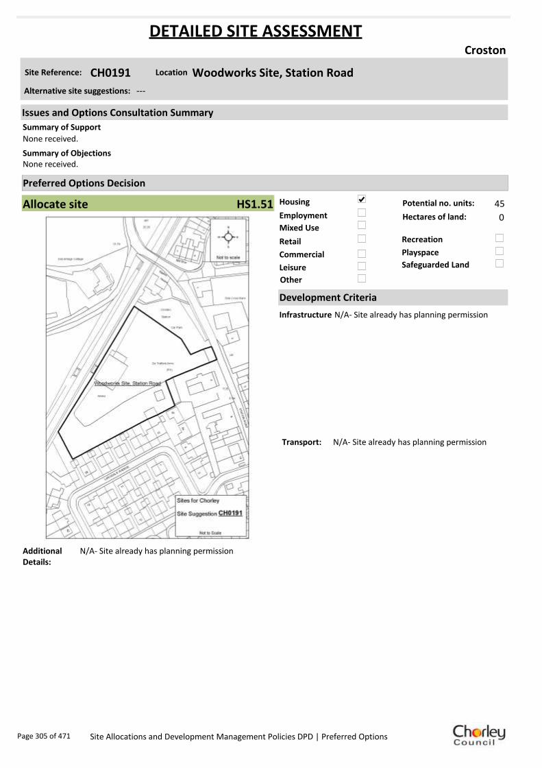
Housing
Employment
Mixed Use
Retail
Commercial
Leisure
Recreation
Safeguarded Land
Preferred Options Decision
Allocate site Potential no. units: 45
Hectares of land: 0
Other
Site Reference: CH0191 Woodworks Site, Station Road
Croston
None received.
None received.Summary of Objections
Summary of Support
Alternative site suggestions: ---
DETAILED SITE ASSESSMENT
Location
Development Criteria
Infrastructure N/A- Site already has planning permission
Transport: N/A- Site already has planning permission
Additional Details:
N/A- Site already has planning permission
Issues and Options Consultation Summary
Playspace
HS1.51
Page 305 of 471 Site Allocations and Development Management Policies DPD | Preferred Options

Sustainability Appraisal
No sustainability Appraisal has been undertaken of this site suggestion as the site has already been
granted planning permission/ is under construction.
Page 306 of 471 Site Allocations and Development Management Policies DPD | Preferred Options

Housing
Employment
Mixed Use
Retail
Commercial
Leisure
Recreation
Safeguarded Land
Preferred Options Decision
Allocate site Potential no. units: 24
Hectares of land: 0
Other
Site Reference: CH0192 Dob Cross Farm, Moor Road/Station Road
Croston
Summary of Objections
Summary of Support
Alternative site suggestions: CH0089 CH0101 CH0143 CH0290 CH0330
DETAILED SITE ASSESSMENT
Location
Development Criteria
Infrastructure N/A- Site already has planning permission
Transport: N/A- Site already has planning permission
Additional Details:
N/A- Site already has planning permission
Issues and Options Consultation Summary
Playspace
HS1.50
Page 307 of 471 Site Allocations and Development Management Policies DPD | Preferred Options

Sustainability Appraisal
No sustainability Appraisal has been undertaken of this site suggestion as the site has already been
granted planning permission/ is under construction.
Page 308 of 471 Site Allocations and Development Management Policies DPD | Preferred Options

Housing
Employment
Mixed Use
Retail
Commercial
Leisure
Recreation
Safeguarded Land
Preferred Options Decision
Do not allocate Potential no. units: 0
Hectares of land: 0
Other No identified need for a community facility
Site Reference: CH0231 Land to the north of Brickcroft Lane
Croston
Site would make a great allotment site.
Object to removal of proposed housing use of the site. Site is promoted as being deliverable, sustainable and achievable, with a committed landowner able to bring the land forward. Site is close to train station and local amenities. Site is known to contain at least one heritage asset. Any proposed schemes should assess the impact of development on all known assets.
Summary of Objections
Summary of Support
Alternative site suggestions: ---
DETAILED SITE ASSESSMENT
Location
Development Criteria
Infrastructure N/A-proposed not to allocate this site
Transport: N/A-proposed not to allocate this site
Additional Details:
N/A-proposed not to allocate this site
Issues and Options Consultation Summary
Playspace
Page 309 of 471 Site Allocations and Development Management Policies DPD | Preferred Options

Sustainability Appraisal
No sustainability Appraisal has been undertaken of this site suggestion as there is currently no
identified need for additional community facilities. If a need is demonstrated in the future, the
provision of community facilities will be reassessed at such a time.
Page 310 of 471 Site Allocations and Development Management Policies DPD | Preferred Options

Housing
Employment
Mixed Use
Retail
Commercial
Leisure
Recreation
Safeguarded Land
Preferred Options Decision
Do not allocate Potential no. units: 0
Hectares of land: 0
Other No identified need for a community facility
Site Reference: CH0232 Land to the east of Out Lane
Croston
None received.
Object to the removal of the housing element of the site suggestion. Site is promoted as being deliverable, sustainable and achievable, with a committed landowner able to bring the land forward. Site is close to train station and local amenities. No technical, physical or environmental constraints restricting development of the site.
Summary of Objections
Summary of Support
Alternative site suggestions: ---
DETAILED SITE ASSESSMENT
Location
Development Criteria
Infrastructure N/A-proposed not to allocate this site
Transport: N/A-proposed not to allocate this site
Additional Details:
N/A-proposed not to allocate this site
Issues and Options Consultation Summary
Playspace
Page 311 of 471 Site Allocations and Development Management Policies DPD | Preferred Options

Sustainability Appraisal
No sustainability Appraisal has been undertaken of this site suggestion as there is currently no
identified need for additional community facilities. If a need is demonstrated in the future, the
provision of community facilities will be reassessed at such a time.
Page 312 of 471 Site Allocations and Development Management Policies DPD | Preferred Options

Housing
Employment
Mixed Use
Retail
Commercial
Leisure
Recreation
Safeguarded Land
Preferred Options Decision
Undecided Potential no. units: 0
Hectares of land: 0
Other Suggested recreation allocation. Await results of Open Space Study.
Site Reference: CH0233 Land to the east of Station Road
Croston
None received.
Object to the removal of the housing element of the site suggestion. Site is promoted as being deliverable, sustainable and achievable, with a committed landowner able to bring the land forward. Site is close to train station and local amenities. No technical, physical or environmental constraints restricting development of the site.Site is known to contain at least one heritage asset. The potential impacts of development should be assessed before plans are made.
Summary of Objections
Summary of Support
Alternative site suggestions: ---
DETAILED SITE ASSESSMENT
Location
Development Criteria
Infrastructure ---
Transport: ---
Additional Details:
It has been suggested that this site be allocated for recreation use. Until the results of the Open Space Study are received, no decisions will be made as to the allocation or otherwise of this site.
Issues and Options Consultation Summary
Playspace
Page 313 of 471 Site Allocations and Development Management Policies DPD | Preferred Options

Sustainability Appraisal
No sustainability Appraisal has been undertaken of this site suggestion. Until the findings of the
Open Space Study are produced, the Council will not be allocating additional land for recreation
purposes. Once the Study is complete, a decision on the allocation of this site for recreational use
can be made.
Page 314 of 471 Site Allocations and Development Management Policies DPD | Preferred Options

Housing
Employment
Mixed Use
Retail
Commercial
Leisure
Recreation
Safeguarded Land
Preferred Options Decision
Undecided Potential no. units: 0
Hectares of land: 0
Other Suggested recreation allocation. Await results of Open Space Study.
Site Reference: CH0234 Land off Out Lane
Croston
None received.
Sites CH0234 and CH0233 form part of an infill parcel in the centre of Croston. They, along with adjoining land, could create a high quality, appropriate extension to the village. Site is deliverable, sustainable and achievable, with a committed landowner to bring the land forward.
Summary of Objections
Summary of Support
Alternative site suggestions: ---
DETAILED SITE ASSESSMENT
Location
Development Criteria
Infrastructure ---
Transport: ---
Additional Details:
It has been suggested that this site be allocated for recreation use. Until the results of the Open Space Study are received, no decisions will be made as to the allocation or otherwise of this site.
Issues and Options Consultation Summary
Playspace
Page 315 of 471 Site Allocations and Development Management Policies DPD | Preferred Options

Sustainability Appraisal
No sustainability Appraisal has been undertaken of this site suggestion. Until the findings of the
Open Space Study are produced, the Council will not be allocating additional land for recreation
purposes. Once the Study is complete, a decision on the allocation of this site for recreational use
can be made.
Page 316 of 471 Site Allocations and Development Management Policies DPD | Preferred Options
Housing
Employment
Mixed Use
Retail
Commercial
Leisure
Recreation
Safeguarded Land
Preferred Options Decision
Allocate site Potential no. units: 24
Hectares of land: 0
Other
Site Reference: CH0290 Moor Road
Croston
None received.
None received.Summary of Objections
Summary of Support
Alternative site suggestions: CH0089 CH0101 CH0143 CH0192 CH0330
DETAILED SITE ASSESSMENT
Location
Development Criteria
Infrastructure N/A- Site already has planning permission
Transport: All development proposals should achieve a high level of road safety, and will be assessed as such by the Council through the planning application process. As this site already has planning permission, the relevant Transport Statement/Assessment has already been submitted to, and approved by the Council.
Additional Details:
N/A- Site already has planning permission
Issues and Options Consultation Summary
Playspace
HS1.50
Page 317 of 471 Site Allocations and Development Management Policies DPD | Preferred Options

Sustainability Appraisal
No sustainability Appraisal has been undertaken of this site suggestion as the site has already been
granted planning permission/ is under construction.
Page 318 of 471 Site Allocations and Development Management Policies DPD | Preferred Options

Housing
Employment
Mixed Use
Retail
Commercial
Leisure
Recreation
Safeguarded Land
Preferred Options Decision
Undecided Potential no. units: 0
Hectares of land: 0
Other Suggested recreation allocation. Await results of Open Space Study.
Site Reference: CH0327 Land off Coniston Way
Croston
None received.
None received.Summary of Objections
Summary of Support
Alternative site suggestions: CH0084 CH0196 CH0188 CH0189
DETAILED SITE ASSESSMENT
Location
Development Criteria
Infrastructure ---
Transport: ---
Additional Details:
It has been suggested that this site be allocated for recreation use. Until the results of the Open Space Study are received, no decisions will be made as to the allocation or otherwise of this site.
Issues and Options Consultation Summary
Playspace
Page 319 of 471 Site Allocations and Development Management Policies DPD | Preferred Options

Sustainability Appraisal
No sustainability Appraisal has been undertaken of this site suggestion. Until the findings of the
Open Space Study are produced, the Council will not be allocating additional land for recreation
purposes. Once the Study is complete, a decision on the allocation of this site for recreational use
can be made.
Page 320 of 471 Site Allocations and Development Management Policies DPD | Preferred Options

Housing
Employment
Mixed Use
Retail
Commercial
Leisure
Recreation
Safeguarded Land
Preferred Options Decision
Undecided Potential no. units: 0
Hectares of land: 0
Other Suggested recreation allocation. Await results of Open Space Study.
Site Reference: CH0328 Croft Field, Off Grape Lane
Croston
None received.
If site should be designated for recreation, then a site must also be allocated for car parking as there is not enough in the village already. Parish Plan states that more car parks are needed.
Summary of Objections
Summary of Support
Alternative site suggestions: ---
DETAILED SITE ASSESSMENT
Location
Development Criteria
Infrastructure ---
Transport: ---
Additional Details:
It has been suggested that this site be allocated for recreation use. Until the results of the Open Space Study are received, no decisions will be made as to the allocation or otherwise of this site.
Issues and Options Consultation Summary
Playspace
Page 321 of 471 Site Allocations and Development Management Policies DPD | Preferred Options

Sustainability Appraisal
No sustainability Appraisal has been undertaken of this site suggestion. Until the findings of the
Open Space Study are produced, the Council will not be allocating additional land for recreation
purposes. Once the Study is complete, a decision on the allocation of this site for recreational use
can be made.
Page 322 of 471 Site Allocations and Development Management Policies DPD | Preferred Options

Housing
Employment
Mixed Use
Retail
Commercial
Leisure
Recreation
Safeguarded Land
Preferred Options Decision
Allocate site Potential no. units: 24
Hectares of land: 0
Other Suggested recreation allocation. Await results of Open Space Study.
Site Reference: CH0330 Former Orchard, Moor Road
Croston
None received.
None received.Summary of Objections
Summary of Support
Alternative site suggestions: CH0089 CH0101 CH0143 CH0192 CH0290
DETAILED SITE ASSESSMENT
Location
Development Criteria
Infrastructure N/A- Site already has planning permission and is under construction
Transport: N/A- Site already has planning permission and is under construction
Additional Details:
N/A- Site already has planning permission and is under construction
Issues and Options Consultation Summary
Playspace
Page 323 of 471 Site Allocations and Development Management Policies DPD | Preferred Options

Sustainability Appraisal
No sustainability Appraisal has been undertaken of this site suggestion as the site has already been
granted planning permission/ is under construction.
Page 324 of 471 Site Allocations and Development Management Policies DPD | Preferred Options

Housing
Employment
Mixed Use
Retail
Commercial
Leisure
Recreation
Safeguarded Land
Preferred Options Decision
Undecided Potential no. units: 0
Hectares of land: 0
Other Suggested recreation allocation. Await results of Open Space Study.
Site Reference: CH0332 Rear of 81-101 Station Road
Croston
None received.
None received.Summary of Objections
Summary of Support
Alternative site suggestions: ---
DETAILED SITE ASSESSMENT
Location
Development Criteria
Infrastructure ---
Transport: ---
Additional Details:
It has been suggested that this site be allocated for recreation use. Until the results of the Open Space Study are received, no decisions will be made as to the allocation or otherwise of this site.
Issues and Options Consultation Summary
Playspace
Page 325 of 471 Site Allocations and Development Management Policies DPD | Preferred Options

Sustainability Appraisal
No sustainability Appraisal has been undertaken of this site suggestion. Until the findings of the
Open Space Study are produced, the Council will not be allocating additional land for recreation
purposes. Once the Study is complete, a decision on the allocation of this site for recreational use
can be made.
Page 326 of 471 Site Allocations and Development Management Policies DPD | Preferred Options

Housing
Employment
Mixed Use
Retail
Commercial
Leisure
Recreation
Safeguarded Land
Preferred Options Decision
Undecided Potential no. units: 0
Hectares of land: 0
Other Suggested recreation allocation. Await results of Open Space Study.
Site Reference: CH0333 Recreational Area, off Station Road
Croston
None received.
None received.Summary of Objections
Summary of Support
Alternative site suggestions: ---
DETAILED SITE ASSESSMENT
Location
Development Criteria
Infrastructure ---
Transport: ---
Additional Details:
It has been suggested that this site be allocated for recreation use. Until the results of the Open Space Study are received, no decisions will be made as to the allocation or otherwise of this site.
Issues and Options Consultation Summary
Playspace
Page 327 of 471 Site Allocations and Development Management Policies DPD | Preferred Options

Sustainability Appraisal
No sustainability Appraisal has been undertaken of this site suggestion. Until the findings of the
Open Space Study are produced, the Council will not be allocating additional land for recreation
purposes. Once the Study is complete, a decision on the allocation of this site for recreational use
can be made.
Page 328 of 471 Site Allocations and Development Management Policies DPD | Preferred Options

Housing
Employment
Mixed Use
Retail
Commercial
Leisure
Recreation
Safeguarded Land
Preferred Options Decision
Allocate site Potential no. units: 0
Hectares of land: 0
Other It is proposed to bring forward all existing play space allocations.
Site Reference: CH0334 Land off Riverside Crescent
Croston
None received.
None received.Summary of Objections
Summary of Support
Alternative site suggestions: ---
DETAILED SITE ASSESSMENT
Location
Development Criteria
Infrastructure ---
Transport: ---
Additional Details:
Site is being rolled forward from the existing Local Plan as a future playspace. Await results of Open Space Study before any sites are reviewed.
Issues and Options Consultation Summary
Playspace
HW1.30
Page 329 of 471 Site Allocations and Development Management Policies DPD | Preferred Options
Sustainability Appraisal
No sustainability Appraisal has been undertaken of this site suggestion. Until the findings of the
Open Space Study are produced, the Council will be rolling forward all future playspace allocations
from the existing Local Plan.
Page 330 of 471 Site Allocations and Development Management Policies DPD | Preferred Options
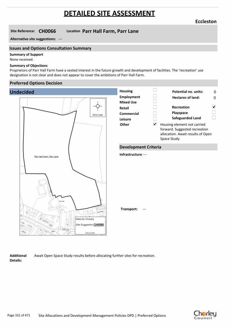
Housing
Employment
Mixed Use
Retail
Commercial
Leisure
Recreation
Safeguarded Land
Preferred Options Decision
Undecided Potential no. units: 0
Hectares of land: 0
Other Housing element not carried forward. Suggested recreation allocation. Await results of Open Space Study.
Site Reference: CH0066 Parr Hall Farm, Parr Lane
Eccleston
None received.
Proprietors of Parr Hall Farm have a vested interest in the future growth and development of facilities. The ‘recreation’ use designation is not clear and does not appear to cover the ambitions of Parr Hall Farm.
Summary of Objections
Summary of Support
Alternative site suggestions: ---
DETAILED SITE ASSESSMENT
Location
Development Criteria
Infrastructure ---
Transport: ---
Additional Details:
Await Open Space Study results before allocating further sites for recreation.
Issues and Options Consultation Summary
Playspace
Page 331 of 471 Site Allocations and Development Management Policies DPD | Preferred Options

Sustainability Appraisal
No sustainability Appraisal has been undertaken of this site suggestion. Until the findings of the
Open Space Study are produced, the Council will not be allocating additional land for recreation
purposes. Once the Study is complete, a decision on the allocation of this site for recreational use
can be made.
Page 332 of 471 Site Allocations and Development Management Policies DPD | Preferred Options
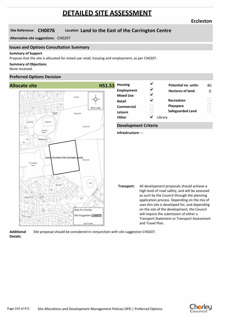
Housing
Employment
Mixed Use
Retail
Commercial
Leisure
Recreation
Safeguarded Land
Preferred Options Decision
Allocate site Potential no. units: 40
Hectares of land: 0
Other Library
Site Reference: CH0076 Land to the East of the Carrington Centre
Eccleston
Propose that the site is allocated for mixed use retail, housing and employment, as per CH0207.
None received.Summary of Objections
Summary of Support
Alternative site suggestions: CH0207
DETAILED SITE ASSESSMENT
Location
Development Criteria
Infrastructure ---
Transport: All development proposals should achieve a high level of road safety, and will be assessed as such by the Council through the planning application process. Depending on the mix of uses this site is developed for, and depending on the size of the development, the Council will require the submission of either a Transport Statement or Transport Assessment and Travel Plan.
Additional Details:
Site proposal should be considered in conjunction with site suggestion CH0207.
Issues and Options Consultation Summary
Playspace
HS1.53
Page 333 of 471 Site Allocations and Development Management Policies DPD | Preferred Options

Sustainability Appraisal
Site Ref CH0076
Address Land to the East of the Carrington Centre, Eccleston
SA Obj
Indicator Site Performance SA Comments
S1
Distance to railway station Ove r 3 km Social This site has good access to a frequent bus service with services 2-5 times per hour. There is no rail service in the settlement and the site has poor access to an A road junction and motorway junction. The site has good access to all local services and facilities. Environmental The only identified negative environmental effect in developing this site is the site partly Greenfield and part of the site is within designated safeguarded land. Economic There are no identified negative economic effects in developing this site.
Rail service frequency No se rvices in settle me nt Distance to ne arest bus stop Up to 0 .4km Bus service frequency 2 -5 /hour/direction Distance to se rvice ce ntre Ove r 3 km Distance to A Road junction 1. 61 to 3 km Distance to motorwa y junction Ove r 3 km Distance to supermarket Up to 0 .4km Distance to convenience store Up to 0 .4km Distance to Post Office Up to 0 .4km Distance to Primary School Up to 0 .4km Distance to Secondary School 3. 21 to 5 km On a cycle route No Distance to cycle route Over 1. 6km
S2
Distance to GP surge ry Up to 0 .4km Distance to NH S general hospital 2 .1 to 5km Distance to public open space /park Up to 0 .4km Distance to local ce ntre Up to 0 .4km
EN1
Designation of land Part Safe guarde d La nd Are a of Separation Outside AONB Outside SSSI Outside Biological/ G eological He ri tage Site Outside Agricultural classification 3
EN2
Conservation Are a Outside Ancie nt Monument on site No Regis tere d Park or G arden Outside Listed Build ing on site No Locally Listed Building on s ite No
EN3 Curre nt/former land use Brownfield/Gree nfield EN4 Flood Zone are a All Zone 1
EN5 Contaminated land No risk Within 3 km of a congestion spot No
EC1 Distance to employme nt site Up to 0 .8km Access to Broadband Yes
EC2 Distance to further/ highe r e ducation Ove r 5 km
De
live
rab
ility
In
dic
ato
rs
Access to sewer system
Yes
Is the site deliverable: Yes Access to water
Access to gas
Access to e lectricity
Exis ting road acce ss
At risk from haza rdous ins tallations No
Overall Site Performance
Band Spe ctrum:
Overall Band:
C
Page 334 of 471 Site Allocations and Development Management Policies DPD | Preferred Options

Housing
Employment
Mixed Use
Retail
Commercial
Leisure
Recreation
Safeguarded Land
Preferred Options Decision
Allocate site Potential no. units: 70
Hectares of land: 0
Other
Site Reference: CH0077 Sagar House, Langton Brow
Eccleston
Planning permission has been granted for residential redevelopment and it follows that the site allocation should reflect the permitted development use.
The site is known to contain at least one heritage asset. Any proposed schemes should assess the impact of development upon known assets.
Summary of Objections
Summary of Support
Alternative site suggestions: CH0304
DETAILED SITE ASSESSMENT
Location
Development Criteria
Infrastructure Site already has planning permission. Water Cycle Study: Site specific FRA required to check flood zones. Surface water should not be routed to wastewater network. All developments in the Croston Wastewater Treatment Works catchment need to be assessed by UU. Attenuation SUDS most likely to be viable, however needs detailed check. Need agreement from EA regarding attenuating to watercourses.
Transport: All development proposals should achieve a high level of road safety, and will be assessed as such by the Council through the planning application process. As this site already has planning permission, the relevant Transport Statement/Assessment has already been submitted to, and approved by the Council.
Additional Details:
Site already has planning permission. Site should be considered in conjunction with CH0304.
Issues and Options Consultation Summary
Playspace
HS1.54
Page 335 of 471 Site Allocations and Development Management Policies DPD | Preferred Options

Sustainability Appraisal
Site Ref CH0077
Address Sagar House, Langton Brow, Eccleston
SA Obj
Indicator Site Performance SA Comments
S1
Distance to railway station Ove r 3 km This site has been granted planning permission for housing development.
Rail service frequency No se rvices in settle me nt Distance to ne arest bus stop Up to 0 .4km Bus service frequency 2 -5 /hour/direction Distance to se rvice ce ntre Ove r 3 km Distance to A Road junction 1. 61 to 3 km Distance to motorwa y junction Ove r 3 km Distance to supermarket 0.4 1 to 0. 8km Distance to convenience store Up to 0 .4km Distance to Post Office 0.4 1 to 0. 8km Distance to Primary School Up to 0 .4km Distance to Secondary School 3. 21 to 5 km On a cycle route No Distance to cycle route Over 1. 6km
S2
Distance to GP surge ry 0.8 1 to 1. 6km Distance to NH S general hospital 2 .1 to 5km Distance to public open space /park 0.4 1 to 0. 8km Distance to local ce ntre Up to 0 .4km
EN1
Designation of land Rural Local Se rvice Ce ntre Are a of Separation Outside AONB Outside SSSI Outside Biological/ G eological He ri tage Site Outside Agricultural classification 3
EN2
Conservation Are a Outside Ancie nt Monument on site No Regis tere d Park or G arden Outside Listed Build ing on site No Locally Listed Building on s ite Yes
EN3 Curre nt/former land use Brownfield EN4 Flood Zone are a All Zone 1
EN5 Contaminated land No risk Within 3 km of a congestion spot No
EC1 Distance to employme nt site Up to 0 .8km Access to Broadband Yes
EC2 Distance to further/ highe r e ducation Ove r 5 km
De
live
rab
ility
In
dic
ato
rs
Access to sewer system
Yes
Access to water
Access to gas
Access to e lectricity
Exis ting road acce ss
At risk from haza rdous ins tallations No
Overall Site Performance
Band Spe ctrum:
Overall Band:
C
Page 336 of 471 Site Allocations and Development Management Policies DPD | Preferred Options

Housing
Employment
Mixed Use
Retail
Commercial
Leisure
Recreation
Safeguarded Land
Preferred Options Decision
Retain existing designation Potential no. units: 0
Hectares of land: 0
Other
Site Reference: CH0081 Land off Parr Lane
Eccleston
Site is in a sustainable location, close to village centre, the Carrington Centre and bus routes. Appropriate to phase release for 5-10 or 11-15 year period.
None received.Summary of Objections
Summary of Support
Alternative site suggestions: ---
DETAILED SITE ASSESSMENT
Location
Development Criteria
Infrastructure Proposed to retain existing safeguarded land designation. However, the following information is provided. Water Cycle Study: All developments in Croston Wastewater Treatment Works catchment need to be assessed by UU. Attenuation SUDS most likely to be viable, however needs detailed check. Need agreement from EA regarding attenuating to watercourses.
Transport: N/A- proposed to retain existing safeguarded land designation.
Additional Details:
Poor sustainability score - would need significant infrastructure if developed. Sufficient land identified elsewhere.
Issues and Options Consultation Summary
Playspace
BNE2.11
Page 337 of 471 Site Allocations and Development Management Policies DPD | Preferred Options

Sustainability Appraisal
Site Ref CH0081
Address Land off Parr Lane, Eccleston
SA Obj
Indicator Site Performance SA Comments
S1
Distance to railway station Ove r 3 km Social This site has good access to some local services and facilities however the site does not have access to a rail service and is over 3kn from the nearest service centre. The site has good access to local convenience stores, post office and a supermarket. Environmental This site is a Greenfield site on an existing safeguarded land designation. Economic There are no identified negative economic effects in developing this site.
Rail service frequency No se rvices in settle me nt Distance to ne arest bus stop 0.4 1 to 0. 8km Bus service frequency 2 -5 /hour/direction Distance to se rvice ce ntre Ove r 3 km Distance to A Road junction 1. 61 to 3 km Distance to motorwa y junction Ove r 3 km Distance to supermarket Up to 0 .4km Distance to convenience store Up to 0 .4km Distance to Post Office Up to 0 .4km Distance to Primary School 0.4 1 to 0. 8km Distance to Secondary School 3. 21 to 5 km On a cycle route No Distance to cycle route Over 1. 6km
S2
Distance to GP surge ry 0.4 1 to 0. 8km Distance to NH S general hospital 2 .1 to 5km Distance to public open space /park Up to 0 .4km Distance to local ce ntre Up to 0 .4km
EN1
Designation of land Safe guarde d Land Are a of Separation Outside AONB Outside SSSI Outside Biological/ G eological He ri tage Site Outside Agricultural classification 3
EN2
Conservation Are a Outside Ancie nt Monument on site No Regis tere d Park or G arden Outside Listed Build ing on site No Locally Listed Building on s ite No
EN3 Curre nt/former land use Greenfield EN4 Flood Zone are a All Zone 1
EN5 Contaminated land No risk Within 3 km of a congestion spot No
EC1 Distance to employme nt site 0.8 1 to 1. 2km Access to Broadband Yes
EC2 Distance to further/ highe r e ducation Ove r 5 km
De
live
rab
ility
In
dic
ato
rs
Access to sewer system
Yes
Is the site deliverable: Yes Access to water
Access to gas
Access to e lectricity
Exis ting road acce ss
At risk from haza rdous ins tallations No
Overall Site Performance
Band Spe ctrum:
Overall Band:
D
Page 338 of 471 Site Allocations and Development Management Policies DPD | Preferred Options

Housing
Employment
Mixed Use
Retail
Commercial
Leisure
Recreation
Safeguarded Land
Preferred Options Decision
Retain existing designation Potential no. units: 0
Hectares of land: 0
Other
Site Reference: CH0093 Land at Tincklers Lane
Eccleston
None received.
None received.Summary of Objections
Summary of Support
Alternative site suggestions: CH0094 CH0095 CH0287 CH0321
DETAILED SITE ASSESSMENT
Location
Development Criteria
Infrastructure Proposed to retain existing safeguarded land designation. However, the following information is provided. Water Cycle Study: All developments in the Croston Wastewater Treatment Works catchment need to be assessed by UU. Attenuation SUDS most likely to be viable, however needs detailed check. Need agreement from EA regarding attenuating to watercourses.
Transport: N/A- Proposed to retain existing safeguarded land designation.
Additional Details:
Poor sustainability score - would need significant infrastructure. Sufficient land identified elsewhere. Site proposal should be considered in conjunction with site suggestions CH0094, CH0095, and CH0287.
Issues and Options Consultation Summary
Playspace
BNE2.10
Page 339 of 471 Site Allocations and Development Management Policies DPD | Preferred Options

Sustainability Appraisal
Site Ref CH0321
Address Land at Tincklers Lane, Eccleston
SA Obj
Indicator Site Performance SA Comments
S1
Distance to railway station Over 3km Social This site has good access to some local services and facilities however the site does not have access to a rail service and is over 3kn from the nearest service centre. The site has good access to local convenience stores, post office and a supermarket. Environmental This site is a Greenfield site on an existing safeguarded land designation and carries a medium risk of land contamination. Economic There are no identified negative economic effects in developing this site.
Rail service frequency No services in settlement Distance to nearest bus stop Up to 0.4km Bus service frequency 2-5/hour/direction Distance to service centre Over 3km Distance to A Road junction 0.81 to 1.6km Distance to motorway junction Over 3km Distance to supermarket 0.41 to 0.8km Distance to convenience store 0.41 to 0.8km Distance to Post Office 0.41 to 0.8km Distance to Primary School 0.41 to 0.8km Distance to Secondary School 3.21 to 5km On a cycle route No Distance to cycle route Over 1.6km
S2
Distance to GP surgery 0.41 to 0.8km Distance to NHS general hospital 2.1 to 5km Distance to public open space/park Up to 0.4km Distance to local centre 0.81 to 1.2km
EN1
Designation of land Safeguarded Land Area of Separation Outside AONB Outside SSSI Outside Biological/ Geological Heritage Site Outside Agricultural classification 2
EN2
Conservation Area Outside Ancient Monument on site No Registered Park or Garden Outside Listed Building on site No Locally Listed Building on site No
EN3 Current/former land use Greenfield EN4 Flood Zone area All Zone 1
EN5 Contaminated land Medium risk Within 3km of a congestion spot No
EC1 Distance to employment site 1.21 to 1.6km Access to Broadband Yes
EC2 Distance to further/higher education Over 5km
Del
iver
abili
ty
Indi
cato
rs
Access to sewer system
Yes
Is the site deliverable: Yes Access to water
Access to gas Access to electricity Existing road access At risk from hazardous installations No
Overall Site Performance Band Spectrum:
Overall Band:
D
Page 340 of 471 Site Allocations and Development Management Policies DPD | Preferred Options
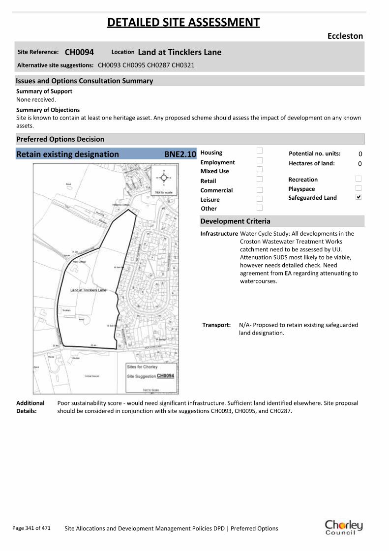
Housing
Employment
Mixed Use
Retail
Commercial
Leisure
Recreation
Safeguarded Land
Preferred Options Decision
Retain existing designation Potential no. units: 0
Hectares of land: 0
Other
Site Reference: CH0094 Land at Tincklers Lane
Eccleston
None received.
Site is known to contain at least one heritage asset. Any proposed scheme should assess the impact of development on any known assets.
Summary of Objections
Summary of Support
Alternative site suggestions: CH0093 CH0095 CH0287 CH0321
DETAILED SITE ASSESSMENT
Location
Development Criteria
Infrastructure Water Cycle Study: All developments in the Croston Wastewater Treatment Works catchment need to be assessed by UU. Attenuation SUDS most likely to be viable, however needs detailed check. Need agreement from EA regarding attenuating to watercourses.
Transport: N/A- Proposed to retain existing safeguarded land designation.
Additional Details:
Poor sustainability score - would need significant infrastructure. Sufficient land identified elsewhere. Site proposal should be considered in conjunction with site suggestions CH0093, CH0095, and CH0287.
Issues and Options Consultation Summary
Playspace
BNE2.10
Page 341 of 471 Site Allocations and Development Management Policies DPD | Preferred Options

Sustainability Appraisal
Site Ref CH0094
Address Land at Tincklers Lane, Eccleston
SA Obj
Indicator Site Performance SA Comments
S1
Distance to railway station Ove r 3 km Social This site has good access to some local services and facilities however the site does not have access to a rail service and is over 3kn from the nearest service centre. The site has good access to local convenience stores, post office and a supermarket. Environmental This site is a Greenfield site on an existing safeguarded land designation and carries a medium risk of land contamination. Economic There are no identified negative economic effects in developing this site.
Rail service frequency No se rvices in settle me nt Distance to ne arest bus stop Up to 0 .4km Bus service frequency 2 -5 /hour/direction Distance to se rvice ce ntre Ove r 3 km Distance to A Road junction 0.8 1 to 1. 6km Distance to motorwa y junction Ove r 3 km Distance to supermarket 0.4 1 to 0. 8km Distance to convenience store 0.4 1 to 0. 8km Distance to Post Office 0.4 1 to 0. 8km Distance to Primary School 0.4 1 to 0. 8km Distance to Secondary School 3. 21 to 5 km On a cycle route No Distance to cycle route Over 1. 6km
S2
Distance to GP surge ry 0.4 1 to 0. 8km Distance to NH S general hospital 2 .1 to 5km Distance to public open space /park Up to 0 .4km Distance to local ce ntre 0.8 1 to 1. 2km
EN1
Designation of land Safe guarde d Land Are a of Separation Outside AONB Outside SSSI Outside Biological/ G eological He ri tage Site Outside Agricultural classification 2
EN2
Conservation Are a Outside Ancie nt Monument on site No Regis tere d Park or G arden Outside Listed Build ing on site No Locally Listed Building on s ite No
EN3 Curre nt/former land use Greenfield EN4 Flood Zone are a All Zone 1
EN5 Contaminated land Me dium risk Within 3 km of a congestion spot No
EC1 Distance to employme nt site 1.2 1 to 1. 6km Access to Broadband Yes
EC2 Distance to further/ highe r e ducation Ove r 5 km
De
live
rab
ility
In
dic
ato
rs
Access to sewer system
Yes
Is the site deliverable: Yes Access to water
Access to gas
Access to e lectricity
Exis ting road acce ss
At risk from haza rdous ins tallations No
Overall Site Performance
Band Spe ctrum:
Overall Band:
D
Page 342 of 471 Site Allocations and Development Management Policies DPD | Preferred Options

Housing
Employment
Mixed Use
Retail
Commercial
Leisure
Recreation
Safeguarded Land
Preferred Options Decision
Retain existing designation Potential no. units: 0
Hectares of land: 0
Other
Site Reference: CH0095 Land at Tincklers Lane
Eccleston
None received.
None received.Summary of Objections
Summary of Support
Alternative site suggestions: CH0093 CH0094 CH0287 CH0321
DETAILED SITE ASSESSMENT
Location
Development Criteria
Infrastructure Water Cycle Study: All developments in the Croston Wastewater Treatment Works catchment need to be assessed by UU. Attenuation SUDS most likely to be viable, however needs detailed check. Need agreement from EA regarding attenuating to watercourses.
Transport: N/A- Proposed to retain existing safeguarded land designation.
Additional Details:
Poor sustainability score - would need significant infrastructure. Sufficient land identified elsewhere. Site proposal should be considered in conjunction with site suggestions CH00943, CH0094, and CH0287.
Issues and Options Consultation Summary
Playspace
BNE2.10
Page 343 of 471 Site Allocations and Development Management Policies DPD | Preferred Options

Sustainability Appraisal
Site Ref CH0095
Address Land at Tincklers Lane, Eccleston
SA Obj
Indicator Site Performance SA Comments
S1
Distance to railway station Ove r 3 km Social This site has good access to some local services and facilities however the site does not have access to a rail service and is over 3kn from the nearest service centre. The site has good access to local convenience stores, post office and a supermarket. Environmental This site is a Greenfield site on an existing safeguarded land designation and carries a medium risk of land contamination. Economic There are no identified negative economic effects in developing this site.
Rail service frequency No se rvices in settle me nt Distance to ne arest bus stop Up to 0 .4km Bus service frequency 2 -5 /hour/direction Distance to se rvice ce ntre Ove r 3 km Distance to A Road junction 0.8 1 to 1. 6km Distance to motorwa y junction Ove r 3 km Distance to supermarket 0.4 1 to 0. 8km Distance to convenience store 0.4 1 to 0. 8km Distance to Post Office 0.4 1 to 0. 8km Distance to Primary School 0.4 1 to 0. 8km Distance to Secondary School 3. 21 to 5 km On a cycle route No Distance to cycle route Over 1. 6km
S2
Distance to GP surge ry 0.4 1 to 0. 8km Distance to NH S general hospital 2 .1 to 5km Distance to public open space /park Up to 0 .4km Distance to local ce ntre 0.8 1 to 1. 2km
EN1
Designation of land Safe guarde d Land Are a of Separation Outside AONB Outside SSSI Outside Biological/ G eological He ri tage Site Outside Agricultural classification 2
EN2
Conservation Are a Outside Ancie nt Monument on site No Regis tere d Park or G arden Outside Listed Build ing on site No Locally Listed Building on s ite No
EN3 Curre nt/former land use Greenfield EN4 Flood Zone are a All Zone 1
EN5 Contaminated land Me dium risk Within 3 km of a congestion spot No
EC1 Distance to employme nt site 1.2 1 to 1. 6km Access to Broadband Yes
EC2 Distance to further/ highe r e ducation Ove r 5 km
De
live
rab
ility
In
dic
ato
rs
Access to sewer system
Yes
Is the site deliverable: Yes Access to water
Access to gas
Access to e lectricity
Exis ting road acce ss
At risk from haza rdous ins tallations No
Overall Site Performance
Band Spe ctrum:
Overall Band:
D
Page 344 of 471 Site Allocations and Development Management Policies DPD | Preferred Options

Housing
Employment
Mixed Use
Retail
Commercial
Leisure
Recreation
Safeguarded Land
Preferred Options Decision
Allocate site Potential no. units: 9
Hectares of land: 0
Other
Site Reference: CH0148 75 Towngate
Eccleston
None received.
75 Towngate is contained within the Schedule of Locally Important Buildings. Proposed use of the adjacent land may detract from no 75.
Summary of Objections
Summary of Support
Alternative site suggestions: CH0224
DETAILED SITE ASSESSMENT
Location
Development Criteria
Infrastructure ---
Transport: All development proposals should achieve a high level of road safety, and will be assessed as such by the Council through the planning application process. For housing developments with between 50 and 80 units, the Council will require a Transport Statement. For developments of more than 80 units, the Council will require a Transport Assessment and Travel Plan as part of the application.
Additional Details:
Site proposal should be considered in conjunction with site suggestion CH0224.
Issues and Options Consultation Summary
Playspace
HS1.52
Page 345 of 471 Site Allocations and Development Management Policies DPD | Preferred Options

Sustainability Appraisal
Site Ref CH0148
Address 75 Towngate, Eccleston
SA Obj
Indicator Site Performance SA Comments
S1
Distance to railway station Ove r 3 km Social This site has good access to a frequent bus service with services 2-5 times per hour. There is no rail service in the settlement and the site has poor access to an A road junction and motorway junction. The site has good access to all local services and facilities. Environmental The only identified negative environmental effect in developing this site is the site is a Greenfield site. Economic There are no identified negative economic effects in developing this site.
Rail service frequency No se rvices in settle me nt Distance to ne arest bus stop Up to 0 .4km Bus service frequency 2 -5 /hour/direction Distance to se rvice ce ntre Ove r 3 km Distance to A Road junction 0.8 1 to 1. 6km Distance to motorwa y junction Ove r 3 km Distance to supermarket 0.4 1 to 0. 8km Distance to convenience store 0.4 1 to 0. 8km Distance to Post Office 0.4 1 to 0. 8km Distance to Primary School 0.4 1 to 0. 8km Distance to Secondary School 3. 21 to 5 km On a cycle route No Distance to cycle route Over 1. 6km
S2
Distance to GP surge ry 0.4 1 to 0. 8km Distance to NH S general hospital 2 .1 to 5km Distance to public open space /park Up to 0 .4km Distance to local ce ntre 0.4 1 to 0. 8km
EN1
Designation of land Rural Local Se rvice Ce ntre Are a of Separation Outside AONB Outside SSSI Outside Biological/ G eological He ri tage Site Outside Agricultural classification 2
EN2
Conservation Are a Outside Ancie nt Monument on site No Regis tere d Park or G arden Outside Listed Build ing on site No Locally Listed Building on s ite No
EN3 Curre nt/former land use Greenfield EN4 Flood Zone are a All Zone 1
EN5 Contaminated land No risk Within 3 km of a congestion spot No
EC1 Distance to employme nt site 1.2 1 to 1. 6km Access to Broadband Yes
EC2 Distance to further/ highe r e ducation Ove r 5 km
De
live
rab
ility
In
dic
ato
rs
Access to sewer system
Yes
Is the site deliverable: Yes Access to water
Access to gas
Access to e lectricity
Exis ting road acce ss
At risk from haza rdous ins tallations No
Overall Site Performance
Band Spe ctrum:
Overall Band:
C
Page 346 of 471 Site Allocations and Development Management Policies DPD | Preferred Options

Housing
Employment
Mixed Use
Retail
Commercial
Leisure
Recreation
Safeguarded Land
Preferred Options Decision
Do not allocate Potential no. units: 0
Hectares of land: 0
Other
Site Reference: CH0165 Bygone Times
Eccleston
Bygone Times/Grove Mill is not performing well as an employment site. Employment use would have detrimental effect of neighbouring uses. Site is sustainably located and has existing infrastructure. Support a residential-led mixed use designation.
Allocation appears to fall on an identified textile mill site and is known to contain at least one heritage asset. Any proposed scheme should assess the impact of development on known assets.
Summary of Objections
Summary of Support
Alternative site suggestions: ---
DETAILED SITE ASSESSMENT
Location
Development Criteria
Infrastructure N/A- proposed not to allocate this site
Transport: N/A- proposed not to allocate this site
Additional Details:
In active employment use. Employment use will be protected. Also in Flood Zone 3.
Issues and Options Consultation Summary
Playspace
Page 347 of 471 Site Allocations and Development Management Policies DPD | Preferred Options

Sustainability Appraisal
Site Ref CH0165
Address Bygone Times, Eccleston
SA Obj
Indicator Site Performance SA Comments
S1
Distance to railway station Ove r 3 km Social This site has good access to a frequent bus service with services 2-5 times per hour. There is no rail service in the settlement and the site has poor access to an A road junction and motorway junction. The site has good access to all local services and facilities with the exception of distance to secondary school which is 3.21 to 5km away. Environmental The only identified negative environmental effect in developing this site is the majority of the site is within flood zone 3 and all the site is at high risk of flooding. Economic There are no identified negative economic effects in developing this site.
Rail service frequency No se rvices in settle me nt Distance to ne arest bus stop Up to 0 .4km Bus service frequency 2 -5 /hour/direction Distance to se rvice ce ntre Ove r 3 km Distance to A Road junction 1. 61 to 3 km Distance to motorwa y junction Ove r 3 km Distance to supermarket 0.4 1 to 0. 8km Distance to convenience store Up to 0 .4km Distance to Post Office 0.4 1 to 0. 8km Distance to Primary School Up to 0 .4km Distance to Secondary School 3. 21 to 5 km On a cycle route No Distance to cycle route Over 1. 6km
S2
Distance to GP surge ry 0.8 1 to 1. 6km Distance to NH S general hospital 2 .1 to 5km Distance to public open space /park 0.4 1 to 0. 8km Distance to local ce ntre Up to 0 .4km
EN1
Designation of land Rural Local Se rvice Ce ntre Are a of Separation Outside AONB Outside SSSI Outside Biological/ G eological He ri tage Site Outside Agricultural classification 3
EN2
Conservation Are a Outside Ancie nt Monument on site No Regis tere d Park or G arden Outside Listed Build ing on site No Locally Listed Building on s ite No
EN3 Curre nt/former land use Brownfield EN4 Flood Zone are a Part Zone 3
EN5 Contaminated land Me dium risk Within 3 km of a congestion spot No
EC1 Distance to employme nt site Up to 0 .8km Access to Broadband Yes
EC2 Distance to further/ highe r e ducation Ove r 5 km
De
live
rab
ility
In
dic
ato
rs
Access to sewer system
Yes
Is the site deliverable: Yes/No Access to water
Access to gas
Access to e lectricity
Exis ting road acce ss
At risk from haza rdous ins tallations No
Overall Site Performance
Band Spe ctrum:
Overall Band:
C
Page 348 of 471 Site Allocations and Development Management Policies DPD | Preferred Options

Housing
Employment
Mixed Use
Retail
Commercial
Leisure
Recreation
Safeguarded Land
Preferred Options Decision
Undecided Potential no. units: 0
Hectares of land: 0
Other Housing element not carried forward. Suggested recreation allocation. Await results of Open Space Study.
Site Reference: CH0182 Land Between Lydiate Lane and New Lane
Eccleston
None received.
None received.Summary of Objections
Summary of Support
Alternative site suggestions: ---
DETAILED SITE ASSESSMENT
Location
Development Criteria
Infrastructure ---
Transport: ---
Additional Details:
Housing element has been discounted- not in conformity with Core Strategy Policy 1: Locating Growth. Await results of Open Space Study before allocating any further recreation sites.
Issues and Options Consultation Summary
Playspace
Page 349 of 471 Site Allocations and Development Management Policies DPD | Preferred Options

Sustainability Appraisal
No sustainability Appraisal has been undertaken of this site suggestion. Until the findings of the
Open Space Study are produced, the Council will not be allocating additional land for recreation
purposes. Once the Study is complete, a decision on the allocation of this site for recreational use
can be made.
Page 350 of 471 Site Allocations and Development Management Policies DPD | Preferred Options
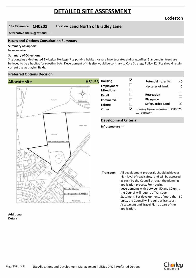
Housing
Employment
Mixed Use
Retail
Commercial
Leisure
Recreation
Safeguarded Land
Preferred Options Decision
Allocate site Potential no. units: 40
Hectares of land: 0
Other Housing figure inclusive of CH0076 and CH0207
Site Reference: CH0201 Land North of Bradley Lane
Eccleston
None received.
Site contains a designated Biological Heritage Site pond- a habitat for rare invertebrates and dragonflies. Surrounding trees are believed to be a habitat for roosting bats. Development of this site would be contrary to Core Strategy Policy 22. Site should retain current use as playing fields.
Summary of Objections
Summary of Support
Alternative site suggestions: ---
DETAILED SITE ASSESSMENT
Location
Development Criteria
Infrastructure ---
Transport: All development proposals should achieve a high level of road safety, and will be assessed as such by the Council through the planning application process. For housing developments with between 50 and 80 units, the Council will require a Transport Statement. For developments of more than 80 units, the Council will require a Transport Assessment and Travel Plan as part of the application.
Additional Details:
Issues and Options Consultation Summary
Playspace
HS1.53
Page 351 of 471 Site Allocations and Development Management Policies DPD | Preferred Options

Sustainability Appraisal
Site Ref CH0201
Address Land North of Bradley Lane, Eccleston
SA Obj
Indicator Site Performance SA Comments
S1
Distance to railway station Ove r 3 km Social This site has good access to some local services and facilities however the site does not have access to a rail service and is over 3kn from the nearest service centre. The site has good access to local convenience stores, post office and a supermarket. Environmental This site is a Greenfield site on an existing safeguarded land designation and is also within a biological/geological heritage site. Economic There are no identified negative economic effects in developing this site.
Rail service frequency No se rvices in settle me nt Distance to ne arest bus stop Up to 0 .4km Bus service frequency 2 -5 /hour/direction Distance to se rvice ce ntre Ove r 3 km Distance to A Road junction 1. 61 to 3 km Distance to motorwa y junction Ove r 3 km Distance to supermarket Up to 0 .4km Distance to convenience store Up to 0 .4km Distance to Post Office Up to 0 .4km Distance to Primary School Up to 0 .4km Distance to Secondary School 3. 21 to 5 km On a cycle route No Distance to cycle route Over 1. 6km
S2
Distance to GP surge ry 0.4 1 to 0. 8km Distance to NH S general hospital 2 .1 to 5km Distance to public open space /park Up to 0 .4km Distance to local ce ntre Up to 0 .4km
EN1
Designation of land Safe guarde d Land Are a of Separation Outside AONB Outside SSSI Outside Biological/ G eological He ri tage Site Within Agricultural classification 3
EN2
Conservation Are a Outside Ancie nt Monument on site No Regis tere d Park or G arden Outside Listed Build ing on site No Locally Listed Building on s ite No
EN3 Curre nt/former land use Greenfield EN4 Flood Zone are a All Zone 1
EN5 Contaminated land No risk Within 3 km of a congestion spot No
EC1 Distance to employme nt site Up to 0 .8km Access to Broadband Yes
EC2 Distance to further/ highe r e ducation Ove r 5 km
De
live
rab
ility
In
dic
ato
rs
Access to sewer system
Yes
Is the site deliverable: Yes Access to water
Access to gas
Access to e lectricity
Exis ting road acce ss
At risk from haza rdous ins tallations No
Overall Site Performance
Band Spe ctrum:
Overall Band:
D
Page 352 of 471 Site Allocations and Development Management Policies DPD | Preferred Options

Housing
Employment
Mixed Use
Retail
Commercial
Leisure
Recreation
Safeguarded Land
Preferred Options Decision
Allocate site Potential no. units: 40
Hectares of land: 0
Other Library
Site Reference: CH0207 Carrington Centre
Eccleston
Request the proposed use is a mix of retail, housing and employment.
Objection to ‘mixed use’- support for employment use only. Allocation appears to fall on an identified textile mill site. Any proposed schemes should assess the impact of development upon known heritage assets.
Summary of Objections
Summary of Support
Alternative site suggestions: CH0076
DETAILED SITE ASSESSMENT
Location
Development Criteria
Infrastructure ---
Transport: All development proposals should achieve a high level of road safety, and will be assessed as such by the Council through the planning application process. Depending on the mix of uses this site is developed for, and depending on the size of the development, the Council will require the submission of either a Transport Statement or Transport Assessment and Travel Plan.
Additional Details:
Site proposal should be considered in conjunction with site suggestion CH0076.
Issues and Options Consultation Summary
Playspace
HS1.53
Page 353 of 471 Site Allocations and Development Management Policies DPD | Preferred Options

Sustainability Appraisal
Site Ref CH0207
Address Land to the East of the Carrington Centre, Eccleston
SA Obj
Indicator Site Performance SA Comments
S1
Distance to railway station Ove r 3 km Social This site has good access to a frequent bus service with services 2-5 times per hour. There is no rail service in the settlement and the site has poor access to an A road junction and motorway junction. The site has good access to all local services and facilities. Environmental The only identified negative environmental effect in developing this site is the site is a Greenfield site. Economic There are no identified negative economic effects in developing this site.
Rail service frequency No se rvices in settle me nt Distance to ne arest bus stop Up to 0 .4km Bus service frequency 2 -5 /hour/direction Distance to se rvice ce ntre Ove r 3 km Distance to A Road junction 1. 61 to 3 km Distance to motorwa y junction Ove r 3 km Distance to supermarket Up to 0 .4km Distance to convenience store Up to 0 .4km Distance to Post Office Up to 0 .4km Distance to Primary School Up to 0 .4km Distance to Secondary School 3. 21 to 5 km On a cycle route No Distance to cycle route Over 1. 6km
S2
Distance to GP surge ry Up to 0 .4km Distance to NH S general hospital 2 .1 to 5km Distance to public open space /park Up to 0 .4km Distance to local ce ntre Up to 0 .4km
EN1
Designation of land Part Safe guarde d La nd Are a of Separation Outside AONB Outside SSSI Outside Biological/ G eological He ri tage Site Outside Agricultural classification 3
EN2
Conservation Are a Outside Ancie nt Monument on site No Regis tere d Park or G arden Outside Listed Build ing on site No Locally Listed Building on s ite No
EN3 Curre nt/former land use Brownfield/Gree nfield EN4 Flood Zone are a All Zone 1
EN5 Contaminated land No risk Within 3 km of a congestion spot No
EC1 Distance to employme nt site Up to 0 .8km Access to Broadband Yes
EC2 Distance to further/ highe r e ducation Ove r 5 km
De
live
rab
ility
In
dic
ato
rs
Access to sewer system
Yes
Is the site deliverable: Yes Access to water
Access to gas
Access to e lectricity
Exis ting road acce ss
At risk from haza rdous ins tallations No
Overall Site Performance
Band Spe ctrum:
Overall Band:
C
Page 354 of 471 Site Allocations and Development Management Policies DPD | Preferred Options

Housing
Employment
Mixed Use
Retail
Commercial
Leisure
Recreation
Safeguarded Land
Preferred Options Decision
Allocate site Potential no. units: 9
Hectares of land: 0
Other
Site Reference: CH0224 75 Towngate
Eccleston
None received.
None received.Summary of Objections
Summary of Support
Alternative site suggestions: CH0148
DETAILED SITE ASSESSMENT
Location
Development Criteria
Infrastructure ---
Transport: All development proposals should achieve a high level of road safety, and will be assessed as such by the Council through the planning application process. For housing developments with between 50 and 80 units, the Council will require a Transport Statement. For developments of more than 80 units, the Council will require a Transport Assessment and Travel Plan as part of the application.
Additional Details:
Site proposal should be considered in conjunction with site suggestion CH0148.
Issues and Options Consultation Summary
Playspace
HS1.52
Page 355 of 471 Site Allocations and Development Management Policies DPD | Preferred Options

Sustainability Appraisal
Site Ref CH0224
Address 75 Towngate, Eccleston
SA Obj
Indicator Site Performance SA Comments
S1
Distance to railway station Ove r 3 km Social This site has good access to a frequent bus service with services 2-5 times per hour. There is no rail service in the settlement and the site has poor access to an A road junction and motorway junction. The site has good access to all local services and facilities. Environmental The only identified negative environmental effect in developing this site is the site is a Greenfield site. Economic There are no identified negative economic effects in developing this site.
Rail service frequency No se rvices in settle me nt Distance to ne arest bus stop Up to 0 .4km Bus service frequency 2 -5 /hour/direction Distance to se rvice ce ntre Ove r 3 km Distance to A Road junction 0.8 1 to 1. 6km Distance to motorwa y junction Ove r 3 km Distance to supermarket 0.4 1 to 0. 8km Distance to convenience store 0.4 1 to 0. 8km Distance to Post Office 0.4 1 to 0. 8km Distance to Primary School 0.4 1 to 0. 8km Distance to Secondary School 3. 21 to 5 km On a cycle route No Distance to cycle route Over 1. 6km
S2
Distance to GP surge ry 0.4 1 to 0. 8km Distance to NH S general hospital 2 .1 to 5km Distance to public open space /park Up to 0 .4km Distance to local ce ntre 0.4 1 to 0. 8km
EN1
Designation of land Rural Local Se rvice Ce ntre Are a of Separation Outside AONB Outside SSSI Outside Biological/ G eological He ri tage Site Outside Agricultural classification 2
EN2
Conservation Are a Outside Ancie nt Monument on site No Regis tere d Park or G arden Outside Listed Build ing on site No Locally Listed Building on s ite No
EN3 Curre nt/former land use Greenfield EN4 Flood Zone are a All Zone 1
EN5 Contaminated land No risk Within 3 km of a congestion spot No
EC1 Distance to employme nt site 1.2 1 to 1. 6km Access to Broadband Yes
EC2 Distance to further/ highe r e ducation Ove r 5 km
De
live
rab
ility
In
dic
ato
rs
Access to sewer system
Yes
Is the site deliverable: Yes Access to water
Access to gas
Access to e lectricity
Exis ting road acce ss
At risk from haza rdous ins tallations No
Overall Site Performance
Band Spe ctrum:
Overall Band:
C
Page 356 of 471 Site Allocations and Development Management Policies DPD | Preferred Options
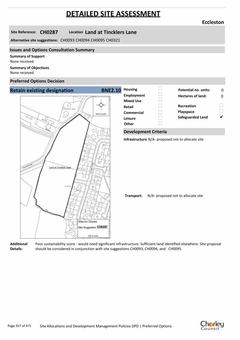
Housing
Employment
Mixed Use
Retail
Commercial
Leisure
Recreation
Safeguarded Land
Preferred Options Decision
Retain existing designation Potential no. units: 0
Hectares of land: 0
Other
Site Reference: CH0287 Land at Tincklers Lane
Eccleston
None received.
None received.Summary of Objections
Summary of Support
Alternative site suggestions: CH0093 CH0094 CH0095 CH0321
DETAILED SITE ASSESSMENT
Location
Development Criteria
Infrastructure N/A- proposed not to allocate site
Transport: N/A- proposed not to allocate site
Additional Details:
Poor sustainability score - would need significant infrastructure. Sufficient land identified elsewhere. Site proposal should be considered in conjunction with site suggestions CH0093, CH0094, and CH0095.
Issues and Options Consultation Summary
Playspace
BNE2.10
Page 357 of 471 Site Allocations and Development Management Policies DPD | Preferred Options

Sustainability Appraisal
Site Ref CH0287
Address Land at Tincklers Lane, Eccleston
SA Obj
Indicator Site Performance SA Comments
S1
Distance to railway station Ove r 3 km Social This site has good access to some local services and facilities however the site does not have access to a rail service and is over 3kn from the nearest service centre. The site has good access to local convenience stores, post office and a supermarket. Environmental This site is a Greenfield site on an existing safeguarded land designation with a medium risk of land contamination. Economic There are no identified negative economic effects in developing this site.
Rail service frequency No se rvices in settle me nt Distance to ne arest bus stop Up to 0 .4km Bus service frequency 2 -5 /hour/direction Distance to se rvice ce ntre Ove r 3 km Distance to A Road junction 0.8 1 to 1. 6km Distance to motorwa y junction Ove r 3 km Distance to supermarket 0.4 1 to 0. 8km Distance to convenience store 0.4 1 to 0. 8km Distance to Post Office 0.4 1 to 0. 8km Distance to Primary School 0.4 1 to 0. 8km Distance to Secondary School 3. 21 to 5 km On a cycle route No Distance to cycle route Over 1. 6km
S2
Distance to GP surge ry 0.4 1 to 0. 8km Distance to NH S general hospital 2 .1 to 5km Distance to public open space /park Up to 0 .4km Distance to local ce ntre 0.8 1 to 1. 2km
EN1
Designation of land Safe guarde d Land Are a of Separation Outside AONB Outside SSSI Outside Biological/ G eological He ri tage Site Outside Agricultural classification 2
EN2
Conservation Are a Outside Ancie nt Monument on site No Regis tere d Park or G arden Outside Listed Build ing on site No Locally Listed Building on s ite No
EN3 Curre nt/former land use Greenfield EN4 Flood Zone are a All Zone 1
EN5 Contaminated land Me dium risk Within 3 km of a congestion spot No
EC1 Distance to employme nt site 1.2 1 to 1. 6km Access to Broadband Yes
EC2 Distance to further/ highe r e ducation Ove r 5 km
De
live
rab
ility
In
dic
ato
rs
Access to sewer system
Yes
Is the site deliverable: Yes Access to water
Access to gas
Access to e lectricity
Exis ting road acce ss
At risk from haza rdous ins tallations No
Overall Site Performance
Band Spe ctrum:
Overall Band:
D
Page 358 of 471 Site Allocations and Development Management Policies DPD | Preferred Options

Housing
Employment
Mixed Use
Retail
Commercial
Leisure
Recreation
Safeguarded Land
Preferred Options Decision
Allocate site Potential no. units: 70
Hectares of land: 0
Other
Site Reference: CH0304 Sagar House
Eccleston
None received.
Planning permission has been granted for residential redevelopment and it follows that the site allocation should reflect the permitted residential use. Site is known to contain at least one heritage asset. Any proposed scheme should assess the impacts of development upon the known assets.
Summary of Objections
Summary of Support
Alternative site suggestions: CH0077
DETAILED SITE ASSESSMENT
Location
Development Criteria
Infrastructure Site already has planning permission. Water Cycle Study: Site specific FRA required to check flood zones. Surface water should not be routed to wastewater network. All developments in the Croston Wastewater Treatment Works catchment need to be assessed by UU. Attenuation SUDS most likely to be viable, however needs detailed check. Need agreement from EA regarding attenuating to watercourses.
Transport: All development proposals should achieve a high level of road safety, and will be assessed as such by the Council through the planning application process. As this site already has planning permission, the relevant Transport Statement/Assessment has already been submitted to, and approved by the Council.
Additional Details:
Site already has planning permission. Site should be considered in conjunction with CH0077.
Issues and Options Consultation Summary
Playspace
HS1.54
Page 359 of 471 Site Allocations and Development Management Policies DPD | Preferred Options
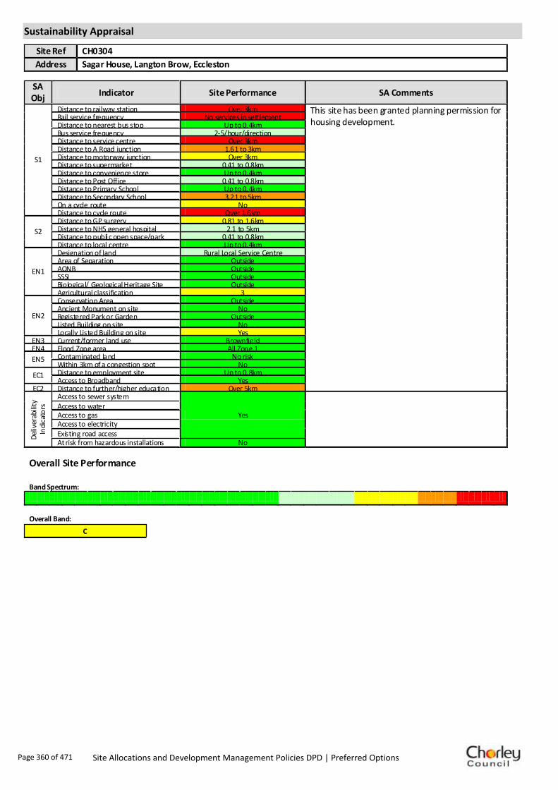
Sustainability Appraisal
Site Ref CH0304
Address Sagar House, Langton Brow, Eccleston
SA Obj
Indicator Site Performance SA Comments
S1
Distance to railway station Over 3km This site has been granted planning permission for housing development.
Rail service frequency No services in settlement Distance to nearest bus stop Up to 0.4km Bus service frequency 2-5/hour/direction Distance to service centre Over 3km Distance to A Road junction 1.61 to 3km Distance to motorway junction Over 3km Distance to supermarket 0.41 to 0.8km Distance to convenience store Up to 0.4km Distance to Post Office 0.41 to 0.8km Distance to Primary School Up to 0.4km Distance to Secondary School 3.21 to 5km On a cycle route No Distance to cycle route Over 1.6km
S2
Distance to GP surgery 0.81 to 1.6km Distance to NHS general hospital 2.1 to 5km Distance to public open space/park 0.41 to 0.8km Distance to local centre Up to 0.4km
EN1
Designation of land Rural Local Service Centre Area of Separation Outside AONB Outside SSSI Outside Biological/ Geological Heritage Site Outside Agricultural classification 3
EN2
Conservation Area Outside Ancient Monument on site No Registered Park or Garden Outside Listed Building on site No Locally Listed Building on site Yes
EN3 Current/former land use Brownfield EN4 Flood Zone area All Zone 1
EN5 Contaminated land No risk Within 3km of a congestion spot No
EC1 Distance to employment site Up to 0.8km Access to Broadband Yes
EC2 Distance to further/higher education Over 5km
Del
iver
abili
ty
Indi
cato
rs
Access to sewer system
Yes
Access to water
Access to gas Access to electricity Existing road access At risk from hazardous installations No
Overall Site Performance Band Spectrum:
Overall Band:
C
Page 360 of 471 Site Allocations and Development Management Policies DPD | Preferred Options

Housing
Employment
Mixed Use
Retail
Commercial
Leisure
Recreation
Safeguarded Land
Preferred Options Decision
Undecided Potential no. units: 0
Hectares of land: 0
Other Suggested recreation allocation. Await results of Open Space Study.
Site Reference: CH0315 Land between Bannisters Lane and Tincklers Lane
Eccleston
None received.
None received.Summary of Objections
Summary of Support
Alternative site suggestions: ---
DETAILED SITE ASSESSMENT
Location
Development Criteria
Infrastructure ---
Transport: ---
Additional Details:
It has been suggested that this site be allocated for recreation use. Until the results of the Open Space Study are received, no decisions will be made as to the allocation or otherwise of this site.
Issues and Options Consultation Summary
Playspace
Page 361 of 471 Site Allocations and Development Management Policies DPD | Preferred Options

Sustainability Appraisal
No sustainability Appraisal has been undertaken of this site suggestion. Until the findings of the
Open Space Study are produced, the Council will not be allocating additional land for recreation
purposes. Once the Study is complete, a decision on the allocation of this site for recreational use
can be made.
Page 362 of 471 Site Allocations and Development Management Policies DPD | Preferred Options

Housing
Employment
Mixed Use
Retail
Commercial
Leisure
Recreation
Safeguarded Land
Preferred Options Decision
Undecided Potential no. units: 0
Hectares of land: 0
Other Suggested recreation allocation. Await results of Open Space Study.
Site Reference: CH0316 Land between Bradley Lane and Parr Lane
Eccleston
None received.
It is suggested that this site be allocated for housing as it is in a very sustainable location. It may be appropriate to phase its release for the 5-10 or 11-15 year period of the plan.
Summary of Objections
Summary of Support
Alternative site suggestions: ---
DETAILED SITE ASSESSMENT
Location
Development Criteria
Infrastructure ---
Transport: ---
Additional Details:
It has been suggested that this site be allocated for recreation use. Until the results of the Open Space Study are received, no decisions will be made as to the allocation or otherwise of this site.
Issues and Options Consultation Summary
Playspace
Page 363 of 471 Site Allocations and Development Management Policies DPD | Preferred Options

Sustainability Appraisal
No sustainability Appraisal has been undertaken of this site suggestion. Until the findings of the
Open Space Study are produced, the Council will not be allocating additional land for recreation
purposes. Once the Study is complete, a decision on the allocation of this site for recreational use
can be made.
Page 364 of 471 Site Allocations and Development Management Policies DPD | Preferred Options

Housing
Employment
Mixed Use
Retail
Commercial
Leisure
Recreation
Safeguarded Land
Preferred Options Decision
Allocate site Potential no. units: 0
Hectares of land: 0
Other It is proposed to bring forward all existing play space allocations.
Site Reference: CH0317 Fields between Bradley Lane and Drapers Ave
Eccleston
Site is part of an integral sports facility put to intensive use by the local community. Reduction of this facility would be detrimental. Retain as recreation.
None received.Summary of Objections
Summary of Support
Alternative site suggestions: ---
DETAILED SITE ASSESSMENT
Location
Development Criteria
Infrastructure ---
Transport: ---
Additional Details:
Site is being rolled forward from the existing Local Plan as a future playspace. Await results of Open Space Study before any sites are reviewed.
Issues and Options Consultation Summary
Playspace
HW1.32
Page 365 of 471 Site Allocations and Development Management Policies DPD | Preferred Options

Sustainability Appraisal
No sustainability Appraisal has been undertaken of this site suggestion. Until the findings of the
Open Space Study are produced, the Council will be rolling forward all future playspace allocations
from the existing Local Plan.
Page 366 of 471 Site Allocations and Development Management Policies DPD | Preferred Options
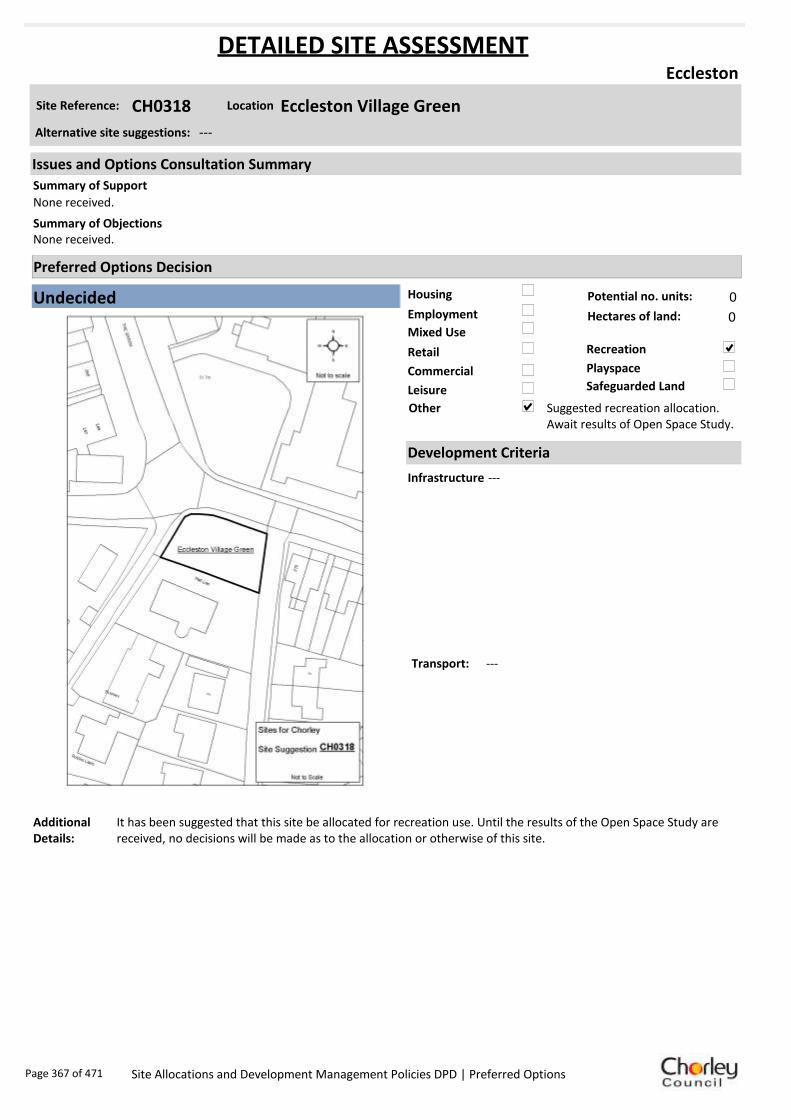
Housing
Employment
Mixed Use
Retail
Commercial
Leisure
Recreation
Safeguarded Land
Preferred Options Decision
Undecided Potential no. units: 0
Hectares of land: 0
Other Suggested recreation allocation. Await results of Open Space Study.
Site Reference: CH0318 Eccleston Village Green
Eccleston
None received.
None received.Summary of Objections
Summary of Support
Alternative site suggestions: ---
DETAILED SITE ASSESSMENT
Location
Development Criteria
Infrastructure ---
Transport: ---
Additional Details:
It has been suggested that this site be allocated for recreation use. Until the results of the Open Space Study are received, no decisions will be made as to the allocation or otherwise of this site.
Issues and Options Consultation Summary
Playspace
Page 367 of 471 Site Allocations and Development Management Policies DPD | Preferred Options

Sustainability Appraisal
No sustainability Appraisal has been undertaken of this site suggestion. Until the findings of the
Open Space Study are produced, the Council will not be allocating additional land for recreation
purposes. Once the Study is complete, a decision on the allocation of this site for recreational use
can be made.
Page 368 of 471 Site Allocations and Development Management Policies DPD | Preferred Options

Housing
Employment
Mixed Use
Retail
Commercial
Leisure
Recreation
Safeguarded Land
Preferred Options Decision
Undecided Potential no. units: 0
Hectares of land: 0
Other Suggested recreation allocation. Await results of Open Space Study.
Site Reference: CH0319 The Hawthorns Play Area
Eccleston
None received.
None received.Summary of Objections
Summary of Support
Alternative site suggestions: ---
DETAILED SITE ASSESSMENT
Location
Development Criteria
Infrastructure ---
Transport: ---
Additional Details:
It has been suggested that this site be allocated for recreation use. Until the results of the Open Space Study are received, no decisions will be made as to the allocation or otherwise of this site.
Issues and Options Consultation Summary
Playspace
Page 369 of 471 Site Allocations and Development Management Policies DPD | Preferred Options

Sustainability Appraisal
No sustainability Appraisal has been undertaken of this site suggestion. Until the findings of the
Open Space Study are produced, the Council will not be allocating additional land for recreation
purposes. Once the Study is complete, a decision on the allocation of this site for recreational use
can be made.
Page 370 of 471 Site Allocations and Development Management Policies DPD | Preferred Options

Housing
Employment
Mixed Use
Retail
Commercial
Leisure
Recreation
Safeguarded Land
Preferred Options Decision
Undecided Potential no. units: 0
Hectares of land: 0
Other Suggested recreation allocation. Await results of Open Space Study.
Site Reference: CH0320 Middlewood Close Play Area
Eccleston
None received.
None received.Summary of Objections
Summary of Support
Alternative site suggestions: ---
DETAILED SITE ASSESSMENT
Location
Development Criteria
Infrastructure ---
Transport: ---
Additional Details:
It has been suggested that this site be allocated for recreation use. Until the results of the Open Space Study are received, no decisions will be made as to the allocation or otherwise of this site.
Issues and Options Consultation Summary
Playspace
Page 371 of 471 Site Allocations and Development Management Policies DPD | Preferred Options

Sustainability Appraisal
No sustainability Appraisal has been undertaken of this site suggestion. Until the findings of the
Open Space Study are produced, the Council will not be allocating additional land for recreation
purposes. Once the Study is complete, a decision on the allocation of this site for recreational use
can be made.
Page 372 of 471 Site Allocations and Development Management Policies DPD | Preferred Options
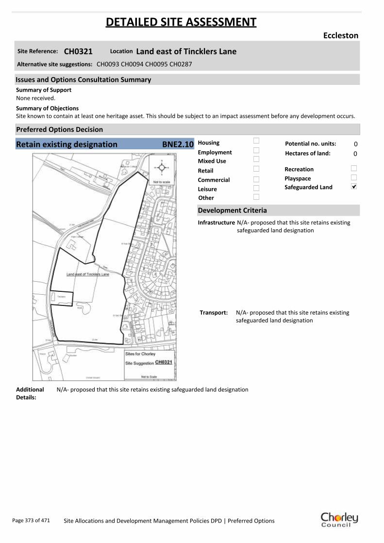
Housing
Employment
Mixed Use
Retail
Commercial
Leisure
Recreation
Safeguarded Land
Preferred Options Decision
Retain existing designation Potential no. units: 0
Hectares of land: 0
Other
Site Reference: CH0321 Land east of Tincklers Lane
Eccleston
None received.
Site known to contain at least one heritage asset. This should be subject to an impact assessment before any development occurs.Summary of Objections
Summary of Support
Alternative site suggestions: CH0093 CH0094 CH0095 CH0287
DETAILED SITE ASSESSMENT
Location
Development Criteria
Infrastructure N/A- proposed that this site retains existing safeguarded land designation
Transport: N/A- proposed that this site retains existing safeguarded land designation
Additional Details:
N/A- proposed that this site retains existing safeguarded land designation
Issues and Options Consultation Summary
Playspace
BNE2.10
Page 373 of 471 Site Allocations and Development Management Policies DPD | Preferred Options
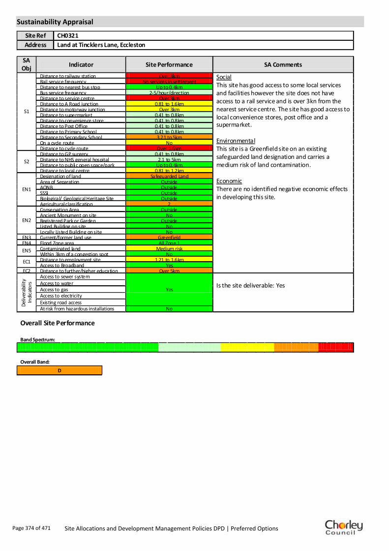
Sustainability Appraisal
Site Ref CH0321
Address Land at Tincklers Lane, Eccleston
SA Obj
Indicator Site Performance SA Comments
S1
Distance to railway station Over 3km Social This site has good access to some local services and facilities however the site does not have access to a rail service and is over 3kn from the nearest service centre. The site has good access to local convenience stores, post office and a supermarket. Environmental This site is a Greenfield site on an existing safeguarded land designation and carries a medium risk of land contamination. Economic There are no identified negative economic effects in developing this site.
Rail service frequency No services in settlement Distance to nearest bus stop Up to 0.4km Bus service frequency 2-5/hour/direction Distance to service centre Over 3km Distance to A Road junction 0.81 to 1.6km Distance to motorway junction Over 3km Distance to supermarket 0.41 to 0.8km Distance to convenience store 0.41 to 0.8km Distance to Post Office 0.41 to 0.8km Distance to Primary School 0.41 to 0.8km Distance to Secondary School 3.21 to 5km On a cycle route No Distance to cycle route Over 1.6km
S2
Distance to GP surgery 0.41 to 0.8km Distance to NHS general hospital 2.1 to 5km Distance to public open space/park Up to 0.4km Distance to local centre 0.81 to 1.2km
EN1
Designation of land Safeguarded Land Area of Separation Outside AONB Outside SSSI Outside Biological/ Geological Heritage Site Outside Agricultural classification 2
EN2
Conservation Area Outside Ancient Monument on site No Registered Park or Garden Outside Listed Building on site No Locally Listed Building on site No
EN3 Current/former land use Greenfield EN4 Flood Zone area All Zone 1
EN5 Contaminated land Medium risk Within 3km of a congestion spot No
EC1 Distance to employment site 1.21 to 1.6km Access to Broadband Yes
EC2 Distance to further/higher education Over 5km
Del
iver
abili
ty
Indi
cato
rs
Access to sewer system
Yes
Is the site deliverable: Yes Access to water
Access to gas Access to electricity Existing road access At risk from hazardous installations No
Overall Site Performance Band Spectrum:
Overall Band:
D
Page 374 of 471 Site Allocations and Development Management Policies DPD | Preferred Options

Housing
Employment
Mixed Use
Retail
Commercial
Leisure
Recreation
Safeguarded Land
Preferred Options Decision
Undecided Potential no. units: 0
Hectares of land: 0
Other Suggested recreation allocation. Await results of Open Space Study.
Site Reference: CH0322 Millennium Green
Eccleston
None received.
None received.Summary of Objections
Summary of Support
Alternative site suggestions: ---
DETAILED SITE ASSESSMENT
Location
Development Criteria
Infrastructure ---
Transport: ---
Additional Details:
It has been suggested that this site be allocated for recreation use. Until the results of the Open Space Study are received, no decisions will be made as to the allocation or otherwise of this site.
Issues and Options Consultation Summary
Playspace
Page 375 of 471 Site Allocations and Development Management Policies DPD | Preferred Options

Sustainability Appraisal
No sustainability Appraisal has been undertaken of this site suggestion. Until the findings of the
Open Space Study are produced, the Council will not be allocating additional land for recreation
purposes. Once the Study is complete, a decision on the allocation of this site for recreational use
can be made.
Page 376 of 471 Site Allocations and Development Management Policies DPD | Preferred Options

Housing
Employment
Mixed Use
Retail
Commercial
Leisure
Recreation
Safeguarded Land
Preferred Options Decision
Undecided Potential no. units: 0
Hectares of land: 0
Other Suggested recreation allocation. Await results of Open Space Study.
Site Reference: CH0323 Land off the Hawthorns
Eccleston
None received.
None received.Summary of Objections
Summary of Support
Alternative site suggestions: ---
DETAILED SITE ASSESSMENT
Location
Development Criteria
Infrastructure ---
Transport: ---
Additional Details:
It has been suggested that this site be allocated for recreation use. Until the results of the Open Space Study are received, no decisions will be made as to the allocation or otherwise of this site.
Issues and Options Consultation Summary
Playspace
Page 377 of 471 Site Allocations and Development Management Policies DPD | Preferred Options

Sustainability Appraisal
No sustainability Appraisal has been undertaken of this site suggestion. Until the findings of the
Open Space Study are produced, the Council will not be allocating additional land for recreation
purposes. Once the Study is complete, a decision on the allocation of this site for recreational use
can be made.
Page 378 of 471 Site Allocations and Development Management Policies DPD | Preferred Options

Housing
Employment
Mixed Use
Retail
Commercial
Leisure
Recreation
Safeguarded Land
Preferred Options Decision
Retain existing designation Potential no. units: 0
Hectares of land: 0
Other
Site Reference: CS0012 Land off Bradley Lane
Eccleston
None received.
Site is part of an integral sports and leisure facility, put to intensive use by the community. Should be retained for recreational use. Doctor’s surgeries and schools are already oversubscribed- cannot cope with further development.
Summary of Objections
Summary of Support
Alternative site suggestions: ---
DETAILED SITE ASSESSMENT
Location
Development Criteria
Infrastructure N/A- proposed to retain existing safeguarded land designation
Transport: N/A- proposed to retain existing safeguarded land designation
Additional Details:
Poor sustainability score. Sagar House as an existing employment site was not viable or suitable for continuing employment use, so unlikely to be necessary to allocate further land for employment in Eccleston. Outside planning application for Carrington Centre, but adjacent. No interest. Sufficient land identified elsewhere.
Issues and Options Consultation Summary
Playspace
BNE2.11
Page 379 of 471 Site Allocations and Development Management Policies DPD | Preferred Options

Sustainability Appraisal
Site Ref CS0012
Address Land at Tincklers Lane, Eccleston
SA Obj
Indicator Site Performance SA Comments
S1
Distance to railway station Ove r 3 km Social This site has good access to some local services and facilities however the site does not have access to a rail service and is over 3kn from the nearest service centre. The site has good access to local convenience stores, post office and a supermarket. Environmental This site is a Greenfield site on an existing safeguarded land designation. Economic There are no identified negative economic effects in developing this site.
Rail service frequency No se rvices in settle me nt Distance to ne arest bus stop Up to 0 .4km Bus service frequency 2 -5 /hour/direction Distance to se rvice ce ntre Ove r 3 km Distance to A Road junction 1. 61 to 3 km Distance to motorwa y junction Ove r 3 km Distance to supermarket Up to 0 .4km Distance to convenience store Up to 0 .4km Distance to Post Office Up to 0 .4km Distance to Primary School Up to 0 .4km Distance to Secondary School 3. 21 to 5 km On a cycle route No Distance to cycle route Over 1. 6km
S2
Distance to GP surge ry 0.4 1 to 0. 8km Distance to NH S general hospital 2 .1 to 5km Distance to public open space /park Up to 0 .4km Distance to local ce ntre Up to 0 .4km
EN1
Designation of land Safe guarde d Land Are a of Separation Outside AONB Outside SSSI Outside Biological/ G eological He ri tage Site Outside Agricultural classification 3
EN2
Conservation Are a Outside Ancie nt Monument on site No Regis tere d Park or G arden Outside Listed Build ing on site No Locally Listed Building on s ite No
EN3 Curre nt/former land use Greenfield EN4 Flood Zone are a All Zone 1
EN5 Contaminated land No risk Within 3 km of a congestion spot No
EC1 Distance to employme nt site Up to 0 .8km Access to Broadband Yes
EC2 Distance to further/ highe r e ducation Ove r 5 km
De
live
rab
ility
In
dic
ato
rs
Access to sewer system
Yes
Is the site deliverable: Yes Access to water
Access to gas
Access to e lectricity
Exis ting road acce ss
At risk from haza rdous ins tallations No
Overall Site Performance
Band Spe ctrum:
Overall Band:
D
Page 380 of 471 Site Allocations and Development Management Policies DPD | Preferred Options

Housing
Employment
Mixed Use
Retail
Commercial
Leisure
Recreation
Safeguarded Land
Preferred Options Decision
Allocate site Potential no. units: 26
Hectares of land: 0
Other
Site Reference: CH0062 Land bounded by Dunrobin Drive/West Coast Mainline/Riv
Euxton
Wildlife habitat would be preserved and protected. Footpath links would remove traffic concerns. Yarrow Valley extension would safeguard the land for future generations. Well managed formal recreation i.e. small playing field, could be acceptable.
Access road is narrow and only just able to deal with current traffic levels. The near by junction is very busy at peak times.Summary of Objections
Summary of Support
Alternative site suggestions: CH0230 CH0295
DETAILED SITE ASSESSMENT
Location
Development Criteria
Infrastructure ---
Transport: All development proposals should achieve a high level of road safety, and will be assessed as such by the Council through the planning application process. For housing developments with between 50 and 80 units, the Council will require a Transport Statement. For developments of more than 80 units, the Council will require a Transport Assessment and Travel Plan as part of the application.
Additional Details:
It has been suggested that this site be allocated for recreation use. Until the results of the Open Space Study are received, no decisions will be made as to the allocation or otherwise of this site.
Issues and Options Consultation Summary
Playspace
HS1.42
Page 381 of 471 Site Allocations and Development Management Policies DPD | Preferred Options

Sustainability Appraisal
No sustainability Appraisal has been undertaken of this site suggestion. Until the findings of the
Open Space Study are produced, the Council will not be allocating additional land for recreation
purposes. Once the Study is complete, a decision on the allocation of this site for recreational use
can be made.
Page 382 of 471 Site Allocations and Development Management Policies DPD | Preferred Options
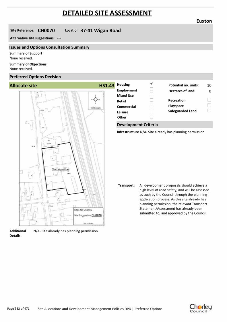
Housing
Employment
Mixed Use
Retail
Commercial
Leisure
Recreation
Safeguarded Land
Preferred Options Decision
Allocate site Potential no. units: 10
Hectares of land: 0
Other
Site Reference: CH0070 37-41 Wigan Road
Euxton
None received.
None received.Summary of Objections
Summary of Support
Alternative site suggestions: ---
DETAILED SITE ASSESSMENT
Location
Development Criteria
Infrastructure N/A- Site already has planning permission
Transport: All development proposals should achieve a high level of road safety, and will be assessed as such by the Council through the planning application process. As this site already has planning permission, the relevant Transport Statement/Assessment has already been submitted to, and approved by the Council.
Additional Details:
N/A- Site already has planning permission
Issues and Options Consultation Summary
Playspace
HS1.43
Page 383 of 471 Site Allocations and Development Management Policies DPD | Preferred Options

Sustainability Appraisal
Site Ref CH0070
Address 37-41 Wigan Road, Euxton
SA Obj
Indicator Site Performance SA Comments
S1
Distance to railway station 1.6 1 to 2. 4km This site has been given planning permission for housing development.
Rail service frequency 2-3 trains/hour per direction Distance to ne arest bus stop Up to 0 .4km Bus service frequency Le ss than 1/hour/ direction Distance to se rvice ce ntre 2. 41 to 3 km Distance to A Road junction Up to 0 .4km Distance to motorwa y junction 1. 61 to 3 km Distance to supermarket 1. 61 to 3 km Distance to convenience store 0.4 1 to 0. 8km Distance to Post Office 0.4 1 to 0. 8km Distance to Primary School 0.8 1 to 1. 6km Distance to Secondary School 3. 21 to 5 km On a cycle route No Distance to cycle route 0.8 1 to 1. 2km
S2
Distance to GP surge ry 0.4 1 to 0. 8km Distance to NH S general hospital 2 .1 to 5km Distance to public open space /park Up to 0 .4km Distance to local ce ntre 0.4 1 to 0. 8km
EN1
Designation of land Urban Local Service Centre Are a of Separation Outside AONB Outside SSSI Outside Biological/ G eological He ri tage Site Outside Agricultural classification None
EN2
Conservation Are a Outside Ancie nt Monument on site No Regis tere d Park or G arden Outside Listed Build ing on site No Locally Listed Building on s ite No
EN3 Curre nt/former land use Brownfield EN4 Flood Zone are a All Zone 1
EN5 Contaminated land No risk Within 3 km of a congestion spot Yes
EC1 Distance to employme nt site 0.8 1 to 1. 2km Access to Broadband Yes
EC2 Distance to further/ highe r e ducation Up to 1 .6km
De
live
rab
ility
In
dic
ato
rs
Access to sewer system
Yes
Is the site deliverable: Yes/No Access to water
Access to gas
Access to e lectricity
Exis ting road acce ss
At risk from haza rdous ins tallations No
Overall Site Performance
Band Spe ctrum:
Overall Band:
B
Page 384 of 471 Site Allocations and Development Management Policies DPD | Preferred Options

Housing
Employment
Mixed Use
Retail
Commercial
Leisure
Recreation
Safeguarded Land
Preferred Options Decision
Allocate site Potential no. units: 248
Hectares of land: 3
Other
Site Reference: CH0078 Land to the South of Euxton Lane
Euxton
None received.
Development would create traffic problems on School Lane, Pear Tree Lane, and Euxton Lane. Already sufficient housing/employment area at Buckshaw Village/ Matrix Park. The area should be designated as Green Belt, to accord with Policy 19 of the Core Strategy.
Summary of Objections
Summary of Support
Alternative site suggestions: CH0160 CH0262 CH0264 CH0297
DETAILED SITE ASSESSMENT
Location
Development Criteria
Infrastructure Water Cycle Study: Favourable location for development if agreement is reached on connection point to wastewater network. Agreement with EA required on attenuating runoff to nearby watercourses.
Transport: All development proposals should achieve a high level of road safety, and will be assessed as such by the Council through the planning application process. Depending on the mix of uses this site is developed for, and depending on the size of the development, the Council will require the submission of either a Transport Statement or Transport Assessment and Travel Plan.
Additional Details:
Site proposals should be considered in conjunction with site suggestions CH0160, CH0262, and CH0264.
Issues and Options Consultation Summary
Playspace
HS1.41; EP1.21
Page 385 of 471 Site Allocations and Development Management Policies DPD | Preferred Options

Sustainability Appraisal
Site Ref CH0078
Address Land to the South of Euxton Lane/Pear Tree Lane
SA Obj
Indicator Site Performance SA Comments
S1
Distance to railway station Up to 0 .8km Social This site has good access to public transport with frequent bus and rail services. The site has good access to all local services and facilities. The site has good road link and is close to the motorway junction. Environmental This site is currently designated safeguarded land, part of the site is urban greenspace and the site has a Grade II listed building within the boundary. Economic There are no identified negative economic effects in developing this site.
Rail service frequency 2-3 trains/hour per direction Distance to ne arest bus stop Up to 0 .4km Bus service frequency 2 -5 /hour/direction Distance to se rvice ce ntre 2. 41 to 3 km Distance to A Road junction Up to 0 .4km Distance to motorwa y junction 1. 61 to 3 km Distance to supermarket 0.8 1 to 1. 6km Distance to convenience store 0.4 1 to 0. 8km Distance to Post Office 0.4 1 to 0. 8km Distance to Primary School 0.4 1 to 0. 8km Distance to Secondary School 1.6 1 to 3. 2km On a cycle route Yes Distance to cycle route Up to 0 .4km
S2
Distance to GP surge ry Up to 0 .4km Distance to NH S general hospital 2 .1 to 5km Distance to public open space /park Up to 0 .4km Distance to local ce ntre 0.4 1 to 0. 8km
EN1
Designation of land Safe guarde d Land Are a of Separation Outside AONB Outside SSSI Outside Biological/ G eological He ri tage Site Outside Agricultural classification 3
EN2
Conservation Are a Outside Ancie nt Monument on site No Regis tere d Park or G arden Outside Listed Build ing on site Grade II Locally Listed Building on s ite No
EN3 Curre nt/former land use Urban Gree nspace EN4 Flood Zone are a All Zone 1
EN5 Contaminated land No risk Within 3 km of a congestion spot Yes
EC1 Distance to employme nt site Up to 0 .8km Access to Broadband Yes
EC2 Distance to further/ highe r e ducation Up to 1 .6km
De
live
rab
ility
In
dic
ato
rs
Access to sewer system
Yes
Is the site deliverable: Yes Access to water
Access to gas
Access to e lectricity
Exis ting road acce ss
At risk from haza rdous ins tallations No
Overall Site Performance
Band Spe ctrum:
Overall Band:
B
Page 386 of 471 Site Allocations and Development Management Policies DPD | Preferred Options
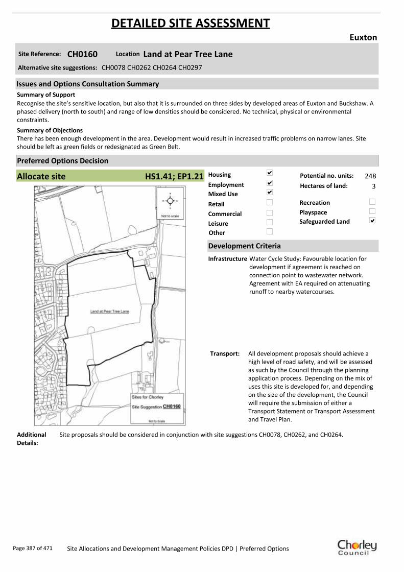
Housing
Employment
Mixed Use
Retail
Commercial
Leisure
Recreation
Safeguarded Land
Preferred Options Decision
Allocate site Potential no. units: 248
Hectares of land: 3
Other
Site Reference: CH0160 Land at Pear Tree Lane
Euxton
Recognise the site’s sensitive location, but also that it is surrounded on three sides by developed areas of Euxton and Buckshaw. A phased delivery (north to south) and range of low densities should be considered. No technical, physical or environmental constraints.
There has been enough development in the area. Development would result in increased traffic problems on narrow lanes. Site should be left as green fields or redesignated as Green Belt.
Summary of Objections
Summary of Support
Alternative site suggestions: CH0078 CH0262 CH0264 CH0297
DETAILED SITE ASSESSMENT
Location
Development Criteria
Infrastructure Water Cycle Study: Favourable location for development if agreement is reached on connection point to wastewater network. Agreement with EA required on attenuating runoff to nearby watercourses.
Transport: All development proposals should achieve a high level of road safety, and will be assessed as such by the Council through the planning application process. Depending on the mix of uses this site is developed for, and depending on the size of the development, the Council will require the submission of either a Transport Statement or Transport Assessment and Travel Plan.
Additional Details:
Site proposals should be considered in conjunction with site suggestions CH0078, CH0262, and CH0264.
Issues and Options Consultation Summary
Playspace
HS1.41; EP1.21
Page 387 of 471 Site Allocations and Development Management Policies DPD | Preferred Options

Sustainability Appraisal
Site Ref CH0160
Address Land to the South of Euxton Lane/Pear Tree Lane
SA Obj
Indicator Site Performance SA Comments
S1
Distance to railway station Up to 0 .8km Social This site has good access to public transport with frequent bus and rail services. The site has good access to all local services and facilities. The site has good road link and is close to the motorway junction. Environmental This site is currently designated safeguarded land, part of the site is urban greenspace and the site has a Grade II listed building within the boundary. Economic There are no identified negative economic effects in developing this site.
Rail service frequency 2-3 trains/hour per direction Distance to ne arest bus stop Up to 0 .4km Bus service frequency 2 -5 /hour/direction Distance to se rvice ce ntre 2. 41 to 3 km Distance to A Road junction Up to 0 .4km Distance to motorwa y junction 1. 61 to 3 km Distance to supermarket 0.8 1 to 1. 6km Distance to convenience store 0.4 1 to 0. 8km Distance to Post Office 0.4 1 to 0. 8km Distance to Primary School 0.4 1 to 0. 8km Distance to Secondary School 1.6 1 to 3. 2km On a cycle route Yes Distance to cycle route Up to 0 .4km
S2
Distance to GP surge ry Up to 0 .4km Distance to NH S general hospital 2 .1 to 5km Distance to public open space /park Up to 0 .4km Distance to local ce ntre 0.4 1 to 0. 8km
EN1
Designation of land Safe guarde d Land Are a of Separation Outside AONB Outside SSSI Outside Biological/ G eological He ri tage Site Outside Agricultural classification 3
EN2
Conservation Are a Outside Ancie nt Monument on site No Regis tere d Park or G arden Outside Listed Build ing on site Grade II Locally Listed Building on s ite No
EN3 Curre nt/former land use Urban Gree nspace EN4 Flood Zone are a All Zone 1
EN5 Contaminated land No risk Within 3 km of a congestion spot Yes
EC1 Distance to employme nt site Up to 0 .8km Access to Broadband Yes
EC2 Distance to further/ highe r e ducation Up to 1 .6km
De
live
rab
ility
In
dic
ato
rs
Access to sewer system
Yes
Is the site deliverable: Yes Access to water
Access to gas
Access to e lectricity
Exis ting road acce ss
At risk from haza rdous ins tallations No
Overall Site Performance
Band Spe ctrum:
Overall Band:
B
Page 388 of 471 Site Allocations and Development Management Policies DPD | Preferred Options

Housing
Employment
Mixed Use
Retail
Commercial
Leisure
Recreation
Safeguarded Land
Preferred Options Decision
Allocate site Potential no. units: 26
Hectares of land: 0
Other
Site Reference: CH0230 Land at end of Dunrobin Drive
Euxton
None received.
Dunrobin Drive is unsuitable as an access through road, and roads are particularly busy at the A49/A581 junction. Euxton has ‘had its fair share of housing development’. The field is a haven for wildlife, which would be displaced and their habitat destroyed.
Summary of Objections
Summary of Support
Alternative site suggestions: CH0062 CH0295
DETAILED SITE ASSESSMENT
Location
Development Criteria
Infrastructure ---
Transport: All development proposals should achieve a high level of road safety, and will be assessed as such by the Council through the planning application process. For housing developments with between 50 and 80 units, the Council will require a Transport Statement. For developments of more than 80 units, the Council will require a Transport Assessment and Travel Plan as part of the application.
Additional Details:
It has been suggested that this site be allocated for recreation use. Until the results of the Open Space Study are received, no decisions will be made as to the allocation or otherwise of this site.
Issues and Options Consultation Summary
Playspace
HS1.42
Page 389 of 471 Site Allocations and Development Management Policies DPD | Preferred Options

Sustainability Appraisal
Site Ref CH0230
Address Land at end of Dunrobin Drive, Euxton
SA Obj
Indicator Site Performance SA Comments
S1
Distance to railway station Up to 0 .8km Social This site has very good access to public transport with good access to bus and rail links. Rail services are very frequent with 2-3 trains per hour although bus services are poor with a service less than hourly. The site has poor access to all local services and facilities although the site is in close proximity to an A road junction. Environmental This site is a Greenfield site with a current designation as safeguarded land. Economic There are no identified negative economic effects in developing this site.
Rail service frequency 2-3 trains/hour per direction Distance to ne arest bus stop Up to 0 .4km Bus service frequency Le ss than 1/hour/ direction Distance to se rvice ce ntre Ove r 3 km Distance to A Road junction Up to 0 .4km Distance to motorwa y junction Ove r 3 km Distance to supermarket 0.8 1 to 1. 6km Distance to convenience store 0.8 1 to 1. 2km Distance to Post Office 0.8 1 to 1. 2km Distance to Primary School 0.8 1 to 1. 6km Distance to Secondary School 1.6 1 to 3. 2km On a cycle route No Distance to cycle route 0.4 1 to 0. 8km
S2
Distance to GP surge ry 1. 61 to 3 km Distance to NH S general hospital 2 .1 to 5km Distance to public open space /park Up to 0 .4km Distance to local ce ntre 0.8 1 to 1. 2km
EN1
Designation of land Safe guarde d Land Are a of Separation Outside AONB Outside SSSI Outside Biological/ G eological He ri tage Site Outside Agricultural classification 3
EN2
Conservation Are a Outside Ancie nt Monument on site No Regis tere d Park or G arden Outside Listed Build ing on site No Locally Listed Building on s ite No
EN3 Curre nt/former land use Greenfield EN4 Flood Zone are a All Zone 1
EN5 Contaminated land No risk Within 3 km of a congestion spot Yes
EC1 Distance to employme nt site Over 1. 6km Access to Broadband Yes
EC2 Distance to further/ highe r e ducation 1.6 1 to 3. 2km
De
live
rab
ility
In
dic
ato
rs
Access to sewer system
Yes
Is the site deliverable: Yes Access to water
Access to gas
Access to e lectricity
Exis ting road acce ss
At risk from haza rdous ins tallations No
Overall Site Performance
Band Spe ctrum:
Overall Band:
C
Page 390 of 471 Site Allocations and Development Management Policies DPD | Preferred Options
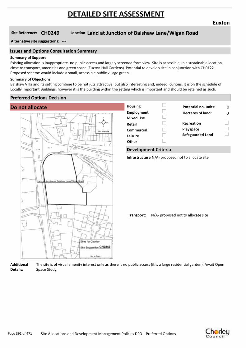
Housing
Employment
Mixed Use
Retail
Commercial
Leisure
Recreation
Safeguarded Land
Preferred Options Decision
Do not allocate Potential no. units: 0
Hectares of land: 0
Other
Site Reference: CH0249 Land at Junction of Balshaw Lane/Wigan Road
Euxton
Existing allocation is inappropriate- no public access and largely screened from view. Site is accessible, in a sustainable location, close to transport, amenities and green space (Euxton Hall Gardens). Potential to develop site in conjunction with CH0122. Proposed scheme would include a small, accessible public village green.
Balshaw Villa and its setting combine to be not juts attractive, but also interesting and, indeed, curious. It is on the schedule of Locally Important Buildings, however it is the building within the setting which is important and should be retained as such.
Summary of Objections
Summary of Support
Alternative site suggestions: ---
DETAILED SITE ASSESSMENT
Location
Development Criteria
Infrastructure N/A- proposed not to allocate site
Transport: N/A- proposed not to allocate site
Additional Details:
The site is of visual amenity interest only as there is no public access (it is a large residential garden). Await Open Space Study.
Issues and Options Consultation Summary
Playspace
Page 391 of 471 Site Allocations and Development Management Policies DPD | Preferred Options

Sustainability Appraisal
Site Ref CH0249
Address Land at Junction of Balshaw Lane/Wigan Road, Euxton
SA Obj
Indicator Site Performance SA Comments
S1
Distance to railway station Up to 0 .8km Social This site has good access to public transport with frequent bus and rail services. The site has good access to all services and facilities with the exception of a GP surgery which is 0.81 to 1.6km away. The site is over 3km from a motorway junction and is 2.41 to 3km from the key service centre of Chorley. Environmental The only identified negative effect in developing this site is the site is currently an urban greenspace. Economic There are no identified negative economic effects in developing this site.
Rail service frequency 2-3 trains/hour per direction Distance to ne arest bus stop Up to 0 .4km Bus service frequency 2 -5 /hour/direction Distance to se rvice ce ntre 2. 41 to 3 km Distance to A Road junction Up to 0 .4km Distance to motorwa y junction Ove r 3 km Distance to supermarket 0.8 1 to 1. 6km Distance to convenience store Up to 0 .4km Distance to Post Office Up to 0 .4km Distance to Primary School 0.4 1 to 0. 8km Distance to Secondary School 1.6 1 to 3. 2km On a cycle route Yes Distance to cycle route Up to 0 .4km
S2
Distance to GP surge ry 0.8 1 to 1. 6km Distance to NH S general hospital 2 .1 to 5km Distance to public open space /park Up to 0 .4km Distance to local ce ntre Up to 0 .4km
EN1
Designation of land Urban Local Service Centre Are a of Separation Outside AONB Outside SSSI Outside Biological/ G eological He ri tage Site Outside Agricultural classification 3
EN2
Conservation Are a Outside Ancie nt Monument on site No Regis tere d Park or G arden Outside Listed Build ing on site No Locally Listed Building on s ite No
EN3 Curre nt/former land use Urban Gree nspace EN4 Flood Zone are a All Zone 1
EN5 Contaminated land No risk Within 3 km of a congestion spot Yes
EC1 Distance to employme nt site 1.2 1 to 1. 6km Access to Broadband Yes
EC2 Distance to further/ highe r e ducation 1.6 1 to 3. 2km
De
live
rab
ility
In
dic
ato
rs
Access to sewer system
Yes
Is the site deliverable: Yes Access to water
Access to gas
Access to e lectricity
Exis ting road acce ss
At risk from haza rdous ins tallations No
Overall Site Performance
Band Spe ctrum:
Overall Band:
B
Page 392 of 471 Site Allocations and Development Management Policies DPD | Preferred Options

Housing
Employment
Mixed Use
Retail
Commercial
Leisure
Recreation
Safeguarded Land
Preferred Options Decision
Allocate site Potential no. units: 248
Hectares of land: 3
Other
Site Reference: CH0262 Land at Pear Tree Farm
Euxton
Recognise the site’s sensitive location, but also that it is surrounded on three sides by developed areas of Euxton and Buckshaw. A phased delivery (north to south) and range of low densities should be considered. No technical, physical or environmental constraints.
There has been enough development in the area. Development would result in increased traffic problems on narrow lanes. Site should be left as green fields or redesignated as Green Belt.
Summary of Objections
Summary of Support
Alternative site suggestions: CH0078 CH0160 CH0264 CH0297
DETAILED SITE ASSESSMENT
Location
Development Criteria
Infrastructure Water Cycle Study: Favourable location for development if agreement is reached on connection point to wastewater network. Agreement with EA required on attenuating runoff to nearby watercourses.
Transport: All development proposals should achieve a high level of road safety, and will be assessed as such by the Council through the planning application process. Depending on the mix of uses this site is developed for, and depending on the size of the development, the Council will require the submission of either a Transport Statement or Transport Assessment and Travel Plan.
Additional Details:
Site proposals should be considered in conjunction with site suggestions CH0078, CH0160, and CH0264.
Issues and Options Consultation Summary
Playspace
HS1.41; EP1.21
Page 393 of 471 Site Allocations and Development Management Policies DPD | Preferred Options

Sustainability Appraisal
Site Ref CH0262
Address Land to the South of Euxton Lane/Pear Tree Lane
SA Obj
Indicator Site Performance SA Comments
S1
Distance to railway station Up to 0 .8km Social This site has good access to public transport with frequent bus and rail services. The site has good access to all local services and facilities. The site has good road link and is close to the motorway junction. Environmental This site is currently designated safeguarded land, part of the site is urban greenspace and the site has a Grade II listed building within the boundary. Economic There are no identified negative economic effects in developing this site.
Rail service frequency 2-3 trains/hour per direction Distance to ne arest bus stop Up to 0 .4km Bus service frequency 2 -5 /hour/direction Distance to se rvice ce ntre 2. 41 to 3 km Distance to A Road junction Up to 0 .4km Distance to motorwa y junction 1. 61 to 3 km Distance to supermarket 0.8 1 to 1. 6km Distance to convenience store 0.4 1 to 0. 8km Distance to Post Office 0.4 1 to 0. 8km Distance to Primary School 0.4 1 to 0. 8km Distance to Secondary School 1.6 1 to 3. 2km On a cycle route Yes Distance to cycle route Up to 0 .4km
S2
Distance to GP surge ry Up to 0 .4km Distance to NH S general hospital 2 .1 to 5km Distance to public open space /park Up to 0 .4km Distance to local ce ntre 0.4 1 to 0. 8km
EN1
Designation of land Safe guarde d Land Are a of Separation Outside AONB Outside SSSI Outside Biological/ G eological He ri tage Site Outside Agricultural classification 3
EN2
Conservation Are a Outside Ancie nt Monument on site No Regis tere d Park or G arden Outside Listed Build ing on site Grade II Locally Listed Building on s ite No
EN3 Curre nt/former land use Urban Gree nspace EN4 Flood Zone are a All Zone 1
EN5 Contaminated land No risk Within 3 km of a congestion spot Yes
EC1 Distance to employme nt site Up to 0 .8km Access to Broadband Yes
EC2 Distance to further/ highe r e ducation Up to 1 .6km
De
live
rab
ility
In
dic
ato
rs
Access to sewer system
Yes
Is the site deliverable: Yes Access to water
Access to gas
Access to e lectricity
Exis ting road acce ss
At risk from haza rdous ins tallations No
Overall Site Performance
Band Spe ctrum:
Overall Band:
B
Page 394 of 471 Site Allocations and Development Management Policies DPD | Preferred Options

Housing
Employment
Mixed Use
Retail
Commercial
Leisure
Recreation
Safeguarded Land
Preferred Options Decision
Allocate site Potential no. units: 248
Hectares of land: 3
Other
Site Reference: CH0264 Land at Sylvesters Farm
Euxton
Recognise the site’s sensitive location, but also that it is surrounded on three sides by developed areas of Euxton and Buckshaw. A phased delivery (north to south) and range of low densities should be considered. No technical, physical or environmental constraints.
There has been enough development in the area. Development would result in increased traffic problems on narrow lanes. Site should be left as green fields or redesignated as Green Belt.
Summary of Objections
Summary of Support
Alternative site suggestions: CH0078 CH0160 CH0262 CH0297
DETAILED SITE ASSESSMENT
Location
Development Criteria
Infrastructure Water Cycle Study: Favourable location for development if agreement is reached on connection point to wastewater network. Agreement with EA required on attenuating runoff to nearby watercourses.
Transport: All development proposals should achieve a high level of road safety, and will be assessed as such by the Council through the planning application process. Depending on the mix of uses this site is developed for, and depending on the size of the development, the Council will require the submission of either a Transport Statement or Transport Assessment and Travel Plan.
Additional Details:
Site proposals should be considered in conjunction with site suggestions CH0078, CH0160, and CH0262.
Issues and Options Consultation Summary
Playspace
HS1.41; EP1.21
Page 395 of 471 Site Allocations and Development Management Policies DPD | Preferred Options

Sustainability Appraisal
Site Ref CH0264
Address Land to the South of Euxton Lane/Pear Tree Lane
SA Obj
Indicator Site Performance SA Comments
S1
Distance to railway station Up to 0 .8km Social This site has good access to public transport with frequent bus and rail services. The site has good access to all local services and facilities. The site has good road link and is close to the motorway junction. Environmental This site is currently designated safeguarded land, part of the site is urban greenspace and the site has a Grade II listed building within the boundary. Economic There are no identified negative economic effects in developing this site.
Rail service frequency 2-3 trains/hour per direction Distance to ne arest bus stop Up to 0 .4km Bus service frequency 2 -5 /hour/direction Distance to se rvice ce ntre 2. 41 to 3 km Distance to A Road junction Up to 0 .4km Distance to motorwa y junction 1. 61 to 3 km Distance to supermarket 0.8 1 to 1. 6km Distance to convenience store 0.4 1 to 0. 8km Distance to Post Office 0.4 1 to 0. 8km Distance to Primary School 0.4 1 to 0. 8km Distance to Secondary School 1.6 1 to 3. 2km On a cycle route Yes Distance to cycle route Up to 0 .4km
S2
Distance to GP surge ry Up to 0 .4km Distance to NH S general hospital 2 .1 to 5km Distance to public open space /park Up to 0 .4km Distance to local ce ntre 0.4 1 to 0. 8km
EN1
Designation of land Safe guarde d Land Are a of Separation Outside AONB Outside SSSI Outside Biological/ G eological He ri tage Site Outside Agricultural classification 3
EN2
Conservation Are a Outside Ancie nt Monument on site No Regis tere d Park or G arden Outside Listed Build ing on site Grade II Locally Listed Building on s ite No
EN3 Curre nt/former land use Urban Gree nspace EN4 Flood Zone are a All Zone 1
EN5 Contaminated land No risk Within 3 km of a congestion spot Yes
EC1 Distance to employme nt site Up to 0 .8km Access to Broadband Yes
EC2 Distance to further/ highe r e ducation Up to 1 .6km
De
live
rab
ility
In
dic
ato
rs
Access to sewer system
Yes
Is the site deliverable: Yes Access to water
Access to gas
Access to e lectricity
Exis ting road acce ss
At risk from haza rdous ins tallations No
Overall Site Performance
Band Spe ctrum:
Overall Band:
B
Page 396 of 471 Site Allocations and Development Management Policies DPD | Preferred Options

Housing
Employment
Mixed Use
Retail
Commercial
Leisure
Recreation
Safeguarded Land
Preferred Options Decision
Allocate site Potential no. units: 26
Hectares of land: 0
Other
Site Reference: CH0295 Daisy Hill Field
Euxton
Parish Council support the recreation use of this site- there is a lack of accessible recreation space in Euxton.
The area is generally well provided with gardens. Allotments would result in extra traffic and no parking for residents. Allotment sheds contain expensive tools and are targets for burglary. Chickens or other small animals being kept on allotments may attract rats. Unless managed properly, allotments begin to look untidy and run down.
Summary of Objections
Summary of Support
Alternative site suggestions: CH0062 CH0230
DETAILED SITE ASSESSMENT
Location
Development Criteria
Infrastructure ---
Transport: All development proposals should achieve a high level of road safety, and will be assessed as such by the Council through the planning application process. For housing developments with between 50 and 80 units, the Council will require a Transport Statement. For developments of more than 80 units, the Council will require a Transport Assessment and Travel Plan as part of the application.
Additional Details:
It has been suggested that this site be allocated for recreation use. Until the results of the Open Space Study are received, no decisions will be made as to the allocation or otherwise of this site.
Issues and Options Consultation Summary
Playspace
HS1.42
Page 397 of 471 Site Allocations and Development Management Policies DPD | Preferred Options

Sustainability Appraisal
Site Ref CH0295
Address Land at end of Dunrobin Drive, Euxton
SA Obj
Indicator Site Performance SA Comments
S1
Distance to railway station Up to 0.8km Social This site has very good access to public transport with good access to bus and rail links. Rail services are very frequent with 2-3 trains per hour although bus services are poor with a service less than hourly. The site has poor access to all local services and facilities although the site is in close proximity to an A road junction. Environmental This site is a Greenfield site with a current designation as safeguarded land. Economic There are no identified negative economic effects in developing this site.
Rail service frequency 2-3 trains/hour per direction Distance to nearest bus stop Up to 0.4km Bus service frequency Less than 1/hour/direction Distance to service centre Over 3km Distance to A Road junction Up to 0.4km Distance to motorway junction Over 3km Distance to supermarket 0.81 to 1.6km Distance to convenience store 0.81 to 1.2km Distance to Post Office 0.81 to 1.2km Distance to Primary School 0.81 to 1.6km Distance to Secondary School 1.61 to 3.2km On a cycle route No Distance to cycle route 0.41 to 0.8km
S2
Distance to GP surgery 1.61 to 3km Distance to NHS general hospital 2.1 to 5km Distance to public open space/park Up to 0.4km Distance to local centre 0.81 to 1.2km
EN1
Designation of land Safeguarded Land Area of Separation Outside AONB Outside SSSI Outside Biological/ Geological Heritage Site Outside Agricultural classification 3
EN2
Conservation Area Outside Ancient Monument on site No Registered Park or Garden Outside Listed Building on site No Locally Listed Building on site No
EN3 Current/former land use Greenfield EN4 Flood Zone area All Zone 1
EN5 Contaminated land No risk Within 3km of a congestion spot Yes
EC1 Distance to employment site Over 1.6km Access to Broadband Yes
EC2 Distance to further/higher education 1.61 to 3.2km
Del
iver
abili
ty
Indi
cato
rs
Access to sewer system
Yes
Is the site deliverable: Yes Access to water
Access to gas Access to electricity Existing road access At risk from hazardous installations No
Overall Site Performance Band Spectrum:
Overall Band:
C
Page 398 of 471 Site Allocations and Development Management Policies DPD | Preferred Options

Housing
Employment
Mixed Use
Retail
Commercial
Leisure
Recreation
Safeguarded Land
Preferred Options Decision
Undecided Potential no. units: 0
Hectares of land: 0
Other Suggested recreation allocation. Await results of Open Space Study.
Site Reference: CH0296 Highways Avenue
Euxton
Support open space/recreation allocation.
None received.Summary of Objections
Summary of Support
Alternative site suggestions: ---
DETAILED SITE ASSESSMENT
Location
Development Criteria
Infrastructure ---
Transport: ---
Additional Details:
It has been suggested that this site be allocated for recreation use. Until the results of the Open Space Study are received, no decisions will be made as to the allocation or otherwise of this site.
Issues and Options Consultation Summary
Playspace
Page 399 of 471 Site Allocations and Development Management Policies DPD | Preferred Options

Sustainability Appraisal
No sustainability Appraisal has been undertaken of this site suggestion. Until the findings of the
Open Space Study are produced, the Council will not be allocating additional land for recreation
purposes. Once the Study is complete, a decision on the allocation of this site for recreational use
can be made.
Page 400 of 471 Site Allocations and Development Management Policies DPD | Preferred Options

Housing
Employment
Mixed Use
Retail
Commercial
Leisure
Recreation
Safeguarded Land
Preferred Options Decision
Allocate site Potential no. units: 248
Hectares of land: 3
Other
Site Reference: CH0297 Pear Tree Lane/Euxton Lane
Euxton
Support for recreation allocation as Euxton has a need for more accessible recreation space.
Wish to see land designated as green belt. Recreational facilities would have an impact on the wildlife. Leave as open space for local residents to enjoy.
Summary of Objections
Summary of Support
Alternative site suggestions: CH0078 CH0160 CH0262 CH0264
DETAILED SITE ASSESSMENT
Location
Development Criteria
Infrastructure ---
Transport: All development proposals should achieve a high level of road safety, and will be assessed as such by the Council through the planning application process. For housing developments with between 50 and 80 units, the Council will require a Transport Statement. For developments of more than 80 units, the Council will require a Transport Assessment and Travel Plan as part of the application.
Additional Details:
---
Issues and Options Consultation Summary
Playspace
HS1.41; EP1.21
Page 401 of 471 Site Allocations and Development Management Policies DPD | Preferred Options
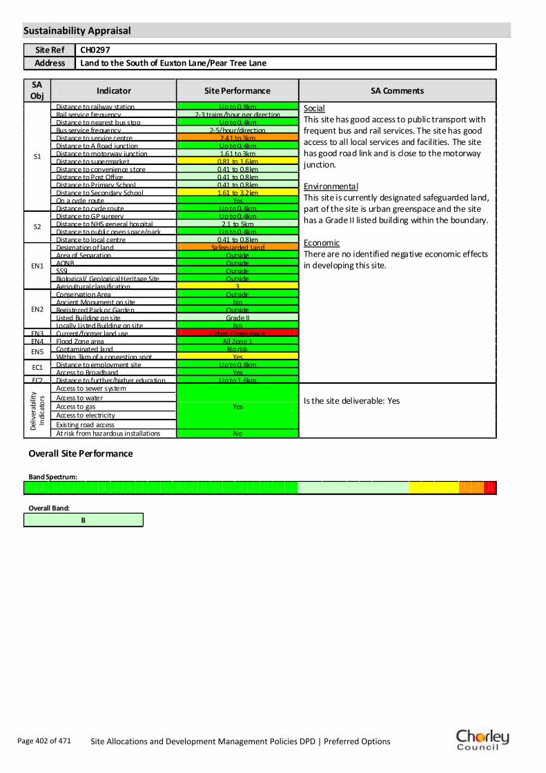
Sustainability Appraisal
Site Ref CH0297
Address Land to the South of Euxton Lane/Pear Tree Lane
SA Obj
Indicator Site Performance SA Comments
S1
Distance to railway station Up to 0.8km Social This site has good access to public transport with frequent bus and rail services. The site has good access to all local services and facilities. The site has good road link and is close to the motorway junction. Environmental This site is currently designated safeguarded land, part of the site is urban greenspace and the site has a Grade II listed building within the boundary. Economic There are no identified negative economic effects in developing this site.
Rail service frequency 2-3 trains/hour per direction Distance to nearest bus stop Up to 0.4km Bus service frequency 2-5/hour/direction Distance to service centre 2.41 to 3km Distance to A Road junction Up to 0.4km Distance to motorway junction 1.61 to 3km Distance to supermarket 0.81 to 1.6km Distance to convenience store 0.41 to 0.8km Distance to Post Office 0.41 to 0.8km Distance to Primary School 0.41 to 0.8km Distance to Secondary School 1.61 to 3.2km On a cycle route Yes Distance to cycle route Up to 0.4km
S2
Distance to GP surgery Up to 0.4km Distance to NHS general hospital 2.1 to 5km Distance to public open space/park Up to 0.4km Distance to local centre 0.41 to 0.8km
EN1
Designation of land Safeguarded Land Area of Separation Outside AONB Outside SSSI Outside Biological/ Geological Heritage Site Outside Agricultural classification 3
EN2
Conservation Area Outside Ancient Monument on site No Registered Park or Garden Outside Listed Building on site Grade II Locally Listed Building on site No
EN3 Current/former land use Urban Greenspace EN4 Flood Zone area All Zone 1
EN5 Contaminated land No risk Within 3km of a congestion spot Yes
EC1 Distance to employment site Up to 0.8km Access to Broadband Yes
EC2 Distance to further/higher education Up to 1.6km
Del
iver
abili
ty
Indi
cato
rs
Access to sewer system
Yes
Is the site deliverable: Yes Access to water
Access to gas Access to electricity Existing road access At risk from hazardous installations No
Overall Site Performance Band Spectrum:
Overall Band:
B
Page 402 of 471 Site Allocations and Development Management Policies DPD | Preferred Options

Housing
Employment
Mixed Use
Retail
Commercial
Leisure
Recreation
Safeguarded Land
Preferred Options Decision
Undecided Potential no. units: 0
Hectares of land: 0
Other Suggested recreation allocation. Await results of Open Space Study.
Site Reference: CH0298 Bredon Ave
Euxton
Parish Council support the use of the site for recreation.
The pending Governance review will greatly impact on the Parish Council’s calculation of recreational space in Euxton as any new properties built on the ROF site will no longer fall within Euxton Parish.
Summary of Objections
Summary of Support
Alternative site suggestions: ---
DETAILED SITE ASSESSMENT
Location
Development Criteria
Infrastructure ---
Transport: ---
Additional Details:
It has been suggested that this site be allocated for recreation use. Until the results of the Open Space Study are received, no decisions will be made as to the allocation or otherwise of this site.
Issues and Options Consultation Summary
Playspace
Page 403 of 471 Site Allocations and Development Management Policies DPD | Preferred Options

Sustainability Appraisal
No sustainability Appraisal has been undertaken of this site suggestion. Until the findings of the
Open Space Study are produced, the Council will not be allocating additional land for recreation
purposes. Once the Study is complete, a decision on the allocation of this site for recreational use
can be made.
Page 404 of 471 Site Allocations and Development Management Policies DPD | Preferred Options

Housing
Employment
Mixed Use
Retail
Commercial
Leisure
Recreation
Safeguarded Land
Preferred Options Decision
Undecided Potential no. units: 0
Hectares of land: 0
Other Suggested recreation allocation. Await results of Open Space Study.
Site Reference: CH0299 Adjacent Yarrow Valley car park, Southport Road
Euxton
Parish Council support the recreational use of this site.
Leave the area as open space and designate as green belt.Summary of Objections
Summary of Support
Alternative site suggestions: ---
DETAILED SITE ASSESSMENT
Location
Development Criteria
Infrastructure ---
Transport: ---
Additional Details:
It has been suggested that this site be allocated for recreation use. Until the results of the Open Space Study are received, no decisions will be made as to the allocation or otherwise of this site.
Issues and Options Consultation Summary
Playspace
Page 405 of 471 Site Allocations and Development Management Policies DPD | Preferred Options

Sustainability Appraisal
No sustainability Appraisal has been undertaken of this site suggestion. Until the findings of the
Open Space Study are produced, the Council will not be allocating additional land for recreation
purposes. Once the Study is complete, a decision on the allocation of this site for recreational use
can be made.
Page 406 of 471 Site Allocations and Development Management Policies DPD | Preferred Options

Housing
Employment
Mixed Use
Retail
Commercial
Leisure
Recreation
Safeguarded Land
Preferred Options Decision
Undecided Potential no. units: 0
Hectares of land: 0
Other Suggested recreation allocation. Await results of Open Space Study.
Site Reference: CH0300 Adjacent Pear Tree Lane
Euxton
Euxton has a shortage of accessible recreation space, therefore support the proposed use. The HCA has agreed to make this site available, subject to planning consent being secured.
The area should be retained as open space, providing much needed undeveloped space between Astley Village and Euxton. The proposals would create traffic issues in School Lane, Pear Tree Lane and Euxton Lane. It would ruin the green belt nature of the land and cannot be viable- either for capital costs or annual operation and maintenance costs.
Summary of Objections
Summary of Support
Alternative site suggestions: ---
DETAILED SITE ASSESSMENT
Location
Development Criteria
Infrastructure ---
Transport: ---
Additional Details:
It has been suggested that this site be allocated for recreation use. Until the results of the Open Space Study are received, no decisions will be made as to the allocation or otherwise of this site.
Issues and Options Consultation Summary
Playspace
Page 407 of 471 Site Allocations and Development Management Policies DPD | Preferred Options

Sustainability Appraisal
No sustainability Appraisal has been undertaken of this site suggestion. Until the findings of the
Open Space Study are produced, the Council will not be allocating additional land for recreation
purposes. Once the Study is complete, a decision on the allocation of this site for recreational use
can be made.
Page 408 of 471 Site Allocations and Development Management Policies DPD | Preferred Options
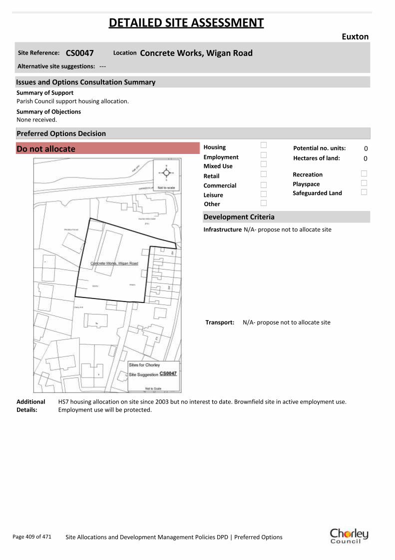
Housing
Employment
Mixed Use
Retail
Commercial
Leisure
Recreation
Safeguarded Land
Preferred Options Decision
Do not allocate Potential no. units: 0
Hectares of land: 0
Other
Site Reference: CS0047 Concrete Works, Wigan Road
Euxton
Parish Council support housing allocation.
None received.Summary of Objections
Summary of Support
Alternative site suggestions: ---
DETAILED SITE ASSESSMENT
Location
Development Criteria
Infrastructure N/A- propose not to allocate site
Transport: N/A- propose not to allocate site
Additional Details:
HS7 housing allocation on site since 2003 but no interest to date. Brownfield site in active employment use. Employment use will be protected.
Issues and Options Consultation Summary
Playspace
Page 409 of 471 Site Allocations and Development Management Policies DPD | Preferred Options

Sustainability Appraisal
Site Ref CS0047
Address Concrete Works, Wigan Road, Euxton
SA Obj
Indicator Site Performance SA Comments
S1
Distance to railway station Up to 0 .8km Social This site has good access to public transport with frequent bus and rail services. The site has poor access to local services and facilities and is over 3km from a motorway junction. Environmental There are no identified negative environmental effects in developing this site. Economic There are no identified negative economic effects in developing this site.
Rail service frequency 2 -3 /hour/direction Distance to ne arest bus stop Up to 0 .4km Bus service frequency 2 -5 /hour/direction Distance to se rvice ce ntre 2. 41 to 3 km Distance to A Road junction Up to 0 .4km Distance to motorwa y junction Ove r 3 km Distance to supermarket 0.8 1 to 1. 6km Distance to convenience store 0.4 1 to 0. 8km Distance to Post Office 0.4 1 to 0. 8km Distance to Primary School 0.8 1 to 1. 6km Distance to Secondary School 1.6 1 to 3. 2km On a cycle route No Distance to cycle route Up to 0 .4km
S2
Distance to GP surge ry 0.8 1 to 1. 6km Distance to NH S general hospital 2 .1 to 5km Distance to public open space /park Up to 0 .4km Distance to local ce ntre 0.4 1 to 0. 8km
EN1
Designation of land Urban Local Service Centre Are a of Separation Outside AONB Outside SSSI Outside Biological/ G eological He ri tage Site Outside Agricultural classification 3
EN2
Conservation Are a Outside Ancie nt Monument on site No Regis tere d Park or G arden Outside Listed Build ing on site No Locally Listed Building on s ite No
EN3 Curre nt/former land use Brownfield EN4 Flood Zone are a All Zone 1
EN5 Contaminated land No risk Within 3 km of a congestion spot Yes
EC1 Distance to employme nt site 1.2 1 to 1. 6km Access to Broadband Yes
EC2 Distance to further/ highe r e ducation 1.6 1 to 3. 2km
De
live
rab
ility
In
dic
ato
rs
Access to sewer system
Yes
Is the site deliverable: Yes Access to water
Access to gas
Access to e lectricity
Exis ting road acce ss
At risk from haza rdous ins tallations No
Overall Site Performance
Band Spe ctrum:
Overall Band:
B
Page 410 of 471 Site Allocations and Development Management Policies DPD | Preferred Options

Housing
Employment
Mixed Use
Retail
Commercial
Leisure
Recreation
Safeguarded Land
Preferred Options Decision
Undecided Potential no. units: 0
Hectares of land: 0
Other Suggested recreation allocation. Await results of Open Space Study.
Site Reference: CH0339 Dismantled Railway Line
Heapey
Previously when houses were planned there, the builder offered a bike track and nature reserve in the remainder of the cutting to compensate. This was turned down twice at planning. Concern that insufficient ground is given to the long term future of the cutting. Wonderful if it was for recreation in a proper manner.
None received.Summary of Objections
Summary of Support
Alternative site suggestions: ---
DETAILED SITE ASSESSMENT
Location
Development Criteria
Infrastructure ---
Transport: ---
Additional Details:
It has been suggested that this site be allocated for recreation use. Until the results of the Open Space Study are received, no decisions will be made as to the allocation or otherwise of this site.
Issues and Options Consultation Summary
Playspace
Page 411 of 471 Site Allocations and Development Management Policies DPD | Preferred Options

Sustainability Appraisal
No sustainability Appraisal has been undertaken of this site suggestion. Until the findings of the
Open Space Study are produced, the Council will not be allocating additional land for recreation
purposes. Once the Study is complete, a decision on the allocation of this site for recreational use
can be made.
Page 412 of 471 Site Allocations and Development Management Policies DPD | Preferred Options

Housing
Employment
Mixed Use
Retail
Commercial
Leisure
Recreation
Safeguarded Land
Preferred Options Decision
Undecided Potential no. units: 0
Hectares of land: 0
Other Suggested recreation allocation. Await results of Open Space Study.
Site Reference: CH0061 Bramblewood Nursey and Garden Centre, Wigan Lane
Heath Charnock
None received.
None received.Summary of Objections
Summary of Support
Alternative site suggestions: ---
DETAILED SITE ASSESSMENT
Location
Development Criteria
Infrastructure ---
Transport: ---
Additional Details:
It has been suggested that this site be allocated for recreation use. Until the results of the Open Space Study are received, no decisions will be made as to the allocation or otherwise of this site.
Issues and Options Consultation Summary
Playspace
Page 413 of 471 Site Allocations and Development Management Policies DPD | Preferred Options

Sustainability Appraisal
No sustainability Appraisal has been undertaken of this site suggestion. Until the findings of the
Open Space Study are produced, the Council will not be allocating additional land for recreation
purposes. Once the Study is complete, a decision on the allocation of this site for recreational use
can be made.
Page 414 of 471 Site Allocations and Development Management Policies DPD | Preferred Options
Housing
Employment
Mixed Use
Retail
Commercial
Leisure
Recreation
Safeguarded Land
Preferred Options Decision
Undecided Potential no. units: 0
Hectares of land: 0
Other Suggested recreation allocation. Await results of Open Space Study.
Site Reference: CH0123 Heskin Green
Heskin
None received.
None received.Summary of Objections
Summary of Support
Alternative site suggestions: ---
DETAILED SITE ASSESSMENT
Location
Development Criteria
Infrastructure ---
Transport: ---
Additional Details:
It has been suggested that this site be allocated for recreation use. Until the results of the Open Space Study are received, no decisions will be made as to the allocation or otherwise of this site.
Issues and Options Consultation Summary
Playspace
Page 415 of 471 Site Allocations and Development Management Policies DPD | Preferred Options

Sustainability Appraisal
No sustainability Appraisal has been undertaken of this site suggestion. Until the findings of the
Open Space Study are produced, the Council will not be allocating additional land for recreation
purposes. Once the Study is complete, a decision on the allocation of this site for recreational use
can be made.
Page 416 of 471 Site Allocations and Development Management Policies DPD | Preferred Options

Housing
Employment
Mixed Use
Retail
Commercial
Leisure
Recreation
Safeguarded Land
Preferred Options Decision
Undecided Potential no. units: 0
Hectares of land: 0
Other Suggested recreation allocation. Await results of Open Space Study.
Site Reference: CH0049 Copthurst Lane/Kenyon Lane
Wheelton
None received.
None received.Summary of Objections
Summary of Support
Alternative site suggestions: CH0050 CH0186
DETAILED SITE ASSESSMENT
Location
Development Criteria
Infrastructure ---
Transport: ---
Additional Details:
Undecided- await results of Open Space Study before allocating further sites for recreation.
Issues and Options Consultation Summary
Playspace
Page 417 of 471 Site Allocations and Development Management Policies DPD | Preferred Options

Sustainability Appraisal
No sustainability Appraisal has been undertaken of this site suggestion. Until the findings of the
Open Space Study are produced, the Council will not be allocating additional land for recreation
purposes. Once the Study is complete, a decision on the allocation of this site for recreational use
can be made.
Page 418 of 471 Site Allocations and Development Management Policies DPD | Preferred Options

Housing
Employment
Mixed Use
Retail
Commercial
Leisure
Recreation
Safeguarded Land
Preferred Options Decision
Undecided Potential no. units: 0
Hectares of land: 0
Other Suggested recreation allocation. Await results of Open Space Study.
Site Reference: CH0050 Copthurst Lane/Kenyon Lane
Wheelton
None received.
None received.Summary of Objections
Summary of Support
Alternative site suggestions: CH0049 CH0186
DETAILED SITE ASSESSMENT
Location
Development Criteria
Infrastructure ---
Transport: ---
Additional Details:
Undecided- await results of Open Space Study before allocating further sites for recreation.
Issues and Options Consultation Summary
Playspace
Page 419 of 471 Site Allocations and Development Management Policies DPD | Preferred Options

Sustainability Appraisal
No sustainability Appraisal has been undertaken of this site suggestion. Until the findings of the
Open Space Study are produced, the Council will not be allocating additional land for recreation
purposes. Once the Study is complete, a decision on the allocation of this site for recreational use
can be made.
Page 420 of 471 Site Allocations and Development Management Policies DPD | Preferred Options

Housing
Employment
Mixed Use
Retail
Commercial
Leisure
Recreation
Safeguarded Land
Preferred Options Decision
Undecided Potential no. units: 0
Hectares of land: 0
Other Suggested recreation allocation. Await results of Open Space Study.
Site Reference: CH0186 Old Sand Quarry, Between Kenyon Lane and Copthurst Lan
Wheelton
None received.
None received.Summary of Objections
Summary of Support
Alternative site suggestions: CH0049 CH0050
DETAILED SITE ASSESSMENT
Location
Development Criteria
Infrastructure ---
Transport: ---
Additional Details:
Await Open Space Study results before allocating any further sites for recreation.
Issues and Options Consultation Summary
Playspace
Page 421 of 471 Site Allocations and Development Management Policies DPD | Preferred Options

Sustainability Appraisal
No sustainability Appraisal has been undertaken of this site suggestion. Until the findings of the
Open Space Study are produced, the Council will not be allocating additional land for recreation
purposes. Once the Study is complete, a decision on the allocation of this site for recreational use
can be made.
Page 422 of 471 Site Allocations and Development Management Policies DPD | Preferred Options
Housing
Employment
Mixed Use
Retail
Commercial
Leisure
Recreation
Safeguarded Land
Preferred Options Decision
Undecided Potential no. units: 0
Hectares of land: 0
Other Suggested recreation allocation. Await results of Open Space Study.
Site Reference: CH0337 Black Lion Field, Blackburn Road
Wheelton
None received.
None received.Summary of Objections
Summary of Support
Alternative site suggestions: ---
DETAILED SITE ASSESSMENT
Location
Development Criteria
Infrastructure ---
Transport: ---
Additional Details:
It has been suggested that this site be allocated for recreation use. Until the results of the Open Space Study are received, no decisions will be made as to the allocation or otherwise of this site.
Issues and Options Consultation Summary
Playspace
Page 423 of 471 Site Allocations and Development Management Policies DPD | Preferred Options
Sustainability Appraisal
No sustainability Appraisal has been undertaken of this site suggestion. Until the findings of the
Open Space Study are produced, the Council will not be allocating additional land for recreation
purposes. Once the Study is complete, a decision on the allocation of this site for recreational use
can be made.
Page 424 of 471 Site Allocations and Development Management Policies DPD | Preferred Options

Housing
Employment
Mixed Use
Retail
Commercial
Leisure
Recreation
Safeguarded Land
Preferred Options Decision
Undecided Potential no. units: 0
Hectares of land: 0
Other Suggested recreation allocation. Await results of Open Space Study.
Site Reference: CH0338 Land off Ryefield
Wheelton
Summary of Objections
Summary of Support
Alternative site suggestions: ---
DETAILED SITE ASSESSMENT
Location
Development Criteria
Infrastructure ---
Transport: ---
Additional Details:
It has been suggested that this site be allocated for recreation use. Until the results of the Open Space Study are received, no decisions will be made as to the allocation or otherwise of this site.
Issues and Options Consultation Summary
Playspace
Page 425 of 471 Site Allocations and Development Management Policies DPD | Preferred Options

Sustainability Appraisal
No sustainability Appraisal has been undertaken of this site suggestion. Until the findings of the
Open Space Study are produced, the Council will not be allocating additional land for recreation
purposes. Once the Study is complete, a decision on the allocation of this site for recreational use
can be made.
Page 426 of 471 Site Allocations and Development Management Policies DPD | Preferred Options

Housing
Employment
Mixed Use
Retail
Commercial
Leisure
Recreation
Safeguarded Land
Preferred Options Decision
Allocate site Potential no. units: 15
Hectares of land: 0
Other
Site Reference: CH0004 Hill Top Lane
Whittle-le-Woods
None received.
Request the retention of the safeguarded land in its present state. Concerns regarding proposals for housing development near existing working quarries, which have permission for the extraction of stone until 2042.
Summary of Objections
Summary of Support
Alternative site suggestions: ---
DETAILED SITE ASSESSMENT
Location
Development Criteria
Infrastructure ---
Transport: All development proposals should achieve a high level of road safety, and will be assessed as such by the Council through the planning application process. For housing developments with between 50 and 80 units, the Council will require a Transport Statement. For developments of more than 80 units, the Council will require a Transport Assessment and Travel Plan as part of the application.
Additional Details:
---
Issues and Options Consultation Summary
Playspace
HS1.45
Page 427 of 471 Site Allocations and Development Management Policies DPD | Preferred Options

Sustainability Appraisal
Site Ref CH0004
Address Hill Top Lane, Whittle-le-Woods
SA Obj
Indicator Site Performance SA Comments
S1
Distance to railway station Ove r 3 km Social This site has good access to frequent bus services with 2-5 services per hour. There is no rail service within the settlement. The site has good access to all local services and facilities with the exception of distance to supermarket which is 1.61 to 3km away. Environmental This site is a Greenfield site within a current safeguarded land designation. There is a Grade II listed building on the site with a medium risk of land contamination. Economic There are no identified negative economic effects in developing this site.
Rail service frequency No se rvices in settle me nt Distance to ne arest bus stop Up to 0 .4km Bus service frequency 2 -5 /hour/direction Distance to se rvice ce ntre Ove r 3 km Distance to A Road junction Up to 0 .4km Distance to motorwa y junction 1. 61 to 3 km Distance to supermarket 1. 61 to 3 km Distance to convenience store Up to 0 .4km Distance to Post Office 0.4 1 to 0. 8km Distance to Primary School 0.4 1 to 0. 8km Distance to Secondary School 3. 21 to 5 km On a cycle route Yes Distance to cycle route Up to 0 .4km
S2
Distance to GP surge ry 0.4 1 to 0. 8km Distance to NH S general hospital 2 .1 to 5km Distance to public open space /park Up to 0 .4km Distance to local ce ntre Up to 0 .4km
EN1
Designation of land Safe guarde d Land Are a of Separation Outside AONB Outside SSSI Outside Biological/ G eological He ri tage Site Outside Agricultural classification 3
EN2
Conservation Are a Outside Ancie nt Monument on site No Regis tere d Park or G arden Outside Listed Build ing on site Grade II Locally Listed Building on s ite No
EN3 Curre nt/former land use Greenfield EN4 Flood Zone are a All Zone 1
EN5 Contaminated land Me dium risk Within 3 km of a congestion spot Yes
EC1 Distance to employme nt site Over 1. 6km Access to Broadband Yes
EC2 Distance to further/ highe r e ducation 3. 21 to 5 km
De
live
rab
ility
In
dic
ato
rs
Access to sewer system
Yes
Is the site deliverable: Yes Access to water
Access to gas
Access to e lectricity
Exis ting road acce ss
At risk from haza rdous ins tallations No
Overall Site Performance
Band Spe ctrum:
Overall Band:
C
Page 428 of 471 Site Allocations and Development Management Policies DPD | Preferred Options

Housing
Employment
Mixed Use
Retail
Commercial
Leisure
Recreation
Safeguarded Land
Preferred Options Decision
Allocate site Potential no. units: 130
Hectares of land: 0
Other
Site Reference: CH0016 Land to West of Lucas Lane
Whittle-le-Woods
Land identified as safeguarded and therefore capable of accommodating future development needs. Land is suitable, viable and available for development and would create a sustainable extension to Whittle-le-Woods.
Area liable to flooding, as in 1987- particularly Town Lane and Waterhouse Green. New development would impact on drainage and surface run off. Inadequate infrastructure (roads, facilities, open space) for development of suggested size. Development would result in further traffic problems. Loss of wildlife, flora and fauna.
Summary of Objections
Summary of Support
Alternative site suggestions: ---
DETAILED SITE ASSESSMENT
Location
Development Criteria
Infrastructure Water Cycle Study: All developments in the Walton-le-Dale Wastewater Treatments Works catchment need to be assessed by UU. Attenuation and infiltration SUDS may be viable, however this needs detailed check. Need agreement from EA regarding attenuating to watercourses.
Transport: All development proposals should achieve a high level of road safety, and will be assessed as such by the Council through the planning application process. For housing developments with between 50 and 80 units, the Council will require a Transport Statement. For developments of more than 80 units, the Council will require a Transport Assessment and Travel Plan as part of the application.
Additional Details:
---
Issues and Options Consultation Summary
Playspace
HS1.44
Page 429 of 471 Site Allocations and Development Management Policies DPD | Preferred Options

Sustainability Appraisal
Site Ref CH0016
Address Land to the West of Lucas Lane, Whittle-le-Woods
SA Obj
Indicator Site Performance SA Comments
S1
Distance to railway station Ove r 3 km Social This site has good access to a local bus service with services 2-5 times per hour. There is no railway service within the settlement but the site has good access to all services and facilities. Environmental This site is a Greenfield site within a current safeguarded land designation. The site is also within a biological/geological heritage site. Economic There are no identified negative economic effects in developing this site.
Rail service frequency No se rvices in settle me nt Distance to ne arest bus stop 0.4 1 to 0. 8km Bus service frequency 2 -5 /hour/direction Distance to se rvice ce ntre 2. 41 to 3 km Distance to A Road junction 0.4 1 to 0. 8km Distance to motorwa y junction 1. 61 to 3 km Distance to supermarket 1. 61 to 3 km Distance to convenience store 0.4 1 to 0. 8km Distance to Post Office Up to 0 .4km Distance to Primary School 0.4 1 to 0. 8km Distance to Secondary School 1.6 1 to 3. 2km On a cycle route No Distance to cycle route Up to 0 .4km
S2
Distance to GP surge ry 0.4 1 to 0. 8km Distance to NH S general hospital 2 .1 to 5km Distance to public open space /park 0.4 1 to 0. 8km Distance to local ce ntre 0.4 1 to 0. 8km
EN1
Designation of land Safe guarde d Land Are a of Separation Outside AONB Outside SSSI Outside Biological/ G eological He ri tage Site Within Agricultural classification 3
EN2
Conservation Are a Outside Ancie nt Monument on site No Regis tere d Park or G arden Outside Listed Build ing on site No Locally Listed Building on s ite No
EN3 Curre nt/former land use Greenfield EN4 Flood Zone are a All Zone 1
EN5 Contaminated land No risk Within 3 km of a congestion spot Yes
EC1 Distance to employme nt site 0.8 1 to 1. 2km Access to Broadband Yes
EC2 Distance to further/ highe r e ducation 3. 21 to 5 km
De
live
rab
ility
In
dic
ato
rs
Access to sewer system
Yes
Is the site deliverable: Yes Access to water
Access to gas
Access to e lectricity
Exis ting road acce ss
At risk from haza rdous ins tallations No
Overall Site Performance
Band Spe ctrum:
Overall Band:
C
Page 430 of 471 Site Allocations and Development Management Policies DPD | Preferred Options

Housing
Employment
Mixed Use
Retail
Commercial
Leisure
Recreation
Safeguarded Land
Preferred Options Decision
Retain existing designation Potential no. units: 0
Hectares of land: 0
Other
Site Reference: CH0017 Land to the North of Town Lane
Whittle-le-Woods
None received.
Objection to development due to increased surface water flow and potential flooding on Waterhouse Green. Wish to see land retained as safeguarded. If required, it should only be released for appropriate recreation and leisure uses.
Summary of Objections
Summary of Support
Alternative site suggestions: ---
DETAILED SITE ASSESSMENT
Location
Development Criteria
Infrastructure Site is proposed to remain as safeguarded land. However, the following information is provided. Water Cycle Study: All developments in the Walton-le-Dale Wastewater Treatments Works catchment need to be assessed by UU. Attenuation and infiltration SUDS may be viable, however this needs detailed check. Need agreement from EA regarding attenuating to watercourses.
Transport: N/A- site is proposed to remain as safeguarded land.
Additional Details:
Not necessary to release all safeguarded land in Whittle - poor accessibility and topography on northern safeguarded sites. More impact on adjacent green belt and countryside.
Issues and Options Consultation Summary
Playspace
BNE2.14
Page 431 of 471 Site Allocations and Development Management Policies DPD | Preferred Options

Sustainability Appraisal
Site Ref CH0017
Address Land North of Town Lane, Whittle-le-Woods
SA Obj
Indicator Site Performance SA Comments
S1
Distance to railway station Ove r 3 km Social This site has good access to a local bus service with services 2-5 times per hour. There is no railway service within the settlement but the site has good access to all services and facilities with the exception of a supermarket which is 1.61 to 3km away. The site has very goo access to an A road junction and a motorway junction. Environmental This site is a Greenfield site within a current safeguarded land designation. Economic There are no identified negative economic effects in developing this site.
Rail service frequency No se rvices in settle me nt Distance to ne arest bus stop 0.4 1 to 0. 8km Bus service frequency 2 -5 /hour/direction Distance to se rvice ce ntre Ove r 3 km Distance to A Road junction Up to 0 .4km Distance to motorwa y junction 1. 61 to 3 km Distance to supermarket 1. 61 to 3 km Distance to convenience store 0.4 1 to 0. 8km Distance to Post Office Up to 0 .4km Distance to Primary School 0.4 1 to 0. 8km Distance to Secondary School 3. 21 to 5 km On a cycle route No Distance to cycle route Up to 0 .4km
S2
Distance to GP surge ry 0.4 1 to 0. 8km Distance to NH S general hospital 2 .1 to 5km Distance to public open space /park 0.4 1 to 0. 8km Distance to local ce ntre 0.4 1 to 0. 8km
EN1
Designation of land Safe guarde d Land Are a of Separation Outside AONB Outside SSSI Outside Biological/ G eological He ri tage Site Outside Agricultural classification 3
EN2
Conservation Are a Outside Ancie nt Monument on site No Regis tere d Park or G arden Outside Listed Build ing on site No Locally Listed Building on s ite No
EN3 Curre nt/former land use Greenfield EN4 Flood Zone are a All Zone 1
EN5 Contaminated land No risk Within 3 km of a congestion spot Yes
EC1 Distance to employme nt site Over 1. 6km Access to Broadband Yes
EC2 Distance to further/ highe r e ducation 3. 21 to 5 km
De
live
rab
ility
In
dic
ato
rs
Access to sewer system
Yes
Is the site deliverable: Yes Access to water
Access to gas
Access to e lectricity
Exis ting road acce ss
At risk from haza rdous ins tallations No
Overall Site Performance
Band Spe ctrum:
Overall Band:
C
Page 432 of 471 Site Allocations and Development Management Policies DPD | Preferred Options
Housing
Employment
Mixed Use
Retail
Commercial
Leisure
Recreation
Safeguarded Land
Preferred Options Decision
Allocate site Potential no. units: 10
Hectares of land: 0
Other
Site Reference: CH0030 Rear of 243-281, Preston Road
Whittle-le-Woods
None received.
This site appears on the Whittle-le-Woods list but isn't actually part of Whittle-le-Woods.Summary of Objections
Summary of Support
Alternative site suggestions: ---
DETAILED SITE ASSESSMENT
Location
Development Criteria
Infrastructure N/A- site is already under construction
Transport: All development proposals should achieve a high level of road safety, and will be assessed as such by the Council through the planning application process. As this site is already under construction, the relevant Transport Statement/Assessment has already been submitted to, and approved by the Council.
Additional Details:
---
Issues and Options Consultation Summary
Playspace
HS1.47
Page 433 of 471 Site Allocations and Development Management Policies DPD | Preferred Options

Sustainability Appraisal
Site Ref CH0030
Address Rear of 243-281 Preston Road, Whittle-le-Woods
SA Obj
Indicator Site Performance SA Comments
S1
Distance to railway station Ove r 3 km This site has planning permission for housing and is under construction.
Rail service frequency No se rvices in settle me nt Distance to ne arest bus stop Up to 0 .4km Bus service frequency 2 -5 /hour/direction Distance to se rvice ce ntre Ove r 3 km Distance to A Road junction Up to 0 .4km Distance to motorwa y junction Ove r 3 km Distance to supermarket 1. 61 to 3 km Distance to convenience store Up to 0 .4km Distance to Post Office 0.4 1 to 0. 8km Distance to Primary School Up to 0 .4km Distance to Secondary School 3. 21 to 5 km On a cycle route Yes Distance to cycle route Up to 0 .4km
S2
Distance to GP surge ry 0.4 1 to 0. 8km Distance to NH S general hospital 2 .1 to 5km Distance to public open space /park Up to 0 .4km Distance to local ce ntre 0.4 1 to 0. 8km
EN1
Designation of land Urban Local Service Centre Are a of Separation Outside AONB Outside SSSI Outside Biological/ G eological He ri tage Site Outside Agricultural classification 3
EN2
Conservation Are a Outside Ancie nt Monument on site No Regis tere d Park or G arden Outside Listed Build ing on site No Locally Listed Building on s ite No
EN3 Curre nt/former land use Brownfield EN4 Flood Zone are a All Zone 1
EN5 Contaminated land Low risk Within 3 km of a congestion spot Yes
EC1 Distance to employme nt site 1.2 1 to 1. 6km Access to Broadband Yes
EC2 Distance to further/ highe r e ducation 3. 21 to 5 km
De
live
rab
ility
In
dic
ato
rs
Access to sewer system
Yes
Is the site deliverable: Yes/No Access to water
Access to gas
Access to e lectricity
Exis ting road acce ss
At risk from haza rdous ins tallations No
Overall Site Performance
Band Spe ctrum:
Overall Band:
B
Page 434 of 471 Site Allocations and Development Management Policies DPD | Preferred Options

Housing
Employment
Mixed Use
Retail
Commercial
Leisure
Recreation
Safeguarded Land
Preferred Options Decision
Allocate site Potential no. units: 12
Hectares of land: 0
Other
Site Reference: CH0033 Land to the Rear of 114 to 138 Chorley Old Road
Whittle-le-Woods
None received.
Retain land as safeguarded and only release it for appropriate recreation or leisure uses. Part of the site is a proposed car park for the approved ski slope development (09/98/0841) and is therefore not appropriate for housing development.
Summary of Objections
Summary of Support
Alternative site suggestions: ---
DETAILED SITE ASSESSMENT
Location
Development Criteria
Infrastructure ---
Transport: All development proposals should achieve a high level of road safety, and will be assessed as such by the Council through the planning application process. For housing developments with between 50 and 80 units, the Council will require a Transport Statement. For developments of more than 80 units, the Council will require a Transport Assessment and Travel Plan as part of the application.
Additional Details:
---
Issues and Options Consultation Summary
Playspace
HS1.45
Page 435 of 471 Site Allocations and Development Management Policies DPD | Preferred Options

Sustainability Appraisal
Site Ref CH0033
Address Hill Top Lane, Whittle-le-Woods
SA Obj
Indicator Site Performance SA Comments
S1
Distance to railway station Ove r 3 km Social This site has good access to frequent bus services with 2-5 services per hour. There is no rail service within the settlement. The site has good access to all local services and facilities with the exception of distance to supermarket which is 1.61 to 3km away. Environmental This site is a Greenfield site within a current safeguarded land designation. There is a Grade II listed building on the site with a medium risk of land contamination. Economic There are no identified negative economic effects in developing this site.
Rail service frequency No se rvices in settle me nt Distance to ne arest bus stop Up to 0 .4km Bus service frequency 2 -5 /hour/direction Distance to se rvice ce ntre Ove r 3 km Distance to A Road junction Up to 0 .4km Distance to motorwa y junction 1. 61 to 3 km Distance to supermarket 1. 61 to 3 km Distance to convenience store Up to 0 .4km Distance to Post Office 0.4 1 to 0. 8km Distance to Primary School 0.4 1 to 0. 8km Distance to Secondary School 3. 21 to 5 km On a cycle route Yes Distance to cycle route Up to 0 .4km
S2
Distance to GP surge ry 0.4 1 to 0. 8km Distance to NH S general hospital 2 .1 to 5km Distance to public open space /park Up to 0 .4km Distance to local ce ntre Up to 0 .4km
EN1
Designation of land Safe guarde d Land Are a of Separation Outside AONB Outside SSSI Outside Biological/ G eological He ri tage Site Outside Agricultural classification 3
EN2
Conservation Are a Outside Ancie nt Monument on site No Regis tere d Park or G arden Outside Listed Build ing on site Grade II Locally Listed Building on s ite No
EN3 Curre nt/former land use Greenfield EN4 Flood Zone are a All Zone 1
EN5 Contaminated land Me dium risk Within 3 km of a congestion spot Yes
EC1 Distance to employme nt site Over 1. 6km Access to Broadband Yes
EC2 Distance to further/ highe r e ducation 3. 21 to 5 km
De
live
rab
ility
In
dic
ato
rs
Access to sewer system
Yes
Is the site deliverable: Yes Access to water
Access to gas
Access to e lectricity
Exis ting road acce ss
At risk from haza rdous ins tallations No
Overall Site Performance
Band Spe ctrum:
Overall Band:
C
Page 436 of 471 Site Allocations and Development Management Policies DPD | Preferred Options

Housing
Employment
Mixed Use
Retail
Commercial
Leisure
Recreation
Safeguarded Land
Preferred Options Decision
Do not allocate Potential no. units: 0
Hectares of land: 0
Other
Site Reference: CH0121 Kem Mill, Kem Mill Lane
Whittle-le-Woods
Site access is problematic and the main building is old and obsolete. Practical and safer to allocate site for housing.
The land appears to fall on an identified textile site and contains at least one heritage asset. These factors should be considered before any potential development occurs. Objection to proposed housing use- retain as employment allocation.
Summary of Objections
Summary of Support
Alternative site suggestions: ---
DETAILED SITE ASSESSMENT
Location
Development Criteria
Infrastructure N/A- proposed not to allocate site
Transport: N/A- proposed not to allocate site
Additional Details:
In active employment use. Employment use will be protected.
Issues and Options Consultation Summary
Playspace
Page 437 of 471 Site Allocations and Development Management Policies DPD | Preferred Options

Sustainability Appraisal
Site Ref CH0121
Address Kem Mill, Kem Mill Lane, Whittle-le-Woods
SA Obj
Indicator Site Performance SA Comments
S1
Distance to railway station Ove r 3 km Social This site has good access to a local bus service with services 2-5 times per hour. There is no railway service within the settlement but the site has good access to all services and facilities with the exception of distance to supermarket which is 1.61 to 3km away. The site also has good access to the A road and motorway junction. Environmental This site is partly within flood zone 3 along the east boundary and therefore part of the site is at high risk of flooding. The site also has a medium risk of land contamination. Economic There are no identified negative economic effects in developing this site.
Rail service frequency No se rvices in settle me nt Distance to ne arest bus stop Up to 0 .4km Bus service frequency 2 -5 /hour/direction Distance to se rvice ce ntre Ove r 3 km Distance to A Road junction Up to 0 .4km Distance to motorwa y junction 1. 61 to 3 km Distance to supermarket 1. 61 to 3 km Distance to convenience store Up to 0 .4km Distance to Post Office 0.4 1 to 0. 8km Distance to Primary School Up to 0 .4km Distance to Secondary School 3. 21 to 5 km On a cycle route Yes Distance to cycle route Up to 0 .4km
S2
Distance to GP surge ry Up to 0 .4km Distance to NH S general hospital 2 .1 to 5km Distance to public open space /park Up to 0 .4km Distance to local ce ntre Up to 0 .4km
EN1
Designation of land Urban Local Service Centre Are a of Separation Outside AONB Outside SSSI Outside Biological/ G eological He ri tage Site Outside Agricultural classification 3
EN2
Conservation Are a Outside Ancie nt Monument on site No Regis tere d Park or G arden Outside Listed Build ing on site No Locally Listed Building on s ite No
EN3 Curre nt/former land use Brownfield EN4 Flood Zone are a Part Zone 3
EN5 Contaminated land Me dium risk Within 3 km of a congestion spot Yes
EC1 Distance to employme nt site Over 1. 6km Access to Broadband Yes
EC2 Distance to further/ highe r e ducation 3. 21 to 5 km
De
live
rab
ility
In
dic
ato
rs
Access to sewer system
Yes
Is the site deliverable: Yes Access to water
Access to gas
Access to e lectricity
Exis ting road acce ss
At risk from haza rdous ins tallations No
Overall Site Performance
Band Spe ctrum:
Overall Band:
C
Page 438 of 471 Site Allocations and Development Management Policies DPD | Preferred Options

Housing
Employment
Mixed Use
Retail
Commercial
Leisure
Recreation
Safeguarded Land
Preferred Options Decision
Retain existing designation Potential no. units: 0
Hectares of land: 0
Other
Site Reference: CH0133 Town Lane
Whittle-le-Woods
None received.
Object to suggested housing development use. Access roads (Harvest Drive and Town Lane) are not capable of carrying additional traffic. Site is contaminated due to previous use as a refuse tip. There are also a number of footpaths running across the site, as well as natural habitats, which could be lost if development occurs.
Summary of Objections
Summary of Support
Alternative site suggestions: ---
DETAILED SITE ASSESSMENT
Location
Development Criteria
Infrastructure N/A- proposed not to allocate site
Transport: N/A- proposed not to allocate site
Additional Details:
Not necessary to release all safeguarded land in Whittle-le-Woods. Wooded sloping site with poor topography. Retain character of Town Lane.
Issues and Options Consultation Summary
Playspace
BNE2.14
Page 439 of 471 Site Allocations and Development Management Policies DPD | Preferred Options
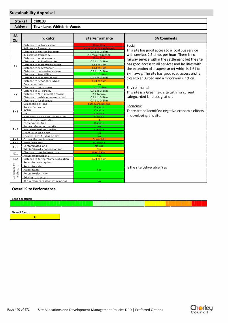
Sustainability Appraisal
Site Ref CH0133
Address Town Lane, Whittle-le-Woods
SA Obj
Indicator Site Performance SA Comments
S1
Distance to railway station Ove r 3 km Social This site has good access to a local bus service with services 2-5 times per hour. There is no railway service within the settlement but the site has good access to all services and facilities with the exception of a supermarket which is 1.61 to 3km away. The site has good road access and is close to an A road and a motorway junction. Environmental This site is a Greenfield site within a current safeguarded land designation. Economic There are no identified negative economic effects in developing this site.
Rail service frequency No se rvices in settle me nt Distance to ne arest bus stop 0.4 1 to 0. 8km Bus service frequency 2 -5 /hour/direction Distance to se rvice ce ntre Ove r 3 km Distance to A Road junction 0.4 1 to 0. 8km Distance to motorwa y junction 1. 61 to 3 km Distance to supermarket 1. 61 to 3 km Distance to convenience store 0.4 1 to 0. 8km Distance to Post Office Up to 0 .4km Distance to Primary School 0.4 1 to 0. 8km Distance to Secondary School 3. 21 to 5 km On a cycle route No Distance to cycle route Up to 0 .4km
S2
Distance to GP surge ry 0.4 1 to 0. 8km Distance to NH S general hospital 2 .1 to 5km Distance to public open space /park 0.4 1 to 0. 8km Distance to local ce ntre 0.4 1 to 0. 8km
EN1
Designation of land Safe guarde d Land Are a of Separation Outside AONB Outside SSSI Outside Biological/ G eological He ri tage Site Outside Agricultural classification 3
EN2
Conservation Are a Outside Ancie nt Monument on site No Regis tere d Park or G arden Outside Listed Build ing on site No Locally Listed Building on s ite No
EN3 Curre nt/former land use Greenfield EN4 Flood Zone are a All Zone 1
EN5 Contaminated land No risk Within 3 km of a congestion spot Yes
EC1 Distance to employme nt site Over 1. 6km Access to Broadband Yes
EC2 Distance to further/ highe r e ducation 3. 21 to 5 km
De
live
rab
ility
In
dic
ato
rs
Access to sewer system
Yes
Is the site deliverable: Yes Access to water
Access to gas
Access to e lectricity
Exis ting road acce ss
At risk from haza rdous ins tallations No
Overall Site Performance
Band Spe ctrum:
Overall Band:
C
Page 440 of 471 Site Allocations and Development Management Policies DPD | Preferred Options

Housing
Employment
Mixed Use
Retail
Commercial
Leisure
Recreation
Safeguarded Land
Preferred Options Decision
Allocate site Potential no. units: 11
Hectares of land: 0
Other
Site Reference: CH0146 Land rear of 23 Birchin Lane
Whittle-le-Woods
Site already has planning permission.
Site is known to contain at least one heritage asset.Summary of Objections
Summary of Support
Alternative site suggestions: ---
DETAILED SITE ASSESSMENT
Location
Development Criteria
Infrastructure N/A- site already has planning permission and is under construction
Transport: All development proposals should achieve a high level of road safety, and will be assessed as such by the Council through the planning application process. As this site is already under construction, the relevant Transport Statement/Assessment has already been submitted to, and approved by the Council.
Additional Details:
N/A- site already has planning permission and is under construction
Issues and Options Consultation Summary
Playspace
HS1.46
Page 441 of 471 Site Allocations and Development Management Policies DPD | Preferred Options

Sustainability Appraisal
Site Ref CH0146
Address Land Rear of 23 Birchin Lane, Whittle-le-Woods
SA Obj
Indicator Site Performance SA Comments
S1
Distance to railway station Ove r 3 km This site has been granted planning permission for housing and is under construction.
Rail service frequency No se rvices in settle me nt Distance to ne arest bus stop Up to 0 .4km Bus service frequency 2 -5 /hour/direction Distance to se rvice ce ntre Ove r 3 km Distance to A Road junction Up to 0 .4km Distance to motorwa y junction Ove r 3 km Distance to supermarket 1. 61 to 3 km Distance to convenience store Up to 0 .4km Distance to Post Office 0.8 1 to 1. 2km Distance to Primary School 0.4 1 to 0. 8km Distance to Secondary School 3. 21 to 5 km On a cycle route Yes Distance to cycle route Up to 0 .4km
S2
Distance to GP surge ry 0.8 1 to 1. 6km Distance to NH S general hospital 2 .1 to 5km Distance to public open space /park Up to 0 .4km Distance to local ce ntre 0.4 1 to 0. 8km
EN1
Designation of land Urban Local Service Centre Are a of Separation Outside AONB Outside SSSI Outside Biological/ G eological He ri tage Site Outside Agricultural classification 3
EN2
Conservation Are a Outside Ancie nt Monument on site No Regis tere d Park or G arden Outside Listed Build ing on site No Locally Listed Building on s ite No
EN3 Curre nt/former land use Brownfield EN4 Flood Zone are a All Zone 1
EN5 Contaminated land Me dium risk Within 3 km of a congestion spot No
EC1 Distance to employme nt site Over 1. 6km Access to Broadband Yes
EC2 Distance to further/ highe r e ducation Ove r 5 km
De
live
rab
ility
In
dic
ato
rs
Access to sewer system
Yes
Is the site deliverable: Yes/No Access to water
Access to gas Access to e lectricity
Exis ting road acce ss
At risk from haza rdous ins tallations No
Overall Site Performance
Band Spe ctrum:
Overall Band:
C
Page 442 of 471 Site Allocations and Development Management Policies DPD | Preferred Options

Housing
Employment
Mixed Use
Retail
Commercial
Leisure
Recreation
Safeguarded Land
Preferred Options Decision
Allocate site Potential no. units: 12
Hectares of land: 0
Other
Site Reference: CH0195 Crostons Farm, Lucas Lane
Whittle-le-Woods
The suggestion acts as a natural rounding-off of the existing residential development. No increased problems in infrastructure, traffic or facilities.
Area has experienced enough development and has inadequate services, sewage system and infrastructure to cope with additional development. Wish to see land retained in current state.
Summary of Objections
Summary of Support
Alternative site suggestions: ---
DETAILED SITE ASSESSMENT
Location
Development Criteria
Infrastructure Water Cycle Study: Confirm flood risk from minor watercourse. All developments in the Walton-le-Dale catchment need to be assessed by UU. Attenuation and infiltration SUDS may be viable, however this needs a detailed check. Need agreement from EA regarding attenuating to watercourses.
Transport: All development proposals should achieve a high level of road safety, and will be assessed as such by the Council through the planning application process. For housing developments with between 50 and 80 units, the Council will require a Transport Statement. For developments of more than 80 units, the Council will require a Transport Assessment and Travel Plan as part of the application.
Additional Details:
---
Issues and Options Consultation Summary
Playspace
HS1.44
Page 443 of 471 Site Allocations and Development Management Policies DPD | Preferred Options

Sustainability Appraisal
Site Ref CH0195
Address Crostons Farm, Lucas Lane, Whittle-le-Woods
SA Obj
Indicator Site Performance SA Comments
S1
Distance to railway station Ove r 3 km Social This site has good access to a local bus service with services 2-5 times per hour. There is no railway service within the settlement but the site has access to all services and facilities with the exception of a supermarket which is 1.61 to 3km from the site. This site has good road connections and is in close proximity to an A road and motorway junction. Environmental This site is a Greenfield site within a current safeguarded land designation. Economic There are no identified negative economic effects in developing this site.
Rail service frequency No se rvices in settle me nt Distance to ne arest bus stop Up to 0 .4km Bus service frequency 2 -5 /hour/direction Distance to se rvice ce ntre 2. 41 to 3 km Distance to A Road junction Up to 0 .4km Distance to motorwa y junction 1. 61 to 3 km Distance to supermarket 1. 61 to 3 km Distance to convenience store 0.4 1 to 0. 8km Distance to Post Office 0.8 1 to 1. 2km Distance to Primary School 0.8 1 to 1. 6km Distance to Secondary School 1.6 1 to 3. 2km On a cycle route No Distance to cycle route 0.4 1 to 0. 8km
S2
Distance to GP surge ry 0.8 1 to 1. 6km Distance to NH S general hospital Up to 2km Distance to public open space /park Up to 0 .4km Distance to local ce ntre Over 1. 6km
EN1
Designation of land Safe guarde d Land Are a of Separation Outside AONB Outside SSSI Outside Biological/ G eological He ri tage Site Outside Agricultural classification 3
EN2
Conservation Are a Outside Ancie nt Monument on site No Regis tere d Park or G arden Outside Listed Build ing on site No Locally Listed Building on s ite No
EN3 Curre nt/former land use Greenfield EN4 Flood Zone are a All Zone 1
EN5 Contaminated land No risk Within 3 km of a congestion spot Yes
EC1 Distance to employme nt site 0.8 1 to 1. 2km Access to Broadband Yes
EC2 Distance to further/ highe r e ducation 3. 21 to 5 km
De
live
rab
ility
In
dic
ato
rs
Access to sewer system
Yes
Is the site deliverable: Yes Access to water
Access to gas
Access to e lectricity
Exis ting road acce ss
At risk from haza rdous ins tallations No
Overall Site Performance
Band Spe ctrum:
Overall Band:
C
Page 444 of 471 Site Allocations and Development Management Policies DPD | Preferred Options
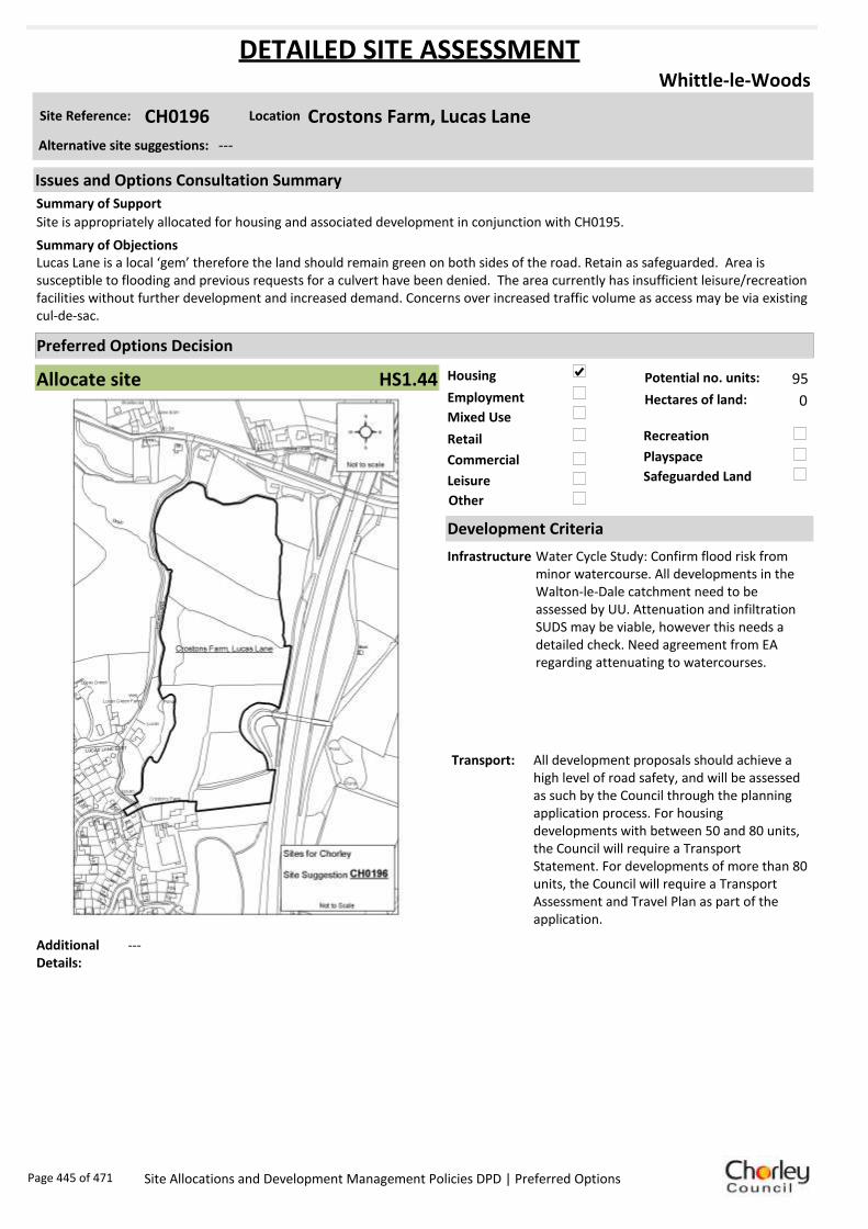
Housing
Employment
Mixed Use
Retail
Commercial
Leisure
Recreation
Safeguarded Land
Preferred Options Decision
Allocate site Potential no. units: 95
Hectares of land: 0
Other
Site Reference: CH0196 Crostons Farm, Lucas Lane
Whittle-le-Woods
Site is appropriately allocated for housing and associated development in conjunction with CH0195.
Lucas Lane is a local ‘gem’ therefore the land should remain green on both sides of the road. Retain as safeguarded. Area is susceptible to flooding and previous requests for a culvert have been denied. The area currently has insufficient leisure/recreation facilities without further development and increased demand. Concerns over increased traffic volume as access may be via existing cul-de-sac.
Summary of Objections
Summary of Support
Alternative site suggestions: ---
DETAILED SITE ASSESSMENT
Location
Development Criteria
Infrastructure Water Cycle Study: Confirm flood risk from minor watercourse. All developments in the Walton-le-Dale catchment need to be assessed by UU. Attenuation and infiltration SUDS may be viable, however this needs a detailed check. Need agreement from EA regarding attenuating to watercourses.
Transport: All development proposals should achieve a high level of road safety, and will be assessed as such by the Council through the planning application process. For housing developments with between 50 and 80 units, the Council will require a Transport Statement. For developments of more than 80 units, the Council will require a Transport Assessment and Travel Plan as part of the application.
Additional Details:
---
Issues and Options Consultation Summary
Playspace
HS1.44
Page 445 of 471 Site Allocations and Development Management Policies DPD | Preferred Options

Sustainability Appraisal
Site Ref CH0196
Address Crostons Farm, Lucas Lane, Whittle-le-Woods
SA Obj
Indicator Site Performance SA Comments
S1
Distance to railway station Ove r 3 km Social This site has good access to a local bus service with services 2-5 times per hour. There is no railway service within the settlement but the site has good access to all services and facilities with the exception of a supermarket which is 1.61 to 3km away. The site has good access to the roads network and is in close proximity to and A road and motorway junction. Environmental This site is a Greenfield site within a current safeguarded land designation. Economic There are no identified negative economic effects in developing this site.
Rail service frequency No se rvices in settle me nt Distance to ne arest bus stop 0.4 1 to 0. 8km Bus service frequency 2 -5 /hour/direction Distance to se rvice ce ntre 2. 41 to 3 km Distance to A Road junction 0.4 1 to 0. 8km Distance to motorwa y junction 1. 61 to 3 km Distance to supermarket 1. 61 to 3 km Distance to convenience store 0.4 1 to 0. 8km Distance to Post Office 0.4 1 to 0. 8km Distance to Primary School 0.8 1 to 1. 6km Distance to Secondary School 1.6 1 to 3. 2km On a cycle route No Distance to cycle route Up to 0 .4km
S2
Distance to GP surge ry 0.8 1 to 1. 6km Distance to NH S general hospital Up to 2km Distance to public open space /park Up to 0 .4km Distance to local ce ntre 0.8 1 to 1. 2km
EN1
Designation of land Safe guarde d Land Are a of Separation Outside AONB Outside SSSI Outside Biological/ G eological He ri tage Site Outside Agricultural classification 3
EN2
Conservation Are a Outside Ancie nt Monument on site No Regis tere d Park or G arden Outside Listed Build ing on site No Locally Listed Building on s ite No
EN3 Curre nt/former land use Greenfield EN4 Flood Zone are a All Zone 1
EN5 Contaminated land No risk Within 3 km of a congestion spot Yes
EC1 Distance to employme nt site 0.8 1 to 1. 2km Access to Broadband Yes
EC2 Distance to further/ highe r e ducation 3. 21 to 5 km
De
live
rab
ility
In
dic
ato
rs
Access to sewer system
Yes
Is the site deliverable: Yes Access to water
Access to gas Access to e lectricity
Exis ting road acce ss
At risk from haza rdous ins tallations No
Overall Site Performance
Band Spe ctrum:
Overall Band:
C
Page 446 of 471 Site Allocations and Development Management Policies DPD | Preferred Options

Housing
Employment
Mixed Use
Retail
Commercial
Leisure
Recreation
Safeguarded Land
Preferred Options Decision
Do not allocate Potential no. units: 0
Hectares of land: 0
Other
Site Reference: CH0210 Swansey Mill between Swansey Lane and Mill Lane
Whittle-le-Woods
This site appears to fall on an identified textile mill area- any proposed development must be assessed carefully. This is an old, obsolete former textile mill and should be reallocated for housing.
The site should retain its existing employment allocation.Summary of Objections
Summary of Support
Alternative site suggestions: ---
DETAILED SITE ASSESSMENT
Location
Development Criteria
Infrastructure N/A- proposed not to allocate site
Transport: N/A- proposed not to allocate site
Additional Details:
In active employment use. Employment use will be protected.
Issues and Options Consultation Summary
Playspace
Page 447 of 471 Site Allocations and Development Management Policies DPD | Preferred Options

Sustainability Appraisal
Site Ref CH0210
Address Swansey Mill, Whittle-le-Woods
SA Obj
Indicator Site Performance SA Comments
S1
Distance to railway station Ove r 3 km This site is all within flood zone 3 and should be discounted as part of the filtering process.
Rail service frequency No se rvices in settle me nt Distance to ne arest bus stop Up to 0 .4km Bus service frequency 2 -5 /hour/direction Distance to se rvice ce ntre Ove r 3 km Distance to A Road junction Up to 0 .4km Distance to motorwa y junction Ove r 3 km Distance to supermarket 1. 61 to 3 km Distance to convenience store Up to 0 .4km Distance to Post Office 0.8 1 to 1. 2km Distance to Primary School 0.4 1 to 0. 8km Distance to Secondary School 3. 21 to 5 km On a cycle route Yes Distance to cycle route Up to 0 .4km
S2
Distance to GP surge ry 0.4 1 to 0. 8km Distance to NH S general hospital 2 .1 to 5km Distance to public open space /park Up to 0 .4km Distance to local ce ntre 0.4 1 to 0. 8km
EN1
Designation of land Urban Local Service Centre Are a of Separation Outside AONB Outside SSSI Outside Biological/ G eological He ri tage Site Outside Agricultural classification 3
EN2
Conservation Are a Outside Ancie nt Monument on site No Regis tere d Park or G arden Outside Listed Build ing on site No Locally Listed Building on s ite No
EN3 Curre nt/former land use Brownfield EN4 Flood Zone are a All Zone 3
EN5 Contaminated land Me dium risk Within 3 km of a congestion spot No
EC1 Distance to employme nt site 1.2 1 to 1. 6km Access to Broadband Yes
EC2 Distance to further/ highe r e ducation Ove r 5 km
De
live
rab
ility
In
dic
ato
rs
Access to sewer system
Yes
Is the site deliverable: Yes/No Access to water
Access to gas
Access to e lectricity
Exis ting road acce ss
At risk from haza rdous ins tallations No
Overall Site Performance
Band Spe ctrum:
Overall Band:
C
Page 448 of 471 Site Allocations and Development Management Policies DPD | Preferred Options

Housing
Employment
Mixed Use
Retail
Commercial
Leisure
Recreation
Safeguarded Land
Preferred Options Decision
Retain existing designation Potential no. units: 0
Hectares of land: 0
Other
Site Reference: CH0227 Land to the Rear of Dolphin Farm, Off Chorley Old Road
Whittle-le-Woods
None received.
Safeguarded land in an area which has already been overdeveloped. Poor access to the site. Site contains grade II listed structure, which should be considered before any development occurs.
Summary of Objections
Summary of Support
Alternative site suggestions: CH0238
DETAILED SITE ASSESSMENT
Location
Development Criteria
Infrastructure N/A- proposed to retain existing safeguarded land designation
Transport: N/A- proposed to retain existing safeguarded land designation
Additional Details:
Listed Building and existing/planned low density dwellings on significant part of site make site too small to allocate. Site proposal should be considered in conjunction with site suggestion CH0238.
Issues and Options Consultation Summary
Playspace
BNE2.14
Page 449 of 471 Site Allocations and Development Management Policies DPD | Preferred Options

Sustainability Appraisal
Site Ref CH0227
Address Land to the Rear of Dolphin Farm, Off Chorley Old Road, Whittle-le-Woods
SA Obj
Indicator Site Performance SA Comments
S1
Distance to railway station Ove r 3 km This site has been granted planning permission for housing and is under construction.
Rail service frequency No se rvices in settle me nt Distance to ne arest bus stop Up to 0 .4km Bus service frequency 2 -5 /hour/direction Distance to se rvice ce ntre Ove r 3 km Distance to A Road junction Up to 0 .4km Distance to motorwa y junction 1. 61 to 3 km Distance to supermarket 1. 61 to 3 km Distance to convenience store Up to 0 .4km Distance to Post Office Up to 0 .4km Distance to Primary School 0.4 1 to 0. 8km Distance to Secondary School 3. 21 to 5 km On a cycle route Yes Distance to cycle route Up to 0 .4km
S2
Distance to GP surge ry 0.4 1 to 0. 8km Distance to NH S general hospital 2 .1 to 5km Distance to public open space /park Up to 0 .4km Distance to local ce ntre Up to 0 .4km
EN1
Designation of land Urban Local Service
Ce ntre/Safeguarded Land Are a of Separation Outside AONB Outside SSSI Outside Biological/ G eological He ri tage Site Outside Agricultural classification 3
EN2
Conservation Are a Outside Ancie nt Monument on site No Regis tere d Park or G arden Outside Listed Build ing on site Grade II Locally Listed Building on s ite No
EN3 Curre nt/former land use Brownfield/Gree nfield EN4 Flood Zone are a All Zone 1
EN5 Contaminated land No risk Within 3 km of a congestion spot Yes
EC1 Distance to employme nt site Over 1. 6km Access to Broadband Yes
EC2 Distance to further/ highe r e ducation 3. 21 to 5 km
De
live
rab
ility
In
dic
ato
rs
Access to sewer system
Yes
Is the site deliverable: Yes/No Access to water
Access to gas
Access to e lectricity
Exis ting road acce ss
At risk from haza rdous ins tallations No
Overall Site Performance
Band Spe ctrum:
Overall Band:
C
Page 450 of 471 Site Allocations and Development Management Policies DPD | Preferred Options

Housing
Employment
Mixed Use
Retail
Commercial
Leisure
Recreation
Safeguarded Land
Preferred Options Decision
Allocate site Potential no. units: 36
Hectares of land: 0
Other
Site Reference: CH0229 Land fronting Moss Lane
Whittle-le-Woods
Site already has development around it. No infrastructure or service problems foreseen.
Land should be retained as safeguarded through the next plan period. Should only be released for appropriate recreation and leisure uses.
Summary of Objections
Summary of Support
Alternative site suggestions: ---
DETAILED SITE ASSESSMENT
Location
Development Criteria
Infrastructure ---
Transport: All development proposals should achieve a high level of road safety, and will be assessed as such by the Council through the planning application process. For housing developments with between 50 and 80 units, the Council will require a Transport Statement. For developments of more than 80 units, the Council will require a Transport Assessment and Travel Plan as part of the application.
Additional Details:
---
Issues and Options Consultation Summary
Playspace
HS1.44
Page 451 of 471 Site Allocations and Development Management Policies DPD | Preferred Options

Sustainability Appraisal
Site Ref CH0229
Address Land fronting Moss Lane, Whittle-le-Woods
SA Obj
Indicator Site Performance SA Comments
S1
Distance to railway station 2. 41 to 3 km Social This site has good access to a local bus service with services 2-5 times per hour. There is no railway service within the settlement but the site has access to all local services and facilities with the exception of a supermarket which is 1.61 to 3km away. The site is in close proximity to and A road and motorway junction. Environmental This site is a Greenfield site within a current safeguarded land designation. Economic There are no identified negative economic effects in developing this site.
Rail service frequency No se rvices in settle me nt Distance to ne arest bus stop Up to 0 .4km Bus service frequency 2 -5 /hour/direction Distance to se rvice ce ntre 2. 41 to 3 km Distance to A Road junction Up to 0 .4km Distance to motorwa y junction Up to 1 .6km Distance to supermarket 1. 61 to 3 km Distance to convenience store Up to 0 .4km Distance to Post Office 0.8 1 to 1. 2km Distance to Primary School 0.8 1 to 1. 6km Distance to Secondary School 1.6 1 to 3. 2km On a cycle route No Distance to cycle route 0.4 1 to 0. 8km
S2
Distance to GP surge ry 0.8 1 to 1. 6km Distance to NH S general hospital Up to 2km Distance to public open space /park Up to 0 .4km Distance to local ce ntre Over 1. 6km
EN1
Designation of land Safe guarde d Land Are a of Separation Outside AONB Outside SSSI Outside Biological/ G eological He ri tage Site Outside Agricultural classification 3
EN2
Conservation Are a Outside Ancie nt Monument on site No Regis tere d Park or G arden Outside Listed Build ing on site No Locally Listed Building on s ite No
EN3 Curre nt/former land use Greenfield EN4 Flood Zone are a All Zone 1
EN5 Contaminated land No risk Within 3 km of a congestion spot Yes
EC1 Distance to employme nt site Up to 0 .8km Access to Broadband Yes
EC2 Distance to further/ highe r e ducation 1.6 1 to 3. 2km
De
live
rab
ility
In
dic
ato
rs
Access to sewer system
Yes
Is the site deliverable: Yes Access to water
Access to gas
Access to e lectricity
Exis ting road acce ss
At risk from haza rdous ins tallations No
Overall Site Performance
Band Spe ctrum:
Overall Band:
C
Page 452 of 471 Site Allocations and Development Management Policies DPD | Preferred Options

Housing
Employment
Mixed Use
Retail
Commercial
Leisure
Recreation
Safeguarded Land
Preferred Options Decision
Retain existing designation Potential no. units: 0
Hectares of land: 0
Other
Site Reference: CH0238 Land to the Rear of Dolphin Farm, Off Chorley Old Road
Whittle-le-Woods
Summary of Objections
Summary of Support
Alternative site suggestions: CH0227
DETAILED SITE ASSESSMENT
Location
Development Criteria
Infrastructure N/A-proposed to retain existing safeguarded land designation
Transport: N/A-proposed to retain existing safeguarded land designation
Additional Details:
Listed Building and existing/planned low density dwellings on significant part of site make site too small to allocate. Site proposal should be considered in conjunction with site suggestion CH0227.
Issues and Options Consultation Summary
Playspace
BNE2.14
Page 453 of 471 Site Allocations and Development Management Policies DPD | Preferred Options

Sustainability Appraisal
Site Ref CH0238
Address Land to the Rear of Dolphin Farm, Off Chorley Old Road, Whittle-le-Woods
SA Obj
Indicator Site Performance SA Comments
S1
Distance to railway station Ove r 3 km This site has been granted planning permission for housing and is under construction.
Rail service frequency No se rvices in settle me nt Distance to ne arest bus stop Up to 0 .4km Bus service frequency 2 -5 /hour/direction Distance to se rvice ce ntre Ove r 3 km Distance to A Road junction Up to 0 .4km Distance to motorwa y junction 1. 61 to 3 km Distance to supermarket 1. 61 to 3 km Distance to convenience store Up to 0 .4km Distance to Post Office Up to 0 .4km Distance to Primary School 0.4 1 to 0. 8km Distance to Secondary School 3. 21 to 5 km On a cycle route Yes Distance to cycle route Up to 0 .4km
S2
Distance to GP surge ry 0.4 1 to 0. 8km Distance to NH S general hospital 2 .1 to 5km Distance to public open space /park Up to 0 .4km Distance to local ce ntre Up to 0 .4km
EN1
Designation of land Urban Local Service
Ce ntre/Safeguarded Land Are a of Separation Outside AONB Outside SSSI Outside Biological/ G eological He ri tage Site Outside Agricultural classification 3
EN2
Conservation Are a Outside Ancie nt Monument on site No Regis tere d Park or G arden Outside Listed Build ing on site Grade II Locally Listed Building on s ite No
EN3 Curre nt/former land use Brownfield/Gree nfield EN4 Flood Zone are a All Zone 1
EN5 Contaminated land No risk Within 3 km of a congestion spot Yes
EC1 Distance to employme nt site Over 1. 6km Access to Broadband Yes
EC2 Distance to further/ highe r e ducation 3. 21 to 5 km
De
live
rab
ility
In
dic
ato
rs
Access to sewer system
Yes
Is the site deliverable: Yes/No Access to water
Access to gas
Access to e lectricity
Exis ting road acce ss
At risk from haza rdous ins tallations No
Overall Site Performance
Band Spe ctrum:
Overall Band:
C
Page 454 of 471 Site Allocations and Development Management Policies DPD | Preferred Options

Housing
Employment
Mixed Use
Retail
Commercial
Leisure
Recreation
Safeguarded Land
Preferred Options Decision
Retain existing designation Potential no. units: 0
Hectares of land: 0
Other
Site Reference: CH0261 Little Quarries/Whittle Hill Quarry, Hill Top Lane
Whittle-le-Woods
Makes effective use of considerable area of previously developed land for new housing in a sustainable location, popular with families and other households. Once developed, quarry traffic would be replaced with private cars.
Whittle Hill Quarry has planning approval until 2042 for the extraction of stone and Little Quarry has permission for a ski slope development. Housing should not therefore be considered. There is already insufficient recreation land available without further housing development.
Summary of Objections
Summary of Support
Alternative site suggestions: ---
DETAILED SITE ASSESSMENT
Location
Development Criteria
Infrastructure N/A- proposed not to allocate site
Transport: N/A- proposed not to allocate site
Additional Details:
Not necessary to release all safeguarded land in Whittle - poorer accessibility and topography on northern safeguarded sites. More impact on adjacent green belt and countryside.
Issues and Options Consultation Summary
Playspace
BNE2.14
Page 455 of 471 Site Allocations and Development Management Policies DPD | Preferred Options

Sustainability Appraisal
Site Ref CH0261
Address Hill Top Lane, Whittle-le-Woods
SA Obj
Indicator Site Performance SA Comments
S1
Distance to railway station Ove r 3 km Social This site has good access to frequent bus services with 2-5 services per hour. There is no rail service within the settlement. The site has good access to all local services and facilities with the exception of distance to supermarket which is 1.61 to 3km away. Environmental This site is a Greenfield site within a current safeguarded land designation. There is a Grade II listed building on the site with a medium risk of land contamination. Economic There are no identified negative economic effects in developing this site.
Rail service frequency No se rvices in settle me nt Distance to ne arest bus stop Up to 0 .4km Bus service frequency 2 -5 /hour/direction Distance to se rvice ce ntre Ove r 3 km Distance to A Road junction Up to 0 .4km Distance to motorwa y junction 1. 61 to 3 km Distance to supermarket 1. 61 to 3 km Distance to convenience store Up to 0 .4km Distance to Post Office 0.4 1 to 0. 8km Distance to Primary School 0.4 1 to 0. 8km Distance to Secondary School 3. 21 to 5 km On a cycle route Yes Distance to cycle route Up to 0 .4km
S2
Distance to GP surge ry 0.4 1 to 0. 8km Distance to NH S general hospital 2 .1 to 5km Distance to public open space /park Up to 0 .4km Distance to local ce ntre Up to 0 .4km
EN1
Designation of land Safe guarde d Land Are a of Separation Outside AONB Outside SSSI Outside Biological/ G eological He ri tage Site Outside Agricultural classification 3
EN2
Conservation Are a Outside Ancie nt Monument on site No Regis tere d Park or G arden Outside Listed Build ing on site Grade II Locally Listed Building on s ite No
EN3 Curre nt/former land use Greenfield EN4 Flood Zone are a All Zone 1
EN5 Contaminated land Me dium risk Within 3 km of a congestion spot Yes
EC1 Distance to employme nt site Over 1. 6km Access to Broadband Yes
EC2 Distance to further/ highe r e ducation 3. 21 to 5 km
De
live
rab
ility
In
dic
ato
rs
Access to sewer system
Yes
Is the site deliverable: Yes Access to water
Access to gas
Access to e lectricity
Exis ting road acce ss
At risk from haza rdous ins tallations No
Overall Site Performance
Band Spe ctrum:
Overall Band:
C
Page 456 of 471 Site Allocations and Development Management Policies DPD | Preferred Options

Housing
Employment
Mixed Use
Retail
Commercial
Leisure
Recreation
Safeguarded Land
Preferred Options Decision
Retain existing designation Potential no. units: 0
Hectares of land: 0
Other
Site Reference: CH0366 Land off Birchin Lane
Whittle-le-Woods
New site suggestion.
New site suggestion.Summary of Objections
Summary of Support
Alternative site suggestions: ---
DETAILED SITE ASSESSMENT
Location
Development Criteria
Infrastructure N/A- proposed not to allocate site
Transport: N/A- proposed not to allocate site
Additional Details:
Not necessary to release all safeguarded land in Whittle - poorer accessibility and topography on northern safeguarded sites. More impact on adjacent green belt and countryside.
Issues and Options Consultation Summary
Playspace
BNE2.14
Page 457 of 471 Site Allocations and Development Management Policies DPD | Preferred Options

Sustainability Appraisal
Site Ref CH0366
Address Land off Birchin Lane, Whittle-le-Woods
SA Obj
Indicator Site Performance SA Comments
S1
Distance to railway station Ove r 3 km Social This site has good access to a local bus service with services 2-5 times per hour. There is no railway service within the settlement but the site has good access to all services and facilities with the exception of a supermarket which is 1.61 to 3km from the site. The site has good access to an a road and is in close proximity to a motorway junction. Environmental This site is a Greenfield site within a current safeguarded land designation. Economic There are no identified negative economic effects in developing this site.
Rail service frequency No se rvices in settle me nt Distance to ne arest bus stop Up to 0 .4km Bus service frequency 2 -5 /hour/direction Distance to se rvice ce ntre Ove r 3 km Distance to A Road junction Up to 0 .4km Distance to motorwa y junction 1. 61 to 3 km Distance to supermarket 1. 61 to 3 km Distance to convenience store Up to 0 .4km Distance to Post Office 0.4 1 to 0. 8km Distance to Primary School 0.4 1 to 0. 8km Distance to Secondary School 3. 21 to 5 km On a cycle route Yes Distance to cycle route Up to 0 .4km
S2
Distance to GP surge ry 0.4 1 to 0. 8km Distance to NH S general hospital 2 .1 to 5km Distance to public open space /park Up to 0 .4km Distance to local ce ntre Up to 0 .4km
EN1
Designation of land Safe guarde d Land Are a of Separation Outside AONB Outside SSSI Outside Biological/ G eological He ri tage Site Outside Agricultural classification 3
EN2
Conservation Are a Outside Ancie nt Monument on site No Regis tere d Park or G arden Outside Listed Build ing on site No Locally Listed Building on s ite No
EN3 Curre nt/former land use Greenfield EN4 Flood Zone are a All Zone 1
EN5 Contaminated land Low risk Within 3 km of a congestion spot Yes
EC1 Distance to employme nt site Over 1. 6km Access to Broadband Yes
EC2 Distance to further/ highe r e ducation 3. 21 to 5 km
De
live
rab
ility
In
dic
ato
rs
Access to sewer system
Yes
Is the site deliverable: Yes Access to water
Access to gas
Access to e lectricity
Exis ting road acce ss
At risk from haza rdous ins tallations No
Overall Site Performance
Band Spe ctrum:
Overall Band:
C
Page 458 of 471 Site Allocations and Development Management Policies DPD | Preferred Options

Housing
Employment
Mixed Use
Retail
Commercial
Leisure
Recreation
Safeguarded Land
Preferred Options Decision
Do not allocate Potential no. units: 0
Hectares of land: 0
Other
Site Reference: CS0006 Adj Springside Farm, Moss Lane
Whittle-le-Woods
This land is already built on.
None received.Summary of Objections
Summary of Support
Alternative site suggestions: ---
DETAILED SITE ASSESSMENT
Location
Development Criteria
Infrastructure N/A- site already developed
Transport: N/A- site already developed
Additional Details:
N/A- site already developed
Issues and Options Consultation Summary
Playspace
Page 459 of 471 Site Allocations and Development Management Policies DPD | Preferred Options
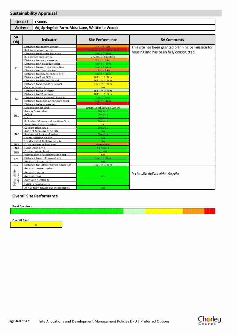
Sustainability Appraisal
Site Ref CS0006
Address Adj Springside Farm, Moss Lane, Whittle-le-Woods
SA Obj
Indicator Site Performance SA Comments
S1
Distance to railway station 2. 41 to 3 km This site has been granted planning permission for housing and has been fully constructed.
Rail service frequency No se rvices in settle me nt Distance to ne arest bus stop Up to 0 .4km Bus service frequency 2 -5 /hour/direction Distance to se rvice ce ntre 2. 41 to 3 km Distance to A Road junction Up to 0 .4km Distance to motorwa y junction Up to 1 .6km Distance to supermarket 1. 61 to 3 km Distance to convenience store Up to 0 .4km Distance to Post Office 0.8 1 to 1. 2km Distance to Primary School 0.8 1 to 1. 6km Distance to Secondary School 1.6 1 to 3. 2km On a cycle route No Distance to cycle route 0.4 1 to 0. 8km
S2
Distance to GP surge ry 0.8 1 to 1. 6km Distance to NH S general hospital Up to 2km Distance to public open space /park Up to 0 .4km Distance to local ce ntre Over 1. 6km
EN1
Designation of land Urban Local Service Centre Are a of Separation Outside AONB Outside SSSI Outside Biological/ G eological He ri tage Site Outside Agricultural classification 3
EN2
Conservation Are a Outside Ancie nt Monument on site No Regis tere d Park or G arden Outside Listed Build ing on site No Locally Listed Building on s ite No
EN3 Curre nt/former land use Greenfield EN4 Flood Zone are a All Zone 1
EN5 Contaminated land No risk Within 3 km of a congestion spot Yes
EC1 Distance to employme nt site Up to 0 .8km Access to Broadband Yes
EC2 Distance to further/ highe r e ducation 1.6 1 to 3. 2km
De
live
rab
ility
In
dic
ato
rs
Access to sewer system
Yes
Is the site deliverable: Yes/No Access to water
Access to gas
Access to e lectricity
Exis ting road acce ss
At risk from haza rdous ins tallations No
Overall Site Performance
Band Spe ctrum:
Overall Band:
C
Page 460 of 471 Site Allocations and Development Management Policies DPD | Preferred Options
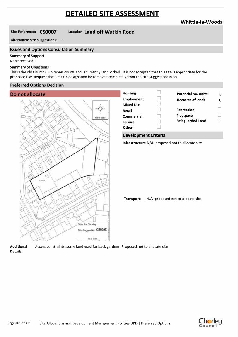
Housing
Employment
Mixed Use
Retail
Commercial
Leisure
Recreation
Safeguarded Land
Preferred Options Decision
Do not allocate Potential no. units: 0
Hectares of land: 0
Other
Site Reference: CS0007 Land off Watkin Road
Whittle-le-Woods
None received.
This is the old Church Club tennis courts and is currently land locked. It is not accepted that this site is appropriate for the proposed use. Request that CS0007 designation be removed completely from the Site Suggestions Map.
Summary of Objections
Summary of Support
Alternative site suggestions: ---
DETAILED SITE ASSESSMENT
Location
Development Criteria
Infrastructure N/A- proposed not to allocate site
Transport: N/A- proposed not to allocate site
Additional Details:
Access constraints, some land used for back gardens. Proposed not to allocate site
Issues and Options Consultation Summary
Playspace
Page 461 of 471 Site Allocations and Development Management Policies DPD | Preferred Options

Sustainability Appraisal
Site Ref CS0007
Address Land off Watkin Road, Whittle-le-Woods
SA Obj
Indicator Site Performance SA Comments
S1
Distance to railway station Ove r 3 km Social This site has good access to a local bus service with services 2-5 times per hour. There is no railway service within the settlement but the site has good access to all services and facilities with the exception of a supermarket which is 1.61 to 3km from the site. The site has good access to an A road junction although the motorway junction is over 3km away. Environmental The only identified negative environmental effect in developing this site is the site is currently Greenfield. Economic There are no identified negative economic effects in developing this site.
Rail service frequency No se rvices in settle me nt Distance to ne arest bus stop Up to 0 .4km Bus service frequency 2 -5 /hour/direction Distance to se rvice ce ntre Ove r 3 km Distance to A Road junction Up to 0 .4km Distance to motorwa y junction Ove r 3 km Distance to supermarket 1. 61 to 3 km Distance to convenience store Up to 0 .4km Distance to Post Office 0.4 1 to 0. 8km Distance to Primary School Up to 0 .4km Distance to Secondary School 3. 21 to 5 km On a cycle route No Distance to cycle route Up to 0 .4km
S2
Distance to GP surge ry 0.4 1 to 0. 8km Distance to NH S general hospital 2 .1 to 5km Distance to public open space /park Up to 0 .4km Distance to local ce ntre 0.4 1 to 0. 8km
EN1
Designation of land Urban Local Service Centre Are a of Separation Outside AONB Outside SSSI Outside Biological/ G eological He ri tage Site Outside Agricultural classification 3
EN2
Conservation Are a Outside Ancie nt Monument on site No Regis tere d Park or G arden Outside Listed Build ing on site No Locally Listed Building on s ite No
EN3 Curre nt/former land use Greenfield EN4 Flood Zone are a All Zone 1
EN5 Contaminated land No risk Within 3 km of a congestion spot Yes
EC1 Distance to employme nt site Over 1. 6km Access to Broadband Yes
EC2 Distance to further/ highe r e ducation 3. 21 to 5 km
De
live
rab
ility
In
dic
ato
rs
Access to sewer system
Yes
Is the site deliverable: Yes Access to water
Access to gas
Access to e lectricity
Exis ting road acce ss
At risk from haza rdous ins tallations No
Overall Site Performance
Band Spe ctrum:
Overall Band:
C
Page 462 of 471 Site Allocations and Development Management Policies DPD | Preferred Options

Housing
Employment
Mixed Use
Retail
Commercial
Leisure
Recreation
Safeguarded Land
Preferred Options Decision
Retain existing designation Potential no. units: 0
Hectares of land: 0
Other
Site Reference: CS0017 Land off Birchin Lane
Whittle-le-Woods
None received.
No proven need for additional residential property in the area. Site is unsuitable for development due to proximity of motorway, the impact on the environment and wildlife, and the difficulties with access to the site. Land should remain safeguarded and undeveloped. Land should only be considered for appropriate recreation/ leisure uses.
Summary of Objections
Summary of Support
Alternative site suggestions: ---
DETAILED SITE ASSESSMENT
Location
Development Criteria
Infrastructure N/A- proposed to retain existing safeguarded land designation
Transport: N/A- proposed to retain existing safeguarded land designation
Additional Details:
Not necessary to release all safeguarded land in Whittle - poor accessibility and topography on northern safeguarded sites. More impact on adjacent Green Belt and countryside.
Issues and Options Consultation Summary
Playspace
BNE2.14
Page 463 of 471 Site Allocations and Development Management Policies DPD | Preferred Options

Sustainability Appraisal
Site Ref CS0017
Address Land off Birchin Lane, Whittle-le-Woods
SA Obj
Indicator Site Performance SA Comments
S1
Distance to railway station Ove r 3 km Social This site has good access to a local bus service with services 2-5 times per hour. There is no railway service within the settlement but the site has good access to all services and facilities with the exception of a supermarket which is 1.61 to 3km from the site. The site has good access to an a road and is in close proximity to a motorway junction. Environmental This site is a Greenfield site within a current safeguarded land designation. Economic There are no identified negative economic effects in developing this site.
Rail service frequency No se rvices in settle me nt Distance to ne arest bus stop Up to 0 .4km Bus service frequency 2 -5 /hour/direction Distance to se rvice ce ntre Ove r 3 km Distance to A Road junction Up to 0 .4km Distance to motorwa y junction 1. 61 to 3 km Distance to supermarket 1. 61 to 3 km Distance to convenience store Up to 0 .4km Distance to Post Office Up to 0 .4km Distance to Primary School 0.4 1 to 0. 8km Distance to Secondary School 3. 21 to 5 km On a cycle route Yes Distance to cycle route Up to 0 .4km
S2
Distance to GP surge ry 0.4 1 to 0. 8km Distance to NH S general hospital 2 .1 to 5km Distance to public open space /park Up to 0 .4km Distance to local ce ntre Up to 0 .4km
EN1
Designation of land Safe guarde d Land Are a of Separation Outside AONB Outside SSSI Outside Biological/ G eological He ri tage Site Outside Agricultural classification 3
EN2
Conservation Are a Outside Ancie nt Monument on site No Regis tere d Park or G arden Outside Listed Build ing on site Grade II Locally Listed Building on s ite No
EN3 Curre nt/former land use Greenfield EN4 Flood Zone are a Part Zone 2
EN5 Contaminated land Me dium risk Within 3 km of a congestion spot Yes
EC1 Distance to employme nt site Over 1. 6km Access to Broadband Yes
EC2 Distance to further/ highe r e ducation 3. 21 to 5 km
De
live
rab
ility
In
dic
ato
rs
Access to sewer system
Yes
Is the site deliverable: Yes Access to water
Access to gas
Access to e lectricity
Exis ting road acce ss
At risk from haza rdous ins tallations No
Overall Site Performance
Band Spe ctrum:
Overall Band:
C
Page 464 of 471 Site Allocations and Development Management Policies DPD | Preferred Options

Housing
Employment
Mixed Use
Retail
Commercial
Leisure
Recreation
Safeguarded Land
Preferred Options Decision
Retain existing designation Potential no. units: 0
Hectares of land: 0
Other
Site Reference: CS0018 Land north of Town Lane
Whittle-le-Woods
None received.
Concern over cumulative impact of proposals in the area. Risk of increased flooding and the increased demand on limited local infrastructure. The area has already experienced significant growth over the past 20 years. Land should only be considered for appropriate leisure/ recreation use.
Summary of Objections
Summary of Support
Alternative site suggestions: ---
DETAILED SITE ASSESSMENT
Location
Development Criteria
Infrastructure N/A- proposed to retain existing safeguarded land designation
Transport: N/A- proposed to retain existing safeguarded land designation
Additional Details:
Not necessary to release all safeguarded land in Whittle - poor accessibility and topography on northern safeguarded sites. More impact on adjacent Green Belt and countryside.
Issues and Options Consultation Summary
Playspace
BNE2.14
Page 465 of 471 Site Allocations and Development Management Policies DPD | Preferred Options

Sustainability Appraisal
Site Ref CS0018
Address Land north of Town Lane, Whittle-le-Woods
SA Obj
Indicator Site Performance SA Comments
S1
Distance to railway station Ove r 3 km Social This site has good access to a frequent bus service and has good access to an A road and motorway junction. The site does not have any rail service within the settlement although access to local services and facilities is good. Environmental This site is currently designated safeguarded land and is a Greenfield site. Economic There are no identified negative economic effects in developing this site.
Rail service frequency No se rvices in settle me nt Distance to ne arest bus stop 0.4 1 to 0. 8km Bus service frequency 2 -5 /hour/direction Distance to se rvice ce ntre Ove r 3 km Distance to A Road junction 0.4 1 to 0. 8km Distance to motorwa y junction 1. 61 to 3 km Distance to supermarket 1. 61 to 3 km Distance to convenience store 0.8 1 to 1. 2km Distance to Post Office 0.4 1 to 0. 8km Distance to Primary School 0.8 1 to 1. 6km Distance to Secondary School 3. 21 to 5 km On a cycle route No Distance to cycle route Up to 0 .4km
S2
Distance to GP surge ry 0.8 1 to 1. 6km Distance to NH S general hospital 2 .1 to 5km Distance to public open space /park 0.4 1 to 0. 8km Distance to local ce ntre 0.8 1 to 1. 2km
EN1
Designation of land Safe guarde d Land Are a of Separation Outside AONB Outside SSSI Outside Biological/ G eological He ri tage Site Outside Agricultural classification 3
EN2
Conservation Are a Outside Ancie nt Monument on site No Regis tere d Park or G arden Outside Listed Build ing on site No Locally Listed Building on s ite No
EN3 Curre nt/former land use Greenfield EN4 Flood Zone are a All Zone 1
EN5 Contaminated land No risk Within 3 km of a congestion spot Yes
EC1 Distance to employme nt site Over 1. 6km Access to Broadband Yes
EC2 Distance to further/ highe r e ducation 3. 21 to 5 km
De
live
rab
ility
In
dic
ato
rs
Access to sewer system
Yes
Is the site deliverable: Yes Access to water
Access to gas
Access to e lectricity
Exis ting road acce ss
At risk from haza rdous ins tallations No
Overall Site Performance
Band Spe ctrum:
Overall Band:
C
Page 466 of 471 Site Allocations and Development Management Policies DPD | Preferred Options
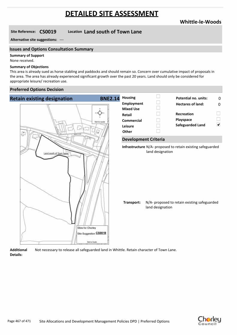
Housing
Employment
Mixed Use
Retail
Commercial
Leisure
Recreation
Safeguarded Land
Preferred Options Decision
Retain existing designation Potential no. units: 0
Hectares of land: 0
Other
Site Reference: CS0019 Land south of Town Lane
Whittle-le-Woods
None received.
This area is already sued as horse stabling and paddocks and should remain so. Concern over cumulative impact of proposals in the area. The area has already experienced significant growth over the past 20 years. Land should only be considered for appropriate leisure/ recreation use.
Summary of Objections
Summary of Support
Alternative site suggestions: ---
DETAILED SITE ASSESSMENT
Location
Development Criteria
Infrastructure N/A- proposed to retain existing safeguarded land designation
Transport: N/A- proposed to retain existing safeguarded land designation
Additional Details:
Not necessary to release all safeguarded land in Whittle. Retain character of Town Lane.
Issues and Options Consultation Summary
Playspace
BNE2.14
Page 467 of 471 Site Allocations and Development Management Policies DPD | Preferred Options

Sustainability Appraisal
Site Ref CS0019
Address Land south of Town Lane, Whittle-le-Woods
SA Obj
Indicator Site Performance SA Comments
S1
Distance to railway station Ove r 3 km Social This site has good access to a frequent bus service and has good access to an A road and motorway junction. The site does not have any rail service within the settlement although access to local services and facilities is good with the exception of a supermarket which is 0.61 to 3km from the site. Environmental This site is currently designated safeguarded land and is a Greenfield site. Economic There are no identified negative economic effects in developing this site.
Rail service frequency No se rvices in settle me nt Distance to ne arest bus stop 0.4 1 to 0. 8km Bus service frequency 2 -5 /hour/direction Distance to se rvice ce ntre Ove r 3 km Distance to A Road junction 0.4 1 to 0. 8km Distance to motorwa y junction 1. 61 to 3 km Distance to supermarket 1. 61 to 3 km Distance to convenience store 0.8 1 to 1. 2km Distance to Post Office 0.4 1 to 0. 8km Distance to Primary School 0.8 1 to 1. 6km Distance to Secondary School 3. 21 to 5 km On a cycle route No Distance to cycle route Up to 0 .4km
S2
Distance to GP surge ry 0.8 1 to 1. 6km Distance to NH S general hospital 2 .1 to 5km Distance to public open space /park 0.4 1 to 0. 8km Distance to local ce ntre 0.8 1 to 1. 2km
EN1
Designation of land Safe guarde d Land Are a of Separation Outside AONB Outside SSSI Outside Biological/ G eological He ri tage Site Outside Agricultural classification 3
EN2
Conservation Are a Outside Ancie nt Monument on site No Regis tere d Park or G arden Outside Listed Build ing on site No Locally Listed Building on s ite No
EN3 Curre nt/former land use Greenfield EN4 Flood Zone are a All Zone 1
EN5 Contaminated land No risk Within 3 km of a congestion spot Yes
EC1 Distance to employme nt site Over 1. 6km Access to Broadband Yes
EC2 Distance to further/ highe r e ducation 3. 21 to 5 km
De
live
rab
ility
In
dic
ato
rs
Access to sewer system
Yes
Is the site deliverable: Yes Access to water
Access to gas
Access to e lectricity
Exis ting road acce ss
At risk from haza rdous ins tallations No
Overall Site Performance
Band Spe ctrum:
Overall Band:
C
Page 468 of 471 Site Allocations and Development Management Policies DPD | Preferred Options
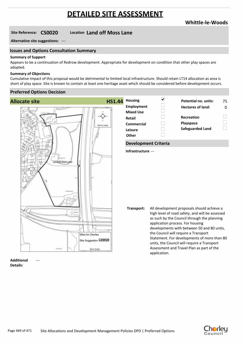
Housing
Employment
Mixed Use
Retail
Commercial
Leisure
Recreation
Safeguarded Land
Preferred Options Decision
Allocate site Potential no. units: 75
Hectares of land: 0
Other
Site Reference: CS0020 Land off Moss Lane
Whittle-le-Woods
Appears to be a continuation of Redrow development. Appropriate for development on condition that other play spaces are adopted.
Cumulative impact of this proposal would be detrimental to limited local infrastructure. Should retain LT14 allocation as area is short of play space. Site is known to contain at least one heritage asset which should be considered before development occurs.
Summary of Objections
Summary of Support
Alternative site suggestions: ---
DETAILED SITE ASSESSMENT
Location
Development Criteria
Infrastructure ---
Transport: All development proposals should achieve a high level of road safety, and will be assessed as such by the Council through the planning application process. For housing developments with between 50 and 80 units, the Council will require a Transport Statement. For developments of more than 80 units, the Council will require a Transport Assessment and Travel Plan as part of the application.
Additional Details:
---
Issues and Options Consultation Summary
Playspace
HS1.44
Page 469 of 471 Site Allocations and Development Management Policies DPD | Preferred Options
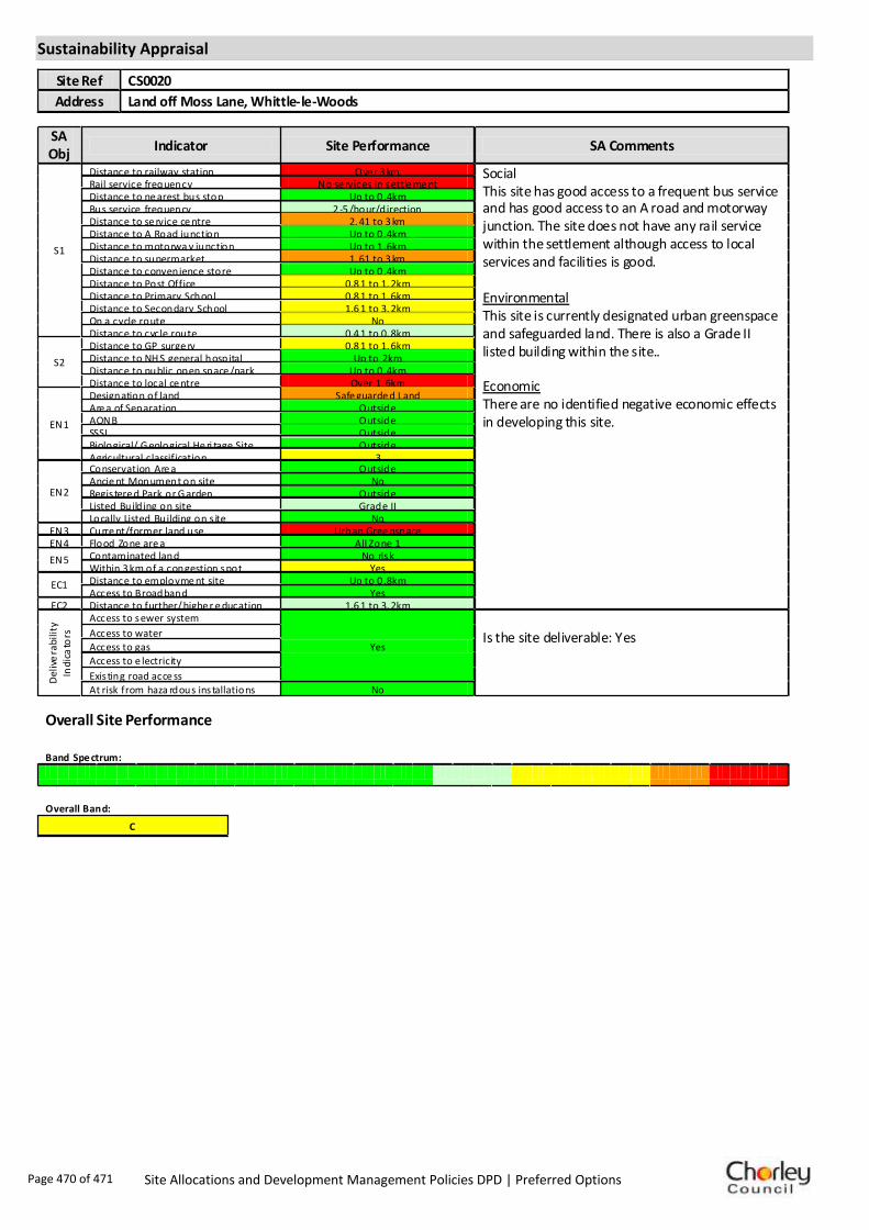
Sustainability Appraisal
Site Ref CS0020
Address Land off Moss Lane, Whittle-le-Woods
SA Obj
Indicator Site Performance SA Comments
S1
Distance to railway station Ove r 3 km Social This site has good access to a frequent bus service and has good access to an A road and motorway junction. The site does not have any rail service within the settlement although access to local services and facilities is good. Environmental This site is currently designated urban greenspace and safeguarded land. There is also a Grade II listed building within the site.. Economic There are no identified negative economic effects in developing this site.
Rail service frequency No se rvices in settle me nt Distance to ne arest bus stop Up to 0 .4km Bus service frequency 2 -5 /hour/direction Distance to se rvice ce ntre 2. 41 to 3 km Distance to A Road junction Up to 0 .4km Distance to motorwa y junction Up to 1 .6km Distance to supermarket 1. 61 to 3 km Distance to convenience store Up to 0 .4km Distance to Post Office 0.8 1 to 1. 2km Distance to Primary School 0.8 1 to 1. 6km Distance to Secondary School 1.6 1 to 3. 2km On a cycle route No Distance to cycle route 0.4 1 to 0. 8km
S2
Distance to GP surge ry 0.8 1 to 1. 6km Distance to NH S general hospital Up to 2km Distance to public open space /park Up to 0 .4km Distance to local ce ntre Over 1. 6km
EN1
Designation of land Safe guarde d Land Are a of Separation Outside AONB Outside SSSI Outside Biological/ G eological He ri tage Site Outside Agricultural classification 3
EN2
Conservation Are a Outside Ancie nt Monument on site No Regis tere d Park or G arden Outside Listed Build ing on site Grade II Locally Listed Building on s ite No
EN3 Curre nt/former land use Urban Gree nspace EN4 Flood Zone are a All Zone 1
EN5 Contaminated land No risk Within 3 km of a congestion spot Yes
EC1 Distance to employme nt site Up to 0 .8km Access to Broadband Yes
EC2 Distance to further/ highe r e ducation 1.6 1 to 3. 2km
De
live
rab
ility
In
dic
ato
rs
Access to sewer system
Yes
Is the site deliverable: Yes Access to water
Access to gas
Access to e lectricity
Exis ting road acce ss
At risk from haza rdous ins tallations No
Overall Site Performance
Band Spe ctrum:
Overall Band:
C
Page 470 of 471 Site Allocations and Development Management Policies DPD | Preferred Options

Page 471 of 471 Site Allocations and Development Management Policies DPD | Preferred Options