detection and tracking of moving objects using 2.5d …a-asvadi.ir/wp-content/uploads/itsc15.pdf ·...
TRANSCRIPT
Detection and Tracking of Moving Objects Using2.5D Motion Grids
Alireza Asvadi, Paulo Peixoto and Urbano NunesInstitute of Systems and Robotics, Department of Electrical and Computer Engineering,
University of Coimbra, Coimbra, Portugal{asvadi, peixoto, urbano}@isr.uc.pt
Abstract—Autonomous vehicles require a reliable perceptionof their environment to operate in real-world conditions. Aware-ness of moving objects is one of the key components for theperception of the environment. This paper proposes a method fordetection and tracking of moving objects (DATMO) in dynamicenvironments surrounding a moving road vehicle equipped with aVelodyne laser scanner and GPS/IMU localization system. First,at every time step, a local 2.5D grid is built using the last sets ofsensor measurements. Along time, the generated grids combinedwith localization data are integrated into an environment modelcalled local 2.5D map. In every frame, a 2.5D grid is comparedwith an updated 2.5D map to compute a 2.5D motion grid. Amechanism based on spatial properties is presented to suppressfalse detections that are due to small localization errors. Next,the 2.5D motion grid is post-processed to provide an objectlevel representation of the scene. The detected moving objectsare tracked over time by applying data association and Kalmanfiltering. The experiments conducted on different sequences fromKITTI dataset showed promising results, demonstrating theapplicability of the proposed method.
I. INTRODUCTION
The interest in autonomous cars which are able to perceiveenvironment and take appropriate actions, has increased signifi-cantly in recent years. However, to increase their reliability andcapability to operate in real-life environments they need to beempowered with a stronger representation and understandingof their surroundings. Different types of sensors such as stereovision [1], [2] and 3D laser scanners [3], [4] are employedalong with radars [2], [5] to perceive the environment in 3D.The data acquired by these sensors need to be processed tobuild an internal representation of the environment surroundingthe vehicle. Using this representation an intelligent vehicle cantake an appropriate decision in response to the state of itssurrounding environment.
Autonomous road vehicles must be able to perceive thedynamic environments and detect moving objects such asvehicles and pedestrians. By detecting, tracking and analyzingmoving objects, an autonomous vehicle can make a predictionabout their location and behavior and plan for next actions.Detection and tracking of moving objects (DATMO) is arapidly developing field that provides awareness of road sceneparticipants for intelligent vehicles.
In this paper, we propose a DATMO approach based ona 2.5D grid-based representation of the dynamic environ-ment surrounding a vehicle equipped with a 3D laser and aGPS/IMU system. The proposed method comprises two mainparts: 1)- detection of moving objects; 2)- data association
and tracking of moving objects. The main contribution of thispaper is on the first part where a robust motion detectionmechanism is proposed that can handle small localizationerrors and suppress false detections using spatial reasoning.The motion grids are next used to extract moving objects. Theproposed method detects moving objects in the absence of apriori assumption on the shape of the objects which makes itsuitable for a wide range of targets like pedestrians, vehicles, orbicycles. The result of the proposed method is a 3D boundingbox of moving objects.
The remaining part of this paper is organized as follows.Section II describes the related state of the art. Section IIIdescribes the proposed DATMO approach by introducing a2.5D motion grid algorithm. Experimental results are presentedin Section IV and Section V brings some concluding remarks.
II. RELATED WORK
Different techniques have been proposed for the detectionand tracking of moving objects. In Petrovskaya et al. [6]DATMO approaches are classified into: traditional DATMO,model-based DATMO and grid-based DATMO. Here, weare interested in the grid-based approaches. Grid-based ap-proaches are a memory-efficient environment representationwhich makes them a good choice for integrating temporaldata. Grid-based DATMO starts by making a low-level gridrepresentation of the dynamic environment, followed by seg-mentation and tracking, to provide an object level represen-tation of the scene. The Bayesian Occupancy Filter (BOF)[7] is a well-known grid-based DATMO. It adapts Bayesianfiltering to the occupancy grids to infer the dynamic of thegrids and in combination with the Fast Clustering and TrackingAlgorithm (FCTA) [8] is used for detection and tracking ofmoving objects. Recent work [9] introduces a motion detectionmodule to improve FCTA performance. However, setting theparameter values of the FCTA is a challenging task. Otherapproaches exist in the literature for perception and reasoningof the dynamic environments. Moras et al. [10] build a 2Dpolar grid using 2D laser and GPS/IMU positioning system anddetect moving objects by conflict analysis of evidence grids. Itworks based on the fact that a moving object occupies differentcells along time. Based on Dempster-Shafer theory, the motionof an object is represented by conflicting information thatresults in detection of moving objects. This method needsvery precise ego-motion estimation and finding appropriatevalues of the method’s parameters is not straightforward. Liand Ruichek [11] proposed a stereo-vision based frameworkto build up a dynamic occupancy grid map. First, feature points
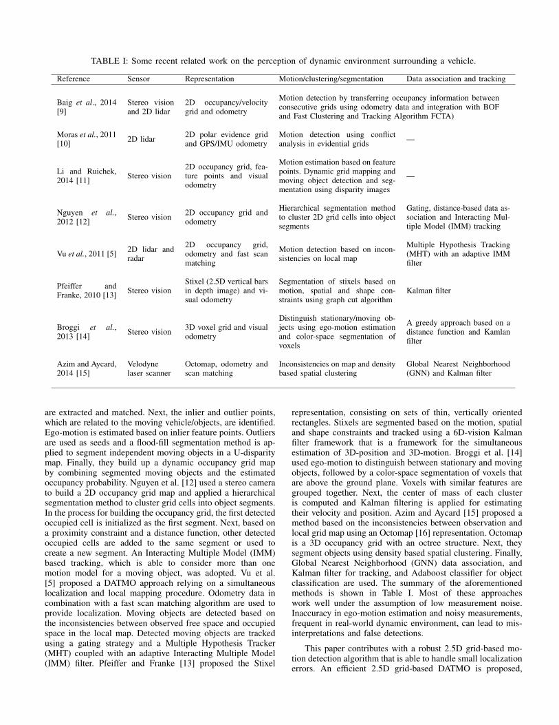
TABLE I: Some recent related work on the perception of dynamic environment surrounding a vehicle.
Reference Sensor Representation Motion/clustering/segmentation Data association and tracking
Baig et al., 2014[9]
Stereo visionand 2D lidar
2D occupancy/velocitygrid and odometry
Motion detection by transferring occupancy information betweenconsecutive grids using odometry data and integration with BOFand Fast Clustering and Tracking Algorithm FCTA)
Moras et al., 2011[10] 2D lidar 2D polar evidence grid
and GPS/IMU odometryMotion detection using conflictanalysis in evidential grids —
Li and Ruichek,2014 [11] Stereo vision
2D occupancy grid, fea-ture points and visualodometry
Motion estimation based on featurepoints. Dynamic grid mapping andmoving object detection and seg-mentation using disparity images
—
Nguyen et al.,2012 [12] Stereo vision 2D occupancy grid and
odometry
Hierarchical segmentation methodto cluster 2D grid cells into objectsegments
Gating, distance-based data as-sociation and Interacting Mul-tiple Model (IMM) tracking
Vu et al., 2011 [5] 2D lidar andradar
2D occupancy grid,odometry and fast scanmatching
Motion detection based on incon-sistencies on local map
Multiple Hypothesis Tracking(MHT) with an adaptive IMMfilter
Pfeiffer andFranke, 2010 [13] Stereo vision
Stixel (2.5D vertical barsin depth image) and vi-sual odometry
Segmentation of stixels based onmotion, spatial and shape con-straints using graph cut algorithm
Kalman filter
Broggi et al.,2013 [14] Stereo vision 3D voxel grid and visual
odometry
Distinguish stationary/moving ob-jects using ego-motion estimationand color-space segmentation ofvoxels
A greedy approach based on adistance function and Kamlanfilter
Azim and Aycard,2014 [15]
Velodynelaser scanner
Octomap, odometry andscan matching
Inconsistencies on map and densitybased spatial clustering
Global Nearest Neighborhood(GNN) and Kalman filter
are extracted and matched. Next, the inlier and outlier points,which are related to the moving vehicle/objects, are identified.Ego-motion is estimated based on inlier feature points. Outliersare used as seeds and a flood-fill segmentation method is ap-plied to segment independent moving objects in a U-disparitymap. Finally, they build up a dynamic occupancy grid mapby combining segmented moving objects and the estimatedoccupancy probability. Nguyen et al. [12] used a stereo camerato build a 2D occupancy grid map and applied a hierarchicalsegmentation method to cluster grid cells into object segments.In the process for building the occupancy grid, the first detectedoccupied cell is initialized as the first segment. Next, based ona proximity constraint and a distance function, other detectedoccupied cells are added to the same segment or used tocreate a new segment. An Interacting Multiple Model (IMM)based tracking, which is able to consider more than onemotion model for a moving object, was adopted. Vu et al.[5] proposed a DATMO approach relying on a simultaneouslocalization and local mapping procedure. Odometry data incombination with a fast scan matching algorithm are used toprovide localization. Moving objects are detected based onthe inconsistencies between observed free space and occupiedspace in the local map. Detected moving objects are trackedusing a gating strategy and a Multiple Hypothesis Tracker(MHT) coupled with an adaptive Interacting Multiple Model(IMM) filter. Pfeiffer and Franke [13] proposed the Stixel
representation, consisting on sets of thin, vertically orientedrectangles. Stixels are segmented based on the motion, spatialand shape constraints and tracked using a 6D-vision Kalmanfilter framework that is a framework for the simultaneousestimation of 3D-position and 3D-motion. Broggi et al. [14]used ego-motion to distinguish between stationary and movingobjects, followed by a color-space segmentation of voxels thatare above the ground plane. Voxels with similar features aregrouped together. Next, the center of mass of each clusteris computed and Kalman filtering is applied for estimatingtheir velocity and position. Azim and Aycard [15] proposed amethod based on the inconsistencies between observation andlocal grid map using an Octomap [16] representation. Octomapis a 3D occupancy grid with an octree structure. Next, theysegment objects using density based spatial clustering. Finally,Global Nearest Neighborhood (GNN) data association, andKalman filter for tracking, and Adaboost classifier for objectclassification are used. The summary of the aforementionedmethods is shown in Table I. Most of these approacheswork well under the assumption of low measurement noise.Inaccuracy in ego-motion estimation and noisy measurements,frequent in real-world dynamic environment, can lead to mis-interpretations and false detections.
This paper contributes with a robust 2.5D grid-based mo-tion detection algorithm that is able to handle small localizationerrors. An efficient 2.5D grid-based DATMO is proposed,
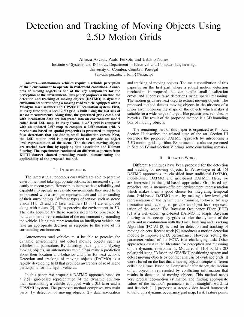
Motion detection
Modeling the static part of the environment
Update
Building local 2.5D grid
Moving object detection module
List of objects’locations
- Generating 2.5D motion grid and spatial reasoning to suppress false detections using equation (2).- Morphological operators (fill holes and compensate the Velodyne scan’s gaps).
- 2.5D grid (average height in each cell).- Remove cells that contains points with low variance and height (ground cells) using equation (1).
- Local grid mapping:- Keep last n grids (SCGrds).- Use last m (m < n) observations for each cell.- Only consider cells that have been observed
for the minimum number of k times.
Track management
- Initialize new tracks for new detected objects.- Remove exited tracks.- Prune tracks.
Tracking module
Kalman tracking
- 2D Kalman filters.- One filter for each object.
Data association
- Gating.- Nearest neighbor object association.
List of objects and tracksGPS/IMU localization data Point cloud
2.5D grid
2.5D grid
Local grid map
Fig. 1: Architecture of the proposed algorithm for 2.5D grid-based detection and tracking of moving objects (DATMO).
which outputs a list of objects’ 3D bounding boxes andtracks, but, avoiding a computationally expensive full 3Drepresentation of the environment. It extracts moving objectsfrom 2.5D motion grids without a priori knowledge aboutobjects.
III. PROPOSED METHOD
In this section, we present an algorithm for 2.5D grid-based DATMO. Fig. 1 shows the architecture of the proposedperception system. Each block is described in the followingsections.
A. Building a local 2.5D grid
A 2.5D grid stores in each cell of a discrete grid the heightof objects above the ground level at the corresponding pointof the environment [17]. For a vehicle moving on a single un-derlying surface, a 2.5D grid provides sufficient information torepresent the surrounding environment. Obstacles overhangingat higher levels than the vehicle, such as bridges, are ignoredwithout compromising safety.
In the present work, we are going to build a 2.5D localheight grid to continuously represent an area covering 30meters ahead of the vehicle, 10 meters behind it and 10 meterson the left and right sides of the vehicle. The grid resolutionin the vehicle plane is chosen to be equal to 20 cm providingenough number of cells to represent objects. The total numberof 2.5D cells inside the local grid is 20, 000. For each cell, theheight value is determined by calculating the average heightof all measured points mapped into the cell.
Those cells that belong to the ground can cause falsedetections, in motion detection module, particularly in the caseof undulated roads. A simple method is used to remove groundcells when building the 2.5D grid. The variance of height ofpoints falling into each cell is computed. If the value is undera certain threshold, it is selected as a candidate ground cell.However, this cell may belong to any planar surface such as
the roof of a vehicle. A cell is confirmed as a ground cell if itsaverage height is lower than a given threshold. To summarize,a cell belongs to the ground if it has a variance and heightlower than certain given thresholds. A 2.5D grid with rejectionof ground cells is computed by
Grd[i] =
{0, if σ2
i < trσ and µi < trµµi, otherwise
(1)
where µi and σ2i are the average height and its variance in cell
i. The trσ and trµ thresholds are learned empirically, and inour experiments were chosen as 2 cm and 30 cm respectively.The result of this stage is a 2.5D grid with removed groundcells.
B. Modeling the static part of the environment
So far, we addressed the problem of building a local 2.5Dgrid using data collected at one instant of time. The next stepconsists on the integration of consecutive 2.5D local gridsand GPS/IMU localization data to build a local 2.5D map.This map is particularly useful to model the static part of theenvironment. The 2.5D grid map is updated on every new 2.5Dgrid obtained from new sensor data.
To keep the number of necessary computations limitedand to avoid problems resulting from the accumulated errorof localization drifts, the number of possible 2.5D grids islimited by considering only a time slot instead of the wholehistory. Therefore, old 2.5D grids are discarded after n scans.A queue like data structure is defined using a first in firstout (FIFO) approach to keep a sequential collection of 2.5Dgrids SCGrds (with a maximum length of n). Using thisstructure, we keep the last n grids which are permanently beingtransformed according to the current pose of the vehicle. The2.5D map is calculated for each cell by taking the averageon the maximum number of m last valid values in the cell’shistory with a constraint that a cell should have been observed
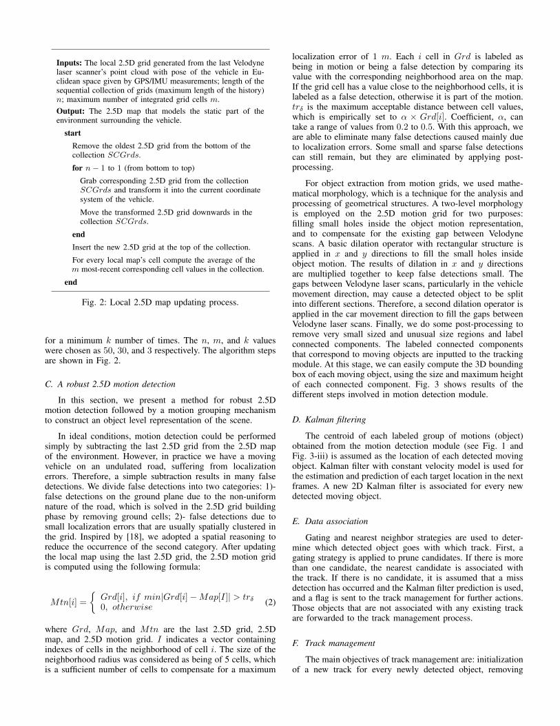
Inputs: The local 2.5D grid generated from the last Velodynelaser scanner’s point cloud with pose of the vehicle in Eu-clidean space given by GPS/IMU measurements; length of thesequential collection of grids (maximum length of the history)n; maximum number of integrated grid cells m.Output: The 2.5D map that models the static part of theenvironment surrounding the vehicle.
startRemove the oldest 2.5D grid from the bottom of thecollection SCGrds.
for n− 1 to 1 (from bottom to top)
Grab corresponding 2.5D grid from the collectionSCGrds and transform it into the current coordinatesystem of the vehicle.
Move the transformed 2.5D grid downwards in thecollection SCGrds.
endInsert the new 2.5D grid at the top of the collection.
For every local map’s cell compute the average of them most-recent corresponding cell values in the collection.
end
Fig. 2: Local 2.5D map updating process.
for a minimum k number of times. The n, m, and k valueswere chosen as 50, 30, and 3 respectively. The algorithm stepsare shown in Fig. 2.
C. A robust 2.5D motion detection
In this section, we present a method for robust 2.5Dmotion detection followed by a motion grouping mechanismto construct an object level representation of the scene.
In ideal conditions, motion detection could be performedsimply by subtracting the last 2.5D grid from the 2.5D mapof the environment. However, in practice we have a movingvehicle on an undulated road, suffering from localizationerrors. Therefore, a simple subtraction results in many falsedetections. We divide false detections into two categories: 1)-false detections on the ground plane due to the non-uniformnature of the road, which is solved in the 2.5D grid buildingphase by removing ground cells; 2)- false detections due tosmall localization errors that are usually spatially clustered inthe grid. Inspired by [18], we adopted a spatial reasoning toreduce the occurrence of the second category. After updatingthe local map using the last 2.5D grid, the 2.5D motion gridis computed using the following formula:
Mtn[i] =
{Grd[i], if min|Grd[i]−Map[I]| > trδ0, otherwise
(2)
where Grd, Map, and Mtn are the last 2.5D grid, 2.5Dmap, and 2.5D motion grid. I indicates a vector containingindexes of cells in the neighborhood of cell i. The size of theneighborhood radius was considered as being of 5 cells, whichis a sufficient number of cells to compensate for a maximum
localization error of 1 m. Each i cell in Grd is labeled asbeing in motion or being a false detection by comparing itsvalue with the corresponding neighborhood area on the map.If the grid cell has a value close to the neighborhood cells, it islabeled as a false detection, otherwise it is part of the motion.trδ is the maximum acceptable distance between cell values,which is empirically set to α × Grd[i]. Coefficient, α, cantake a range of values from 0.2 to 0.5. With this approach, weare able to eliminate many false detections caused mainly dueto localization errors. Some small and sparse false detectionscan still remain, but they are eliminated by applying post-processing.
For object extraction from motion grids, we used mathe-matical morphology, which is a technique for the analysis andprocessing of geometrical structures. A two-level morphologyis employed on the 2.5D motion grid for two purposes:filling small holes inside the object motion representation,and to compensate for the existing gap between Velodynescans. A basic dilation operator with rectangular structure isapplied in x and y directions to fill the small holes insideobject motion. The results of dilation in x and y directionsare multiplied together to keep false detections small. Thegaps between Velodyne laser scans, particularly in the vehiclemovement direction, may cause a detected object to be splitinto different sections. Therefore, a second dilation operator isapplied in the car movement direction to fill the gaps betweenVelodyne laser scans. Finally, we do some post-processing toremove very small sized and unusual size regions and labelconnected components. The labeled connected componentsthat correspond to moving objects are inputted to the trackingmodule. At this stage, we can easily compute the 3D boundingbox of each moving object, using the size and maximum heightof each connected component. Fig. 3 shows results of thedifferent steps involved in motion detection module.
D. Kalman filtering
The centroid of each labeled group of motions (object)obtained from the motion detection module (see Fig. 1 andFig. 3-iii) is assumed as the location of each detected movingobject. Kalman filter with constant velocity model is used forthe estimation and prediction of each target location in the nextframes. A new 2D Kalman filter is associated for every newdetected moving object.
E. Data association
Gating and nearest neighbor strategies are used to deter-mine which detected object goes with which track. First, agating strategy is applied to prune candidates. If there is morethan one candidate, the nearest candidate is associated withthe track. If there is no candidate, it is assumed that a missdetection has occurred and the Kalman filter prediction is used,and a flag is sent to the track management for further actions.Those objects that are not associated with any existing trackare forwarded to the track management process.
F. Track management
The main objectives of track management are: initializationof a new track for every newly detected object, removing

Fig. 3: From top to bottom: i) 2.5D motion grid obtainedby simple subtraction of last grid from map, ii) after falsedetection suppression, iii) after morphology, post-processing,and labeling connected components. For a better visualization,the 2.5D grid was projected and displayed onto the RGBimage.
exited tracks when their location falls outside the local gridand pruning tracks.
The data association module sends information to the trackmanagement unit in two situations: i) when there is a newobject that is not associated to any existing track, and ii) whenthere is no object for association to a track. When a new objectis detected, not yet associated to a track, it might be a trueor a false detection. In this case, the track management unitcreates a new track and waits for the next frame; if in the nextobservation an object get associated to that track it is confirmedas a new object, else it is considered as false detection. Forthe second situation, when there is no object to associate to atrack for next consecutive frames, that track is eliminated.
IV. EXPERIMENTAL RESULTS
The presented algorithm was tested on a set of dataacquired with a real vehicle. The proposed method is currentlyimplemented in Matlab and runs offline. The ground truth forthe specific task of DATMO is not available yet, thereforewe have performed a qualitative evaluation. In the followingsections we describe the dataset used to evaluate the proposedmethod and present experimental results.
A. Dataset
We evaluated the proposed method using the KITTI dataset[19]. This dataset was captured in rural areas and highwaysusing a car equipped with multiple sensors. The data usedwas recorded using a Velodyne 3D laser scanner and a high-precision GPS/IMU inertial navigation system.
The Velodyne HDL-64E rotating 3D laser scanner spins at10 frames per second counter-clockwise with vertical resolu-tion of 64 layers, angular resolution of 0.09 degree, and 2 cm
distance accuracy. The horizontal and vertical fields of vieware 360 and 26.8 degrees respectively, and the maximum rangeis 120 m. The Velodyne point cloud is compensated for thevehicle ego-motion. The inertial navigation system is a OXTSRT3003 inertial and GPS navigation system with 100 Hz speedof recording data and a resolution of 0.02m / 0.1 degree.
B. Evaluation
In order to evaluate the performance of the proposedalgorithm, a variety of challenging sequences were used. Themost representative sequences are summarized in Fig. 4. Thisfigure is composed of two kinds of representations: the RGBscreenshot of the scene and the grid representation of the scene.The 2.5D motion grid, 3D bounding box and tracks of movingobjects are shown in the grid representation. The blue dotscorrespond to the Velodyne points and vectors on the centerof the local grid show the pose of the vehicle. Only the 3Dbounding of detected moving objects are shown in the RGBimage. The selected sequences are: 1)- vehicles circulating on ahighway; 2)- a road junction scenario; 3)- a crossing scenario.In the first scenario, the proposed DATMO system detects andtracks all the moving vehicles when they get into the localperception field. In the road junction scenario, in the earlyframes a vehicle comes from different lane and in the nextframes two vehicles join to the road. Our method successfullydetects all the moving objects. In the crossing scenario, theproposed DATMO system successfully detected the vehiclespassing by.
V. CONCLUSION
Awareness of moving objects is one of the key componentsfor environment perception. In this paper, we propose a 2.5Dgrid-based DATMO. A 2.5D grid, with excluded ground cells,was employed for the representation of the environment.Each cell value is computed by averaging the heights ofall measured points mapped in the cell. A robust motiondetection mechanism was introduced to handle false detectionscaused by small localization errors. First a model of theenvironment surrounding a vehicle was developed. In everyframe, the last generated 2.5D grid is compared with theupdated environment map to generate the 2.5D motion grid.A method was presented aiming to suppress false detections,due to small localization errors, based on spatial reasoning. Theobject level representation is achieved by grouping the motiongrids. Moving objects are detected without a priori knowledgeabout them. Detected moving objects are finally tracked usinggating and nearest neighbor association strategies and Kalmanfiltering. Experimental results are presented that give goodindication of the applicability of the proposed DATMO system.We plan to make the system more robust, less dependent onthresholds assigned empirically, and to assess its performancein real-time applications.
ACKNOWLEDGMENT
This work has been supported by the FCT project ”AMS-HMI2012 - RECI/EEIAUT/0181/2012” and project ”ProjB-Diagnosis and Assisted Mobility - Centro-07-ST24-FEDER-002028” with FEDER funding, programs QREN and COM-PETE.

Fig. 4: Sample screenshots of the results for the sequences. Each raw represents one sequence. From top to bottom, results for:vehicles circulating on a highway; a road junction scenario, and a crossing scenario. Left to right we see the results obtained indifferent time instants.
REFERENCES
[1] C. Laugier, I.E. Paromtchik, M. Perrollaz, M.Y. Yong, J-D. Yoder, C.Tay, K. Mekhnacha, and A. Negre, Probabilistic analysis of dynamicscenes and collision risks assessment to improve driving safety, IEEEIntelligent Transportation Systems Magazine, vol. 3, no. 4, pp. 4-19,2011.
[2] J. Ziegler, P. Bender, M. Schreiber, H. Lategahn et al., Making berthadrive? - an autonomous journey on a historic route, IEEE IntelligentTransportation Systems Magazine, vol. 6, no. 2, pp. 8-20, 2014.
[3] C. Urmson, J. Anhalt, D. Bagnell, C. Baker, R. Bittner, M. N. Clarket al., Autonomous driving in urban environments: Boss and the urbanchallenge, Journal of Field Robotics, vol. 25, no. 8, pp. 425-466, 2008.
[4] M. Montemerlo, J. Becker, S. Bhat, H. Dahlkamp, D. Dolgov, S.Ettinger, D. Haehnel et al., Junior: The stanford entry in the urbanchallenge, Journal of Field Robotics, vol. 25, no. 9, pp. 569-597, 2008.
[5] T-D. Vu, J. Burlet, and O. Aycard, Grid-based localization and localmapping with moving object detection and tracking, Information Fu-sion, vol. 12, no. 1, pp. 58-69, 2011.
[6] A. Petrovskaya, M. Perrollaz, L. Oliveira, L. Spinello, R. Triebel, A.Makris, J.D. Yoder, C. Laugier, U. Nunes, and P. Bessiere, Awarenessof road scene participants for autonomous driving, In Handbook ofIntelligent Vehicles, Springer London, pp. 1383-1432, 2012.
[7] M. K. Tay, K. Mekhnacha, M. Yguel, C. Coue, C. Pradalier, C.Laugier, Th. Fraichard and P. Bessiere, The Bayesian occupation filter,In Probabilistic Reasoning and Decision Making in Sensory-MotorSystems, Springer Berlin Heidelberg, pp. 77-98, 2008.
[8] K. Mekhnacha, Y. Mao, D. Raulo, and C. Laugier, Bayesian occupancyfilter based ”Fast Clustering-Tracking” algorithm, In IEEE/RSJ Inter-national Conference on Intelligent Robots and Systems (IROS), 2008.
[9] Q. Baig, M. Perrollaz, and C. Laugier, A Robust Motion DetectionTechnique for Dynamic Environment Monitoring: A Framework forGrid-Based Monitoring of the Dynamic Environment, IEEE Roboticsand Automation Magazine, vol. 21, no. 1, pp. 40-48. 2014.
[10] J. Moras, V. Cherfaoui, and P. Bonnifait, Moving objects detection byconflict analysis in evidential grids, In Intelligent Vehicles Symposium(IV), pp. 1122-1127, 2011.
[11] Y. Li and Y. Ruichek, Occupancy Grid Mapping in Urban Environmentsfrom a Moving On-Board Stereo-Vision System, Sensors, vol. 14, no.6, pp. 10454-10478, 2014.
[12] T. N. Nguyen, B. Michaelis, A. Al-Hamadi, M. Tornow, and M.Meinecke, Stereo-camera-based urban environment perception usingoccupancy grid and object tracking, IEEE Transactions on IntelligentTransportation Systems, vol. 13, no. 1, pp. 154-165, 2012.
[13] D. Pfeiffer, and U. Franke, Efficient representation of traffic scenesby means of dynamic stixels, In IEEE Intelligent Vehicles Symposium(IV), pp. 217-224, 2010.
[14] A. Broggi, S. Cattani, M. Patander, M. Sabbatelli, and P. Zani, A full-3D voxel-based dynamic obstacle detection for urban scenario usingstereo vision, In 16th International IEEE Conference on IntelligentTransportation Systems (ITSC), 2013.
[15] A. Azim, and O. Aycard, Layer-based supervised classification ofmoving objects in outdoor dynamic environment using 3D laser scanner,In IEEE Intelligent Vehicles Symposium (IV), pp. 1408-1414, 2014.
[16] A. Hornung, K. M. Wurm, M. Bennewitz, C. Stachniss, and W. Burgard,OctoMap: An efficient probabilistic 3D mapping framework based onoctrees, Autonomous Robots, vol. 34, no. 3, pp. 189-206, 2013.
[17] M. Herbert, C. Caillas, E. Krotkov, I. S. Kweon, and T. Kanade,Terrain mapping for a roving planetary explorer, In IEEE InternationalConference on Robotics and Automation (ICRA), pp. 997-1002, 1989.
[18] A. Elgammal, D. Harwood, and L. Davis, Non-parametric model forbackground subtraction, In European Conference on Computer Vision(ECCV), Springer Berlin Heidelberg, pp. 751-767, 2000.
[19] A. Geiger, P. Lenz, C. Stiller, and R. Urtasun, Vision meets robotics:The kitti dataset, The International Journal of Robotics Research, vol.32, no. 11, pp. 12311237, 2013.