developing geospatial intelligence … · developing geospatial intelligence stewardship . for...
TRANSCRIPT

DEVELOPING GEOSPATIAL INTELLIGENCE STEWARDSHIP FOR MULTINATIONAL OPERATIONS
A thesis presented to the Faculty of the U.S. Army Command and General Staff College in partial
fulfillment of the requirements for the degree
MASTER OF MILITARY ART AND SCIENCE
General Studies
by
JEFFREY L. THOMAS, MAJOR, U.S. ARMY M.S., Cranfield University, England, 2006
MPPA, University of Missouri, Saint Louis, Missouri, 2005 B.A., California State University, Fullerton, California, 1994
Fort Leavenworth, Kansas 2010-01
Approved for public release; distribution is unlimited.

ii
REPORT DOCUMENTATION PAGE Form Approved OMB No. 0704-0188
Public reporting burden for this collection of information is estimated to average 1 hour per response, including the time for reviewing instructions, searching existing data sources, gathering and maintaining the data needed, and completing and reviewing this collection of information. Send comments regarding this burden estimate or any other aspect of this collection of information, including suggestions for reducing this burden to Department of Defense, Washington Headquarters Services, Directorate for Information Operations and Reports (0704-0188), 1215 Jefferson Davis Highway, Suite 1204, Arlington, VA 22202-4302. Respondents should be aware that notwithstanding any other provision of law, no person shall be subject to any penalty for failing to comply with a collection of information if it does not display a currently valid OMB control number. PLEASE DO NOT RETURN YOUR FORM TO THE ABOVE ADDRESS. 1. REPORT DATE (DD-MM-YYYY) 11-06-2010
2. REPORT TYPE Master’s Thesis
3. DATES COVERED (From - To) AUG 2009 – JUN 2010
4. TITLE AND SUBTITLE Developing Geospatial Intelligence Stewardship for Multinational Operations
5a. CONTRACT NUMBER 5b. GRANT NUMBER 5c. PROGRAM ELEMENT NUMBER
6. AUTHOR(S) MAJ Jeffrey L. Thomas
5d. PROJECT NUMBER 5e. TASK NUMBER 5f. WORK UNIT NUMBER 7. PERFORMING ORGANIZATION NAME(S) AND ADDRESS(ES)
U.S. Army Command and General Staff College ATTN: ATZL-SWD-GD Fort Leavenworth, KS 66027-2301
8. PERFORMING ORG REPORT NUMBER
9. SPONSORING / MONITORING AGENCY NAME(S) AND ADDRESS(ES)
10. SPONSOR/MONITOR’S ACRONYM(S) 11. SPONSOR/MONITOR’S REPORT NUMBER(S) 12. DISTRIBUTION / AVAILABILITY STATEMENT
Approved for Public Release; Distribution is Unlimited 13. SUPPLEMENTARY NOTES 14. ABSTRACT In recent years the contemporary operational environment has increasingly included multinational operations, which have fault lines in understanding and visualizing the common operational picture. These fault lines are typically associated with national caveats, over-classification, releasability and interoperability issues. This research of Joint, Interagency, Intergovernmental and Multinational respondents stated geospatial intelligence (GEOINT) must be properly planned, released and executed for multinational operations to be effective. Results indicate that a higher level of cognitive comprehension of GEOINT and its application is needed for multinational operations. This requires effective stewardship of GEOINT wherein all participants are charged with the responsibility to properly develop, utilize and safeguard GEOINT, including its people, its property and its financial assets to maximize the effectiveness for GEOINT cells and commanders. GEOINT stewardship is not tied to specific systems architecture. The GEOINT cell is therefore able to adjust to the evolving character of conflict in order to better frame the problem. GEOINT stewardship enables users to apply critical and creative visualization to situational understanding, and provide context and orientation to solve ill-structured problems. The GEOINT cell must train and exercise this stewardship through a shared vision that will enhance their capability to effectively address multinational GEOINT requirements focus internal and external research and development efforts, pursue economies in acquisition, and develop approaches to improve information sharing. 15. SUBJECT TERMS Geospatial Intelligence, stewardship, multinational, operations, ISAF, NATO, coalition, unity of effort, unity of command, situational awareness, situational understanding, contemporary operational environment 16. SECURITY CLASSIFICATION OF: 17.
LIMITATION OF ABSTRACT
18. NUMBER OF PAGES
19a. NAME OF RESPONSIBLE PERSON a. REPORT b. ABSTRACT c. THIS PAGE 19b. PHONE NUMBER (include area code)
(U) (U) (U) (U) 135 Standard Form 298 (Rev. 8-98)
Prescribed by ANSI Std. Z39.18
iii
MASTER OF MILITARY ART AND SCIENCE
THESIS APPROVAL PAGE
Name of Candidate: Major Jeffrey L. Thomas Thesis Title: Developing Geospatial Intelligence Stewardship for Multinational
Operations
Approved by: , Thesis Committee Chair Ralph O. Doughty, Ph.D. , Member Major Nicholas Martin, M.E. , Member Ralph M. Erwin, M.S.S Accepted this 11th day of June 2010 by: , Director, Graduate Degree Programs Robert F. Baumann, Ph.D. The opinions and conclusions expressed herein are those of the student author and do not necessarily represent the views of the U.S. Army Command and General Staff College or any other governmental agency. (References to this study should include the foregoing statement.)

iv
ABSTRACT
DEVELOPING GEOSPATIAL INTELLIGENCE STEWARDSHIP FOR MULTINATIONAL OPERATIONS, by Jeffrey L. Thomas, 135 pages. In recent years the contemporary operational environment has increasingly included multinational operations, which have fault lines in understanding and visualizing the common operational picture. These fault lines are typically associated with national caveats, over-classification, releasability and interoperability issues. This research of Joint, Interagency, Intergovernmental and Multinational respondents stated geospatial intelligence (GEOINT) must be properly planned, released and executed for multinational operations to be effective. Results indicate that a higher level of cognitive comprehension of GEOINT and its application is needed for multinational operations. This requires effective stewardship of GEOINT wherein all participants are charged with the responsibility to properly develop, utilize and safeguard GEOINT, including its people, its property and its financial assets to maximize the effectiveness for GEOINT cells and commanders. GEOINT stewardship is not tied to specific systems architecture. The GEOINT cell is therefore able to adjust to the evolving character of conflict in order to better frame the problem. GEOINT stewardship enables users to apply critical and creative visualization to situational understanding, and provide context and orientation to solve ill-structured problems. The GEOINT cell must train and exercise this stewardship through a shared vision that will enhance their capability to effectively address multinational GEOINT requirements focus internal and external research and development efforts, pursue economies in acquisition, and develop approaches to improve information sharing.

v
ACKNOWLEDGMENTS
I am indebted to my thesis committee who has provided guidance and invaluable
contributions throughout this study. I would also like to thank those officers and civilians
who gave so willingly of their valuable free time to discuss this research.
For Rebecca . . . your love and support for assisting in the editing of the thesis and
tolerating the major time commitment to this project is priceless.

vi
TABLE OF CONTENTS
Page
MASTER OF MILITARY ART AND SCIENCE THESIS APPROVAL PAGE ............ iii
ABSTRACT ....................................................................................................................... iv
ACKNOWLEDGMENTS ...................................................................................................v
TABLE OF CONTENTS ................................................................................................... vi
ACRONYMS ..................................................................................................................... ix
ILLUSTRATIONS ..............................................................................................................x
TABLES ............................................................................................................................ xi
CHAPTER 1 INTRODUCTION .........................................................................................1
Thesis Intent and Primary Research Question ................................................................ 3 Assumptions .................................................................................................................... 3 Definitions ...................................................................................................................... 4 Limitations ...................................................................................................................... 7 Scope and Delimitations ................................................................................................. 8 Significance of Research ................................................................................................ 9 Summary ......................................................................................................................... 9
CHAPTER 2 LITERATURE REVIEW ............................................................................11
Statutes .......................................................................................................................... 11 Professional Forums ..................................................................................................... 15 Doctrinal Multi-National Publications .......................................................................... 24 Previous Research ......................................................................................................... 26
World Health Organization Stewardship .................................................................. 26 USJFCOM GEOINT Cell Experimentation ............................................................. 28
Articles .......................................................................................................................... 32 Studies and Theses ........................................................................................................ 35 Summary ....................................................................................................................... 37
CHAPTER 3 RESEARCH METHODOLOGY ................................................................38
Thesis Framework Overview ........................................................................................ 39 Design Specifics ........................................................................................................... 39 Instrumentation ............................................................................................................. 41

vii
Survey Structure ........................................................................................................... 43 Summary of Survey Design .......................................................................................... 45
CHAPTER 4 RESEARCH FINDINGS .............................................................................46
Survey Significance ...................................................................................................... 46 Demographics ............................................................................................................... 48
Level of Operations ................................................................................................... 48 Deployed ................................................................................................................... 49 Education .................................................................................................................. 51
Secondary Research Question Number 1 ..................................................................... 54 GEOINT Multinational Operations .......................................................................... 54 GEOINT Multinational Planning .............................................................................. 57 Summary ................................................................................................................... 60
Secondary Research Question Number 2 ..................................................................... 61 GEOINT Releasability .............................................................................................. 61 GEOINT Emerging Technology ............................................................................... 63 GEOINT Maintenance .............................................................................................. 64 GEOINT Shared Awareness ..................................................................................... 65 GEOINT Enhanced Situational Awareness .............................................................. 67 Summary ................................................................................................................... 68
Secondary Research Question Number 3 ..................................................................... 68 What Was Your Most Salient Story? ........................................................................ 69 What Was Your Biggest Frustration? ....................................................................... 71 Summary ................................................................................................................... 74
Primary Research Question .......................................................................................... 75 Summary ................................................................................................................... 77
CHAPTER 5 CONCLUSIONS AND RECOMMENDATIONS ......................................78
Conclusions ................................................................................................................... 78 Primary Research Question. ...................................................................................... 78 Secondary Research Question Number 1.................................................................. 82 Secondary Research Question Number 2.................................................................. 82 Secondary Research Question Number 3.................................................................. 83
Suggestions for Further Research ................................................................................. 84 Recommendations ......................................................................................................... 87
GLOSSARY ......................................................................................................................89
APPENDIX A DOTMLPF CHANGE RECOMMENDATION ACTION .......................95
APPENDIX B SURVEY CONTROL Number 10-050 .....................................................97
APPENDIX C RAW: SURVEY GENERAL COMMENTS ..........................................109
APPENDIX D QUANTIFIED: SALIENT SURVEY COMMENTS .............................112

viii
APPENDIX E QUANTIFIED: FRUSTRATING SURVEY COMMENTS ...................114
BIBLIOGRAPHY ............................................................................................................117
INITIAL DISTRIBUTION LIST ....................................................................................123
ix
ACRONYMS
ABCA American, British, Canadian, Australian, and New Zealand Armies Standardization Program
COP Common Operational Picture
GEOINT Geospatial Intelligence
ISO International Standards Organization
ISP Iraqi Security Police
ISR Intelligence, Surveillance, and Reconnaissance
JMD Joint Manning Document
MiTT Military Training Team
NATO North Atlantic Treaty Organization
NGA National Geospatial-Intelligence Agency
SOIC Stability Operations Information Center
SA Situational Awareness
US United States
USJFCOM US Joint Forces Command

x
ILLUSTRATIONS
Page Figure 1. Six Elements of Stewardship .............................................................................28
Figure 2. GEOINT Cell Cross Functional Coordination ..................................................30
Figure 3. GEOINT Cell Organizational Construct ...........................................................31
Figure 4. GEOINT Stewardship Model ............................................................................76
Figure 5. GEOINT Stewardship Model ............................................................................80

xi
TABLES
Page Table 1. Three Classifications of Tasks for Stewardship ................................................27
Table 2. Survey Population .............................................................................................47
Table 3. Favorable Status Classifications ........................................................................48
Table 4. Survey Question Number 1, Highest Level of GEOINT Operation .................49
Table 5. Survey Question Number 2, Number of Multinational Deployments ...............49
Table 6. Survey Question Number 4, Number of NATO Deployments .........................50
Table 7. Survey Question number 5, Number of Afghanistan Deployments ..................51
Table 8. Comparison of Survey Questions Number 6 and Number 10 ...........................52
Table 9. Survey Question number 7, Highest Level of GEOINT Education Received ..52
Table 10. Survey Question number 8, Personal Level of GEOINT Knowledge ..............53
Table 11. Survey Question Number 9, Multinational Operations .....................................55
Table 12. GEOINT Operations, Integration and Synchronization ....................................57
Table 13. GEOINT Planning Comparison ........................................................................58
Table 14. GEOINT Releasability ......................................................................................63
Table 15. GEOINT Emerging Technology .......................................................................64
Table 16. GEOINT Maintenance ......................................................................................65
Table 17. GEOINT Shared Awareness .............................................................................66
Table 18. GEOINT Enhanced Situational Awareness ......................................................67
Table 19. Salient Story and GEOINT Stewardship Measures ..........................................69
Table 20. Biggest Frustration and GEOINT Stewardship Measures ................................71
Table 21. Secondary Research Questions Status ...............................................................75
Table 22. Secondary Research Questions Status ...............................................................79
1
CHAPTER 1
INTRODUCTION
The purpose of this study is to identify how geospatial intelligence (GEOINT)
support for multinational operations can be made more effective. It is clearly understood
that many coalition operations are limited by sharing and classification restrictions.
Likewise, the recent wars in Afghanistan and Iraq, the 2006 Lebanon non-combatant
evacuation operation and many global disasters have demonstrated a vital need to
improve the way decision-makers understand and visualize multinational operations.
Military commanders and staffs start situation assessment by examining a map to
clearly understand and visualize the contemporary operational environment.1 To
accomplish this successfully, the commander must have up-to-date GEOINT, an
established intelligence discipline that supports joint forces in their ability to rapidly
respond to threats around the world by providing geo-referenced visual and data products
that serve as a foundation and common frame of reference for understanding and
visualizing operations.2
GEOINT can be employed across the national, strategic, operational, and tactical
levels of the contemporary operational environment. Military customers are generally the
most vocal in stating that GEOINT is most useful at the tactical level. At the tactical level
1Andy Sanchez, “Leveraging Geospatial Intelligence (GEOINT) in Mission
Command” (Monograph, School of Advanced Military Studies, Fort Leavenworth, KS, May 2009), 1. http://www.dtic.mil/cgi-bin/GetTRDoc?AD=ADA506270&Location= U2&doc=GetTRDoc.pdf (accessed 8 May 2010).
2Chairman, Joint Chiefs of Staff, Joint Publication 2-03, Geospatial Intelligence Support to Joint Operations (Washington, DC: Government Printing Office, 2007), vii.

2
the locally produced report (i.e. value-added data) adds to the finished product’s graphic
intelligence and imagery. GEOINT technology is also advancing in government and
private sectors to support business ventures and government agencies. Nevertheless,
commanders often neglect GEOINT’s proven methods, and may lump it into “buckets”
comprising intelligence, surveillance, and reconnaissance (ISR), or other terrain products.
Many military planners do not appreciate the important role that GEOINT can serve in
visualizing and informing multinational operations. So what must be done to demonstrate
the value of GEOINT in the planning and conduct of multinational operations? GEN
Mattis, Commander, United States (US) Joint Forces Command and the North Atlantic
Treaty Organizations (NATO’s) Allied Command Transformation states that the best way
forward for most legacy methods is to:
re-baseline our terminology and concepts by returning to time-honored principles, such as mission-type orders, unambiguous commander’s intent, and clear articulation of ends, ways, and means that have been tested in combat and are historically grounded in the fundamental nature of war while incorporating, where logical, the issues introduced by today’s more complex environment.3
In an increasingly complex international operating environment, how do we best
re-baseline GEOINT? What are the time-honored principles? How do we apply
unambiguous commander’s intent? How do we apply clear ends, ways, and means for
GEOINT? Re-baselining GEOINT requires stewardship; which may be defined as the
responsibility to properly develop, utilize and safeguard GEOINT, including its people,
its property and its financial assets to maximize the effectiveness for GEOINT cells and
the commander. It is clearly understood that GEOINT requires people, is actual
3James N. Mattis, “USJFCOM Commander’s Guidance for Effects-based
Operations,” Joint Forces Quarterly 4th Quarter, no. 51 (October 2008): 107.

3
information property and has tangible financial value. Therefore, GEOINT must have
stewardship.
Thesis Intent and Primary Research Question
The primary research question for this thesis is, “How can geospatial intelligence
for multinational operations be made more effective?” To address the primary research
question, the following secondary questions must be answered:
1. How does GEOINT support decision makers in the contemporary operational
environment?
2. What are the capabilities and limitations of GEOINT cells in providing
understanding and visualization of the common operational picture?
3. Is GEOINT cell stewardship understood and practiced in multinational
operations?
Assumptions
The primary assumption in this research is that coalition operations and the global
community require sharing to enable cohesive understanding and visualization for
multinational operations. GEOINT has evolved significantly in recent years and 9/11 has
altered the resource management model. The bulk of operations in the contemporary
operational environment will require increasingly complex GEOINT support and
resource management since tasks come from different multinational requirements and
different national caveats.
As NATO leads many of these multinational operations, it will turn into an even-
larger international alliance by gradually adding distant countries to its membership.

4
NATO will continue to be the world’s foremost intergovernmental military alliance, even
though there will be major transformation challenges. Even though NATO has specific
limitations and particular growing pains, it is distinctly capable of meeting the burden of
the contemporary operational environment and provides the command and control
composition necessary for complex multinational operations. In comparison, the United
Nations with its restructured composition and means are able to assume limited
peacekeeping operations but the UN is restricted in command and control of more
difficult peace support operations under chapter 6 of its Charter and is unable to
undertake more difficult operations under its chapter 7.
What has definitely changed is the expectation for coalition members to take more
responsibility for GEOINT support and to take charge of current and future operational
environment support. These ever-challenging coalition operations require GEOINT
stewardship--the responsibility to properly develop, utilize and safeguard GEOINT,
including its people, its property and its financial assets to maximize the effectiveness for
GEOINT cells and the commander.
Definitions
For the purpose of transparency, key terms in this thesis are defined as follows:
Battle Command is the “art and science of understanding, visualizing, describing,
directing, leading, and assessing forces to impose the commander’s will on a hostile,
thinking and adaptive enemy (or threats).”4
4Headquarters, Department of the Army, Field manual (FM) 3-0, Operations
(Washington, DC: Government Printing Office, 2008), 5-2.

5
Combined/Multinational is an adjective used to describe activities, operations and
organizations in which elements of more than one nation participate.5 Joint/Multiservice
is an adjective used to describe activities, operations and organizations in which elements
of at least two services participate.6 An alliance is a relationship “that results from a
formal agreement or treaty between two or more nations or broad, long-term objectives
that further the common interests of the members.”7 In contrast, a coalition is “an adhoc
arrangement between two or more nations for common action.”8 A coalition action is a
“multinational action outside the bounds of established alliances, usually for single
occasions or longer cooperation in a narrow sector of common interest.”9
Common Operational Picture is a “single identical display of relevant information
shared by more than one command. A common operational picture facilitates
collaborative planning and assists all echelons to achieve situational awareness (SA).”
10
Contemporary Operational Environment replaced the term battlespace. This term
addresses both the current and future operational environments. The Contemporary
Operational Environment is the overall operational environment that is current and in the
5North Atlantic Treaty Organization, Standardization Agency (NSA), 2009, 2-C-
9, http://www.nato.int/nsa/nsa_home.htm (accessed 8 May 2010).
6Ibid, 2-J-1.
7Chairman, Joint Chiefs of Staff, Joint Publication (JP) 3-16, Multinational Operations (Washington, DC: Government Printing Office, 2007), Glossary-5.
8Ibid., Glossary-6.
9Ibid.
10Chairman, Joint Chiefs of Staff, Joint Publication (JP) 3-0, Joint Operations (Washington, DC: Government Printing Office, 2008), Glossary-9.

6
near future, until year 2030. The range of multiple threats during this time extends across
the full spectrum of conflict, from smaller, lower-technology, high intensity, to multiple,
concurrent conflicts. A combination of any of these conflicts would be particularly
challenging, and require adaptive solutions for these ill-structured problems.
Geospatial Intelligence (GEOINT). There is no universally acceptable definition
for GEOINT (see the various national GEOINT definitions). Nearly every member of
NATO defines GEOINT differently as each nation applies platforms, collection and
exploitation to varying degrees. Not all NATO members define GEOINT as geospatial
information, imagery intelligence, and imagery. Yet, the basic geospatial referenced
collection requirements process (i.e. 2009 NATO acceptance of the National Image
Interpretability Rating Scales) and exploitation (data formats, conflation, analysis, and
migration) of geographically referenced activities on Earth is understood to be common.
GEOINT data sources include imagery and mapping data, whether collected by
commercial or government satellites, manned/unmanned aircraft, and ground-truthed
(absolutely verified) by demographic (i.e. census, cultural intelligence) information,
global positional systems waypoints, utility schematics, or any discrete data that have
locations on Earth.
Geospatial Intelligence Stewardship is defined as the responsibility to properly
develop, utilize and safeguard GEOINT, including its people, its property and its
financial assets to maximize the effectiveness for GEOINT cells and the commander.
GEOINT data is a resource that has established collection and exploitation processes,
financial value, and legal oversights. A key focus of GEOINT stewardship is knowledge
stewardship (akin to knowledge management), which includes the preservation, sharing,

7
and generation of old and new GEOINT knowledge regarding the contemporary
operational environment. In order to accomplish this, GEOINT stewardship has three
functions: to formulate GEOINT policy; to exert influence; and to collect and use
GEOINT.
National caveats are national restrictions placed by nations on the use of national
military forces operating as part of a multinational operation. These national caveats can
constrain NATO commanders by limiting their flexibility in executing warfare. For this
reason, the NATO seeks national contributions with as few caveats as possible.11
Stewardship is the conducting, supervising, or managing of an object, field or
discipline; particularly the careful and responsible management of something entrusted to
one's care. Applied as organizational stewardship, it refers to a leader's responsibility to
properly utilize, develop, and share its resources, including its people, its property, and its
financial assets, while still protecting the security of these resources. Similarly, the World
Health Organization defines stewardship as, “the careful and responsible management of
a well-being of the population, the very essence of good government.”
12
Limitations
There are many aspects of GEOINT that will not be addressed in this research.
The vast majority of GEOINT research is on procedures and processes with robust
11Vincent Morelli, Congressional Research Service Report for Congress, NATO in
Afghanistan: A Test of the Transatlantic Alliance, 3 December 2009. http://www.fas.org/ sgp/crs/row/RL33627.pdf (accessed 8 May 2010).
12World Health Organization, “Stewardship,” http://www.who.int/health-systems-performance/sprg/hspa06_stewardship.pdf (accessed 8 May 2010).

8
research and development. Consequently, this study is focused on how GEOINT support
for multinational operations can be made more effective.
This research centers its attention on GEOINT stewardship with regards to
complex, multinational environments. Research is focused on international, governmental
and coalition GEOINT capabilities and limitations. One relevant multinational operation
is selected to illustrate the effectiveness of GEOINT stewardship. This research focuses
on the multinational GEOINT operations of those nations supporting multinational
operations.
Scope and Delimitations
This research is unclassified and includes joint and multinational GEOINT,
GEOINT stewardship, and other tangible factors. It does not address the interagency
dimensions, nor the ISR platform issues related to the requirements management
processes. The interagency and ISR realm is discussed only as it serves to argue the
practical use of multinational operations. This study will focus on a multinational
operation that consists of air-land-sea operations, but will not delve too deeply into
operational art.
When mentioning command and control, the objective is to discuss the overall
means and not to discuss the command, control, communications, computers,
intelligence, surveillance, and reconnaissance domain and related technological
interoperability. Command and control will be discussed in terms of the human aspect of
leadership and the aspect of stewardship.
It is clearly understood that coalition and mission partners protect their own
higher national interests, impacts of sharing and releasability, and national caveats often

9
restrict what can be shared, thus resulting in a lack of coalition understanding and
visualization. Finally, lessons learned from after-action-reports or from current operations
are mostly classified and will not be included in this research.
Significance of Research
The results of this research will contribute to raise the general comprehension of
the intricacies of GEOINT stewardship and will help military planners assess the
operational effectiveness of GEOINT support for multinational operations. The research
will assist military planners in realizing that GEOINT support can be easily understood
and coordinated, even in a dynamic, technologically inundated operational environment.
Planners should recognize that multinational operations come together in different forms.
Different nations are able to take on GEOINT leadership roles in the Contemporary
Operational Environment. Together, these nations can achieve the unity of effort needed
to execute the full spectrum of operations. This research offers mission-specific GEOINT
‘fitness’ metrics to assess the effectiveness of GEOINT stewardship. These metrics allow
common friction points and risks to be mitigated, and should assist planners in resolving
differences in understanding and visualizing multinational operations. In addition, the
research may improve the content and applicability of the US Joint Publication, 2-03,
Geospatial Intelligence Support to Joint Operations.
Summary
Today, countries group together in a coalition of the willing to face global threats.
In this multinational environment, it is important to accurately understand and visualize
the input of all GEOINT capable coalition partners. Each may be critical to the success of

10
the multinational operation, and each has capabilities and limitations that must be
understood. Thus, organizations are duty bound by the principles of GEOINT
stewardship to the practice and responsibility of assuring decision-makers that GEOINT
resources are properly utilized and developed. Chapter 2 comprehensively summarizes
and evaluates the existing literature on battle command and the common operational
picture, GEOINT, and stewardship with particular focus on multinational operations
since 9/11.

11
CHAPTER 2
LITERATURE REVIEW
The purpose of this study is to identify how GEOINT support for multinational
operations can be made more effective. The primary research question is: How can
GEOINT for multinational operations be made more effective?
From chapter 1, the necessity of providing understanding and visualization of the
operational environment to decision-makers should be apparent. Unilateral operations
continue to take place, but rarely can one nation ever go it alone. Therefore, multinational
coalitions are established in an attempt to allow the burden sharing among nations, reduce
costs, and communicate international legitimacy. Importance is often placed on a regional
nation because of its vicinity, knowledge, and ability to intervene and reconcile.
To address the primary research question, this chapter reviews the existing
significant literature on contemporary operational environment, GEOINT, stewardship,
and GEOINT cells. This chapter will not review the technical aspects of GEOINT, data
format specifications, nor standards. It contains six main portions: governing
multinational statutes; professional forums; doctrinal multinational publications; previous
research; articles; and studies and theses that are pertinent to the research. This
examination will permit a considerable section of the available information to address the
three secondary questions stated in chapter 1.
Statutes
The US has four strategic mandated documents that shape the national
contemporary operational environment vision: the 2006 National Security Strategy; the

12
2008 National Defense Strategy; the 2010 Quadrennial Defense Review, and the more
current influential 2006 Quadrennial Defense Review; and the 2004 National Military
Strategy.13 Together, these documents provide a strategic framework and shape the
doctrine, organizational, training, materiel, leadership, personnel, and facilities
(DOTMLPF) for the defense services. In addition, these documents help the commander
to understand the operational environment of various friendly, adversary, and neutral
actions and how this impacts achieving the military end state.14
Many of our closest allies have developed similar guidance documents to
influence the strategic vision of their defense forces and operational environment.
15
Australia’s Future Warfighting Concept and Defence White Papers provides strategic and
operational guidance of their operational environment.16
13White House, 2006 National Security Strategy (Washington, DC, March 2006).
www.strategicstudiesinstitute.army.mil/pdffiles/nss.pdf (accessed 8 May 2010); Department of Defense, National Defense Strategy (Washington, DC: Government Printing Office, 2008), http://www.defense.gov/news/2008%20national%20defense% 20strategy.pdf (accessed 8 May 2010); Department of Defense, 2009 Quadrennial Defense Review (Washington, DC: Government Printing Office, 2009); Chairman, Joint Chiefs of Staff, The National Military Strategy (Washington, DC: Government Printing Office, 2004), http://www.defense.gov/news/Mar2005/d20050318nms.pdf (accessed 8 May 2010).
In addition, the British Strategic
14Eric Springer, “Developing Security Forces Officers For The Future Operating Environment” (Thesis, Command and General Staff College, Fort Leavenworth, KS, 2009), 14, http://www.dtic.mil/cgi-bin/GetTRDoc?Location=U2&doc=GetTRDoc.pdf &AD=ADA502058 (accessed 8 May 2010).
15Ibid.
16Chief of the Defense Force, Future Warfighting Concept, 2003, http://www.defence.gov.au/publications/fwc.pdf (accessed 8 May 2010); Australian Government, Department of Defence, “Defending Australia in the Asian PacificCentury: Force 2030,” White Paper, 2009, http://www.defence.gov.au/whitepaper/docs/ defence_white_paper_2009.pdf (accessed 8 May 2010).

13
Defence Review, Strategic Trends Programme 2007-2036, 3rd ed., and Australian and
British Defence White Papers specify the need for common approaches to contemporary
operational environment adversaries.17
The French Army’s Winning the Battle Building Peace: Land Forces in Present
and Future Conflicts, and the French White Paper on Defence and National Security
draws insights into the emerging security challenges of the contemporary operational
environment which parallel those of the US national command authority.
In addition, they tend to lean on United States
(US) strategic structures (EUCOM, CENTCOM, PACOM, and others) for execution.
These commonwealth documents reinforce US operational concepts and organizational
structures, and along with other key nations’ doctrines, further American dominance in
dealing with the contemporary operational environment threats.
18
17Ministry of Defence, Development, Concepts, and Doctrine Centre, Strategic
Trends Programme 2007-2036, Global Strategic Trends, Strategic Defence Review, 4rd ed., 2007, http://www.mod.uk/DefenceInternet/MicroSite/DCDC/OurPublications/ StrategicTrends+Programme/ (accessed 8 May 2010); House of Commons, “Delivering Security in a Changing World,” Research Paper 04/71, Defence White Paper, 2004, http://www.parliament.uk/commons/lib/research/rp2004/rp04-071.pdf (accessed 8 May 2010).
Likewise, the
German Konzeption der Bundeswehr and the 2006 White Paper on German Security
Policy and the Future of the Bundeswehr support observations regarding the lack of
18Ministere De La Defense. Winning the Battle Building Peace: Land Forces in present and Future Conflicts. Translated by a panel of British and French officers and academic military experts, January 2007, http://www.cdef.terre.defense.gouv.fr/ doctrineFT/doc_fond/FT_01/FT-1_eng.pdf (accessed 8 May 2010); Council on Foreign Relations, White Paper on Defence and National Security, June 2008, http://www.cfr.org/ publication/16615/french_white_paper_on_defence_and_national_security.html (accessed 8 May 2010).

14
conventional military threats and the increase of non-state actors that have drastically
altered the international security environment.19
The US Joint Forces Command (USJFCOM) serves as the US joint force
executive agent for transformation and as the NATO Allied Command Transformation. It
is important to note that while USJFCOM is currently conducting GEOINT cell
development, NATO does not have a unified GEOINT definition. The USJFCOM’s Joint
Operating Environment: Trends and Challenges for the Future Joint Force Through
2030 is a major endeavor that provides a framework for considering the future and
determining the impact of the operational environment on joint force operations.
20
Similarly, the Australian government’s view of the greater Asia-Pacific and their Army’s
Complex Warfighting and Adaptive Campaigning Future Land Operational Concept
share much with the American concept of joint force applications for full-spectrum
operations in a future dominated by persistent conflict.21
19Federal Ministry of Defense, “French White Paper on German Security Policy
and the Future of the Bundeswehr,” 2006, http://merln.ndu.edu/whitepapers/ Germany_White_Paper_2006.pdf (accessed 8 May 2010).
20Headquarters, Joint Forces Command, Joint Operating Environment: Trends and Challenges for the Future Joint Force Through 2030 (Norfolk, VA: Government Printing Office, November 2008), www.jfcom.mil/newslink/storyarchive/2008/ JOE2008.pdf (accessed 8 May 2010).
21David Kilcullen, Australian Army. Complex Warfighting and Adaptive Campaigning Future Land Operational Concept. Draft Developing Concept, 7 April 2004, http://www.quantico.usmc.mil/download.aspx?Path=./Uploads/Files/ SVG_complex_warfighting.pdf (accessed 8 May 2010).

15
In accordance with Title 10, US Code 467, GEOINT is defined as “imagery,
imagery intelligence and geospatial information.”22 Even though other nations do not
define GEOINT in the same terms, the basic geospatial referenced collection and
exploitation is understood to be common. The US Department of Defense Directive
5105.60, National Geospatial-Intelligence Agency, directs the National Geospatial-
Intelligence Agency (NGA) to support US national security objectives by providing
timely, relevant, and accurate GEOINT to the Department of Defense, the Intelligence
Community, other US Government departments and agencies, and partner nations.23
Professional Forums
Many of the US key allies have implemented policy to influence the strategic
vision of their defense forces. The integration of these visions is prevalent within
Australia, Canada, Great Britain, New Zealand and the US, commonly referred to as the
“Five-Eye” nations. In 2009, this researcher was instrumental in bringing New Zealand
back into the Five-Eye information and intelligence sharing community.
Formed in 1948, the Air and Space Interoperability Council is an active and
productive international organization that works for Five-Eye air forces.24
22National Geospatial Intelligence Agency, “GEOINT,” Title 10, United States
Code 467, https://www1.nga.mil/About/WhatWeDo/GeoInt/Pages/default.aspx (accessed 8 May 2010).
Its principal
objective is to ensure member nations are able to fight side-by-side as airmen in joint and
23Department of Defense, United States Directive 5105.60, National Geospatial-Intelligence Agency (Washington, DC: Government Printing Office, 29 July 2009), http://www.dtic.mil/whs/directives/corres/pdf/510560p.pdf (accessed 8 May 2010).
24Air and Space Interoperability Council (ASIC), ASIC Programs and Links, http://www.dtic.mil/asic/ (accessed 8 May 2010).
16
combined operations. It provides standardization of doctrines, operational procedures,
materiel, and equipment. The Air and Space Interoperability Council also exchanges
technical information and arranges the free loan of equipment between member nations
for test and evaluation purposes.
The ABCA (Australia, Britain, Canada and America, and New Zealand) forum
has the duty to optimize Five-Eye Army interoperability in order to deliver success in
coalition operations.25
The AUSCANNZUKUS (Australia, Canada, New Zealand, United Kingdom and
US) forum fosters knowledge sharing that enables the Five-Eye naval warfighter to
successfully complete missions across the spectrum of Joint and Combined Operations.
ABCA addresses current tactical and operational interoperability
level issues within the context of contemporary joint full spectrum operations, as well as
addressing longer-term interoperability requirements. It also shares and exploits
information to support the transformation and modernization of ABCA Armies.
26
The Combined Communications and Electronics Board is a Five-Eye joint military
communications-electronics organization whose mission is the coordination of any
military Command, Control, Communications, and Computer matter that is referred to it
by a member nation.27
25Australia, Britain, Canada, America and New Zealand Armies,
http://www.abca-armies.org/Error.aspx?aspxerrorpath=/Organization/Default.aspx (accessed 8 May 2010).
26AUSCANNZUKUS, Information Portal, http://www.auscannzukus.net/ (accessed 8 May 2010).
27Combined Communications and Electronics Board (CCEB), Public Website, http://jcs.dtic.mil/j6/cceb/ (accessed 8 May 2010).

17
The Multinational Interoperability Council is a seven nation (Australia, Canada,
Great Britain, US, France, Germany, and Italy) multinational forum for identifying
interoperability issues and articulating actions at the strategic and high operational levels
which, if nationally implemented by the member nations, would contribute to more
effective coalition operations.28
The NATO Standardization Agency (NSA) initiates, coordinates, supports and
administers standardization activities conducted under the authority of the NATO
Committee for Standardization (NCS).
It provides an adaptive and agile framework to allow
potential Lead Nations the opportunity to identify interoperability issues and articulate
courses of action to set the conditions, at the strategic and operational level, for more
effective coalition operations within and outside extant political alliances.
29 Standardization is defined within NATO as the
process of developing concepts, doctrines, procedures, and designs to achieve and
maintain the most effective levels of compatibility, interchangeability and commonality
in the operational, procedural, materiel, technical, and administrative fields. The primary
products of this process and NATO's tools for the enhancement of interoperability are
Standardization Agreements between member nations.30
The NATO Allied Command Transformation is NATO’s leading agent for change
by driving, facilitating, and advocating continuous improvement of Alliance capabilities
28Multinational Interoperability Council, “Overview, Vision, Mission,”
http://jcs.dtic.mil/j3/mic/ (accessed 8 May 2010).
29North Atlantic Treaty Organization, “Standardization,” Updated 4 November 2008, http://www.nato.int/issues/standardization/index.html (accessed 8 May 2010).
30North Atlantic Treaty Organization, Standard Agreements (STANAGs), Last updated 22 April 2010, http://www.nato.int/cps/en/natolive/stanag.htm (accessed 8 May 2010).

18
to maintain and enhance the military relevance and effectiveness of the Alliance.31
The NGA is an intelligence agency of the US Government with the primary
mission of collection, analysis, and the distribution of GEOINT in support of national
security and our partner nations.
The
NATO Allied Command Transformation is collocated with the USJFCOM at Norfolk,
Virginia. The Allied Command Transformation provides appropriate support to NATO
missions and operations, leads NATO military transformation, and improves
relationships, interaction, and practical cooperation with partners, nations, and
international organizations.
32 The NGA is the largest global GEOINT agency and
most US allied nations directly coordinate through NGA Support Teams (NSTs) for
support. The US National System for Geospatial Intelligence (NSG) is the governing
body of the US GEOINT community, which has military services, intelligence agencies,
National Guard Bureau, federal law enforcement agencies, federal agencies and Five-Eye
nations as voting members.33
In 2004, the NSG also created the National Center for Geospatial Intelligence
Standards (NCGIS), which is the coordinating organization within the NGA that is
responsible for setting and implementing GEOINT standards and management policies
31North Atlantic Treaty Organization (NATO) Allied Command Transformation
(ACT), Homepage, http://www.act.nato.int/ (accessed 8 May 2010).
32National Geospatial-Intelligence Agency, Homepage, www.nga.mil (accessed 8 May 2010).
33National Geospatial Intelligence Agency, NSG, https://www1.nga.mil/ About/WhoWeAre/NSG/Pages/default.aspx (accessed 8 May 2010).

19
for NGA and the NSG community.34 The Geospatial Intelligence Standards Working
Group (GWG) is chartered under the Department of Defense Information Technology
Standards Committee, and is the governing group responsible for developing and
promoting standards for interoperability in support of net-centricity within the US
Department of Defense.35
NCGIS.
The GWG provides the forum for the coordination of GEOINT
standards for the NSG. The GWG is led and chaired by the NGA's It is
important to note that the GEOINT data stream requires the largest bandwidth for full
motion video, hyper-spectral and multispectral imagery.
The Defence Geospatial Information Working Group is the multi-national body
responsible to the defense organizations of twenty-three member nations (mostly NATO
nations) for coordinated advice and policy recommendations on geospatial
standardization issues.36
34National Geospatial Intelligence Agency, “GEOINT Standards,”
https://www1.nga.mil/ProductsServices/geointstandards/Pages/default.aspx (accessed 8 May 2010).
It will meet coalition interoperability challenges by creating the
standards and procedures required to enable the provision, exchange and use of
standardized geospatial information. It supports the requirements of NATO and the other
alliances in which its member nations participate, including UN sanctioned peacekeeping.
The requirements have been identified to address a specific set of operational scenarios.
Eight operational scenarios, each requiring various types of geospatial support, serve as a
guide for Defence Geospatial Information Working Group client interaction and project
35Geospatial Intelligence Standards Working Group, “About the GWG,” http://www.gwg.nga.mil/ (accessed 8 May 2010).
36Defence Geospatial Information Working Group, “About the GWG,” http://www.dgiwg.org/dgiwg/ (accessed 8 May 2010).
20
management. These eight scenarios are: Coalition War Fighting Operation; Coalition
Peacekeeping Operation; Coalition Counter-Terrorist Operation; Non-Combat
Evacuation Operation; United Nations Humanitarian Aid Operation; Coalition Sanctions
Enforcement Operation; Peacetime/Routine Exchange and Co-Production; and,
Asymmetric Threat Preparedness Operation. Defence Geospatial Information Working
Group operates as a consensus organization that builds its standards based on
international standards and commercially available industrial specifications. It closely
cooperates with the International Organization of Standardization (ISO), Technical
Committee (TC) Geographic Information/Geomatics (ISO/TC 211), and other
international organizations addressing related specializations of geographic
information.37 The Defence Geospatial Information Working Group geospatial standards
are built upon the generic and abstract standards for geographic information defined by
the International Organization for Standardization (ISO TC/211). Defence Geospatial
Information Working Group makes use of the service specifications endorsed by the
Open Geospatial Consortium (OGC).38
The ISO is the world's largest developer and publisher of International Standards.
The ISO is a network of the national standards institutes of 162 countries, one member
per country, with a Central Secretariat in Geneva, Switzerland that coordinates the
37International Organization for Standardization, Technical Circular 211,
Geographic Information/Geomatics, 2009, http://www.isotc211.org/ (accessed 8 May 2010).
38Open Geospatial Consortium Inc., OGC Website, http://www.open geospatial.org/ (accessed 8 May 2010).

21
system. Common ISO imagery data formats include Jpeg, Mpeg, Tiff, BMP, and many
other collection platform (camera, airborne and satellite) data formats.39
The Open Geospatial Consortium is an international industry consortium of 389
companies, government agencies and universities participating in a consensus process to
develop publicly available interface standards. OpenGIS Standards support interoperable
solutions that “geo-enable” the Internet/Web, wireless and location-based services, and
mainstream Information Technology.
40
The United States Geospatial Intelligence Foundation is the only organization
dedicated to promoting the GEOINT tradecraft and building a stronger community of
interest across industry, academia, government, professional organizations, and
individuals.
The standards empower technology developers to
make complex spatial information and services accessible and useful with all kinds of
applications. The Open Geospatial Consortium standards applied to governmental
solutions are likened to Google Earth at the classified levels; that is, recently,
governments are increasingly using Open Geospatial Consortium standards to easily
understand and visualize ISO and open standard data on web-based viewers.
41
39International Organization for Standardization, Homepage, http://www.iso.org/
iso/home.htm (accessed 8 May 2010).
As a non-profit educational foundation, United States Geospatial
Intelligence Foundation strives to bring together the GEOINT community and support
life-long learning that will ensure a robust cadre of professionals and a healthy tradecraft
40Open Geospatial Consortium Inc. Official Names Space of the OpenGIS schemas, www.opengis.net (accessed 8 May 2010).
41United States Geospatial Intelligence Foundation, Homepage, http://usgif.org/ (accessed 8 May 2010).

22
now and in the future. The United States Geospatial Intelligence Foundation's purpose is
to promote the GEOINT tradecraft and to develop a stronger community of interest
between government, industry, academia, professional organizations, and individuals
who share a mission focus around the development and application of GEOINT to
address national security objectives. The United States Geospatial Intelligence
Foundation has just recently conducted their first ever GEOINT 101 course, and has been
working with several national universities in developing Graduate Certificates in
GEOINT education. Currently, the United States Geospatial Intelligence Foundation
conducts the largest GEOINT conference in the world.
The American Society for Photogrammetry and Remote Sensing is the American
component of its international parent.42
The Institute of Electrical and Electronics Engineers (IEEE) is the world’s largest
technical professional association advancing innovation and technological excellence for
the benefit of humanity.
The American Society for Photogrammetry and
Remote Sensing advances knowledge and improves understanding of mapping sciences
and promotes the responsible applications of photogrammetry, remote sensing,
geographic information systems (GIS) and supporting technologies. The society ties
together all imagery professionals from surveyors to analysts into a fraternal society.
43
42American Society for Photogrammetry and Remote Sensing, asprs on-line,
http://www.asprs.org/ (accessed 8 May 2010).
IEEE and its 400,000(+) members and 1,860 international
chapters inspire a global community to innovate for a better tomorrow through its highly
cited publications, conferences, technology standards, and professional and educational
43Institute of Electrical and Electronics Engineers, Homepage, http://www.ieee.org/portal/site (accessed 8 May 2010).

23
activities. IEEE is the trusted “voice” for engineering, computing, and technology
information around the globe. Through its global membership, IEEE is a leading
authority on areas ranging from aerospace systems, optical remote sensing systems,
computers, and telecommunications to biomedical engineering, electric power, and
consumer electronics among others.
The US Army Geospatial Community Contact List (GCCL) is a detailed
collection of easily referenced contact information for active, defense geospatial
community members.44
The US Army Special Operations Geospatial News is the most comprehensive
collection of periodic information shared with the US Army GCCL. It consists of remote
sensing, geospatial information, data standards, and production facts and ongoing
research. The US Army Special Operations Command has an invested interest to be the
worldwide leader of actionable GEOINT at the tactical level.
This GCCL list consists of over 700 active US Army, Marine
Corps, Canadian, British, and Australian contacts, and is the only existing registry of
names available for open defense geospatial dialogue. It is important to note that these
contacts are more than likely those geospatial personnel who are actively involved in
GEOINT support at the tactical levels. No other nation or supporting agency has a similar
contact list.
45
44Geospatial Community Contact List, http://gccl.geospatial-community.com/
(accessed 8 May 2010).
45William Farr, United States Army Special Operations Geospatial News. Registration with the Geospatial Community Contact List is required to receive this newsletter.

24
Doctrinal Multi-National Publications
In conjunction with the USJFCOM, Future Operational Environment study, the
US Joint Publication 3-0, Doctrine for Joint Operations provides the doctrinal foundation
and fundamental principles that guide the Armed Forces of the US in the conduct of joint
operations across the range of military operations.46
The USJFCOM and NGA responded to the contemporary operational
environment and the abovementioned military publications with Joint Publication 2-03,
The US Joint Publication 3-16,
Multinational Operations, provides doctrine for the Armed Forces of the US when they
operate as part of a multinational force. It describes joint organizational structures
essential to coordinate air, land, maritime, space, and special operations. Also, it
addresses operational considerations that the commander and staff should consider during
the planning and execution of multinational operations. The Joint Publication 5-0,
Doctrine for Joint Planning, provides military guidance for the exercise of authority by
combatant commanders and other joint force commanders (JFCs) and, provides guidance
for joint planning integration of military actions with those of other instruments of
national power and our multinational partners. JP 5-0 further describes the Joint
Operation Planning Process, and Operational Art and Design. Finally, the US Army Field
Manual 3-0, Operations, provides guidance on Army operations, the current operational
environment, full spectrum operations and, how to Command and Control operations by
use of Battle Command.
46US Joint Forces Command, Future Operational Environment (Norfolk, VA:
USJFCOM), www.jfcom.mil (accessed 8 May 2010); Chairman, Joint Chiefs of Staff, Joint Publication 3-05, Doctrine for Joint Special Operations, http://www.dtic.mil/ doctrine/new_pubs/jointpub_operations.htm (accessed 8 May 2010).

25
Geospatial Intelligence Support to Joint Operations.47 JP 2-03 discusses GEOINT roles,
planning, coordination, production, dissemination, and existing architectures that support
GEOINT and the geospatial information and services for the intelligence officer in
planning, execution, and assessment of the mission. It attempts to discuss GEOINT cell
support for the Intelligence Officer but falls short in providing understanding and
visualization to the commander. Each of the US military services has developed their
own application of GEOINT. The US Marine Corps has the most comprehensive
GEOINT structure under their Marine Corps Warfighting Publication 2-12.1, Geographic
Intelligence, which supports the Marine Air Ground Task Force concept.48
47Chairman, Joint Chiefs of Staff, Joint Publication (JP) 2-03, Geospatial
Intelligence Support to Joint Operations, http://www.dtic.mil/doctrine/ new_pubs/jp2_03.pdf (accessed 8 May 2010).
In July 2000,
the US Marine Corps consolidated its topographic engineers and imagery intelligence
into one comprehensive GEOINT cell organization within the Marine Corps Intelligence
Agency (MCIA). Their ability to provide unfettered understanding and visualization to
commanders is exceptional. The other services place GEOINT mostly under applications
and capabilities, thus tied to systems and procedures, with service GEOINT structure
becoming more fractured. Problems arise when the USJFCOM is describing GEOINT
cells with JP 2-03, since there is truly no joint GEOINT foundation amongst the services.
48U.S. Marine Corps, Marine Corps Warfighting Publication 2-12.1, Geographic Intelligence (Washington, DC: Department of the Navy, 6 July 2000), http://www.fas.org/irp/doddir/usmc/mcwp2-12-1.pdf (accssed 8 May 2010).
26
Previous Research
Previous research is divided between the World Health Organization conducting a
detailed analysis of stewardship and as a function of a health system, and the USJFCOM
conducting GEOINT cell structure experimentation, both of which provide background
for the primary research question.
World Health Organization Stewardship
From 2000-2001, the World Health Organization conducted a detailed analysis of
stewardship as a function of a health system. Their report states that a government does
not need to budget and provide all health interventions. However, it needs to set the
“direction for both public and private sectors and ensure that the health system
contributes to the socially desired intrinsic goals. How well or poorly a government
executes its stewardship role can influence all aspects of health system performance.”49
The World Health Organization report identified three separate, but equal,
classification events that highlight stewardship tasks (see table 1).
The World Health Organization report also identified the difficulty in translating and
preserving the essence of stewardship into other languages, but agreed there were three
key elements. First, stewardship is the ‘glue’ that binds a health system together. Second,
stewardship is the ‘oil’ that keeps it running consistently. Third, stewardship is the
‘energy’ that gives it moral and ethical direction, and momentum.
49World Health Organization. “Stewardship.” http://www.who.int/health-systems-
performance/sprg/hspa06_stewardship.pdf (accessed 8 May 2010), 41.

27
Table 1. Three Classifications of Tasks for Stewardship
WHO Report 2000 Consultation Travis et al. (2002) Collecting and using information
Collecting and using intelligence
1. Generation of intelligence
Defining the vision and direction of health policy
Formulating health policy
2. Formulating strategic policy direction
Exerting influence through regulation and advocacy
Exerting influence 3. Ensuring tools for implementation: powers, incentives and sanctions 4. Coalition building / Building partnerships 5. Ensuring a fit between policy objectives and organizational structure and culture 6. Ensuring accountability
Source: World Health Organization, “Stewardship,” http://www.who.int/health-systems-performance/sprg/hspa06_stewardship.pdf (accessed 8 May 2010), 43. This table attempts to “provide evidence-based advice on the relationship between
stewardship and system outcomes.”50
Figure 1 shows the six elements of stewardship (from table 1) and presents an
interconnected model for the six elements.
The World Health Organization declared that
governments are primarily responsible for executing a health systems stewardship
function yet does not imply that governments are responsible for all the essential tasks.
Governments develop partnerships, intelligence, vision/direction, influence change, and
enable stewardship.
50Ibid., 45.

28
Figure 1. Six Elements of Stewardship Source: World Health Organization. “Stewardship.” http://www.who.int/health-systems-performance/sprg/hspa06_stewardship.pdf (accessed 8 May 2010), 47.
The World Health Organization report discusses assessing stewardship by
developing a quantitative and qualitative “survey instrument that would include questions
on all domains of stewardship, accompanied by vignettes.” Also, that a set of training
modules for stewardship capacity building is required. This report is key in that it sets the
tone for a model that can be used across other stewardship paradigms, and identifies the
need for a survey instrument and training requirements to enable performance.
USJFCOM GEOINT Cell Experimentation
From 2006-2008, the USJFCOM participated in exercises Trident Warrior (TW)
2006, Strong Angel III 2006, Trident Warrior 2007, EMPIRE CHALLENGE (EC) 2008
and NOBEL RESOLVE (NR) 2008, to “validate the need for, refine the high level
functions of, and examine the composition of the GEOINT Cell” described in the Joint
Warfighter Interoperable GEOINT (JWIG) Concepts of Operations and Joint Publication

29
2-03, GEOINT Support to the Joint Warfighter.51 These experiments examined the
requirement for a GEOINT Cell and validated its capabilities to “improve information
fusion, visualization, analysis and sharing,” the last two exercises examining the
capabilities and structure of the GEOINT Cell. 52
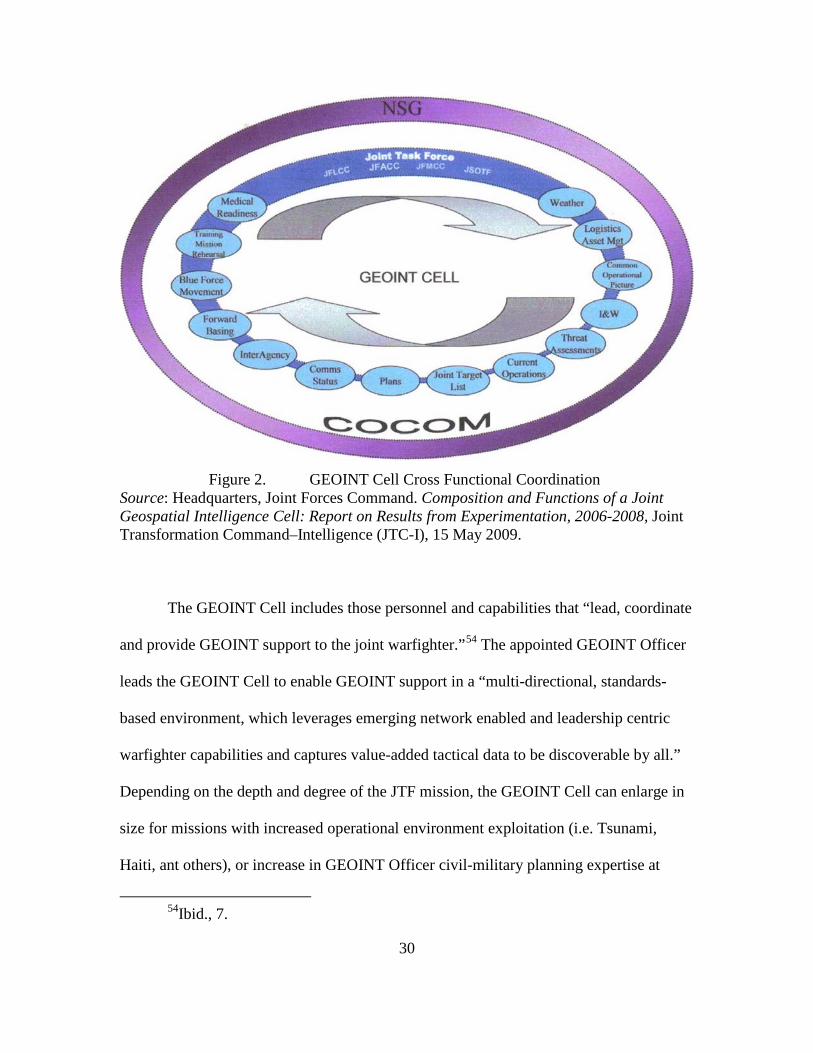
In figure 2, the GEOINT Cell serves as a Joint Task Force cross-functional
coordination cell that facilitates the use of “standardized GEOINT processes, procedures,
and organizations” across the National System for GEOINT, Combatant Commands,
Services, and Agencies to “enhance organic capabilities to conduct effective joint
operations.”
53
While the exercises provided room for USJFCOM to stretch the GEOINT
Cells proverbial legs by improving shared SA, it did not provide the true cross functional
coordination of a cell. Nor did it integrate itself into the civil-military operational
planning cycle, joint planning guidance, joint operational planning process, or higher
level problem solving. Likewise, in order to assess the GEOINT Cell, USJFCOM
developed a detailed checklist of GEOINT operations, planning, releasability, emerging
technology, maintenance, shared awareness, and enhanced SA considerations.
51Headquarters, Joint Forces Command. Composition and Functions of a Joint
Geospatial Intelligence Cell: Report on Results from Experimentation, 2006-2008. Joint Transformation Command–Intelligence (JTC-I), 15 May 2009, 2.
52Ibid.
53Ibid., 1.
30
Figure 2. GEOINT Cell Cross Functional Coordination
Source: Headquarters, Joint Forces Command. Composition and Functions of a Joint Geospatial Intelligence Cell: Report on Results from Experimentation, 2006-2008, Joint Transformation Command–Intelligence (JTC-I), 15 May 2009.
The GEOINT Cell includes those personnel and capabilities that “lead, coordinate
and provide GEOINT support to the joint warfighter.”54
54Ibid., 7.
The appointed GEOINT Officer
leads the GEOINT Cell to enable GEOINT support in a “multi-directional, standards-
based environment, which leverages emerging network enabled and leadership centric
warfighter capabilities and captures value-added tactical data to be discoverable by all.”
Depending on the depth and degree of the JTF mission, the GEOINT Cell can enlarge in
size for missions with increased operational environment exploitation (i.e. Tsunami,
Haiti, ant others), or increase in GEOINT Officer civil-military planning expertise at

31
higher levels of operations. In figure 3, the GEOINT Cell consists of about five experts
who conduct day-to-day cell functions and coordinate existing GEOINT capabilities in
support of the designated mission. The extended GEOINT Cell provides JTF cross-
functional information fusion, visualization, analysis, and sharing. Depending on the
nature of the JTF mission, the GEOINT Cell can conduct unclassified and classified
mission support, utilizing commercial, unclassified, and NTM sources.
Figure 3. GEOINT Cell Organizational Construct
Source: Department of Defense, Memorandum, Subject: Joint Geospatial Intelligence Transformation DOTMLPF Change Recommendation, Washington, DC, 25 June 2008.
Currently, the USJFCOM is developing the GEOINT Cell within the “Joint
GEOINT Transformation DOTMLPF Change Recommendation”, dated 25 June 2008.
The Joint Requirements Oversight Council (JROC) endorsed the Doctrine, Organization,
Training, Material, Leadership, Personnel and Facility (DOTMLPF) Change

32
Recommendation (DCR), and appointed the NGA as the overall lead organization to
implement the DCR (see Appendix A).
In July 2009, the USJFCOM assumed leadership of the annual Empire Challenge
exercise from the National Geospatial-Intelligence Agency. In July 2010, Empire
Challenge 2010 will move from China Lake Naval Air Weapons Station, California, to
Fort Huachuca, Arizona. The move will continue to demonstrate live joint, NATO and
coalition ISR interoperability. USJFCOM and NATO will cooperate in the USJFCOM
GEOINT Cell as any efforts will hopefully be advantageous for further NATO
transformation.
After assessing the primary research question based on the foundation of statutes,
professional journals, official publications and previous research, a study of relevant
articles and studies to include theses was conducted and is provided below.
Articles
In 2007, COL Richard Barrowman, the then USJFCOM Geospatial Officer, wrote
“Geospatial Intelligence: The New Intelligence Discipline” in the Joint Forces Quarterly.
He discusses the use of the Joint GEOINT Activity (JGA) by USJFCOM to provide for
and inform the Joint Force Commander.55
55Richard Barrowman, “Geospatial Intelligence: The New Intelligence
Discipline,” Joint Forces Quarterly (2007), http://www.ndu.edu/inss/Press/jfq_pages/ editions/i44/21.pdf (accessed 8 May 2010).
The JGA has five lines of operations which tie
the GEOINT Cell to the Joint Forces Commander as follows: (1) defines the GEOINT
requirements through the Joint Planning Group; (2) enables the joint warfighter to make a
decision on the most cost-effective approach for meeting the requirements within specific

33
timeliness; (3) directs phased GEOINT exploitation; (4) enables the joint warfighter to
use superior GEOINT to plan, decide, act, and monitor; and (5) ensures the data is kept
current and relevant. The ultimate goal is to provide a true and unmitigated current
picture, whereby the GEOINT Cell provides understanding and visualization of the
operational environment to the decision maker and considers the data currency risk
mitigation efforts.
Dan Raducanu, Chief for Romania’s Center for Geospatial Intelligence (CGINT)
comprehensively details their GEOINT operations in support of Operation Iraqi
Freedom.56
Major General Michael T. Flynn’s, Fixing Intel: A Blueprint for Making
Intelligence Relevant in Afghanistan, is a sentinel study by the Deputy Chief of Staff,
Intelligence (CJ2), for the International Security Assistance Force in Afghanistan since
June 2009. He directs that select teams of analysts will be “empowered to move between
field elements. . . integrate information collected by civil affairs officers, PRTs,
atmospheric teams, Afghan liaison officers, female engagement teams, willing non-
governmental organizations and development organization, United Nations officials,
psychological operations teams, human terrain teams, and infantry battalions, to name a
The CGINT defines GEOINT the same as the US imagery, imagery
intelligence and geospatial information. The CGINT was a pilot program for the
Romanian Government, and their GEOINT Cell is an outstanding example of how US,
Coalition and Iraqi troops on the ground are the direct beneficiaries of multinational
collaboration in GEOINT to support operations in real time.
56Dan Raducanu, CGIN-Center for Geospatial Intelligence, http://earth.esa.int/
rtd/Events/ESA-EUSC_2006/Oral/Ar44_Raducanu.pdf (accessed 8 May 2010).
34
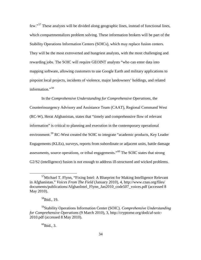
few.”57 These analysts will be divided along geographic lines, instead of functional lines,
which compartmentalizes problem solving. These information brokers will be part of the
Stability Operations Information Centers (SOICs), which may replace fusion centers.
They will be the most extroverted and hungriest analysts, with the most challenging and
rewarding jobs. The SOIC will require GEOINT analysts “who can enter data into
mapping software, allowing customers to use Google Earth and military applications to
pinpoint local projects, incidents of violence, major landowners’ holdings, and related
information.”58
In the Comprehensive Understanding for Comprehensive Operations, the
Counterinsurgency Advisory and Assistance Team (CAAT), Regional Command West
(RC-W), Herat Afghanistan, states that “timely and comprehensive flow of relevant
information” is critical to planning and execution in the contemporary operational
environment.
59 RC-West created the SOIC to integrate “academic products, Key Leader
Engagements (KLEs), surveys, reports from subordinate or adjacent units, battle damage
assessments, source operations, or tribal engagements.”60
57Michael T. Flynn, “Fixing Intel: A Blueprint for Making Intelligence Relevant
in Afghanistan.” Voices From The Field (January 2010), 4, http://www.cnas.org/files/ documents/publications/AfghanIntel_Flynn_Jan2010_code507_voices.pdf (accessed 8 May 2010).
The SOIC states that strong
G2/S2 (intelligence) fusion is not enough to address ill-structured and wicked problems.
58Ibid., 19.
59Stability Operations Information Center (SOIC). Comprehensive Understanding for Comprehensive Operations (9 March 2010), 3, http://cryptome.org/dodi/af-soic-2010.pdf (accessed 8 May 2010).
60Ibid., 3.
35
The SOIC is tasked to fuse as far left, as comprehensive as possible, and more
perspectives and disciplines as needed, and in line with MG Flynn’s Fixing Intel paper.
The SOIC-West supports,
the Regional Command Team’s Civilian and Military COIN Unity of Effort by facilitating information sharing between all relevant actors in order to provide effective understanding of the Operational Environment and enable the development of accurate and timely assessments, comprehensive plans, fully informed decisions and appropriate actions.61
Studies and Theses
LtCol L.H. Remillard’s Making New Friends, Trusting New Friends: The
Challenges of Coalition Intelligence Sharing in Afghanistan, a 2009 Canadian Force
College student, argues that intelligence sharing and the development of a common
intelligence picture (CIP) in Afghanistan has led to a more effective coalition intelligence
apparatus.62
Danny Fortin’s “Sharing the Burden: How Effective is a Multinational Force in
the Contemporary Operational Environment,” a 2007 US Army Command and General
Staff College student, argues that peace enforcement is too much for the United Nations’s
capacity. He also argues that “a coalition of Allies and like-minded partners, including
comparible regional partners, possessing robust tools and minimal debilitating national
caveats, is the most promising and effective military arrangement.”
63
61Ibid., 6.
62L. H. Remillard, “Making New Friends, Trusting New Friends: The Challenges of Coalition Intelligence Sharing in Afghanistan” (MDS Research Project, Canadian Force College, April 2009), www.cfc.forces.gc.ca/papers/csc/csc35/mds/remillard.doc (accessed 8 May 2010).
63Danny Fortin, “Sharing the Burden: How Effective is a Multinational Force in the Contemporary Operational Environment” (Thesis, Command and General Staff
36
Andy Sanchez’s “Leveraging Geospatial Intelligence (GEOINT) in Mission
Command,” a 2007 US Army Command and General Staff College student, argues for
use of GEOINT as an instrument of and for the execution of policy.64
The RAND Corporation conducts extensive research for the US Government, in
particular the US Air Force. There are several RAND studies worth mentioning, but most
are tied to systems and platforms efficiency. Carl Rhodes’ 2007 RAND Study, “A
Strategies-to-Tasks Framework for Planning and Executing Intelligence, Surveillance,
and Reconnaissance (ISR) Operations,” treats systems and platforms as sensor agnostic.
Sanchez uses
openly available sources covering Hurricane Katrina sources. He does provide emphasis
towards a GEOINT Cell, but offers no recommendations, only that early interoperability
and cooperation will solve most issues. He particularly emphasizes the use of the
internationally recognized use of ArcGIS software as the forcing function to gain
understanding and visualization. Although the purpose of the literature review was not to
focus on systems or platforms, many of Andy Sanchez’s discussion points are applicable
to this thesis research.
65
College, Fort Leavenworth, KS, 2007), http://www.dtic.mil/cgi-bin/GetTRDoc?AD= ADA471324&Location=U2&doc=GetTRDoc.pdf (accessed 8 May 2010).
In other words, his RAND study focuses on the ends-ways-means of ISR collection
64Andy Sanchez, “Leveraging Geospatial Intelligence (GEOINT) in Mission Command” (Monograph, School of Advanced Military Studies, 2009), http://www.dtic.mil/cgi-bin/GetTRDoc?AD=ADA506270&Location=U2&doc= GetTRDoc.pdf (accessed 8 May 2010).
65Carl Rhodes, “A Strategies-to-Tasks Framework for Planning and Executing Intelligence, Surveillance, and Reconnaissance (ISR) Operations” (RAND, Project Air Force, 2007), http://www.rand.org/pubs/technical_reports/2007/RAND_TR434.pdf (accessed 8 May 2010).

37
strategy. He also alludes to many decision-makers becoming nearly addicted to certain
platforms, as in the phrase “Predator Porn.” Yet, what should be used could be called an
ISR-operational design, in an end-ways-means approach.
Summary
A thorough appreciation of the significant literature concerning the contemporary
operational environment, battle command, GEOINT, GEOINT cells, the stewardship
implications they pose to battle command, and the capabilities needed to provide
understanding and visualization is essential to this analysis. The perspectives afforded by
the various governmental publications presented above paint a picture of the
contemporary operational environment that GEOINT operations must contend with in the
future.

38
CHAPTER 3
RESEARCH METHODOLOGY
The previous chapter provided an overview of the literature and research
documents used for this thesis. This chapter reflects the framework and methodology
used for research in pursuing whether GEOINT stewardship is appropriately integrated
into multi-national operations so that our leaders can effectively face the future
operational environment.
This thesis provides research, analysis, conclusions, and recommendations
concerning GEOINT stewardship and its ability to properly develop the commander’s
understanding and visualization in accordance with current and future operational
environments. In the process of conducting this research, the author noted a significant
gap in all GEOINT processes in that they lacked the appropriate inclusion of stewardship
in the increased role in multinational operations and the contemporary operational
environment.
This chapter examines the primary and secondary research questions and
examines the need and quality control of a survey to not only determine the effectiveness
of multinational GEOINT operations, but to also find out the thinking behind these
operations and what might be able to affect these operations.
The primary research question for this thesis is, “How can geospatial intelligence
for multinational operations be made more effective?” To address the primary research
question, the following secondary questions must be answered:
1. How does GEOINT support decision makers in the contemporary operational
environment?

39
2. What are the capabilities and limitations of GEOINT cells in providing
understanding and visualization of the common operational picture?
3. Is GEOINT cell stewardship understood and practiced in multinational
operations?
Thesis Framework Overview
The following framework for this thesis methodology is:
1. Investigate how proper GEOINT stewardship enables battle command to
understand and visualize the contemporary operational environment.
2. Conduct a detailed GEOINT survey to answer the three secondary questions,
and analyze the survey results to determine GEOINT operational gaps and fault lines,
current GEOINT cells capabilities and limitations, and recommend stewardship bridging
methods.
3. Assess the importance of GEOINT stewardship and its increasing role within
multinational and, quite possibly, joint operations.
4. And finally, show the relevance of GEOINT stewardship for commanders to
successfully understand and visualize the operational environment.
Design Specifics
The foundation of battle command is the common operational picture and the
foundation of the common operational picture is GEOINT. In the contemporary
operational environment three concepts tend to get blended in multinational operations:
contemporary operational environment, battle command, and the common operational
picture. By studying these three concepts, the researcher hopes to give the reader
40
comprehension of how understanding and visualizing the contemporary operational
environment is nested for the decision making process. Next, the research will study the
GEOINT cell fundamentals. By studying these GEOINT cell fundamentals, the
researcher hopes to give the reader insight into the relevancy of GEOINT and
stewardship. By following a consistent and growing thread of relevancy, this thesis seeks
to show that GEOINT cell stewardship is essential in multinational operations.
Following the analysis of stewardship as an effective means of transforming
multinational operations to understand and operate in a coalition environment, this
research analyzes whether GEOINT contains sufficient foundational integration.
Additionally, the research examines whether future transformation in multinational
operations should reflect change or inclusion of GEOINT stewardship.
Chapter 4 describes the details of the US Army Command and General Staff
College students survey used for this research, and chapter 5 analyzes the survey
findings. Initial coordination was conducted with the NGA Office of International Policy
(i.e. the Multinational Office), the USJFCOM, United States Geospatial Intelligence
Foundation and the CGSC Quality Assurance Office to determine what survey
information currently exists on GEOINT stewardship. The questions asked to all
participants were:
1. How can GEOINT stewardship enable resource management for multinational
operations?
2. How does GEOINT stewardship operate at national, strategic, operational and
tactical levels?

41
3. How can these lessons learned be applied for US multinational GEOINT
oversight?
Initial research for this thesis began with a literature review from open sources,
electronic media, and professional discussions. Since there is no known research on
GEOINT stewardship, it is difficult to predict its future. However, one can ask future
intentions of the GEOINT community. Therefore, an effective method to determine these
future trends for this research is by conducting a survey of GEOINT personnel who have
been deployed on multinational operations. A survey gives the ability to not only
determine the effectiveness of multinational GEOINT operations, but to also find out the
thinking behind these operations and what might be able to affect these operations. For
the purpose of this research, the target audience is those personnel who requested or
provided GEOINT support while on multinational operations.
Instrumentation
The instrument used for this research was a researcher derived census survey. The
survey (Appendix A) consists of nine parts: I) Demographics and Education; II) GEOINT
Multinational Operation; III) GEOINT Multinational Planning; IV) GEOINT
Releasability; V) GEOINT Emerging Technology; VI) GEOINT Maintenance; VII)
GEOINT Shared Awareness; VIII) GEOINT Enhanced Situational Awareness; and IX)
General Comments. The respondents were invited to include any general comments at the
end of the survey. The survey was approved through the CGSC Quality Assurance Office
and assigned a survey control number (10-050). Most of the survey questions ask the
respondents to reply with a Likert Scale (0= Did Not Observe, 1= Greatly Disagree, 2=
Disagree, 3= Neither Disagree Nor Agree, 4= Agree, and 5= Greatly Agree).

42
After coordinating with the CGSC Quality Assurance Office to identify and clean
up potential contaminated survey questions, the author queried the Office of International
Affairs and Policy, NGA for survey question viability. They recommended that all
reference to NGA and the US Army be removed, and that only the reference of
Afghanistan and NATO exist as proper subjects. This would suffice for most
international oversight of a survey.
Due to the complexity of dealing with multiple governmental research and survey
oversight committees, it was deemed necessary to first test the survey with a group of
Five-Eye GEOINT peers, and a group of NATO GEOINT leaders. In November 2009, an
initial test pool consisted of distributing the survey to a group of Five-Eye GEOINT
peers. In December 2009, a second test pool consisted of distributing the survey to a
NATO GEOINT Course taught by the US NGA. Many of the initial survey questions
were further correlated, and several questions were reduced to a manageable number.
Next, the US Army CGSC Quality Assurance Office distributed the survey to a
census of 1,049 CGSC students, which follows the Joint, Interagency, Intergovernmental,
and Multinational model. The first group surveyed was comprised of “Joint” service
members including the US Air Force, US Army, US Marine Corps and the US Navy. The
second group surveyed was comprised of “Interagency” members including the Federal
Bureau of Investigation, Intelligence Agencies, and others. The third group surveyed was
comprised of “Intergovernmental” members including the Department of State,
Department of Justice, Department of Treasury, Department of Homeland Security, and
others. The fourth group surveyed was comprised of “International and Multinational”
military service members.
43
Survey Structure
The census survey is limited to surveying only those personnel that could be
contacted within a reasonable timeframe (March-April 2010). In total, 1,049 personnel
were sent surveys via secure CGSC website invitation. Out of the 1,049 invitations, 113
responded, with 39 qualified to take the survey. The survey has a confidence level of over
95 percent and an error interval rate of +/- 14 percent for a population size of 15,000.
The survey is organized by the primary research question answered by asking the
three secondary research questions, and the three secondary research questions answered
by asking the nine survey question categories- GEOINT operations, planning,
releasability, emerging technology, maintenance, shared awareness, enhanced SA, most
salient story, and most frustrating story. Each of these nine categories have several
assessed questions. Each respondent is allowed to answer each survey question with
Greatly Agree, Agree, Neither Agree Nor Disagree, Disagree, Greatly Disagree, and Did
Not Observe. It is understood that if a GEOINT activity was not observed it did not have
GEOINT stewardship. A sixty-six percent, or two-thirds, of respondents replying at least
agreement would identify that a certain survey question and grouping of questions was
statistically significant. With the addition of the 14 percent error rate the survey questions
will be broken down into three categories: GREEN (66+14, or at least 80 percent);
AMBER (53-79 percent); and RED (below 53 percent).
First, the survey indicates what national relationships each respondent is
associated with, including military/civilian rank, level of leadership/management, NATO
participation, if deployed to Afghanistan, and education. These demographics will be
used to determine common relationships among like groups and to identify ways for

44
targeting GEOINT programs. The survey also attempts to address the level of GEOINT
education of each respondent to identify the comprehension of all GEOINT disciplines
and to what degree. The assumption is that respondents tend to make smarter GEOINT
stewardship decisions based on level of education, applications, and levels of
applications.
Second, the survey is designed to identify each respondent’s GEOINT support
experience for multinational operations. The respondent is asked what type of
multinational operation they supported. The type of support that was provided while on
multinational operation describes the depth and degree of complexity and GEOINT
support required. Finally, the respondent is asked whether adequate GEOINT support
was not provided, and if not, what they felt were the reasons. The likely answers may
include poor knowledge, legality issues and operational tempo.
Third, the survey is designed to identify each respondent’s evaluation of how
GEOINT for multinational operations were planned, coordinated, and shared prior to
operations, how basic collection strategy methods were coordinated, how the commander
understood the support and how the units in question received the support. The
assumption is that multinational operations that had successful GEOINT support were
properly coordinated and synchronized both prior to and during the operation, and has a
high degree of releasability, integrated emerging technology, GEOINT data maintenance,
has shared awareness, and enhanced situational awareness.
Finally, the respondent is encouraged to provide general comments. What was the
most salient experience? And what were the biggest frustrations? These open comments
will be compiled and evaluated for background and contextual understanding. If research

45
proves a lack of effective integration of stewardship into current GEOINT support for
multinational operations, the thesis will make recommendations for change, provide a
model for change and propose capacity building requirements. Otherwise, the research
will establish the baseline measure of GEOINT stewardship for multinational operations.
Summary of Survey Design
In addressing potential gaps in a long-standing intelligence discipline like
GEOINT, it is critical to implement an effective research methodology and design
GEOINT stewardship with concrete literature to support the proposed concepts. GEOINT
integration with existing coalition and multinational cultures is paramount for
commanders to successfully understand and visualize the operational environment. The
next chapter takes the design methodology from chapter 3 and applies analysis of the
survey results and the literature from chapter 2, to generate answers to the primary and
secondary questions of this thesis. The combined effect is to understand the importance
of GEOINT stewardship and to assess its role within multinational operations.

46
CHAPTER 4
RESEARCH FINDINGS
The previous chapter provided an overview of the research methodology and
survey design specifics. This chapter reflects the research and survey findings in pursuing
whether GEOINT stewardship is appropriately integrated into multi-national operations
so that our leaders can effectively face the future operational environment. This chapter
includes survey demographics, answers the secondary research questions, and finally, the
primary research question. The survey data is then presented for validity and content
analysis is conducted to present common and unique themes found in the census
population responses. The researcher’s interpretation of the survey results is offered by
answering the secondary and primary research questions.
Survey Significance
Participation in the GEOINT Stewardship survey was “significant enough for a
representative sample of the target population.” The target population consisted of 1,049
US Army CGSC students. Of the 113 students who responded to the survey, only thirty-
nine answered “Yes” to the qualifying survey question, “Have you requested or provided
geospatial intelligence on a multinational operation?” (see table 2). It is understood that
of the 113 students who were interested enough to respond and take the survey, only
thirty-nine students had the personal experience and knowledge of GEOINT in a
multinational operation. It is important to note that the census survey was distributed to
1,049 students of the US Army CGSC 10-01 class, which is the largest class that the US
Army CGSC has ever instructed. This exceptionally large class ensured the largest

47
anonymous spread of knowledge and combat experience, yet also allowed veterans who
have participated in non-combat multinational operations to respond (see Appendix B).
Table 2. Survey Population
Total Population
Target Population
Total Sample
Qualified Sample
Percent of Target Population
Survey Error
1,049 1,049 113 39 3.7% 14% Source: Created by author.
While survey questions 1-10 are based on demographics and GEOINT operational
considerations, survey questions 11-41 are based on favorable responses to survey
questions asked (see table 3). The favorable percentage is the total of “Agree” and
“Strongly Agree” percentage responses. The classification is derived as follows: A
“Favorable” percentage of 80 percent or above rates “Green,” a “Favorable” percentage
between 53 percent and 79 percent rates “Amber,” a “Favorable” percentage of 52
percent or below rates “Red.”
Statistically speaking, if the “true” percentage of favorable responses (which one
would get with all 15,000 people queried responding to the survey) is BELOW 66
percent, there is about a 95 percent chance that the favorable response percentage from
the 39 respondents will be below 80 percent. Table 3 identifies that, if the observed
favorable response percentage is 80 percent or above, there is a 95 percent certainty that
the “true” percentage of favorable responses (across a population of 15,000) would be AT
LEAST 66 percent. This is where the GREEN designation is established. A similar
argument (in reverse) established the RED designation. If the favorable response

48
percentage is between 53 percent and 79 percent, a favorable and non-favorable
statement cannot be made, hence the AMBER designation.
Table 3. Favorable Status Classifications
Standard Favorable Ratings
Survey Error
Adjusted Minimum Favorable Ratings
Favorable Status
66% +14% 80% GREEN 66% -14% 53% AMBER
0 RED Favorable Status: RED (<53%); AMBER (53-79%); and GREEN (80%=>)
Source: Created by author.
Demographics
Level of Operations
In survey question number 1, the population consisted of eight National, seven
Strategic (country or province), seventeen Operational (joint task force, province or city),
and six Tactical (or community) individual experiences (see table 4). It is commonly
understood that GEOINT greatly supports tactical level operations. The thirty-two
Operational, Strategic and National level experiences denote a higher level of GEOINT
support than what was anticipated. The more probable explanation is that CGSC students
tend to have previous assignments across the Joint, International, Interagency and
Multinational domains that provide higher-level GEOINT insights. Also, this research
may result in a greater understanding of the 43 percent of those operationally focused
respondents.

49
Table 4. Survey Question Number 1, Highest Level of GEOINT Operation
Level of Operation Count Percent National 8 20.5% Strategic/Country/Province 7 17.9% Operational/Joint Task Force/Province/City 17 43.6% Tactical/Community 6 15.4% Other 1 2.6%
TOTAL 39 100% Source: Created by author.
Deployed
In survey question number 2, analysis shows that while only five respondents had
been deployed once on multinational operations, the remaining thirty-four respondents
had been deployed at least twice (see table 5).
Table 5. Survey Question Number 2, Number of Multinational Deployments
Deployments Count Percent
1 5 12.8% 2 15 38.5% 3 11 28.2%
4+ 8 20.5% TOTAL 39 100%
Source: Created by author.
In survey question number 3, thirty-nine respondents acknowledged their country
as a member of NATO. It can be understood that the majority of foreign students in
CGSC 10-01 are affiliated with NATO. It came as a surprise that no non-NATO students
participated in the survey. It can also be understood that the majority of non-NATO

50
students in CGSC 10-01 might be unwilling to participate in a GEOINT survey, for fear
of sharing their opinions. It can also be understood that those NATO students might have
a higher level of GEOINT knowledge and experiences for multinational operations. This
research was hoping to include those close non-NATO countries (Australia, New
Zealand, South Korea, and others), or from other nations that place weight on educating
their officers on the importance of integrating GEOINT into multinational operations.
In survey question number 4, twenty-seven respondents have deployed on NATO
operations, while twelve respondents have not deployed on NATO operations (see table
6). This shows that one-third of the respondents (or twelve) have not supported NATO
operations, which can be tied to non-NATO operations (i.e. Operation Iraqi Freedom).
Table 6. Survey Question Number 4, Number of NATO Deployments
Deployments Count Percent 0 12 30.8% 1 20 51.3% 2 3 7.7% 3 3 7.7%
4+ 1 2.5% TOTAL 39 100%
Source: Created by author.
Finally in survey question number 5, twelve respondents stated that they have
deployed at least once to Afghanistan, while twenty-seven have not deployed to
Afghanistan at all (see table 7). What is not known is if those non-Afghanistan
respondents actually deployed in support of Iraqi operations.

51
Table 7. Survey Question number 5, Number of Afghanistan Deployments
Deployments Count Percent 0 27 69.2% 1 10 25.7% 2 0 0% 3 2 5.1%
TOTAL 39 100% Source: Created by author.
Education
Next, each respondent was asked what type of GEOINT education they had
received and the level of education they had received. In Survey Questions number 6 (see
table 8) and number 7 (see table 9), the majority of the respondents stated they had
received geospatial information education. Of the remaining respondents, the next two
significant categories are ISR collection management and targeting education.

52
Table 8. Comparison of Survey Questions Number 6 and Number 10
Source: Created by author.
Table 9. Survey Question number 7, Highest Level of GEOINT Education Received
QUESTION #7 COURSE LENGTH COUNT University/College Level 2 Military Occupation Specialty/Civilian Skill 2 Long Course (2-4 weeks) 2 Short Course (1-7 days) 5 Received education but uncertain of the level 10 None 17 Other 1
Source: Created by author.
#6 and #10 Type of GEOINT Education Received
Pre-Deploy Need
Operational Need Change
Mission Planning (command & control systems, etc) 10 21 +11
Geospatial Information (maps, terrain analysis, shapefiles, vectors, ground truth, etc) 21 27 +6
Imagery (processing, science, IR, MSI/HSI, etc) 11 23 +12 Imagery Intelligence (analysis, ORBAT, etc) 11 19 +8 Radar, IFSAR, MTO/GMTI, LIDAR, etc 10 7 -3 Full Motion Video 10 11 +1 Survey, GPS foundation/benchmark, gravitational, magnetic 4 3 -1
Network Analysis (human, signals, infrastructure, etc) 6 11 +5
Cultural intelligence layers/Human terrain teams 4 15 +11 Targeting 11 20 +9 Intelligence, surveillance, and reconnaissance collection management 13 16 +3
Space 5 3 -2 Maritime 1 3 +2 Littoral 2 3 +1 (Received no education) (14)
TOTAL 119 182 +63

53
Another possible analysis could be that non-NATO mission partners tend to
provide their own geospatial information, targeting, and ISR collection management
education, while analysis, processing, and exploitation could entail extensive NATO
releasability oversights and classification issues.
Finally, in Survey Question number 8 (table 10), respondents were asked to
characterize their personal level of knowledge regarding GEOINT support for
multinational operations. Thirty respondents stated they had at least an average level of
knowledge developed from training or operational support, while nine stated they had an
above average level of knowledge developed from training AND operational support. It
is important to note that while fourteen respondents stated they had received no GEOINT
education (see table 8), thirty respondents have at least an average level of knowledge
(see table 10). Conversely, if one believes the group of thirty respondents, even with no
formal training, one could achieve at least an average understanding of GEOINT. This
could mean that GEOINT support was easily learned, understood and applied by non-
NATO members across multinational operations.
Table 10. Survey Question number 8, Personal Level of GEOINT Knowledge
GEOINT KNOWLEDGE COUNT
Detailed- supervised multinational support, developed from formal training AND operational support 2
Above Average- developed from training AND operational support 7
Average- developed from training or operational support 21 Limited- based largely on anecdotal information 9
Source: Created by author.
54
Secondary Research Question Number 1
How does GEOINT support decision makers in the contemporary operational
environment? Secondary research question number one is divided into two categories-
GEOINT Multinational Operations and GEOINT Multinational Planning. Each of these
categories has several apportioned survey questions.
GEOINT Multinational Operations
GEOINT Multinational Operations is defined as organizational concept of
operations, structure and establishment of a GEOINT officer. In question number 9 (table
11), each respondent was allowed to select those types of missions where they utilized
GEOINT support. Three types of multinational operations had the highest responses:
Major Operations had a score of twenty-four; Counterinsurgency Operations had twenty-
three; and Combating Terrorism had sixteen. The remaining types of operations were
between one and twelve responses, which indicates a highly acceptable rating of the
highest three operation types as being the dominant and prevailing mission type.
Likewise, it can be inferred that the remaining survey questions will support these three
mission types.

55
Table 11. Survey Question Number 9, Multinational Operations
#9 MULTINATIONAL OPERATION GEOINT SUPPORT COUNT Major Operations 24 Homeland Defense/Internal Security 3 Civil Support 8 Strikes 9 Raids 9 Show of Force 5 Enforcement of Sanctions 5 Protection of Shipping 2 Freedom of Navigation 2 Peace Operations 12 Support to Insurgency 2 Counterinsurgency Operations 23 Combating Terrorism 16 Noncombatant Evacuation Operations 4 Recovery Operations 5 Consequence Management 3 Foreign Humanitarian Assistance 6 Nation Assistance 6 Arms Control and Disarmament 3 Routine, Recurring Military Activities 11 Other 1
Source: Created by author.
Survey question number 10 (table 8) had 182 responses for type of GEOINT
support required, compared to Survey Question number 6 (table 8), which had 119
responses (see Appendix B). The plus-sixty-three responses could be attributed to the
operational demand placed on GEOINT support and that training back at home station
was not properly leveraged. In other words, personnel are deploying to an operational
theater severely undertrained for what the multinational mission would require.
Comparatively, Survey Questions number 6 and number 10 show (table 8): a significant
increase in mission foundation fundamentals such as, mission planning, geospatial

56
information, imagery and cultural intelligence; an increase in actionable intelligence
fundamentals such as, imagery intelligence, full motion video, network analysis, and
targeting; and, negligible changes in mission support such as radar, survey, ISR
collection management, space, and littoral. The significant increase in mission foundation
fundamentals could signify that operational deployments require a higher level of
GEOINT understanding than what can be trained at home station. The increase in
actionable intelligence training requirements might be provided by classified home
station training (i.e. Project Foundry).66
Survey questions number 11 to 14 identify GEOINT operational structure and
organization (see table 12). Question number 11 shows twenty-three favorable responses
(AMBER) for ‘at least agreeing’ (agree and greatly agree) that GEOINT operations were
established according to the commander’s concept of operations, while five respondents
at ‘least disagreed’ (disagree and greatly disagree). Question number 12 shows thirty-one
favorable responses (AMBER) for at least agreeing that GEOINT operations were
integrated into the mission, while two respondents at least disagreed. Question number 13
shows twenty-two favorable responses (AMBER) for at least agreeing that the GEOINT
officer was integrated into the mission, while one respondent at least disagreed. Question
number 14 shows twenty-two favorable responses (AMBER) for at least agreeing that the
Finally, the negligible changes in mission
support could indicate these types of GEOINT support are highly specialized skills that
do not require operational surge capacity. Or, deployed adjunct instructors could be used
at the major forward operating bases.
66Foundry Program, Brochure, http://www.dami.army.pentagon.mil/offices/dami-
zxg/documents/foundry-brochure.pdf (accessed 8 May 2010).

57
GEOINT cell was synchronized with the unit’s battle rhythm, while three respondents at
least disagreed.
Table 12. GEOINT Operations, Integration and Synchronization
Survey Questions Did Not Observe
<= Disagree
Neither Agree Nor Disagree
Agree => Status
11. Commanders Concept of Operations 4 5 7 23 Amber
12. Integrated with Mission 2 2 4 31 Amber
13. GEOINT Officer 9 1 7 22 Amber 14. Synchronized with Battle Rhythm 7 3 7 22 Amber
TOTAL (156) 22 11 25 98 Percentage 14.1% 7.1% 16% 62.8% AMBER
Favorable Status: RED (<53%); AMBER (53-79%); and GREEN (80%=>) Source: Created by author.
Table 12 compares survey questions number 11 to 14, which shows that 62.8
percent of the respondents agreed that GEOINT was favorable (AMBER), while 7.1
percent of the respondents disagreed. In addition, 14.1 percent of the respondents “did not
observe” GEOINT functionality, which could be mitigated by the GEOINT cell being an
established organization in accordance with the commander’s concept of operations.
Nevertheless, the ninety-eight favorable responses did provide an AMBER status.
GEOINT Multinational Planning
GEOINT Multinational Planning is defined as, “effective command and control
demands that commanders and staffs collaborate in planning- determining the mission

58
statement, commander’s intent (objectives, desired effects, and tasks/purpose) and
concept of operations.”67
Table 13. GEOINT Planning Comparison
Survey Questions Did Not Observe
<= Disagree
Neither Agree Nor Disagree
Agree => Status
15. GEOINT Officer Prioritization 9 1 8 21 Amber
16. Coordinated Multinational GEOINT Collection Strategy
10 3 11 15 Red
17. GEOINT Usefulness 2 1 0 36 Green 18. Planning Staff Understanding 1 9 6 23 Amber
19. Intelligence Staff Understanding 2 5 8 24 Amber
20. Engineer Staff Understanding 10 2 7 20 Red
21. Civil-Military Staff Understanding 10 7 13 9 Red
22. Mission Partners Visualization 6 9 13 11 Red
23. PIR Synchronized With Collection Strategy 3 6 12 18 Red
24. Foreign National Intelligence Synchronized with Collection Strategy
8 12 11 8 Red
TOTAL (390) 61 55 89 185 Percentage 15.6% 14.1% 22.9% 47.4% RED
Favorable Status: RED (<53%); AMBER (53-79%); and GREEN (80%=>) Source: Created by author.
67Chairman, Joint Chief of Staff, Joint Publication 3-0, xvi.

59
Survey Questions number 15-24 identify GEOINT planning considerations (see
table 13). Question number 15 shows twenty-one favorable responses (AMBER) for ‘at
least agreeing’ (agree and greatly agree) that the GEOINT prioritized planning
considerations, while one respondent ‘at least disagreed’ (disagree and greatly disagree).
Question number 16 shows fifteen favorable responses (RED) for at least agreeing that
their unit coordinated Multinational GEOINT Collection Strategy, while three
respondents at least disagreed. Question number 17 shows thirty-six favorable responses
(GREEN) for at least agreeing that GEOINT was useful, while one respondent did not
observe this action. Question number 18 shows twenty-three favorable responses
(AMBER) for at least agreeing that the planning staff understood GEOINT planning
considerations, while nine respondents at least disagreed. Question number 19 shows
twenty-four favorable responses (AMBER) for at least agreeing that the intelligence staff
understood GEOINT planning considerations, while five respondents at least disagreed.
Question number 20 shows twenty favorable responses (RED) for at least agreeing that
the engineer planning staff understood GEOINT planning considerations, while two
respondents at least disagreed. Question number 21 shows nine favorable responses
(RED) for at least agreeing that the civil-military planning staff understood GEOINT
planning considerations, while seven respondents at least disagreed. Question number 22
shows eleven favorable responses (RED) for at least agreeing that mission partners
visualization was included in GEOINT planning considerations, while nine respondents
at least disagreed. Question number 23 shows eighteen favorable respondents (RED) for
at least agreeing that priority intelligence requirements were synchronized with GEOINT
collection strategy, while six respondents at least disagreed. Question number 24 shows

60
eight favorable respondents (RED) for at least agreeing that foreign national intelligence
was synchronized with their unit’s collection strategy, while twelve respondents at least
disagreed.
By comparison table 13 shows 185 favorable responses (RED) for agreeing that
GEOINT planning considerations were functional, while 14.1 percent of the respondents
disagreed. Also, 15.6 percent of the respondents “did not observe” GEOINT planning.
The GEOINT cell could mitigate this large disagreement by having an established
planning cycle.
Summary
How does GEOINT support decision makers in the contemporary operational
environment? The results in this survey show that, for the officers who participated,
GEOINT Multinational Operations knowledge level was AMBER. Furthermore, there is
no clear GEOINT officer or structure identified. This finding leads to the conclusion that
a GEOINT officer and structure is required for GEOINT stewardship to exist. Findings
also show that GEOINT personnel are deploying on multinational operations that require
a greater degree of mission training than can be provided at home station. GEOINT
Multinational Planning (RED) assessment is that friendly force GEOINT planning was
favorable, while multinational (i.e. engineer, civilian, mission partners, foreign nationals)
focused GEOINT planning was unfavorable.
It appears that multinational GEOINT support has been based on relationship
building, not on established structure. GEOINT planning received the worst overall rating
of RED, mostly due to an ambivalent attitude towards its success (neither agree nor
disagree) and the large number of “did not observe” responses. It is the individual

61
leadership and education abilities of current augmented teams that have overcome
insurmountable odds to provide multinational SA for decision makers. Hopefully, current
efforts by the USJFCOM and NATO in establishing a GEOINT Officer and Cell in
accordance with a formal manning document (i.e. Joint Manning Document), will support
decision makers in the contemporary operational environment.
Secondary Research Question Number 2
What are the capabilities and limitations of GEOINT cells in providing
understanding and visualization of the common operational picture? Secondary research
question number two is divided into five categories- GEOINT Releasability, GEOINT
Emerging Technology, GEOINT Maintenance, GEOINT Shared Awareness, and
GEOINT Enhanced SA. Each of these categories has several apportioned survey
questions.
GEOINT Releasability
GEOINT releasability is defined as, “to identify security considerations of
GEOINT such as classification levels, procedures or authority to release and/or
handle/transfer classified or sensitive information and, interoperability with supporting
systems and security domains. To ensure capability to transfer data between security
domains consistent with [COCOM] and [DoD] security policies and directives.”68
68Headquarters, Joint Forces Command, Joint Geospatial-Intelligence Activity,
Combatant Command GEOINT Task List (Norfolk, VA: Government Printing Office, 28 May 2008), 2.6.
Survey
questions numbers 25 to 29 identify GEOINT releasability functions (see table 14).
Questions number 25, number 26 and number 29 show a high correlation to “agreement”

62
with somewhat equal “disagreement”. Question number 25 shows seventeen favorable
responses (RED) for ‘at least agreeing’ (agree and greatly agree) that GEOINT
releasability was integrated in accordance with mission requirements, while four
respondents ‘at least disagreed’ (disagree and greatly disagree). Question number 26
shows twenty-two favorable responses (AMBER) that GEOINT was disseminated to
mission partners, while seven respondents at least disagreed. Question number 27 shows
twelve favorable responses (RED) that GEOINT was available via web search release,
while four respondents at least disagreed. Question number 28 shows thirteen favorable
responses (RED) that GEOINT support mitigated area-coverage gaps, while five
respondents at least disagreed. Question number 29 shows twenty favorable responses
(RED) that mission partners satisfy my unit’s mission requirements, while four
respondents at least disagreed. By comparison, table 14 shows that 43.1 percent of the
favorable respondents (RED) agreed that GEOINT releasability worked, while 12.3
percent of the respondents disagreed. In addition, 24.1 percent of the respondents “did not
observe” GEOINT releasability, which could be mitigated by the GEOINT cell
advertising multinational releasability support, or selling itself.

63
Table 14. GEOINT Releasability
Survey Questions Did Not Observe
<= Disagree
Neither Agree Nor Disagree
Agree => Status
25. IAW Mission Requirements 11 4 7 17 Red
26. Disseminated to Mission Partners 5 7 5 22 Amber
27. Web Search Release 13 4 10 12 Red 28. Mitigate Area-Coverage Gaps 10 5 11 13 Red
29. Mission Partners Satisfy My Reqt’s 8 4 7 20 Red
TOTAL (195) 47 24 40 84 Percentage 24.1% 12.3% 20.5% 43.1% RED
Favorable Status: RED (<53%); AMBER (53-79%); and GREEN (80%=>) Source: Created by author.
GEOINT Emerging Technology
GEOINT Emerging Technology is defined as to integrate emerging GEOINT
technologies into a military command to enable or enhance training, operations,
maintenance, and other applicable mechanisms. Survey Questions numbers 30-32
identify GEOINT releasability functions (see table 15). Question number 30 shows
fifteen favorable responses (RED) for ‘at least agreeing’ (agree and greatly agree) that
GEOINT emerging technology was integrated with mission partners, while four
respondents ‘at least disagreed’ (disagree and greatly disagree). Question number 31
shows thirteen favorable responses (RED) that their GEOINT cell coordinated emerging
technology training, while four respondents at least disagreed. Question number 32
shows seventeen favorable responses (RED) that emerging GEOINT technology
enhanced their unit’s SA, while zero respondents at least disagreed. By comparison, table

64
15 shows that 38.4 percent of the favorable respondents (RED) agreed that emerging
GEOINT technology was functional, while 6.8 percent of the respondents at least
disagreed. Also, 27.4 percent of the “neither agree nor disagree” respondents and 27.4
percent of the “did not observe” respondents could have been positively influenced by the
GEOINT cell advertising emerging technology support, or selling itself.
Table 15. GEOINT Emerging Technology
Survey Questions Did Not Observe
<= Disagree
Neither Agree Nor Disagree
Agree => Status
30. Integrate with Mission Partners 10 4 10 15 Red
31. Coordinate Training 10 4 12 13 Red 32. Enhanced My Unit’s Situational Awareness 12 0 10 17 Red
TOTAL (117) 32 8 32 45 Percentage 27.4% 6.8% 27.4% 38.4% RED
Favorable Status: RED (<53%); AMBER (53-79%); and GREEN (80%=>) Source: Created by author.
GEOINT Maintenance
GEOINT maintenance is defined as to coordinate, establish, monitor, utilize and
purge data accuracy, version control, data holdings and standardization, and purge
databases as necessary. Survey Questions number 33-36 identify GEOINT maintenance
functions (see table 16). Question number 33 shows twenty-two favorable responses
(AMBER) for ‘at least agreeing’ (agree and greatly agree) that GEOINT integrated data
was validated, while zero respondents ‘at least disagreed’ (disagree and greatly disagree).
Question number 34 shows fifteen favorable responses (RED) that GEOINT data naming

65
conventions were established, while four respondents at least disagreed. Question number
35 shows twelve favorable responses (RED) that GEOINT support integrated mission
partner data, while four respondents at least disagreed. Question number 36 shows ten
favorable responses (RED) that the GEOINT cell purged irrelevant data, while three
respondents at least disagreed. By comparison, table 16 shows that 37.8 percent of the
favorable respondents (RED) agreed that GEOINT maintenance was functional, while 7.1
percent of the respondents at least disagreed. Also, the GEOINT cell positively taking
control of GEOINT data maintenance, and/or providing guidance could have positively
influenced 37.8 percent of the “did not observe” respondents.
Table 16. GEOINT Maintenance
Survey Questions Did Not Observe
<= Disagree
Neither Agree Nor Disagree
Agree => Status
33. Integrate Validated Data 9 0 8 22 Amber
34. Established Data Naming Conventions 14 4 6 15 Red
35. Integrate Mission Partner Data 16 4 7 12 Red
36. Purge Irrelevant Data 20 3 6 10 Red
TOTAL (156) 59 11 27 59 Percentage 37.8% 7.1% 17.3% 37.8% RED
Favorable Status: RED (<53%); AMBER (53-79%); and GREEN (80%=>) Source: Created by author.
GEOINT Shared Awareness
GEOINT shared awareness is defined as to coordinate, integrate, employ and
modify the capture and sharing of GEOINT data to ensure the common operational

66
picture and joint intelligence preparation of the operational environment with mission
partners. Survey Questions number 37-39 identify GEOINT maintenance functions (see
table 17). Question number 37 shows twenty-nine favorable responses (AMBER) for ‘at
least agreeing’ (agree and greatly agree) that GEOINT was integrated into the common
operational picture, while one respondent ‘at least disagreed’ (disagree and greatly
disagree). Question number 38 shows thirty favorable responses (AMBER) that GEOINT
was integrated into the joint intelligence preparation of the operational environment (i.e.
IPB), while zero respondents at least disagreed. Question number 39 shows twenty-three
favorable responses (AMBER) that GEOINT was useable by mission partners, while
three respondents at least disagreed. By comparison, table 17 shows that 70.1 percent of
the favorable respondents (AMBER) agreed that GEOINT shared awareness was
functional, while 3.4 percent of the respondents at least disagreed. Also, the GEOINT cell
positively taking control of GEOINT shared awareness, and/or providing guidance could
have positively influenced 18 percent of the “neither agree or disagree” respondents.
Table 17. GEOINT Shared Awareness
Survey Questions Did Not Observe
<= Disagree
Neither Agree Nor Disagree
Agree => Status
37. Integrated into COP 4 1 5 29 Amber
38. Integrated into JIPOE (IPB) 3 0 6 30 Amber
39. Useable by Mission Partners 3 3 10 23 Amber
TOTAL (117) 10 4 21 82 Percentage 8.5% 3.4% 18% 70.1% AMBER
Favorable Status: RED (<53%); AMBER (53-79%); and GREEN (80%=>) Source: Created by author.

67
GEOINT Enhanced Situational Awareness
GEOINT enhanced SA is defined as to coordinate and employ GEOINT across
mission functions in order to achieve and maintain shared awareness of the operational
environment with mission partners. Survey Questions number 40-41 identify GEOINT
maintenance functions (see table 18). Question number 40 shows twenty-five favorable
responses (AMBER) fort ‘at least agreeing’ (agree and greatly agree) that GEOINT was
available via collaboration tools, while three respondents ‘at least disagreed’ (disagree
and greatly disagree). Question number 41 shows twenty-four favorable responses
(AMBER) that GEOINT was customized in accordance with mission requirements, while
two respondents at least disagreed. By comparison, table 18 shows that 62.8 percent of
the favorable respondents (AMBER) agreed that GEOINT enhanced SA, while 6.4
percent of the respondents at least disagreed. Also, the GEOINT cell positively taking
control of GEOINT shared awareness, and/or providing guidance could have positively
influenced 14.1 percent of the “did not observe” respondents.
Table 18. GEOINT Enhanced Situational Awareness
Survey Questions Did Not Observe
<= Disagree
Neither Agree Nor Disagree
Agree => Status
40. Available via Collaboration Tools 6 3 5 25 Amber
41. Customized IAW Mission Reqt’s 5 2 8 24 Amber
TOTAL (78) 11 5 13 49 Percentage 14.1% 6.4% 16.7% 62.8% AMBER
Favorable Status: RED (<53%); AMBER (53-79%); and GREEN (80%=>) Source: Created by author.

68
Summary
What are the capabilities and limitations of GEOINT cells in providing
understanding and visualization of the common operational picture? The effectiveness of
GEOINT Releasability (RED), Emerging Technology (RED), Maintenance (RED),
Shared Awareness (AMBER) and Enhanced SA (AMBER) are unfavorable, yet, there are
large populations that did not observe them. One way to mitigate this non-observation is
that the GEOINT cell be functionally involved in the multinational planning process, to
be responsible for the coalition GEOINT annex and to maintain, cultivate and advertise
multinational GEOINT integration.
Again, it appears that multinational GEOINT integration has been based on
relationship building not on established structure. Yet, it is this exact organizational
leadership, responsibility and structure that is required to provide understanding and
visualization of the common operational picture. Hopefully, current efforts by the
USJFCOM and NATO in establishing a GEOINT Officer and Cell in accordance with a
formal manning document (i.e. JMD) will provide understanding and visualization of the
common operational picture.
Secondary Research Question Number 3
Is GEOINT cell stewardship understood and practiced in multinational
operations? Secondary research question number three is based on two General
Comments (see Appendix C and D). The first general comment is, “What was your most
salient story?”, or most important and prominent GEOINT story. The second general
comment is, “What was your biggest frustration?”, or unresolved GEOINT problem.
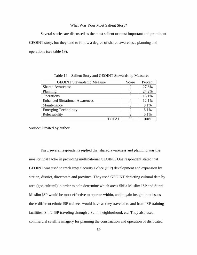
69
What Was Your Most Salient Story?
Several stories are discussed as the most salient or most important and prominent
GEOINT story, but they tend to follow a degree of shared awareness, planning and
operations (see table 19).
Table 19. Salient Story and GEOINT Stewardship Measures
GEOINT Stewardship Measure Score Percent Shared Awareness 9 27.3% Planning 8 24.2% Operations 5 15.1% Enhanced Situational Awareness 4 12.1% Maintenance 3 9.1% Emerging Technology 2 6.1% Releasability 2 6.1%
TOTAL 33 100% Source: Created by author.
First, several respondents replied that shared awareness and planning was the
most critical factor in providing multinational GEOINT. One respondent stated that
GEOINT was used to track Iraqi Security Police (ISP) development and expansion by
station, district, directorate and province. They used GEOINT depicting cultural data by
area (geo-cultural) in order to help determine which areas Shi’a Muslim ISP and Sunni
Muslim ISP would be most effective to operate within, and to gain insight into issues
these different ethnic ISP trainees would have as they traveled to and from ISP training
facilities; Shi’a ISP traveling through a Sunni neighborhood, etc. They also used
commercial satellite imagery for planning the construction and operation of dislocated

70
civilian holding areas during combat operations. A second respondent stated they did not
have SA of where Iraqi Army and ISP were located, as there were limited Coalition
forces partnered with them. At first, they would wait for the translation of Iraqi Army
Division situation reports but then discovered they could get quicker confirmation from
outside GEOINT reports (i.e. imagery), showing recent Iraqi Army activities. A third
respondent stated GEOINT was the critical factor in planning and executing convoy and
combat operations with Iraqi Army units. A fourth respondent stated that when a bridge
collapsed in Afghanistan, they successfully searched an imagery database for likely
bridges, then requested immediate satellite imagery over the selected sites. This quick
process aided in a coalition unit quickly going to the site to conduct a bridge
reconnaissance.
In addition, one respondent stated that enhanced SA coupled with fused Iraqi
Human Intelligence, Measurements and Signals Intelligence, and unclassified satellite
imagery indicated unusual movement in Al Anbar Province, Iraq. The respondent said
that the fusion of intelligence queued on unclassified satellite imagery allowed Coalition
forces to plan and execute an operation that unearthed over 3,000 artillery shells and
buried containers full of enemy ammunition. A second respondent said that the
integration of emerging technology, such as the regular use of unclassified Buckeye
imagery, was incredible and they loved that it was current with high-resolution imagery.
A third, respondent stated that as a naval officer they would successfully plan and
integrate GEOINT data to enhance SA before entering engagement zones with potential
hostile nations. Finally, a fourth respondent said that GEOINT aided in Coalition forces
recovering a US killed-in-action (KIA) Soldier’s body in Iraq following an ambush.

71
What Was Your Biggest Frustration?
Several stories are discussed as the biggest frustration or unresolved GEOINT
problem, but they tend to follow a degree of operations, planning, releasability, emerging
technology, shared awareness, enhanced SA, then maintenance (see table 20).
Table 20. Biggest Frustration and GEOINT Stewardship Measures
GEOINT Stewardship Measure Score Percent Operations 15 25.4% Planning 14 23.7% Releasability 9 15.3% Emerging Technology 8 13.5% Shared Awareness 6 10.2% Enhance Situational Awareness 5 8.5% Maintenance 2 3.4%
TOTAL 59 100% Source: Created by author.
First, several respondents replied that GEOINT operational understanding,
planning considerations and releasability were the critical factors in providing poor
multinational GEOINT support. Operational understanding and planning considerations
provide a successful GEOINT releasability program. Operational understanding of
GEOINT support was the first highly critical frustration. One respondent stated they were
currently taking a couple of geospatial courses at CGSC but they wish they knew last
year in Iraq what they know today regarding GEOINT as it would have made them a
much more effective Battalion Operations Officer (S3). Another respondent stated that at
the Infantry battalion level accessing available GEOINT products was frustrating. They
understood that GEOINT products exist but they did not understand how to request

72
GEOINT products in their multinational area of operations. A third respondent stated
they never received GEOINT training, nor understood how GEOINT worked and what it
could provide. A fourth respondent stated that as a member of a Military Training Team
(MiTT), they were not supplied with a GEOINT team, and they did not have the expertise
to perform those tasks. A fifth respondent stated they did not have much training before
deploying, and they still do not really know what GEOINT is available and how to get it.
A sixth respondent stated they did not know how to leverage GEOINT support, especially
with limited time and resources. A seventh respondent stated that GEOINT tools come
and go fast, and it is difficult to retain experts in units due to operational turnover. Also,
that it is often difficult to find the GEOINT leadership to find and exploit those systems.
Two additional respondents state that GEOINT does not “sell” themselves very well.
They understand that GEOINT can provide much, but do not understand their
capabilities, what is available and how to get GEOINT.
Planning considerations of GEOINT support was the second highly critical
frustration. The first respondent stated that GEOINT was not directly integrated into the
G5 Civil-Military Operations and Planning section. Therefore, those long-range planners
who take civilian strategic guidance and apply operational tactics did not properly frame
the problem with GEOINT tools to show the human and urban terrain along with the
physical and geologic terrain. A second respondent stated that the main problem working
at Multi-National Corps-Iraq as a collection manager was the challenge of not having a
unified process for units at battalion and brigade level to easily submit collection
requirements. Use of spreadsheets (i.e. Excel) was the only means to gather tactical
collection requirements for input into service collection systems. A third respondent

73
stated there were constraints of GEOINT exploitation. Often, analysts were restricted
from requesting theater collection assets. Instead, Multi-National Corps-Iraq would
simply keep the collection open, therefore overly relying on one sensor (i.e. sensor
dominance). On the other hand, during times of bad weather and collection platform (i.e.
airborne, satellite) maintenance, analysts could catch up on exploitation and production.
A fourth respondent stated it was quite often difficult to divert assets to look at priority
sites because the intelligence section often were focused on their specific purposes, and
not the operational plan; even though the chain of command declared a change of
priority. A fifth respondent stated that the time delay in receiving GEOINT information
was frustrating, but they understood they were low on the priority list. They also wished
they knew how to plan and integrate GEOINT support better into their operations.
GEOINT Releasability was the third highly critical frustration. Two respondents
stated they repeatedly and unsuccessfully tried to get the NGA to grant release authority
to Iraqi forces of Limited Distribution GEOINT products but were told they should get
release authority from back in theater. Then theater redirected them back to NGA for
release. This quite often created a contentious multinational planning environment over
existing GEOINT products, denying access to over half of the coalition forces. This lack
of operational releasability was not user friendly, nor were the enabling abilities
explained well or integrated. A third respondent stated there was too much secrecy
surrounding data that did not need to be classified. Also, there was too much data on
classified systems that could not, or was not, migrated to unclassified systems. A fourth
respondent stated that during the planning for the 2006 Iraqi elections, most of the work
was done on SIPRNet (US Military Secret Network) but everyone working on the

74
elections did not have SIPRNet access. The Iraqi’s knew everything about their elections,
but the GEOINT data and products created by US forces was not releasable due to the
amount of work being executed on SIPRNet. A fifth respondent stated that often US Air
Force leadership at the Combined Air Operations Center, Iraq, would not release U-2
airplane imagery to US Army Corps, Tactical Exploitations System (TES), for ground
operations. Finally, releasability impacted accessibility and proactiveness by planning
staff, as multinational mission partners were not able to access anything except what was
handed to them in hardcopy as they did not have the required clearances.
Other points of frustration include compatibility, maintenance, coverage, and
automation. Two respondents did mention the severe frustrations with compatibility,
currency and coverage gaps of GEOINT data within Command Post of the Future
(CPOF), Blue Force Trackers (i.e. FBCB2), and other command and control systems. A
third respondent thought it was frustrating not having automated fusion of GEOINT with
the other intelligence disciplines and systems. A fourth respondent stated there was a total
lack of connectivity between interagency, international, and interservice exploitation and
reporting systems.
Summary
Is GEOINT cell stewardship understood and practiced in multinational
operations? The results of this study show that the answer is “No, not at this moment in
time.” The previous seven GEOINT stewardship categories help to measure the two
general comments. The several frustrating stories highlight the lack of GEOINT
operational understanding, planning considerations, and releasability as the critical
factors in providing poor multinational GEOINT support. The two divergent questions

75
highlight when GEOINT support is properly integrated and when it is not properly
integrated into multinational operations. When correlated to those 43.6 percent of the
operational level of warfare respondents (see table 4), it shows a lack of GEOINT
stewardship at operational level of warfare.
Again, it appears that multinational GEOINT integration has been based on
hopeful relationship building and not on established structure. Yet, it is this exact
organizational leadership, responsibility, and structure that is required to ensure GEOINT
cell stewardship is understood and practiced in multinational operations.
Primary Research Question
How can GEOINT for multinational operations be made more effective?
GEOINT for multinational operations can be made more effective by enabling, training
and exercising GEOINT stewardship. Table 21 identifies the three secondary research
questions that showed an overall status of RED in this research.
Table 21. Secondary Research Questions Status
Secondary Research Question Categories Status 1. How does GEOINT support decision makers in the contemporary operational environment?
Operations AMBER Planning RED
2. What are the capabilities and limitations of GEOINT cells in providing understanding and visualization of the COP?
Releasability RED Emerging
Technology RED
Maintenance RED Shared Awareness AMBER
Enhance Situational Awareness
AMBER
3. Is GEOINT cell stewardship understood and practiced in multinational operations?
Most Salient Biggest Frustration
NO
Source: Created by author.

76
First, a multinational coalition must enable GEOINT stewardship at the
operational level of warfare, which will establish interoperability standards to overcome
ill-structured problems of diverse organizational leadership, structure and resource
constraints and limitations. In accordance with the established World Health
Organization six-elements of stewardship model (chapter 2, figure 1), the research in this
thesis indicates a need for several changes which will ensure GEOINT stewardship
performance and assessment are tied together. Figure 4 models reliable, up-to-date
information. This new model enhances vision and strategic guidance which influence
change across GEOINT and multinational communities. Continuous monitoring and
multinational transparency is the centerpiece of GEOINT cell stewardship.
Figure 4. GEOINT Stewardship Model
Source: Created by author.
Second, GEOINT stewardship in multinational operations must build capacity by
training and exercising early and often, in order to establish GEOINT best practices and
standards. This research shows that GEOINT stewardship at the operational level of

77
warfare must provide the necessary multinational ownership and responsibility to
properly develop, utilize and safeguard GEOINT, including its people, its property and its
financial assets to maximize the effectiveness for GEOINT cells and the commander.
Summary
A statistically significant census population participated in the survey research.
The census survey was sent to 1,049 CGSC students, out of the 113 students who
responded only 39 respondents were qualified to complete the survey. The purpose of this
chapter was to explain in detail the survey methodology and conduct a survey of qualified
respondents who could address potential multinational gaps in a long-standing
intelligence discipline like GEOINT. This chapter presented the survey results collected
and identified common and unique themes which surfaced during the survey and general
comments. Finally, this chapter presented a GEOINT stewardship model, which ensures
GEOINT stewardship performance and assessment are tied together. Chapter 5 will
present the researchers conclusions to the analysis, relationships to previous research,
suggestions for further research, and recommendations to ensure the development of
GEOINT stewardship. The combined effect is to understand the importance of GEOINT
stewardship at the operational level of warfare and to assess its role within multinational
operations.

78
CHAPTER 5
CONCLUSIONS AND RECOMMENDATIONS
Conclusions
This research is based upon existing GEOINT experiences of mid-grade officers
in multinational operations, and the reality that they grasp the complexities of
multinational operations. It can be inferred that these CGSC mid-grade officers represent
the greater population of mid-grade officers. This research seeks to add to the body of
knowledge of current unified GEOINT actions through the survey research of 1,049 mid-
level officers (and civilians) in the US Army Command and General Staff College class
10-01, at Fort Leavenworth, Kansas. The research seeks to add value to current GEOINT
research conducted by numerous international organizations, nations, military services,
and other agencies. This GEOINT stewardship also seeks to further GEOINT
partnerships, unified and collaborative GEOINT operations, GEOINT source strategies,
and GEOINT to the last tactical mile.69
Primary Research Question.
How can GEOINT for multinational operations be made more effective?
GEOINT for multinational operations can be made more effective by enabling, training
and exercising GEOINT stewardship. This research has shown that GEOINT stewardship
can positively influence the overall RED survey results in table 22 at the operational level
of warfare.
69The National Geospatial-Intelligence Agency. Pathfinder 5, no, 1 (January-
February 2007): 4.

79
Table 22. Secondary Research Questions Status
Secondary Research Question Categories Status 1. How does GEOINT support decision makers in the contemporary operational environment?
Operations AMBER Planning RED
2. What are the capabilities and limitations of GEOINT cells in providing understanding and visualization of the COP?
Releasability RED Emerging
Technology RED
Maintenance RED Shared Awareness AMBER
Enhance Situational Awareness
AMBER
3. Is GEOINT cell stewardship understood and practiced in multinational operations?
Most Salient Biggest Frustration
NO
Source: Created by author.
First, a multinational coalition must enable GEOINT stewardship at the
operational level of warfare, which will establish interoperability standards to overcome
ill-structured problems of diverse organizational leadership, structure and resource
constraints and limitations. Figure 5 illustrates how GEOINT stewardship performance
and assessment are tied together. Continuous monitoring and multinational transparency
are the centerpieces of GEOINT cell stewardship.

80
Figure 5. GEOINT Stewardship Model
Source: Created by author.
Second, GEOINT stewardship in multinational operations must build capacity by
training and exercising early and often in order to establish GEOINT best practices and
standards. This research shows that GEOINT stewardship is needed at the operational
level of warfare to provide the necessary multinational ownership and responsibility to
properly develop, utilize and safeguard GEOINT, including its people, its property and its
financial assets to maximize the effectiveness for GEOINT cells and the commander.
No survey respondent directly stated that GEOINT stewardship was critical to
multinational operations. Yet, all respondents did respond that GEOINT must be properly
planned, released and executed for multinational operations to be effective (see Appendix
B). The respondents did not recommend any specific GEOINT parameters for evaluation.
GEOINT cells must do more than simply abide by USJFCOM parameters to effectively
operate in a multinational environment. It is this research that proposes GEOINT cell’s
stewardship is critical to the success of multinational operations. As such, the GEOINT

81
cell will have stewardship of the responsibility to properly develop, utilize and safeguard
GEOINT, including its people, its property, and its financial assets to maximize the
effectiveness for the commander. To accomplish GEOINT stewardship, a multinational
coalition must quickly respond to their customers’ operational level of warfare GEOINT
needs with the best technology and information available. The GEOINT cell must
exercise this stewardship through a shared vision that will enhance their capability to
effectively address GEOINT requirements, focus internal and external research and
development efforts, pursue economies in acquisition, and develop approaches to
improve information sharing.
With GEOINT stewardship, multinational operations and planning are postured to
better frame the problem. GEOINT stewardship enables users to apply critical and
creative visualization to situational understanding, and provide context and orientation to
solve ill-structured problems. GEOINT stewardship is not tied to any specific systems
architecture and thus the GEOINT cell is able to adjust to persistent conflict and the
evolving character of conflict in order to provide context. GEOINT cell stewardship
enables users to provide critical thinking, share awareness of the operational
environment, solve the right problems, adapt to dynamic conditions and achieve
designated goals.70
Of the 1,049 CGSC students sent the survey, 113 students responded to the
survey, and 39 respondents qualified as having GEOINT experience in multinational
70Headquarters, Department of the Army, Field Manual (FM) 5-0, Operations
Process (Washington, DC: Government Printing Office, 2010), 3-1.
82
operations. Also, it can be assumed that respondents with multiple deployments would
have better GEOINT SA and understand how they impact multinational operations.
Secondary Research Question Number 1
How does GEOINT support decision makers in the contemporary operational
environment? Multinational GEOINT support has been based on relationship building,
not on established structure. It is the individual leadership and education abilities of
current augmented teams that have overcome insurmountable odds to provide
multinational SA for decision makers. This question is assessed by the effectiveness of
GEOINT Multinational Operations and GEOINT Multinational Planning. GEOINT
Multinational Operations assessment is that there is no clear GEOINT officer or
structure, and that a GEOINT officer is a must for GEOINT stewardship to exist.
GEOINT personnel are deploying on multinational operations that require a greater
degree of mission training than can be provided at home station. GEOINT Multinational
Planning assessment is that GEOINT support was successfully planned, while
multinational (i.e. civilian, mission partners, foreign nationals) GEOINT support was
unsuccessfully planned.
Secondary Research Question Number 2
What are the capabilities and limitations of GEOINT cells in providing
understanding and visualization of the common operational picture? Multinational
GEOINT cells have been based on relationship building, not on established structure. But
it is organizational leadership, responsibility and structure that is required to provide
understanding and visualization of the common operational picture. This question is

83
assessed by the effectiveness of GEOINT Releasability, Emerging Technology,
Maintenance, Shared Awareness and Enhanced SA. The previous five category
assessments are all fairly positive, yet there are large populations that did not observe
them. One way to mitigate this non-observation is for the GEOINT cell to be functionally
involved in the multinational planning process, to be responsible for the coalition
GEOINT annex and, to maintain, cultivate and advertise multinational GEOINT
integration.
This validates current efforts by the USJFCOM in establishing a GEOINT Officer
and Cell in accordance with a JMD that will provide established organizational structure
for the contemporary and future operational environments (see Appendix A).
Secondary Research Question Number 3
Is GEOINT stewardship understood and practiced in multinational operations?
The results of this study show that the answer is “No, not at this moment in time."
Multinational GEOINT cell stewardship has been based on relationship building, not on
established structure. It is this exact organizational understanding and practice that is
required for multinational operations. The secondary survey question was assessed by
asking the respondents two general comments: ‘what was their most salient story?’ and
‘what was their biggest frustration?’ (see Appendix C and D). The several salient stories
highlight the important and prominent use of GEOINT for multinational planning and
operations, tracking of units, multi-source intelligence fusion, and use of unclassified
collection platforms, in order to bring about a high degree of shared awareness, enhanced
SA, and integration of emerging technology. On the other hand, the several frustrating
stories highlight the lack of GEOINT releasability, operational understanding and

84
planning considerations as the critical factors in providing poor multinational GEOINT
support. The two divergent questions highlight when GEOINT support is properly
integrated and when it is not properly integrated into multinational operations.
Suggestions for Further Research
Not every aspect of GEOINT stewardship could be covered in this thesis. Listed
below are some of the topics that fell outside the scope of this research.
First, the GEOINT Stewardship concept needs to be validated by other commands
and institutions. They must understand that it is more than a systematic approach for
current permissive operational environments (Iraq and Afghanistan). The GEOINT cell
must be tied to the commander via a JMD. GEOINT stewardship is the glue that provides
that context for multinational operations. Further base lining of the survey against other
service CGSC students (Air Force, Navy and USMC) should be encouraged. Base-lining
the survey against those close mission partners- Britain, Canada, Australia, New Zealand,
and NATO, will provide the multinational context required.
Second, GEOINT stewardship for foreign humanitarian operations, noncombatant
evacuation operations, consequence management, peace operations, nation assistance,
and recovery operations requires a different level of GEOINT cell experimentation and
capacity buildings.
Third, there are numerous complexities dealing with national caveats and their
relationships to coalitions, alliances, nations and services, which impact how they could
apply GEOINT stewardship. Likewise each entity will apply the fundamentals of
GEOINT stewardship differently due to national caveats, strategic guidance, techniques-
tactics-procedures (TTPs), and budgetary oversights. Currently the Five-Eye nations

85
(Australia, Britain, Canada, New Zealand and the US) are predominantly capable of
conducting GEOINT and exercising GEOINT stewardship. These five nations have very
capable information and intelligence sharing capabilities. Likewise, singular nations like
France are capable of conducting GEOINT and exercising GEOINT stewardship. As of
July 2009, France decided to return to the military side of NATO, and hopefully will be
able to better integrate itself into GEOINT stewardship across multinational operations.
Fourth, GEOINT stewardship may have a higher level of success if applied to a
current multinational operational theater (such as Afghanistan), which could provide
better utility of SA satisfaction as a rare change to actually do the job that GEOINT
experts have spent years training to do. This theory is rationalized by the assumption that
GEOINT experts are prepared to permanently insert themselves into a Joint Task Force
of Multinational Headquarters, in accordance with JMD or NATO Crisis Establishment
(similar to a JMD). In July 2010, the US Army will assign its first US Army officer to a
NATO GEOINT billet, which will be located at International Security Assistance Force,
Afghanistan. This billeting is long overdue by the US Army to recognize the importance
of multinational GEOINT assignments. Also, the survey results did not include officers
or civilians who were deployed, or members of a foreign nation’s military; therefore, no
defendable answer is available.
Fifth, this research just scratches the surface of examining the different GEOINT
stewardship requirements at the various levels of GEOINT operations (tactical,
operational, strategic and national). Many nations and forces are not able to provide
GEOINT at all levels of operations. They in turn often rely on external sources (i.e.

86
NGA, etc) to augment their internal GEOINT capabilities. Also, these external sources
could heavily influence GEOINT force structure in other nations.
Sixth, this research did not estimate or determine what impact GEOINT
stewardship would have for a SOIC. The implications are that by pulling the GEOINT
cell out of the J2/G2 domain, and moving it into the SOIC might cause certain
capabilities to diminish. On the other hand, the GEOINT cell could be better postured to
support full-time operational planning if it were a permanent and operational entity.
Seventh, this research does not analyze the strengths or weaknesses of a GEOINT
cell that is initialized early for an expeditionary operation (i.e. Tsunami, Haiti, Lebanon,
etc). Nor does it compare how this early initialization would have on disciplining the staff
and planning process of emerging boards, bureaus, centers, cells and working groups
(B2C2WG). The early creation of the GEOINT cell could fully support a multinational
force battle rhythm and “encourage creativity and increase organizational agility and
adaptability.”71
Finally, this research does not go into the doctrine, organization, training,
materiel, leadership, personnel or facility issues associated with a JMD fill for qualified
or unqualified personnel. Currently, the US Army is about 15 percent under strength in
recruiting officer cadets. This number could impact ground warfare personnel billets,
Furthermore, early GEOINT cell stewardship might enhance shared
situational awareness of the contemporary operational environment by providing careful
monitoring and evaluation of multinational transparency.
71Boteler, Dwaine, and Steward Liles. Knowledge Management, US Corps and
Multi-National Corps-Iraq. 2009 Army Operational Knowledge Management (AOKM) Conference, 19-23 October 2009. http://usacac.army.mil/CAC2/bcks/Connected/ ConnectedFall2009.html (accesses 8 may 2010).

87
particularly with a GEOINT cell that has a JMD requirement. On the other hand, defense
civilians may be able to fill the JMD GEOINT officer billet, if qualified.
Recommendations
The USJFCOM effort to develop the GEOINT cell is a step in the right direction
and helps in building a culture of support for shared operational level of warfare SA. It
takes more than regulations to modify human behavior. The culture within the defense
forces needs to change which will take positive leadership. It will demands nations and
services to accept GEOINT as a comprehensive discipline, and GEOINT stewardship to
guide multinational operations to overcome obstacles and initiate change, rather than the
suppression of it, for perceived agency or external organizational gains.
The USJFCOM GEOINT cell experimentations have repeatedly demonstrated
their ability to provide increased SA. Nations and services must be obliged to adopt
GEOINT cells and demonstrate the willingness to address multinational SA with current
resources. Likewise, depending on the depth and degree of the JTF mission, the GEOINT
Cell, if set up early, can enlarge in size for missions with increased operational
environment exploitation (i.e. Tsunami, Haiti, etc), or increase in GEOINT Officer civil-
military planning expertise at higher levels of operations. The GEOINT Cell will help
solve the shared SA that a multinational operation will require in a non-permissive
environment. It is the enabling, training and exercising of GEOINT stewardship and
relationship building at the multinational, operational level that is needed.
Servicemen and women will always be the ‘heart and soul’ of the defense forces.
Technology, doctrine, techniques, tactics and procedures will change, but sharing a
common operational picture is what makes the US unique from all other defense forces in

88
the world. USJFCOM must lead, enable, train and exercise changes in how Soldiers and
civilians view the battlefield, reinforce and the importance of GEOINT stewardship for
multinational operations.

89
GLOSSARY
ABCA. Army cooperation between American, Britain, Canada, Australia, and New Zealand. To optimize ABCA Armies’ interoperability in order to deliver success on coalition operations. (www.abca-armies.org)
Alliance. A relationship that results from a formal agreement or treaty between two or more nations or broad, long-term objectives that further the common interests of the members. (JP 3-0)
Battle Command. The art and science of understanding, visualizing, describing, directing, leading, and assessing forces to impose the commander’s will on a hostile, thinking and adaptive enemy (or threats). (FM 5-0)
CGSC. The US Army Command and General Staff College (CGSC), located at Fort Leavenworth, Kansas. It educates and develops mid-level (field grade) military and civilian officers for full spectrum joint, interagency and multinational operations; acts as lead agent for the Army’s leader development program; and advances the art and science of the profession of arms in support of Army operational requirements. (www.cgsc.edu)
Coalition. Is an adhoc arrangement between two or more nations for common action. (JP 5-0)
Coalition Action. Is a multinational action outside the bounds of established alliances, usually for single occasions or longer cooperation in a narrow sector of common interest. (JP 5-0)
Combined. Between two or more forces or agencies of two or more allies. (JP 1-02)
Common Operational Picture. A single identical display of relevant information shared by more than one command. A common operational picture facilitates collaborative planning and assists all echelons to achieve situational awareness. (JP 3-0)
Contemporary Operational Environment. The Operational Environment replaced the term battlespace. The contemporary operational environment (COE) is the overall operational environment that exists today and in the near future (out to the year 2020). The range of threats during this period extends from smaller, lower-technology opponents using more adaptive, asymmetric methods to larger, modernized forces able to engage deployed U.S. forces in more conventional, symmetrical ways. In some possible conflicts (or in multiple, concurrent conflicts), a combination of these types of threats could be especially problematic. (www.strategypage.com)

90
Ends-Ways-Means. While each plan is unique, all plans seek a balance for combining ends, ways, and means against risk. Ends are the desired conditions of a given operation. Ways are actions to achieve the end state. Means are the resources required to execute the way. (JP 5-0)
Five-Eyes (5-Eyes). National intelligence cooperation between Australia, Britain, Canada, New Zealand and the United States; frequently called “Commonwealth Sharing”. (www.dni.gov, also see bibliography)
Geospatial Intelligence. There is no universally acceptable definition for GEOINT. Nearly every member of NATO and ABCA defines GEOINT differently as each nation applies platforms, collection and exploitation to varying degrees. Unofficial Wikipedia definition: an intelligence discipline comprising the exploitation and analysis of geospatial information to describe, assess, and visually depict physical features and geographically referenced activities on the Earth. GEOINT data sources include imagery and mapping data, whether collected by commercial or government satellites, manned/unmanned aircraft, and ground-truthed (absolutely verified) by demographic (i.e. census, cultural intelligence) information, global positioning systems (GPS) waypoints, utility schematics, or any discrete data that have locations on Earth. (Wikipedia)
Geospatial Intelligence (Australia). Geospatial Intelligence is intelligence derived from the exploitation and analysis of imagery and geospatial information about features and events with reference to time and location. (www.defence.gov.au/digo)
Geospatial Intelligence (Canada). Geospatial Intelligence is the exploitation and analysis of imagery (all kinds) and geospatial information to describe, assess, and visually depict physical features and geographically referenced activities on the Earth and is provided as an element of a fused product. It consists of imagery, imagery intelligence, geospatial, meteorological and oceanographic information. (www.cdi-crd.forces.gc.ca)
Geospatial Intelligence (European Union). The term GEOINT stands for GEOspatial INTelligence, which is a discipline that comprises the exploitation and analysis of imagery and geospatial information to describe, assess, and visually depict physical features and geographically referenced activities on the Earth. (www.eusc.europa.eu)
Geospatial Intelligence (NATO). NATO currently has two GEOINT defintions, which are slightly in conflict with each other, and has asked the NATO Standards Agency (NSA) to agree on a single definition. First definition: Geospatial intelligence is the exploitation and analysis of imagery and geospatial information to describe, assess, and visually depict physical features and geographically referenced activities on the Earth”. (www.nato.int, AJP 2.1, paragraph 0270) Second definition: Geospatial intelligence is the outcome of the combination of quality-assured geospatial information with verified feature data of the military

91
intelligence or other intelligence sources for compliance with a requirement. Geospatial intelligence consists of imagery intelligence and geospatial information”. (www.nato.int, MC 0128/6, Annex D, May 2007.)
Geospatial Intelligence (New Zealand). Geospatial intelligence (GEOINT) is defined as intelligence derived from the exploitation and analysis of integrated imagery and geospatial information about features and activities of defence, security or foreign intelligence interest, viewed in the context of location and time. (www.nzdf.mil.nz/jgsf)
Geospatial Intelligence (United Kingdom). The United Kingdom does not define GEOINT in the classical sense, the UK Intelligence Collection Group (ICG) separates and controls the components of GEOINT to different national and defence agencies. (www.mod.uk)
Geospatial Intelligence (United Nations). The UN does not use the term GEOINT, instead it identifies geospatial information, remote sensing and imagery analysis in terms of Open Source collection, exploitation, and production for members nations, of environmental, weapons and disaster monitoring, verification and inspection. (www.un.org)
Geospatial Intelligence (United States). Geospatial intelligence is the exploitation and analysis of imagery and geospatial information to describe, assess and visually depict physical features and geographically referenced activities on the Earth. Geospatial intelligence consists of imagery, imagery intelligence and geospatial (e.g., mapping, charting and geodesy) information. (www.nga.mil)
GEOINT Stewardship. Is defined as the responsibility to properly develop, utilize and safeguard GEOINT, including its people, its property and its financial assets to maximize the effectiveness for GEOINT cells and the commander. GEOINT data is a resource that has established collection and exploitation processes, financial value, and legal oversights. Altogether, GEOINT stewardship has three functions: formulating GEOINT policy; exerting influence; and collecting and using GEOINT. (Wikipedia)
GEOINT Support Team. NGA has been at the forefront of providing consistent forward geospatial intelligence (GEOINT) support to the warfighter through its network of deployed GEOINT Support Teams (GSTs). (www.nga.mil)
International Security Assistance Force. ISAF is a NATO-led security mission in Afghanistan established by the United Nations Security Council on 20 December 2001 as envisaged by the Bonn Agreement. in support of the Government of the Islamic Republic of Afghanistan, conducts operations in Afghanistan to reduce the capability and will of the insurgency, support the growth in capacity and capability of the Afghan National Security Forces (ANSF), and facilitate improvements in governance and socio-economic development, in order to

92
provide a secure environment for sustainable stability that is observable to the population. (www.isaf.nato.int)
Joint Intelligence Support Element. A JISE is a subordinate joint force element whose focus is on intelligence support for joint operations, providing the joint force commander, joint staff, and components with the complete air, space, ground, and maritime adversary situation. (JP 2-01)
Joint/Multiservice. Connotes activities, operations, organizations, etc., in which elements of two or more Military Departments participate. (JP 1-02)
Joint Task Force. A joint task force is constituted and so designated by the Secretary of Defense, a combatant commander, a sub-unified commander, or an existing joint task force commander. (JP 1-02)
Knowledge Management. Is the action of creating, organizing, applying, and transferring knowledge to facilitate situational understanding and decision making. Knowledge management supports improving organizational learning, and performance. Knowledge management processes ensure that knowledge products and services are relevant, accurate, timely, and useable to commanders and decision makers. Knowledge management has three major components people, processes, and technology. (FM 3-0)
Littoral. Commonly referred to as that part of a sea, lake, or river, between the high water mark and the low water mark. This is the zone that directly impacts amphibious operations. The littoral comprises two segments of operational environment: Seaward, they are from the open ocean to the shore, which must be controlled to support operations ashore; Landward, the area inland from the shore that can be supported and defended directly from the sea. (JP 1-02)
Multinational. Between two or more forces or agencies of two or more nations or coalition partners. (JP 5-0)
National Caveats. National restrictions placed by nations on the use of national military contingents operating as part of a multinational operation. These caveats can restrict NATO commanders by limiting their flexibility to respond to situations on the ground. For this reason, the Alliance seeks national contributions with as few caveats as possible. (www.nato.int)
NATO. The North Atlantic Treat Organization (NATO) is an alliance of 28 countries from North America and Europe committed to fulfilling the goals of the North Atlantic Treat signed on 04 April 1949. (www.nato.int)
NGA Support Team. NSTs are vital to the GEOINT products NGA provides. These teams serve as direct, embedded support to national and international level agencies, and combatant commands on a global scale, providing these decision-

93
makers with the analysis and tools that help shape decisions affecting the battlespace. (www.nga.mil)
Operational Environment. Is a composite of the conditions, circumstances, and influences that affect the employment of capabilities and bear on the decisions of the commander. (JP 1-02)
Situational Awareness. The immediate knowledge of the conditions of the operation, constrained geographically and in time. More simply, it is Soldiers knowing what is currently happening around them. SA occurs in Soldier’s minds. It is not a display or the common operational picture; it is the interpretation of displays or the actual observation of a situation. On receipt of mission, commanders develop their SA. They have it on information and knowledge products, such as the common operational picture and running estimates. (FM 3-0)
Situational Understanding. Is the product of applying analysis and judgment to relevant information to determine the relationships among the mission variables to facilitate decisionmaking. It enables commanders to determine the implications of what is happening and forecast what may happen. SU enhances decision making by identifying opportunities, threats to the force or mission accomplishment, and information gaps. It helps commanders identify enemy options and likely future actions, the probable consequences of proposed friendly actions, and the effect of the operational environment on both. SU based on a continuously updated common operational picture fosters individual initiative by reducing, although not eliminating, uncertainty. (FM 3-0)
Stability Operations Information Center. Afghanistan, Regional Command – West (RC-West) argues that SOIC is the type of organization that is capable of institutionalizing the concepts and processes described in TRADOC Pam 525-5-500 toward greater understanding, not just during operational design, but also during campaign planning and the execution of operations in the contemporary operational environment. (SOIC article, see bibliography)
Stewardship. Conducting, supervising, or managing of an object, field or discipline; particularly the careful and responsible management of something entrusted to one’s care. Applied as organizational stewardship, it refers to a leader’s responsibility to properly utilize, develop and share its resources, including its people, its property and its financial assets, while still protecting the security of these resources. (www.dictionary.com)
Subordinate Unified Command. A command established by commanders of unified commands, when so authorized by the Secretary of Defense through the Chairman of the Joint Chiefs of Staff, to conduct operations on a continuing basis in accordance with the criteria set forth for unified commands. A subordinate unified command may be established on an area or functional basis. Commanders of subordinate unified commands have functions and responsibilities similar to those

94
of the commanders of unified commands and exercise operational control of assigned commands and forces within the assigned operational area. (JP 1-02)
Unified Action. The synchronization, coordination, and/or integration of, the activities of governmental and nongovernment entities with military operations to achieve unity of effort. (JP 1-02)
Unified Command/Unified Combatant Command. A command with a broad continuing mission under a single commander and composed of significant assigned components of two or more Military Departments that is established and so designated by the President, through the Secretary of Defense with the advice and assistance of the Chairman of the Joint Chiefs of Staff. (JP 1-02)
Unified GEOINT Operations. UGO has moved GEOINT support from a “need to know” to a “need to share” construct. UGO is a collaborative and coordinated effort to assess, align and execute GEOINT analysis and production across the NSG and its partner organizations. UGO is based on shared responsibility and trust to optimize GEOINT capabilities in a rationally prioritized, needs-based approach to analysis and production. (www.nga.mil)
Unity of Effort. Coordination and cooperation toward common objectives, even if the participants are not necessarily part of the same command or organization; the product of successful unified action. (JP 1-02)

95
APPENDIX A
DOTMLPF CHANGE RECOMMENDATION ACTION
DOTMLPF Category
Action Suspense Date
Completed
Doctrine 1. Conduct an early assessment of joint GEOINT doctrine execution (tactics, techniques and procedures (TTP), JP 2-03)
3Q FY 2009 YES
Doctrine 2a. Determine the composition and functions of a GEOINT cell through experimentation. USJFCOM to list composition and functions of GEOINT cell in a report to be delivered to the Community GEOINT Training Council (CGTC).
3Q FY 2009 YES
Doctrine 2b. Determine if the GEOINT cell composition and functions require a separate cell or can be absorbed into other JTF cells. USJFCOM to brief this determination to CGTC.
1Q FY 2010
Doctrine 2c. Document GEOINT TTP and submit to J7 to revise doctrine per CJCSI 5120.02A.
1Q FY 2010
Training 3. Perform study in coordination with combatant commands, Services and NGA to recommend joint GEOINT skill sets for GEOINT officers and GEOINT cell members. USJFCOM to deliver study to CGTC.
3Q FY 2009 YES
Training 4. Recommend, determine, develop, refine and maintain joint GEOINT training curriculum supporting GEOINT officer and GEONT cell. NGA to provide recommendations on training curriculum to CGTC.
3Q FY 2010
Organization 5. Validate functions of personnel necessary for GEOINT cell based on results of Action 2a. Joint Staff J2 will utilize the Joint Staff Action Package (JSAP) process to obtain concurrent from combatant commands, Services and NGA to validate the functions of personnel in a GEOINT cell.
1Q FY 2010
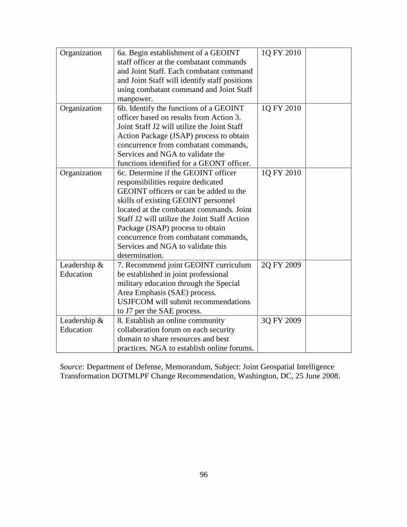
96
Organization 6a. Begin establishment of a GEOINT staff officer at the combatant commands and Joint Staff. Each combatant command and Joint Staff will identify staff positions using combatant command and Joint Staff manpower.
1Q FY 2010
Organization 6b. Identify the functions of a GEOINT officer based on results from Action 3. Joint Staff J2 will utilize the Joint Staff Action Package (JSAP) process to obtain concurrence from combatant commands, Services and NGA to validate the functions identified for a GEONT officer.
1Q FY 2010
Organization 6c. Determine if the GEOINT officer responsibilities require dedicated GEOINT officers or can be added to the skills of existing GEOINT personnel located at the combatant commands. Joint Staff J2 will utilize the Joint Staff Action Package (JSAP) process to obtain concurrence from combatant commands, Services and NGA to validate this determination.
1Q FY 2010
Leadership & Education
7. Recommend joint GEOINT curriculum be established in joint professional military education through the Special Area Emphasis (SAE) process. USJFCOM will submit recommendations to J7 per the SAE process.
2Q FY 2009
Leadership & Education
8. Establish an online community collaboration forum on each security domain to share resources and best practices. NGA to establish online forums.
3Q FY 2009
Source: Department of Defense, Memorandum, Subject: Joint Geospatial Intelligence Transformation DOTMLPF Change Recommendation, Washington, DC, 25 June 2008.

97
APPENDIX B
SURVEY CONTROL Number 10-050
DEVELOP GEOINT STEWARDSHIP FOR MULTINATIONAL OPERATIONS Survey Questions Answers Count Percent
QUALIFIER Have you requested or provided GEOINT on a multinational operation?
Yes 39 34.5%
No 74 65.5% TOTAL 113 100.0%
DEMOGRAPHICS 1. Please specify your highest level (scale) of GEOINT operation?
National 8 20.5%
Strategic/State/County 7 17.9%
Operational/Joint Task Force/County/City 17 43.6%
Tactical/Community 6 15.4% Other 1 2.6% TOTAL 39 100.0% 2. How many times have you deployed on multinational operation(s)?
1 5 12.8%
2 15 38.5% 3 11 28.2% 4+ 8 20.5% TOTAL 39 100.0% 3. Is your country a member of NATO? Yes 39 100.0%
No 0 0.0% TOTAL 39 100.0% 4. How many times have you deployed on NATO operation(s)? 0 12 30.8%
1 20 51.3% 2 3 7.7% 3 3 7.7% 4+ 1 2.6% TOTAL 39 100.0%

98
5. How many times have you deployed to Afghanistan? 0 27 69.2%
1 10 25.6% 3 2 5.1% TOTAL 39 100.0%
6. What type of formal GEOINT education have you received?
Mission Planning (Command & Control Systems, etc) 10 7.5%
Geospatial Information (maps, terrain analysis, shapefiles, vectors, etc)
21 15.8%
Imagery (processing, science, IR, MSI/HSI, etc) 11 8.3%
Imagery Intelligence (analysis, ORBAT, etc) 11 8.3%
Radar, IFSAR, MTI/GMTI, LIDAR, etc 10 7.5%
Full Motion Video 10 7.5% Survey/gravitational/magnetic 4 3.0%
Network Analysis (human, signals, infrastructure, etc) 6 4.5%
Cultural intelligence layers/Human terrain team 4 3.0%
Targeting 11 8.3%
Intelligence, surveillance, and reconnaissance collection management
13 9.8%
Space 5 3.8% Maritime 1 0.8% Littoral 2 1.5% None 14 10.5% TOTAL 133 100.0% 7. What is the highest level of GEOINT education you received?
University/college level education (Remote Sensing, GIS, Analysis, etc)
2 5.1%
Military Occupation Specialty/Civilian Skill (4+ weeks)
2 5.1%
Long course (2-4 weeks) 2 5.1% Short course (1-7 days) 5 12.8%
Received education but not certain of the level 10 25.6%

99
None 17 43.6% Other 1 2.6% TOTAL 39 100.0% 8. How would you characterize your personal level of knowledge regarding GEOINT support for multinational operation(s)?
Limited- Based largely on anecdotal information. 9 23.1%
Average- Developed from training or operational support. 21 53.8%
Above Average- Developed from training AND operational support.
7 17.9%
Detailed- Supervised multinational support, developed from formal training AND operational support
2 5.1%
TOTAL 39 100.0% GEOINT MULTINATIONAL OPERATIONS 9. What type of multinational operation(s) did you support? Major Operations 24 15.1%
Homeland Defense/Internal Security 3 1.9%
Civil Support 8 5.0% Strikes 9 5.7% Raids 9 5.7% Show of Force 5 3.1% Enforcement of Sanctions 5 3.1% Protection of Shipping 2 1.3% Freedom of Navigation 2 1.3% Peace Operations 12 7.5% Support to Insurgency 2 1.3% Counterinsurgency Operations 23 14.5% Combating Terrorism 16 10.1%
Noncombatant Evacuation Operations 4 2.5%
Recovery Operations 5 3.1% Consequence Management 3 1.9% Foreign Humanitarian Assistance 6 3.8% Nation Assistance 6 3.8% Arms Control and Disarmament 3 1.9%

100
Routine, Recurring Military Activities 11 6.9%
Other 1 0.6% TOTAL 159 100.0% 10. What type of GEOINT support did your multinational operation(s) require?
Mission Planning (Command & control systems, etc) 21 11.5%
Geospatial Information (maps, terrain analysis, ground truth locations, etc)
27 14.8%
Imagery (processing, science, IR, MSI/HSI, etc) 23 12.6%
Imagery Intelligence (analysis, ORBAT, etc) 19 10.4%
Radar, IFSAR, MTI/GMTI, LIDAR, etc 7 3.8%
Full Motion Video 11 6.0%
Survey, GPS foundation/benchmark, gravitational, magnetic
3 1.6%
Network Analysis (human, signals, infrastructure, etc) 11 6.0%
Cultural intelligence layers/Human terrain teams 15 8.2%
Targeting 20 11.0%
Intelligence, surveillance, and reconnaissance collection management
16 8.8%
Space 3 1.6% Maritime 3 1.6% Littoral 3 1.6% TOTAL 182 100.0% 11. My unit's GEOINT operations were established according to the commander's concept of operations:
Strongly Agree 6 15.4%
Agree 17 43.6% Agree 17 43.6%

101
Neither Agree Nor Disagree 7 17.9%
Disagree 4 10.3% Strongly Disagree 1 2.6% Did Not Observe 4 10.3% TOTAL 39 100.0% 12. My unit's GEOINT operations were integrated into our mission: Strongly Agree 6 15.4%
Agree 25 64.1%
Neither Agree Nor Disagree 4 10.3%
Disagree 1 2.6% Strongly Disagree 1 2.6% Did Not Observe 2 5.1% TOTAL 39 100.0% 13. My unit's GEOINT officer was integrated into the our mission:
Strongly Agree 5 12.8%
Agree 17 43.6%
Neither Agree Nor Disagree 7 17.9%
Disagree 1 2.6% Strongly Disagree 0 0.0% Did Not Observe 9 23.1% TOTAL 39 100.0% 14. My unit's GEOINT cell was synchronized with our battle rhythm:
Strongly Agree 4 10.3%
Agree 18 46.2%
Neither Agree Nor Disagree 7 17.9%
Disagree 1 2.6% Strongly Disagree 2 5.1% Did Not Observe 7 17.9% TOTAL 39 100.0% GEOINT MULTINATIONAL PLANNING 15. My unit's GEOINT officer prioritized GEOINT mission requirements during the planning process:
Strongly Agree 4 10.3%
Agree 17 43.6%

102
Neither Agree Nor Disagree 8 20.5%
Disagree 1 2.6% Strongly Disagree 0 0.0% Did Not Observe 9 23.1% TOTAL 39 100.0% 16. My unit coordinated multinational GEOINT collection strategy methods:
Strongly Agree 5 12.8%
Agree 10 25.6%
Neither Agree Nor Disagree 11 28.2%
Disagree 2 5.1% Strongly Disagree 1 2.6% Did Not Observe 10 25.6% TOTAL 39 100.0% 17. GEOINT products were useful towards my unit's mission: Strongly Agree 11 28.2%
Agree 25 64.1%
Neither Agree Nor Disagree 0 0.0%
Disagree 1 2.6% Strongly Disagree 0 0.0% Did Not Observe 2 5.1% TOTAL 39 100.0% 18. My unit's planning staff understood GEOINT planning considerations:
Strongly Agree 5 12.8%
Agree 18 46.2%
Neither Agree Nor Disagree 6 15.4%
Disagree 8 20.5% Strongly Disagree 1 2.6% Did Not Observe 1 2.6% TOTAL 39 100.0% 19. My unit's intelligence section/staff understood GEOINT planning considerations:
Strongly Agree 7 17.9%
Agree 17 43.6%
Neither Agree Nor Disagree 8 20.5%
Disagree 4 10.3%

103
Strongly Disagree 1 2.6% Did Not Observe 2 5.1% TOTAL 39 100.0% 20. My unit's engineer section/staff understood GEOINT planning considerations:
Strongly Agree 3 7.7%
Agree 17 43.6%
Neither Agree Nor Disagree 7 17.9%
Disagree 1 2.6% Strongly Disagree 1 2.6% Did Not Observe 10 25.6% TOTAL 39 100.0% 21. My unit's civil-military operations section/staff understood GEOINT planning considerations:
Strongly Agree 1 2.6%
Agree 8 20.5%
Neither Agree Nor Disagree 13 33.3%
Disagree 4 10.3% Strongly Disagree 3 7.7% Did Not Observe 10 25.6% TOTAL 39 100.0% 22. Other mission partners could visualize my unit's GEOINT support:
Strongly Agree 3 7.7%
Agree 8 20.5%
Neither Agree Nor Disagree 13 33.3%
Disagree 8 20.5% Strongly Disagree 1 2.6% Did Not Observe 6 15.4% TOTAL 39 100.0% 23. My unit's priority intelligence requirements were synchronized with our GEOINT collection strategy:
Strongly Agree 4 10.3%
Agree 14 35.9%
Neither Agree Nor Disagree 12 30.8%
Disagree 5 12.8% Strongly Disagree 1 2.6%

104
Did Not Observe 3 7.7% TOTAL 39 100.0% 24. My unit's foreign national intelligence requirements were synchronized with our GEOINT collection strategy:
Strongly Agree 1 2.6%
Agree 7 17.9%
Neither Agree Nor Disagree 11 28.2%
Disagree 11 28.2% Strongly Disagree 1 2.6% Did Not Observe 8 20.5% TOTAL 39 100.0% GEOINT MULTINATIONAL RELEASABILITY 25. My unit coordinated multinational GEOINT releasability in accordance with mission requirements:
Strongly Agree 4 10.3%
Agree 13 33.3%
Neither Agree Nor Disagree 7 17.9%
Disagree 4 10.3% Strongly Disagree 0 0.0% Did Not Observe 11 28.2% TOTAL 39 100.0% 26. My unit disseminated GEOINT layers to mission partners:
Strongly Agree 3 7.7%
Agree 19 48.7%
Neither Agree Nor Disagree 5 12.8%
Disagree 7 17.9% Strongly Disagree 0 0.0% Did Not Observe 5 12.8% TOTAL 39 100.0% 27. My unit established standard web search parameters to release GEOINT support:
Strongly Agree 3 7.7%
Agree 9 23.1%
Neither Agree Nor Disagree 10 25.6%
Disagree 4 10.3%
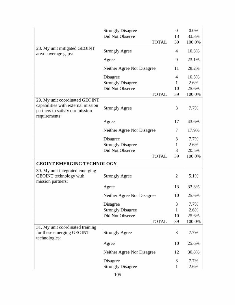
105
Strongly Disagree 0 0.0% Did Not Observe 13 33.3% TOTAL 39 100.0% 28. My unit mitigated GEOINT area-coverage gaps: Strongly Agree 4 10.3%
Agree 9 23.1%
Neither Agree Nor Disagree 11 28.2%
Disagree 4 10.3% Strongly Disagree 1 2.6% Did Not Observe 10 25.6% TOTAL 39 100.0% 29. My unit coordinated GEOINT capabilities with external mission partners to satisfy our mission requirements:
Strongly Agree 3 7.7%
Agree 17 43.6%
Neither Agree Nor Disagree 7 17.9%
Disagree 3 7.7% Strongly Disagree 1 2.6% Did Not Observe 8 20.5% TOTAL 39 100.0% GEOINT EMERGING TECHNOLOGY 30. My unit integrated emerging GEOINT technology with mission partners:
Strongly Agree 2 5.1%
Agree 13 33.3%
Neither Agree Nor Disagree 10 25.6%
Disagree 3 7.7% Strongly Disagree 1 2.6% Did Not Observe 10 25.6% TOTAL 39 100.0% 31. My unit coordinated training for these emerging GEOINT technologies:
Strongly Agree 3 7.7%
Agree 10 25.6%
Neither Agree Nor Disagree 12 30.8%
Disagree 3 7.7% Strongly Disagree 1 2.6%

106
Did Not Observe 10 25.6% TOTAL 39 100.0% 32. Introducing this new GEOINT technology enhanced my unit's situational awareness:
Strongly Agree 4 10.3%
Agree 13 33.3%
Neither Agree Nor Disagree 10 25.6%
Disagree 0 0.0% Strongly Disagree 0 0.0% Did Not Observe 12 30.8% TOTAL 39 100.0% GEOINT MAINTENANCE 33. My unit validated GEOINT data for accuracy in accordance with mission requirements:
Strongly Agree 4 10.3%
Agree 18 46.2%
Neither Agree Nor Disagree 8 20.5%
Disagree 0 0.0% Strongly Disagree 0 0.0% Did Not Observe 9 23.1% TOTAL 39 100.0% 34. My unit established GEOINT data naming conventions: Strongly Agree 3 7.7%
Agree 12 30.8%
Neither Agree Nor Disagree 6 15.4%
Disagree 4 10.3% Strongly Disagree 0 0.0% Did Not Observe 14 35.9% TOTAL 39 100.0% 35. My unit integrated mission partners GEOINT data into sharable GEOINT holdings:
Strongly Agree 2 5.1%
Agree 10 25.6%
Neither Agree Nor Disagree 7 17.9%
Disagree 3 7.7% Strongly Disagree 1 2.6% Did Not Observe 16 41.0% TOTAL 39 100.0%

107
36. My unit purged GEOINT databases of irrelevant data: Strongly Agree 1 2.6%
Agree 9 23.1%
Neither Agree Nor Disagree 6 15.4%
Disagree 3 7.7% Strongly Disagree 0 0.0% Did Not Observe 20 51.3% TOTAL 39 100.0% GEOINT SHARED AWARENESS 37. My unit integrated GEOINT layers into the common operational picture:
Strongly Agree 6 15.4%
Agree 23 59.0%
Neither Agree Nor Disagree 5 12.8%
Disagree 1 2.6% Strongly Disagree 0 0.0% Did Not Observe 4 10.3% TOTAL 39 100.0% 38. My unit integrated GEOINT layers into the joint intelligence preparation of the operational environment (i.e. IPB):
Strongly Agree 8 22.9%
Agree 19 54.3%
Neither Agree Nor Disagree 5 14.3%
Disagree 0 0.0% Strongly Disagree 0 0.0% Did Not Observe 3 8.6% TOTAL 35 100.0% 39. GEOINT was usable by mission partners: Strongly Agree 3 7.7%
Agree 20 51.3%
Neither Agree Nor Disagree 10 25.6%
Disagree 2 5.1% Strongly Disagree 1 2.6% Did Not Observe 3 7.7% TOTAL 39 100.0% GEOINT ENHANCED SITUATIONAL AWARENESS

108
40. GEOINT was available via collaboration tools (i.e. web, CPOF, Blue Force Tracker, etc):
Strongly Agree 7 17.9%
Agree 18 46.2%
Neither Agree Nor Disagree 5 12.8%
Disagree 1 2.6% Strongly Disagree 2 5.1% Did Not Observe 6 15.4% TOTAL 39 100.0% 41. GEOINT was customized to support my unit's mission requirements:
Strongly Agree 5 12.8%
Agree 19 48.7%
Neither Agree Nor Disagree 8 20.5%
Disagree 1 2.6% Strongly Disagree 1 2.6% Did Not Observe 5 12.8% TOTAL 39 100.0%

109
APPENDIX C
RAW: SURVEY GENERAL COMMENTS
42. What was your most salient story? We were trying to track Iraqi Army and Police operations with very limited Coalition Forces- they didn't have MiTTs, and we didn't have enough partnered units to be out in the AO with them and see what they were doing. After a few days, I found that the MNC-I was getting updates on my Iraqi Division's activities by comparing photographs of positions- it was usually 24 hours old, but more current than the translation of situation reports I was getting from the Iraqi Division, and a good way to confirm them. GEOINT was not directly integrated into the G5 section. Therefore, long range planners did not properly frame the problem with GEOINT tools to show the human and urban terrain along with the physical and geologic terrain. Recovery of body in Iraq from an ambush. MASINT, SIGINT, and satellite imagery indicated unusual movement at unusual hours in my company AO in Al Anbar in 2005. We acted on the intel, and as a result unearthed over 3000 artillery shells and buried milvans full of other enemy ammunition. My unit utilized ARCGIS to track progress of Iraqi Police development and expansion by station, district, directorate and province. We used Geospatial products depicting cultural data by area in order to help determine which areas shia versus sunni IPs would be most effective and to gain insight into issues IP trainees would have as they travelled to and from IP training facilities (ex.Shia trainee travelling through Sunni neighborhoods). We also used satellite imagery during plnning for the erection and operation of dislocated civilian holding areas during combat operations. Loved and used buckey regularly. GeoInt was the critical factor in destroying the target and conducting the raid that my unit executed. Main problem working at MNC-I as a collection manager was the challenge of not having a cradle to grave ability for units at battalion/brigade level to easily submit requirements for collection. Use of spreadsheets was the only means to gather requirements for input to PRISM for USAF collection and to Army Assets for collection. Second, was the lack and refusal of USAF leadership at the CAOC to push U-2 imagery to Corps TES. We ran daily convoy security missions in Iraq and extensively used imagery (TIGR was a super program) to conduct map recons since we often did not have time for route recons. Color imagery had real value added. We also used imagery from TIGR in our TOC as well as other imagery sources (cannot name them now) to integrate into our TOC and for use with our FBCB2 to monitor and assist convoy commanders with navigation. Prepping for elections in Iraq - most of the work done on SIPR but everyone working elections did not have SIPR access. The Iraqis knew all about their elections, but the data and products produced was not immediately available due to work being executed on SIPR.

110
In Afghanistan a report from the HN government stated that a bridge collapsed on the ring road. No U.S. forces were able to independently verify and coalition partners would not do a recon to validate. I searched an imagery database for likely bridges based on the report and my office then coordinated for real time imagery shots of the selected sites. We found the collapsed bridge and some signs of why it collapsed and we then directed a U.S. unit to go to the site and conduct a bridge recon. As a naval officer, we only requested information when close to hostile nations. Receiving key data prior to entering engagement zones was critical to our effective planning and deployment to maximize our capabilities. GEOINT was very useful on my last deployment. 43. What were your biggest frustrations with geospatial intelligence operations? I never really understood how it worked, and what the system can provide. It was never touched on in any training I received, but all learning by experience. Accessability and proactiveness. Trying to get NGA to grant release authority so we could share a product with our Iraqi partners when NGA was the orignator. They said we should get release authority from in theater; we were redirected back to the orignator! As a member of a MiTT, we were not supplied with a GEOINT TM and we did not have the expertise to perform those tasks. None really I was not always sure of the product I needed, especially with limited time and resources I didn't have much training before deploying, and I still don't really know what all is available and how to get it. More importantly, MN partners were not able to access anything except what I gave them in hardcopy, since they weren't cleared for most of it. Compatibility, esp with CPOF !!! Many geospatial products were restricted access/LIMDIS and not very user friendly, especially when denying access to over half our coalition. It was not user friendly nor were the enabling abilities explained well or integrated No major frustrations. Need to update imagery within CPOF at CGSC and on BFTs and FBCB2s. At the Infantry BN tactical level - getting my hands on the products that are available is the most frustrating part. I know that these products exist, but don't seem to rate a priority high enough to get the information (existing information) or understand what channels I need to work through to get new information. i.e. an updated analysis of my AO. Constraints of exploitation. Often this would be the means to restrict collection from theater assets. It was always the position of MNC-I to collect on imagery and not limit the collection because of exploitation. Reason, weather and maintenance would prevent some flights and analyst could catch up on exploiting imagery during those times. I am taking a couple of geospatial courses in ILE now as electives. I wish I new last year in Iraq what I know today. I would have been much more effective as a BN S3.
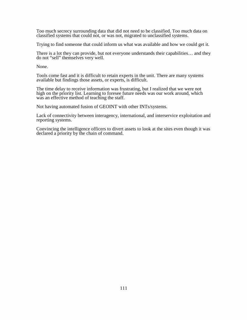
111
Too much secrecy surrounding data that did not need to be classified. Too much data on classified systems that could not, or was not, migrated to unclassified systems. Trying to find someone that could inform us what was available and how we could get it. There is a lot they can provide, but not everyone understands their capabilities… and they do not “sell” themselves very well. None. Tools come fast and it is difficult to retain experts in the unit. There are many systems available but findings those assets, or experts, is difficult. The time delay to receive information was frustrating, but I realized that we were not high on the priority list. Learning to foresee future needs was our work around, which was an effective method of teaching the staff. Not having automated fusion of GEOINT with other INTs/systems. Lack of connectivity between interagency, international, and interservice exploitation and reporting systems. Convincing the intelligence officers to divert assets to look at the sites even though it was declared a priority by the chain of command.

112
APPENDIX D
QUANTIFIED: SALIENT SURVEY COMMENTS
GENERAL COMMENTS
Ope
ratio
ns
Plan
ning
Rel
easa
bilit
y Em
ergi
ng
Tech
nolo
gy
Mai
nten
ance
Sh
ared
A
war
enes
s En
hanc
e SA
TOTA
L
1. We were trying to track Iraqi Army and Police operations with very limited Coalition Forces- they didn't have MiTTs, and we didn't have enough partnered units to be out in the AO with them and see what they were doing. After a few days, I found that the MNC-I was getting updates on my Iraqi Division's activities by comparing photographs of positions- it was usually 24 hours old, but more current than the translation of situation reports I was getting from the Iraqi Division, and a good way to confirm them.
0 0 0 0 0 1 0 1
2. Recovery of body in Iraq from an ambush. 0 1 0 0 0 1 0 2 3. MASINT, SIGINT, and satellite imagery indicated unusual movement at unusual hours in my company AO in Al Anbar in 2005. We acted on the intel, and as a result unearthed over 3000 artillery shells and buried milvans full of other enemy ammunition.
0 1 0 0 0 1 1 3
4. My unit utilized ARCGIS to track progress of Iraqi Police development and expansion by station, district, directorate and province. We used Geospatial products depicting cultural data by area in order to help determine which areas Shia versus Sunni IPs would be most effective and to gain insight into issues IP trainees would have as they traveled to and from IP training facilities (ex.Shia trainee traveling through Sunni neighborhoods). We also used satellite imagery during planning for the erection and operation of dislocated civilian holding areas during combat operations.
1 1 1 0 0 1 0 4
5. Loved and used Buckeye imagery regularly. 0 0 0 1 0 0 0 1 6. GEOINT was the critical factor in destroying the target and conducting the raid that my unit executed.
1 1 0 0 0 1 0 3

113
7. We ran daily convoy security missions in Iraq and extensively used imagery (TIGR was a super program) to conduct map recons since we often did not have time for route recons. Color imagery had real value added. We also used imagery from TIGR in our TOC as well as other imagery sources (cannot name them now) to integrate into our TOC and for use with our FBCB2 to monitor and assist convoy commanders with navigation.
0 1 0 0 0 1 0 2
8. In Afghanistan a report from the HN government stated that a bridge collapsed on the ring road. No U.S. forces were able to independently verify and coalition partners would not do a recon to validate. I searched an imagery database for likely bridges based on the report and my office then coordinated for real time imagery shots of the selected sites. We found the collapsed bridge and some signs of why it collapsed and we then directed a U.S. unit to go to the site and conduct a bridge recon.
1 1 0 0 1 1 1 5
9. As a naval officer, we only requested information when close to hostile nations. Receiving key data prior to entering engagement zones was critical to our effective planning and deployment to maximize our capabilities.
1 1 0 0 1 1 1 5
10. GEOINT was very useful on my last deployment. 1 1 1 1 1 1 1 7
SALIENT TOTAL 5 8 2 2 3 9 4 33
Ope
ratio
ns
Plan
ning
Rel
easa
bilit
y Em
ergi
ng
Tech
nolo
gy
Mai
nten
ance
Sh
ared
A
war
enes
s En
hanc
e SA
TOTA
L

114
APPENDIX E
QUANTIFIED: FRUSTRATING SURVEY COMMENTS
GENERAL COMMENTS
Ope
ratio
ns
Plan
ning
Rel
easa
bilit
y Em
ergi
ng
Tech
nolo
gy
Mai
nten
ance
Sh
ared
A
war
enes
s En
hanc
e SA
TOTA
L
1. Prepping for elections in Iraq - most of the work done on SIPR but everyone working elections did not have SIPR access. The Iraqis knew all about their elections, but the data and products produced was not immediately available due to work being executed on SIPR.
0 1 1 0 0 1 0 3
2. Trying to get NGA to grant release authority so we could share a product with our Iraqi partners when NGA was the originator. They said we should get release authority from in theater; we were redirected back to the originator!
0 0 1 0 0 0 0 1
3. Many geospatial products were restricted access/LIMDIS and not very user friendly, especially when denying access to over half our coalition. It was not user friendly nor were the enabling abilities explained well or integrated
0 0 1 0 0 0 0 1
4. Main problem working at MNC-I as a collection manager was the challenge of not having a cradle to grave ability for units at battalion/brigade level to easily submit requirements for collection. Use of spreadsheets was the only means to gather requirements for input to PRISM for USAF collection and to Army Assets for collection.
1 1 0 1 0 1 0 4
5. Second, was the lack and refusal of USAF leadership at the CAOC to push U-2 imagery to Corps TES.
0 0 1 0 0 0 0 1
6. I was not always sure of the product I needed, especially with limited time and resources
0 1 0 0 0 0 0 1
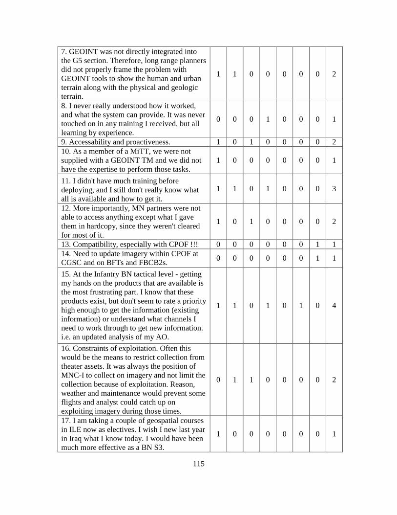
115
7. GEOINT was not directly integrated into the G5 section. Therefore, long range planners did not properly frame the problem with GEOINT tools to show the human and urban terrain along with the physical and geologic terrain.
1 1 0 0 0 0 0 2
8. I never really understood how it worked, and what the system can provide. It was never touched on in any training I received, but all learning by experience.
0 0 0 1 0 0 0 1
9. Accessability and proactiveness. 1 0 1 0 0 0 0 2 10. As a member of a MiTT, we were not supplied with a GEOINT TM and we did not have the expertise to perform those tasks.
1 0 0 0 0 0 0 1
11. I didn't have much training before deploying, and I still don't really know what all is available and how to get it.
1 1 0 1 0 0 0 3
12. More importantly, MN partners were not able to access anything except what I gave them in hardcopy, since they weren't cleared for most of it.
1 0 1 0 0 0 0 2
13. Compatibility, especially with CPOF !!! 0 0 0 0 0 0 1 1 14. Need to update imagery within CPOF at CGSC and on BFTs and FBCB2s. 0 0 0 0 0 0 1 1
15. At the Infantry BN tactical level - getting my hands on the products that are available is the most frustrating part. I know that these products exist, but don't seem to rate a priority high enough to get the information (existing information) or understand what channels I need to work through to get new information. i.e. an updated analysis of my AO.
1 1 0 1 0 1 0 4
16. Constraints of exploitation. Often this would be the means to restrict collection from theater assets. It was always the position of MNC-I to collect on imagery and not limit the collection because of exploitation. Reason, weather and maintenance would prevent some flights and analyst could catch up on exploiting imagery during those times.
0 1 1 0 0 0 0 2
17. I am taking a couple of geospatial courses in ILE now as electives. I wish I new last year in Iraq what I know today. I would have been much more effective as a BN S3.
1 0 0 0 0 0 0 1

116
18. Too much secrecy surrounding data that did not need to be classified. Too much data on classified systems that could not, or was not, migrated to unclassified systems.
0 0 1 0 0 0 0 1
19. Trying to find someone that could inform us of what was available and how we could get it.
1 1 0 0 0 0 0 2
20. There is a lot they can provide, but not everyone understands their capabilities… and they do not “sell” themselves very well.
1 1 0 1 0 1 1 5
21. None. 0 0 0 0 0 0 0 0 22. Tools come fast and it is difficult to retain experts in the unit. There are many systems available but finding those assets, or experts, is difficult.
1 1 0 1 0 0 0 3
23. The time delay to receive information was frustrating, but I realized that we were not high on the priority list. Learning to foresee future needs was our work-around, which was an effective method of teaching the staff.
1 1 0 0 0 0 0 2
24. Not having automated fusion of GEOINT with other INTs/systems. 1 1 0 1 1 1 1 6
25. Lack of connectivity between interagency, international, and interservice exploitation and reporting systems.
1 1 1 1 1 1 1 7
26. Convincing the intelligence officers to divert assets to look at the sites even though it was declared a priority by the chain of command.
1 1 0 0 0 0 0 2
FRUSTATION TOTAL 15 14 9 8 2 6 5 59
Ope
ratio
ns
Plan
ning
Rel
easa
bilit
y Em
ergi
ng
Tech
nolo
gy
Mai
nten
ance
Sh
ared
A
war
enes
s En
hanc
e SA
TOTA
L

117
BIBLIOGRAPHY
Periodicals
Barrowman, Richard. “Geospatial Intelligence: The New Intelligence Discipline.” Joint Forces Quarterly, 2007. http://www.ndu.edu/inss/Press/jfq_pages/ editions/i44/21.pdf (accessed 8 May 2010).
Flynn, Michael T. Fixing Intel: A blueprint for Making Intelligence Relevant in Afghanistan. Center for a New American Security. Voices From The Field. January 2010. Page 4. http://www.cnas.org/files/documents/publications/ AfghanIntel_Flynn_Jan2010_code507_voices.pdf (accessed 8 May 2010).
Mattis, James N. “USJFCOM Commander’s Guidance for Effects-based Operations.” Joint Forces Quarterly, 4th Quarter, no. 51 (October 2008), 107.
The National Geospatial-Intelligence Agency. Pathfinder 5, no, 1 (January-February 2007).
Government Documents
Australian Government. Department of Defence. “Defending Australia in the Asian
PacificCentury: Force 2030.” White Paper, 2009. http://www.defence.gov.au/ whitepaper/docs/defence_white_paper_2009.pdf (accessed 8 May 2010).
Chairman, Joint Chiefs of Staff. Joint Publication (JP) 1-02, Dictionary of Military and Associated Terms. Washington, DC: Government Printing Office, 2009.
―――. Joint Publication (JP) 2-03, Geospatial Intelligence Support to Joint Operations. Washington, DC: Government Printing Office, 2007.
―――. Joint Publication (JP) 3-0, Joint Operations. Washington, DC: Government Printing Office, 2008.
―――. Joint Publication (JP) 3-05, Doctrine for Joint Special Operations. http://www.dtic.mil/doctrine/ new_pubs/jointpub_operations.htm (accessed 8 May 2010).
―――. Joint Publication (JP) 3-16, Multinational Operations. Washington, DC: Government Printing Office, 2007.
―――. The National Military Strategy. Washington, DC: Government Printing Office, 2004. http://www.defense.gov/news/Mar2005/d20050318nms.pdf (accessed 8 May 2010).

118
Chief of the Defense Force. Future Warfighting Concept. 2003. http://www.defence.gov.au/publications/fwc.pdf (accessed 8 May 2010).
Council on Foreign Relations. White Paper on Defence and National Security. June 2008. http://www.cfr.org/publication/16615/french_white_paper_on_defence_and_national_security.html (accessed 8 May 2010).
Department of Defense, Directive 5105.60, National Geospatial-Intelligence Agency. Washington, DC: Government Printing Office, 29 July 2009. http://www.dtic.mil/ whs/directives/corres/pdf/510560p.pdf (accessed 8 May 2010).
―――. Memorandum, Subject: Joint Geospatial Intelligence Transformation DOTMLPF Change Recommendation. Washington, DC, 25 June 2008.
―――. National Defense Strategy. Washington, DC: Government Printing Office, 2008. http://www.defense.gov/news/2008%20national% 20defense%20strategy.pdf (accessed 8 May 2010).
―――. Quadrennial Defense Review. Washington, DC: Government Printing Office, 2009.
Federal Ministry of Defense. “French White Paper on German Security Policy and the Future of the Bundeswehr.” 2006. http://merln.ndu.edu/whitepapers/ Germany_White_Paper_2006.pdf (accessed 8 May 2010).
Headquarters, Department of the Army. Field manual (FM) 3-0, Operations. Washington, DC: Government Printing Office, 2008.
―――. Field Manual (FM) 5-0, Operations Process. Washington, DC: Government Printing Office, 2010.
Headquarters, Intelligence and Security Command, Department of the Army. Project Foundry. http://www.dami.army.pentagon.mil/offices/dami-zxg/documents/foundry-brochure.pdf (accessed 8 May 2010).
Headquarters, Joint Forces Command. Composition and Functions of a Joint Geospatial Intelligence Cell: Report on Results from Experimentation, 2006-2008. Joint Transformation Command–Intelligence (JTC-I), 15 May 2009.
―――. Joint Geospatial-Intelligence Activity. Combatant Command GEOINT Task List. Norfolk, VA: Government Printing Office, 28 May 2008.
―――. Joint Operating Environment: Trends and Challenges for the Future Joint Force Through 2030. Norfolk, VA: Government Printing Office, November 2008. www.jfcom.mil/newslink/storyarchive/2008/JOE2008.pdf (accessed 8 May 2010).

119
Headquarters, United States Marine Corps, Department of Navy. Marine Corps Warfighting Publication (MCWP) 2-12.1, Geographic Intelligence. Washington, DC: Government Printing Office, 6 July 2000.
House of Commons. “Delivering Security in a Changing World.” Research Paper 04/71, Defence White Paper, 2004. http://www.parliament.uk/commons/lib/research/ rp2004/rp04-071.pdf (accessed 8 May 2010).
Kilcullen, David, Australian Army. Complex Warfighting and Adaptive Campaigning Future Land Operational Concept. Draft Developing Concept, 7 April 2004. http://www.quantico.usmc.mil/download.aspx?Path=./Uploads/Files/SVG_complex_warfighting.pdf (accessed 8 May 2010).
Ministere De La Defense. Winning the Battle Building Peace: Land Forces in present and Future Conflicts. Translated by a panel of British and French officers and academic military experts, January 2007. http://www.cdef.terre.defense.gouv.fr/ doctrineFT/doc_fond/FT_01/FT-1_eng.pdf (accessed 8 May 2010).
Ministry of Defence. Development, Concepts, and Doctrine Centre, Strategic Trends Programme 2007-2036. Global Strategic Trends. Strategic Defence Review. 4rd ed., 2007. http://www.mod.uk/DefenceInternet/MicroSite/DCDC/ OurPublications/ StrategicTrends+Programme/ (accessed 8 May 2010).
U.S. Marine Corps. Marine Corps Warfighting Publication 2-12.1, Geographic Intelligence. Washington, DC: Department of the Navy.
White House. 2006 National Security Strategy. Washington, DC, March 2006. www.strategicstudiesinstitute.army.mil/pdffiles/nss.pdf (accessed 8 May 2010).
Reports and Theses
Flynn, Michael T. “Fixing Intel: A blueprint for Making Intelligence Relevant in Afghanistan.” Voices From The Field (January 2010). http://www.cnas.org/ files/documents/ publications/AfghanIntel_Flynn_Jan2010_code507_voices.pdf (accessed 8 May 2010).
Fortin, Danny. “Sharing the Burden: How Effective is a Multinational Force in the Contemporary Operational Environment.” Thesis, Command and General Staff College, Fort Leavenworth, KS, 2007. http://www.dtic.mil/cgi-bin/GetTRDoc?AD= ADA471324&Location=U2&doc=GetTRDoc.pdf (accessed 8 May 2010).
Morelli, Vincent. Congressional Research Service Report for Congress, NATO in Afghanistan: A Test of the Transatlantic Alliance. 3 December 2009. http://www.fas.org/sgp/crs/row/RL33627.pdf (accessed 8 May 2010).

120
Raducanu, Dan. CGIN-Center for Geospatial Intelligence. http://earth.esa.int/rtd/ Events/ESA-EUSC_2006/Oral/Ar44_Raducanu.pdf (accessed 8 May 2010).
Remillard, L.H. “Making New Friends, Trusting New Friends: The Challenges of Coalition Intelligence Sharing in Afghanistan.” MDS Research Project, Canadian Force College, April 2009. www.cfc.forces.gc.ca/papers/csc/csc35/mds/ remillard.doc (accessed 8 May 2010).
Rhodes, Carl. “A Strategies-to-Tasks Framework for Planning and Executing Intelligence, Surveillance, and Reconnaissance (ISR) Operations.” RAND, Project Air Force, 2007. http://www.rand.org/pubs/technical_reports/2007/ RAND_TR434.pdf (accessed 8 May 2010).
Sanchez, Andy. “Leveraging Geospatial Intelligence (GEOINT) in Mission Command.” Monograph, School of Advanced Military Studies, 2009. http://www.dtic.mil/cgi-bin/GetTRDoc?AD=ADA506270&Location=U2&doc=GetTRDoc.pdf (accessed 8 May 2010).
Springer, Eric. “Developing Security Forcs Officers For The Future Operating Environment” (Thesis, Command and General Staff College, Fort Leavenworth, KS, 2009), http://www.dtic.mil/cgi-bin/GetTRDoc?Location=U2&doc= GetTRDoc.pdf&AD=ADA502058 (accessed 8 May 2010).
Stability Operations Information Center (SOIC). Comprehensive Understanding for Comprehensive Operations. 9 March 2010. http://cryptome.org/dodi/af-soic-2010.pdf (accessed 8 May 2010).
Other Sources
Air and Space Interoperability Council (ASIC). ASIC Programs and Links.
http://www.dtic.mil/asic/ (accessed 8 May 2010).
American Society for Photogrammetry and Remote Sensing. asprs on-line. http://www.asprs.org/ (accessed 8 May 2010).
AUSCANNZUKUS. Information Portal. http://www.auscannzukus.net/ (accessed 8 May 2010).
Australia, Britain, Canada, America and New Zealand Armies. http://www.abca-armies.org/Error.aspx?aspxerrorpath=/Organization/Default.aspx (accessed 8 May 2010).
Boteler, Dwaine, and Steward Liles. Knowledge Management, US Corps and Multi-National Corps-Iraq. 2009 Army Operational Knowledge Management (AOKM) Conference, 19-23 October 2009. http://usacac.army.mil/CAC2/bcks/Connected/ ConnectedFall2009.html (accesses 8 may 2010).

121
Combined Communications and Electronics Board (CCEB). Public Website. http://jcs.dtic.mil/j6/cceb/ (accessed 8 May 2010).
Defence Geospatial Information Working Group. “About the GWG.” http://www.dgiwg.org/dgiwg/ (accessed 8 May 2010).
Foundry Program. Brochure. http://www.dami.army.pentagon.mil/offices/dami-zxg/documents/foundry-brochure.pdf (accessed 8 May 2010).
Geospatial Community. Geospatial Community Contact List. http://gccl.geospatial-community.com/ (accessed 8 May 2010).
Geospatial Intelligence Standards Working Group. “About the GWG.” http://www.gwg.nga.mil/ (accessed 8 May 2010).
Institute of Electrical and Electronics Engineers. Homepage. http://www.ieee.org/portal/site (accessed 8 May 2010).
International Standards Organization. Homepage. http://www.iso.org/iso/home.htm (accessed 8 May 2010).
―――. Technical Circular 211, Geographic Information/Geomatics. 2009. http://www.isotc211.org/ (accessed 8 May 2010).
Multinational Interoperability Council. “Overview, Vision, Mission.” http://jcs.dtic.mil/j3/mic/ (accessed 8 May 2010).
National Geospatial Intelligence Agency. “GEOINT Standards.” https://www1.nga.mil/ ProductsServices/geointstandards/Pages/default.aspx (accessed 8 May 2010).
―――. “GEOINT,” Title 10, United States Code 467. https://www1.nga.mil/ About/WhatWeDo/GeoInt/Pages/default.aspx (accessed 8 May 2010).
―――. Homepage. www.nga.mil (accessed 8 May 2010).
―――. NSG. https://www1.nga.mil/About/ WhoWeAre/NSG/Pages/default.aspx (accessed 8 May 2010).
North Atlantic Treaty Organization (NATO) Allied Command Transformation (ACT). Homepage. http://www.act.nato.int/ (accessed 8 May 2010).
―――. “NATO Standardization Agency.” Updated 8 October 2002. http://www.nato.int/nsa/nsa_home.htm (accessed 8 May 2010).
―――. “Standardization.” Updated 4 November 2008. http://www.nato.int/issues/ standardization/index.html (accessed 8 May 2010).

122
―――. Standard Agreements (STANAGs). Last updated 22 April 2010. http://www.nato.int/cps/en/natolive/stanag.htm (accessed 8 May 2010).
Open Geospatial Consortium Inc. Official Names Space of the OpenGIS schemas. www.opengis.net (accessed 8 May 2010).
―――. OGC Website. http://www.opengeospatial.org/ (accessed 8 May 2010).
United States Geospatial Intelligence Foundation. Homepage. http://usgif.org/ (accessed 8 May 2010).
World Health Organization. “Stewardship.” http://www.who.int/health-systems-performance/sprg/hspa06_stewardship.pdf (accessed 8 May 2010).

123
INITIAL DISTRIBUTION LIST
Combined Arms Research Library U.S. Army Command and General Staff College 250 Gibbon Ave. Fort Leavenworth, KS 66027-2314 Defense Technical Information Center/OCA 825 John J. Kingman Rd., Suite 944 Fort Belvoir, VA 22060-6218 Dr, Ralph O. Doughty Chair of Interagency and Multinational Studies USACGSC 100 Stimson Ave. Fort Leavenworth, KS 66027-2301 Major Nicholas Martin Chief, Joint Space Operations DJIMO USACGSC 100 Stimson Ave. Fort Leavenworth, KS 66027-2301 Mr. Ralph M. Erwin. National Geospatial-Intelligence Agency USACGSC 100 Stimson Ave. Fort Leavenworth, KS 66027-2301 Marty D. Dunn GEOINT Cell Officer Joint Geospatial-Intelligence Activity US Joint Force Command Norfolk, VA 23551 Melissa A. Planert NATO GEOINT Officer PSC 80 Box 105 APO AE 09702 COL Richard Hornack NGA Support Team (CCJ2-NGA) 7115 South Boundary Blvd MacDill AFB, FL 33621-1501

124
COL Richard E. Barrowman Chief, NGA Support Team Kabul, Afghanistan Commandant The School of Geospatial-Intelligence National Geospatial-Intelligence Agency College Fort Belvoir, VA 22060 Mr. Robert W. Burkhardt Director US Army Geospatial Center Alexandria, VA 22315 LTC Patrick Fryer JISR Branch, C4ISN Allied Command Transformation 7857 Blandy Road, Suite 100 US Joint Forces Command Norfolk, VA 23551-2490 John F. Teufert NC3A Geo-Officer Oude Waalsdorperweg 61 2597 AK The Hague P.O. Box 174, 2501 CD The Hague, Netherlands