developing guidelines for institutional arrangements of ...€¦ · data sharing by addressing...
TRANSCRIPT

DEVELOPING GUIDELINES FOR INSTITUTIONAL ARRANGMENTS OF FEDERAL GOVERMENTAL GEO-INFORMATION PROVIDER ORGANIZATIONS IN ETHIOPIA
I
Developing guidelines for institutional arrangements of the federal
governmental geo-information provider organizations
in Ethiopia
Getinet Beshah March, 2003

DEVELOPING GUIDELINES FOR INSTITUTIONAL ARRANGMENTS OF FEDERAL GOVERMENTAL GEO-INFORMATION PROVIDER ORGANIZATIONS IN ETHIOPIA
II
Developing guidelines for institutional arrangements of federal governmental geo-information provider
organizations in Ethiopia by
Getinet Beshah Thesis submitted to the International Institute for Geo-information Science and Earth Observation in partial fulfilment of the requirements for the degree of Master of Science in Geo-information Man-agement. Degree Assessment Board 1) Prof. Ir Paul van der Molen, Chairman 2) Prof.Dr. A. van der Veen, External Examiner; University of Twente 3) Ir. Walter de Vries, 1st supervisor4) Dr. Ing. Erik de Man, 2nd Supervisor
INTERNATIONAL INSTITUTE FOR GEO-INFORMATION SCIENCE AND EARTH OBSERVATION ENSCHEDE, THE NETHERLANDS

DEVELOPING GUIDELINES FOR INSTITUTIONAL ARRANGMENTS OF FEDERAL GOVERMENTAL GEO-INFORMATION PROVIDER ORGANIZATIONS IN ETHIOPIA
III
Disclaimer This document describes work undertaken as part of a programme of study at the International Institute for Geo-information Science and Earth Observation. All views and opinions expressed therein remain the sole responsibility of the author, and do not necessarily represent those of the institute.

DEVELOPING GUIDELINES FOR INSTITUTIONAL ARRANGMENTS OF FEDERAL GOVERMENTAL GEO-INFORMATION PROVIDER ORGANIZATIONS IN ETHIOPIA
IV
Acknowledgment This study would never have been accomplished without the contribution and help of many people and organizations to whom I want express my great appreciation. First of all I gratefully acknowledge The Netherlands government and people for granting scholarship opportunity. The same way, I would like gratefully acknowledge the Ethiopian Mapping Authority for nominating me for this opportunity. My deepest and most gratefulness is due to my supervisors Ir. Walter de Vries and Dr. Ing. Erik de Man. Their intellectual advice, guidance, critical comment and encouragement have been invaluable for me. Their willingness to listen and discus with me, read my work, and render constructive sugges-tions from the beginning to the end of my research helped me eventually to produce this thesis. I am very grateful to appreciate the federal governmental geo-information provider organizations in Ethiopia from which I have collected institutional arrangements data during my fieldwork. If it were without full cooperation of the organizations, my fieldwork and research would never have been com-pleted. The organizations to which I extend my appreciation are Ethiopian Mapping Authority, Geo-logical Survey of Ethiopia, Ministry of Water Resource, National Urban Planning Institute, Environ-mental Protection Authority, National Meteorological Service Agency, Population and Housing Cen-sus Commission Office, Land use Section, Ministry of Agriculture, Ethiopia Science & Technology Commission, Ethiopian Tourism Commission, and Woody Biomass Inventory & Strategic Plan-ning Project Office. I am indebted to my family and friends back home for encouragement they have been providing me during my stay at ITC. I also extend my heartfelt appreciation to all my friends at ITC for having wonderful and forever remembered time with me.

DEVELOPING GUIDELINES FOR INSTITUTIONAL ARRANGMENTS OF FEDERAL GOVERMENTAL GEO-INFORMATION PROVIDER ORGANIZATIONS IN ETHIOPIA
V
Abstract In Ethiopia, despite federal geoinformation (GI) provider organizations have been established by proc-lamation to advance socio-economic development of the country, geoinformation is not effectively used to support the decision-making process. In the process of providing reliable and timely geoin-formation, the organizations are challenged by mandate and right inscribed in the proclama-tion/mission. Geoinformation administration and GI technology usage in the organizations are in general very poor. Data are not produced to the standard to insure compatibility of data from different sources; pricing of geoinformation products is done in ad hoc manner; and sharing or provision of data to avoid redun-dancy is not an easy task. On the other hand, even though GI technology is adopted by organizations it is not yet effectively used and enable to respond for digital data demand. Coordination among GI organizations in order to work together to formulate geoinformation policy and exchange information does not exist; and coordinating of the organizations is not an easy task. Different organizations collect/create data, develop database, adopt standard, etc in isolation and in ad hoc manner. There is no full coverage data within organizations; most of the available data are in analogue for-mats; and it is not possible to provide timely, up-to-date, and users demanding data. However, the GI organizations are not outsourcing activities to mitigate these problems. This research, therefore, is made to focus on identifying and analysing of the institutional arrangement bottlenecks for the above problems, and to come up eventually with guidelines to mitigate them. To this effect, on the one hand theories and literatures investigated to identify types of problems and mitigation alternatives. On the other, the actual institutional arrangement problems facing the GI or-ganizations have been collected. By comparing, contrasting and analysing these problems visa-vice reviewing theories/literatures, appropriate guidelines to the Ethiopia situation are developed. To make function of the GI organizations effective and develop GII whereby the current geoinforma-tion sharing problems can be overcome, the guidelines are addressing the following issues. First, modernization of the GI organizations proclamation/mission which advances user demand driven sys-tem, joint work with private companies, effectiveness in human resource management and training, becoming strong in financial capacity, and flexible and transparent management system. Second, for-mulating of geoinformation policy to insure data are collected, processed, and stored as to the stan-dard whereby data from different sources (particularly from different regional and federal organiza-tions) are compatible and complete to avoid effort and resource redundancy. Similarly, promoting of data sharing by addressing custodian right, data advertisement, digital data availability, and access and copyright. Third, developing price standard for geoinformation products to insure the provision of geoinformation for all citizens. Fourth, one the one hand formulating strategic plan to use GI technol-ogy effectively within organizations and maintaining it; and on the other insuring of data up to dated-ness and liability. Fifth, political commitment and organizational restructuring to coordinate GI or-ganizations and sustaining it. Six, government policy and organizational commitment to outsource activities, and develop a mechanism to insure the quality of outsourced products.
DEVELOPING GUIDELINES FOR INSTITUTIONAL ARRANGMENTS OF FEDERAL GOVERMENTAL GEO-INFORMATION PROVIDER ORGANIZATIONS IN ETHIOPIA
VI
Table of contents
Disclaimer …………………………………………………………………………………….………III Acknowledgment …………………………………………………………………………….……… IV Abstract ……………………………………………………………………………………….……….V List of tables ………………………………………………………………………………………..…IX List of figurers. …………………………………………………………………………………… ….X List of abbreviation ………………………………………………………………………….………...X
Chapter I 1. Introduction...................................................................................................1
1.1. Background..............................................................................................................................1 1.2. Research Problems ..................................................................................................................2 1.3. Research Objective..................................................................................................................3 1.4. Research question....................................................................................................................3 1.5. Prior works ..............................................................................................................................4 1.6. Research Methodology............................................................................................................4 1.7. Expected outcomes..................................................................................................................5 1.8. Structure of thesis....................................................................................................................6
Chapter II
2. GI organizations institutional arrangements ................................................7 2.1. Introduction .............................................................................................................................7 2.2. Geoinformation Infrastructure (GII)........................................................................................7 2.3. Mission of GI organizations ....................................................................................................8 2.4. Human resource development .................................................................................................8 2.5. GI technology in organizations ...............................................................................................9 2.6. Organizational culture ...........................................................................................................10 2.7. GI organizations financial regime .........................................................................................10 2.8. Information policy in Ethiopia ..............................................................................................11 2.9. Geoinformation administration issue ....................................................................................11
2.9.1. Data standard and data sharing ....................................................................................11 2.9.2. Spatial data up-to-datedness and liability ....................................................................12 2.9.3. Copyright and access right of spatial data ...................................................................12
2.10. Data pricing. .....................................................................................................................13 2.11. Coordination of GI organizations.....................................................................................13
2.11.1. How GI organizations are coordinated.........................................................................14 2.12. Outsourcing of GI activities .............................................................................................14
2.12.1. Why outsourcing is needed ..........................................................................................14 2.12.2. What are outsourced activities .....................................................................................15 2.12.3. How are the organizations outsourcing........................................................................15
2.13. Project implementation assessment..................................................................................16 2.14. Conclusion........................................................................................................................16

DEVELOPING GUIDELINES FOR INSTITUTIONAL ARRANGMENTS OF FEDERAL GOVERMENTAL GEO-INFORMATION PROVIDER ORGANIZATIONS IN ETHIOPIA
VII
Chapter III
3. Fieldwork and filed data............................................................................ 17 3.1. Introduction ...........................................................................................................................17 3.2. Reasons for the fieldwork......................................................................................................17 3.3. Selection of the organizations ...............................................................................................18 3.4. Methodology used during the fieldwork ...............................................................................18 3.5. Fieldwork data/result.............................................................................................................19 3.6. Organizational issues.............................................................................................................19 3.7. Training and research in GI technology ................................................................................22 3.8. GI technology in the organizations........................................................................................22
3.8.1. How GI technology adopted by the organizations, and its effect ................................22 3.8.2. Difficulties in using GI technologies ...........................................................................23
3.9. Geospatial data administration issues ...................................................................................23 3.9.1. Geospatial data creating and updating .........................................................................23 3.9.2. Geospatial data provision.............................................................................................24 3.9.3. Data standard................................................................................................................24 3.9.4. Data exchangeable format standard .............................................................................24 3.9.5. Geospatial database standard .......................................................................................25 3.9.6. Metadata standard ........................................................................................................25 3.9.7. Data access and sharing ...............................................................................................25 3.9.8. Advertisement of products ...........................................................................................26 3.9.9. Resource redundancy ...................................................................................................26 3.9.10. Geoinformation centre in organizations.......................................................................26 3.9.11. Data coverage...............................................................................................................27
3.10. Data users issues ..............................................................................................................27 3.10.1. Making users need assessment.....................................................................................27 3.10.2. Major users of the data.................................................................................................28
3.11. Geospatial data pricing issue............................................................................................28 3.12. Coordination of GI organizations.....................................................................................29 3.13. Outsourcing of GI activities .............................................................................................30 3.14. Observation at the organizational issues during fieldwork..............................................31 3.15. Conclusion........................................................................................................................32
Chapter IV
4. GI organizations institutional arrangements analysis ............................... 34 4.1. Introduction ...........................................................................................................................34 4.2. Existence of the GI organizations and their role in society...................................................34 4.3. Outdatedness of organizational proclamation/mission .........................................................35
4.3.1. Cultural problem in organizations................................................................................38 4.3.2. Cost recovery strategy in Ethiopia ...............................................................................39
4.4. GI technology in the organizations........................................................................................40 4.4.1. GI technology adoption by the organizations ..............................................................40

DEVELOPING GUIDELINES FOR INSTITUTIONAL ARRANGMENTS OF FEDERAL GOVERMENTAL GEO-INFORMATION PROVIDER ORGANIZATIONS IN ETHIOPIA
VIII
4.4.2. Problems for effectiveness and sustainability of GI technology..................................40 4.5. Geospatial data administration ..............................................................................................42
4.5.1. Geospatial data standard ..............................................................................................42 4.5.2. Data sharing problems..................................................................................................43 4.5.3. Data up-to-datedness and liability problem .................................................................45 4.5.4. Absence of geoinformation centre within GI organizations ........................................45
4.6. Pricing for geoinformation products .....................................................................................46 4.7. Coordination of GI organizations..........................................................................................47
4.7.1. Need of coordinating the GI organizations ..................................................................47 4.7.2. How the GI organizations were coordinated in Ethiopia and its benefit. ....................48 4.7.3. Barrier to coordinate GI organizations.........................................................................49
4.8. Outsourcing of GI activities ..................................................................................................50 4.8.1. When organizations need to outsource ........................................................................50 4.8.2. Barrier to outsource GI activities .................................................................................50 4.8.3. Factors to facilitate outsourcing of GI activates. .........................................................51
4.9. Conclusion.............................................................................................................................52
Chapter V
5. Guidelines for institutional arrangments of federal govermental GI organizations in Ethiopia......................................................................... 54
5.1. Introduction ...........................................................................................................................54 5.2. Organizational proclamation/mission....................................................................................54 5.3. GI technology in the organizations........................................................................................58 5.4. Creating geoinformation centre in GI organizations .............................................................59 5.5. Geoinformation policy at national level................................................................................59
5.5.1. Policy for geoinformation standard..............................................................................60 5.5.2. Data up to datedness and liability ................................................................................61 5.5.3. Data access and sharing ...............................................................................................62 5.5.4. Copyright......................................................................................................................63 5.5.5. Appropriate pricing standard for geoinformation products .........................................63
5.6. Organizational coordination ..................................................................................................64 5.7. Outsourcing of GI activities ..................................................................................................65 5.8. Conclusion.............................................................................................................................66
Chapter VI
6. Project approach implementation of the guidelines for institutional arrangments ............................................................................................. 68
6.1. Introduction ...........................................................................................................................68 6.2. Possible risks and management tools to mitigate the risks ...................................................68
6.2.1. Risks .............................................................................................................................68 6.2.2. Management tools to mitigate the risks .......................................................................72
6.3. Conclusion.............................................................................................................................73

DEVELOPING GUIDELINES FOR INSTITUTIONAL ARRANGMENTS OF FEDERAL GOVERMENTAL GEO-INFORMATION PROVIDER ORGANIZATIONS IN ETHIOPIA
IX
Chapter VII
7. Conclusion and Recommendations for further research .......................... 75 7.1. Conclusion.............................................................................................................................75 7.2. Recommendations for further studies....................................................................................77
References ……………………………………………………………………..78 Appendix……………………………………………………………………….81 List of Tables
Table 3.1 Organizational mission, responsibility and main products ..................................................21 Table 3.2 Organizational mandates and rights....................................................................................21 Table 3.3 Organizational human resource management ......................................................................22 Table 3.4 Training and research issues in the organizations ...............................................................22 Table 3.5 GI technology within the organizations and its effect .........................................................23 Table 3.6 Difficulties in using GI technology.....................................................................................23 Table 3.7 Geospatial data creating and updating .................................................................................24 Table 3.8 Geospatial data provision.....................................................................................................24 Table 3.9 Geospatial data and exchangeable format standard.............................................................25 Table 3.10 Database and metadata standard ........................................................................................25 Table 3.11 Public right to access data and sharing of data with others. ..............................................26 Table 3.12 Advertising of organizational products..............................................................................26 Table 3.13 Redundant satellite data .....................................................................................................26 Table 3.14 Geoinformation center within GI organizations structure .................................................27 Table 3.15 Geospatial data coverages in organizations .......................................................................27 Table 3.16 Organizations interaction with users and compensation for lose .....................................28 Table 3.17 Users of GI organizations products....................................................................................28 Table 3.18 Geospatial data pricing ......................................................................................................29 Table 3.19 Provision of Geospatial data free.......................................................................................29 Table 3.20 Vertical and horizontal GI organizations coordination......................................................29 Table 3.21 Method of organizational coordination and problems issues ............................................30 Table 3.22 GI organizations coordination to work together and exchange information. ....................30 Table 3.23 Outsourcing of GI activities issues ....................................................................................31 Table 3.24 Financial resource and amount of activities to outsource..................................................31 Table 3.25 Organizational structures ...................................................................................................32 Table 6.1 Factors that causing risks.....................................................................................................71
DEVELOPING GUIDELINES FOR INSTITUTIONAL ARRANGMENTS OF FEDERAL GOVERMENTAL GEO-INFORMATION PROVIDER ORGANIZATIONS IN ETHIOPIA
X
List of Figures Figure 4.1 Interrelation among mission elements and their extra impacts ..........................................36 Figure 5.1 Process oriented vs. Function oriented business structure .................................................55 Figure 5.2. Flattening of hierarchical organization..............................................................................57 Figure 6.1 Major and subclasses of risks .............................................................................................69
List of Abbreviation EMA Ethiopian Mapping Authority ENRAMED Ethiopian Natural Resource and Environmental Meta-Database l EPA Environmental Protection Authority ESTC Ethiopia Science & Technology Commission ETC Ethiopian Tourism Commission GII Geo-Information Infrastructure GSE Geological Survey of Ethiopia LUS-MA Land use Section, Ministry of Agriculture MWR Ministry of Water Resource NCIC National Computer and Information Centre NMSA National Meteorological Service Agency NUPI National Urban Planning Institute PHCCO Population and Housing Census Commission Office WBISPO Woody Biomass Inventory & Strategic Planning Project Office

DEVELOPING GUIDELINES FOR INSTITUTIONAL ARRANGMENTS OF FEDERAL GOVERMENTAL GEO-INFORMATION PROVIDER ORGANIZATIONS IN ETHIOPIA
XI
To my family

DEVELOPING GUIDELINES FOR INSTITUTIONAL ARRANGMENTS OF FEDERAL GOVERMENTAL GEO-INFORMATION PROVIDER ORGANIZATIONS IN ETHIOPIA
1
Chapter I
1. Introduction
1.1. Background
Institutions are the rules of the game in a society or, more formally, are the humanly devised con-straints that shape human interaction (North, 1990). Similarly, institutions in specific organizations are also rules and regulations that govern the organizations, (Sevatdal, 2002) Institutions are affecting internally the over all functions of organizations, and externally organizations’ interaction with users and other organizations. Particularly, institutional arrangement for Geo-information (GI) providers and users organizations is incredibly crucial for the effectiveness and development of GI technology (Choi, 2002) In Ethiopia, there are many federal governmental organizations producing and providing geoinforma-tion. The organizations are established by government proclamation to satisfy need of geoinformation in the country in different sectors. However, the organizations’ ability towards achieving mandates and responsibilities given by the proclamation is challenged by problems, which are mainly institu-tional. For the organizations, it is common to face problems in management of human and other re-sources, using GI technology, administrating of geospatial data, determining price for data, coordinat-ing with other organizations and outsourcing of GI activities. These problems are largely emerging from the existing proclamation/mission. The organizations are governed by government rules and regulations, which are traditional, rigid, and mostly resistant to pace with the current technology and development of geoinformation infrastructure. As a result, geoinformation products that the users want either are not available or not provided fairly. All in all there are different problems occurring from producing/creating of geoinformation products to provid-ing for users, consequently geoinformation products have not major role in the country to support the socio-economic development and assist decision makers at large. Being governmental organizations, they have similarity among them in some fundamental institutional arrangements. According to the regulations, they are government budget dependent as major financial resource; monopolistic, product driven and limited in producing of specified products; providing products with optimal price or free, etc. Above all, they all are under similar social structure and geo-graphical areas. On the other hand, the organizations also have differences in institutional arrangement. They have differences in mission and functions of the organization; each organization produces different types of geoinformation. Their status in using of geoinformation technology, data administration, data provi-
DEVELOPING GUIDELINES FOR INSTITUTIONAL ARRANGMENTS OF FEDERAL GOVERMENTAL GEO-INFORMATION PROVIDER ORGANIZATIONS IN ETHIOPIA
2
sion and dissemination is also different. In addition, as a result of the countries political structure (which is federal system) some organizations have decentralized while others are not, etc. In general, the organizations have similarities and differences in institutional arrangement. Hence, comparing and contrasting the similarities and differences of the institutional arrangements visa-vice ideas and theories in literatures, result in several advantages. Some major advantage is developing of guidelines for institutional arrangements. The guidelines help increase organizational effectives and efficiency which includes amendment of organizational mission, administration of the geospatial data, effectively use of GI technology, appropriately pricing of geoinformation products, coordination of GI organizations, formulation of policy for geoinformation, and outsourcing GI activities, etc. And then they lead to develop geoinformation infrastructure (GII)
1.2. Research Problems
Groot and Laughlin (2000) & Ezigbalike (2002) are emphasising the need of GDI/GII infrastructure development for sharing geospatial data in order to use it effectively for different purposes, particu-larly for decision-making. Countries like USA has developed spatial data infrastructure at national level with a vision reduce duplication, increase efficiency and effectiveness, save money, etc (Moeller, 2000). But to realize the development of GDI/GII, the following issues, among many, are to be put in place: organizational issue (culture, norms and rules), technology, human development, pol-icy/law, standard, clearinghouse, political commitment, people, coordination, and data availability. In Ethiopia, however, there is no well-established GII; as a result there is geoinformation problem among users and providers. Basic reason for this goes to problems with institutional arrangements of GI provider organizations. These organizations are governed by traditional management system, poorly structured internally and externally, and not effective in producing and providing of geoinfor-mation for the society. The problems that affect effectiveness of the functions of GI organizations and then development of GII described below: 1) Outdated proclamation/mission of the GI organizations. The existing mission of the organiza-
tions is affecting the effectiveness of organizations functions and development of the GII. Ac-cording to the mission, they are budgeted, controlling production and distribution of geoin-formation, sole producers and providers of geoinformation in the country, and product driven. Moreover, their ability in development of human resource and effectively using is very weak. Accomplishing their responsibilities and mandates is generally not possible and challenging. Organizational capacity in providing up-to-date and users demanding data is also very limited.
2) Poor administration of geoinformation products; and weakness in dealing with GI technology.
These problems are manifested as: ��There is no standard at national level for geoinformation products. Organizations are
collecting processing and storing data in isolation and in a way compatibility of data from different sources is not insured.
��There is a problem in accessing and sharing of data found within government or-ganizations.
��GI technology is not effectively used by the organizations and maintained regularly.

DEVELOPING GUIDELINES FOR INSTITUTIONAL ARRANGMENTS OF FEDERAL GOVERMENTAL GEO-INFORMATION PROVIDER ORGANIZATIONS IN ETHIOPIA
3
Similarly, pricing standard for geoinformation products is not developed at national level. Prices of geoinformation products vary from organizations to organizations; and some of geoinformation products are given free or with least price, despite literatures suggest geoin-formation products have to have appropriate price.
3) Absence of coordination among GI organizations. The organizations are not coordinated to
exchange information or develop geoinformation policy/ standard and data pricing to pro-mote data sharing, which, otherwise results in effort and resource duplication (Groot and Laughlin, 2000) and (Mbumwae, 1999).
4) Absence of outsourcing GI activates, those cannot be done by the organizations. The organi-
zations have huge responsibilities in providing GI for the society. But they have human and technological capacity problems to do that. To mitigate such problems, the organizations need to outsource those activities, however, it is not done largely. In addition outsourcing of activities promotes roles of private companies in data capturing, updating and distributing, to satisfy demand of users and help GII development in the country (Williamson, 1997). But because of organization and institutional problems it is done by the organizations.
1.3. Research Objective
This research has the following objective: ��To identify, analyse and develop guidelines if elements in the institutional arrangement of GI
provider organizations are bottlenecks for organizational effectiveness and development of geoinformation infrastructure in Ethiopia.
��To investigate impacts of organizational mission on GI provider organizations func-tions and effectiveness.
��To investigate impacts of institutional arrangements on Geoinformation administra-tion, GI technology effectiveness, and pricing of geoinformation products
��To investigate institutional arrangement mechanisms for coordinating GI organiza-tions, and identify which institutional arrangements work and not work to coordinate the organizations.
��To analyse how and to what extent the institutional arrangements are affecting out-sourcing of GI activities.
��To develop guidelines for institutional arrangement of GI provider organizations to support development of GII.
1.4. Research question
How far institutional arrangements affect effectiveness of GI organizations functions and then devel-opment of GII on the one hand; and what guidelines are developed for institutional arrangements to increase the effectiveness of the organizations and develop GII to mitigate geoinformation problems on the other?
��What does institutional arrangements mean for GI organizations? ��How are the GI providers organizations there? What are their roles in the society?
DEVELOPING GUIDELINES FOR INSTITUTIONAL ARRANGMENTS OF FEDERAL GOVERMENTAL GEO-INFORMATION PROVIDER ORGANIZATIONS IN ETHIOPIA
4
��What are impacts of organizational mission and organizational culture in effective-ness of the GI provider organizations function?
��What is the trend of cost recovery strategy in the country, particularly for GI organi-zations?
��How does institutional arrangements affect data administration, data pricing and GI technol-ogy effectiveness
��What are impacts of the institutional arrangements in development of geoinformation infrastructure in the country (data creating/updating, storing, standardizing, advertis-ing and sharing, etc)?
��Why is pricing for geospatial data needed? ��How can GI technology be effective within GI organizations?
�� What does coordination mean for GI organizations? ��Why are organizations coordinated? ��How are organizations coordinated? ��Why are institutional arrangements essential for organizational coordination?
�� What are the roles of institutional arrangements in outsourcing of GI activities? ��Why is needed outsourcing of GI activities ��What are institutional problems with outsourcing of GI activities? ��What are factors that facilitate outsourcing GI activities?
��What guidelines can be developed for institutional arrangements? ��Why is the guidelines needed ��What are the institutional elements included in the guidelines?
1.5. Prior works
This is a practical work will be done in Ethiopia to identify and analyse institutional arrangements problems of federal governmental GI provider organizations. Some works, which are not actually identical or similar, have been done. Harvey (2000) carried out surveying using questionnaire method to identify potential and pitfalls for vertical integration for the NSDI (special focusing on institutional arrangement NSDI for integration of geospatial data between local and federal governments). Feeney and Williamson (2002) contributed a paper on the role of institutional mechanisms in spatial data in-frastructure development that support decision making. All of them have emphasised the role of de-veloping institutions for development of spatial data infrastructure. Similarly, based on Korean case Choi,(2002) emphasised that institutions are emerged from politics, policy and legislation, and guide-lines developed to promote spatial data sharing in the country. In general numerous literatures and authors objectively and with evidence indicated institutional and cultural issues, which are, in fact, vary from country to country based on societal structure, are quite important for development and ef-fectiveness of geoinformation infrastructure.
1.6. Research Methodology
The research methodology approach is qualitative. It will focus on institutional, organizational, cul-tural and sociological approach to interpret, compare, contrast and evaluate the institutional arrange-ments of the GI provider organizations in Ethiopia. To this effect fieldwork, which includes ques-

DEVELOPING GUIDELINES FOR INSTITUTIONAL ARRANGMENTS OF FEDERAL GOVERMENTAL GEO-INFORMATION PROVIDER ORGANIZATIONS IN ETHIOPIA
5
tionnaire, interview, and observation at organizations institutional arrangements on the one hand, and literature review on the other will be done. Comparing, contrasting and valuing institutional arrange-ments of the GI organizations vis-à-vis ideas in literatures will enable to develop guidelines for insti-tutional arrangements of the federal GI provider organizations in Ethiopia.
1. Literature review and field data analysis on: ��Mission of GI organizations ��Institutional arrangements for GI organizations functions ��Developing and problems with developing of human resources
2. Literature review and field data analysis on ��Institutional arrangement in adopting and maintaining of GI system; ��Institutional arrangement for creating, updating, sharing, standardizing, providing, etc of
geoinformation ��Determining and problems with determining of appropriate price for geoinformation ��Impacts of absence of price for geoinformation
3. Field data and literature review on ��Institutional arrangement and GI organizations coordination ��Purpose of coordination ��Degree and method of coordination
4. Field data analysis and literature review on: ��Existing institutional arrangements of GI provider organizations in outsourcing of GI
activities. ��Role of organizational coordination in outsourcing activities ��Activities to be outsourced and not outsourced, and to whom ��Controlling standards of the outsourced activities ��Emerging of private companies, and their impacts in development of geoinformation.
5. Field data, literature ideas, GI organizations problem analysis to develop the guidelines. ��Identify organizational missions ��Identify societal structure and GI organizations culture ��Identify institutional arrangements for administration of geospatial data ��Identify institutional arrangements for pricing of geoinformation ��Identify institutional arrangements for coordinating the organizations ��Identify institutional arrangements for outsourcing of GI activities ��Identify strong and ill institutional arrangements in similar organizations
6. Literature review in Project Implementation Approach
1.7. Expected outcomes
Expected outcome from the research will be guidelines for institutional arrangements of federal GI provider organizations in Ethiopia. The guidelines contain institutional arrangement elements that help solve GI organizational problems to meet their responsibility in the society and develop GII in the country to overcome geoinformation usage problems. The effectiveness of the institutional ar-rangements will be evaluated from qualitative aspect such as by comparing the problems that will be

DEVELOPING GUIDELINES FOR INSTITUTIONAL ARRANGMENTS OF FEDERAL GOVERMENTAL GEO-INFORMATION PROVIDER ORGANIZATIONS IN ETHIOPIA
6
discussed and analysed with appropriateness of the corresponding guidelines in mitigating the prob-lems.
1.8. Structure of thesis
Chapter 1 deals with background, research objectives, research question, and research methodology, and structure of thesis Chapter 2 deals with basic concepts and facts about institutional arrangement of GI provider organiza-tions. It will base on what literatures indicate about the institutional problems for GI organizations mission, GI technology effectiveness, human resource development, data administration, coordina-tion, and outsourcing. Chapter 3 deals with fieldwork and filed data. It includes presentation and description of filed data on institutional arrangements. The discussion and presentation will focus on: organizational missions, cultures and functions issues; problems in using GI technologies; problems with geospatial data ad-ministration issues like data standard, sharing, etc; users need issue; problems with data pricing is-sues; organizational coordination issues; and outsourcing of GI activities issues. Chapter 4 deals with qualitative analysis of institutional arrangements problems. For analysis work, filed data and ideas from literatures presented in chapter 3 and 2 respectively will be used. The analy-sis mainly focuses on institutional arrangements problems and their impacts on geoinformation infra-structure development and effectiveness of GI technology. The focus of the analysis will be in identi-fying and justifying of problems with the old mission of the GI organizations compared to the existing need of geoinformation; geospatial pricing situation and its impact in geoinformation infrastructure; data administration within each organizations and between organizations; GI organizations coordina-tion and its use; and GI activities outsourcing. Chapter 5 deals with development of guidelines for institutional arrangement of GI provider organiza-tions. The development of the guidelines depends on discussion ands results is chapter 2, 3, and 4. The guidelines will help mitigate the institutional problems, which are bottlenecks for development of GII and effectiveness GI organizations. Chapter 6 deals with Project Implementation Approach. This approach is mainly focusing on imple-mentation of the guidelines as a project approach. It includes project management tools to implement it and possible risks can come out as a result. Chapter 7 deals with Conclusion of the research and Recommendation for further studies

DEVELOPING GUIDELINES FOR INSTITUTIONAL ARRANGMENTS OF FEDERAL GOVERMENTAL GEO-INFORMATION PROVIDER ORGANIZATIONS IN ETHIOPIA
7
Chapter II
2. GI organizations institutional arrangements
2.1. Introduction
The focus of this chapter is analysing and understanding how is problems in the previous chapter are addressed in literatures. Already research problems are identified and research questions are asked, but here literatures, books and articles will be read and investigated to develop methodology to iden-tify the problems and answer the research questions. And develop guidelines to mitigate the problems Institutional arrangements are basic issues for effectiveness of GI organizations functions and devel-opment of GII. Woldai (2002) arguing that institutional arrangement is not an easy deal as it includes policy, financial and political issues. Hereby he magnifies rules and norms governing organizational functions; financial regimes; organizational interactions etc are determined by institutional arrange-ments. On the other hand, de Man (2000) emphasises the institutionalisation of GIS for its diffusion and effectiveness. The idea bouncing out from institutionalisation of GIS is that GIS is to be accepted by everybody, and by society largely. It, therefore, magnifies that GIS or GI technology in general is not only technical but also societal and institutional. The institutional arrangements have roles from the start of establishing the GI organizations to deter-mine how they function and what service they have to give for the society. Institutional arrangements are decisive factors for better and effective method of data administration (data standard, data sharing, data pricing, copyright policy, data accessing, data provision), and development of geoinformation infrastructure. Moreover, coordination of the GI organizations to formulate policy and avoid resource and effort duplications; and outsourcing GI activities to assure effectiveness of the organizations and availability of geoinformation, are largely depending on institutional arrangements. In this chapter issues related with mission, organizational culture, human resource development, geoinformation administration (data creating & updating, data standardizing, data sharing, data, etc), pricing, GI organizational coordination, and outsourcing of GI activities will be discussed. The chap-ter will give conclusion at the end.
2.2. Geoinformation Infrastructure (GII)
The establishment or development of GDI or GII helps to promote sharing of datasets between differ-ent data sources. To this effect, its establishment or realization in a general bases on two major as-

DEVELOPING GUIDELINES FOR INSTITUTIONAL ARRANGMENTS OF FEDERAL GOVERMENTAL GEO-INFORMATION PROVIDER ORGANIZATIONS IN ETHIOPIA
8
pects: technical and institutional. These two aspects include: polices, standards, political, legislation (access, privacy, copy right, protection, liability, etc), pricing, dissemination, sharing, organizational structures, organizational culture, human resource development, technology, etc. These issues how-ever vary from country to country. For example the pricing situation in USA and Western Europe countries is not the same. In some country (USA) there is political support and not in others. Simi-larly, there are cultural and societal differences that influence the development of GII from country to country. (Ezigbalike, 2002; Groot and Laughlin, 2000; Radwan, 2002). Hence, all those issues, par-ticularly in this case institutional issues, need to be properly addressed according to the context of where GII will be developed.
2.3. Mission of GI organizations
GI organizations are negatively or positively affected by their mission. Mission of the GI organiza-tions, like other organizations, is governing the overall function of the organizations; and determining why for they exist (Paresi, 2001). So, in identifying organizations mission helps to realize, among oth-ers, basic functions and products, groups/society they serve, basic difference and similarity with other organizations, geographical area limit to give service, competence with others, and financial regimes, (Smith and Ruther, 1986). In addition, as to WG (2000), the mission enables the organizations to have the vision of making appropriate geospatial data and information available and easily accessible to the entire community of spatial data users to support decision making in socio-economic development. Hence, giving emphasis on mission of GI organizations during studying institutional arrangements, very crucial to identify institutional problems that are hampering organizations from properly functioning and achieving the goals, and development of GII. Moreover, nowadays, old mission of the organizations is in conflict with facts on ground. Most tradi-tional organizations mission is not aiming at users demand; it is mostly focusing on maximizing of products. But now as Radwan, Sani & Morales (1999) pointed out organizations need to respond rapid changes in the GIS market and enable to be competent. To this effect, the organizations need to change their mission; and should develop policy in user need assessment to focus on producing of what users demanded. Mission of the organizations on the other hand is leading the government organizations to monopoly. Monopolistic tendency has minimized private companies roles in producing geoinformation. But now as private companies can access to the technology, the monopolistic organizations are challenged; and the general situation is moving to free market system. However, this situation is fully realistic if there is a policy that supports it at macro level, which includes revoking of government organizations mo-nopolistic legal right.(de Vries and Beerens, 2002).
2.4. Human resource development
Human resource development is becoming key factor in development of GII. Staffs in organizations need to be trained or educated to enable designing, managing and sustaining GII development (de Vries and Beerens, 2002). Training and educating of staffs need to have two coordinated efforts. On the one hand governmental policy needs to encourage the organizations to train the staffs; on the other

DEVELOPING GUIDELINES FOR INSTITUTIONAL ARRANGMENTS OF FEDERAL GOVERMENTAL GEO-INFORMATION PROVIDER ORGANIZATIONS IN ETHIOPIA
9
the organizations need to bring continuing education into their offices, even at university level. The training should be also structured and continuing. Otherwise, when the training is an ad hoc process, it is has no large positive impact on individuals career and development of GI. (UN/ECE, 1996) Training in the organizations is able to include both at technical and managerial level. Training at the technical level helps the organizations linking database on distributed geospatial information net-works, on developing application software and decision support tools to exploit more effectively the information available and on building a much broader information services industry. (Groot and Laughlin, 2000). Mbumwae (1999) also emphasizes that training helping for proper way of spatial data collection which, in turn, resulting in the data sets fulfilling the quality assurance criteria test; and designing of planning metadata collection program right from the beginning of compiling of the data sets. Similarly training for managers help to promote successfully GII development and effectiveness of GI technology. Mangers that are trained help set reasonable target for the performance of the organiza-tions. They persuade their political and financial masters for the sustainability and development of geoinformation in all aspects. (UN/ECE, 1996).
2.5. GI technology in organizations
Nowadays, getting of the GI technology is not a difficult task; rather to use it effectively is a difficult task. The organizations can get the GI technology through donation, aid, project, etc, in other word by technology push. The way GI technology is adopted in organizations, however, has impacts in the ef-fectiveness and development of the technology. GI technology adopted by technology push is not mostly effective in the organizations. But the technology adopted by users demand-pull is effective, and integrated successfully into the organizations. To this effect the organizations should have a pol-icy or norm to assess users need in order to identify the technology that the society needs and will be effective eventually. This assessment largely includes identifying what GI technology is used in other GI user and provider organizations. (Reeve and Petch, 1999) When the GI technology effectively used in the organization, it will have impacts in integrating of production process. Especially in Mapping Organizations, where the activities are done by different sections like Surveying, Photogrammetry, Cartography, etc will be integrated in to one system to re-duce the conventional production steps. The integrated production system will not need hierarchy su-pervisor; the quality of data controlled at one place after acquiring. It has also implication in increas-ing of the organizations efficiency. (Groot, 1992). Moreover, he is arguing that the integration of GI technology with the organizations main production system helps integrate the information itself. This will affect functions in the organizations and also create new ones, i.e. database concept and applica-tion programs, etc. On the other hand, the GI organizations need to encourage research and development on GI technol-ogy. The organizations could finance, support and promote the research focused on GI development in the organizations. It enables the GI technology is to be adopted in the organizations according to spe-cific needs of the organizations. (Groot and Sharifi, 1994)

DEVELOPING GUIDELINES FOR INSTITUTIONAL ARRANGMENTS OF FEDERAL GOVERMENTAL GEO-INFORMATION PROVIDER ORGANIZATIONS IN ETHIOPIA
10
2.6. Organizational culture
Culture of the organizations is playing a crucial role in effectiveness of GI technology within organi-zations. Although there have been many successes in GIS application, there is also a considerable re-cord of failures. In some cases the reasons can be traced to an under-estimation of the cultural factors in the organizations (Groot and Laughlin, 2000). Culture of the organizations, among others, includes lack of transparency, bureaucratic management or power distance (Hofstede, 1997), lack of pacing with users need, lack of creative and innovative staff, and lack of information flows among different sections in the organization. These cultural elements are also used to indicate successfulness of some GI organizations (Ordnance Survey, 1999). Traditional bureaucratic hierarchy identified by Applegate (1999) as “ requiring a set of detailed guidelines for designing large organizations that could cope efficiently with the complexity of doing business on a broad scale. The organization was broken down into distinct units of specialization, each responsible for one major task associated with designing, developing, manufacturing, marketing, selling, and servicing a product. On the other hand also behaviour was codified in detailed polices, procedures, and job descriptions that facilitated tight control through direct supervision.”
2.7. GI organizations financial regime
The emphasis in this issue will be in identifying of how the financial regime affects the GI activities in the organization. The financial regime of GI government organizations, like any other organiza-tions, can be either government budget or cost recovery system. Government budgeted organization: The GI organizations can have difficulties to develop geoinformation when their financial regime is government budget. Budgeted system does not enable to calculate true costs, establish pricing policy based on true costs, and predict financial effects of changes of portfolio. (Molen, 2001). The budgeted system is also not responding to the needs of an adequate business administration (de Vries and Beer-ens, 2002). Cost recovery organizations: Cost recover policy is adapted by GI organizations to recovery invested or estimated costs (Choi, 2002). Cost recover bases on users should pay a fee that recovers the cost of distribution for data col-lected, for service of any specialized data collection or manipulation (Groot and Laughlin, 2000; UN/ECE, 1996). With such policy, it is possible to have pricing policy since true costs are based on depreciation values of investments, registered staff and other expenditures, registration of delivered products and services. (Molen, 2001). Cost recovery policy in government organizations, however, is associated with intention of generating revenue by reducing and cutting of budget (de Vries and Beer-ens, 2002). They are also arguing that the best approach for government organizations could be recov-ery of expenditure than cost recovery because of parliamentary competence on the one hand, and ade-quate administration on the other.

DEVELOPING GUIDELINES FOR INSTITUTIONAL ARRANGMENTS OF FEDERAL GOVERMENTAL GEO-INFORMATION PROVIDER ORGANIZATIONS IN ETHIOPIA
11
2.8. Information policy in Ethiopia
In Ethiopia in general there is not policy or guideline for the coordination of national effort in the de-velopment of the information systems and services. Plus there is no any sectoral policy and plan, ex-cept in few organizations to avoid the lack of efficient and reliable data and information services. But establishing of National Computer and Information Centre (NCIC), under ESTC has taken the lead of preparing draft for national information policy in 1991. The draft has been made on the one hand to have four basic inputs as the basis for information policy objectives: institutional machinery (organ-izational framework), manpower, physical facilities, processes and utilization, and finance/funding; and on the other to address the policy issues for books, journals, periodicals, etc found or can be found in libraries; But it does not give any emphasis for geoinformation products. Generally, at a na-tional level there is no standards, quality controlling methods, pricing indexes etc for geoinformation products. (ESTC, 1991).
2.9. Geoinformation administration issue
The geoinformation administration issue is strongly associated with policy on geoinformation. Such policy focuses on standard of geoinformation, production and management of geoinformation, data availability and provision and pricing standard for geoinformation.
2.9.1. Data standard and data sharing
Organizations are failing to develop standard for data or adopt already existing standard to enable or facilitate data sharing. It is, therefore, quit essential to identify to what extent the institutional ar-rangements affecting the effort of developing the standard. In industrialized nations, the national GI government organizations/agencies have responsibilities for approval of information system standard in general, and for geospatial data and software standard in particular by their constituencies. More-over, these national organizations have created bodies that focus solely on geospatial information standard. The creation of new bodies, however, possible after coordination of the organizations, which, in turn, can be realized by and according to the national policy. In addition, to sustain the de-veloped or adopted common standard, the GI organizations need to be committed in applying of the standards for all geoinformation products. Applying of common standard to all geoinformation prod-ucts is crucial for sharing of data available in different organizations. (Groot and Laughlin, 2000). Similarly to facilitate data sharing, the meaning of data delivered from one institution to another need to be clear. To this effect, it is essential to include meta-data, standards for transforming data from one system to another, method to describe the data, quality of the data, etc. (UN/ECE, 1996). Moreover, the standard issue extends to include standard for database schema, file exchangeable for-mat, and data collection. Standard for database is needed to insure the compatibility among different databases, to enable data sharing. Difference in databases is resulted when there is difference in rules for objects categorisation, database model, GIS platforms, etc. Similarly, standard for file exchange-able format is required to facilitate data sharing between different sources and GIS platforms. (Groot and Laughlin, 2000; Radwan, 2002). They also identified that when different organizations collect and update geospatial data according to multiple and incompatible classification schemes, it results in compatibility of data not to share it.

DEVELOPING GUIDELINES FOR INSTITUTIONAL ARRANGMENTS OF FEDERAL GOVERMENTAL GEO-INFORMATION PROVIDER ORGANIZATIONS IN ETHIOPIA
12
2.9.2. Spatial data up-to-datedness and liability
Spatial data up-to-datedness Most GI organizations are unable to provide up-to-date data for users up on demand. For GI organiza-tions that are governed by traditional mission and using analogue technique, updating of data is be-coming a very challenging task. But the data provided for users need to be up-to-date or timely; it is because the accuracy of not up-to-date data is not known to use it. (Radwan Sani & Morales, 1999) and (Woldai, 2002). Spatial data liability Providing of reliable data for users is becoming a necessary obligation of GI organizations. It is be-cause geo-information is mostly used for decision-making purpose. Hence, geoinformation users al-ways want to get geoinformation that is correct and reliable. To this effect, users, in general, need to be granted that the data are correct and according to the standard; but if the data have errors that lead to wrong decision, there would be compensation and to be held accountable body. Therefore, the problem with data sharing and using it depends on guarantying users about the liability of data. In some countries, however, government gives unequivocal guarantee about the data (like land registry). (UN/ECE, 1996).
2.9.3. Copyright and access right of spatial data
It is very apparent that institution is a cornerstone to bring copyright and access right into effect. In regarding of data access, de Vries (1998) is arguing that there is dilemma how to optimise access and at the same time ensure protection measure is in place. It means that the problem with accessing of data is associated with protection of data. But according to Choi (2002), legal issues and political support or parliamentary decision are needed to enforce those issues at a national level. Moreover, to protect the commercial value of creative work, and insure public information--information created and held by the government—not to be copyrighted, copyright policy is to be in place. (Kenneth, 1995). Countries like Ethiopia, has included copyright law in Civil Code of the country. But it is exclusively focusing on literature and artistic works; it has no any legal impacts in protecting geoinformation products (ESTC, 1991). When copyright policy is put in place, however, like UN/ECE (1996) pointed out it facilitates data sharing. In addition, together with copyright, access right also need to be given emphasis for sharing of geoin-formation products. Main reason for that is that the private citizens can have access to the information found in the public GI organizations (Kenneth, 1995). It is because the public organizations are using the public money to produce the information (WG, 2000). Hence, all citizens of the country must have access to those data. Generally, in the field of geospatial data distribution, the public interest can be served by insuring the following:
��Unlimited and efficient production and access ��Broadest possible access, and ��Lowest possible cost (de Vries and Beerens, 2002).

DEVELOPING GUIDELINES FOR INSTITUTIONAL ARRANGMENTS OF FEDERAL GOVERMENTAL GEO-INFORMATION PROVIDER ORGANIZATIONS IN ETHIOPIA
13
Mostly ownership right of the organizations on data is a problem in accessing of data from public or-ganizations. To this regard, WG (2000) argues that all data collected with public funds form part of the nation’s corporate data resources and the individual agencies involved in their collection and management are viewed as custodians, and not owners, of such data. Ultimate target of such argument is to insure the whole public right to access and shared data from public organizations.
2.10. Data pricing.
At institutional level the pricing of data is strongly associated with the issues such as appropriate price, the right of individuals to get open access to data, and cost recovery polices. Regarding to price of geoinformation, Mohamed (1998) pointed out that barriers to the fuller exploitation of information are not so much technical or even financial, but rather issues as, among others, pricing. Mitigating of this problem will lead, to the question what price should be paid for geospatial data, and how the price is determined. Basically those who bear the cost of producing data should receive appropriate reward. This ap-proach emphasizes the idea of appropriate. What is appropriate rate of return is a matter of political judgment but in general the trend is to recover most if not all costs with the aim of making a small profit (UN/ECE, 1996). However, WG (2000) indicates the cost of collecting geospatial data using public funds should not be charged to any consumer who should only be charged the costs of distribu-tion, customizing or value-addition. This cost is therefore could be the appropriate cost for the data collected by public fund. The main focus of institution to wards data pricing is to be developing of policy for data pricing. Ac-cording to Mbumwae (1999) due to lack of such policy coupled with the lack of common framework for sharing of data has driven many organizations would like to recover the full cost or producing the data sets from each client, which in turn, make the price of data not affordable by many users. As to him also because of unable to afford the price, many organizations are creating the data by themselves (to waste money & time) while the same data is available somewhere. However, organizations that are promoting business according to customer need have pricing methods for their products. For example, Ordnance Survey (1999) indicating that the Ordnances Survey has pricing models to determine price for its core products. The model is consisted of five factors:
��Value to customer ��Information content relative to other ordnance survey products ��Effect of competitive force and existing price structure in the market ��Investment funding required to continue to meet customer requirements ��The need for the Trading fund to break even
2.11. Coordination of GI organizations
The national organizations need to be coordinated in order to formulate GI policy and enable GII de-velopment in a nation. Coordination is to try to achieve greater impact from organizations by having them plan and work together and make decision (Cunningham, 1982). Mbumwae (1999) is also iden-

DEVELOPING GUIDELINES FOR INSTITUTIONAL ARRANGMENTS OF FEDERAL GOVERMENTAL GEO-INFORMATION PROVIDER ORGANIZATIONS IN ETHIOPIA
14
tifying that coordination can be made between GI organizations so that the spatial data producers and users can ensure non-duplication of efforts. Moreover, in decentralized organizations system, for maintaining standard of data at a national level, coordination among the organizations between at cen-tral level and regional level is crucial (UN/ECE, 1996). Such coordination also helps to establish part-nership for developing and transferring data between databases. The partnership can be based on ex-change (sell, trade, share) data, or creation of data. (Groot and Sharifi, 1994). Coordination will also lead the organizations to develop codes and standard (metadata) and clearinghouse concepts (Mohamed, 1998) Coordination of the organizations would be realized based on their legal mandate and obligation on the one hand; and on commitment to be coordinated on the other. The commitment needs to include sharing resources, planning and making decision together (Cunningham, 1982)& (Mohamed, 1998). Budic and Pinto (1999) are also looking the organizational coordination from geographic information relationships. For them, that coordination is interorganizational structures and polices employed, and the history and process undergone in coordinating multi-participant and establishing sharing relation-ships. They generally classified the coordination mechanism of GI organizations into three: Structure, Process and Policies (see pp 56, URISA Journal, Vol. 11, No. 1 Spring 1999).
2.11.1. How GI organizations are coordinated
The organizations can be coordinated through voluntarily or through third party. (Cunningham, 1982) emphasises that coordination can be entirely voluntary; voluntary, but with formal agreements that have been reached; or coordination can be mandated by a third party. According to (UN/ECE, 1996; WG, 2000) the third party (or leading party) can be responsible for policy formulation and for overall control on geoinformation system and development. Nevertheless, there are barriers in effectiveness of coordination among the organizations. (Cunningham, 1982) identified barriers to the effectiveness of the coordination. Among them one is loosing organizational autonomy as a result of coordination. Budic and Pinto (1999) also supporting his idea by arguing as organizational setting and interorganizational relations significantly complicate the implementation of multi-participant GIS projects and can jeopardize the benefits of the joint data-base development and sharing. However, the structural coordination, which specifies roles, obliga-tions, rights and procedures, reduces ambiguity and level agreement about mutual expectation, could help to mitigate the barrier
2.12. Outsourcing of GI activities
2.12.1. Why outsourcing is needed
The GI organizations need to outsource some GI activities for effectiveness, available of diversified and up-to-date data, encourage private companies emerging, and help development of GII. For exam-ple, in western world, many GI organizations regularly outsource some of the organizational activities for other companies. The outsourcing institute‘s annual survey results indicate reasons for outsourc-ing, factors in vender selection and factors for successfulness of outsourcing (OI, 1998); (see page 1, The outsourcing Institute: Article & info). Among the reasons, which are related with GI organiza-
DEVELOPING GUIDELINES FOR INSTITUTIONAL ARRANGMENTS OF FEDERAL GOVERMENTAL GEO-INFORMATION PROVIDER ORGANIZATIONS IN ETHIOPIA
15
tions are: when activities are difficult to mange or control; to shorten the period required to produce; to reduce operating costs like cost on research, development, deployment when the organization is doing every thing itself, otherwise will rise the price of the product; when resources are not available internally for example the organization does not have the expertise and capacity to do the work; and the companies remain competitive (Halley, 2000). In other word, Kudos (2002) pointed out that for the sake of effectiveness and efficiency of the GI organizations, activities traditionally handled within the organizations are also outsourced. For example, since 1994 the Portuguese NMA has been subcon-tracting the private sector for producing part of topographic maps series at large/medium scales namely 1:10 000 and 1:50 000 (Halley, 2000). Outsourcing of these activities has helped several pub-lic tenders have been launched; private companies emerged; and promote the companies to train their staffs. In addition, as the companies competed for the tender based on quality of the products, time, and cost, it can bring effectiveness and efficiency in the organizations activities.
2.12.2. What are outsourced activities
Organizations need to know activities to be outsourced and not. Outsourced activities types are vary-ing from organization to organizations as long as functions of the organizations are different to differ-ent organizations. Hence it is essential for each organization to identify types of activities outsourced from the organizations. Identifying those will help vendors to get focus in direction of training their staffs, adapting new technologies and identify areas to be more specialized. It, therefore, enables the companies becoming more specialized to do activities effectively and efficiently. (Halley, 2000). Ac-cording to him, to this effect, the Portuguese NMA is identified and out sourcing the following activi-ties: Aerial photography as well as other forms of remote sensing, Surveying and levelling, Aerial tri-angulation, photogrammetric stereoplotting, analogue to numerical data conversion, map editing, and orthorectification.
2.12.3. How are the organizations outsourcing
The organizations need to have clear policy and regulation how to out source the activities and control standard of the outsourced activities. These days, it is becoming common practise that organizations are getting mandate to outsource activities. They are also developing the organizational ability techni-cally and managerially to control the standard/quality of the outsource activities. For example, the Portuguese NMA has got a mandate for establishing of rules for cartographic production in the nation territory; and licensing and supervising the private sector’s activities. To this effect it has prepared appropriate documents in order to facilitate the subcontractor’s tasks and ensure the desired final products quality. The quality is accurately described including like projection, file format and struc-ture, position accuracy, generalization rules, etc. Doing all these helping 1) Identifying the qualifica-tion of the vendors, and 2) Selecting the right vendors. The organizations are assuring sustainability of outsourcing activities by taking some institutional measures. OI (1998) identified two reasons to sustain the outsourcing of activities: 1: organizations which are outsourcing activities should have open communication with vendors, and 2: secure finan-cial resources.

DEVELOPING GUIDELINES FOR INSTITUTIONAL ARRANGMENTS OF FEDERAL GOVERMENTAL GEO-INFORMATION PROVIDER ORGANIZATIONS IN ETHIOPIA
16
2.13. Project implementation assessment
This topic emphasis risks that occur during implementation of the project on the one hand; and appro-priate management tools to deal with the risks on the other. Implementation of risk is meant for identi-fying what remains after the application of proper tools. Effects of risks during project implementa-tion are associated with structure of the project (small or large project); shortage of allocated fund; completion of the project in the specified period of time; political commitment, technological level and expertise skill, system in compatibility and cultures. On the other hand to mitigate the risks, there are four types of tools: external integration tool, integral integration devices, formal planning tool, and formal results-control mechanisms. (Applegate, 1999). When any project gets challenges its consequence impacts vary depending on the scope and the ap-proach or management tools used (Tilk, 2002). To this regard, he identified three critical project risk points: business environment (projects and changes initiatives do not operate in isolation), Project framework (project mangers direct control or ability to influence), project scope and execution (the over all project scope and the approach to execution carry inherent risks). On the other hand, RFG (2002) identified risks associated with IT like extent (how far is reaching the risk), likelihood (what is the likelihood of the risk occurring), risk to IT (how does the risk affect IT), significance (how significance is the risk) and vulnerabilities (what are the vulnerabilities and where are they). In terms of mitigating the risks, he (after Stoneburner, Goguen, and feribga, 2001) identified the following risk mitigation options: risk assumption, risk avoidance, risk limitation, risk planning, acknowledgment and research and risk transference.
2.14. Conclusion
Quit many literatures strongly emphasised that institutional arrangements is crucial in effectiveness of organizational function and development/advancement of geoinformation infrastructure. The litera-tures also indicate elements of the institutional arrangements that affect or facilitate organizational effectiveness and the development of GII. These elements, if not all but largely, are organizational mission; organizational culture; human resource management and development; proper geoinforma-tion administration (creating and updating data, geoinformation standardization, data sharing, data correctness and quality, data accessibility, etc); appropriate pricing of geoinformation; coordination of GI organizations; and outsourcing of GI activities. . The literatures identified that some organizations have become successful by changing the existing mission of the organizations. The same way they also indicated the development of GII bases on insti-tutional issues like (data policy, access right, copy right, standardization, security, pricing policy, agreement, commitment, etc). However, the impacts of these elements (institutional arrangements) have similarities and differences among different countries because of differences in economic devel-opment, technological development, culture etc. Hence to develop guidelines for institutional ar-rangements of one particular country and GI organizations, collecting of data on institutional ar-rangements of the organizations therein is crucial.

DEVELOPING GUIDELINES FOR INSTITUTIONAL ARRANGMENTS OF FEDERAL GOVERMENTAL GEO-INFORMATION PROVIDER ORGANIZATIONS IN ETHIOPIA
17
Chapter III
3. Fieldwork and filed data
3.1. Introduction
A three week fieldwork was conducted in Addis Ababa, Ethiopia to collect data on institutional ar-rangements of the federal GI provider organizations. The fieldwork was done with aim is to test the research questions or hypothesis in chapter1. To this effect questionnaire, interview methods, and ob-servations have been used to collect the data. The questionnaire was consisted of nine sections (see Appendix). The design of the questionnaire was in accordance with the research objectives and ques-tions and ideas cited in chapter 2. To fill all sections of the questionnaire accurately, one or a group of respondents have been required. At the beginning, the questionnaire was handed in to the respondents to fill and return it on a day convenient for them. Up on returning the questionnaire, an interview and observation at organizations was made. Nevertheless, to reach at the stage of collecting the relevant and required institutional arrangement data, many challenges and limitations have been encountered. In this chapter, first general situation about the fieldwork purpose, selection of the organizations, methodology used during filed work will be discussed and presented. Second, presenting field data in tabular form with brief description after classifying into different sections to be easily understood and used for analysis. It contains organizational missions, cultures and products; training and research within organizations; GI technology adoption by organizations and problems encountered while using the technology; geospatial data administration trend like data creating, updating, standardizing, shar-ing, accessing, disseminating, etc; price of geospatial data; organizational coordination; outsourcing of GI activities. Third the chapter will end by making conclusion on the institutional arrangements problems.
3.2. Reasons for the fieldwork
In Ethiopia different governmental organizations have been established by proclamation to help avail-ability and provision of geoinformation in the country. For example, to make available or satisfy need of topographical maps, aerial photographs, etc (Foundation data), the Ethiopian Mapping Authority has been established by proclamation (see proclamation issued to establish Ethiopian Mapping Au-thority). Similarly the Ministry of Water Resources has been established by proclamation as well to provide geoinformation that is needed to make decision on effective use of river basins for sustainable agricultural use largely, and other socio-economic development. Other organizations, which are indi-cated in the table 3.1, have been also established by proclamation to satisfy needs of geoinformation in different aspects in the country.

DEVELOPING GUIDELINES FOR INSTITUTIONAL ARRANGMENTS OF FEDERAL GOVERMENTAL GEO-INFORMATION PROVIDER ORGANIZATIONS IN ETHIOPIA
18
Nevertheless, the organizations are not in apposition to do so. And they have capacity problems in meeting their responsibility and making available and accessible geoinformation, and more impor-tantly up-to-date geoinformation, for decision-making process (see the following tables and descrip-tions). It is generally true that the organizations can develop such ability when they get appropriate institutional arrangements (Feeney and Williamson, 2002). Hence, it is essential to get data on these organizations institutional arrangements to analyse the problems, and to develop guidelines that will help mitigate the problems. To this effect a fieldwork has been carried out to collect such data from the organizations. Limitation of the fieldwork During the fieldwork some limitations have been encountered. As the organizations are not document-ing all information and making it available at one place, it was not easy to get required information up on demand. It was, hence, essential to ask many people to get comprehensive information. On the other, some concepts of the questionnaire were new to answer properly and accordingly for some or-ganizations. They required briefing and explanation for questions not clear for them before answering. There were also limitations in getting documents to photocopy or to have look at them; this would have been used to support with written evident the points that were raised by respondents during in-terview times. Some of the documents are confidential; some are not known where can be found then; some were not yet finalized work of the organizations; and even some of them are not totally given or shown for non-organizational members.
3.3. Selection of the organizations
Selection of the organization largely based on facts about the organizations and their mandates. Actu-ally, at the beginning all possible GI provider and user organizations in the country have been identi-fied for selection purpose. But eleven organizations have been found to be very relevant from the per-spective of the research objectives and hypothesis to be proved. Among many, mentioning some of major facts about these organizations may be essential. At a national level, they are major GI provid-ers as well as responsible organizations for GI activities in the country. They are also engaging in drafting bill for geoinformation policy in the country. Verbal information obtained from Mapping Au-thority also indicates these are major users of the foundation data provided by the organization. Moreover, five of the selected organizations are among the seven organizations, which have been par-ticipated in metadata creation for the country (Thio, 2001). Therefore, there is a strong believe that the eleven organization would give true image of the GI provider organizations institutional arrange-ments in Ethiopia
3.4. Methodology used during the fieldwork
As mentioned above, the questionnaire was consisted of nine sections in order to comprehend the or-ganizations institutional arrangements as much as possible. Such questionnaire apparently requires respondents, who are aware of technical and management aspects of the organizations. For respon-dents where GI technology is not yet fully used by the organizations, some questions were difficult to understand very easily, and needed explanations. As a strategy, primarily the respondents were given

DEVELOPING GUIDELINES FOR INSTITUTIONAL ARRANGMENTS OF FEDERAL GOVERMENTAL GEO-INFORMATION PROVIDER ORGANIZATIONS IN ETHIOPIA
19
the questionnaire to fill it by themselves; and then an interview held with them. In some organizations, the respondents made discussion among colloquies in the organization, particularly with concerned colloquies, about the questionnaire before answering. Nevertheless, as the questionnaire was carrying some new concepts for them, they did not answer some questions or tried to answer with understand-ing differently. But, most of (but not all) such problems became clear and solved during interview time. The interview time also helped largely get data on institutional arrangement issues that were not included in the questionnaire. For example, rules, norms and values, which are mostly in effect in or-ganizations but not found as written rules or norms.
3.5. Fieldwork data/result
The fieldwork was designed to collect data on institutional arrangements of GI provider federal or-ganizations in Ethiopia. Type and content of filed work data or result mainly depends on contents of the questionnaire. Basically, according to literatures approach and previous works, nine major aspects of the institutional arrangement issues have been identified. The organizations, which filled the ques-tionnaire or interviewed are: Ethiopian Mapping Authority (EMA), Geological Survey of Ethiopia (GSE), Ministry of Water Resource (MWR), National Urban Planning Institute (NUPI), Environ-mental Protection Authority (EPA), National Meteorological Service Agency (NMSA), Population and Housing Census Commission Office (PHCCO), Land use Section, Ministry of Agriculture (LUS-MA), Ethiopia Science & Technology Commission (ESTC), Ethiopian Tourism Commission (ETC), and Woody Biomass Inventory & Strategic Planning Project Office (WBISPPO). The questionnaire and survey data for the above organizations is presented below. The filed data or result indicate how the institutional arrangements of GI providers similar to, and are they different from these similar organizations.
3.6. Organizational issues
All the federal GI provider organizations in Ethiopia have come to existence by proclamation. The proclamation constitutes issues such as different legal mandate and obligations of the organization. Among these, to mention a few, are: purpose (mission), power and duties, financial resources and right of ownership preserved, and civil servant regulation of the organizations (Negarit, 1980; Negarit, 2002) In table 3.1 a & b the organizations mission and main products are indicated while in tables 3.2 & 3.3 some of the organizations mandate and rights, and human resource management issues are presented respectively.

DEVELOPING GUIDELINES FOR INSTITUTIONAL ARRANGMENTS OF FEDERAL GOVERMENTAL GEO-INFORMATION PROVIDER ORGANIZATIONS IN ETHIOPIA
20
EMA GSE MWR NUPI EPA NMSA
Organizational type
Govern-mental
Governmen-tal
Governmental Governmen-tal
Governmental Governmental
Has exclusive responsibility
Preparing foundation data
Producing geological and related information.
Preparing master plan information for river ba-sins and water policy
Preparing master plan and related information for urban areas.
-Monitor/ regulate envi-ronmental condition; and Preparing environ-mental infor-mation
Producing weather and climate in-formation
Main products Topog-raphic maps and aerial pho-tographs -Surveying products -Ortophoto products -RS and GIS re-search products -National Atlas
-Geological, Hydrologi-cal, geo-physical, and mineral maps - Earth sci-ence scien-tific reports
-River basin master plan maps and digital data - River basin studies report
-City/urban areas master plan maps. -Technical study report of the master plan
Environ-mental policy and assess-ment guide-lines, and strategy. Different study and assessment reports and maps on envi-ronment
Meteorologi-cal data. -Daily, monthly, sea-sonally weather and climate bulle-tins. -Weather forecast. Research and study report
a)

DEVELOPING GUIDELINES FOR INSTITUTIONAL ARRANGMENTS OF FEDERAL GOVERMENTAL GEO-INFORMATION PROVIDER ORGANIZATIONS IN ETHIOPIA
21
PHCCO LUS-MA ESTC ETC WBIS PPO
Organizational type
Govern-mental
Governmen-tal
Governmental Governmen-tal
Governmental
Has exclusive responsibility
Producing census data population data.
Preparing land use maps and policy for the country.
Coordinating and promot-ing science and technol-ogy in the country
Formulating policy and laws on tourism, and preparing tourism in-formation.
Inventory woody bio-mass, prepar-ing related information..
Main products -Statistical information about population number, distribu-tion, etc at different administra-tion levels in the coun-try
-Land use policy -Land use maps -Technical reports
-National and sectoral sci-ence & tech-nology poli-cies. -Research and development project report
-Information on tourist areas. -Promoting tourist ac-tivities in the country. -Promoting eco-tourism
-Woody bio-mass atlas for all regions. -Strategic plan for all regions. -Methodology for forest inventory
b) Table 3.1 Organizational mission, responsibility and main products
Law governing the or-ganizations
Financial Regime
Rights on data Monopolistic organization
Statutory Cooperative Gov’t budget
Cost recovery
Own-ership
Cus-todian
Not Applica-ble
Yes No
Nº of respon-dent organi-zations
11
0
11
0
10
0
1
11
0
Table 3.2 Organizational mandates and rights

DEVELOPING GUIDELINES FOR INSTITUTIONAL ARRANGMENTS OF FEDERAL GOVERMENTAL GEO-INFORMATION PROVIDER ORGANIZATIONS IN ETHIOPIA
22
Recruiting new staffs is easy?
GI Experts salary structure Decreasing of experts number
Yes No Fixed by government
Market dependent
Yes No No idea
Nº of respondent organizations
0 11 11 0 6 2 3
Table 3.3 Organizational human resource management
3.7. Training and research in GI technology
Developing human resources at different levels by education or training is not organizational culture in Ethiopia. As it is shown in table 3.4 ten organizations have no any strategic plan to train their em-ployees in regular bases. Similarly encouraging, allocating resources and personnel for research and development in GI technology is not common in most organizations. Only one organization, but not on regular base, is conducting research and development in the organization. The rest nine organiza-tions are not doing it at all; and it is not applicable for one organization. (Hereafter ‘Not applicable’ means, it does not concern the organizations)
Regular training/education pro-gram in GI technology
Supporting research and devel-opment in GI technology
Yes No Not applicable Yes No Not applicable
Nº of respondent or-ganizations
0
10
1
1
9
1
Table 3.4 Training and research issues in the organizations
3.8. GI technology in the organizations
3.8.1. How GI technology adopted by the organizations, and its effect
The way GI technology introduced in these organizations is largely by technology push. As table 3.5a shows only three organizations have purchased the technology by government budget. Five organiza-tions have got the technology through foreign donation and project. One organization, in fact, has purchased some technologies by government budget and got the rest through donation and project. On the other hand also, the effect of using GI technology on performance of the organizations has been assessed. The assessment has been done from production and revenue increasing aspects as shown in table 3.5b. Seven organizations have realized its effect in increasing of productions. But four organi-zations do not have any idea since either the GI technology is new in the organization or not yet adopted the technology, or the organization is not directly engaged in GI production activities.

DEVELOPING GUIDELINES FOR INSTITUTIONAL ARRANGMENTS OF FEDERAL GOVERMENTAL GEO-INFORMATION PROVIDER ORGANIZATIONS IN ETHIOPIA
23
Purchased by the organization
Through do-nation and project
Purchased and through donation and project
No GI technology
Nº of respondent organizations
3
5
1
2
a) Effect of using GI technology
Production increased Revenue increased Both No idea
Nº of respondent organiza-tions
7
0
0
4
b)
Table 3.5 GI technology within the organizations and its effect
3.8.2. Difficulties in using GI technologies
The organizations have encountered several problems while using the GI technologies. As it is shown in table 3.6 the major problems are manpower, technology or both. In addition to these, one organiza-tion responded to have a problem of budget for GI system maintenance. Some respondents also men-tioned lack of awareness about the use of GI technology by the staffs and management people. Such difficulty is becoming very challenging when it comes from management people. Manpower Technology Manpower and
technology No difficulty No GI
technology Nº of respon-dent organiza-tions
1
1
6
1
2
Table 3.6 Difficulties in using GI technology
3.9. Geospatial data administration issues
The organizations have found to have capacity problems in administration of geospatial data. The problems are actually different from organization to organization. Current capacity problems and fu-ture trend in administration of geospatial data has been made from different aspects as shown below:
3.9.1. Geospatial data creating and updating
The emphasis given for creating and updating of data is not the same. Despite geospatial data can get out dated through time, to keep it up-to-date is not yet strategy of most organizations. As shown in table 3.7 while six organizations are engaged in activities of data creating (including digitising of to-pographic maps), but only three organizations are updating the data.

DEVELOPING GUIDELINES FOR INSTITUTIONAL ARRANGMENTS OF FEDERAL GOVERMENTAL GEO-INFORMATION PROVIDER ORGANIZATIONS IN ETHIOPIA
24
Creating Geospatial data in or-ganization
Regularly updating of Geospatial data
Yes
No
Not applicable Yes
No
Not applicable
Nº of respondent organizations
6
4
1
3
7
1
Table 3.7 Geospatial data creating and updating 3.9.2. Geospatial data provision
Most of the organizations still opt to provide data in analogue format, see table 3.8. Even the organi-zations that have digital data are not ready or willing to provide the data in digital format. To provide data in digital format, some organizations need government policy.
Type of Geospatial data to be provided
Analog Digital Both No data provided
Not applicable
Nº of respondent organizations
6
1
2
1
1
Table 3.8 Geospatial data provision
3.9.3. Data standard
Concerning standard of geospatial data, the organizations are at different levels. Six organizations have standard for geospatial data, see table 3.9. Of these organizations, only one organization has tried to develop standard for digital data as well. The rest organizations still have standard for ana-logue data. But four organizations still do not have standard for both analogue and digital data.
3.9.4. Data exchangeable format standard
To share/exchange digital data with other organization, data exchangeable format standard is not yet developed by most organizations. Only one organization has adopted de facto standard called DXF for providing data. Another one organization is also in progress to adopt or develop its own standard. Otherwise, the organizations in general have not adopted common data exchangeable format standard whereby all of them enable to share data. See table 3.9.

DEVELOPING GUIDELINES FOR INSTITUTIONAL ARRANGMENTS OF FEDERAL GOVERMENTAL GEO-INFORMATION PROVIDER ORGANIZATIONS IN ETHIOPIA
25
Geospatial data standard Data exchangeable format standard
Yes
No
Not applicable
Yes
Yes (In progress)
No
Not applicable
Nº of respondent organizations
6
4
1
1
1
8
1
Table 3.9 Geospatial data and exchangeable format standard
3.9.5. Geospatial database standard
There is a trend to develop geospatial database among the organizations. As shown in table 3.10, one organization is already developed database for its organizations. Similarly another two organizations are in progress to develop database for the respective organizations. But the rest organizations do not have database or even any clear strategic plan to develop database, except EMA. But during develop-ing the database, the organizations are not paying attention to database schema in other organizations; most focus and purpose of the database development is to solve data management problems within organizations
3.9.6. Metadata standard
Metadata/meta-database standard has been developed in Ethiopia to make easily accessible the natural resource information found in different organizations in scattered way (Thio, 2001), and see table 3.10. Around the process of developing such standard about seven governmental organizations have been gathered. From the seven organizations five are the federal GI organizations, while the two are regional bureaus, see table 3.10. As shown in the table the organizations involved in the process have got metadata standard while the others not.
Geospatial database standard
Metadata standard
Yes
Yes (In progress)
No
Not applicable
Yes
No
Not applicable
Nº of respondent organizations
1
2
7
1
5
5
1
Table 3.10 Database and metadata standard
3.9.7. Data access and sharing
The organizations firmly expressed that their data is accessed and shared by users. The proclamation that established the organizations also clearly indicates all government organizations have the obliga-tion to provide their products for users. But those data are obtained according to formalities put in place by the organizations.. See table 3.11
DEVELOPING GUIDELINES FOR INSTITUTIONAL ARRANGMENTS OF FEDERAL GOVERMENTAL GEO-INFORMATION PROVIDER ORGANIZATIONS IN ETHIOPIA
26
Public right to access and sharing the Geospatial data
Yes No Not applicable
Nº of respondent organiza-tions
10
0
1
Table 3.11 Public right to access data and sharing of data with others.
3.9.8. Advertisement of products
Advertising of organizational products is not common practise among the GI organizations. As indi-cated in table 3.12, from the surveyed eleven organizations ten organizations responded that they do not advertise their products.
Advertising of products
Yes No Not applicable
Nº of respondent organiza-tions
0
10
1
Table 3.12 Advertising of organizational products
3.9.9. Resource redundancy
Redundancy of resources has been found in GI organizations. The inventory carried out by EMA has indicated the following identical resources are redundantly available in different organizations. The redundant data shown in table 3.13 are satellite data (from unpublished survey result by EMA, and filed interview). Similarly, during interview it was identified the same area topographic maps at the scale of 1:250,200 had been digitised and found in different organizations (EMA, WBIS PPO, MWR)
Path Raw Date Organizations 168 054 21/11/89 Addis Ababa University, WBIS PPO, EMA 181 056 25/01/76 MWR, NUPI
Table 3.13 Redundant satellite data
3.9.10. Geoinformation centre in organizations
In some organizations to advance GI technology, geoinformation structure at centre, section, service or department level has been established within the organizational. Some other organizations are also in a progress to establish such structure in the organization. But three organizations neither estab-lished before nor in a progress to establish it in the future. See table 3.14.
DEVELOPING GUIDELINES FOR INSTITUTIONAL ARRANGMENTS OF FEDERAL GOVERMENTAL GEO-INFORMATION PROVIDER ORGANIZATIONS IN ETHIOPIA
27
Geoinformation centre in the organization
Yes Yes (In progress) No Not applicable
Nº of respondent or-ganizations
6
2
2
1
Table 3.14 Geoinformation center within GI organizations structure
3.9.11. Data coverage
Within the organizations, it is not available full coverage of data. Five organizations have the cover-age of (or so far produced) data ranging from 75 to 100% from the total data the organizations need to produce. Two and three organizations have data coverages ranging from 25 to 50% and from 0 to 25% respectively. This figure indicates the coverages of analogue data only. Although digital data cover-age in the organizations is generally low, an attempt was made to get its coverage; but it was not suc-cessful. On the whole, determining the amount of data coverage within the organizations was not an easy task because there was no documented information in the organizations. Moreover, availability of more than one product in most organizations, which are major and minor products, has made de-termining the amount of coverage very complicated, and not enabled to get comprehensive figure about the data coverage in the organizations. As a result, the data coverage within organizations is presented in summarized form as shown in table15.
Data coverages in the organizations
0-25% 25-50% 50-75% 75-100% Not applicable
Nº of respondent organizations
3
2
0
5
1
Table 3.15 Geospatial data coverages in organizations
3.10. Data users issues
3.10.1. Making users need assessment
The organizations interaction with users are in general very weak. As shown in table 3.16, only three organizations, some how, have made users need assessment so far. The assessment, except one or-ganization, is not regular and comprehensive. Some organizations are registering users coming to their organizations. Purpose of registering is mainly for organizational report to the government. They do not generally use the registry to contact and get users opinions towards their products and services. Moreover, it is not common practise in Ethiopia to compensate for users in case of any lose as a result of errors within the data provided by the organization. See table 3.16. There is no also any strategic plan to insure the users about the correctness of the products by any means.

DEVELOPING GUIDELINES FOR INSTITUTIONAL ARRANGMENTS OF FEDERAL GOVERMENTAL GEO-INFORMATION PROVIDER ORGANIZATIONS IN ETHIOPIA
28
Making users need assessment Compensating of users for er-rors in data provided
Yes No Not applicable Yes No Not applicable
Nº of respondent organizations
3 7 1 0 10 1
Table 3.16 Organizations interaction with users and compensation for lose
3.10.2. Major users of the data
All users in the country are not given the same privilege to get data from government organizations. During fieldwork, it was tried to identify users of data/products of the organizations by classifying in to three groups: governmental organizations, private companies and individuals. Table 3.17 shows eight organizations responded that the first users of their product are governmental organizations; second and third are private companies and individuals. Some organizations, rather, responded private companies are not users, or not given the products. In general, major users of the governmental or-ganizations product are found to be governmental organizations themselves
Major users of the products
Government Private Individual All equal
Not known
1st user
2nd users
3rd user
1st user
2nd users
3rd user
1st user
2nd users
3rd user
Nº of re-spondent organiza-tions
8
----
-----
------
3
1
-----
3
3
1
1
Table 3.17 Users of GI organizations products
3.11. Geospatial data pricing issue
The geospatial data pricing issue is different from organization to organization. The filed survey result presented in table 3.18 shows three organizations have pricing policy. Of these organizations, only one organization is checked by government to provide its products at lowest possible price; and the price itself is fixed by the government. The other two organizations, however, have developed price index by themselves and used it to determine price of their products. Moreover, one organization re-sponded just randomly or in informal way the price for products is determined to return material costs or production costs. Six organizations do not have any pricing policy or price determination method.

DEVELOPING GUIDELINES FOR INSTITUTIONAL ARRANGMENTS OF FEDERAL GOVERMENTAL GEO-INFORMATION PROVIDER ORGANIZATIONS IN ETHIOPIA
29
Pricing policy Informal pricing system
No pricing policy and method
Not applicable
Nº of respondent organizations
3
1
6
1
Table 3.18 Geospatial data pricing If not all, some organizations are providing their products free of price. As shown in table 3.19, six organizations are giving their whole products free; three organizations are giving some products, but not major ones, free; and one organization does not give any product free.
Amount of geospatial data given for free
All data Only some data No free data Not applicable
Nº of respondent organizations
6
3
1
1
Table 3.19 Provision of Geospatial data free
3.12. Coordination of GI organizations
GI organizations have been coordinated before to develop metadata standard for the country (Thio, 2001). But the coordination does not include all organizations. The coordination has largely focused to include organizations engaged in producing of natural resource information. As table 3.20 shows five organizations horizontally coordinated to create metadata standard while six have not coordi-nated. But vertical coordination between the federal organizations and regional bureaus is very weak or does not exist.
Coordinating with other GI organiza-tions (horizontally).
Degree of coordination with regional offices (verti-cally).
Yes No Strong Weak No coordination Not applicable
Nº of respondent organizations
5
6
0
4
1
6
Table 3.20 Vertical and horizontal GI organizations coordination Coordination of the organizations is based on voluntarily; and there is no any governmental force on organizations to involve in the coordination, despite they all are governmental organizations. How-ever, in the process of developing metadata standard, the leading organization (MWR) has been chal-lenged by problems mainly legal mandate to coordinate. See table 3.21

DEVELOPING GUIDELINES FOR INSTITUTIONAL ARRANGMENTS OF FEDERAL GOVERMENTAL GEO-INFORMATION PROVIDER ORGANIZATIONS IN ETHIOPIA
30
How the organization coordinated Has the coordination problems
By Government order
Voluntarily Not applicable
Yes
No
Not applicable
Nº of respondent organizations
0
5
6
5
0
6
Table 3.21 Method of organizational coordination and problems issues As mentioned above, unless the coordination created to develop metadata standard, there is no other coordination among the GI organizations. These organizations are also do not have any method or agreement to work together to develop information policy, and exchange information, etc. See table 3.22
Do you work with other organiza-tions to develop policy on geoin-formation
Do your organization knows what data available, data standard, data-base, etc in other organizations
Yes No Yes No
Nº of respondent organizations
0
11
0
11
Table 3.22 GI organizations coordination to work together and exchange information.
3.13. Outsourcing of GI activities
The outsourcing trend and practice in Ethiopia is at early stage. As shown in table 3.23a, from eleven geoinformation provider organizations, only three organizations are outsourcing the activities that are not done by the organizations. But, of the three organizations only two organizations have guidelines to control the quality of outsourced activities while the rest organizations do not have it. Moreover, organizations that are possibly or mostly doing outsourced activities are government organizations, see table 3.23b. Private companies are not in general involved in executing of those activities. But foreign companies are involved in executing the activities that are not possible to be done locally, like aerial photographing for EMA.
Outsourcing of GI activities
Guidelines to control standard of the outsourced activities
Yes No Not applicable Yes No Not applicable
Nº of respondent organizations
3
7
1
2
8
1
a)
DEVELOPING GUIDELINES FOR INSTITUTIONAL ARRANGMENTS OF FEDERAL GOVERMENTAL GEO-INFORMATION PROVIDER ORGANIZATIONS IN ETHIOPIA
31
Outsourced activities are given to which organizations
Private
Government Local Foreign
Not applicable
Nº of respondent organizations
2
0
1
1
b) Table 3.23 Outsourcing of GI activities issues The organizations are largely depending on government budget to allocate fund for outsourcing activi-ties; and mostly would like to outsource limited types of activities. One the one hand because of the budgeted system the organizations need to limit the amount of activities to be outsourced per fiscal year, for example the coverage of area to be photographed per each fiscal year; on the other the or-ganizations as a tradition would like to out source limited activities such as digitising and production services. Otherwise, the organizations in general do not have any strategy to identify activities to be sourced from not outsourced, and continuously outsourcing activities. See table 3.24.
Financial resource for outsourcing ac-tivities
What amount of activities are identi-fied to be outsourced
Gov’t budget
Organizational revenue
Not applicable
All Only some
Not any Not applicable
Nº of respondent organizations
3
0
8
0
3
7
1
Table 3.24 Financial resource and amount of activities to outsource.
3.14. Observation at the organizational issues during fieldwork
The data indicated in table 3.25 a & b are not only collected by interviewing the respondents and but also from observation during surveying the organizations. As shown in the table some organizations are decentralized while others are not. Decentralizing of the organizations is associated with limita-tion of the spatial territory of interest area where the organizations have to work. Some organizations are working through out the country without any limit; these are not decentralized organizations. The others, however, work in areas where it is left for federal government; otherwise it is up to the re-gional government to work therein. Table 3.25 a & b also shows that the organizations bureaucratic al system is vertical hierarchical; mandate to restructure the organizations is up to the federal govern-ment; and business process of the organizations is product driven.

DEVELOPING GUIDELINES FOR INSTITUTIONAL ARRANGMENTS OF FEDERAL GOVERMENTAL GEO-INFORMATION PROVIDER ORGANIZATIONS IN ETHIOPIA
32
Decentralized Organizational bureaucratic System
No Yes Hierarchical Flat
Nº of Organizations
5 6 11 0
a)
Mandate of restructuring the organization is up to
Business process
Government Organizational Product driven Customer oriented
Nº of Organizations
11 0 11 0
b)
Table 3.25 Organizational structures
3.15. Conclusion
The filed data shows that the GI provider organizations have been established by government procla-mation to advance socio-economic development in the country. According to the proclamation, they are product driven, limited to produce specified type of products; government budget dependent, mo-nopolistic in producing and providing geoinformation products, owner (not custodian) of data they produce, poor in human resource management as there is no training and research within organiza-tions, and unable to retain trained and experience personnel. Moreover, they are not enabling to ac-complish their responsibilities and make available full coverage data within organizations. All most all organizations have adopted GI technology through technology push; and it is not used effectively. The organizations have manpower and technological problems to use the technology. Similarly, the organizations have problems in geoinformation administration. They mostly create the data but only few organizations up date the data; data provision is not uniform for all citizens from the organizations; standard for data, database and exchangeable format is not well developed and applied by the organizations; sharing of data is not an easy task; organizational products are not advertised; insuring the correctness (up-to-datedness) and completeness of data is not common; resources are du-plicated among the organizations. On the other hand most organizations either do not have any pricing method and give their data free but only for government organizations; or determine price in random way. In general there is no any geoinformation policy in effect in the country to govern geoinforma-tion administration and pricing of geoinformation products. Coordination among GI organization either horizontally or vertically is very weak or does not sustain. Even already started coordination among GI organizations to create Meta-database has faced chal-lenges. Moreover, exchanging of information among GI organizations about any standards, available

DEVELOPING GUIDELINES FOR INSTITUTIONAL ARRANGMENTS OF FEDERAL GOVERMENTAL GEO-INFORMATION PROVIDER ORGANIZATIONS IN ETHIOPIA
33
data, etc within organizations unprecedented phenomenon in the country. Similarly, organizations have not practised outsourcing of activities that they cannot do it. And there are no methods to control the quality of outsourced activities and sustain it. Generally, the filed data shows there are institutional arrangements problems concerning the GI or-ganizations. Hence, it is essential to analysis how these problems are affecting functions/effectiveness of the organizations, and then development of GII in the country.
DEVELOPING GUIDELINES FOR INSTITUTIONAL ARRANGMENTS OF FEDERAL GOVERMENTAL GEO-INFORMATION PROVIDER ORGANIZATIONS IN ETHIOPIA
34
Chapter IV
4. GI organizations institutional arrangements analysis
4.1. Introduction
This chapter emphasis the analysis part of the institutional arrangements problems. It will base on ideas cited in literatures (in chapter 2) and data collected during fieldwork (chapter 3). As indicated in the methodology section, the approach that will be used to analyse the problems is qualitative, which is explorative and interpretative of cultural/sociological, institutional and organizational issues. The analysis starts with problems related with organizational proclamation/mission. It includes prob-lems in users need assessment, in human resource management, financial regime, monopolistic power, data ownership right, and culture of organizations. The second part of the analysis will be on geospatial data administration, and sustainability of GI technology in the organizations, which includes mainly: problems with geospatial standard (standard for data, database, exchangeable format); problems with data sharing (accessibility, advertisement, ownership on data, data availability); problems of data up-to-datedness and liability. On the other; problems with adopting of GI technology and its effectiveness and sustainability. The third part of the analysis will be on data pricing, which includes: problems with determining of appropriate price for geospatial data; and its impact in provision of geoinformation. The fourth and fifth part of the analysis will be on organizational coordination, which includes: need of coordination and problems with sustaining it. Similarly need of outsourcing of GI activities and problems with outsourcing of activities. Finally the chapter will have conclusion.
4.2. Existence of the GI organizations and their role in society
All the federal GI provider organizations have been established or made to exist by government proc-lamation. Each organization has its own proclamation wherein its mandate, obligations, rights, etc inscribed. As the proclamation shows the organizations are established to produce geoinformation in different sectors to advance socio-economic development of the country on the one hand; and prepare policy draft on the other. (The geoinformation produced and provided by the organizations are indi-cated in table 3.1). But the organizations are not in general enabling to produce and provide full cov-erage data and up to date or what the users demand (see table 3.7 & 3.15). Above all, organizations like ETC are not in apposition to provide any geoinformation products related to tourists for users,
DEVELOPING GUIDELINES FOR INSTITUTIONAL ARRANGMENTS OF FEDERAL GOVERMENTAL GEO-INFORMATION PROVIDER ORGANIZATIONS IN ETHIOPIA
35
despite tourist information can only be available from it. Similarly, ESTC is lacking to prepare geoin-formation policy draft and include with information policy of the country. In general, these and other organization are not able to achieve or meet the over all objectives which they are made to exist for. Although the organizations have been given role in a society by the proclamation, their effectiveness found to be not enough and satisfactory. As federal organizations, they need to go beyond producing and providing of geoinformation. They should have immense role in preparing of geoinformation pol-icy draft. Except the effort being carried out by ESTC to prepare policy information draft for the country, there is no any other effort to prepare information policy, particularly for geoinformation, at a national level. But, despite the federal organizations have mandate to prepare policy for the country, their role to wards this is very week. Enhancing their role in preparing policy draft and presenting for the federal government to be endorsed could enable the country to have geoinformation policy; that would facilitate the development of GII in the country.
4.3. Outdatedness of organizational proclamation/mission
As the GI organizations establishing proclamation issued at the time of modern GI technology was not introduced in the country, now it becomes outdated with respect to the new organizational structure system should be. The existing organizational structure is not supporting the effectiveness of GI tech-nology within organizations and development of GII in the country. As shown in table in table 3.2, 3.3 and 3.25b all organizations are product driven, budgeted, and in general governed by traditional man-agement system. But, the current information technology (IT) requires a proclamation/mission that goes in line with dynamism of the technology. The current organizational proclamation/mission is not targeting need of users in the process of pro-duction. Like Radwan, Sani & Morales (1999) arguing the existing management system bases on functions, which however largely recommended to be changed to management of business process. But change of such system is directly linked with change of the mission. Change of the mission, how-ever, is not up to the organizations; it is up to the legislation body of the country as shown in table 3.25b; it is therefore taking long time and a complicated process to realize it. As a result it is not pos-sible for the organizations to pace with demand of users during the process of production. Moreover, rigidity of the proclamation/mission is also affecting the organizations ability to serve the society. As shown in the previous chapter on the one hand the need of users is changed, and on the other the organizations are not able to respond for the need because of the rigid mission. Such situa-tion is incredibly affecting the availability and provision of up to date or required geoinformation to users and decision makers to advance socio-economic development in the country. Rigidity of the proclamation/mission generally has the following impacts: 1) the organizations are not able to achieve their functions and responsibilities; 2) geoinformation that users demanded is not available; 3) the effort of GII establishment in the country is adversely affected. Here below major proclamation or mission elements that affect organizational functions and devel-opment of GII in the country are discussed. And in figure 4.1 how these elements are interrelated, af-fecting each other, and their extra impacts depicted.
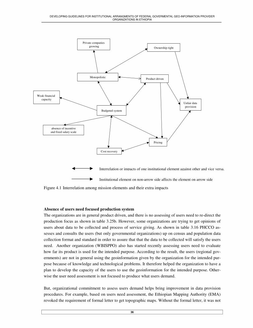
DEVELOPING GUIDELINES FOR INSTITUTIONAL ARRANGMENTS OF FEDERAL GOVERMENTAL GEO-INFORMATION PROVIDER ORGANIZATIONS IN ETHIOPIA
36
Figure 4.1 Interrelation among mission elements and their extra impacts Absence of users need focused production system The organizations are in general product driven, and there is no assessing of users need to re-direct the production focus as shown in table 3.25b. However, some organizations are trying to get opinions of users about data to be collected and process of service giving. As shown in table 3.16 PHCCO as-sesses and consults the users (but only governmental organizations) up on census and population data collection format and standard in order to assure that that the data to be collected will satisfy the users need. Another organization (WBISPPO) also has started recently assessing users need to evaluate how far its product is used for the intended purpose. According to the result, the users (regional gov-ernments) are not in general using the geoinformation given by the organization for the intended pur-pose because of knowledge and technological problems. It therefore helped the organization to have a plan to develop the capacity of the users to use the geoinformation for the intended purpose. Other-wise the user need assessment is not focused to produce what users demand. But, organizational commitment to assess users demand helps bring improvement in data provision procedures. For example, based on users need assessment, the Ethiopian Mapping Authority (EMA) revoked the requirement of formal letter to get topographic maps. Without the formal letter, it was not
Budgeted system
Product driven
Pricing
Unfair data provision
Monopolistic
Private companiesgrowing
Weak financial capacity
absence of incentiveand fixed salary scale
Ownership right
Cost recovery
Interrelation or impacts of one institutional element against other and vice versa.
Institutional element on non-arrow side affects the element on arrow side

DEVELOPING GUIDELINES FOR INSTITUTIONAL ARRANGMENTS OF FEDERAL GOVERMENTAL GEO-INFORMATION PROVIDER ORGANIZATIONS IN ETHIOPIA
37
possible to get the foundation data. Such formality was, therefore, contradicting with the basic princi-ple and purpose of producing foundation data, which, like Groot and Laughlin (2000) arguing is needed by every body. However, as still such formality is required by many organizations, it is diffi-cult to access the data owned by the public organizations. (In detail will be discussed later). Although users need assessment is very important, it is undermined because of the following reasons: 1) users are few and known, where mostly users of government organizations products are other gov-ernment organizations (see table 3.17); 2) budgeted financial system, see table 3.2, which limits the organizations financial capacity not to be flexible with need of users; 3) monopolistic power see table 3.2, under which assessing of users need is almost useless. All in all, as the organizations are product driven, they focus on maximizing of products according to their annual work plan, and providing for users up on demand However, being product driven organizations, they are not enabling to identify which product is highly needed by the society and given more emphasis. Hence they have problems in mobilizing the available financial and human resources to produce demanded data as much as possible than dividing these limited capacity sources to produce less demanded data now. Rigidity of civil servant salary scale Salary structure of staffs for all surveyed GI organizations is rigid, and salary scale for work posts is fixed by the federal government, see table 3.3. But fixing scale of the salary has weakened human re-source management within the organizations as shown below: 1) As table 3.3 shows the number of GI experts is decreasing in the organizations. These experts are easily absorbed by informally and in disorganized manner growing private computer and GIS sectors. It should be noted this problem is occurring on top of already existing manpower shortage problem in the organizations. 2) The organizations are not able to recruit new experts from the market by negotiation on salary for the vacant posts. Moreover, as qualification level and service years are largely considered to fix salary scale for posts, the situation has been more worsened. The value given for profession type is very less; all profes-sions, which are easily available and not easily available on market, have equal value. Rigidity of financial resources The organizations financial resource is limited to government annual budget see table 3.2; and the activities are also limited as to the amount of budget allocated for each year. The activities also should be planed to be accomplished in a year time; even the long time activates should be breakdown to fit to the budget of each year. Under such rigid financial situation, therefore, it is very difficult or impos-sible to function according to users need, and provide diversified products. Even if the organizations want to assess users need and act accordingly, like to respond just-in-time, they easily face financial problems; it is because such activity is not included in the annual work plan earlier. In general, rigid financial resources system does not allow the organizations to be dynamic in producing and providing of geoinformation. Moreover budgeted financial resources policy enforces the organizations to return the revenue to the government treasure. When the whole allowed budget is not allocated under some circumstances, the organizations are allowed to cover the deficit from revenue obtained by selling the products. But if the

DEVELOPING GUIDELINES FOR INSTITUTIONAL ARRANGMENTS OF FEDERAL GOVERMENTAL GEO-INFORMATION PROVIDER ORGANIZATIONS IN ETHIOPIA
38
revenue exceeds the allowed budget, it should be transferred to the government treasure. It is not al-lowed using such money for incentive and award for staffs, despite giving incentive and awards help encourage the staffs to be creative and perform well. In general, it is not easy to give incentive or any award for staffs at the time of the organizations able to produce more or generated immense revenue. Outdatedness of ‘rights of ownership preserved’ Ownership right of public organizations on geospatial data is in conflict with the new approach of GII development principle. According to the proclamation/mission, each organization has ownership right on data they produce see table 3.2. However, the new thinking to promote GDI is against ownership right the organizations. It rather strongly emphasis that the public organizations are not ownership of the data, but custodian of the data. The ownership right on the data has given the organizations full right to determine how they can distribute the data for users (Later its impact will be discussed in de-tail). Outdatedness of ‘organizations power and duty’ The organizations have given legal mandate and power that lead them to monopolistic power whereby they are sole producer and provider of geoinformation (monopolistic); and controlling geoinformation usage, see table 3.2. Monopolist power of the organizations paralysed the role of private companies in promoting GII development. Private companies have not major roles in helping the government or-ganizations to accomplish their functions and responsibilities when they are not able to do it by them selves; and in producing and providing of geoinformation products, particularly products that users demand. As a result there is problems of geoinformation availability in the country on the one hand; and no competition among organizations to increase the efficiency on the other.
4.3.1. Cultural problem in organizations
As traditional organizations, there are cultural problems in the organizations. These cultural problems are mainly emerged from the proclamation. These cultural problems are realized and observed during field work: Resistance to new technology Mostly employees are not enthusiastic to work with the new technology, rather resistance to it. During fieldwork, resistance of employees to the GI technology has been assessed indirectly. Whether the new technology has been integrated with the main production system, or not. Largely the new tech-nology has not been yet integrated with the main production system. The employees mostly opt to work with the existing technology/analogue method, and would like to provide analogy data than digi-tal data, see table 3.8. The management of the organizations are also opting to support and develop the existing analogue method than the new one. But there is demand for digital data from users. Plus it is crucial in development of GII. Resistance to the new technology and opting to work with analogue method is emerging from threat to lose importance within the organization or job in worst case as a result of new technology implementation in the organizations. It is therefore a bottleneck to use effec-tively GI technology within the organizations; and integrate it with the main production system.

DEVELOPING GUIDELINES FOR INSTITUTIONAL ARRANGMENTS OF FEDERAL GOVERMENTAL GEO-INFORMATION PROVIDER ORGANIZATIONS IN ETHIOPIA
39
Hierarchical organizational structure system The organizations are structured being vertically hierarchical (see table 3.25a); which has resulted in bureaucratic system in the organizations. This organizational bureaucratic system can go, some how, parallel with one of the four Hofstede (1997) organizational culture dimensions, which is called power difference. During the fieldwork the researcher him self realized that the respondents had to get order from top management in order to give information and make interview. This is typical character of organizations what Radwan Sani & Morales (1999) called structure based management system. The employees largely need top management order to accomplish organizational tasks. This situation hampers the ability of employees to know what his/her responsibility is than waiting for top-decision. It is the management people that are largely responsible for effectiveness or accomplishing of organ-izational tasks. Role of the majority staffs in achieving organizational mission is very low. As a result any information, which could be innovation, new technology, new standard, etc is less valued by the staffs. It is because the staffs do not use such information to improve or bring any change in the or-ganizations functions or performances. These staffs are, therefore, as Etzioni (1968) identified pas-sive. Transparency and accountability within the organizations is not developed culture. Most of the tech-nicians and professionals are not aware of the organizations mission, strategy and annual working plan. Discussing among the whole staffs of the organizations about the function and performance of the organization is yet to develop. The staffs in the organizations are always doing the work they are given by top management. The ability and initiation of the staffs to create work is very low. On the other there is no clearly inscribed rules or regulation that the employees would be held accountable when they fail to accomplish their responsibilities. But according to modern geoinformation era think-ing, GII development can be better realized under transparent and accountable organizational system. Absence of training and research strategic plan Almost all the surveyed organizations have not strategic plan or culture to give training for employees on regular base on the one hand; and to support research on GI technology on the other. As it is shown in table 3.4, ten organizations have no any strategic plan to train their employees in regular bases. The training and educations programs are largely base on ad hoc manner. The employees get the training or education when there is on job training at times, financial aid for training and free scholarship. These ad hoc trainings are also focused mostly on technical aspects of geoinformation. Giving training on management aspect does not exist; despite it is more crucial than technical aspect in effectiveness of the organizations function and development of geoinformation infrastructure. Simi-larly encouraging, allocating resources and personnel for research and development in GI technology is not common in most organizations. Only one organization (WBISPPO) but not on regular base, is conducting research and development in GI technology. But research and training has enabled WBI-SPPO to develop appropriate methodology or technique to accomplish the organization task with out difficulties.
4.3.2. Cost recovery strategy in Ethiopia
Cost recovery practise in Ethiopia The federal government of Ethiopia has started changing of budgeted organizations in to cost recovery system. So far government organizations, which are involved in provision of utilities (for example

DEVELOPING GUIDELINES FOR INSTITUTIONAL ARRANGMENTS OF FEDERAL GOVERMENTAL GEO-INFORMATION PROVIDER ORGANIZATIONS IN ETHIOPIA
40
Ethiopian Telecommunication Authority, Ethiopian Electric and power authority, etc); and organiza-tions involved in financial activities like, Commercial Bank of Ethiopia (CBE), have been changed to cost recovery system. Although they are in cost recovery system, all, except CBE, are still owned those activities by monopoly. And private companies were not emerged to engage in provision of the same services. Hence, the effectiveness and competitiveness of the organizations with private compa-nies in free market is not yet tested practise in the country. Just recently however, new policy put in place to allow private companies involve in the activities monopolized by those organizations, but only to a limited extent. Nevertheless as it is new or early stage, some time is needed to realize its successfulness. Cost recovery system for GI organizations. The organizations involved in provision of geoinformation have no any strategic plan to be cost re-covery in the coming 10 years as shown in table 3.2. As realized from interview with the respondents also, there is no any government strategy to implement cost recovery system in GI organizations. This is because of that impacts of budgeted system on function of GI organizations and geoinformation provision are not very well known by the organizations and government as well. Hence absence of awareness plus good practise in cost recovery system will make the process of changing budgeted GI governmental organizations to cost recovery system to take long time. But as it will be discussed be-low and practically seen in country, the budgeted system is affecting the competence of the organiza-tions in providing what users demand, and even in accomplishing the tasks they are established for; and eventually the development of GII.
4.4. GI technology in the organizations
4.4.1. GI technology adoption by the organizations
Most of the organizations have adopted the technology through donation or project. As shown in table 3.5a, five organizations have got the GI technology through project and donation, and three organiza-tions have bought by government budget. But driving force in all cases to adopt the technology is lay-ing entirely on maximizing the organizations products; but not in increasing of the organizations reve-nue, see table 3.5b. Moreover, the initial idea to adopt the technology has come from donors or com-panies carry out projects. Types of the GI platforms or systems (soft ware and hard ware) also mostly identified and determined by them or from their interest side. The role of the organizations in identify-ing based on users need assessment and negotiating with donors about type of technology to be adopted is low or does not exist. The only organizations some how succeeded in identifying and nego-tiating with donors is EMA. Even then however, the negotiation was not intended to adopt the tech-nology that users need. But, it helped to get a new technology that is compatible with or a new version of already existing system. Generally, the method how GI technology adopted is the same as with findings of (Reeve and Petch, 1999), which is by technology-push.
4.4.2. Problems for effectiveness and sustainability of GI technology
The organizations in general have problems in using effectively and sustaining the GI technology. As shown in table 3.6 only one organization responded that it has no any difficulties. It is because the organization gets technical support, works with consultants, regularly provides on job training, and

DEVELOPING GUIDELINES FOR INSTITUTIONAL ARRANGMENTS OF FEDERAL GOVERMENTAL GEO-INFORMATION PROVIDER ORGANIZATIONS IN ETHIOPIA
41
carries out research on GI technology. Problems that are accounted for not using effectively and sus-taining the GI technology are emerged from the following reasons:
Trained manpower and technology. The manpower problem is highly associated with fixed salary structure of the organizations whereby number of trained people decreases from the or-ganizations through time; and absence of organizations strategy to train and educate the staffs in regular base, see table 3.4. Technological problems in the organizations are associated with obtaining of up to date GI technology or regularly maintaining it; and absence of technical support whenever there is problems with the system. The technology has not yet fully integrated with the main production system. As the technolo-gies are adopted by external push on the one hand, and staffs are resistance for the new tech-nology on the other, there is difficulty in integrating of the technology with the main produc-tion system. During the filed work it was identified that, some experts who trained on GIS and Remote sensing technology are some how working on the new technology, but facing resis-tance from staffs including the management. Such resistance reaches to the extent not to have any strategy on what GI technology is adopted and how the technology is integrated with the main production system. As a result, in most organizations the two systems: analogue and digi-tal systems are executed in parallel, while the later can do what the first can do in more effec-tive and efficient way; but more emphasis is still given for the analogy one. Absence of assessing impacts of GI technology on function of the organization. As inventory is not conducted by the organizations to identify the GI technology impacts, a decision could not be reached to use the technology at full scale and regularly maintain it. Moreover, as the organizations are product driven, first and most, its impacts on increasing of organizational revenue is undermined (see table 3.5b). Secondly, even though they are aiming at maximizing of the productions, they are not able to conduct inventory to quantify how far the production has been increased after adoption of the technology. In general, as the organizations are not clear with the impact of the new technology, they do not have any strategy how to effectively use and regularly maintain it. Lacking of commitment to pursue with the technology after the donation stops or the project is over. The GI technology that has been adopted through donation and project gets lack of such commitment. For example the LUS-MA adopted GIS technology in 1985 through a project and donation to prepare land use plan for the country, but the organization was not pursue working with the technology after the project/donation was over. Such same problem has been experi-enced by NUPI. It was not enabled to continue working with the GI technology after the master plan preparation for Addis Ababa city project was over. Budgeted financial system. It is not, however, usually occurring main and major problem for many organizations. Because the organizations are always getting prepared for it at the begin-ning of the fiscal year. Nevertheless, it seldom becomes a problem when system maintenance cost gets very expensive unexpectedly at some point in the fiscal year. Then under the budg-eted system, it is impossible or very difficult to get extra fund to maintain the system. Hence maintaining of the system would delay until the coming fiscal year.

DEVELOPING GUIDELINES FOR INSTITUTIONAL ARRANGMENTS OF FEDERAL GOVERMENTAL GEO-INFORMATION PROVIDER ORGANIZATIONS IN ETHIOPIA
42
4.5. Geospatial data administration
Geospatial data administration issue is a vast and an essential issue in development of GII in the coun-try. It is dealing with standardization, data liability and up-to-datedness, and data sharing/provision issues
4.5.1. Geospatial data standard
Geospatial data standard is used here in a very generic way to include problems with data standard, exchangeable format standard and database standard. Data standard problem The organizations have problems with properly developing, adopting and using of data standards. In table 3.9 indicated that six organizations have standard and four not. These standards are either di-rectly adopted from international standards (like standards in LUS-MA, NMSA) or developed at home (like in EMA, NUPI, WBISPPO, PHCC). The standards, however, are not properly used. These stan-dards strongly associated with analogue data concept. In other word, the way data standard concept understood and used by organizations is more of similar with what Woldai (2002) emphasised. The standard is focused on how to present geographic features on paper map like colour, size, shape etc of geographical features as well as marginal information; it does not include content of data and parame-ters of projection system. In most cases such standards are not documented and known by every body to control quality of the products. It is only in EMA, well prepared and documented standard manual is available. Different sections in the organization are therefore aware of the manual and applying it to insure the quality of products. The existing standard for analogue data is in conflict with standard for digital data. Nowadays, the organizations have been adopting digital technology, but not yet developed standard suitable for the digital data. Some organizations are using the analogue data standard concept for digital data stan-dard. But digital data standard is more than that, it needs data quality and projection/reference system standard. Otherwise, it is impossible to integrate data from different sources, and overlay different geographical features. During interview, no organization is found being concerned about digital data reference system. The reference system is rather largely understood as UTM or lat/long coordinate only. The rest projection elements like spheroid, datum, and other projection elements are neglected. Moreover, some organizations are always driven by software default reference system. Currently, absence of standard at national level (or organizational level) and enforcement to use it is causing a challenge to integrate data produced by different sources. Since such standard is not avail-able, data are collected and classified the way individuals design it; which actually vary from individ-ual to individual. For example, the MWR, which does not have standard to collect and classify data, has carried out four major river basins master plan studies by different foreign consultants. As the consultants used different methods and standards to collect and classify the data, now it becomes im-possible to integrate these data, even though they are adjacent to each other geographically. For more explanation, see M.Sc. thesis by Mr. Wubeshet Demeke, 2003, at ITC, The Netherlands. As a result,

DEVELOPING GUIDELINES FOR INSTITUTIONAL ARRANGMENTS OF FEDERAL GOVERMENTAL GEO-INFORMATION PROVIDER ORGANIZATIONS IN ETHIOPIA
43
despite the organization is frequently demanded by users to provide data that include two or more river basins in integrated form, it is not possible to respond for the demand. Absence of data exchangeable format standard Standard for exchanging digital data is not largely known by users or organizations. As shown in table 3.9 most organizations do not have any common standard to exchange digital files. But the organiza-tions are facing problems during exchanging digital data. The problems are on the one hand the or-ganizations/users are loosing data while transferring the digital data from one system to another; and on the other as the data are mostly transferred after separated into spatial and attribute data, the users need to re-do joining of the spatial and attribute data, though it leads to errors. The importance of data exchangeable format standard is also magnified when the users/organizations need an intermediate system to convert from one system to another; in case of the two systems are not compatible. To miti-gate these problems, one organization (WPISPPO) already adopted de facto standard DXF just to pro-vide for users with uniform standard; and the other organization (GSE) is trying to develop its own standard. Absence of database standard Some organizations are trying to develop database for their own organizations in isolation from other organizations database schema. As shown in table 3.10, one organization (WBISPPO) already devel-oped its own database; other two organizations (GSE & EPA) are in progress to develop their own database. However, as shown in table 3.22 and confirmed by respondents during interview, there is no information exchange about database schema between any GI organizations. Similarly between these three organizations there is no any information exchange about database schema compatibility while they develop the database, even though the later organizations are users of the first organization prod-ucts. Moreover, it seems that this trend will continue with other organization as well; it, therefore, will results in incompatibility of databases schema which leads to duplication of efforts; even in worst case impossible to integrate the data obtained from different database sources.
4.5.2. Data sharing problems
Data sharing is very complicated and difficult task. Problems that are accounted for data sharing are lack of data accessibility from public organizations, lack of advertising organizational products, ab-sence of digital data provision data and its unavailability, and organizational ownership right on data. Lack of data accessibility from public organizations Accessing and obtaining of data from public organizations is restricted by unnecessary formalities. As shown in table 3.11 all geoinformation provider organizations responded that their data is accessible and obtained by users. But the process how the data is accessible and obtained from the organizations is very complicated by formalities. One can have access and get the data from the public organizations if he/she can present letter from other organizations, preferably government organizations. Otherwise, except some products, which can be available in governmental organizations library, it is not possible to get the data. Moreover, this problem is largely complicated when users need data from organiza-tions, which give the products free, for example MWR & WBISPPO. (Reasons for provision of data for free will be discussed later). Such free provision of data, however, does not include private com-panies. It is because the organizations have doubt that private companies can use the data for com-

DEVELOPING GUIDELINES FOR INSTITUTIONAL ARRANGMENTS OF FEDERAL GOVERMENTAL GEO-INFORMATION PROVIDER ORGANIZATIONS IN ETHIOPIA
44
mercial purpose. Individuals and researchers are also face the same problem if they cannot present formal letter from other organizations. In true sense, data accessibility and obtaining from public or-ganizations is very difficult and is not fair for all citizens of the country. This situation is therefore leading the private companies and individuals to create data by themselves while it is already avail-able in government organizations. As a result, effort and resource duplication is occurring in the coun-try. Lack of advertising organizational products It is very challenging task to know what products is available in other organizations and share it since there is no method to advertise products. As shown in table 3.12, all organizations are not regularly advertising their new or updated products. They may advertise products when they get opportunity like workshop, seminar or randomly published broachers. It is particularly becoming immense prob-lem for users living in far areas of the country. Like Wolda (2002) pointed out these users need to travel to or call the office to know currently available or updated products, it is however difficult and expensive task. Moreover, as shown in table 3.13, lack of knowing available data in other organiza-tions is resulting in resource and effort duplication. Absence of digital data provision data and its unavailability Sharing of digital data among the GI organizations or users is not common practise; despite there is demand for digital data provision. As shown in table 3.8 most organizations give analogue data than digital data. During interview with respondents, two possible reasons have been identified for provi-sion of only analogue data: first digital data is not available in plenty; and second the organizations are not ready and willing to give digital data. For example, population data is available in digital for-mat within PHCC, but for users this digital data is not given; only the print out is given. Similarly, only print out of topographic maps is provided for users by EMA. Although, an effort has been made to identify tangible and convincing reasons why digital data is not given, it was not possible to get exclusive reasons. The respondents however identified with hesitation and doubt that it might be there is no government policy to provide digital data; and it is not yet widely practised phenomenon. Never-theless, to satisfy need of digital data, individuals and different companies are involved in creating of digital data from analogy source in ad hoc manner. As a result, quality of these digital data is un-known; and same type of data can be produced by different people or companies to result in redun-dancy of resources and efforts. Organizational ownership right on data As indicated in table in table 3.2, the organizations have ownership right on their products; as a result sharing of digital data is hampered by this right. Digital data created by organization other than the creator of the original analogue data cannot be shared among users easily. It is because the creator organizations have the mandate to stop such sharing or exchanging of the data; even in some cases to stop digitising the analogue maps. Exchange of such digital data is in fact needed when it is not avail-able in the creator organization. But to overcome the challenge of the creator, some organizations are sharing the digital data informally; or create digital data by themselves. This situation is therefore leading to effort and resource duplication.

DEVELOPING GUIDELINES FOR INSTITUTIONAL ARRANGMENTS OF FEDERAL GOVERMENTAL GEO-INFORMATION PROVIDER ORGANIZATIONS IN ETHIOPIA
45
4.5.3. Data up-to-datedness and liability problem
Many organizations either create digital data or collect primary data from filed, but only few organiza-tions update the data. Lack of keeping the products up-to-date is laying largely on organizational ca-pacity problem, besides absence of obligation to provide up-to-date data. In table 3.7 shown that six organizations create data but only three organizations up date the data. Of these three organizations, PHCCO updates the population data in every 10 years by law; NMSA is update every time as it is the weather information; and LUS-MA updates regularly based on conditions on the ground. Why LUS-MA is updating the data regularly goes to its mission. One of its establishment missions is to provide up-to-date land use information for the government in order to take immediate action to protect the soil. The rest organizations including producer of the foundation data (EMA) are not regularly updat-ing their products. Foundation data, however, like 1:250;000 scale topographic maps of areas that are highly vulnerable for change have been updated. But updating of the rest topographic maps at scale of 1:25000 and 1:50000 was not continued, despite most of them are out dated. In general, mostly avail-able data within different organizations are not up to date. Most organizations have not developed method to insure the liability of the data, particularly digital data they get and produce as well as provide. Only organizations like EMA & WBISPPO have qual-ity/standard controlling guidelines to insure standard and correctness of analogue data, see table 3.23a. But after the introduction of digital technology, all organizations are equally challenged in in-suring of the quality and correctness of digital data they obtain from different sources and provide. When checking correctness or quality of data is needed it is usually done using visual technique on computer screen by overlaying one dataset over the other; it is however not enabled to identify the correctness of datasets properly and accurately. As a result insuring the quality of data is a problem for GI organizations in Ethiopia. Nevertheless, as shown in table 3.16 the organizations are not held accountable for any errors in data they provide. As a result the organizations are not opting to insure the up-to-datedness and liability data they provide. Lack of accountability also results in communication gap between producers and users not to get feed back about the correctness and up-to-datedness of products. Only EMA infor-mally gets some users complaint that the topographic maps are out dated and misleading. Otherwise, the organizations are not accountable for data they provide for users.
4.5.4. Absence of geoinformation centre within GI organizations
Geoinformation is poorly administered in organizations where geoinformation centre has not been established in structure of the organizations than it does. As shown in table 3.14, two organizations do not have the centre while two are in progress to establish it. As there is no responsible centre for geoinformation activities within GSE, different sections of the organizations digitise the same map and produce it in different ways. For example Geological and Mineral map of Ethiopia at scale of 1:2,000,000 digitised by different sections and printed in different ways. On the other hand, however, after the establishment of geoinformation centre within EPA, purchasing of GI technology and devel-opment of database has been started. Moreover, different efforts like exchanging of information, de-veloping standards, etc are initiated primarily by such centre. On the whole, the establishment of re-sponsible centre for geoinformation in the organization helps to coordinate and lead the efforts of bet-

DEVELOPING GUIDELINES FOR INSTITUTIONAL ARRANGMENTS OF FEDERAL GOVERMENTAL GEO-INFORMATION PROVIDER ORGANIZATIONS IN ETHIOPIA
46
ter data administration, to avoid redundancy in effort and resource, and to promote GI technology within organizations
4.6. Pricing for geoinformation products
The organizations have problems in determining of appropriate price for geoinformation products. At a national level, there is no data pricing policy to determine prices for geoinformation products. As shown in table 3.18 most of the organizations do not have any pricing methods or standards for their products. Problems for determining of pricing for geoinformation and its impacts are discussed as fol-lows: Problems in determining of price for geoinformation Determining of price for geoinformation products is suffering with problems such as budgeted system and related issues. These problems are categorized into four types: The first problem first and most goes in line with what Molen (2001) arguing on influence of budgeted policy to calculate true cost and establish pricing policy based on true costs. Under budgeted system, it is quit difficult or impos-sible to identify costs involved to produce the geoinformation. There are indirect costs like support from other organizations or other departments within the same organizations during the production process. Plus, the costs are calculated in aggregated way for the whole organizational activities, not in detail and specific way for each activities and tasks. Secondly, the revenue generated by the organiza-tion has not used to increase the financial capacity of the organizations, so the organizations are dis-couraged to determine appropriate price for geoinformation products. The second problem goes to getting of some materials free like, ink, printing papers, computers, etc. In most cases the price of these materials are not unknown. And the organizations are not tending to determine price for materials obtained free. The third problem goes to absence of organizations mandate to sell it products. As shown in table 3.19, some organizations are providing their products free. These organizations are not allowed to determine price and sell their geospatial data for users like other budgeted government organizations do. From interview with the respondents, it was identified that the organizations missions, particularly financial rule of the organizations forbids to sell the products as long as the they are meant purely ser-vice giving organizations. Pricing trend in these organizations, therefore, by one step behind from other organizations that have the experience of selling products after fixing price in some way. The fourth problem goes to that the organizations are not ready and well ware of the importance of determining price for geoinformation. As it was realized during field, the organizations have wrong perception about pricing of geoinformation. They largely associate fixing appropriate price for geoin-formation products with making of profit; which is, actually, against mission of the organizations. Impacts of absence of price for geoinformation products Absence of pricing for geoinformation products has impacts on dissemination and provision of geoin-formation products. As shown in table 3.17, as a result of lacking appropriate data pricing policy there is unfair data provision and distribution. Products of government organizations are provided mostly for other government organizations; but not for individuals and private companies. In worst cases, as already mentioned, private companies are not given any data from some government organizations. Absence of price affects the data provision because of two reasons: 1) most of the data are provided

DEVELOPING GUIDELINES FOR INSTITUTIONAL ARRANGMENTS OF FEDERAL GOVERMENTAL GEO-INFORMATION PROVIDER ORGANIZATIONS IN ETHIOPIA
47
with price that is far less than the appropriate price; and 2) some data are given free of price by some organizations. Hence government organizations are not fully willing to provide data for private for they worry these companies may use the data for commercial use; and consequently the right of all citizens of the country to access and get data from public organizations is violated. Absence of price standard for geoinformation products has resulted heterogeneous pricing system among government organizations. As shown in table 3.18, among the surveyed eleven organizations, only three organizations have pricing policy. Of these three organizations, the price of one organiza-tion (NMSA) is high (despite high price means ambiguous). As a result, other user organizations are complaining about the price, specially the organizations that giving their product free. These organiza-tions are not willing or ready to buy data from that organization with relatively high price. Neverthe-less, NMSA emphatically expresses that the price demanded for the products is far less than what it should cost. The concern is, therefore, if each organization is determining the price alone and as it wants, there would be a possibility the price of data would be very high, even to the extent not afford-able. It will, in turn, adversely affect sharing of data and then development of GII in the country.
4.7. Coordination of GI organizations
4.7.1. Need of coordinating the GI organizations
In Ethiopia, as there is no GI organizations coordination, problems are encountered during geospatial data administrations. Similarly, it is not possible to formulate policy for geoinformation, exchange information about available data, database structure, standard, etc with other organization; and pro-mote of GII in the country. Generally, the need of coordinating the GI organizations is emphasised by the following facts: Coordinating the GI organizations is largely needed to avoid effort and resource duplication. As aforementioned, there is no well-established product advertising method and data sharing is not easy; as a result effort and resource are duplicated within the organizations (see tables under chapter 3.9, particularly table 3.13). Similarly, database schemas and file exchangeable standards are developed in isolation. Mitigating of this problem is therefore largely rest on coordinating of the organizations so that they exchange information and develop common standard to share data, consequently avoid re-dundancy. The countries political administration system (decentralization system) is demanding the vertical co-ordination of GI organizations. As shown in table 3.25a some of the federal GI organizations are de-centralized into regions. As the organizations at each regional level are accountable to the administra-tion council thereof, there is no coordination/communication with similar organizations at federal level, or in other regions. As a result the federal organizations have no any information what standard and method are used by the regional organizations to collect and classify data to insure compatibility or integration between data collected by different regions in the country. During the fieldwork, it was realized that all the federal organizations communicate with regional organizations only when there is technical support demand from regional organizations. Otherwise the federal organizations have no any mandate or voluntarily base coordination to enforce and lead the regional organizations to use the same standard during data collection, classification and database design. In general, to apply uniform

DEVELOPING GUIDELINES FOR INSTITUTIONAL ARRANGMENTS OF FEDERAL GOVERMENTAL GEO-INFORMATION PROVIDER ORGANIZATIONS IN ETHIOPIA
48
way of data collection and classification method in the country, the decentralization system needs co-ordination of the organizations. Coordination among the organizations is needed to avoid power gap between the organizations, and insure availability of geoinformation products. As a result of decentralization in some cases it is not clear which organization has what mandate and responsibility in producing geoinformation. For ex-ample, current tourist map of Ethiopia is not available in the country because of power gap between the federal organization (ETC) and the concerned regional bureaus. As realized during the filed work, the ETC is not ready to tackle this problem unless government policy is put in place to this regard. The federal organizations in general are not in apposition to lead or mobilize the regional organiza-tions to produce geoinformation thereof, and eventually compile them to insure the availability of geoinformation at the national level.
4.7.2. How the GI organizations were coordinated in Ethiopia and its benefit.
The way GI organizations were coordinated is in a voluntarily base to develop metadata base for the country, see table 3.21. And one organization, MWR, has got responsibility by accident to lead the coordination. It is because an organization, which originally initiated the idea of Meta-Database crea-tion and designed the project for that, was dissolved in to three organizations. Among these, one is MWR; and the MWR was also where most of the natural resource and environmental information were found. Largely as a result of this, it has taken the leading task to coordinate the organizations on voluntarily base in order to create Ethiopian Natural Resource and Environmental Meta-Database (ENRAMED) for the country. Organizations that are participated in the coordination are governmental organizations. Selection of the organizations was done based on relevance of the organizations in producing of natural resource and environmental geoinformation. But from interview it was realized that an attempt was not made to include the same organizations functioning at regional level, except two. It is because the leading or-ganization planed to start the coordination with small number of organizations, and gradually increase number of the organizations in order to avoid possibly emerging coordination and management prob-lems. The selected organizations are also voluntarily accepted the request from the leading organiza-tions and joined the coordination. The coordination has been benefited the country and the organizations. It enables the country to have Meta-database system (ENRAMED) on the one hand; and member organizations to have Meta-database software to create metadata for their data and to get training for staffs on how to use the soft-ware on the other. As a result, these organizations are in apposition to have metadata standard, and metadata for limited data within the organizations, see table 3.10. Above all, the experience of coor-dinating the organizations and its shortcomings will be a good base for any organizational coordina-tion that will take place in future times

DEVELOPING GUIDELINES FOR INSTITUTIONAL ARRANGMENTS OF FEDERAL GOVERMENTAL GEO-INFORMATION PROVIDER ORGANIZATIONS IN ETHIOPIA
49
4.7.3. Barrier to coordinate GI organizations
Barriers in coordinating of GI organizations and sustaining of the coordination are largely emerged from absence of organizational mandate to lead the coordination, when coordination is led by uni-sectoral organization, and Lack of creating new job description. Absence of organizational mandate to lead the coordination As the existing coordination (which has objective of creating Meta-Database) was established purely on voluntary base, without any legal binding, the leading organization (MWR) has faced challenge of mandate to coordinate, see table 3.21. Because of this, MWR has not enabled to coordinate and mobi-lize the organizations one the one hand, and member organizations were not committed for the suc-cessfulness of the objectives of the coordination on the other. For example, Ministry of Agriculture was quit from the coordination very early. In addition, after first component of the project is over, which was creating of the metadata database soft ware and providing for the organizations, it is not possible for MWR to check and monitor and enforce the member organizations to use the software to create metadata for data in the organizations. Absence of mandate in general blocked the leading or-ganization to sustain the current coordination, expand the coordination by including other organiza-tions, and most importantly to keep the meta-database up to date and fully used by users. When coordination is led by uni-sectoral organization As the coordination is led by uni-sectoral organization, its sustainability is challenged. The current hosting and coordination leading organization (MWR) is in charge of uni-sectoral activities like river basins or water policy issue in the country, see table 3.1. As a result, member organizations have a complaint that the ministry is inclining the meta-database to focus more on water issue; and is giving less attention to the interest of other organizations. For example, the GSE has strong compliant that its interest is not given due consideration. Despite it has bibliographical standard and requested this stan-dard to be included or integrated with the metadata base, it was not included or integrated. Generally sustaining of the existing coordination around Meta-Database or to coordinate organizations to work together is highly affected when leading organization is uni-sectoral. Lack of creating new job description Organizations could not create a new job description that is responsible and accountable for executing of commitment and agreement reached with other organizations through coordination. For govern-ment organizations, to create anew job description within the organizations it is up to the federal gov-ernment (see table 3.25b). So the organizations have difficulties to create new job description by themselves whenever necessary. Moreover, the process of creating such job-description is not an easy to task, and usually it takes quit long time. Currently absence of such job-description within organiza-tions is accounted for failing of creating metadata for the data. For example, the organizations partici-pated in Meta-Data base creation have reached an agreement or commitment to create metadata for data they have within their organizations. But as there is no job-description like Metadata processing, they are not able to create metadata for the data. Generally, unless each organization is able to create a job description whenever necessary, it will be difficult for them to be coordinated with other organiza-tions and accomplish objectives of the coordination.

DEVELOPING GUIDELINES FOR INSTITUTIONAL ARRANGMENTS OF FEDERAL GOVERMENTAL GEO-INFORMATION PROVIDER ORGANIZATIONS IN ETHIOPIA
50
4.8. Outsourcing of GI activities
4.8.1. When organizations need to outsource
The organizations need to outsource activities since they are not able to do by themselves because of capacity problems. As shown in table 3.7, 3.8 and 3.15 the data coverage in organizations are not fully satisfactory; or most of the data are still in analogue format and not up-to-date. Hence, outsourcing of activities is needed to provide up-to-date data and data demanded by users just in time, accomplish organizational function and responsibilities, and insure availability of full coverage geoinformation products.
4.8.2. Barrier to outsource GI activities
Barriers in outsourcing of GI activities is largely immerged from absence of quality controlling man-ual, lack of organizational commitment to outsource activities, and lack of professionally licensing private companies. Absence of quality controlling manual Lacking quality controlling manual is hampering the outsourcing of GI activities for private compa-nies. Mostly government organizations would like to provide outsourced activities only for other gov-ernment organizations than for private companies, see table 3. 23b. Traditionally, the government or-ganizations are comfortable with quality of data produced by other government organizations. Popular organization in doing outsourced activity is EMA. But EMA is not enabling to do outsourced activi-ties for others organizations besides its own activities because of capacity problems. Hence, for timely provision of products, particularly up to date data, allowing other companies, particularly private companies, to execute those activities is very essential. However, a long time trend of providing out-sourced activities for other governmental organizations has discouraged the emerging of private com-panies. And even already established private companies (for example Information Systems Services, ISS) hardly get activities from government organizations because of that trend. The trend is persist because of one the hand the government organizations have doubt with the quality of geoinformation produced by private companies; and on the other there is no quality controlling manual to check qual-ity of geoinformation products. Lack of organizational commitment to outsource GI activities The government organizations in general are not committed to accomplish their responsibility by out-sourcing activities that are not done by the organizations, see table 3.23a. It is however largely emerg-ing form being monopolistic, and not held accountable when failing to provide data for users. As shown in table 3.6, the organizations have difficulties in capacities like human resource and technol-ogy to accomplish the responsibilities or make available of full data coverage. Moreover, currently the users are demanding the organizations for different products than before (for example digital data). To compact such problems, the organizations can outsource the activities. But as the organizations want to keep the activities undone until they have got the capacities to do by them selves, the activities re-main not outsourced. For example, earlier times some governmental organizations were giving ready-for-print products to EMA to be printed according to the standard. But now, the organizations have abandoned doing that because they want to print it within the organizations after buying equipments, like plotter. Similarly, organizations that are rarely engaged in digitising and printing activities, want
DEVELOPING GUIDELINES FOR INSTITUTIONAL ARRANGMENTS OF FEDERAL GOVERMENTAL GEO-INFORMATION PROVIDER ORGANIZATIONS IN ETHIOPIA
51
to buy digitiser and plotter to do it by them selves than outsourcing. Hence the organizations are buy-ing and accumulating equipments that they are not frequently using, while they do not have qualified experts to work with the equipments and capacity to maintain them regularly. Generally lack of organ-izational commitment to outsource activities has resulted first the organizations are not able to provide required data for users; second resource redundancy (plotter, digitiser); and third private companies are not emerging. Lack of professionally licensing private companies The private companies usually get work permit from Trade Office to involve in geoinformation activi-ties, but not professional licence. As realized during field interview, there is no governmental body that professionally licensing the private companies. Private companies capacity (technological and manpower) is not checked to insure their ability and liability to execute outsourced activities. Lack of licensing private companies professionally, together with absence of quality controlling manual, has resulted that the government organizations have doubt in professional qualification of private compa-nies. Hence, the government organizations are not very comfortable to provide outsourced activities for private companies.
4.8.3. Factors to facilitate outsourcing of GI activates.
Besides the problems encountered during outsourcing of activities as mentioned above, there are some factors to facilitate outsourcing of GI activities. These factors may seem as problems to outsource ac-tivities as well; but their being problems at this time is not appeared in the organizations because out-sourcing of GI activities is not largely done by the organizations. However, if they are not addressed now as discussed below, they will be part of the problem in the future time. These factors are coordi-nation with private companies, identifying of outsourced and not outsourced activities, and sustaining of financial resources. Coordination with private companies As there is no coordination between government organizations and private companies, it is difficult for private companies to know what activities can be outsourced and their sustainability. To develop capacity, in terms of human resource and technology, knowing activities to be outsourced and their sustainability are very important. For example, by knowing an activity called digitising of analogue map is outsourced, many people, on individual base, have developed skill in digitising and editing of spatial maps. But at company level it has to be done in well organized/coordinated and sustainable way. Nevertheless, as realized from interview with one private company (ISS), the private companies do not have any knowledge about activities possibly outsourced from government organizations, like they do with NGO or other private companies. Awareness what is outsourced from NGO or other pri-vate companies helped to develop specialization to work together in different aspects, like creating digital data, GIS analysis, system customisation, etc. But absence of same coordination with govern-ment organizations largely hampers private companies effort to develop specialization or capacity to meet the interest of government organizations, and to execute the activities as to the standard. Identifying of outsourced and not outsourced activates Governmental organizations are not identifying formally as well as regularly activates to be out-sourced and not outsourced, see table 3.24. The organizations are outsourcing the activities in ado hoc

DEVELOPING GUIDELINES FOR INSTITUTIONAL ARRANGMENTS OF FEDERAL GOVERMENTAL GEO-INFORMATION PROVIDER ORGANIZATIONS IN ETHIOPIA
52
manner. During the filed work, it was realized that activities that are mostly outsourced are digitising, production service and aerial photographing. The first two activities are outsourced when the organi-zations need digital data; otherwise they are not outsourced as continuous base. The third one is out-sourced, as the technology to take aerial photography is not available at organizational level. Despite it has better continuity to be outsourced than the other two, it highly depends on availability of gov-ernment budget as shown in table 3.24. In general because of awareness and organizational strategic problems, the organizations are not identifying activities to be outsourced from not outsourced and publicizing to sustain trend of outsourcing activities and encourage private companies to emerge. Sustaining of financial resource The existing financial resource to outsource activities largely depends on government budget. As shown in table 3.24, the organizations are depending on government budget largely to outsource ac-tivities. Currently, as the organizations are not fully engaged in outsourcing activities, see table 3.23a, the budgeted system impact during outsourcing is not practised by many organizations. But the or-ganizations that already started outsourcing of some activities faced challenges from it. First, it is lim-ited; and second it is impossible to outsource at the middle of a fiscal year for urgent activities unless it is budgeted at the beginning of fiscal year. Moreover, with the budgeted financial system (particu-larly by its rigidity), it is not possible to plan activities to be outsourced in advance without constraint. As a result sustaining of the financial resources to facilitate outsourcing of GI activities is very diffi-cult task under budgeted system.
4.9. Conclusion
Clearly indicated that in the country the GI organizations are not functioning effectively and GII de-velopment is suffering from institutional arrangement problems. The proclamation/mission governing the GI organizations are out dated. According to the mission they are not driven by need of users to effectively use the available resources to produce data demanded by users; salary structure is fixed and determined by government hence it has weakened the organizations human resource management capacity; financial resource is government budget whereby it is impossible to give incentive and in-crease financial capacity of the organizations; the organizations are sole producer or monopolistic which minimizes the role of private companies in producing of geoinformation and particularly for the availability of diversified and timely data; and the organizations have ownership right on data which is bottleneck for data sharing and provision. In addition, as the organizations are using traditional management system, there is vertical power gap difference, which results in not transparent system and reduces the active participation of all staffs for effectiveness of the organizations. On the other, there is no education/training program at technical and managerial level to promote development of GII. Geoinformation is produced and provided in ad hoc manner; and there is no common standard for geoinformation. As there is no standard, organizations collect data in different methods, and it results in data incompatibility. Even a standard used by some organizations is not comprehensive and docu-mented mostly to insure the quality of data. Similarly, on the one hand organizations are trying to de-velop database in isolation without confirming the compatibility of the database with other databases. The same thing is also done in adoption of file exchangeable file format standard; hence no confirma-

DEVELOPING GUIDELINES FOR INSTITUTIONAL ARRANGMENTS OF FEDERAL GOVERMENTAL GEO-INFORMATION PROVIDER ORGANIZATIONS IN ETHIOPIA
53
tion for smooth data transferring between different systems. Although data sharing is very essential to avoid redundancy, it is challenged and complicated by issues such as absence of access for citizens to data owned by public organizations, lack of product advertisement, and absence of digital data, and ownership right of organizations on data. Moreover, data provided by the organizations is not mostly up-to-date on the one hand, and its correctness is not checked against any standard. Appropriately pricing of geoinformation products is not possible by problems like budgeted system, obtaining of donation, organizational obligation not to sell products, and organizational misconcep-tion about pricing of geoinformation. It, however, has affected the provision of geoinformation prod-ucts for all citizens uniformly. The organizations are not coordinated in sustaining way to solve problems occurring during geoin-formation. The coordination effort is affected by problems like absence of mandate, multi-sectoral organization, and organizational rigid structure. Similarly, despite outsourcing is a crucial solution to organizations effectiveness, and availability of up-to-date and diversified products, it is not done by GI organizations because of absence of quality controlling manual, professionally licensed private companies and organizational commitment to outsource activities. As result of this and monopolistic power, the role of private companies to help the development of GII has become very low. In general, as institutional problems are adversely affecting the effectiveness function of the organiza-tions and most importantly development of GII in the country, it is essential to develop guidelines for the institutional arrangements to mitigate the problems.
DEVELOPING GUIDELINES FOR INSTITUTIONAL ARRANGMENTS OF FEDERAL GOVERMENTAL GEO-INFORMATION PROVIDER ORGANIZATIONS IN ETHIOPIA
54
Chapter V
5. Guidelines for institutional arrangments of federal govermental GI organizations in Ethiopia
5.1. Introduction
Guidelines for institutional arrangements for GI organization can be developed with the aim to miti-gate the institutional arrangements problems, to help increase effectiveness of GI organizations and to develop GII to solve geoinformation sharing problems in the country. The approach of developing the guidelines is based on review from literatures (chapter 2), data collected from filed (chapter 3) and institutional arrangements analysis (chapter 4). The guidelines are to be unique and appropriate for Ethiopian GI provider organizations. It is because as de Man (1984), arguing as a result of technologi-cal, level of awareness, institutional, etc differences from country to country, there is no universal way of dealing with geoinformation. Developing of these guidelines, therefore, needs to be based on the approach mentioned above. The guidelines include amendment or modification of the existing proclamation/mission; introducing and implementing cost recovery system among GI organizations in Ethiopia; developing a method a such that GI technology can be effective in GI organizations; developing and applying geoinformation policy (like developing standards, data sharing and accessing, insuring data up-to-datedness and liabil-ity) to facilitate data administration; developing pricing policy at national level; coordinating of GI organizations and political support; and outsourcing of activities and requirements to outsource.
5.2. Organizational proclamation/mission
Amendment of the existing proclamation/mission The existing organizational missions as shown in chapter 4.3 have not enabled the respective organiza-tions to be effective and meet their objectives, because of outdatedness of these missions. As a result, the missions generally not enable the organizations to cope up with the current needs of society and the dynamism of the GI technology. However, to mitigate this problem, and most importantly to make the organizations effective, competent in free GI market, and insure easily accessible and available of geoinformation, the old organizational mission is to be changed (see in chapter 2.3). The following is therefore suggested: - As shown in table 3.25b and discussed in chapter 4.3, currently the production system is prod-
uct driven. This does not enable the organizations to produce what users need (diversified prod-ucts, digital products and services, up-to-date data, etc), and to allow increased accessibility to

DEVELOPING GUIDELINES FOR INSTITUTIONAL ARRANGMENTS OF FEDERAL GOVERMENTAL GEO-INFORMATION PROVIDER ORGANIZATIONS IN ETHIOPIA
55
their data in similar as who are using Internet facilities. To overcome these problems an in-creased customer oriented production system is to be applied. The mission statement should thus be unambiguous about the service and customer orientation. Then the organizations need to assess user needs to produce what the user wants; make easily accessible their products for us-ers using different facilities (internet, clearinghouse, opening selling centre in different places, etc). They need also create link with users so that they can get feed back to improve the quality of products and take additional effort to satisfy users need. Moreover, accessing users need and identifying of demanded products will direct the organizations to mobilize the limited resources to produce products that users need than producing all products uniformly and in gross.
As a result of the mission statements, they are supply driven and the business process are fo-
cused on function structure where different functions carried out by different units in organiza-tions. But for the sake of improving the effectiveness of the organizations and satisfaction of users, the business process is to focus on a process oriented structure. Figure 5.1 depicts graphi-cal representation of differences between structuring according to function and process. (It is adopted from (Radwan Sani & Morales, 1999)). It is because process orientation naturally crosses intra-organization boundaries, thereby imposing collective objectives and collective re-sponsibilities on going bases.
Figure 5.1 Process oriented vs. Function oriented business structure (Adopted from Radwan, Sani & Morales, 1999)
- The organizations are loosing trained experts through time on the one hand; and are not enable to recruit new staffs from market on the other as shown in table 3.3 and discussed in chapter 4.3. Evidence suggests that rigidity of salary scales is partly to blame, but also the high demand for GI and IT people by many organizations. It has weakened the organizations human resource capacity. So it is strongly recommended that human resource development is very essential to increase effectiveness of the organizations and help development of GII, (see chapter 2.4).
Product 1
Product 2
Product n
Datacapture Analysis Presentation
Function-Oriented
Process-Oriented
Product 1
Product 2
Product n
Datacapture Analysis Presentation
Function-Oriented
Process-Oriented

DEVELOPING GUIDELINES FOR INSTITUTIONAL ARRANGMENTS OF FEDERAL GOVERMENTAL GEO-INFORMATION PROVIDER ORGANIZATIONS IN ETHIOPIA
56
Therefore, to avoid the current out flowing of trained persons from the organizations and recruit new GI and IT people, the current salary structure needs to be flexible. A flexible salary struc-ture could be based on regularly increasing of salary based on efficiency and performance. Sec-ondly, the range of salary structure could be determined based on incentive structures. Thirdly, flexibility could be introduced when recruiting and/or insourcing trained experts (GI &IT) from private companies and thereby negotiating salary based on experience and qualification. Such flexibility in salary negotiations requires however a change in the government salary regula-tions, and probably also computer / software facilities to deal with such flexible salaries. With regards to the latter a package like CompExec (http://www.compexec.com/) amongst many oth-ers deals with such structures
- Currently there is no particular incentive or award system at any of the surveyed organizations
Yet, the flexibility of staff and the dynamics of the GI market and the GI technology could re-quire GI organizations to introduce such an incentive based and result performance based struc-ture. Obviously, this would require a change in organizational culture with incentives based on performance results. It has yet to be investigated to which extent this will affect the yearly budgets of the respective organizations. It could however be imagined that part of the budget must serve as a pool for incentive bonuses, together with a system to allow such bonuses to be allocated. It must be said, however, that Ethiopia in general does not score well in the CPI lists for example1, a score of 3.5, leaving a big question mark for the feasibility of such a system
- The GI organizations are sole producers or monopolistic as shown in table 3.2. And as dis-cussed in chapter 4.3, the monopolistic power emerges from ‘power and duty’ right given to the organizations by proclamation. But, as indicated in 4.8.2, the monopolistic organizations are not committed to outsource activities and consequently thus hampering the availability of geoin-formation; and also blocking possibilities of private companies to grow by competing in produc-tion of geoinformation (see chapter 2.3). However, to promote the role of private companies in producing, distributing and updating of geoinformation products, the monopolistic power of government organizations is to be changed to free market system. To this effect, federal gov-ernment should issue a policy that reduces the monopolistic power of the government organiza-tions and promote free market.
- As discussed in chapter 4.3.1, the organizations are vertically hierarchical and in transparent
system. This has made most of the staffs are not actively contribute to increase effectiveness of the organization. Every activity in the organizations is under tight control of the top manage-ments; whereby very little room is left for bottom-up and/or continuous improvement processes. This is characterized by the fact that staff members in general need order forms the top man-agement to execute any of their activities. Hence, it makes that motivation and creativeness and information flow among the staff is very low. In addition, as shown in chapter 2.6, business the-ory confirms that bureaucratic, non-transparent and non-accountable management systems are adversely affecting the effectiveness and competence of the organizations. To mitigate these problems, therefore, the organizations are able to base on flat, transparent and business man-agement system. This system should enforce close and frequent discussion between top man-
1 http://www.transparency.org/pressreleases_archive/2002/2002.08.28.cpi.en.html
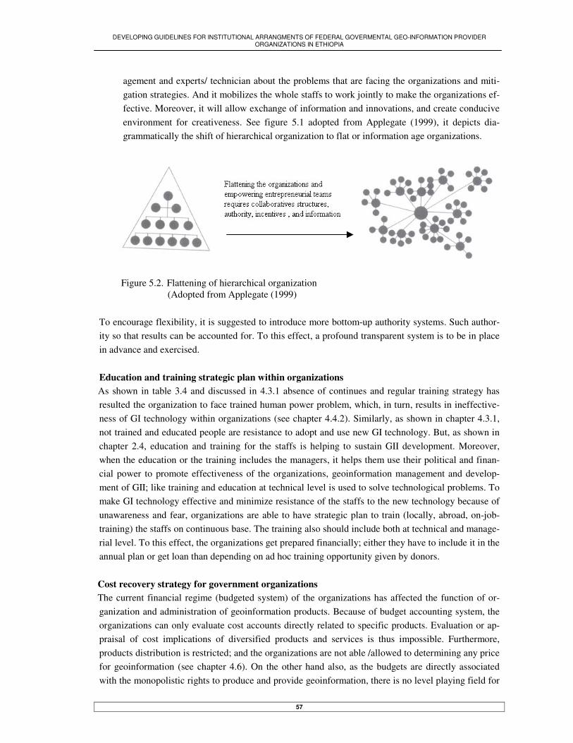
DEVELOPING GUIDELINES FOR INSTITUTIONAL ARRANGMENTS OF FEDERAL GOVERMENTAL GEO-INFORMATION PROVIDER ORGANIZATIONS IN ETHIOPIA
57
agement and experts/ technician about the problems that are facing the organizations and miti-gation strategies. And it mobilizes the whole staffs to work jointly to make the organizations ef-fective. Moreover, it will allow exchange of information and innovations, and create conducive environment for creativeness. See figure 5.1 adopted from Applegate (1999), it depicts dia-grammatically the shift of hierarchical organization to flat or information age organizations.
Figure 5.2. Flattening of hierarchical organization (Adopted from Applegate (1999) To encourage flexibility, it is suggested to introduce more bottom-up authority systems. Such author-ity so that results can be accounted for. To this effect, a profound transparent system is to be in place in advance and exercised. Education and training strategic plan within organizations
As shown in table 3.4 and discussed in 4.3.1 absence of continues and regular training strategy has resulted the organization to face trained human power problem, which, in turn, results in ineffective-ness of GI technology within organizations (see chapter 4.4.2). Similarly, as shown in chapter 4.3.1, not trained and educated people are resistance to adopt and use new GI technology. But, as shown in chapter 2.4, education and training for the staffs is helping to sustain GII development. Moreover, when the education or the training includes the managers, it helps them use their political and finan-cial power to promote effectiveness of the organizations, geoinformation management and develop-ment of GII; like training and education at technical level is used to solve technological problems. To make GI technology effective and minimize resistance of the staffs to the new technology because of unawareness and fear, organizations are able to have strategic plan to train (locally, abroad, on-job-training) the staffs on continuous base. The training also should include both at technical and manage-rial level. To this effect, the organizations get prepared financially; either they have to include it in the annual plan or get loan than depending on ad hoc training opportunity given by donors.
Cost recovery strategy for government organizations The current financial regime (budgeted system) of the organizations has affected the function of or-ganization and administration of geoinformation products. Because of budget accounting system, the organizations can only evaluate cost accounts directly related to specific products. Evaluation or ap-praisal of cost implications of diversified products and services is thus impossible. Furthermore, products distribution is restricted; and the organizations are not able /allowed to determining any price for geoinformation (see chapter 4.6). On the other hand also, as the budgets are directly associated with the monopolistic rights to produce and provide geoinformation, there is no level playing field for

DEVELOPING GUIDELINES FOR INSTITUTIONAL ARRANGMENTS OF FEDERAL GOVERMENTAL GEO-INFORMATION PROVIDER ORGANIZATIONS IN ETHIOPIA
58
any private companies to grow and promote competition among organizations on free market. Ab-sence of competition, in turn, has resulted in ineffectiveness of the organization and absence of re-quired data. Similarly, the budget system has not enabled the organizations to increase the salary and give incentives for the staffs when it is required. Even though, generally believed cost recovery sys-tem can overcome these problems, because of nature of the government organizations, the better ap-proach could be recovering of expenditure than cost recover (see chapter 2.7). Moreover, as there is no profound experience on cost recovery in the country on the one hand; and organizations are not ready for that on the other, the implementation may take long time and face challenges (see chapter 4.3.2).
But generally to solve the above problems, either in short term or long term strategy, changing of the current financial regime (budgeted) to cost recovery or expenditure system is essential. But for its ef-fective implementation, many pre-conditions need to be fulfilled in advance: - There should be political commitment and decision at macro level to apply cost recov-
ery/recovery of expenditure system by reducing budget of the organizations. - Awareness among the organizations staffs and management is to be created to help them
know that how budgeted system is affecting function of the organizations and mitigated by cost recovery system. It enables to avoid resistance from member of the organizations, and fa-cilitate its implementation.
- Strategic plan should be developed on the methodology/process how implementation of cost recovery will take place. Whether it will be applied on all government organizations at same time or turn-by-turn.
- Strategic plan should be developed on how alternative funding can be and is allowed to take place; and in securing financial resource for the organizations in case of crises. .
5.3. GI technology in the organizations
Sustaining of GI technology within the organizations As the GI technology has been adopted by organizations either through donation or project or pur-chasing with government budget, in other word by technology-push (see table 3.5a and chapter 4.4.1), it is not largely effective within the organizations (see chapter 4.4.2). But in chapter 2.5, it is indicated that the technology that has been adopted by users demand-pull is effective. Nevertheless, as shown in chapter 4.3, the organizations are not basing on users need assessment to adopt technology or to direct the focus of production along need of users. On the other hand also, discussion in chapter 4.4.2 shows that sustainability of the technology, that is adopted through project and donation is suffering from lack of awareness and strategic plan how to sustain it after the donation stops and the project is over. These problems therefore have resulted that it is impossible to use effectively the technology by inte-grating with the main production system (chapter 4.4.2). And also impossible to identify its impact on organizational performance, like revenue and/or production increase (see table 3.5). However, to sustain and effectively use the technology in order to provide data that demanded by us-ers (particularly up-to-date and digital data), and increase production and revenue of the organiza-tions, the following are to be done:

DEVELOPING GUIDELINES FOR INSTITUTIONAL ARRANGMENTS OF FEDERAL GOVERMENTAL GEO-INFORMATION PROVIDER ORGANIZATIONS IN ETHIOPIA
59
- Preparing strategic plan how to sustain the technology that is adopted through donation and pro-ject, after the donation stops and the project is over. In the strategic plan, allocating required fund to run the system and assigning personals working with the system permanently is to be in-cluded
- Enough budgets should be availability to maintain the system and to get technical and consul-tancy ser vice, like an organization WBISPPO is doing.
- Strategic plan should be made how the digital technology will replace the analogy technique. Such replacement requires management decision and commitment to support the new technol-ogy; and training (including on-job-training) for staffs who are working on the analogy system to shift them easily to digital technology and to avoid possible resistance from them.
- There should be strategic plan in order to focus on customer driven production system whereby the adoption of GI technology will base on users demand-pull. It is like Ordnance Survey of England has made.
5.4. Creating geoinformation centre in GI organizations
Adoption and application of GI technology, and administration of geoinformation within GI organiza-tions is requiring adequate job-description. In organizations where geoinformation centre are not es-tablished, either there is effort redundancy or there is no organizational initiation to develop the GI technology or properly administer the geoinformation (see chapter 4.5.4). It is therefore suggested that a proper geoinformation administration would include a design of strate-gic plans to develop and update the technology, develop/adopt standards and insure all sections of the organization are applying it; information can flow among different sections and with other organiza-tions. To this effect, it is very essential to create a centre responsible and accountable for geoinforma-tion activities within organization.
5.5. Geoinformation policy at national level.
In Ethiopia geoinformation producer organizations and users have faced many problems during geoin-formation administration (like during integration of data, exchanging of data, and provision of data, etc). But as indicated in chapter 2.9, to solve these problems, policy at national level is required. The responsibility of preparing such policy largely lay on the national organizations. But, in Ethiopia, the federal organizations are not much involved in activity towards this. So far, only ESTC tried to pre-pare draft policy on information policy for the country (see chapter 2.8). To prepare draft policy on geoinformation, the federal GI provider organizations have to prepare pol-icy draft and present for government to be endorsed. To this effect, all these organizations should be willing and cooperative. But, for the sake of its effectiveness, one multi-sectoral organization (most likely EMA) or a new independent committee under secretariat is able to take the responsibility to lead the effort of preparing the policy draft. It is because only multi-sectoral or independent commit-tee can get cooperation of all concerned organizations and successfully satisfies interests of all or-ganizations (see chapter 4.7.3). Selection of EMA is because of its being relatively multi-sectoral or-ganization than other organizations (as it produces foundation which is demanded by all users, and

DEVELOPING GUIDELINES FOR INSTITUTIONAL ARRANGMENTS OF FEDERAL GOVERMENTAL GEO-INFORMATION PROVIDER ORGANIZATIONS IN ETHIOPIA
60
provides different services); rich in experience of proposing policy draft on geoinformation so far; relatively better in administrating geoinformation than other organizations; and completely mandated to work through out the country and get help from all regional and federal organizations. Similarly the new committee is independent and not uni-sectoral to get acceptance and cooperation from all organi-zations. If EMA is given the leading responsibility it has to crate a new centre responsible and ac-countable for that by fulfilling all requirements: appropriate fund, personals, office, etc. It is like ESTC created National Computer and Information Centre to prepare policy draft on information pol-icy at national level (see chapter 2.8)
5.5.1. Policy for geoinformation standard
Below standard for geospatial data and exchangeable format, and database schema compatibility will be emphasised. As implementation of the standard faces challenges, the leading committee or organi-zation should be empowered and take the responsibility to control and check every thing is done ac-cording to the standard Standard for geospatial data In Ethiopia, as shown in chapter 4.5.1, the data standards that are available in some organizations is mostly prepared for analogue data handling, particularly for cartographic presentation purpose (for example, how and what symbols used to represent geographic features on map); it does not properly include the projection parameters to insure smooth integration of digital data obtained from different sources. Even such standard is not mostly documented so that everybody knows and applies it; only few people have it in their mind. Moreover, data are collected and classified in different methods since there is no standard; as a result it is creating data integration problems (like the problem MWR is facing now, see chapter 4.5.1). But as shown in chapter 2.9, standard (particularly at national level) helps to enable all data are to be collected and processed the same method to avoid problems that are otherwise occurring during data sharing. To insure the compatibility of data obtained from different sources and make easy data sharing, stan-dard for geospatial data at national level is essential. Development of the standard can base on ana-logue standards already available in some organizations in Ethiopia and standard from other countries (like standard of FGDC, ISO) by modifying it to fit the need of the country. The standard necessarily include data types and contents clearly, cartographic presentation standard, and most importantly pro-jection parameters. When agreement reached among users on the standard, it has to be given for or-ganizations. Within the organizations it has to be documented and known by all staffs of the organiza-tions to insure the products are as to the standard. Standard for data exchangeable format The GI users in Ethiopia are currently facing problems of data lose and effort duplication while trans-ferring file from one system to another. As shown in chapter 4.5.1, some governmental organizations are adopting exchangeable file formats standards in isolation, or without confirming the similarity and compatibility of the standards between different organizations. But as mentioned in chapter 2.9.1, if organizations use different file exchangeable standards, there will be data sharing problems between different GIS platforms.

DEVELOPING GUIDELINES FOR INSTITUTIONAL ARRANGMENTS OF FEDERAL GOVERMENTAL GEO-INFORMATION PROVIDER ORGANIZATIONS IN ETHIOPIA
61
To insure smooth data sharing between different GI systems, the GI organizations need to develop common digital file exchangeable format standard. To this effect, the GI organizations are able to work together. And the leading organization/committee (mentioned above) should take this responsi-bility as well. Standard for database Some organizations are trying to develop database for their respective organization in isolation from other organizations or without confirming the compatibility (see chapter 4.5.1). But differences in da-tabase schema is resulting in incompatibility of data from different databases, and then lead to diffi-culties of data sharing (see chapter 2.9.1) To insure data sharing and compatibility from different databases, all the GI organizations are able to work together to have compatible database schema. Otherwise it will be difficult to integrate datasets from different sources and avoid resource and effort duplication. The leading organization/committee (mentioned above) should take this responsibility as well
5.5.2. Data up to datedness and liability
As shown in table 3.7 and discussed in chapter 4.5.3, the GI organizations are not largely engaged in updating of geospatial data like they are creating the data. The data mostly given, therefore, are out-dated. But as indicated in chapter 2.9.2, outdated data can mislead users, particularly decision makers. In order to give for users up-to-date data, and save them from wrong decision or misled, the organiza-tions have to have strategic plan to up date the data regularly. To this effect, it is essential to include in the mission that updating of data is organizational obligation and only up-to-date data is given for users (like organization LUS-MA does). Mostly it is not guaranteed by organizations or government whether the data, particularly digital data, produced and provided is error free or not. And also there is no a trend to compensate for any lose because of errors in the data. This is because first, there is no standard to check data quality; second it is not largely known the importance of providing correct or liable data for users; third there is no pol-icy that enforces to do that. Nevertheless, in chapter 2.9.2, it is identified that as geoinformation is used for decision-making purpose, the provider organizations grant the users to compensate for any lose resulting from errors in the data. As long as the country will use geo-information for decision making process which incredibly need liability of the information, federal government need to issue a policy that allows compensation for any lose because of errors in the data. Such policy enforces the organizations to produce and provide liable data on the one hand, and insures the users that the data are correct and as to the standard. This it will benefit the country so that only liable data is produced and shared between users and providers.
DEVELOPING GUIDELINES FOR INSTITUTIONAL ARRANGMENTS OF FEDERAL GOVERMENTAL GEO-INFORMATION PROVIDER ORGANIZATIONS IN ETHIOPIA
62
5.5.3. Data access and sharing
Currently, in Ethiopia when users want to share data from public organization, they are facing differ-ent challenges. Because of these challenges, sharing data among different sources is not an easy task; and resulted in resource redundancy as indicated in table 3.13. The challenges are (see chapter 4.5.2): First, for private and individuals it is very difficult or impossible to get data from public organiza-tions. Either they need to get formal letter or they are not allowed to get any data from free data pro-vider organizations. But as indicated in chapter 2.9.3, as long as public organizations are using the public money, all citizens of the country could have access to the data found in public organizations. To insure the citizens to get data from public organizations, requirement of formal letter from organi-zations is to be revoked (like EMA did), and free data provider organizations enable to provide their data for private citizens and individuals as well, like they do for other government organizations. But as its implementation gets problem because of long time used experience and culture, it needs politi-cal decision and strong commitment as well as follow up to put it in effect. To this effect also, there should be access right at national level; and it has to be included in the Civil Code so that oneself can take the case to court when he/she is not provided data from public organizations. Second, users in general do not have any information what data is available where. Particularly, it is very challenging and expensive task for users of far area. These users are calling or travelling head office to ask for available information. To enable users to get data from organizations (specially new or updated data), the organizations are able to regularly advertise their products (through media, bulletin, magazine, etc for the time being; and clearinghouse in the future time). To this effect, advertising of products should be included in mission of organizations so that budget is allocated for it and carried out. Third, currently, data provision by GI organizations is unfair in general; and digital data sharing is complicated or impossible because of the ownership right of the organizations on data particularly (see chapter 4.5.2). But, as shown in chapter 2.9.3, to facilitate data accessibility and sharing from public organizations, the ownership right of organizations on data is to be changed to custodian right on data. Similarly, the ownership right on data is hampering exchanging of digital data that is created for some purpose by organization other than the creator organization (the analogue format data crea-tor). Exchanging of such digital data, however, becomes essential when same digital data is not avail-able in the creator organization.
To insure the right of all citizens to access data from public organizations fairly and uniformly, and to enable sharing of available digital data to avoid effort and resource redundancy, the organizations’ ‘right of ownership on data’ is to be amended to ‘custodian right on data’. To this effect, the federal government has to modify it from the proclamation. However, to facilitate data sharing and maintain the privilege of the creator organization, there has to be fee according to the pricing policy of the country when the data is shared for commercial purpose. Fourth, absence of digital data in most organizations (see table 3.8), and organizations being not will-ing to provide the available digital data (see chapter 4.5.2), are impedance for data sharing. As result,

DEVELOPING GUIDELINES FOR INSTITUTIONAL ARRANGMENTS OF FEDERAL GOVERMENTAL GEO-INFORMATION PROVIDER ORGANIZATIONS IN ETHIOPIA
63
different organizations are creating digital data for their own purpose; which, in turn, results in effort and resource redundancy. To avoid redundancy that is resulting by creating the same digital data by different organizations; and to enable obtaining of the digital data from respective organization, the organizations are able to largely involve in producing digital data, and to be committed and willing to provide digital data, like they provide analogue data now. Moreover, as long as a copyright policy is in place, it protects illegal copying of digital data to facilitate sharing of digital data. (For detail see below)
5.5.4. Copyright
As indicated in chapter 4.5.2, private companies are not given (do not have access right to) data from data free provider organizations. It is because these organizations have doubt and worry that the pri-vate companies may use the data for commercial purpose. But as indicated in chapter 2.9.3, to allow all citizens can access and share data from public organizations, copyright policy should be in place side-by-side with access right to protect all rights and privilege of the creator. In Ethiopia, to protect creative work of literature from illegal copying; the copyright law is issued and included in Civil Code; but it is not applied the same way for geoinformation products. To facilitate data sharing and avoid its redundancy impacts, the country needs to have copyright pol-icy at national, and is to be included in Civil Code of the country. When such policy is put in place, first and most geoinformation producing public organizations can develop confidence to provide data for users uniformly, particularly for private companies and individuals; it secures illegal copying of the data without the knowledge and permission of the creator; and data creator can get fee when the data is used for commercial purpose. The reason to include the policy in the Civil Code is, when ille-gal copy is occurred, the owner can take the case to court.
5.5.5. Appropriate pricing standard for geoinformation products
Geoinformation products are not distributed for all citizens uniformly and fairly, and in worst cases are not given at all, because of problems related with price issue. The government organizations are not willing to give data with price less than what it actually costs or free for organizations to which they suspect may use the data for commercial purpose (see chapter 4.6 and table 3.19). Moreover, al-though some organizations have price for data and selling products accordingly, they are not sure the appropriateness of the price; they do it randomly. As a result pricing situation in the country is het-erogeneous; and price of some organizations becomes higher compared to others. But in chapter 2.10, it is emphasised that despite the data needs price and the creator should get fee, determination of the price is to be appropriate and affordable. The price is to include only costs spent for data distribution and other additional works; it does not include cost for data collection. To enable all citizens can get data from government organizations uniformly and fairly, and data crea-tor gets fee when the data used for commercial purpose (as mentioned above), geoinformation prod-ucts should have appropriate price. To this effect, all geoinformation products have to have appropri-ate price and the producer organizations need to be ready to sell their products for all users with the appropriate price. To implement this, the federal organizations are able to prepare the pricing policy

DEVELOPING GUIDELINES FOR INSTITUTIONAL ARRANGMENTS OF FEDERAL GOVERMENTAL GEO-INFORMATION PROVIDER ORGANIZATIONS IN ETHIOPIA
64
draft on the one hand; and the government is to endorse it as national pricing policy on the other. Based on the situation, a committee to facilitate its implementation may be essential. In that case, it has to be created from all concerned organizations with full authority and accountability.
5.6. Organizational coordination
Coordination for GI organizations In the country, there is no common standard to insure compatibility of datasets from different sources. As shown in chapter 4.7.1 organizations in general are administrating geoinformation in isolation. Moreover, the current decentralization system has largely complicated the issue of insuring the com-patibility of data collected by different regional organizations. It has also created power gap among the organizations so that some geoinformation products are missing. However, in chapter 2.11, it is pointed out that coordination among the organizations is essential to enable them exchange informa-tion and develop common standard to avoid incompatibility and duplications, and in general to work together and make decision. But, in Ethiopian case, there is no strong and sustainable vertical or hori-zontal coordination among the GI organizations (see table 3.20). But to insure development of standard that enables compatibility of data from different sources (fed-eral and regional organizations) to avoid redundancy; to insure availability of data that is missing from concerned organizations because of power gap; and to promote development of GII for the coun-try, the organizations need to be coordinated in both way horizontally (federal organization to federal organization) and vertically (federal organization to regional organization). Political support to coordinate the organizations As indicated in chapter 4.7.3, already started coordination to create the meta-database (ENRAMED), has faced challenges to sustain. It is because the organization that leading the coordination has no le-gal mandate to do so on the one hand; and it is not mult-sectoral in mission to satisfy interest of all member organizations. Moreover, the existing rigid organizational structure is not allowed to create a new job description, which is responsible to create and update the metadata at organizational level. To sustain already created coordination or to create and sustain new coordination among GI organiza-tions, the political support is essential. It is because: first all the organizations that participate in the coordination are governmental so they traditionally need order from the government; and second the effectiveness and implementation of the coordination need organizational structure flexibility. To this effect, the political support or decision is needed to full fill the following:
- Identify multi-sectoral organization or create a new committee (for the same reasons men-tioned above) to lead the coordination in order to equally satisfy the interests of all member organizations.
- Giving legal mandate for the leading organization to coordinate and achieve the objectives of coordination. It has to have mandate to check and monitor whether member organizations have accomplished their commitment within respective organization or not.
- Restructure the organizations in to flexible system so that new job description is created by the organizations themselves whenever necessary. The new job-description is to be responsi-ble and accountable to accomplish objectives of the coordination at organizational level. For
DEVELOPING GUIDELINES FOR INSTITUTIONAL ARRANGMENTS OF FEDERAL GOVERMENTAL GEO-INFORMATION PROVIDER ORGANIZATIONS IN ETHIOPIA
65
example, Meta data processing job-description is responsible and accountable to create and update metadata for data at organizational level to sustain already created coordination.
5.7. Outsourcing of GI activities
The need of outsource GI activities As shown in tables 3.8, and 3.15, the data coverage in organizations is not satisfactory on the one hand and most of available data is in analogue format on the other, despite there is demand for digital data. Similarly, as shown in table 3.7, most of the data are not up-to-date as the organizations are not largely engaged in updating the data. To do these, however, the organizations have human resource and technological capacity problems. Nevertheless, in chapter 2.12.1, for the sake of effectiveness and efficiency when there is no organizational capacity to do the tasks, organizations should able to out-source activities traditionally handled within organizations. Moreover, outsourcing of those activates enables the organizations to be competent; and creates an opportunity for private companies to grow and to do the work. In Ethiopia, however, as shown in table 3.23a, outsourcing of GI activities is not common practise. When first, the organizations do not have human power and technological resources to do the tasks by themselves; second to increase the efficiency of the organizations in order to accomplish their mission and provide data that users demand, and third to let private companies grow and involve in producing of geoinformation and make availability up-to-date and diversified data, government organizations are able to outsource the activities that they can not do than keep until they get the capacity to do them-selves. Political support and organizational readiness to outsource activities The government organizations are not committed to outsource the activities that are not done by them. Rather they would like to keep the activities not done until they get the capacity to do. On top of that, even when there are outsourced activities, they would like to give for other government organizations. It is because there is a trust on quality of products produced by government organizations. But these government organizations are not in apposition to do their own task let alone to do the outsourced ac-tivates and to provide shortly or on time. Moreover, even if few private companies already exist, they are not licensed professionally to execute activities outsourced by government organizations. (See chapter 4.8.2). However, as indicated in chapter 2.12.3, to control the quality of outsourced activities, quality controlling standard or manual is very essential. To enable the organizations continuously outsource activities, there is to be a government policy to enforce the organizations to outsource activities that are not done by the organizations on the one hand, and organizations commitment to do so on the other. Similarly, to create confidence on government organizations to provide outsourced activities for pri-vate companies so that the activities are executed in short period of time than government organiza-tions do, there are two conditions need to be fulfilled: - The government has to issue a law whereby private companies get professional licence (be-
sides work permit), and establish government body that checks the qualification of the private

DEVELOPING GUIDELINES FOR INSTITUTIONAL ARRANGMENTS OF FEDERAL GOVERMENTAL GEO-INFORMATION PROVIDER ORGANIZATIONS IN ETHIOPIA
66
companies and issues the professional licence. It will assure the government organizations that the private companies are qualified to carry out the outsourced activities.
- Each organization is able to develop quality controlling manual based on standard at national level (yet to be developed) and /or according to specific objectives and need of the organiza-tion.
Moreover, in order to sustain and facilitate outsourcing of activities: - The government organizations need to identify outsourced activities from not outsourced ac-
tivities and publicize them; - Government organizations need to be coordinated with private companies. - A financial resource for outsourcing activities is to be secured (to this regard adopting of cost
recovery system is very essential).
5.8. Conclusion
The guidelines of institutional arrangements is found to be essential to make functions of the organi-zations effective on the one hand; and develop GII to mitigate the geoinformation sharing problem in the country. For effectiveness of the GI organizations, the existing mission should be modified to ap-ply modern organizational system which focus on: - User-demand driven production system to produce what users need. - Joint work with private companies; and support their emerging. - Flexible and dynamic organizational salary scale to retain out flowing trained personnel. - Transparent and accountable system to increase the active participation of the whole staffs;
and to enable information flow among different sections. - Continuous training for staffs at technical and managerial level. - Cost recovery policy to mitigate dependency on government budget, and determine price for
geoinformation products. The guidelines also quit essential to make the GI organizations effectively use and maintain GI tech-nology within organizations. To this effect: - There should be strategic plan to continue working with GI technology after the donation and
the project is over. - There should be large focus on user need assessment during purchasing and updating the GI
systems - It is essential to allocate budget and get technical support to maintain the system. For effectiveness of GI technology, proper data administration and development of GII, independent job description has been found to be established within organizational structure. Such job description is to be responsible for all GI activities within and out side organizations. Geoinformation policy at national level is found to be very essential to overcome the problems coun-tered during geoinformation administration. The policy will address the following issues: - Developing and applying of common data standard, insuring of database schema compatibil-
ity, and digital data exchangeable file format standard to insure the compatibility of data,

DEVELOPING GUIDELINES FOR INSTITUTIONAL ARRANGMENTS OF FEDERAL GOVERMENTAL GEO-INFORMATION PROVIDER ORGANIZATIONS IN ETHIOPIA
67
transferring of data from system to system, and eventually to avoid redundancy by facilitating data sharing.
- The GI provider organizations obligation to keep the data up-to-date; and insure its liability, otherwise compensation for any lose because errors in data
The policy also found to be essential: - To insure right of all citizens to access and share data owned by government organizations - Advertising products by all possible means to facilitate data sharing - Changing of the current ownership right on data to custodian right - Developing and put in effect copyright policy for geoinformation products. Similarly the policy emphasises the need of pricing standard for geoinformation products to insure the provision of data for all citizens from public organizations. GI organizations are able to be coordinated to develop geoinformation policy and to exchange infor-mation. Coordination of organizations is very essential to insure the compatibility of data collected by different federal and regional organizations, and avoid redundancy. The coordination effort should get political support to identify multi-sector organizations or establish a new committee that lead the co-ordination; to give legal mandate for the leading organization/committee to create and sustain the co-ordination; to give mandate for the organizations to create new job description that is responsible and accountable for objective of the coordination at organizational level Similarly as long as the organizations do not have the human and technological capacity, they have to outsource activities. To this effect, private companies should be professionally licensed; quality con-trolling manual should be developed; and organizations should be obliged to outsource activities sooner they are not able to do them.
DEVELOPING GUIDELINES FOR INSTITUTIONAL ARRANGMENTS OF FEDERAL GOVERMENTAL GEO-INFORMATION PROVIDER ORGANIZATIONS IN ETHIOPIA
68
Chapter VI
6. Project approach implementation of the guidelines for institutional arrangments
6.1. Introduction
The main focus of this chapter is to implement the guidelines developed in the previous chapter as project approach. Developing guidelines is not complete without analysing the risks occurring during its implementation and possible mitigation options. Whenever a new technology is implemented, the existing technology is replaced with new, or organizational set up is changed to new, there are differ-ent risks (Tilk, 2002) But, there is no universally appropriate risk implementation method and man-agement tools (Applegate, 1999). Hence assessing of the implementation risks for the guidelines and mitigation tools that are appropriate for Ethiopia situation is essential. Possible risks associated with the implementation of the guidelines are technology risks, structure of the project risks, cost or fund risks, project size risks, availability of effective communication network system risks, absence of societal awareness about GII risks, shortage of experience in digital technol-ogy risks, lengthy time risks, absence of technical or consultancy service risks, organizational struc-ture risks, absence of political commitment risks and failing to meet the anticipated result risks.
6.2. Possible risks and management tools to mitigate the risks
Risks that occur during implementation of projects can vary from project to project because of differ-ent factors linked with the project. Degree of risks also varies from project to project based on struc-ture of the projects: large or small project. Similarly, a project implemented in different organization has different risks because of culture, organizational structure, management systems, financial re-sources, technological shortage, management systems, etc within organizations. Consequently, identi-fying and assessing of management tools according to the risk types, degree, etc is very essential to mitigate the problems and make strategic plans.(Baker Stewart and Sheremeta, 2002). Therefore, based on these facts and according to the Ethiopian context, the following possible risks that occur during implementation of the guidelines and management tools are pointed out.
6.2.1. Risks
Possible risks that can occur during implementation of the guidelines are identified and categorized into four major classes as well subclasses as shown in figure 6. 1. Similarly, factors that causing the risks are discussed and presented in table 6.1. This table has four parts. The first part, table 6.1a shows risks related with Information Technology (IT) and possible factors for emerging of such risks.

DEVELOPING GUIDELINES FOR INSTITUTIONAL ARRANGMENTS OF FEDERAL GOVERMENTAL GEO-INFORMATION PROVIDER ORGANIZATIONS IN ETHIOPIA
69
The second part, table 6.1b shows risks related with human and financial resources and factors for emerging of such risks. Third part, table 6.1c shows risks related with institutional and societal (with particular emphasise on organizational, political and community issues), and factors for emerging of such risks. Fourth, 6.1d shows risks related with project structure, which are size of project, duration for project implementation and approach to implement the project; and factors for emerging of such risks.
Figure 6.1 Major and subclasses of risks
IT service
Resource
Risk
IT Institutional-societal
Technology
System identification and development.
Financial
Human
Project nature
Organizational management
Lack of political commitment
Lack of awareness
Large project
Project time
Implementationapproach

DEVELOPING GUIDELINES FOR INSTITUTIONAL ARRANGMENTS OF FEDERAL GOVERMENTAL GEO-INFORMATION PROVIDER ORGANIZATIONS IN ETHIOPIA
70
Types of risk
Factors for the risk
IT 1. Technological
- It requires advanced computer, network and re-lated systems. Currently there are no well-developed computer systems - It requires software, particularly developed to meet interest of the users (like ENRAMED). - It requires efficient and effective communication system. The existing system is old and not reliable.
2. System specific identification and de-velopment
- System specification and identification is not com-mon practise. - Computers and accessorise are purchased ran-domly
3. IT Service in (technical and consultancy service)
The technology is new and there are no experienced people and companies to maintain the system when fault or problems occur, consulted for help, and up-grade the system when needed
a)
Resource 4. Fund for the project -As size of the project is very large, it needs very
huge and sustainable financial resources to imple-ment.
5. Human resource -Generally, there are no well-trained and experi-enced people in geoinformation and IT in the coun-try. -Local education institutes are not largely involved in giving training in geoinformation and IT. And training at abroad is not continuous and not reliable to depend on it.
b)

DEVELOPING GUIDELINES FOR INSTITUTIONAL ARRANGMENTS OF FEDERAL GOVERMENTAL GEO-INFORMATION PROVIDER ORGANIZATIONS IN ETHIOPIA
71
Institutional-societal
6. Organizational management system -The organizations are vertically hierarchal and bu-reaucratic to start the implementation smoothly. Accountability is not practised culture in organiza-tions -Financial, personnel, technology and data man-agement system is very poor in organizations. Documentation systems in the organizations are very poor as well.
9. Lack of political commitment
It may not be priority of the government to support the implementation of these guidelines. It is because current focus of the government on agriculture and water areas.
10. Society and community awareness Geoinformation is not widely and practically known by society and community to help socio economic development.
c)
Project structure 3. Size of the project
-It is very large project intended to implement new modern management system to bring effectiveness and transparency within organizations, and to de-velop GII. -The benefit if establishing GII cannot be deter-mined at the beginning, and not known for users and all concerned parties.
6. Determining project life time -Generally project management system is not prac-tised in the country to mange and finish on time. Factors like organizational bureaucratic system hin-ders the performance of the project and will take more than expected time
11. Implementation approach Failing in identifying the right implementation ap-proach method, analysing the milestone and reach to decision to meet the anticipated results
d) Table 6.1 Factors that causing risks

DEVELOPING GUIDELINES FOR INSTITUTIONAL ARRANGMENTS OF FEDERAL GOVERMENTAL GEO-INFORMATION PROVIDER ORGANIZATIONS IN ETHIOPIA
72
6.2.2. Management tools to mitigate the risks
The risk mitigation approach bases on four management tools developed by (Applegate, 1999). These tools are external integration tools, internal integration tools, formal planning tools, and formal re-sults-control tools. Internal integration tools It is to create a committee that lead the implementation of the guidelines and accountable for its suc-cessfulness - Members of the committee are to be as much as possible those who are aware of geoinforma-
tion science and IT - The team should be motivated and get all assistance from different sections within organiza-
tions, particularly from management groups - The committee is able to discus frequently among themselves and with the management about
the achievement and problems encountered - The committee is able to prepare progress report periodically, and inform the staffs of the or-
ganizations about the progress and document it. External integration tools It is to link or coordinate the organizations with users, community/society, concerned organizations and policy makers in order to work together. - Establishing of a team responsible for relations with outsiders - The team is to assess users need and identify who the users are, including private and gov-
ernment organizations. - The team also actively involves in creating awareness among the society, community, deci-
sion makers, politicians, etc to get financial, material and legal support - Developing geoinformation policy jointly with concerned organizations to facilitate data shar-
ing and development of GII Formal Planning tools It is about the work plan to be made to implement the guidelines. Its focuses are: - Identify methodology/procedures to implement the guidelines taking in to consideration size
and structure of the project. It is whether to apply at one time or step-by-step; and analyse ad-vantage and disadvantage of the two cases to reach a decision
- Identify project implementation phases. Each phase includes milestones, time plans, and deci-sion. The implementation phases will base on the following issues:
- Identifying of required fund and financial resources to sustain the implementation of the projects
- Identifying of required human resources and possible ways to train people (on-job-training, locally and abroad) in geoinformation and IT.
- Assessing availability of consultancy and technical support, and insuring to get it when needed

DEVELOPING GUIDELINES FOR INSTITUTIONAL ARRANGMENTS OF FEDERAL GOVERMENTAL GEO-INFORMATION PROVIDER ORGANIZATIONS IN ETHIOPIA
73
- Applying standards of geoinformation data, database, file exchangeable format - Identifying of specification for systems, hardware and software. - Developing information system (which includes conceptual, logical and physical
modelling) according to the specifications. - Purchasing of hard/soft ware equipments according to the specifications and
configuring them - Construction of the system - Testing of the systems and checking its quality and functionality - Integrating the system with the main production system
- Developing of documentation system for all process taking place in the organizations for later organizational assessment and trace back bottlenecks
Formal control tools It is to control the implementation process and take measure to mitigate problems when they occur. It includes, if not shortly but in long term plan, to use management tool soft ware. Generally, the formal control tools focus on the following issues: - Applying of modern management system that enables the staffs to know what they work and
to be accountability for what they do. Its aim is to change the existing bureaucratic and not-transparent system.
- Using of workflow management system tools (like action Work Metro software) to control the workflow and identify bottlenecks for delaying of works and lengthening project lifetime.
- Using modern costing system like Activity Based Costing (ABC) tool system than traditional costing system. Its aim is to know the accurate cost for project than lamping all other costs to-gether and make it unnecessarily expensive.
- Using dataflow managements system tool (like SDW software package) to control in-flowing and out-flowing information; and to develop information systems
- Collecting the milestones, analysing and making decisions
6.3. Conclusion
The project is facing challenges and risks during implementation time. The risks are emerging from inside and outside situation of the organizations. These are 1) Risks related with IT; it means avail-ability of modern computer, software and communication technology; and obtaining of support in IT. 2) Risks associated with resource availability. There is no trained and experience experts in IT and geoinformation technology on the one hand; and it is difficult to insure the availability financial re-source to the end of the project. 3) Risks related with institutional and societal, which means that lack of government support, traditional and bureaucratic system in organizations and lack of societal awareness to support the effort. 4) Risks related with nature of project, which means the project is very large to have high risk; taking loner time than expected, and identifying of appropriate imple-mentation approach.

DEVELOPING GUIDELINES FOR INSTITUTIONAL ARRANGMENTS OF FEDERAL GOVERMENTAL GEO-INFORMATION PROVIDER ORGANIZATIONS IN ETHIOPIA
74
On the other hand possible mitigations options for the risks base on 1) Internal integration which fo-cuses on creating team to strengthen inside environment of the organizations. 2) External integration tool which focus on creating team to link with outsiders like users, policy makers, other similar or-ganizations etc 3) Formal planning tools which focus on implementation of the projects. It includes identifying of human and financial resources, system development and implementation. 4) Formal controlling tool which focus on applying of modern management system, and applying of modern management techniques like work flow management, activity based costing system and information flow system.

DEVELOPING GUIDELINES FOR INSTITUTIONAL ARRANGMENTS OF FEDERAL GOVERMENTAL GEO-INFORMATION PROVIDER ORGANIZATIONS IN ETHIOPIA
75
Chapter VII
7. Conclusion and Recommendations for further research
7.1. Conclusion
The main objective of this research was: To identify, analyse and develop guidelines if elements in the institutional arrangement of GI provider organizations are bottlenecks for organizational effectiveness and development of geoinformation infrastructure in Ethiopia. 1) Institutional arrangements of GI organizations in Ethiopia It is found that most – if not all- producers of geospatial information are guided by government proc-lamations. But the proclamation (existing organizational mission) is a bottleneck for effectiveness of the organizations function. As the field data showed, the missions are in most cases old and the or-ganizations are governed by traditional management systems. 2) Effect of institutional arrangements on data administration, data pricing and GI technology effec-
tiveness Data administration within GI organizations is very poor and no any policy to govern it. Similarly geoinformation products have no price standard and mostly pricing is done in ad hoc manner. GI technology in the organizations has been adopted by technology push than users demand-pull. And it has no large effect in increasing effectiveness of the organizations and responding to the digital data demand. The technology in general is facing challenges from organizations staffs and management. As a result it is not integrated with the main production system. However, it is essential to have stra-tegic plan how to sustain the technology. The strategy has to largely focus on allocating budget and human power; train the staffs on new technology; and depending on users need assessment. 3) Coordination of GI organizations Coordination among GI organizations to work together, formulate geoinformation policy and ex-change information very low or does not exist. But to coordinate the organizations, there should be political decision since already started coordination failed because it was created on voluntary base, and without legal binding. The coordination is to be led by multi-sector organizations and it has to have legal mandate to coordinate the organizations. Similarly, as responsible and accountable job-description is essential within organizations to meet objectives of the coordination, the organizations should enable to create that job-description

DEVELOPING GUIDELINES FOR INSTITUTIONAL ARRANGMENTS OF FEDERAL GOVERMENTAL GEO-INFORMATION PROVIDER ORGANIZATIONS IN ETHIOPIA
76
4) Outsourcing of GI activities The organizations in general are not able to accomplish their responsibilities in providing for the soci-ety and decision makers required data. It results therefore shortage of geoinformation products and services. Occasionally it was observed that to mitigate these problems, organizations were able to out-source activities that they cannot do now, even though there were no clear mandates to do so, or even though institutionally it was not always allowed. In addition, one of the bottlenecks of outsourcing any of such activities, however, still appears to be that there is no proper control of private companies whether they are professionally licensed and/or applying quality-checking guidelines. This may be partly related to the problems of outdated mandates of the organizations. If such mandates cannot be used internally, it is even more difficult to use such mandates to establish clear outsourcing contracts and control mechanisms. Reforming the mandates by new proclamations could thus help indirectly the ability of GI organizations to outsource. 5) Guidelines for institutional arrangements In general, therefore, it can be argued that to cope up with the current and expected users’ demand and on going dynamism of the various types of technology which make GI applications possible, the or-ganization missions are to be amended. The new missions need to be based on modern management principles, which would include:
• user need driven production systems rather than product driven systems; • regulating the GI providers to prevent them from operating as monopolistic and to en-
courage private companies to grow; one way of doing that is to force accounting practices based on partial or full cost recovery, which could also reduce the absolutely dependence on government budgets;
• flexible management systems with regards to human resource by providing incentive and increasing salary based on efficiency and performance than rigid salary scale rules;
• flat management styles to create link between management and staffs to increase effec-tiveness of the organizations by joint work; transparent system whereby information can flow, which enables the staffs to be creative and motivated than leave the responsibility for few management groups; and accountable system where every body can know what he/she is doing and responsible for it.
Policy on geoinformation is found to be very essential in Ethiopia for proper administration of geoin-formation products. It is because, one, geoinformation is created, produced, stored and disseminated in ad hoc manner; and any common standard is not to adopted or developed to insure compatibility of data from different sources to avoid redundancy. Two, the provision of data for users largely lay on good willing of the creator organizations; geoinformation products are not given for all citizens uni-formly; and sharing of data is very difficult task. Third, although geoinformation is used for decision-making process, all data provided are not up-to-date and their liability is not checked and guaranteed. Standard at national level for geospatial data is essential. The development of the standard should give much emphasis, among others, on data contents and projection elements, which are mostly miss-ing but important. Similarly, database schema in different organizations should be compatible to each
DEVELOPING GUIDELINES FOR INSTITUTIONAL ARRANGMENTS OF FEDERAL GOVERMENTAL GEO-INFORMATION PROVIDER ORGANIZATIONS IN ETHIOPIA
77
other. Common digital data exchangeable format standard should be adopted by the organizations. Otherwise, there will be data sharing problem, and then duplication of effort and resource. To facilitate data sharing and avoid effort and resource redundancy, GI provider organizations have to advertise their products; digital data is to be provided for users when there is demand; and ownership right on data is to be changed to custodian right on data. Similarly, to protect the illegal copying of public organizations data and using the data for commercial purpose, copyright policy is to be in place. Pricing policy/standard to determine price for geoinformation products is found to be every essential to insure the access right of all citizens to the data owned by government organizations. But as users should pay for extra work other than production process, the appropriate pricing must be imple-mented. On the other hand, the pricing policy is also enabling the GI organizations either to recover their expenses or become cost recovery by selling their products.
7.2. Recommendations for further studies
This research is mainly focused on institutional arrangements for organizational function effective-ness and development of GII in Ethiopia. Further research could address the more technical implica-tions of the guidelines as suggested by this research Some of the bottlenecks in cooperation and sharing of data may be based on socio-cultural aspects. These could be further investigated. The current possibilities for private companies are relatively limited, yet could provide potential to support a GI market. How these could be created and supported could also be of further interest for research. Possibilities for a more theoretical approach could be related to the fields of institutional economics, business economics (in particular e-commerce).

DEVELOPING GUIDELINES FOR INSTITUTIONAL ARRANGMENTS OF FEDERAL GOVERMENTAL GEO-INFORMATION PROVIDER ORGANIZATIONS IN ETHIOPIA
78
References Applegate, L.M., 1999. Corporate information system management: the challenge of manag-
ing in an information age: text and cases. Irwin - McGraw Hill, Boston etc. Baker Stewart and Sheremeta, 2002. Risk Management Planning-How Much is Good
Enough? http://www.risksig.com/articles/euro2002/1289.pdf. Accessed date January 30, 2003.
Budic and Pinto, 1999. Understanding Interorganizational GIS Activities: A conceptual Framework. URISA, 11, No 1.
Choi, W., 2002. Institutional Issues of the Spatial Data Exchange in Korea, FIG XXII interna-tional Congress, Washington, D.C, USA.
Cunningham, C., 1982. Creating Coordination Among Organizations. An orientation and planning guide. http://www.soc.iastate.edu/Extension/Docs/Creating%20Coordination.pdf. Accessed date September 25, 2002.
de Man, W.H.E., 1984. Conceptual framework and guidelines for establishing geographic in-formation systems: capable of integrating natural resources data and socio - economic data for development - oriented planning, monitoring an research: preliminary version. UNESCO, Paris.
de Man, W.H.E., 2000. Institutionalization of Geographic Information Technology: Unifying Concepts? Cartography and Geographic Information Science, 27: 139-151.
de Vries and Beerens, W.T.S.J.J., 2002. Economic, financial and capacity aspects of national geospatial data infrastructures, Map India 5th annual international conference, New Delhi, India.
de Vries, W.T., 1998. Access versus protection. Geoinformation Africa PP: 16-18. ESTC, 1991. National Policy on Information Systems and Services (Draft Proposal).
http://www.telecom.net.et/~estc/ICTPolicy/infosystem.htm#SCOPE. Accessed date December 10, 2002.
Etzioni, A., 1968. The active society: a theory of societal and political processes. The Free Press, London; New York: Collier-Macmillan.
Ezigbalike, D., 2002. Justification for Spatial Data Infrastructures. http://www.opengis.org/gisd/docs/Asmara_SDIJustification_Dozie.ppt. Accessed date November 5, 2002.
Feeney and Williamson, 2002. The Role Of Institutional Mechanisms In Spatial Data Infra-structure Development That Supports Decision-Making. http://www.sli.unimelb.edu.au/research/publications/IPW/5_02_MSIAFeeney.pdf. Accessed date November 14, 2002.
Groot and Laughlin, 2000. Geospatial data infrastructure. Concepts cases, and good practice. Oxford university press, Oxford etc.
Groot and Sharifi, 1994. Spatial Data Infrastructure, Essential in the Successful Exploration of GIS Technology. In: J.V. Arragon (Editor), Fifth European conference and exhibi-tion on Geographic Information systems, Paris.
Groot, R., 1992. New technology in national base mapping programs: Institutional impacts, 1st international conference on surveying and mapping, Tehran.
Halley, A., 2000. A Study of the Outsourcing Activities of Canadian Businesses. http://www.cfib.ca/legis/quebec/outsourcing.pdf. Accessed date September 24, 2002.
Harvey, F., 2000. Potentials and pitfalls for vertical integration for the NSDI, final report of survey of local government perspectives, department of geography, university of Ken-
DEVELOPING GUIDELINES FOR INSTITUTIONAL ARRANGMENTS OF FEDERAL GOVERMENTAL GEO-INFORMATION PROVIDER ORGANIZATIONS IN ETHIOPIA
79
tucky, Lexington. http://www.tc.umn.edu/~harve024/finalreport.pdf .Accessed date September 22, 2002.
Hofstede, G., 1997. Cultures and organizations: software of the mind. McGraw Hill, New York, etc.
Kenneth, E.F., 1995. Legal Issues Relating to GIS. http://www.colorado.edu/geography/gcraft/notes/legal/legal_f.html. Accessed date September 26, 2002.
Kudos, 2002. Information Outsourcing. http://www.kudos-idd.com/outsourcing. Accessed date October 04, 2002.
Mbumwae, V., 1999. Spatial data management in Zambia an institutional & operational. http://www.oicrf.org. Accessed date October 1, 2002.
Moeller, J.M., 2000. Spatial Data Infrastructures: A Local to Global View. http://gsdi.org/PPT/sdi-bei.ppt. Accessed date January 10, 2003.
Mohamed, D.A.M.B., 1998. Case Study of NSDIs in Countries in Transition - Malaysia. http://www.gsdi.org/docs/canberra/malaysia.html. Accessed date September 23, 2002.
Molen, P.V.D., 2001. Cost recovery for land administration. Survey Review V., 36(2001)282 PP: 241-248.
Negarit, G., 1980. Ethiopian Mapping Agency Establishment Proclamation, Proclamation No 193/1980.
Negarit, G., 2002. Federal Civil Servant Proclamation, Proclamation No. 262/2002. North, D.C., 1990. Institutions, institutional change and economic performance (The political
economy of institutions and decisions). Cambridge University Press, Cambridge etc. OI, 1998. The outsourcing Institute: Article & info.
http://www.outsourcing.com/content.asp?page=01i/articles/intelligence/oi_top_ten_survey.html. Accessed date October 04, 2002.
Ordnance Survey, 1999. Ordnance Survey Framework Document. http://www.ordsvy.gov.uk/about_us/framewrk/Framework.pdf. Accessed date Sep-tember 23, 2002.
Paresi, C.M., 2001. Situation Analysis in the Framework of Strategic Planning. Lecture Note, ITC, Enschede, The Netherlands.
Radwan, M., 2002. The Development of Geographic Information Infrastructure 'GII' to Sup-port Multi-level Decision Sysytem (Technical Aspects). Lecture Note, ITC, Enschede, The Netherlands.
Radwan Sani & Morales, 1999. Business Process Redesign & Process Modelling. GFM-Handout series, Lecture Note, ITC, Enschede, The Netherlands.
Reeve and Petch, 1999. GIS, organizations and people: a socio - technical approach, Taylor and Francis. Taylor and Francis, London, etc.
RFG, 2002. Risk Management in IT. http://www.rfgonline.com/research/riskmgmt-1102.html. Accessed date January 17, 2003.
Sevatdal, H., 2002. Land administration and land management-An institutional approach, FIG XXII international congress, Washington, D.C, USA.
Smith and Ruther, 1986. Achieving improved performance in public organizations: a guide for managers. Kumarian, West Hartford.
Thio, K.S., 2001. ENRAEMED - LET'S WALK TOGETHER! The Ethiopian Natural Re-sources And Environmental Meta-Database. http://ethiopiaknowledge.org/Final%20Papers/ENRAEMED,%20Thio.pdf. Accessed date November 18,2002.

DEVELOPING GUIDELINES FOR INSTITUTIONAL ARRANGMENTS OF FEDERAL GOVERMENTAL GEO-INFORMATION PROVIDER ORGANIZATIONS IN ETHIOPIA
80
Tilk, D., 2002. Project Success Through Project Assessment. http://www.pwcglobal.com/extweb/manissue.nsf/DocID/B08D56926CD348B685256C3F007A3DF4. Accessed date January 17, 2003.
UN/ECE, 1996. Land Administration Guidelines, UN, New York, Geneva. WG, R., 2000. Ad-hoc expert group meeting on " study on the future orientation of geoinfor-
mation activities in Africa" 6-10 Nov. 2000, Addis Ababa, Ethiopia. Williamson, I., 1997. Strategic Management of Cadastral Reform-Institutional Issues. Cadas-
tral Systems in Developing Countries, Cadastral Systems in Developing Countries, Penang.
Woldai, T., 2002. Geospatial Data Infrastructure: The Problem of Developing Metadata for Geoinformation in Africa., ITC, Enschede, The Netherlands.
DEVELOPING GUIDELINES FOR INSTITUTIONAL ARRANGMENTS OF FEDERAL GOVERMENTAL GEO-INFORMATION PROVIDER ORGANIZATIONS IN ETHIOPIA
81
Appendix Questionnaire on Geo-information (GI) providers/users institutional arrangements The main aim of this questionnaire is purely for academic research. The over all objective of the re-search is to assess and analyse status of: 1) geoinformation development (like geographic data gener-ating, updating, standardizing, sharing, policy, etc) within GI organizations; 2) coordination of GI or-ganizations; and 3) subcontracting of GI activities. The assessment and analysis will help eventually to come up with guidelines that helping future development of GI technology, facilitating geographi-cal data sharing, and assisting establishment of National Spatial Data Infrastructure. I thank you very much for your kind cooperation and taking your time to fill the questionnaire.
(If the space provided for answer is not enough, you can use backside of the paper)
1. Introduction to organization 1.1. Name of the organization ……………………………………………………. 1.2. Type of the organization: [ ] Governmental [ ] NGO [ ] Private 1.3. What is Act/kind of legislation governing the organization?
[ ] Statutory law [ ] Cooperative law [ ] Other. Please specify………
1.4. What are main responsibilities of the organization? …………………………………………………………………………………………… …………………………………………………………………………………………… …………………………………………………………………………………………… ………………………………………………………………………………………….. 1.5. What are main products of the organization? ………………………………………. ………..………………………………………. ………………………………………………………………………………………….. …………………………………………………………………………………………. ………………………………………………………………………………………….
2. GIS/Remote Sensing (RS) technology in the organization 2.1 How did your organization get the GIS/RS technology? A) Through foreign donation B) Through project C) Purchased by the organization D) No GIS/RS technology If your answer is D, go to Q. 2.4; otherwise Q. 2.2 2.2 What is the effect of using GIS/RS technology on the performance of the organization? [ ] Revenue increased [ ] Production increased [ ] No idea 2.3. If you have difficulties in effectively using of GIS/RS technology, what are the problems?
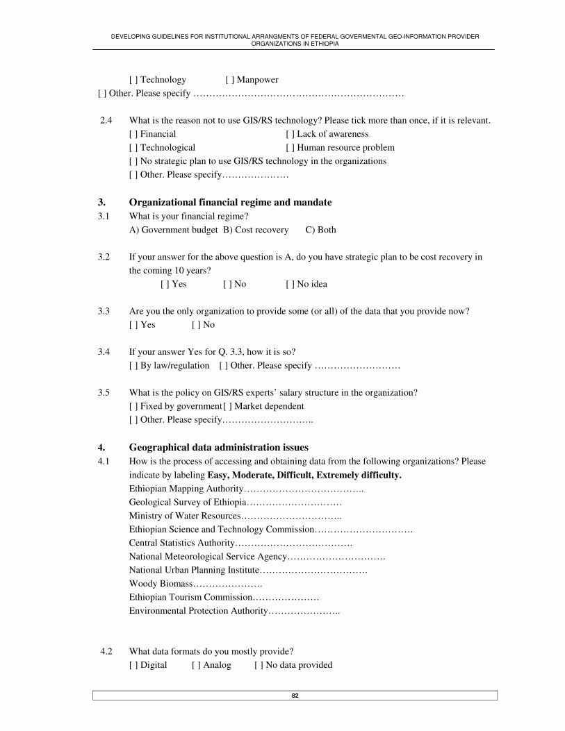
DEVELOPING GUIDELINES FOR INSTITUTIONAL ARRANGMENTS OF FEDERAL GOVERMENTAL GEO-INFORMATION PROVIDER ORGANIZATIONS IN ETHIOPIA
82
[ ] Technology [ ] Manpower [ ] Other. Please specify ………………………………………………………… 2.4 What is the reason not to use GIS/RS technology? Please tick more than once, if it is relevant. [ ] Financial [ ] Lack of awareness [ ] Technological [ ] Human resource problem [ ] No strategic plan to use GIS/RS technology in the organizations [ ] Other. Please specify………………… 3. Organizational financial regime and mandate 3.1 What is your financial regime?
A) Government budget B) Cost recovery C) Both 3.2 If your answer for the above question is A, do you have strategic plan to be cost recovery in
the coming 10 years? [ ] Yes [ ] No [ ] No idea 3.3 Are you the only organization to provide some (or all) of the data that you provide now? [ ] Yes [ ] No 3.4 If your answer Yes for Q. 3.3, how it is so? [ ] By law/regulation [ ] Other. Please specify ……………………… 3.5 What is the policy on GIS/RS experts’ salary structure in the organization?
[ ] Fixed by government [ ] Market dependent [ ] Other. Please specify……………………….. 4. Geographical data administration issues 4.1 How is the process of accessing and obtaining data from the following organizations? Please
indicate by labeling Easy, Moderate, Difficult, Extremely difficulty. Ethiopian Mapping Authority……………………………….. Geological Survey of Ethiopia………………………… Ministry of Water Resources………………………….. Ethiopian Science and Technology Commission…………………………. Central Statistics Authority……………………………….
National Meteorological Service Agency…………………………. National Urban Planning Institute……………………………. Woody Biomass…………………. Ethiopian Tourism Commission………………… Environmental Protection Authority…………………..
4.2 What data formats do you mostly provide?
[ ] Digital [ ] Analog [ ] No data provided

DEVELOPING GUIDELINES FOR INSTITUTIONAL ARRANGMENTS OF FEDERAL GOVERMENTAL GEO-INFORMATION PROVIDER ORGANIZATIONS IN ETHIOPIA
83
4.3. Does your organization advertise its products? [ ] Yes [ ] No 4.4 Do you have the following in your organization? Section responsible for Geoinformation [ ] Yes [ ] No Quality-controlling section [ ] Yes [ ] No 4.5 Considering topographic maps standard, do you apply that standard to your data during digi-
tizing any analog/paper maps? [ ] Yes, always [ ] Yes, some times [ ] Not applied [ ] We don’t digitize maps
4.6. Do you regularly/continuously update your data?
[ ] Yes [ ] No 4.7 Can you indicate in percentage (%) the coverages of all data types and formats found in the
organization? …………………………………………………. ………………………………………………………………………………… 4.8 How do you check quality of digital data you get from others?
……………………………………………………………………………….. 4.9 Do you have policy in your organizations for the following?
Data standard [ ] Yes [ ] No Data pricing [ ] Yes [ ] No Data exchangeable format standard [ ] Yes [ ] No Metadata standard [ ] Yes [ ] No Data collecting/updating standard [ ] Yes [ ] No Geospatial database standard [ ] Yes [ ] No Public right to access your data [ ] Yes [ ] No
5. Data users Issues 5.1 Which of the following organizations are frequently demanding your data? Please rank them. [ ] Government organizations [ ] Private companies
[ ] Individuals 5.2 Do you have policy whereby your organization compensates users in case of loses as a result
of errors in the data provided to them by the organization? [ ] Yes [ ] No 5.3 Do you know all your data users [ ] Yes [ ] No

DEVELOPING GUIDELINES FOR INSTITUTIONAL ARRANGMENTS OF FEDERAL GOVERMENTAL GEO-INFORMATION PROVIDER ORGANIZATIONS IN ETHIOPIA
84
5.4 If you have made assessment of users need before, does it bring any impact on the function of the organization? [ ] Yes [ ] No [ ] No users need assessment done before
6. Geographical data pricing issue 6.1 Considering your data pricing policy, how do you calculate the prices of individual products
of your organization? [ ] Based on market value [ ] To return service cost [ ] To make profit [ ] Fixed by Ministry/government [ ] other. Please specify …..……………………………
6.2 Are you held / checked / monitored by government to provide your data at the
lowest possible cost? [ ] Yes [ ] No
6.3. Can you mention data types that you give free of cost for public?
…………………………………………………………………………. 7. GI provider/user organizations coordination issues 7.1 If your organization is decentralized, how is the coordination with the regional bureau in ex-
change geoinformation? [ ] Strong [ ] Moderate
[ ] Weak [ ] No communication [ ] Not decentralized 7.2 Do you know what data available, data standard, data formats, database structure, and GIS/RS
technology in other GI provider or user organizations? [ ] Yes [ ] No 7.3 Is your organization a member of any GI coordination council (Metadata, clearinghouse, etc)? [ ] Yes [ ] No If your answer is Yes go to Q. 7.4; otherwise Q. 7.7 7.4 What are objectives of the coordination? Please tick more than once, if it is relevant. [ ] data standard [ ] Metadata standard/clearinghouse [ ] Data pricing [ ] Data Policy formulation [ ] Data sharing [ ] Other. Please specify ………………………….. 7.5 How your organization becomes member of the council?
[ ] Voluntarily [ ] By government regulation [ ] Other. Please specify………………………..

DEVELOPING GUIDELINES FOR INSTITUTIONAL ARRANGMENTS OF FEDERAL GOVERMENTAL GEO-INFORMATION PROVIDER ORGANIZATIONS IN ETHIOPIA
85
7.6 If you are coordinating the council, or being a member of the council, what are the problems the council face? [ ] Mandate [ ] Finance [ ] Other…………………
7.7 What are the problems not to be a member of the council? ……………………………………………………………. 8. Outsourcing/subcontracting (giving some of the organizational GI activities for others to
do for you) 8.1 Do you outsource/subcontract some of your GI activities? A) Yes B) No If your answer is A go to Q. 8.2; otherwise Q. 8.7 8.2. Which of the following organization mostly doing your outsourced/subcontracted activities? [ ] Government [ ] Private [ ] Both 8.3 What are the activities your organization outsourcing/subcontracting? [ ] Digitizing [ ] Aerial photography [ ] Printing/production services [ ] Master plan study and preparation
[ ] Other. Please mention them. ………………………………………….. 8.4 Does the money you allocate for outsourcing/subcontracting activities increase yearly? [ ] Yes [ ] No [ ] Depends on budget/other sources 8.5 Considering quality/standard of subcontracted activities, do you have already established
guidelines for controlling quality/standard of the activities? [ ] Yes [ ] No 8.6 Do you know all companies (government & private) that can possibly do your subcontracted
activities? [ ] Yes [ ] No 8.7 Can you mention main reasons not to subcontract activities? [ ] Mandate [ ] Finance [ ] Other. Please specify…………… …………. 9. Human resource and research Issues 9.1 Considering training/education, do you have training program on regular base?
[ ] Yes [ ] No 9.2 Does the number of GIS/RS experts in the organization decrease through time?
[ ] Yes [ ] No . How many experts you have now? ……………

DEVELOPING GUIDELINES FOR INSTITUTIONAL ARRANGMENTS OF FEDERAL GOVERMENTAL GEO-INFORMATION PROVIDER ORGANIZATIONS IN ETHIOPIA
86
9.3 On what base your organization financing research and development programs on GIS/RS technology?
[ ] Regularly [ ] Not regularly [ ] No research & development Contact Person: Name…………………………… Address……………………