developing internal data quality metrics for lidar: a … · introduction · inter swath accuracy ·...
TRANSCRIPT

U.S. Department of the Interior
U.S. Geological Survey
Developing Internal Data
Quality Metrics for Lidar: A
USGS-ASPRS Research
Effort
Ajit Sampath JACIE 2014, 3/28/2014
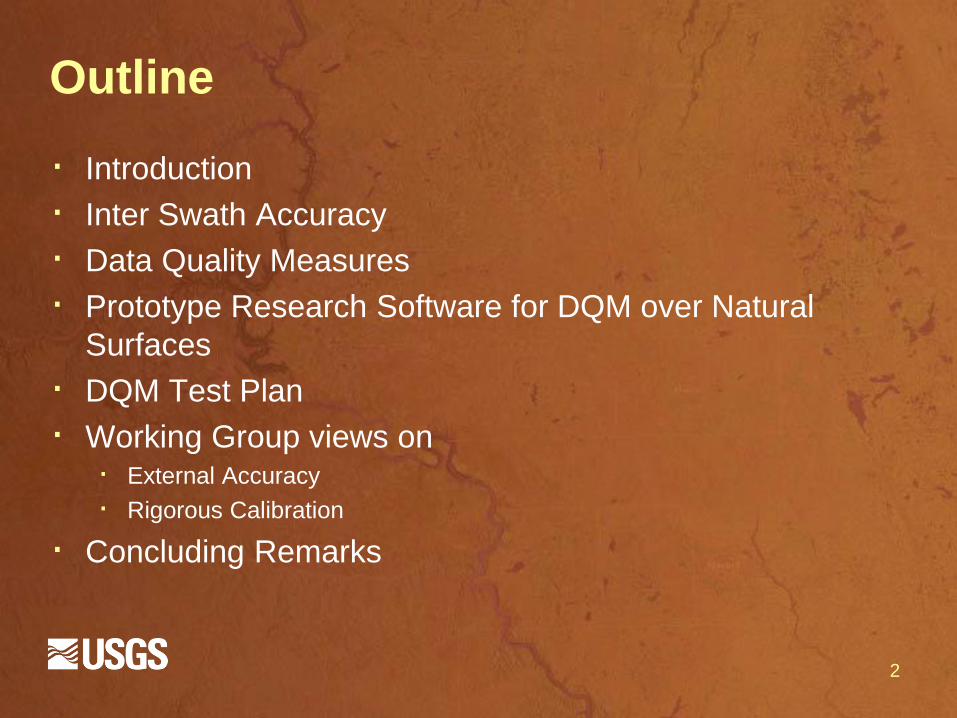
Outline
· Introduction
· Inter Swath Accuracy
· Data Quality Measures
· Prototype Research Software for DQM over Natural
Surfaces
· DQM Test Plan
· Working Group views on · External Accuracy
· Rigorous Calibration
· Concluding Remarks
2

Introduction
· Lidar data have become the primary means of 3D
mapping
· Quality standards transform Lidar point cloud from pretty
visualization to metric data
· Quality control and assurance processes are not
consistently applied · Does not mean current processes are incorrect
· Inconsistent in reporting quality of calibration/boresight of Lidar system
· With large projects such as 3DEP on the anvil, consistent
geometric quality assessment methods for procurement
purposes needed
3

ASPRS Lidar Cal/Val Working Group
· ASPRS Airborne Lidar Committee has formed a
working group of: · Industry - Instrument Manufacturers, Data providers, and Data
users
· Government (USGS, NGS/NOAA, US Army corps, NGA, etc.)
· Academia (Ohio State, University of Calgary, Purdue, etc.)
· Develop and publish guidelines on assessing
geometric accuracy of Lidar data
· Relative (Internal) Quality Control Processes and Report
· Absolute (external) Quality Control Processes and
Report
· Recommended Quality Assurance Guidelines
4

Framework for Guidelines Document
5
Inter-swath goodness of fit or internal accuracy
metrics
Sensor independent Data Quality Measures
Standard report provided by vendor to
customer prior to data processing
Absolute accuracy
(horizontal and vertical) metrics
Sensor independent
metrics based on targets
Standard report provided by
vendor at time of delivery of final data products
Rigorous system calibration methods
Sensor model (actual or generic)
dependent metric
Instrument manufacturer
guided procedures provided to vendor

Inter Swath Accuracy: DQMs

Inter Swath Accuracy: Why?
· Quality of calibration manifests most clearly in overlapping regions of adjacent swaths
· Importance of well calibrated instrument cannot be overstated
· A consistent quantifiable process to check the quality of calibration is needed
· DQMs quantify the inter-swath goodness of fit in a consistent manner

Internal accuracy: DQMs
· Three Data Quality Measures to represent inter swath
accuracy of data
Nature of
surface Examples
Data Quality
Measures
(DQMs)/Goodness of
fit measures
Units
Natural
surfaces Ground surface, i.e. not trees,
chimneys, electric lines etc. Point to natural surface
distance Meters
Point to surface vertical
distance Meters
Man-made
surfaces Roof planes Centroid of one plane to
the conjugate plane Meters
Roof edges Centroid of one line
segment to the conjugate
line segment
Meters

DQM over Natural Surfaces: Point to
Tangential Plane Distance
· Ideally, conjugate features in
both swaths should be
coincident · Any departure from ideal is a measure
of discrepancy
· Select a point from one swath
and determine its neighbors in
swath # 2.
· Fit a plane to the neighbor
points
· Determine distance of point ‘p’
to this plane.
9
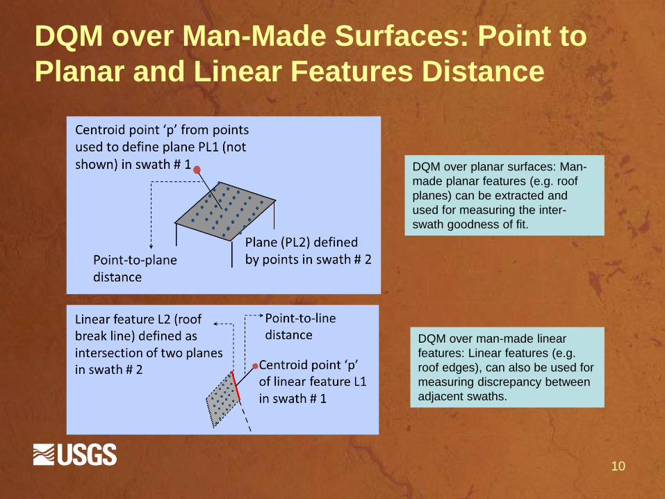
DQM over Man-Made Surfaces: Point to
Planar and Linear Features Distance
10
DQM over planar surfaces: Man-
made planar features (e.g. roof
planes) can be extracted and
used for measuring the inter-
swath goodness of fit.
DQM over man-made linear
features: Linear features (e.g.
roof edges), can also be used for
measuring discrepancy between
adjacent swaths.

DQM over Natural Surfaces Research
Software
· US Geological Survey has
funded prototyping a research
level implementation for the
Working Group
· The prototype works on
adjacent and multiple swaths
· Uniformly samples point in
overlapping region
· Determines DQM for each
sample
11

DQM over natural surfaces
implementation
· Determine neighbors for each
sample point · Voronoi Neighbors
· Extended Voronoi neighbors
· Nearest Neighbors
· Determine Planar parameters
using Eigen analysis · Eigen values give RMSE of planar fit
· Eigen vector give planar equation
· Many linear algebra packages available
(e.g. Eigen)
· Determine Point to Plane Distance · Displacement vectors, Normal vectors, etc.
12
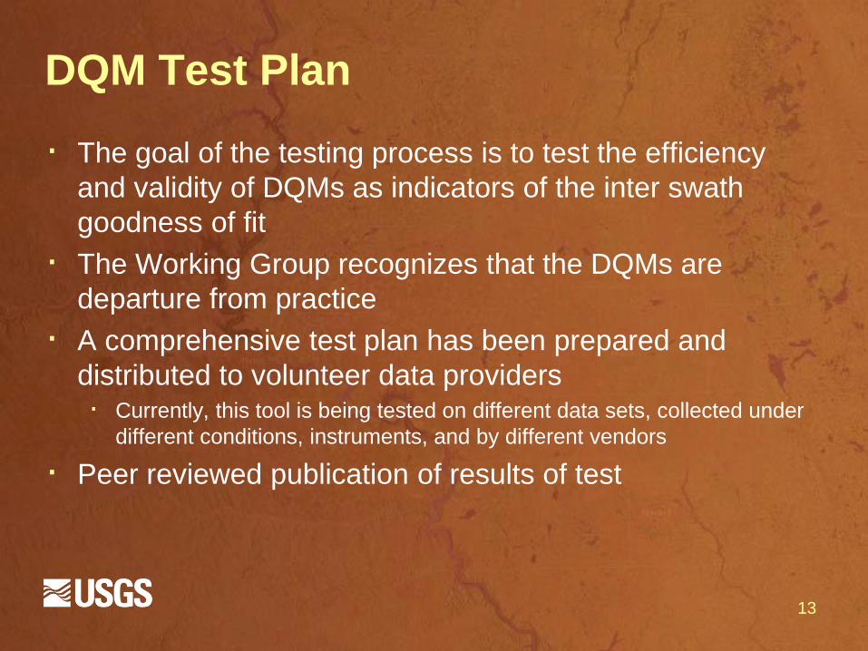
DQM Test Plan
· The goal of the testing process is to test the efficiency
and validity of DQMs as indicators of the inter swath
goodness of fit
· The Working Group recognizes that the DQMs are
departure from practice
· A comprehensive test plan has been prepared and
distributed to volunteer data providers · Currently, this tool is being tested on different data sets, collected under
different conditions, instruments, and by different vendors
· Peer reviewed publication of results of test
13

DQM Test Plan
· Data re-generated after errors are introduced to nominal
boresight values
· Volunteer data providers distributed a table with three
sets of errors to be introduced to the nominal parameter
values
· The errors introduced to the boresight parameters vary
depending on discussions with data providers
14
ΔX
(m)
ΔY
(m)
ΔZ
(m)
Δω
(seconds)
Δφ
(seconds)
Δκ
(seconds)
Mirror angle scale
(unit less)
Range errors
(meters)
-0.13 0.7 .17 17” -18” 72” 0.13 0.7
-0.15 -0.14 0.05 11” 106” 5” 0.15 -0.14
-0.04 0.07 0.08 71” 129” 66” 0.04 0.07

DQM Test Plan
· The output generated will be analyzed to obtain summary
estimates of errors in different data sets.
· Analysis will be followed with discussions with the ASPRS
Cal/Val Working Group members on representing results · Geoscience Australia represents them as matrix.
· Analysis will help correctly quantify the quality of data for
procurement and scientific applications.
15

Some preliminary analysis
16

External Quality: Absolute Accuracy
· Targets are not new to the geospatial industry
· Used in conventional surveying, photogrammetry and
also microwave/SAR based mapping.
· A few examples are shown
17

Discussions on Rigorous Calibration
· Discussions have favored the use of rigorous sensor
model based calibration approaches
· Rigorous calibration approach is robust and automated
·Resulting data are consistent with each other and with external control.
· These approaches use proprietary sensor models · Software and procedures suggested by instrument manufacturers may
be used for lidar system calibration
· Generic sensor model based calibration · ULEM, Semi Rigorous
18
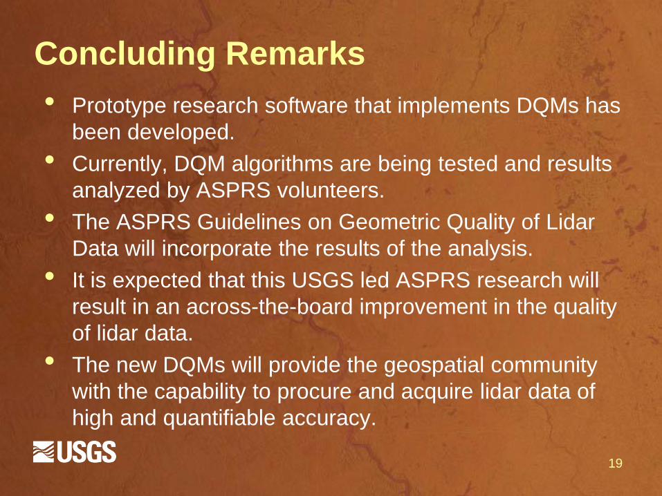
Concluding Remarks
• Prototype research software that implements DQMs has
been developed.
• Currently, DQM algorithms are being tested and results
analyzed by ASPRS volunteers.
• The ASPRS Guidelines on Geometric Quality of Lidar
Data will incorporate the results of the analysis.
• It is expected that this USGS led ASPRS research will
result in an across-the-board improvement in the quality
of lidar data.
• The new DQMs will provide the geospatial community
with the capability to procure and acquire lidar data of
high and quantifiable accuracy.
19