development brief: western gateway - newcastle.gov.uk · unauthorised reproduction infringes crown...
TRANSCRIPT

we
ste
rn
ga
tew
ayd
ev
elo
pm
en
t b
rie
f:
draft: v0.5, 21/11/07

�
western gateway brief
Mapping: This map is reproduced from Ordnance Survey material with the permission of Ordnance Survey on behalf of the Controller of Her Majesty’s Stationery Office © Crown Copyright. Unauthorised reproduction infringes Crown Copy-right and may lead to prosecution or civil proceedings. Newcastle City Council, 100019569, 2007. Cities Revealed ® Aerial Photography © The GeoInformation Group 2005. All rights reserved. Newcastle City Council, 2007.
draft: v0.5, 21/11/07
Regeneration Directorate
purpose & statusThis document covers a specific group of sites at the western end of Walker. The area is identified within the Walker Riverside Area Action Plan [AAP] for redevelopment as part of the overall regeneration of this part of Newcastle.
The status of this document is as an Informal Developer Guidance. This guidance is intended to clarify the detailed requirements of the Local Planning Authority regarding this development site, for the benefit of the local community and the delivery partners involved in the Walker Riverside Regeneration Programme.
site detailsThe sites covered by this guidance are located either side of Walker Road, at the junction with Allendale Road. These sites are known as part of the “Western Gateway” area. Linked to these sites is the Rivers Gate development site to the east, on the site of the former McCutcheons Court housing, which is under construction at the time of writing.
There are three separate development plots within the group of sites - the “strip” site north of Walker Road plus the former Allotments site between Walker Road / Bakewell Terrace and the Hadrians Way route [Site WG2 in the AAP]; and the former St Peters Station site [Site HDP2 in the AAP]. The sites are highly influenced by the local topography of the Tyne Gorge.
The boundaries of these plots may be varied from those currently apparent on the ground, to allow for desirable alterations to adjacent routes.
policy historyThere has been no preceding guidance from the Local Planning Authority for this specific site. The background to the proposal of this site for development is largely contained in the Area Action Plan [AAP, adopted in 2007].
the city’s visionNewcastle City Council and its partners have developed a clear vision for the regeneration of Walker Riverside.
Our vision for the Western Gateway area is to secure development of a high quality residential area featuring:
A strong, positive and unique character which enhances the sense of entry into Walker, transforming Walker Road to present a high quality coordinated and coherent experience.
Layouts which seek to integrate the new development into the adjacent established urban area, which create a clear and positive edge as an identifiable extension of Walker, and which are rooted in an understanding of the history & future direction of the neighbourhood.
Building designs which resolve the challenges and opportunities of the southerly, river-facing sites aspects to maximise passive and active solar design, and maximise views & vistas in & out of the site.
Layouts and spaces which enhance the perception of topography, and encourage & facilitate safe access into and through the sites from adjacent areas.
A mix of housing which reflects the overall Walker Riverside Regeneration Programme, and is appropriate to the specific opportunities of this location and sites.
»
»
»
»
»
site location in relation to Newcastle City Centre: Walker Riverside Regeneration Area hatched in red, Western Gateway site location marked with blue spot
▲

�Mapping: This map is reproduced from Ordnance Survey material with the permission of Ordnance Survey on behalf of the Controller of Her Majesty’s Stationery Office © Crown Copyright. Unauthorised reproduction infringes Crown Copy-right and may lead to prosecution or civil proceedings. Newcastle City Council, 100019569, 2007. Cities Revealed ® Aerial Photography © The GeoInformation Group 2005. All rights reserved. Newcastle City Council, 2007.
western gateway briefdraft: v0.5, 21/11/07
Regeneration Directorate
plan of the area▲
context analysis summaryThis is a summary of the full context analysis included in the appendices to this document, appraised against the objectives in “By Design: Urban Design in the Planning System”.
Character: Distinctive topography & views, and access to open spaces. Isolation from the Riverside, lack of distinctive built features, unbroken massing.
Continuity and enclosure:Generally well defined frontage lines, a few modern instances which are poor. Station site lacks any defining relationship. Rears present to public space on strip site and along Riverside Park. Front gardens common.
Quality of the public realm:Immediate access to varied, well connected green spaces. Overlooking & surveillance poor in many instances. South-facing aspect, but public realm design generally very basic.
ease of movement:Good access to movement & transport networks, but service levels currently poor. Highways over-engineered, low priority for pedestrians. North-south links required.
legibility:Few distinctive features; “hole” in the edge of the fabric of Walker; key junction is poorly defined; basic palette of materials in area.
adaptability:Earlier housing relatively adaptable; additional flexibility desirable. Open space needs flexbility.
diversity:Lack of variety across public spaces; need for more stimulating built form as well.
»
»
»
»
»
»
»
key context issuesThese are the key context issues and appropriate means of responding to them:
“Repair” the continuity of urban fabric defining the edge of and entrance to Walker.
Using carefully considered massing formation to enhance and create specific views & vistas.
Embracing the former railway alignment with buildings in the Riverside Park, in contrast to historic reaction of turning away from this infrastructure.
Creating public spaces & links that encourage safe access to the Riverside Park routes, particularly providing a new direct link from the south of Allendale Road through the WG2 site.
Increasing pedestrian priority, especially on Walker Road and at the Allendale junction. Re-engineering of this junction is essential to changing the perception of Walker Road.
Introduction of more stimulating & distinctive public spaces and architectural detailing.
Integration of the station site into the Byker area, recognising the long-term possibilities of sites around Glasshouse Street.
Integration with the recently commenced “Riversgate” housing adjoining the site.
»
»
»
»
»
»
»
»
Walker Road
Allendale Road
Walker RoadHDP2 site [former St Peters Railway station
WG2 site [former allotments and Walker Road frontage]
Area Action Plan Proposals map extract for Western Gateway area. Key: Yellow=mixed use; Brown=housing; Green=open space
▲
�
western gateway brief
Mapping: This map is reproduced from Ordnance Survey material with the permission of Ordnance Survey on behalf of the Controller of Her Majesty’s Stationery Office © Crown Copyright. Unauthorised reproduction infringes Crown Copy-right and may lead to prosecution or civil proceedings. Newcastle City Council, 100019569, 2007. Cities Revealed ® Aerial Photography © The GeoInformation Group 2005. All rights reserved. Newcastle City Council, 2007.
draft: v0.5, 21/11/07
Regeneration Directorate
be guided by the agreed approaches for Walker Riverside:
The majority of the housing should be designed for families, with a strong preference for larger accommodation.
10% of the total housing units on the site should be provided as social rented housing.
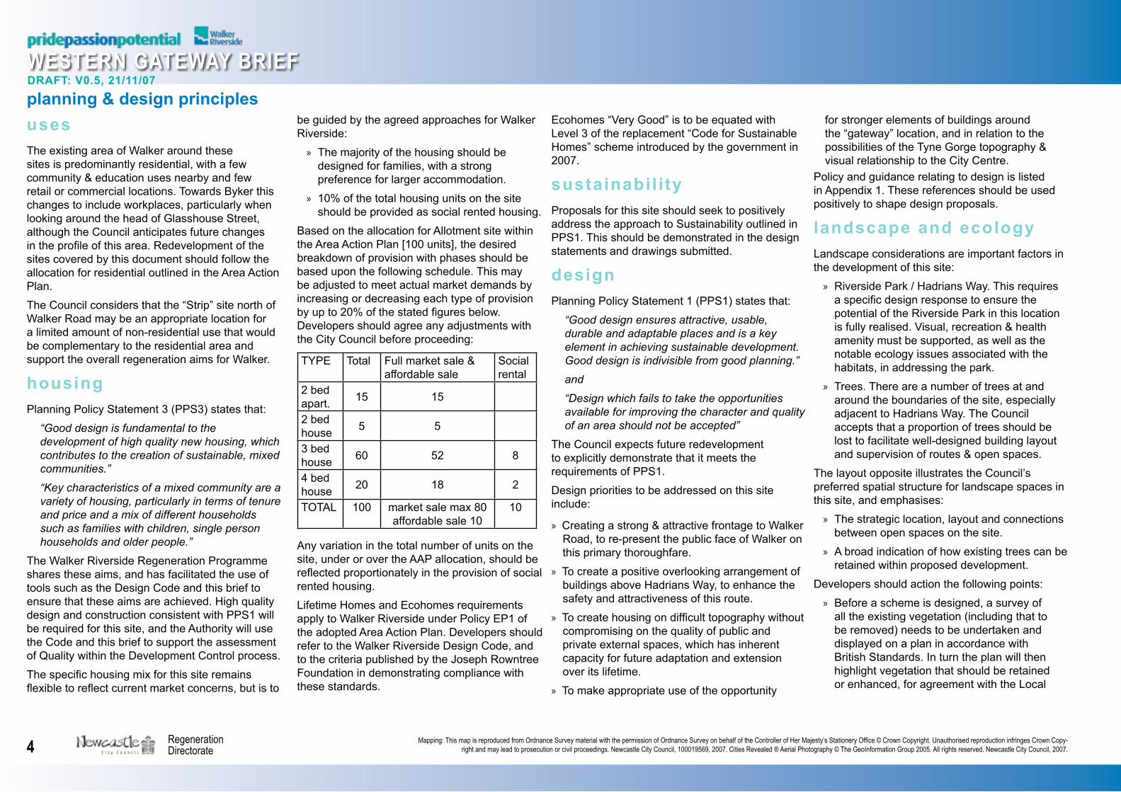
Based on the allocation for Allotment site within the Area Action Plan [100 units], the desired breakdown of provision with phases should be based upon the following schedule. This may be adjusted to meet actual market demands by increasing or decreasing each type of provision by up to 20% of the stated figures below. Developers should agree any adjustments with the City Council before proceeding:
TYPE Total Full market sale & affordable sale
Social rental
2 bed apart. 15 15
2 bed house 5 5
3 bed house 60 52 8
4 bed house 20 18 2
TOTAL 100 market sale max 80 affordable sale 10
10
Any variation in the total number of units on the site, under or over the AAP allocation, should be reflected proportionately in the provision of social rented housing.
Lifetime Homes and Ecohomes requirements apply to Walker Riverside under Policy EP1 of the adopted Area Action Plan. Developers should refer to the Walker Riverside Design Code, and to the criteria published by the Joseph Rowntree Foundation in demonstrating compliance with these standards.
»
»
for stronger elements of buildings around the “gateway” location, and in relation to the possibilities of the Tyne Gorge topography & visual relationship to the City Centre.
Policy and guidance relating to design is listed in Appendix 1. These references should be used positively to shape design proposals.
landscape and ecologyLandscape considerations are important factors in the development of this site:
Riverside Park / Hadrians Way. This requires a specific design response to ensure the potential of the Riverside Park in this location is fully realised. Visual, recreation & health amenity must be supported, as well as the notable ecology issues associated with the habitats, in addressing the park.
Trees. There are a number of trees at and around the boundaries of the site, especially adjacent to Hadrians Way. The Council accepts that a proportion of trees should be lost to facilitate well-designed building layout and supervision of routes & open spaces.
The layout opposite illustrates the Council’s preferred spatial structure for landscape spaces in this site, and emphasises:
The strategic location, layout and connections between open spaces on the site.
A broad indication of how existing trees can be retained within proposed development.
Developers should action the following points:
Before a scheme is designed, a survey of all the existing vegetation (including that to be removed) needs to be undertaken and displayed on a plan in accordance with British Standards. In turn the plan will then highlight vegetation that should be retained or enhanced, for agreement with the Local
»
»
»
»
»
planning & design principlesusesThe existing area of Walker around these sites is predominantly residential, with a few community & education uses nearby and few retail or commercial locations. Towards Byker this changes to include workplaces, particularly when looking around the head of Glasshouse Street, although the Council anticipates future changes in the profile of this area. Redevelopment of the sites covered by this document should follow the allocation for residential outlined in the Area Action Plan.
The Council considers that the “Strip” site north of Walker Road may be an appropriate location for a limited amount of non-residential use that would be complementary to the residential area and support the overall regeneration aims for Walker.
housingPlanning Policy Statement 3 (PPS3) states that:
“Good design is fundamental to the development of high quality new housing, which contributes to the creation of sustainable, mixed communities.”
“Key characteristics of a mixed community are a variety of housing, particularly in terms of tenure and price and a mix of different households such as families with children, single person households and older people.”
The Walker Riverside Regeneration Programme shares these aims, and has facilitated the use of tools such as the Design Code and this brief to ensure that these aims are achieved. High quality design and construction consistent with PPS1 will be required for this site, and the Authority will use the Code and this brief to support the assessment of Quality within the Development Control process.
The specific housing mix for this site remains flexible to reflect current market concerns, but is to
Ecohomes “Very Good” is to be equated with Level 3 of the replacement “Code for Sustainable Homes” scheme introduced by the government in 2007.
sustainabil i ty Proposals for this site should seek to positively address the approach to Sustainability outlined in PPS1. This should be demonstrated in the design statements and drawings submitted.
designPlanning Policy Statement 1 (PPS1) states that:
“Good design ensures attractive, usable, durable and adaptable places and is a key element in achieving sustainable development. Good design is indivisible from good planning.”
and
“Design which fails to take the opportunities available for improving the character and quality of an area should not be accepted”
The Council expects future redevelopment to explicitly demonstrate that it meets the requirements of PPS1.
Design priorities to be addressed on this site include:
Creating a strong & attractive frontage to Walker Road, to re-present the public face of Walker on this primary thoroughfare.
To create a positive overlooking arrangement of buildings above Hadrians Way, to enhance the safety and attractiveness of this route.
To create housing on difficult topography without compromising on the quality of public and private external spaces, which has inherent capacity for future adaptation and extension over its lifetime.
To make appropriate use of the opportunity
»
»
»
»

�Mapping: This map is reproduced from Ordnance Survey material with the permission of Ordnance Survey on behalf of the Controller of Her Majesty’s Stationery Office © Crown Copyright. Unauthorised reproduction infringes Crown Copy-right and may lead to prosecution or civil proceedings. Newcastle City Council, 100019569, 2007. Cities Revealed ® Aerial Photography © The GeoInformation Group 2005. All rights reserved. Newcastle City Council, 2007.
western gateway briefdraft: v0.5, 21/11/07
Regeneration Directorate
Authority.
Developers may also be required to contribute through a S106 agreement to help address specific landscape issues such as replacement planting of trees in another location to offset losses within this site.
Any new development will have to implement a whole scale, hard and soft landscaping scheme that falls in accordance with UDP’s Development Control Policy Statement 19.
Based on survey of existing facilities in the Walker area, development on this site should make provision for an open space that meets the “5 minute walk standard” as described Green Space Strategy (“Green spaces…your spaces” on pages 52-3. The open space should also include play features for children under 5, and seating for carers. The landscape strategy layout opposite indicates a preferred location for this facility.
Early discussion with Landscape and Ecology officers is recommended. Developers should contact the NCC Project Manager [Clare Wood, 0191 277 7877] to arrange discussions.
»
»
»
Increase visual connection between Riverside Park and adjacent housing by selectively thinning trees and locating new dwellings close to the boundary to overlook the traffic-free route
Direct access from Walker Road to new green space, which will feature panoramic views of the Tyne gorge, over the roofs of 2 storey dwellings at the lower boundary of the site, and include a children’s play area
Area offering potential for addition to the former railway station site development. Development here could improve overlooking of the Park, provide linking vehicle / shared surface route between the two sites, and rationalise the steep “leftover” land within the new allotment boundary
Southern boundary of the former station site - retain existing tree corridor along park pathway, locate dwelling frontages or street spaces close to boundary to improve overlooking
Redefine public space adjacent Walker Road, integrating areas for seating, public transport waiting, parking and occasional special event functions
Building frontages aligned to “repair” the missing gap in the urban edge of Walker, and provide overlooking of new route & open space
Harbottle Park
New Allotments
St Peters
Riverside Park
Riverside Park
Walker RoadAllendale R
oad
Desired landscape strategy network▲aerial view: brief sites highlighted and edged in red; other development sites edged in blue with grey site areas
▲

�
western gateway brief
Mapping: This map is reproduced from Ordnance Survey material with the permission of Ordnance Survey on behalf of the Controller of Her Majesty’s Stationery Office © Crown Copyright. Unauthorised reproduction infringes Crown Copy-right and may lead to prosecution or civil proceedings. Newcastle City Council, 100019569, 2007. Cities Revealed ® Aerial Photography © The GeoInformation Group 2005. All rights reserved. Newcastle City Council, 2007.
draft: v0.5, 21/11/07
Regeneration Directorate
hierarchy of spacesEstablishing a meaningful hierarchy of spaces within the former Allotments site will be a priority. The challenges of the topography and limited number of access points should not be allowed to excessively constrain the structure of public space.
In particular where streets may need to either follow contours or provide a consistent access gradient into the site, significant attention should be paid to ensuring that these spaces have differentiated characters and are do not present themselves as uniform spaces with insufficient variety and articulation.
movement and transport Walker Road provides the primary means of vehicle access for these sites. Hadrians Way provides easy access to the strategic off-road network. The diagrams on this page indicate the Council’s preferred movement network for these development sites, and also reflects the need to provide accessible gradients in the public realm. No direct link into the Oval is required.
Location of car parking should be varied, as directed in the Design Code, and the level of parking provision should accord with the City’s current guidance. Contact the NCC Project Manager to discuss further if required.
facing buildings to routesWalker Riverside Design Code gives specific guidance regarding the location and percentage of frontage to be provided around perimeter blocks to ensure appropriate street enclosure. This should be supported by the location of primary operational building entrances within primary street spaces, not within courtyards or on secondary elevations.
promoting active frontageThe Design Code also requires street frontages to be “active”. Refer to the “Urban Design
Desired movement: vehicles [red], foot [green], shared [red dotted]
▲ Desired hierarchy of key public spaces
▼Desired greenspace network▲ Key street frontage and significant corner locations
▼
Future link option
Enhanced green space and new walking link between Harbottle & Riverside Parks new play
provision

�Mapping: This map is reproduced from Ordnance Survey material with the permission of Ordnance Survey on behalf of the Controller of Her Majesty’s Stationery Office © Crown Copyright. Unauthorised reproduction infringes Crown Copy-right and may lead to prosecution or civil proceedings. Newcastle City Council, 100019569, 2007. Cities Revealed ® Aerial Photography © The GeoInformation Group 2005. All rights reserved. Newcastle City Council, 2007.
western gateway briefdraft: v0.5, 21/11/07
Regeneration Directorate
Compendium” for detailed guidance [section 5.2].
Planning applications should also provide an assessment of the degree to which they offer “active frontage” against the grading scale on page 89 of the compendium.
public realm designThe Design Code contains specific advice about different street types and general public realm issues, especially for the Walker Road “boulevard”. In addressing the design of each street space, designers should also demonstrate that they have applied the principles of the Manual for Streets, and that issues of Accessibility have been surveyed and addressed. Developers are encouraged to facilitate community involvement in the detail of specific public realm design.
massing & densityThe Design Code sets parameters for building heights - for this site they equate to 2 storeys generally, with 3-4 storeys encouraged at block corners in order to increase “legibility”.
The diagrams on this page illustrate the Council’s desired conceptual massing envelope incorporating the preceding principles: note that this does not mean all of this envelope will be filled with building mass, and that this diagram is not a final site layout:
designers should ensure that they apply further design investigation to this framework, particularly with regard to meeting the required accommodation mix and providing an accessible public realm.
The exact alignment of streets & spaces, and exact position of building masses should be carefully considered. Final designs may vary from this massing diagram if they justify the changes on the basis of site & brief analysis, and clearly illustrate this justification.
»
»
»
Open space with children’s play area
Private gardens and parking courts
Private gardens
Private gardens
Homezone street
Homezone street
Turning Head
Turning Head
3 storeys against Walker Road at corner
3 storeys at corner
3 storeys at corner
3 storeys against Walker Road at corner
“Riversgate” housing scheme
Walker RoadAlle
ndal
e R
oad
The Oval
Riverside Park Route

�
western gateway brief
Mapping: This map is reproduced from Ordnance Survey material with the permission of Ordnance Survey on behalf of the Controller of Her Majesty’s Stationery Office © Crown Copyright. Unauthorised reproduction infringes Crown Copy-right and may lead to prosecution or civil proceedings. Newcastle City Council, 100019569, 2007. Cities Revealed ® Aerial Photography © The GeoInformation Group 2005. All rights reserved. Newcastle City Council, 2007.
draft: v0.5, 21/11/07
Regeneration Directorate
Junction of Allendale & Walker Roads: main vehicle access
▲ Riverside Park, at foot of existing steps from the Oval
▼Block south of Walker Road: parking options
▲ “Strip site” north of Walker Road: redefined public space
▼
The Area Action Plan allocates a total of 130 dwellings on 3.9 hectares of site areas [WG2 and HDP2 together]. This is equivalent to a density of 33 dwellings per hectare, reflecting the difficult physical constraints of the site. The Council will consider higher numbers subject to:
meeting the overall design objectives set out in this brief
providing a proportional amount of affordable housing
specif ic location issuesUrban block on the south side of Walker Road. This area should resolve the difficulties of providing strong frontage to Walker Road, alignment of access routes within the site at acceptable gradients, provision of parking in a variety of integrated locations, and the significant level changes falling away from Walker Road. The corners at the western and eastern ends of the block should be strongly formed.
The “Strip” Site north of Walker Road. The area available for buildings is tightly constrained here, and therefore bespoke designs should be used to resolve the issues of plan depth and carefully arranging heights/sections to minimise negative impacts on neighbouring properties in Chatsworth Gardens. The building adjacent to the Allendale junction should address the sense of enclosure / gateway identified in this document for this urban edge. The overall scheme for this part of the site should include a minority of building footprints [anticipated as being located at the eastern & western-most ends of the “strip”], together with a reorganisation of public realm. However, it is important that the design of this space includes elements which visually screen the ground floor level rear yard enclosures of dwellings on Chatsworth Gardens.
»
»
»
»
New Allotments
Planting screen to boundary
Signalised Cross-road junction
Main vehicle access
Open space
Homezone Street
Walker RoadUndercroft parking for corner apartments
Public SpaceBus Stops
Non-residential corner building
Buildings arranged to minimise impact on views
Existing steps on path from The Oval
Trees & planting thinned out to allow overlooking of park pathway

�Mapping: This map is reproduced from Ordnance Survey material with the permission of Ordnance Survey on behalf of the Controller of Her Majesty’s Stationery Office © Crown Copyright. Unauthorised reproduction infringes Crown Copy-right and may lead to prosecution or civil proceedings. Newcastle City Council, 100019569, 2007. Cities Revealed ® Aerial Photography © The GeoInformation Group 2005. All rights reserved. Newcastle City Council, 2007.
western gateway briefdraft: v0.5, 21/11/07
Regeneration Directorate
This should be condensed into a high quality public space which can be used for daily leisure & relaxation, as well as being able to flexibly host outdoor events. The public transport stop should be linked closely to this area, with access routes / lighting / seating all considered and integrated into the design.
Junction of Allendale and Walker Road. As part of the Boulevard proposals ,the roundabout should be replaced with a signalised cross-roads, providing the main vehicular access to the former allotment site. This is intended to increase pedestrian priority & safety and contribute to reducing vehicle speeds. Draft designs will be available from Newcastle City Council Engineering Services. The public realm around the junction should be designed as a coherent, high quality public space, presenting a strong sense of enclosure & entry to Walker.
Adajcent to Bakewell Terrace & The Oval. Site layout should locate rear gardens against existing rear gardens. The orientation of existing houses adjacent on Bakewell Terrace should be continued. Parking & access on Bakewell Terrace should reflect this precedent pattern as far as practically possible.
Homezone streets. These spaces should prioritise pedestrian movement, whilst accommodating some parking in an informal and varied arrangement, with planting used to break up the street arrangement. Allocated parking bays in this space should be located adjacent to relevant front doors.
Boundary with the Riverside Park. It is essential that the design of this area provides a carefully resolved overlooking frontage towards the park & off-road route, and this also provides opportunity to utilise the panoramic views available from this position.
»
»
»
»
Options for connecting new path access into the Riverside Park
▲ Boundary with The Oval: buildings massed for views
▼Looking west along Bakwell Terrace: views & alignments
▲ Pedestrian & vehicle routes should not exceed 1:12
▼
Bak
ewel
l Ter
race
Alignment of streets and buildings facilitates views towards city centre/bridges, and surrounding landscape
Walker Road
1 2
To St Peters
Levels are approximate

10
western gateway brief
Mapping: This map is reproduced from Ordnance Survey material with the permission of Ordnance Survey on behalf of the Controller of Her Majesty’s Stationery Office © Crown Copyright. Unauthorised reproduction infringes Crown Copy-right and may lead to prosecution or civil proceedings. Newcastle City Council, 100019569, 2007. Cities Revealed ® Aerial Photography © The GeoInformation Group 2005. All rights reserved. Newcastle City Council, 2007.
draft: v0.5, 21/11/07
Regeneration Directorate
Topography within the former allotment site dictates a custom solution for any building here, and it is important that the design achieves positive overlooking of the park without being compromised by technical considerations. The indicative concept illustrated here is for houses which cantilever out from the hillside to provide a dramatic setting for the dwellings as well as a strong interaction with the park spaces. It is important that the layout of this part of the site facilitates the future option of connecting the WG2 site [former allotments] to development on the former station site, including possibility for a vehicular / shared surface link.
Access route to the Riverside Park & St Peters Basin. The new route through the site connection to the Riverside Park should also be designed, and signed, to connect to the existing path nearby down to St Peters. The Council would like to see this development contribute to improvements to this existing path.
Former station site: it is important that this site is integrated into the surrounding area as much as possible. The southern boundary should be overlooked with frontages and the existing trees along the route retained. Private gardens should abut the allotment gardens. Engineering concrete needs removing in a manner that ensures the stability of retaining structure on the north side is maintained. The site also offers the possibility of new connections for non-car traffic, for which the Council is undertaking preliminary feasibility work. Developers should contact Jon Higgins [0191 277 8959] for further advice.
development phasingAt present the Council is undertaking measures to secure the WG2 site for development in the near future.
The HDP2 site [the former station] is under
»
»
separate ownership, and is likely to be developed significantly later than the WG2 site. This should be seen as beneficial, as this programme facilitates integration with the wider regeneration programme in the South Byker area.
This document seeks to establish some of the issues linking the two sites, and identify principles for coordinating their development. The HDP2 site may be subject to a further brief to refine requirements, and will particularly need to examine the possibility of arranging a physical link between the two sites.
The guidance in this brief is based on carrying out demolitions in line with the Walker Riverside Area Action Plan.

11Mapping: This map is reproduced from Ordnance Survey material with the permission of Ordnance Survey on behalf of the Controller of Her Majesty’s Stationery Office © Crown Copyright. Unauthorised reproduction infringes Crown Copy-right and may lead to prosecution or civil proceedings. Newcastle City Council, 100019569, 2007. Cities Revealed ® Aerial Photography © The GeoInformation Group 2005. All rights reserved. Newcastle City Council, 2007.
western gateway briefdraft: v0.5, 21/11/07
Regeneration Directorate

planning & transportation regeneration direCtorate newCastle City CounCil CiviC Centrebarras bridgenewCastle upon tyne
ContaCt: Clare wood,regeneration offiCer, 0191 277 7877
doCument version: 0.5status: internal review onlydate: 21/11/07