development control unit no. 013 - hunter's hill council
TRANSCRIPT

Development Control Unit
No. 013 26 September 2018 at 10.30 AM
Hunter 's H i l l Counc i l

ORDER OF BUSINESS
Attendance, Apologies, Declarations of Interests 1 Confirmation of Minutes 2 Development Applications

CONFIRMATION OF MINUTES 26 September 2018
Minutes of the Development Control Unit Meeting held on 12 September 2018. This is page 1
HUNTER'S HILL COUNCIL DEVELOPMENT CONTROL UNIT
26 September 2018 INDEX
1 – CONFIRMATION OF MINUTES
1 Confirmation of Minutes of Development Control Unit 012 held 12 September 2018
2 - DEVELOPMENT APPLICATIONS
2.1 10:30 am - 8 Crown Street, Henley 1 2.2 10:50 am - 29 Waruda Place, Huntleys Cove 28

CONFIRMATION OF MINUTES 26 September 2018
Minutes of the Development Control Unit Meeting held on 12 September 2018. This is page 2
COMMENCEMENT
The meeting commenced at approximately 10:30 am. LIST OF ATTENDEES
Barry Smith General Manager – (Chair – Item 2 & 3)
Steve Kourepis Group Manager Development & Regulatory Control (Item 2)
Debra McFadyen Group Manager Corporate Governance – (Acting Chair – Item 1)
Kerry Smith Senior Development Officer
Shahram Zadgan Development Assessment Officer
Julie Woodley Administration Officer
APOLOGIES
No apologies were received. DECLARATIONS OF INTEREST
The Chairperson called for Declarations of Interest without response. CONFIRMATION OF MINUTES
RECOMMENDATION That the Minutes of Development Control Unit of previous Meeting DCU 011 held on 29 August 2018 were confirmed
DEVELOPMENT APPLICATIONS
2.1 10:30 AM - 30A VIRET STREET, HUNTERS HILL
PROCEEDINGS IN BRIEF
PROPOSAL Modifications to existing roof, enclose first floor balcony for a bedroom and a pergola – Section 4.55 – delete external stairs and replace with extension to lift. ATTENDEES Carrado Palleschi - Applicant
RESOLVED on the motion of Ms McFadyen, seconded Mr Zadgan That the s4.55 application No.2015/1074-1 to modify Development Application No.2015/1074 of consent dated 27July 2015 for the alterations and additions plus new swimming pool and driveway at No.30A Viret Street, Hunters Hill, be approved, subject to the alteration to condition No.2 as follows:
CONFIRMATION OF MINUTES 26 September 2018
Minutes of the Development Control Unit Meeting held on 12 September 2018. This is page 3
2. The development consent No. 2015/1074 relates to the plans prepared by Corrado A. Palleschi Dwg. S96 01 Issue A to S96 09 Issue A dated 6 June 2018 as received by Council on 22 June 2018, except where amended by conditions of this consent.
2.2 10:50 AM - 8 BARONS CRESCENT, HUNTERS HILL - LOT 2
PROCEEDINGS IN BRIEF
PROPOSAL Construction of new two storey dwelling. ATTENDEES George Saaib - Applicant Tessa Manning - Submission
RESOLVED on the motion of Mr Kourepis, seconded Mr Zadgan That the development application No.2017/1188 for the construction of a new two storey dwelling with attached garage be granted a “Deferred commencement” consent pursuant to Section 4.16 of the Environmental Planning and Assessment Act, 1979 in respect of proposed Lot 2 at No.8 Barons Crescent, Hunters Hill. The development consent as contained in Schedule 2 shall not operate (nor be issued) until such time as the matters contained in Schedule 1 are finalised to the satisfaction of Council. Schedule 1 1. An Aboriginal Cultural Heritage Assessment Report (ACHAR) being prepared
and submitted to Council, in accordance with the Guide to investigating, assessing and reporting on Aboriginal cultural heritage in NSW (OEH 2011) and any such conditions recommended being incorporated in the conditions of the ‘outright’ development consent.
2. Evidence being produced that the Torrens Title subdivision as approved by
the Land & Environment Court for the overall allotment has been registered with the NSW Land Titles Office.
3. A detailed Construction Management Plan being prepared and submitted to
Council for this development and any such conditions recommended being incorporated in the conditions of the ‘outright’ development consent.
4. A Construction Traffic Management Plan being prepared and submitted to Council for this development and any such conditions recommended being incorporated in the conditions of the ‘outright’ development consent.
5. The geotechnical Assessment report and its recommendations as prepared by JK Geotechnics dated 17 November 2016 and received by Council on 5 December 2017 being implemented with such constructional details being shown on the architectural and structural plans to be submitted to Council for approval prior to the release of any stamped approved plans.

CONFIRMATION OF MINUTES 26 September 2018
Minutes of the Development Control Unit Meeting held on 12 September 2018. This is page 4
6. Matching privacy screens being provided on the sides of the upper level rear balcony with such details being shown on the subsequent architectural plans to be submitted for approval prior to the release of any stamped approved plans.
Schedule 2
A. That Development Application No. 2017/1188 for the construction of a new
two-storey dwelling with attached garage at No.8 Barons Crescent, Hunters Hill, be approved, subject to the following conditions
Standard Conditions: GEN0 GEN1 GEN3 GEN5 GEN6 GEN7 GEN20 GEN21 PCC0 PCC1($3,493.00) PCC2($2,530.00) PCC3($1,300.00) PCC4($2,000.00) PCC5 ($9,980.00) PCC11 PCC12 PCC20 PCC21 PCC40 PCC41 PCW0 PCW1 PCW2 PCW3 PCW4 PCW5 PCW9 PCW11 PCW14 CSI0 CSI1 CSI2 CSI3 DEM0 DEM1 DEM3 DEM4 DEM5 DEM6 DEM7 DEM8 DEM9 DEM11 CON0 CON1 CON2 CON3 CON5 CON7 CON8 CON10 CON13 CON17 CON18 CON19 CON20 CON21 CON23 CON27 CON28 CON49 CON50 CON51 CON52 CON53 CON54 CON55 CON56 CON57 CON58 CON59 POC0 POC1 POC2 POC13 POC14 POC25. Special Conditions:
1. All native vegetation including native understorey outside the Inner Protection
Area (IPA) must be retained. This vegetation is prescribed by Hunters Hill Council’s Consolidated Development Control Plan 2013 and requires a permit from Council before pruning or lopping, cutting down or removal, ringbarking, destruction or injury (according to clause 5.9 of the Hunters Hill LEP 2012).
2. The recommendations outlined in the Vegetation Management Plan prepared
by SIA Ecological and Environment Planning 2018, the Bushfire Assessment & Compliance Report prepared by Sydney Bushfire Consultants, 2017, and the Landscape Establishment and Management Plan prepared by JCA Urban Designers –Landscape Architects 2018 is to be implemented at all stages of the development to ensure minimal impact on part of the regionally significant wildlife corridor located on adjoining Buffalo Creek Reserve.
3. All bush regeneration works within the development site must be carried out at
all times to the satisfaction of the Council’s Bushland Management Officer. Work must not commence in this area, including control of weeds, until an on-site meeting has been held with the applicant, consultant and Councils Bushland Management Officer.
4. The dense weed infested vegetation on the proposed Lot 2 development site
must be cleared by hand to ensure significant vegetation is not removed, soil erosion is adequately controlled and potential sandstone outcrops underlying the vegetation are not destroyed.
5. All plant species to be used for the Woodland Augmentation Planting must be
species indigenous to Buffalo Creek Reserve and to the satisfaction of Council’s Bushland Management Officer. A species list for the adjacent reserve is available on request.

CONFIRMATION OF MINUTES 26 September 2018
Minutes of the Development Control Unit Meeting held on 12 September 2018. This is page 5
6. The Stormwater Management Plan and Sediment and Erosion Control Plan prepared by Instruct Consulting Engineers November 2015 must be followed at all stages of development to ensure the protection of Coastal Saltmarsh listed as an Endangered Ecological Community under the NSW Biodiversity Conservation Act 2016 located downslope on adjoining Buffalo Creek Reserve.
7. The location of the northern level spreader from the stormwater detention
facility must be approved by Council’s Works Engineer, prior to the issue of the construction certificate. It is also recommended that a double row of native Mat Rush Lomandra longifolia be planted immediately next to and the downslope side of the northern level spreader.
8. A 15 metre wide Asset Protection Zone measured from the north of the
indicative building envelope within proposed Lot 2, including any external deck and patio as shown registered on the title is to be managed as an Inner Protection Zone in accordance with the requirements of section 4.1.3 and Appendix 5 of ‘Planning for Bush Fire Protection 2006’ (as amended) and the NSW Rural Fire Service’s document ‘Standards for Asset Protection Zones’ (as amended) at the commencement of building works and in perpetuity.
9. Water, electricity and gas are to comply with section 4.1.3 of ‘Planning for
Bush Fire Protection 2006’.
10. Property access roads shall comply with section 4.1.3 (2) of ‘Planning for Bush Fire protection 2006’
11. ‘No parking’ signs are to be installed as to not block access for emergency vehicles.
12. New construction on the northern, eastern and western elevation and new roof shall comply with Sections 3 and 8 (BAL 40) Australian Standard AS3959-2009 ‘Construction of buildings in bush fire-prone areas’ or NASH Standard (1.7.14 updated) ‘National Standard Steel Framed Construction in Bushfire Areas - 2014as appropriate and section A3.7 Addendum Appendix 3 of ‘planning for Bush Fire Protection 2006’.
13. New construction on the southern elevation shall comply with section 3 and section 7 (BAL 29) Australian Standard AS3959-2009 ‘Construction of ‘National Standard Steel Framed Construction in Bushfire Areas – 2014’ as appropriate and section A3.7 Addendum Appendix 3 of Planning for Bush Fire Protection’ 2006’.
14. Landscaping to the site is to comply with the principles of Appendix 5 of ‘Planning for Bush Fire Protection 2006’.
15. Any new fencing shall comply with New South Wales Rural Fire Service ‘Fast Fact 2/06’ for fences and gates in Bush Fire Prone Areas.
16. Unobstructed pedestrian access should be provided to the rear of the property to aid in firefighting activities.

CONFIRMATION OF MINUTES 26 September 2018
Minutes of the Development Control Unit Meeting held on 12 September 2018. This is page 6
GEN3
Drawing Number Drawn By Plan Dated Council Dated
Site Plan Dwg. DA100 Issue D
BD Architecture 3 May 2018 7 May 2018
Ground Floor Plan Dwg. A101 Issue D
3 May 2018 7 May 2018
First Floor Plan Dwg. A102 Issue D
3 May 2018 7 May 2018
Roof Plan Dwg. A103 Issue D
3 May 2018 7 May 2018
South & East Elevations Dwg. A200 Issue D
3 May 2018 7 May 2018
North & West Elevations Dwg. A201 Issue D
3 May 2018 7 May 2018
Section 1 Dwg. A300 Issue D
3 May 2018 7 May 2018
Section 2 Dwg.301 Issue D
3 May 2018 7 May 2018
Proposed Landscape Plan 08BC/LOT 2/DA/LP/D
JCA Landscape Architecture 10 Nov 2017 5 Dec 2017
Document(s) Dated Council Dated
Basix Certificate 879273S 29 Nov 2017 7 May 2018 Arboricultural Impact Assessment Tree Wise Men Australia Pty Ltd 28 Nov 2017 11 Apr 2018
Vegetation Management Plan SIA Ecological & Environmental Planning 7 Feb 2018 11 Apr 2018
Aboriginal heritage Due Diligence Assessment Extent Heritage Advisors
10 Nov 2017 5 Dec 2017
Bushfire Assessment & Compliance report Sydney Bushfire Consultants 10 Nov 2017 5 Dec 2017
Geotechnical Assessment JK Geotechnics 17 Nov 2017 5 Dec 2017
Construction & Waste Management Plan BD Architecture Undated 7 Dec 2017
Landscape Establishment & Management Plan JCA Landscape Architecture
17 Jan 2018 11 Apr 2018
Environmental Management Plan SIA Ecological & Environmental Planning 5 Apr 2018 11 Apr 2018
Car park/Access Certification Report Positive Traffic 14 Nov 2017 5 Dec 2017

CONFIRMATION OF MINUTES 26 September 2018
Minutes of the Development Control Unit Meeting held on 12 September 2018. This is page 7
PCC Amended Landscape Plan
The Landscape Plan (prepared by JCa Landscape Architects, Dwg no 08BC/LOT2/DA/LP/D, dated 10.11.2017, date stamped 5 Dec 2017) shall be amended as follows:
(a) The following replenishment trees must be incorporated into the
landscape proposal for Lot 2:
Glochidion ferdinandi (Cheese Tree) (b) The trees shall be supplied and installed as a 25L specimen (or larger
where available).
An amended landscape plan complying with this condition must be submitted to the Principal Certifying Authority for approval prior to the issue of the Construction Certificate.
CON49 Protection of Trees
Tree No Location TPZ (m) Tree 1 Callistemon viminalis (Weeping Bottlebrush)
Barons Crescent Street Tree 4
Tree 2 Callistemon viminalis (Weeping Bottlebrush)
Barons Crescent Street Tree 4
Tree 5 Jacaranda mimosifolia (Jacaranda) Front of site 10
Tree 21 Eucalyptus resinifera (Red Mahogany) Neighbouring tree east 15
Tree 22 Glochidion ferdinandi (Cheese Tree) Rear Lot 1 10
Tree 24 Ficus rubiginosa (Port Jackson Fig) Rear Lot 1 6
Tree 33 Eucalyptus pilularis (Blackbutt) Lot 2 28
Tree 34 Eucalyptus pilularis (Blackbutt) Lot 2 27
Tree 35 Eucalyptus pilularis (Blackbutt) Lot 2 27
Tree 36 Eucalyptus pilularis (Blackbutt) Lot 2 26
Tree 37 Eucalyptus pilularis (Blackbutt) Lot 2 27
Tree 38 Eucalyptus pilularis (Blackbutt) Lot 2 26
Tree 39 Eucalyptus pilularis (Blackbutt) Lot 2 26
CONFIRMATION OF MINUTES 26 September 2018
Minutes of the Development Control Unit Meeting held on 12 September 2018. This is page 8
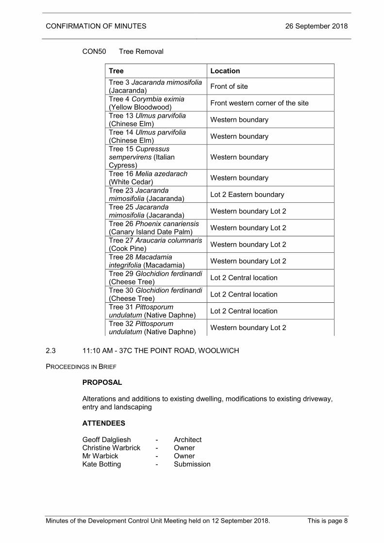
CON50 Tree Removal
Tree Location Tree 3 Jacaranda mimosifolia (Jacaranda) Front of site
Tree 4 Corymbia eximia (Yellow Bloodwood) Front western corner of the site
Tree 13 Ulmus parvifolia (Chinese Elm) Western boundary
Tree 14 Ulmus parvifolia (Chinese Elm) Western boundary
Tree 15 Cupressus sempervirens (Italian Cypress)
Western boundary
Tree 16 Melia azedarach (White Cedar) Western boundary
Tree 23 Jacaranda mimosifolia (Jacaranda) Lot 2 Eastern boundary
Tree 25 Jacaranda mimosifolia (Jacaranda) Western boundary Lot 2
Tree 26 Phoenix canariensis (Canary Island Date Palm) Western boundary Lot 2
Tree 27 Araucaria columnaris (Cook Pine) Western boundary Lot 2
Tree 28 Macadamia integrifolia (Macadamia) Western boundary Lot 2
Tree 29 Glochidion ferdinandi (Cheese Tree) Lot 2 Central location
Tree 30 Glochidion ferdinandi (Cheese Tree) Lot 2 Central location
Tree 31 Pittosporum undulatum (Native Daphne) Lot 2 Central location
Tree 32 Pittosporum undulatum (Native Daphne) Western boundary Lot 2
2.3 11:10 AM - 37C THE POINT ROAD, WOOLWICH
PROCEEDINGS IN BRIEF
PROPOSAL Alterations and additions to existing dwelling, modifications to existing driveway, entry and landscaping ATTENDEES Geoff Dalgliesh - Architect Christine Warbrick - Owner Mr Warbick - Owner Kate Botting - Submission

CONFIRMATION OF MINUTES 26 September 2018
Minutes of the Development Control Unit Meeting held on 12 September 2018. This is page 9
RESOLVED on the motion of Chairperson Smith, seconded Mr Smith A. That the Council, as the consent authority, is satisfied that the objection lodged
under clause 4.6 of LEP 2012 to vary the Landscaped Area development standard of clause 6.9 of the Hunters Hill Local Environmental Plan 2012, is well founded under the circumstances of the case and is consistent with the aims of the Policy.
B. That Development Application No.2018/1018 for the alterations and additions
to existing dwelling, modifications to existing driveway, entry and landscaping at No.37C The Point Road, Woolwich, be approved, subject to the following conditions:
Special Condition
(GEN) 1. That the subject site is to remain as a single occupancy dwelling, and not to
be used for a dual occupancy at any time. 2. Chosen Marraya (Murraya paniculata) along western boundary to be
substituted with planting chosen from Council’s preferred planting list e.g. Acemna smithii minor “Cherry Surprise’, Syzygium ‘Cascade’ or Viburnum ‘Dense Fence’ with such detail being provided in the amending landscape plan. Amended plans are to be submitted prior to the issue of the Construction Certificate.
Standard Conditions
Drawing Number Drawn By Plan Dated Council Dated
Site Plan & Roof Plan, DA02, rev A
Dalgliesh Ward Architects 27.03.18 28.03.18
First Floor Plan, DA03, rev A Dalgliesh Ward
Architects 27.03.18 28.03.18
Ground Floor Plan, DA04, rev A
Dalgliesh Ward Architects 27.03.18 28.03.18
Section AA, DA05, rev A Dalgliesh Ward
Architects 27.03.18 28.03.18
West and East Elevations, DA06, rev A
Dalgliesh Ward Architects 27.03.18 28.03.18
North and Elevations, DA07, rev A
Dalgliesh Ward Architects 27.03.18 28.03.18
Southern Elevation, DA08, rev A
Dalgliesh Ward Architects 27.03.18 28.03.18
Proposed Landscaped Area Calculation, DA10, rev A
Dalgliesh Ward Architects 27.03.18 28.03.18
Driveway Details, DA14, rev A Dalgliesh Ward
Architects 27.03.18 28.03.18
Landscape Plan, DA15, rev A Dalgliesh Ward
Architects 27.03.18 28.03.18
Finishes Schedule, DA15 Dalgliesh Ward
Architects 02.03.18 08.03.18

CONFIRMATION OF MINUTES 26 September 2018
Minutes of the Development Control Unit Meeting held on 12 September 2018. This is page 10
GEN0 GEN1 GEN3 GEN5 GEN6 GEN7 GEN12 GEN17 GEN20 GEN21 PCC0 PCC1 ($1050) PCC2 ($1460) PCC3 ($1300) PCC4 ($1000) PCC5 ($3000) PCC11 PCC12 PCC13 PCC20 PCC21 PCC31 PCC40 PCC41 PCC47 PCW0 PCW1 PCW2 PCW3 PCW4 PCW5 CSI0 CSI3 DEM0 DEM1 DEM3 DEM4 DEM6 DEM7 DEM8 DEM9 DEM11 CON0 COM1 CON2 CON3 CON5 CON7 CON8 CON13 CON17 CON18 CON19 CON20 CON21 CON23 CON47 CON51 CON52 CON53 CON54 CON55 CON59 POC0 POC1 POC2 POC3 POC4 POC7 POC13 POC14 POC24 POC25 POC75 POC7 Landscaping in accordance with the stamped approved plans
Prepared by Dalgliesh Ward Architects), dwg no. DA15, dated 02.03.18, date stamped by Council 28 March 2018
The meeting closed at 11:32 am.

DEVELOPMENT APPLICATIONS 26 September 2018
Item 2.1 Page 1
ITEM NO : 2.1 SUBJECT : 10:30 AM - 8 CROWN STREET, HENLEY STRATEGIC OUTCOME : THE HERITAGE, CHARACTER AND CONSERVATION OF
THE AREA IS RESPECTED, PRESERVED AND ENHANCED
ACTION : ASSESS ALL APPLICATIONS AGAINST THE NEW
LEP/DCP REPORTING OFFICER : SHAHRAM MEHDIZADGAN DEVELOPMENT APPLICATION NO
2017/1135 REVIEW OF DETERMINATION
PROPOSAL SECTION 8.2 - REVIEW OF DETERMINATION -
CONSTRUCTION OF NEW TWO (2) STOREY DWELLING APPLICANT METRICON HOMES OWNER YANG LAI & WEI HUI QIAN
DATE LODGED 16 JULY 2018
Ref:382929
INTRODUCTION Reasons for Report The proposal results in one (1) submission received in response to the neighbour notification process. The proposal is for a s8.2 review of the refusal of Development Application 2017/1135 for construction of a new two (2) storey dwelling, and in accordance with the provisions of the Act, this application has to be referred to Council’s Development Control Unit (DCU) Meeting for a decision.
REPORT 1. SUMMARY Objectors Issues Richard and Lisa Edwards 9 Crown Street Henley Impact on views of the Gladesville Bridge and North Sydney, as a result of the
proposed two storey dwelling
DEVELOPMENT APPLICATIONS 26 September 2018
Item 2.1 Page 2
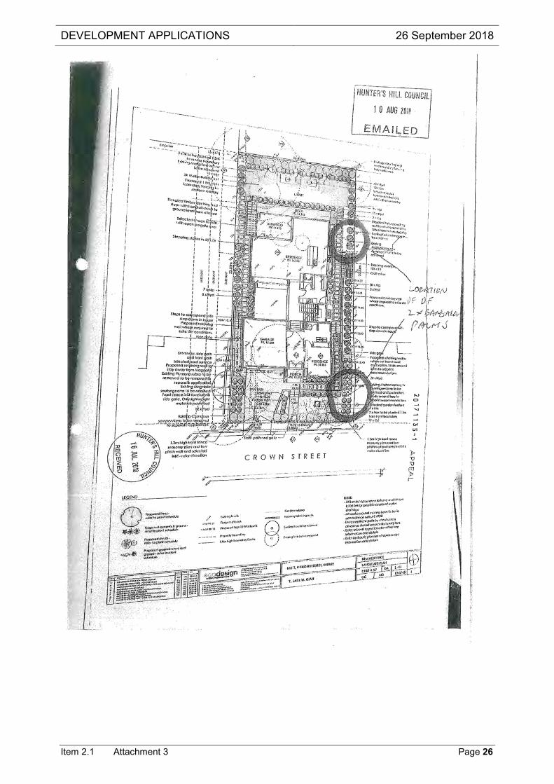
To compensate for the view loss that would result from the construction of the dwelling, we ask Council approve the removal of both the Archonotophoenix cunninghamianas (Bangalow Palms). This will improve the views of the water and Gladesville Bridge from our property in the corridor between the existing dwelling at 10 Crown Street and the proposed new dwelling at 8 Crown Street
Submissions One (1) submission was received. Recommendation The application is recommended for a deferred commencement approval for reasons that it is acceptable having regard to: 1. is permissible under the zoning 2. complies with the relevant planning objectives contained in Hunters Hill Local
Environmental Plan 2012 and Consolidated Development Control Plan 2013 3. will not have adverse effects on the amenity of adjoining properties. 2. DESCRIPTION OF PROPOSAL The subject site is known as No.8 Crown Street, Henley, located on eastern side of Crown Street, near the corner of Bayview Crescent. The site is rectangular in shape with a site area of 531sqm. The site slopes from the front to the rear. The site currently accommodates an existing dwelling and associated structures. Surrounding development consists of single to two storey residential dwellings. 3. DESCRIPTION OF SITE AND LOCALITY Original Proposal The original application sought consent for construction of a two storey dwelling, as follows: Ground Floor Garage, entry, portico, sitting, family, dining, outdoor room, deck, kitchen, pantry,
laundry, bedroom 5, powder, W.C., bedroom 5 First Floor Study, W.I.R, retreat, bedroom 1, ensuite, bedroom 2, leisure, bedroom3, W.I.R 2,
bathroom, bathroom 4 Site Works Landscaping
Driveway
Water feature
1.2m high masonry front fence

DEVELOPMENT APPLICATIONS 26 September 2018
Item 2.1 Page 3
Demolition of the existing dwelling and associated structures were proposed under a complying Development. S8.2 Review Application In support of the request for review, the applicant has provided the following changes in support of the application: Reduce the roof pitch to 15 degrees - being the minimum for a tile roof
Reduce ceiling heights of the upper level
Move the entire upper level further to the north and redesign internals to provide view corridor
Agreement to remove the palm in the south western corner of the site that currently blocks water views
No proposed landscaping to reach mature height of more than 3m along the southern boundary
Increase setbacks at the upper level to the southern boundary
Revised upper level fenestrations and skirt roof - with return roof element; 4. PROPERTY HISTORY The original application was refused by Council on 4 April 2018. 5. STATUTORY CONTROLS Relevant Statutory Instruments Environmental Planning and Assessment Act, 1979 Local Environmental Plan 2012 Zone: R2 Conservation Area: No River Front Area: Yes SREP (Sydney Harbour Catchment) 2005: Yes Development Control Plan: DCP 2013 Listed Heritage item: No Contributory Building: No Vicinity of Heritage Item: No 6. POLICY CONTROLS Consolidated Development Control Plan 2013 7. REFERRALS 7.1 External Approval Bodies Not applicable.

DEVELOPMENT APPLICATIONS 26 September 2018
Item 2.1 Page 4
7.2 Health & Building The application was referred to Council’s Environmental Health and Building Surveyor who raised no concern, subject to standard conditions. 7.3 Heritage Not applicable. 7.4 Works & Services The application was referred to Council’s Design and Development Engineer who stated that:
Concept stormwater management plan is satisfactory, but the applicant needs to submit details of proposed easement at Lot 2 before the issue of the Construction Certificate.
A special condition will be imposed to reflect the above comments. 7.5 Parks & Landscape The application was referred to Council’s Tree Consultant who provided the following comments:
The following documents and/or reports have been received and reviewed: Architectural Plans
(prepared by Metricon, dwg no 1 of 12, dated 07.06.2017, date stamped 16 July 2018)
Arboricultural Impact Assessment (prepared by Arboreport, dated 12.07.2018, not date stamped)
Landscape Plan (prepared by Eco Design, dwg no L – 01 - 03, dated 12.07.2018, date stamped 16 Jul 2018)
Tree Management The Arboricultural Impact Assessment (Report) has addressed the impact of the works on a number of trees located onsite and/or neighbouring sites. The tree/s are discussed in detail below: Tree 1 Archontophoenix cunninghamiana (Bangalow Palm) is located in the front of the site. The Report outlines a Major encroachment (20.2%) from the proposed works (retaining wall and front masonry wall). Tree 1 is a 10m specimen considered to have medium landscape value. The Landscape Plan shows Tree 1 for retention. It is understood from the Planning Officer that submissions have been received from neighbouring residents regarding the impact of the development on view corridors. With consideration to the impact of the works and retention value, removal and replacement elsewhere onsite is considered acceptable.

DEVELOPMENT APPLICATIONS 26 September 2018
Item 2.1 Page 5
Tree 2 Plumeria rubra (Frangipani) is located in the front of the site and Tree 7 Magnolia indica (Mango Tree) is located in the rear of the site. This group of trees are small in size, with low landscape value. This group of trees are located in the footprint of the proposed works and are proposed for removal. Removal and replacement is considered acceptable conditional to appropriate replacement planting. Tree 4 Magnolia soulangena (Saucer Magnolia) is located in the neighbouring property at 6 Crown Street. Tree 4 is a small specimen with a height of 6m. The Report outlines a combined encroachment of 23% from the proposed works. This is a Major encroachment as defined by AS4970-2009. The Report outlines that the works would result in a moderate level of impact which is considered sustainable by the tree, if undertaken in a manner that minimizes impact to the tree. The Report outlines tree sensitive construction methods and tree protection measures that must be implemented in accordance with AS4970-2009. All works within the TPZ must be under the supervision of the Project Arborist (AQF Level 5). Tree 5 Cupress torulosa (Himalayan Cypress) is located within the neighbouring site at 6 Crown Street. Tree 5 has a modified crown with associated localized dieback due to previous pruning for the overhead power lines. The Report outlines a combined encroachment of 33% from the proposed works. This is a Major encroachment as defined by AS4970-2009. The Report outlines that both the owner of the tree and the applicant wishes to remove the tree due to ongoing maintenance issues. A Tree Permit Application should be submitted to Council for processing. The Tree Permit Application must include written authorization from the tree owner. Tree 3 Plumeria rubra (Frangipani) is located on the boundary between the subject site and 6 Crown Street. A retaining wall is located within the footprint of Tree 3 and it would require removal to undertake the works as proposed. As the tree is jointly owned the applicant is required to consult with the owners of 6 Crown Street regarding removal. If the owners at 6 Crown Street are in support of removal a Tree Permit Application should be submitted to Council for processing. The Tree Permit Application must include written authorization from both tree owners. Tree 6 Archontophoenix cunninghamiana (Bangalow Palm) is located in the rear of the site. The Report outlines a Major encroachment( 12.1%) from the proposed stormwater pipe and pit. It is understood from the Planning Officer that submissions have been received from neighbouring residents regarding the impact of the development on view corridors. With consideration to the impact of the works and retention value, removal and replacement elsewhere onsite is considered acceptable. Landscape Management There is concern regarding the scale of the proposed dwelling and the resultant impact on neighbourhood amenity. The use of landscaping will be important for reducing the visual impact of the development. To compensate for the removal of vegetation in the front of the site, additional planting is required. Two (2) small deciduous trees have been proposed in the front of the site. To reduce the visual impact of the development throughout the year, the proposed deciduous trees should be replaced with evergreen species. As Council encourages the use of indigenous vegetation throughout Hunters Hill, the evergreen trees should be indigenous species.

DEVELOPMENT APPLICATIONS 26 September 2018
Item 2.1 Page 6
Recommendations Council’s Tree and Landscape Consultant has determined that the development proposal is satisfactory in terms of tree preservation and landscaping, subject to compliance with the following Conditions of Consent (Deferred Commencement). Conditions Schedule 1 Tree Permit Application
The applicant is required to consult with the owners at 6 Crown Street regarding the proposed removal of Tree 3 Plumeria rubra (Frangipani) and Tree 5 Cupress torulosa (Himalayan Cypress). If the owners are in support of the proposed works a Tree Permit Application is required to be submitted to Council for processing. The Tree Permit Application must include written authorization from the tree owner (in the case of Tree 3, both tree owners). Amended Landscape Plan The Landscape Plan (prepared by Eco Design, dwg no L – 01 - 03, dated 12.07.2018, date stamped 16 Jul 2018) shall be amended as follows: The proposed Prunus cerasifera ‘Nigra’ shall be replaced with one of the
following: Elaeocarpus reticulatus (Blueberry Ash) x 2 (75 Litre)
Callistemon viminalis (Weeping Bottlebrush) x 1 (75 Litre) Tree 1 Archontophoenix cunninghamiana (Bangalow Palm) for removal
Schedule 2 GEN21 Tree planting in accordance with Australian Standard 2303-2015 “Tree
Stock for Landscape Use” PCW14 Arboricultural Report CON49 Protection of Trees
Tree No/ Species Location Height (m)
Tree 4 Magnolia soulangena (Saucer Magnolia) 6 Crown Street 6
CON50 Tree Removal
Tree No/ Species Location Comment
Tree 2 Plumeria rubra (Frangipani) Front of site
Tree 7 Magnolia indica (Mango Tree) Rear of site
CON51 Planting undertaken at the completion of construction

DEVELOPMENT APPLICATIONS 26 September 2018
Item 2.1 Page 7
CON52 Planting to be in accordance with Tree Management Control CON53 Establishment of landscape for 2 years CON54 Section 96 require for amended landscape CON55 Trees to be retained under Tree Management Control CON56 Stump Grinding CON57 Tree Condition CON58 TPZ CON59 Tree Planting CON60 Adjacent Trees CON61 Practising Arborist POC10 Compliance with Arboricultural Report Prepared by Arboreport, dated 12.07.2018, not date stamped) POC75 Landscaping prior to Final Occupation Certificate PCW Tree Protection Tree protection for Tree 4 Magnolia soulangena (Saucer Magnolia) shall be in accordance with Section 4, Section 5, Section 6 and Section 10 of the Arboricultural Impact Assessment (prepared by Arboreport, dated 12.07.2018, not date stamped).
8. ENVIRONMENTAL ASSESSMENT UNDER S.79C The relevant matters for consideration under section 79C of the Environmental Planning and Assessment Act 1979 are assessed under the following headings. 9. STATE INSTRUMENTS / LEGISLATION 9.1 State Environmental Planning Policies (SEPPs) Not applicable. 9.2 Regional Environmental Plans (REPs) – Deemed SEPPs The subject site is located within the area covered by SREP (Sydney Harbour Catchment) 2005. This plan has a number of general aims and objectives, the most relevant of which, in this case, is as follows:
(a) to ensure that the catchment, foreshores, waterways and islands of Sydney Harbour are recognised, protected, enhanced and maintained:

DEVELOPMENT APPLICATIONS 26 September 2018
Item 2.1 Page 8
(i) as an outstanding natural asset, and
(ii) as a public asset of national and heritage significance, for existing and future generations,
(b) to ensure a healthy, sustainable environment on land and water, (c) to achieve a high quality and ecologically sustainable urban environment.
(2) For the purpose of enabling these aims to be achieved in relation to the Foreshores and Waterways Area, this plan adopts the following principles:
(a) Sydney Harbour is to be recognised as a public resource, owned by the
public, to be protected for the public good, (b) the public good has precedence over the private good whenever and
whatever change is proposed for Sydney Harbour or its foreshores, (c) protection of the natural assets of Sydney Harbour has precedence over all
other interests. The emphasis here is that the area covered by the SREP is a public resource to be protected for the public good. These factors need to be considered when assessing development that is to take place in this area. Furthermore, Part 3 Division 2 of SREP (Sydney Harbour Catchment) 2005 lists matters for consideration by Council when determining an application. It states that Council shall not grant consent to an application unless it is satisfied that the proposal is consistent with the relevant objectives of the SREP. The following matters for consideration are relevant to this application: 25 Foreshore and waterway Scenic Quality The matters to be taken into consideration in relation to the maintenance, protection and enhancement of the scenic quality of foreshores and waterways are as follows: 25 Foreshore and waterways scenic quality
The matters to be taken into consideration in relation to the maintenance, protection and enhancement of the scenic quality of foreshores and waterways are as follows: (a) the scale, form, design and siting of any building should be based on an
analysis of:
(i) the land on which it is to be erected, and
(ii) the adjoining land, and
(iii) the likely future character of the locality,
(b) development should maintain, protect and enhance the unique visual qualities of Sydney Harbour and its islands, foreshores and tributaries,
(c) the cumulative impact of water-based development should not detract from
the character of the waterways and adjoining foreshores.

DEVELOPMENT APPLICATIONS 26 September 2018
Item 2.1 Page 9
The proposed development would not be overly visible from the waterway. The proposal would satisfy the above aims of the policy and matters for consideration, in particular those of particular relevance pertaining to the appearance of the development from the waterway and foreshore, and those requiring the protection and enhancement of the landscape qualities of the Harbour. 9.3 Other Legislation Pursuant to section 8.2 of the Environmental Planning and Assessment Act, the applicant for the proposal, is seeking a review of the Council’s determination of Development Application 2017/1135, which was refused.
Procedure – 8.2 Review of determination
(1) If the consent authority is a council, an applicant may request the council to review a determination of the applicant’s application.
(2) A request for a review may be made at any time, subject to subsection (2A).
(2A) A determination cannot be reviewed:
(a) after the time limited for the making of an appeal under section 8.7 expires, if no such appeal is made against the determination, or
(b) after an appeal under section 8.7 against the determination is disposed of by the Court, if such an appeal is made against the determination.
(3) The prescribed fee must be paid in connection with a request for a review.
(3A) In requesting a review, the applicant may make amendments to the development described in the original application, subject to subsection (4) (c).
(4) The council may review the determination if:
(a) it has notified the request for review in accordance with:
(i) the regulations, if the regulations so require, or
(ii) a development control plan, if the council has made a development control plan under section 3.38 that requires the notification or advertising of requests for the review of its determinations, and
(b) it has considered any submissions made concerning the request for review within any period prescribed by the regulations or provided by the development control plan, as the case may be, and
(c) in the event that the applicant has made amendments to the development described in the original application, the consent authority is satisfied that the development, as amended, is substantially the same development as the development described in the original application.

DEVELOPMENT APPLICATIONS 26 September 2018
Item 2.1 Page 10
(4A) As a consequence of its review, the council may confirm or change the determination.
(5) The decision whether or not to review the determination must not be made by the person who made the determination unless that person was the council, but is to be made by a person who is qualified under subsection (6) to make the review.
(6) If the council reviews the determination, the review must be made by:
(a) if the determination was made by a delegate of the council - the council or another delegate of the council who is not subordinate to the delegate who made the determination, or
(b) if the determination was made by the council—the council.
SUPPORTING DOCUMENTATION In support of the request for review, the applicant has provided the following changes in support of the application: Reduce the roof pitch to 15 degrees - being the minimum for a tile roof
Reduce ceiling heights of the upper level
Move the entire upper level further to the north and redesign internals to provide view corridor
Agreement to remove the palm in the south western corner of the site that currently blocks water views
No proposed landscaping to reach mature height of more than 3m along the southern boundary
Increase setbacks at the upper level to the southern boundary
Revised upper level fenestrations and skirt roof - with return roof element; 10. HUNTERS HILL LOCAL ENVIRONMENTAL PLAN 2012 10.1 Aims and Objectives of Hunters Hill Local Environmental Plan 2012 and Zone The proposal is permissible with consent under Zone R2 and complies with the relevant statutory controls of Hunters Hill Local Environmental Plan 2012. 10.2 Statutory Compliance Table The following table illustrates whether or not the proposed development complies with the relevant statutory controls of Hunters Hill Local Environmental Plan No.2012. Compliance with Current Statutory Controls Proposed Control Compliance HEIGHT Ridge
7.8 metres
8.5 metres
Yes
Storeys 2 storey 2 storeys Yes Landscape Area 50.5% 50% Yes

DEVELOPMENT APPLICATIONS 26 September 2018
Item 2.1 Page 11
10.3 Site Area Requirements The proposal complies with these requirements. 10.4 Residential flat buildings and low-rise multi-unit housing-density and garden
area controls Not Applicable. 10.5 Height of Buildings The height of the proposal, being 7.8 metres and 2 storey in height is acceptable as it would comply with the maximum of 8.5 metres/no more than two storeys height limit as prescribed by Clause 4.3 of the Hunters Hill Local Environmental Plan 2012. 10.6 Landscaped Area The proposed landscaped area of 50.5% would be above the 50% minimum permissible landscaped area as prescribed by the Hunters Hill Local Environmental Plan 2012. 10.7 Subdivision Lot Size Not Applicable. 10.8 Floor Space Ratio Not Applicable. 10.9 Street Frontage Not Applicable. 10.10 Dual Occupancy Not Applicable. 10.11 Foreshore Building Lines Not Applicable. 10.12 River Front Area The subject site is also located within the Foreshore Scenic Protection Area and, as such, assessment is required in accordance with Clause 6.7 of Hunters Hill Local Environmental Plan 2012. Clause 6.7 states:
6.7 (3) Development consent must not be granted for development on land to which this clause applies unless the consent authority is satisfied that:
(a) Measures will be taken, including in relation to the location, design and appearance of the development and conservation of existing trees, to minimize the visual impact of the development to and from the nearest waterway, and

DEVELOPMENT APPLICATIONS 26 September 2018
Item 2.1 Page 12
(b) Any historic, scientific, cultural, social, archeological, architectural, natural or aesthetic significance of the land on which the development is to be carried out, and of surrounding land, will be maintained, and
(c) Existing views towards waterways from public roads and reserves would not be obstructed.
The proposed works will have no detrimental effect in relation to the views from the waterway. 10.13 Other Special Clauses / Development Standards Not Applicable. 11. DRAFT AMENDMENTS TO STATUTORY CONTROLS No relevant draft amendments pertaining to this application. 12. DEVELOPMENT CONTROL PLANS (DCPs) 12.1 Compliance Table Consolidated Development Control Plan 2013 (DCP) Compliance with Current Statutory Controls Proposed Control Compliance Height Ridge External Walls
7.8 metres 6.945 metres
8.5 metres 7.2 metres
Yes Yes
Storeys 2 storey 2 storeys Yes
Landscaped Area 50.5% 50% Yes Planning Policy – All Development The proposal complies with the relevant objectives, design parameters and preferred design elements under Parts 2 and 3 of Consolidated Development Control Plan 2013. Heritage Conservation Areas Not Applicable. River Front Area Refer to section 10.12 of this report ‘River Front Area’. Height Refer to section 10.5 of this report ‘Height of Buildings’. Front, Side & Rear Setbacks The single storey side setback of the proposed garage (north) would be 1330mm, which fails to comply with the required 1.5m building side setback under 3.3.3 of DCP 2013. However, under the DCP exceptions and concessions do apply to single structures such as carports and garages. In this instance, it is considered that the proposed building side setback is considered to be satisfactory, as the proposed garage would not result in any unreasonable impacts on the adjoining property.

DEVELOPMENT APPLICATIONS 26 September 2018
Item 2.1 Page 13
Landscaped Area Refer to section 10.6 of this report ‘Landscaped Area’. Solar Access The shadow diagrams indicate that at 9am mid winter, the shadows are cast to the south-west of the subject site and onto the adjoining property, being No.2 Bayview Crescent and 10 Crown Street. The shadowing would affect less than 33% of the site. The shadow diagrams indicate that at 12 noon mid winter the shadows are cast to the south of the subject site and onto the adjoining property, being No.10 Crown Street. The shadowing would affect less than 33% of the site. The shadow diagrams indicate that at 3pm mid winter there would be shadows cast south-east of the subject site and onto the adjoining properties, being No.10 Crown Street. The shadowing would affect less than 33% of the recreational open space of the sites. It is considered that even though the solar provision to No.10 Crown Street has been reduced with the new dwelling on the subject site it is acceptable considering the properties have east west orientation and a reasonable level of solar access is still available. The proposal would comply with the general requirements, being that new development must not eliminate more than one third of the existing sunlight to adjacent properties at ground level, measured at 9 am, 12 noon and 3 pm of the winter solstice. The proposal would comply with the general requirements and objectives stipulated under Part 7.4.1 of the Development Control Plan No.15, as the proposal would allow for reasonable access to sunlight to adjoining buildings and their recreational open space. Privacy The proposed development is not likely to reduce the privacy of the residents of adjoining premises. Views The residents of No.9 Crown Street have raised the following concerns: Impact on views of the Gladesville Bridge and North Sydney, as a result of the
proposed two storey dwelling
To compensate for the view loss that would result from the construction of the dwelling, we ask Council approve the removal of both the Archonotophoenix cunninghamianas (Bangalow Palms). This will improve the views of the water and Gladesville Bridge from our property in the corridor between the existing dwelling at 10 Crown Street and the proposed new dwelling at 8 Crown Street.
The proposed s8.2 has made several changes to avoid view loss for the rear properties. The following changes have been made: Reduction of the roof pitch to 15 degrees - being the minimum for a tile roof
Reduction of ceiling heights of the upper level

DEVELOPMENT APPLICATIONS 26 September 2018
Item 2.1 Page 14
Move the entire upper level further to the north and redesign internals to provide view corridor
Agreement to remove the palm in the south western corner of the site that currently blocks water views
No proposed landscaping to reach mature height of more than 3m along the southern boundary
Increase setbacks at the upper level to the southern boundary Also, on 31 August 2018, Council received an email letter from the applicants Planning consultant, that as the neighbour No.9 Crown Street would prefer that the Archontophoenix cunninghamiana (Bangalow Palm) to be removed from the front of the subject site, the applicant has no objection to a condition of consent requiring the removal of this tree. This matter was referred to Council’s Landscape Consultant who raised no concern for the removal of the Archontophoenix cunninghamiana (Bangalow Palm) located to the front of the subject site. A condition has been imposed as part of Schedule No.1 of the deferred Commencement that Archontophoenix cunninghamiana (Bangalow Palm) tree to be removed from the front of the subject site. Subject to this condition, the concerns of the residents of No.9 Crown Street, in regards to view sharing would be addressed. These concerns are not sufficient to warrant the refusal of the application. Hence, the objections cannot be sustained. Car Parking The proposal complies with Part 5.3.3 of the DCP 2013, as two (2) car parking spaces have been provided for a gross floor area in excess of 125sqm. Garages & Carports The proposal would have a double garage with a setback of 1m from the front wall of the dwelling. It is considered that the location of the garage and design of the garage would satisfy the objectives stipulated under Part 3.6 of the Development Control Plan 2013. Fences Timber picket front fencing of a height of 1200mm has been proposed to Crown Street frontage. The height and design of the proposed fencing is considered to be acceptable and would comply with the DCP 2013. 12.2 Other DCPs, Codes and Policies Hunter’s Hill Council S94A Developer Contributions Plan 2011

DEVELOPMENT APPLICATIONS 26 September 2018
Item 2.1 Page 15
13. THE LIKELY IMPACTS OF THE DEVELOPMENT Subject to conditioning, the proposal is considered not to unreasonably impact upon the amenity of the adjoining properties, waterway or the Crown Street streetscape. As stated within the body of the report, the proposal would satisfy the objectives of the Development Control Plan 2013 and LEP 2012. Subject to conditioning, there would be no impact upon the natural and built environment within the vicinity of the subject site as a result of the proposed works. Furthermore, there would be no social and economic impacts to the locality as a result of the proposed works.
14. SUBMISSIONS The proposed development was notified in accordance with Council’s Consolidated Development Control Plan 2013 for a period of fourteen (14) days commencing on the 27 July 2018. Within the specified time period one (1) submission was received. Copy of the submission is attached to the report. NOTIFICATION REQUIRED YES NUMBER NOTIFIED 7 SUBMISSIONS RECEIVED Name & Address of Respondents
SUMMARY OF SUBMISSIONS
Richard and Lisa Edwards 9 Crown Street Henley
Impact on views of the Gladesville Bridge and North Sydney, as a result of the proposed two storey dwelling
To compensate for the view loss that would result from the construction of the dwelling, we ask Council approve the removal of both the Archonotophoenix cunninghamianas (Bangalow Palms). This will improve the views of the water and Gladesville Bridge from our property in the corridor between the existing dwelling at 10 Crown Street and the proposed new dwelling at 8 Crown Street
The main issues of concern outlining the objections are discussed below:
Impact on views of the Gladesville Bridge and North Sydney, as a result of the
proposed two storey dwelling
To compensate for the view loss that would result from the construction of the dwelling, we ask Council approve the removal of both the Archonotophoenix cunninghamianas (Bangalow Palms). This will improve the views of the water and Gladesville Bridge from our property in the corridor between the existing dwelling at 10 Crown Street and the proposed new dwelling at 8 Crown Street
Comment: The proposed s8.2 has made several changes to avoid view loss for the rear properties. The following changes have been made: Reduction of the roof pitch to 15 degrees - being the minimum for a tile roof
Reduction of ceiling heights of the upper level
Move the entire upper level further to the north and redesign internals to provide view corridor
DEVELOPMENT APPLICATIONS 26 September 2018
Item 2.1 Page 16
Agreement to remove the palm in the south western corner of the site that currently blocks water views
No proposed landscaping to reach mature height of more than 3m along the southern boundary
Increase setbacks at the upper level to the southern boundary Also, on 31 August 2018, Council received an email letter from the applicants Planning consultant, that as the neighbour No.9 Crown Street would prefer that the Archontophoenix cunninghamiana (Bangalow Palm) to be removed from the front of the subject site, the applicant has no objection to a condition of consent requiring the removal of this tree. This matter was referred to Council’s Landscape Consultant who raised no concern for the removal of the Archontophoenix cunninghamiana (Bangalow Palm) located to the front of the subject site. A condition has been imposed as part of Schedule No.1 of the deferred Commencement that Archontophoenix cunninghamiana (Bangalow Palm) tree to be removed from the front of the subject site. Subject to this condition, the concerns of the residents of No.9 Crown Street, in regards to view sharing would be addressed. These concerns are not sufficient to warrant the refusal of the application. Hence, the objections cannot be sustained. CONCLUSION Subject to conditioning, the proposed works are considered acceptable and would have no unreasonable impacts upon the adjoining properties. The proposal has been assessed in terms of the public interest and following compliance with the relevant development standards and objectives in Development Control Plan 2013 and Hunters Hill Local Environmental Plan 2012, the application is considered acceptable. The proposal has been assessed having regard to the relevant matters for consideration under s4.15 of the Environmental Planning and Assessment Act 1979, Hunters Hill Local Environmental Plan 2012, and Development Control Plan 2013. For the reasons outlined in this report it is considered that the proposed development would not unduly impact upon the adjoining residential properties and accordingly is recommended for deferred approval, with schedule No.1 conditions to address view issues.
FINANCIAL IMPACT ASSESSMENT There is no direct financial impact on Council’s adopted budget as a result of this report. ENVIRONMENTAL IMPACT ASSESSMENT There is no direct environmental impact on Council arising from Council consideration of this matter. SOCIAL IMPACT ASSESSMENT There is no direct social impact on Council arising from Council consideration of this matter. RISK ASSESSMENT There are no direct or indirect risks impacting on Council arising from consideration of this matter.

DEVELOPMENT APPLICATIONS 26 September 2018
Item 2.1 Page 17
HUNTERS HILL 2028 This matter relates to ensuring that heritage and conservation of the area is respected, preserved and enhanced including the preservation of the character, views to and from the Municipality, and the preservation of the tree canopy. RECOMMENDATION That a “Deferred Commencement” consent be granted pursuant to Section 4.16 of the Environmental Planning and Assessment Act 1979. The development consent as contained in Schedule 2 shall not operate (or be issued) until such time as the matters contained in Schedule 1 are finalised to the satisfaction of Council. Schedule No.1 Tree Permit Application 1. The applicant is required to consult with the owners at 6 Crown Street regarding the
proposed removal of Tree 3 Plumeria rubra (Frangipani) and Tree 5 Cupress torulosa (Himalayan Cypress). If the owners are in support of the proposed works a Tree Permit Application is required to be submitted to Council for processing. The Tree Permit Application must include written authorization from the tree owner (in the case of Tree 3, both tree owners).
Amended Landscape Plan 2. The Landscape Plan (prepared by Eco Design, dwg no L – 01 - 03, dated
12.07.2018, date stamped 16 Jul 2018) shall be amended as follows: The proposed Prunus cerasifera ‘Nigra’ shall be replaced with one of the
following:
Elaeocarpus reticulatus (Blueberry Ash) x 2 (75 Litre)
Callistemon viminalis (Weeping Bottlebrush) x 1 (75 Litre)
Tree 1 Archontophoenix cunninghamiana (Bangalow Palm) for removal Schedule No.2 That the review of determination under s8.2 of the Environmental Planning & Assessment Act, 1979, to the refusal of Development Application No.2017/1135 for the construction of a new two storey dwelling at No.8 Crown Street, Henley, be approved, subject to the following conditions: Special Conditions
(CON)
1. Concept stormwater management plan is satisfactory, but the applicant needs to submit details of proposed easement at Lot 2 prior to the issue of the Construction Certificate.
Standard Conditions
GEN0 GEN1 GEN3 GEN5 GEN6 GEN7 GEN20 GEN21 PCC0 PCC1 ($2577) PCC2 ($2200) PCC3 ($1500) PCC4 ($1536) PCC5 ($7365) PCC11 PCC12 PCC13 PCC20 PCC21 PCC40 PCC41 PCW0 PCW1 PCW2 PCW3 PCW4 PCW5 PCW6 PCW14 CSI0 CSI1CSI2 CSI3 DEM0 DEM1 DEM3 DEM4 DEM5 DEM6 DEM7 DEM8 DEM9 DEM10 DEM11 CON0 CON1 CON2 CON3 CON5 CON7 CON9 CON11 CON12 CON13 CON17 CON18 CON19 CON20 CON21 CON51 CON52 CON53 CON54 CON55 CON56 CON57 CON58 CON59 CON60 CON61 POC0 POC1 POC2 POC3 POC4 POC7 POC13 POC14 POC25 POC75

DEVELOPMENT APPLICATIONS 26 September 2018
Item 2.1 Page 18
CON49 Protection of Trees
Tree No/ Species Location Height (m)
Tree 4 Magnolia soulangena (Saucer Magnolia) 6 Crown Street 6 CON50 Tree Removal
Tree No/ Species Location Comment
Tree 2 Plumeria rubra (Frangipani) Front of site
Tree 7 Magnolia indica (Mango Tree) Rear of site
POC10 Compliance with Arboricultural Report Prepared by Arboreport, dated 12.07.2018, not date stamped)
PCW Tree Protection Tree protection for Tree 4 Magnolia soulangena (Saucer Magnolia) shall be in accordance with Section 4, Section 5, Section 6 and Section 10 of the Arboricultural Impact Assessment (prepared by Arboreport, dated 12.07.2018, not date stamped).
ATTACHMENTS 1. Location Map 2. Plans 3. Submission

DEVELOPMENT APPLICATIONS 26 September 2018
Item 2.1 Attachment 1 Page 19

DEVELOPMENT APPLICATIONS 26 September 2018
Item 2.1 Attachment 2 Page 20

DEVELOPMENT APPLICATIONS 26 September 2018
Item 2.1 Attachment 2 Page 21

DEVELOPMENT APPLICATIONS 26 September 2018
Item 2.1 Attachment 2 Page 22

DEVELOPMENT APPLICATIONS 26 September 2018
Item 2.1 Attachment 3 Page 23

DEVELOPMENT APPLICATIONS 26 September 2018
Item 2.1 Attachment 3 Page 24

DEVELOPMENT APPLICATIONS 26 September 2018
Item 2.1 Attachment 3 Page 25
DEVELOPMENT APPLICATIONS 26 September 2018
Item 2.1 Attachment 3 Page 26

DEVELOPMENT APPLICATIONS 26 September 2018
Item 2.1 Attachment 3 Page 27

DEVELOPMENT APPLICATIONS 26 September 2018
Item 2.2 Page 28
ITEM NO : 2.2 SUBJECT : 10:50 AM - 29 WARUDA PLACE, HUNTLEYS COVE STRATEGIC OUTCOME : MAINTAIN THE CHARACTER AND AMENITY OF
HUNTERS HILL ACTION : ALL BUILDING WORK COMPLIES WITH COUNCIL
REGULATIONS REPORTING OFFICER : KERRY SMITH DEVELOPMENT APPLICATION NO
2011-1139-6
PROPOSAL TO SUBDIVIDE THE LAND INTO THREE (3) COMMUNITY
TITLE LOTS& TO CONSTRUCT A TWO STOREY DWELLING - S4.55 - CHANGES TO LANDSCAPE PLAN AND FINISHES OF ROOF BALUSTRADE, ADD SKYLIGHTS, DECKING AND GRAVEL DRIVEWAY
APPLICANT MICHAEL JOHN BERNAUER OWNER MICHAEL BERNAUER
DATE LODGED 15 MAY 2018
Ref:383057
INTRODUCTION Reasons for Report The proposal resulted in one (1) submission being received in response to the neighbour notification process. REPORT 1. SUMMARY Issues Excessive scale & bulk of balustrade wall Loss of solar access due to balustrade wall Location of electrical meter box inappropriate
Submissions One (1) submission was received.

DEVELOPMENT APPLICATIONS 26 September 2018
Item 2.2 Page 29
Recommendation The application is recommended for approval for reasons that it is acceptable having regard to: 1. It is permissible under the zoning 2. It complies with the relevant planning objectives contained in Hunters Hill Local
Environmental Plan 2012 and Consolidated Development Control Plan 2013 3. It will result in the development being substantially the same as that originally
approved 4. It will not have adverse effects on the amenity of adjoining properties. 3. DESCRIPTION OF PROPOSAL
Original Development approval
To create a three (3) lot Community Title subdivision as follows: - Lot 2 – ‘foreshore lot’ – 600.7sqm
- Lot 3 – ‘Farm attendants Cottage’ – 974.2swm
- Lot 4 – ‘Southern Lot’ – 603.9sqm To construct a new two storey dwelling house on proposed Lot 2 which will comprise: On the lower ground floor, three (3) bedrooms (each with an ensuite and one with a walk-in ‘robe, laundry, service room and staircase. On the ground floor, main entrance, media room, powder room, study, kitchen/meals room, living/dining room and staircase. A full width covered terrace 2.7 metres deep will open off the living/dining room facing north On the roof level, there will be two (2) open parking spaces and a landscaped roof terrace. S4.55 Modifications proposed The extension of the upper level roof balustrade and its change from stone cladding
to render & paint finish. The relocation of the services access point at the property boundary being a meter
box approx. 1 metre high by 2.5 metres long at the south eastern entrance to the site. The replacement of gravel seating areas from the approved landscape plan with
wooden decking. The addition of three (3) skylights to the rooftop garden. Deletion of the garden path located on the eastern side garden. Change the finish of the roof level parking area and its connection to the bitumen
access road from paving to decomposed granite. Add the location of the property’s service access point to the approved site plan.

DEVELOPMENT APPLICATIONS 26 September 2018
Item 2.2 Page 30
Addition of the balustrading to the SE corner of the roof. These works have been carried out to the premises and the s4.55 application is to formalise such works. 3. DESCRIPTION OF SITE AND LOCALITY The premises are known as No.29 Waruda Place, Huntleys Cove and are legally described as Lot 2 in DP 270751. The overall allotment is located to the east of Waruda Place. It has an area of 600.8sqm. The overall site has a slope of approx. 31.05 metres down from the street to the boundary of Council’s Great North Walk. Existing on the overall site is a single-storey brick/tile dwelling with a detached garage in the course of demolition. The subject site, being proposed Lot 2) also contains a large rock outcrop and is heavily vegetated with mature trees and shrubs. Proposed Lot 2 is an irregular shaped lot adjoining the heritage listed bungalow known as the ‘farm attendants cottage’. Surrounding and nearby development comprises mostly two storey houses and townhouses. 4. PROPERTY HISTORY On 10 April 2012, development consent was issued under delegated authority for the subdivision of the land into 3 Community Title lots and the construction of a new two-storey dwelling house with an accessible flat roof. On 13 August 2014, a s.96 application (DA 2011-1139-5) was refused for the deletion of condition No.9 relating to the construction of a bitumen access road. This work has since been carried out to Council’s satisfaction. On 13 August 2014, a s.96 application (DA 2011/1139-4) was refused to alter condition No.53 relating to the completion of the landscaping work. The construction of the dwelling house has been completed using the Construction Certificate and a private certifier. The original condition - of development consent relevant to this application is:
2. The development consent No.201`1/1139 relates to the plans prepared by Zoltan Kovacs Architect numbered DA.03 A to DA.05 A dated November 2011 as received by Council on 7 December 2011, except where amended by conditions of this consent.
Amending plans were submitted to Council on 14 June 2018 giving details of the extension of the balustrade and the location of the services access point.
5. STATUTORY CONTROLS Relevant Statutory Instruments
DEVELOPMENT APPLICATIONS 26 September 2018
Item 2.2 Page 31
Environmental Planning and Assessment Act, 1979 Local Environmental Plan 2012 Zone: Low Density Residential R2 Conservation Area: No River Front Area: Yes SREP (Sydney Harbour Catchment 2005): Yes Development Control Plan 2013: Yes Listed Heritage item: No Contributory Building: No Vicinity of Heritage Item: Yes 6. POLICY CONTROLS Consolidated Development Control Plan 2013 7. REFERRALS 7.1 External Approval Bodies Not applicable. 7.2 Health & Building The application was referred to Council’s Environmental Health and Building Surveyor who advised by memo that the changes appear to be consistent with the performance requirements of the NCC. 7.3 Heritage As stated within the body of the report, the property is not a heritage item and is not in a conservation area under Hunters Hill Local Environmental Plan 2012. The proposal, however, was referred to Council’s Heritage Advisor who provided the following comments:
Heritage Status: Within the vicinity of a heritage item, the Farm Attendants Cottage (Item 101). Proposal: s4.55 modifications to landscaping and roof balustrade.
Statement of Heritage Impact: minor amendments- not required. Comments: With reference to the Bernauer letter of 08/06/2018: My understanding of the proposed modifications to the consent is that:
1. Balustrade- render and paint in lieu of stone cladding- O.K. if recessive, earthy
colour (“Apparition” O.K.).
2. Decking- gravel replaced by timber decking- O.K.
3. Skylights- O.K.
4. Garden path- O.K.
5. Paving- paving to decomposed granite-O.K.
6. Underground Services Access- O.K.
7. Addition of balustrade- O.K. if recessive, earthy colour (“Apparition” O.K.).

DEVELOPMENT APPLICATIONS 26 September 2018
Item 2.2 Page 32
It appears as though most of the above modifications have already been effected (?) Recommendation: Approval.
The application was not forwarded to the Conservation Advisory Panel as the works were of a minor nature. 7.4 Works & Services The application was not referred to Council’s Design and Development Engineer as no drainage works were involved. 7.5 Parks & Landscape The application was not referred to Council’s Tree Consultants as no major landscaping works were involved. 8. ENVIRONMENTAL ASSESSMENT UNDER S4.15 The relevant matters for consideration under section 4.15 of the Environmental Planning and Assessment Act 1979 are assessed under the following headings. 9. STATE INSTRUMENTS / LEGISLATION 9.1 State Environmental Planning Policies (SEPPs) Not applicable. 9.2 Regional Environmental Plans (REPs) – Deemed SEPPs Sydney Harbour Catchment 2005 Aims of plan (1) This plan has the following aims with respect to the Sydney Harbour Catchment:
(a) to ensure that the catchment, foreshores, waterways and islands of Sydney
Harbour are recognised, protected, enhanced and maintained:
(i) as an outstanding natural asset, and (ii) as a public asset of national and heritage significance, for existing
and future generations,
(b) to ensure a healthy, sustainable environment on land and water, (c) to achieve a high quality and ecologically sustainable urban environment, (d) to ensure a prosperous working harbour and an effective transport corridor, (e) to encourage a culturally rich and vibrant place for people,
(f) to ensure accessibility to and along Sydney Harbour and its foreshores, (g) to ensure the protection, maintenance and rehabilitation of watercourses,
wetlands, riparian lands, remnant vegetation and ecological connectivity,
DEVELOPMENT APPLICATIONS 26 September 2018
Item 2.2 Page 33
(h) to provide a consolidated, simplified and updated legislative framework for future planning.
(2) For the purpose of enabling these aims to be achieved in relation to the Foreshores
and Waterways Area, this plan adopts the following principles:
(a) Sydney Harbour is to be recognised as a public resource, owned by the public, to be protected for the public good,
(b) the public good has precedence over the private good whenever and
whatever change is proposed for Sydney Harbour or its foreshores, (c) protection of the natural assets of Sydney Harbour has precedence over all
other interests. Furthermore, Part 3 Division 2 of SREP (Sydney Harbour Catchment) 2005 lists matters for consideration by Council when determining an application. It further states that Council shall not grant consent to an application unless it is satisfied that the proposal is consistent with the relevant objectives of the SREP. The following matters for consideration are relevant to this application: 25 Foreshore and waterways scenic quality
The matters to be taken into consideration in relation to the maintenance, protection and enhancement of the scenic quality of foreshores and waterways are as follows: (a) the scale, form, design and siting of any building should be based on an
analysis of:
(i) the land on which it is to be erected, and
(ii) the adjoining land, and
(iii) the likely future character of the locality,
(b) development should maintain, protect and enhance the unique visual qualities of Sydney Harbour and its islands, foreshores and tributaries,
(c) the cumulative impact of water-based development should not detract from
the character of the waterways and adjoining foreshores.
The proposed development would not be discernable from the nearby river. It would not, therefore have a detrimental effect on the skyline as seen from the River and would not have an undue impact in relation to visual presentation of the built form to the river. It is considered that the proposal would satisfy the above aims of the policy. The matters for consideration, in particular those of specific relevance pertaining to the appearance of the development from the waterway and foreshore are considered to have been satisfactorily addressed by the proposal. The proposal to utilise glass balustrading on the new external stairs for the new decks facing north is not of concern in that none of this building work will be visible from the nearby Lane Cove River due to heavy vegetation including that of the Great north Walk.
DEVELOPMENT APPLICATIONS 26 September 2018
Item 2.2 Page 34
9.3 Other Legislation Not Applicable. 10. HUNTERS HILL LOCAL ENVIRONMENTAL PLAN 2012 10.1 Aims and Objectives of Hunters Hill Local Environmental Plan 2012 and Zone The proposal is permissible with consent under Zone Low density Residential R2 and complies with the relevant statutory controls of Hunters Hill Local Environmental Plan 2012. 10.2 Statutory Compliance Table The statutory compliance table is not applicable as the dwelling house itself is not proposed to be altered in terms of building footprint, height or landscaped area. 10.3 Site Area Requirements The proposal complies with these requirements. 10.4 Residential flat buildings and low-rise multi-unit housing-density and garden
area controls Not Applicable. 10.5 Height of Buildings No change proposed and complies. 10.6 Landscaped Area No change proposed and complies. 10.7 Subdivision Lot Size Not Applicable, 10.8 Floor Space Ratio Not Applicable. 10.9 Street Frontage Not Applicable. 10.10 Dual Occupancy Not Applicable. 10.11 Foreshore Building Lines Not Applicable.

DEVELOPMENT APPLICATIONS 26 September 2018
Item 2.2 Page 35
10.12 River Front Area The subject site is also located with the River Front Area and, as such, assessment is required in accordance with Clause 6.7 of Hunters Hill Local Environmental Plan 2012. Clause 6.7 states: 6.7 (3) Development consent must not be granted for development on land to
which this clause applies unless the consent authority is satisfied that:
(a) Measures will be taken, including in relation to the location, design and appearance of the development and conservation of existing trees, to minimize the visual impact of the development to and from the nearest waterway, and
(b) Any historic, scientific, cultural, social, archaeological,
architectural, natural or aesthetic significance of the land on which the development is to be carried out, and of surrounding land, will be maintained, and
(c) Existing views towards waterways from public roads and reserves
would not be obstructed.
As the proposed modifications will be of a minor effect when compared to the development approval, this will have no detrimental effect in relation to the views to or from the waterway. 10.13 Other Special Clauses / Development Standards Not Applicable. 11. DRAFT AMENDMENTS TO STATUTORY CONTROLS No relevant draft amendments pertaining to this application. 12. DEVELOPMENT CONTROL PLANS (DCPs) 12.1 Compliance Table Consolidated Development Control Plan 2013 (DCP) The DCP 2013 compliance table is not applicable as the dwelling house itself is not proposed to be altered in terms of building footprint, height or landscaped area. Planning Policy – All Development The proposal complies/does not comply with the relevant objectives, design parameters and preferred design elements under Parts 2 and 3 of Consolidated Development Control Plan 2013. Heritage Conservation Areas Not Applicable. River Front Area Refer to section 10.12 of this report ‘River Front Area’. Height Not Applicable.
DEVELOPMENT APPLICATIONS 26 September 2018
Item 2.2 Page 36
Front, Side & Rear Setbacks Not Applicable. Landscaped Area Not Applicable. Solar Access Complies. Privacy No effective change will result from the works proposed to be formalised. Views There will be no undue loss of shared water views resultant from the works carried out and subject of this application. Car Parking Complies. Garages & Carports No change proposed. Fences Not Applicable. 12.2 Other DCPs, Codes and Policies Not applicable.
13. THE LIKELY IMPACTS OF THE DEVELOPMENT It is considered that the necessary balustrading around the accessible roof garden in a render and painted finish as it now exists is reasonable and acceptable in the circumstances. The landscaping plan has been amended to reflect the changes to the roof garden area as it presently exists. This is deemed acceptable and will relate to a condition of consent based on the s4.55 modifications to the original approval. The proposal does not create a breach in landscaped area or height development standards of LEP 2012. It is considered that the proposed alterations to the dwelling and its surrounds do not contravene the controls as set out in DCP 2013. It is considered that the proposed alterations will result in the overall development being substantially the same as that originally approved by Council.

DEVELOPMENT APPLICATIONS 26 September 2018
Item 2.2 Page 37
14. SUBMISSIONS The proposed development was notified in accordance with Council’s Consolidated Development Control Plan 2013 for a period of fourteen (14) days commencing on the 28 May 2018. Within the specified time period one (1) submission was received. Copy of the submission is attached to the report. NOTIFICATION REQUIRED YES NUMBER NOTIFIED 73 SUBMISSIONS RECEIVED Name & Address of Respondents
SUMMARY OF SUBMISSIONS
Neil & Lyn Worsley 31 Waruda Place HUNTLEYS COVE
The wall is at RL 11.1m and follows the roof slab edge on two sides of the property boundary. This wall has been constructed approximately 450mm and 800mm from the existing property boundary and is verified by boundary surveys. The wall is between 800mm and 900mm above the 1.6m boundary paling fence
The location of the meter box is immediately adjacent to the property boundary. This box location is not part of the proposed landscape design and appears totally inappropriate.
The only resolution suggested by the certifier was that a further change to the application by Michael Bernauer will be required for these items. It was therefore confirmed that no certification was ever provided for this change to the balustrade wall and the electrical meter box
The main issues of concern outlining the objections are discussed below: The wall is at RL 11.1m and follows the roof slab edge on two sides of the
property boundary. This wall has been constructed approximately 450mm and 800mm from the existing property boundary and is verified by boundary surveys. The wall is between 800mm and 900mm above the 1.6m boundary paling fence
Comment: Council’s Environmental Health & Building Surveyor has reported on this modification application and it would appear that the necessary safety balustrading as constructed around sections of the accessible roof area gives compliance to NCC in terms of height and position. To delete or reduce the height of such balustrading would be in contravention of that building code. The location of the meter box is immediately adjacent to the property
boundary. This box location is not part of the proposed landscape design and appears totally inappropriate.
Comment: The placement of the meter box is one in which Council has no jurisdiction. That is, it is a matter between the owner and the public authority supplying the public utility service. In any case, it is considered that such structure is not detrimental to the extensive landscaping of the site or of the local streetscape.

DEVELOPMENT APPLICATIONS 26 September 2018
Item 2.2 Page 38
The only resolution suggested by the certifier was that a further change to the application by Michael Bernauer will be required for these items. It was therefore confirmed that no certification was ever provided for this change to the balustrade wall and the electrical meter box
Comment: Whilst it is recognised that this work may have been carried out without the necessary approvals required, a s4.55 application is the proper way to go to formalise such work retrospectively. Therefore approval to this modification application is deemed acceptable and reasonable in the circumstances. CONCLUSION The s.4.55 application to modify the consent to formalize the existing works as recently carried out on the premises by the construction of balustrading and landscaping is deemed acceptable in the circumstances of the case as there is no breach of any development standard and, in any case, would give compliance to the National Construction Code in terms of personal safety measures. The likely impacts of the modified development are such that there will be no undue detrimental effects on the amenity of the adjoining and nearby residents. The local streetscape of Waruda Place will not be unduly altered and, as stated within the body of the report, the proposal would comply with the objectives for redevelopment stipulated under LEP 2012 and DCP 2013. There would be no undue social and economic impacts to the locality as a result of the proposed development and subject to compliance with the conditions of consent. Further, there will be no undue effects on the heritage significance of the conservation area. It would be reasonable to grant approval to the modification to the existing consent as set out in the recommendation and as proposed under the provisions of s.4.55 of the EP & A.Act subject to compliance with altered development conditions Nos. 2 & 58 of the original consent. The development, as to be amended, will result in its being substantially the same as that originally approved. FINANCIAL IMPACT ASSESSMENT There is no direct financial impact on Council’s adopted budget as a result of this report. ENVIRONMENTAL IMPACT ASSESSMENT There is no direct environmental impact on Council arising from Council consideration of this matter. SOCIAL IMPACT ASSESSMENT There is no direct social impact on Council arising from Council consideration of this matter. RISK ASSESSMENT There are no direct or indirect risks impacting on Council arising from consideration of this matter. HUNTERS HILL 2030 This matter relates to ensuring that heritage and conservation of the area is respected, preserved and enhanced including the preservation of the character, views to and from the Municipality, and the preservation of the tree canopy.
DEVELOPMENT APPLICATIONS 26 September 2018
Item 2.2 Page 39
RECOMMENDATION That the s4.55 application No.2011-1139-6 to modify Development Application No.2011/1139 of consent dated 10 April 2012 for the changes to the balustrading and landscaping of the site at No.29 Waruda Place, Huntleys Cove, be approved, subject to the alteration to condition No.2 and condition No.58 as follows: 2. The development consent No.2011/1139 relates to the plans prepared by Zoltan
Kovacs Architect numbered DA.03 A to DA.05 A dated November 2011 as received by Council on 7 December 2011, and additional plans relating to balustrade detail, east elevation 07/2012 CC.11 A south elevation 07/2012 CC.08 A, west elevation 07/2012 CC.09 A, north elevation 07/2012 CC.10 A as received by Council on 15 May 2018 and undated and unnumbered plans as prepared by Zoltan Kovacs Architect as received by Council on 14 June 2018 and Landscape Plan LPCC 13-16/1 issue C dated Jan 2013 as prepared by Conzept Landscape Architects, as received by Council on 15 May 2018, except where amended by conditions of this consent.
58. Compliance with the schedule of external materials as prepared by Zoltan Kovacs
architect dated July 2012 except where amended by architectural plans received by Council on 15 May 2018 and 14 July 2018 and the landscape plan prepared by Conzept Landscape Architects as received by Council on 15 May 2018 .
ATTACHMENTS 1. Map 2. Plans 3. Submissions 4. Response from applicant to submission

DEVELOPMENT APPLICATIONS 26 September 2018
Item 2.2 Attachment 1 Page 40

DEVELOPMENT APPLICATIONS 26 September 2018
Item 2.2 Attachment 2 Page 41

DEVELOPMENT APPLICATIONS 26 September 2018
Item 2.2 Attachment 2 Page 42

DEVELOPMENT APPLICATIONS 26 September 2018
Item 2.2 Attachment 2 Page 43

DEVELOPMENT APPLICATIONS 26 September 2018
Item 2.2 Attachment 2 Page 44

DEVELOPMENT APPLICATIONS 26 September 2018
Item 2.2 Attachment 2 Page 45

DEVELOPMENT APPLICATIONS 26 September 2018
Item 2.2 Attachment 3 Page 46

DEVELOPMENT APPLICATIONS 26 September 2018
Item 2.2 Attachment 3 Page 47

DEVELOPMENT APPLICATIONS 26 September 2018
Item 2.2 Attachment 3 Page 48

DEVELOPMENT APPLICATIONS 26 September 2018
Item 2.2 Attachment 3 Page 49

DEVELOPMENT APPLICATIONS 26 September 2018
Item 2.2 Attachment 3 Page 50

DEVELOPMENT APPLICATIONS 26 September 2018
Item 2.2 Attachment 3 Page 51

DEVELOPMENT APPLICATIONS 26 September 2018
Item 2.2 Attachment 3 Page 52

DEVELOPMENT APPLICATIONS 26 September 2018
Item 2.2 Attachment 4 Page 53

DEVELOPMENT APPLICATIONS 26 September 2018
Item 2.2 Attachment 4 Page 54
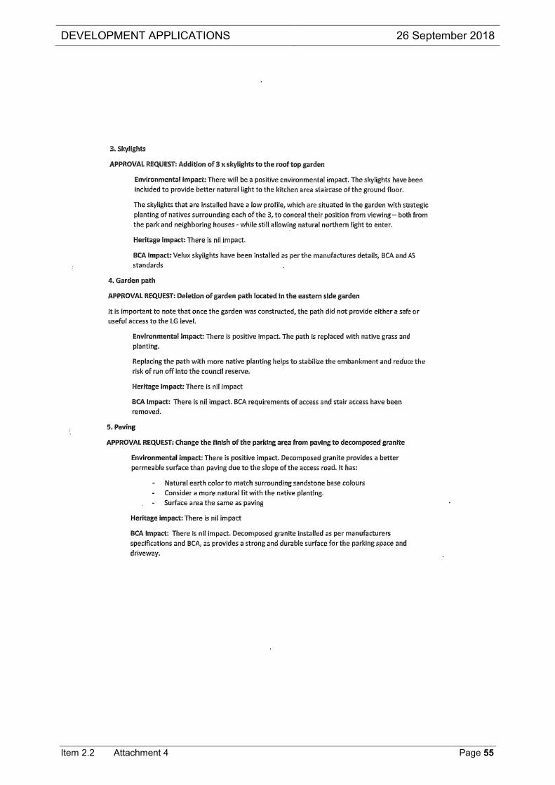
DEVELOPMENT APPLICATIONS 26 September 2018
Item 2.2 Attachment 4 Page 55

DEVELOPMENT APPLICATIONS 26 September 2018
Item 2.2 Attachment 4 Page 56