development of the sorong fault zone north of misool ...searg.rhul.ac.uk/pubs/saputra_etal_2014...
TRANSCRIPT

IPA14-G-086
PROCEEDINGS, INDONESIAN PETROLEUM ASSOCIATION Thirty-Eighth Annual Convention & Exhibition, May 2014
DEVELOPMENT OF THE SORONG FAULT ZONE NORTH OF MISOOL
EASTERN INDONESIA
Afif Saputra* Robert Hall*
Lloyd T. White*
ABSTRACT The part of Sorong Fault Zone studied here is located to the north of Misool between Obi and Batanta. The fault zone cuts an Early Miocene collision suture between the Philippine Sea Plate and the northern Australian margin. Its complex geometry and tectonic history are important for hydrocarbon exploration and to the south of the fault zone are the major oil fields of the Salawati Basin in the Bird’s Head region of Papua. 2D seismic and multibeam seafloor bathymetry data demonstrate the characteristics of the fault zone and basins in the subsurface and at the surface. Three major fault strands of the Sorong Fault Zone are identified: the E–W striking Molucca-Sorong Fault to the north, the NE–SW striking North Sula-Sorong Fault in the middle and NE–SW striking North Misool-Sorong Fault to the south. These faults separate basinal areas which formed by different mechanisms, and as a result have different geomorphological, stratigraphic and structural characteristics. There are significant difficulties in correlating between the basinal areas which have different basement types. An intriguing feature of the fault zone is the variation in seabed expression of different segments. The western Sorong Fault Zone was active very recently although there is currently little seismic activity. There is evidence of both transpression and transtension at different places along the sinistral strike-slip system area. The Kofiau Basin has several features suggesting it could be the northern part of the Salawati Basin displaced to the west on the Molucca-Sorong Fault during the Pliocene. * Royal Holloway, University of London
INTRODUCTION The Sorong Fault (Visser and Hermes, 1962; Pieters et al., 1983) is part of a left-lateral strike-slip zone which extends from eastern Papua, across the northern part of the Bird’s Head of New Guinea (Froidevaux, 1978; Hall et al., 1995; Satyana and Herawati, 2011) and continues west of the Bird’s Head which broadly marks the southern boundary of the Molucca Sea and Philippine Sea plates and the northern boundary of Australian Plate (Hall et al., 1995). Westward movement of the Pacific, Caroline and Philippine Sea plates relative to Australian continental crust (Hall, 1996, 2002) caused the left-lateral strike-slip zone (Froidevaux, 1978; Satyana and Herawati, 2011; Riadini et al., 2009) to develop along a suture produced during Paleogene collision of the Philippine-Halmahera arcs and the Australian margin (Ali and Hall, 1995; Hall et al., 1995; Hall, 1996, 2002). The initiation of the Sorong Fault system at ~25 Ma is based on geochronological and paleomagnetic data (Ali and Hall, 1995; Hall et al., 1995) from several islands located close to and north of the northern fault strand. The timing of displacement on the Sorong Fault from the northern Bird’s Head to as far west as Misool Island is still debated. Movements are suggested to have occurred in the Pliocene (Froidevaux, 1978; Gibson-Robinson et al., 1990; Decker et al., 2009; Satyana and Herawati, 2011) or the Miocene (Riadini et al, 2009). The geometry of the Sorong Fault Zone to the west of the Bird’s Head is not well known. Extending west of the Bird's Head, there are several Pliocene-Recent left-lateral splays of the Sorong Fault (Figure 1). Hamilton (1979) named two splays of the Sorong Fault Zone the Molucca-Sorong Fault and the North Sula-Sorong Fault, while Letouzey et al. (1983) identified a third southern splay as the North Misool-Sorong Fault and referred to the zone

between the two southern splays as the North Buru-Salawati Tectonized Zone. Recently acquired seismic and multibeam data provided the opportunity to study this region in more detail.
DATASET AND METHODS
The dataset used in this study comprised thirty five 2D seismic lines and multibeam seabed bathymetry dataprovided by TGS (Figure 2). The 2D seismic covers an area of more than 43,000 km2with a total length of approximately 3300 km. The multibeam dataset covers an area of 25,250 km2and was acquired by TGS using a Kongsberg Simrad EM 120 Multibeam Echo Sounder with 190 beams at equidistant spacing. C-NavStarfire DGPS was used for positioning control. During the processing, corrections were applied for positioning and tidal calibrations. Noise and artifacts were removed and the dataset was gridded using a 25 m bin size.
The area covered by the seismic and multibeam data between Batanta in the northeast and Obi in the southwest was divided into two parts: the Kofiau Basin and the North Misool Area (Figure 3). In the Kofiau Basin there is little seabed expression of the Sorong Fault strands although faults are very clear on the seismic lines. In contrast, in the North Misool Area there is very clear evidence of several strands of the Sorong Fault on the seabed and the area becomes significantly deeper to the southwest. The structure of each area was first interpreted using the seabed multibeam data, mapping geomorphological features and lineaments to guide interpretationof strike of faults identified in the subsurface using the seismic data. As no well data were available, there is no absolute control on the age of each unit and this results in some uncertainty in identifying relationships between the two areas and correlating their tectonic history.
KOFIAU BASIN
The Kofiau Basin is located in the NE part of the study area (Figure 3). Figure 4 shows a 2D seismic line crossing the basin. At the seabed from the northwest to southeast it shows a carbonate platform with some development of pinnacle reefs, an irregular bathymetry at the northern margin of the Kofiau Basin, the almost flat seafloor of the Kofiau Basin, a small inflection marking a strand of the Sorong Fault, and the shallow northern margin of the Salawati Basin.
Geomorphology
There are a number of emergent areas around the Kofiau Basin exposing mainly Quaternary reef
limestones with some exposures of pre-Neogene basement rocks which include volcanic rocks and ophiolites (Froidevaux, 1978; Pieters et al., 1983; Dow et al., 1986; Amri et al., 1990; Hall et al., 1991). The southeast side of the basin is bordered by a relatively steep slope trending NE-SW continuing east into the narrow Sagewin Strait south of Batanta suggesting fault strands (Figure 3a). Lineaments within the Kofiau Basin have an E-W trend in the south, parallel to the Kofiau Island coastline which is interpreted to represent the Molucca-Sorong Fault strand. A NE-SW trend which extends from the Sagewin Strait is considered to represent the North Sula-Sorong Fault strand (Figure 3b). Seismic Stratigraphy The stratigraphy of the Kofiau Basin area was divided into two major parts (Figure 4) based on their seismic character and the termination of reflectors. The oldest units of the section were assigned to a “Pre-Kofiau Basin Formation” (PKFunits) and younger units are referred to as “Kofiau Basin Fill” (KFunits). Pre-Kofiau Basin Formation The BS unit is the oldest unit with chaotic, bright, low amplitude reflectors but with well-defined parallel reflectors to the southeast (Figure 4). Basement (BS) rocks are interpreted to be of Philippine Sea Plate origin to the northwest (arc volcanics and ophiolites) and Australian continental crust to the southeast; the parallel reflectors at the SW end of the line are probably Mesozoic sedimentary rocks (Fraser et al., 1993; Pairault et al., 2003). The position of the change in basement type is uncertain but is assumed to be north of, or close to, the southernmost strands of the Sorong Fault Zone. The Pre-Kofiau Basin Formation sequence unconformably overlies the basement and is divided into four parts: PKF-1, PKF-2, PKF-3, and PKF-4, from oldest to youngest. Not all of the units can be observed on all seismic sections. PKF-1 and PKF-2 unit are mostly parallel, but there are downlap features in places. PKF-1 and PKF-2 have relatively low to medium amplitude reflectors with constant thickness. PKF-3 overlies unconformably the BS and PKF-2 units and is characterized by medium to high amplitude, sub parallel and moderately continuous reflectors. The PKF-3 unit may be Miocene Limestone which is widespread on Batanta Island above a volcanic basement and on other islands
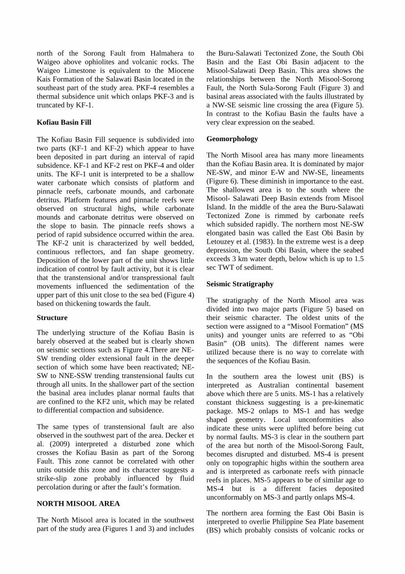
north of the Sorong Fault from Halmahera to Waigeo above ophiolites and volcanic rocks. The Waigeo Limestone is equivalent to the Miocene Kais Formation of the Salawati Basin located in the southeast part of the study area. PKF-4 resembles a thermal subsidence unit which onlaps PKF-3 and is truncated by KF-1. Kofiau Basin Fill The Kofiau Basin Fill sequence is subdivided into two parts (KF-1 and KF-2) which appear to have been deposited in part during an interval of rapid subsidence. KF-1 and KF-2 rest on PKF-4 and older units. The KF-1 unit is interpreted to be a shallow water carbonate which consists of platform and pinnacle reefs, carbonate mounds, and carbonate detritus. Platform features and pinnacle reefs were observed on structural highs, while carbonate mounds and carbonate detritus were observed on the slope to basin. The pinnacle reefs shows a period of rapid subsidence occurred within the area. The KF-2 unit is characterized by well bedded, continuous reflectors, and fan shape geometry. Deposition of the lower part of the unit shows little indication of control by fault activity, but it is clear that the transtensional and/or transpressional fault movements influenced the sedimentation of the upper part of this unit close to the sea bed (Figure 4) based on thickening towards the fault.
Structure
The underlying structure of the Kofiau Basin is barely observed at the seabed but is clearly shown on seismic sections such as Figure 4.There are NE-SW trending older extensional fault in the deeper section of which some have been reactivated; NE-SW to NNE-SSW trending transtensional faults cut through all units. In the shallower part of the section the basinal area includes planar normal faults that are confined to the KF2 unit, which may be related to differential compaction and subsidence. The same types of transtensional fault are also observed in the southwest part of the area. Decker et al. (2009) interpreted a disturbed zone which crosses the Kofiau Basin as part of the Sorong Fault. This zone cannot be correlated with other units outside this zone and its character suggests a strike-slip zone probably influenced by fluid percolation during or after the fault’s formation. NORTH MISOOL AREA The North Misool area is located in the southwest part of the study area (Figures 1 and 3) and includes
the Buru-Salawati Tectonized Zone, the South Obi Basin and the East Obi Basin adjacent to the Misool-Salawati Deep Basin. This area shows the relationships between the North Misool-Sorong Fault, the North Sula-Sorong Fault (Figure 3) and basinal areas associated with the faults illustrated by a NW-SE seismic line crossing the area (Figure 5). In contrast to the Kofiau Basin the faults have a very clear expression on the seabed. Geomorphology The North Misool area has many more lineaments than the Kofiau Basin area. It is dominated by major NE-SW, and minor E-W and NW-SE, lineaments (Figure 6). These diminish in importance to the east. The shallowest area is to the south where the Misool- Salawati Deep Basin extends from Misool Island. In the middle of the area the Buru-Salawati Tectonized Zone is rimmed by carbonate reefs which subsided rapidly. The northern most NE-SW elongated basin was called the East Obi Basin by Letouzey et al. (1983). In the extreme west is a deep depression, the South Obi Basin, where the seabed exceeds 3 km water depth, below which is up to 1.5 sec TWT of sediment. Seismic Stratigraphy The stratigraphy of the North Misool area was divided into two major parts (Figure 5) based on their seismic character. The oldest units of the section were assigned to a “Misool Formation” (MS units) and younger units are referred to as “Obi Basin” (OB units). The different names were utilized because there is no way to correlate with the sequences of the Kofiau Basin. In the southern area the lowest unit (BS) is interpreted as Australian continental basement above which there are 5 units. MS-1 has a relatively constant thickness suggesting is a pre-kinematic package. MS-2 onlaps to MS-1 and has wedge shaped geometry. Local unconformities also indicate these units were uplifted before being cut by normal faults. MS-3 is clear in the southern part of the area but north of the Misool-Sorong Fault, becomes disrupted and disturbed. MS-4 is present only on topographic highs within the southern area and is interpreted as carbonate reefs with pinnacle reefs in places. MS-5 appears to be of similar age to MS-4 but is a different facies deposited unconformably on MS-3 and partly onlaps MS-4. The northern area forming the East Obi Basin is interpreted to overlie Philippine Sea Plate basement (BS) which probably consists of volcanic rocks or

ophiolites. Unconformably above the basement OB-1 is characterized by high amplitude reflectors and is interpreted as carbonate and is possibly the Miocene Limestone deposited across the whole area. OB-2 is a younger syn-kinematic unit deposited unconformably on top of OB-1. This unit has at least three internal unconformities that probably reflect episodic southward tilting. Some slump features can be observed on the upper slope. Together with the units below, it is cut by a high angle normal fault. OB-3 is a thin unit at the top of the sequence that may be cut by the fault which appears to reach the sea bed. Structure
Close to surface, the faults are clearly seen in the seismic section but are obscured at depth. There are two NE-SW major fault strands crossing the North Misool area identified as the North Misool-Sorong Fault to the south and the North Sula-Sorong Fault to the north. Some minor E-W left-lateral strike-slip faults connect the major faults. Planar normal faults cut through most units and propagate to the seabed suggesting fault reactivation in the southern part of the area. In the Buru-Salawati Tectonized Zone there are folded sediments with a southward vergence cut by some minor trans-tensional faults. To the north part of the area is more complicated than the south. Within the basin, northward-directed reverse faults suggest a detachment connected to a steep normal fault. The reverse faults resemble features in the Waigeo Basin which Riadini et al. (2009) explained as a transpressional zone. However, here they appear to be consequences of gravity sliding from the south to the north on a steep slope which were later cut left-lateral movements of the North Sula-Sorong Fault. DISCUSSION Molucca-Sorong Fault Hamilton (1979) traced the E-W Molucca-Sorong Fault from the Sagewin Strait (between Batanta and Salawati Islands) north of Kofiau Island (Figure 1) and Letouzey et al. (1983) continued it west to join the Halmahera thrust. This position of this left-lateral fault is now drawn more precisely based on seismic, multibeam and SRTM data.It can be traced west close to the northern coast of Kofiau Island (Figure 4 and 7). The eastern part of this fault forms the northern margin of the Neogene Salawati Basin (Gibson-Robinson et al., 1990; Satyana and Herawati, 2011).This study suggests most fault activity is late Neogene with syn-kinematic
sediment close to the surface in a zone close to the Molucca-Sorong Fault (Figure 7). North Sula-Sorong Fault Letouzey et al. (1983) described this fault as a splay of the Sorong Fault which connects the Sorong Fault to the Sula Thrust Zone. The North Sula-Sorong Fault splays from the Molucca-Sorong Fault between Batanta and Kofiau Islands (Figure 3) and further west separates the East Obi Basin in the north from the Buru-Salawati Tectonized Zone in the south (Figure 6a). This fault is not a single but a segmented NE-SW trending fault zone (Figure 6b). The segmentation of this fault suggests variation between zones of transpression and transtension (Figures 8 and 9). Based on the seismic data, the North Sula-Sorong Fault movements were recently dominated by normal fault displacements (Figures 8 and 9) which probably formed during strike-slip movements within the basin. A broad negative flower structure is shown on Figure 9a. At the flanks of the narrow basin with steep slopes, there are indications of space for mass transport movements (Figure 9b). The western part of the basin is inferred to have been active recently, indicated by the presence of mud volcanos on the sea bed (Figure 9b). It is unclear whether strike-slip faulting was controlled by existing faults. North Misool-Sorong Fault Letouzey et al. (1983) identified but did not describe this fault in any detail. The Misool-Sorong Fault strand is observed clearly in the SW part of the area (Figure 10). It strikes NE-SW and is located to the north of Misool Island. The extent of the data set prevents this fault being traced further to the east. However, this fault probably continues to the Salawati Basin where it joins the North Sula-Sorong Fault. From south to north, across the fault, the northern Australia margin becomes disrupted. Further north is the Buru-Salawati Tectonized Zone underlain by basement of uncertain origin which could be either the north Australian margin or Philippine Sea Plate volcanic or ophiolitic rocks. The NNE-SSW normal faults within the Buru-Salawati Tectonized Zone developed mostly in the western part of the North Misool area and these are probably related to a broad strike-slip system. Cross-cutting relationships indicate that these faults mark the last episode of tectonic movement in the area. However, the faults are buried by younger

sediment to the east indicating that the movement along the fault must have ceased before the deposition of this sediment.
Tectonic evolution of Kofiau Basin and Salawati Basin
The Misool-Salawati Deep Basin is considered to be the westward part of the Salawati Basin which developed within the Bird’s Head block. This basin developed after collision of the Philippine Sea Plate volcanic arc and northern Australian margin during the Miocene (Gibson-Robinson et al., 1990). Thick sequences of sediment were deposited during this time. Late stage deformation may be related to Misool-Onin-Kumawa Ridge formation to the south which is (Pairault et al., 2003; Decker et al., 2009) an intra-Pliocene event. Erosion was followed by subsidence of the area marked by pinnacle reef and rimmed carbonate formation which may be related to North Misool-Sorong Fault activity.
There has been no previous investigation of Kofiau Basin ages. We assume that the Pre Kofiau Basin Formation PKF-2 is equivalent to the widespread Miocene Limestone. After Early Miocene Philippine Sea Plate-Australian collision there was widespread carbonate deposition all over the area and cessation of volcanism (Hall et al., 1995). Thus the age of the Kofiau Basin is Late Miocene or younger. The Salawati and Kofiau basins developed as broad WNW-ESE synclinal basins with rapid subsidence and deposition. Decker et al. (2009) suggested that the Kofiau Basin formed in a transtensional setting. Interpretation of the isochron map of the Kofiau Basin KF-1 unit (Figure 11a), suggests an interpretation in which strands of the Sorong Fault Zone cut the Salawati and Kofiau Basins (Figure 11b) with the Kofiau Basin representing the northern part of the Salawati Basin. On figure 11b, the Sorong Fault is shown to cut this basin, with a sinistral sense of displacement of 90-150 km. Letouzey et al. (1983) suggested that most of the activity on the Sorong Fault Zone was accommodated by the Molucca-Sorong Fault and was linked to Halmahera subduction allowing westward movement north of the Sorong Fault Zone. There is no clear evidence to support this hypothesis, but it does provide an explanation of how the estimated 90-150 km of westward movement could have been accommodated.
East Obi Basin
Letouzey et al. (1983) described the East Obi Basin as a forearc basin which was uplifted by collision of
Philippine Sea volcanic arc and north Australian margin. This is unlikely as the basin seems to be most influenced by young Sorong Fault movements. Probable carbonates at the base of the East Obi Basin are interpreted to be Miocene Limestones Carbonate which post-date to Philippine Sea Plate volcanic arc and northern Australian margin collision. There is folding and tilting toward the south of the carbonates overlying the interpreted Philippine Sea Plate volcaniclastic units (Figure 5). The basin was then filled a syn-kinematic unit which thickens southward probably controlled by normal faulting or by tilting related to strike-slip movements (Figures 5 and 9). Deposition was followed by movement on the NE-SW North Sula-Sorong Fault producing transtension and transpression zones and developing a very steep northward dipping slope which allowed the sequence to collapse and form reverse faults within the basin with deposition of the youngest units at the same time. The present day westward drainage pattern shows that the final deformation is quite young (Figure 6). South Obi Basin The South Obi Basin is the deepest basin within the area. It has a similar stratigraphy to the Misool-Salawati Deep Basin but has deformed differently. The basin may have originally formed during bending of the northern Australian margin where thick sequences were deposited in deep water while normal faulting occurred. Compression did not occur until after deposition. The basin later collapsed due to strike-slip faulting associated with the Sorong Fault. This collapsed the sequences into a compressional system within the basin on shallow detachment thrust faults (Figure 10). The mechanism of the compressional system is more or less the same as observed in the East Obi Basin. CONCLUSIONS The northern Misool section of the Sorong Fault Zone can be divided into three major fault strands: An E-W striking Molucca-Sorong Fault in the north, a NE-SW striking North Sula-Sorong Fault in the middle and a NE-SW striking North Misool-Sorong Fault in the south part of the study area. Several Neogene basins were formed north of Misool separated by the Sorong Fault Zone splays namely the Kofiau Basin, the Misool-Salawati Deep Basin, the East Obi Basin and the South Obi Basin. It is unknown exactly when the basins formed due to the lack of well data and the difficulties of

correlating between each basin. It is probable that all formed after collision between the Philippine Sea volcanic arc and the northern Australian margin. Miocene carbonates interpreted at depth in many of the basins suggest that most of them are Late Miocene or younger. The nature of basement rock is interpreted to have a Philippine Sea Plate origin in the northern part of the study area and as Australian continental crust south of the North Misool-Sorong Fault. The Buru-Salawati Tectonized Zone could be underlain by either or both types of crust. The Kofiau Basin seems likely to be correlative with the Salawati Basin. It is suggested that these basins were separated by movements on the Molucca-Sorong Fault with a sinistral sense of displacement of 90-150 km during the Pliocene and Pleistocene. The Sorong Fault Zone north of Misool shows many signs of recent activity on seabed suggesting very young, probably Late Pliocene or Pleistocene, activity despite the absence of recent seismicity in the North Misool area. Strike-slip movements appear to be older in the Kofiau Basin as displacements are evident on the seismic lines but have little or no expression at the seabed. ACKNOWLEDGEMENTS We thank TGS, who provided the 2D seismic and high resolution seabed multibeam data set. We would like to thank the members of SEARG for discussing and sharing knowledge about the area. This work was undertaken during an MSc by the first author funded by the SE Asia Research Group. REFERENCES Ali, J.R. & Hall, R., 1995. Evolution of the boundary between the Philippine Sea Plate and Australia: palaeomagnetic evidence from eastern Indonesia. Tectonophysics, 251, 251–275. Amri, Ch., Sanyoto, P., Hamonangan, B., Supriatna, S. & Pieters, P. E. 1990. Geological Map of the Sorong Sheet, Irian Jaya, 1:250,000. Geological Research and Development Centre, Bandung. Decker, J., Bergman, S.C., Teas, P.A., Baillie, P. & Orange, D.L. 2009. Constraints on the tectonic evolution of the Bird’s Head, West Papua, Indonesia. Indonesian Petroleum Association,
Proceedings 33rd Annual Convention, IPA09-G-139 1-24. Dow, D. B., Robinson, G. P., Hartono, U. & Ratman, N. 1986. Geological map of Irian Jaya, Indonesia. Scale 1: 1,000,000. Geological Survey of Indonesia, Directorate of Mineral Resources, Geological Research and Development Centre, Bandung. Fraser, T. H., Bon, J. & Samuel, L. 1993. A new dynamic Mesozoic stratigraphy for the West Irian micro-continent Indonesia and its implications. Indonesian Petroleum Association, Proceedings 22nd Annual Convention, 707-761. Froidevaux, C. M. 1978. Tertiary tectonic history of the Salawati area, Irian Jaya, Indonesia.American Association of Petroleum Geologists Bulletin, 62, 1127-1150. Gibson-Robinson, C., Henry, N. M., Thompson, S. J. & Raharjo, H.T. 1990. Kasim and Walio fields, Indonesia, Salawati Basin, Irian Jaya. In: Beaumont, E. A. & Foster, N.H. (Eds.), American Association of Petroleum Geologists, Treatise on Petroleum Geology, Atlas of Oil and Gas Fields: Stratigraphic Traps I, 275-295. Hall, R. 1996. Reconstructing Cenozoic SE Asia. In: Hall, R. & Blundell, D. J. (Eds.), Tectonic Evolution of SE Asia. Geological Society of London Special Publication, 106, 153-184. Hall, R. 2002. Cenozoic geological and plate tectonic evolution of SE Asia and the SW Pacific: computer-based reconstructions, model and animations. Journal of Asian Earth Sciences 20, 353-434. Hall, R., Ali, J. R. & Anderson, C. D. 1995. Cenozoic motion of the Philippine Sea Plate - paleomagnetic evidence from eastern Indonesia. Tectonics, 14, 1117-1132. Hall, R., Nichols, G., Ballantyne, P., Charlton, T. & Ali, J. 1991. The character and significance of basement rocks of the southern Molucca Sea region.Journal of Southeast Asian Earth Sciences, 6, 249-258. Hamilton, W. 1979. Tectonics of the Indonesian region.USGS Professional Paper, 1078, 345 pp. Letouzey, J., de Clarens, P., Guignard, J. & Berthron, J. L. 1983. Structure of the North Banda-

Molucca area from multichannel seismic reflection data. Indonesian Petroleum Association, Proceedings 12th Annual Convention, 143-156. Pairault, A.A., Hall, R. & Elders, C.F. 2003. Structural styles and tectonic evolution of the Seram Trough, Indonesia. Marine and Petroleum Geology, 20, 1141–1160. Pieters, P. E., Pigram, C. J., Trail, D. S., Dow, D. B., Ratman, N. & Sukamto, R. 1983. The stratigraphy of western Irian Jaya. Bulletin Geological Research and Development Centre, Bandung, 8, 14-48. Riadini, P., Adyagharini, A.C., Nugraha, A.M.S., Sapiie, B. & Teas, P.A. 2009. Palinspatic reconstruction of the Bird’s Head pop-up structure
as a new mechanism of the Sorong Fault.Indonesian Petroleum Association, Proceedings 33rd Annual Convention, IPA09-SG-067 1-13. Satyana, A.H. & Herawati, N. 2011. Sorong Fault tectonism and detachment of Salawati Island: Implications for petroleum generation and migration in Salawati Basin, Bird’s Head of Papua. Indonesian Petroleum Association, Proceedings 35th Annual Convention, IPA11-G-183 1-21. Visser, W. A. & Hermes, J. J. 1962. Geological results of the exploration for oil in Netherlands New Guinea. Verhandelingen Koninklijk Nederlands Geologisch en Mijnbouwkundig Genootschap, Geologische Serie, 20, 265pp.

Figure 1 - Regional tectonic features of the Sorong Fault Zone in eastern Indonesia (adapted from
Froidevaux, 1978; Hamilton, 1979; Letouzey et al., 1983).
Figure 2 - Location of study area showing multibeam coverage and seismic data set.

Figure 3 - The study area was subdivided into the Kofiau Basin and North Misool Areas. a) Multibeam
coverage. b) Structural interpretation from multibeam and seismic and including terminology of previous publications for fault strands.
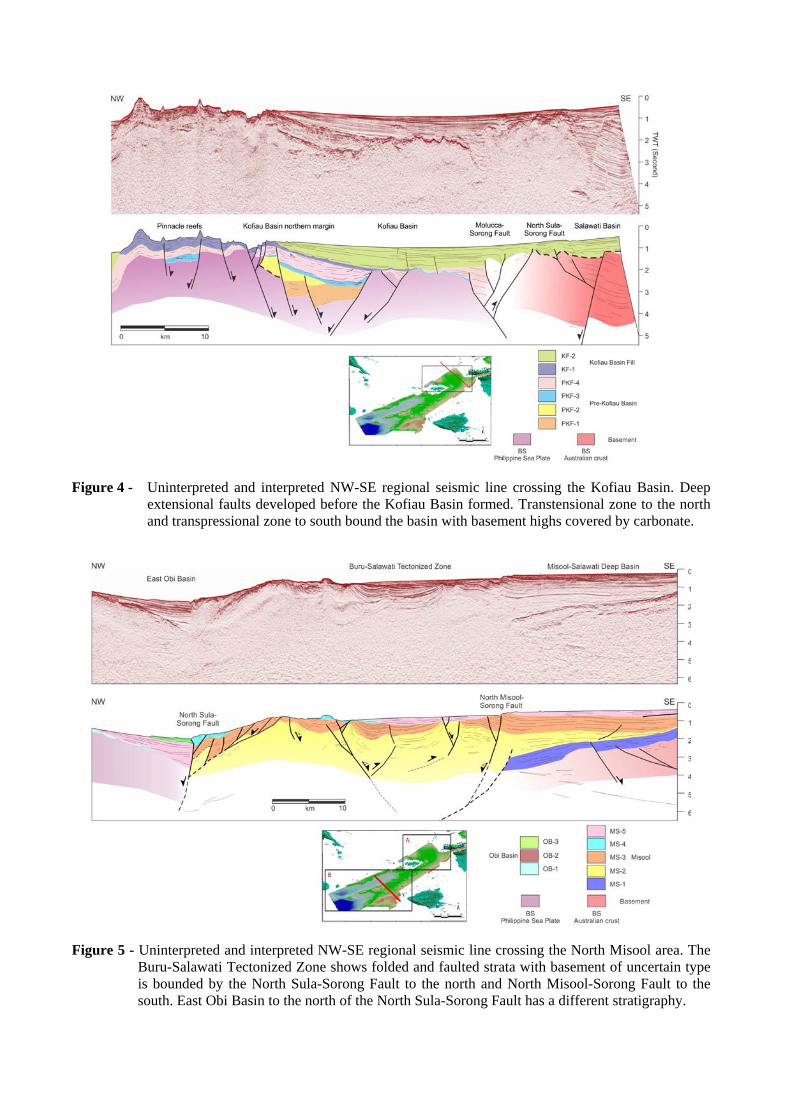
Figure 4 - Uninterpreted and interpreted NW-SE regional seismic line crossing the Kofiau Basin. Deep
extensional faults developed before the Kofiau Basin formed. Transtensional zone to the north and transpressional zone to south bound the basin with basement highs covered by carbonate.
Figure 5 - Uninterpreted and interpreted NW-SE regional seismic line crossing the North Misool area. The
Buru-Salawati Tectonized Zone shows folded and faulted strata with basement of uncertain type is bounded by the North Sula-Sorong Fault to the north and North Misool-Sorong Fault to the south. East Obi Basin to the north of the North Sula-Sorong Fault has a different stratigraphy.

Figure 6 - a) The seabed multibeam bathymetry map of the North Misool area showing the different basins.
b) Interpretation of lineaments within the area which have a predominantly NE-SW trend. The thinner grey lines are the interpreted lineaments and the thick black lines are the interpreted major faults.
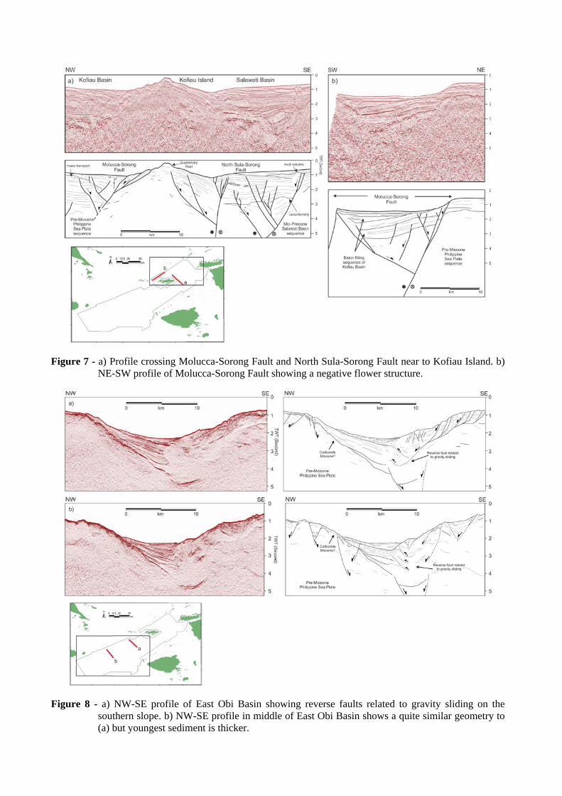
Figure 7 - a) Profile crossing Molucca-Sorong Fault and North Sula-Sorong Fault near to Kofiau Island. b)
NE-SW profile of Molucca-Sorong Fault showing a negative flower structure.
Figure 8 - a) NW-SE profile of East Obi Basin showing reverse faults related to gravity sliding on the
southern slope. b) NW-SE profile in middle of East Obi Basin shows a quite similar geometry to (a) but youngest sediment is thicker.
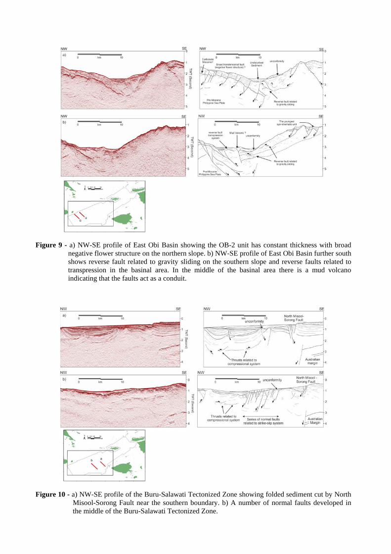
Figure 9 - a) NW-SE profile of East Obi Basin showing the OB-2 unit has constant thickness with broad
negative flower structure on the northern slope. b) NW-SE profile of East Obi Basin further south shows reverse fault related to gravity sliding on the southern slope and reverse faults related to transpression in the basinal area. In the middle of the basinal area there is a mud volcano indicating that the faults act as a conduit.
Figure 10 - a) NW-SE profile of the Buru-Salawati Tectonized Zone showing folded sediment cut by North
Misool-Sorong Fault near the southern boundary. b) A number of normal faults developed in the middle of the Buru-Salawati Tectonized Zone.

Figure 11 - a) Isochron map of unit KF-1; b) Paleogeography for the Late Miocene (Salawati Basin area
based on Gibson-Robinson et al., 1990) using present day structures and coastline position.