development plan document
TRANSCRIPT

DEVELOPMENT PLAN DOCUMENT
ADOPTED JULY 2011

Title Rutland Core Strategy Development Plan Document. Subject matter Establishes the overall vision, objectives and spatial strategy for Rutland. Adoption Date Adopted by resolution of the Council on 11 July 2011. Contact information This document can be made available on requests, in other languages and formats (large print, Braille or on audio tape) by contacting: Planning Policy Team Rutland County Council Catmose Oakham Rutland LE15 6HP Tel: 01572 722577 Fax: 01572 758427 E-mail: [email protected]
Web: www.rutland.gov.uk
Core Strategy Development Plan Document
Contents
1
Chapter/Section Page no.
Introduction 3
1 Spatial Vision and Objectives
Spatial portrait 5 Issues to be addressed 8 The vision 12 Strategic objectives 13
2 Spatial Strategy
Sustainable development principles 16 The spatial strategy 17 The settlement hierarchy 19 The location of development 22 Spatial strategy for Oakham 24 Re-use of redundant military bases and prisons 28 Key diagram 30
3 Creating Sustainable Communities
Delivering socially inclusive communities 31 Developer contributions 32 The housing requirement and distribution 33 Housing density and mix 36 Affordable housing 37 Gypsies and travellers 40
4 Building our Economy and infrastructure
Employment and economic development 41 Tourism 44 The rural economy 45 Town centres and retailing 48 Transport and accessibility 49
5 Sustaining Our Environment
Promoting good design 52 Energy efficiency and low carbon energy generation 53 The natural environment 54 The historic and cultural environment 55 Green infrastructure, open space, sport and recreation 57 Rutland Water 58 Waste management and disposal 60
6 Implementation and monitoring framework 64
(continued …)
Core Strategy Development Plan Document
Contents
Chapter/Section Page no.
2
Appendix 1 – Housing supply and trajectory
66
Appendix 2 – Implementation and monitoring framework 70 Appendix 3 – Waste management needs 81 Appendix 4 – LDF evidence-base studies 84 Appendix 5 – Proposals Map Alteration 86 Appendix 6 – List of replaced Local Plan policies 87 Appendix 7 – Glossary 88

Core Strategy Development Plan Document
Introduction
What is the Core Strategy? The Core Strategy is the key Development Plan Document (DPD) in Rutland’s Local Development Framework (LDF) as it establishes the overall vision, objectives and spatial strategy and all other documents within the LDF must conform to it. The LDF comprises a folder of documents than can be amended and updated as required. This will gradually replace the policies contained in the existing Rutland Local Plan and the Leicestershire, Leicester and Rutland Waste Local Plan and provide planning policies for Rutland for the period to 2026 and beyond. The document takes into account to a wide range of national, regional and local policies and strategies and has regard to social, economic and environmental issues. It is closely linked to the community’s aspirations set out in the Sustainable Communities Strategy. Diagram: The Local Development Framework
3
The Core Strategy has been influenced at each stage of preparation by a Sustainability Appraisal (SA) and Habitat Regulations Assessment (HRA). The purpose of the SA is to assess the significant effects of the plan and how it will meet social, economic and environmental objectives. The purpose of the HRA is to assess
Core Strategy Development Plan Document
Introduction
potential impacts of the plan against the conservation objectives of Rutland Water, and where necessary identify mitigation measures or other options in order to avoid any potential damaging effects. The Core Strategy has been underpinned by an extensive evidence base including a number of studies that have been specifically commissioned to inform preparation of the LDF. These are listed in Appendix 4. Preparation of this document has involved an extensive process of consultation, commencing in 2008 with an “Issues and Options” consultation and followed by a “Preferred Options” consultation in May 2009 and April 2010. The “Proposed Submission” document was published in August 2010 and submitted to the Secretary of State in November 2010. The Council has considered the issues raised in consultation at each stage and taken into account the findings of the LDF evidence base, the Sustainability Appraisal, the Habitats Regulation Assessment, the Sustainable Communities Strategy for Rutland and the Council’s “20 Year Vision for Rutland”. A public examination was held in March 2011 and the inspector’s report was received by the Council in May 2011. The inspector concluded that the strategy is sound, subject to number of minor changes to the policies and text of the document being made, which have been incorporated into this document. The Core Strategy was adopted by Rutland Council on 11th July 2011 and now forms part of the statutory development plan which provides the framework for the Council’s decisions on future development proposals in Rutland. A list of the existing Local Plan policies that are replaced by the Core Strategy is included in Appendix 6. Other Local Plan policies will gradually be replaced by future Development Plan Documents as they are prepared.
4

Core Strategy Development Plan Document
Spatial Vision and Objectives
5
Spatial portrait
1.1 The spatial portrait provides context for the spatial vision and strategic objectives. It sets out the main characteristics of Rutland in terms of geography, economy, environment, social and cultural matters.
Spatial characteristics
1.2 The area of Rutland is approximately 390 km2 and latest mid-year population
estimates (2009) show it as having a population of 38,400. This is projected to rise substantially to 44,300 by 2026 and to 46,400 by 2033. The density of population is low with less than one person per hectare. Rutland has been classed as the most rural county or unitary authority in England and Wales with a high proportion of land in agricultural use.
1.3 Oakham is the larger of the two market towns with a population of about 10,000
and a range of education, community, health and leisure facilities, employment, shopping, a twice weekly market, a railway station and bus services to the surrounding area. Uppingham has a population of about 4,000 with a more limited range of facilities, employment and shopping, a weekly market and bus services to the surrounding area.
1.4 Rutland has 52 villages ranging in size from small hamlets with a few houses
and no facilities to larger villages with facilities such as a school, a convenience store, a post office, general medical practice, employment opportunities, community and leisure facilities and bus links to the towns and neighbouring villages. The six largest villages each have a population of more than 1,000 and account for about 25% of Rutland’s population.
1.5 Beyond Rutland’s borders, Stamford lies just outside the county boundary,
providing a range of community facilities, shopping, education, health services and acting as a service centre to some of the villages on the eastern side of Rutland. Corby lies approximately 3 miles south of Rutland and is planned to double in size in the next 30 years including new housing, leisure and shopping facilities. Sustainable Communities
1.6 Rutland is a relatively affluent area with very low levels of deprivation, the
lowest in the East Midlands and 334 out of 354 nationally, where 1 is the most deprived. There are low levels of unemployment (4.2% in April 2009-March 2010), low levels of crime and lowest levels of premature death (under the age of 75) in the East Midlands.
1.7 There are above average levels of educational attainment with the highest level
of pupils obtaining 5 or more GCSEs at grades A-C in the East Midlands. Rutland has 17 primary schools located in the towns and larger villages and 3 secondary schools located in Oakham, Uppingham and Great Casterton. There are large independent schools in Oakham and Uppingham.
1.8 Rutland has a higher proportion than the East Midlands regional average of
people in good health and lower levels of limiting long-term illness. The county
Core Strategy Development Plan Document
Spatial Vision and Objectives
6
has a hospital in Oakham providing inpatient and outpatient services which it is planned to develop to include a new health centre. Rutland is also served by larger hospitals in Leicester, Peterborough, Grantham and Kettering. GP and dentists’ practices are located in Oakham and Uppingham and some of the villages.
1.9 There are below average numbers of people in the 0-15 and 20-34 age groups
and above average in the 16-19 and 35-69 and 80+ age groups compared with the East Midlands regional average. Numbers of people aged 65+ are expected to roughly double during the plan period. The proportion of non-white ethnic groups is low being under 2%. Crime levels are below the East Midlands regional average.
1.10 Based on 2001 census data, 35% of household incomes were below £20,000;
conversely 36% of households had incomes in excess of £35,000. This results in concealed pockets of deprivation and housing affordability problems given the high house prices.
1.11 The average house price in Rutland in September 2010 was £216,000 compared with the East Midlands regional average of £128,000. It is one of the least affordable areas in the region with an average house price to incomes ratio of more than 8:1. A recent survey shows more than 20% of households unable to buy market housing, with over 90% of social tenants and almost half of private tenants unable to afford to buy.
1.12 Rutland has a high proportion of detached and very large houses and
properties owned outright compared with the rest of the region and a low proportion of local authority rented and mortgaged properties. The number of people on the Council’s housing register has almost doubled to nearly 300 in the last 7 years.
Economy and Infrastructure
1.13 The service sector provides the most jobs in Rutland (about 77%) with the
remainder in manufacturing (about 16%) and construction (about 4%). This broadly reflects the East Midlands regional average but a higher proportion than average are employed in tourism related businesses (about 11%). Agriculture, the traditional employer, is a minority employer (3%) and still declining.
1.14 Major employers with importance to the local economy include Ministry of
Defence establishments at Cottesmore and North Luffenham, HM Prisons at Ashwell and Stocken Hall, independent schools at Oakham and Uppingham, Hanson Cement at Ketton and Rutland County Council in Oakham. Small businesses also have an important role. RAF Cottesmore is due to close by 2013 and the future of Ashwell prison also looks uncertain.
1.15 Economic activity rates for both men and women are above the East Midlands
and national averages with low levels of unemployment. There is a high incidence of self-employment for men and women. A high proportion of the resident work force is managerial or professional (48%). Earnings of residents on average are higher than those for the region.

Core Strategy Development Plan Document
Spatial Vision and Objectives
7
1.16 The A1 passes through the eastern part of Rutland providing good north-south road links. East-west connections are less good, although the A47, which traverses the southern part of Rutland, and A606 Stamford-Nottingham road provide east-west road links. Oakham has direct rail links to the east coast main line and Stansted Airport and Birmingham to the west. A direct once-daily return rail link to London via Corby commenced in 2009. A number of long-distance footpaths pass through Rutland.
1.17 Rutland has high levels of car ownership – with only 14% non-car ownership.
Although there are continual efforts to improve public transport as well as cycling and pedestrian facilities, there is a high level of car dependence and commuting with 40% of Rutland residents who travel to work going out of the county to work.
Environment
1.18 Rutland’s towns and villages have a large number of buildings listed of historic
and architectural interest (approximately 1,700) and a large number (34) of designated conservation areas providing a built environment with a historic and distinctive character. The county has 31 scheduled ancient monuments and 2 registered parks and gardens.
1.19 The environmental quality of Rutland’s landscape is high and the character of
the landscape is varied with five different landscape character types. These range from high plateau landscapes across large areas of the north east and south west to lowland valleys in the centre and north west and on the county’s southern border along Welland Valley.
1.20 Rutland has 21 sites of special scientific interest (SSSIs) including Rutland
Water which is an internationally designated wetland site with importance for wintering and passage wildfowl. There are 190 local wildlife sites and important areas of calcareous grassland and ancient and broadleaved woodland in the county.
1.21 The limestone geology has importance for local quarrying and wildlife. Soils
are largely loamy in the east and clayey in the west. Agricultural land is largely grade 3 with some grade 2 centred on the south and pockets of grade 1 in the north. The county has SSSIs designated for their geological interest and a number of Regionally Important Geological Sites.
Waste management
1.22 All forms of development and activities produce waste, this includes residential,
commercial, industrial, agricultural, and construction. About 20,000 tonnes of municipal waste are generated in Rutland each year, of which about 11,500 tonnes (55%) is recycled. The county has two civic amenity sites. All non-recycled waste is currently exported to adjoining Counties for disposal.
1.23 About 30,000-60,000 tonnes of commercial and industrial waste are generated
in Rutland each year, of which up to 50% is recycled, the remainder is disposed of. The majority is collected by private waste operators and exported to
Core Strategy Development Plan Document
Spatial Vision and Objectives
8
adjoining counties for recycling and disposal. A small proportion of ‘trade waste’ is taken to Rutland’s civic amenity sites.
1.24 About 55,000-90,000 tonnes of construction, demolition and excavation waste
is generated in Rutland each year, of which more than 50% is recycled, up to 38% is used as inert fill, and 18% is disposed of.
Issues to be addressed 1.25 In general terms, Rutland is recognised as having a high quality of life, with an
attractive and high quality environment, low levels of deprivation, unemployment and crime, high levels of life expectancy, health and educational attainment.
1.26 Nevertheless, it is not a universal picture of affluence and the attractive rural
nature of the area gives rise to its own problems such as the high cost of housing and difficulties in access to services due to the dispersed pattern of settlement and lack of public transport.
1.27 The key issues below are based on the spatial portrait and the Sustainable
Communities Strategy.
Locations for development
1.28 Locations for growth need to be identified for new housing, employment and other development to meet the aspirations of the local community. The need for new development will need to be balanced against the need to protect Rutland’s character.
1.29 While Oakham and Uppingham are likely to be the most sustainable locations
for new development, the needs of the rural areas also need to be met and there may be circumstances where a limited amount of development in some villages may help to maintain or enhance their vitality and meet local needs.
1.30 Suitable re-uses for military bases and prisons in Rutland will need to be
determined should they be closed and proposed for other uses, in the light of the announcement that RAF Cottesmore is to close by 2013 and uncertainties over the future of Ashwell Prison.
Creating Sustainable Communities
1.31 There is a need to remove barriers to access key services and facilities
including education, health, social care, cultural, leisure, recreation, open spaces, woodland and other facilities to all groups in the community including disadvantaged/vulnerable groups and disabled people and consider how the gradual decline in some facilities such as village shops, post offices and pubs can be addressed.
1.32 There is a need to provide a wider variety of cultural, leisure and recreation
facilities and improve opportunities for the whole community in particular activities for young people in Rutland. The Sustainable Communities Strategy has identified a need for better facilities for the elderly and the young and the

Core Strategy Development Plan Document
Spatial Vision and Objectives
9
need for a disability resource centre, children’s centres, libraries, health centre, sports and leisure facilities.
1.33 There is a requirement for about 1,900 additional new dwellings in Rutland in
the period to 2026 but the possibility that development may proceed more quickly or slowly than expected needs to planned for, including the impact of the economic recession.
1.34 Rutland has a high proportion of larger housing and some of the highest house
prices in the country leading to a need for a significant increase in affordable housing and also a mix of housing sizes and types to meet the needs of all the community.
1.35 New housing needs to be designed to the highest quality so that it respects the
existing built and natural environment, is energy and resource efficient, is at the highest density and makes use of developed land where possible. Adequate infrastructure will need to be provided.
1.36 There is a need to identify a suitable site for Gypsies and Travellers in Rutland
as there are no pitches currently provided. The Gypsy and Travellers Accommodation Needs Assessment has shown the need for additional residential and transit pitches in the period to 2011. An assessment of needs for the period after 2011 will also need to be carried out
Building our Economy and Infrastructure
1.37 New land for employment may be needed to meet the needs of existing
employers or to attract new ones into in Rutland. At present there are high levels of commuting from Rutland to surrounding areas while conversely existing employers find it difficult to recruit staff within the county.
1.38 Although wages of residents are higher than the East Midlands regional
average, there is a limited range of work opportunities in Rutland and a generally lower paid and unskilled range of jobs, suggesting the need for a wider range of industry sizes and types.
1.39 The needs of the rural economy need to be catered for, including farm
diversification and use of redundant farm buildings. Tourism is an important element of Rutland’s economy and suitable policies are needed to promote tourism development in suitable locations.
1.40 Oakham and Uppingham as the two market towns and main service centres
need to maximise their appeal to visitors, businesses and investors. The vitality and viability of the town centres needs to be promoted, including provision for new retail and leisure facilities and environmental enhancements where needed.
1.41 There is significant growth proposed in the areas surrounding Rutland which
will require careful planning and management to ensure there are not adverse impacts on Rutland’s environment and facilities.

Core Strategy Development Plan Document
Spatial Vision and Objectives
10
1.42 New development in Rutland will need to be located and designed to reflect the fact that much of the county has limited public transport services and is relatively inaccessible without private transport.
1.43 Sustainable forms of transport in Rutland need to be improved and further
integrated in order to encourage public transport, walking and cycling as an alternative to car travel.
1.44 There is a need to improve the road network, road safety and means of
accessibility throughout the county and beyond that would tie in with cross-border developments including bypasses for some towns and villages such as Caldecott and Uppingham.
Sustaining our Environment
1.45 The high quality of Rutland’s landscape and countryside, cultural heritage,
archaeological and built environments needs to be protected and enhanced and local distinctiveness protected.
1.46 Rutland Water requires special levels of protection due to its international
importance as a nature conservation area but also recognising its role as a major water supply resource and as a recreational facility for the region.
1.47 The design of new development will need to be of the highest quality to take
account of the need to reduce the opportunities for crime, fear of crime and anti-social behaviour, ensure that the natural and built environment is not adversely affected and new development reflects energy, resource efficiency and waste management issues.
1.48 There is a need to protect natural resources and conserve and enhance
biodiversity by protecting wildlife and its habitats and promoting “green infrastructure” through new and existing development. The need to provide open spaces and opportunities for recreation facilities will need to be considered.
1.49 The effects of climate change needs to be considered including Rutland’s
contribution towards meeting renewable energy targets, policies and locations for new technologies such as wind power and biomass and the scope for on-site generation of power as part of new developments.
1.50 The management of all waste streams needs to be considered, which includes:
how and where waste is managed (i.e. within Rutland or exported) and what new facilities are needed in Rutland as well as how they should relate to other forms of development.
Development in neighbouring areas
1.51 There are major proposals for new housing and employment growth in
neighbouring areas that may impact on the demand for housing, employment and recreation facilities in Rutland in particular. Other effects are difficult to predict but will depend in part on:
Core Strategy Development Plan Document
Spatial Vision and Objectives
11
• The success of surrounding areas in creating the required number of jobs and the type of jobs that are created
• The price of market housing in neighbouring areas other expansion areas
• The policy of housing authorities in neighbouring areas towards affordable
housing in general and social housing for people of working age in particular because this will affect labour supply.
1.52 The Council will continue to monitor the proposals emerging through the LDFs
in the neighbouring areas.
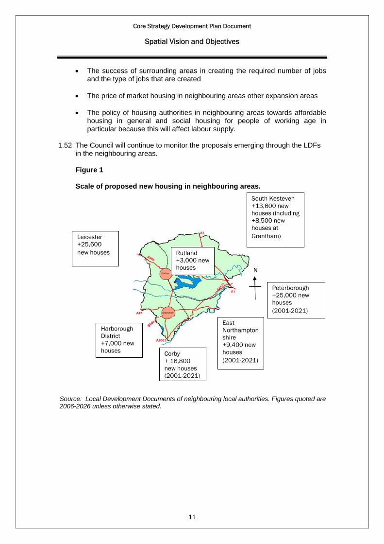
Figure 1
Scale of proposed new housing in neighbouring areas.
Source: Local Development Documents of neighbouring local authorities. Figures quoted are 2006-2026 unless otherwise stated.
N
Corby + 16,800 new houses (2001-2021)
Peterborough +25,000 new houses (2001-2021)
Leicester +25,600 new houses
Harborough District +7,000 new houses
East Northamptonshire +9,400 new houses (2001-2021)
Rutland +3,000 new houses
South Kesteven +13,600 new houses (including +8,500 new houses at Grantham)
Core Strategy Development Plan Document
Spatial Vision and Objectives
12
The vision 1.53 The vision is based on the vision of the region and the local community set out
in the Sustainable Communities Strategy and the Council’s “20 Year Vision for Rutland”:
a) By 2026 Rutland will have become a more sustainable, safer, healthier
and more inclusive place to live, work and visit. The attractiveness, vitality and prosperity of Rutland’s towns, villages and Countryside would have been enhanced. This will be achieved through reducing the impact of people and development on the environment and climate change, protecting and enhancing Rutland’s environment assets, providing more affordable housing, supporting economic activities and improving the quality of the built environment and infrastructure throughout the county
b) People from all sections of the community will have been provided with
access to homes, jobs and services, more of the county’s younger and working age population will have been retained and the needs of the elderly will have been better met. Much more will have been achieved to help disadvantaged and vulnerable groups of the community, through removing barriers to access to new and improved social, health and educational facilities. The provision of better services and access to them from all those living within the county will be achieved by a carefully focused strategy which recognised the distinctive roles of the two main market towns of Oakham and Uppingham, the thriving rural villages and the lively and diverse rural economy and communities
c) The vision for the two main market towns is to have created thriving,
vibrant and prosperous towns by 2026. Oakham will be the main focus for development and provision of services and employment followed by Uppingham. The prosperity of the towns will be achieved by retaining and developing a range of employment generating uses in the town centres including retail, commercial, health and leisure uses, by providing good quality employment sites and by supporting an appropriate balance of commercial and residential development in each town. In order that they can serve their wider hinterlands emphasis will be placed on ensuring they are accessible as possible, both through continued provision of public transport between the market towns and their hinterland and by guiding development to places best served by existing public transport services.
d) The vision for the villages is to have diverse and thriving communities
where planned and carefully managed development will have taken place to ensure that sufficient jobs and homes are provided for local people. In particular the larger local service centres of Cottesmore, Edith Weston, Empingham, Greetham, Ketton, Market Overton, and Ryhall, will provide the necessary day-to-day services to ensure rural communities have the choice to live, work and play close to where they live.
Core Strategy Development Plan Document
Spatial Vision and Objectives
13
e) An appropriate scale of housing reflecting local needs and the level of services available will have been achieved in each town and the larger villages. Elsewhere more limited housing development will have taken place. A high priority will have been given to the provision of affordable housing. New homes will be available for all those in the local community wishing to buy or rent at a price that is affordable. In addition a ‘design-led’ approach to all new development will ensure that the distinctiveness of the towns and villages are maintained and enhanced to support the attractiveness of the county and reduce the opportunities for crime and anti-social behaviour.
f) New training opportunities for all age groups and employment
opportunities within growth sectors such as high tech industry and office, IT, technology, tourism and leisure industries, particularly in the market towns will have increased the range of skilled jobs in Rutland so that by 2026, a much smaller proportion of the county’s population will travel outside Rutland to work.
g) Accessibility through and beyond the county will have been improved
by developing more integrated forms of sustainable transport, improving road safety, cycling and walking facilities and reducing the adverse effects of traffic.
h) The diversity and environmental quality of Rutland’s natural resources,
countryside and built heritage will all have been improved and the character of the market towns and villages and their historic cores maintained. At the same time, sustainable access to the countryside, open spaces, recreational areas and green infrastructure will have been enhanced through green corridors and improved cycling and pedestrian routes linked to the main towns.
i) The impact of people and development on the environment would be
improved by the prudent uses of resources, including minerals, improved waste management and recycling, increased use of renewable energy and addressing the implications of flood risk and climate change.
Strategic objectives 1.54 The strategic objectives form the link between the vision and the strategy based
on the “issues to be addressed” and the priorities of the Sustainable Communities Strategy and the Council’s “20 Year Vision for Rutland”:
Spatial strategy Strategic Objective 1: Broad locations for Development • To identify broad locations for sustainable development that will give access
for all to services and facilities, minimise the impact on climate change and need to travel and promote the efficient use of land while protecting the natural environment, landscape, the unique character and identity of the towns, villages and countryside.
Core Strategy Development Plan Document
Spatial Vision and Objectives
14
Strategic Objective 2: Vibrant and prosperous market towns • To develop vibrant and prosperous market towns by encouraging
sustainable development that supports their function as service centres with a range of good quality housing, jobs, businesses, shops and services that met the needs of local people and wider hinterland.
Strategic Objective 3: Diverse and thriving villages • To develop diverse and thriving villages by encouraging sustainable
development where it supports the role of the larger villages as “service hubs” for the smaller villages and meets local needs in the smaller villages and maintains and improves their vitality and viability.
Creating sustainable communities Strategic Objective 4: Housing for everyone’s needs • To ensure a range and mix of housing types to meet the needs of all the
community that is adequately supported by new infrastructure, including affordable housing, special needs housing and Gypsies and Travellers.
Strategic Objective 5: Healthy and socially inclusive communities • To support healthy and thriving communities by protecting existing facilities
and providing high quality local, accessible and diverse opportunities for leisure, recreation, sport, natural green space and cultural activities in order to address the needs of all groups in Rutland, including disadvantaged and vulnerable groups.
Strategic Objective 6: A stronger and safer community • To develop a stronger and safer community by designing out opportunities
for crime and implementing measures to improve road safety to ensure that people can live, work and relax where they feel safe and enjoy a better quality of life.
Building our economy and infrastructure Strategic Objective 7: Strong and diverse economy • To strengthen and diversify the local economy in order to provide a greater
range and quality of employment opportunities locally and reduce commuting out of the county, including new high-tech knowledge-based, leisure and tourism industries.
Strategic Objective 8: Rural economy and communities • To support the rural communities by encouraging development
opportunities related to the rural economy including farm and rurally based industries and promoting services and facilities in the larger local services and villages.
Strategic Objective 9: Sustainable transport • To develop integrated and sustainable forms of transport including better
public transport, walking and cycling facilities.

Core Strategy Development Plan Document
Spatial Vision and Objectives
15
Strategic Objective 10: Transport and infrastructure • To develop a strong and vibrant community by developing communication
and transport infrastructure and links throughout the county and beyond. Sustaining our environment Strategic Objective 11: Natural and cultural environment • To safeguard and enhance the natural resources, landscape and
countryside, cultural heritage and the diversity of wildlife and habitats, including green infrastructure and special protection for Rutland Water to improve our quality of life and make a full contribution to global sustainability.
Strategic Objective 12: Built environment and local townscape • To protect and enhance the built environment and open spaces, historic
heritage and local townscape associated with the historic core of the market towns, listed buildings and conservation areas.
Strategic Objective 13: High quality design and local distinctiveness • To ensure that design of new development is of the highest quality to
provide attractive and safe places to live, work and visit and reflects the local character, identity and distinctiveness of the towns and villages.
Strategic Objective 14: Resources, waste and climate change • To reduce the impact of people and development on the environment by
sustainable design and construction, reducing pollution, encouraging the prudent uses of resources, including minerals, waste management and recycling, increased use of renewable energy and provision of green infrastructure and addressing the implications of flood risk and climate change.
Core Strategy Development Plan Document
Spatial Strategy
16
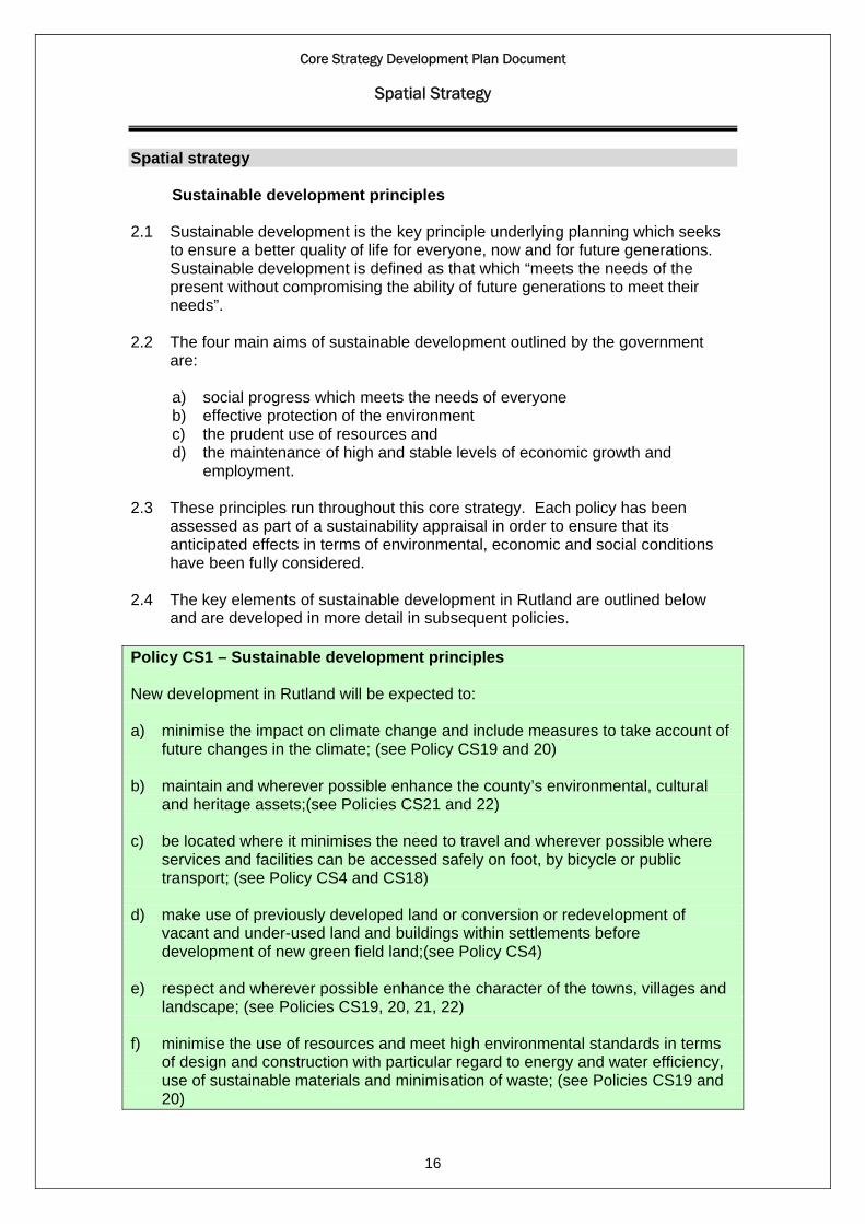
Spatial strategy Sustainable development principles 2.1 Sustainable development is the key principle underlying planning which seeks
to ensure a better quality of life for everyone, now and for future generations. Sustainable development is defined as that which “meets the needs of the present without compromising the ability of future generations to meet their needs”.
2.2 The four main aims of sustainable development outlined by the government
are:
a) social progress which meets the needs of everyone b) effective protection of the environment c) the prudent use of resources and d) the maintenance of high and stable levels of economic growth and
employment. 2.3 These principles run throughout this core strategy. Each policy has been
assessed as part of a sustainability appraisal in order to ensure that its anticipated effects in terms of environmental, economic and social conditions have been fully considered.
2.4 The key elements of sustainable development in Rutland are outlined below
and are developed in more detail in subsequent policies. Policy CS1 – Sustainable development principles New development in Rutland will be expected to: a) minimise the impact on climate change and include measures to take account of
future changes in the climate; (see Policy CS19 and 20) b) maintain and wherever possible enhance the county’s environmental, cultural
and heritage assets;(see Policies CS21 and 22) c) be located where it minimises the need to travel and wherever possible where
services and facilities can be accessed safely on foot, by bicycle or public transport; (see Policy CS4 and CS18)
d) make use of previously developed land or conversion or redevelopment of
vacant and under-used land and buildings within settlements before development of new green field land;(see Policy CS4)
e) respect and wherever possible enhance the character of the towns, villages and
landscape; (see Policies CS19, 20, 21, 22) f) minimise the use of resources and meet high environmental standards in terms
of design and construction with particular regard to energy and water efficiency, use of sustainable materials and minimisation of waste; (see Policies CS19 and 20)
Core Strategy Development Plan Document
Spatial Strategy
17
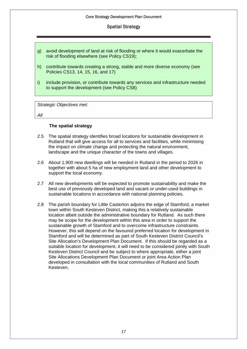
g) avoid development of land at risk of flooding or where it would exacerbate the
risk of flooding elsewhere (see Policy CS19); h) contribute towards creating a strong, stable and more diverse economy (see
Policies CS13, 14, 15, 16, and 17) i) include provision, or contribute towards any services and infrastructure needed
to support the development (see Policy CS8) Strategic Objectives met: All The spatial strategy 2.5 The spatial strategy identifies broad locations for sustainable development in
Rutland that will give access for all to services and facilities, while minimising the impact on climate change and protecting the natural environment, landscape and the unique character of the towns and villages.
2.6 About 1,900 new dwellings will be needed in Rutland in the period to 2026 in
together with about 5 ha of new employment land and other development to support the local economy.
2.7 All new developments will be expected to promote sustainability and make the
best use of previously developed land and vacant or under-used buildings in sustainable locations in accordance with national planning policies.
2.8 The parish boundary for Little Casterton adjoins the edge of Stamford, a market
town within South Kesteven District, making this a relatively sustainable location albeit outside the administrative boundary for Rutland. As such there may be scope for the development within this area in order to support the sustainable growth of Stamford and to overcome infrastructure constraints. However, this will depend on the favoured preferred location for development in Stamford and will be determined as part of South Kesteven District Council’s Site Allocation’s Development Plan Document. If this should be regarded as a suitable location for development, it will need to be considered jointly with South Kesteven District Council and be subject to where appropriate, either a joint Site Allocations Development Plan Document or joint Area Action Plan developed in consultation with the local communities of Rutland and South Kesteven.
Core Strategy Development Plan Document
Spatial Strategy
18
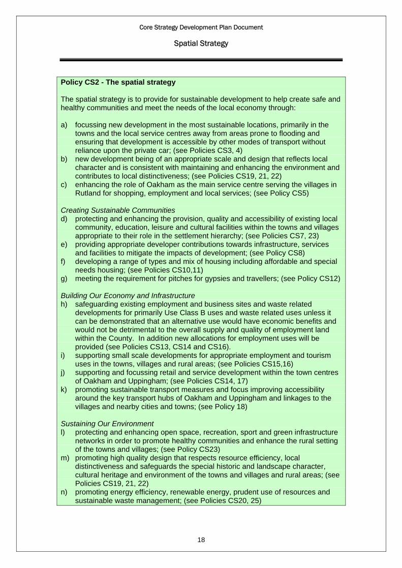
Policy CS2 - The spatial strategy The spatial strategy is to provide for sustainable development to help create safe and healthy communities and meet the needs of the local economy through: a) focussing new development in the most sustainable locations, primarily in the
towns and the local service centres away from areas prone to flooding and ensuring that development is accessible by other modes of transport without reliance upon the private car; (see Policies CS3, 4)
b) new development being of an appropriate scale and design that reflects local character and is consistent with maintaining and enhancing the environment and contributes to local distinctiveness; (see Policies CS19, 21, 22)
c) enhancing the role of Oakham as the main service centre serving the villages in Rutland for shopping, employment and local services; (see Policy CS5)
Creating Sustainable Communities d) protecting and enhancing the provision, quality and accessibility of existing local
community, education, leisure and cultural facilities within the towns and villages appropriate to their role in the settlement hierarchy; (see Policies CS7, 23)
e) providing appropriate developer contributions towards infrastructure, services and facilities to mitigate the impacts of development; (see Policy CS8)
f) developing a range of types and mix of housing including affordable and special needs housing; (see Policies CS10,11)
g) meeting the requirement for pitches for gypsies and travellers; (see Policy CS12) Building Our Economy and Infrastructure h) safeguarding existing employment and business sites and waste related
developments for primarily Use Class B uses and waste related uses unless it can be demonstrated that an alternative use would have economic benefits and would not be detrimental to the overall supply and quality of employment land within the County. In addition new allocations for employment uses will be provided (see Policies CS13, CS14 and CS16).
i) supporting small scale developments for appropriate employment and tourism uses in the towns, villages and rural areas; (see Policies CS15,16)
j) supporting and focussing retail and service development within the town centres of Oakham and Uppingham; (see Policies CS14, 17)
k) promoting sustainable transport measures and focus improving accessibility around the key transport hubs of Oakham and Uppingham and linkages to the villages and nearby cities and towns; (see Policy 18)
Sustaining Our Environment l) protecting and enhancing open space, recreation, sport and green infrastructure
networks in order to promote healthy communities and enhance the rural setting of the towns and villages; (see Policy CS23)
m) promoting high quality design that respects resource efficiency, local distinctiveness and safeguards the special historic and landscape character, cultural heritage and environment of the towns and villages and rural areas; (see Policies CS19, 21, 22)
n) promoting energy efficiency, renewable energy, prudent use of resources and sustainable waste management; (see Policies CS20, 25)

Core Strategy Development Plan Document
Spatial Strategy
19
o) protecting and enhancing the natural environment and protecting the internationally designated nature conservation site of Rutland Water from any likely significant effects. (see Policy CS24)
Strategic Objectives met: All The settlement hierarchy 2.9 The Core Strategy sets out the distribution and scale of development between
the towns and villages and the strategic location of housing and other development. A settlement hierarchy is a useful approach to locating new development in a sustainable way, where local services will be available and the need to travel is reduced. It will inform the distribution of development in the Core Strategy and be used to inform decisions on other LDF documents, particularly the Site Allocations and Policies DPD and decisions on planning applications.
2.10 Rutland consists of two rural market towns of Oakham and Uppingham and 52
villages. The settlements vary from the towns with a concentration of services and facilities to very small villages, which have no or minimal, community facilities. The Sustainability Assessment of Towns and Villages in Rutland produced in April 2009 established a hierarchy that categorised the towns and villages according to the accessibility of each settlement to facilities and services together with physical and environmental constraints.
2.11 Based on the spatial strategy for Rutland and the settlement hierarchy, the
majority of development up to 2026 will take place within and adjoining Oakham, with reduced levels of development taking place in Uppingham, the local service centres, smaller service centres and restraint villages commensurate to their role within the settlement hierarchy.
2.12 Oakham reflecting its role as the main market town in the county with the best
range of employment opportunities, services and facilities and access to public transport will include the strategic allocation for a sustainable urban extension to the north west of Oakham. This area to the east of the A606, Melton Road falls within the parish boundary of Barleythorpe.
2.13 Policy CS3 sets out the defined settlement hierarchy for Rutland. The location
and scale of development in Rutland must comply with the settlement hierarchy and the principles for the location of development.
2.14 As the settlement hierarchy is based on the existing situation in April 2009, a
reduction in services may mean a settlement no longer performs its role within the hierarchy, while any increases in service provision will be considered appropriate to the position of the settlement in the hierarchy, this will have implications for the implementation of Policy CS3. When determining proposals in the villages, it will be necessary to take account of the level of services, facilities and access by public transport existing at the time. The settlement hierarchy will be reviewed where necessary as part of the Annual Monitoring Report.
Core Strategy Development Plan Document
Spatial Strategy
20
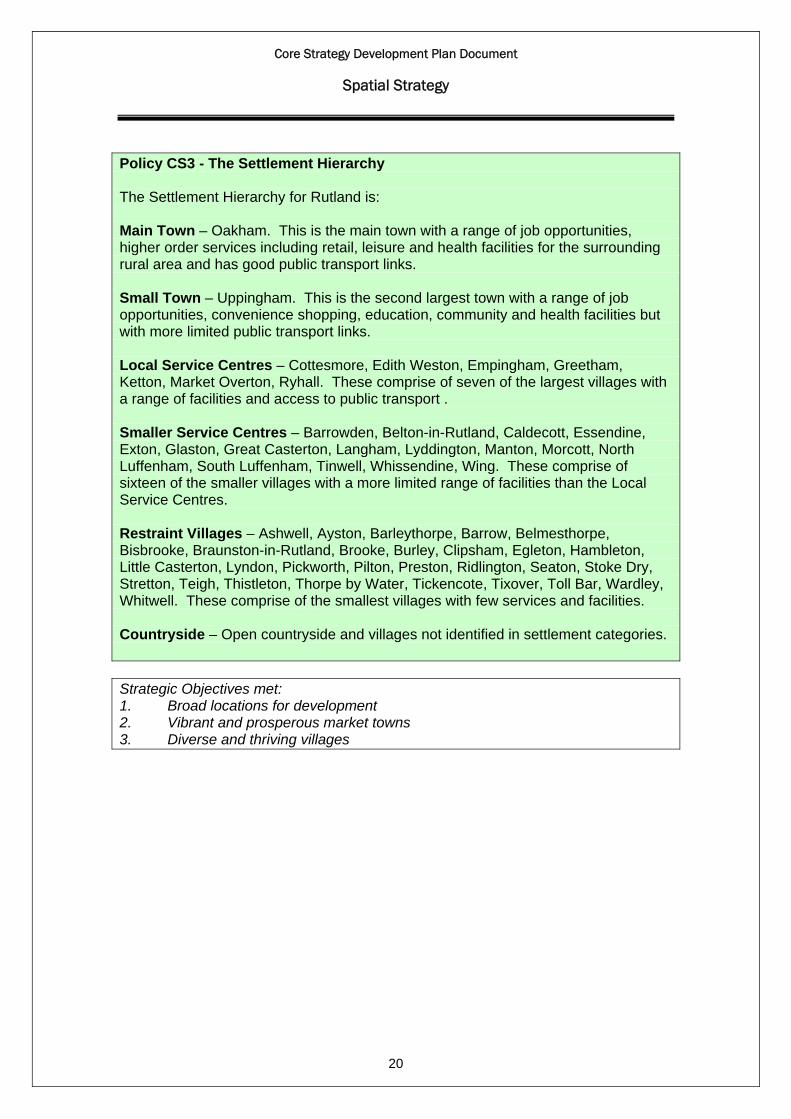
Policy CS3 - The Settlement Hierarchy The Settlement Hierarchy for Rutland is: Main Town – Oakham. This is the main town with a range of job opportunities, higher order services including retail, leisure and health facilities for the surrounding rural area and has good public transport links. Small Town – Uppingham. This is the second largest town with a range of job opportunities, convenience shopping, education, community and health facilities but with more limited public transport links. Local Service Centres – Cottesmore, Edith Weston, Empingham, Greetham, Ketton, Market Overton, Ryhall. These comprise of seven of the largest villages with a range of facilities and access to public transport . Smaller Service Centres – Barrowden, Belton-in-Rutland, Caldecott, Essendine, Exton, Glaston, Great Casterton, Langham, Lyddington, Manton, Morcott, North Luffenham, South Luffenham, Tinwell, Whissendine, Wing. These comprise of sixteen of the smaller villages with a more limited range of facilities than the Local Service Centres. Restraint Villages – Ashwell, Ayston, Barleythorpe, Barrow, Belmesthorpe, Bisbrooke, Braunston-in-Rutland, Brooke, Burley, Clipsham, Egleton, Hambleton, Little Casterton, Lyndon, Pickworth, Pilton, Preston, Ridlington, Seaton, Stoke Dry, Stretton, Teigh, Thistleton, Thorpe by Water, Tickencote, Tixover, Toll Bar, Wardley, Whitwell. These comprise of the smallest villages with few services and facilities. Countryside – Open countryside and villages not identified in settlement categories. Strategic Objectives met: 1. Broad locations for development 2. Vibrant and prosperous market towns 3. Diverse and thriving villages

Core Strategy Development Plan Document
Spatial Strategy
21
Figure 2 The settlement hierarchy

Core Strategy Development Plan Document
Spatial Strategy
22
The location of development 2.15 Oakham will play a key role in meeting the vision and delivering the strategic
objectives of the Core Strategy, as such a specific spatial strategy for Oakham is considered necessary.
2.16 Within Rutland, Oakham will be the focus for large scale development. This scale of development is sufficient to have a significant impact on a settlement and would only be acceptable in the most sustainable location.
2.17 Uppingham will be able to support development of a moderate scale
appropriate to the size of the town. Land to the west or north west of Uppingham has been identified as the most sustainable direction for future growth following a Strategic Transport Assessment and through an appraisal process that examined a range of factors, including the capacity of the landscape to accommodate development, physical characteristics, flood risk, wildlife habitats, access and infrastructure. The location and details of future housing development will be determined through the Site Allocations and Policies DPD.
2.18 The local service centres will be the focus for small scale level of development
outside the two towns reflecting the range of facilities and access to public transport available and their role as serving surrounding minor settlements. Small scale development for unallocated sites is defined as being up to 9 dwellings, provided that proposals of this scale can be sensitively developed within Local Service Centres. The location and appropriate scale for allocated sites will be determined through the Site Allocations and Policies DPD.
2.19 The smaller service centres have a more limited range of services and facilities
as such can only accommodate a minor level of development where appropriate to the scale and character of the village. Minor level development is defined as being an individual development of up to 5 dwellings. Residential infilling is defined as an individual development of up to 2 dwellings within a gap in an otherwise built-up frontage to an existing road, provided that it is not sufficiently large to accommodate up to 2 dwellings on similar curtilages to those adjoining; or the redevelopment or sub-division of an existing residential curtilage; or the conversion or redevelopment of a non-residential building where this would not result in a loss of local employment. In very exceptional circumstances a small scale development may be permitted where this would lead to the sustainable recycling of a brown field site bringing positive overall benefit to the village.
2.20 The restraint villages with few services and facilities, generally lack any food
shops, have no primary school and may not have a permanent post office or a village hall or meeting place. Development on any scale would be unsustainable in these villages, as it is will generate a disproportionate number of additional journeys outside the village. House extensions, replacement dwellings, conversions of traditional buildings to dwellings will continue to be permitted where they are in accordance with planning policy and guidance.

Core Strategy Development Plan Document
Spatial Strategy
23
2.21 As an exception to normal policies, developments solely for the purpose of providing affordable housing may be permitted within or adjoining villages in accordance with Policy CS11.
2.22 Development in the countryside will be strictly limited to house extensions,
replacement dwellings, agricultural and forestry worker dwellings, conversions of appropriately located and suitably constructed buildings to dwellings and employment uses and other development normally acceptable in the countryside. The core strategy aims to continue to protect the countryside but also recognises the social and economic needs of rural communities.
2.23 Policy CS4 sets out the approach to the location of development within the
settlement hierarchy to provide a framework for the management of the scale of development appropriate to the location. The indicative scale of development set out in this policy is intended to guide the volume of development likely to be acceptable in different types of location and to protect the overall strategy of focusing growth in Oakham. The exact scale and level of development will be dependent on a number of criteria, including the capacity to accommodate the development and the impact on infrastructure provision. These factors will establish how development should be phased and the precise distribution and scale of development to be delivered will be determined through the Site Allocations and Policies DPD.
2.24 The existing planned limits of development around the towns and villages that
were previously defined in the Rutland Local Plan (2001) will be retained and any boundary modifications considered through the Site Allocations and Policies DPD. More detailed criteria relating to development in the villages and countryside will also be set out in the Site Allocations and Policies DPD.
Policy CS4 - The location of development In order to contribute towards the delivery of sustainable development and meet the vision and the strategic objectives of the Core Strategy: Development in Rutland will be directed towards the most sustainable locations in accordance with the settlement hierarchy of Oakham, Uppingham, Local Service Centres, Smaller Service Centres and Restraint Villages. The rest of Rutland, including settlements not identified in settlement categories will be designated as countryside. Oakham will be the key focus for new development mostly on land allocated to the north west of the town. This is considered to be the most sustainable location to accommodate significant levels of growth, about 69 dwellings per annum up to 2026 Uppingham will be a focus for more moderate growth mostly on allocated sites to the west or north west of the town. Uppingham has the capacity to accommodate about 16 dwellings per annum up to 2026 The Local Service Centres can accommodate a level of growth mainly through small scale allocated sites, affordable housing sites, infill developments and conversion or reuse of redundant suitable rural buildings, approximately 24 dwellings per annum in this settlement category up to 2026.
Core Strategy Development Plan Document
Spatial Strategy
24
The Smaller Service Centres can accommodate a minor scale level of development mainly on previously developed land on a limited scale appropriate to the character and needs of the village concerned, comprising affordable housing sites, infill developments and conversion or reuse of redundant suitable rural buildings. The Restraint Villages are not considered sustainable locations to accommodate further development unless it is development normally acceptable in the countryside. Development in the Countryside will be strictly limited to that which has an essential need to be located in the countryside and will be restricted to particular types of development to support the rural economy and meet affordable housing needs. The conversion and re-use of appropriately located and suitably constructed rural buildings for residential and employment-generating uses in the countryside will be considered adjacent or closely related to the towns, local services centres and smaller services centres provided it is of a scale appropriate to the existing location and consistent with maintaining and enhancing the environment and would contribute to the local distinctiveness of the area. New development will be prioritised in favour of the allocation and release of previously developed land within or adjoining the planned limits of development where it can support sustainable patterns of development and provides access to services by foot, public transport and cycling. Strategic Objectives met: 1. Broad locations for development 2. Vibrant and prosperous market towns
Spatial strategy for Oakham
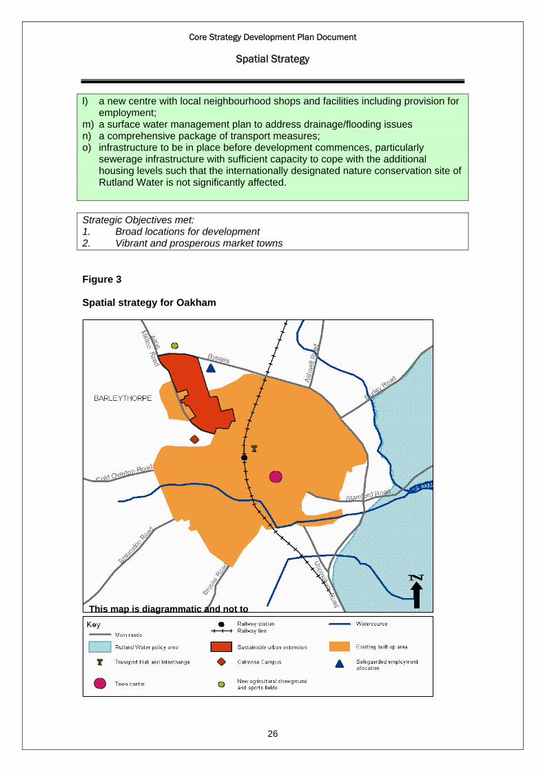
2.25 The spatial strategy for Oakham seeks to enhance the town’s role as the main service centre for the county by protecting and enhancing existing facilities, recognising the potential to regenerate the west end of the town centre and supporting provision of new facilities and development including a new sustainable mixed use urban extension to the north west of the town (Figure 3 below)
2.26 Land to the north west of Oakham has been identified as the most sustainable
direction for future growth through an appraisal process that examined a range of factors, including the capacity of the landscape to accommodate development, physical characteristics, flood risk, wildlife habitats, access and infrastructure.
2.27 The sustainable urban extension will be the focus for the majority of the new
development to be accommodated (about 1,000 new dwellings) but with the remaining development (about 100 dwellings) on other sites within the town to be identified through a Site Allocations and Policies DPD.
2.28 The key requirements for the sustainable urban extension are set out in Policy
CS5. These will be developed in more detail through a master plan that will be
Core Strategy Development Plan Document
Spatial Strategy
25
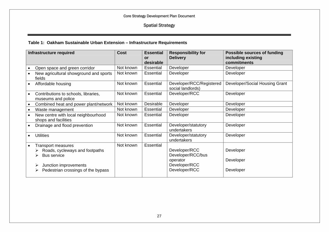
prepared as a supplementary planning document and drawn up in consultation with the local community. The key infrastructure requirements are listed in Table 1 below, together with details of their likely costs, phasing, responsibility for delivery and possible sources of funding.
2.29 A map showing the extent of the sustainable urban extension and new
agricultural showground and sports fields is shown in Appendix 5. This map forms an alteration to the existing Rutland Local Plan and should be read alongside the existing Proposals Map until a replacement Proposals Map is created as part of the proposed Site Allocations and Policies DPD.
Policy CS5- Spatial strategy for Oakham The Spatial Strategy for Oakham is to provide for sustainable development to help meet the needs of the local communities and the local economy by: a) supporting a sustainable urban extension to Oakham; b) supporting the development of the new education, recreation, leisure and cultural facilities as part of the Catmose Campus development; c) supporting initiatives to regenerate the west end of Oakham town centre; d) promoting the integration of transport modes through a new transport interchange in Oakham. Sustainable urban extension to Oakham A sustainable mixed-use urban extension of about 1,000 new homes will be developed to the north west of the Oakham. The development will need to meet the highest standards of design and construction including layout and design of buildings, access, green space, landscaping and energy use and waste management. Development of this area will be subject to the following key requirements: a) well related to Oakham and the local area; b) of appropriate scale and design to reflect the local character; c) phasing to ensure continuity of housing supply and co-ordination with provision of
infrastructure; d) provision of green infrastructure including multi-functional space linking the
development with the town by way of footpaths, cycleways, green corridors and the potential for habitat creation;
e) provision of community, sport and recreation facilities; f) provision of a new agricultural showground and sports fields to compensate for
the loss of existing facilities; g) affordable housing (at least 35% of the total); h) minimum density of 40 dwellings per hectare; i) provision of a new school or contributions towards extending existing schools as
required; j) low or zero carbon development and on-site renewable energy generation; k) provision of waste management facilities for the recycling and recovery of
resources;
Core Strategy Development Plan Document
Spatial Strategy
26
l) a new centre with local neighbourhood shops and facilities including provision for employment;
m) a surface water management plan to address drainage/flooding issues n) a comprehensive package of transport measures; o) infrastructure to be in place before development commences, particularly
sewerage infrastructure with sufficient capacity to cope with the additional housing levels such that the internationally designated nature conservation site of Rutland Water is not significantly affected.
Strategic Objectives met: 1. Broad locations for development 2. Vibrant and prosperous market towns Figure 3 Spatial strategy for Oakham
This map is diagrammatic and not to
Core Strategy Development Plan Document
Spatial Strategy
27
Table 1: Oakham Sustainable Urban Extension – Infrastructure Requirements Infrastructure required Cost Essential
or desirable
Responsibility for Delivery
Possible sources of funding including existing commitments
• Open space and green corridor Not known Essential Developer Developer • New agricultural showground and sports
fields Not known Essential Developer Developer
• Affordable housing Not known Essential Developer/RCC/Registered social landlords)
Developer/Social Housing Grant
• Contributions to schools, libraries, museums and police
Not known Essential Developer/RCC Developer
• Combined heat and power plant/network Not known Desirable Developer Developer • Waste management Not known Essential Developer Developer • New centre with local neighbourhood
shops and facilities Not known Essential Developer Developer
• Drainage and flood prevention Not known Essential Developer/statutory undertakers
Developer
• Utilities Not known Essential Developer/statutory undertakers
Developer
• Transport measures Roads, cycleways and footpaths Bus service
Junction improvements Pedestrian crossings of the bypass
Not known Essential Developer/RCC Developer/RCC/bus operator Developer/RCC Developer/RCC
Developer Developer Developer
Core Strategy Development Plan Document
Spatial Strategy
Re-use of redundant military bases and prisons 2.30 There are two large military bases and two prisons in Rutland, which form an
important part of the local economy and community and include extensive areas of land and buildings. Policies are required to consider the future of these establishments should they be closed and proposed for other uses.
2.31 The closure of RAF Cottesmore was announced on 15 December 2009. The
base is to close by 2013 although initial indications are that some or all of the housing on the base will initially be retained for use by RAF personnel. The base includes extensive areas of airfield land, technical buildings, community and leisure facilities for use by service personnel.
2.32 St George’s Barracks occupies the former RAF North Luffenham base. Some
of the original housing has been sold but the remainder of the base remains in use by the army and for military training. This base also includes extensive areas of airfield land, technical buildings, and community and leisure facilities for use by service personnel.
2.33 Stocken Prison is in operational use as a prison but Ashwell Prison has now
closed and its future use is under consideration. 2.34 The policy sets out the key requirements for any alternative uses of the military
bases or prisons that may be proposed, setting out criteria relating to the re-use of existing land and buildings, disturbance to local communities, protecting the countryside, landscape and ecology, accessibility, design and construction, renewable energy and energy efficiency. The detailed requirements of any proposed alternative uses would be the subject of a master plan or development brief in the form of either a development plan document or supplementary planning document both of which are based on robust evidence and would be subject to sustainability appraisal, Habitat Regulation Assessment and to publicity and consultation.
2.35 Major proposals such as a new airport, self-standing new settlement or new
business park would need to be considered in the context of the spatial strategy that seeks to focus new development in and adjoining the main towns while limiting unnecessary development in the countryside. Major proposals may also need approval through the national planning process.
2.36 The policy does not relate to any development or uses that may be proposed in
connection with the existing operational use of the military bases or prisons or the intensification of such uses. Such proposals would be considered having regard to the national planning policy framework, which provides flexibility to deal with any operational requirements.
2.37 More detailed policies on the development and use of the military bases and
prisons for operational purposes will be identified in the Site Allocations and Policies DPD.
28

Core Strategy Development Plan Document
Spatial Strategy
Policy CS6 – Re-use of redundant military bases and prisons The Council will seek to ensure that any re-use or redevelopment of former military bases or prisons is planned and developed in a comprehensive and co-ordinated manner. Proposals will be subject to a development brief or masterplan setting out the main requirements. This will form part of a supplementary planning document or development plan document to be prepared in consultation with the prospective developers and local communities. The key requirements for any proposals are that they should: a) re-use existing land and buildings and where appropriate minimise any built
development on undeveloped airfield land; b) not lead to undue disturbance to nearby local communities through traffic, noise,
aircraft activity or other uses; c) protect and where possible enhance the countryside and character of the
landscape, natural and cultural heritage; d) be accessed satisfactorily and not generate unacceptable traffic on the
surrounding road network e) be accessible by public transport and include measures to encourage walking
and cycling; f) incorporate high quality design and construction including the need for energy
efficiency, renewable energy and waste management. Strategic Objectives met: 1. Broad locations for development 5. Healthy and socially inclusive communities
29
7. Strong and diverse economy

Core Strategy Development Plan Document
Key Diagram
30
Core Strategy Development Plan Document
Creating Sustainable Communities
Delivering socially inclusive communities 3.1 Government guidance is that sustainable communities are places where
people want to live and work, now and in the future. They meet the diverse needs of existing and future residents and contribute to a high quality of life. In terms of criteria, these sustainable communities should be active, inclusive and safe, well run, environmentally sensitive, well designed and built, well connected, thriving, well served and fair to everyone.
3.2 Providing easy local access to community, education, leisure and cultural
facilities is critically important in terms of supporting sustainable settlements and communities and meeting the diverse needs of all members of the community. Facilities such as schools, nurseries, village halls, village shops, post offices, and public houses, places of worship and health services play important roles in the social and cultural life of the communities.
3.3 The loss of essential facilities can create unsustainable travel patterns and as a
matter of principle will not be supported. Any scope to add or improve existing facilities, through new build, sharing facilities or mobile services would be supported. This would include such examples as the Catmose Campus development in Oakham, a new post-16 learning centre in Rutland, the Council’s initiatives to extend the use of school facilities and a wider use of existing mobile library services.
3.4 Some villages are in easy and safe walking/cycling distance of Oakham,
Uppingham and Stamford. The accessibility of settlements will be defined by considering the distance from Oakham, Uppingham and Stamford to the village, where this is within 2 miles, there is potential easy and safe access for cycling or walking via a suitable road with a relatively flat topography and a public footpath/verge to the towns.
Policy CS7 – Delivering socially inclusive communities Support will be given to development proposals and activities that protect, retain or enhance the provision, quality or accessibility of existing community, education, leisure and cultural facilities that meet the diverse needs of all members of the community. Proposals involving the loss of services and facilities, such as schools, nurseries, village halls, village shops, post offices, public houses, places of worship and health services will not be supported unless an alternative facility to meet local needs is available that is both equally accessible and of benefit to the community or all options for continued use have been fully explored and none remain that would be financially viable. Development should take account of the needs and requirements of all people in the community, including people with disabilities or special needs, elderly people, and young people. Appropriate measures or adaptations should be included where necessary.
31
Core Strategy Development Plan Document
Creating Sustainable Communities
Strategic Objectives met: 5: Healthy and socially inclusive communities. Developer contributions 3.5 New developments have an impact on local and strategic infrastructure,
services and facilities. Contributions will be sought from developers to mitigate and/or compensate for these impacts or to help meet the needs for additional infrastructure, services and facilities generated by the new development.
3.6 To maximise any developer contributions opportunities which may arise in the
meantime, the Council has prepared a Planning Obligations and Developer Contributions Supplementary Planning Document (SPD) that sets out the approach to planning obligations and developer contributions when considering planning applications on a case-by-case basis. The SPD has sought to reflect the current economic climate by incorporating a degree of flexibility by including elements such as discounting of the standard contributions, based on independent viability appraisal, phasing of payments and deferred contributions which will allow the authority to recover all or part of the discount if the economic climate improves in the future.
3.7 The Government is seeking to implement the fundamental changes to the
system of developer contributions through the Community Infrastructure Levy (CIL) Regulations. There is a transitional period of four years until 2014 for developing the CIL charging mechanism and phasing out of the general developer contribution policies covered by this SPD. In the meantime, the SPD provides clarity to developers who may submit development proposals in the interim period before CIL (or a subsequent future charging policy framework) is adopted. This will provide the County Council with the opportunity to develop an Infrastructure Plan to inform any future generalised charging mechanism to support wider infrastructure delivery.
Policy CS8 - Developer contributions Developer contributions will be sought to ensure that new development meets the reasonable costs of providing the on and off site infrastructure requirements to meet the needs for additional or improvements to existing local and strategic infrastructure, services and facilities that would mitigate and/or compensate for the impacts generated by the new development. Negotiations with developers will consider the individual site circumstances and the approach set out in the Council’s published Planning and Developer Contributions Supplementary Planning Document (SPD). Where viability is identified as an issue, a site specific financial evaluation will be required to demonstrate to the Council that a development will be unviable as a consequence of the developer contributions. Any such claims will need to be verified using an open book financial appraisal by an independent third party in advance of a planning application being submitted.
32
Based on an independent viability assessment, developer contributions may be deferred or discounted where this would not make the development unacceptable in planning terms. This will retain a degree of flexibility in applying the standard

Core Strategy Development Plan Document
Creating Sustainable Communities
contributions/charges where affordability based on development viability is clearly demonstrated, without compromising the planning necessity for identified infrastructure and facilities. The Council will apply clauses in Planning Obligations relating to deferred contributions, which will seek to recover all or part of the discount in circumstances where the financial climate and economic viability of the development improves. Any recaptured discount will be limited to the full standard developer contributions for the infrastructure applicable at the time the planning obligation for a development was signed. Developer contributions will be payment in full upon commencement of the development, although the phasing payments of developer contributions maybe appropriate in certain circumstances. The charging mechanisms by which developer contributions are achieved will be reviewed in the light of the changes in national policy. The Community Infrastructure Levy (or a subsequent future charging policy framework) will be considered where the generalised charging mechanism would help to support the wider infrastructure delivery in the area. Strategic Objectives met: 5: Healthy and socially inclusive communities. 10. Transport and infrastructure The housing requirement and distribution 3.8 Table 2 shows the housing requirement in Rutland up to 2026.
Table 2: Housing Requirement in Rutland Requirement Housing requirement 2006-2026 (20 years @ 150 dwellings per annum
3,000
Net completions 2006-2010 532 Existing commitments at 1st April 2010 (1) 549 Remaining requirement 2010-2026 1,919 Notes: 1) Existing commitments including outstanding permissions and sites under construction as 1st April
2010 from Rutland County Council monitoring
Meeting the requirement 3.9 Provision should be made for 3,000 dwellings over the plan period 2006-2026
which was required under the previous Regional Plan and supported through consultation with key stakeholders and the community. This amounts to an average rate of house building of 150 dwellings per annum.
33
3.10 The Core Strategy has to ensure that enough housing land is made available and that the release of land is managed in a way that ensures targets are met. The management of supply will depend on monitoring of housing commitments

Core Strategy Development Plan Document
Creating Sustainable Communities
and completions. This will enable an assessment to be made on the need for the allocation of sites and their phasing against Rutland’s planned housing requirements.
3.11 To meet the requirement, the amount of land provided will be through existing
commitments, windfall developments (these are sites which have not been specifically identified as available and they comprise of previously developed land that has unexpectedly become available) and there will be a need to allocate green field sites for housing development. The SHLAA update 2009 indicates potentially there is sufficient land to meet the requirements which are suitable, deliverable and available for development but did not identify a sufficient supply of previously developed land. New housing allocations will be identified in the Site Allocations and Development Control Polices DPD.
Windfalls
3.12 Historic windfall sites, in particular on small sites, have made a significant
contribution to housing supply in Rutland because of the rural nature of the county, with a large number of villages, where planning policies have allowed limited infill development inside settlement boundaries. Since 2006, 59% of all completions were on windfall sites, the distribution overall was predominantly in the villages with 66% of all dwellings built.
3.13 The Council’s Small Site Windfall Housing Study identified approximately 152
dwellings falling below the SHLAA threshold, which may come forward between 2010 and 2026 on ‘windfall sites’. These cannot be individually predicted at this stage and would be unsuitable for allocation due to the small sizes of the site. These potential small site windfall sources include outstanding commitments on small sites, dwellings on small previously developed plots within settlements, affordable housing schemes on rural exception sites, residential conversions and infill development, and essential dwellings in the countryside for agricultural workers, these are likely to continue to come forward in accordance with the location of development Policy CS4, and as such will contribute towards meeting the requirement.
3.14 It is recognised in Rutland, the need to avoid further less sustainable green
field allocations when opportunities for development on previously developed land within the settlements exists. As such, the extent that windfalls occur will be picked up through the Annual Monitoring Report and would reduce the need for the release of further allocations identified through the Site Allocations and Policies DPD.
Distribution of housing in Rutland
3.15 The distribution of housing in Rutland will follow the Spatial Strategy Policy
CS2 in accordance with the settlement hierarchy and the principles for the location of development policies CS3 and CS4.
34
3.16 Housing development will be predominantly focused in Oakham in order to support delivery of the sustainable urban to the north west of Oakham. Detailed phasing and management of the release of allocated sites will be set out in a Supplementary Planning Document and the Site Allocations and Policies DPD.
Core Strategy Development Plan Document
Creating Sustainable Communities
Policy CS9 – Provision and distribution of new housing Provision will be made for 3,000 new dwellings over the period 2006-2026. As at 1st April 2010 at least 1,930 new dwellings will be made available in accordance with the following distribution: About 70% of new housing (about 1,350 new dwellings) will be located within and adjoining Oakham and Uppingham, of which:
80% will be in Oakham (about 1,100 dwellings or 69 per annum) 20% in Uppingham (about 250 dwellings or 16 dwellings per annum)
About 20% of new housing will be located within and adjoining the Local Service Centres (about 390 dwellings or 24 per annum) The remaining 10% new housing will be located within the Smaller Service Centres and Restraint Villages in the form of affordable housing, conversion and re-use of buildings and on previously developed land (about 190 dwellings or 12 per annum). Greenfield sites within or adjoining the planned limits of development in Oakham, Uppingham and the Local Service Centres will only be allocated and released where needed to maintain a sufficient and phased supply of deliverable and developable land. Sites outside or adjoining the smaller service centres and restraint villages will not generally be allocated or released. The target is for about 25% of dwellings to be built on previously developed land. Strategic Objectives met: 1: Broad locations for development.
Previously-developed land 3.17 The target for the proportion of housing development on previously developed
land was 60% in the previous Regional Plan. In Rutland, as a rural county, the potential for brown field development is less than in some urban areas. As such it is unlikely the 60% target can be achieved. The Council has therefore set a more realistic and achievable target of 25%.
3.18 Since 2001, 45% of completions have been on previously developed land. The
Council’s Strategic Housing Land Availability Assessment has identified a limited number of previously developed land opportunities. Approximately 3100 dwellings have been identified on green field sites compared to 700 dwellings approximately 18% on previously developed land. The sites identified in the SHLAA, together with past completions and current commitments indicate that the 25% target is likely to be achieved. The proposed 25% target represents about 31 houses per year
35

Core Strategy Development Plan Document
Creating Sustainable Communities
3.19 The re-use of previously developed land will have to take account of the presumption in favour of retaining local employment sites (see Policy CS13) as well as the potential for housing development. Otherwise, some places could be considered no longer sustainable if all employment sites are redeveloped for housing Delivery
3.20 The housing trajectory (Appendix 1) sets out the predicted levels of supply year
on year up to 2026. The housing trajectory sets out what has been achieved to date and the future delivery of housing. The trajectory shows that most strategic development in the plan period 2012-2022 will predominantly be focused in Oakham. Detailed phasing of housing development will be set out in a masterplan for the strategic allocation and the Site Allocations and Development Control Polices DPD.
3.21 The housing trajectory will form part of the Annual Monitoring Report and will
be kept under review enabling the Council to monitor the extent to which the LDF is delivering the required scale and distribution of housing.
Phasing
3.22 The release of land for housing will be managed in order to deliver the levels of
development set out in Policy CS9 over the period to 2026 in line with the housing trajectory. The adequacy of the housing land supply will be assessed through the Annual Monitoring Report. Depending on the results of monitoring it may be necessary to adjust the pace of housing delivery by bringing forward or holding back, new development in the less sustainable settlements.
Housing density and mix 3.23 In order to make the most efficient use of land and minimise development of
green field land, larger new developments of 10 dwellings or more will be expected to meet density requirements. These requirements will be subject to the development being appropriate and sympathetic to its setting in accordance with the requirements of Policy CS19.
3.24 Higher densities of more 40 dwellings per hectare may be appropriate in the
built-up areas of Oakham and Uppingham where they would be in keeping with their surroundings. Conversely, densities of less than 30 dwellings per hectare may be appropriate in some of the smaller villages where higher densities would not be in keeping with their surroundings.
3.25 A range of housing types, sizes and tenures should be provided to ensure that
the needs of all sectors of the community are met, including newly forming households, young couples and expanding households, as well as more specialist needs such as the elderly, learning disability and care leavers and those with physical disabilities.
3.26 The Strategic Housing Market Assessment identified the following needs in
Rutland in particular:
36

Core Strategy Development Plan Document
Creating Sustainable Communities
• a notable shortfall in the owner-occupied sector, the main shortage being for three bedroom homes, with a smaller shortage for two, four and one bedroom dwellings;
• a significant shortfall of all sizes of social rented housing with the largest shortfall for two bedroom properties;
• a shortfall of one, two and three bedroom intermediate housing properties • a small shortfall of all sizes of private rented accommodation.
3.27 The requirements for provision of affordable housing are set out under Policy CS11 below.
Policy CS10 - Housing density and mix New housing developments of 10 dwellings or more or sites of 0.3 hectares or more will be expected to achieve the following densities having regard to the character of the surroundings and other design principles set out in Policy CS19: • 30 dwellings per hectare in the villages; • 40 dwellings per hectare within the built-up area of Oakham and Uppingham town
and the proposed sustainable urban extension to Oakham although developers will be encouraged to achieve higher densities where this can be achieved without adversely affecting the character of the area.
New housing developments of 10 dwellings or more will be expected to provide a range of housing types, sizes and tenures, to meet the general and specialist needs for housing as identified in the Strategic Housing Market Assessment. The precise details of housing mix will be set out for larger sites through master planning or in the Site Allocations and Policies DPD. Strategic Objectives met: 4: Housing for everyone’s needs Affordable housing 3.28 Rutland suffers acute problems of affordable housing, having some of the
highest average house prices in the country and a high proportion of large houses. The need for affordable decent housing is one of the main issues arising from the Sustainable Communities Strategy for Rutland.
3.29 Affordable housing is defined as housing provided to eligible households
whose needs are not met by the market. This can include rented housing, at social rent levels for which guideline target rents are determined through the national rent regime; housing at affordable rents; and intermediate housing which is housing at prices and rents above social rent but below market prices or rents, excluding affordable rented housing..
37
3.30 The main method by which the planning system can help is by requiring developers to provide or contribute towards affordable housing as part of their

Core Strategy Development Plan Document
Creating Sustainable Communities
developments and by allowing small developments solely for affordable housing as an exception to normal planning policies.
3.31 An affordable housing viability study for the Council examined the viability of
varying levels of affordable housing in different locations in Rutland having regard to range of assumptions about market conditions, grant levels, buildings and land costs and other developer contributions. This concluded that a 35% requirement would be viable across Rutland in present market conditions.
3.32 The 35% overall requirement is based on market conditions when the
affordable housing study was prepared. This will be reviewed annually in accordance with the methodology set out in the study. On larger sites the requirement may be phased over the lifetime of the development. The Council expects that a percentage of the affordable housing will be provided without public subsidy as evidenced as economically viable by the Affordable Housing Viability Study or subsequent studies.
3.33 The study also showed that the site size threshold at which new developments
would be expected to meet this target could be reduced to one dwelling. Contributions to affordable housing will therefore be expected from all new housing irrespective of size. On sites of less than 5 dwellings it may not be practical to provide affordable housing on-site in which case the contribution may be made via a commuted sum payment.
3.34 Commuted sum payments will normally be used for providing affordable
housing within the vicinity of the development site but otherwise will be pooled towards providing affordable housing elsewhere in Rutland. The sum payable will be calculated on the basis of the requirements set out in the Council’s Affordable Housing Viability Study and will vary according to the locality and circumstances of each site.
3.35 Exceptionally commuted sum payments may also be appropriate in other
circumstances, for example where on-site provision of affordable housing would be detrimental to the local environment, where it would adversely affect a conservation area or listed building, or where it would result in abnormal service charge costs for residents.
3.36 As a general guideline approximately 80% of affordable housing should be for
rent and 20% intermediate housing reflecting the recommendations of the Strategic Housing Market Assessment. This may be varied to reflect local circumstances where evidenced by local housing needs studies.
3.37 Sites solely for affordable housing may also be identified through the Site
Allocations and Policies DPD or permitted as an exception to normal planning policies. Provision of affordable housing will be monitored and adjustments made if it is taking place more quickly or slowly than expected.
38
3.38 Priority for affordable housing will be given to households with a local connection as defined in the Council’s published housing allocations policy. In certain circumstances the allocations policy gives priority to households who have a local connection with a particular parish or adjoining parish which may include residence or former residence, work, the need to give or receive family support or other special circumstances. Where there are insufficient applicants

Core Strategy Development Plan Document
Creating Sustainable Communities
who have a local connection, allocations would cascade to the wider Rutland housing register.
3.39 Alternative housing models such as park homes, chalets and log cabin
developments will be considered as a means of providing a better and more affordable housing mix in appropriate circumstances.
Policy CS11 - Affordable housing In order to address the need for affordable housing in Rutland, the target for the provision of affordable housing is at least 40 affordable homes per year through developer contributions and other opportunities in the period 2009-2026. A minimum target of 35% affordable housing provision will apply to all new housing developments. The Council will expect this requirement to be met where it considers evidence indicates that this would be viable. In some cases a higher requirement may be expected where this is evidenced as economically viable. Where there is disagreement as to viability between the Council and the applicant the lesser provision would need to be justified through clear evidence set out in a viability assessment and the Council will need to be satisfied that all public subsidy funding sources have been explored.. The provision of affordable housing should be made on site with the exception of developments of 5 dwellings or less or sites of 0.15 hectares or less where an equivalent commuted sum payment towards affordable housing may be made. Commuted sum payments may also be made in exceptional circumstances where provision of affordable housing is considered by the Council to be detrimental environmental, demographic or other reasons. Commuted sum payments will be used where possible for the provision of affordable housing within the vicinity of the development site within a reasonable time frame. In other circumstances contributions will be pooled to provide affordable housing elsewhere in Rutland. As a general guideline approximately 80% of affordable housing should be for rent and 20% intermediate housing. This may be varied to reflect local circumstances and national economic conditions and/or where evidenced by local housing needs studies. Small sites for affordable housing may be permitted within or adjoining villages as an exception to normal policies of restraint provided that they: a) are justified by evidence of need from a local needs survey; b) meet the needs for affordable housing of households who are currently resident,
or have a local connection as defined in the Council’s published housing allocations policy;
c) wherever possible have reasonable access to at least a basic range of services appropriate to the form of housing proposed;
d) have appropriate safeguards in place to ensure that the housing will remain affordable to successive occupiers in perpetuity.
39
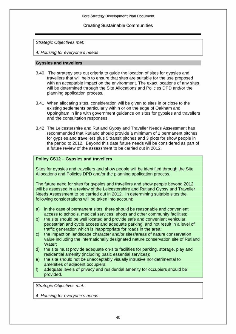
Core Strategy Development Plan Document
Creating Sustainable Communities
Strategic Objectives met: 4: Housing for everyone’s needs Gypsies and travellers 3.40 The strategy sets out criteria to guide the location of sites for gypsies and
travellers that will help to ensure that sites are suitable for the use proposed with an acceptable impact on the environment. The exact locations of any sites will be determined through the Site Allocations and Policies DPD and/or the planning application process.
3.41 When allocating sites, consideration will be given to sites in or close to the
existing settlements particularly within or on the edge of Oakham and Uppingham in line with government guidance on sites for gypsies and travellers and the consultation responses.
3.42 The Leicestershire and Rutland Gypsy and Traveller Needs Assessment has
recommended that Rutland should provide a minimum of 2 permanent pitches for gypsies and travellers plus 5 transit pitches and 3 plots for show people in the period to 2012. Beyond this date future needs will be considered as part of a future review of the assessment to be carried out in 2012.
Policy CS12 – Gypsies and travellers Sites for gypsies and travellers and show people will be identified through the Site Allocations and Policies DPD and/or the planning application process. The future need for sites for gypsies and travellers and show people beyond 2012 will be assessed in a review of the Leicestershire and Rutland Gypsy and Traveller Needs Assessment to be carried out in 2012. In determining suitable sites the following considerations will be taken into account: a) in the case of permanent sites, there should be reasonable and convenient
access to schools, medical services, shops and other community facilities; b) the site should be well located and provide safe and convenient vehicular,
pedestrian and cycle access and adequate parking, and not result in a level of traffic generation which is inappropriate for roads in the area;
c) the impact on landscape character and/or sites/areas of nature conservation value including the internationally designated nature conservation site of Rutland Water;
d) the site must provide adequate on-site facilities for parking, storage, play and residential amenity (including basic essential services);
e) the site should not be unacceptably visually intrusive nor detrimental to amenities of adjacent occupiers;
f) adequate levels of privacy and residential amenity for occupiers should be provided.
Strategic Objectives met:
40
4: Housing for everyone’s needs
Core Strategy Development Plan Document
Building Our Economy and Infrastructure
Employment and Economic Development 4.1 The key features of the local economy are set out in the spatial portrait in
section 1. The Core Strategy recognises the importance of all sectors of the diverse local economy and the need to make the best use of the area’s assets for securing a healthy local economy which is compatible with its sensitive environment.
4.2 Policy CS2 outlines the key components of the spatial distribution of economic development. This section expands on Policy CS2 and deals with other aspects of the spatial strategy for employment and the economy. Tourism, retailing and other town centre uses and other sectors are very important in the area’s economy.
4.3 The spatial strategy for employment developments aims to help maintain high
levels of employment and a thriving local economy that would be consistent with the Council’s 20-year vision and the Strategic aims and objectives.
Existing employment sites and allocations
4.4 This section of the Core Strategy focuses on the general employment land needs for industry, offices and warehousing. There is the need to ensure a continuous supply of general employment land to provide a choice of sites in terms of size, quality and location and to safeguard the existing industrial estates and employment areas that are important for providing local jobs and for sustaining the local economy and the wider community in the county. The Core Strategy seeks to make better use of existing employment land and encourage redevelopment and intensification of general employment uses when suitable sites become available. The location of the ’industrial estates’ and ‘employment areas’ in Policy CS13 are outlined in the Council’s Employment land assessment (July 2008) or subsequent Employment land reviews
4.5 There is a presumption in favour of retaining local employment sites, otherwise,
some places could be considered no longer sustainable if all employment sites are redeveloped for housing. Further detailed criteria relating to the protection of local employment sites will be set out in the Site Allocations and Policies DPD.
4.6 There are a small number of large employers in the county (see paragraph 1.14). This can be attributed to the largely rural nature of the county and its location between a number of large urban areas which tends to be the focus for this type of inward investment. Some larger firms have located in Oakham and this will continue to be most suitable location for larger firms in the county.
41
4.7 The Core Strategy seeks to build on the healthy rate of business formations and the number of small firms in the county. Small firms and the highly skilled, knowledge based businesses, which tend to have a low environmental impact are likely to be most appropriate for the market towns and local services centres where possible taking advantage of existing buildings and previously developed land.

Core Strategy Development Plan Document
Building Our Economy and Infrastructure
4.8 Sites identified for general employment development will help to meet the needs of local businesses, business start-up and relocations of businesses taking advantage of the attractive environment and the highly skilled workforce in Rutland. Workforce skills
4.9 The economic profile of the county (see spatial portrait in Chapter 1) shows fewer people employed in the lower paid manufacturing, construction and administrative sectors compared with the regional average, while high paid professional, technical and managerial workers and those employed in the service and tourism related businesses are over-represented.
4.10 The Council’s Sustainable Communities Strategy and strategic aims and objectives see improving access to training and development of business skills as priorities.
4.11 The Strategy to encourage high value and knowledge based, leisure and
tourism industries will require efforts to retain and improve the skill-base of the local workforce in order to ensure local people can take advantage of these employment opportunities that will arise in these sectors. The strategy is to work with relevant partners in business and education to further this priority and where possible to identify sites through the Site Allocations and Policies DPD to accommodate new training facilities such as the new post-16 college proposed in Rutland.
Broadband and information and communication technology
4.12 Technology is making home working more feasible. There is already a high
proportion of working from home in the county with overall 13% of those in employment working from home (2001 Census) which is above the East Midlands regional average. This level of home working is consistent with an economy typified by small businesses in high quality environment and a high rate of business start-ups.
4.13 The development of superfast broadband and information and communication technology will be important in helping to diversify and modernise the types of businesses that can operate in the area. Working from home can also reduce the need to travel and help meet wider sustainability objectives.
Policy CS13 – Employment and economic development The strategy is to: a) support the provision of a greater range of employment opportunities focused on
high skilled, knowledge based, leisure and tourism industries in the county; b) support small scale and start up businesses including through the provision of
additional managed incubator and start-up premises;
42
c) safeguard all of the land and premises in the existing industrial estates for employment uses (B1, B2, B8) unless it can be demonstrated that an alternative use would have economic benefits and would not be detrimental to the overall supply and quality of employment land within the County.;
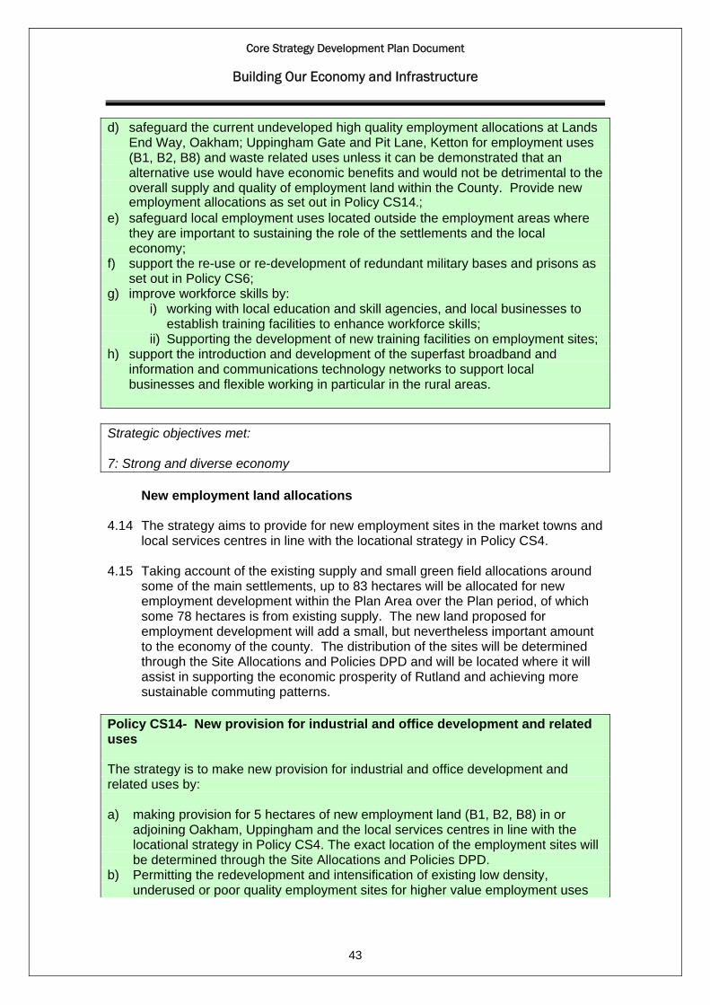
Core Strategy Development Plan Document
Building Our Economy and Infrastructure
d) safeguard the current undeveloped high quality employment allocations at Lands End Way, Oakham; Uppingham Gate and Pit Lane, Ketton for employment uses (B1, B2, B8) and waste related uses unless it can be demonstrated that an alternative use would have economic benefits and would not be detrimental to the overall supply and quality of employment land within the County. Provide new employment allocations as set out in Policy CS14.;
e) safeguard local employment uses located outside the employment areas where they are important to sustaining the role of the settlements and the local economy;
f) support the re-use or re-development of redundant military bases and prisons as set out in Policy CS6;
g) improve workforce skills by: i) working with local education and skill agencies, and local businesses to
establish training facilities to enhance workforce skills; ii) Supporting the development of new training facilities on employment sites; h) support the introduction and development of the superfast broadband and
information and communications technology networks to support local businesses and flexible working in particular in the rural areas.
Strategic objectives met: 7: Strong and diverse economy
New employment land allocations
4.14 The strategy aims to provide for new employment sites in the market towns and local services centres in line with the locational strategy in Policy CS4.
4.15 Taking account of the existing supply and small green field allocations around
some of the main settlements, up to 83 hectares will be allocated for new employment development within the Plan Area over the Plan period, of which some 78 hectares is from existing supply. The new land proposed for employment development will add a small, but nevertheless important amount to the economy of the county. The distribution of the sites will be determined through the Site Allocations and Policies DPD and will be located where it will assist in supporting the economic prosperity of Rutland and achieving more sustainable commuting patterns.
Policy CS14- New provision for industrial and office development and related uses The strategy is to make new provision for industrial and office development and related uses by: a) making provision for 5 hectares of new employment land (B1, B2, B8) in or
adjoining Oakham, Uppingham and the local services centres in line with the locational strategy in Policy CS4. The exact location of the employment sites will be determined through the Site Allocations and Policies DPD.
43
b) Permitting the redevelopment and intensification of existing low density, underused or poor quality employment sites for higher value employment uses

Core Strategy Development Plan Document
Building Our Economy and Infrastructure
(B1, B2, B8) and waste-related uses particularly in the towns and local services centres; and
c) Supporting and making provision for office development within the town centres where it is appropriate to the scale and role of the centres in the settlement hierarchy.
Employment land provision will be monitored and may be adjusted if development takes place more quickly or slowly than anticipated. Strategic objectives met: 7: Strong and diverse economy Tourism 4.16 The vibrant market towns of Oakham and Uppingham, the numerous stone-
built villages, the attractive countryside and Rutland Water combine to make Rutland an appealing destination to visitors. Tourism is already an established part of the local economy and in 2008 it accounted for about 1,400 full time jobs in Rutland which serviced about 1,600,000 visitors.
4.17 Employment related tourism in Rutland includes a wide range of activities
catering for visitors including overnight accommodation (e.g. hotels, bed and breakfast, self catering establishments and camping and caravan sites), pubs and restaurants, visitor attractions and Rutland Water which provides sailing, fishing, cycling and bird watching facilities. In addition Oakham and Uppingham with their historic character, weekly markets and other retail attractions contribute to the local tourism economy.
4.18 The principle of sustainable tourism development which at the same time
protects Rutland’s unique heritage and culture is a common and underlying theme in both the sustainable community and tourism strategies. In addition, the Sustainable Community Strategy emphasise the need to deliver high quality and high value tourism and to maximise the potential appeal of Oakham and Uppingham. The Council’s Tourism Strategy 2007-2012 identifies tourism as a sector of the local economy which is capable of increasing economic growth all year round by attracting a range of different types of visitors throughout the year. It acknowledges the need to increase the number of permanently employed staff in tourism jobs and to raise the profile of jobs in tourism.
44
4.19 Policies CS1, 2 and 3 address the principles of sustainable development and will apply to tourism development. The aim of the strategy is to support high quality, tourism development in Rutland in the most sustainable locations which optimises and respects the benefits of Rutland’s heritage and the character of its building and landscape. This will be achieved by supporting the tourism role of Oakham and Uppingham through the retention and improvement of existing visitor facilities and attractions and the provision of new facilities and services in sustainable locations. Tourism development that meets these requirements
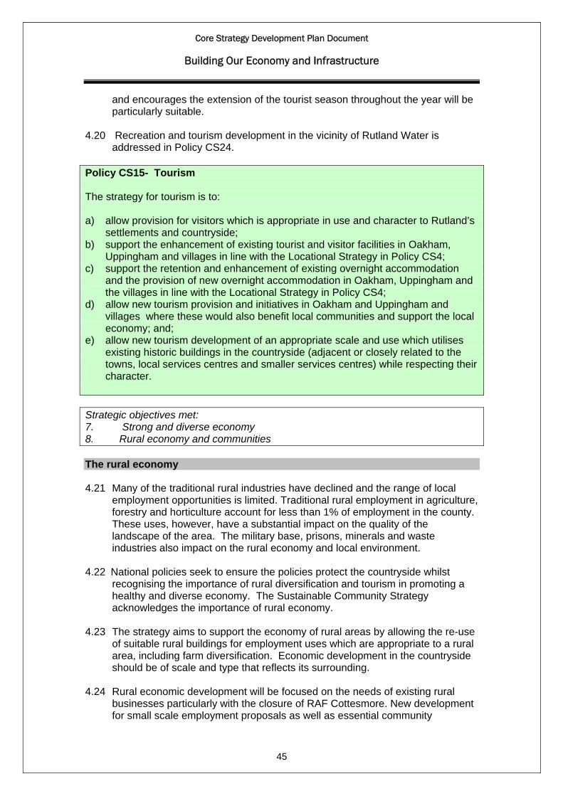
Core Strategy Development Plan Document
Building Our Economy and Infrastructure
and encourages the extension of the tourist season throughout the year will be particularly suitable.
4.20 Recreation and tourism development in the vicinity of Rutland Water is
addressed in Policy CS24. Policy CS15- Tourism The strategy for tourism is to: a) allow provision for visitors which is appropriate in use and character to Rutland’s
settlements and countryside; b) support the enhancement of existing tourist and visitor facilities in Oakham,
Uppingham and villages in line with the Locational Strategy in Policy CS4; c) support the retention and enhancement of existing overnight accommodation
and the provision of new overnight accommodation in Oakham, Uppingham and the villages in line with the Locational Strategy in Policy CS4;
d) allow new tourism provision and initiatives in Oakham and Uppingham and villages where these would also benefit local communities and support the local economy; and;
e) allow new tourism development of an appropriate scale and use which utilises existing historic buildings in the countryside (adjacent or closely related to the towns, local services centres and smaller services centres) while respecting their character.
Strategic objectives met: 7. Strong and diverse economy 8. Rural economy and communities The rural economy 4.21 Many of the traditional rural industries have declined and the range of local
employment opportunities is limited. Traditional rural employment in agriculture, forestry and horticulture account for less than 1% of employment in the county. These uses, however, have a substantial impact on the quality of the landscape of the area. The military base, prisons, minerals and waste industries also impact on the rural economy and local environment.
4.22 National policies seek to ensure the policies protect the countryside whilst
recognising the importance of rural diversification and tourism in promoting a healthy and diverse economy. The Sustainable Community Strategy acknowledges the importance of rural economy.
4.23 The strategy aims to support the economy of rural areas by allowing the re-use
of suitable rural buildings for employment uses which are appropriate to a rural area, including farm diversification. Economic development in the countryside should be of scale and type that reflects its surrounding.
45
4.24 Rural economic development will be focused on the needs of existing rural businesses particularly with the closure of RAF Cottesmore. New development for small scale employment proposals as well as essential community

Core Strategy Development Plan Document
Building Our Economy and Infrastructure
infrastructure and affordable housing will be directed towards the local services centres and smaller services centres where possible taking advantage of existing buildings and previously developed land. The economic prosperity of rural areas influences the quality of the environment, and the quality of the local environment attracts businesses to the area. It is important that any development which takes places should maintain the environmental qualities of the countryside. Further guidance on rural employment and the conversion and re-use of rural buildings for both employment and residential uses will be developed through the Site Allocations and Policies DPD.
Policy CS16 – The rural economy The strategy for the rural economy is to: a) encourage agricultural, horticultural and forestry enterprises and farm
diversification projects where this would be consistent with maintaining and enhancing the environment, and contribute to local distinctiveness;
b) support the mineral industry as set out in the Minerals Core Strategy and Policies DPD;
c) support waste management development as set out in Policy CS25; d) safeguard existing rural employment sites and permit the improvement and
expansion of existing businesses provided it is of a scale appropriate to the existing development where this would be consistent with maintaining and enhancing the environment, and contribute to local distinctiveness of the area;
e) allow small scale developments for employment purposes in the local services centres and smaller services centres provided it is of a scale appropriate to the existing location where this would be consistent with maintaining and enhancing the environment, and contribute to local distinctiveness of the area;
f) support the conversions and re-use of appropriately located and suitably constructed rural buildings in the countryside (adjacent or closely related to the towns, local services centres and smaller services centres) for employment-generating uses particularly where they would assist in the retention or expansion of existing rural businesses or encouragement of enterprises that have little adverse environmental impact,
g) support the local delivery of services and retention of local shops and pubs as set out in Policy CS7.
Strategic objectives met: 8. Rural economy and communities Town centres and retailing 4.25 Planning Policy Statement 4: Planning for Sustainable Economic Growth
(2009) sets out the government planning policies for economic development. Economic development includes main town centre uses which comprises of retail development, leisure, entertainment facilities, offices and arts, culture and tourism.
46
4.26 One of the key objectives is to promote the vitality and viability of town and other centres as important places for communities. The Core Strategy sets out
Core Strategy Development Plan Document
Building Our Economy and Infrastructure
the retail hierarchy in line with government guidance in PPS4 and the strategic objectives in order to develop vibrant and prosperous market towns and villages and support sustainable communities with locally accessible services.
4.27 The vitality and viability of Oakham and Uppingham town centres will need to
be maintained and enhanced. The identification of additional convenience and comparison floorspace is necessary to protect the centres whilst securing additional retail development in order to provide local residents with an improved retail offer, reduce leakage of retail spending and improve the local economy commensurate with the level of housing growth proposed in the Core Strategy.
4.28 Local neighbourhood shops are important in providing for the day-to-day needs
of local communities in both urban areas and rural villages. Typically these include a small range of shops of a localised nature such as a small convenience store and newsagent. Existing uses will be protected and where a need is established, new shops to meet day to day needs within communities will be supported. Support will be given for new neighbourhood shops in the sustainable urban extension to the north-west of Oakham in delivering a sustainable community.
4.29 A Retail Capacity Assessment was undertaken for Rutland in accordance with
PPS4 and published in April 2010. The study assessed existing provision of retail, commercial and leisure uses and assessed future need and capacity of the two town centres to accommodate growth and undertook a ‘healthcheck’ of Oakham and Uppingham town centres.
Town centre strategy 4.30 The town centre strategy for Rutland is to focus the majority of new retail
floorspace onto Oakham town centre, allowing it to develop and strengthen its role as the principal comparison shopping destination in the county.
4.31 This strategy allows for the retail needs to be met on sites in or close to the
edge of the existing retail centre of Oakham town centre, through the identification of sites on the edge of the town centre to accommodate additional comparison goods development of an appropriate scale along with a bulky goods-format allocation in an out-of-centre location.
4.32 The strategy does not preclude development opportunities from coming
forward in Uppingham, but any schemes will be expected to be relatively small-scale appropriate to the role and function of the town, and should not detract from the focus of the strategy being on Oakham as the higher-order centre.
4.33 Given the small size of Oakham and Uppingham all planning applications
upwards of 500 m2 gross for town centre uses outside the defined town centres will be required to undertake an Impact Assessment. The assessment will be in accordance with PPS4 and examine the impacts of the proposal on the existing town centre.
47
4.34 Any locally significant impacts on the town centres will be identified and defined in the Site Allocations and Policies DPD. These local considerations may typically include the provision and management of car parking and ensuring a

Core Strategy Development Plan Document
Building Our Economy and Infrastructure
range of shopping frontages are retained and will be tested at the application stage.
4.35 Within Oakham there is an opportunity for the regeneration of the Oakham
West End. The regeneration of this area on the western edge of the town centre towards the railway crossing has been identified as a corporate and community priority. A strategy for the potential improvement of this part of the town centre has been prepared and any specific proposals for the town centre will be addressed in a Site Allocations and Policies DPD.
4.36 Support will be given for suitable planning applications for residential or office
purposes above ground floor retail level and for the development of an ‘evening economy’ including complementary leisure uses such as cafés and restaurants in order to diversify the offer of the centres and support the vitality and viability outside of retail trading hours.
4.37 Oakham as the main town will need to accommodate further retail development
including a modest net level of additional food retailing of between 1838 m2 to 2234 m2 to satisfy the quantitative requirement to 2026 and address the qualitative need to provide food store competition in Oakham’s town centre since the closure of a food store as encouraged in PPS4.
4.38 Up to an additional net 5484 m2 comparison floorspace is required, this would
allow potential for Oakham to improve its retention in sectors particularly clothing and footwear as well as specialist comparison goods shopping and reflects the qualitative requirement for larger, modern units in order to improve ‘bulky goods’ format retail provision which is lacking in the county at present.
4.39 Sites to accommodate these levels of convenience and comparison floorspace
provision will be identified in the Site Allocations and Policies DPD, a reassessment of the areas defined as primary and secondary shopping frontages will also be undertaken.
4.40 The forecasts for floorspace requirements up to 2026 will be monitored and
kept under review to take account of both changes in forecast expenditure growth and turnover efficiency rates, and also changes in the retail provision within the catchment area.
Policy CS17 – Town centres and retailing The vitality and viability of the town centres will be maintained and enhanced so they continue to provide a range of retail, leisure and business uses. This will be achieved by: a) supporting the following hierarchy of town centres:
Oakham: Main Town Centre – serving the whole of Rutland Uppingham: Town centre – serving the wide surrounding rural catchment
48
b) focussing main town centre uses in the defined town centres. Where such developments cannot be identified within defined town centres a sequential

Core Strategy Development Plan Document
Building Our Economy and Infrastructure
approach will be followed with preference given first to sites on the edge of the defined town centres prior to the consideration of out-of-centre sites.
c) supporting initiatives which enhance and regenerate the Oakham West End d) supporting suitable proposals for the development of the ‘evening economy’ and
complementary leisure uses e) supporting proposals for the use of upper floors above shops and commercial
premises for residential or office purposes f) requiring Impact Assessments for proposals upwards of 500 m2 gross for town
centre uses outside of the defined town centres g) supporting the provision of new local neighbourhood shops in the sustainable
urban extension to the north-west of Oakham h) monitoring retail provision which may be adjusted if development takes place
more quickly or slowly than anticipated. Strategic Objectives met: 2. Vibrant and prosperous market towns 7. Strong and healthy economy Transport and accessibility 4.41 It is recognised that improving accessibility and providing realistic alternatives
to car travel in a rural area like Rutland is particularly challenging. The interface between planning and transport is of great importance. The location of development can have significant impact on the patterns of travel and accessibility.
4.42 The role of the Council as the highway and planning authority in the area is
central to meeting the Council’s strategic transport objectives. This is primarily guided by the Council’s Local Transport Plan. The Spatial Strategy is designed to reduce need to travel by car through locating development proposals in the most accessible locations in the larger settlements and ensure appropriate contributions are sought from new developments to reduce or mitigate its impact on the highway and transportation networks in the area.
49
4.43 Although public transport provision in the county is generally limited, the longer term transport strategy is based on deliverable and realistic improvements to public transport backed up by a package of improvements to pedestrian and cycle routes across the county. It will go hand in hand with the Council’s effort to promote a sustainable local economy and greater access to services and will sit at the heart of our efforts to accommodate existing and future need to travel in a sustainable way. The Council’s challenge is to take a co-ordinated approach across all modes of transport, whilst recognising the individual access requirements of specific development proposals. Better use of existing

Core Strategy Development Plan Document
Building Our Economy and Infrastructure
transport infrastructure and the provision of new infrastructure will be required which is safe and well designed. In some cases this will need to be provided across the county boundary, which will require joint working with the surrounding local highway authorities, highway agency and the transport providers.
4.44 To meet these objectives, the Council will focus its efforts on improving the bus
routes, services and passenger facilities from the key transport hubs of Oakham and Uppingham and providing effective links to serve the larger service villages and nearby cities and towns to ensure that people have access to jobs and a full range of services, such as hospital, leisure, cultural and comparison shopping activities. The local highway authority will utilise the contributions arising from new development and supplement, where possible, through other funds, improvements to the local highway network and the delivery of local public and community transport services in partnership with the private, voluntary and community sectors, wherever appropriate.
4.45 The Council will continue to work in partnership with Network Rail and the
Department of Transport to improve passenger rail services and facilities to Oakham and other parts of the region and bus, pedestrian and cycle links to the rail station. The majority of freight movements in the county are undertaken by road and there is limited use of the rail network, apart from the Cement works at Ketton, where about 20% of the products go by rail. Any opportunities for sustainable freight movement by rail associated with new development will be considered in partnership with Network Rail and other agencies.
4.46 Cycling and walking have a key role to play in connecting to the wider transport
network, accessing services and facilities, and promoting low-cost sustainable, healthy travel in the county. Rutland is ideally placed to take advantage of the increase in popularity of walking and cycling holidays and improvements to the strategic walking and cycling routes particularly around Rutland Water and the linkages to nearby market towns and villages forms a key element of the sustainable tourism economy. The continued development of an accessible green infrastructure network of footpaths, cycleways and green spaces in the county as set out in Policy CS23 will support tourism, promote healthy living and encourage walking and cycling.
50
4.47 A number of transport improvement schemes are identified in the county aimed at improving road safety, traffic flows and alleviating congestion. A bypass for Caldecott has been included as a Sub-regional Transport Investment Priority and feasibility of a bypass for Uppingham is identified in the Council’s Sustainable Communities Strategy and Strategic Transport Assessment for Oakham and Uppingham. However, there are no identified sources of funding for these schemes at present and are not programmed for implementation during the plan period.
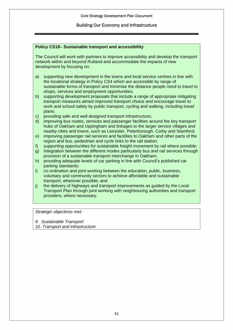
Core Strategy Development Plan Document
Building Our Economy and Infrastructure
Policy CS18– Sustainable transport and accessibility The Council will work with partners to improve accessibility and develop the transport network within and beyond Rutland and accommodate the impacts of new development by focusing on: a) supporting new development in the towns and local service centres in line with
the locational strategy in Policy CS4 which are accessible by range of sustainable forms of transport and minimise the distance people need to travel to shops, services and employment opportunities;
b) supporting development proposals that include a range of appropriate mitigating transport measures aimed improved transport choice and encourage travel to work and school safely by public transport, cycling and walking, including travel plans;
c) providing safe and well designed transport infrastructure; d) improving bus routes, services and passenger facilities around the key transport
hubs of Oakham and Uppingham and linkages to the larger service villages and nearby cities and towns, such as Leicester, Peterborough, Corby and Stamford;
e) improving passenger rail services and facilities to Oakham and other parts of the region and bus, pedestrian and cycle links to the rail station;
f) supporting opportunities for sustainable freight movement by rail where possible; g) Integration between the different modes particularly bus and rail services through
provision of a sustainable transport interchange in Oakham; h) providing adequate levels of car parking in line with Council’s published car
parking standards; i) co-ordination and joint working between the education, public, business,
voluntary and community sectors to achieve affordable and sustainable transport, wherever possible; and
j) the delivery of highways and transport improvements as guided by the Local Transport Plan through joint working with neighbouring authorities and transport providers, where necessary.
Strategic objectives met: 9. Sustainable Transport
51
10. Transport and infrastructure
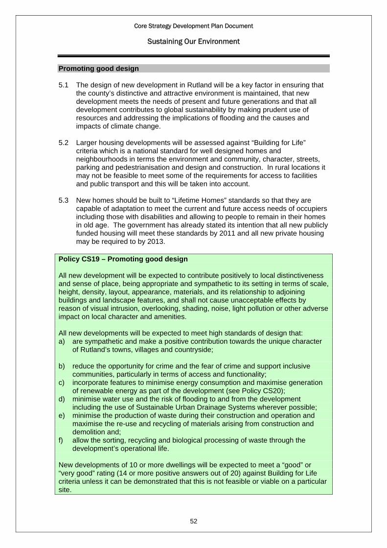
Core Strategy Development Plan Document
Sustaining Our Environment
Promoting good design 5.1 The design of new development in Rutland will be a key factor in ensuring that
the county’s distinctive and attractive environment is maintained, that new development meets the needs of present and future generations and that all development contributes to global sustainability by making prudent use of resources and addressing the implications of flooding and the causes and impacts of climate change.
5.2 Larger housing developments will be assessed against “Building for Life”
criteria which is a national standard for well designed homes and neighbourhoods in terms the environment and community, character, streets, parking and pedestrianisation and design and construction. In rural locations it may not be feasible to meet some of the requirements for access to facilities and public transport and this will be taken into account.
5.3 New homes should be built to “Lifetime Homes” standards so that they are
capable of adaptation to meet the current and future access needs of occupiers including those with disabilities and allowing to people to remain in their homes in old age. The government has already stated its intention that all new publicly funded housing will meet these standards by 2011 and all new private housing may be required to by 2013.
Policy CS19 – Promoting good design All new development will be expected to contribute positively to local distinctiveness and sense of place, being appropriate and sympathetic to its setting in terms of scale, height, density, layout, appearance, materials, and its relationship to adjoining buildings and landscape features, and shall not cause unacceptable effects by reason of visual intrusion, overlooking, shading, noise, light pollution or other adverse impact on local character and amenities. All new developments will be expected to meet high standards of design that: a) are sympathetic and make a positive contribution towards the unique character
of Rutland’s towns, villages and countryside; b) reduce the opportunity for crime and the fear of crime and support inclusive
communities, particularly in terms of access and functionality; c) incorporate features to minimise energy consumption and maximise generation
of renewable energy as part of the development (see Policy CS20); d) minimise water use and the risk of flooding to and from the development
including the use of Sustainable Urban Drainage Systems wherever possible; e) minimise the production of waste during their construction and operation and
maximise the re-use and recycling of materials arising from construction and demolition and;
f) allow the sorting, recycling and biological processing of waste through the development’s operational life.
52
New developments of 10 or more dwellings will be expected to meet a “good” or “very good” rating (14 or more positive answers out of 20) against Building for Life criteria unless it can be demonstrated that this is not feasible or viable on a particular site.
Core Strategy Development Plan Document
Sustaining Our Environment
New housing developments will be required to meet “Lifetime Homes” standards in order to ensure that they meet the current and future needs of occupiers. Strategic objectives met: 6. A stronger and safer community 13: High quality design and local distinctiveness 14. Resources, waste and climate change Energy efficiency and low carbon energy generation 5.4 Rutland will need to play its part in meeting national and regional targets for
reductions in CO2 emissions and generation of energy from renewable sources. The government has stated its intention that all new dwellings should be zero carbon rated from 2016 and non-dwellings from 2019 and that local policy should promote and not restrict renewable and low carbon energy.
5.5 The spatial strategy and other policies of the core strategy address the causes
and effects of climate change through a range of measures including locating development where it minimises the need to travel, promoting alternative means of travel to the private car, promoting green infrastructure and development which minimises flood risk.
5.6 In order to meet national targets for renewable energy and energy efficiency, a
high level of energy efficiency will be encouraged in all new developments. As recommended in the “Planning for Climate Change” study carried out for the Council, new housing and non-domestic developments will be expected to go beyond the building regulations in reducing carbon emissions.
5.7 The government has proposed improving energy efficiency standards beyond
the minimum requirements of the Building Regulations by complying with the following energy efficiency ratings in the Code for Sustainable Homes:
2010-2013 Code level 4 (25% reduction in CO2) 2013-2016 Code level 5 (44% reduction in CO2) 2016 onwards Code level 6 (zero carbon)
5.8 Higher levels of energy efficiency will be encouraged in non-domestic buildings
and new buildings such as schools, hospitals and offices will be encouraged to meet a minimum Building Research Establishment Environmental Assessment (BREEAM) rating of “very good”.
5.9 Some potential for low carbon energy generation from wind turbines, biomass
and straw and energy crops in Rutland was identified in the “Planning for Climate Change” study and such uses will be supported where they help meet national targets for low carbon energy generation and are acceptable in terms of the local impact.
53
Core Strategy Development Plan Document
Sustaining Our Environment
5.10 More detailed criteria relating to wind turbines and other low carbon energy generating developments will be set out in the Site Allocations and Policies DPD.
Policy CS20 - Energy efficiency and low carbon energy generation Renewable, low carbon and de-centralised energy will be encouraged in all development. The design, layout, and orientation of buildings should aim to minimise energy consumption and promote energy efficiency and use of alternative energy sources. All new housing developments will be encouraged to meet the minimum energy efficiency standards of the Code for Sustainable Homes in accordance with the government’s proposed timetable for improving energy efficiency standards beyond the requirements of the Building Regulations. All new non-domestic buildings will be encouraged to meet BREEAM design standards for energy efficiency. Wind turbines and other low carbon energy generating developments will be supported where environmental, economic and social impacts can be addressed satisfactorily and where they address the following issues: a) landscape and visual impact, informed by the Rutland Landscape Character
Assessment and the Rutland Historic Landscape Character assessment; b) effects on the natural and cultural environment including any potential impacts
on the internationally designated nature conservation area of Rutland Water; c) effects on the built environment, public and residential amenity, including noise
intrusion; d) the number and size of wind turbines and their cumulative impact; e) the contribution to national and international environmental objectives on climate
change and national renewable energy targets. Strategic objectives met: 14: Resources, waste and climate change The natural environment 5.11 Development will be expected to reflect the local landscape character which
has been identified in the Leicestershire, Leicester and Rutland Landscape Characterisation Assessment. The main locations for growth in the county have been subject to a landscape sensitivity and capacity study in order to ensure that any new development minimises impact on the landscape.
5.12 Rutland has a wide range of sites of importance or interest for biodiversity
including ancient woodlands, sites of special scientific interest and the internationally designated wildlife site of Rutland Water. Much of Rutland forms part of a regional Biodiversity Conservation Area.
54
5.13 The Leicestershire, Leicester and Rutland Biodiversity Action Plan (BAP) has identified priorities for improving biodiversity in Rutland which will include

Core Strategy Development Plan Document
Sustaining Our Environment
protecting and creating calcareous grassland, protecting hedgerows and mature trees as wildlife sites.
5.14 The overall strategy for the location of development in Rutland is intended to
minimise the impact of biodiversity and wildlife. The main areas of land around the two main towns, where the majority of new development will be located, have been subject to a Phase 1 Habitat Survey to assess its importance for biodiversity.
Policy CS21 - The natural environment Development should be appropriate to the landscape character type within which it is situated and contribute to its conservation, enhancement or restoration, or the creation of appropriate new features. The quality and diversity of the natural environment of Rutland will be conserved and enhanced. Conditions for biodiversity will be maintained and improved and important geodiversity assets will be protected. Protected sites and species will be afforded the highest level of protection with priority also given to local aims and targets for the natural environment. All developments, projects and activities will be expected to: a) Provide an appropriate level of protection to legally protected sites and species; b) Maintain and where appropriate enhance conditions for priority habitats and
species identified in the Leicestershire, Leicester and Rutland Biodiversity Action Plan;
c) Maintain and where appropriate enhance recognised geodiversity assets d) Maintain and where appropriate enhance other sites, features, species or
networks of ecological interest and provide for appropriate management of these;
e) Maximise opportunities for the restoration, enhancement and connection of ecological or geological assets, particularly in line with the Leicestershire, Leicester and Rutland Biodiversity Action Plan;
f) Mitigate against any necessary impacts through appropriate habitat creation, restoration or enhancement on site or elsewhere;
g) Respect and where appropriate enhance the character of the landscape identified in the Rutland Landscape Character assessment;
h) Maintain and where appropriate enhance green infrastructure. (see Policy CS23) Strategic objectives met: 11: Natural and cultural environment The historic and cultural environment
55
5.15 Rutland has a rich built and historic environment with many attractive stone-built villages and two historic town centres that provide a distinctive local character to the area. There are 34 designated Conservation Areas and 1,700 listed buildings which are afforded statutory protection.
Core Strategy Development Plan Document
Sustaining Our Environment
5.16 The Council will seek to implement measures to protect and enhance these and other historic assets, which are important to Rutland’s local distinctiveness and quality of life, working in partnership with organisations and owners of heritages assets. These may include:
a) the preparation of a list of buildings and features of local architectural or
historic importance b) the production of conservation area management plans to identify and
explain how the special interest of such areas will be preserved and enhanced
c) actions to ensure the proper conservation of all heritage features that are at risk
d) the maintenance and repair of heritage assets e) the introduction of tighter controls within conservation areas and other sites
or areas of heritage importance by implementing Article 4 (2) Directions to control certain types of permitted development which, if unchecked, would cause harm to the special character and appearance of such areas.
5.17 A historic landscape characterisation project will map and characterise the
landscape across Rutland from historic perspective. This will help to ensure that future developments respect and where possible enhance the historic landscape.
Policy CS22 - The historic and cultural environment The quality and character of the built and historic environment of Rutland will be conserved and enhanced. Particular protection will be given to the character and special features of: a) listed buildings and features; b) conservation areas; c) scheduled ancient monuments; d) historic parks and gardens; e) known and potential archaeological sites. All developments, projects and activities will be expected to protect and where possible enhance historic assets and their settings, maintain local distinctiveness and the character of identified features. Development should respect the historic landscape character and contribute to its conservation, enhancement or restoration, or the creation of appropriate new features. The adaptive re-use of redundant or functionally obsolete listed buildings or important buildings will be supported where this does not harm their essential character. Strategic objectives met: 11: Natural and cultural environment
56
12. .Built environment and local townscape

Core Strategy Development Plan Document
Sustaining Our Environment
Green infrastructure, open space, sport and recreation 5.18 Green Infrastructure is a network of multi-functional green spaces. For the
purposes of this Core Strategy it consists of all public and privately owned land and water networks including – allotments, amenity green space, green corridors, parks and gardens, play areas, natural and semi-natural areas, sports fields and cemeteries.
5.19 Successful Green Infrastructure complements the built infrastructure and
contributes to natural environment. Amongst a list of benefits it can improve sustainability, health and wellbeing, provide recreational and sporting opportunities, support and enhance biodiversity and improve environmental quality. Therefore it is an integral part of planning within the Core Strategy and contributes towards effective spatial planning.
5.20 A review of open space, sport, recreation facilities and green infrastructure in
Rutland was undertaken in 2009 in accordance with the requirements of Planning Policy Guidance Note 17 (PPG 17). The review considered the quantity, quality, accessibility and adaptability of provision, but most importantly, it considered the local needs of the population and the potential demands that may be placed on provision as the population grows. Rutland contains a variety of built and natural environment green infrastructure assets that promote an active and high quality experience for residents, visitors and wildlife.
5.21 The review established, in Rutland, open space is seen as a vital part of the
environment to be protected and improved wherever possible. Rutland has very few formal parks but access to spaces such as those around Rutland Water.
5.22 The findings show Rutland is very well provided for in terms of Green
Infrastructure, the total extent of the existing Green Infrastructure Assets Network in Rutland is 88.6% of the total area of the county; the remaining area consists of the built environment.
5.23 Nevertheless, it will be important to protect and increase this provision in the
future, to meet the future needs associated with development. There will be opportunities for provision and/or improvement to existing green infrastructure, in association with new development, either on or off-site depending on the scale of the development and feasibility. There is particularly significant potential as part of development sites such as the sustainable urban extension to the north west of Oakham. Making full use of existing facilities, such as schools and village halls, is also important. There is a need to work in partnership with schools to make facilities available to the wider community by maximising the range, quality and effectiveness of joint use provision
57
5.24 Policy CS23 reflects the importance of green infrastructure and its value for health, biodiversity, landscape and regarding climate change. Clear priorities for green infrastructure and the provision of open space standards will be set out in the Site Allocations and Policies DPD and through masterplanning for strategic sites. It will address the Council’s approach to protecting and improving the green infrastructure network in Rutland including identifying areas of value for open space, sport and recreation purposes and protect them from

Core Strategy Development Plan Document
Sustaining Our Environment
development. The Council working with its partners will develop a Green Infrastructure Strategy, this will require more detailed consideration.
Policy CS23- Green infrastructure, open space, sport and recreation The existing green infrastructure network will be safeguarded, improved and enhanced by further provision to ensure accessible multi-functional green spaces by linking existing areas of open space. This will be achieved by: a) the continued development of a network of green spaces, paths and cycleways
in and around the towns and villages; b) requiring new development to make provision for high quality and multifunctional
open spaces of an appropriate size and will also provide links to the existing green infrastructure network;
c) resisting development resulting in the loss of green infrastructure or harm to its use or enjoyment by the public. Proposals involving the loss of green infrastructure will not be supported unless there is no longer a need for the existing infrastructure or an alternative is provided to meet the local needs that is both accessible and of equal or greater quality and benefit to the community;
d) resisting the loss of sport and recreation facilities where they are deficient and supporting the provision of additional new facilities in an equally accessible location as part of the development, particularly where this will provide a range of facilities of equal or better quality on a single site or provide facilities that may be used for a variety of purposes.
Strategic objectives met: 5. Healthy and socially inclusive communities 11. Natural and cultural environment 14. Resources, waste and climate change Rutland Water 5.25 Rutland Water’s primary function is as a reservoir to provide water supplies to
the East Midlands and areas to the south and east but it is also an internationally important site for nature conservation with a major role as a recreational facility with importance for tourism and the local economy.
5.26 The reservoir and its immediate surrounds has been designated a Site of
Special Scientific Interest, a RAMSAR site and Special Protection Area with national and international importance for passage and breeding waterfowl. As such, it receives statutory protection and any development will be subject to strict controls to ensure that it does not adversely affect the integrity of the site.
5.27 The whole of the Rutland Water Area including the defined Recreation Area
falls within the countryside and will be subject to policies relating to development in the countryside (see Policies CS4 and CS21). Any development will therefore need to respect the character of this sensitive countryside location.
58

Core Strategy Development Plan Document
Sustaining Our Environment
5.28 However Rutland Water also plays a major role in providing recreational activities, of both a passive and active nature, such as sailing and water sports, walking, cycling, bird watching and picnicking and it is recognised that some limited development may be needed to support this role.
5.29 The previous approach in the Rutland Local Plan has been to focus new
development on five defined “Recreation Areas” around the shores of the reservoir where small scale new recreation, sport and tourist facilities are to be permitted reflecting the needs and specific circumstances of each area.
5.30 A wider “Rutland Water Area” was also defined comprising the reservoir and its
immediate surroundings where small scale new recreation, sport and tourist facilities developments are limited to those essential for nature conservation or fishing or essential for operational requirements of existing facilities and subject to requirements in terms of location, scale, design and landscape impact.
5.31 Camping and caravanning activities were seen to be potentially damaging to
the character and setting of Rutland Water and are not permitted in the wider Rutland Water Area nor in the defined Barnsdale or Whitwell Recreation Areas.
5.32 This approach has been largely successful in balancing Rutland Water’s
important operational and recreational role with the need to protect its nature conservation interests and generally tranquil and undisturbed character and it is intended that it should be continued in this strategy.
5.33 Further detailed policies for the area and any boundary modifications to the
defined recreation areas and the Rutland Water policy area will be determined through a masterplan to be prepared as part of the Site Allocations and Policies DPD.
Policy CS24 - Rutland Water Development in the defined Rutland Water Area will be carefully designed and located to ensure that it respects the nature conservation features of this internationally important site and does not have an adverse impact on the landscape and wildlife interests and the general tranquil and undisturbed environment of Rutland Water. New development will be limited to small scale recreation, sport and tourist uses within the five defined Recreation Areas around the shores of Rutland Water where this is directly related to the use and enjoyment of Rutland Water and appropriate in scale, form and design to its location. Outside the five defined recreation areas, new development will be restricted to small scale development for recreation, sport and tourism facilities only where essential for nature conservation or fishing or essential for operational requirements of existing facilities and subject to it being appropriate in terms of location, scale, design and impact on the landscape.
59
Caravan and camping sites will not be acceptable outside the defined recreation areas and only within the defined recreation areas where appropriate to the area in terms of its scale, location and impact on the surrounding area.
Core Strategy Development Plan Document
Sustaining Our Environment
Strategic objectives met: 11: Natural and cultural environment Waste management and disposal 5.34 All forms of development and activities produce waste. It is important in creating
sustainable communities that waste management is incorporated into new development and that there is a social change which recognises waste as a resource and communities take more responsibility for the waste they produce.
5.35 The majority of Rutland’s waste is exported to surrounding counties where it is
recycled, composted, or disposed of to landfill. Limited advanced treatment of wastes has been reported (with the exception of thermal treatment of clinical wastes).
5.36 The amount of waste generated in Rutland is likely to increase over the plan
period, resulting in a capacity gap between current operational capacity and future requirements.
5.37 An assessment of the potential future requirements for facilities has
demonstrated that there are opportunities in Rutland for increasing the current waste management capacity, particularly in relation to recycling and biological processing. There is a potential requirement for: a) one to two small-scale materials recycling facilities, plus either additional
capacity at the existing civic amenity sites or an additional site, b) two to three small-scale composting or one to two small-scale anaerobic
digestion facilities, and c) one small-scale inert recycling/processing facility.
5.38 Given the number and scale of facilities, it is estimated that between 2.5 and 6 ha of land is needed to accommodate this requirement.
5.39 The two existing civic amenity sites in Cottesmore and North Luffenham will be
retained. Additional capacity for civic amenity sites will be provided either through an extension to existing sites or a new site near Oakham.
5.40 The operational capacity for large preliminary and advanced treatment facilities
cannot be sustained from waste arisings from within Rutland alone. It may be possible that over the mid to long term of the plan period the development of a small scale advanced treatment facility may become viable. Until such a facility is provided it is likely that the exporting of waste to surrounding counties for treatment will continue and that amounts may increase in line with meeting waste management targets.
5.41 There are currently no operational non-inert landfill* sites within Rutland. The
county is not considered appropriate as an area to accommodate a new landfill site. The exporting of waste to surrounding counties for disposal to landfill will continue but the amount of waste requiring disposal is anticipated to reduce.
60
*Non-inert landfill does not include hazardous landfill (i.e. Grange Top Quarry landfill site, used to dispose of cement kiln bypass dust produced from the Ketton cement works)

Core Strategy Development Plan Document
Sustaining Our Environment
5.42 Regional self-sufficiency will be promoted through sustainable patterns of waste
movements in relation to urban areas in neighbouring counties. 5.43 Waste related development will be predominantly focused in Oakham,
Uppingham, and the Local Service Centres (see Policy CS3). This will maximise the use of existing infrastructure networks and facilitate communities taking greater responsibility for their waste. Waste developments should be co-located with complementary activities, for example within industrial areas or integrated with new residential and commercial development.
5.44 Development on the edge of Stamford, redeveloped Ministry of Defence land,
or other similar establishments would be considered where consistent with its role in accordance with Policies CS3 and CS6. Facilities in these areas should deal with the waste generated from identified urban areas or the redevelopment and ongoing use of such establishments. The co-location of waste management facilities with complementary activities would be expected.
5.45 In other areas, including the countryside, redundant agricultural and forestry
buildings may also provide suitable opportunities for preliminary treatment. Particularly for the management of agricultural wastes or where a rural location is more appropriate due to the nature of operations or the relationship with rural activities, for example composting and anaerobic digestion.
5.46 The location of waste related development will be in accordance with policy
CS25 below and Policies CS2 (the spatial strategy), CS3 (the settlement hierarchy), CS3 and CS4 (principles for the location of development). Allocations will be identified in the Site Allocations and Development Control Polices DPD.
5.47 Proposals for waste related development and allocation of sites will have regard
to the following principles:
a) a justified need for the development in respect of: (i) distribution of waste related development; (ii) waste management capacity requirements; (iii) the development of a waste management facilities to support
sustainable growth; (iv) dealing with waste close to its origin;
b) reducing reliance on land filling; c) maximising opportunities to:
(i) co-locate facilities together and with complementary activities, and (ii) the re-use of previously developed land, redundant agricultural and
forestry buildings, and their curtilage (where possible);
61
d) protecting and enhancing the environment, including where necessary the minimisation of potentially adverse impacts on the built and natural environment, general amenity, human health and safety, and traffic.

Core Strategy Development Plan Document
Sustaining Our Environment
Policy CS25 - Waste management and disposal The development of a sustainable waste management network for Rutland will be met through recognising waste as a resource; this will be delivered through the provision of facilities to meet the indicative waste management capacities. Waste development within the county will focus on the provision of preliminary and supporting facilities. Rutland is not considered an appropriate location for large scale advanced treatment facilities. The indicative waste management capacity requirements up to 2026 include: a) recycling capacity of 12,000 to 22,000 tonnes per annum (tpa), plus an additional
500 tpa for civic amenity facilities, b) biological processing capacity of 6,000 to 12,000 tpa, c) inert recycling of 7,000 tpa, and d) advanced treatment of 16,000 to 19,000 tpa. Within Rutland facilities to meet the above waste management capacity requirements should be focussed at Oakham, Uppingham, and the Local Service Centres. Within these areas waste development should be located within industrial areas or integrated with new residential and commercial development, and be of an appropriate scale. In other areas, including the countryside, the development of preliminary treatment facilities should be linked to the management of agricultural wastes, or where a rural location is more appropriate due to the nature of operations or the relationship with rural activities. Within these areas, preference would be for the use of redundant agricultural and forestry buildings. Development on the edge of Stamford, redeveloped Ministry of Defence land, or other similar establishments would be considered where consistent with their role and there is a clearly demonstrated need. The current role of the Ketton cement works, being a regionally significant facility for the use of alternative fuels, is to be maintained. The estimated inert disposal capacity requirement up to 2026 is 13,000 to 36,000 (tpa). Disposal of inert fill should be directed towards quarries to facilitate restoration; however inert fill could be permitted for agricultural improvement or other purposes as long as it could be demonstrated that it would not prejudice restoration of any quarries (existing and allocated). Rutland is not considered an appropriate location for non-inert disposal facilities. However it is important to note that there will still be a requirement for disposal. The estimated non-inert disposal capacity requirement up to 2026 includes 12,000-34,000 tpa for non-inert waste, as well as an additional 4,000 to 5,000 tpa of residual waste materials.
62
Rutland is not considered an appropriate location for hazardous waste management facilities. The estimated requirement for hazardous waste management up to 2026 includes recycling or re-use capacity of approximately 400 tpa, total treatment &

Core Strategy Development Plan Document
Sustaining Our Environment
transfer capacity of approximately 1,200 tpa, and hazardous waste disposal (landfill) capacity of approximately 80 tpa. Regional self-sufficiency will be promoted through sustainable patterns of waste movements in relation to urban areas in neighbouring counties, particularly for advanced treatment, non-inert disposal, and hazardous waste management.
Strategic objectives met: 14: Resources, waste and climate change
63

Core Strategy Development Plan Document
Implementation and monitoring framework
Implementation and monitoring framework 6.1 This section sets out how the Core Strategy will be implemented and
monitored. By identifying appropriate indicators and targets, the effectiveness of policies and implementation measures can be monitored, these are set out in Appendix 2.
6.2 The results of such monitoring will then identify which polices and
implementation measures are succeeding, and which need revising or replacing because they are not achieving the intended effect.
6.3 A key component of the monitoring process is the Annual Monitoring Report.
This document is prepared annually based on the period 1st April to 31st March. The AMR is required to assess the implementation of the LDS and the extent to which policies are being successfully implemented.
6.4 The Local Development Scheme (LDS) will also play a crucial role in
implementing the policies and proposals in the Core Strategy. This project management tool sets out the programme for producing the other general and area specific LDF documents that will follow the Core Strategy.
6.5 In doing so the LDS can ensure that the policies and proposals of the Core
Strategy are implemented in such a way that ensures areas of greatest priority and need are tackled first. This coordinated approach will help to secure implementation and timely delivery of the Core Strategy's objectives.
6.6 The Council has developed a framework for monitoring the Core Strategy that
can assess the extent to which the strategy, vision and strategic objectives are being achieved. This framework includes a series of indicators and targets which will be used to assess the extent to which policies in the Core Strategy are being implemented.
6.7 Where this is failing, the monitoring process will help to explain why and set out
the steps to be taken to ensure that the policy is implemented properly or amended. Monitoring should also be undertaken to identify any significant effects that implementation of the policies in the Core Strategy is having on the delivery of sustainable development, and to determine whether policies need to be amended or replaced. The outcome of this monitoring will be provided in the AMR.
6.8 To measure the performance of the Core Strategy, the Council has used the
strategic objectives and related policies to guide the selection of meaningful indicators and targets as a means of ensuring effective policy implementation, monitoring and review.
6.9 Implementation of the polices contained in the Core Strategy will require
concerted action by a range of public, private and voluntary sector bodies working in partnership. The documents role is to provide a clear and robust framework for development in order that investment and action can be coordinated and geared to efficient and effective delivery.
64
6.10 Should annual monitoring of the key indicators reveal any significant failure(s) to meet targets, the Council will take action to rectify the situation as soon as

Core Strategy Development Plan Document
Implementation and monitoring framework
possible. This will include a review of one or more policies or the whole Core Strategy. In the event of a significant shortfall or over provision of new dwelling completions against the housing trajectory, the Council will bring forward additional sustainable alternative sites or if there is likely to be a significant over provision set back sites as soon as possible via the site specific DPDs and/or the development control process to meet housing requirements up to 2026.
65
Core Strategy Development Plan Document
Appendix 1 – Housing supply and trajectory
This appendix sets out details of past and projected housing completions, and is intended to provide background information in support of Policy CS9 ‘Provision and distribution of new housing’. Meeting the requirement Provision should be made for 3000 dwellings over the plan period 2006-2026 which was required under the previous Regional Plan and supported through consultation with key stakeholders and the community. This amounts to an average rate of house building of 150 dwellings per annum. Sources of housing supply
a) Completions – This relates to dwellings completed between 2006 and 2010.
Data on housing completions for these years has been taken from the Council’s monitoring system.
b) Outstanding commitments – This relates to large sites of 10 or more dwellings (allocated and unallocated) with extant planning consent at 1st April 2010, it includes sites granted planning permission or with resolution to grant and likely to be completed following discussions with land owners and developers.
c) Outstanding commitments on small sites – This source relates to sites with outstanding planning permission for up to 9 dwellings as at 1st April 2010 by assuming small sites will be deliverable after making an allowance for some sites not coming forward based on average past lapse rates since 1st April 2006, which on average are 12 lapses a year.
d) Remaining Local Plan Allocations – This source relates to the remaining Local Plan allocation which following discussions is considered likely to come forward within the plan period.
e) Strategic Housing Land Availability Assessment (SHLAA) sites – This source relates to sites identified in the Council’s SHLAA and the update which took place in April 2009. Sites were included in the trajectory on the basis of being within or adjoining the most sustainable locations of Oakham, Uppingham and the Local Service Centres and deliverable up to the period 2018.
Housing trajectory The housing trajectory sets out how the various sources of supply will contribute to provision, and when it is expected the development will occur. The housing trajectory compares the level of actual and projected completions over the period from 2006 to 2026. For 2006-2010, it shows actual annual completions. For the period 2010-2026, it projects housing completions on outstanding commitments, windfall and potential ‘SHLAA’ sites up to 2026. It is published annually as part of the Council’s Annual Monitoring Report. Regular updating allows the Council to monitor progress and manage provision to ensure the required amount of housing is delivered. The graph illustrates the trajectory, along with the data informing the trajectory which is set out in the following table.
66
Core Strategy Development Plan Document
Appendix 1 – Housing supply and trajectory
67
Housing completions 2006 - 2010 The trajectory shows that 523 dwellings have been completed from the beginning of the plan period, 2006 to 2010, from 1st April 2006 to 31st March 2010 at an average rate of 131 dwellings per annum. This is 19 dwellings below the annualised rate of 150 required to deliver 3,000 dwellings over 20 years from 2006 to 2026. Projected net additional dwellings With the addition of housing allocations from adopted DPDs and current projections for SHLAA sites it is expected that the target of 3,000 dwellings will be met before 2026. Given the level of extant planning permissions, 549 at 1st April 2010 and the other identified sources of supply, the projected 3,087 net additional dwellings from 2010 to 2026 is considered to be a realistic figure. The housing provision through allocated sites in the Core Strategy and Site Allocations DPDs will allow a more managed approach to the delivery of housing. The calculation of the projected number of additional dwellings to be completed over the remaining plan period has considered the following: • The rate of development of the committed dwellings will be governed by market
forces but there is no way that this can be controlled through the planning process,
• From 2012/13 anticipated housing provision will be influenced by the Core
Strategy,
• The contribution from unidentified windfalls has not been included. However, there is an assumption that potential permissions will still come forward on unidentified small sites and the contribution made by these will be subject to review in the Annual Monitoring Report.
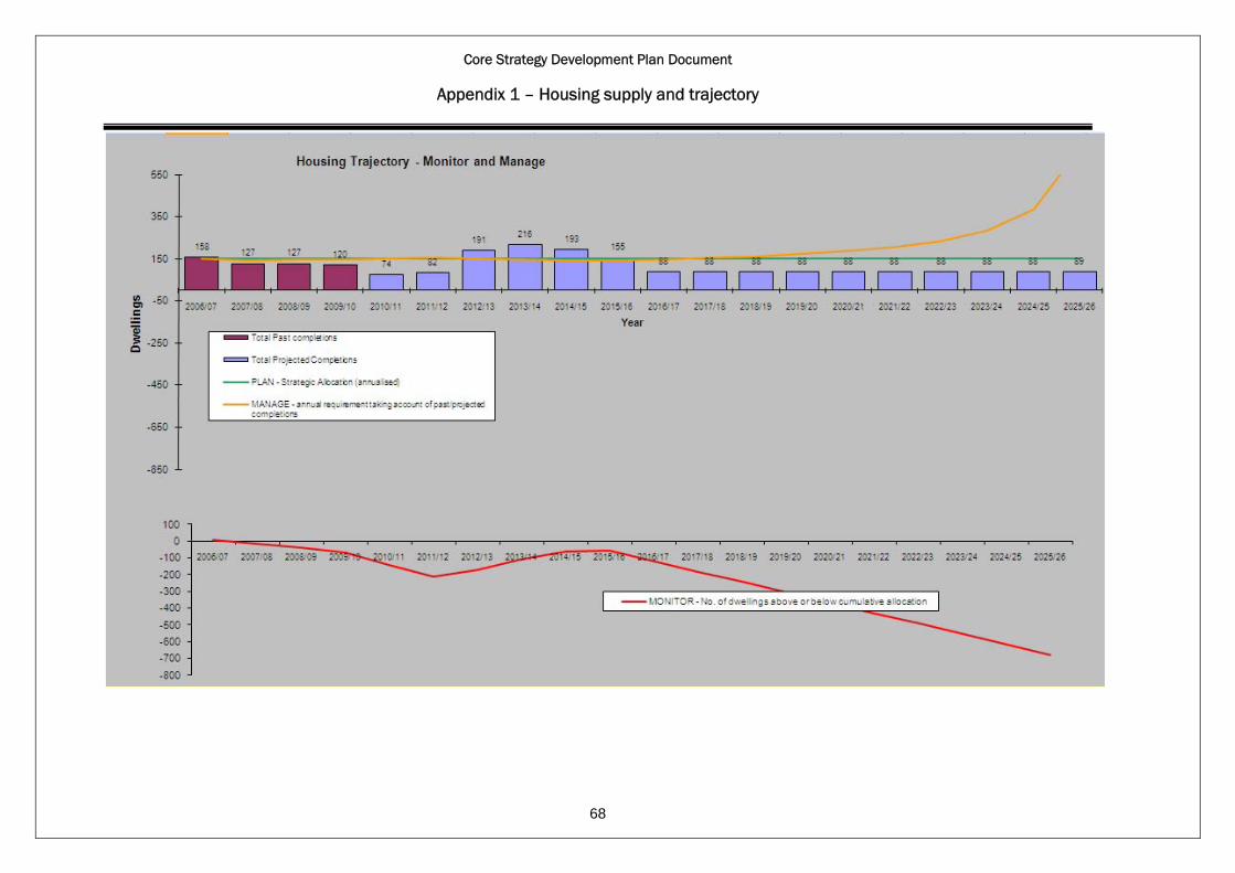
Core Strategy Development Plan Document
Appendix 1 – Housing supply and trajectory
68
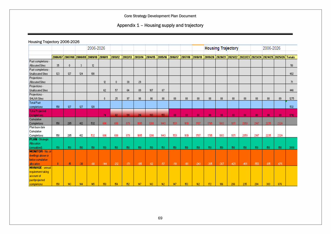
Core Strategy Development Plan Document
Appendix 1 – Housing supply and trajectory
Housing Trajectory 2006-2026
69

Core Strategy Development Plan Document
Appendix 2 –Implementation and monitoring framework
70
Policy Strategic Objective
Indicator Target Data source Implementation
CS1 Sustainable development principles
All No specific indicator identified. Through the LDF & Development Control decisions
Number & percentage of dwellings completed in Oakham & Uppingham, Local Service Centres, Smaller Service Centres & Restraint Villages.
To ensure that 70% of all dwellings to be completed in Oakham and Uppingham and 30% elsewhere.
CS2 The spatial strategy
All
The number & percentage of dwellings refused permission contrary to the spatial strategy and supported at appeal.
To minimise development in unsustainable locations.
RCC Through the LDF – Site Allocations & Policies DPD & Development Control decisions
CS3 The settlement hierarchy
1,2,3 Number & percentage of dwellings completed in Oakham & Uppingham, Local Service Centres, Smaller Service Centres & Restraint Villages.
To minimise development in unsustainable locations ensure that 70% of all dwellings to be completed in Oakham and Uppingham and 30% elsewhere.
RCC Through the LDF – Site Allocations & Policies DPD & Development Control decisions
CS4 The location of development
1,2 Number of dwellings completed in each settlement and the countryside.
To minimise the level of development outside the planned limits of developments as specified in Policy CS3 & CS4.
RCC Through the LDF – Site Allocations & Policies DPD & Development Control decisions

Core Strategy Development Plan Document
Appendix 2 –Implementation and monitoring framework
Policy Strategic Objective
Indicator Target Data source Implementation
71
Number & percentage of dwellings completed within the sustainable urban extension and elsewhere in Oakham.
CS5 Spatial strategy for Oakham
1,2
Number of shops, facilities and employment completed within the sustainable urban extension.
To ensure sustainable development to help meet the needs of the local communities and local economy.
RCC Developers
Through the LDF – Site Allocations & Policies DPD, SPD & Development Control decisions.
CS6 Re-use of redundant military bases and prisons
1,5,7 No indicator identified. Through the LDF – Site Allocations & Policies DPD, SPD & Development Control decisions.
CS7 Delivering socially inclusive communities
5 Number & type of services and facilities lost in Rutland by location.
No net loss of facilities to ensure community facilities are provided to meet local needs.
RCC Parish Councils
Through the LDF & Development Control decisions.
Number of agreements signed.
Total value of developer contributions.
CS8 Developer contributions
5,10
The level of commuted sum payments towards affordable housing on sites of less than 5 dwellings.
To ensure that the completion of improvements to or provision of infrastructure or commuted sums reflects that agreed in S.106 agreement, (including the scale & timing of provision).
RCC Developers
Through the LDF – Site Allocations & Policies DPD, SPD & Development Control decisions.
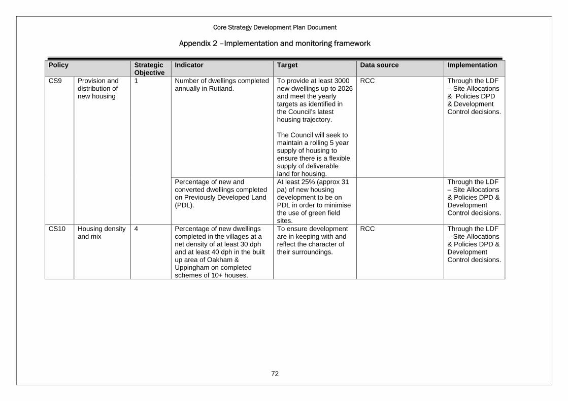
Core Strategy Development Plan Document
Appendix 2 –Implementation and monitoring framework
Policy Strategic Objective
Indicator Target Data source Implementation
72
Number of dwellings completed annually in Rutland.
To provide at least 3000 new dwellings up to 2026 and meet the yearly targets as identified in the Council’s latest housing trajectory. The Council will seek to maintain a rolling 5 year supply of housing to ensure there is a flexible supply of deliverable land for housing.
RCC Through the LDF – Site Allocations & Policies DPD & Development Control decisions.
CS9 Provision and distribution of new housing
1
Percentage of new and converted dwellings completed on Previously Developed Land (PDL).
At least 25% (approx 31 pa) of new housing development to be on PDL in order to minimise the use of green field sites.
Through the LDF – Site Allocations & Policies DPD & Development Control decisions.
CS10 Housing density and mix
4 Percentage of new dwellings completed in the villages at a net density of at least 30 dph and at least 40 dph in the built up area of Oakham & Uppingham on completed schemes of 10+ houses.
To ensure development are in keeping with and reflect the character of their surroundings.
RCC Through the LDF – Site Allocations & Policies DPD & Development Control decisions.

Core Strategy Development Plan Document
Appendix 2 –Implementation and monitoring framework
Policy Strategic Objective
Indicator Target Data source Implementation
73
Percentage of dwellings completed by the number of bedrooms.
To ensure a mix of housing types is maintained that meets the needs of the community by increasing provision of smaller 1, 2, and 3 bedroom dwellings as a proportion of new dwellings built. Targets to be set in the Site Allocations & Policies DPD.
Number & percentage of affordable houses delivered & completed as part of a residential development scheme.
CS11 Affordable housing
4
Number of affordable houses completed on exception sites.
Provide 40 affordable dwellings pa. 35% of all dwellings completions up to 2026 to be affordable housing.
RCC Through the LDF – Site Allocations & Policies DPD & Development Control decisions.

Core Strategy Development Plan Document
Appendix 2 –Implementation and monitoring framework
Policy Strategic Objective
Indicator Target Data source Implementation
74
CS12 Gypsies and travellers
4 Number of Gypsy & Traveller pitches completed for permanent pitch, transit pitches & number of plots for show people.
The Leicestershire & Rutland Gypsy & Travellers Needs Assessment requires Up to 2 permanent, up to 5 transit pitches & 3 plots for show people up to 2012. Target to be revised as part of a future review of the Assessment to be carried out in 2012.
RCC Through the LDF – Site Allocations & Policies DPD, SPD & Development Control decisions.
The amount of additional employment land & premises completed & available - by type & location.
The amount of employment land lost to other uses.
No loss of employment land to ensure a continuous supply of general employment land to provide local jobs for sustaining the local economy.
Proportion of employment in high tech and knowledge based, leisure and tourism industries. Numbers of new or improved educational or vocational training facilities.
CS13 Employment and economic development
7
New business registration rate.
To improve workforce skills. 1 new or improved educational or vocational training facility a year. 8 new businesses created.
RCC Local Businesses EMDA ONS Job Centre Plus.
Through the LDF – Site Allocations & Policies DPD, SPD & Development Control decisions.
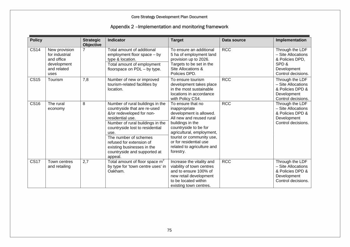
Core Strategy Development Plan Document
Appendix 2 –Implementation and monitoring framework
Policy Strategic Objective
Indicator Target Data source Implementation
75
Total amount of additional employment floor space – by type & location.
CS14 New provision for industrial and office development and related uses
7
Total amount of employment floorspace on PDL – by type.
To ensure an additional 5 ha of employment land provision up to 2026. Targets to be set in the Site Allocations & Policies DPD.
RCC Through the LDF – Site Allocations & Policies DPD, SPD & Development Control decisions.
CS15 Tourism 7,8 Number of new or improved tourism-related facilities by location.
To ensure tourism development takes place in the most sustainable locations in accordance with Policy CS4.
RCC Through the LDF – Site Allocations & Policies DPD & Development Control decisions.
Number of rural buildings in the countryside that are re-used &/or redeveloped for non-residential use. Number of rural buildings in the countryside lost to residential use.
CS16 The rural economy
8
The number of schemes refused for extension of existing businesses in the countryside and supported at appeal.
To ensure that no inappropriate development is allowed. All new and reused rural buildings in the countryside to be for agricultural, employment, tourist or community use, or for residential use related to agriculture and forestry.
RCC Through the LDF – Site Allocations & Policies DPD & Development Control decisions.
CS17 Town centres and retailing
2,7 Total amount of floor space m2 by type for ‘town centre uses’ in Oakham.
Increase the vitality and viability of town centres and to ensure 100% of new retail development to be located within existing town centres.
RCC Through the LDF – Site Allocations & Policies DPD & Development Control decisions.
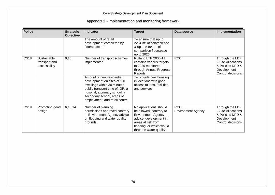
Core Strategy Development Plan Document
Appendix 2 –Implementation and monitoring framework
Policy Strategic Objective
Indicator Target Data source Implementation
76
The amount of retail development completed by floorspace m2.
To ensure that up to 2234 m2 of convenience & up to 5484 m2 of comparison floorspace up to 2026.
Number of transport schemes implemented
Rutland LTP 2006-11 contains various targets to 2020 monitored through Annual Progress Reports
CS18 Sustainable transport and accessibility
9,10
Amount of new residential development on sites of 10+ dwellings within 30 minutes public transport time of: GP, a hospital, a primary school, a secondary school, areas of employment, and retail centre.
To provide new housing in locations with good access to jobs, facilities and services.
RCC Through the LDF – Site Allocations & Policies DPD & Development Control decisions.
CS19 Promoting good design
6,13,14 Number of planning permissions approved contrary to Environment Agency advice on flooding and water quality grounds.
No applications should be allowed, contrary to Environment Agency advice, development in areas at risk from flooding, or which would threaten water quality.
RCC Environment Agency
Through the LDF – Site Allocations & Policies DPD & Development Control decisions.
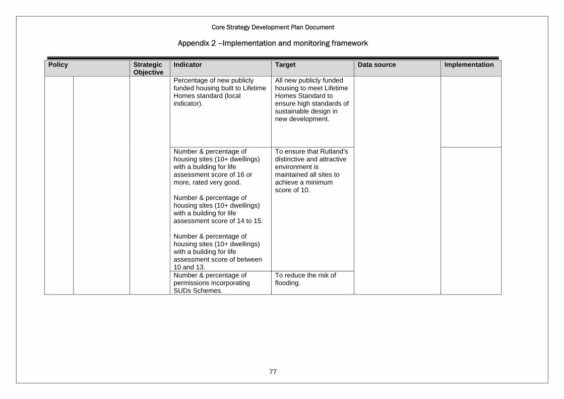
Core Strategy Development Plan Document
Appendix 2 –Implementation and monitoring framework
Policy Strategic Objective
Indicator Target Data source Implementation
77
Percentage of new publicly funded housing built to Lifetime Homes standard (local indicator).
All new publicly funded housing to meet Lifetime Homes Standard to ensure high standards of sustainable design in new development.
Number & percentage of housing sites (10+ dwellings) with a building for life assessment score of 16 or more, rated very good. Number & percentage of housing sites (10+ dwellings) with a building for life assessment score of 14 to 15. Number & percentage of housing sites (10+ dwellings) with a building for life assessment score of between 10 and 13.
To ensure that Rutland’s distinctive and attractive environment is maintained all sites to achieve a minimum score of 10.
Number & percentage of permissions incorporating SUDs Schemes.
To reduce the risk of flooding.

Core Strategy Development Plan Document
Appendix 2 –Implementation and monitoring framework
Policy Strategic Objective
Indicator Target Data source Implementation
78
Renewable energy generation by installed capacity and type.
To increase the amount of renewable energy generation capacity installed.
Percentage of new dwellings that meet the relevant code for sustainable homes.
To ensure that all new homes reach at least level 4 of the code for sustainable homes.
CS20 Energy efficiency and low carbon energy generation
14
Percentage of non-residential development meeting BREEAM very good standard.
To ensure higher levels of energy efficiency, non-residential development over 500 m2 will be required to meet BREEAM very good standard.
RCC Through the LDF – Site Allocations & Policies DPD & Development Control decisions.
Change in areas of biodiversity importance.
No net loss of areas of biodiversity importance.
CS21 The natural environment
11
Number of applications refused due to impact on nature conservation interests and supported at appeal.
No applications be allowed to impact on nature conservation interests to ensure development minimises the impact of biodiversity and wildlife.
RCC Natural England
Through the LDF – Site Allocations & Policies DPD & Development Control decisions.

Core Strategy Development Plan Document
Appendix 2 –Implementation and monitoring framework
Policy Strategic Objective
Indicator Target Data source Implementation
79
Number of applications refused due to landscape impacts and supported at appeal.
No applications be allowed to adversely impact on the landscape to ensure development minimises the impact & reflects the local landscape character.
CS22 The historic and cultural environment
11,12 Number of applications refused due to Listed Building and/or Conservation Area reasons and supported at appeal.
No application to be allowed to ensure that development reflects the local character and special features.
RCC
CS23 Green infrastructure, open space, sport and recreation
5,11,14 The number & percentage of applications refused planning permission as would result in a loss of green infrastructure contrary to CS23 and supported at appeal.
To minimise the loss of green infrastructure. Targets for open space, sport and recreation facilities to be set in the Site Allocation & Policies DPD.
RCC
Number & type of development refused & supported at appeal within the 5 defined recreation areas.
Through the LDF – Site Allocations & Policies DPD, SPD & Development Control decisions.
CS24 Rutland Water 11
Number & type of development approved within the Rutland Water Area.
No inappropriate development is allowed to ensure that development respects the nature conservation features of this internationally important site and doesn’t have an adverse impact on the landscape.
RCC

Core Strategy Development Plan Document
Appendix 2 –Implementation and monitoring framework
80
Policy Strategic Objective
Indicator Target Data source Implementation
Number of caravan & camping sites permitted within the Rutland Water Area outside the 5 defined recreation areas.
No applications should be allowed to ensure the character & setting of Rutland is protected.
The amount of waste produced in Rutland and the management methods
Waste production forecasts (MSW,C&I, CD&E).
The permitted and operational waste management capacity.
Estimated capacity requirements.
CS25 Waste management
14
MSW diverted from landfill for MSW.
MWMS targets for recycling, composting, recovery & Lats.
RCC Through the LDF – Site Allocations & Policies DPD & Development Control decisions.
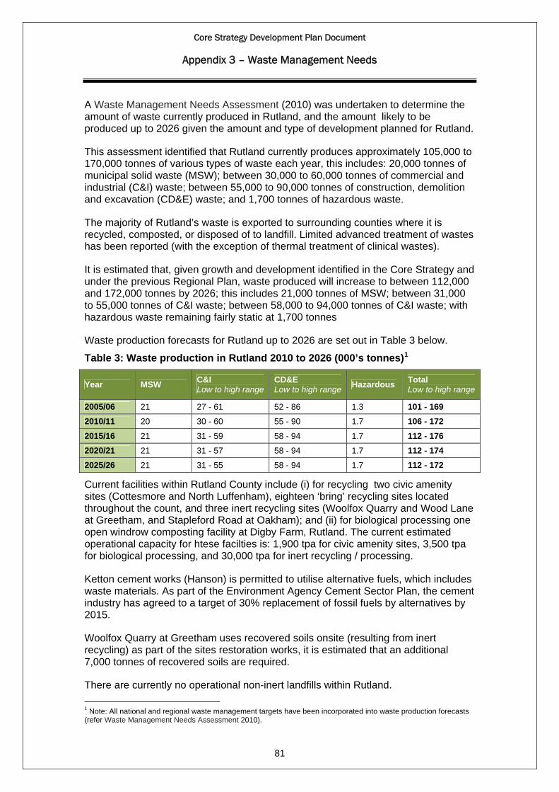
Core Strategy Development Plan Document
Appendix 3 – Waste Management Needs
A Waste Management Needs Assessment (2010) was undertaken to determine the amount of waste currently produced in Rutland, and the amount likely to be produced up to 2026 given the amount and type of development planned for Rutland.
This assessment identified that Rutland currently produces approximately 105,000 to 170,000 tonnes of various types of waste each year, this includes: 20,000 tonnes of municipal solid waste (MSW); between 30,000 to 60,000 tonnes of commercial and industrial (C&I) waste; between 55,000 to 90,000 tonnes of construction, demolition and excavation (CD&E) waste; and 1,700 tonnes of hazardous waste.
The majority of Rutland’s waste is exported to surrounding counties where it is recycled, composted, or disposed of to landfill. Limited advanced treatment of wastes has been reported (with the exception of thermal treatment of clinical wastes).
It is estimated that, given growth and development identified in the Core Strategy and under the previous Regional Plan, waste produced will increase to between 112,000 and 172,000 tonnes by 2026; this includes 21,000 tonnes of MSW; between 31,000 to 55,000 tonnes of C&I waste; between 58,000 to 94,000 tonnes of C&I waste; with hazardous waste remaining fairly static at 1,700 tonnes
Waste production forecasts for Rutland up to 2026 are set out in Table 3 below.
Table 3: Waste production in Rutland 2010 to 2026 (000’s tonnes)1
Year MSW C&I Low to high range
CD&E Low to high range Hazardous Total
Low to high range
2005/06 21 27 - 61 52 - 86 1.3 101 - 169 2010/11 20 30 - 60 55 - 90 1.7 106 - 172 2015/16 21 31 - 59 58 - 94 1.7 112 - 176 2020/21 21 31 - 57 58 - 94 1.7 112 - 174 2025/26 21 31 - 55 58 - 94 1.7 112 - 172
Current facilities within Rutland County include (i) for recycling two civic amenity sites (Cottesmore and North Luffenham), eighteen ‘bring’ recycling sites located throughout the count, and three inert recycling sites (Woolfox Quarry and Wood Lane at Greetham, and Stapleford Road at Oakham); and (ii) for biological processing one open windrow composting facility at Digby Farm, Rutland. The current estimated operational capacity for htese facilties is: 1,900 tpa for civic amenity sites, 3,500 tpa for biological processing, and 30,000 tpa for inert recycling / processing.
Ketton cement works (Hanson) is permitted to utilise alternative fuels, which includes waste materials. As part of the Environment Agency Cement Sector Plan, the cement industry has agreed to a target of 30% replacement of fossil fuels by alternatives by 2015.
Woolfox Quarry at Greetham uses recovered soils onsite (resulting from inert recycling) as part of the sites restoration works, it is estimated that an additional 7,000 tonnes of recovered soils are required.
There are currently no operational non-inert landfills within Rutland.
81
1 Note: All national and regional waste management targets have been incorporated into waste production forecasts (refer Waste Management Needs Assessment 2010).

Core Strategy Development Plan Document
Appendix 3 – Waste Management Needs
The waste production forecasts were used as a guide for future waste management capacity requirements and identifying the difference between current operational capacity and and future requirements (called the ‘capacity gap’). Identifying the capacity gap helps us to determine how many, and when, facilities are needed.
Waste management and disposal capacity requirements for Rutland up to 2026 are set out in Table 4.
Table 4: Indicative waste management and disposal capacity requirements 2010 to 2026 – Low to high range (000’s tonnes)
Year Processing of recyclables
Biological processing
Advanced treatment
Inert recycling Inert fillDisposal
Residual waste
material for
disposal2
Total disposal
2005/06 8 - 19 6 - 13 6 - 7 27 - 42 12 - 33 29 - 61 2 - 3 31 - 63
2010/11 12 - 25 9 - 17 6 - 8 32 - 50 12 - 35 20 - 42 2 - 3 22 - 45
2015/16 13 - 25 9 - 17 16 - 19 34 - 52 13 - 36 12 - 34 4 - 5 16 - 39
2020/21 13 - 24 9 - 16 16 - 19 34 - 52 13 - 36 12 - 34 4 - 5 16 - 39
2025/26 13 - 23 9 - 16 16 - 19 34 - 52 13 - 36 12 - 34 4 - 5 16 - 39 Current capacity 1.9* 3.5 Nil 30 7 Nil Nil Nil
Capacity gap 2025
12 - 22 # 6 - 12 16 - 19 7 13 - 36 12 - 34 4 - 5 16 - 39
* All of the current capacity is attributed to civic amenity sites
# Of which there will be a capacity gap of 500 tpa for civic amenity sites
An assessment of potential facility requirements was undertaken (based on indicative waste management capacity requirements in Policy CS25 and average facility throughput3). This demonstrated that there are opportunities in Rutland for increasing the current waste management capacity, particularly in relation to recycling and biological processing. There is a potential requirement for:
• one to two small scale materials recycling facilities, plus either additional capacity at the existing civic amenity sites or an additional site,
• two to three small scale composting or one to two small scale anaerobic digestion facilities, and
one small scale inert recycling / processing facility. The County Council has recently finalised the procurement process to secure diversion of MSW from landfill (through waste management contracts). As part of the Municipal Waste Management Strategy (MWMS):
• Co-mingled kerbside collected recyclables will be taken to a Materials Recycling Facility in Leicester owned and run by Casepak Ltd (1st April 2011 to 31st March 2016).
2 SEPA 2006 Waste treatment technology information sheets. Minimum residual output rates per tonne of waste input: processing of recyclables 3%, composting 5%, advanced treatment 20%.
82
3 ODPM 2004 Planning for waste management facilities, SEPA 2006 Waste treatment technology information sheets. Average facility throughput (small scale): materials recycling facility (MRF) 10,000 tpa, composting 3,500 tpa, anaerobic digestion 5,000 tpa, inert recycling / processing 10,000 tpa.

Core Strategy Development Plan Document
Appendix 3 – Waste Management Needs
• Compostable materials will be taken to an on-farm composting facility in North Luffenham, Rutland, run by J & B Ellis Ltd (1st April 2011 to 31st March 2016).
• Remaining municipal waste will be disposed of at the Waste Recycling Group (WRG) landfill sites in Stainby, Lincolnshire and Weldon, Northamptonshire (1st April 2011 to 31st March 2013). Thereafter (1st April 2013 to 31st March 2021) it will undergo advanced treatment at WRG's Eastcroft waste to energy facility in Nottingham.
All contracts can be extended for a further two 5 year periods. The above waste management contracts will help to ensure that the Council achieves its Landfill Allowance Trading Scheme (LATS) targets to 2020 and possibly beyond..
There are currently no operational non-inert landfills within Rutland. In addition Rutland is not identified as an area considered appropriate to accommodate a new landfill site.
Inert waste may be disposed of to landfill, used as inert fill at mineral extraction sites, or used as inert fill for engineering purposes or agricultural improvement. Government guidance recognises filling operations as part of restoration works for mineral extraction sites. The provision of inert fill to support restoration of mineral extraction sites is recognised as key to delivering effective restoration. The diversion of inert waste materials away from quarry restoration may affect the ability of some operators to undertake effective restoration. Where sufficient material can be demonstreated to be available for restoration of mineral extraction sites, other purposes (such as inert fill for engineering purposes or agricultural improvement) may be considered appropriate.
Waste disposal capacity requirements for Rutland up to 2026 are set out in Table 4.
83
Hazardous waste management and disposal facilities are of a specialised nature and as such facilities tend to have a regional or national role. No national or regional advice currently exists for low-level radioactive wastes, this makes it very difficult to cascade down to a local level for the purposes of the Core Strategy. In addition Rutland does not have any nuclear facilities. There is no robust demonstration to support the requirement for either a hazardous or low-level radioactive waste management or diposal facility in Rutland.
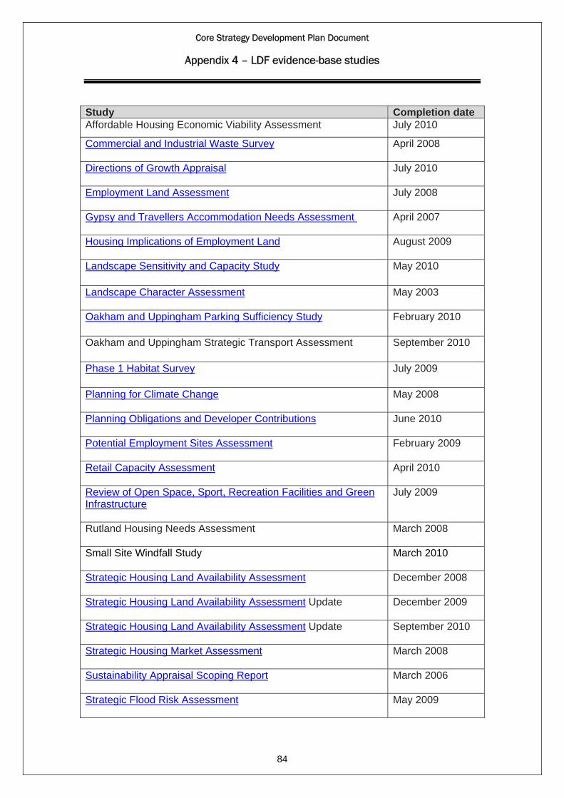
Core Strategy Development Plan Document
Appendix 4 – LDF evidence-base studies
Study Completion date Affordable Housing Economic Viability Assessment July 2010
Commercial and Industrial Waste Survey
April 2008
Directions of Growth Appraisal
July 2010
Employment Land Assessment
July 2008
Gypsy and Travellers Accommodation Needs Assessment
April 2007
Housing Implications of Employment Land
August 2009
Landscape Sensitivity and Capacity Study May 2010
Landscape Character Assessment
May 2003
Oakham and Uppingham Parking Sufficiency Study February 2010
Oakham and Uppingham Strategic Transport Assessment September 2010
Phase 1 Habitat Survey July 2009
Planning for Climate Change
May 2008
Planning Obligations and Developer Contributions
June 2010
Potential Employment Sites Assessment
February 2009
Retail Capacity Assessment
April 2010
Review of Open Space, Sport, Recreation Facilities and Green Infrastructure
July 2009
Rutland Housing Needs Assessment March 2008
Small Site Windfall Study
March 2010
Strategic Housing Land Availability Assessment
December 2008
Strategic Housing Land Availability Assessment Update
December 2009
Strategic Housing Land Availability Assessment Update
September 2010
Strategic Housing Market Assessment
March 2008
Sustainability Appraisal Scoping Report
March 2006
84
Strategic Flood Risk Assessment
May 2009
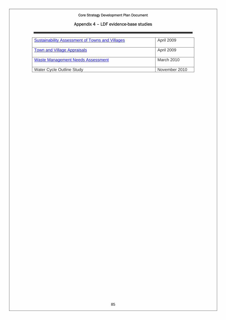
Core Strategy Development Plan Document
Appendix 4 – LDF evidence-base studies
Sustainability Assessment of Towns and Villages
April 2009
85
Town and Village Appraisals
April 2009
Waste Management Needs Assessment
March 2010
Water Cycle Outline Study November 2010
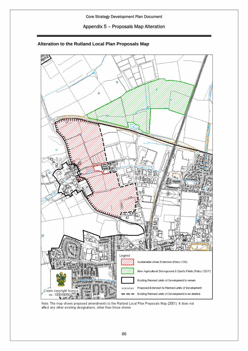
Core Strategy Development Plan Document
Appendix 5 – Proposals Map Alteration
Alteration to the Rutland Local Plan Proposals Map
86

Core Strategy Development Plan Document
Appendix 6 – List of replaced Local Plan Policies
1. Rutland Local Plan (July 2001): Policies Replaced.
Core strategy policy Policies replaced. CS3 – The settlement hierarchy SE1 – Development in Market Towns
SE2 – Development in Rural Centres SE3 – Residential Development in Limited Growth Villages SE4 – Other Development in Limited Growth Villages SE5 – Housing Development in Restraint Villages SE6 – Other Development in Restraint Villages
CS4 – The location of development
SE1 – Development in Market Towns SE2 – Development in Rural Centres SE3 – Residential Development in Limited Growth Villages SE4 – Other Development in Limited Growth Villages SE5 – Housing Development in Restraint Villages SE6 – Other Development in Restraint Villages
CS7 – Delivering socially inclusive Communities
CS2 – Development of Community Facilities Land and Buildings for Other Purposes
CS8 – Developer contributions IM1 – Provision for On-Site and Off-Site Facilities CS10 – Housing Density and Mix
HO16 – Housing Density
CS11 – Affordable housing HO9 – Affordable Housing – larger Sites HO10 – Affordable Housing – Exception Sites
CS12 – Gypsies and travellers HO14 – Sites for Gypsies and Travelling Show People CS17 – Town centres and retailing
RE1A – Retail Development RE1B – Major Retail Development in Edge of Centre and Out of Centre Locations RE1C – Vitality and Viability of Existing Town Centres
CS19 – Promoting good design EN2 – Design of Buildings
CS20 – Energy efficiency and low carbon energy generation
UT9 – New power generating plant
CS21 – The natural environment
EN21 – Incorporating sites of ecological and geological interest within a development
2. Leicestershire, Leicester and Rutland Waste Local Plan (2002): Policies
Replaced.
Core Strategy DPD Policies replaced CS18 - Sustainable transport and accessibility
WLP9 - Transportation of waste
CS21 – The natural environment
WLP8 – Environmental considerations
CS25 - Waste management and disposal
WLP1 - Waste minimisation WLP18 - Waste disposal sites for construction and demolition wastes WLP19 - Disposal of waste from major construction
87
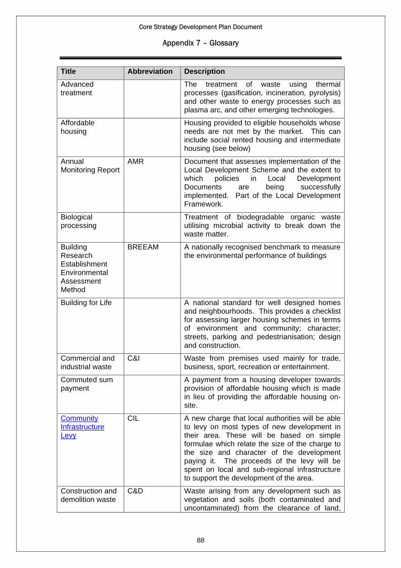
Core Strategy Development Plan Document
Appendix 7 – Glossary
Title Abbreviation Description
Advanced treatment
The treatment of waste using thermal processes (gasification, incineration, pyrolysis) and other waste to energy processes such as plasma arc, and other emerging technologies.
Affordable housing
Housing provided to eligible households whose needs are not met by the market. This can include social rented housing and intermediate housing (see below)
Annual Monitoring Report
AMR Document that assesses implementation of the Local Development Scheme and the extent to which policies in Local Development Documents are being successfully implemented. Part of the Local Development Framework.
Biological processing
Treatment of biodegradable organic waste utilising microbial activity to break down the waste matter.
Building Research Establishment Environmental Assessment Method
BREEAM A nationally recognised benchmark to measure the environmental performance of buildings
Building for Life
A national standard for well designed homes and neighbourhoods. This provides a checklist for assessing larger housing schemes in terms of environment and community; character; streets, parking and pedestrianisation; design and construction.
Commercial and industrial waste
C&I Waste from premises used mainly for trade, business, sport, recreation or entertainment.
Commuted sum payment
A payment from a housing developer towards provision of affordable housing which is made in lieu of providing the affordable housing on-site.
Community Infrastructure Levy
CIL A new charge that local authorities will be able to levy on most types of new development in their area. These will be based on simple formulae which relate the size of the charge to the size and character of the development paying it. The proceeds of the levy will be spent on local and sub-regional infrastructure to support the development of the area.
Construction and demolition waste
C&D
88
Waste arising from any development such as vegetation and soils (both contaminated and uncontaminated) from the clearance of land,
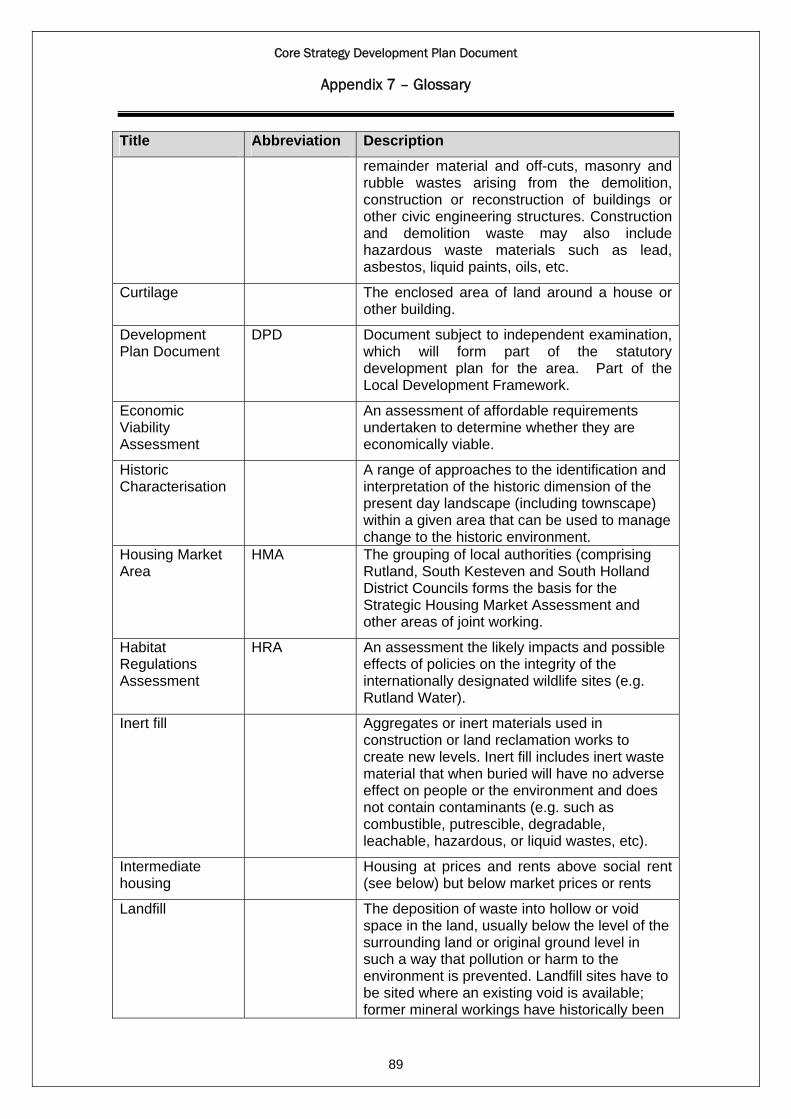
Core Strategy Development Plan Document
Appendix 7 – Glossary
Title Abbreviation Description
remainder material and off-cuts, masonry and rubble wastes arising from the demolition, construction or reconstruction of buildings or other civic engineering structures. Construction and demolition waste may also include hazardous waste materials such as lead, asbestos, liquid paints, oils, etc.
Curtilage The enclosed area of land around a house or other building.
Development Plan Document
DPD Document subject to independent examination, which will form part of the statutory development plan for the area. Part of the Local Development Framework.
Economic Viability Assessment
An assessment of affordable requirements undertaken to determine whether they are economically viable.
Historic Characterisation
A range of approaches to the identification and interpretation of the historic dimension of the present day landscape (including townscape) within a given area that can be used to manage change to the historic environment.
Housing Market Area
HMA The grouping of local authorities (comprising Rutland, South Kesteven and South Holland District Councils forms the basis for the Strategic Housing Market Assessment and other areas of joint working.
Habitat Regulations Assessment
HRA An assessment the likely impacts and possible effects of policies on the integrity of the internationally designated wildlife sites (e.g. Rutland Water).
Inert fill Aggregates or inert materials used in construction or land reclamation works to create new levels. Inert fill includes inert waste material that when buried will have no adverse effect on people or the environment and does not contain contaminants (e.g. such as combustible, putrescible, degradable, leachable, hazardous, or liquid wastes, etc).
Intermediate housing
Housing at prices and rents above social rent (see below) but below market prices or rents
Landfill
89
The deposition of waste into hollow or void space in the land, usually below the level of the surrounding land or original ground level in such a way that pollution or harm to the environment is prevented. Landfill sites have to be sited where an existing void is available; former mineral workings have historically been
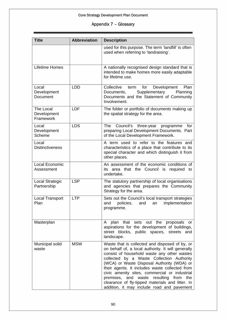
Core Strategy Development Plan Document
Appendix 7 – Glossary
Title Abbreviation Description
used for this purpose. The term ‘landfill’ is often used when referring to ‘landraising’.
Lifetime Homes A nationally recognised design standard that is intended to make homes more easily adaptable for lifetime use.
Local Development Document
LDD Collective term for Development Plan Documents, Supplementary Planning Documents and the Statement of Community Involvement.
The Local Development Framework
LDF The folder or portfolio of documents making up the spatial strategy for the area.
Local Development Scheme
LDS The Council’s three-year programme for preparing Local Development Documents. Part of the Local Development Framework.
Local Distinctiveness
A term used to refer to the features and characteristics of a place that contribute to its special character and which distinguish it from other places.
Local Economic Assessment
An assessment of the economic conditions of its area that the Council is required to undertake.
Local Strategic Partnership
LSP The statutory partnership of local organisations and agencies that prepares the Community Strategy for the area.
Local Transport Plan
LTP Sets out the Council’s local transport strategies and policies, and an implementation programme.
Masterplan A plan that sets out the proposals or aspirations for the development of buildings, street blocks, public spaces, streets and landscape.
Municipal solid waste
MSW
90
Waste that is collected and disposed of by, or on behalf of, a local authority. It will generally consist of household waste any other wastes collected by a Waste Collection Authority (WCA) or Waste Disposal Authority (WDA) or their agents. It includes waste collected from civic amenity sites, commercial or industrial premises, and waste resulting from the clearance of fly-tipped materials and litter. In addition, it may include road and pavement

Core Strategy Development Plan Document
Appendix 7 – Glossary
Title Abbreviation Description
sweepings, gully emptying wastes, and some construction and demolition waste arising from local authority activities.
Planning Policy Statement
PPS Government statement of planning policy.
Planning for Climate Change study
A study commissioned jointly by Rutland and other local authorities in order to underpin future planning policies relating to climate change.
Preliminary treatment
Any waste management process that involves the recycling or biological processing of waste, for example materials recycling facility, recycling / processing of inert waste, composting, or anaerobic digestion, etc.
Prior treatment Treatment (including sorting) of wastes that may be carried out either before or after acceptance to a landfill installation. It however cannot be carried out as part of the landfilling operation (i.e. compaction after deposit at the landfill) as it is a requirement that the treatment has been undertaken prior to landfilling. Prior treatment should not be carried out purely for the sake of achieving a treated condition. If treatment of a waste stream does not reduce the quantity of waste landfilled or the hazards of the waste to human health or the environment then it need not be undertaken.
Regional Plan Alternative name for the Regional Spatial Strategy, which formed part of the statutory development plan before being abolished in 2010.
Residual waste materials/arisings
Waste generated as an output resulting from waste treatment processes e.g. contaminated recyclates/compost matter, non-recyclable/compostable materials, bottom ash residue, metals, Air Pollution Control (APC) residues (by products of cleaning up flue gases from high temperature processes), etc.
Rutland Together The name of the Local Strategic Partnership for Rutland.
Section 106 Planning Obligation
91
A legal agreement requiring a developer to do something or restrict what can be done with land following the granting of planning permission. This may for example require provision of new infrastructure to support the development or require payment of a sum or sums of money, e.g. towards future maintenance costs.

Core Strategy Development Plan Document
Appendix 7 – Glossary
Title Abbreviation Description
Strategic Housing Land Availability Assessment
SHLAA A study of potential housing land available for development to meet the housing provision targets in the housing market area up to 2016 prepared by the Council.
Site Allocations and Policies DPD
A development plan document to be prepared by the Council in order to identify specific sites for development and set out detailed development planning policies.
Social rented housing
Housing for which guideline target rents are determined through the national rent regime.
Statutory Development Plan
The statutory plan that provides the basis for determining planning applications. Comprises the Core Strategy and other Local Development documents adopted by the local authority.
Sustainability Appraisal
SA Document setting out the appraisal of plans and policies to ensure they reflect sustainable development objectives.
Statement of Community Involvement
SCI Document setting out when, with whom and how consultation will be undertaken on Local Development Documents. Part of the Local Development Framework.
Strategic Environmental Assessment
SEA Document setting out the environmental assessment of policies, to meet the requirements of the European SEA Directive.
Strategic Housing Market Assessment
SHMA A study of housing need and supply carried out jointly with other authorities in the Housing Market Area to assist in policy development, decision-making and resource allocation in relation to housing issues.
Supplementary Planning Document
SPD Document that expands on policies and proposals in Development Plan Documents. Part of the Local Development Framework but not subject to formal public examination and not part of the statutory development plan.
Supplementary Planning Guidance
SPG Generic term for non-statutory planning policies and documents. Not part of the statutory development plan.
Sustainable Communities Strategy
SCS Document prepared by the Council in partnership with local organisations and individuals setting out the community’s aspirations for the area.
20 Year Vision for Rutland
92
Document adopted by the Council in September 2008 setting out its vision for Rutland for the next 20 years. Does not form
Core Strategy Development Plan Document
Appendix 7 – Glossary
Title Abbreviation Description
part of the Local Development Framework nor part of the statutory planning process.
93