development policies and practices affecting habitat for
TRANSCRIPT

Development Policies and Practices Affecting Habitat
for Anadromous Fish
San Francisquito Creek Watershed, Santa Clara and
San Mateo Counties, California
Prepared for San Francisquito Watershed Council
December 2005
Prepared by University of California, Berkeley, Cooperative Extension
Richard R. Harris, Ph.D. Principal Investigator
Susan D. Kocher
Staff Research Associate

Table of Contents Introduction..................................................................................................................................... 1 Methods........................................................................................................................................... 3 Results............................................................................................................................................. 4 Policy Review ................................................................................................................................. 4
Introduction................................................................................................................................. 4 Land Development and Uses ...................................................................................................... 4 Summary of Policies Affecting Anadromous Fish and Their Habitats ...................................... 6
Stream Flow Modification ...................................................................................................... 6 Riparian Vegetation ................................................................................................................ 6 Sedimentation ......................................................................................................................... 7 Channel Modification ............................................................................................................. 8 Water Quality.......................................................................................................................... 8 Migration Barriers................................................................................................................... 9
Conclusions................................................................................................................................. 9 Collaborative Organizations and Policies..................................................................................... 10
Joint Powers Authority ............................................................................................................. 10 Sedimentation ....................................................................................................................... 11 Channel Modification ........................................................................................................... 12
Santa Clara Basin Watershed Management Initiative .............................................................. 12 Santa Clara Valley Watershed Resources Protection Collaborative......................................... 13
Riparian Vegetation/Corridor Protection/Channel Modification.......................................... 13 Santa Clara Valley Urban Runoff Pollution Prevention Program (SCVURPP)....................... 13
Stream Flow Modification .................................................................................................... 14 Sedimentation/Water Quality ............................................................................................... 14
San Mateo Countywide Storm Water Pollution Prevention Program (STOPPP)..................... 14 Water Quality........................................................................................................................ 14
San Francisquito Watershed Council........................................................................................ 14 Migration Barriers................................................................................................................. 15
Synthesis and Conclusions........................................................................................................ 15 Stream Flow Modification/Sedimentation/Water Quality Impacts ...................................... 15 Riparian Vegetation Impacts................................................................................................. 15 Channel Modification Impacts.............................................................................................. 16 Migration Barrier Impacts..................................................................................................... 16 Summary ............................................................................................................................... 16
Inventory and Assessment of Management Practices................................................................... 16 Introduction............................................................................................................................... 16
Channel and Bank Stabilization............................................................................................ 16 Storm Water Management .................................................................................................... 22 Stream Crossings .................................................................................................................. 23 Subdivision/Residential Development and Redevelopment................................................. 24 Vegetation Management and Channel Clearing ................................................................... 25 Road Maintenance and Slope Stabilization .......................................................................... 26 Water Quality Monitoring..................................................................................................... 27
Joint Powers Authority Annual Creek Walk ............................................................................ 27 Synthesis and Conclusions........................................................................................................ 28

Case Studies .................................................................................................................................. 29 San Francisquito Levee Project ................................................................................................ 29
Project Description................................................................................................................ 29 Required Permits................................................................................................................... 30 Environmental Documentation ............................................................................................. 30 Analysis................................................................................................................................. 30 Conclusions........................................................................................................................... 31
Sand Hill Road Developments.................................................................................................. 32 Project Description................................................................................................................ 32 Required Permits................................................................................................................... 32 Environmental Documentation ............................................................................................. 32 Analysis................................................................................................................................. 35 Conclusions........................................................................................................................... 36
Los Trancos Road Subdivision ................................................................................................. 36 Project Description................................................................................................................ 36 Required Permits................................................................................................................... 37 Environmental Documentation ............................................................................................. 37 Analysis................................................................................................................................. 38 Conclusions........................................................................................................................... 38
Blue Oaks Subdivision.............................................................................................................. 39 Project Description................................................................................................................ 39 Required Permits................................................................................................................... 39 Environmental Documentation ............................................................................................. 40 Analysis................................................................................................................................. 41 Conclusions........................................................................................................................... 43
Glenoaks Equestrian Center...................................................................................................... 43 Project Description................................................................................................................ 43 Required Permits................................................................................................................... 43 Environmental Documentation ............................................................................................. 44 Analysis................................................................................................................................. 44 Conclusions........................................................................................................................... 45
Woodland Creek Apartments.................................................................................................... 45 Project Description................................................................................................................ 45 Required Permits................................................................................................................... 46 Environmental Documentation ............................................................................................. 46 Analysis................................................................................................................................. 47 Conclusions........................................................................................................................... 48
Synthesis and Conclusions........................................................................................................ 48 Development Within Riparian Zones ........................................................................................... 48 Conclusions and Recommendations ............................................................................................. 50 Literature Cited ............................................................................................................................. 51
Table of Figures Figure 1. San Francisquito Watershed. ........................................................................................... 1 Figure 2. Gabion bank protection on San Francisquito Creek, Palo Alto..................................... 17 Figure 3. Bank stabilization installed to protect single-family residence, Menlo Park (Activity 1)........................................................................................................................................................ 18

Figure 4. Rock-lined swale, Blue Oaks subdivision, Portola Valley............................................ 19 Figure 5. One of five weirs installed to reduce bank erosion and incision on Saratoga Creek. ... 19 Figure 6. Cross vane weirs promoting deposition and channel narrowing, Thompson Creek. .... 20 Figure 7. Bank stabilization and re-vegetation project applied to failing freeway embankment, Stevens Creek................................................................................................................................ 21 Figure 8. Log installation to prevent bank erosion, Permanente Creek........................................ 21 Figure 9. Rock-lined detention basin and drain, Los Trancos Creek, Portola Valley. ................. 22 Figure 10. Bridge expansion project on San Francisquito Creek, Junipero Serra Boulevard. ..... 24 Figure 11. Woody debris management, Calabasas Creek............................................................. 26 Figure 12. Slope protection applied to unstable area along access road, Blue Oaks subdivision, Portola Valley. .............................................................................................................................. 27 Figure 13. Floodwall along San Francisquito Creek, East Palo Alto. .......................................... 29 Figure 14. Levee on San Francisquito Creek, downstream from Highway 101........................... 31 Figure 15. Re-constructed bridge on Sand Hill Road over San Francisquito Creek. ................... 33 Figure 16. Vegetated swale along Sand Hill Road. ...................................................................... 34 Figure 17. Curb cut in Sand Hill Road. ........................................................................................ 35 Figure 18. Building site and re-vegetation of graded area on Los Trancos Road subdivision (May 2005). ............................................................................................................................................ 36 Figure 19. Sediment trap along access road to Los Trancos Road subdivision............................ 38 Figure 20. Rock-lined inboard ditch along emergency access road, Los Trancos Road subdivision. This treatment pre-dated the subdivision. ................................................................ 39 Figure 21. Recently constructed house and drainage control retention basin, Blue Oaks subdivision. ................................................................................................................................... 40 Figure 22. Rock-lined drainage swale, Blue Oaks subdivision. ................................................... 41 Figure 23. Slope stability enhancement on access road to Blue Oaks subdivision. ..................... 42 Figure 24. Armored outfall on cross drain, Blue Oaks subdivision.............................................. 42 Figure 25. Slope instability at construction site, Blue Oaks subdivision...................................... 43 Figure 26. Glenoaks Equestrian Center. ....................................................................................... 45 Figure 27. Woodland Creek Apartments, East Palo Alto. ............................................................ 46 Figure 28. Woodland Creek Apartments. ..................................................................................... 47 Figure 29. Demolition of single-family residence in riparian zone of San Francisquito Creek. .. 48 Figure 30. Single family residence adjacent to top of bank, San Francisquito Creek. ................. 50
Table of Tables
Table 1. Land Development and Use Activities in the San Francisquito Watershed. .................... 5 Table 2. Riparian Corridor Protection Measures. ........................................................................... 7 Table 3. Tree Protection Policies. ................................................................................................... 7 Table 4. Water Quality Protection Policies in the San Francisquito Watershed. ........................... 8 Table 5. Collaborative Efforts in the San Francisquito Watershed. ............................................. 10 Table 6. Number and Type of Activities Assessed....................................................................... 16 Table 7. Locations of Assessed Channel and Bank Stabilization Projects. .................................. 18 Table 8. Locations of Storm Water Management Projects. .......................................................... 22 Table 9. Locations of Stream Crossing Projects. .......................................................................... 23 Table 10. Locations of Residential Development Projects........................................................... 24 Table 11. Locations of Vegetation Management and Channel Clearing Projects. ....................... 25 Table 12. Locations of Road Maintenance/Slope Stabilization Projects...................................... 26

Table 13. Locations of Water Quality Monitoring Projects. ........................................................ 27 Table 14. Redevelopment Activities in Vicinity of Streams, San Francisquito Watershed (as of July 2005). Neither Portola Valley nor Woodside were included. ............................................... 49

1
Introduction The San Francisquito Creek watershed is located in southern San Mateo and northern Santa Clara Counties. It is approximately 45 square miles, of which about 37 square miles is comprised of hilly to mountainous terrain and about eight square miles is alluvial fan (Figure 1) (Metzger 2002). San Francisquito Creek is nearly 13 miles long and almost half of it is in a near-natural (unchannelized) state. Stream flow is quite variable and sections of the creek may be dry for up to six months in a given year (Metzger 2002).
San Francisquito Creek is known to sustain small runs of anadromous steelhead trout. Although there are barriers to migration in the creek, the trout are able to obtain access to the upper watershed and to tributaries where good spawning and rearing habitat exist. In addition to passage, the main limiting factors to salmonid production are stream flow, water temperature and fine sediment. The watershed has been designated as “impaired” by sediment under section 303-d of the Clean Water Act by the Environmental Protection Agency (EPA).
The San Francisquito watershed is urbanized in its alluvial fan and foothills. All or parts of the cities of Palo Alto, East Palo Alto, Menlo Park, Woodside and Portola Valley are located within the watershed. It lies within two counties, San Mateo and Santa Clara. The most significant sponsor of new development is Stanford University, which is mostly located within unincorporated Santa Clara County. Under its current use permit, Stanford could develop more than 2 million square feet of additional academic space and over 3000 new housing units for students, faculty, staff and others.
Figure 1. San Francisquito Watershed.

2
There is substantial public interest in improving the habitat and fisheries in San Francisquito Creek and its tributaries. The existence of the San Francisquito Watershed Council (Watershed Council, hereafter) is evidence of this interest. There are several on-going processes and studies that are aimed at assessing and improving water quality and fisheries habitat in the watershed. For example, in 2003, there was a review of storm water management policies and practices conducted pursuant to the Santa Clara Valley Urban Runoff Pollution Prevention Program (SCVURPPP) (EOA 2003). Providing recommendations for reducing polluted storm water runoff was a central goal of that review. Many of the jurisdictions within the San Francisquito watershed were included in the SCVURPPP study. Those within Santa Clara County are subject to the Program’s requirements. An equivalent program exists for jurisdictions within San Mateo County. There have also been studies of fish migration barriers (Smith and Harden 2001) and sediment production (Northwest Hydraulic Consultants 2004). A study of factors limiting salmonid production is currently underway. A Joint Powers Authority (JPA, hereafter in this report) comprised of most jurisdictions has been formed to address flood management and related issues in the watershed.
In 2004, the Watershed Council obtained funding from the State Water Resources Control Board to do several things. One task was to extend the SCVURPPP study to jurisdictions within the watershed that had not been covered in the previous work. Another task was to implement a new study to assess the effectiveness of jurisdictions’ policies and practices in protecting anadromous fish and their habitats. This new study was to include all willing jurisdictions within the watershed. The study design was based on previous work conducted by the University of California Cooperative Extension (UCCE) for 10 California counties (Harris and Kocher 1998; Harris et al. 2001). EOA, Inc., was retained by the Watershed Council to do the SCVURPPP work and UCCE was retained to do the new study.
This report presents the findings of the UCCE assessment.
The jurisdictions that actively participated in UCCE’s assessment included Santa Clara Valley Water District and the cities of Palo Alto, East Palo Alto, Menlo Park and Portola Valley. The County of San Mateo did not participate because it had already been involved with the previous work reported in Harris et al. (2001). The following individuals were instrumental in completing this assignment:
Santa Clara County Water District Bill Springer Brett Calhoun Lisa Fleming Jae Able Sarah Young Sue Tippets City of Palo Alto Joe Teresi Steven Turner Dave Dockter Steve Sims
City of East Palo Alto Debra O’Leary City of Menlo Park Virginia Parks Roldano Guerra Yaw Owusu Portola Valley Leslie Lambert Howard Young Tom Vlasic

3
Katie Pilat acted as project coordinator for the Watershed Council. In that capacity, she arranged and participated in all meetings and field trips, obtained documents and provided oversight to the UCCE researchers. Jonathan Owen of Balance Hydrologics, Inc., participated in some of the field reviews.
Methods The methods used for this assessment were based on previous work (Harris and Kocher 1998, Harris et al. 2001). The first step was to solicit the jurisdictions to determine their interest in participating. In this case, the Watershed Council performed that function. Not all jurisdictions agreed to participate. Also, the level of participation, i.e., allocation of staff time, varied among them. After obtaining commitment to participate, meetings were held with staff from each jurisdiction. The purposes of the meetings were: 1) to introduce and explain the project; 2) to determine what land management activities were occurring that had potential to affect fish and their habitats; 3) to identify relevant policy documents; and 4) to identify potential sites for field review. Minutes from these meetings were drafted, distributed to meeting attendees and finalized. They are available on request from the Watershed Council.
After this initial meeting, the next step entailed a review of all jurisdictions’ relevant planning policy documents and ordinances to determine the degree to which they acknowledge and protect anadromous fish and their habitats. The policy and ordinance review was facilitated by the ability to access most relevant documents through jurisdictions’ websites. In cases where web access was not available, documents were obtained directly from jurisdictions’ planning and public works departments. All jurisdictions within the watershed, with the exception of San Mateo County, were included in the policy review. Please see Harris et al. (2001) for a review of San Mateo County’s policies.
On the basis of discussions with staff, sites were selected for field review. These sites were typical projects that were either undertaken or regulated by each jurisdiction. Emphasis was placed on projects directly affecting fish or habitats, e.g., development within riparian zones, stream channel modifications, etc. These sites were then visited in the field to ascertain whether or not approved policies and practices were adequately implemented. The field evaluation teams included representatives of each participating jurisdiction, UCCE, the Watershed Council and a consultant experienced with fisheries and engineering (Balance Hydrologics). Standardized forms were used to record observations at each development site. The following types of land use activities were included in the field review: 1) residential, commercial and industrial development or re-development; 2) public works construction and maintenance; and 3) drainage and flood control system maintenance. For the most part, the San Francisquito watershed is fully developed in areas that are zoned for urban uses. The primary land development activities occurring in the watershed are re-development on residential and commercial sites. The notable exception to this is Stanford University on whose lands some major development projects have recently been undertaken with more planned in the future.
It was not feasible to conduct detailed field review at all development sites in the watershed. To supplement the field review, a “drive-by” survey of re-development occurring within the riparian zones of major creeks was undertaken. Surveyors included the UCCE team and Watershed Council staff. Field forms were used to record observations on the type of development

4
occurring, impacts and mitigation measures applied. In some cases, these field observations were followed up with review of project files or discussions with city staff.
The final component of this assessment process was a review of case study documentation for selected development projects to evaluate environmental review procedures relative to fisheries habitat protection. Six land development case studies were reviewed. These included a series of major developments on lands owned by Stanford University (inclusive of road improvements), two residential subdivisions, a multi-family housing project, an equestrian facility and a flood control project. There were relatively few projects to choose from since most of the watershed has been developed. The intent was to evaluate the effectiveness of the environmental review process in identifying and preventing deleterious impacts on fish habitats. To complement the case study review, all subject areas were included in the field assessment.
The results of the policy, field and case study reviews are presented in this report along with conclusions and recommendations. Appendix A contains the policy review. Appendix B contains data forms for the sites included in the field review.
Results
Policy Review Introduction The San Francisquito watershed is governed by a complex array of jurisdictions, including several collaborative groups and intergovernmental bodies. It is distinctly different from less urbanized regions of California in that regard. While the main thrust of this assessment was an analysis of the policies of individual jurisdictions, it became evident that these collaborative efforts are extremely important in determining practices of those jurisdictions. Consequently, the collaboratives’ activities are discussed in some detail in a subsequent section of this report.
Land Development and Uses Interviews with participating cities and the Santa Clara Valley Water District (SCVWD) disclosed the range of development and land use activities potentially affecting anadromous fish. These are grouped according to their potential impacts in Table 1.

5
Table 1. Land Development and Use Activities in the San Francisquito Watershed.
A. Stream Flow
Quantity Modification
B. Riparian Clearing
C. Sedimentation
D. Instream Habitat
Modification
E. Water Quality
Impairment
F. Migration Barriers
Menlo Park
Road surfacing- *Bridge construction /repair *Storm drainage/ Retention basins *Expansion of impervious surface
Roadside brushing Channel/ site clearing
*Grading /excavation/ filling *Site clearing *Bridge construction /repair
*Channel armoring *Channel structure installation Channel clearing
Storm drainage Street sweeping *NPDES monitoring
Instream barriers
Palo Alto
*Storm drainage/ Retention basins Expansion of impervious surface
*Roadside brushing *Streamside development
*Grading/ excavation/ filling Levee construction/ repair *Site clearing Bridge construction /repair *Road grading
Channel armoring Channel clearing
Storm drainage Street sweeping
Culvert barriers
East Palo Alto
Storm drainage/ Retention basins Flood plain filling Expansion of impervious surface
Roadside brushing
Grading/ excavation/ filling Culvert clearing *Levee construction/ repair
Channel armoring Channel clearing
Storm drainage treatment Street sweeping
Portola Valley
*Storm drainage/ Retention basins Expansion of impervious surface
*Channel/ site clearing
*Grading/ excavation/ filling
*Channel armoring Channel clearing
*Storm drainage *Domestic animals
Instream barriers
SCVWD Managing groundwater
Vegetation clearing *Levee construction
Grading/excavation/filling *Channel maintenance *Bridge construction/ repair
*Channel armoring *Channel clearing *Channel structure installation
TMDL requires NPDES and BMPs
*Instream barriers
*Activities marked with an asterisk were evaluated in the field.
The most common activities in the watershed are redevelopment on existing lots and modification of infrastructure. With the exception of the Stanford lands, a limited amount of new development is occurring.
These land development and use activities may have a number of negative impacts on salmonid habitat (Paul and Meyer 2001). They include: 1) modification of stream flow quantity, 2) clearing of riparian vegetation, 3) stream sedimentation, 4) modification of stream channels, 5) degradation of water quality, and 6) creation of barriers to steelhead migration. These categories

6
of impact were used as the baseline for our policy analysis, i.e., we searched policy documents and regulations for policies and rules pertinent to these impacts.
To some extent, the discretion of local jurisdictions in regulating uses or actions that may impact anadromous fish and their habitats is limited by state and federal mandates. For example, projects involving work within the channel of San Francisquito Creek or its tributaries is subject to regulation (and application of mitigation measures) by the California Department of Fish and Game (Streambed Alteration Agreements), and the US Army Corps of Engineers (Section 404 permitting process). In the instance of non point source pollution control, local jurisdictions are subject to state regulation implemented in permits issued pursuant to the National Pollutant Discharge Elimination System (NPDES). As discussed in a subsequent section of this report, collaborative entities operating in the San Francisquito watershed function to assist jurisdictions in responding to these state and federal mandates, but may also have the effect of limiting local discretion about management of anadromous fish and their habitats.
Summary of Policies Affecting Anadromous Fish and Their Habitats An inventory and description of all relevant policies and regulations applicable to management of anadromous fish and their habitats for each jurisdiction in the San Francisquito watershed is provided in Appendix A. The following is a summary of those policies. The summary is organized according to the six categories of impact presented above.
Stream Flow Modification None of the cities have jurisdiction over withdrawals of water from San Francisquito Creek or its tributaries. SCVWD is a purveyor of domestic water but it has no water sources in San Francisquito watershed. Wells are regulated by the state and by county health departments. Wells in the Santa Clara Basin are subject to approval by the SCVWD as well, since it officially owns the groundwater. All of the cities in the watershed have policies and regulations concerning storm drainage and its effects on stream flow. Woodside, Portola Valley, and Palo Alto also have general plan language encouraging protection of the natural hydrologic regime. Palo Alto’s plan recommends that impervious surface created by new development be minimized to reduce runoff to creeks and encourages use of permeable paving materials. All of the jurisdictions in the watershed have specific storm water pollution prevention ordinances in their municipal codes. These ordinances typically require a permit for discharge into city storm sewers and allow jurisdictions to require storm water retention measures in new developments and significant redevelopments. Menlo Park requires on-site infiltration for additions that increase a building’s footprint by as little as 500 square feet. Menlo Park and East Palo Alto also have water conservation and rationing ordinances that apply to municipal water service during droughts. However, there is little connection between these water conservation ordinances and instream flow since virtually all water used in these municipalities is imported from outside of the watershed.
Riparian Vegetation Five jurisdictions have adopted General Plan policies to protect riparian vegetation and riparian corridors, and promote re-vegetation of riparian areas (Table 2). Only Woodside has implemented that policy in its zoning ordinance. Santa Clara County’s buffer applies only outside of designated urban service areas. SCVWD has regulatory authority within 50 feet of creeks and streams within its jurisdiction. In its permitting process, it may require mitigation

7
measures for impacts on riparian vegetation. Menlo Park regulates grading within 20 feet of the stream bank but does not have a riparian ordinance.
Table 2. Riparian Corridor Protection Measures.
Jurisdiction Buffer Waterbodies Measured from Regulation Type Woodside 25 to 50
feet Designated in General
Plan Greater of 50 feet from
centerline or 25 feet from top of bank
General Plan and Zoning Ordinance
Portola Valley None N/A N/A N/A Palo Alto 100 feet From top of bank General Plan Menlo Park 20 feet Ceeks From top of bank Grading and
Drainage Plan Guidelines
East Palo Alto None N/A N/A N/A Santa Clara County 150 feet Creeks outside urban
area General Plan
San Mateo County None N/A N/A N/A SCVWD 50 feet Creeks under the
jurisdiction of SCVWD From top of bank Ordinance
Activities involving tree removal in riparian zones are regulated by the same policies governing tree removal throughout the jurisdictions. Menlo Park, Portola Valley and Santa Clara County have provisions protecting trees of a minimum diameter which varies from 8 inches to 17 inches depending on the species and jurisdiction. Although Palo Alto does not have a tree protection ordinance, developers are required to develop tree protection and preservation plans identifying affected trees and mitigations to avoid impacts.
Table 3. Tree Protection Policies.
Jurisdiction Tree
Protection Policies
Definition of Protected Tree Zone of Protection Regulation Type
Woodside None Portola Valley
X 8” to 17” diameter depending on species
Site Development Ordinance
Palo Alto X Decided within an individual tree protection and preservation plan Menlo Park X 15” diameter tree or 10”
diameter native oak Area 10 times diameter of tree
Tree Protection Ordinance
East Palo Alto None Santa Clara County
X 12” diameter in hillside, design review or Los
Gatos areas, 6” inches in diameter in historic zones,
or on county property
None, permit for removal only
Tree Protection Ordinance
Sedimentation The San Francisquito watershed is listed by EPA as a 303-d watershed impaired by sediment. Studies supporting the listing identified elevated sediment as a primary or secondary cause of declines in native fish populations. Between 1984 and 2000 over 17,000 cubic yards of sediment were removed from the stream by SCVWD to maintain the capacity of the Highway 101 bridge.

8
All of the jurisdictions in the San Francisquito watershed regulate activities that cause erosion and sedimentation through their municipal codes. Palo Alto and East Palo Alto have grading ordinances that require permits before grading or clearing above a threshold level can occur. Permits require erosion and sedimentation control measures. Portola Valley and Woodside implements these same requirements through their Site Development Ordinances. Menlo Park and Santa Clara County’s grading controls reside in their Subdivision Ordinance. In addition, Menlo Park’s Grading and Drainage Plan Guidelines identify specific erosion control measures required for single lot residential and mixed use projects including additions that expand the building foot print by 500 square feet or more.
The SCVWD follows standard mitigation measures during instream projects to reduce increases in short-term stream turbidity that include temporary stockpiling, transportation, and disposal of removed sediments and reseeding.
Channel Modification All of the jurisdictions in the watershed have language in their General Plans advocating retention of natural stream channels. These policies may be implemented by jurisdictions with storm water pollution control ordinances (Palo Alto, East Palo Alto, Menlo Park, Woodside and the two counties). SCVWD regulates channel modifications within its area of jurisdiction (main stem, within Santa Clara County). It can stipulate bank protection and instream structure designs.
Most of San Francisquito Creek’s banks and bed are in private ownership, i.e., lot lines extend to the center of the stream. This is also the case for the major tributaries. Consequently, landowners may undertake channel and bank modifications at their discretion, assuming that the necessary permits are obtained from local, state and possibly, federal agencies. As noted below, the JPA is attempting to address the issue of bank stabilization and develop some uniformity in approaches across jurisdictions.
Water Quality All of the jurisdictions in the watershed have language in their General Plans recommending the protection of water quality (see Table 4). All have specific storm water pollution prevention ordinances.
Table 4. Water Quality Protection Policies in the San Francisquito Watershed.
Jurisdiction General
Plan Policies
Storm Water Pollution
Prevention Ordinances
Horse Keeping
Ordinances
Member of Santa Clara SCUVRPPP
Member of San Mateo STOPPP
Palo Alto X X X X Menlo Park X X X X East Palo Alto X X X Portola Valley X X X X Woodside X X X San Mateo County
X X X
Santa Clara County
X X X

9
Local discretion is especially limited in the area of water quality. Prevention of non point source pollution to streams is mandated by federal and state law requiring projects over five acres in size (soon to be one acre) to file a Notice of Intent with the state or regional Water Resources Control Board and develop an approved Storm Water Pollution Prevention Plan. Local jurisdictions also must obtain an NPDES permit for their storm drain systems. Their storm water pollution prevention ordinances implement the provisions of this permit by stipulating requirements for controlling impacts of storm drainage from new or existing land uses.
All jurisdictions participate in county wide non point source pollution control programs. Palo Alto and Santa Clara County are members of SCVURPPP. East Palo Alto, Menlo Park, Portola Valley and Woodside, along with San Mateo County, are members of the San Mateo Countywide Storm water Pollution Prevention Program (STOPPP). As participants in these programs, each jurisdiction reports annually to the San Francisco Bay Regional Water Quality Board on the amount of pollution prevented by planning, review, inspections, enforcement, outreach and educational activities. Cities report the number of storm drains cleaned, miles of channels and creeks cleared, and the amount of material collected from street sweeping and chemical collection facilities. For example, in 2004-05, STOPPP reported that jurisdictions in the San Francisquito watershed swept 985 curb miles of streets and removed 11,109 cubic yards of debris that would have probably flowed into the stream.
Pursuant to SCVURPPP and STOPPP, local jurisdictions also prevent water pollution by inspecting and cleaning sediment from storm drains and maintaining stream channels. Furthermore, they inspect commercial facilities to ensure they are complying with their storm water permits.
Migration Barriers Although migration barriers exist throughout the watershed, there continues to be an observable steelhead population that successfully migrates back and forth from the upper watershed to the ocean through the main stem of San Francisquito Creek. The major barrier in the system is the Searsville dam which blocks all migration from the main steam into the eight miles of spawning and rearing habitat in the Corte Madera Creek watershed in Portola Valley. Bear Creek and Los Trancos Creek in Portola Valley remain at least somewhat accessible to steelhead, especially during very wet winters.
Local jurisdictions in the watershed make no reference to migration barriers in their General Plans or ordinances. None identify upgrading of instream facilities such as culverts or weirs as a priority. SCVWD policies prohibit creating migration barriers during implementation of instream projects. Mitigation measures required during project installation may include maintenance of appropriate flow velocities and depths in diverted stream water and restored channels.
Conclusions The cities, counties and special district (SCVWD) responsible for regulating land uses and actions in the San Francisquito watershed have strong policies and implementation tools for controlling erosion, sedimentation and non point source pollution. In the area of storm water management, local efforts are bolstered by participation in county wide programs, i.e., STOPPP and SCVURPP, as discussed below. Policies are less robust in the areas of channel modifications, riparian vegetation and migration barriers. These issues transcend local interests and to some degree, they are being addressed by collaborative organizations.

10
Collaborative Organizations and Policies Collaborative organizations operating in the watershed are currently focused on sedimentation control, flood control, bank stabilization, streamside development, and urban runoff management. These entities and their membership are listed in Table 5. The only entity that includes the entire watershed is a non-governmental collaborative, the Watershed Council which addresses fish passage, monitoring, education and restoration.
Table 5. Collaborative Efforts in the San Francisquito Watershed.
Collaborative Effort Member Jurisdictions Focus Joint Powers Authority (JPA)
Palo Alto, Menlo Park, East Palo Alto, the Santa Clara Valley Water District, and the San Mateo County Flood Control District
Flooding Sediment reduction Bank stabilization
Santa Clara Valley Watershed Resources Protection Collaborative (WRPC)
All cities in Santa Clara County, Santa Clara Valley Water District, Regional Water Quality Control Board
Streamside Development
Santa Clara Basin Watershed Management Initiative (SCBWMI)
15 cities in Santa Clara County and community organizations and interest groups
Watershed Management
Santa Clara Valley Urban Runoff Pollution Prevention Program (SCVURPPP)
13 cities in Santa Clara County including Palo Alto, and the Santa Clara Valley Water District
Storm water Pollution Prevention
San Mateo Countywide Storm water Pollution Prevention Program (STOPPP)
20 cities in San Mateo County including East Palo Alto, Menlo Park, Portola Valley and Woodside.
Storm water Pollution Prevention
San Francisquito Watershed Council
Menlo Park, Palo Alto, East Palo Alto, Portola Valley, San Mateo County, Santa Clara Valley Water District, Santa Clara Valley Water District, JPA, Department of Fish and Game, Stanford University, Department of Water Resources, Regional Water Quality Control Board, California Coastal Conservancy, United States Geological Survey, National Marine Fisheries Service, U.S. Fish and Wildlife Service, National Park Service, and interest groups
Fish passage Monitoring Stream side BMPs Restoration Watershed education Volunteer stream keepers
Joint Powers Authority The JPA was created in 1999 and is comprised of Palo Alto, Menlo Park, East Palo Alto, SCVWD, and the San Mateo County Flood Control District. Portola Valley and Woodside are not members. For more background on the decisions of jurisdictions on whether or not to join the JPA, see Tomlinson (2003). The JPA was created primarily to address community concerns about flooding on San Francisquito Creek. Major flood incidents have occurred in 1955, 1958, 1982, 1995 and 1998. The Army Corps of Engineers (ACOE) is studying and providing proposals for a long-term flood management project for the main stem of San Francisquito Creek. The JPA has no regulatory authority, but it still has a significant influence on the management of anadromous fish and their habitats within the participating jurisdictions.

11
Sedimentation In 2004, the JPA commissioned a Watershed Assessment and Sediment Reduction Plan (Northwest Hydraulic Consultants 2004) to comply with NPDES permit provisions for the co-permittees in SCUVRPPP and STOPPP. That study determined that natural peak flows in San Francisquito Creek and some tributaries appear to have been altered by the amount of impervious surface in the watershed(s). Increased peak flows due to impervious surface were not found to be important in Bear, Corte Madera or Los Trancos Creeks. All municipalities except Woodside were found to lack ordinances or regulations to reduce or limit site imperviousness and instead rely on planners and engineers to implement controls during the project review process.
Northwest Hydraulic Consultants (2004) assessed the sources of sediment within each San Francisquito sub-watershed, estimated the proportion caused by direct and indirect human impact, and suggested management measures to reduce these impacts. Over half of the estimated 10,000-14,000 cubic yards/year of sediment input was sourced in the Bear and Los Trancos Creek watersheds.
The proportion of human caused erosion varied by sub-watershed. In the Searsville Lake watershed, 16 percent of the total deposited between 1995 and 2000 was human induced primarily through stream bank failures and landslides. More than 45 feet of silt have gathered on the bottom of the lake, reducing the its depth to only 22 feet at the center. In the Bear Creek watershed, 17 percent of sediment was human induced consisting primarily of stream erosion through modification of banks, and surface erosion from roads. In the Los Trancos Creek watershed, 37 percent of the sediment was human related, mostly from landslides and road and gully erosion.
Northwest Hydraulic Consultants (2004) found that controls on new development such as grading regulations and sediment control standards are already well established and broadly implemented throughout the watershed. Moreover, new development is limited by the lack of available land. Consequently, they recommended focusing on the sediment impacts of existing development:
“While policies and regulations to manage new development are important to control sediment contributions to streams, over the next few decades existing development is expected to be the more significant contributor to erosion. Few jurisdictions have policies or regulations that address rehabilitation or restoration to reduce sediment impacts of existing development.” p. 107
Northwest Hydraulic Consultants (2004) recommended the following measures:
• Updating geologic hazard maps, upgrading roads and treating chronic mass wasting sources in San Mateo County, Portola Valley and Woodside.
• Developing a bank erosion inventory and bank stabilization master plan for West Union and Bear Creeks in Woodside, and upper Corte Madera Creek in San Mateo County.
• Upgrading and treating culverts and bridges causing erosion and headcutting throughout the watershed.
• Stabilizing and re-vegetating stream banks along the entire stream and stabilization and treatment of streambed incision in Bear Creek.
• Assessing and rehabilitating existing unpaved roads and trails throughout the watershed.

12
• Training engineers, inspectors and contractors in design, implementation, and maintenance of erosion control measures.
• Curtailing storm water drainage to gullies from new and existing development in Portola Valley, Woodside, and San Mateo County.
• Maintaining and expanding sediment monitoring throughout the watershed. Northwest Hydraulic Consultants (2004) further recommend repair or decommissioning of sensitive sites, treatment of chronic sources, developing standards for control of urban runoff, retrofitting current development with storm water management measures such as detention basins, watershed based coordinated planning for new development, inventories of bank erosion and structures in the Los Trancos and Bear Creek watersheds, and adoption of stream buffer regulations.
Channel Modification The JPA has also taken on the issue of bank stabilization throughout the watershed. It has assessed the status of riparian vegetation on 6.5 miles of the main stem of San Francisquito Creek and prepared a “bank stabilization and re-vegetation master plan.” The JPA assessment found that 54 percent of the creek has high quality riparian habitat, 28 percent has medium quality habitat, and 18 percent has low quality habitat. A quarter of the mainstem was assessed to have high re-vegetation potential. The plan identifies 10 alternative treatment options for landowners undertaking bank stabilization and provides guidelines (including fisheries guidelines) for implementation. Streamside property owners conducting bank stabilization projects are rewarded with streamlined permitting if they follow the Plan’s voluntary guidelines. The JPA also collaborated with non-member Portola Valley to produce a Citizen’s Guide to Creekside Property Protection for Corte Madera Creek. The Guide assesses the status of the stream’s banks and provides six alternatives for treatment of unstable banks. Its use is entirely voluntary for landowners.
The JPA has been criticized because upper watershed cities (Woodside and Portola Valley) are not members (Tomlinson 2003). Since much of the erosion in the watershed icomes from the Bear and Los Trancos Creek basins, this does seem important. The JPA mission to date has been narrowly interpreted as flood control but it is increasingly tackling a broader range of watershed issues. Formal membership of the upper watershed communities in watershed management via the JPA might increase its effectiveness (Tomlinson 2003).
Santa Clara Basin Watershed Management Initiative The Santa Clara Basin Watershed Management Initiative (WMI) is a consortium of regional and local public agencies; civic, environmental, resource conservation and agricultural groups; professional and trade organizations; business and industrial sectors, and the public in Santa Clara County. It has no regulatory authority. The WMI conducted an assessment of the entire San Francisquito Creek watershed, even though a majority of it is outside the Santa Clara Basin. The assessment identified the degree to which beneficial uses are achieved for stream reaches in the watershed, including cold freshwater habitat, municipal and domestic water supply, protection from flooding, preservation of rare and endangered species, and water contact recreation.

13
The WMI prepared a Watershed Management Plan that advocates development of comprehensive and consistent policies to protect watersheds in General Plans and ordinances. Priorities include ecologically-sound management of riparian corridors and floodplains.
In addition, the WMI has begun a process of developing environmental indicators to characterize progress towards protection of watershed health as a result of the Watershed Management Plan (Santa Clara Basin Watershed Management Initiative 2005). Candidate indicators report on the state of riparian habitat, stream water quality, instream flows and instream habitat, fish abundance and channel condition.
Santa Clara Valley Watershed Resources Protection Collaborative In Santa Clara County, the Santa Clara Valley Watershed Resources Protection Collaborative includes the County of Santa Clara, SCVWD, 15 cities and towns in the county, community organizations such the League of Women Voters and the Chamber of Commerce, and interest groups including the Homebuilder’s Association and the Audobon Society.
Riparian Vegetation/Corridor Protection/Channel Modification The goal of the collaborative is to address typical issues associated with developments near streams in a clear and consistent manner throughout the county. To that end, the Collaborative prepared a User’s Manual for land use near streams (August 2005) that proposes uniform guidelines and standards for development near streams and also streamlines the permitting process. Guidelines apply to new development, major redevelopment and single family dwellings near streams. Each jurisdiction is to incorporate these standards into its own permitting processes by February 2007.
The guidelines establish a streamside protection area within 50 feet of the top of the stream bank, as in Ordinance 83-2 administered by SCVWD (unless a local jurisdiction has a stricter policy). The manual includes standards for riparian corridor protection, bank stability, encroachments including utilities, erosion prevention and repair, grading, outfalls and pump stations, channelization, trail construction, septic systems, trash removal, protection of groundwater and water quality, and flood protection. Design guidelines for activities near creeks, including planting, vegetation management, erosion control measures, fill placement and grading, and construction of trails, outfalls, detention basins and crossings are given. Additional model practices are suggested in the Manual including adoption of riparian ordinances and development of proactive programs to restore streams.
Santa Clara Valley Urban Runoff Pollution Prevention Program (SCVURPP) SCVURPPP is an association of thirteen cities and towns in the Santa Clara Valley including Palo Alto, together with Santa Clara County and SCVWD. SCVURPP facilitates implementation of the Non Point Discharge Elimination System (NPDES) requirements for new development (also known as the “C.3. Provisions”) in the San Francisco Bay Regional Water Quality Control Board storm water discharge permit. The goal is to reduce non point source pollution in storm water runoff and other surface flows in streams of Santa Clara County and to avoid changes in runoff due to urbanization. The Program incorporates regulatory, monitoring, and outreach measures to improve water quality and include a hydro-modification management plan to address urban impacts on stream flow.

14
Stream Flow Modification SCUVRPPP holds the first Bay Area NPDES permit to implement new Provision C.3.f that requires a hydro-modification management plan to manage increases in the magnitude, volume, and duration of runoff from new development and significant redevelopment to protect streams. Runoff controls must be designed so that runoff after implementation of projects that create one acre of impervious surface does not exceed pre-project rates. Off site mitigations may be used in some cases. Single family homes are exempt. Developers may receive some relief from these requirements if they can show that the combined construction costs of storm water treatment and flow control measures exceed two percent of the cost of the total project. Methods to estimate impacts, and costs and design guidelines for treatments including detention basins and bioswales are given.
Sedimentation/Water Quality Another action taken by SCVURPPP was to commission a comparison of development policies of all participating jurisdictions (EOA 2003). Policies compared include those that encourage detention and infiltration of runoff and control erosion and sedimentation from construction sites. Recommendations for improving policies throughout the region included specifying training requirements for those implementing erosion and sediment control measures, establishing guidelines for incorporation of storm water controls in new and redevelopment, modifying requirements for parking and street width to minimize construction of impervious surfaces, requirements for storm water treatment in development designs, adoption of pesticide reduction measures, adoption of riparian corridors and use regulations, and provision of specific watershed management plans.
San Mateo Countywide Storm Water Pollution Prevention Program (STOPPP) STOPPP is generally equivalent to SCVURPPP. It is a consortium of the 20 cities in San Mateo County as well as the county. It includes East Palo Alto, Menlo Park, Portola Valley and Woodside. The STOPPP program coordinates implementation of the NPDES permit issued to each incorporated city and town and the county.
Water Quality STOPPP develops performance standards for new construction, storm water management and pollution prevention for municipalities and helps train staff in their implementation. They also provide “best management practices” to help homeowners, businesses, contractors, and service people reduce the amount of storm water pollution that maintenance activities might generate.
San Francisquito Watershed Council The Watershed Council consists of representatives from public agencies, local governments, community organizations, and citizens who meet on a voluntary basis to discuss creek-related concerns and collaborate on creek and watershed stewardship projects. Goals are to improve water quality, preserve and restore wildlife habitat, and reduce flood dangers along San Francisquito Creek and its tributaries.
The Watershed Council’s Long-Term Monitoring and Assessment Program (LTMAP) identifies and prioritizes information needs and lays out a framework for coordinating monitoring activities within the watershed. Implementation of the LTMAP plan has led to installation of three permanent water quality and flow monitoring stations in the lower part of the watershed. Plans

15
include establishing four more monitoring stations; creating a coordinated process to review, synthesize, and interpret data; and creating a publicly accessible database management system.
The Watershed Council also implements hands on restoration projects and educates citizens through presentations, technical assistance, and development of maps, pamphlets, and signage.
Migration Barriers One focus of the Watershed Council is to provide policy support for local governments to improve stream stewardship. This has included a study on fish migration barriers and implementation of at least 11 barrier remediation projects by the agencies making up the voluntary Steelhead Taskforce. The barriers modified included concrete weirs and small dams in Portola Valley, Woodside, Menlo Park, Palo Alto, and East Palo Alto. An additional 14 barriers need modification and plans are now underway to improve fish passage at seven of them.
Synthesis and Conclusions Stream Flow Modification/Sedimentation/Water Quality Impacts The stream flow regime and water quality of San Francisquito Creek have been impacted by urban development. Local policies for regulating hydrologic impacts and non-point source pollution including sedimentation from site development are in place and are obviously augmented by the presence of SCVURPPP and STOPPP. The effectiveness and follow-through from policy to implementation on these problems was validated through our evaluations of site development and case studies.
While the regulations of new development appears adequate, there is still a need to improve storm water management in existing developments (Northwest Hydraulic Consultants 2004). Efforts should be made to expand storm water runoff controls by retrofitting existing development in all jurisdictions.
Riparian Vegetation Impacts The riparian vegetation corridor along San Francisquito Creek and its tributaries is surprisingly intact for an urbanized watershed. However, only half the jurisdictions in the watershed have riparian corridor protection policies and these differ substantially. The Santa Clara Valley Watershed Resources Protection Collaborative is attempting to deal with inconsistencies in riparian zone management. Unfortunately, only Santa Clara County and Palo Alto are included in the group and Palo Alto already has effective regulations on riparian zones. The cities in the watershed that do not have regulations are either not presently considering them (Menlo Park, East Palo Alto) or have been stymied by political controversy (Portola Valley). An analogous collaborative effort for San Mateo County jurisdictions may be needed to increase riparian protection.

16
Channel Modification Impacts Incremental channel modification through bank stabilization is a significant issue in the San Francisquito Creek watershed. The JPA design guidelines for bank stabilization projects apply to SCVWD and the cities of Palo Alto, Menlo Park and East Palo Alto. Portola Valley collaborated with the JPA to identify fish-friendly bank stabilization techniques on the creeks in its jurisdiction. More needs to be done in this area, especially in the upper watershed where bank erosion is a significant source of sediment.
Migration Barrier Impacts Migration barriers are essentially ignored in the policies of individual jurisdictions. Sustaining and expanding the efforts of the Steelhead Task Force through the Watershed Council is of critical importance and is one of the actions that can be taken to improve steelhead habitat most quickly in the watershed. More leadership by individual jurisdictions, as has been shown in a number of recent collaborative efforts in other jurisdictions (Harris and Kocher 1998, Harris et al. 2001), could be useful to allow a more timely mitigation of these impacts. Fish population monitoring should be conducted to judge the effectiveness of these measures.
Summary The principal policy challenges in the watershed are riparian zone management, consistency in bank stabilization practices, removal of migration barriers, and upper watershed erosion and sediment control. There are consortiums in place that could deal with these issues on a whole-watershed scale. The key to success would be linking the upper and lower watershed communities with common stewardship objectives.
Inventory and Assessment of Management Practices Introduction A total of 24 sites were formally evaluated in the San Francisquito and other watersheds. Table 3 lists the projects visited by type of activity. In addition, the results of the annual “creek walk” undertaken by the JPA in fall 2005 were reviewed to ascertain what maintenance activities are typically undertaken to preserve flood conveyance capacity in San Francisquito Creek.
Table 6. Number and Type of Activities Assessed.
Type of Activity Number of Sites Visited Channel/Bank Stabilization 7 Storm Water Management 4 Stream Crossings 4 Subdivision/Residential Development/ Redevelopment 4 Vegetation Management/Channel Clearing 2 Rural Road Maintenance/ Slope Stabilization 2 Water Quality Monitoring 1
Data forms for these activities (with the exception of the “creek walk”) are included in the Appendix B. The major findings of the field assessment are presented below.
Channel and Bank Stabilization A 1998 survey along San Francisquito Creek (PWA 2003) found that bank instability is a widespread problem, especially in locations where channel incision has left banks with steep angles. Some banks are armored with sacked concrete. Gabion baskets and sprayed concrete are

17
also common. Sacked concrete and gabions may be covered with an herbaceous layer of vegetation that does not add much to bank stability (Figure 2).
Figure 2. Gabion bank protection on San Francisquito Creek, Palo Alto. Bank protection is variable and interspersed with natural channel throughout the watershed on the main stem and tributaries.
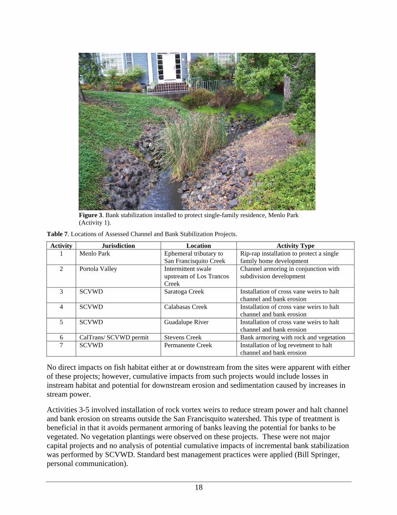
The seven channel and bank stabilization projects observed in the field included installation of rock “vanes” in perennial creeks, log revetments on an intermittent creek, and rip-rap and paving on intermittent creeks and swales (Table 4). Two were apparently installed by private parties to protect residences in the San Francisquito watershed while five were installed by SCVWD on creeks outside the watershed. The goal of visiting projects on creeks outside the watershed was to see the types of treatments that would be used by the SCVWD on San Francisquito Creek when the need arises (Figure 3).
Known mitigation measures applied to these projects included restriction of work to low flow periods, temporary diversion of stream flow away from the construction site, and fish relocation if appropriate. For SCVWD projects, there are specified “best management practices” applied to any bank stabilization (B. Springer, personal communication). Mitigation measures may have been applied to Activity 1 but documentation was not available for review.
Activity 1 may have been installed by a landowner. It is uncertain if a permit was required or obtained (Figure 3). Activity 2 involved hardening an intermittent swale to prevent erosion and facilitate installation of roads and homes in a subdivision (Figure 4). The swale was armored upstream and downstream of a culvert with small rock and concrete and the crossing was constructed to act as a debris basin in case of a debris flow from unstable areas upslope. This activity was undertaken as part of the subdivision and was subject to environmental review.
18
Figure 3. Bank stabilization installed to protect single-family residence, Menlo Park (Activity 1).
Table 7. Locations of Assessed Channel and Bank Stabilization Projects.
Activity Jurisdiction Location Activity Type 1 Menlo Park Ephemeral tributary to
San Francisquito Creek Rip-rap installation to protect a single family home development
2 Portola Valley Intermittent swale upstream of Los Trancos Creek
Channel armoring in conjunction with subdivision development
3 SCVWD Saratoga Creek Installation of cross vane weirs to halt channel and bank erosion
4 SCVWD Calabasas Creek Installation of cross vane weirs to halt channel and bank erosion
5 SCVWD Guadalupe River Installation of cross vane weirs to halt channel and bank erosion
6 CalTrans/ SCVWD permit Stevens Creek Bank armoring with rock and vegetation 7 SCVWD Permanente Creek Installation of log revetment to halt
channel and bank erosion No direct impacts on fish habitat either at or downstream from the sites were apparent with either of these projects; however, cumulative impacts from such projects would include losses in instream habitat and potential for downstream erosion and sedimentation caused by increases in stream power.
Activities 3-5 involved installation of rock vortex weirs to reduce stream power and halt channel and bank erosion on streams outside the San Francisquito watershed. This type of treatment is beneficial in that it avoids permanent armoring of banks leaving the potential for banks to be vegetated. No vegetation plantings were observed on these projects. These were not major capital projects and no analysis of potential cumulative impacts of incremental bank stabilization was performed by SCVWD. Standard best management practices were applied (Bill Springer, personal communication).

19
Figure 4. Rock-lined swale, Blue Oaks subdivision, Portola Valley.
Activity 3 was the installation of five rock vortex weirs in a reach where existing bank stabilization structures were failing (Figure 5). Boulders were keyed in without use of mortar or cables and some weirs created downstream scour pools. Activity 4 involved installation of a cross vane weir as a mitigation for unintended impacts associated with installation of gabion
Figure 5. One of five weirs installed to reduce bank erosion and incision on Saratoga Creek. This type of treatment is being applied by SCVWD as an alternative to typical bank stabilization approaches.

20
baskets throughout the reach in 1998. Impacts from the earlier project included a permanent reduction in riparian vegetation (although re-vegetation was done downstream) and incision. If the rock weir installation is successful, the incision may be reversed. Activity 5 was the installation of four cross vane weirs secured with mortar. Notches were made in the weirs to allow fish passage. Upstream deposition may have occurred and detrimentally affected instream habitat.
SCVWD commonly uses weirs as an alternative to conventional bank protection. Figure 6 illustrates a successful project of this type undertaken by SCVWD on Thompson Creek. Observations indicate that they perform well for grade control upstream of the weir and can reduce downstream bank scour. They need to be closely spaced to minimize downstream scour (J. Owens, personal communication). They also seem to cause some localized bank scour upstream, reinforcing a need for measures to prevent the creek from migrating around the structure(s) (J. Owens, personal communication).
Figure 6. Cross vane weirs promoting deposition and channel narrowing, Thompson Creek. This SCVWD project is about three years old (photograph courtesy of J. Owens).
Activity 6 entailed removing a failed section of sacked concrete, laying back banks, installing large rock, and re-vegetating the slope to protect a nearby state highway. This project improved instream habitat by reducing the amount of hardened bank and restoring a natural bank angle. It also increased vegetation in the riparian area (Figure 7).

21
Figure 7. Bank stabilization and re-vegetation project applied to failing freeway embankment, Stevens Creek.
Activity 7 was the installation of two large logs to shore up an eroding section of creek bank within 10 feet of a private home. The logs should stabilize a large tree that might have been undermined in future high flows. Although the treatment avoided permanent hardened surfaces and may provide some cover for aquatic habitat, the logs may deflect flow and energy and cause bank erosion downstream (Figure 8).
Figure 8. Log installation to prevent bank erosion, Permanente Creek. SCVWD uses prescriptive guidelines for all projects involving placement of large wood in streams.

22
Storm Water Management All development projects (residential, commercial or industrial) that increase impervious surfaces have the potential to modify stream flow, cause erosion, exacerbate flooding, and impair water quality. Storm water pollution prevention regulations are implemented by each jurisdiction. Four projects involving management of storm water were reviewed (Table 8).
Table 8. Locations of Storm Water Management Projects.
Activity Jurisdiction Location Activity Type 8 Menlo Park Sand Hill Road and San
Francisquito Creek Bioswale and storm water catchment to mitigate road widening
9 Portola Valley Intermittent tributary to Los Trancos Creek
Detention basin to mitigate increase in impervious surfaces due to subdivision development
10 Portola Valley Los Trancos Creek Storm water management at an equestrian center 11 Portola Valley Los Trancos Creek Detention basin installation at recreational field
Activity 8 involved installation of a bioswale to detain and filter storm water in association with the widening of a road. The swale was planted with wetland species. Activity 9 increased the capacity of an old stock pond to serve as a detention basin within a housing subdivision. Water quality impacts were also avoided by restricting the amount of impervious surface and lawn allowed in each lot (see descriptions and photographs for both of these projects in the case studies section of this report). Activity 10 involved re-grading and relocating horse pastures at an equestrian center away from Los Trancos Creek. A rock lined detention basin was constructed to retain flow and improve water quality (Figure 9). Manure is hauled away for disposal. Horse washing pads were moved away from the creek. Activity 11 was construction of a detention basin to mitigate water pollution caused by upgrading of an athletic field.
Figure 9. Rock-lined detention basin and drain, Los Trancos Creek, Portola Valley. This type of storm water management practice is commonly applied to new developments in the watershed by all jurisdictions. It is effective in reducing impacts on peak flows as well as reducing non-point source pollution.
23
All projects seemed reasonably effective at slowing storm water runoff, decreasing sedimentation, and improving water quality. Activity 11 involved some riparian vegetation clearing to accommodate the basin since the project was retrofit to the original site plan.
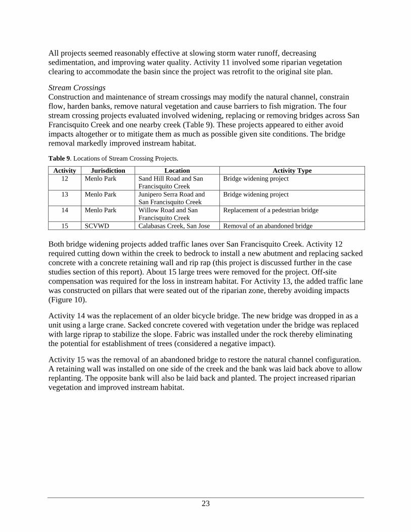
Stream Crossings Construction and maintenance of stream crossings may modify the natural channel, constrain flow, harden banks, remove natural vegetation and cause barriers to fish migration. The four stream crossing projects evaluated involved widening, replacing or removing bridges across San Francisquito Creek and one nearby creek (Table 9). These projects appeared to either avoid impacts altogether or to mitigate them as much as possible given site conditions. The bridge removal markedly improved instream habitat.
Table 9. Locations of Stream Crossing Projects.
Activity Jurisdiction Location Activity Type 12 Menlo Park Sand Hill Road and San
Francisquito Creek Bridge widening project
13 Menlo Park Junipero Serra Road and San Francisquito Creek
Bridge widening project
14 Menlo Park Willow Road and San Francisquito Creek
Replacement of a pedestrian bridge
15 SCVWD Calabasas Creek, San Jose Removal of an abandoned bridge Both bridge widening projects added traffic lanes over San Francisquito Creek. Activity 12 required cutting down within the creek to bedrock to install a new abutment and replacing sacked concrete with a concrete retaining wall and rip rap (this project is discussed further in the case studies section of this report). About 15 large trees were removed for the project. Off-site compensation was required for the loss in instream habitat. For Activity 13, the added traffic lane was constructed on pillars that were seated out of the riparian zone, thereby avoiding impacts (Figure 10).
Activity 14 was the replacement of an older bicycle bridge. The new bridge was dropped in as a unit using a large crane. Sacked concrete covered with vegetation under the bridge was replaced with large riprap to stabilize the slope. Fabric was installed under the rock thereby eliminating the potential for establishment of trees (considered a negative impact).
Activity 15 was the removal of an abandoned bridge to restore the natural channel configuration. A retaining wall was installed on one side of the creek and the bank was laid back above to allow replanting. The opposite bank will also be laid back and planted. The project increased riparian vegetation and improved instream habitat.
24
Figure 10. Bridge expansion project on San Francisquito Creek, Junipero Serra Boulevard. The project entirely avoided the riparian zone. Extensive erosion control measures were applied at the periphery of the excavated area.
These were major projects that involved extensive soil disturbance. Mitigation measures included construction during the dry season, trucking of spoils off site, and installation of silt fences and concrete blocks around the disturbed areas closest to the creek. Work on live streams required diversion of stream flow around the construction area, relocation of any resident aquatic vertebrates, installation of gravels in the stream bed to reduce compaction, and minimum flows to maintain aquatic habitat.
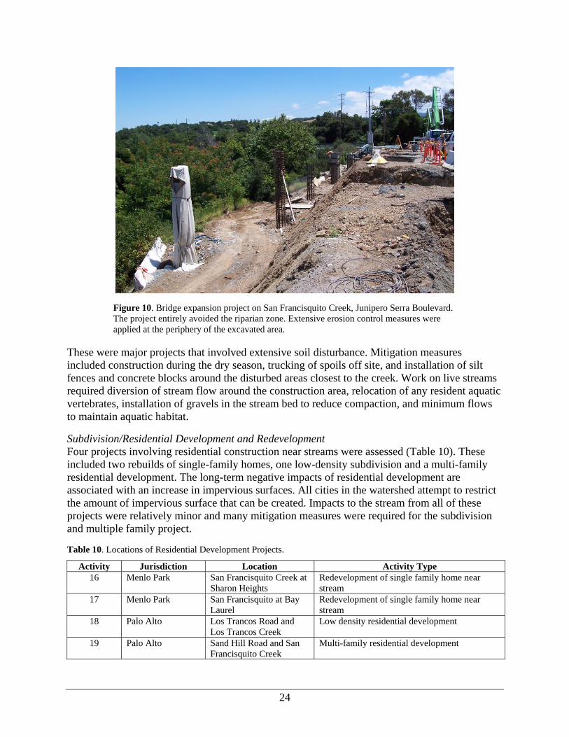
Subdivision/Residential Development and Redevelopment Four projects involving residential construction near streams were assessed (Table 10). These included two rebuilds of single-family homes, one low-density subdivision and a multi-family residential development. The long-term negative impacts of residential development are associated with an increase in impervious surfaces. All cities in the watershed attempt to restrict the amount of impervious surface that can be created. Impacts to the stream from all of these projects were relatively minor and many mitigation measures were required for the subdivision and multiple family project.
Table 10. Locations of Residential Development Projects.
Activity Jurisdiction Location Activity Type 16 Menlo Park San Francisquito Creek at
Sharon Heights Redevelopment of single family home near stream
17 Menlo Park San Francisquito at Bay Laurel
Redevelopment of single family home near stream
18 Palo Alto Los Trancos Road and Los Trancos Creek
Low density residential development
19 Palo Alto Sand Hill Road and San Francisquito Creek
Multi-family residential development

25
Activities 16 and 17 were the rebuilding of single-family homes on existing lots. Construction related impacts at the first site were mitigated by erosion control measures, including use of straw bales and rolls and long-term effects on hydrology were mitigated in part by installation of permeable pavement. No preventative measures of this nature were apparent at the second site.
Activities 18 and 19 involved subdivision and eventual construction of eight new homes and a multi-family residential project subject to conditional use permit. These projects went through extensive environmental review and had numerous mitigation measures applied. The low-density subdivision dedicated more than half of the site to open space (both of these projects are discussed at greater length in the case studies section of this report). The amount of impervious surface in the subdivision was controlled by stipulations on maximum lot coverage. Future homeowners will be required to control runoff on their lots by connecting roof drains to a pipe that flows to a dissipater. Los Trancos Creek was completely avoided. Activity 19 avoided impacts with setbacks from the stream, a riparian buffer and fencing. Some eucalyptus trees were removed to improve the composition of the riparian vegetation. The primary impacts to the creek will probably come from increased human incursion due to increased use of a pre-existing path that was relocated to the riparian zone as part of the project.
Vegetation Management and Channel Clearing Vegetation management along streams may lead to chronic removal of riparian vegetation, thereby decreasing shading of the stream and increasing stream temperature. Removal of downed trees from the channel also deprives it of structure that enhances fish habitat. Most jurisdictions routinely remove or modify large wood in streams to protect critical infrastructure including bridges and culverts and to avoid destabilizing streambanks. Two examples of vegetation management along streams were reviewed (Table 11).
Table 11. Locations of Vegetation Management and Channel Clearing Projects.
Activity Jurisdiction Location Activity Type 20 Palo Alto San Francisquito Creek at El
Palo Alto Park Vegetation management in city park
21 SCVWD Saratoga Creek Debris clearing from stream At Activity 20, the City and volunteers removed invasive ivy and planted native species within a well-used park. Management of an adjacent fenced riparian buffer along the stream is more passive however. Some planting occurs there to mitigate vegetation impacts incurred elsewhere. Some minor gaps in the riparian canopy were created by removal of hazardous or dead trees.
At Activity 21, a dead tree that had fallen into the creek was cut into two-foot lengths and left on the banks by SCVWD staff (Figure 11). This practice occurs in cases where trees may obstruct flows, cause erosion or pose a hazard. On creeks with anadromous salmonids under SCVWD jurisdiction (not Saratoga Creek) removal of large wood from the stream must be compensated for by placement of wood at another location on a 1:1 basis (B. Springer, personal communication).

26
Figure 11. Woody debris management, Calabasas Creek. Under SCVWD practices, large pieces of wood that fall into the stream or trees whose failure is imminent are cut into smaller pieces and either left on the banks or in the stream. Other jurisdictions probably use the same practices as the need arises. Note compensatory tree planting required in conjunction with channel work upstream.
It should be noted that on San Francisquito Creek woody debris management is reviewed annually during a “creek walk” conducted by the JPA. The Watershed Council participates in these walks. Consideration is given to the ecological impacts of debris removal while balancing the needs for maintaining flood conveyance capacity. See the discussion of this year’s creek walk, below.
Road Maintenance and Slope Stabilization Road maintenance procedures and areas of slope instability have the potential to add chronic sources of sediment to streams. Activity 22 involved regular maintenance of a lightly used unsurfaced road in a City park located high in the watershed. Although the road required regular maintenance, very little sediment reached the stream because of the topography of the site. One unmitigated impact was reduction in riparian vegetation due to roadside brushing within 20 feet of the stream. Activity 23 involved slope stabilization in association with road upgrading in a subdivision. The slope had been identified as an eroding area delivering sediment to the stream. The failing slope was excavated, perched material was removed, and the slope was covered with rip-rap. The project reduced sediment delivery to the stream and retained the meander in the channel (Figure 12).
Table 12. Locations of Road Maintenance/Slope Stabilization Projects.
Activity Jurisdiction Location Activity Type 22 Palo Alto Buckeye Creek, tributary to
Los Trancos Creek Road maintenance in Foothills Park
23 Portola Valley Intermittent tributary to Los Trancos Creek
Stabilization of eroding slope during road and subdivision development

27
Figure 12. Slope protection applied to unstable area along access road, Blue Oaks subdivision, Portola Valley.
Water Quality Monitoring City staff responded to a homeowner who observed discolored stream flow in an intermittent stream. A spill of some kind of contaminant adversely affected water quality. The city tried to locate the pollution source to abate the problem, but could not find the polluters. All cities in the watershed monitor water quality and illicit discharges as part of their NPDES permit.
Table 13. Locations of Water Quality Monitoring Projects.
Activity Jurisdiction Location Activity Type 24 Menlo Park Intermittent tributary to San
Francisquito Creek Abatement of pollution spill into creek
Joint Powers Authority Annual Creek Walk As mentioned earlier in this report, every year before the winter rains the JPA coordinates a “creek walk” with its member jurisdictions. The purpose of this is to identify potential obstructions to flood flow or other impairments to flood conveyance capacity. Depending on location and responsibility, the member jurisdictions then take action to solve the problem. In 2005, the JPA annual creek walk identified the following types of problems involving obstruction of flood conveyance capacity in San Francisquito Creek:
• Trash and/or debris: 20 instances • Encampments: 2 instances • Fallen trees or limbs: 11 instances • Live vegetation: 3 instances • Undermined fence posts: 1 instance

28
The recommendations for trash and debris were to remove it from the channel. Encampments were to be investigated and posted. Fallen trees and limbs were recommended for cutting to eight-foot segments and/or assessed for stability. In the case of live vegetation, for exotics (i.e., eucalyptus) the recommendation was to cut and spray stumps. Native vegetation (i.e., willows) was recommended for trimming to reduce flow obstructions. In the one case of undermined fence posts, the landowner was to be contacted to take appropriate action.
According to the JPA, this year’s creek walk revealed more instances of trash but otherwise, the problems encountered and solutions were typical.
Synthesis and Conclusions The field review revealed few instances of negligence or serious impacts on fish habitat. On the contrary, several beneficial practices to prevent impacts on habitat, non-point source pollution and hydrologic processes were observed. Use of instream structures by SCVWD as an alternative to conventional bank stabilization is considered particularly noteworthy.
Two concerns derive from this review. First, treatments to prevent impacts on re-developed parcels were inconsistent, even within the same jurisdiction. That could be due to a lack of regulatory “nexus” to require mitigation measures, specific site conditions or other reasons. This same observation was made in the “drive-by” survey of re-development in the watershed, discussed in a following section.
The second concern applies to bank stabilization. A wide variety of approaches are used to reduce bank erosion. Although SCVWD is utilizing innovative approaches, that may not be true where projects are undertaken with or without permits by private landowners. This issue is currently being addressed by the preparation of “bank stabilization” master plans for at least some streams (main stem and Corte Madera Creek). The JPA currently has an assigned staff person who consults with landowners on bank stabilization if a permit is involved.

29
Case Studies San Francisquito Levee Project Project Description San Francisquito Creek has a history of flooding, consequently, provisions for flood protection, including floodwalls and levees have been constructed through much of the urbanized lower section of the creek (Figure 13). Flooding in the late 1990’s revealed deficiencies in flood protection, especially in the lower-most reaches below Highway 101.
Figure 13. Floodwall along San Francisquito Creek, East Palo Alto.
A project to restore flood protection in the lower reaches was undertaken by the SCVWD on behalf of the JPA. In September 2000, the JPA requested that SCVWD restore levees along San Francisquito Creek downstream from Highway 101 to their as-built (1958) elevations. Levee height had been reduced by 0.5 to 2.6 feet due to land subsidence, settlement, and erosion. In addition, sedimentation had reduced the flood conveyance capacity of the channel. Overall, channel capacity had been reduced from accommodating flows up to 7100 cubic feet/second (cfs) to an impaired capacity of 3600-4000 cfs.
There were actually two components to the project. Upstream of Highway 101, approximately 1370 feet of floodwall was reconstructed or modified. This required construction within the channel and temporary de-watering of the creek. Downstream of Highway 101, levees were raised in a reach about 4400 feet long (8800 total treated stream length, including both sides). Several alternatives were considered for the downstream reach. The chosen alternative involved raising the existing earth levees with a 2:1 side slope. On the San Mateo County side of the creek, to maintain adequate top width for a maintenance road, one side of the levee (landward side) was cleared of vegetation and the levee footprint was expanded. On the Santa Clara County side of the creek, reinforced earth was used to increase the levee height with no increase in the levee footprint. All work downstream of Highway 101 was accomplished outside of the stream channel.

30
Required Permits Permits for the project were required from the US Army Corps of Engineers (404 permit), Regional Water Quality Control Board (Waiver of Waste Discharge), and California Department of Fish and Game (Section 1601 Streambed Alteration Agreement). Requirements of these permits included incorporation of mitigation measures to offset adverse effects on water quality or biological resources.
SCVWD implements stream protection best management practices when it undertakes capital projects such as this one. These practices are extensive and include measures to prevent water quality degradation and damage to instream habitat.
Since the project is within the jurisdiction of two counties and two cities, the policies of these entities regarding environmental protection, flood management, tree removal, etc. also applied.
Environmental Documentation Project documentation, including environmental review, is provided in a report dated April 2002 (Santa Clara Valley Water District 2002). That document was the primary source of information for this case study review. In addition, the authors and Watershed Council staff visited the project site in June 2005. A website containing information about the project was also consulted.
No significant impacts were identified in the Initial Study and Mitigated Negative Declaration (Santa Clara Valley Water District 2002). Specifically, the Initial Study states: “The levee restoration portion of the project will not result in direct removal of critical habitat or riparian vegetation. The project will not occur within the creek bed and thus will not have an adverse effect on fish species” (p. 3-12). The project occurred outside of the period during which steelhead migrate up the creek (November-May). In regard to native tree species, the following mitigation measure was incorporated into the project: “Removal of existing native trees shall be prohibited unless the tree is demonstrated to be unhealthy, diseased or unsafe by a qualified arborist, or is less than 11.5 inches in diameter” (p. 3-21).
For the floodwall reconstruction component of the project, limitations on timing and requirements for restoration of the stream bed after construction were cited as mitigations for potential significant impacts.
The proposed levee height restoration was predicted to increase flood stage upstream of Highway 101. The floodwall reconstruction to a higher elevation was mitigation for those effects.
Tables MMRP-1 and MMRP-2 in the Initial Study list all proposed best management practices and mitigation measures incorporated into the project.
Analysis The planning and execution of this project clearly demonstrate a concern for anadromous fish and their habitats. Inspection of the project site after completion revealed no evidence of significant environmental impacts on either the stream or associated riparian vegetation (Figure 14).

31
Figure 14. Levee on San Francisquito Creek, downstream from Highway 101. Raising the levee had minimal effect on riparian vegetation or instream habitat. Note retaining wall to left of maintenance road that was used to raise the height.
There were several key mitigation measures or best management practices that contributed to the successful implementation of this project. For the levee restoration component, the avoidance of disturbance in the creek bed and the limitation on construction to the period of June 15 to October 15 were most important for avoiding impacts on steelhead. Temporal limitations and requirements to salvage aquatic vertebrates during dewatering were important for the floodwall reconstruction component. There was also a requirement to restore the channel bottom after floodwall construction.
Limitations on removal of riparian vegetation also helped minimize environmental impacts. These included restrictions on tree removal, protection of trees during construction and replanting of vegetation that was unavoidably lost.
Although construction was confined to the dry season, mitigation measures to prevent entry of debris, soil, silt or construction materials into the stream were applied. These included silt fences and straw bales. No storage or fueling of equipment on the levee was permitted.
Conclusions This project illustrates a benign approach to what has often been a problem for fisheries. It shows how a flood management project can be designed to achieve flood protection while minimizing impacts to riparian vegetation and instream habitat. In general, the SCVWD implements fish-friendly practices in both its construction and maintenance procedures. For example, maintenance plans avoid large-scale vegetation clearing or sediment removal whenever practicable.

32
Sand Hill Road Developments Project Description Over the past several years, Stanford University has undertaken or sponsored a number of projects along Sand Hill Road within the city of Palo Alto. These have included the Stanford West Apartments (600+ units on a 47.8 acre parcel adjacent to San Francisquito Creek), Stanford West Senior Housing (388 living units and health care center on a 22.3 acre site adjacent to San Francisquito Creek), expansion of the Stanford Shopping Center (an addition of about 80,000 square feet of retail space and associated parking) and extension and widening of Sand Hill Road, including enlargement of an existing bridge over San Francisquito Creek. The city of Palo Alto determined that it was appropriate to consider the environmental impacts of all these projects within a single Environmental Impact Report (EIP Associates 1998). That report was certified by the city in July 1998. The projects have either been completed or are in the final stages of completion at this time.
Required Permits In addition to land use permits required by the city, these projects required permits from the US Army Corps of Engineers (404 permits), Regional Water Quality Control Board (Waiver of Waste Discharge), California Department of Fish and Game (Section 1602 and 1603 Streambed Alteration Agreements), California Department of Transportation and the SCVWD. The city of Menlo Park also had jurisdiction for some project components. The only project that directly affected fish habitat was the replacement of the existing bridge over San Francisquito Creek. Otherwise, all of the projects avoided development near the creek so that direct impacts did not occur.
Environmental Documentation The environmental documentation and associated planning reports and analysis for these projects were extensive. The environmental impact report alone comprised four volumes. This review was confined to the following documents or sections thereof: 1) certified EIR, chapters 4.7 (biological resources), 4.8 (geology, soils and seismicity), 4.9 (hydrology and water quality), 5.5 (significant unavoidable impacts); 2) Palo Alto city manager’s and planning commission staff reports on the projects; 3) city of Palo Alto conditions for approval of Stanford West Apartments, Senior Housing and Sand Hill Road extension; 4) Sand Hill Road Projects Construction Management Plan; 5) 404 permit and Stream Alteration agreement conditions for the Sand Hill Road bridge replacement; and 6) miscellaneous excerpts from staff reports regarding the policy implications of the projects. All sites were also reviewed in the field.
The most concise expression of the effects of these projects is contained in chapter 5.5 of the certified EIR. All projects were predicted to cause cumulative adverse effects on aquatic life in San Francisquito Creek by increasing runoff and non point source urban pollutant loads (p. 5.5-4; 5.5-5). The Stanford West Apartments and Senior Housing were predicted to increase human access to the creek, thereby increasing the likelihood of damage to riparian habitat (p. 5.5-4). Predicted hydrologic impacts of the projects included increased sediment delivery to San Francisquito Creek during construction and increased frequency and severity of downstream flooding due to increased impervious surface (p. 5.5-5).
Direct impacts of these projects on fish habitat were limited. Only the widening of the bridge on Sand Hill Road had a direct effect on the creek and its riparian vegetation. Approximately one

33
third of an acre of riparian vegetation was removed to enable construction (p. 4.7-52). The new road alignment was initially proposed to be within 60 feet of the creek (p. 4.7-53) but was subsequently moved to be at least 100 feet from the creek. Most disturbance stemmed from construction within the streambed. Also, permanent habitat changes occurred because banks were armored to prevent undermining of the structure. The banks had been armored with sacked concrete before the project, however, so this was an incremental change rather than an entirely new impact (Figure 15).
Figure 15. Re-constructed bridge on Sand Hill Road over San Francisquito Creek.
Many mitigation measures were included in these projects to offset adverse impacts. For the Stanford West Apartments these were:
• Requirement to retain a “creek restoration specialist” to oversee mitigation measures aimed at minimizing impacts on San Francisquito Creek and its riparian vegetation.
• Incorporation of best management practices for storm water pollution prevention. • Setbacks from the creek and mitigations for reducing possible effects of increased human
intrusion. • On-site detention facilities designed to detain increased runoff during a 100-year flood
event resulting from new impervious surfaces. • Permanent protection of open space lying between apartment buildings and the creek
(formal zoning designation as Streamside Open Space). For the Senior Housing, mitigations were:
• Provision of a detention pond to reduce impacts on downstream flooding. • Incorporation of best management practices for storm water pollution prevention. • Building setbacks of at least 100 feet from San Francisquito Creek.

34
Because the Sand Hill Road improvements and specifically, the replacement of the bridge over San Francisquito Creek had the greatest potential to adversely affect fish habitat, mitigation requirements were extensive. In addition to changing the alignment of the road to achieve a 100-foot minimum setback from the creek, the following measures were incorporated into the project:
• Use of innovative storm drainage facilities including curb cuts to divert runoff to a vegetated swale before discharge to the creek (Figures 15 and 16).
• Requirement for the preparation and implementation of a Storm Water Pollution Prevention Plan to minimize construction-related water quality impacts.
• Requirement to minimize changes to the stream channel and to conduct hydraulic analysis of proposed changes to determine potential for downstream erosion.
• Restoration of channel bed and banks after construction and assurance that obstacles to steelhead migration were not created.
• Retaining a creek restoration specialist, hydrologist and arborist to oversee implementation of mitigation measures and riparian plantings.
Figure 16. Vegetated swale along Sand Hill Road. Road runoff is diverted to the swale through curb cuts (see Figure 17). The swale drains to a catch basin before entering San Francisquito Creek.

35
Figure 17. Curb cut in Sand Hill Road.
The Department of Fish and Game and US Army Corps of Engineers required a number of mitigation measures including the following:
• Construction was limited to the period of June 1 to October 15 during periods of low or no flow or predicted precipitation.
• Requirements for re-vegetation of disturbed areas and monitoring to ensure survival. • Diversion of stream flow around the work site and relocation of aquatic vertebrates. • Backfilling rock rip-rap with soil to enhance re-vegetation.
In addition, off-site mitigation was required to compensate on a 1:1 basis for lost habitat. Mitigation entailed removal of a concrete low water crossing on San Francisquito Creek, restoration of channel and bank habitat, construction of fish passage facilities and riparian restoration (nearly an acre).
Analysis The visibility of the Sand Hill development projects and the public scrutiny they received caused the environmental review process to extend over two years. A major issue was the potential effects of these projects on San Francisquito Creek. The projects were modified over time to address this issue. The results included liberal setbacks from the creek in the cases of the Stanford West Apartments and Stanford Senior Housing. Outside expertise was retained to help implement required mitigation measures. The only potential impact that may remain for those projects is the long-term effect of increased human uses in the riparian zone and in the stream itself. Specifically, the re-location of a path on the Stanford West site into the riparian zone will encourage increased human use of the area.

36
For the Sand Hill Road project, the re-construction of the bridge over San Francisquito Creek has caused permanent changes in the creek due to bank armoring to protect the structure. This is a localized impact and it was compensated for by off-site restoration. Requirements for assessing effects of the bridge replacement on downstream erosion probably offset any off-site effects. Observations in the field indicated that erosion control measures taken during construction were probably adequate. Also, there were mitigation measures applied to replace riparian vegetation lost due to construction.
Conclusions With the exception of the Sand Hill Road bridge replacement, none of the Sand Hill development projects caused changes to fish habitat or riparian vegetation. The environmental review process and subsequent planning and approval processes for the projects were sufficiently robust to minimize impacts.
Los Trancos Road Subdivision Project Description This project was located in the city of Palo Alto on land bordering Foothills Park. The Los Trancos Road subdivision initially proposed to divide a 151-acre hillside parcel into eight lots ranging in size from 10.29 to 34.86 acres each. As approved, it consisted of eight lots of five to nearly 10 acres each comprising 59 acres and 88.5-acre open space lot. A building envelope was designated on each lot for housing construction. Two-story houses up to 10,000 square feet in size could be constructed within these envelopes. A pre-existing unpaved road was improved to provide access. At the time of this review, access road construction had been completed and re-vegetation of disturbed areas was in progress but no housing construction had commenced (Figure 18).
Figure 18. Building site and re-vegetation of graded area on Los Trancos Road subdivision (May 2005).

37
Required Permits This project required tentative and final subdivision map approvals from the city of Palo Alto. Future housing construction will be subject to site and design review by the city. Since on-site wastewater disposal is proposed, permits for septic systems must be obtained from the Santa Clara County Department of Environmental Health Services. Available documentation does not indicate if additional permits were required from other agencies.
Environmental Documentation Documentation available for this project included “Los Trancos Road Subdivision EIR: Draft Environmental Impact Report” dated June 1997; “Los Trancos Road Subdivision Final EIR: Response to Comments on the Draft EIR” dated October 1997; a “Storm Drain Assessment Report” dated August 2003; and a “Storm Water Pollution Prevention Plan” dated October 2002 and updated in September 2003. In addition, an annotated list of development conditions for approval was available.
A portion of this project site is bordered by Los Trancos Creek. An intermittent stream called Buckeye Creek traverses the site, No construction or development activities were proposed near Los Trancos Creek. Impacts on Buckeye Creek were minimized by requirements to restore illegally filled portions of it and avoid further disturbance. No significant impacts on the streams or riparian zones were observed in the field.
The EIR did identify several impacts on hydrology and water quality. Impacts considered significant included “a significant increase in downstream peak flow rates from Sub-watershed 3.” Increased peak flows were predicted because of the increased amount of impervious surface associated with the development. The EIR assumed up to 200,000 square feet of impervious surface. Considering the size of the project site (151 acres) this would be a very small change in watershed conditions. Calculations in the Draft EIR indicated that peak flows during 10-year and 100-year design storms would increase by one cubic foot/second and 2.2 cubic feet/second, respectively in Sub-watershed 3. The 10-year estimate was revised upward in the Final EIR Response to Comments. This sub-watershed happened to be one that had deficient storm drainage facilities.
Solutions suggested in the EIR for the potential increase in downstream peak flows included: 1) construction of a retention basin and improvement of an existing culvert; or 2) removal of unauthorized fill from Buckeye Creek and changes in access and lot layout. The latter alternative was chosen and no retention basin was required as a condition of approval.
The EIR identified the potential for erosion and sediment delivery to Los Trancos Creek and San Francisquito Creek during grading and construction. Several mitigation measures were suggested. The project applicant prepared a “Storm Water Pollution Prevention Plan” (Mark Thomas and Co., Inc., 2002) that contains prescriptive guidance for reducing impacts on water quality.
Conditions on approval included many provisions for protection of streams and riparian resources such as erosion control measures, re-location of leach fields from steep slopes, construction staging away from riparian zones and protection of existing trees.

38
Analysis It was evident from the environmental documentation that this project was controversial. Since there were no direct impacts on fish or their habitats, the only potential adverse effects were associated with changes in hydrology or water quality. Review of the Storm Water Pollution Prevention Plan for the project indicated that there were many provisions for mitigating these impacts. There were also some project features such as sediment basins on the main access road (Figure 19) and rock-lined ditches along the emergency access road (Figure 20) that would reduce water quality impacts. Also, the access road was built almost entirely with full-bench construction, minimizing road fill. Excavated materials were either used elsewhere on the site or transported for disposal off-site.
Conclusions Considering the low density of this project, the environmental review process and requirements for mitigation were exceptional. There were no direct impacts on Los Trancos Creek and impacts on Buckeye Creek were minimized. Provisions for managing hydrologic and water quality impacts avoided indirect effects on fish habitats.
Figure 19. Sediment trap along access road to Los Trancos Road subdivision.

39
Figure 20. Rock-lined inboard ditch along emergency access road, Los Trancos Road subdivision. This treatment pre-dated the subdivision.
Blue Oaks Subdivision Project Description The Blue Oaks Subdivision is located in Portola Valley, on Los Trancos Road. The site is bordered on the west by Corte Madera Creek and on the east by Los Trancos Creek, both of which potentially support steelhead. It is traversed by the north and south forks of Buck Meadow Creek, an intermittent stream. As approved, the project was a 31-lot subdivision on a 264-acre hillside parcel. Nearly 200 acres were contained within a single open space parcel. For each lot, the maximum allowable coverage, i.e., impervious surface area, was limited to 10,000 square feet. The on-site road system constituted an additional 6.05 acres. At the time of this review, most on-site improvements had been made, some housing had been constructed and other houses were under construction (Figure 21).
Required Permits The project required a general plan amendment, planned unit development approval and subdivision map approval from the Town of Portola Valley. Each house would require a building permit, subject to the restrictions imposed on the entire development with respect to design. Permits were also required from the U.S. Army Corps of Engineers (Section 404 permit), Department of Fish and Game (1603 Stream Alteration Agreement) and Regional Water Quality Control Board (Construction Activity Storm Water Permit).

40
Figure 21. Recently constructed house and drainage control retention basin, Blue Oaks subdivision.
Environmental Documentation The environmental documentation for this project was extensive. It included “Blue Oaks Subdivision: Revised Draft Environmental Impact Report” dated March 1994; “Blue Oaks Subdivision: Final Environmental Impact Report, Comments and Responses Addendum” dated September 1994; various comments and environmental submittals by the project sponsor; “Storm Water Pollution Prevention Plan and Monitoring Program for Blue Oaks Subdivision” dated May 1998; “Report to the Portola Valley Planning Commission on the Proposed Blue Oaks Project” dated March 1995; and “Blue Oaks Project Approved by Portola Valley Town Council” dated June 1996.
As previously noted, the site is bordered by Corte Madera and Los Trancos Creeks and traversed by Buck Meadow Creek. It also contains an impoundment called Buck Meadow Pond and two other ponds. According to the Draft EIR, no construction activities were proposed within 50 feet of either Corte Madera or Los Trancos Creeks (Nichols and Berman 1994). Portions of Buck Meadow Creek were affected by access road construction and slope stability improvements. Buck Meadow Pond was enlarged to provide on-site storm drainage retention. Many of the issues related to the development were concerned with geologic hazards, including the presence of landslides and the San Andreas Fault.
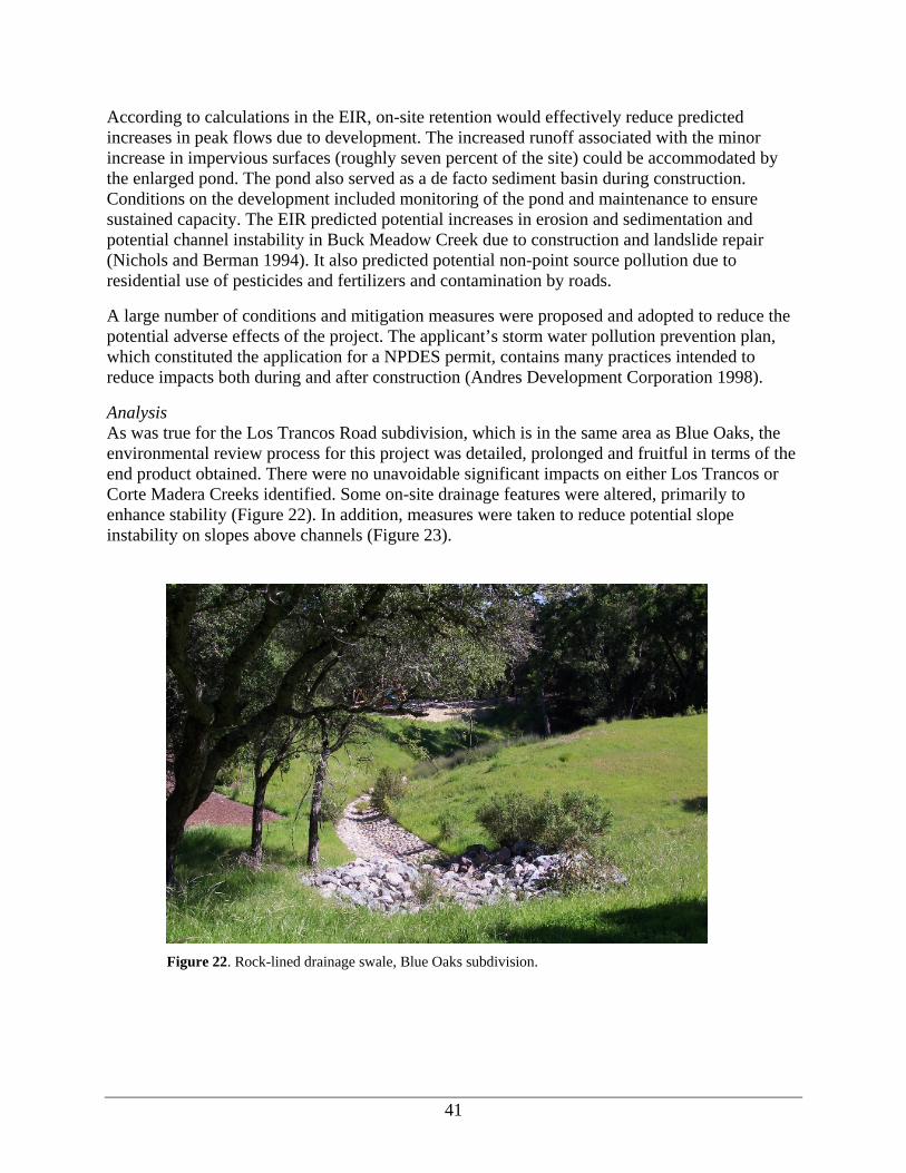
41
According to calculations in the EIR, on-site retention would effectively reduce predicted increases in peak flows due to development. The increased runoff associated with the minor increase in impervious surfaces (roughly seven percent of the site) could be accommodated by the enlarged pond. The pond also served as a de facto sediment basin during construction. Conditions on the development included monitoring of the pond and maintenance to ensure sustained capacity. The EIR predicted potential increases in erosion and sedimentation and potential channel instability in Buck Meadow Creek due to construction and landslide repair (Nichols and Berman 1994). It also predicted potential non-point source pollution due to residential use of pesticides and fertilizers and contamination by roads.
A large number of conditions and mitigation measures were proposed and adopted to reduce the potential adverse effects of the project. The applicant’s storm water pollution prevention plan, which constituted the application for a NPDES permit, contains many practices intended to reduce impacts both during and after construction (Andres Development Corporation 1998).
Analysis As was true for the Los Trancos Road subdivision, which is in the same area as Blue Oaks, the environmental review process for this project was detailed, prolonged and fruitful in terms of the end product obtained. There were no unavoidable significant impacts on either Los Trancos or Corte Madera Creeks identified. Some on-site drainage features were altered, primarily to enhance stability (Figure 22). In addition, measures were taken to reduce potential slope instability on slopes above channels (Figure 23).
Figure 22. Rock-lined drainage swale, Blue Oaks subdivision.

42
Figure 23. Slope stability enhancement on access road to Blue Oaks subdivision.
During construction, prescribed erosion control measures were implemented to ensure against sediment delivery to streams. These included the use of straw bales, straw rolls and immediate re-vegetation after grading. Culvert outfalls were armored to prevent development of gullies (Figure 24).
Figure 24. Armored outfall on cross drain, Blue Oaks subdivision.
The only significant problem observed on the site was at a community facility construction site. Grading had initiated a landslide and remedial treatment will be required (Figure 23).

43
Figure 25. Slope instability at construction site, Blue Oaks subdivision.
The EIR for the Blue Oaks project included an assessment of cumulative effects on hydrology and water quality in the Los Trancos watershed. It considered all possible development within the watershed (approximately 150 residential units). It concluded that there could be cumulative impacts on flooding and water quality in Los Trancos Creek and as far as San Francisquito Creek. Mitigation measures implemented on this project as well as the Los Trancos Road subdivision, discussed above, may be adequate to offset at least the contributing impacts from those projects.
Conclusions This case study illustrates that a rigorous environmental review process can be a vehicle for identifying and avoiding significant impacts to fish habitat. The provisions for storm water pollution prevention, in particular, have both direct and indirect benefits, especially in relation to avoiding cumulative impacts.
Glenoaks Equestrian Center Project Description This project involved the improvement of an existing commercial boarding stable located on Alpine Road in Portola Valley. Improvements included renovation of a stable building, construction of a new stable, installation of a riding ring, new horse shelters and corrals and drainage improvements.
Required Permits The Town of Portola Valley required an amendment to an existing conditional use permit and a variance for this project.

44
Environmental Documentation The project was determined to qualify for a Negative Declaration under CEQA based on an Initial Study conducted by Town staff. Documents reviewed for this case study included the minutes from several Planning Commission meetings, conditions on approval, comments by Town planning staff and letters from concerned citizens and groups. In addition, the site was visited in the development review portion of this study.
Documentation indicates that the approval process for this project was prolonged in part by the Town’s desire to minimize impacts on Los Trancos Creek. There was also an instance of illegal grading. Environmental issues included requirements for setback from the creek, the allowable level of impervious surface, drainage improvements, manure management and riparian zone protection (and restoration). As ultimately approved and built, the project had the following features:
• Minimum 50-foot setback from Los Trancos Creek for all buildings and intensive uses • Construction of a new bridge across Los Trancos Creek for pedestrian and horse traffic to
minimize uncontrolled access to the creek • Daily collection of manure from stalls and paddocks and weekly off-site disposal • Concrete-floored horse washing facilities located away from the creek • Fencing along a portion of Los Trancos Creek • Riparian zone planting with prescribed species within the 50-foot setback. • Incorporation of a retention basin and lined drainage ditch to accommodate increased
runoff In addition to these conditions, requirements for prevention of non-point source pollution and erosion control during construction were also stipulated.
The Town permitted a variance from restrictions on impervious surface due to the unique nature of the project, acknowledging that other stables had similar levels of impervious surface and that the project could not feasibly meet the zoning code.
Analysis The chronology for this project indicated that over four years were required to reach a result satisfactory to the Town. The numerous comments by Town staff and Planning Commission members with respect to impacts on Los Trancos Creek demonstrate a concern for the resource. The final product, as observed in the field, indicated that no significant impacts on Los Trancos Creek occurred during construction or subsequent use (Figure 26).
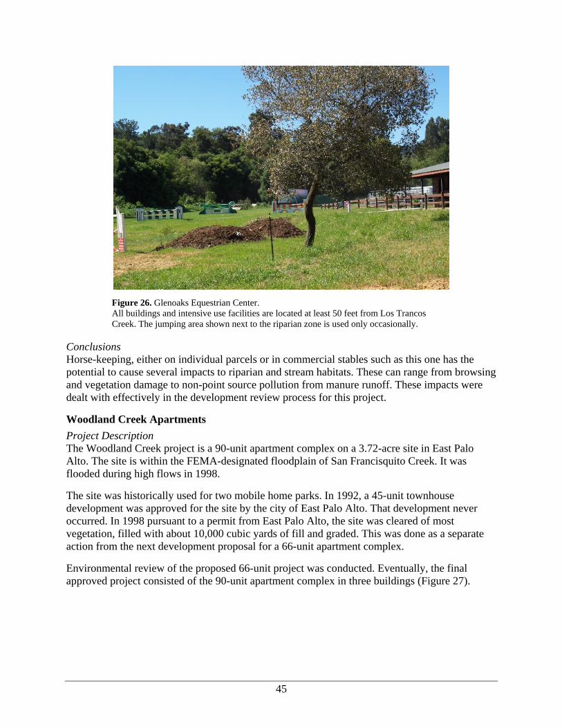
45
Figure 26. Glenoaks Equestrian Center. All buildings and intensive use facilities are located at least 50 feet from Los Trancos Creek. The jumping area shown next to the riparian zone is used only occasionally.
Conclusions Horse-keeping, either on individual parcels or in commercial stables such as this one has the potential to cause several impacts to riparian and stream habitats. These can range from browsing and vegetation damage to non-point source pollution from manure runoff. These impacts were dealt with effectively in the development review process for this project.
Woodland Creek Apartments Project Description The Woodland Creek project is a 90-unit apartment complex on a 3.72-acre site in East Palo Alto. The site is within the FEMA-designated floodplain of San Francisquito Creek. It was flooded during high flows in 1998.
The site was historically used for two mobile home parks. In 1992, a 45-unit townhouse development was approved for the site by the city of East Palo Alto. That development never occurred. In 1998 pursuant to a permit from East Palo Alto, the site was cleared of most vegetation, filled with about 10,000 cubic yards of fill and graded. This was done as a separate action from the next development proposal for a 66-unit apartment complex.
Environmental review of the proposed 66-unit project was conducted. Eventually, the final approved project consisted of the 90-unit apartment complex in three buildings (Figure 27).

46
Figure 27. Woodland Creek Apartments, East Palo Alto. Showing location of structures relative to San Francisquito Creek and floodwall.
Required Permits In addition to permits from the city of East Palo Alto, a permit was required from the SCVWD for activities within 50 feet of the creek. SCVWD also reviewed flood control measures for the project. San Mateo County Flood Control District was also involved in these discussions but it is unknown whether or not it required a separate permit.
The project required a NPDES General Construction Activity Storm Water Permit from the Regional Water Quality Control Board.
Existing documentation does not indicate that permits were required from any other state or federal agency.
Environmental Documentation The documents reviewed for this case study included two binders of correspondence and information available from SCVWD, a Final Supplemental Environmental Impact Report (City of East Palo Alto 1999), and a hydrologic and hydraulic analysis (Brian, Kangas and Foulk 1998).
It should be noted, that many impacts occurred prior to development in 1998 when the site was cleared, filled and graded. Consequently, the proposed project was evaluated in relation to a highly altered “existing condition”. A succinct summary of potential impacts is contained in a staff report prepared for the East Palo Alto Planning Commission, dated October 12, 1999.
One notable finding stated in the staff report was that there were no unavoidable adverse project impacts. SCVWD disputed this finding. Their contention was that increased off-site flooding caused by the project was not mitigated.

47
In an attempt to mitigate flooding both on and off the site, building elevations were raised above the 100-year flood level, a flood-wall was constructed along the creek at the top of the bank and a flow-through path through the project site for floodwaters was created. The flow-through provisions were apparently not implemented (Figure 28). According to SCVWD, despite these measures, there could still be an aggravation of off-site flooding during major events due to the project (B. Springer, personal communication). To this day, the flooding issue has not been resolved.
Figure 28. Woodland Creek Apartments. Showing location of proposed flow-through path designed to accommodate increased runoff from the project. The wall in the center of the photograph will prevent a flow-through path from functioning during high flows,
No significant impacts to San Francisquito aquatic habitat conditions were predicted. Non-point source pollution control was implemented during construction pursuant to the NPDES permit.
Analysis Comments on the environmental and planning documents for this project were voluminous and commonly vitriolic. Several iterations of flood control alternatives were presented and modeled. Ultimately, the residual issue of increased off-site flooding still remained. According to SCVWD, the issue of flooding in San Francisquito Creek will be addressed in future comprehensive studies by the Army Corps of Engineers under the purview of the JPA (B. Springer, personal communication). Consequently, the potential impacts of this project may eventually be re-considered and prevented.
The most significant changes to the site occurred in 1998 when it was cleared, filled and graded. In addition, the stream in the vicinity of the project site had already been altered by bank protection (sacked concrete and concrete, see Figures 27 and 28).

48
Conclusions In this case study, the site was irretrievably altered prior to a detailed environmental review process. Consequently, many options for design that might be more sensitive to riparian resources were precluded.
Synthesis and Conclusions Environmental and planning review procedures within the San Francisquito watershed are extensive. Since San Francisquito Creek and its tributaries are of significant value to residents, local jurisdictions and state and federal agencies, impacts on the streams are considered in detail. Mitigation measures for impacts on the streams and on watershed processes were incorporated into all projects with the primary approach being to avoid any direct impacts. The only exception to this was the Woodland Creek apartments. Floodplain filling and removal of riparian vegetation on that site appeared to be an exceptional departure from prevailing development practices in the watershed.
Development Within Riparian Zones As is true for the entire San Francisco Bay area, real estate values in the San Francisquito watershed have increased dramatically over the past decade. One sign of this is the amount of residential renovation and reconstruction occurring. This may involve remodeling and enlargement of an existing house or tear-down and construction of a new house (Figure 29). In either event, if this activity occurs within the riparian zone of streams there may be impacts on fish habitat.
Figure 29. Demolition of single-family residence in riparian zone of San Francisquito Creek.
Anecdotal information indicated that there was a significant amount of residential re-construction occurring within the watershed. To determine if this was true, a drive-by survey of most neighborhoods adjoining San Francisquito Creek and its main tributaries was conducted. At every location where an on-going or recent re-construction was observed, notes were recorded on

49
the extent of disturbance to the riparian zone or stream, treatment of storm water runoff and project characteristics. The results of the survey are presented in Table 14.
Table 14. Redevelopment Activities in Vicinity of Streams, San Francisquito Watershed (as of July 2005). Neither Portola Valley nor Woodside were included.
Jurisdiction Street Type of Construction Impacts Observed Mitigation Measures
Observed Palo Alto Edgewood New (4) Increased lot coverage On-site storm water
retention, permeable paving
Edgewood Remodel (2) None evident None evident Marlowe Remodel (1) Riparian clearing Tree planting Menlo Park Russell Court New (4) Riparian clearing, bank
erosion Permeable paving
Woodland New (1) None evident None evident Bay Laurel New (5) Increased lot coverage
(2) None evident
Bay Laurel Remodel (3) Increased lot coverage On-site storm drainage, permeable paving
San Mateo Drive New (1) Increased lot coverage, riparian clearing
On-site storm drainage
San Mateo County
Bishop Lane New (4) Increased lot coverage Permeable paving
Wildwood Lane New (4) Increased lot coverage, bank stabilization, riparian clearing
None evident
Stowe Court New (4) None evident None evident Schnekner Court New (4) Increased lot coverage On-site storm drainage Old Alpine Road Remodel (2) Riparian clearing Permeable paving
In general, the level of re-construction activity observed was modest. In the cities, most new construction appeared to be occurring on lots where existing houses had been demolished. In San Mateo County, new construction was occurring on lots that had been subdivided (lot splits or minor subdivisions <five lots). As a rule, new housing was significantly larger than other housing in the neighborhoods. Remodels often involved adding a story to an existing one-story structure.
The impacts observed mainly were associated with the enlargement of the housing “footprint” or the creation of several houses where one formerly existed. There was one case where bank erosion was occurring in the vicinity of a new structure. There was one other instance where bank stabilization appeared to have been installed. In a few instances riparian clearing had been done to accommodate a remodel or enlarged structure.
There were no consistently applied mitigation measures. Restrictions on construction in the vicinity of streams were not evident (Figure 30). In some instances, measures to prevent storm water pollution and urban runoff, such as permeable paving materials and downspouts leading to on-site retention features were observed. It is unknown if these were required as a condition of building permit approval or were voluntary measures. The jurisdictions involved generally require that impervious surface not be increased with a remodeling or re-construction project.

50
Figure 30. Single family residence adjacent to top of bank, San Francisquito Creek.
It should be noted that the drive-by survey was not able to access streamside development areas in Portola Valley or Woodside. There did not appear to be very much activity occurring.
Conclusions and Recommendations Considering the results of our policy analysis, site review and case studies, it is evident that urban development in the San Francisquito watershed is regulated by a complex set of policies, extensive environmental review procedures, enforcement and follow-through by local jurisdictions and by an alert and interested public. Concern for the creek and its resources is apparent. One particularly notable thing is the use of innovative best management practices to deal with non-point source water pollution. By protecting water quality and controlling hydrologic impacts, these practices have the added benefit of protecting anadromous fish habitat.
We did note some inconsistencies in the regulation of re-development. Re-development is occurring in the watershed and may increase in the future. When existing uses are converted to new ones or their intensity increases, there is a potential for site-specific and cumulative impacts. At the present time, these impacts are not threatening but there should probably be a set of watershed-wide best management practices developed for re-development projects and consistently applied by all jurisdictions.
Implementing watershed-wide practices would require coordination amongst all jurisdictions to a degree that does not presently exist. As noted by Tomlinson (2003), there is presently no watershed-wide entity that can coordinate activities amongst jurisdictions at the watershed scale. The JPA comes closest to this but it does not include upper watershed jurisdictions and its mission is perceived to primarily be flood management. In the absence of this entity, management actions by individual jurisdictions or property owners may not be undertaken with a holistic perspective.

51
In addition to re-development, watershed-wide consideration should be given to issues such as riparian zone management, bank stabilization, fish passage, habitat restoration and instream flows. Specific actions to address these issues should include:
• Removal of instream barriers to fish migration through cooperative projects between cities and the Watershed Council,
• Increasing the use of storm water control measures in existing development,
• Extending the work of standardizing riparian zone management currently occurring in Santa Clara County to the portions of the watershed in San Mateo County,
• Extending the effort of the JPA in coordinating bank stabilization projects to the entire watershed,
• Developing a more active watershed-wide riparian re-vegetation program. This should include identifying specific riparian areas in need of re-vegetation in each city and assigning responsibilities for re-establishing and maintaining riparian canopy to appropriate departments in each city.
• Investigating the impact of surface water withdrawals in the watershed on instream flow and salmonid habitat.
• Monitoring the steelhead population on a comprehensive basis to produce information on critical steelhead habitat for conservation planning purposes.
Although some of these issues were only touched upon in this study, anecdotal information indicated concerns among both jurisdictions and the Watershed Council.
In summary, although the San Francisquito watershed currently has problems, and the anadromous fish population is at risk, there is reason to believe that further degradation will not be caused by future urban development. To reverse the degradation that has occurred due to past uses, assertive restoration actions will be necessary. Developing the political will and institutional capacity to undertake a comprehensive restoration program should be a high priority for the Watershed Council.
Literature Cited Andres Development Corporation. 1998. Storm Water Pollution Prevention Plan and Monitoring
for Blue Oaks Subdivision, Town of Portola Valley, California. Walnut Creek, CA.
Brian, Kangas and Foulk. 1998. Appendix F to Woodland Creek Apartments Complex Supplemental Environmental Impact Report: Hydrologic and Hydraulic Analysis, San Francisquito Creek, City of East Palo Alto, CA. Prepared for City of East Palo Alto, CA.
City of East Palo Alto. 1999. Final Supplemental Environmental Impact Report: Woodland Creek Apartments. City of East Palo Alto, CA.
City of Palo Alto. Various Dates. Miscellaneous Staff Reports, Issues Papers, Conditions and Resolutions for Stanford Sand Hill Road Corridor Projects.

52
EIP Associates. 1998. Certified Environmental Impact Report Stanford Sand Hill Road Corridor Projects. Prepared for the City of Palo Alto, CA.
EOA. 2003. Watershed Assessment Report. Prepared for the Santa Clara Basin Watershed Management Initiative
EOA. 2005. Santa Clara Basin Municipal Development Policies Comparison Project. Prepared for the Santa Clara Valley Urban Runoff Pollution Prevention Program. 130 pages.
Harris, R.R. and S.D. Kocher. 1998. Effects of County Land Use Regulations And Management On Anadromous Salmonids And Their Habitats: Humboldt, Del Norte, Mendocino, Siskiyou And Trinity Counties, California. Final Report to the Five County Planning Group in the North Coast Coho Salmon Transboundary Evolutionarily Significant Unit.
Harris, R.R., Kocher, S.D., and K.M. Kull. 2001. Effects of County Land Use Regulations and Management on Anadromous Salmonids and Their Habitats: Sonoma, Marin, San Mateo, Santa Cruz And Monterey Counties, California. Final Report to FishNet 4C.JPA. Bank Stabilization and Revegetation Master Plan.
Mark Thomas and Co., Inc. 2002 (updated in 2003). Storm Water Pollution Prevention Plan for 500 Los Trancos Subdivision, Palo Alto, CA. San Jose, CA.
Mark Thomas and Co., Inc. 2003. Logistics Plan for 500 Los Trancos Wood Subdivision, Palo Alto, CA. San Jose, CA.
Mark Thomas and Co., Inc. 2003. Storm Drain Assessment Report for Tract No. 9273, 500 Los Trancos Wood Road in City of Palo Alto. San Jose, CA.
Metzger, L.F. 2002. Stream flow Gains and Losses Along San Francisquito Creek and Characterization of Surface-Water and Ground-Water Quality, Southern San Mateo and Northern Santa Clara Counties, California, 1996-97. U.S. Geological Survey Water-Resources Investigation Report 02-4078, Sacramento, CA.
Nichols and Berman Environmental Planning. 1994. Blue Oaks Subdivision Revised Draft Environmental Impact Report. Prepared for the Town of Portola Valley, CA.
Nichols and Berman Environmental Planning. 1997. Blue Oaks Subdivision Final Environmental Impact Report Comments and Responses Addendum. Prepared for the Town of Portola Valley, CA.
Nichols and Berman Environmental Planning. 1997. Los Trancos Road Subdivision EIR Draft Environmental Impact Report. Prepared for the City of Palo Alto, CA.
Nichols and Berman Environmental Planning. 1997. Los Trancos Road Subdivision Final EIR Response to Comments on the Draft EIR. Prepared for the City of Palo Alto, CA.

53
Northwest Hydraulic Consultants. 2004. San Francisquito Creek Watershed Assessment and Sediment Reduction Plan, Final Report. Prepared for the San Francisquito Creek Joint Powers Authority. 128 pages.
Owens, J. 2005. Personal communications. Balance Hydrologics.
Paul, M.J. and J.L. Meyer. 2001. Streams in the urban landscape. Annual Review of Ecology and Systematics 32:333-365.
Portola Valley Planning Department. 1995. Report to the Portola Valley Planning Commission on the Proposed Blue Oaks Project, March 24, 1995.
Portola Valley Planning Department. 1996. Blue Oaks Project Approved by Portola Valley Town Council on June 12, 1996 (approving resolutions).
PWA. 2005. Maintaining Corte Madera Creek: A Citizen’s Guide to Creekside Property Protection. Phil Williams and Associates, Ltd. in collaboration with H.T. Harvey and Associates. 124 pages.
San Francisquito Watershed Council. 2002. Long-term Monitoring and Assessment Plan for the San Francisquito Creek Watershed Phase I. 126 pages
Santa Clara Valley Water District. 2002. San Francisquito Creek Levee Project: Footbridge to 1400 Feet Upstream of Highway 101, Volume One, Engineer’s Report. San Jose, CA.
SCVURPPP. 2005. Hydromodification Management Plan: Final Report. Prepared by the Santa Clara Valley Urban Runoff Pollution Prevention Program. 130 pages.
Smith, J.J. and D.R. Harden. 2001. Adult Steelhead Passage In the Bear Creek Watershed. San Jose State University. Report to the San Francisquito Watershed Council. 65 pages.
SMSTOPPP. 2003. Stormwater Management Plan. San Mateo County Stormwater Pollution Prevention Program. 152 pages.
Springer, B. 2005. Personal communications. Santa Clara Valley Water District.
Tomlinson, S. 2003. Upstream, Downstream, Across the Stream: Multi-jurisdictional Management in the San Francisquito Creek Watershed. Master’s Thesis for Oxford University. 54 pages.
Town of Portola Valley. Various dates. Staff Reports, Planning Commission Minutes and Approval Resolutions for the Glenoaks Equestrian Center.
WMI. 2005. State of the Santa Clara Basin: Phase I Indicator Development Interim Technical Report. 53 pages.
WMI. 2005. Watershed Action Plan. 163 pages.

54
WRPC. 2005. User’s Manual – Guidelines and Standards for Land Use Near Streams: A Manual of Tools, Standards, and Procedures to Protect Streams and Streamside Resources in Santa Clara County. Prepared by the Santa Clara Valley Water Resources Protection Collaborative. 188 pages.

A-1
APPENDIX A
Management of Anadromous Fish and Their Habitats: Policies of Individual Jurisdictions Within
San Francisquito Watershed The General Plans and ordinances of each jurisdiction in the watershed were reviewed to identify policies and regulations that protect anadromous fish and their habitats. The relevant policies of each jurisdiction in the watershed are identified and described below.
Palo Alto The City of Palo Alto refers to the protection of natural streams and their biological integrity in several policy documents and regulations (see Table A-1). The General Plan Natural Element advocates preserving and protecting creeks, sloughs and wetlands as open space (N-8). Recommended actions include adoption of a creek ordinance (Program N-8), establishing creek setbacks for 100 feet from the top of bank (exempting existing single family lots) (Program N-7), and participation in the San Francisquito Coordinated Resource Management Plan (now the Watershed Council) with other jurisdictions and agencies (Program N-9). The Land Use Element designates Streamside Open Space where only hiking, biking and riding trails may be developed.
Table A-1. Palo Alto Policies and Documents Reviewed.
Jurisdiction General Plan Elements Ordinances Palo Alto Part 2 - Land Use and
Community Design Chapter 6.24 Stables
Part 3 - Transportation Chapter 8.04 Street Trees, Shrubs and Plants Part 4 - Housing Chapter 8.08 Weed Abatement Part 5 – Natural Environment Chapter 16.10 Private Sewage Disposal Systems Part 6 – Community Services
and Facilities Chapter 16.11 Storm water Pollution Prevention
Chapter 16.28 Grading And Erosion And Sediment Control Chapter 16.52 Flood Hazard Regulations Title 18 Zoning
Additional policies and regulations are listed below by category of potential impact.
Streamflow Quantity Modification The General Plan recommends that the amount of impervious surface created by new development be minimized to reduce runoff to creeks (N-22). To accomplish this, permeable paving materials should be evaluated for use (Program N-34). Groundwater should be protected from the adverse impacts of urban uses (N-18) by working with the Santa Clara Valley Water District (SCVWD) to identify and map key groundwater recharge areas for use in permitting and land use planning (Program N-22). Water use efficiency should be maximized in new and existing developments (N-20). The Plan states that impacts to flooding should be minimized by

A-2
review of development proposed for flood prone areas (N-52). A standard process for evaluating impacts of development on storm drainage should be established (Program N-75)
Riparian Vegetation The Natural Element says that the creation of stream bank instability should be discouraged by minimizing site disturbance and vegetation removal near streams and by carefully reviewing grading and drainage plans for development near creeks (N-13). The habitat value of the creek should be preserved using native plants to replace exotics (N-12). The city should work with SCVWD to establish creek maintenance guidelines that preserve native vegetation (Program N-10), and to develop a comprehensive restoration program for San Francisquito Creek including provisions for tree planting (Program N-11). Heritage trees should be protected on public and private land (N-17).
Sedimentation The General Plan’s Natural Element states that the grading ordinance should be reviewed to ensure that it adequately protects streams from disturbance (Program N-12) and a public education effort should be undertaken to emphasize the value of creeks and riparian areas (Program N-13). The City’s Grading Ordinance (Chapter 16.28) regulates land disturbances, land fill, soil storage, and erosion and sedimentation and establishes the requirement for a grading permit for activities which may cause these impacts including disturbing more than 10,000 square feet of land, working on or creating slopes steeper than 10:1, moving more than 100 cubic yards, diverting rainwater from an area or creating an impervious surfaces of at least 5,000 square feet, Activities within 100 feet of a stream are also regulated. An erosion and sediment control and storm water pollution prevention plan is required as part of the permitting process.
Channel Modification The General Plan’s Natural Element states that the integrity of riparian corridors should be maintained (N-11) or enhanced (N-10) in collaboration with SCVWD and regional agencies. Fencing, piping and channelization of creeks should be avoided when implementing flood control projects, if possible (N-9).
Water Quality The General Plan says that non-point source pollution should be prevented in urban runoff from all development classes (N-22). This should be done through participation in the Santa Clara Valley Urban Runoff Pollution Prevention Program (SCVURPPP, Program N-29), working with agencies and stakeholders to identify BMPS (Program N-27) and public education (Program N-28). Regular street sweeping (Program N-30), spill, response and cleanup investigations (Program N-31), study of metals pollution from architecture (Program N-33) and automotive parts (Program N-32) should be done to reduce pollution in urban runoff.
The General Plan sets the goal of reducing toxic material discharged to the sanitary sewer system by promoting BMPs (N-23) and working with commercial and industrial dischargers to recover toxics onsite (Program N-35). Reducing the amount of copper in city waste water discharge is a priority (N-25). The use of chlorine as a disinfectant should be monitored (Program N-37) due to the possibility of creation of toxic compounds.

A-3
Storm water pollution prevention regulations (Chapter 16.11) require all development projects creating more than one acre of impervious surface to include permanent storm water pollution prevention measures for the life of the project. Significant redevelopment projects that result in an increase of, or replacement of, more than fifty percent of the impervious surface of a previously existing development shall include permanent storm water pollution prevention measures sufficient to reduce water quality impacts of storm water runoff from the entire site for the life of the project. Redevelopment projects that increase or replace up to fifty percent of the previous impervious surface must also include permanent storm water pollution prevention measures.
The Stable Ordinance (Chapter 6.24) requires that all stables be kept clean at all times, manure be kept in bins, and removed at least twice each week. The Sewage Disposal System ordinance (Chapter 16.10) requires that unused septic tanks be pumped out and filled with earth.
The Flood Hazard Regulations (Chapter 16.52) require a permit for development in any area of special flood hazard.
Migration Barriers No policies on migration barriers were found.

A-4
Menlo Park Menlo Park’s General Plan states that San Francisquito Creek should be maintained and preserved to the maximum extent possible (see Table A-2). The City is to work in cooperation with other jurisdictions to implement this policy (I-G-8). The City is to develop, evaluate, and adopt an ordinance in cooperation with other jurisdictions to protect and preserve the Creek, including considerations of land use regulations such as use permits for structures or impervious surfaces within a specified distance from the top of the creek bank (Implementation Program I-2). (This ordinance has never been formally proposed.)
Table A-2. Menlo Park Policy Documents Reviewed.
Jurisdiction General Plan Elements Ordinances Menlo Park Part I Goals Policies and Implementation
Programs Chapter 7.34 Water Rationing
Chapter 7.38 Water Conservation Chapter 7.42 Storm Water Management Program Chapter 9.24 Horses Chapter 12.42 Flood Damage Prevention Chapter 13.24 Heritage Trees Title 15 Subdivisions .Title 16 Zoning Grading and Drainage Plan Guidelines and
Checklist
Streamflow Quantity Modification The Subdivision Ordinance (Chapter 15.16) requires all surface drainage water to drain to a natural waterway, a public street, or public storm drain system. Subsurface water shall be disposed of in a natural waterway, or the public storm drain system as approved by the city engineer. Disposal of other than natural drainage shall meet the joint approval of the city building official and the city engineer.
The City’s new Grading and Drainage Plan Guidelines identify the specific stormwater control measures required for single lot residential and mixed use projects as well as major and minor subdivision projects. On-site infiltration is required for new buildings and for additions that increase the building footprint by 500 square feet or more. Storm water from impervious surfaces not infiltrated on-site must be routed through vegetated swales or a comparable BMP prior to discharge to a public storm drain. Erosion control measures such as limiting grading to dry months, planting of exposed soils, temporary sediment basins and silt fences, mulching, and protection of storm drain outlets are required.
The Water Conservation Ordinance (Chapter 7.38) requires repair of defective plumbing and irrigation systems, use of shut off valves on hoses, and recycling of water used for cooling. The Water Rationing Ordinance (Chapter 7.34) permits water rationing by the city during declared emergencies and imposes additional use restrictions. The ordinance allows use of groundwater when recycled or reclaimed water is not available.

A-5
Riparian Vegetation The Storm Water Management Program (Chapter 7.42) requires maintenance of watercourses by adjacent property owners to allow storm water flow without obstruction. Healthy bank vegetation should not be removed beyond that necessary for routine maintenance. The City’s new Grading and Drainage Plan Guidelines prohibit grading or construction within 20 feet of the top of a creek bank.for all subdivisions and for single lot residential and non-residential projects including additions of 500 square feet or more.
The Heritage Tree Ordinance (Chapter 13.24) requires anyone grading, excavating, or constructing within an area 10 times the diameter of the tree to submit a tree protection plan prepared by a certified arborist to minimize impacts. Removal of heritage trees, all those with a diameter of 15 inches, or native oaks wider than 10 inches, requires a permit.
Sedimentation Menlo Park’s subdivision ordinance (15.16.140) requires grading and improvement plans and a city permit before any construction is started in a subdivision. The City’s Grading and Drainage Plan Guidelines identify the specific erosion control measures required for single lot residential and mixed use projects as well as major and minor subdivision projects. Storm water from impervious surfaces not infiltrated on-site must be routed through vegetated swales or a comparable BMP prior to discharge to a public storm drain. Erosion control measures such as limiting grading to dry months, planting of exposed soils, temporary sediment basins and silt fences, mulching, and protection of storm drain outlets are required.
Channel Modification The Flood Damage Prevention Ordinance (Chapter 12.42) prohibits encroachments of fill or construction in floodways.
Water Quality The Storm Water Management Program (Chapter 7.42) requires anyone creating supplemental runoff to the city storm sewer system through parking lots or commercial facilities to undertake all practicable measures to reduce pollutants or runoff. Parking lots and similar structures must be cleaned frequently and thoroughly. Contractors must provide filter materials at the catch basin to retain any debris flowing into the storm sewer system. The city may establish controls on the volume and rate of storm water runoff from new developments and redevelopments. BMPs must be used when required by the city.
The Horse Keeping Ordinance (Chapter 9.24) prohibits commercial stables but permits horse keeping in all zones in the city subject to a permit. Parcels with horses must have good drainage and be graded so as to prevent the accumulation of storm waters. Corrals must be cleaned once a week.
Migration Barriers No policies on migration barriers were found.
A-6
East Palo Alto East Palo Alto’s General Plan directs the city to preserve and enhance natural plant and animal communities on San Francisquito Creek (Conservation and Open Space Element 2.1). Important watershed areas and soils should be protected through appropriate site planning and grading techniques, re-vegetation and soil management practices (2.2).
Table A-3. East Palo Alto Policy Documents Reviewed.
Jurisdiction General Plan Elements Ordinances East Palo Alto Conservation and Open
Space Element Chapter 8.28 Dirt Hauling
Land Use Element Chapter 8.44 Individual Sewage Disposal Systems Chapter 8.48 Manure And Fertilizers Chapter 8.64 Wells Chapter 12.20 Street And Drainage Dedication And
Improvement Chapter 13.08 Sanitary Sewers Chapter 13.12 Storm Water Management And Discharge Chapter 13.20 Water Supplies Chapter 13.24 Water System Chapter 15.48 Excavation, Grading, Filling And Clearing
Regulations Chapter 15.52 Flood Damage Prevention Chapter 17.04 Water Conservation
Streamflow Quantity Modification The Water System Ordinance (Chapter 13.24) requires specific measures to be taken to conserve water when supply from the Hetch Hetchy project has been reduced. Phase I shortage occurs with a twenty percent in supply and a phase II shortage occurs with a forty percent reduction. Irrigation and planting plans on new developments should be designed to be water efficient and conserving.
The Water Conservation Ordinance (Chapter 17.04) requires waste water recycling and recirculation by various facilities where economically feasible. It also requires water efficient landscaping that limits the size of turf areas and sets standards for irrigation facilities. This is also codified in the city’s Zoning Ordinance (Chapter 21).
Riparian Vegetation The Storm water Management and Discharge Control Ordinance (Chapter 13.12) requires maintenance of watercourses by adjacent property owners to allow storm water to flow without obstruction. Healthy bank vegetation should not be removed beyond that necessary for routine maintenance. Watercourse vegetation and erosion control measures must be maintained to prevent erosion of the watercourse and downstream sedimentation. Anyone planning an activity that may cause erosion and sedimentation of a watercourse must have a grading permit (Chapter 15.48) and must use BMPs.
The Grading Ordinance (Chapter 15.48) requires a permit for clearance of 5,000 square feet of vegetation within any two year period, clearing on slopes over 20 percent or clearing in any sensitive habitat or buffer zone. Mitigation measures are required.

A-7
Sedimentation The Grading Ordinance (Chapter 15.48) requires a permit for any grading or filling in a drainage channel, or for cuts and fills deeper than two feet or over one hundred fifty (150) cubic yards. Repair of storm damage consisting of slide repair, debris removal and water impoundment replacement is exempt. Erosion and sediment control plans are required. The city also requires a written permit and evidence that no harm will be done to public health or safety from hauling of dirt (Chapter 8.28).
The flood damage prevention ordinance (Chapter 15.52) requires a development permit and special construction techniques and standards in areas of special flood hazard. This is also codified in the city’s Zoning Ordinance (Chapter 21).
Channel Modification The Stormwater Management and Discharge Control Ordinance (Chapter 13.12) requires a grading permit for constructing, altering, damming, diverting or bridging any watercourse in the city and the city may require mitigation measures and BMPs.
Water Quality The Street and Drainage Dedication and Improvement Ordinance (Chapter 12.20) requires that development of any parcel in the city be accompanied by dedication of drainage easements and improvements or payment of in lieu of fees.
The Storm water Management and Discharge Control Ordinance (Chapter 13.12) requires anyone creating supplemental runoff to the city storm sewer system through parking lots or commercial facilities to undertake all practicable measures to reduce pollutants or runoff. Parking lots and similar structures must be cleaned frequently and thoroughly. Contractors must provide filter materials at the catch basin to retain any debris flowing into the storm sewer system. The city may establish controls on the volume and rate of storm water runoff from new developments and redevelopments. BMPs may be required.
The Water Supply Ordinance (Chapter 13.20) requires that anyone operating a water supply system in the city must offer water in compliance with drinking water standards. The ordinance has requirements for water purification methods. Chapter 13.20 prohibits anyone from constructing a water system along or across public streets without a permit.
The Sanitary Sewer Ordinance (Chapter 13.08) requires major contributing industries to obtain a permit before discharge into city sewerage facilities. Pretreatment before discharge and measures preventing accidental discharge must be included. The city prohibits discharge of storm water into the sewerage facilities without a permit.
The city requires that manure be managed to avoid impacts on public roads, residential lots, or wells (Chapter 8.48).
Migration Barriers No Policies On Migration Barriers Were Found.

A-8
Portola Valley Portola Valley documents reviewed for this policy overview are listed in Table A-4.
Table A-4. Portola Valley Policy Documents Reviewed.
Jurisdiction General Plan Elements Ordinances Portola Valley General Plan 1998 Chapter 6.08 Horse Keeping and Stables
Chapter 8.28 Storm Water Management and Discharge Control Chapter 15.12 Site Development and Tree Protection Ordinance Title 17 Subdivisions Title 18 Zoning Design Guidelines
Other Documents: Corte Madera Bank Stabilization Plan, Creekside Corridor Regulations: Analysis and Recommendations 2001, Foothills Park Trails Maintenance Plan
Portola Valley’s General Plan includes some policies that protect streams. The Open Space (2210.9) and Recreation Elements (2305.1) state that streams should be designated as open space and protected from encroachment through flood plain zoning, development setbacks, conservation easements and public acquisition
Streamflow Quantity Modification The Conservation Element requires natural stream flow to be maintained and not diverted (4212.1). The Storm Water Management and Discharge Control Ordinance (Chapter 8.28) allows the town to establish controls on the volume and rate of runoff from new developments and redevelopments
Riparian Vegetation The Conservation Element states that indigenous vegetation along creeks should be protected and restored where necessary (4213.2). Creek corridors should be designated as sensitive areas for aquatic and terrestrial wildlife habitat. All new subdivisions and site development proposals should contain setbacks sufficient to buffer wildlife from impacts of development (4215.4). The Safety Element prohibits erection of structures in areas subject to 100-year flooding without mitigation (4147.5).
The Storm Water Management and Discharge Control Ordinance (Chapter 8.28) limits landowners’ ability to remove healthy riparian vegetation to that amount required for maintenance of the watercourse. The Site Development and Tree Protection Ordinance (Chapter 15.12) requires a permit for clearing 5,000 square feet or over 10 acres and for removal of a significant tree, defined according to diameter that varies by species from 8 to 17 inches.
The Corte Madera Citizen’s Guide to Creekside Property Protection recommends treatments for specific bank instability problems including planting vegetation alone or in association with rock, bulkheads or biotechnical treatments (see further discussion, below).
Portola Valley is currently exploring adoption of a riparian corridor ordinance. The Town created a Creekside Corridor Committee to address the possibility of formulating regulations to protect riparian corridors in 1999. A draft ordinance was developed in 2002, along with recommendations to amend the General Plan, Zoning, Subdivision, and Site Development Ordinances to implement the regulations. These measures have not been adopted.

A-9
Sedimentation The Safety Element requires preservation of existing vegetation and remedial measures to control storm water when vegetation is removed (4149.7). The Site Development and Tree Protection Ordinance (Chapter 15.12) requires a permit for grading more than 50 cubic yards of material. All cut and fill surfaces subject to erosion must be planted with ground cover.
Channel Modification The Conservation Element recommends that creeks be maintained in their natural channels. Where channels are damaged, bank stabilization by biotechnical methods is preferable. Undisturbed protective buffers around creeks should be encouraged (4212.1).
The Corte Madera Citizen’s Guide to Creekside Property Protection was developed in conjunction with the JPA and the Watershed Council. It provides guidelines for landowners to implement bank stabilization projects that protect property while maintaining stream function. Guidelines include striving to maintain a dynamic equilibrium, refraining from narrowing the creek or removing meanders, conducting grading to flatten bank angles, incorporating vegetation and biotechnical approaches when possible, and placing rather than dumping rock. An assessment of conditions along the creek associated with the preparation of this guide found that existing bank conditions are conducive to erosion in several locations. Residences are found along the reaches with the most severe bank instability. Inappropriate stabilization treatments were also found. The guide provides treatment alternatives including vegetated rock, bulkhead rock, grade control structures, biotechnical stabilization and planting with native vegetation. Treatment are recommended for specific problems including dumped fill/rock material, concrete walls, failing gabions, eroding unprotected bends, and poor vegetation cover.
Water Quality The Conservation Element warns against dumping waste materials into creeks, and use of fertilizers and chemicals along creeks. Management practices that reduce pollution should be required (4212.1).
The Storm Water Management and Discharge Control Ordinance (Chapter 8.28) prohibits discharge of non-stormwater into city storm sewers unless it is in compliance with an NPDES permit. Parking lots and other large paved areas must be cleaned thoroughly to avoid polluting waters. Construction contractors must filter catch basins to avoid sedimentation. Individuals must comply with any BMPs adopted by the town. The Horsekeeping and Stable Ordinance (Chapter 6.08) requires manure to be hauled away weekly.
Migration Barriers No policies on migration barriers were found.
A-10
Woodside Woodside’s General Plan directs the Town to conserve streams (see Table A-5).
Table A-5. Woodside Policy Documents Reviewed.
Jurisdiction General Plan Elements Ordinances Woodside Conservation Chapter 51 Sewers
Design Guidelines Chapter 52 Storm water Hazard Chapter 54 Water Land Use Chapter 55 Floodplain Noise Chapter 150 Building Open Space Chapter 151 Site development Utilities Chapter 152 Subdivision Circulation Chapter 153 Zoning Town Center
The Land Use Element states that stream corridors must be preserved and protected through imaginative planning, conservation practices, and dedication of open space, conservation or scenic easements (P-19). Program objectives include development of an inventory of streams and other water resources (2108.1). Environmentally sensitive areas including stream corridors and floodplains in the planning area are named. The Hazards Element directs that areas hazardous to public safety such as streams and 100-year floodplains should be open space (Open Space P-2). Open space objectives include: maintaining building setbacks from stream corridors and maintaining natural stream bank slopes and contours (10), controlling removal of riparian vegetation except for noxious plants (11), requiring dedication of conservation easements on new subdivisions on creeks (12), and ensuring proper management of lands abutting creeks (13). The Hazards Element also identifies Bear Gulch Creek as the only local stream capable of supporting trout (2236) and says the town should encourage the California Water Service Company to continue to manage these lands with effective watershed management practices.
The Conservation Element says that riparian areas (P-8) should be avoided in land development or acquired as public land when feasible. Streams should be inventoried (P-9) to allow their identification in project review.
The Zoning Ordinance designates stream corridors extending 50 feet from each side of the center-line of the stream or 25 feet from the top of the bank, whichever is greater. Only trails and approved emergency flood control measures are allowed in this corridor. Farming, roads and utilities may be allowed with a conditional use permit. No removal of riparian vegetation, filling, fertilizers, pesticides, herbicides, or structures are permitted within the stream corridor. All agricultural wastes, including manure, must be kept from the stream corridor and disposed of to prevent drainage into the stream. No channelization or damming is permitted, unless required by the Planning Commission.
The Subdivision Ordinance (Chapter 152) allows the Planning Commission to require the dedication of open space, conservation, or scenic easements within a proposed land division or subdivision for the express purpose of protecting the natural vegetation, terrain, watercourses, historic and cultural resources, scenic vistas, and wildlife and for the purpose of preventing or limiting drainage, erosion, and water quality problems and geologic hazards.

A-11
Streamflow Quantity Modification The Conservation Element of the General Plan stipulates that the natural water regimen should be protected in the planning, environmental review, and completion of all subdivisions, land development, or land alteration projects (P-3). The Land Use Element states that care should be taken in development to protect Woodside and downstream communities against excessive storm water runoff, flooding, and erosion (P-5). Low intensity uses are to be promoted on hillsides to limit storm runoff, prevent erosion and protect watersheds (P-4).
Riparian Vegetation The Site Design Guidelines call for the maintenance of natural vegetation including mature oaks and redwoods by avoiding development within their drip-line (also in the General Plan G-3, G-6, P-1 and zoning ordinance (153.220 B). The Utilities Element stipulates that vegetative ground cover be retained to reduce storm water runoff (P-25).
Sedimentation The Hazards Element directs that natural slopes should be maintained and vegetation preserved. Remedial measures are needed for vegetation cover and to control storm water. In specific applications, these policies should be tempered by needs for fire protection (P-33). A procedure should be developed to protect streamside vegetation and avoid stream siltation and pollution, by monitoring environmental problems (action 6).
The Site Development Ordinance (Chapter 151) requires grading operations conducted between April 15 and October 15 to be winterized by November 1. All exposed surfaces must be protected through planting, mulching, retention basins, slope protection, check dams, cribbing, rip rap, sand bags, plastic covering, and temporary culverts if required.
The Zoning Ordinance (Chapter 153) lists development standards for hillside areas and precludes grading, the removal or alteration of streams, rock outcrops, drainage swales, or natural vegetation when slope is 35 percent or more.
Channel Modification The Land Use Element states that stream corridors should be kept free of structures and maintained in a natural condition, except for erosion and flood control measures (P-18). The Utilities Element states that natural drainage channels should be used to convey storm water (P-26) and should be kept free of obstructions to carry the 100-year storm.
The Floodplain Ordinance (Chapter 55) requires a development permit before any development in any area of special flood hazard and imposes standards for construction. Encroachments into floodways are prohibited unless this shall not result in any increase in the base flood elevation.
The Storm Water Management and Discharge Control Ordinance (Chapter 52) stipulates that watercourses must be maintained free of obstacles which would retard the flow of water. Healthy bank vegetation should not be removed to the extent that it increases the vulnerability of the watercourse to erosion.
A-12
Water Quality The Conservation Element of the General Plan stipulates that pesticide use should be restricted to reduce damage to streams, ponds, and waterways (P-10). The Utilities Element states that waste management systems for horses should be actively monitored on horse properties and composting should be encouraged (P-32).
Sewer provisions (Chapter 51) require that interceptors be provided when they are necessary for the proper handling of liquid waste containing grease except for residential dwelling units. They must be constructed of impervious materials and be properly operated and maintained by the owner. No one may discharge storm water directly or indirectly into the wastewater facilities, without a Town permit. Specific standards for allowed contaminants are also set.
The Storm Water Management and Discharge Control Ordinance (Chapter 52) requires a permit for discharges in conformance with the National Pollutant Discharge Elimination System (NPDES). Dischargers and owners of parking lots, gas stations and commercial and industrial facilities should undertake all practicable measures to reduce pollutants. Those owning or operating a parking lot, gas station pavement or similar structure shall clean those structures as frequently and thoroughly as practicable in a manner that does not result in discharge of pollutants to the Town storm sewer system. Any construction contractor must provide filter materials at the catch basin to retain debris and dirt flowing into the storm sewer system. The town may establish controls on the volume and rate of storm water runoff from new developments and redevelopments as may be appropriate to minimize the discharge and transport of pollutants. Every person must comply with BMP guidelines.
Migration Barriers No policies on migration barriers were found.

A-13
Santa Clara County Santa Clara’s General Plan establishes the goal of protection and restoration of special water environments including healthy functioning creek and stream ecosystems (4.1) (Table A-6). Riparian corridors and water supply watersheds are identified as areas unsuited for urban development C-GD (6) or inclusion in urban service areas. Urban service areas should be located in areas to avoid cumulative adverse impacts on the county’s water supply watersheds.
Table A-6. Santa Clara County Policy Documents Reviewed.
Jurisdiction General Plan Elements Ordinances Santa Clara
County Part I: Vision of the Plan Agriculture And Resource Management - B29
Part II: County Issues and Policies
Animals And Fowl - B31
Part III: Rural Unincorporated Area Issues and Policies
Integrated Pest Management and Pesticide Use - B28
Part IV: Urban Unincorporated Area Issues & Policies
Non point Source Pollution - B11 1/2
Part V: South County Joint Area Plan
Subdivisions And Land Development - C12
Part VI: Appendices Tree Preservation And Removal - C16 Zoning Ordinance
Other Documents: 2003 Riparian Corridor Study, 2003 Draft Riparian Ordinance The Resource Conservation Element says the County should provide leadership in protecting and restoring wetlands and riparian areas (R-RC3), evaluate and impose conditions on development (R-RC5) and acquire open space to protect these resources (R-RC6). Comprehensive watershed management plans should be developed (R-RC8). Habitat should be maintained by improving knowledge, protecting critical habitat, encouraging restoration, and monitoring mitigation measures (R-RC20). Streams and riparian areas should be left in their natural state and streams which may provide spawning habitat for anadromous fish should be protected from pollution and development impacts (R-RC31).
The Resource Conservation Element states riparian areas should be retained as open space in cluster development (R-RC36). The Zoning Ordinance allows for preservation of open space through cluster development. Open space should be configured to incorporate natural features such as riparian areas.
Streamflow Quantity Modification The Resource Conservation Element states that water quality in Resource Conservation Areas should be protected by prohibiting uses that are a hazard to water quality and limiting the amount of impervious surface near streams (R-RC10).
Riparian Vegetation The Resource Conservation Element states that restoration of stream channels and riparian areas should be encouraged wherever feasible (R-RC54). The county should participate in the riparian inventory and mapping conducted by the SCVWD and other agencies to identify candidate areas

A-14
for restoration (R-RCi19). Riparian habitats will be protected by setbacks, regulation of tree and vegetation removal, reduced chemical use by public agencies, and by control and design of grading, road and bridge construction (R-RC32). Public projects should be designed to avoid damage to streams (R-RC33).
The Resource Conservation Element establishes riparian buffer areas of 150 feet on each side of the stream bank where the stream is primarily in its natural state, 100 feet where the stream has had major alterations (R-RC 37). Buildings, parking lots, clearing and pollution are prohibited in buffers in residential subdivisions, non-residential developments and public projects (R-RC38). Development near buffers should minimize impacts on the buffered area (R-RC39). New roads, clustered development or residential subdivisions near streams should retain riparian vegetation, maintain streams as open and unfenced, and separate roads and buildings from the stream environment (R-RC40). Trails in riparian areas should be located on the edges of the buffer to avoid impacts on vegetation (R-RC41). Implementation recommendations for the plan include exploring the usefulness and limitations of the riparian ordinances adopted by neighboring jurisdictions (R-RCi9), devising setback requirements for new development including buildings, logging, agriculture, and roads (R-RCi10), and developing cooperative education efforts on animal impacts to riparian areas (R-RCi11).
The Tree Preservation and Removal Ordinance (Division C16) requires a permit for removal of a tree with a diameter of 12 inches in hillside, design review or Los Gatos areas, six inches in diameter in historic preservation zones, or on county property or easements. Any heritage tree designated by the Historical Commission should be preserved.
Sedimentation The Resource Conservation Element states that erosion and sedimentation should be minimized by controlling development including grading, quarrying, vegetation removal, and road and bridge construction (R-RC13). Large scale grading and clearing should be prohibited if it will affect water quality (R-RC43) and new development is prohibited on building sites in the Los Gatos watershed with slopes over 30 percent (R-LU24).
The Subdivision Ordinance (Division C12) regulates subdivisions and grading and requires protection of environmentally sensitive areas, such as streams and riparian habitat. Dikes, swales and ditches may be required to control runoff and erosion from graded areas. Erosion prevention and sediment control measures must be installed for projects started but not completed by October 15 of each year. Disturbed areas must be protected from erosion by planting grass or ground cover plants and/or trees, which must be maintained through irrigation. Development within areas of flood hazard requires a development permit and must meet construction standards.
Channel Modification The Resource Conservation Element states that flood control measures should preserve the county’s streams and riparian vegetation (C-HS34 and R-HS31). Joint planning with the SCVWD should balance flood control and resource objectives (C-HSi32). Flood control projects should restore natural conditions whenever possible (R-HS32). Land uses in floodplains that are not already developed should be restricted to avoid the need for flood control projects that would

A-15
alter streams and vegetation (R-RC34). Flood control projects should be designed to enhance riparian resources rather than alter them (R-RC35).
Water Quality The Resource Conservation Element states that agricultural chemicals should be managed to minimize water quality problems (R-RC14), and that land uses with the potential to create pollution should be located away from streams (R-RC15).
The Integrated Pest Management Ordinance (Division B28) appoints a County IPM Coordinator charged with developing a list of approved pesticides, promoting alternative IPM treatments, posting notices of pesticide use, and monitoring impacts.
The Nonpoint Source Pollution Ordinance (Division B11) prohibits non storm water discharges to county storm sewers.
Migration Barriers No policies on migration barriers were found.
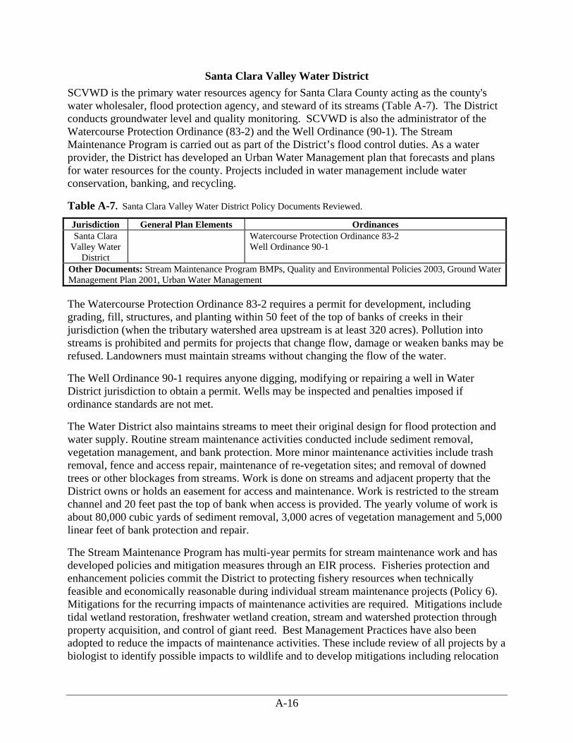
A-16
Santa Clara Valley Water District SCVWD is the primary water resources agency for Santa Clara County acting as the county's water wholesaler, flood protection agency, and steward of its streams (Table A-7). The District conducts groundwater level and quality monitoring. SCVWD is also the administrator of the Watercourse Protection Ordinance (83-2) and the Well Ordinance (90-1). The Stream Maintenance Program is carried out as part of the District’s flood control duties. As a water provider, the District has developed an Urban Water Management plan that forecasts and plans for water resources for the county. Projects included in water management include water conservation, banking, and recycling.
Table A-7. Santa Clara Valley Water District Policy Documents Reviewed.
Jurisdiction General Plan Elements Ordinances Santa Clara
Valley Water District
Watercourse Protection Ordinance 83-2 Well Ordinance 90-1
Other Documents: Stream Maintenance Program BMPs, Quality and Environmental Policies 2003, Ground Water Management Plan 2001, Urban Water Management The Watercourse Protection Ordinance 83-2 requires a permit for development, including grading, fill, structures, and planting within 50 feet of the top of banks of creeks in their jurisdiction (when the tributary watershed area upstream is at least 320 acres). Pollution into streams is prohibited and permits for projects that change flow, damage or weaken banks may be refused. Landowners must maintain streams without changing the flow of the water.
The Well Ordinance 90-1 requires anyone digging, modifying or repairing a well in Water District jurisdiction to obtain a permit. Wells may be inspected and penalties imposed if ordinance standards are not met.
The Water District also maintains streams to meet their original design for flood protection and water supply. Routine stream maintenance activities conducted include sediment removal, vegetation management, and bank protection. More minor maintenance activities include trash removal, fence and access repair, maintenance of re-vegetation sites; and removal of downed trees or other blockages from streams. Work is done on streams and adjacent property that the District owns or holds an easement for access and maintenance. Work is restricted to the stream channel and 20 feet past the top of bank when access is provided. The yearly volume of work is about 80,000 cubic yards of sediment removal, 3,000 acres of vegetation management and 5,000 linear feet of bank protection and repair.
The Stream Maintenance Program has multi-year permits for stream maintenance work and has developed policies and mitigation measures through an EIR process. Fisheries protection and enhancement policies commit the District to protecting fishery resources when technically feasible and economically reasonable during individual stream maintenance projects (Policy 6). Mitigations for the recurring impacts of maintenance activities are required. Mitigations include tidal wetland restoration, freshwater wetland creation, stream and watershed protection through property acquisition, and control of giant reed. Best Management Practices have also been adopted to reduce the impacts of maintenance activities. These include review of all projects by a biologist to identify possible impacts to wildlife and to develop mitigations including relocation

A-17
plans (BMP 3.7) and biodiversity monitoring. Other BMPs from the Stream Maintenance Program are listed by impact category below.
Streamflow Quantity Modification Live streams where instream work is occurring must be dewatered using BMPs (BMP1.3). Bypassed flows must be reintroduced without increasing downstream sedimentation.
Riparian Vegetation The District should avoid and minimize impacts to the quality and extent of riparian habitat (Policy 9). Vegetation control and removal will be minimized and measures will be taken to leave the work site in a vegetated condition after individual projects (Policy 8). Mitigations will include planting of an equal length of creekside for any new impervious bank protection projects (concrete lining, gunite, sack concrete). Bank protection plantings must be monitored for survival for five years and are successful at 70 percent survival or 50 percent absolute cover (BMP 2.4). Native trees removed for bank protection must be replaced in a three to one ratio, on site when possible (BMP 2.8).
Sedimentation The District will take measures to reduce increases in short-term stream turbidity that can result from stream maintenance activities (Policy 7). The temporary stockpiling, transportation, and disposal of removed sediments from stream maintenance projects must minimize impacts to the surrounding natural environment (Policy 13 and BMP1.8). Banks that are disturbed must be reseeded (BMP 2.7).
All instream work must be done between June 15th and October 15th (BMP 0.1) to minimize sedimentation. Where instream vegetation is removed in a newly treated stream, removals may need to be phased to reduce sediment production in one season, or excess sediment may be mechanically removed (BMP 1.14). Sedimentation and erosion control measures to be used are specified in BMP 1.5.
Channel Modification Bank stabilization projects must assess the up and downstream impacts on bank erosion and stability. Projects should minimize hardscaping and use vegetation that increases stability of the bank when possible (BMP 2.3). Hardscape projects that increase erosive power must include energy dissipative mitigations such as riparian plantings, rock placement grade controls or pools (BMP 1.15). Woody vegetation must be retained in projects (BMP 3.9). Escape cover such as stable undercut banks and large boulders should remain in place (BMP 3.14). Temporary fills must be removed after completion of work (BMP 3.13) and channel pools and configuration must be restored to pre-project conditions (BMP 3.15). Spawning gravels removed as part of project work must be replaced at the end of construction (BMP 3.16). Reused gravels must be tested for hazardous materials and be of similar composition to original gravels (BMP 3.17).
Water Quality The District's use of herbicides must be consistent with environmental goals, including protection, preservation, and restoration. Herbicide use will avoid or minimize negative effects to the environment (Policy 11). Hazardous materials must be properly handled and the quality of water resources protected by all reasonable means when removing sediments from streams

A-18
(Policy 12). Only aquatic herbicides may be used within 20 feet of water (BMP 3.18) and only from July 15th to October 15th. Herbicides may not be used in upland areas within 72 hours of predicted rain (BMP 3.20). Runoff from curing concrete used in bank stabilization projects must be kept from the stream (1.11).
Migration Barriers Stream diversions for maintenance on the San Francisquito must maintain a low flow or open artificial channel with water depths to accommodate fish passage and no drops of over 6 inches or flow velocities of over 8 feet per second (BMP 3.8). Projects that alter the low flow channel must return the channel to adequate depth to maintain fish passage (BMP 3.12).

B-1
Appendix B Activities Review Field Forms

B-2
ACTIVITIES REVIEW SURVEY FORM Channel/Bank Stabilization
Activity 1 PROJECT DATA: Type of activity (refer to list in Attachment “A”): Bank stabilization. Rip-rap installed in conjunction with a single family home development General location (Specific information is considered confidential): Menlo Park Is the activity located in or near a stream that supports or could support anadromous fishes? No, the project took place on an unnamed ephemeral tributary of San Francisquito. IMPACTS: Was the activity primarily intended to benefit fish or fish habitat? What beneficial practices were carried out? No. Did the activity have a discernible adverse effect on anadromous fishes or their habitats? Describe the impacts: Channel armoring on this tributary probably had little or no impact on downstream fish habitat. Is the impact short-term, related to construction? No. Is there a long-term, chronic or cumulative impact associated with the activity? D-) In stream habitat – Bank stabilization causes incremental losses in instream habitat. C-) Sedimentation – There could be a cumulative effect on sediment discharge caused by incremental rip-rapping. Are impacts reversible? That is, will the short-term impact end or can the long-term impact be mitigated? No. Once a bank is hardened it is not likely the treatment will be removed without restoration. MITIGATION PROCEDURES: Are there policies or procedures used by the county or other agency to mitigate observed impacts? Cite authorities. Unknown. Were mitigation measures carried out? If not, will they be carried out in the future? Cite sources for this information. Unknown. What county departments or other agencies were responsible for implementation? Menlo Park Planning Department. Were impacts observed for which there are no formal mitigation procedures? What were they? Unknown. What were the major obstacles to mitigation measure implementation? Unknown.

B-3
REVIEWERS’ NAMES AND DATE OF SURVEY: Virginia Parks, Katie Pilat, Jonathan Owens, Richard Harris, Susie Kocher, May 9th, 2005

B-4
ACTIVITIES REVIEW SURVEY FORM Channel/Bank Stabilization
Activity 2 PROJECT DATA: Type of activity (refer to list in Attachment “A”): Channel armoring General location (Specific information is considered confidential): Blue Oaks subdivision Is the activity located in or near a stream that supports or could support anadromous fishes? The channel is an intermittent swale upstream of Los Trancos Creek, which supports steelhead. The channel itself does not support steelhead. IMPACTS: Was the activity primarily intended to benefit fish or fish habitat? What beneficial practices were carried out? No. The channel was armored both upstream and downstream of a culvert with small rock and concrete to reduce potential for erosion. The road crossing at the swale was also constructed to act as a debris basin in case of a debris flow coming down from unstable areas upslope. Did the activity have a discernible adverse effect on anadromous fishes or their habitats? Describe the nature of the impacts: Is the impact short-term, related to construction? No. Is there a long-term, chronic or cumulative impact associated with the activity? C-) sedimentation – sediment delivery is potentially accelerated downstream of the armored section because there is no ability to store sediment within the channel. There is also the potential for erosion and sediment delivery downstream of the armored section where it joins an unprotected reach. The potential severity of this was not investigated in the field. C+) sedimentation – the armoring will prevent channel erosion within the treated section. Are impacts reversible? That is, will the short-term impact end or can the long-term impact be mitigated? These types of treatments tend to break down in about 15 years with water starting to pipe under the rock layer. Long-term maintenance will be required. Long-term impacts on erosion and sediment delivery downstream could be mitigated if found to be a serious problem. MITIGATION PROCEDURES: Are there policies or procedures used by the county or other agency to mitigate observed impacts? Cite authorities. The project was part of the subdivision improvement plan. It was one of 369 conditions inserted into the subdivision approval. The problem was first identified in the subdivision EIR by the consultants. The recommendations went through a town peer review system and the town geologist before being finalized as conditions. Were mitigation measures carried out? If not, will they be carried out in the future? Cite sources for this information. Yes, as observed in the field.

B-5
What county departments or other agencies were responsible for implementation? The project was proposed by the developer and approved by the town engineers. Were impacts observed for which there are no formal mitigation procedures? What were they? Although the project was conservatively built, if debris does flow down into the crossing structure, and if it fills, the flow will travel onto the road, since there is no critical dip installed. The crossing also does not have a debris rack to keep it from plugging with debris. What were the major obstacles to mitigation measure implementation? None REVIEWERS’ NAMES AND DATE OF SURVEY: Leslie Lambert, Richard Harris, Katie Pilate, Susie Kocher, Tom Vlasic, Jonathan Owens, April 19th, 2005

B-6
ACTIVITIES REVIEW SURVEY FORM Bank/Channel Stabilization
Activity 3 Type of activity (refer to list in Attachment “A”): Bank stabilization project. The stream was downcutting within the project site and existing bank protection was failing. Five rock vortex weirs were installed in the channel to redirect stream flow away from the banks and stop downcutting. Limited armoring was done at the base of slopes. Disturbance only occurred in the weir locations and on the bank where the stream was accessed. The boulders were keyed in without use of mortar or cables. Some of the weirs have created scour pools. This treatment has been done in bigger streams with larger rocks. General location (Specific information is considered confidential): Saratoga Creek Is the activity located in or near a stream that supports or could support anadromous fishes? No, but this type of treatment could be used in the San Francisquito watershed. IMPACTS: Was the activity primarily intended to benefit fish or fish habitat? What beneficial practices were carried out? No. Did the activity have a discernible adverse effect on anadromous fishes or their habitats? Describe the nature of the impacts: Is the impact short-term, related to construction? C-) Sedimentation. Is there a long-term, chronic or cumulative impact associated with the activity? D+) In stream habitat – using the rock weir design avoided use of riprap or other bank hardening designs. C-) Sedimentation. Downstream erosive power may be increased due to cumulative bank stabilization projects. Are impacts reversible? That is, will the short-term impact end or can the long-term impact be mitigated? The short term sediment impact will end. Positive impacts on the instream habitat should remain if the design holds up. MITIGATION PROCEDURES: Are there policies or procedures used by the county or other agency to mitigate observed impacts? Cite authorities. The SCVWD has a 10-year permit from the Army Corps of Engineers, Regional Water Quality Control Board, and Department of Fish and Game to conduct its stream maintenance program. The permit was granted after completion of an EIR. The permit includes Best Management Practices to be done for all projects. The BMPs generally treat all streams as if they had anadromous fish. Each individual project plan is also reviewed by these agencies for design approval.

B-7
Every year, a maintenance planner inspects streams and identifies areas that need work. Then, a list of projects is developed and treatments are prioritized. Approximately 15 stream maintenance projects are done every year. Were mitigation measures carried out? If not, will they be carried out in the future? Cite sources for this information. Yes, a generator was brought in to pump the stream water and divert it. No fish re-location was required. What city or county departments or other agencies were responsible for implementation? The project was located on lands owned by Santa Clara Valley Water District and it was the only agency involved. Were impacts observed for which there are no formal mitigation procedures? What were they? The road leading down to the project site shows some erosion. Erosion control measures may be applied there but this is not known. There is a potential for long-term channel changes due to incremental bank stabilization projects. What were the major obstacles to mitigation measure implementation? None REVIEWERS’ NAMES AND DATE OF SURVEY: Bill Springer, Richard Harris, Katie Pilat, Susie Kocher, August 5th, 2005

B-8
ACTIVITIES REVIEW SURVEY FORM Channel/Bank Stabilization
Activity 4 PROJECT DATA: Type of activity (refer to list in Attachment “A”): Bank stabilization. A cross vane weir was installed in the creek for grade control. The weir was a mitigation for the downcutting that occurred under a concrete apron below gabion baskets installed in 1998. The 1998 project was completed to increase bank stability. The recent downcutting may have occurred as a result of the earlier gabion project. If the project is successful, aggradation will occur to obscure the concrete apron and rock weir altogether. More grade control structures will be installed downstream. General location (Specific information is considered confidential): Calabasas Creek Is the activity located in or near a stream that supports or could support anadromous fishes? No. IMPACTS: Was the activity primarily intended to benefit fish or fish habitat? What beneficial practices were carried out? No. Did the activity have a discernible adverse effect on anadromous fishes or their habitats? Describe the nature of the impacts: Is the impact short-term, related to construction? C-) Sedimentation - There was probably some sedimentation due to construction. Is there a long-term, chronic or cumulative impact associated with the activity? B-) Riparian vegetation - Installing the gabions led to a permanent reduction in riparian vegetation. D-) In stream habitat – It is likely that the 1998 project hardened the bank and so redirected the flow, leading to the recent downcutting. Are impacts reversible? That is, will the short-term impact end or can the long-term impact be mitigated? Yes, if the project is successful. The installation of rock weirs is a mitigation to halt the stream downcutting. MITIGATION PROCEDURES: Are there policies or procedures used by the county or other agency to mitigate observed impacts? Cite authorities. An EIR was prepared for the 1998 project. Use of rock gabions would probably not be proposed at the present time. The baskets can deteriorate quickly when not properly packed with rock. The rock weir was installed under the SCVWD’s 10 year permit although the design was submitted to the regulating agencies for approval.

B-9
Were mitigation measures carried out? If not, will they be carried out in the future? Cite sources for this information. Yes, the stream flow was diverted around site during both project phases. The rock weir is a mitigation to reduce downcutting. What city or county departments or other agencies were responsible for implementation? Santa Clara Valley Water District. Were impacts observed for which there are no formal mitigation procedures? What were they? Installation of the gabion baskets led to a permanent reduction in riparian cover. This was mitigated by plantings downstream. What were the major obstacles to mitigation measure implementation? None, the SCVWD owns the property in this location. They have faced obstacles with planting in other locations when adjacent property owners have sprayed herbicides on their plantings. REVIEWERS’ NAMES AND DATE OF SURVEY: Bill Springer, Richard Harris, Katie Pilat, Susie Kocher, August 5th, 2005

B-10
ACTIVITIES REVIEW SURVEY FORM Channel/Bank Stabilization
Activity 5 PROJECT DATA: Type of activity (refer to list in Attachment “A”): Bank stabilization. Four cross vane weirs were installed in the creek for grade control. This may have been done in association with a housing development but this is not known. The weirs were intended to reduce the erosive capacity of the flow and create scour pools downstream and deposition upstream. Mortar was used to secure rocks. General location (Specific information is considered confidential): Guadalupe River at Foxworthy (to Capitol Expressway), San Jose Is the activity located in or near a stream that supports or could support anadromous fishes? Yes, it is located on Guadalupe River which supports both steelhead and salmon. IMPACTS: Was the activity primarily intended to benefit fish or fish habitat? What beneficial practices were carried out? No. Did the activity have a discernible adverse effect on anadromous fishes or their habitats? Describe the nature of the impacts: D+) In stream habitat – – The weirs were successful at stopping downcutting and stabilizing the bank. It created scour pools downstream of the weirs and notches were left in the center of the weirs to allow fish passage. E-) Water quality - It appears that the weirs were so successful at encouraging deposition that areas of slack water with instream vegetation developed. In unshaded areas, eutrophication of warmed water is apparent. Is the impact short-term, related to construction? C-) Sedimentation – Some sediment was probably disturbed by construction. Is there a long-term, chronic or cumulative impact associated with the activity? Both impacts are long term. Are impacts reversible? That is, will the short-term impact end or can the long-term impact be mitigated? Yes, removal of a few rocks could increase water velocity. Riparian plantings could also shade and cool waters. MITIGATION PROCEDURES: Are there policies or procedures used by the county or other agency to mitigate observed impacts? Cite authorities. The project was permitted individually (not part of the 10 year stream maintenance permit). It may have been done before salmon or steelhead were listed as threatened.

B-11
Were mitigation measures carried out? If not, will they be carried out in the future? Cite sources for this information. Yes, the stream flow was diverted around the project and stranded fish were relocated. The rock weirs are constructed with a central notch to allow for fish passage. Elderberry and ash were planted in riparian areas. The adjacent development left a wide riparian buffer that is fenced off. What city or county departments or other agencies were responsible for implementation? Santa Clara Valley Water District, Ken Riler designer. Were impacts observed for which there are no formal mitigation procedures? What were they? The reduction in water quality upstream from the weirs due to slack water and lack of overhead canopy (may have been pre-existing). What were the major obstacles to mitigation measure implementation? Gaining access to the stream can be a problem because the SCVWD does not have an easement along the entire stream. REVIEWERS’ NAMES AND DATE OF SURVEY: Bill Springer, Richard Harris, Katie Pilat, Susie Kocher, August 5th, 2005

B-12
ACTIVITIES REVIEW SURVEY FORM Channel/Bank Stabilization
Activity 6 PROJECT DATA: Type of activity (refer to list in Attachment “A”): Bank stabilization. A failed sacked concrete wall adjacent to Highway 85 and the Stevens Creek bike trail was treated in 2003. The bank was laid back, large rock was placed at the toe and the slope was re-vegetated. The treated reach was tied into a sacked concrete section upstream. The project was implemented when the stream was dry. General location (Specific information is considered confidential): Stevens Creek, Mountain View Is the activity located in or near a stream that supports or could support anadromous fishes? Yes, it is on Stevens Creek, which supports steelhead IMPACTS: Was the activity primarily intended to benefit fish or fish habitat? What beneficial practices were carried out? No, the goal was to protect Highway 85. Did the activity have a discernible adverse effect on anadromous fishes or their habitats? Describe the nature of the impacts: B+) Riparian vegetation –The old sacked concrete was covered with blackberry but the project planted shrubs and trees that will provide more stream shading. D+) Instream habitat – The bank is sloped at a more natural angle, which should reduce downstream erosive pressure. Is the impact short-term, related to construction? No. Is there a long-term, chronic or cumulative impact associated with the activity? Both impacts are long term. Are impacts reversible? That is, will the short-term impact end or can the long-term impact be mitigated? Yes, vegetation must continue to survive for the positive impacts to continue. It is currently irrigated and looks vigorous. Mortality will be monitored until 2007. MITIGATION PROCEDURES: Are there policies or procedures used by the county or other agency to mitigate observed impacts? Cite authorities. SCVWD issued a permit to CalTrans for the work under their 83-2 ordinance. SCVWD comments on the plans and suggests conditions, but other permitting agencies have the final say for habitat-based requirements. SCVWD is the only agency reviewing the project for flood protection and bank stability issues. Were mitigation measures carried out? If not, will they be carried out in the future? Cite sources for this information. The entire project could be interpreted as mitigation for the failing bank.

B-13
What city or county departments or other agencies were responsible for implementation? The California Department of Transportation. Were impacts observed for which there are no formal mitigation procedures? What were they? No. What were the major obstacles to mitigation measure implementation? Long term monitoring requirements can be problematic. REVIEWERS’ NAMES AND DATE OF SURVEY: Bill Springer, Richard Harris, Katie Pilat, Susie Kocher, August 5th, 2005

B-14
ACTIVITIES REVIEW SURVEY FORM Channel/Bank Stabilization
Activity 7 PROJECT DATA: Type of activity (refer to list in Attachment “A”): Bank stabilization. Two large logs, one on top of the other, were installed to shore up a failed natural section of creek bank. The project should stabilize a large tree that might have been undermined in future high flows. General location (Specific information is considered confidential): Permanente Creek, Mountain View. Is the activity located in or near a stream that supports or could support anadromous fishes? No. IMPACTS: Was the activity primarily intended to benefit fish or fish habitat? What beneficial practices were carried out? No, the goal was to protect private property. Did the activity have a discernible adverse effect on anadromous fishes or their habitats? Describe the nature of the impacts: D-) Instream habitat – Installation of a hardened bank may deflect flow and energy and cause more bank erosion downstream. D+) Instream habitat – The configuration of logs may provide some cover for aquatic life. Is the impact short-term, related to construction? No. Is there a long-term, chronic or cumulative impact associated with the activity? Small sections of bank hardening may cause cumulative impacts. Are impacts reversible? That is, will the short-term impact end or can the long-term impact be mitigated? Yes, the logs will degrade in time. Ten years is the design life of the project, although it is hoped that stability will continue after this. This creek is too small to install rock weirs MITIGATION PROCEDURES: Are there policies or procedures used by the county or other agency to mitigate observed impacts? Cite authorities. This is a maintenance project covered under the District’s 10 year permit. SCVWD maintenance planners do maintenance walks to prioritize bank areas to treat. They document problems through descriptions, photos and evaluation. Over time, problem areas are recognized and prioritized. Potential for flood damage and value of the damage are used as criteria for prioritizing projects. To stabilize banks, they prescribe the least hard method possible in that location. Permanente Creek was part of a SCVWD sponsored ballot initiative that imposed a temporary property tax to reduce flooding. Permanente Creek has been allocated $30 million for studies and construction to address flooding issues. The stream flows at 1500 cubic feet per second

B-15
during a 100 year storm but the culvert in this location is designed to accommodate only about 300 cubic feet per second. There are dozens of undersized culverts on the stream. One product will be a management plan for the creek. Some of the solutions suggested, such as detention areas on private property may prove controversial. Were mitigation measures carried out? If not, will they be carried out in the future? Cite sources for this information. Straw was applied to disturbed ground for erosion control. Plantings in this location don’t look promising because of shade. Willow stakes could be inserted between logs for this design in other locations. What city or county departments or other agencies were responsible for implementation? SCVWD Were impacts observed for which there are no formal mitigation procedures? What were they? Cumulative bank hardening is not being mitigated. Developing a bank stabilization master plan might be useful for the creek to categorize each reach of creek and prescribe treatment methods in that reach. Another approach might be revetments or weirs to redirect flow to the center of the stream. What were the major obstacles to mitigation measure implementation? The adjacent landowner’s house is about six feet from the bank, constraining the possible actions that can be taken. REVIEWERS’ NAMES AND DATE OF SURVEY: Bill Springer, Richard Harris, Katie Pilat, Susie Kocher, August 5th, 2005

B-16
ACTIVITIES REVIEW SURVEY FORM Stormwater Management
Activity 8 PROJECT DATA: Type of activity (refer to list in Attachment “A”): Stormwater management. Bioswales and catchments were installed along Sand Hill Road during the road widening project. The swales run parallel to the road and have a layer of aggregate underneath the soil. The soil is planted with wetland species. The curb along the road has gaps to allow water to flow into the swale. The project was completed in the last two or three months and has not been tested by storm-flow yet. General location (Specific information is considered confidential): Sand Hill Road, Menlo Park Is the activity located in or near a stream that supports or could support anadromous fishes? Yes, San Francisquito Creek contains steelhead. IMPACTS: Was the activity primarily intended to benefit fish or fish habitat? What beneficial practices were carried out? The project is intended to conform with the NPDES permit requirements. Did the activity have a discernible adverse effect on anadromous fishes or their habitats? Describe the impacts: Is the impact short-term, related to construction? C-) Sedimentation – some impacts from road widening occurred during construction. Is there a long-term, chronic or cumulative impact associated with the activity? A+) Stream flow quantity modification – The catchments slow stormwater flowing off the road. C+) Sedimentation – The bioswale will mitigate increases in turbidity due to incidental erosion. . E+) Water quality – The swale collects pollutants and keeps them from flowing to the stream. Are impacts reversible? That is, will the short-term impact end or can the long-term impact be mitigated? The short term impact has ended. The benefits of the swale and catchments could be reduced if the facilities fail or are not properly maintained. It must be inspected and cleaned at least every 5 years. The plants must be maintained through irrigation and weeding. Trash should be removed from the swale. MITIGATION PROCEDURES: Are there policies or procedures used by the county or other agency to mitigate observed impacts? Cite authorities. The bioswale was suggested as a mitigation measure in the EIR for the road widening project. It will also be part of the city’s NPDES permit. Were mitigation measures carried out? If not, will they be carried out in the future? Cite sources for this information. Yes. Balance Hydrologics has been conducting sediment

B-17
monitoring up and downstream of this project which is allowed to increase turbidity by 50 NTUs. The difference is usually between 10 and 30 NTUs, but sometimes it reaches 80 NTUs. What county departments or other agencies were responsible for implementation? Menlo Park Engineering Division Were impacts observed for which there are no formal mitigation procedures? What were they? No. What were the major obstacles to mitigation measure implementation? None REVIEWERS’ NAMES AND DATE OF SURVEY: Virginia Parks, Katie Pilat, Jonathan Owens, Yaw Owusu, Richard Harris, Susie Kocher, May 9th, 2005

B-18
ACTIVITIES REVIEW SURVEY FORM Stormwater Management
Activity 9 PROJECT DATA: Type of activity (refer to list in Attachment “A”): Storm drainage/retention basins General location (Specific information is considered confidential): Blue Oaks subdivision, Portola Valley Is the activity located in or near a stream that supports or could support anadromous fishes? No, the project is on an intermittent tributary to Los Trancos Creek, which supports steelhead. However, this small stream is probably too steep for steelhead to access. IMPACTS: Was the activity primarily intended to benefit fish or fish habitat? What beneficial practices were carried out? Yes, a check dam was added to a stock pond from the pre-existing ranch to raise the height and detain more water. This was a mitigation to reduce the peak flow increases caused by impervious surfaces within the subdivision. An additional pond was expanded upstream and the meadow downstream was also used for dissipation of runoff. The road system is fitted with catch basins collect water and sediment and can be opened and cleaned. Did the activity have a discernible effect on anadromous fishes or their habitats? Describe the nature of the impacts: Is the impact short-term, related to construction? None. Is there a long-term, chronic or cumulative impact associated with the activity? A+) Stream flow quantity modification – the detention pond and meadow prevent peak flow increases. C+) sedimentation - The pond and basins collect sediment before it is delivered downstream. Are impacts reversible? That is, will the short-term impact end or can the long-term impact be mitigated? The positive effects should continue over time as the system is maintained through fees collected by the homeowner’s association. MITIGATION PROCEDURES: Are there policies or procedures used by the county or other agency to mitigate observed impacts? Cite authorities. The project was part of the subdivision improvement plan. It was one of 369 conditions inserted into the subdivision approval. The problem was first identified in the subdivision EIR by the consultants. The mitigation recommendations went through a town peer review system and were formulated as final conditions by the town geologist and engineer. Were mitigation measures carried out? If not, will they be carried out in the future? Cite sources for this information. The project was a mitigation measure.

B-19
What county departments or other agencies were responsible for implementation? The idea came from the EIR consultant and was required by the Portola Valley Planning Department. Were impacts observed for which there are no formal mitigation procedures? What were they? There should be a minimal water quality impacts from herbicides and pesticides. The subdivision allows only a 1000 square foot lawn with the rest of the lot covered by native plants. The homeowners association must advise residents on how to control vegetation without use of chemicals. No horses are allowed in the subdivision. What were the major obstacles to mitigation measure implementation? None REVIEWERS’ NAMES AND DATE OF SURVEY: Leslie Lambert, Richard Harris, Katie Pilate, Susie Kocher, Tom Vlasic, Jonathan Owens, April 19th, 2005

B-20
ACTIVITIES REVIEW SURVEY FORM Stormwater Management
Activity 10 PROJECT DATA: Type of activity (refer to list in Attachment “A”): Waste water management General location (Specific information is considered confidential): Alpine Road, Portola Valley (Glen Oaks Equestrian Center, 3639 Alpine Road) Is the activity located in or near a stream that supports or could support anadromous fishes? The horse facility straddles Los Trancos Creek, which supports steelhead. IMPACTS: Was the activity primarily intended to benefit fish or fish habitat? What beneficial practices were carried out? The property is owned by Stanford University and the stable was in existence before the Town of Portola Valley was incorporated. When the new conditional use permit was approved in 2001 with a new operator, many water quality improvements were required by the town. Before these changes, horse washing was conducted on a pad that drained directly to the creek. The pasture near the creek had very poor drainage and manure four feet deep in it. Water flowed through the stables and into the creek. A new barn was constructed, new drainage was established and the old barn, which was directly on the edge of the creek was torn down over the period of five years. There is currently a riparian pasture used for horse jumping a few days a year in the spring and fall when the ground is not too hard or too soft. Horse paddocks are cleaned every day with manure loaded into a semi tractor trailer and hauled to Half Moon Bay for disposal. A new bridge was installed to keep the horses from crossing directly through the creek. Horse washing pads were moved away from the creek. The stables have concrete floors covered with rubber mats and wood shavings. They are not routinely hosed out unless a horse is sick. The whole area was graded to re-direct drainage and a rock lined detention basin was constructed to retain flow and improve its quality. Did the activity have a discernible effect on anadromous fishes or their habitats? Describe the nature of the impacts: Is the impact short-term, related to construction? None of the construction impinged on the riparian zone. There was no new bank stabilization installed. Is there a long-term, chronic or cumulative impact associated with the activity? E+) Water Quality Impacts – The drainage and management practices have had a very positive impact on water quality in the creek. This is supported by water quality monitoring data. Are impacts reversible? That is, will the short-term impact end or can the long-term impact be mitigated? Yes, some of the benefits depend on daily maintenance. If this maintenance were neglected, water quality impacts could occur.

B-21
MITIGATION PROCEDURES: Are there policies or procedures used by the county or other agency to mitigate observed impacts? Cite authorities. The mitigation measures were required as part of the facility’s conditional use permit. The town required a 50 foot setback from the creek, while Stanford wanted a 150 foot setback from the creek. This was not feasible due to required setbacks from Alpine Road. The compromise was a 110 foot setback. The town engineer dictated the size of the detention basin. Were mitigation measures carried out? If not, will they be carried out in the future? Cite sources for this information. Yes. The town conducts an annual compliance review on the use permit. This is conducted by their stable consultant who inspects about 100 horse facilities/pastures per year. What county departments or other agencies were responsible for implementation? The Portola Valley Planning Department. Were impacts observed for which there are no formal mitigation procedures? What were they? No. What were the major obstacles to mitigation measure implementation? Some measures were opposed by neighbors because of potential visual impacts. This involved locations specified locations for new buildings that were aimed at reducing impacts on the creek. REVIEWERS’ NAMES AND DATE OF SURVEY: Leslie Lambert, Richard Harris, Katie Pilat, Susie Kocher, Jonathan Owens, April 19th, 2005

B-22
ACTIVITIES REVIEW SURVEY FORM Storm Water Management
Activity 11 PROJECT DATA: Type of activity (refer to list in Attachment “A”): Storm drainage/Retention basins General location (Specific information is considered confidential): Alpine Road, Portola Valley Is the activity located in or near a stream that supports or could support anadromous fishes? Yes, the field is adjacent to Los Trancos Creek, which supports steelhead. IMPACTS: Was the activity primarily intended to benefit fish or fish habitat? What beneficial practices were carried out? The retention basin was used to mitigate the effects of water pollution caused by re-construction of the soccer field. The town upgraded their soccer field several years ago by expanding it and adding sand channels. These seemed to funnel sub-drainage right into the creek including the fertilizers used to improve the turf. This may have led to the algae bloom downstream during low flow. The retention basin was installed to improve water quality. Did the activity have a discernible effect on anadromous fishes or their habitats? Describe the nature of the impacts: Is the impact short-term, related to construction? No. Is there a long-term, chronic or cumulative impact associated with the activity? A+) Stream flow Quantity Modification – Irrigation of the soccer field is achieved with municipal water supply. This water eventually reaches Los Trancos Creek, although the retention basin slows the rate of return flow. The net result is an augmentation of stream flow. B-) Riparian Clearing – part of the riparian corridor was cleared to install the basin. E+) Water Quality Impacts – The retention basin is improving the quality of the field drainage before it flows into the creek. Are impacts reversible? That is, will the short-term impact end or can the long-term impact be mitigated? Yes, some of the benefits of the basin depend on maintenance. Detention basins do a better job of improving water quality when they are exposed to the sun. Shading could degrade its effectiveness, as could sedimentation. MITIGATION PROCEDURES: Are there policies or procedures used by the county or other agency to mitigate observed impacts? Cite authorities. The soccer field was upgraded by permit after a CEQA review. The project was done as a Public Works Capital Improvement project. The water quality impact was not identified during this review and the detention basin was not part of the CEQA mitigations imposed. The original mitigations called for keeping the drainage on site, but the sand channels from the field subverted this. The detention basin was installed when the water quality impact came to the attention of the Planning Department. Rules for creek set backs were followed when

B-23
installing the basin, although it was tight in one corner. The project is at least 20 feet from the creek. Were mitigation measures carried out? If not, will they be carried out in the future? Cite sources for this information. Yes. The detention basin was installed. What county departments or other agencies were responsible for implementation? Public Works and Planning Were impacts observed for which there are no formal mitigation procedures? What were they? There were no mitigations for the riparian clearing done to install the trail and the basin about 20 feet from the creek bank. Also, the basin does not completely mitigate the runoff (subsurface seepage) from the field. Better fertilizer management (which is occurring) could also reduce the impact of the field. They are working with the STOPP program to implement field management BMPs. What were the major obstacles to mitigation measure implementation? The major obstacle was not anticipating the effects of the field’s sand channel design. Also, the basin had to be squeezed into a very small area. REVIEWERS’ NAMES AND DATE OF SURVEY: Leslie Lambert, Richard Harris, Katie Pilat, Susie Kocher, Jonathan Owens, April 19th, 2005
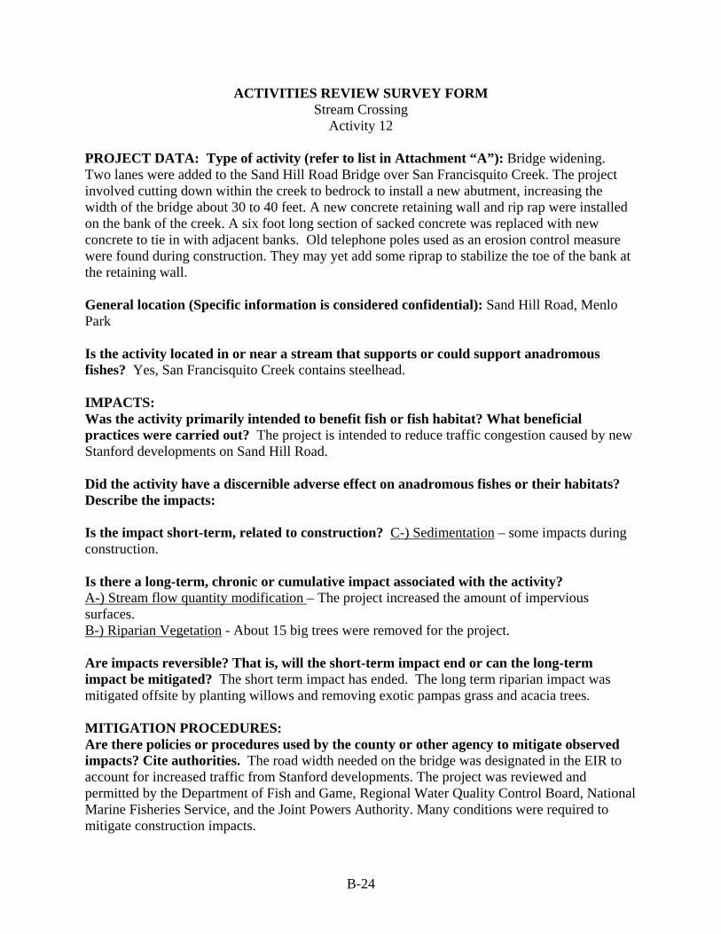
B-24
ACTIVITIES REVIEW SURVEY FORM Stream Crossing
Activity 12 PROJECT DATA: Type of activity (refer to list in Attachment “A”): Bridge widening. Two lanes were added to the Sand Hill Road Bridge over San Francisquito Creek. The project involved cutting down within the creek to bedrock to install a new abutment, increasing the width of the bridge about 30 to 40 feet. A new concrete retaining wall and rip rap were installed on the bank of the creek. A six foot long section of sacked concrete was replaced with new concrete to tie in with adjacent banks. Old telephone poles used as an erosion control measure were found during construction. They may yet add some riprap to stabilize the toe of the bank at the retaining wall. General location (Specific information is considered confidential): Sand Hill Road, Menlo Park Is the activity located in or near a stream that supports or could support anadromous fishes? Yes, San Francisquito Creek contains steelhead. IMPACTS: Was the activity primarily intended to benefit fish or fish habitat? What beneficial practices were carried out? The project is intended to reduce traffic congestion caused by new Stanford developments on Sand Hill Road. Did the activity have a discernible adverse effect on anadromous fishes or their habitats? Describe the impacts: Is the impact short-term, related to construction? C-) Sedimentation – some impacts during construction. Is there a long-term, chronic or cumulative impact associated with the activity? A-) Stream flow quantity modification – The project increased the amount of impervious surfaces. B-) Riparian Vegetation - About 15 big trees were removed for the project. Are impacts reversible? That is, will the short-term impact end or can the long-term impact be mitigated? The short term impact has ended. The long term riparian impact was mitigated offsite by planting willows and removing exotic pampas grass and acacia trees. MITIGATION PROCEDURES: Are there policies or procedures used by the county or other agency to mitigate observed impacts? Cite authorities. The road width needed on the bridge was designated in the EIR to account for increased traffic from Stanford developments. The project was reviewed and permitted by the Department of Fish and Game, Regional Water Quality Control Board, National Marine Fisheries Service, and the Joint Powers Authority. Many conditions were required to mitigate construction impacts.

B-25
Were mitigation measures carried out? If not, will they be carried out in the future? Cite sources for this information. Short term sedimentation impacts were mitigated. Instream impacts were minimized within the project area by not expanding the amount of hardened bank. Concrete was used to replace sacked concrete because of the bank steepness. Using stone riprap would have required cutting the bank back. The bed was not modified. Pre and post construction cross sections show that the project did not move the creek’s thalweg. Off site mitigation included removal of the concrete and asphalt associated with a low water crossing on the creek within the Stanford Golf course. Instream habitat associated with the crossing removal was maintained by addition of three large redwood trees to a scour pool. No mitigation for stream flow quantity impacts from the bridge widening was observed. Some of the long term impacts of the entire road widening project are mitigated by the bioswale installed on Sand Hill Road. What county departments or other agencies were responsible for implementation? Menlo Park Public Works, Engineering Division Were impacts observed for which there are no formal mitigation procedures? What were they? Some gullies have developed where a bike trail intersects the project area. It appears that the paved trail is concentrating water and causing the gullying. The path was moved when a golf course green was moved. What were the major obstacles to mitigation measure implementation? None REVIEWERS’ NAMES AND DATE OF SURVEY: Virginia Parks, Katie Pilat, Jonathan Owens, Yaw Owusu, Richard Harris, Susie Kocher, May 9th, 2005

B-26
ACTIVITIES REVIEW SURVEY FORM Stream Crossing
Activity 13 PROJECT DATA: Type of activity (refer to list in Attachment “A”): Bridge replacement. The bridge is being widened as a response to increased development and widening of Sand Hill Road. The additional lane is raised on pillars that are seated out of the riparian zone. The bridge deck will extend into the riparian zone. General location (Specific information is considered confidential): Junipero Serra Boulevard, Menlo Park Is the activity located in or near a stream that supports or could support anadromous fishes? Yes, the bridge crosses San Francisquito Creek which contains steelhead. IMPACTS: Was the activity primarily intended to benefit fish or fish habitat? What beneficial practices were carried out? No. Did the activity have a discernible adverse effect on anadromous fishes or their habitats? Describe the impacts: Construction in the riparian zone has been completely avoided. Is the impact short-term, related to construction? N/A Is there a long-term, chronic or cumulative impact associated with the activity? C-) Sedimentation – The slope underneath the pillars was cut during construction, to bedrock in some places. Soil will be added and the area will be hydroseeded. However, it appears it will be difficult to establish vegetation there. Are impacts reversible? That is, will the short-term impact end or can the long-term impact be mitigated? Yes, if the slope is successfully re-vegetated. MITIGATION PROCEDURES: Are there policies or procedures used by the county or other agency to mitigate observed impacts? Cite authorities. Stanford is paying for the project as a result of a lawsuit about the growth inducing impacts of Stanford development. The project may have been categorically exempt from CEQA because it involved replacement of an existing structure. No DFG streambed alteration permit was required because the project avoided the creek. Were mitigation measures carried out? If not, will they be carried out in the future? Cite sources for this information. Sedimentation controls include construction during the dry season and trucking of spoils off site. Silt fences and concrete blocks were installed to stabilize the disturbed area closest to the creek. These efforts look effective. What county departments or other agencies were responsible for implementation? Menlo Park Public Works, Engineering Division is the lead agency. (Half the bridge is in Palo Alto. One corner of the approaching road is under the jurisdiction of San Mateo County).
B-27
Were impacts observed for which there are no formal mitigation procedures? What were they? No What were the major obstacles to mitigation measure implementation? None noted. REVIEWERS’ NAMES AND DATE OF SURVEY: Yao Owusu, Katie Pilat, Richard Harris, Susie Kocher, June 20th, 2005

B-28
ACTIVITIES REVIEW SURVEY FORM Stream Crossing
Activity 14 PROJECT DATA: Type of activity (refer to list in Attachment “A”): Bridge replacement. The old bicycle bridge was removed and replaced by a new one that was dropped in as a unit onto the site using a large crane. Sacked concrete with vegetation on the banks under the bridge was replaced with large riprap to stabilize the slope. Fabric was installed under the rock. A large loader was used for the work. General location (Specific information is considered confidential): Willow Place, Menlo Park Is the activity located in or near a stream that supports or could support anadromous fishes? Yes, the bridge crosses San Francisquito Creek which contains steelhead. IMPACTS: Was the activity primarily intended to benefit fish or fish habitat? What beneficial practices were carried out? No. Did the activity have a discernible adverse effect on anadromous fishes or their habitats? Describe the impacts: Is the impact short-term, related to construction? B-) Riparian vegetation – There was a loss of herbaceous riparian vegetation from removal and replacement by big rock. This may take many years to fill back in. Is there a long-term, chronic or cumulative impact associated with the activity? B-) Riparian Vegetation – It will take at least 15 to 20 years for small vegetation to cover the slope. Are impacts reversible? That is, will the short-term impact end or can the long-term impact be mitigated? No. The city would remove trees that grow on the slope to maintain channel capacity and stop undermining of the slope. A tree would have to puncture the fabric to survive in any case. MITIGATION PROCEDURES: Are there policies or procedures used by the county or other agency to mitigate observed impacts? Cite authorities. The project was permitted with a 1603. DFG prefers rock rip rap to sacked concrete as it appears more natural. The project was categorically exempt from CEQA because it involved replacement of existing structures. Were mitigation measures carried out? If not, will they be carried out in the future? Cite sources for this information. Yes. What county departments or other agencies were responsible for implementation? Menlo Park Public Works, Engineering Division

B-29
Were impacts observed for which there are no formal mitigation procedures? What were they? Riparian impacts. What were the major obstacles to mitigation measure implementation? No. REVIEWERS’ NAMES AND DATE OF SURVEY: Virginia Parks, Katie Pilat, Jonathan Owens, Richard Harris, Susie Kocher, May 9th, 2005
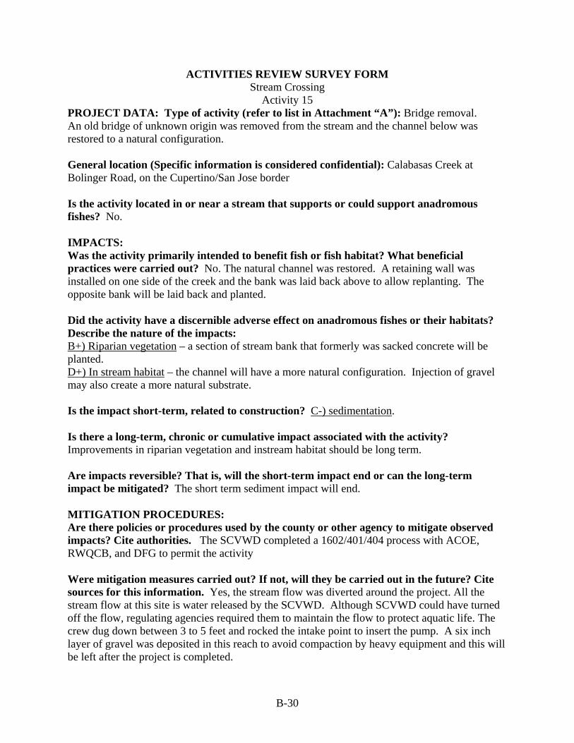
B-30
ACTIVITIES REVIEW SURVEY FORM Stream Crossing
Activity 15 PROJECT DATA: Type of activity (refer to list in Attachment “A”): Bridge removal. An old bridge of unknown origin was removed from the stream and the channel below was restored to a natural configuration. General location (Specific information is considered confidential): Calabasas Creek at Bolinger Road, on the Cupertino/San Jose border Is the activity located in or near a stream that supports or could support anadromous fishes? No. IMPACTS: Was the activity primarily intended to benefit fish or fish habitat? What beneficial practices were carried out? No. The natural channel was restored. A retaining wall was installed on one side of the creek and the bank was laid back above to allow replanting. The opposite bank will be laid back and planted. Did the activity have a discernible adverse effect on anadromous fishes or their habitats? Describe the nature of the impacts: B+) Riparian vegetation – a section of stream bank that formerly was sacked concrete will be planted. D+) In stream habitat – the channel will have a more natural configuration. Injection of gravel may also create a more natural substrate. Is the impact short-term, related to construction? C-) sedimentation. Is there a long-term, chronic or cumulative impact associated with the activity? Improvements in riparian vegetation and instream habitat should be long term. Are impacts reversible? That is, will the short-term impact end or can the long-term impact be mitigated? The short term sediment impact will end. MITIGATION PROCEDURES: Are there policies or procedures used by the county or other agency to mitigate observed impacts? Cite authorities. The SCVWD completed a 1602/401/404 process with ACOE, RWQCB, and DFG to permit the activity Were mitigation measures carried out? If not, will they be carried out in the future? Cite sources for this information. Yes, the stream flow was diverted around the project. All the stream flow at this site is water released by the SCVWD. Although SCVWD could have turned off the flow, regulating agencies required them to maintain the flow to protect aquatic life. The crew dug down between 3 to 5 feet and rocked the intake point to insert the pump. A six inch layer of gravel was deposited in this reach to avoid compaction by heavy equipment and this will be left after the project is completed.

B-31
What city or county departments or other agencies were responsible for implementation? Santa Clara Valley Water District, the project was completed on their own land deeded to them by developer of the adjacent neighborhood in 1974 Were impacts observed for which there are no formal mitigation procedures? What were they? The road leading down to the project shows some erosion. Erosion control measures may be applied there but this is not known. What were the major obstacles to mitigation measure implementation? None REVIEWERS’ NAMES AND DATE OF SURVEY: Bill Springer, Richard Harris, Katie Pilat, Susie Kocher, August 5th, 2005
B-32
ACTIVITIES REVIEW SURVEY FORM Subdivision/Residential Development/Redevelopment
Activity 16 PROJECT DATA: Type of activity (refer to list in Attachment “A”): Redevelopment of single family home. The project involved buying an older house and tearing it down to build a larger and taller house. General location (Specific information is considered confidential): #7 Campo Bella, Sharon Heights, Menlo Park Is the activity located in or near a stream that supports or could support anadromous fishes? Yes, the project took place about 200 feet from San Francisquito Creek, which supports steelhead. IMPACTS: Was the activity primarily intended to benefit fish or fish habitat? What beneficial practices were carried out? No. Did the activity have a discernible adverse effect on anadromous fishes or their habitats? Describe the nature of the impacts: Increasing the house’s footprint increased the amount of impervious surface on the lot. Is the impact short-term, related to construction? C-) sedimentation - some sediment no doubt escaped the site. Is there a long-term, chronic or cumulative impact associated with the activity? A-) stream flow quantity modification – the project increased the impervious surface on the lot. This contributes to cumulative effects on stream flow and non-point source pollution. Are impacts reversible? That is, will the short-term impact end or can the long-term impact be mitigated? Yes, the short term construction impact has ended. Installation of permeable pavement may mitigate long-term effects on hydrology and water quality, if it is effective. However, it looked fairly impervious. MITIGATION PROCEDURES: Are there policies or procedures used by the county or other agency to mitigate observed impacts? Cite authorities. This was a ministerial project requiring only a building permit. If the project increased the percentage of lot coverage over that allowed in the zoning ordinance or if it were a non-conforming lot, a variance would be needed and some conditions might be applied. Building permits may be subject to erosion control requirements during construction. Were mitigation measures carried out? If not, will they be carried out in the future? Cite sources for this information. Erosion control measures, including use of straw bales and rolls were observed.

B-33
What county departments or other agencies were responsible for implementation? Menlo Park Engineering performs inspections. Conditions may be imposed by the Planning Department. Were impacts observed for which there are no formal mitigation procedures? What were they? No. What were the major obstacles to mitigation measure implementation? None. REVIEWERS’ NAMES AND DATE OF SURVEY: Virginia Parks, Katie Pilat, Jonathan Owens, Richard Harris, Susie Kocher, Roldano Guerra – Menlo Park construction supervisor, May 9th, 2005

B-34
ACTIVITIES REVIEW SURVEY FORM Subdivision/Residential Development/Redevelopment
Activity 17 PROJECT DATA: Type of activity (refer to list in Attachment “A”): Single family redevelopment. Re-construction of a house. General location (Specific information is considered confidential): Menlo Park Is the activity located in or near a stream that supports or could support anadromous fishes? Yes, the project took place across the street from San Francisquito Creek, which supports steelhead. IMPACTS: Was the activity primarily intended to benefit fish or fish habitat? What beneficial practices were carried out? No. Did the activity have a discernible adverse effect on anadromous fishes or their habitats? Describe the impacts: Impacts were caused by construction and increase in impervious surfaces. Is the impact short-term, related to construction? C-) Sedimentation – some impacts during construction. No erosion control measures were observed but they may have been removed before this survey. Is there a long-term, chronic or cumulative impact associated with the activity? A-) Stream flow quantity modification – Increased impervious surface could contribute to cumulative effects on stream flow and non-point source pollution. Are impacts reversible? That is, will the short-term impact end or can the long-term impact be mitigated? The short term construction impact has ended. Cumulative effects on stream flow and water quality will continue. These impacts could be mitigated by requiring downspouts to discharge to permeable areas that promote infiltration of rooftop runoff. MITIGATION PROCEDURES: Are there policies or procedures used by the county or other agency to mitigate observed impacts? Cite authorities. This would be a ministerial project requiring only a building permit if the lot is legal under current zoning. If a non-conforming lot, a variance would be needed and some conditions might be applied. Mitigations might include directing rooftop runoff to landscaped areas where the runoff will infiltrate. Building permits may be subject to application of requirements for erosion control during construction. Were mitigation measures carried out? If not, will they be carried out in the future? Cite sources for this information. Trees and a grassy strip were required to be left at the front of the site.

B-35
What county departments or other agencies were responsible for implementation? Menlo Park Planning Department checks the zoning and imposes conditions, the Engineering Department does a plan check if the lot is non-conforming. Were impacts observed for which there are no formal mitigation procedures? What were they? No. What were the major obstacles to mitigation measure implementation? Only building permits are required for conforming lots and engineering does not inspect projects on conforming lots for drainage impacts. REVIEWERS’ NAMES AND DATE OF SURVEY: Virginia Parks, Katie Pilat, Jonathan Owens, Richard Harris, Susie Kocher, May 9th, 2005

B-36
ACTIVITIES REVIEW SURVEY FORM Subdivision/Residential Development/Redevelopment
Activity 18 PROJECT DATA: Type of activity (refer to list in Attachment “A”): Subdivision. The parcel, just downstream from Foothills Park, was divided into 9 lots allowing 8 single family homes. One lot, comprising more than half of the site, is dedicated to open space. The building pads on each lot have been graded. The access road was completed in fall 2004. The road was preexisting but widened for the project. Most of the road was constructed using full bench techniques, thereby minimizing fills. The developer did some illegal grading in July, filling a valley to create a meadow and a building pad. The area was the headwaters of Little Buckeye Creek. A code enforcement action was taken and the developer was ordered to stop work. He was required to remove the fill and regrade and recontour the valley, and restore the riparian area. He installed straw bales and wattles, hydroseeded and mulched, and planted thousands of trees. Plants must have 80 percent survival after 5 years. The work stoppage delayed paving of the access road so a six inch layer of rock was required for the winter season (which was later removed). General location (Specific information is considered confidential): Los Trancos Road, Palo Alto Is the activity located in or near a stream that supports or could support anadromous fishes? The site is traversed by Buckeye Creek, a small ephemeral stream that flows into Los Trancos Creek, which has steelhead. IMPACTS: Was the activity primarily intended to benefit fish or fish habitat? What beneficial practices were carried out? No. Did the activity have a discernible adverse effect on anadromous fishes or their habitats? Describe the nature of the impacts: Is the impact short-term, related to construction? C-) Sedimentation – The unauthorized filling and grading probably contributed sediment to Little Buckeye Creek. The emergency access road has some unstable areas that may produce sediment. Is there a long-term, chronic or cumulative impact associated with the activity? A-) Stream flow quantity modification – The amount of impervious surface in the subdivision was increased by road widening, water tank installation, and future lot development. The overall coverage is very low, however, and impacts would probably be undetectable. Are impacts reversible? That is, will the short-term impact end or can the long-term impact be mitigated? The impacts from unauthorized grading were mitigated with remediation requirements and the emergency road had a retaining wall installed. Catch basins were required along the access road to improve water quality and reduce water velocity and mitigate against the increase in impervious surfaces.

B-37
MITIGATION PROCEDURES: Are there policies or procedures used by the county or other agency to mitigate observed impacts? Cite authorities. The subdivision was conducted under the subdivision ordinance. The lots are in an open space overlay zone with 10 acre minimum lots. It also had an EIR. Design review and a grading permit will be required when each lot is developed. The City Council reviews building permits in the open space zone. The City is currently reworking its zoning ordinance and will be looking at open space districts and will be developing stronger open space guidelines. No development in the riparian zone of Los Trancos Creek was permitted. Were mitigation measures carried out? If not, will they be carried out in the future? Cite sources for this information. Yes, mitigations for the subdivision and illegal grading have been carried out. Future home owners will be required to dissipate runoff on their lots using a pipe that flows to a dissipater. The area for each leach field has already been designated. What county or city departments or other agencies were responsible for implementation? Palo Alto Planning Department Were impacts observed for which there are no formal mitigation procedures? What were they? No. What were the major obstacles to mitigation measure implementation? The Planning Department has one inspector for the whole city. He did not visit the site for a week during which the unauthorized grading occurred. The violation was noted when other Planning staff visited the site to look at plantings. REVIEWERS’ NAMES AND DATE OF SURVEY: Steven Turner, Joe Teresi, Jae Abel, Katie Pilat, Richard Harris, Susie Kocher, May 10th, 2005

B-38
ACTIVITIES REVIEW SURVEY FORM Subdivision/Residential Development/Redevelopment
Activity 19 PROJECT DATA: Type of activity (refer to list in Attachment “A”): Residential development near stream. The residential development is set back from the stream by a fenced riparian buffer all the way to El Camino Real. A path and walking park follows the fence line outside the buffer area. The path predated the development but gets more use now and has been graveled as part of the project. This path was originally established further from the fence line, in the meadow. However, people kept walking closer to the fence to get in the shade of the trees, so the path was moved. The meadow between the buffer and the homes is currently undeveloped and is in the process of restoration to native grassland. It currently has weedy species that deter pedestrians. General location (Specific information is considered confidential): Stanford West apartments, Palo Alto Is the activity located in or near a stream that supports or could support anadromous fishes? Yes, San Francisquito Creek has steelhead. IMPACTS: Was the activity primarily intended to benefit fish or fish habitat? What beneficial practices were carried out? No. Did the activity have a discernible adverse effect on anadromous fishes or their habitats? Describe the nature of the impacts: Is the impact short-term, related to construction? No, there did not appear to be any construction-related impacts on the creek. Is there a long-term, chronic or cumulative impact associated with the activity? B+) Riparian vegetation has been maintained by establishing the riparian buffer and installing fencing. Some eucalyptus trees were removed to improve the composition of the vegetation. Debris and weeds may be cleared within 15 to 20 feet of the path. There is a potential long-term impact associated with intensified human use of the riparian zone and stream. Are impacts reversible? That is, will the short-term impact end or can the long-term impact be mitigated? There has been vandalism to the fence that has been repaired. (Other information that could be used to gauge impacts would be a count of trash collected in the buffer). The area has a 20 year tree management plan. The area is walked by a biologist and arborist every year to assess management needs and presence of invasive weeds. MITIGATION PROCEDURES: Are there policies or procedures used by the county or other agency to mitigate observed impacts? Cite authorities. The property is owned by Stanford and is zoned Multiple Family Residential. It was not subdivided for different uses but was developed through a master plan, accompanied by an EIR. The project required a development permit. A 100 foot wide (from top

B-39
of bank) riparian buffer was required by the City’s general plan. The buffer is zoned Streamside Open Space and must remain open space in perpetuity. The City has legal authority over this through the Sand Hill Road agreement. A plan update has since been completed and a 150 foot buffer would now be required. Any activities in the riparian buffer would require a permit from the Santa Clara Valley Water District. Were mitigation measures carried out? If not, will they be carried out in the future? Cite sources for this information. Yes, the stream was completely avoided by maintaining a riparian buffer. What county or city departments or other agencies were responsible for implementation? Palo Alto Planning Department and Code Enforcement Division. Were impacts observed for which there are no formal mitigation procedures? What were they? No. What were the major obstacles to mitigation measure implementation? Menlo Park residents who used the path by crossing over the nearby bridge complained about the development and removal of flowers during construction. The City added interpretive signs to educate the public and stations with bags to collect dog droppings. REVIEWERS’ NAMES AND DATE OF SURVEY: Steven Turner, Joe Teresi, Dave Dockter, Katie Pilat, Richard Harris, Susie Kocher, May 10th, 2005

B-40
ACTIVITIES REVIEW SURVEY FORM Vegetation Management and Channel Clearing
Activity 20 PROJECT DATA: Type of activity (refer to list in Attachment “A”): Vegetation management. The San Francisquito Watershed Council has been working with volunteers and the City to plant in El Palo Alto Park. They removed invasive ivy and planted native species. They installed erosion control cloth during the plantings. They are doing small segments of plantings every year. Maintenance in the park is limited. Parks staff blow off the paths, mow, and pick up branches. They also remove redwood suckers and do occasional spot spraying of weeds with Roundup. A biotechnical bank stabilization project was done on the opposite creek bank in 1998. Large debris in the stream that could be a flood hazard is removed in September when the creek bed is dry. The City also maintains the riparian buffer on the Palo Alto side of the stream all the way along Timothy Hopkins Park from Chaucer to Alma. Upstream of El Palo Alto Park, management is mostly passive. Staff removes hazards, gophers, and weeds. Most of the riparian area is fenced off to reduce their liability for an attractive nuisance. They only plant trees in association with engineering projects or for mitigations to impacts elsewhere. General location (Specific information is considered confidential): El Palo Alto Park and Timothy Hopkins Park, Palo Alto Is the activity located in or near a stream that supports or could support anadromous fishes? Yes, San Francisquito Creek has steelhead. IMPACTS: Was the activity primarily intended to benefit fish or fish habitat? What beneficial practices were carried out? No. Did the activity have a discernible adverse effect on anadromous fishes or their habitats? Describe the nature of the impacts: Is the impact short-term, related to construction? No. Is there a long-term, chronic or cumulative impact associated with the activity? B+) Riparian vegetation has been maintained by establishing the riparian buffer and installing fencing. Some eucalyptus trees were removed to improve the composition of the vegetation. Debris and weeds may be cleared within 15 to 20 feet of the path. Are impacts reversible? That is, will the short-term impact end or can the long-term impact be mitigated? MITIGATION PROCEDURES: Are there policies or procedures used by the county or other agency to mitigate observed impacts? Cite authorities. Areas needing bank stabilization are identified in the Bank Stabilization Master Plan. The City does not currently have an active permit from the Santa

B-41
Clara Valley Water District. The City does not have any written guidelines on managing the park. Were mitigation measures carried out? If not, will they be carried out in the future? Cite sources for this information. N/A. What county or city departments or other agencies were responsible for implementation? Palo Alto Open Space and Parks Department. Community Services Department? Were impacts observed for which there are no formal mitigation procedures? What were they? There are some gaps in the riparian canopy within the park. The City’s Tree Department is charged with maintaining trees in city parks and must approve plantings. They do not have an approved tree list. CANOPY, a non profit group, has been planting trees in the city. What were the major obstacles to mitigation measure implementation? Some homeless people live within the park and have created trails within the riparian area. The City obtained permission from CalTrans to enforce the no camping ordinance in the early 90’s, but some homeless people still live there. REVIEWERS’ NAMES AND DATE OF SURVEY: Steven Turner, Joe Teresi, Dave Dockter, Steve Sims, Katie Pilat, Richard Harris, Susie Kocher, May 10th, 2005

B-42
ACTIVITIES REVIEW SURVEY FORM Vegetation Management and Channel Clearing
Activity 21 PROJECT DATA: Type of activity (refer to list in Attachment “A”): Channel clearing. Trees next to the stream are dying and will be cut and removed. Small fire wood sized pieces (about 2 feet long) cut from a large tree upstream by SCVWD were present on the site. General location (Specific information is considered confidential): Saratoga Creek at Walnut Street Is the activity located in or near a stream that supports or could support anadromous fishes? No. IMPACTS: Was the activity primarily intended to benefit fish or fish habitat? What beneficial practices were carried out? No. Large wood is cut in order to remove obstructions to flood flow and avoid bank instability caused by downed logs. Did the activity have a discernible adverse effect on anadromous fishes or their habitats? Describe the nature of the impacts: D-) Instream habitat - There is an incremental impact on habitat by depriving the stream of large woody debris. Is the impact short-term, related to construction? No. Is there a long-term, chronic or cumulative impact associated with the activity? D-) Instream habitat - The impact is long term and chronic. Are impacts reversible? That is, will the short-term impact end or can the long-term impact be mitigated? Yes, impacts to habitat could be reversed by leaving larger pieces of wood in the stream. However, this may not be acceptable to the District due to the need to protect downstream infrastructure. MITIGATION PROCEDURES: Are there policies or procedures used by the county or other agency to mitigate observed impacts? Cite authorities. The SCVWD cuts large trees that fall into the creek into firewood sized pieces. There are no particular written guidelines on the size of pieces trees should be cut into. Regular inspections are made to identify trees that are dying for hazard assessment. Those that are a hazard are cut and may be used whole in stream projects elsewhere. Those that are not a hazard are left standing to provide wildlife habitat. Nests were seen in several snags by the stream. Woody debris removal mitigation is required by the Stream Management Permit. Were mitigation measures carried out? If not, will they be carried out in the future? Cite sources for this information. None were seen at this location. However, large woody debris (greater than 30 centimeters and 1 meter in length) removed from the channels of San Francisquito Creek must be replaced at a minimum 1:1 ratio at appropriate sites within the same

B-43
watershed. Appropriate sites include areas where the existing habitat complexity is low and would be enhanced by the provision of complex woody debris, where habitat restoration is ongoing, and at project sites where woody debris could be incorporated as part of the structure design. What city or county departments or other agencies were responsible for implementation? Santa Clara Valley Water District Were impacts observed for which there are no formal mitigation procedures? What were they? N/A What were the major obstacles to mitigation measure implementation? N/A REVIEWERS’ NAMES AND DATE OF SURVEY: Bill Springer, Richard Harris, Katie Pilat, Susie Kocher, August 5th, 2005

B-44
ACTIVITIES REVIEW SURVEY FORM Rural Road Maintenance/Slope Stabilization
Activity 22 PROJECT DATA: Type of activity (refer to list in Attachment “A”): Unsurfaced road maintenance. City park roads get public use between May and September, mostly on the weekends and get service use daily. The campground road had several cross drains installed for drainage. Some remediation is needed every year despite restrictions on wet weather use. Other roads maintained by the City have had soil cement applied, vastly reducing the need to re-grade or resurface the road. There are no real problem legacy roads in Foothills Park. General location (Specific information is considered confidential): Foothills Park, Palo Alto Is the activity located in or near a stream that supports or could support anadromous fishes? No, Buckeye Creek is a small ephemeral stream, but it is tributary to Los Trancos Creek which has steelhead. IMPACTS: Was the activity primarily intended to benefit fish or fish habitat? What beneficial practices were carried out? No. Did the activity have a discernible adverse effect on anadromous fishes or their habitats? Describe the nature of the impacts: Road maintenance is remedial, intended to reduce sediment inputs to streams. Road use and some maintenance procedures may have adverse effects (see below). Is the impact short-term, related to construction? No, the issue is on-going maintenance and use, not construction. Is there a long-term, chronic or cumulative impact associated with the activity? B-) Riparian vegetation – roadside brushing is not restricted and occurs within 20 feet of the stream. The City Parks staff has its own mowers and does all its own mowing. C-) Sedimentation – Road use produces sediment. However, the road at this location is fairly flat so very little sediment reaches the stream. Are impacts reversible? That is, will the short-term impact end or can the long-term impact be mitigated? Park staff is trying to get the funds to surface the roads with soil cement, involving mixing an additive with the top four inches of road surface. This would reduce sedimentation and maintenance needs. Roadside brushing could be suspended to reduce the impacts on riparian vegetation. MITIGATION PROCEDURES: Are there policies or procedures used by the county or other agency to mitigate observed impacts? Cite authorities. The Department recently put together a trail master plan for the Arastradero Preserve but has no written road polices. The trail project involved an EIR to allow year round utility access and avoid sewage back ups.

B-45
Were mitigation measures carried out? If not, will they be carried out in the future? Cite sources for this information. No herbicides are used for vegetation management. What county or city departments or other agencies were responsible for implementation? Palo Alto Community Services Department (contains Human Services, Parks and Open Space) Were impacts observed for which there are no formal mitigation procedures? What were they? Road side brushing was done within 20 feet of the stream removing riparian vegetation. What were the major obstacles to mitigation measure implementation? Funding is the major barrier. The Parks staff has only 8 FTEs and no planning staff. They work with park associations to do field trips and get conservation and planning information and BMPs. REVIEWERS’ NAMES AND DATE OF SURVEY: Steven Turner, Joe Teresi, Dave Dockter, Katie Pilat, Richard Harris, Susie Kocher, May 10th, 2005

B-46
ACTIVITIES REVIEW SURVEY FORM Rural Road Maintenance/Slope Stabilization
Activity 23 PROJECT DATA: Type of activity (refer to list in Attachment “A”): Slope stabilization General location (Specific information is considered confidential): Blue Oaks subdivision Is the activity located in or near a stream that supports or could support anadromous fishes? No. The slope abuts a bridge over an intermittent tributary to Los Trancos Creek, which supports steelhead. However, this small stream is probably too steep for steelhead to access. IMPACTS: Was the activity primarily intended to benefit fish or fish habitat? What beneficial practices were carried out? Yes, the slope had been identified as an eroding area that was delivering a substantial amount of sediment to Los Trancos downstream. The culvert down stream was impacted with sediment, probably from this slope area. The treatment also protects the road. The failing slope was excavated and perched material was removed. The slope was covered with rip rap. The meander in the channel was retained. The project was completed in 1999. Did the activity have a discernible effect on anadromous fishes or their habitats? Describe the nature of the impacts: Is the impact short-term, related to construction? None. The project was done when the channel was dry and no 1603 permit was needed. Is there a long-term, chronic or cumulative impact associated with the activity? C+) sedimentation. The project reduced sediment delivery to the stream. Are impacts reversible? That is, will the short-term impact end or can the long-term impact be mitigated? The design effectiveness time frame is not known, but since all of the perched material was removed from the slope, project designers have a fairly high level of confidence that it will last. MITIGATION PROCEDURES: Are there policies or procedures used by the county or other agency to mitigate observed impacts? Cite authorities. The project was part of the Blue Oaks subdivision improvement plan. It was one of 369 conditions inserted into the subdivision approval. The problem was first identified in the subdivision EIR by the consultants. The recommendations went through a town peer review system before the project was required by the town geologist and engineer Were mitigation measures carried out? If not, will they be carried out in the future? Cite sources for this information. The project was a mitigation measure.

B-47
What county departments or other agencies were responsible for implementation? Portola Valley Planning Department. Were impacts observed for which there are no formal mitigation procedures? What were they? The project has a visual impact due to the contrasting color of the rip rap with its surrounding. Project implementers attempted to stain the rocks to make them more aesthetically pleasing. No biotechnical options were considered. Plantings were not possible due to the depth of the rocks. Organic material will eventually accumulate and should help encourage some level of vegetation cover. What were the major obstacles to mitigation measure implementation? No obstacles were experienced. The site will be maintained through a fund collected by the homeowners association for drainage facility maintenance. REVIEWERS’ NAMES AND DATE OF SURVEY: Leslie Lambert, Richard Harris, Katie Pilate, Susie Kocher, Tom Vlasic, Jonathan Owens, April 19th, 2005

B-48
ACTIVITIES REVIEW SURVEY FORM Water quality monitoring
Activity 24 PROJECT DATA: Type of activity (refer to list in Attachment “A”): Water pollution nuisance abatement. Last August, a homeowner on the creek observed discolored stream flow every day at about 3:30 and called the city. The city tried to locate the pollution source but was unsuccessful. They assume it was a painting project upstream in which workers rinsed out painting tools in a parking lot at the end of the day. The source was probably the apartments along Sharon Park Drive. General location (Specific information is considered confidential): Menlo Park Is the activity located in or near a stream that supports or could support anadromous fishes? No, the project took place on an unnamed tributary 0.3 miles upstream from San Francisquito Creek. IMPACTS: Was the activity primarily intended to benefit fish or fish habitat? What beneficial practices were carried out? No. Did the activity have a discernible adverse effect on anadromous fishes or their habitats? Describe the impacts: Is the impact short-term, related to construction? E-) Water quality – the spill adversely affected water quality Is there a long-term, chronic or cumulative impact associated with the activity? D-) In stream habitat – Habitat in the creek was affected, possibly affecting amphibians. The extent and duration of the impact is unknown. Are impacts reversible? That is, will the short-term impact end or can the long-term impact be mitigated? Probably. There has been no official cleanup up, but the pollutants were probably flushed out after the first winter flow. MITIGATION PROCEDURES: Are there policies or procedures used by the county or other agency to mitigate observed impacts? Cite authorities. The city monitors water quality and illicit discharges as part of their NPDES permit. Were mitigation measures carried out? If not, will they be carried out in the future? Cite sources for this information. No mitigations were possible because the discharge was unplanned and illicit. They tried to find the dischargers to work with them on implementing BMPs. The city does not actually fine polluters because court costs are prohibitive. They would have sent the polluter a bill for the staff time involved in identifying and abating the problem.
B-49
What county departments or other agencies were responsible for implementation? Menlo Park Engineering Division reporting to the San Mateo County Storm Water Pollution Prevention Program. Were impacts observed for which there are no formal mitigation procedures? What were they? No mitigation measures were applied. What were the major obstacles to mitigation measure implementation? The source of the pollution could not be identified. REVIEWERS’ NAMES AND DATE OF SURVEY: Virginia Parks, Katie Pilat, Jonathan Owens, Richard Harris, Susie Kocher, May 9th, 2005