dg/env6: the river clyde flood management strategy
TRANSCRIPT

DG/ENV6: THE RIVER CLYDE FLOOD MANAGEMENT STRATEGY DEVELOPMENT GUIDE This Development Guide should be read in conjunction with policy ENV 5 - Flood Prevention and Land Drainage (see Part 3 of the Plan). The Guide covers: Section A: Vision Section B: Context and Analysis • Background • Key Issues Section C: Design Rationale • Flooding • Quay Wall and Riverbank Stability • Heritage • Landmarks and Vistas • Connectivity and Accessibility • Detailing
- Transitional Areas - Public Realm Areas - Parks and Green Space
Section D: Development Criteria and Strategy Masterplan • Flood Risk Management • Site Specific Development Criteria • Generic Development Criteria

(A) VISION The River Clyde is undergoing a dramatic transformation, involving the revitalisation of around 300 hectares of prime riverfront land, including new housing, offices, hotels, leisure and retail outlets. A co-ordinated and strategic approach is essential if the development of the River Corridor is to contribute to the sustained physical, social, economic, cultural and environmental regeneration of Glasgow. The Council is committed, by law, to delivering comprehensive flood defence and quay wall stability solutions in areas within its control and other areas, in particular to promote the protection of existing residential areas. The Council also recognises the need to deliver added value as part of this work, through high standards of urban and landscape design. It is essential that any development affecting the River Clyde corridor helps to reconnect transport networks in a sustainable way, brings back activity to the River and responds to the City’s regeneration needs. Proposals for development on the River Corridor will be required to take into account all relevant policy documentation, in addition to the Plan’s development and design policies and development guides. See, in particular, DES 5: Development and Design Guidance for the River Clyde and Forth and Clyde Canal Corridors, DES 6: Public Realm and Lighting and ENV 5 and development guide DG/DES 6: Development and Design Guidance for the River Clyde Corridor. (B) CONTEXT AND ANALYSIS BACKGROUND In recent years, severe flooding in Scotland, and elsewhere, has raised the profile of flood risk to homes and businesses. As a result, the Council commissioned a comprehensive study to identify flood risk from the River Clyde within the City, and beyond, and also the increased risk of flooding associated with global warming and climate change. The outcomes of the study are fundamental to the regeneration of the River Clyde corridor (an urban regeneration priority highlighted in National Planning Framework 2). Private consultants were appointed by the Council in May 2003 to prepare the River Clyde Flood Management Strategy. A catchment-wide approach was used to help deliver a strategy to manage flood risk along the River Clyde. A wide variety of flood management options were considered. These included flood warning and preparedness, catchment management options, local defences and strategic engineering solutions, including tidal barriers and upstream storage. Three options were considered viable: • local flood defences within Glasgow; • a tidal barrier at Milton, combined with local flood defences; and • a tidal barrier upstream of the River Kelvin with upstream storage within the catchment and
local flood defences. Of these, local flood defences were preferred, on the basis of environment, operational risk and economics. This option fitted best with the aspirations of City Plan 2 and other existing and emerging strategies. It also provided the opportunity to address quay wall stability problems, which are linked to flood risk. A prioritisation programme has been developed, and the areas which require early action by the Council identified. Outline designs for the early action areas were set out in an Early Action Areas Report and the more generic solutions to river edge treatment in other areas were set out in a River Edge Treatment Report.
However, there is still a need for a comprehensive, consistent and deliverable solution for flood defence and public access in areas outwith the direct control of the Council, and this is supported by this development guide. The guide provides a consistent approach for the River Clyde corridor, regardless of ownership, and is supported by development criteria objectives that can secure the safety and well-being of local citizens. Although development of the early action areas will deliver flood protection and ensure quay wall stability locally, these areas also need to connect with the rest of the River Clyde corridor so that, together, they can deliver flood protection along the river. Generic River edge treatments have been developed for areas in the Council’s ownership and areas where the river banks and walls protect residential property. KEY ISSUES Flooding Up to the 19th Century, the River Clyde had a long history of flooding in central Glasgow. Extensive river engineering works carried out from the mid 18th Century onwards, including the widening and deepening of the river, the construction of quay walls and raising of adjacent land, has alleviated over-bank flooding in the centre of Glasgow within the last century. There have been some near misses, however, and climate change and rising sea levels increase the potential risk. Flooding along the River Clyde can be both fluvial and tidal, as Glasgow is located along the transition reach between the tidal and fluvial influences. There has been serious tidal flooding in areas downstream of Glasgow. Notable instances occurred in Renfrew and Dumbarton in 1991, when an extreme high tide coincided with a moderately high river flow. Upstream of Glasgow City Centre, there have been instances of fluvial flooding, most recently in December 1994, with an approximate 1% annual probability (100 year return period) event. Areas affected in Glasgow included Carmyle and many areas such as Cambuslang, in South Lanarkshire, were also badly affected. A comprehensive river modelling study has been carried out to identify the areas at risk of flooding along a 56km corridor of the River Clyde between Greenock/Cardross and to assess the impact of potential changes to the various processes associated with the risks. One of the objectives of the model was to assess flood management scenarios, including the use of catchment storage and a tidal barrier. Details of the modelling work are included in two reports, and these reports formed the basis of design levels for the proposed flood defences and planning policies within the River Clyde corridor. Developing from this comprehensive modelling exercise, flood defence scenarios were tested (the use of catchment storage, a tidal barrier and direct defences). Catchment storage, on its own, did not deliver a sustainable option due to the excessive volume of storage required. Tidal barrages located either 20 km downstream of Glasgow, or within Glasgow, could provide the required protection from a tidal event. However, due to operational difficulty and risk, environmental issues and costs, this option was ruled out. The provision of direct defences has been considered the most suitable and sustainable strategy for protecting the existing areas identified at risk of flooding in Glasgow and other neighbouring local authorities. The outcome of these reports has formed the basis of design levels for the proposed direct defences and development criteria within the River Clyde corridor.
Quay Wall and Riverbank Stability The riverside quays within Glasgow were built using a range of construction methods. The early 19th Century walls usually consisted of masonry blockwork supported on timber piles. As the harbour was steadily deepened and the size of vessels using the harbour increased, failures of these early walls were common and many were rebuilt on more than one occasion. The first change in construction technique came in 1870 with the development of the south side at Plantation Quay (now called Pacific Quay). Here the wall was founded on interlocking cylinders built of brick. This system proved very successful and was followed in the riverside quay and dock walls built subsequently. Pre-cast concrete rather than brick cylinders were soon introduced. The cylinder system was eventually abandoned and replaced with what were termed monoliths. These large rectangular, box like structures were sunk by internal excavation and weighting in the same way as the cylinders but, because of their greater area, provided increased stability and capacity. The first monoliths sunk at Clydebank were built of brick but this was later changed to concrete. After sinking and concreting the monoliths, the upper part of the quay wall was constructed using concrete blocks. More recent forms of construction include mass gravity walls built of concrete and steel sheet piles. In the reach of the River Clyde between the tidal weir and upstream of Dalmarnock, the majority of the riverbanks are stone pitched and silted over, with the resulting vegetation giving them a natural appearance. Within the centre of Glasgow, a number of studies and investigations into the condition and stability of the quay walls have been carried out. These include the collation of historic records, visual inspections of the majority of quay structures and riverbanks within the City boundaries to identify and record major and minor defects, and detailed stability analysis to determine the performance of the quay walls under a range of loads. These studies and investigations identified a number of locations where the quays were in poor, or very poor, condition and where historic failures of the quay walls or river banks had occurred. More generally, they confirmed that very few of the riverside quays met current design standards in terms of stability, under both normal and extreme loading patterns. Waterfront walls are subject to greater wear and tear than their land based equivalents. The fact that so many of these walls are still standing reflects the quality of the original construction materials used, and the fact that unsound walls were replaced shortly after construction, rather than the maintenance they received. Detailed and generic engineering solutions have been identified as part of the study and range from fairly simple and cost effective stabilisation of existing structures through the placement of rock ballast, to full reconstruction of the quays and the introduction of new and improved public landscaped areas. (C) DESIGN RATIONALE This guide incorporates key design rationale to ensure that Glasgow’s vision for the River Clyde creates a place that is strongly integrated with the surrounding City. Detailed assessments of key parts of the River Clyde corridor outline specific needs and opportunities. This helps to ensure the guidance is adaptable enough to allow for the comprehensive regeneration of the River Clyde corridor in the long term. The guidance is also robust enough to ensure development takes place in a strategic manner, delivering direct flood defences while adding value in other ways. FLOODING

Predicted flood levels along the 56km corridor between Greenock/Cardross have been used to produce flood maps for a range of return periods: 10 year, 50 year, 200 year, and 200 year plus climate change. Although high river flows can be damaging to structures, the risk of over-bank flooding in the city centre, downstream of the tidal weir, is essentially linked to extreme tides. The modelling work undertaken indicates that areas at risk in Glasgow for the 0.5% annual probability (200 year return period) event include:
• On the north bank: Lancefield Quay, Finnieston Quay, Scottish Exhibition and Conference Centre, Yorkhill Quay, areas around the West Basin and River Kelvin confluence, Meadowside Quay, Scotstoun shipyard and Yoker Road.
• On the south bank: Windmillcroft Quay, Springfield Quay, Mavisbank Quay, The Glasgow
Science Centre and areas surrounding Prince’s Dock, Govan shipyard and surrounding properties.
The predicted risk is mainly limited to low probability events (less than 2% or 50 year return period), which concurs with historical accounts of flooding in Glasgow’s City Centre. Upstream of the tidal weir, the main areas at risk are Dalmarnock Bridge and Carmyle (fluvial flood risk). Scenarios of climate change, based on the latest published data by the UK climate change programme (UKCIP02), have been considered. UKCIP02 indicates that a 300mm sea level rise and 20 per cent increase in river flows by 2080 translate into raised extreme flood levels, ranging from 300mm in Glasgow’s City Centre to more than 900mm at Dalmarnock Bridge or Carmyle. Areas at risk of flooding would increase, with greater flood depth, in particular areas at fluvial risk. The Council will update this development guide, and its underlying assumptions, as necessary, to ensure that it takes account of projected changes in flood risk resulting from reviews of Climate Change guidance and other appropriate factors. Other change scenarios have been tested, such as siltation of the river and engineering works. Siltation has insignificant impact on extreme flood levels. Engineering works in the City Centre, including modest narrowing of the river and raised quay walls, would not increase the risk of flooding in other areas. Although direct flood defences in areas affected by fluvial flooding may have a local impact, they are considered the most suitable strategy for protecting the areas at risk of flooding, in Glasgow and in neighbouring local authorities. Policy is needed to ensure each development provides appropriate direct flood defences. With no such policy in place there is no requirement for developers or public organisations to provide direct defences. The models developed as part of the flood management strategy provide the most up to date flood risk information. This informs new development proposals affecting the River Clyde. Although any new development proposals must be supported by a flood risk assessment, these individual assessments should also take into account the modelling information. The following design levels in Table 1 are for the predicted 0.5% annual probability (200 year return period) and include freeboard (which is an allowance above predicted levels to take into account uncertainties in predictions) and climate change. These design levels should be used as guidance when preparing development proposals, in conjunction with the development criteria set out in this document. Taking into account the results of the River Clyde modelling reports, two aspects of design rationale are critical, namely: • the delivery of direct defences; and • appropriate design levels for new developments in Tables 1 and 2.

Flood defences should take the form of permanent structures (e.g walls and earth embankments) which have an insignificant visual impact and do not act as a barrier to the movement of people or vehicles.
Flood Defence Mechanism
Soft and hard landscaping can be used to disguise the true function of permanent flood defences. Where their construction would act as a barrier or result in a significant visual impact, demountable flood defences are an alternative. Folding demountable defences can provide flood defence up to 2.0m above ground level. They can be constructed from lightweight aluminium with panels that fold out from a prefabricated housing and lock into place with the aid of aluminium stays.

Relying solely on the use of folding demountable defences is not appropriate for new buildings and associated areas. New residential, commercial, industrial, leisure and car park developments must be able to operate without the need to erect temporary flood defences. This does not require the whole site to be defended by permanent defences. A combination of building design, raised areas and permanent and demountable defences can achieve a satisfactory level of defence. Detailed examples of such proposals are set out in the Early Action Areas Report and River Edge Treatment Non-Technical Summary. The principles are set out in the Diagrams below for Potential Demountable Defence Solutions. The delivery of development proposals that meet the design levels set out in Table 1 and the provision of continuous flood defences along the Clyde River corridor within Glasgow are achievable with strong land use development criteria
Visualisation of folding demountable defences at Lancefield
Flood Defence option – Demountable Dutchdam Delta

QUAY WALL AND RIVERBANK STABILITY Over time, many of the quay walls along the River Clyde have become dilapidated and unfit for their intended use. The Council recognises that quay wall maintenance has not been carried out in a consistent manner and that many of the quay walls are in a poor condition. Quay wall collapse is a possibility along certain stretches of the river. A visual survey of the assets has been undertaken as part of the flood management study. Significant sections of river edge and quay walls are in the ownership of the Council (see map below). Other major areas are in private ownership and out of the control of the Council. A comprehensive approach to repair and maintenance is required.
The development criteria set out in the next section should be used to guide the replacement, repair and ongoing maintenance of the quay walls. Any planning applications affecting quay walls, or areas which are supported by quay walls, must fully consider their condition and whether there is a need for remedial and/or stabilisation works. This assessment must be robust and carried out in accordance with good practice. The outcomes of the assessment must then form part of the development proposals and be carried out as part of the development. Potential engineering approaches and solutions to quay wall stability are illustrated below.

Potential Quay Wall Stability Solutions
Stepped Revetment Cellular Construction

Rip Rap Ballast Single Row Sheet Piles
Revetment Stabilisation Bio Engineered Solution

HERITAGE As a result of the industrial heritage of the River Clyde, there was little opportunity for recreation space to develop adjacent to the River. As a result, many parts of the existing walkways suffer from poor design and maintenance and fail to address issues of safety adequately. A lack of continuity of design and materials in developments that have taken place next to the River has also led to a disjointed and uncoordinated appearance. This guide seeks to reinforce:
• restoration of appropriate riverside objects • reinstatement of riverside features • signage and interpretation facilities • promotion of the river’s heritage
The Council’s built heritage strategy aims are:
• to protect those buildings and areas of special quality • to enhance those buildings and areas of special quality • to promote built heritage and areas of special quality
Parts of the River Clyde are included within Glasgow’s Central Conservation Area. Planning controls are designed to maintain the integrity of the area and enhance its special character. Old and new developments should gel to create an attractive and evolving townscape, taking advantage of opportunities to achieve high design standards, using traditional and modern materials and colours to enhance the conservation area. LANDMARKS AND VISTAS New developments along the river should not obscure important views and should seek to create new ones as this will improve legibility and allow people to orientate themselves. Development proposals should accommodate and contribute to a series of linked spaces and markers to allow for easy movement along the river. Distinctive landmarks will provide reference points; views and vistas aligned with a key building help create a memorable route. It is inappropriate to obscure existing landmarks or alter their setting and skyline. New developments which provide new views or enhance existing views should be welcomed. Any new landmarks that are constructed along the waterfront should be designed to form part of, or tie into, the provision of a continuous flood defence along the river.

CONNECTIVITY AND ACCESSIBILITY The comfort, safety and convenience with which people can visit and pass through buildings, places and spaces are important in determining an area’s success. A well designed urban structure offers a network of connected spaces and routes for pedestrians, cyclists and vehicles. A thriving place will ensure it is just as easy to travel by foot, bicycle or public transport as it is to travel by car. An appropriate balance is needed between these methods of transport to create an attractive, interesting and safe place. Interaction between the different elements of an area is dependent on the integration of its roads, footpaths and public transport routes. These connections help to link a place to the rest of the City. Linking up - New developments need to be clearly linked to existing routes. The more direct links, the more successful the integration of new and old. Movement choices - Connections should give people the maximum choice in how to make their journeys, while promoting walking, cycling and public transport. A sense of place - Making connections is an essential part of creating a sense of place. This means that roads and transport links should be designed in response to the local context. Traffic management - The design and layout of buildings and spaces can help control the flow and density of traffic. Green space - The Plan recognises the River as an integral part of the City’s green network. This is not a park, in the traditional sense, but a series of linked open spaces creating an interconnected network. This development guide promotes consistent design quality and landscape treatment within the River corridor. River access and safety are also important in the development of the River Clyde, especially in public realm areas. The criteria which are considered appropriate in the development of the river’s edge are set out in policy DES 5: Development and Design Guidance for the River Clyde and Forth and Clyde Canal Corridors and in development guide DG/DES 6: Development and Design Guidance for the River Clyde Corridor. The provision of the following safety measures are considered to be integral to the design and layout of new public realm areas, or the improvement or maintenance of existing public realm areas:
• Ladders, Steps, Slips and Pontoons • Lifebelts • Lighting • CCTV Cameras • Help Points • Railings
DETAILING Glasgow has already been successful in creating and using specialist street furniture to enhance the city. This can be seen in the City Centre, where bespoke detailing is integral to the design of the public realm. The purpose of this section, therefore, is to set out a co-ordinated range of street furniture components and surface finishes that will help create a safe, useable, legible and comfortable public realm along the waterfront. This is a direct response to the mixture of surface finishes and street furniture that exists along the River Clyde. There are three broad character zones along the River Clyde corridor, defined as:
• transitional areas • public realm areas • open and green spaces

The next section set out the design elements that development proposals must incorporate if there is to be a consistent and strategic approach to the River Clyde corridor. The development criteria set out below define whether areas are transitional, public realm or open spaces, or a combination of all three. They require all developments to demonstrate how these characters have been incorporated. (a) Transitional Areas
Transitional areas along the River Clyde will provide simple routes for pedestrians. It may be unnecessary or undesirable for people to gather here. The minimum walkway width in areas classified as transitional should be 6 metres. The use of high-quality, robust materials is encouraged in these areas. Consistency of materials used is crucial so there is a common theme running through all the developments proposed, creating a coherent environment. This will help reinforce the identity of the River Clyde corridor and the City as a whole. Any development classified as a transitional zone should comply with the following specifications and components in the development of River Clyde walkways and public realm areas: • Materials: pavements and hard standing areas Porphyry/granite/whinstone/limited areas
of Caithness flagstone • Hard landscaping: railings and lighting standards Stainless steel (preferred)/other self-
coloured durable material • Seating, bins and other features: Natural stone/stainless steel/high-quality-concrete
factory manufactured products • Soft landscaping: Lawn/bonded gravel/planting beds
(b) Public Realm Areas
The quality of the public realm in any town or city is vital to creating environments where people want to live and work. This is particularly the case for areas where investment, maintenance and ongoing stewardship are needed to raise standards and restore civic pride. Every element of the street scene contributes to a place’s identity, including lighting, railings, litter bins, paving, fountains, sculpture and street furniture. In public realm areas, careful consideration should be given to the styling and detailing of these features. The minimum walkway width in a public realm area should be 6 metres (see policy DES 5). Developments that fall within a public realm area will be expected to demonstrate they have considered the following elements in any planning application: Materials - The use of local materials, building methods and details is a major factor in enhancing local distinctiveness. Materials can include local stone and traditional steel and cobbles, for example. More contemporary materials should be encouraged where appropriate to the setting, including aluminium, glass, timber and stainless steel.

Public Art - Developments should accommodate public art in major public realm areas. This contributes to and reinforces a sense of place along the river, which in turn helps to generate social interaction, community participation and civic pride. The inclusion of artwork within public spaces must be considered early in the design and planning process. Artwork that is successfully incorporated into a development can bring added value to the scheme by creating a more memorable place. Artworks often work well when they are site specific or related to local events or traditions, but this should not exclude other themes. Public art should therefore relate to the Clyde Maritime theme. Further guidance in relation to public art is contained within policy DES 6: Public Realm and Lighting and development guide DG/DES 7: Public Realm and Public Art. Signage - Clear signage is important in urban areas and crucial within public realm areas. The decoration of streets and squares with celebratory flags and banners helps enliven the City and promote events taking place along the river and within the City. Signage that is consistent between existing areas and new developments is important. Incorporating interactive signage in line with the current Disability Discrimination Act will be encouraged. Developers should include signage as part of any new development, an important part of adding to the identity and character of the River Clyde. Size, colours, location and graphics will be subject to approval, but developers should demonstrate they have considered the following: reclaimed signs and notices recycled from local architecture; contemporary signs; maps and location finders and meeting points; banners; street nameplates; fingerposts and information panels. Any development classified as a public realm area should comply with the following specifications and components in the development of River Clyde walkways or public realm areas: In addition to the materials specified within the transitional areas, developers must demonstrate they have considered using the following detailing within any planning application submitted: • Materials: The use of local materials adds to local distinctiveness. • Public art: This must be considered early within the design stages and planning process. • Signage: This must include interactive signage, maps and location finders, contemporary
signs and banners.
(c) Parks and Green Space
Detailing within parks and open space areas along the River Clyde should be treated differently to that in urban areas (see Development Criterion 14). The use of high quality and robust materials is still encouraged, but hard landscape design should respond to the character of the area through subtle components which relate to the natural setting. It is important that the riverside components used are inherently part of the character of the area. Specific hard landscaping has been implemented in Glasgow Green and should remain consistent with the park and open space areas along the River Clyde. Any development classified as parks and green space should comply with the following specifications and components in the development of River Clyde walkways or public realm areas: In addition to the materials specified for Transitional Areas, developers must ensure any hard landscaping and street furniture is sensitive with its surroundings and consistent with the hard landscaping already implemented in the area.

(D) DEVELOPMENT CRITERIA AND STRATEGY MASTERPLAN

The development criteria for the River Clyde corridor were formulated using information gathered during the context and analysis stages of the project, taking account of the key design principles outlined in the design rationale. To address flood prevention and quay wall stability along the River Clyde, a prioritisation programme has been developed which identifies areas needing early action or a river edge treatment. The River Corridor is divided into specific action areas. These are outlined on the accompanying strategy masterplan and defined in more detail below. To ensure that all aspects of development are continuous through the action areas (e.g. continuity of action to stabilise quay walls and development of walkways), generic areas have been identified. FLOOD RISK MANAGEMENT This guide takes account of Scottish Planning Policy on Flooding, and policy ENV 5: Flood Prevention and Land Drainage. Other relevant advice on good practice is set out in Planning Advice Note 69 (PAN) 69: Planning and Building Standards Advice on Flooding. It defines generic and site specific development criteria and guidance for all new development proposals to address flood risk in a strategic manner. There are two main aims of design criteria in relation to development and flood risk, i.e. to ensure that:
• new developments are protected from flood risk (allowing for operation and access) • all riverside development proposals incorporate direct flood defences.
Provision of continuous defence is controlled using the site specific design criteria set out above with reference to the generic flood risk policy in policy ENV 5. SITE SPECIFIC DEVELOPMENT CRITERIA Development Criterion 1 – Pointhouse Quay Flood defences will be required at Pointhouse Quay to protect buildings to a design flood defence level of 6.0m AOD. This level provides protection for a flood event of 0.5 per cent annual probability (1 in 200 years), taking climate change and freeboard into consideration. The defences will be incorporated into the overall design of the scheme. The river edge consists of various construction types, including timber-sheet piled walls, stone revetments and masonry walls. A visual assessment of quay wall stability and riverbanks concluded that a large proportion of the structure was in very poor condition, with the remaining lengths being in poor condition. New quay walls are proposed to provide a suitable building platform for the development of the site.1 This area has the potential to accommodate built form and the aim is to attract development which will provide a world-class visitor destination on the River Clyde, making the most of riverside access and providing a magnet cultural attraction in the heart of the river development area. This will be a key component in the City’s waterfront regeneration. A public realm area is proposed in this location, all street furniture and hard landscape elements for this must mirror other successful schemes within the city centre and along the Clyde Walkway. Public art will also be encouraged to engage passers by, helping to create an active and lively waterfront. Pedestrian connections to the north and south of the site should be considered to link into current and future developments.
1 New quay walls have recently been developed in conjunction with the new Riverside Transport Museum.

DEVELOPMENT CRITERION 1 Subject to assessment against other provisions of the development plan, development proposals within Pointhouse Quay, as defined in the development guide, should clearly demonstrate: (a) that the new development will meet the requirements of policy ENV5 (b) that a continuous flood defence will form part of the proposed development to provide a
continuous level of protection from the 0.5 per cent annual probability (1 in 200 years) flood event, taking into account climate change and freeboard
(c) that flood defences are incorporated into the hard landscape design, including folding
demountable defences (d) how the flood defence will link into the strategy for continuous direct defences in the River
Clyde corridor (e) that the stability of existing quay walls has been addressed and remedial works required for
quay walls in this location are incorporated into any development proposals through a build out of the existing quay wall which will also provide increased access
(f) that quay wall stability meets current codes of practice and design standards (g) that the development contributes to an improved public realm and the provision of a
continuous Clyde Walkway and Cycleway (h) the palette of riverscape components (set out under DETAILING, (b) Public Realm Areas) has
been considered for this public realm area. (i) that all development proposals must be sensitive to and enrich the surrounding urban fabric
through: • restoring existing riverside objects • reinstating all appropriate riverside features • promoting the river’s heritage (j) that any development should create and enhance views, ensuring the built form contributes
positively to views and does not obscure existing views (k) that any development provides links into existing and proposed developments adjacent to the
site (l) that, through appropriate assessment, the development will not cause unacceptable harm to
the environment. To ensure that proposed developments meet the above criteria, in full, it may be necessary to condition any planning consent or enter into a planning agreement under Section 75 of the Town and Country Planning (Scotland) Act 1997. Development Criterion 2 - Lancefield and Anderston Quay Buildings in this vicinity lie below the recommended flood defence design level of 6.0m AOD for this location and will therefore require protection. This level provides for a flood event of 0.5 per cent annual probability (1 in 200 years), taking into consideration climate change and freeboard levels. The Early Action Areas Report shows that flood defences can be achieved through hard landscaping within the public realm area, using folding demountable defences where appropriate.
A visual assessment of the quay wall stability in this location concluded that the quay walls at both Anderston Quay and Lancefield Quay are in very poor condition. Part of the structure has now collapsed and remedial works will have to be undertaken. The Early Action Areas Report also suggests that the most appropriate way to achieve quay wall stability in these locations is through a stepped build out to the Lancefield Quay wall and rock ballasting to the Anderston Quay wall. New buildings can be accommodated within this area and should incorporate active ground floor uses to provide interest for the pedestrian. The development of Clyde Fastlink, a new public transport corridor within the site, will act as a focal point with transport nodes being integrated into the locality. There are significant developments along the riverside, as part of the Council’s drive to:
• remove barriers to the Clyde Walkway • improve river amenity • regain streets • create a vibrant community at this location
A number of new development programmes have been agreed. Land use within this area will continue to be a mix of residential and commercial. Well thought out developments will help to integrate this area with the rest of the City. Development proposed within this area must offer links with existing and proposed local developments. This can be achieved by making key routes accessible and promoting continuity in the location. Finnieston Street is a key route in this location and new development along the river edge should be integrated within this area. The heritage and history of the river should also be celebrated, with the retention of existing riverside objects found in this location, such as capstans. This will reinforce the river’s local character and identity. DEVELOPMENT CRITERION 2 Subject to assessment against other provisions of the development plan, development proposals within Lancefield Quay and Anderston Quay, as defined in the development guide, should clearly demonstrate: (a) that the new development will meet the requirements of policy ENV 5 (b) that a continuous flood defence will be constructed that provides a continuous level of
protection from the 0.5 per cent annual probability (1 in 200 years) flood event, taking into account climate change and freeboard
(c) that flood defences are incorporated into the hard landscape design and folding demountable
defences, as appropriate (d) how the flood defence will link into the strategy for continuous direct defences in the River
Clyde corridor (e) that the stability of existing quay walls has been addressed and remedial works required for
quay walls in this location are incorporated into any development proposals through a build out and rock ballasting of the existing quay wall
(f) that quay wall stability meets current codes of practice and design standards (g) that the development contributes to an improved public realm and the provision of a
continuous Clyde Walkway and Cycleway (h) the palette of riverscape components (set out under DETAILING, (b) Public Realm Areas) has
been considered for this public realm area
(i) that all development proposals must be sensitive to and enrich the surrounding urban fabric through:
• restoring existing riverside objects • reinstating all appropriate riverside features • promoting the river’s heritage (j) that any development should create and enhance views, ensuring the built form contributes
positively to views and does not obscure existing views (k) that any development provides links into existing and proposed developments adjacent to the
site (l) that the development promotes links to Finnieston Street (m) that the development includes and provides for the route of the Clyde Fastlink, including any
transport node proposed within this site (n) that, through appropriate assessment, the development will not cause unacceptable harm to
the environment To ensure that proposed developments meet the above criteria, in full, it may be necessary to condition any planning consent or enter into a planning agreement under Section 75 of the Town and Country Planning (Scotland) Act 1997
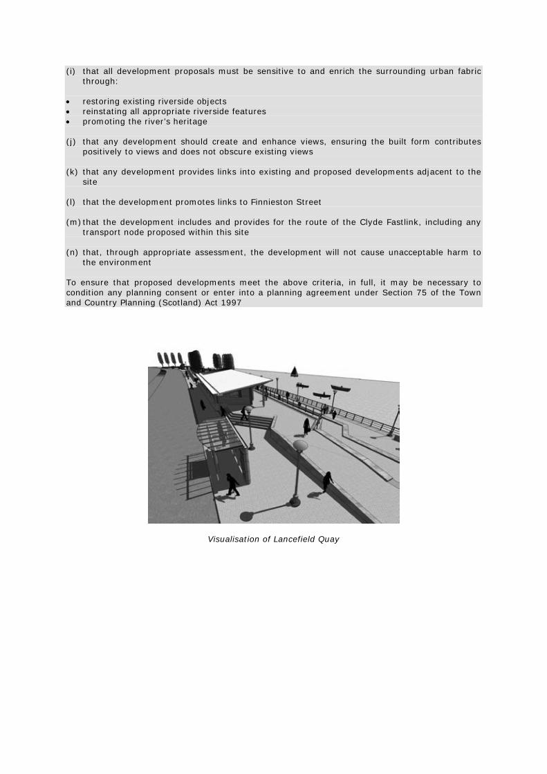
Visualisation of Lancefield Quay

Visualisation of Lancefield Quay
Visualisation of Anderston Quay Development Criterion 3 - Govan Wharf Housing at Govan Wharf, which lies below the recommended flood defence design level in this location of 6.0m AOD, will require flood protection. This level provides for a flood event of 0.5 per cent annual probability (1 in 200 years), taking into consideration climate change and freeboard levels. The Early Action Areas Report demonstrates that flood defence can be achieved by using folding demountable defences, either in conjunction with repairs to the existing wall or a new tied sheet pile wall with raised earth embankment. A low tide visual survey reported that the wall and revetment are in a variable state of repair along their lengths. Minor remedial works in relation to wall stability will be needed. This area consists of a recently built development of residential housing between Govan Road and the River, with a pedestrian pathway and planting strip adjacent to the River. Future major developments within this area include the enhancement of Govan town centre which aims to promote links with the waterfront and achieve greater connectivity between key development sites along the River Clyde and adjacent communities. A mixed use development at Govan Graving Docks is under consideration. There is an opportunity to improve the appearance of, and access to the river frontage so that links to this area are improved and can be tied into future local developments.

As this is a predominantly residential area, aspects such as residents’ privacy and the need for a public walkway will need to be addressed. There is an opportunity to encourage development which will help define a semi-private space for residents, but this must be treated sensitively. The space should be designed to ensure privacy for local residents. Clearly defining private space helps to provide better privacy and security. Any development in this location must contribute to a coherent urban fabric and walkway for the River Clyde. Detailing, such as hard and soft landscaping, helps provide a transition between public and private space. Trees, planting, paving and bollards are all commonly used to define different areas and to guide pedestrians away from private spaces. DEVELOPMENT CRITERION 3 Subject to assessment against other provisions of the development plan, development proposals within Govan Wharf, as defined in the development guide, should clearly demonstrate: (a) that the new development will meet the requirements of policy ENV 5 (b) that a continuous flood defence will be constructed that provides a continuous level of
protection from the 0.5 per cent annual probability (1 in 200 years) flood event, taking into account climate change and freeboard
(c) that, in this location, flood defences are incorporated into the hard landscape design, including
folding demountable defences (d) how the flood defence will link into the strategy for continuous direct defences in the River
Clyde corridor (e) that the stability of existing quay walls has been addressed and remedial works required for
quay walls in this location are incorporated into any development proposals and also provide increased access
(f) that quay wall stability meets current codes of practice and design standards (g) that the development contributes to the provision of a continuous Clyde Walkway and
Cycleway (h) the palette of riverscape components (set out under DETAILING, (a) Transitional Areas) has
been considered within the development of this transitional area (i) that landscaping will be required in this location, using paving, bollards and soft landscaping
to: • steer pedestrians away from the residential area • promote a semi-private feel to the area • help alleviate security fears (j) that, through appropriate assessment, the development will not cause unacceptable harm to
the environment To ensure that proposed developments meet the above criteria, in full, it may be necessary to condition any planning consent or enter into a planning agreement under Section 75 of the Town and Country Planning (Scotland) Act 1997.

Development Criterion 4 - Riverside Quay Large proportions of the land surrounding the flats in this location lie below the recommended flood defence design level in this location of 6.0m AOD, so flood mitigation will be required. This level provides for a flood event of a 0.5 per cent annual probability (1 in 200 years), taking into consideration climate change and freeboard levels. The River Edge Treatment Report demonstrates that flood defences can be achieved through new coping along the existing quay wall. The visual survey concluded that quay wall stability in this location was in good to fair condition with only a small section of the upper brickwork in very poor condition. The River Edge Treatment Report concludes that remedial works are not required, but a routine maintenance programme should be implemented. This is a residential area, with a small housing estate backing onto the quay. A landscaping scheme consisting of planting, paving, lighting and seating was provided when the estate was constructed. Any proposal must address residents’ privacy, through a clear definition of private and public spaces. DEVELOPMENT CRITERION 4 Subject to assessment against other provisions of the development plan, development proposals within Riverside Quay, as defined in the development guide, should clearly demonstrate: (a) that the new development will meet the requirements of policy ENV 5 (b) that a continuous flood defence will be constructed that provides a continuous level of
protection from the 0.5 percent annual probability (1 in 200 years) flood event, taking into account climate change and freeboard
(c) that the stability of existing quay walls and riverbank has been addressed through a structural
analysis and, if necessary, remedial works required for quay walls in this location are incorporated into any development proposals
(d) that quay wall stability meets current codes of practice and design standards (e) that the development contributes to the provision of a continuous Clyde Walkway and
Cycleway (f) the palette of riverscape components (set out under DETAILING, (a) Transitional Areas) has
been considered within the development of this transitional area (g) that landscaping will be required in this location, using paving, bollards and soft landscaping
to: • steer pedestrians away from the residential area • promote a semi-private feel to the area • help alleviate security fears (h) that, through appropriate assessment, the development will not cause unacceptable harm to
the environment To ensure that proposed developments meet the above criteria, in full, it may be necessary to condition any planning consent or enter into a planning agreement under Section 75 of the Town and Country Planning (Scotland) Act 1997.

Indicative cross section of Riverside Quay Development Criterion 5 - Princes Dock Flood mitigation will be required in this location as the residential area lies below the recommended flood defence design level of 6.0m AOD. The River Edge Treatment Report shows that flood defences can be achieved through a flood embankment tied into the higher ground to the west of development. The visual survey concluded that quay wall stability in this location was in good condition. The River Edge Treatment Report also demonstrates that, although the quay walls are in good condition, some remedial works are required through the placement of a rock ballast. DEVELOPMENT CRITERION 5 Subject to assessment against other provisions of the development plan, development proposals within Princes Dock, as defined in the development guide, should clearly demonstrate: (a) that the new development will meet the requirements of policy ENV 5 (b) that a continuous flood defence will be constructed that provides a continuous level of
protection from the 0.5 per cent annual probability (1 in 200 years) flood event, taking into account climate change and freeboard
(c) that flood defences link into the strategy for continuous direct defences in the River Clyde
corridor (d) that the stability of existing quay walls has been addressed and remedial works required for
quay walls in this location are incorporated into any development proposals, in the form of the placement of a rock ballast next to the quay wall
(e) that quay wall stability meets current codes of practice and design standards (f) that the development contributes to the provision of a continuous Clyde Walkway and
Cycleway (g) the palette of riverscape components (set out under DETAILING, (a) Transitional Areas) has
been considered within the development of this transitional area

(h) that landscaping will be required in this location, using paving, bollards and soft landscaping
to: • steer pedestrians away from the residential area • promote a semi-private feel to the area • help alleviate security fears (i) that, through appropriate assessment, the development will not cause unacceptable harm to
the environment To ensure that proposed developments meet the above criteria, in full, it may be necessary to condition any planning consent or enter into a planning agreement under Section 75 of the Town and Country Planning (Scotland) Act 1997.
Indicative cross section of Princes Dock Development Criterion 6 - Mavisbank Quay Flood mitigation will be required in this location as the lowest threshold level of the adjacent flats is 5.59m, which is below the recommended flood defence design level of 6.0m AOD in this location. This provides for a flood event of a 0.5 per cent annual probability (1 in 200 years), taking into consideration climate change and freeboard levels. The River Edge Treatment Report shows that flood defence can be achieved through an embankment incorporated into the landscaping works. The visual survey concluded that quay wall stability in this location was fair to poor, with a small length of sheet piling showing signs of accelerated low-water corrosion. The River Edge Treatment Report also demonstrated that the most appropriate way to achieve quay wall stability is through ballasting the entire length of quay. This area is predominantly residential, but the Clyde Arc road bridge will help link Finnieston, Govan and the various commercial and residential developments in the area. This will bring life back to this stretch of the River Clyde. Public realm improvements on the north bank at Lancefield Quay and the Clyde Arc bridge means it will be important to enhance the views to the south bank. The quay wall is in poor condition and remedial works will ensure views in this area are enhanced.

DEVELOPMENT CRITERION 6 Subject to assessment against other provisions of the development plan, development proposals within Mavisbank Quay, as defined in the development guide, should clearly demonstrate: (a) that the new development will meet the requirements of policy ENV5 (b) that a continuous flood defence will be constructed that provides a continuous level of
protection from the 0.5 per cent annual probability (1 in 200 years) flood event, taking into account climate change and freeboard
(c) that flood defences link into the strategy for continuous direct defences in the River Clyde
corridor (d) that the stability of existing quay walls and riverbank has been addressed and remedial works
required for quay walls in this location are incorporated into any development proposals in the form of a rock ballast against the entire length of the quay wall
(e) that quay wall stability meets current codes of practice and design standards (f) that the development contributes to the provision of a continuous Clyde Walkway and
Cycleway (g) the palette of riverscape components (set out under DETAILING, (a) Transitional Areas) has
been considered within the development of this transitional area (h) that landscaping will be required in this location, using paving, bollards and soft landscaping
to: • steer pedestrians away from the residential area • promote a semi-private feel to the area • help alleviate security fears (i) that, through appropriate assessment, the development will not cause unacceptable harm to
the environment To ensure that proposed developments meet the above criteria, in full, it may be necessary to condition any planning consent or enter into a planning agreement under Section 75 of the Town and Country Planning (Scotland) Act 1997.
Indicative cross section of Mavisbank Quay

Development Criterion 7 - Windmillcroft Quay The lowest water threshold level of the adjacent flats is 5.36m AOD which is below the recommended flood defence design level in this location of 6.0m AOD, so flood mitigation will be required. This level provides for a flood event of 0.5 per cent annual probability (1 in 200 years), taking into consideration climate change and freeboard levels. The River Edge Treatment Report shows that flood defences can be achieved through permanent walls and embankments as part of remedial and refurbishment works. The visual survey concluded that quay wall stability is poor to very poor with numerous buckled or missing sections of the steel walling plate that ties the top of the timber piles to the masonry upper wall. The stability assessment concluded that the structure of the wall is inadequate and the main factor ensuring its stability is the buildup of silt at the bottom of the wall. Remedial works are proposed. The River Edge Treatment Report also demonstrates that the most appropriate way to achieve quay wall stability in this location is through a build out and stepped revetment or tiered promenade. This area comprises residential housing and a narrow public walkway on the River edge. It adjoins the recently developed pedestrian crossing between Broomielaw and Tradeston, which incorporates extensive public realm enhancements. Development will require to protect the amenity of nearby residents and ensure a clear distinction between public and private space. This will help alleviate security issues. DEVELOPMENT CRITERION 7 Subject to assessment against other provisions of the development plan, development proposals within Windmillcroft Quay, as defined in the development guide, should clearly demonstrate: (a) that the new development will meet the requirements of policy ENV 5 (b) that a continuous flood defence will be constructed that provides a continuous level of
protection from the 0.5 per cent annual probability (1 in 200 years) flood event, taking into account climate change and freeboard
(c) that flood defences link into the strategy for continuous direct defences in the River Clyde
corridor (d) that the stability of existing quay walls and riverbank has been addressed and remedial works
required for quay walls in this location are incorporated into any development proposals through a build out of the existing quay wall
(e) that quay wall stability meets current codes of practice and design standards (f) that the development contributes to the provision of a continuous Clyde Walkway and
Cycleway (g) the palette of riverscape components (set out under DETAILING, (a) Transitional Areas) has
been considered within the development of this transitional area (h) that landscaping will be required in this location, using paving, bollards and soft landscaping
to: • steer pedestrians away from the residential area • promote a semi-private feel to the area • help alleviate security fears

(i) that, through appropriate assessment, the development will not cause unacceptable harm to
the environment To ensure that proposed developments meet the above criteria, in full, it may be necessary to condition any planning consent or enter into a planning agreement under Section 75 of the Town and Country Planning (Scotland) Act 1997.
Indicative cross section of Windmillcroft Quay Development Criterion 8 - Broomielaw Quay (East) Flood mitigation is not required here. The recommended flood defence design level in this location is 6.0m AOD. This level provides for a flood event of 0.5 per cent annual probability (1 in 200 years), taking into consideration climate change and freeboard levels. The road between George V Bridge and Glasgow Bridge is above this predicted flood level. The visual survey for this location concluded that quay wall stability is good and structures are relatively modern. The River Edge Treatment Report recommends a periodic maintenance scheme, especially with regard to checking the steel sheet piles for signs of accelerated low-water corrosion. This area, possibly more than any other along the River Clyde, is experiencing significant changes in riverside use. A new pedestrian bridge linking both sides of the bank. from Broomielaw and Tradeston. has recently been constructed. Development proposals for this area should provide a harmonious and consistent river frontage, improve access to the city centre and other developments along the riverside, and provide a mix of uses to give people reasons to visit the river. Active ground-floor uses are encouraged within urban blocks to connect the river to Argyle Street, as well as major walkway improvements. The main priorities in relation to access and connectivity are:
• to encourage continuous access along the River • develop connectivity between the river and the City Centre through key nodes and links • improve the appearance and natural surveillance within the location to help alleviate
security fears and encourage people to use the area

DEVELOPMENT CRITERION 8 Subject to assessment against other provisions of the development plan, development proposals within Broomielaw area, as defined in the development guide, should clearly demonstrate: (a) that the new development will meet the requirements of policy ENV 5 (b) that no alterations to ground levels, structures and built form will take place that will reduce
the provision of continuous flood protection (c) that the stability of existing quay walls and riverbank has been addressed and remedial works
required for quay walls in this location are incorporated into any development proposals through a build out of the existing quay wall
(d) that quay wall stability meets current codes of practice and design standards (e) that the development contributes to the provision of a continuous Clyde Walkway, Cycleway
and improved public realm, including a taxi bus stop (f) the palette of riverscape components (set out under DETAILING, (b) Public Realm Areas) has
been considered within the development of this public realm area (g) that, through appropriate assessment, the development will not cause unacceptable harm to
the environment (h) that the redevelopment of this area increases the connectivity between the site and the city
centre and should link into existing and proposed developments adjacent to the site (i) that all development proposals must be sensitive to and enrich the surrounding urban fabric
through: • restoring existing riverside objects • reinstating all appropriate riverside features • promoting the river’s heritage To ensure that proposed developments meet the above criteria, in full, it may be necessary to condition any planning consent or enter into a planning agreement under Section 75 of the Town and Country Planning (Scotland) Act 1997.
Indicative cross section of Broomielaw Quay (East)

Development Criterion 9 - Custom House Quay Flood defences are required in this location. The recommended flood defence design level in this location is 6.1m AOD. This level provides for a flood event of 0.5 per cent annual probability (1 in 200 years), taking into consideration climate change and freeboard levels. The River Edge Treatment Report shows that flood defences can be achieved through built form and hard landscaping. Custom House Quay has a range of structural forms. Quay wall stability is in variable states of repair. The sections of quay wall requiring the most urgent attention are the stretches of perched wall where the visual condition survey reported the wall façade to be in poor to fair condition. Custom House Quay lies within a conservation area and any proposed development must be sensitive to the surroundings. New buildings must gel with old to create an attractive and evolving townscape. This area is Glasgow City Centre’s main frontage onto the River Clyde, so development should exploit the links of Dixon Street to Buchanan Street to the City Centre to ensure the area is easily accessible. This area was identified as suitable for tall landmark buildings within the river design framework. The City Plan earmarks this area for a major mixed-use development with an extensive public realm area and walkway, creating a new urban environment. Any major development proposal will have a significant impact on the views and vistas along the Clyde. DEVELOPMENT CRITERION 9 Subject to assessment against other provisions of the development plan, development proposals within Custom House Quay, as defined in the development guide, should clearly demonstrate: (a) that the new development will meet the requirements of policy ENV5 (b) that a continuous flood defence will be constructed that provides a continuous level of
protection from the 0.5 per cent annual probability (1 in 200 years) flood event, taking into account climate change and freeboard
(c) that, in this location, flood defences are incorporated into the hard landscape design, including
demountable defences (d) that flood defences link into the strategy for continuous direct defences in the River Clyde
corridor (e) that the stability of existing quay walls has been addressed and remedial works required for
quay walls in this location are incorporated into any development proposals, through a build out of the existing quay wall
(f) that quay wall stability meets current codes of practice and design standards (g) that the development contributes to the provision of a continuous Clyde Walkway and
Cycleway (h) the palette of riverscape components (set out under DETAILING, (b) Public Realm Areas) has
been considered within the development of this public realm area (i) that all development proposals must be sensitive to and enrich the surrounding urban fabric
through restoring existing riverside objects, reinstating all appropriate riverside features and promoting the river’s heritage
(j) that any development should create and enhance views, ensuring the built form contributes
positively to views and does not obscure existing views (k) that the development of this area offers links into existing and proposed developments
adjacent to the site and promotes links to Dixon Street and Buchanan Street, in particular

(l) that, through appropriate assessment, the development will not cause unacceptable harm to the environment
(m) It has been demonstrated through appropriate assessment that the development will not cause
unacceptable harm to the environment. To ensure that proposed developments meet the above criteria, in full, it may be necessary to condition any planning consent or enter into a planning agreement under Section 75 of the Town and Country Planning (Scotland) Act 1997.
Indicative cross section of Custom House Quay Development Criterion 10 - Carlton Place Quay Flood mitigation is required in this location. The recommended flood defence design level in this location is 6.1m AOD. This level provides for a flood event of 0.5 per cent annual probability (1 in 200 years), taking into consideration climate change and freeboard levels. Ground levels range from 4.20m to 6.50m AOD. As some buildings may be below the recommended flood design defence level of 6.06m, permanent or demountable flood defences will be necessary. The River Edge Treatment Report shows that flood defences can be achieved by raising the level of the grass embankment between the Sheriff Court and the riverside embankment. The visual survey showed quay wall stability to be in poor to very poor condition, with numerous signs of lateral and vertical displacement and settlement. The revetment is very steep, which is a contributing factor in its instability. Remedial works will be required. The River Edge Treatment Report also showed that the most appropriate way to achieve quay wall stability is through the replacement of the original revetment using traditional setts coursed into a reinforced concrete base slab. This area has a number of Listed Buildings and is within the Central Conservation Area. Carlton Place is an attractive setting with a strong identity. Proposals for this area should preserve and enhance its character. Due to the historical importance of this location, funding and grants may be available to restore the original revetment. Historic frontages and the street cobbles should be retained and preserved. The cross-river links here should be promoted to link Carlton Place with the Custom House Quay development on the north bank. There is also an opportunity to provide access to the riverbank itself with the restoration of the original revetment.

DEVELOPMENT CRITERION 10 Subject to assessment against other provisions of the development plan, development proposals within Carlton Place, as defined in the development guide, should clearly demonstrate: (a) that the new development will meet the requirements of policy ENV 5 (b) that no alterations to ground levels, structures and built form will take place that will reduce
the level of continuous flood protection provided (c) that riverbank stability has been addressed and any remedial works in this location seek to
replace and restore the original revetment using traditional setts (d) that riverbank stability meets current codes of practice and design standards (e) that the development contributes to the provision of a continuous Clyde Walkway, Cycleway
and improved public realm area (f) the palette of riverscape components (set out under DETAILING, (b) Public Realm Areas) has
been considered within the development of this public realm area (g) that any proposals are sensitive to and enrich the surrounding area, as the site is within the
Central Conservation Area (h) that, through appropriate assessment, the development will not cause unacceptable harm to
the environment To ensure that proposed developments meet the above criteria, in full, it may be necessary to condition any planning consent or enter into a planning agreement under Section 75 of the Town and Country Planning (Scotland) Act 1997.
Indicative cross section of Carlton Place

Development Criterion 11 - Clyde Street Flood mitigation will not be required in this location. The minimum surveyed threshold level of any building adjacent to the quays is 6.22m AOD which is above the recommended flood defence design level of 6.1m AOD in this location. This level provides for a flood event of 0.5 per cent annual probability (1 in 200 years), taking into consideration climate change and freeboard levels. The revetment stability in this location is poor, suffering from numerous missing stones, minor slippage and extensive vegetation growth. Besides one defect, the retaining wall was in good condition. The River Edge Treatment Report shows that the most appropriate way to achieve revetment stability is through a build out with a low level promenade. Clyde Street is within the Central Conservation Area, so any development proposed should be sensitive to its surroundings. This site is also a key link between the major development site of Custom House Quay and the Glasgow Green area. DEVELOPMENT CRITERION 11 Subject to assessment against other provisions of the development plan, development proposals within Clyde Street, as defined in the development guide, should clearly demonstrate: (a) that the new development will meet the requirements of policy ENV 5 (b) that no alterations to ground levels, structures and built form will take place that will reduce
the level of continuous flood protection provided (c) that riverbank stability has been addressed and remedial works required for the riverbank in
this location are incorporated into any development proposals (d) that riverbank stability meets current codes of practice and design standards (e) that the development contributes to the provision of a continuous Clyde Walkway, Cycleway
and improved public realm area, including a taxi bus stop (f) the palette of riverscape components (set out under DETAILING, (b) Public Realm Areas) has
been considered within the development of this public realm area (g) that all development proposals must be sensitive to and enrich the surrounding urban fabric of
the Central Conservation Area, through: • restoring existing riverside objects • reinstating all appropriate riverside features • promoting the river’s heritage (h) that any development should create and enhance views, ensuring the built form contributes
positively to views and does not obscure existing views (i) that any development provides links into existing and proposed developments adjacent to the
site (j) that, through appropriate assessment, the development will not cause unacceptable harm to
the environment To ensure that proposed development meet the above criteria, in full, it may be necessary to condition any planning consent or enter into a planning agreement under Section 75 of the Town and Country Planning (Scotland) Act 1997.

Indicative cross section of Clyde Street Development Criterion 12 - Glasgow Green Flood mitigation will not be required in this location. The existing footpaths lie above the recommended flood defence design level, which is 6.1m AOD in this location. This level provides for a flood event of 0.5 per cent annual probability (1 in 200 years), taking into consideration climate change and freeboard levels. Following a major flood event in 1994, emergency revetment stabilisation works were carried out on a failed 50m long section of bank upstream of the Albert Bridge. This consisted of rock armouring in the low-tide zone, gabion baskets in the intertidal zone and a geo-textile reinforced grassed slope above the high-tide level. The visual survey contained within the River Edge Treatment Report shows most of the assets to be in fair condition, although the rip-rap slope is in poor condition. To avoid a repeat of the bank collapse, the stability option for this location should be similar to the emergency revetment stabilisation measures. Quay wall stability has also been addressed recently through remedial works and the assets in this location are in a reasonable condition. The Council aims to restore Glasgow Green to its former status as a primary visitor attraction. The concept seeks to restore and enhance historic visitor attractions as well as creating event and open-space areas. The River Edge Treatment Report also shows that a new green-faced bank, incorporating bio-engineered works and slope stabilisation, would encourage ecological opportunities and habitat enhancement in this location. Lighting should be used to increase security. The introduction of new trees and flora will define existing and new event and open space areas. The upgraded and new furniture, signs and interpretation will promote accessibility and connectivity within Glasgow Green. This area has been identified as suitable for ecological enhancement and habitat creation at the river’s edge. Ecological opportunities should be investigated for soft bank treatment. This is best achieved through new green-faced gabion-terraced riverbank and slope stabilisation.

DEVELOPMENT CRITERION 12 Subject to assessment against other provisions of the development plan, development proposals within Glasgow Green, as defined in the development guide, should clearly demonstrate: (a) that the new development will meet the requirements of policy ENV 5 (b) that no alterations to ground levels, structures and built form will take place that will reduce
the level of continuous flood protection provided (c) that riverbank stability has been addressed and remedial works required for the riverbank in
this location incorporate ecological enhancement and habitat creation are incorporated into any development proposals, through a build out of the existing quay wall
(d) that riverbank stability meets current codes of practice and design standards (e) that the development contributes to the provision of a continuous Clyde Walkway and
Cycleway (f) that the palette of riverscape components (set out under DETAILING, (c) Parks and Green
Space) has been considered within the development of this park/green space area (g) that any proposals are sensitive to and enrich the surroundings, as this site is within a
conservation area (h) that, through appropriate assessment, the development will not cause unacceptable harm to
the environment To ensure that proposed developments meet the above criteria, in full, it may be necessary to condition any planning consent or enter into a planning agreement under Section 75 of the Town and Country Planning (Scotland) Act 1997. Development Criterion 13 - Florence and Adelphi Streets Flood mitigation will not be required in this location. The minimum surveyed threshold level of any building adjacent to the quays is 6.20m AOD which is above the recommended flood defence design level of 6.1m AOD in this location. This level provides for a flood event of 0.5 per cent annual probability (1 in 200 years), taking into consideration climate change and freeboard levels. The visual survey of quay wall stability shows the revetments to be in a poor to very poor condition. There is evidence of bank collapse and numerous examples of bulging and settlement of the slopes. The masonry retaining walls are in fair condition with few major defects. The River Edge Treatment Report shows the most appropriate way to achieve quay wall stability is through ballasting the most critical sections of the revetment. The area has already undergone basic improvements to public realm areas, but any works along this stretch of the river must:
• ensure that any development accommodates the Clyde Walkway • promote links up into the Gorbals and the Crown Street regeneration project • enhance views across to Glasgow Green • improve lighting and security • promote pedestrian priority • include quay wall and revetment improvements • seek to incorporate habitat creation planting

DEVELOPMENT CRITERION 13 Subject to assessment against other provisions of the development plan, development proposals within Florence and Adelphi Streets, as defined in the development guide, should clearly demonstrate: (a) that the new development will meet the requirements of policy ENV 5 (b) that no alterations to ground levels, structures and built form will take place that will reduce
the level of continuous flood protection provided (c) that riverbank stability has been addressed and remedial works required for the riverbank in
this location incorporate a rock ballast to the most critical sections of the revetment (d) that riverbank stability meets current codes of practice and design standards (e) that the development contributes to the provision of a continuous Clyde Walkway and
Cycleway (f) that the palette of riverscape components (set out under DETAILING, (a) Transitional Areas)
has been considered for this transitional area (g) that any development promotes links with the Gorbals and the Crown Street regeneration
project (h) that, through appropriate assessment, the development will not cause unacceptable harm to
the environment To ensure that proposed developments meet the above criteria, in full, it may be necessary to condition any planning consent or enter into a planning agreement under Section 75 of the Town and Country Planning (Scotland) Act 1997. GENERIC DEVELOPMENT CRITERIA Development Criterion 14 - Urban Areas Any development in these areas must link fully with key routes, encouraging north-south links to the City Centre and River, while promoting a continuous walkway along the River Clyde. Lighting schemes will be encouraged along appropriate lengths of the river walkway as they can help alleviate safety and security fears, whilst creating a welcoming and vibrant atmosphere. Any development in these areas must contribute to a coherent urban fabric and walkway for the River Clyde. The need for a continuous walkway is essential, even within residential areas and development must also ensure that residents’ privacy is addressed within development proposals, where necessary. There must be a clear distinction between public and private space to maximise privacy for residents, with clearly defined private space to help provide better privacy and security. Detailing, such as hard and soft landscaping, helps provide a transition between public and private space and can help differentiate between passive and active space. Trees, planting, paving and bollards are all commonly used to define different areas and to guide pedestrians away from private spaces.

DEVELOPMENT CRITERION 14 Subject to assessment against other provisions of the development plan, development proposals within the urban areas of the River Clyde corridor, as defined in the development guide, should clearly demonstrate: (a) that the new development will meet the requirements of policy ENV 5 (b) that a continuous flood defence will be constructed that provides a continuous level of
protection from the 0.5 per cent annual probability (1 in 200 years) flood event, taking into account climate change and freeboard
(c) that flood defences link into the strategy for continuous direct defences in the River Clyde
corridor (d) that quay wall and riverbank stability has been addressed and the required remedial works are
incorporated into any development proposals (e) that quay wall and riverbank stability meets current codes of practice and design standards (f) that the development contributes to the provision of a continuous Clyde Walkway and
Cycleway and improved public realm (g) that, if necessary, an appropriate landscape scheme will be implemented to ensure maximum
privacy for residents (h) that the palette of riverscape components (set out under DETAILING, (a) Transitional Areas
and (b) Public Realm Areas) has been considered, as appropriate, for the transitional and public realm areas
(i) that, through appropriate assessment, the development will not cause unacceptable harm to
the environment To ensure that proposed developments meet the above criteria, in full, it may be necessary to condition any planning consent or enter into a planning agreement under Section 75 of the Town and Country Planning (Scotland) Act 1997. Development Criterion 15 - Parks and Open Space Lighting should be an integral element used in park and open space areas to increase security. The introduction of new trees and flora will define existing and new event and open space areas. Upgraded and new furniture, signs and interpretation will promote accessibility and connectivity along the River Clyde.

DEVELOPMENT CRITERION 15 Subject to assessment against other provisions of the development plan, development proposals within existing park and open space areas of the River Clyde corridor, as defined in the development guide, should clearly demonstrate: (a) that the new development will meet the requirements of policy ENV 5 (b) that a continuous flood defence will be constructed that provides a continuous level of
protection from the 0.5 per cent annual probability (1 in 200 years) flood event, taking into account climate change and freeboard
(c) that flood defences link into the strategy for continuous direct defences in the River Clyde
corridor (d) that quay wall and riverbank stability has been addressed and the required remedial works are
incorporated into any development proposals (e) that quay wall and riverbank stability meets current codes of practice and design standards (f) that the development contributes to the provision of a continuous Clyde Walkway and
Cycleway and improved public realm (g) that the palette of riverscape components (set out under DETAILING, (c) Parks and Green
Space) has been considered for this park/greenspace area (h) that, through appropriate assessment, the development will not cause unacceptable harm to
the environment To ensure that proposed developments meet the above criteria, in full, it may be necessary to condition any planning consent or enter into a planning agreement under Section 75 of the Town and Country Planning (Scotland) Act 1997.
DEFINITIONS ACCELERATED LOW WATER CORROSION: A form of microbially influenced corrosion of steel in seas and estuaries, mostly affecting a zone close to the lowest astronomical tide level. AOD: Level above Ordnance Datum. BIO-ENGINEERED: The application of engineering principles to the fields of biology, in this case to address landscape and ecological design opportunities and create habitats for enhancement within the river corridor. COPE HEIGHT: The level of the top of a wall. COPE WALL/COPING: The top of a wall. CATCHMENT STORAGE: Water storage within the catchment of a river that reduces peak flows in the river. DREDGING: Excavation of deposited sediments in the bed of a river or estuary. EMBANKMENTS: Soil structures, usually with sloping sides built up above natural ground level. FINGERPOSTS: Information Posts/Signage to assist with general public orientation within the river corridor. FLOOD DEFENCE DESIGN LEVEL: The level of the top of the flood defence, consisting of predicted flood level plus freeboard. FLUVIAL FLOODING: Flooding passing down the channel and floodplain of a watercourse that originates in the rain falling over the catchment area. FOLDING DEMOUNTABLE DEFENCES: Flood defences that are stored in a recess in the surface of a footpath or road until needed and then the flood barrier is unfolded and erected. FREEBOARD: An allowance above predicted flood levels to take account of uncertainties in the prediction. HABITAT ENHANCEMENT: Identified species and habitats requiring mitigation measures to address concerns regarding nature conservation (through design, implementation and management) (see also development guide DG/ENV 5: Broad Environmental Mitigation Measures) HARD LANDSCAPE: The character or appearance of urban hardstanding/pavement/ road, consisting of non-vegetation material such as brick, stone, concrete, tile and wood. INTERLOCKING CYLINDERS: A form of mass gravity wall construction. MASS GRAVITY WALLS: A wall constructed usually of concrete or masonry resisting earth pressure by its weight. MASONRY WALLS/BLOCKWORK: Walls constructed of stone, concrete blocks or bricks. MONOLITHS: A form of mass gravity wall construction. NODE: A place where activity and routes are concentrated. PERCHED WALL: A quay wall where the bed of the river was later dredged below the original foundation level of the wall, the foundation generally being protected by timber sheet piles driven down the face of the wall. PIECEMEAL DEVELOPMENT: Uncoordinated and gradual development of land which doesn’t form part of a coherent masterplan or framework.

PLANNING CONDITIONS AND AGREEMENTS: Standards or actions relating to a planning permission that the owners and/or developers must adhere to when carrying out work. QUAY WALL BUILD OUT: A new quay wall built out into a river or estuary, providing additional land. QUAY WALL/QUAY WALL STABILITY: A wall originally constructed for berthing of ships. REMEDIAL WORKS: Work to remedy a defect in a structure. REVETMENT (STEPPED/STONE): Sloping or stepped protective treatment to a river bank, often formed in stone or concrete blockwork. RIP-RAP SLOPE: Sloping protection against waves or the flow of a river, formed from large rock boulders. RIVERSCAPE COMPONENTS: Detailing of the public realm including street furniture, paving material, hard landscaping and soft landscaping. ROCK BALLAST OR BALLASTING: Rock placed at the base of a wall to provide weight to improve stability of the wall. SHEET PILING/SHEET PILED WALLS: Walls constructed of steel profiled sheets driven into the ground, and sometimes anchored by tie bars. SILTATION: The process of sediment deposition occurring in a river or an estuary. SOFT LANDSCAPE: The character or appearance of open space/parkland, consisting of vegetation such as trees, shrubs, hedges, grass and ground cover. TIDAL BARRIER: A structure crossing the tidal reach of a river with gates that can be closed to exclude extreme tides. A typical example is the Thames Barrier. TIDAL FLOODING: Flooding originating in tide levels in the sea passing up the estuary into the river. TIMBER PILES: Timber driven into the ground to form piles to support a structure. TRAINING WALLS: Walls designed to direct the flow of a watercourse. TRANSITIONAL AREAS: Areas which lie between visitor destinations/public realm areas or ‘through routes’. TRANSITION REACH: The part of a river forming a transition between fluvial and tidal influences. URBAN FABRIC: The pattern of the arrangement and size of buildings and their plots in a settlement and the degree to which an area’s pattern of streetblocks and street junctions is respectively small and frequent, or large and infrequent. VISTAS: An enclosed view, usually a long and narrow one, sometimes past a series of landmarks. WALL FAÇADE: The face of a wall. 0.5% ANNUAL PROBABILITY: An event that has a probability of exceedance of 0.5% in any one year, also often referred to as the 200 year return period.