dgiwg 908 dgiwg portrayal roadmap - dgiwg portal system
TRANSCRIPT
DGIWG 908
DGIWG PORTRAYAL ROADMAP
Document type: Enterprise
Document date: 26 July 2019
Edition: 3.0.0
Responsible Party: Defence Geospatial Information Working Group
Audience: This document is approved for public release and is available
on the DGIWG website, http://www.dgiwg.org/dgiwg/
Abstract: The activities defined in this document are intended to serve
as a guide to facilitate program/project management
undertaken by the DGIWG in response to future state needs.
The document places special emphasis on portrayal activities
that promote interoperability of geospatial data, products and
services.
The document is reviewed annually and is subject to change
without notice.
Copyright: © Copyright DGIWG. Licensed under the terms in CC BY 4.0.
ENT-DP-19-004 26 July 2019
ii
Table of Contents
1. Scope .............................................................................................................................................. 1 2. Purpose ........................................................................................................................................... 1 3. Reference documents ..................................................................................................................... 1 3.1. Open Geospatial Consortium (OGC) ......................................................................................... 1 3.2. Defence Geospatial Information Working Group (DGIWG) ....................................................... 2 3.3. North Atlantic Treaty Organization (NATO) ............................................................................... 2 3.4. International Organization for Standardization (ISO) ................................................................. 2 3.5. World Wide Web Consortium (W3C) ......................................................................................... 2 3.6. International Hydrographic Organization (IHO) ......................................................................... 2 3.7. International Civil Aviation Organization (ICAO) ........................................................................ 3 4. Terms and Definitions ..................................................................................................................... 3 5. Geospatial Information – present state ........................................................................................... 5 5.1. Geospatial Content .................................................................................................................... 5 5.1.1 Data Models ............................................................................................................................... 5 5.1.2 Symbol Sets and Portrayal Rules .............................................................................................. 6 5.1.3 Static Portrayal Products............................................................................................................ 6 5.1.4 Dynamic Portrayal Procedures .................................................................................................. 6 5.2. Geospatial Services ................................................................................................................... 6 5.3. Standards Assessment .............................................................................................................. 7 5.3.1 Civil Standards ........................................................................................................................... 7 5.3.2 Defence Standards .................................................................................................................. 13 6. Technology Considerations ........................................................................................................... 19 6.1. Existing ..................................................................................................................................... 19 6.1.1 Hardcopy Data Products .......................................................................................................... 19 6.1.2 Computing and Display Environment ....................................................................................... 19 6.1.3 Web Services for Geospatial Display ....................................................................................... 20 6.1.4 Proliferation of Open Source Data ........................................................................................... 20 6.1.5 Disconnected / Intermittent / Limited Bandwidth (DIL) Users .................................................. 20 6.2. Emerging .................................................................................................................................. 20 6.2.1 Bundling Data and Delivery Containers, GeoPackage and OGC Web Service Context ......... 20 6.2.2 Vector Tiling ............................................................................................................................. 21 6.2.3 Geospatial Analytics ................................................................................................................. 21 6.2.4 Plug and Play, Code Reuse and Modular Design ................................................................... 21 6.2.5 Chained Services ..................................................................................................................... 21 6.2.6 3D Portrayal ............................................................................................................................. 21 6.2.7 Semantics, Ontologies and Linked Data .................................................................................. 22 6.2.8 Cloud Computing ..................................................................................................................... 22 7. Geospatial Information - Future State ........................................................................................... 23 7.1. Target Objectives ..................................................................................................................... 23 7.1.1 Symbology for Common Operational Picture .......................................................................... 23 7.1.2 Dynamic Vector Portrayal ........................................................................................................ 24 7.1.3 Common Portrayal Content ..................................................................................................... 25 7.1.4 Portrayal Register and DGIWG Registry ................................................................................. 26 7.1.5 Feature Portrayal Service ........................................................................................................ 28 7.1.6 3D Portrayal ............................................................................................................................. 28 7.1.7 Tailored Portrayal ..................................................................................................................... 28 7.2. Geospatial Content .................................................................................................................. 29 7.2.1 Vector Datasets ........................................................................................................................ 29 7.2.2 Symbol Sets and Portrayal Rules ............................................................................................ 30 7.2.3 Hardcopy and Raster Portrayal Products ................................................................................ 30 7.2.4 Vector Portrayal Procedures .................................................................................................... 30

ENT-DP-19-004 26 July 2019
iii
7.3. Geospatial Services ................................................................................................................. 30 7.4. Standardisation Initiatives ........................................................................................................ 31 7.4.1 Civil Standards ......................................................................................................................... 31 7.4.2 Defence Standards .................................................................................................................. 32 8. Program Plan ................................................................................................................................ 33 8.1. Portrayal Technical Panel (P4) ................................................................................................ 33 8.2. Current Projects ....................................................................................................................... 33 8.2.1. P4.01: Symbology for Web Service Environment .................................................................... 33 8.2.2. P1.03: City Map Hardcopy DPS ............................................................................................... 34 8.2.3. P1.05: DJOG(A) DPS ............................................................................................................... 34 8.2.4. P4.05: Portrayal Repository/Database ..................................................................................... 34 8.3. Envisioned Projects .................................................................................................................. 34 8.3.1. P4.03: DGIWG Implementation Guide for General Symbology Encoding ............................... 34 8.3.2. Portrayal Register .................................................................................................................... 35 8.3.3. Dynamic Portrayal Specification .............................................................................................. 36 9. Dependencies ............................................................................................................................... 37 Annex A – Acronyms and Abbreviations ............................................................................................... 38 Annex B - Summary of activities ........................................................................................................... 42
List of Figures
Figure 1 Joint Military Symbology Document Structure ........................................................................ 16
Figure 2 Dynamic Vector-Based Map Portrayal ................................................................................... 24
Figure 3 Feature Portrayal Service ...................................................................................................... 28
ENT-DP-19-004 26 July 2019
iv
Introduction
The Portrayal Roadmap facilitates current and future planning of the DGIWG Portrayal
Technical Panel (PTP) activities. DGIWG requires a roadmap that looks four years into the
future from the 2019 approved roadmap completion (2019-2023) for current standards and
six years into the future to track industry research and development of emerging standards.
This roadmap provides DGIWG Management with a strategy to manage portrayal
symbology, encoding and labelling definitions that synchronise efforts with all DGIWG
Technical Panels and Data Product Specifications (DPS) development. DGIWG, its Member
Organisations and Associates, prioritises requirements to ensure interoperability milestones
are achieved. The DGIWG Plenary will review and approve the initial Portrayal Roadmap
followed by annual reviews by the PTP project team. Annual Portrayal Roadmap updates
shall be submitted to the Plenary for assessment and approval.

ENT-DP-19-004 26 July 2019
v
i. Contributing participants
Nation Parent organisation
Czech Republic Military Geographic and Hydrometeorologic Office (MGHMO)
France Institut national de l'information géographique et forestière (IGN)
Institut Geographique National (IGN)
United Kingdom MoD - JFC C4ISR JtUser
United States National Geospatial-Intelligence Agency (NGA)
US Army Geospatial Center (AGC)
ii. Document points of contact
All questions regarding this document shall be directed to the [email protected]
iii. Revision history
Date Edition number
Primary clauses Modified
Description
2018 3.0 (draft) All Creation (on basis of
previous Portrayal roadmap
version 2.0 02 Aug 2010)
using a new template

ENT-DP-19-004 26 July 2019
1
1. Scope
DGIWG is the Multi-National body responsible to Member Nation Defence Organisations for
coordinating, advising and providing Policy recommendations on Geospatial Standardisation
issues. The Portrayal Roadmap serves as a strategy and planning tool for DGIWG, its
Member Organisations and Associates. It provides a baseline for standardisation
advancements and identifies deficiencies in portrayal. This document describes the present
state of geospatial interoperability across the Civil and Defence user communities. It
establishes the future state goals and objectives upon which associated standardisation
activities are based. Key factors used for this roadmap include: user requirements, relevant
standards (published or in work) and emerging technologies.
2. Purpose
The Portrayal Roadmap is a planning tool for DGIWG. The guidance within the document
highlights portrayal efforts to support software and capability development and advances
interoperability within the civil and defence user communities.
The DGIWG portrayal work focuses on symbology, labelling definition and ruleset creation
together with their maintenance, encoding and distribution. The PTP supports geospatial
production, data product specifications development and web services implementation.
3. Reference documents
3.1. Open Geospatial Consortium (OGC)
OGC 06-042 OpenGIS Web Map Service (WMS) Implementation Specification, Version
1.3, 15 March 2006,
http://portal.opengeospatial.org/files/?artifact_id=14416
OGC 07-057r7, Web Map Tile Service Implementation Standard, v1.0.0, 2010-04-06,
http://portal.opengeospatial.org/files/?artifact_id=35326
OGC 09-025r2, Web Feature Service, 2.0, 6 December 2010 (in DISR as ISO
19142:2010),
http://docs.opengeospatial.org/is/09-025r2/09-025r2.html
OGC 09-110r4, Web Coverage Service (WCS) 2.0 Interface Standard- Core
(incorporating Corrigendum), Version 2.0.1, 2012-07-12,
https://portal.opengeospatial.org/files/09-110r4
OGC 12-168r6, Catalogue Services 3.0,
http://docs.opengeospatial.org/is/12-168r6/12-168r6.html
OGC 12-128r15, OGC Geopackage Encoding Standard 1.2.1, 2018-09-06,
https://portal.opengeospatial.org/files/12-128r15
OGC 07-036r1, OpenGIS® Geography Markup Language (GML) Encoding Standard
3.2.2, 2016-12-05,
https://portal.opengeospatial.org/files/?artifact_id=74183&version=2
OGC 05-078r4, OGC OpenGIS Styled Layer Descriptor Profile of the Web Map Service
Implementation Specification,
http://portal.opengeospatial.org/files/?artifact_id=22364
ENT-DP-19-004 26 July 2019
2
OGC 05-077r4, OGC Symbology Encoding Specification,
http://portal.opengeospatial.org/files/?artifact_id=16700
OGC 12-007r2, KML 2.3
http://docs.opengeospatial.org/is/12-007r2/12-007r2.html
OGC 15-001r4, 3D Portrayal Service 1.013 Sep 2017,
http://docs.opengeospatial.org/is/15-001r4/15-001r4.html
3.2. Defence Geospatial Information Working Group (DGIWG)
DGIWG 112: DGIWG Web Map Service (WMS) 1.3 Profile – Revision, 2017-11-28,
https://portal.dgiwg.org/files/?artifact_id=68226&format=pdf
DGIWG 122: DGIWG Web Feature Service (WFS) 2.0 Profile, 2017-11-28,
https://portal.dgiwg.org/files/?artifact_id=68228&format=pdf
DGIWG 119: DGIWG Web Coverage Service (WCS) 2.0 Profile, 2017-11-28,
https://portal.dgiwg.org/files/?artifact_id=68227&format=pdf
DGIWG 125: DGIWG Catalogue Service for the Web 2.0 Profile, 2018-03-01,
https://portal.dgiwg.org/files/?artifact_id=68270&format=pdf
DGIWG 118: DGIWG Portrayal Registry Service Interface Specification
DGIWG 904: Defence Geospatial Standards Baseline (DGSB)
3.3. North Atlantic Treaty Organization (NATO)
STANAG 3675 Ed 2 Symbols on land maps, aeronautical and special naval charts
STANAG 3676 Ed 3 Marginal information on land maps, aeronautical charts and
photomaps
STANAG 3833 Ed 4 Symbols for use on maps of training areas for land forces
STANAG 7170 Ed 3 Additional Military Layers (AML)
STANAG 2019 Ed 7 (RD) NATO Joint Military Symbology – APP-6D, FD
STANAG 2592 Ed 2 NATO Geospatial Information Framework (NGIF)
3.4. International Organization for Standardization (ISO)
ISO 19117: 2012, Geographic Information – Portrayal
3.5. World Wide Web Consortium (W3C)
Scalable Vector Graphics (SVG) 1.1 (Second Edition)
http://www.w3.org/TR/SVG11/
Cascading Style Sheets (CSS) Basic User Interface Module Level 3 (CSS3 UI), W3C
Proposed Recommendation, 14 December 2017
https://www.w3.org/TR/2017/PR-css-ui-3-20171214/
3.6. International Hydrographic Organization (IHO)
IHO Publication S-52, Specifications for Chart Content and Display Aspects of ECDIS,
Ed. 6.1(.1) - October 2014 - With Clarifications up to June 2015,

ENT-DP-19-004 26 July 2019
3
https://www.iho.int/iho_pubs/standard/S-52/S-52%20Edition%206.1.1%20-
%20June%202015.pdf
IHO Publication S-100, IHO Universal Hydrographic Data Model (April 2017),
https://www.iho.int/iho_pubs/standard/S-100/S-100_Ed_3/S-100_Edition_3.0.0.pdf
IHO Geospatial Registry,
http://registry.iho.int/
3.7. International Civil Aviation Organization (ICAO)
ICAO Doc 8126 Aeronautical Information Services Manual
4. Terms and Definitions
Annotation
any marking on illustrative material for the purpose of clarification
[SOURCE: ISO 19117:2012]
Data
facts and statistics collected together for reference or analysis
[Oxford English Dictionary]
Data Product Specification
detailed description of a dataset or dataset series together with additional information
that will enable it to be created, supplied to and used by another party
[SOURCE: ISO 19131:2007]
Dynamic Vector Portrayal
digital representation of geospatial features rendered directly from vector data, with
symbols, line weights and area patterns that change to appropriate size, density and
geometry for different scales according to (pre-) defined rules
Globe
a three-dimensional scale model of Earth (terrestrial globe or geographical globe) or
other celestial body such as a planet or moon
[SOURCE: OGC Glossary of Terms]
Map
a two-dimensional visual portrayal of geospatial data.
[SOURCE: OGC Glossary of Terms]
NOTE: A map is not the data itself.
Portrayal
presentation of information to humans
[SOURCE: ISO 19117: 2012]
NOTE: The use of the term portrayal is restricted to the portrayal of geographic
information.
Portrayal Service
generic interface used to portray features

ENT-DP-19-004 26 July 2019
4
[SOURCE: ISO 19117: 2012]
Data Product
a dataset or dataset series that conforms to a product specification.
[SOURCE: derived from ISO 19131: 2007]
Raster
the representation of spatial data as a matrix of valued cells
[OGC Glossary of Terms]
Digital Raster Map
a map or globe product in raster format conformant with a Data Product Specification
suitable for digital or hard copy use.
Register
set of files containing identifiers assigned to items with descriptions of the associated
items
[SOURCE: ISO 19135-1:2015]
NOTE: A register in its simplest form can be a list.
Registry
information system on which a register is maintained
[SOURCE: ISO 19135-1:2015].
Style
the mapping from feature types and feature properties and constraints to parameterised
symbols used in drawing maps
[SOURCE: OGC Glossary of Terms]
Symbol Portrayal
primitive that can be graphic, audible, or tactile in nature, or a combination of these
[SOURCE: ISO 19117:2012]
Symbology
methodology for describing symbols and mapping of the schema to an application
schema
[SOURCE: OGC Glossary of Terms]
NOTE: Portrayal requires symbology
Vector
a representation of the spatial extent of geographic features using geometric elements
(such as point, curve and surface) in a coordinate space
[SOURCE: OGC Glossary of Terms]

ENT-DP-19-004 26 July 2019
5
5. Geospatial Information – present state
In the past, the DGIWG developed standards addressing the production, cartographic
finishing and printing/rasterising of hardcopy maps. Hardcopy and digital raster map
production is mature with common practices to provide common static raster map
backgrounds.
However, the DGIWG does not have a common mechanism to portray their maps on a
Common Operational Picture (COP) display. The primary reason is a lack of a standard
specification for dynamic vector-based maps that include symbology, registries and
rendering rules. Additionally, numerous proprietary commercial map display capabilities are
in use by DGIWG Nations that yield differences in symbols, formats and services. These
differences exacerbate the problem, leading to inconsistent portrayal solutions.
Standards for portrayal of dynamic vector-based maps are less mature primarily because of
the technical complexity of the subject. The community relies on commercial vendors with
unique and often proprietary map display solutions that are not easily translatable across
nations or beyond vendor-specific applications. Recent technology improvements support
rendering and display of dynamic vector-based maps in an acceptable amount of time and
with suitable visual quality. The lack of regional/global coverage of topographic vector data in
a consistent data schema at tactically significant scales (urban, 1:50,000 and 1:100,000
scales) compounds the symbolisation interoperability problem.
5.1. Geospatial Content
The main task for the Portrayal Panel is to develop symbol sets for vector data that provide
clear and unambiguous information to the map user. Therefore, collaboration between the
Vector Model and Schema Team (VMST) and the PTP is essential as the VMST defines the
geospatial concepts required by military users.
Portrayal consists of the symbol sets and portrayal rules describing how geospatial features
contained in the vector datasets are displayed.
Portrayal of geospatial content requires standardisation and governance. This
standardisation must address both international standards which define interfaces,
exchanges and general structure as well as Community of Interest (COI) specifications and
profiles which apply the general standards within the community for the data, symbols, rules
and products under its governance.
5.1.1 Data Models
The VMST provides governance of vector data models for DGIWG. Several formats and
schemas such as Defence Geospatial Information Framework (DGIF) and Multinational
Geospatial Co-Production Program (MGCP) are recognised and/or managed by DGIWG.
Additionally, national formats and schemas as well as commercial/open source datasets are
used when required or when they are the best available source. The capability to translate
data between schemas and apply common symbology and portrayal rules to different
datasets is not uniformly implemented. Data is often created and maintained by geospatial
organisations at the national or unit level or by individual commercial entities for internal use.
ENT-DP-19-004 26 July 2019
6
5.1.2 Symbol Sets and Portrayal Rules
Portrayal of any vector dataset is performed based on associated symbology and portrayal
rules. These symbol sets and portrayal rules are currently only published for hardcopy
products and associated raster representation. To portray vector data, individual
organisations and vendors create and maintain unique symbol sets and rules that often have
minor variations and system-specific constraints that prevent sharing across vendors or
organisations. Given the diversity of vector datasets and lack of common symbols and rules,
consistent portrayal is challenging to achieve between different systems and organisations.
Often the resulting portrayal is not sharable across the community but only within a very
limited set of users.
5.1.3 Static Portrayal Products
Static portrayal products include hardcopy and associated raster representation. These map
products are generated in accordance with documented data product specifications (DPS).
DGIWG and other organisations adopt consistent symbology and portrayal rules for
hardcopy and associated raster representation such as the Topographic Maps (TM) and
Joint Operations Graphics (JOG). Minor variations exist as DPS for similar products are
established by collaborating organisations (e.g. MGCP).
5.1.4 Dynamic Portrayal Procedures
Specifications for static portrayal products do not exist for the dynamic vector rendering
required to support web services and handheld devices. Dynamic portrayal procedures are
required to access vector data and apply symbology, portrayal rules and rendering logic. As
many of the component parts are subject to change as content evolves, a more agile and
responsive specification and governance process is required. The growing availability of web
services and handheld devices requires standardisation of dynamic portrayal across civil and
military user communities.
5.2. Geospatial Services
Direct users of portrayal capabilities are map producers, web service creators and
application developers. The portrayal rules and symbols are used to create products and
services, harmonise symbology and create applications that support the war-fighter.
Common OGC web services are used to provide raster representation of static products and
dynamic map products. These services include; WMS, WFS and Web Map Tile Service
(WMTS). DGIWG portrayal will comply with these standards and DGIWG profiles and
additionally, will utilise OGC portrayal standards such as Symbology Encoding (SE) and
Styled Layer Descriptor (SLD) Profile of WMS or other adopted formats and encodings.
These services, particularly WMS, are widely used in industry and within member nations,
primarily to share and portray geospatial content. Use of OGC web services to display vector
data requires use of SE and SLD which presents interoperability challenges from the lack of
consistent and shared symbol sets and portrayal rules.
Future portrayal web service and registry capabilities will utilise the OGC Catalogue Service
for the Web (CSW) and registry models such as ebXML Registry Information Model (ebRIM)
that will be web-enabled using OGC Web Processing Services (WPS). These models and
service capabilities show great promise, although the work is conceptual with limited
operational implementations.
ENT-DP-19-004 26 July 2019
7
Within DGIWG, the Web Service Technical Panel (WSTP) is responsible for the
development of DGIWG WMS, WMTS and WFS implementation profiles. The PTP provides
the symbol set and labelling rules that are used in the WSTP profiled web services. A
detailed discussion of geospatial service standards and DGIWG implementation profiles is
provided in the WSTP Roadmap.
5.3. Standards Assessment
5.3.1 Civil Standards
5.3.1.1 Civil Geospatial Standards Development Organisations
Several international standards organisations provide key standards addressing portrayal to
include standards for data, formats, services and graphics. Key organisations and their
portrayal related standards are included here. This is not an exhaustive list of standards or
organisations. Primary organisations are listed below:
Open Geospatial Consortium
The Open Geospatial Consortium (OGC) is an international industry-oriented consortium
of more than 300 companies, government agencies, research organisations and
universities participating in a consensus process to develop publicly available interface
specifications.
OGC’s portrayal activities mainly involve the development of portrayal data exchange
formats and service specifications for Web rendering of distributed feature and coverage
data. Some basic management aspects of portrayal catalogues are also being
considered, but with no emphasis on the organisational and versioning management
processes of registration. These activities currently take place in the OGC innovation
initiative such as testbeds, plug-fests and interoperability experiments in the Defence
and Intelligence (D&I) and Portrayal Domain Working Groups and in various standards
working groups (SWGs) dealing with the development and revision of OGC standards.
International Standards Organization Technical Committee 211
The International Standards Organization Technical Committee 211 (ISO/TC 211) is a
committee established under the International Organisation for Standardization (ISO) to
develop international standards for geospatial information. Several of these standards
are of special interest in the portrayal of geographical information.
International Hydrographic Organization
The International Hydrographic Organization (IHO) ensures that all the world's seas,
oceans and navigable waters are surveyed and charted. The mission of the IHO is to
create a global environment in which States provide adequate and timely hydrographic
data, products and services and ensure their widest possible use. The vision of the IHO
is to be the authoritative worldwide hydrographic body which actively engages all coastal
and interested States to advance maritime safety and efficiency and which supports the
protection and sustainable use of the marine environment. Digital Information Portrayal
Working Group (DIPWG) is the IHO technical body, responsible for IHO specifications for
colours, symbols and display rules.

ENT-DP-19-004 26 July 2019
8
International Civil Aviation Organization
The International Civil Aviation Organization (ICAO) is a UN specialised agency,
established in 1944 to manage the administration and governance of the Convention on
International Civil Aviation (Chicago Convention). ICAO works with the Convention’s 192
Member States and industry groups to reach consensus on international civil aviation
Standards and Recommended Practices (SARPs) and policies in support of a safe,
efficient, secure, economically sustainable and environmentally responsible civil aviation
sector. These SARPs and policies are used by ICAO Member States to ensure that their
local civil aviation operations and regulations conform to global norms, which in turn
permits more than 100,000 daily flights in aviation’s global network to operate safely and
reliably in every region of the world.
World Wide Web Consortium
The World Wide Web Consortium (W3C) is an international community where Member
organisations, a full-time staff and the public work together to develop Web standards.
Led by Web inventor and Director Tim Berners-Lee and CEO Jeffrey Jaffe, W3C's
mission is to lead the Web to its full potential. W3C standards define an Open Web
Platform for application development that has the unprecedented potential to enable
developers to build rich interactive experiences, powered by vast data stores that are
available on any device. Although the boundaries of the platform continue to evolve,
industry leaders speak almost in unison about how Hypertext Markup Language 5
(HTML5) will be the cornerstone for this platform. The full strength of the platform relies
on many more technologies that W3C and its partners are creating, including Cascading
Style Sheets (CSS), Scalable Vector Graphics (SVG), the Semantic Web stack,
eXtensible Markup Language (XML) and a variety of Application Programming Interfaces
(APIs). Contact W3C for more information.
5.3.1.2 Civil Geospatial Content Standards
ISO 19117, Geographic Information – Portrayal
This standard is part of the 191xx series of standards that are being promulgated by
ISO/TC 211. This international standard is an abstract document and is not intended for
direct implementation. It gives general guidelines to the application developers about the
mechanism that will be used to portray feature instances of a dataset. The portrayal
mechanism described in ISO 19117 separates the geospatial data from the portrayal of
the data. This makes it possible to portray the same data in different ways depending on
the needs of the user community. Portrayal rules establish a relationship between a
geospatial feature and a particular symbol. Portrayal rule sets are collections of portrayal
rules that in aggregate define a portrayal for each possible feature type defined in the
application schema of a geospatial data set. Different portrayal rule sets can be used to
create different portrayals of the same data set. This International Standard includes a
mechanism for declaring portrayal attributes as part of the portrayal specification. The
standard defines the concepts of portrayal specifications, portrayal catalogues and how
they relate to geospatial datasets.
The second edition of ISO 19117 was published in 2012. A revision of ISO 19117:2012
is currently underway to improve the structure and content of this standard. The rules
that define relationships of symbols to other symbols are not defined in ISO 19117.
ENT-DP-19-004 26 July 2019
9
These product finishing rules (de-confliction, displacement, thinning, etc.) could be the
subject of future work in TC 211 or DGIWG.
5.3.1.3 Civil Geospatial Service Standards
In DGIWG, the Web Services Technical Panel (WSTP) is the primary organisation
managing civil and defence geospatial services standards. See the WSTP Roadmap for
detailed information of services available.
OGC Web Map Service
The OGC Web Map Service (WMS) generates a dynamic image from geospatial data
using a simple request string which includes, at minimum, the requested layers and the
bounding box of the required area. Additional parameters may include; time, depth,
transparency and other optional dimensions such as spectral bands from satellite images
or filtering parameters.
DGIWG has published a WMS 1.3 Profile which has been adopted by the OGC as a best
practice document. WMS is a DGIWG Core Service.
OGC Styled Layer Descriptor
The OGC Styled Layer Descriptor (SLD-WMS) specification is a profile of the WMS
Encoding Standard that defines an encoding that extends the WMS standard to allow
user-defined symbolisation and colouring of geographic feature and coverage data. SLD
addresses the need for users and software to be able to control the visual portrayal of
the geospatial data. The ability to define styling rules requires a styling language that the
client and server can both understand. The OGC Symbology Encoding Standard (SE)
provides this language, while the SLD profile of WMS enables the application of SE to
WMS layers using extensions of WMS operations. Additionally, SLD defines an
operation for standardised access to legend symbols.
SLD allows users to utilise their own symbology and rule sets to portray geospatial data
in accordance with their individual needs. SLD provides the capability for users to include
or reference their own SLD file for published data layers or geospatial data accessible
via WFS or WCS services. These services may be loosely coupled component servers
which can symbolise feature/coverage data from any WFS/WCS to which it is directed
and also Geography Markup Language (GML) data that is provided inline as Feature
Portrayal Services (FPS) or Coverage Portrayal Services (CPS). These services may
also be integrated servers that are closely coupled and can only work in particular
configurations and with specified data sources.
DGIWG submitted a Change Request to SLD WMS (CR 117) to OGC to improve support
of such portrayal registries as sources for symbology. OGC is developing the open
portrayal framework which should improve the SLD-WMS.
OGC Web Map Tile Service
The OGC Web Map Tile Service (WMTS) Implementation Standard provides a
standards-based solution to serve digital maps using tile images with predefined content,
extent and resolution. WMTS provides a complementary approach to WMS for tiling
maps. WMS focuses on rendering custom maps and is a good solution for dynamic data
or custom styled maps (combined with the OGC Style Layer Descriptor (SLD) standard).
ENT-DP-19-004 26 July 2019
10
WMTS trades the flexibility of custom map rendering for the scalability possible by
serving of static data (base maps) where the bounding box and scales have been
constrained to discrete tiles. The fixed set of tiles allows for the implementation of a
WMTS service using a web server that simply returns existing files. The fixed set of tiles
also enables the use of standard network mechanisms for scalability such as distributed
cache systems.
OGC Web Feature Service
The OGC Web Feature Service (WFS) specification provides a service interface for
accessing and writing geospatial data that is usually delivered in GML format. Features
normally have unique identifiers and can be accessed in groups using relationships e.g.
all roads within a national boundary.
DGIWG has defined two WFS 2.0 profiles: One for Basic WFS responding to basic
requirements such as access to vector data and one for Transactional WFS allowing
both access and update of vector data. WFS 2.0 is a DGIWG Core Service.
OGC Web Coverage Service
The OGC Web Coverage Service (WCS) Implementation Specification provides
interfaces to access geospatial data as coverages, i.e. Digital Geospatial Information
representing space-time multidimensional varying phenomena. Typical examples are;
aerial, satellite images and meteorological and oceanographic (METOC) data.
The standard WCS 2.0 consists of a core definition and extensions, some of which are
community based, thus DGIWG will be monitoring and contributing to these extensions
when deemed relevant to the military use case. DGIWG has developed a WCS 2.0
profile for GEO requirements. WCS is a DGIWG Core Service.
OGC Catalogue Service for the Web
The OGC Catalogue Service for the Web (CSW) defines common interfaces to discover,
browse and query metadata about data, services and other potential resources.
The OGC catalogue standards break down into a number of components. For example,
the base standard which defines an abstract search interface. This currently supports
two information models for catalogues (Application Profiles) which are the CSW-ISO
profile and the CSW-ebRIM profile providing simple but limited and more advanced
cataloguing options respectively. CSW-ISO supports only two artifacts: Dataset and
Service. CSW-ebRIM is able to catalogue a wider range of artifacts and has an
extensible model. There are arguments for the use of either, or both of these application
profiles depending on the requirements and use cases. In both cases (and particularly in
the case of ebRIM) the need for a DGIWG profile is likely to be significant if real
interoperability is to be achieved between nations.
OGC has published Catalogue Services 3.0. DGIWG WSTP has published a profile for
the CSW-ISO Application Profile based on Catalogue Service 2.0.
OGC 3D Portrayal Service
The 3D Portrayal Service (3DPS) is a Geospatial Three-Dimensional (3D) content
delivery implementation specification. It focuses on what is to be delivered, and in which
manner, to enable interoperable 3D portrayal. It does not define or endorse particular
ENT-DP-19-004 26 July 2019
11
content transmission formats, but specifies how geospatial 3D content is described,
selected and delivered. It does not prescribe how aforementioned content is to be
organised and represented but provides a framework to determine whether 3D content is
interoperable at the content representation level.
5.3.1.4 Civil Graphics and Encoding Standards
The portrayal of geographic information is achieved by applying pre-determined symbols to
the feature geometry and rendering the data to visually display information or form a
recognisable map or chart. Symbols may be represented either as raster (also known as
“bitmaps”) or vector format.
While many graphic-employed encoding standards are proprietary and software specific, the
majority of raster formats are open and available for general use. The most common lossy
compression graphics standard is Joint Photographic Experts Group (JPEG) format. The
lossless graphics standards include Bitmap (BMP), Graphics Interchange Format (GIF),
Portable Network Graphics (PNG) and X PixMap (XPM). There are standards that work as
lossless or lossy, such as JPEG 2000 and Tagged Image File Format (TIFF). Vector
graphics standards include Computer Graphic Metafile (CGM) and SVG. Some standards
combine both raster and vector data, for example Encapsulated PostScript (EPS) and
Portable Document Format (PDF).
Some of these standards have been adapted specifically for Geographic Information such as
Geospatial Tagged Image File Format (GeoTIFF) or Geospatial Portable Document Format
(GeoPDF). This document does not provide an exhaustive list of encoding formats nor
makes any recommendations as to which format to use. The formats discussed below
provide a selective overview of which ones are commonly used for portrayal in a web service
context.
International Hydrographic Organization (IHO) Publication S-52
IHO Publication S-52 provides specifications for colours, symbols and display rules along
with its accompanying Presentation Library and the portrayal elements of IHO
Publications S-100 and S-101, as well as the Portrayal Register of the Geospatial
Information Infrastructure. S-52 is the symbology for Electronic Navigational Chart
(ENC).
International Civil Aviation Organization (ICAO) Doc 8126 Aeronautical Information
Services Manual
Doc 8126 is a guidance material on aspects of the Aeronautical Information Service
(AIS), explaining the basic functions of an AIS and the basic type of organisation
required to assist member states in implementing the Standards and Recommended
Practices of Annex 15 — Aeronautical Information Services. Key documents include:
Annex 4 — Aeronautical Charts, Annex 15 — Aeronautical Information Services and Doc
8697 — Aeronautical Chart Manual.
OGC Symbology Encoding
OGC Symbology Encoding (SE) defines the XML language for styling information that
can be applied to digital Feature and Coverage data. This document, together with the
SLD Profile (for the WMS Implementation Specification), is the direct follow-up of SLD
Implementation Specification 1.0.0. The old specification document was split into two
ENT-DP-19-004 26 July 2019
12
documents to allow the parts that are not specific to WMS to be reused by other service
specifications.
SE is undergoing an update in OGC to address design and symbolisation shortfalls by
creating a modular specification. This specification will include a conceptual model that is
independent and provide more open encoding alternatives to improve interoperability
and exchange outside of vendor specific extensions.
Geography Markup Language
Geography Markup Language (GML) is an XML grammar for the description of
application schemas as well as the transport and storage of geographic information.
The aim of GML is to provide a standardised encoding (i.e. a standardised
implementation in XML) of conceptual models specified by the International Standards
for Geographic Information provided by ISO Technical Committee 211 (Geographic
Information/Geomatics) (ISO/TC211). If every application schema was encoded
independently and the encoding process included the types from, for example, ISO
19108, then without unambiguous and completely fixed encoding rules, the XML
encodings would be different. Additionally, since every implementation platform has
specific strengths and weaknesses, it is helpful to standardise XML encodings for core
Geographic Information concepts modelled in the ISO 19100 series of international
standards and commonly used in application schemas. Work is underway in the DGIWG
DGIF project to create GML 3.2.1 application schemas for DGIF data.
Keyhole Markup Language
Keyhole Markup Language (KML) is an XML grammar used to encode and transport
representations of geographic data for display in an earth browser, such as a three-
dimensional (3D) virtual globe, two-dimensional (2D) web browser application, or 2D
mobile application. KML Application Profiles that support extensions for symbology
encoding, symbol graphics and regular polygon geometry for certain symbol sets (e.g.
MIL-STD-2525) need to be agreed on and supported by KML clients.
Scalable Vector Graphics
Scalable Vector Graphics (SVG) is an XML-based vector image format for two-
dimensional graphics that has support for interactivity and animation. The SVG
specification is an open standard developed by the W3C since 1999. SVG is used in
Geographic Information Systems both as an encoding for symbols and as a format for
rendering maps.
Cascading Style Sheets
Cascading Style Sheets (CSS) is a language for describing the rendering of structured
documents (such as HTML and XML) on screen, on paper, in speech, etc. The CSS
specification describes user interface related properties and values that are proposed for
CSS level 3 to style HTML and XML (including XHTML). It uses various properties and
values to style basic user interface elements in a document.
The CSS specification is an open standard developed by the W3C. Geospatial
derivatives such as CartoCSS and GeoCSS are openly available.

ENT-DP-19-004 26 July 2019
13
JavaScript Object Notation
JavaScript Object Notation (JSON) is an open standard format that uses human-
readable text to transmit data objects consisting of key value pairs. It is used primarily to
transmit data between a server and web application as an alternative to XML. An
advantage of JSON over XML is that it is a more lightweight format as it does not have
the XML overhead of, for example, start- and end-tags. The disadvantage of JSON is the
lack of the schema representation found in XML as a Mark-Up language. JSON is an
alternative to XML where there are no requirements for sophisticated schemas or
specific data types.
Geospatial JavaScript Object Notation
Geospatial JavaScript Object Notation (GeoJSON) is an open standard format for
encoding collections of simple geographical features along with their non-spatial
attributes using JSON. GeoJSON supports the following geometry types: Point,
LineString, Polygon, MultiPoint, MultiLineString, MultiPolygon and GeometryCollection.
Features in GeoJSON contain a geometry object and additional properties and a feature
collection represents a list of features. GeoJSON offers an efficient method to parse data
in a browser, i.e. it can be faster to deliver and parse WFS as GeoJSON compared to
GML.
OGC GeoPackage
OGC GeoPackage provides a flexible, interoperable solution for providing geospatial
content that can be exchanged and shared across different mobile devices, applications
and web services. GeoPackage currently allows users to store, view, edit and update
feature data, tiled imagery and raster maps. It features 22 standard zoom levels that
allow the user to zoom in and out across multiple scales and resolution data in a similar
way to Google maps. Additionally, GeoPackage enables users to include maps and
images in an open format. A GeoPackage file is a single SQLite container for the
storage, dissemination and direct-use of vector features, tile matrix sets and metadata on
a variety of computing platforms.
GeoPackage is intended to provide a light-weight interoperable solution use case for
many defence users. It provides the ability to load data on to a handheld device for use
in situations where continuous connection to a web service is impractical due to limited
bandwidth, radio silence/covertness, or potential denial of communications. Currently
GeoPackage may contain: Vector Feature User Data Tables and Tile Matrix Set User
Data Tables (PNG and JPEG Tiles). OGC has ongoing work to standardise how to
include symbology and rules in GeoPackage. It is possible that this, and future work will
lead to a DGIWG GeoPackage Profile.
5.3.2 Defence Standards
5.3.2.1 Defence Standards Development Organisations
Defence Geospatial Information Working Group
DGIWG is the Multi-National body responsible for Geospatial Standardisation for the
Defence Organisations of Member Nations. DGIWG Geospatial Standards are built upon
the generic and abstract standards for geographic information defined by ISO TC/211
ENT-DP-19-004 26 July 2019
14
and the service specifications endorsed by the OGC. DGIWG defines information
components for use in the development of product specifications and application
schemas for military geospatial data. DGIWG also establishes service specifications,
encoding formats and testing methodologies to meet military geospatial information
requirements.
NATO Working Groups
Joint Geospatial Standards Working Group
The role of the Joint Geospatial Standards Working Group (JGSWG) is to progress
standardisation and/or interoperability in military geospatial matters in order to improve
the effectiveness of NATO forces. JGSWG oversees Geospatial Standardization
Agreements (STANAGs). JGSWG is the main point of contact between DGIWG and
NATO Core Geographic Information Systems (GIS) and other NATO initiatives related to
Geospatial Information. The JGSWG transforms the geospatial requirements from NATO
into an unclassified JGSWG Program of Work.
DGIWG and JGSWG have established a close relationship around which future
cooperation will be developed. This is the framework to provide NATO geospatial
requirements to DGIWG. Currently JGSWG and DGIWG are working on DGIF/NGIF,
services and interfaces and the involvement of civil geospatial standards within NATO.
NATO Core GIS is currently one of the main focuses of both organisations.
Joint Symbology Panel
The Joint Symbology Panel (JSP) is a panel of the Information Exchange Requirements
Harmonization Working Group (IERHWG). JSP ensures that the requirements for joint
symbology are correctly represented in Allied Procedural Publication 6 (APP-6). The
Panel also ensures that joint symbols remain harmonised with NATO doctrine,
terminology and information exchange requirements.
Geospatial Maritime Working Group
The Geospatial Maritime Working Group (GMWG) is responsible for the Additional
Military Layers initiative to add supplementary information to nautical charts. For NATO
Geospatial Standardisation, the GMWG is directed and supported by the JGSWG.
GMWG also reports annually to the NATO Geospatial Board (NGB). For NATO
Operational Geospatial Requirements, the GMWG is directed and supported by the
Geospatial Requirements Working Group (GRWG). For Oceanographic and
Meteorological contents, GMWG will liaise with the Military Committee Meteorology and
Oceanography Group (MC METOC Group).
Geospatial Aeronautical Working Group
In 2018 the NATO Geospatial Board agreed to give the Geospatial Aeronautical Working
Group (GAWG) permanent status as a NATO working group. The role of the GAWG is
to provide the NATO Command and Force Structure with Aeronautical Geospatial
Standards, governance of Production and Co-production, Operational Support and
provision of Aeronautical Geospatial Information in close consultation with, and as
directed by, the GRWG and the JGSWG.

ENT-DP-19-004 26 July 2019
15
5.3.2.2 Defence Vector Data Standards
The development of standards and specifications supporting the collection, management,
production and provision of geospatial information as vector data is a task of the Vector
Modelling Standards Team (VMST).
NATO and DGIWG started the NATO Geospatial Information Framework/Defence
Geospatial Information Framework (NGIF/DGIF) based on the US Geospatial Intelligence
(GEOINT) Structure Implementation Profile (GSIP) 5.0 in order to solve the issues of
inhomogeneous, isolated and partly outdated specifications for Geospatial Information in the
Military Environment.
The first step was the creation of an information model for vector data called NATO/Defence Geospatial Information Model (NGIM/DGIM) accompanied by the NATO/Defence Geospatial Feature Concept Dictionary (NGFCD/DGFCD) and the NATO/Defence Geospatial Real-World Object Index (NGRWI/DGRWI). These three standardisation documents were adopted for use by NATO Nations and NATO in 2014 with the ratification and promulgation of STANAG 2592 and AGeoP-11. They create a foundation for any future specification for Geospatial Information Exchange and Geospatial Products based on vector data. The terms DGIF 1.0 and NGIF 1.0 are interchangeable as they have the exact same
content. In future this may vary, as NGIF may only be a sub set of the DGIF suite of
standards and specifications. For the purposes of this document the term DGIF will be used.
DGIWG has published edition 2.0 of the DGIF specifications comprising of content changes
to reflect NATO and Nations’ requirements. DGIWG is currently developing product
specifications for a 50k topographic map and additional specifications for the encoding of
Geospatial Information for exchange.
Review the VMST Roadmap for a detailed discussion of Defence Geospatial Vector Data
standards.
5.3.2.3 Defence Symbology and Portrayal Rules Standards
STANAG 3675 Ed 2 Symbols on Land Maps, Aeronautical and Special Naval Charts
This JGSWG agreement standardises the basic symbols used on topographical land
maps, aeronautical charts and special naval charts for use by NATO Armed Forces.
These symbols are recommended for portrayal of communication network features.
These include, at the very least, roads, railroads, built-up areas (populated places),
power transmission lines (high tension), aeronautical data and hydrography where
applicable.
NOTE: Edition 3 shall align symbology for global, regional, local and urban/specialised
topographical land maps. It may be addressed under STANAG 2592.
STANAG 3676 Ed 3 Marginal Information on Land Maps, Aeronautical Charts and
Photomaps
This JGSWG agreement standardises the presentation of marginal data on land maps,
aeronautical charts and photomaps.
STANAG 3833 Ed 4 Symbols for use on Maps of Training Areas for Land Forces
This JGSWG agreement standardises the basic production procedures and the basic
symbolisation of training facilities that are shown on the maps of training areas.
ENT-DP-19-004 26 July 2019
16
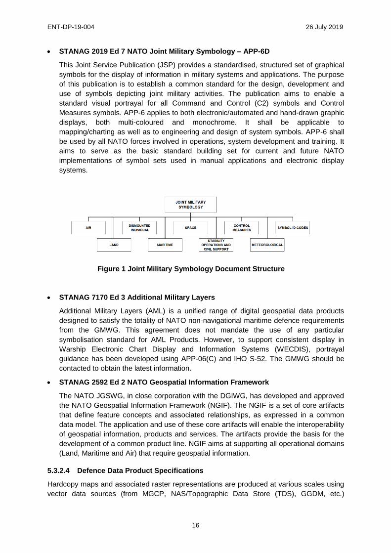
STANAG 2019 Ed 7 NATO Joint Military Symbology – APP-6D
This Joint Service Publication (JSP) provides a standardised, structured set of graphical
symbols for the display of information in military systems and applications. The purpose
of this publication is to establish a common standard for the design, development and
use of symbols depicting joint military activities. The publication aims to enable a
standard visual portrayal for all Command and Control (C2) symbols and Control
Measures symbols. APP-6 applies to both electronic/automated and hand-drawn graphic
displays, both multi-coloured and monochrome. It shall be applicable to
mapping/charting as well as to engineering and design of system symbols. APP-6 shall
be used by all NATO forces involved in operations, system development and training. It
aims to serve as the basic standard building set for current and future NATO
implementations of symbol sets used in manual applications and electronic display
systems.
Figure 1 Joint Military Symbology Document Structure
STANAG 7170 Ed 3 Additional Military Layers
Additional Military Layers (AML) is a unified range of digital geospatial data products
designed to satisfy the totality of NATO non-navigational maritime defence requirements
from the GMWG. This agreement does not mandate the use of any particular
symbolisation standard for AML Products. However, to support consistent display in
Warship Electronic Chart Display and Information Systems (WECDIS), portrayal
guidance has been developed using APP-06(C) and IHO S-52. The GMWG should be
contacted to obtain the latest information.
STANAG 2592 Ed 2 NATO Geospatial Information Framework
The NATO JGSWG, in close corporation with the DGIWG, has developed and approved
the NATO Geospatial Information Framework (NGIF). The NGIF is a set of core artifacts
that define feature concepts and associated relationships, as expressed in a common
data model. The application and use of these core artifacts will enable the interoperability
of geospatial information, products and services. The artifacts provide the basis for the
development of a common product line. NGIF aims at supporting all operational domains
(Land, Maritime and Air) that require geospatial information.
5.3.2.4 Defence Data Product Specifications
Hardcopy maps and associated raster representations are produced at various scales using
vector data sources (from MGCP, NAS/Topographic Data Store (TDS), GGDM, etc.)
ENT-DP-19-004 26 July 2019
17
according to published DPS comprised of annotation and portrayal catalogues, which
include detailed symbology, portrayal and styling rules. Existing examples include the
Topographic Map (TM at 1:50,000 or 1:100,000 scale) and the Joint Operations Graphic
(JOG, 1:250,000 scale). Future examples will include the Tactical Pilotage Chart (TPC,
1:500,000), Operational Navigation Chart (ONC, 1:1,000,000) and Urban Maps (UM,
1:12,500 and larger). NSG and DGIWG members publish DPS documents to ensure system
developers and map producers have well defined technical information to consistently
develop applications and finish products to an approved specification.
5.3.2.5 Defence Vector Portrayal Standards
Dynamic vector portrayal standards are required within the military community, however,
existing standards were designed for static hardcopy and raster representations which do
not take advantage of the capability effectively and dynamically represent multiple map
scales from a single dataset. There are many drivers supporting the need to fill the gap in
portrayal standards including: the availability of significant global coverage of vector map
data, improved processing and rendering capabilities within military systems, as well as
improving bandwidth which offers the potential for updates to maps. These driving forces
result in the potential for more current maps with a smaller data storage footprint, however
standardised dynamic portrayal standards and implementation profiles are required to
ensure a common operational picture. Rapid expansion of vector data in the commercial and
Open Source communities has resulted in a variety of dynamic vector solutions, such as:
Open Street Map, MapBox and Google Maps. Civil standards, specifying how to dynamically
portray vector data, are evolving. DGIWG WSTP follows these activities for possible future
implementation profiles.
5.3.2.6 Defence Web Service Standards
DGIWG established profiles and extensions for OGC web services to provide additional
implementation guidance to improve interoperability. DGIWG profiles and extensions are
managed by the Web Service Technical Panel. Review the WSTP Roadmap for a detailed
discussion of geospatial service standards. Approved profiles exist for WMS, WFS, WMTS,
WCS and CSW. Profiles for Web Processing Services (WPS) are in development.
5.3.2.7 Defence Graphics and Encoding Standards
The Defence community uses civil graphic standards such as TIFF, SVG, JPEG, etc. to
create symbols (see 5.3.1.4). Apart from these civil formats, special formats for the military
community have been developed such as; ARC Digitized Raster Graphics (ADRG),
Compressed ADRG (CADRG), Controlled Image Base (CIB), GeoPDF (geomatic
specialisation of PDF - a result of NGA's eChart initiative).
5.3.2.8 Defence Metadata Standards
DGIWG has established a metadata standard called DMF (DGIWG Metadata Foundation),
based on ISO standards. It defines metadata elements to describe a resource (general
information, data content, quality, etc). It also includes a metadata element pointing to the
legend of the resource, if any. Data Quality referenced in DMF metadata might also be
relevant to improve portrayal (e.g. show “no-data” or data with poor quality areas).
ENT-DP-19-004 26 July 2019
18
5.3.2.9 Defence Registers and Registries
ISO 19135-1:2015 defines a register as a set of files containing identifiers assigned to items
with descriptions of the associated items. A register in its simplest form can be a list or table
and can be applied to multiple concepts and parameters (e.g. datamodels, codelists,
coordinate reference systems, etc). Registries are an information system in which one or
more registers are maintained. Registries may include the software and web service that
holds and disseminates the organisation’s registers.
The DGIWG S01 Portrayal Service activity created the DGIWG Portrayal Registry Service
Interface Specification [DGIWG 118] which defined a collection of indexed portrayal
information, which acts as a central authority and can be accessed by users (human or
software agents) to retrieve visualisation data and enable consumers to produce a
consistent visualisation across distributed system domains. The DGIWG Register
Maintenance Procedures [DGIWG 915], provides a framework which specifies how a
DGIWG registry or register shall be maintained. In practice, development of robust and multi-
part registers hosted and maintained in a common registry in DGIWG has been limited to
isolated registers, therefore integration and development of web services has not started in
earnest.

ENT-DP-19-004 26 July 2019
19
6. Technology Considerations
Technology has a disruptive effect on how geospatial information is shared and visualised.
Over time, technology has opened the cartographic process to mass generation of unique
products leveraging expertly extracted data and high-end information technology. Both
technology and data availability have allowed end users to participate in geospatial
visualisation without constraints. While continuing to support common visual outputs
necessary for defence operations, portrayal must also support alternative visualisation
techniques that spawn from multiple data sources, a variety of processing systems and
analytic applications. Technology and the tech savvy users require advanced portrayal
options. Producers must move beyond the simple provisioning of standard products or
standard computer graphics that are based upon the legacy map production paradigm. As
the availability of geospatial services is exposed to a broader non-specialised user base, it is
imperative to provide platform agnostic adaptive portrayal standards and services. Without
an adaptive approach, poorly developed and competing portrayal solutions will continue to
persist and confound end users.
6.1. Existing
6.1.1 Hardcopy Data Products
The primary current implementation of portrayal is in support of hardcopy and associated
raster representation development. Commercial, open-source and custom proprietary GIS
systems are used to develop these products which are then provided as raster content to
servers, computers and devices via network communication or external drive delivery.
Hardcopy products are generated through complex printing processes or via on-site plotters.
The complex symbology used for the generation of hardcopy products and associated raster
representations is designed for visualisation at a fixed scale or within a narrow scale band.
These maps are designed to maximise the content that can be read at the particular product
scale. Most commercial solutions used for production of these hardcopy and raster products
use portrayal solutions with limited interoperability. Open-Source solutions offer portrayal
solutions but have limitations with the rendering of some complex styles and portrayal rules.
The construction of effective visual products begins with vector data which goes through a
complex process of data pre-processing, refinement, de-confliction of overlapping features
and labelling. Hardcopy products are either plotted or delivered as a raster product in a
variety of formats. Currency of the maps suffers because this production process is laborious
and time consuming.
6.1.2 Computing and Display Environment
Printed and digital displays have different technical limitations that affect how data can be
represented. Digital displays have different properties such as size, resolution, ambient light
properties and colour gamut. These properties impact the suitability of some portrayal rules
and styles for different computing environments leading to a need for some customisation.
Production systems are often high-end processing systems, configured with mature GIS and
graphics software and robust capacities for processing, rendering, storing, printing and
network sharing. Use of digital display devices continues to expand in defence. Information
ENT-DP-19-004 26 July 2019
20
is provided to lower echelons on diverse computing and display environments. These
environments include; high-end GIS systems, thick client computers with robust processing
and network access, thin client computers with reduced client processing capacity, and
hand-held devices, such as mobile phones, tablets and navigation devices often operating
with significant communications and processing constraints. Portrayal development needs to
account for the targeted end user capabilities and limitations and provide tailorable solutions
to computing systems constrained by bandwidth, storage and computing capacity. These
portrayal solutions also need to be tailorable for visualisation over a variety of imagery
including sand, snow and lush vegetation.
6.1.3 Web Services for Geospatial Display
Web services are becoming more common. They offer the flexibility to provide desired
content at a variety of scales from the same service. Portrayal symbols and rules have not
been defined to fully leverage the capabilities of web services, so users often work with
limited portrayal information available within their organisation which is built into proprietary
software or found in Open Source Projects such as Open Street Map (OSM). The WMS,
WMTS and WFS currently provide varied but limited capability to portray feature information.
Where capabilities exist, implementations may have service interoperability in order to
exchange information but lack portrayal interoperability to display that information. Web
services need to provide more robust server and client portrayal capabilities. The web
service technology is mature but lacks standards and governance in application.
6.1.4 Proliferation of Open Source Data
Access to civil, commercial and open source geospatial information on the internet has
expanded data availability of geospatial data to the general public and to defence users.
These data sources provide a variety of dynamic vector based solutions, such as OSM,
MapBox and Google Maps. Managing and integrating these sources is a challenge, with
portrayal required to provide common symbology of data from diverse sources in multiple
formats and schema.
6.1.5 Disconnected / Intermittent / Limited Bandwidth (DIL) Users
For many defence users, continuous connection to a web service is impractical for reasons
of limited bandwidth or intermittent or constrained connectivity. The GeoPackage standard
described in detail in the encoding formats chapter can provide a possible solution for at
least some of the problems related to the use case described above. Portrayal capabilities
will need to adapt to constraints in operating environments and system limitations to tailor
portrayed information to defence users and clients.
6.2. Emerging
6.2.1 Bundling Data and Delivery Containers, GeoPackage and OGC Web Service
Context
Simple containers are being implemented to bundle and manage data for efficient delivery to
address requirements for common data and operational display and off-line provisioning of
data for DIL-constrained users. To facilitate tailoring and delivery of data, several
approaches including GeoPackage, OGC Web Service (OWS) context documents and
Common Object Model containers are advancing at varying levels of maturity and
ENT-DP-19-004 26 July 2019
21
implementation. While much of the early development of these delivery mechanisms were
focused on raster content, vector implementations are starting to mature as well and will
require portrayal to fully realise the advantages of vector content.
6.2.2 Vector Tiling
Tiling services provide spatially referenced data divided into small manageable tiles. Raster
tiling of images and maps is fairly mature. Vector tiling does not have a well-defined
standardised solution, however, some implementations such as MapBoxTiles (MBTiles) exist
and OGC and industry are investigating additional solutions. Vector tiles have the potential
to improve rendering speed of large vector datasets by only processing data in or near the
displayed area. To provide usable and relevant vector information, vector tiling needs to
mature to address generalisation, portrayal symbols and rules applicable to unique tiles.
6.2.3 Geospatial Analytics
The drive for dynamic portrayal is focused on delivering more useful information directly to
the end user and decision maker. Commercial solutions allow for real-time updates that can
provide networked or client-based analytics such as routing or line of sight to help them
understand additional geospatial context directly from the data without reliance on trained
GIS users. While most analytics output a mixture of text, graphic and geospatial references,
their geospatial representation has traditionally fallen outside the core portrayal activities
where user-defined portrayal can provide different and conflicting views. Portrayal standard’s
efforts should allow users easy access to common portrayal outputs and symbology and, by
incorporating emerging analytics-derived portrayal, enable them to be managed as tailored,
custom views.
6.2.4 Plug and Play, Code Reuse and Modular Design
Modularity and agile design are spurring a rapid pace of change in information technology.
Plug and play encourages loose coupling of components to rapidly swap out capabilities for
new designs, offering performance enhancement in speed, rendering, complexity and/or
efficiency. Leveraging modularity and reuse will benefit portrayal developers to provide more
agile symbology, rules and encodings in new applications to meet the diverse mission
requirements and systems designs of their defence geospatial enterprise. A flexible design
and agile governance process would support rapid insertion of new solutions and replication
and reuse for portrayal solutions across different Communities of Interest.
6.2.5 Chained Services
Robust network or cloud connectivity permits the hosting of web-based services and
applications that can execute discrete functions on demand. An emerging approach is to
chain multiple services and online data offerings to provide a cumulative effect. For instance,
Web feature portrayal service capabilities envision successfully combining these OGC OWS
context documents, executable OGC WPS processes and on-line data sources into an
interoperable process for dynamic display.
6.2.6 3D Portrayal
3D display technology is rapidly expanding for both high fidelity and generic users. The
internet gaming community and the defence modelling and simulation community are
ENT-DP-19-004 26 July 2019
22
demanding higher quality 3D portrayal while simple 3D globe applications are proliferating in
desktop and mobile devices. As life cycle replacement of older systems is planned, more
and more GIS and mission command systems are adopting 3D solutions and demanding
more from visualisation than simply draping 2D imagery, features and symbology over a 3D
terrain mesh. Efforts to mature portrayal capabilities must provide more accurate location
information and COP visualisation to display objects on, above or below surface level.
6.2.7 Semantics, Ontologies and Linked Data
Technologies associated with semantics, ontologies and linked data allow automated
associations across entities and databases. These technologies along with WPS would
facilitate online portrayal services accessing vector databases, portrayal registries with
symbology and rules. From a geospatial portrayal perspective, this could be applied to
dynamically associate a feature to corresponding symbology without direct mapping
between symbology and the schema. This schema agnostic approach could support queries
in the user’s preferred context without knowing the structure of the underlying data.
6.2.8 Cloud Computing
Cloud computing enables infrastructure builders to scale computing and storage resources
up and down in a flexible way. Cloud computing services enable lightweight clients to access
powerful processing services hosted at remote locations. Future Portrayal Registries could
be hosted as Cloud resources to enable the user community to access approved symbology
sets, portrayal rules and labelling definitions to consistently render geospatial data on mobile
devices.
ENT-DP-19-004 26 July 2019
23
7. Geospatial Information - Future State
A common (standard) topographic map display across all coalition mission command
systems and devices is fundamental to planning and conducting operations. Therefore, there
is a need for a dynamic map portrayal standard that is applied across all DGIWG and NATO
Nations. The standard will specify a common means to symbolise and digitally portray
topographic map information consistently across all coalition/national systems and include all
echelons and computing systems. Dynamic portrayal of vector data and more formal data
product specifications for hardcopy products and associated raster representations will be
closely aligned to consistently provide geospatial information to DGIWG nations and enable
a common operational picture that efficiently provides rich and query-able content.
Upon completion of the portrayal roadmap activities over the four year program (2019-2023),
the envisioned end-state is that DGIWG members will have a standard on digital map
portrayal that improves geospatial interoperability, enhancing common and shared
situational awareness to commanders and war-fighters via the provision of a common
foundation map for all digital COPs. Digital mapping will be displayed clearly, accurately and
in a timely manner across coalition members. Mission Command digital COP and other
platforms will display common, authoritative mapping as the foundation layer for shared
situational awareness across nations and echelons.
7.1. Target Objectives
7.1.1 Symbology for Common Operational Picture
Portrayal capabilities are essential for the employment of Geospatial Information and a
collaborative environment is crucial to enable standardisation for the exchange of Geospatial
Information. In portrayal, standardisation implies more than common encoding and
technological interfaces. Standardisation also requires shared data formats and schema,
common symbology to represent geographic features and portrayal rules to provide common
operational picture and tailored views based on operational requirements and IT system
constraints. Symbols need to be intuitive or look like current military and commercial
symbols. Soldiers and partnered agencies need to understand the map symbols when
viewing on hand held devices. Symbols need to scale with the scale of the map & stay
geographically accurate within the bounds of cartographic license. The map needs to look
crisp on screen and print clearly to scale. The objective of providing enhanced portrayal of
geospatial data to support the COP provides DGIWG members key operational capabilities
to include:
Gain and maintain situational awareness and facilitate mission command in the initial
stages of any contingency.
Maintain a common operating picture between command posts and forward elements:
- Provide common geospatial foundation data on which staff can overlay information
and analytical layers.
- Provide geospatial information for the Recognized Environmental Picture (REP).
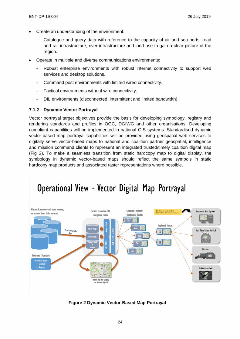
ENT-DP-19-004 26 July 2019
24
Create an understanding of the environment:
- Catalogue and query data with reference to the capacity of air and sea ports, road
and rail infrastructure, river infrastructure and land use to gain a clear picture of the
region.
Operate in multiple and diverse communications environments:
- Robust enterprise environments with robust internet connectivity to support web
services and desktop solutions.
- Command post environments with limited wired connectivity.
- Tactical environments without wire connectivity.
- DIL environments (disconnected, intermittent and limited bandwidth).
7.1.2 Dynamic Vector Portrayal
Vector portrayal target objectives provide the basis for developing symbology, registry and
rendering standards and profiles in OGC, DGIWG and other organisations. Developing
compliant capabilities will be implemented in national GIS systems. Standardised dynamic
vector-based map portrayal capabilities will be provided using geospatial web services to
digitally serve vector-based maps to national and coalition partner geospatial, intelligence
and mission command clients to represent an integrated trusted/timely coalition digital map
(Fig 2). To make a seamless transition from static hardcopy map to digital display, the
symbology in dynamic vector-based maps should reflect the same symbols in static
hardcopy map products and associated raster representations where possible.
Figure 2 Dynamic Vector-Based Map Portrayal
ENT-DP-19-004 26 July 2019
25
These dynamic vector-based maps will provide similar displays to the existing hardcopy
products and associated raster representations. However, the dynamic nature of these maps
will provide access to additional feature information and provide the ability to dynamically
update and render topographic information at varying scales, as well as tailor portrayal to the
user’s client capability and information requirements. Dynamic vector map portrayal
capabilities must support multiple and diverse communications environments and satisfy
user requirements at three distinct levels of complexity with tailorable symbology:
Complex portrayal systems (e.g. thick clients) support expert users with portrayal
sufficient for rendering, visualization and analysis, closely aligned to raster specifications.
Generalized portrayal systems (e.g. command post thin clients) support mid-level users
with simplified and optimized symbology for efficient network display using grouped
feature concepts, basic patterns and lines to minimize symbol drawing time.
Simple portrayal systems (e.g. DIL or mobile systems) support disadvantaged users with
limited display capability using very few patterns and basic, intuitive symbols employing
a reduced volume of critical features.
Dynamic vector-based map portrayal requires both common portrayal content and a
portrayal repository or registry.
7.1.3 Common Portrayal Content
Central to any standard portrayal capability is the development of symbols and portrayal
rules to be applied to content for clear, consistent and coherent visualisation.
Portrayal information in the form of symbols and rules:
- Must be available for exchange among the DGIWG members and its partners.
- Must be easily maintained and expanded upon as new requirements for Geospatial
Intelligence visualisation emerge.
- Must be consistent with international standards.
- Must be accessible through web-services for use in a web-centric environment and
available for download to support non-networked applications.
- Must be able to visualise and query portrayal content by database elements,
keywords and tags to allow for improved discovery, application and adaption/revision
of symbols and rules.
- Must be accessible to users via standards-based applications.
- Must be open, non-proprietary and machine readable.
- Must be in technology and vendor-agnostic formats to allow common input and
output.
Symbols must be:
- Harmonised between digital and hard copy in scale bands.
- Familiar, clearly identifiable and intuitive.
- Machine readable and available for online use by the user and developer
communities.
ENT-DP-19-004 26 July 2019
26
Portrayal rules, styling and rendering must:
- Provide readability over diverse imagery from different regions of the world.
- Be in formats and encodings accessible and available online.
- Use OGC geospatial web services (WMS, WFS, WMTS), related portrayal standards
(SE, SLD) and common formats (e.g. SVG, PNG, GeoCSS).
- Ensure interoperable exchange between GIS and mission command systems.
- Provide ability to interpret map data and display variation at different scales (global to
urban scales).
- Ensure portrayal processes that are de-conflicted and harmonised with NATO APP 6
or MIL-STD-2525x military symbology processes.
- Provide clearly identifiable and intuitive symbols.
- Provide simple symbology (e.g. point of interest type icons) for quick situational
awareness.
- Ensure interoperable exchange between all GIS and military command systems
regardless (vendor agnostic input and output).
- Provide symbols and styles for lines, areas patterns and labelling rules to display
readable geospatial data in scale-appropriate symbology from global to urban scales.
7.1.4 Portrayal Register and DGIWG Registry
In addition to common content in portrayal rules and symbols, digital vector portrayal also
requires an accessible and sharable warehouse where the symbols and rules can be
accessed to enable consistency across joint, coalition and service systems. An overarching
DGIWG registry should address both requirements for a management capability (for
agencies to manage portrayal in a federated and authoritative way) and also requirements
for dissemination or exploitation to provide an environment easily exploitable by systems and
users. Initially, this may be in multi-part registers hosted in a static registry providing a
common repository where the symbols and rules are stored, accessed and managed for use
in development of operational implementations. Objectively, a more robust portrayal register
would be provided as part of an expanded DGIWG registry and would allow web service
enabled access for dynamic visualisation and content update. The DGIWG Portrayal
Registry Service Interface Specification [DGIWG 118] provides a sound point of reference
but needs to be reassessed for currency, validated against objectives and technologies and
revised as required. The DGIWG Register Maintenance Procedures [DGIWG 915] describes
procedures to populate, manage and maintain portrayal content.
A portrayal register in a DGIWG registry would provide a central authority of machine-
readable symbology, portrayal rules and metadata for vector data portrayal.
Common objective attributes of multi-part portrayal registers include:
- Provide machine-readable symbols and portrayal rules.
- Maintain portrayal information in a digital, system agnostic format.
- Management procedures and technical controls for content display.

ENT-DP-19-004 26 July 2019
27
- Portrayal processes that are query-able and de-conflicted or harmonised with NATO
APP-6 or MIL-STD-2525x military symbology processes.
Core functions include:
- Allow users to discover and retrieve symbols and portrayal rules.
- Support operational systems to provide a common operating picture with vector data.
- Provide common portrayal and symbology for system developers (geospatial and
mission systems).
- Provide a governance framework for common digital symbology and promote
improved standards for symbology portrayal.
- Portrayal rules support common vector data formats and schema.
- Aligned with and incorporate DPS for hardcopy products (e.g. TM, JOG).
- Compliant with open standards, contain elements to support multiple encodings and
flexibility to support anticipated standards evolution.
- Manage updates and maintenance.
Additional technical capabilities include:
- Allow dynamic applications at varied scales for diverse platforms.
- Provide web-based service interfaces.
- Expansible for use and reuse by multiple organisations and COIs.
- Easily integrated with other systems, clients and applications.
- Interoperable exchange between all GIS and military command systems regardless
(vendor agnostic input and output).
- Real time dynamic query, rendering and portrayal.
- Support for complex symbology.
- Store and apply symbols and rules for a standardised COP.
- Combine symbols and rules on demand for a user-defined picture (allow custom
profiles to meet operational needs).
- May be implemented as a single registry or a family of registries.
- Supports a diverse set of users, including developers, for hard copy and digital
portrayal, geospatial experts, WFS providers, users and application developers.
- Open and available to other communities of interest to replicate process and improve
efficiencies of complementary symbology and portrayal rules.
- Support the generation of DPS and reference documents to support user community.
- Provide a downloadable open font family to support feature entity labelling on
products by web servers, handheld devices and disconnected users.
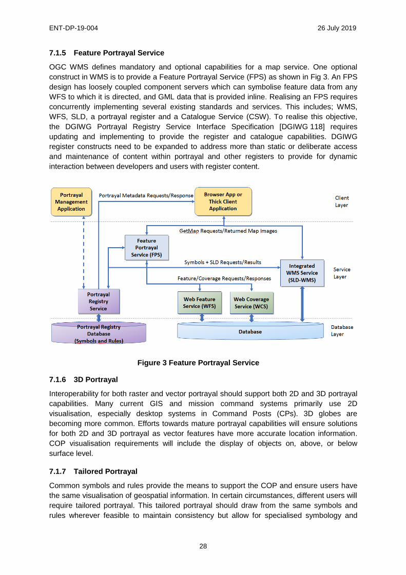
ENT-DP-19-004 26 July 2019
28
7.1.5 Feature Portrayal Service
OGC WMS defines mandatory and optional capabilities for a map service. One optional
construct in WMS is to provide a Feature Portrayal Service (FPS) as shown in Fig 3. An FPS
design has loosely coupled component servers which can symbolise feature data from any
WFS to which it is directed, and GML data that is provided inline. Realising an FPS requires
concurrently implementing several existing standards and services. This includes; WMS,
WFS, SLD, a portrayal register and a Catalogue Service (CSW). To realise this objective,
the DGIWG Portrayal Registry Service Interface Specification [DGIWG 118] requires
updating and implementing to provide the register and catalogue capabilities. DGIWG
register constructs need to be expanded to address more than static or deliberate access
and maintenance of content within portrayal and other registers to provide for dynamic
interaction between developers and users with register content.
Figure 3 Feature Portrayal Service
7.1.6 3D Portrayal
Interoperability for both raster and vector portrayal should support both 2D and 3D portrayal
capabilities. Many current GIS and mission command systems primarily use 2D
visualisation, especially desktop systems in Command Posts (CPs). 3D globes are
becoming more common. Efforts towards mature portrayal capabilities will ensure solutions
for both 2D and 3D portrayal as vector features have more accurate location information.
COP visualisation requirements will include the display of objects on, above, or below
surface level.
7.1.7 Tailored Portrayal
Common symbols and rules provide the means to support the COP and ensure users have
the same visualisation of geospatial information. In certain circumstances, different users will
require tailored portrayal. This tailored portrayal should draw from the same symbols and
rules wherever feasible to maintain consistency but allow for specialised symbology and
ENT-DP-19-004 26 July 2019
29
selection of data visualised to meet operational, environmental, or technical requirements.
While a preferred or directed portrayal is critical to the COP, other visualisation should be
permitted in standards, procedures and policy.
Profiles for specific content portrayal will use the same data and symbols but allow for a user
defined picture that is sharable and understandable and also maintains characteristics
described in the common portrayal section. The portrayal register should maintain distinct
portrayal profiles containing the rules for when and how the profile is invoked and the
alternative objects, symbols and rules to portray. Developing these profiles would be a
shared responsibility of the users, system owners and symbol developers and would require
governance procedures. User-defined or tailored portrayal profiles will be necessary to
account for specific operational use cases, environmental concerns and technical computing
constraints:
- Display user-defined content for analytics (routing, line of sight analysis), specialised
communities (intelligence, fires, engineers) and sensitive/controlled operations
(special forces).
- Simple symbology (e.g. Point of Interest (PoI) type icons) for situational awareness.
- Provide the capability to turn features on and off and bring features in at different
scales for operational needs.
- Provide unique portrayal to account for display to support diverse computing systems
(e.g. desktop, mounted, hand held) and accommodate constraints of specific
computing systems (bandwidth, compute capacity).
- Provide unique rules or symbols to allow clients and applications to symbolise data
on devices in a disconnected environment.
- Provide unique rules for rendering to adjust for differing background imagery (change
colours style between arid, forested, urban, etc.).
- Provide unique rules or symbols to allow portrayal in different user environments (day
v night conditions, red light v blue-green light conditions, etc.).
- Available as a web service or export/offline provisioning.
7.2. Geospatial Content
Portrayal requires content, rules and symbols. The content consists of vector datasets,
representing geospatial features, and the portrayal rules and symbol sets which describe
how those features are to be displayed. Mapping tables linking data and symbols and
product content, where there are specific rules and symbols, are applied to vector data to
create finished portrayal products.
7.2.1 Vector Datasets
DGIWG-defined and directed datasets will be available and recommended for portrayal
activities. At the same time, an open portrayal approach should be usable by additional
national, open source, or specialised datasets when properly aligned and mapped to
DGIWG symbols and portrayal rules.
ENT-DP-19-004 26 July 2019
30
7.2.2 Symbol Sets and Portrayal Rules
Dynamic vector portrayal identifies the common portrayal content requirements for symbols
and rules. To realise this objective, DGIWG needs to define, document and publish common
symbol and portrayal rule-sets and to establish a multi-part register to enable developers
and users to access and apply the rules to available datasets. The symbology and portrayal
approach, formats and encodings shall be open, sharable and made available to other COIs
(e.g. METOC, COP, Aeronautical, etc) to replicate processes and improve efficiencies.
7.2.3 Hardcopy and Raster Portrayal Products
Hardcopy Products and associated raster representation will continue to be produced as
specified in DGIWG, NATO, or National Data Product Specifications. DGIWG will maintain
and review DPS for the following products:
- Defence Topographic Map for 1:50,000 Scale (DTM50)
- Defence City Map (DCM)
- Defence Joint Operation Graphic (Air) (DJOG(A))
7.2.4 Vector Portrayal Procedures
To properly select and apply symbols and rules to features, proper linkage and mapping of
data aligned to symbols must be established. DGIWG will provide and maintain for the
DGIWG, managed datasets and symbology COIs. Other mappings are encouraged to be
developed by the dataset owner or COI and shared to improve common portrayal and may
be hosted with the DGIWG register. Concepts and capabilities to define common object
groups (such as the VMST’s Product Object work) will facilitate and enable this mapping.
7.3. Geospatial Services
Direct users of portrayal capabilities are map producers, web service creators, and
standards and application developers that require portrayal rules and symbols to create
products and services, harmonise symbology and create applications that support war-
fighter needs. To provide raster products and visually portray vector data, common OGC
web services are used. These services include Web Map Service (WMS), Web Feature
Service (WFS) and Web Map Tile Service (WMTS). Portrayal services will comply with these
standards and DGIWG profiles as well as enabling future OGC portrayal standards, formats
and encodings.
As a portrayal register is realised, a robust Catalogue and Information Model will be required
to register, query and request elements. The Catalogue Service for the Web (CSW) ebXML
Registry Information Model (ebRIM) is presently specified to provide this capability for basic
services in the DGIWG Portrayal Register specification but other alternatives such as a
Semantic Registry Information Model (SRIM) should be considered. Additionally, Web
Processing Service (WPS) may be paired with the catalogue and register to provide a
dynamic web portrayal service.
The Portrayal Technical Panel will coordinate the use of OGC web services with the DGIWG
Web Service Technical Panel.
ENT-DP-19-004 26 July 2019
31
7.4. Standardisation Initiatives
Current portrayal standards are contained in PDF documents, focus on hardcopy products
for individual scale bands and are not easily implemented. Current implementations tend to
be national or vendor specific and are not broadly shared across communities of interest. To
rectify this shortcoming, DGIWG needs to engage with civil standards organisations that also
support the development of defence implementation profiles. Additionally, symbol sets and
portrayal rules should be developed and published for use across DGIWG members to
support both static portrayal products and dynamic vector-based portrayal processes. A
dynamic interplay between civil standards, defence profiles and DGIWG implementations is
necessary to ensure that standards are suitable for implementation and maintainable. Use of
these standards and profiles allows expansion based on new requirements for geospatial
intelligence visualisation that emerge with increased implementation and advancements in
technology.
7.4.1 Civil Standards
DGIWG needs to be engaged in civil standards development to share lessons learned from
prior and ongoing DGIWG portrayal efforts. Monitoring civil standards will allow DGIWG to
guide and prioritise encoding specifications for update and revision within defence standards
activities.
OGC SE and SLD
OGC is planning to revise and update SE and SLD. Their current intent is to focus on a
modular Symbology Encoding standard that establishes critical requirements in the core
document and outlines a unifying conceptual model for portrayal. From this core,
additional specifications will be tailored to formats and encodings (e.g. GML (probably
revised SLD), JSON, etc).
OGC GeoPackage
Early implementations of OGC GeoPackage have identified the need to improve
specifications and best practices for providing portrayal information for packaged vector
data. Presently, complete symbology and portrayal rules could be included as a related
extension to GeoPackage, provided as an online service or pre-staged on the client to
facilitate proper portrayal of the vector information. Various approaches have distinct
design and cost implications. OGC has various ongoing innovation initiatives to better
support portrayal.
3D Portrayal Standards
Several OGC and community efforts are evolving to define portions of the 3D portrayal
process. A unifying conceptual model to include basic 3D terrain and exchange models
as well as 3D symbology and rendering needs to be developed.
Vector Tiling
Raster tiling of images and maps is quite mature but parallel processes for vector tiling
(to include scales, generalisation and portrayal symbols and rules) are not well defined.
OGC and industry are investigating solutions and several vendor specific

ENT-DP-19-004 26 July 2019
32
implementations are in use. Once this technology matures and is standardised, it could
leverage portrayal registers.
7.4.2 Defence Standards
In addition to improving civil standards, DGIWG needs to document implementation
specifications and profiles to support portrayal objectives.
DGIWG Web Symbol Sets and Portrayal Rules
The Portrayal Panel is completing a web symbology project which documents the
symbols approved by DGIWG. Symbol sets will be maintained and governed by the COI
(e.g. topography, military symbology and hydrography). DGIWG standardisation will
define both the content of symbol sets and rules and the development and conformance
requirements for symbol set and portrayal rules to guide expansion to, and compatibility
with, additional COI.
DGIWG Registry and Portrayal Register
Expanding both DGIWG 915 and DGIWG 118 is required along with the development of
portrayal registers and the population and management of portrayal content. The
DGIWG portrayal register would include the DGIWG web symbol sets, portrayal rules
and enabled physical implementations. An expanded and web-service enabled registry
framework would also allow COI or DGIWG members to establish parallel or subsidiary
registry services which are conformant to a master registry as part of a federated registry
approach.
DGIWG Portrayal Web Services
This builds on the DGIWG Web Symbol Sets and Portrayal Rules and on the DGIWG
Portrayal Register to document specifications for web services providing dynamic vector
data portrayal. These services will incorporate OGC web services and DGIWG profiles
and be coordinated with the Web Service Technical Panel.
DGIWG Data Product Specifications
DGIWG and NGA have an existing project to regularly review and update DPS for core
DGIWG Standards. This management process needs to be continued and embedded in
roadmap activities.

ENT-DP-19-004 26 July 2019
33
8. Program Plan
8.1. Portrayal Technical Panel (P4)
The PTP coordinates portrayal activities within DGIWG and ensures coordination with
civilian standardisation bodies and military customers regarding the portrayal of Geospatial
Information.
Its aims are:
To maintain this document (i.e. the DGIWG Portrayal Roadmap) through annual revision.
To develop, update and maintain symbol sets and portrayal rules both for static portrayal
products and dynamic portrayal of vector-based data.
To develop and maintain a portrayal register serving as an accessible and sharable
warehouse from which the symbols and rules can be accessed.
To monitor developments in portrayal standards and technology to identify when
additional PTP projects should be initiated. Priority monitoring should be on updates to
OGC portrayal standards and application of portrayal in emerging geospatial processes
such as 3D portrayal, portrayal in GeoPackage and portrayal with vector tiles, SLD-WMS
Feature Portrayal Service, and portrayal test and validation.
8.2. Current Projects
8.2.1. P4.01: Symbology for Web Service Environment
This project is developing a standard for the portrayal of vector data published through Web
Services. The project should:
- Identify scale bands which features should be portrayed in.
- Recommend symbology designs for the content and build a symbol library based on
recommended formats.
- Create draft standardisation documentation outlining the recommendations.
- Create a demonstrator service to test the recommendations and refine the standard.
The deliverables of the project are:
- Symbology Spreadsheet which provides the details of the scale bands, content and
portrayal for creating a service.
- Symbol Library which provides the encoding of the symbols.
- Best Practice Document which provides guidance and recommendations in
portraying data through a web service.
- Demonstrator = a prototype implementation of the standard.
Additional work will be dedicated to the development of sRGB colour token values,
“equivalent” to the CMYK colour token values used in DTM50 DPS, for application in web
services. The sRGB colour definition will be based upon the International Colour Consortium

ENT-DP-19-004 26 July 2019
34
(ICC) colour profile of sRGB ISO/IEC 61966-2-1:1999. USA and FRA will partner to provide
expertise and resources.
The initial output of P4.01 documents web symbology derived from available raster DPS and
best represents the web symbology suited for complex GIS systems as identified in section
7.1.2. Additional refinement of web symbology to create more generalised symbology for
networked clients and simplified symbology for disadvantaged users is required.
8.2.2. P1.03: City Map Hardcopy DPS
The goal of the project is the definition of a data product specification for a city hardcopy
map with scales 1:10,000 and 1:5,000. It collaborates closely with VMST for the content
description and Portrayal Technical Panel to define the representation.
The role of the PTP in the project is to:
- Identify appropriate symbology and labelling rules for hardcopy city maps.
- Provide unique symbology aligned to the Product Object and Symbol Object
approach developed by the VMST.
FRA is the lead for this activity in the PTP as it has practical experience with this product.
Other participants include the CZE, GBR, ITA and USA.
8.2.3. P1.05: DJOG(A) DPS
The role of the PTP in the project is to:
- Identify appropriate symbology and labelling rules for hardcopy DJOG(A).
- Provide unique symbology aligned to the Product Object and Symbol Object
approach developed by the VMST.
8.2.4. P4.05: Portrayal Repository/Database
The project shall:
- Develop a database schema for MS Access.
- Migrate symbology dealt by the PTP from Excel spreadsheets into the database.
- Create guidelines to establish roles, responsibilities and maintenance rules.
8.3. Envisioned Projects
8.3.1. P4.03: DGIWG Implementation Guide for General Symbology Encoding
Existing Symbology Encoding standards such as SE have been proven to be insufficient for
DGIWG Portrayal requirements. DGIWG has documented a number of issues regarding
SLD and SE. These are captured in an OGC discussion paper produced by DGIWG (OGC
17-059). Moreover, the DGIWG community does not have common implementations of SE
in SLD documents. Thus, this project is to provide a guide for general symbology encoding.
The project should:
- Examine approaches to meeting the DGIWG Portrayal requirements in a system
agnostic way.
ENT-DP-19-004 26 July 2019
35
- Develop and publish guidance for portrayal definition using existing Standards (SE
together with SLD).
- Input DGIWG and OGC references.
- DGIWG 908: DGIWG Portrayal Roadmap.
- DGIWG 909: DGIWG Web Services Roadmap.
- OGC Portrayal Concept Development Study (17-094r1).
- OpenGIS Symbology Encoding Implementation Specification 1.1 (05-077r4).
- DGIWG 112: DGIWG Web Map Service (WMS) 1.3 Profile – Revision, 2017-11-28,
https://portal.dgiwg.org/files/?artifact_id=68226&format=pdf
- OpenGIS Styled Layer Descriptor Profile of the Web Map Service Implementation
Specification 1.1 (05-078r4).
8.3.2. Portrayal Register
This project will conduct all efforts to make a common portrayal register an implemented and
accessible capability available to all DGIWG members. The project should:
- Review and assess current and emerging capabilities and standards related to
registries, including catalogues, encodings, and information models (e.g. ebRIM,
SRIM).
- Expand on portrayal database project to document requirements for register items
(individual lists and tables) for symbols, rules, encodings and linkages. It will
incorporate advancements in standards and technology and reflect current and future
operational requirements.
- Create a physical implementation of the portrayal register to serve as a web-enabled
repository supporting the search and discovery of portrayal symbols and rules.
- Populate the register with validated symbols and rules.
- In coordination with the Web Services and Vector Maintenance Technical Panels,
provide a DGIWG web portrayal service demonstrator.
- Establish governance procedures for the maintenance, review and update of the
register in compliance with DGIWG 915.
- Conduct periodic reviews of register design and standards to incorporate emerging
requirements and alternative solutions (e.g. new encodings, 3D).
- Provide a framework for other communities of interest to replicate processes and
rules to improve common approaches to portrayal.
Input DGIWG references:
- DGIWG 118
- DGIWG 915
- DGIWG White paper on Registry and Registers
- P4.05 Portrayal Repository/Database
ENT-DP-19-004 26 July 2019
36
8.3.3. Dynamic Portrayal Specification
This project will define a specification to achieve the dynamic portrayal objectives outlined in
the roadmap. Other existing and proposed projects are necessary predecessor tasks
required to provide sufficient normative direction for mandatory and optional requirements to
achieve dynamic portrayal, such as:
- Integrate web symbology and portrayal register outputs into a standard describing
how to use these and other resources to provide consistent dynamic portrayal across
DGIWG members.
- Define conformance classes for a range of dynamic portrayal alternatives. Include a
simple class with GIS server providing portrayal based on defined symbology and
rules and a more robust class for full interactive and transactions feature portrayal
service across multiple partner nations.
- Incorporate current and emerging OGC symbology and web service standards.
- Allow for multiple encoding options providing a common core symbology and ruleset.
- Define procedures for dynamic portrayal profiles to include a standard COP profile
and optional user defined profiles.
ENT-DP-19-004 26 July 2019
37
9. Dependencies
The DGIWG Portrayal panel must consider current and upcoming works regarding portrayal
within civilian standardisation bodies such as ISO and OGC, as well as vector data
schemas, metadata and web services within the Defence community (e.g. other DGIWG
technical panels – VMST, Metadata Panel, Web Services Panel and NATO).
Currently, the Portrayal Technical Panel closely cooperates with VMST to develop data
product specifications for hardcopy maps (DTM50 and DCM) and with Web Services to
prepare machine-readable symbology for web service environment.

ENT-DP-19-004 26 July 2019
38
Annex A – Acronyms and Abbreviations
(Informative)
2D Two Dimensional
3D Three Dimensional
ADRG ARC Digitized Raster Graphics
AGeoP Allied Geospatial Publication
AIS Aeronautical Information Service
AML Additional Military Layers
API Application Programming Interface
APP Allied Procedural Publication
BMP Bitmap
C2 Command and Control
C4ISR Command, Control, Communications, Computers, Intelligence, Surveillance
and Reconnaissance
CADRG Compressed ARC Digitized Raster Graphics
CartoCSS Cartography Cascading Style Sheets
CEO Chief Executive Officer
CIB Controlled Image Base
CGM Computer Graphic Metafile
CMYK Cyan, Magenta, Yellow, and Key (or Black)
COI Community of interest
COP Common Operational Picture
CP Command Post
CPS Coverage Portrayal Services
CSS Cascading Style Sheets
CSS3 Cascading Style Sheets 3
CSW Catalogue Service for the Web
DCM Defence City Map
DGIF Defence Geospatial Information Framework
DGIWG Defence Geospatial Information Working Group
DGFCD Defence Geospatial Feature Concept Dictionary
DGIM Defence Geospatial Information Model
DGRWI Defence Geospatial Real-World Object Index
DGSB Defence Geospatial Standards Baseline
DIL Disconnected / Intermittent / Limited Bandwidth
DIPWG Digital Information Portrayal Working Group
ENT-DP-19-004 26 July 2019
39
DJOG(A) Defence Joint Operation Graphic (Air)
DMF DGIWG Metadata Foundation
DPS Data Product Specification
DTM50 Defence Topographic Map for 1:50,000 Scale
DWG Domain Working Group [OGC]
ebRIM Electronic Business Registry Information Model
ECDIS Electronic Chart Display and Information System
ENC Electronic Navigational Chart
EPS Encapsulated PostScript
FD Final Draft
FPS Feature Portrayal Services
GAWG Geospatial Aeronautical Working Group
GeoCSS Geography Cascading Style Sheets
GEOINT Geospatial Intelligence
GeoJSON Geospatial JavaScript Object Notation
GeoPDF Geospatial Portable Document Format
GeoTIFF Geospatial Tagged Image File Format
GGDM Ground-Warfighter Geospatial Data Model
GIF Graphics Interchange Format
GIS Geographic Information System
GML Geography Markup Language
GMWG Geospatial Maritime Working Group
GRWG Geospatial Requirements Working Group
GSIP Geospatial Intelligence (GEOINT) Structure Implementation Profile
HTML Hypertext Markup Language
HTML5 Hypertext Markup Language 5
ICAO International Civil Aviation Organization
ICC International Colour Consortium
IEC International Electrotechnical Commission
IERHWG Information Exchange Requirements Harmonization Working Group
IGN Institut Geographique National
IHO International Hydrographic Organization
ISO International Organization for Standardization
ISO/TC211 ISO Technical Committee 211 (Geographic Information/Geomatics)
IT Information Technology
JFC Joint Forces Command
JGSWG Joint Geospatial Standards Working Group
ENT-DP-19-004 26 July 2019
40
JOG Joint Operations Graphic
JPEG Joint Photographic Experts Group
JSON JavaScript Object Notation
JSP Joint Symbology Panel
KML Keyhole Markup Language
MBTiles MapBoxTiles
MC Military Committee
METOC Meteorological and Oceanographic
MGCP Multinational Geospatial Co-Production Program
MGHMO Military Geographic and Hydrometeorologic Office
MoD Ministry of Defence
MS Microsoft
NAS NSG Application Schema
NATO North Atlantic Treaty Organization
NGA National Geospatial-Intelligence Agency
NGB NATO Geospatial Board
NGFCD NATO Geospatial Feature Concept Dictionary
NGIF NATO Geospatial Information Framework
NGIM NATO Geospatial Information Model
NGRWI NATO Geospatial Real-World Object Index
NSG National System for Geospatial Intelligence
OGC Open Geospatial Consortium
ONC Operational Navigation Chart
OSM Open Street Map
OTF Open Type Font
OWS OGC Web Services
PDF Portable Document Format
PNG Portable Network Graphics
PoI Point of Interest
PTP Portrayal Technical Panel
RD Ratification Draft
REP Recognized Environmental Picture
SARP Standards and Recommended Practices
SCOTS Standards-based Commercial-Off-The-Shelf
SE Symbology Encoding
SLD Style Layer Descriptor
SQL Structured Query Language
ENT-DP-19-004 26 July 2019
41
sRGB standard Red Green Blue
SRIM Semantic Registry Information Model
STANAG Standardization Agreement
STD Standard
SVG Scalable Vector Graphics
SWG Standards Working Group
TC Technical Committee
TDS Topographic Data Store
TIFF Tagged Image File Format
TM Topographic Map
TPC Tactical Pilotage Chart
UI User Interface
UN United Nations
USA United States of America
VMST Vector Model and Schema Team
W3C World Wide Web Consortium
WCPS Web Coverage Processing Service
WCS Web Coverage Service
WECDIS Warship Electronic Chart Display and Information System
WFS Web Feature Service
WG Working Group
WMS Web Map Service
WMTS Web Map Tile Service
WPS Web Processing Service
WSTP Web Services Technical Panel
XHTML Extensible Hypertext Markup Language
XML eXtensible Markup Language
XPM X PixMap
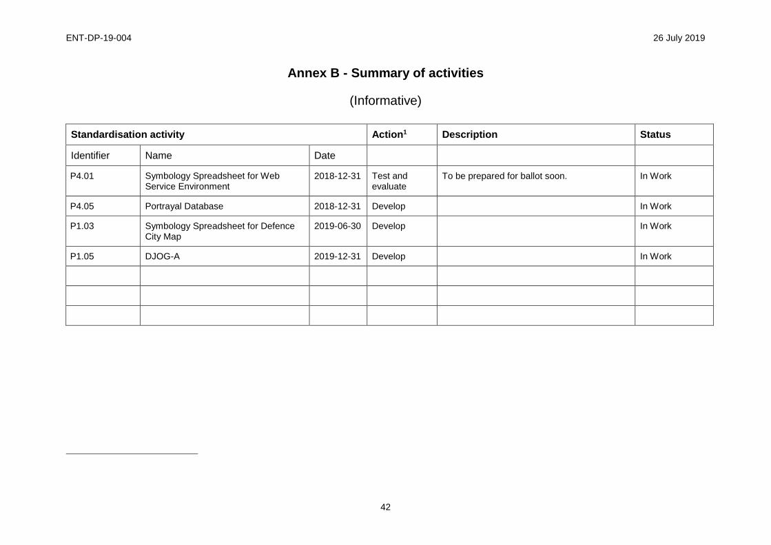
ENT-DP-19-004 26 July 2019
42
Annex B - Summary of activities
(Informative)
Standardisation activity Action1 Description Status
Identifier Name Date
P4.01 Symbology Spreadsheet for Web Service Environment
2018-12-31 Test and evaluate
To be prepared for ballot soon. In Work
P4.05 Portrayal Database 2018-12-31 Develop In Work
P1.03 Symbology Spreadsheet for Defence City Map
2019-06-30 Develop In Work
P1.05 DJOG-A 2019-12-31 Develop In Work