digital india - centre for innovations in public corporation of chennai and other utility...
TRANSCRIPT

Digital India Workshop on Geo-Informatics
by Tamil Nadu SeMT K. MOHANRAM, Project Manager, Directorate of e-Governance, Chennai-600018
& Dr. A. MOHAN, Senior Technical Director, NIC, Chennai-600005

Progress of Tamil Nadu in Implementing GIS based Decision Support Systems (DSS)
Sl. No Name of the Owning State Department
Name of the Implementing Agency
Implementation Area <e.g. Agriculture, Natural Disaster, Forest, Aviation, Mining, Infra., Health etc.)
1 Tamil Nadu Highways Department
Govt. of Tamil Nadu Road Networks
2 Commissioner of Municipal Administration
Govt. of Tamil Nadu 3 Corporations & 8 Municipalities – Properties and Municipalities
3 CMDA, MAWS NIC Land use planning
4 Sarva Shiksha Abhyan NIC Schooling Access – Served / Un-served Primary, Upper Primary, High and Higher Secondary Schools
5 Directorate of Town Panchayats
NIC Ponneri TP – Utilities and Property-Tax Data
04-Apr-2016 Workshop on Geo-Informatics 2

Designed & Developed GIS based G2C (Intranet) Web applications
04-Apr-2016 Workshop on Geo-Informatics 3
• Web GIS Solution for CMDA to host their large scale Land Use maps on Intranet / Internet – http://cmdamaps.tn.nic.in (G2C); Back office operations enable Work Flow based online editing of land parcels and attributes; spatial queries
• Property Tax and Utilities based Ponneri Town Panchayat GIS for Ponneri Town Panchayat – Directorate of Town Panchayats
• Online Editor of Spatial data – Create / Modify / Delete spatial features including Points, Lines and Polygons along with their attributes; The application can be customized for any Department, any layer through metadata entries; GeoSpatial Services based Architecture enables rendering any OGC compatible base layers (WMS), that is, Open Street Maps, NIC Maps, Google Maps, Bhuvan, etc.
• Location based Services for Directorate of Rural Development, Corporation of Chennai, etc.

Designed & Developed GIS based G2C (Intranet) Web applications
04-Apr-2016 Workshop on Geo-Informatics 4
• Web based Generic Software as Service Platform for dynamic rendering maps based on the Web Applications using any technology from any platform. The following map services are currently available: • Thematic / Choropleth Maps • Graduated Symbol Maps • Unique Symbology Maps • Creation of thematic map based on the client data by any user in CSV / XLS format by uploading
their data to server • Union Planning Commission Funded project for preparation of 3D 1:1000 scale maps of Chennai
under Chennai Utility Mapping project 3D spatial database built for Chennai City at for sharing across utility agencies to enable Smart City Governance
• Corporation of Chennai and other utility departments including TNEB, CMWSSB, CMDA, Chennai City Police, Metropolitan Transport Corporation & Fire and Rescue Services and BSNL are currently the members of the system.
• Web GIS support to BSNL Chennai Circle and Chennai City Police with spatial analytical capabilities

Designed & Developed GIS based G2C (Intranet) Web applications
04-Apr-2016 Workshop on Geo-Informatics 5
• Support to Sarva Siksha Abhiyan (SSA) for online analysis of schooling access under TNGIS project through web based interface: • Verification of the 57,192 school locations • Verification of around 98,000 Rural / Urban Hamlets • 1 / 3 / 5 / 8 Km buffer from Hamlets for analysing Primary /
Upper Primary / Secondary/ Hr Secondary Schooling access • Exceptional hamlets where by-road distance is more than the
radial distance

04-Apr-2016 Workshop on Geo-Informatics 6
• Hosting Tamil Nadu Administrative Maps through http://tnmaps.tn.nic.in for more than a decade. http://tnmaps.tn.nic.in/tamil - the Tamil Version (G2C)
• GIS based Web dissemination of Population Census 2011 and 2001 at http://www.census.tn.nic.in and http://www.census2001.tn.nic.in (G2C)
• GIS for Chennai City Police http://gis-police.tn.nic.in rendering their jurisdictions, crime locations, accident locations, basic infrastructure details at 1:1000 scale
• GIS for Chennai Circle of BSNL http://gis-bsnl.tn.nic.in
Designed & Developed GIS based G2C (Intranet) Web applications

04-Apr-2016 Workshop on Geo-Informatics 7
• GIS Based National Urban Health Mission for State Health Society
• http://gis-nuhm.tn.nic.in (G2C and G2E) • GIS based General Land Records Management for
Directorate General of Defence Estates – an Intranet solution (Raksha Bhoomi Software) that is running in 64 Cantonments across the country (only Intranet) – 2006-2007
• Dynamic Reports on Served / Unserved Hamlets Number & List of schools serving Served hamlets
Designed & Developed GIS based G2C (Intranet) Web applications
Software / Technology used NIC-TNSC
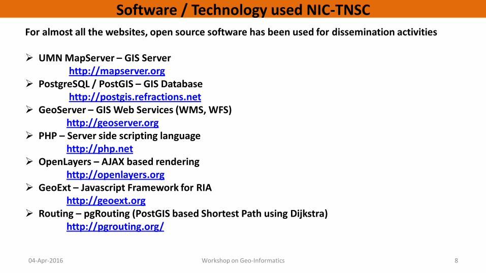
For almost all the websites, open source software has been used for dissemination activities UMN MapServer – GIS Server http://mapserver.org PostgreSQL / PostGIS – GIS Database http://postgis.refractions.net GeoServer – GIS Web Services (WMS, WFS) http://geoserver.org PHP – Server side scripting language http://php.net OpenLayers – AJAX based rendering http://openlayers.org GeoExt – Javascript Framework for RIA
http://geoext.org Routing – pgRouting (PostGIS based Shortest Path using Dijkstra)
http://pgrouting.org/
04-Apr-2016 Workshop on Geo-Informatics 8

04-Apr-2016 Workshop on Geo-Informatics 9
Tamil Nadu Geo-Informatics System (TNGIS)
of Tamil Nadu State Spatial Data Infrastructure
(TNSSDI)
(State Spatial Data Repository)
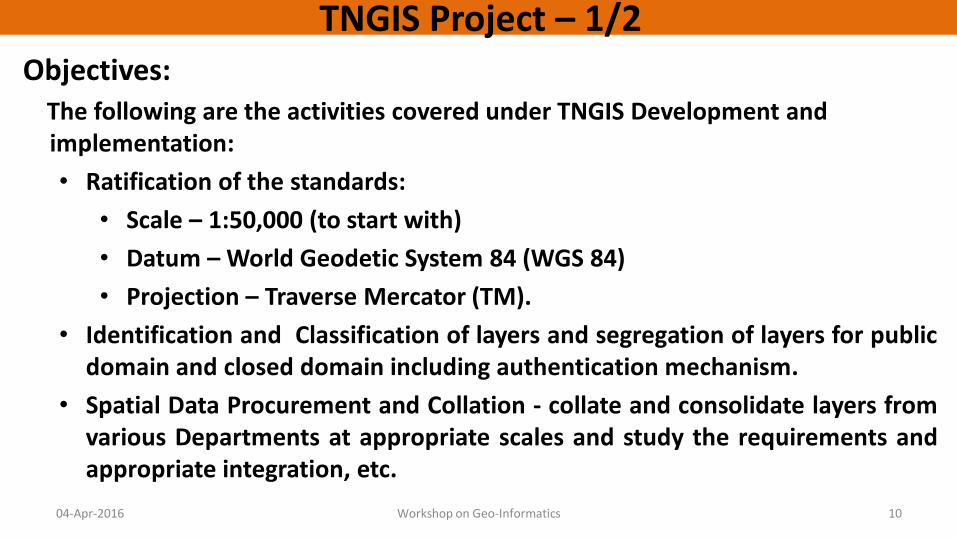
TNGIS Project – 1/2 Objectives: The following are the activities covered under TNGIS Development and
implementation:
• Ratification of the standards:
• Scale – 1:50,000 (to start with)
• Datum – World Geodetic System 84 (WGS 84)
• Projection – Traverse Mercator (TM).
• Identification and Classification of layers and segregation of layers for public domain and closed domain including authentication mechanism.
• Spatial Data Procurement and Collation - collate and consolidate layers from various Departments at appropriate scales and study the requirements and appropriate integration, etc.
04-Apr-2016 Workshop on Geo-Informatics 10

TNGIS Project – 2/2
Objectives (continued..)
• Attribute Data Integration - Integration of already available datasets including Population Census, Agriculture department, Public Health, Rural Development data, Economics and Statistics etc.
• Hardware and Software – build necessary infrastructure in place for proper access and usage of GIS across various Departments.
• Generic GIS Web Interface – Standards based Web GIS adopted as the technology to provide interface for the various datasets, keeping in mind the large number of users who would show interest to view the same.
• Deployment and Capacity Building – TNGIS is a continuous process as the needs would keep growing horizontally and vertically. Sensitization and training programs keep the number of GIS users on increase.
04-Apr-2016 Workshop on Geo-Informatics 11

Advantages of the Application
04-Apr-2016 Workshop on Geo-Informatics 12
• To enable applications to use Geo Spatial Services effectively for geographic representation of their data from any Platform / Technology ensuring following advantages:
• Without physical sharing of GIS datasets • Use by application developers without GIS skillsets • Interoperable with heterogeneous databases (spatial /
non-spatial) • Compliant with OGC specifications

Service Oriented Architecture(SOA)
04-Apr-2016 Workshop on Geo-Informatics 13
• Sharing the Spatial data across the organization / websites for various security reasons by retaining map data at the source itself.
• Enables easy administration of maps (as the changes on maps would be required only once and in only one database)
• Since the map rendering is Service Oriented, the backend technologies do not matter. Interoperability is achieved using XML technologies.
• Technology being leveraged by Application developers who have very little knowledge of GIS; That is, the development team from the concerned department need not be aware of the finer details of GIS technology
• Fully compliant with the Open Geospatial Consortium Standards being proposed by the OGC
• Supports a distributed architecture
04-Apr-2016 Workshop on Geo-Informatics 14
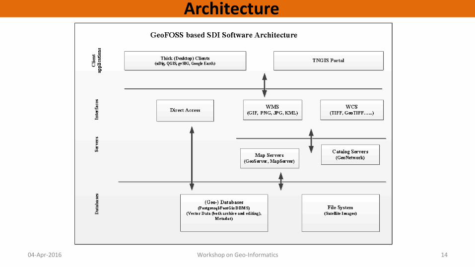
Architecture

04-Apr-2016 Workshop on Geo-Informatics 15
Spatial Data Infrastructure

04-Apr-2016 Workshop on Geo-Informatics 16
Technology used
• Application was Developed on Completely Free/Open Source Software: • GeoServer (Geospatial Services) • PostgreSQL/PostGIS for Spatial & Attribute database • PHP / GeoExt / OpenLayers/Leaflet for frontend
design and development • Open Source Desktop GIS software gvSIG / QGIS • The entire application was build based on the OGC
Compliant Geospatial Web Services Open Source software

04-Apr-2016 Workshop on Geo-Informatics 17
TNGIS Application http://164.100.167.42/tnega/index.php
04-Apr-2016 Workshop on Geo-Informatics 18
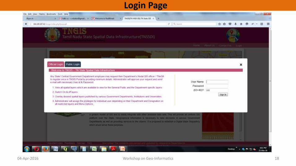
Login Page

04-Apr-2016 Workshop on Geo-Informatics 19
Menu Page

04-Apr-2016 Workshop on Geo-Informatics 20
Map viewer

1. Administrative
2. Health
3. School Education
4. Higher Education
5. Transport
6. Water Resources
7. Physical Resources
8. Water Bodies
9. Forest
10. Public Infrastructure
11. Government Offices
12. Communication
04-Apr-2016 Workshop on Geo-Informatics 21
Layers Group (Menu)

04-Apr-2016 Workshop on Geo-Informatics 22
Health Layer

04-Apr-2016 Workshop on Geo-Informatics 23
School Education – SSA School
04-Apr-2016 Workshop on Geo-Informatics 24
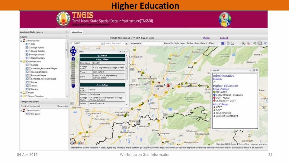
Higher Education

04-Apr-2016 Workshop on Geo-Informatics 25
Transport HD District and NH & SH Layer
04-Apr-2016 Workshop on Geo-Informatics 26
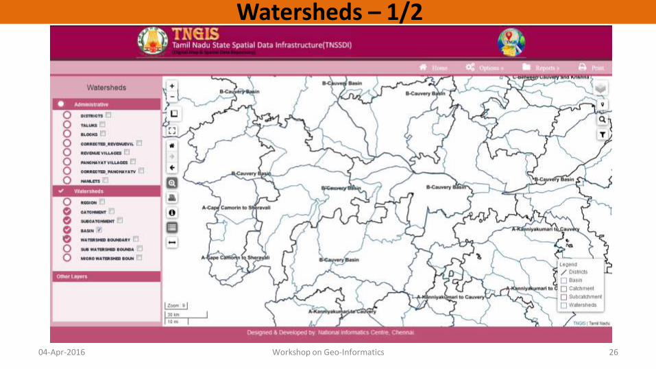
Watersheds – 1/2

04-Apr-2016 Workshop on Geo-Informatics 27
Watersheds – 2/2

04-Apr-2016 Workshop on Geo-Informatics 28
Geology

Public Infrastructure
04-Apr-2016 Workshop on Geo-Informatics 29

Admin Menu
• Create Role
• Create Users
• Menu Management

Create Role
04-Apr-2016 Workshop on Geo-Informatics 31
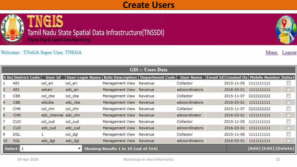
Create Users
04-Apr-2016 Workshop on Geo-Informatics 32

Entry Form Menu
• Officers Entry Form
• Metadata Entry Form

Officers Entry Form
04-Apr-2016 Workshop on Geo-Informatics 34
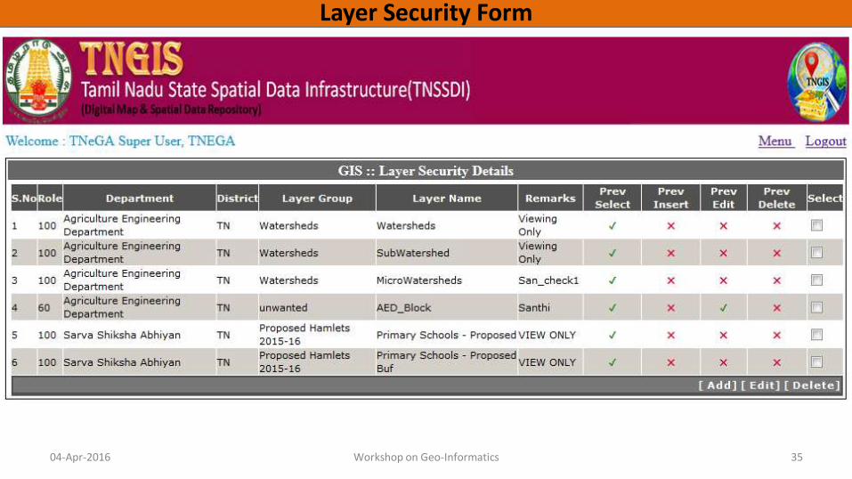
Layer Security Form
04-Apr-2016 Workshop on Geo-Informatics 35

04-Apr-2016 Workshop on Geo-Informatics 36
Switching on / off layers – On the fly customization of Labels, styles, etc.

04-Apr-2016 Workshop on Geo-Informatics 37
Dynamic Buffer – Arbitrary point / user selected feature, locate other layers’ features within the buffer zone

CMDA – Back office support with Work Flow based spatial editing functionalities
Edit by Assistant Planner level officer
Recommended by Deputy Planner level officer 04-Apr-2016 Workshop on Geo-Informatics 38
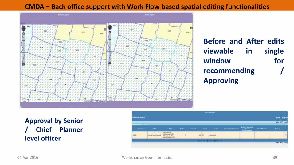
CMDA – Back office support with Work Flow based spatial editing functionalities
Before and After edits viewable in single window for recommending / Approving
Approval by Senior / Chief Planner level officer
04-Apr-2016 Workshop on Geo-Informatics 39

CMDA – Scale Based rendering of spatial data
04-Apr-2016 Workshop on Geo-Informatics 40

Creation / Editing of Line Features
04-Apr-2016 Workshop on Geo-Informatics 41
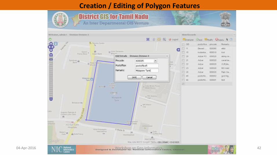
Creation / Editing of Polygon Features
04-Apr-2016 Workshop on Geo-Informatics 42

Information on any work by clicking on the location (Integration with backend MIS through Web Services)
04-Apr-2016 Workshop on Geo-Informatics 43

04-Apr-2016 Workshop on Geo-Informatics 44
Live Monitoring of Cleared / Uncleared bins in Corporation of Chennai Red bins indicate uncleared ones; Click on any bin for photo / other details

Tamil Nadu GIS Implementation Stage – 1/2 • TN State Government has setup a State Spatial Data
Infrastructure – TNGIS under IT & Planning Department
• Tamil Nadu e-Governance Agency has the repository of the Spatial Data
• Many Departments’ layers at various scales are being collated by TNeGA about 80 number of layers
• TNGIS Web based GIS framework for all State Departments’ requirements is nearing completions
• Base layers from nodal deptts. are available that can be seamlessly integrated with any other spatial datasets.
04-Apr-2016 Workshop on Geo-Informatics 45

• Common Sensitization Workshops for Spatial Data & Attribute Data codes Standardization by all Departments for their respective layers
• Training for User Departments on GIS / TNGIS for their own Spatial Data Updating and providing value addition on other department Layers and further enrichment of TNGIS.
• Training to the various Departments on both Code Mapping / Spatial Data Editing.
04-Apr-2016 Workshop on Geo-Informatics 46
Tamil Nadu GIS Implementation Stage - 2/2

GIS Plans / Goals of the State • Scaling up TNGIS for the domain specific utility
• Design and Development deptt. Specific applications and the related tools
• Capacity Building in a continuous manner for general GIS concepts to the deptt. Officials as they are frequently shifted from one deptt. to another
• Nodal officers of the respective deptt. need to be trained on intensive domain specific tools and applications.
04-Apr-2016 Workshop on Geo-Informatics 47

Support Desired from DeitY
• DeitY can provide the following support on TNGIS:
–GIS framework enhancement
–Capacity building w.r.t. general GIS concepts and domain specific applications
–Proof of Concept Studies
– GIS application development / enhancement
04-Apr-2016 Workshop on Geo-Informatics 48

04-Apr-2016 Workshop on Geo-Informatics 49