digital tax mapping – present and...
TRANSCRIPT

Digital Tax Mapping – Present and Future
Kurt Donaldson
WV GIS Technical Center
• Mission - To provide focus, direction and leadership to users of geographic information systems (GIS), digital mapping and remote sensing within the State of West Virginia
• The West Virginia GIS Technical Center (WVGISTC) is the designated clearinghouse for statewide GIS data, developer of core base layers, and contributing author to state GIS plans

Outline – Digital Tax Mapping
• What is GIS?• GIS Benefits and Applications• What constitutes a digital tax mapping system?• GIS tax map conversion steps• Components of a tax GIS• Future Directions
Contributions: State Tax Office (GIS Unit) and Mountain CAD

Focus: Surface Land Ownership
The cadastral parcel and The cadastral parcel and ownership rightsownership rightsSource: Land Administration (Peter Dale and John McLaughlin)

What is GIS ?GIS = Geographic Information System
In its simplest form: A computer system capable of holding and using data describing places on the earths surface.
A computerized system for the capture, storage, management, analysis, and display of digital maps, images, and related databases about geographic features. The five components of GIS are pictured below:

What is GIS ?
A geographic information system (GIS) links locational(spatial) and database (tabular) information and enables a person to visualize patterns, relationships, and trends.
This process gives an entirely new perspective to data analysis that cannot be seen in a table or list format.

Who uses GIS?
Source : Space Imaging /EOSAT
5. Construction5. Construction
3. Agriculture3. Agriculture
6. Telecom6. Telecom
10. Media10. Media11. Resource exploration11. Resource exploration
DOLLARSDOLLARS
$100,000,000$100,000,000
$200,000,000$200,000,000
$300,000,000$300,000,000
$400,000,000$400,000,000
$500,000,000$500,000,000
$600,000,000$600,000,000
1. Local Government1. Local Government
4. Other4. Other
2. Utilities2. Utilities
8. State & Federal Government8. State & Federal Government9. Insurance9. Insurance
$576 Million$576 $576
MillionMillion
$86 Million$86 Million$86 Million
7. Logistics7. Logistics
1998 North American GIS Market1998 North American GIS Market1998 North American GIS Market

Applications
Land records information needed for a variety of applications
• Permitting• Public Utilities• Boundaries• Economic Development
• Zoning• Planning• Public Works• Police• Assessors

New Road

Zoning

Flood Mapping

Assessed Values
< 1%1% to 10%
11 % to 20%21% to 30%
> 31%
Change in assessed valuesMercer Island

Public Works

What Constitutes a GIS Tax Map?
– Composed of thematic layers, referenced to a common coordinate system (i.e., State Plane, UTM, Lat./Long.)
– Linked to external databases (e.g. CAMA)
– Has topology (i.e. mathematically closed polygons)
– Seamless (countywide)
– A digital reference, not a legal record

Related data layers
BoundariesBoundariesStreetsStreetsParcelsParcelsLandLand UseUseEnvironmentalEnvironmentalConsiderationsConsiderations
“The Real World”“The Real World”
• Data is organized by layers, coverages or themes (synonomous concepts), with each theme representing a common feature.• Layers are integrated using explicit location on the earth’s surface, thus geographical location is the organizing principal.
StructuresStructures

Same Geographic SpaceTable of Contents
shows 3 layers 2 Layers displayed –They match!
All three match in space

Linked to Assessment DatabaseA GIS links locational (spatial) and database (tabular) information
Tax Parcel Record: Anytown, West VirginiaParcel Number: 1Owner: Mr. John Sebastian DoeAddress: 3057 Apis Mellifera RoadAddress: Anytown, WV 20555Phone: 1-304-555-7574Acreage: 116Appraised Value: 220,000Mineral Rights: NoZoning Classification Single Family Residential (R1)Tax District: Trap Hill DistrictDistrict Number: 12Map Number: 21
+
Spatial Information
Tabular Information
Database links to parcels via: (1) parcel identifier or (2) standardized address

GIS = Parcel Features + Database
• GIS are a combination of geographic data and attribute data– Parcel polygons are the spatial features– CAMA records are the attributes
• GIS allow two key types of functionality– Point at a graphic feature and retrieve
attributes– Query attributes and see graphic result of
query on a map

Topology (spatial relationships)• How to model spatial relationships
– Parcels cannot overlap one another– Building footprints must not overlap parcels– Parcel lines cannot have dangles
Error / Validation Checks

Topology – Define Relationships
Define Spatial Relationships

Parcel Data Model: tableEntity Related to Spatial Type
Land Base Data SetsParcel Boundary Parcel ID (CAMA) Area or lineParcel ID Parcel Boundary TextLot Numbers TextInterior lot / tract lines Parcel Boundary LineOwnership Parcel ID (CAMA) TableLandhook Text or line Dimensions (acreage) Parcel ID (CAMA) TextDimensions (metes and bounds) TextParcel Photograph Parcel ID ImageStructures Parcel Boundary Area or pointAddress Parcel ID (CAMA) / Structure Address Location
Parcel Index Grid Area or LineDistrict Boundaries Parcel Boundary AreaCorporation Boundaries Parcel Boundary Area
Reference Data SetsRoads Area or lineWater Bodies Area or linePolitical Boundaries Area or lineAerial Photos ImageSatellite Images ImageTopographic Maps ImageGeographic Names Referenced features TextFlood hazards Area or lineRight of Way Dimensions Referenced features Text

Parcel Data Model: diagram

Seamless
Seamless
Not Seamless
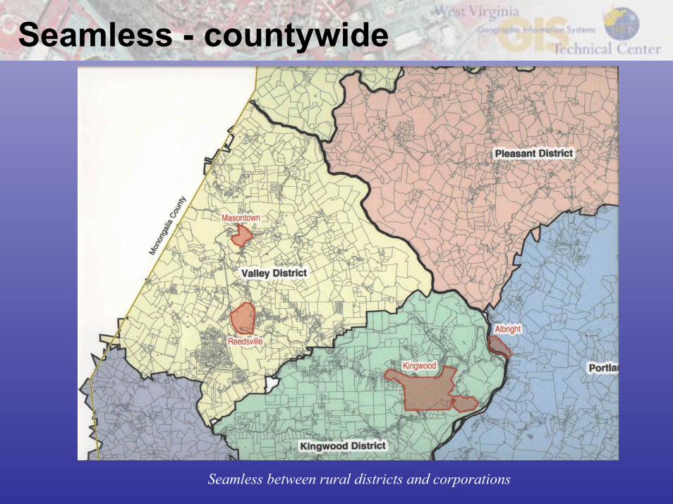
Seamless - countywide
Seamless between rural districts and corporations

Digital Reference
• A digital landbase is a digitized reference to the legal cadastre, specifically, a reference to the source documents that describe the intent of the on-ground cadastre
• A digital landbase is not the official cadastre of record – only a reference to it. A digital landbase does not define land tenure boundaries.
• Example: Assessor's Parcel Map used for taxation. These maps should not be used as the basis for engineering and construction which determines the location of built features ("fixed works")

GIS Tax Map Conversion Steps • Approaches for parcel data automation
– Automation of hard copy $2 - $6+ /parcel – Conversion of CAD data $2 - $6+ /parcel – Parcel deed research (COGO) $15 - $20/parcel
• Hybrid Approach– Use GIS to identify problematic parcels that might require deed research
• Polygons with no matching CAMA records• CAMA records with no matching polygons• Wide variance between measured area and CAMA area• Splits required after digital conversion
– Perhaps:• 70%-80% of parcels @ $2 - $6/parcel • 20%-30% of parcels @ $15 - $20
Source: Applied Geographics, Inc.

Digital Conversion - Geology
Hand drawn geologic features on USGS 1:24,000-scale topographic map Geologic map digital conversion

Conversion of Hardcopy Maps• Scan existing maps• Georeference scans to a base map
– Control points: street intersections, bldg. corners• Heads-up digitize linework
– Parcels – ROW/easement– Dimension annotation (extra $)– Index grid
• Make “adjustments” to enhance fit to base map– Performed during automation– Or later, as a separate project
• Create topology• Label parcels with their ID number (e.g. Map and Lot) Link to to CAMA database• Obtain “dump” from CAMA in DBF, MDB or ASCII• Database “table join” using ID number as primary key• Produce checkplots• Integrate parcel related features with other reference base layers• Create electronic map book of “pretty maps.” Source: Applied Geographics, Inc.

Select Base LayersA base map is needed to establish a coordinate system,
accuracy and ability to overlay with other layers
AERIAL PHOTOS
Scale: 1:48001” = 400 ft.
Date: Spring 2003
CIR AERIAL PHOTOS
Scale: 1:12,0001” = 1,000 ft.
Date: 1996-97
TOPOGRAPHIC MAPS
Scale: 1:24,000 1” = 2,000 ft.
Date: avg. map 23 yrs. old

Heads-Up Digitizing / Data Integration
Parcel Related Features•Geo-Referenced Tax Map•Digitized Parcel Lines•Parcel IDs•Interior Lot Lines and IDs•Land Hooks and Buildings•Parcel Dimensions
Reference Datasets•Road and Water Layers•Arial Photography
Integration (spatial compatibility) of data layers is more difficult if compiled from different sources or assembled at varying time intervals

Parcel Line Work Adjustments
• Can be a highly “interpretive” and subjective process
• Try to make parcels and reference layers look “logically consistent”
• If the fit between parcels and base map is really bad, a need for deed research may be implied

CAMA Reconciliation Process• Process to determine how well CAMA matches polygons
– 99% match rates are possible– Known problems with “exempt” properties
• “Combined” lots can pose issues– Two parcels, one CAMA record
• Condos pose an issue
• Most issues are resolved during the checkplot review process
Parcels with FAILED PID linkSource: Applied Geographics, Inc.

Map Tile Reference SystemMust covert grid system to a GIS format
Primary map tiles NestedGrid
TrueGrid
ModifiedGrid
Random
Orientation true north Y Y Y N
Uniform tile size Y Y N N
100 scale nested within 400 scale Y N N N
Map Tile Reference System: The parcel reference system for each county is subdivided into rural tax districts and corporations, which are further subdivided into map tiles / map sheets. The type of parcel reference system is determined by the primary map scale (usually 1”=400’ scale) configuration for rural maps and its relationship to urban areas (usually 1”=100’ scale).

Random Grid – Pendleton County
Random Orientation, No uniform tile size, No nesting of 100’ and 400’ scale maps

Modified Grid - Wetzel County
True North Orientation, No uniform tile size, No nesting of 100’ and 400’ scale maps

Electronic Map Books – using indexes

Map Products – Pretty Maps
• Visually appealing cartographic product• Print-ready electronic versions

Internet Applications

Maintenance• Plan maintenance strategy before digital
conversion• Can be done in-house, or out-sourced• Diligence and Staff Responsibility required
– It’s more fun to make maps than update data
• Adjust “business process” workflow– Update data instead of maps– Can be done continually, not just annually– Coordinate with Planning/Building
Departments• New sub-divisions• Base map changes (new buildings, etc.)
Source: Applied Geographics, Inc.

Challenges – digital conversion
• Maintaining two systems (manual and digital)
• Expense
• Time
• Technical Issues
• Organizational Issues
- Sharing resources and expenses with other entities can minimize redundancy, ensure interoperability, and maximize benefits.- Conduct pilots to resolve critical issues.

WV Digital Tax Mapping Status

Components of a Tax GIS
• A working GIS integrates these key components:– hardware– software– data– people– methods

Hardware
The hardware is the computer and peripherals on which the GIS operates
Traditional Mapping
MANUAL DRAFTING TOOLSMAP TYPEWRITER
Computer Mapping
GPSPLOTTERCOMPUTER CD-ROM

SoftwareGIS software provides the functions and tools users need to store analyze, and display geographical information. It includes the assessment database software.
Multiple software vendors
Family or suite of software products necessary to have complete GIS functionality (i.e., ESRI: ArcView, ArcEditor, ArcInfo)
Adequate training and technical support

Data An important component of GIS is complete, current, and accurate data.
Raster Image
A form of GIS data structure thatquantizes space into an array or grid of uniformly shaped cells (pixels), each of which represents a limited, but defined, amount of the earth’s surface.
Digital Raster Graphic (DRG)Digital Topographic Map
Digital Ortho Quarter QuadAerial Photography
VectorA graphic data structure that represents the points, lines, and areas of geographical space by exact X and Y coordinates.
Digital Line Graph (DLG)Hydrographic features
County boundaries with linked data

WV Spatial Data Infrastructure
Armories Railroads Pipelines
Access to $50 million dollars worth of spatial data
Sewer Treatment Plants Rural Tax Districts Police Towers

WV Addressing & Mapping Layers ($15 million value)

Digital Flood Layers

Mineral Parcel Mapping Project - WVDTR

Mineral Parcel Mapping Project• Can be a starting point for digital tax map conversions• Not all surface parcel related features collected• Not continually updated
Local Tax Map
WV DTR Collection
State Mapping Project

PeopleGIS technology is clearly of limited value without people to manage the system and to develop plans for applying it.
• County Level– Political Champion (i.e., Assessor, County Commissioners)– Tax Mapper (technically proficient)
• State Level– Political Champion (State Tax Office, Tax Commission)– Application Experts (Standards, Training, Education)
• Private Sector– Reputable Vendors
• Specialize in tax map applications and customization• Training and technical support PeoplePeople

Methods
Methods, plans, specifications, standards, and business rules describing how technology is applied
• Plans (integrate with other state IT plans)– Digital Tax Map Plan (proposed). What is the vision?– Interrelate with other state plans
• The National Map State Business Plan (2003)• WVGISTC Strategic Plan (2003)• Addressing and Management Maintenance Plan (in progress)• All Hazard Mitigation Plan (in progress)• Flood Map Modernization State Business Plan (proposed)• State GIS Plan (in progress)• State IT plans
• Procedures (for digital tax maps)– Statewide Procedures for the Manual Maintenance of Surface Tax Maps,
Title-Series 189-04– Tax Map Sales Title-Series 189-05
VisionVision

Methods (cont.)New business rules are needed for compiling and sharing GIS tax data with other government agencies.
StatewideConfiguration Concept
Server
GIS TAXDatabase
OtherState Databases
Govt. Agencies Needing Access• Office of Emergency Services• Development Office• Redistricting Office• Division of Highways

Future Directions• Digital Tax Guidelines (Report)
– Elaborate on information in this presentation– Definitions, Procedures, Policies, Organization Roles, Benefits– Preston County as pilot
• Organizational Roles– Property Valuation Commission (PVC)
• Overarching body (authority)• Approve digital tax guidelines• Update existing regulations to include digital mapping procedures• Establish new business rules / organizational role
– Tax Advisory Committee• Develop digital tax guidelines• Interface with other strategic plans• Present and obtain feedback from tax geospatial community• Consult with private sector• Proposed Members
– (WVU GIS Technical Center, Tax and Revenue, WV GIS Coordinator, 3 Assessors)

WVGISTC’s Role?• Assist with Digital Tax Guidelines Report
– Standards– Specifications– Procedures
• Assist with editing of tax map regulations – Authority– Policies
• Training and Outreach
• Applied Research
• Repository of digital tax files forstate government
Kurt Donaldson
Project Manager
WV GIS Technical Center
(304) 293-5603 x 4336