digitisation and georeferencing of maps: key terms or ... · further maps or only digitised maps or...
TRANSCRIPT
e-Perimetron, Vol. 14, No. 3, 2019 [117-125] www.e-perimetron.org | ISSN 1790-3769
[117]
Wolfgang Crom
Digitisation and Georeferencing of Maps: Key Terms or Stimulus Words?
Keywords: map digitisation; georeferencing; subject indexing; graphic search; webmapping
Summary: The digitisation of maps can only be seen as a first step regarding new pro-
cessing methods. On the one hand georeferencing and transformation enable us to inte-
grate old maps and land surveys in Web GIS applications and geoportals. On the other
hand it is possible to deduce graphical search possibilities from either the maps them-
selves or from geocoded keywords.
Introduction
As a representative of a map department that is an organisational part of a large library, I would
like to use my keynote to talk about some of the perceptions and developments that I have been
able to observe in our professional environment in recent years. The keynote will include com-
ments from our users as well as ideas and projects from colleagues in the map collections. All in
all, it is a colourful mixture of different goals, wishful thinking - real and less real -, local experi-
ments and supra-regional projects. I would like to introduce the following with the questions: dig-
itisation and georeferencing are key terms or stimulus words? Or perhaps they are: key terms or
provocative words?
Maps are not always fully acknowledged in libraries. In general, the focus is on old maps and at-
lases, so maps are often attributed to the collections of manuscripts or historical prints. In very
few cases a specialised map curator is responsible for collection building, cataloguing of the hold-
ings and, above all, for the provision of specialist information. In these institutions a collection of
modern maps, on the other hand, is usually only expected in the form of a current hand atlas. In-
stead the question is asked whether a map collection is still needed at all in the age of Google and
Open Street Map. Online accessible services can be used at any place at any time, and this is also
being implemented step by step for old maps as a result of digitisation projects.
In this context, I cite the question that is repeatedly put to us: “When will all maps be digitised?“ I
always start my answer with the impressive figure that we digitise about 5,000 maps a year in
high resolution. Then follows the arithmetical problem: with holdings of about 1.2 million map
sheets we would only need 240 years to complete the task – provided that we do not acquire any
further maps or only digitised maps or just geodata. Then, after 240 years, and with this I con-
clude my answer, even the works today still protected by copyright will be in the public domain.
Digital Change
Digitisation, not only of maps, is seen as a major task for the future viability of national econo-
mies and their administration. Governments have formulated it in such a way that they want to
“shape digital change“ and have commissioned studies for this purpose, which in the public per-
Head of the map department, Staatsbibliothek zu Berlin [[email protected]]
e-Perimetron, Vol. 14, No. 3, 2019 [117-125] www.e-perimetron.org | ISSN 1790-3769
[118]
ception are only overwritten with the word “digitisation“, a term to which everyone gives their
own meaning.1
But what is this: “digitisation“? In view of the wide-ranging demands, the postulated change, dig-
itisation appears to be the universal remedy. Processes are to be simplified and accelerated, things
not yet related to one another can be linked at will, the independence of observation or processing
decouples subject and object from time and place.
In addition to that, digitisation is regarded as an indispensable prerequisite for scientific work,
which is reflected in the equally nebulous concept of virtual research environments. The vague-
ness in the use of the term becomes apparent through its frequent use in the plural form. It allows
for many interpretations, which mostly have a very individual character – and thus lead to conclu-
sions about the speaker rather than contribute to clarification. By the way, I am absolutely no ex-
ception. When applying for third-party funding, I also use certain keywords in my proposals to
convince the reviewers of the relevance and modern approach of the project, of course.
The digital age has dawned, even if not yet fully developed. This is implied by the efforts ex-
pressed in the socio-political will. Funding programmes reflect this development and put their fo-
cus on the conversion of up to now analogue processes into automated processes or the production
of a digital copy of a tangible template, as well as on the consistent production of digital primary
data. The latter is probably to be understood under the buzzword “born digital“. Here the technical
and medical disciplines are already very far advanced, which will have previously unforeseen
consequences for the archives still thinking very much in analogue models. Not only the amount
of data generated, but also the many data formats present them with completely new challenges.
Archives and libraries not only have to digitise their own holdings, but also have to develop con-
cepts for the permanent storage and readability of digital primary data: The first panel of the
workshop is entitled “The New Collection Paradigm“, I am curious to hear about the new world
views.
Why georeferencing?
In the library world, the term “georeferencing” has been used frequently for several years. Such a
technical term radiates competence and expertise. If one asks however, what this means and
which purpose one pursues with it, then very different answers are given. For this term, too, there
is a lack of definition that leaves a lot of room for interpretation, so that I would like to pick up on
some aspects. The starting point is the determination that a coordinate specification (reference) is
assigned to any location on earth (geo) in a reference system in order to generate a position speci-
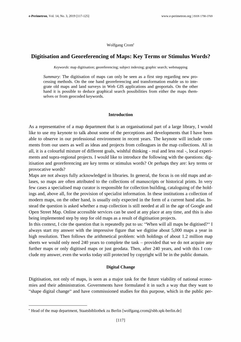
fication. The location is where the two lines of the coordinate system intersect. Official maps
therefore always indicate the geometric reference system and enclose the map image with a frame
on which the coordinate system is mapped. Accordingly, maps are objects that offer the infor-
mation they contain in geocoded form (Figure 1).
1 A compilation of some headings from german newspapers spring 2019 may explain it: “Digitisation: Will we
depend of few companies?“ “Digitisation vs. Employment“, “Digitisation in Germany: State of the Union“, “The
Urgency of Digitisation“, Altmaier (Minister for Economic Affairs) calls for faster action regarding digitisation“.
e-Perimetron, Vol. 14, No. 3, 2019 [117-125] www.e-perimetron.org | ISSN 1790-3769
[119]
Figure 1: Topographical Map Germany, sheet 3644 Potsdam (2011) with different coordinate systems on the margin.
(With kindly licence Landesvermessung und Geobasisinformation Brandenburg)
But how is it the other way around, can maps themselves be georeferenced? This is what lies be-
hind the use of the term when it is commonly used in libraries. Of course, first the somewhat he-
retical question can be asked, whether a map itself can be georeferenced at all. After all, the indi-
cation of coordinates always refers to only one point and a map is known to represent an area. But
with diligence a surface can be divided into an arbitrary number of points and the interspaces can
be captured by interpolation. At first, however one must ask what is the intended use and purpose
of it? What should be achieved by georeferencing a map?
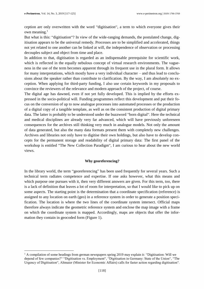
Well, I can imagine various application scenarios of georeferenced maps. On the one hand I can
project the map on another map with a smaller scale or tag the map. On the other hand I can try to
match the content of a map with the content of another map. The first application has been used
for centuries in the analogue processes. Whether an atlas shows the contained maps on the inside
of its cover or whether the sheet index of a map series shows the structure, the graphic representa-
tion of the positions in a map is a well-proven and much-used visual orientation method (Figure
2). The advantages are well known and do not need to be explained here.
e-Perimetron, Vol. 14, No. 3, 2019 [117-125] www.e-perimetron.org | ISSN 1790-3769
[120]
Figure 2: Example sheet index of a map series “Mapa general de la República de Panamá 1:250.000”.
The transfer of this graphic search into an electronic version is only logical, one can think of new
added value for electronic library catalogues and inventory directories on the basis of the technical
possibilities available today. The second application, the content transfer of cartographic infor-
mation or the map image, has to meet much higher requirements, because geometric parameters
have to be taken into account and, if necessary, have to be converted or transformed. Both usage
scenarios are now used in libraries and we should have a closer look at them. In the examples giv-
en here I refer to developments in German libraries.
The way towards a digital map library
The first experiments in researching map sheets of a map series with a visual representation on the
Internet were carried out at the end of the 1990s at the Württembergische Landesbibliothek (Crom
1999), an easy but very functional HTML-based attempt, which was adopted and enhanced in a
better graphical implementation at the University Library Halle (Grell, 2004). At the same time,
the map trade developed the first products, at first on a local basis, in order to display the existing
stock of map sheets belonging to a map series (Lamatsch, 2004). With the digitisation projects
that were about to start and their funding, research procedures for individual maps were devel-
oped, which, however, exclusively took these digitised holdings into account. The first of its kind
was initiated at the Staats- und Universitätsbibliothek Bremen (Kintrup, 2003). Some of these dig-
itisation and indexing projects were based on a regional collection, e.g. Lower Saxony, Saxony,
Bavaria, Ibero-America or Eastern Europe2, whereby the IKAR Database of old maps3 mostly
formed the bibliographic backbone, so that this famous database still plays a central role for the
indexing of old maps.
Some of the digitisation and indexing projects are regional, some are subject-specific, some are
integrated into larger structures, some are set up with only a local focus. The project of the Uni-
2 http://gauss.suub.uni-bremen.de/suub/hist/index.jsp; http://www.deutschefotothek.de/cms/kartenforum.xml;
https://www.bayerische-landesbibliothek-online.de/histkarten; https://digital.iai.spk-berlin.de/viewer/browse/-
/1/-/MD_MATERIAL:Karte/; https://www.herder-institut.de/abteilungen/kartensammlung/kartenrecherche.html 3 http://ikar.staatsbibliothek-berlin.de/index.html
e-Perimetron, Vol. 14, No. 3, 2019 [117-125] www.e-perimetron.org | ISSN 1790-3769
[121]
versitäts- und Landesbibliothek Darmstadt for example has such a local focus (Ammon 2016).4 In
order to georeference individual maps the project benefited from the commitment of users who
were recruited via crowdsourcing. In the end the individual maps have been integrated into the
portal OldMaps-Online5. The evaluation of the project did not only show the prompt support es-
pecially regarding maps of the Darmstadt region, but also provided important information on the
quality of georefrencing and on what is necessary for post-processing. At the Sächsische Landes-
und Universitätsbibliothek Dresden, on the other hand, sheets from map series are georeferenced,
also with support by interested people recruited via crowdsourcing (Bill & Kaiser, 2015; Mendt,
2014). Further processing of the map sheets (for example seamless presentation and display in a
geoportal) is still planned.6 For libraries and archives user participation is a new form of recipro-
cal work. It is contained in the title of the second Panel, their role will be examined in the after-
noon. Activities in this field range from a service which brings together the diverse subjects of a
university, for example project LODUM at the University of Münster7, to a thesis covering only a
part of the holdings of a library in Darmstadt. Such examples are typical of an experimental phase
in the search for new ways for electronic services (Christoph et al., 2016).
In the project Kartenarchiv + of the University of Jena corner coordinates of digitised maps from
various institutions were gathered and connected with a graphic search. The project Karten-
speicher8 developed out of this initiative and is now located at the North German library network
(Christoph & Dührkohp, 2017). In the future it should offer a common portal for all map collec-
tions in German institutions and that is why the Commission of Map Curators9 is also involved. I
don't want to go into technical details here, because a look into the upcoming programme shows
that we will be given insights into the practical work and its results of similar ideas.
Instead, I would like to ask the question regarding the effort and benefits of georeferencing and
crowdsourcing, which is closely linked to the question of purpose. Are maps to be located by
georeferencing and thus made searchable via a graphical search? Should it be made possible to
carry out cartometric analyses? Especially in the case of land surveys, should map sheets be re-
edited, rectified and geometrically transformed? Isn't it sufficient to record the corner coordinates
to locate a map, as it has become part of the normal bibliographic description? Is it necessary to
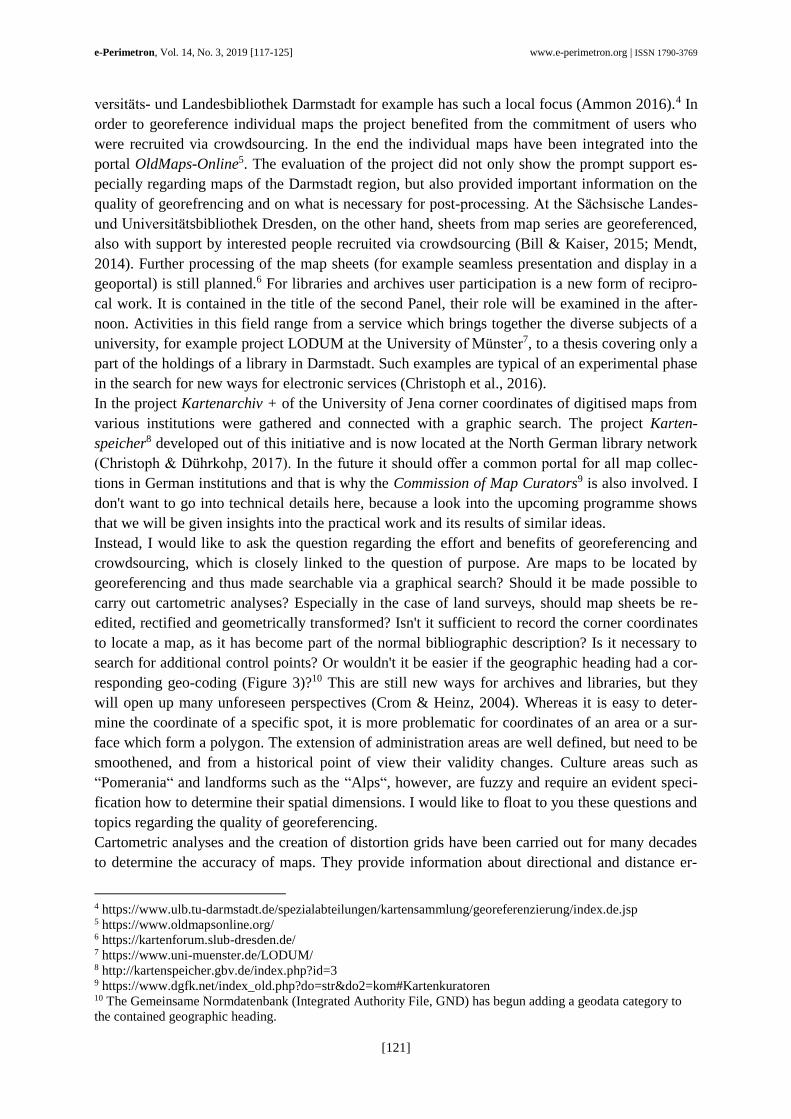
search for additional control points? Or wouldn't it be easier if the geographic heading had a cor-
responding geo-coding (Figure 3)?10 This are still new ways for archives and libraries, but they
will open up many unforeseen perspectives (Crom & Heinz, 2004). Whereas it is easy to deter-
mine the coordinate of a specific spot, it is more problematic for coordinates of an area or a sur-
face which form a polygon. The extension of administration areas are well defined, but need to be
smoothened, and from a historical point of view their validity changes. Culture areas such as
“Pomerania“ and landforms such as the “Alps“, however, are fuzzy and require an evident speci-
fication how to determine their spatial dimensions. I would like to float to you these questions and
topics regarding the quality of georeferencing.
Cartometric analyses and the creation of distortion grids have been carried out for many decades
to determine the accuracy of maps. They provide information about directional and distance er-
4 https://www.ulb.tu-darmstadt.de/spezialabteilungen/kartensammlung/georeferenzierung/index.de.jsp 5 https://www.oldmapsonline.org/ 6 https://kartenforum.slub-dresden.de/ 7 https://www.uni-muenster.de/LODUM/ 8 http://kartenspeicher.gbv.de/index.php?id=3 9 https://www.dgfk.net/index_old.php?do=str&do2=kom#Kartenkuratoren 10 The Gemeinsame Normdatenbank (Integrated Authority File, GND) has begun adding a geodata category to
the contained geographic heading.
e-Perimetron, Vol. 14, No. 3, 2019 [117-125] www.e-perimetron.org | ISSN 1790-3769
[122]
rors, they provide information about the methods of map production and the way of cartographers
work. However, these very special scientific questions cannot be the declared objective of georef-
erencing old maps, especially since the map content mostly plays only a minor role in this context.
For example, a street drawn as a straight line certainly has a different course in reality – and this
will still be the case after the transformation.
Figure 3: Geographic heading “Regensburg” in the Gemeinsame Normdatei (GND) with coordinates and references.
Georeferencing und transformation
Finally, let us turn to the georeferencing and the transformation of maps that have been created for
Web GIS applications or that have found their way into geoportals. The creation of the Digital
Wenker Atlas11, originally a dialect atlas of the late 19th century, began in the early 2000s. The
digitisation of the 1,668 map sheets, in which the results of the data collection are drawn by hand,
meant that the first and to this day most comprehensive language atlas could actually be used. The
project, which has since been further funded by the Academy of Sciences and Literature Mainz12,
provides linguists and interested laypersons with a range of instruments that offer a wide variety
of applications and thus open up completely new perspectives in dialect research (Kehrein et al.,
2005; Rabanus, 2005).
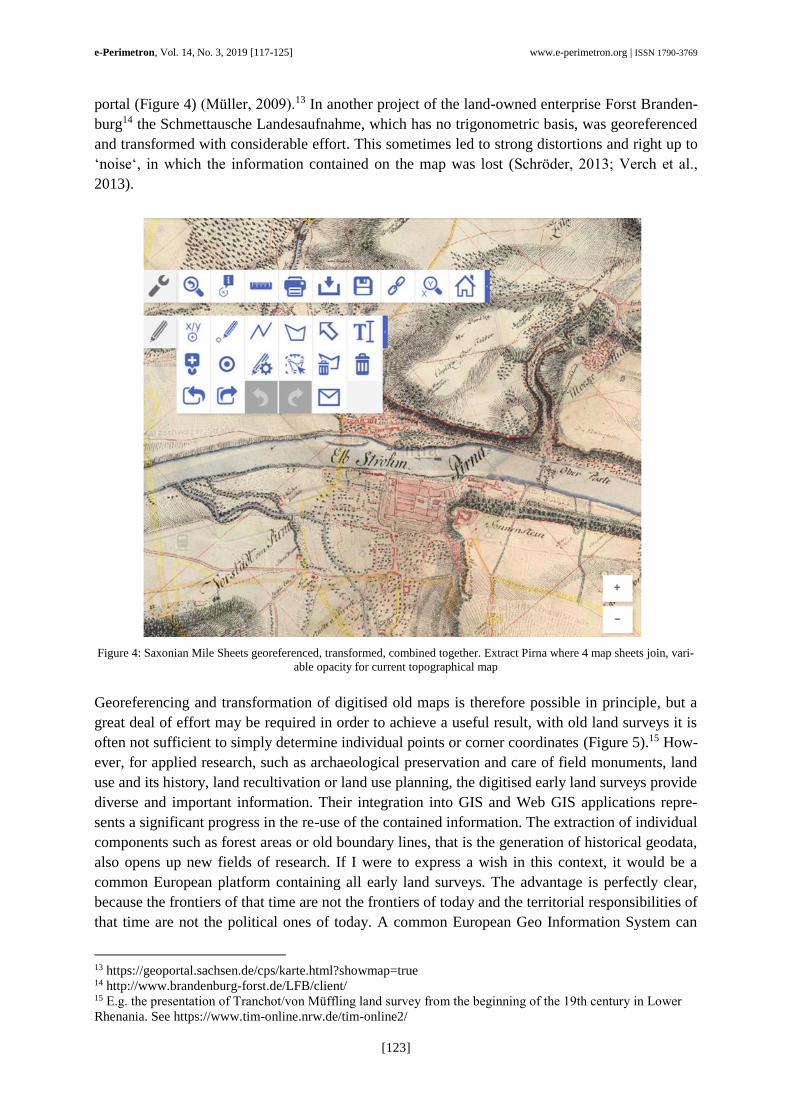
From the middle of the 2000s onwards, attempts were made to georeference old land surveys
(Crom, 2014). The first study known to me dealt with the handling of the Saxon mile sheets by
students of the Dresden University of Applied Sciences. The land surveys from the 1780s on-
wards which are based on trigonometry were transferred to current reference data as part of a stu-
dent training and have since become an important historical component of the Saxony Atlas geo-
11 http://www.diwa.info 12 https://www.regionalsprache.de/
e-Perimetron, Vol. 14, No. 3, 2019 [117-125] www.e-perimetron.org | ISSN 1790-3769
[123]
portal (Figure 4) (Müller, 2009).13 In another project of the land-owned enterprise Forst Branden-
burg14 the Schmettausche Landesaufnahme, which has no trigonometric basis, was georeferenced
and transformed with considerable effort. This sometimes led to strong distortions and right up to
‘noise‘, in which the information contained on the map was lost (Schröder, 2013; Verch et al.,
2013).
Figure 4: Saxonian Mile Sheets georeferenced, transformed, combined together. Extract Pirna where 4 map sheets join, vari-
able opacity for current topographical map
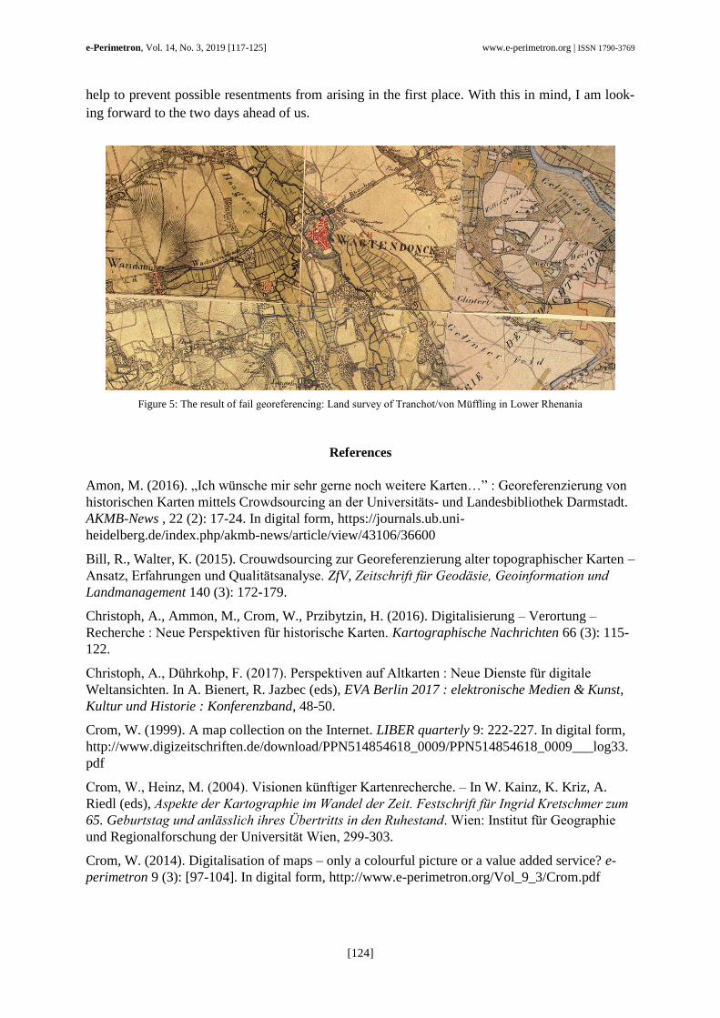
Georeferencing and transformation of digitised old maps is therefore possible in principle, but a
great deal of effort may be required in order to achieve a useful result, with old land surveys it is
often not sufficient to simply determine individual points or corner coordinates (Figure 5).15 How-
ever, for applied research, such as archaeological preservation and care of field monuments, land
use and its history, land recultivation or land use planning, the digitised early land surveys provide
diverse and important information. Their integration into GIS and Web GIS applications repre-
sents a significant progress in the re-use of the contained information. The extraction of individual
components such as forest areas or old boundary lines, that is the generation of historical geodata,
also opens up new fields of research. If I were to express a wish in this context, it would be a
common European platform containing all early land surveys. The advantage is perfectly clear,
because the frontiers of that time are not the frontiers of today and the territorial responsibilities of
that time are not the political ones of today. A common European Geo Information System can
13 https://geoportal.sachsen.de/cps/karte.html?showmap=true 14 http://www.brandenburg-forst.de/LFB/client/ 15 E.g. the presentation of Tranchot/von Müffling land survey from the beginning of the 19th century in Lower
Rhenania. See https://www.tim-online.nrw.de/tim-online2/
e-Perimetron, Vol. 14, No. 3, 2019 [117-125] www.e-perimetron.org | ISSN 1790-3769
[124]
help to prevent possible resentments from arising in the first place. With this in mind, I am look-
ing forward to the two days ahead of us.
Figure 5: The result of fail georeferencing: Land survey of Tranchot/von Müffling in Lower Rhenania
References
Amon, M. (2016). „Ich wünsche mir sehr gerne noch weitere Karten…” : Georeferenzierung von
historischen Karten mittels Crowdsourcing an der Universitäts- und Landesbibliothek Darmstadt.
AKMB-News , 22 (2): 17-24. In digital form, https://journals.ub.uni-
heidelberg.de/index.php/akmb-news/article/view/43106/36600
Bill, R., Walter, K. (2015). Crouwdsourcing zur Georeferenzierung alter topographischer Karten –
Ansatz, Erfahrungen und Qualitätsanalyse. ZfV, Zeitschrift für Geodäsie, Geoinformation und
Landmanagement 140 (3): 172-179.
Christoph, A., Ammon, M., Crom, W., Przibytzin, H. (2016). Digitalisierung – Verortung –
Recherche : Neue Perspektiven für historische Karten. Kartographische Nachrichten 66 (3): 115-
122.
Christoph, A., Dührkohp, F. (2017). Perspektiven auf Altkarten : Neue Dienste für digitale
Weltansichten. In A. Bienert, R. Jazbec (eds), EVA Berlin 2017 : elektronische Medien & Kunst,
Kultur und Historie : Konferenzband, 48-50.
Crom, W. (1999). A map collection on the Internet. LIBER quarterly 9: 222-227. In digital form,
http://www.digizeitschriften.de/download/PPN514854618_0009/PPN514854618_0009___log33.
Crom, W., Heinz, M. (2004). Visionen künftiger Kartenrecherche. – In W. Kainz, K. Kriz, A.
Riedl (eds), Aspekte der Kartographie im Wandel der Zeit. Festschrift für Ingrid Kretschmer zum
65. Geburtstag und anlässlich ihres Übertritts in den Ruhestand. Wien: Institut für Geographie
und Regionalforschung der Universität Wien, 299-303.
Crom, W. (2014). Digitalisation of maps – only a colourful picture or a value added service? e-
perimetron 9 (3): [97-104]. In digital form, http://www.e-perimetron.org/Vol_9_3/Crom.pdf
e-Perimetron, Vol. 14, No. 3, 2019 [117-125] www.e-perimetron.org | ISSN 1790-3769
[125]
Grell, J. (2004). Das elektronische Kartenarchiv X an der Universitäts- und Landesbibliothek
Sachsen-Anhalt. In: J. Bühler (ed.), Die digitale Kartenbibliothek : eine Momentaufnahme.
München: Saur, 81-89.
Lamatsch, J. (2004). Toporama. In J. Bühler (ed.), Die digitale Kartenbibliothek : eine
Momentaufnahme. München: Saur, 161-168.
Kehrein, R., Lameli, A., Nickel, J. (2005). Möglichkeiten der computergestützten
Regionalsprachenforschung am Beispiel des Digitalen Wenker-Atlas (DiWA). Jahrbuch für
Computerphilologie 7, 149-170. In digital form, http://www.computerphilologie.uni-
muenchen.de/jg05/kehrein/kehrein.html
Kintrup, A. (2003). Historische Karten : der Online-Katalog der Staats- und Universitätsbibliothek
Bremen. Bibliotheksdienst 37 (1): 47-52. In digital form,
https://digital.zlb.de/viewer/readingmode/019591853_2003/23/
Mendt, J. (2014). Virtuelles Kartenforum 2.0 : Geodateninfrastruktur für die Raum-Zeitforschung
mit historischen Karten. BIS : das Magazin der Bibliotheken in Sachsen 7 (3): 140-142. In digital
form, http://slub.qucosa.de/api/qucosa%3A4750/attachment/ATT-2/
Müller, M. (2009). Alte Landkarten in neuem Gewand. Der Web Map Service – Berliner
Meilenblätter Sachsens. Sächsische Heimatblätter 55(2): 114-121
Rabanus, S. (2005). Sprachkartographie des Deutschen: von Schmeller bis zum Digitalen
Wenker-Atlas. In: Perspektiven Eins : Akten der 1. Tagung Deutsche Sprachwissenschaft in
Italien, 345-362. In digital form,
http://www.dfll.univr.it/documenti/OccorrenzaIns/matdid/matdid213717.pdf
Schröder, J. (2013). Georeferenzierung und Entzerrung der brandenburgischen Kartenblätter des
Schmettauschen Kartenwerks. Vermessung Brandenburg [18], 14-23. In digital form,
https://www.geobasis-bb.de/verm_bb/pdf/2_13_Schroeder_14-23.pdf
Verch, C., Gross, J., Ahrndt, J. (2013). Waldentwicklung online : Die Waldflächen des Landes
Brandenburg im Spiegel der Zeit. In: Jan Engel (Red.). Wissenstransfer in der Praxis : Beiträge
zum 8. Interkolloquium am 21. Februar 2013 in Eberswalde: 74-80. In digital form,
https://www.waldwissen.net/technik/land_raum/lfe_geoportal/lfe_geoportal_originalartikel.pdf