digitization of cultural landscape in castile and leon (spain) · 2017-02-09 · digitization of...
TRANSCRIPT

Digitization of cultural landscape
in Castile and Leon (Spain)
Carlos Rodríguez Fernández
Researcher architect
LABPAP Architectural, Heritage and Cultural Landscape. University of ValladolidValencia I 01/02/2017

Castile and Leon, Spain
94.222 km²
2.495.000 inhabitants
Natural Places Network: more than 30 areas
The region of the world with more Unesco World Heritage Sites: 8

Regional natural and cultural heritage: public websites – maps locations
Mapa de la Red de Espacios Naturales en Castilla y León.http://www.patrimonionatural.org/espacios-naturales/listado
Visor Geográfico de Bienes Culturales de Castilla y León.http://www.idecyl.jcyl.es/VisorLigeroPACU/index2.html?
Portal de turismo de la Junta de Castilla y León.http://www.turismocastillayleon.com/es/destinos
Vías Romanas en Castilla y León. Junta de Castilla y León.http://www.viasromanas.net/

Regional natural and cultural heritage: STP ITER PLATA project
LABPAP UVa, 2009 - 2013STP ITER PLATA DISPLAYhttp://www.jcyl.es/jcyl/patrimoniocultural/iterplata
Roman route from Merida to Astorga – 276 km. long Castile and León stretch.
Heritage Territorial System: Natural and cultural landscape
Points of interest developed at different scales. Resources: IGN -National Geographic Institute and JCYL - Castile and Leon Government: SIG and CAD files, aerophotographies, historical cartographies…

3. Digitization with:3.1. advertisement goals – some examples
General Directorate Ministry of Culture and Tourism. Castile and Leon Government
Architectural Project:LABPAP Research Group UVA Architect Dr. Miguel A. de la Iglesia Dr.Darío Álvarez Álvarez, Flavia Zelli, Sagrario Fernández, Carlos Rodríguez
Archaeological monitoring:IE University, SegoviaCesáreo Pérez González (Coordinator)Emilio Gómez IllarreguiArribas Lobo Pablo
Topography:Pablo Beltrán Rodríguez
DIGITIZATION OF TIERMES ARCHAEOLOGICAL SITE, Soria

Drone flight: 4k video and photographAdvertisement goals: Informative video AR&PA 2016 Exhibition, Valladolid 2016

Photogrammetry 3D terrain Resource: PNOA CYL public photographsLABPAP – LFA, 2014
Source: Roman Architecture in the Eastern Landscape of Castile and Leon: interpretation and valorization R+D Project Report, 2014 LABPAP Laboratorio de Paisaje Arquitectónico Patrimonial y Cultural LFA Laboratorio de Fotogrametría ArquitectónicaUniversity of Valladolid

Drone products: Planning flights
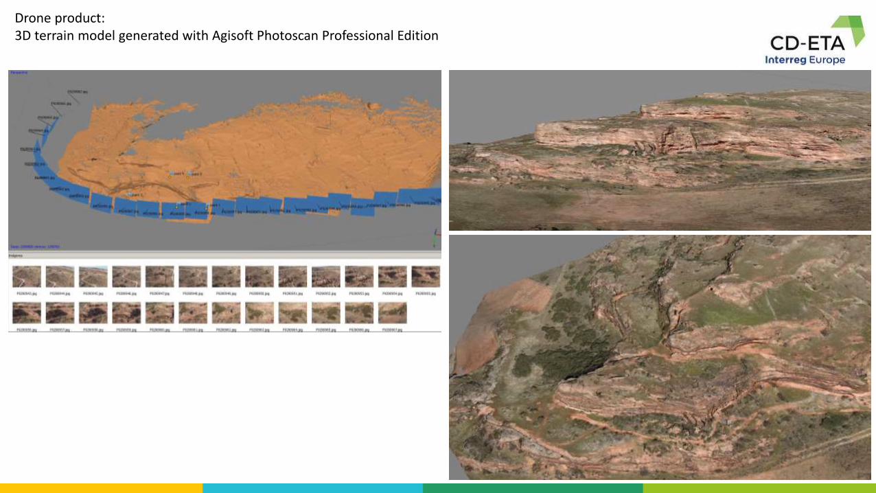
Drone product:3D terrain model generated with Agisoft Photoscan Professional Edition

Aerial photographies, 1980-1990

Orthophotography public access PNOA CyL, 2010

Drone product: Orthophotography generated with 3D terrain Agisoft PhotoscanArchaeological site and its surroundings: Roman caves, necropolis and streams

2D drawings: plansNew resources + evolution of the representation (coding)

2D drawings: plansNew resources + evolution of the representation (coding)


2D drawingsScientific goal + advertisement goals: info points/signals

2D drawings: plans Scientific goal + advertisement goals: info points/signals

Drone product3D terrain model generated with Agisoft Photoscan Professional Edition – PDF 3D
Domus of the Acqueduct 3D Model
Source: Roman Architecture in the Eastern Landscape of Castile and Leon: interpretation and valorization R+D Project Report, 2014 LABPAP Laboratorio de Paisaje Arquitectónico Patrimonial y Cultural UVaLFA Laboratorio de Fotogrametría Arquitectónica UVa.

3D Model generated with Agisoft Photoscan Professional Edition: Virtual model
3D Photogrametric Model 3D Final ModelRepresentation
CodifyDigitization

Digitization 3D Photogrametric Model 3D Final ModelRepresentation
Codify
3D Model generated with Agisoft Photoscan Professional Edition: 3D Printed Model


Colonia Clvnia Sulpicia: DEM (Digital Elevation Model) generated with PNOA public photographies
Source: Roman Architecture in the Eastern Landscape of Castile and Leon: interpretation and valorization R+D Project Report, 2014. LABPAP – LFA UVa

Colonia Clvnia Sulpicia: DEM (Digital Elevation Model) generated with PNOA photographies

Roman theatre of CluniaDigitization and restauration works (1998-2017)

Roman theatre of Clunia: Digitization with Laser Scan: Points cloud 3D model – contour lines 3D model
Source: LABPAP – LFA UVa

Roman theatre of CluniaVirtual reconstruction with Sketchup 3D Model – Architectural work, 2010


Roman CaveDigitization with Laser Scan - 3D model - plan and sections
Source: Technology Group for Hostile Environments (GTE) of the Engineering Research Institute of Aragón (I3A). University of Zaragoza.

Future Challenges:Clunia Master Plan (2015)

Thank you for attention!
Prepared by: Carlos Rodríguez Fernández, architect
LABPAP Laboratorio de Paisaje Arquitectónico Patrimonial y Cultural
School of Architecture, University of Valladolid
www.uva.es/labpap